Transcriber’s Note
Larger versions of most illustrations may be seen by right-clicking them and selecting an option to view them separately, or by double-tapping and/or stretching them.
BY
F. B. TOWER
OF THE
ENGINEER DEPARTMENT.
New-York and London:
Wiley and Putnam,
1843.
Entered according to the Act of Congress, in the year 1843, by F. B. Tower, in the Clerk’s office of the District Court of the Southern District of New-York.
TO
THE INHABITANTS
OF THE
CITY OF NEW-YORK,
WHOSE ENTERPRISE IS STRIKINGLY EXEMPLIFIED
BY THE CONSTRUCTION OF THE
CROTON AQUEDUCT,
THIS BOOK
IS MOST RESPECTFULLY DEDICATED,
BY
THE AUTHOR.
v
The views which I have given of the important points on the line of the Croton Aqueduct, are from sketches taken for my own satisfaction; but the interest so generally taken in the work, has suggested to me the propriety of presenting them to the public in this form. Having been engaged in the Engineer Department during the whole of the construction of the Aqueduct, my acquaintance with it would enable me to present more of its details; but I have given those of the construction of the Aqueduct, and a general outline of the structures connected with it, trusting that a more detailed description may emanate from John B. Jervis, Esquire, who, as Chief Engineer, gave Plans and Specifications for the work during its construction.
A description from such source, accompanied with detailed plans of all the appurtenances of the Aqueduct, with the results of experiments on the flow of water in the Aqueduct, would be a useful contribution to the cause of science, a valuable work to Engineers generally, and particularly so to younger members of the profession.
The history which I have given of the preliminary measures leading to the accomplishment of this work, has been obtained, mainly, from printed documents of the Common Council. I have also had conversations with personsvi who were intimately concerned in some of those measures, and trust that I have made the history sufficiently full to embrace the leading steps which were taken.
The accounts of the Aqueducts of ancient Rome, and those built by the ancient Romans in other parts of Europe, also that of the Aqueducts of modern Rome, of Italy, France, &c., have been mostly obtained from the French work of J. Rondolet, in which the account of the Aqueducts of ancient Rome is translated from the Latin of Frontinus.
For the account of the Aqueducts of Mexico and South America, I am indebted, in a great degree, to “Bradford’s Antiquities of America,” and “Ewbank’s Hydraulics.”
F. B. Tower.
vii
| Page. | |
| Aqueducts of Ancient Rome, | 13 |
| Principal Aqueducts constructed by the Ancient Romans in other parts of Europe, | 18 |
| Aqueducts of Modern Rome, | 28 |
| Principal Modern Aqueducts of Italy, France, etc., | 30 |
| Aqueducts of Mexico and the adjacent States, | 37 |
| Aqueducts of South America, | 40 |
| Fountains, | 47 |
| History of the Progressive Measures for Supplying the City of New-York with Water, | 57 |
| Of Plans Proposed for furnishing the City with Water and of the Plan adopted, | 69 |
| Sources of the Croton River, | 75 |
| Flow of Water in the Croton River, Capacity of the Fountain Reservoir, &c., | 76 |
| General Design of the Channel-way and Reservoirs, | 78 |
| General Construction of the Aqueduct, | 81 |
| Description of the Line of Aqueduct, | 95 |
| Appendix, | 125 |
| PLATES. | |
| Aqueduct of Spoleto, Italy, | 32 |
| Sections of the Croton Aqueduct, | 84 & 86 |
| Entrance Ventilator, | 88 |
| Isometrical View of Culvert, | 90 |
| Tunnel and Gate Chamber at the head of the Aqueduct, | 92 |
| View above the Croton Dam, | 95 |
| Entablature over the entrance to the Aqueduct, | 96 |
| View below the Croton Dam, | 98 |
| Croton Aqueduct at Sing-Sing, | 101 |
| Aqueduct Bridge at Sing-Sing, | 102 |
| Aqueduct Bridge for Road-way, | 103 |
| Croton Aqueduct at Mill-River, | 104 |
| Croton Aqueduct at Jewell’s Brook, | 105 |
| Croton Aqueduct at Hastings, | 106 |
| Croton Aqueduct at Yonkers, | 108 |
| Croton Aqueduct at Harlem River, | 110 |
| View of the Jet at Harlem River, | 112 |
| Croton Aqueduct at Clendinning Valley, | 113 |
| Aqueduct Bridge at Clendinning Valley, | 114 |
| Plan of the Receiving Reservoir, | 116 |
| Isometrical View of the Distributing Reservoir, | 119 |
9
A supply of pure and wholesome water is an object so essential to the health and prosperity of a city, that it should form one of the leading features of the public improvements which characterize its growth. The advantages arising from it are so numerous, and the comforts so great, that every effort should be made to accomplish it.
The means which have been resorted to for such purposes in almost every city of importance in the Old World, are examples for us of the New, and should induce us early to avail ourselves of that important element of health. We contemplate with mingled emotions of wonder and admiration, those works of art which were achieved by ancient Rome in her palmy days of wealth and power, and among them we find that her Aqueducts hold a prominent place.
Among the ruins of cities whose history is shrouded in mystery on this continent, we find provisions for bringing water from distant sources. In the wilds of Central America,10 the persevering traveller finds ruined cities buried in the depths of the forest, where nature is at work covering and concealing them: among those ruins he tells us of the Aqueduct. We find them also among the ruins of cities along the western coast of South America. With such examples before us, we may consider that by the construction of the Croton Aqueduct for supplying the City of New-York with water has been secured an important measure for the promotion of its growth.
Many cities of the United States have directed their attention to this object, and some have been fortunate in finding a supply of water near at hand, but others will look towards distant sources for a supply, and will, ere long, resort to the construction of Aqueducts.
In the history of cities built in remote periods of antiquity, we find mention made of plans for supplying water, and among remains of those cities which are found at this day, are traces of Aqueducts. We have accounts of Aqueducts constructed under the reign of Solomon, and the remains of them still existing in Palestine, give evidence of an extensive acquaintance with the principles of hydraulics among the Hebrew architects. The Pools of Solomon, which are mentioned by travellers who combine in their researches a regard for the arts as well as the religion of Judea, are connected with a scheme for supplying Jerusalem with water.
The vast expense incurred in the construction of Aqueducts11 by the Ancient Romans, as well in Italy as in other countries of Europe, proves the value that was attached by that people to a plentiful supply of pure water, and the details of the plan of construction of the different works, evince an acquaintance with the principles of hydraulics which, at this day, is not generally accorded to them. That they understood the principle that water seeks the level of its source after encountering depressions in its conduit, is sufficiently proved by instances, in works constructed by them, where the inverted syphon of pipes was used in crossing valleys. That this plan was not generally adopted by them in cases where great expense has been incurred to maintain the uniform declivity of the conduit over valleys, may be accounted for perhaps by the want of proper material for the construction of pipes. In cases where this plan has been adopted leaden pipes were used, and since it is only within the last century that iron pipes have been invented, we may reasonably conclude that considerations of such a nature would have induced them to adopt the more expensive plan of maintaining the general inclination of the conduit by vast structures of masonry.
By substituting inverted syphons instead of maintaining a uniform declivity in the conduit, would not give the requisite discharge of water at the elevation of the terminus of the Aqueduct, and perhaps they preferred, rather than diminish this elevation of the supply of water, to incur the expense of high structures across valleys. The Roman Emperors, with all their power and the wealth which was at their command, knew how to perpetuate the glory of their reign by the erection12 of Temples, Palaces and other public buildings, and what is more natural than to suppose that in the construction of these Aqueducts, which were considered so essential to the public welfare, they should encourage works of such architectural magnificence? Whatever the reasons might have been for maintaining the elevation of their Aqueducts over valleys by such expensive structures, we have no right to charge them with the want of that knowledge which the plan of some of their Aqueducts clearly proves them to have possessed.
Trusting that it will be interesting to the reader, I shall present an account of some of the principal Aqueducts built by the Ancient Romans,—some of the modern Aqueducts of Italy and France; also of Aqueducts in other parts of the world. This account might be enlarged, to embrace a description of more of the modern Aqueducts of Europe; but sufficient will be presented, it is thought, to interest without detaining the reader too long in arriving at the principal object of this work,—a description of the Croton Aqueduct.
A view is given of the Aqueduct of Spoleto, in Italy. The bridge supporting this Aqueduct is remarkable for the slender form of the piers and their great height; being only ten and a half feet thick and two hundred and fifty feet high to the base of the arches. This Aqueduct was built by the Goths, a people who gave a model for Church Architecture which is much admired at the present day. It is said that they borrowed the idea of the form of their arch from the opening beneath an arbor of trees.
13
The plan of the bridge for the Croton Aqueduct at Harlem River has been criticised on account of the small thickness of the piers as compared with their height, and because they were not made piers of equilibrium; that is to say, having their bases broader, so as to include the line of thrust of the arches, so that if a portion of the bridge were removed, the remainder of the arches and piers would maintain their position. By the present plan the permanency of any one individual arch may be considered to depend upon that of the whole structure.1
The Aqueduct of Spoleto, has been standing about eleven hundred years and is still in a perfect state of preservation.
With proper care in preparing the foundations of the bridge at Harlem River, there is no good reason to fear that it will be less durable than that of Spoleto.
The largest and most magnificent Aqueducts of which we have any account, were the work of the Romans; and the ruins of several of them, both in Italy, and other countries of Europe, remain to the present time monuments of the power and industry of that enterprising people.
14
For 440 years from the foundation of Rome the inhabitants contented themselves with the waters of the Tiber, and of the wells and fountains in the city and its neighborhood. But at that period the number of houses and inhabitants had so augmented, that they were obliged to bring water from distant sources by means of Aqueducts. Appius commenced this scheme of improvement. About 39 years after him, M. Curius Dentatus, who was censor with Papirius Cursor, brought water from the neighborhood of the city of Tibur; and applied towards defraying the expense, part of the sums taken in the spoils of Pyrrhus. After them Lucius Papirius, Caius Servillius Cepion, Lucius Longinus Crassus, Quintus Marcius, (who brought water to Rome from a spring at the distance of nearly sixty miles,) Marcus Agrippa, Augustus, and others, signalized themselves by their noble Aqueducts. Even Tiberius, Claudius, Caligula, and Carracalla, though in other respects not of the best character, took care of the city in this useful article.
In the remains of these ancient Aqueducts, some are elevated above the ground upon a solid mass of stone work, or upon arches continued and raised one above the other; other portions are subterraneous, passing through deep excavations, and in many instances piercing through mountains of rock; such is that seen at Vicovaro beyond Tivoli, where a tunnel of about five feet deep and four broad, pierces a rock for a distance of more than a mile.
These Aqueducts were generally built of stone and covered by arches or large flat stones. At certain distances15 vents were provided to discharge the water from the channel-way; and cavities were formed, into which the water was precipitated, and where it remained till its mud was deposited, and ponds in which it might purify itself.
One of these Aqueducts was formed with two channels, one above the other: they were, however, constructed at different periods; the most elevated was supplied by the waters of the Tiverone, Anio novus, and the lower one by the Claudian water. It is represented by Pliny, as the most beautiful of all that had been built for the use of Rome. It was begun by Caligula, and finished by Claudius, who brought its waters from two springs called Cœruleus and Curtius. Vespian, Titus, Marcus-Aurelius, and Antonius Pius, repaired and extended it; it is now called Aqua Felice.
The Aqueduct that conveyed the Aqua Neroniana to Rome, was built of brick; this, as well as the former, was in some instances 70 Roman feet high.
The Aqueduct that brought the Aqua Marcia into the city was repaired by Agrippa, who laid pipes from it to several parts of the city.
The Aqua Marcia, Aqua Julia, Aqua Tepula, entered Rome in one and the same Aqueduct, divided into three ranges or stories; in the uppermost of which flowed the Aqua Julia, in the second the Aqua Tepula, and in the lowest the Aqua Marcia. This accounts for the extraordinary16 height of this Aqueduct, which far surpassed that of any other in Rome. From the ruins of this fabric, which are still seen, and are called “Il castel del Acqua Marcia,” it appears to have been a very superb structure.
The Aqueducts were under the care and direction, first of the censors and œdiles, and afterwards, of particular magistrates called “Curatores Aquarum,” instituted by Agrippa, to whom the Aqueducts of Rome were objects of particular attention. Messala was one of these curatores in the reign of Augustus, and Frontinus held the same office in that of Nerva. Augustus caused all of them to be repaired.
Procopius reckons only fourteen Aqueducts in ancient Rome; but Victor has enlarged the number to twenty.
Frontinus, a man of consular dignity, and who had the direction of the Aqueducts under the Emperor Nerva, mentions nine. From other accounts we are informed that nine great Aqueducts existed at Rome at the commencement of the reign of Nerva. Five others were constructed by that Emperor, under the superintendence of Julius Frontinus; and it appears that at a later period the number amounted to twenty.
Frontinus, who had the superintendence of the Roman Aqueducts under the Emperor Nerva, died A. D. 101. He gave an account of the Aqueducts, which has since been translated into French by Rondolet. The following table is made up of data from that work.
17
The table is arranged to show, First, the name of the water or Aqueduct; Second, the era of its construction; Third, the length of each Aqueduct in miles and decimals; Fourth, the cubic feet discharged in 24 hours, and Fifth, the gallons in wine measure.
| NAME. | ERA. | LENGTH. | CUBIC FEET. | GALLONS. | ||
| 1. Appian Aqueduct, | B.C. | 312 | 10,3250 | 3,706,575 | 27,724,181 | |
| 2. Old Anio | „ | „ | 273 | 36,6775 | 8,932,338 | 66,813,887 |
| 3. Marcian | „ | „ | 146 | 56,9417 | 9,525,390 | 71,249,917 |
| 4. Tepulan | „ | „ | 127} | 14,2341 | { 903,795 | 6,760,386 |
| 5. Julian | „ | „ | 35} | {2,449,386 | 18,321,407 | |
| 6. Virgin | „ | „ | 22 | 14,3116 | 5,085,624 | 38,040,467 |
| 7. Alsietina | „ | A.D. | 14 | 20,4526 | 796,152 | 5,656,016 |
| 8. Claudian | „ | „ | 49 | 42,1989 | 9,356,817 | 96,988,991 |
| 9. New Anio | „ | „ | 90 | 54,1644 | 9,622,878 | 71,979,127 |
| 249,3058 | 50,378,955 | 376,834,379 | ||||
Some auxiliary supplies or feeders make the total length of the Roman Aqueducts, at that period, exceed 255 miles.
The names of the Roman Aqueducts are taken from those of the River or Lake which supplies them, or from the emperors who caused them to be constructed. Frontinus gives the following as the origin of the name Virgin Aqueduct: “It is called the Virgin (Virgo), because it was a young girl who showed some veins to a few soldiers who were in search of spring water. Those who dug followed these veins and found a great quantity, and there is a painting in a little temple erected close by the source representing this event.”
18
This is probably one of the most ancient Aqueducts constructed, out of Rome, by the Romans. It is attributed to Agrippa, son-in-law of Augustus, to whom that emperor gave the government of the country becoming a Roman Colony.
Agrippa, flattered by the honors which he received from the inhabitants of Nismes, made his residence there: he enclosed the town with new walls, built baths, and probably the Aqueduct of the bridge of Gard (“pont du Gard”) for bringing water to them.
This Aqueduct is nearly thirty miles in length, forming, in its course, the figure of a horse-shoe. It brought water from the fountains of Eura and Airan, situated in the neighborhood of the town of Uzès. The bridge of Gard was about the middle part of the work, and the Aqueduct terminated at Nismes.
This Aqueduct traversed a very mountainous country, piercing through mountains and crossing valleys by means of arches upon arches, forming magnificent structures entirely of cut stone. The Aqueduct or channel-way is formed of stone throughout the whole length. The bottom of the interior has a curved form, being an arc of a circle; the sides19 are vertical, and the top covered with a flagging of cut stone, except where it is under ground, in which situation the top is covered by an arch of stone. The interior face of the walls and the bottom were covered with a coat of plastering two inches in thickness, composed of quick-lime, fine sand, and brick nearly pulverized. This coating has now a tenacity and consistence equal to the hardest stone.
The size of the channel-way is the following: 4 feet wide and 5⅓ feet high, except where the top is covered with an arch, in which case it is 7½ feet high in the interior.
The descent of the Aqueduct is 1 foot in 2500 feet, or 2-11/100 feet per mile.
The water which flowed in this Aqueduct formed a deposit upon the sides, of lime, until nearly half the channel was closed; this deposit amounting to a thickness of 11 inches on each side. By the height of this deposit it has been ascertained that the water flowed generally with a depth of 3¼ feet.
The pont du Gard is that part of the Aqueduct of Nismes which crosses the deep valley in which runs the Gardon or Gard. This part, considered alone, is one of the noblest monuments built by the Romans among the Gauls. It is composed of three ranges of arches one above another. The first range, under which the Gardon flows, is formed by 6 arches; the second by 11, and the third by 35, all of which are semicircular; supported upon piers of greater or less height.
20
The channel in which the water flows is upon the top of the third range of arches, and is 160 feet above the water of the river. The whole length of this bridge is about 900 feet.
The bridge of Gard having been broken down at the two extremities, at a period very remote and uncertain, it is thought that this destruction may be attributed to the Barbarians who invaded the country of Nismes a short time after their first invasion, which is fixed at the commencement of the fifth century, about the year 406, and it is supposed that by this means they would deprive the inhabitants of Nismes of the water furnished by the Aqueduct, and force them to yield. But by this supposition, which is very probable, the water had been running in this Aqueduct for more than four centuries; and this structure which has been out of use during fourteen hundred years, is still in such a state of preservation that it could be restored without a very great expenditure of money.
Nothing gives a better idea of the splendour of the city of Lyons under the reign of the first Roman Emperors, than the remains of the ancient monuments. We see there at the present day, remains of temples, of palaces, of amphitheatres, of basins for mock sea fights, of baths and of many Aqueducts, of which three were constructed under the reigns of Augustus, of Tiberius and of Claudius, for conducting water to that part of the ancient city situated upon the mountain.
21
The first and the most ancient of these Aqueducts, constructed by Mark Anthony, brought the waters from Mount-d’Or, by means of two branches which embraced that group of mountains.
The water furnished by the first Aqueduct having been found insufficient, they constructed a second one to bring the water of the Loire.
The third Aqueduct was built by the Emperor Claudius to furnish water to the palace of the emperors situated upon an elevated mountain. The Aqueducts built at this era are all of the same construction; that is to say, from the plan and construction adopted by the Romans. A fourth Aqueduct was also constructed for this city, but there is some doubt whether it was built by the Romans.
This Aqueduct was built by Claudius, who was born at Lyons, to conduct water to the emperor’s palace, situated on the highest part of the city. The sources which supplied it, were in the neighbourhood of Mount Pila, and they were brought into the main Aqueduct by branch aqueducts. The main Aqueduct was forty miles in length; and adding the branches, the length of the Aqueduct was forty-five miles.
There were 13 bridges of stone to support the Aqueduct across valleys or over rivers, two of which were not built up to the plane of the Aqueduct, but were crossed by leaden22 pipes which descended on one side of the valley and, crossing the bridge, ascended on the opposite side. In another instance the pipes descended and crossed upon a wall of masonry and reached the opposite side of the valley. One instance, where pipes were used, will give an idea of their general form: the bridge was about 40 feet high and the perpendicular height of the Aqueduct above it was 140 feet. Nine leaden pipes of about 8 inches interior diameter and one inch thick were laid upon the inclined planes and across the level part of the bridge; thus communicating with the opposite crests of the valley.
These bridges which were constructed for the support of pipes, were wider in the bottom of the valley and also half way up the inclined plane, than they were for the remainder of the distance; and this form has suggested the idea that the pipes of 8 inches diameter, when they reached half way down the plane, separated, each one into two of 6 inches diameter which crossed the bridge, and converged into one again half way up the opposite plane. But it may be supposed that they continued of the same interior form throughout their length, and that this extra width was made for the purpose of giving an opportunity to fortify the pipes at the place where the pressure to which they were subjected was the greatest.
They commenced the construction by making a trench in the ground of sufficient dimensions for the masonry of the23 Aqueduct: upon the bottom of this trench was laid a mass of masonry 1 foot thick, upon which two walls were built, each 1½ foot thick and 5⅓ feet high, these walls standing 2 feet apart, and surmounted by a semicircular arch of a thickness of 1 foot and generally covered with earth 2 feet deep. The interior had a coat of cement plastering, 6 inches thick on the bottom and 1½ inch thick on the sides. The walls were constructed with small stones from 3 to 6 inches in thickness, bedded in mortar so that no spaces could be found between them. They avoided the use of stones of greater thickness than 6 inches, because the walls built of small stones, well filled with mortar, formed a mass more solid and impervious than with larger stones, on account of the great quantity of mortar used.
No bricks were used in the construction of the channel-way of the Aqueduct.
Ventilators were constructed along the course of the Aqueduct 2 feet square, and rising above the ground 2 or 3 feet. The Aqueduct when it was above the ground, was supported upon a wall of masonry, and the side walls of the channel-way had an increased thickness. When it was elevated 6 or 7 feet above the ground, the foundation wall was six feet thick; but when it had a greater elevation it was supported upon arches and piers, and upon the elevation depended the span of the arch, the thickness and height of the piers. The general declivity in the channel-way, was 1 foot in 640, or about 8¼ feet per mile.
24
This Aqueduct supplied about 1,200,000 gallons of water in 24 hours. The velocity of the water was about five times that of the water in the Aqueducts of Rome.
This work was constructed at an immense expense, and in substituting the “inverted syphon,” for high structures across valleys, there is evidence of the intelligence and skill of those who had charge of the construction.
A fragment of a pipe forming part of this reversed syphon, is still preserved in the museum at Lyons, and an instance of the Romans having laid pipes across the beds of rivers, is given by M. Gautier, Architect, Engineer, &c., in his work called “Traité de la Construction des Chemins,” published in 1778.
About 70 or 80 years ago, he was directed by Mr. Pontchartrain, Minister of State, to repair to Rochefort, to conduct spring water to the port from the fountains of the city, which were supplied from a source, though quite insufficient for the city, in the neighborhood. In his researches he discovered a good and copious source, at less than half a league, but on the other side of the river, the Charente. Many difficulties were presented, because at low water vessels might ground upon the pipes and injure them.
However, Mr. Gautier proposed to lay down two leaden pipes, to preserve a supply in case of accident to one, and to protect them by wooden frames in an effectual way against injury, should vessels lay upon the defence frames25 during low water. Mr. Begon, intendant of the Marine, approved the plan, but it was finally rejected.
“Some years after,” says Mr. Gautier, “when I had charge of the roads on the Rhone, and of many other works in the Province of Languedoc, and while at Arles, I heard that a vessel had cast anchor in the Rhone, opposite the city, to take some loading; but when the commander wanted to sail again he could not raise the anchor. This fact attracted much attention, and many people went to witness the singular circumstance. The Captain, unwilling to lose his anchor, sent down a man, to find what was the matter. The diver reported that the anchor was hooked under something round, but he could not tell what it was. A capstan was applied to raise it, which succeeded.
It brought up a leaden conduit pipe from the bottom of the Rhone, which crossed it from the City of Arles, towards Trinquetaillade, over a breadth of about 90 toises (576 feet) in a depth of 6 or 7 toises (about 40 feet,) the deepest part of the Rhone. I saw some pieces of this conduit of lead, 5 or 6 inches in diameter, about 4 lines (one third of an inch) thick, in joints of 1 toise each soldered lengthwise, and covered by a strip or sheet of lead of the same thickness covering the first solder about 2 inches. The conduit was soldered at the joints, 6 feet apart, by the same material, which made a swell at that distance. On each joint were these words in relief C. CANTIUS POIHINUS. F. which was apparently the name of the maker or architect, who laid down the conduit pipe in the time of the Romans. I delayed26 not to inform Mr. Begon, at Rochefort, of this discovery, because he had always favoured my project of conducting water along the bottom and across the Charente, which would not have been half so difficult as it had no doubt been, to lay one across the Rhone where this was found.
Hence it may be believed, as I think now myself, that many things supposed now-a-days to be new and never to have been previously invented, may have been thought of long before, even in remote ages.” Pp. 129, 130.
This Aqueduct was built by the Romans when that city was under their dominion; but it is difficult to fix upon the precise era of its construction. It is said in the history of the city of Metz that the Roman legions built roads in the year 70; but there is reason to suppose that the construction of this Aqueduct, as well as that of other important structures built by the Romans at Metz, belongs to a time more remote, and that the date of the reign of the first emperors may be the era when the legions of Cæsar occupied the country of the Gauls.
The total length of the Aqueduct was 14 miles, and the fall for this distance was about 73 feet.
The channel-way was 6⅓ feet high, by 3 feet wide, constructed with stone masonry and having an arch over the top: the interior face of the walls and the bottom was27 covered with a coat of plastering; 3 inches thick in the bottom, and 2 inches on the sides. From remains of this Aqueduct which are now found at various points along its course, it appears to have required many expensive structures for crossing valleys; in one instance the Aqueduct bridge was 3,600 feet long, and the greatest height was 100 feet. In constructing the Aqueduct over these bridges, they formed it in two channels separated by a wall, and each covered with an arch; thus they insured a supply of water across the bridge by one channel in case the other required repairs.
Three Aqueducts exist in the valley of Bourgas, 8 miles from Constantinople, for conducting water into the city. One of them is remarkable for the beautiful architectural arrangement and the solidity of its construction. It is 115 feet high, and was built under the Emperor Justinian, A. D. 527. It has two ranges of arches, one above the other, and the Aqueduct supported upon the second. These Aqueducts are in some parts unlike those of Rome, which were formed on a continuous line for many miles, with a regular inclination from the source to the city, but are interrupted by reversed syphons. Instead of crossing deep and wide valleys in the usual manner of stone structures, the Aqueduct terminates on one bank in a reservoir or cistern, and a pipe is laid from it down the sloping side of the hill to a stone pier erected at a suitable distance; the pipe rises up the pier to the top where the water is discharged into a small cistern28 nearly as high as that in the reservoir. From the cistern, another conduit pipe descends to the bottom of the pier, passes along the ground to a second pier at a proper distance and rises to another cistern on the top of it, and so on till it rises on the crest of the opposite bank, where the water resumes its regular motion along the Aqueduct.
This plan was probably adopted with a view to avoid the expense of constructing a bridge which should preserve the general inclination of the channel-way; but it is difficult to imagine any advantage arising from the construction of the piers, instead of laying the pipe along the bottom of the valley.
Rome is now supplied with water by three Aqueducts, being three of the ancient works restored in modern times.
First, Aqua Virgini, called by Frontinus, Aqua Virgo, or Virgin Aqueduct.
The trunk of the Aqueduct having been injured, the reparation was began under the Pontificate of Nicholas V. and Sextus IV., and completed under that of Pius IV. in 1568. This water supplies the beautiful fountain Trevi, thus named from the three discharges issuing from it, or from its being placed at the junction of three streets. The water this Aqueduct furnishes is 2,322,762 cubic feet (14,168,848 gallons) daily, discharging through 7 principal conduits, at 13 public and 37 other fountains.
29
Second, Aqua Felice. This is a part of the ancient water of the Claudian and Marcian Aqueducts united with many others, and collected under Sextus V. The daily quantity it furnishes is 727,161 cubic feet, (4,435,682 gallons,) and supplies 16 public and 11 other fountains. The Moses fountain discharges from this source.
The Pauline Aqueduct, called Aqua Paola, is the third of the ancient works restored. The water is collected within the territories of Arcolo and Bassano, and conducted along the ancient Aqueduct of Alsietina. This was effected under Pope Pius V., and directed by Charles Fontana, an eminent Hydraulic Architect, who constructed the great fountain of S. Pietro-in-Montorio. Additional water was also taken from Lake Bracciano by Fontana in 1694, under Clement X. The whole quantity in 24 hours is 3,325,531 cubic feet, (20,285,739 gallons,) about one third of which goes to feed the fountains of St. Peters, and those of the Pontifical Palace on the Vatican Hill; the rest is distributed among 8 public and 23 other fountains, as well as to 21 work-shops, (usines) in St. Pancras-street.
An evidence of the durability of these old Roman structures is furnished in this junction of water from Lake Bracciano by Cardinal Orsini, under authority of Clement X., upon condition that a part of the water should be used to feed a second fountain about to be built in St. Peter’s Square at Rome, and the rest to be divided between the Apostolic Chamber and the House of Orsini. From the lake the conduit leads to the old Alsietina Aqueduct, in which it flows 2030 miles to the city, and it was found to be in so perfect a state when the trial was first made after the restoration, October 13th, 1693, that all the water which entered the old Aqueduct was discharged at Rome without any loss, after its use had been suspended nearly 1000 years.
This Aqueduct was built by the order of the King of Naples, Charles III., for conducting water to his residence which he had at Caserta, a town situated about fifteen miles north of Naples.
This Aqueduct was commenced in 1753. It is twenty-seven miles long, from the sources which supply it to the gardens of Caserta. The sources are at the base of the mountain called Taburno; the principal one is called Sorgente de la Sfizzo; it is afterwards joined by streams from many other sources, which are in the country called Airola.
These waters are all joined in one Aqueduct, crossing the river Faënza, upon a bridge of three arches, built in 1753. Again, in the valley of Durazzano, there is another bridge of three arches, upon which the Aqueduct crosses the valley, passing over the river, and extending from the mountain called Santa Agata de’Goti, to the mountain of Durazzano.
31
This Aqueduct afterwards crosses a deep valley, which it meets between Monte-Longano and the hills Tifata, where ancient Caserta is situated, about the place called Monte di Gazzano. The crossing of this valley required the most important of all the constructions connected with the work. It was accomplished by an Aqueduct bridge, 1724 feet long and 190 feet in height, composed of three tiers of arches, one above another. The lower range has nineteen arches, the middle twenty-seven, and the upper one forty-three; making in all eighty-nine arches.
The labor of constructions under ground for this Aqueduct was more than that above; it pierced through five hills or mountains, making an aggregate length of tunnel of about four miles, and most of this was through rock.
To give air and light to the channel, they made pits or wells; some of which were 250 feet deep, 10 feet diameter at the bottom, and 4 at the top.
This Aqueduct was built in connection with an ancient Causeway, which led to Civita-Castellana.
This Causeway was about 820 feet long and 32 feet wide; the greatest height was about 130 feet. It was pierced in the middle of this extent, by nine large arches; three of which were 86 feet span, and the others were each 64 feet span. Above these arches of the bridge the Aqueduct is built, the32 height of which is about 57 feet, and it is sustained upon a series of arches of about 19 feet span each.
This Aqueduct is one of the most beautiful works of the kind, which exist in France. The length is about 3,200 feet; it conducts to Montpelier the waters of Saint Clement and du Boulidou. It was built by M. Pitot, engineer and member of the Academy of Sciences. He was thirteen years constructing it. This Aqueduct is formed by two ranges of arches; those in the lower tier are seventy in number, and each 28 feet span; the piers of these arches are each 12 feet thick. The arches of the second or upper tier are much smaller, and are arranged so that three of them come within the space occupied by one of the lower arches. They are 9 feet diameter; their piers are 4 feet and a quarter thick.
The greatest height of this Aqueduct is 90 feet.
It is constructed entirely of cut stone. The quantity of water furnished by it is about 300,000 gallons in twenty-four hours.
This Aqueduct was constructed in the year 741, by Theodoric, King of the Goths, to communicate with the town of Spoleto, situated upon the summit of a mountain. It is composed of ten grand Gothic arches each 71 feet diameter, supported upon piers of 10½ feet thickness. The middle arches which are over the river de la Morgia, are about 328 feet high.
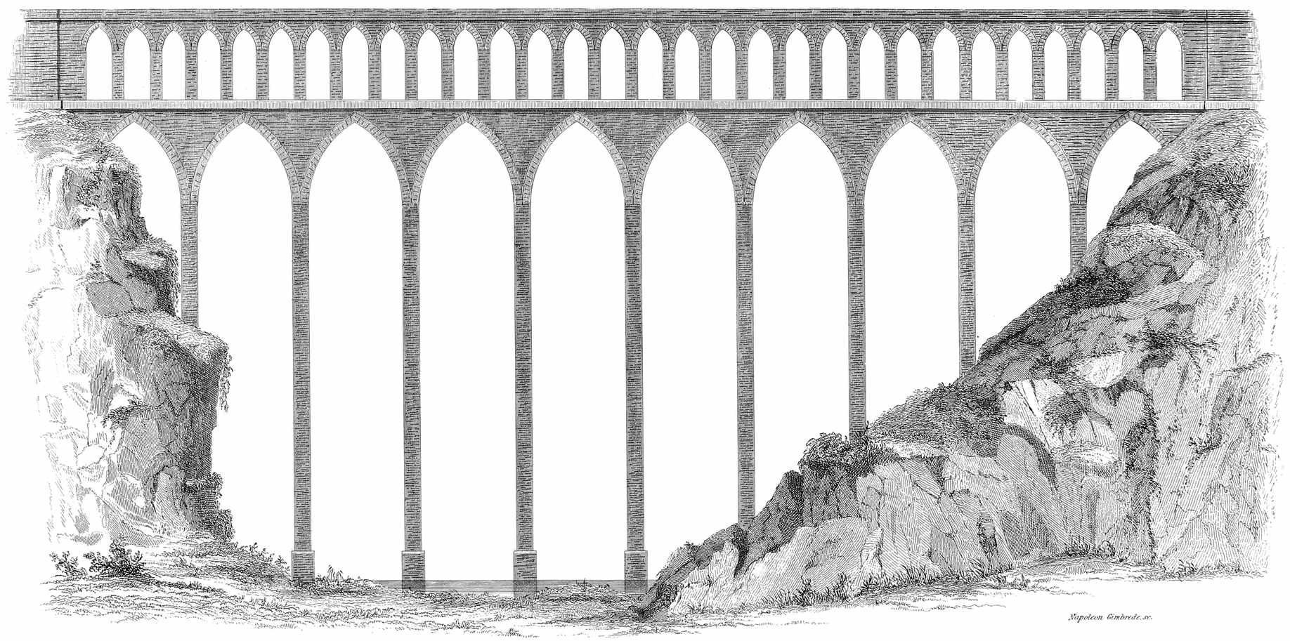
Napoleon Gimbrede. sc.
AQUEDUCT OF SPOLETTO, ITALY.
On the top of this bridge is the Aqueduct which carries the water to Spoleto.
This structure was difficult to execute, and being built of a very hard stone, remains entire at the present day.
The total length is 800 feet, and the breadth is 44 feet.
The greatest height of this bridge is 420 feet.
This Aqueduct was constructed by the Prince of Biscari, in Sicily, at his own expense, across the river Saint-Paul, the ancient Symète. It conducts a pure stream of water to the estate of the prince, and at the same time serves as a public bridge over the valley. This bridge is composed of thirty-one arches, the largest of which, over the river, is 90 feet span. This arch is of Gothic form, while all the others are semi-circular. The bridge has two tiers or ranges of arches; the roadway is upon the first range, and the channel for the water, upon the second or upper range. The length of the bridge is 269 feet. The height to the top is 120 feet. It is said that this magnificent structure was accomplished in two years.
34
The Emperor Julian built this Aqueduct to bring water to Paris, A. D. 360; it supplied the palace and hot baths, but was destroyed by the Normans. It was above nine miles and a half long, and was entirely under ground, except the stone arcade over a deep valley at Arcueil. After its use had been suspended 800 years, a new and beautiful arched Aqueduct was built by the side of the ruins of the old one, and its final restoration to public use was completed in 1634.
Part of this ancient construction, consisting of two arches substantially built, still exists, near the modern Aqueduct.
The Aqueduct bridge over the valley of Arcueil has twenty-five arches, is 72 feet high and 1,200 feet in length.
In the interior of the Aqueduct on each side is a parapet which forms a walk. On the outside along the whole line are various openings, called regards.
This Aqueduct was thoroughly repaired in 1777; and fresh sums of money have lately been devoted to the same purpose by the city of Paris. It supplies 36,000 hogsheads daily.
This work, had it been completed, would have been one of the most remarkable of modern times. The project was one35 of the noblest examples of the enterprise which characterized the reign of Louis XIV., and had it been carried out would have presented a work equal in grandeur to any of the kind constructed by the Romans. It was projected by Vauban, and the work was commenced in 1684, but was abandoned in 1688.
It was intended to conduct water from the river Eura to Versailles; a distance of over seventy miles; and it was also contemplated to continue the work to St. Cloud and to Paris; had this been done it would have been over ninety miles in length. It was intended to be of a mixed construction; partly by a canal formed by excavations and embankments, and partly by a channel of masonry.
One of the most remarkable structures connected with it, was the Aqueduct bridge across the valley of Maintenon. This was designed to be entirely of masonry, having three ranges of arches, one above another. The length of this Aqueduct bridge would have been three and a quarter miles, and the height from the lowest part of the valley would have been 234 feet.
The whole number of arches designed for this bridge was 685.
Some of the piers and arches of the lower tier were constructed, but have since been suffered to crumble and fall. Many deep valleys were filled with embankments, and the canal was completed for a portion of the distance, but the36 course of the work is now but faintly marked by the remains of these structures.
The site of Lisbon, as well as the ground in its vicinity, consists chiefly of limestone and basalt, which render it necessary to obtain good water, at about three leagues distance, for the beverage, and other uses of the inhabitants. The source consists of several springs that are near to the village of Bellas, and their produce is conveyed to Lisbon by an Aqueduct, constructed of a kind of white marble, and finished in 1738. In some parts its course has been excavated through hills; but near to Lisbon it is carried over a deep valley, for a length of 2400 feet, by means of several bold arches, of which the largest has a height of about 250 feet, by a breadth of 115. The arches being pointed have an interesting aspect, particularly when viewed from below, the interior of the spacious vaults being not only majestic in appearance, but reverberating every sound. The water flows through a stone tunnel, or covered arch-way, about 8 feet wide, formed in the middle of the structure; and on each side there is a foot-path, with a parapet wall, having a sufficient width for two persons to walk. The Aqueduct enters the town on its northern side, at a place called da Amoreira, where it branches into several others, in order to supply the different fountains, from which the inhabitants are supplied. Persons, denominated gallegos, obtain a subsistence by selling the water, which they procure at the fountains in small barrels, and afterwards cry it through the streets.
37
The people who, in remote times, inhabited the region of Mexico, were advanced in civilization and in the arts; they had regularly organized states and established forms of government, and their immense cities, their roads, Aqueducts and other public works, give evidence of the advanced state of the arts among them and their knowledge of the sciences.
The location and great population of some of their cities required a familiar knowledge of hydraulic operations to supply them with water; and hence it would seem as if they had cultivated this department of the arts equally with others, for some of their Aqueducts were of a character that would have done honor to Greece or Rome. Nearly all the ancient cities of Mexico were supplied by them.
“The city of Mexico, which was built on several islands near the shore of the lake, was connected to the main land by four great causeways or dikes, the remains of which still exist. One of these to the south, the same by which Cortez entered, was nearly two leagues long—another to the north about one league, and the third at the west somewhat less. The fourth supported the celebrated Aqueduct of Chapoltepec, by which water was conducted from springs, upon an insulated hill of that name, at the distance of from two to three miles.”
The Aqueduct of Chapoltepec was the work of Montezuma, and also the vast stone reservoir connected with it.
38
This Aqueduct consisted of two conduits formed of solid mason work—each five feet high and two paces broad—by which the water was introduced into the city for the supply of various fountains.
Olid and Alvarado commenced the siege of Mexico by attempting to cut off this supply of water, an enterprise which the Mexicans endeavored to prevent. “There appeared on that side,” says De Solis, “two or three rows of pipes, made of trees hollowed, supported by an Aqueduct of lime and stone, and the enemy had cast up some trenches to cover the avenue to it. But the two captains marched out of Tacuba with most of their troops, and though they met with a very obstinate resistance, they drove the enemy from their post, and broke the pipes and Aqueduct in two or three places, and the water took its natural course into the lake.”
Humboldt says, there are still to be perceived the remains of another Aqueduct, which conducted to the city the waters of the spring of Amilco, near Churubusco. This Aqueduct, as described by Cortez, consisted of two conduits composed of clay tempered with mortar, about two paces in breadth, and raised about six feet. In one of them was conveyed a stream of excellent water, as large as the body of a man, into the centre of the city. The other was empty, so that when it became necessary to clean or repair the former, the water might be turned into it; which was the case also with those of Chapoltepec, “of which one was always in use, whenever the other required cleaning.”
39
The gardens of Montezuma were also adorned and nourished with streams and fountains, and appear to have rivalled those of Asiatic monarchs in splendour.
The ruins of the city of Tezcuco, which with its suburbs was even larger than Mexico, and according to Torquemada, contained one hundred and forty thousand houses, still betoken an ancient place of great importance and magnificence. Without the walls, tumuli, the sepulchres of the former inhabitants, may yet be observed, and also the remains of a fine Aqueduct in a sufficient state of preservation for present use.
Two miles from Tezcuco, the village of Huexotla, situated on the site of the ancient city of that name, which was considered as one of the suburbs of Tezcuco, exhibits signs of ancient civilization, in the foundations of large edifices, in massive Aqueducts, one of which, covered with rose-colored cement, still exists in a perfect state, and in an extensive wall of great height and thickness. A covered way flanked by parallel walls proceeds from the ancient city, to the bed of a stream now dry, over which there is a remarkable bridge, with a pointed arch 40 feet high, and supported on one side by a pyramidal mass of masonry.
Tlascala was furnished with abundance of baths and fountains, and Zempoala, like the city of Tezcuco, had every house supplied with water by a pipe.
Iztaclapa, which contained about ten thousand houses,40 had its Aqueduct that conveyed water from the neighboring mountains, and led it through a great number of well cultivated gardens.
Among the ruins of the city of Zacatecas, are found the remains of an Aqueduct; and at Palenque is found an Aqueduct of stone, constructed with the greatest solidity.
Among the hieroglyphical ornaments of the pyramid of Xochicalco are heads of crocodiles spouting water, and much proof may be found that the ancient Americans were acquainted with that property of liquids by which they find their level; and applied it not merely to fountains and jets d’eau, but to convey water through pipes to their dwellings.
The ancient inhabitants of Peru, Chili, and other parts of South America were undoubtedly a refined, civilized and agricultural people; they constructed extensive cities, roads, Aqueducts, &c. Though they constructed many and extensive Aqueducts for the supply of towns and cities with water, yet the object of the greater part of the public works of this kind was for the encouragement of agriculture.
“The Peruvians and some of the neighboring nations carried the cultivation of the soil to a higher stage of perfection than any of the American nations. In consequence of the narrow extent of land intervening between the mountains and the sea, the rivers in this region are usually of41 small size, and the soil, being arid and sandy, needs the aid of artificial irrigation. To such an extent did they carry their ingenious efforts, that the sides of the steepest mountains were converted into productive fields, by being encircled with terraces, supported by stone walls, and watered by canals.”
“Upon the sides of some of the mountains,” observes Mr. Temple, “were the remains of walls built in regular stages round them, from their base to their summits, forming terraces on which, or between which, the Indians, in days of yore, cultivated their crops.”
“Frezier says the Indians were very industrious in conveying the waters of the rivers through their fields and to their dwellings, and that there were still to be seen in many places Aqueducts formed of earth and stone, and carried along the sides of hills with great labor and ingenuity.”
“I have had various opportunities,” says a recent traveller, “of closely examining one of these canals, which is formed at the source of the river Sana, on the right bank, and extends along a distance of fifteen leagues, without reckoning sinuosities, and which consequently supplied a vast population; particularly one city, whose ruins still remain in the vicinity of a farm now called Cojal.”
“These Aqueducts were often of great magnitude, executed with much skill, patience and ingenuity, and were boldly carried along the most precipitous mountains, frequently42 to the distance of fifteen or twenty leagues. Many of them consisted of two conduits, a short distance apart; the larger of these was for general use; the other and smaller, to supply the inhabitants and water the fields, while the first was cleansing; a circumstance in which they bear a striking resemblance to those of Mexico.”
Molina, in his “Natural and Civil History of Chili,” observes, that previous to the invasion of the Spaniards, the natives practised artificial irrigation, by conveying water from the higher grounds in canals to their fields. Herrera says, many of the vales were exceedingly populous and well cultivated, “having trenches of water.”
The Peruvians carried the system to a great extent. “How must we admire, (says Humboldt,) the industry and activity displayed by the ancient Mexicans and Peruvians in the irrigation of arid lands!
“In the maritime parts of Peru, I have seen the remains of walls, along which water was conducted for a space of from 5 to 6000 metres, from the foot of the Codilleras to the coast. The conquerors of the 16th century destroyed these Aqueducts, and that part of Peru has become, like Persia, a desert, destitute of vegetation. Such is the civilization carried by the Europeans among a people, whom they are pleased to call barbarous.” These people had laws for the protection of water, very similar to those of Greece, Rome, Egypt, and all the older nations; for those who conveyed water from the canals to their own land before their turn, were liable to arbitrary punishment.
43
Several of the ancient American customs respecting water, were identical with those of the oldest nations.
They buried vessels of water with the dead. The Mexicans worshipped it. The Peruvians sacrificed to rivers and fountains. The Mexicans had Tlaloc, their god of water. Holy water was kept in their temples. They practised divinations by water. The Peruvians drew their drinking water from Deep Wells, and for irrigation in times of drought, they drew it from pools, and lakes, and rivers.
There is reason to believe that Peru, Chili, and other parts of the southern continent, were inhabited by a refined, or partially refined people, centuries before the time of Manco Capac, the first Inca; and that a long period of barbarism had intervened, induced, perhaps, by revolutions similar to those which, in the old world, swept all the once celebrated nations of antiquity into oblivion. The ancient Peruvians had a tradition respecting the arrival of giants, who located themselves on the coast, and who dug wells of immense depth through the solid rock; which wells, as well as cisterns, still remain.
There is much uncertainty respecting Manco Capac. Who he was, and from what country he came, are equally unknown. According to their Quippus, or historical cords, and the opinion of the Inca, who was uncle to Garcilasso, and who communicated to the latter all the knowledge of their ancestors then extant, he made his appearance in Peru about 400 years before the invasion of the Spaniards. It44 is said he was whiter than the natives, and was clothed in flowing garments. Awed by his presence, they received him as a divinity, became subject to his laws, and practised the arts he introduced. He founded Cusco, and extended his influence to all the nations around. He taught them agriculture and many useful arts, especially that of irrigating land. His son succeeded him, and without violence greatly extended the limits of the kingdom; prevailing with the natives, it is said, by a peaceable and gentle manner, “to plough, and manure, and cultivate the soil.” His successors pursued the same mode, and with the same success. The fifth Inca, we are informed, constructed Aqueducts, bridges and roads in all the countries he subdued. When the sixth Inca acquired a new province, he ordered the lands to be “dressed and manured;” the fens to be drained, “for in that art (draining) they were excellent, as is apparent by their works, which remain to this day; and also they were (then) very ingenious in making Aqueducts for carrying water into dry and scorched lands, such as the greatest part of that country is; they always made contrivances and inventions to bring their water. These Aqueducts, though they were ruined after the Spaniards came in, yet several reliques and monuments of them remain unto this day.”
The seventh Inca, Viracocha, constructed some water works, which, in their beneficial effects, perhaps equalled any similar undertakings in any other part of the world. “He made an Aqueduct 12 feet in depth, and 120 leagues in length; the source or head of it arose from certain45 springs on the top of a high mountain between Parcu and Picuy, which was so plentiful that at the very head of the fountains they seemed to be rivers. This current of water had its course through all the country of the Rucanas, and served to water the pasturage of those uninhabited lands, which are about 18 leagues in breadth, watering almost the whole country of Peru.”
There is another Aqueduct much like this, which traverses the whole province of Cuntisuyu, running above 150 leagues from south to north. Its head or original is from the top of high mountains, the which waters falling into the plains of the Quechuas, greatly refresh their pasturage, when the heats of the summer and autumn have dried up the moisture of the earth.
“There are many streams of like nature, which run through divers parts of the empire, which being conveyed by Aqueducts, at the charge and expense of the Incas, are works of grandeur and ostentation, and which recommend the magnificence of the Incas to all posterity; for these Aqueducts may well be compared to the miraculous fabrics which have been the works of mighty princes, who have left their prodigious monuments of ostentation to be admired by future ages; for, indeed, we ought to consider that these waters had their source and beginning from vast, high mountains, and were carried over craggy rocks and inaccessible passages; and to make these ways plain, they had no help of instruments forged of steel or iron, such as pickaxes or sledges, but served themselves only with one stone to46 break another. Nor were they acquainted with the invention of arches, to convey the water on the level from one precipice to the other, but traced round the mountain until they found ways and passages at the same height and level with the head of the springs.”
“The cisterns or conservatories which they made for these waters, at the top of the mountain, were about 12 feet deep; the passage was broken through the rocks, and channels made of hewn stone, of about two yards long and about a yard high; which were cemented together, and rammed in with earth so hard, that no water would pass between, to weaken or vent itself by the holes of the channel.
“The current of water which passes through all the division of Cuntisuyu I have seen in the province of Quechua, which is part of that division, and considered it an extraordinary work, and indeed surpassing the description and report which hath been made of it. But the Spaniards who were aliens and strangers, little regarded the convenience of these works, either to serve themselves in the use of them, or to keep them in repair, nor yet to take so much notice of them as to mention them in their histories, but rather out of a scornful and disdaining humor, have suffered them to run into ruin, beyond all recovery. The same fate hath befallen the Aqueducts which the Indians made for watering their corn lands, of which two thirds at least are wholly destroyed, and none kept in repair, unless some few which are so useful that without them they cannot sustain themselves with bread, nor with the necessary provisions of life. All which works47 are not so totally destroyed but that there still remain some ruins and appearances of them.”
In describing the temple and gardens at Cusco. Garcilasso observes, “there were five fountains of water, which ran from divers places through pipes of gold. The cisterns were some of stone, and others of gold and silver in which they washed their sacrifices, as the solemnity of the festival required.”
Artificial fountains and jets d’eau are of extreme antiquity; they have been used for beautifying public grounds of cities, and have served the purpose of moderating the temperature of the air; in these cases the water has been in some instances perfumed.
“From excavations made at Pompeii it appears that in almost every street there was a fountain, and that bronze statues, through which the water issued were common,—several have been found,—four or five are boys of beautiful workmanship; the fluid issued from vases resting on their shoulders, or held under their arms, and in some cases from masks. Paintings of elegant fountains, from which the water issued in perpendicular jets, have also been discovered both at Herculaneum and Pompeii.”
“In the middle of the square of the Coliseum, is a pretty remarkable piece of antiquity, (says Blainville,) though very48 little minded by most people. Here stood anciently, a beautiful fountain, adorned with the finest marbles and columns; and on the top was a bronze statue of Jupiter, from which issued great plenty of water, as may be seen on the reverse of one of Titus’ medals. This fountain was of great use both to the spectators and the gladiators in the amphitheatre to refresh themselves. Pope Alexander VII. caused it to be repaired, but since his time it has been entirely neglected.”
“During hot weather, Augustus the Roman Emperor slept (observes Sentonius) with his chamber doors open, ‘and frequently in a portico with waters playing around him.’”
The garden water-works of the Duke of Devonshire at Chatsworth are probably the finest in England; being ornamented by many fanciful devices and from a jet of six inches diameter the water rises perpendicularly to the height of 90 feet.
The most remarkable fountain or jet d’eau in the world, is at Cassal in Germany, where the water rises from an orifice of 12 inches diameter to a perpendicular height of 250 feet. The source from which it is supplied is at the top of a mountain near by, being about 500 feet above the level of the town. The surplus water not used for the supply of the fountain flows down the mountain-side forming a beautiful cascade.
The cities of Europe abound in fountains which in their49 arrangement furnish beautiful designs and are ornamented with specimens of workmanship displaying much skill and refinement of taste: a minute description of them would, however, occupy too much space, and since we have had our attention drawn (on the subject of Aqueducts) more particularly to the works of the Romans, we will revert to the
“If during the most distinguished eras of the Roman state, the Aqueducts conduced to the luxurious enjoyments of the wealthy and powerful, yet in modern times, the residents of Rome have also found them particularly advantageous, by their furnishing occasions for the cultivation of those elegant arts, which, in a peculiar manner, call forth the energies of genius, and the exercise of refined taste, in realizing and decorating her productions. Qualities of this kind appear conspicuous in several of the numerous fountains which adorn that celebrated city; and the most intellectual and accomplished professors of sculpture and architecture, have happily united beauty and grandeur in the construction of many such admirable edifices. These structures are also characterized by great diversity of design, as well as skilful execution; hence, a concise description of several of them may be interesting.”
“The largest structure of this kind in Rome, is that denominated the Pauline Fountain, which was built by order of Pope Paul V., with the materials of Nerva’s Forum. This spacious edifice is situate on the highest part of the50 Janiculum hill, and Dominica Fontana, and Carlo Mederno, furnished the designs for its construction. The front is adorned with six Ionic columns of red granite, on which an attic has a tablet containing an inscription with the pontiff’s arms placed above it. Between the columns the spaces are open, and from these arcades the currents of water flow with a loud noise, and in great abundance. The apertures on the sides are smaller than the others, and in each of those is placed a dragon spouting water into the spacious magnificent marble basin below. This fountain is furnished with water by the Aqueduct called Aqua Paolo; and it runs from the basin, in a very large stream into several canals, whence it is employed to work various corn, paper, and other mills, as well as to supply fountains and fish-ponds in the gardens and palaces of the opulent.”
“Near to the baths of Dioclesian, and in the square of the Termini, stands the fountain of the Aqua Felice. The edifice is not only elegant but fanciful, and it has three arcades ornamented with four Ionic columns of granite. The middle arcade has a colossal statue of Moses, causing the water to issue from the rock; and at the sides are two basso relievos, one representing Aaron leading the Israelites to the miraculous spring, and the other Gideon selecting the soldiers to enlarge the passage for the water, which flows in great abundance through three apertures into marble basins. The sides are adorned by four marble lions, with the water issuing from their mouths: two of these are formed of white Grecian marble, and the other two of black granite. The latter are Egyptian workmanship, and covered with hieroglyphics.51 This noble fountain was erected from a design of Cav. Fontana; by the order of Pope Sixtus V., and its supply of water is obtained twenty-two miles from the city.”
“Another of these fine structures is that called the Fountain of Trevi, in which boldness of design, and elegance of architecture are admirably united. The erection of this very magnificent edifice commenced during the pontificate of Clement XII., who repaired the Aqueducts. Niccolo Salvi designed the grand front, but the work was completed under Clement XIII., who decorated it with statues, basso relievos in marble, and different columns of the Corinthian, Ionic, and Composite orders. In the centre is a statue representing Oceanus, standing in a car, drawn by two large sea-horses, guided by Tritons. One of the horses appears furious and impatient, whilst, on the contrary, the other is exhibited as calm and placid, so that both are symbolical of the tempestuous or tranquil state of the sea.
“A statue, designating Abundance, is placed at the right of Oceanus, and on the left another emblematical of Health. The basso relievo, which adorns the right side, portrays the Emperor Trajan, contemplating a plan of the fountain; and that on the left exhibits a girl showing to some soldiers, the spring that supplies it with water. Various other sculptures decorate this superb edifice; and at the top of the principal52 front are two figures of Fame, supporting the arms of the Pope. Its supply of water is furnished by the Aqua Virgini, and it flows in very large streams from three arcades. The cost of constructing this splendid and useful fountain was great; but it ranks among the most interesting objects conspicuously embellishing the city of Rome.”
“The Piazza Novana has a very noble fountain standing in its centre. It is composed of a large circular marble basin 79 feet in diameter, in the middle of which is placed a rock of square form with apertures at the sides. The figure of a lion adorns one side, and that of a sea-horse another. From the base to the top of the rock, the height is about 14 feet; and on its summit stands an Egyptian obelisk formed of red granite, 55 feet in height, and covered with hieroglyphics. At the four sides of the rock are colossal marble statues, which designate the four great rivers in different quarters of the world: viz. the Danube, the Nile, the Ganges, and the Plata: and from these statues the water flows in copious streams to the spacious basin below.
“During the summer, it is the custom occasionally to permit the water to overflow the whole square, for the entertainment of the people; and on midsummer’s eve persons amuse themselves by wading and driving through the flood. This practice has sometimes been attended with fatal accidents,53 and not only men but horses have actually been drowned in the attempts to pass it in carriages.
“In the month of August the area of the square is likewise filled with water for the purpose of amusement.
“The same square likewise contains two other fountains, one of which consists of a capacious marble basin, having at its centre a Triton holding a dolphin by the tail; and on the margin of the basin are four heads with the same number of Tritons that spout the water from their mouths. The other fountain has not any remarkable characteristics to entitle it to peculiar attention.”
“Where formerly stood the circus of Flora is now the site of the Piazza Barberinni, which has two fountains to embellish it:—one of them being composed of four dolphins supporting a large open shell, with a Triton in the middle ejecting water to a great height. The other is fanciful, being also formed of an open shell, from which three bees throw out the water.”
“In the vicinity of the Temple of Vesta stands a handsome fountain, having a capacious basin, in which some Tritons support a large marble shell. From the centre of the latter, the water spouts to a considerable height, and then descending flows over its margin into the basin beneath. Some fine fountains adorn the magnificent colonnade in front of the Cathedral of St. Peter. The Piazza di Spagna54 has likewise for its embellishment, a fountain in the form of an antique boat. Besides the structures described above, there is a great number of other fountains which evince much diversity of taste and ingenuity in their contrivance. But at the different villas of the opulent, the abundance of water is rendered subservient to amusing as well as useful purposes, and several of them are rather singular. The description of one will convey some notion of what is common to many of them.
“The delightful promenades, groves, and gardens belonging to the Doria family, are interspersed with fountains of various forms; besides having a beautiful lake with waterfalls. Statues, antique basso relievos, and small fountains, adorn a kind of amphitheatre, where a circular edifice contains the marble figure of a fawn holding a flute, on which it seems to play different airs: the music, however, is produced by a machine resembling an organ in its construction, and motion being given to it by the flowing of the water from a cascade.”
“Perhaps the few instances recited above will suffice to demonstrate the different modes employed at Rome, for calling into exercise genius, fancy, and taste, to diversify the public edifices concerned with its abundant supply of water; thus rendering them subservient to magnificence, entertainment, and utility. Whilst John Dyer resided there, he viewed these celebrated fountains with the mingled feelings of the painter and the poet; hence, associating them with55 other interesting circumstances, they furnished the materials for one of his most striking and pathetic delineations.
57
56
As early as 1774, when the population of the city of New-York was only twenty-two thousand, the Corporation commenced the construction of a reservoir and other works for supplying water; and for the purpose of defraying the expense of the undertaking, issued a paper money, amounting to two thousand five hundred pounds, under the denomination of “Water Works Money,” and bonds were executed in favor of certain individuals for land and materials to the amount of eight thousand eight hundred and fifty pounds more.
A spacious reservoir was constructed on the east line of Broadway, between, what is now known as Pearl and White streets, and a well of large dimensions was sunk in the vicinity of the Collect. The war of the revolution, which commenced in 1775, and the consequent occupation of the city of New-York by the British troops, was the cause of the abandonment of the work in its unfinished state.
In the year 1798, Doctor Joseph Brown addressed a58 communication to the Common Council, strongly recommending the Bronx River as a source from which to obtain a supply of good water for the use of the citizens. This recommendation induced the Common Council to employ William Weston, Esquire, a Civil Engineer, to examine the subject, and he reported on the 16th of March, 1799, in favor of the practicability of introducing the water of the Bronx into the city. Neither of these gentlemen had used levels or made any survey of the country over which the water should be brought, nor was there any measurement obtained of the flow of the stream; consequently, their opinion was only founded on personal view, gained by walking over the ground.
In April, 1799, the Manhattan Company was incorporated by an act of the Legislature, and the object of this Company was declared to be, to supply the city with pure and wholesome water; but instead of looking for a supply from foreign sources, they resorted to the plan of furnishing the water from wells which they sunk within the city limits. Besides these wells of the Manhattan Company there were others subsequently sunk by the Corporation of the city, as well as by individual enterprise. Some of these wells were of great depth and capacity, having, in some instances, horizontal excavations at a considerable depth below the surface, branching off from the main shaft. Efforts of this kind, however, proved unsatisfactory, and much solicitude was felt by the citizens on account of the scarcity of pure water.
On the 17th of March, 1822, the Mayor among other measures suggested by him to the Common Council, brought59 to their consideration, the important question of supplying the city with pure and wholesome water, and requested its reference to a Committee, which was accordingly done. The Committee, of which the Mayor was one, proceeded to the principal source of the Bronx River, in the county of Westchester, known as the Rye Pond. They spent two days, the 20th and 21st of March, in exploring the country adjacent to the River and Sound, and at a meeting of the Common Council, on the first of April, the Mayor, as Chairman of the Committee, made a report of their observations, and recommended an appropriation, with authority to employ a competent engineer to survey and profile the whole line between the city and the main source of the river Bronx, and to ascertain the quantity of water it would afford, and an estimate of the probable cost of completing the project of supplying the city with good and wholesome water from the aforesaid source. The recommendation was concurred in, and the Mayor employed Canvas White, Esquire, a Civil Engineer, to make the said survey and estimate.
The yellow fever prevailed in the city during the summer of 1822, and shortly after the termination of the epidemic, on the 25th of November, the Mayor, in a communication to the Common Council, on subjects relative to the preservation of the public health, stated that a very important subject connected with the health of the city, was a sufficient supply of good water; and that on this subject all had been done that it was practicable, under existing circumstances, to perform; that arrangements had been made with Mr. White, a Civil Engineer of repute, to examine the several60 sources from which a supply was likely to be obtained, and to furnish correct surveys and profiles of the heights and depressions of the country through which the water must be conveyed, and that he had been requested to report as soon as it was practicable.
In 1823, the Sharon Canal Company was chartered by the State, and among its duties was that of supplying the city of New-York with pure and wholesome water. The work was not, however, undertaken.
In January, 1824, Mr. White made his report, which he prefaced as follows:—“That he had the honor of receiving a request from Stephen Allen, late Mayor, to make an examination and estimate of the expense of furnishing the city with a copious supply of good and wholesome water. Agreeably to that request, I have made the necessary surveys, levels and examinations to ascertain the practicability of the project,” &c. &c. At the same date, Benjamin Wright, Esq., reported to the Common Council on the same subject, which he prefaces as follows:—“In obedience to a request of your honorable body, communicated to me by Stephen Allen, Esq., late Mayor, in November last, desiring me to assist Canvas White, Esq., with my advice and counsel, as to the best method of supplying the city of New-York with plenty of good water, I beg leave to make the following report,” &c.
Mr. White reported in favor of bringing the water of the Bronx to the city; taking it from the River at the Westchester Cotton Factory pond. The natural flow of the River at this place, he stated to be 3,000,000 of gallons per day, in the driest season, and he proposed by artificial61 works at the upper Rye pond, and by lowering the outlet of this pond, to obtain 3,600,000 gallons more per day; thus furnishing a daily supply of 6,600,000 gallons. The cost of bringing the water to a reservoir near the Park, was estimated at $1,949,542. Mr. Wright concurred with him in this opinion.
In 1825 a company was incorporated by the Legislature, and called the “New-York Water Works Company,” with authority to supply the city with pure water. Canvas White, Esq., was appointed Engineer to this Company, and in his report to the Directors, he recommended taking the waters of the Bronx at Underhill’s bridge; estimated that 9,100,000 gallons of water could be delivered in the city daily, and that the expense would not exceed $1,450,000.
The charter of this company proved so defective in practice, that they were unable to proceed under it, and they accordingly applied to the Legislature in 1826 for an amendment, authorizing the company to take such of the waters, land and materials, by appraisement of indifferent persons, as might be required for the work. In this application, however, they were defeated, by the opposition of the Sharon Canal Company, who claimed, under their charter, all the water on the route of their canal. The Water Works Company was accordingly dissolved in 1827.
In 1831, the Common Council of the city, impelled by a sense of the importance of a supply of pure and wholesome water, began to take more decided steps towards the accomplishment of the object: a Committee of the Board of Aldermen on Fire and Water, consisting of James Palmer, Samuel Stevens and William Scott, to whom were referred62 various communications and resolutions on the subject of supplying the city with water, presented a report adducing facts and arguments sufficient to prove the practicability of the project and the ability of the Corporation to meet the expense; and prefaced that report as follows:—“That they approach the subject as one of vast magnitude and importance to an already numerous and dense population, requiring our municipal authorities no longer to satisfy themselves with speeches, reports and surveys, but actually to raise the means and strike the spade into the ground, as a commencement of this all important undertaking.”2
Their attention was drawn, at that time, to the Bronx River, with the ponds at its head, as the source for supply; but appended to their report is a letter directed to the Corporation and signed Cyrus Swan, “who is President of the New-York and Sharon Canal Company,” in which it is asserted, “it has been ascertained that that River (the Croton) can be carried into the city of New-York, and that without it, a supply which shall be adequate to the present and future wants of the city cannot be obtained.
This Committee drafted an Act for the Legislature to pass, which was approved by the Common Council, and presented to the Legislature in the session of 1832, but failed in becoming a law. That Act provided for the appointment of a Board of Commissioners of three persons, by the Common Council, to superintend the execution of the plan and make contracts for introducing water into the city of New-York.
63
In November, 1832, a report was made by Timothy Dewey and William Serrell to Benjamin Wright, Esq. They had examined the sources of the Bronx River and other streams, and the practicability of introducing the water of the Croton by connecting it with the Sawmill and Bronx Rivers;—they did not consider it possible to bring the Croton water to mingle with those of the aforesaid rivers without the aid of expensive machinery, from the great height it would be necessary to elevate the water. They finally recommended the Bronx as a sufficient source, with some artificial reservoirs, to answer all the city purposes.
The frightful ravages of the cholera, during the summer of 1832, gave to the subject of a supply of pure water a deeper interest, and the minds of the citizens were again aroused to the importance of it. The Committee of the Board of Aldermen, on “Fire and Water,” James Palmer, chairman, pursued the subject with energy; exhibiting on all occasions perseverance and industry in their researches.
Myndert Van Schaick, Esq., being a member of the Board of Aldermen at that time, was familiar with the question of a supply of pure and wholesome water, and holding the situation of Treasurer of the Board of Health, became deeply interested in the measure, and urged it as a matter of the deepest importance to the permanence, welfare and financial interests of the city, that every method should be taken to investigate and probe the subject which cautious men could adopt, and his efforts in the subsequent measures and provisions of law in relation to it are of the same character.
In December, 1832, De Witt Clinton, Esq., of the United64 States Corps of Engineers, made a report pursuant to a request of the Committee on Fire and Water, in which, after stating the substance of the several reports in favor of the Bronx as the source of supply, he arrives at the conclusion, that an adequate supply can only be obtained from the Croton River.
He proposed to take the waters of the Croton at Pine’s bridge, which he stated to be 183 feet above the level of the Hudson; to conduct the water in an open Aqueduct, following the line of the Croton and Hudson Rivers, and cross Harlem River on an arch of 138 feet in height, and 1,000 feet in length. The whole cost he estimated at $2,500,000.
It does not appear, however, that any levels were run, or survey made by Mr. Clinton, of the route he recommended; but, that he depended on the information of others, together with his personal observation, for the subject matter of his report.
In a report made to the Board of Aldermen in January, 1833, it was suggested that the failure of the law asked for the year previous, was in consequence of a want of sufficient information to warrant the opinion of the feasibility of the project, and it recommended that immediate application should be made to the Legislature, asking for the appointment of a Board of Commissioners, with full powers to examine all the plans proposed, to cause surveys, and to estimate the probable expense of supplying the city of New-York with water.
The Committee recommended that the Commissioners should be appointed by the Governor and Senate, and that their number should consist of five, “inasmuch as the object65 of their appointment is to settle conclusively the plan to be adopted, and the amount requisite for its performance.” This report was concurred in by the Board of Assistants, and approved of by the Mayor, January 17th, 1833.
In compliance with the request of the Common Council the Legislature of the State, on the 26th of February, 1833, passed an Act,3 providing for the appointment by the Governor and Senate, of five persons, as Water Commissioners, whose duty it was by said Act declared to be “to examine and consider all matters relative to supplying the city of New-York with a sufficient quantity of pure and wholesome water for the use of its inhabitants, and the amount of money necessary to effect that object.”
In pursuance of this law, the Governor and Senate appointed the Board of Water Commissioners, consisting of the following named gentlemen:—Stephen Allen, William W. Fox, Saul Alley, Charles Dusenberry and Benjamin M. Brown. They were directed to make their report to the Legislature, by the second Monday of January, 1834, and to present a copy thereof to the Common Council of the City of New-York on or before the first day of November, 1833.
The Commissioners proceeded in the discharge of their duties, employed as Engineers Canvas White, Esquire, and Major D. B. Douglass, of the United States Corps of Engineers,66 and made all necessary examinations so as to determine, whether a sufficient quantity of pure and wholesome water could be obtained for present and future purposes, whether its introduction into the city would be practicable at an elevation precluding the use of machinery, and also what would be the probable cost of completing the projected work. Their report satisfied the Legislature that a supply of pure and wholesome water was of great importance to the city—that its introduction was feasible, and that the expense was within the financial ability of the citizens. Accordingly an Act4 was passed by the Legislature, on the 2d of May, 1834, which provided for the appointment of five Water Commissioners by the Governor and Senate, and they were required “to examine and consider all matters relative to supplying the city of New-York with a sufficient quantity of pure and wholesome water; to adopt such plan as in their opinion will be most advantageous for securing such supply, and to report a full statement and description of the plan adopted by them; to ascertain, as near as may be, what amount of money may be necessary to carry the same into effect; to report an estimate of the probable amount of revenue that will accrue to the city, upon the completion of the work, and the reasons and calculations upon which their opinion and estimates may be founded; such report to be made and presented to the Common Council of the city on or before the first day of January, 1836.”
67
It was further provided, that “in case the plan adopted by the Commissioners shall be approved by the Common Council, they shall submit it to the electors to express their assent or refusal to allow the Common Council, to instruct the Commissioners to proceed in the work.”
The Commissioners who were appointed in 1833, were re-appointed under the Act of the 2d of May, 1834. They immediately entered upon the duties of their office, thoroughly re-examined their former work, and decided that the Croton River was the only source that would furnish an adequate supply of water for present and future purposes. In making these examinations they employed, as Engineers, David B. Douglass, John Martineau and George W. Cartwright, Esquires. Various plans were proposed for conveying the water to the city, and estimates made of the cost of the work constructed by either of these plans, but the one recommended by the Commissioners, and that for which a preference was expressed by the Engineers, Messrs. Martineau and Douglass, was a closed Aqueduct of masonry. These gentlemen each made an estimate of the cost of bringing the water of the Croton River to the city of New-York by a closed Aqueduct of masonry, and the Water Commissioners offered, as the true cost of the work, an average of the two estimates. The cost of the work, as estimated for this plan and presented by the Water Commissioners, (including the cost of the city mains and conduits,) was $5,412,336.72.
The report of the Water Commissioners was referred to a Committee, who reported to the Common Council, on the 4th of March, 1835, two resolutions, the first approving the plan adopted by the Commissioners as described in their68 report; and the second referring the subject to the electors at the ensuing annual election, as required by the Act of May 2d, 1834. These resolutions were adopted by the Common Council, and at the election in April, 1835, the subject having been duly submitted to the electors of the city and county of New-York, a majority of the voters were found to be in favor of the measure. On the 7th of May following, the Common Council “instructed the Commissioners to proceed with the work.”
Thus authorized, the Commissioners immediately commenced the preparatory measures for the construction of the work. David B. Douglass was employed as Chief Engineer; he proceeded in the location of the line for the Aqueduct and in preparing plans, until October, 1836, when he was succeeded by John B. Jervis, who continued at the head of that department during the construction of the Aqueduct.
The construction of the work was commenced in May 1837; and on the 22d June, 1842, the Aqueduct received the water from the Fountain Reservoir on the Croton:—on the 27th of June, the water having been permitted to traverse the entire length of the Aqueduct, entered the Receiving Reservoir at the city of New-York, and was admitted into the Distributing Reservoir on the 4th of July.
The Commissioners who were appointed in 1833, and re-appointed in 1834, continued in the performance of their duties until 1837—in March, of which year Thomas T. Woodruff was appointed in the place of Benjamin M. Brown, who resigned his office, and the Board of Commissioners thus constituted, continued until March, 1840, when they were succeeded by Samuel Stevens, John D. Ward, Zebedee69 Ring, Benjamin Birdsall and Samuel R. Childs. This Board of Commissioners remained in office until February, 1843, when they were succeeded by the gentlemen who composed the former Board.
In the course of examinations which were made to determine sources whence water could be obtained, questions of deep importance presented themselves in regard to the source to be relied upon for a supply, also in reference to the plan which should be adopted for conducting the water to the city.
It was of so much importance to the city that the supply should be such as not only to answer the present purposes, but be adequate to the future increased demands, and that the quality of the water should be unquestionable, that it became necessary to extend the examinations over every watered district in the vicinity, in order to judge of the comparative merits of different sources. The Engineers who were employed, traversed the country, gauged the streams, reported their supply, the quality of the water, and plans which might be adopted for conveying it to the city. It was a field for the exercise of the talent and research of the Engineer: in resorting to a distant stream for a supply, any plan which he might propose for conveying the water, would encounter obstacles requiring skill and ingenuity to70 overcome. He would find it necessary to build up the valleys, pierce through the hills, and span the waters of the arms of the sea which embrace the city and make it an island. Structures would be required, which, in their design, would find no parallel among the public works of this country, and in forming plans for them he might study with advantage, the works constructed for similar purposes by the Ancient Romans.
The examinations embraced all the sources from which a supply of water might be obtained in the neighboring counties of Westchester and Putnam; giving a comparison of the different streams in regard to their elevation, their capacity, and the quality of the water. It was decided that the Croton River would supply a sufficient quantity of water at all seasons of the year; at an elevation precluding the use of steam or any other extraneous power, and that the quality of the water was unexceptionable. Other streams were found which would furnish water equally pure, but too limited in quantity at certain seasons of the year, and not at a sufficient elevation.
In addition to the information furnished by the Engineers employed, the Water Commissioners received communications from other sources suggesting plans for supplying the city with water.
It was suggested that water might be obtained from the Passaic Falls, at a distance of about eighteen miles from the city, in New-Jersey. The objections to this project were, that it would be going into another state, that an Aqueduct bridge over the Hudson River would obstruct its navigation, and iron pipes laid across the bed of the71 river would be exposed to injury from the anchors of the shipping. Another plan was proposed which contemplated a permanent dam across the Hudson River extending from the city to the Jersey shore. This dam was proposed to be built about 2 feet above the level of high tide, thereby keeping all the salt water below; and above the dam would be the fresh water for supplying the city, which must be pumped up into a reservoir by means of water-wheels, which would be operated by the overfall of water when the tide was low, but when the tide was up within 2 feet of the top of the dam there would not be sufficient fall to propel the wheels. Locks were to be inserted in the dam, of a sufficient number to accommodate the vessels on the river. The river, at the place where it was proposed to locate the dam, is over a mile in width, and in the channel the depth below the surface to proper foundation for such a structure, would probably be 50 feet. The difference of tides is about 5 feet, which added to the height of dam above high tides, would give 7 feet of the top of the dam exposed to the pressure of the water on the up stream side when the tide is low.
It was suggested that the hydraulic power here obtained, could be used for manufacturing purposes, except that portion of it which would be required for elevating the water to the reservoir. This plan of supplying the city with water was objected to, because it could not be accomplished except by an Act of the Legislature of New-Jersey as well as that of New-York, and it was also questionable whether such obstructions could be placed in navigable rivers without interfering with the powers of Congress to regulate the commerce of the nation. It was feared that in locking vessels72 through, the salt water would become mingled with the fresh above the dam where a supply would be taken for the city, to such a degree, that it would render it unfit for domestic use. The quantity of land that would be overflowed by the water set back by the dam, presented another objection. The space of time that the tide would be sufficiently low to allow the wheels to work in pumping water into the reservoir, would be entirely too short to insure a supply. This objection was offered by Frederick Graff, Esq., the superintendent of the Philadelphia Water Works, who stated that although the dam on the Schuylkill River is raised 6 feet 6 inches above the highest tides, the delay in pumping, occasioned by the tides, averages seven hours out of the twenty-four; and in full moon tides, from eight to nine hours.
The projector of this plan set forth many advantages which he thought would arise from the construction of the dam, but the obstruction to the navigation of the river, the destruction of the shad fishery, and various objections besides those already mentioned, induced the Water Commissioners to reject the idea of building a dam across the Hudson.
We have now gone over most of the preliminary steps which were taken before deciding upon the source for a supply of water.—Having fixed upon the Croton River as a stream possessing the requisite advantages for a supply, questions naturally arose as to the manner in which it should be conveyed to the city. The distance being about forty miles, over a country extremely broken and uneven, and following a direction, for a portion of this distance, parallel with the Hudson River, encountering the streams which73 empty into it and form deep valleys in their courses. It will be interesting to notice the different plans which were suggested for forming a channel-way to conduct the water. The following modes were presented:—a plain channel formed of earth, like the ordinary construction of a canal feeder:—an open channel, protected against the action of the current by masonry:—an arched culvert or conduit, composed essentially of masonry; and iron pipes. In deciding which of these modes should be adopted, it was necessary to make a comparison among them as to their efficiency for conducting the water in purity, and in the quantity required, their permanency as structures, and their cost.
The disadvantages attendant upon an open canal were, that by filtration through the banks there would be a heavy loss of water;—the difficulty of preserving the water from receiving the wash of the country, and preventing injurious matter from being thrown into it and rendering it impure, and the impurities which might be contracted by passing through different earths. Evaporation would also occasion a serious loss of water. The banks would be liable to failure in seasons of long-continued rains, and the city depending upon this for a supply, would be cut off, except there should be sufficient in the reservoirs to furnish a supply during the period of repairs. The canal could never be subjected to a thorough repair, because of the necessity of keeping it in a condition for furnishing water constantly during the whole year, so that all repairs would be done under great disadvantages, and the channel would be yearly growing worse until its failure might become a public calamity. In regard to the open channel having the sides protected by masonry, the74 objections were found to be such as would apply equally to every species of open channel; namely, that it would be exposed in many situations to receive the wash of the country; that it would be unprotected from the frost, and liable to be interrupted thereby, and lastly, that there would be a loss by evaporation. It was supposed that these objections might be obviated by certain precautions; for example, the wash could be avoided by making sufficient side drains; and the interruption liable to occur from frost and snow, and the evaporation, to a certain extent, could be prevented by closing the channel entirely with a roof over the top. The close channel or culvert, composed essentially of masonry seemed to possess all the requisite advantages for conducting the water in a pure state and keeping it beyond the influence of frost or any interruption which would be liable to occur to an open channel. In point of stability this plan had a decided preference over either of the other plans proposed, and the only objection offered was the cost of the work constructed in this way. To avoid too great expense it was proposed to make use of a mixed construction, using the close channel or culvert in situations where deep excavations occurred and it would be desirable to fill in the earth again to the natural form, also where the line of Aqueduct intersected villages, and using the open channel with slope walls for the residue of the distance.
In regard to iron pipes for conducting the water, it was found that a sufficient number of them to give the same sectional area as would be adopted by either of the other plans would be more expensive, and considering the great distance and the undulating surface over which they would75 extend, other disadvantages were presented which added to the objections, and the plan was considered inexpedient. Could a line be graded so as to give a regular inclination from the Fountain Reservoir to one at the city, then the expense of laying iron pipes for conducting the proposed quantity of water, would be greater than for constructing a channel-way of masonry; and when laid, the pipes were thought to be less durable. Should the pipes follow the natural undulations of the ground, there would be so much resistance offered to the flow of water that the discharge would be diminished in a very great degree.
The close channel or conduit of masonry was adopted as the plan best calculated to answer all the purposes of conducting the water to the city.
The sources of the Croton River are principally in the county of Putnam, at a distance of fifty miles from the city of New-York; they are mostly springs which in that elevated and uneven country have formed many ponds and lakes never-failing in their supply. There are about twenty of these lakes which constitute the sources of the Croton River, and the aggregate of their surface areas is about three thousand eight hundred acres.
From these sources to the mouth of the Croton at the head of Tappan Bay in the Hudson, the distance is about twenty-five miles. The country bordering upon the Croton is generally elevated and uneven, not sustaining a dense population and cleared sufficiently to prevent injury to the76 water from decayed vegetable matter. The river has a rapid descent and flows over a bed of gravel and masses of broken rock. From these advantages there is good reason to suppose that the water will receive very little impurity from the wash of the country through which it flows, and there is no doubt that the sources furnish that which is peculiarly adapted to all the purposes of a large city.
The water is of such uncommon purity that in earlier days the native Indian gave a name to the river which signified “clear water.”5
The medium flow of water in the Croton, where the fountain reservoir is formed, exceeds fifty millions of gallons in twenty-four hours, and the minimum flow, after a long-continued drought, is about twenty-seven millions of gallons in twenty-four hours.
The dam on the Croton River is about 38 feet above the level which was the surface of the natural flow of water at that place, and sets the water back about six miles, forming the Fountain Reservoir which covers an area of about four hundred acres. The country forming the valley of the River was such as to give bold shores to this reservoir generally, and in cases where there was a77 gentle slope or a level of the ground near the surface of water, excavations were made so that the water should not be of less depth than four and a half feet.
The great length of this Reservoir is favourable for the purity of the water which enters the Aqueduct: spread over this large surface, it will have an opportunity to settle and part with some of the impurities which it receives, during rainy seasons, from the wash of the country through which it flows.
The available capacity of this Reservoir, down to the level where the water would cease to flow off in the Aqueduct, has been estimated at six hundred millions of gallons.
Could we suppose that the Croton River will ever in any season of drought, fail to furnish a supply greater than would be carried off from this Reservoir and the Reservoirs at the city by evaporation, we have still a supply of water which would be sufficient for one million of inhabitants during the space of thirty days (estimating the amount necessary for each inhabitant to be twenty gallons for every twenty-four hours.)
But we may assume the number of inhabitants at present to be one third of a million, and therefore we have a sufficient store of water in this Fountain Reservoir to supply them for the space of ninety days, in the emergency before supposed. In addition to the quantity in the Fountain Reservoir, we have sufficient in the Reservoirs at the city to supply one third of a million of inhabitants for about twenty-five days, at the rate of supply before mentioned. Thus we find, should such a limit as we have supposed ever happen to the supply from the River, the season of drought cannot78 certainly be supposed to continue during the length of time (about four months) that would be required for the present population of the city to exhaust the quantity in store when all the Reservoirs are full.
The minimum flow of water in the river where the dam is constructed, has been stated to be twenty-seven millions of gallons for every twenty-four hours. This would be a sufficient supply for one million of inhabitants, and should the population of the city increase to one million and a half, this supply, together with the quantity in store, will probably be sufficient during any season of drought. There is, therefore, no fear in regard to the supply for the present, and should the time arrive when the city will require more than the present facilities afford during low stages of the river, other streams may be found which can be turned into the upper branches of the Croton, or into the Aqueduct along its course. Other Reservoirs may also be constructed farther up the Croton to draw from in seasons of drought. These suggestions would only be useful to provide a supply during the low stages of the river, for at other seasons the flow of water in the Croton would be equal to the full capacity of the Aqueduct.6
A description of the general design and purpose of the channel-way in connection with the Reservoirs will serve to give a clear understanding of the operation of the work.79 Having ascertained the elevation in the city at which it would be desirable to use the water, it was only necessary then, to find a point on the Croton River where a dam could be constructed that would turn the water into a channel having a gradual descent to the required elevation at the city. So that it may easily be conceived, it is only diverting the water into another channel where it will flow on unobstructed. The manner in which water is conducted from its natural channel, for the purpose of propelling the machinery of manufacturing establishments, by a race-way or other channel, is a simple illustration of the operation of this great work.
At the place where it was determined to build the dam across the Croton River, the surface of the natural flow of water was about 38 feet below the elevation required as a head for the water to flow into the Aqueduct leading to the city. By going farther up the river the dam would have been of less height, and a point might have been found where it would be only necessary to build a dam to turn the water, and not form a pond of much extent above it, but for such purpose it would have been necessary to go above where some important tributaries enter the river, and would have required a considerable extension of the Aqueduct. It was perhaps desirable to form this Fountain Reservoir, so that it would afford a supply of water to draw from, should there at any future time, in a season of drought, be more required for the use of the city than would be flowing in the river.
No essential change occurs in the form of the channel-way from the Fountain Reservoir on the Croton, to the Receiving Reservoir on the island of New-York; a distance80 of thirty-eight miles, except in crossing Harlem River to reach the island, and in passing a deep valley on the island, where iron pipes are used instead of the channel-way of masonry to provide for the pressure consequent upon a depression from the regular plane.
At these points the iron pipes descend and rise again, so that when the water is flowing in the channel-way they will be constantly full. Thus it will be perceived that the channel-way of masonry will never be filled entirely, so as to occasion a pressure on all its interior surface.
The surface of the Fountain Reservoir is 166⅙ feet above the level of mean tide at the city of New-York; and the difference of level between that and the surface of the Receiving Reservoir on the island of New-York, (a distance of thirty-eight miles) is 47⅙ feet, leaving the surface of this reservoir 119 feet above the level of mean tide. From the Receiving Reservoir the water is conducted (a distance of two miles) in iron pipes to the Distributing Reservoir, where the surface of the water is 115 feet above the level of mean tide. This last is the height to which the water may generally be made available in the city.
81
Plate I. is a section of the Aqueduct showing the form of the masonry used in earth excavations. The foundation is formed with concrete; the side walls of stone; the bottom and sides of the interior being faced with brick, and the top covered with an arch of brick.
In forming the concrete a mortar is made by mixing three parts of sand with one of hydraulic lime, and then mixing about three parts of stone, broken to a size allowing them to pass through a ring an inch and a half in diameter. Having thoroughly mingled the broken stone and mortar, the concrete is placed in its proper position and form, and brought into a compact state by using a pounder; and is then suffered to remain until it set, or become indurated, before any work is commenced upon it. The object should be to mix as many stones or pebbles as will thoroughly bed in the mortar, allowing none of them to come in contact, but all to be enveloped in mortar. This forms a body which becomes indurated and makes a foundation under the whole length of the Aqueduct like one continuous stone. It attains a degree of hardness which gives it the appearance of the conglomerate bearing the name of Pudding-stone, and is an article of the greatest importance in forming foundations for walls of82 great weight; superseding in many instances, where the soil is soft, the use of piles or other timber foundation.
Though we have evidence that concrete was used by the Ancient Romans in the foundations of some of their structures and even in the formation of their roads—such as the Appian-Way, and though we find it used in the foundations of the feudal castles of the Norman Barons of England, still it has not been introduced into the general practice of architecture until quite a modern date, and even at the present time is not widely appreciated in this country as a material of so much importance in foundations.
The side walls are laid up in a character of workmanship styled “rough-hammered work;” the stone required to be of sound and durable quality and laid in a manner to render the work water-tight. Though attention is given in some degree to insure a proper bond to the wall, yet the point more particularly attended to, is to make it compact and impervious to water. The bonding of the wall is not by any means disregarded, in all situations where it is required, yet the position of the work generally, where it is in excavation below the natural surface of the ground, renders such precaution of less importance than that of making it compact. The mortar used in these side walls is formed by mixing clean sharp sand with hydraulic lime, using the proportions of three parts of the sand to one of the lime; and these are thoroughly mixed and incorporated before they are wet; when this mixture is wet and thoroughly worked, it is used immediately and always kept properly tempered so as to render it plastic, and to prevent any disposition to become hardened before it is in the wall. After the side83 walls are finished and the concrete between them has received its proper form, a coating of plastering, about three eighths of an inch in thickness, is put on over the surface of the concrete and on the face of the walls before the interior facing of brick is commenced. The proportions of this plastering are two parts of sand to one of the hydraulic lime.
The bricks used in this work are generally of quite a different character from those used in ordinary house-building; being harder burnt and of a superior quality of material. They are required to be burnt to such a degree of hardness that they present a cherry red, or brownish color, and give a clear ringing sound when struck; and when broken, must present a compact and uniform texture. All bricks brought upon the work which are soft and of a pale color, such as are usually denominated salmon brick, are rejected. Those which are used, possess nearly the hardness and durability of ordinary building stone, and are calculated to resist the action of the water, to which they will be exposed.
The advantage of using brick is, that a smooth channel offering little resistance to the flow of water can be formed with less expense than with stone, and greater security can be obtained against any leakage; for besides the coat of plastering which covers the face of the walls and the top of the concrete, there is also a mortar joint between this plastering and the brick work. The bricks being of good form and easily handled, can be more expeditiously and closely laid than the face of a wall of stone, and afford a smooth and uniform face to the wall with less expense. They are required to be bedded full and flush with mortar, so that on84 lifting one from its position in the work, no imperfections be discovered, but the impress of the brick be found distinct throughout.
The proportions of the mortar for the brick work, are two parts of sand to one of hydraulic lime.
The inverted arch of brick, as well as the brick facing on the sides, is four inches thick, and the roofing arch of brick is eight inches thick.
After the masonry is finished the excavation which was done to receive it, is filled up around it, and over the top of the roofing arch generally to the height of 3 to 4 feet, and in some instances of deep excavation, up to the natural surface. If the natural surface be not of sufficient height for the top of the earth covering, the earth is raised to the requisite height with proper width on the top and slopes on the sides for protection to the Aqueduct masonry.
I
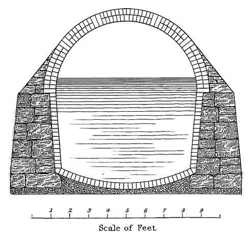
F. B. Tower.
Gimber.
II
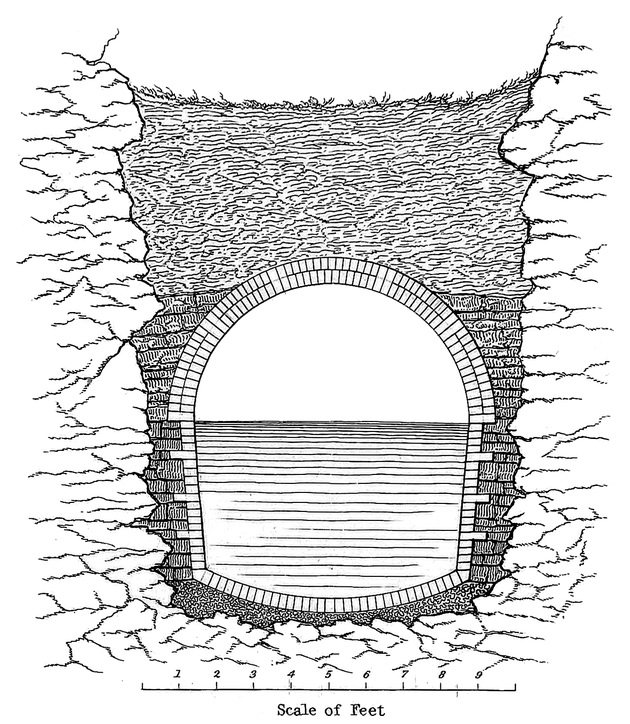
F. B. Tower.
Gimber.
III
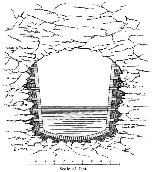
F. B. Tower.
Gimber.
IV
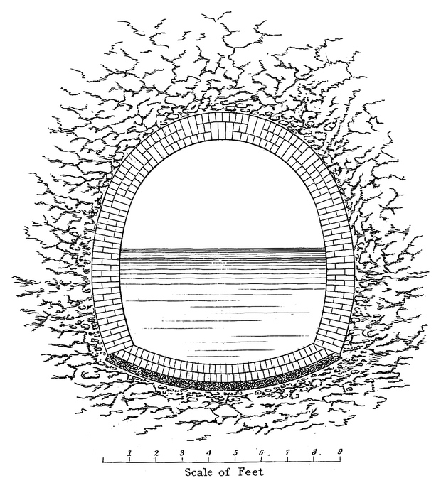
F. B. Tower.
Gimber.
Plate II. is a section of the Aqueduct in open cutting in rock.
After the rock has been excavated to the required depth and width, the bottom is levelled up with concrete to the proper height and form for the inverted arch of brick, which is laid in the manner before described for earth excavation. The side walls of stone and brick are bonded together by headers of brick entering the stone walls as shown in the drawing, and the walls of stone are built closely against the sides of the rock and forming a junction with it. On the exterior of the roofing arch a heavy spandrel of stone masonry (of the same character as the stone walls beneath it) is built, filling the space between the arch and the rock. After the masonry is finished, the rock cut above it is filled with earth to the same height above the roofing arch as mentioned for earth excavation.
Plate III. is a section of the Aqueduct in tunnel cutting in rock.
The width of the tunnel excavation in rock is the same as that of open excavation in rock; and the manner of building the masonry to form the channel-way is the same, with the exception that the rock roof of the tunnel serves as the roof of the channel-way, where it is sound, but in cases where the rock is soft and liable to fall, a brick arch is built over the channel-way, and the space between its extrados, or outer surface, and the rock roof is filled with earth closely rammed in. In some instances where the tunnel perforated rock which was at first quite hard, the roofing has by exposure to the air, become soft and insecure, so as to render it necessary to turn an arch for its support. This is attended with inconvenience and some difficulty after the channel-way has been completed and closed through the tunnel.
Plate IV. is a section of the Aqueduct in tunnel cutting in earth.
When the earth is dry and compact, the excavation for the bottom and sides is made of a proper form to receive the masonry, which is built closely against it: the top is excavated sufficiently high to give room to turn the arch, and the space above is afterwards filled with earth closely rammed in. Where the earth is wet and there is difficulty in making it stand, the excavation is made larger, and props of timber and plank are used to support the top and sides until the masonry be completed; and the whole space exterior to the masonry is then compactly filled with earth.
86
Plate V. is a section of the Aqueduct showing the manner of constructing it across valleys, or where the natural surface of the ground falls below the plane of grade.
In such cases the Aqueduct is supported upon a foundation wall of stone laid dry, and formed by using large stones laid in positions to give proper bond, and to allow small broken stone to be closely packed in, filling up all the interstices so as to form a compact and uniform mass. The wall is generally allowed to stand some months after it is completed, before the masonry of the Aqueduct is commenced upon it, lest by this weight being placed upon it before it has found its bearing, it should settle and cause cracks in the masonry. That such settlement should in some instances occur, even after the Aqueduct is completed, is not surprising, for passing over so many different elevations, and encountering such numerous transitions from a hard soil, or from rock, to valleys of alluvial deposit, it would be beyond human powers of foresight and vigilance to prevent it.
V
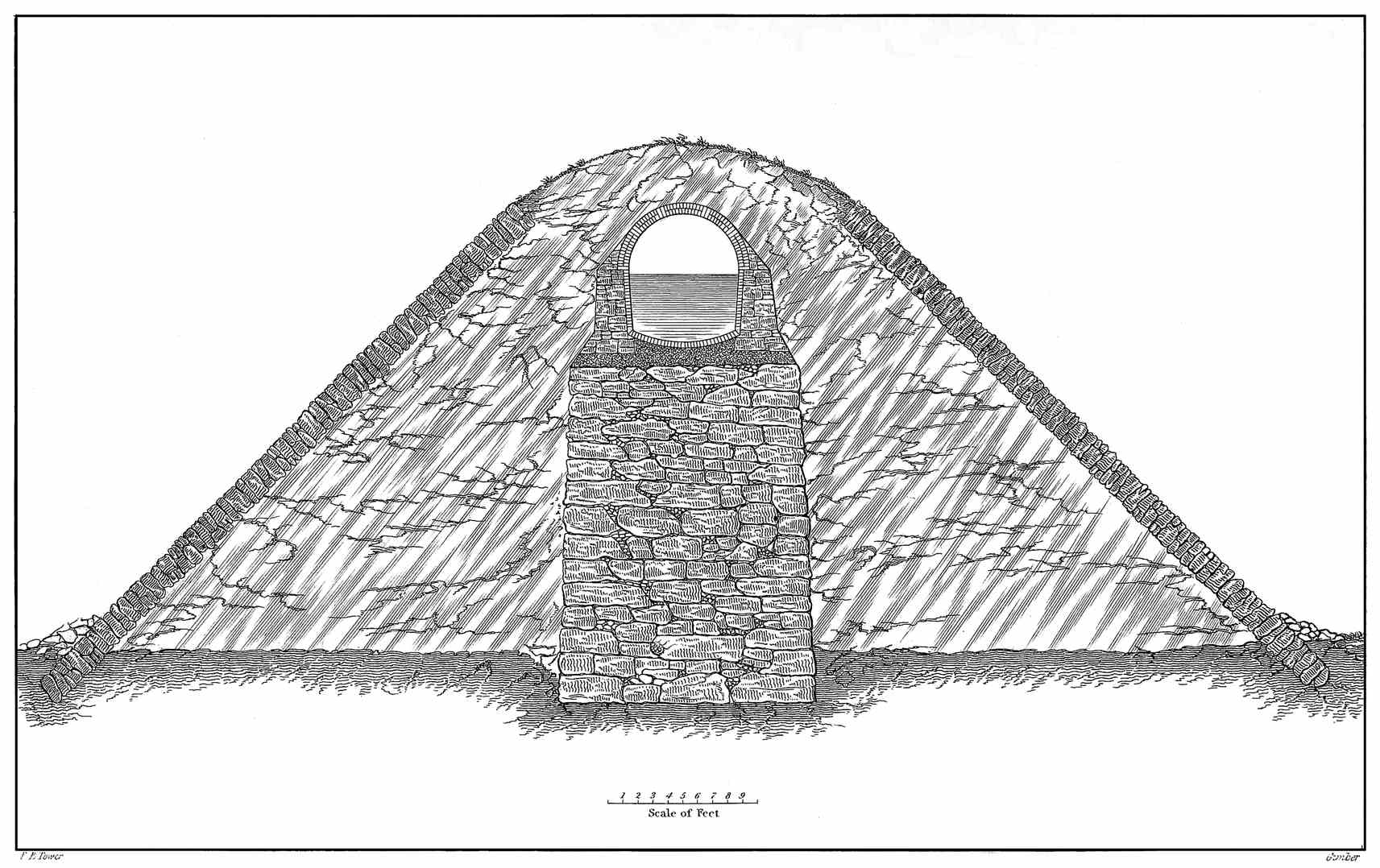
F. B. Tower.
Gimber.
To render the Aqueduct more secure in such positions, the concrete foundation has an increased thickness, and in preparing it a greater proportion of hydraulic lime is used; the proportion being two and a half parts of sand to one of lime. The dimensions of the stone side walls and the spandrel backing of the roofing arch, are also increased; and the proportion of hydraulic lime to the sand in the mortar for these is increased. Another precaution has been taken to render the work secure, by plastering the interior of the Aqueduct over these foundation walls. The embankment adjacent to foundation walls has various slopes according to circumstances, and is generally protected with a dry stone wall on the face, and is carried up of sufficient width to insure the requisite covering over the Aqueduct masonry.
Along side hills an excavation is made for the Aqueduct into the hill, and a protection wall of stone built on the lower side so as to support a covering of earth over the masonry; great care being taken to obtain a deep and firm footing for this wall in order to render the work secure. In such a position the Aqueduct is perhaps less secure than in those before described. Where the soil is wet from springs, and the formation clay, there is danger of slides; and in rainy seasons there is danger from the torrents which gather on the hill sides and come down with destructive force: the earth covering is liable to be carried away, and the Aqueduct itself to be undermined. Great care has, however, been used in such cases to form strong paved channels for the passage of the water over the top of the Aqueduct, or by culverts to pass it underneath.
At suitable places on the line of the Aqueduct, waste-weirs are constructed to discharge surplus water. They are constructed in one side of the channel-way, in such manner as to allow the water to flow off when it rises above a given level, and arrangements are also made at these places to close the channel-way entirely, by means of stop planks, and to discharge the whole of the water through waste-gates; so that the water might be running from the Fountain Reservoir through a portion of the Aqueduct and discharging88 from these waste-weirs while the remainder of the channel-way, or portions of it, would be drained so as to admit of inspection or repairs. There are six of these waste-weirs constructed for the Aqueduct.
For the purpose of ventilation hollow cylinders of stone are erected over the top of the Aqueduct and rising about 14 feet above the surface of the ground, or earth covering. These occur every mile, and every third one is constructed with a door to afford an entrance to the Aqueduct.
Those allowing an entrance have an interior diameter of 4 feet, and the others have an interior diameter of 2 feet; each, however, slightly diminishing towards the top. An iron grating covers the top to prevent any thing being thrown in.
Plate VI. is a view of an entrance ventilator; this stands on one side of the Aqueduct, where the masonry of the side wall is enlarged for its base; we can descend from the door and gain an entrance to the channel-way by an opening in the side of the roofing arch. The sill of the door is about 12 feet above the bottom of the channel-way.
VI
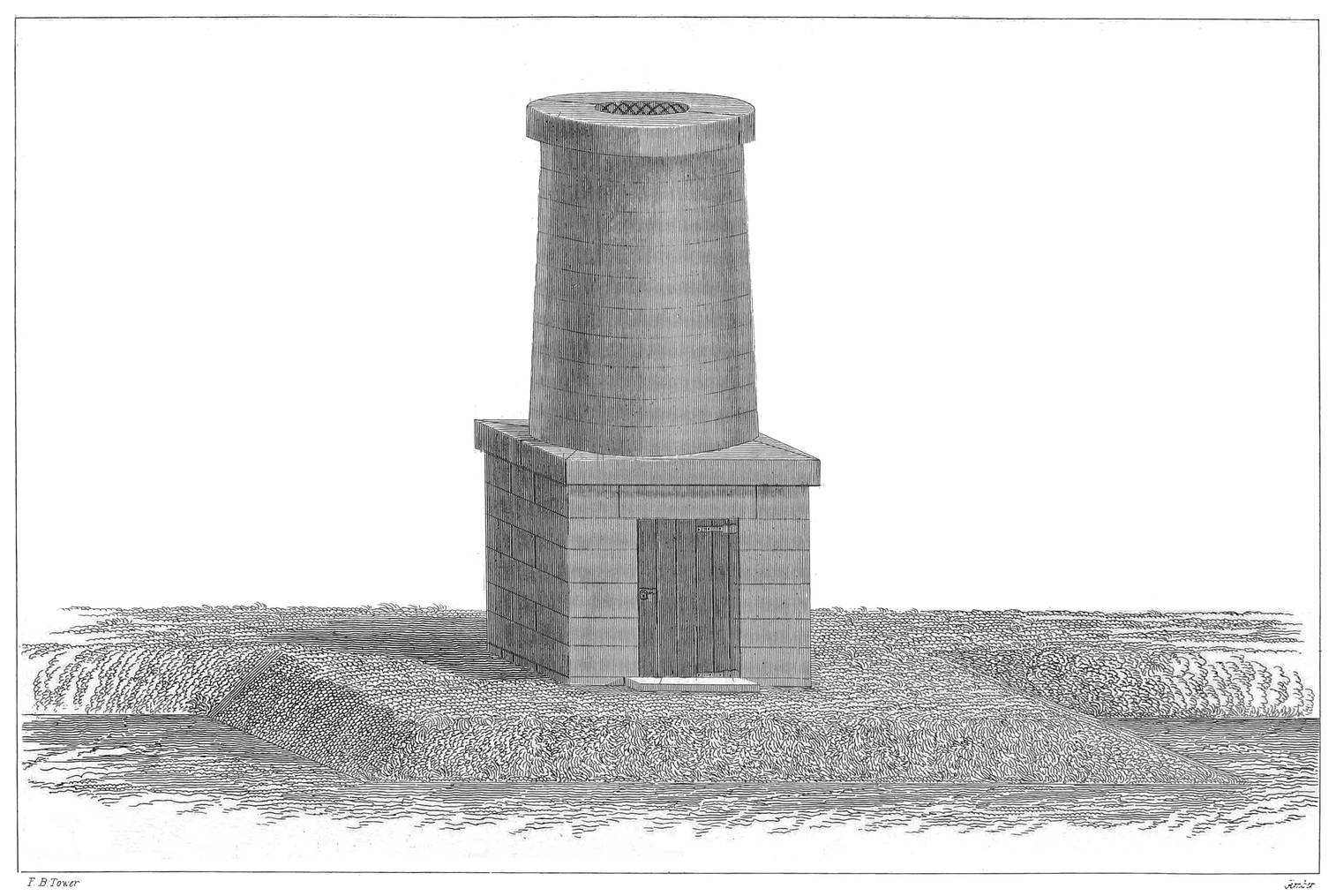
F. B. Tower.
Gimber.
ENTRANCE VENTILATOR
Those not intended for an entrance stand directly over the top of the Aqueduct and are groined into the roofing arch.
Besides these Ventilators, there are openings 2 feet square in the top of the roofing arch, every quarter of a mile: they are covered with a flag stone and the place is marked by a small stone monument projecting above the surface of the ground. These may be useful to obtain entrance to the Aqueduct, or to afford increased ventilation should it ever become necessary.
Where streams intersect the line of Aqueduct, culverts are built to allow them to pass under it. They are simply a stone channel-way built under the Aqueduct of such form and dimensions as will allow the stream to pursue its natural direction without causing injury to the work. The foundation of these culverts is formed by laying down concrete, upon which an inverted arch of cut stone is laid forming the bottom of the water-way: side walls of stone are built and surmounted by an arch of stone. The span, or width of water way, of the culverts built, varies from 1½ foot to 25 feet. Those of 1½ foot span have a square form for the water-way, and are constructed by making a foundation of concrete, upon which a flooring of well dressed stone is laid forming the bottom of the water-way, and from this, side walls are built and covered by a course of thick stone flagging well dressed and closely fitted. At each end of the culvert a deep wall is built underneath so as to prevent the water from doing injury by undermining it. Buttresses and wing walls are built at each end of the culvert to guide the water to and from the channel-way, and a parapet wall is built over the top of the channel-way at each end to sustain the embankment of earth over the culvert. These wing walls and parapets have various forms; sometimes the parapet is built across the top of the culvert, and the wing walls built at right angles to it, and sloping down to the buttresses,90 and sometimes the wing walls and parapet form one continuous wall of a semi-circular form, the top sloping up from the buttresses in a plane parallel with the slope of the embankment covering the Aqueduct above. These culverts are permanently constructed, and in preparing the plans for them much skill has been displayed in adapting the form and size which the circumstances required, and much taste displayed in the design for their construction.
Plate VII. is an isometrical drawing of one of the culverts with rectangular wings and parapets; the body of the culvert is cut in two in the drawing, showing that it may be of any length, according to the width of the embankment through which it is constructed. The length is generally arranged so that the slope of the embankment may intersect the rear of the top of the parapet and pursue a direction down, parallel with the slope of the top of the wing walls.
VII
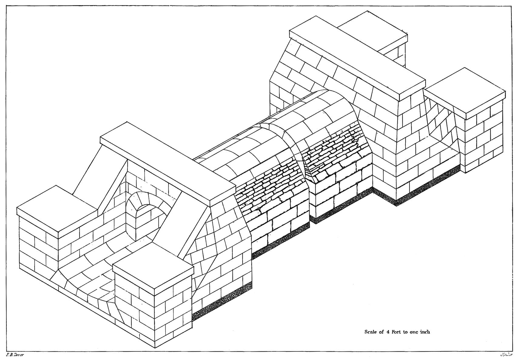
Scale of 4 feet to one inch
F. B. Tower.
Gimber.
Plate VIII. is a longitudinal section through the tunnel and gate chamber at the head of the Aqueduct showing its connection with the Fountain Reservoir. This gate chamber is not in any way connected with the dam itself, but stands some distance from it, and the water reaches it by means of the tunnel which leaves the Reservoir above the dam and passes through the solid rock of the hill against which the masonry of the dam is built, a distance of over 200 feet. This tunnel descends into the Reservoir, so that the centre of it at the mouth is about 12 feet below the surface91 of the water; any floating substance cannot enter it, and during the winter season when the water is frozen over no obstruction can take place to the flow into the Aqueduct, and during the summer season the water will be drawn from a level where it is cooler than at the surface.
The gate chamber has two ranges, or sets of gates; one called regulating gates, and the other guard gates: the regulating gates are made of gun metal, and work in frames of the same material which are fitted to stone jambs and lintels: the guard gates are made of cast iron, and work in cast iron frames also attached to stone jambs and lintels. The gates are all managed by means of wrought iron rods attached to them, having a screw formed on the upper part on which a brass nut works, being set in a cast iron socket-cap.
The bottom of the water way, of the Aqueduct, where it leaves the gate chamber is 11.40 feet below the surface of the Fountain Reservoir, and 154.77 feet above the level of mean tide at the city of New-York. The following table shows the length of the Aqueduct as it is divided into different planes of descent, from the gate chamber at the Croton dam to the gate chamber at the Receiving Reservoir on the Island of New-York. Commencing at the south side of the gate chamber at the Croton dam,
| The 1st plane of Aqueduct extends | 26099.72 ft. or 4.943 miles, and the descent | 2.94 ft. |
| The 2d plane of Aqueduct extends | 148121.25 ft. or 28.053 miles, | 30.69 ft. |
| Length of pipes across Har. River, | 1377.33 ft. or 0.261 miles. | |
| Diff. of level betw’n extremes of pipes | 2.29 ft. | |
| The 3d plane of Aqueduct extends | 10733.14 ft. or 2.033 miles, | 2.25 ft. |
| Length of pipes across Manhat. valley, | 4105.09 ft. or 0.777 miles. | |
| Diff. of level betw’n extremes of pipes | 3.86 ft. | |
| The 4th plane of Aqueduct extends | 10680.89 ft. or 2.023 | 1.60 ft. |
| 201117.42 ft. — 38.090 miles | 43.63 ft. |
92
Making the whole distance from the gate chamber at the Croton dam to the gate chamber at the Receiving Reservoir 201117.42 feet, or 38.09 miles, and the whole descent 43.63 feet.
The descent on the first plane is about 7⅛ inches per mile.
The descent on the second and third plane is about 13¼ inches per mile.
The descent on the fourth plane is about 9½ inches per mile.
In crossing Harlem River there is a fall of 2 feet more than there would have been had the Aqueduct continued across with its regular inclination: this extra fall will afford an opportunity to adjust the number and capacity of the pipes (which descend below the level of the Aqueduct and rise again) to discharge the full quantity of water as freely as the Aqueduct, or channel-way of masonry, would have done had it continued its regular inclination across the valley.
In crossing Manhattan Valley there is an extra fall of 3 feet for the same reasons as before stated for that at Harlem River. In both cases, by using the pipes, there is a loss of the head of water for the City Reservoirs, equal to the amount of this extra fall; but this small loss of head was not considered of such importance as to induce the building of structures across these valleys up to the plane of Aqueduct grade.
VIII
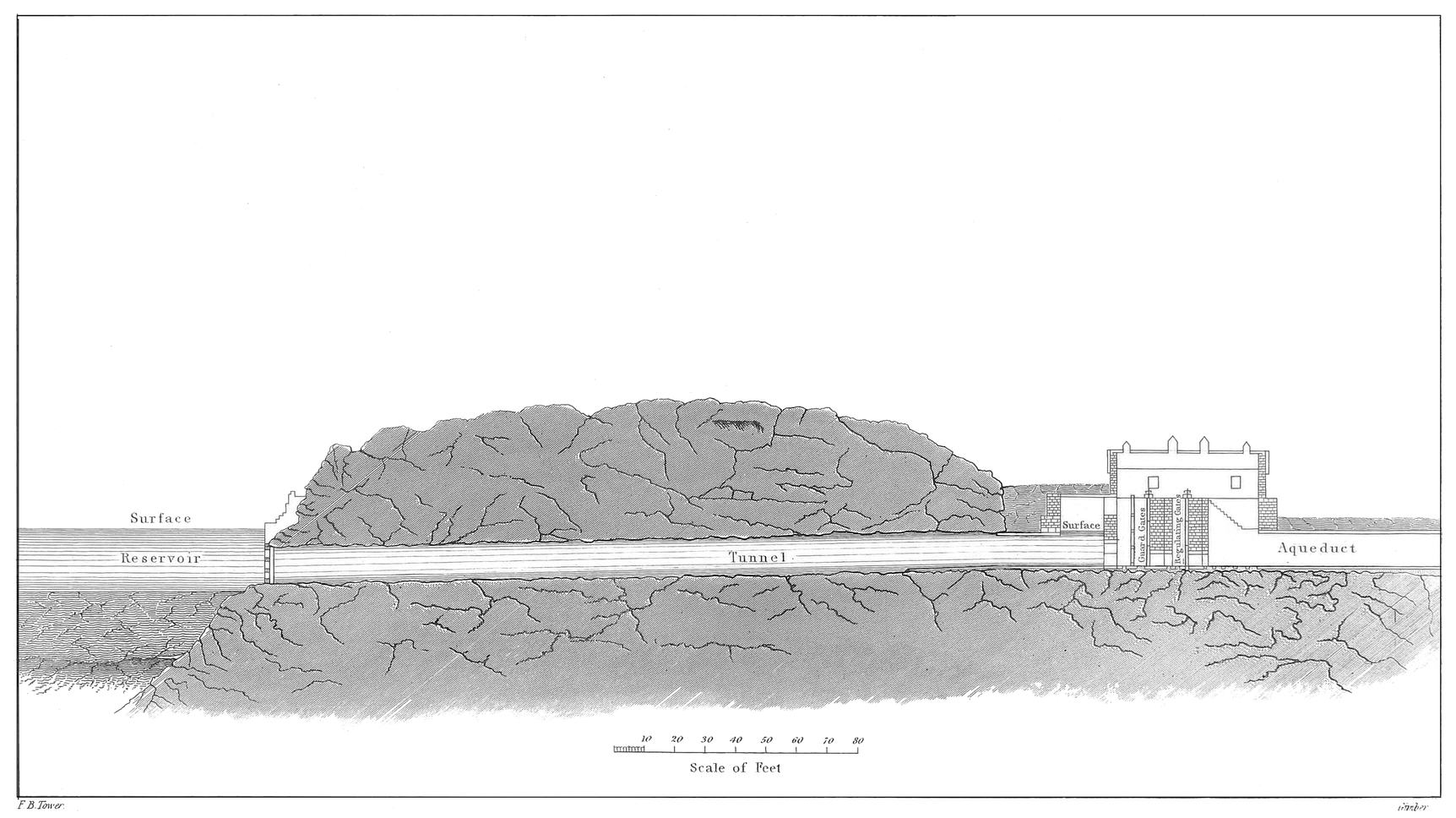
F. B. Tower.
Gimber.
The bottom of the water-way of the Aqueduct at the gate chamber where it enters the Receiving Reservoir, is 7.86 feet below the level of top water line in the Reservoir, thus when the Reservoir is full the water will rise to within 7¼ inches of the top of the interior of the Aqueduct at that place, and the height from top water to the top of the interior will increase, going northward according to the inclination of the plane of Aqueduct grade, until it reach the surface level of the flow of water in the Aqueduct.
The height of the interior of the Aqueduct is 8 feet 5½ inches, and the greatest width is 7 feet 5 inches. The sectional area of the interior is 53.34 square feet. On the first plane, the Aqueduct is larger; being 2.05 feet higher at the gate chamber, 2.31 feet higher at 2244. feet from the chamber, and then diminishing, to the head of the second plane, where it assumes the size above mentioned and continues of that size throughout the remainder except in tunnels, where it assumes the forms before described. Where the Aqueduct on the first plane is larger, the width across the interior at the spring line of the roofing arch is the same as the general width, but the increase takes place only in the height of the side walls, and the slope of the inner face of the walls being the same, the width across at the spring line of the inverted arch will be less according to the increased height of walls. The original design was to continue the inclination which the second plane has, up to the Fountain Reservoir; but it was considered desirable to draw from this Reservoir at a lower level, and the head of the Aqueduct was depressed for that purpose, and a less inclination adopted for the length of the first plane. The roofing arch was left on the same inclination as was originally designed, except for the distance of 2244. feet from the gate chamber, where it was built on a level.
The curves which are used to change the direction of the line of the Aqueduct are generally formed with a radius of94 500 feet; some have a radius of 1000 feet, and in a few instances larger ones are adopted, but the majority of them are of 500 feet radius.
The velocity of the water in the Aqueduct has been ascertained to be about one mile and a half an hour when it is 2 feet deep; this was determined by floating billets of wood from the Croton Dam to Harlem River and noting the time of their passage. Such an experiment would express the surface velocity and would give a greater velocity than it would be proper to attribute to the whole body of water in the Aqueduct; but the depth of water in the Aqueduct will be probably 4 feet as soon as it is brought into general use, and then there will be a corresponding increase in the velocity of the body of water. This velocity of a mile and a half an hour may be taken in general terms as the velocity of the water in the Aqueduct.
IX

F. B. Tower.
W. Bennett.
VIEW ABOVE THE CROTON DAM.
95
The dam, built to form the Fountain Reservoir, is about six miles above the mouth of the Croton River. The reservoir forms a beautiful sheet of water in the lap of the hills in the wild region of the Croton, and has received the name of the “Croton Lake.”
Pine’s Bridge over the Croton River, which is mentioned in the early history of the country, occupied a position which is now about the middle of this Reservoir, and there is at that place a bridge over the Reservoir resting upon piers and abutments.
The hills which bound the Croton Valley where the Reservoir is formed are so bold as to confine it within narrow limits: for about two miles above the dam the average width is about one eighth of a mile; at this distance from the dam the valley opens so that for the length of two miles more the width is about a quarter of a mile; here the valley contracts again and diminishes the width until the flow line reaches the natural width of the River at the head of the lake. The country immediately contiguous to the shore has been cleared up, and all that would be liable to impart any impurity to the water has been removed. This gives a pleasing aspect to the lake, showing where the hand of art has swept along the shores leaving a clean margin. Retiring from the water are the richly cultivated slopes with the96 neat farm houses overlooking the lake, or the hills crowned with forest trees, while at intervals a valley or ravine opens and empties in its tributary stream.
Plate IX. is a view taken above the dam showing the position of the entrance to the tunnel which leads from the Reservoir to the gate chamber at the head of the Aqueduct. The entablature which is seen on the left against the rock, is built directly over the mouth of the tunnel, and from this the tunnel extends through the rock to the gate house, which is seen on the right of the picture and some distance from the dam. The structure which is seen in the centre of the picture and on the ridge of the dam is a gate house over a culvert which extends through the body of the dam; this culvert is 30 feet below the surface of water when the Reservoir is full, and has gates which are operated by means of rods which rise to the interior of the house. During low stages of the River the water which is not drawn off by the Aqueduct may pass through this culvert and allow none to pass over the dam.
The entrance to the tunnel is protected by a screen of timber work.
Plate X. is a representation of the entablature over the mouth of the tunnel, showing the inscriptions upon it, relating to the date of the commencement of the dam and its completion, the persons who had contracts for building it, and those having charge of the work during the time.
X
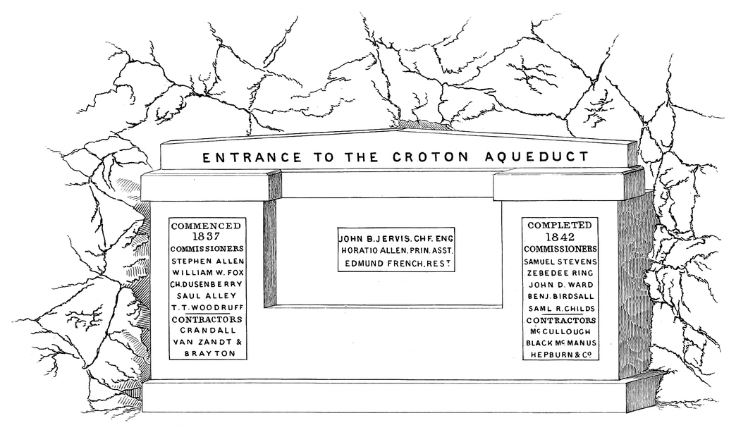
ENTRANCE TO THE CROTON AQUEDUCT
COMMENCED 1837
COMPLETED 1842
Plate XI. is a view taken from a point below the dam and shows the relative positions of the dam and the gate chamber at the head of the Aqueduct.
The original channel of the River where the dam is built, was about 120 feet wide; the average depth of water at this place was about 4 feet; and the greatest depth 10 feet.
The left bank of the river arose abruptly with rock, the channel was gravelly, and on the right bank a sandy table land about 3 feet above the ordinary surface of water extended about 80 feet; then a sandy hill arose on a slope of about forty-five degrees.
In making the plan for a dam at this place it was determined to fill the main channel and the table land on the right bank with an embankment of earth; and on the left bank where rock was found, to build a body of masonry against the slope to the requisite height for the surface of the Reservoir and connect it with the embankment in the channel; this masonry formed the overfall for the water, and the rock in the side of the hill adjacent to it was excavated down to the level of the overfall, thereby extending it into the hill, making the space for the water to pass over partly of masonry and partly of rock. The embankment extended with a slope on the upstream side giving it a broad base, and the lower or downstream side was faced with a heavy wall of stone. There was a timber pier constructed in the embankment extending across the channel and faced with plank on the upstream side. The overfall was made of such length as was thought sufficient to pass all the water of the river during its highest stages, and with the view of adapting it to such purpose, examinations were made to find the highest marks of floods on the banks of the river; and those who were engaged in determining these marks were guided also by the observations of the inhabitants of the vicinity who had long known the river in its various98 stages. High freshets were witnessed during the construction of the work, for in the course of two years that the work was going up, all the various changes and freshets of rainy seasons were experienced, and those in charge of it did not neglect to note the quantity of water flowing on such occasions.
XI
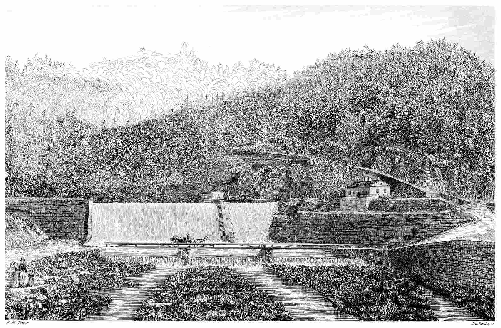
F. B. Tower.
Gimbrede. sc.
VIEW BELOW THE CROTON DAM.
With such opportunities to become acquainted with the changes of the stream they could not fail to know the quantity of water flowing at periods of the highest freshets, and knowing it, to adapt an overfall of sufficient capacity for its discharge. For this purpose it was thought ample provision was made; yet at the time when the work was nearly completed such a flood occurred as could not have been anticipated from previous knowledge of the River; the water filling the entire passage at the overfall, flowed over the top of the embankment where it was not supposed it could ever reach. The lower slope of this embankment was covered with a wall not calculated to resist the action of the water and it gave way; the water broke through the embankment and rushed along the valley with most disastrous consequences. The breach occurred at an early hour in the morning; and many persons were suddenly aroused from their sleep to escape before the approaching waters. Dwelling-houses and mills were carried away and three lives were lost. Two of those who were drowned had taken refuge in the tops of trees, but these being swept away they were drowned; while others who were not able to reach the main land, but had also taken refuge in trees, were saved. The change wrought by the flood, in the appearance of the country, was truly wonderful and the destruction was complete. Night had closed over that valley where all was happiness and quiet, but day opened upon a scene of desolation. The fertile fields were torn up and covered with masses of stone and gravel, and the flood left marks of its fury far up on the hill sides.
At the commencement of the rain which caused this flood, the ground was covered with snow to the depth of eighteen inches: the weather became warm and the powerful rain storm continued incessantly for forty-eight hours. Notwithstanding the immense volume discharged at the overfall of the dam, the water was rising, during the night previous to this disaster, at the rate of fourteen inches per hour over the Reservoir, covering an area of four hundred acres.
It occurred on the 8th of January, 1841.
In repairing the breach it was decided to build an extension of solid hydraulic masonry in the place of the portion of embankment which was carried away.
The gate house and wing wall, which is seen on the ridge of the dam, shows where the masonry of the original structure connected with the embankment which extended across the river. The whole length of the overfall is 251 feet. Access to the house over the culvert, is gained by a foot bridge which is seen in the picture. The masonry of the original structure has a rock foundation, and the extension of the overfall which is seen on the left of the house extending across to the embankment has an artificial foundation of concrete.
The masonry of the dam is about 8 feet thick at the top and 65 feet at the base; it is built in a vertical form on the upstream side, with occasional offsets, and the lower face100 has a curved form such as to pass the water over without giving it a direct fall upon the apron at the foot; this apron is formed of timber, stone, and concrete; and extends some distance from the toe of the masonry, giving security at the point where the water has the greatest action. A secondary dam has been built at a distance of 300 feet from the masonry in order to form a basin of water setting back over the apron at the toe of the main dam so as to break the force of the water falling upon it. This secondary dam is formed of round timber, brush wood, and gravel; it may be seen in the picture directly under the bridge which extends across below the main structure.
On the upstream side of the masonry of the dam, an embankment of earth is filled in, extending 275 feet from the masonry at the base, and extending from the masonry with a slope of 1 foot in 5 on the top.
XII
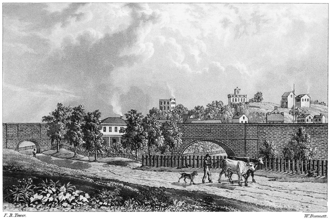
F. B. Tower.
W. Bennett.
CROTON AQUEDUCT AT SING SING.
The whole work about the dam possesses great interest, and though it be distant from the city and somewhat difficult of access, will not fail to please those who may take time to visit it. Just above the place where the dam is constructed the River had a bold turn and flowed along at the foot of a steep and rugged bank. A road passed along at the base of this hill leading to a mill which was situated at the turn of the River, before mentioned; a substitute for this road, which was submerged, has been made along the hill side passing on the right of the gate house. Enough of the forest has been cleared away to admit of the construction of the work, but the place still possesses much of its original wildness, and to see such beautiful mechanical work standing against the rude rocks,—to observe what changes have been wrought in the form of this rock to render it subservient to the purposes of the work, makes us feel that there has been a strife there; but it all shows that art has gained the ascendency.
The form which has been adopted for the face of the extension of the overfall is a reversed or double curve which would be easily recognized as Hogarth’s line of beauty: the overfall for the original dam has a plane face with a curve at the base.
Walks are formed about the work bordered with grass, giving a neatness and finished appearance to the whole; and every thing in connection seems to indicate that the vicinity of the Croton Dam will be one of the resorts in summer seasons for the citizens of New-York. From the Croton Dam the Aqueduct passes along the left side of the valley of the Croton River until at the mouth of this river it reaches the left bank of the Hudson, which it pursues, keeping at a distance of nearly half a mile from the River, until it arrives at the village of Sing-Sing, which is eight miles from the dam. In the course of this distance the Aqueduct passes through four tunnels and encounters many valleys and ravines where high foundation walls were required, and culverts for the passage of the streams.
At the village of Sing-Sing there are two Aqueduct bridges; one over a public road-way, and the other over the Sing-Sing Kill. These bridges and the adjacent work form a very interesting point on the line of Aqueduct.
Plate XII. is a view of the Aqueduct at this place: at the left of the picture may be seen the bridge over the road, and on the right that over the Kill. The bridge over the road has a span of 20 feet, and the direction of the road-way being102 not at right angles with the line of Aqueduct required the arch to be built askew; the arch lies in the direction of the road-way, having the ends in planes parallel with the direction of the Aqueduct. This bridge is worthy of notice, but public attention is more generally directed to the larger one: that has an arch of 88 feet span and a rise of 33 feet; the form of the arch is elliptical, being a compound curve drawn from five different centres, or radius points. The Kill, or valley over which this arch stands, is a deep narrow gorge worn by a small stream which empties into the Hudson River.
The bottom of the ravine is about 70 feet below the soffit or under side of the arch. Plate XIII. is another view of the large arch taken from the bottom of the valley near it, and shows the bridge which has been constructed for a public road passing under it, and the mill near by.
XIII
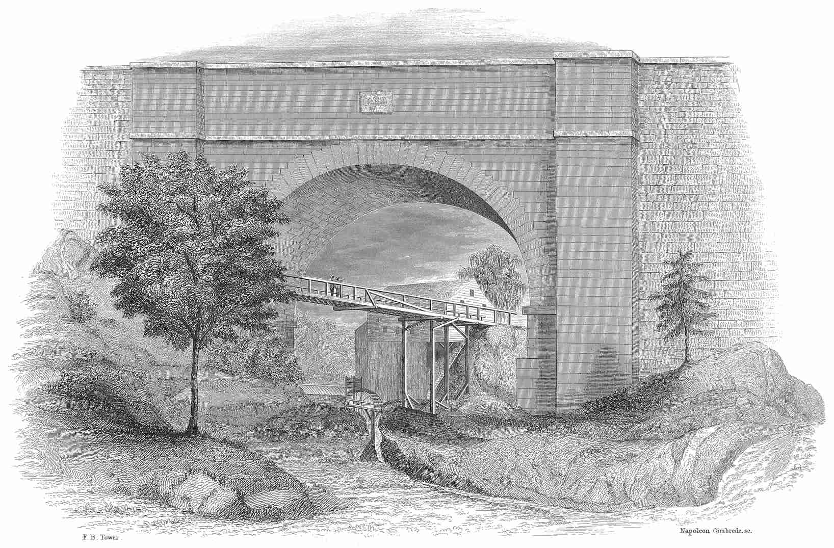
F. B. Tower.
Napoleon Gimbrede. sc.
AQUEDUCT BRIDGE AT SING SING.
This arch presents a singularly bold appearance, vaulting over the roadway and rising high up above the old mill, and what adds much to this boldness, is the narrowness of the arch, or small distance from one end of it to the other; being only 23⅓ feet long at the springing line while the span is nearly four times this length. The length of the arch diminishes towards the crown, the ends being in planes not vertical, but inclining towards each other at the top. Each end has a batter or inclination of one twenty fourth of its height, or half an inch to the foot. The arch is built of granite, is 3 feet thick at the crown and 4 feet at the spring or base. The abutments have a foundation of solid rock which was excavated in proper form to give them firm footing. The whole structure presents a degree of stability which seems to defy the effects of time. The Aqueduct has a cast iron lining over this bridge (as it has over all of this character): it is formed of plates five eighths of an inch thick, put together with screw-bolts and nuts and the joints closely filled with iron cement. This lining is within the brick work of the bottom and sides of the channel-way, having four inches of brick outside of it and four inside. The object of it is to prevent any water dripping through the work, lest by any means it should fill the exterior masonry of the bridge with moisture and thus render it liable to injury from frost. Other precautions are taken in forming the masonry about the channel-way, to prevent this exuding, and the whole plan of the work shows foresight and precaution worthy of the highest praise.
From the Sing-Sing Kill the Aqueduct pursues a course along the east bank of the Hudson and the first work of peculiar interest is the Aqueduct bridge over the road from Tarrytown to Sing-Sing; before it reaches this place it passes through three tunnels, over high foundation walls, and encounters deep excavations.
XIV
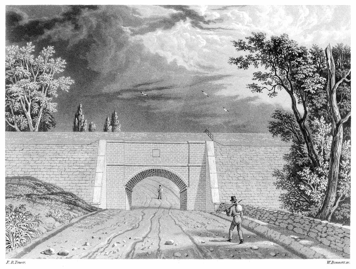
F. B. Tower.
W. Bennett. sc.
AQUEDUCT BRIDGE FOR ROAD WAY.
Plate XIV. is a view of this bridge: it is eleven and a quarter miles from the dam. The arch is 20 feet span and has a versed sine or rise of 5 feet. From this the Aqueduct passes on, encounters one tunnel, and reaches the valley of Mill River, twelve miles and three quarters from the dam. This River runs through Sleepy Hollow and enters the Hudson about a mile and a half above Tarrytown. The stream is 72 feet below the bottom of the Aqueduct, and the valley being of considerable width required a very heavy foundation wall.
104
Plate XV. is a view of the Mill River Culvert: it is 25 feet span and 172 feet long. It is about half a mile east of the road leading from Tarrytown to Sing-Sing, and to follow the course of the stream which passes through it, it is three quarters of a mile to the Old Dutch Church, near Tarrytown, which is well known, and familiar to every one who has read Irving’s “Legend of Sleepy Hollow.”
There is much of the wildness and beauty of nature about this place; the woods are standing close upon the work,—the stream which passes through the culvert displays its whitened crests as it tears along over the rocky bed, and utters its music until it is lost in the depth of the forest. The wild vines will soon climb the walls and cover them; vegetation will gather over the work until nature and art be harmoniously wedded.
XV
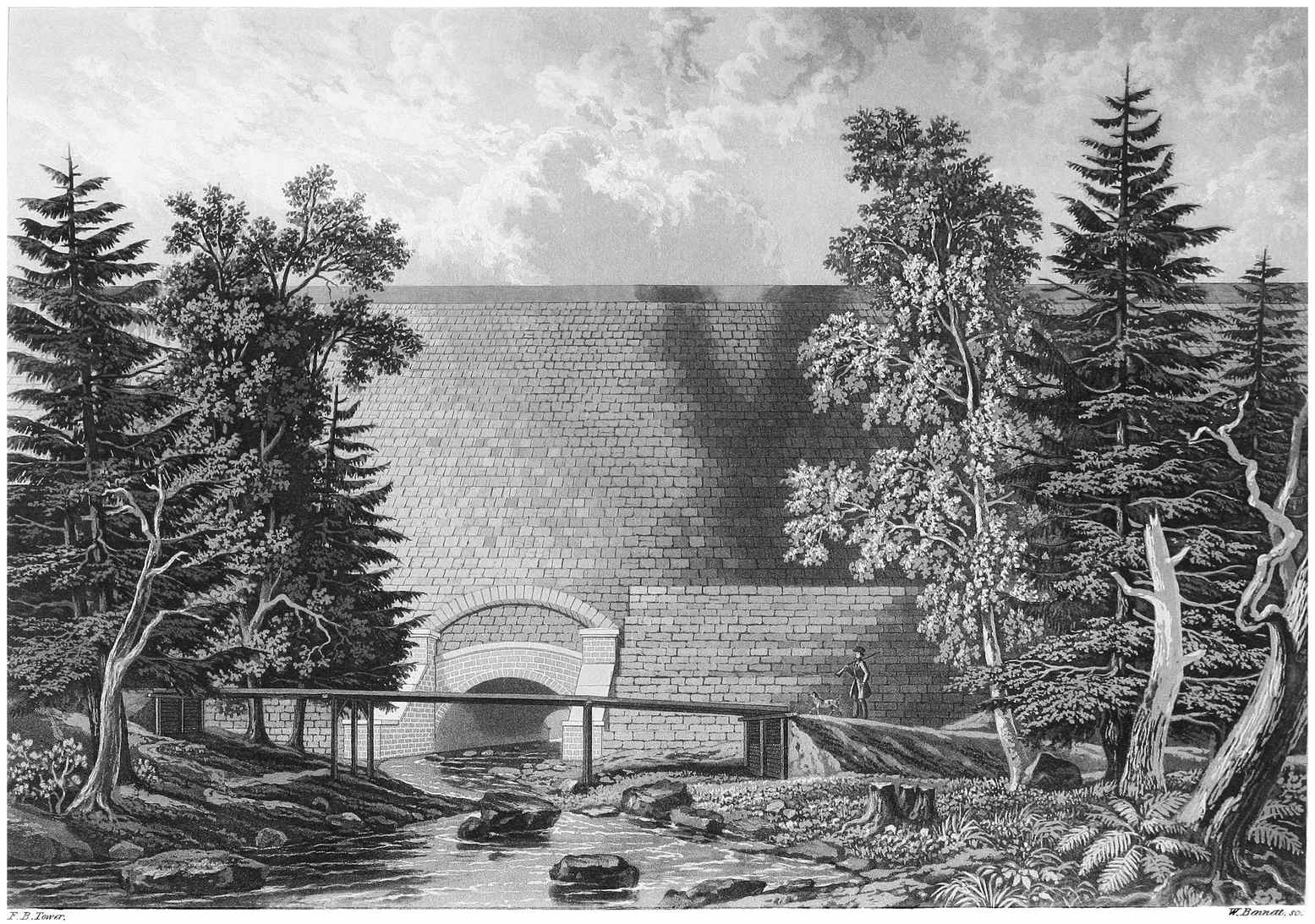
F. B. Tower.
W. Bennett. sc.
CROTON AQUEDUCT AT MILL RIVER.
From Mill River the Aqueduct passes the village of Tarrytown and through one tunnel and over several depressions and streams, reaching Jewell’s Brook which is seventeen and a half miles from the dam. This stream enters the Hudson River about two miles below Tarrytown. The distance from the mouth of the stream to the line of Aqueduct is only a quarter of a mile.
Plate XVI. is a view of the work at Jewell’s Brook. The culvert for the stream is 6 feet span and 148 feet long. The larger culvert for a private road is 14 feet span and 141 feet long. The wall which supports the Aqueduct at this valley is 50 feet high.
In this case, as in many others, the slope wall which covers the face of the embankment has an arch turned in it over the top of the culverts: the object of this is to prevent the direct pressure of the wall upon the top of the parapet wall, as it would tend to displace the coping or injure the parapet itself.
XVI
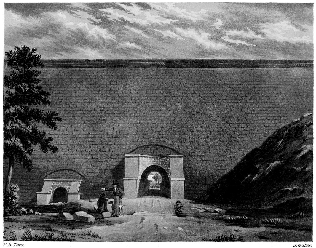
F. B. Tower.
J. W. Hill.
CROTON AQUEDUCT AT JEWELLS BROOK.
After crossing Jewell’s Brook the Aqueduct passes along the bank of the Hudson through the village of Dobb’s Ferry, where there is a tunnel and a valley requiring a culvert, and continues from this place to the village of Hastings, where there is an Aqueduct bridge over a rail-road which is used for transporting marble from the quarry near by, to the landing on the Hudson River.
Plate XVII. is a view of this bridge and the view under the arch shows the face of the quarry which is near the work; the landing at the river is near by, giving a very rapid descent from the quarry. The arch has a span of 16 feet and a rise of 1½ foot. This bridge is twenty-one miles from the dam.
From Hastings the Aqueduct continues along the bank of the Hudson until it reaches the village of Yonkers where it leaves the valley of the Hudson, and passing through a tunnel of considerable length reaches the valley of Saw-Mill River. At the crossing of this valley there is a culvert of 20 feet span for a public road to pass under the Aqueduct, and one having two arches each 25 feet span for the river.
Plate XVIII. is a view of the work at Saw Mill River.
The water is set back at this place by a dam for a mill a short distance below, giving the stream an appearance of more magnitude than it really possesses. This point is 25 miles from the dam. The wall which supports the Aqueduct over this valley is 40 feet high.
From Saw-Mill River the Aqueduct passing through one106 tunnel soon reaches Tibbit’s Brook, which it crosses by means of a foundation wall about 30 feet high and a culvert of 6 feet span, and continues along the south side of the valley of this brook, thence to the Harlem River which it crosses at one mile from McComb’s Dam. This crossing is thirty-three miles from the Croton Dam, and about ten miles from the City-Hall.
The distance across this valley is about a quarter of a mile, and the surface of the River is 120 feet below the bottom of the Aqueduct.
In all the examinations which were made with a view of bringing water from Westchester County, the crossing of this River, or arm of the sea, was regarded as the most formidable work that would be encountered; various plans were proposed, and in presenting these plans the project was such as to call into requisition much talent and skill.
An Aqueduct Bridge built of stone, having arches resting upon piers and abutments, was proposed so as to continue the Aqueduct across with its regular inclination.
An Inverted Syphon of iron pipes was proposed; the pipes to descend to a level near the surface of the River, and passing along upon a stone embankment rise again and connect with the Aqueduct: in this stone embankment an arch was to be built of sufficient dimensions to allow free passage of the water of the River.
XVII
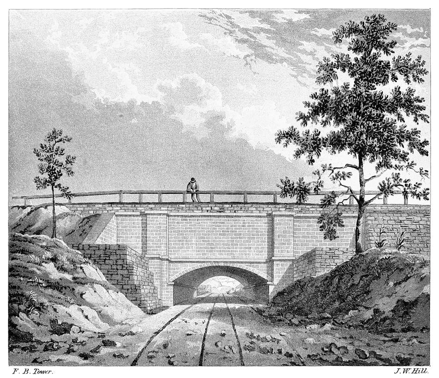
F. B. Tower.
J. W. Hill.
CROTON AQUEDUCT AT HASTINGS.
Another plan was proposed which, though novel in its application to such purpose, was worthy of consideration: this was to build a Suspension Bridge of wire cables reaching across the valley, supported at intervals upon suitable stone piers. This, maintaining the regular inclination of the Aqueduct, would support iron pipes. The design was a bold one, yet instances where such bridges have been constructed for road-ways afford examples of the feasibility and permanency of the structures, and prove that the application of that principle for this purpose was not a visionary project.
The plan which was adopted as the most suitable under all the considerations of economy and security to the work, was a Low Bridge to support an inverted syphon of iron pipes; and the design of it was as follows: adjacent to the southern shore of the river there was to be constructed an arch for the channel of the river, of 80 feet span and springing from abutments 10 feet above high water level; this would form a passage of 80 feet wide, and the height from high water level to the under side of the arch at the crown would be 50 feet: south of this arch followed three other arches on the slope of the rocky hill, of 35, 30, and 25 feet span: south of these arches a foundation wall was designed to continue the plane of inclination to the level of the Aqueduct. From the large arch to the northern shore of the river an embankment of stone was designed for the support of the pipes, and from this wall the table land on the northern shore and the slope of the northern side of the valley, would be excavated to a form to give the proper position to the pipes descending from the Aqueduct. The lowest level of the top of this stone embankment was designed to be 4 feet above flood tide. Suitable parapet walls were designed to be built along the sides of the embankment to sustain a covering of earth over the pipes. With the form which was given to this inverted syphon, four pipes, each of 3 feet interior diameter, were found to give a discharge of water equal108 to that of the Aqueduct of masonry on the established inclination.
In accordance with this plan of the Low Bridge the work for crossing the River was put under contract and some progress made in its execution, when a law was passed by the Legislature of the State requiring, instead of this, a structure, the arches of which should be (over the channel of the river) at least 80 feet span and having a distance of 100 feet from the level of high water to the under side of the crown; or to go under the channel of the river by a structure which should not rise above the bed, and that would leave the present channel unobstructed. At this time when the work was going on vigorously, they were compelled to abandon the plan which had been adopted, and devise one which would comply with the requirements of the law of the Legislature. A comparison was instituted between the plan of a tunnel under the bed of the river and that of a bridge of masonry at the required height above the river.
The tunnel would be at least 300 feet long and the top of the masonry forming it, would be 18 feet below high water level. In this tunnel the iron pipes would pass under the River and would be protected from the salt water.
XVIII
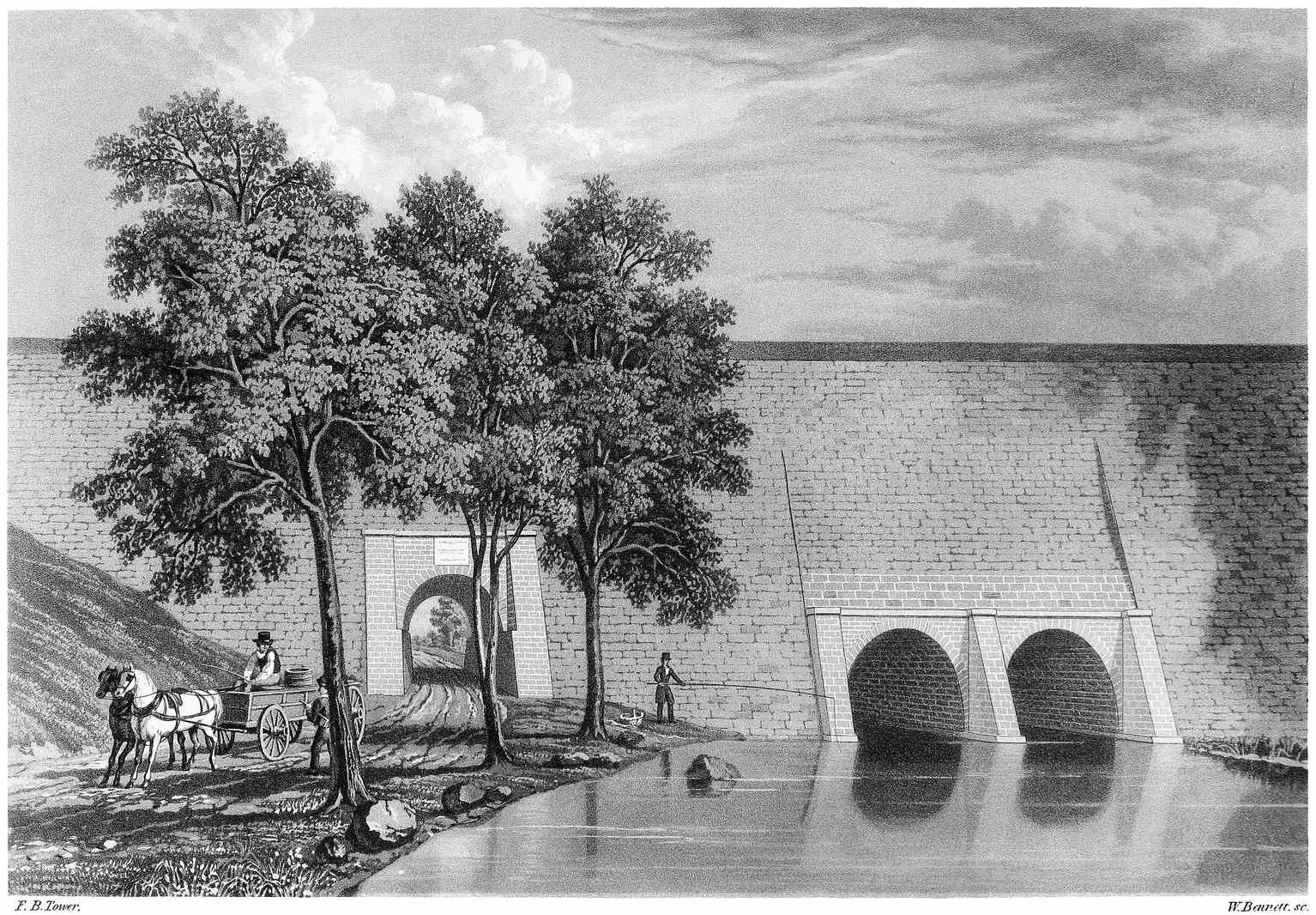
F. B. Tower.
W. Bennett. sc.
CROTON AQUEDUCT AT YONKERS.
An estimate of the cost of crossing by means of each plan was made, and the result was in favor of the tunnel under the bed of the River; but from the imperfect knowledge which could at best be obtained of the formation of the bed, there was great uncertainty in the estimate of the cost of the tunnel and the time that would be required for its completion. The history of the progress of work in the tunnel under the Thames at London warned them of the difficulties of such a work and the uncertainty of arriving at a proper estimate of the cost.
In the alternative to which they were driven by the Act of the Legislature, the plan of an Aqueduct bridge of masonry was adopted as the proper one for crossing the River; but in establishing its altitude they complied only with the requisitions of the law, and made the soffit or under side of the arches at the crown, 100 feet above common high water level. This would not carry the work up to the level of the Aqueduct, and would render it necessary to connect the Aqueduct on each side of the valley by iron pipes which would descend to the level of the bridge and crossing it rise again to the masonry channel-way. The plans which were before spoken of for a bridge of masonry across this valley, contemplated a structure which would maintain the regular inclination of the Aqueduct; and the channel-way would have been formed of masonry having a cast iron lining; but a more full consideration of the subject suggested the propriety of using iron pipes over the bridge, even if it had been carried up to the grade plane of the Aqueduct: when the use of iron pipes was determined upon, then considerations of economy induced them to build the work only high enough to comply with the requirements of the law.
The plan which has been adopted for building an Aqueduct bridge across this valley is as follows: on the south shore of the river there is one arch of 50 feet span, across the river there are eight arches, each of 80 feet span, and on the north shore there are six arches each of 50 feet span; making a range of fifteen arches. From the extremes of110 this range of arches, a foundation wall of dry stone work connects with the Aqueduct.
Two of the piers in the river have a rock foundation and the foundations for those where rock is not obtained is formed by driving piles which are placed 2½ feet from centre to centre, and the spaces between filled with concrete to a depth of 3 feet below the top of them.
Plate XIX. is a view of this bridge, which, when completed, will be the most interesting work on the whole line of Aqueduct, and in its appearance will rival the grandeur of similar works of the Ancient Romans. The height from the foundations in the river, to the top of the work is 150 feet; the width across the top is 21 feet. The pipes when laid upon the bridge will be covered with earth to protect them from frost. The distance between the extremes of the pipes when laid across the bridge will be 1377⅓ feet. For a distance of 18 feet at each end of the pipes there is an inclination and the remainder of the distance across, which is 1341⅓ feet, they are level.
The bottom of the interior of the pipes on the level part, is 12-8/10 feet below the bottom of water way of the Aqueduct on the north side, and 10-5/10 below that on the south side of the valley.
In the progress of excavating in one of the coffer dams in the channel of the river a portion of a sunken vessel was found within the enclosure; it had the appearance of great age. Tradition among the inhabitants of the vicinity says that at an early period of the Revolutionary war a vessel was scuttled and sunk in that part of the river.
XIX
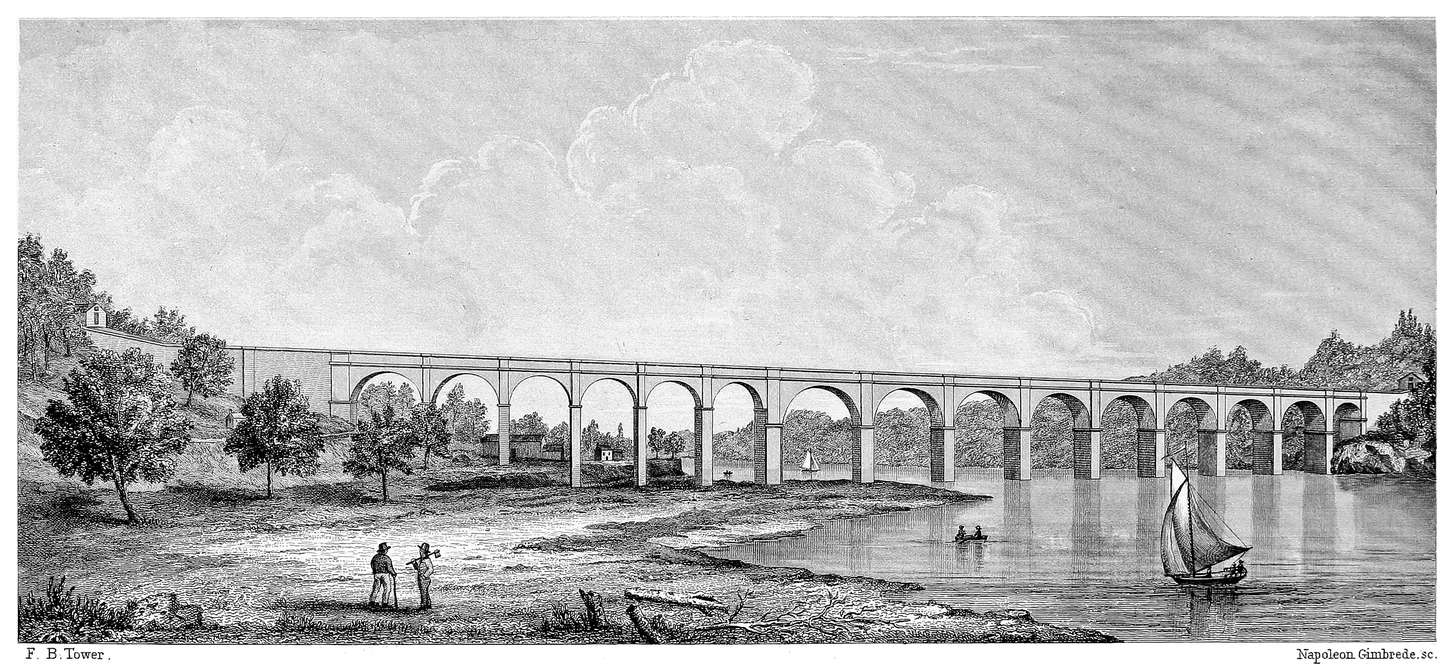
F. B. Tower.
Napoleon Gimbrede. sc.
CROTON AQUEDUCT AT HARLEM RIVER.
To a mind fond of antiquarian researches and accustomed to invest objects of such a nature with associations of the past, this ancient wreck would furnish a fruitful theme. We are now laying the foundation of a magnificent work: at the day when this vessel was sunk the American people were laying the foundation of a new form of government composed of principles which should support a fabric of enduring strength and beauty. We are now building a work which will stand as a monument of the genius and enterprise of the age, but it may be regarded among the fruits of that civil and religious liberty which has been reared upon the foundations formed by the people of that day.
The water is now conveyed across this valley by an iron pipe of 3 feet interior diameter. In the progress of preparing foundations for the piers of the bridge, an embankment has been formed across the River and the pipe leaving the Aqueduct on the north side of the valley follows down the slope of the hill, and crossing over the River upon this embankment, ascends on the south side again to the Aqueduct. At the bottom or lowest point in this pipe, a branch pipe of 1 foot diameter has been connected, extending a distance of 80 feet from it at right angles and horizontally: the end of this pipe is turned upwards to form a jet, and iron plates are fastened upon it giving any form that may be desired to the water issuing. The level of this branch pipe is about 120 feet below the bottom of the Aqueduct on the north side of the valley; affording an opportunity for a beautiful jet d’eau;—such an one as cannot be obtained at the fountains in the city. From an orifice of seven inches diameter the column of water rises to a height of 115 feet when there is only a depth of 2 feet of water in the Aqueduct.
112
To those who had watched over the work during its construction and looked for its successful operation, this was peculiarly gratifying. To see the water leap from this opening and rise upwards with such force and beauty, occasioned pleasing emotions and gave proof that the design and construction of the work were alike faultless, and that all the fondest hopes of its projectors would be realized.
The scenery around this fountain added much to its beauty; there it stood,—a whitened column rising from the river, erect, or shifting its form, or waving like a forest tree as the winds swayed it, with the rainbow tints resting upon its spray, while on either side the wooded hills arose to rival its height: all around was of nature; no marble basin,—no allegorical figures, wrought with exquisite touches of art to lure the eye, but a fountain where nature had adorned the place with the grandeur and beauty of her rude hills and mountain scenery.
Plate XX. is a distant view of the jet at Harlem River.
From Harlem River the Aqueduct passes along the south bank of the River for a short distance where it rests in the side of the rocky hill, and continues over an uneven surface encountering two tunnels before it reaches Manhattan Valley, which is about 35 miles from the Croton dam. This valley is four fifths of a mile wide where the Aqueduct meets it, and the depression is 102 feet below the plane of Aqueduct grade.
XX
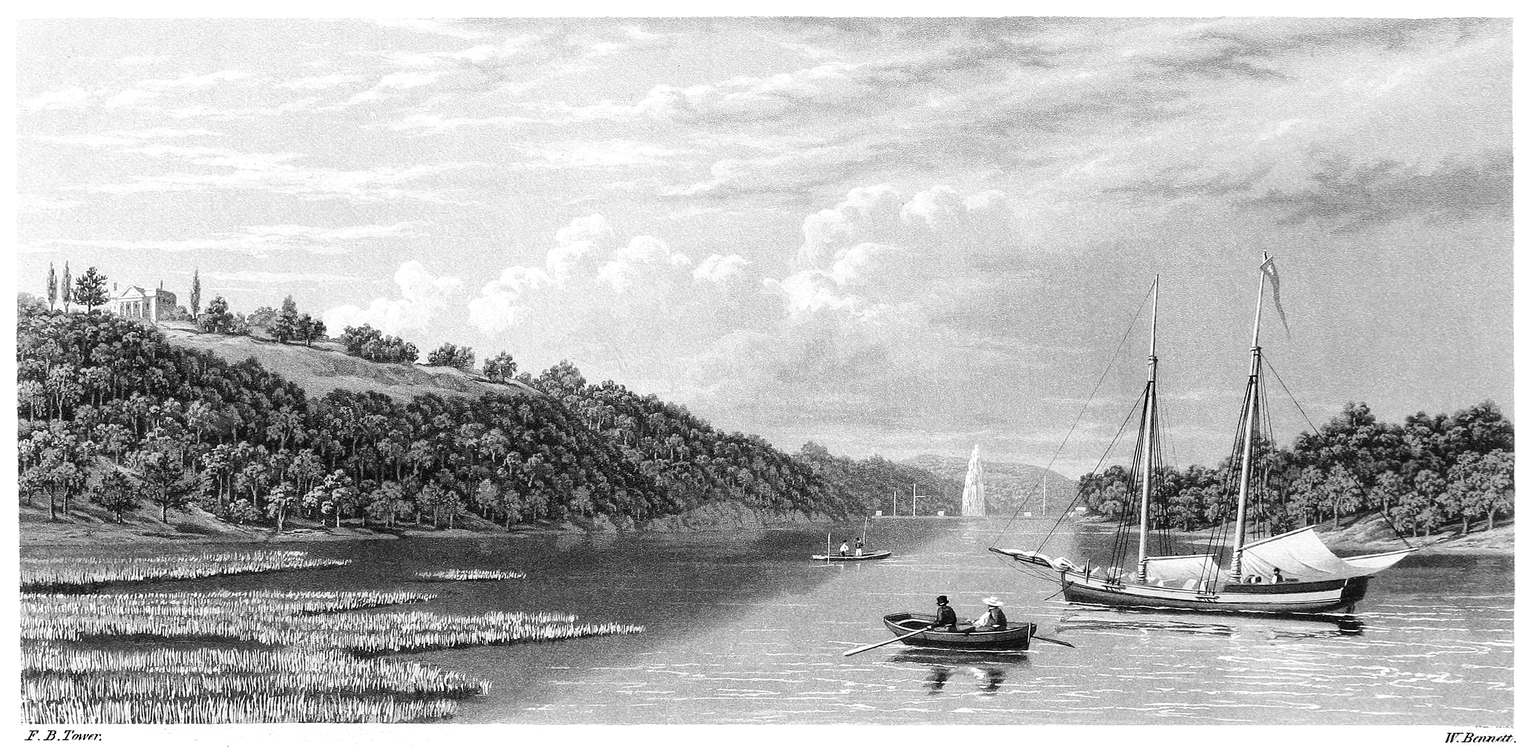
F. B. Tower.
W. Bennett.
VIEW OF THE JET AT HARLEM RIVER.
Here was an opportunity for constructing a work of architectural beauty and boldness by building up with arcades of arches, one line above another, and thus maintain the regular inclination of the Aqueduct; but considerations of economy forbade it. Where the Aqueduct reaches the north side of the valley, a gate chamber is formed, and from this, two pipes of 3 feet interior diameter descend to the bottom of the valley and ascend on the south side to another gate chamber where they connect with the Aqueduct again. Provision is made for four pipes of 3 feet diameter, but at present only two are laid which answer the demands of the city at this time. At the bottom of the valley waste cocks are provided which discharge into a sewer leading to the Hudson River, a distance of half a mile.
The lowest point in the pipes is 102 feet below the bottom of the water way of the Aqueduct on the north side of the valley.
From Manhattan Valley the Aqueduct passes through a tunnel, and following its course the next work of interest is at Clendinning Valley, which is thirty-seven miles from the Croton Dam. This valley is 1900 feet across, and the Aqueduct is supported upon a foundation wall of dry stone work having the face laid in mortar, except over three streets where bridges are built, having an arch of 30 feet span for the carriage-way and one on each side of 10½ feet span for the side walks. These bridges are over 98th, 99th, and 100th streets.
XXI
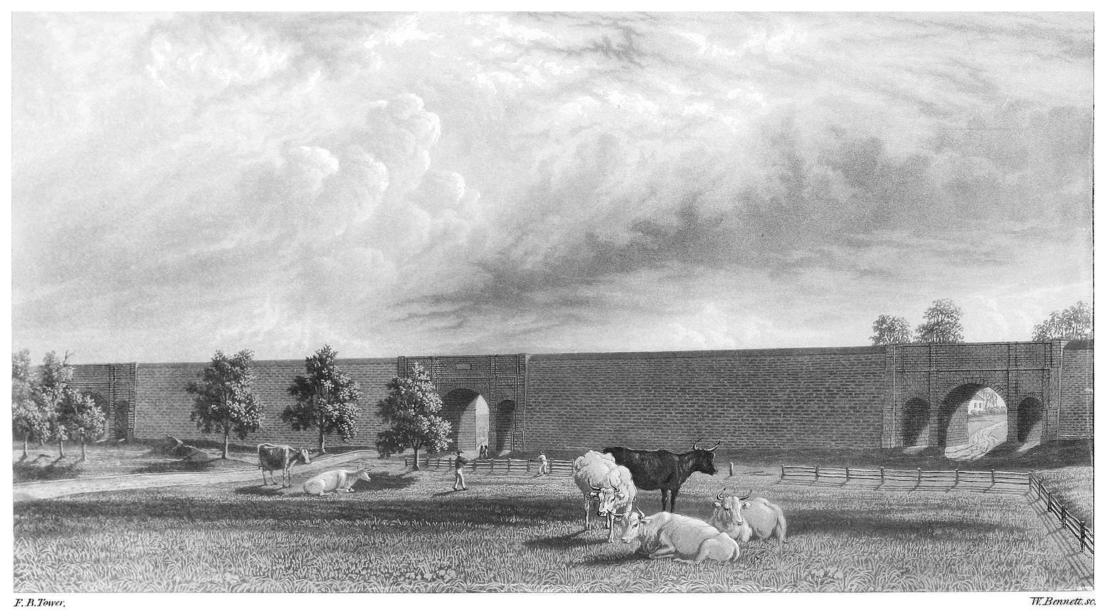
F. B. Tower.
W. Bennett. sc.
CROTON AQUEDUCT AT CLENDINNING VALLEY.
Plate XXI. is a view of a portion of the work at Clendinning Valley showing the three bridges; and comprises a length of about 700 feet.
The greatest height from the foundation to the top of the work is 50 feet, and the width at the bottom of the Aqueduct is 30 feet. Parapet walls are built on the sides of the wall above the bottom of the Aqueduct to support a covering of earth over it.
114
Plate XXII. is an enlarged view of one of the bridges and a portion of the foundation wall and Aqueduct adjacent to it. The Aqueduct has a cast iron lining over the bridges like that described at the Sing Sing Kill.
These bridges are beautiful specimens of mechanical work; indeed the whole structure across this valley has a degree of neatness, finish, and taste, not surpassed by any on the line of Aqueduct.
To visit this structure and follow along its whole extent, gives one an idea of the magnitude of the work which the City of New-York has accomplished; particularly when it is considered that this is only one of the parts which make up the whole.
From Clendinning Valley the Aqueduct soon reaches the Receiving Reservoir which is thirty-eight miles from the Croton Dam.
This Reservoir occupies an elevated part of the island between 79th and 86th streets and between the 6th and 7th Avenues. It covers seven of the city blocks; is divided into two divisions, one covering three and the other four of these blocks. It is 1826 feet long and 836 feet wide from outside to outside of the top of the exterior walls of the embankment, making an area of thirty-five acres.
XXII
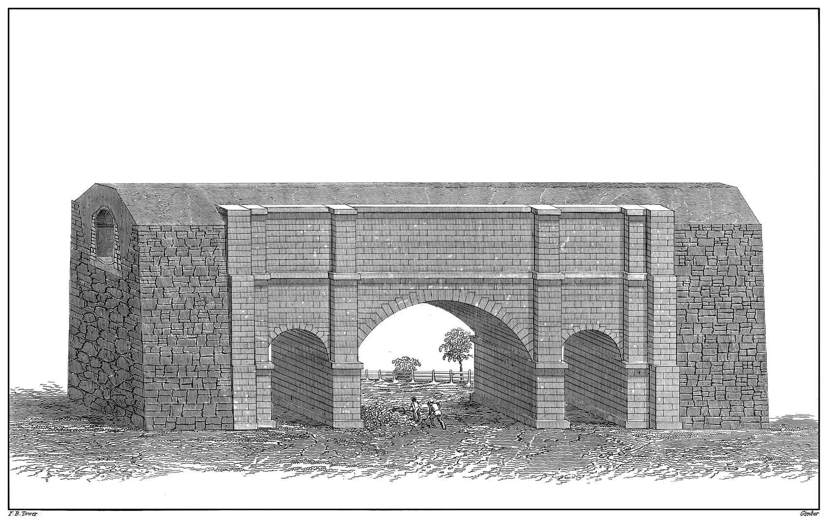
F. B. Tower.
Gimber.
AQUEDUCT BRIDGE AT CLENDINNING VALLEY.
The situation was chosen as one affording the proper elevation: but its formation was such as to present difficulties in the way of making the Reservoir perfectly water-tight; the surface, in tracing it from 79th to 86th street, was quite undulating, a portion of it in the southern division of the Reservoir falling below the proposed bottom, and that portion of the surface which was earth, forming only a covering to the rock, which over the whole island, presents a singularly broken and uneven formation. In almost every instance of excavation, the rock was found above the proposed bottom of the Reservoir, and the difficulty of preventing leakage along the surface of this rock may easily be conceived; but considering that measures are taken to prevent such an occurrence, another difficulty is still presented in the formation of the rock: the veins and fissures which are frequent in this gneiss formation would possibly afford courses for the water to escape; the rock being unsound in many instances, would render such an occurrence still more liable. A Reservoir has however, been constructed here which proved, when it was filled with water, that sufficient precaution was used to prevent leakage, and that the difficulties which presented themselves before the commencement of the work were no longer to be feared.
The embankments forming the Reservoir are made of good assorted earth, and a portion of the bank is puddled, or made compact and impervious by wetting the earth and using a spade to force it into a compact state. They are about 20 feet wide on the top, and increase in thickness towards the base by a slope on both sides: the outside face of the Reservoir bank has a slope of 1 foot horizontal to 3 feet vertical: the inside has a slope of 1½ foot horizontal to 1 foot vertical. The outside face is protected by a stone wall 4 feet thick having the face laid in mortar: the inside face is protected by a slope wall of stone laid without mortar, 1¼ foot thick. The top of the bank is 4 feet above top water line, and the inside slope wall terminates at 2 feet above top water line, leaving the remainder of the face to be covered116 with grass, so as to present a belt of green above the water on the bank entirely around the Reservoir.
A neat fence bounds the outside and the inside of the top bank, forming a walk of a mile in length around the entire Reservoir.
The greatest depth of water in the northern division is 20 feet: it was originally intended to excavate so as to give the water a depth of 20 feet over the whole, but a quantity of rock was left, as the capacity was thought to be sufficient without taking it out.
The southern division has 30 feet of water where the bottom was filled in with embankment, and 25 where excavation was made. A portion of rock was left in this division for the same reason as that in the northern division; the greater part of it being in the south-west corner, where it rises above top water line.
The capacity of the Reservoir when both divisions are full, is 150,000,000 Imperial gallons.
The surface of water in the northern division covers 18.13 acres, and in the southern division, 12.75 acres; making in both nearly 31 acres.
Plate XXIII. is a plan of the Receiving Reservoir.
The Aqueduct enters a gate chamber at A. where there are regulating gates by which the water can be discharged into the northern division; or into the southern division by a continuation of the Aqueduct within the Reservoir bank to the angle B. of that division.
XXIII
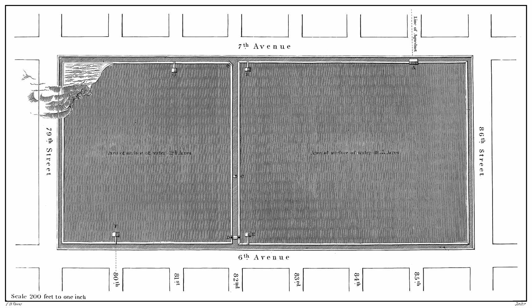
Scale 200 feet to one inch
F. B. Tower.
Gimber.
RECEIVING RESERVOIR
A connection pipe of cast iron is placed in the division bank at C. to allow the water to flow from one division into the other in order to equalize the level; it is placed 10 feet below top water line and has a stop-cock to close or open it.
At D. is a waste weir, where surplus water may pass off: it is so arranged that the water, when it rises to a proper level, will flow into a well, and from this a brick sewer conducts it off into low grounds, where it finds its way to the East River.
At each place where it is designed to discharge water from the Reservoir, a gate house is built far enough into it to reach the greatest depth of water beyond the slope of the embankment. These houses have a wall upon three sides, and the front which faces the centre of the Reservoir has a suitable screen of wood work and wooden gates which regulate the level below the surface for the current of discharge, and the iron pipes leading from these houses have a stop-cock by which the discharge is controlled; this stop-cock is in a vault within the Reservoir bank.
The position of these effluent gate houses is marked on the plan by the letters E, F, G, H, there being two in each division. A foot bridge affords convenient access from the bank to the house.
Those houses on the east side denoted by E, F, are the ones from which pipes lead to the lower or Distributing Reservoir, and those on the west side denoted by G, H, are intended for supplying the western part of the city north of the Distributing Reservoir.
There is a vault within the eastern bank to accommodate the pipes which leave the house E, and passing along, connect with those from the house F, and thence the pipes continue along 80th street and the 5th Avenue to the Distributing Reservoir. A vault within the west bank accommodates the pipe which leads from the house H, and intersects118 the one from G, passing out at 81st street; thus in this street a pipe draws from the southern division at G, and a branch of it passing along within the vault draws from the northern division at H.
Provision has been made on the east side of the Reservoir for supplying that part of the city when it becomes necessary.
At present there are two pipes leading from this to the Distributing Reservoir, each 3 feet interior diameter, and they are arranged that both may draw from the southern division, or one from that, and one from the northern division. The pipes are placed at a level below the bottom of the division from which they draw: the bottom of the interior of those from the southern division being 2 feet below, and that of those from the northern 5 feet below.
The exterior walls of this Reservoir present a face of rough-hammered masonry, finished in a manner to give them neatness and durability.
As a specimen of mechanical work, this Reservoir will not bear a comparison with the lower, or Distributing Reservoir, yet the sheet of water it presents, renders it an object of perhaps greater interest. This beautiful lake of pure water resting upon the summit of the Island is truly a pleasing object, and considering its size, is what no other city can boast of having within its limits.
The Distributing Reservoir is situated on the west side of the 5th Avenue between 40th and 42nd streets; it is two miles from the Receiving Reservoir, and about three miles from the City-Hall.
XXIV
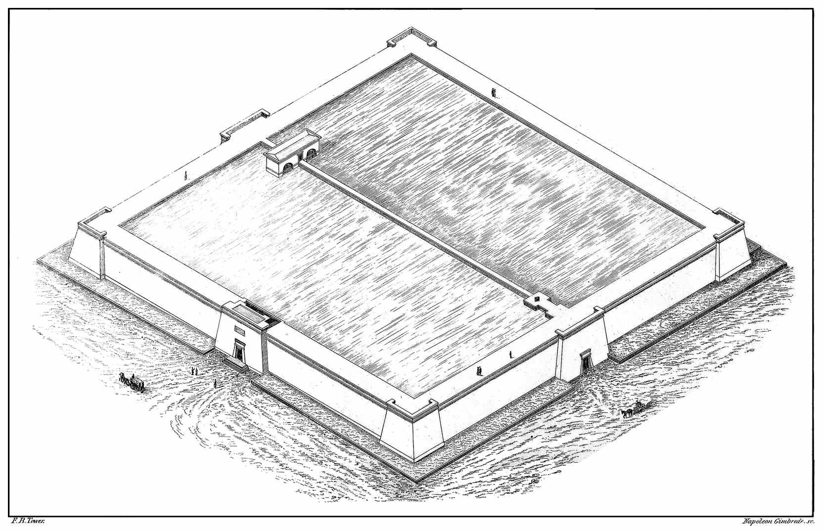
F. B. Tower.
Napoleon Gimbrede. sc.
DISTRIBUTING RESERVOIR.
The question may naturally be asked, why this Reservoir was built, when the receiving one, of such great capacity, is so near at hand? The reason for building it, was to obtain an efficient head of water near to the densely populated parts of the city, and had the formation of the island been favorable, the Receiving Reservoir would undoubtedly have been located farther down, bringing the store of water more nearly in the centre of the city.
Plate XXIV. is an isometrical view of the Distributing Reservoir showing the front on the 5th Avenue and on 42nd street.
The pipes which leave the Receiving Reservoir follow along the 5th Avenue until they reach 42nd street, where they turn and enter the Distributing Reservoir at the base of the central pilaster in that street, which in the drawing is shown on the right hand side. The pipes enter at the bottom of the Reservoir and the flow of water is regulated by stop-cocks: the door in the pilaster affords an entrance to the vault where these stop-cocks are situated. The Reservoir is divided into two separate divisions by a wall. It is designed to have three pipes, each 3 feet diameter, to lead from the Receiving to the Distributing Reservoir and arrangements are made to discharge water from two of them into one division of the Distributing Reservoir at a time, or the water may be divided into an equal supply for both divisions.
On the south side of the Reservoir a pipe of 3 feet diameter leaves each division and they are arranged with branches so as to draw from one or both divisions. The house standing across the division wall is directly over the mouth of the effluent pipes, and is constructed like those at the Receiving Reservoir, with a gate and screen frame of timber.120 The central pilaster on 40th street has an entrance (like that on 42nd street) to the vault where the stop-cocks are situated which regulate the discharge from the Reservoir. The pipes leave the Reservoir at the base of this pilaster and from 40th street, curve into the 5th Avenue, which they pursue until they reach a convenient point for diverging to the densely populated parts of the city.
This Reservoir is 420 feet square on the top, measuring on the cornice of the main wall; it is 425 feet square at the top of the cornice of the pilasters, and 436 feet square at the base, measuring from outside to outside of the corner pilasters, covering a little over four acres. The height of the walls is 45 feet above the streets around, and about 50 feet above the foundations.
The water is 36 feet deep when it reaches the level designed for its surface (which is 4 feet below the top of the walls) and the surplus, when the Reservoir is full, passes into a well in the division wall and is conducted by a sewer in 42nd street to the Hudson River, which is one mile distant.
The Reservoir is calculated to hold 20,000,000 gallons.
The outside walls are constructed with openings in them so that by entering the door on 42nd street one may walk entirely around the Reservoir within the walls. One object of this arrangement is to obtain the greatest breadth with a given quantity of material; another is to afford an opportunity to examine the work so as to guard against leakage; and another, to prevent any moisture finding its way through to the exterior so as to cause injury to the wall by the action of frost. This kind of open work of the wall rises to within about 8 feet of top water line. Inside of these walls an121 embankment of puddled earth is formed with suitable breadth of base to give security to the work, and the face of this earth next to the water is covered with a wall of hydraulic masonry 1¼ foot thick. The top of the embankment is covered with stone flagging, forming a walk around the top of the Reservoir. The bottom of the Reservoir has a covering of concrete 1 foot thick; thus when it is empty there will be seen two basins having the sides and bottom formed of masonry.
A section of the wall of one side of the Reservoir, including the embankment, is 17 feet wide at the top, 35 feet wide 16 feet below the top, and 76 feet wide at the bottom: the cornice projects on the outside and the coping on the inside so as to make the width of the top 21 feet. An iron railing bounds the outside and inside of the walk around the top.
The outside of the Reservoir is built on a slope of one sixth its height, or two inches to the foot, and an Egyptian cornice projects at the top of the main walls and the pilasters.
At the entrance on the 5th Avenue a stairway leads up to the top of the Reservoir.
Terraces are built around at the foot of the walls and covered with grass, giving a rich finish to the work.
This Reservoir may be considered the termination of the Croton Aqueduct, and is distant from the Fountain Reservoir on the Croton, forty and a half miles.
The whole cost of the work, exclusive of the pipes in the city below the Distributing Reservoir, is about 9,000,000 dollars. Adding to this the cost of pipes and arrangements122 for distributing the water in the city, will make the total cost of supplying the city of New-York with water about 12,000,000 dollars.7
The water was introduced into the Distributing Reservoir on the 4th of July, 1842, and the event was hailed by the citizens of New-York with an interest scarcely less than that pervading the whole American people at the remembrance of the event, the anniversary of which, was on that day celebrated.
At an hour when the firing of guns and the ringing of bells had aroused but few from their slumbers, and ere the rays of the morning sun had gilded the city domes, the waters of the Croton gushed up into the Reservoir and wandered about its bottom as if to examine the magnificent structure; or to find a resting place in the temple towards which they had made a pilgrimage.
The national flag floated out from each corner of the Reservoir, and during the day thousands of the citizens visited it giving demonstrations of joy and satisfaction at the accomplishment of this great work.
The 14th of October following was set apart as a day for the celebration of the introduction of the water into the city: and it was an occasion of unrestrained enthusiasm and joy. Multitudes came in from the country around, and from sister cities:—all business was laid aside for the pleasing ceremonies of the day, and the Croton water, with the beauty and grandeur of its fountains, met with a welcome which showed that its value was appreciated.
123
The advantages, the comforts and blessings of this supply of pure water will be appreciated as the city extends the means for its use, and the time is not distant when she will regard it as a treasure which was cheaply purchased, and will proudly point to the noble work which she has achieved not only as an example of her munificence, but as an illustration of what art and science can accomplish.
With cleanly streets, and the public parks beautified with the fountains which send forth cooling and refreshing vapours upon the air, the citizens will forget to leave the city during the warm months of summer, and the sea-shore, the mountain-tops, and watering-places, will fancy their beauty has faded, since they cease to be visited.
The foreigner who visits this country will find the Croton Aqueduct an interesting specimen of our public works, and will be pleased with a pedestrian tour along the line of work to the Fountain Reservoir among the hills of the Croton. Besides becoming acquainted with the important features of the work, he may enjoy much that is beautiful in American scenery. In his course along the Aqueduct he may see the majestic palisades which for a distance wall the right bank of the Hudson; he may view the Tappan and Haverstraw bays with their ever-varying scenery, and the dark gorge where the Hudson emerges from the Highlands with its white bosom.
Along the Aqueduct there are also many picturesque scenes where the mountain stream leaps among the rocks in the deep ravine which guides its course to the Hudson.
The country is interesting also from the associations with which it has been invested by the pen of our novelists. The124 region of the Croton where the Fountain Reservoir is formed, is a part of the district where the scene of the “Tale of the Neutral Ground” is laid; and one may fancy there the figure of Harvey Birch, beneath his pondrous pack, casting a shadow at night along the moon-lit slopes.
Leaving the valley of the Croton we come out upon the Hudson at the head of the “great waters of the Tappan Zee,” beyond which the early inhabitants of New-Amsterdam dared not to voyage without first “settling their family affairs, and making their wills.”
As we approach Tarrytown we find the localities which were pictured in the “Legend of Sleepy Hollow,” and easily recognize the Old Dutch Church near which the affrighted Ichabod Crane was so sadly unhorsed by the headless Hessian. We find in this vicinity also, the place noted as the “spot where the unfortunate ‘Andre’ was captured.”
Besides the romantic and diversified scenery of the Hudson which is in view from the line of Aqueduct, the visitor may find highly cultivated grounds and delightful country seats, and among them that of our distinguished countryman, Washington Irving, where he sought a rural retirement for his literary pursuits. But it is unnecessary to speak further of the objects which are calculated to interest the visitor to this part of the country: we would only invite the stranger who visits the city of New-York to go forth and visit her noble Aqueduct: when he has become acquainted with the magnitude and grandeur of its construction, then he may turn aside for prospects to admire and incidents to interest.
125
BY CHARLES A. LEE, M. D.
(Chiefly compiled from the works of Thomson, Pereira, Whewell and others.)
Water was regarded by the ancients as an elementary substance, and as a constituent of most other bodies. This opinion was somewhat modified by the experiments of Van Helmont and Mr. Boyle, who maintained that it could be changed into all vegetable substances, as well as into earth; but it was substantially held until the middle of the last century, (1781,) when Mr. Cavendish proved that this liquid was a compound of oxygen and hydrogen.
Water is very generally diffused over the surface of the globe, forming seas, lakes, and rivers; it is mechanically disseminated among rocks, constitutes an essential part of some minerals, and always exists to a greater or less extent, in the atmosphere. In the air, water is formed in two states; as a vapor (which makes about one-seventieth by volume, or one one-hundredth by weight of the atmosphere) it is supposed to be the cause of the blue color to the sky; and in a vesicular form, in which state it constitutes the clouds. Terrestrial water forms about three-fourths of the surface of the terraqueous globe. The average depth of the ocean is calculated at between two and three miles. Now as the height of dry land above the surface of the sea is less than two miles, it is evident, that if the present dry land were distributed over the bottom of the ocean, the surface of the globe would present a mass of waters a mile in depth. On the supposition that the mean depth of the sea is not126 greater than the fourth part of a mile, the solid contents of the ocean would be 32,058,939 cubic miles (Thomson’s Chemistry.) The quantity of water mechanically disseminated through rocks, which serve merely as a natural reservoir for the time, must be, in the aggregate, very considerable, though it is impossible to form any very accurate estimate of it. Even in those rocks which merely supply springs, the amount of disseminated water must be enormous; for they so far resemble filters, that are necessarily charged with the fluid before they permit it to pass out. De La Beche has advanced the opinion that capillary attraction has great power, both in mechanically disseminating water among rocks, and in retaining it in them when so disseminated, and that it therefore keeps them, to a certain extent, saturated with moisture, and assists in promoting a more equal flow of water in springs. Capillary attraction and gravity probably carry water down far beyond those situations where it can be returned in springs, at least cold springs, for there are certain circumstances connected with those which are thermal, which go to prove, that the water thrown up by them may have percolated to considerable depths. It is very evident that most rocks contain disseminated moisture, for there are few which, when exposed to heat, do not give water. Sulphate of lime, for example, or plaster of paris, contains about 20 per cent., and common serpentine, as much as 15 per cent. of it. Soap-stone has 4 per cent., and even quartz 2 per cent. of water, in their composition. This fluid exists in minerals either as water of crystallization, or combined as a hydrate.
But though water is thus generally diffused over the surface of the globe, yet it is not found perfectly pure in any place; even the rain and the snow that descend from the clouds, the condensation, as it were, of a natural distillation, are slightly tainted by saline matters; which circumstance can only arise from the great solvent power of water enabling it to take up a portion of most substances with which it comes into contact, in its natural condition. In many lakes, and in the ocean, the quantity of saline matter is so great as to render it unfit for diluent purposes; but, when sea-water freezes, the saline impregnations are deposited; and the ice affords fresh water. In the state in which water is generally employed as a diluent, its impregnations are in small quantity, and not usually sufficient either to dim its transparency, or to give it color, smell, or taste, and consequently to render it unfit for the ordinary purposes of life. Water, therefore, which is transparent, colorless, inodorous, and tasteless, is called good and pure, and none other can be called such; though some medical writers are of opinion, that it is not necessary it should be in this pure state for common use. Such opinion however is undoubtedly erroneous—
II. In the organized kingdom. Water enters largely into the composition of127 organic substances. It constitutes, at least, four fifths of the weight of the animal tissues, being the source of their physical properties, extensibility and flexibility. This water is not chemically combined in them: for it is gradually given off by evaporation, and can be extracted at once by strong pressure between blotting-paper. When deprived of its water, animal matter becomes wholly insusceptible of vitality; except in the case of some of the lower animals, which, as well as some plants, revive when again moistened. According to Chevreul, pure water alone can reduce organized substances to this state of softness; although salt water, alcohol, ether, and oil, are also imbibed by dry animal textures. Moist animal tissues, by virtue of their porosity, allow soluble matters, which come into contact with them, to be dissolved by the water which they contain, and which oils their pores: if the matters are already in solution, they are imparted by their solutions to the water of the tissues. Gaseous substances are taken up in the same way. Water exists in nearly as large a proportion in vegetable as in animal substances.
Properties. Pure water, as has already been stated, is a transparent liquid without color, taste, or smell. Some have doubted whether it is entirely inodorous, from the fact that the camel, and some other animals, can scent water to a considerable distance, and also whether it can be called colorless, as all large masses of water have a bluish-green color. This phenomenon is, however, probably owing to the presence of foreign matters. It refracts light powerfully, is a slow conductor of heat, when its internal movements are prevented, and an imperfect conductor of electricity. It is almost incompressible, a pressure equal to 2000 atmospheres occasioning a diminution of only one-ninth of its bulk; or, when submitted to a compressing force equal to 30,000 lbs. on the square inch, 14 volumes of this fluid are condensed into 13 volumes; proving that it is elastic. Water being the substance most easily procured in every part of the earth in a state of purity, it has been chosen by universal consent, to represent the unit of the specific gravity of all solid and liquid bodies. A cubic inch of water at 60° Fah. weighs 255.5 grains; so that this fluid is about 815 times heavier than atmospheric air, but being the standard to which the weight of all other substances is referred, its specific weight is said to be 1. Accordingly when we say that the specific gravity of a body is two we mean that it weighs twice as much as the same volume of water would do. Water unites with both acids and bases, but without destroying their acid or basic properties. Thus the crystallized vegetable acids, tartaric, citric, and oxalic, are atomic combinations of water with acids. Caustic potash (potassa fusa) and slaked lime may be instanced as compounds of water, and basic substances; these are therefore called hydrates. The crystallized salts, such as alum, common salt, sulphate of soda, sulphate of magnesia, borate of soda, (borax,) &c., contain128 a large amount of water as a chemical constituent, called water of crystallization. Water rapidly absorbs some gases, as ammonia, fluoride of boron, &c., but it is neither combustible, nor, under ordinary circumstances, a supporter of combustion.
Composition. The composition of water is determined both by analysis and synthesis. If this liquid be submitted to the influence of a volcanic battery, it is decomposed into two gases, namely one volume of oxygen and two volumes of hydrogen. These gases, in the proportions just mentioned, may be made to recombine, and form water by heat, electricity, or spongy platinum, as water consists of one equivalent of hydrogen, 1 and one of oxygen, 8 = 9; and in volume, of one volume of hydrogen, and half a volume of oxygen, condensed into aqueous vapor or steam we can easily calculate the specific gravity of steam, for its density will be, .0689 (Sp. gr. of hydrogen) + .5512 (half the Sp. gr. of oxygen) = .6201.
As the extensive and important functions which water discharges in the economy of nature, depend mainly on the manner in which it is affected by the laws of heat, a few remarks on this subject may not be inappropriate to this place.
Heat is communicated through water in a different manner, from that observed in relation to solids, for it is not conducted as in them, from one particle to another, but carried with the parts of the fluid by means of an intestine motion. Water expands and becomes lighter by heat, and therefore it is, that if the upper portion of water be cooled below the lower, the former descends, and the latter rises to take its place. Thus a constant counter-current is kept up, and the whole body of water has to cool down to near the freezing point, before congelation can take place. This equalization of temperature, moreover, takes place much more rapidly, than it would do in a solid body; hence alternations of heat and cold, as day and night, summer and winter, produce in water, inequalities of temperature much smaller than those which occur in a solid body.
Hence it is, that the ocean, which covers so large a portion of the earth’s surface, produces the effect of making the alternations of heat and cold much less violent than they would be if it were absent. The different temperatures of its upper and lower parts produce a current which draws the seas, and by means of the seas, the air, towards the mean temperature. This circulation is also carried on between distant tracts of the ocean; as we see in the case of the Gulf Stream, which rushing from the Gulf of Mexico across the Atlantic to the western shores of Europe, carries with it a portion of the heat of equatorial climes to the colder northern regions, and bringing back in return a portion of the cold from the same higher latitudes. Thus,129 large portions of the earth are rendered habitable to man, which, without the existence of such a law, would be doomed to perpetual frost and solitude. This influence of the ocean on temperature, explains satisfactorily some peculiarities in the climates of certain tracts and islands, for example, why London is cooler in summer, and hotter in winter than Paris. But though water expands by heat and contracts by cold, there is even a limit to this law, for had there not been, the lower parts of water would have frozen first, and thus entire lakes, rivers and oceans, perhaps, become solid, and had they become thus frozen, they would have remained so; for, as the heat at the surface would not have descended far through the colder parts, the main body of the ice must forever have remained solid, as in the arctic circle. To obviate this great disadvantage, water contracts by the increase of cold till we come near the freezing temperature, (40° F.) when it begins to expand and continues so to do till it freezes; at 32° F. Hence, water at 40° is at its greatest density and will lie at the bottom, with cooler water or ice floating above it. However much the surface be cooled, water colder than 40° cannot descend to displace water warmer than itself. Hence we never can have ice formed at the bottom of deep water, though it is not uncommon to find it thus situated, in shallow streams or rivers of rapid flow. Here the temperature of the whole body of water is brought down to the freezing point, and in freezing the ice adheres to the sides and bottom of the stream. What a beautiful provision is this, that the coldest water should rise to the surface, and there freeze and remain, exposed to the warmth of the sun-beams and the air, to be speedily dissolved upon the return of spring! This is owing to the well known fact, that in the act of freezing a still further expansion takes place, so that the specific gravity of ice is less than water of any temperature, and consequently floats upon the surface. We thus see that by the contraction of water by cold, the temperature of various times and places is equalized, though were that contraction without limit, a great portion of the earth would be bound in fetters of ice. Such a disastrous result, is prevented by the substitution of expansion for contraction, when the temperature is reduced to 40°, and the benevolent purposes of an all-wise Designer, are made still more manifest by the further expansion of water in the act of freezing. As water becomes ice by cold, it becomes steam by heat. We generally understand by steam the vapor of hot water, but steam or vapor rises from water at all temperatures, however low, and even from ice. The expansive force of this vapor increases rapidly as the heat increases, but yet in all cases the surface of water is covered with an atmosphere of aqueous vapor, the pressure, or tension of which is limited by the temperature of the water. If, therefore, the vapor is not confined, causing the surface of water to be pressed upon, evaporation will take place, and thus there must, according to this law, always exist an atmosphere of130 aqueous vapor, the tension of which may be compared with that of our common atmosphere. Now the pressure of the latter is measured by the barometrical column, about 30 inches of mercury, while that of watery vapor is equal to one inch of mercury at the constituent temperature of 80 degrees, and to one fifth of an inch at the temperature of 32 degrees.
If the atmosphere of air by which we are supported were annihilated, there would still remain, an atmosphere of aqueous vapor, arising from the waters and moist parts of the earth, but in the existing state of things this vapor rises in the atmosphere of dry air, and thus its distribution and effects are materially influenced by the vehicle in which it is thus carried.
The moisture thus floating at all times in the air, serves for the support of vegetable life, even in countries where rain seldom if ever falls. It is absorbed by the leaves of living plants, which thus increase in weight even when suspended in the atmosphere and disconnected with the soil. During intense heats, and when the soil is parched and dry, we see the life of plants thus preserved until the earth is again refreshed with showers, and the roots supplied with their wonted moisture.
Clouds, are produced when aqueous vapor returns to the state of water; and this process is called condensation. Whenever the temperature becomes lower than the constituent temperature, requisite for the maintenance of the vapory state, some of the vapor, or invisible steam, will be condensed, and become water. This may be seen illustrated in the condensation of the steam, as it issues from the spout of a tea-kettle. Clouds not only moderate the fervor of the sun, but they also check radiation from the earth, for we find that the coldest nights are those which occur under a cloudless winter sky. The use of clouds in the formation of rain, is too obvious to need pointing out more particularly. Snow is frozen vapour aggregated by a confused action of crystalline laws, and ice is water, solidified while in its fluid state, by the same crystalline forces. These are bad conductors of cold, and when the ground is covered with snow, or the surface of the soil, or if the water is frozen, the roots or bulbs of plants beneath are protected by the congealed water from the influence of the atmosphere, the temperature of which in northern winters, is usually very much below the freezing point; and this water becomes the first nourishment of the plant, in early spring. The expansion of water during its congelation, at which time its volume increases one twelfth, and its contraction in bulk during a thaw, tend to pulverize the soil, to separate its parts from each other, and to make it more permeable to the influence of the air.
When ice changes to water, or water to steam, although at an invariable degree of temperature, yet the change is not sudden, but gradual. When the heat reaches131 the point, at which thawing or boiling takes place, the temperature makes a stand; a portion of it disappears, or becomes latent, as it is called; thus the temperature of ice cannot be raised, till the whole is thawed, nor that of boiling water, till it has all been converted into steam; all the heat that is applied being absorbed in producing these changes. Were it not for this law of latent heat, thaw and evaporation would be instantaneous, we should be overwhelmed with floods, at the first glow of warmth in the spring, and in heating water the whole would flash instantaneously into steam upon reaching the boiling point.
It is through the same relations of water to heat, that springs are supplied—for these undoubtedly draw their principal supplies from rain. Mr. Dalton has calculated that the quantity of rain which falls in England is 36 inches a year. Of this he reckoned that 13 inches flow off to the sea by the rivers, and that the remaining 23 inches are raised again from the ground by evaporation. The 13 inches of water are of course supplied by evaporation from the sea, and are carried back to the land through the atmosphere. Vapor is perpetually rising from the ocean, and is condensed by cold in the hills and high lands, as is easily recognized by the mists and rains, which are frequent in such regions; whence it descends through their pores and crevices, till it is deflected, collected and conducted out to the sea, by some stratum or channel which is water-tight, thus keeping up a perpetual and compound circulation. In every country these two portions of the aqueous circulation have their regular and nearly constant proportion; and their due distribution appears to be necessary to its organic health, to the habits of vegetables and of man. This circulation goes on from year to year as regularly as that of the blood, in the veins and arteries of the human system, and though maintained by a very different machinery, is no less clearly adapted to its purposes. In short the properties of water which regard heat make one vast watering engine of the atmosphere, (Whewell.)
Common Water. Under this head are included the waters commonly known as rain, spring, river, well or pump, lake and marsh waters. Thomson includes ice, and snow water, spring and river water, and lake water under rain water, as it is from this source that they are chiefly supplied.
Rain Water is the purest kind of all natural waters, though subject to some variations. Thus, when collected in large towns or cities, it is less pure than when obtained in the country; moreover it is usually loaded with impurities at the commencement of a shower, but after some hours of continuous rain it becomes nearly pure; for the first water which falls brings down the various foreign matters suspended in the atmosphere. In specific gravity, it scarcely differs from distilled water. It nevertheless generally holds in solution common air, carbonic acid, carbonate of132 lime, chloride of lime, and a trace of nitric acid. If it be collected from the roofs of houses, after it has rained for some time, it contains sulphate of lime and occasionally carbonate of lead. The quantity of common air in rain water does not exceed 3½ cubic inches in 100 cubic inches of water; it contains more oxygen than atmospherical air; the same quantity of rain water contains one inch of carbonic acid gas.
These combinations, in the small quantities in which they exist, in no degree injure the diluent properties of rain water. It is indeed to the presence of the two elastic gases, that rain water owes the taste which renders it palatable to animals and useful to vegetables. Ice water, being destitute of these gases is extremely vapid; fish cannot live in it; and it does not seem either to quench thirst or to be so complete a solvent in the stomach as rain water. Carbonate of ammonia is also another ingredient. It is derived from the putrefaction of nitrogenous substances. When several hundred pounds of rain water were distilled by Liebig, in a copper still, and the first two or three pounds evaporated with the addition of a little muriatic acid, he found a very distinct crystallization of sal-ammoniac, the crystals having a brown or yellow color. “It is worthy of observation,” says Liebig, “that the ammonia contained in rain and snow water possesses an offensive smell of perspiration and animal excrements, a fact which leaves no doubt respecting its origin.” It is owing to the presence of carbonate of ammonia that rain water owes its softer feel than pure distilled water. According to Liebig, it is the atmospheric ammonia which furnishes the nitrogen of plants. The traces of nitric acid which have been detected in the air, are referable to the oxidation of the constituents of ammonia; and not to the direct union of the oxygen and free nitrogen of the atmosphere. Dr. Pereira states that a carbonaceous (sooty) substance, and traces of sulphates, chlorides, and calcareous matter, are the usual impurities of the first rain water of a shower. Zimmerman found oxide of iron and chloride potassium in rain water; other chemists have been able to detect no iron in it, but have found meteoric iron and nickel in dew. Brande detected in it, chloride of sodium, chloride of magnesium, sulphate and carbonate of magnesium, sulphate of lime, and oxide of manganese. The putrefaction to which rain water is subject, shows that some organic matter is present. The term pyrrhin (from πυρρος red) has been applied by Zimmerman to an atmospheric organic substance which reddens solutions of silver. Whenever rain water is collected near large towns, it should be boiled and strained before use, as it contains less saline impregnation than other kinds of natural waters, it is more apt to become contaminated with lead from roofs, gutters, cisterns, and water pipes. To purify rain water and render it useful, for the delicate purposes of chemical experiment, Morveau recommends dropping into it a little barytic water133 and then exposing it for some time to the atmospheric air. This combines with the carbonic acid, which being the solvent of the carbonate of lime, both it and the carbonate of baryta are precipitated as insoluble salts. Instead of exposing it to the atmosphere, it may be poured from one vessel to another; by which means not only the minute portion of barytic water is dispersed through the rain water, and brought into contact with the carbonic acid, but it involves a great portion of air in its substance, which improves both the taste and the utility of the fluid.
Snow water, as we have already stated, is destitute of air and other gaseous matters found in rain. According to Liebig, it contains ammonia. It has long been a popular, but erroneous opinion, that it was injurious to health, and had a tendency to produce bronchocele. But this malady occurs at Sumatra, where ice and snow are never seen; while, on the contrary, the disease is quite unknown in Chili and Thibet, although the rivers of these countries are chiefly supplied by the melting of the snow, with which the mountains are covered. Ice is said not to quench thirst, but on the contrary to augment it, and that the natives of the Arctic regions prefer enduring the utmost extremity of this feeling, rather than attempt to remove it by eating of snow,8 (Captain Ross.)
2. Spring Water. Rain water, when it falls on high grounds, enters the soil and filtrates through it, until it is stopped by some natural obstacle, when it pushes upwards, and welling out upon the surface, forms springs; the water is therefore merely a modification of rain water. During its passage, however, it almost always takes up some soluble matters, which of course vary according to the nature of the soil. It is purest when it passes through sand or gravel; in a limestone region, it always contains more or less of the sulphate and carbonate of lime, and it generally contains a trace of common salt, and the usual proportions of air and carbonic acid gas. The presence of these is detected by subacetate of lead, which displays the smallest portion of carbonic acid or a carbonate, and nitrate of silver, which detects the muriates by the formation of muriate of silver.
Water from melted ice is perfectly wholesome, and is drunk during the summer season, wherever the climate will admit of its being collected and preserved at a moderate expense. In this form, it is a luxury—almost a necessary—in the middle states of this country more particularly, “where,” Dr. Dunglison remarks, “there is not a tavern on the road, on the eastern side of the Blue Ridge, that does not furnish ice to the traveller in any abundance.” When sea-water freezes, the ice does not contain the salts. Consequently, when melted, it affords fresh water, and according134 to the voyagers in high northern and southern latitudes, the water has been found sweet, soft, and wholesome.
River Water. This is a mixture of rain and spring water, and when deprived of the matters which it frequently holds in suspension, is generally of considerable purity. Mountain streams, which generally issue from siliceous rocks, and run over stony or pebbly beds, are, for the most part, comparatively pure and soft. The river water of New-England, and the other hilly portions of the United States, is usually of this description, though in the time of floods, and after heavy rains, they contain much sedimentary matter. River water gradually deposits much of its earthy salts as it flows, and becomes purer by exposure; it therefore generally contains less calcareous matter than spring water; its specific gravity is less, and its taste more vapid. It, however, more or less partakes of the nature of the soil over which it flows; consequently some rivers, whose waters were pure and excellent at their source, lose these properties before they mingle with the sea. The water of the Thames, for example, in England, which is originally very soft and pure, becomes so loaded with animal and vegetable matter from the towns and villages on its banks, that after being kept a month or two in a closed cask, on opening it, a quantity of sulphuretted hydrogen gas, of the most offensive odor escapes, and the water is so black and nauseous as to be unfit for use. But on racking it off, it clears, depositing a quantity of slimy mud, and becomes remarkably clear, sweet and palatable. As the matters deposited in such rivers are merely mingled with the body of the water, which is too large, and too changing, to admit of any permanent taint from solution, filtration, or even the natural deposition of the ingredients fits them for every domestic and medicinal purpose.
The following Table shows the solid contents of the Thames water9 London, and of the Croton water10 in the city of New-York.
135
| QUANTITY OF WATER. 1 Gallon = 10 lbs. Avoirdupois, at 62° Fah., or 70, grs. Avoirdupois. |
THAMES WATER. | CROTON WATER. | |||
| Brentford. Source of the Grand Junction Water Works Company. |
Chelsea. Source of the Chelsea Water Works Company. |
At its source, Croton Lake. |
In the City of New-York as it issues from the pipes. |
||
| Grains. | Grains. | Grains. | Grains. | ||
| Carbonate of Lime, | 16·000 | 16·500 | 1·42 | 1·52 | |
| Sulphate of Lime, | } | 3·400 | 2·900 | ·00 | ·44 |
| Chloride of Sodium, | } | ||||
| Oxide of Iron, | } | very minute portions |
Ditto. | ||
| Silica, | } | ||||
| Magnesia, | } | ·34 | ·46 | ||
| Carbonaceous Matter, | } | ||||
| Chloride of Magnesium, | } | ·86 | ·90 | ||
| Chloride of Calcium, | } | ||||
| Carbonate of Magnesia, | ·70 | ·84 | |||
| Solid matter held in solution, | 19·400 | 19·400 | 2·98 | 3·70 | |
| Mechanical impurity, | 0·368 | 0·238 | ·34 | ·46 | |
| Total solid matter, | 19·768 | 19·638 | 3·32 | 4·16 | |
Analysis of the Croton and Schuylkill waters, by J. C. Booth, Professor of Chemistry to the Franklin Institute of Pennsylvania, and H. M. Boye, of Philadelphia.
| Croton Water. | Schuylkill Water. | |||
| In 100 parts | gr. in 1 gall. | In 100 parts | gr. in 1 gall. | |
| Carbonate of Lime, | 45.86 | 2.293 | 53.67 | 2.190 |
| Carbonate of Magnesia, | 18.78 | .939 | 11.87 | 0.484 |
| Alkaline Carbonates, | 16.57 | .828 | 4.53 | 0.185 |
| Alkaline Chlorides, | 3.87 | .193 | 3.75 | 0.153 |
| Oxide of Iron, | 2.21 | .110 | ||
| Silica, | 7.18 | .359 | 9.68 | 0.395 |
| Organic Matter, | 5.53 | .276 | 0.88 | 0.036 |
| Parts, 100.00 | grs. 4.998 | |||
| Alumina and Oxide of Iron, | 1.88 | 0.077 | ||
| Alkaline Sulphates, | 13.74 | 0.560 | ||
| Parts, 100 | grs. 4.080 | |||
The Croton water was taken from the Croton dam, and when perfectly clear was found, as appears by the above analysis to contain 4.998, or about five136 grains of solid matter to the gallon. The Schuylkill water was taken from the middle basin on Fair Mount, and contained 4.08 grains of solid matter to the gallon. The Croton differs from the Schuylkill water in containing a larger amount of the alkaline carbonates, and of the carbonate of magnesia, while it contains less carbonate of lime, and is entirely destitute of the alkaline sulphates, of which the Schuylkill contains 13.74 parts in 100 of the total solid matters, though amounting to only one half a grain to the gallon.
It appears from the above table, that the amount of impurities contained in the Thames water, exceeds those of the Croton by nearly six fold, and that the quantity of lime, held in solution in the former, surpasses that of the latter, about fifteen times. The Thames water differs also from the Croton, in the circumstance that it contains an appreciable quantity of chloride of sodium, or common salt of which the Croton is entirely free. There are but very few streams to be found, whose waters contain less than 4.16 grains of solid matter to the gallon. The carbonate of lime is held in solution by carbonic acid, forming bicarbonate of lime. By boiling, this acid is expelled, and the carbonate of lime is precipitated on the sides of the vessel, constituting the fur of the tea-kettle, and the crust of boilers. River water always contains a quarter or less quantity of organic matter in suspension or solution. As a general rule, the quantity is too small to produce any decidedly injurious effect, but physicians and medical writers agree in the opinion that water impregnated with it to any great extent must be deleterious. Where the quantity of decomposing matter is too small to produce any immediately obvious effects, it is difficult to procure any decisive evidence of its influence on the system. When the amount is considerable, it causes dysentery and fevers, often of a highly fatal character. In a trial at Nottingham, England, in 1836, it was proved that dysentery of an aggravated form, was caused in cattle by the use of water contaminated with putrescent vegetable matter, produced by the refuse of a starch manufactory. The fish, (perch, pike, roach, dace, &c.,) and frogs in the pond, through which the brook ran, were destroyed, and all the animals which drank of the water became seriously ill, and many of them died with the symptoms of dysentery. It was, moreover, shown, that the animals sometimes refused to drink the water, that the mortality was in proportion to the quantity of starch made at different times; and that subsequently, when the putrescent matter was not allowed to pass into the brook, but was conveyed to a river at some distance, the fish and frogs began to return, and the mortality ceased among the cattle. There are many instances on record where troops have sickened and many died of putrid fever and dysentery, from drinking the water of stagnant pools and ditches or of rivers, as of the river Lee, near Cork, (Ireland,) which, in passing through the city, receives the contents of the sewers from the houses, and is otherwise unwholesome.
137
The organic matter contained in river water consists chiefly of the exuviæ of animal and vegetable substances, but another class of impurities consists of living beings, (animals and vegetables.) The aquatic animals, which have, from time to time, been exhibited in this city by means of the solar microscope, are collected in stagnant pools, and are not found in river or well water. The quantity of organic matter contained in the Croton must be extremely small, as this, together with the silex, iron, and magnesia, amount to only 4/10ths of one grain to the gallon.
Well Water,—or pump water, as it is often called in cities, is essentially the same as spring water, but liable to impregnation, owing to the land springs filtering through the walls, and conveying impurities into it. This is sometimes prevented by lining them with cast-iron cylinders, or by bricks laid in water-cement. Dr. Percival affirms, that bricks harden the softest water, and give it an aluminous impregnation. The old wells must, therefore, furnish much purer water than the more recent, as the soluble particles are gradually washed away. It contains a greater proportion of earthy salts, and of air, and has a greater specific gravity than other spring waters. Owing to the fact, that it contains a larger quantity of bicarbonate and sulphate of lime, than river water, it decomposes and curdles soap, and is then denominated hard water, to distinguish it from those waters which mix with soap, and are therefore called soft waters. The reason that hard water does not form a pure opaline solution with soap, is, because the lime of the calcareous salts, chiefly the sulphate, forms an insoluble compound with the margaric and oleic acids of the soap. Here a double decomposition ensues, the sulphuric acid unites with the alkali of the soap, setting free the fatty acids, which unite with the lime to form an insoluble earthy soap. Hard water is a less perfect solvent of organic matter than soft water; hence in the preparation of infusions and decoctions, and for many economical purposes, as making tea and coffee, and brewing, it is much inferior to soft water, and for the same reasons it is improper as a drink in dyspeptic affections, causing irritation, and a sensation of weight in the stomach. The abundance of this earthy salt in the water of Paris, and London, of many parts of Switzerland and this country, cause uncomfortable feelings in strangers who visit these places. It is also said to produce calculous complaints in the inhabitants, a result which might be expected, owing to the low solvent power of the water not being sufficient to carry off the animal acid, which concretes in the kidneys to form calculi.11 Well138 water can be easily freed from these earthy salts; boiling precipitates the carbonate of lime by driving off the carbonic acid which holds it in solution; and the addition of a little carbonate of soda precipitates the lime, if any exist in the water. Many persons prefer the taste of hard water to that of soft, and a change from one to the other, frequently causes a derangement of the digestive organs. The briskness, and rapidity of this and other water is owing to the air, and carbonic acid mixed with it. The air contained in water, has a larger proportion of oxygen than atmospheric air, and hence it is better adapted for the respiration of animals.
The water procured from wells in the city of New-York, has gradually been growing more and more impure, as the city has increased in size, until a very large proportion of it, is entirely unfit for culinary and dietetic purposes. That in the lower part of the city, has always been, more or less, brackish, owing to the percolation of the salt water from the north and east rivers through the loose sandy soil, thus giving them a distinct saline impregnation. The amount of impurities contained in these waters, varies, therefore, in different parts of the city, according to its elevation, and the denseness of the population. A gallon of water from the well belonging to the Manhattan Company in Reade-street, yielded 125 grains of solid matter; while the same quantity of water, from their well in Bleecker-street, yielded 20 grains, and in 13th street, 14 grains. A gallon of water taken from four of the city wells in the densely populated parts of the city yielded on an average, 58 grains each of solid matter.
The supply also of well water has been gradually diminishing in this city for the last several years. For example, at the Chemical Works on the North River, at 33d street, and at an extensive distillery on the East River, some distance above the Alms House, water cannot be procured in sufficient quantities on their premises, where, but a few years past, it was obtained in great abundance. At the Gas Works on the Collect grounds, where they have a well 20 feet in depth, by 18 feet in diameter, which, until 1834, furnished water freely, enabling the engine to raise 20,000 gallons in ten hours, in 1835 it required 14 to 16 hours to raise the same quantity, and in order to continue the supply, it was found necessary to return the water to the well, after using it for condensing the gas. The Corporation well, also, in 13th street, furnished, for several years, about 120,000 gallons of water daily, but in 1835, this quantity was reduced down to from five to ten thousand. In order to remedy this evil, a well was sunk at Jefferson Market, which in a short time deprived most of the wells in that vicinity, of water; thus drying up one source of supply, in order139 to increase that of another. There is, therefore, every probability that had not water been introduced into the city of New-York from abroad, the supply from the wells would, in a few years, have been insufficient for the economical, domestic and manufacturing purposes of the inhabitants. It is fearful to contemplate the amount of decomposing organic matter contained in the wells in the vicinity of Trinity, St. Paul’s, and St. John’s burying grounds, which for more than a century furnished the only water used by those residing in their neighborhood. No one can doubt that the use of such water, as well as that from the wells on the Collect, and over the greater portion of the city below Canal-street, must have proved extremely detrimental to the health of the citizens, and especially to children, and infants. We believe, therefore that the introduction of the Croton water, will increase the average duration of human life in the city of New-York, from 8 to 12 per cent. From 1815 to 1836, it ranged from 30.08 to 22.05, (in 1836), but the mean duration of life for the last 20 years is about 25 years; and the ratio of mortality, according to population, about as 1 to 35. From the manner, however, in which the inspector’s reports have been made, from the imperfection of the law, no great confidence can be placed in the returns,—those carried out of the city for burial, not having been included.
From a “Report on the subject of introducing pure and wholesome water into the city of Boston, by L. Baldwin, Esq., Civil Engineer,” it appears that the whole number of wells in that city in 1835, was 2,767. The water from 2,085 of these wells was drinkable, though brackish and hard, and 682 of them were bad and unfit for use. There were only seven of the city wells which yielded soft water occasionally and for washing, and from 33 of them the water was obtained by deep boring. “Within a few years,” says the Report, “it has become common in Boston, and the vicinity, to bore for water, and to make what are called Artesian wells. But no certain or valuable result has grown out of these endeavors. There are 33 bored wells, only two of which are stated as furnishing soft water. The same remarks will apply to the public wells of this city, the most of which produce nothing but hard and brackish water, and none of which is sufficiently soft to authorize its use in washing clothes,” &c.
Lake Water is a collection of rain, spring and river water, usually more or less contaminated with putrefying organic matter. It is generally soft, and when filtered, is as good and wholesome as any other description of waters. Though lake water cannot be characterized as having any invariable qualities; yet most of the Lakes of the United States, especially our great ones, afford a very pure water. In many of our smaller lakes the water is more or less stagnant, and of course very unhealthy.
Marsh Water. This is analogous to lake water, except that it is altogether140 stagnant and is more loaded with putrescent matter. The sulphates in sea and other waters are decomposed by putrefying vegetable matter, with the evolution of sulphuretted hydrogen; hence the intolerable stench from marshy and swampy grounds liable to occasional inundations from the sea. Marsh water cannot be drunk with safety either by man or beast.
The following are the tests by which the presence of the ordinary constituents or impurities of common waters may be ascertained.
1. Ebullition.—By boiling, air and carbonic acid gas are expelled, while carbonate of lime, (which has been held in solution by the carbonic acid) is deposited. The latter constitutes the crust which lines tea-kettles and boilers.
2. Protosulphate of Iron. If a crystal of this salt be introduced into a phial filled with the water to be examined, and the phial be well corked, a yellowish-brown precipitate (sesquioxide of iron) will be deposited in a few days, if oxygen gas be contained in the water.
3. Litmus. Infusion of litmus or syrup of violets is reddened by a free acid.
4. Lime Water. This is a test for carbonic acid, with which it causes a white precipitate (carbonate of lime) if employed before the water is boiled.
5. Chloride of Barium. A solution of this salt usually yields, with well water, a white precipitate insoluble in nitric acid. This indicates the presence of sulphuric acid (which, in common water, is combined with lime).
6. Oxalate of Ammonia. If this salt yield a white precipitate, it indicates the presence of lime, (carbonate and sulphate.)
7. Nitrate of Silver. If this occasion a precipitate insoluble in nitric acid, the presence of chlorine may be inferred.
8. Phosphate of Soda. If the lime contained in common water be removed by ebullition and oxalic acid, and to the strained and transparent water, ammonia and phosphate of soda be added, any magnesia present will, in the course of a few hours, be precipitated in the form of the white ammoniacal phosphate of magnesia.
9. Tincture of Galls. This is used as a test for Iron, with solutions of which it forms an inky liquor, (tannate and gallate of iron). If the test produce this effect on the water before, but not after boiling, the iron is in the state of carbonate; if after, as well as before, in that of sulphate. Tea may be substituted for galls, to which its effects and indications are similar. Ferro cyanide of potassium yields, with solutions of the sesqui-salts of iron, a blue precipitate,141 and with the proto-salts a white precipitate, which becomes blue by exposure to the air.
10. Hydrosulphuric Acid. (Sulphuretted Hydrogen.) This yields a dark (brown or black) precipitate, (a metallic sulphuret) with water containing iron or lead in solution.
11. Evaporation and Ignition. If the water be evaporated to dryness, and ignited in a glass tube, the presence of organic matter may be inferred by the odor and smoke evolved, as well as by the charring. Another mode of detecting organic matter is by adding nitrate (or acetate) of lead to the inspected water, and collecting and igniting the precipitate; when globules of metallic lead are obtained if organic matter be present. The putrefaction of water is another proof of the presence of this matter. Nitrate of silver is the best test for the presence of chloride of soda or common salt. By adding a small quantity of this to the common well water of New-York, a copious, white, flocculent precipitate is immediately formed, which is the chloride of soda. The same test, however, applied to the Croton water, produces no discoloration whatever.
Purification of Common water. By filtration, water may be deprived of living beings and of all suspended impurities; but substances held in solution, cannot thus be separated. Ebullition destroys the vitality of both animals and vegetables; expels air, or carbonic acid, and causes the precipitation of carbonate of lime, but the water should be afterwards subjected to the process of filtration. Distillation, when properly conducted is the most effectual method of purifying water. But distilled water is in general contaminated by traces of organic matter. The addition of chemical agents is another mode which has been proposed and practised, for freeing water from some of its impurities. Alum is often used by the common people to cleanse muddy water, and ashes and pearl-ash to destroy its hardness. When alum is used, two or three grains are sufficient for a quart of water. The alum decomposes the carbonate of lime; sulphate of lime is formed in solution, and the alumina precipitates in flocks, carrying with it mechanical impurities. This agent, however, adds nothing to the chemical purity of the water, but by converting the carbonate into sulphate of lime augments its hardness. Caustic alkalies added to lime saturate the excess of carbonic acid, and throw down the carbonate of lime, having an alkaline carbonate in solution. Professor Clark of Aberdeen,12 (Scotland) has recently patented a plan for the purification of water, by the addition of lime. The lime unites with the excess of carbonic acid in the water, and forms carbonate of lime (chalk) which precipitates, along with the carbonate of lime held142 previously in solution in the water. The effect of this process is similar to that of ebullition,—as the hardness of water is, however, owing to the sulphate and not the carbonate of lime,13 this plan can have little or no influence in rendering hard water soft. Alkaline carbonates soften water, decompose all the earthy salts (calcareous and magnesian carbonates, sulphates, and chlorides) and precipitate the earthy matters. They leave, however, in solution, an alkaline salt, but which does not communicate to water the property of hardness.
Sea-water includes the waters of the ocean and of those lakes, called island seas, which possess a similar composition. The Dead Sea, however, varies so much from ordinary sea-water, as to rank amongst mineral waters.
The quantity of solid matter varies considerably in the waters of different seas, as the following statement proves—
| 10,000 parts of water of | Solid constituents. | |
| the Mediterranean Sea, contain | 410 grs. | |
| English Channel, | 380 „ | |
| German Ocean | { At the Island of Fohe, | 345 „ |
| { At the Island of Norderney, | 342 „ | |
| { In the Frith of Forth, | 312 „ | |
| { At Ritzebuttle, | 312 „ | |
| At Apemalle, in Sleswick, | 216 „ | |
| At Kiel, in Holstein, | 200 „ | |
| Baltic Sea | At Doberan, in Mecklenbergh, | 168 „ |
| At Travemunæ, | 167 „ | |
| At Zoppot, in Mecklenbergh, | 76 „ | |
| At Carshamm, | 66 „ | |
The average quantity of saline matter in sea-water is 3½ per cent., and its specific gravity about 1.0274. The composition of sea-water differs also in different localities. Iodine has been found in the Mediterranean sea.
Action of Water on Lead. When lead is exposed to atmospheric air, the oxygen of the air combining with it, forms an oxide, while, at the same time the carbonic acid of the air, unites with it forming a thin white crust, which is the carbonate of lead. This formation is accelerated by moisture, and by the presence of an unusual quantity of carbonic acid in the atmosphere. The same process goes on with still143 greater rapidity in pure running water. But if water be deprived of all its gases by ebullition, and excluded from contact with the air, the lead will not be acted upon If water, however, be exposed to the air, although all the gases have been expelled, a white powder will soon form around the lead, till, in the course of a few days, there is formed a large quantity of white, pearly scales, which partly float in the water, but are chiefly deposited on the bottom of the vessel. In 12 ounces of distilled water, contained in a shallow glass basin, loosely covered to exclude the dust, twelve brightly polished lead rods weighing 340 grains, will lose 2½ grains in 8 days, and the lead will show evident marks of corrosion; and this action will go on as long as the water is exposed to the air. While these changes are going on, a small quantity of lead will be dissolved, as may be shown by carefully filtering the water acidulating with a drop or two of nitric acid, and evaporating to dryness. Sulphuretted hydrogen is also a good test, occasioning, where lead is present, first a brown color, and subsequently a black precipitate. Christison has proved that the lead which is dissolved, is in the form of the carbonate, and hydrate of the oxide, or, oxide of lead, carbonic acid and water.
The fact is then sufficiently established, that distilled water has the property of dissolving lead—Does the same hold true in relation to waters in ordinary use? In the year 1809, it was first announced by Guyton Morveau, that the salts which are held in solution by some natural waters, destroy their property of acting on lead, and that of these modifying circumstances none are more remarkable in their action than the neutral salts. Dr. Christison has pursued this investigation with great success, and has proved that this preservative power exists in the case of sulphates, muriates, carbonates, hydriodates, phosphates, nitrates, acetates, tartrates, arseniates, &c. These salts, however, do not possess an equally protective influence, the carbonates and sulphates being most, the chlorides the least energetic of those saline substances commonly met with in waters. As a general rule, it appears that those whose acid forms with the lead a soluble salt of lead, are the least energetic; while those whose acid forms an insoluble salt of lead, are most energetic. The variable quantity of salts necessary to prevent the action of water on lead, may be seen from the following results obtained by actual experiment.
| Of acetate of soda a 100th part of the water is a preservative. | |||
| Of arseniate of soda 12,000th | „ | „ | „ |
| Of phosphate of soda 30,000th | „ | „ | „ |
| Of hydriodate of potash 30,000th | „ | „ | „ |
| Of muriate of soda 2,000th | „ | „ | „ |
| Of sulphate of lime 4,000th | „ | „ | „ |
| Of nitrate of potash 100th | „ | „ | „ |
144
The sulphates of soda, magnesia, lime, and the triple sulphate of alumina and potash, possess about the same preservative power; which appears to depend on the acid, not on the base of the salt. The general results of Dr. Christison’s investigations, appear to be, that neutral salts in various, and for the most part minute, proportions, retard or prevent the corrosive action of water on lead—allowing the carbonate to deposit itself slowly, and to adhere with such firmness to the lead as not to be afterwards removed by moderate agitation,—adding subsequently to this crust other insoluble salts of lead, the acids of which are derived from the neutral salts in solution,—and thus at length forming a permanent and impermeable screen in the form of a film over its surface, through which the action of the water cannot any longer be carried on. These films are composed of the carbonate of lead, with a little of the muriate, sulphate, arseniate, or phosphate of lead, according to the nature of the acid in the alkaline salt, which is dissolved in the water. The following general conclusions may therefore be considered as sufficiently established.
1. Lead pipes ought not to be used for the purpose of conducting water, at least where the distance is considerable, without a careful examination of the water to be transmitted.
2. The risk of a dangerous impregnation with lead is greatest in the instance of the purest waters.
3. Water, which tarnishes polished lead when left at rest upon it in a glass vessel for a few hours, cannot safely be transmitted through lead-pipes without certain precautions; and conversely, it is probable, that if lead remain untarnished, or nearly so, for 24 hours in a glass of water, the water may be safely conducted through lead-pipes.
4. Water which contains less than about an 8000th of salts in solution, can not be safely conducted in lead pipes without certain precautions.
5. Even this proportion will prove insufficient to prevent corrosion, unless a considerable part of the saline matter consists of carbonates and sulphates, especially the former.
6. So large a proportion as a 4000th part, probably even a considerably larger proportion, will be insufficient, if the salts in solution be in a great measure muriates.
7. In all cases careful examination should be made of the water after it has been running a few days through the pipes; for it is not improbable that other circumstances, besides those hitherto ascertained, may regulate the preventive influence of the neutral salts.
8. Where the water is of sufficient purity to act on lead, a remedy may be found, either, in leaving the pipes full of water and at rest for three or four months,145 or by solution of phosphate of soda; in the proportion of about a 25,600th part.14
Dr. Kane, however, seems to differ from Dr. Christison in opinion on this subject; for after having mentioned the crust which gradually forms on the interior of the cistern, and assists in protecting it from the oxidizing action of the air, he remarks, “no danger is therefore to be apprehended from the supply of water to a city being conveyed through leaden pipes, and preserved in leaden cisterns; for all water of mineral origin dissolves, in filtering through the layers of rocks in its passage to the surface, a sufficiency of saline matters to serve for its protection.”
Now, to apply these results to the water of the Croton; as this holds in solution only about one 18,000th part of salts, it must, according to Christison, exert a corroding influence on the lead-pipes. Dr. Dana, of Lowell, has lately investigated this subject and detected lead in the water which had passed through the leaden-pipes for the distribution of water in the city of Lowell. The first examination was made from a sample of water taken from the source or spring-head before it had entered the leaden pipes, when the specific gravity was found to be 1,000,18. The pint, on evaporation to dryness, yielded 2.37 grains of solid matter. The solid contents of an imperial pint were found to be,
| Grains. | |
| Chloride of Sodium, | 1.54 |
| Chloride of Magnesia, | 0.71 |
| Sulphate of Lime, | 0.128 |
| A trace of Carbonic acid, | |
| Grains, | 2.378 |
| Excess in the course of analysis | .008 |
The second examination was made of water taken from the leaden pipes when the specific gravity was found to be 1.000.42. Upon a pint of this water being evaporated to dryness it yielded two grains of solid matter, (viz.)
| Carbonate of lead | 164 | Grains, |
| Organic matter and salts | 038 | „ |
| 202 | „ | |
| Excess in analysis, | 002 | „ |
It therefore has been calculated that every gallon of the water used after passing146 through the leaden pipes, contains 1.312 grains of the carbonate of lead. Such water, although it would not speedily destroy life, would undoubtedly be attended with injurious consequences, should its use be habitually continued.
On the other hand, Dr. Hare of Philadelphia, in reply to a letter requesting his opinion as to the action of the Schuylkill water15 on lead pipes, states that after using the Schuylkill water for 25 years in his laboratory, he has never perceived the slightest indication of the presence of lead; and that if there had been any in the water, the re-agents which he has been accustomed to use must have rendered the impurity evident. If it be true that the Schuylkill water does not act upon the lead pipes, it would follow as a matter of course, if the doctrines above laid down be correct, that the Croton, which contains very nearly the same quantity of saline ingredients, would also exert no influence upon this metal. In cases, however, where injurious consequences have resulted from the agency of lead, the pipes through which the water was conducted, were of considerable length; suppose for example that the pipes are 4000 feet long, and three fourths of an inch in diameter, each portion of water will pass successively over no less than 784 square feet of lead before being discharged; and it would not therefore be at all remarkable, if the water were found contaminated with the lead. In this city, however, the pipes are rarely more than 50 feet in length, generally not more than 25, and therefore cannot exert so deleterious an influence as in those of greater extent. Dr. Chilton, recently inspected the Croton water drawn from the leaden pipes, by which it is introduced into the house of Mr. G. D. Coggeshall. No 421 Pearl-street in this city, and found the water evidently affected by the lead. He has also obtained similar results in several other instances. If the precaution be used, of not employing the water first drawn from the pipes for dietetic and culinary purposes, no injurious consequences would probably attend the use of water conveyed in this metal, but as this is not likely to be attended to generally, it is expedient to employ other measures to guard against its deleterious effects.
For this purpose, various means have been suggested, such as the substitution of block-tin and other metals not acted upon by water; but the most efficient, scientific, and useful, as well as the most economical, of all the plans hitherto proposed, is that introduced by Thomas Ewbank, Esq., of coating the lead-pipes with tin both inside and out. The process, which has been patented, consists simply in drawing an ordinary lead-pipe through a bath of melted tin, coated with a layer of melted rosin, which leaves a continuous deposit, of tin upon both sides of the pipe, of sufficient thickness, to effectually prevent any oxidation of the lead. These147 pipes have been highly recommended by our first chemists, and other men of science, as furnishing an effectual safeguard against the corroding effects of pure water This highly ingenious process, strengthens the pipe, without diminishing its elasticity, and although some small portions of the lead should escape being coated, yet the proximity of the tin, will, from galvanic action, probably prevent oxidization of the lead. As these pipes are furnished at about eight cents per pound, the usual price of ordinary lead-pipe, there can be no doubt that they will be generally adopted by our citizens,—as they have been, already, by the Corporation, in the conveyance of the Croton water, into the public buildings.
Use of Water as Aliment. Water is the beverage provided by nature for all animated beings. It is a vital stimulus, or one of the external conditions essential for the manifestations of life. Consequently, without it, life, at least in the higher order of animals, could not be maintained.
Considered in a dietetical point of view, water serves three important purposes in the animal economy; namely, it repairs the loss of the aqueous part of the blood, caused by the action of the secreting and exhaling organs; secondly, it is a solvent of various alimentary substances, and therefore assists the stomach in the act of digestion, though, if taken in very large quantities, it may have an opposite effect, by diluting the gastric juice; thirdly, it is a nutritive agent, that is, it assists in the formation of the solid parts of the body.
As a diluent, water is indispensable to the preservation of health. The body being composed of solids and fluids, there must be maintained a certain relative proportion of these, to constitute that state of system called health. In a full grown adult, the solid matter of the body, by which we mean all that substantial part of the frame which is not in constant motion in the vessels, amounts to only about one fifth of the weight of the body—Chaussier says, one ninth of the total weight, the difference, perhaps, being owing to the fact that there is a quantity of fluid combined with the solids in so intimate a manner, as almost to constitute a part of their substance. The diminution of the fluid part of the body, is the cause of an uneasy sensation, indicating the necessity of repairing the waste of fluids, which we familiarly call thirst. This is a sensation connected with some natural state of the corporeal functions, and altogether independent of the occasional excitement of foreign bodies, although it may be induced by these. There is a demand for a certain supply of liquid which is the result of repletion of the stomach, and the cause of our drinking at our ordinary meals, but this is different from true or spontaneous thirst. True thirst occurs, when we have been some time without taking drink, (unless the food has consisted mainly of fruits and other succulent vegetables; under which circumstances, a person may go for months without any desire for drink); when the system148 has been greatly excited, whether by corporeal or mental causes; when acid substances, particularly saline bodies, have been taken into the stomach; and, in short, in every condition of the system, which favors the inordinate excretion of fluids. The immediate cause of thirst appears to be a dry state of the mouth and fauces; owing to the mucus which covers these parts becoming thick and viscid, though physiologists are not agreed on this point. This may arise from the absorption of the fluid parts of the saliva; for it appears to be necessary for the due performance of the functions of the palate and the tongue, that the mucus should possess a certain degree of liquidity. The sensation of thirst is generally indicative of the necessity of a supply of fluid to the system generally; for although thirst may be momentarily assuaged by wetting the mouth, or holding a thin fluid in it—yet it can only be effectually relieved by conveying into the stomach a quantity of fluid sufficient to supply the deficiency. This supply is termed dilution, from the fact that the fluid is absorbed and carried into the blood, which it renders thin, and the fluids themselves are called diluents.
Thirst, however, does not always indicate a deficiency of fluids in the circulating mass, and the tongue and fauces are occasionally dry and harsh whilst the sensation of thirst is absent. Some individuals never experience the sensation of thirst. Mr. Alcott, who lives entirely on succulent vegetables, states that he has drunk no fluids for more than a year past, and that he never experiences the sensation of thirst—a similar case is mentioned by Sauvages, of an individual who never thirsted, and passed whole months of the hottest weather without drinking. It is well known that many warm-blooded animals such as mice, quails, parrots, rabbits, &c., drink but very little; which is supposed to be owing to the circumstance that they have very large salivary glands, and a larger pancreas in proportion to the size of their bodies. In general, as we have already remarked, thirst is indicative of diminished fluidity of the blood and when it is not assuaged by taking liquids into the stomach, or by moistening the mouth with them, or by applying them to the surface, the torment which it induces amounts occasionally almost to phrenzy, and is borne with less patience and greater difficulty than hunger; sometimes inflammation of the mouth and throat and intense fever supervene. Various circumstances connected with the ordinary condition of the body influence the sensation of thirst. Thus it is greater in infancy and childhood than in adult age, and less in old age; it is greater in women than in men; it is varied by constitution and temperament; by climate; season; the nature of the diet; exercise; passions of mind, and even by imagination. As an aliment, water is of prime necessity to all organized beings. As a solvent, it reduces to a fluid mass all the principles necessary for the growth of animal and vegetable bodies; which must be in a fluid form,149 before they can be taken up by the fine lacteal and other absorbent vessels, and thus carried to every part of the living tissue. How important then, that this universal solvent should be pure,—that it should be free from those foreign ingredients, whether of animal, vegetable or mineral origin, which, if introduced into the system, tend to disturb the functions of the various organs, and often to occasion serious derangement and disease. But besides its important office as a menstruum, water is perhaps the most important nutrient, of all those which sustain the existence of organized bodies. A great proportion of that which is drunk, is speedily absorbed by the veins, and carried into the circulation, some time before the product of the digested food is introduced by the way of the laeteals. There are numerous cases on record, where persons have lived, for a considerable length of time, on water alone. In the “Transactions of the Albany Institute,” for 1830, Dr. M’Naughten relates the case of a man who was sustained on water alone, for 53 days. “For the first six weeks he walked out every day, and sometimes spent a great part of the day in the woods. His walk was steady and firm, and his friends even remarked that his step had an unusual elasticity; he shaved himself until about a week before his death, and was able to sit up in bed till the last day.”
To the evils which result from the use of impure water, we have already alluded, although it would require far more space than has been assigned to us in this Appendix, to do them adequate justice. There can be no doubt, that the chief cause of the excess of mortality in cities, over that of the country, is to be found in the impure water, with which the former are so generally supplied, and we may confidently predict, that in consequence mainly of the introduction of the Croton River into the City of New-York, no city in the world of equal size, will surpass it in salubrity. To the operation of the same cause, we may doubtless look with confidence for a decided improvement in personal comeliness and beauty. “It is evident,” says Dr Jackson, “that the health of a whole community may be so affected by impurities in water drank by them, as to give a peculiar morbid expression to their countenances which causes the observant eye of a traveller to remark it, while he in vain endeavours to account for the phenomenon. Who has not remarked the expression common in some of our cities, as in New-York and Boston, which is called a “care worn and anxious expression.” This expression I will venture to assert, is not so much the result of “too much care,” as it is of abdominal disease, produced by the habitual and continued use of impure and unwholesome water, which has fixed upon us this morbid stamp. I do not know that the people of the cities in question, are subject to more care than those in other districts, but I do know that they use every day, in many forms, a variety of noxous ingredients, which they pump up from their wells, dissolved in the water, and150 which enters into every form of food and drink they use in their houses.” Mrs. Hale, also, in her excellent Manual “The Good Housekeeper,” remarks, that “hard water always leaves a mineral matter on the skin, when we use it in washing, which renders the hands and face rough and liable to chap. Does not this water, if we drink it, likewise corrode and injure the fine membranes of the stomach? The Boston people, who constantly use hard water for all purposes of cookery and drink, certainly have bad complexions, sallow, dry, and hard looking; and complaints of the stomach or dyspepsia are very common among them.16 A Salem gentleman declared, that when his daughters, who frequently visited at Boston, passed two or three weeks at a time there, he could see a very material change in their complexions. At Salem there is plenty of soft water, and the ladies of that ancient town are famed for their beauty, which is chiefly owing (its superiority I mean) to a peculiarly fair, delicate tincture of skin contrasted with the half petrified appearance of those who are obliged to drink hard water always, and often to wash in it.” Such authority on this point we presume will not be disputed.
Health, however, is no less promoted by the internal, than by the external use of water; and it is to be hoped, that but a short period will elapse, before free baths will be provided at the public expense, for the use of the poor, as well as the public generally. Daily ablution should be regarded as necessary as daily food or sleep.
The advantages which soft water possesses over hard, in the thousand economical purposes of life, are too obvious to need particular remark. The lime contained in well water, renders it inapplicable to the purposes of brewing, tanning, washing, bleaching, and many other processes in the arts and domestic economy; and we believe the calculation would not be found extravagant, if we should say that by the use of the Croton water 100,000 dollars annually will be saved to the inhabitants of New-York, in the articles of soap and soda alone. When to this, we add the increased comfort and health of the citizens, from its free external and internal use,—the superior cleanliness of the streets, by the washing away of all stagnant matters in the sinks and gutters, and the consequent purity of the atmosphere,—the diminution of danger from fires, and the consequent reduction of rates of insurance, with other important advantages too numerous to detail, we shall not consider its introduction purchased at too dear a rate, even were the expenses attending it increased to double the actual amount.
We need not attempt to specify in detail the benefits which are likely to accrue to the city of New-York from the introduction of an abundance of pure water. Its151 value is not to be estimated by dollars and cents; though it might easily be shown, that it already saves to the citizens a sum far exceeding the annual interest on its cost. We have already referred to its superiority as a solvent of vegetable matter, over the hard well water, formerly used. Since then, we have made a calculation, by which we are satisfied that in the single items of tea and coffee, it will save to the inhabitants of this city annually, not far from 90,000 dollars. To this may be added the improvement of the public health, and the consequent saving in medicine, and physicians’ fees, a sum probably exceeding that above specified; the increase of the working days, and the extension of the average period of working ability among the laboring classes; and lastly, the moral and intellectual advancement of the entire population, attendant upon the improvement of their physical condition; each of which is not an unimportant item in the aggregate of public prosperity and happiness.
Such are some of the facts connected with this important fluid—water. So common and abundant is it in nature, that we are apt to overlook its value; but we need only be deprived of it for a season, when we shall set a due estimate upon its importance. Pure and sparkling to the eye, bland and refreshing to the taste, whether it bubbles up from mother earth, gurgles in rills, flows along in streams and rivers, or spreads out in lakes and oceans, it every where proves a blessing,—and ought to be universally regarded as one of the most inestimable gifts of Providence to man. As it is the only fluid capable of quenching thirst, so it is the only one compatible with the prolonged duration of animal life—we need not add, that as ALCOHOL, under all its combinations, fermented and distilled, is a deadly poison, fatal to organized beings, whether they belong to the vegetable or animal kingdom, WATER can in no case be improved by combining it with this deleterious fluid. It was formerly common in this city, and still is so in many places where the well-water is brackish, to modify its taste by the addition of a quantity of brandy, or some other form of ardent spirit, with a view, not only of rendering it more agreeable to the palate, but also of correcting the deleterious properties, occasioned by the salts held by it in solution. But in all such instances, the spirit which is added proves far more injurious than the small quantity of vegetable and mineral matters which it is designed to correct. To the latter, the system becomes in a manner habituated, so that even when pure soft water can be had, the former is often preferred, as is now the case with many individuals, who prefer our brackish well water to that of the Croton. But where ardent spirit is added, an artificial appetite for stimulants is soon created,—there is a constantly increasing demand for a repetition as well as increase of the dose, derangement of the digestive organs succeeds, and in a large majority of instances, the health is irremediably impaired. But fortunately,152 no arguments are needed in this place to convince the citizens of New-York that pure Croton water needs no corrective,—and that it is the sworn enemy of fire, whether in the shape of alcoholic poison, or that of the more simple element—
“Αριστον μεν υδωρ”—Pindar.
PRINTED BY WILLIAM OSBORN,
88 William-street.
1 It is proper to remark that, the pier at each extremity, of the range of arches of eighty feet span, has an extra thickness, making it a pier of equilibrium; this is also the case with the one in the centre of that range of arches, so that on each shore and in the centre of the river this additional security has been given.
2 This report was from the pen of Samuel Stevens, Esq.
3 This Act was drawn up by Myndert Van Schaick, Esq., and its character and suitableness to obviate former difficulties were approved of by the Common Council, and the situation of Mr. Van Schaick, as member of the Senate, no doubt promoted its success.
4 This Act was prepared by Myndert Van Schaick, Esq., from materials which he had previously collected for the purpose, and it passed into a Law, and is the one under which, as its main foundation, the work has been constructed.
5 For some general remarks on Water, its economical and dietetical uses, an analysis of the Croton and the comparative purity of that supplied to different cities, the action of water on lead, &c., see Appendix, which has been kindly furnished by Charles A. Lee, M. D., of New-York.
6 The Aqueduct is calculated to convey 60,000,000 gallons in twenty-four hours.
7 This includes, besides the actual cost of constructing the work, the accumulation of interest on loans.
8 The air in ice and snow water contains 34.8 per cent. of oxygen, while that in rain water contains but 32 per cent.
9 Report from the Select Committee of the House of Lords, appointed to inquire into the supply of water to the Metropolis, p. 91, 1840. Analysis by R. Phillips, Esq.
10 Analysis, by Dr. J. R. Chilton, of New-York.
11 The bad effects of hard water on the animal system, are likewise manifested in horses. “Hard water drawn fresh from the well,” says Mr. Youatt, “will assuredly make the coat of a horse unaccustomed to it stare, and it will not unfrequently gripe, and otherwise injure him. Instinct, or experience, has made even the horse himself conscious of this; for he will never drink hard water, if he has access to soft; he will leave the most transparent water of the well, for the river, although the water may be turbid, and even for the muddiest pool. Some trainers have so much fear of hard or strange water, that they carry with them to the different courses the water that the animal has been accustomed to drink and what they know agrees with it.”
12 Repository of Patent Inventions, for October, 1841.
13 It is now well ascertained, that carbonate of lime has only a slight action on soap, and cannot in the proportions in which it exists in potable waters decompose it, by giving rise to the formation of a clotty precipitate, as we observe with sulphate and nitrate of lime, and chloride of calcium—and this is probably owing to the excess of carbonic acid which prevents the re-action of the calcareous carbonate on the oleate and stearate of soda of the soap.
14 Where water contains a large quantity of carbonic acid, there are some facts which appear to prove, that it may act on lead, to an injurious extent, though there may be present a large amount of neutral salts.
15 Containing 4.05 grains of solid matter to the gallon, or about one 18,000 part.
16 “It has been computed that the Boston people have drank sufficient lime, were it all collected, to build the Bunker Hill Monument as high as it was ever designed to be carried.”
Punctuation, hyphenation, and spelling were made consistent when a predominant preference was found in the original book; otherwise they were not changed. This includes misspellings of several Roman names, both proper and common.
Simple typographical errors were corrected; unbalanced quotation marks were remedied when the change was obvious, and otherwise left unbalanced.
The appearances and hierarchy of headings in the original book were inconsistent. Those inconsistencies have been retained here. In versions of this eBook that support hyperlinks, references in the Table of Contents link to the corresponding headings.
Illustrations in this eBook have been positioned between paragraphs and outside quotations. In versions of this eBook that support hyperlinks, the page references in the List of Plates link to the corresponding illustrations.
Footnotes, originally at the bottoms of pages, have been renumbered and moved to the end of the text.
Plate X, page 96: In this eBook, the caption shown for this Plate includes only the headings in the plaque illustrated in the original book. The names of individuals listed under those headings are not included here.
Page 145: The numbers “1,000,18” and “1.000.42” were printed that way. In the first one, the commas almost certainly should be periods, if the notation in the second one is what the author intended.