| Note: |
Images of the original pages are available through
Internet Archive. See
https://archive.org/details/medivalmilitarya02clar Project Gutenberg has the other volume of this work. Volume I: see http://www.gutenberg.org/files/64187/64187-h/64187-h.htm Some characters might not display in this html version (e.g., empty squares). If so, the reader should consult the original page images noted above. |


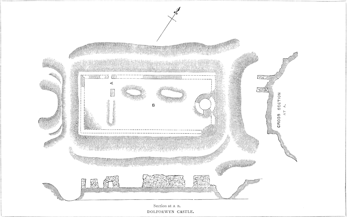
DOLFORWYN, or “The Maiden’s Meadow,” is a name evidently transposed from the meads of the adjacent Severn to the ridge occupied by the castle, which rises 500 feet or 600 feet above, and half a mile west of, the river, from which it is separated by an intervening hill. The approach is by a steep road, which becomes still more so near the top of the ridge, and finally skirts along, and is commanded by, the works of the castle.
These works are very simple in plan, and of rude construction. A platform about 200 yards long by 100 yards broad occupies the centre of the ridge. Its rocky sides are scarped and revetted all round to a height of about 10 feet, and upon this wall was built a curtain of from 20 to 30 feet more, and about 5 feet thick. At each end a cross ditch was quarried in the rock, so as to isolate the castle from the equally high ground beyond. Probably there were no bridges across these ditches, and the entrance seems to have been by a plain doorway in the curtain upon the northern face of the works. The curtain appears to have been quite plain, without either buttress or pilaster or flanking tower, save at the eastern end of the area, near the centre, where are the remains of a circular tower about 30 feet in diameter with walls 5 feet thick. The curtain to the south, or most exposed, side is broken away; on the opposite side it is more perfect, and contains a doorway, broken, and now a mere hole in the wall. Within is a fragment of a building into which probably the gateway opened. The platform is very irregular, partly natural, chiefly from the heap of rubbish covering up the foundations of the domestic buildings. The building is not unlike Dinas Brân and Dinas Powis, and is probably of the age of Henry III. or Edward I., early in the reign. The material is the tile-stone of the country laid in courses. There is no sign of ashlar.
Dolforwyn has no history. All that is known is that it was granted by Edward I. [7 Edward I.] to Roger Mortimer of Wigmore as “the Castle of Dolvoron,” with the territories of Keddewy and Kery, to be held by the service of three knight’s-fees. In 14 Edward I. the castle was still held by a Mortimer, for Richard Labaunk was in prison at Wigmore, by reason of arrears in his account to Edmund de Mortimer whilst constable of his castle of Dolfnovan. He was liberated on bail. In 18 Edward I., Bogo de4 Knovill, being constable of Montgomery Castle, had a pardon for £90 due on his farm of lands of Kery and Kidgewenny. This, however, was from the king, who seems to have resumed possession. Dugdale says the castle was built by David ap Llewelyn, who flourished 1240–46, but the Welsh attribute it to Bleddyn ap Cynfin between 1065 and 1073. Bleddyn may have had some kind of stronghold here, as a place very convenient for a raid upon the flat country, then held by the English; but he certainly did not build the existing walls. These are not unlikely to have been the work of Roger Mortimer, and their destruction probably followed at the first convenient opportunity. The name of the castle has not been found in the Mortimer inquisitions, nor is it mentioned save as above, among their possessions, or those of any other landowner. After the settlement of Wales it would cease to possess any value.
THE tract of chalk which forms and gives character to the isle of Thanet and the south-eastern portion of the county of Kent, rises towards the sea to a line of cliffs upon which the promontories of the North and South Foreland and of Dover are the most conspicuous. The cliff line, however, is not continuous. It is broken at intervals by various valleys and gorges, down which the waters from the interior find their way to the sea, producing havens which in former days and for vessels of light burthen were much in request. Of these waters the chief is the Stour, which at no very remote period, near to the present Canterbury, fell into the head of a considerable estuary, the waters of which, guarded by the ancient fortresses Regulbium, Rutupiæ and Lemanis, maintained Thanet as an island, and gave to the trade of the period free access to the interior of the district. This estuary was not exempt from the general tendency to become silted up. Before the Norman Conquest the waters had receded from Canterbury to the parish thence named Stourmouth, and Thanet from an island had become a peninsula. The process of silting up has been since continued, and the mouth of the Stour carried many miles lower. The river, after a very winding course, falls into and in part forms what remains of the ancient English port of Sandwich, opposite to the anchorage known as the Small Downs.
5
About three miles to the west of the South Foreland, another and much smaller stream, fed from the lower chalk and greensand, flows down a deep valley, and, reaching the sea between two considerable heights, has given origin to the port, town, and castle of Dover, so called, without doubt, by derivation from a British name represented in the Roman times by Dubris. The town and port lie deep in the valley. Of the heights, a part of that to the west has been rendered famous by Shakespeare, and has long borne his name. That to the east is known as the Castle Hill, so called from the fortress by which, under some form or other, it has been crowned from a very remote period. A position so convenient and so capable of defence would, upon any shore, have attracted the notice of the very earliest inhabitants; for not only was the height strong and the port convenient, but these advantages were found at the point at which the island approached nearest to the Continent, and at which those who crossed the straits, whether as friends or foes, would first make the land, and, if not obstructed, would come ashore. The position, therefore, was of far more than local importance, and would be sure to receive the attention not only of the chiefs of the Cantii, but of the rulers, if such there were, of the whole of Britain. It is therefore probable that haven, town, and fortress date from very nearly the first settlement of the country.
Although the Western or Shakespeare’s Cliff is part of a larger range, the Castle Hill is better suited for defence. It is, in fact, an isolated knoll about 1,000 yards north and south, and 500 yards east and west, the summit being a steep and narrow ridge. Towards the south its boundary is the sea cliff, 320 feet high, and to the west the deep valley of the town. To the east and north are other valleys, less deep but by no means inconsiderable, and the sides of which are steep. Moreover, the whole hill is of chalk, that is to say, of a material easily scarped and capable of retaining any general outline to which it may be cut.
But though, on general grounds, a very remote antiquity may safely be attributed to both town and fortress, it is difficult to find any precise or special evidence on which to rest the claim. Here, as at Durovernum or Canterbury, the Roman form indicates a British origin, and, if the ancient name of the stream be indeed, as asserted, the Dour, may well be derived from it, and the Castle Hill is just the place upon which a British camp is likely to be found. The commerce of the Britons, known to have been carried on with activity through the Cornish ports and the Isle of Wight, has also been claimed for the route through Dover. The actual present traces of British occupation in this southern country are indeed very scanty, and confined to a few names of rivers and hills, a very few of towns or villages, and to occasional entrenchments upon high ground, and of an irregular outline. The great roads, whatever their remote origin, in their present form carry the stamp of Rome upon every mile of their course, and the oldest known works in masonry are due to the same people, while the general topography,6 all that relates to property and self-government, hundreds, lathes, rapes and tythings, parish and hamlet, grange and farm, and the crowd of bourns, dens, hams, hangers, hirsts, ings, tons, wolds and worths point with overwhelming force to the English settlers. Even the tenure in gavelkind, claimed as a British custom, and known in Wales by the expressive name of “Randyr” or “partible” land, is by most legal antiquaries regarded as Teutonic.
Although Cæsar does not mention Dover by name, there can be no doubt that his fleet lay before it in August, B.C. 55, the period of his first invasion of Britain. Dr. Guest has clearly demonstrated that the Portus Icius whence he sailed was a small and now silted-up haven between Cape Gris Nez, the Ician promontory, and Wissant, whence a ten hours’ course brought him in the morning abreast of Dover. Here he found the natives, in great numbers and armed, drawn up to oppose his landing. He therefore anchored in Dover Wick, the roadstead east of the town, to give time for his slower ships to arrive, and thence proceeded to Deal, where he probably landed with two legions, or from eight to ten thousand men. Dr. Guest has pointed out that the word Icius coincides closely with the Irish name for the English Channel, “Muir n’Icht,” “the Ician Sea,” “icht” being a form of “uch” or “ucha,” upper in height, which plays so important a part in the names of places in Wales and the north of Scotland. It was natural that the Channel should be named from its most remarkable feature, and to this day its name in Dutch is “De Hofden,” or “the heights.”
Cæsar stayed but three weeks in the country, and may not have visited Dover; but as, when he returned in the following year with a much larger force, he seems to have embarked and landed at the same points, he must have been familiar with the aspect of the port from the sea. As on this occasion he traversed Kent and crossed the Thames, he probably left no dangerous force behind him at Dover, which he does not mention, and which clearly was not then made a rallying point by the Britons. Had the heights been held in force, he would probably in the first instance have reduced them, or at any rate have mentioned the fact in his narrative. During the century that followed Cæsar’s appearance, Rome took no active part in British affairs, but it is probable that a considerable trade sprang up between the island and the Continent, and the Britons made great advances in commerce and civilisation. Towns were founded and coins struck. The next military invasion took place, A.D. 43, ninety-eight years after the first appearance of Cæsar, and under the reign of Claudian, and command of Aulus Plautius, who landed with four legions. The Cantii then held a tract nearly corresponding to the present county of Kent. Durovernum had been founded amidst its indigenous alders, and Camalodunum, beyond the Thames, was the chief city of the Trinobantes. Where Plautius landed is not precisely known. Probably at several points on the open beach between Rich borough and Laymen. Whether the Britons mustered north or south of the Thames is also un7known; but, when Claudian followed his lieutenant, the way lay open to that river, and he marched at once upon Camalodunum, where the Trinobantes were put to flight. Plautius probably subdued the country as far west as the Axe and the Tamar, and his progress may, it is thought, be traced by the remains of his rectangular camps opposed to those of larger area and irregular outline thrown up by the retiring Britons. As, in the year A.D. 40, Caligula had caused a lighthouse to be set up on the heights of Boulogne, it is not improbable that Plautius was the builder of the corresponding tower at Dover.
Ostorius Scapula is said to have occupied with a camp the Castle Hill. He, Suetonius Paulinus, and Agricola were busied mainly with the midland and northern parts of the island, and the southern province, Britannia Prima, seems to have been at peace. Roads were laid out, towns built, the metals were smelted, and agriculture prospered. Dubris (Dover), Durobrivis (Rochester), Rutupiæ (Richborough), Lemanis (Lymne), Regulbium (Reculver), and Anderida (Pevensey), came afterwards into notice as towns or havens. The Watling Street, which ran from Canterbury by Rochester northwards, seems to have been commenced at Dover. There were indeed roads from Canterbury to Lymne and to Richborough, but Dover would be the port reached by the production of the road in a straight line from Canterbury. In the reign of Valentinian, A.D. 364–7, a cohort of the Second Legion of 1,100 men was stationed at Dubris, where stamped tiles show them to have built a bath, and which is mentioned as a port in the Iter of Antoninus and as a town (civitas) by the geographer of Ravenna. In the time of Constantine, Dubris was one of the six ports south of Thanet, under the Count of the Saxon shore, the others being Rutupiæ, Regulbium, Lemanis, Anderida, and Adurnus (Portsmouth). It is, however, not included in the list of the twenty-eight towns existing when the Romans retired from Britain, of which Rutupiæ was one. Still, even if Dubris were one only of three heads of the Watling Street, its importance under the Roman sway was considerable.
To the Roman period is to be referred the burial-ground laid open near the edge of the cliff in 1797, and the bath discovered on the brook west of St. Mary’s Church. No mention is made of a Roman fortress, nor was it in accordance with the practice of that people to place a permanent camp, still less a military station, upon a height so inaccessible as the Castle Hill. The existing earthworks show no traces of Roman outline, nor, when they had possession of the whole district, was there any need to fortify the lighthouse. The lighthouse alone, of the works upon the hill, can with certainty be pronounced to be Roman, but this, of course, implies the existence and employment of the port. All that the topographer can affirm is that the earthworks do not now present, and, so far as description may be relied on, do not appear ever to have presented, anything of a Roman character.
Kent was probably the part of Britain first invaded by the8 Northmen, and certainly the first actually subdued and settled. It was the only independent state established and maintained by the followers of Hengist, the Jutes, a people who did not contribute largely to the conquest of Britain, neither did they occupy any considerable portion of the conquered country; but what they did retain became and still remains intensely Teutonic, and their early supremacy, during the conversion of the English to Christianity, is marked by the fact that their chief city became, as it has since remained, the ecclesiastical metropolis of the island. Dover was a considerable Jutish port, and before long was regarded as the key of England. Very probably the inner earthworks still to be seen, though too much altered to be recognisable, were the work of this people, and the collegiate church of St. Martin, founded in the town by Wihtræd, King of Kent (690–725), is said to have been removed by him from the Castle Hill. In the time of Alfred, Dover was placed in the bailiwick of Stouting, and the lathe of St. Augustine. Its history, however, properly so called, does not begin till the reign of the Confessor, whose charter to the Cinque Ports, which John is said to have inspected, was confirmed by many later kings.
In September, 1051, Eustace, Count of Boulogne, brother-in-law to King Edward, paid a visit to the English Court at Gloucester, and returning through Canterbury there rested his escort, and thence went to Dover on his way homeward. Before entering the town, he and his men put on their coats of mail, and attempted to take free quarters in the houses of the burghers. This led to a fight in which much blood was shed, and the Count finally, being expelled the town, returned to Gloucester with his complaint. The subsequent tale has often been told. Godwin, then Earl of Kent, took part with his injured countrymen, and withstood the strong Norman interest about the king, and was, in consequence, banished. Godwin proposed, says Malmesbury, “Ut magnates illius castelli blande in curia regis de seditione convenirentur.” Whether “castellum” can be taken for more than the fortified town is uncertain. It is not probable that Eustace would have ascended to the castle, since he sought quarters in the town. On the whole this passage can scarcely be taken to prove the existence at that time of a regular castle on the hill. Nevertheless, the existence of such a castle at that time is exceedingly probable, for in 1064–65 Harold, says William of Poitiers, swore to Duke William that, on the death of the Confessor, “se ... traditurum interim ipsius militum custodiæ castrum Doveram, studio atque sumptu suo communitum, item per diversa loca illius terræ alia castra.” Eadmer is more precise. In his account Duke William insists, “et insuper castellum Dofris cum puteo aquæ ad opus meum te facturum.” Malmesbury says, “Castellum Doroberniæ (Dubris) quod ad jus suum pertineret.” Here there can be no mistake as to what is meant. A well in the town could be of no special value, but a well on a chalk hill 290 feet above the water springs was an addition to the castle worthy of special notice. Such a well, moreover, was a very laborious work,9 and must have taken some time to complete. Harold’s oath is no doubt involved in a good deal of doubt and uncertainty, but the tale may at least be taken to show that there was, before the Norman conquest, a castle upon the hill, now crowned by the Norman keep, and that it had been strengthened by Harold. Malmesbury here, as in his account of the fray with Count Eustace, for Dover puts Canterbury, evidently in error.
Domesday Book opens with Dover. “Dovere tempore regis Edwardi,” &c. That king held two parts of half its rents, and Earl Godwin the other third, that is, the earl’s penny. The burgesses provided the king with twenty ships annually for fifteen days, in each twenty-one men. The king’s messengers also had certain valuable privileges, showing that the port lay in the usual route to the Continent. There was a mill at the entry to the port, much in the way of the shipping. The castle is not mentioned, but we read of the Gildhalla, or Guildhall, of the burgesses. The town, though thriving, had recently been burned, and the rent reduced in consequence.
The Normans landed, as their Teutonic ancestors had landed centuries before them, beneath the ancient walls of the Roman Anderida, which, under the name of Pevensey, had become an English, and was to become ere long a Norman fortress. Pevensey is a haven no longer, but within its circuit may still be seen huge fragments of Roman and Norman masonry, and the simpler, but, at least, equally durable mound of its English occupants, a grand and striking composition, and, to the instructed observer, eloquent of great events. William took possession of the ruins, and, on the following day, marched upon the battlefield, hastily fortifying with wood and earth the hill of Hastings in support of his position. After the battle Romney first felt the weight of the Conqueror’s hand, and he then turned to Dover. The castle was, says William of Poitiers, impregnable, and the town even then considerable; but the people, though assembled in vast numbers, had no leaders, and town and castle were at once surrendered, though in the transfer, either by design or accident, much of the town was burned. William paused here eight days, detained by sickness among his troops. He treated the people with great lenity, placed a Norman garrison in the castle, to the defences of which he added, and then proceeded towards the Thames, receiving the submission of Canterbury and Rochester on his way. Kent was placed under the command of Bishop Odo, who held Dover as its military centre. This continued to be its position, and in 1074, when the fierce Jutish blood broke out, and the men of Kent, headed by Eustace of Boulogne, rose against William, their first object was to gain Dover Castle, to which they laid siege. Its defences, whether English or Norman, were strong, but the attack was sharp. Bishop Odo and Hugh de Montfort, who had the castle in charge, were absent, but they exerted themselves in the county, and the castle was relieved. Towards the end of the reign the town is said to have been walled, and to10 have had ten gates. Its position, as the most important of the Cinque Ports, seems to have been established, to which its castle largely contributed. The five ports were Hastings, Romney, Hythe, Dover and Sandwich. Winchelsea and Rye were among the members. Their service was to provide fifty-seven ships annually, of which number Dover furnished twenty-one.
Important as the castle continued to be under the reigns of the Plantagenet and Tudor kings, its history does not possess any very particular interest. It was not the scene of any very remarkable event, and, though accounted the key of the kingdom, was not in any very intimate manner bound up with its history. It has always been held by the Crown and governed by a constable, usually a man of eminence, of which officials Lyon gives a list of 138. Three barons of the house of Fiennes held the office under the Conqueror, Rufus, and Henry I., and in their time seem to have been built the outer curtain and many of its towers. Walchelin Magminot, placed in office by Stephen, held the place against him in 1137, and in 1138 surrendered it to the queen, just before the battle of the Standard. Stephen died at Dover, probably in the castle, and Mr. Puckle has fought gallantly for the recent discovery of his remains. Henry II. is supposed to have built the keep and the wall of the inner ward in 1154, soon after his accession to the crown, and, if so, it was probably the actual work of one of the Barons Fiennes, who held the office of constable in that reign. Of these lords, the last, James Fiennes, was constable at the accession of Richard I., and in 1191 received, as a prisoner in the castle, Geoffrey, Henry II.’s natural son, on his way to take up the archbishopric of York. He was taken from the sanctuary of St. Martin’s church, and imprisoned by order of the Bishop of Ely, the chancellor. For this outrage Fiennes was suspended, and eventually the chancellor was excommunicated and banished. In 1198 the constable was one of the five officers appointed to inspect the treasures of the church of Canterbury. In the reign of John, the constable was Hubert de Burgh, to whom it fell to defend the castle against Prince Louis and the French invaders. Louis made great attempts to win over De Burgh to his party, but without success, and upon his final refusal he laid siege to the castle. Trebuchets and petraria, and much siege artillery were brought over from France, and a covered way was run along the slope outside the castle ditch on the north-west quarter. Wooden towers (Malvoisins) also were erected on the edge of the ditch to quell the fire from the walls, which were actually shaken by strokes of the ram. Also a small colony was established in temporary huts, so as to give the siege the aspect of a blockade. Hubert, however, was a true and loyal subject of England. He regarded his charge as held under his sovereign, whoever that sovereign might be, and his castle as the “clavis Angliæ et repagulum.” He returned attack for attack, stone for stone, until the death of John, by removing much of the cause of dissatisfaction, led to the retirement of the French from the country. The great spur-work in advance of the northern gateway,11 and which still, though much altered, remains, is probably the work of De Burgh, no doubt suggested to him by the direction of the French attack. Henry III. was here in state in 1255, on his way from Spain, and in 1259 the castle was in the hands of the barons, who refused to allow his brother Richard, King of the Romans, to enter the place until he had sworn to adopt their cause. Henry recovered the castle in 1261 from Hugh le Bigot, but was unable to hold it, and was refused admission when, with his brother and the Earl Mareschal, he presented himself before the gate in 1263. In the great struggle, Henry held the Tower of London, and the barons the castle of Dover. After Lewes, the Princes Edward and Henry were for a time held in durance in Dover. In 1265, when the prince had the upper hand, and Kenilworth had fallen, fourteen nobles of the royal party were imprisoned in the keep of Dover. Here they defended themselves, turning the tables upon their captors, who, attacked from without by Prince Edward, and thus placed between two fires, surrendered the castle. The Countess of Leicester, who was within it, was allowed to retire to France.
On his return from Palestine, after his father’s death, in the summer of 1274, Edward I. landed at Dover. He again visited the castle in 1278, 1296, and 1299. Dover was his usual port when he visited or returned from the Continent, and in his time the castle was maintained and strengthened, and some of its most considerable parts, such as the Constable’s Gate and St. John’s Postern, are of the conclusion of the reign of Henry or early in that of Edward, and most probably the latter.
Edward II. was here in the January following his father’s death, and here he embarked for Boulogne on the occasion of his marriage in 1308, and here he received the queen. Edward III. was not infrequently at Dover, but is more likely to have lodged in the Maison Dieu than in the castle. He probably drew troops from hence when he sailed from the port on his celebrated secret expedition to Calais in 1348. In the reign of Henry V. the Emperor Sigismond was received at the castle as a visitor, and from hence the king embarked his army for France in 1421, as did Henry VII. in 1491.
Henry VIII. suppressed the Maison Dieu, the celebrated foundation of Hubert de Burgh, within which very many kings and princes had been entertained, but the castle was an object of his special care, and was repaired and garrisoned. Henry also built the blockhouses of Sandown, Deal, Walmer, and Sandgate, and placed them under the charge of the Constable of Dover. Three bulwarks also were constructed under the cliff and upon the pier of the harbour. Later on the castle fell into neglect, and in the reign of Charles I., being garrisoned by a small force, and but little cared for, it was taken by surprise and held for the Parliament. In 1648 the Kentish royalists made a vigorous effort to recover it, but were repulsed by Algernon Sydney, then its governor.
12
Dover Castle is called by Matthew Paris “the very front door of England,” and described by William of Poitou as “Situm est id castellum in rupe mari contigua quæ naturaliter acuta undique ad hoc ferramentis elaborate incisa, in speciem muri directissima altitudine, quantum sagittæ jactus permetiri potest consurgit, quo in latere unda marina alluitur.” It presents a good combination of the defences of several architectural periods, the general result being a concentric fortress, the growth of many centuries, and which, a century ago, presented much both of earthwork and masonry of great and unmixed antiquarian interest. More recently, however, the works have been delivered over to the military authorities of the country, and the result has been a series of alterations, additions, and removals, necessary, it is in all courtesy to be presumed, for the defence of the country, but very destructive of the ancient features of the fortress. The ancient earthworks have been scarped, extended, retrenched, and tunnelled, barracks and magazines have been built, the keep has been converted into storerooms and water-tanks, and in its basement are two powder magazines. In its present condition, and having regard to the strict regulations, prohibiting even the use of the pencil, under which the whole is placed, an accurate examination of what remains of the ancient works, whether in earth or masonry, is almost impracticable.
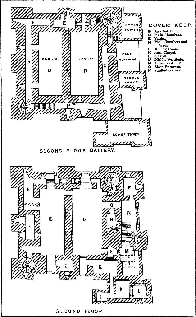
The British camp was oblong, following the figure of the hill. It was composed of a deep and broad ditch, the contents of which were in part thrown inwards and upwards so as to form a bank. The area thus enclosed measured within the bank about 875 yards by 350 yards, the latter being its diameter at the cliff, by which it is cut off, the northern end running to a point. This main ditch has probably been deepened and more or less altered during the Norman period, and it is now connected with various bastions, hornworks, and caponnières, but its general outline is sufficiently clear, and it may, from internal evidence, be presumed to be British. Within the area, rather nearer to its northern end, a second earthwork, also composed of bank and ditch, has been thrown up. This includes the lighthouse tower, and is therefore called the Roman ditch, but there is nothing about it of a Roman character, and it is far more probable that it was the work of the English, and formed the inner defence of the castle which Harold undertook to surrender. The space between this and the great earthwork forms the outer ward of the Norman castle; the inner work has been divided into two parts. That to the south, containing the lighthouse, forms the middle ward; that to the north contains the keep, and is the inner ward. The lighthouse has been employed as a belfry to the adjacent church of St. Mary, which is the subject of an excellent memoir by Mr. Puckle, though he can scarcely be admitted to establish its connexion with13 the British church. The two are undoubtedly the oldest buildings within the castle area.
The Keep and Inner Ward are Norman, of the reign of Henry II., but the curtain and most of its towers have been refaced or rebuilt, a great part recently, but more or less on the old lines. The plan is an irregular polygon, about 120 yards each way, with fourteen rectangular mural towers of no internal projection, and not rising above the curtain, which, however, is lofty. Two of those to the south-west take their name from Magminot and one from Gore. The walls were of flint rubble, quoined with ashlar, and battering outside at the base, the top of which is marked by a bold cordon of stone. Upon the sides of some of the towers are bold machicolated openings from garderobes. The keep stands detached in the centre of the ward, and within the area, built against the walls, are several buildings, as Arthur’s Hall, the guard chamber, and the officers’ quarters, some of early English character, others modern.
There are two entrances, the north, or King’s Gate, and the south, the Duke of Suffolk’s, or Palace Gate. The gateways are vaulted passages, with a flat segmental arch, opening externally between two square flanking towers. There is a groove for a portcullis, and the vaults have an early English import. Each of these gates is defended by an additional work. A sort of hornwork is thrown out in advance, enclosed within a wall with towers, and with a second gate placed obliquely to the first, to allow the approach to be commanded. The north, called the King’s Gate, is tolerably perfect. The southern outwork is nearly destroyed. It had two gates, one to the south, connected with which was the tower containing a well, and one to the east, called King Arthur’s Gate, close to which was the Armourer’s Tower, and near this was Earl Godwin’s Postern. The masonry of this inner ward was probably of the date of the keep. It was included within a broad and deep ditch, now incomplete, on the southern front.
The Middle Ward includes the southern half of what was probably the English earthwork. Its southern two-thirds is rounded, but at its base are, or were, walls and towers connecting it right and left with the curtain of the outer ward, which it thus divided into two parts. In advance of this work were three towers: two, to the east and west, Clinton and Mortimer, were square. Both seem to have been of Norman date. The central tower to the south was circular, and was called Valence. It was, no doubt, later, probably of the reign of Henry III. The foundations of Clinton Tower were laid open and removed in 1794. A fragment of Mortimer’s Tower remains. Valence Tower was destroyed in the last century. The gatehouse of the ward is called Colton Gate. It is Norman, but an octagonal story has been added to the square base. The curtain connecting these towers is gone, and the lofty south bank has been scarped, and its outline changed. In this ward is a well 380 feet deep, once covered by a tower.
14
The Outer Ward is contained within a curtain, much of which is reduced by an internal ramp to a parapet wall. Upon the three landward sides it is narrow, and chiefly occupied by the ditch of the middle and inner wards. Upon the remaining or southern side it expands and includes a large space between the middle ward and the cliff. Its circuit is only not complete because its walls rest at either end upon the cliff. The plan of the wall is irregular, with an occasional angle or shoulder for raking the ditch. Exteriorly it rises from the outer dry ditch, and upon it are twenty-seven towers of various dates, figures, and dimensions, square, circular, and multiangular. Most of those on the western face are simply hollow bastions, and have no internal projection. Those on the eastern face are mostly mere sentry-boxes, or bartizan turrets of small dimensions. Upon the seaward front, where the cliff is perpendicular, there is no wall. The ingenuity of the engineer has been exercised on the landward and weaker sides. Five of the towers are connected with gates. These towers, commencing at the south-west angle of the ward, near the cliff, are: 1. Canon’s or Monk’s Gate, now destroyed; in it was a well. 2. Rokesley’s Tower, semicircular. 3. Fulbert de Dover’s Tower, square; near which was long the office of the “bodar,” or sergeant-at-arms, to whom all civil warrants of arrest for debt or breach of the revenue laws were addressed. Fulbert’s Tower was also his prison. 4. Hirst’s Tower, semicircular; it commands a shoulder or re-entering angle in the wall. 5. Arsick’s Tower, semicircular. 6. Gatton Tower. 7. Peverill’s, Beauchamp’s, or Marshall’s Tower. This is also the gatehouse between the two divisions of the outer ward, which was strong, with a ditch on the south front, and a drawbridge. It was also the marshal’s prison. 8. Port, Gosling, or Queen Mary’s Tower, having been repaired by that sovereign. 9. Fiennes’s Tower, or the Constable’s Gate. This is one of the grandest gateways in England. It is in plan a triangle with its obtuse angle presented to the field. The angles at the base fall within the line of the curtain, and are capped by two large drum towers. The salient angle in like manner is capped by an oblong tower, rounded at each end and flat in the centre, through which the entrance passes. These three towers are large and lofty, and are connected by an embattled curtain. Within the triangle a central tower rises to a still greater height, and commands the whole. The entrance passage is broad and vaulted, and provided with gates and a portcullis. Within, it opens upon the level of the outer ward; without, it terminates abruptly upon the scarp of the ditch, there about 50 feet deep. From this gateway a bridge communicates with the opposite bank. A single lofty pier rises from the centre of the ditch, and from it an arch springs to the outer abutment, carrying a regular roadway and parapets. In the opposite direction the parapets alone spring, as two arches, from the pier to the gateway, and serve to steady the pier, but the roadway is omitted, and its place supplied by a drawbridge. This arrangement is not uncommon, but is here specially necessary, owing to the height and consequent15 weakness of the pier. Upon the counterscarp of the ditch is a tête-de-pont, from which a steep road descends by a traverse towards the town. This gate, though open, is but little used. The ordinary gate is modern, and near the site of Canon’s Gate. The Constable’s Gate is of the Decorated period. Its interior is said to be very curious, but is not shown.
Sixteen towers, including Clopton, Godsfoe, Magminot (4), and Crevequer’s Towers (2), protect the north-west face. Clopton is a hexagon; the name of Magminot is borne by four towers. The two towers bearing the name of Crevequer mark the position of the great postern, a very curious work. Passing from the north gate of the inner ward, a range of arches cross the ditch and the outer ward, and terminate abruptly in a large low pier with salient angles to the right and left. Opposite to the pier, and no doubt at one time connected with it by a drawbridge, rise a pair of circular towers (Crevequer), connected by a heavy curtain and flanked by lesser towers (Magminot) at short distances, all forming part of the enceinte of the outer ward. Towards the field the curtain has a salient angle, and from its base a covered gallery descends into the outer ditch, and there reaches St. John’s, a drum tower built in the middle of it. The gallery passes through the first story of the tower, and terminates in the counterscarp, in a circular chamber cut in the chalk, and from this chamber three tunnels radiate to different parts of the glacis, of which one formerly led to a distant postern, and another still communicates with the old spur-work, attributed to Hubert de Burgh, and converted into a modern ravelin. Two other tunnels, apparently of Edwardian date, leave the main gallery under the castle wall, and the basement floor of St. John’s contains two sally ports, opening into the bottom of the ditch. The modern access to these galleries is by a shaft sunk in the pier of the old drawbridge, but the old entrance was nearer the curtain. The French siege of 1216 was directed upon this quarter. The approaches were made from the west below the Constable’s Gate, and under cover of a trench and breastwork. While the attack was impending Sir Stephen de Pencester brought a reinforcement into the castle by the postern under Godwin’s Tower. De Burgh, taught by experience, threw up the advanced work which still, under a changed form, covers the northern end of the castle, and it was to reach this in safety that the gallery from St. John’s Tower was executed.
Fitzwilliam’s Tower (18), placed about 80 yards east of the north gate, was connected with a second postern, not unlike the last, and now connected with a caponnière. Beyond this are 19 and 20, two watch turrets, and farther on 21, Albrinci’s or Avrenches’ Tower. This contains a third postern of peculiar arrangement. It is a low, polygonal structure, placed on a shoulder on the ditch, so as to rake its continuation southward. It was reached by a covered gallery from the south gate of the inner ward, which is continued through its basement so as to open on the counterscarp of the main ditch.16 Connected with this gallery was Veville or Pencester’s Tower, placed upon the curtain which on this side closed the connexion between the two divisions of the outer ward. Of the remaining towers, five in number, three are called Ashford’s, and near one of them was another well. This part of the defence has been completely remodelled. The names of the several towers are those of the knights by whom they were built, or whose duty it was to defend them, for to no castle in Britain, not even to Richmond, was the practice of tenure by castle guard so extensively applied as to Dover, and very numerous and valuable were the Kentish manors so held, amounting to 230½ knight-fees, of which 115¼ were attached to the office of Constable.
The Keep.—This is a very fine example of a late Norman keep. It is very nearly square, being, at the base above the plinth, 98 feet north and south by 96 feet east and west, with a forebuilding 15 feet broad by 115 feet long, which covers the east side and the south-east angle of the main structure. The angles are capped by pilasters 19 feet broad and of 5 feet projection, which meet to form a solid angle, and, rising to the summit, become the outer faces of four square turrets. On each of the three free faces is an intermediate pilaster, 15 feet broad by 5 feet projection, which rises to the same height with the parapet, and forms a bay in its line. There is a battering plinth, 6 feet high, from which the pilasters rise, and the total height of the wall is 83 feet, and of the turrets 12 feet more, or 95 feet. The base of the keep is 373 feet above high-water mark. The top of the plinth is marked, on the face of the pilasters, by a bold cordon or roll, and there are two sets-off of 6 inches common to both walls and pilasters, one at the first and the other at the second-floor level. The walls are of unusual thickness, even for a Norman keep. That to the west, between the pilasters, is 21 feet reduced to 19 feet at the first and to 18 feet at the second floor. The north wall is 17 feet, the south 19 feet, and the east 18 feet. The cross wall, which runs north and south, and divides the building nearly equally, is 11 feet at the base, and reduced to 7 feet and 6 feet at the top story.
The main entrance is in the east face, near its north end, at the second-floor level. The forebuilding which covers it is the finest in England. It is in fair preservation, all but its roofs and part of its east wall, which are modern. As at Rochester, it is of masonry inferior to the keep, at least outside, and there is no cordon at the base of its pilasters, but it contains within more ornamental work than the keep, with which it is so intimately connected that it cannot be an addition. In the north-east and south-west angles of the keep are well-staircases remarkably commodious and well lighted. They are 14 feet 6 inches in diameter, the stairs being 6 feet 6 inches and the newel 1 foot 6 inches. They rise from the basement to the roof by 114 steps, and communicate with each floor, the two lower by lobbies, the upper and upper gallery by branching passages. From the north-east lobbies doors open into 17the two tiers of vaults below the upper part of the forebuilding. The extraordinary thickness of the walls is intended to allow of the construction of a very unusual number of mural chambers, of which there are altogether twenty-seven. Besides the main entrance there seems to have been one at the first-floor level, also from the forebuilding. Others have since been made, one probably in the fourteenth century, direct into the basement, and another very recently into the base of the south-western staircase. Besides these, divers loopholes have been converted into doors, to give external entrance to the basement mural chambers which are used as water-tanks and powder-magazines.
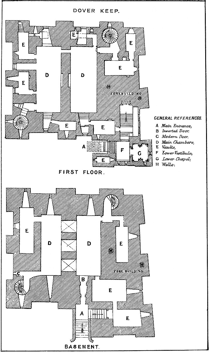
The basement.—There is some doubt about the original level of this floor. At present it is 9 feet above the ground outside, but it contains two doors, the sills of which are 6 feet or 8 feet below the floor, and on opening the ground near the centre of the keep a pavement was found at the same level, so that the floor may have been filled in with earth and raised. If so, however, there must have been some kind of stair to supplement the well staircases, for the floor of their lobbies is certainly at its original level. The cross-wall between the two chambers is pierced by three plain round-headed arches of 11 feet opening.
The east chamber, 50 feet by 20 feet, has in its north end a deep recess, and a loop up to which the sill is stepped, while the arch overhead rises as the recess contracts. It is evident that the recess at the south end was similar, but has been converted into a doorway. This is the opening in general use, from the first landing of the exterior staircase. The wall here is 24 feet thick, and there are rebates for two doors, with bars within each. The arches are segmental and the angles rounded off. The alteration seems to have been made in the Decorated period, with a trace of later work. Close east of this door, and 6 feet below it, is another door, now partially concealed, which led into a vault 28 feet by 15 feet, occupying the south-east angle of the building. In its south wall a door leads into a second vault, 23 feet by 15 feet, below the lower vestibule and chapel. Each vault had a loop towards the east. They are now used as water-tanks, and reached by external openings. Returning to the east chamber, in its east wall are two doors, one at its north end and one near the middle, now blocked up. The northern door opens into the lobby of the north-east staircase, and from it a door led into a vault 28 feet by 12 feet, in the forebuilding, now used as a magazine, and entered through the outer wall. The middle door probably led into another vault, of which nothing is known. Thus at the ground level of the forebuilding there are three, if not four vaults, all originally entered from the keep. They are about 6 feet high to the arch-springing.
The west chamber, 50 feet by 16 feet, has a large recess and loop in each end, and in the west wall two doors, one opening into the lobby of the south-western staircase, where is the modern door, and the other, now blocked up, which led into a mural chamber18 39 feet long by 12 feet broad, now a powder-magazine, and entered from the outside.
The first floor also contains two main rooms which communicate by a small door near the north end of the cross-wall.
The east chamber, 53 feet by 22 feet, has a recess 7 feet wide in its south end, which ended in a loop, now converted into a window. In its right or west jamb is a fireplace; in its left a door opening into a mural chamber 18 feet by 11 feet, with a loop to the south, and from the east end of which a door opens upon a staircase of the forebuilding. This door and the window above it are of Tudor date, but there are indications that there was an original door here, of which the Tudor frame is a replacement. In the exterior wall is an arch of relief in fine ashlar, which matches in size with the vault within, and looks as though intended to protect an original door. In the east wall of the great chamber is a door opening into the lobby, in which six steps descend to the north-east staircase. From this lobby a door leads into a vault 24 feet by 12 feet, with a recess in its north and south walls, and a loop in its east end. From this a short passage leads into a second vault, 17 feet by 2 feet, with a loop to the north. These two vaults are placed below the upper vestibule and great guard-room of the forebuilding. In the north wall of the great chamber, at the east end, a small door opens into a mural gallery, 16 feet by 4 feet, with a loop to the north, and which ends in a chamber 5 feet by 6 feet, also with a loop to the north. Above this gallery is a recess 7 feet wide, raised about 10 feet from the floor, to clear the gallery. Its loop is replaced by a modern window.
The west chamber, 52 feet by 20 feet, has also a 7-feet recess in its south end, with a modern window, and in its east jamb a door opening into a mural chamber, 13 feet by 9 feet, with a south loop, and a fireplace in the east wall. This, and the fireplace already mentioned, are placed back to back, and, though with Tudor fittings, may possibly be original. In the north wall of the great chamber is a high recess and window, similar to that in the east chamber. In the west wall are four openings; that at its north end opens into a chamber in the north-west angle, 23 feet by 10 feet, with loops to the west and south. From it branches a passage 18 feet by 4 feet, in the north wall, which leads under the high window recess to a chamber 7 feet by 6 feet. Both passage and chamber have loops to the north. Next follows a window recess of 6-feet opening at the floor level, rising by four steps to the modern window; then a door opening into a mural chamber, 20 feet by 9 feet, with a fireplace in the east wail and two loops to the west. Finally is a door opening upon the lobby which leads to the south-west staircase, rising three steps, and having a loop to the west. Besides the three fireplaces in mural chambers, there were two others under arches of 12 feet span, one in the centre of each face of the cross-wall. These, however, are closed up. In the same wall, at the north end, is a door between the two chambers.
19
The second floor is the main or state floor of the building, and that into which opens the great entrance. As in the keeps of London, Rochester, and Hedingham, it had two tiers of windows, the upper passing through a mural gallery. Early in the present century this floor was covered in by two large brick vaults, slightly pointed. The object was to convert the ramparts into a platform for cannon. This clumsy addition completely conceals the upper half of the walls and destroys the effect of two very fine chambers.
The east chamber, 55 feet by 24 feet, is entered on the east side, near the north end, by a large, full-centred doorway, flanked outside by nook shafts. From this a vaulted passage, 5 feet broad, traverses the wall, here 16 feet thick, and descends by eight steps into the main chamber. This inconvenient height was evidently given to secure headway for the vault below the vestibule. In the entrance passage, on the left or south side, a door opens into the well chamber, a vault, 16 feet by 8 feet, with a loop to the east upon the great staircase. At the south end of the vault, upon a step, is the well, 4 feet diameter and 289 feet deep, lined, as far as can be seen, with ashlar. In the east wall is a recess for a spare bucket. Near the entrance, at the north end of the east wall of the great chamber, a door leads into a curved passage which descends eleven steps into the north-east staircase. At the south end of the same wall a large arch, 5 feet above the floor, opens into a mural chamber 8 feet by 7 feet. This arch has been reduced by modern brickwork, to support the great vault. In the same chamber a loop opens upon the grand staircase, and in the south wall is a door and a descent by eight steps towards the chapel. It is possible that the loop was originally a small door leading into the upper floor of the middle tower of the forebuilding, and that thence, in Tudor days, a small wooden gallery led to the north door of the ante-chapel. In the south end of the great chamber is a window recess of 7 feet, opening with nearly flat sides. In its west jamb is a fireplace, in the east a door leading into a mural vault 18 feet by 12 feet, over that by which the first floor is entered. This vault has a loop to the east upon the great staircase, on the north the eight steps, already mentioned, and in the south wall a narrow door and mural passage leading to the robing-room and ante-chapel. In the north end of the great chamber, near the north-east corner, a door opens into a chamber 7 feet by 5 feet, which lies in the north wall below the window recess, here of 8 feet opening.
The west chamber, 55 feet by 21 feet, has in its south end a window recess 7 feet broad, in the east wall of which a door opens into a mural chamber 14 feet by 9 feet, with a loop to the south and a fireplace in the east wall. In the west wall of the great chamber is a window recess 5 feet wide, commencing at the floor level, and there are three doors. That at the north end opens into a chamber, 22 feet by 9 feet, in the west angle, with loops to the west and north. From this opens a passage in the north wall 17 feet long, which ends in a chamber 11 feet by 5 feet; chambers20 and passage have loops to the north. Near the centre of the west wall of the great chamber a door opens into another mural chamber, 22 feet by 14 feet, with two loops to the west and a fireplace in the east wall. Another door leads, by a curved passage with a loop to the west, into the south-west staircase. In the great cross-wall is a door near its north end, and in each of its faces two large fireplaces, now walled up. In the north wall is a high window or recess of 8 feet opening.
The main gallery, though it threads the wall nearly all round, lies at different levels, and at one point is stopped. It is entered from the two staircases. That at the north-east gives off two branches, of which one rises by fourteen steps, with a loop to the north, and enters a passage in the north wall 16 feet long, having a loop to the north, and to the south an opening, now blocked up, into the great chamber. The passage ends in a chamber 18 feet by 8 feet, in the north wall of which is a loop, and near it a deep recess for a garderobe; and in the south wall is what seems to be the mouth of a gallery threading the cross-wall, where, however, it would be stopped, or very much reduced, by the shafts of the fireplaces. The other branch from the north-east staircase rises by six steps, when it gives off a branch to the east of nine steps, which lead to the roof of the upper tower of the forebuilding. The main passage then curves and rises ten steps more, in all sixteen steps, when it enters the substance of the east wall, where it is 60 feet long and 4 feet 7 inches broad, and has a door to the east, opening on the middle tower of the forebuilding, and a loop, and opposite to these are two openings in the west wall, which formerly opened into the great chamber, and now are blocked by the brick vault. The passage then turns and lies for 67 feet in the south wall. In its east end is a loop; in its south wall, there 10 feet thick, a door opening upon the roof of the lower tower of the forebuilding. In the same wall are two, and probably three loops, opposite to two of which seem to have been openings into the great chamber. The third is much broken. In the inner wall is a recess, probably the mouth of the cross-wall gallery. At its west end the main gallery descends twenty steps to reach the south-east staircase. From this staircase, at twenty steps higher up, a door opens into the gallery, which is continued along the west wall 68 feet. It has three loops in the outer wall, opposite to two of which are apertures, now closed, which looked into the great chamber. This gallery is continued 15 feet, with a width of 6 feet, in the north wall.
The roof of the keep is now an artillery platform, pierced on the south by six and on the west by five embrasures, the top of the pilasters forming a bay in the centre of each face. The two other faces are solid, and protected by guns “en barbette.” Of the four turrets, which are 21 feet square, with two entrances on each face, the two to the south have entrance stairs, and doors from the stair-head open in the side of those at the north-east and south-west angles. The north-west turret seems to be entered by an opening in21 its east face. Though these turrets have been much pulled about, their substance seems original.
The forebuilding covers the whole of the east and about 45 feet of the adjacent south face of the keep. Its breadth ranges from 15 feet to 23 feet. It was strengthened by three towers, one over the north end or top of the staircase, one over the south-east angle or bottom, and one on the east front over the middle of the staircase. The middle tower, in which was the middle doorway, is unusual. These rose to about four-fifths of the height of the main building, and their battlements were reached, as has been shown, by doors from the upper gallery. The object of this forebuilding was to contain and protect the great staircase, and in it are three vestibules, a lower and upper chapel, and an ante-chapel, several mural chambers, and a well. The entrance at this time begins from the ground on the south front by an open staircase of ten steps, probably modern, as the original ascent seems to have been against and parallel to the keep wall. At the top of these steps is a landing, upon which opens the present entrance into the basement floor. The staircase then turns to the right and rises eleven steps, still open, having on the left the keep and on the right the flanking projection of the forebuilding, in which is the lodge, and above it the robing-room. In front is a lofty doorway, 7 feet wide, with a segmental arch, quite plain, and above it a loop which opens from the chapel passage. This was the lower entrance, and was closed by a barred door. Entering the doorway, eleven steps under cover lead to the lower vestibule, which is thirty-two steps, or 20 feet, above the ground. This vestibule is a handsome chamber, 15 feet by 12 feet, with an arcade of two arches in its south wall, each pierced for a loop. In the west wall, near the entrance, is the door of the lodge, a plain barrel-vaulted chamber, 13 feet by 6 feet, having a loop to the west. In the east wall of the vestibule is an arch of 7 feet opening, springing from coupled columns and flanked by two others. The head is moulded with the chevron pattern. This arch opens into the lower chapel, 14 feet by 13 feet, which occupies the south-eastern angle of the building, and is so placed that the altar could be seen if desired by each person who entered the keep. In its north and south walls are arcades of two arches, divided by a pier carrying two nook shafts and a third shaft in the centre. In the south-east arch is a loop, and opposite to it a cupboard. In the east end is also a loop, placed in a recess flanked by two shafts. The floor of this chapel is one step above the vestibule. The ceiling of both was flat, and of timber. Beneath chapel and vestibule is the vault already described. The walls of this part of the forebuilding are from 2 feet 6 inches to 5 feet thick.
From the vestibule a doorway, the second, opens in the north wall. This has a segmental head, and is original, but it has been reduced in breadth, probably when the basement door was opened, by the insertion of new jambs. It opens into a vaulted passage, 6 feet wide and 5 feet long, being the thickness of the north wall22 of the lower tower. It is occupied by three steps and a landing, from which four steps ascend into the middle vestibule. This is a chamber 25 feet long by 15 feet broad, having a modern roof and two modern windows in its east wall, which has been in part rebuilt. On the left, on entering, is a Tudor doorway, and above it a square-headed window of two lights, of the same date. This opens into a mural chamber already described, and thence into the first floor of the keep. A large arch of relief is seen above in the wall, and it is probable that there was always a door here.
Beyond this door the staircase rises by twelve steps to a broad landing at the end of the vestibule. Besides the Tudor doorway and window, on the same side, higher up, are loops from two mural chambers of the second floor of the keep, and in the south wall over the stairs a small door, not now used, which opens into the ante-chapel. In the north wall of this vestibule, a doorway of 5 feet opening, the third in order upon the stairs, opens into a passage 6 feet wide, which pierces the wall of the middle tower, here 6 feet thick, the whole tower being 14 feet. From this doorway a flight of twenty steps, 8 feet wide, ascends into the upper vestibule, to a large landing 19 feet by 14 feet. The vestibule itself is 25 feet by 14 feet, and lies between the middle and upper tower of the forebuilding. In the east wall, which has been rebuilt with the roof, are two modern windows. In the south wall a narrow passage, 10 feet long by 3 feet broad, leads to the outer well, the ashlar pipe of which is 4 feet diameter. It seems to have been used in modern times as a cesspit, and is choked up. The well is placed in the centre of the tower, which seems to have been a mass of masonry. At present the wall round the well has been broken away so as to form a rude chamber. It cannot now be ascertained whether the well stopped at this level, as is probable, or was carried up to the roof of the tower. In the north end of the vestibule, looking down upon the staircase, a door leads into a vaulted guard-chamber, 16 feet by 10 feet, with loops to the north and east, and a deep recess in the west wall. In the west wall of the vestibule is the great door of the keep and a loop from the well-chamber. There are traces on this wall of ashlar, as though it was originally intended to vault and groin this vestibule.
In the forebuilding, on the level of the second floor of the keep, remain to be mentioned the robing-room, ante-chapel, and chapel. They are placed in the lower tower of the forebuilding over the lodge, vestibule, and lower chapel, and were entered only from the keep, through the mural chamber already described. From this chamber a passage, only 2 feet 5 inches broad, lies in the wall over the outer doorway, and from it a loop opens over the staircase, outwards. This passage, 17 feet long, ends in two small doors, right and left, one entering the robing-room, the other the ante-chapel. Originally this was the only way into the chapel, and a very stout person could scarcely have reached it. The Plantagenet princes, though mostly big in the bones, were rarely corpulent. The robing-room is23 over the lodge. It is 10 feet by 7 feet, vaulted, groined, and ribbed; the ribs are of plain roll section, and there is no boss. They spring from nook shafts at the four angles. There are loops, or rather small windows, of a foot opening to the west and south, flanked by small columns. The ante-chapel, 16 feet by 13 feet, has an arcade of two arches in the north and south walls, and a loop in the north-east space, converted into a small door, so as to give a separate entrance. In the east wall an arch of 8 feet span opens into the chapel. It springs from coupled columns, flanked on each face by two others, and the arch has a chevron moulding. The floor was of timber, and rested on five beams. The roof is vaulted, groined, and ribbed, and the moulding a roll with a band of dog-tooth. The chapel is 14 feet by 13 feet. It is peculiar in its position, being placed over the base of the entrance stair, instead of, as at Middleham, at its head. It also has an arcade of two arches in the north and south walls, with nook shafts in pairs at the angles behind which, from a corbel capital, spring the ribs of the vaulted roof. These are of a roll section with a band of the dog-tooth ornament, and a central flowered boss. There is a small east window, and also south of it a piscina with a trefoiled head and projecting basin, now broken off. This seems a Decorated addition. There are two loops in the south wall, and one in the north near the east end, and in the other north bay a cupboard. The floor was of timber, resting upon four joists.
The material of this keep is chiefly the rag stone of the country worked as rubble, not very regularly coursed. Ashlar, mostly of Caen stone, is used freely for the door and window dressings and the quoins. The joints are close. The pilasters are of unusual breadth and projection. The chapels and the lower vestibule are highly ornate, with much of the chevron and roll mouldings, and occasionally of the dog-tooth. The arches are sometimes segmental, but more commonly full centred. There is no portcullis in the building; the entrances were closed with doors only, secured with wooden bars. None of the loops that open on the staircase could be used in its defence. Excepting about the main door there is no ornamentation in the keep itself. Doors, windows, and fireplaces seem to have been quite plain. This is the only known keep in which there is a second well, and it is difficult to understand why there should be two so near together, the expense of making which must have been so great. The upper gallery is of very rude masonry indeed; the lines of the passages do not coincide with the general direction of the walls, and the execution is very inferior. It is unfortunate, with ample buildings all round, that the authorities should pervert this very curious keep to vulgar and dangerous uses. The stores should be kept elsewhere, and the brick vaulting and additions be removed. The external breaches and doors in the walls should be closed, the second well cleared out, and the whole building as far as possible restored to its original condition. It might then be fitted up as a museum of arms, and every part, including the ward,24 made accessible. The reputed date of this keep is 1153, when the foundations are said to have been laid by Henry, grandson of Henry I., shortly before he succeeded to the throne. This coincides sufficiently well with the evidence of the building itself, which is late in the Norman style.
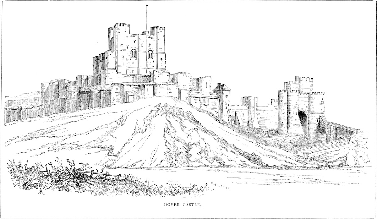
The general view here added is taken from the north, and shows the constable’s gate and bridge, and in the foreground the towers and curtains of the outer ward on this side. Immediately behind them are seen the square towers and the curtain of the inner, or Norman ward, and within all rises the keep, applied to the east side of which are seen the three towers of the forebuilding.
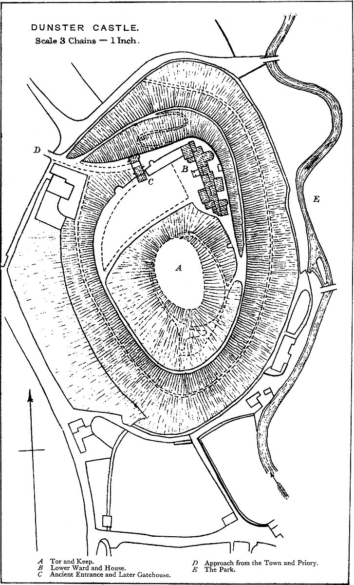
THE Castle of Dunster is of high antiquity, and for many centuries was a place of great military consideration in the western counties. It was the caput of an extensive Honour, and the chief seat of a line of very powerful barons. The hill upon which it stands is the north-eastern, or seaward extremity of a considerable ridge, from which it is cut off by a natural depression, and thus forms what is known in West-Saxon nomenclature as a tor. The tor covers above ten acres of ground, and is about 200 feet high, with a table top in area about a quarter of an acre. It stands upon the western edge of a deep and broad valley, which contains the park, and below the castle expands into a tract of meadow about a mile in breadth, skirting the sea from Minehead to below Carhampton. The park is traversed by a considerable stream, the Avill, one head of which springs from Croydon Hill, and the other, flowing past Wootton-Courtenay, rises about six miles distant under Dunkery Beacon. The home view, one of exceeding richness, is limited and sheltered on the south and west by the Brendon Hills and the high ground rising towards Exmoor. To the east it includes the vales of Cleeve and Williton, bounded by the Quantocks. Seaward on to the north the eye ranges over Bridgwater Bay to the headland of Brean Down and Worle, and commands the west or opposite coast from Penarth Point to Aberavan and Swansea.
West, and at the foot of the castle hill, and under the immediate control and protection of the old fortress, is the town of Dunster, a small and compact cluster of old-fashioned houses, many with timber fronts, in the midst of which is the parish church, once connected with the priory, the foundation of one of the early Norman lords. The eastern or monastic part of the building now forms the private chapel of the Luttrells, and contains several of their tombs.
The fancy cloths once known as “Dunsters” have long ceased to 25be fabricated, and of the fulling mills the ruins have well-nigh perished. The haven at which these manufactures found shipping is also silted up, and the privileges conceded to the townspeople, being now shared by the community at large, are no longer commemorated, and are known only because the charters granting them have been preserved. Of the neighbouring hills, “Gallocks” is thought to be so called because there the high judicial powers of the lords were exercised in the view of all men, and “Grabhurst,” the castle ridge, is said to be named from an entrenched wood, though this use of the word “graff” is unknown or unusual in English nomenclature, and “Hirst” or “Hurst” belongs rather to Sussex and Kent than to Somerset. The fact is that the hill in old deeds is spelt “Grobefast,” and is at this time colloquially “Grabbist.” Near it is a lofty detached hill known as “Conygaer,” crowned by a tower of the last century. At present it is thickly planted, but no camp has been discovered there, such as the name might indicate. The castle mill remains. It is placed on the verge of the park, upon the stream, and concealed and protected by the castle.
The castle is composed of two parts, due to the natural disposition of the ground; these are the tor or keep, and the lower ward. The tor is in form oval, and its summit, naturally flat, has been further levelled by art, as the slopes also have been trimmed, and rendered almost impracticable for direct ascent. The summit measures about 35 yards east and west, by 70 yards north and south. The keep, which stood here, has disappeared, and its existence, long a matter of tradition, may now be deduced from a sewer and some foundations in the south-west corner laid open a few years ago. The present surface was laid down as a bowling-green in the last century, and a summer-house constructed at the north-east corner, in which is a window in the Perpendicular style taken from some earlier structure.
The artificial scarping of the hill sides is confined to the upper 80 or 100 feet. At this level are two platforms or shelves, one, a small one, towards the south, the other much larger, also chiefly natural, towards the north, and which forms the lower ward. The lower ward is of a semilunar or semioval figure, the hollow side being formed and occupied by a portion of the skirts of the tor. It measures about 33 yards north and south by 126 yards east and west, and covers about half an acre of ground. The outer or convex edge, steep by nature, has been cut into a low cliff, supported by a retaining wall, which, with its flanking towers and superstructure of parapet, protected this ward. At the foot of this wall, part of which supports the present house, the slope recommences, and, though now terraced by roads and paths, formerly descended unbroken to the base of the hill.
The keep was probably either circular or polygonal, approached as at Lincoln by a direct flight of steps from the lower ward. Its gateway seems to have been defended by a portcullis, as one is mentioned in the records, which could not have been in the earlier26 gateway or the later gatehouse. The buildings and inhabited part of the old castle were in the lower ward or its north-eastern quarter, upon the enceinte or curtain wall, and on the site, generally, of the present house. The wall was strengthened and flanked by half-round towers, of which the lower part of several remain incorporated into the later building and connected with fragments of wall, now a part of the house, and betrayed by their excessive thickness. One of these walls has a core of the natural red sandstone rock, enclosed in masonry, but traceable by an occasional exudation of dampness. The gateway of this ward remains between two of these flanking towers. It is 9 feet broad, with plain chamfered jambs, and a low stiff drop arch. There was no portcullis, and probably no drawbridge, the only defence being a door composed of bars of oak, 4 inches square and 4 inches apart, forming a grating, planked vertically outside with inch-and-a-half oak plank. Upon each oak bar was laid a bar of iron, and the whole fabric was spiked together with iron fastenings, having diamond-shaped heads. The meeting line of the two valves was guarded by an iron bar. In the right valve, on entering, is a wicket-gate 3 feet 8 inches high by 2 feet 6 inches broad, fastened with a huge iron lock in a wooden shell. This very curious specimen of carpenter’s and smith’s work, though of later date than the gateway, is old, not unlike that of Chepstow Castle, and probably of the time of Henry VIII. or Elizabeth. The gateway itself belongs to those of Henry III. or his son. In the last century the gates were permanently closed, and behind them was built a wall backed with earth. The gateway has recently been restored as far as possible to its original condition, and now gives access by steps to the lower ward.
The mural towers flanking the gateway are parts of circles, 16 feet 6 inches external diameter, and the lower 12 feet are original. One contains a curious vaulted basement with the usual three loops, and in the rear a doorway which opened into the ward. The other, or eastern flanker, had a basement chamber until recently filled with earth, and had also three loops, of which two are still visible outside. This tower was connected with a building in its rear, the foundations of which are original, and now form a part of the offices. Also upon the retaining wall, but about 20 yards beyond, and to the south-west of the old gateway, is another similar flanking tower, of which the upper story remains, and a part of a doorway. This tower is open in the rear. The towers, curtain, and entrance gateway are, in substance, all of one date, and what ashlar remains is of good quality and well jointed. The superstructure has been renewed recently.
The approach to the castle was steep, as it still is, from the town up to the old gateway, to enter which the road made a sharp turn. Just below the gateway, upon this approach, has been built a gatehouse, which projects from and is connected with the curtain, being incorporated into the tower, flanking the old curtain on the west side. This structure, the great gatehouse, still remains perfect, and, though evidently intended more for ornament than defence, makes a27 most appropriate approach to the castle, and gives to the whole structure much of a mediæval and something of a military character. This building is rectangular, 63 feet broad by 23 feet deep, and about 45 feet high, sixty-two steps leading to its battlements. It is pierced by a passage 10 feet 6 inches broad, having a plain pointed waggon vault, and at each end a not very highly pointed arch, with good moulded jambs continued round the head. There are no lodge doors opening into the archway, and neither portcullis nor drawbridge. The fronts are plain, save that the exterior has two flanking buttresses, and over the entrance is a rectangular panel containing nine coats of arms in three rows—one, four, and four. The interior front is flanked by two half-hexagonal turrets, of which that at the outer end contains a well-stair, entered from the outside by a small four-centred doorway, and communicating with each floor, and with the battlements. The corresponding turret is built upon one of the old mural towers which flanked the gateway of the lower ward. It contains a small chamber, probably a garderobe, on each floor. Against the outer end of the building are two buttresses, a large and small one, probably added to support the wall which then stood upon a steep slope and showed signs of settlement. The gatehouse is of three stages. The basement has a chamber on each side of the main passage, entered, one by the well-stair, the other by an exterior door. That next the well-stair is 14 feet 6 inches by 9 feet 8 inches, and has a window to the front. That on the other side of the archway is 21 feet 6 inches by 16 feet 3 inches, and is entered from the outside by a small doorway, probably an insertion. Opening from this chamber are two closets, and a well-stair ascends to the two floors above.
The first floor contains two rooms, 22 feet 10 inches by 16 feet 6 inches, and 21 feet 6 inches by 16 feet 6 inches, and 13 feet high. In its inner end are two closets.
The second, upper, or principal floor, was formerly of two rooms, but has recently been converted into a handsome hall, 47 feet by 16 feet 6 inches, with an open roof. It has five windows and a fireplace, and is entered on the level from the lower ward by a doorway, which seems an insertion of the date of Henry VIII., and which has the head of the well-stair on one side, and beyond, on each side, a closet. The windows of the gatehouse are mostly of two lights, divided by a transom into four, with the upper lights cinquefoiled and in the head quatrefoiled. The summit is embattled, and at the four angles are turrets, of which the two to the outer or front face are apparent only.
The shields on the exterior panel are, in the upper line, 1. Luttrell with crest and supporters. Below, in the next line, 2. Luttrell impaling Courtenay; 3. Luttrell impaling Beaumont of Sherwell; 4. Luttrell impaling Audley; 5. Luttrell impaling Courtenay of Powderham. In the lower row, 6. Luttrell impaling Hill; 7. Luttrell impaling blank; 8 and 9 blank. The Luttrell supporters were two swans chained and collared, derived from Bohun through28 Courtenay. The date of this gatehouse is uncertain. It has been thought to be the “novum ædificium castri de Dunster,” with the construction of which the accounts show Henry Stone to have been charged in the 9th of Henry V., but the lower part is of the style prevalent under Richard II. The door from the lower ward into the lobby is scarcely earlier than Henry VII. or VIII.
It is probable that the gatehouse was for some time used in combination with the gateway by its side, until the latter was closed. The approach and entrance, however inconvenient, were strong, and almost precluded any regular attacks by battering-machines, or even by escalade.
The history of Dunster commences with Domesday, in which it is recorded that William de Mohun holds Torre, and there is his castle. Aluric held it in the time of King Edward. “Ipse [Willielmus de Moion] tenet Torre. Ibi est castellum ejus. Aluric tenuit T.R.E.” These words are very appropriately inserted over the great chimney-piece in the hall. The Exeter Domesday also confirms the holding both of Mohun and Aluric. Who Aluric was is unknown. That he was a considerable Englishman none can doubt, but the name was common, occurring sixty-four times in Domesday, as does Alric, probably the same name, twenty-six times.
Mohun no doubt found the tor strongly fortified, after the English manner, for not only was it a frontier fortress against the western Celts, but it must have been exposed to the piratical invasion of the Northmen, who gave name to the opposite islands of the Holms, and the not very distant port of Swansea. The place was, in fact, a natural burh on a large scale, such as Æthelflæd and Eadward the Elder were wont to throw up artificially on a smaller scale in the early part of the tenth century. There was the conical hill with its flat top for the aula or domus defensabilis, and the courtyard below for the huts and sheds of the dependents and cattle.
William de Mohun was no mere adventurer. He was a great baron of the Cotentin, having the castle of Moion in la Manche. He fought at Hastings with a knightly following, and received from the Conqueror from sixty to seventy manors in Somerset, Devon, Dorset, and Wilts. These manors were in his time, or in that of his successor, combined into an Honour, as was the case with those attached to the chief seats of Plympton, Totnes, and Barnstaple. Dunster became the caput honoris.
The Honour of Dunster was one of about eighty-six in England, though in what they differed from baronies is not precisely understood. The nucleus of either was almost always an estate held before the Conquest, added to largely by the Norman who conquered it. In all cases it extended into more than one county, and was held of the king in capite by homage, fealty, and military service. By the laws of Henry I., every lord could summon his liegemen before the court, “et si residens est ad remotius manerium ejusdem honoris unde tenet, ibit ad placitum, si dominus suus summoneat29 eum.” The Honour is not a jurisdiction mentioned in Domesday, unless it be in a passage relating to Cornwall where it is recorded, “Hæ terræ pertinent ad honores chei;” chei being a place. The term is said to have been first used by the Conqueror in his charter to the Abbot of Ramsey. Most of the Honours seem to have fallen into disuse by the alienation of the manors composing them, as was the case with Dunster, although the records show that for many centuries the rights were maintained by the lord of the castle in full rigour.
To what extent the Mohuns were content with the earlier defences of the castle is unknown, but it is remarkable that no mouldings or fragments of Norman ornament have been dug up in or about the building, although there is original Norman work in the parish church. From the configuration of the ground the lines of the old fortress must have been where they still are, so that there would be no reason for pulling down the earlier works to enlarge the area; and yet it is difficult to suppose that works as durable as was the case with those of the Norman period could have fallen to decay by the reigns of Henry III. or Edward I., the date of the oldest extant parts. However this may be, it is certain that the castle of the Mohuns was one of the most important of the western fortresses; and in the lawless days of Stephen it was held for the empress against the king, during the great revolt of 1138, its lord being then William de Mohun, the second baron.
William, indeed, was not content with passive resistance. He is described as the “Scourge of the West,” ravaging and plundering the country up to the gates of Barnstaple, where he was held in check by Henry de Tracy. He is said to have been created earl either of Dorset or Somerset, or both, by the empress in 1140; but this creation rests on very uncertain authority, and has never been admitted as valid. The earldoms of that period were very irregular, and some were afterwards set aside. This lord founded the Augustine Priory of Brewton, in Somerset, and, according to the Black Book of the Exchequer, he held forty-four knights’ fees. It is not improbable that to him is due the circular or polygonal keep, which was common at that time where a castle possessed a mound, and which is known to have stood on the summit of the tor.
No mention of the castle occurs till the reign of John, who held the castle and Honour during the minority of Lord Reginald, when the fines, &c., for the Honour were levied by the king’s officers. In the Chancery roll of 1201–2, Nicholas Puinz accounts for 15s. 2½d., half a year’s pay allowed to the janitor of the castle, and the same to the watchman; and these payments are repeated by Reginald de Clifton, who, in 1204, was ordered to place Reginald de Moyon in possession of the castle of Dunster and the heritage then in his custody. A very little before this, the coming of age of Reginald, Hubert de Burgh was in charge, and had accounted “de finibus militum” of the Honour; and 25th February, 1202, John called upon the knights and free tenants to contribute through De Burgh30 for strengthening the castle. “Our castle,” the king calls it, probably not merely as holding it in wardship, but as asserting the general rights of the crown to all castles. A second Reginald seems to have founded a mass for the weal of his ancestors, to be said daily by a monk or a secular priest, to be provided by the prior, in the upper or St. Stephen’s chapel, in the castle, or during war in the chapel of St. Lawrence, within the priory. If the same was neglected, power was reserved to distrain upon the goods of the prior. Leland mentions St. Stephen’s chapel as connected with the keep. There seems also to have been a second chapel, as usual, in the lower ward. Upon the death of Lord Reginald, about 1213, the Honour again fell into the hands of the Crown during a long minority. Henry Fitz Count was placed in charge, and Alice the widow was allowed dower and “maritagium.” It is curious that John does not appear to have visited Dunster, although he was at Stoke-Courcy.
Henry III., in 1220, placed the forest of Dunster in charge of Peter de Maulay. He retained the castle in his own hands, and there occur several charges for the payment of Roger and William de Vilers, as “balistarii regis,” who dwelt in the king’s castle of Dunster. A specific order in 1222 places the Mohun lands in Carhampton in charge of William Briwer, probably next of kin to the widow, but reserves to the king’s hands the castle and vill of Dunster. Soon after, Watchet market, being unlicensed and injurious to Dunster, was put down (Close Roll I., 137, 418, 605). The above were not the only persons to whom from time to time this valuable wardship was committed.
Of the condition of the castle at the close of this wardship, nothing is on record; but the wealth of the family was much augmented by the match of Reginald, King John’s ward, with a Briwer co-heiress, and either his son Reginald, the founder, 1246, of Newenham Abbey, who died 41st Henry III., 1256, or his grandson John, who died 7th Edward I., 1278, the last baron by tenure, might have built the curtain and mural towers containing the lower ward, of which the bases remain. The keep was probably left unaltered, and indeed, from the great and inconvenient height at which it stood, could have been but little used. The purely defensive parts of castles, when not inhabited by the owner, were usually but little cared for, and the allowance for a porter and a single watchman shows that in this respect Dunster was no exception.
In 1376, John de Mohun, the eighth baron and the tenth in lineal descent from the founder of the family, died, leaving daughters only, and a sale of the castle and the rest of the property was effected by his widow Joan Burghersh. The purchaser was another widow, Elizabeth, daughter of Hugh Courtenay, Earl of Devon, and widow, first, of Sir John de Vere, and afterwards of Sir Andrew Luttrell, of Chilton, a cadet of the barons Luttrell of Irnham. Elizabeth was a lady of high rank, of kin, through the Bohuns, to Edward III., and with the command of great wealth. Her son, Sir Hugh Luttrell,31 became the new lord of the castle and Honour, and probably built the great gatehouse.
The Luttrells were steady Lancastrians, and their representative, Sir James, took knighthood on the field of Wakefield, and fell in the second battle of St. Alban’s, when his estates were confiscated, 1st Edward IV., though only to be restored, 1st Henry VII., in the person of his son, Sir Hugh. Sir Hugh Luttrell stood high in the favour of Henry VII., and seems to have lived at Dunster in great splendour. To a second Sir Hugh, Leland attributes the great gatehouse, and he may have completed or repaired it, and opened its south door leading upon the lower ward. Probably he also inserted the armorial panels over the entrance portal, the last of which, complete, bears his coat impaling that of Margaret Hill, his wife. He also repaired the chapel of St. Stephen. Leland describes the donjon, or keep, as having been “full of goodly buildings,” which, however, had disappeared even before his time. The inhabited part of the castle was then, as now, in the north-east angle of the lower ward. Sir Andrew, Sir Hugh’s son and successor, “built a new piece of the castle wall by the east.”
The next possessor who left his mark upon the castle was George Luttrell, Sheriff of Somerset in 1593. He built the market-house in the town and the older part of the present dwelling-house, which bears date 1589, incorporating with it much of the curtain wall, towers, and walls of the older and more distinctly military building. The entrance to the ward seems to have remained as before, through the gateway between the flanking towers.
During the wars between Charles and the Parliament, the Luttrells sided warmly with neither party, and were out of favour with both. Its owners at this time were Thomas Luttrell, who died 1644, and George, died 1655. In 1643 a Royalist garrison, under Colonel Wyndham, took possession, and the castle was visited by Prince Charles, whose chamber is still pointed out. In 1646 Blake laid siege to the castle for the Parliament, and battered it from the north-west, behind the Luttrell Arms. It was surrendered by Wyndham in April, 1646. A few iron cannon balls, memorials of this siege, have been found.
The government, although they apologised for the military occupation of the castle, levied a local rate for pulling it down. Probably this referred only to the upper part of the curtain wall on either side of the gatehouse. It is said that the gatehouse was injured, but its present condition shows that the injury could not have been of a very serious character.
A century later the accounts show that the Luttrells raised the surface of the lower ward, probably about fourteen feet, evidently with earth obtained by scraping the adjacent slope of the tor. This, which involved the closing up of the old gateway, was probably combined with the construction of a new approach, which passed below and outside of the gatehouse, wound round the castle and the tor, and entered the lower ward at the new level. Matters thus32 remained until the accession of Mr. George Luttrell in 1869, when, under the judicious advice of Mr. Salvin, a great addition was made to the Elizabethan house, a new tower was constructed on the west front, and the foundation and pavements of buildings along the north front, and connected with the entrance gate and the gatehouse were laid open, and the walls restored and rebuilt, and a terrace formed along a part of the curtain. The approach for carriages was also much improved, though, as before, at the cost of avoiding the great gatehouse.
The ancient walls incorporated with the later residence prove that there must have been very considerable buildings upon the ground now occupied by it, but there is some reason to suppose that both hall and chapel stood near the site of the later gatehouse, and, therefore, to the right or west of the original entry. If this be so, the extent of buildings in the lower ward must have been very considerable indeed, as in the other direction they certainly extended, as does the present house, to the foot of the tor, and were flanked by it. Nevertheless, considerable as the alterations have been, and handsome and convenient as are the rooms of the present mansion, it represents very fairly the original fortress, and, like it, is sheltered by the tor, and predominates over the park, the town, and the sea-coast, commanding a very extensive view, and, as becomes the representative of so important a military post, is itself visible from the tract of country of which it was sometimes the terror, but more frequently the protection.
THE Castle of Durham is now given over to the use of the Northern University, and is in great part occupied by the students. Parts of it only are open to visitors, and any description of its details, under the present restrictions, would be of little value.
In a recent volume of the publications of the Surtees Society, Mr. James Raine, the worthy son of a distinguished sire, has given to the archæological world a very curious poem, now first printed, entitled “Dialogi Laurentii Dunelmensis Monachi ac Prioris,” a work of the time, and which records the intrusion of William Cumin into the see of Durham. This was a period of extreme interest in that important see, once including the city of Carlisle and the territory of Teviotdale, and at the date of the poem still holding the Castles of Durham and Norham, fortresses of the first rank, even in a district which contained Bamborough.
The strife between Stephen and Maud, severe all over England, was nowhere conducted with greater severity than upon the Tyne, the Tees, and the Wear. David of Scotland, Maud’s uncle and33 active supporter, unsubdued by his defeat at Northallerton, claimed the earldom of Cumberland in his own right, and that of Northumberland in right of his wife. Durham alone stood in his path, and its bishop, Geoffrey Rufus, strong in his impregnable castle, steadfastly adhered to Stephen. His death in 1140–41 enabled a certain William Cumin, an adherent of David, to obtain by force and fraud possession of the castle and the temporalities of the see, although he failed to secure his election to the bishopric. The result was a severe contest between Cumin and the lawful bishop, William de St. Barbe, in the course of which the cathedral was occupied by soldiery, and its monks were ill-treated and slain. It was not till 1144 that Cumin was put down, and peace restored to the house and patrimony of St. Cuthbert.
Laurence, who was born at Waltham and brought up in its holy house, came to Durham during the episcopate of Flambard, who probably completed the castle, the masonry of which, at least, was begun during the reign of the Conqueror. As an ordinary monk, he was celebrated for his facility in metrical composition. He became first precentor, and then a chaplain, to the bishop. The episcopal seat and church of Durham has been described as
and the bishops themselves partook largely of this double character. In the bishop’s household, Laurence saw much of secular life. He became a hunter of the wolf and boar, a fisherman, and a judge of horse-flesh; and, if not actually a warrior, he certainly understood the principles of military defences. At the death of Bishop Rufus his connexion with the episcopal household ended, and he took an active part against the intrusion of Cumin and in the election of St. Barbe. He was for some time expelled from the monastery; but after his return became prior in 1149. On St. Barbe’s death, in 1152, he led in the election of De Puiset, Stephen’s nephew, and supported him against the Archbishop of York, by whom he was excommunicated and sentenced to a penitential flagellation at the door of Beverley. Nevertheless, he stood firm to the election, and was one of those who accompanied De Puiset to Rome, and witnessed his consecration by the Pope. He did not, however, live to return to England, but died in France; and his bones only were laid at Durham.
The Dialogues are but one of several of his poems. They may be referred to the first half of the twelfth century, when their author was probably resident within the castle with Bishop Rufus, and must have been very familiar with that nearly completed structure.
The castle still retains many of the features and some of the buildings described in the poem. The ditch which cut off the fortress from the cathedral is, it is true, filled up, and the pasture ward to the east is built over and obscured, but the south gate, though rebuilt, stands on the old site, and is still the main entrance; and34 the wall on the right on entering still extends towards the keep. The keep itself is a late work; but the mound upon which it stands is a part of the original fortress, and the masonry is laid on the old lines, and in outline the tower no doubt represents pretty clearly the work of Flambard. A strong wall still connects the keep with the lodgings of the castle, and forms the front towards the river. The chapel also remains but little altered, and the walls and arches of the dormitory are original. The well is still seen in the open court, and is, or was recently, in use. Notwithstanding various repairs, rebuildings, and additions, there can be but little doubt that the Castle of Durham resembles in its general aspect the fortress of the Conqueror and of Flambard; nor is there in England any more remarkable example of a Norman castle of the shell-keep type. The publication of the description of it by Laurence possesses, therefore, a peculiar charm; and this must be the excuse for the following attempt at its translation. The poem is here and there very obscure, and occasionally scratches Priscian’s head; and it may be that I have misapprehended one or two lines in the original:—
THE Ouse, rising in the shires of Northampton and Bucks, and finally falling at King’s Lynn into the head of the Wash, flows deep and sluggish past Bedford, St. Neots, and Huntingdon, intersecting broad tracts of low and level land, now fertile meadow, but formerly almost impassable swamp, opposing great difficulties to the march of an invading force, especially if advancing from the eastern coast. At Eaton-Socon, between Bedford and Huntingdon, and a little above the town of St. Neots, the Ouse impinges upon the rising ground to the west, upon which stand Eaton Church and Village, and which afforded facilities for the construction of a large and lofty earthwork.
This earthwork, known as the Castle Hill, is placed upon the west or left bank of the river, about 30 yards from its present brink, and a furlong or so from the fine parish church. It is possible that when the earthwork was first formed, the course of the stream lay at the foot of the banks. At present there is a large mill upon the river, a few yards above the castle, the leat of which is reunited to its parent stream opposite to the south-eastern edge of the fortress.
The appended sketch shows the general plan of the place. It is, roughly speaking, a triangle, the east side, of 160 yards, resting upon the river, and the north side, of 140 yards, projecting from it at a right angle. The third side, or hypothenuse, is convex and irregular; measured upon the curve, it is in length about 220 yards. The area, complete, is about 3½ acres.
The work is composed of three parts—an Inner, Northern, and Outer ward. The inner and north wards lie side by side upon the river, separated by a cross ditch. The two are contained within another ditch, which communicated at each end with the river. Beyond this, covering the south-western front, is the outer ward, and beyond this again the outer ditch, which commences at the south-east corner in the mill leat, covers the south-western front, and at the north-western angle sweeps round to join the ditch already mentioned, and thus, through it, to communicate with the river at the north-east corner of the work.
The Inner Ward is about 45 yards north and south, or along the river front, by 54 yards east and west. Its figure is a rectangle, with the angles so rounded off that its aspect is almost as much that of a circle as of a square. Towards the river is a steep slope of about 20 feet. On the other sides a similar slope falls towards the ditch. On the crest of the slope on these three inland sides is a bank of earth about 8 feet to 12 feet high, especially strong at the north-west corner. The entrance was at the south-east corner. The inner area or platform of the ward is about 15 feet above the level of the exterior soil. On this platform, about 8 yards from the north-east 37corner, is a low circular mound about 5 feet high and 40 feet diameter upon its table-top. It may have been somewhat higher. It has no ditch of its own. The ditch of this ward is from 40 feet to 50 feet broad, and still contains water.
North of this is the North Ward, above 35 yards north and south, by 80 yards east and west. This also has a ditch about 40 feet broad, on the west and north fronts. From the inner ward it is separated by the cross ditch common to the two, and towards the river is a steep slope about 20 feet high. Besides these defences, the slope on the west and north is crested by a steep bank of earth, and towards the south, or inner ward, is one somewhat slighter.
The Outer Ward is in figure long and curved. Its breadth ranges from 29 yards at the north end down to 22 yards near the south-east end, beyond which it terminates upon the mill leat in a point. This ward is separated from the other two by a common ditch, which communicates with the cross ditch, and thus at three points, directly or indirectly, with the river. The south-eastern end opens at the junction of the leat with the river. The leat covers this end of the ward, and from the leat springs the outer ditch, from 40 feet to 50 feet broad, which covers the outer front of the ward, and at its northern end, sweeping round by a sharp angle, is continued till it joins the north ditch, of which it thus forms a part. The entrance was at the south-east corner, where a modern causeway crosses this outer ditch. The road thence skirts the edge of the outer ward, along the margin of the leat, and thence, by a second causeway, crosses the inner ditch, and, ascending the slope, gains the inner ward. No doubt these causeways represent drawbridges. It does not appear how the inner and north wards communicated. The bridge between the latter and the outer ward was probably at the south-west corner of the northern. The ditches are in parts reduced in depth, and evidently were originally fed from the river. There is not a trace of masonry, but depressions in the bank of the north ward seem to indicate towers at its north-east and north-west angles. It is convenient to use the term angle, but the lines are more or less curved and irregular, and are largely rounded where they meet. The plan has, in fact, nothing of the squareness of a Roman work, and the rounding of the angles is quite different. It is probable that the tendency to sharpness in its outline is due to the walls and towers of the work in masonry, which, though now gone, is reported to have been at one time present.
Eaton, or Eiton, appears in Domesday as held in capite by the Bishop of Bayeux, but there is no mention of a castle either then or at any later time. The Beauchamps, its later lords, do not there appear as Bedfordshire landowners. In the “Liber Niger,” however, about 1165, Simon de Beauchamp held a barony, under which Hugh de Beauchamp held one knight’s fee.
This Hugh was of Eaton. He was the eldest son of Oliver, a cadet of Milo de Beauchamp, of Bedford. Oliver and Hugh were founders of Bismead Priory, in Eaton parish. Hugh was a38 considerable baron. He was Custos of Rhuddlan Castle 3 Henry II., and, 22 Henry II., one of those who conveyed Henry’s daughter to Palermo, on her marriage with the King of Sicily. He was slain in Palestine, 33 Henry II., and succeeded by Roger, his brother, and he by a third brother, William, whose son John inherited, and, 6 Henry III., was seized of the family manors of Eaton and Sandy. His son was William, living 42 Henry III., father of Ralph, summoned as Lord Beauchamp of Eaton, and who died 21 Edward I., holding one fee in Sandy and Eaton, no doubt that held by Hugh, his ancestor. He held Eaton in capite, “per baroniam.” His son, Roger de Beauchamp, of Eaton, was the last summoned. He was aged 21 at his father’s death, and his descendants have not been followed up.
44 Edward III., John de Goldington and Jocosa his wife, John Hemmyngford and others, were seized of a third part of Eaton juxta St. Neots, and half of Sandy. 1 Henry IV., Sandy was held by Katherine, wife of Sir Thomas Engayne; and 1 Edward IV., Lord Zouch had Eaton. Long after the extinction of the barons, the barony remained, and Wyboldeston Manor was held of it by Sir John de Greystock. In the reigns of Henry VIII. and Elizabeth, Eaton was held by the Lords Vaux of Harrowden, who sold it in 1624. They were cadets of Vaux of Gillsland, and are said to have inherited Eaton from the Beauchamps.
Although the manor of Eaton is not unfrequently mentioned in the records, we never hear of the Castle, nor is the addition of “Socon” ever used. Leland writes of “Eiton a good village in interiore ripa” [of the Ouse] ... “where be seen vestigia castelli between the church and the ripe, and almost hard on the ripe.... The ruins of Eiton Castle long to Lord Vaux.” In Leland’s loose language these terms may apply to the earthworks only. It is, however, probable, from present appearances, and from the place having for six descents been the chief, if not the only seat, of barons of the realm, that there was a castle, and Speed, writing a little later, names Woodhill, Tempsford, Eaton, and Ampthill, as the castles of Bedfordshire. It is possible that a very moderate excavation would lay bare the foundations, though no doubt, building materials being scarce in these parts, those who dismantled the castle would make a clean sweep of the masonry.
The position is a very strong one, and the earthworks much resemble those of Huntingdon, and are probably of the same age. The mill is no doubt a very old one, though this does not apply to the present structure.
THE “Castellaria Aluredi Ewias” of Domesday was a tract, the particulars of which are not known, but which no doubt lay among those lines of hill and valley which converge like the fingers of a hand upon the Worm and the Monnow, between the Golden Valley and the Black Mountain, and form the south-western portion of the county of Hereford. The actual castle, “Castellum Ewias,” stands about six miles within the border, and about three miles outside or west of the presumed line of Offa’s Dyke at this point. The country is hilly, but fertile, well worth the defence, for which it affords many natural advantages. The immediate position is chosen with great skill, though it required an immense application of human labour to make it an almost impregnable fortress against the fierce and active hordes of Welshmen whose alienated patrimony it was intended to grasp. While the Mound of Builth remains an evidence of English rule, that of Ewias can scarcely be regarded as the advanced post, the “Castle Dangerous” upon the British territory; but it must nevertheless at all times have been a post of very great danger, and have borne, with Kilpeck, the brunt of the ordinary and frequent attacks of the men of South and West Wales upon Hereford.
In selecting the position advantage was taken of a tongue of high land, broad towards the west and north, but which came rapidly to a narrow and almost abrupt termination in a point about 300 feet above and within the junction of the two adjacent streams. Of these the larger flows along the northern front of the position, and the smaller down a deep valley along its southern front. The two meet a few score yards below the high ground; and upon the left or further bank of the larger stream, and a short distance above the junction, is the church, and attached to it the village, to which the castle and its English lord have given the distinguishing name.
It was decided to convert the point or eastern end of the high ground into the proposed strong place, and to form thus, in the northern fashion, an isolated mound. With this intent a broad and deep ditch was cut across the ridge, curved so as to embrace about one-half of the future elevation. At its north end the ditch was carried straight down the hill-side towards the brook. At its south end it came to rather a sharp conclusion, running out upon a natural bank and slope. Here, however, it was in some sort resumed at a lower level, and ended in a shallow ditch at the southern or principal entrance to the castle. The part thus isolated by the ditch formed the circular base of a mound of about 120 yards diameter and about 30 feet high. This the addition of the soil from the ditch raised to about 70 feet, and thus gave it, in the military sense, a command over the adjacent part of the original ridge. On its opposite, or40 eastern side, the mound does not descend at once towards the junction of the waters, but at its foot is a broad semicircular platform, which covers its east, north-east, and south-east fronts, and from the outer or convex edge of which descends a steep slope towards the water, which slope is again succeeded by inclinations of a far more gentle character, not included in the military works.
A fair general idea of this stronghold may be given by supposing a circular platform of 200 yards diameter to be bordered on the east and adjacent sides by a steep natural slope falling from its edge, and on the west and adjacent sides by a steep artificial slope falling to its edge. Then on the western margin is placed a conical table mound, 60 feet or 70 feet high, and about 120 yards diameter at the base, which necessarily converts the western slope into the further side or counterscarp of a ditch, and reduces the eastern side to an open crescent-shaped platform. Such is the original plan of the Castle of Ewias, and such its present appearance after the complete removal of the masonry which for about 600 years adorned or encumbered its earthworks.
The top of the mound is oval, about 34 yards north and south by 40 yards east and west. Upon it has stood a shell-keep, either circular or many-sided, about 30 yards diameter. Although no masonry remains, the outline of the keep is plainly indicated by the trench which has been dug while the foundations were being grubbed up. The keep seems from this to have stood, not in the centre, but nearer the eastern margin of the mound, probably to allow room for a couple of exterior towers, or perhaps a gatehouse, which seems to have stood where now are some circular pits. Towers would be well placed on this the weakest side, so as to give a still greater command over the approach along the high ground. There is no trace of any regular ascent to the keep,—no mark of an original winding path up the mound, that now in use being evidently very modern. The side is so steep that no wheeled carriage could ascend it, and scarcely any heavily-laden horse. Probably the way up lay by a direct flight of steps, as at Hawarden and Carisbrook.
There is no trace of a well. The material of the keep was evidently a hard schistose bed of the old red sandstone, fragments of which are seen in the excavations.
The outer ward or crescent-shaped platform, below and west of the keep, runs out to a point towards the southern end, but to the north or north-west it is stopped at a breadth of about 42 yards by the prolongation of the keep ditch. The breadth of the ward at its greatest is about 60 yards. Along the north-west front it is strengthened by large earth-banks thrown up from the contiguous ditch, but elsewhere the natural slope of from 30 feet to 40 feet, steeply scarped, needed neither ditch nor bank. This ward had a curtain wall along its outer edge, of which the foundation diggings remain open. The north-west end was continued up the mound, and probably the circuit on the opposite side was completed in a similar way, so as to make the mound and keep, as at Tamworth41 and Durham, a part of the general enceinte. A group of excavations shows that this ward contained a considerable number of domestic buildings placed in its north-eastern and eastern part, near to the curtain wall. At the foot of the mound to the north is a sort of notch in the line of bank, possibly indicating a postern. The main approach evidently rose gradually from the village bridge, and skirted the foot of the eastern slope of the outer ward nearly to its south end, where it turned inwards and entered that ward by a roadway or slight cutting.
There is no trace of masonry to be seen within or about the castle enceinte; the material seems to have been in request as building-stone, and to have been everywhere collected and even grubbed up with most covetous care. There is a limekiln on the south side, near the line of the entrance, no doubt built of the materials of the castle, and a sort of house, now a shed, between it and the brook, but the material shows no mark of the tool and no old mortar.
There are some mounds between the castle and the brooks, possibly thrown up on the occasion of some attack by the enemy. On the other or high side there are no outworks nor any indications either of attack or defence.
There are no remains of the priory save what are included within the parish church. This is a good-sized building, recently repaired or restored, and in excellent order. It is composed of a tower, nave, south porch, and chancel. The nave has been so completely restored that little of old work is to be seen in its walls or roof. It is probably in substance of Decorated date, judging from the buttresses on the south side. The porch is new. The chancel has in the north wall a sepulchral recess, of Decorated pattern, covering the original recumbent figure of a female with her hands in prayer, holding what looks like a covered cup. In the south wall are two lancet windows of one light, under pointed recesses, and between them a late Decorated window of two lights, trefoiled, with a plain four-sided opening in the head. The whole is in a round-headed recess. The arch into the nave is new.
The tower is the best part of the church. It is of large size, square, and short for its size, probably having had another story. It rests upon a bold plinth, about 5 feet 6 inches high, at the top of which is a bold half-round cordon, with a band. The south-west angle is covered by the pilaster buttresses, of 8 feet 6 inches breadth, and a foot projection, which die into the tower, near the present summit. In this angle is a well-stair. In the south side is an unusually large door, of 8 feet opening, with high lancet arch. In the centre of the flat jamb on each side is a half-column, 2 feet diameter, with a water-bearing moulding, and a sort of bell-cap, with several bands of moulding above it. The arch is plainly chamfered, and the cordon of the tower is carried round it as a hood. Above this is a clumsy window of two lancet lights under a pointed head, very plain. Above this again is a small broad window, with a trefoiled head, and above all an early English window of three lights, with42 three-quarter shafts before each mullion, with bell-caps. In the nooks of each jamb are two similar shafts, seven in all. The head is a drop-pointed arch, plainly chamfered. There is a window similar to this in the north wall. The church contains nothing earlier than this mixture of the early English with the Decorated style. The masonry of the castle was probably, from its plan, of a late Norman, or transitional date. The earthworks are of the regular Herefordshire type; attributable to the English of the early part of the tenth century. They resemble generally, in the presence of a mound, those of Kilpeck and Builth, Caerleon and Cardiff, of Brecon, Abergavenny, and many places in this county or district. No doubt this and the similar works were thrown up when the early Saxon inroads were made into Wales, and were the strongholds of the invading chiefs.
Ewias Harold certainly does not bear the name of its founder, and that founder was probably as completely forgotten in the eleventh century as now.
There are two places called Ewias in Herefordshire, distinguished by the names of their eleventh-century owners, as Ewias Lacy and Ewias Harold. Both are mentioned in Domesday, and both as the seats of a castelry, a sort of Honour or superior lordship attached to the castle. Under the lands of the church of Hereford, we are told that “in the manors of Dodelegie and Stane are ten hydes, all waste save one in Dodelegie. Of the nine, one part is ‘in castellaria Aluredi Ewias,’ and the other in the King’s enclosed land.”
Another entry explains that Alured was Alured de Merleberge or of Marleborough, a great tenant in chief, especially in Wiltshire. We read, “Alured de M. holds the castle of Ewias of William the King. For that king conceded to him the lands which William the Earl [Fitzosbern of Hereford] had given to him. Who refortified [refirmaverit] this castle.” Of it held seven knights, whose Christian names are given, besides other persons. The castle was then valued at £10. Agnes, the daughter of Alured, married Turstan of Wigmore.
How or when Alured gave up the castle does not appear; but in 1100 it was held by a certain Harold, also a large tenant in Domesday, though not in Herefordshire. He is called “Heraldus filius comitis Radulphi,” and as such held Sudeley, in Gloucestershire. Earl Ralph, called the Timid, was the Earl of Hereford who was beaten by the Welsh and English forces in 1055, when his son was a mere child. Ralph was a considerable man by descent, being great-grandson of Æthelred and great-nephew to the Confessor. Harold probably obtained some of his father’s possessions when he came of age, and Ewias may have been part of them. He and his descendants were liberal donors to St. Peter’s, Gloucester, in its behalf founding the Priory near the Castle of Ewias.
The names and order of Harold’s sons are preserved in the Gloucester Cartulary, and they correct Dugdale and all other authorities. They were Robert, Roger, John (to whom his father43 gave Sudeley, and whose issue were barons), Alexander, and William. Robert de Ewias, the eldest, is described in the “Gesta Stephani” as “vir stemmatis ingenuissimi.” According to the “Liber Niger,” he held in capite upwards of forty-seven fees, the mesne tenants of which were twenty knights. Dugdale mentions only twenty-two fees, and confounds him with a second Robert, his son, also Lord of Ewias. The elder Robert had by his wife Sybilla, Robert, and Richard de Ewias, who left a daughter and heiress, Sybilla, who married Philip Spenser, and left issue.
Robert de Ewias, the third owner of the castle, and the second baron, married Petronilla. He was living 1194–6. He also left a Sybilla, daughter and heiress of Ewias. She married, first, Robert de Tregoz; second, William de Newmarch, whom she married during her father’s lifetime, in the reign of Richard I. He was living 11 John. Third, Roger de Clifford, probably the second brother of William de Clifford. From this match spring the Earls of Cumberland. Newmarch had no children. Sybilla was dead 20 Henry III., and was followed by her son, Robert de Tregoz, slain at Evesham 1265. He was father of John and Henry, father of a line of barons who ended about 1405.
John de Tregoz died 1300, leaving two co-heirs, Clarice and Sybil. Clarice, who died 29 Edward I., married Roger la Warre, and had John, aged 23, in 1300; and Sybil married Sir William de Grandison, ancestor in the female line of the St. Johns, Viscounts Grandison. In the partition, John la Warre had the “body of the castle,” of which, 4 Edward III., he enfeoffed John de Cleydon. He died 21 Edward III. John, his eldest son, died before him, and as early as 12 Edward III. he had enfeoffed his grandson, Roger la Warre, and Elizabeth his wife, with Ewias Castle and Manor.
Roger la Warre died 44 Edward III., seized of Ewias Harold, and was succeeded by John, his son. 13 Richard II., Sir John de Montacute, sen., is seized of Ewias Harold, and three Wiltshire fees in the Honour of Ewias, and Teffont-Ewias, in Wiltshire, besides other Ewias lands in Herefordshire. 18 Richard II., these same lands were held by Margaret, wife of Sir John Montacute, Bart.; and 10 Henry IV., by Thomas de Montacute, Earl of Salisbury.
The nature of this alienation is obscure; for, in the midst of it, 22 Richard II., Sir John de la Warre and Elizabeth his wife are seized of the Castle of Ewias Harold. However, there seems to have been an actual and permanent alienation to the Montacutes; for, 7 Henry VI., Thomas, Earl of Salisbury, has Ewias Harold. Thence it passed to the Beauchamps, of whom Joan, widow of Sir William Beauchamp, of Bergavenny, had the castle, vill, and lordship in 14 Henry VI.; and, finally, the Beauchamp heir, Edward Nevile, Lord Abergavenny, died seized of the castle, &c., in Herefordshire, and of Teffont-Ewias, in Wiltshire.
THE Castle of Exeter is not only a fortress of high antiquity, but is in many respects peculiar. It occupies the northern angle of the city, forming a part of its enceinte, and it crowns the summit of a natural knoll formed by an upburst of Plutonic rock, of a red colour, whence it derived its Norman appellation of Rougemont. The knoll rises steeply on the north-east and north-west from a deep valley, but on the other two sides the slope, though still considerable, is more gradual. The sides of the knoll have been scarped, and at the foot of its upper part a deep and broad ditch has been excavated, beyond which, to the north, a second scarp descends to the bottom of the valley. Towards the south, where the ground allowed of and required it, there was a second and outer ditch. The contents of the inner ditch were carried upwards and inwards to form a high bank round the original summit of the knoll, the central part of which was thus converted into a pit, and became the inner, and indeed the only, ward of the castle. In figure this ward, taken at the level of the circumscribing bank, is something between a square and a circle. Probably its outline was governed by the natural figure of the ground, and such angles as it now has are due to later modifications of the works.
Originally then, the fortress was a hill camp, composed of a bank about 30 feet high, cresting the edge of the knoll, and outside scarped down about 60 to 80 feet deep to the bottom of a broad ditch, which again was reinforced on the less steep side by a second ditch. The main ditch towards the north-east and north-west has been filled up and converted into a broad public walk and garden, but the outer or second scarp still remains, and descends to the valley now occupied by the station of the London and South-Western Railway. Towards the south-east and south the ditch remains unaltered, and is a very fine example of an ancient earthwork. Towards the east it seems to have been filled up.
The camp thus described is probably older than the city, and was an ordinary earthwork, constructed in the usual fashion of the Britons, with one main ditch, reinforced with parts of others where needed. The main entrance was probably always on the south-eastern face, where the ground is less steep than elsewhere. Here, no doubt, a cut traversed the bank, and the ditches were crossed by narrow causeways, as at Old Sarum and elsewhere. These original works were probably British, and were no doubt occupied and slightly modified by the Romans. When the city, if such there was, of Caerwisc, was founded by the Britons, they probably made it an appendage to the south side of the camp, on the site of the present city, the spot being indicated by nature for such a purpose. The city occupies an oblong, elevated platform, contained between the Exe45 on the south-west, and its tributary streams, with their valleys, on the north-west and south-east, and connected with the higher and distant ground to the north-east by a long narrow isthmus, pierced recently by the tunnel of the London and South-Western Railway.
The Isca Damnoniorum of the Romans was certainly this enclosure, though, no doubt, they gave their enceinte more of a rectangular figure than it afterwards maintained, and laid out the cruciform roads which are occupied by the two main streets of the present city. The camp was their citadel, and they would, of course, continue the defences of the city up its faces, so as to make it a part of the general enceinte. The Saxons, on their arrival, no doubt contented themselves with these previous arrangements, and made the best of them against the Danes in 876 and 894. Rather later Æthelstan walled in the city and the castle, and, amidst the varieties of ancient masonry still to be traced round the town, Mr. Freeman thinks it just possible that some of this great king’s work may be seen. These were the walls which enabled the citizens to hold at bay Swend of Denmark in 1001, when he threw up the earthworks at Penhow to the north of the city, and won a victory in the open field. When the Norman Conqueror appeared before Exeter in 1068, he approached from the north-east, and summoned the city at the east gate, just below the castle. Æthelstan’s walls were then in good order, and it was in them that the breach was effected. Probably, however, neither the city walls nor the defences of the castle were up to the Norman standard, for Baldwin of Okehampton was left in command with the usual instructions to build a castle, as the Normans understood that formidable structure. How long Baldwin contented himself with repairing the existing defences, and in what order he replaced them, is unknown, but enough Norman work remains to show the general plan upon which he or his immediate successor proceeded. A strong retaining wall was built against the face of the upper bank. This wall rested, and does still rest, upon the natural edge of the hill, and it supports, as a revetment, the made ground behind it, being about 30 feet high, and having carried a parapet of about 4 feet more. Probably this wall was carried on slowly, the old outer defences being tenable.
The earliest masonry now seen, earlier probably than the wall, is the gatehouse, which may safely be attributed to the latter part of the eleventh century. At the western angle, where the city wall joined the castle, was built a rectangular tower, the base of which still remains, and it is said at the north angle was a similar tower, the two thus flanking the north-west face. The wall had a high base or plinth, battering somewhat, and carrying the superstructure, which is vertical. There remain upon it two half-round solid bastions; one at the north end of the south-west face has three flat pilasters rising from the plinth, and is evidently pure Norman; the other, near the centre of the north-east face, is similar in pattern, but the pilasters are rather narrower and chamfered, and probably very late, or transition Norman. Most of the wall is rubble, but a46 portion of the north-eastern front, near the site of the castle chapel, is composed of good blocks of ashlar, possibly of the age of Richard II. The bank and wall have been removed in the centre of the north-west front, to make room for the Sessions House, an ungainly structure, ugly anywhere, but here especially out of place. The chapel stood in the court, near the western corner.
The gatehouse is decidedly original, and a good example of a rude Norman gatehouse. It is about 30 feet square, with walls 6 feet thick. At each end is a full-centred archway, of 12 feet opening, very plain, having a square rib 2 feet broad, with deep recesses or “nooks” of 2 feet on each side. The southern capital of the inner archway shows traces of Norman carving. There was no portcullis, each portal having doors; the space between the portals was covered with timber. On each of the two outer sides are two broad flat pilasters. The superstructure is lofty, and seems to have contained two stories. Above each portal are two windows, of 2 feet 6 inches opening, divided by a space of about 2 feet. The jambs are square, with a plain Norman cap or abacus. The present covering of each is formed of two inclined stones or lintels, which may be original, but are more probably late insertions. Above each pair is a larger single window. The inner portal opens at the level of the court. Outside, the ground is about 10 feet below that level. No doubt there was a drawbridge falling upon a detached pier, whence a causeway, probably with one or two bridges, crossed the ditches and carried the approach. The enceinte wall abuts against the gateway flush with its inner face, so that it has a projection outward of about 24 feet, flanking the adjacent curtain. In later days, probably during the time of Richard II., two buttresses, or rather pilasters, 4 feet broad by 5 feet deep, have been built against the inner face, one on each side of the portal; and at the other end are a similar pair, but of 14 feet projection. These latter, at the battlement level, outside, are connected by a flat segmental arch; and the sort of barbican, or forebuilding thus formed contained the drawbridge, covered the gateway, and above had a flat roof, where archers could be posted to protect the approach. The old entrance is walled up, and pierced with two loops, which look early, but can scarcely be so. In the east side of the gatehouse a small doorway, in the Decorated style, has been pierced, possibly as a postern, for any lodge connected with it would have been outside the castle. The present entrance is, and for very many years has been, close west of, and outside the main gatehouse. This evidently was due to a wish to preserve the gatehouse, but to avoid the inconvenience of entering at so high a level. Probably when the new entrance was made the ditch at this point was filled up, all but a narrow gut, across which fell the drawbridge shown in the later drawings of the castle. When this was dispensed with the whole was made smooth, and Castle Street took its present aspect.
There is no evidence as to what buildings, save the chapel, were contained within the court of the castle. There must of necessity47 have been a hall, kitchen, lodgings, stabling, and barracks; and probably most of these buildings stood near or on the site of the Sessions House, where there seems to have been a postern gate. There is no evidence of a keep, nor, at so great a height, was any needed. Rectangular keeps, though found at Corfe, Sherborne, and Taunton, were not common in the west. A shell-keep, as at Trematon, Launceston, Dunster, Restormel, or Truro, would, in such a position, have been the usual structure; but the previous earthworks had converted the only site for a shell-keep into a pit so deep that it would have been commanded from the ramparts. Probably the Normans regarded the whole court as a shell-keep.
Whether the city walls were built concurrently with the castle is unknown. Probably they were, for the water-gate, removed in 1815, had certainly a Norman arch, as had, though later, and in the transition style, Broad Gate, of which also Lysons gives a view. These walls crossed the ditches, and abutted upon that of the castle. That from the east gate, seen in the Club Garden, has been rebuilt; but the north-west wall is very perfect, and though the buttresses on its outside are of Decorated date, as were most of the gates of the city, the substance of the wall is original, and very strong. In its base, where it crosses the ditch, it contains a hollow place, much enlarged, and said to have been a dungeon, which is absurd. It probably was a culvert or sluice-gate, to allow the ditch to be drained and cleared out, for though these ditches could scarcely have permanently contained water, a wet season would have converted them into a pond.
THE scanty remains of this, the seat of the family of Hastings before they rose to their earldom of Pembroke, and now known as Castle Yard, are placed about a quarter of a mile south of Fillongley Church upon a small triangle of land formed by the beds and junction of two brooks which flow down from the south and the south-east to meet and form the point of the triangle to the north.
In the space thus protected towards the north, west, and east, was constructed a rudely oval shell of masonry about 50 feet east and west by 80 feet north and south, traces of which are seen in five masses of stone rubble-work, of which four are overthrown and a fifth remains in its proper place. A light ridge connects these detached masses, and indicates the line of the curtain of which they formed a part. The fragment standing in its place seems to have48 been connected with a curved recess, or, perhaps, a well-stair, but the others have been overthrown by gunpowder. The whole was on a small scale, and there are no visible traces of towers or gatehouse. The earth and rubbish heaped up in the interior of the area may cover foundations, and, no doubt, a light excavation here would disclose the plan of the whole structure and the place of the entrance, which, probably, was towards the east.
Outside the walled area the ground falls slightly, and there are traces at about 30 yards’ distance, towards the south, of a ditch and internal bank protecting this, by nature, the weakest side. The valley towards the east is occupied by one of the brooks which flows a few feet only from and below the wall. There is no trace of any second or outer circle of masonry, so that probably the castle was composed of a single ring wall, possibly set with turrets, but if so, of no great size.
The whole castle must have been a very inconsiderable place, though from the steepness of the little valleys between which it stands, and the marshy character of the ground watered by the brooks, it evidently possessed much passive strength, and if garrisoned by determined men, could have held out for some time.
Fillongley is unnoticed in any record older than the Conqueror’s Survey. We learn from Domesday that “Filungelei” contained two hides of land, of which one half-hide belonged to the Bishop of Coutances, and was held by Lewin; a second by the monks of Coventry; a third by a certain Alsi, who held it from before the Conquest; and a fourth by Robert le Despenser, which, though of less value, contained the church. Alsi may have resided upon the Castle hill. The half-hide held by the monks is identified with Old Fillongley, on the western side of the parish, and was held of them in the reign of Henry III. by Gerard de Alspath, whose name is preserved in Alspath Hall, in the south-west quarter of the parish. He held it as a fourth part of a knight’s fee. A part of this holding passed in some way from the ownership of the monks, who, in the time of Edward III., held in it one-eighth of a fee of Lord Hastings. Part of Le Despenser’s share passed to the Marmions, and thence, it would seem, to the Earls of Leicester, one of whom probably enfeoffed of it either Walter or Hugh de Hastings, one of the earlier members of that family, who long continued to hold it of the Marmions and Le Despensers. Thus the family of Hastings were of Fillongley in the reign of Henry I., and it speedily became their chief residence in Warwickshire, and the nucleus of a considerable estate. John de Hastings, 29 Edward I., had a license to crenellate “manerium suum et villam de ... Filungeleye,” though the castle is probably considerably older. With the church was the advowson which, in the reign of Edward III., Lawrence Hastings, Earl of Pembroke, sold to Clinton, Earl of Huntingdon. Fillongley, though it appears in the inquisitions of the Hastings family, is not mentioned as a castle, being, in fact, too inconsiderable to be claimed by the Crown, and so entered upon the public 49records, but it seems to have remained the chief, if not the only, residence of the family, until Henry de Hastings, in the reign of Henry III., married Joan de Cantelupe, who became a very great heiress, so that John, their son, the recipient of the above license, inheriting the castle of Abergavenny, resided there, as did occasionally his descendants. On the death of the last Hastings, Earl of Pembroke, Fillongley passed with much of his property to the Beauchamps, and so to the Nevilles, who held it when Dugdale wrote his very valuable history.
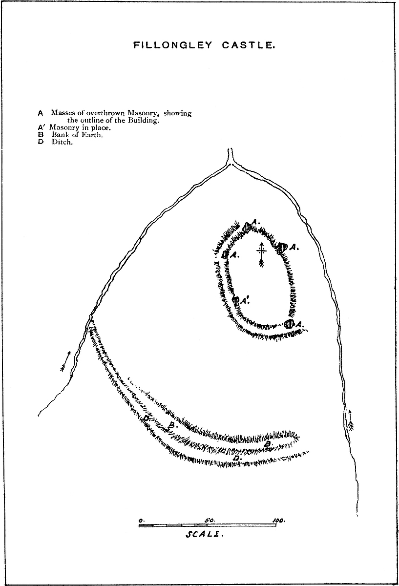
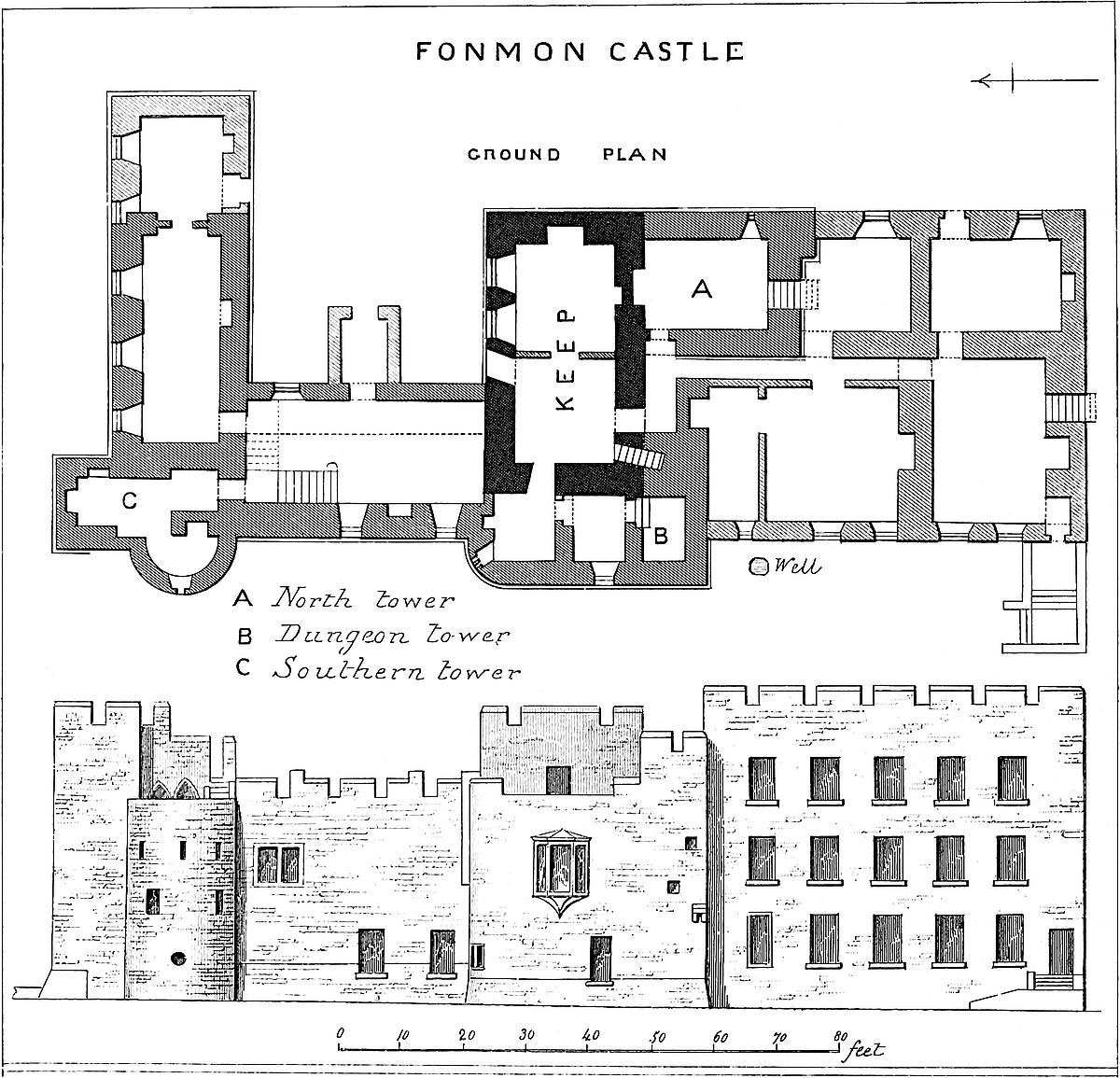
Fillongley Church contains no monuments of the Hastings family, who buried at Polesworth and with the Grey Friars at Coventry.
FONMON Castle was, no doubt, built by Sir John de St. John soon after the conquest of Glamorgan; and part of the present building is original.
The castle rises from the western edge of a narrow and deep ravine, which conveys a streamlet from Fonmon village into the Kenson.
On its north front, but at some little distance from the castle, a similar steep bank slopes down direct to the Kenson, which there traverses a meadow, in earlier days probably an impassable morass. On its west and south sides the castle stands on table land, and was covered, no doubt, by a moat and outer wall. The keep, a rectangular building 45 feet high, and 25 feet north and south, by 43 feet east and west, including its walls, which are 5 feet thick, appears to be late Norman, and may be presumed to be Sir John de St. John’s work. Additions, probably of early English and early Decorated date, enclose it on the north, east, and partially on the south sides; on the latter forming a considerable wing, a part of which is a square tower which caps the south-east angle, and is a principal feature in the general view of the building. Two bow towers of the same date project from the east front. The principal additions on the north are of the seventeenth century, and were erected without reference to defence.
The outworks, with the exception of one tower which stands alone on the south-eastern front, about 140 yards from the castle, long since have given way to stabling, barns, and formal terraced gardens, most of which have in their turn disappeared. The remaining tower seems to have been the south-eastern termination of the defences of the outer court.
The St. Johns resided, more or less, at Fonmon until towards the fourteenth century, when, by intermarriage with the heiresses of50 Paveley, Pawlet, and, finally, of Beauchamp of Bletsoe, they became powerful English lords, and removed their head-quarters into Bedfordshire. Fonmon was probably left to the care of a bailiff, though some cadets of the family settled at Highlight, and there remained after the sale of the property to Colonel Jones, about 1655. Since that period it has been regularly inhabited by the Jones family, as it now is by their descendant and representative, Robert Oliver Jones, Esq.
The castle contains portraits of Cromwell and Ireton, and a fine one of Mr Robert Jones, grandfather of the present proprietor, by Reynolds.
THE masonry of this castle has been entirely removed, but the original moated mound and earth-banks remain, and the lines of the masonry may be traced by the trenches dug when the foundations were grubbed up. The mound stands on the left bank of the river Nene, and of the buildings the principal, disposed nearly east and west, was very evidently the great hall in which Mary of Scotland was tried and executed.
There is in “Ellis’s Letters” (First Series, Vol. II.) a draught plan, in Burghley’s hand, of the hall as it was ordered to be prepared for the trial.
The “great chamber” was 23 yards long with the window, and 7 yards broad. The length without the window was 21 yards. The window, therefore, was probably a bay or oriel, of 6 feet projection within. The draught plan was sent down with the figures blank to be filled in by special measurement.
At the upper, probably the eastern, end, and in front of the window, was a chair for the Queen of England. Against the wall on her left, a bench for thirteen barons; on her right, leaving space for passage between it and the wall, was a bench for twelve earls. Across the hall, 13 yards from the upper (east) end, and 8 yards from the lower end, was a bar, extending on the barons’ side nearly to the wall, but on the earls’ leaving space for passage. Within, close to the bar and opposite Elizabeth’s seat, was a chair for Mary.
The points of the compass are not marked upon the plan, but it is clear, from the disposition of the passage, that the door was on that or the north side, and most probably near to its west end. The door of a castle-hall would never have opened towards the defences of the place, but into the inner court.
The block for the execution was placed at the upper end of the hall; probably, therefore, where Elizabeth’s chair had stood during the trial.
51
The fireplace in which, after the execution, the block and bloody drapery were burned, probably was placed in the centre of the south wall.
Possibly, during a season of drought, some local antiquary may succeed in establishing the actual position of the door, the bay window, and the fireplace.
GROSMONT is one of five strong places disposed along the right or south-west bank of the Munnow river, the others being, below it, Skenfrith, and above it Oldcastle, Longtown, and the fortified house of Perthir; Monmouth Castle, and the town beneath its protection, occupied the junction of the Munnow with the Wye. These are some of the fortified buildings scattered broadcast over the Welsh marshes, and especially abundant in the county of Monmouth, and the remains of which, always picturesque, are often tolerably perfect.
In the rear of these castles on the Munnow were those of Brecknock, Tretower, Crickhowell, and Abergavenny, upon the Upper Usk; and over the whole of that country there is scarce a hill-top or point of vantage which is not occupied by some defensive earthwork, showing the importance attached to it by each of the several races, Celt, Roman, Saxon, and Norman, who in turn either attacked or defended this devoted soil.
Grosmont, about four miles above Skenfrith and five below Oldcastle, is placed, like the former fortress, upon the high concavity of a sharp bend of the river, about a hundred yards from its margin. Very near to it is the fine old cross church, which, having shared in the prosperity of the castle, has escaped its decay, and still remains in tolerable repair, although requiring a few subtractions and restorations at the hand of a judicious architect.
The castle is composed of a court or ward of irregular plan, more or less rectangular, with projections upon the south side, the wall of which contains a space of 110 feet by 70 feet, strengthened on the south by a larger and a smaller three-quarter mural tower, having a gateway upon the east face, and on the west traces of a building exterior to the curtain wall. The north side is occupied by a hall, also exterior to, or rather replacing the line of, the curtain, three of its four walls forming a part of the exterior defences of the building.
The whole is placed within a ditch of great depth, and, indeed, the earthworks generally are of so formidable a character as to make it probable that they are earlier than the present building, or than any other work in masonry. The actual platform occupied by the52 walls, and contained within the crest of the ditch, is about 150 feet in diameter.
Outside the ditch, to the east and south, and covering the entrance of the castle, is a large demi-lune, or platform of earth, scarped towards the field, and upon which are traces of walls and a defence of the nature of a barbican. The main ditch, now traversed by a modern embankment, was evidently at one time crossed by the usual bridge, of which a part lifted. The gatehouse, if such it can be called, presents two lateral cheeks of wall, projecting on either side of the bridge, and thus forming a covered way, from each side of which a cruciform loop is directed along the ditch. The pointed vault of the entrance is broken, but there remain the ragged grooves for the portcullis, and the two holes which received the large wooden bar fastening the gate.
Entering, on the right is the shell of the hall, 80 feet long by 27 feet broad, out of all proportion to the area of the defences. The floor, of timber, was laid 6 feet above the level of the court, so as to give height to a spacious basement store-room or cellar, but which, however, has a large fireplace in its east wall. The hall has windows at each end, and four in each side; but probably only the six to the east belonged to the hall, the other two lighting a withdrawing-room. The position of the fireplace on the north side seems to mark the centre of the hall.
On the left of the entrance the curtain extends to the south-east or smaller drum tower, and probably supported a spacious lean-to roof marked by the corbels or bearers for the upper wall-plate. This south-east tower seems to have been massive, but low, and to have been altered and enlarged at the gorge, on the side towards the court, which now projects inwards in a rectangular form. When this addition was made the tower seems to have been raised to three or perhaps four stories, and near its summit is a bold cordon.
A strong curtain extends from this to the south-west drum-tower, of larger dimensions, and broken down towards the court. The floors of these two towers were of timber. Between them, and parallel to the curtain, seem to have been some buildings, probably barracks.
The buildings outside of, and built against, the west curtain projected boldly into the moat. They are in great decay. Here was the fireplace, the flue from which, wrought out in the substance of the curtain, rises above it as an elegant octagonal chimney shaft, the summit of which is crowned by the elegant lanthorn or spiracle which has so often been drawn and is so well known.
Grosmont, as it now appears, is of moderate size and much mutilated; but its towers and walls, though stripped of their ashlar, are still standing, and the earthworks are large, bold, and well-defined.
Whatever may be its ancient history, the present building presents nothing earlier than the reign of Henry III. The additions seem to have been in the Decorated style, and, probably, are of one date,53 that of the reign of Edward I. After the South Welsh conquest, Grosmont was one of the numerous De Braose castles, and passed by inheritance to the Cantelupes. It then fell into the possession of Henry III., who granted it to Hubert de Burgh. In the well-known war waged by the Welsh and Richard Mareschal, Earl of Pembroke, against Henry III., it was besieged by Llewelyn and relieved by the king, who occupied it as head-quarters during the latter part of the campaign. After De Burgh’s fall, Henry regranted the castle to the Earl of Lancaster, and it has since, with the somewhat earlier castles of Skenfrith and Whitecastle, remained attached to the duchy. Henry, Crouchback’s grandson, was here born, and hence styled Henry of Grosmont. Probably he was the author of the principal additions.
The adjacent church contains a late Norman font, with cylindrical base and octagonal bowl; and the pier arches of the central tower are also Pointed Norman. Most of the remainder of the church is early English, and probably of the date of the castle; but there is a Decorated north porch, and also some other parts in the same style, which may have been the work of the artist who completed the additions to the castle and designed its elegant chimney-shaft and finial.
GUILDFORD Castle, of which the keep was always the most prominent, and is now the chief remaining, feature, is in position, age, structure, and dimensions, a very remarkable fortress.
It is true, indeed, that though of great age, neither the town nor the castle have played any great part in English history. The town was never walled; the castle never stood a siege. No considerable battle was ever witnessed from its towers; no parliament or great council was ever held within its hall. Though always a royal manor, and long maintained as a royal residence, it was used also as a prison, and is but rarely mentioned, either in the records or by the chroniclers. The castle was not garrisoned in the great civil war, and so escaped being dismantled and blown up by either king or parliament. Its state of decay is due to the effects of time, powerfully aided by the local greed for building materials. Nevertheless, though wanting in many of the points of interest often attaching to English military buildings, Guildford Castle has certain peculiarities of its own not unworthy of notice, and which it is the object of this notice to set forth and explain.
The great chalk range which forms the bulwark of London and the southern limit of the vale of the Thames, from its mouth to the border of Hampshire, is contracted towards the west into a narrow but elevated ridge, which extends from Reigate nearly to Farnham54 and, resting upon the firestone and gault of the Weald of Kent and Surrey, supports the clay and gravels of the London basin.
This ridge, generally unbroken, is traversed by two well-known gorges about twelve miles apart, of which the eastern is occupied by the Mole at Dorking and Mickleham, and the western by
The Wey, the tributaries of which rise widely over much of Surrey and the eastern part of Hampshire, is, where it cleaves the chalk, a considerable stream, much less milky than in the days, or rather in the verse, of Pope; and twelve miles below the pass it falls into the Thames at Weybridge.
The town of Guildford is placed upon the right or eastern bank of the river, well within, that is, north-east of the gorge, and within and a little above the town is the castle. As the ridge is here steep and lofty and the gorge deep and moderately narrow, it might be supposed that this pass would at all times have been important to whoever wished to defend London and the Thames from invaders from the south. In position it is to the south of London what Berkhampstead Castle is on the north; both are placed in gorges of chalk, both upon tributaries of the Thames; both are late Norman castles, founded upon earlier English earthworks; and both were for centuries held direct by the Crown. Guildford, however, unlike Berkhampstead, though the nucleus of a large town, has no military history. Although Surrey and Sussex are by no means deficient in traces of early occupation, the immediate neighbourhood of Guildford is in this respect almost a blank. An early trackway has been talked of as taking the ridge of the Downs, and traces of an irregular, and therefore British, camp are said to have been formerly observed on St. Martha’s hill; but the long chalk crest and slopes of the Downs, so tenacious of the slightest works ever executed on their surface, are not known to exhibit any traces of the encampments or pits or other works usually attributed to the British, which, considering the dense forest that certainly extended to the foot of the high ground on the south side, and probably on the north, is very singular. Antiquaries, indeed, have placed the capital of the British Regni at Guildford and the city of Vindomis at Farnham, but nothing beyond general probabilities have been brought forward in favour of either supposition. It is curious, also, to observe how completely Celtic names have disappeared from the neighbourhood. Even the rivers, the first to receive and the last to change their names—the Wey, the Wandle, and the Mole—are Saxon, as are the names of Guildford, the chief town of the county and district, Farnham, the ancient episcopal seat, and the villages about them.
Neither are there any very decided marks of Roman occupation in Guildford. The Castle Hill at Hescomb, Hilbury in Puttenham, and Holmbury in Ockley, are said to be rectangular, and therefore Roman earthworks; but neither of the two great Roman roads from the south passes through Guildford. The Watling Street leads from55 Canterbury, by Rochester, to Southwark; and the Icknild Street, from Chichester, takes the pass of Mickleham in its way to the same destination. It is very curious that a town so remarkable in position, so strongly posted, and so directly in the way from the south-west to London, and withal so sheltered, and placed close to pastures so fertile, should exhibit no marks of occupation by the Romans or the earlier or later Britons.
The early history of Guildford, like its name, is Saxon, and, like its name, savours wholly of the arts of peace. Of the “guild,” or mercantile community, which in early times must have been established on the “Ford” of the Wey, nothing is recorded; but from the lingering presence of such names as Burgh Road, Burgh Field, and the Bury, it has been supposed that the earliest Saxon municipality was seated on the west, and not, as now, on the east bank of the river. It has been said that the cause of this was the establishment of the fortress on the east bank, and the consequent want of space for private dwellings. But the fact is probably just the reverse. A fortress, whether Saxon or Norman, would, as a rule, attract inhabitants to place themselves under its protection; and, however spacious may have been the area enclosed—and a little under six acres is the very utmost that has ever been assigned to it—there must always have been ample room between the walls and the river to the north, where the present town is located. If ever the town stood upon the west bank, the balance of probability is in favour of its having been transferred across the stream as soon as the earliest stronghold was established there.
There is reason to believe that the principal thoroughfare of the present town—the High Street—existed in the thirteenth century, and probably some centuries earlier. Guildford is a borough by prescription, and therefore may be of any English date, however early. It has paid the castle the fitting compliment of placing it on the borough shield, which bears “on a mount vert, a castle.” The town stands in three parishes: St. Mary’s, which includes the castle; Trinity; and on the west bank of the river, St. Nicholas.
The recorded history of Guildford has no ignoble beginning. It was the property of Alfred, and is first mentioned in his will, between 872 and 885. “To Ethelwald, my brother’s son,” says the great king, “I bequeath the manor at Godalming and at Gyldeford, and at Steyning.” On the death of Ethelwald, childless, Guildford reverted to the West Saxon crown. In the following century, in 1036, Guildford was the scene of the capture of Alfred, the elder brother of the Confessor, and of the massacre of his Norman attendants. As to the particulars of the event, and as to the parts played in it by Godwin, Queen Emma, and Harold Harefoot, testimonies differ, but all agree in the mention of Guildford as the place to which the Atheling was conveyed.
When the Conqueror marched northward from Canterbury, he went by the Watling Street, through Rochester, to Southwark, and thence ascending to Wallingford, turned the position of Guildford,56 and placed himself between it and the Thames. Its name even does not occur till late in the reign, and then only in the General Survey. From that survey, it appears that it had remained Crown property. No castle is there mentioned, but that it contained a residence is more than probable, both because it had been so long a royal demesne and from what is stated as to the Atheling’s reception there.
In Domesday Book, as now, Guildford was in the Hundred of Woking. The chief of the royal tenants was Ranulf Flambard, afterwards so celebrated both for his rapacity and his magnificence. He was rector of Godalming, and as such held lands in Guildford, which were afterwards appended to his canonry at Salisbury, to be eventually resumed by Henry II., and attached, with the castle, to the Crown. In 2 Henry II. the king gave Godalming hundred and manor to the church of Sarum, in exchange for the castle of Devizes and Rueles, or Erlestoke, then held by the bishop of that see.
The Conqueror granted a large plot of ground, upon which much of the modern town north of the castle and south of High-street now stands, to a family of the name of Testard, who held it for several generations by a singular tenure recorded in Blount, and are reputed to have built the two churches of St. Mary and Trinity for the use of their tenants—a fact which would go to show that the town was already standing within convenient reach of these churches, of which one is still mainly Norman, and of large area; and, further, makes it improbable that the castle enceinte ever extended far to the north, as the Conqueror was not likely to have granted away any part of the older area. The historians of Surrey estimate the population of Guildford recorded in Domesday at 700 persons.
The internal evidence of the buildings of the castle makes it most probable that the whole of it, keep, hall, and domestic buildings, with its enceinte wall enclosing above five acres, was constructed by Henry II. very early in the reign; but the castle is not mentioned in his reign, nor in that of Richard I. In the Pipe Rolls, the town appears from time to time as contributing to tallage and other imposts, and in 1 Richard I. the park is named in connexion with the canons of Sarum. It also appears from the Rot. Curiæ Regis, 6 Richard I., that an assize was held there. Henry II., probably when he built the castle, seems to have formed a royal park on the opposite side of the river, north of the Hog’s Back, the site of which is still indicated by such names as Guildford Park, Wilderness, Stag Hill, and the Manor Farm, the latter being probably the site of the royal lodge.
Captain James, who conducted the Ordnance Survey of the district and paid great attention to the ancient boundaries, and to whose researches much that concerns the castle is due, is of opinion that the area of the park was on the north, west, and east, conterminous with the parish of St. Nicholas, and that on the south it was bounded57 by the crest of the Hog’s Back. This tract is said anciently to have contained four manors, but at this time it is composed of three very ancient farms, all within one manor.
King John, whose suspicious nature and feverish activity led him to be always in motion, was at Guildford nineteen times in eleven different years. In 1200 he kept Christmas here and equipped his household in new liveries, which, to the king’s great but dissembled disgust, the Archbishop of Canterbury proceeded to surpass in splendour. In 1202 he was not here; but there is a charge for £6. 5s. 8d. for work done upon the king’s houses, and £1. 6s. 6d. for the transport of wine, and 4s. for the repair of the gaol in the castle. This is the first mention of the castle, and it is curious that it is connected with its use as a prison.
In 1204, John was here 9th October and 7th, 8th, 9th November; and in this year £10 was paid for the repair of the king’s houses, and £40 for the expenses of his chamber. John Fitz-Hugh, sheriff of Surrey and Sussex, 1208, 1210–11–12–13 and 1214, was then made keeper of the park. In 1205, the king was here 9th, 10th, 11th of April; 1st August; and 30th, 31st of October. On the 7th February, two tuns of wine, the king’s prisage, were sent here, and 15th May, two hundred porkers went from hence to Southampton, a supply of flesh to London, and a net to Southwark.
King John was here 28th, 29th, 30th December, 1206, and in 1207, 27th, 28th December. In this year, 28th August, the sheriff of Hants was to take certain prisoners from Sarum Castle and deliver them to the constable of Guildford Castle. This is the second mention of the fortress, and also as a gaol. In 1208, John was here 25th, 26th, 27th January; and 5th, 6th, 7th April; and in 1210, on the 1st, 2nd, 3rd January; and 8th March. Also in 1212, on the 12th, 13th, and 14th May.
In 1213, on the 14th, 15th, 16th, 17th December, King John was here. 3rd January the custody of the county of Surrey, with the castle of Guildford, was committed to Reginald, son of Reginald de Cornhill, to be held during pleasure, and John Fitz-Hugh was ordered to give it up to him. The Cornhills were a family of farmers-general of the revenues of the counties south of London, and between 1164 and 1215 Gervase, Henry, Ralph, and Reginald de Cornhill appear as sheriffs of Surrey and Sussex then combined.
In this year, 1213, also one hundred deer, “damos et damas,” were given from Guildford to the Archbishop of Canterbury to replenish his park. In 1214, 24th August, 53s. was allowed for the entertainment of the Papal legate, then on his way to revoke the Interdict. Rochester and Guildford Castles are mentioned together in this year as undergoing some repairs.
In 1215, King John was here for a whole week from the 15th to the 21st of January. His forces had been beaten at Bovines in the preceding July, and he had come to Guildford from London, after receiving the demands of the confederate barons agreed and sworn to at Bury. He was probably at that time actively employed in58 obtaining support from the clergy, in the hope of evading the great charter, which, nevertheless, he was forced to agree to in the following June. On the 18th November, John Fitz-Hugh, who again was sheriff, was ordered to give up the castle to whomsoever Peter Bishop of Winchester should name to receive it. It was probably made over to Reginald de Cornhill.
In 1216, John paid his last visit to Guildford, and remained there during the 20th, 21st, and 22nd of April. In the June following, the Dauphin Louis was here on his way from Sandwich. With Guildford, he held Reigate, then a castle of the Warrens, and Farnham.
Guildford, both castle and park, are mentioned not unfrequently in the reign of Henry III. In 1222, 19th November, £200 was paid for the royal expenses going thither from London. In 1223, 19th January, King Henry was at Guildford. 18th April, allowance was made for building a house of alms in the king’s court there. This was probably an office for the receipt of deodands, fines, forfeitures, escheats of felons’ goods, and other moneys accruing from incidents of feudal tenures, and, it has been supposed, appropriated to charitable uses. 14th May, works were in progress on the king’s houses, and 27th May, Richard Dale had ten marcs for repairs in the park; and again, in October, money was paid for fencing it. In 1224, repairs were done to the king’s houses, and half a marc paid for making a door. The fencing of the park was proceeded with. In 10 Henry III., William de Coniers was governor for the king, as were in 30 and 53 Henry III., Elias Mansel and William d’Aguillon.
In 24 Henry III., 4th April, the sheriff of Surrey was ordered to repair the glass windows of the king’s houses and chapel at Guildford, broken by the storm, and the houses unroofed thereby were to be restored. In 29 Henry III., the vill of Guildford is mentioned as vested in the king; the sheriff was to enclose the area by the kitchen which the king had purchased, with a wall conveniently answering to the other wall by which the said court is enclosed; and he is to repair the two piers of the king’s hall, which need repair because they are out of the perpendicular. In 30 Henry III., 3rd February, the sheriff of Surrey and Sussex is to make “a certain chamber at Guildford, for the use of Edward, the king’s son, with proper windows well barred, which is to be 50 feet long and 26 feet wide ... with a privy chamber ... so that the chamber of the same Edward be above, and the chamber of the king’s noble valets underneath, with fitting windows, and a privy chamber, and a chimney in each chamber. And he is to make under the wall towards the east, opposite the east part of the king’s hall, a certain pent-house, which, although narrow, shall be competently long, with a chimney and private chamber, for the queen’s wardrobe; and to make in the queen’s chamber a certain window equal in width to the two windows which are now there, and as much wider as may be, between the two walls, and as high as becomingly may be, with two marble59 pillars; and to wainscote that window above, and close it with glass windows between the pillars, with panels which may be opened and shut, and large wooden shutters internally to close over the glass windows; and to cause the upper window in the king’s hall towards the west, nigh the dais, to be fitted up with white glass lights, so that in one half of that glass window there be made a certain king sitting on a throne, and in the other half a certain queen likewise sitting on a throne.”
In 40 Henry III., these decorations and alterations were still continued, for on the 3rd January, the king being at Guildford, orders the sheriff of Sussex to deliver £100 to the wardens of the king’s works at Guildford, “to pay off certain arrears due for the same works, and for wainscoting the king’s chapel, the queen’s chapel, the king’s chamber, and the other chambers newly built there; and for making the great windows in the king’s chapel; for barring the windows of the king’s new chamber with iron; making the porch to the hall, of stone; for painting in the hall there, opposite the king’s seat, the story of Dives and Lazarus; making a certain figure with beasts on the same seat; and lengthening the chamber of the king’s chaplain there.”
Also on the 5th May following, the sheriff of Surrey and Sussex is ordered to whitewash the king’s hall at Guildford within and without. On the 17th June, 45 Henry III., 1261, the king visited Guildford, and doubtless examined and took pleasure in the various improvements and decorations he had ordered. All this luxury was probably confined to the hall and royal apartments in the middle ward, for an entry on the Hundred rolls at the commencement of the reign shows that the Sussex county prisoners were kept at Guildford, and no doubt in the keep.
In 50 Henry III., Prince Edward was at Guildford engaged in putting down Sir Adam Gordon, a soldier who, having been outlawed after Evesham fight, had turned freebooter, and made the Surrey woodlands very insecure. Edward came up with and attacked him between Farnham and Alton, took him prisoner in single combat, got him a pardon, and presented him to the queen then at Guildford. At the end of Henry’s reign, 52 Henry III., the “King’s Mills” were removed farther down the stream, probably to the site now occupied by their modern successors.
Edward I. became possessed, in due course, of Guildford, and in 27 Edward I., 1299, the park, castle, and farm of the town were assigned as part of the dower of Margaret, the king’s second wife, and on her death, 10 Edward II., they reverted to the Crown. Edward was here, 20th January, 31 Edward I., 1303, resting on his way from Odiham to Windsor.
In 35 Edward I., 1306, Henry de Say, keeper of the prisoners indicted at the Sussex Assizes, and lodged in Guildford Castle, petitioned that an officer might be sent to receive their fines and chattels, according to their offences, and that a stronger prison may be provided, the castle being insecure for so many prisoners. The60 answer, recorded on the rolls of Parliament, is terse:—“Si carcer sit nimis debilis, faciat, Custos, emendari; si nimis strictus, faciat elargari; quia Rex non est avisatus mutare locum prisonarum suarum: vel saltem teneat eos in vinculis fortioribus.” “Double iron the prisoners” was at one time a usual, and certainly an economical, way of securing their safety. It is probable that it was under these circumstances of great pressure that the mural oratory in the keep was employed as a prison.
In the king’s circular to the sheriff, 1 Edward II., 1307, 15th December, which was followed by the edict confiscating the goods of the Templars, the sheriff of Surrey and Sussex was ordered to repair to Guildford. In 15 Edward II., Oliver de Burdegala, governor, had a writ of privy seal directing the castle to be victualled and garrisoned.
Guildford, 2 Edward III., 1328, was the head-quarters of the sheriff of Surrey, who was ordered to go there to prevent tournaments from being held. On the 8th March, 1329, the king was at Guildford; also 28th February and 26th December, 1330; 18th–20th November, 1331; 2nd September, 1334; and 18th–24th April, 1336; so that the castle was in not infrequent use as a royal residence. In this last year the king granted the town in fee farm to the corporation, reserving only the park and castle. On the 23rd April, 1337, 11 Edward III., the king ordered that Robert d’Artoys should have a right to be hospitably received should he visit the royal castles of Guildford, Wallingford, or Somerton, and he might sport in the park at Guildford.
In the same year, 24th December, Edward was himself at Guildford, as he was in 1340, and again 27th–28th December, 1347, in which year the commonalty of Sussex petitioned that Chichester in place of Guildford might be the county gaol. The petition was set aside, and in 41 Edward III. the sheriff still held his official residence in the castle, which was the prison, as before, for the two counties. 42 Edward III., 1368, 28th July, the king was here. 43 Edward III., the custody of the castle and park was given to Helmyng Legatte for life. Edward was again here, 45 Edward III., 1371, on the 12th of May, probably for the last time.
In 1 Richard II. Sir Simon Burley was constable of the castle, and afterwards Sir Hugh Waterton, on whose death, 10 Henry IV., Sir John Stanley had the office also for life, and his appointment was confirmed by Henry V. By that time the custody of the park was evidently an office more coveted than that of the castle.
What occurred in the castle during the wars of York and Lancaster is not known, save that it was the scene of no event of importance, and it certainly continued still to play the ignoble part of a common prison, for in 3 Henry VII., 1487, the old complaint is revived, and the county of Sussex again petitions for a gaol of its own, and under its own sheriff, suggesting Lewes as a proper place. This time the prayer was granted, and probably the Surrey prisoners either then or soon afterwards were bestowed elsewhere, though the two counties61 continued long after this to be placed under one sheriff. As late as 1620 a Sussex gentleman, Nicholas Eversfield, was sheriff of the two counties, and the jurisdiction does not appear to have been finally divided till 1637.
Finally, in 1611–12, after having been attached to the Crown at least from the days of Alfred, or 700 years, the castle and its enceinte were granted by James I. to Francis Carter, of Guildford, who died in 1617, and whose son, John Carter, is described as dwelling in the castle in 1623. His eldest son Francis died in 1668, leaving a daughter only, and it is his brother, the second son, John Carter, whose initials, “J. C., 1699,” stand upon a tablet within and above the great gateway in Quarry Street. The castle has since remained in private hands, and is now the property of Lord Grantley.
The above extracts, mainly taken from those given by Mr. Parker in his valuable volumes on Domestic Architecture in the Middle Ages, will have shown that the fittings and adornments of the castle were chiefly due to Henry III. That prince, who was a great patron of the arts, and especially of architecture and painting, paid great attention to the royal residences. Unfortunately, his decorations were for the most part confined to the hall and principal domestic apartments, but few of which anywhere have survived. At Guildford, the destruction has been peculiarly sweeping, and the only remaining structure, the keep, does not seem to have participated in the royal care. The keeps of Norman castles, inhabited but rarely, and only during a siege, even by those who built them, seem very soon to have been altogether deserted for more convenient lodgings in the lower and more spacious wards. The keep was then used as a storehouse or barrack, or, as at Guildford, as a prison, and very little was spent upon its repairs, and nothing upon its decoration. It is, however, in consequence of this neglect, that the Norman keeps, where they have not been pulled down, remain pretty much as they were originally built, or with only such additions as may easily be detected, or such diminutions as may readily be supplied. This is particularly the case with the keep at Guildford, the additions to, or alterations in, which are of the rudest character, and may readily be detected, while of the masonry of the original structure little is wanting save the parapets and angle turrets and some details connected with the approach and entrance.
Guildford Castle occupied a natural platform of nearly six acres upon the slope of the chalk hill, far below its summit, and from 40 to 80 feet above the river. The platform, inclining gently towards the stream, terminates at about 80 yards from its bank in a low cliff of from 10 to 12 feet high, in parts replaced by, and in parts resting upon, a steep, natural slope or talus, which dies away 40 feet lower down into the meads traversed by the river. The crest of this cliff or talus is occupied by Quarry Street, and forms the west front of the castle. Towards the north, the river is more distant, and the slope of the platform far more gradual. On this side, the62 High Street and the present town of Guildford intervene between the castle and the river.
The keep stands on the eastern and highest part of the platform, and commands the rest of the castle, as the castle commands the town; and here are what appear to be the remains of the English residence. At the foot of the steep, a mound, wholly artificial, but resting upon an inclined natural base, has been thrown up, composed of chalk, in form conical, truncated, and with a level summit, no doubt originally circular, and still nearly so, and about 90 feet diameter. The base is about 200 feet. Between the mound and the adjacent steep hill-side is the main, and perhaps a trace of a second and outer, ditch. This inner ditch, about 60 feet broad and 12 to 20 feet deep, sweeps round the foot of the mound on the east, north, and south sides, the ends dying out on reaching the platform on the west below. The ditch, always dry, has long been cultivated as a garden, and was no doubt once considerably deeper. Its north limb is partially built upon by the houses in Castle Street, and is, in consequence, nearly obliterated. It is traversed at the north-east quarter by a narrow causeway of earth, which, no doubt, represents an older causeway of stone, provided with a drawbridge, and forming a direct entrance for foot passengers and perhaps horses, to the keep. Beyond this, the east and south-east, in the extra-parochial plot called the “Bowling Green,” are very slight traces of what may have been a second and outer ditch, a not unlikely security to have been provided by the inhabitants of the mound against an attack on this the weakest, because the commanded, side.
The mound on the eastern face, measured from the scarp of the ditch, is about 30 feet high, but on the western side, where it rises from a lower level, it is about 50 feet, or 92 feet above the river. The mound and the ditch evidently supported and protected the dwelling of the English lord, and it is probable that upon the platform below, where the Norman king afterwards placed his hall and offices, were lodged the serfs and dependents of the earlier household. Judging from the close analogy of Leicester, Tamworth, Tutbury, and other earthworks of known date, the earthworks of Guildford may, with great probability, be referred to the earlier part of the tenth century.
The keep, a rectangular structure, covers the eastern slope of the mound, but is placed a little to the south of its central line, so as to allow of a gateway (now gone) at its north-east angle, and a passage up the mound outside the north wall. The east or lower wall rests on the undisturbed ground, a little above the level of the scarp of the ditch, and the west or upper wall upon the edge of the level summit of the mound, nearly the whole of which thus extends undisturbed to the west and north-west of the building. The difference in level of the base of the two faces of the keep is about 15 feet. It is exceedingly rare to find a rectangular keep placed upon an artificial mound. Guildford, Christchurch, and Clun are the only recorded examples.
63
The keep stands nearly by the points of the compass, measuring 46 feet north and south, by 52 feet east and west. The wall is perfect to the base of the parapet, a height on the west front of about 63 feet. The masonry of the lower side contains more ashlar, and is of better quality than the rest, to prevent the structure from slipping. Of the depth of the foundations nothing is known, but the thickness of the wall—at least 11 feet at the visible base—would serve to distribute the load, and chalk, even when made ground, does not make a bad foundation. There was, no doubt, a risk in placing so heavy a building upon an artificial hill, even though a couple of centuries old, but the result has justified the means employed, for there is not a crack or mark of settlement in the whole edifice. Grose represents some half-buried arches on the south side, not now visible, but which, if they ever existed, which is more than doubtful, might indicate that parts of the building rested on piers, carried down to the solid ground. However, enough of the wall is bared to show that this is not the case. What Grose took for an arch was probably a low course of inclined or half-herring-bone masonry. Others have described an opening on this side supposed to lead to a sub-basement vault which there is no reason for supposing to exist. The machicolations cited in evidence as defending this fabulous doorway are the vents of a garderobe in the upper story.
The four faces of the keep are generally alike. Each is flanked by two pilasters of 4 feet 6 inches wide, by 9 feet projection, so placed as not to cap the angle, but to convert it into a hollow or re-entering one. This hollow was left open, not filled up, as at Scarborough and elsewhere, by a bold bead or engaged column. In the centre of each face is a third and similar pilaster, but 5 feet wide. Probably these rested below upon a plinth common to the whole building; but if so, this is gone. Each pilaster is of equal breadth and projection throughout, having no sets-off. The central pilasters run up to the base of the parapet, now gone. Those at the angles were continued to form the usual square turrets, of which some slight though clear remains still rise above the curtain.
The material employed for the exterior is chiefly Bargate stone, from the bed representing the chalk marl immediately beneath the chalk. This is worked up as rubble, interspersed irregularly with courses of the same stone laid herring-bone fashion, for which the larger and flatter stones have been selected. The work is very rough. The herring-bone courses are laid at all heights and distances; some broken, some mere single inclined stones, and here and there, especially near the top, are occasional courses of flints, some of which look like insertions. The angles, salient and re-entering, of the pilasters, are of the same stone, cut as ashlar and well jointed; but between these quoins the pilasters are usually of rubble, sometimes herring-boned. Above the parapets the angle turrets seem to have been of ashlar. There is no string-course, shelf, or set-off upon the face of the wall. The west-central pilaster, being pierced by the entrance,64 is mainly of ashlar, as are the pilaster and adjacent wall, about the north-east angle of the building, where the gate of the ward seems, from traces in the masonry, to have abutted. Here, too, the joints being very wide are made good with single or double rows of thin ordinary bright-red roofing tiles. The base of the east face was repaired about forty years ago, and now has a modern ashlar plinth of about 15 feet high. The ashlar within reach on the other faces has been pillaged, and the base of the wall generally is very hollow and ragged. The hearting of the walls throughout seems composed of chalk and Bargate stone, very roughly laid and grouted.
The walls are everywhere pierced with putlog holes, about 4 inches square, indications of the method of construction, and probably originally but loosely stopped to allow the work to dry and for the convenience of future repairs. There are no large holes above, and no signs of a bretasche having been employed. Four double windows on the upper floor and one on the east face of the middle floor, though original, have been fitted up with cut brick mullions and arches of perhaps two hundred years ago, the work, no doubt, of the first purchaser. All earlier alterations seem to have been effected in stone.
Having thus disposed of the general exterior of the keep, the next step is to describe its interior details. Allowing for the removed plinth or casing, three of the faces are about 11 feet thick and the fourth or east about 14, so that the interior dimensions are 24 feet north and south, by 27 feet east and west. The building is composed of a basement and two upper stories, and the floors and roof were of timber. There is no evidence of any subterranean chamber, and no reason for supposing one.
The basement on the level of the top of the mound is about 12 feet high. The walls are pierced in the centre of the north and south faces with a round-headed recess 5 feet wide and about the same height to the springing. The sides and roof converge to an exterior loop, and the base is stepped up to it. The work is good plain rubble. The east and west walls were originally solid, and the only entrance to this floor must have been by a ladder and trap from the floor above. It was of course a store or cellar, as usual.
At a later date, a doorway, 4 feet 6 inches broad and 8 feet to the springing, has been cut through the west wall near the north end. This has a slightly pointed arch. Its masonry is of small weak rubble without any dressings; and this, and the absence of bond with the older work, show it to be an insertion. In the north-east corner, the wall has been rudely cut away to some depth to form a fireplace and an oven. The bricks composing these have been removed, and a recent pier of masonry supports the wall above. The chimney shaft of this and a fireplace in the floor above have been formed by cutting away the inner face of the wall, which has been rudely restored. No doubt all this is the work of the purchaser, who seems to have lived in the keep and converted the65 basement into a kitchen. In the south-west corner is a small platform of stone, said to have carried a wooden stair communicating with the floor above, and of the date of the kitchen. This is probable enough. One of the stones is a late Norman capital, brought from some other part of the castle. The whole interior of this basement is rubble. It contained neither fireplace nor garderobe. The two loops, its only light, are about 18 inches high, and were probably 4 inches broad, though now increased by weather to 6 inches.
The first or state floor was about 30 feet high, fairly lighted, and contained various mural chambers. In the centre of the west side was the entrance from without, and in each of the other three sides a window. These were of two lights, or rather composed of two tall, narrow, round-headed windows, coupled under one round head outside and a similar recess inside. These recesses commenced about a foot above the floor level, and are 4 feet 4 inches wide and to the springing about 12 feet high. Their sides are parallel, not convergent, and each contained four steps ascending towards the window. There are no mouldings or decorations, but the quoins are ashlar. The window, arches, imposts, and jambs are plain and good. The central window piers or mullions are gone, but in two cases the small head arches remain. In the third case, that in the east face, the window has been removed and replaced by one in brick, but the recess is untouched.
The entrance is 3 feet 4 inches broad, 9 feet high, and about 14 feet from the ground. It is lined with good ashlar; but with a barrel-vault, round-headed, in rubble. The outer portal occupies the whole breadth of the central pilaster, being about 5 feet wide. It is very slightly, but decidedly, pointed. There is no portcullis groove, and but one, an outer, door, well strengthened by bar holes. Below the springing are two small holes, now stopped, for an iron bar, rather low for a centring, and possibly connected with a light drawbridge. The door is in the centre of the west face, as is the opposite window of the east face; but the north window is at the west end of its face, about 3 feet from the corner, and the south window is placed diagonal to it at a similar distance from the south-east corner. The three windows were all of one pattern.
Besides these openings, there are at the same level three mural chambers and a staircase. The principal chamber occupies the south-west angle, and is in plan a right angle with two limbs, like the capital letter L. That in the west wall is 5 feet 6 inches broad by 14 feet long; that in the south wall, 4 feet 10 inches broad by 23 feet long; but as each is measured over the breadth of the other, the total length of the chamber measured on the outer wall is 37 feet and measured along the inner wall only 26 feet 8 inches. The chamber is partly lined with chalk ashlar and partly with rubble, and the vault, barrel and round-headed, is of rubble. The vault springs from a plain Norman abacus. The height to the springing is about 7 feet. The outer wall of this chamber has been lined throughout with an arcade, originally of ten arches, of which66 six remain quite perfect, and of most of the others there are traces. The arcade is of late Norman work, the piers delicate, the caps very highly carved, the arches round-headed. The whole is recessed in the wall, reaches to the springing of the vault, and rests upon a low plinth or dado. There is a loop in the west wall near the north end of the chamber and another in its south end in the south wall. There is also a third and longer and lower loop at the other end of the south limb, close to, and on the right of, the priest as he stood before the altar, the place of which at the east end is marked by a bench or step in the wall. One original door was in the west limb, close to the main entrance. In King’s time it was perfect, and was round-headed, 2 feet 4 inches wide and 7 feet 7 inches high, but it has since been broken away. There is a larger, rude opening in the south limb, which may represent the place of another door. That this singular and highly-ornate chamber was originally an oratory is evident, both from the care bestowed upon it, from the traces of an altar in the east wall, and from the window next the altar.
In Tudor times, the south wall was breached, and a clumsy, flat-topped window of three lights inserted, for which much of the arcade has been cut away; and a rude wall with a door in it has been built across the south limb, probably to convert the oratory into two sleeping places. Upon the chalk ashlar of this chamber have been carved a considerable number of rude representations, apparently the work of one period. Some are simply incised, others carved in relief. There is one very evident Crucifixion, with a soldier piercing our Lord’s side, the disciples attending, and something like a veiled female figure about to faint. There is also a St. Christopher; a bishop recumbent beneath a crown; and other figures, both ecclesiastic and military. They are evidently the work of persons confined in this apartment, and as they are rude, illiterate, and without any trace of heraldic emblems, they are probably the work of common gaol prisoners, and are likely enough to be of the beginning of the thirteenth century, when the prison was over-crowded and every available space sure to have been employed. There was, of course, a larger chapel in the lower ward, not to mention the parish church of St. Mary, hard by. These carvings have been engraved, but not with the necessary correctness. It speaks little for the public spirit of Guildford that they are not photographed.
On the other or north side of the main entrance, also in the west wall, is a second mural chamber, entered by a narrow, round-headed, original door, 2 feet 4 inches broad by 7 feet 7 inches high, quite plain, of ashlar. This chamber has a rude, round-headed barrel vault, and is 9 feet 2 inches long by 5 feet 1 inch broad. There is one loop in the west wall. The walls are rubble, but the internal jamb of the door, being of chalk ashlar, bears some carvings in the style of those described above.
The third chamber is in the north wall, at its east end. Its door and much of its inner wall and floor have been removed to allow of the insertion of a fireplace and chimney-shaft, but enough remains67 to show that the chamber was 14 feet long by 3 feet 2 inches broad, and had a loop in the north wall. The eastern third of this chamber is uninjured. A depression in the floor, quite at the east end, looks as though it had been a garderobe for the state floor, and this idea is strengthened by the quoining and ashlar-work about the angles at that end. Brayley prolongs this chamber at a right angle into the east wall. This is a pure fiction. The quoining of the end shows that there was nothing further, and the groove in the wall is only meant to support the ends of the boards upon which the vault was turned. The fireplace, close west of this chamber, of which the flue remains, is an insertion. The position of the mural chamber and of the window shows, however, that there may have been an original fireplace here.
There remains to be mentioned the well-stair, which occupies the north-west angle of the keep, commencing at the first-floor level and ascending to the roof. This stair does not communicate directly with the main chamber, but opens by a small, round-headed door in the jamb of the adjacent north window, where three steps in a short, narrow passage lead up into the base of the well-stair. The stairs are gone, but the cylinder of the well-stair, 8 feet diameter, remains. As high as the second floor it is lined with excellent chalk ashlar, and lighted by two loops on the west side. A door and passage, similar to that below, ascends by four steps into a recess, not a window, in the north wall of the upper floor. This side door is pointed, but this seems the effect of modern cobbling. It should further be mentioned that the four hollow angles of the first or state floor are quoined with chalk ashlar. The floor rested on no set-off, the walls being of the thickness of the basement.
The second, or upper floor was about 15 feet high. There is a set-off at the floor level, reducing the east and west walls by about 2 feet. In this floor are four windows in broad recesses. Those on the west and east and south faces are central. The fourth window is towards the east end of the north wall, the centre of that side being occupied by a fireplace much modernised, but which the displacement of the window shows to be original. In the south wall, close to the south-east angle, a door leads into a small mural garderobe, with two vents corbelled out over the exterior wall and a loop above them. With this exception, there are no mural chambers on this floor, which is singular, seeing that the wall is quite thick enough to carry them. There is, however, in the west wall, near its north end, one jamb of a walled-up door, which may have been meant to communicate with the stair or with a mural chamber. It seems never to have been completed. The four angles of this room are quoined in chalk ashlar, as in the room below, and the window recesses had, and one still has, round-headed arches. This floor is very inaccessible, but was reached by a ladder when these remarks upon it were recorded. The walls are evidently, in the main, original, though much pulled about by the Carter family when they lived here. The recesses also are original, but68 the windows themselves are cut-brick insertions of two lights, arched.
It will be observed that the eastern wall, though very thick, is pierced by no galleries, and, with the exception of two windows, is absolutely solid from base to summit. Probably the object was, by placing this mass of firm masonry on the solid ground, to give support to the other three sides, and thus prevent them from sliding down the slope of the mound, as was the case with some much lighter and later buildings in a similar position at Cardiff.
It has been stated that the keep stands upon the south-eastern slope of the mound, consequently there is to the west, and in front of its entrance, nearly the whole table summit. This was enclosed by a circular wall, like a shell-keep, about 25 feet high, which, springing from the south-eastern angle of the keep, seems to have been carried round the mound, commencing at about half its height, until it reached the north-east angle of the keep, at which junction there seems to have been a gateway. Of this circular wall about one-half, either actual or in foundations, remains. The fragment of wall, about 5 feet thick and 20 feet high, is evidently of the date of the keep, the same thin red tiles being used in its chalk masonry. Also in this wall is an original garderobe, apparently of three stages: one at the ward level, one half-way up, and one on the battlements; the three seem to have united in a common shaft, the vent of which is seen outside the base of the wall.
The space thus enclosed by the keep and the circular curtain was the inner ward. How the main door of the keep was reached does not appear. There was not the usual fore-building, as at Norwich or Rochester; the circumscribing wall and the lofty position of the keep rendered this unnecessary. A row of small holes at the door level may have belonged to a sort of timber landing, to be reached by a flight of steps of the same material. There is said to have been a well in this ward, about 6 feet from the west wall of the keep, south of the door.
There remain two wards to be described. The line of the enceinte of the castle seems to have been much as follows: Commencing at the angle of Castle Street and Quarry Street, where the site of the present “King’s Head” inn was probably marked by a tower, the west front took the line of Quarry Street, past the great gateway, to the tower containing a postern, which still marks the south-west angle of the enclosure. Thence the wall passed east till it reached the boundary of the extra-parochial ground, whence, in the line of that boundary, it probably took the curve of the counterscarp of the main ditch, in the direction of the Bowling Green Cottages. There, on the platform at the end of the causeway, was no doubt a barbican covering the direct approach to the keep. Thence the wall seems to have been continued along the line of the ditch, shown by the curve of Castle Street, until it again reached Quarry Street, thus enclosing what corresponds tolerably well to the area of the castle at the sale of 1612, which is described as 5 acres, 3 roods, 10 perches; 69or nearly six acres. Of this area, the part north of the great gateway was shut off by a curtain, parts of which remain, and which seems to have run up the mound to the enceinte of the inner ward. In this, the middle ward, stood the hall and principal buildings, as is clear from the considerable, though fragmentary, Norman walls still to be seen, two of which, forming two sides of a large chamber, are very perfect, and one is pierced by a very perfect Norman window recess and loop.
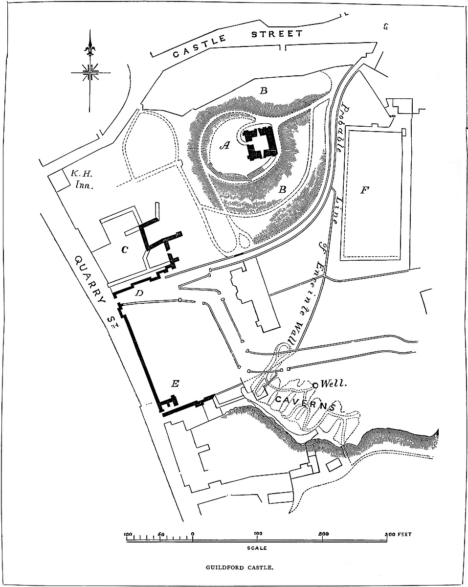
What stood in the area south of the gateway, into which the postern led, is not known. It long contained the gardens of the governor of the gaol, when the castle was employed for that ignoble use, and in it is the celebrated well connected with the caverns.
The great gate in Quarry Street, though large, is at present a mere opening, perhaps of the age of Henry III., in an older, and probably Norman, curtain. Whether it was connected with the gatehouse is uncertain, but there is, as already stated, an indication in the masonry that such was the case. Also the portcullis groove is large, and so heavy a grate could not have been worked without a chamber above carrying a winch. Outside the gate are two buttresses, which have a late Norman aspect. One is nearly perfect, the other has been replaced in brick, but probably upon the old base. The south-west angle of the Quarry Street front is marked by the not inconsiderable remains of the postern tower, adjacent wall, and a large buttress, all pretty clearly late Norman. Towards the north and east the walls are entirely removed, but in these quarters the line of the ditch affords a clue to the original boundary. The enceinte thus laid down measures about 535 yards; its greatest north and south diameter, 170 yards; and east and west, 140 yards. The Quarry Street front is straight and 138 yards long, with the gate nearly in the middle. From the postern tower to the end of the keep causeway is 213 yards, and thence to the “King’s Head” angle, 184 yards.
Captain James has detected traces of a line of wall parallel to, and about 30 yards south of, the High Street, which may not improbably have been the boundary of an enclosed area appended to the castle, as may the extra-parochial lands on the east and south-east, but the actually defended area of the castle seems to have been as above described.
It may further be observed that Quarry Street, which runs along the foot of the west wall of the castle and lay between it and the river, seems to have been defended on that side by the low cliff and talus already mentioned, supported probably by the retaining wall, of which traces and the jamb of a gate remain; while there is a tradition of a gate crossing the street near the postern of the castle, which probably guarded the approach to the town from the south, the only quarter from which a hostile approach would be apprehended.
Not only are the remains of the domestic buildings of a late Norman character, but among the repairs of the hall, in the reign of Henry III., two of the piers are mentioned as out of the perpendicular, a tolerably conclusive evidence that the hall resembled70 Oakham and Leicester and was of Norman date. Altogether, it is sufficiently evident that the whole area of the castle was enclosed by its original founder, and is not later than the middle of the twelfth century, the detached fragments of walls and buildings being in substance of the same date with the keep. The castle is in St. Mary’s parish, bordered on the north-east by Trinity and on the east by the extra-parochial plot, the origin of which is not known. Probably the enceinte took in the whole of the residence of the royal Saxon owners.
Those who have supposed that the enceinte of the castle extended to the present High Street have regarded the two well-known crypts remaining there as proofs of this extent. One of these, on the south side, the writer has not been able to visit; but the other, exactly opposite the former, and about 160 yards from the keep, he has examined, and it is said that the two are of the same age and dimensions and very nearly alike.
The north crypt, beneath the Angel Hotel, is a rectangular chamber, 31 feet north and south, by 19 feet east and west, and divided into two aisles and six bays by two central piers. The piers are plain cylinders, 18 inches diameter and 5 feet 6 inches high. The bases are now concealed; the piers are without caps and quite plain. The roof is vaulted, and 10 feet 3 inches from the floor to the cornice, groined and ribbed. The arches are drop and pointed, the ribs chamfered and springing from carved corbels in the wall. At the south end of each aisle is a window recess, converging and rising to a loop at the street level. The entrance is by a narrow drop-arched door, opening from a rising passage, vaulted, with hanging ribs. This opens into a small chamber, north of, and 4 or 5 feet above, the vault, whence another narrow door probably led up to the ground level. The date of the crypt seems to be of the thirteenth century, and it is quite clear that it never was prolonged southwards towards the other crypt, and was always and only lighted, as now, from the street level. In all probability this was the cellar of some considerable hostel, situate, as now, in the High Street, which, in the twelfth and thirteenth centuries, as now, was probably the main thoroughfare of the town.
In the immediate neighbourhood of the castle, and, indeed, running under the southern edge of its enceinte, are the celebrated caverns which have recently been explored, and for the first time correctly planned by Capt. James, whose excellent account of them is well known. These caverns are excavated in the chalk, which forms a cliff south of the town, and from the base of which they are entered. The chalk here dips northerly, at about ten degrees, and the hardest bed and the most suitable for building purposes lies at the base of the cliff and is about 6 or 7 feet thick. This bed has been largely quarried by open “patching” in the broken ground south of the cliff, which, indeed, is apparently artificial, and produced by these excavations, and it was only when the bed became too deep for that mode of working that the quarrymen had recourse to mining71 operations. These later works are, in general plan, composed of a gallery parallel to, and a few feet within, the face of the cliff, from which, at a right angle, eight parallel stalls are carried north-eastwards. The extreme points of the excavation are a little over 55 yards north-west and south-east, by 32 yards north-east and south-west; but the area actually excavated is only about 1,150 yards, and the cubical contents about 2,330 yards. The plan alone would show that they were opened for quarries. But, besides this, although much solid chalk has been removed, the excavation is nearly choked up with the immense quantity of “small” produced by unskilful working, and through which narrow paths are left to get at the face of the work. It is evident that this is not débris brought in, nor caused by the fall of the roof, which is remarkably sound. It is simply broken chalk which has been thrown back as the miners proceeded, and remains undisturbed. The character and presence of this rubbish not only shows that the excavation was a quarry, but that it never was used for anything else, neither as a granary, nor a cellar, nor for human habitation, for nowhere has it been cleared away so as to set any part of the cavities free for such purposes.
Nearly in the deepest part of the working, about 60 feet below the surface, the caverns have been pierced by a well, sunk, it is said, in the garden of the governor of the old gaol. This well has been carried through the caverns, if to water, probably to a depth of another hundred feet, but it has subsequently been covered over with plank, at the level of the cavern floor, and so now remains. The pipe of the well above is very rugged, as though sunk by unskilled workmen—perhaps convicts,—and is stained, as though used as a cesspool. Also, for many yards around, the rubbish, elsewhere of pure white, is dark and foul, as though, failing to reach water, or afterwards disused for that purpose, the well had been employed as a receptacle for all the filth of the prison.
As to the age of these quarries, it is not easy to form a sound opinion. They have been supposed to be British, and various uses have been found for them, quite at variance with the appearances they present. The only argument for such an origin has been overlooked. The town is in Woking hundred, and Woking, like Wokey in Mendip, may be a corruption of the British “Ogof” (fovea), a cave. But Woking was never the name of the town, and the material evidence of the caverns does not favour this theory. They are certainly not British: the plan of the workings excludes this view. No doubt they might be Roman, but there are no traces of Roman buildings in the neighbourhood, and chalk, even hard chalk, is too plentiful all along the ridge to be carried hence to any great distance. The most probable supposition seems to me to be that they were opened by the builders of the Norman castle, who used chalk largely for their inner, and, indeed, for much of their more exposed, work. The quarries have no communication with any part of the castle. Where they infringe upon its borders, they are far too deep to have been employed against it during a mediæval siege.
THE Castle of Harlech occupies a bold and rugged headland of rock which juts forward upon the coast-line of Merioneth over the broad alluvial plain known as Morfa Harlech, near to its southern and narrower extremity. Six centuries back, when the Traeth was an estuary, and the waves may have washed the foot of the rock, Harlech, as now Criccaieth, was probably accessible by water,—a circumstance likely to have governed its founder in his selection of the site. Although scarcely 200 feet above the sea level, and connected with a much higher background, the rock of Harlech is nevertheless a very striking object, and by the extreme boldness of its outline and its almost isolated position does justice to its very significant appellation. It commands one of the most remarkable prospects in Britain. Before it is the Bay of Caernarvon with its vast sweep of sandy shore, contained on the right by Snowdon and its subordinate peaks; whence the high land, after rising into the elevations of Carn Madryn, Carn Bodfuan, and Yr Eifl, gradually subsides into the Bay of Aberdaron and the Sound and Isle of Bardsey. Caernarvon and Conway are fortresses more ornate in character and of larger area; but they are not equal to Harlech in natural strength and in grandeur of position; nor is, in these respects, Beaumaris itself, though placed in the very eye of the Snowdon group, by any means its superior.
Harlech is a concentric castle of the Edwardian type, and of that type a simple and excellent example. It is composed of a central four-sided ward contained within four lofty curtains, and capped at each angle by a drum-tower of three-quarter projection. In the centre of the landward or eastern side is the great gatehouse; opposite to which, built against the curtain, are the remains of the hall and domestic buildings; and contiguous to them, against the north side, is the chapel.
The main or Inner Ward, thus composed and occupied, stands within the second or middle ward, which resembles it generally in plan, save that the four corners are not symmetrical, one being merely rounded, two others capped by more or less of three-quarter bastions, and the fourth rounded on one face and fashioned as a bastion on the other. In the centre of the south side is a half-round smaller bastion, corbelled out from the retaining wall below; and in the centre of the north side are two others, also small, between which is the postern of this middle ward. In the east face, opposite the great gatehouse, are two “tourelles,” or round bartizan turrets, corbelled out from the wall; and parts of a small low gatehouse, which contained the outer gate.
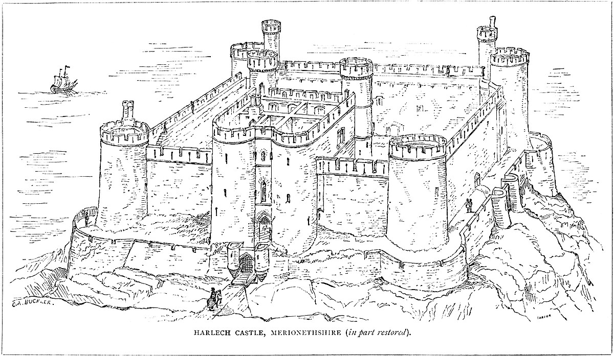
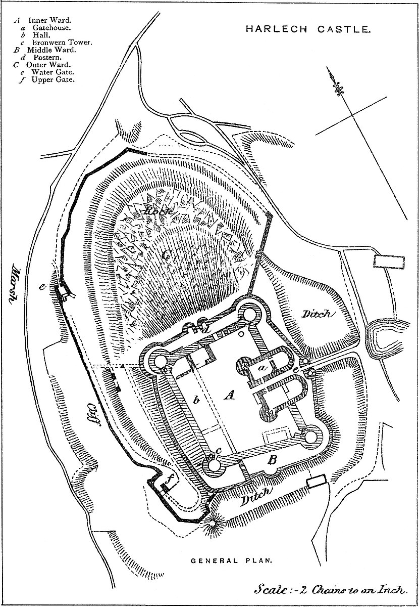
73
This middle ward is narrow and of unequal breadth, varying from 8 feet to 30 feet. It is rather below the level of the inner ward, and the ground outside it is from 10 feet to 15 feet lower still; and its walls are revetments crested with a parapet which seems to have ranged from 6 feet to 12 feet in height; in the latter case having a rampart-walk reached by open steps. The several bastions seem to have risen a little higher than the parapet, and to have contained each a low chamber, probably with a flat roof. This ward is protected on the east and south sides by a broad and deep dry ditch, quarried in the rock, and running out until it ends on the cliff. The other two sides are covered by an outer ward of considerable breadth, but composed for the most part of steep slopes and abrupt ledges of rock. A part of this ward towards the west or sea front contains a long passage which ascends by a lower traverse from a water-gate at the foot of the rock, resting partly upon a shelf of rock, and which by a second and upper traverse reaches the postern of the middle ward.
Passing into details, the court of the inner ward is about 164 feet north and south, by 132 feet east and west. The opposite sides are not quite equal, nor are its angles right angles, though nearly so. The curtains are about 40 feet high; that to the west is 10 feet thick, the others are 11 feet. The parapet was 3 feet thick, and the rear wall 2 feet, leaving 5 feet to 6 feet for the walk. The two western towers are circular, and 34 feet diameter, having three-fourths of their circumference exposed outside. Within, the gorge wall fills up the angle of meeting of the curtains and contains the entrance-door. The basement chamber is below the inner ward level and circular. The first floor, at the ward level, is polygonal, as are the two upper floors. None are vaulted, and the basement has neither loops nor stairs of access. Each of these two towers has a well-stair at its junction with the western curtain, lighted by five loops placed one over the other in the hollow angle between the tower and the curtain, outside. The stairs ascend 20 feet above the tower, in a round turret, battlemented on small corbels. Each turret has a door upon the tower roof. The staircases commence at the first floor, on or level with the inner ward, and open on each floor, but not upon the ramparts of the curtain. The upper floor has fireplaces with hoods.
Outside, these towers rise from the ground without slope or cordon; two string-courses, however, mark the level of the two upper floors. The stairs are broken away, and the upper rooms inaccessible; but certain exterior loops show the existence of two tiers of small chambers (no doubt garderobes) in the north and south curtains, where they join the towers. Moreover, on the outside of each of these curtains, next to the tower, is a broad, flat buttress, thrown out to give space and support to these chambers and to contain the sewer-shaft from them. On the north wall, the buttress is of good ashlar of the age of the tower. On the south wall, it is of rude, inferior work, as though an addition. It may have74 been rebuilt. In the north curtain there seems to be a third chamber at a lower level. The drain here is not seen; on the south face it is open. Where these towers meet the rampart-walk they block it up; a sort of gallery is, therefore, thrown out on corbels, across the angle, and thus, as at Conway, the rampart-walk is carried on.
The two eastern towers resemble the others in general features and dimensions, but differ in details. Their basements have one loop towards the middle ward, and their first floor, at the inner ward level, is an irregular pentagon in plan, one angle being square. The doors are in the gorge wall, but do not lead direct into the tower, only into the staircase. In the south-east tower, a stair ascends in the northern wall, curving with it, and forks, the right branch leading to the second floor of the tower, from which alone, by a trap and descending ladder, the first floor and basement were accessible. This floor, like all the rest, was of timber, and from it, on the west side, a second stair commences, and curving with the wall, and having a small garderobe by the way, ascends to the ramparts of the south curtain. Reverting to the lower stair, the branch to the left opens upon the inner face of the east curtain, and ascends by a narrow, open stair, supported on corbels, across the gorge wall of the tower, and up the inner face of the south curtain to its ramparts. The roof and ramparts of the tower are reached by an exterior stair from the rampart of the east curtain. A loop in the hollow between the junction of this tower with the south curtain marks the place of the garderobe already mentioned. Above it was a second upon the battlements of the tower, and at the base of the wall is a large flat-topped sewer descending from the two. The south-east tower bears the name of Mortimer, the south-west that of Bronwen, the fair-bosomed, sister of Brân the Blessed.
The north-east, the debtors’ or armourers’, tower has a door in the gorge opening on the left upon a well-stair, 8 feet diameter, which ascends to the second floor only, from which the first floor and basement were reached by a trap and ladder. The second floor is seven-sided, those below cylindrical. As in the south-east tower, an independent stair led from the second floor to the ramparts of the curtain, and upon this curved stair is a garderobe, the loop of which is seen at the junction of the tower with the north curtain, and the mouth or vent at the ground level. The roof of this tower, like the other, is reached from the walls by an external stair. These two towers, having no well-stairs to the roof, have no subordinate turrets. That all these four towers had flat roofs is pretty clear from the position of two corbels in each, evidently intended to carry hammer beams or struts to the one main beam which crossed the aperture, and was thus rendered capable of carrying great weight.
The great gatehouse is 80 feet broad and 54 feet deep, besides which it has two half-round projections in the front and two three-quarter projecting stair-turrets 24 feet diameter at the outer angles of the rear, the former flanking the entrance, the latter communicating75 with each floor and the ramparts. The entrance passage, 54 feet long by 8 feet broad, is much mutilated, but seems to have had an exterior drawbridge, two grates, folding doors, and a grate at the inner front. The entrance portal has within it a “machecoule,” or meurtrière,—that is, an opening from the chamber above—and behind this a portcullis. Then follows a passage 11 feet long, crossed by two ribs, a second portcullis, and a portal arch, upon which rests the west wall of the chapel. Then follows another passage, 20 feet long, entered by gates opening towards the inner ward, and crossed by five broad ribs, with four open spaces. At the end of this is a third portcullis, the groove for which is now closed above at a level too low to allow the grate to be lifted to the height of a cart, while in the arch above is a square cavity or “machecoule.” It would seem that while the wall was rising it was decided not to use these grooves, and that the hole was intended to take the place of the grate as a defence. Beyond this is the inner portal, which, like the outer, has no rebate for a door. In the front division of this long entrance, between the two outer grates, are two loops from the side lodges, which are entered by two doors placed near to the inner end. This passage was covered over with boards, the flooring of the rooms above, and which rested upon the stone ribs. Here, as is often the case, the portcullis groove stops from 1 foot to 18 inches above the door sill, showing that the spikes at the lower end of the grate were of this length. This long entrance passage is further lengthened by the addition of two unequal piers to its internal face. They are blocks of masonry 10 feet thick. That on the south or left had a door whence a narrow staircase of two flights ascended to the front floor. The pier on the right is of less breadth, and was only an abutment to support the arch which connected the two and contained and continued the entrance passage, and on which was the landing at the stair-head.
The basement of the gatehouse is at the ground level. On each side of the passage are two chambers, those in front occupying the half-round projection and looped to the field. They are entered from the chambers in the rear, which are rectangular, having shoulder-headed doors from the passage and into the well-stairs. The northern chamber has a fireplace in the south-east angle. The two southern chambers communicate through a large arch, the northern through a doorway only. There are also two upper floors, divided as these below, and reached by the two large well-stairs. There are spacious and handsome rooms, two on each floor, with large windows of two lights in the western or larger rooms, and in all are fireplaces with stone hoods. The eastern rooms below are half circles in plan; and above, are polygonal. Between the lateral rooms and over the entrance passage are two narrow chambers unequally divided by a cross wall. The eastern is an oratory, with a small, pointed east window over the entrance gate of the castle, and near it, in the south wall, is a piscina, which is in the cill of a small window opening into a small mural chamber, a vestry. There76 is a similar chamber, but without the window, in the north wall. Both rooms are entered from the oratory. As at York, Chepstow, and elsewhere, this oratory served also as a portcullis chamber, and the floor was of wood, with traps to allow the passage of the grates when lifted. The grates were suspended from the vault above, as is still seen. The other and larger chamber, placed over the western part of the passage, had also a wooden floor. It had a west window of two lights over the inner portal, and north of this a round-headed doorway. The portcullis, if lifted, would have blocked this entrance, and therefore when the door was opened it was stopped. The machecoule is seen in the window seat. The upper chambers are not accessible, but they seem similar to those below, and there is a second oratory above the first, with a smaller east window—a very unusual arrangement. This floor communicates laterally with the ramparts of the curtain, and at the junction on each side is a mural garderobe. On the south side a mural stair descends to two chambers at different levels, both in the curtain wall. On the north side the arrangement is rather different. There, the mural garderobes are supported in part by a projection at the first-floor level, corbelled out in the angle between the gatehouse and the curtain, outside, and the vent was probably between the corbels. Above, at the rampart level, half the thickness of the wall is occupied by a garderobe chamber, of which the side is broken down. Several of the chimney shafts are collected in a central group, each shaft having a bold capital with a plain roll moulding.
The domestic buildings were placed against the curtain on the west side of the inner ward. The kitchen is thought to have been at the north end, including within its limits the basement of the north-west tower. It is, however, more probable that this was the withdrawing room, placed between the hall and the chapel. A gloomy corner, no doubt, but the state rooms were evidently in the gatehouse. The kitchen would scarcely have been designed originally between the hall and the chapel. The cross wall, still standing, but which looks either modern or rebuilt, formed the north end of the hall, and the recesses in the west wall of the curtain carried the hammer beams of its open roof. In this wall are the remains of a large fireplace, of which the hood is gone, and the lower part has recently been rebuilt. On either side are the broken apertures for two windows, and in the wall, near its south end, a segmental-headed door, now walled up, but evidently a postern. There are also near this two small windows, one of which seems to have lighted the gallery and the other the space below it. Of the position of the gallery there can be no doubt, but the wall behind it, forming the south end of the hall, and now removed, had no bond either into the curtain or into the east wall. Most of this east wall, the inner wall of the hall, is gone. The hall was 30 feet broad. The roof seems to have been lofty, and part of the weather moulding of its gutter remains along the west wall. On the floor, in the north-west corner of the hall, has been built a large oven of stone, the lining of which is77 much burnt. It probably was inserted when the castle was used as a prison.
South of the hall is a considerable space extending to the gorge wall of Bronwen Tower, and in the east wall of this space are remains of a door and two windows. It is probable that the kitchen was here, in the rear of the gallery, and that a row of corbels outside the east wall carried a lean-to building attached to it and near this; against the south wall is a rectangular pit, the underground storey of some building now removed. If the kitchen was at this end, the hall fireplace was a little below the dais, a very probable position.
The chapel, a later building, was placed against the north wall. Its east wall and pointed window remain. The south wall is gone. In the centre of the north curtain is a segmental-arched doorway, evidently a postern, and nearly opposite to that of the middle ward. It is much mutilated, and does not seem to have had a portcullis. The wall east of it is pierced by three loops, 4 feet above the ground level. There was at least one loop westward of the postern. The well was in the north-east angle of the court. It has recently been opened a few feet down.
The Middle Ward contains little of interest. On the north side it is 15 feet broad, and hence, between its two roundels, 10 feet apart, opened the postern, 8 feet wide, now walled up. On the west front, the ward is 27 feet broad and forms a noble terrace overlooking the sea and commanding the approach from the water-gate. The hall had windows looking this way, and upon it opened the hall postern. Towards the south end a few steps descended about 10 feet into the south-west bastion. Probably there was a cross wall here with a doorway. Turning the south-west corner, the ground again rises to a door in a wall which crosses the south terrace near its west end. This side of the wall has a central half-round bastion, the broken parapet of which shows traces of a loop and of a garderobe. On the remaining or eastern side is the great entrance. Here the gateway, which crowns a low salient, is flanked by two roundels. The portal is broken down, and it does not now appear how this was connected with the inner gatehouse. Probably the short distance between the two was arched over and had lateral doorways into the middle ward. From the inner gate, twenty steps descended to the bridge, so that no horse or carriage could have entered this way.
The defences beyond the middle ward are the ditch, the outer ward, and the water-gates and passage. The ditch covers only the east and south, the two landward sides. It is quarried in the rock, and is about 60 feet broad and was 20 feet deep, with vertical sides. Its scarp is the revetment wall of the middle ward, and the counterscarp, where the rock was broken, is also lined with masonry. The ditch runs out at either end upon the shelving face of the rock. Across it, to the main entrance, led a bridge upon which it is said there were two openings with drawbridges. The whole is now a solid causeway.
Although the castle stands upon a promontory of rock, there is a78 broken shelving space between its wall and an actual cliff in which the rock terminates below, and it is this space, which lies to the west and north, which has been enclosed as the outer ward, the containing wall of which crowns the cliff and where necessary is supported by a revetment. This outer wall begins below the north-east bastion of the middle ward, whence a door with steps seems to have led down about 10 feet to its ramparts. It is at that point a very stout wall, about 14 feet high, with a parapet on the western face, thus defending the ditch and main bridge from an enemy who might be in possession of the outer ward and be disposed to turn the eastern flank. It is probable, however, that the wall had a double parapet, for lower down, where the wall faces the north, the parapet is on that face. Near the bastion there seems to have been a door in this wall, giving a passage from the outer ward to the ditch. Lower down, where the wall stands on the cliff, it is thinner, and in parts much broken away. Still lower it is more perfect and much stronger, and where it turns the north-west corner of the rock, opposite the railway station, it is of great thickness, and has a rampart wall and parapet towards the sea, above the level of which it is about 30 feet; near this point is the lower water-gate, a regular postern, in a small rectangular shoulder in the wall. A roadway of about 5 yards or 6 yards long, cut in the rock, rises from the marsh 10 feet or 12 feet, and upon it, in front of the portal, was a drawbridge with a pit 12 feet deep, and within the portal a short shoulder-headed passage closed apparently by a door, but without any portcullis. Beyond this a flight of open stairs niched in the curtain ascended to an embattled platform over the gate. From the lower gate, the road leads up a rather steep passage formed partly by taking advantage of a shelf and partly by quarrying the rock, the outer side being protected by a wall 8 to 10 feet high and from 2 to 3 feet thick, and looped at about every 20 feet. As the inner side of the roadway is the irregular face of the cliff, it varies much in breadth, from 6 to 12 feet or more. This road, continually ascending, thus covers the whole seaward face of the castle rock, and at about 70 feet or 80 feet in height it terminates in the middle gate, which is about 20 feet below the base of the south-western bastion of the middle ward. Here, a shoulder in the rock is occupied by a second gatehouse, fortified as the first, with a drawbridge and a deep pit, which below has two arches, one for the discharge of water from the pit and the other, which may be merely to support the side wall of the gatehouse, but which may also be a sewer from the castle. Outside this gate is a platform which rakes the face of the wall of the passage below, while above and within the gate is a broad bastion, whence commences the second traverse. At this point, the end of the main ditch lies just below the bastion wall, and was reached from it by a small door and some steps, now gone.
The road now makes a complete turn, and commences a new traverse which rises much more gently than that below. When abreast of the mid-front of the castle it is supported by a retaining79 wall and two small square buttresses or buttress turrets, traces of which are seen upon a ledge of rock. Passing these, where the road comes opposite to the north-west bastion of the middle ward, it was crossed by a wall and doorway, of which traces remain, which divided the outer ward into two parts. Above this, the way turned eastward and ascended to the centre of the north front, where it reached the postern of the middle ward and there ended.
These are the whole of the works proper to the castle, but a few yards to the north of the rock a steep road has been cut by which men and horses could be led up from the castle landing-place to the village without entering the enceinte, though commanded from it.
No one acquainted with Caerphilly can visit Harlech without observing the close resemblance between the two castles, so far as regards the plan of the interior and middle wards. The court, rectangular, or nearly so, the absence of a keep, the drum-towers capping the four angles, the general character of the gatehouse and its position in the centre of one side, and the domestic buildings placed against the wall of the inner court, are peculiarities common to both. In each also the gatehouse is the grand feature of the building. Further, there is to be observed in both the excessive narrowness of the middle ward, its revetment rendering more than a parapet unnecessary, its slender and subordinate gatehouse, and its lateral postern opening direct through both wards. As Harlech did not need the outworks and exterior gate of Caerphilly, nor Caerphilly the water-gate of Harlech, here the resemblance ceases, but it is such as to justify the conclusion that Henry of Elfreton, who was the architect of Harlech, had studied Caerphilly, if indeed he was not also its architect.
The defences of Harlech seem calculated for protection against a surprise by the Welsh, who were probably as active as they were fearless. Hence the very lofty curtains, the long entrance bridge, the ascending steps to the main entrance, and the dimensions of the middle ward, too narrow to allow any considerable body of men to effect a lodgment there for an attack upon the inner ward, and the water-gates and covered way, in the construction of which the natural strength of the rock was enhanced by the occupation of its various points of vantage. Whether in the reign of Edward I. Morfa Harlech was more than a marsh is a question for a geologist to solve; but either by the shallow sea or by a canal cut across the low ground, it seems certain that in planning the castle Edward counted upon the means of reaching it by a quarter quite independent of the Welsh.
Although the general plan of Harlech is evidently the work of one mind and its execution generally of one date, there are some appearances in the work which show that alterations and additions were introduced affecting, not the general plan, but certain of its parts. It is evident that parts of the curtain have been thickened about 2 feet,—the north and south walls by additions inside; the west, on the outside. Also this thickening seems to have been80 decided upon when the walls were 30 feet high, as above that level they are of one mass and date. The exterior stair on the inner face of the great gatehouse was also an afterthought, and the doorway at its head clearly was not originally introduced. Besides this, the six windows on that front of the gatehouse, in the two upper floors, have been reduced in height by the insertion of a segmental arch between 2 feet and 3 feet below the original head; but the pattern is the same, and the masonry filling up the space seems of the date of the window, or very nearly so. These windows are of a peculiar pattern. Their two lights are trefoiled; and in the spandrels are also trefoils pierced. The mouldings are concave; and one is a small hollow, as in the early Perpendicular style. They must, however, be original.
The inference from these alterations seems to be, that Edward visited the castle when the works were far advanced, and the hall, gatehouse, and the lower part of the north, south, and west curtains built. The gatehouse curtain was probably always intended to be of its present height, as at Caerphilly. He ordered the other three curtains to be thickened and raised to the full height of the gatehouse curtain; to obey which order, the thickening was applied where possible on the inside, but where the hall prevented this, on the outside. The upper part of the walls so raised would, of course, be of one date, and solid. At the same time it was decided to make the rooms of the upper floors of the gatehouse those of state; and as the ways up the well-staircases were not thought suitable, a new and more direct staircase was built and a new door opened in the wall. The chapel in the inner ward seems a still later addition.
The character of the masonry throughout is exceedingly rough, as though hastily executed. It is rubble, and some of it very poor rubble indeed. The towers are of far better work than the curtains. The stones are larger, and their interstices filled in with more care. The ashlar is very good, but is sparingly used, and confined to the dressings, window-cases, chimney-hoods and heads, and a few of the more important doorways. The ordinary doors are mere openings to the walls, without rebates or chamfer, with shouldered heads of a rude character; and the sewer-openings, seen under the garderobes, have merely long stones for lintels. The masonry of the covered way and water-gates is also very inferior, and much of the side wall has, in consequence, slipped away from the rock.
The turret-heads of the gatehouse and two western towers have parapets projecting upon a corbel-table about 6 inches. There are no traces of holes for brattices; but upon the exterior of these two towers the putlog-holes are arranged in a spiral ascending form, east to north. In the north-west tower, on its east face, at the height of the old curtain, is a row of round holes about a foot apart, and from this level the spiral commences. It is pretty clear that having built the curtain, the masons here threw out a platform, and that the spiral round, by which the materials were raised for the81 upper part of the tower, began here. The tower of Coucy was scaffolded in the same way. There is throughout the building a remarkable absence of vaulting. It was confined to the oratory and to parts of the entrance passage.
The bird’s-eye view here given is taken from the east or landward side, and shows the entrance, with its great gatehouse, here, as at Caerphilly, seen to cross and close the narrow outer ward. The northern postern is also shown.
The castle seems to have escaped the usual dismantling that followed upon the civil wars, and no part has been blown up. It has, however, been freely used as a quarry by the people around; and, with its iron and timber, much of its ashlar has been rudely detached and stolen. There is but little evidence of any material addition to, or alteration in, the work of Edward I., which is singular, seeing that the place was long the seat of an assize, and the judges lodged here. It was then also a prison, and the windows were heavily barred, the bars forming shallow cages in front of the windows, as in some of the Italian palaces. Any later work introduced for the judicial or prison arrangements has either fallen down or been removed. The quarry whence the castle was built is pointed out on the hill-side, a short distance to the south-east. Although the present castle certainly is not older than the reign of Edward I., probably about 1280, the Welsh claim to have been the founders of an older fortress on the same spot, called by them Caer Gollwyn, from Collwyn ab Tangno, a Welsh chief who lived A.D. 877. Possibly a spot so inviting might have been occupied by a camp; but all that is now seen, whether of earthwork or masonry, is evidently not older than the thirteenth century. In 1404 the castle is said to have been taken by Owen Glyndwr; and Margaret of Anjou was sheltered here in 1460, in memory of which event the south-east tower for some time bore her name. There does not seem to be any detailed account of the siege of 1468, when the governor was Dafydd ab Ievan ab Einion, the same who had received Queen Margaret, and whose boast it was, that as he had held a castle in France till all the old women in Wales had heard of it, so he would hold his Welsh trust till it had become equally well known in France. He seems to have redeemed his pledge by standing a long siege, and yielding at last, on honourable terms, to Sir Richard Herbert, the commander for Edward IV. Harlech was held for Charles I., and surrendered on articles to General Mytton in 1647. The borough seal represents a castle triple towered, but the design is evidently conventional. The first constable was Hugh de Wonkeslow, appointed about 1283 by Edward I.; the last was the late W. W. E. Wynne, Esq., of Peniarth, as good a man as he was an eminent antiquary.
THE Rape of Hastings is the most eastern of the six divisions of the county of Sussex which are supposed to derive their somewhat peculiar name from the early occupation of the district by emigrants from Jutland. The Rape of Hastings, probably, is so called from its principal town, which was also the seat of its lords both before and after the Norman Conquest. Like the other rapes, it had its river and its forest, its castle and its castelry, often designated as an Honour. The river, the Rother, is the common boundary of Kent and Sussex, and joins the sea at Rye. The forest, long since disafforested and enclosed, is represented by frequent patches of woodland, scattered over the least fertile parts of the district, and by the numerous and well-timbered parks by which it is characterised. The town once possessed a small port, now silted up. It was situate at the mouth of a stream, which still brings down its inconsiderable tribute, flowing at the foot and to the west of the castle hill.
The origin and etymology of the name of Hastings are lost in obscurity. It is so uncommon, that it has been supposed to come from Haesten, the celebrated pirate and Danish Viking, who infested the southern coasts of England and the valley of the Seine in the ninth century,—a period when warriors of Northern descent gave their names to their possessions, instead of, like their descendants of two centuries later, reversing the practice. Mr. Lower, familiar with Sussex topography, has suggested that the small stream of the Asten, a few miles west of Hastings, may play some part in its etymology, and that Hasting, or the Haesten-Ceaster of the English, may have stood upon its margin. It has also been regarded as the seat of the Hastinges, a tribe said to have been warred upon by Offa of Mercia in 792. Another not less interesting point connected with the place is the fact that it gave name to the ancient family who long ago bore the title of Pembroke, and still bear that of Huntingdon.
The castle occupies the narrow, acute, and very steep extremity of a ridge of the Wealden formation, which here terminates abruptly to the seaward at a height of about 180 feet above the seashore, and seems intended by nature for a defensive position. The ridge is a spur from a range of larger and more elevated character which extends from the high ground of Battle, by Ore, south-eastwards to the sea, and has to its west and south a large tract of broken and highly-fertile picturesque land known as the hop garden of Sussex, and within which are the well-known seats of Hurstmonceaux, Ashburnham, Battle, and Crowhurst,—a tract which presents to the sea an open frontier of about twenty-two miles from Hastings to the marsh of Pevensey, defended anciently by the two castles of those names, and more recently by twenty or thirty martello towers, in 83which our fathers, three quarters of a century ago, placed an expensive confidence.
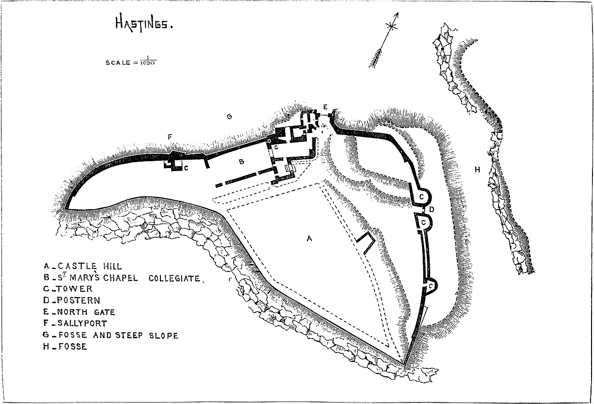
The ridge and promontory of Hastings remain unencumbered by modern buildings, and are occupied only by the castle and its outworks. The older part of the town, with its two parish churches of St. Clement and All Saints, occupies a deep valley to the east of the castle, while round the nose of the rock the remains of the old port have been superseded by the new town, a fashionable watering-place. Much of this town stands within the parish of St. Mary de Castro, the parish church having been the chapel of the castle, and collegiate. The town seems to have been partially walled, and certainly had four gates. Hastings, though now affording no accommodation for shipping, is still a cinque port, and its ancient consideration is attested by the fact that in 1229, Seaford, Pevensey, Bulverhythe, Hidney, Iham, Beaksbourne, Greenhythe, and Northeye, were its subordinate members, and tamquam membra were Rye and Winchelsea.
The castle is composed of two wards, separated by a formidable ditch cut through the sandstone rock about 400 feet, across the ridge, with a breadth of 60 feet, and to a depth of 30 to 40 feet. The inner ward lies to the west of this ditch, between it and the point of the promontory. The outer ward lies to the east, and is again protected by an outer and considerable, though less clearly-defined, ditch of greater length than the former, and also crossing the ridge. There was also another ditch cut as a sort of step in the steep northern slope, and covering that side of the place, and chiefly intended for the defences of the inner ward. Between the east end of this ditch and the north end of the great cross ditch was the original entrance to the inner ward, the approach to which wound up the steep north-western slope of the rock.
The Inner Ward is in figure nearly a right-angled triangle, containing about 1½ acres, the north side 154 yards, and the east side 87 yards in length, while the hypothenuse curves inwards, reducing the breadth of the ward at one point to 16 yards. The cliff which forms the boundary has been either scarped or has fallen away, so that it is at present precipitous, and its face has been patched with modern masonry and brickwork. It is said that this side was once straight, and has been cut away to make room for the gasworks and a crescent of houses below, so as to diminish the castle area. This may be so, but the encroachment cannot have been considerable. A wall for defence on this front could never have been needed: probably it was only a low parapet.
Along the north front the ground, though very steep, is not absolutely precipitous, and along the crest of the slope are the remains of the curtain wall, about 6 feet to 9 feet thick, and in parts 20 to 30 feet high. Upon this wall is a rectangular tower, about 12 feet by 20 feet, having a ground and upper floors in which are parts of three windows of Norman date. Connected with this tower are said to be traces of a small postern, and there is certainly a mural passage, 18 feet long, ending in a garderobe. East of this tower is84 a turret, square at the base, but which above seems to have been cylindrical. It contains a well-stair connected with the chapel. The wall is continued round the east front across to the cliff. At the angle it is still 20 feet to 25 feet high, but further on it has been reduced to 10 feet. In this front, overlooking the ditch, are the bases of three half-round buttress towers, 20 feet diameter. Their ground floors have been vaulted; all above is removed. Between the two most northern of these are still to be seen the jambs of an Edwardian gateway, of 9 feet opening, with a square portcullis groove, and rebates for a door immediately behind it. In this part of the curtain are the remains of some mural cells. The gateway must have communicated with the outer ward by a bridge across the ditch, probably of timber, since there is no trace of masonry in the rock. This entrance is now disused, and the entrance in use is in the north side between the chapel tower and the north-east angle, protected by a late tower, about 20 feet square with very slight walls and a flanking wall, also slight, and projecting about 20 feet. This is thought to have been the original gateway of the ward, and may have been so, though the other entrance between the two flanking half-round towers has at present more the aspect of a main entrance.
The eastern, naturally the weakest side of the inner ward is further defended by a broad, artificial bank or ramp of earth from 20 feet to 30 feet broad and 8 feet to 10 feet high, piled up against the back of the wall, which, in fact, is a revetment. At the north-east angle of the ward this bank is expanded into a mound about 20 feet high above the inner area. The curtain traverses this mound, of which about two-thirds is within its circuit.
No doubt this mound was the keep of the English fortress, and the bank and ditch its main landward defences, but, save the curtain, there is no trace of any masonry upon it, nor does the Norman castle appear to have been provided with any regular keep, either shell or rectangular. Probably, as at Exeter, the whole inner ward was the keep.
There are at present no traces of a hall, kitchen, or regular lodgings within the castle, but placed against the north wall are the remains of the chapel, or rather of the free collegiate church, composed of a nave and chancel. The nave was 30 feet by 64 feet, the curtain forming the north wall. There seem to have been a west door and one, or perhaps two, south doors. At its east end a handsome highly-pointed arch opened into the chancel, and still remains very perfect. The jambs are square, the angles replaced by delicate shafts, a quarter engaged, with caps and bases of Norman type. The abacus is part of a moulded string, and the arch, though the section is square, as in the Norman style, is richly moulded. The central member of the arch is a bold rib, springing from two brackets or corbels carved in foliage. The general character of the whole is very late Norman, passing into early English. In the north wall, at its east end, are the remains of the arches of three sedilia, and85 near the middle of the wall, in a sort of buttress, is a piscina, probably a perpendicular insertion. Near the north-west angle is the cylindrical base of the font. In the east wall, on each side of the chancel arch, is a flat-topped doorway of rude workmanship, as though intended to be concealed by hangings. The northern door opens into the well-stair of the turret, the southern into a vestry.
The chancel was about 18 feet broad by 28 feet long. Of its walls only a few traces remain. It communicated on the north side with a small chamber, perhaps a garderobe, and on the south side with the vestry. The vestry, called also the chapter-house, is a small, nearly square chamber, 12 feet by 15 feet, with a plain Norman recess in its east wall, and the jambs of a door, evidently Norman, opening into what seems to have been a sort of lean-to cloister resting on the south wall of the nave. The cloister itself is gone; but in the nave wall are traces of an arcade. Here are three graves inclosed in pieces of stone placed edgeways, and a much worn dos-d’âne coffin-lid. The breadth of the nave is wide for a single span, but if there were aisles, there must have been two, the arches being central, and in that case very narrow ones, even for a Norman church. The floor of the chancel is three steps above that of the nave.
The curtain wall along the north front and over the mound is apparently of Norman date, as is most of the east wall; but its buttress-towers and the gateway are probably insertions of the reign of Henry III. or Edward. The chapel may be later than the north wall, probably of the reign of Henry II. or John.
The old part of the masonry is coursed rubble, with occasional pebble-stones, faced with bold, open-jointed ashlar, the blocks being rudely dressed. In one part, near the church, is a little herring-bone work, though probably not older than, if so old as, the rest. The quoins and window-dressings, where preserved, are good ashlar. Various fragments of cut stone are collected and heaped up; of these, a few are late Norman, some good early English, some Perpendicular. A late Norman crypt has been discovered in the town.
It may be doubted whether William or his feudatories, the Earl of Eu or de Tiliol, added defences in masonry to the works already existing. At least, there is no evidence that they did so, and the oldest masonry now seen is certainly not very early Norman, though too early to have allowed time for the decay of any previous masonry of the same architectural period.
The chapel was probably founded in the reign of Henry I., and though the castle was erected, and for some time held, under the Crown, by the powerful Earls of Eu, it was never a great baronial residence, being in that respect far inferior to Arundel or Lewes, but was probably maintained only as a strong, though small, post to cover embarkations for, or disembarkations from, Normandy.
The Outer Ward is contained between the inner and outer lines of ditch; within the latter is a considerable bank of earth, which rises86 at the north-east angle and is continued across the northern end, that being naturally the weakest part of the inclosure. It does not appear where was the entrance of this ward, but possibly near the south-east angle. There are no traces of masonry here, so that the defences of the outer ward may have been a stockade only.
From the position of this fortress, it is most probable that, like Dover, it may originally have been a British work, the entrenchments, including the promontory and the south ditches, being the defences landward. The mound, however, placed at an angle of the inner ward, upon the bank, and covering the approach, is almost certainly a later, and no doubt an English, work.
Whatever may be the origin of Hastings as a defensive work, its known history commences towards the end of the sixth and the beginning of the eighth centuries in the times of Offa and Athelstane, when it was a place of some consequence, and contained a mint. Coins, indeed, were minted here as late as the reign of Henry I.
The termination “ceaster,” which it then bore, shows it to have been fortified. Towards the middle of the eleventh century it was plundered by the Danes, and towards the middle of that century it was the men of Hastings who, after the murder of Beorn by Swegen, captured his ships and slew his accomplices in the murder, though Swegen himself escaped. Hastings also played a part in the Norman Conquest, though not that popularly assigned to it as the scene of the battle. William landed at Pevensey, and thence moved rapidly to Hastings in search of food. There Odo of Bayeux, as one of his lieutenants, ordered a fortress to be thrown up, “ut foderetur castellum,” and thence, according to the same authority, the Bayeux tapestry, William marched against Harold. William, we are told, on reaching the port, selected a proper site, and fortified it rapidly with a castle in timber, “ligneum castellum.” This, we must suppose to be a replacing or restoration of whatever there was standing on the old site. It can scarcely have been a palisade on the low ground below the castle rock. He then placed Humphrey de Tilliol, brother-in-law of Hugh de Grantmaisnil, to execute his orders, “qui Hastinges a prima die constructionis ad custodiendum susceperat.” Wace’s description applies more to Hastings than to Pevensey, which was already walled in:—
De Tilliol’s occupation was confined to the construction or restoration of the defences: the castle and castelry, manor, and superiority of the whole Rape were granted by William to Robert, Earl of Eu, one of the most powerful of his Norman adherents. This grant of the castelry is recorded in Domesday, and a castelry involves the existence of a castle. The Earls of Eu held possession for five generations in the male line. No doubt either Earl William, who succeeded in 1090, or Earl Henry, who died in 1139, executed some works in masonry at the castle,—probably the wall of the enceinte,87 much of which still remains. Either the first or second earls founded within the castle a free chapel and college, with a dean and secular canons, and to this Henry, the third earl, added a considerable endowment by charter in the reign of Henry I. The college survived the castle, and flourished when the latter became a ruin. Thomas à Becket held the deanery, and William of Wykeham one of the prebends. The college endured to the 38 Henry VIII., when it was dissolved and the property alienated to Sir Anthony Brown. After the extinction of the Eu earldom, the patronage vested in the Crown. The charter of Earl Henry is recited in a confirmation, 22 Edward I.
In 1088 the castle probably had been made strong, for it was the boast of William of St. Calais, Bishop of Durham, that he secured Hastings for William Rufus. It was the place of muster for the powerful military force with which that king proposed to invade Normandy. At that time Anselm and many bishops and barons were present in and about the castle and were detained there from Candlemas, in 1094, for six weeks by contrary winds, during which time the king was present at the completion and consecration of his father’s Abbey of Battle. Immediately afterwards, Robert Bloet was consecrated Bishop of Lincoln within the chapel of the castle, and here also Bishop Herbert of Thetford was deprived of his see. It was in the castle of Hastings also, on this occasion, that Rufus once more refused attention to the reasonable remonstrances of Anselm, who left him unblessed to depart on his Norman expedition. The Earls of Eu, by no means always faithful vassals of the Crown of England, seem latterly to have neglected the castle, which was inferior to Pevensey as a muster-place for troops and had become of but moderate value. Henry, the fifth earl, who died in the reign of Richard I., left an only daughter, Alice, who married Ralph de Essoudun, who in her right became Earl of Eu, and so died in 1211. Their son, William, elected to become a subject of France, and, 29 Henry III., his possessions in England escheated to the Crown, and were granted to Prince Edward. As early as 1227 King Henry allowed to Robert de Aubeville 10 marcs, half his salary, as keeper of the castle. The college was retained by Henry in his own hands. In 5 Edward III., the dean and canons petitioned to have the castle wall restored, it having been injured by the sea. In 1372, the castle was granted to John of Gaunt, and in the reign of Richard II. it was a ruin and probably so remained. The early English work, especially connected with the chapel, was probably executed by Henry III. on his acquisition of the barony.
By Henry IV. the castle was granted to Rafe Neville, Earl of Westmoreland, with reversion to Sir John Pelham, who again transferred it, in 1412, to Sir Thomas Hoo, created Baron Hoo and Hastings in 1447. He died without issue male about 1453. The feoffees of Sir Thomas sold the castle and other property, in 1461, to Sir William Hastings, who in that year was summoned to Parliament as Lord Hastings of Hastings. By his descendant, Henry,88 Earl of Huntingdon, the castle and its appendages were sold, in 1591, to Sir Thomas Pelham, in whose descendant, now Earl of Chichester, they remain vested. Those who wish to understand thoroughly the position of Hastings as regards the landing, first movements, and subsequent advance of Duke William upon English soil, will do well to consult the very lucid and quite original account of the battle of Senlac, given in Mr. Freeman’s “History of the Conquest.”
THE Hundred of Atiscross, in which Hawarden is an important parish, is, in Domesday, included in the county of Chester; and in that Hundred, as in very many parts of the Welsh border, the Saxons, as is well known from history and still evident from the prevailing names of places, early and in strength established themselves. But although the power of the Earls of Chester and the perfectly Saxonised condition of the peninsula of West Chester gave the invaders a secure hold over the open country on the west bank of the Dee, their sway was contested on the higher and more rugged ground, and though such names as Hope, Northop, Holywell, Whitford, Newmarket, Soughton, and Ryden show that they had settlements in the central and northern parts of Flintshire, the presence of a still larger number of Welsh names shows that their occupation was actively contested and the very reverse of secure.
The length and severity of the struggle is also made evident by the number and magnitude of the various military earthworks which still attract attention. Such of these as are situated on the summits of hills, are of irregular form and bear Welsh names, may safely be attributed to the Welsh; while those of English origin, usually on more accessible ground, have a tendency to a circular form, and in some very marked instances are characterised by a mound or motte.
Hawarden, the Haordine of Domesday, and in Welsh called “Penard Halawg,” said to mean “the steep head of the marsh,” is, as its name declares, a Saxon settlement, and its fortress, so long preserved, presents in a remarkable degree the features of a well-known class of earthworks found both in England and in Normandy. The parish, containing about 16,000 acres, occupies the eastern or English end of the first high ground that rises west of the Dee. It includes the commencement of a wooded ridge, which runs for some way parallel to the estuary, and then trends inland to be lost in the higher country around Northop.
The castle stands at the south-west end of a considerable area of89 level sward, upon which is built the later house of Hawarden, and which, with a ravine bounding it on the south and west, is included in the park.
The ground occupied by the castle and its earthworks covers an irregular circle of about 150 yards diameter. It rises steeply about 50 feet from the level area, and almost abruptly 150 feet to 200 feet from the ravine that protects it on the south, south-east, and west.
At the central and highest point of this ground, composed in part of rock and in part of the red sandy soil of the district, has been formed, by scarping down with perhaps some little addition in height, a conical mound, the flat top of which is about 70 feet diameter, having steep slopes all around. On the north-east side, or that towards the house, the descent is about 30 feet, at which level is a platform occupied by the main ward of the fortress, and beyond it, near the foot of a further but gentle slope, a broad and deep ditch, dry and wholly artificial, which sweeps round this the weakest side and cuts it off from the area already mentioned.
About the other two thirds of its circumference, towards the south and west, the mound descends rapidly to the ravine, but on its way the slope is broken by concentric banks, ditches, and shelves, of somewhat irregular height, depth, and configuration, owing, no doubt, to their having been originally natural, but converted and strengthened by art.
This kind of fortification by mound, bank, and ditch, is well known both in England and Normandy, and was in use in the ninth and tenth, and even in the eleventh centuries, before masonry was general. The mound was crowned with a strong circular house of timber, probably constructed like the walls of Greenstead chancel, and such as in the Bayeux tapestry the soldiers are attempting to set on fire. The court below and the banks beyond the ditches were fenced with palisades and defences of that character.
The Normans in Normandy, towards the middle of the eleventh century, and in England a little later, and onwards into the reign of Henry II., commonly replaced these defences by more substantial walls of masonry, which, being of great thickness and solidity, have often remained to the present day, though more frequently they were removed in the reigns of the earlier Edwards, to be replaced by structures of more scientific though less solid design, affording more accommodation within the enceinte. At Hawarden, the course of action seems to have been different. Here are no traces of Norman work or of the Norman style, and though the keep is unusually substantial, it bears evidence of being the work of one period, and that the close of the reign of Henry III. or early in that of Edward, his Welsh-compelling son. If this be so, it must be concluded that the Norman barons, who were known to have held Hawarden in the twelfth century, were content to allow its defences to be formed of timber, as any masonry constructed by them would scarcely so soon have needed to be removed.
90
The Keep (A in the plan) very nearly covers the top of the mound. It is circular, 61 feet across at the base, and originally about 40 feet high. The base gathers inwards to a height of 5 feet, where the cylinder is 59 feet across, and from hence to the summit it further diminishes to 57 feet. The interior is vertical, and 31 feet diameter throughout; hence the wall, which is 15 feet thick at the base, and 14 feet a little above it, is 13 feet at the level of the rampart walk; dimensions of unusual solidity even at the Norman period and very rare in England under Henry III. or the Edwards.
The exterior is very plain, having neither cordon, string-course, nor window labels. A little above the ground is a double course of large ashlar blocks of a light yellow sandstone, tying the work firmly together, and higher up are other bonding courses of a less substantial character. The ordinary material is a bluish stone laid as rubble work, with the spaces and joints neatly filled up with spawls and fragments. The battlements have been replaced by a modern wall, but the junction, at the rampart walk, may be readily detected.
The entrance is at the ground level on the north-east side, from the main ward. It is marked by a broad, flat buttress, rather Norman in character, which rises vertically from the common base so as to stand out about 18 inches, where it dies into the wall about 5 feet below the battlements. In its centre is the gateway, and above it the window of the portcullis chamber. It is extended laterally in two wings, rising about half its height, and also dying into the wall above. These are intended to strengthen the wall, weakened by a well-stair and a lodge. As this buttress covers a considerable segment of the circle and is flat, it is broken into three planes by two vertical angles. The modern brick and stone wall replacing the battlement is rugged and broken, but in parts about 12 feet high, and intended to give elevation to the keep. The building thus made extensively visible has become a sort of parish cynosure, and, however irregular its appearance, it would scarcely be in good taste to remove the addition.
The keep has two floors. The lower is cylindrical, 31 feet in diameter, with walls 14 feet to 15 feet thick. It was about 14 feet high, with a ceiling of logs, which rested upon some forty plain corbels, of which about seventeen remain. At two opposite points, about half way up the wall, are two larger corbels, which evidently supported the struts destined to give stiffness to the central and longest beam.
This chamber, no doubt a store-room, save when in time of siege it might accommodate soldiers, was entered directly from the gateway, and rather ventilated than lighted by three equidistant openings, about 4 feet from the floor, 4 feet broad, and 5 feet high, having shouldered heads and covering. The sides converge, and the floor rises to a small square-headed loop of 4-inch opening. There is neither fireplace, seat, nor recess. The floor has been removed. There is no subterranean chamber.
The upper chamber within is an octagon, inscribed about the91 cylinder below it, with walls from 13 feet to 14 feet thick, and from side to side 31 feet. It is about 15 feet high to the corbels that carried its flat roof, and a row of larger corbels along one of the remaining faces seems to have supported struts necessary to make the roof a safe platform for military engines and stone ammunition. This, which was a state-room, was lighted by three recesses at irregular distances. They are 6 feet 6 inches wide, and rise from the floor 8 feet, being covered by slightly-pointed drop arches. Each has a vaulted roof and parallel sides, which afterwards converge upon a square-headed window, 2 feet wide and 5 feet 6 inches high, having a plain chamfer outside. In each side of the recesses is a plain shouldered doorway, 3 feet 9 inches broad by 10 feet high, opening into the mural gallery.
This floor has its main entrance through the portcullis chamber, and next north-west of this entrance is the chapel. This is a mural chamber, 14 feet by 7 feet, but not quite rectangular. It is flat vaulted, and its axis points south-east to the altar, which is a restoration. The doorway next the west end is only 2 feet broad by 7 feet high, with a cinquefoiled head and a plain moulding of Decorated character. The door opened inwards, and could be barred within the chapel. On the same side, but near the altar, is a small cinquefoiled recess for a piscina, with a projecting bracket and a fluted foot. In the opposite wall, in vaulted recesses, are two windows, that next the altar square-headed, the other lancet-headed. Against the west wall is a stone bench, and above it a rude squint through which any person in the adjacent window recess could see the altar.
The entrance to the keep is by a gateway 5 feet wide and 6 feet 6 inches high, having a drop arch rising about 3 feet more. The jambs have a single and the arch a double chamfer. Two feet within is the portcullis groove, 4 inches square, and next is the rebate for the door, with its bar holes. Beyond is the vaulted passage, 6 feet broad, leading to the ground floor, with a door opening so as to be barred against that chamber; within, however, is a narrow rebate, as though for a lighter door opening inwards. The portcullis grooves are stopped 3 feet above the floor, so that either the cill must have been obstructively high or the grate have terminated in a range of long spikes. On each side of the entrance passage is a shouldered doorway. That on the right, 2 feet 9 inches broad, opens into a mural chamber, vaulted, 6 feet by 9 feet, with a lancet loop to the field. On the left, the door is 3 feet 3 inches broad, and opens on a well-stair, which, lighted from the field by loops, ascends to the upper floor and the battlements.
Twenty-one steps lead to the portcullis chamber, which is also the antechamber to the state-room. It is vaulted, 6 feet broad by 10 feet long, with a square-headed window of 2 feet opening to the field, and within it the chase for the passage of the portcullis. At the other end a large doorway with a plain moulding of a Decorated type and an arch very nearly, if not quite, round-headed, open in a92 recess similarly arched, and this into the state-room. The door was barred inside so as to be held against the stairs.
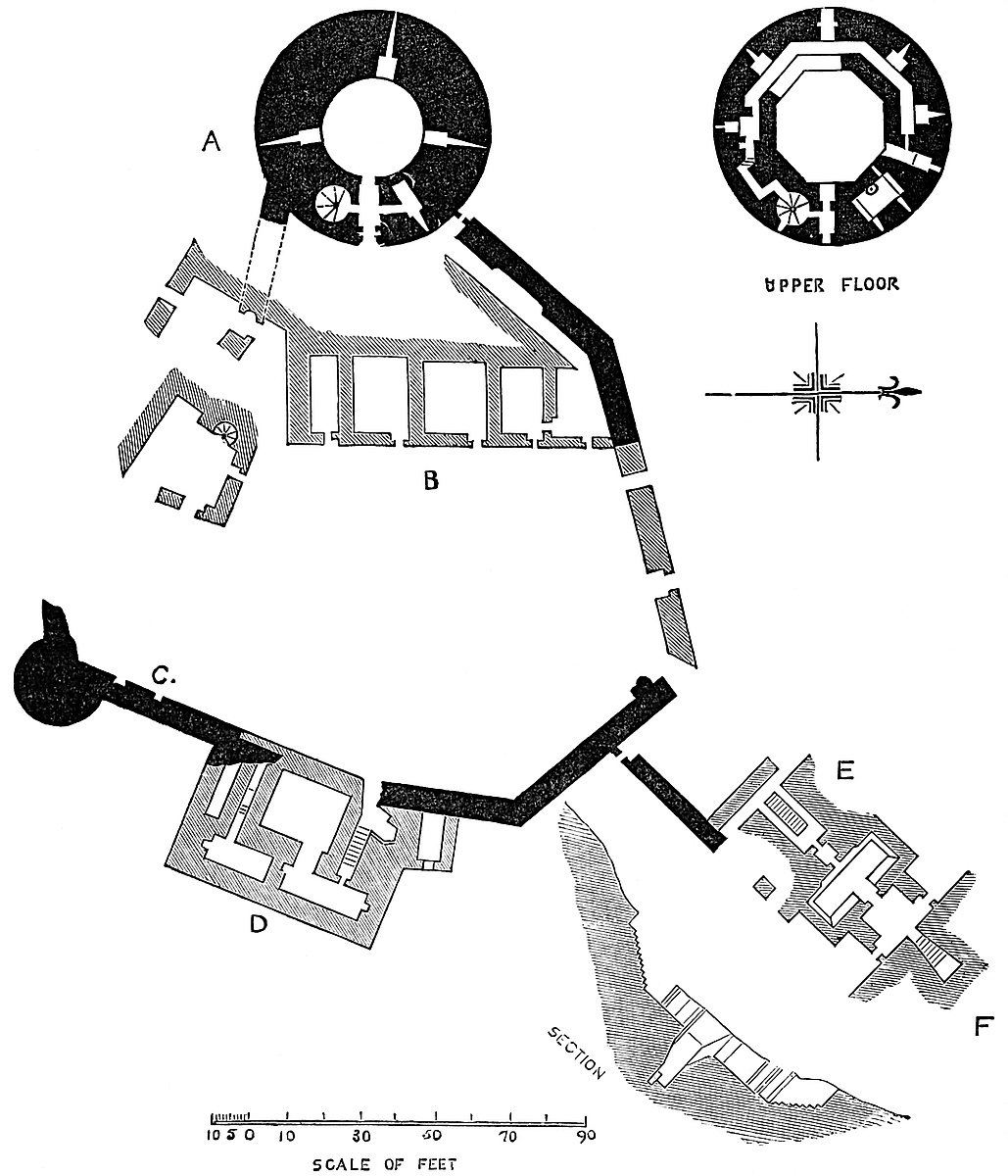
Returning to the well-stair, the upper part of which is broken away, at twenty-nine steps from the base is a small lancet-headed93 door. It opens into a mural passage, 2 feet 6 inches broad, and 7 feet high, which makes two turns at right angles. At one, on the left, is a recess, 3 feet deep by 1 foot 9 inches broad, a garderobe, the back part of which, probably bratticed off, carried a shaft from a similar recess on the ramparts. At its second turn the passage descends seven steps to the nearest window recess in the main chamber, crossing which an opposite doorway leads into the mural gallery. The ascent and descent in the narrow passage is rendered necessary by the level of the steps of the well-stair.
The mural gallery, at the main chamber level, is continued within the substance of the wall, to the recess next the chapel. It is in plan a polygon parallel with the inner faces of the wall. It is 10 feet high and 3 feet 9 inches wide, having a flagged roof resting on a double tier of corbels, and in it are three large recesses, each opening to the field by a long loop, swallow-tailed at each end. These recesses and loops are not seen from the main chamber. The doors and window frames, where original, are executed in straw-coloured sandstone. The chapel doorway and piscina and the side doors of the window recesses seem of later Decorated work than the rest, and may be insertions, though this does not look probable.
The keep, as at Tamworth, Durham, Berkhampstead, Warwick, and Cardiff, stands in the enceinte line of the main ward, and forms part of it, about two thirds of its circumference being outside, and one third, including the doorway, inside the curtain. This curtain was about 460 feet in length, and encircles the main ward, abutting against the keep at two points: one 24 feet south and one 18 feet north of the entrance. On each side it is carried down the slope, and, meeting below, thus encloses a somewhat fan-shaped area, about 170 feet north-east and south-west by 142 feet north-west and south-east, within which were the principal buildings of the fortress. The southern part of this curtain can be traced, but in its foundation only; that to the north is tolerably perfect. It is 7 feet thick, and has been about 25 feet high. It does not, as at Tamworth, so ascend the mound that its ramparts terminate at the level of the base of the keep, but it abuts against the keep at a height of 12 feet or 14 feet, and is so continued down the slope. Up the mound, the rampart of the curtain, as at Windsor, was a flight of steps, but as the ramparts only abutted against, and had no doorway into, the keep, the steps were merely to enable the defenders to man that part of the wall. On the north side, besides these steps, there was a second flight, laid on the surface of the mound, behind and at the foot of the curtain, and probably covered over, as traces remain of a second wall. These led to the entrance to the keep, and were the communication between it and the main ward.
At the junction of this curtain with the keep is a postern, a small, shouldered doorway with a door barred within, where an enemy who had reached the foot of the keep could be attacked. About 90 feet lower down are traces of a similar doorway, whence the base of the mound could be reached. Of the south curtain a fragment94 remains attached to the keep; it had no postern, and probably no steps behind it.
The Main Ward (B in the plan) is divided into two parts: the one a level platform, in which stood the hall and other buildings, round a court about 125 feet by 92 feet, and into which was the main entrance; and the other, and much smaller part is the steep slope of the mound, about 50 feet broad, and which was probably left rugged and waste as we now see it. At the foot of this slope are the remains of four rooms, about 18 feet deep from the face, probably for stores, each with a doorway to the court; in the wall of one is a sort of rude drain as from a sink or trough. This range was evidently continued along the south end of the court, being built against the curtain and carried on to the hall. Of these extensions only the excavated ground-floor, some low walls, and the base of a well-stair remain. From the character of the stair, it looks as though it had been of some consequence, and it shows that there was an upper floor, probably of rooms communicating with the hall, and perhaps connecting it with the keep.
At the opposite, or north end of the store-room range is the doorway at the foot of the stairs leading to the keep, and beyond this, in the curtain wall, a door which seems to have led into a well-stair which gave access to the stepped rampart. Again, a few feet beyond this, at an angle of the enclosure, are the fragments of the great gateway, beyond which, for about 100 feet round the north angle of the court, the curtain is of full height and very perfect, having angle-quoins of the same yellow ashlar used in the keep.
The Hall (C) was placed on the east face of the ward, at its south end, and occupied above one half of that face. The curtain formed its outer wall, and was pierced by its windows, and strengthened at its south-east angle by a solid, half-round buttress, 22 feet diameter, probably an addition. The hall was on the first floor, the low basement being probably a cellar, and entered by a vaulted passage at its south end. The hall was about 30 feet high from its timber floor to its wall plate. Two lofty windows remain, and traces of a third, and between them are the plain chamfered corbels whence sprung the open roof. The window recesses have a low-pointed arch and a bold bead moulding. The windows are of one light, trefoiled, with the cusp lights worked. There is no label. Within the recess are lateral seats.
North of, and connected with the hall is a rectangular projection (D), 36 feet deep by 60 feet in front, the lower floors of which are laid on the scarp of the ditch, considerably below the level of the ward. These were doubtless offices, but as nothing but the lower walls remain little can be discovered of their detail. There remains, however, in the curtain the jamb of a large doorway, whence descends a flight of steps about 20 feet, probably to a postern, of which, however, there are no traces, on the edge of the ditch. These steps led into one of two apartments, at one end of each of which is what was probably a fireplace, though they more resemble95 the vent of a garderobe shaft, which, however, they cannot well be, since the chambers were certainly not cesspools. The walls of this projection are substantial, and certainly carried an upper storey, probably occupied by withdrawing-rooms and private apartments attached to the hall. No well has been discovered, nor oven, nor any signs of a garrison chapel, all which were probably placed in this ward.
The great gateway opened in the north-west face of the curtain, and from the fragment of a jamb that remains with a bold rebate seems to have been about 8 feet high and broad in proportion. A projection inwards from the curtain shows that there was some kind of small gatehouse.
This gateway opened into a spur work formed by two curtains, 32 feet apart, projecting from the main curtain down the scarp of the ditch so as to form a parallelogram 40 feet wide by 68 feet long. The curtains were 4 feet thick and about 24 feet high. The western is destroyed, but the eastern is tolerably perfect, and at its junction with the main curtain is a shouldered postern door, 2 feet 9 inches broad, which opened on the scarp of the ditch.
At the further and lower end of the spur-work the walls turn inward (E in the plan), and again proceed parallel for 14 feet at 27 feet apart, and there contain the gates and pit of the drawbridge, beyond which a second narrowing reduces the distance to 21 feet, at which they proceed for 14 feet more, when the walls abut upon the counterscarp of the ditch, at that point revetted with ashlar. Thus the whole length of the spur-work, from the main curtain to the counterscarp, is 96 feet, and its breadths, over all, 40 feet, 25 feet, and 21 feet.
About 34 feet in advance of the great gateway was a cross wall, probably containing a second gate, and beyond it is a flight of fifteen steps, 6 feet broad, leading down into a rectangular chamber, which has had a flat timber roof, and in the opposite wall of which is a shouldered doorway, with no rebate for a door, 2 feet 9 inches broad, and 7 feet high. This opens into a low, narrow, flat-topped passage, 3 feet broad and 10 feet long, but expanded at the centre to 3 feet 6 inches, so that two persons could pass by squeezing; and at this point, in the roof, is a hole 8 inches square, evidently for the purpose of attacking them if necessary. The passage ends in a second small doorway, barred from the inside, which opens upon a bridge-pit, about 27 feet long right and left, 12 feet deep, and 10 feet broad, to a similar doorway opposite. The pit is lined with rubble below the door cills and with ashlar above, and at its west end is a hole, probably for cleaning it out, and communicating with the main ditch, of which the pit is an isolated part.
Crossing over a narrow plank bridge, the further door leads through a short, narrow passage into a chamber 13 feet square, entirely of ashlar, and having, right and left, a small door, 2 feet 9 inches broad, opening upon the counterscarp of the ditch. The doorway from the bridge had no door but those of the lateral sally-ports opened inwards. In the further, or north, wall is another96 doorway, also shouldered, 3 feet broad and 8 feet high, the door of which also opened inwards and disclosed a very steep flight of eleven steps, rising about 8 feet in a dovetail-shaped chamber, commencing at a breadth of 3 feet and expanding to 8 feet. It is 14 feet long. The steps land on a floor, but the walls, of which the lower 6 feet 6 inches, of ashlar, are quite perfect, have so far no openings. This singular chamber is niched into the counterscarp of the ditch, and is actually within the barbican.
The remains of the Barbican (F) are a considerable knoll of earth, having a ditch of its own, and on its rugged surface showing traces of old buildings. This covers the head of the bridge, and appears to have been approached by a winding road and entered on the west side.
This work has been the subject of much speculation. That it was the main entrance is sufficiently certain. This could only have been at one end of the main ward, and the remaining jamb is too large for a postern, and the ground at the opposite end far too steep for an approach.
The spur-work, with its lateral curtains, completely enclosed the entrance. The steps to the bridge are modern, but must represent others somewhat similar. The doors and passage were calculated for single files only, with a special arrangement for commanding the only point at which two armed men could pass. In the chamber beyond the bridge 80 or 100 men could assemble previous to a sally by the lateral doorways.
On their return, if pursued, and the enemy should enter with them, the narrow passages would make almost impossible a surprise or any sudden rush into either the body of the place or the barbican.
Further, looking to the lateral space between the walls and the great length of the bridge-pit, it is pretty clear that above the foot passage was a roadway for wheel carriages, with at least one drawbridge. Most of the passages below seem to have been flagged with stone. One drawbridge was clearly over the remaining pit; another may have covered the chamber at this time occupied by the modern flight of stairs. The thickness (4 feet) and solidity of the existing walls show that they must have been much higher, so that they would have formed lateral parapets, concealing the passage of the bridge. For this, about 15 feet might be added to the existing wall.
The fan-shaped chamber was probably an outlet for those who, having used the foot-bridge, did not wish to go out by the sally-ports but to ascend into the barbican. The steps are no doubt inconvenient, but the whole passage was certainly only meant for occasional use, and is in no part particularly commodious. Probably the means of egress from the stair-head into the barbican were stairs of timber. The whole arrangement is very peculiar, and it may be doubted whether the safety proposed was worth the considerable expense bestowed upon it. As the whole of this bridge97 arrangement is clearly an addition, it is probable that though the original entrance was at this point, it was by an ordinary drawbridge, of which the lateral curtains of the spur-work, which are old, would be the protection.
Of the exterior earthworks there is little to be said. On the south-east side of the fortress the outer bank is cut through, as though for an entrance. If so, this must have been carried laterally along the ditches of the place until it reached the barbican.
Hawarden seems to present traces of at least three periods of construction, the oldest being that of the earthworks, which, like some similar ones in England, may be as early as the tenth century.
The keep, the curtain of the main ward, the hall, and perhaps the curtains of the spur seem to be of one date, the material employed being substantially the same, and the workmanship not unlike.
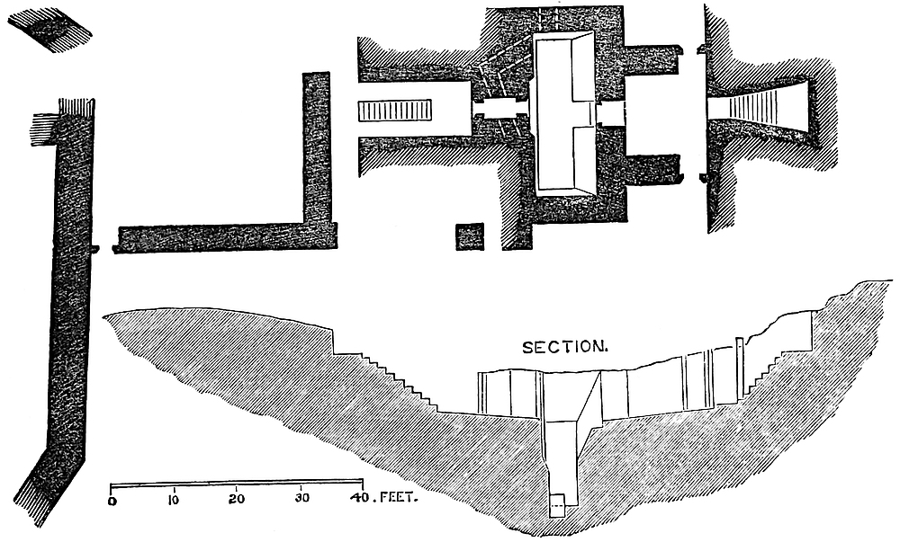
The range of storehouses in the main ward, the offices projecting from it towards the north-east, and the whole of the buildings of the foot entrance are of later date, and of different design, material, and workmanship. The material is a greenish sandstone, and the workmanship ashlar of the most expensive kind, dressed on every face, and laid in thin joints, with but little mortar. This excellence has proved fatal to the structure; for, as the stones needed only to be lifted from their beds and laid, without any adaptation, into any new work, the temptation has proved too strong, and most of this later work has been carefully removed by hand, and not, like the older work, overthrown by gunpowder. In fact, the lower walls that remain have much more the appearance of an unfinished than of a partially-destroyed building.
There is a paper by the late Mr. Hartshorne in the fifteenth volume of the Archæological Journal, which, though it touches but lightly98 upon the topography of the castle, enters at some length upon the history of the Barons of Montalt, long its owners. From thence, and from other sources, it appears that Hawarden belonged, from a very early period, to the Earls of Chester, some of whom probably constructed it, but no doubt occupied it before the completion of the structure. In their line it remained till the death of Ranulph de Blundeville, the last earl, in 1231, when, with Castle Rising and the “Earl’s Half,” in Coventry, it came to his second sister and co-heir, Mabel, who married William d’Albini, third Earl of Arundel. Their second son, Hugh, who inherited, died in 1243, when the estates passed to his second sister and co-heir, Cecilia, who married Robert de Montalt.
The Barons de Monte-Alto, sometimes styled de Moaldis or Mouhaut (Mold, where the mound of the castle remains), were hereditary seneschals of Chester and lords of Mold. Roger de Montalt, grandson of Robert and Cecilia, inherited Hawarden, Coventry, and Castle Rising. He married Julian, daughter of Roger de Clifford, justice of North Wales, but dying childless, in 1297, his lands passed to his brother, Robert, the seventh and last lord, who died childless, 1329, when the barony became extinct. Robert de Montalt signed the celebrated letter to the Pope in 1300, as Dominus de Hawardyn. [P. Writs, I. 743.] He bequeathed his estates to Isabella, the queen of Edward II.
The entries concerning Hawarden in the public records are few. In 1265, 49 Henry III., the king granted to Llewelyn-ap-Griffith, Prince of Wales, the Castle of Hawardin, to him and the heirs of his body, Hereford, 22nd June [N. Fœd. I. 457], but in 1267, 51 Henry III., by a letter by the legate Ottoboni, Prince Llewelyn is at once to restore to Robert de Otto Monte the lands of Ha Wordin, but Robert is not to build a castle there for thirty years. Montgomery 3 Kal. Oct. [Ibid. p. 474.]
In the Inquisitions and Escheats are also some entries. From an inquisition, 3 Edward I., Robert de Monte Alto is seized of the manor of Hawardine, co. Cest. His possessions were extensive. They occupy ninety-one entries in thirteen counties. [Inq. p.m. I. 55.] In the next year, 4 Edward I., is an inquisition, whence it appears that the manor was never settled in dower. Neither Leuca, wife of Robert de Montalt the Black, nor Matilda, wife of Ralph de Montalt, nor Nicholaa, wife of Roger de Montalt the elder, nor Cecilia, wife of Roger the younger—all ladies of the Honour of Hawirdyn—were ever so endowed. [Ib. 60, Cal. Geneal. I. 247.] 10 Edward I., 25 March, is an entry on the Welsh roll concerning the pursuing and taking certain Welsh malefactors, who took captive Roger de Clifford in the king’s castles of Hawardin and Flint [Ayloffe, p. 76], and from the king’s writ itself of that date, addressed to Roger de Mortimer, and given at length by Mr. Hartshorne, it appears that the Welsh attacked Hawarden by night, killed some of De Clifford’s household, and burnt the castle houses, and did much the same at Flint. This outrage was repeated in the next year,99 when (6 November, 1282) the justice’s elder son, also Roger Clifford, was slain. [Foss’s “Judges,” III. 76.] The next entry in the inquisition is one of 25 Edward I. on Roger de Montalt, whence it appears that at that time, though he held Castle Rising, &c., the manor of Hauwerthyn was vested in Thomas de Offeleye. This might, however, be as feoffee in trust. [Inq. p.m. I. 134.]
From all this it may be inferred that there was a castle here which Prince Llewelyn destroyed, and which Robert de Montalt undertook not to rebuild. Such promises went for as little then as between nations at the present day, and the castle that the Welsh took 10 Edward II., 1282, was of course built or restored during that period. If Llewelyn had found a keep of anything at all approaching in substance to the present he could scarcely have destroyed it; nor does it seem probable, from the internal evidence of the building, that the keep now standing was the work taken by the Welsh, 10 Edward I. Its mouldings and the plan of its upper floor point to a rather later date; and probably it was the work of the last Baron de Montalt, between 1297 and 1329. Cylindrical keep towers, of a pattern not unlike that of Hawarden, though usually, as at Coucy, on a much larger scale, were in use in France in the earlier part of the thirteenth century; and although the unusual thickness of the walls in the present example might be thought more in keeping with the Norman period, the general details, the polygonal mural gallery and interior, and the entrance, evidently parts of the original work, are very decidedly Edwardian.
Hawarden was finally dismantled by order of Parliament, in the time of the Commonwealth, and the keep much shattered by a mine, sprung probably under the doorway. It so remained until very recently, when it was restored by Sir Stephen Glynne, the late owner, under the advice of Mr. Shaw, of Chester. The task was one of exceeding delicacy, but was executed with marvellous skill and complete success, so far as the work proceeded. Enough remained of each part to give a clue for its reproduction, and thus the gateway, portcullis chamber, much of the well-staircase, most of the chapel, and part of the great mural gallery have been restored just as they must have been left by the original builder. At the same time the stone employed and the mode of dressing it, will always indicate to the skilled observer which parts of the work have been replaced.
The present access to the rampart is an addition in brick of the last century, and might well be restored in stone. The view thence is extensive, having in the foreground the park, which, for wildness and sylvan beauty may well compare with any ground even on the Welsh border; and beyond is the broad and fertile plain of Cheshire and Shropshire, including the city of Chester, the rock and ridge of Beeston, and, in clear weather, the Wrekin. In the opposite direction are views, less extensive, of the estuary of the Dee and the peninsula of West Chester. The Welsh view is inconsiderable, being cut off by the higher ground.
HELMSLEY, the Elmeslae of Domesday and the Hamlake of genealogists, is the name of an extensive tract of wild moorland which lies on the southern slope of the Cleveland Hills, in the north-east corner of the North Riding of Yorkshire. The hills rise to 1,400 feet above the sea, but Helmsley Moor hardly reaches 1,100 feet, and the town of Helmsley, placed where the uplands pass into the plain, scarcely stands at 200 feet.
The real river of Helmsley, descending from the moors, is the Seph; but after its union with the Rye, the stream and the dale bear the name of the latter water, made famous by the Abbey of Rievaulx, about four miles below which, sweeping round the well-wooded promontory of Duncombe, the stream, returning somewhat upon its former course, forms the southern boundary of the castle and the town.
The castle is barely included in Duncombe Park, part of its eastern outwork being traversed by the border. Its position, if not specially striking, is yet strong, and favourable to the works which rendered it in former days almost impregnable. The low platform upon which it stands is mainly of rock, and the labour employed has been rather that of removing than of making ground, the ditches being wholly artificial.
Besides the Rye, which, where it flows about a furlong south of the castle, has low and swampy banks, the Etton beck, close upon the east, between the town and the castle, descends on its way to the Rye, at a level which allowed of its waters being employed to flood the ditches of the fortress.
The plan of the castle is rectangular, and its earthworks are upon a scale not usual with castles of pure Norman origin, and which, notwithstanding their form, raises a surmise that they may be of much earlier date.
The main ward of the castle is about 200 feet square, level, and contained within a deep and broad ditch, completely surrounding it. A moderate bank of earth crowns the edge of the slope, partly, no doubt, original, but in part composed of the ruins of the curtain.
Beyond the ditch, and forming its counterscarp, is a ridge or bank of earth a few feet lower than the level of the ward, and therefore commanded by it. This ridge, interrupted at the southern angle, so as to communicate with the excavations beyond, is expanded upon the north-west front and again still more considerably upon the opposite or south-east front, so as to form a lesser and a greater barbican, covering the two entrances to the place.
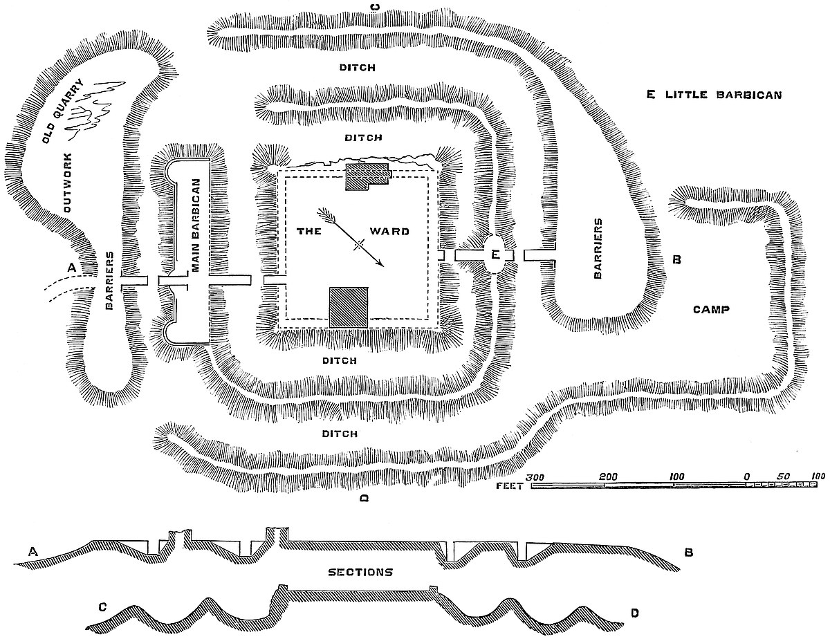
Again, beyond the ridge is a second ditch, also encircling the whole place, and passing, therefore, in front of the barbicans. This, in its turn, is succeeded by a second or outer bank, also interrupted,101 and in three places, at the north, south, and east angles. This also is of variable breadth: somewhere, a mere ridge; in other places, as before the two fronts, expanded into broad platforms, covering the entrances and the approaches to them. Supposing these ditches102 to contain either water or mud, the interruption in the banks would very much increase the difficulties of those besieging the place, by breaking the communications, and preventing them from attacking the barbicans by the flanks. There are traces, outside this second bank, of a third ditch, which, however, seems to have been confined to such points as were supposed especially to need further protection.
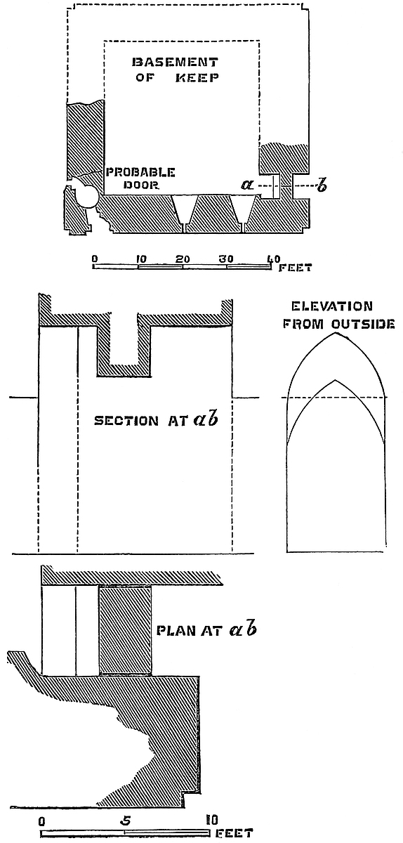
It is evident that an earthwork such as that described, covering above ten acres of ground, and with ditches 60 feet to 70 feet broad, and deep in proportion, would, in resolute hands, and properly palisaded, be a most formidable stronghold. That such was the103 nature of the defences contemplated seems certain, since the banks would not support masonry; and although the edge of the inner ditch was of firm ground, the bank or crest thrown up upon it was not, and had masonry been contemplated, would have been superfluous.
When the Norman engineer undertook to fortify the place, he seems to have confined himself to the construction of a curtain of 10 feet thick round the inner area, placing it on the firm ground, and employing the earth-bank as a ramp against the wall; to this he added a gatehouse at each end, and a work of some strength as a barbican beyond the inner ditch; then a second gatehouse, placed upon the barbican; and finally a second or outer bridge. On the west side of the inner area, where the rock was firm, a low cliff of 20 feet to 25 feet was substituted for the slope of the ditch.
Besides the enceinte or curtain-wall, the four drawbridges, and probably four gatehouses, there seem to have been four drum-towers—one capping each angle of the place. It is true that these are no longer to be seen; but a circular heap of rubbish at each angle seems to represent such towers which, indeed, were the usual and necessary constituents of such a work, though whether these towers were of the Norman period may be doubted: probably they were later.
In addition to these works, and reared up high above them all, was the rectangular keep, placed near the centre of the east or town side, and upon and forming a part of the enceinte. Opposite to the keep, and also forming a part of the enceinte, but on the west side, and built therefore upon the edge of the cliff, were the domestic buildings, some parts of which remain mixed up with later works. It may be also seen that a cross curtain between the keep and the domestic buildings divided the ward into a northern and a southern court, and it would seem that a fragment now standing, and which has much the air of having been part of a chapel, was connected, as at Knaresborough, with this wall.
The keep appears to have been a square of 53 feet, and although about 9 feet of it are buried in earth and rubbish, it still rises to about 90 feet. Rather more than the outer or eastern half has been blown up, and has fallen into the ditch, and what remains has suffered much from alterations and additions. It is built in rubble of a very ordinary description, but with quoins and dressings of ashlar. The plinth, if one there be, is of course concealed. The walls are plain, 9 feet thick, having neither string nor set-off, and but one low pilaster buttress, which rises to the first floor only, and is placed upon the west end of the north wall, to give strength to an interior stair. At the two remaining angles are nooks, but not intended to carry shafts or beading.
The original tower was composed of a basement and first floor, about 70 feet high, or, as now seen, 60 feet. There remains within, against the west wall, a not very high-pitched weather-table, which shows, as at Porchester and Richmond, where the roof abutted104 against the wall as a gable. The wall was carried all round, high enough to conceal the roof. The west angle contains a well-staircase, which rose from the basement to the first floor. The door into the basement is buried, but the line of the steps in the wall points downwards. A breach has been effected in the west wall exposing the staircase, and seems to occupy the place of a loop.
In the west wall of the basement are two acutely-pointed recesses, terminating in square-headed loops; and in the south wall is a doorway, of 5 feet 6 inches opening, also under an acute arch. It is possible that this basement was vaulted, though it is more probable that the covering was of timber.
The first floor was originally lighted by three windows, in early pointed recesses, of different sizes and heights, and above the central recess, which was placed lower, to give place for it, are a round-headed recess and a window, placed in the angle of the gable. The three lower windows have been replaced by three lancets, and the recesses reduced in height and proportion to suit. The later arch is handsomely ribbed. It is uncertain how the first and main floor was covered over. In the north wall are seen the springing-stones of three ribs, evidently part of a vault; but near them is a short table, with four corbels, possibly connected in some way with the stair-entrance. Also there are fragments of two ribs in the west wall, so that the arrangements of the vaulting are obscure. The ribs mentioned are plainly chamfered, and may be early English, or later. An addition of about 30 feet has been made to the original keep, giving it an upper or second floor. In the west wall of this addition is a pointed window in a segmental recess, resting on the old masonry. In the north wall is another pointed window and a fireplace. There is a loop towards the south; but this part of the wall, both inside and out, is obscured by ivy. In the wall of this floor, cutting the line of the windows, is a corbel-table, the corbels cut somewhat into the shape of heater shields. This must have supported the roof, but have interfered seriously with the windows. How this story was reached does not appear; probably by a well-stair in the wall, now destroyed, a point which could, no doubt, be ascertained by uncovering the fragments in the ditch. The upper wall seems as thick as that below; and it is curious that there are no traces visible of mural galleries or chambers.
The battlements remain perfect, so far, at least, as are the walls they crown. The embrasures are of moderate size, and the merlons broad, and the running moulding is carried round the whole. At each angle is a square turret, rising about 10 feet above the curtains. These turrets rest upon a light bracket outside, and each of the outer faces is flanked by two light, slender buttresses, in tabernacle work, resting below upon brackets, and, no doubt, once ending above in delicate finials. In each face is a single embrasure. Of course, all these are additions.
The question of the entrance to this keep is obscure. There remain three doors, any one of which would serve. That on the105 ground floor to the south; a small round-headed door at the first floor level to the north; and a third door, in the same wall, a little lower down, leading into the well-stair. There are, however, indications that none of these was the real entrance. Against the south wall are traces of attached masonry, probably of a forebuilding, containing and covering the entrance, which in that case would have been in the south wall near the east end, a part now destroyed. The staircase seems to have commenced against the south-west end of this wall, and to have passed over the present door, which probably, as at Rochester, opened into a cell below the staircase of the forebuilding. This conclusion is strengthened by the presence of seven holes in the keep-wall at the rampart level, evidently to carry a brattice commanding the staircase below. Also, high up in the same wall, there projects a mass of ashlar, which may very well have been part of a machicolation, overhanging the door at the stair-head: arrangements similar to these are not uncommon in keeps of this pattern. Of the other doors the small round-headed one may very well have opened upon the ramparts as at Clitheroe; and that which is let into the well-stair, now closed and converted into a loop, looks rather of a Decorated character, and may be an insertion, and may have led into some annexed building now destroyed. At the period when this tower was built there was no longer that extreme caution in allowing no more than one entrance to the keep.
It would seem that the original keep was late Transition or pointed Norman, and therefore might well have been built, as supposed, by Robert de Ros, surnamed Fursan, who held the lordship from 1184 to 1226, and probably completed the work before 1200. Then came the alteration in the first floor in a most decided early English style, and therefore probably by Robert de Ros, Fursan’s grandson, who married the heiress of Belvoir, and flourished between 1257 and 1285. Then followed the addition of the upper story, and of the battlements and turrets, all rather late Decorated. This might well be the work of William de Ros, who held Helmsley from 1317 to 1342, to whom, in 1337, was granted the tower built by Edward II. in London, near Baynard’s Castle, and which seems to have stood on the bank of Fleet-ditch, where some ancient foundations were recently laid open in the formation of the new street. This he was to hold as appendant to his Castle of Helmsley.
The domestic buildings standing opposite to the keep are composed of two blocks. One a square mass of great height, and with walls of considerable thickness, has traces of transition Norman or early English work, but has undergone alteration in the Decorated period, and finally in that of the sixteenth century. The other or northern building may be on early foundations, and probably is so, but its fittings are of the sixteenth century, and probably the work of the Earl of Rutland, whose armorial bearings are embossed in plaster on a deep cornice and on the panelled ceiling, all now in the last stage of decay.
The northern gatehouse, and any structure that may have stood106 upon the smaller barbican, have disappeared utterly from sight, though probably their foundations could be laid open. To the south there is more to be seen. The inner gatehouse indeed is ruined, and nothing is visible above the rubbish save the outline of the western jamb, which shows a portcullis groove and rebate for folding-gates.
The outer gatehouse and its barbican form a very remarkable work. This barbican is, as has been stated, an expansion of the bank which surrounds the inner ditch. It is here above 80 feet broad, and long enough to cover completely the southern front of the place. The gatehouse, like that behind it, is much nearer to the east than to the west end of the work. It is composed of two small round turrets, and two large drum-towers flanking the portal. On either side of these extend the curtains, which terminate in a pair of large drum-towers, which flank and close the outwork.
The gatehouse is tolerably perfect on the ground floor. The upper story is in ruins. The portal, about 32 feet deep, is vaulted throughout at different heights and with arches of different curves. It was defended by a portcullis and a pair of gates. The outer portal is handsome and peculiar. It is of about 10 feet opening, and shoulder-headed, the shoulders being worked brackets. Above is a pointed arch of relief, and the tympanum between the two is composed of stones joggled together with great neatness. Above is a good flat-topped Decorated window of two lights trefoiled. Traces of the chain-holes for the bridge are seen in the spandrels of the portal. The gatehouse is evidently of two periods. All behind the portcullis groove is original, either late Norman or early English. The groove with all before it is late Decorated, probably of the age of the upper story of the keep.
Much as the buildings of this castle have suffered, it is curious that the piers, counter-piers, and bridge-pits of the four bridges should remain quite perfect, and all of excellent ashlar. The inner, or pier from which the bridge dropped, is from 9 feet to 12 feet long, and the pit across which it dropped of 12 feet opening. The counter-pier, upon which the bridge dropped, is much longer, from 40 to 45 feet, and as this long and exposed causeway was but 12 feet broad, any body of enemies approaching by it would be placed at a great disadvantage.
It is difficult to form an opinion upon the age of the earthworks of this castle. Either the Romans or the Normans might have laid out an earthwork on a rectangular plan, but when either people desired to construct a place of excessive strength, they employed masonry rather than earthworks. The Saxons and early English, on the other hand, though much given to employ defences of earth, and often upon an immense scale, are not known ever to have made them rectangular. What was the practice of the Romanised Britons, who, inheriting something of Roman arts and military rules, might also well have derived from their Celtic forefathers a taste for works in earth, is not known. Such a fortification as the present may107 possibly be in part their work. Of course, it is possible that the whole may have been the work of Robert Fursan, especially as, remarkable as it is, it is not named in Domesday nor any early record.
Helmsley appears, as has been stated, in Domesday as “Elmeslae, in the wapentake of Langeberg.” It is now in that of Ryedale; but that this is the place meant seems certain, from its entry in company with Sprostune, now Sproxton, one of its townships, and Harun, now Harome, a chapelry in the parish. The entries are of a very ordinary description. The tenants are—“In Sprostune Turloge Normand et Sortcolf; in Elmeslae, tres Taini; in Harum Sortcol.” When these holders were swept away and who succeeded to them, is not known; but, according to Dugdale, Helmsley was held in the reign of Henry I. by Walter L’Espec, a very famous baron. He appears as connected with Yorkshire, Bedfordshire, and Carlisle, in the Pipe-roll of 31 Henry I., 1130–1; and having lost his only son by a fall from his horse, he founded the abbeys of Kirkham and Rievaulx in Yorkshire, and Wardon in Bedfordshire. L’Espec was a Norman, and held estates in Normandy, but when or how he came over is not recorded. A certain William Spech is recorded in Domesday as a great tenant in Bedfordshire, and he may be the father of Walter, who had lands there. He died in 1153, and in 1157–8 Walter de Bussei is found moving against Robert de Ros for the partition of this estate. Who this Robert de Ros was is uncertain. Adelina, Walter’s daughter and co-heir, married Peter de Ros, who in her right was of Helmsley, or, as it was always called, Hamlake.
Peter de Ros, whose name was derived from his lordship of Ros, in Holderness, was, by Adelina, father of Everard de Ros, who appears in the Liber Niger as the tenant in capite of several Yorkshire fees, which no doubt included Helmsley, as many of the tenants’ names are local, as Hairun, Spouston, and Stainesgrave. Everard, being under age, was then in the wardship of Ranulph de Glanvill. He died before 1186, and was succeeded by his son Robert, third Lord of Hamlake, surnamed Fursan, one of the Magna Charta barons, and the reputed builder of Helmsley Castle. He died as a Templar, and his effigy is still pointed out in their church in London.
Robert de Ros, his grandson, who probably executed the earliest additions to the work of his grandfather, married Isabel d’Albini, heiress of Belvoir.
From them came William de Ros, seventh lord of Hamlake, who died 1342–3, and probably completed the keep and the outer gatehouse and barbican at Helmsley. With his descendant, Edmund, fifteenth lord, the male line failed, and Helmsley passed with his sister and co-heiress Eleanor, to Sir Robert Manners, or rather to their son, George Manners.
His descendant, Francis Manners, sixth Earl of Rutland, became Lord Ros of Hamlake by patent, which, however, died with him, as he left a daughter only, Katherine, who married George Villiers,108 Duke of Buckingham, whose son dissipated the estate, which, at his death, was sold to the ancestor of the present owner. The barony of Ros, or Roos, of Hamlake, was called out of abeyance, but exists quite separated from the castle or estate.
THE borderers of England, whether on the north or on the west, were bold, hardy, and aggressive races of men, having for their patrimony the moor and the morass, the wild bleak upland which occurs on the Scottish frontier, or the steep crags and rugged defiles which gave strength and, in ordinary cases, impunity to the Welsh. The Scots, indeed, came of the same stock with the English, and had recently formed a part of the same kingdom, under the same lords; nor was the land immediately south of the Tyne or the Tweed materially richer than that to its immediate north. But the Welsh had other more potent and better causes for their continual and ferocious transgressions. They were the earlier possessors of the whole country, a possession still attested by the names of hills and rivers, and, indeed, of many of the chief cities of England. They were of an entirely different blood and language from either Saxon or Norman: by the one they had been gradually driven into the western and less fertile tracts of the island, and the other held them cooped up and at bay within their mountain fastnesses, and responded to their continual partisan warfare by occasional invasions on a large, and, for the time, irresistible scale.
Full in view of the Welsh mountains were spread out some of the most fertile lands in Britain—cultivated, inhabited, and fortified by the invaders, who, not content with the slopes of the Cotteswold and the velvet meads on the left bank of the Severn, had pushed their conquests far beyond the right bank, holding the stately ridge of Malvern and the rich pastures of the Teme, the Lug, the Frome, the Worm, and the Wye, even up to the Dyke of Offa. That dyke, still to be traced along much of its length, between the estuaries of the Severn and the Dee, was felt to be a perpetual mark of inferiority, an abiding affront to the patriotic feelings of every Welshman. No marvel, then, that the Welsh were ever insurgent, ever breaking forth with fire and sword into the English territory, and especially into the most rich and, by nature, least-protected tract of it, the fair county of Hereford.
Herefordshire was first subjugated by the Romans. Three miles north of the city are the remains of a camp, probably British, covering about thirty acres of ground, and now known as Sutton Walls, a little south of which runs the line of the road which led to the109 Roman town of Magna Castra, four miles to the west, and was continued onward in the same direction.
At what precise period Herefordshire passed under the Saxon yoke, and became annexed to Mercia, is unknown—probably under Creoda, early in the seventh century. The see was founded in 680, when a synod was held here under Putta, the first bishop. Sutton, or Southton, so called from its position close south of the Roman camp to which it has given its name, was at a very early period a residence of the Mercian kings. Here, in the middle of the eighth century, resided the celebrated Offa, probably during the construction of his dyke, which passes about six miles to the west; and here in 794 was committed the murder of Ethelbert, his intended son-in-law, a deed which led to the aggrandisement of the cathedral church, to which Offa’s penitential donations were largely paid. A charter of King Cœnulf, A.D. 799, mentions Hereford, as do others by Deneberht, in 802 and 803, the last recording certain “monasteria quæ olim in antiquis dictis ad Herefordensem ecclesiam præstita fuerunt.” Sutton continued a Mercian palace until the union of the seven kingdoms, under Egbert of Wessex, in 827.
Edward the Elder, a great constructor of strong places, who repaired the citadel and walls of Chester in 909, is said by Grafton also to have fortified Hereford, erecting a strong castle there. His sister Ethelfleda, a still greater castle-builder than he, and to whom are due the mounds of Tutbury, Tamworth, Leicester, and some others, was the widow of Ethelred, Duke of Mercia, in 915, when the Danes had advanced by the Wye, and taken captive the Bishop of Archenfield. She attacked and defeated them before Hereford, no doubt making use of the new defences. She died shortly afterwards.
Early in the eleventh century, the Saxon sway had been so far extended as to have left the Dyke behind, and Wales was regarded as a part of England, and an attempt made to force it to contribute to the common tax for the defence of the island against the Danes. For this purpose Edwin, the Ealderman of the Mercians, led an army as far as St. David’s, punishing the people for their refusal. At that period, and during the reign of the Confessor, the Welsh were led by Griffith-ap-Llewelyn, the ablest of their princes, and, indeed, the only one who ever held the Welsh together, or gave the English cause for anything like serious apprehension. Aided sometimes by the Danes from Ireland, sometimes by traitorous Saxon chiefs, and sometimes even by the discontented Normans, he is found during the first half of the eleventh century waging on the whole a successful war against Herefordshire. It is certain, from the number, magnitude, and character of the existing earthworks, that Irchen or Archenfield, called from its beech-trees “Trefawrth” by the Welsh, and sometimes by the English “Fernley,” had from a very early period been inhabited by the English; but either distrusting these, or because he wished to quarter afar off the visitors whom he attracted, but of whom he was afraid, the Confessor made large110 grants of land along this district to his Norman courtiers, with whom, therefore, Griffith had not unfrequently to deal.
The earliest of these grants seems to have been made to Richard Fitz-Scrob, whose fortress, built after a fashion till then unknown in England, gave great and general offence. His original castle has been replaced by later structures, now also in ruin, but the earthworks are probably original; and the name of Richard’s Castle shows how deeply the fear of its builders was impressed upon the people; and it is, moreover, a very rare example of a parish bearing a purely Norman name.
These grants were opposed by Earl Godwin and his sons, and it was to enforce his remonstrances against them that the English Thane led a force from Beverstone, and challenged the Confessor to give up his stranger favourites—a struggle which finally ended in the temporary banishment of that truly English noble.
In 1052, during Godwin’s exile, Griffith invaded Herefordshire, and advanced as far as Leominster before Fitz-Scrob and his Normans were in the field to meet him. They were beaten in a pitched battle, and upon open ground.
In 1055, the earldom of Hereford was in the hands of Ralph, surnamed “the Timid.” Griffith, uniting with Ælfgar, the Saxon lord of the East Angles, who was accompanied by an Irish force, burst into Archenfield, and again laid waste the border. Two miles from Hereford, Griffith and Ælfgar were met by Earl Ralph, who seems, with the Norman contempt for infantry, to have placed undue weight upon his cavalry, the result of which was a complete defeat. Griffith entered Hereford, which was undefended, sacked and burnt the city, treated the cathedral and the clergy with excessive severity, and destroyed what the “Brut” calls the gaer, that is, the castrum or fort. The account seems to imply that the city was not then fortified. Mr. Freeman thinks the gaer was a work of masonry. However that may be, there is little doubt but that it was a work on the site of the later castle, for by the riverside, for defence, it would certainly be placed; and as the position of the cathedral has doubtless always been the same, there would scarcely be room for a fortress between its precincts and the western marsh. The position of the bridge, too, is probably ancient, and this would lead into the city, not into the gaer. The appearances of the earthworks, as they existed before the removal of the mound and the filling up of its proper ditch, much resembled those of Tamworth, and other works attributed to Edward and Ethelfleda, and the gaer may well have been of that date, so far as the earthworks were concerned. This inroad of the Welsh in 1055 was the most severe and the most lasting in its effects of any on record. All Archenfield suffered, and traces of the spoiler are recorded long afterwards in Domesday.
Although Godwin’s return from banishment in 1052 had been followed by the putting forth of most of the Norman intruders, Richard Fitz-Scrob, one of the most offensive, seems to have remained, and long afterwards to have put down Edric the Wild;111 and his son Osborn, after a short exile in Scotland, came back to Herefordshire, and held office and dignities both before and after the Conquest.
In 1055 Godwin was dead, and to Harold, as Earl of the West Saxons, it belonged to redeem the disgrace incurred by Ralph the Timid. He lost no time in preparation. In the course of the same year he mustered his forces at Gloucester, and by his mere presence cleared Hereford of the Welsh and Ælfgar. He at once fortified Hereford. Whether he restored the castle is unknown, but he surrounded the city with a wall, no doubt along the line of the later structure. Mr. Freeman supposes Harold’s work to have been a mere “dyke of earth and loose stones,” Florence of Worcester describes it as “Vallum latum et altum.” Domesday, however, records a “murus” at Hereford as having stood in the time of the Confessor, so that Harold, when Hereford came under his immediate government, may, as Mr. Freeman suggests, have replaced his vallum with a wall of masonry. Harold’s defences probably did not include the suburb, which even then must have existed, since we read in Domesday of burghers within and burghers without the walls; though the latter would derive a not incomplete protection from the broad belt of marsh which then surrounded the city.
Griffith had sought and received terms of peace. Nevertheless it did not suit him to allow Hereford to become a strong post. Early in 1056 he again crossed the border. He was opposed by Leofgar, the new bishop, who, however, was slain in the first combat. His successor, Ealdred—a man of equal determination with better fortune,—held the Welsh in check, and negotiated a peace, and the fortifications of Hereford were completed.
In 1062 Griffith again appears upon the scene. Probably he traversed Herefordshire, for he crossed the Severn in the diocese of Worcester. On this occasion Harold—appearing, not as the defender of this or that province, but of the whole kingdom—executed a counter movement, and invaded North Wales. This was followed in 1063 by Harold’s great invasion, in which Griffith was murdered by his own countrymen, and Wales submitted, having deprived herself of her greatest son. It was at the conclusion of this war that Harold employed himself in constructing a sort of hunting-lodge for his sovereign in the low lands of Gwent, at Port-skewet, where earthworks are still seen. The lodge was attacked and destroyed while in progress by Caradoc-ap-Griffith-ap-Rhydderch, of South Wales.
Hereford played no part in the Conquest; but the city and shire occupy a respectable place in the Domesday Survey, where the customs are related in great detail. The king had six moneyers there, and the bishop one. Of the city burgesses 103 held of the king, and twenty-seven had held of Earl Harold. All the tenants of the burgh were liable to military service against the Welsh.
The customs called of the Welsh in King Edward’s land in Arcenefeld, or Irchenfield, also there recorded, are curious, and112 show not only the early existence of a local militia to resist the Welsh, but that the people were mostly of Welsh blood, and were employed against their countrymen. The king held three churches there, and the priests of them were to be the king’s legates or ambassadors in Wales, and when the army marched against an enemy, to the men of Archenfield was committed the post of trust and danger. During the advance they were to form the “Auantwarde,” and in retreat the “Redrewarde.”
Such, then, having been the antecedents of Herefordshire, it is not to be wondered at that it bristled with strong places, nearly all of which show indications of early dates, and in many may be traced the mount or motte, which in England there is strong reason to regard as in favour in the tenth century. Domesday, usually so silent as to fortresses, and enumerating only forty-nine in all England, mentions in this county eight, and two strong houses. There were, however, many more, and at this day there remain traces more or less considerable of twenty-eight, of which many preserve the mount, and others earthworks of an early character. Similar works are found at Brecon and Builth, places known to have been held by the English at an early period. No doubt these strongholds, originally strengthened with timber, were burned again and again by the insurgent Welsh; but the positions of most of them were well chosen, and each had its surrounding estate, so that when, after the Conquest, the great Norman barons marched into Wales, they constructed upon these sites castles of masonry after their fashion, of which a few remain, though many, having been destroyed, have been rebuilt in the reign of Henry III., or later.
William’s arrival no doubt confirmed and extended any local power that may have been allowed to Richard Fitz-Scrob and his son, under Harold. Osborn, as sheriff, held Hereford, and either he or the first Norman earl probably rebuilt the castle in the Norman manner.
William FitzOsborn, the great Norman chief, “Magister militum bellicosus,” Earl of Hereford from 1067 to 1071, was a fearful scourge of the Welsh, whom he drove back and vanquished on the banks of the distant Rhymny. To him are attributed the castles of Strigwil, Clifford, Wigmore, and Ewias—that is, the Norman part of them, for some at least preserve older earthworks.
Roger de Bretuil, William’s third son, succeeded him in the earldom. He plays no part in the history of shire or castle. Failing in rebellion in the eastern counties, he ended his days in prison.
When Bretuil died is unknown, but in 1138 Hereford, commanded by William Talbot, held out successfully against Stephen during a long siege. The defence was much aided by Milo, the Constable of England, who received the earldom of Hereford from Maud, in 1140, and it remained in his family till the end of the century. Milo’s patent gave him the moat, probably the “motte,” and all the castle. As earl, however, he was unfortunate. Stephen returned and took the castle, and wore his crown in state in the cathedral.
113
Roger, son of Milo, was in opposition to Henry II., but escaped by the wise counsels of Foliot, the bishop. In the reign of John, a less discreet or bolder prelate—Giles, Baron de Braose—united with Llewelyn; but failing to bring over the men of Hereford to support him, died in exile. The castle seems then to have fallen into the possession of the Crown, and so to have remained. Prince John gave the custody of it to Roger Bigod, and in the sixth of his reign as king, and in the seventh of Henry III., William, brother to Thomas, Lord Cantelupe, and sheriff, was also governor. The turbulent reign of Henry III. gave value to the castle of Hereford. 15 Henry III., John Fitz-Terrick and William de Stowe, surveyors of works at Hereford Castle, were allowed £20 for repairing the walls. 16 Henry III., Terrick and Roger Carlton were surveyors of mangonels and petards within the castle. 26 Henry III., John and Roger le Werrur were surveyors, and had spent £7. 8s. 6½d. on artillery, and £12. 1s. 4d. in making a trebuchet called “Blythe,” and £40. 14s. 4d. in building a tower in the castle. 42 Henry III., the castle was in the hands of the sheriff, Henry de Pembridge, until the barons forced the king to appoint John de Grey.
44 Henry III., Roger Mortimer was governor, and penetrated into Wales as far as Builth. He was, however, in turn attacked, and held the castle, though for a few weeks only, against Simon de Montford and Prince Llewelyn. Bishop Acqua Blanca was taken and imprisoned at Eardesley. Peter de Montford, the Earl’s son, had charge of the county, and employed its issues in the repairs of the castle. After the battle of Lewes, Prince Edward was a prisoner here.
Edward’s escape hence has often been related. Widemarsh, whence he galloped off, still bears that name, and lies about a mile north of the city.
During the whole of this time, from 1199, the title of Earl of Hereford had been borne by Henry de Bohun, whose mother was a co-heir of a previous earl, but neither he nor his celebrated descendants, Earls of Hereford and Essex, although they held Huntington Castle and the lordship of Brecknock, and built the Castle of Caldecot, ever seem to have been seized of that of Hereford, which remained in the Crown.
Soon after the time of Edward’s flight, John le Werrur and William Valet were surveyors of works for the king, at Hereford, and charged £45. 6s. 10½d. for repairs of the walls and of the king’s houses. William Capon also held lands at Marden, by the serjeantry of keeping the door of the castle, and this, under Henry III., was commuted into military service in the field.
Possibly the castle was employed as a local treasury; for, 1 Edward I., Henry Pigot held 46 acres in capite by the tenure of transporting the king’s treasure from Hereford Castle to London. In the same year Richard Porter and Richard le Panner, surveyors, charged £21. 1s. 6d. for expenses and repairs of the king’s house in the castle, and in the next year they had fifteen oaks from the114 king’s forest of Haywood, a mile south-west of the city, allowed for repairs.
2 Edward I., Giles Berkeley, sheriff, had spent £4. 15s. in repairs, and in 7–8 Edward I., Roger Burghull, his successor, had spent £2. 5s. 4d. Hugh Turberville, one of a very unruly race, had, it appeared, when sheriff, burnt and destroyed in the castle the king’s house, and certain engines of war and military stores, to the value of £100. For this he had a pardon, November 5, 48 Henry III.; but the debt remained, and, 9 Edward I., the sheriff was ordered to distrain upon his goods.
12 Edward I., a new chapel was erected in the castle, and the barons of the exchequer, by the king’s precept, allowed Roger de Burghull £10. 6s. 8d. on that account. 15 Edward I., Henry de Solers, a Herefordshire man, had charge of the castle, with arms and stores. 32 Edward I., Miles Pychard charged 40 marks for repairs, which were disallowed because not certified by the surveyor. John de Acton was governor, 33 Edward I.
1 Edward II., Alan Plukenet, keeper of the king’s forest of Haywood, was to allow twelve oaks and stone for the repairs of the castle walls and towers. Ralph Freeman held lands in capite, in Fromyngton, by the service of carrying the cord round the castle walls when they were measured. 5 Edward II., he paid half a mark for his relief, and commuted future payments for 7s. 7d. per week. 10 Edward II., Hugh de Hacluyt charged £5 for repairs.
13 Edward II., Sheriff Richard Walwyn charged £6. 13s. 6d. for repairs. At the close of the reign the queen held a great council at Hereford, and Hugh le Despenser, the younger, was hanged upon a tall gibbet, outside Friar’s Gate. During the reign of Edward II., Wales was loyal, and Hereford, therefore, neglected. John of Gaunt was its governor, 1 Richard II., but even his great love of building was not exercised here. As late as 8 Henry VI., the city had a grant of timber to replace the wall where wanting.
The castle lay unnoticed, and more or less of a ruin for some centuries, until it became the scene of one of the struggles between Charles and his people. It was first seized by Sir William Waller for the Parliament in 1643, with the city, then also walled, and the position of which is naturally strong. He retired from it before Prince Maurice, but shortly afterwards, without stroke of sword, recovered possession, again to retire, so that in 1644 it was still held by the king. In 1645, however, its troubles began in good earnest. Leslie and the Scots laid regular siege to it, and from the south of the Wye opened a destructive fire upon the castle, cathedral, and bishop’s palace. Sir Barnabas Scudamore, with eleven guns, held out stoutly, beat off an attempt at a storm, and forced the enemy to be content with a blockade. As the mills without the walls were destroyed, others were extemporised within them. The Scots then encamped on Burtonshaw Meads, close under the castle, between it and the river. Scudamore, whose defences were out of repair, and his garrison weak, sent out for country folks to assist as workmen.115 The enemy found this out, and, entering under the guise of workmen, succeeded in taking the place. Much injury was then done to the public buildings, and the castle, as belonging to the Crown, and a ruin, was sold about 1652, for the value of the materials.
The castle of Hereford was one of the strongest, most advanced, and most important fortresses upon the Welsh March, and one which, being posted in a very fertile and open district, was peculiarly offensive to, and very liable to the attacks of, the Welsh people. The present remains are not inconsiderable, but, as is often the case with fortresses of pre-Norman date, they are confined chiefly to earthworks, and include but slight traces of the later defences of masonry.
The castle was placed upon the left or northern bank of the Wye, east of and below the city bridge, the cathedral, and in some measure the city, of which it occupied the south-eastern corner. Though excluded from the city liberties, it is, in common with the city, covered at some distance by a steep slope, at the foot of which lies the Yazor brook, which, rising far off to the west beyond Kentchester, and the remains of Magna Castra, supplied the broad tract of lowland still known as Forster’s Moor, Moorfield, Canon’s Moor, Prior’s Moor, Eastern Moor, Moor Barn, and Widemarsh, to the north-west of the city, and which, after skirting its north front below Baron Court, turns Monkmoor and Scult Mills, and finally falls into the Wye, at Eigne Mill, some traces of which remain about half a mile in advance of, and below the castle. The ground thus included is to the north-east, a broad and dry platform of gravel, very fertile, and probably employed as a safe pasture in wild times. The lower tract to the north-west, now drained, and either cultivated or built upon, must, in former days, have been an almost impracticable morass.
The city of Hereford, within its walls, was, in plan, about three-fourths of an irregular circle, placed upon the Wye, which forms its concave chord. Its dimensions were, north and south, 600 yards; east and west, 770 yards; and along the river bank, about 600 yards; including the cathedral and the castle. The total girth was about 2,350 yards. The walls—no doubt Norman—upon the older lines, were confined to the landward sides, excepting about 50 yards above the city bridge, and were in length about a mile and a quarter. They were pierced by six gates—Wye Bridge, removed in 1782; Friar’s Gate and Eigne, on the west, removed in 1787; Widemarsh Gate and Bye or Bishop’s Gate, towards the north, removed in 1798; and St. Andrew’s or St. Owen’s Gate, on the east, removed in 1786.
The walls were reinforced by fifteen hollow mural towers, placed from 75 yards to 125 yards apart, or at a “flyte shoot,”—explained to be within 400 yards, and here much less. They were rather more than half round—that is to say, their side walls were a little pro116longed or stilted in plan, and they were 34 feet high, having a cruciform loop in front, and probably two others laterally. Of these, two at least remain and are accessible, though their upper half has been removed. The intervening curtain was 16 feet high on the interior, but it was built against the old English bank, which thus covered the lower 6 feet of the interior face, and served as a ramp. Besides the two towers already mentioned, which stood on the north-west face, the wall may be traced along the western side from Bishop’s Gate—now “the Commercial Road”—to the river bank. Where it has been pulled down the step remains, and the difference between the level within and without is brought to view. Of this wall the part from the Friar’s Gate to the river is open to view from the exterior paddock. The ditch has been partly filled up, but the wall remains about 12 feet high, unaltered, save by the removal of its upper 4 feet or 6 feet. At regular intervals along it of about 50 feet are broad pilaster buttresses, of slight projection, and without sets-off. These die into the wall below its present top. There do not appear to have been any mural towers on this part of the wall. Some kind of manufactory conceals the termination of this wall upon the river, where there was probably a tower; and from this point to the bridge a line of modern houses effectually conceals any foundations that may have escaped. The tracing out the town wall, or what remains of it, though aided by parallel streets, representing the rampart within and the ditch without, is a delicate operation; for the lowest houses of the city are here found, and the inhabitants seem to drive the trade of those who, at Jericho, dwelt in a similar locality. That part of the wall showing the pilasters is, no doubt, the original Norman wall. The part beyond, or, at least, the towers upon it, is probably of the time of Henry III. The wide modern street, called Commercial Road, which takes the place of the old Bishop’s Gate, has, of course, caused the removal of all traces of the wall near the site of the gate; but the line may still be traced round the eastern quarter of the city as far as the angle of the castle. Here, as before, are two roads—one inside and one outside the line of the wall—the actual place of which is shown, sometimes by a few stones built into the walls of later houses, and sometimes by a dip of nearly 6 feet in level. Beyond St. Owen’s Gate the actual wall remains for some yards, and may be seen from the exterior road. It extends to the counterscarp of the castle ditch, where it ends abruptly, having been in part pulled down.
The city bridge crosses the Wye by six arches, round headed, and all apparently old. One is stiffened with three plain square ribs, and another shows traces of a similar addition. The bridge has bold piers, and advantage has been taken of this to widen it by turning a subsidiary arch, about 5 feet wide, on each face, so that the old work is partially concealed. It does not appear where the fortified gateway was placed; probably upon the last narrow arch on the city side. This does not, indeed, show any trace of having been perforated for a drawbridge, and tradition places the gate at the outer end.
117
Next to and a little below the bridge, near the river bank, and a little south of the centre of the city, stands the cathedral, and below and next to it the castle.
Besides the cathedral and its appendage of St. John’s, there stood within the walls four churches—St. Nicholas’s, All Saints’, St. Peter’s, and St. Owen’s. There was also St. Martin’s, beyond the Wye, destroyed during the civil wars. The disposition of the streets is irregular, and in no way cruciform or indicative of any Roman arrangement. Thus situated and defended, Hereford was a very strong place, as it had need to be, for it was exposed to the fierce and repeated attacks of the Welsh, who especially resented, as was natural, the conquest of their most fertile provinces by the invaders.
The castle, as has been said, occupied the south-eastern quarter of the city. It lay in the parish of St. John. Leland describes it as one of the fairest, largest, and strongest castles in England.
It was composed of two wards placed side by side along the bank of the Wye, not actually on the stream, which, when the defences were of earth, might have undermined them; but about 7 yards distant from and on the edge of a steep sloping bank, about 8 feet above the water.
In general plan the eastern ward was an oblong, the sides being nearly straight, and the east end narrower than the west. The eastern end runs at right angles to the river, and measures along the old line of its wall 100 yards. The south or river front measured 175 yards, as did the north front. The west front, connecting the two, measured 196 yards. This inclosure formed the eastern or lower ward, and contained about 26,000 square yards.
The upper or western ward was applied to the end of the eastern, and like it rested on the river. In form it was rounded, or rather irregularly polygonal, and composed of a large conical mound, wholly artificial, with a circular circumscribing ditch. Within the ditch it measured, on the east and south sides, each 100 yards, and, on the three remaining sides, 60 yards each. It was, therefore, in girth about 380 yards, and in area about 14,000 yards. Thus the area of the whole castle, ditches included, might be about 8¼ acres. The eastern ward is stated to have contained about 5½ acres.
The earthworks of the lower ward are tolerably perfect. They are composed of a steep bank along the north and east sides, from 15 feet to 30 feet high, the highest and broadest part being at the north-east angle, where there was probably a tower. This bank has evidently been thrown up out of a broad and deep ditch, which remains perfect and full of water, on the north front; but has recently been filled up along the east as far as the river; nor do there remain any traces of the castle mill, which stood at its junction with the river. The ground is raised along the river front about 4 feet, and may have been higher. Along the west or side towards the upper ward, the bank has been thrown into the ditch, and there is only a trace of either. Leland says there was “a great bridge of stone arches, and118 a drawbridge in the middle of it to enter into the castle;” but even in Leland’s time this was gone.
The entrance to this ward was evidently at its north-west angle, where the moat is crossed by a causeway, and the public now enter. There was a gatehouse in Speed’s time, which he places, probably by an error of drawing, near the middle of this face. But the bank is there far too high, and the ditch far too deep and broad, to allow of the entrance being placed there.
The modern museum, built on the river at the south-west angle of the ward, or rather between the two wards, and over the line of the ditch, contains some parts of an older building, and a doorway of the time of Henry III. or Edward I. This building probably guarded the opening of the middle ditch into the river, and was also the gatehouse between the two wards. Speed shows a sort of water-gate here, which is probable enough. The surface of the lower ward is level. In it stood the chapel of St. Cuthbert, with a semicircular apse, and in Speed’s time also two small dwelling-houses. Leland says, “There is a fayre and plentifull spring of water in the castell, and that, and the piece of the brook coming out of the ditch, did drive a mill within the castle.” This was in addition to the mill outside and north of the castle, and probably was a part of the present museum-house.
The earthworks of the upper ward have unfortunately been destroyed, the mound and banks thrown into the ditches, and all made level and much built over. The site of the mound is occupied by an enclosed three-cornered kitchen garden. The well or spring spoken of as St. Ethelred’s remains. It opens behind the museum building about 50 feet from the river, and 6 feet or 8 feet above it. As it is described as being further north, it is probable that when the ditch was filled up a pipe was laid to bring the water out at its original level. This ward contained the mound known as the Castle Hill, and which seems to have been removed early in the present century. It was girded at the base by a polygonal curtain wall, outside of which was the ditch. It is difficult clearly to understand how the mound was occupied. Leland says “there was one great tower in the inner warde.” Sir Henry Slingsby, in his diary, in 1645, describes Hereford city as not much unlike York, “for it hath a round tower mounted upon a hill, like to Clifford’s Tower, and the mills near it, with some little works about, having the river Wye running close by; but the walls, though they be high, yet are not mounted upon a ramp, as York walls are.” This is intelligible enough, the walls spoken of having been at the base of the hill; but Leland speaks also of a donjon or keep, of what plan is unknown; but upon its wall ten half-round towers, and within, what appears to have been a square tower of considerable height, in the base of which was a dungeon. We may safely conclude from Sir Henry Slingsby’s very clear account that the mound carried, like Cardiff and Kilpeck, a shell keep; but this could scarcely have been furnished with ten half-round towers. These probably belonged to the119 enceinte wall below. The keep was entered, it seems, from the south-east side by a flight of steep steps up the mound. In the mound was a well, lined with stone, as at York.
The castle ditches were wide, deep, and filled with water, not from the river, or but partially so, but from a brook, which seems to have fed the city ditch on this side, and on reaching the castle at the north-east angle to have divided, a part running direct along the east front of the lower ward, to the river, and the other part supplying the north ditch, and the ditch which divided the upper from the lower ward, and the ditch which passed round the east side of the ward, and divided it from the cathedral precinct. This latter ditch also received some little contribution from St. Ethelred’s Well, a spring on the north side of the upper ward, already mentioned. The castle mill stood at the junction of the eastern ditch with the Wye. The water in the castle ditches was, of course, penned back for the use of the mill, and to strengthen the defences, and it seems to have flowed back upon the city ditch as far as St. Owen’s Gate, thus strengthening and connecting the city and the castle.
We have, then, to recapitulate, as the constituent parts of Hereford Castle, an oblong space, with the river on one side, and high banks and ditches on the other three. One end was cut off from the rest, and had its proper ditch, more or less circular, and within it a conical mound, with a table summit, and upon it a shell keep, with some kind of central tower, probably an addition. At the base of the mound, within its ditch, was a second wall, many sided in plan.
The lower ward, no doubt, had its walls along the summit of the earthworks, and these probably were low, by reason of the height of the bank and the depth of the ditch beyond. There was a gatehouse at the land entrance at the north-west angle, and a water-gate at the south-western, where also was the passage between the two wards. Very likely there was a postern at the south-eastern angle, where is now a footway.
There is a general resemblance, as regards the mound and bank, between these arrangements and those at Wallingford, Wareham, and Tamworth, and with what is related of the castle of Worcester.
THE Castle of Hertford not only is of high antiquity, but the date of its foundation is on record. The Saxon Chronicle relates that in the year 913, Edward the Elder, son of Alfred, threw up two Burhs at Hertford, one at Martinmas, on the north bank of the river, and, later on, one on the south bank, between three of the rivers which here unite. The former of these works has long been120 laid low, and no trace of it is visible, but the latter has been preserved by its incorporation into the later castle. The mound, standing on the edge of the river Lea, is indeed shorn of its original dimensions, but it remains, and attached to it is the base court with its exterior ditch, once of great breadth and depth, the invariable accompaniment of the mound, and with it constituting the Burh.
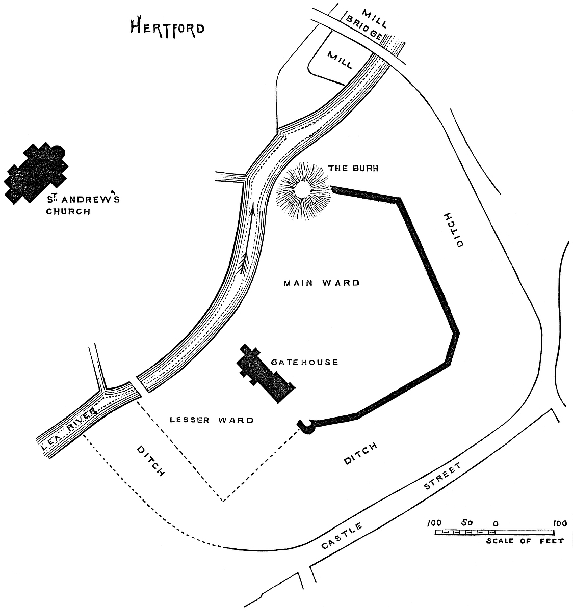
Edward’s Burhs may have been preceded by an earlier earthwork, for Hertford is reputed to stand on the site of a chief town of the Trinobantes, the British occupants of the district north of this part121 of the Thames. The Britons, however, if they here established a stronghold, are more likely to have placed it upon one of the adjacent heights, where are several excellent positions for an entrenchment. Probably the existence of a British settlement in a neighbourhood so well protected by its watercourses attracted the invading settlers, for here the East Saxon kings are said to have had a residence, and to this place Archbishop Theodore, consecrated in 668, convened a synod of the national Church in 673.
The Danes overran this part of England more than once, and the camp at Danesbury was probably their work. Also, they are thought to have had a camp upon Port Hill, of which, however, it is said that no traces are now to be seen. It was upon the river Lea, between Hertford and Waltham, that Alfred rendered the Danish fleet useless by blocking up the river, and so preventing their return. It is on record that this was effected, not by actually throwing a dam across the stream, but by the far more scientific process of cutting a number of channels for its waters, each too shallow to allow the vessels to float down. By this means the retreat of the Danes to the Thames was cut off, and they were fain to march inland to the Severn at Bridgenorth.
In 913 the protection afforded by the Hertford Burhs seems to have attracted inhabitants, who occupied both banks of the river Lea, and the town thus situate was raised by Edward into a royal Burgh, held of the Crown by burgage tenure. Hertford was so held of the Confessor, and so accepted by the Conqueror, and entered in Domesday, which, however, as was not uncommon, makes no mention of the castle, nor, indeed, of the churches. William is said to have strengthened the castle, and he gave it in charge to Peter de Valoignes, one of his followers, who transmitted it to his son Roger, and he to his two sons in succession, Peter and Robert. The male line closed with Robert, whose daughter and heiress, Gunnora de Valoignes, married Robert Fitz-Walter. The charge of the castle does not seem to have descended, but to have been resumed, possibly as a male fief, by the Crown.
King John, that most erratic of monarchs, held the castle, and visited it in 1212, 1213, and 1216. In this latter year, however, it was attacked by Lewis of France, who laid siege to it from St. Martin’s (November 11) to St. Nicholas’s Day (December 6), and finally took it. Robert Fitz-Walter, an adherent of Lewis, took the opportunity to revive his wife’s claim, but without success. It was finally recovered by John, and transmitted to his son Henry III., who placed Richard de Argentin in charge of it, and expended £20, and probably other sums, in its repairs. In 1226 it was held by Hubert de Burgh, on whose fall Henry granted it to be held in capite by William de Valence, after whom it was held by his son, Aymer, Earl of Pembroke.
Edward III. resumed possession in 1327, and granted the castle to John of Gaunt, his son, from whom it finally passed into the Duchy of Lancaster, to which it is nominally attached. Henry IV.122 kept his Easter here in 1429, and Henry VII. continued to appoint a constable and a porter. It is described as “castrum non immensum sed pulcherrimum.” Hertford fared better than most royal castles, possibly from its convenient position as regarded London, for in the reign of Henry VIII. it contained lodgings suitable for the king, and Edward VI. and the Princess Elizabeth were both here. By the latter, when queen, it was alienated to Sir William Harrington, who built a large brick house on the site of the inner gatehouse, which still remains. In the time of James I. the castle is described as covering 7¾ acres. The ditch then extended to the roads or streets now known as the Mill Bridge, the Wash, and Castle Street. The mill was upon the Lea just below the castle mounds. The Church of St. Andrew stands about 150 yards from the remaining mound, beyond the river. There was a second mill, probably that on the river above the castle. The castle was finally leased to Mr. Secretary Cecil, in whose descendant, the Marquis of Salisbury, it remains. It is remarkable that Hertford Castle at no time belonged to the earls who bore the title of Hertford. They were, of course, earls of the county, though this is not specified in the peerages. Their principal eastern seat was at Clare in Suffolk, round which they possessed considerable property.
The strength of Hertford as a military position was very great, and depended upon the low marshy ground by which it was almost surrounded, and which was liable to be flooded by the waters of three, or rather four, considerable streams, “flumina non profunda sed clarissima.” Of these, the Lea, flowing from the west, received, a few yards above the castle, the Mimram from the north-west, while a little below the castle the combined stream is swollen by the waters of the Beane from the north, and the Rib from the north-east, the combined volume flowing forward under the name of the Lea. Below, or south-west of the castle, along the course of the Lea, is a wide breadth of lowland, which even now is occasionally flooded, and which in former days must have been an impracticable morass. In the other direction the ground, though built upon and forming a part of the town, is for some distance around but little higher than the meadow, though here and there, elevated 4 feet or 5 feet, appear small deposits of gravel. The castle stands upon the right bank, south-east of the river, and its extreme limit, within the counterscarp or outer edge of its main ditch, included a space something in the figure of an ear, the river forming the shorter side or concavity. In length, north-east and south-west, this space measures 234 yards; its breadth varies from 100 yards to 200 yards, with a mean of 140 yards. The ditch, now almost filled up and in part built over, was about 30 yards broad, and no doubt filled from the river with which it communicated at each end. Within the ditch, taking the line of the old bank, or of the present wall, the area is about three and a half or four acres. The mound is placed on the edge of the river, at the north angle of the enclosure. The bank does not include it, but points to its centre, so that the123 mound, as was not unusual, formed a part of the enclosing defence. The proper ditch of the mound has been filled up.
Of the mediæval castle there remains only a considerable part of the wall of the enceinte, and, it may be, some ancient masonry built up into Sir William Harrington’s house, which is still inhabited. This is said to have been the gatehouse; if so, it was that of the northern ward, and was upon the line of the wall dividing the one ward from the other. The curtain wall is about 7 feet thick, and 25 feet to 30 feet high, and composed of flint rubble. The battlement is gone or nearly so, and there remains but a part of one mural tower, circular in plan, which capped the south-east angle of the wall of the northern ward. The wall covers the northern and most of the eastern sides of the area. There is no trace of it along the western or river side. No doubt it was less substantial on that side, upon which the natural defence was strong. The south or smaller ward does not appear to have been walled in. It was covered on the three sides by the river and the marsh, and may have been palisaded only. The wall evidently crossed the ditch of the mound, and abutted upon it, or possibly upon the shell keep, all vestiges of which are gone.
The present entrance to the castle is at the eastern angle of the ditch, which is traversed by a road leading to a small and apparently modern doorway in the wall. There is no trace of a main entrance in this direction, but it must be confessed that if the main entrance lay to the south of the gatehouse, it must have been difficult to approach, save by water.
ABOUT five miles south-east of Clun, upon a tributary of the Teme, is placed the parish and castle of Hopton, the Opetune of Domesday, when it was, like Clun, held by Picot as the successor of Edric. It was a fief of Clun. In 1165 it was held by Walter de Opton as two knights’ fees under Geoffrey de Vere, one of the three husbands of Isabel de Say; and Peter de Opton held it in 1201. William de Hopton may have followed, but Mr. Eyton is not clear whether he may not have been of Monk-Hopton in the same county.
However this may be, Walter de Hopton held the fief in 1223, as did another Walter, 1255–72, and was bound to provide for the defence of Clun Castle one soldier all the year round, and a second for forty days in time of war. In 1304–5, upon the death of Walter de Hopton, he was seized of the Vill of Hopton with its hamlets, and a considerable property about it, chiefly held under124 Clun, as continued to be the original two fees, by Sir John de Hopton, in the 21 Richard II. The family seems to have remained at Hopton till the reign of Elizabeth, but the castle was still standing and of sufficient strength to be held for King Charles in the seventeenth century. It was taken after a gallant resistance, and dismantled.
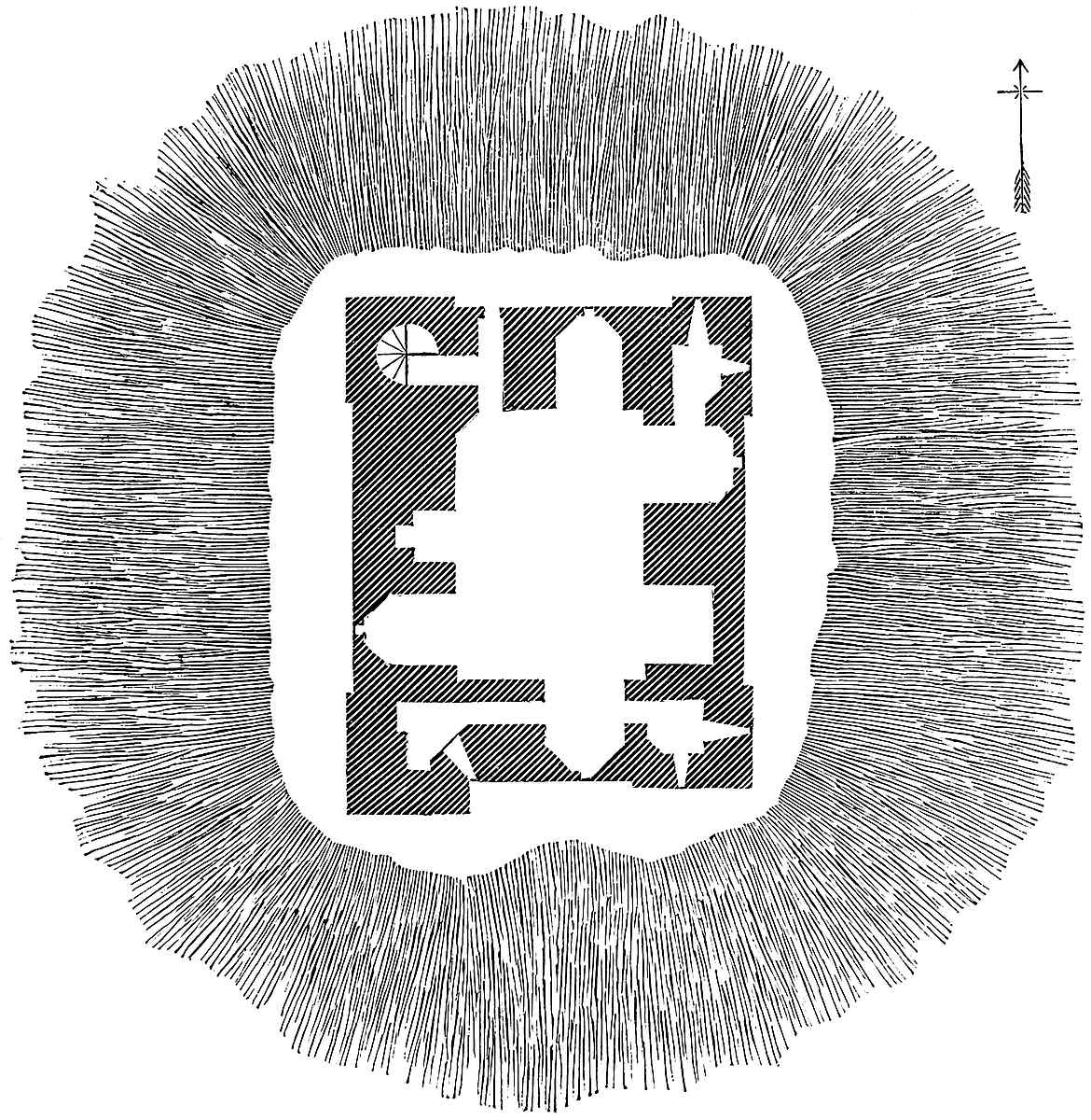
Hopton Castle or Tower stands about half a mile south of the parish church. It occupies a knoll or patch of gravel, which rises out of a marshy bottom, caused by the waters of the brooks which here fall into the main stream. There is a central mound, low but well defined, which is surrounded by a circular ditch, and beyond this ditch are the traces of two or three platforms, but slightly elevated, and which have been fortified by ditches fed with water by a streamlet from the west. No doubt the place was occupied by some tenant of Edric, for its earthworks are certainly pre-Norman, and125 perhaps of the tenth century. It is probable that its Norman tenant and his descendants, who derive their names from the place, were for some centuries content with such defences as they found ready to their hands, for there is no trace of masonry, either of the eleventh or twelfth centuries.
The castle consists of a single tower, quadrangular, 48 feet by 50 feet, with walls 10 feet thick. It stands upon the mound, which is not above 6 feet high, and through which the foundations are no doubt carried. It has a basement at the ground level, a first or main floor, and an attic in the roof. The exterior is plain, having a double-scroll stringcourse from 4 feet to 6 feet from the ground. Each angle is capped by a pair of broad pilasters of slight projection, which ascend to the summit, and probably carried four square turrets. The doorway is on the north side, not far from its west end, and nearly at the ground-floor level, ascended from the exterior by three or four steps. The south front has a square projection at its west end, in which is a garderobe. The doorway, the only entrance, is 6 feet wide, and has an equilateral arched head. Its mouldings are two convex quarter circles divided by a step. Their character is plain but excellent Decorated. Over the doorway was a triangular hood, now broken away. There is no portcullis, only a strong door.
Entering, a vaulted passage leading to the basement has a small door on the right, which leads into a well-stair, 6 feet in diameter, occupying the north-west angle of the building, and ascending to the roof. At the first floor is a lobby, with a small window above the outer door. This is the only staircase. The basement chamber is 29 feet by 21 feet. In the north wall is a deep recess, 7 feet wide, containing a small square-headed loop. Opposite, in the south wall, is a similar recess and window, but in the jambs are two doors, which by short passages lead into two chambers in the two southern angles. That in the south-east angle is 7 feet by 6 feet, with two loops. The other is a garderobe, with one loop. Both are covered in with overhanging slabs. In the west side is another window, in a recess, similar to those above described, and a fireplace with a vertical tunnel. In the east wall are two recesses, one blank and one pierced with a loop. From the jamb of this latter a door opens into a small chamber in the north-east angle.
The first floor is lofty. The joists and boards are gone, and the walls and window recesses are so thick with brambles and so inaccessible that the details are not to be seen. This floor seems to resemble the basement, save that it is higher, and the windows are larger.
The remains of two gables in the north and south fronts show that there was a ridge roof, with a small window at each end. Altogether this is a very peculiar building, much more like a Scottish than an English castle. It is all of one date, probably the work of Walter de Hopton, who died in 1304–5, and seems to have been a man of considerable wealth and power.
IT has generally been supposed that the town of Godmanchester, upon the right bank of the Ouse, represents the Roman station of Durolipons. It is traversed by the Ermine Street, which here receives the Via Devana from Cambridge, and another Roman road from the station at Salenæ, or Sandy. The Roman town, however, seems, as was often the case, to have been destroyed in the centuries of war that followed on the departure of the Roman armies, and its memory is chiefly preserved in the termination of “Chester” suffixed to its later name. The northern invaders did not much care to build upon or employ Roman foundations, and in this case they passed over from the low and watery side of the old station and established themselves on the higher position of the Hunters, or Hunting-down, on the opposite, or left and northern, bank of the river. By whom, or precisely when, the capital of the future county was founded is not known. The first mention of it, or rather of Huntingdon Port, in history, is in A.D. 657, when it occurs in the foundation limits of Medehampstede (Peterborough). As a military post it is named in A.D. 918, when, according to the Saxon Chronicle, the Danish army from Huntingdon and East Anglia threw up a work at Tempsford, and for it deserted another at Huntingdon. That work must necessarily be the earthworks now remaining, which may either have been thrown up by the Danes or by earlier Saxons. Later in the year, King Eadweard with his West Saxons brought the Danes of Northampton and Welland to obedience, “reduced the burgh at Huntingdon, and repaired and renovated it, where it was before in a state of ruin.... And all the folk that were left there of the peasantry submitted to King Eadweard, and sought his peace and his protection.”
Henry, Archdeacon of Huntingdon, who wrote towards the close of the eleventh century, mentions the three burhs (tria castra) of Buckingham, Bedford, and Huntingdon. The castle is mentioned several times in Domesday. It was within the borough of Huntingdon. The Bishop of Lincoln had a residence (mansio) in the place of the castle (in loco castri). In the place of the castle were twenty residences (mansiones). “Besides these were and are LX. ‘mansiones’ waste ... and on account of these are VIII. ‘mansiones’ waste.” William the Conqueror was at Huntingdon 1068, when he ordered a castle to be built, evidently on the site of the old fortress restored by Edward the Elder in 918. The names in Domesday show how complete had been the removal of the larger English landowners. The new castle was probably built by, and in the hands of, Eustace, one of the most rapacious of the Norman sheriffs; but the earldom was given to Judith, the king’s niece, and descended to and through Maud, her daughter, by Earl Waltheof. Maud married,127 first, Simon de St. Liz, in her right Earl of Huntingdon. The earldom, on his death, was held by David, afterwards King of Scots, Maud’s second husband, and, with the castle, was long a subject of contention between the two families, until David, the third son of Henry, son of Maud and David, laid siege to and took the castle, on which Simon de St. Liz, the son of Maud, retook it. The result was that Henry II. had the castle demolished, nor does it appear ever to have been rebuilt. The town occurs from time to time in the public records, and the honour remained attached to the earldom. The king also had a prison there; but there is never any allusion to a castle. In 1205 King John granted to Robert Rufus the demesne and mill at Huntingdon, and in 1218 and 1219 the sheriff had order to give seizin, under certain limitations, to Alexander, King of Scotland, as custos of the honour. The junior branch of the house of Hastings took the title of Huntingdon, to commemorate the descent of the elder line from the Scottish earls.
It is difficult to suppose that Henry would, within a century of its construction, demolish a first-class castle, commanding a shire town, and posted upon the edge of a very strong and inaccessible tract of country. The usual course with an important structure was to attach it to the Crown. And yet, whatever stood there was certainly then demolished, and Huntingdon Castle is not again heard of. Was there really a castle built there, or was it, as was often the case, a mere strengthened form of the older English work in timber? It is difficult, after this lapse of time, to say, though an excavation judiciously conducted would no doubt set the question at rest.
There does not appear to be any plan of Huntingdon Castle, that is, of the earthworks known as Castle Hill, which still are seen; and as they are extensive and partly included within a private garden, a mere handsketch is scarcely practicable. The position is a fine one. The Ouse, here deep, broad, and sluggish, in its way from Bedford and Eaton to the Fens, recedes from the higher land to the northward, and makes, between Huntingdon and Godmanchester, a bold curve to the south; thus enclosing a grand circle of meadow about half a mile in diameter, and now used as the racecourse. Along the northern edge of this breadth of sward flows the Alconbury brook, a considerable watercourse, which skirts the foot of the high land, and joins the Ouse opposite the Castle Hill, and just above the bridge by which the Ermine Street is carried across the river. Here, upon the edge of the high land, and protected from the south by the river and the brook, and the low and formerly impassable levels beyond them, are the ancient earthworks, which, though partially levelled, and reduced both in height and depth, and traversed by a road and a railway, are still very considerable, and form a remarkable feature in the view of the town from the south. In general outline the work is rather a circle than a square, and about 180 yards in clear diameter. The outer ditch, which is included in this measurement, encircles two-thirds of the whole, communicating at128 each end with the brook, which thus completes the investment. Upon the western margin of the area thus enclosed, and projecting boldly into it, is a large mound, the flat top of which, now crowned by a neglected mill, is 100 feet diameter, and about 30 feet high above the inner platform, and 40 feet or more above the country outside. This mound, which was the citadel of the work, had its proper surrounding ditch, which at the outer face was identified with the main ditch, but elsewhere cut off the mound from the general area of the fortress. This remainder, which, by the indentation of the mound and ditch cutting out a huge cantle, was converted into a sort of crescent, was defended along its outer edge by broad and high banks of earth, perhaps 20 feet above the contained area, and 30 feet or 40 feet above the circumscribing ditch. The railway passes east and west, close south of the mound, and cuts off a part of the work; the road passes north of the mound; and north of this a close fence shuts off from the visitors a part of the earthwork.
The entrance was on the east, or town side. Towards the west, outside the ditch, is a natural elevated platform, which, at 100 yards distance, terminates in a steep slope, and which may have been a part of the defences, or perhaps a safe penfold for cattle. There was a mill mentioned in Domesday, upon the river below the castle. There is now no trace of masonry above ground, but the earthworks look as though they had been built upon.
The two town churches are handsome. One seems, except perhaps the tower, wholly Perpendicular; the other contains some Norman or early English work, with much of Decorated work, and some of Tudor date. Near the George Hotel are two large round-headed arches springing from three fine Norman piers. The building to which they belong has been rebuilt, or nearly so, in brick. There is said to have been a hospital here.
Although the evidence is, on the whole, in favour of the English origin of these earthworks, and of those at Eaton-Socon, the mound at Eaton does not form so important a feature as usual in the burhs of the tenth century, although it is nevertheless present. But both these works present a feature which is, independently of the mound, very common in works of their class, and very uncommon in those of admitted British or Roman origin. Not only is there a mound, but the level of the area contained within the inner ditches is generally higher than the land immediately around. This is remarkably so at Builth and Kilpeck, among many other places, and was apparently intended to give the domestic buildings greater safety and an advantage when actually attacked. This distinction does not seem to have been pointed out, and it is possible that upon it may turn the identification of many of the earthworks, the date of which is now unknown.
THIS is one of the moated mounds with appended courts of which there are so many in the counties of Hereford and Salop, and here as usual the earthworks were employed to support and defend the masonry of a Norman castle. There remains but little of these additions; but the earthworks are remarkably perfect and show in great completeness the mound, the inner ward, and its proper ditch, and the outer ward, also with its ditch. The annexed plan is taken from the pages of the “Archæologia Cambrensis,” where also there is a valuable paper upon the castle.
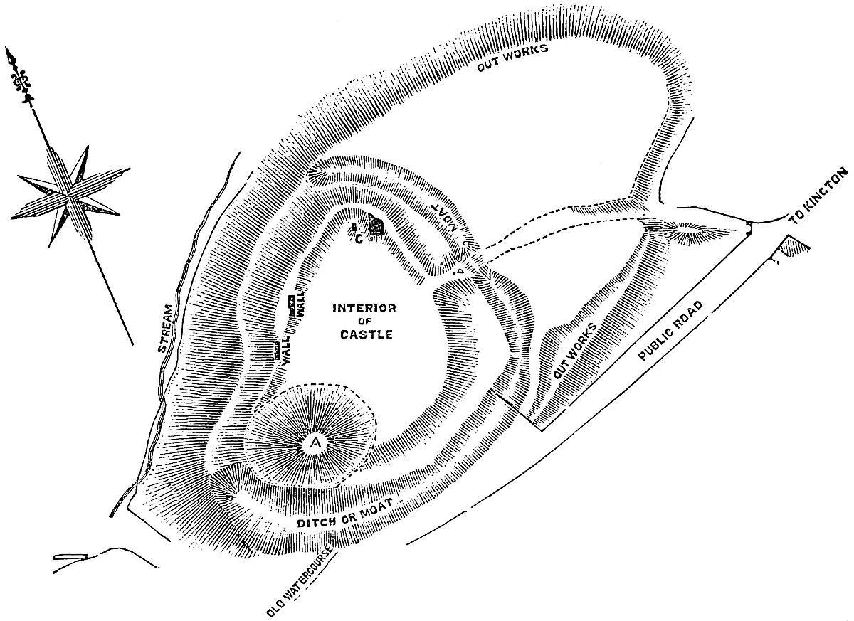
THE three midland counties of England, happily for those who dwelt in them, were not rich in castles, and such as remain are rarely of a very striking character. The position of Belvoir, indeed, is very noble, and Warwick stands without a rival; but these are brilliant exceptions, and the early castle-builders of the shires of Leicester, Warwick, and Northampton, in the absence of those wilder features of nature to which many of the Welsh and Scottish fortresses owe much of their celebrity, had to be content with defences often wholly artificial, and, where natural, seldom of a bold character, though sometimes of formidable strength.
The Castle of Kenilworth is an excellent example of a midland fortress. To an ordinary observer, its site presents much of quiet sylvan beauty, but nothing of obtrusive military strength; and yet, in the hands of skilful engineers, it became, in point of size, strength, and accommodation, one of the most important military posts in England. It had walls capable of great passive resistance, a capacity for containing a numerous garrison and immense stores of provision, and a front protected by a large sheet of water, which again was covered by a formidable outwork. Moreover the midland districts were, from an early period, traversed by main and cross roads, favourable to the concentration of troops and the transfer of stores, seldom sought in vain in so fertile a country. For all these qualities, strength, capacity, a central position, and facilities for collecting and feeding a garrison, there was, in the days of its pride, no fortress in England superior, probably none equal, to Kenilworth; and now, when its grassy lawns and ivy-covered walls are redolent of peace and prosperity, and of English rural life, the thoughtful visitor cannot but feel that the place was a fitting one for the conclusion of that celebrated contest between monarchical power and civil liberty, in which, though the honour and nominal victory were with the Crown, the real and permanent gain remained with the English people.
Half-way between Warwick and Coventry, where the action of water upon the soft rock of the new red sandstone has wrought the surface of the country into an immense network of low, round-topped hills and broad and gentle valleys, the Inchford brook, one of the many tributaries of the river Sow, receives, on its left or northern bank, a smaller and nameless streamlet. At the point where the waters and their respective valleys unite, a knoll, partly of rock and partly of gravel, juts out from the north-east as a sort of low headland131 between the two, and is somewhat farther isolated by an expansion of the valley lower down, the general effect of which is to invest the high ground with a marshy frontier upon its west, south, and south-eastern slopes, leaving it toward the north and north-east connected with larger tracts of equally raised land.
Such was the spot selected in remote times, probably by some wealthy English franklin, for a residence, and adopted by his Norman successors. By one or other, or possibly by both, a deep trench was dug across the neck of the high ground, on the north and north-east, and the slopes were made steeper on the other sides. The central plot, thus isolated, was raised artificially about 15 feet, probably from the surrounding excavations, and works were thus formed which may still be traced amidst the additions and alterations due to many generations of inhabitants. As usual with these concentric earthworks, the inner and higher part, which carried the residence of the lord, was placed out of centre with the outer and lower area. This was intended not only as an outer defence to the citadel, but as a place of security for the dependents, and in times of danger for the herds and flocks. It was important that all these should be placed near together, hence one or two sides of the base court were of large area, while the remainder was narrow and used for defence only. Such is the arrangement at Berkhampstead, Caerleon, Wigmore, Richard’s Castle, Tonbridge, Ewias-Harold, Kilpeck, Shrewsbury, and in many other fortresses where the Norman engineer has built upon the earlier lines, and such is the case at Kenilworth, where the eastern and north-eastern sides of the outer ward are by much the most spacious.
The mound, so common in English strong places, and found at the adjacent fortress of Warwick, is not here distinctly visible; the question being, whether its site is occupied by the Norman keep or encroached upon by John of Gaunt’s Hall, both of which are connected with ancient earth-banks. A part of one of these banks is seen on the west front of the inner ward, and, though mutilated, may well represent the original burgh. The Norman keep is also connected with made ground. It includes within its walls a very decidedly artificial mound, from 10 to 15 feet high, against which its walls are built. Kenilworth, as it now stands, is a castle of several periods, but its general plan is original and concentric, the principal additions having been the lake and the outwork beyond it. It is composed of a keep, an inner and outer ward, a lake now drained, a large outwork beyond the lake, and a dam which supported the lake, and across which lay the main approach to the castle.
The Inner Ward measures about 80 yards north and south, by 84 yards east and west. Its north-eastern angle is a right one, and its eastern and much of its northern sides are straight lines, but the southern and western sides are irregular. The keep forms and fills up the north-eastern angle. West of it, on the north front, are the kitchens, and at the north-west angle the strong tower. The west front is occupied by the hall, and other domestic and state buildings132 stand along the south side. Leicester’s buildings form the south-east angle, and Henry VIII.’s lodgings and the curtain, now gone, covered the remainder of the east side. In the centre was an open court, about 40 yards north and south, by 50 yards east and west.
The Keep, known as “Cæsar’s,” and with more justice as “Clinton’s Tower,” is, in magnitude, general proportions, and excellence of material and workmanship, a fine example of a first-class late Norman keep of the rectangular type. It forms the north-east angle of the inner ward, and is built mainly on the rock, here near the surface. The ground is lowest on the east and south faces, so that on these the base is composed of a bold battering wall from 8 to 12 feet high, divided into eight or ten steps, and of 6 to 8 feet projection at the ground line. At the top of this base, which corresponds to the level of the ground floor, the keep measures, from curtain to curtain, 58 feet north and south, by 87 feet east and west, and is from the level about 80 feet high. Its west face is covered by the forebuilding, which projects 38 feet more, and is as long as the keep is broad, or 73 feet from the front face of the turrets. The angles of the keep are capped by four turrets, projecting 7 feet 6 inches, and the faces of which are 26 feet and 22 feet, the latter to the east and west. Between these there are on the south face four, and on the east face three, pilasters, 5 to 7 feet broad, and 1 foot projection. These rise from the common plinth and ascend to the summit of the present wall, which is broken, but which includes 5 or 6 feet of parapet. It is remarkable that this parapet has no exterior projection, not even a stringcourse to mark the level of its base.
The turrets are broken down nearly to the level of the curtains, but parts of their chambers remain. The west face is modified by the forebuilding. There are upon it two pilasters, but they stop at the level of the first floor. The turrets have an offset of 6 inches at two-thirds of their height, and the curtains one at a rather lower level. These are the only exterior reductions in the thickness of the wall, which is vertical. The walls, at the floor level, are 13 to 14 feet thick, and there were two floors only—a basement and an upper or main floor. The basement chamber is 60 feet by 30 feet, and 20 feet high; the upper floor about 4 feet larger, the wall being reduced by 2 feet, upon which shelf the floor rested. This main chamber was about 40 feet high. The basement has lately been probed and opened. It is filled with made ground, varying from 6 to 15 feet deep. The walls evidently go through the made ground, and rest either upon the rock or on the original black vegetable soil. The sacrifice of so much space in so costly a structure is curious. It is evidently intentional, for the character of the masonry shows it was not meant to be seen.
The north-east turret contained a well-stair 10 feet diameter, which ascended from the basement to the battlements, communicating with the first floor. It was lighted by six round-headed loops, of which three to the south-east remain, and open upon a chamfer133 which fills up the hollow angle between the turret and the east curtain. The stair seems to have opened below by a short bent passage in the north wall, though in the restoration it has been made to open into the chamber in the east wall. The whole north curtain is gone, from the plinth upwards, and has been removed with some care, its junction with the north-west turret being cut smooth. At the other end its removal has necessarily carried away half the staircase, the base of which has been entirely restored. This basement chamber is surrounded by a low, narrow plinth or step, 2 feet high and 1 foot broad. The floor was paved. In the south wall are three grand window recesses, round-headed, and each placed in a reveal about 1 foot broad and deep and square-headed. The arches spring from a plain abacus. They are 8 feet wide and 12 feet high to the springing. At present these recesses are parallel-sided, and open throughout. It is evident they once were deeply splayed, and contained small lights or loops, but the splays were cut away, and the loops replaced by large heavily-mullioned windows of the Tudor period, which windows have again been removed. In the east wall is a similar recess, 6 feet broad, and unaltered. Here the splay from outside and inside contracts in an hour-glass fashion to a loop in the centre of the wall, with a slight shoulder to intercept an arrow. As the parallel sides of the loop are 2 feet thick, and it is 6 feet from the face of the wall, it is clear that no arrow could be discharged hence save nearly straight forwards. As usual, these loops were for air and light, not for defence. Between this loop and the south angle is a square-headed door, of 3 feet opening, under a curious round-headed arch, of which the tympanum is partly formed by the arch stones. This leads to the well, which is in the centre of the wall. It is 4 feet diameter, and much choked up. It ascends to the upper floor. At the north end of this side the wall has been broken away and a small mural chamber laid open, 5 feet wide by 8 feet long, having a plain barrel vault. A door opened into it from the great chamber, and it was lighted by a loop, now converted into a sort of window. The inner wall about the doorway has been strengthened by a pilaster of 1 foot projection, which stops at the first floor. In the recent restoration, this chamber has been made the lobby at the foot of the staircase.
In the west wall is a plain, round-headed doorway, of 6 feet opening, and with ashlar ring-stones 2 feet deep. This is the opening of a straight passage through the wall, here 12 feet 9 inches thick. There are in the passage rebates for two doors, opening towards each other. At Rochester, a small door in this position led only into a sort of prison in the base of the forebuilding, and this may have been the case here; but the size of the door, as at Corfe, makes it at least possible that it was a regular entrance, approached through the forebuilding from the common exterior door. In small keeps the basement was often entered from the first floor only, as at Clitheroe, by a trap, or, in the larger keeps, by a well-stair, as at Middleham. Unfortunately, as the forebuilding is almost always134 more or less injured, it is impossible in most cases where there is a large basement door to say positively whether it was an independent entrance. There is also the further doubt, as at the Tower of London, Guildford, and Malling, whether the doorway in the basement be not a later introduction. The cill of this doorway is about 10 feet above the outer or main entrance of the forebuilding, the floor of which rises to it. Close north of the large doorway is a small one, of 2 feet 6 inches opening, which leads into a garderobe, the seat of which is corbelled out into the interior of the north-west turret. This interior, 10 feet 6 inches square, seems to have been a vast cesspit, receiving the contents of garderobes from each floor and from the battlements. There is no drain below, and the lower part of the pit contained sand, which has recently been removed. There is a somewhat similar pit in the keep at Ludlow, and one at Sherborne which resembles them. Large as this pit is for such a purpose, it is much smaller than the turret, the wall of which to the west, if solid, must be 11 feet thick. Can there be a second and smaller shaft in that part of the turret, not now accessible? There was no way from this floor to either of the southern turrets, both of which, at this level, were filled with earth.
The main or upper floor is 34 feet by 64 feet, and was about 40 feet high. As the span is long for single joists, it is possible that these rested upon a central beam, and this upon posts; or, as no bases have been found, it may be that they were stiffened by struts from the side walls. Some traces in the ashlar of the broken staircase at the north-east corner seem to point to an entrance from the stair through the north wall, similar to that supposed below. In the south wall are three window recesses corresponding to those below, but of 6 feet opening, with segmental heads. They rest on the floor and are 12 feet high. Above one of these openings, on the outside, may be traced the head of one of the original Norman windows, which shows that it was of small size—probably of 2 feet opening. These have been replaced, with small regard for congruity, by late Tudor windows of three lights, divided in the centre by a transom. In the east wall are two similar windows, and over the well-pipe is the well-chamber, 7 feet square, rudely vaulted and groined. Its floor has been relaid, but it is evident that the pipe ascended into this chamber, and that a pulley hung from the centre of the vault for the working of the bucket. In the south-east corner is a locker for a spare rope or tools. The entrance to this chamber was through the jamb of the adjacent window, but a second doorway has been broken direct from the great chamber. Close to this breach a door and bent passage lead into the south-east turret, where is a chamber 12 feet 6 inches by 15 feet. The floor is of earth, with which the turret is filled to this level. Above are traces of an upper chamber, entered probably by a ladder and a trap-door. There is no fireplace, but a loop high up in the south wall has been converted into a window, and a second loop remains in the east wall.
The west wall of the great chamber contains two windows similar135 to the other side—save that they do not descend to the floor, but begin about 8 feet up, so as not to interfere with the forebuilding outside. North of these windows, in the part of the north-west turret which abutted on the north curtain, is a door of 3 feet opening, and 8 feet or 10 feet high. This is the cross section of a mural passage leading from the great chamber. Close south of it, in the west wall, and above the similar door on the ground floor, a small round-headed door leads into the garderobe turret. The other opening in the west wall is at its south end, and is the main entrance to the keep. It is a plain doorway of 6 feet opening, with a flat, segmental head beneath a full-centred arch of relief. The passage has a segmental barrel vault. It goes direct through the curtain, here 12 feet thick. It has no portcullis. In the south wall of the passage a side door opens into the south-west turret. This also had an original upper chamber, but below the entrance or first-floor level it was filled with earth; this has been removed, and the lower part fitted up, and windows opened in the south wall, and a rude door at the base, but the rough character of the masonry shows that the turret was originally filled up to the first-floor level. Dudley’s alterations converted the interior of this turret into five tier of rooms, the windows of which are seen in the south wall. It is said also to have been fitted up as a staircase.
The great chamber had an open roof, the holes for the joists of which are seen in the southern wall. The pitch was low, almost flat, as is shown by the original weather-moulding in the east and west walls, which has been masqued by a thin interior facing, carrying a moulding for a roof of a rather higher pitch, all which, however, has disappeared under the recent repairs. This is different from Porchester, Rochester, and Bridgenorth, where the original pitch was steep. On the outside, above the windows, but much below the base of the parapet, is seen a row of loops, square-headed, with a plain chamfer, expanded below into a broad fantail. There are three of these in the south wall and two in the east and west, and each turret has besides one on each of its two outer faces. The turret loops are at a higher level, and this shows that the turrets themselves stood clear above the curtains. These apertures are curious. The loop ascended in the wall and opened in the base of the parapet beneath a flat, three-centred arch. The loops are probably original, but the parapet seems to have been rebuilt, either when the pitch of the roof was altered or in Dudley’s time. The walls are covered with ivy and in a dangerous condition, so that even with the aid of long ladders their upper part is not very accessible. There are traces of doorways opening from the rampart walk into the upper parts of the turrets, the floors of which were of timber.
The forebuilding covering the entrance forms almost as remarkable a feature here as at Rochester or Middleham, though it has suffered much from alterations. It was a rectangular tower built against the west wall of the keep, and projecting 38 feet. Its walls136 are 6 feet thick, bonded into and of the date of the keep. The west wall has been in part removed down to the plinth, but the two other walls are tolerably perfect. It was of two stages and about 40 feet high. The door was in the south wall, opening from the inner ward. It may be traced, but has been in part replaced by an entrance of Perpendicular date, now also broken away. Above the old door, 12 feet from the ground, is a plain Norman string. From the door a straight stair, reversed with a second flight, must have risen 25 feet to reach the first floor. At that level, over the entrance, was a chamber, of which part of the Norman wall remains, but which was rebuilt by Dudley, and has been nearly all destroyed. Here was possibly a chapel, as at Middleham. The entrance to the first floor of the keep opens from this level, in the curtain, close to the south-west turret. The doorway, like that within, is quite plain, and has a flat, segmental head under an arch of relief, also segmental, but less flat. It looks as though the lower arch had been inserted to carry the joists of the roof, but it is really original. The pitch of the roof of the forebuilding has been thrice altered, as is shown by the grooves cut in the wall of the turret. The flattest is the latest. The roofs seem to have been of the lean-to character. Whether there was a chamber below the stair, or whether there was a way at the base of the stair into the lower floor of the keep, as has been already pointed out, cannot now be ascertained.
It would seem that in the Perpendicular period this forebuilding was much altered, its entrance a little shifted, and in it were placed several piers, 3 feet square, supporting full-centred arches, of 9 feet span, on which the timbers of the floor above were laid. A plain doorway of 6 feet opening was cut in the curtain forming the north end, and in the exterior of the wall an alcove was formed of 13 feet span by 6 feet deep, having a segmental arch, and supported by three plain ribs with a hollow chamfer. This alcove opened upon a terrace, which overlooked the northern part of the outer ward, and formed a sort of landing and staircase, giving a descent of four or five steps from the door to the terrace. The object seems to have been to form a handsome way from the inner ward to the garden north of the keep. The piers and arches might be of the date of Elizabeth or James, but their mouldings and parts of the adjacent walls are clearly earlier, and no doubt the work of the Lancastrian owners, who in that case must have indulged in a garden. Dudley made further alterations, and a part of the south front of the forebuilding still bears the date of 1575, and has Italian ornaments.
There is to be remarked in this keep, the absence of a cross wall, the basement filled up with earth, the unusual projection of the four turrets, the probably distinct entrances from the forebuilding to the ground and first floor, and the well-stair, nearly as large as that of the Tower of London. Also, there is no portcullis, and there are but few mural chambers or galleries. This is the more remarkable as the walls are unusually thick and the material excellent. Further, there are no fireplaces in the three remaining walls, and there is no137 ornamentation of any kind, inside or outside. The keep is the only distinctly Norman building remaining in the inner ward, although much of the curtain is Norman, and more rests upon the Norman lines.
It has been stated that the keep forms the north-eastern angle of the inner ward. The curtain abutting upon it on either face is of its own date. At the north-west corner the curtain forms the north wall of the forebuilding, and for some yards is original. At the south-east corner of the keep are the remains of the entrance into the inner ward. This, as at Bridgenorth, was a doorway in the east curtain, close to the keep, and, as at Bridgenorth, although the curtain has been removed, a part of the doorway remains. The curtain was here 11 feet thick and 21 feet high to the rampart wall, above which were a parapet and rear wall of about 5 feet more. One whole jamb and the springing-stones of the portal remain. There was no gatehouse, only an opening in the wall, as at Ogmore, and probably at Ludlow. The defences were:—First, a portal 3 feet deep, and in it a square portcullis groove; then a rebate for a door opening inwards; and, finally, an arched passage 3 feet higher than the portal and 6 feet deep. The entrance appears to have been a foot-gate only, so that carriages could not enter the inner ward.
What are called Lancaster’s buildings occupy most of the inner ward. They commence at the forebuilding, and extend along the rest of the north side, the whole of the west, and much of the south side. They evidently replaced similar buildings of the Norman period, and were built towards the end of the fourteenth century. Next west of the forebuilding are the remains of the kitchen and buttery, now a mass of ruin, much of which is covered up with earth. An immense fireplace has been inserted into the wall of the forebuilding, having two very perfect ovens lined with thin bricks; another fireplace is formed in the adjoining curtain; the fire-backs are also of thin brick, set herring-bone fashion. Further on, a curious triangular buttress outside the curtain contains a garderobe shaft, the drain from which is a squared-headed opening in the rock below, about 6 feet high and 4 feet broad. There is a second drain, which traversed the kitchen, and the mouth of which, fitted with a groove for a sluice, is seen in the inner ward, near the hall door. Probably if the rubbish was removed, the plan of these buildings would be visible. Beyond them, the north-western angle of the ward is capped by the strong tower, quadrangular, 50 feet by 40 feet, with octagonal turrets at the two western angles, and between them a rather remarkable triangular buttress. The tower is of three stages, all vaulted and groined, each vault of four bays springing from a central pier. It is of the date of the hall and kitchens, from the foundations. This tower probably derived its name of the “Strong Tower” from its use as a prison, though evidently for persons of consequence. The windows are plain, flat-topped openings. In the sides of one of the splayed recesses, looking towards the west, are some coats-of-arms scratched in the stone. Those that have been made out are four.
138
1. Six cross-croslets flory, on a bend three pheons bend-wise, points depressed to the sinister.
2. Quarterly, per fesse embattled.
3. On a quarter a fret (or fretty).
4. Quarterly, 1 and 4, a cross botonné.
„ 2 and 3, three crescents inverted.
Next to this tower is the Hall, which occupies nearly the whole west side of the ward. This, for dimensions, proportion, material, and workmanship was probably the finest hall in the kingdom, wholly of the early Perpendicular period. It measured 90 feet by 45 feet, and stood upon a basement of the same size, of which the roof was vaulted in eighteen square bays, springing from ten piers, arranged with the walls in three equal aisles, while against the wall are fourteen responds, besides one at each of the four angles. Between each pair is an arched recess. This vast and beautiful cellar was aired by loops upon the east side only. The cross aisle at the north end was partitioned off by a stone screen as a passage, which traversed the cellar, having at its east end a door from the inner ward, and to the west a postern opening on the outer ward. This postern is a square-headed doorway, with a bold portcullis groove, and immediately above it is a small square window traversed by the grate, and in the cill of the hall window above is a round hole for the chain, by which the grate was lifted. This portcullis is rather a tribute to the military character of the building, than for the affording any special security, for the large windows of the hall above would have admitted an army. The cellar was entered by a side door from the passage, and at its south-west corner was a small apartment, a cellaret, whence a small well-stair led to the “buffet” above. The hall, resting upon its vaulted floor, is one storey above the inner ward level. It was approached by a broad, straight staircase, which landed in a porch at the north end of the east side of the room. The porch rested upon a vault, and was itself vaulted and groined and richly panelled. The hall was lighted by four large windows towards the west or outer ward, and by three towards the inner ward. At the upper two-thirds of the room, opposite each other, and between two pair of windows, are two large fireplaces. They have lintels slightly shouldered, no hoods or projection, and their splays are panelled.
At the upper or south end of the hall, on the east side, is a large half-octagon oriel, opening by an arch of 15 feet from the dais, panelled and groined, and containing three large windows of two lights with transoms and foliated heads, and a small fireplace. Opposite to this, in the west wall, is a recess of 10 feet opening, the roof of which is ceiled, and which is intended for a “buffet” or sideboard. It is flanked by two small octagonal turrets, one of which contains the stair which descends to the cellar and rises to the roof. From hence a passage led to the withdrawing-rooms at the south end of the hall. The buffet projection, with its turrets, matches the strong tower which caps the further end of this front.139 The north wall of the hall is gone, but there remains the jamb of a large door, probably opening into the buttery. In the north-west angle, in the window jamb, a small door opens into a well-stair, leading up to the roof. The south wall behind the dais is also gone, but one window of the music gallery remains. The windows are broad and lofty, set in deep, splayed recesses, panelled and fitted with seats. The arches, though four-centred, are rather highly pointed. The edge of each recess is replaced by a bold roll. The windows are coupled, each of two lights, divided by two transoms, and the heads of the openings thus formed are richly foliated. The roof was open, of timber, supported by five pair of principals, besides those against the wall at each end, and the spandrels of the window arches in the main wall are panelled. The exterior buttresses are set on square, but have diagonal faces. The door is set in a low drop arch. The whole building is Perpendicular of the purest kind, and early in the style.
From the upper end of the hall a suite of rooms stood along the south side of the court, of which only the ruins remain. Beyond the hall was the White Hall, now entirely gone; and beyond it a fine oriel window, looking into the court, is said to have belonged to the presence chamber. Behind this, upon the curtain, is a low turret of bold projection, 30 feet by 20 feet, divided by a cross partition into two public garderobes, with large cesspits below, a very curious appendage to a suite of state rooms. The base of the curtain on this front shows traces of Norman work, and seems original. Owing to the superior height of the inner ward, the lower 8 or 10 feet of the curtain on this side is a revetment.
Lancaster’s buildings end in the remains of an octagonal tower, on the curtain, and are succeeded by what are called Leicester’s buildings, though it is a shame to use that title at Kenilworth with reference to any other than the great earl to whom England owes so much. These form the south-east angle of the ward. They cover a plot of 50 feet by 90 feet, and are 80 or 90 feet high. They possess no architectural merit, and though built of sound ashlar, the walls are thin for their height, and they are cracked and much ruined. All the floors and roofs are gone. No doubt these buildings replace a Norman tower of some sort, but they probably project much further than that did into the outer ward. Beyond these, along the eastern face of the ward, Henry VIII.’s lodgings and Dudley’s Lobby extended nearly to the entrance; these are now removed, and with them the Norman curtain upon which they rested.
This inner ward was in itself a very tolerable fortress, the keep commanding the whole, and being, from its excessive passive strength and rocky base, practically impregnable. The curtains seem to have had buildings placed against them nearly all round; they were certainly lofty, and from this circumstance and the vantage of the ground on which they stood the inner ward overlooked all the exterior defences of the place. The ground falls rapidly upon the north, south, and west fronts. Along the east front, where the140 natural slope was gradual, was excavated a broad and deep ditch, which completed the defences of the ward. Moreover, it is not improbable that this ditch was continued along the north front, occupying the site of the garden, and dying out in the low ground near the Swan Tower.
The Outer Ward has next to be described. This is roughly an oval in plan, 270 yards east and west, by 174 yards north and south. The inner ward covers about one-sixth of its area, and is placed about 54 yards and 30 yards from its west and south boundaries, and 67 yards and 130 yards from those on the north and east, giving a large space in the latter direction, which seems to have contained various domestic buildings, the entrances, and the chapel. This ward was divided by the cross ditch already mentioned, and which extended from the exterior northern ditch 150 yards, nearly to the lake. Traces of it remain at either end, but most of it has been completely filled up, probably by Dudley after Queen Elizabeth’s visit. It was 70 feet broad, and across it a bridge led up to the entrance of the inner ward. At the north end this ditch must have been very deep; towards the south, in front of Leicester’s buildings, where part of it remains, the ground falls and it becomes shallow. Probably as an additional protection, a cross wall was built in the rear of this ditch from the south-east corner of the inner ward to the opposite curtain. Part of this wall was removed when Leicester’s buildings were constructed, but the outer end remains, and a part of a doorway in it. This ward is crossed by another wall of later date, which extends from the Strong Tower to the west curtain, about 34 yards. In its centre is a doorway of 10 feet opening, which, with the wall, seems of Perpendicular date. Henry VIII.’s “Plaisance” was built on each side of this gate to the north. The first wall is no doubt original, and was intended to prevent an enemy who had crossed the ditch where it was shallow pushing westwards along the outer ward; the second was probably built to shut off the garden on the north front, in the Lancastrian period. In this outer ward is what appears to be a part of the original earthworks of the early residence. In front of the hall, about on a level with its floor, so that the cellar wall is a revetment, is a triangular platform about 72 feet long at its base along the wall, and of about 63 feet projection at its apex. It is about 30 feet above the rest of the ward, and has a slope of one to one. The cutting for the path from the hall postern divides it from a smaller mound to the north, and the whole seems artificial, or nearly so. This platform commands the outer curtain. It is odd it was not included within the inner ward.
The broad space to the north, called in Dudley’s time the garden, and now a large kitchen garden, has probably been partially raised by the ruins of the keep and of the north curtain. How it was originally occupied is not known; possibly there was a ditch here. If the Lancastrian lords made the passage through the forebuilding and the alcove in the curtain, they must have laid out the space 141within the ditch as a garden. Of the many detached buildings that at various times must have stood in the outer ward, and especially in the eastern section of it, the site of but one, the chapel, is known. This was an oblong nave, without aisles, having an east end of three sides of a hexagon, and across which is the foundation of a wall. The interior breadth was 33 feet; the length has not yet been excavated. Probably there was always a chapel here, for a capital has been found in it of Norman work much earlier than the keep, but the building, of which the foundations remain, is of Decorated or early Perpendicular date, as is evident from the plan, and from parts of the sedilia which have been dug up.
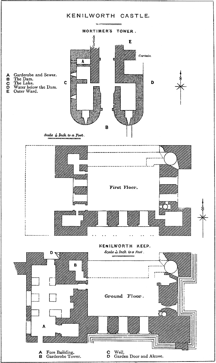
The enceinte of this outer ward, about 750 yards in length, and including rather above nine acres, is mainly composed of a curtain wall, upon which are six rather important buildings. These are Mortimer’s and Swan Towers, Leicester’s Gatehouse, Lunn’s Tower, the Stables, and the Water Tower. Mortimer’s Tower derives its name either from Lord Mortimer of Wigmore, who led in a tournament here in the reign of Edward III., or from a Sir John Mortimer imprisoned here by Henry V. It is a gatehouse, and stands upon the inner end of the dam, and occupies a salient of the curtain to the south-east. It is in plan 60 feet deep, by 55 feet broad; in the rear, flush with the curtain and projecting from it, 54 feet. The entrance passage is in the centre of its length, and the outer portal opened between two half-round towers of 18 and 20 feet diameter. Within the arch was a portcullis in a square groove of dimensions for a wooden grate, and behind this a rebate for folding doors. The passage then widens a little with a curved splay, and on each side a door 2 feet wide opens into a lodge looped to the front and to the outside. In the rear of the east lodge is a solid wall 7 feet thick; but to the west lodge has been added a garderobe, and beyond it is the shaft of a second garderobe from the upper floor, and below them a sewer which opened into the lake. The loops are all cruciform. There was a second portcullis, the groove for which is stopped up, and at the inner face a rebate for a second pair of doors. The upper floor of this gatehouse has been removed. It is evident that it has been much altered. Originally it was composed of a mere pair of parallel walls, as at Berkhampstead and Coningsborough, 7 feet thick and 12 feet apart, and these form the back part of the present building. Of the upper floor a fragment remains outside the west wall, carrying on corbels the overhanging vent of a garderobe. To the plain rectangular tower the front drums and lateral chamber were added. The mouldings of the original structure are early, and of the later, more perfect Decorated; but the work is of an inferior character. The whole structure seems to have been originally built and added to in haste.
On its east side, this gatehouse was joined by the ward curtain, here 6 feet thick, of which a few yards have been removed. On the west, the curtain passes back straight and then turns westward at a right angle, forming a shoulder, by which means the long southern142 face is flanked. Near the angle is a postern door descending by steps to the lake. In the rear of the gatehouse is a shaft upon a culvert, which seems to have brought water from the lake into the lower floor of the Water Tower. There may have been a mill thus fed within the outer ward. In front, the eastern drum of the gatehouse is connected with a long curtain wall, which crested the edge of the dam to the east, and abutted upon the gatehouse, closing one of its loops. In this curtain, near that end, a small Decorated doorway gave access to the lower lake.
Passing westwards from Mortimer’s Tower, the curtain is seen to rest upon ground a few feet above the level of the lake and a few yards distant from its margin. It is of all dates from Norman to Perpendicular, and is from 20 to 30 feet high outside, and inside less by 6 or 8 feet. Opposite Leicester’s buildings, where the wall is 5 feet 6 inches thick, are three loops, of 1 foot opening, placed in full-centred recesses splayed to 5 feet. They have lighted some original Norman building now destroyed. Of the buttresses outside the curtain, some are original pilaster strips, others are from 6 feet to 14 feet broad, and of a projection from 2 feet to 4 feet, with many sets-off, and of a character decidedly Decorated. On the south face there are altogether fourteen buttresses. At the two south-west angles the wall is capped by two broad, flat buttresses, 10 feet broad and 2 feet projection. They may be late Norman. In the space of 30 yards between these is a shoulder-headed window, of 2 feet opening, and a late Decorated postern, which corresponds with the postern below the great hall. Beyond this a depression in the ground causes the wall to be 40 feet high. This western part is about 112 yards long, and terminates in the Swan Tower. In it is a large archway of Perpendicular date and 18 feet opening, corresponding to the “Plaisance” of Henry VIII., and perhaps intended for the purpose of allowing a boat to be thence launched upon the lake.
The Swan Tower caps the north-western angle of the ward. It is an octagon, but rests upon a base 12 feet high and 40 feet square. The upper part has been removed. The base is solid and the inner floor about 10 feet above the ground outside. The door to the remaining floor is in the gorge. The base of this tower may be either Perpendicular or Decorated. It is said to have been remodelled by Dudley. From the Swan Tower the north wall ran nearly straight 150 yards to Leicester’s Gatehouse, and upon it were two towers, one rectangular and one polygonal. These are gone, as is the wall, excepting one very thick fragment, which seems to have closed the cross ditch at its north end, and probably is provided with a sluice. A little probing and clearing here might bring this into evidence, and settle the breadth of the cross ditch. In front of this wall is the great northern outer ditch of the castle by which this front is protected from Clinton Green.
Leicester’s Gatehouse, built about 1570, is a rectangular building 56 feet by 28 feet, with bold octagon turrets at the angles, which rise slightly above the roof. The basement contained the entrance143 passage and gateway, and above it are two storeys. The windows are square-headed, of two lights and a transom; and, on the whole, the building is a fair example of its period. The passage has been closed and converted into two rooms, entered by a curious lateral porch, of Italian design, which has been added on. Outside are carved the arms of Beauchamp, and the ragged staff is employed as though it was a Dudley cognisance. The panelling of the interiors and a fireplace are curious, and were brought from the castle. A few yards east of this gatehouse are the remains of a buttressed causeway crossing the ditch, here nearly filled up. This looks old, and is probably part of the original entrance. Beyond this, the ditch deepens and reaches Lunn’s Tower, which caps the east angle of the ward.
Lunn’s Tower is cylindrical, 36 feet diameter, and about 40 feet high, and stands three-quarters outside the curtain. On the outer face are four pilaster strips, 5 feet broad by 6 inches projection, which probably rose to the base of the parapet, now gone. They rest on a plinth, and the tower has two sets-off, of which they partake. Appended to the rear of the tower has been added a sort of half-octagonal turret carrying a well-stair—an early addition. The basement is at the ward level, and there are two upper floors containing fireplaces under segmental heads. The floors were of timber. The only openings are loops: those of the two lower floors are square-headed, placed outside in square-headed recesses, ending below in broad fantails like those of the keep. Within, they are placed in splayed recesses with segmental arches. The basement has a door from the ward, but the upper floors are reached by the well-stair, which also opens on the contiguous curtain. This curtain on either side for some yards has been removed; but fragments remain, and show that a small, round-headed arch sprung on each side from the tower to the curtain and supported a garderobe at the rampart level over the hollow angle. Close in the rear of this tower is a well, lined with ashlar, 4 feet diameter. The curtain south of Lunn’s Tower has been breached for about 50 feet, and beyond this it is old and supports a range of stabling and farm buildings 170 feet long by 25 feet broad with square buttresses, in the centre of which is a large porch with diagonal buttresses and a wide entrance as for a barn, with a round-headed arch. The lower stage is of stone, and above is a stage of brick and timber. It is said to have been built by Thomas, Earl of Lancaster, in the reign of Edward II.; but much of it is certainly of far later date—in the late Perpendicular style. The curtain against which it is built is early English or Decorated, and the superstructure of the barn seems to be an addition, placed there when it was decided to have an upper storey. The arches are round-headed and look Decorated, but there are two late Tudor windows. The chapel was a few yards from this building.
Close south of the barn is the Water Tower, a very curious and complete building, early in the Decorated style. It is a mural tower, with no internal projection, having a base 50 feet broad by 30 feet144 deep, from which it rises as half an octagon, the angles being taken off by two diagonal buttresses, between which, in a projection, is a loop which lights a garderobe. It has a basement and upper floor, and the culvert from the lake discharged under it and washed out its garderobe sewer. In the ground floor is a large fireplace, above which is a handsome chimney-shaft. This seems to have been a kitchen. There is also a mural garderobe. A well-stair, having a spire over its head, leads to the upper storey, the floor of which was of timber, and to the battlements of the tower and of the curtain. The upper floor has a small room appended on the west, with a loop towards the field. The windows are of two lights, trefoil-headed. The roof sloped with a moderate pitch. It was contained within the battlements. Beyond this is a warder’s chamber, chiefly in the wall, but with a slight exterior projection. It contains a large fireplace and a garderobe, and seems of early English or early Decorated date. From hence the curtain was 6 feet thick, and what remains is supported by three Decorated buttresses. Beyond these, a breach of 30 yards extends to Mortimer’s Tower.
The walls of this ward, though much repaired and restored, seem to occupy the original Norman lines, and are probably in many places of the date of the keep. The defences outside the wall are formidable. On the north is the ditch cut in the rock, of great depth and breadth, a very necessary defence, for beyond it the ground is at least as high as the base of the keep. This is Clinton End or Clinton Green, upon which are some banks of earth, traces it may be of the great siege by Henry III., who probably encamped on this side. It is curious that no attempt should have been made to fill up the ditch, without which no engine could have been brought to play with effect upon the keep. Probably the strength of the garrison and the frequent sallies they are known to have made prevented this, or faggots may have been used. From Lunn’s Tower to the Water Tower, the ditch is still filled with water, and from thence to Mortimer’s Tower no ditch was needed, the ground being low and wet and at times under water. Then follows the dam, above which the lake covered the south front, as an arm of it did the west front, as far as the Swan Tower. The north was the weak side, the ground there being high; but opposed to this was the keep and the very formidable ditch. It is said that this ditch could be filled from the lake, and the castle thus encircled with water. If so, there must have been a small dam, probably at the bridge in front of the old entrance west of Lunn’s Tower.
The defences on the south require special notice. From Mortimer’s Tower a bank of earth is thrown straight across the valley. It is 80 yards long, 15 yards broad, and about 20 feet high on the upper or western side. The lower side is strengthened by a ramp in the slope. About a third of the way across, a deep and broad cut, now bridged, lets off the water and has drained the lake; but whether this was the position of the sluice is doubtful. Mortimer’s Tower closed the inner end of this dam, and a curtain 145wall 4 feet thick defended its eastern face. At its further end are the remains of the floodgate or gallery tower, an outer gatehouse, beyond which is a deep ditch across the dam, which was evidently intended to take the overflow of the lake, and perhaps to drain it if necessary. It was crossed by a drawbridge, the piers of which still remain. This gatehouse is attributed to Lord Leicester, who probably recast it. In substance it is certainly much older. A grand block of stone, worked with Decorated mouldings, has been used in its repairs, and is probably part of the older building, though also thought to have been brought from the chapel. A flight of steps from this gatehouse descended to the lake, and is superseded by a modern farm road.
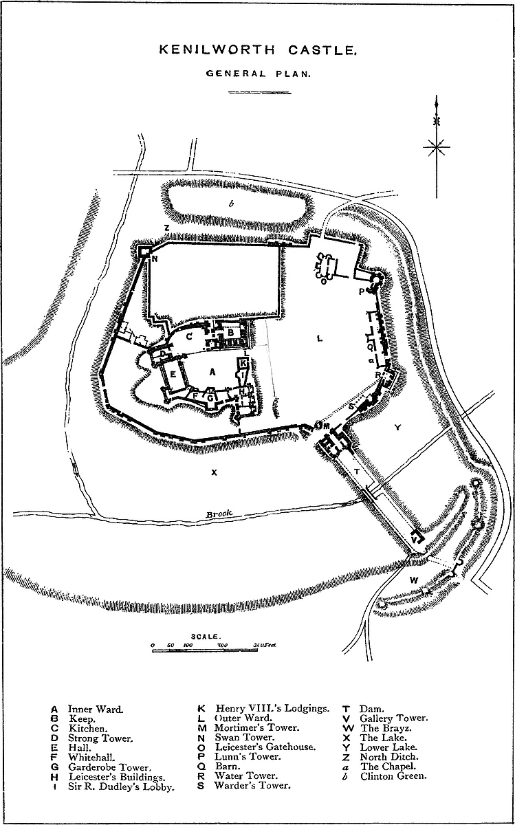
It was by this gateway, between the Brayz and the tilt-yard, that Queen Elizabeth made her celebrated entry. Dugdale’s drawing of 1620 seems to show a wall on the upper side of the dam, but of this there is now no visible trace. The broad and level surface of the dam was well suited for a tilt-yard and seems always to have been so employed, as was also, no doubt, the Brayz. Such exercises, being attended by numbers of armed men, were usually held at the barriers, or outside the main gate of the castle, as a precaution against a surprise. The effect of the dam was to form a sheet of water 90 yards to 100 yards across, half a mile long, 10 feet to 12 feet deep, and covering about 111 acres. Below the dam, where the valley is rather broader and the ground naturally low and marshy, a second, lower and smaller lake has been formed, the dam of which, of a slight character, may be seen along the upper side of the road from the station to the castle. This lower lake must always have been shallow, but it served to protect the great dam, to cover the south-east angle of the castle, and to guard the rear and eastern flank of the great outwork. At Ledes there was a “Stagnum Regis” below the dam of the lake, and at Caerphilly the waste water from the lake was made to cover the principal front of the castle.
There remains, finally, to be noticed the great outwork which completed the defence of the castle on the south side, and formed a noble tête-de-pont beyond the lake. It bore the name of the Brayz, possibly from “Brayda,” a suburban field or broad place.
South of the lake, a tongue of high land intervenes between it and a more or less parallel brook, which descends from Wedgnock Park, by a valley which falls into the Inchford a little below the castle. It was the point of this tongue, lying between the two valleys, that was taken advantage of for an advanced defence. The ground was scarped into a sort of large, flattened half moon, with a front of 300 yards, and covering about eight acres. Along its front is a bank about 20 feet high, and as broad at the top, and upon this are four mounds such as in later times were called “cavaliers,” and of which that at the south-west end was 40 feet diameter at the top. In front of this bank was excavated a ditch, in some parts 40 feet deep and 100 feet broad, and in parts double, and in the rear, where146 the work rested on the lake it was steeply scarped and guarded by a ditch about 20 feet deep, beyond which, on the edge of the lower lake, was a bank 10 to 12 feet high, so as to make it very difficult to turn the flank of the outwork and to enter it from the rear. Near the middle of this outwork was the entrance to the castle from the south. Its position is marked by two bold drum bastions in ashlar, 25 feet diameter, and 40 feet apart. They rise out of the ditch from a plain plinth to the height of 14 feet, and so high are solid. Their superstructure is gone. There was, no doubt, a drawbridge here, and the road may be traced across the outwork to the Floodgate Tower. Here stood the southern of the four gatehouses mentioned at Elizabeth’s visit, and by this she made her entrance. A little west of the Brayz is a quarry, which probably supplied some of the materials for the castle.
In advance of the Brayz, between it and the Wedgnock brook, are traces of a light bank and ditch, or perhaps two ditches, with flanking bastions of earth, intended to check the advance of an enemy from that side. The lines cross the road, and are protected by the brook, which flows below and in their front. This road—the main approach from Warwick and the south—leads direct up to the Brayz entrance, whence it makes a sharp turn to the right and skirts the counterscarp of the ditch, so as to be completely commanded from the ramparts.
It would add much to the appearance of the castle, and bring some of its most remarkable features prominently into view, if the owner would make an entrance for visitors at the Brayz gate, and allow them to approach the castle along the dam through Mortimer’s Tower.
The history of the construction of Kenilworth is written with tolerable clearness in its earthworks and walls. The English founder probably placed his residence upon what became the inner ward; he there fenced himself in, as was the manner of his nation, with banks and ditches, and walls either of dry stone or timber, taking the highest ground, and quartering his herds and herdsmen lower down, nearer to the meadows and the marshes in what is now the outer ward. Whether he found it necessary to cut the northern ditch to its full depth is uncertain; probably not, for its faces are sharp for so remote a period. Some ditch, however, there must have been, as without it the other works would be of little use. It may be also that there was then dug an inner ditch upon the north and east faces, as these were necessary to complete the security of the inner ward, and of one at least of them there are traces.
There is no mention of Kenilworth as a lordship until it was granted by Henry I. to Geoffrey de Clinton, who is the reputed founder of Clinton’s Tower or the keep; but this is more probably the work of his son, another Geoffrey, between 1170 and 1180, soon after which the estate fell to the Crown. Lunn’s Tower was probably the work of King John, about 1200; and the original curtain of the two wards seems to have ranged between the two147 dates. If the northern ditch of the outer work was not previously dug, it must have been dug, or at any rate deepened, at this period; and this applies also to the northern and eastern ditches, which seem to have covered the corresponding faces of the inner ward.
The character of the ground makes it probable that the Norman fortress had but one entrance. This could not have been on the east, west, or south fronts, as the ground was low and marshy; nor on the north, where the ditch is wide and deep, and on which side the inner ward had no corresponding gateway. The obvious position would be where is now Leicester’s Gatehouse, between the high ground of Clinton Green and the marsh land, and the way from which towards the gateway of the inner ward would be commanded by the keep.
Henry III. spent large sums here, and the Water Tower and adjacent Warder’s Tower and the stair of Lunn’s Tower are probably his work, together with large repairs to the south and east curtain. It is also pretty certain that to him must be attributed the great dam, and therefore the older parts of Mortimer’s and the Gallery Towers. Of parallel cases, the lake at Caerphilly belongs to the end of that reign; as, or to the commencement of that of Edward I., does the completion of that at Ledes in Kent. The Brayz, being a necessary adjunct to the dam, must have been contemplated while that was made, and therefore is probably of the same date. The light earthworks crossing the Warwick road are probably the work of Simon de Montfort the younger, thrown up in haste to check the approach of the royal troops from Warwick. Save the Gallery Tower, bridge, and the outer gatehouse, there does not appear to have been any masonry beyond the lake.
The castle contains but little pure Decorated work. The kitchens, hall, and rooms to the south-east, called Lancaster’s buildings, are probably the work of John of Gaunt, late in the fourteenth century. They no doubt replaced other less magnificent domestic buildings of Norman date. The chapel seems rather earlier than the hall, the barn later, and its upper floor later still.
The later Plantagenet and earlier Tudor sovereigns did little more than keep up the place; and thus it remained, until it was granted by Elizabeth to Robert Dudley, Earl of Leicester, who spent a large sum of money upon it in buildings and gardens, most of which have disappeared. He gutted the keep and forebuilding, and fitted them up in the Tudor style; and raised the lofty, but flimsy, pile known as Leicester’s buildings. He also embellished the entrance by the Brayz and Gallery Tower, and built the gatehouse still standing to the north-east, a very fine example of a declining period in English architecture. He probably filled up the east ditch and the inner north ditch, if such there was. The castle does not seem to have been inhabited after Leicester’s death. Prince Henry and his brother used it more for its chase than as a residence, and their successors, until recently, allowed it to be used as a quarry. During the Parliamentary wars, the north side of the keep was taken down,148 and the gorge of Lunn’s Tower blown up. Probably the lake was drained afterwards, when land became valuable.
Kenilworth is evidently the worth or dwelling of Kenelm; though who Kenelm was, or when he lived, are matters unrecorded. He was certainly a considerable person, both because he gave name to his estate and because his dwelling-place was evidently extensive and strong. It appears from Domesday that Kenilworth was a member of the royal manor of Stanlei or Stoneleigh, held as ancient demesne, the tenant doing suit and service upon the mote known as Motstow Hill. This mote, one of the most interesting English remains in the midland counties, stands, as it did at Domesday, and probably for several preceding centuries, upon a ridge of rock which forms the left bank of the Sow, opposite to the curious old Norman church of Stoneleigh. Some excavations upon its flanks have somewhat injured its integrity; but it is still a very marked feature in the valley, and one of the very few mote hills in the midland counties. A steep hollow way leads up to it from the river. The register of Stoneleigh Abbey mentions a castle in the manor, which was destroyed by the Danes in the wars between King Edmund and Canute, and which stood at a place called Holm Hill, on the Avon, in the woods opposite to the site of the late Abbey of Stoneleigh. As the destruction probably relates only to the timber superstructure, it is not unlikely that the mound or burh remains. Unfortunately, Holm Hill, as the ground thereabouts is still called, is in one of the Stoneleigh preserves, and therefore, not unreasonably, closed against strangers. Kenilworth at Domesday was in two parts: Opton or Upton, containing three hides, held direct of the king by Albertus Clericus, in pure alms; and Chineworde, held by Ricardus Forestarius. Opton is upper-town or high-town, the rising ground to the north of the present church; Chineworth is Kenilworth proper. Dugdale mentions a Richard Chineu as the same with Ricardus Forestarius, and cites the “Testa de Nevill”; but the name does not appear in the index to the printed volume of that record. Chineworth may be an accidental coincidence, or it may be a corruption of Kenilworth.
The two members continued in the Crown until Henry I. granted them to Geoffrey of Clinton, or Glinton, in Oxfordshire, one of his chamberlains and his treasurer, and possibly afterwards justiciary of England. Dugdale says he built the castle, and one of his grants shows that he had an important residence there, though it may be doubted whether any of the masonry now standing is his work. The date of Henry’s grant is not known, but no doubt it was before 1122, about which year Geoffrey de Clinton founded the priory of Kenilworth, from the local endowment of which he reserved his castle and park. Speed places the building of the church as early as 1112, but Robert, Bishop of Chester, who was consecrated in 1121, is one of the witnesses to the foundation charter. The Abbey of Stoneleigh was not established at that place till 1154, when Henry II. translated it from Radmore in Staffordshire. To Geoffrey149 de Clinton, who was living as late as 1129, succeeded Geoffrey his son, a chamberlain to Henry II., who acquired ten knights’ fees in the county by marriage with Agnes, daughter of Roger de Bellomont, Earl of Warwick. These he held, 12 Henry II. He was a large benefactor to the monks of Kenilworth, but he alienated the castle to the king, who held it, 12 Henry II., for some years. It was then recovered by Geoffrey, who, in a charter to the priory, says, “Postquam castellum meum et Honorem meum recuperavi.” It remained in his hands for about seven years, when it was again obtained by the king, who held it, 19 Henry II. and 27 Henry II., as did his successors. The date of Geoffrey’s death is unknown, but it was after 1165. The king evidently strengthened the place, for the entries in his reign relating to it are frequent and important. In 19 Henry II., it was victualled and garrisoned: the prices and quantities of the stores are set down in the Pipe Roll. In 27 Henry II., ward-silver and a commutation for castle-guard were paid to the sheriff, and rent, probably from persons living there for security. In 30 Henry II., the walls were repaired. In it there was then a prison, which was repaired, 31 Henry II. The castle was kept in order during Richard’s reign, and was much valued by King John, who, early in his reign, took a re-lease from Henry, son of the second Geoffrey de Clinton, with whom, or his son, another Henry, the name disappeared from Kenilworth.
King John paid five visits to Kenilworth between 1204 and 1215, and by his order large sums of money were spent upon the castle, and much wine was sent there. In 13 John, the sheriff is allowed sums of £361 and £102, and in the following year £224—all for buildings. In 17 John, £402 was thus spent. No doubt, King John may have built the keep in those years; it is, however, more probable that it was of earlier date, the work of the second Geoffrey; but John may well have built Lunn’s Tower.
Henry III. was much at Kenilworth, and the sheriff’s accounts show large and frequent expenditure very early in his reign. In 3 Henry III., a chapel was built, probably in the outer ward, and £150 allowed to rebuild a tower that had fallen. In each year more or less is spent. In 5–7 Henry III., the wind was high, and blew down several trees in the park, and much damaged certain buildings in the castle. Wine was occasionally sent there from Southampton. In 13 Henry III., the bank of the pool was repaired, and two years later there were more repairs, and mention is made of a gaol delivery by the judges. King John had already used the castle as a prison. In 19 Henry III., £6 16s. 4d. was allowed for a fair and beautiful boat to lie near the door of the king’s great chamber. No doubt the king had by that time constructed the dam and formed the lake. In 22 Henry III., Archbishop Walter de Gray had temporary charge of the castle, to receive there Ottoboni, the papal legate, who was himself soon afterwards placed in charge of it. In 26 Henry III., more money was spent. The chapel was to be ceiled with wainscot and painted, and seats provided for the king150 and queen. The tower where the bells hung was to be repaired, a new wall built on the south side by the pool, and the queen’s chamber to be painted. No doubt the Water Tower and the early part of, and perhaps the additions to, Mortimer’s Tower were of this period, as well as the dam and the outworks beyond it. Henry seems to have completed the military works pretty much as they are now seen.
In 28 Henry III., Simon de Montfort appears as governor for the king; and, in 32 Henry III., Alianor, the king’s daughter, and Earl Simon’s wife, has the custody of the castle for life. In 34 Henry III., such was the state of the district that the constable of the castle was ordered to cut away the woods to a breadth of six acres between Coventry and Warwick. In 38 Henry III., the Earl of Leicester and his countess had a grant of the castle for their lives, a concession by which Henry made over to his most dangerous enemy the strongest and most central fortress in his dominions. The events by which the king and the earl became opposed in arms in the field, and the succession of great events which led to the death of the earl, and the celebrated siege of Kenilworth, belong to the history of England rather than to that of Kenilworth, and form one of its most interesting and most valuable chapters. The subject has fallen under the pen of Mr. Green, and has found a place in the pages of the Archæological Journal (vol. xxi. p. 277), where the course of the events is disentangled, and very clearly narrated, and their political significance and bearing upon the constitutional history of our country treated in a manner both brilliant and profound. Earl Simon had evidently prepared Kenilworth as the base of his operations in the impending struggle; and upon his fall and death at Evesham, his son at once completed the preparations, and made his arrangements for a protracted defence. It was under the walls of Kenilworth that the younger Simon was surprised and nearly captured by the superior activity of Prince Edward, and it was from Kenilworth that he was marching when intercepted by the superior generalship of the prince, on the eve of the battle of Evesham.
The death of the earl and the defeat of his party brought out into strong relief the immense military value of Kenilworth. Thither fled all who escaped from the field, and they were employed in scouring the country, and adding to the immense stores already accumulated there. Richard, Earl of Cornwall, the king’s brother, was a prisoner there, and the conduct of Sir Simon towards him bears testimony to the prudence and moderation of the captor. He set free Richard, his son, and his followers, and despatched them to the Parliament convoked in September at Winchester, in the hope, not altogether in vain, that moderate counsels would ultimately prevail.
The possession of Kenilworth was the first object of the royal party; but not only was the castle strong, and its resources abundant, but the popular cause was in the ascendant, and the garrison included some of the greatest nobles and bravest soldiers in England. Henry, forty years before, had learned by the experience of Bedford151 that the siege of a well-appointed fortress was no light matter, and his preparations were very considerable. On the 8th of December he summoned his nobles to a muster at Northampton to proceed against Kenilworth, and on 26th December he called out the “posse” of Warwick and Oxford, “ad gravandum et expugnandum illos qui se tenent in Castro de Kenelworth.” The garrison refused to surrender the castle to Sir Simon, then in the hands of their enemies, and pleaded that they held it in trust for the Countess of Leicester, and could give it over to none other. It was the 23rd June, 1265, before the siege was commenced in good earnest.
The royal head-quarters seem to have been on the north side of the castle, probably along the high ground between what is still called Camp Field and Clinton Green, and it is not improbable that the king’s pavilion was pitched at the former point so as to be out of reach of the sallies of the garrison. On the Sunday after St. Margaret’s day, 20th July, the sword of state, called “Curtana,” was brought to the camp, and, in the presence of the king, delivered to the keeper of the king’s pavilion. To the camp came also the legate, Ottoboni; and so intent was the king upon the siege that the Duke of Brunswick, who had come to Windsor to marry Henry’s niece, came on to the camp, where the marriage ceremony was performed. The garrison was, however, in no way daunted by these symptoms of the king’s determination to take the place. They constructed powerful engines, and threw great stones from the walls, some of which are probably the stone balls, 18 inches diameter, which have been found there, and are still preserved at the castle. Unfortunately, the political events were so important that the operations of the siege have escaped record.
As, however, the royal cause gained ground, it became evident that, however strong the castle might be, its fall was a question of time only, and the counsels of Prince Edward and Prince Richard and the legate were directed to hasten this event by moderate means. A royal council was summoned, and met at Coventry, to settle the terms to be offered to the “disinherited”; and on the calends of November (31st October) the celebrated “Dictum” or “Ban” was proclaimed in camp, and on the following day confirmed, and, finally, on the Sunday, read out from the pulpit of Warwick Church by the legate in the presence of the king. The terms were, however, rejected by the garrison; on which the king decided to attack the place by storm, and, 20th November, masons, labourers, pioneers, and sappers were ordered up from Northampton.
Probably the garrison had been improvident; for stores began to fall short, the water became bad, and disease broke out. Upon this, the garrison asked for time to seek and advise with Simon de Montfort, then supposed to be on the continent. This was granted, but as the sickness became pestilential, Hastings agreed to surrender on terms. Four days were allowed for the retreat of the garrison, with their horses, arms, and harness. The necessary safe-conducts bear date the 13th December, but the castle was surrendered on the152 12th. The siege had lasted six months, at a prodigious expense to the royal exchequer, as Henry soon afterwards informed the sheriffs, and to the severe injury of the monks of Kenilworth and Stoneleigh, and of the people of the whole midland district, who had been harried by both besiegers and besieged. Henry left immediately afterwards for Oxford, placing Philip Marmion in charge as constable; but before leaving he, by grant dated Warwick, 16th December, made over the castle and lordship to his brother Edmund, Earl of Lancaster.
Edmund was created Earl of Leicester by his nephew, Edward I., in 1274; and four years afterwards, 7 Edward I., he held a grand tournament at the castle, at which Roger Mortimer, Earl of March, specially distinguished himself. Edmund’s son and successor, Earl Thomas, enlarged the park, 30 Edward I. On his execution and attainder, the castle escheated to Edward II., who was afterwards brought here a prisoner by Henry, Earl Thomas’s brother and heir, and here retained until he was sent to Berkeley. With the new reign the attainder was reversed, and Earl Henry held the castle till his death, 19 Edward III., as did his son Henry, created Duke of Lancaster, 25 Edward III. Ten years later, on his death, 35 Edward III., Kenilworth came to his second daughter and co-heir, Blanch, who married John of Gaunt, Edward’s fourth son, who became Duke of Lancaster, 36 Edward III.
On the death of Edward III., John of Gaunt, distrusting the new king, his nephew, took up his abode for a time at Kenilworth, and probably commenced his alterations there. The works were, no doubt, carried on for many years; and certainly were not ended 15 Richard II., 1391–2, when masons, quarrymen, carpenters, and labourers were employed at the castle, the result being the remodelling of the inner ward, and the construction of the magnificent range of kitchens, hall, and state apartments, of which the remains are still visible. When the son and successor of John of Gaunt became Henry IV., Kenilworth, with the other possessions of the Duchy of Lancaster, fell to the Crown, and so remained. The castle received certain small additions, not of a military character, and all now removed, from Henry VI. and Henry VIII. Elizabeth, in the fifth year of her reign, 1563, granted the domain to Lord Robert Dudley, creating him in the following year Earl of Leicester. Leicester’s works were considerable. He gutted the keep and forebuilding, fitting them up in the Tudor style; built the pile of masonry, now nodding to its fall, and which bears his name, at the south-east corner of the inner ward; he built or restored the Gallery Tower upon the outer end of the dam; probably added an upper storey to the great barn; and built the great gatehouse, a very fine specimen of its age.
Probably also, late in his life, he filled up the ditch of the inner ward. His masonry, though of ashlar, and not ill executed, was not substantial; and upon the removal of the floors and roofs, the walls became unsafe, and much has fallen and is about to fall. No 153doubt his works were executed with great rapidity, since his famous reception of Elizabeth here took place in 1575. Leicester’s conduct threw a doubt upon the legitimacy of his only son, of which King James availed himself to make an enforced purchase of Kenilworth for an inconsiderable sum for Prince Henry; after whom it was held by Prince Charles, probably more for the use of the chase than as a residence. At that time the lake covered 111 acres, and there were four gatehouses; the four being, no doubt, Leicester’s Gatehouse, Mortimer’s and the Gallery Towers, and the entrance gate of the Brayz.
Charles granted Kenilworth, in 1621, on a lease on lives to Carey, Earl of Monmouth, which was converted into a freehold in 1626, and upon which the Careys founded a claim at the restoration in 1660; Colonel Hawkesworth and others having held it while Cromwell was in power. Finally it was granted by Charles II. to Lawrence Hyde, Earl of Clarendon, from whom it has descended in the female line to its present owner, whose conduct shows a true appreciation of the value of the remains.
THE reader who places before him the two sheets, 37 and 41, of the Ordnance Survey, may observe, between the ranges of Penbrè and Mynydd-Sulen on the east, and Mynydd-Garreg and Llangyndeyrn on the west, a valley of about ten miles in length, and from one and a half to three in breadth. The head waters of its stream spring from the well-known elevation of Mynydd-mawr, and its mouth opens upon the Bristol Channel, between the estuaries of the Llwchwr and the Towy, in the bay of Caermarthen.
This is the valley of the Gwendraeth (white-strath)—
one of the larger rivers of Caermarthen. West of this valley, between it and the Towy, but of much smaller dimensions than either, is a second valley and stream, tributary to the former, and bearing, like it, the name of Gwendraeth (“fach,” or “the less,” being its distinction). The rivers meet in a sort of estuary, chiefly formed by the “Gwendraeth-fawr.”
These valleys are traversed by the roads leading from the strait154 and tower of Llwchwr to the castles of Llanstephan and Caermarthen, as well as by the northern and originally Roman road from Llwchwr to Caermarthen, so that the district lies in the way between England and Pembroke and Cardigan, and was, in consequence, known at an early period to, and often crossed by, the Norman invaders of South Wales, who attached considerable importance to its possession.
The castle and town of Kidwelly are placed upon either bank of the Gwendraeth-fach, on the verge of the hill country, here divided from the sea by a marsh of a quarter of a mile in breadth.
The new town, parts of which are of high antiquity, with its church and some remains of a priory, stands upon the left bank, and is traversed by the old road from Llwchwr to Caermarthen. A mile east of the town, the road crosses the Gwendraeth-fawr by an ancient and narrow bridge. Close west of the town a similar bridge crosses the Gwendraeth-fach, just below the castle, with which it is connected by a suburb, said by Leland to be the original town, and, in his time, enclosed within a wall with three gates.
The castle stands from 80 feet to 100 feet above the river, on the right bank, here steep and rocky. It thus protects and overawes the town and priory, which are opposite to and below it. The eastern face is defended naturally by the steep and the river. On the other sides the defences are wholly artificial. The castle weir and a leat lead the water from the river, cutting off a bend, to the mill, which is placed between the castle and the town bridge.
Kidwelly is distant from the tower of Llwchwr, eleven miles; from the castles of Llanstephan and Caermarthen, five and nine miles; and from those of Dryslwyn and Dynevor, thirteen and eighteen miles.
The Gwendraeth seems to have derived a part of its name from the “traeth” or “strath” of meadow land found along its course, the fertility of which may have led to the establishment of the town and priory of Kidwelly.
Cydweli is the name of one of the three commots of Eginoc, one of the four cantrefs or hundreds of the ancient county of Caermarthen, which included Gower. The adjacent commot of Carnwyllion, north of Kidwelly, contained the strong pass of the same name, and is often mentioned in local records.
The lordship of Kidwelly extends from the Llwchwr to the Towy, and includes the parliamentary borough of Llanelly, and the municipality of Kidwelly. The franchise of the corporation is reputed to extend beyond the town, around the castle precinct. Of this franchise the mayor is the lord, holding his courts in the town. The courts for the lordship are held in the castle.
Kidwelly is a castle of the Edwardian or concentric type, slightly modified from the perfect examples of Beaumaris and Caerphilly. It is composed of the “castle proper,” containing the inner and outer ward, and the “outworks,” containing the southern and northern platforms.
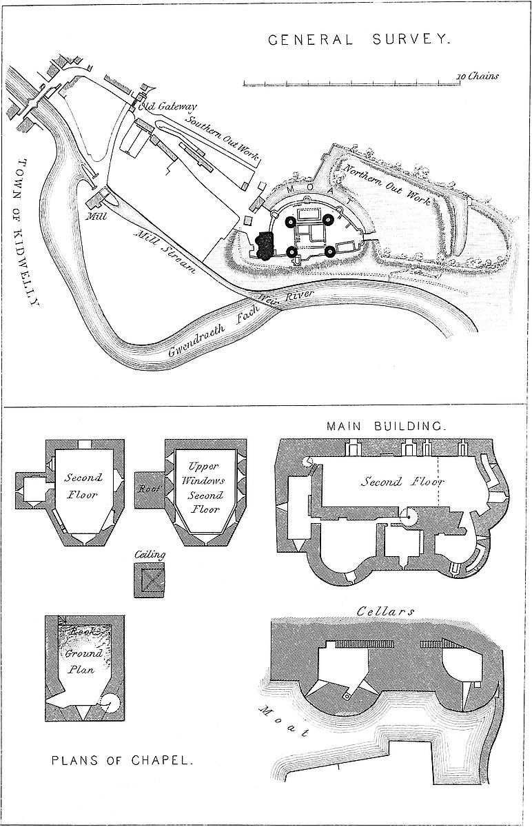
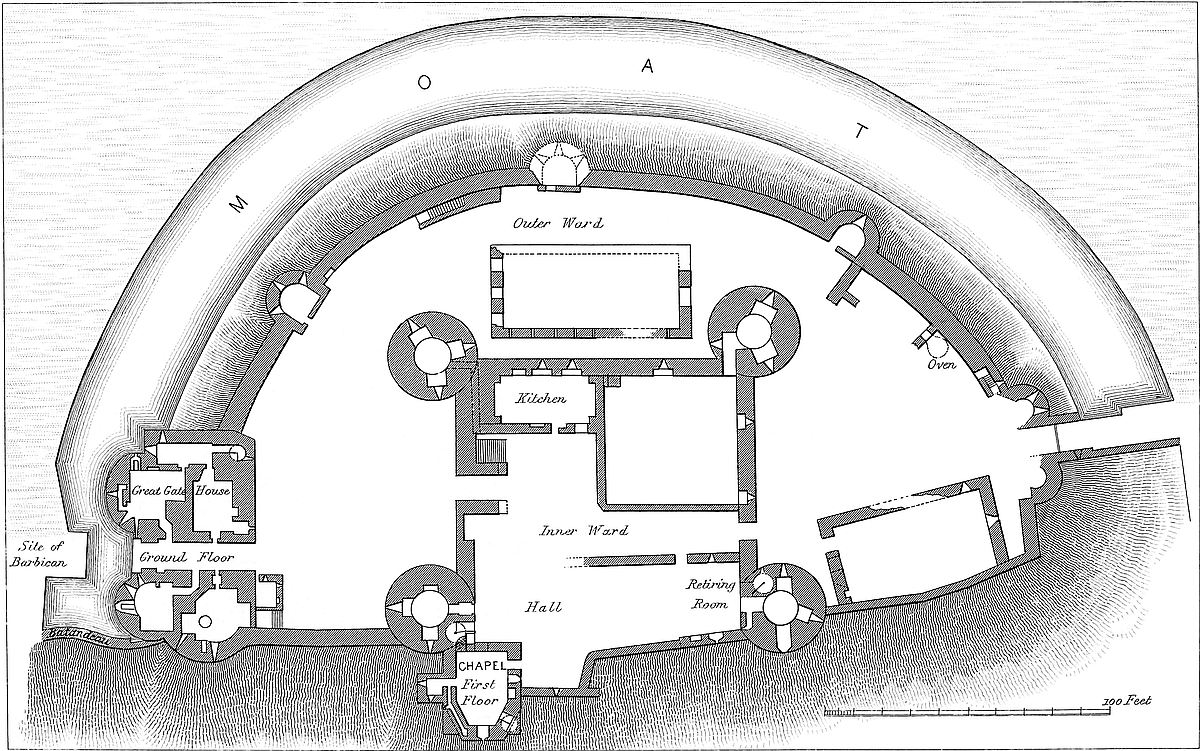
155
The castle is in plan nearly a semicircle, the main ditch forming the curve, and the cliff and river the chord. The long axis lies north and south, and the gateways are at opposite ends. The whole work measures 440 yards, by from 90 yards to 130 yards, and covers about three acres.
The Inner Ward contains the drum towers, the curtains, the chapel tower, the hall, and the kitchen.
The drum towers are four:—The north-west or black tower; the south-west or Astragun Tower; the south-east or Margaret Dun Tower; and the north-east tower. All are of one date, and nearly of one pattern,—cylindrical, 30 feet diameter, with walls 9 feet thick. They are 44 feet high, with a battlement, and each has a well-stair at the gorge, terminating above in a square turret, the top of which is 53 feet high. Each contains a souterrain, and three stages of circular chambers, looped outwards, usually with three openings. There are also the usual chambers in the walls, and doors opening upon the ramparts of the curtains. There are also some points of difference. The chambers of the south-west tower are vaulted; the rest have timber floors. In this tower the souterrain is entered by a long gallery in the wall, common to the south curtain and the kitchen, opening from the porter’s lodge. This is the “porter’s prison,” and possibly the vaulting was to allow the whole tower to be used for this purpose. The north-west tower is cylindrical below, but above it passes into a sort of heart-shaped plan, presenting towards the gorge a double bow, with a flat recess between. These two towers cap the angle of their curtains, and are engaged in about one-fifth of their circumference.
The north-east and south-east towers are placed, not at the angles, but on the faces of the north and south curtains, close to their east ends, and on the edge of the river cliff. Besides their junction with the curtains of the inner ward, they are connected north and south with that part of the curtain of the outer ward which is built along the edge of the cliff. The south-east tower is closely connected with the chapel tower, and has also a door opening upon the curtain of the outer ward, leading to the great gatehouse.
The curtains are four in number. That to the east is irregular, low, and weak; the cliff has been considered its defence. The other three are 6 feet thick, and 18 feet high to the top of the parapet. Along each is a rampart walk, having a parapet pierced with loops and a rere wall. The curtains enclose a quadrangle 80 yards square.
The north curtain is pierced by a gateway, 6 feet wide, with a low drop arch, and the groove of a portcullis worked from the rampart; it is near the east end of the wall, and nearly opposite the northern gatehouse. This curtain is pierced by two loops, which seem to have been defended from the ground level. The west curtain has three loops, two of which opened from the kitchen.
The south curtain is pierced near its centre by a gateway, 10 feet156 wide, with a low drop arch and portcullis groove. The wall has been thickened to give depth to the gateway, and possibly to allow of the superstruction of a low tower above it. This is the principal entrance to the inner, and opens towards the great gatehouse of the outer, ward.
The chapel tower, forming part of the east curtain, deserves particular attention. It is an oblong building, springing from a rectangular base; but, as the two outer or eastern angles are formed by buttresses, each of which is a half pyramid, cut diagonally, the plan of the upper part is an oblong, with the two eastern angles removed so as to form an apse. As this tower projects some way down the steep, its outer face is 56 feet high and its inner only 20 feet. Its top is 24 feet lower than that of the contiguous south-east tower.
Against the south side of the chapel tower is a small square projection containing a vestry. This does not rise to the clerestory.
The chapel tower has three floors, all ceiled with timber. The interior is 26 feet from the altar to the west end, and 18 feet broad. The east wall is 6 feet thick; the west wall, 3 feet. In the south-east corner is a mural gallery, leading to a sewer chamber below the vestry. In the north-east corner is a well-stair. The ground floor is below the level of the inner ward, and is entered by a curved stair from the adjacent hall. The next, or first floor, is on the level of, and entered directly from, the hall. Above this, and on the rampart level, is the chapel. This includes two tiers of windows, the upper being a clerestory, and is entered by a west door. The east window is common to both tiers. It is a long, narrow, and acutely-trefoiled loop, set in a broad recess, which nearly occupies the whole east bay of the apse, and has a flat drop arch with a plain rib.
In the face next south of the altar-place is a small trefoiled piscina, and next to this a broad recess or sedile under a drop arch. On the south side, a small, acutely-pointed door leads to the vestry, and west of this is another recess, with a flat drop arch, and in it, close to its east side, a loop, long since blocked up, intended to defend the nook between the vestry and the south-east tower, and to rake the adjacent curtain. There is also a trefoiled loop in the north wall, and a door long closed up.
The clerestory is lighted by nine windows, three on each side, and three, including that to the east, in the apse. They are all alike—long, narrow, acutely-trefoiled openings, within broad recesses, plainly ribbed, and with flat drop arches. All rest inside upon a string, a filleted half round, which dips to pass under the east window. Between each pair of windows is a plain corbel block for the roof timbers. There is nothing, save the battlements, above the chapel. The walls have been stuccoed. The west wall has neither ashlar dressings nor string course, and is of different date and inferior work to the rest of the tower.
The hall, 60 feet by 25 feet, filled up, with the retiring-room, the whole east side of the inner ward. Its south end is formed by 157the south-east tower, the circular face of which has been patched and plastered to present a flat surface towards the hall, and this addition still shows the height and pitch of the hall roof. The west wall of the chapel forms part of the east wall of the hall; and in another part of this, which was also the outer wall towards the river, are traces of a window recess, like those of the chapel. Near this, also connected with the chapel, is a projecting space from the curtain, which may have been a sort of oriel or small chamber attached to the hall. In the west wall, at the south end, is an ashlar door or window jamb. The west wall is destroyed.
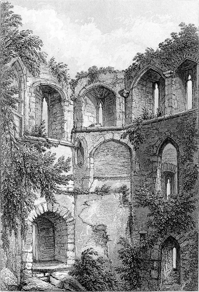
The retiring-room is of the breadth of the hall, and 30 feet long. It communicates with the north-east tower. Its west wall is tolerably perfect. It has been stuccoed, and includes a doorway. The cross wall, and perhaps the place of its door opening into the hall, may be traced. A trefoiled and recessed loop, of the date of those in the chapel, remains on the east side in the curtain; and close south of it is the fireplace, with a carved base to the chimney shaft. The whole of the east curtain seems to have been employed to carry the roofs of the hall and retiring-room, and was probably defended by a battlement accessible from the roof gutter. The commanding position of the north-east and chapel towers and the steep rise from the river would render this the least accessible side of the castle.
The kitchen is placed opposite to the hall, in the south-west corner of the court. It is 30 feet by 17 feet, and appears from its remaining gable to have had a highly-pitched roof. At each end, north and south, is a large fireplace, with magnificent tunnels. On the west side, which is formed by the curtain, a window of narrow opening but broad recess opens into the outer ward. Towards the south end is a third fireplace, of smaller dimensions, apparently intended for stewing and similar operations, like a modern hot closet.
In the east wall is a narrow doorway, placed within and on one side of a wider arch, which at breast high is opened to its full breadth. This seems to have been devised to allow servants to carry out large dishes without opening a doorway of unnecessary breadth. On each side of this door are low, broad openings, evidently intended for buttery hatches.
The north-west angle of this ward is occupied by an enclosure 45 feet square, of which the two curtains form two sides. It is walled in, and may have contained offices or barracks.
The Outer Ward is nearly semicircular, the inner ward being built upon the middle of its chord. Its parts are the great and lesser gatehouses, the curtains, the mural towers, and the offices. The inner ward has no ditch, and the space between the walls of the two wards is on the north side, 90 feet; on the west side, 60 feet; and on the south side, 80 feet.
The great gatehouse is a fine pile of building. It is an oblong mass, 80 feet broad by 50 feet deep, and 62 feet high. The gate158way is 11 feet high, and 8 feet broad, and has a high drop arch. It is placed in a very flat, segmental, arched recess, 20 feet high. The sill of the doorway is 12 feet above the bottom of the ditch, and on either side it is flanked by a conical round tower, 24 feet in diameter below, and 20 feet above. Above the gateway, between and on a level with the top of the towers, runs a bold machicolation of three flat arches upon two corbels.
The gatehouse has a circular projection eastward towards the river; and at its north-west angle a square turret terminates in a watch-tower, which rises 93 feet above the court, and is known as “Pigin Tower” [Pigwn, Beacon].
The portals, both towards the field and towards the court, have plain chamfered ribs in ashlar; the portal vault is turned in rubble, with a portcullis groove at either end. The gates open inwards, so that the gatehouse could be defended on either side. There are also three chases in the vault, intended for the passage of gratings. The middle one appears to have been long closed up.
The drawbridge dropped across the moat, here reduced 16 feet, upon a pier connected with the barbican.
Entering by the great gate, on the right and left are dungeons and guard chambers, with loops commanding the approach. The doorways are small, with arches nearly half round, or very slightly pointed. One chamber on the right contains a large domed water-tank below the floor, two singular recesses in the wall, and a garderobe. A well-stair at the north-west angle leads to the first floor, which is also reached by an exterior and state staircase from the court, under which is a porter’s lodge. The subterranean chambers and those on the ground floor are vaulted.
The first or principal floor contains a state-room, 40 feet by 17 feet, with two large windows opening upon the court, and a fireplace between them. The windows appear to have been of two lights, trefoiled, and they are placed in large, flat, segmental recesses. The roof has been of timber, flat, and rather low. On the same floor are three smaller rooms and a portcullis chamber; and on the east side, over the tank-room, is a vaulted kitchen, with a large fireplace and oven. From the kitchen a small door leads to the east rampart, and along it to the south-east drum tower. Two well-staircases lead to the second floor, which contains also a large chamber, with windows of two lights, and trefoiled, opening upon the court, and a fireplace. Here also are several bedrooms, with doorways of carved ashlar. This floor seems intended for the accommodation of persons of condition. The well-stair at the north-west angle is continued upwards to the watch tower; and from near this stair a narrow door leads to the rampart of the curved curtain, and so to the mural towers of the outer ward.
The watch tower is considerably higher than any other part of the castle, and commands an extensive view over both sea and land.
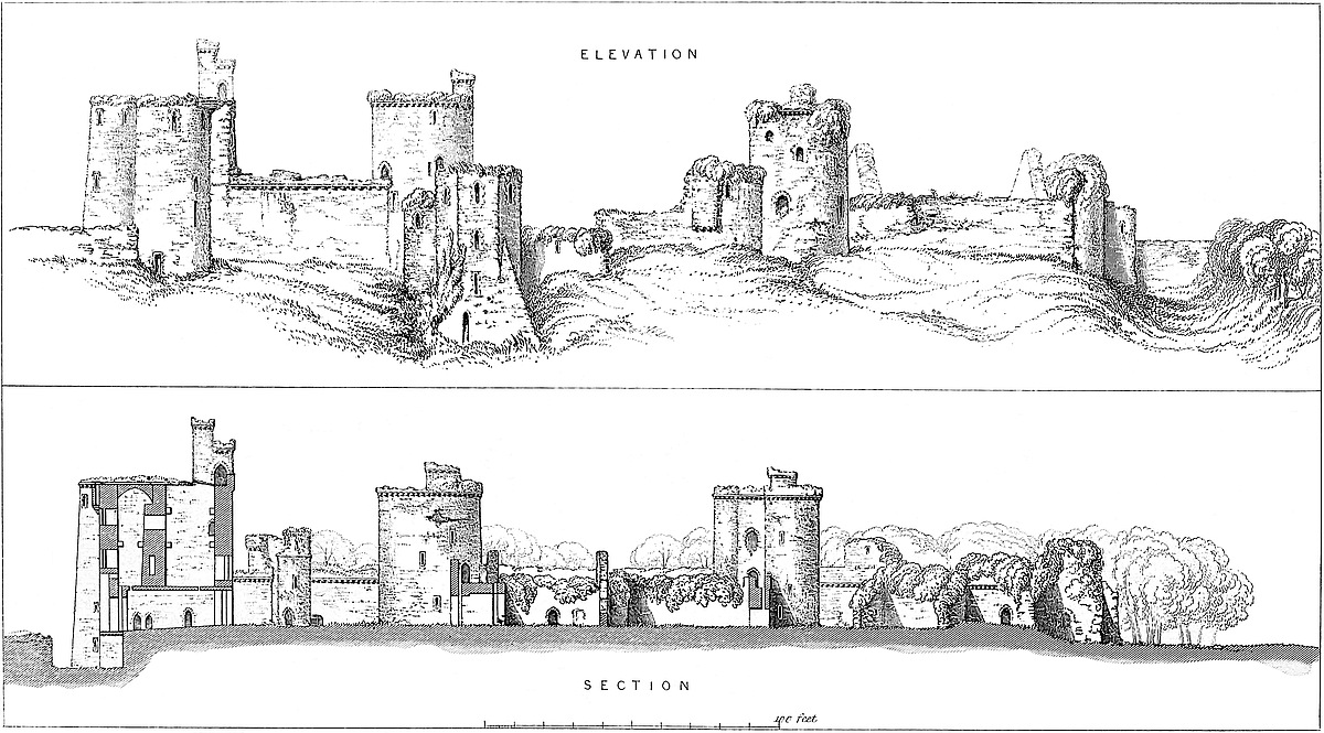
The lesser or northern gatehouse is in great part destroyed, and 159appears to have been hastily built. It is on a small scale, and composed only of two half-round towers, the back or gorge walls of which, and part of the portal, have been destroyed. There appears to have been an upper story entered by a staircase in the adjacent western curtain. The portal arch is gone, but there are traces of a drawbridge which worked between two side walls, looped to rake the ditch. That on the east remains. The portal was 10 feet wide, and the bridge dropped with a span of about 18 feet upon a pier still remaining, and projecting from the counterscarp of the fosse. The bridge walls are later than the towers, and these probably than the curtain. This gateway is placed at the north extremity of the outer ward, only a few yards from the river bank. It appears to be an addition.
The curtain of the outer ward is in three parts: one, 330 feet long, and curved, encloses the ward on the west or landward side, and connects the gatehouses with the mural towers. This wall is 6 feet thick, and 20 feet high, and is defended by the main fosse. Besides openings from the gatehouses, there is a direct access to this rampart from the court by a mural staircase built against the wall. The rampart walk is protected by a parapet and a rere wall, both of which, to give breadth to the walk, are thrown out upon corbels or false machicolations.
The second part of the curtain is straight, or nearly so, and extends 50 feet in length along the river cliff, from the great gatehouse to the south-east drum tower. Its rampart is accessible from each end. This wall is 30 feet high and 7 feet thick.
The third portion of the curtain also runs along the river cliff, and extends 90 feet from the north-east drum tower to the north gatehouse, near which it makes a salient angle. Between this angle and the gate it is 5 feet thick; elsewhere, only 2 feet. Possibly there was a tower at the angle.
The mural towers are three in number, all placed in the western curtain. They are half round, 30 feet high, 22 feet in diameter, with an external projection of 8 feet, and a slight square projection within formed by the gorge wall. They have a ground floor, looped, a first floor with a fireplace, and a chamber on the level of the rampart walk and forming a part of it. The walls are 5 feet thick. The middle tower of the three has fallen into the fosse. The masonry of these towers is rude, and they are ill-bonded into the wall.
The offices in this ward are represented by the walls of a detached building, 65 feet by 30 feet, with high gables, placed west of the inner ward; another room, 60 feet by 35 feet, built against the river curtain, near the northern gatehouse; and some outbuildings, kitchens probably, and a bakehouse, built against the curved curtain, close west of the same gatehouse. These buildings were probably intended for the accommodation of the garrison.
The main ditch sweeps round the north, west, and south sides of the outer ward, opening upon the river cliff at, and rising towards160 each end. The opening at the south-east end, near the great gatehouse, is closed by a batardeau, which seems to have been embattled towards the river, and to have been approached from the barbican. There are some traces of a similar wall at the other end, next the north gatehouse. This ditch is high above the river, but is fed by land waters, and part of it is still wet. It is about 30 feet broad, and of considerable depth. Westward it gives off a branch which divides the north and south outworks, and communicates with the ditches of the former.
The barbican appears, from the traces of its foundations, to have been a small, circular tower. It occupied a rocky knoll on the counterscarp of the main ditch, opposite the great gateway, and on the edge of the steep bank of the river. It evidently was intended to cover the drawbridge, and to force those who arrived by this entrance to pass exposed to the fire of the adjacent western curtain. This work seems to have been cut off from the other outworks by a dry ditch, or covered way, leading from the river, south-west of the barbican towards the main ditch.
The outworks are divided into north and south platforms by the branch of the main ditch already mentioned.
The south platform is defended on the east by the mill leat. It was walled in, and seems to have been about 170 yards long by 130 yards broad. Part of the wall remains on the west side and on the north, along the edge of the branch ditch. At the south end, the approach still lies through the outer gatehouse, part only of which is destroyed. The portal, a drop arch with portcullis grooves, remains; above it are three windows with flat, segmental arches. From the sill of the central window a hole opens upon the outside of the portal, probably for the passage of missiles. The building has a ground and upper floor. There are no traces of ditch or drawbridge. The work is rubble. There does not appear to have been any ashlar. The style is Perpendicular—possibly of the date of the great gatehouse, probably later. Grose gives a drawing of this gatehouse in 1786, in which it appears much in its present condition.
The northern platform covers the north and west quarters of the castle. It measures about 130 yards long by 90 yards broad, and is enclosed within a wet ditch, a branch of which nearly cuts off its northern portion, leaving a narrow neck towards the river, across which lay the approach to the south entrance. Within the ditches of this work are high banks, and indications of a slight wall, and perhaps of a tower, near the entrance passage.
This castle has sustained less injury than might have been expected. It has been dismantled, and the ironwork and timber removed, but none of its towers or walls appear to have been blown up. The mural tower missing from the outer ward has probably slipped into the ditch from some defect in its foundation.
The castle is easy of access and examination, not being overgrown with ivy or brushwood.
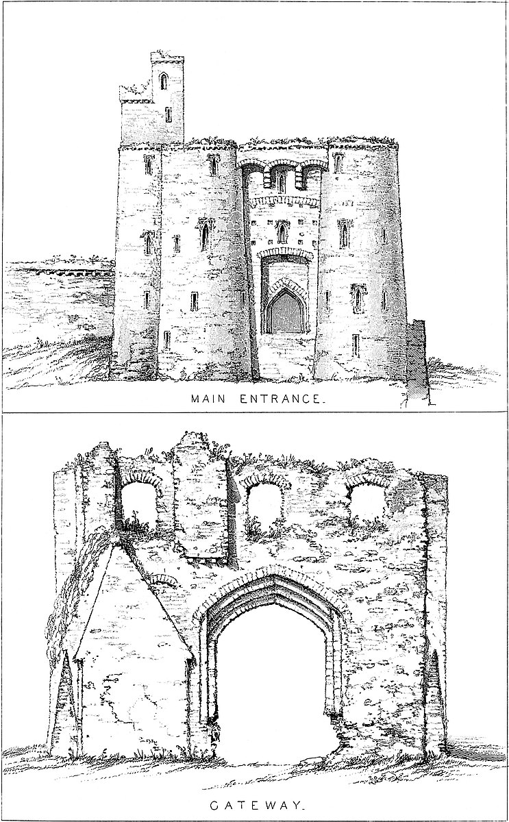
161
The details of Kidwelly afford some general indications of the age of its several portions. There is nothing which can safely be pronounced to be Norman work, although no doubt the present was preceded by a structure partaking both of this and the early English style.
The general plan or arrangement of the castle seems, from its style, to be of one date—probably that of Henry III., or early in the reign of Edward I. The chapel is of this age. Its west wall, however, appears, from the peculiarities of its bond, to be of earlier date than the rest, and of the same date with the south-eastern drum tower, say 1260–80, which would be the date of all the towers and curtains of the inner ward, for all are in the same style.
The great hall seems a little later than the south-eastern tower, the face of which has been flattened to suit its gable.
The walls and mural towers of the outer ward may be a little later than the inner ward. That they are part of the original plan may be inferred from the want of strength in the inner gatehouses.
The great gatehouse is decided, but early, Perpendicular, perhaps of the reign of Richard II. or Henry IV., 1388–1400. Pigin tower is a later addition.
The name of Kydwelly, or Cydwelhi, is Welsh. Leland, whose etymologies are not infallible, derives the name from “Cathwelli,” or “Cattalectus,” because Cattas used to make his bed in an oak there. Others explain “Cyd” to mean an “Aber,” or junction of waters. The Catgueli were a Celtic tribe. The town is no doubt of Welsh origin, and of high antiquity.
This does not apply to the castle, which, in its present form at least, is of later date, and the site of which, though naturally strong, was not that which a Celtic engineer would have selected.
The castle is supposed to have been founded by a certain William de Londres, one of the Norman knights who, in 1091, assisted Fitzhamon in the conquest of Glamorgan, and who is recorded afterwards to have pushed his arms into Caermarthen, no doubt when, in 1093, the Normans ravaged Gwyr, Kidwelly, and Ystrad Tywy, and then to have won from the Welsh the lordships of “Kidwelly and Carnwilthion.”—[Powel, 32.] In Glamorgan, this William is known as the founder of the castle of Ogmore, the Norman keep of which, though injured, is still standing. It is probable that his works at Kidwelly were of a less solid character, else all traces of them could scarcely have disappeared.
It is possible that the gain of De Londres was confined to the town and suburb of Kidwelly, for, in 1100, Henry I. wrested from Iorwerth ap Blethyn his lands, and gave to Howel ap Grono the districts of Strath-Tywy, Kidwelly, and Gower. Howel, however, was, in 1102, slain by the Normans, who had already taken from him the castle of Rydcors.—[Powel, 124.]
162
In 1113 Griffith ap Rhys, prince of South Wales, took Caermarthen, and retreated upon his stronghold in Strath-Tywy, whence he marched upon Gower. William de Londres deserted Kidwelly and fled. The Welsh ravaged the lands and burned the castle [Powel, 145], which then could hardly have been a regular Norman fortress. After this followed a period of tranquillity, and Maurice de Londres had a park at Kidwelly, and preserved his venison strictly. On one side of the park, next the sea, were large sheep pastures. His wife, wishing to have some of the deer destroyed, caused wool to be inserted into the bowels of some of the stags, and then showed it in proof that they destroyed the sheep; on which Maurice allowed the deer to be attacked with dogs.—[“Giraldus Cambrensis,” i. 168.] On the death of Henry I., 1135, while Griffith ap Rhys was absent in North Wales, Gwenllian his wife led an army into Kidwelly. She was defeated and put to death by Maurice de Londres, its lord, and by Geoffrey, constable to the bishop. Her eldest son, Morgan, was slain, and his brother, Maelgon, was taken.—[“Giraldus Cambrensis,” i. 168.] “The battle-field,” says the editor of “Giraldus,” “is still called ‘Maes Gwenlian,’ and a tower in the castle, ‘Twr Gwenlian.’” In 1145, there were already castles at Llanstephan and Dynevor, and, in 1150, at Llwchwr.
From the family of De Londres Kidwelly passed, by an heiress, to that of De Cadurcis, or Chaworth, whose heiress married Henry of Lancaster, grandson of Henry III. Henry, his son, and his grandson, held the castle until their line also ended in a daughter, who married John of Gaunt and was the mother of Henry IV., since which time the estates of the Duchy of Lancaster, including Kidwelly, have remained in the Crown. It is now in the hands of the Earl of Cawdor.
THE parish of Kilpeck, in the county of Hereford, occupies a tract of rolling broken ground which intervenes between the Mynde, Orcop, and Garway ridge of hills and the river Worm, a stream which receives the drainage of a considerable valley, and finally falls into the Monnow, near Kentchurch. The railway from Abergavenny towards Hereford passes up this valley, which affords an excellent example both of the fertility and the picturesque beauty of the old red sandstone country of Herefordshire.
The castle, church, and the site of the long-destroyed priory lie near together about the village of Kilpeck, two miles north of the ridge, and a short mile south of the church and railway station of St. Devereux.
163
The ground falls rapidly towards the north, and is traversed by deep dingles, each with its contained streamlet. The hedgerows and steeper banks are covered with wood, and the grassy knolls and ridges subside into broad level meadows of unrivalled verdure, amidst which the plough is but little known.
Kilpeck Castle, as now seen, is composed almost entirely of earthworks. It consists of a mound and circumscribing ditch, beyond which, on the north, is a triangular platform, on the south an enclosure of a horseshoe figure, and beyond this again a southern platform much more extensive, but also somewhat triangular in outline. On the very edge, and to the east of these enclosures, stand the ancient Norman church and a farmhouse, parts of which are of some antiquity; on the west, about 200 yards distant from the castle, the ground falls rapidly towards a deep dingle, across the lower part of which has been thrown a strong bank of earth, while remains of other banks are seen higher up. By these means it is evident that there was formed a chain of long and deep lakes, perhaps at two or even three levels, which must have rendered any approach from the west, or Welsh quarter, exceedingly difficult and hazardous.
The mound is wholly artificial. It is conical and truncated, and of oval plan. Its summit measures, north and south, about 25 yards, and east and west about 40 yards, and its height is from 20 feet to 40 feet, according to the depth of its ditch, which is greatest on the northern side. The slopes are steep, the red earth having little disposition to slip.
The summit was crowned by a shell keep placed about 3 feet within the edge of the slope, and therefore about 23 yards north and south, by 38 yards east and west. It was polygonal in plan, with faces from 14 feet to 15 feet long. Of this shell there remain but two fragments, one on the north and the other on the west side, about 20 yards apart. These show the wall to have been polygonal without, and circular, or nearly so, within, also within vertical, but on the outside battering from 7 feet thick at the base up to 4 feet at 6 feet high, above which it was continued at 4 feet. The north fragment is about 40 feet long, with a sine of about 2 feet, and about 18 feet high; probably it was, with the parapet, about 25 feet. It contains a round-backed fireplace, 3 feet broad by 2 feet deep, which gathers in above into a cylindrical shaft of 12 inches diameter. On each side is a water-drain, as from sinks, passing through the wall. The other, or western fragment, is 30 feet long and about 14 feet high. This also has a fireplace, similar to the last, but 5 feet wide and 3 feet deep; on the north side of it is a water-drain. From the south end of this there remains a fragment of a cross wall, 3 feet thick, which belonged to an interior building; it is of the age of the outer wall. This outer wall seems to have been blown outward a little by a mine sprung from within. The summit of the mound is slightly convex, from the accumulation of rubbish, which the fireplaces show to be about164 4 feet deep. It is said that a deep well was discovered here, but no trace of it is now seen. These walls are the only remains of masonry visible in the whole castle. From their general aspect and that of the fireplaces they seem to be Early English. It is clear that the shell contained buildings against the wall, which, from the water-drains, may have been kitchens.
The mound is surrounded by a deep ditch, which on the north is succeeded by the north platform, on the north-east, east, and south, by the horseshoe platform or outer ward, and on the west by a narrow bank, from the base of which the natural slope falls rapidly.
The outer ward is a platform of a horseshoe or lunated shape, varying from 90 yards to 180 yards broad, and covering full half the mound. Its concave edge forms the counterscarp of the inner ditch. Its convexity is bounded by a ditch from 10 feet to 30 feet deep, which on the east borders the churchyard, and on the south is succeeded by the south platform, the general level of which is 10 feet to 12 feet below the summit of the mound. The outer edge of this area has been raised by a bank, which along the south side and at the west end rises 10 feet to 20 feet, having been no doubt thrown up from the exterior ditch. The surface is scarred as by the removal of foundations, but not a trace of actual masonry is visible, and even where the bank has been cut through no stones are seen.
There remains the south platform. This is nearly at the level of the outer ward, though below that of its elevated edge. The area is considerable, probably above four acres. It is divided from the outer ward by the ditch common to both, and about 30 feet broad. To the west and to the east it has a ditch, but to the south a scarp of about 12 feet, the ground beyond being flat and at a lower level. The present entrance to this platform, now under tillage, is by a hollow way to the east side near the north end, which may be old.
The main entrance to the castle, that is, to the outer ward, was by a gateway at the south point, marked by a deep hollow way cut in the bank, and flanked by earth heaps, which may conceal the foundation of small towers. This entrance is approached from the east by a road along the ditch below the outer ward and the south platform.
The way from the outer ward into the keep is not opposite the outer entrance, but more to the east; a slender causeway crosses the ditch, and a path ascends the mound. Probably this is all modern, and here was a sloping bridge, rendering the ascent of the mound less steep. At the south-west corner the ditch of the mound runs out at one point on the hill side, so that from hence a way may have lain along the ditch as far as the mound bridge.
The inference suggested by the present earthworks is something to the following effect:—Originally advantage was taken of a natural knoll, of an irregular figure, but about 300 yards north and south by 125 yards east and west, which was surrounded by a single ditch, or,165 where the ground allowed, by a scarp only. It may be that here, as partially at Malvern, and in other examples, this long enclosure was subdivided by two cross cuts into three parts, of which the central formed the citadel. This would probably be the work of the British.
Then it would seem that a later people, the English, took possession, and threw up a mound at one corner of the citadel, isolating it by its proper circular ditch, the principal dwelling being on the mound, and the horseshoe remainder below containing the base court for the dependents, while the north and southern portions would serve for protected enclosures for cattle.
When the Normans took possession they seem to have built a shell keep upon the mound, and to have employed the base court below as an outer ward, probably surrounding the whole with a stone wall, now removed, and replacing the English stockade. This would constitute the castle proper, to which the north and south platforms would be appendages, no doubt stockaded for cattle.
The history of Kilpeck commences with Domesday, which records, “Hæ villæ vel terræ subscriptæ sitæ sunt in fine Arcenefelde. Will’us filius Normanni tenet Chipcete. Cadiand tenuit tempore Regis Edwardi.”
The church is decidedly older than the masonry of the keep, and it may therefore be that the early Norman lords contented themselves with a residence and defences of timber, and did not build for a century or so after their occupation, when the shell keep was constructed. It is not probable that this was preceded by any earlier work in masonry, as Norman buildings were substantial and durable.
The church has been the subject of a “monograph.” The priory, of which not a trace remains, stood in a field south-east of the castle and village.
Chipcete in Irchenfield is the present Kilpeck, where William Fitz Norman sat in the seat of Cadiand, the dispossessed Englishman. The lands paid no geld or military service, which in that border district is remarkable. William was a large Herefordshire landowner. In 1134, 25 Henry I., Hugh, son of William Fitz Norman, gave to St. Peter’s, Gloucester, the church of St. David at Kilpeck, and the chapel of our Lady of or within the castle. Of the chapel no more is said, but the church is included in the confirmation charter by Stephen to Gloucester in 1138, and in many later confirmations and charters of Inspeximus.
According to Dugdale, a priory was founded at Kilpeck in 1134, and dedicated to St. David, by Henry de Kilpec. The founder more probably was Hugh Fitz Norman, who certainly endowed it. It was a cell of the Benedictine Abbey of St. Peter at Gloucester, and subsisted until its suppression in 1422–48, during the Episcopate of Thomas Spofford of Hereford. The priors were summoned to take part in the elections of the Gloucester abbots.
Hugh was succeeded by Henry, called “De Kilpec,” who had to166 pay a fine of 100 marks to King Stephen for a trespass on the royal forest of the Haywood. Henry is also mentioned in the Pipe roll of Richard I. as in arrear 13 marks in 1189 for dues to the king from the forest of Trivel.
John de Kilpec, son of Henry, purchased the barony of Purbeck or Pulverbach, Salop, of the Crown, in 1193 for £100. At the commencement of John’s reign he seems to have held in his bailiwick the forests of Herefordshire, probably as sheriff of that county, for which he rendered his accounts in the third of John. He also paid two marks scutage for his lands in Salop. He died 1204, and Julian, his widow, paid 60 marks to King John to marry whom she pleased. In the following year she had dower of Rokeslegh and La Teme, according to Madox.
By Julian John left Hugh de Kilpeck, who was a ward to William de Cantelupe, a great border baron. At this time the king visited Kilpeck occasionally, being there 1211, 11th March, in his way from Hereford to Abergavenny, no doubt at both places as Cantelupe’s guest. Also in 1213, 27th and 28th November, he was here between Hereford and St. Briavels, and finally 18th and 19th December, 1214, while going from Monmouth to Hereford.
Hugh de Kilpeck, when of age, inherited the keepership of the royal forests in Herefordshire, and in 1248 he held Little Taynton, in Gloucestershire, by the serjeantry of keeping Haywood forest, also an hereditary charge. The forests of Hay, Kilpeck, and Acornbury seem, from the patent rolls, to have been in his hands 3 Henry III. In 1231, 16 Henry III., Hugh de Kilpeck and William Fitz Warine were two of the eight lords employed to negotiate a truce with Llewelyn. This seems positive; but Dugdale says he died about 1207. There is an inquisition upon him 28 Henry III., 1243–4; but it appears from the fine rolls that he died before this. He married Egidia, who married afterwards, says Dugdale, William Fitz Warine. John was the third and last Baron Kilpeck. He left two daughters, co-heirs, Isabella and Joan. Joan, the younger, aged seventeen at her father’s death, was the first wife of Philip de Marmion. She held half the barony of Kilpeck, and left three daughters, co-heirs. Philip, who was champion of England and a great supporter of Henry III., left by a second wife a fourth daughter. Each had a quarter of the barony of Marmion, and the elder three had each a third of that of Kilpeck. The Frevilles of Tamworth sprang from Mazera, the second child, and the Ludlows and Dymokes, champions, from Joan, the fourth.
Isabella, the elder co-heir, seems to have held the castle of Kilpeck in her share. She married, 28 Henry III., William Waleran. Her seal, lately found at Ewshot, near Crondall, is engraved in the “Top. and Geneal.,” i., p. 28, where is an excellent account of her family. Isabella left Robert, William, and Alice.
Robert Waleran held Kilpeck. He was sheriff of Gloucestershire 30–35 Henry III. He fought for Henry at Evesham, and was167 governor of the castles of Cardigan and Caermarthen, and a Baron. In 1262 he composed a dispute between the Bishop and Chapter and the citizens of Hereford relating to the assize of bread. He died s.p. 1 Edward I., 1273, leaving apparently Matilda, his widow, no doubt his second wife, who had dower in Kilpeck manor.
William, brother of Hugh, died before him, leaving Robert, who succeeded to Kilpeck, but seems to have died 2 Edward II., either childless, or leaving a son who did not inherit Kilpeck in consequence of his great uncle’s entail; for it appears that by deed in 1269 Robert Waleran gave to Alan de Plunkenet, his sister’s son, the reversion of Kilpeck castle and of the park of Treville and Coytmore, the forestership of the Hay, and the manor of Hampton. Alan regranted to Robert for life, and on Robert’s death the lands reverted to Alan, who did homage. By what tenure Robert, the nephew and last baron, held Kilpeck, does not appear.
Alice Waleran, sister of the first Robert, married Auchew de la Bere. Their son Alan bore the name of Plukenet or Plugenet, and became lord of Kilpeck castle and manor, and was summoned to Parliament 23 Edward I. He died 27 Edward I., 1299. He was buried at Dore. He was a great agriculturist, and reclaimed the tract called from him “Alan’s Moor.” In his time, 13 Edward I., William Butler held a carucate of land in Kilpeck and the manor and court there; also, 20 Edward I., Philip de Marmion of Scrivelsby held a fee in Kilpeck. Several fiefs seem to have been held of the castle; 2 Edward III., Alexander de Freville so held one-sixth of a fee.
Alan Plugenet, son of Alan, succeeded. He was distinguished in the Scottish wars, and was also summoned to Parliament. He obtained a weekly market and annual fair for Kilpeck, and died s.p. about 1311, leaving his sister Joan his heir.
Joan Plugenet, called Joan de Bohun de Kilpeck, held the barony. She married Edward de Bohun, but died s.p. 20 Edward II., or 1 Edward III., 1327.
Her heir was Richard, son of Richard, and grandson of Sir Richard de la Bere. He died 19 Edward III., leaving Thomas, his son and heir, aged 30, 27 Edward III.; but Edward de Bohun, who survived his wife, and probably was tenant of Kilpeck by the courtesy, had licence from Edward III. to alienate Kilpeck, Treville, and the bailiwick of the Haywood to James Butler, first Earl of Ormond.
Meantime the elder family continued to hold their shares. Thomas de Useflete, 5 Edward III., probably a trustee, enfeoffed Richard de la Bere, of Munestoke, in Kilpeck, which, 2 Edward III., had been held by Nicholas de Useflete. 17 Edward III., Baldwin de Frevill held Kilpeck manor; and finally, 18 Richard II., Kinardus de la Bere held the manor and hundred of Kilpeck for the chantry of St. Mary of Madley.
The Butlers, however, seem to have been substantially the owners. 12 Edward III., James, first Earl of Ormond, held the manor168 and extent by the tenure of keeping the forest of Hay, and 13 Edward III. Eleanor, his widow, held the castle and manor.
As holders of the castle or manor, or both, appear—37 Edward III., Sir Thomas Moigne; 6 Richard II., James, Earl of Ormond, and, 13 Richard II., Elizabeth, his widow. 20 Richard II., Sir Richard Talbot and Ankareta his wife held the castle and manor as one fee of James, Earl of Ormond, within the land of Irchenfield. The Butlers, however, held the castle until the attainder of the fifth earl, a Lancastrian, who was beheaded after Towton in 1467.
In the fifteenth year of Edward IV., the King granted Kilpeck in tail special to the male heirs of Sir W. Herbert, Lord Herbert (Earl of Pembroke), for one knight’s fee, and, 6 Edward IV., this grant was extended in tail general, failing heirs male of the body. After the earl’s death, in 1469, Edward restored Kilpeck to the Butlers in the person of John, sixth Earl of Ormond, and it descended to his elder daughter and co-heir, whose son, Sir George St. Leger, held it in 1545.
After this it was sold, and came into the possession of the Pye family, of whom Sir Walter held the castle and park. He was a Royalist, and on the fall of Charles I. the Parliament first garrisoned the castle, and in 1645 dismantled it. The Pyes followed James II. into exile, and one of them bore the titular honour of Baron Kilpeck. Probably the materials of the castle were valuable, for their removal, with the trifling exceptions mentioned, has been complete, and yet the castle must have been a considerable place.
AMONG the various windings by which, still bearing its original British appellation, the river Nidd finds its way from its sources in Nidderdale and on the flanks of Whernside to its union with the Ouse a few miles above York, none are more remarkable than those by which it traverses the ancient forest of Knaresborough, where it lies within a deep ravine, celebrated, even in Yorkshire, for its happy combination of wood, and rock, and water.
Near the middle of this part of its course a bold promontory of rock projects as a rugged cliff towards the stream, rising on its eastern bank to a height of about 230 feet. Two tributary ravines, to the north and south of the rock, isolate it from the adjacent high ground, and become broader and deeper as they descend towards the river, so that the rock is strongly fortified by nature upon its northern, southern, and western fronts. To complete the strength169 of the position nothing was wanting but a ditch connecting the heads of the ravines and traversing the neck of the peninsula, and this was long since executed, and with it the upper parts of the ravines were also rendered deeper and broader, so that the position, before the use of gunpowder, must have been well-nigh impregnable.
By whom, or by what people, this formidable platform was first turned to account, is unknown, but no inhabitants of the district to whom security was an object could have overlooked its advantages. There is, however, no actual evidence of either British or Roman occupation, unless the rectangular area fortified by bank and ditch still to be traced through the streets of the later town can be accepted, as at Tamworth and Wallingford, as the work of semi-Romanised Britons; a people who, having acquired some knowledge of the principles of Roman castrametation, were yet unwilling or unable to include their strong places within walls of masonry.
The manor of Cnaresburg is mentioned in Domesday as the private demesne of the Conqueror, as it had been of the Confessor. Nothing is said of an “Aula” or a castle there; but, as eleven Berewicks depended upon it, it is clear that it was, during, and probably long before, the time of Edward, the centre of a considerable estate, and if, as was usual, its early lord had there a fortified residence, it would naturally be placed upon the rugged and knotty platform that bore the descriptive name of Cnaresburg.
William granted the manorial lands, returned in Domesday as “wasta,” to Serlo de Burg, Burg being probably the manor now called Boroughbridge. Burg was a territorial designation, not a regular surname, and does not appear to have been used by the family. The Pipe Roll, 31 Henry I., 1130, mentions Serlo as holding lands in Notts and Derby, and gives the names of Osbert, his son, and of another Osbert, his “nepos” or nephew, both of whom seem to have died before their respective fathers. The successor and heir of Serlo was John the One-eyed, whose son, Eustace Fitz-John, was a Yorkshire Justiciar. He appears in the same Pipe Roll as farming Burg and Chenardesburg, and to him was then allowed £11 for the king’s works, evidently upon the castle, at the latter place. Eustace married Beatrice, a De Vesci heiress, and their son William assumed that name. Richard FitzEustace, another son, married Albreda, the daughter and heir of Robert de Lisours, by Albreda, sister of Ilbert and Henry de Lacy, and aunt and heir of Robert de Lacy of Pontefract, who died childless, 1193. In consequence, Roger, Constable of Chester, the son of Richard FitzEustace and Albreda, took and transmitted the name of Lacy. Eustace had also a brother, Pain Fitz-John, a considerable Herefordshire landowner, and ancestor of the Barons FitzPain. With Eustace, who fell in the Welsh wars in 1159, the family occupation of the castle ceased, and it was from time to time granted by the Crown to various castellans. One of these, Hugh de Morville, took refuge here after the murder of Beckett. It was held also by the Estotevilles, and, in the reign of John, by Brian de Lisle, who is170 reputed to have excavated the castle ditch, and to have repaired or added to the buildings. Henry III. granted the castle to Hubert de Burgh in fee. Before that time the manor had been erected into an Honour, and the Honour, the Peculiar, and the forest of Knaresborough are from time to time the subject of royal grants. In 1257, Henry III. gave them to his brother Richard, who founded a priory on the river bank below the castle. Edward II. repeated the grant to Gaveston, about which time the Slingsbys appear as keepers of the forest. In 1327, the castle was taken for the Earl of Lancaster, but only to be resumed by Edward III., who, in 1371, granted it to John of Gaunt, and it has ever since formed a part of the Duchy of Lancaster. Richard II. was imprisoned here in 1399, and the keep has since borne the name of the king’s tower, it is said, in consequence. In 1642 the castle was held for the king, and was the head-quarters of an active and somewhat unscrupulous body of soldiery. It was, in consequence, besieged and taken by Fairfax in 1644, and in 1648 was, by the Council of State, ordered to be slighted, which seems to have been effected by removing the curtain wall, and blowing away one angle of the keep.
The castle occupied the whole area of the platform up to the edge of the ditch, the crest of the ravines, and the river cliff. In figure the plan is an irregular oval, in the proportion of about three parts east and west, to two parts north and south, and containing about 2½ acres. Close south of, and dependent upon, the castle, was the town. The area within the line of the town ditch measures about 500 yards north-east and south-west by 850 yards north-west and south-east, and includes all the older part of the town. About 170 yards of the ditch, where it divided the castle from the town, has been filled up since the dismantling of the castle. The castle was contained within a great curtain wall 7 feet to 8 feet thick, and of the unusual height in places of from 30 feet to 40 feet. The keep forms a part of the enceinte, being built upon the crest and slope of the northern ravine, not far from the centre of that front. The curtain abutted upon its two ends, so that the building was partly within and partly outside the area. Connected with its southern angle are some fragments of masonry showing that the area was divided by a cross wall into an eastern and western part, the one being the outer and the other the inner ward, and the keep is so placed that its south-eastern face looks upon the outer, and its south-western and north-western faces upon the inner ward.
Very nearly the whole both of the curtain and cross wall are gone, but the projection from the northern angle of the keep shows that the curtain, at that point at least, was about 40 feet high and at least 11 feet thick. It would seem that the curtain had originally no mural towers, for these, in the shape of half-round or segmental solid buttresses, have been added, built against the face of the curtain, the removal of which has laid bare the rough face of the applied work. Leland speaks of eleven or twelve of these buttress towers. There remain at present only six. They have all been faced with ashlar. 171Upon one is a good stringcourse of Perpendicular date, and on another is seen the shaft of a garderobe, the upper part of which must have been on the battlements. Two of the largest of the buttresses are placed opposite to the town, about 21 feet apart, forming a sort of solid gatehouse, and flanking the main entrance to the castle through the outer ward. The gateway was 18 feet wide and at least 18 feet high to the springing. The arch is gone. The square groove for the portcullis remains, and within is a rebate for the door. Outside in the northern jamb is a hole as for the heel of a drawbridge, but there is no corresponding hole on the other side, so that the indication is probably deceptive. A drawbridge there must have been, but it was possibly more advanced. Leland also mentions a subterranean passage opening upon the slope of the ditch, but this, of which nothing is now known, was probably a sewer. In the inner ward is the house in which are still held the courts for the Honour. This is a modern building, but it contains an original Decorated doorway, and a large fireplace, plain, but probably of the same date. There is said to have been a well near this, now lost, and local tradition describes a chapel as having stood near the courthouse.
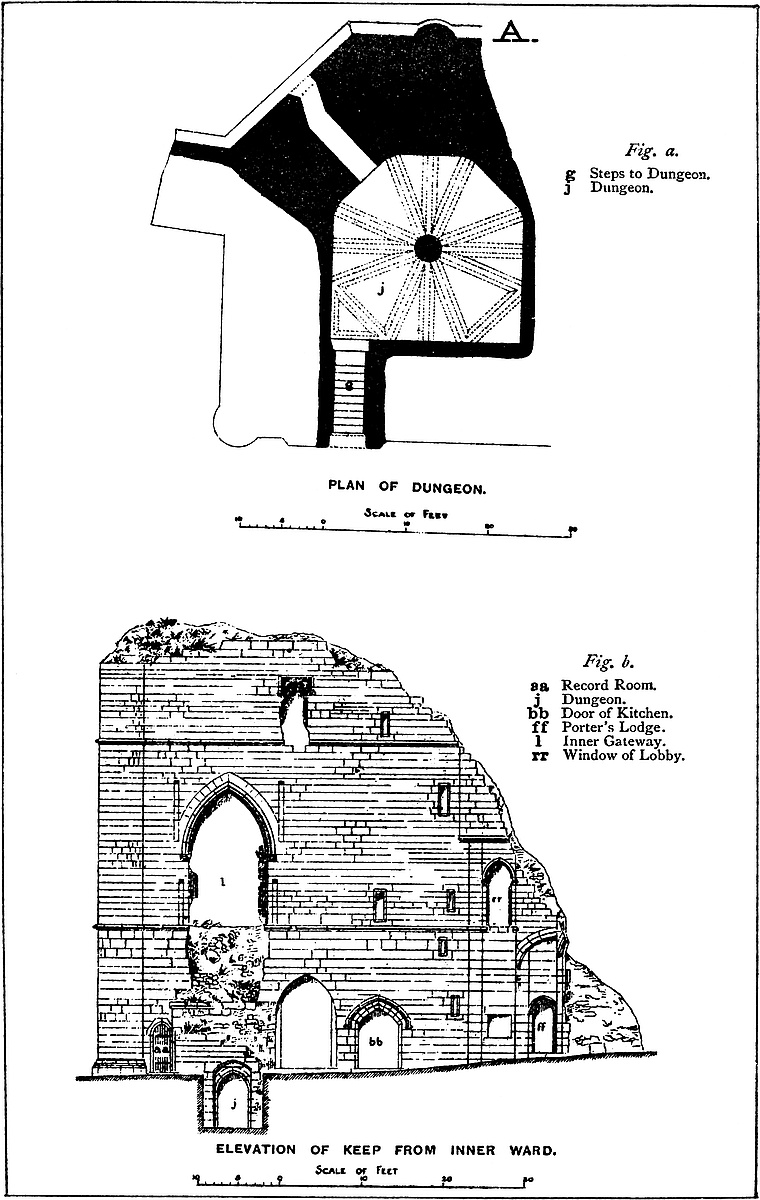
The principal interest of the building centres upon the King’s Tower or keep, of which the remains are considerable. It may be described as rectangular in plan, 64 feet north-west and south-east by 52 feet north-east and south-west, or nearly square. Its symmetry is, however, broken by the cutting off of the north angle. Also the whole of the eastern angle is gone, and it is a question how far out this extended, and with much of the north-east side, the whole south-east end, and the angle between them are gone, but enough of the two other sides remains to show the general plan and details of the building. [B. Fig. a.]
The western angle is capped by a cylindrical turret of solid masonry, 6 feet diameter, and, at present, 52 feet high. It was probably, together with the main building, about 10 feet higher. This was the height from the level of the inner ward; the absolute height of the keep, measured from the dungeon floor, was about 16 feet more, or about 78 feet or 80 feet.
The principal or south-west is also the most perfect front, and that which looks into the inner ward. It is here seen that the keep was composed of a sub-basement below the court level; a basement at the level; a first or main floor; and an upper floor: the lines of floor being indicated by two stringcourses or mouldings.
The sub-basement consists only of the dungeon. [A. Fig. a.] The entrance is by a sunken doorway, approached by a descending flight of steps. It is placed 14 feet from the western turret, and the top of the doorway arch shows just above the ground level. The doorway opens into a vaulted passage, down which twelve steps lead to a second doorway, that of the dungeon. This may be described as a square of 23 feet, of which the two north-eastern angles are cut off, reducing one end to a sort of apse of three faces of 9 feet172 6 inches each. In the centre is a plain cylindrical pier, 3 feet diameter, with a chamfered base, but no cap, from the head of which branch out twelve ribs, plain and substantial, with a slightly hollow chamfer. They are arranged in groups of three, separated by four rather wider openings, of which two, including the two right angles, are traversed by diagonal ribs, so that the plan of the vault is an octagon. There is an air-hole 3 feet square in the north wall, whence a passage, slightly zigzag, and 14 feet long, ended in a loop, now broken down. There seems also to have been a garderobe, as the mouth of a sewer is seen outside at the foot of the wall, 10 feet below the loop.
The basement floor contains three chambers, entered from the inner ward by three doors. [A. Fig. b.] Of these a narrow one of 2 feet opening placed close to the turret leads by a vaulted passage 3 feet long into the record-room. [B. Fig. a.] This is an L-shaped chamber, of which the arms are 6 feet 6 inches broad, and on the longer sides 12 feet, and on the shorter 5 feet 6 inches, one limb being a few inches the larger. In the north-west wall is a loop for air. Each limb is crossed by a plain chamfered rib, and the square space thus formed, common to the two limbs, is crossed diagonally by a single rib. This chamber was recently used as a debtor’s prison.
Next to the record-room, and nearer the centre of the front, is a large window, of which the ashlar casing and tracery have been removed, and the cill cut down to convert it into a door. At present the aperture is 6 feet broad and 13 feet to the crown of the arch. Close to, but beyond this, is the original doorway, now blocked up, but quite perfect. It was of 5 feet opening with a low drop arch, and over it a good Decorated drip stone or hood moulding. This door led into the kitchen. [B. Fig. a.]
The kitchen may be described as a square of 24 feet, having applied to its north-east side an apse of three faces of 8 feet each; or it may be called a rectangle of 24 feet by 30 feet, with two of its angles cut off so as to form an apse.
This chamber is also vaulted after a peculiar fashion. Twelve feet from the apsidal end is an octagonal pier, from the head of which spring eight ribs at equal angles. At 6 feet from the pier, that is, at the crown of the vault, each rib is met by two others, sixteen in number, which spring from eight half piers or responds in the angles of the wall. There are, however, actually only six of these wall piers, two being replaced by a different arrangement, rendered necessary by the oblong form of the chamber, which leaves a space 6 feet by 24 feet to be covered in. Of this space one third, being the western angle, is solid, and, in fact, contains one limb of the record-room. The remainder is divided into two square bays, vaulted diagonally. Between this compartment and the larger one stands a second pier, which receives the thrust of three ribs from the main pier, and has five ribs besides of its own. The general result is not unpleasing, but the vaulting is exceedingly complex, containing eight 173rhombs and eighteen triangles, great and small. The height to the crown of the vault is 12 feet. Besides the great window towards the inner ward is a small opening, probably a loop, though now enlarged, towards the ditch. The fireplace occupies one of the north-western bays. It is 7 feet broad, and the grate stood in a half-round recess of 3 feet 6 inches radius, with a vertical flue in the wall. From the kitchen open two smaller chambers and a well-stair. One of these, plainly vaulted, and 11 feet by 7 feet, is placed in the south-east wall. It is entered by a small door from the side of the kitchen, and near the door is a loop, also looking into the kitchen. This was probably the cook’s bedroom.
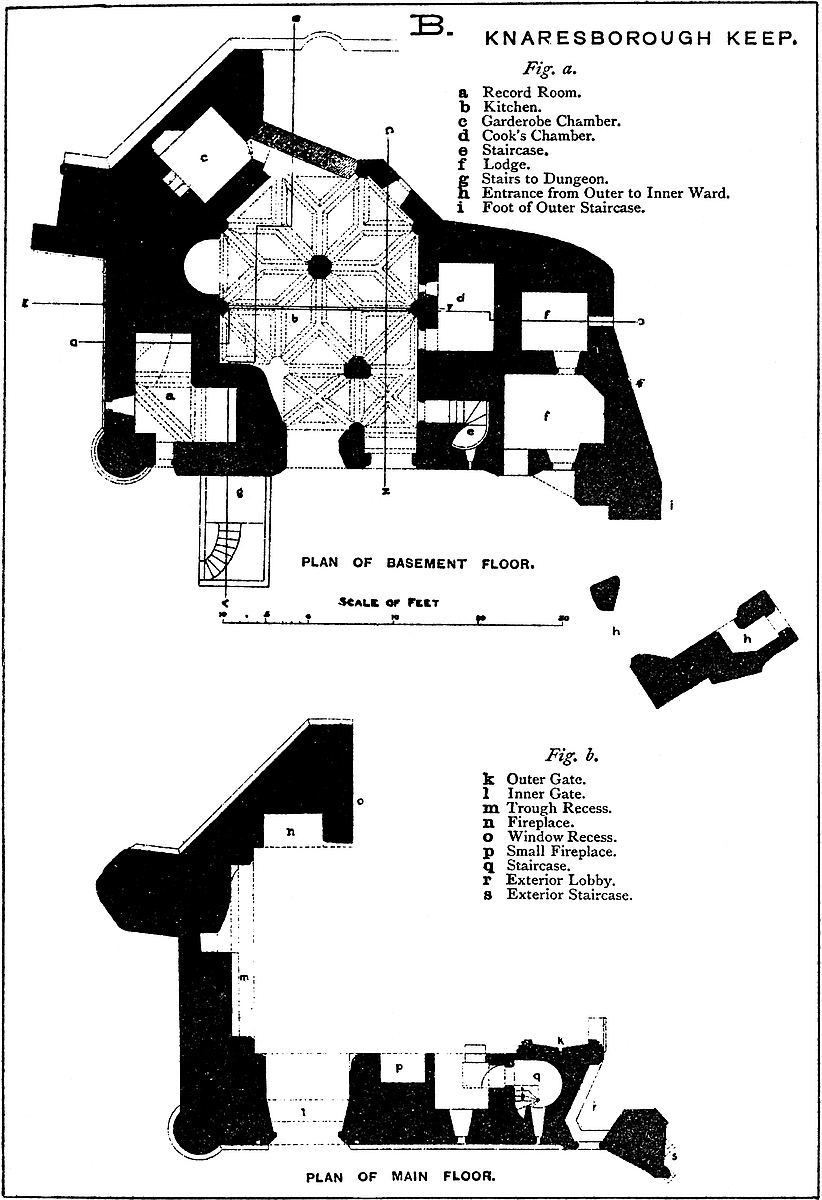
A second chamber, 8 feet by 9 feet, also vaulted, is placed in the north wall, and is entered by a small and much mutilated doorway and a short oblique passage. This chamber has a loop towards the ditch, and a garderobe, the outlet from which seems to join that from the dungeon.
The staircase is contained within the wall at the south angle of the chamber, and is lighted by two loops from the inner ward. It is entered from the kitchen by a small door opening into a straight passage, whence the well-staircase rises. This leads to both the first and second floor, and has a stone hand-rail carved in the wall. It is 2 feet 6 inches radius.
There remains only in the basement to be mentioned the Porter’s Lodge. [B. Fig. a.] It is composed of a couple of cells, at present occupied by the keeper of the castle. The outer cell is entered by a small door very near to the passage between the outer and inner ward. The hollow angle formed by the junction of the cross wall with the keep is crossed by a squint, or oblique arch, which supports a bartizan turret above, and affords a sort of hood over the door. The outer cell, vaulted, measures 12 feet by 9 feet. One angle is filled up. There is a small two-light window towards the inner ward. From this cell a door opens into an inner cell, 7 feet by 8 feet, also vaulted, and with a small window or sort of loop, now broken down, which is formed in the south-east wall, and seems to have opened beneath the first arch of the bridge which carried the ascending road from the outer ward to the level of the first floor of the keep.
The first or main floor of the keep presents its chief peculiarities. [B. Fig. b.] It is, or was, a rectangular chamber 24 feet 6 inches by 31 feet, and 19 feet high to the boarded floor of the room above. The north-west end, which is tolerably perfect, is wholly occupied by a segmental arched recess with a handsome moulding. It is 2 feet 9 inches deep, and contains a sort of table or shelf 2 feet high and of 1 foot projection, the upper part of which is hollowed into a narrow trough, as though for animals to drink from, had it been a little broader. It is much broken, so it does not appear whether it was provided with a feed-pipe and drain. What it was intended for it is difficult even to guess. The wall is broken, and within it is seen the flue from the kitchen fireplace below. Above, a weather-174moulding in the wall shows that at some time there was a low-pitched roof.
Of the adjacent north-east side only about 12 feet remains. It is chiefly occupied by a large fireplace, 7 feet broad by 4 feet deep. It was flat-topped and quite plain. The wall has been broken down and the flue is disclosed. Next south of this is the jamb of a bold arched recess which runs through the wall, 14 feet deep, and must have contained a large window opening over the ditch.
With the eastern angle is also gone the south-eastern side. Much of this must have been occupied by a large doorway, of which the south-west jamb remains, and its external and internal mouldings, in the Decorated style and of a very elaborate character. The wall was 10 feet 6 inches thick, and in its centre, half-way between the two moulded arches, is a rectangular portcullis groove. It is evident that this was a regular gateway, fortified in the usual manner, and, as what remains of the arch shows, of a large size.
The south-west wall, which is tolerably perfect, contains at its north end a door of the same size as that just described, saving that there is no portcullis, which, this being the inner gate, was not needed. The wall is here 11 feet thick, giving a very deep recess 10 feet broad, in which the doorway was placed. It is panelled and 15 feet high to the arch crown; the recess narrows to 7 feet 6 inches width, which was that of the doorway. The doorway is richly moulded, and the mouldings are continued down to the cill, showing that it was a door, and not, as some suppose, a window. There was, however, tracery in the head, of which a fragment remains, but not enough to show the pattern. In the jambs are a set of stanchion-holes, too large for the rods by which window-glass was usually supported, and which are evidently the remains of the bars inserted when the keep was used as a prison. The outermost hollow of the mouldings contains a band of delicate ball-flowers. There is also a handsome drip supported by two heads as corbels.
Outside the doorway, in the wall on either hand, are two square grooves 7 inches broad and about 6 inches deep, and 11 feet apart. They commence at the stringcourse, which corresponds with the cill of the doorway, and are 6 feet high. Above this, 10 feet 6 inches from the stringcourse, and 12 feet apart, are two similar grooves, 7 feet 6 inches long, and which, therefore, reach a little above the level of the top of the doorway arch. It is evident that these two pair of grooves were connected with the drawbridge, the lower pair probably receiving the ends of the parapet rail, and the upper the struts supporting the beams of the bridge.
Next to this door recess, in the inside of the chamber, is a small plain fireplace, placed in a tall pointed recess, like a doorway, and beyond this again is a lower recess, but broader, and also pointed, in which is a plain, square-headed window, 4 feet high by 1 foot broad, looking towards the inner ward. In the jamb of the recess is a side door, leading by a short passage into the well staircase from175 the kitchen, which also, at this level, has a loop towards the inner ward.
The floor of this chamber at present rises about 2 feet, or 1 in 26, from the outer to the inner gate. This, however, may be a modern arrangement, intended to carry off the water from the asphalt with which the floor has been paved.
Outside the outer gate of this chamber, towards the south, is a small mural chamber, lighted by a very handsome window, 2 feet 6 inches broad, with tracery in the arched head and a handsome drip-stone above, looking towards the inner ward. This chamber opens upon a sort of lobby, now mostly destroyed, outside the great gate, and provided with a small doorway of its own, fitted with a portcullis, and from this descends a small staircase with a ribbed and vaulted roof, which communicated with the lodge connected with the entrance from the outer to the inner ward. This was evidently a postern for such foot-passengers as came after the great gates were closed, and who did not wish to enter the main or guard-chamber of the keep. From this lobby ascended a well-stair to the upper story, rather larger than the other one, which was close beside it in the wall. The position of the larger staircase is marked by a sort of bartizan or projecting round turret, which commenced at the first floor level, and was lighted from the inner ward. Most of this is broken away, and only traces of it remain.
Of the upper floor but little remains save the wall towards the inner ward. In this wall is an excellent trefoil-topped window of one light beneath a square head. This is placed in a recess of the wall, vaulted and ribbed.
Near it a small door opens upon the head of the staircase from the lower floor and the kitchen. The other staircase from the postern is destroyed.
It appears from what has been described that the main floor of the keep was in fact a passage by which the principal entrance led from the outer to the inner ward. As the level of the first floor is 17 feet above that of the inner ward, and something more above that of the outer, the approaches were upon arches leading up to the gateways. The outer bridge no doubt was built against and protected by the curtain of the outer ward. That the road rested upon arches is evident from a trace of a skewback or springing stone below the gateway, and from the position of the window of the inner cell of the porter’s lodge. There is similar evidence of another bridge from the inner gateway down to the level of the inner ward, and excavation there would probably show the pier bases. How there came to be two fireplaces in what must have been the guard-chamber, and what was the use of the trough, are questions as yet unanswered. So far as I know, this is the only example of a main entrance so raised and carried through the keep. This keep is, in fact, a gatehouse.
There remains to be noticed the fragment of a building attached to the southern angle of the keep, and from which evidently sprang176 the wall which ran between the outer and the inner ward. [B. Fig. a.] This seems to have been an oblong, divided into two compartments. One, of which much of two sides remains, was 11 feet square, vaulted and ribbed, the fans spreading from the four angles. This was entered on one side from a small Decorated door of 2 feet 3 inches opening, which led into a bent passage. The face towards the inner ward seems to have contained a second small door, by the side either of a window or a larger door. From this chamber a door probably led, through the second chamber, now removed, to the base of the winding steps already mentioned as ascending to the eastern entrance to the keep. The designs of the mouldings of this appended building are peculiarly delicate and graceful, and well executed.
This keep is probably the latest example of a rectangular keep as well as a singular one of a keep with its main floor employed as a gatehouse. Its ornaments and details generally are in the late Decorated style, and of the reign probably of Edward II., though it is by no means likely that the work was due to Gaveston. Ashlar masonry is freely employed outside and inside the building, and the details throughout are admirable. It is probable that the addition of the solid buttresses to the curtain was the work of the builder of the keep. The masonry and material correspond. The portcullis grooves are alike, and the solitary stringcourse on one of the bastions is nearly, if not quite, of the pattern of that employed on the keep. It is much to be desired that the inhabitants of Knaresborough would obtain the castle as a promenade, reopen the ditch, or part of it, restore the bridge leading to the outer gate, excavate the foundation of the north-east angle of the keep and of the bridge covering the way into the prison, and check the progress of weather and exposure in the upper portions of the keep. A moderate sum would execute all that is required, and the result would add to the comfort and augment the attractions of the town.
LEEDS Castle is a very peculiar structure. It stands upon three rocky knolls, of which two are islands in a lake of 15 acres, and the third occupies the central part of the artificial bank by which, as at Kenilworth and Caerphilly, and in some degree at Framlingham and Ragland, the waters are or were retained.
The central and larger island is girt by a revetment wall, having half-round bastions, and rising about 15 feet out of the water. This was the wall of the outer ward. About 40 feet within, and concentric with this, are indications of the wall of the inner ward, which was about 8 feet thick and 20 feet high. At each end,177 connecting the two walls, and occupying the space between them, were the gatehouses, of which that to the south remains, and is a very curious structure. It represents, probably, a late Norman work; but its oldest recognisable part is a doorway of the time of Henry III., surrounded, however, by masonry apparently of that of Edward, his son. A bretache is mentioned in a Survey of 1314, but the present corbels overhanging the gateway, and upon which the timber work rested, appear to be of the age of Richard II., and probably date from 1386. The Constable’s room, placed in the rear, and at the level of the portcullis chamber, is entered through a doorway, the valve of which is original and peculiar, being composed of planks of a taper section, the narrow edge of one fitting into a groove in the back or broad edge of the next.
The domestic buildings occupied the north end of the two wards, and are replaced by a modern house, excepting only a vaulted cellar, which may be late Norman, and is certainly the oldest known masonry in the place, and a bracket which supported the ancient oven, and is placed near what (17 Henry VI.) is described as “Una coquina juxta pedem pontis de la Gloriet,” which kitchen was not long since removed.
In this ward also, or rather partly in this and partly in the outer ward, near a building of the age of Henry VIII., is a very remarkable bath,—“balnea domini regis apud Ledes,” as it is designated, which was constructed for the use of Edward I. in 1291–2. This is now used as a boathouse. It communicates with the lake by a passage in which are still seen the grooves for the portcullis, and the recesses for the oblique gates by means of which the water was retained or excluded. Mr. Wykeham Martin’s investigations of the accounts relating to this bath are very curious. The hundred Reigate stones, 2 feet square, which are there specified, just tally with the area of the chamber.
Thus far the castle is, or has been, a concentric structure, after the plan much in use in the latter part of the reign of Henry III. and throughout that of Edward I. Its peculiarities are caused by the circumstances of its position, and remain to be described. Of these the chief is the keep, or Gloriette, a shell of wall rising from the deep water around it to a considerable height, and containing apartments round a central court, an arrangement usual in Norman shell keeps. This shell contains the chapel, no doubt the “major capella” of the records, the kitchen, and amidst much work of the date at least of Edward I., more that is of that of Henry VIII., and even of recent date. This island is thought to have been the original stronghold of those who first appropriated the spot, but the oldest work now seen dates from Edward I., and the style of the chapel points to about 1280. It contains, however, an excellent low side window, open 17 feet above the water, probably an insertion by Richard II. There is also a postern at the level of the water, part of which appears old, as does an adjacent garderobe. The basement, by which the ground-floor is raised178 about 12 feet above the water, is solid, and probably very old, for no occupant of these islands for the purpose of security could have neglected this site. Edward, no doubt, remodelled this work with the rest of the castle, and possibly rebuilt the whole of the outer wall. Sir Henry Guildford, custos here for Henry VIII., seems to have removed part of the earlier building, and to have built a spacious hall, a large fragment of which is the present kitchen. During the reign of Charles II. these additions were much injured by fire, so that most of the buildings next the court are modern. Still the general type and arrangement was evidently preserved; and there is little doubt but that this structure represents a late Norman shell, if not an earlier Saxon house of timber. A handsome clock-tower, to which the term Gloriette is sometimes confined, contains a very early clock, and is of the date of Henry VIII., guarding the covered bridge which connects the keep with the larger island. This bridge is of two openings, and has two stories, and was originally a drawbridge, the pit being contained between the side walls, and dropping into the water. It is called in the accounts “pons gloriettæ.”
The term “Gloriette” is not of frequent occurrence, and its meaning has not been precisely defined.[1] It was first brought under notice in the ancient miscellanea of the Exchequer relating to Corfe Castle, amongst which Mr. Bond cites a document dated 8 Edward I., that mentions “Camera que vocatur Gloriette.”[2] It was probably like “Butavant” and “Cocaygne,” one of the towers of the enceinte of the castle, and may have been of somewhat greater elevation. Scarcely any vestiges remain. The name seems sometimes to denote the whole of the buildings near the Queen’s Tower and Hall; in that part of the castle there existed a chapel called the chapel of the Gloriette. It appears that the Gloriette tower at Corfe was newly built by Richard II., about 1379.[3] Amongst the conventual buildings also of Christ Church, Canterbury, there was a “New Lodgyng, juxta antiquam Priorum mansionem vocatam Le Gloriet.” Professor Willis informs us that it was the upper chamber at the north end of the range of buildings, known as the “Privata Camera,” or “Prior’s Mansion.”[4] A building on an elevated spot in the palace grounds at Schönbrunn, commanding an extensive view of Vienna, is called “La Gloriette.”
179
The third great division of the castle, also very peculiar, is the barbican, or tête-de-pont, which is placed on the counterscarp of the lake, here reduced to 50 feet in width, and at the outer end of the bridge which carries the road of approach into the great island. It is composed of three parts, which were isolated by three wet ditches, of which one is the river Len, and having three entrances, one from each wing of the dam, and one, the main one, central, from the south. Each approach had its drawbridge, gateway, and portcullis, and the three met upon a small central plot, open towards the fortress, and whence sprung the bridge leading up to the great gateway. This is the bridge that was broken down by the great horses and heavy wagons of Aymer de Valence. It is of two arches, the inner of which was open between the parapets for the pit of the drawbridge. One division of the barbican contains the mill, a strongly-fortified building, in advance of which were the barriers which are known to have covered the southern approach, and to have been standing in 1385. They were no doubt mainly of timber, though there are traces of foundations in masonry. This triple composition of a barbican has not been elsewhere observed. The object of its lateral gates was the defence of the dam, which might otherwise have been mined and cut through. Also those who came either from the east or the west could only have reached the south gate by a wide detour, for the causeway along the dam was defended on the outside as well as the inside by water, the lake to the south-east being of large area, and known as the “stagnum exterius,” while, to the south-west, was a deep watercourse and marsh formed by the Len.
The late Mr. Wykeham Martin, whose investigations of his hereditary fortress were a labour of love, seems to have established firmly, on sound critical grounds, the date of its several parts. He shows the high probability of its occupation by at least a Saxon lord, and the changes it has undergone from the Crevecœurs, Leyburns, and the Plantagenet and Tudor monarchs, who, from Edward I. to Edward VI., held it in possession.
Like many Saxon strongholds, Leeds is thought to date from the ninth century. It was held, probably by a Norman arrangement, by castle-guard tenure under Dover. To Bishop Odo, who obtained it at the Conquest, is attributed some Norman work in the church, but the earliest masonry in the castle, probably represented by the curious vaulted cellar, is thought to be the work of Robert de Crevecœur, who founded Leeds Priory in 1119, and afterwards removed three canons into the chapel of his castle. A later Robert shared in the defeat of Lewes, and was in consequence obliged to yield up Leeds in exchange with Roger de Leyburn, a powerful Kentish baron, father of that William whose unscrupulous boldness is well described in the Roll of Caerlaverock, which designates him as “A valiant man, without ‘but’ or ‘if.’”
Out of the disputes between the dispossessed and the dispossessor Edward seems to have established a title by the strong hand. He180 gave to the fief the character of a royal manor, was a frequent visitor at the castle, and appears to have completely remodelled the fortress of the Crevecœurs, giving it the aspect which in many points it presents at this day. By Edward it was settled upon the queen, part of whose funeral charges were incurred here in 1291. Here also the king founded a chantry in the castle chapel for her soul’s health, and it was about this time that he caused the bath to be constructed.
Upon Edward’s second marriage Leeds was again settled upon his queen, and for several reigns this continued with some exceptions to be the practice. It was also much used for the reception of visitors of distinction who rested here on their way from Dover to London.
In 1321 the king’s defences were put upon their trial. The castle seems to have passed by an exchange to Bartholomew de Badlesmere, a great lord, who in 1321 was away in the North plotting with other barons the fall of Despenser, while his wife and children remained in the castle, the Constable being a certain Walter Colepeper.
One night in midsummer, Queen Isabella, with a large retinue, presented herself at the gates demanding hospitality. The Constable, dreading her designs, boldly refused it. “Nor queen, nor any other, should enter without his lord’s order.” The “She-wolf of France” ordered an instant attack, in which several of her people were killed, whose skeletons, bearing marks of violence, have recently been discovered before the barbican. The attack failed, and her Grace had to lodge as best she might outside. Of course, this event had its consequences. The king proclaimed a levy en masse through four counties and raised besides the “posse comitatus” of Kent. The muster place was Leeds Castle, the day the 23rd of October. Thither at the appointed time came the king and his brother and a large force, the command of which was given to Aymer de Valence, who pressed the siege vigorously. Badlesmere attempted a diversion, also by the display of a force, much inferior, however, in numbers, at Kingston, where he was on the 28th of October. All attempts at a negotiation between Badlesmere and the king failed. The castle held out till the 1st of November, when this, its only known siege, ended in a surrender, apparently to the king in person. The brave Constable and twelve others were hanged, and Lady Badlesmere and her family committed to the Tower. It was thought that the execution of Badlesmere himself, when taken afterwards at Boroughbridge, was partly in revenge for his having, in writing, sanctioned Colepeper’s resistance.
Edward, having thus recovered the castle, was frequently there, his last visit being on the 15th of June, 1326.
Edward III. settled the castle upon his queen, and it was placed with other royal buildings under the surveyorship of William of Wykeham, who in 1359 seems to have laid out £16. 6s. 8d. upon it, of which sum £5 went to replace glass windows blown in181 by a hurricane, 24s. to repair Aymer de Valence’s injuries to the bridge, and 70s. was spent upon the old chapel. In 1367 occurs a curious charge for habergeons, basnets, and other harness for a body of archers, for materials for making armour, and for the carriage of two beds from Leeds to Canterbury for the use of the Count of Flanders, and of six to Leeds from Sittingbourne. The castle cannot boast of any attentions from Edward III. in person.
Leeds formed a part of the settlement of Anne of Bohemia, the queen of Richard II., who was himself much here. A list of the military stores of the place in 1385 is preserved, and includes the following curious items relating to the defences of the great gate or barbican:—“Duas portas nudas vocatas portes colys, et viginti pikes cum viginti platis de ferro, quatuordecem platas de ferro longas, viij platas de ferro curtas, centum sexaginta et quinque clavos de ferro pro eisdem portis dictis portes colys novo ferrando, unum circulum ferreum pro barreris juxta molendinum, unum magnum crowe, unum parvum crowe de ferro, unum magnum slegge, unum parvum slegge, unam magnam cathenam, unam parvam cathenam, sex forcipes, unum vertinuel, sex vyles, unum cable, unum nayltol,” etc. The “nudæ portæ” were, of course, open timber gratings upon which the iron was to be plated. The barriers near the mill show them to have been in advance of the centre entrance, and the crows, sledge hammers, chains, and files would all be necessary for the setting up of portcullis or drawbridge.
Ten years later, 15th of July, 1395, Richard from hence despatched the proxies who were to plight his troth to the French king’s daughter, and at the same time received a visit from Froissart, who was a great favourite, and accompanied the king to Eltham, where he was to discuss the French match with the magnates of the realm.
It was also at Leeds, and at the same time, that Richard signed two mandates, one for the expulsion of the Lollards from Oxford, and the other directing the University to sit in judgment upon the “Trialogus” of Wycliffe. Leeds was also one of the places to which Richard was carried after his deposition.
Henry IV. was at Leeds in 1401, but he seems to have granted the castle to Archbishop Arundel, who thence followed up Richard’s edicts against the new heresy, by citing in 1413 Sir John Oldcastle to appear before him in “the greater chapel of Leeds Castle,” where also, on his non-appearance, he passed upon him for contumacy the sentence which led to his martyrdom in the following reign.
In that reign, 4 Henry V., 1416, Leeds gave hospitality to the Emperor Sigismund on his return from London to Dover, when its resources must have been taxed to house the very splendid retinue provided for him. Two years later a royal but enforced visitor here was Joan, mother of the Duke of Brittany and stepmother to the king. Her stay at this time as a prisoner was short, but she resided here after her liberation in the next reign.
On the accession of Henry VI., Katherine of Valois was put in182 possession of Leeds, but Henry was there in 1436–1438, and ordered certain repairs to the roof of the keep. In 1441, Duchess Eleanor of Gloucester was tried for sorcery in the chapel by Archbishop Chichele.
Under Edward IV. Leeds ceased to be assigned to the queen consort, and remained vested in the king, but the castle was no longer visited by royalty, and seems to have been allowed to fall into decay until the reign of Henry VIII., under whom Sir Henry Guildford resided here, and seems to have made considerable alterations, especially in the keep.
Edward VI. alienated Leeds from the Crown in favour of Sir Anthony St. Leger about 1550, whose descendants, after 1618, sold it to Richard Smith of the Strangford ancestry, whose heir, after 1631, resold it to Thomas Colepeper of the family of the former constable. The Smith occupation was marked by the construction of a handsome Elizabethan mansion at the north end of the larger island. The Colepepers, created barons in 1644, farmed the castle, in 1655, to the Government for the safe keeping of about 600 French and Dutch prisoners, under the general charge of John Evelyn, who records himself to have “flowed the dry moat, made a new drawbridge, and brought spring water into the court of the castle to an old fountain.” The prisoners, however, much damaged the building and set fire to part of the keep.
The Colepeper heiress carried the estate to her husband Thomas, fifth Lord Fairfax. Robert, the seventh lord, repaired the dwelling-house and laid out the park, and here, in 1778, entertained George III. and his queen, the latest of very many royal visits to the place.
Lord Fairfax left the castle to his sister’s son, Dr. Martin, known later as Dr. Fairfax, who died 1800, and was succeeded by his brother, General Martin, on whose death, in 1821, it descended to Fiennes Wykeham, representative of the younger branch of the Wykehams of Swalcliff, where they held lands as early as the Domesday Survey, and whose son, Charles Wykeham Martin, was the author of the history of the castle.
THE town of Leicester stands upon moderately high ground, and on its western side is divided by a narrow valley from the opposite elevations of Glenfield and Braunstone. This valley gives passage to the Soar, the river of the county, which, flowing northwards, meanders through the meadows of the Abbey of St. Mary de Pratis, and thus, before agriculture had drained these183 lands, securely covered the western and northern, and, to a certain extent, the southern fronts of this very ancient and once well-fortified place.
Down the western valley, but outside the stream, and along the edge of the higher ground, was carried the Fossway, which thus, on its passage from Bennones or High Cross towards Lincoln, left the old Roman “Ratæ Coritanorum,” known to us as Leicester, about a furlong to its east.
Whether Ratæ be an original Roman, or a Latinised British name, is uncertain. Ratcliffe and Ratby occur in the district, and at the latter is a large camp of doubtful origin. Upon the language to which “Rat” belongs, depends the question of the British origin of the town.
Ratæ, if not founded, was occupied and fortified, by the Romans. The line of the wall, on the usual rectangular plan, has been traced upon the north, south, and east sides, the western defence being formed by the river, and both city and suburb are fruitful in pavements and other Roman remains. There is, however, some doubt as to whether the wall actually reached the water at the south-west angle. If, as is supposed, though upon very insufficient evidence, the fragment of Roman masonry known as the Jewry wall was really a part of the town wall, it follows that the wall was present on the west side, and there was a space between that defence and the river, and that the castle, which occupies the south-west angle, was outside the town.
Ratæ, under the name of Leicester, was also a town of great importance among the Saxons, and was nearly central in the kingdom of Mercia. It is mentioned in a Saxon charter of 819, and is said to have given the title of earl to Leofric, A.D. 716, to Algar in 838, and to other Algars and other Leofrics, and to Leofwin, the Saxon line ending with Earl Edwin, who was slain in 1071. The town, during the Danish interregnum, was one of the five burghs; and the castle, like those of Tamworth and Tutbury, is said to have been either founded or restored by Æthelflæd in 913–4, though for this solid evidence is wanting. Nevertheless, that Saxon Leicester was the seat of a very important earldom is very certain, and the residence of the lords was most probably the castle.
The town and castle were placed by the Conqueror in charge of Hugh de Grentmaisnil, lord of the neighbouring Honour and castle of Hinkley, where also is a fine mound; and whose son Yvo was vice-comes of the county under Henry I. The actual property of the Grentmaisnils, in Leicester, was one-fourth of the town; but it does not appear how this and much more of the other parts were acquired by Robert de Bellemont, Earl of Mellent, who became Earl of Leicester, and died 1118, in possession of the castle and Honour. “Juxta et infra castellum,” which may conveniently be rendered, “outside, but just beneath the castle wall,” was a collegiate church, of Saxon foundation, dedicated to St. Mary. This Robert was probably the builder, between 1106 and 1118,184 of the castle, including the hall, the chapel, and a tower upon the mound.
Robert Bossu, the second earl, took the part of Henry I. He strengthened and enlarged the castle. He was the founder of St. Mary de Pratis, outside the town; and, to endow this, he diminished the ecclesiastical staff, and diverted some of the lands from his father’s foundation by the castle. He died 1167.
Robert Blanchmains, his son, the third earl, married Petronilla, the heiress of the Grentmaisnils, his predecessor at Leicester, and with her obtained Hinkley, Groby (where also is a mound), and other possessions. He is reputed to have enlarged and strengthened the castle, and his constable, Anketel Mallory, held it against Henry II. until he surrendered it by the earl’s command. Also Mallory surrendered, on the same day, the castles of Groby and Mountsorrell. Both castle and town were taken, the town wall was demolished, and it is said that the part between the north and east gates was never rebuilt.
Robert Fitzparnell, the fourth earl, died childless in 1204, when Leicester Castle, and in 1206 the earldom, came to Simon de Montford, who had married Amicia, his sister and co-heir. Upon the death at Evesham of their son Simon in 1264, and his attainder, the earldom and castle were granted to Edmond, second son of Henry III., Earl of Leicester and Lancaster, and the castle has since descended with the Lancaster property, and is still a part of the duchy of that name.
Henry, Earl of Lancaster and Leicester, founded the Hospital of the Newark contiguous to the castle in 1322, and the works were completed by Henry, his son, Duke of Lancaster, in 1354. The hospital contained four acres. It reached the river, and covered the castle on the south side, and at this time one approach to the castle is across the Newark, through its handsome gatehouse.
The earls and dukes of Lancaster must have restored the castle, as they resided here very frequently, and with their usual display. When John of Gaunt granted certain privileges to the city in 1376, he reserved the castle and its mill, and the rents and services of the castle court, and its office of porter. In the castle he entertained Richard II. and his queen with great splendour in 1390.
In 1414, when Henry V. held a Parliament in the hall of the Grey Friars, he resided at the castle, and it was in the great hall of the castle that was held the Parliament of 1425–6, the Commons meeting in an apartment below it, which, however, could scarcely be the case literally, as the hall is on the ground level. It is just possible that the modern brick vaults and cells constructed under the floors of the hall for the purposes of police may replace an older substructure, into which opened the existing cellar.
Henry VI. was here in 1426, and in 1444 the castle and Honour were included in his marriage settlement. In 1450 a third Parliament was held at Leicester, but whether in the castle hall is not recorded. Edward IV. was here in 1463 and 1464, but from this185 period the castle seems to have been neglected, and to have fallen into great decay.
Leland, who visited Leicester about 1512, says,—“The castelle stonding nere the west bridge is at this tyme a thing of small estimation, and there is no apparaunce other [either] of high waulles or dykes. So that I think that the lodgings that now be there were made sins the tyme of the Barons’ war in Henry III. tyme, and great likelyhood there is that the castelle was much defaced in Henry II. tyme, when the waulles of Liercester were defacid.” (Itin., i., p. 16.)
Speed gives a rough perspective view of the castle and town, which, however, is very indistinct as regards the former. In 1633 Mr. Herrick, of Beaumanor, was directed by the king to remove the ruinous parts and sell their material; to repair the castle house, which contained the records of the Honour of Lancaster, and to preserve the vaults and stairs leading to it, for the use of the keep of the castle. Upon this an inquisition was taken in 1633–4, and the value recorded of the materials, “excepting the Sessions Hall and the vault under the old castle, and the stairs leading to it.” This inquisition gives several details, chiefly of parts now removed; and mentions as to be repaired “John of Groat’s kitchen, divers outhouses belonging to the Great Sessions Hall, and the ruinous pieces at the south end of the same hall; also the south gate, and the wall from this gate to the Soar, which divides the castle from the Newark; also a wall next the porch of the church.” By “keep” is no doubt meant the hall. The south gate and wall to the Soar remain, as does a wall next the (south) porch of the church.
In the civil wars, the castle was held for the king. It then fell to the Parliament; was retaken by the king in 1645, and finally yielded to the Parliament after Naseby. In the struggles the south gate was probably reduced to its present ruined condition.
In 1781, Mr. Rogers Ruding had a lease of the premises from the duchy, which specifies the south gate evidently that remaining towards the Newark, the castle house, several tenements, the mount, and the appendages to the castle, and stipulates for the holding of sessions in the great hall.
The castle stands at the south-western angle of the town, upon ground close to, and about 20 feet above, the right bank of the Soar, the three channels of which unite below the castle. The nearest of these streams is the artificial leat which supplied the castle mill, and does still supply its modern representative. From the line of the castle wall the ground slopes rapidly, and terminates in a strip of level land that forms the margin of the mill leat, therein closely resembling the river front of Taunton Castle on the Tone.
The castle seems to have been composed of a mound on its south-west quarter; a hall and other buildings on the west or river front; the church of St. Mary de Castro opposite to the hall; and on the east side a gatehouse between the church and the mound; another gatehouse close north of the church, and a wall which runs east of186 the church, and forms a part of the eastern boundary of its churchyard. There is also the mill which, though modern, covers the ancient site.
The area within which these remains are included is known as “The Castle View.” This evidently represents the precinct of the Norman, and probably of the Saxon castle, and has been preserved as a distinct and, in part, extra-parochial district, vested in the duchy of Lancaster. The Castle View is nearly square, and may include four or possibly five acres. In 1861 it was returned as “The Liberty of the Castle View,” and contained 29 houses and 131 persons. The boundaries are the line of the ancient circumscribing ditch, or nearly so. On the south they divide the castle from the Newark, just including the mound. On the east they take the line from the present south gatehouse, by the old wall, and thence by the edge of the road down to the mill, including the house and garden attached to the Sessions House. The ditch is everywhere filled up, but in the garden north of the Hall the line of the wall is marked by a step of from 8 to 10 feet.
This line includes St. Mary’s, which was once the collegiate church or chapel of the castle. If it be that the castle was enlarged by Robert Bossu, it is probable that the older defence just excluded the church, and took the line of the present upper gatehouse, cutting off the churchyard and church, and placing the latter “juxta et infra” the castle wall. St. Mary’s was made parochial in 1400, the rest of the View remaining extra parochial, and it is not impossible that this was a restoration to the church of its ecclesiastical position before it was included within the Norman military precinct.
The mound, though broad, is at present less lofty than is usual in the more important Saxon castles, having been lowered 40 years ago by 12 or 15 feet. It is now about 30 feet high and 100 feet diameter upon its circular top, which is quite flat, without a trace of old building upon it. It has now no ditch, and is connected with no ancient wall; but, though probably within the ancient enceinte, it may, as at Warwick and Tamworth, have actually formed a part of it. The original well still remains in the mound and is in use.
The present hall was a part of the castle proper. It is an oblong structure, like Oakham and Winchester, composed of a nave and two narrow aisles. The nave lies north and south, and is about 60 feet by 25 feet, having gables at either end, and an open high-pitched roof. Since 1633, and perhaps earlier, it has been used for judicial purposes, and divided into three parts,—a civil and criminal court, and between them an entrance lobby, and above it a grand-jury room. To enlarge the courts, the old oaken posts or piers, with carved Norman caps, have been removed, the east aisle rebuilt or cased, and the west aisle walled off for retiring-room and passages. Its older parts also are concealed by panelling and partition-walls. The original south wall of the nave remains. In it are two round-headed windows, resting upon a string-course, or187 set-off in the wall, with a plain chamfered moulding. The windows are small and plain, and the recesses have but little splay. These are flanked by two slender detached octagonal shafts, possibly replacing cylindrical ones, with Norman capitals, and the head of each recess is surrounded by a single bold band of chevron moulding. There is a third and small window above, near the apex of the gable, with a recess of about 2 feet opening, all quite plain. Below is a small Norman door, but apparently a very recent insertion. It may, however, represent a way into the kitchen, which was at this end.
The opposite or north end wall, forming the side of the civil court, appears also to be old, but is so plastered and pointed as to be inscrutable from the inside. It contains a large round-headed window, probably a modern insertion. From the outside the base of the wall seems original, and there is the jamb of a window in end of the east aisle.
The wall of the west aisle, towards the river, is original, and is flanked at each end by a buttress, probably of Decorated date. In drawings of the last century this building is shown as an aisle, but it has been raised, and now forms a judge’s retiring-room behind each court, and a staircase between them. In the basement are offices. This aisle contains one original window near the south end, flat pointed, with plain jambs, and a head adorned by a single chevron band. The jambs have been renewed in brick.
The hall-floor is on the ground level, but it has been largely excavated, and now contains a number of cells and vaulted passages to them beneath the court. These vaults show nothing ancient.
Until recently there were some small inferior buildings at the south end of the court. These are now replaced by a barristers’ room. The kitchen stood here till 1715, when it was removed. Beneath the site of the kitchen is a very fine vault, perhaps 40 feet long by 15 feet wide, the west wall of which is the original outer wall of the castle. The vault is of excellent ashlar, slightly four-centred and evidently Perpendicular work. At the north end is a door, now walled up, steps beyond which led up to the hall. At the other end is also a door. This was evidently a cellar and a fine one.
In the garden north of the hall, no doubt, stood the principal apartments of the old castle. Here was the Castle House of the seventeenth century. Norman rectangular keep there was certainly none.
The gatehouse towards the Newark opens from the castle, its front being outwards. It is small, having a portal passage, a lodge, and a turnpike stair, and on the upper floor, now a ruin, a portcullis chamber, and two other rooms. Its arches are four-centred. It has the broad hollow moulding of the Perpendicular period, and a square portcullis groove behind the outer entrance. Within was a door, opening inwards. The central part of the portal was boarded188 over. The structure is good, very early Perpendicular, the work, no doubt, of an Earl of Lancaster.
The upper or north gatehouse is framed of timber, and probably of Tudor date. It stands close north of the west end of the church, with which it was, until recently, connected by certain timber houses, used by the prebendaries. These have been pulled down.
Parts of the church are Norman, and the north aisle seems of the date of the hall of the castle, and, therefore, a part of the work of Robert de Bellomont. There is a small door in the west wall of the aisle, that may very well have opened from the base court of the castle.
In this court, in front of the hall, is a small knoll, in which were recently found two skeletons, headless, the head placed on the breast of each. This was, therefore, the place of execution in front of the hall of trial.
Should the Courts of the county of Leicester ever be lodged in a more central or more convenient building, it is to be hoped that the castle hall will be divested of its unseemly additions, and restored to its original dimension and pattern, when, probably, some correct information would be discovered as to the vaults and foundations of the buildings of the eleventh century.
Leicester Castle, mutilated as it is, is yet a very fine specimen of a Norman fortress on an earlier site. The latter represented by the mound, the former by the hall and chapel, form together a good example of the Norman practice of placing the castle proper on the level ground, and treating the mound as a part of the external defences.
Too much praise cannot be bestowed upon Mr. William Napier Reeve, the deputy constable of the castle, for his care of the hall intrusted to his charge. The bâton used on all solemn occasions by the Constable or by himself is part of one of the original Norman posts that supported the roof of the nave; and the post, from its great size, must certainly have been an old tree when the castle was built, and therefore have been in growth when the mound, the work of Æthelflæd, was thrown up.
THIS castle, the lords of which played a considerable part in the earlier troubles of the thirteenth century, when two of the name were summoned as barons, stands by the road-side near its parish church of the same name, between Snodland and West Malling, in Kent, and at no great distance from the ancient Neville seat of Birling.
189
The building, judging from its present remains, is scarcely in keeping with the wealth of its late lords, nor does it appear ever to have been more extensive. Part of the walls may be of Norman date, but the general aspect is of the date of Henry III., and the gateway may be of Edward III.
The most perfect portion is the gateway, a pointed and ribbed arch, which opens between two bold drum towers, placed unusually close together. Above the portal is a slit or chase, about 3 feet wide and 6 inches deep, pointing downwards and outwards, and much resembling a large post-office opening. The narrow dimensions of this opening, its straight sides, and thickness of the wall, would prevent its being used for the casting down of projectiles, and even as a horizontal loop its range would be very limited. It may possibly have been intended for the pouring down of water, supposing the outer gate to have been assailed by fire.
A little in advance of this wall, on either side of the doorway, is a portcullis groove, rectangular instead of a half round as usual; and these grooves, instead of ascending as a chase or slit in the entrance vault, placing the grate when lifted nearly out of sight, ascend in front of the door to about double its height, so that the grating would always be entirely visible, whether down or up. The chains by which it hung, also visible, ascended through a machicolation at the rampart level, formed by throwing a flat segmental arch from tower to tower, parallel to and about 18 inches in advance of the gateway and wall above it. This arrangement, seen at Neath and elsewhere, enabled stones or heavy projectiles to be dropped with but little risk to those employing them.
In advance of the portcullis grooves, two lateral holes at the level of the door-cill show where the pivots of the drawbridge rested. Bridge pit and moat are now filled up. The rear parts of the gatehouse and entrance vault have been destroyed.
The irregular outline of the castle may be traced, and two detached groups of ruins, with a couple of drum towers, remain; but there is nothing of any special interest excepting the gateway and its defences.
WHEN “the devil looked over Lincoln” he is said to have smiled at man’s costly devotion. But if the smile of the arch-enemy of mankind was, as must be supposed, in derision of man’s attempts at progress, the occasion of it was singularly ill-chosen, for in the whole of Britain it would be difficult to find a tract for the well-being of which man has exerted himself so much and so successfully. Two thousand years ago, that broad but not190 unbroken plain which extends from the Wash to the Humber, from the Trent and the uplands of Nottingham and Derby to the German Ocean was composed of arid heath and moorish fen, contributing little to the material support of man, and probably nothing to his moral culture. Beasts of chase, fish, and water-fowl shared the territory with savage hordes, but little removed from the animals upon which they preyed. By slow degrees, by many generations of men, labouring through many centuries, great things have been achieved. The fen has been banked and drained, and the heath brought under culture, so that the whole expanse is now covered by green pastures and rich root crops, and year after year the autumnal sun is reflected from broad fields waving with golden grain.
Nor has the moral been behind the material progress. From the castled hill of Belvoir, to the rocks of Newark and Nottingham, and the crowned promontory of Lincoln, the land bristles with the works of man. The constructive taste and skill of many generations, and their deep religious feeling, are represented by a rich variety of ecclesiastical architecture, from the rude and primitive tower of Barton to the lordly spires of Louth and Newark, and the glorious lanthorn of Boston; churches and schools, mansion-houses and granges, “tower and village, dome and farm,” are unmistakable evidences of peace, prosperity, and civilisation. There, too, are to be seen, not sparingly scattered, the sunken arch and ruined aisle, the ivy-covered remains and richly-carved fragments of many religious houses, making pleasant the study of hoar antiquity, and reminding us that there was a time when each was a centre of gospel truth, and of an early and beneficial civilisation, the abode of men who did good work in their day, and founded by those who—
Something of all this is visible to mere mortal ken, and far more to him who adds to the material prospect a knowledge of the past and the distant. It is true that the vision thus beheld from the guarded mount of Lincoln is not equal to that far wider and more noble outlook from a more exalted pinnacle, upon the description of which Milton has poured forth in one glittering roll the full stream of his learning, illuminated by the fire of his genius, but it is nevertheless one in which the student of the past may well take delight.
Lincoln itself is thickly strewed with the footsteps of the past. The Briton, the Roman, the Saxon, the Dane, the Englishman, and the Norman, have successively been lords of the soil, and each has left his mark, either in material traces or in a nomenclature still less liable to decay. A great historian, our chief authority also in matters of topography, has pronounced the earthworks to the north of the city to be of British origin. If this be so, they must be the work of those Romanised Britons who attempted, though in vain, to hold their country against the Picts and Scots, and the Scandinavian191 hordes from beyond the German Ocean, and who, while so striving, showed some considerable acquaintance with the Roman rules of castrametation, though unequal, it would seem, to the works in masonry for which that people were so celebrated. The conclusion that these earthworks are, if not Roman, early post-Roman British, rests upon the fact that their outline is rectangular, and that the enclosure is bisected, nearly equally, by the Roman way.
Of the earlier Britons, those dispossessed by the Romans, the traces are slight indeed, and probably confined to a few nearly effaced intrenchments, and to the roots of such proper names as “Durnomagus,” “Segelocum,” “Banovallum,” on the Bane river, and “Lindum,” names which probably, like “Eboracum” and “Londinum,” represent an earlier appellation. The mound at Riseholme, if sepulchral, may, of course, be of any age; but the district, possessing but few of those grand features which are usually the earliest to receive their names and the latest to lose them, has retained no very obvious traces of its primal inhabitants.
Of their successors, the remains are of a very different character. The imperial mistress of the world left everywhere traces of her sway not easily to be obliterated. Her measures of war were also calculated—“pacis imponere morem.” From the station at Lindum great roads radiated in several directions, and preserved that facility of communication which civilised conquerors usually seek to establish.
In the modern city of Lincoln, the Roman Lindum is well represented. The Roman walls, 10 feet to 12 feet thick, and 20 feet to 25 feet high, included a nearly rectangular area, within which was the high ground of the upper city. Of this enclosure, the northern or upper end was cut off by a cross wall, and formed the military quarter, 385 yards north and south, by an average of 517 yards east and west. Of the four gates of the station, that to the north, upon the Ermine Street, still bears a name which must have descended from the time when it was first erected, and when it probably superseded an earlier structure, and is called the New-port. Of the opposite, or south gate, only one jamb remains. Of the east gate, the place is known, and a few of its very peculiar stones are built into the adjacent enclosures. The west gate was laid open a few years ago, but, as the arch gave way under the process, it was removed. Of the walls which connected these gates, some fragments remain. One lies west and another east of the north gate, and there is a considerable mass south of the north-east angle, capping which, the foundations of a round tower, of 9 feet interior diameter, have been discovered. There is also a fragment of wall in the slope of what is called the observatory mound, a little west of the remains of the south gate. The exterior ditch, also more or less Roman, is in parts very perfect, broad and deep along the north front, and, though narrower, deep and well preserved about the north-east angle. There is also, within the area, the side wall and part of the front of a considerable building, known, probably192 from its mediæval use, as the Mint. The exterior Roman walls are laid upon the natural ground, although the earth is heaped up against their inner face as a ramp or terrace.
The southern half of the Roman station is divided between the cathedral and the castle, the church, though the later occupant, taking the larger half. Some centuries, however, must have passed between the departure of the Romans and the throwing up of the earthworks of the castle, during which time the Roman walls were broken down, and their contained buildings laid waste, as is shown by the dilapidated condition of those remaining parts which have been found buried beneath the castle works.
The English fortress is placed within the south-west quarter of the Roman station, and its outline, roughly four-sided, was no doubt governed by the lines of the two adjacent Roman walls. It stands on the crest of the steep slope, covered, as in Roman days, by the city, and descending about 200 feet to the river. It is contained within a massive earth-bank, from 50 yards to 80 yards broad, and from 20 feet to 30 feet in height, internally of easy slope, externally steep, and which, though in substance within the Roman area, extends its skirts beyond the line of the wall, so that the Roman west gate was found buried within its substance, and a fragment of the south wall is still seen to rise through its slope. This bank measures, upon its north face, 180 yards, upon its south face 170 yards, its east 134 yards, and its west 163 yards. Here, as at York, it is evident not only that these earthworks are of post-Roman date, but that the Roman walls were completely ruined before the earthworks were thrown up. The enclosure may contain from 6 acres to 7 acres. At the south-east angle the bank swells into, and ends in, a large conical mound, about 40 feet high, and 50 feet diameter at the top. Besides this, there is a second and larger mound, about 40 feet high, and 100 feet diameter at the top, which was the citadel or keep of the place, and the site of the hall of its English lord. This mound, though near the centre of the south front, was not a continuous part of the regular earth-bank, which it here replaced. It had its own proper circular ditch, communicating on the outside with, and forming a part of, the regular ditch of the place, as is yet evident, notwithstanding much filling up.
It will thus be seen that Lincoln Castle, as regards its earthworks, belongs to that type of English fortress in which the mound has its proper ditch, and is placed on one side of an appended area, also with its bank and ditch. The general area, which at Windsor, Arundel, and Berkhampstead is oblong, to suit the contour of the ground, is here, as at Tonbridge, Tickhill, and Clare, where the ground is not strongly marked, nearer to a more solid figure, of which, in this case, two sides and the contained angle are governed by the line of the old Roman wall. In general, these fortresses are much alike, and all belong to that class of burhs known to have been thrown up by the English in the ninth and tenth centuries, and at about the same time by the Scandinavian settlers in Normandy. 193Two mounds, though not unknown, are uncommon. At Lewes there are two, one at each end of an oblong enclosure. At Hereford, besides the keep mound, now removed, there is a mass of earth at the north-east corner of the outer area, a part of the bank, and at Cardiff also, besides the keep mound, are two masses of earth upon the north-east and south-east corners of the enclosure, forming, which there the keep mound does not, a part of the bank. Such subordinate mounds are not uncommon in earthworks of all ages, and are totally distinct from the grand isolated moated mound which gives character to the earthworks of the ninth and tenth centuries, both in England and Normandy.
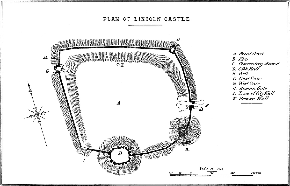
When, in 1068, the Conqueror marched from York to Cambridge, he paused at Lincoln, even then a very important place, fenced in and populous, not indeed as yet boasting a minster, but numbering 1,150 inhabited houses, a leading member of the famous Danish civic confederation, and governed by twelve lawmen, who wielded powers elsewhere exercised by the territorial lords. As he traversed the intrenchment that covered the northern front, and entered the city through the strong Roman gateway, still in use, he could not but appreciate the strength and importance of the place, of which he seems to have been allowed to take peaceable possession. Here, as at York and Cambridge, he at once ordered the English stronghold to be converted into a Norman castle. What was the precise condition of the existing work, or what was immediately executed in obedience to William’s order, we do not know; there were, of course, defences, probably of timber, along the crest of the banks, and upon the summit of the mound, but whether William merely directed these to be strengthened, or had them replaced by walls such as were coming into use in Normandy, does not appear; probably the former: as time pressed, and there was much work of the same kind to execute all over England, it was important to secure an immediate shelter for the Norman garrison. That the 166 houses which, we learn from Domesday, were destroyed to make way for Lincoln Castle were not removed to allow of the extension of its area is certain, for the Norman walls stand upon the English banks. It is probable that, during the long and prosperous reign of the Confessor, houses had been allowed to be built upon the slopes and glacis of the ditch, and, perhaps, actually within the fortress. This, of course, could not be tolerated, and is probably the removal recorded. But, if timber was employed, it was, of course, only until works in masonry could be erected, and, whatever the Conqueror’s officers may have actually executed, there can be little doubt but that they or their immediate successors designed the gates, walls, and keep of the castles, as these now stand.
The castle is placed in the south-west quarter of the Roman station, high above the city and the valley of the Witham, which lie to its south and east, and somewhat elevated, artificially, above the table land to its north and west. Its walled enceinte lies just within the Roman area, to the adjacent limits of which its southern and194 western fronts are roughly parallel. The curtain wall, a very remarkable, and, on the whole, a very perfect work, is built upon the ridge or central line of the earth-bank, and therefore contains the same space, and is in circuit about 650 yards; it is from 8 feet to 10 feet thick, and 30 feet to 35 feet or even 40 feet high, exhibiting much herring-bone work, and certainly of Norman, and possibly early Norman, date. Opposite to the great mound, where the earth-banks cease, the wall is continued across the ditch and up the slope of the mound, as at Tamworth and Tonbridge. To enable it to reach the level of the battlements of the keep, it is raised by steps to the point of junction, and there contains chambers which will be more conveniently described with the keep.
In the wall are two principal gates, one to the east, opening into the upper city, opposite to the Exchequer Gate of the Close, and the other to the west, opening direct into the field. Besides these there is a small door opening towards the south upon the lower city, and a door in the keep in the same direction.
The main entrance is placed in the east wall at about 40 yards from its south-east angle. The west gate stands in the west wall, about 30 yards from the north-west angle, which length is thrown back at a very obtuse angle, probably to avoid the remains of the Roman west gate, which stood about four yards in front of it. Both east and west gates are of Norman date, and were originally much alike, each being a plain arch, placed in a rectangular bay or recess in the wall, 18 feet wide by 10 feet deep, instead of, as was more usual, in a regular square gatehouse, as at Tickhill, Porchester, and Sherborne. The bay may have been closed in the rear by a cross-wall with a second archway, of which there is an indication at the west gate. There was an upper chamber with a timber floor. At the east gate the arch is full centred, of 14 feet opening, without chamfer or rebate, or ornament of any kind. Probably there is a portcullis groove, but if so it is blocked up and completely concealed by the woodwork of the modern doors. It is certain that the main entrance of a Norman castle could never have been so constructed that there should be no rebate against which the door should be pressed when closed, and probably the fitting was composed of a ring of stones inserted, as in the doorway in the cross-wall of Rochester keep, without bond, into the exterior arch. Over the door is a pointed window, probably an early English or early Decorated insertion. Later in the Decorated period, this gateway has been masked by a front containing a bold equilateral arch, springing from two angular corbels, behind which the Norman doorway is seen. Above, the two outer angles are capped by two round turrets, corbelled out of the angle and rising about 6 feet, and between them the curtain projects at a low angle, the salient being over the entrance. The arrangement is unusual, but the effect is good. It is said that the turrets contained staircases, ascending from the upper floor to the battlements, but they are not now accessible. There were lateral walls projecting forward from each side of the entrance. Across the ditch,195 and between them, was the drawbridge, traces of the recesses for working which still remain. The entrance was flanked by two stone lions, of one of which a fragment is preserved in the castle; the interior additions to this gate are entirely modern.
The west gate, of the same age and pattern, has fortunately been long walled up, and so has escaped alteration. Here the portcullis groove is exposed to view, and there is a rebate for the door, though concealed by the cross-wall. Here also is what looks like the springing of an arch across the inner face of the bay, though Norman mural towers were sometimes, as at Ludlow, left open, to be closed only with brattice-work. The upper floor has two small Norman windows in front, and a small door, flat headed, but with a round-headed arch of relief; this opened upon the battlements of the barbican. Of this barbican, which was composed of two flanking walls and an outer gate, the north wall remains and part of the south. The wall rises to the level of the upper floor of the gatehouse, projects about 30 feet, and is 7 feet thick. The masonry is evidently of the date of the gateway, and contains some herring-bone work. The approach must have been very steep, the sill of the gate being some feet above the level of the counterscarp.
Another work of Norman date is a rectangular tower, about 25 feet by 40 feet, placed upon the summit of the south-eastern mound; it is of two floors, vaulted, and chiefly built in ashlar; it contains a good straight mural staircase. To the Norman work has been added, in the Decorated period, a front, upon the east face, also of two floors, flanked by two square turrets, bringing up the whole tower to a square of 40 feet. The peculiarity of this tower is that, instead of flanking the curtain, it is set back a little from its line. A modern gazebo has been added above, and the whole is dignified by the name of the Observatory.
In the curtain, at the foot of the observatory mount, and between it and the keep, is a pointed arch of relief, and below it, beneath a rude flat lintel, composed of two large stones, is a small door, either never opened, or closed at a very early period. This arch is certainly late Norman, and seems of the same date with that part of the curtain in which it is imbedded.
The Keep, also Norman, is an unusually perfect example of a shell keep. It is in plan a somewhat irregular polygon, 64 feet north and south by 74 feet east and west within the walls, which are about 8 feet thick. Within, it has twelve sides, of irregular lengths. Without are fifteen, and each angle is capped with a broad flat pilaster, all rising from a common plinth. At about two-thirds of the height there is a set-off, common to wall and pilaster; the latter has also a bold roll moulding. The wall is 20 feet high to the rampart walk. The parapet is gone. The keep stands upon the line of the curtain, which abuts upon it at opposite sides; so dividing it that there are eight facets outside the wall, and seven inside. The main entrance is by a full-centred arch of 7 feet opening, set in a broad, projecting buttress or pilaster towards the north-east. The arch of196 the actual doorway and of its inner recess is segmental. There was no portcullis, and the door had a stout wooden bar. Above the outer arch is a hood-moulding, with a light Norman ornament, said to be a restoration from the original. At present a straight steep flight of steps leads up to the door, and these, though modern, probably represent the original mode of approach. There is another and smaller door, diagonally opposite to the main door, to the south-west; this is quite plain, the arches segmental, the outer boldly splayed. The opening is 5 feet 6 inches wide. There are traces of something like a third door in the eastern face outside the curtain, opening from a bay in the wall. Opposite to this, in the west wall, is another bay, also 12 feet wide, but no trace of an opening. There are no loops in the wall of the keep, no trace of any buildings within its area, nor have any foundations been discovered there. It is pretty clear that any accommodation provided there was by means of timber structures placed against the wall, leaving an open court in the centre. There are indications, on the masonry, of an upper floor. Where the two curtains join the keep, each contains, at its rampart level, a mural chamber, about 6 feet wide by 12 feet long, the floor of which is about 10 feet or 12 feet from the ground. These chambers are choked with brambles and not accessible, but they have no door towards the ramparts of the curtain, and seem to have been entered from the upper part of the keep; that to the west is a garderobe, and has a loop and shoot upon the north or inner face; the other has a loop only, and that outwards: one of them is said to have been groined and vaulted, the vaults springing from columns in the angles. This is probably that towards the east, and it may have been an oratory, as at Arundel.
The above works, curtain, gateways, observatory tower, and keep contain the only Norman masonry now extant. The curtain, for its great length, is singularly deficient in flanking towers. At the south-west angle the wall has been laid open by a wide breach, and built up, and there may have been a tower, but it is more probable that here was the junction with the city wall.
Generally, the lower two-thirds of the curtain look much older than the upper part, and the line of junction is very uneven, as though the wall had long been left in a ruinous condition. This may have been so; but, as there is no diminution in the excessive thickness, it seems more probable that the new work is confined to the facing. No doubt when the castle was taken by the county much was done to the walls; but they could scarcely, at that time, have been much lower than they are now, for to rebuild them at their present thickness would have been a great and quite unnecessary expense.
The herring-bone work is of a superficial character, confined to the facing; not, as in the Roman work, carried through the substance of the wall. Mr. Wilson, in his paper on this castle, states that, when the foundations of the curtain were laid open during some repairs, they were found to be worked in with a sort of framework of timber, tieing the whole together. Such a precaution was often197 taken by the Norman builders, even to the extent of enclosing ties in the superstructure, especially where the work was laid upon made ground. The cavities left by the decay of such ties are seen at Rochester and elsewhere.
There is a flanking tower capping the north-east angle of the place, an insertion, though whether replacing a Norman structure is not known. It is called “Cobbe Hall,” and is in plan very slightly horseshoe, with prolonged sides and a square rear. It is in breadth 25 feet, and in length 40 feet. It has a basement and first floor, both covered in with acutely-pointed vaulting, with deeply-splayed loops towards the field. The basement is reached by a trap-door and ladder, and the upper floor and battlements by a stone stair. It seems, from the rings let into the wall, to have been a prison. It has been called a chapel, probably because its round or apsidal end looks towards the north-east.
There is a deep well in the north side of the great enclosure, still in use, and the bottom of which has recently been enlarged into a cistern. The castle stands upon the oolite rock, and is mainly built of that material, laid as roughly-coursed rubble, but the keep, the observatory tower, and the Decorated work are mostly of ashlar.
It is difficult to form a decided opinion as to the age of the several works in masonry remaining in this castle. The two gateways and much of the curtain, especially its north and west sides, are probably early Norman. The keep and observatory tower are later in the same style. To judge from the little postern, the curtain between the observatory mount and the keep, and probably the part beyond it, are also late Norman; that is to say, the English defences of the keep were the last to be replaced, and it was a century before the isolation of its mound was broken by the carrying the curtain across its ditches, and the completion of its general enceinte. Altogether it seems probable that the lower stage of the two gateways, and the older part of the curtain, were constructed during the reign of the Conqueror, or, at any rate, before the close of the eleventh century. The keep and observatory tower were probably built, the upper floor of the gateways added, and the curtain raised and completed, in the reign of Stephen, who granted, with the castle and city of Lincoln, to Gernons, Earl of Chester, licence to fortify a tower in the castle, and to hold it until he recovered his own castle of Tickhill,—and even then, when he surrendered Lincoln, he was to retain his own tower, which his mother, Countess Lucia, had fortified, in the castle, of which also he was to retain the hereditary constableship. As the keep was the only part of the castle which could be held independently of the rest, it must be to it that the charter relates. It is curious that Tickhill should also have a mound and polygonal keep.
As to the later works, Cobbe Hall, and the additions to the observatory tower and the eastern gateway, are probably the work of Thomas of Lancaster, Earl of Lincoln, who held the castle from 1312 to 1322. The Pipe Roll of 2 John, A.D. 1200, records a charge198 of £20 by the constable of Lincoln Castle for the repairs of the new tower, probably the keep.
The additions directed by the Conqueror to the defences of the hill, already strong by nature and by art, rendered Lincoln, under the Norman dynasty, even a more important city than it had been under the earlier governments. Its castle was the almost impregnable fortress, held by or for the sovereign, of a very important division of England; but it was a division strong in its rivers and marshy ground, in its English and thoroughly disaffected feeling, and open to the visits of the Danes, no longer as enemies, but as allies to the cause of the people. Its position, dominating the whole shire, challenged comparison with Belvoir, which received a similar accession of strength, and Nottingham, on the brow of which a rectangular keep of the first class was then in progress; but what confirmed its central authority, and placed it far above any castled eminence of the counties of the Midland, was the recognition of the hill as the centre of an important bishopric, and the foundation by Remigius of the stately pile to which many succeeding centuries have added beauty and grandeur.
The castle long remained a part of the demesne of the Crown but was administered by constables, whose office was, at times, regarded as hereditary, and, on one very important occasion, was held by a lady. Always a strong position, it became especially valuable upon the death of Henry I., when the long civil war broke out between his daughter and his nephew, and, by one party or the other, all existing castles were strengthened and an immense number of new ones built. In such a state of anarchy a castle became a necessary of life, and the bishops vied with, and even surpassed, the lay barons in their examples of military architecture. Sherborne, Malmesbury, and the strong and magnificent Devizes were the work of Bishop Roger of Salisbury, as were Newark and Sleaford of his nephew, Alexander of Lincoln; and the castle of Ely, of Giles, another nephew, and prelate of that see. Durham, also, was held by its bishop, and the Close of Lichfield strongly intrenched.
Of the lay adherents of Matilda, Robert Earl of Gloucester, her wise and faithful brother, built the castles of Cardiff, Bristol, and Gloucester; Fitz-Alan held Shrewsbury; D’Albini, Arundel; Talbot, Hereford; Paganel, Ludlow; Brian Fitz-Count, Wallingford; D’Oyley, Oxford; Robert of Lincoln, Wareham; Mohun, Dunster; Lovel, Castle Cary; Mandeville, Walden and Plessis; and Fitz-John, Melton. Dover, much strengthened by Maminot, was surrendered to the queen. It is curious that, of all these castles, six only, Sherborne, Bristol, Ludlow, Walden, and Dover, with Hedingham, held by De Vere for Stephen, are certainly known to have had square keeps; of the others, seven are doubtful, but thirteen had shell keeps upon mounds.
Among those who at first adhered to the cause of Stephen were the two half-brothers, William de Roumare and Ranulph, Earl of199 Chester, who had hereditary claims upon a large Lincolnshire property, and, of some sort, upon the castle of Lincoln. These, as regarded the castle, were exercised mainly by the Earl of Chester, the younger, but, in England at least, the most powerful of the two.
Their claims dated from a period before the Conquest, and were no doubt connected with the ownership of the English fortress. Ælfgar, Earl of Mercia, son of Earl Leofric, and lord of many Lincolnshire lordships, was father of the well-known Earls Eadwine and Morkere, and of Ealdgyth, widow of Gryffydd of Wales, and afterwards of Harold, and of Lucia, or Lucy, the eventual heiress of the family, and as such claiming not only the Lincolnshire lands, but, as it seems, the hereditary constableship of the castle. Mr. Nichols, in a very valuable paper upon the earls of Lincoln, has shown that Lucy married Ivo Taillebois, one of the Conqueror’s barons, a hero both of history and romance, and, in right of his wife, a great landowner in Lincolnshire. Her name occurs in his charter in 1085 concerning the church of Spalding. Ivo died in 1114, and their daughter, another Lucy, an heiress or co-heiress, and who claimed the constableship of Lincoln Castle, and fortified one of its towers, married, first, Roger de Roumare, and second, Ranulph de Briquesard, called Le Meschines, Earl of Chester, who died 1129. By each she had a son. (1) William de Roumare, afterwards Earl of Lincoln; and (2) Ranulph, called Gernons, Earl of Chester. These two half-brothers, unstable and greedy politicians and soldiers, played considerable parts in the war of the succession, and had much to say to Lincoln Castle.
Early in the struggle in 1140, Stephen acknowledged the claim of De Roumare, and created him one of his earls, called in derision “pseudo-comites,” because they had not the usual third penny from a county. Notwithstanding this favour, however, the brothers, a few days or weeks afterwards took the castle of Lincoln by surprise, turned out the royal soldiers, and held it for Matilda. Stephen, highly incensed, marched at once to Lincoln, and, supported by the citizens, laid siege to the castle from the west front, that next the city, but on which the ground was less steep than within the city itself. Earl Ranulph, on this, escaped from the place, leaving it, with his wife and children, in charge of De Roumare, while he went to persuade his brother-in-law, Robert, Earl of Gloucester, to come to their rescue. Robert accordingly led a force of 10,000 men in that direction, and the two earls, fording or swimming the Trent and the marsh lands on its margin, were met by the king in person. The result was the Battle or “Joust of Lincoln,” fought on the 2nd of February, 1141, in which Stephen was taken, to be exchanged a short time afterwards for Earl Robert. Mr. Nichols has pointed out that a certain Gilbert de Gant, a young Lincolnshire noble, being taken in the battle, was married by the Earl of Chester to his niece Rohesia, and was also created Earl of Lincoln, which title he retained till his death, in 1156. Mr. Nichols suggests that Rohesia200 was probably a sister’s daughter, and a co-heiress of Lucy Taillebois the first, and therefore a co-heir of Earl Ælfgar.
William de Roumare left a son, who died before him, and the grandson, though holding a large Lincolnshire estate, and in rank an earl, never assumed the title of Lincoln. He died childless, 1198, and the title of Lincoln seems to have been dropped for a time, Alice, Earl Gilbert’s daughter and heiress, being styled only “Countess Alice, daughter of Earl Gilbert.”
In 1144 also, at Christmas, Earl Ranulph was a second time besieged in Lincoln Castle by King Stephen, and also without success; but two years later, he, being at the king’s court, was made prisoner, and had to give up the castle as his ransom. Once fairly in possession of it, Stephen caused himself to be crowned at Lincoln.
In 1147 their positions were reversed, and the city was attacked by the earl, but without success; and in 1151 he became a second time Stephen’s prisoner, and so continued a few months, until, at the pacification of Wallingford, in 1151, he was set free, included in the general amnesty, and received from Stephen the grant of the city and castle already noticed, to be held until Tickhill should be restored to him.
During the reign of Henry II. the Crown recovered much of its power, and Lincoln Castle seems to have been dissociated from the earldom, although the Earl of Chester preserved a hold upon it. Richard de Hay held the constableship in fee, and it descended to his daughter and heiress, Nicholaa, who married Gerald de Camville, who received from Richard I. the custody of the castle and the farm of the revenues of the county. Gerald, however, was a partisan of Prince John, and stood a siege in the castle from Longchamp, chancellor to the absent Richard. The castle was relieved by John; but Gerard lost his office and farm in 1194, until John became king. His widow, Nicholaa, held the castle for the king against the insurgent lords. After the war, King John visited Lincoln, and Nicholaa, then of great age, received him at the east gate of the castle, and offered him the keys, desiring to be relieved on account of her age. John gracefully requested her to retain the keys, and she continued in command through the reign of John, and into that of Henry his son. Nicholaa was sheriff of the county, and a very remarkable person. In her latter days she had an assistant assigned to her, and a manor to support the charges of her office. She finally retired, and died in 1231.
In 1216, towards the close of John’s reign, Gilbert de Gant, nephew to the former Earl of Lincoln of the same name, condescended to accept the titular rank at the hands of the invading French Prince Louis, and took the city, but not the castle. He fought and was taken at the “Fair of Lincoln,” in May, 1217, by Ranulph de Blondville, Earl of Chester, a man of small stature but a great soldier, who added the title of Lincoln to that of Chester four days after the battle, and held it until he resigned it to his sister, Hawise de Quincy, in 1232. The actual relief introduced201 into the castle before the battle was led by the notorious Fulk de Breauté.
The descent of the constableship of the castle is at this point rather obscure. It seems, probably during the minority of De Camville’s daughter and heiress, Idonea, to have been administered successively by Philip de Lascelles, Walter Evermue, and, in 1224, by William de Longespée, Earl of Salisbury, probably as having married Idonea, daughter and heiress of Gerard de Camville. Whether their son William, who died 1257, held it is uncertain, but whatever rights he had were united to those of the Earls of Lincoln by the marriage of his daughter and heiress, Margaret Longespée, to Henry de Lacy. Henry was descended from Hawise de Quincy, whose daughter Margaret carried the earldom to her husband John de Lacy, who died 1240. Their son, Edmond, did not live to inherit; but his son, Henry de Lacy, was Earl of Lincoln, and by his marriage with Margaret Longespée, earl also of Salisbury. In the Escheat Roll, 4 Edward II., he is entered as constable of the castle of Lincoln.
Alice, the daughter and heiress of Henry de Lacy, married Thomas, Earl of Lancaster, and, in her right, of Lincoln, grandson of Henry III., and thus both the constableship and the fee of the castle became absorbed in the Duchy of Lancaster, and so in the Crown. During the wars of Charles and the Parliament, the castle was held as a military post for the king. In 1644 it fell, with the city, into the hands of the Parliament, and finally, in 1832, was sold to the county.
The Pipe and Close Rolls contain many entries in the reigns of Henry II., Richard I., John, and Henry III., relating to the castle, sometimes for repairs, sometimes for manacles for prisoners, sometimes for sustentation of soldiers. There are orders for storing corn, for “balistæ ad strumum” and “ad turnum,” the former worked by hand, the latter by a winch. In 1225, we read of repairs to the gate of the castle, to the “Tour de Luce,” and to the barbican. Even in Domesday, we have Waldin, ingeniator; Heppo, balistarius; and Ody, arbalistarius.
ABOUT two miles east of Cowbridge, and half a mile or so north of the old Roman way from that town to Cardiff, a brooklet from St. Hilary Down crosses the road, and descends a deep and narrow ravine, to fall into the broad Aberthin valley, about two miles above its junction with the Cowbridge Taw, near the village of202 Aberthin. The ground on either bank of the ravine is very strong, and has been occupied for the purposes of defence from an early period. On the right bank is a large and irregular, and, therefore, probably British, enclosure or encampment; the defences of which, on the upper or eastern side, are two banks, each with an exterior ditch; and on the lower, or northern and western sides, a single bank, the ground below being sufficiently steep to render a ditch impracticable and unnecessary. This camp is locally known as Erw Gron, or the round acre (unless otherwise described, the acre would probably be a rectangular slip).
On the left or western bank, nearly opposite to the camp, is a rocky knoll, a little raised above the ground immediately adjacent to the west and south, but which towards the east and north slopes rapidly towards the brook and the Aberthin valley, perhaps a hundred feet below. Beyond the depression on the west and south, the ground expands into a platform of moderately level but broken ground, beyond which again is a considerable rise. Thus the knoll is both secluded from observation, and naturally strong, at least on the northern and eastern sides, and very defensible on the others. The approach was from the south-west, from the Cowbridge road, in which direction are buildings and remains of buildings, part modern, but part evidently having belonged to the outworks and outbuildings of the Tower.
The Tower, or castle proper, was a shell of masonry, circular, or nearly so, about 64 feet diameter, placed upon and covering the top of the knoll, the sides of which were scarped down to a dry ditch about 30 feet diameter, and now about 8 feet deep. Of this shell the outline of the whole foundation is to be traced, and towards the north-west are fragments of the wall and of ruined chambers; and to the north-east a small, low mound probably conceals the foundations of a mural tower.
There are the ruins of a rectangular building about 28 feet square, with walls about 4 feet thick, parts of which retain their original facing of coursed limestone (apparently lias) roughly dressed with the hammer. The walls are about 10 feet to 12 feet high, and one forms a part of the enceinte. These fragments may probably be parts of a small gatehouse, covering a narrow doorway, which would be all that could be needed for so small an enclosure. The masonry is evidently original; and the tower, probably, is of the reign of Henry III., which seems to have been the date of a somewhat similar but superior structure at Whitchurch. Llanquian then belonged to the powerful family of Nerber of Castleton in St. Athan’s, under whom it was probably held by the family of De Wintonia or De Wincestria, afterwards Wilkins, still extant, whose occupancy is preserved in the mead below, designated in the Ordnance Map as “Pant Wilkin.”
Across the site of both tower and camp are written in black letter, on the same map, the words Twr Gron, which appears to be a new name, compounded of those of the two very distinct remains. It is203 also singular that, in a map usually so very correct, the name of Llanquian does not appear.
About half a mile south-east of the Tower, a part of the Cowbridge road is still known as “Pant y lladron,” that is, via latronum, or the robbers’ way: a name indicative of the former bad character of the spot, and suggesting a suspicion that the inhabitants of the strong place either connived at the robberies or perpetrated them themselves.
ALTHOUGH Britain presents numerous examples of military works, and her Welsh and Scottish borders are very thickly set with castles, the circumstances of the country have not been favourable to the production of military buildings of the first class. Our insular position has enabled us to dispense altogether with grand frontier fortresses; and our great nobles, although they often held their own against the Crown, and even encroached upon its legitimate powers, drew their resources from estates more or less scattered in position, and seldom possessed whole provinces, or ruled over a territory sufficiently compact and extensive to justify the construction of a great castle-palace like those of France, for the defence of the lordship and the residence of the baron. The keeps of Arques, Etampes, Provins, and Vez; the towers of Coucy and Beaucaire; the walls of Avignon; and the fortresses of Château-Gaillard, Carcassonne, Villeneuve-les-Avignon, and Pierrefonds, the details of which are familiar to the readers of the exhaustive work of M. Viollet-le-Duc, are due to a period when France was divided into provinces, the rulers of which were scarcely subordinate to its Crown, and were either actual monarchs elsewhere, or held much of the state privilege and power of independent sovereigns.
It happens, however, that, in that particular class of fortress of which the quadrangular Norman keep is the type, we have less to fear comparison, seeing that castles of this description are confined, or very nearly so, to our own country and to Normandy. Whereas, on the continent of Europe, in Italy, Spain, France, and Germany, the earlier castles appear to have sprung directly from Roman, or debased Roman patterns, in Normandy a simpler and more original type prevailed, unlike what is seen in other parts of France, and which there is some reason to regard as the invention of the Normans themselves. These keeps, so remarkable for their simple quadrangular form and the immense solidity of their masonry, were erected in Normandy during the eleventh century, and are well known by such examples as Arques near Dieppe, Falaise, and Caen. By the Normans they were introduced into England.
204
An unaltered Norman castle is very rare, if indeed such exists at all. It is, however, certain that the keep had an enceinte defence and ditch, the latter sometimes part of an earlier earthwork; and in the base court thus formed were stabling and barracks, and other subordinate accommodations. These buildings were at first often of timber, and the enceinte a stout palisade, the object having been to afford protection to the garrison as rapidly as possible. Both at Dover and Windsor the enceinte wall, part of which is of late Norman date, stands upon the scarp of the ditch of an earlier earthwork, the solid chalk of which, as at Arques, is traversed by subterranean galleries. Where, as at Cardiff and the Tower, the wall is of great strength, and of the twelfth century, it is probable that the palisade was retained longer than usual, and the wall now seen the first constructed. No regular Norman wall would so soon have required reconstruction.
Where the Norman wall was of light construction or insufficient area, it had to be removed, and in the larger works replaced by a double and concentric ring of defences. These additions, usually due to the reigns of Henry III. and Edward I., show that military engineering had made great progress, and that less dependence was placed upon passive strength, and more upon the skilful distribution of material. Having regard to the state of the military art at that period, and to the cross and long bows, catapults, rams, scorpions, and movable turrets that formed the weapons of attack, it would be difficult to improve upon these concentric works, either in general design or in detail of construction, or to show greater skill in flanking defences than appears at Corfe, Caerphilly, Conway, or Beaumaris, or in other of the castles built in the reigns of Henry and his son. This science, so successfully grafted upon the pure Norman works, was no doubt in some considerable measure derived from the East, where Cœur de Lion seems to have acquired the skill displayed in the construction of Château-Gaillard, and which, in the opinion of M. Le Duc, places him at the head of the military engineers of his day.
When, having crossed the Thames, the Conqueror marched in person to complete the investment of London, he found that ancient city resting upon the left bank of its river, protected on its landward side by a strong wall, a Roman work, with mural towers and an exterior ditch.
The enclosure, of about 370 acres, was in general figure a semicircle; the river forming the chord. The defences, commencing on the Thames at Blackfriars, upon the east bank of the Flete, swept in an irregular curve northward and eastward, by Ludgate, Aldersgate, Cripplegate, and the line of London Wall to where, trending eastward and southward, they took the line of Houndsditch, and appear to have abutted upon the Thames a little east of or below Billingsgate. Upon the west the Flete formed a respectable natural defence, and upon the east the line took the crest of the high ground just where it begins to subside into the low lands long occupied by205 St. Katherine’s Hospital, and now, more suitably, by the docks of that name. Towards the north the defence must have been wholly artificial, and is reputed to have been by a ditch which, in the later reign of King John, was deepened and made 204 feet broad, but which must have been a sufficient defence even at the time of the Conqueror. Ludgate, like the later Newgate, was placed in a re-entering angle of the wall, so that the road approaching it from the west ran for a short distance parallel to, and commanded by the ramparts.
London, therefore,—
resembled in plan and mode of entrance those large half-round Celtic earthworks sometimes found upon the banks of a watercourse; nor is there known to have been attached to or within it anything of the character of prætorium or citadel.
It is related that before the Conqueror entered London he directed a fortress to be built which should command the city. This, of course, was a temporary camp, and it was probably while he was at Westminster, or in the camp at Barking, that he studied the ground and selected as the site of his future citadel a point upon the eastern flank of the city defences, displacing for that purpose, we are told, a part of the Roman wall, including the two towers next to the Thames. Recent excavations have actually laid bare part of this wall a very few yards east of William’s tower.
William was crowned in 1066, and it was from Barking, immediately after the ceremony, that he directed the actual commencement of the works, which were no doubt at first a deep ditch and strong palisade; for the keep, probably the earliest work in masonry, appears not to have been begun till twelve or fourteen years later.
The new castle thus more than supplied the place of the removed works, for it could not only protect, but overawe the city, and, if necessary, cut off its trade and supplies by water.
Such was the origin of this grand old fortress, the chief and central part of which gives mass and character to the group, and has from its earliest times caused the whole to pass under the name of “The Tower.”
The new fortress was supported by two other considerable works within the city, Baynard’s Castle upon the Thames’ strand, built about the same time by Baynard, the castellan and standard-bearer of the city, and Montfitchet’s Castle, near it, built by a knight of that name. Later kings had “Tower Royal,” in Vintry Ward, where Stephen lodged, and to which the mother of Richard II. fled from the Tower in Wat Tyler’s rebellion. Edward II. also built a strong place near Blackfriars.
The Tower, though all save the keep is later, and most of it considerably later than the eleventh century, well supplements the original design. The area enclosed and the strength of the walls and gates are in keeping with the dimensions and impregnable 207character of the keep; and the circumscribing ditch, though unusually broad and deep, was by no means too secure a defence against a turbulent and notoriously brave body of citizens.
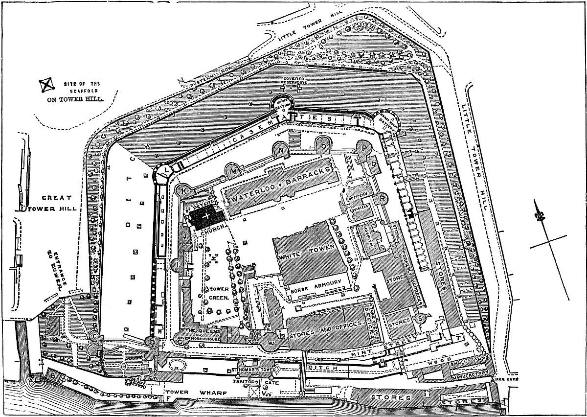
The Tower, in its present form, is a fine example of a concentric castle, of mixed composition, but general harmony of design, and covering, with its circumscribing ditch, about twelve acres of ground.
Nearly in the centre, but now detached and alone, stands the keep, “La blanche Tour” of Edward III., the oldest and most stable part of the fortress. Around it is the inner ward, in plan generally four-sided, but with a salient on the north front, and contained within a wall strengthened by a gatehouse and twelve mural towers.
Encircling this is the outer ward, following the same general plan, and contained within a wall rising from, and forming the scarp of, the ditch. Upon it are bold drum bastions, at the angles of the north front; and the south, or Thames front, is protected by five mural towers, of which one covers the land and one the water gate, and two others are connected with posterns.
The ditch, which completely girdles the fortress, is divided from the river by a narrow strip of land used as a wharf, but also ingeniously contrived to cut off the water of the ditch from the tidal stream.
The space outside the ditch, forming the esplanade of the fortress, is known as Tower Hill. It was once divided by the City wall, which extended from the north to the edge of the ditch, having a postern at the junction, which still gives name to a row of houses, and to the east of which is Little Tower Hill. The ground covered by the Tower rises from the river, so that parts of the inner ward are 40 feet above the water, and the ground north of, and outside the ditch, is 8 feet to 10 feet higher. This disadvantage was neutralised by the breadth of the ditch, while the descent towards the south, or entrance side, was of material advantage in repelling an attack from that side. The object being to command the river and fill the ditch, the keep was placed as high as was consistent with these points.
It has been remarked by Sir F. Palgrave, that William, in settling the jurisdiction of his new fortress, respected, as far as possible, the limits of the City of London. Only the smaller half of the enclosure was within the line of the old wall; and, while the Tower liberties (if St. Katherine’s be included within them) extend some distance eastward, or into the county of Middlesex, on the west frontier, the authority of the constable ranges but a little way beyond the counterscarp of the ditch. The area of the liberties proper is about 26 acres, of which the western portion stands in Tower Ward and All-Hallows Barking parish, and the eastern portion in the county of Middlesex.
The White, or Cæsar’s Tower, is the keep of the fortress. It stands a little to the south-east of the centre of the inner ward, upon208 ground which, on the north, is 40 feet, and on the south 15 feet above the ordnance mean water-mark, so that the basement is at the ground level on one side, and above it on the other. It is quadrangular, 107 feet north and south by 118 feet east and west. Its two western angles are square. That on the north-east is capped by a round stair-turret, 22 feet diameter, about one-third engaged, and having 3 feet more projection upon the north than upon the east face. The south wall terminates eastward in a bold, half-round bow of 42 feet diameter, projecting on the east wall. This marks the apse of the chapel, and is the great peculiarity of this tower.
The keep rises 90 feet from the floor to the crest of the present battlement. It is composed of three floors, or four stages. The walls are reinforced by the usual pilaster strips; on the east face two, on the north three, on the west and south four each. The round turret has four pilasters, two being at its junction with the walls, and the bow four. They vary from 3 feet to 6 feet broad, and all are of 18 inches projection. They lessen by two sets-off, at 50 feet and 75 feet from the ground, and die away 8 feet below the battlement. Also upon the flank of each front containing the two square angles is a strip 12 feet broad, two to each angle, but so placed as not quite to cover it, so that three salient angles appear at each of the two corners. These four pilasters rise from the plinth unbroken to 16 feet above the battlement, forming square turrets. A third turret, also square, is placed on the roof, where, but for the bow, would be the south-east angle. Thus the keep is crowned by three square turrets and one round one.
The loops of the basement are seen to open just below those, now windows, of the second stage. The openings of the third stage, once probably single-light windows of moderate size, but now enlarged, appear, one between each pair of pilasters, and each below a large plain round-headed and slightly-recessed relieving arch, springing from a strip of wall left as a sort of pier against each pilaster. The base of this arcade is a set-off in the wall stopped by the pilasters.
The lights of the fourth or upper stage may be of about their original size. On the south wall, between the two western pilasters, the windows, of 2 feet opening, are in pairs, having a plain baluster in common, and each pair being within a shallow, round-headed recess, so that the eight windows form a short arcade. One pair are probably the only windows in the keep that present quite their original appearance; for the baluster, long since removed, was found bricked up in the adjacent wall, and is now in its proper place. It is believed to have been from one of these windows that Bishop Flambard, here a prisoner, let himself down. The exterior has been defaced by pointing with flint chips and mortar, and the substitution of Portland for the old ashlar dressings, but the windows, though enlarged into casements, represent the old openings.
The staircase, 11 feet diameter, contained within the circular or north-east turret, rises from the floor to the summit, and communicates with every floor, and with the leads.
209
The basement is slightly below ground on the north, and at the ground level on the south front. The walls are from 12 feet to 15 feet thick, and the internal area about 91 feet by 73 feet. This is crossed by a wall 10 feet thick, built with much neglect of the plumb-line. It rises to the summit, and divides the building into a larger western and smaller eastern portion. The latter is again subdivided into a larger northern and smaller southern part, by another wall, also carried through, so that every floor is divided into three chambers. The larger chambers are all ceiled with timber; all the smaller are vaulted. The basement was reached only from above by the great well-stair. The west chamber is 91 feet by 35 feet; the eastern, 67 feet by 28 feet; and the vault, the lower or sub-crypt of the chapel, known in Tower phrase as “Little Ease,” is 15 feet by 47 feet, the east end being semicircular. A door leads from the east into the west chamber, and from the former into Little Ease. Bold recesses in the walls ascend to a line of loops, giving air, but very little light.
In modern times a shaft has been sunk 10 feet in the south-west angle of this floor, and a tunnel cut through its 24 feet of foundation towards the river quay, and another door on the other side of the angle has been cut at the ground level. The two larger chambers have been vaulted in modern brick. Little Ease was, until recently, fitted up as a powder magazine, and passages cut through its east and west ends. These have now been carefully made good with old stone, and the vault cleared out. The well has lately been discovered. It is a plain pipe, 6 feet diameter, lined with ashlar. It is in the floor of the keep, a few feet from its south-western angle.
The second stage much resembles the basement. The walls are about 13 feet thick, the cross-wall 8 feet. In the latter are three openings, 6 feet wide and 15 feet high, round-headed and quite plain, between a doorway at the north end, 4 feet 6 inches wide and 12 feet high, and one at the south end, 4 feet wide and 9 feet high. These five openings communicate between the eastern and western chambers. The western room, 92 feet by 37 feet, has in its west wall five plain round-headed recesses, once converging into loops, but now enlarged into windows. In the south wall is a similar recess, and in the north wall are two. Between one of these and the west angle is a small mural passage, 2 feet 10 inches wide, and bent at right angles. This is vaulted, quadripartite, with plain hips, very rough, but good. Under its exterior loop was the garderobe shaft.
The eastern room, 68 feet by 30 feet, has in its east wall three recesses for loops. In its north wall is a recess, now cut into a door, and communicating with the outside by a double flight of modern stone steps. There is also an original door of 3 feet opening, leading by a short mural passage, 5 feet wide, to the well-stair, which supplies each stage. In the south wall a door leads into the crypt of the chapel, 13 feet 6 inches broad by 39 feet long, having an apsidal east end, and 17 feet high to the crown of its very plain vault. In the north wall of the crypt, near the apse, a passage 2 feet210 broad leads into a vaulted cell, 8 feet by 10 feet, formed in the wall, and quite dark. In the south wall three round-headed recesses, 6 feet broad and 13 feet high, terminated in loops, as did one at the east end. This crypt was fitted up as an armoury, but has been cleared out, and the injured vaulting restored in good taste.
The two larger rooms on this stage are 15 feet high, and recently their respective open ceilings were supported by eighteen and twelve large posts in double rows. These no doubt were inserted when the rooms were given up to stores and records. They have now been removed, and the beams stiffened with iron, to carry the weight of small-arms here stored up. Possibly there was originally a single line of posts, as 30 feet and 37 feet are large spans for single untrussed beams. Recently, two plain original fireplaces have been discovered in the east wall. Their smoke was discharged, as at Colchester, by two small apertures in the wall.
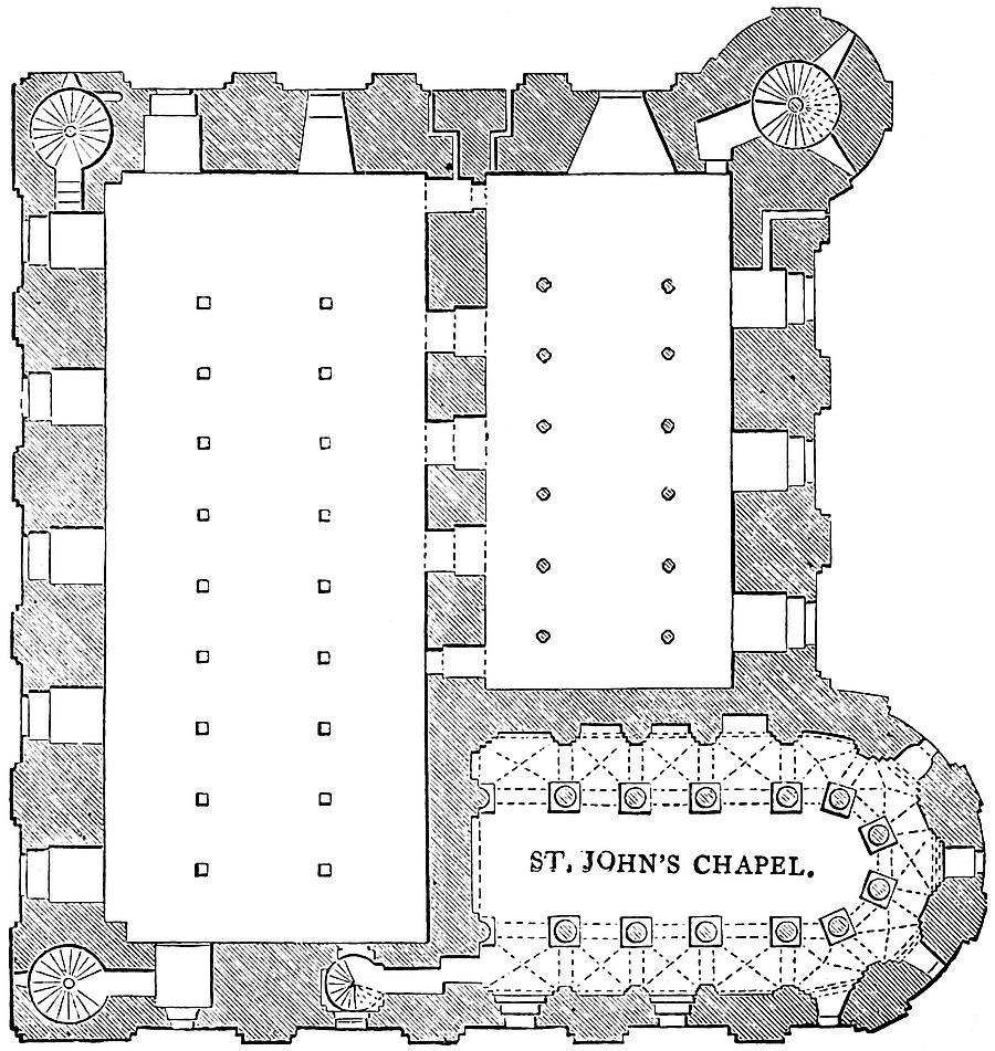
Ascending by the well-stair from this stage, a Tudor door is seen cut in the shell of the staircase, and leading into the adjacent armourers’ shops. A similar door, below this, has been cut at the ground level.
The third stage, or second floor, has also three chambers: the western, 95 feet by 40 feet; the eastern, 64 feet by 32 feet; both211 15 feet high, and until recently propped by posts. The cross chamber is the chapel, which occupies this and the upper stage, to the roof. The exterior walls are here 10 feet to 11 feet, and the party-wall 6 feet thick. In the latter are five openings, as below, all apparently doorways. The rebates show that the doors of the four to the south opened into the east chamber, and the north door the other way. In the north wall, close to this door, are two mural garderobes, resembling that already described, one serving the west, and one the east room.
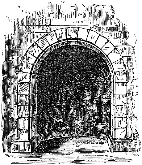
Within the north-west and south-west angles of this stage commence well-stairs, 9 feet diameter, which rise to the roof. They do not open, as usual, direct into the room; but, by short passages, into the jamb of the nearest loop recess. The east chamber is entered from the main stair in a similar way, by a passage 3 feet wide, in the north wall. In the south wall of this room is only a small door opening into the north aisle of the chapel. In its east wall are three loop recesses, and from the jamb of one a garderobe opens, resembling those described. In this wall also is the plain round-headed opening of a fireplace, with an inclined back and vertical flue, the outlet of which has not been followed. It resembles somewhat a fireplace in Colchester keep. This room is called the “Banqueting Chamber.”
Besides its regular recesses for loops, 7 feet wide and 14 feet high, of which there are five on the west side, two on the north, and one on the south, the west room has in its south wall a round-headed opening, which is the summit and landing of a well-stair, which commences, about 15 feet above the ground level, by an external door, and thence leads to the third stage. From its head there is also a mural passage leading into the west end of the south aisle of the chapel. This was, no doubt, the private way from the palace to the chapel and state-rooms of the keep. It was at the foot of this stair, in the wall, that were found the bones supposed to be those of the children of Edward IV., and now in Westminster Abbey.
The fourth, or upper stage, is the “state floor.” Its tripartite arrangement resembles those below, and the two larger chambers have open ceilings 21 feet high, until recently supported by posts, as below. The outer walls range from 10 feet to 11 feet thick, the party-wall is 6 feet, and the short cross-wall which shuts off the triforium of the chapel is 4 feet. The western, or great council-chamber, is 95 feet by 40 feet; the eastern, 65 feet by 32 feet. Between them are three plain openings, 7 feet wide and 14 feet high, and, flanking these, two doorways of smaller dimensions. It may be212 remarked that the square of the two western turrets is preserved in the council chamber. The angles project about 7 feet into the room. The north-eastern angle is hollow as usual. The exterior wall of these two chambers is threaded by a vaulted mural gallery, 13 feet high and 3 feet to 3 feet 6 inches wide. One end of it opens into the west end of the south aisle of the chapel triforium, and the other end into its north aisle near the chevet. It communicates with the main stair in the north-east turret, and with those in the two western213 turrets. It pierces the jambs of each of the window recesses, of which there are in the west room five in the west wall, two in the north, and two in the south wall; and in the east room three in the east wall, and one in the north. Where the gallery traverses the window recesses, the vault is raised a step. In this gallery, in the south wall of the state-room, are the coupled windows already described as escaped through by Flambard. This was the royal council-chamber, at least as late as the reign of Richard III. Here Charles of Orleans, and probably John of France, were confined. And hence Edward, Lord Hastings, the celebrated Chamberlain, was taken from the council-board to execution.
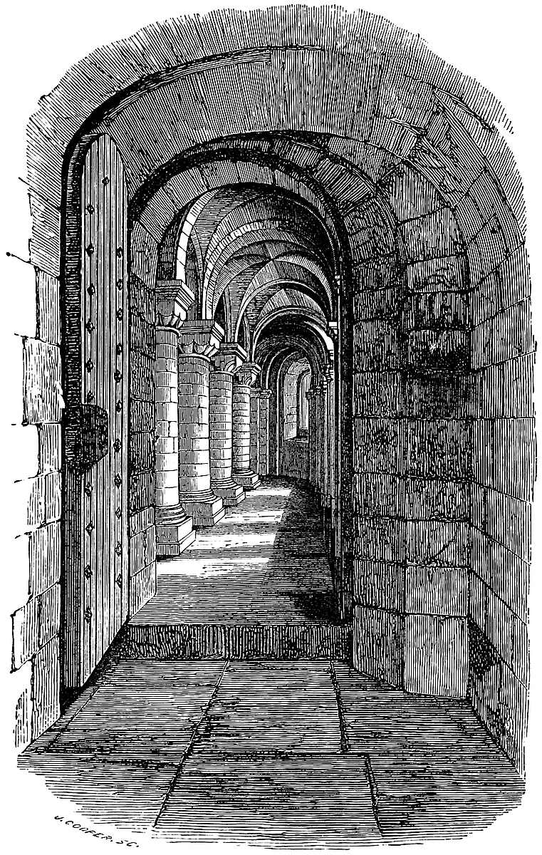
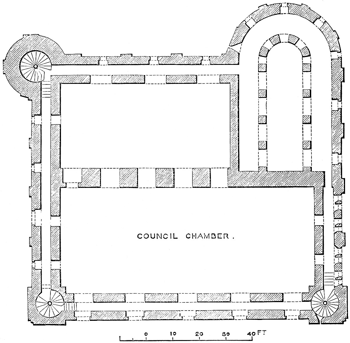
The vertical section of the keep, upon a line east and west, looking south, and here given, shows on the ground floor “Little Ease,” and the lower store-room; on the first floor, the chapel crypt, and the upper store-room. On the second floor is the chapel nave and aisle, and the lower armoury; on the third floor, the chapel triforium and space above the vault, and the upper armoury or council-chamber.
214
The chapel, dedicated to St. John the Evangelist, is a rare, if not a singular example of such an apartment, so large and so complete, in the original and interior arrangements of a Norman keep. It is in plan a rectangle, 40 feet by 31 feet, terminating eastward in a semicircular apse of its full breadth; its extreme length, therefore, with this addition, being 55 feet 6 inches.
It is divided into a nave and aisles, the latter being continued as a chevet round the apse.
The nave, 14 feet 6 inches broad, and 40 feet long, has an eastern apse, giving 7 feet 3 inches additional for the altar. It is divided from the aisles by four columns, and a western respond or half-column, on each side; and by four columns which contain the apse. The whole support thirteen arches. The columns are cylinders of 2 feet 6 inches diameter, and 6 feet 6 inches high, with plain torus bases resting upon a square stone of two stages, giving,215 with the base, an additional 20 inches. The capitals vary in pattern, some being plain cushion, others a combination of four cushions, giving a scalloped or indented outline in the elevation; others, again, are chamfered at the angles; and others finished with a stiff rude volute of an Ionic aspect.
The capitals of the eight eastern columns are unfinished, having a block in the form of a Tau, or cross-potent, upon each face, evidently intended to be carved into the usual central flower of a Corinthian capital; and the astragal is set round with a row of stiff upright feathers, like a plume. Each capital has a plain abacus, with varieties of the half-round, ogee, and hollow mouldings, excepting the western responds, of which the faces of the abaci are cut into the star-pattern found in early Norman work. Beneath is a light cable bead. These capitals vary from 34 inches to 40 inches square, and are 22 inches high, so that from the floor to the top of each is 10 feet. Each capital is a single block, and each abacus a single slab.
The thirteen arches springing from these capitals in the nave are 7 feet, and in the apse 2 feet 9 inches, diameter. The five apsidal arches are stilted, the rest semicircular, the crowns of all being level. The whole are perfectly plain openings in a 22-inch wall, without chamfer or rib.
Twenty inches above these crowns is a plain chamfered stringcourse, and upon this the arcade of the triforium, each arch being exactly above, and of the same diameter with, that below. These arches spring from piers 30 inches square, and 4 feet 3 inches high, without either base or cap. As the apsidal arches are not stilted, the piers are taller, so that the crowns still range.
The nave roof is a barrel vault, commencing imperceptibly at the crown level of the triforial arches, and ending eastwards in a semi-dome. The height to the crowns of the nave arches is 13 feet 6 inches, to those of the triforium 23 feet 9 inches, and to the crown of the vault 32 feet. The vault abuts against the west wall, in which is a plain round-headed recess, 18 inches deep, 12 feet diameter, and 13 feet 6 inches high.
The aisle is 6 feet 6 inches broad. Opposite to each nave column is a flat pilaster, advanced three steps from the wall surface, and having a plain chamfered abacus, or string-cap, and from each springs a broad flat rib. The aisle is thus divided into thirteen bays, four on each side, and five in the chevet, the sides of these latter being convergent. Each bay is hip-vaulted, the vaults being groined, and entirely in rubble work. The aisle is 13 feet 6 inches high. The wall of each bay is recessed, and the recesses form an arcade. In the southern recesses are four windows, of which two open between, and two upon the exterior pilaster strips. Four of the five apsidal bays also have windows, one being to the east. There are two doors: one in the north aisle, opening into the eastern room on the third stage of the keep, and one in the west wall of the south aisle, leading by a short mural gallery to the well-216stair in the south wall, and into the great or western chamber of the keep.
The triforium is 7 feet 6 inches diameter. It is a mere plain gallery, without pilasters, stringcourse, or moulding of any kind, 8 feet high to the spring of its side barrel-vault, which gives 3 feet 9 inches more.
In its south wall are three windows, one opening in the face of an outer pilaster; and in the apse are five. In the north wall, and at the west end of the south limb, are the openings of the mural gallery which surrounds the keep at this, the council-chamber level; the chapel, as has been stated, rising through the two upper stories to the roof. The walls of the aisle are 4 feet thick; of the west and east ends, 5 feet. Of the triforium, the north, south, and east walls are 4 feet, and the west wall 5 feet 6 inches thick.
This, the earliest and simplest, as well as most complete Norman chapel in Britain, must have witnessed the devotions of the Conqueror, and his immediate descendants; the church, when afterwards built, having evidently been intended rather for the garrison at large than for the sovereign. The upper gallery, communicating with the state-rooms, was, no doubt, as was often the case in domestic chapels, intended for the principal persons, the household occupying the floor below. Always architecturally plain, the walls were probably painted and hung with tapestry, and the eastern windows contained stained glass, placed there, with other ornaments, by the piety of Henry III.
Henry also, in 1261, on the death of his sister-in-law, Saunchia, Countess of Cornwall, wife of his brother Richard, charged upon the Exchequer, in favour of the adjacent Hospital of St. Katherine, fifty shillings per annum for the support of a chaplain, here to pray for her soul; he having already, 1240–1, provided a similar endowment for the sustenance of a regular priest there, with vesture, and chalice, and everything necessary for his office. The obit payment probably fell into arrear; for, in 1290 (18 Edward I.), the Brethren and Sisters of St. Katherine petition for the fifty shillings given by Henry III. for the spiritual benefit of Saunchia. This chapel was dismantled by an Order of Council, August 22, 1550, directing, in both church and chapel, all such crosses, images, and plate of gold as remain, to be melted down. The chapel thus desecrated was long employed as a repository for records. Very recently these have been removed, the walls restored to their primitive simplicity, and the whole paved with tiles of a plain and suitable character. It is due to the interference of the late Lord de Ros that this chapel did not become a tailor’s warehouse.
Above the fourth stage of the keep is the flat leaded roof, affording an area between the parapet wall, of 100 feet east and west, by 113 feet north and south. The turrets rise about 16 feet above the platform, upon which they open by doors, the north-west, south-west, and north-east crowning well-stairs. The fourth, or south-east turret, is built over the chapel wall, and contains a217 chamber entered from the leads. The large circular, or north-east turret, of 16 feet interior diameter, and of two floors, was used as an observatory by Flamsteed, before the construction of the present building at Greenwich. Its upper floor seems to have been entered by an exterior stair, on the south side, for the support of which the parapet, as may be seen, has an exterior projection. These turrets have been cased, but the old Norman masonry may still be detected.
There is a sort of “entre-sol” between the chapel-vault and the roof, which, over the aisles, is about 7 feet high, and capable of being turned to account. Some of the old drawings show loopholes pierced in the south wall, and there are traces in the south-west turret of a doorway, which seems, from its level, to have led into this vacant space.
The place and manner of the original entrance to the keep are unknown. One notion is that it was on the north side, at the second stage, or first-floor level, near the east end of the wall, where there is at present an entrance by stone steps, 12 feet above the ground. This, however, is certainly an enlarged loop, the interior arch of the recess remaining. A close examination of the exterior shows that the present door has been cut through masonry not intended to cover a large opening, for the joints are horizontal, and there is no relieving arch. West of this in the next, or floor above, where also a modern door has been cut, through which stores are lifted into the armouries, there are traces of an arch of relief, intended to cover an opening of unusual size, and this also has been regarded as the original entrance. But this only seems to have been an enlarged loop; the recess has been enlarged by cutting away the wall, which at the sides has been refaced. This would have been unnecessary had the recess been intended for a doorway. More probably the entrance was on the south side near the west end, where, on this floor level, is a large and original opening with parallel sides and niches in the sides. Evidently this was the main entrance. The masonry shows where the doorway jambs and arch have been cut away, and a window inserted.
Very near this doorway, to the east, is a small but original door opening into the base of the small well-stair. These two doors, being at some height above the ground, pretty certainly opened into a forebuilding which covered the south side of the keep, having its outer entrance at the east end. The armoury is now being removed, and possibly below it may be found the foundations of the Norman forebuilding.
Although much injured and obscured by injudicious repairs, parts of the original surface may be detected. The base, quoins, and pilaster strips were evidently of ashlar, very open jointed. The rest of the wall was of rubble, rudely coursed, but with a great preponderance of mortar, much resembling the earliest work at Malling Abbey and St. Leonard’s Tower. The arches throughout are semicircular, and quite plain. The vaulting, though sometimes groined,218 is never ribbed. It may also be remarked that there is no subterranean chamber in the keep, or anywhere throughout the fortress.
The arrangements within the keep are very peculiar, and show a prevision against surprise, carried, if not to excess, yet to a degree fatal to the convenience of the royal personages and great officers of state, for whose deliberations and occasional residence the building was designed.
The main door, supposing it to be as indicated, opened upon a very gloomy first floor, from which a turnpike stair led downwards to the basement, and upwards to the second floor. To this floor the way from the stair was along a bent and narrow mural passage, and from the inner room by two staircases to the upper story and battlements. Having attained the upper story, the entrance to the state-rooms was again only by mural galleries, admitting but one person abreast.
For purely military purposes all this was advantageous. Supposing a score of resolute men to garrison the keep, they could hold the main door and postern against an army; or supposing them, by surprise, to have lost the lower stories, they could still defend the passage to the second floor without fear of being outflanked; while above there was easy access from the state-floor to the battlements, whence the enemy could be assailed to most advantage. There remained indeed to the besiegers the last and most terrible resource of firing the place, and, once within the walls, this would be easy and irresistible. Not even this immensely solid masonry would have resisted the conflagration which a torch flung upon the wooden floors of the building would be sure to kindle.
For the purposes of state the great height of the council-chamber, its excessive coldness, the difficulty of access, the inconvenience of the frequent posts probably necessary for the support of its roof, and finally, the entire absence of privacy in a room so large and with so many lateral openings, must have been serious drawbacks. No doubt the rooms were bratticed off into smaller chambers, and hung with tapestry, but even then the presence of the floors, ceilings, and partitions must have rendered the employment of stoves and bratticed chimneys very dangerous.
Neither is it easy to understand the intention of the arches in the party wall. Where, as at Rochester, these openings were of large span, the chambers admitted, on occasions of state, of being thrown into one. Here, however, though inconveniently large for doorways, they were far too small to make the rooms common. They could scarcely be intended to economise material, else the wall might have been safely much reduced in thickness, without piercing it completely through; and below they have no rebates or recesses for doors, or wooden partitions. On the third floor, where the doors are rebated, it is clear that they opened opposite ways, so that one, if not both the chambers, was subdivided. The rebates, however, may not be original.
219
The absence of all ornament, the very sparing use of ashlar, and the general roughness of the work, especially of the lower floor of this keep, lead to the conclusion that it was executed in haste, and with an insufficient command of good material. The vaulting especially is very coarse, and impressions remaining upon, and the occasional fragments of oak imbedded in, the mortar, show that the centering was composed of small rough oak slabs, not even cut to lengths, but overlapping, and that occasionally the form of the arch was preserved by the intervention of a rough coat of mortar. This used to be apparent even in the vaults of the chapel, and may still be seen in the mural galleries and staircases.
Against the east wall of the keep, a large rectangular building, now removed, was constructed, it is said, by Edward III. The lower walls were thick, and its south-east angle, which remains, seems to have been rounded off, perhaps as a turret. It is evidently an addition, and had nothing to do with any raised or covered entrance to the keep.
The inner ward is enclosed within a curtain wall, having four sides, twelve mural towers, and a gatehouse. The base or longest side faces the river. The east and west sides incline inwards, so that the north face is narrower than the base. This face is broken by an obtuse angle, having a central salient.
The level of much of this enclosure is 15 to 20 feet above that of the outer ward. Possibly part of the clay from the ditch, excavated by Longchamp, in the reign of Richard I., was here piled up. By reason of this difference, the lower part of this ward wall is a revetment, retaining the ground along the west and north, and part of the south and east fronts. The inequality is seen at the gatehouse, the passage through which rises one foot in ten to the middle of the ward; and, at St. Martin’s Staircase, at the north-east corner. Where the palace stood, from Wakefield to Salt Tower, the levels are nearly equal. This ward is much encumbered with buildings, some of the age of Henry VIII., some later, while others have been lately removed. No doubt this ward was always thus occupied, as the Tower was a depôt for all sorts of military stores, and a residence for petty officers of the court and garrison. In 1213, King John ordered to be salted and hung up “bacones nostros qui sunt apud Turrim”; and, in 1224, he drew upon the Tower for thirty dolia of wine; so that pigstyes and wine-stores formed a part of its contents. Lead, and the more expensive building-materials, were also kept here.
The Church of St. Peter ad Vincula, mentioned in the reign of John, and rebuilt in the late Perpendicular period, still occupies the north-west quarter of the ward. In the south-east quarter stood the Royal Palace, destroyed, at various times, by James, Cromwell, or after the Restoration. The keep in Norman castles was intended rather for the occasional than the regular residence of the lord, whose ordinary lodgings were more conveniently placed in the inner ward. This was so at Rochester, in 1281, at Bamborough, Carlisle220 Porchester, and elsewhere. Here the palace stood between the keep and the ward wall, and, besides, had walls of its own; one crossing from Wakefield Tower to the keep, where were drum-towers and a gateway known as Cold Harbour, and another called the Wardrobe Gallery, crossing from Broad Arrow Tower to the keep, and having upon it Wardrobe Tower, also circular, with a circular turret. The Queen’s Gallery extended from Salt to Lanthorn Tower, on the line of the curtain, and the great hall was connected with Wakefield Tower. The whole space was occupied by small courts and gardens, lodgings, and offices; and the buildings in the reign of Henry III. seem to have encroached upon the outer ward, where were two posterns for the service of the palace. These buildings, after the manner of royal houses, were always under repair; and seem to have absorbed much of the money expended on the Tower. The main guardhouse stands on the site of Cold Harbour. The foundation of the Queen’s Gallery and great hall have lately been laid open. Norman masonry, part of the ward-wall, has also been discovered. In the earlier surveys, the palace quarter is called the “Inner Ward.” Cold Harbour was probably very lofty; for, in 1572, complaint was made that Sir Owen Hopton, the lieutenant, allowed his prisoners to meet and walk on the “leads of Cold Harbour”; and about that time the Earl of Southampton stayed leaping upon the tower, his wife being on the opposite side of the ditch.
Of the twelve mural towers of this ward one caps each of the five angles. Two were intermediate on the south face, as two still are upon the east, and two upon the north, one on each side of the salient. The west, or shortest face, has one large intermediate tower. The gatehouse, called the Bloody Tower, stands considerably west of the centre of the south front, and opposite to Traitor’s Gate. It is contiguous to Wakefield Tower, which flanks it on the east, and probably determined its position and that of Traitor’s Gate.
Commencing with Wakefield, and passing westwards, the towers are, Bloody, Bell, Beauchamp, Devereux, Flint, Bowyer, Brick, St. Martin’s or Jewel, Constable’s, Broad-Arrow, Salt, and Lanthorn Tower, now destroyed.
Wakefield Tower deserves very close attention, its lower story being next to the keep in antiquity. It is also known as the Record Tower, records having been kept there from an early period until a short time ago. In the survey of Elizabeth it is called the Hall Tower, from its proximity to the royal hall, destroyed during the Commonwealth.
It is in plan a cylinder of 50 feet diameter, and is about 50 feet high. Its projection from the line of the south curtain is about 22 feet. Whether it was originally intended to cap an angle, is uncertain. No doubt the curtains from Lanthorn Tower on the east, and Cold Harbour on the north, abutted upon it on two faces, and were coëval with it; but it is unknown whether the third221 curtain from the west, now replaced by the gatehouse, was of the same date; and, in fact, whether the original design included the present inner ward.
This tower has two, and had three, stages. The basement, the floor of which is upon the ground level, contains an octagon chamber, 23 feet from face to face, with walls 13 feet 6 inches thick. In each face is a recess, 6 feet broad, having a semicircular head, the edge of which has a double chamfer, with an angular recess between. The northern and the three southern recesses are 8 feet deep, and have a flat end also 6 feet across, so that there is no splay. In the end is an opening, round-headed, and about 4 feet across, which contracts rapidly to a loophole. The north-east and north-west recesses are 7 feet and 6 feet deep, and are blank, without loops. The west recess is only 2 feet 6 inches deep, and was probably closed when the Bloody Tower was built. The eastern recess is the present entrance, but the curtain must have abutted on this side, so that it is not improbable that the original entrance was in the north-eastern recess. The chamber is, however, so dark, and the recesses so obscured and encumbered by stores and brick walls, that it is difficult to examine them minutely.
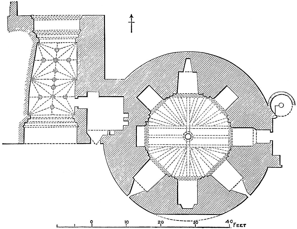
The chamber is 10 feet high. It has a flat timber covering, which, if not original, is very old, and may well represent the original. Probably it actually dates from the rebuilding of the upper story, in222 the reign of Henry III. In the centre of the chamber, upon a plain stone cheese-like base, is set up an oak post, 18 inches square, with the angles taken off. Upon this rest two beams, 11 inches square, at right angles, crossing the chamber east and west, and north and south. Parallel to the former, 2 feet from it on each side, are two other similar beams also crossing the chamber. There are, therefore, left outside these beams, and divided by the north and south beam, four quadrants, and these are filled up each with five beams, also 11 inches square, which radiate fan-like towards the walls, where all seem to have rested upon a stone ledge or wall-plate. The radiating beams are mortised into the main beams. All this work is original. These timbers have rotted at the wall ends, and to support them, and the load of records above them, two octagonal frames have been placed beneath, one close to the wall, and one half-way between the walls and the central post, and these are supported each by eight props, so that the interior of the chamber is disfigured by a regular forest of seventeen posts. East of this tower the foundation of the old curtain has been laid open.
Since these lines were written, all this timber work has been swept away, and the tower has been converted into the jewel office. On the north-east side of the tower is a later well-stair, 6 feet 6 inches diameter, which ascends to the first floor and the battlements.
This upper or first floor, also an octagon chamber, is of 30 feet diameter, and has a recess in seven of its eight faces. Of these three to the south, and that to the north-west, terminate in modern enlargements of the old windows, as does that of the west, of which the opening is skewed, to avoid the Bloody Tower. In the north face is a fireplace, probably representing an original one. The north-east recess is closed at 4 feet deep, and that to the east is occupied by two openings; one, the present door, evidently not original; close north of which, beneath a drop arch, is the original entrance from the palace, 5 feet 5 inches broad, and at 2 feet 6 inches deep reduced to 4 feet broad, where it forms a lofty doorway, now closed. These recesses have each a drop arch, supported by a plain chamfered rib.
The south-east recess was intended for an oratory, and its sides are produced inwards by two walls, buttressed in tabernacle work at their west ends, and connected above by a bold plain drop arch, rather light, and flatter than the rest. This no doubt is the chapel mentioned in 1238. It is possible that the recess to the north-east was the royal door, and that the narrow eastern opening led to the stair and to the rampart of the curtain.
The south recess also differs from the rest, in having within it a second rib, of 3 feet opening, as though above a doorway, and the opening is twisted to bring it opposite to the door of St. Thomas’s Tower, between which openings, 18 feet apart, there was evidently either a cross-wall or a light bridge, giving a short cut from the palace to the ramparts of the water-gate.
The intention was to vault this chamber, and in each angle is a223 semi-octagon pier, with a rude base, and without a cap. The total height of the ceiling, now flat, is 25 feet, so that the vault was to have had a high pitch with eight cells. It is clear that this never was executed.
This tower has now undergone complete restoration, all the interior fittings have been cleared out, the masonry laid bare, and the two floors vaulted, and the bridge suggested as having led to St. Thomas’s Tower has been actually built.
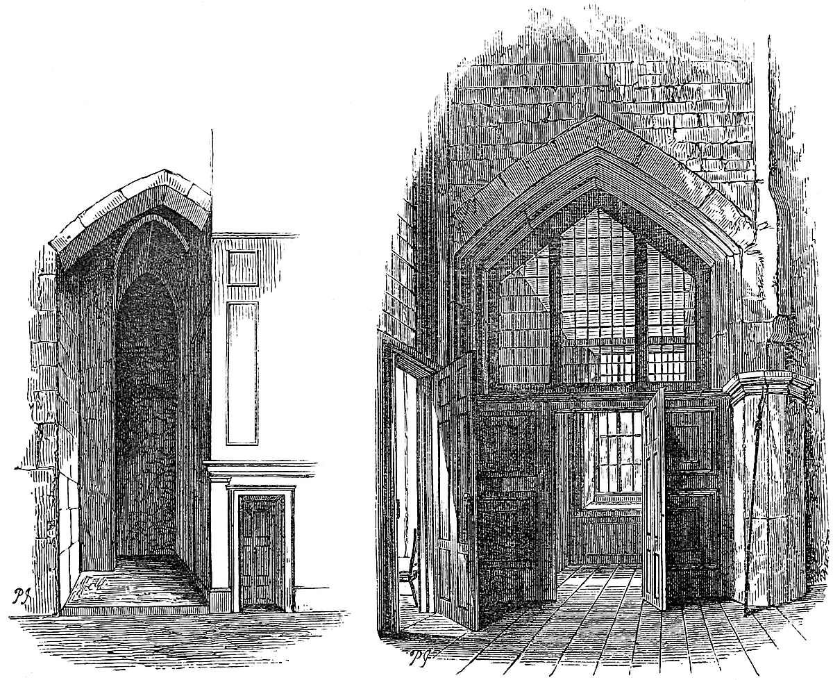
A line of blocked-up arches in the outer wall shows that an uppermost story was contemplated, and probably constructed, since in St. Thomas’s Tower is a second or upper door, evidently intended for a second bridge, or a passage along a cross rampart, above that already mentioned.
The arch-rings within, and the whole of the basement story without, of this tower, are of finely-jointed ashlar, and it appears from the decay of some of the stones, and from other indications, that the joints were not mere face-work, but were equally fine through the whole depth of each outer stone, a degree of precision not common now, and rare at any age. The upper story is of uncoursed rubble. It has been pointed and stuck over with chips of flint, but the acute relieving arches over the windows are seen, both of the first and224 second floor. The parapet is of brick, and encrusts an older wall of stone.
The basement of Wakefield Tower is probably late Norman, perhaps of the reign of Stephen, or Henry II., although this is no doubt early for masonry so finely jointed. The superstructure is early in the reign of Henry III., perhaps 1220–30, as in 1238 mention is made of the chapel in the new tower next the hall, and towards the Thames. The records of the realm were lodged in the New Temple as late as 20 Edward I., but 33 Edward I., they were in the Tower, no doubt the keep, whence “extra magnam turrim,” to make room for King John of France, they were removed, 1360, probably to this tower. In August of that year the clerk of the works was to repair the roof, doors, and windows of the house provided for the records, and this is repeated next year for the tower in which are the Chancery rolls.
The Wakefield Tower was the subject of a restoration in 1867, when all its modern disfigurements were removed, and the original masonry exposed. The brick casing was stripped from the parapet, the roof taken down, the interior fittings cleared away, and the brick and stone work with which the loops, enlarged into windows, had been made good, was removed.
The clearance included certain public garderobes, built against the north face of the tower, and a private garderobe, niched into the junction with the Bloody Tower, and thus was shown the original base of the latter, and the remains of a bold cordon encircling it 6 feet from the ground. Here also was exposed a loop and a curious hole, about 3 feet diameter, and 3 feet or 4 feet deep, of doubtful use. Besides the removal of these additions, the timber work of the ground-floor was cleared out, and the double circle of posts shown to be of modern date, inserted to support the additional weight of the records. The timbers of the ceiling were original. The main beams of oak, 6 feet by 6 feet, went deep into the wall, and were evidently laid when the upper floor was added by Henry III. They rested upon fragments of early roofing tiles.
The central post, also of oak, was found to stand upon a plain stone cylinder 2 feet 6 inches diameter and 3 feet 6 inches high. This again rested upon a thick square slab of oak, which was placed upon the head of a short pile, only partially decayed. Beneath the floor was laid 2 feet of broken tiles, and below this, gravel, so charged with moisture that a pit sunk 5 feet stood with 2 feet of water.
Of the arched recesses the masonry was sound, save a crack in the spandrels of that to the west. It was clear that the three southern recesses had contained original loops. That to the west seemed to have been walled up when the Bloody Tower was built. The northern recess was different, as though the loop had been lifted on account of the exterior ground having been raised.
The vaulting ribs of the first floor did not seem to have been completed. The north-western recess had been a fireplace, which the original herring-bone fire-back showed to have been very shallow,225 so as to require a hood, which two holes in the wall indicated to have been of timber. The south-eastern aperture was double. There was a small window with a drop arch and hollow chamfer, and steps up to it, and by its side a doorway pointing to the Water Tower, and no doubt intended to open on a small bridge.
The eastern recess now shows the oratory. The original window was narrow and drop pointed. On the wall are traces of fresco painting. There is also a piscina and a locker, and on each side a recess as for a sedile. That in the north wall has been cut as though for a doorway. The original door to this floor seems to have been in the north-east side.
There was evidently a floor above this. In the exterior wall are some cylindrical holes about 2 feet deep and 2 inches diameter. Their use is not clear. There were gurgoyles below the embrasures of the parapet. It is well to rebuild the bridge to the Water Tower, but to vault the ground-floor would be a mistake. The lower floor covering was always timber, and of a curious pattern. It should be replaced.
The Bloody Tower is the gatehouse of the inner ward. It stands in the south front, west of the centre, opposite to the earlier Traitor’s Gate, and it abuts against the also earlier Wakefield Tower. The exterior face ranges with the curtain. Its position was no doubt determined by the Traitor’s Gate, and by the advantages offered by the flanking defence of Wakefield Tower on the outside, and Cold Harbour Wall on the inside.
It is rectangular or nearly so in plan, 25 feet broad and 38 feet deep, and pierced by a vaulted passage, the axis of which has a twist to the east. It is of three stages, and 47 feet high from the outer gate cill to the parapet, which is modern, and of brick.
The portal, 15 feet wide, opens under a low-browed drop arch, 8 feet high at the spring, and 14 feet at the crown; 3 feet 6 inches within the entrance is a 6-inch portcullis groove, working through the vault in a chase 2 feet 6 inches broad, so as to admit a heavy wooden frame. Then follows a double chamfered gateway, reducing the passage to 11 feet 8 inches. Next is the body of the gatehouse, 21 feet long and vaulted, having a pair of gates at each end, and on the right a porter’s lodge. The inner pair of gates are succeeded by another chamfered gateway of 11 feet opening, and this by a second portcullis, with a chase only 1 foot 4 inches broad, followed by a portal of 15 ft. opening. The passage rises about one foot in ten, and this rise, giving a great advantage to the defenders, is continued to a point opposite to the White Tower, where it ends in a short flight of steps.
The vaulted space occupying the central part of the passage is about 22 feet long by 13 feet broad, and is divided into two not quite equal bays. The vaulting ribs spring from four corner and two intermediate corbels, representing lions’ heads, each supporting an octangular bracket.
Each bay is divided by four main hip ribs into four cells, and226 along the axis of each cell is a ridge rib, longitudinal and transverse. These cells are subdivided each by a secondary rib, springing also from the six corbels, and, with the ridge rib, dividing each cell into four compartments. Thus, besides the two wall half-ribs, from each intermediate corbel spring seven ribs, and from each angle corbel three ribs.
There are no regular bosses, but at each point of intersection the ribs abut upon an open circle, the centre of which is occupied by a lion’s face, dropped in from above. There are, therefore, three main and eight smaller circles, besides six half-circles at the junction of the ridge and wall-ribs. The ribs and circles, though of one pattern, are of two sizes. All have been clumsily cobbled with Roman cement.
The porter’s lodge, on the east side of the entrance, is a vaulted chamber, 10 feet square, with a window of two lights, no doubt replacing a loop towards the south or front. A door, now closed, on its north side, seems to have led into a staircase to the upper floors. About 4 feet of this lodge is excavated in the thickness of the wall of Wakefield Tower.
The entrance-way, on passing the gatehouse, lies between a retaining wall on the left, or west, and the main guard, which supersedes Cold Harbour wall, on the right. A modern staircase, no doubt representing an old one, ascends in the substance of the west wall, and opens on the parade before the constable’s house, and here also is the entrance to the first floor of the gatehouse.
This is by a Decorated, or early Perpendicular door, leading into a chamber 28 feet by 18 feet, having a large double-light window in the west wall by the door, and in the east wall a loop towards Cold Harbour, and a passage which, through a Caernarvon-headed door, leads into a small vaulted and ribbed garderobe on the left, and onward into what is no doubt the well-stair from below, now closed; and which seems to have ascended to the roof.
This, which was the portcullis chamber, has also windows at either end over the portals, and across its south end a low four-centred arch, in which are fastened two sheaves carrying the portcullis, which rises through a chase in the floor, and is lifted by a rude long wooden windlass worked by three sets of capstan bars.
The northern portcullis was lighter, and perhaps never actually inserted. The only trace of its working arrangements is a part of a flat-topped recess, from which it might have been suspended.
An upper floor, reached by a well-stair cut in the wall between this and the Wakefield Tower, contains a room 25 feet long by 18 feet broad, at the south end of which is walled off a passage 26 feet long by 4 feet broad, at the west end of which a door, now walled up, opened upon the ramparts, showing that this curious passage made a part of the rampart walk, which accounts for a door and loop which opens upon it from the gatehouse upper floor. The well-stair is continued to the leads of the tower, 10 feet above the curtain.
227
The doors, window, and portcullis arch in the first floor, all have a deep bold quarter-circle hollow, replacing the angle, instead of the usual chamfer.
This gatehouse is generally attributed to Edward III., who may have constructed it in the later part of his reign; or it may be the work of Richard II. The vaulting and portcullis-arch appear of later date than the walls, but the whole is probably of the transition period between Decorated and Perpendicular.
In the survey of Henry VIII. this is called the Garden Tower, being close to the constable’s garden, now the parade. In the survey of 1597, it is called by its present name; and popular prejudice, rather than Tower tradition, has attributed that name to the murder of the sons of Edward IV., idly said to have been perpetrated here.
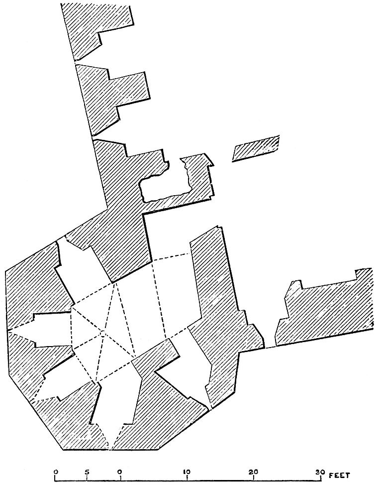
As Garden Tower, this building was a well-known Tudor prison. From hence to Bell Tower, 150 feet, the original curtain remains, of its full height of about 40 feet, and its base thickness about 10 feet. It is, however, so defaced outside, and inside so encrusted with houses of the Tudor period, that but little of its detail can be seen. It is pretty clear that there is no range of loopholes in its228 substance. A cell, recently a stable, is really a Tudor brick vault built against it.
Near to Bell Tower is an original mural chamber, probably a garderobe, lighted by a recess and loop. This recess shows the original wall, about 7 feet thick; and an interior addition of 3 feet more. The original recess has an acute, and the addition a drop arch. The one may be early English, and the other of Decorated date. Above this the full thickness of the wall is seen in the great modern window, cut through it, in the constable’s lodging.
Bell Tower is so called from the alarm bell once suspended from its summit. The bell now discharges the less exciting duty of summoning the garrison to St. Peter’s Church, and the bell turret has been replaced by a gazebo. The tower caps the south-west angle of the ward, and stands 40 feet within the Byward Gate, which it commands. It is in plan an irregular octagon, about 35 feet mean diameter, and 60 feet high, from the level of the outer ward. Five and a half of its sides project beyond the curtains. Above, the angles are rudely rounded off, and the upper 20 feet is cylindrical, and may be an early addition. The two southern faces have a chamfered plinth, 6 feet high. The walls have been stuck over with chips of flint, and the parapet is a brick addition; but it is evident that the basement was originally of fine jointed ashlar, almost equal to Wakefield. Five cruciform loops mark the line of the interior basement, about 14 feet above the exterior ground.
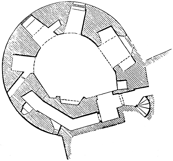
The lower 10 feet of this tower is solid, and above this are two stages. The basement, now a cellar and boot-hole, is of irregular plan, and may be called a rectangular figure with inclined ends. The walls are from 9 feet to 13 feet thick, and contain four pointed arched recesses with loops, and a mural chamber, also looped. The entrance passage from the gorge is bent at right angles.
This chamber is vaulted and ribbed, its outer end terminating in a rude pentagon, traversed by five hip-ribs, of plain rectangular section, and meeting by a high-pitched arch, in a central boss. This boss and the capitals whence spring three of the ribs are of early English character. The shafts are wanting.
The upper chamber is rudely circular, and about 18 feet across. The walls are 8 feet thick. From the well-stair, which commences at this level, a short passage opens into a rectangular lobby, also vaulted, 4 feet by 5 feet 6 inches, from which a door leads into the229 chamber, and another into a small flag-roofed mural gallery, which threads the south wall for 22 feet, and has two loops, one raking the south curtain, the other lighting a garderobe, which seems to have another opening direct into the tower.
The main chamber was lighted by four loops, of which two have been converted into windows, and two stopped up. These recesses are of irregular breadth, with high drop arches, the crowns 10 feet 3 inches from the ground, with traces of a broad moulding above each. The north loop rakes the west curtain, and has cupboards right and left under flat drop arches for archers’ tools. Another has a lateral squint towards the south, and another, with a hole in its arch, widened by the rubbing of the old bell-rope, has evidently been used as a doorway. No doubt it opened upon the gatehouse, now removed, which crossed the outer ward at this point, close north of the Byward gate. This chamber is rudely domed in with overhanging courses of tile stone and flat rubble, like an ancient dovecote. No doubt a proper vault was intended. To the spring of the dome is 14 feet, to its crown 22 feet.
It was in this chamber that, in 1830, was discovered an inscription commemorating the imprisonment here, 20th June, 1565, of Lady Mary Douglas, Countess of Lennox, on account of the marriage of her son, Lord Darnley, to the Queen of Scots.
The well-stair ascends from this floor to the battlements; and at its foot a narrow door, set in a square recess, opens upon the rampart wall of the west curtain, leading to the Beauchamp Tower. The Bell Tower has been the subject of an interesting paper by the Rev. Thomas Hugo, read in Suffolk Street, in 1858. It may safely be attributed to the reign of John, or even of Richard I., that is, to the last twenty years of the twelfth century.
The curtain, from Bell to Beauchamp Tower, 138 feet in length, 37 feet high above the outer, and 18 feet above the inner ward, and 10 feet thick, is very perfect, but still much encrusted by dwelling-houses. The exterior of this wall shows eleven loops about 12 feet from the ground, and 12 feet apart, and these are found within to represent eleven recesses of 7 feet 4 inches opening, with drop arches of 3 feet 4 inches rise, so that the curtain was pierced by an arcade intended for the defence of its base against the outer ward, but which would have been fatal to the security of the heavy superstructure, had the most ordinary battering engine been brought to bear upon it. The recess next to Beauchamp Tower seems to have been walled up when that tower was built. At the base of the parapet was a stringcourse, now much mutilated. The rampart walk remains open, but a part of it lies between the roofs of houses. The loops are of one pattern, of about four inches opening, and cruciform. The three upper ends are square; the lower expands into a round oillet.

This mural arcade is very singular. Such of the recesses as are accessible are found to be lined with brick, and can scarcely, in their present form, be earlier than the reigns of Edward IV. or Richard III.,230 if so early. In fact, they much resemble the work of Henry VIII. The openings themselves are, however, original. They evidently exist also beyond the Beauchamp to the Devereux Tower, as the loops are visible, although the back of the wall is so shut in with dwelling-houses and the vaults of the church, as to be inaccessible. Nothing like them has been detected between the Bell and Bloody Tower, or in the fragments of the original curtain on the east side, about the Broad Arrow Tower. In the short low cross curtains connected with Salt Tower, something like these recesses may be seen, and apparently of early date. In rebuilding the curtain next to Broad Arrow Tower these recesses have very judiciously been copied.
The Beauchamp, or Cobham Tower, stands towards the centre of the west wall, into which it has been inserted, either as an addition, or more probably in place of an earlier tower. Its plan is a semicircle of 36 feet exterior diameter, and 18 feet projection beyond the curtain. The exterior wall is 8 feet, and the gorge wall 4 feet thick, and ranging with the inner face of the curtain.
This tower is of three stages, not vaulted, the middle being at the rampart level. A well-stair, 9 feet diameter, in the curtain, close south of the231 tower, opens from the inner ward, and communicates with each floor, the curtain ramparts, and the battlements of the tower. The stair is looped toward the field, and its passage has a small window towards the inner ward.
The middle chamber is that possessing most interest, from the number and quality of the memorials cut upon its walls by its distinguished prisoners. Its plan is rectangular, with a western bow of three sides of an octagon. In the gorge wall is a large modern restored window, and in the bow two loops and one central window, no doubt once a loop, towards the field. One face is occupied by a fireplace, perhaps of modern date. Though used as a prison, it was evidently constructed for defence only, as a place d’armes upon the rampart. Hence the rampart walk is continued right through it, and from the passage opens a small mural chamber 6 feet by 8 feet, with a loop to the field, and near it a small mural garderobe, 5 feet by 4 feet. The staircase on the south, and these chambers on the north, occupy the two square turrets which flank the Beauchamp Tower.
Beauchamp Tower is in the Decorated style, and the work of the fourteenth century, probably of Edward III. It is evidently later than the contiguous curtain into which it has been inserted. Its name of Beauchamp is probably derived from Thomas Earl of Warwick, who was imprisoned here towards the end of the fourteenth century, and it has also been called “Cobham,” from the well-known prisoner of that name, who was lodged here in consequence of Wyatt’s conspiracy. It is built of uncoursed rubble, much resembling St. Thomas’s and Salt Tower, and very different from the basements of Wakefield, Bell, and Martin towers. The rubble is broken into vertical compartments by lines of ashlar, or single stones, set like coign stones, though on a plain surface.
The curtain from Beauchamp to Devereux Tower is 148 feet in length, and about 30 feet high outside, the rampart being level, and the ground rising. It is original, and about 10 feet thick, except where it expands to 14 feet on joining the Beauchamp Tower. The cells in its base are indicated by their exterior loops. Near to Devereux Tower this curtain has been altered and renewed, and a raised platform, covering the church vaults, and a brick chamber, annexed to the tower, have been built against it.
Devereux Tower caps the north-west angle of the ward. In plan it is about three-quarters of an irregular circle, 35 feet across at the gorge, and of about 30 feet projection. It is of two stages; the lower 10 feet or 12 feet being solid. A well-stair at its junction with the north curtain leads downwards from the church platform to the basement, and to a vaulted garderobe, 7 feet 10 inches by 6 feet 7 inches with two exterior loops, and one towards the inner ward. This is in the curtain.
The basement is of an irregular figure, a sort of polygon of four very unequal sides, with a curved outer end. It is vaulted, and its outward portion has three, and its inward four hip-ribs, plain,232 chamfered, and 13 inches broad, springing from the wall without pier or corbel, and meeting irregularly in mitred joints at the crown. The wall is about 12 feet thick, and in two of the sides and the curved end are three round-headed recesses of 7 feet 6 inches opening, intended for loops, but now fitted with windows. The ring-stones of these recesses appear original, and much resemble those in Wakefield Tower.
The entrance door from the stairs has a slightly drop arch, and near it another similar but larger door, set in a deep recess, opens into a vault about 22 feet by 16 feet, looped outwards. This vault is a Tudor casemate of brick, but half of it is in the old curtain, and probably old, though lined. As the door is certainly old, this may have been an original mural chamber, or it may have opened on the “terre-plein” before the church vaults were built. The vaulting of the tower is chalk, the ribs and coigns of harder material. Possibly the walls and recesses of this tower are late Norman, of the age of the Wakefield, and the ribs and vaulting early English, or later additions, or, which is more probable, the whole is of one date, Richard I., or John. It is a very curious structure. Bayley says that courses of tiles were seen in the masonry like those found in the adjacent city wall, of the fragments of which it may certainly have been constructed. If the whitewash were removed, and the exposed masonry examined, we should probably learn whether the233 base of the tower be a part of the ancient enceinte of the fortress, the work of Henry II. or his son.
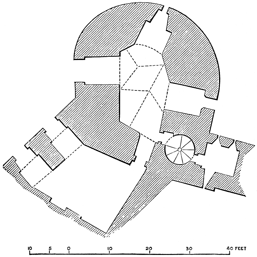
The survey of 1597 shows two circular turrets at its junction with its curtains, and calls it “Robyn the Devyll’s Tower,” or, later, “Develin Tower.” Its present appellation is derived from Robert Earl of Essex, confined here in 1601. The superstructure is modern.
Flint Tower was taken down in the last century, and rebuilt of brick, and was again rebuilt in stone, a few years ago. In its present form it is a rectangle, 40 feet square, having a slight interior and bold exterior projection, and its outer face is rounded. The survey of 1597 shows the interior projection and the usual flanking turrets, but the whole of the present tower appears new, and even the exterior base is either new or has been cased. In the curtain, close west, is a modern staircase in the wall.
The curtain from Devereux to Flint Tower, 90 feet, though capped with a modern parapet, and casemated within, seems in substance to be old; as does the curtain, also 90 feet, from Flint to Bowyer Tower.
Bowyer Tower caps the salient of 160 degrees which breaks the north front of this ward. It is in plan half-round, flat-sided, of 45 feet diameter, 28 feet projection from the exterior of the curtain, and ranging with its interior face, here thickened by the addition of modern casemates. It had in 1597 one circular turret at its junction with its east curtain. The basement is original, and only altered by the substitution of windows for loops. In plan it is rectangular, with a bow of three faces, in each a recess for a loop, the walls being 10 feet thick. There is also a blank recess in the west wall. The entrance door is in the south side, and close east of it is a smaller door, communicating with a chamber in the east wall. Above the entrance door is a trace of a large closed-up arch in the wall. The arches are all drop pointed. The chamber is vaulted, and from its angles, without piers or corbels, spring four plain, heavy, chamfered hip-ribs, which meet, without boss or ornament, in the crown. They are of the pattern of those in Devereux Tower, and no doubt of rather early Decorated date, and probably of the reign of Edward III.
The upper floor is wholly new, as is the whole casing of the exterior.
Bowyer Tower was, from an early date, the residence and probably workshop of the royal maker of bows. In 1223, Grillot was making “balistas corneas”; and, for his encouragement, he had, in 1224, a robe for his wife. Soon afterwards the Archbishop of York had orders to send up Roger Balistarius, with all his implements, to the Tower, paying his expenses. Bayley gives a good perspective drawing of the interior.
From Bowyer to Brick Tower, 62 feet, the curtain is lined with modern casemates, but seems in substance original, though capped with a new parapet, and cased at its exterior base.
234
Brick Tower, in 1532 Burbidge Tower, was, in 1597, shown as a half-round, with a circular turret upon its eastern flank, in the base of which was a mural chamber, and no doubt a staircase. It appears to have been recently rebuilt from the foundation, and is now a horseshoe tower, of 44 feet diameter, and 42 feet at the gorge, applied to very ignoble purposes. Its projection from the curtain is 36 feet.
The curtain from hence to Martin’s Tower, 65 feet, seems to have been rebuilt. It is casemated, and, close to the latter tower, is pierced for a staircase of twenty-seven steps, which ascends from the outer to the inner ward, and shows the point of greatest difference of level between them.
Martin’s, or Jewel, formerly Brick, Tower, was, until recently, the residence of the keeper of the jewels. It caps the north-east angle of the ward, and is in plan an irregular circle 40 feet diameter. Its base for 12 feet or 14 feet, seen in the outer ward, is solid; but, unlike the other towers, is mere rough foundation work, evidently intended to be covered up. Possibly Brass Mount, a bastion of the outer ward, just in front of this tower, was a small mound or cavalier, and extended backwards to the tower. But, however this may have been, the outer ward, at the base of this tower, was certainly 10 feet to 12 feet higher than it now is.
Above the foundation, the wall of the tower, some way up the basement floor, is of fine close-jointed ashlar, like that of Bell Tower. Still higher, the wall is rubble, with vertical lines of ashlar, as described in Beauchamp Tower.
The interior of this tower is so disfigured with lath-and-plaster partitions, and linings of wood, and so cut up into small domestic apartments, that little or nothing can be made of its original details, which probably remain but slightly altered. The basement floor, until recently the jewel-house, and now a kitchen, is circular, or nearly so, in plan, with three loops opening beneath pointed arch recesses. This floor has plain chamfered ribs. The entrance was at the gorge; and on the right, or south, is a well-stair; and on the left traces of a mural chamber. These, no doubt, occupied the two circular turrets shown appended to this tower in the view of 1597. The first floor is evidently original, though still more obscured than that below. This tower is probably of the reign of Henry III.
The jewels seem to have been moved here soon after 1641, from the south side of the White Tower, then used as a powder-magazine, which it was feared might be endangered by the adjacent chimneys.
The Crown jewels, regalia, and the public treasures were originally lodged in the New Temple. King John, however, employed the Tower as a treasury; and sent 4,000 marks thither in 1212. The Bishop of Winchester was his treasurer there in 1215. In 1218, when De Faukenberg was treasurer, money was kept both here and at the Temple. 37 Henry III. (1252–3), the royal jewels and treasure were kept at both places. But, in that year, the regalia were sent, sealed up, to the Tower; and, from this reign, the treasury was235 here. Thus (14 Edward III.) certain jewels are described as “En la Blaunche Tour deinz la tour de Londres.” And (18 Edward III.) are mentioned: “Claves interioris cameræ juxta aulam nigram in Turre Londˢ. ubi jocalia Regis privata reponuntur.” And (30 Edward III.) we hear of the “Tresorie deinz la haute Toure de Londres.” Long afterwards there were, perhaps, two strong places; for (20 James I.) occurs: “His Majesty’s secret Jewell house in the Tower.”—[“Kal. of the Exch.,” iii. 197, 208, 225, 424.] And such entries are numerous.
It was in 1673, while the regalia were in Martin’s Tower, that the attempt of the notorious Colonel Blood was made upon them.
Constable’s Tower stands 102 feet south of Martin’s Tower. It seems to have resembled Broad Arrow Tower in pattern and dimensions; but it has, to all appearance, been recently rebuilt from the foundations. It is now a half-round tower of 32 feet diameter, rising a story above the curtain, which seems also to have been rebuilt. It bore its present name under Henry VIII., and was a prison at least as early as 1641.—[Harl. MS., 1326.]
From hence to Broad Arrow Tower, the curtain, 102 feet in length, seems, for the most part, to be old; but it is completely locked in, on both faces, by houses.
Broad Arrow Tower, though obscured by modern buildings, does not seem to have been much altered. In general arrangement it resembles Beauchamp Tower, but has only two stages, and is much smaller, being 26 feet diameter, with a projection on the curtain of 13 feet. Its inner face is flush with the curtain. On each flank is a small square turret. That on the north contains a steep narrow stair, not a well, entered below by a Caernarvon doorway. That on the south contains a small chamber, probably a garderobe. The ground floor is entered from the gorge, and is a rude, half-round chamber with three loops under drop-pointed arches.
The upper chamber seems to have had four outward faces, and a loop in each; and another in the gorge wall. The mural chamber, 6 feet by 4 feet, has a lancet vault and door, and a loop commanding its curtain southward. A passage from the rampart traverses the upper floor, making it a place d’armes. The stair is continued to the battlements. In 1532, this was “the tower at the east end of the wardrobe,” and as late as the reign of Elizabeth, the wardrobe gallery abutted on this tower, extending from it towards the keep.
The curtain from Broad Arrow to Salt Tower, 156 feet, is so completely locked in by high buildings on each face, that its rampart walk serves as a gutter between the two lines of roof. It is evidently original, about 30 feet high, and 12 feet thick at the base. It does not appear to contain any cells like those in the west curtain.
Salt Tower, in 1532 Julius Cæsar’s Tower, caps the south-east angle of the ward. It is circular in plan, 30 feet in diameter, and 62 feet high. It is constructed of uncoursed rubble, with vertical lines of ashlar, resembling coigns, as in Beauchamp Tower.
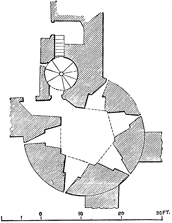
The ground floor, entered from the inner ward between the two236 curtains, is an irregular pentagon with five loops beneath drop-arched recesses. The door opens into a short passage at the north end of the west wall under a segmental arch, against which abuts a similar but half arch in the north wall, under which a small door with a drop-arch leads into the ascending well-stair. The arch-rings are all of good ashlar, but the room is not vaulted.
The well-stair, which lies between the tower and its north curtain, at a height of about 10 feet, leads by a narrow branch to a niche or recess in the curtain, having a drop-arch, reinforced by a plain chamfered rib. This recess is open in the rear, and has a loop raking the outside of the tower and the cross-wall of the outer ward.
The stair goes on to the first and second floor and leads. The first floor, also a pentagon, has on the south face a good but plain early Decorated stone chimney hood, with scroll moulding and plain corbels. In the two eastern faces are loops. In the west is a large two-light window, a modern restoration, and close to it a lancet opening, no doubt once a door leading to the south curtain. The staircase door enters on the north side, and close to it is a loop pointing north along the face of the curtain. From this floor a passage leads along the curtain towards the Broad Arrow Tower; from it opens a small garderobe.
There is a third stage, and above it the battlements.
Salt Tower was the meeting point of four curtains. These were the east and south walls of the inner ward, of equal height and thickness, and two walls of smaller dimensions, of which one ran east, and traversed the east member of the outer ward, and one ran south to Well Tower, and traversed the south member. Each of these had a gateway, opening into the space between them, and leading to the Iron Gate postern. Of the five loops on the ground-floor of Salt Tower, two opened north-eastward upon the outer ward, two south-westward upon that ward towards Cradle Tower, and one south-eastwards towards Galleyman Tower and the postern.
Salt Tower has undergone recent and complete restoration. Its original features, however, seem to have been preserved.
A section of the curtain between Salt and Lanthorn Tower seen against the wall of the former show it to have been 10 feet thick and about 20 feet high, but the rest of it was probably removed before237 1532 to make way for the Queen’s Gallery. This curtain terminated in the Lanthorn Tower.
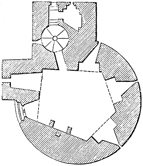
The Lanthorn Tower has been long since pulled down, but its foundation has lately been discovered. It formed a part of the palace, and contained the king’s bedchamber and private closet. It was circular, and probably originally of the age, size, and fashion of Wakefield Tower. As in 1532 it was called the New Tower, it may have been rebuilt in that or the preceding century. It was injured by fire in 1788 and pulled down, with a contiguous gateway which traversed the outer ward at this point.
Lanthorn Tower is stated in the survey of 1532 to have been 106 feet distant from Wakefield Tower. The actual distance occupied by Lanthorn Tower and its curtains, that is from Salt to Wakefield Tower, was 343 feet.
The Outer Ward is a strip of from 20 feet to 110 feet in breadth, which completely surrounds the inner ward, and is itself contained within the ditch, of which its wall forms the scarp. This wall, though generally, is not strictly, parallel to the inner curtain. Like it, its east and west faces are straight, and the north face has a salient angle near its centre. The river front is also bent, though slightly.
On the south side this ward varies in breadth from 20 feet to 80 feet; on the east from 60 feet to 90 feet; on the west from 60 feet to 70 feet; and on the north, the salient of which is rather bolder than that behind it, and a little nearer to the east end, the breadth ranges from 90 feet to 110 feet. The lengths of the faces upon the ditch in the same order are, 750 feet, 580 feet, 460 feet, and 620 feet, being a girth of 800 yards.
The wall has been so altered and strengthened by modern casemates, and so encrusted by buildings, that it is difficult to arrive at its original dimensions. The height varies from 15 feet to 20 feet inside, and is about 12 feet more to the bottom of the present ditch. The usual thickness is about 6 feet. On the river front the wall was only 10 feet high, and apparently only of moderate thickness.
The north-east and north-west angles are capped by drum bastions, parts of circles of about 80 feet diameter. They are called Brass Mount and Legge’s Mount, probably from cavaliers once upon them. Legge’s Mount has the lesser projection, and seems to be solid. The lower part of its exterior wall looks as old as the adjacent curtains, but the upper part is new, and contains a casemate pierced for six guns. Brass Mount, that towards Little Tower Hill, is pierced by a well-stair from above and a cross gallery below.238 This leads from a door in the gorge to the middle of a circular gallery, vaulted in brick, which envelopes the bastion and has numerous loops for musketry, and others altered to suit small cannon. This gallery is probably an addition of the Tudor period, excavated within the old retaining walls. The salient between these two mounts has recently been capped by the north bastion, an additional and perfectly new work, being two-thirds of a circle of about 60 feet diameter, with flattened sides, and containing three tiers of casemates, each pierced for five guns.
The only regular towers of the outer ward are upon the south front, where the ditch is narrow and the palace buildings were most exposed. These are five, Develin, Well, Cradle, St. Thomas’s, and Byward Tower.
Develin Tower, in 4 Richard II. “Galighmaies Tower,” when no cart or dray was to come before it into St. Katherine’s unless the brethren paid a fine to the constable, was, in 1549, Galleyman, and in 1641, Iron Gate Tower. Until recently it was a powder-magazine, and not to be entered with a light. These conditions are not favourable to the study of its interior. It is a long rectangular tower, 18 feet by 32 feet, and built wholly in the ditch, one end being applied to the face of the curtain, so that it projects like a buttress from the south end of the east curtain, while its south side is a prolongation of the river front. The exterior has been partially cased, but it is evidently old, and in substance as originally built. Its basement is solid, but about 10 feet above the ditch is a line of loops on the north and south, or two longer faces. There has been an upper story, the walls of which remain, but seem later than the lower. At this level, in the east face, is the outline of a door, which, if a postern, opened 20 feet above the ditch. The view of 1597 shows a double wall, probably an embattled dam serving as a bridge, extending from this tower across the ditch, and crowned on the counterscarp by a small work, called the “Iron Gate.” If this drawing be correct, the roadway was through the basement chamber, and the upper floor led to the rampart of the wall. This gate led into the precinct of St. Katherine’s. The tower is probably the work of Henry III., and connected with an original dam for keeping up the water of the ditch. Forty feet west of Develin is Well Tower.
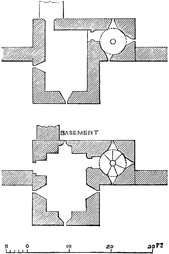
Well Tower, also rectangular, forms a part of the curtain, and has a projection into the ditch 10 feet by 16 feet wide. Its basement, below the present level of the inner ward, and scarcely above the water level of the ditch, contains a chamber, 14 feet by 10 feet, vaulted at a high pitch in two unequal bays, the north the larger, parted by a transverse rib. Each bay is vaulted in four cells, with four hip-ribs meeting in a plain mitred joint. There is a half or wall-rib in the gable of each cell. The ribs are 7½ inches broad by 6¾ inches deep, with a plain chamfer, and spring from four corner and two intermediate circular bell corbels, the tops of which are 3 feet 4 inches from the floor. The height of the chamber is 11 feet239 6 inches. There are four loops, one pointing northwards into the ward, and the rest opening towards the ditch. All are under drop arches. In the west side is a door of 3 feet, opening in a drop-arched recess, which may have led into a mural cell in the curtain, or have been an entrance from the ward. On the east side a rectangular appendage, entered by a square-headed door, contains a well-stair of 6 feet 3 inches diameter, looped upon the inner face of the curtain and the ditch. This stair leads to an upper room on the rampart level, not vaulted, 15 feet by 10 feet, looped to the field and upon the face of the west curtain. In its north wall an original door, 2 feet 3 inches wide, opens on the rampart. The second floor is modern. Well Tower is a good example of the early English style.
Well Tower stands due south of Salt Tower, and a short curtain, with a gateway, connected them. Part of it remains, 12 feet high and 6 feet thick, pierced with loops at the ground level, and embattled against an attack on the east. This rampart was reached from Well Tower, and did not communicate with Salt Tower. A similar cross curtain connected Salt Tower with the outer ward wall westward. This also was looped, had a central gate, and was em240battled for defence from a south attack. These two curtains thus enclosed the approach to the Iron Gate postern, and prevented either part of the outer ward from being entered by surprise. These arrangements are evidently as early as the time of Henry III., and are shown in the view of 1597.
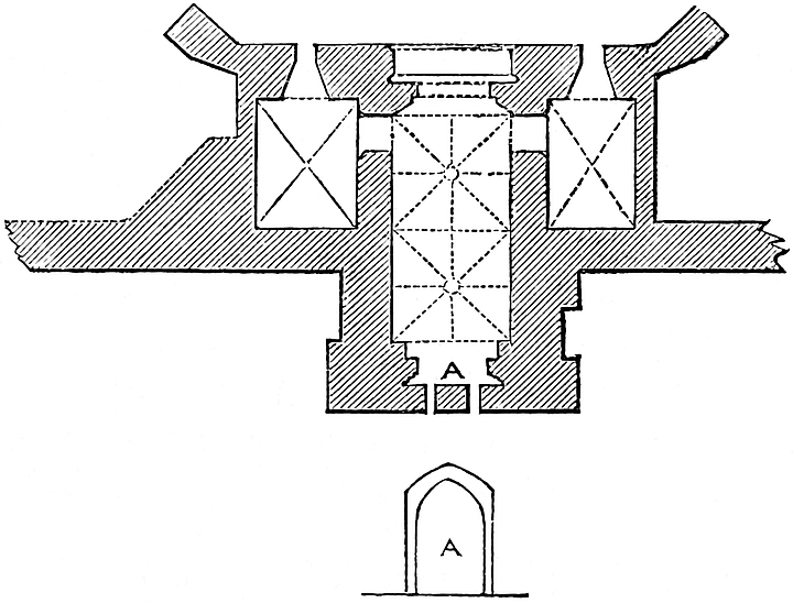
Cradle Tower comes next west, at 118 feet distant. It stands on the outer wall, and projects 9 feet into the ditch, with a breadth of 16 feet. It is a gatehouse, and though of small dimension very complete in its design, and of excellent construction. It stood nearly in front of the bye-gate of the royal quarter, and allowed a direct passage thence to the quay.
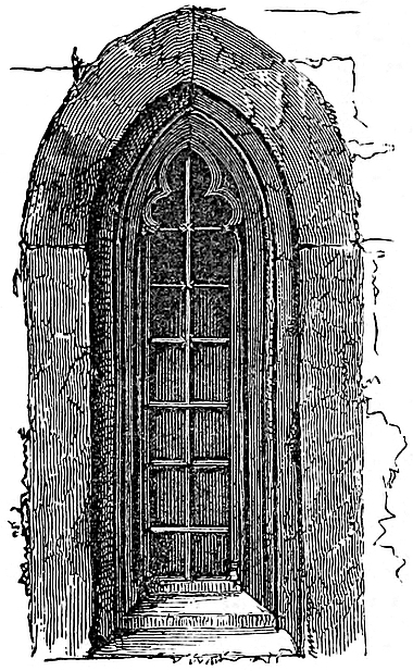
It is in plan T-shaped, the portal running through the main limb, which projects into the ditch, and the lateral wings, each containing a lodge, forming a gorge or main front of 26 feet width, and flanked by two diagonal buttresses, which cap the angles and project into the ward. Between these is the doorway, and on each side of it a small lancet window, cinquefoil-headed. One of these windows is quite unaltered.
The doorway is 7 feet 2 inches broad, with a drop arch and light chamfer moulding. Two feet in is a portcullis groove, succeeded by a doorway of 5 feet opening, of which the valves move inwards. The wall is 4 feet 7 inches thick. The passage is a chamber of two squares, 7 feet broad, and 12 feet 6 inches high. It is vaulted in two equal bays, parted by a transverse rib. Each bay has four hip-ribs, and a straight rib takes the crown line of each vaulting cell, so that eight ribs meet in the centre of each bay, the point of junction being a hollow circle. There is besides a wall-rib in each gable. The rib parting the two bays, and the longitudinal rib, have a plain mitred junction. The rib and circle-mouldings are the same. They are light and bold, 5 inches broad and 7 inches deep. The base of the rib has a hollow chamfer, and its apex is an ogee. The ribs spring from four corner and two intermediate corbels, the tops of which are 7 feet from the ground. These are octagonal and embattled. The bracket below is much defaced.
The doorway in the south end, of 4 feet 6 inches opening, had gates opening inwards, and outside them is a second portcullis groove.
The lodges open from the central passage close to the ward entrance, by doors, 2 feet 10 inches wide, one of which has the remains of the cusps of a cinquefoil in the head. They are 12 feet broad by 8 feet 9 inches long and 12 feet high, having the small241 windows already noticed towards the ward. They are hip-vaulted in chalk, with four cells, having four ribs 7 inches broad by 7 inches deep, springing from corbels, now knocked off, but the tops of which were 7 feet above the floor. There are no wall ribs. The portal arches of the main passage are drop in recesses, of which one is so low as to be nearly, and the other is quite, segmental. The vault-arches are equilateral, or nearly so.
On each side of the part of this tower that projects into the ditch, on the outside, is a recess, on the west face 4 feet 6 inches, and on the east face 3 feet broad, and 1 foot 4 inches deep. Possibly these were the shoots of garderobes from the upper floor and battlements, now removed. On each side, at the old water level, is a half-arch admitting the water of the ditch below the drawbridge or cradle.
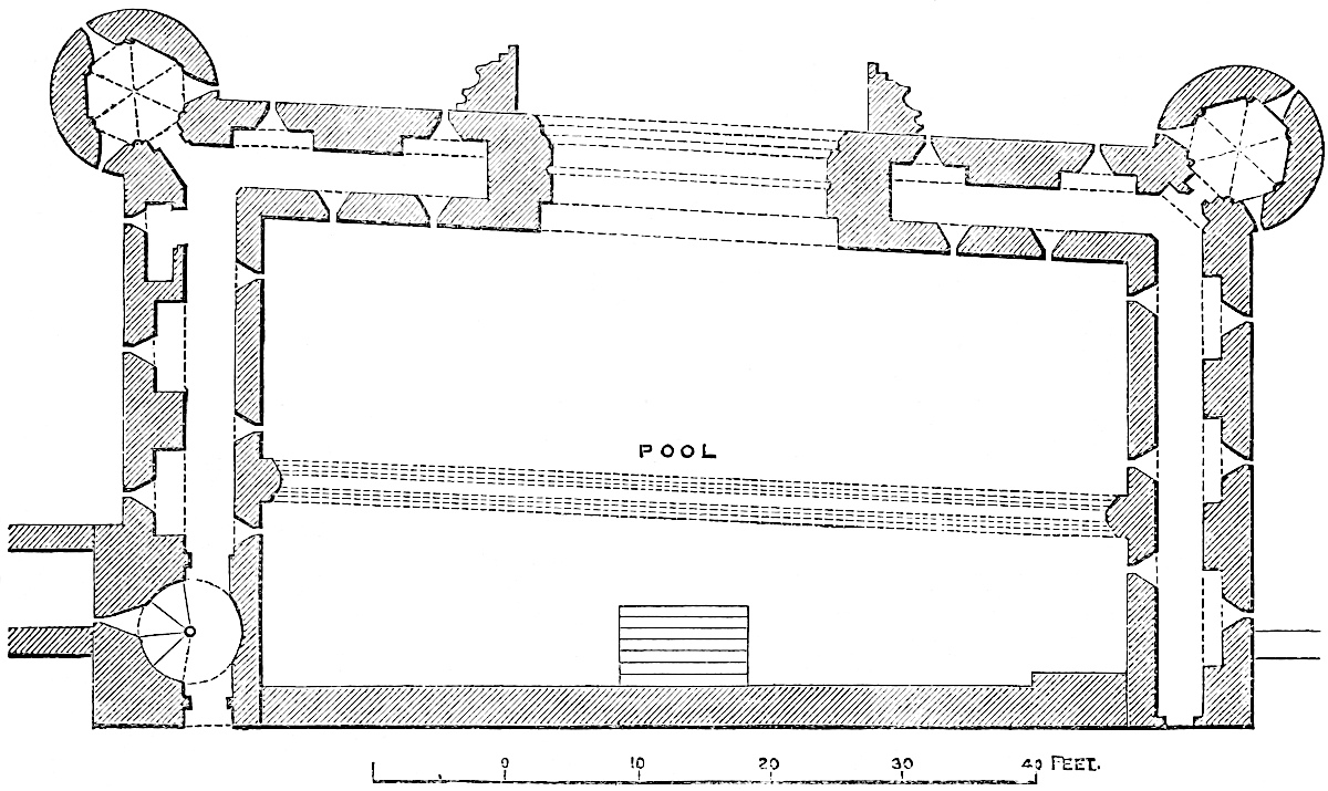
In the curtain, close west of this tower, is a well-stair, leading from the west lodge to the roof.
The superstructure of Cradle Tower is said to have formed a part of the palace quarter, and the view of 1597 shows it as a water-gate, with a square turret on its west flank, where was the supposed staircase. It shows also, west of this, a considerable tower extending across the ward, here very narrow, to the Lanthorn Tower, and which no doubt contained the Lanthorn Gate.
The details of Cradle Tower are rather Decorated than early English; and if, as is historically probable, it be the work of Henry III., it must be late in his reign, and was perhaps completed242 by his son. Owing to the cumbrous character of the sluices and gates of St. Thomas’s Tower, state prisoners were sometimes admitted by this gate, then fitted with a cradle or drawbridge.
St. Thomas’s Tower, better known from its ancient function as Traitors’ Gate, is the water-gate of the Tower, and also contained and commanded the communication between the Thames and the main ditch. It is, in fact, a barbican, and a very singular one, placed astride upon the ditch, here 40 feet broad, and perforated by a passage leading from the river. It stands considerably west of the south front, being in advance of the Bloody Tower 30 feet, the breadth, at this point, of the outer ward.
The quay, in front of this tower, is traversed by a channel, 28 feet broad and 13 feet 6 inches deep, partly arched over and newly lined with granite, which opens from the Thames, through an archway 21 feet broad, into a rectangular basin or pool, 66 feet by 40 feet, and 18 feet deep, lined and paved with stone, and containing, when the gates are opened, about 8 feet of water at high water. A flight of steps from the water, on the inner or north side of this basin, landed the prisoner within 30 feet of the gateway of the inner ward.
The tower proper is placed above the outer 18 feet of this basin, but its side walls are prolonged backwards, so that both the front and sides of the basin are protected. The south wall, 9 feet thick, is pierced below by a low-browed water portal, already mentioned, beneath a drop arch, ribbed and chamfered. Between the ribs is a groove, 6 inches broad, for an iron sluice or portcullis, worked in the building above; and in the jambs are two holes, 6 inches diameter, lined with iron, for the passage of a chain. Within this, on the inner face of the portal, were folding gates opening inwards.
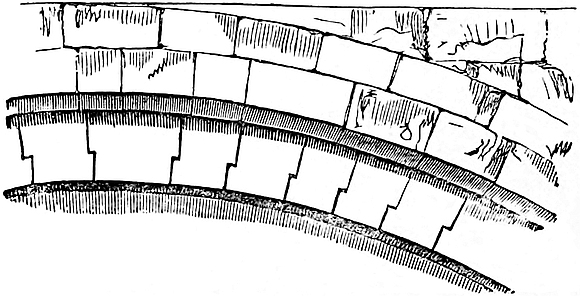
Seventeen feet within this outer wall the basin is crossed by an arch, supporting a light wall of brick and timber, which was the rear wall of the tower. This arch is a very remarkable piece of construction. It springs from two half-octagonal piers, and is segmental, of 61 feet span and 15½ feet rise. The voussoirs form two ribs, and the inner one is composed of seventy-five stones, united by a simple joggle or rebate. The rectangular tower, which thus rises from the walls of the outer half of the basin, is 86 feet east and west by 18 feet north and south, and capped at its two Thames-ward angles by light cylindrical turrets, three-quarters engaged, and rising above the parapet of the tower. The side walls, prolonged backwards an additional 30 feet, terminate in two square turrets, which occupy the northern angles, and also rise above the battlements.
243
Two doors on the north faces of these turrets, on the ground level, open into a mural gallery in each wall, looped on one face towards the ditch and on the other towards the basin. These galleries communicate with the southern turrets, and are continued within the south wall, having each two loops towards the Thames and two towards the basin. They do not meet, being stopped by the jambs of the sluice-gate. They were also used to receive the slack of the chain when drawn up.
The floor of the tower, which is above the level of these galleries, contained the machinery for lifting the sluice, which must have been heavy. The walls of this floor are also pierced with loops, and contain two garderobes. In the river-front are two early Decorated windows, of two lights each. The two upper chambers in the south turrets open into this floor, which is reached by a winding stair in the north-east turret, and by an exterior stone stair in the north-west turret.
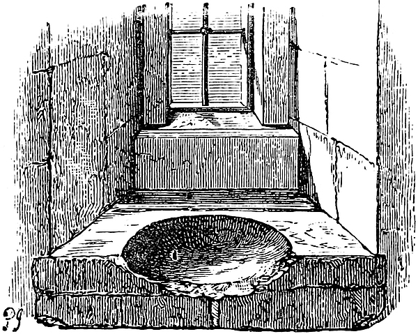
The four chambers in the two cylindrical turrets are of excellent design and delicate workmanship, as may be seen from the plate in the “Vetusta Monumenta.” They are in plan octagons, having slender columns, with high bases and bell caps, all cylindrical, and slightly engaged, in each angle, from each of which springs a light chamfered rib, meeting in a plain joint at the centre. There are thus eight cells, each with a lancet gable, supported by two half-ribs. Three of the faces have windows or loops, and another is occupied by the door. In the lower rooms the loops have chamfered recesses beneath drop arches. In the upper, the loops are larger, but still square-headed, and their recesses have an arch-rib with a hollow chamfer. The south-east upper chamber was an oratory. The window-sills on each side the east windows are Purbeck slabs, hollowed into bowls,—on the south for a piscina, on the north for holy water. Both slabs projected, and have been broken off when the walls were wainscoted.
There is a second floor, reached by a well-stair in the square turrets, which ascend further to the roof, but it contains nothing of interest. The well-stair in the north-east turret leads to a door that opens on the north face, 20 feet from the ground, and which opened outwards, and was barred on the outside. The meaning of this is only explicable on the supposition that a bridge, or perhaps an embattled cross-wall, connected this door with the corresponding opening in Wakefield Tower, 18 feet distant. By this means a person leaving St. Thomas’s Tower, and barring the door behind244 him, would reach Wakefield Tower, and therefore the palace, and cut off pursuit. In the second floor of St. Thomas’s Tower is another door, above and similar to the first, which in like manner communicated with the top floor of Wakefield Tower; so that either there were two drawbridges, or a wall pierced by a mural gallery at 20 feet high, and with a rampart walk at its summit.
St. Thomas’s Tower was, until lately, occupied by a water-engine, to the great injury of its walls. The upper rooms were cut up into lodgings by means of wainscot and lath and plaster. All has lately been cleared out, and the tower restored in good taste.
St. Thomas’s Tower is attributed, and no doubt justly, to Henry III.; but, although the octagon chambers have an early English aspect, the grand arch, the staircase doors, and the windows towards the river are decidedly Decorated, though probably early in that style. If, therefore, this tower be of one date, it must be very late in the reign of Henry, but more probably it was completed and the grand arch turned in that of his son. The material is a rag-stone laid in uncoursed rubble masonry, like Beauchamp and Salt Towers, with ashlar dressings. The pool below was extensively repaired by Henry VIII. There is some reason to suppose that this was the tower that fell twice while being built.
The curtain along this front is original, though capped and patched in modern times. It seems to have been about 20 feet high above the water, and from 12 feet to 14 feet on the inner side. In parts it was 12 feet thick; but the addition of brick casements in Tudor times, to enable the ramparts to carry cannon, prevents an accurate examination. It is no doubt the work of Henry III. From St. Thomas’s to Byward Tower is 160 feet.
Byward Tower is the great gatehouse of the outer ward, and is placed upon the scarp of the west ditch, at its junction with the south ditch. It is in plan rectangular, 50 feet broad by 24 feet deep, and its two outward angles are capped by drum towers, 23 feet diameter, one quarter engaged, which rise out of the moat. Between them is a curtain of 14 feet, pierced by the main entrance. The towers, below the roadway, are solid; above it they are of three stages, and 49 feet high to the crest of the parapet, which, with most of the casing, is modern.
The portal opens from the bridge by a low drop arch, 12 feet broad and 12 feet high, reduced by two deep chamfers to 10 feet opening, followed by a broad jamb, in which are loop openings from the lodges. This is succeeded by a 6-inch portcullis groove, with a chase of 16 inches in the vault, to allow of the passage of a heavy wooden grate. Then follows a heavy rib, pierced with three round holes, which slightly converge, and are probably for the beams of a stockade, supposing the gates to be forced; and behind is a rebate with hinges for the valves of a door, opening inwards. The middle portion of the portal, which begins here, has a flat timber roof, 18 feet high. In it is a second portcullis groove, and the doors of the warders’ lodges. Finally is245 the inner archway, without jambs, but with a bold triple rib forming the arch.
The south lodge door enters a lobby, 8 feet by 4 feet, vaulted in chalk, with a southern loop raking the postern. A pointed door on the left or east face opens into a garderobe, with a loop to the east, now closed. Opposite, a short passage, also vaulted, and with a cross rib, leads into the south or warders’ lodge.
This is an octagon, 15 feet 9 inches from face to face. In each angle is a slender octagonal pier, engaged on a face and two half-faces, with a sort of bell-cap and stilted base, both octagonal. From each pier spring a main rib and two half-ribs. The former meet in the centre in a plain joint; the latter form lancet arches at the gable of each cell. All are narrow and plainly chamfered. Of the eight vaulting cells the ridge lines are horizontal, and have no ribs. The ribs and piers are of freestone, the vaults of chalk. From the floor to the pier caps is 6 feet 11 inches. The total height is 17 feet.
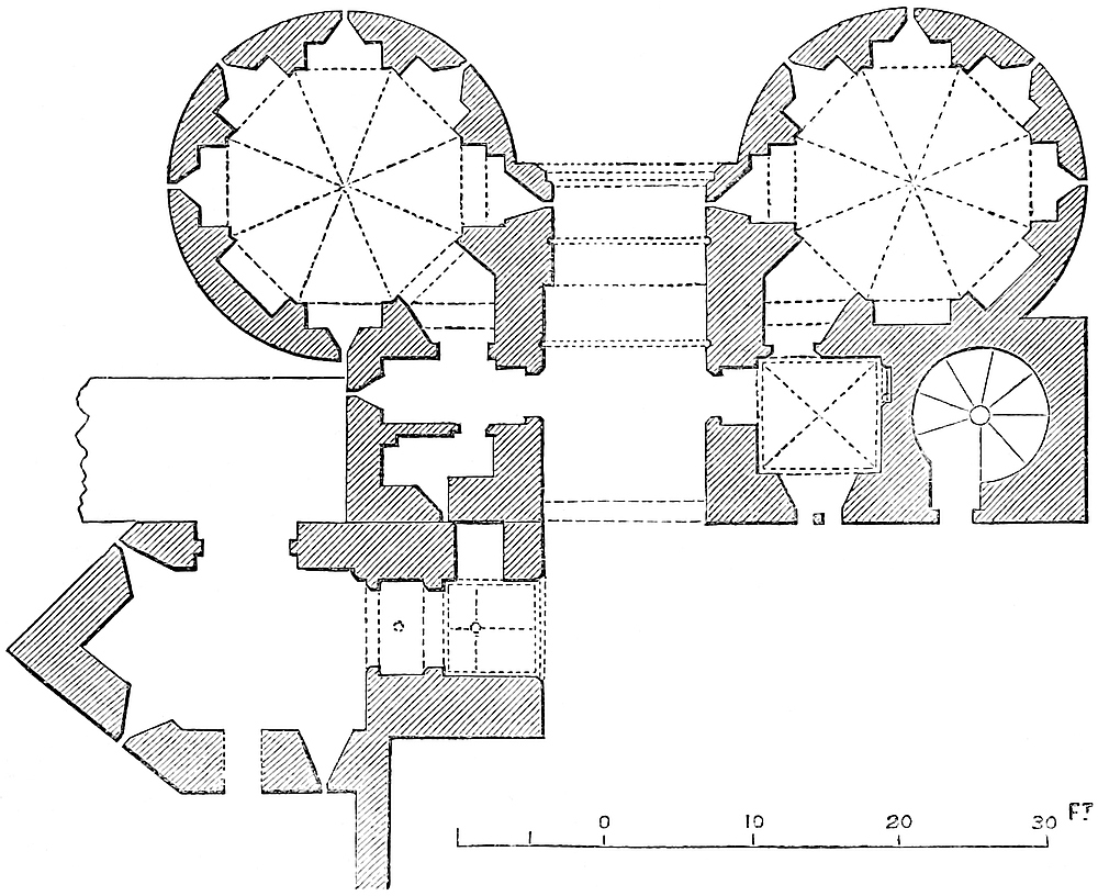
In each of the faces is a recess. That on the north-east is the entrance. The south-east is occupied by a fireplace, no doubt representing an original one; The other six are looped.
The north lodge is entered through a lobby, 7 feet 9 inches square, and 15 feet high, vaulted in four cells, with four slender chamfered hip-ribs, springing from octangular corbels, one at each angle. There is no boss. Each cell has a profile half-rib in its gable.
In the east side is a long two-light window beneath a segmental246 recess, which seems original. This window, and the proportions and general elegance of this chamber, point to its possible use as an oratory. Those who entered the Tower might well need to be met by spiritual support on the threshold.
In its north wall is a small lancet doorway, leading to a well-stair, but probably always closed. A west door leads through a short passage into the lodge, now a police barrack. This lodge resembles closely that on the south side, save that the east recess is closed up, and the fireplace, the brackets of which are original, occupies the north-east face. The upper part of this chamber, towards the ditch, has been pierced, probably for musketry, so as to command the approach from Tower Street. In the north-east angle of this gatehouse is a well-stair, entered by a separate door from the east and outer side.
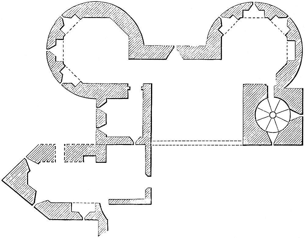
The first floor contains two large octagonal chambers in the towers. The staircase opens into one of these in the north-east angle, and a chamber 8 feet square occupies the south-east angle. The rear wall between these two turrets is wanting, so that this gatehouse, with its portcullis chamber, was intended to be open in the rear, or was closed, as now, by a lath-and-plaster brattice. There was a small window to the west, over the entrance-gate, looking on the bridge.
The arrangements of the second floor are still more simple. The staircase remains, and the two octagon chambers, but the small south-east chamber is wanting. The rear is open.
At the battlement level the staircase and its turret cease. There is now nothing above the parapet.
247
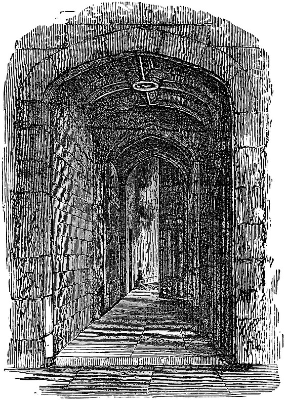
In the rear of and attached to the south-east part of this gatehouse is a low tower, of later date, intended to cover a postern bridge, traversing the south ditch, and dropping on the quay. The tower is rectangular in plan, 14 feet broad and 29 feet long, besides an acute salient of 12 feet more, which projects into the south ditch, and prevents it from being raked.
It is pierced north and south by a portal 6 feet 9 inches broad, which commences by a square cell, vaulted, with a cross and longitudinal rib, chamfered, and pierced at the intersection by an octagonal cavity. Two door jambs then reduce the opening by a foot, and between them, in the vault, is a hole 9 inches diameter, apparently intended for a chain which passed out over the rib of the further door, and worked, still within the tower, a light bridge, the recess for which is seen outside the door. The chamber here widens by 3 feet, to allow space for those defending the east wall. When this bridge was down, a way was opened to a door in the west wall, outside which is a platform, whence a second bridge dropped southwards across the ditch. The upper story of this postern tower was one large chamber for working the inner bridge. A door leads from it upon the rampart walk of the east curtain. Above this were the battlements of the postern, two stages below that of the contiguous tower. In the Tudor reigns these buildings were encumbered with additions in brick, timber, and plaster, which still remain, and much obscure the original details. This postern tower is Perpendicular, perhaps the work of Richard II.
Besides the bulwarks and towers just described, the inner ward was strengthened against surprise by several cross walls and gates, breaking it up into independent sections. One of these gates crossed from Bell to Byward Tower, and another, it is said, crossed north of Beauchamp Tower. There were walls with gates across the ward, on either side of Traitors’ Gate, so that prisoners could be brought in by water and led across into the Bloody Tower gate, without any chance of rescue in the outer ward, and indeed without being seen. Another gateway of a stronger description, and with towers, extended from Lanthorn to near Cradle Tower; and another also, already mentioned, opened in the small curtain between Salt and Well Tower. There was at least one more gateway in the short248 curtain east from Salt Tower. The ward, between all these gates, must have been intended to be open; but, at least since the Tudor reigns, it has been encumbered with private houses. Here the operations of the Mint were carried on with much inconvenience; and the north and west limbs of the ward still bear the name of Mint Street, and the east limb, of Irish Mint Street.
The curtain or scarp wall of this ward was, no doubt, the work of Henry III., and much of the wall is still original. In the west wall, near Byward, below a modern battery of two guns, are six loops, probably old, but lighting modern casemates, and beneath each an air-hole. Also, on the north front, close west of the new bastion in the wall, is a pointed arched door, long closed up, but probably an original water-gate. West of this also is an original loop, no doubt marking the place of a mural chamber not now accessible.
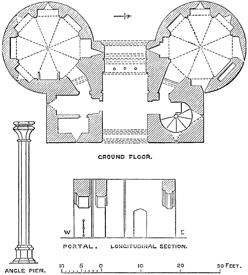
The modern additions to this curtain consist in a line of casemates, storehouses, canteens, magazines, and workshops, built against and concealing its inner face, and giving a rampart or platform of 30 feet width.
This exterior wall has been built with great care on a broad and deep foundation, since it shows no sign of settlement, though built in what, until recently, was a deep and muddy ditch. At one part indeed, close south of Brass Mount, it has been strengthened by249 three very clumsy buttresses of 12 feet in breadth and 22 feet projection. One covers the internal angle of the bastion; the next is about 40 feet distant; and the third, at about the same space, is in fact a rectangular mural tower resembling Galleyman, and contains a small chamber having two loops on each of its three free faces. Its parapet is new, and pierced for two guns.
Middle Tower is the outwork of Byward Tower, and a barbican covering the landward entrance to the fortress. It stands on the counterscarp of the ditch, at the outer end of the bridge, and was originally enveloped by a special ditch of its own, a loop from the main ditch of the place, filled up in the eighteenth century. In design and execution it resembles closely Byward Tower, though rather smaller, its breadth being 40 feet, and its height 30 feet from the roadway. It is evidently of the date of Byward, and like it was open at the rear. It also has been cased with Portland stone. Its portal has a double portcullis, gateway, vertical holes, side loops and lodges, and its central part is ceiled with timber. In neither tower is there now any trace of a drawbridge. The lodges are tolerably perfect; the stair in the north-east angle is in use, and corresponds to the Byward oratory; and in the south-east turret is a lobby and a garderobe, and above these a chamber 7 feet by 8 feet 6 inches, and again on the leads another chamber 7 feet 4 inches by 10 feet 10 inches.
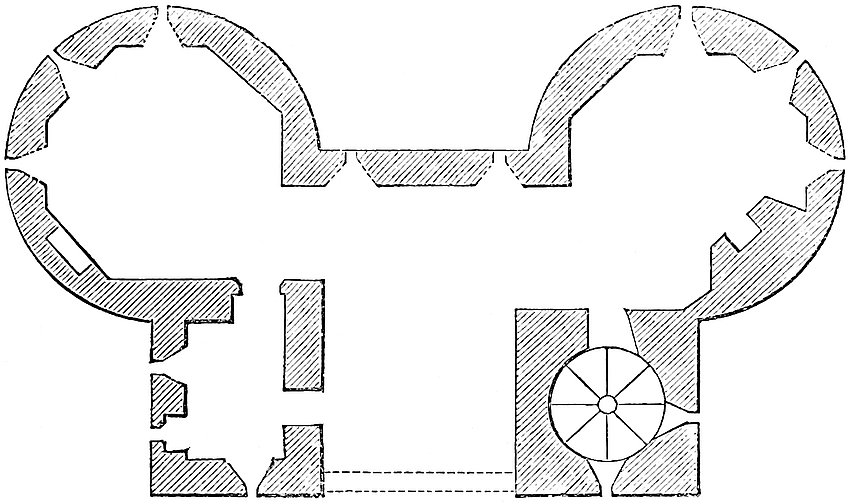
Between the two gatehouses the ditch is traversed by a stone bridge, 130 feet long, and at the narrowest 20 feet wide. As the towers are not precisely opposite, the line of the bridge is broken by a slight zigzag. In the centre appears to have been an opening of 20 feet, now a stone arch, once the place of a drawbridge, as shown in old drawings.
The Quay does not appear to have had any permanent parapet wall, which indeed would have interfered with its uses. It was sufficiently commanded by the defences of the outer ward. It was probably the work of Henry III., in the twelfth of whose reign it is first250 mentioned, and called “Kaia Regis”; and John de Crumbwell, custos 8–9 Edward III., had then an order for 300 alder poles from Windsor forest for repairing it. The quay is in length about 1,130 feet, that being the full frontage of the Tower.
The Ditch.—This, by far the most formidable of the defences of the Tower, varies in breadth from 100 feet on the east to 110 feet on the north, and 120 feet on the west or City side. Along the south or river front it is only 40 feet broad, probably because on that side it was covered by the wharf, the narrow limits of which did not permit any great force of assailants to be drawn up upon it; besides which the tower covering Traitors’ Gate, and the two small postern bridges which it was convenient to have towards the wharf and river, did not allow any great breadth of ditch.
The ditch was not only broad, but of great depth, so that when filled to the level of high water it was scarcely to be passed, and indeed when the water was low, the mud which accumulated there, and which made it of late years an unhealthy nuisance, must have been quite as formidable as a defence. Nevertheless, care was taken to cleanse it, and the “Liber Albus” informs us that, in the reign of Edward III., the penalty for bathing in the Tower fosse, or in the Thames near the Tower, was death! (vol. i., p. xlix.) Its exterior circuit is computed at 3,156 feet.
Also, from the great height of the ground to the west and north, the counterscarp is so very high as to be in itself a considerable obstacle to crossing the ditch, although, no doubt, this was in other respects advantageous to besiegers. Besides the main bridge, the ditch was crossed by St. Thomas’s Tower and the dam between Galleyman and Iron Gate, all of which served to hold up the water. There were also the posterns of Iron Gate, Byward, and Cradle Tower.
No doubt the Conqueror’s ditch, even when deepened by Longchamp, was fed by the Thames; and the water rose and fell with the tide. The intervention of the wharf and the St. Thomas’s sluice-gate were devised to make the water in the ditch independent of the tide, and thus add materially to the strength of the defences. The ditch was drained and its bottom raised and levelled by the Duke of Wellington during his constabulate. There are seen in the modern brick revetment of the counterscarp a number of walled-up arches, resembling sewer-mouths, which appear to have been intended to facilitate the mining the glacis in the event of a siege.
The outwork in advance of Middle Tower, though its ditch is filled up, and its other buildings removed, is still indicated by a line of stockades, which contain the ticket-office and a small engine-house. Here stood the Lion Tower, and the Royal Menagerie; and this whole tête-de-pont was further protected by a smaller tower and drawbridge of its own, shown in some of the early drawings.
Lions were a part of the royal state, and lodged in the Tower bulwark, in the reign of Henry I. The Emperor Frederick, in 1235, sent Henry II. three leopards; and, in 1252, Henry III.251 received a white bear from Norway, for whose sustenance, with his keeper, the sheriffs of London provided fourpence daily, with a muzzle and iron chain, to keep him when “extra aquam,” and a stout cord to hold him when a-fishing in the Thames. In 1254, Louis of France sent the king an elephant. He was brought from Sandwich to the Tower, where the sheriffs were to build him a strong and suitable house, 40 feet by 20 feet, and to support him and his keeper. Edward I. and Edward II. kept lions here. At a time when the allowance for an esquire was one penny per day, a lion had a quarter of mutton and three-halfpence for the keeper; and, afterwards, sixpence was the lion’s allowance; the same for a leopard, and three-halfpence for the keeper. In 16 Edward III., there were a lion and a lioness, a leopard, and two cat-lions. In 1543, the Duke of Najara saw here four large and fierce lions, and two leopards. The menagerie was finally closed about the year 1830. Its establishment on this particular spot was probably due to Henry III.
The whole outward space was, in 1597, called the Bulwark, and sometimes the Spur-yard.
Having decided to build an “Arx Palatina,” and having some years’ experience of the value of the proposed site as a temporary camp, the Conqueror at length determined to erect a regular castle, and entrusted the work to Gundulf, a monk of Bec, who, in 1077, soon after his arrival in England, was consecrated Bishop of Rochester.
Gundulf brought with him from Normandy some reputation as an architect, which vocation he pursued in this country. Rochester Keep, that strong but graceful tower, placed so judiciously above the ancient passage of the Medway, and long attributed to the bishop, is now known to be of later date; and the only existing buildings, besides the White Tower, which can safely be attributed to him, are the north tower of Rochester Cathedral, parts of the old crypt, and perhaps a small part of its west front; also the very perfect and unaltered shell of Malling Keep, known as St. Leonard’s Tower; possibly the broad, massive tower of the adjacent church, and, it may be, the Norman portions of that of Dartford. These remains, however, the White Tower, and the testimony of many generations, may be regarded as sufficient for the confirmation of his fame.
A direct evidence for the employment of Gundulf upon the White Tower is afforded by the “Textus Roffensis,” written about 1143, or within eighty years of the Conquest, and printed by Hearne. This record preserves incidentally the fact that Gundulf, while so employed, lodged at the house of Eadmer Anhœnde, a burgess of London, and a donor to the bishop’s church at Rochester, where252 he directed his body and that of his wife to be buried, and to have an annual obit.[5]
Gundulf was appointed bishop in 1077, and probably his first attention was given to his cathedral, so that it is supposed he did not commence the Tower until 1078, up to which time the ground was occupied by certain temporary defences.
Gundulf reached the age of eighty-four, and lived till 1108, that is, through the reigns of the Conqueror and Rufus, and to the ninth of Henry I.; it is, therefore, certain that he lived to see the keep completed, perhaps by Rufus; and he most probably made some progress in the walls of the enceinte, and the buildings of the palace, and perhaps of the Wakefield Tower.
The fortress designed by the Conqueror no doubt included very much of the space within the present walls. Less would scarcely suffice to contain a citadel, a palace, and an arsenal; and the liberties were evidently of no greater area than was necessary.
The west boundary line runs but a few yards outside the counterscarp of the ditch, and includes only what may be called a narrow glacis, and nothing of the open space or esplanade usually reserved around a fortress. It is, however, probable that no permanent exterior defences were executed by the Conqueror, and that those first commenced were the curtains from the Wakefield to the present Broad Arrow Tower, and the cross walls of the Wardrobe Gallery and Cold Harbour, which, with the keep, included the space set apart for the palace. This was for many centuries known as the inner ward; and the Wardrobe and Lanthorn Towers and those of the Cold Harbour Gatehouse, all now destroyed, are represented in the reign of Elizabeth as cylindrical, and resembling in design the Wakefield Tower, which is late Norman. It is, therefore, probable that the old inner or palace ward was first completed.
The rest of the enceinte, forming what is now known as the inner ward, could not, however, have been much later. According to the “Anglo-Saxon Chronicle,” Gervase, and Le Livere, Rufus was, in 1097, building about the Tower a wall of sufficient magnitude, with the new hall at Westminster, to be the cause of heavy taxation, and the subject of general discontent, augmented, no doubt, by the impregnable character of his work. The existing curtain of the inner ward, being from 9 feet to 12 feet thick, from 39 feet to 40 feet 253high, and of sound but rude masonry, cannot be later than John, by which reign the wall of Rufus could not have fallen into decay. It is far more probable, and quite consistent with the dimensions and character of the work, that this was the actual wall commenced by Rufus, and upon which he was employed in 1097.
Bell Tower, indeed, which seems to bond into the curtain, and the base of which presents masonry very like that of Wakefield, is octagonal, and its vaulting can scarcely be earlier than John; but Devereux Tower, which is cylindrical outside, and has round-headed recesses in its polygonal basement chamber, may be as old as Wakefield, and therefore in substance the work of Rufus. The vaulting is later, but both may have been, as at Wakefield, taken down to the first floor at a later period, to which the vaulting may belong. Beauchamp, Bowyer, and all the other towers on this wall are evidently later insertions; but the wall itself, where it remains, as on the west and part of the east and south fronts, is of a very early character, and not unlike the wall of John at Corfe and the earlier one attributed to Robert Consul at Cardiff.
Most of the chroniclers record a violent storm that swept over London towards the close of the eleventh century. Le Livere dates it Friday, 27th October, and Malmesbury, 28th November, 1091, and says it unroofed St. Mary-le-Bow, and destroyed 600 houses, as houses then were.
Stowe adds that the White Tower was damaged “by tempest and winde sore shaken,” and that it was repaired by Rufus and Henry I.; but he gives no authority for this statement, which the extreme solidity of the building renders very improbable. The outworks, however, both wall and towers, if in course of construction, with scaffolding up, might very well have suffered severely.
The Tower, therefore, of the close of the reign of Rufus, and of those of Henry I. and Stephen, was probably composed of the White Tower with a palace ward upon its south-east side, and a wall, probably that we now see, and certainly along its general course, including what is now known as the inner ward. No doubt there was a ditch, but probably not a very formidable one.
Ralph Flambard, Bishop of Durham, and the faithful and rapacious minister of Rufus,—“pacitator Ranulphus, vir pessimus,”—by his severe exactions greatly promoted the works of the Tower. Singularly enough, he is the first person known to have been imprisoned there. Henry, on his accession, and by the advice of his council, 15th August, 1100, shut up Flambard in the Tower. Palgrave says he was lodged in the uppermost or council-chamber of the White Tower, under the custody of Walter de Magnaville, the hereditary constable. Probably his imprisonment was only intended to satisfy the popular cry, for two shillings, at that time a considerable sum, was allowed for his daily sustenance. He employed it, as is said, in feasting his keepers; and having received a rope in a flagon, took advantage of their drunken state to let himself down from the window of the south gallery, on the night of the254 4th February, 1101, taking his pastoral staff with him. The rope proved too short for the descent of 65 feet, and he was injured by a fall, but he escaped in safety to Normandy, and, as is well known, lived to recover his see of Durham, where he completed the cathedral, added a moat to the Palatine castle, founded Norham on the Tweed, built Framwell Gate bridge, and endowed the hospital of Kepyer. The Tower was probably from the first a state prison, for in 1106 the Earl of Mortaigne, taken with Robert Duke of Normandy by Henry I., was, says Eadmer, shut up there. The Pipe Roll of 21 Henry I. records “£17. 0s. 6d., inoperatione Turris Lond.”
In the time of Stephen the Tower was regarded as impregnable. Geoffrey, grandson of Geoffrey de Magnaville, the companion of the Conqueror, and the third hereditary constable, was created Earl of Essex by the king, who in 1140 kept Whitsun in the Tower. “Eodem anno, 1140, in Pentecoste resedit Rex Londiniæ in Turri, tantum modo Episcopo Sagiensi presente: cæteri vel fastidierunt, vel timuerunt venire.” [R. de Hoveden.] The new earl proved false, and shifted his allegiance to the empress, who, by charter in 1141, confirmed him in his earldom and the constableship.
When the power of Maud declined, the citizens, to whom Geoffrey was as odious as his fortress, laid siege to it. Their efforts were so unsuccessful that on one occasion the earl made a raid as far as Fulham, and captured the bishop.
In 1143 the earl trusted himself in the royal presence at St. Alban’s, depending on the king’s word. The temptation to obtain the Tower was too great,—“magis ex necessitate quam honestate,”—he was detained, and the Tower was his ransom. Stephen held it until 1153, close upon the conclusion of his reign, when, by the Treaty of Winchester, he gave it up to Richard de Lacy, the Justiciary, who was to hold it until Stephen’s death, when it was to pass to Henry, which accordingly was done in 1154. It is clear, therefore, that at that time the fortifications of the Tower were both complete and strong; and this, in the absence of a wet ditch, which it will be shown did not then exist, could scarcely be the case with walls of inferior strength to those now seen.
Henry II. is said to have placed Becket in command of the Tower, the government of which had ceased to be hereditary. But there is no proof of this, or that Becket repaired it; though at a later period, indeed, one of his demands, as archbishop, was the custody of Rochester Castle and the Tower. By this time “London’s lasting shame” had attained its gloomy reputation, and Fitz-Stephen describes the “Arx Palatina” as “great and strong, with encircling walls rising from a deep foundation, and built with mortar tempered with the blood of beasts.”
The Pipe Rolls of this reign contain frequent entries of large sums issued for the repair of the king’s houses in the Tower, his chapel, and his gaol. In 2 Henry II., 6s. 1d. was paid for carrying the king’s breastplates to the Tower; but the regular series of accounts does not begin until 13 Henry II., and ends with 34. The255 entries for Westminster and the Tower are also much mixed up together, though sometimes distinct. Thus in 13 Henry II. the king’s houses in the two places and the queen’s chamber cost £64, and, in 19 Henry II., £60 was paid for the repairs of the Tower and of the houses in it. In the preceding year the king’s houses in the bailey of the Tower cost £21. In 20 Henry II., Alnod, the engineer, had £6. 13s. 4d. for works at the Tower, and afterwards 100s. Similar payments continually occur, sometimes for lead for the repairs of the chapel, sometimes for carriage of timber and planks, sometimes for the kitchen, the gateways of the gaol, the repairs of the houses, and sometimes for the Tower itself.
The necessity for each expenditure is often certified to by the view of two officers, Edward Blund and William Magnus; the works were executed by the engineer Alnod; and the brief, authorising payment, was signed either by the king himself, or by Richard de Lucy or Ranulph de Glanville, no doubt as justiciars. The sums paid varied from 1s. 4d. to £64, and the total for the thirteen years of which the rolls remain, is £215. 15s. and 50 marks.
When in February, 1190, Cœur de Lion departed from Normandy to the East, he placed the Tower in charge of William Longchamp, Bishop of Ely and Chancellor, sharing the power of chief justiciary with Pudsey, Bishop of Durham, to which the Pope added the office of legate. These combined honours seem to have turned Longchamp’s head. Always of intense activity of character, he spurned all colleagues in his power. His first act on reaching England seems to have been to provide for his personal security by girdling the Tower with a wall and deep ditch, which he proposed to fill from the Thames. In this, however, he failed, after spending a large sum of money.[6]
The wall was probably that of the outer ward, which would be necessary to retain the banks of the ditch, and the commencement of that which still remains. The failure could scarcely be in the admission of the Thames, which required only a certain depth of excavation, but was rather in the retaining it full at low tide, so as to make it really a wet ditch. This important object was attained in a later reign, by a new and ingenious arrangement. In his excavations, Longchamp encroached upon land belonging to Trinity Church, East Smithfield, and took a mill from St. Katherine’s Hospital. These trespasses were much complained of, and seem to have been the same on account of which a compensating rent-charge was afterwards paid by Edward I. There is still a small burial-ground on the east glacis of the Tower, which is said to be a part of the land then taken. There was also an earlier trespass on Church lands by the constables, for Geoffrey, Earl of Essex, took by force from Trinity Priory, in East Smithfield, land near the 256Tower to make a vineyard, which was not restored to that church until towards 1137.
Longchamp, whose patent directed the lieges to obey him, even as the king himself, commenced by imprisoning Bishop Pudsey, his rival justiciar. His unpopularity was fostered by Prince John, who headed a party against him, and took occasion of his ill-treatment of the Archbishop of York to summon Longchamp to appear before a council at Loddon, by Reading. Longchamp refused compliance, but retired before John’s superior force to London, where he entered the Tower with all his train, pressed by the citizens, who took part against him and blockaded the fortress by land and water. John, with many barons and bishops, reached London on the 8th of October, 1191, and held a council in the chapter-house, in St. Paul’s Churchyard, on the 9th, summoning the people by the sound of the bell. Here the Archbishop of Rouen and William Mareschal produced Richard’s declaration from Messina, limiting the independent powers of the justiciar, whom the meeting then deposed by acclamation. Four earls and as many bishops conveyed this sentence to Longchamp, who fell senseless upon the floor. On the following morning, at an early hour, John assembled an immense host in East Smithfield, a great green plain near the Tower, and summoned the justiciar to a parley. He surrendered upon terms at once, far too soon for his credit, and marched out with his followers and household stuff to Bermondsey, whence with much difficulty and through various dangers he reached Normandy.[7] The Archbishop of Rouen then took charge of the Tower; but the chancellor, as is well known, retained or resumed his office, and on November 21, 1194, the well-known William Fitz-Osbert impleaded his brother Richard in the Curia Regis (“Rot. Cur. Regis.” xi., xvii.) for having said, “In recompense for the money taken from me by the chancellor within the Tower of London, I would lay out forty marks to purchase a chain in which to hang both king and chancellor.”
Various entries in the Pipe Rolls of Richard show that the usual repairs of the Tower, and especially of the royal apartments therein, still went on. Unfortunately, although the sums are given, the detail of their outlay is very generally omitted.
The entries extend from the first to the tenth of the reign, and relate to nine years, during which about £610 was spent on the Tower and its houses. The recipient was sometimes Wm. Puincell, the constable; at others, Jordan de Turri, Richard le Duc, John Fitz-Erlecum, and others. Sometimes under the king’s brief, sometimes the chancellor’s. In one year, lime cost £46. 9s. 6d. In the 257first of the king, 50 marcs were spent upon the “Royal Chapel in the Tower.” The ditches are mentioned 5 Richard I.
Longchamp’s reign was so short that it is difficult to understand how he managed to execute as much as he undoubtedly did. The rolls of the early years of Richard I. do not indeed show above one or two hundred pounds of outlay, but the chancellor had the command of other funds; and one cause of his excessive unpopularity with the citizens was the avidity with which he took upon himself to tax them.
Prince John, when he succeeded to the throne in 1199, was not inattentive to the wants of the Tower. In his two first years, Elias, the engineer, was employed upon the king’s houses and works, and similar entries appear in the fifth, tenth, sixteenth, and seventeenth years. In the sixteenth the sum was considerable—£117. 15s. 8d.; and in the seventeenth the charge, £12, is for building the mud or “clay wall between the Tower [precinct] and city,” which wall is often referred to in later surveys. On the whole, the Pipe Rolls of the reign are scanty as regards the Tower, but they are in some degree replaced by entries upon the Mise, Close, and Patent Rolls, which show that it was kept up as a royal residence, and that the king occasionally stayed there.
In 1209 and 1210, 9s. 4d. were given in alms to one hundred poor there; and in the latter year Osmund, a knight bound for Poictou, received a gift of ten marcs, and, to buy a horse, a hundred shillings from the king. This was given in the “Church of St. Peter at the Tower of London”; and is the earliest known mention of that building. Here also, on Sunday, the morrow of St. Philip and Jacob, Steffan, the messenger of the emperor, received half a marc on his return to his lord, and other payments were made here.
In 1212 the Archdeacon of Durham and Philip de Ulecote are ordered to send in all haste to London thirty carratas (cartloads) of lead for covering the Tower; and, in 1213, among orders for repairs for the castles of Rochester, Canterbury, and Guildford, is mention of carriage of timber and “busca” (faggots), for the works of the Castle of Dover and the Tower of London. It was about this time that the city ditch was deepened, and widened to a breadth of 200 feet. In 1215, Henry de Nevill was to supply ten oaks for the works at the Tower, five from within Havering Park and five from outside it.
It was also in 1215 that the barons seized upon London, and that the Tower was given over to be held by the Archbishop of Canterbury until Assumption Day as a pledge for the king’s performance of certain engagements. The rights of either party to the Tower were suspended, and the king was not to reinforce the garrison. The great charter was signed 15th June. The barons, however, continued virtually in possession until the arrival of the Dauphin, to whom it was given up in 1216, and by him held until he left the kingdom.
258
Mr. Hardy, in his valuable “Itinerary of King John,” shows that he executed instruments at the Tower upon seventy-two days during his reign of seventeen years and a half. In 1204, he was there 28–30th January, 27–30th May, 2–3rd November. In 1205, 28th April and 13–16th August. In 1207, 2nd July. In 1208, 21st January, 10th, 19th–21st February. In 1209, 9th October. In 1210, 2nd, 3rd, 5th, 6th, 19th February, 2nd May, and 27th October. In 1211, 1–3rd and 18th April. In 1212, 18–20th May; 2–4th June; and 20–22nd September. In 1213, 16th and 17th April; and 21–23rd, 26–29th December. In 1214, 2–5th, 12th, 13th January; and 29th–31st October. In 1215, 1–6th and 14–18th March; and 19th April.
As Henry III. has usually been regarded as the builder of much of the Tower as it now stands, and did undoubtedly execute considerable works there, it will be convenient here to examine into the probable condition of the fortress at the time of his accession.
It has been shown, from structural evidence, that the Wakefield Tower, and probably the shell of Devereux Tower, and perhaps that of Bell Tower, are at least as old as the reign of John; and that there is great reason to regard the original Wardrobe and Lanthorn Tower and its curtains, and the Cold Harbour wall and Gate towers, and the contained palace, all now destroyed, as of the age of Wakefield Tower. Also, as St. Peter’s Church existed in the reign of John, and was “apud Turrim,” or within the walls, these, between the Bell and Devereux Towers, where they pass close to the church, were also then existing. We should thus have the wall of enceinte of the present inner ward, from Lanthorn Tower to Wakefield, Bell, and Devereux Towers, as the extent of the fortress on the south and west fronts. The north curtain, now mostly destroyed, seems to have been of the same date as is the east curtain, though probably some of the towers upon these—the Bowyer, Jewel, Constable’s Broad Arrow, and Salt—are of later reigns.
Then there was the ditch deepened and widened by Longchamp, with a wall on the line of that of the present outer ward. The quay and the river front, from Iron Gate to Byward, with St. Thomas’s Tower, were not then constructed, nor was the Bloody or Gatehouse Tower. Probably the inner ward wall abutted direct upon the river shore.
Henry III. began his reign in 1216, and the attention of his prudent guardian, the “rector regis et regni,” seems at once to have been turned to the Tower. In 1217 the sheriff of Essex and Herts is to pay to Nicholas Rowland £10 for repairs of the king’s houses in the Tower; to which is added, in the next year, £8. 9s. 11d. and £19. 9s. 11d., also to the same Nicholas. About the same time (2 Henry III.) 6s. 1d. is paid for the transporting the king’s breastplates (loricas) to the Tower; 3 Henry III., £9. 13s. 1d. is paid for repairs of the king’s hall, and the broken wall of the chamber; and the houses within the ballium of the Tower are to be repaired upon the view and testimony of certain lawful men; and259 (5 Henry III.), at a cost of 17s., four tables “ad mensam,” for the use of the king, are to be placed in the Tower. The year before this (4 Henry III.), the Pleas of the Crown, in the City of London, were heard before the justices in the Tower.
In 1221, Peter, Bishop of Winchester, was to have £11. 10s. for the repairs of the king’s house, executed when the Tower was in his hands; and Richard de Munfitchet was to supply Stephen de Segrave, the constable, with timber of the best quality, from Havering, for planks for the completion of the “jarellum” [jarolium, barrier] about the Tower.
The king was there in person in these years, for his expenses for five days there, in 1219, were £19. 1s. 7¼d.; and next year 100 marcs were paid towards his expenses there during Lent, and 200 marcs repaid to Pandulph the legate, then Bishop of Norfolk, advanced on the same account. In that year, also, the king had at the Tower a supply of 10 lampreys, part of a debt due from the city of Gloucester to his lamprey-loving father.
1221 was a busy year at the Tower. Many military implements and stores, and seven cartloads of prisoners, were brought in by Alex. de Sabrichtsworth, from Biham, the surrendered castle of Wm. de Fortibus, at a cost of 5s. 10d. Henry was there 28th February and 5th March. The next year also included several accounts connected with the siege of Biham. The works were also continued. Stephen de Segrave had 30 marcs for the repairs of the ballium wall; and Peter de St. Edward, with Andrew Buckerell, the chamberlain, 70 marcs of the amerciament levied on the London vintners, for works at the Tower. 8th December, 1221, Nicholas Mazon, who made the well, had five marcs. Timber and materials were sent in by the sheriffs of Essex and Bucks.
In 1222, 8s. 1d. was paid for the repairs of the wardrobe in the king’s chamber at the Tower, and for making a chimney in the same, and 10s. for a robe for Robert le Champenies, clerk of the works. Chimneys in those days were not always flues within the wall, but shafts of wood, or other temporary material, placed against it.
7 Henry III., 1222–3. The Close Roll credits Richard Benger and Thomas Lamberde with £10. 12s. 1d., which they paid by the king’s precept to Peter of Poictou and his companions, keepers of the works of the “New Turrelle,” or turret, of the Tower of London, for the work of the said turret. Mr. Hugo applies this entry to the Bell Tower; it may, with equal or more probability, be applied to the superstructure of the Wakefield Tower.
Pandulph the legate appears to have been custos in 1223, and in that capacity entertained at the Tower John de Brienne, titular King of Jerusalem, and the Grand Master of the Hospital, then in England to promote a crusade. In this year the king acknowledged the receipt of “unum austurcum” (a goshawk) at the Tower. John de Monmouth and the vendors of “cableicium,” or underwood, in Dean Forest, out of the king’s gift thereof to the Priory of260 Llantony, are to find 40 chevrons for the repairs of the Tower; and the sheriffs of London are to restore the “palum coram postico,” or “gallows before the postern” of the Tower, and the gallows outside of the Tower. 26th May, 1224, the king’s crown was lodged in the Tower by the treasurer.
The Pipe Roll of 9 Henry III., 1224–5, contains various entries relating to the Tower:—34s. 1d. was paid for “pro husciis de cute et de feltrio [housings of hide and of felt or compressed wool, or gambeson], ad balistas Regis, etc., cooperiendas,” for housing the king’s balistæ which are in the Tower; and for iron and steel (ascero) delivered to the constable for the works there, 2 marcs. Also for charcoal (carbo), for the king’s smiths’ work there, 8s. 6d.; and to Thomas de Blunvill, 50 marcs for the king’s works; and for charcoal for making the king’s “quarells” (cross-bow bolts), &c., by “Thomas Faber” (the smith), in the Tower, 8s. 7d.; and for mending the king’s houses in the Tower, 29s. 7¼d.
In the tenth year, besides the sum of 42s. and 3s. 11d., for charcoal for works, Thos. de Blunvill received the value of £12. 3s. in six caretatis, or cartloads, of lead, “ad novam turrellam turris Lond: cooperiendam,” and four loads, value £8. 0s. 19d., for the same purpose; so that the lead on the roof of the new turret cost at least £20. 4s. 7d. At this time Blunvill had £40 per annum as custos.
In the two next years, 1226–8, 96s. 11d. was paid for charcoal, Thomas Faber being the master-workman; and Henry Fitz-Alchi had 100 marcs for the Tower works. For the three following years the rolls are silent. In 1232, Hubert de Burgh had a fee of £50 per annum as constable; and in 16 Henry III., 113s. 10d. was paid for iron, steel, and charcoal, purchased and delivered to Roger le Smith, in the Tower, for making quarells and other work.
In 1233, the Tower became the enforced residence of Isabel, the king’s sister, until her marriage with the Emperor Frederick, in 1235; and 28th April, 1236, Henry adopted the unusual course of adjourning a council of his magnates to the Tower. The assembly, as was to be expected, was but thinly attended, and in consequence was further adjourned to Westminster.
On 2nd March, 1238, 22 Henry III., the Liberate Roll contains an entry, which is repeated as follows in the corresponding Pipe Roll:—“Et in cameris Regis in turri Lond: reparandis et chimenee Camere Regine perficiendis et uno spiro de bordis bono et decenti faciendo inter cameram et capellam nove turrelle eiusdem turris prope aulam Regis versus tamisiam xvili. iijs. viijd. per breve, etc.” “And for repairing the king’s chamber in the Tower of London, and completing the chimney in the queen’s chamber, and for making a good and fitting spur [partition] of boards between the chamber and chapel of the new turret of the same Tower, near the King’s Hall, towards the Thames, £16. 3s. 8d., by brief, &c.” This is one of the few notices of repairs the precise place of which261 can be identified. The new turret is undoubtedly the first floor of the Wakefield Tower, known to have been near the King’s Hall and towards the Thames, and of which the chapel, or oratory, still remains.
In the same 1238, 23rd November, the Liberate Roll shows the king to have ordered the constable to cause the walls of the queen’s chamber, “which is within our chamber at the Tower, to be whitewashed and pointed,” and within the pointings to be painted with flowers; “and to cause the drain of the privy chamber to be made in the fashion of a hollow column, as our beloved servant John of Ely shall more fully declare to thee.”
In the 24 Henry III. is a charge of £30. 16s. 4d. for purchasing and conveying to the Tower “una navata,” or shipload, of marble, and four shiploads of Purbeck marble, for the works of the Tower. It is only in the cills of the two windows of the sacrarium of St. Thomas’s Tower that Purbeck stone has been discovered in position; but much of this material remains upon the rampart walks and in other places in the fortress, whither, no doubt, much of it was imported in this reign, and especially at this time, for the works then in progress, which in 1239 were considerable. A good deal of Kentish rag was used, and both Ryegate and Caen stone for ashlar. Often the material for building was brought a great distance. Henry II. and Edward III. used Egremont stone for Windsor. Matt. Paris describes the treasury as well filled, which unusual condition, and looming troubles of the realm, probably disposed Henry to add to the security of his stronghold. The new works were unpopular in the city, the citizens fearing, and not without reason, that they would be employed in some way to their detriment. On this subject they addressed a remonstrance to the king, who assured them that the works were not intended to be employed to their injury. “I only,” said he, “imitate my brother, reputed a wiser man than I, in rebuilding my castles.”
It seems that a fine gateway and a wall were completed, but fell suddenly on St. George’s night (23rd April), 1240, and were immediately rebuilt by the king. A year later, in 1241, the same structures, or as much of them as had been rebuilt, again fell down, and this time the citizens found a supernatural reason for the event. On the night of the second fall, says Matt. Paris, a certain grave and reverend priest saw a robed archbishop, cross in hand, who gazed sternly upon the walls with which the king was then girdling the tower, and striking them sharply, asked, “Why build ye these?” on which the newly-built work fell as though shattered by an earthquake. The priest, too alarmed to accost the prelate, addressed himself to the shade of an attendant clerk, “Who, then, is the archbishop?” “St. Thomas the Martyr,” was the answer, “by birth a citizen, who resents these works, undertaken in scorn and to the prejudice of the citizens, and destroys them beyond the power of restoration.” On which the priest remarked, “What outlay and labour of the hands he has destroyed!” “Had it been,” said the clerk, “simply that the262 starving and needy artificers thence promised themselves food, it had been tolerable; but seeing that the works were undertaken, not for the defence of the realm, but to the hurt of the citizens, even had not St. Thomas destroyed them, they had been swept away utterly by St. Edmund, his successor.”
That night the priest told his tale, and next morning the walls about the tower, built at a charge of about 12,000 marcs, were seen upon the ground, to the surprise, but by no means to the grief, of the citizens, to whom they had been as a thorn in the eye. Notwithstanding the prediction of St. Thomas, the works were at once resumed, and this time with complete success.
No doubt the wall and gateway were St. Thomas’s Water-gate and the adjacent curtain along the south face of the fortress, and upon the bank of the river, where the wet ground and the treacherous character of the London clay, exposed more or less in the old city ditch and that of Longchamp, would render the archbishop’s task an easy one. The story may be taken to show that in 1239–40 Henry was engaged in extensive works about the Tower, including the outer ward wall and tower, the quay, and the present ditch; and the present works show that they were of sufficient importance to be replaced, at whatever cost, when destroyed by an accident. Probably the architect learned experience by the event; for it is remarkable that no serious mark of settlement from defective foundation has been observed either in the work of the outer ward or in any other part of the fortress, and this is more singular because part of the masonry must have traversed the line of the old city ditch. This stability is probably due to the great breadth of the foundations, and to the fact that the fortress contains no underground chambers, the towers below the ground level, and sometimes far above it, being solid.
The resumption of the works on the wall and west gateway did not lead to the neglect of the royal residence within. 24th February, 1240, 24 Henry III., the king, according to the Liberate Roll, thus addressed the custos of the works:—“We command you to cause the chamber of the queen, in the aforesaid tower, to be wainscotted without delay, and to be thoroughly whitened internally, and newly painted with roses; and to cause to be made a wall [partition] in the fashion of wainscot between the chamber and the wardrobe of the same, and let it be entirely covered externally with tile; and also cause one great chamber in the same tower to be entirely whitewashed and newly painted, and all the windows of the same chamber to be made anew with new wood and bolts and hinges, and to be painted with our arms, and barred with iron where needful. Moreover, repair and mend all the glass windows in the chapel of St. John the Baptist within the said tower, where necessary; and repair all the windows in the great chamber towards the Thames with new wood, with new bolts and hinges, and bar them well with iron; and in the corner of the same chamber make a great round turret towards the Thames, so that the drain of the last chamber may descend into263 the Thames; and make a new cowl on the top of the kitchen of the great tower.”
The Liberate Roll of the same year, January, 1240, orders “a mantel” to be painted in the Tower, with a personification of Winter with a sad visage and miserable contortions of the body.
And on the 10th December following (25 Henry III.) the keeper is further ordered, “To repair the granary within the same tower, &c., and to cause all the leaden gutters of the great tower, through which rain-water should fall from the summit of the same tower, to be carried down to the ground; so that the wall of the said tower, which has been newly whitewashed, may be in no wise injured by the dropping of rain-water, nor be easily weakened. And make on the same tower on the south side, at the top, deep alures of good and strong timber, entirely and well covered with lead, through which people may look even unto the foot of the said tower, and ascend, and better defend it, if need should be. And also whitewash the whole chapel of St. John the Evangelist in the same tower, and make in the same chapel three glass windows, one, to wit, on the north part, with a certain small figure of Mary holding her child; the other, on the south side, with the [subject of the] Trinity; and the third on the same south side, with St. John the Apostle and Evangelist; and paint the cross and beam beyond the altars of the same chapel, and with good colours. And cause to be made and painted two fair images, where they may be best and most decently made in the same chapel, one of St. Edward holding a ring and giving it to St. John the Evangelist. And whitewash all the old wall around our aforesaid tower.”
From these orders, we learn that the chapel in the White Tower was whitewashed, glazed, had three painted windows, and a painted beam and rood behind the altar, besides painted figures, no doubt in fresco, on the wall, of St. Edward and St. John the Evangelist. The great chamber towards the Thames, being enumerated in conjunction with the chapel, might be supposed to be the state-room in the White Tower; but “the great round turret towards the Thames, with the contained drain,” could not apply to the White Tower, nor indeed to any of the existing towers on the Thames front. It may have been the Lanthorn Tower.
The White Tower is spoken of as newly whitewashed. This was no doubt intended to make good any irregularities in the masonry, for 28 Henry III., the tower at Corfe was ordered to be pargetted with mortar where necessary, and the whole exterior to be whitewashed. It is not quite clear what were the alures, so minutely specified, on the top of the south front of the White Tower; probably a bretasche or hoarding, since no other work would enable the defenders to see the foot of the wall. It might have been supposed that at so great a height no extra defence from missiles would have been necessary, and supposing the inner ward to be taken, it would be from the higher ground on the north, rather than on the south side, that the effect of archery or warlike engines would be the greatest.
264
In this same 25 Henry III. Peter Bacun and Richard de Fresingfeld and their fellows, keepers of the Tower works, had £36; also £24. 40d. was paid for twenty breastplates and twenty halbergeons, purchased for the defence of the Tower, and delivered to the constable. So important were the works at this time that an order was made that “before closing the Exchequer the barons were to audit the accounts of the custos of the works of the king’s Tower of London.” In 26 Henry III. the chaplain ministering in the Tower chapel had 50s. per annum.
Among the regulations in use about this time were several relating to the legal position of the Tower, recorded in the Liber Albus. Thus, when the Exchequer was closed, the mayor was to be presented at the Tower, and the Pleas of the City with the crown were sometimes held there; and when this was the case the city barons were to place their own “janitors” outside the Tower gate, and the king’s janitor was to be on the inside. They further had an “ostiarius” outside the door of the hall where the pleas were held, to introduce the barons, and the king had an “ostiarius inside.” The hall was no doubt the building afterwards superseded by the office of Ordnance, and the entrance to which is thought to have been by the modernised doorway close east of the Wakefield Tower.
The next entry discovered is upon the Liberate Roll, 29 Henry III., 3rd December, 1244, by which the constable of the Tower is ordered to deliver to Edward Fitz-Otho as much lead as shall be necessary to execute certain specified works at Westminster. It was in this year that Griffith-ap-Llewelyn, in attempting to escape by a rope from his prison in the Tower, fell and broke his neck. Griffith was corpulent, and the White Tower whence he let himself down was lofty. His rope was composed of bed linen and the like, and broke. 30th April, the king publicly declares this unfortunate accident, and attributes the neglect to the attendants, whose duty it was to take charge of the prisoner.
31 Henry III., 1246–7, the constable had sixty marcs for constructing “quandam turrellam,” a certain turret; and next year forty marcs more were paid for making a certain turret, a privy chamber, and other works. 33 Henry III., fourteen cartloads of lead were purchased for £32. 9s. 10d., and delivered to Peter Blund, the constable.
In 34 Henry III. the Pipe Roll shows Edward of Westminster and the constable to have had sixty marcs for Tower works, and the keepers thirty marcs for repairing and covering the king’s houses and for lead for the works. Next year, 1250–1, ten marcs went for repairing and covering walls and turrets, and £4. 8s. 6d. for two loads of lead for the same operation upon the king’s houses.
37 Henry III., Adam de Lamburn, master of the Tower works, had £10, and the keepers, also for works, £30, and Adam again £12, and next year the keepers for works fifty marcs more. 39 Henry III., 1254–5, £22. 20d. was paid for a house for the king’s elephant, 40 feet long by 20 feet wide. This was a present265 from the King of France, and is said by Matt. Paris to have been the first elephant seen north of the Alps. There was also paid for repairs of houses and turrets, £59. 6s. 2d. Next year, £52. 11s. 3d. was paid for works begun by the sheriff of the year preceding, and for Tower shortcomings £37. 2s. 9d.; and 41 Henry III., £90. 14s. 9d. for stones for completing the already commenced Tower quay, and for the Great Wardrobe and other deficiencies.
42 Henry III., 1257–8, two sums of 101s. 8d. and £4. 12s. 6d. were paid for lead gutters and other repairs; and 43 Henry III., £36. 3s. 8d. for repairs of the king’s houses, and for making a new stable and repairing an old one, and gutters, and a “claustura,” or partition, for the same tower, £17. 15s. 7d.
This was the year, 1258, in which, under the Provisions of Oxford, the barons seized the Tower and placed in it Hugh le Bigod as custos. There was in this year a brief,—“In emendacionem planchicii[8] turris Lond: et turrella ejusdem turris versus aquam cooperienda, etc.” Henry soon afterwards, by the permission of the pope, broke faith with his subjects, and regained the Tower, where he was resident in February, 1261, and ordered 40s. to Theodore de Castell for iron for the King’s Tower works, taken from him.
The circumstances of the country forced the king into active measures for the conservation of the fortress. He spent Christmas, 1260, there with his queen, and employed the money at his command in completing the defences. Probably it was about this time that the water-gate was ready, and the tidal ditch converted into a wet moat. Matt. Paris mentions the efforts now made to strengthen the place, and how the king at this time invited the citizens to swear fidelity to him, and to take service in his army then mustering outside the city. He also again named the Tower as the place of meeting for a Parliament to be holden 21st February, 1261, 45 Henry III.
The councillors did not respond to the summons. The king kept Easter in the fortress, whither the bailiffs of Gloucester were directed, 18th March, to send up daily as many lampreys as they could take; and, 17th April, the bailiffs of Waltham were to supply 60s. worth of good fine bread and loaves of four for a penny, and to send them to the royal pantler at the Tower for the usual dole on Easter eve. Similar perquisitions were addressed to the bailiffs of Barking and Dartford, to those of Kingston and Watford, to the extent of 40s., and to the mayor and sheriffs of London to £20. In all, £33 worth of bread was to be distributed. There were also orders for 164 tunics on the part of the king and queen, to be delivered to the royal almoner, and 21 tunics on the part of the royal children; all to be distributed to the poor according to custom. Henry remained at the Tower till about the 20th April.
Prince Edward returned to England in that year, but did not act 266with his father, whose advisers he distrusted. The king, however, seems to have held the Tower, and kept Christmas of 1261 within its walls. Thence, leaving John Mansell in charge, he went to Dover, and so by Rochester to Winchester for Whitsuntide. There, however, the barons prepared to seize him, and he retired to the Tower, where he remained till October. Christmas of 1262 he again spent at the Tower.
After some time passed beyond sea, and a Christmas at Canterbury, Henry failed to meet his enemies at Worcester, and returned, 47 Henry III., to the Tower, where, with his queen, Prince Edward, and the King of the Romans, he consulted with the mayor and aldermen of London on the subject of de Montfort, and soon afterwards with that nobleman himself. One result was the placing Hugh le Despenser in charge of the Tower. It was in this year that the queen, leaving the Tower by water to join the prince at Windsor, was hooted at and pelted by the populace on the bridge, and forced to put back. In the same year, John Sperling, at a cost of £7, erected a “palicium,” or palisade, between the Tower and the city wall; and two years later he had altogether £25. 10s. 3d. for covering-in the king’s houses, repairing the king’s garderobe, &c.
Henry was again at the Tower in 1265, after the battle of Evesham; and in 1268 the fortress, then commanded by Hugh Fitz-Otho, and containing the papal legate, Ottobon, was besieged by Gilbert, Earl of Gloucester. The Jews, who with their families had been harboured in the Tower, contributed personally to its defence. Gloucester threw up earthworks and attempted a blockade; but in May and June, Henry, approaching by Windsor and Stratford, encamped there for two months, and, throwing in a reinforcement, brought out the legate by the south postern towards the river, and established him with the army at Stratford, forcing Gloucester to sue for peace.[9]
The hall of the Tower and other houses cost £20 in repairs in 1268–9, and in other repairs £12 in the next year; but nothing is recorded concerning the following and two closing years of the long reign of Henry III.
With the death of Henry and the earlier years of his son the history of the Tower, as a specimen of military architecture, may be said to decline, and its history as a state prison, if not to begin, to preponderate. Edward at once continued and completed the works commenced by his father, and probably was thus employed for ten or twelve years. In 1274, 2 Edward, the treasurer was to pay 200 marcs towards the work of the ditch, then nearly made, about the bulwark. This was the loop ditch surrounding the barbican, planned by Henry III., but no doubt then first excavated. Besides this, in 1287, the main ditch seems to have been under 267enlargement, and its encroachment upon St. Katherine’s land was valued in 1302 at 73s. per annum. The clay taken out was sold by the constable to the tylers working in East Smithfield. In 1289, it yielded 20s., but had averaged £7—about £100 in our day. Bayley tells that 600 Jews were at one time imprisoned here by Edward, 1281–2, as clippers of the coin. On 8th October, 1303, the king, then at Kinloss, ordered the Abbot of Westminster and his 80 monks to be imprisoned in the Tower, on a charge of stealing £100,000 of the royal treasure. The following mandate, of three years’ later date, shows the form in which prisoners were committed. It relates to a Scottish gentleman of rank. “Mons: P: de Graham et vadletz, soient enveez, par bon conduyt, a Londres, et livrez au Conestable de la Tour illueques: et q’il les face garder en fers, en bon et sur lieu, denz meisme la Tour, si sauuement, et si surement, come le Conestable voudra respondre de eux, corps pour corps; et q’il lor face trouver lor sustenance meanement.”
In 1307 occurs a curious sanitary order. “Whereas Margaret, Queen of England, is about to dwell awhile in the Tower, the mayor and sheriffs, to prevent infection of the air, ‘per accensionem rogorum,’ are to prohibit and punish any one ‘burning pyres’ or doing anything by which the air can be corrupted.” Dated, Carlisle, 28th June.
Edward II. was more dependent upon the Tower for personal safety than as a prison. His eldest daughter, hence called “Jane de la Tour,” was here born. In 1312, he put the Tower in a state of defence against his barons; and, in 1324, shut here the two lords, Roger Mortimer of Wigmore and his namesake of Chirk. Their escape is described in the “Opus Chronicorum.” They were shut up “in eminentiori et arctiori loco Turris,” which should mean the White Tower. They drugged the drink of their keepers, and in a stormy night escaped by breaking the wall, and thus reached the annexed palace kitchen, from the top of which, by a rope-ladder, and aided from within the walls, they reached the Thames and thus fled the country.
Two years later, Mortimer of Wigmore returned with the queen, and took arms against Edward, who put the Tower in order, sending thither 100 coats of mail (Pell Rolls, 158), and there, 20th June, he received the city authorities. On the 2nd October he fled, leaving his son, John of Eltham, in the Tower, and Stapleton, Bishop of Exeter, in charge of the city. The citizens, as is well known, rose and beheaded the bishop, and next day, falling in with John de Weston, the constable, they extorted from him the keys, and entered the fortress. They seem, however, only to have freed the prisoners, turned out the officials, and appointed their own men, under the nominal authority of Prince John.
The first years of Edward III.’s reign were spent, perforce, in the Tower, until he put down Mortimer and assumed the government. Probably the Beauchamp and Salt Towers, and perhaps the Bowyer, were his work. In the ninth of his reign, by commission, dated268 Berwick, 16th October, 1336, he ordered a survey of the defects of the Tower to be made, and a jury to be empanelled to declare what repairs were needed. This return was made without delay, and is printed by Bayley. It mentions the gate towards St. Katherine’s, the steps and passages upon the wall, a chamber over the Water-gate; “Corande’s” Tower and “Le Moneye” Tower; the chapel of the Tower; the king and queen’s chapel; two turrets over the old gate, one called “La Plummerye”; and the quay opposite the Thames, with the little postern at one end and “Petywales” at the other. Beauchamp, Bowyer, and most of the other towers are not named,—probably because some were not then built, and others, the work of his grandfather, did not need repair. “Le Blanche Tour” seems not to be the keep, called then “Alta turris.” The other parts named are numerous, but evidently belonged to the palace ward, now destroyed. The result of the return was, that the Tower, next year, was put in order and garrisoned. The Close Roll (10 Edward III.) mentions that, in 1337, the sheriffs of London were to pay £40 out of the farm of the city, to be spent on “the great Tower,” then in great need of repair; and the sheriff of Kent was to bring oak from Havering for the works. The sheriffs of Surrey and Sussex also had to provide £20 for the same service.
The Tower was Edward’s chief arsenal. Thither, 1337–8, the sheriffs of London were to send “5 millia ferri et 200 bordas de Estland [Baltic planks], ac centum quarter carbonum maritimorum” (sea-coal), for making anchors for the “Christopher” and “Cogge Edward,” and for certain works on the Tower. (“Abb. Rot. Orig. II.,” p. 116). Edward was at this time much engaged in preparing for foreign wars, and it was to the Tower that he returned suddenly from Tournay, towards midnight, 30th November, 1340, and punished the constable for negligence. Also between 1340 and 1342 he was much at the Tower, and one of his daughters was born here. The records also show that the Mint had a considerable share of the royal attention.
Mr. Hunter has shown (“Arch.,” xxxii., 380) that, as early as 1347, bills were paid for the manufacture, probably two or three years earlier, of “pulvis pro ingeniis”; and in 1346, “ad opus ipsius Regis pro gunnis suis,” 9 cwt. 12 lb. of saltpetre and 886 lb. of quick sulphur were had; so that gunpowder was then, no doubt, manufactured in the Tower.
About the same time the Tower received the first of a series of illustrious foreign prisoners of war. David, King of Scots, taken at Neville’s Cross, was brought here in January, 1347, and remained here eleven years; so late as 1357–8, £2. 12s. 9d. being paid for medicines supplied to him. Later, in the same year with David, came Charles of Blois, nephew to Philip of France; and still later John de Vienne, governor of Calais, and the twelve brave burgesses of that town. Finally, in 1350, here was lodged John, King of France, and the nobles taken with him, and in the same place of safety the £47,171. 1s. 4d., the first instalment of his ransom.
269
In 24 Edward III., 1350–1, John de Alkeshull had commission to take, throughout the kingdom, “petram, buscam, carbones, maeremium, plumbum, vitrum, ferrum, et tegulam”; that is, stone, wood, coal, timber, lead, glass, iron, and shingle, and all things needful for the king’s works at Westminster, Windsor, and the Tower. How these materials were divided is not known. Windsor probably received the chief share of them.
In 1354, the king proposed to alter the constitution of the chapel of St. Peter ad Vincula at the Tower, and incorporate it as a college, with a dean and three canons, instead of a rector and chaplains. This, however, does not seem then to have been effected, as both Richard II. and Henry IV. nominated a rector to the “Free Chapel of St. Peter.” The actual incorporation did not come to pass until the last year of the reign of Edward IV. It was in 1354 proposed that the standards of weight and measure should be kept at the Tower; and this year the king ordered the city ditch to be cleansed, and prevented from overflowing into the Tower ditch. In Stowe’s time the filth was taken off by a sewer from the City ditch.
Appointments of armourers, bowyers, engineers of the war-slings, &c., show that the store of weapons of war continued to be considerable. In 33 Edward III. all the bows, strings, arrows, “hancipes [two-handed winches] pro balistis tendendis,”[10] in the custody of W. Rotherel, in the Tower, are ordered to be packed in chests, quivers, butts, pipes, and barrels, and sent to Sandwich to cross the water with the king. In 1360–2, various sums were spent in repairs of the king’s record-house in the Tower containing the Chancery Rolls: probably the Wakefield Tower.
Richard II. fulfilled the usual custom of lodging a short time in the Tower before his coronation, that he might proceed in state to that ceremony through the City. Here also he took refuge during Wat Tyler’s rebellion, after which Arnold Brocas was paid £3. 6s. 8d. for repairing the door broken open by the common rebels within the Tower. In 1380–1, a code of regulations was drawn up for the better government of the place. In 1385–6, cannon were sent hence to Porchester. In 1387, Richard came here to escape his uncle the Duke of Gloucester, and at Christmas in that year he was blockaded by the rebel lords, to whom he gave audience within the fortress.
Two years later, in 1389, it was from the Tower that the king went to hold a great feast and tournament in London; and here, in 1396, his new queen, Isabel of France, was lodged before her coronation. Here, finally, Richard signed his abdication in favour of Henry of Lancaster. No work at the Tower can positively be attributed to this reign, or the succeeding one of Henry IV.
It appears from the Issue Roll and the Pell Records of 1 Henry V., that breakfast was provided at the Tower at a cost of £2. 16s. 8d. for Thomas, Earl of Arundel, Henry le Scrop, Lord de Roos, and the Mayor of London, commissioners for trying traitors. This Lord 270de Roos was William, seventh baron, ancestor of a late lieutenant-governor, whose ancestors on the male side—the Fitzgeralds—also frequently partook of the hospitality of the Tower, though in the less agreeable capacity of prisoners.
Henry V. revived the old glories of the prison by sending hither Charles, Duke of Orleans, taken at Agincourt. An illumination of the period, given by Lord de Ros, shows the duke to have been lodged in the state rooms in the White Tower, and shows also the four windows of the great hall, which adjoined Wakefield Tower on the east.
The strong monarchs employed the Tower as a prison, the weak ones as a fortress; and under Henry VI. it appears in this latter capacity. In 1460, Lord Scales, the king’s governor, was besieged by the Earl of Salisbury, Lord Cobham, and Sir John Wenlock. The city men attacked the west front; Wenlock, from St. Katherine’s; and Cobham, with the artillery, from the Southwark shore, firing across the river. When the south ditch was cleared out and levelled in 1842–3, several round shot of iron and about thirty of Kentish rag stone, from 4½ inches to 10 inches, and in one case 17 inches, diameter, were found, which are supposed to have fallen there on this occasion.
Edward IV. is reputed to have built a bulwark outside the west gate by the Lion Tower. In the eleventh of his reign payments were made for arms and ammunition for the defence and for work upon the fortifications of the Tower. The workmen were brought from Calais. In the same year money was allowed for the expenses of Henry VI., then prisoner in the Tower. Richard III., during his brief reign, pressed masons and bricklayers to complete certain repairs at the Tower.
Probably the walls and towers were allowed to decay by Henry VII.; for Henry VIII., in 1532, ordered a survey to be made with a view to a general repair, which was executed shortly afterwards. The repairs were very considerable, and the masonry was executed in Caen stone backed with brick, and, unfortunately, very much of the Tower seems to have been so faced or cased, and otherwise very seriously altered. The survey is very minute, and throws light upon much that is now destroyed. Mention is made of “Burbedge Tower,” on the wall between Bowyer and Brick Towers, evidently the present Brick Tower, the then “Brick” being the present Martin Tower. “St. Martin’s” Tower was then the outer gate, now “Middle” Tower. The present Salt Tower was then Julius Cæsar’s Tower, and the old Lanthorn Tower was called New Tower. Wakefield is called “the tower where the king’s records lie,” and “Bloody” was then Garden Tower. “Byward” was “the Wardyng Gate.” Two timber bridges, evidently drawbridges, were to be renewed at the west entrance. The keep was then, as now, the White Tower, distinguished by its four turrets.
Byward Tower had a narrow escape in 1548. A Frenchman who lodged in “the round bulwark called the Warden Gate, between the271 west gate and the postern, or drawbridge,” blew up the bulwark, and himself, with gunpowder. It was rebuilt. There was also in the reign of Edward VI. a drawbridge between Iron and Traitors’ Gate, evidently Cradle Tower. This was used for the reception of great prisoners, the strong iron gate (St. Thomas’s) being almost out of use.
The buildings of the palace probably had fallen into decay in the reign of Elizabeth, by whom, or by James, the Great Hall was removed. Other buildings followed. Many were destroyed by Cromwell and many by James II. to make room for a new Ordnance office, and the remains of the Lanthorn Tower were taken down late in the last century. The White Tower underwent a final disfigurement at the hands of Sir C. Wren in 1663, who Italianised its openings, cased a part of its exterior, and rebuilt two of its turrets. Sir Christopher’s work may be traced throughout the fortress by the Portland stone introduced by him, just as the work of Henry VIII. is indicated by the use of brickwork and rough-cast, and the practice of closing the joints of the masonry with chips and spawls of flint. The ditch was cleansed in 1663, and the quay refaced.
The Tower, at the commencement of the present century, was an extraordinary jumble of ancient and later buildings, the towers and walls being almost completely encrusted by the small official dwellings by which the area was closely occupied. A great fire in 1841 removed the unsightly armoury of James II. and William III. on the north of the inner ward, but the authorities at the time were not ripe for a fire. The armoury was replaced by a painfully-durable Tudor barrack, and the repairs and additions were made with little reference to the character of the fortress. More recently, the general improvement in public taste has made its way even into the Tower. Mr. Salvin was employed upon it until his death, and more recently many modern buildings have been removed, many ancient foundations laid open, and very extensive repairs and some absolutely necessary restorations have been effected, under the skilful and very judicious care of Sergeant-Major Andrews.
Thus much of the Tower as an ancient and very curious military structure, which, throughout the additions, alterations, and subtractions of eight centuries, still preserves the character of an early fortress, and very much of original and peculiar work. It may be that, in some respects, the Tower cannot be compared with others of the great feudal castles of England. It does not, like Dover and Bambro’, stand on the edge of a lofty cliff, commanding an equal expanse of land and water. It has not the solitary grandeur of Corfe, nor its old associations with the Anglo-Saxon times. It does not, like Conway, Caernarvon, Beaumaris, and Harlech, bear the impress of one mind in its design, of one hand in its execution; neither can it boast the rich surroundings of Ludlow, Warwick, or Kenilworth, nor the proud pre-eminence of Windsor, the present residence of the sovereign, the seat of the oldest and most illustrious order of Christian chivalry, the cynosure of four fair counties, rising272 amidst a rich mantle of forest verdure diversified with the silver windings of the Thames, and the venerable walls and courts of Eton.
The Tower of London can put forth none of these various claims to our attention, but it is not the less the most interesting fortress in Britain. It is the work of the great Norman conqueror of England, founded by the founder of her monarchy. It is the citadel of the metropolis of Britain, and was long the most secure residence of her greatest race of kings. Here they deposited the treasure of the empire and the jewels and regalia of their crown. Here they secured the persons of their prisoners, and minted and stored up their coin. Here the courts of law and of exchequer were not unfrequently held; here the most valuable records were preserved; and here were fabricated and preserved long-bow and cross-bow, sword, lance, and pike, armour of proof, balistæ, scorpions, and catapults, then the artillery and munitions of feudal war. Here, too, as these older machines were laid aside, was first manufactured that “subtle grain,” that “pulvis ad faciendum le crak,” and these “gonnys and bombards of war,” which were to revolutionise the military art, until they themselves should be superseded by later inventions, of which the ancient keep is still the grand storehouse and armoury of the country.
But the Tower has memories surpassing even its associations with the military glories of the state. It has been the prison and the scaffold of not a few of the best and bravest of English blood. Percy and Mortimer, Hastings and Clinton, Neville and Beauchamp, Arundel, Devereux, Stafford, and Howard,—those “old stocks who so long withstood the waves and weathers of time,”—have here found a grave. Here the great house of Plantagenet flourished and was cut down. Here England’s Elizabeth learned the uses of adversity; and here Raleigh solaced his confinement with the composition of that History which has made his name great in letters as in naval enterprise.
Here, too, captive within these walls, and through these gates led to death, were More and Fisher, martyrs for the ancient, and Anne Askew for the purer, faith; Lady Jane Grey, the most innocent and accomplished of victims; Strafford and Laud, firm for the old tyranny; Sir John Elliot, who died broken-hearted in the prison for the new liberty.
No other fortress, no bastile in France, no bargello in Italy, no prison-castle in Spain or Germany, is so deeply associated with the history of its nation, or with the progress of civil and religious liberty.
LUDLOW CASTLE is the glory of the middle marches of Wales, and first in place among the many military structures by which the great county of Salop has been adorned and defended. It is a noble specimen of military, palatial, and even ecclesiastical architecture, of high antiquity and of historic fame. It is probably without rival in Britain for the sylvan beauty of its position, in which wood and water, and meadows of wide expanse and rare fertility, are combined with rugged and lofty crags, of which the walls and towers seem to form a component part, so natural are the tints of their lichens, so thick the foliage, and so close the embrace of their ivy. Nor are its associations with the past unworthy of so bright a scene. Here, in the age of chivalry, the Lacys and the Mortimers achieved many of those feats of arms which filled the border counties with their renown. Here Stephen exercised his great personal strength on behalf of the heir of the Scottish throne, who was about to be hauled up into the beleaguered castle by a somewhat uncouth and unusual engine of war; and against these formidable walls the wild tribes of Wales flung themselves for two centuries, only to fall back, like the surge of the sea, broken and scattered. The Castle of Ludlow was the early residence of Edward IV., and the cradle of his infant sons; and here died Prince Arthur, the elder brother of Henry VIII. In rather later times within these walls sat that celebrated Council of Wales of which Henry Sydney was long the President, and which the chambers of the building, ruined and roofless as they are, show to have been lodged so splendidly. Here, too, towards the close of that brilliant but vicious provincial court, the attractions of which were felt even by the austere Baxter, Butler wrote a part of his immortal satire, and the masque of Comus was first given to the world. The history of Ludlow, however, both castle and borough, has already been written,—for its early period, with scrupulous accuracy by Mr. Eyton, and at greater length, and down to a later period by Mr. Wright; and the object of the present paper is only to describe the particulars of the castle, or at least of the military part of it, and thus to supply an admitted deficiency.
The Castle of Ludlow crowns a rocky promontory which projects at a height of above a hundred feet over the union of the Corve with the Teme. Eastwards, and in its immediate rear, and rather lower than the castle, but much above the adjacent plain, stands the grand cruciform church with its lofty central tower, and about and below it the quaint old town. To the north, far below the walls, the Corve and the Teme are seen to wind across the meads which they fertilise, while to the west opens the deep and narrow ravine274 down which their combined waters flow to the distant Severn. Formerly, when the mead was a morass, and the ravine choked with fallen timber and the irregularities of an obstructed drainage, the defence on these two most exposed quarters must have been peculiarly strong, and an addition, by no means unnecessary, to the security of the march.
The promontory is in plan rather more than a right angle, and its two sides are protected by nature. At a radius of about two hundred feet from the angle a broad and deep ditch has been excavated from cliff to cliff, and thus, as at Norham, encloses an area in plan a quadrant, though not of extreme regularity. This forms the middle ward of the castle, and the inner ward is carved out of it in its south-western corner. The outer ward lies to the east and south, covering the middle ward on its townward side. To form it, the northern and western sides were projected along the cliffs about another two hundred feet, and were connected by a second ditch, now filled up, and which formed the outer defence of the place upon its weakest but least exposed sides. This ditch, the line of which may be inferred from its curtain-wall, was not exactly concentric with the inner ditch, but lay in two irregular lines nearly at right angles to each other, so that the whole area of the castle is in form roughly rectangular, and about 130 yards east and west by 150 yards north and south; including, therefore, about four acres.
The town also was walled, and its walls abutted upon the castle, which thus, as usual under such circumstances, though provided with its own defences, formed a part of the general enceinte. The town-wall may still be traced from the south-western angle of the castle, above the river, to the south gatehouse, which, though encrusted with late building, and disfigured in the manner characteristic of the last and preceding centuries, stills shows a portcullis-groove, and an archway which seems to be in the early English style, and probably of the time of Henry III.
The castle is composed of an inner, middle, and outer ward. The inner ward occupies the south-west angle of the middle ward, and is roughly rectangular, 32 yards east and west by 16 yards north and south. The south wall divides it from the outer ward, and its western is part of the general enceinte. Its two other walls divide it from the middle ward. This ward has three towers, the keep, the bakehouse, and the postern, at its south-east, south-west, and north-west angles. In it is the well.
The middle ward contains a pile of Tudor buildings over and about the gateway, built against the south curtain, which is of Norman date. They abut also upon the keep. Along the north curtain is the grand mass of the state and domestic buildings, composed of the buttery tower, the hall, the state and private rooms, and the square tower, which occupies the north-east angle of the ward. This group forms the grand feature of the castle, being of mixed Norman and Decorated date, of great height, and of lordly 275dimensions. On one side of the ward is the kitchen, built against the inner ward wall; and opposite to it the well-known Norman chapel, the circular nave of which stands detached, but which formerly had a chancel which abutted upon the curtain.
The outer ward contains at present but few buildings. Near the centre of its curtain is the outer gatehouse, and on its south side a range of Tudor buildings, probably stabling. One square tower, of early date, stands on the east wall, and indicates the boundary of the Norman castle; and another, later and semicircular, on the west wall above the river, bears the name of Mortimer. There were some later buildings, including probably a chapel, at the south-west corner of this ward; but these are in part pulled down, and this quarter of the ward has been walled off, and a public footway made across it. This footway passes through two modern doorways in the outer curtain, the thickness of which is thus seen. The ditch covering the middle is, of course, actually within the outer ward. It is cut in the rock, 13 yards broad, 4 yards deep. 150 yards long, and in part revetted; the revetment being, no doubt, a long subsequent addition. It is crossed and closed at each end by the curtain, and must always have been dry, or nearly so. The general position, and to some extant the plan, of Ludlow, suggests a comparison with Barnard Castle, the outline of which is also Norman.
Before considering the interior of the castle, it will be convenient to bestow a few words upon the walls as seen from the exterior, especially along the road and north fronts. Commencing with the south-west angle, where the front wall branches off towards the river bridge, first comes Mortimer’s Tower, half-round in plan, and in the early English style, in which Hugh Mortimer is said to have been imprisoned in about 1150, but which seems of later date. It has a close gorge-wall, a basement at the ground level, and three upper floors. The basement is vaulted, groined, and ribbed, but the ribs and a large window are insertions. There is a well-stair in the north-east angle, and the upper floor communicates laterally with the curtain, which is lofty. Just below the line of the parapet is a row of corbels intended to support a wooden gallery or brétasche. This tower is of early English or early Decorated date, with additions of the Perpendicular and Tudor periods. Next to this, upon the wall, is the bakehouse tower, placed at the junction of the exterior curtain and that of the middle ward, and to be described with the keep. Beyond this tower the original Norman wall has been raised to 40 feet. In it is what seems to have been a sewer-mouth. Next follows the postern tower, a small Norman tower, square, of bold external and no internal projection, having a Norman door in its gorge; and another, the postern, of 4 feet opening, in its northern face. This tower is closed up and inaccessible. The upper part seems an addition. It marks the junction of the inner and middle wards. From it the curtain is continued northward at the same height; the lower part, at the least,276 being original. Inside, various buildings, now removed, were placed against this wall, and the wall itself is pierced by chambers and galleries not now accessible. Upon it is corbelled out the vent of a mural garderobe, which has been supplemented by the addition of a hollow shaft placed as a buttress below the corbels.
At the north-west angle is a group of towers, forming the angle, and which contain the buttery. The first has a rectangular projection, in the base of which is a round-headed sewer of 2 feet opening. Connected with this is a second tower, a half-octagon in plan, much patched and added to, but the lower part of which is Norman, and the upper early Decorated. This group is very lofty, and has a battering base, so that the weight is thrown backwards well within the edge of the cliff. Across the hollow angle, between this last tower and the north curtain, is turned a Norman squinch arch, in the soffit of which is the vent, and above, the loop window of a garderobe. This curtain forms the wall of the great hall and adjacent building. A large stone spout marks the buttery, and beyond are the three exterior windows of the hall. This wall crowns a cliff of about 40 feet, below which a broad platform has been cut in modern times, and from which a second steep slope of 50 feet or 60 feet descends to the meadows. The hall wall ends in a half-octagon, within which is the staircase to the private apartments; and beyond this again is the garderobe tower—a large rectangular mass of great height and breadth, and very bold projection, and entirely of Decorated date. In each of the three faces, at the base, are two large shoulder-headed recesses, each containing a vent, the sloping shoot from which is 6 feet long. In the floors above are various windows, of one light with trefoiled heads, and above rises the lower part of a handsome octagonal chimney shaft.
Beyond the garderobe tower is the wall of a part of the private apartments, mainly of Decorated date, but much altered. In its base are three large early Perpendicular windows of two lights, trefoiled, with tracery in the heads; and above are various Tudor insertions of inferior taste and workmanship, and the timbers of two balconies. This face of the middle ward ends in a square tower of Norman date, which stands at the junction of the walls of the outer and middle ward. From hence the wall is of the outer ward, and seems to have been rebuilt partly in the reign of Elizabeth, to which belongs a small square-headed door, outside which are some ruins upon a platform of rock about 30 feet broad. From hence the wall is modern, nearly to the Norman tower, from which to the gatehouse it is probably Norman. Beyond the gatehouse, to the river cliff, the wall is 5 feet to 6 feet thick and 40 feet to 50 feet high. It is old, but probably not original. The ditch is filled up, and trees have grown along its line, two or three of which must be above a century old.
The Inner Ward.—The keep stands on the higher part of the
enclosure, but at some distance from the river cliff, nor has it
any natural advantages for defence. It was not intended to stand
alone, but, as is often the case with keeps of that age, is placed
277upon the enceinte, and so forms part of the general line of
defence. It is peculiar in that its original plan, though rectangular,
had two slight ears or projections, and it was, in fact, slightly
 -shaped, and had communications right and left through the
arms of the with the curtain wall on which it stood. This
is very unusual, and quite an exception to the jealousy with which
the entrances to Norman keeps are usually guarded. In this respect it
is rather a large mural tower than a keep. It has been much altered
at various periods, both within and without, and the history of these
successive alterations is by no means easy to unravel. The keep is 40
feet long on its south face, which projects about 7 feet beyond the
curtain into the outer ward. This is the cross limb of the .
The stem projects from the curtain into the inner ward about 30 feet,
and is 31 feet broad.
-shaped, and had communications right and left through the
arms of the with the curtain wall on which it stood. This
is very unusual, and quite an exception to the jealousy with which
the entrances to Norman keeps are usually guarded. In this respect it
is rather a large mural tower than a keep. It has been much altered
at various periods, both within and without, and the history of these
successive alterations is by no means easy to unravel. The keep is 40
feet long on its south face, which projects about 7 feet beyond the
curtain into the outer ward. This is the cross limb of the .
The stem projects from the curtain into the inner ward about 30 feet,
and is 31 feet broad.
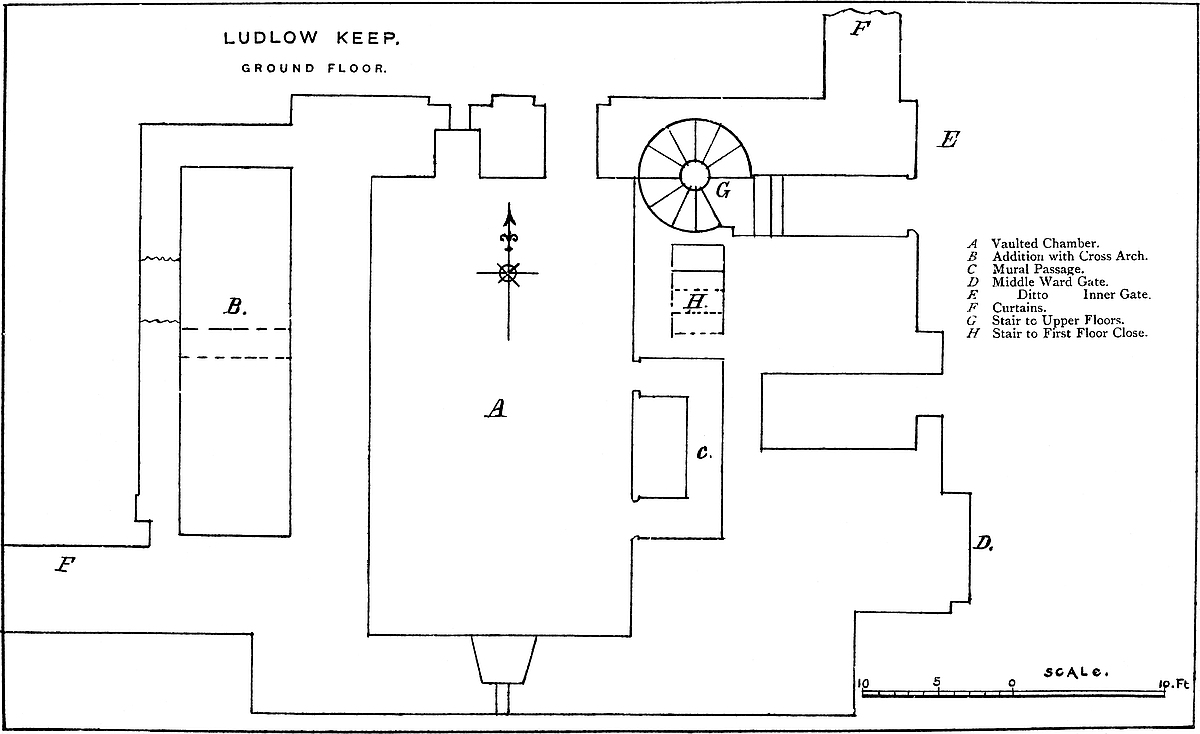
In the original building there was a basement nearly at the ground
level and a lofty upper floor with an open roof. The exterior was
plain. It had a low plinth, but no pilaster strips, save that at the
end of the east wall there is a sort of pilaster 6 feet broad by 1
foot deep. On the south face a string of half-hexagonal section runs
a little above the level of the first floor, and on the east and west
faces, a little higher up, are sets-off of 5 inches. The upper story
is marked by a similar set-off all round. The north, south, and west
walls at the base are 7 feet 6 inches thick, and above it 5 feet.
The east wall, containing the staircase, is 9 feet 6 inches thick.
Two additions have been made, which much affect the ground plan. On
the west, the hollow angle of the has been filled up by a
building 11 feet broad by 24 feet long, which is carried up to the top,
and enters partly into the composition of a north-west turret. The wall
of this building is only 3 feet thick. The corresponding hollow angle
on the east face is also filled up by a mass of masonry 9 feet thick,
but which goes no higher than the first floor. It contains a cell,
the porter’s prison, and a passage leading from the main gate to the
well-stair of the keep. The porter’s prison is barrel-vaulted, is not
bonded into the keep, and is probably very late Norman. There is in the
keep wall, partly seen in the vault, a loop or window, though there is
no indication inside from whence it opened.
The existing keep is composed of a basement and three floors. At present the basement chamber is entered by a door in the north wall from the inner ward, the first and other floors by a well-stair in the east angle, entered from the main gate. The basement is three steps below the ground level. It is 31 feet north and south and 14 feet 5 inches wide. It has a high-pointed vault, a loop in the south or outer end, and in the north end a loop, and above it a window, and by their side the door from the inner ward. The window recess is slightly pointed, that of the door more decidedly so, but the exterior facing of both door and window is late Perpendicular, four-centred in a flat head. In the side walls, at their north end, on each side is a Norman arcade of two arches, plain and shallow, springing from plain detached columns with fluted and278 cushion capitals, the whole resting on a low bench. The arcades begin a foot from the north wall, and the arches are full centred, but of unequal span, 4 feet 3 inches and 5 feet 11 inches. The western arcade has been walled up and is only partially seen. On the east side, at the southern arch, the column is gone, and the lower half of its nook is occupied by a sort of altar of square stones, having a large flat stone on its top. The whole work is rude. There are no drips or hood mouldings, and a mere attempt at an incised ornament. The arcade is recessed about a foot. In the east wall, near its south end, are two square-headed doors of 2 feet opening and 7 feet 6 inches apart. Each opens into a passage 3 feet 7 inches long and 2 feet 7 inches broad, and these end in, and are connected by, a cross gallery 12 feet long and 2 feet 6 inches broad. These passages are lined with ashlar and are 6 feet 7 inches high, and flat-topped. The roof is formed of rubble, wedged tight and plastered. Also, each doorway has a rebate and bar-hole, showing that the door opened inwards, and was fastened on the inner side or from the passage, into which, however, there was no other way. It appears also that the great chamber was formerly divided by a cross wall, so placed that one of these doors opened into each chamber, and a step in the rubble vaulting shows where this wall crossed, and that there was a slight difference in the height of the vault on its two faces. The southern of the two doorways has been mutilated and a Norman pier has been inserted, but this seems modern, and a clumsy device to support the roof. It is difficult to understand for what purpose this very curious passage was constructed. It afforded a way from the outer to the inner room, but this does not account for the position of the bar-holes. Moreover, as regards the large room, the arcade seems strangely out of place. It was certainly confined to two arches on each side; and as the room lies north and south, it could scarcely have been a chapel, neither is it likely that it was a room of state. The wall seems at one time to have been lined with ashlar, and there are ashlar bands in the vault, a part of which is built of hammer-dressed stone, and part of very ordinary rubble. The arcade and probably the substance of the building are rather early Norman, and the vault and north wall seem additions in the early English period. This chamber has no communication with the additions either upon the east or the west front.
The first floor is exactly above the basement, and measures 30 feet by 17 feet 6 inches. In its south end is a Tudor window, no doubt replacing a Norman loop; and in its north end are two windows in Tudor recesses, and between them a Tudor fireplace. In the west wall, north end, a round-headed door opens into a side-chamber 8 feet by 13 feet, vaulted, but with a timber floor, having windows to the north and west, and in its east or keep side two round-headed recesses of 3 feet 8 inches opening, and 3 feet deep. In the south end of this room a narrow passage leads into a garderobe chamber, 7 feet 6 inches by 5 feet, with a loop to the west. Between the two rooms is a block of masonry which contains the 279shafts of the garderobes from the upper story. In the other or south end of the west side of the main room, a lofty full-centred arch of 5 feet 10 inches opening, is the mouth of a vaulted lobby, 13 feet 7 inches long; at first 5 feet 10 inches wide, and then reduced to 3 feet 2 inches. This opens upon the south curtain, west of the keep. In the south wall of the lobby is a small round-headed window in a plain recess, and outside, flanked with nook-shafts, the only ornamented Norman window in the keep. Opposite, in the east wall, is a door, of 4 feet 3 inches opening, which leads into a vaulted and groined chamber, 8 feet square, with a loop to the south, and to the east a short passage 4 feet wide, which opens upon the south curtain and leads to the upper floor of the gatehouse. In the north wall of the chamber is the head of a straight staircase, which threads the east wall of the keep, and was the original entrance from the ground level to the first floor. The staircase is of ashlar, barrel-vaulted, and fifteen steps are still to be seen. Returning to the main chamber, there remains to be noticed a door at the north end of the east wall, which opens into a well-stair, and from it by an outer door into what was the first floor of the gatehouse. This well-stair occupies the north-east angle of the keep. It is entered by a vaulted rising passage in the east wall from the main gate at the ground level, and the staircase rises to the ramparts, opening upon the first and two upper floors. At present its door and window openings are Tudor, but the staircase itself is probably much older. It is evident that here was the original entrance to the keep, as at Chepstow and Carlisle, whence a straight stair led up the centre of the wall to the first floor; but when the lower part of the well-stair was inserted, the straight stair was walled up, and so remains. At Chepstow and Carlisle, besides the staircase, there was a door which gave entrance to the basement floor. This could not have been the case here, for it would have cut the arcade. The cill of the south-east door shows the floor of the first floor chamber to have been slightly raised, which was, no doubt, done when the vaulting was inserted. There are two square holes in the floor, intended to give air to the main room below, and probably late insertions. This story was 12 feet 6 inches high. From it seventeen steps in the well-staircase lead to a Tudor door into the second floor.
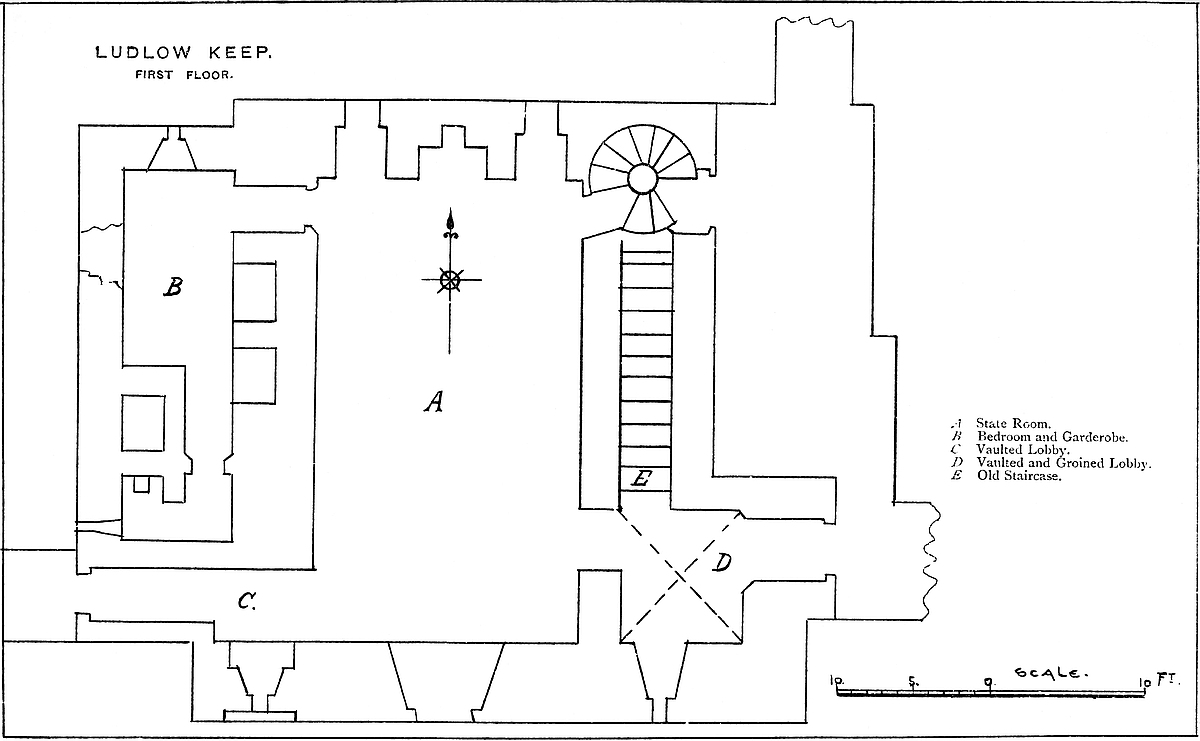
The second floor is of the same dimensions with the first. In its south wall is a Tudor window, no doubt replacing one of Norman date; and in the north wall two windows, square-headed, but in round-headed though not Norman recesses. In the east wall, besides the staircase door, is a Tudor fireplace, possibly only refaced in that style. This wall has been much altered and patched, and the fireplace is probably an insertion. In the west wall, at its north end, a door opens into a lateral chamber, above that appended to the first floor, and in it are two garderobes. It has a square-headed loop to the north and three to the west, the central one in a round-headed recess. On a level with this chamber, and probably opening from it, is a small chamber over the west lobby. This has a loop to280 the west, but is not accessible. There is a similar chamber over the east lobby, but how entered does not appear. This second floor is 11 feet 10 inches high, and from it nineteen steps ascend to the floor above.
The third floor, also entered by a Tudor doorway from the staircase, is of the same dimensions with the floor below. In the east wall is a fireplace, also Tudor, and in the west wall, at the north end, a square-headed door, opening into the third floor of the appended chamber. This chamber has a Decorated window in its north wall, and had a timber floor and ceiling, and is crossed by a round-headed arch which supports the south wall of the north-west turret. A weather-moulding in the south wall shows that this appendage had at first a lean-to roof.
The south wall of the main chamber has also a weather-moulding, showing that this wall was once a gable, and that the keep had originally a high-pitched roof with a central ridge. A Tudor window has been inserted into the wall, and cuts through the moulding. The north wall is pierced by two round-headed recesses, in which are trefoil-headed windows of one light, and apparently of Decorated date. There is no weather-moulding at this end, one of the many indications that this wall has been rebuilt. This floor, like that below it, is 11 feet 10 inches high, and from it nineteen steps ascend to the battlements, opening by a Tudor door at the stair-head. The stair ends in a rectangular turret, 15 feet by 9 feet. The north-west turret, 8 feet by 10 feet, has no opening from the ramparts. The two southern turrets are larger, and both have exterior staircases of twelve stairs leading to their flat roofs. The south-west turret is 15 feet by 14 feet, and the south-eastern, not now accessible, is about 15 feet square. The north and south walls are here 5 feet thick, two being occupied by the embattled parapet. The east wall is 9 feet thick, and contained a double chimney-flue. The west wall is double, the inner 4 feet thick, being the wall of the keep, and the outer 3 feet to the wall of the appendage. The space between, 5 feet 8 inches broad, was covered by a flat roof, so that the rampart here was 12 feet 8 inches broad within the parapet. There were two embrasures on each face of the keep, and the roof last laid upon it was flat.
The keep seems originally to have been built by Roger de Lacy, 1086 to
1096, as a plain -shaped tower, upon and a part of the curtain
wall. It had a basement floor at the ground level, and one upper floor
of considerable height, with an open, high-pitched roof, of which the
north and south walls, nearly if not quite of their present height,
formed the gables, just as in the Norman gatehouse of Sherborne Castle.
Probably the side walls were nearly as high as the gables, so as to
conceal the roof. The basement was entered at the ground level by a
door in the north wall. It had at least two arches of an arcade in each
of its side walls, and was probably divided by a cross wall into two
chambers, the inner being entered by the passage in the east wall. The
entrance to the upper floor was281 also on the ground level, but in the
east wall, and therefore in the middle ward. It was by a small door and
short passage, from which, on the south or left, a staircase threaded
the east wall, and landed in a vaulted lobby at the level of the first
floor. This lobby and one opposite to it led out upon the curtain. How
the keep battlements were reached is uncertain, possibly by the present
well-staircase, which, in that case, then commenced at the first-floor
level.
The first alteration made in the Norman period was probably a century
later than the original building. This consisted in the addition of
a building on the west front, filling up the hollow angle of the
. It contained a basement, which seems to have been a
cesspit, and is now entered by a breach, and is vaulted. The roof was
a lean-to. To enter the first floor of this building a door was opened
in the wall of the keep. Also on the opposite or east side a mass of
masonry was built into the hollow angle of the . This,
however, stopped at the first-floor level, and was probably intended to
give a second passage between the first floor and the gatehouse. In
the block was a vaulted prison cell for the porter, and a passage which
led into and covered the entrance of the keep.
At a later date, during the early English period, still greater changes were made. The north wall was either rebuilt or refaced, the basement was vaulted, and the north-east angle was taken down and rebuilt, a well-stair being probably inserted into it. At the same time the lateral walls and the west appendage were raised, the first floor fitted with a flat ceiling, and two floors inserted above it, with doors into the western appendage, and two turrets were carried up at the two northern angles of the building.
The next and final alteration occurred in the Tudor period, when the vault of the eastern entrance was rebuilt, and faced with an outer door-case, the well-staircase fitted with doors and loops, and the old straight staircase walled up, and fireplaces inserted in the walls. Also the north door and window of the basement were refaced. Of course all this is a matter of opinion only, the alterations having been so great, and of so complete a character, that it is difficult to form even a theory concerning them. This is one of the most curious and perplexing Norman keeps now standing. It is much to be desired that its owner would cause an accurate plan and section of it at each floor to be made and published.
The curtain connecting the keep with the Bakehouse Tower is 36 feet by 38 feet long, 7 feet thick, and about 20 feet high to the ramparts, but it had a covered passage, and rose towards the tower, probably having a narrow staircase communicating with the second floor, while the main gallery opened into the first floor. The tower is rectangular, about 23 feet by 27 feet. It projects 16 feet into the ditch, and its interior measures 15 feet by 11 feet. It was originally open at the gorge into the inner ward, the masonry being replaced, as at Cologne and Avignon, and as in the later gatehouse of the Tower of London, by a timber partition. A large oven has been built at the ground level, filling up the whole area, and an arch282 turned at the first-floor level, supporting a wall, which replaces the timber work in the upper floors. In this wall are a fireplace, small oven, and window. A door in the east wall opens from the curtain, and in the west wall another door opens into a mural passage in the west or outer curtain, in which it has a loop. On the left, or south, is a garderobe chamber, 6 feet by 5 feet, with a loop to the south, and in the opposite direction the passage runs 11 feet, descending four steps. It probably was continued in the substance of the curtain to the postern tower, but is now walled up. The upper or second wall of the tower is not accessible. It seems to be on the pattern of the first floor, and is entered by an exterior staircase from the south curtain, and on the other side has a garderobe and passage opening upon the rampart of the west curtain, towards the postern tower. The bakehouse tower is Norman, and of the age of the keep. Its floors were of timber.
The Postern Tower is spiked up and inaccessible. It is about the size and height of the bakehouse tower, and of the same date, but its gorge was always closed. At the ground level a small door opens from the inner ward, and there is a similar door on the north and outer face of the tower, which is the postern. Both are full centred and plain. This tower has no internal projection. In the ward, close to the tower door, in a most inconvenient position, is the well, with a shaft worked roughly in the rock, 8 feet in diameter. It is now partly choked up.
The cross curtain from the postern is carried straight to the north-east angle of the ward, and thence turns south, till it abuts upon the keep. This wall, though probably Norman, is not so old as the keep or main curtain, so that in the original castle the inner and middle ward seem to have been one. There is a round-headed door in the curtain near its north-east angle, which opens between the inner and middle ward.
The Middle Ward is the most important division of the castle. In it are the domestic and state buildings, the chapel, the kitchen, and the great gatehouse. The principal buildings occupy its north side, resting upon and partly forming the exterior curtain wall. Near the centre is the hall. This was a noble apartment, 60 feet long by 30 feet broad, and 35 feet high to the springing corbels of its open timber roof. The recesses for the hammerbeams remain, and the corbels on which the principals rested. Owing to the low springing of the main timbers, the roof had from within the appearance of a very high pitch, which the water table shows not really to have been the case. The hall is on the first floor, and approached from the court by a broad exterior staircase, opening in the south wall near its west or lower end. In the north wall are three long narrow windows of one light each, trefoiled, and crossed by a heavy transom, and in the east end of this side a small door leads, probably, into a garderobe. The view from these windows is up the Teme and Corvedale. In the south wall are three large windows looking upon the court; they are of two lights, trefoiled, and crossed by a transom. Their283 recesses have equilaterally arched heads, and the angles are replaced by filleted beads. One window only has a stone seat. The great door, towards the west end of this side, matches with the window recesses, though a little lower. In the west end are two buttery doors of unequal size, and at the north-west corner a door opens, as at Pembroke, into a well-stair to the roof. In the east end of the hall, near the north-east corner, and high up, is a combined door and window—a sort of hatch, by means of which those in the upper state room could either look into the hall or step down into the gallery that ran across above the dais. The central south window has been blocked up, and converted into a late Tudor fireplace. No doubt the original grate, as at Penshurst, stood in the middle of the hall.
West of the hall is the buttery tower, a very fine group, which occupied the north-west angle of the ward. Part of it projects boldly, and caps the north-western angle of the curtain. The part within the ward is also rectangular. The part connected with the curtain is Norman, and was a large rectangular tower with an open gorge. In its base are two round-headed doorways, now nearly buried, whence mural passages led to garderobes in the curtain. The older part has been raised, and a pointed arch turned, and upon it a wall built, closing the gorge at the second floor. This tower has had large additions on its inner face, and is now a part only of the building, of which the basement seems to have been a store, and the first floor, 33 feet by 27 feet, a serving-room and buttery attached to the hall. This room was entered by a side-door on the great hall staircase, so that the dishes were brought from the kitchen up the great stair, but not through the great door of the hall. In the buttery is a large fireplace.
At the other or east end of the hall are the state rooms, contained within a grand and lofty structure, rectangular in plan, and projecting beyond the hall. Whether the foundations are Norman, or whether, like the superstructure, the whole is of Decorated date, is doubtful. The material is excellent ashlar. There are a basement and two upper floors. In the first is a grand fireplace; but the principal apartments were on the second floor. The door and window openings are numerous and varied. Some are excellent Decorated, with lancet and segmental arches; others are insertions in florid Perpendicular; and others, in wretched taste and of base materials and workmanship, are of Tudor date. The upper room has also a large fireplace, and the abutments of the hood are two carved heads. The north window is of one light, and of great length, divided by transoms. The south window is of similar character, but has two lights. This upper room had an open roof of low pitch, supported by three pairs of principals.
Next to these rooms, on the east side, is a smaller pile of buildings, also rectangular, which fills up the space between the state rooms and the north-eastern tower. This, probably, was appropriated below to servants’ apartments, and above to the principal bedrooms. There are, in the basement, three fine early Perpendicular284 windows of two lights, trefoiled, and with the centre mullion carried through the head. Windows of this size, so low down in an outer wall, are rare, and what is also curious, they open from two rooms by no means remarkable for size or ornamentation. This part of the suite, originally Decorated, on perhaps a Norman foundation, seems to have been remodelled or rebuilt in the Perpendicular period. Connected with these buildings and with the state apartments, and abutting upon both, is the garderobe tower—a grand rectangular structure projecting from the curtain, and wholly of ashlar, and of Decorated date. It is composed of a basement and four upper floors. The basement is occupied by several garderobes, the spacious outlets of which have already been described. The upper floors seem to be connected with the state rooms, and in the walls are many small chambers not accessible. The windows are of one light, trefoiled, usually with a transom. Between this building and the hall, projecting outside the curtain, is a multiangular turret containing a staircase.
The north-eastern tower caps the angle of the ward. It is rectangular in plan and of Norman date. It forms a part of the two curtains of the middle and outer ward, standing upon each. In its base a door leads into a mural passage in the east curtain, now blocked up with rubbish, and in its first floor is a garderobe in the north wall.
The kitchen, wholly of Decorated date, is a large rectangular building, placed against the wall of the inner ward, but free on the other three sides. It has two large windows to the east, and an excellent door in the north wall opposite to the hall staircase. The flagging of the floor remains, and parts of the large fireplace on the west side, with a couple of small side ovens. It has had divers Perpendicular additions. The back kitchen was to the west, and it is probable that a breach in the adjacent wall of the inner ward represents a late doorway, communicating with the well and the great oven.
The Gatehouse is approached from the middle ward by a bridge over the ditch, of which the inner end was broken by a drawbridge, flanked by walls with loops. The gateway has a low-pointed arch, on a tablet above which are the arms of Elizabeth and those of Sir Henry Sydney, with the date 1581. As the curtain is 7 feet thick, and bonded into the keep, it is evidently original, and the door fittings are an insertion. There is no portcullis. The entrance door opened into a passage, having the porter’s prison and the entrance to the keep on the left, and on the right the gatehouse chambers. The building is of the age of Elizabeth, and very inferior to the older work. Probably the original entrance was by a mere archway in the curtain, as at Kenilworth and Bridgenorth.
The Chapel, dedicated to St. Mary Magdalen, is the most remarkable part of the castle. It stands out in the centre of the middle ward, between the gatehouse and the hall. All of it that remains is the circular nave. This is 28 feet in interior diameter, with walls285 4 feet thick. It has an entrance door to the west, and a large chancel arch to the east. The rest of the interior is occupied by a mural arcade of fourteen arches, seven on a side, resting on a low stone bench. The arches are alternately chevron moulded and beaded, the capitals cushion-shaped and roughly ornamented. Above the arcade was a timber gallery resting upon twelve corbels, of which one is decided Norman and one early English. Light was admitted by three windows, to the west, north, and south. That over the door was round-headed, with plain flanking detached shafts, and round the head a chevron and double billet moulding. Outside, these windows rest upon a billeted string, the flanking shafts are engaged, with small plain caps and bases, and the ring-stones, of considerable breadth, rest upon an abacus, and are worked in chevron and billet mouldings. The north and south windows are quite plain.
The west door is a fine example of enriched late Norman work. Outside, it stands in a double recess, having detached nooked flanking shafts, two on each side, with fluted capitals, and the semi-circular spaces above the flutes are covered with a small indented pattern, a sort of hollow nail-head. Of the four, all the caps and one shaft remain. The actual doorway has plain, square jambs. Above, a bold, simple abacus, the under chamfer of which is hollow, has the face carved with the rudimentary dog-tooth ornament. Over the door is a deep chevron moulding. The next ring, over the inner shafts, has a bold beading, and the outer, and much the broadest ring, has a chevron moulding reduplicated, and above it a double billeted drip.
The chancel arch is large, round-headed, and of three ribs, beneath a double billet moulding. The style of ornamentation resembles generally that of the west door. On the west face are two nook shafts on each side, and in addition two half shafts are placed as pilasters in the actual archway supporting the middle rib. This arch and that of the door have become slightly flattened by settlement, as is shown by the gaping of the soffit joints near the crown. The east face of this arch is quite plain, save that the abacus is returned. The original chancel, 42 feet long, had a high-pitched roof, and there is a mark of a second and later one less steep. The side walls are gone. The curtain formed the east wall, and has no window. Outside, the nave is divided into two stages by a billeted string, on which the windows rest, and which is considerably above the top of the door. Above is a plain battlement of no projection, with embrasures one-half the breadth of the merlons.
Two arches of the nave arcade have been pierced for Tudor windows, and a third, to the north, has been converted into a doorway. The north window has also been made a doorway, and it is evident that a light gallery of two stages was laid from the domestic apartments to the chapel, the upper one opening on the circular gallery. The original way to this circular gallery must have been by a wooden286 stair within the building. The chancel was standing in the reign of Charles II., and had two Tudor windows in its north wall and windows in the roof, also the nave had a saddleback roof, of which the gables were east and west. The material of the chapel is coursed rubble. South-west of the chapel was, in Elizabeth’s time, a fountain. This chapel is, with great probability, attributed to Jocelyn de Dinan in the reign of Henry I. (1100–1135), the Temple Church, which it resembles, dating from 1127.
The Outer Ward.—The gatehouse has been much altered and mutilated. In front it presents the appearance of a gateway, with a low-pointed arch, in a curtain about 6 feet thick and 35 feet high, of which the merlons are pierced by plain loops. On each side the gate is a flanking wall, 3 feet thick, and projecting 8 feet, which, no doubt, covered the drawbridge. The arch looks Decorated, as is probably the curtain, though the battlements are probably modern. The ditch has been filled up, and large trees grow along its course. The only buildings in this ward are placed against the curtain, and have already been noticed.
There is no evidence, material or by record, of any castle here before the Norman Conquest. The “low” or mound known to have been removed from the churchyard, and the memory of which is preserved in the name of the town, is the only ancient earthwork connected with the place, and was, no doubt, sepulchral. The original Norman castle seems to have stood on the present lines. It was composed of a keep, placed close to the entrance, and forming a part of the enceinte. Westward, the keep was connected by a short curtain with the south-west or bakehouse tower, rectangular, of moderate size, and having its inner face or gorge open. From thence the curtain passed at right angles northwards along the edge of the rock to a second tower, also rectangular, and containing a postern. From thence, still along the edge of the rock, the curtain, probably 25 feet high, reached the north-west angle, where it was capped by a tower nearly rectangular, but placed diagonally, so as to cap the angle, and which was open in the rear. Thence the curtain passed eastwards, along the north front, to the north-east angle, where was a tower, square, or nearly so. No doubt the Norman domestic buildings were placed upon this curtain, and probably there was a central tower on the wall near the present garderobe tower. From the north-east tower to the keep was the curved curtain, probably then, as now, free from buildings, and outside of this a ditch, still remaining, and extending from cliff to cliff. Of this original castle there at present remain the keep, the bakehouse and postern towers, the base of the buttery, and much of the north-eastern tower, and more or less of the curtain.
Later in the Norman period certain changes were made. The keep was raised and enlarged, the curtain forming the inner ward was built, and probably the well was sunk, and in the middle ward the chapel was built. The outer ward may have been part of the original design, or it may have been a late Norman addition; that it287 was not of later date than this is shown by the square mural tower. All the rest, curtain, gatehouse, and Mortimer Tower are later.
The next changes were in the Decorated period, when very important alterations were made in the older parts, amounting almost to a reconstruction of the fortress. Very early in the period, perhaps before it, the north door and window of the basement of the keep were inserted, the vault turned, and probably the gateway remodelled. At a later date, but still early in the Decorated period, the hall, buttery, and domestic apartments were built along the north front and the kitchen.
The works in the Perpendicular style are few, and are confined to alterations in the domestic apartments, and in the entrance passage to the keep and the kitchen.
Then came the Tudor period, in which the castle had to be converted into a palace for the Presidents of the Marches. The base of the keep became a prison, the well-stair was probably inserted, the rooms fitted with Tudor windows and fireplaces, and the gatehouse was built. Much was done in fitting up the hall and domestic apartments, though in a slight and flimsy manner, so that most of this work has disappeared, and stables were built in the outer ward. The extinction of the Council of Wales, and the civil wars, put a stop to any outlay upon the place, and for some time it seems to have been freely pillaged, until it became a complete ruin, without floors, or roofs, or any kind of fittings in lead, iron, or timber. Of late years it has been so far cared for as to be protected against all injuries save those of time and weather, while at the same time it is freely open to all visitors. What is wanted for antiquarian purposes is that the mural passages should be cleared out, and a plan made of each floor.
Ludlow is apparently a purely Norman fortress. Its earthworks, such as they are, or were, have nothing in common, either in position or character, with the hill forts of British origin, so common in that district; neither do they at all resemble the later and English works attributed to Æthelflæd and her countrymen in the ninth or tenth centuries, and of which Wigmore, Richard’s castle, and Shrewsbury are adjacent types. In plan, indeed, Ludlow is not unlike those works by which headlands and promontories on the seashore were frequently defended, it is supposed, by the Scandinavian sea kings, and of which the entrenchment at Flamborough Head is the finest example on record; but these are seldom, if ever, found far inland, nor is there anything in the two concentric segments of ditches which constitute, or did formerly constitute, the earthworks of Ludlow, inconsistent with the notion that they are Norman works.
There is no mention of Ludlow in Domesday; but that record gives three places in the district bearing the name of Lude, of which one, belonging then to Osberne Fitz Richard, is demonstrated by288 Mr. Eyton to be the later Ludlow. The termination necessary for its distinction was derived from a large “low” or tumulus, probably sepulchral, and which stood until 1190 on what afterwards became the burial-ground of the parish church. “Lude” or “lud” is thought by the same author to mean a ford, as, by a common pleonasm, in the adjacent “Ludford.” The two other Ludes were distinguished by the names of their lords, and known as Lude-Muchgros and Lude-Sancy.
Mr. Eyton has further shown, almost to demonstration, that Fitz Richard’s tenant in Lude was the much more considerable Roger de Lacy, and that when he decided here to build a castle, he obtained the lordship from Fitz Richard, and founded the castle within ten years after the survey, or about 1086–1096. Roger was a good type of a Marcher lord. In 1088 he was in rebellion against William Rufus, on behalf of Courthose, and again in 1095, when he took part in the Mowbray rising, was exiled, and so died.
Rufus allowed his estates to pass to his next brother, Hugh, who, however, died childless between 1108–1121, when the estates fell to the Crown by escheat. Henry I. granted Ludlow to Pagan Fitz John, who also held Ewias Lacy, and who was slain by the Welsh in 1136, leaving no male issue. Stephen seems to have seized his lands, and to have placed as castellan in Ludlow a certain Sir Joyce or Gotso de Dinan, evidently a Breton knight. Shortly afterwards, Joyce was in rebellion, for in April 1139, Stephen, accompanied by Prince Henry of Scotland, laid siege to the castle, and constructed against it two “counter-forts.” It was at this siege that Stephen rescued Prince Henry, by his personal strength, from the grasp of a grappling-iron, thrown over him as they walked rather too near to the walls. It would seem that the castle was not taken.
Joyce’s most dangerous foe was his neighbour, Hugh de Mortimer of Wigmore, of whom he obtained possession by means of an ambush, and detained him prisoner in the castle; a tower of which has been supposed by its name to commemorate this event. Joyce died, also without male issue, about 1166, after which event Henry II. gave or restored Ludlow to Hugh de Lacy, a descendant, though not in the male line, from the former family; Emma, the sister of Roger and Hugh de Lacy, having been the mother of a certain Gilbert, who took his mother’s name, and died 1135, leaving Hugh de Lacy, the new grantee of Ludlow. This Hugh, who was a very powerful lord in Ireland, held both Ludlow and Ewias, and was custos of Dublin. Henry II. feared his power, and in 1181 seized upon Ludlow. Hugh was assassinated in Ireland in 1185, and left Walter, his son and heir, to whom Henry, in 1189, restored his father’s lands; but seems to have retained the castle and tower of Ludlow, which thence came to King John, to whom, in 1206, Walter de Lacy paid 400 marks, to be reinstated at Ludlow.
John, however, again seized the castle in 1207, and gave it in charge to William de Braose, and for a time to Philip de Albini, and then to Thomas de Erdington. Nor did the king restore it till289 1214, when Ingelram de Cygoigne was directed to render it up, which he did, though unwillingly. Walter, like his father, was chiefly occupied in Ireland. In 1224 he gave up Ludlow to William de Gammages; no doubt to hold as a pledge for his own good conduct. He died in 1241, leaving Walter, his grandson, as his heir, who died under age. Walter left two sisters, of whom Matilda married, first, Peter de Geneva, one of the Provençal favourites of Henry III., and who had the custody of Ludlow. Peter died childless, but in 1234 he made over to William de Lacy the constableship of the castle in fee. Lacy was to keep it in repair, and to maintain there a chaplain, porter, and two sentinels, and the expenses were to be allowed. In time of war, the lord was to garrison the place, and live in the inner, the tenant living in the outer, ward. Peter de Geneva died in 1249. His widow then married Geoffrey de Genville, a Poitevin, who was living in 1283, and who held the castle and half the manor, the other half belonging to Margery de Lacy, sister and co-heiress with Matilda, and who had married John de Verdon. During that period, and immediately after the battle of Lewes, when Simon de Montfort visited Wales in 1264, he took Ludlow Castle, which, however, he could have held but for a short time.
Although Peter de Genville, son of Geoffrey and Matilda, died before both his father and mother, yet he had the castle at his death in 1292. His daughter and heiress, Johanna de Genville, married Roger de Mortimer, Earl of March, who, in 1316, was joint lord of Ludlow with Theobald de Verdon, grandson of John de Verdon and Margaret de Lacy.
The Mortimers held what they probably made the lion’s share of Ludlow for five generations, through some of the most turbulent times in English history; but under their rule Ludlow gave place to Wigmore, their chief seat, and the centre of their oldest estates and main power. Roger, the paramour of the she-wolf of France, received the young Edward III. at Ludlow soon after his father’s death with great magnificence, and not long before his own fall, attainder, and execution. Edmund, his son, recovered this and his other castles in 1354, six years before his death. His grandson Roger, the fourth Earl of March, obtained the long separated moiety of the Lacy property by exchange with William de Ferrars, who had inherited it from the Verdons, and thus transmitted the whole of Ludlow to his son Edmund, the fifth earl, in whose time Sir Thomas Beaufort, afterwards Duke of Exeter, held the castle against the insurgent Welsh. The fifth earl died childless in 1424, when Ludlow Castle and the earldom of March descended to his nephew, Richard Plantagenet, Duke of York, who held it through the wars of the Roses, and transmitted it to his son, King Edward IV. The borough of Ludlow profited by the assumption of the castle by the Crown. The townsfolk were steady Yorkists, and if they occasionally suffered, and that severely, from the fortunes of war, on the whole they were gainers. Their ancient franchises, dating at the least from the commencement of the thirteenth century, were confirmed in the reign290 of Henry VI. by Richard, Duke of York, and in 1461 and 1478 Edward IV. gave them an extended charter, under which they were removed from dependence upon the castle. In 1472 the king sent his two sons to remain in the castle, where the Council of Wales established by him, sat in the name of the elder, the Prince of Wales, then but an infant in arms. They remained at Ludlow until 1483, when they were removed to a prison and a grave in the Tower. Henry VII. also sent Prince Arthur, his infant son, born in 1486, to Ludlow, and was himself a frequent visitor here till the prince’s untimely death in 1502. After that event the Council of Wales was established on a more regular footing, and placed under a lord president, who at first was a bishop. Money was granted for the repairs and maintenance of the castle, which, it appears from Bishop Lee’s report, in 1535 was in a ruinous state.
In 1559 Queen Elizabeth appointed Sir Henry Sidney as lord president. He held the office twenty-seven years, keeping considerable state at the castle, where, on his return from Ireland, he passed the latter years of his life. He built the gatehouse within the middle ward, which the inscriptions inserted on the gate show to have been completed in 1581. He built also a bridge leading into the castle, probably one to the outer gate, for the description does not accord with that now standing, and which leads to the middle gate. Also he repaired the chapel, and brought water into the castle, and did much in the way of general repairs, and of buildings and enclosures, to facilitate the business of the council and the custody of its prisoners. The keep, called then the porter’s lodge, was their prison, and the inner ward their court for exercise. Sir Henry died in May 1586. Whatever the Council may have been in his time, it became, in the reign of James, a source of great expense and scandal, and Richard Baxter has left on record the condition, moral and social, to which the purlieus of this provincial court were reduced during his youth. It fell, and it was time, with the surrender of the castle to the parliamentary army in 1646. The place was dismantled, and in 1651 the furniture and fittings were inventoried and put up for sale. At the restoration an attempt was made to revive the Council, but the actual revival was nominal only, and even this was abolished on the coming in of King William. The Crown appointed a governor of the castle, and it would seem, by an inventory of goods there in 1708, that part of it at any rate was in very tolerable repair, especially the rooms of state. The final ruin was commenced under an order by George I., when the lead was removed from the roofs. Buck, whose account was published in 1774, speaks of many of the apartments as still entire, and probably it was not absolutely roofless until the end of the century. In 1811 a lease held by the Powis family was converted by purchase from the Crown into a freehold.
THIS tower, apparently the earliest built and the last part remaining of the residence of Bishop Gundulf, is probably one of the first Norman keeps, perhaps one of the earliest military towers in masons’ work, after the departure of the Romans, constructed in England. With these pretensions, it deserves more attention than it has hitherto met with.
It stands about a quarter of a mile south-west of the parish church of Town, or West Malling, in Kent, the plain heavy tower of which is also attributed to the bishop; and a little further from the remains of the religious house founded by the same skilful and magnificent prelate, and a remaining part of which seems also to have been his actual work.
The tower stands upon a ledge of horizontally-bedded sandstone rock, of a friable character, which juts out from and forms the east side of a short narrow combe, the defence of the castle on its western front, and which opens upon a stream tributary to the Medway, which stream receives a further addition from a spring which rises from beneath the rock about 100 yards south of the tower, and has been employed to strengthen the defences of the place on that side.
The tower is a very plain rectangular structure of the early Norman type, about 32 feet square at its base, and about 60 feet high on its northern and eastern, and about 70 feet on the two other faces; the difference being produced by the greater depth of the rocky shelf. The walls rise from a plain plinth, the top of which is at the ground level on the east face and north-east angle, and 10 feet above the level on the south and west, so that the plinth is on these sides 10 feet high. The tower is flanked at the end of each face by a pilaster strip, which rises from the plinth, and each adjacent pair meet and cover the contained angle. At three of the angles these strips have 6-inch projection, and are 3 feet 6 inches wide, reduced by two sets-off to 2 feet 6 inches at the base of the parapet, into which they probably died. The pilasters covering the fourth, or north-east angle, are 7 feet broad, and of 18 inch projection. These also have two sets-off. This increased breadth and projection is to accommodate a turnpike-stair, which rises from the base to the roof, and was evidently crowned by a square turret, but whether there were turrets at the other angles is doubtful, though, if present, they must have been of rather smaller dimensions. In the centre of the west face is another pilaster, 3 feet broad, and of 6 inch projection. This also rises from the plinth, but stops at the level of the uppermost floor, at the base of the window, of which it forms the cill. Of the sets-off, that at the level of the first floor is292 carried round the tower; the upper one is confined to the pilasters. The parapet is gone, and the wall at the head of the staircase, being weakened by it, is somewhat broken down. The tower wall is described as battering, or inclining inwards; if so, the degree must be very slight, for its appearance is vertical, the set-off reducing it by about 6 inches or 8 inches, so that at the summit the dimensions cannot be less than 30 feet square, and the wall appears, from below, to be about 6 feet thick.
The basement is without windows, but in the south face, near the east end, was a round-headed doorway, quite plain, without a portcullis or any moulding, and of about 3 feet 6 inches opening. This is now, and evidently has long been, walled up, so that any rebate it may contain for the door is concealed. It opened on the top of the rock, and probably was approached by a wooden exterior stair, which must have been 10 feet high. The present entrance is opposite to it at the same level, which, there, is that of the ground. This seems to have been a later opening, broken through where the wall was reduced in thickness by a sort of lobby at the foot of the staircase. This is a very common treatment with Norman keeps, the ordinary doorway becoming inconvenient, and the times ceasing to demand extraordinary precaution.
The first floor has a plain round-headed flat-sided opening, that is, without splay, or what in the North is called flanning, placed in the centre of the north, south, and east faces. On the south face this window is in the centre of a plain arcade, having on each side of it two similar arches, about 3 feet broad and 2 feet deep. The singular thing is that these niches are in the outer face of the wall, not, as would seem natural, and as occurs at Chepstow, in the inner face. In the west wall are four similar niches, but the central space is solid, occupied by the pilaster. There are two narrow round-headed loops on the north face, lighting the staircase at two levels.
The second and upper floor has four windows, one in each face. These are round-headed, quite plain, flat-sided, of about 4 feet opening and 8 feet high to the springing. The three floors seem to be,—the basement, 15 feet high; the first or main floor, 30 feet; and the upper floor, 15 feet. The floors were all of timber. There is no visible fireplace, nor do there seem to be any mural chambers or galleries. The walls at the base are 8 feet thick. The staircase communicated with each floor, and with the roof. The line of the lower floor cut off the head of the original entrance doorway, as at Chepstow.
The masonry throughout is of a very sound and solid, though of a rude description. It is evidently original, and does not appear ever to have been repaired or even pointed. It is of rubble, the stones being pretty much as they came from the quarry, of all shapes, but rarely containing more than a foot cube. The work is roughly but decidedly coursed, with a slight tendency to the herring-bone pattern. The joints are very open, and the mortar has been very293 freely used. The quoins and window-dressings are of a tufaceous ashlar, with wide joints.
It is difficult to form any safe conclusion as to the plan or area of the castle, of which this tower was certainly the keep. No doubt it lay to the north-east and east, where the ground forms a table-land a little above the keep level, and where there are traces of some rather extensive earthworks. There is a short piece of curtain wall projecting a few yards from the south-east angle of the keep, and pointing eastwards. It looks of early masonry, but of rather later date than the keep, against which it is built without bond. It is about 25 feet high. According to this evidence the south and west faces, at the least, must have been the exterior, which, considering the arcades on their faces, and the position of the entrance-door, is curious. Probably the other end of the curtain abutted upon the north-east angle, but if so it did not bond, and has been destroyed, leaving no trace of its presence. This keep stands in three separate premises, two of which are, or rather were when these notes were taken, jealously closed. The only entrance is by the modern door, which was fastened and the key judiciously mislaid; nor, at that time, was there a ladder to be found within reach of the tower. The garden containing the earthworks, and within which probably stood the hall and lodgings, was attached to a private lunatic asylum. It is much to be desired that the Kent Archæological Society should take this curious tower in hand, and obtain proper plans and elevations of so very remarkable a building, with a good photograph of its masonry.
ALTHOUGH the size and extent of Middleham Castle are but moderate for the figure it has made in local story, and the rank and power of the succession of great barons who built, augmented, and have inhabited it, it is in itself a remarkable building, and presents much of antiquarian interest. It is placed on the southern edge of the town of Middleham, and a little above it. Its immediate position presents no great natural advantages, but for the general defence of Wensley Dale, it is not ill chosen, standing between the Yore and the Cover, about a mile and a half above the junction of the two streams.
In plan Middleham is rectangular, composed of a keep about 100 feet north and south, by 80 feet east and west, and to the base of its parapet about 55 feet high, which is placed in the centre of an enceinte, also rectangular, 240 feet north and south, by 190 feet east294 and west, so that the area of its only ward is but limited. The enceinte is a curtain wall, about 30 feet high. At its north-west and south-east angles, it has rectangular towers of slight external projection, which rise above the curtain. Its south-west angle is capped by a drum tower of three stages, and on the north face, but at its north-east angle, is the gatehouse, rectangular, of slight projection, but four stages high, basement included. The east curtain has been destroyed. Upon the south and west curtains are many exterior projections, buttresses, and near the centre of each a rectangular tower. The domestic buildings were chiefly placed against the curtains on the north, west, and south sides, and thus the ward is reduced to a mere passage between these buildings and the keep.
The gatehouse is about 25 feet deep by 50 feet broad. It has in its exterior front a central portal, round-headed, beneath a pointed arch of relief. This is flanked by buttresses, 2 feet broad by 1 foot deep, and the adjacent angles of the building are supported by similar buttresses, two being set on each. At the first story these pass into a single buttress, which caps the angle,—a pleasing arrangement, giving variety to the outline. The entrance vault, like the gateway, is round-headed, with ribs for doors, and it has a single portcullis groove at its inner end. It is all of one date, and in the Decorated style. This gatehouse, and the buildings of the ward generally, are Decorated, and require far more examination than the writer has been able to bestow upon them.
The Keep is reinforced at the four angles by broad, flat-capping buttresses, of variable breadth and projection, and which, no doubt, rose above the battlement into rectangular turrets. The buttress on the north-east angle has a breadth of 26 feet on the north, and a projection of 7 feet, and to the east a breadth of 16 feet, and a projection of 1 foot. It contains the chamber communicating with the battlement of the outer gate of the fore-building, and below is solid. The buttress on the north-west angle has to the north a breadth of 22 feet, and a projection of 3 feet, and to the west a breadth of 12 feet, and depth of 1 foot. On the south-west angle the breadth of the west face is 14 feet, and of the south 11 feet, and the depth of each is 1 foot.
The south-east angle, as at Rochester, contains the staircase. It has no projection on the east face, being covered by the fore-building. On the south its breadth is 20 feet, and its depth 6 feet. This alone preserves the remains of a turret above the battlements. Excepting the stair-turret, the angles of the keep seem solid below, though worked into chambers on the first floor.
There are also projections on the west and south wall. That on the west has a depth of 12 feet, and a breadth of 18 feet. The lower story is broken away; it was hollow, and looks as though meant for a gigantic cesspit. The upper part hangs unsupported save by the cohesion of its cement, and greatly needs conservation. This turret is about 51 feet from the north end, and 31 feet from the south. The projection on the south wall is 12 feet broad, and295 8 feet deep. It is placed 24 feet from the west, and 44 feet from the east angle, coinciding with the partition-wall within. This turret is hollow, and forms a great shaft for garderobes in the upper stories. In its face, at the ground level, is a round-headed arch, of 3 feet opening, and 4 feet high, the outlet of the sewer, but above ground. These two turrets at present cease at the level of the parapet, but probably rose sufficiently above it to cover a garderobe. The keep has a plinth on the north, west, and south sides. The east face is covered by the fore-building. The walls are about 9 feet thick.
The keep has a basement floor at the ground level, and a first or state floor, and on the east side an upper floor. It is divided by a wall 9 feet thick into two unequal parts, that to the east being 29 feet, and that to the west 24 feet broad, each being about 84 feet long. A well-stair 12 feet diameter, ascended in the south-east angle from the basement to the battlements, lighted by loops, and with doors to each floor.
The east chamber into which this stair opens by a large and apparently round-headed door, now broken, was vaulted in two lines, each resting upon five cylindrical piers, about 3 feet 6 inches each in diameter, and averaging 14 feet from centre to centre. The vault seems to have been a barrel, groined. At each end were two square-headed loops, high above the floor, with stepped recesses. The east wall contains only three square lockers, and the door of the staircase. The west or partition-wall side is pierced by five openings, about 4 feet broad, and round-headed, three to the north and two to the south of the thick solid central part. Probably these were introduced to lighten the work, and all but one or two thinly walled up. One must have been a doorway, as from the eastern lay the only communication with the western chamber.
The western chamber seems to have been spanned by a single vault, apparently slightly pointed and groined in six bays. In each end is a single square-headed loop. On the west side are seven loops, the central part being occupied by the unpierced rear wall of the turret already described.
First floor, east side. This was evidently the hall. It is very lofty, and in its north end is a round-headed window of 2 feet opening, and 7 feet high to the springing. In the south end are two similar windows, but about 14 feet long, and a curious water-drain between them and the door. This, the door from the stair, is plain round-headed, and of 6 feet opening. Close north of it is a similar door, of 7 feet opening, quite plain, and without a portcullis. This is the main entrance, and opens from the barbican tower. Beyond this is a short window, and then three long ones, like those at the north end, so arranged as to open clear of the exterior barbican stair. The west wall has an opening at each end, the bulk of the wall being solid. The northern of the two openings was probably the great door of passage between the rooms; the southern communicated with the garderobe in the south wall. In the north-east angle is a296 very curious mural chamber, 12 feet east and west, by 9 feet north and south, vaulted in a single groined bay, round-headed, and springing from half-octagon brackets in the angles, each the cap of a detached shaft, now removed. In the north wall are two and in the east one loop. A door in the south wall opens into the north end of the hall, and one in the east wall passes obliquely through the wall, and evidently led to the battlements of the outer gate of the barbican, over the foot of its staircase. This room is much broken, but its fittings are original, and late Norman. If the hall had a fireplace in masonry, it was in the west wall, at a part recently repaired. It is not clear how the hall was roofed; possibly the original covering was a high-pitched roof, with the battlements above, but at present the side walls carry a table, with corbels of a plain billet moulding, on which an upper wall, about 12 feet high, is advanced 6 inches. In these walls are large window openings, with segmental arches, three on each side, which must have opened clear of the roof of the west chamber, and upon the battlements on the east side. In the south end, above the two narrow windows mentioned, is a third smaller one, as though to light a roof of high pitch. There are no corbels for principals, and no holes for main beams, but above the corbel table on each side is a range of holes, about 9 inches square, and as much apart, neatly stopped with ashlar, as though an original flat roof had been removed, and a roof of high pitch introduced. However this may have been, the windows of the side walls are clearly additional, and belonged to a second floor. Altogether the history of this roof is very obscure, and demands a close local investigation. The upper door in the well-stair is not at a level to suit a second floor, nor consistent with a high-pitched roof.
First floor, west side. In the north end is a round-headed window, 2 feet opening by 7 feet high, and a door into a now inaccessible mural chamber in the north-west angle. At the south end are two similar windows, and a door into a chamber in the south-west angle. In the east wall are the two broken doorways already mentioned, and the broken tunnels of two, if not of three, large fireplaces, the shafts of which, much broken, still rise clear of the roof. The fireplaces are gone, and the wall has been much patched recently to give it support. There are two rather curious lockers in this wall. In the west wall there seem to have been four round-headed windows of 2 feet opening and 7 feet high, and near the middle is a door opening into the middle buttress tower, which contains two chambers of unequal size. These are not accessible, but one was probably a large garderobe, and the other may have been the way to a small drawbridge, opening from the keep upon a rectangular tower in the ward, not 12 feet distant, so as to give direct passage from the keep to the outer walls. In the keep wall, north of this tower, is a large segmental-arched window, evidently an insertion, probably the work of Richard III. In the north-west and south-west angles, as already mentioned, are mural chambers, not accessible. There do not appear to be any galleries in the wall.
297
This west chamber was probably divided by a brattice, and the north part used as a withdrawing-room from the hall. There does not appear to have been a second floor on this side. It is, however, curious that there should be no corbels, nor any of the usual indications of the principals of an ordinary open roof. In each side wall, high up, is a row of holes, about 9 inches square and 18 inches from centre to centre, so that probably the roof was flat, or at any rate, was composed of heavy rafters, without principals.
The east face of the keep was occupied by the fore-building or barbican, and which, as was not uncommon, contained the chapel.
The approach seems to have been, as at Rochester, Scarborough, and elsewhere, by a flight of stone steps built against the wall, commencing, in this case, about 10 feet from its northern end, and rising about 20 feet to a vestibule, upon which opened, right and left, the great door of the keep, and that of the chapel. The staircase was about 9 feet broad, and 45 feet or 50 feet long to the vestibule. It seems to have been protected by a side wall, reducing the actual stair-breadth to (say) 5 feet or 6 feet, and to have been either vaulted or roofed with timber. Its lower gate must have opened beneath a small tower, the battlements of which were reached from the chamber in the north-east angle of the keep. About half-way up the staircase past what, from the appearance of the wall, seems to have been a second gate in the keep wall, is a large cavity capable of holding comfortably twenty men, evidently as a guard in case the entrance should be forced. Higher up, where the staircase landed on the vestibule, there seems to have been a third door.
The vestibule is part of the second floor of the usual rectangular barbican tower, built against the keep, about 12 feet from the south end of the east face. This tower measures about 33 feet north and south, and about 48 feet east and west. It rose about two-thirds of the height of the keep, and is divided into a basement or sub-crypt, an upper crypt, and a chapel and vestibule floor.
The basement is at the ground level. Next the keep, or rather, next the solid mass of masonry which supports the stair and vestibule, is the sub-crypt, 20 feet north and south, by 24 feet east and west. Beyond, that is, east of it, a passage runs right through the building, 5 feet broad, with a door at each end; and beyond this are the ruins of a small chamber, which probably reached to the outer curtain wall. The passage gave a communication between the north and south parts of the ward, otherwise divided, on this side, by the barbican tower, and from this passage a door led into the sub-crypt. This room was vaulted in two lines in eight bays, springing from a central line of three columns now gone. The arch gables show that the vault was round-headed. In the south wall at the west end is a well-stair leading to the upper crypt, and the only way to it. The sub-crypt is lighted by two small round-headed Norman windows in each of the two open faces, one on each side of an exterior plain pilaster buttress, 3 feet broad by 3 feet deep.
The first floor, or upper crypt, extended eastward over the passage298 the whole length of the barbican and was 20 feet broad, and probably 40 feet long inside. This also was vaulted, but the vault spanned the whole breadth, and formed two bays only. The ribs of the groining sprang from half-round mural pilasters. In the north wall, near the east end, is a fireplace. This floor has no communication with that above it. It was not uncommon for the basement of the barbican to be quite independent of the keep, and to be entered, as here, by an outer door of its own.
The second floor of the barbican contained the chapel and the vestibule, this floor being on the level of the great entrance to the keep. Whether the vestibule was vaulted is uncertain, probably it was. It is about 20 feet north and south, by 9 feet east and west, the entrance stair arriving at the north end, the keep door being on the west, and the chapel door on the east side. The chapel was loftier and vaulted in a lighter style than the crypts below. Its walls were 7 feet thick, and its area about 20 feet by 40 feet. It was vaulted in two bays in a light style, probably early English. The great door of the keep was plain Norman, but chamfered round the head and jambs. There are traces of caps, and probably there were two flanking shafts, but no mouldings or drip-stone. The walls of the barbican are, no doubt, mainly original, though the vaulting of the sub-crypt and crypt may have been renewed. The chapel probably replaces an earlier building.
Middleham seems never to have had any works beyond the enceinte wall, save a slight ditch, of which traces remain on the south side only. On the east, a field road has superseded the ditch, as have some modern buildings on the west side. There is no present trace of either ditch or drawbridge on the north or town front.
The keep is built of coursed rubble, with ashlar groins and dressings. The Decorated and later work is mostly of excellent ashlar.
As regards the age of the several parts of the castle, the keep is plainly late Norman, and, likely enough, the work of Robert Fitz-Ranulph, Lord of Middleham, in 1190; and to his immediate descendants are certainly due the earlier alterations, especially the chapel, before the extinction of the male line, in 1271.
No doubt the exterior ward is built on the site of a Norman enceinte, and some of the original work may remain; but this part of the fortress was completely recast by the Neviles, who married the Fitz-Ranulph heiress, and, no doubt, either by Robert, called the Peacock of the North, who had Middleham, &c., from his grandmother, and who died before 5 Edward II., 1331, or by Ralph, Lord Nevile of Raby, his brother and successor, who died 41 Edward III., 1367.
Of the later residence of Richard, Duke of York (Richard III.) the traces are the large window opening on the west face of the keep, and perhaps the upper story on the east side of the same building, and certain details added to the ward.
Middleham was a part of the broad territory granted by the Conqueror to Alan Fergaunt, the founder of Richmond Castle, and299 lord of that extensive Honour, stepping thus into the seat of the English Earl Edwin, which he shifted from the adjacent Gilling. His younger son, Ribald, had Middleham for his especial lordship, by the gift of the second Alan, his brother. Ribald was followed by Ralph, his son, and he by Robert FitzRalph, or Ranulph, who married Berta, niece of Ranulph de Glanvill, and is the reputed builder of Middleham Keep in 1191, 2 and 3 Richard I.
Ranulph FitzRobert was the founder of Coverham Abbey, “Near his manor-house of Middleham,” and was there buried in 1251 (31 Henry III.), leaving Ralph Fitz Ranulph, his son, who appears to have been lord of Middleham Manor in an inquisition for the partition of his lands (55 Henry III.), the year of his death. He left three daughters, co-heiresses, of whom Mary, the eldest, married Robert de Nevile, and had Middleham. Ralph died (55 Henry III.) 1271. It appears, by an inquisition under the name of Peter of Savoy, that Middleham was a fee owing suit of court to the Honour of Richmond. 18 Edward I., Maria de Nevile is styled Domina de Middleham, and 13 Edward II. she had the manor. She lived till 14 Edward II. (1320), having held Middleham for life.
Their son was Ralph Nevile, who died 5 Edward III., (1331), and who appears in an inquisition (1 Edward III.) as holding Middleham Manor and Castle. His son, Robert Nevile, the Peacock of the North, had from his grandmother the castle and manor of Middleham. He died, without issue, before his father, leaving Ralph his brother and heir, who died 41 Edward III. This Ralph, Lord Nevile of Raby, took a very active part in all the public transactions of his time, both in war and peace. He died seized of the castle and manor of Middleham, and was the first layman buried in the Cathedral of Durham.
The next lord was John, his son, also a great soldier and diplomatist. He died 12 Richard II., 1388, leaving Ralph, his son and heir, who added to the wealth and power of the family, and also held the castle, manor, and lordship of Middleham at his death in 4 Henry VI., 1425. John, son of Ralph, died before his father, 1423, who was succeeded by his grandson, Ralph, Earl of Westmoreland, who died 2 Richard III. Middleham, however, had passed to Richard Nevile, Earl of Salisbury, son of Earl Ralph, who died 4 Henry VI., by his second wife, a daughter of John of Gaunt. The Earl of Salisbury, by an inquisition of 12 Richard II., had then Middleham. This is the earl who, in 37 Henry VI., marched with 4,000 men from Middleham into Lancashire on his way to London, to obtain redress from the king and queen for injuries done to his son. On this earl’s forfeiture, before 38 Henry VI., his Lancastrian kinsman, Sir John Nevile, was made constable of Middleham Castle, then in the Crown. Sir John fell at Towton, 1 Edward IV., and his son Ralph became Earl of Westmoreland. But Middleham remained in the Crown.
At Middleham, then in charge of Nevile, Archbishop of York, Edward IV. was confined by Richard, Earl of Warwick, the prelate’s300 brother. Edward escaped when hunting in the park. After Barnet the castle was granted to Richard, Duke of Gloucester, to the exclusion of the male heirs of the Marquis Montagu, Warwick’s brother. Richard was much here; raised the rectory to a deanery, with a view to the foundation of a college; and here his son Edward, Prince of Wales, was born. After Richard’s death, Middleham fell to the Crown, and was leased to various persons. Finally it was sold to Mr. Wood, of Littleton, ancestor of the present owner. Recently the keep has been partially cleared of rubbish, and some of the most dangerous portions have been under-pinned; but a little more assistance of the same character is much needed to save some of the most prominent features of the ruin from destruction.
THIS is one of the most remarkable of the Northumbrian castles. It is situated about two miles above and west of Morpeth, on the right bank of the Wansbeck, which here makes two very sharp bends, the larger and higher of which includes the castle, the church of St. Andrew, the new Hall, and the ruins of the old one. The church, the nave of which was long roofless, has been repaired, and is now in good order. It is the burial-place of the ancient barons and modern lords of Mitford. The chancel is early English; the nave rude but good Norman, with a pointed south door in the same style. The old Hall, of which a tower is standing, was a Tudor building, constructed by the Mitfords, in part from the materials of the castle. The present Hall, the Mitford residence, is modern.
What remains of the castle occupies the summit of a knoll of sandstone rock, rising about 70 feet, on the north side abruptly, and elsewhere more or less steeply, from a marshy meadow, which on the north, east, and west is encircled by the folds of the Wansbeck, and on the south by a sweep of a tributary stream, which joins the river just below the castle. Each watercourse flows beneath a steep and high concave bank, thickly wooded, and the result is a sylvan amphitheatre of great seclusion and much beauty.
The castle knoll, at its summit, is about eighty yards across, irregularly circular. Along its brow runs the enceinte wall of the place, much broken down, but which seems to have been about 20 feet high and 7 feet thick. It may be traced all round, save at one point on the south face, where it is encroached upon by a quarry opened for the materials of the new Hall in 1810. Towards the north the wall is tolerably perfect, though more or less riven, and without its battlements. The inclosure is now an orchard.
301
The northern portion of the area is somewhat higher than the rest, and has been parted off by a cross wall, creating an inner ward, of small dimension, semi-circular plan, and considerable strength. In this ward stands the Norman keep, a square of about 36 feet, but having its north side in two oblique faces, forming a salient. It has, therefore, five sides, a rare and certainly original departure from the usual Norman plan. The walls are about 7 feet thick, and the interior area 22 feet 6 inches square. This space is divided by a cross wall, north and south, into two equal parts, each barrel-vaulted, with a plain, round-headed arch springing from a plain chamfered abacus. The north face of each chamber is oblique, to match the exterior salient. Of these chambers, one has a loop in the north gable, and the other, in the corresponding place, two small stone spouts, about 3 feet from the floor, as though for the admission of water. Both chambers are ruined at the south end.
All the keep above the ground-floor walls is destroyed, and the rubbish conceals the exterior wall face, but the whole is clearly of excellent ashlar. From and within the west wall a small mural stair descends, turning the south-west angle to a door in the south wall, opening into the west vault. This door has a flat segmental arch. The outer entrance seems to have been in the west wall in the floor above the basement. It is said that an exterior stone stair is concealed by the rubbish. This keep stands upon the rock, here, perhaps, 20 feet above the rest of the area. It blocks up the triangular, or rather segmental inner ward, standing about 50 feet from one angle and 30 feet from the other. Its salient extends to within 10 feet of the northern, or corresponding salient of the ward, and its southern face is about 6 feet within the cross wall. In the curved outer wall of this ward, towards the north-west, is a very remarkable window recess, 8 feet broad and of the same height, to the plain Norman abacus, whence springs its round-headed arch, over which is a hood-moulding of the same pattern, the only attempt at ornament. The wall here is 8 feet thick, but as the outer 2 feet are not original, the window-case is gone. It was probably of two lights, and opened upon the cliff.
Close south of this window, in the inner face of the same wall, are a number of curious holes, irregularly placed, more or less rounded, as though half a soda-water bottle had been thrust into the green mortar. They occur at the joints, and the best marked are where three joints meet. They are certainly not putlog holes, being too irregular and too shallow.
The inner ward was entered from the outer by a small strong doorway in the cross wall, now much ruined, a few feet west of the keep.
The outer ward had probably a chapel on its south side; many graves, some covered with slabs, and one containing a stone coffin, having been laid open when baring for the quarry. In the west wall is a good plain Caernarvon-headed postern door of 5 feet opening, below a pointed relieving arch. The main entrance to this ward302 was on the east side, near the inner ward wall, and commanded by the keep. The gateway, said to have been 15 feet deep, is now a ruin, but it opened upon a small platform, a little lower than the ward, and defended by a wall, under cover of which the road wound up from below. Some broken ground on this side is said to indicate an ancient quarry, probably that employed when the castle was built.
On the north-west quarter was also a spur from the hill, but lower and narrower than the former one. This has been converted into a thin falciform bank, concave to the castle, by the cutting of a deep ditch in its rear, probably to provide a covered way to the postern, up which cattle could be driven with safety.
The castle hill seems to have been girt, a few yards from its base, by a wet ditch, in part artificial, which covered its north-west and south sides, and communicated at each end with the Wansbeck, which completed the circle on the east side. Whether there was a wall within the ditch is uncertain, probably not, but it was guarded towards the north-east by a gatehouse and enclosed space, in front of which, below the present bridge, was the old fosse-bridge, by the tenure of guarding which Walter de Swinhowe, in the reign of Edward III., held forty acres of land.
A knoll so defined as Mitford, so secluded, and so protected by a river and by marshy ground, was likely to have been a British camp as well as a Saxon or English dwelling-place, and there is high probability of the truth of the tradition that asserts the Barony of Mitford to have been held in the reign of the Confessor by John of Mitford, whose daughter Sybil is said to have carried it in marriage to Richard Bertram, a follower of the Conqueror, and of the stock of Baliol. The first recorded lord is, however, Roger Bertram, who held the Barony in 1155, and certified to its having been held by his father and grandfather. At that time the Barony extended over five parishes, and received payment of castle-guard from nine manors, itself paying scutage to the castle of Newcastle.
The Bertrams who, like the Baliols, bore an orle for their arms, retained Mitford for eight generations, when Agnes, their heiress, sold the estate, in 1275, to Alexander de Baliol, from whom it passed by various changes to de Valence, and thence with part of his estate to the Earl of Athol, one of his heirs general. There remained, however, in the district a family who bore the surname of Mitford, and claimed descent from a brother of John, whose daughter married the Bertram. Their representative, William, in the tenth generation, held lands in, and his son was actually of Mitford, and seems to have recovered the castle, and to be the direct ancestor in the male line of the present Mr. Mitford, of Mitford, and of his distant kinsman, Lord Redesdale.
The castle, though of no great magnitude, played, from its position and strength, rather an important part in Border warfare. William the Lion, who reigned from 1165 to 1214, dated a charter from hence, 28th December, 1215. King John is said to have burned303 the vill, though whether he took the castle is unknown. The public records, however, make him visit Mitford from Berwick in 1216, and stay there the 24th, 25th, and 26th of January, going on the latter day to Newcastle. Alexander, King of Scotland, failed to take the place in May, 1217, when he lay in leaguer before it for seven days. Local history is silent concerning it during the active reign of Edward I., but in the wild times consequent upon Bannockburn, a notorious Border freebooter, Sir Gilbert Middleton, made Mitford his stronghold, and here imprisoned Henry, Lord Beaumont, while his brother Lewis, Bishop of Durham, was shut up in Morpeth Castle.
The castle, by its present condition, affords evidence of the vicissitudes it has undergone. Still, ruined as it is, careful observation finds much from which its original plan, and even part of its details, may be ascertained. Its general plan, the keep, and the most part of the enceinte wall, are evidently original, and late Norman, probably the work of Richard Bertram early in the reign of Henry II. The postern is, of course, later, either early Edwardian or of the reign of Henry III. It is unusual to find so small a keep divided by a cross-wall, or to find any Norman keep with an original vaulted basement, though of this there is apparently an example in the late Norman Keep of Norham. The salient on one side is unknown elsewhere.
A good ground-plan and photographs on a large scale of the masonry are much needed, and a very moderate amount of excavation in the inner ward would probably throw light on the original structure of the keep. In point of recorded history the very complete account of Mitford, given in Hodgson’s “Northumberland,” leaves nothing to be desired; it is only to be regretted that a corresponding industry and critical acumen have not been brought to bear upon its architectural remains.
IT is by a singular chance that a rude and artificial mound of earth, in an obscure part of a foreign province, should have given its name to a British county and to the town that forms its capital. The proper names of places in Britain are usually either British or English. Once given in the latter tongue, they have but seldom been changed. New creations, as Battle and Jervaulx, and some other ecclesiastical houses, bear, indeed, new names; but these do not appear to have displaced any already existing. Pontefract is a name probably derived from an accidental circumstance; but304 Richmond and Montgomery are solitary instances of a shire or a capital town deriving its name from the inheritance of a Norman lord.
The castle of Montgomery is registered by that name in the Domesday survey, and placed in the hundred of Wintentrue, in the county of Salop. “Ad castellum de Montgomeri habet comes iiii carucas et vi libras denariorum. habet de uno fine de Walis pertinente ad ipsam castellariam. Rogerius [Corbet] habet ibi ij carucas, et de Walis, cum fratre suo habet xl. solidos.” And further on, “Ipse comes construxit castrum, Muntgumeri vocatum. Ad quod adjacent lii. hidæ et dimidia quas tenuere Seuuar, Oslac, Azor, de rege Edwardo, quietas ab omni geldo; ad venandum eas habuere.” Here, then, we have the name of the castle, its inclusion in an English county, its castelry, its chief lord, Earl Roger, and the fact that in the time of the Confessor, three Englishmen held 52½ hides about it as a hunting-ground. The Englishmen are entered, a few lines on, as Thanes. Seuuar was, no doubt, like Siward, a very great, as was Azor a considerable, landowner in the same county. “De fine de Walis” shows that Earl Roger’s territory included Welshmen with his English tenants, just as the names of places, and especially of parishes, in the district, show a great and early establishment of English there. The castelry included twenty-two members, at no great distance from the castle rock, and the castle was one of about fourteen strong places mentioned in Domesday as then existing in Hereford, Monmouth, and Salop. It only differed from most others, and especially from such as Clun, Ludlow, Caus, Oswestry, or Whittington, in being held by the earl himself, and not by one of his secondary barons.
Earl Roger, the “comes” of the above entry, upon the fall of Morkere, added Shropshire to his Sussex earldom, and to him, with powers equal in many respects to those of royalty, was committed the safety of the middle march, with its extensive but imperilled English settlement there. On the site of the British Pengwern and of the Saxon Shrobsbury, folded securely within a remarkable convolution of the Severn, he established his chief seat upon, and at the base of, the English mound, which still looks down upon the deep and wide river; and with its connected fragment of the ancient city wall forms a striking contrast to the bustle and action carried out upon the railway and within its ephemeral buildings at the foot of the slope. There is a tradition, founded, however, upon error, that the earl’s lieutenant in the more advanced frontier of his dangerous territory, was a certain Baldwin, whose name is preserved in the Welsh appellation of Tre-Faldwin for the town and castle, and of Frydd-Faldwin for a remarkable encampment on the summit of an adjacent hill. But Baldwin, though not an uncommon name with the Normans, does not occur in Shropshire among either the tenants-in-chief or the under-tenants, in Domesday. There was indeed a William Fitz-Baldwin, Lord of Rhydcors, in the reign of Rufus, but he was a South Wales man, and unconnected with Earl Roger. But305 whether as Tre-Faldwin or Montgomery, whether named from the hand or the head, it is clear that the castle stood in a position most offensive to the pride and patriotic feelings of the Welsh. The vale of the Severn from Welsh Pool to a little short of Llanidloes, had for centuries been a field of bitter contest. The Roman, the Dane, and the Englishman had done violence to the “virgin daughter of Locrine,” and stained her molten crystal with blood. Its broad band of flat and fertile meadow made Powys-land a prize of great value, and the steep and lofty hills between which it was contained, were highly favourable to both the sudden attack and safe retreat of the Welsh. The plain and its lower eminences, traversed by the dyke of Offa, are thickly studded with moated mounds and earthworks, thrown up in the eighth, ninth, and tenth centuries, and which show how far-reaching was, even in that remote period, the Mercian and English power. The mound thrown up by Æthelflaed in 916, at Chirbury, is destroyed; but those of Moat Lane, of Newtown, of Hên-domen, of Kerry, and Nant-cribba, remain, and are as large and as well-defined as that of Shrewsbury itself, and of the very type of those more famous royal residences in Elmete and at Laughton-en-le-Morthen, or of the works near Livarot, whence Earl Roger derived his name, and which have survived all subsequent additions in stone and lime.
That Earl Roger, between his acquisition of the earldom and the year of the Domesday survey had built a castle, is on record, but what sort of a castle may be a question. Norman towers were plain, solid, of durable design, and excellent workmanship, too stout and too useful to be intentionally pulled down, and usually, as at Wattlesborough, outlasting all later additions; but assuredly there is now no trace of any work of Earl Roger on the castle rock, nor anywhere near it; for it has been supposed, without shadow of probability, that his castle was placed, not upon the rock, but somewhere in its neighbourhood. It seems difficult to avoid the conclusion that Earl Roger’s castle was of a less durable character than is usually supposed, and that this will account for its quick destruction in 1095, two years after his death, by the Welsh, accompanied by the slaughter of his successor’s (Earl Hugh) garrison. This was the event that brought Rufus into the district, to the earl’s aid, in 1096, when, though he did but little, he seems to have recovered the site of the castle, and to have given the earl an opportunity of rebuilding or restoring it. Earl Hugh is said to have done so, but however this may have been, Montgomery is not mentioned among the castles held by his elder brother, but successor, Robert de Belesme, the wicked earl, on his ruin and banishment in 1102. Here, again, the probability is that any castle then standing was of a light and not very durable character, not worthy of being mentioned with Shrewsbury or Bridgenorth.
With the fall of the house of Montgomery, the earldom escheated to the Crown, and with it its castle and castelry. Henry I. upon this remodelled the hundreds of Salop, and raised Montgomery into306 an Honour or barony, throwing into it the greater part of the adjacent seignory of Chirbury, and several other manors. The valuable, and, on the whole, compact territory thus constituted was at once granted by Henry to a certain Baldwin de Bollers, who was the husband “Sibillæ nepotis regis,” whatever relationship, legitimate or illegitimate, that word may indicate. This lady is also designated, possibly from her mother, as “Sibil de Faleise.” All that is known of Baldwin is that he already held five knight’s-fees of the honour of Warden. He held the new Honour, in capite, of the king, per baroniam; his under-tenants holding of him, most of them, as set forth in the Hundred Rolls, by castle guard. Baldwin began his reign by the very necessary act of building a castle, though what he actually constructed is uncertain, for there is no existing masonry that can be attributed to him or his immediate successors. Still, he is reported to have built a castle, and that he did so is probably just as certain that it is his name, and not that of any lieutenant of Earl Roger, that is identified with the rock by the Welsh. It is also reported that while Baldwin was preparing this castle, he occupied the British camp above, known, in consequence, as Ffrydd-Faldwin. This is most improbable. The camp, a very large and very fine specimen of a British work, would hold five or six thousand men, and could not well be defended by less than a third of that number, for its front is extensive, and its slopes, though steep, are by no means so steep as to stop, or materially to check the onset of a tribe of light-armed mountaineers. Baldwin’s force was more likely to be 500 than 5,000 men, and no doubt depended for its power far more upon its arms and discipline than upon its numerical strength. The castle rock would have held such a force with great security while the operations of a castle were in progress, and probably did so.
The descendants of De Bollers, incorrectly given by Dugdale, have been disentangled by Mr. Eyton, the real historian of Montgomery, with his usual patience and skill, and seem to be as follows:—
Baldwin de Bollers, Lord of Montgomery, 1121, married, (1) Sibil de Faleise, and had also a second wife. By Sibil he had Stephen de Bollers, 1160, Lord of Montgomery, who married Maria, and had Robert, who died young. Matilda, Sibil’s daughter, married Richard Fitz-Urse, 1130–58, and had Reginald Fitz-Urse, one of Becket’s murderers, and Margery.
On Stephen’s death the Honour seems to have passed to Almeric de Bollers, probably a son or descendant of Baldwin, by his second wife, and who had it in 1162. He was succeeded by Robert de Bollers, 1176–1203, who died childless, but left a widow, Hilaria Trusbut, who had dower till 1241. The heir was Robert’s brother, Baldwin, 1203–7, who also died childless, and whose widow, Wenllian Tet, had dower till 1243. This ended the male line.
The next heirs were the Fitz-Urses. Reginald, Becket’s murderer, had a daughter and heiress, who married Robert, and had307 William de Courtenay, Lord of Montgomery, who died 1214, childless, leaving Ada a widow with dower, who died 1217. The next heir was the descendant of Margery, sister of Reginald Fitz-Urse, who married Richard Engaine, 1177–85, and had Richard, 1185, father of Vitalis Engaine, 1217, who claimed the Honour on the death of William de Courtenay, but only obtained a portion of it. Thomas de Erdington was a rival and more successful claimant. He held the castle, 1215–18, but much of the Honour was granted, in 1216, to William de Cantilupe, with certain reservations. In 1225 the king, who had all along treated the castle as a royal fortress, claimed the Honour as an escheat, and the whole was taken by the Crown, the dowers being allowed. Erdington, who had been the custos of the king’s castles of Shrewsbury, Whitchurch, Shawardine, Morton, Clun, Montgomery, Moreton, and other Shropshire strongholds, was repaid the outlay he had made upon them. Some sort of castle undoubtedly occupied the rock of Montgomery between 1102 and 1225, and it is said to have been twice taken and destroyed by Llewelyn, who, on the death of John, gained some advantages in Wales, and was allowed the custody of all the land that had belonged to Gwenonwhyn in “Wales and Mungumer,” of which he had been disseized during the war between John and the Barons. This he was to hold till Gwenonwhyn came of age. Probably the result was that when Henry entered he found the rock laid bare, for, from that time the Sheriff’s accounts show annual and very considerable payments for military works there for many years, and we read of the king’s new castle of Montgomery. As early as 1225, when the Welsh war made the place of great importance, nearly £1,000 is paid out; £1,100 in 1224; and above £500 in 1225. Master carpenters are sent to construct defences of timber, brétasches, to strengthen the castle, and miners or quarrymen from the Forest of Dean, no doubt to prepare stone, and to hew out the cross ditches. A fit chaplain is to be appointed to serve in the castle chapel, under the parson of Montgomery, and the king is to decide about the emoluments or “obventions” of the chantry. These were afterwards allotted to the mother Church, that is to the parish church of Montgomery, which was the mother church of the chapel; of the whole district Chirbury was the mother church. To the parson was also given the corn tythe of the land newly cultivated, of which he already had the small tythe. Sums of money are also allowed for assisting in clearing the lands of underwood and harbours for robbers; and on one occasion the king alludes to the time “when we took in hand our castle of Montgomery.” Henry himself was there in 1224, and all the masonry now standing is pretty evidently his work, and of this period.
1223 was the year of Llewelyn’s submission, and Godescal de Maghelines was castellan, and received drafts of miners and carpenters, and quarrels from St. Briavel’s forges. Henry, the king’s brother, and other knights, formed the garrison; and the chapel was in use.
308
In 1224 the king granted an annual fair in “our manor of Montgomery,” and Hubert de Huse was coupled with Godescal as custodes of the castle, honour, and vale of Montgomery, and soon after Baldwin de Hodnet was seneschal, and William de Cantelupe had seizin of the fees of the knights and free tenants annexed to the Honour. A fair was also proclaimed to be held under the castle, and protections were granted to those attending.
In 1227 Henry changed his policy, and granted the castle to Hubert de Burgh, with 200 marcs yearly for its custody for life, and an augmentation in war time, which speedily occurred; for in 1230, Llewelyn, having hanged William de Braose, marched towards Montgomery, the garrison of which suffered from an ambuscade near Kerry, whither they had gone to cut down a large wood. The Welsh followed them to the castle, and besieged it. Henry came to their relief. In 1233 de Burgh lost Henry’s favour, and with it Montgomery, and a constable was appointed by the king. A windmill was erected near the castle, to grind for its use. In 1235, a tower beyond the castle wall had been repaired, as had the town walls, for which nine wooden turrets were provided. Wine and various stores were sent to the castle, which, in 1245, was attacked by the Welsh under David, and, notwithstanding all the money so recently spent upon it, was found not to be in good repair, as appears from an inquisition held upon it in 1249, which specifies particularly the donjon or keep; the chamber and chapel; the wooden turret or brétasche, and the bridge near the chapel; the balister’s house; the wooden turret next the town; the stable; the wooden turret beyond the outer gate; the grange and wall round it; the pentiscie, pent-houses, or lean-to’s, carrying the woodwork belonging to five wooden turrets; the small tower or garrit, outside the gate; the “barrier” (jurullum) near the chapel; and the porter’s lodge. For the repairs of these is wanted £59. 3s. 8d. At this time there is also a water-mill connected with the castle, “Stanlawes Mill,” which only worked in winter.
In 1254 Henry granted Montgomery to Prince Edward, who, with the consent of the king and council, appointed a custos. In 1264, after Lewes, Henry, then in durance, ordered Adam Fitz-Philip to surrender the castle. Adam, however, refused, unless the order was backed by Prince Edward. In 1267, 29th September, Henry was here, and received Llewelyn’s homage, and recognised his principality, for which he was to pay 30,000 marcs.
Edward I. let the castle in farm to Bogo de Knovill, for £40 per annum, which rent was mostly expended upon the town defences, the town being a royal borough, under a charter from Henry III., in 1227, strengthened by one from Hubert de Burgh, by which leave was given to enclose it within a wall and ditch, of which the four gates remained in Leland’s days. In 1274 Prince Llewelyn was summoned to meet Edward’s Commissioners at the ford of Montgomery, a favourite trysting-place in that reign: but the Welsh prince did not attend.
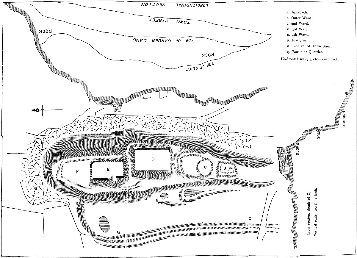
309
The reduction of the principality by Edward I. necessarily destroyed the value of the castles along the march, as bulwarks against the Welsh, and the strong domestic government of that sovereign put an end to the continued rebellions of the Marcher Barons. Under these circumstances the border castles were either allowed to fall into decay, or were employed only as county prisons. In any case they had little or no military value; nor, with the exception of a few passages in the reign of Edward II., and for a while, during the Glendower rebellion, were they regarded as defensible or so employed. Long afterwards, indeed, during the wars of Charles and his Parliament, such of these castles as remained tolerably perfect were garrisoned, defended, usually taken and retaken, and finally slighted or blown up by the prevailing party. Montgomery seems to have had its share of these misfortunes, and no doubt its walls and towers suffered; but in all probability, here, as elsewhere, far more damage has been done by the use of the ruins as a quarry in modern times of peace and prosperity than by the violence attendant upon war. Here, as in most other border castles, the military history of the building closes with the reign of Edward I., up to which point, or nearly so, all that can be said of the castelry, honour, and descent of the castle, has been collected from the original records, combined, digested, and recorded by Mr. Eyton, in his admirable “History of Salop.” For the later history of the castle, may be read with advantage a paper by the Rev. George Sanford, recently printed in the Montgomery Transactions.
The position of Montgomery Castle is formed by nature, and needed only to be seen to be recognised as very suitable for a border fortress. A narrow and lofty ridge of rock, lying nearly north and south, rises abruptly between two valleys; that to the east very suitable for the town which has sprung up within it; that to the west, narrower and equally steep, but rising on its further side to far loftier elevations, one of which is crowned by the encampment of Frydd-Faldwin, and the other, rather lower and more to the south, is occupied by a much smaller work of very different, and, probably, English type. The ridge is in length about 500 yards, and that part of its summit occupied by the castle and its works about 330 yards. Its greatest breadth is about 60 yards, of which the castle may occupy about 40 yards. The ridge is reached from the south-east, or town quarter, by a steep road, but towards the north it terminates in a sharp point, whence a very steep slope falls to the top of a cliff of rock, the whole height being perhaps 250 feet. The contiguous sides are also very steep, so much so that a stone set rolling from the top does not stop till it reaches the gardens and orchards 150 feet or more below. The parish church stands within the town upon an eminence opposite to, but lower than the castle. The view from the ridge extends over the plain of the Severn to the Welsh mountains in one direction, and to the Shropshire hills in the other. Below, in the direction of Chirbury, Offa’s Dyke may be discerned about a mile distant, the castle being upon310 its outer or Welsh side. The ridge is traversed by three ditches quarried in the rock, and dividing it into four platforms, which formed the four wards of the castle, each of which appears to have been enclosed by walls or palisades, and connected with the others by bridges of timber. The northern and strongest ward is also by some feet the highest ward, and formed the donjon, or citadel; keep there was certainly none. This ward was about 52 yards north and south, by 32 yards east and west. It is nearly rectangular, and its four faces are scarped and revetted, that portion of the wall being about 15 feet high. Upon this stood the curtain and the outer walls of the contained buildings. A considerable building stood on the west face, along the southern half of which a wall remains about 9 thick, which supported a basement and two upper floors, of which holes for the joists are seen. In the first floor is a recess with a window and two garderobes, with shafts in the wall. The window was pointed, and that is all that can be ascertained. In the upper floor is also a garderobe. Connected with this fragment of wall is half a horseshoe tower, 30 feet in diameter, projected 25 feet from the wall. This also had a basement, and two upper floors, but little of it now remains. In the outer side of its wall, to the north, are the remains of another garderobe shaft, and, high up, part of a straight mural staircase. From hence, northwards, is a mere curtain. On the three other faces only the revetment, or traces of it, remain. A heap of rubbish at the south end may be the foundation of the gatehouse. There is no trace of a well, hall, or chapel. The only ashlar remaining is a sort of quoin in the substance of the great wall, and in a window jamb in the horseshoe tower. The masonry is rude but coursed rubble.
Between this and the third ward was a ditch about 20 yards broad, dammed up at its lower or west end to form a pond, probably for the benefit of the castle cattle. There is no trace of a bridge of masonry here. The third ward is a regular oblong, carefully scarped, and probably revetted all round. Only the eastern face is visible, and there the wall is about 20 feet high, with the remains of three half-round solid buttresses, 6 feet in diameter, and something like traces of two more. There is no masonry above the surface of the platform, which is about 40 yards north and south by 35 yards east and west. A ditch of about 8 yards broad divided it from the second ward.
The second ward is roughly oval, about 50 yards long by 30 yards broad, and its southern end is occupied by a rocky mound. There is no trace of masonry connected with this ward, which may have been defended with timber. The ditch dividing this from the first ward is not above 4 yards or 5 yards broad, and very irregular, the depression being apparently in part natural.
The first ward is smaller than the rest, irregular and rocky. It bears traces of dry walling, and upon its platform are the foundations of a rectangular building, and at the south end of a sort of tower, indicated only by a heap of earth. It may have been about 25 yards311 by 15 yards. It may be that the first and second wards were merely natural platforms palisaded with timber brétasches, as they are called in the close roll, but the third and fourth wards were certainly walled and must have been strong. To the north, 20 feet to 30 feet beyond, below the north ward, is a level triangular platform of turf about 60 yards in the side, and protected by a light bank on which may have been a fence. This platform, by nature so strong, was probably intended for a pasture for cattle. At the other or south end is also a platform, 20 feet or 10 feet below the level of the first ward, and now occupied by a cottage. Here was the entrance, which probably was covered by some sort of tower, protected in advance by a palisade.
Scanty as are the remains of this castle, it may safely be concluded that they present no masonry of Norman date, whether early or late. The plan of the works is, of course, dictated by the natural outline of the rock, and it therein resembles Bere, though that is a little earlier than Henry III., and Dolforwyn, probably a work of that king’s reign. Henry III.’s border castles had no keep. They were mostly mere enclosures, the curtains being set rather thick with towers.
Altogether this castle, as it now stands, seems to be the new castle referred to by Henry III., and built early in his reign, nor is there any trace of any earlier work, although there is every reason to believe that such there was, and that it or they stood on this site. Moreover, as to these earlier works, tempting as is the position, there is nothing in the way of earthwork upon it which can be safely attributed either to the Welsh or the English. That Earl Roger constructed a castle of some kind at or near the present site is certain, and it is very improbable indeed that with a position so convenient, and made so strong by nature, he should have selected any other, nor is there in the immediate neighbourhood any trace of any other work likely to have been constructed later than the Conquest.
It has been mentioned that the borough of Montgomery had licence, in the reign of Henry III., to enclose the town within a wall and ditch, and although gates and ditches do not necessarily imply the more costly addition of a wall of masonry, it is certain that the town was fortified, and Mr. Sandford’s view of 1610 shows a wall including an area somewhat wider than the present town, and, what is very unusual, this wall includes the castle, instead of the castle forming a part of the circuit. No traces of any wall of masonry are known to exist, but outside it, to the west, and at the foot of the slopes of the castle, is a bank with a ditch, looking very much like a local dyke of the age of that of Offa, but which is reputed to be what remains of the town wall. The curious thing is that this dyke, which, while opposite to the castle is commanded and therefore strengthened by the castle rock, passes southwards along the steep slope of an opposite hill, and is there commanded from the outside, and would be utterly untenable. This is often the case with Offa’s312 dyke, which, though laid out with a bank and outer ditch, was really rather a boundary than intended at every point for defence. Its defence was obviously the general fear of the Mercian power, rather than the apprehension of an armed force at every point along its line. It may be that the town wall was placed upon this bank, but the bank itself seems older and part of an earlier boundary.
For the plan and section of the castle and castle rock which accompany this paper, and add materially to any little value that it may possess, the author and his readers are indebted to the skill and kindness of Mr. Mikleburgh, of Montgomery.
UPON the northern limits of the county of Glamorgan, and above the eastern and lesser of the two sources of the Taff, stand the ruins of the castle of Morlais, so called from a small brook which rises a little to its north-east, and which, after receiving the Dowlais, flows into the Taff, within the adjacent town of Merthyr.
The castle is placed upon the edge of a considerable platform of mountain limestone rock, quarried extensively during the present century for the neighbouring ironworks, and about 470 feet above the Taff Vechan, which, descending through a steep and narrow gorge of considerable beauty, the boundary of the ancient districts of Brecheinioc and Morganwg, as of the modern counties of Brecknock and Glamorgan, escapes below the castle, through the defile and over the fall of Pont Sarn, to join the Taff a little above Merthyr.
The position, strong upon the north and west, is open upon the east and south; thus, in its want of complete natural defences, resembling in position the Norman castles rather than the Celtic or Saxon camps. It commands an extensive view over much of the upper Taff, and of the Merthyr basin, and was, on the whole, well placed to guard this frontier of Glamorgan against the inland tribes, to give notice of their approach to the garrisons of the plain, and to cut off any spoilers who, having invaded the vale, might be returning by this route to their native fastnesses.
The ancient trackway of Heol Adda, still a parish road, the shortest, and within memory the ordinary, way from Gelligaer and Merthyr to Brecon, passes about half a mile north-east of the castle, and was completely commanded by it.
The ground-plan of Morlais is very simple. A court, of an irregular oval shape, 140 yards north and south, by 60 yards east and west, is enclosed within an embattled wall capped by five or six circular towers, and encompassed on the north, east, and south sides by a moat, discontinued on the west side, which was always steep, 313though recently quarried into a cliff. The only remaining entrance to the court is on the east side, through a narrow archway in the curtain, which could only have admitted infantry, and which is approached by a steep path and a causeway across the moat. A broader causeway across the moat at its south end seems to have led to a larger gateway, probably commanded by a tower, connected by a curtain with the main wall; but this gateway, if it ever existed, is completely buried beneath the ruins.
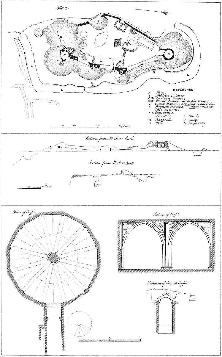
The court seems to have been divided by a wall into a northern and southern portion, in the latter of which is the well.
Proceeding to details, A is the southern or keep tower, of two stories. The lower, a polygon of twelve sides, 28 feet in diameter, has a central column, with corresponding facets, branching into twelve fan-ribs, which, forming pointed arches, support the roof, and terminate on the containing wall in as many pilasters. The ribs are of limestone, but the upfilling of the vault is of a calcareous tufa, light, and very strong, and found in situ below a calcareous spring on the Heol Adda road, towards Pont-Sticcill. The whole chamber, though extremely elegant, is quite plain, the mouldings being a mere chamfer with no other decoration. There are neither windows nor loops, and the entrance is by an acute lancet-headed doorway, 5 feet wide by 13 feet high, which occupies the northern facet, and is approached from the court by a descending flight of steps. The upper chamber was probably not vaulted. Like Castell Coch, it seems to have contained several large fireplaces, as well as a garderobe chamber. It was approached by a winding stair, which appears to have terminated below upon a sort of drawbridge across the stairs leading to the crypt, and thus to have communicated with the eastern walls by another stair, exterior to the tower, and also leading to its battlements. In the curtain wall, close north-east of the keep, is a singular cavity, the use of which, if one it had, has not been discovered.
The opposite or northern tower, B, was of much less elaborate construction. It appears to have been a mere shell, 37 feet in internal diameter, of two stories, divided by a timber floor, entered below from the court on the level, and above probably by a winding stair on its north-east side, communicating also with the ramparts of the eastern curtain.
The east entrance, I, 5 feet broad, which was provided with a portcullis, and had a sharply-pointed arch, destroyed about twenty years ago, is placed between two smaller drum-towers, C and D, about 16 feet in diameter, each with its subsidiary well-stair. The northern tower, close to the door, completely commanded its exterior, and the southern, at some distance from the door, but nearly opposite to the causeway, K, commanded that passage, and the steep way up to the gate.
The western wall, probably 6 feet thick, was altogether weaker than the eastern, which was about 12 feet, and instead of two, it seems to have contained but one tower, a chamber of, or perhaps a drain from314 which, still remains. South-west of the keep are two heaps of rubbish which evidently indicate the position of two towers, one upon the curtain, and the other some way in advance, which latter seems to have terminated a sort of spur wall, projecting 60 feet from the curtain, and intended to cover the principal entrance by the southern causeway.
The well, N, is a singular excavation, rough and unlined, 27 feet square, and now about 44 feet deep. A few years ago it was partially filled up, and it is said before that to have been 70 feet deep. However this may be, it is certain that no water would be reached here at less than 400 feet, a depth which was not likely to have been attained. Close to the well, at O, is an oblong chamber, 44 feet by 24 feet, with broad steps, which appears to have been a tank, probably for rain-water. Near this tank is an oval oven, 11 feet by 15 feet, very perfect, and, singularly enough, formed of limestone. Near to this are the foundations of the kitchen. The wall dividing the court crossed just north of the well, opposite to which are traces of a large bow, and east of this of a doorway. In the southern court, against the east wall, were ranges, probably of barracks, roofed with shingle or tile-stone, with leaden trimmings, the stones and lead having been turned up in the ruins. Near the well is a large heap of mixed iron slag, coal, charcoal, and clinker, probably from a smith’s forge, near to which fragments of iron have been found. The heap is evidently old, inasmuch as it contains crystals of selenite. It also contains chlorine and sodium in various combinations, proving, or thought to prove, that common salt has been used in the operations of the forge, or perhaps in smelting the ore here.
The moat, which ranges from 14 yards to 40 yards from the walls, is about 40 feet broad and 14 feet deep, and its total length is about 370 yards. It has been quarried out of the rock, and its contents no doubt were used in building the castle, which is almost wholly of limestone.
In the moat, at Q, is a driftway, now much broken down, but which it is just possible may have been a private passage into the court. The area covered by the castle, measuring from the exterior edge of the moat, is about four acres.
Exterior to the moat, at its south side, is a sort of semi-circular space inclosed within a mound, and probably intended for the protection of cattle. East of the moat are various holes and ruined inclosures, the former probably old places for burning lime, and the latter shepherds’ huts and folds.
This castle, in 1833, was partially excavated by Lady C. E. Guest, when a metal seal was discovered in an adjacent field. The legend is, s . inon . fili . howel . gor .; but the names of Einon and Howell are exceedingly common in Glamorgan pedigrees, and the concluding abbreviation, no doubt a distinguishing cognomen, has not been explained, unless it may be read “Goch” or “the Red.” Coins have also been occasionally picked up. Very recently there315 were found together several silver pennies of Edward I., and one of Alexander I. of Scotland.
The castle at this time is a ruin, only the mere outline of the walls, and the débris of the towers remaining. The keep alone is above ground. The foundations are, however, tolerably perfect, and have been excavated and traced very recently with a view to the annexed plan. There is reason, from the disposition of the rubbish, to infer that the walls and towers were regularly pulled down from the top, and not, as usual in later days, blown up; so that the castle was probably deserted and dismantled at an early period. Mr. Stephens, whose general authority is in this instance strengthened by accurate local knowledge, was of opinion that this castle was never completed; and this may certainly have been the case.
In the course of the recent excavations a few discoveries were made. The oven was before unknown, as were the staircases of the two eastern towers, and the chambers in the wall of the upper story of the keep, and in the western wall. Very many cut stones, parts of door and window-cases, brackets, &c., were dug up, but all were perfectly plain, having only the chamfer moulding.
The brothers Buck engraved a view of Morlais from the north-west in the last century, which shows the keep, and a small part of the curtain, in a much more perfect state than at present.
The details of Morlais, though good, are, as became an obscure castle, so bare of ornament that it is difficult to refer the building to any precise date. Still the general proportions of the openings, the character of the crypt, and, perhaps, the general plan of the building, point with tolerable certainty to the latter period of the early English style, or the close of the thirteenth century, as about the time of its construction.
The history of Morlais is scanty, but it corroborates the internal evidence supplied by its architecture, and connects it with one of the most remarkable legal struggles between the Crown and the lords of the Welsh marches.
It appears from the public records that, towards the middle of the reign of Edward I., a quarrel arose between Gilbert de Clare, the Red Earl of Gloucester and Hertford, Lord of Glamorgan, and Humphrey de Bohun, Earl of Hereford and Essex, Constable of England and Lord of Brecknock. Both were powerful peers, and De Clare, during the quarrel, had married, 29th April, 18 Edward I., 1290, Joan, the king’s daughter, while De Bohun’s wife, Maud de Fienles, was of kin to the queen. De Clare was the elder, and had the wardship of De Bohun.
The cause of quarrel was a castle, which De Clare had built upon his frontier, and, it was said, upon land belonging to De Bohun. That Morlais was the disputed castle is certain from the general tenor of the evidence, and from the mention of Penderyn Church, which is near to no other fortified place to which the particulars given would apply.
The trespass was the subject of a suit at law, and the king in316 Parliament, eight days before the Purification of the Virgin, 18 Edward I. (25th of January, 1290), gave a formal order to the two earls to abstain from hostilities. This order they disobeyed, and the new offence, of a far more serious nature than the original one, was at once noticed by the king, and the proceedings upon it are recapitulated with great minuteness in the parliamentary record, made on the occasion of the sentence, on the 7th January, 20 Edward I., 1292.
It appeared from the complaint of De Bohun, that De Clare’s retainers, headed by William de Valers, Richard le Fleming, and Stephen de Cappenore, with horse and foot, and the earl’s banner of arms displayed, had made three forays into Brecknock.
The first time, on Friday (3rd February) after the Purification, 1290, marching from the contested ground, they entered two leagues; the second time on Monday (5th June), before St. Barnabas, five leagues; and the third time, on Monday (27th Novem.), before St. Andrew, they entered seven leagues.
In these incursions they lifted and carried home 1070 head of cattle, 50 farm horses and colts, and sheep, goats and swine unnumbered. Also they wasted the land, and killed several people. The damage was rated by a jury at £100. Of the spoil, De Clare, according to the custom of marcher war, received one-third.
On other occasions, following this example, the loose rogues, “latrones et esketores,” of the district, perhaps some of those who gave name to “Bwlch-y-Lladron” above Aberdare, and “Rhyd-y-Milwr” above Rhymney, repeated the forays; and, besides other outrages, burned the house of “Tyraph,” and the church of Penderyn, taking from the latter a chalice, certain ornaments, and other matters. The earl and his captains were not charged with any knowledge of, or share in, these robberies or sacrileges.
It seems probable that the league (leuca) was not above an English mile, and that their depredations were confined to the south side of the Beacons. If so, that tract of country must have been at least as well stocked as it is now. And it may be doubted whether the modern church of Penderyn, with its hassocks and cassocks, and old prayer-books, would yield as much to any modern “esketores.”
Upon the receipt of this complaint, the king appointed by letters patent William de Luda Bishop of Ely, whom Nicholas calls Lord Chancellor (a statement unconfirmed by the very accurate Foss), William de Valence the king’s uncle, John de Mettingham the honest Chief Justice, and Robert de Hertford one of the judges of the Common Pleas, to inquire into the matter, and especially as to whether the outrages were committed after the royal inhibition. They were to summon witnesses from the counties of Hereford, Caermarthen, and Cardigan, and the parts of Gower, Ewyas, and Grosmont, and they were to report to the king by fifteen days from Easter (22d April), 1291.
The sheriff of Berkshire was to summon the Earl of Gloucester, and Robert de Typetoft, justiciary of West Wales, was to summon317 his captains. The sheriff of Hereford, the justiciary, Geoffrey de Genville and Theobald de Verdun bailiffs of Ewyas, and Edmund the king’s brother’s bailiff of Grosmont, were to provide the jury. Strathwelly, in Brecknock, was to be the place; and the Monday (12th March) after Quadragesima the time of meeting. Also, to prevent any collusion, the inquiry was to proceed, even should one of the parties withdraw.
The following magnates were also summoned by the king as jurors: John de Hastings, John Fitz-Reginald, Edmund and Roger Mortimer, Theobald de Verdun, John Tregoz, William de Braose, Geoffrey de Cammill (no doubt “Camville,”), and Roger Pycheworth, together with the king’s Welsh seneschals, and his brother’s seneschals of Monmouth, Grosmont, Skenfrith, and Whitecastle. Also were summoned the sheriffs of Hereford and Gloucester, and the seneschal of Crickhowel, so as to provide a jury of twenty-four knights and others. The preparations were not unsuitable to the rank and power of the offenders, and to what it is clear our English Justinian regarded as the excessive heinousness of the offence.
On the appointed Monday, Hastings, then Lord of Abergavenny, and his companions, met the commissioners at Brecknock, and were adjourned to Wednesday, at Laundon; but the commissioners proceeded the same day to Strathwelly, which they reached about three o’clock.
The Earl of Hereford was punctual, but Gloucester and his captains were not forthcoming, though the sheriff and Typetoft proved their summons. It was, perhaps, the probability of this contumacy that had caused the previous adjournment to Laundon, to which place the commissioners next proceeded.
Here, his opponents being still absent, the Earl of Hereford stated his complaint, and demanded an inquiry. Upon this the magnates were called upon to swear, placing their hands upon the book. Hastings and the rest unanimously refused compliance. Their ancestors, they said, in those parts, had never heard of a compulsory oath, except in certain march affairs, sanctioned by custom. They were admonished that the king’s power was supreme, but they still, each for himself, declined, without consulting their peers.
The excuses of certain jurors were next stated. De Braose did not appear, because his lands were in the king’s hands. Pycheworth was a name unknown; but Pychard, who came, was not received. Genville had enfeoffed his son Peter with his Welsh lands. The seneschal of Abergavenny had received no summons. Certain Crickhowell jurors came unsummoned, as their seneschal testified. Roger de Mortimer held his Welsh lands under the Earl of Hereford, and of course could not act; and Edmund’s lands were far off, so no summons had found its way thither. From Tregoz and Camville came neither jurors nor seneschal.
The inquisition then proceeded, and the jury found that the three forays had occurred, and the robberies, &c., as stated; but that318 John de Creppyng, who had been indicted as a captain, had not been present in person, but had sent his men, and shared the booty.
Before the commission broke up, the charge to the earls to keep the peace was repeated.
The next step, the commission having apparently reported, was taken by the king in council, who summoned the two earls to appear at Ambresbury, on Monday (3rd September) preceding the Nativity of the Virgin. Thither accordingly they came; and as it was well known that there had been new and repeated breaches of the peace, the matter had become still more serious. With a view to fresh evidence on this point, the king further adjourned the inquiry to Abergavenny, where he, his council, the jurors, and the two earls, finally met about Michaelmas.
The Earl of Hereford was asked whether he had disobeyed the royal order either before or since the Laundon meeting; but the Earl of Gloucester, having absented himself, was taken as guilty of the former charge, and invited to meet only the latter. To this he pleaded not guilty; but he was permitted to take objections to the former judgment, and, by special favour, to hear read the previous proceedings.
The points he raised were ingenious, but rather fine spun. He took objection to the writ of scire facias, under which he was summoned, as not having been issued through a court of law in the regular way. This was overruled, on the ground of the importance of the case, and the pressing necessity for action. Next, he objected to the commission itself as an ex officio proceeding, and not binding upon him. Then he advanced that his father, under the orders of the late and present king, had slain or done various injuries to the parents and kin of many of the jurors from Caermarthen and Cardigan, which disqualified them from sitting on the inquest. These also were overruled, the latter on the ground that judgment had gone by his non-appearance. He then said that, between the date of the original prohibition and the first foray (25th January to 3rd February), there had not been time to communicate with his distant and scattered retainers. This also was pronounced invalid.
As to the second foray, the earl pleaded that he was not responsible for it, as the king had at that time seizin of his Glamorgan lands. This was no doubt on the occasion of his marriage, with a view to which event he surrendered, 18 Edward I., his estates, and, after the marriage, took a regrant of them to himself and his wife, under new limitations. It appeared, however, from the records, that the earl had received seizin nine days before the second foray; so this also failed. As to the third foray, he pleaded the recent enfeoffment, which, being entirely new, removed the effect of any prohibition issued to the old feoffee. This, however, was met by a declaration that the prohibition was not territorial but personal; consequently the verdict of guilty was confirmed against himself and his captains.
The breaches of the peace after the Laundon meeting were then inquired into. It was proved that, on the Thursday (29th July)319 before St. Peter ad Vincula, the Earl of Gloucester’s people having put certain averiæ, or “plough bullocks,” to feed in the disputed ground, the Earl of Hereford’s bailiff and retainers appeared in force. Upon this, De Clare’s men retired with the cattle into their own lands. The others followed, slew some of the men, captured and drove off the cattle, and lodged them in Brecknock Castle. De Bohun had not known of this; but, on its being reported, he directed the cattle to be retained and ransomed. At the time of the inquiry some of them had been killed, and others were in custody at Brecknock.
Further, on Monday (9th August) after the Assumption of the Virgin, the Earl of Gloucester’s men went by night, like robbers, into the Bohun territory. The Bohun retainers, alarmed, drove them back three leagues into their own lands, recovered all the cattle they had stolen, and took several others besides, which they brought home and still kept. Of these expeditions the Earl of Gloucester was entirely ignorant. The Bohun leaders were John Perpoynt, seneschal of Brecknock Castle, and the earl’s bailiff, John Deucroys, or Everoys, Philip Seys, Howell Vaughan, and Howell ap Trahern. Their earl, however, not only did not approve of this second expedition, but on hearing of it, he bound over his captains to bail, under which they still remained. Also, it was shown that, on receiving the royal order, the Earl of Hereford caused it to be proclaimed at church, and market, and other public places. Nevertheless, as he had sanctioned the retaining of the captured cattle, he was also found guilty.
The Earl of Hereford, however, had not offended before the Laundon meeting, neither had the Earl of Gloucester after it.
In each case the jury notice with reprehension that the earls allowed proceedings in the marches which elsewhere would, as they knew, have been punished.
Both earls, with their followers, were committed to jail, and their Welsh franchises taken in hand by the king.
Upon this Edmund, the king’s brother, William de Valence, his uncle, Henry de Lacy, Earl of Lincoln, and John de Hastings, gave bail for Gloucester; and Reginald de Grey, Robert Typetoft, Robert Fitz-Walter, and Walter de Beauchamp, for Hereford; and, while thus at large, they were permitted to hold their franchises. The earls themselves, thus bailed, were permitted to become bail for their followers, and thus passed 1291.
The parties appeared again at Westminster on the morrow of Epiphany, 1292, but sentence was not finally pronounced until Thursday (17th January) after the octaves of Epiphany, when the parties again appeared before the king at Westminster.
With regard to the Earl of Gloucester, his whole franchise or royalty, totum regale, in Morganwg, was declared forfeited. But whereas he had married the king’s daughter, and had by her offspring; and whereas she had an equal share in the franchise, the earl having a life interest only, he could not forfeit more than his320 own rights, neither was it lawful to punish the innocent for the guilty. His forfeiture therefore was to be for life only. He was further to be imprisoned during pleasure, and to pay £100 damages to the Earl of Hereford.
The Earl of Hereford’s Welsh franchises, being held by him without limitation, were forfeited altogether, and he also was remitted to prison. But, inasmuch as his offence non est ita carcans, nor deserving of punishment so heavy as that of his brother earl, and as he had married a kinswoman of the queen, who made the marriage, so that the earl’s children and the king’s children would be of kin, his forfeiture also was limited to his life.
The obvious unfairness of the punishment seems to have been in some degree adjusted by the fines under which the earls were restored, Gloucester paying 10,000 marcs, and Hereford 1,000 marcs.
Neither earl long survived this transaction. Gloucester died in the castle of Monmouth in 1295, and Hereford in 1298, but not before he had on more than one occasion made a bold and successful, and strictly legal, opposition to his sovereign.
The retainers were let off lightly, on the plea that they had not been warned by their lords of the royal prohibition. John de Creppyng was fined fifty marcs; his securities being Richard de Creppyng, of co. York, and John Wogan, of Somerset.
Richard le Flemyng was fined £20; his securities were John le Waleys, of Somerset, and Stephen Haucumb, of Cornwall.
Stephen de Cappenore was fined twenty marks; his securities being Robert de Typetoft, and John Lovel, of co. Northampton, at ten marcs each.
William le Valers was fined £10; his securities were John de Creppyng, of Lincoln, and Robert Fylliot, of Cumberland.
Perpoynt and his fellows were left to the ordinary course of law, with a hint that their punishment was not likely to be very severe. And thus ended one of the most important transactions in the history of the Welsh marches; a trial evidently pressed forward by Edward with a view to break down the great, ill-defined, and ill-exercised power of the Lords Marchers, intended to be regulated by the celebrated statute of Rhuddlan.
No apology is necessary for introducing this event at some length of detail into the history of a march castle; besides which, the names contained in it show who were at that time the great lords of the district. They show also, that while De Bohun’s captains were native Welshmen, for the Perpoynts, descendants of Giles Perpoynt, had become naturalised at Gileston a generation or two earlier, De Clare’s affairs were in the hands of strangers to the soil, men whose names, with the exception of Flemyng, do not appear then or since in Glamorgan pedigrees. (“Rolls,” i., 70; Carte, “History of England,” ii., 221; Dugd., “Bar.,” i., 182; Jones, “Brec.,” iii., 143; “Rot. Fin.,” 20 Edward I.)
The original cause of dispute seems to have been overlooked in the consequences, for nothing more is heard of the contested321 boundary. It is, however, noteworthy, that very near Morlais the county boundary quits the well-defined Taff Vechan, and crosses the mountain in a direction unmarked by any natural features, so that, until an amicable arrangement was arrived at twenty years ago, the actual limit of each county continued to be subject of dispute between the manorial lords on either side.
Morlais, though thus founded amidst contentions, seems, on the whole, to have enjoyed a peaceful, if not an ignoble, existence. No doubt the settlement of the country under the long reign of Edward III. destroyed its value as an outpost, and led to its neglect, or perhaps destruction. No mention of it has been discovered until the days of Leland, who says,—
Morlays Castelle standith in a good valley for corn and grass and is on the ... ripe of Morlais brook. This castelle is in ruin and longith to the king.—(“Itin.,” iv., 39.)
Leland probably had not visited the spot which he thus somewhat incorrectly describes, but his evidence as to the proprietorship is likely to be correct.
The circumstances that led to the construction of Morlais are sufficiently evident from its general position. The lower part of the county was protected not only by the lord’s castles of Cardiff, Llantrissant, and Kenfig, but by a considerable number of lesser castles belonging to private persons, and intended, primarily, for the protection of their estates. It remained to guard against the sudden inbreaks of the Welsh, who, descending from the north, and moving with great rapidity, and having, besides, the advantage of what strategists call “interior lines,” could readily select their point of attack, and cutting off detached parties, or sacking an occasional village or castle, could retreat through paths and at a rate which rendered useless any pursuit by the heavily armed Normans.
To check such marauders, or at any rate to cut them off in their retreat, other castles were constructed by the marchers, such as Castell Coch on the Taff, the tower of Whitchurch a little below it, and finally, at the head of the two great valleys of the Nedd and Taff, and at the apex of this contained triangle of mountainous country, Morlais.
Caerphilly belongs to the same class of defences. It was built hastily, and probably decided upon hastily also. It never was, and Cardiff being the chief seat of the lord, it may be doubted whether it ever could have been, of an importance at all commensurate with its extent and cost. Morlais, on the contrary, seems to have been solidly constructed, and to have been in all respects suited to the purpose it was intended to fulfil.
Local tradition, the tendency of which is, naturally enough, to ascribe all considerable works to the native lords of the soil, attributes this to Ivor Bach, a celebrated chieftain of east Glamorgan, late in the twelfth century, who is reputed to have fallen in fight upon an adjacent spot, still called “Pant-Coed-Ivor.”
322
That Morlais, like Caerphilly and Castell Coch, was built on the territory of the family of Ivor Bach is no doubt true, since he, his ancestors, and his descendants, as Lords of Senghenydd above and below the Caiach, possessed the whole tract of country between the Taff and the Rhymney, from Cardiff northwards to the Brecon border; but it is clear, from the position of the work, that it was not built by, but intended to curb the aggressions of, those turbulent native chieftains, among whom Ivor and his son Griffith, and their neighbour Llewelyn Bren (1315), played in their day a conspicuous part.
Moreover, the residences of Ivor and his descendants, said to have been anciently at Castell Coch, but known to have been afterwards at Brithdir, at Merthyr, and finally at the Van, have never been recorded as at Morlais, nor is it at all probable that they would have constructed so expensive a dwelling upon the very verge of their domain, and upon a spot far too high and rocky for ordinary cultivation.
It may be objected that, had Morlais been built by the Earls of Gloucester, it would have remained, like Caerphilly, in the hands of the chief lords; for the site of Caerphilly, seized upon by De Clare in the reign of Henry III., still remains an isolated part of the Cardiff lordship in the midst of the Van estate; but it may well be that, while the size and importance of Caerphilly, and its later use as a prison, caused the lords of Cardiff to retain it in their possession, Morlais, from its moderate dimensions and distant position escaping notice, would be dismantled, and the site allowed to revert to the descendants of its original owners, who still held the surrounding estate. It was probably soon after Leland’s time that the Crown allowed its right, as the then Lord of Glamorgan, to fall into disuse.
The Morlais property, including the castle, passed from Ivor Bach’s male descendant, Thomas Lewis of the Van, by the marriage of his daughter with an Earl of Plymouth, to the Windsor family, in which family it still remains.
THE castle of Norham-upon-Tweed, “Old Norham,” the Queen of Border fortresses, and the most important stronghold between Carlisle and Berwick, was long the “Castle Dangerous” of that contested territory, and the strongest place on the Marches. It is a lasting monument of episcopal magnificence, founded, restored, and maintained by Flambard, Pudsey, and Beke, three of the most powerful prelates who sat in the chair of St. Cuthbert, and as an example of a great Norman keep is not unworthy to be named with Bamborough itself. The natural strength of the ground led to its early occupation for purposes of defence, and the traditions of323 Norham are in keeping with its architectural grandeur. Here the Roman legions paused in their progress northwards, and threw up earthworks which may still be recognised, and which were probably abandoned when, under the military occupation of the country, a permanent road was laid out a few miles to the eastward, near to the mouth of the river. An early settlement of the Saxon kings of Deira seems to have been on the steep side of Yevering Bell, the ancient Gebrium, a spur of the Cheviot range, about twelve miles south of Norham, where there yet remain formidable earthworks, which Mr. Raine regarded as traces of the residence of the celebrated Eadwine, King of Deira (585–633), the disciple and friend of Paulinus, but who derived his knowledge of Christianity and probably his taste for a hill residence from Cadvan of Gwynedd, by whom he was educated. Hence, in later times, his successors moved their seat to Millfield, a place near to the Till, and scarcely nine miles from Norham. Probably it was from here that the Saxon kings guarded the pass of the Tweed, then called Ubbanford; and it may well be that their handiwork remains in the banks and ditches, not to be confounded with the camp of the legions, but incorporated with the later castle, and which much resemble in their figure and strength other well-known residences of the ninth century. Here, near this “Northern home” of the successors of St. Cuthbert, Bishop Ecfrid of Lindisfarne founded the parish church dedicated to that saint, towards the middle of the ninth century, and placed in it the remains of Ceolwulph, king and saint. The two contiguous shires of Norham and Island, probably given by Oswald of Northumberland to Lindisfarne, are reputed the oldest possessions of the see of Durham, and detached from the body of the bishopric, presented a bold and strongly-fortified front of twelve miles, from Coldstream to Berwick, to the Scottish invaders. Early in the twelfth century arose the castle, of which the ruins are still so grand, and for the possession of which English and Scottish kings contended for centuries with varying success. The great Edward, “Malleus Scotorum,” made much use of Norham in his wars, and here, both in the church and in the castle, were assembled before him the competitors for the Scottish throne, of whom he selected one rather on the score of his subserviency than of his worthiness. It was also from Norham that Surrey and Dacre and the warders of the middle march directed that formidable raid which, following upon Flodden, carried fire and sword almost to the gates of Edinburgh. But although the broad stream of Tweed still flows at the base of the castle rock, and the scaurs and ravines that constituted the strength of the position still remain unaltered upon its southern frontier, all else is widely changed. The lofty, though ruined, battlements, rising far above the tufted trees, still, indeed, remain the landmark of the local shire, but they no longer look out over wasted lands and ruined villages, harried alternately by Englishman and Scot, “galling the gleaned land with hot assays.” In no part of Britain are the fields more skilfully cultivated, the rickyards more324 richly stored, the byres stocked with cattle of a higher breed, the farmhouses indicative of greater ease, or the agricultural labourer better able to care for his own interests. All shows plainly to the eye of the experienced traveller what has been achieved by the sturdy northern agriculturist, under the invigorating influence of an unfettered trade.
Norham occupies the hollow of a grand bend of the Tweed, which here cuts “a huge half-moon, a monstrous cantle,” out of the English bank to bestow it upon that of Scotland, in the form of a broad and fertile meadow. The castle stands upon a rocky platform, the south-western extremity of a cliff which forms the river bank for a considerable distance. A deep ravine cuts off the higher ground to the north-east, and is joined by a less marked depression, which, deepened by art, sweeps round and forms the southern defence until it opens upon the steep slope which descends to the river and forms the north and north-western front of the castle. Beyond this ditch, which contained the approach from the village of Norham, and more to the south, is a broad and level platform, also defended by deep ravines, upon which may be traced the remains of the Roman camp and the less regular banks and ditches of some of the besiegers of the castle. Both in its choice and in the manner of occupation of the position are shown much strategical judgment and engineering skill. It is both locally strong and well selected for the defence of St. Cuthbert’s and the Northumbrian frontier from Scottish inroads, as well as for the cutting off such invaders as, having advanced southwards, might be forced to retreat. The description of Simeon of Durham is both concise and accurate. Writing of Flambard, he says: “Condidit castellum in excelso præruptæ rupis super Tuedam flumen, ut inde latronum incursus inhiberet et Scottorum irruptiones. Ibi enim, utpote in confinio regni Anglorum et Scottorum, creber predantibus ante patebat excursus, nullo ibidem, quo hujusmodi impetus repellerentur, præsidio locato.”
The glories of Norham, indeed, have been honourably recorded in every stage of its stirring existence. Its sieges, misfortunes, reparations, and their particulars and cost, are entered in considerable fulness in the sheriffs’ accounts and in those of the Palatine see, and, finally, in its neglect and decay, it has been honoured with Scott for its poet and Raine for its historian.
The plan of the castle is irregular, following the general outline of the ground. Like Barnard Castle, its form is a sort of quadrant, the north and east faces 143 yards and 108 yards long, being nearly at right angles, and more or less straight, and the border to the south-west a curve of 223 yards, connecting the two sides. Of the area thus enclosed, the north-eastern portion is occupied by the upper or inner ward, the plan of which is roughly square, 57 yards east and west by 47 yards north and south, covering, therefore, within its walls 2,680 square yards. The north and east sides of this ward form part of the common curtain of the whole. In front of the other two sides is a broad and deep ditch, which extends 325from the eastern ravine to the northern steep, and is contained wholly within the outer ward, the available area of which is thus considerably reduced. The whole was contained within a curtain wall which, where it belonged to the inner ward, was high and strong, but where to the outer ward was unequal, being high where it crossed the ends of the inner ditch and along a part of the north front, but elsewhere either very low or of but moderate thickness. Most of the care of the engineer was lavished upon the inner ward.
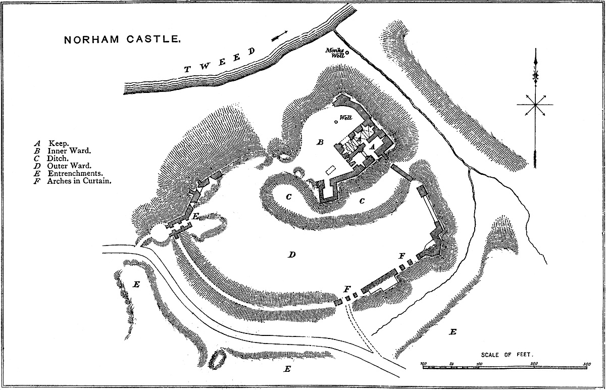
The keep, the great, and, though a mere ruin, the best-preserved feature of the fortress, is rectangular, and measures at its base about 64 feet north and south by 86 feet east and west, and is or has been about 90 feet high. The walls range from 12 feet to 15 feet thick, and appear to be 8 feet to 10 feet at the summit, which is inaccessible. The east end is a part of the exterior line of defence, and ranges with the curtain. The south face looks into the outer, the two other faces into the inner, ward. The exterior faces have certain peculiarities. The south-east angle is capped by two pilasters, 11 feet broad and of slight projection, which, like the similar pilasters at Kenilworth, rise from a rough, bold, sloping plinth, 12 feet high, continued all along the east end. These pilasters have various sets-off reducing them to 10 feet at the summit. They meet at and cover the angle, which is solid. Near the centre of the east end is another somewhat similar pilaster, only 10 feet broad, and beyond this the wall has been pulled down to the first floor. The part left, forming the north-east angle of the keep, had no pilaster, but is bonded into the northern curtain, which is of its age. The southern curtain is not in the line of the keep, but sprung from its south face about 25 feet west of the south-east angle, where it is seen to have been 7 feet thick and of the height of the first floor of the keep, or about 30 feet. This also was of the age of the keep. The southern face of the keep, so far at least as its outer face is concerned, is of two dates. In the centre, but belonging to the eastern or older part, is a pilaster, 8 feet broad, but without setts-off. Between this and the south-east angle, above the curtain, and also without sett-off, is another pilaster, only 3 feet wide. A flat wall, without pilasters, but with two setts-off near the summit, occupies the next 36 feet westward. The base seems old, but the upper part is certainly later, into which the Decorated windows are probably insertions. Near the west end, about 16 feet from the angle, is a plain pilaster, 3 feet broad and 6 inches projection, which ascends to the second floor level, and stops at the cill of a small pointed doorway in the second floor; above this, in the two upper storeys, are two similar but rather smaller doors. It is probable that these opened from mural lobbies into garderobes of timber, projected from the wall: at least, it is difficult to suggest any other reason for doorways so placed.
The west face is all of one date; the doors and windows are of the Decorated period, but the wall itself is Norman. The curtain of the inner ward abuts upon the south-west angle, and is about326 30 feet high and very thick, with a mural closet high up within it, which may be the garderobe, completed probably soon after 1431–2. There are two pointed doors, both at the ground level; one leading into the south chamber of the keep, the other, near the centre, into a well-stair, 10 feet diameter, which ascends in the wall to the summit, and terminates in a raised square turret, a marked feature in every view of the keep. Six loops, one over the other, show the line of this staircase, and a few feet from the top, and over the door, are four or five corbels, which evidently supported some kind of brétasche of timber to protect the doorway below. Above are various windows, three of two lights, trefoiled, square-headed, but Decorated, and others of one light, with square labels. Towards the south end of this front, at the first-floor level, is a large round-headed doorway, evidently the original main door of the keep, the outer stair leading to which is removed. No doubt this stair ascended from the north end, and the chamber in the curtain, now inaccessible, was either an oratory or a garderobe, opening from the vestibule before the door. This end, like the south, is tolerably perfect.
The north front is almost all removed. About 15 feet from the west end there remains one jamb of a door at the ground level. Beyond this, about 26 feet is level with the ground. The remainder, about 45 feet, remains to the level of the first floor, and is pierced by two loops from the basement.
The interior of the keep shows it to have contained a basement and four floors, the whole divided east and west, or longitudinally, from bottom to top, by a party wall 5 feet thick, of which only the lower part remains. The basement, at the ground level, is composed of a north and south chamber, each 60 feet long, the northern 20 feet and the southern 15 feet broad. The southern was divided by a cross-wall into two chambers, both barrel-vaulted, the western rather the longer. The eastern has a loop to the east, high up, set in a splayed, round-headed recess; and in the north wall is a door leading into the north chamber. In the south wall, here 12 feet thick, is a breach 8 feet wide, at the ground level, which probably represents a loop. The western chamber has a loop in the south wall, the recess of which runs into the barrel, producing a groin. In the west end is a doorway and passage through the wall, here 15 feet thick, and by its side a loop. There must have been a door between these southern chambers, in the cross-wall.
The northern chamber seems to have been one room only, broken into four compartments by groined vaulting, between each bay being a broad flat band. There is a loop at the east end, and two others near it, in the north wall. The two western bays are broken down. In the west wall is a loop, and near it, in the north wall, the jamb of a door of entrance, probably the stone doorway into the dungeon vault made in 1429–30, and fitted with an iron gate. This basement vaulting is about 10 feet high to the springing, and is original, as at Bamborough, Mitford, and Newcastle, and the walls 327and loops all round, seen from within, seem also original, and their interior face work is excellent open or jointed ashlar. The remains of the cross-wall show the first floor to have contained two chambers, both probably vaulted; the southern certainly so. Each was entered by a door from the western staircase. The north and much of the east wall of this north chamber is gone. In the west end is a Decorated window in a large round-headed recess, flat-sided, and near it the entrance from the staircase. In the east end was a loop in a splayed recess. The southern chamber was probably a lower and lesser hall. In its east end is a door from the well-stair, and another door, large and round-headed, once the main entrance. Against the south wall are seen the remains of the vault, of four compartments, groined, the bays divided by cross arches springing from corbels. In the most western bay was a fireplace; in each of the three eastern a round-headed window in a splayed recess. In the east end is a pointed recess and a large lancet window, the whole evidently an insertion. The height of this floor was about 12 feet to the spring of the vault.
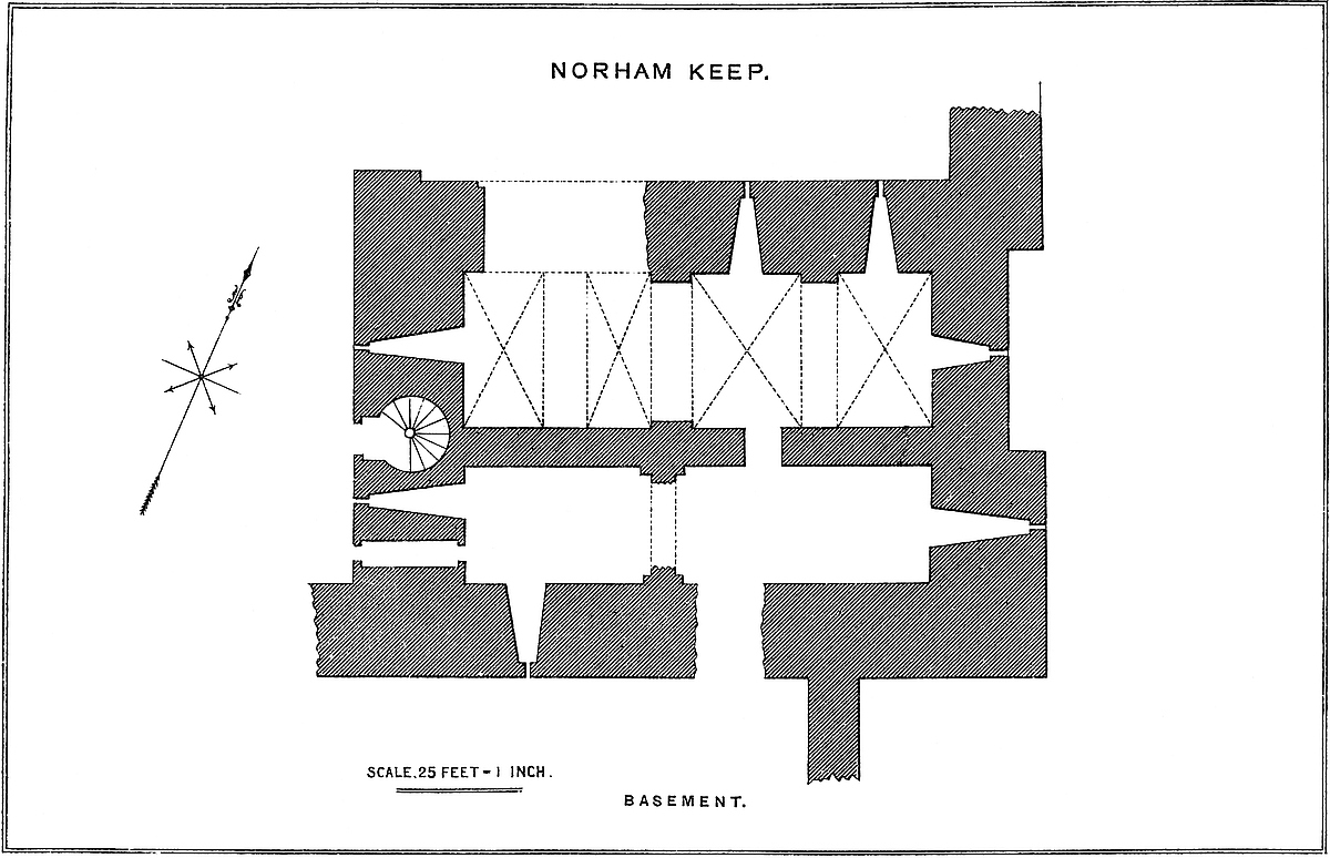
The second was the floor of state, and, in the original keep, also the uppermost floor. The two rooms had low-pitched open roofs, of which the weather mouldings are seen, as at Porchester, in the end walls. These rooms were entered, each by its own door, from the well-stair, but the northern door has been built up and a loop placed in it. Of the north chamber there only remains a large window in the west wall, in a drop arch, a Decorated insertion. If there was any fireplace, it must have been in the dividing wall. The south chamber was evidently the great hall. In its east end is a large full-centred Norman recess, containing a Norman window. In the west wall, besides the staircase door, here pointed below a square label, is a pointed recess and window. In the south wall are two bold, round-headed recesses splayed to small lancet windows, and west of these a pointed door, probably entering a mural chamber, and communicating with the door already mentioned, in the outer face of the wall.
Originally there was no third floor, and to provide this the hall roof was removed, and for it substituted a flat ceiling supported by nine joists, the holes for which remain. On these were laid the planks of the third floor. Of this the north chamber had in its west end a segmented arched window recess and the staircase door, now blocked up. In the north chamber, west end, was a similar staircase door and a pointed window recess. The east wall was not pierced, neither was the south wall, save by one window, and near it a small pointed door, near the west end. The covering of this storey was composed also of nine joists, which carried the planks of the fourth floor.
Of this floor the remains are but slight. It also was composed of two chambers. Of the north the west wall remains, but it contains neither window nor staircase door. The south chamber has in its west end a window, and in its south wall a fireplace. Of this wall only about 6 feet in height remains, so that probably about 4 feet to328 6 feet of its upper part is gone. Considering the thickness of the walls, the absence of mural chambers and galleries in this keep is remarkable.
The keep was certainly built originally by Ralf Flambard in 1121, and the eastern end and adjacent halves of the north and south sides were certainly of the same date. It is also pretty certain that Flambard’s keep was of the same size with the present one, and the whole basement, and the vaulting of the first floor, seems original. Probably there was but one entrance, that in the west end at the first-floor level, and there would be, in that case, an exterior tower or fore-building, covering the staircase, and of which there seem to be traces in the face of the curtain against which, as at Kenilworth, it must have abutted. The entrance is quite plain, and without a portcullis. Bishop Pudsey, who ruled from 1158 to 1174, is said to have rebuilt the western half of the ruined keep. Possibly he only restored it, for it is scarcely probable that half of so very substantial a building should have been pulled down, either with the means or in the time at the disposal of any band of invaders; still, it must be admitted, that the western half differs materially from the eastern. In the latter, the plinth is bold and high, and the pilasters marked features. In the western part are no pilasters, and no plinth of any consequence, and the setts-off of the wall are at a different height. If Bishop Pudsey rebuilt the western half, he did so in the late Norman style, so that the work harmonises inside with that of Flambard. Pudsey, no doubt, raised the walls somewhat, converted the ridge roofs of the second story into a flat covering, and, in the space thus gained and created, added two more floors, as was done to the extent of one floor, at Porchester, Kenilworth, and Richmond, and in many other Norman keeps.
In the Decorated Period great changes were certainly made. Doors were opened at the ground level in the north and west walls. The fore-building was removed, and in its stead a well-stair inserted in the centre of the west wall, so as to provide a new and convenient approach to each floor; and this was carried up to the end in a raised turret, adding somewhat to the view. The entrance to this staircase was at the ground floor on the outside, but it did not lead into the basement. The whole of the west wall and the contiguous half of the south wall were faced with ashlar, and window-cases of the period inserted. All this may well have been the work of Anthony Beke, “Presul Magnanimus,” called “the maist prowd and masterfull Busshop in all England,” in that period—
The window recesses all through the building are mostly in the Norman style, and therefore in almost every case much older than the windows which they contain.
The three ends of the curtain abutting on the keep are of the same workmanship with, and bond into it, and are about 30 feet329 high. That proceeding northwards is capped at the north-east angle by a stout bastion, with a salient angle of 110 degrees, two faces of 17 feet, and shoulders of 4 feet. This is evidently a rebuilding after the introduction of artillery, and probably the work of Sir George Bowes. This curtain is continued 30 feet further along the river face, and is thence broken down. The kitchen seems to have been in the angle, the hall next to it, and then the chapel, all built against the north curtain. The curtain now standing corresponds closely to what the survey of 1515 calls the long high wall from the Dongeon to the north-west end of the kitchen (44 yards long and 30 feet high, contremured, so as to be 28 feet thick). We are told that in 1551 the chapel was 30 feet by 18 feet, with walls 8 feet thick, and with a crypt below capable of stabling 20 horses, and a “closet” above, and that the battlements above this closet and of the long wall were of the same height, and so extended from the north-east angle of the keep round to its south-west angle. In Sir George Bowes’s very able report upon the castle, he advises strengthening this wall by filling the hall and other buildings with earth, and forming a hall in the first floor of the keep, which seems then to have been much such a ruin as at present. Passing to the south-west angle of the keep, whence springs the southern curtain of this inner ward, also 30 feet high and very thick, this is continued 50 feet, and then broken by a nearly rectangular bastion tower of 40 feet projection, and 30 feet breadth, the “little Bulwark” of 1551;—a Decorated insertion to give a flanking defence where it was much needed. In the rear of this tower, which probably was of the nature of a bastion, that is not higher than the curtain, are remains of buildings. Beyond it, a high bank of earth and rubbish marks the line, but conceals the remains of the rest of the curtain. In this bank, towards the west, a gap marks the position of the gatehouse. The well remains near the north-east corner of the ward, and indicates the general position of the kitchen.
The Outer Ward, or that part of the castle outside the ditch of the inner ward, is of a lunated figure, 50 yards at the widest part. This ditch was crossed at each end by the curtain. The lower part of the wall at the east end still remains, and is about 8 feet thick, and 30 feet high, pierced by a Norman arch, probably for a postern, as at Carlisle. The curtain along the northern front is gone. The slope is there very steep, and in Sir George Bowes’s time this was trusted to, and the wall was a mere low breastwork. More to the west, as far as the lower gatehouse, the wall has been rebuilt. It is in parts about 15 feet thick, and 10 feet high inside, and from 15 feet to 20 feet outside. It probably rests in part on a Norman foundation, but the superstructure looks Decorated or later. It was pierced by deep recesses 11 feet broad under a flat arch, splayed to a loop, and intended to flank the approach from the town to the outer gate. Three of these recesses remain, and probably there were two more.
The lower gatehouse is a rectangular block 40 feet long by 20 feet broad, and of 30 feet projection within the curtain. It is pierced330 by a passage 15 feet wide, reduced at each end and in the centre by gate piers to 12 feet. These piers carried ribs to stiffen the barrel vault of the passage. The arches were round-headed. There was no portcullis. In front of the gate, as at Tickhill, are two projecting walls, between which there was probably a drawbridge. There was an upper floor. This gatehouse is evidently Norman, and no doubt Flambard’s work.
From the gatehouse eastward for about 130 yards the curtain is represented by a high and steep bank of earth and rubbish, which, no doubt, contains its foundations. The ground rises, and the original bank, as well as the curtain upon it, were evidently raised to command the platform opposite and beyond the ditch, which seems to have been the favourite position for besiegers. The curtain recommences, and is continued for 80 yards along the high ground, forming the east end of the southern front. This part of the curtain is very curious, and not a little difficult to understand. Upon it are the remains of one, or perhaps two, polygonal bastions, but in the line of the wall, between them, are six round-headed arches of about 12 feet span, springing from square piers about 3 feet or 4 feet broad. Most of the masonry is so rough that it evidently was intended, as at Southampton Castle, to be covered with earth, though why, while the foundation was excellent, this mode of supporting the curtain should have been employed, is not clear; but the first, that is, the most western, of these arches is of ashlar, and seems to have been a gateway, and is probably the gateway mentioned in the history of the castle as having had its gates unskilfully hung upon gudgeons so placed that they could be lifted off from the outside. Beyond these arches and bastions the curtain makes a sharp turn, and proceeds northwards to 60 yards, to cross the ditch and join the keep.
In front of the lower gate is a small platform, beyond the ditch, and which was, no doubt, stockaded to cover the entrance and enclose the barriers.
The archway described as probably a gate may have been intended to facilitate the entrance of the villagers and their cattle, in the event of a raid. The outer ward was intended by Flambard, it is said, to afford this shelter, and the deep outer ditch was also so employed. In late times a complaint is made, that whereas formerly the castle ditch was, under all circumstances, a place of security for the villagers and their property, now they are attacked and captured by the Scottish rievers under the very walls of the fortress.
The southern and outer ditch is said to have been used as a mill-pool, its mouth being closed by a dam. This ditch is reputed to have been excavated in 1495; but though it may have been then deepened and a dam formed, it must always have been part of the original defence.
Although there is no record of any fortress or residence here before the time of Flambard, it is most probable, looking to the position and the earthworks, that it was so employed by the Saxon kings of331 Deira. These earthworks and the general treatment of the position are thoroughly English, just as the manner in which they are incorporated with the works in masonry is thoroughly Norman.
The authentic history of the castle begins with 1121, when Bishop Flambard is recorded by Hoveden to have commenced it. Probably Flambard’s keep much resembled in outline and dimension, save that it was from 10 feet to 20 feet lower, that we now see, and his inner and outer ward must necessarily have been the same with the present, and in great part within the existing walls. Fifteen years later, in 1136, the castle was taken by David, King of Scotland, and held for his niece, the Empress Maud, for some months, until, under a treaty with Stephen, it was restored to the bishop. David, however, again attacked and took it in 1138, when it is said to have suffered much injury, and to have been dismantled.
Bishop Hugh Pudsey, or Puisét, reputed to have been Stephen’s nephew, succeeded to the see of Durham in 1153, and probably at Stephen’s suggestion restored the keep. What he did it is very difficult to determine, since the lapse of forty years had not materially changed the style of architecture then in use, but whatever it was, it was confined to the western parts of the keep, and did not affect the eastern end. His funds were raised by the sending his archdeacon round the country provided with a fragment of St. Cuthbert’s winding-sheet, to be shown to subscribers only. Puisét’s labours were only too successful, for, being suspected of a leaning towards the party of Prince Henry and the Scots, he was called upon by Henry II. to give up Norham, together with Durham and Northallerton Castles, and did so in 1174–7, when his castellan, Roger de Conyers, was superseded by William de Neville. Soon afterwards, upon paying a fee of 2,000 marks, the castles of Durham and Norham were restored to the see: Northallerton had been destroyed. On the bishop’s death in 1195, Norham again fell into the king’s hands, and £29. 6s. 8d. was paid for its maintenance.
King John was here, it is supposed, four times during the vacancy of the see, and the consequent holding of the castle by the Crown. First, 4th August, 1209, the only visit recorded in his itinerary, when he was preparing to invade Scotland. He stayed at least three days, for, as Mr. Raine has pointed out, an instrument given in the “Fœdera,” as dated 7th August, Northampton, is clearly from Norham. A little later he seems to have negotiated a treaty here with William the Lion, which was confirmed at another meeting about November, 1211, when William brought his son Alexander to do homage. He is also said to have paid another visit. All that can be shown is, that in April, 1210, he was at Durham, and in 1213 at Warkworth, places within easy reach of Norham.
In 1215, the castle was besieged without success for forty days by Alexander, King of Scots, who thence advanced into England, leaving Norham and Bamborough unsubdued in his rear. He retired before John, whose followers harried the Scottish border up to Edinburgh.
332
Early in the reign of Henry II., in 1219, Norham was visited by Pandulf, the legate, who had recently consecrated Bishop de Marisco to the see. With him came Stephen de Segrave, on the part of England, and King Alexander, to settle disputes between the two kingdoms. On the bishop’s death, 1226, and even after the consecration of Bishop Poer, 1228, Norham was held by the Crown. In 1258, Robert Nevill of Raby was constable for the Crown. Bishop Anthony Beke succeeded to the see in 1283, and held it till 1310. He was rather a warrior and statesman than a priest, and bore a prominent part in Edward’s northern transactions. In May, 1291, Edward I. was at Norham, attended by a large muster of northern barons, to meet, hear, and decide between the claimants of the Scottish crown. Edward resided in the castle; the Scots were quartered at Ladykirk, then Upsetlington, beyond the Tweed. The proceedings were opened on the 10th of May with great state in the church of Norham, and in the same church, that now standing, Edward, on the 3rd June, received the recognition of his authority by the claimants. The court was then adjourned to Berwick, and Baliol, who was said to owe his selection to the bishop’s interest, rendered homage for Scotland at Newcastle. In 1296, Bishop Beke raised the banner of St. Cuthbert, and attended his sovereign into Scotland, at the head of 140 knights, 1,000 foot, and 500 horse, he himself leading them in armour. The roll of Caerlaverock describes him as—
These troops formed the van of the royal army, and penetrated as far as Aberdeen. He was present also in later campaigns, and in one was wounded. His power and arrogance were, however, too great for a subject, and excited the ill-will of Edward, whom, however, he survived, dying 1310. Beke was a magnificent builder, and it is probably to him that must be attributed the facing of the part of the keep which had been restored by Pudsey; and the insertion of the great well-staircase and Decorated window-frames. In 1314, the castle was conceded by Bishop Kellow to the Crown, and Edward II. is said to have executed some repairs there. In 1316 it was restored to the see. Norham had its full share of the troubles of the border during the weak reign of Edward II. Its captain, Thomas Gray, was twice besieged in form by the Scots, once by blockade for twelve months and once for seven months. On one occasion the outer ward was taken, but as, after three days’ possession, the enemy could produce no impression upon the inner ward, they retired from so dangerous a proximity. Later in the reign, 1322, it was taken, but recovered by Edward in person after a siege of ten days. In 1327, the night of the coronation of the new sovereign, it was near being taken by treachery, but the plot was frustrated by Thomas Manners, then captain. Edward II. is reputed to have executed great works at the castle.
333
Edward III. found Lewis Beaumont in the see of Durham. The bishop recovered Norham, though with some difficulty, but Barnard Castle remained alienated. In 1335, his successor, Bishop Bury, held an ordination at Norham.
In 1356, ten years after the battle of Nevill’s Cross, the Scots burned Norham, probably the village, and surprised the town, but not the castle, of Berwick, which held out till the arrival of Edward III. from Calais, when the affront was amply avenged, and Bishop Hatfield attested Baliol’s surrender of the crown at Roxburgh Castle in 1357. During the reigns of Henry IV., V., and VI., Norham was well maintained, and played a part in all the great transactions on the Border. The accounts kept by the Bishops of Durham are very copious, and contain many curious technical and local words. The outer bridge was repaired with timber in 1405, as was the roof of the Pex or Pox hall within the castle. A wheel was made for the well, with an axle, gudgeons, and a bucket. The great and other chambers and the kitchen were leaded. Mention is made of the chapel and of the chaplain. The nights being long and cold, extra wages were paid to the watchers, lights were allowed for the chapel, and repairs effected for the whole castle, excepting the great tower. In 1408, the west gate was wholly rebuilt in 298 days, at a cost of £37. 6s. 7d. This can scarcely be the lower or outer gate at the extreme west, which is much older, and was probably the inner gate, which is also to the west of the keep. “Les skafald” is mentioned, and a paling of wood round the tower. In 1422 was built the “new tower within the castle,” and in 1426–7 four iron doors were brought from the bishop’s forges at Auckland.
In 1429–30, during the episcopate of Cardinal Langley, “quædam nova latrina” was appended to the west side of the great tower, a work not completed in 1431–2. Also a great doorway in stone was made under the vault of the Dongeon of the great tower, probably the door in the north wall, of which one jamb remains. The doorway was fitted with an iron door. The draw-well had a new wheel, and a new horse-mill was constructed within the castle.
Hitherto the bishops, when in possession of the castle, had occupied it by their own officers, but in 1435 the cardinal introduced the practice of letting it for a term to some powerful captain who was bound to maintain and defend it, and received a good payment for so doing. This practice was found convenient, and resorted to not infrequently afterwards. The lessee seems sometimes to have been invested by the bishop with the offices of constable of the castle and sheriff and escheator of the see. Bishop Fox began his rule in 1495 by deepening the outer ditch, and, indeed, the aspect of the times rendered prudent all possible precautions for defence.
In that same year, Henry VII., alarmed at the reception of Warbeck in Scotland, prepared for war: a commission of array for the Marches was issued to the bishop, and Lord Surrey took the command north of Trent. King James crossed the Border from Scotland in two successive years, and in the second, 1497, appeared in person before334 Norham. It was strong and well garrisoned, and by some accounts the bishop threw himself into the fortress, within which shelter had been afforded to all the country round. During sixteen days of fierce assault the outer defences were much injured, but the place was not entered, and Surrey came to its relief. The bishop then laid aside the temporal arm and excommunicated Redesdale and Tynedale. In September, 1498, he was at Norham, and lifted his censure from the borderers who submitted. Hamerlin and Garth, his lieutenants, during the siege, were pensioned for their bravery in the defence.
In 1513, 22nd August, the year of Flodden, King James crossed the Tweed in force, and on the 29th Norham, imperfectly garrisoned, was surrendered to him and very roughly handled. The king then
while his army took Etal, Wark, and Heton, and the lesser holds of Tilmouth, Shoreswood, Twisel, Duddoe, and Thornton. This gleam of success was succeeded by the defeat of Flodden, after which, in 1514, Lord Dacre ravaged the Scottish border to beyond Borthwick. If the bishop’s garrison showed want of courage during James’s attack, the main body of the forces of the bishopric redeemed its character at Flodden, where they led the van under Sir William Bulmer. It was the last appearance of St. Cuthbert’s banner in the open field, and often as it had been displayed, it had never been attended by defeat. Bishop Ruthal once more put the castle in repair; the inner ward and the keep were made safe, and much money expended in masons’ and carpenters’ work on walls and roofs. The castle had been “prostratum et disruptum ad terram” by the Scots, a phrase which, however, is not to be taken literally. Bishops-Middleham is said to have been stripped for materials for Norham. By 1515 the castle was in order, victualled, and garrisoned. The walls were countermined as a precaution against “sawting,” or blowing up. The outer walls were buttressed and provided with “Murderers,” a well-known piece of ordnance of that day. When all was done, the masons were despatched to pull down Home Castle.
Nothing seems to have lasted very long at Norham, for William, Lord Greystoke, the captain, found the outer ward so ruined as to be defenceless. Its four towers were too low, but the inner ward was regarded, “with the help of God,” as impregnable. At this time the long wall between the inner gate and the nether gate next the water was ready to be embattled. The four towers were to be raised with ashlar, and quarry rubbish was ready to fill up three of them. Wolsey held the see from 1522 to 1528, but does not seem to have troubled himself about the castle.
About 1530 the Scots appeared before Norham, but the castle was saved by the valour of Archdeacon Franklin, who had a special coat-of-arms assigned to him by Henry VIII. for this service. At this time there was regular stabling for 60 horses, a byre for cattle,335 which, if necessary, could hold 50 more horses, and there was room beneath the chapel for another 20, or 130 in all. Besides stores of salt meat, fish, and grain, 6 fed oxen and 400 sheep lay nightly beneath the castle wall. The garrison was composed of 59 men, besides children. This state of defence was probably stimulated by a whisper of treason, which caused the Privy Council to direct the Duke of Norfolk “to look to it.” Bishop Tunstal seems to have maintained the defences during the reign of Mary.
In the next few years, however, great changes took place. In 1542, the castle was finally put in order by Bishop Tunstal; but in 1551 the bishop was deprived, and the castle was reported again to need repairs. The wall of the inner ward towards the Tweed was rotten, the water having got into it on the removal of the lead from the adjacent buildings, and in such a state that a very light battery on the Scots’ bank would suffice to bring it down with the hall and kitchen. Half the keep had some time since fallen. The reporter, Sir George Bowes, points out the weakness of the place, and then, at great length, how an old castle was to made defensible in modern warfare. He especially dwells on the absence of flanking works. The outer ward wall, on the east, west, and south, is old, thin, and weak, and its small ward towers badly placed as flankers. The north wall was a low parapet, and the outer ward gates so hung that they could be lifted from the outside. He advises filling hall and kitchen with earth to support the river ward wall, and constructing a hall in the ruins of the keep. He is said to have lowered the keep one storey, reserving only the stair turret as a look-out. Probably it was at this time that the north-east bastion was built, and the embrasures made in the outer ward wall.
In 1557 there was a fray in front of the castle, in the space between the bridge and the iron gate. There were but four men in the place. In 1559, Tunstal died, and the castle was finally and by law detached from the see of Durham and held by the Crown, Lord Hunsdon having a lease of it from Elizabeth. Lord Hunsdon’s representatives, the Careys, were induced by James to part with their lease to Home, Earl of Dunbar, in whose favour the property was converted into a freehold to be held by socage tenure of the Crown. As late, however, as 1583 it was kept up as a place of defence, probably for the police of the border, and had an establishment of a captain of horse, an ensign bearer, a trumpeter, a porter and assistant porter, a master-gunner, a quartermaster gunner, 16 gunners, a chaplain, and a surgeon, costing not less than £1,703. 6s. 8d. per annum.
The history of Norham Castle and Shire will be found given in great detail and with great accuracy in the history of North Durham, by the Rev. James Raine.
336
THE annexed drawing, taken from the Illustrated London News, represents admirably, in Nottingham in the sixteenth century, the appearance of a very perfect castle of the first class. The Norman keep is seen on the curtain between two wards. The smaller or inner ward is original and Norman. It was enclosed in a lofty and strong curtain, following the outline of the rock on which it stood, and strengthened at its three most exposed angles by rectangular towers of no exterior projection. On two sides of the court were lodgings, and in the wall was a postern with exterior steps. The main gate of this ward was placed in the face next the tower, near the keep, and was covered by the middle ward. To the original castle was added, probably in the reign of John, or that of Henry III., a second or middle ward, having an entrance through the base of a square tower, so placed as to cover the least protected angle of the original castle. A square tower serving as a gatehouse shows the arrangement was an early one, probably not later than the reign of John. This ward was contained within a strong curtain, with cylindrical mural towers of bold projection, and was so placed as to cover one side of the inner ward, and had its own ditch. Again, outside the two preceding wards, and applied so as to cover them on two sides, and the keep-ward on one side, was a large outer ward calculated to contain a small army. This ward was also walled with round bastion towers, that is, towers on the wall, but not rising above it. It also had two, or probably three, gatehouses and a ditch. The utter destruction of so noble a remnant of early military architecture is much to be regretted.
The drawing shows the Trent and the castle mill, but not the two Burhs, mentioned in the Anglo-Saxon “Chronicle” as guarding the river.
ABOUT a mile north-west of the town of Odiham, in the tything of North Warnborough, stands what remains of this ancient castle. It is placed on the left bank of the Whitewater, a rather copious stream, which rises about two miles south, and flows northwards to fall into the Loddon at Swallowfield. About the castle the ground is low and flat, and, in consequence, very wet. The Basingstoke canal has been carried across the marsh, and being now 337abandoned and choked with weeds, adds to the dreariness of the scene. The place, no doubt, was always one of strength, and the open woodland about it was favourable to the preservation of game, and to the wilder kind of sporting in which the Plantagenet monarchs took great delight.
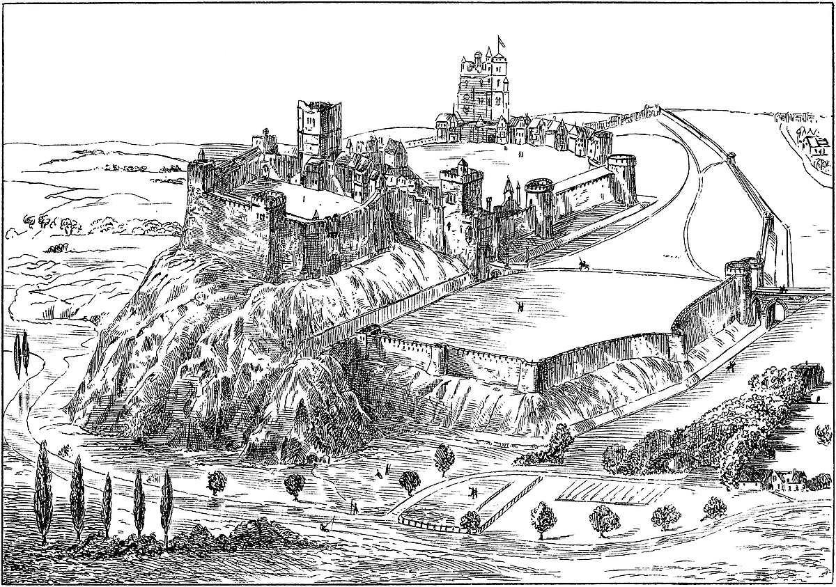
Whatever may have been the extent of the castle in its great days, its remains in masonry are confined to a single tower, now in a very dilapidated condition. This tower is an octagon, described within a circle of about 29 feet radius, the faces, not quite equal, averaging 22 feet 6 inches. The walls, casing included, were 10 feet thick; the interior faces, therefore, average 14 feet 9 inches, and the interior diameter from face to face is 38 feet. At each angle is set a buttress of 4 feet projection and 2 feet breadth, rising to the summit, or nearly so, of the building, now about 60 feet high, and which, the parapet and part of the wall being gone, may have been 8 feet higher. As the tops of some of the upper windows remain, it may be inferred that the height, when complete, did not exceed 68 feet.
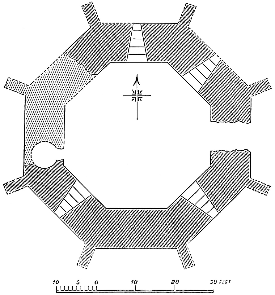
The material of the tower is a conglomerate of small flint nodules grouted in a large quantity of very good mortar. The whole exterior seems to have been faced with small ashlar blocks, possibly of Caen338 stone. The casing is gone, but the mortar has preserved the beds of the stone more or less perfect. The same stone was used in the interior for dressings for the openings, and for a band about 4 feet high at the base of the wall, and for the groining of the internal angles. In these two latter positions, some of the ashlar has been left undisturbed. About one-third of the tower, including most of the two western faces, has fallen; but though the remainder is very rough and a mere mass of flint conglomerate, held together by the excellence of the mortar, the cores of the buttresses remain, and enough of the recesses of the window openings to show something of their original form and dimensions.
The tower is composed of a basement and two stories. The basement floor is about 6 feet below the exterior ground level. It was about 12 feet high, and six of its eight faces appear to have been pierced. Of these openings, five commence within at 4 feet from the floor. They were round-headed and 4 feet wide. They converged upon an ordinary loop, and as the cill rose by six steps, the base of the loop was about a foot above the exterior ground level. Three of these recesses are tolerably perfect; another, judging from an appearance in the wall above, may have been the door into the base of a well-stair, ascending in the wall to the summit. Such a stair there was likely to have been, and the hollow in the wall is more like that for a staircase than for a chimney-shaft or a garderobe vent, and the weakening of the wall by such staircase would account for its having fallen on this side. The stair, if such it was, occupied the south end of the south-west face. Two of the openings in the basement have been called doorways of entrance from without. What remains scarcely leads to this conclusion, and it is exceedingly improbable that there should have been a door on the ground level when there certainly was one on the first floor. Sir E. Home’s plan, mentioned below,[11] shows a sort of staircase in the centre of the tower, as though descending to a sub-basement floor. Of this not a trace is visible, and in so wet a soil a chamber much below the surface would be usually full of water. As regards the ground-floor entry, it is very possible that here, as usual, a basement window may, in modern times, for the convenience of entry, have been converted into a door, and so the present appearance produced.
The first or state floor was about 30 feet high. Its south face was occupied by a very capacious fireplace, with a bold hood and mantel-piece of ashlar, now gone, and it had a round back and a large circular chimney-shaft carried up vertically in the thickness of the wall. Of the other seven faces, two are gone, and four are pierced with lofty, round-headed arches, about 8 feet broad, and slightly splayed. These, no doubt, terminated in small coupled windows. In the east face is an opening without splay, evidently a doorway, 339and, no doubt, the main entrance, with an exterior stair, as at Brunless and Coningsburgh. In an adjacent face is a large square locker.
The upper floor also had a fireplace, a smaller one above that on the state floor, and in front of its chimney-shaft. This lesser shaft seems to have been of ashlar. The arch of the fireplace is of three rings, each of large, thin red tiles, having a very Roman aspect. In this floor the window recesses were ranged in pairs, two in each face. Of these, three and a half pairs, or seven window arches, remain. In the east face is a small locker. This story may have been 18 feet high.
The floors were of timber, and composed of large beams, laid about 6 inches apart. As the wall is the same thickness throughout there are no setts-off, and the walls are pierced with square recesses for the beams. As these recesses are not parallel but radiating, it is clear that the floor rested, as in the Wakefield Tower in the Tower of London, upon a central pier or post.
There are no traces of any mural chamber of any kind.
The history of this tower, the character of its casings, the thickness of its walls, and the round-headed figure of such arches as remain, point to the Norman, or commencement of the early English, period. Nevertheless, it is in plan very unlike the usual Norman structures, and the buttresses, clearly original, are characteristic of a very much later period. If it be Norman or transitional, it is very late indeed in the style; as late as the reign of Richard I., but it must be confessed that the buttresses are much more in harmony with the date of Richard II.
The tower stands near the centre of a roughly-circular platform, about 38 yards diameter, slightly raised above the marsh, and surrounded by a ditch. Beyond this ditch there is, on the north-east front another enclosure with its ditch, and the canal seems to have been carried through something of the same character. All this looks as though there had been an earlier fortification of earth and timber, possibly the seat of the Saxon Odo, of whom nothing is known or surmised but his name.
There are no traces of any other masonry than the tower, and if it stood alone this would account for the otherwise marvellous exploit of the castle having been held out by thirteen men for many days against the Dauphin’s army. Of course, the extent of wall which so small a garrison could defend would be very limited; but with a tower such as Odiham, well-victualled, and a fireproof door, an army, especially unprovided with mining tools or military engines, as with an invading force would not be improbable, could do but little. Nevertheless, some of the records relative to the castle indicate other buildings besides the tower, though all traces of them are now gone.
Odiham has no history before the time of Domesday. That it was the seat of a Saxon lord is to be inferred from its name, though some authorities repudiate “Odo” and his “Hame,” and substitute340 for him Woodyham, Oodyham, Odiham, an etymology, no doubt, applicable enough to the district.
In Domesday, King William is recorded as holding Odiham in demesne; Earl Harold had held it. It is twice mentioned in that record, and was in the hundreds of Edefele and Bermesplet, though a hundred of Odiham is also named. Nothing is said of a castle, nor does the name of the Bishop of Winchester, to whom it has usually been attributed, occur, either then or afterwards, in connexion with the lordship, borough, or castle. Among the royal tenants occur certain “Taini regis,” who were represented in the reign of Edward I. by the “Homines et sokemanni regis,” who then had common of pasture in Odiham.
Richard I. held Odiham. In the first year of his reign certain payments are entered upon the Pipe Rolls of the Exchequer connected with it. Roger Fitz-Renfrid accounted for 20s. for a cowhouse or vaccary there; William de Bend for 100s.; and the sheriff accounted for 12d. for land held by Richard de Rollos. The town also fined 20s. for a murder.
Odiham is frequently mentioned on the same rolls in the reign of John, who was there nineteen times in nine years, for at least forty days in all. In 3 John, William de Bend is probably represented by Adam de Benderges, who appears with Richard de Rollos.
5 John. The men of Odiham had a charter concerning the manor, and they held the vill in fee farm at a fine of 100 marks or £35. 4s. rent.
6 John, 1204. King John was here on the 28th July. Probably he had a palace here, for such there certainly was a little later at Odiham, and it is said to be represented by a farmhouse still known as “Palace” or “Place Gate.” 11th March, Hugh Fitz-John was to have his corn at Odiham, then in the king’s hands, and (26th May, 8 John, 1206) John Fitz-Hugh was allowed in his rent the value of his chattels which the bailiff of Robert de Vipont had taken, saving the stock sold from the same manor for the king’s use by his orders.
9 John, 1207. On the 23rd June the king was at Odiham; and on the 29th, John Fitz-Hugh was to take and hold the manor until the men there had paid the debt due to the king. 10th August, the same John was ordered to have 20 marcs from the king’s treasure for the works at Odiham; and 26th October, a new bed was ordered for Woodstock and another for Odiham, in which, no doubt, King John slept when there in December for three days. There also was an order for payment for making the ditches there at the king’s command (Close Roll, p. 94 b). In 11 John, £50 was ordered for works there. In February, May, and October, of the same year, 1210, John was at Odiham; in 14 John, 1212, he went from Lambeth to Odiham, and arriving on Sunday, 6th May, tested documents there. On Monday, 3s. were paid for the hire of three carts, travelling two days and resting one, conveying the wardrobe from Lambeth; also 13d. to Ferling the huntsman and Thos. de Porkericiis, with the hounds, for their expenses and sleeping one night on the road.341 John then left, but returned to Odiham on the 10th. While absent on the 8th at Freemantell, he paid 6s. for the heads of six Welshmen,—ghastly trophies sent to him. On the 10th, 5d. were paid for cords bought at Winchester to string the cross-bows, besides expenses for hiring carts. John was seven days at Odiham in the May of this year, and afterwards in December. On 25th May, he paid 5s. to Stephen de Guildford for a wolf caught by his master’s dogs at Freemantell.
15 John, 1214. Money had been spent by John Fitz-Hugh on repairs of the king’s castles of Windsor and Odiham. The king was at the latter place in January.
Magna Charta was tested 15th June, 1215, 17 John. In the preceding May the king was at Odiham, from the 21st to the 25th, and from the 28th to the 30th, seven days. On the 29th, he addressed the letter to Pope Innocent, in which he pleaded the contumacy of the barons as the reason why he could not go to the Holy Land. On the same day the castle of Devizes was ordered to be repaired, and Hugh de Beauchamp’s lands were to be taken possession of if he was with the rebels. From the 31st of May to the 3rd of June, the king was at Windsor. On 4th June, he was at Odiham, whence he went to Winchester and was there from the 5th to the 8th. He thence paid a hasty visit to Merton, but was at Odiham on the 9th, it is said, with seven knights only. On the 11th, he was at Windsor, and there remained, visiting Runnymede, from thence to grant the charter, and returning to Windsor till the 21st, when he was again at Runnymede. And so to and fro till the 26th, when he was at Odiham for a day. In that year there was also a charge for putting garrisons into Odiham and other castles.
At this time John seems to have been preparing for the struggle by collecting what he had portable of value. The prior of Reading brought to him at Odiham, on the 26th June, a silver cabinet and an ivory cabinet with precious stones and reliques, a gold cup given him by the Pope, much silver and silver-gilt plate, various rolls of the royal chamber and of the Exchequer and his seal, all which had been deposited in Reading Abbey. On the following day he was at Winchester, and there received by Adam, the cellarer of Merton, more plate and jewels, sapphires, balas rubies, &c., which had been in keeping of the convent there, and again on the same day a very much larger quantity also of plate and jewels, brought by Michael, a canon of Waltham, from the custody of the house there. The details of all these valuables are given at length on the Patent Rolls. From Winchester he went to various places in Wiltshire and the south of England.
In the following year, 1216, 17 John, the king was at Odiham for the last time for five days in April, and on the 15th ordered twenty tuns (“dolia”) of his prisage wines to be sent there from Southampton. He issued thence an immense number of instruments, and finally left for Farnham on the 18th. On 21st April, the manor of Odiham was to be transferred by Bartholomew Peche to the seneschal,342 Engelram de Cygoyn, or his attorney, who seems to have been John Fitz-Hugh, to whom it was again transferred on the 29th. The transfer, however, was confined to the manor, for by a mandate of the 31st of May, directing seisin to be given to Fitz-Hugh, the castle was specially retained in the king’s hands.
How strong the place was appears from the resistance it opposed in this year to the Dauphin Louis and the invading army. Marlborough, a very strong castle, had surrendered, when the French appeared before Odiham. The tower, says Wendover, was held by three knights and ten soldiers, who were besieged in form. On the third day when such engines as were with the army were in place, and an assault had been made and failed, the garrison sallied out and captured a number equal to their own as prisoners. After eight, or, as some accounts say, fifteen, days, the thirteen surrendered on terms, retaining their horses and arms and their liberty. Wendover says the tower belonged to the Bishop of Winchester, but all the evidence seems to show that neither the castle nor domain were ever alienated from the Crown.
The first mention of Odiham in the reign of Henry III. is an order to de Cygoyn to allow Bartholomew de Peche to hold the rents of the vill for his sustenance in the king’s service (18th April, 1 Henry III., 1217). John Fitz-Hugh appears to have been in opposition and to have been dispossessed, for on 12th August he returns to his fidelity, and is allowed seisin of the manor and hundred of Odiham. The great earl marshal’s policy was to pardon and reward all who gave in their adhesion to the new sovereign. The castle was kept up, even to storing the ditches with fish, for John de Venuz was ordered (4th April, 1222, 6 Henry III.) to allow to de Cygoyn twenty breams from the king’s marsh of Woolmer for stocking “our ditches at Odiham.” On 2nd May, 1222, 6 Henry III., two tuns “dolia”) of the king’s prisage wines were ordered from Southampton to Odiham. 16th November, 1222, 7 Henry III., the king had let the manor of Odiham to farm for £50 per annum, but regard was to be had to the rights of the “Men of Odiham.” 15th January, 1224, 8 Henry III., the Archbishop of Canterbury, who holds the castle of Odiham, is directed to give up to Engelram de Cygoyn all his chattels and farming stock at the castle (Close Roll, p. 581); and again, on 20th February, the constable of Odiham is directed to permit Engelram to remove all his chattels, stock, mares, &c., from the park of Odiham, and what he bought with his own money. This done, the king seems to have taken to farming on his own account, for on 23rd February following, the treasurer is directed to pay to Walter de Kirkeham and Walter de Brackel £100 to defray their expenses, and to Ralph Brito 50 marks for the purchase of oxen for the king’s ploughs at Windsor and Odiham, and for seed for the lands there. Further, on the 5th of May, by virtue of an order directing the distribution of wine from Southampton to certain of the royal residences, a tun (“dolium”) of spiced wine was sent to Odiham. On 4th June, in the place of Henry de Feslegh,343 deceased, Gilbert de la Dene is appointed a verderer in the forest of Odiham, and is to take the usual oath.
In 18 Henry III. the royal forests of Windsor and Odiham were committed to the care of Engelram de Cygoyn—then a very old servant of the Crown, and (20 Henry III.) he had also the park of Odiham. In 21 Henry III., Alianor, Countess of Pembroke, the king’s sister, had the castle, and afterwards (33 Henry III.), as Countess of Leicester, the manor. Meantime, however (28 Henry III.), her husband, Simon de Montfort, held the park as the king’s tenant. In the same year, de Cygoyn had a writ of “allocate” for £40, due to the king for two years’ rent of the manor of Odiham; also in the same year, however, de Cygoyn was dead, and the sheriff was to receive from his executors all his ploughs and stock, and to deliver them to de Montfort.
In 30 Henry III., Richard le Male held the manor. The Bishop of Bath and Wells had a grant of three acres of land out of Odiham to augment the park of Dogmersfield. In 34 Henry III., John, the representative of the de Beninges family, long connected with Odiham, had been outlawed, and inquiry was directed as to what he held in chief there, which appears to have been three virgates. In 35 Henry III., William de Synago had a grant of Stapelegh in the parish of Odiham, and Gilbert de Eversley appears among the tenants, as (38 Henry III.) does William Villiers for two acres.
It appears from a document of this reign, printed by Rymer, that upon William, the son of Durandus Nanus (the dwarf), proposing to become a monk, the king allowed his land to pass to his cousin Margaret, wife of Alexander de Barentin. The land lay in Warnburn (Warnborough) and Odiham, and had been purchased by Durandus “de suffacio” in the time of Henry I. with the king’s consent. The land carried with it certain rights of herbage, cutting firewood, enclosing within hedges, &c., and the whole was evidently held direct from the Crown.
The chief interest of Odiham ceases with the reign of Henry III. Edward I. was much engaged in the north and west, and the value of fortresses in the interior of England was small under a prince whose sway no Englishman ventured to contest. His visits to Odiham were but few. The park or forest seems to have been kept up, but only as a place of diversion, and the castle probably was allowed to fall into decay.
2nd September, 1274, 2 Edward I., the king was at Odiham. In the third year of the reign, John de London, the king’s escheator, was to hold the castle during pleasure. He probably did not hold it long, for (10 Edward I.) it was committed to Nicholas le Gras in succession to Ralph de Sandewych, and in 12 Edward I. Hugh le Despenser had it. In 27 Edward I. the castle, park, town, and hundred of Odiham were included in the ample jointure settled on Queen Margaret, and described as “Castrum et villa de Odeham et appruamentum [emolument] parci ibidem”; or, in another schedule, “The castle and vill, with the park and hundred and appurtenances344 in the county of Hants.” In 33 Edward I., John de Beauchamp of Fyfhed held the manor.
Edward II. appears to have seen little of Odiham. In 5 Edward II. the castle, which Queen Margaret had, was committed to Robert le Ewer during pleasure. In 9 Edward II., Robert atte Burgh had licence to enfeoff for Stapelegh Manor and Odiham Manor with suit of court, and a document of this date throws some light on the extent of the hundred of Odiham, which, it appears, included the vills of Odiham, Greywell (now Grewell), Monks Hartley, Helvethan (now Elvetham), Wynchesfelde, Dogmersfelde, Bynteworth (now Bentworth), Brocham (now Burkham), Lassham, Shaldene (now Shaldon), Weston-Patrik, Horefeld, and Lys—the two last only not having been identified, unless Lys be the present chapelry of Lyss-Turney. Of all these, Odiham only belonged to the king. Next year (10 Edward II.) Thomas de Warblyngton held the manor, and (12 Edward II.) Ewer again held the castle, manor, vill, hundred, and park. The change was perpetual—inspired probably by perpetual distrust. In 13 Edward II., Hugh le Despenser, junior, held the castle and manor, and (15 Edward II.) the former was again committed to Ewer. In this year the king’s circumstances probably led him to look to his strong places, for William de Kyngeston, clerk, is made receiver and keeper of provisions, stores, &c., within the castle. In 17 Edward II., Margery de Burgh held the castle and suit of court, as had (18 Edward II.) John de Loxle and Constantia, his wife. In this year is an order to repair the king’s houses within Odiham Castle.
Edward III. seems to have turned Odiham to account as a place for breeding horses, and he kept up the castle. At his accession, John de Meriet and Maria his wife had the manor, and (4 Edward III.) John de Mohun had it, and it was in the hands of Joan, widow of John, 6 Henry IV. The custody of the castle was then in John Wodelok—he paying for it £60 per annum, and Nicholas de la Beche had the reversion after the queen’s death. In 5 Edward III., the king committed to Master William Mareschal the care of the great horses, and the supervision of the royal stud in the park at Odiham. The king himself was there October 25th. In 7 Edward III., Sir Bernard Brocas had a grant of the lordship for life. In 14 Edward III., Richard de Rokeland was keeper of the colts (“pullanorum”) in the king’s park at Odiham. In 1346 (19–20 Edward III.) the battle of Nevill’s Cross was fought and King David Bruce was taken prisoner and committed to Odiham, where he stayed the better part of fifteen years. In 25 Edward III., John atte Berwe held twelve acres in Odiham of the castle of Winchester, and William Talemache and others held four virgates of land there; and (33 Edward III.) the sheriff is to provide oats, litter, and carriage for the support of the royal stud in the parish of Odiham, and there is a specified allowance for grooms, their robes, and their shoes. In 38 Edward III., the people of Odiham had been making free with the boards and timber purchased for the king’s work at the345 park. Five years later (43 Edward III.), Walter Walsh holds the castle, vill, &c., providing carpenter, park-keeper, and tiler for the repair of the houses outside and inside the castle, except the covering of the great tower and the working stone for the castle walls. He was also to feed the beasts in the park. In 46 Edward III., Elizabeth, wife of James de Wyndesor, held the manor.
It appears from a record (2 Richard II.) that Odiham contained places called Shepcote, Smethes, Romeles, and Dunton. We read also of the “campus de Odiham”—probably the common field. In 5 Richard II., Henry Esturmy held the manor—probably the son of a man of that name who had it 33 Edward I. In 15 Richard II., Alianore, wife of William Fremelesworth, has Le Potte and other lands in the parish.
The castle does not seem to have attracted the notice of royalty during the reigns of Henry IV. or V. In the former reign Lord Beaumont had it for life, probably after the death of Joan de Mohun. The domain was still held by the Crown. In 19–23 Henry VI., a jury affirms that within the king’s manor of Odiham was a house called “le Shippe,” which Joan, Queen of England, held in dower. Also, in 1450 (28 Henry VI.), the lordship, manor, and hundred of Odiham, for which £21. 7s. 3d. is paid by John Basket, Esq., form an item in the royal civil list; and in 1454 (32 Henry VI.) the “Castrum, dominium, manerium, et hundredum de Odyham,” form a part of the jointure settled on Queen Margaret, who, indeed, seems to have had a previous settlement (22 Henry VI.). Later in the reign (35 Henry VI.) William Warbleton has a grant in fee of the office of constable of Odiham Castle and park.
In 1467–8 (7 & 8 Edward IV.), Odiham again was included in a royal jointure in favour of the queen of that prince.
In 1 Richard III., the king took advantage of his brief power to appoint Richard Hansard constable and porter of the castle, parker and warrener of the lordship, and steward for life. Whatever might be the arrangements as to its mesne lords, the principal officers seem to have been always appointed by the Crown, and in the Act of Resumption of 1485 (1 Henry VII.) is a saving clause in favour of the right of Nicholas and John Gaynesford to the offices of steward of the manor, constable and porter of the castle, and keeper of the park and warren—all held for their lives. The interest of the Crown was not finally extinguished until the reign of James I., who alienated the whole.
346
THE hundred of Oswestry, though but of moderate extent, represents a tract of country which was for centuries a field of contest between the Britons and the men of Mercia, the Welsh and the English; for it was placed within the old Welsh district of Powys-Fadog, in the centre of the English march, and itself a marcher lordship. Its changes of name have been numerous, adopted as either language prevailed, or as any event occurred which seemed to the party in possession worthy to be commemorated.
The earliest known name of the district is “Maesdir,” compounded of the Welsh maes, a meadow, and tir, land, which in the hands of the English, and, no doubt, upon becoming the seat of a burh, or strong place, became Maesbury, and afterwards Maserfield, an unconscious but not uncommon reduplication of the same idea in the two languages. It was so called when here was fought the great battle between the Christian Oswald and the pagan Penda, about A.D. 642, in which Oswald fell; and his members are said to have been suspended to a cross or tree, in remembrance of which the place was long afterwards known as “Croes Oswald” and “Oswaldestre,”—a not very probable etymology. No doubt the former name really indicated a cross erected in memory of the Christian king; and the latter, also part Welsh and part English, meant “Oswald’s strong place.” The old Welsh maes possessed much vitality, and may be recognised in “Mersete,” the name of the hundred in Domesday, and probably in “Meresburie,” the name of the manor.
The next change was consequent upon the erection of a handsome Norman church, the precursor of the present structure, when Oswaldestre became Blanc-Minster, or, in the language of the records, “Album Monasterium.” Later on, however, as Oswald’s fame as a martyr gained ground, his name took the ascendency, and both town and hundred became known as Oswestry. The church was probably transferred from the Saxon foundation of Maesbury.
The oldest work of man in the district is, no doubt, a British entrenchment placed on high ground a little north of Oswestry, and known as “Hên Ddinas,” the old fortress, and which in later days has been called, for no sufficient reason, Old Oswestry. “Hên Ddinas,” however, though the British, did not become the Mercian centre; this was probably in the first instance at Maesbury—a name found about 3 miles south of Oswestry—but, so far as is known, not connected with any earthwork, the usual mark of an early residence. This evidence is found on a large scale at Oswestry,347 which, therefore, there is reason to suppose was the English centre at least as early as the tenth century.
The contention for the possession of the district does not seem to have commenced in the Roman times,—at least there are no Roman remains at or very near to Hên Ddinas. The Welsh assert that, before the departure of the legions, the district was held by Cunedda Wledig, a prince of the Strathclyde Britons, 328–89, who gave it to his son. However this may have been, it would seem that in the seventh century the Cymric Britons had retired from Hên Ddinas, and it had become part of the Mercian territory, so that Penda (635–55) held it, and fought the battle of Maserfield against the Northumbrian Oswald. This was a short time before the Mercians accepted Christianity. That the English held the district in the latter half of the eighth century is evident from its position within the Dyke of Offa (759–94); but as it is just outside of, or slightly intersected by, Wat’s Dyke, generally regarded as a few years earlier than that of Offa, it may be that the possession was at that time but recently settled. No doubt, after the construction of the greater dyke, the boundary, though often transgressed by either people, on the whole, in ordinary times, served its purpose, and established what the English at least came to regard as a right. The greatest, and before the arrival of the Normans the last, Welsh incursion was that of Griffith ap Llewelyn in the eleventh century, in alliance with Algar, the rebel Earl of Mercia. The result of their frequent and severe attacks was to lay waste the whole country, which, like Irchenfield in Herefordshire, so remained, and is so recorded in Domesday. The long period of English occupation is marked here, as all along the border, by frequent and strong earthworks in the fashion employed by Edward the Elder and Æthelflaed in the tenth century, of which those at Oswestry and Whittington are among the chief; and those of West Felton, Aston, and Belan Banks, though smaller, are said to be of a similar pattern. Maesbury was, no doubt, at one time the caput of the English lordship; but it is evident, from the fashions and dimensions even of the poor remains of the earthwork at Oswestry, that it became the chief place at least as early as the commencement of the tenth century, and so remained, although not actually designated in Domesday.
The Domesday hundred of Mersete and the later of Oswestry are very nearly identical, the addition being Ruyton, and the subtractions, Cynllaeth and Edeyrnion. Mersete extended from Weston-Rhyn, on the Morlais brook, in the north, to Melverley, at the junction of the Vyrnwy with the Severn, on the south; and from, or a little beyond, the Cynllaeth brook on the west, to Wykey on the Perry, to the east; about 12 miles each way.
Domesday calls Meresberie the caput of the lordship; but this, though a corruption of Maesbury, must be taken to indicate Oswestry. In it were five berewicks which are not specified, but which evidently included about twenty-four manors, of which nearly all bear English names. Two centuries later an inquest was taken, which gives the348 lordship as composed of two parts, Oswestry proper and the Welshery. In the latter was included nearly the whole of the hundred, five manors, Weston and Coton (now Weston Cotton), Mesbury or Maesbury, Middleton, and Treveleth or Treflach. Of vills there were very many: Blodnorvawr, now Cefn-Blodwell, Blodowanan or Blodwell, Brongarth, Bren or Bryn, Clanordaffe or Glyn-yr-Afon, Crucket or Crickheath, Dudleston, Fenches and Juston (now lost), Kahercohon or Carrechova, Radioners or Rhandir, Swine or Sweeny, Tibeton (now lost), Travereleuche or Trefar-Clawdd, Treveltholnel or Treprenal, Trevenen or Trefonen, Weston or Weston-Rhyn, Wigeton or Wigginton, and Yston, now Ifton-Rhyn. The lord’s advowsons were the chapel of the Castle of Blanc-Minster, and the churches of Blodwell and Llanmenagh or Llan-y-Mynech. In this latter parish, though in an island of Denbighshire, was the celebrated Castle of Carreghova. This township, however, was a later addition to the hundred, and never belonged to its lords. Osbaston seems at one time to have been in the lordship. In it was Knockyn, the celebrated castle of the Lords Strange, a fief held indirectly of Oswestry. There was also a castle at Kinnerley, also in the lordship.
Mersete, in the reign of the Confessor, and probably much earlier, was a royal domain, and under the names of the hundred of Mersete and manor of Maesbury was included in the grant by the Conqueror in 1071, on the forfeiture of Morcar and Edwin, to Earl Roger of Montgomery, who sub-granted it to Warin the Bald, his sheriff, and second in command, who held seventy manors in Shropshire, and by the earl’s niece Arnieria had a son Hugh. Warin died 1085, just before Domesday was compiled, and the shrievalty was given to Rainald de Bailleul, who married his widow, and built a castle. The entry under Meresberie is, “Ibi fecit Rainaldus Castellum Luure,” which is explained as Luvre or “l’Œuvre”, the work par excellence of the district. It is clear, however, that, as usual, Rainald’s castle was upon an earlier foundation, and not improbably was only an adaptation of existing works. Rainald dwelt at Oswestry, and either he or Warin granted its church of St. Oswald, with the tithes of the town, then for the first time mentioned, to Shrewsbury Abbey. It is uncertain on what tenure Rainald held his office, but it seems to have been held for a short time by his stepson, Hugh, son of Warin, till his early death; and on Hugh’s death, it was to Alan FitzFlaald, the ancestor of the succeeding lords, that the shrievalty and the fief were granted a little before the death of the Conqueror.
The Welsh claim to have recovered and held the lordship for a space about this time, and state that it was given, as part of Powys-Fadog, by Meredith ap Bleddyn to his nephew, or son, Owen, who destroyed Rainald’s castle and rebuilt it in 1148; and that the tower, in memory of Meredith, was called Tre-Fred. However this may be, the Welsh occupation must have been very brief, and Alan must have recovered possession. At this time the house of Montgomery had, in England, become extinct, and Oswestry was held349 of the Crown direct, as a marcher lordship, by the tenure of the defence and maintenance of the castle and the defence of the march.
Mr. Eyton, the extent of whose information concerning the early history of Shropshire is only equalled by its accuracy, has thrown great light upon the descent of this Alan, whom he shows with more than probability to have been the son of Fleance, and grandson of Banquo, Thane of Lochaber, killed about 1048–53. Fleance, or Flaald, seems to have married Gwenta, daughter of Griffith ap Llewelyn, Prince of North Wales, by Aldith, daughter of Algar Earl of Mercia. Alan, who was dead in 1114, was unquestionably direct ancestor of the houses of Fitz-Alan of Oswaldestre, and of the royal house of Stewart.
Alan FitzFlaald, lord of Oswaldestre, was father of I, William; 2, Walter, steward of Scotland, who died 1177, having married Eschina, daughter of Thomas de Londoniis, “hostiarius” or “durward” to the King of Scotland. He was father of “Alanus Dapifer,” whose great-grandson, Walter, who died about 1320, married Marjory Bruce, and had Robert Stewart, King of Scotland.
William Fitz-Alan, the head of the house, born about 1105, and who died 1160, acquired with Isabel de Say, his second wife, the lordship of Clun, which long remained united with Oswaldestre, in the person of their descendants, the FitzAlans, Earls of Arundel, and afterwards by the female line in the Howards.
On the death of Thomas Fitz-Alan, Earl of Arundel, in the reign of Henry V., a curious question arose. He died childless, and his sisters, Joan, Lady Bergavenny, Elizabeth, Duchess of Norfolk, Margaret, Lady Lenthall, and Alice, Lady Powis, became his heirs general; but his heir male was John Fitz-Alan, called Arundel, Lord Maltravers. The Duke of Norfolk, John Mowbray, claimed the earldom in right of his mother; but when the earldom was adjudged to Lord Maltravers, he was allowed the baronies of Clun and Oswaldestre with it, nor did the duke claim them. So also when Earl John’s descendant, Humphrey, Earl of Arundel, Lord Maltravers, Clun, and Oswaldestre, died childless, 16 Henry VI., the baronies were not claimed by Amicia, Lady Ormond, his sister and heir general, but passed to William Fitz-Alan, with the earldom, as heir male.
A good deal of constitutional, or rather peerage, lore has been exercised upon these two baronies, which were borne among the long train of titles which at various times have accrued to the houses of Arundel and Howard, and so appear upon the garter plates of Thomas, Earl of Arundel, in 1611, and of Henry, Duke of Norfolk, in 1685, with other and Parliamentary baronies. Nevertheless, these do not appear to be like Fitz-Alan, Mowbray, Greystoke, and the rest, really Parliamentary baronies, but land baronies only, which strictly should only be appended to the name of the possessors of these manors. However, after their alienation, Thomas Howard, Earl of Arundel, heir general of the FitzAlans, was, by Act of Parliament,350 1627, created Baron Fitz-Alan and Lord of Clun and Oswaldestre—in right of which, and of that date, and under the then limitation only, these titles are borne by the Dukes of Norfolk, his descendants.
The visible remains of this ancient fortress, so celebrated in border story, are very scanty, and are confined to the central mound, and to some fragments of the rude but substantial keep which was placed upon it. The castle stood on ground rather higher than, and on the north-western edge of, the town, completely commanding it; and it is only of late years that its site has been nearly surrounded by buildings. The church is about half a mile distant to the south, the town intervening between the two. From the mound, the view to the east and south is very extensive; to the west it is shut in by the wooded heights of the Denbighshire border, crowned by Offa’s Dyke, at a distance of about two miles. To the north, a mile or so distant, is the detached hill and camp of Hên Dinas, or Old Oswestry, which is in part obscured by the still nearer but lower eminence of Llwyn. No water enters into the landscape, nor is there any considerable stream near at hand. Wat’s Dyke lies close to the east.
The castle mound, though standing on high ground, is wholly artificial, and rather oval at its summit, which is about 60 feet by 100 feet. It is about 30 feet high, and perhaps 200 feet diameter at its present base. On its table top are some fragments of masonry, composed of large rolled boulders, laid in a thick bed of mortar; very rude but very strong work. One fragment, which in places is about 8 feet thick, is 9 feet or 10 feet high; and near it are two other large masses, one of which at least is overthrown. The keep was of the shell type, and probably polygonal. The slopes are covered with bushes, much obscuring the surface, but there seems to be a further trace of masonry on the south-west side. The moat, out of which the mound rose, has been completely filled up, and all trace of the outer ward, its ditches, banks, or buildings, has been utterly removed. Nothing is known of a well. The entrance was probably on the south-west side. Gallowtree bank—a name preserved in the southern suburb—preserves the memory of the lord’s power, as does Oswald’s well of the ecclesiastical legend.
It is probable that the masonry remaining is the work of William Fitz-Alan, who, after 1155, confirmed a previous gift of the church of Oswestry to Shrewsbury Abbey. He died 1160, in which year the Pipe roll designates Oswestry as “Blanc-Minster.” On his death, Guy L’Estrange became custos of the Castles of Clun, Ruthyn, and Blanc-Minster, and works were in progress at the latter. The livery allowed for the garrison was £18. 5s. per annum. In July, 1165, Henry II. was encamped near Oswestry, but his advance was checked by the Ceiriog river, on which he retired to Chester.
351
Guy L’Estrange continued to be custos of the Fitz-Alan estates and castles until 1175, during which time very large sums were expended by the Crown upon Oswestry, apparently about £2,000. A well cost £5. 8s., palisades 40s. and £2. 6s. 8d. A house was built within the walls. The regular garrison was a knight, two porters, two watchmen, and twenty men-at-arms, costing £48. 13s. 4d. per annum. In 1188, William Fitz-Alan received Archbishop Baldwin and Giraldus in the castle. On his death, in 1210, King John stepped in, and Robert de Vipont was in charge in 1212, and in 1213 and 1214 John Mareschal and Thomas de Erdington, who had purchased the wardship during the minority of William Fitz-Alan, who, however, died under age at Clun in 1215. In 1216, King John was before Clun, and (August 16) burned the town of Oswestry, and attacked the castle, but probably without success. In 1226, Oswestry was named for the place of conference between Llewellyn and the lords marchers, but the king, distrusting John Fitz-Alan, sent Hubert de Hoese with nine knights to attend it. In 1240, John Fitz-Alan’s death placed the castle again in the care of the Crown.
In 1257, Oswestry was again named for the meeting of a Welsh and English commission, and John Fitz-Alan, the new lord, had license to levy customs dues for five years, to pay for a wall round the town. At his death, in 1267, the castle was valued at £44. 12s. 5½d. per annum, and mention is made of the “walcheria” or Welshery. The wall probably proceeded slowly, for, in 1283, King Edward issued a patent, licensing the bailiffs to levy customs for twenty years, to complete the wall. Probably this was in consequence of an attack by the Welsh, who actually held the town for a short time. In 1302, on the death of Richard, Earl of Arundel, it was found that he held Oswestry Castle and its lands by the tenure of two and a half knights’ fees. There were one hundred and forty acres of demesne land and four water-mills, but the castle was worth nothing; and its maintenance cost £10 per annum. The mills were Bailey, Weston, Cotton, and Cadogan.
PENMARK CASTLE is about a mile east of Fonmon, and two, three, and four miles from the castles of East Orchard, Barry, and Wenvoe.
It was originally built by Sir Gilbert de Umfreville, soon after the conquest of Glamorgan, but the present ruins are scarcely older than the thirteenth century. It is probably of the reign of Henry III. or Edward I., with some trifling additions of later date;352 but it exhibits no traces either of a Norman keep or of any of the usual Perpendicular or Tudor additions. It is, and has been for some centuries, a complete ruin.
The castle stands along the brow of a steep bank, about 100 feet above the meads of the Duffryn brook, which, with its marshy banks, formed an excellent defence on the north or Welsh front. It is composed of two courts.
The inner court was oblong, about 70 yards by 50, of irregular figure, with a curtain upon the north side along the hedge of the bank, part of which, at each end, remains. On the south side the wall is gone, but its line is marked by its interior moat which, extending from the bank at one end to that on the other, formed the defence on the east, west, and southern fronts.
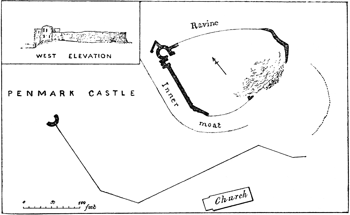
At the eastern end the wall remains, about 10 feet high on the outside. Inside is a mass of earth, no doubt covering ruins. At the north-east angle a circular depression resembles the foundations of a tower.
The west end is most perfect. Here is a curtain about 12 feet high, the rampart walk of which remains, with traces of an open stair to the battlements. At the south end the wall returns square; and here was probably a plain gateway towards the church. At its north end the north-west angle of the court is capped by a tower semi-circular to the field, but angular towards the court. It has two loops and a fireplace on the ground floor, and appended to it on the north side is a square building of two floors, containing a garderobe in each floor. This is later than the tower. Also on the west 353wall, near the tower, is a hollow buttress containing two garderobes. The tower opens into the court.
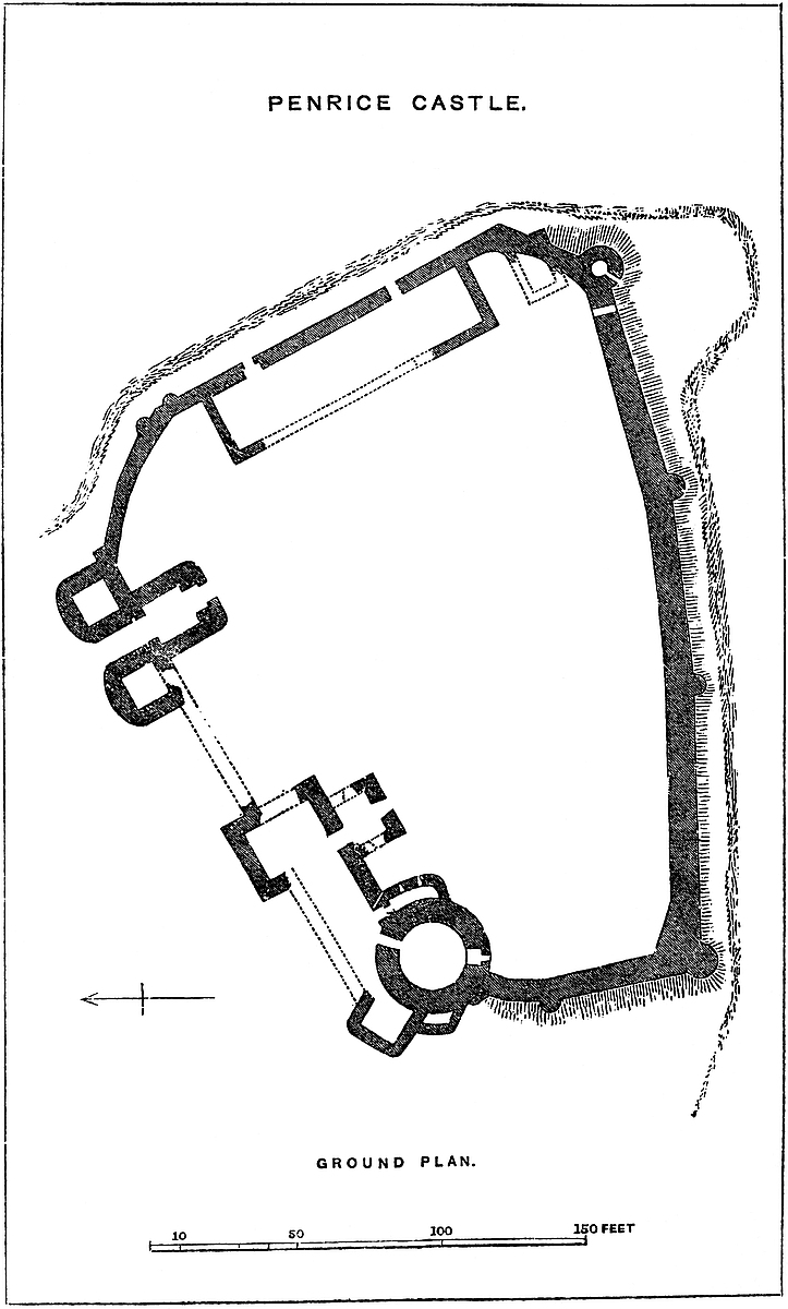
The outer court includes the inner one on the east, south, and west sides, terminating at each flank on the steep bank.
It contains the moat of the inner court, and was itself contained within a moat and wall, which probably included the church. Along the west face the wall may be traced to its termination in a flanking tower, evidently built for a pigeon-house.
The position of the castle is bold and striking, and although a mere ruin, and without the usual accessories of ivy and trees, it has a fine appearance from the north.
In common with most of the strongholds of the district, it is reputed to have been ruined by Owain Glyndwr.
From the castle a road descends obliquely towards the mill, placed about half a mile up the stream.
West of the castle is a considerable table-land, defended by two valleys on its north and west; an excellent place for a display of any cavalry that might be included in the garrison.
THE castle of Penrice, or, as it was anciently called, Penrees, in West Gower, in the county of Glamorgan, is inferior only to Caerphilly, Cardiff, and Coyty, in the area contained within its walls, and is second to none in its strong, commanding, and picturesque position. Penrice stands at the bottom of Oxwich Bay, a mile within the shore, and about 150 feet above the sea. It occupies the rocky crest of a steep slope of greensward, at the base of which is a small lake, and beyond this a sort of lagoon communicates with the bay, here fringed by a line of sand-hills.
The castle, though high, is backed on the north-east by the long and still higher ridge of Cefn Bryn, about half a mile distant. It stands upon the south-eastern end of a platform formed by the crop edges of the mountain limestone, which here is almost vertical, having been lifted up by the old red sandstone of Cefn Bryn. On the south and east the castle is defended naturally by a cliff ranging from 10 feet to 40 feet in height; on the west the ground is broken and strong; on the north it is level, or nearly so; and this, naturally the weakest side, has been converted by works into the strongest and principal front of the place.
The position and outline of the fortress have been governed by the disposition of the ground; the general design is simple, but is by no means of one date, and to the original structure there have been considerable additions. In plan the castle is composed of a354 principal court, or bailey, of irregular figure, and about 60 yards north-east and south-west by 80 yards east and west. Three sides are curtains only; the fourth, or northern, is composed of the gatehouse and main buildings, or corps de logis, and a large drum-tower with its appendages. The curtain skirts the edge of the precipice on the east and south sides. It ranges from 30 feet to 40 feet in height outside, and is about 25 feet within, and from 8 feet to 9 feet thick. It is strengthened outside by a number of half-round buttresses, of about 12 feet diameter; these are solid, and have no projection within; they rise to the height of, or a little above, the walls, and form small flanking places of arms upon the ramparts. Of these buttresses there are none on the east, two on the south, and one on the west face; there is also one larger and loftier, but still solid, capping the south-western angle. There is besides a buttress tower near the south-east angle, of larger dimensions, and hollow; but this, in its present form at least, is probably a late addition built for a dovecote, as which it is still fitted up. The wall near this tower has been broken through and rebuilt, and again broken through to make space for a rectangular building, one angle of which is seen outside the line of the curtain; the rampart wall or battlement remains, and, though more or less ruined, is original. The merlons are about four times the breadth of the embrasures, and each is pierced with a loop; the rear wall remains.
The north, or upper, side of the court is occupied by the main buildings and front of the castle, extending about 70 yards. At the east end is the gatehouse, at the west the drum-tower and its appendages. Between these two was a large square mural tower, placed in the middle of the front. Westward, between this and the drum, was no doubt the hall; eastward, a single curtain connected it with the gatehouse. The gatehouse seems to have been an addition to the curtain wall; it contains a central passage and two lateral chambers, which occupy two flanking towers of bold projection towards the north or exterior front; these are neither rectangular nor half-round, but more near to the latter figure, the angles having been rounded off. The floors were all of wood. There is but one groove, and that of very rude construction, for a portcullis, which defended the outer gate; and there seems to have been a drawbridge which let down between the flanking towers, probably over a pit, for there are no traces of a regular ditch.
The drum-tower caps the north-west angle of the castle, and projects into the court. Its clear diameter is about 36 feet, the walls being 8 feet thick, and the space within 20 feet across. It is of three floors; the basement is entered from the hall side; the first floor by two doors, one of which seems originally to have been a window. Of these doors, one opened from the hall, and one from an appendage on the south-east; there is also a loop towards the court, and a small vaulted chamber and garderobe on the east or outer side, perhaps an addition. The upper floor of the tower is remarkable; it has no entrance whatever, and no opening in the355 walls; it must have been reached by a trap-door. The floors were all of timber.
On the south-east side of this tower is a concentric addition, a sort of chemise, or rather chemisette, covering less than a quarter of its circumference, and projecting into the court; it is entered by a door from below the hall, and is lighted by two loops towards the court; it ends abruptly by a square wall. There was an upper floor opening into the hall and into the first floor of the drum, and there is a curious curved opening in the jamb of the lower door, evidently for a squint, with a rebate for a wooden shutter. On the north, or exterior side of the drum has been added a rectangular building of three stories, with fireplaces and chambers for garderobes. This building projects and forms the end of the north front, facing somewhat towards the north-west. From it a subordinate building, also rectangular, and containing garderobes, projects towards the west. The space between this group of buildings and the central square mural tower was contained between two walls, one still remaining, which is also the wall of the court, and another now destroyed, which formed the exterior defence on this side. As the square tower is also destroyed to its foundations, the manner in which the space was occupied can only be inferred by the openings in the remaining wall. Probably there was here, on the first floor, a hall and below it smaller rooms, perhaps cellars; there is, however, a door opening on the ground floor through the wall into a very small building projecting into the court, and which appears to have had two lateral and one end or south longer window. This may have been a chapel, but its axis, without any necessity of position, is nearly north and south. Within the court, attached to its east wall, remains a gable end, which, no doubt, belonged to a great barn, storehouse, or barrack; it was not a hall, as it had no large windows.
The ruins of the castle, though very considerable, are so devoid of ashlar and ornamental work, and the masonry throughout is so uniformly of a rude and inferior character, that it is exceedingly difficult to arrive at any certain conclusions as to the extent of the original building, or the order of construction of the parts now remaining. All that can be inferred with absolute certainty is that the round tower and the contiguous east curtain are the oldest extant parts, and, though without bond, nearly of the same date; that the north-west lodgings are much later than either; that on the north front were other lodgings now destroyed, and that the enceinte wall of the court, including the gatehouse, are additions to the original building, converting what was at first an exterior curtain into an interior wall looking into the enclosure.
The curtain next east of the tower looks older than the tower, but this is probably not the case. The tower was more probably the original building, and the whole of it. It would be a refuge in case of attack, either from the Welsh or from pirates, capable of holding out until the garrisons of Pennard, Llandremor, Webley, or Llwchwr, or those more distant of Swansea and Oystermouth,356 could bring up assistance. The tower is probably of very late Norman date, in the transition or pointed style. The curtain eastward was probably the first addition to the tower, and is the remnant of the rectangular appendage upon its north-eastern side. This curtain has been much cut into, and contains several later openings; but the door on the ground floor next to the tower is evidently original, and of early English date. It now leads into the enclosure of the chemisette, but was obviously once an outer door, and possibly the main entrance to the rectangular building. The court was probably next enclosed, and the concentric building, or chemisette, added to the round tower, either as a prison or a cellar, the door leading into it being the old main entrance above mentioned. The gatehouse and the north-west tower are somewhat later. Recently three stones, evidently parts of a window or door-jamb, have been dug up near the round tower; these show a simple half-round bead moulding, six inches diameter, and are evidently parts of a Norman jamb, perhaps of the lower and pointed doorway of the round tower. The north-west tower has a small trefoil-headed window in the third floor, which may be of Decorated date, though the building has rather a Perpendicular aspect. The masonry generally is of a very rough character; the round tower windows within had coigns of ashlar, but the gatehouse is of very inferior workmanship, even the portcullis groove being in rubble.
This is a very curious ruin. A round tower of this early date is a very rare feature; the chemisette may be compared to the more perfect envelope at Tretower and Launceston, but it is evidently an addition. The dimensions are nearly those of Bronllys, which is, however, rather later, and of far superior work. It is singular that the original castle should have been placed so far from the edge of the cliff which constituted a part of its later defences. The excavations now in progress may yet throw a light upon the precise age of some of the parts. It is something to have found mouldings of the Norman period.
The only parts absolutely destroyed belong to the north front, where the wall has certainly been blown down by gunpowder, probably during the occupation of Gower by Cromwell.
This is not the only stronghold within the parish and manor of Penrice. About half a mile south-west of the castle, and west of, and very near to, the parish church, is a circular earthwork, composed of a single mound, with an exterior ditch, and an entrance on the north-west side. The diameter of the interior space may be 100 feet, and the mound from 6 to 10 feet high. This is a very perfect, and evidently a very early work, and no doubt was stockaded with timber.
The adjacent church, though much altered in recent times, has a Norman wall and arch, masked with plaster, between the nave and the chancel, and a remarkable south porch of early Decorated and a south door of early English date. Outside the south door of the church and in the porch, on the right on entering, is a water stoup, hollowed out in a sort of stone seat. The upper part of the tower357 and a small north transept are said to have been rebuilt in the last century.
The church stands upon a strong position, superior in many respects to that selected for the castle. The adjacent church of Nicholaston has a rude coupled east window of early English date.
The castle, the ruins of which have been described, was for many generations the seat of a considerable Gower family, who no doubt derived their surname from their estate, therein differing from several of their neighbours, the owners of Nicholaston, Reynoldston, Leysanston, and Scurlage, whose names were bestowed upon and are preserved in those manors. Either custom was here common, and there are several examples of each in the Vale of Glamorgan.
No doubt the lords of Penrice were followers of the Bellomonts and early Norman settlers in Gower, where they probably erected, before the close of the twelfth century, that part of the castle to which the lately-discovered Norman fragments may be assigned. The castle descended by a Penrice heiress to the Mansels, and is at this time the property of their descendant, Mr. Talbot.
PENRITH CASTLE stands upon a slight elevation of old red sandstone gravel, about a furlong from, and from 50 feet to 70 feet above, the church and the old town of Penrith, and a few yards east of the modern railway station. Originally and always a simple structure of no particular military strength or architectural merit, its remains are now scanty, and chiefly remarkable for the excellence of their material and workmanship, and well known from their position in full view of one of the great highways of the country.
The castle is in plan rectangular, 130 feet north and south by 153 feet east and west. It is composed of a stout and lofty curtain-wall, within and against which were built the rooms occupied by the garrison, and outside is an artificial and dry ditch, also rectangular in outline, and rather peculiar in the space left between it and the castle wall. On the west side this ditch has been removed in the formation of a deep road leading from the town to the station. On the south it remains, and beyond it are some excavations, which appear to be old, but are not very intelligible. On the east side the ditch is very perfect. About 9 yards intervene between its scarp and the foot of the curtain wall; and beyond, crowning the counterscarp, is rather a high bank, advantageously placed for those who intended to attack the wall with the weapons and engines of the Middle Ages. On the north front is a considerable platform, about358 half the area of the castle, and on the same level. This is defended towards the town by a natural slope, made somewhat steeper by art, but the ditch is continued in the rear of this, round the north-east angle, just west of which is a roadway indicating the approach to the place. This approach was flanked by the north-east angle of the platform, and the ground beyond the ditch.
The earthworks on this quarter are so sharp and fresh that they seem to have been deepened and strengthened to resist a modern attack from this quarter; and in that case the bank outside the east ditch may have been thrown up to protect the base of the curtain from being breached by cannon. Possibly the intention was to resist the Pretender’s army in 1745.
The curtain, of which the ditch is the outwork, is about 30 feet high and 5 feet thick. It is built of blocks of the red sandstone of the district, of a deep colour and handsome appearance. These are squared, and laid in courses. The wall appears, wholly or in part, to have been crowned by a corbel-table, of moderate projection, upon which rested the parapets. At some special points these corbels are bolder, and form machicolations, but more commonly their object was to add 6 inches in breadth to the rampart walk.
Along the east, and on the adjacent part of the north and south sides, the curtain is tolerably perfect. On the west side are some foundations, and a fragment of wall of full height. At the south-east angle a square buttress, original, of about 3 feet broad by 3 feet 6 inches projection, is set diagonally, and caps the angle. In the middle of the east wall is a similar buttress, but set square. These have no bases or setts-off, and rise to the parapets. At the north-east angle seems to have been a bartisan, or square turret, projected upon corbels; the wall is quite plain below. The other two angles are gone; but the foundations show no trace of mural towers. Grose’s plan, though very incorrect, may be taken to show that late in the last century the walls were tolerably perfect; and that in the centre of the south wall and at the south-west angle were buttresses similar to those described above.
All traces of the gateway are gone; but the earthwork shows it to have been on the north front, rather near the east end. West of this some traces of windows seem to indicate the site of the hall, and part of a large half-round barrel-vault, abutting against the remains of the west wall, seems to have belonged to its substructure. In the east wall, near its summit, are two large window openings, about 5 feet broad. The tracery is gone; but the arch of the recesses is flat segmental, strengthened by two plain bold ribs.
There is no trace of any keep or detached central building. The head of a flat-topped window of two lights, trefoiled, has been dug up and preserved. It seems to be early Perpendicular. The general plan of the building and what remains of its vault and arches, point to the Decorated period, during which both the round-headed and the flat segmental arch were largely used in this district. What remains appears to be of one date. The Ordnance sheet lviii. 4. 24. 359contains a plan of this castle to a scale of 10·56 feet to the mile, or ¹⁄₃₀₀.
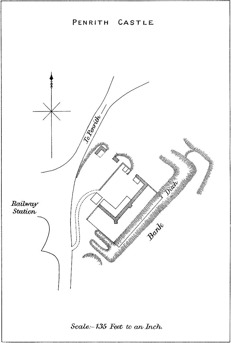
In describing the building, it has been found convenient to call the tower face the north, but really it fronts more to the north-east.
It has been suggested, from the rectangular plan of the earthworks, and from the prevalence of Roman remains in the district, that the castle occupies the site of a Roman encampment, and that its material, said by some to have been taken from Mayburgh, was derived from some Roman building. This latter suggestion is, no doubt, perfectly possible. Certainly the material was not taken from Mayburgh, which never could have supplied ashlar in large quantities.
It is certain that there was no castle here during the early Norman times, or while the manor was the heritage of the kings of Scotland. From them it came to John Baliol, and was confiscated with his other English possessions late in the thirteenth century. The Neviles of Raby then held it. Richard, Duke of Gloucester, had the castle and manor, and seems to have been often here. He probably made any pure Perpendicular additions of which evidence may remain.
There are extant two licences, one to crenellate the town of Penrith, 20 Edward III.; and the other, 22 Richard II., to William de Strickland, with permission to make a mantlet of stone and lime, and to crenellate it. Probably the present castle is the mantlet referred to.
PEVENSEY is, in some respects, the most interesting place in the south of England. Not only is it closely associated with English history during the eleventh and twelfth centuries, but its ancient and present names, and a part of its material remains in masonry and earthworks, connect it closely with the British, Roman, and early English occupation of our island.
It was, without doubt, the chief place in the great forest of Anderida, which, in remote times, extended over the south of Sussex and the Weald of Kent, and of which the not infrequent remains are seen in the very numerous and wild parks found in these districts. The British name, both of forest and town, is preserved in its Roman form, and the site of the latter is still indicated by its Roman walls and towers, which, like those of Porchester, have been incorporated into a later fortress. The Romans probably left Anderida in good repair. One of the chief strongholds of the “Comes littoris Saxonici” was not likely to have been neglected, and it appears, from the Saxon Chronicle, that the Britons were well aware of its value, and held it against their piratical invaders with fierce but360 unavailing valour. Late in the fifth century it was besieged and taken by Ælle and Cissa and their followers, and every Briton within it was put to the sword.
Andredes-ceaster, or Andreceaster, from a Roman and British, became an English fortress, and, by slow degrees, the Forest of Andredes-weald became encroached upon by cultivation. The change of masters also brought a change of name, and the island or “eye” in the marsh is supposed to have become the property of “Peofn,” whence its present name is thought to be derived.
Under the English rule, the divisions and names denoting property were gradually introduced, and Pevensey became the chief town of a Rape, an honour it shared with Chichester, Arundel, Bramber, Hastings, and Lewes, in each of which the town was distinguished by early earthworks, and at Chichester by Roman walls. Each of these Rapes had its town and fortress, and each town was placed upon a river. That of Pevensey rises in the wooded ridge about Penshurst and Dallington by a number of streamlets which meander athwart the marshy level of Pevensey, until a little above the castle they form what is still known as the old Haven, and which was in use in the twelfth century. As late as 1317 a grant by Edward II. mentions the marshes as overflowed by the sea, and as in no man’s tenure. The castle then stood on the margin of the sea, from which it is now more than a mile distant, and the whole area of the level, many square miles in extent, seems to have been an impracticable morass, covering the fortress towards the south and east, and in some degree to the north. The knoll must so have presented itself to Julius Cæsar, if, as generally supposed, he here landed, and so, with the addition of the Roman walls, it was certainly seen by Ælle and his followers, and 500 years later by Duke William when he landed between Eastbourne and Hastings, and selected the higher ground to the east of that castle for his march inland to give battle. “Mare transivit,” says the Bayeux tapestry, “et venit ad Pevensæ,” and the chronicle of Battle says he landed “prope castrum Pevensel dictum,” whence the soldiery went to seek victuals at Hastings. Here, then, it was, beneath these very walls, that the Conqueror took seisin of his yet unconquered kingdom.
Pevensey, under the Normans, became once more a place of consequence, and one of the havens through which the sovereigns kept up their communications with Normandy. It was hence that the king embarked on his return to Normandy in 1067. William granted it to his half-brother of Moretaine, who is said to have built a castle there. What he actually built is unknown, and the only existing masonry that can possibly be of his date is the broken superstructure of one, or perhaps two, Roman towers, and some rude repairs executed on the face of one of them. But whatever he did he held, and continued to hold the Roman castle till his death, and he so held it against William Rufus, in 1088, being supported and encouraged by Bishop Odo of Bayeux, and by the hope that Duke Robert would come to their relief from beyond the361 sea. This hope was fallacious. Rufus having stormed the mound of Tonbridge, laid siege to Pevensey. The garrison was brave, the earl-bishop and his brother count were skilful generals, the walls were high and strong, and for six weeks the king, at the head of a numerous army, assailed the place in vain. A tardy force sent, not led, by Duke Robert, strove to land beneath the castle wall, but, though the king’s English soldiers were thus placed between the double attack from the castle and the ships, they overcame and, for the most part, slew the invaders. The castle was surrendered, and Odo, transmitted under a guard to Rochester, contrived to enter that castle, and to encourage its garrison to hold out.
Pevensey next comes under notice in 1101 as the muster-place of the army led by Henry I. to repel the expected invasion of Duke Robert. He was so far successful that the invaders were driven to land at Porchester. Either under Earl William of Moretaine, who was taken at Tenchbrai and lost his lands, or under his successor, Gilbert de l’Aigle, the lordship or Lewy of Pevensey was erected into an Honour, and finally became the Honour of the Eagle, “Honor de Aquila.” In 1144, the castle was attacked by Stephen, and defended by Gilbert de Clare, then holding it for the Empress, to whose son, Henry, it had been granted by Henry I. It next came to King Stephen, and about 1216 became the property, under the Crown, of William de Warren, and after various confiscations and restorations was finally lost to the De Aquila family in the reign of Henry III. John, Earl Warren, took refuge here in 1264, after the Mise of Lewes, and in the following year it was held by Peter of Savoy for the king against the younger De Montfort. Very little of the present mediæval masonry could have been standing during these various sieges. The strength of the place must have then mainly depended upon the Roman exterior wall, furnished, no doubt, with a mediæval parapet, and dominated by the early English mound, with probably a shell keep of timber or masonry upon it.
About 1269 it fell into the hands of Prince Edward, and remained awhile in the Crown. In 1309 it was in a ruinous condition, “Confractum et male custoditum,” Edward I. having declined to repair it. It must have been soon after this, judging from the evidence of the existing masonry, that the present additions were made, that is, either at the close of the thirteenth or very early in the fourteenth century. The towers are attributed to Edward II., in 1309.
Pevensey, “La Ville et la Lewee de Peuense,” was included in the extensive grants made by Edward III. to John of Gaunt, under whom and the Duchy of Lancaster the Pelhams became hereditary constables. In 1399, Lady Pelham distinguished herself by holding the castle for Richard II. against the combined posse of the counties of Kent, Sussex, and Surrey. After this event it was mainly used as a state prison. Edmund, Duke of York, was confined here in 1405, and in his will bears testimony to his good treatment; and here also were imprisoned James I. of Scotland in 1414, and in362 1419 Joan of Navarre, the last queen of Henry IV. In 1650, the castle had a narrow escape from the claws of the Parliament, the materials having been actually sold for building purposes.
The history of the building, though aided by passages in the public records, is mainly to be established by the study of the material remains. Those of the Roman period have fallen under the searching and very accurate notice of Mr. Roach Smith; the present paper deals mainly with the mediæval additions both in earthworks and masonry.
The Roman fortress is in plan a rounded oblong, 220 yards north-east and south-west by 115 yards, and contains from 8½ acres to 9 acres. It is included within a wall strengthened by towers, and here, as at Lyme, the outline of the plan was evidently governed by that of the ground on which the castle stands, and which rises 8 feet to 10 feet above the sea level and that of the surrounding marsh or meadow. The wall is from 10 feet to 11 feet thick throughout, and at this time from 20 feet to 30 feet high. The length in circuit is about 580 yards. At the bend of the enclosure, towards the south-west, is the main entrance, preserving very nearly its original form. Two half-round towers, 28 feet apart, and 20 feet diameter, with produced flat sides, giving them a depth of 30 feet, and 30 feet high, project 20 feet from the curtain, and were connected by a cross wall, of which only the foundation remains, and in which was the outer gateway. These towers are not quite parallel, but their longer axes radiate slightly outwards. They are solid and have no internal projection, but from each of them a wall ran backwards 18 feet, terminating in a cross wall, in which was the second gateway, the foundations of which show that the base had an opening of 9 feet. This rectangular gatehouse must have resembled those of Porchester, and, like those, had evidently been altered to suit the Norman entrance, of which there remains one jamb of the outer gateway.
Besides the towers flanking the entrance are eleven others upon the curtain wall. These also are solid, of the height and age of the curtain, and without internal projection. They vary from 14 feet to 20 feet in breadth, and from 14 feet to 16 feet projection from the wall. They stand at irregular distances of from 14 yards to 35 yards. Besides the thirteen standing towers, there are two displaced and broken down, and the fragments of two others, making seventeen in all. They are closest along the north-west and north fronts, where the ground outside is highest. Towards the south and east there are but few, the shallow, muddy sea and the marsh being found a sufficient protection. Besides the main entrance there were three posterns, of which that to the north-east is still in use. That to the north is broken down, but its remains show it to have passed obliquely, on a slight curve, through the wall. The southern postern was probably a water-gate. In the south wall the mouth of a drain,363 about 18 inches square, and opening towards the sea, has been laid open. Although the wall is for the most part thickly covered with ivy, it is pretty evident that in parts it is still capped by a later battlement, and one of the northern towers, originally 32 feet high, bears a superstructure of 18 feet, which, from a window in its side, appears to be of the Norman period.
The wall has been breached on the north front for 65 yards, and its mass, thrown forwards, still encumbers the ground outside. To the south is a much longer breach, at least of 200 yards. This seems to have been produced by a slip of the soil, by which the foundations have been moved forward bodily for several feet. At the east end also the wall has been broken down, but here its fragments, which are of considerable bulk, are mixed up with others of later date in wild, but not absolutely inextricable, confusion. Most of the north wall has been picked into to a considerable depth, at the ground level, but the foundation remains uninjured. This is said to be the work of the purchaser of the ruins in 1650, but may possibly be the work of some early assailants, though these are more likely to have worked below the surface of the earth, and to have inserted props of wood beneath the base of the masonry, which, when set on fire, would have caused the destruction of the whole superincumbent mass. No gunpowder has here been employed.
It is evident that there was formerly a ditch at the foot of the wall on the south front, full of water, where, indeed, it may still be traced. Along the north, west, and east fronts, the wall is bordered by a road, to make which the ditch, probably never very wide or deep, has been filled up. There can be no question as to the authors of the exterior enceinte, both wall and towers. They are all of one, or very nearly one, date, and distinctly Roman, and, which is not always the case, the towers are bonded into the walls. The substance of the masonry is very rudely-coursed flint-rubble, chiefly composed of flints and pebbles from the adjacent sea-beach, mixed with angular fragments of stone, the whole held together by mortar very freely employed. This mortar is remarkably white in colour, and contains numerous small pebbles, little if any broken tile, and a preponderance of sand. On the whole the mortar has set firmly, and holds well together the rather heterogeneous mass of materials. The face of the work, both inside and outside, is composed mainly of squared stones from Eastbourne or Beachy Head. They are generally about 6 inches by 4 inches on the face, but sometimes as large as 12 inches by 6 inches. The lowest courses at the ground-level are composed of darker and far larger stones, and in the wall above are occasional double bands of tile, and sometimes of stone nearly of the colour of tile. A good deal of the facing at the lower part of the wall has been stripped off, but inside this stripping is confined to the part of the wall just above the ground-level, which is raised artificially higher than the level of the natural soil. In some places this addition is high enough to convert the lower part of the masonry364 into a retaining wall. It has been thought that the earth thus employed was derived from the inner ditch, an early English work. It may be so, but more probably the contents of this ditch went to form the mound, and it is possible that the raised soil may be derived from the ditches of a British camp preceding the Roman occupation.
The Romans, who constructed the outer walls, seem to have been content with a single line of defence; but the Northmen treated the whole area after a different fashion. Within the area, at its eastern end, a mound was thrown up, table-topped, and about 30 feet high; this, though within the area, was upon its margin, and rested against the eastern wall. The material for the mound seems to have been derived from a ditch which surrounded about two-thirds of its circumference, extending from wall to wall, and which thus isolated it from the remainder of the Roman area. This ditch has been filled up, probably to give space, but its line is still marked by a slight depression in the soil. By this means a strong place would be formed very nearly in accordance with the early English practice, having a mound or bank, with its proper ditch, and an appended court. The only peculiarity would be that the court was walled, and thus the ditch of the mound would be traversed by the masonry, and the outer side of the mound supported by it.
The Normans, who at once saw the value and took possession of Pevensey, probably were for a time content with the Roman walls as they stood, and with the palisaded citadel of the mound. At least, there is no certain trace of any very early Norman masonry. Indeed, the only masonry of Norman date at all now to be seen is a fragment of wall with a window, the remains of a superstructure upon one of the northern towers, and some patchwork in flints, and a few courses of stone laid herring-bone fashion, by which the face of another of the Roman towers has been repaired. Had the Normans of the eleventh or twelfth centuries constructed any eastern walls, gatehouses, or mural towers within the court, some trace of them would probably remain. The chapel, indeed, judging from its dimensions, was Norman, and the base of the font decidedly so; and it is possible that the shapeless fragments of rubble masonry which encumber the top and slopes of the mound may be of the same, that is, of late Norman, date. In truth, the castle, as the Normans found it, was a very strong place. The walls only needed a battlement, and even if this were surmounted, the entrenched and palisaded mound would be perfectly defensible so long as provisions held out.
At this time the Roman enceinte contains the remains of a strong and tolerably perfect mediæval castle. This, as usual in such cases, takes the form of an addition to the defences of the mound, shutting it off as a citadel from the rest of the works. Advantage was taken of the broad and deep ditch extending from the east to the south wall, 210 yards in length, curved westwards or outwards, and which shut off the mound, and a part of365 the great area, and thus formed an inner ward, of about an acre and a quarter, containing the mound or keep. The ditch, which was probably supplied with water from the sea at its south end, gives off a branch northwards towards the Roman tower, called the watch-tower, and this cuts off the north-east corner of the ground, which thus forms a sort of small middle ward between the forks of the ditch. Behind the ditch is a curtain wall, near the centre of which is a gatehouse of some pretensions, and three large drum-towers, of which two flank the gatehouse, and one is placed to the north of it.
The gatehouse points to the west, opposite to that of the Roman area, now the outer ward, at a distance of 184 yards. In front of it are the two solid piers of the drawbridge, 14 feet wide, and approached from without between curved wing walls. The piers were faced with ashlar, now stripped off. The space between them is 12 feet, and may have been 10 feet The gatehouse is composed of two half-round towers, produced backwards to contain the entrance passage. Outside, these towers somewhat resemble those of the Roman or outer gate, which may have served as their pattern. Their loops are of unusual length, one being 15 feet long. The vents of two garderobes are seen, opening flush with the wall. One seems to be the lower end of a loop. They contain a basement, a ground, and an upper floor, looped towards the field, not vaulted, and duly provided with garderobes. The north tower, faced with sound, though rather open-jointed, ashlar, is still standing, though mutilated. In its ground floor is a fireplace. The south tower is quite broken down. The entrance passage is tolerably perfect, although the gateway at each end is gone, as is the upper chamber for working the portcullis, of which part of the grooves remain. The passage, 12 feet broad and 35 feet long, was vaulted with a segmental vault, strengthened with plain broad chamfered ribs, now broken away, and in the vault, a little behind the portcullis, is a large square central hole or “meurtrière” for the defence of the passage. In either wall is an arcade of two arches, a larger and a smaller, low pointed. The larger are closed, the smaller pierced by doors opening into the ground floors of the gatehouse.
Flanking the gatehouse, at a distance of 33 yards north and 54 yards south, are two grand round towers, each capping an angle of the curtain. The north curtain has a base or plinth slightly battering. The wall is vertical. There is no cordon between them. The north-west tower is 30 feet diameter, and has a basement, ground, and upper floor. The basement, though below the inner ward level, is on the level of the ground outside. It is arcaded, having six arches in its rounded sides, and one in its flat end or gorge. These arches have a drip of the double-scroll pattern, and between each pair springs a moulded rib, and one from each of the two right angles, eight in all. They are broken away, but their profile is seen, and the plan of the vault may be inferred. The entrance to this chamber is by a straight staircase from the inner366 ward, and at the foot of the stairs is a lobby on the left or west side leading to a postern doorway placed at the junction of the tower with the curtain. In the gorge wall is a fireplace, the hood of which seems to have been of timber. It is difficult to understand what this chamber can have been intended for, with its ornate details and a fireplace, and yet half under ground.
The ground floor is entered from the inner ward by a separate entrance, in the right or east wall of which an opening passes into an oblong mural chamber, vaulted, and contained within the curtain. This chamber has a water drain, and above it, in the wall, three bold corbels, and above these a small segmental-headed doorway, now blocked up. This is a very peculiar arrangement, and it looks as though there had been a wooden structure, perhaps a garderobe, bracketed out upon the face of the wall, over the ditch, at about 10 feet from the ground. The upper floor of the tower was entered from the battlements, the tower rising above the wall. Only the basement floor was vaulted. Each stage is lighted, or rather ventilated, by loops towards the field.
The southern flanking tower is nearly upon the pattern of that last described, save that the basement is not arcaded, and none of the floors vaulted.
The third tower, in the north wall, 36 yards from the north-west flanker, is of the same pattern, with the same exceptions. The staircase into the basement has a side door opening upon a postern in the east wall, with a segmental head, and from the ground-floor entrance there opens, westwards, a long mural chamber, the counterpart of that described as attached to the north-west flanker, having also brackets and corbels, and a small door in the wall, 10 feet above the ground, as though for a timber garderobe. These are all the regular towers, but in the south wall, where a tower might be expected, is a postern, which pierces the wall at its junction with the Roman wall, and outside and in front of it is a fragment of a Roman tower, which has slipped forwards a few yards, and forms a sort of bulwark concealing and protecting the postern. It is evident that the displacement of the tower is older than the Norman period, and was taken advantage of by the later builder. In the north wall of this inner ward, beneath the north and north-west towers, is a large fireplace, perhaps that of a hall. The kitchen was probably in the north-west tower, and the large mural drain was connected with it.
The mound, which occupied the east end of the castle and carried the keep, remains tolerably perfect, though much encumbered with ruins, produced evidently by gunpowder. Against its east side, and supporting the mound, is a Roman tower, which was worked into the keep, its solid top being battlemented. The mound has a spur of earth towards the north, probably connecting it with the north wall, but nothing definite can at present be ascertained, though the foundations upon it, if laid open, would probably disclose something.
As the mediæval castle is placed within the eastern end of the367 Roman area, its eastern side osculated with the Roman boundary, which is here common to both areas. About four-fifths of the enclosing wall of the castle is mediæval, but the remainder, that towards the east, is Roman, which is thus common to both fortresses. Commencing at the south postern, where the two walls are in contact, to the great disadvantage of the masonry of later date, the Roman wall extends, partially propped up by a later buttress, until it reaches a Roman tower that connected it with the keep mound. Beyond this, passing southward and eastward, to where the mediæval wall springs from the Roman enceinte, the Roman wall has been left to support the mound, but about 6 feet in front of it a mediæval wall, 9 feet thick, has been built, probably to afford more space above, and to assist in supporting the earthwork. The castle has been attacked on this side, or else those who dismantled it, thinking this the strongest part, have mined and blown it up, for the glacis for many yards is covered with enormous masses of masonry, which have evidently been displaced by gunpowder exploded in large quantities. At one part, abutting upon the Roman tower, the two walls are seen. About 20 feet of the mediæval wall, 9 feet thick and 10 feet high, stands undisturbed, though above this height its superstructure has been blown off. Behind it is the Roman wall of about the same height, not only reduced in height by the explosion, but tilted forward. This is what has happened in this quarter, and the history of it is clear, even in the midst of so great a confusion.
Within the mediæval or inner ward an excavation shows the position and plan of the chapel, with a nave 40 feet by 16 feet 8 inches broad, and chancel of 12 feet 8 inches by 11 feet 6 inches. A fragment of the font has been preserved. The chapel is, no doubt, of Norman date, and older, therefore, than the castle in its present form. There is also a rude pillar piscina, such as is now and then found in Norman buildings. There are one or two in Glamorganshire. The free chapel in the castle is mentioned in the grant of John of Gaunt. The well also has been discovered at the foot of the mound. It is cylindrical, 7 feet diameter, and lined with ashlar to a depth of 52 feet, below which it is square and lined with timber.
The Roman works at Pevensey have been explored and examined, as already stated, by Mr. Roach Smith. Unfortunately, the mediæval castle has been less fortunate, and has not been accurately described. A short but complete and brilliant description of Pevensey, and a notice of the part it played in the campaign of 1066, will be found in Mr. Freeman’s “Norman Conquest.” It also plays a conspicuous part in his recent life of the Red King.
THE castle and town of Pickering stand upon the southern edge of the moors of north-eastern Yorkshire, where the upland subsides into a broad tract of meadow, which, under the names of Carr, Ing, Marisch, and Bottom, extends southwards nearly to Malton, and east and west from near Scarborough to a little short of Helmsley. This is the district known as the Lythe or Vale of Pickering, of which the castle was the chief seat.
One of the principal passes into the Lythe from the north is that now occupied by the Malton and Whitby Railway, and down which flows the Pickering Beck, a tributary (through the Costa Beck) of the Rye and the Derwent. The pass is rather a ravine than a valley, and is deep, rocky, narrow, and winding. The castle occupies a rocky knoll near where the pass opens out into the plain, and stands a few yards east of, and 100 feet or more above, the stream, on either bank of which is built the town, below and under the immediate protection of the castle.
The position is upon a rocky headland, about 70 feet or 80 feet above the town, and jutting out sharply towards the north and west into the valley. Thus two sides, covering nearly half the area, are naturally strong. Towards the south and west the ground rises gently, attaining to the height of 200 feet and even 300 feet, at distances of a quarter of a mile to two miles. On these sides, therefore, the defence is artificial, and composed of a deep and broad ditch, which opens out upon the valley at each of its ends. It is quite dry, and from its position and level was probably always so: a part of it, indeed, carried the way up to the postern.
The area thus defended falls somewhat towards the west. It is pear-shaped, the stalk being towards the south-west. Its cross dimensions are about 500 feet by 350 feet. It is contained within a curtain wall of considerable height and strength towards the town front, and having upon its southern half four towers. Upon the northern half were formerly two, both of which have disappeared. The keep and the inner gatehouse belong to both divisions, being upon the line common to both. Within the general area, and rather near to its north-eastern or larger end, is a conical flat-topped mound, wholly artificial, and surrounded by a circular ditch, of which a part towards the east is quarried out of the rock. Upon this mound stood the keep, and from it, on nearly opposite sides, sprung the cross curtain which traversed the area in almost its greatest diameter, and, with the keep, divided it into two nearly equal wards, to the north and the south. On the outer or the southern front of this wall is a deep and wide ditch, which extends from the ditch of the mound each way towards the enceinte, the eastern limb opening into the369 outer ditch, and the western upon the face of the low cliff. Each of these openings is, however, traversed by the main curtain. Upon the southern and longer limb of the cross-curtain is the inner gateway, leading from one ward to the other, and opposite to the outer gate, which is on the southern front.
The four mural towers already mentioned are all in the southern ward. They are, Mill Tower, Rosamond’s, the Devil’s Tower, and the Gate Tower. Devil’s Tower contains a postern. Besides the keep, Leland mentions three towers in the north ward. Of these the inner gate was one, and the other two probably capped the two angles of that ward. The domestic buildings in Leland’s time were of timber, and are gone. There remains a chapel, desecrated, and of which the existing building is of very doubtful date.
The mound is 76 feet diameter at the flat top, about 70 feet high, and at its base in the bottom of the surrounding ditch about 220 feet diameter.
The keep, which is placed upon its summit, was a shell of masonry, 6 feet to 7 feet thick; within it is circular; and outside, in part at least, polygonal; and was perhaps originally a nonagon, with sides of 24 feet. Of this shell there remain two fragments, on nearly opposite sides of the area, one 35 feet long, and containing two loops, the other 24 feet, and containing a loop and a half. These are at the ground level. They are 6 feet high and of 3 inches opening, dove-tailed at the lower end, and having a short cross member. Each is placed in a round-headed recess of 6 feet opening, and splayed. The fragments are about 18 feet high, and may have been 20 feet to the rampart walk. Outside, the wall rises from a low plain plinth. The wall is of rude, roughly-coursed rubble, with ashlar dressings and quoins at the two angles that remain. There is a ledge or walk of about 2 feet broad outside the wall.
From opposite sides of the mound spring the cross curtains, at a very obtuse angle, so that a trifle more of the base of the mound belongs to the south than to the north ward. These curtains are 7 feet thick, and are built upon the slope and across the ditch of the mound, being at the deepest about 70 feet high. At present they cease at the top edge of the mound, and do not seem to have been any higher, save by a parapet, or to have abutted against the keep. This is what appears at Tickhill and Tamworth. No doubt the parapet was continued against the keep wall, and there may have been a postern, as at Hawarden, where, however, the wall itself abuts upon the keep. The eastern limb is tolerably perfect as far as the counterscarp of the ditch. It is then broken down for some feet, but finally is seen to have abutted upon the outer curtain, close to the Devil’s Tower. The other, or western limb, extends to the inner gate tower. Towards the junction the curtain is somewhat thickened and very lofty. Here a straight flight of steps ascends from the rampart walk to a second rampart higher up, so that there are two rows of loops, the upper being in the battlement. Possibly there was a wooden gallery here to give breadth to the upper rampart.
370
The gate tower, at which the curtain ends, was not a gatehouse, but a tower by the side of the gateway, but having no communication with it, as at Cardiff and Ogmore. This tower is 21 feet broad by 16 feet deep, and had a basement and two stories. The gateway, of which it formed the eastern side, was probably a mere opening in the curtain. The further side is gone, but the tower side shows no marks of vaulting or portcullis, and has but one rebate for the doors. Here was a drawbridge of 6 feet span, of which the counter-pier remains. From the gateway the cross curtain was continued until it abutted on the west curtain. All this part is gone, or nearly so. In front of the cross curtain is a ditch, crossed by the outer curtain at each end, and running into the ditch of the mound, as has already been mentioned. It is from this ditch that opens internally the postern of the Devil’s Tower. This cross curtain is of rough masonry, and at the least its lower part may very well be Norman work.
Of the towers in the outer ward, the first to be noted is the Mill Tower. This caps the eastern angle of the castle. It is 31 feet 6 inches square, with walls 10 feet thick. It has a basement and two upper stories, all once floored with timber. It is built of excellent ashlar. The basement chamber is at the ward level, but 20 feet or more above the ditch. It is 11 feet 6 inches square, and entered by an acutely-pointed doorway from the inner face. In its outer face is rather a singular loop. A shoulder-headed recess, 4 feet 3 inches broad, and 5 feet deep, converges upon a loop of 4 inches opening, the sides of which are parallel for 5 feet. On the splay of the loop, in the scanty light of it, some prisoner has carved a circle with figures. Outside, in the west wall, is the mouth of a small drain from this chamber, which was evidently a prison. The first floor is at the level of the rampart walk of the outer curtain, and is entered thence by means of an external stone stair, sheltered by a parapet, 6 feet 6 inches high. The doorway has an equilateral head, with deep mouldings, beaded angles, and a passage ribbed transversely. The chamber is 15 feet 6 inches square. In the west wall is a garderobe chamber, 2 feet 6 inches broad by 10 feet long, looped, and with an external shoot, flush with the wall. In the south wall is an equilateral arched recess, with a ribbed barrel-vault and stone seats, and in it a two-light flat-topped window, trefoiled. In the east wall is a plain, square-headed fireplace, and a door, also square-headed, opening into a well-stair, which ascends hence to the battlements and the upper floor. This stair is contained within a triangular projection from the tower. It ends above under a ribbed and domed covering.
Rosamond’s Tower caps the south-west angle of the curtain. It is of ashlar, 22 feet broad by 24 feet deep, and has no internal projection. The floors were of timber. It has a basement about 5 feet above the court level, and a first and second floor. The basement, entered from the ward, is 10 feet by 8 feet, and has a single loop. The gorge wall, at the rampart level, is pierced by a gallery to carry the rampart walk. The gallery descends and rises again 4 feet, the first floor, being so much below the rampart level. This floor seems371 also to have been entered by an exterior stair built over the lower doorway.
The Devil’s, or Postern Tower, that north-east of the keep, is rectangular and of ashlar, and has exterior projection only. It is 22 feet broad by 27 feet deep. The basement is vaulted, and pierced by a postern passage. The inner door, pointed, opens in the bottom of the ditch of the cross curtain; it is now nearly buried. The outer door is walled up. It is pointed, of 3 feet 6 inches opening, and placed in a square-headed recess, 6 inches deep, 5 feet broad by 10 feet high, intended to lodge the bridge when up. At the foot of this door, outside, in two large stones, are two holes, 6 inches diameter and 18 inches deep, which contained the wooden axle of the drawbridge. Above is a central chain-hole for working the bridge. The chain must have carried a yoke, or sort of splinter-bar, 4 feet or 5 feet long, with lateral chains fastened to the sides of the platform, such as was used at Raglan and is still in use at the castle of Verona. This bridge must have had a special pit, since the way to it, inside and outside, lay along the bottom of the regular ditches. Above the door is a cruciform loop, and above that a plain one. The approach to this postern lay from the meadow north of the castle, up the mouth of the ditch of the place. The first floor of this tower is entered by a round-headed, Decorated door, with exterior steps, through a mural passage, 3 feet broad and 20 feet long, at one end of which is a garderobe. The front floor is 8 feet by 12 feet, with a cruciform loop. The second floor is entered from the rampart. The gorge wall coincides with the curtain, and is pierced to carry the rampart walk. Projecting from the curtain, close south of the tower, is a very handsome chamfered bracket, pierced as the shaft of a garderobe, and worthy of more noble service.
About 12 feet north of the tower, at the junction of the cross and main curtain, is a rectangular turret, about 12 feet square, and pierced for the passage of the rampart walk. Its use seems to be to break the communication between the ramparts of the cross and main curtains.
The outer Gateway Tower, which stands on the south or town front, between Rosamond’s and the Mill Tower, in general construction seems of the date of the inner gate. Strictly speaking, it is not a gatehouse. The curtain is broken and turns outwards, forming two parallel walls, 7 feet thick and 20 feet projection. They are 12 feet apart, and between them lies the entrance. In the line of the curtain this passage is crossed by an acute arch, 2 feet thick, the springing 15 feet high, and above this the curtain rises to 50 feet, forming a sort of screen, giving the appearance of a tower over the gate. The flanking walls, about 20 feet high, form a sort of barbican, and no doubt protected the drawbridge. A door above opened upon these battlements. The work is poor; there is no portcullis or portal vault. The entrance is quite unworthy of the castle.
Returning to the inner ward, no doubt the three towers mentioned by Leland were the inner gate tower, and two upon the two angles372 of the ward; but these are gone; though probably, if the turf and brambles were removed, the foundations would be seen.
The Norman doorway may have opened into one of these towers. At present it fronts a recess in the curtain 6 feet broad, barrel vaulted; and 6 feet high to the abacus or string which marks the springing. The doorway was flanked by two nook shafts, now gone, standing upon square plinths, and with fluted capitals. The architrave is highly ornate, having a beaded angle with a moulding of pointed arches repeated. This looks like rather late Norman, and is the only bit of work in the castle distinctly referable to that period. The drip, if ever there was one, is gone. There is no rebate or trace of a door. The adjacent curtain is low and ruinous. Here are several corbels, as though to support a lean-to range of buildings. Near this door is a small building, which looks modern, with four old lancets inserted, and a door which seems copied from an older one. This is said to be the chapel of the castle which Leland saw, and which was served by one chantry priest. Grose calls it a small, mean building, with some old pews in it. It is now a potato store.
Pickering Castle represents one great type of Anglo-Norman fortress—that is, a castle of Norman masonry upon an English earthwork, for the present walls, if not Norman, are unquestionably laid upon Norman lines. Here the mound does not, as is more usual, form a part of the enceinte, but is concentric, though placed out of centre, like the earthwork at Barwick in Elmete.
No doubt the earthworks were taken possession of and walled, either late in the eleventh or early in the twelfth century, in the Norman period, and the mass of the curtains, with the keep and the Norman door, are probably remains of this work. But the whole fortress was rebuilt in the Decorated period, the mural towers added, the curtains raised, and the place rendered stronger. It is difficult to decide on the age of the gateways. They may be Norman or they may be of the time of Richard II., probably the former.
The domestic buildings are said to have been of timber. They are gone. There is no known well. The castle mill was upon the river a little below the castle. The ditch along the south and west has been nearly filled up; beyond it is a hollow way leading down to the river, which may be old, and intended as a second line of defence.
It is stated in Domesday that, in the time of King Edward, Pickering (Pickeringa) belonged to Earl Morcar. It was then held by the king, with four berewicks, or appended manors, and some chapelries or spiritual dependencies of the parish church. The castle and its territory seem never to have been alienated from the Norman crown. The Pipe Roll of 31 Henry I. mentions that Robert de Widville rendered account for the “census rents of the forest of Pickering.” In 31 Henry II. pannage was accounted for from the forest; and in 1 Richard I., rents were accounted for by William Boie and Alan Fitz-Geoffrey, probably the same who occurs in the 374same year as Alan de Pikering. In 33 Henry II. the men of Pickering were assessed in a donum towards a royal expedition, a tax which was from time to time repeated. In 9 Richard I. mention is made of the wapentake and town of Pickering; and in 11 John, a settlement was ordered of the boundaries between the king’s forest of Pickering and N. de Stuteville’s forest.
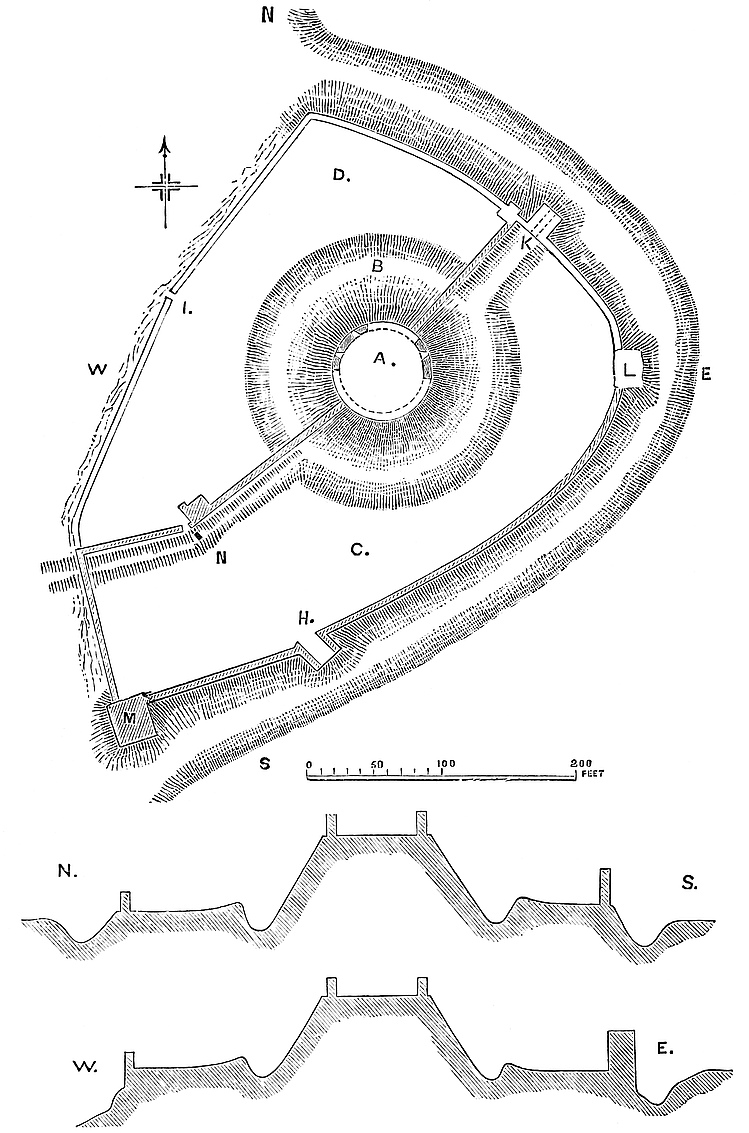
King John was here in February, 1201; August, 1208; and March, 1210; each time for a day.
In 45 Henry III. the castle was held by Hugh le Bigod against the king, with Scarborough, which castle he was monished under the Bull of Alexander VI. to surrender.
Henry III. granted Pickering to his son, Edmund Earl of Lancaster, about which time mention is made of the manor, fee, and forestry of Pickering. In 13 Edward I. the earl had confirmation of the manor, castle, and forest. On the execution and attainder of Earl Thomas, Henry Earl of Northumberland had charge of the castle, but on the fall of Edward II., Earl Henry recovered it. When Henry of Lancaster landed at Ravensburn in 1399, he marched on and retook Pickering, then held for the king.
King Richard II. was prisoner here before his removal to Pontefract.
Peck enumerates Pickering among the royal castles, and says there was a steward of the lordship, a constable of the castle, a master of the game, and a rider of the forest.
Pickering was held for the king in the parliamentary struggles, and breached on the west point, and dismantled. It seems never to have been permanently alienated from the royal demesnes. The Crown held it from the Conquest until it was granted by Henry IV. to the Earl of Lancaster, since which its history is that of the estates of the Duchy of Lancaster, of which it still forms a part.
With Pickering Castle should be mentioned a very curious, though nameless and but little known earthwork in its immediate neighbourhood. This is not even laid down as an earthwork in the Ordnance Map, usually so accurate, though marked as the site of a station. It is placed upon the highest part of a round, grassy hill, with easy slopes, which rises upon the western or right bank of the Beck or river of Pickering, about 200 feet above the water, and opposite to, and a little lower down than, the castle. The position is good, it is clear of the ravine which opens out just above the town and castle, and from it is a rich and extensive view, especially to the south and west, over Rysdale and towards Helmsley. The labour bestowed upon the work is light compared with that expended upon the earthworks of the castle, though the mound is the leading feature of both, and attests their common Saxon or early English origin.
A central mound, 90 feet in diameter at the top and 20 feet high, is girt by a ditch, out of which it rises, and upon the outer edge of which is a low bank. The summit of the mound is level, but is surrounded by a light, circular bank, which probably was heaped up to cover the lower edge of the timber defence or residence, which no375 doubt was here placed. The entrance seems to have been on the south-east side, where are marks of a way across the outer bank, and perhaps of a causeway over the ditch. The hill is enclosed, and part of it under the plough, so that no traces of any exterior or appended enclosures are visible. The work, though its general outline is to be traced with certainty, is much lowered, and its details weakened and rendered obscure by time and weather. It is, however, an earthwork of the same general class with Laughton, Barwick, Castleton, and others similar to them in Yorkshire and elsewhere, and, with them, it deserves attention. Possibly it is earlier than the castle mound of Pickering, and probably was abandoned when that was thrown up; perhaps when the wealth and power of the owner enabled him to found the lythe or lordship of Pickering.
“OUR HISTORIES,” says Swift, “are full of Pomfret Castle;” and although this has long ceased to be the case, and Pomfret be now famous but for cakes and the cultivation of the root employed in the soothing of catarrh and the adulteration of railway coffee, it was once a very famous, and is still a very interesting, place.
Whence came the name of Pontefract, and when and where its bridge was broken down, are questions over which antiquaries have long stumbled, seeing that the Aire, the only stream of the district needing to be traversed by a bridge, is two miles from the town and quite out of its girth.
It appears from Norman charters that the name of the place was Kirkby, a name, no doubt, bestowed upon it when church and hamlet were founded as a Christian settlement, in the old days when King Oswald of Northumbria embraced the new faith, an event probably commemorated by the cross which gave name to the wapentake still known of Oswald’s or Osgod’s Cross. Kirkby, however, is not named in Domesday, though probably even then a burgh. It is evidently included in the manor of Tateshall, or Tanshelf, which belonged to the king, and appended to which was the soke of Manesthorp, Barnebi, and Silchestone. Tateshall formed, and still forms, a part of the town of Pontefract.
No doubt this is the “Taddenes Scylf,” where, in 947, King Eadred received the fealty of Archbishop Wulfstan and the Northumbrian Witan, as recorded, with their speedy breach of it, in the Anglo-Saxon chronicle. The place must even then have been of importance, and there can be but little doubt that the Witan met on376 the site of the later castle. Also it continued to be an important place, for at the Conquest it was a demesne of the Crown, and is recorded in Domesday as rated at £20., having three mills, and containing a hospital for the poor. Domesday, no doubt, means Pontefract Castle, when it records that, “Omnis tornour sedet infra metam castelli Ilberti secundum primam mensuram et secundum novissimam mensuram sedet extra.” Meta is here clearly the castle garth or boundary of its immediate lands, not the military enceinte or curtain about the position, with respect to which no measurement could be in error, nor is it the Castelry, which was a much larger area.
The parish of Pontefract, which is large, is composed of six townships, of which one is Pontefract proper. The parish is one of twenty composing the wapentake or hundred.
Leland, who calls the fortress “Snorre Castle,” says that before the Conquest it belonged to Richard Aschenald, and then to Ailric, Sweine, and Adam, his son, grandson, and great grandson. This last had two daughters, married to Alex. de Crevequer and Adam de Montbegon. Dodsworth calls Aschenald, Aske, still a great Yorkshire name, and points out, what indeed is still very evident, that the Norman works stood in part on an artificial hill, on which no doubt stood the house of the English lord, dispossessed by the Conqueror.
Ailric is a real person, and a Domesday landowner, and before the Conquest held many manors. Sweine was his son, and inherited, and gave a church and chapel to the monks of St. John’s Church at Pontefract. Ailric held his lands, much reduced, under the Norman grantee, as did Sweine, and his son Adam Fitz Sweine, who founded Bretton Priory, and died about 1158, having been a very considerable person. Charters by both Sweine and Adam are found in the Pontefract cartulary.
William I. was at Castleford on the Aire in the winter of 1069, and as he stayed there three weeks he probably found the means of inspecting so strong a place as the English House at Kirkby, and when he granted the district to Ilbert de Lacy it may reasonably be supposed that he followed his usual practice of directing a castle to be built.
Mr. Freeman suggests that the name of Pontefract may have arisen from some incident connected with this passage of the Aire; others have thought that, like Richmond and Montgomery, it was an imported name. Ordericus, however, as Mr. Freeman remarks, refers to it as Fractus-Pons, not Pons-Fractus, “Rex ... præpeditur ad fracti pontis vada,” as though the words were in a state of transition from a description to a proper name. The change of name certainly was adopted slowly, for while an early charter by Robert de Lacy, the second lord, has the passage, “de dominio suo de Kirkbi,” a later one has “Deo et Sᵗⁱ Johanni et Monachis meis de Pontefract,” while Hugh de Lanval, the intrusive lord, at least as late as 1120, employs the older name. Robert of Castleford, a good local authority, writing about a century after the event, says377 the name commemorates the escape of a multitude of people from drowning, when a bridge broke down beneath them. There is, however, no river within two miles of Pontefract capable of drowning a multitude.
Camden derives the name from the breaking down of a bridge or causeway that traversed the marshy valley still called the Wash, the springs of which rise close north-west of the castle and cross its approach from Knottingley, at Bubwith Houses, where, in the time of Edward II., John Bubwith held lands juxta veterem pontem de Pontefract, about a quarter of a mile from the castle, which, indeed, proves the existence of a bridge, though not of a broken one. How water came to be here collected will be explained when the defences of the castle are treated of. Perhaps the real truth of the matter may lie in the suggestion of Hopkinson, that the castle was called after a place of that name belonging to De Lacy in Normandy.
A few marks of Roman occupation have been discovered here, and but few. Legeolium, the station of the district, seems to have been at Castleford, three miles distant.
But whatever may have been the origin of the fortress, or of its evidently pre-Norman earthworks, its recorded history commences with Ilbert de Lacy, to whom William granted Knottingley, a large portion of the wapentake, and other lands, including about 150 manors, chiefly in the West Riding,—where they fill seven pages of Domesday-book,—Nottingham, and Lincoln, of which those in Yorkshire were erected into an Honour, whereof Pontefract, the strongest and most important place, became naturally the chief seat. Ilbert, though no doubt of near kin to the Herefordshire Lord of Ewyas and Holm-Lacy, was a different person. He is thought to have built Pontefract Castle before 1080, commencing it probably in consequence of the visit of the Conqueror, in 1069. If Sir H. Ellis be right, and the castle then built be that alluded to by the Domesday entry, it was speedily completed. Ilbert also endowed the chapel of St. Clement within the castle, which, in some form or other, long survived. He lived into the reign of Rufus, from whom he had a confirmation of his grants. By his wife, Hawise, he left Robert and Hugh.
Robert de Lacy, called, from his birthplace, “of Pontefract,” claims to have built Clitheroe, which has, indeed, been attributed to his second son. He also had a confirmation from Rufus. By Maud, his wife, he had Ilbert, who, with his father, on the death of Rufus, joined Curthose against Henry I., and fought at Tenchbrai. Both were banished, and Robert was disseized of Pontefract in favour of William Transversus, and then of Hugh de la Val, or Lanval, who held it to the reign of Stephen. Robert finally regained the Honour, but King Henry claimed 2,000 marcs, and de la Val had £150. for the demesne lands, and 20 knights’ fees, which are entered in the Liber Niger in 1165 as held “de veteri feodo Pontisfracti.” Robert confirmed some of de la Val’s grants to Nostel, and founded the Cluniac Priory of Pontefract.
378
Ilbert de Lacy, next Lord of the Honour, fought at Northallerton, and was a zealous supporter of Stephen, on whose death he adhered to Henry II. He married Alice, daughter of Gilbert de Gant, but died childless.
Henry de Lacy, next brother, succeeded. To him is attributed the later Norman work in the castle. He appears in the Liber Niger as holding 60 fees. Henry II. confirmed him in the Honour of Pontefract, and the other English and the Norman possessions of his family. 12 Henry II. he was assessed upon 79½ fees. He was a considerable church benefactor, and gave St. John’s Church and St. Nicholas’s Hospital, both in Pontefract, to the priory there. He founded Kirkstall.
Robert de Lacy, his son, and successor to the Honour, was present at the coronation of Richard I. He died childless in 1193.
The heir, according to Dugdale, and in violation of an accepted rule of inheritance, was Albreda de Lizures, Robert’s uterine sister. Mr. Hunter, however, in his preface to the Pipe-roll of 31 Henry I. has shown that in all probability Albreda was the daughter of Robert de Lizures by a sister of Ilbert de Lacy, second of this name, and therefore Robert’s cousin, and heir of the full blood. This point is important as setting aside what has been regarded as a singular exception to an accepted law. Albreda married Richard FitzEustace, Constable of Chester.
John, their son, who died before his mother, Lord of Pontefract and Constable of Chester, abandoned his House of Halton, took the name and arms of de Lacy, and died 1179, having married Alice de Vere.
Roger de Lacy, son and heir. 5 Richard I. he received from his grandmother the Lacy lands. He visited the Holy Land with his father in King Richard’s train. 7 Richard I. he paid 2,000 marcs to have livery of the Honour of Pontefract, excepting the castle, which the king retained in his own hands, and to which he paid at least ten visits between 1205 and 1216. 1 John, he reopened the question of the de la Val 20 fees, for livery of which he paid 500 marcs; and 4 John, 1203, the king addressed a letter to the tenants directing them to acknowledge Roger de Lacy as their lord. Though John continued to hold the Castle, he employed Roger in various important offices, and made him governor of the strong fortress of Château-Gaillard, on the Seine, in which he stood a very famous siege, only giving way when short of food, and deserted by the king. 13 John he paid scutage upon 47¾ fees of his own land, besides others which he held in wardship. He seems to have been the baron who, in the absence of regular soldiers, led the Chester minstrels to the relief of Earl Ranulph, when surrounded by the Welsh. He was a great soldier, and an openhanded benefactor to the church, and deserved the line with which the monks of Hanlau began his epitaph:—
Earl Roger died a young man in 1211. He had married Maud de379 Clare, and by her had John, his successor. In December, 14 John, 1212, the Honour was in the king’s hands, and he seems to have made free with its revenues; for in 1213 he directed 300 marcs from its issues to be spent on the works at Corfe Castle.
John de Lacy had seizin 20 September, 1213, and paid John 7,000 marcs for livery of the Honour, less the castles of Pontefract and Durrington, which the king kept, and for the expenses of keeping which Peter FitzHerbert had an order on the Exchequer. John, who is styled in the writ John de Chester, joined the Barons against King John, and was duly excommunicated by the Pope. He married Margaret, co-heir of Saer de Quincy, Earl of Winchester, by Hawise, Countess of Lincoln and co-heir of Ranulph, Earl of Chester and Lincoln. Early in the reign of Henry III., 1232, on the death of Earl Ranulph, Hawise seems to have made over her earldom to her daughter’s husband, who bore the title till his death, in 1240.
Edmund de Lacy, the son of Earl John and Margaret, was, by the contrivance of Henry III., married to one of his foreign kinsfolk, Alice, daughter of the Marquis de Saluces. He inherited Pontefract, but did not assume the title of Lincoln, as he did not outlive his mother. He died 42 Henry III., 1258, having built the House of the White Friars, near the Barbican, at Pontefract.
Henry de Lacy, Earl of Lincoln, his son, was the greatest of his race. He married the heiress of Longspee, and in her right became Earl of Salisbury. He was in ward to the king, and in 1272 was knighted and made Governor of Knaresborough Castle. He walled the town of Denbigh, and commenced the Castle, which he is said to have left unfinished because his only surviving son was drowned in a draw-well in the Red Tower there. His other son had been killed by a fall from a tower at Pontefract.
Having thus no son, Earl Henry surrendered his estates to the king, who regranted them, 28th December, 21 Edward I., to him for life, with remainder to Edmund, Earl of Lancaster, and the heirs of his body. 28 Edward I., Queen Margaret was a visitor at Pontefract Castle, and during a short hunting excursion to Brotherton, was there brought to bed suddenly of Thomas, called from his birthplace. It is said that the house in which she took refuge, with 20 acres of land, was enclosed in a wall and ditched, and granted by the tenure of keeping the wall in repair. Earl Henry died at Lincoln’s Inn, 1310, leaving a daughter, Alice, who married Thomas, eldest son and successor of Edmund Earl of Lancaster.
Thomas Plantagenet, Earl of Lancaster, and, either by his wife Alice, or by his father’s grant, Earl of Lincoln, and Lord of Pontefract, succeeded. He was much at the castle, and probably refaced the lower part of the keep, built Swillington Tower, and no doubt some of the structures the bases of which remain in the main ward. He also in 1315 built Dunstanborough, and added Lancaster’s Buildings to Kenilworth. Earl Thomas’s history is well known. From Boroughbridge Field he was taken to Pontefract Castle, then380 occupied by the weak and vindictive king. He was imprisoned in Swillington Tower, tried and condemned in the great hall, and, in 1322, executed on the hill which still bears his canonised name, a mile to the north-east. He was buried in the Priory. The patent creating Harcla, one of his captors, Earl of Carlisle, was dated from the castle, three days after the earl’s execution.
Countess Alice, whose character was unhappily not so impregnable as her castle, married, secondly, Eubolo L’Estrange, who died 9 Edw. III. Her third husband was Hugh de Fresnes, called Earl of Lincoln. There was a fourth, earlier in the list, whose claims are doubtful. Alice died 1348, but Pontefract and the other possessions had already passed, under the regrant, to her husband’s brother.
Henry Plantagenet, Earl of Lancaster, succeeded to his brother’s honour in 1324, and died 1345. Edward III. probably retained the castle. He was here in 1328. By Maud Chaworth Earl Henry had another Henry.
Henry Plantagenet (Tort-col, or of Grismond), Earl of Derby, &c., and, in 1351, Duke of Lancaster. He died 1361. Blanch, his second daughter by Isabel Beaumont, and co-heir, inherited Pontefract Castle and Honour.
John Plantagenet, of Gaunt, Duke of Lancaster, married the heiress and became Lord of Pontefract. He resided much at Pontefract, and restored the works. When threatened by Richard II. he victualled and put the castle into a state of defence. 12 Richard II. he obtained by charter “jura regalia” within the honour. Parts of the half-covered basements in the main ward appear to be of his time. He died 1399.
Henry Plantagenet, of Bolingbroke, Duke of Hereford, afterwards Henry IV., son and heir, succeeded, being then in exile. Richard II., by confiscating the estates, provoked reprisals, which led to his own deposition. Pontefract Castle became his first prison, and the scene of his supposed murder. Since that event the castle has been vested in the Crown. Richard Scrope, archbishop of York, was here condemned to death in 1405, and at that time Henry IV. was much here, putting down the Northern insurrections. Many of his instruments are hence dated between 1405 and 1408.
Henry V., much occupied with foreign wars, and having peace at home, had no occasion to make use of Pontefract, which seems to have been neglected in its military capacity; but here Charles, Duke of Orleans, taken at Agincourt, and James I. of Scotland, were long confined, both accomplished men and given to literature.
With the civil dissensions that came under Henry VI., the castle became again of importance. The Duke of Exeter, taken from sanctuary after St. Alban’s, was here imprisoned; and in 1460, after the battle of Wakefield, Edward here took post, with his army encamped around. It was under the walls of the castle that Warwick killed his horse before the soldiers, saying, “Let him flee that flee will; I stay by him who stays by me.” It was in accordance with381 this declaration that the king advanced from Pontefract next day, and defeated the Lancastrians at Towton. Edward’s father, Richard, Duke of York, and his brother, the Earl of Rutland, slain at Wakefield, had been buried at Pontefract. He now added his father’s head to his body, and removed the whole from St. John’s Church to Fotheringay. During Edward’s reverses and absence in Holland, the Lancastrians used Pontefract as a military prison.
In 1463, Edward was again at Pontefract, and in 1478, when he was escorted thither in great state, and remained a week.
The bloody celebrity of Pontefract was increased during the ascendancy of Richard, Duke of Gloucester, who sent hither Rivers, Grey, Vaughan, and Hawse, to be executed without form of trial. Soon after his accession he erected the town into a municipal borough.
The castle rose again briefly into notice in 1536, when Aske and the insurgents of the Pilgrimage of Grace appeared before it, and forced its surrender by Lord Darcy and the Archbishop of York, with more than a presumption of treachery. Henry VIII. was here in 1540. Two years later, Sir Henry Savile, as governor, had charge of several Scottish prisoners taken at Solway Moss.
Elizabeth, towards the close of her reign, repaired the castle, and rebuilt the chapel of St. Clement within it. King James was here in 1603, and made the castle and honour a part of the dower of his queen. He repeated his visit in 1616, and viewed the newly-established college of St. Clement, within the castle. King Charles was here in 1625, soon after his accession.
Pontefract was once more to become a place of military importance. Once the centre of the baronage of the north, it was now to appear as the rallying-place of the great aristocracy of Yorkshire, and of the Royal party. In 1642, when Charles lifted his standard at York, Pontefract Castle was garrisoned by a very strong force of local gentry and volunteers, with the gallant Sir William Lowther, of Swillington, as governor. Their courage was soon to be tried. After Marston Moor and the surrender of York, Sir T. Fairfax appeared before the castle, and in December, 1644, commenced its siege. The main attack seems to have been directed upon the north-west angle, where the Pix Tower was battered, and fell, bringing down part of the adjacent curtain with it. The enemy, however, did not storm, and the breach was made good with earth. Mines were then tried, and one was sprung near the King’s Tower, at the south-east angle. These were met by counter mines, for which the ground, a soft rock, was very favourable. Very many shafts were sunk near the walls in the main ward, and, no doubt, are still in existence. Both attack and defence were carried on with great spirit, but at last stores began to fail, and matters looked ill for the garrison. They were reduced to extremity when, on the 1st of March, Sir M. Langdale arrived with 2,000 men from Oxford, and forced Lambert to raise the siege, while he victualled and reinforced the garrison.
The Parliament, however, was now in the ascendant, and in a few382 days their forces were recruited, and again appeared before the place.
This time regular trenches were opened, batteries thrown up, and a complete line of circumvallation laid out. This was of an oval figure, completely inclosing the castle and its outworks. The contained area, from the head of Micklegate by Knollys’s Hospital on the west, to Monk-hill near New Hall on the east, was 900 yards; and from Baghill on the south, to the middle of the Abbot’s Closes on the north, 700 yards, and about 3,000 yards in girth. Upon this line, which in parts commanded the castle, were thrown up twelve regular places of arms, redans, or batteries, besides flèches and lighter works on the intermediate curtains to beat off the frequent sallies of the garrison. General Sands commanded, and General Overton was governor of the town. New Hall, a large mansion of the Talbots, to the east of the castle and outside the lines, was entrenched, and occupied by Sir John Savile. The garrison held Swillington Tower, the tower of the great church, and Neville’s Mount, a cavalier thrown up by them within the barbican, and carrying a large iron gun. These advanced works were of great service, as they both retarded the siege works and protected the repeated sallies from the garrison.
The trenches were opened in March, but it was the 24th of May before a battery was opened upon the keep. General Poyntz then took the command of the attack. It was, however, late in May before the church-tower was battered down, and the post, therefore, abandoned. Notwithstanding the disastrous news of Naseby, Lowther continued to hold out, and it was not until July 20th, after four months of siege, without further supply of stores or ammunition, and without a chance of relief, that he surrendered upon excellent terms. The fall of Pontefract was followed in three days by that of Sandal Castle, within signal of its towers.
The Parliament spared Pontefract on account of its strength, and put in General Cottrell, with a garrison. The Royalists, however, were still strong in the district, and June 6th, 1648, it was recovered by the treason of Morrice, a renegade, but a man of courage. A garrison was quickly collected, and the castle became once more a Royalist centre.
A third siege thus became necessary, and such was the strength of the place that, even discouraged as the Royalists were, it promised to be a troublesome one. General Rainsborough, who was appointed, met his death before taking the command, which fell at first to Sir H. Cholmley. Cromwell himself was present for a time, and a work on the north front bore his name. He left Lambert in command. Meantime, the king’s death had broken up the party; and ultimate success being impossible, the governor, Morrice, listened to terms. He himself and some others were excepted by name. The difficulty thus created was ingeniously evaded. The excepted persons being reduced to three, they were walled up in one of the subterranean chambers, well provided with food and air,383 and Lambert was made to believe that they had escaped. The place was then surrendered, Lambert entered March 24th, 1649, and as he did not retain the place, the three culprits got away safely. Parliament now ordered the castle to be demolished, and the only record of the details of its parts is that preserved in the schedule of its destruction. The materials—timber, lead, glass, and iron, sold for £1,779. 17s. 4d., of which £777. 4s. 6d. was the cost of demolition, £1,000 was paid to the town, and the balance of £2. 12s. 10d. went to the Commonwealth. This last creditor, however, received afterwards some arrears amounting to £145. 11s. 7d., and so, in an account of profit and loss, was wound up the history of one of the strongest and greatest fortresses in the North.
The position and dimensions of the castle were worthy of the great barons by whom it was constructed, and far too noble for the events with which its name is associated. North-east of, and one-third of a mile from, the market-cross of Pontefract, there is seen a very remarkable table of rock, oval in form, the sides of which are in part a steep slope and in part a cliff of from 30 feet to 40 feet high, rising out of a talus, which, on the north, south, and eastern faces, descends into two deep natural valleys, which unite on the north-eastern front. At the south-west end is also a natural depression dividing the rock from the town, and which has been deepened somewhat by art, as has the cliff been scarped and, where necessary, revetted, so that the general result was the production of an almost impregnable stronghold. This description, however, requires, as regards the east front, some little addition. Here, immediately beyond the wall, is a ditch nearly all artificial, and beyond it a nearly level area, beyond which, again, is the natural valley. As it was necessary to cover the ground, it was walled and converted into what was called the barbican, but was really a double ward outside the castle, covering its main entrance. The castle was thus composed of the main ward, occupying the table-rock, and the outer and inner barbicans covering its south-east front and entrance.
The main ward occupies the whole summit of the rock. It is in plan an irregular oval, 150 yards north-east and south-west, and 103 yards in its cross diameter. Of this area a segment at the south-west end, 37 yards deep or on the “sagitta,” is occupied by a raised platform containing the keep and remains of various buildings, and a smaller segment at the north-east end is occupied by the bases of other buildings, including the chapel. If the arrangement be likened to the deck of a ship, the keep end will be the poop, &c., the other end the forecastle, and the large intermediate space the waist.
The present appearance of the north-eastern platform is a bank of earth, irregular, and about 20 feet above the area level. In plan it384 is rather semilunar, and is evidently composed of the basements and ruins of buildings, the soft red sandstone of which readily becomes converted into soil. The face towards the ward, standing from 2 feet to 6 feet high, shows the base mouldings and plinth of a range of buildings that rose from the main ward level, and seems to have included a polygonal tower or turret. All that is visible is of excellent ashlar, with stones of large size, and the workmanship is mainly in the Perpendicular style. In the rear, along the edge of a cliff, is the curtain-wall, part of which is a revetment filling up the irregularities of the rock. This platform is returned a few yards along the east front against the curtain, and there is seen the basement of St. Clement’s Chapel, more than once rebuilt since its first Norman foundation.
The curtain along the crest, where the cliff is high, seems to have been a mere parapet. On the north-east point, where there is only a slope, the curtain is very lofty, and of prodigious thickness; much is broken away, but what remains shows it to have been 15 feet thick, at its base and 11 feet at 24 feet high. The main gate was in the curtain near the south end. It seems, from the drawings, to have been covered by a small square tower, the exterior and interior portals not being opposite.
The main interest of the castle attaches to its south-western platform. This is about 20 feet above the main ward, and at its southern angle there is raised upon it a conical mound, flat-topped, and rising about as high again.
Towards the main ward this platform is supported by a revetment wall from 12 feet to 14 feet high, of good rough ashlar, of large stones, having a base of 4 feet, and above this a plinth of about 4 feet more, the two offsets being plain chamfers. This, no doubt, carried a curtain wall. In the wall, near its centre, is a broad-arched recess, called “the King’s Seat,” probably from a tradition that Richard II. sat there, which is probable enough. At the north end the platform is returned about 25 yards along the west curtain. Various indications show that this platform was covered with buildings, most of which, like the retaining wall, were of Norman date, and of which the basements remain, though much covered up. Of the enceinte, or curtain-wall that supports the outer face of this platform, only the lower 30 feet, or revetment, remains. This commences some way down the slope, and is prodigiously strong, and built against the rock. At the south-west angle was the Treasurer’s or Pix Tower, the ruins of which still encumber the slope. Passing southward, the wall rises and becomes more perfect. In its exterior base, about 30 feet below the rampart, is a Norman postern, very perfect, and which probably was in the base of the old Red Tower. Then, behind, and on the level with the top of the wall, are remains of early buildings. One presents the end of a round-headed vault of about 16 feet span, of rude rubble, but springing from good ashlar walls, and having a later-inserted window. This is called “King Richard’s Prison.” Near this is a rectangular shaft, 8 feet by385 4 feet, but which, a few feet down, is increased to eight feet square, a round-headed arch supporting the upper half. It is now about 40 feet deep, and dry. It is called a well, but is more probably the shaft of a garderobe.
Beyond this rises the mound, the top of which is circular, and about 20 yards across, and 40 feet to 50 feet above the main ward, and much more above the exterior base of the enceinte of which it forms a part. Those who formed the mound no doubt gave it a natural slope all round, and placed their structure on its top, and, making it a part of their line of defence, carried the general palisade to its summit from either side. The Normans, on taking possession, proceeded in a different way. They cut the soft rock, forming the core of the mound, on the outer sides, into the figure of a three-quarter round mural tower, and then faced it with a very solid wall, so that though really a solid bastion, it had all the appearance of a magnificent half-engaged round tower, 70 feet diameter. When this segmental bastion had been carried to a height of 50 feet or 60 feet, that is, to the level of the top of the mound, the wall was continued all round, and the cylinder completed, so that the mound was crowned by a regular shell keep of 60 feet diameter, and probably 25 feet high, which was really, what its substructure only seemed to be,—a tower of masonry. As the rock was of irregular figure, this process was repeated, and a second smaller bastion was formed to the north, and probably a third. Leland speaks of the donjon as composed of three large and three small roundlets; of these only two now remain. These grand bastions still form the finest part of the castle, standing high above the road from the railway station into the town, upon the crest of a steep slope. They are faced with large blocks of sandstone, of excellent open-jointed ashlar work, with a bold set-off at the base. Advantage was taken of the soft character of the rock to excavate the interior into cells and staircases, some of which are still open. In the large bastion, at its exterior base, near a covering angle, a shoulder-headed doorway, a postern, opens into a round-headed passage, partly cut in the rock, and partly vaulted. From this one way leads into a mural chamber; another up a steep flight of steps, cut in the rock, but having a series of shoulder-headed hanging arches to support the roof. At a height of 30 feet this stair leads to an open gallery above, commanding the postern, and from this again ascends, covered, to the base of the keep proper. Boothroyd gives three other excavations, one of which contained the well mentioned by Leland. Besides these the remaining fragments of the keep proper contained the base of a well-stair, probably ascending to the battlements, and a shaft, probably from a garderobe about that level.
The main entrance to the castle was a few yards east of the keep, in the south curtain. From the gate a narrow stair ran up the curtain into the keep, and is still seen. Another, on the other side, still descends from the keep towards King Richard’s prison.
From the keep a spur wall descends the slope, and was intended386 to cover the approach, as at Hawarden and Coningsborough. It evidently crossed the ditch, and formed part of the barbican. Thus the keep could be reached rapidly and directly by three ways, all narrow and well defended,—one from the outside by a postern, another from the main gate, and a third from the west ramparts. In substance the masonry and arrangement of this keep is clearly Norman, but the whole has been refitted, and no doubt refaced in the Perpendicular period.
Mention must be made of a very curious and early excavation in the main ward. On the surface, a few feet from the king’s seat, a flight of rock-cut steps descends nearly north-west, and at 70 feet distant is the mouth of a square shaft, lighting the passage below. Descending, thirty-three steps lead steeply down a gallery, 4 feet broad, with a hanging roof. A little way down, on the right, are traces of a cylindrical staircase, no doubt the original way in, but now destroyed, with the tower, in the base of which it no doubt was contained. At the foot of the stairs is a plain round-headed door-case, apparently of late Norman date. Beyond this the stairs recommence, and ten steps lower the descent ceases and the passage forks, a short branch running north, and another, a trifle longer, east. Before the fork, part of the passage is vaulted in fine-jointed ashlar, with two plain round-headed ribs. In the wall, on the right, is a round-headed recess for a lamp, and the commencement of another passage, also round-headed, but left as a mere recess. Above the fork opens the shaft, here seen to be a truncated pyramid, about 6 feet by 12 feet, and 30 feet deep. At the fork the salient is occupied by two small oblong cells, with pointed roofs. They communicate with each other and the passages by narrow lancet doorways. The excavation is now called the magazine, and no doubt was so used at the siege; but it is of Norman and early English date, and probably was intended for a cellar. The arrangements of the cells are scarcely suitable for a prison. The present entrance is clearly an addition, opened when the well staircase was disused.
There remain some exterior points to be noticed. Leaving the keep by its postern, and going north-west along the foot of the west face, the wall is seen evidently to be Norman, and near the centre of this front is the original Norman postern. There are upon the face of the wall two broad shallow pilaster strips, 8 feet broad by 6 inches projection, between which is a plain round-headed relieving arch, and below it a segmental-headed doorway, of 4 feet opening, without portcullis, but with a rebate for a door, and holes for two stout bars. This opens into a straight vaulted passage, about 5 feet broad, lofty, also round-headed, of excellent ashlar, and clearly Norman. It runs about 15 feet, and is then choked up. It possibly ends in a well-stair, and might readily be excavated. In later, probably Perpendicular times, this postern has been disused, and the door converted into a loop, and blocked with the usual window-steps within.
Following the base of the cliff along the north front, it is seen to have been carefully made good with masonry; and at the north387-west angle, under what was Queen’s Tower, a large rift in the rock has been lined with ashlar, and spanned by a round-headed arch in good masonry. It looks like a large cavalry postern, but is merely a recess. At the foot of the talus on the west front, and about 180 yards outside the wall, are the remains of Swillington Tower, an outwork built by Thomas Earl of Lancaster, and in which he is said to have been imprisoned. About half of the basement remains. The tower was 46 feet square, with walls 10 feet 6 inches thick. It was intended to command the approach from the north, and was of great use during the siege as a flanking defence. Doubtless a double wall connected it with the main ward; but of this there is no trace.
It would seem that at Pontefract, as at many inland castles, a dam was thrown across a valley below the place, and thus provision made for defence and for the working of a mill. This seems to have been the case here below the northern front. The valley was converted into a lake, employed to feed two mills, of one of which traces remained in 1806, and the other, the lower mill, was removed in 1766, when the dam was levelled, and the pool converted into a meadow. Bubwith Bridge, no doubt, crossed this pool, at what is still called “the Wash.”
Nearly all traces of the Barbican are gone, but its memory and site are preserved in Barbican House, Row, and Garden, and there remains a fragment, probably of the lower gate, between Ass Hill and the Castle chain. There were two approaches, one from the town and one from the great church, which met in the outer ward of the Barbican. In front of the north entrance there still remains a good but late Tudor House, into the front of which has been inserted a grand old stone heater shield, bearing the three lions of England and a label of three points, carved in bold relief, a relic probably of the royal occupation of the castle. The style of the shield is early, and the blazon points to the eldest son of a king of England, before Edward III. introduced the lilies of France.
Boothroyd’s bird’s-eye view gives a general notion of the castle before it was destroyed. There were eight mural towers,—the Keep, the Red Tower, the Treasurer’s or Pix Tower, Swillington Tower in advance of the wall, the Queen’s Tower, the King’s Tower, Constable’s Tower, and the Gatehouse. All, save the keep, were rectangular, perhaps Norman. Of these only the keep and the ruins of Pix Tower are traceable: the rest, with the great hall, kitchens, and lodgings, were carefully removed by the Parliamentary contractor, though probably a few pounds spent in excavation would still show the basements, and establish a general plan.
Looking to the general evidence afforded by the remains of this castle, it is clear that it was a strong place in pre-Norman times; those who fortified it placing the mound at what was naturally its weakest point.
The greater part of the remaining masonry is Norman, and not improbably early. The enceinte wall, the buildings connected with it on the west platform, the rear wall of the platform, the old postern,388 the interior of the keep, and the magazine, all seem to be in substance Norman. Of the early English and Decorated periods very slight traces are left visible; but it is clear that under the House of Lancaster, in the Perpendicular period, much was added. Probably, the buildings on the north-east platform were constructed. St. Clement’s Chapel was rebuilt, Swillington Tower added, the keep refaced, and much done in repairing the chambers and staircases within.
Boothroyd, whose history, with all its imperfections, should be mentioned with respect, gives a copy of the account rendered for the destruction of the works, a plan of the siege operations, and a bird’s-eye view of the castle.
Ruined as is the place, and for many years reduced to be a mere garden of liquorice, enough remains to interest very deeply those who are conversant with our ancient military structures, and especially such of them as are of Saxon or English foundation, and have been recast to suit the Norman fashions of defence.
ALTHOUGH England is rich in Roman remains, and full of material traces of the all-pervading energy of that race of conquerors and colonists, such remains are chiefly roads, encampments, foundations of domestic buildings, and less frequently of fortresses or military works in masonry. Of these latter the chief are Burgh, Caerleon, Caerwent, Caistor, Pevensey, Richborough, and Silchester; parts of Colchester, Lincoln, Wroxeter, and York, and a few traces at Chester and Leicester. But of these, not inconsiderable remains, none are to be compared for completeness of preservation, and but few for extent of area, with Porchester.
That Porchester is a Roman work is unquestionable, though this certainty is not derived from its early history, of which little has been preserved, but from the evidence afforded by its plan, materials, and workmanship, confirmed in some measure by the relation of its walls to the additions of the Norman period; also, an undoubted Roman way connects Porchester with Venta Belgarum or Winchester.
This celebrated fortress is built upon a low point of land which projects into the inner or northern part of Portsmouth Harbour, dividing that spacious and secluded inlet into two heads, and expressing in its name both its position and its character. It is placed about 3 miles above the narrow entrance which, flanked by the towns of Portsmouth and Gosport, is the passage from the larger and exterior roadstead of Spithead.
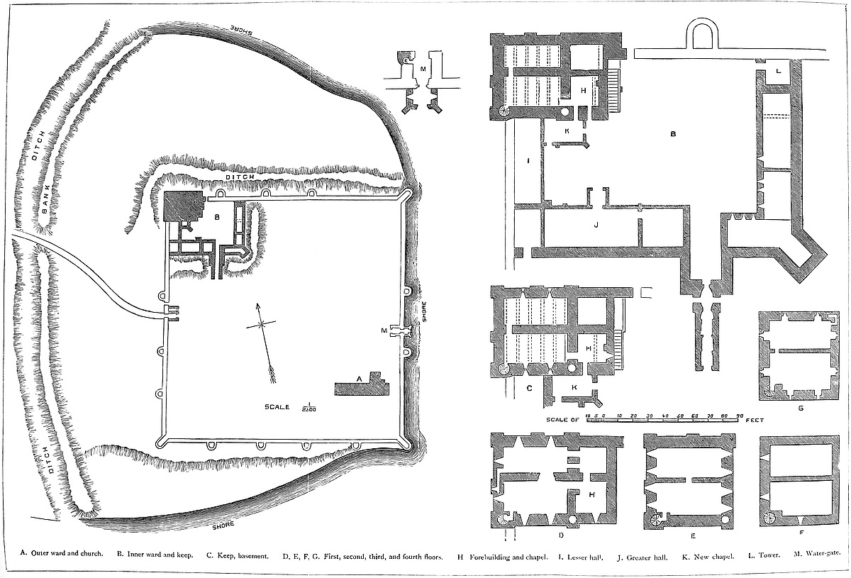
In its present and tolerably perfect condition, Porchester is a 389walled enclosure, square or nearly so, containing within its area close upon 9 acres. The investing walls measure, by the larger Ordnance survey, 210 yards north and south, and 207 yards east and west. They range from 15 feet to 40 feet high, and from 6 feet to 10 feet thick. They were supported outside by four mural bastions on each face, and one at each angle, in all twenty, of which six have at various times been removed, two from the east, one from the north and from the west, and two from the north-west and south-east angles. Those bastions which remain are half-round, 19 feet to 20 feet in diameter, and have slightly prolonged and flattened sides. The angle bastions are of the same pattern. That to the north-west was removed to make way for the keep; that to the south-east has fallen, undermined by the sea. The two remaining are open at the gorge, as are the two upon the east front. The rest are closed, and probably all were originally so, for the interior work is very rough indeed, and seems intended to have been concealed with earth and rubbish, as was often the fashion in Roman bastions. Probably some of those now open have been cleared out by the Norman architect, to make use of the interior, but the gorge wall of one of those to the south has recently given way, and the interior is seen rough as the Roman builders left it. These bastions at present, with one exception, rise no higher than the curtain, no doubt their original condition, but it seems probable that the Normans raised a story upon them, and thus converted them into mural towers. They stand from 41 yards to 42 yards apart, from centre to centre, the distances being slightly unequal. On the west face the two bastions flanking the gate are 48 yards asunder.
The walls are built mainly of flint nodules, laid in courses with as thick or even thicker, beds of mortar. Occasionally are seen single and double flat courses of red tiles and tile-stone, and sometimes of herring-bone work, characteristic peculiarities, especially strongly marked in the bastions. The work seems late in the Roman period. The walls have been patched with Caen stone, and by later builders with coursed flint, and more recently with brick. Here and there the parapet may be Norman, but this can scarcely be the case with much of it, which must have been frequently renewed. The two missing bastions to the east, to judge by the patching up, were probably gone when the Normans took possession. One on the west face was evidently standing in the Perpendicular period; that at the south-east angle fell but a few years ago. There is still an east and west, a water and a land gateway, nor do there appear to have been more in the Roman period.
The east face is washed by the sea, here a good defence, because too shallow for boats, and too deep for land operations. On this face the curtain is especially high, reaching 40 feet, and at the base of its parapet is a row of small holes, as though to carry a timber gallery or brétasche, no doubt a post-Norman addition. Between the south face and the sea there intervenes a triangular strip of flat land, at its widest end 60 yards broad. To command this, and390 protect the foot of the wall, a berm or platform of earth has been thrown up against the wall, about 6 feet high and 24 feet broad, in front of which is a light ditch, prolonged westward to the advanced ditch to check any approach round the angle of the place. The curtain here is about 30 feet high.
On the north front the margin of land is much broader, and is cut off by a deep and broad ditch communicating with the sea, and which turns the north-west angle, and extends along the west or main front nearly as far as the great gate; it would seem that originally this ditch covered the whole front, and extended onward to the sea, but the drawbridge of the gate has been replaced by a causeway, and the further traces of the ditch are but faint, as it has been filled up south of the causeway with some care.
In addition to these special defences the whole work is covered by a deep ditch with a high interior bank of earth, which has been cut from sea to sea right across the tongue on which the castle stands. This is about 300 yards in length, and from 50 yards to 100 yards to the west of or in advance of the west front, forming a broken curve with its salient near the centre. In outline it is rude, and as it bears no trace of masonry was probably stockaded. The notch for the entrance is placed considerably to the north of the main gate, so that the approach was oblique and exposed to be enfiladed from the castle. This work looks rather like an English addition before the arrival of the Normans. There is no trace of any rectangular camp or earthwork of earlier date than the walls. They are built upon the natural ground, and there is little or no difference between the interior and exterior level. In what condition the Romans left, or their successors found, the works which have thus been described, is not known. So convenient an enclosure, so well posted, could scarcely have been neglected by any people. In Domesday, “Porcestre” is a manor, and is the subject of a long and rather detailed entry. Mention is made of a “halla,” or mansion-house, or hall, but none of the castle. It had possibly been disused as a fortress, though probably then and long before a parish, with a church within its girth.
The Normans were for a time content with the existing wall; for it was not till about 1133 that Henry I. here founded a priory for Augustine canons, and built the small and plain, but very complete, Church of St. Mary, which was also the parish church, and most of which remains uninjured. Probably a little before this, judging from the internal evidence of the buildings, he proceeded to convert the Roman into a Norman fortress. This was effected by placing a rectangular keep at the north-west angle, about 10 feet in advance of the line of wall, removing for this purpose about 60 feet of the adjacent curtain on each face, and the capping bastion of the angle. The projection of the keep is mainly inwards. It seems to rest upon the natural soil, at that corner slightly elevated. It has been thought to stand upon an artificial knoll, but more probably its base has been banked round by the earth removed from the ditch, which391 is here both deep and broad. The keep required defence from the large interior court, as well as from the field. To afford this, and also to divide the castle from the church, Henry further enclosed a base-court, of about 67 yards east and west, by 47 yards north and south, or about one-fourteenth of the whole area, in which detached space the keep stood, and of which the great curtain formed the north and west sides. The entrance was in the south face, near the south-east angle, and this inner wall was covered by a wet ditch, fed by a culvert in the north curtain from the exterior tidal ditch, and which completed the isolation of the inner from the outer ward.
The church was placed in the south-east corner of the outer ward, diagonally opposite to the new ward, to which its enclosure corresponded. The conventual buildings stood against the church on the south side, and extended to the Roman curtain, which bears marks of Norman alteration. At Caister, in Norfolk, where the parish church stands within a similar enclosure, it occupies the south-west angle. The wall which, it is probable, cut off the monastery from the rest of the outer ward, is gone. The western or landward gatehouse of the outer ward was remodelled after the Norman fashion, but the eastern or water gate was left unaltered.
The keep answers to the usual conditions of such structures. It measures at its exterior base 65 feet north and south, by 52 feet east and west; and was, as originally built, about 55 feet, and as completed, 100 feet high. On its west front three broad pilaster strips, of slight projection, rise from the ground, independently of the plinth, to rather above half the present height of the tower. On the north front the arrangement is the same, save that the lower half of the pilaster to the east is united with the wall of the forebuilding that covered the entrance to the keep, on the east face. The south face has only two pilasters, that in the centre being omitted. The east face is again different; here the basement is covered by the forebuilding, and there is but one pilaster, at the north end. These pilasters in the north, west, and south faces, rise plain to the second-floor level, where both wall and pilasters are reduced by a set-off. The wall is not again reduced, but the pilasters have two or three rapid sets-off before they die into the wall. Near that was the base level of the original parapet. The angles are solid,—that is, without nooks. The two pilasters covering the south-west angle have a slightly bolder projection than the rest, and contain a well-stair, the head of which opens in a low turret. There are no turrets nor trace of them at the other three angles. They were the natural finish of the pilasters covering the angles, and as these are not carried to the summit it is possible that the usual turrets were also omitted. The present battlement is probably in substance of Decorated date. The north and south parapets are horizontal, but those to the east and west rise to the centre so as to form a very low-pitched gable, a very unusual outline in such a building, and for which there is nothing in the arrangement of the roof to account. The exterior of the keep is very free from ornament. The only exception is a string-392course about 12 feet above the base on the west wall, which has on its under side a billet moulding of great delicacy. This string is confined to this face, and to the wall, being stopped by the pilasters.
The material of the keep, inside and out, is chiefly of Caen stone ashlar for facing, with hearting of chalk flints. The stones are from 4 inches to 6 inches square on the face; high up they are perhaps a little larger, but there is little difference between the original work and the additions. The stones of the parapet are still larger, and seem, from the accounts, to have come from the Isle of Wight.
The walls at the base average about 11 feet thick, and at the first floor about 7 feet. At the summit they are about 6 feet, the reduction in thickness being thus unusually small. The interior is divided throughout by a cross wall running east and west, from 5 feet to 3 feet 6 inches thick. It has a basement and four floors. The entrance was in the first floor, and a spiral stair, the only one, occupied the south-west angle and rose from the first floor, and it may be from the base, to the battlements, communicating with, probably, each floor, by doors, of which all but one are walled up. In the south-east angle was the pipe of the well, with similar communications. The floors throughout were of timber, the beams resting in holes in the wall. The interior sets-off, reducing the thickness of the wall, are irregular.
The two basement chambers are not quite equal, the southern being the larger. They are about 12 feet high, each has a loop in its west end and two in the north and south walls, six in all; these are of 6 inches opening, round-headed, and placed in splays of an hour-glass section, having recesses inside and out of 2 feet opening. The door to the well-pipe is visible, though blocked, but that to the stair seems to have been closed and obliterated. Each of these chambers is vaulted with a low-pointed barrel, running east and west, and stiffened by six very deep slender ribs, with hollow chamfers. These have been cut away from the vault, but the gable ribs remain attached to the wall, and sections of the others are seen at their springings. This work looks early Perpendicular, or, perhaps, a little earlier. It is excellent, and much too good for a cellar, though no doubt intended specially for the custody of the royal prisage wines, which formed a part of the revenue, and were often stored here. There is a door between the vaults, near the west end of the cross-wall, and an outer door in the east wall of the south vault, which latter was probably opened when the vaults were turned, and the spiral stair closed. This, however, may be an original door opening from the basement into a dungeon in the base of the forebuilding, or it may have been connected with an outer door in the forebuilding itself. It is difficult to be sure on this point.
The first floor is also of two chambers, 43 feet long, and 21 feet and 18 feet 6 inches broad. These floors contain the two state-rooms, which, to the timber ceiling, were 24 feet high. In the north and south walls are, in each two windows, round-headed, of 2 feet393 opening, of hour-glass section, with splays of 3 feet opening outside, and 5 feet inside. The sill of the recess is 4 feet above the floor, and the recess 12 feet high. Its angles are occupied by a bold bead or engaged shaft, with bases and foliated caps, whence the bead is carried round the head. Besides these four windows, in each west end is another, of the same character, but with recesses 20 feet high, and without beaded angles. The two south windows were probably walled up when the exterior smaller hall was added, and light ceased to be an object in the keep. In the north chamber the west window is also closed. The doors to the well-shaft and the stair have been closed in modern times. In the cross wall is a large modern breach. The old door was near the west end; also, in the south-west angle of the north room, a door opened into a small garderobe in the west wall. This is partially bricked up, but the loop is seen in the central pilaster, outside. The main entrance of the castle is on this floor, in the east wall of the south chamber. It is round-headed, of 4 feet 6 inches opening, perfectly plain, without chamfer or rebate, which, no doubt, has been cut off. It is evidently original. There are two doors in the east wall of the north chamber, but they are modern openings.
The second floor, 13 feet high, was the attic of the original building, and a mere series of lofts. The roof was very singular. Over the cross wall was a central ridge, and over the middle of each chamber a valley or gutter, from which the roofs rose to the outer walls. As a lean-to, there was, therefore, in the cross section, a central triangle divided by the cross wall, and on each side a half-triangle, formed by the outer wall; and in each of the four half gables thus formed in the east and west walls was a small round-headed window, eight in all. The windows remain, as does the stone weather-table, by which the section of the early roof is indicated. The roofs were steep, and, therefore, no use could be made of them as a platform for machines of defence or for storing missiles. In the cross wall, here 3 feet thick, is a tall, very plain, round-headed door, of 2 feet 6 inches opening, communicating between the halves of the division of the central roof. The south loft was reached by the well-stair, but how the three northern lofts were reached does not appear. In the north chamber, under the southernmost of the two east windows, are traces of a door, which no doubt led to the battlements of the forebuilding, covering the main door, as seen at Scarborough and Richmond, and elsewhere. The arrangement of the original roof resembles that of Helmsley, a very late keep, which also has been raised.
Soon after the completion of this roof, and within the Norman period, it was decided to raise the keep two stages, by which means the roof attics were converted into a regular second floor. Something of this kind was done at Richmond and at Bridgenorth.
The third floor, then built, is 18 feet high. It is quite plain, without an opening in the cross wall, and with one small window in each west wall. How the north chamber was entered is not known.394 The present floor is from 3 feet to 4 feet above the original one. The next is the fourth or upper floor, about 15 feet high, with a cross wall 3 feet 6 inches thick, of rough rubble, while the outer walls are of ashlar on both faces. The south chamber has four windows; those in the south wall of two lights, flat-headed, but under a full-centred arch of relief outside, and within placed in a recess, also full-centred, of 5 feet 6 inches opening. All these are quite plain. There is a similar window in the east end. The west end window is of similar pattern, but with a single light; and of the north chamber, two windows in the north side and one in each end are also of one light. In the east wall of this chamber a small door opens by an L-shaped mural passage turning the north-east angle into a garderobe, having a loop in the east wall, and a vent opening directly outwards on the face of the north wall. At Brougham is a similar arrangement for an oratory. In the south jamb of the west window of the south room a small oven has been excavated. As this could not be reached from the old floor level, it is probably very modern. Whether the well-pipe is brought up through the new work does not appear, nor is there any trace of an original opening from the turnpike stair, though probably there was one. The door in the cross-wall, of 4 feet 6 inches opening and full-centred, is placed near the west end. This has a rebate, so that the door opened into the north chamber, and was bolted on that side.
The original roof of the Norman addition was flat, as shown by a bold weather-table carried round the walls; but the actual present roof is exactly the reverse of that described below, there being a central and two side gutters, and a ridge over the centre of each chamber, an equally impracticable roof for a defensive platform. The flat or nearly flat roof much resembled that now upon the White Tower, London. The parapet can be examined from the top. The embrasures are at long intervals, and 4 feet 6 inches deep by 2 feet 3 inches opening. No traces of angle turrets are seen save at the stair-head, and that is but a small affair. No fireplace has been discovered in the keep, and only two mural chambers, both very small, for garderobes. The absence of ornament or of any very well marked state room with mural closets, is probably due to the construction at the same time with the keep of more convenient domestic buildings in the inner ward.
The forebuilding was part of the original design of the keep, of the lower part of which it is a prolongation, of the same breadth, and 25 feet deep, eastward. Its walls, as thick as those of the keep, also contained two chambers, divided by a cross wall, east and west. The northern chamber is now filled up, and possibly always was so. The southern chamber seems originally to have had no outlet, and if used as a dungeon or cellar, it was probably reached by a trap in the timber floor.
The first floor of this structure, at the level of the same floor of the keep, was divided also into two chambers, between which was a passage, which led from an outer stair to the door of the keep. The395 north chamber has been defiled by use as a dust-house and garderobe for modern prisoners in the keep; but an elegant oriel window in the late Perpendicular style inserted into its north wall shows that it has been a room of some pretension. The south chamber was the chapel of the keep. In its west wall, the wall of the keep, is a large full-centred recess, about 11 feet broad and 2 feet deep, for a seat, and in the south wall remains half a Norman window, which originally opened into the inner ward.
The original roof of the forebuilding had rather a high pitch, of which, over the chapel, the weather-table remains. This was superseded by a higher roof, but at a very low pitch, suitable for lead. The top of both roofs reached nearly to the level of the floor of the second story of the keep. The battlements of this accessory tower were 15 feet to 20 feet below those of the original keep. The approach to the first floor of the forebuilding was by an exterior staircase of twenty-six steps, placed against its east wall, so as to reach the outer door about the centre of the building, and leading on also to the north curtain. The present staircase is modern, but a careful examination will show Norman remains about its base. It would seem that when the keep was raised it was decided to make a door in the south wall of the forebuilding into the space below the chapel. When this was done the wall was thickened on the outside. The door still remains, but opens no longer into the open court, but into the basement of a later building. Part of the added facing has fallen off, and the old wall is seen, with a billeted string corresponding to that upon the keep. In later times a Perpendicular window has been opened in the chapel wall above, and a second Perpendicular door into the space below. This is the door which has over it the arms of Queen Elizabeth in stone, and which was probably made by some earlier monarch to admit the wine-tuns into the vaults of the keep.
The inner ward is still bounded to the east and south by the original Norman wall of Caen stone, 6 feet thick. The original domestic buildings were ranged along the south side to the west of the entrance, as traces of the original walling still show. At the south-eastern angle was a large rectangular tower, of 23 feet breadth by 25 feet projection, placed diagonally,—not a usual Norman arrangement. The walls are 6 feet thick, and the gorge is open. It was of two stages, the basement being one, had timber floors, and was, no doubt, like the middle gatehouse of the Tower of London, boarded in the rear. The two exterior angles are hollow, or nooked, though without shafts. The upper floor was lighted by three narrow, round-headed loops.
Whatever may have been, in Norman times, the extent of the offices, at present these buildings cover three sides of the court, that to the north being open. Near the centre of the court was a well, and in the north wall, close to the steps of the keep, a small postern; at the north-east angle, partly on the two curtains, is a rectangular tower of great strength, about 26 feet by 30 feet, with walls396 6 feet thick. Its basement seems to have been used as the great kitchen, though not originally constructed for that purpose. The upper floor is on the level of, and entered from, the north curtain; its north and east walls are pierced by a mural gallery, 3 feet broad, with two loops to the north and three to the east. There is also on that side a door opening on the main curtain. From this floor a well-stair, near the north-west corner, ascends to the battlements. The base of this tower seems Norman, but the upper floor and battlements are early Perpendicular.
Of the domestic buildings there is built against the keep and the west curtain the smaller hall, 18 feet broad by 30 feet long, one end abutting on the keep, the other on a retiring-room common to it with the great hall. It is of two floors, the lower on the ground level, having a handsome door and windows. The hall, with a timber floor and roof, occupies the upper floor. The fireplace is in the middle of the west side, let into the Roman curtain, which has been raised. In the east side are four windows looking into the ward, each of two lights divided by a transom, with cinquefoil heads.
Set against the keep, and also abutting on this hall, is a building of two floors, the uppermost of which seems to have been a chapel, superseding that of the keep with which it communicated. It has an east window flanked by two diagonal buttresses. Opposite to this, against the curtain, is the great hall. This is 67 feet long by 28 feet broad, also of two floors, the basement having been probably a cellar. In its north wall are arches as for a buttery, and some remains of the original Norman walling, probably of an earlier hall. In the north side are four windows, three to the west and one to the east of the great door, in front of which is a handsome Perpendicular porch with vaulted roof, and steps leading up to the hall. From the porch a well-stair and short gallery led to the music-gallery at the east end of the hall, and at this end also, in the south wall, is the great fireplace. If this was the daïs end, the gallery must have been above it,—not a usual arrangement. The hall had a wooden floor and a low-pitched roof. The porch seems later than the hall. East of the hall are other smaller rooms, abutting against the wall which flanks the entrance-gate. Beyond this gateway the remainder of the south wall, and the whole of the east wall to the kitchen tower, are occupied by buildings of Tudor date,—mere shells, probably servants’ lodgings, butteries, and rooms connected with the kitchen department. It is said there were buildings against the north curtain, but of such there is now no trace.
How the ramparts of the west, south, and east walls of this ward were reached is uncertain. There is no way to them from the keep or from the kitchen tower. The north curtain is reached by a short stair from the forebuilding. This curtain is here 10 feet thick, and has a rampart walk 6 feet high, with a high parapet and rere-wall. One of the old Roman bastions occurs on this part of the curtain. It is solid below, and has been raised to contain a small chamber, the floor of which is a little below the rampart level, from397 which a door opens into it. There is also a good west window of two lights, cinquefoiled, opening on the rampart walk, and a small fireplace; altogether far too comfortable a post for any officer on duty. East of this bastion the hollow angle between it and the curtain is crossed by an oblique arch or squinch, of two rings of voussoirs of excellent Decorated work, which supports a small garderobe, such as is seen on Southampton walls and at Ludlow.
There remains to be described the gatehouse, or entrance to this inner ward,—a very curious structure, of unusual length, and of three periods. First, approaching from the outside are two parallel walls, 5 feet thick and 9 feet apart, from within the ends of which hung the drawbridge, apparently without any special arch or gateway. In one wall is a squint loop, commanding the approach from the great gateway of the outer ward. From the drawbridge a passage, at first of 9 feet, and then of 10 feet in width, and 15 feet long, ends in a portcullis and gateway, the whole 2 feet deep and 9 feet of opening. Beyond this the passage continues 10 feet broad for 17 feet. So far, the road was either open or roofed with timber, and all is of Perpendicular date.
Next follows a remarkably fine archway of the Decorated period, deeply moulded and portcullised, with a rebate for a door. This leads into a sort of peristyle, 8 feet deep, vaulted and groined, with ribs and bosses, and ending in a second and rather lower portal. In this peristyle are two lateral doorways, of 3 feet broad, opening upon the scarp of the ditch between it and the curtain wall, just as at Hawarden, only there they open from a chamber on the counterscarp. The arch in which the peristyle ends is rebated for a door, but has no portcullis grooves. The Decorated work here ends, the portal being seen to mask the original Norman entrance. This is a perfect, plain, square-jambed Norman entrance archway, placed in the front and centre of the original gatehouse, which was a plain rectangular tower of 23 feet projection from the curtain, and 28 feet broad. Entering, the way lies between two lofty walls, 19 feet apart, and which for 22 feet are those of the old Norman gatehouse, with two lateral loops raking the curtain. There was a timber floor above this passage. The walls are then continued 28 feet further, on the left being the rooms attached to the great hall, on the right those of Tudor date. Thus the entrance to this ward is about 100 feet long, defended by a drawbridge, a portcullis, and two sets of gates.
The two gatehouses of the outer ward next require attention. The water-gate is, in substance, Roman. The gatehouse is 26 feet square, with walls 6 feet thick, having no projection outside the curtain. All is perfectly plain, without buttress, chamfered edge, or moulding. The way lies through two doorways, opposite each other, of 8 feet 6 inches opening. The inner arch is built of white limestone, with a few blocks of blood-red iron sandstone. The voussoirs are heavy, and a single ring. The walls generally are of coursed flint rubble, very open jointed. In the Decorated period a sort of porch, of 20 feet projection by 12 feet in breadth, was added upon the outer398 face, in the centre of which is an outer gateway, portcullised, and flanked by a pair of buttresses, placed diagonally. Over the gate is a small window, and in the side walls two loops raking the curtain. The old Roman doorway in the line of the curtain has also been altered and refaced in the Decorated period, and a rebate added for a door. The roof was of timber, and there was an upper floor, no doubt an addition. This was reached by a well-stair in the south-west angle, rebuilt for the purpose, and entered by an interior door.
A study of the water-gate will throw much light upon what has been done at the land-gate, which was evidently built originally upon the same pattern. Here the Roman work was either pulled down and rebuilt of the same dimensions, or, which seems more probable, the Roman core has been preserved, and a Norman facing applied. The inner gate is perfectly plain, save that the arch springs from a simple Norman abacus, which is continued outside the wall as a string. The outer gateway has not even the abacus; but it is masked outside by a handsome Decorated portal, with a drop arch and good moulded jambs, and an exterior drip. There is no portcullis, and no middle gate. The space between the gates, a square of 14 feet, was vaulted over from four heavy corbels in the angles, from each of which sprang five ribs, two placed against the walls. There was a plain but hollow chamfer, and they met in a central open circle, and four half circles against the four walls, connected by four ridge-ribs. The whole is of late Decorated or early Perpendicular character.
Here, also, an upper floor has been added, and remains pretty perfect. The chamber is barrel-vaulted, the axis being east and west, and strengthened by seven plain chamfered ribs, of which the springings remain; but the bodies of the ribs, with the vault, are gone. The vault seems to have been pointed, and looks Perpendicular. This room had windows over the gateways. It was reached by a straight staircase, placed in a projection parallel to the north wall, on the north side, and vaulted over. The stair-head opened on the left into the upper chamber, and on the right upon the curtain. There is another door on the south side of the chamber opening on the opposite curtain. This gatehouse has a perfect and very handsome parapet, with merlons and embrasures of equal size, and a bold moulding is carried round each.
A few yards north of this gatehouse a small lancet doorway has been opened in the Roman curtain, probably as a postern. At present it is a mere rough hole; but it looks old, and had it been very modern it would have been lined with brick.
The structural history of the castle is tolerably plainly written upon its walls. Henry I., probably before 1133, seems to have built the keep, and inclosed the inner ward, repaired the Roman curtain, rebuilt or restored the gatehouse, and placed a hall and other domestic buildings along the south side of the inner ward. It may be that Henry himself raised the keep before the works were completed, or this may have been done by Henry II., as late as 1160.
399
In the Winchester volume of the “Journal of the Archæological Institute” is a paper by Mr. Hartshorne upon Porchester, which gives some curious particulars as to its government and repairs. From these it appears that in 1220 the roof of the keep was out of order, as the constable has four carratas of lead for its covering. This shows that the roof then upon it was the flat one indicated by the weather moulding. Henry III., who obtained in his second, third, and fourteenth years upwards of £10 for tallages from the town or manor of Porchester, suffered the castle to fall into decay, and the return of a survey ordered by Edward I. in 1274 states that the buildings within the castle are old, out of repair, and unfit for habitation. A second report was made twenty years later, after a visit from Edward in person, and repairs were at once ordered, which were very extensive, and were continued through much of the reign of Edward II. Mr. Hartshorne gives an analysis of an account of the clerk of the works here in 1321.
After the receipts, which in this year were £55. 0s. 0½d., the particulars of the expenditure are given in detail. First, the cost of the materials, then the wages of the people employed, the foundation-diggers or “fundatores,” the masons or “cementarii,” at 4d. a day; their labourers or “servientes”; the collectors of stones, “colligentes lapidum,” most of which were picked up on the beach, at 6d. a day; throwers of sand, “jactantes zabulonis,” at 2d.; carpenters, “carpentarii”; sawyers, “sarratores,” at 4d.; fallers, “prostratores”; bark peelers or “scapulatores,” at 3½d.; tilers, “latamores”; plumbers, “plumbatores”; smiths, “fabri”; labourers, “laboratores,” &c. A new lock and key for the east gate cost 4d. William Giles, the tyler, had 4d. a day, and Robert, his boy, 3d., while covering the chamber of Edward II. Two large hawsers, for lifting timber and stone to the top of the tower, cost 43s. 8d.; thirty-two weldichboarde boards were purchased at Havante for 4d. each. Thomas le Piper supplied 157 stones at 10s., and their carriage from the Isle of Wight cost 6d. They were employed for the foundation of the bridge under the castle: probably that in front of the west gate. Peter de Pulford, as clerk and overlooker, had 12d. a day. These works would be all in the Decorated style, varying in detail as the style advanced. The work at the top of the keep was probably the present parapet.
About 12 Edward III. the repairs were resumed. The Queen’s and Knighton’s chambers were repaired. A “fausse wall” was ordered to be built, and a barbican with a brétasche and barriers: works evidently of timber, and probably in advance of the west gate.
Richard II. resumed the works, and about 1396–7, just as the Decorated style was passing into the Perpendicular, seems to have pushed them forward with great activity. Mr. Hartshorne points out that the castle was supplied with stone from Bonchurch and South-Wick, with freestone from Bereston for doors, windows, and fireplaces; and with flint-stone and “rag-platen-stone” from Binnerbeg,400 also in the island. Besides these were wainscot boards, Botineholt boards, for doors and windows, hearth tiles or “hurthtighel,” Flemish tiles from Billingsgate, and “reretighel” or fire-bricks, for the backs of fireplaces. This accounts for the early Perpendicular work found all over the castle. Probably that in the Tudor style was executed in the reign of Elizabeth, who seems to have given her name to the kitchen tower, probably in consequence of alterations made in it.
The works in modern brick were executed during the present and past centuries, when the Crown held the castle on lease, and fitted it up as a prison; building barracks, now removed, in the great court. As early as 1761 there were Spanish and French prisoners of war here; in that year, it is said, 4,000. The Dutch prisoners taken at Camperdown were stowed here, and many French taken in war. It is said that at one time as many as 8,000 were lodged here. The castle has long been the property of the Thistlethwayte family. A couple of hundred pounds judiciously laid out on the keep would close its breaches, restore the old doorways and stairs, and replace the floors at their proper level. Some such moderate outlay would also do much to improve the inner ward.
The history of Porchester is but scanty. Until comparatively modern times it was always in the hands of the Crown, and commanded by constables, whose names occur from time to time in the public records. King John, the most restless of monarchs, was here eighteen times between 1200 and 1214, in all for fifty-two days. Much mention is made of wine stored here; at one time there were thirty tuns. In 1205 the king sent an engineer and sixteen miners to stay here for twenty days, and the constable was to find twenty picked men to aid them. Also Stephen English, an artificer, was sent. This might be to dig the well in the inner ward; the keep well must have been dug when or before the keep was founded. Sheep are sent for the garrison, sixty at a time, and petraria and mangonels, and other military stores. The tenants who held by castle guard were warned. To the castle was attached a large demesne, and a forest, under the charge of the constable, the income from which was considerable.
Edward I. seems to have been here two or three times, and Edward II. more frequently, staying here for several days in 1324–5–6. Edward III. mustered his army here before his French wars, and kept up a strong garrison and good supplies of wheat and barley, and wine.
THE site of Richard’s Castle, a well-known and very ancient fortress in the county of Hereford, but near to Ludlow and the borders of Shropshire, is distinguished by one of those remarkable works in earth which have hitherto, in topographical books, passed undescribed, or described only in such general terms as afford no aid to any sound inference as to the people or the period by whom or at which they were thrown up. And yet, if there were correct plans and precise descriptions of the earthworks of this country, it is probable that some sound general conclusions as to their origin would be arrived at. Many, probably most, are no doubt pre-historic, but still something of their history may, it is probable, be established by a careful consideration of the evidence which they themselves afford.
Richard’s Castle is one of a series of works common on the Welsh border and the Middle Marshes. Such were Hereford and Worcester, in modern times despoiled of their mounds: Shrewsbury, still towering above the deep and rapid Severn: Tre-Faldwin or Montgomery, a single instance of a town and county bearing the name of the invader: Kilpeck and Ewias-Harold, already described: Builth, the extreme limit westward held for any time by the English: Cardiff, Caerleon, Wigmore, and Richard’s Castle.
Richard’s Castle, fortress and parish, takes name from a certain Richard Fitz-Scrob, one of the Normans attached to the court of the Confessor, and who was quartered by that prince upon probably the most exposed district upon the Welsh frontier; a position commanding some of the richest and most regretted of the lands conquered by the English, and sure to be assailed frequently and in force.
What invader originally threw up the magnificent earthwork which must have guided Fitz-Scrob in his choice of a residence, is not known, but from its summit is comprehended one of the noblest and most extensive prospects to be found even in a quarter of England very rich in pleasing combinations of wood and water, lofty hills and broad and fertile dales. As the new settler traversed the meads of the Severn, and left behind him the grassy meadows of the Team and the Lugg, and rode up the rising ground to the point where his own or his son’s devotion afterwards established a church, he must have blessed the fate that placed him amidst a country so rich, and in the possession of which the vast earthwork immediately before him would be an assurance of more than ordinary security.
The advent of Fitz-Scrob must have been viewed with profound dislike from opposite quarters. In those days, on the very402 eve of the coming in of William, Gruffydd, the Welsh Prince, well knew how formidable a neighbour was a Norman knight; and the English, who were aware what engines of local tyranny were the Norman castles, could not but have regarded with dismay the lofty walls and towers, which made impregnable a place already strong, and converted a well-known burh into a castle such as they had heard of with dread but had not before seen.
What were the precise works constructed by Richard it is difficult to say. That he converted the mound into his keep, and girt the annexed ward with a wall is possible, though the masonry, of which vast fragments still remain, is apparently of rather a later date. There is no reason to suppose that he built a rectangular keep. There was already a mound. His keep would be on its summit, and, if masonry were employed in its construction, it must have been a shell or low tower at most of 30 feet or 35 feet diameter, such as is seen on the mound of Cardiff.
The first danger to the new lord came from Earl Godwin and his sons, who represented the English, and therefore the anti-Norman feeling. One of the avowed grievances for the redress of which they met in arms at Beverston, in 1052, was the presence of Richard Fitz-Scrob upon English soil. That they failed, and that their failure led to the temporary exile of Earl Godwin is a matter of history. Richard remained unmolested, and, doubtless, employed himself in adding to his castle that strength which it could scarcely have in excess. It is not stated that he shared in the campaign and ignominious defeat of Earl Ralf the Timid against Prince Gruffydd, but probably he did so.
In 1056, Harold, then Earl of the West Saxons, entered the Marches against the Welsh, and advanced into Archerfield, where his probable godson, Harold, the son of Ralph, held the Castle of Ewias-Harold, the earthworks of which were constructed on the type of those of Richard’s Castle, and which, a few years later, was to receive additions in masonry after the same pattern. Whether Richard was in alliance with Earl Harold or Harold of Ewias is not known, but the position of his castle would scarcely allow him to be neuter.
In 1062, Gruffydd was again over the Herefordshire border, and Harold, then holding the Earldom of Hereford, was again at his post, and the Lord of Ewias joined him. This was followed by the larger expedition, in which Harold invaded Wales by sea from Bristol, conjointly with his brother Tostig from Northumberland. They met at Rhuddlan, and soon after the Welsh Prince was massacred by his own people. During these turbulent years the whole border must have been in constant turmoil, and we may fairly suppose that Richard, to whom both parties were in substance opposed, must have fortified his castle by every means then in use.
The arrival of the Conqueror relieved Richard from his most formidable foe, the English people directed by an English leader. 403He and his son Osbert shared in the ascendancy of their race, and received from William large grants in Herefordshire and elsewhere which are duly recorded in Domesday.
The castle of Richard’s Castle occupies a position equally remarkable for beauty and for strength. It stands upon the eastern slope of the Vinnall Hill, an elevated ridge which extends hither from Ludlow, and a little to the west of the castle is cleft by two deep parallel gorges, beyond which the high ground reappears in two diverging ridges, of which one extends westward in the direction of Wigmore and the other more southerly to the river Lugg, at Mortimer’s Cross, having on its ridge the ancient British earthwork of Croft Ambrey, and below it the fortress of Croft Castle, reported to occupy an early English site. By this means, Richard’s Castle is protected from the Welsh side by a double defence of hill and valley, besides its more immediate and special works.
The castle, though far below the summit of the Vinnall, stands upon very high ground, sloping rapidly towards the east. An exceedingly deep and wide gorge descending from the west bounds the position on the south, while a smaller and tributary valley, descending from the north, falls into the greater valley below the castle, and thus completes its strength upon the north, west, and south points. The defence towards the east is wholly artificial.
Upon the point of the high land, above the meeting of the two valleys, a large and lofty mound has been piled up, the base of which is about 300 feet above the valley, and the summit 60 feet higher, that being its proper height. It is about 30 feet in diameter at the top, and the sides are very steep. It seems wholly artificial, and stands in its own very deep ditch, beyond which is a high bank. On the west side, this ditch is succeeded by the steep natural slope descending to the river, but towards the east the ditch seems to have been reinforced by a second, which encloses a larger area, more or less semilunar in shape, and which has a bank within and upon the scarp of the outer ditch, which is here artificial, and cuts off the fortress from the adjacent high ground now occupied as the churchyard.
These were the defences of the original fortress, and, as was almost invariably the case when the Normans converted such an earthwork into a castle, a round tower or shell was constructed upon the summit of the mound, constituting the keep. From this, on the north-east and south-west sides, a strong and lofty curtain wall descended the slope, and on reaching the edge of the ditch was bent eastward, and curved round so as to include the whole intrenched area south-east of the mound, and half the mound itself, of which the other or western half, strong in its great natural strength, augmented by its ditch, was left without any exterior or second line of defence in masonry. The domestic buildings stood in this base court or lower ward, the keep only being occupied during a siege, or under exceptional circumstances. The entrance was by an arch in the curtain on the south side. Thus, as at Shrewsbury, Berkhamp404stead, and Tamworth, and indeed very generally, the mound and keep stood on the general enceinte of the fortress, forming a part of its outer defence. The lower ward was accessible to wheeled carriages, but the keep could only be ascended by steps. At this time the summit of the mound is covered with débris and rubbish, upon which young timber trees and underwood have made vigorous growth, and the enclosure, naturally inaccessible, is strictly preserved. The curtain descending the slope on the north-east is tolerably perfect, as is the adjacent part along the north-west front of the lower ward. Farther on, the wall seems to have been lifted with gunpowder, and a vast fragment lies in the ditch. Beyond this the foundations here and there appear; the wall itself remains skirting the scarp of the ditch along the east and south fronts, and towards the latter side is the place where the arch of entrance pierced the wall, as shown by the gap in the masonry and the passage through the bank. Just beyond this the curtain ascends the mound and abutted on the keep tower, completing the circle of the defences in masonry.
From the density and offensive character of the vegetation it is difficult to get a good general view of the place or to follow its details, but the fragments of masonry lie about generally, and, if cleared of nettles and the thin upper soil removed, no doubt a correct plan of this most interesting place could be obtained, and the date of the masonry ascertained with some degree of certainty. The masonry above ground is probably Norman, but all the ashlar has disappeared. The great interest of the place is due to its very remarkable earthworks, and to the fact that it was occupied and fortified by a Norman master before the Conquest.
The adjacent church is a large and rather fine building in the Decorated style. It stands but a very few yards outside the castle ditch, up to which its burial-ground extends. It is remarkable in having a large square belfry tower, detached, and placed a few yards south-east of the chancel.
ROCHESTER—Fortress, Cathedral, and City—is a very remarkable place—in some respects the most remarkable place in the South of England. In each of its triple capacities it claims a high antiquity. Its ecclesiastical history commences with Augustin and Æthelbyrht, the founders of its see, over which Justus, the friend of Augustin, was the first to preside, and to the endowments of which a long succession of Kentish and Mercian princes contributed. Its secular history, though often obscure, ascends to a yet more remote period, and its material evidences are still to be read in the form of works either in earth or masonry, showing Roman, Saxon, Danish, and Norman occupations.
Rochester is built upon a low cape or promontory formed by a grand bend of the Medway, the central part of which is occupied by the city, and the most prominent and northern point by the castle. The great Roman way from Canterbury to London traversed the length of the cape, and crossed the river near its apex, in the line of the ancient and nearly of the present bridge.
The position of the fortress is very noble. Rising from a base of hard ground high above the stream, it forms a grand feature upon the shore of the Medway, here 1,000 feet in breadth, and which almost vies with the Thames in the volume of its waters. From the turrets of the keep is seen outspread a view of great extent and exceeding variety, including the steep and verdant slopes of the chalk, and the broad and fertile meads across which the great river flows in graceful folds, concealed and betrayed by the inequalities of the hills and the scattered masses of forest trees. The cathedral, indeed, is scarcely worthy of these advantages. Far from asserting, as at Durham, Canterbury, or York, its equality with, or even superiority over, its temporal neighbour, the cathedral of Rochester, venerable as it is, and honoured as are the ashes that lie within its precincts, is of small dimensions, and in position low. The castle, on the other hand, is a masterpiece of Norman skill, and the first and last object that strikes the eye of the visitor.
The castle of Rochester occupies the northern termination of a chalk ridge which forms the right bank of the Medway for many miles above the city, and intervenes between the river and the cathedral, upon the margin of the one and but a short distance from the other. It thus covers about half of the western front of the city, and extends into what was the south-western angle of its walled enclosure.
Though of ancient date, the castle proper, that is the structure in masonry, has evidently been preceded by the works in earth, in close connection with a part of which it has been laid out. These are on406 a large scale, and, though much degraded by time and obscured by buildings and enclosures, are still tolerably apparent. They seem to have been composed of an oblong space included within a ditch, which commenced near the bridge foot, and was carried eastwards for about 130 yards, when it turned to the south, and ran for about 270 yards roughly parallel to the river, towards which it was again returned. This oblong area was subdivided into two unequal parts, the southern being the smaller, by a cross ditch, and the latter part was occupied by a large flat-topped conical mound, known as Boley Hill. The northern part contains the castle. Along the east or cathedral side, this ditch is in part a bold natural depression. Along the west side it is superseded by the river, here very broad, deep, and rapid. The area thus included is about 7¼ acres. The mound is of large size, though reduced by modern operations. It is in part natural, in part formed from the adjacent ditches. Like the mounds at York, Wallingford, and Wareham, and those formerly existing at Hereford, Buckingham, Worcester, Hertford, Nottingham, and Stamford, it is so placed as to watch the river, which must always have been an open and dangerous highway.
These lines of earthwork, though the principal and most evident now to be traced, are by no means the earliest among the defences of Rochester. Though the discovered Roman remains are not indicative of a large town, the Watling Street here crossed the Medway, and there was certainly a fortified post on the site of the mediæval city. Its rectangular form, about one-third longer than its breadth, the cruciform arrangement of its main streets, its four gates opposite to each other, and the termination of its name, all point to a Roman origin, and the Roman defences are thought to have been composed of a wall and ditch, represented by the line of the later wall, only that they are supposed to have passed from the south gate towards the river, about 45 yards west of the site of present keep.
The area measured about 470 yards by 160 yards, and therefore covered about 15½ acres, and of the gates Childegate stood to the north, and to the south was a gate removed only in 1770, the road between them passing close to the west end of the cathedral. Roman coins and sepulchres have been found in the castle area, and that Rochester was the Roman Durobrivis seems generally admitted.
The Roman lines were in part adopted by the later inhabitants, and fortified in the English manner. The position of the new city laid it open to frequent and severe attacks by both land and water, and its works suffered much from the inroads of the Danes, especially towards the close of the ninth century, and to that people, though perhaps on insufficient grounds, has been attributed the mound.
The earthwork fell into the hands of the Normans at the Conquest, and it became necessary to fortify the position according to the improved manner. The usual custom with the Normans, when dealing with an English stronghold, was to erect a shell keep upon the mound, or, where there was no mound, a rectangular tower, and to surround it with a strong curtain wall built upon the bank within407 the scarp of the existing ditch. Probably, in this case, the older area would have required too large a garrison for its defence, and the mound was at a rather inconvenient distance from the bridge or its preceding ferry. The mound, therefore, was excluded from the new enceinte, as it was at first from the area of the city. Probably it was occupied as an outwork, or it may have been reduced to a rather lower level. The new curtain was built on the scarp of the ditch of the northern division of the earthwork on the three landward sides. On the fourth it was placed upon the crest of a low cliff, about 40 feet above the river, and rather less above the quay, which has been widened in modern times, and in part added to the shore.
The Norman enceinte, the general substance of which is probably of the eleventh century, is roughly four-sided, about 130 yards east and west by 160 north and south, and includes about 4¼ acres. The eastern front is opposite to, and about 60 yards from, the cathedral. The south front faces the old mound of Boley Hill, and the north front, of rather greater length and set obliquely, points towards the bridge. It is probable that the ditch outside the south wall represents that of the Roman work. The gatehouse stood at the north-east angle, and the steep causeway leading up to it, and which has superseded the drawbridge, is known as the “Vennell.” The gatehouse is gone. At the north-west angle are the remains of a bastion tower, standing in 1735, and containing a postern. In it was a shaft for lifting stores from the river, an arrangement seen in another form above the Wye at Chepstow. This tower commanded the bridge. The south-east angle is still capped by a bold drum tower, of 30 feet diameter and three-quarters projection. It has a ground and upper floor, each pierced by an arcade with loops in narrow lancet recesses. The floor was of timber. The gorge is broken down, but may have been always open. This tower does not rise above the curtain, and seems to be an insertion in the early English period. Upon the east wall are two rectangular towers, one of 35 feet breadth and 25 feet length, wholly of exterior projection, and the other 30 feet by 25 feet, and partly within the wall. These seem insertions of the Perpendicular period. The curtain is much broken down, and part altogether removed; 40 feet of it remain next the south-east angle, on the south front. This portion is 7 feet thick, 30 feet high, and seems decided Norman. On its outer face are traces of two flat pilasters. It is pierced by three loops with splayed round-headed recesses, 3 feet broad and 8 feet from the ground, inside. There must, therefore, have been a platform against the wall. From the same angle, along the east face, the curtain is tolerably perfect all along. Near the rectangular tower it is seen to be built upon arches, intended to be covered up, as in the walls of York and of Southampton Castle. The top of one arch is seen inside the wall, and the whole of two arches outside. A long piece of the north wall remains, and is a good example of early masonry, probably Norman. It is very thick, and built of layers of rough undressed stone laid in very thick beds of mortar. As at Cardiff,408 there is no foundation, the wall being laid on the surface of the ground, as was not uncommon with very, thick walls. About 260 feet of the river front remains. At its south end was formerly to be seen some herring-bone work, and in other parts of it is shown a tendency to this mode of building. It is about 40 feet high. Upon its inner face are seen the outlines of two pointed arches, as though two vaults had abutted on the wall, only the arch stones do not project for toothing. There was an upper floor, and in the wall, but outside, are seen the outlines of two rather large round-headed arches. It is in this wall that Roman masonry has been suspected. Much of it seems late Norman. There was a cross wall, now removed, which ran close north of the keep—and divided the Norman castle into a north and south ward.
How the castle was connected with the defences of the city does not appear. The city wall is said to have been built about 1225, on the Roman site, as far as the south gate, from which it seems to have left the Roman line, and to have included the subsequent earthwork of Boley Hill. When this was done the old ditch was widened in some places to 85 feet and made deeper. Part of this wall is said to stand upon arches, like that of the castle; if so, there was probably an earlier wall, of Norman date. The city wall is so blocked in, that little is visible to an ordinary visitor. There is thought to be a trace of Roman masonry in the east wall, and there is a small door of Henry III.’s time, near the east end of the cathedral, where the wall is 4 feet thick and 30 feet high, and a tower of that date at the north-east angle, said originally to have been upon the town wall. This tower is a very fine work, 30 feet diameter, outside a cylinder and within an octagon, with three loops, and a door in the gorge, from which pass two mural galleries, one leading to a well-stair and the other to a garderobe. The upper floor is at the level of the top of the curtain. The line of the south side of the city wall was altered by the monks in 1290, by permission from the king. They were to rebuild it 5 perches and 5 feet to the south or outside of the old line, and it was to be 16 feet high and embattled. Moreover, the old ditch was to be filled up to the length of 54 perches 14½ feet, and in width 5 perches and 5 feet. As this involved prolonging the east wall, they turned an arch over the old ditch. This expansion of the old area lay to the east of the south gate of the city, a little east of which was the gate of the priory. The old wall is thought to have included Boley Hill.
The Keep, for which Rochester Castle is justly celebrated, is placed within, and very near to the south-east angle of the castle area, and upon the highest ground within it, about 60 feet above the river: a point probably specially selected because it is opposed to Boley Hill. It does not, like Porchester, form a part of the enceinte, but, like Carlisle, stands just within it, being from 16 feet to 33 feet from the eastern, and from 10 feet to 15 feet from the southern wall. Though not one of the largest, Rochester is one of the loftiest Norman Keeps in England, and one of the most worthy of note for409 its history, position, the boldness of its decorations, and its substantially perfect condition. Of additions, with the exception of the early rebuilding of its south-east angle, it shows no trace, and its dilapidations are not greater than may be attributed to seven centuries of age, of which the three latter have been periods of neglect.
The keep is a square of 70 feet at its base, and the walls are 12 feet thick, reduced at the summit to 10 feet, so that its exterior dimensions are there 66 feet. This reduction is made by a very slight exterior batter, not perceptible to the eye. There is no set-off or string-course, outside, and no regular shelf for the floors inside. This uncommon thickness is intended to allow, as at Dover and Hedingham, of an unusual number of mural chambers and galleries. The height is 113 feet from the ground to the coping of the parapet, and the turrets rise 12 feet higher. The two western angles are flanked by broad flat pilasters, with hollow angles or nooks of 8 inches. They rise from a common plinth, and each is carried up clear of the parapet to form the outer face of a square turret, the height of which adds much to the commanding aspect of the building. The north-east angle is capped in a similar way, save that the pilasters are rather bolder, have no plinth, and the angles are solid until clear of the forebuilding. The south-east angle has neither plinth nor pilaster, but is capped by a rounded projection, which, though early, is not original. This also terminates in a turret, which is rounded towards the field, but flat on its two inner faces. On each face of the keep, near its centre, is a single pilaster of moderate width and projection. These also rise from the plinth and ascend to the parapet, two of them actually to its coping. On the north face is a second narrower pilaster, formed by continuing the wall of the forebuilding upward.
The keep has many openings, mostly of small size. A tier of round-headed loops marks the basement, and of square-headed ones, a trifle larger, the first floor. Next a line of small round-headed windows shows the level of the second or main floor, and one of larger windows the gallery of the same. Above all, a line of rather larger windows, also round-headed, indicates the uppermost floor. The two upper lines were ornamented, and had Norman half-piers and mouldings, and in some of the openings the windows were coupled, but the ashlar dressing has been much broken away. There are besides several loops placed near the angles, indicating garderobes, mural chambers, and staircases, and each turret has a window on each of its outer faces.
Internally, the keep is divided into two nearly equal chambers by a cross wall, east and west, 5 feet 6 inches thick throughout, and rising to the roof, where it carried the main gutter. Thus each floor was composed of a north and south chamber, one 21 feet and one 20 feet broad, and each 46 feet long. In the cross wall, near its centre, thickened by a pilaster strip on each face, is the well, said to be 60 feet deep from the ground level, and to contain usually 10 feet of water. It has an ashlar pipe, 2 feet 9 inches diameter, which410 seems to have been carried up to the roof, and was accessible by four small round-headed doors, one on each floor. It is unusual to see the well-pipe carried higher than the first floor: at Dover it reaches the second. To the north face of the Keep is appended the forebuilding covering the main entrance, which, as usual, was at the first-floor level.
The basement is reached only by a well-stair in the north-east angle, which stair, as in the Tower of London, ascends from the base to the summit. This staircase is 11 feet diameter, and contains 133 steps. It communicates with each floor, with several galleries and mural chambers, with the chapel, and with the roof of the forebuilding. The basement is at the average level of the ground outside, and there is no underground chamber.
The north chamber is entered at the north-east angle by the well-stair from above, and aired rather than lighted by three round-headed loops placed in its east, west, and north sides. These are of 4 inch opening, set in splayed recesses, and these again in flat-sided recesses, 6 feet broad and 3 feet deep, all round-headed, and the larger descending to the floor. The north loop, which opened into the bridge-pit of the main entrance, has been converted into a rude doorway, but the head of the loop remains. In this wall are two narrow doors, of which one descends 8 feet by nine steps into the basement of the forebuilding, and the other ascends by a slight slope into the first floor of the same. Besides these, near the west end of this wall, is a recess, 6 feet wide and 6 feet 9 inches deep. This recess, the depth of which seriously weakens the wall, can here produce no bad effect, the wall having been supported outside by the solid steps and lower gate of the forebuilding. In the west wall, besides the loop, is a broken doorway opening into a mural chamber, 4 feet 6 inches by 10 feet, which occupies the north-west angle of the building. In the cross wall, besides the opening to the well, are two doorways of 4 feet 7 inches and 5 feet opening.
The south chamber has single loops to the east and west, and two in the south wall in recesses, all of the pattern already described. There is also a mural chamber 3 feet 10 inches by 10 feet, in the south-west angle, entered by a door in the south wall, and near the east end of the same wall is a recess, 6 feet broad and 3 feet deep, but without a loop. The masonry shows this angle to have been rebuilt. Besides these cavities there are two, one in the west wall, 2 feet 10 inches by 3 feet 7 inches, entered by a rugged opening, 2 feet 7 inches broad, and the other in the south wall, 2 feet 10 inches by 4 feet 3 inches, with an opening much broken away. These cavities are shafts, which ascend vertically in the wall, and above are divided, showing that they are the vents of the garderobes in the first and second floors. The openings into them are not original, and probably the shafts were sunk a few feet below the floor, and ended either in cesspools or a drain. As there are other garderobes in the upper floors, there are, no doubt, other shafts, not broken into. There must be at least two, one at each end of the 411cross wall in the north chamber. It is curious that these vents, which in Norman buildings often open, as at Ludlow, upon the outer face of the wall, should have vertical shafts, while the turrets of the fire-flues vent in the face of the wall. At Coningsborough the arrangement is the reverse; the flues are vertical, the garderobe vents horizontal. The basement was evidently a store-room. It was about 15 feet high, and from it 20 steps led to the first floor.
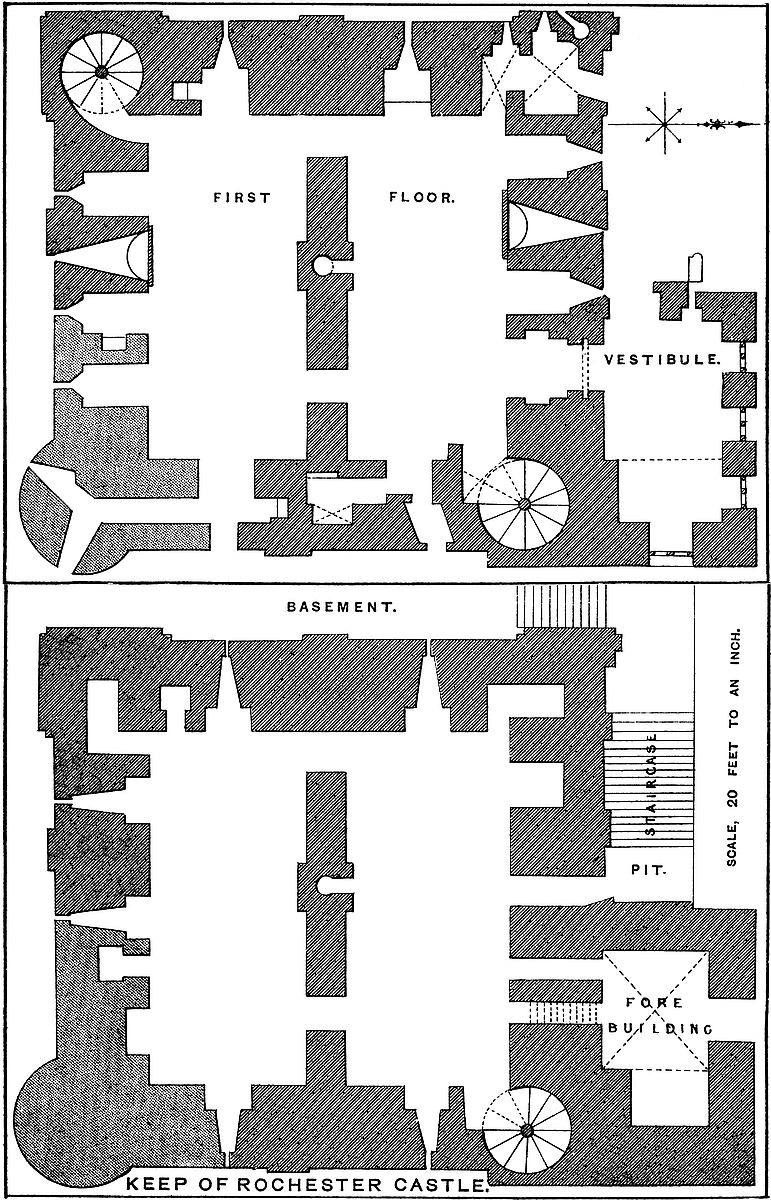
The first floor, also of two chambers, was lofty, gloomy, and perfectly plain. It was probably the soldiers’ lodging during a siege.
The North Chamber. In the north wall, near the east end, is the main entrance, 15 feet from the ground, and opening from the vestibule of the forebuilding. This is a bold, full-centred arch, of 6 feet 2 inches opening, with flat sides, in a wall here 10 feet 6 inches thick. The outer face is flanked by nook shafts, and the architrave has a bold chevron moulding. The inner architrave has a similar but rather plainer moulding, but the jambs are broken away. Just within the outer face is a square portcullis groove, and behind it a rebate for a door, expanding the passage to 7 feet. Near the inner face, in each side, is a small round-headed recess, 2 feet 6 inches broad by 1 foot 4 inches deep, probably to hold the keys or a lamp. The door was secured by a stout bar, and the grate, which seems to have been of iron, was worked from a mural passage above. This portal led direct into the north chamber, about 7 feet from the well-stair door. In the north-west angle is a mural chamber, called “Gundulph’s room,” vaulted and groined, 10 feet 3 inches by 11 feet 7 inches, entered by a door in the west wall, and lighted by two loops to the west. In its rounded north-west corner is a fireplace with a small Norman hood of 2 feet 6 inches projection, having a segmental arch. The tunnel is conical, and ends in a couple of openings in the hollow angle of the south end of the adjacent pilaster, in the face of the wall, above 12 feet above the hearth. Near the north-east angle of this chamber is a small blocked-up doorway, which, as at Middleham, opened upon the roof of the outer gate of the forebuilding. The ashlar rings of the loop recesses, and the hood of the fireplace, are of excellent workmanship. Besides these openings there are in the north chamber four windows, one at each end, and two in the north side. These are set each in a recess, 5 feet 6 inches opening, and 9 feet 6 inches deep, 15 feet high, and round-headed, the loops being square-headed, about 1 foot 6 inches high by 12 inches broad. These recesses, from their great height, produce a good effect, but were probably found to weaken the wall, for they have been partly built up and reduced at their lower 6 feet to a depth of 3 feet. The blocking is of inferior masonry, executed in haste. Between the two northern loops is a fireplace of 5 feet 6 inches opening, round-headed, having no hood, and with a round back. It is strengthened by a pilaster of 9 inches projection and 10 feet breadth, from the inner wall. The tunnel from the fireplace is conical, and has a412 lateral vent about 15 feet up. In the east wall, near the entrance from the well-stair, is a recess, which, besides the loop, contains a postern and a garderobe. The latter is a mural chamber, 5 feet 10 inches by 13 feet, which opens from the southern jamb of the recess: the postern, 2 feet 6 inches broad, is cut obliquely through the wall, and opens in the face of the keep, 15 feet above the ground, and about 30 feet from the rampart of the curtain, with which it must have communicated by a light plank bridge. There is such a door in the Norman keep at Adare, and in the later Wakefield tower in London, to which a stone bridge has recently been fitted. In the cross wall, besides the well opening, are two doors corresponding to those below.
The south chamber has a loop at each end, and three in the south wall, all in recesses similar to those in the north chamber, and these also have been partially blocked up to strengthen the wall. There is a fireplace in the south wall corresponding to that described above, and in the south-west angle a door leads into a well-stair, 11 feet diameter, which commences at this level, and communicates with the floors above, and with the battlements. There are four mural recesses in this chamber. One, a garderobe, opens in the south jamb of the recess of the west window, and another in the east jamb of the central window in the south wall. The shafts from these recesses descend into the wall of the lower chamber, as described. The other galleries open right and left from the window recess in the east end. That to the north is a passage, 3 feet 6 inches by 8 feet, with a garderobe in the end of it. That to the south is a gallery, 20 feet long by 3 feet broad, which ends in the south-east angle, where it has two windows to the south and east. This is in the rebuilt angle. This floor rested upon timber joists. From it forty steps lead up the north-east staircase 30 feet to the main floor, and at thirty-six steps branched off a narrow stair to the chancel of the chapel.
The main, state, or second floor, 32 feet high, rested on each side upon eighteen joists, whole timbers. It contains two tiers of windows, the lower opening directly from the chamber, the upper with the intervention of a mural gallery. Between the two is a plain string of Norman pattern. The roof was flat, being the joists and planks of the upper floor. The window recesses of the lower tier range from 3 feet 2 inches to 5 feet 10 inches opening, and those of the gallery tier nearly correspond to them. All are flanked with nook shafts, but the lower architraves have a bold roll and hollow moulding, those above have the chevron pattern. The ashlar of the windows is mostly gone. The lower seem to have been plain and small, the upper richer and rather larger, but none at all large. The projections in front of the well, the fireplaces, and the two staircases, are beaded at the angles. There are no marks of corbels for struts to stiffen the joists and give support to the ceiling.
The north chamber was entered by a sort of lobby, 5 feet 6 inches square, and groined, into which the staircase opened. The recesses 414of the east and west windows each have mural garderobes opening from the southern jambs. The two recesses in the north wall have no side openings. Between them is the fireplace, similar to that below, but with a handsome chevron architrave. Over the great entrance is a doorway of 7 feet opening, leading to the chapel. In it is the chase for working the grate, and beyond this is a rebate reducing the passage to 3 feet to form the chapel door. In the north-west angle is a small chamber.
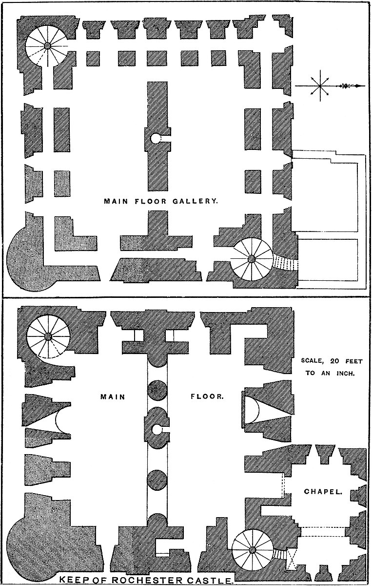
The south chamber has three windows in the south wall, a fireplace, and a door opening into the south-west well-stair. In each end is a loop. In the recess of that to the west, on its north side, is a passage to a garderobe, and there is probably a corresponding place in the opposite, or east window, but the window recesses are inaccessible.
The cross wall, instead of two doors, is pierced by four arches of unequal size, two on each side of the well pier, which has its small and rather ornate door. Between each pair of arches is a heavy Norman pier, a plain cylinder with fluted capital, and opposite to which are two half-piers, or responds. The arch has been ribbed and worked in bold roll and hollow, varied with the chevron pattern, but the central rib has fallen away. The capitals of this arcade range with the general string-course, and the arches rise into the upper division of the apartment. There is rather more ornament on the north than on the south face. The arcade was filled up with a stone screen, about 10 feet high, of which one division remains and a part of its doorway. The screen is original, and has been rather richly worked, but it had no bond into the piers, being merely built against them.
From this floor twenty steps led up 17 feet to the gallery. This threads the whole wall, passing all round the building. It is from 3 feet to 3 feet 6 inches broad, barrel-vaulted, from 8 feet to 9 feet high, and is placed 4 feet from the inner face of the wall, and 5 feet from the outer. It is generally level, save that it rises at the south-west angle to accommodate itself to the staircase, and in the centre of the east front to clear the vaults of the garderobes below, and possibly to meet the thrust of the arch in the cross wall.
In the north division there are in the west end three recesses, 3 feet 7 inches, 5 feet 10 inches, and 4 feet 1 inch, which open into the gallery, and correspond to three windows in its outer side. In the north wall are also three windows with recesses corresponding, each of 5 feet 10 inches in width. In the east end is only one recess of 5 feet 9 inches opening. At this point the gallery is rather above 3 feet wide, and the corresponding window has a recess, 5 feet by 4 feet. Most of these expansions of the gallery opposite to the windows are groined, as in the corresponding gallery in the Tower of London.
The arrangements of the south division are very similar. In the east end is one recess of 5 feet, and in the west three of 3 feet 2 inches, 5 feet, and 3 feet 7 inches, the central being the largest.415 That at the south end represents a short window, intended to conceal the gallery, which here rises to the staircase. In the south wall are three recesses, with windows corresponding. There is no chamber in the south-east angle, the gallery merely turns at a right angle, but in the north-west turret is a groined chamber, 6 feet square, with which the gallery communicates, and which has windows in its two outer faces. The north-east and south-west angles are occupied by the staircases. It is evident from the character of the masonry that with the south-east angle have been rebuilt the two adjacent windows in the south face and of that in the east face. The new work is inferior to the older, and there is no attempt at ornament. The arrangements of this grand floor, like those of the corresponding rooms called the Council Chamber in the Tower of London, must have been inconvenient in the extreme. The rooms must have been very cold and very public, with windows, doors, and garderobes on every side, and a gallery in which a whole household might have listened, unseen, to what went on below. There is nothing to distinguish between the uses to which these two noble chambers were applied. Probably the northern, having the more ornate entrance, was the hall, and the southern a room of a more private character.
From the gallery level twenty-three steps lead up 17 feet to the upper floor, and on the way a small passage opens upon the battlements of the forebuilding. This floor contains two very cheerful and handsome rooms, 25 feet high, with larger windows than the floors below, and a finer view. Here, also, the window recesses and fireplaces are ornamented, and we may suppose this floor to contain the private apartments. The roofs were open and low pitched, and seem to have been supported by rafters placed near together, and without principals. The arrangement of the mural galleries here is peculiar. They do not run round the rooms, but are short, connecting two, or at most three window recesses. Where the wall has been rebuilt they are altogether omitted. They do not pass behind the fireplaces, the vents from which pass off horizontally, and so block the way.
The north chamber is entered, like the rest, from the north-east angle, and from the staircase passes a gallery which pierces the east wall for 20 feet, and traverses the recesses of two windows which light the east end of the room. In the west end are also two windows, in like manner pierced by a short gallery, entered only from the chamber. In the north wall, besides the fireplace, are four windows, two on each side of it, each pair connected by a short gallery, also entered from the chamber. In the cross wall are two doorways, and near the centre the small door of the well pipe.
The arrangements of the south chamber are somewhat different. In the west end are three window recesses, having a mural gallery in common, but not communicating with the staircase. In the east end is but one window, the jambs of which are solid. In the south wall is the door from the south-eastern staircase and also three windows,416 with a fireplace. There are no galleries in this wall. This chamber has suffered much from the destruction of the south-east angle, which it is evident carried with it about 28 feet of the south and 15 feet of the east wall. In the untouched part of the east wall remains embedded the half pier, capital, and half the architrave of a large original late Norman arch, of about two-thirds the span of the room, more or less ornamented, and evidently the recess for a large east window. It is just possible, as this was an archiepiscopal fortress, that this was a chapel. In the south wall, close east of the fireplace, is the jamb and half the arch of a window recess, also ornate, of which the other part has been removed. The restoration has been effected in a very hasty and slovenly manner. The masonry is of inferior quality, and the new recesses are perfectly plain, although the older ones in the same floor are rather highly ornate. Whatever, in designing this chamber, may have been the intention of the builder, it is very certain that the re-builder thought only of making the tower defensible in the cheapest and quickest way.
From this floor thirty steps ascend 25 feet to the battlements. On the way a passage from the north-eastern staircase opens into a gallery in the east wall, 16 feet long and 5 feet wide. It is traversed by a window, the recess of which, 4 feet wide, opens on the gable of the north room of the upper floor. The staircase passes up to the base of the north-east turret, in which are two doorways opening on the ramparts of the north and east walls. The rampart walk is 4 feet broad, with a parapet of 2 feet and a rere-wall, now gone, of 3 feet. The walk is carried through the north-west turret, which contains a chamber 9 feet square, and through the south-eastern turret, which also contains a chamber. From hence the passage is continued along the south wall, but is stopped by the wall of the south-west turret, the stair contained in which only opens on the west wall. The turret chambers were about 8 feet high and had flat roofs, reached possibly by wooden steps. Each turret had two entrances, one on each face. The parapets of the curtains between the turrets were 8 feet high, and contained five embrasures on each face. At this level the profile of the double roof may be traced. It was composed of two ridges, one over each chamber, with a central gutter resting upon the cross wall. Both parts were low pitched, and the ridges did not rise above the battlements: the northern portion sprung a little the lowest and had rather the steeper pitch. The southern, springing higher, delivered half its water from eaves 2 feet above the common gutter, whence it was carried away by an enormous stone shoot, a sort of gurgoyle. Another such, taking the contents of the north gutter, crosses the head of the staircase and projects eastward. At the rampart level the walls and turrets are pierced by a row of holes 9 inches or 10 inches square, intended, evidently, for the horizontal beams of a brattice. There are no corbels or cavities, as usual, below, to receive struts, the beams being probably strong enough without them. These holes seem not to be original, and being rough, were417 probably made in haste when the south-east angle was rebuilt: they are of importance enough to be shown in the tower which figures in the corporation seal. Besides these, in the inner face of the north wall, above the gutter, are two rows of pigeon-holes, probably original, and even now accommodating a few birds.
Affixed to the north front is the forebuilding, composed of a gatehouse, staircase, drawbridge, and vestibule tower. These formed and protected the entrance to the keep. The approach is thought to have commenced on the west front, near the north-west angle, by a flight of steps, which turned the angle, as at Dover, and were continued as a broad staircase against the wall of the building. Upon this, flush with the west front, was a small low tower, about 12 feet square, through which the stairs passed. This portal had a barred door, but no grate, and its roof was reached from Gundulf’s chamber in the first floor of the keep. From this gate the steps rose to the bridge pit, a cavity 15 feet deep by 9 feet opening. This was crossed by a drawbridge, which fell from the gate of the vestibule tower. The stairs were 8 feet broad, and protected by an outer parapet 2 feet thick and 6 feet high, and probably looped. The parapet crossed the bridge pit on an arch, so that persons ascending the stairs or crossing the bridge were protected.
The vestibule tower is 19 feet broad by 36 feet long, and two-thirds of the height of the main building, against the north face of which, at the east end, it is built. Its walls are 6 feet thick; they have no plinth or pilaster steps, and though probably of the age of the keep the work is of an inferior character. There is a basement, first floor, vestibule floor, and chapel. Each floor is entered from the keep. The basement is 14 feet by 23 feet, vaulted and groined, and it has two air-holes near the vault, ascending obliquely through the wall. The floor is on the ground level, here low, and from it a passage, 2 feet 7 inches wide and 12 feet long, leads up nine stairs into the basement of the keep. The present door from the exterior is evidently not original. This chamber was a prison.
The first floor measures 13 feet by 23 feet; it also has two air-holes, rather larger and less oblique than those below. A recess, perhaps a doorway, perhaps a cupboard, has been opened in the east wall and fitted with a Tudor door-case. This chamber had a flat timber ceiling, forming the floor of the vestibule. It was entered by a passage, 2 feet 10 inches broad, slightly ascending to it from the basement of the keep. This also was probably a prison, but of a less severe character.
The second or vestibule floor is of the same dimensions. In its west wall is the outer door of the keep, of 6 feet opening, round-headed, and flanked inside and out with engaged columns, with plain caps, and round the arch a band of chevron moulding. In the rubble work inside, above its head, is seen a pointed arch of relief. The portal was closed by a barred door only. On the right, on entering the vestibule, is the door of the keep. The vestibule has five windows: a small one in the west wall commands the418 staircase; in the north wall are three windows, each formed of a pair, coupled; in the east wall is one. They are all round-headed, with Norman ornaments: one-third of the east end of this chamber is covered with a barrel vault.
The third or upper floor of the forebuilding is occupied by the Chapel, the dimensions of which correspond nearly to the rooms below. It is divided into two parts, a nave and chancel, separated by a plain, bold, round-headed arch of 12 feet span. The nave is entered from the main floor of the keep by a side door, close to which, in the wall, is a recess, now inaccessible. The chancel has a stone floor, resting on the vault below, and its roof is three sides of an octagon, also vaulted, a sort of apse, but covering a rectangular space. There are two east windows, and a large stone drain, which has led to the notion that this room was the kitchen, and no doubt it would have made a very good one. The nave had an open roof of low pitch, which was replaced by one perfectly flat, but at the level of the original ridge. If the large upper room in the keep was a chapel, a second would scarcely be necessary. Probably both were not in use at the same time. A kitchen is a very uncommon adjunct to a Norman keep, as the inmates seem to have broiled their meat at an open fire, whereas a chapel is not uncommon; and at Middleham, Dover, Newcastle, and probably at Corfe and Kenilworth, it was in the forebuilding.
The material of the keep is chiefly the rag-stone of the country, with ashlar coigns and dressings of Caen stone. The ashlar is rather sparingly used, but is of sound quality and close jointed. The rubble is poor, imperfectly coursed, and held together by the excellence of the mortar, or rather of the lime, for the mortar is carelessly mixed and is full of sea shells, which have been brought with the sand and left uncrushed. It is clear from appearances, both inside and outside the building, that the south-east angle has, at some period soon after its construction, fallen down, and been rebuilt soon afterwards clumsily and in haste. No mere battering by a ram, no strokes from the missiles of a catapult, however ponderous, would have brought down both turret and wall. Such ruin must have been produced by a mine, and this is the more probable since the south-east is the most exposed angle for such an attack, the scarp of the ditch being here steep, the soil soft chalk rock, and the keep but a few feet from the ditch. A mine opened in the scarp, just outside the angle of the curtain, and driven 40 feet in the chalk, would reach the foundations of the turret, and thus undermined, its fall would bring down more or less of the adjacent walls, and falling outwards, would crush the angle of the curtain. This would account for the large mass of the angle which has fallen, and for the circular bastion tower, evidently an insertion, at the angle of the curtain. Supposing the keep, built in 1126, to have been mined and breached in the memorable siege of 1215, and the damage soon after made good, this would account for present appearances. It is true that the bastion tower is decidedly early English, while the restoration of the419 keep is Norman, but it is of a period when round and pointed arches were both in use, and when the character of the older part of the keep would naturally lead to the employment of the former; so that the restoration might have been effected as late as 1225, ten years after its probable destruction, and when an entry in the Pipe rolls shows that the sheriff of Kent repaired the tower.
There is a good deal in the character of the forebuilding that looks as though it was an addition to the keep; and yet this cannot be, seeing that the difference in its masonry includes that of the adjacent staircase turret, which could scarcely be an addition. Also the remains of the lower gatehouse, on the north face of the keep, are clearly as old as the keep, of which they are part.
It was long the custom to attribute this keep to Gundulph, making it contemporaneous, or nearly so, with the Tower of London, which it resembles in some of its arrangements, especially its mural gallery and fireplace. Attention to its other details shows, however, that this cannot be so, and that its more probable builder was Archbishop Walter Corboil, about 1126. Those who desire to see examples of Gundulph’s work, and to compare his masonry with that of Rochester keep, should examine St. Leonard’s Tower at Malling, some parts of the nave and transept of Malling Abbey Church, and the north tower of Rochester Cathedral. The White Tower in London has been so often repaired and refaced that it is difficult to be sure of its original masonry. Part of the curtain of the enceinte of Rochester Castle may also be Gundulph’s work. The north wall looks very early, as does the east wall, which is of excellent though rudely coursed rubble, the stones being large and the joints broad, though there are no layers of flat stones as at St. Leonard’s.
Rochester much resembles Hedingham, a very pure and very perfect Norman keep, with three floors, the remains of a forebuilding, and the upper gallery in the main floor. In each ornamentation is effectively employed, and great use made of the chevron moulding. The two buildings are, probably, of about the same date.
The history of the castle of Rochester, in the proper sense, begins with the Norman Conquest, but there is something to be said of the preceding earthwork, subsequent to the Roman period. The bishopric, of which the city is the metropolis, was founded in A.D. 600, and Justus, its first bishop, was consecrated in 604. The church, dedicated to St. Andrew, was founded by Æthelbyrht, King of Kent, and his charter of 604 mentions certain land as extending from the west gate and the wall of the city, one boundary being “fram Suthgaete west, and langes wealles.” Also, other land granted is said to be, “extra murum civitatis versus aquilonem.” In 673 a synod was held here, says Bede, attended by Putta, “Episcopus castelli Cantuariorum quod dicitur Hrofescæstir;” so that it was then a strong place, and the bishop’s residence, and this whether “castellum” relates to the city, or, which is at least equally probable, to the adjacent fortress.
420
In 765, Ecgberht, King of Kent, granted by charter to Eardulf of Rochester, his faithful minister and bishop, “terram intra castelli mœnia supranominati, id est Hrofiscestri;” and in 781, Æthelberht, King of the West Saxons, says, “Concedo Hrofensis ecclesiæ ... aliquantulum terræ juris mei intra mœnia supradictæ civitatis in parte aquiloni”; and in 788, Offa, King of the Mercians, granted “terram ... sex aratrorum” at Trotescliff, “ad ecclesiam beati Andræ apostoli et ad episcopium castelli quod nominatur Hrofescester.” Also, in 789, King Offa, in another charter to the same Bishop Weremund, mentions the wall (murus) of the city, and says, “Ecclesia quæ sita est in castro quod nominatur Hrofesceaster.” Further, in 850, Æthelwulf, King of the West Saxons, mentions “murum civitatis Hroffi;” and in 855 he granted land “Dunne ministro meo ... in meridie castelli Hroffi.”
In 839 and in 885, the city was attacked by the Danes. On the former occasion they took and sacked it, on the latter it was relieved by Alfred. In 986, the city was attacked, but unsuccessfully, by Æthelred, and in 998 with more success by the Danes, who came up the Medway. Boley Hill is said to have been thrown up by the Danes in 884, but the greater part of the hill is natural, though, no doubt, with a very considerable addition; but even the addition would have required more time than was allowed them by Alfred, and a work of such a character would be far more useful for defence than for attack. The towers used in an attack were generally of timber, and so constructed as to admit of being pushed up to the walls. It is more probable that the mount was thrown up as a strong residence for the bishop, to give such personal security as was found necessary at Sherborne.
It is not known in whose hands the fortress of Rochester rested in the times preceding the Conquest, but Earl Godwin had certainly encroached upon the episcopal property; and what more probable than that he should have laid his hands upon a place which, with Dover, would give him the command of the great road from the South to London? We read in Domesday of the episcopal manor of Estockes or Stoke. “Hoc manerium fuit et est de Episcopatu Rofensi, sed Godwinus comes T. R. E. emit illud de duobus hominibus qui eum tenebant de Episcopo et eo ignorante facta est hæc venditio.” So when the term of the tenancy expired the bishop would find that instead of two nameless men ready to give up possession, he would have to deal with a powerful noble claiming the freehold. Stoke passed with Godwin’s Earldom of Kent at the Conquest to Bishop Odo of Bayeux, and was recovered by the archbishop, as Domesday goes on to relate, “Postmodum vero regnante W. Rege diratiocinavit illud Lanfrancus Archiepiscopus contra Baiocensem Episcopum et inde est modo saisita Rofensis Ecclesia.”
It is probable that in some such way Odo received the city with the earldom, and with it the fortress, which the Bishop of Rochester, however, may have recovered possession of in the way shown, and which he certainly afterwards exchanged with the king for land in421 Aylesford. “Episcopus etiam de Rouecestria pro excambio terræ in qua castellum sedet tantum de hac terra tenet quod xvii solidos et iiij denarios valet.” There never was a castle at Aylesford. The bishop gave up the site of Rochester Castle, receiving for it as much land as was worth 17s. 4d.
Gundulf, the follower and friend of Lanfranc, and consecrated Bishop of Rochester in 1077, was a great architect, and a very remarkable man, well deserving the panegyric bestowed upon him upon his promotion, “Eratque Gundulfus religione plenus, literarum non nescius, in rebus forensibus acerrime elimatus et qui putatus sit divina potissimum electione hunc honorem meruisse.” As to his architectural skill, and his work at Rochester Castle, it is said, “Gundulfus, quia in opere cœmentarii plurimum sciens et efficax erat, castrum sibi, Hrofense lapideum de suo construxit.... Igitur, hoc pacto coram rege inito, fecit castrum Gundulfus Episcopus de suo ex integro totum costamine, ut reor, LX librarum.” This transaction between the bishop and the king occurred about 1076. The king was to restore to the see the manor of Hedenham, in Bucks, and the bishop to employ his skill and spend £60 in building a castle, that is, a tower of some sort. What Gundulf certainly built is the tower which still bears his name, and which seems originally to have been upon the city wall. On the death of William the castle was a very strong place, and was seized upon and held by Odo for Duke Robert. Odo (Judas Iscariot, as he was called by the friends of Rufus), associated himself with Eustace of Boulogne and Roger de Belesme, and garrisoned the castle, storing there the spoil drawn from the adjacent country. Rufus, whose activity was a strong contrast to the indolence of his brother, attacked Rochester, while Odo retired to Pevensey to await succour from Normandy, which never came. Rufus took Tunbridge and Pevensey, and forced Odo to demand the surrender of Rochester by his allies. The garrison understood the sincerity of the demand, sallied out, captured their royal escort and their bishop, and installed him, nothing loth, in the government of the castle. Rufus converted the siege into a blockade of both castle and city, and finally, under the pressure of a pestilence, both were surrendered, and Odo was finally banished. Gundulf died in 1108. This first siege of Rochester is one of the great military events of a very stirring period, and one deserving far more notice than has hitherto been bestowed upon it.
The castle, thus taken in 1088, seems to have remained in the Crown for thirty-eight years, when, in 1126, Henry II. granted “to Archbishop William de Corboil and his successors the perpetual charge and constableship of the castle of Rochester,” thus leaving it in the Church, but detaching it finally from the see of Rochester. The archbishop, we are told, built, in consequence, a handsome tower, “egregiam turrim,” which is, no doubt, the existing keep. William died in 1139, between which date and 1126 the keep was, therefore, built.
Henry II., also alludes to the castle in his confirmation charter to the church of Rochester, “volo etiam et ipsi et homines sui sint422 liberi et absoluti ab omni opere castelli, et expeditione archisve constructione;” so that, probably, the arx, or citadel, was then in contemplation or in progress. It may be that Gundulph’s Tower was removed to make way for the new keep, but in this case its materials would have been made use of, and some trace of them would be almost certain to be detected. But there is no such trace, so that, probably, the new keep did not supersede the older tower.
The castle, especially with its splendid and very strong keep, was far too important a military post to remain unchallenged in the possession of the see of Canterbury, and both when the see was vacant and at other times the Crown got possession, and its repairs were then entered on the Pipe roll. In 1141, William of Ypres, a Fleming, was its governor for Stephen, and when the Earl of Gloucester was taken he was confined here for a short time—from September to November,—until he was exchanged for Stephen. Various sums were spent upon the castle between 1167 and 1202, when it was again given up to the archbishop, then Stephen Langton. Towards the close of John’s reign the castle was placed by Langton in the hands of William d’Albini, to be held in the interest of the barons, whose army proposed to march from London to its relief. John, however, interposed, and in 1215, after a severe siege of three months, it was surrendered. Wendover expressly states that the military engines employed on this occasion produced but little effect, but that the place was taken by the efforts of the miners, who first undermined and threw down the walls, and then applied the same method of attack against the tower. It was, without doubt, on this occasion that the south-east angle was destroyed. In May, 1216, it was taken, apparently without any difficulty, by the Dauphin, but on John’s death it fell, with other Crown possessions, into the hands of Henry III. Under Henry III. considerable sums were spent upon it in repairs, especially in 1225, when, probably the broken angle was made good. In 1226–7 a bretasche and drawbridge were repaired, and the gutters of the hall in the keep. Unfortunately, here as elsewhere, the repairs were commonly those of buildings in the courtyard, all which are now destroyed. The keep was not used save for stores. In 24 Henry III., the tower was ordered to be whitewashed in those places which had not been so washed before. In 31 Henry III., both chapels were ordered to be wainscotted. One of these, at the least, was pretty sure to be in the outer ward, for the use of the garrison.
In 1264, the castle was in charge of the celebrated Roger de Leybourne, who had just taken part with the king. As de Montfort was supposed to meditate an attack on Rochester, Leybourne defended it with a strong garrison, and stored it with ample provisions. In April, the attack being expected, Warren, Earl of Surrey, Henry’s brother-in-law, came to the castle. The barons laid siege to it just before Easter, and remained before it nearly a week, but without any result, and on their retreat most of the garrison, with Leybourne, joined the king at Lewes, and took part in the battle. The loss of423 that battle was followed by the surrender of the castle, but after the death of de Montfort and the fall of Kenilworth, Leybourne resumed his governorship. A century later, in 1367–8, extensive repairs were undertaken by Edward III., under Prior John of Rochester as chief clerk of the works. Stone was imported from Beer, Caen, and Reigate, with copings and crests for battlements, probably for buildings in the court. Since that period it has played no part in the transactions of the kingdom, nor is its military history of any special interest. An extant drawing, taken in 1588, shows the turrets domed over and capped with vanes, like those of the White Tower.
Excellent papers have been written upon Rochester Castle by Messrs. Beal Poste, Blaauw, Hartshorne, and Burtt, the latter in the form of an account of Roger de Leybourne’s share in the Barons’ war.
P.S. Since the above account was written, Mr. Irvine, the very able and acute superintendent of the late Sir Gilbert Scott’s works at Rochester Cathedral, has made a discovery which is not in accord with any of the existing opinions as to the particulars of the Roman settlement. It appears that the south transept is built across a ditch, which runs north and south, and, no doubt, underlies the whole breadth of the cathedral. The ditch is 12 feet broad at the top, and 7 feet at the bottom of the excavation, now 14 feet deep, but was probably much deeper. It is cut through sound old gravel, and was filled up with black soil, with occasional dressed stones of Roman workmanship, Roman tiles, and bits both of black and red pottery, one of the former having a stamped interior ornament. Mr. Irvine, it is said, is in a condition to show that this was the ditch of a wall standing to its west, or towards the river. If so, the original station may have occupied the site of the present castle, at the west end of the accepted place of the Roman town, of which it may have been the citadel.
WITHIN the north-eastern border of Northamptonshire, abutted upon by the shires of Leicester, Rutland, and Lincoln to the north and east, and by that of Huntingdon to the south, is a large tract of rather elevated land, known as the Forest of Rockingham. Its natural limits are the valleys of the Nen and the Welland, whose general parallelism is continued in their course across the Holland fen to their common termination in the Wash. Towards the west this platform is further cut off by the Ise, which rises about four miles from the Welland and falls into the Nen by424 Wellingborough. The tract thus marked out by nature, and long known as the Forest, extends east and west twenty-four miles from Oxendon Bridge to that of Stamford, and is at its widest between Rockingham and Thrapston, about twelve miles. The position, when the meads of the Nen and the Welland were marshes, and the fens scarcely navigable, was one of great strength, and occupied at an early period by invaders and colonists of Danish blood, whose traces are largely preserved in the topographical nomenclature of the district. The soil, chiefly derived from the subjacent oolite, is not naturally fertile, and long remained as forest, which even now, though cultivation has made immense progress, is represented by large patches of woodland, such as the well-timbered parks of Rockingham, Boughton, Blatherwick, Burleigh, Drayton, and Dene; the wilds of Morehay and Sulehay; the Bedford purlieus; and the Chase of Geddington.
Rockingham, which gave name to the forest and to a much smaller tract of land still known as the Shire, is placed upon the right or south bank of the Welland, just above the point where the influx of the Eye brook marks the meeting of the counties of Northampton, Leicester, and Rutland. The village stands on ground rising from the river, and above and to its south, immediately over the parish church, is the castle. The castle is a marked feature in the landscape, as it is placed upon a sort of promontory which juts out from the table land of the forest towards the Welland, and is protected on each side by a deep ravine, two of many by which the steep margin of the valley is intersected. South-west of the castle, and divided from it by the larger ravine, is the park, a very ancient enclosure, at one time containing red deer, which, however, had disappeared before Leland’s visit; and behind, and south of the castle and the park, is the tract of recently-enclosed land called the Shire.
Rockingham has been described as a name of English formation, purely descriptive. The castle stands on the “Rock;” between it and the Welland is the broad and fertile “Ing,” or meadow; and the “Ham” represents the village, whether enclosed by bank, ditch, or hedge. Other authorities, with perhaps more reason, have objected to this use of the word “ing,” and have supposed the name to be the “hame” or home of the “Rockings.” However this may be, ancient as is the name, and important as must ever have been the position, the place is not to be found in any record previous to the Conquest, though a similar name occurs in Kent as Roegringham, in a charter by Cœnulf of Mercia, A.D. 811. It may be that the name is found elsewhere, for among the followers of Archduke Philip at his meeting with Henry VII. in 1500 occurs “Le Sieur de Rockingham de Flanders” (“Letters of Henry VII.”, p. 88). The earliest mention of the place is in Domesday, where it is stated that the king holds Rockingham. Bovi held it in the time of King Edward with sac and soc. It was waste when King William ordered a castle to be made. No doubt here, as425 generally elsewhere, William’s decision was guided by the existence of an earlier work. It is evident, from an inspection of the remaining earthworks, and from a comparison of them with others, such, for example, as Brinklow, that they belong to the class of moated mounds, and consequently are far older than the Conquest. Bovi, no doubt, dwelt here, and it was his strong dwelling that the Conqueror ordered to be converted into a castle.
Enough remains to show that the earthworks were composed of a conical flat-topped mound or donjon, with a base-court attached on one side. The mound seems to have been about 100 feet diameter on the top, and not less than 30 feet high. It was circumscribed by its proper ditch, which, to judge from indications on the south side, must have been broad and deep. To the north of the mound was the base-court, of an irregular but rounded figure, covering about 3½ acres. The outline of this court corresponded generally with the contour of the ground, the slope of which formed a part of the defence. The court abutted upon the north face of the mound, outside its ditch, and covered about one-third or five-twelfths of its circumference. Thus the greater part of the mound, as at Brinklow, was outside the general line of defence, of which it formed a part. Also it was posted on the side of the work opposite the high ground, between the heads of the ravines, and naturally, as at Brinklow, the weakest side. In advance of the mound, at some yards distance, is a bank and ditch crossing the approach, and again in advance, about a furlong from the keep, is a second ditch, even now containing water, and dividing the castle precinct from the shire. Probably these outworks are of later date than the keep. There are also other works to the east, beyond the ravine, and especially one large bank which now forms the central line of an avenue of lime-trees. These works are irregular, and were possibly thrown up when the castle has been besieged. On this side are also some small tumuli, placed two and two, said to cover the remains of cottages.
The changes made by the Norman builders, and by those who in their turn destroyed the Norman walls, have much effaced the traces of the early fortress. The bank, which no doubt encircled the court, has been thrown back so as to raise and level up the interior platform, and for the main ditch has been substituted a scarped revetment about 8 feet high, surmounted by a parapet, which represents the curtain wall. At the foot of this are the remains of the ditch, and lower down the hill certain terraces, which look as though they had been defended by lines of stockade for musketeers during the parliamentary siege. These irregularities of the surface have been thought to represent a British camp, for which the situation is, no doubt, suitable. Of the mound there remains only a semilunar bank, which formed its northern edge. The central and southern parts have been removed and thrown into the ditch, the line of which is indicated by a slight but clear and broad depression. This was evidently done when the Parliament obtained the place, to426 render it indefensible. It is also evident that the base-court was subdivided, as at Brinklow. This is shown by the levels of the different parts. One division ran north and south, cutting off on the east the entrance ward with the lodgings. The other ran east and west, and subdivided the western ward. The three courts are on different levels, the entrance court the lowest by 6 feet or 8 feet.
Whether the Conqueror built a work in masonry, or merely strengthened the existing defences, is unknown. There is no masonry extant of that century. But he or his successors certainly placed a shell keep upon the mound, and built a wall round the court. This wall seems to have had six faces, and to have occupied a circuit of about 490 yards. It still commences at the top of the keep mound, descends the slope, crosses the ditch, and runs 134 yards in a straight line, forming the east front of the castle. The lower courses of this wall, which is 9 feet thick, may be late Norman. The upper part, 25 feet to 30 feet high, is probably Decorated, as is the gatehouse, which is in this front. Towards the north-east angle the wall has been rebuilt, and supports a seventeenth-century building. At this, at a right angle, the wall is replaced by a revetment of late date, and runs westward for 83 yards, having the church, &c., below and in front of it. The direction of the wall then changes to the south-west at the angle of about 160°, which was capped by a round mural tower, of which the foundations remain. This face is 94 yards long, and ends in an angle of 130°, where, no doubt, was another drum-tower. Then follows a side of 64 yards, ending in an angle of 140°, followed by a side of 40 yards, then by an angle of 150°, and a short side of 25 yards, which ends in the keep mound in a mass of masonry, which, if not wholly original, is so in part, and formed of old material. Thus the whole circuit of the court wall from one side of the keep to the other is about 440 yards. The two western faces rise directly over the ravine. The two to the south-west are some way from its edge, and here are no traces of a revetment; and there was, no doubt, a ditch. The wall is now removed, but indications of its foundation are seen on the turf in dry weather. The distance from one end of the wall to the other, measured across the keep, is 50 yards, which thus completes the circuit of the court.
Between the two masses of masonry which mark the abutment of the two ends of the outer wall upon the keep, is a third, which points north-west, and shows the line of a cross wall which divides the entrance from the western wards. The line is followed by the later buildings and by the western end of the castle hall. The place of the cross wall branching westward from this is indicated by a double yew-tree hedge, and a step of about 4 feet.
The gatehouse is composed of two half-round towers, 26 feet diameter, flanking a gateway of 10 feet opening. The towers spring from a block 60 feet broad and 30 feet deep, having no internal projection, so that the towers and a part of the block stand out from the wall 47 feet, giving a fine, bold character to the entrance. The 427towers are of two stages, divided outside by a string-course, and crowned above by a plain embattled parapet resting upon a second string. The gateway has a low-pointed arch, over which the string is continued and raised so as to form a square head. The entrance passage, 10 feet broad, is 30 feet deep. Within the portal is a portcullis groove, rounded and narrow, as for an iron grate, and behind it a rebate for folding doors. At the other end of the passage is a second portal, also with gates. Each portal has had a bold internal drip, now cut flat. A plain cornice shows that the original roof was of timber, and flat. The present and new beams have by an oversight been laid lengthways. On each side is a small, heavily-moulded door, with an equilateral head, in very excellent style. The north tower contains two chambers, one 16 feet by 18 feet, with a loop into the courtyard, and from which a small Decorated doorway opens into a front half-round chamber of 12 feet span, having three loops to the front beneath deep arched recesses. In the south tower are also two chambers. That in front has two loops only. The other chamber has a door into a garderobe in the south wall. The roofs were all of timber, and the internal doorways heavy but excellent Decorated. The gatehouse has been much repaired. The plinth is new. The exterior has been chisel drafted, and the jamb mouldings of the portal apparently recut. The towers had till lately conical roofs, which, however, were not original, and the parapet, though in excellent taste, is modern. The loops are cruciform, with short cross-limbs, and œillets below. The late Rev. T. James attributes this gateway to the year 1200.
Upon the curtain wall, a few yards south of the gatehouse, is a door, and near it a loop, both of Decorated date, and which evidently belonged to a mural tower, now replaced by a modern larder.
Entering the castle by the gateway, on the left and in front are the lodgings, buildings of very various dates. The entrance to the house on the left is, however, older than any other part of the front. It is an original door of Decorated date, and in a good style, and opens into what was once the hall or an antechamber leading into it. Opposite is a corresponding door, of the same age, which opens into a yard or court set round with buildings of all ages. The hall has long been converted into two floors, and is traversed by two partition walls, but the lateral or exterior walls are original, and contain two fireplaces, now covered up, but indicated by broad exterior buttresses, and several windows, no longer in use, and but partially seen. This is the only part of the present house that can be certainly shown to have belonged to the ancient castle, and it was probably begun about 1275. The place of the west window is occupied by a large Tudor or Stuart insertion.
The space within the ancient walls, from the doors to the west end, measures about 20 feet by 85 feet, too long for the proportions of a hall, so that it is probable that the actual hall was confined to the western portion of it, which contains one of the fireplaces and the jambs of four of the original windows.
428
Between the east end of the hall and the curtain wall is a fine pile of building bearing date 1585, the work no doubt of Edward Watson. This contains the kitchen and various offices, and probably includes parts of the ancient building. Another building on the north-east side of the court, and a long line of buildings facing the west, and containing the end of the hall, are dated 1660. A building on the curtain wall between the gatehouse and the keep is dated 1669.
The present cellars lie between the hall and the keep, and, though modern, are conjectured to occupy the place of the castle chapel, and near them is the well, though it is doubtful, from an old plan, whether there was not also a well in the keep.
With the exception of the lower part of the eastern curtain wall there is no masonry visible that can by any possibility be of the eleventh, and probably none of the twelfth, century. In the churchyard are some fragments in the Norman style, but they are not supposed to have come from the castle. Over the inner portal a stone carved in a sort of cable moulding has been inserted, but this does not appear to be Norman, and in any case has only lately been placed there.
The works of Henry III. and Edward I. are represented by the upper part of the curtain, the gatehouse, and the doors, walls, and windows of the hall, and probably by the three blocks of masonry that abut upon the keep mound, though two of these may be in substance earlier. All the rest of the castle is the work of the several grantees, and mainly, if not wholly, of the ancestors of the present owner. The general result of the mixture of buildings of so many styles and ages is exceedingly happy. The rooms, though not lofty, are comfortable and picturesque, and filled with fittings and furniture in harmony with their age and dimensions, and also with modern appliances. The walls, of the stone of the country, have a venerable aspect, and are covered with climbing plants, and the platforms of the several wards, and interior of the keep mound, are lain out in lawns and flower-gardens, whence the view over the village and beyond the Welland is very extensive.
Leland, who visited the castle in the reign of Henry VIII., while it was yet a military building, has left a description of it, and what he then saw:—“The castelle of Rockingham standith on the toppe of an hille, right stately, and hath a mighty diche, and bullewarks agayne without the diche. The utter waulles of it yet stond. The kepe is exceeding fair and strong, and in the waulles be certein strong towers. The lodgings that were within the area of the castelle be discovered and faul to ruine. One thing in the waulles of this castelle is much to be noted, that is, that they be embattelid on booth the sides, so that if the area of the castelle were won by cumming in at either of the two greate gates of the castelle, yet the kepers of the waulles might defende the castelle. I marked that there is a stronge tower in the area of the castelle, and from it over the dungeon dike is a drawbridge to the dungeon toure.”—“Itin.,” i. 14.
429
The mighty ditch, and bulwarks beyond it, refer probably to the keep and the ground to its south, where alone a ditch was needed. The keep was, of course, a circular or polygonal shell upon the mound. The strong towers on the walls were, no doubt, drums like those of the gatehouse, capping the angles of the curtain wall. The double parapet was not unusual, and with a wall 9 feet thick by no means impracticable. Where the strong tower stood is unknown, but it must have been within the court, north of the keep, and beyond the ditch of the keep or donjon, to which its drawbridge gave access. Of the second great gate no tradition is preserved, but it could not possibly have been anywhere save to the south, as on the other sides is no practicable approach. The latest works are two towers by Mr. Salvin, one plain, square, and solid, near the keep, the other octagonal, light, and lofty, placed near the end of the hall. They are a great and judicious addition to the building.
It so happens that there exists a still later evidence for the condition of the keep in a plan probably representing the temporary works thrown up during the parliamentary attack for the defence of the keep from an attack on the outer or south front. This shows the summit of the keep covered with buildings arranged in a polygon 80 feet diameter, with an open court in the centre. Outside these, along the edge of the mount, is a line of stockade, 180 feet long, resting on the walls of the court, and strengthened by two bastions of timber. The bottom of the ditch forms a covered way, and along the counterscarp is placed a second line of stockades, 240 feet long, and also resting at each end on the walls. The ends of the curtain and of the intermediate wall abutting on the keep are also shown. On the south margin of the keep is a well. This plan is specially interesting, as it not only shows that there was a building upon the mound, but lays down a plan of defence, which in all probability is precisely what the Conqueror found here in use when he ordered a castle to be made.
Among the Fabric rolls in the Public Record Office are several entries relating to Rockingham Castle, from which the following extracts were made by the late Mr. Burtt.
A small roll, 4 Edward I., of masons’ and carpenters’ work, amounting to £37. 6s. 6½d.
A fragment of a roll, undated, but early in the same reign: Expenses of a mason “circa turrem faciendam et murum turris ex parte meridionali punctuandum et petras in muro debiles et fractas extrahendas et alias petras ibi ponendas et petras ad eundem murum scapulandas.” A carpenter was employed “circa chevrones ad lardarium faciendas et fenestras ad celarium (the cellar) sub oriolo reparandas et faciendas.” Two masons are employed upon “murum castri ex parte orientali porte facientes;” and others upon the walls generally. There was also a payment “plumbariis facientibus et cooperientibus parvam cloacam super murum castri versus ecclesiam Rok’,” that is, on the north curtain.
Another roll, 4–5 Edward I., contains in two membranes a430 record of the expenses “ad petram liberam frangendam apud Pukesalter”; also of two men “operantes super gradus aule Regine”; and of a carpenter “ad garderobam Regine carpentandam ad tascam et cendulandam, 40s.”
5–6 Edward I. are three entries: a mason and other men were employed “circa novum oriolum ad hostium magne camere et veteram aulam erigendam.” Others were engaged “circa mantellam magni turris faciendam et erigendam”; and others “circa cumilum parve camere juxta le viz et fenestram et alia in garderoba Regis facienda.”
5–8 Edward I. is an incomplete roll of five membranes, written, but not closely, on the front and back. The entries relate to works upon the walls, the chimney, and other parts of a chamber “ultra volticium (drawbridge) circa crestos ad murum versus mantell’ (mantlet) turris.” Also repairs of the “porta de Durr’.” Also to windows, &c., of the same, carpenters’ work, and the door of the new turret. To masons, “ad novam cameram faciendam de veteri aula”; to carpenters for doors of the great cellar and new turret. The stone was quarried and conveyed from Weldon. Masons, &c., were engaged “circa cameram magnam Regis corrigendam”; and carpenters “circa claustrum faciendum et porcheam camere Regine cooperiendam.” At the end of the dorse of one of the membranes is the pious valediction addressed either to the accounts or the building, “Deus te comburet vel Diabolus”! something in the style of “Deil pike out the een,” said to have been invoked by old Q upon those who examined into the building accounts of Drumlanrig.
6 Edward I., a roll of three membranes, mentions men engaged “ad veterem aulam faciendam et emendam.”
6–7 Edward I. is a roll of five membranes, closely written on the face and partly so on the back. The entries are “circa novum turriolum faciendum”; “circa coquinam faciendam.” Carpenters’ work about “unam januam ad barbecanum et unam januam ad mantellum versus turriolum juxta magnam turrem.” Masons were engaged “circa cameram Regine faciendam,” and cutting stones, “ad circularem fenestram in magna camera Regis.” The expenses appear of Master Ralph the painter “circa parvas cameras juxta cameram Regine dealbandas” (whitewashing); also masons engaged “circa chimineum in magna camera Regis et muros ad cameram ultra volticium faciendos.” Again, the expenses of Ralph the painter “circa cameram Regis dealbandam,” and “circa cameram Regine dealbandam.” A carpenter was employed “circa claustrum et hostium ad camere Regine faciendas.” Master Richard “circa cameram ultra volticium faciendam et terram juxt coquinam removendam.” Of stores there were, “In iiij libras ære et dimidiam empt’ ad opus cement’ confectis cum thure code et pictivæ ad cementum faciendum.” More stone from Weldon; slates from Haringworth; “In vitreis fenestris emptis ad cameram Regine, 10s.”
7 Edward I. is a roll of two membranes. The expenses of a mason “in magno horre crestando”; of men “fodientes petras in431 quarreria juxta castellum ad fundamentum aule cohoperiendum.” Masons “ad muris aule, solarii, capelle, et garderobe cohoperiend’ et super fundamentum stabule per ij dies”; also a mason “ad capellam prosternendam in turre.”
Another roll of the same date contains the trades of the workmen employed. One master-mason, four cissores (trimmers or dressers of stone); four cubitores (bedders); six servitores (helpers); two quarrymen at Rockingham; six carpenters; two makers of boards and laths; and two sawyers.
8–9 Edward I., six membranes. A complete roll of works for the year, Michaelmas to Michaelmas, naming however but few places; only the tower, the chamber, near the new chapel; men engaged “circa capellam et cameram domini Regis faciendam”; also “circa murum aule et fundamentum celarii.” The stone came from Weldon and Haverne.
9–10 Edward relates to small works only.
13–14 Edward I., a full roll, Michaelmas to Michaelmas: Masons are busy “super capellam”; “super kernellos”; carpenters, “super magnam capellam Regis”; masons, “circa fenestram Reginæ inter duos turiolos erigendam,” and “circa murum et fenestram celarii reficiendam” and “circa unum baterat intrantem magnam cameram et circa dictum murum et fenestram”; also “circa gabulam capelle et circa turiolum,” and “super turiolum et murum versus magnam portam juxta boveriam”; also a carpenter was engaged “super sedem Regine ad capellam.” The total thus expended by and according to this roll was £103. 0s. 12d.
15–16 Edward I., also a full roll, Michaelmas to Michaelmas. Masons engaged “circa novum turiolum juxta coquinam,” a carpenter, making “gistas ad turriolum de Holebrooke”; a mason “cooperiens ij turiolos, muros aule, et in aliis locis emendans cohoperturam murorum.” Two masons “perimplentes warderobam Regine et viam de aula usque cameram Regis et domum Lawyte’ juxta capellam, et facientes astr’ (astra are fireplaces or hearths) in v caminis in turri et iiij caminis in castello ad tascham 8s.’ ... circa murum versus turrim erigendum et turridum versus turrim.”
In the same record mention is made of “stagnum,” or tin, for solder: of the gables of the solar or upper floor, next the sun. “Cyntles or cindules” are shingles for roofing. “Viz,” from “vis,” a screw, is a spiral staircase. “Vertevellis” are hinges, and “gumphis,” the big hooks on which they turned: gudgeon and pintle.
The above entries show much attention to the lodging of the King and Queen, and but little to those of any one else, or to the fortifications. The old hall is probably that which preceded the present structure, and was no doubt Norman. The cellar under the oriel is mentioned. The magna turris was probably the keep, and the drawbridge that which crossed the keep ditch. The barbican was no doubt a timber structure outside one of the two outer gates. The old chapel, probably that in which the council met, was432 destroyed, and a new one erected. The new hall seems to have been in progress 8–9 Edward I.
The history of Rockingham is closely bound up with that of the forest, of which its constables or castellans were almost always seneschals. It has been shown that the Conqueror here ordered a castle to be made, and probably therefore he visited the spot. In 1095 it was selected by Rufus as the place of meeting for the nobles and prelates of the realm to discuss with Archbishop Anselm the important question, “Utrum salvâ reverentiâ et obedientiâ Sedis apostolicæ posset Archiepiscopus fidem terreno Regi servare, annon”? When the King arrived from Normandy, 29th December, 1094; he found Anselm about to accept his pall from Urban II., whom the king had not acknowledged as pope, and the question arose whether the recognition of Urban was consistent with fidelity to the crown. The meeting took place at Rockingham on the fifth Sunday in Lent, 11th March, 1095. They met in the chapel, when Anselm called on the prelates for their advice. The prelates inclined to the feudal rather than the ecclesiastical view of the question, which they rather avoided, and decided that Anselm had treated the king with disrespect. The meeting was adjourned to the Monday, when the prelates agreed that the assembly was one of vassals of the crown, and not a synod, and they and the nobles advised Anselm to submit himself to the king. On the Tuesday a deputation of the prelates met Anselm. They persisted in regarding the difference from the secular point of view only, offering an opinion that as a vassal of the crown the Archbishop was in the wrong, but declining to go further, or to pass any censure upon their ecclesiastical superior. The meeting then broke up, Anselm refusing to give way. Soon afterwards the king acknowledged Urban and received his legate, but without consulting or informing Anselm. All this shows that Rockingham was then an important place. The chapel must have been more than a mere oratory in the keep like those of Arundel or Lincoln, and there must have been some sort of accommodation for the assembly, composed as it was of laymen of high rank and of bishops, in an age when men of that order were not remarkable for asceticism.
The forest is said anciently to have extended to Northampton, but the boundaries, as fixed by various perambulations from Edward I. to Charles I., limit it to Oxendon and Stamford bridges. It was divided into the Bailliewicks of Rockingham, Clive or Clyffe, and Brigstoke, each under a bailiff and verdurers, and in each of which was a forest lodge, kept in repair by the crown. At Geddington on the Ise was a larger residence, often visited by the sovereigns, where a great Curia Regis was once held, and where still remains one, the most perfect, of the memorial crosses set up by Edward I. to his Queen. Many manors also were held of the castle by the tenure of castle-guard. There is no regular list of these, but it is known that among them were Little Billing, Cottingham, Aldwinkle, Cogenhoe, Harwedon, Hanington, Horton, Isham, Uphall, Wotton, and the433 Barony of Chipping-Warden, which itself had tenants holding by like services. Also an inquisition, 18th February, 18th Edward I., shows that the Manor of Wahul was held of the king per Baroniam by the service of one knight’s fee, and sixty-nine shillings each Michaelmas, for the ward of Rockingham Castle. The sums for which the service was commuted ranged from twenty pence to seventy-five shillings annually, and were assessed at five shillings for a knight’s fee. The collection of these sums was the business of a special officer who held half a virgate of land by this tenure, besides hous-bote and hey-bote in Cottingham wood, a right to grass his horse in the Abbot of Peterborough’s meadows at Eston, and his diet when the king or his constable were in residence. He seems to have been called the castle bailiff, and in Henry III.’s time, when Geoffrey de Rockingham held it, the office was hereditary. There was also a weyte or watchman, who mounted guard at night, and held the weyte fee by the tenure of castle-weyte. Simon de (la) Weyte held the office 36 Henry III.
In 1137 we are told in the Anglo Saxon Chronicle that the Abbey of Peterborough, under its indomitable abbot Martin, that “good monk and good man,” recovered from William Malduit, who held the Castle of Rockingham, the lands of Cottingham and Easton. Malduit was only constable, but in the lawless reign of Stephen the keeper of so strong a place must have exercised very independent powers. The castle was never actually alienated from the crown, and was frequently visited by the kings, together with Brigstoke and Geddington, and forest laws were very strictly enforced, through the Justice “in itinere forestarum.” In 1139–40 (5 Stephen) the king had a vinedresser at Rockingham, for whose livery was allowed thirty shillings, and twenty shillings were spent in procuring necessaries for the vineyard. In 1188, 11th February, a great assembly, “Curia Regis,” was held at Geddington to discuss the question of a crusade. In 1189–90 the Sheriff of Northamptonshire accounted for one hundred shillings for the rent of Rockingham.
In 1194 King Richard was here.
Henry II. and Richard I. allowed £4. 11s. 3d. for the castle porter and two watchmen. The custos or constable purchased his office. In 1157–8 Fulk de Lisoriis accounted for twenty pounds for the old rent of the forests of Rockingham and Selveston, and a similar sum was accounted for as the new rent of the same forests. In 1199 Robert Malduit paid for it one hundred pounds by four quarterly payments. He had already held it. King John was here at least fourteen times between 1204 and 1216, and dated many instruments from hence. In 1204, 5th May, the county of Rutland and the vill of Rockingham had been settled in dower by John on Queen Isabella. He probably retained the castle. In this settlement he followed precedent, for in 1209 Pope Innocent called upon him to restore to Berengaria, Richard’s queen, her goods, among which is specified “In Nordhantonscire Rokingham cum pertinenciis434 ejus” (Rymer). The dower was confirmed 5th May, 1215. In 1204 the Patent Roll shows that King John granted to Samson Wascelin, “our clerk,” the church of Rockingham with the attached chapel of Manneton, in free alms for life. In 1205, Scogernel, a king’s messenger, had ninepence for going to Rockingham. In October, 1207, Earl David (of Huntingdon) had paid the king in his chamber at Rockingham, by the hand of Peter de Stoke, £100 due on an imprest, and in 1208 Hugh de Nevil was to be prepaid his outlay, estimated by competent persons, on the king’s houses at Rockingham and Clyve.
In 1209 and 1210 occur divers entries in the Mise Roll concerning William Aquarius, who provided the king’s bath. Of eight baths, he had made one at Northampton. There is no bath at Rockingham. There are payments for the “roncini” [baggage ponies] of Thomas Marescal staying at Northampton and Rockingham for six days with the royal wardrobe, while the king wandered [‘spatiatum’] among the forests and rivers. He thus visited Geddington and Clyve, where he lost 4s. 10d. at tables with the Earl of Salisbury, and afterwards 4s. 11d. Also the keep of twenty-nine horses and twenty-four valets (garciones) for three days at Rockingham, with a workshop (fabrica), cost 24s. 5d.
The frequency of the royal visits was in some measure due to the necessity for supporting the household from the local resources; wine however, notwithstanding the vineyard, was imported and kept in store, especially at Southampton, and there delivered to the king when needed. Thus, in 1212, sixteen casks of wine were imported, of which five went to Rockingham, three to Clyffe, and four to Geddington; and John while here, 10th July, acknowledges the receipt of a coat of mail which had belonged to the Constable of Chester. Here also, according to the Mise Roll, John ordered 100 marcs given him by the burgesses of Nottingham to be expended in making a tower “in mota de Notingham.”
The castle was also a prison. In 1213, Gilbert de Gartington was to be set free from thence, with his chattels, on bail; also Robert de Mara, taken at Carrickfergus, was freed at the request of the legate. In 1214, the chancellor was directed to purchase five dolia of the best wine in London and to send them to Clyffe, Geddington, Rockingham, and Selveston. In this year £127. 8s. 6d. was allowed for works on the new tower and chamber in the castle, and Peter de Barr and Nicholas de Hugevill, foot crossbowmen, were sent to be employed in the defence of the castle, at six pence per day each. In January, 1215, the chancellor was to send more red wine. In March the king has restored to William, Earl of Albemarle, the manor of Rockingham, which had belonged to Alice his paternal aunt (amitæ suæ). This may be either Alice de Romeli his mother’s mother, or Alice Mareschal his sister. He is to have “homines, res, terras, et omnes possessiones.” In May, William de Harcourt is to be well received at the castle if he needs hospitality. It appears that the late custos had been enclosing, for the king gives to Roger435 de Nevil the whole assart of Rockingham which Hugh de Nevil had assarted or cleared, and adds common of pasture in the vill for his stock, by the tenure of a pair of gilt spurs annually.
1216, 4th March, of the prisoners sent by Lady Nichole de Haya to Nottingham four are to be transferred to Rockingham. The custos of the castle seems to have been trespassing on the powers of the sheriff, which the king sets right. Probably there had been a disturbance at Rockingham for John directs the Constable of Nottingham to liberate on a fine a prisoner taken there. Later in the year the garrison must have been discontented, for the custos is ordered at once to pay their arrears of livery to the men who garrison the castles of Northampton and Rockingham, so that they may have no excuse for desertion. The constable is to retain for the use of the castle the manors of Geddington, Cliff, Brigstock, and Corby. He is to act as escheator in order to give seizin of Blaston and Weston to Ralph Fitz Peter. This is one of the first orders made in the new reign, and is witnessed by the Earl marshall “teste Comite.” Henry III. was probably at Rockingham many times, certainly in 1220, 1226, and 1229.
1217, the Abbot of Peterborough asks not to be distrained for his castle guards. This is granted, but the knights who hold the abbot’s fees are to do the service. In 1218 Richard Trussell was fined for taking his dogs through the forest. In 1219 to Hugh de Nevil is restored the bailliage of the forest and of Clyve, Gettington, and Brigstoke. The offices being connected with land, the constable is to give seizin. 25th June the king sent his huntsman, Richard de la Hunt, to chase in the forest, and during his stay the sheriff is to provide for him and his two horses, two valets, a swordsman or “sicarius” (bernarius), a whipper-in (veltarius), four greyhounds, and fourteen chiens de meute (canes de mota necessaria). He is also to have salt for salting the venison which he may take, and a carriage to convey it to the king as needed. Occasionally an order is given to allow some great man to take three or four bucks or does, but it is evident the number named are not to be exceeded. 19th July, Walter de Preston is sent to take forty bucks for the king’s larder. In November, William, Earl of Albemarle, in charge of the castles of Rockingham, Sauvey, and Biham, had refused to give them up, on which the sheriffs are warned that he had been excommunicated by the legate, and no person is to aid him in holding the castles. The earl, however, resisted, and this castle was actually besieged and taken by surprise 28th June, 1220 (“Hist. Anglor.,” ii. 242). Henry was here in person, and allowed William de Albini three, and William de Insula two, bucks. William de Preston and Richard de Watervill are also allowed twenty each, probably for the king’s use. A little before this, in May 1220, Isabel, the king’s mother, wrote to inform him that on his account rather than her own she had married the Comte de la March, and requested that her husband might be allowed her dower, which included Rockingham Castle (“Letters of436 Henry III.,” i. 115). In July the bailliages were returned to Hugh de Nevil, who had a charter from King John, and in November, Fulk de Breauté had one hundred pounds for his expenses during the siege of Rockingham, which he seems to have conducted. Sauvey and Rockingham when taken were found to be utterly bare of provisions, not three loaves of bread being found in the two.
Henry seems at first to have granted his mother’s request, but 2nd September, 1221, Richard de Ripariis had the custody of the whole land which the Comte de la March had held in England of his wife’s dower, and the good men of Rockingham were to answer to Richard for the rent of the vill, as they had done to the earl and his wife.
Other entries relate to the same year. The constable is allowed large timber for the repairs of the king’s houses and the “turris” of Rockingham, and the sheriff is to allow twenty marcs for the same. Also Hugh de Nevile is to take a forest verdurer and good men “de visñeto” [from the neighbourhood; hence “venue” as applied to a jury] of Cottingham and Carlton, and measure the assart which the Abbot of Peterborough had licence from King John to make. If 100 acres or less, the abbot is to be left in peace; if above that area, Hugh is to take possession and report.
16th April, 1222, the men of Rockingham are informed that Queen Isabel and her husband are again allowed the dower lands. In May the Earl of Albemarle had made his peace, and under King John’s charter touching the lands of Hawise, his mother, he is acquitted of relief and other charges for his farm of the manors of Rockingham, Clyffe, and Brigstoke, from the day on which he took charge of the castle to the 18th November, 1219. In this month the king sent ten marcs for the repairs of his houses, and the same for the castle, to be applied as far as it would go.
1223: the abbot is not to be distrained in time of peace for more than four shillings, castle guard, according to the tenor of the charter of Richard I. 13th September, it appears that Alianor, the king’s aunt (grandmother), formerly Queen of England, had the fair of Rockingham as part of her dower, and, she being dead, Isabel and the Comte de la March are to have it, with all the dues. 31st October, the custos has five marcs from the sheriff for the repairs of the gutter of the king’s chamber. 1224: in this year ten casks of wine were sent to Rockingham, and the carriage from Southampton to be paid by the sheriff, and later on ten dolia more. Walter the Miller has an oak for the repair of the bridge; one conveniently situated is to be chosen. In 1225 the sheriff was to take with him proper men, skilled in carpentry and masonry, and see to the repairs of the king’s chamber in the castle, and for this sufficient timber was to be allowed. The Bishop of Ely had an order for ten bucks from an Essex forest, but because they were hard to take he had a similar order on Rockingham, to be used should the first attempt fail. A certain Ivo de Dyen taken in the forest had fined to King John eight marcs and a palfrey for his freedom, and paid it to the437 constable, for which he now has a quittance. William de Cantilupe has two bucks and two does from the forest to put into his park at Eston. Martin de Patishull has ten bucks. Some timber allowed for the castle is to be selected by the foresters and verdurers, who are to take a receipt (talliam) for it from the sheriff.
In 1226 ten dolia of wine were sent to the castle. In this year Ralph de Trublevill was to have timber from some convenient spot where the forest would not be injured, for the bay of the king’s vivary at stoke and the repair of his houses. The custos has twenty marks from the sheriff for works at the chapel and other parts of the castle. The Sheriff of Beds is also to supply twenty marcs for these works; a load of lead is ordered for the gutters of the roof. 15th August, the constable is to have two bucks in season [in horis]. 24th July, 1227, the constable is to pay over his receipts for the past and present year from Rockingham fair to Thomas de Cyrene, or his bailiff of that vill, and he is to leave them with him in future. William de Cantilupe is allowed to take two bucks in season. In 1230 three casks of wine were sent to the castle from Boston.
After some lapse of time an inquisition of 34 Henry III., 1249–50, states that the castle was left ruinous by Sir Robert Basselewe, the last constable. It mentions the tower, the walls, and their battlements. The chapel was destitute of fittings for divine service.
1250, Geoffrey de Rokingham, who probably held the Weyte fee in capite under the castle, had died, and his executors were allowed administration on giving security for the debts due to the king. 1284–6, the estate was not wound up, and Master Henry Sampson brought before the Barons of the Exchequer the pieces of a tally for £4 levied by the Sheriff of Rutland, which tally was by mischance broken. Sampson seems to have been an executor. 1251, the sheriff is allowed 8s. 2d. for the carriage of the king’s venison from Rockingham to Westminster, and Elias de Hanvill is to take sixty oaks from the king’s woods of Clyve, Brigstoke, and Cottingham for works at the castle.
In 1253–4 Ernald de Bosco, justice of the forests south of Trent, had charge of Rockingham forest between the bridges of Stamford and Oxendon, excepting the castle and its appendages; and he was directed to make “Trencheyns” where it seemed most expedient in the forests of Rockingham and Clyve. Two years later Hugh de Goldingham had the same charge, and four men were imprisoned in the castle for trespass. They paid two marcs to be allowed bail until the advent of the justice in eyre.
1260–1, the king committed to Alan la Zouch the castle and the forest from bridge to bridge, and John de Oxindon and Walter le Butiller were his attorneys to account for the issues of the county and forest to the king.
1269–70, Henry Engayne had licence to impark ten acres of forest, probably near Blatherwick. In 1271, at the close of Henry’s reign, Edmund, Earl of Cornwall, his nephew, had the manor of Rockingham, and obtained a grant for the town of a Friday market.
438
Edward I. was at Rockingham in 1275, 1279, 1290, and 1300, on the last occasion for eight days in April.
3 Edward I., 1274–5, the jurors of the Hundred found that, when the king came to Rockingham and stayed there, he used to have grass (herbagium) in grazing time for all his horses in the Abbot of Peterborough’s meadows on the Welland, and the constable claimed the same, but it appeared that since the time of Abbot de Cauz these rights had been lost, as well as a right to take large timber for the repairs of the castle, and wood to burn and for fences from the abbot’s wood of Cottingham. Also, about twenty-five years before, the abbot by “pourpresture,” or unlawful enclosure, had encroached upon the king’s common of pasture in Estiburg, to what extent was not known. Also Robert Oliver had appropriated a slice of the king’s meadow, 20 rods by 2 feet, to enlarge his mill-race, and Geoffrey FitzPeter had built a wall in the king’s highway in Rockingham, and enclosed land 80 feet by 8 feet. Another entry states that the abbot, who held the manor of Cottingham in capite, had enclosed an assart there, on which was formerly common of pasture attached to the castle, and worth 40s. per acre. Also for three years Berenger le Moyne and the men of Henington had ceased to do suit in the Hundred court of Polebroke, worth 7s. 4d. per annum, and castle guard 20s. It appears also from the same Hundred rolls that it had been the custom from ancient times to celebrate divine services in the chapel within the castle, for which 50s. was allowed annually by the sheriff. The celebration had ceased for eight years before 1268. The vill of Rockingham had been in the hands of the king’s predecessors, and was given by King Henry to the King of the Romans, whose son, Edmund, Earl of Cornwall, inherited it, and had the manor. The advowson of the parish church of St. Leonard was wont to be in the Crown, but the jurors were ignorant, “Utrum data esset domino Regi Alim’ cum manerio de Rokingham an non.” Manton chapel was attached to the manor, and Henry had given it to the last pastor, who was still alive. The abbot, on his side, but half a century later, had counter-complaint to make (“Plac. in Parl.,” ii. 22).
1276–7, the Abbot of Pipewell was relieved from the toll for chiminage, or right of way through the forest. Thomas de Blatherstone had 9d. for his expenses with the king’s greyhounds and 2d. for bread for them, and another 5½d. for bread when Master Richard de Holbroc stayed at Rokingham, and for the greyhounds of the Abbot of Laund for nineteen days, 19d., in all 8s. 6½d. for greyhounds.
In the year 1279 was an outlay on the castle, the details of which are preserved.
1279–80, Lawrence de Preston, one of a family who held Gretton Manor, complained of Roger de Hollande, constable, for “estovers,” or wood for the use of the house, taken from the woods of the Abbot of Peterborough in Cottingham, from William de Latimer in Corby, and from Preston’s own wood at Gretton, “pro nimia oppressione,”439 in taking more than were due to him. Ralph Basset was allowed to assart and cultivate thirty-eight acres in Weldon in the forest.
1280–1, the king granted to Robert Fitz-Roger of Wanton that part of the bailliewick of Bulay in the forest which is in the king’s hands, and the charge of the wood of Fernes for life, saving to the king the rights of vert and venison. 1281, 8s. 2d. are allowed the sheriff for carriage of the king’s venison from Rockingham to Westminster. 1282, Richard de Holebroke has the custos-ship of the castle and seneschalship of the forest, with the king’s rents of Whytele and the manors of Saham, Oveston, and Silveston, for three years, and, 1285, Holebroke is again constable, and has £637. 17s. 8½d. for moneys expended by him in repairs of the castle during the past seven years. It is, therefore, probable that Holebroke held office before 1282. As he was by far the most active person who held the office, and as most of the older part of the castle is his work, it will be convenient here to quote from the Miscellaneous Rolls for 9 and 10 Edward I., a translation of the instrument by which Holebroke was appointed constable, which may be taken as the general form, and may thus be rendered:
“Concerning the castle of Rokingham and the office of the seneschalcy of the forests and the divers manors committed.
“The king commits to Richard de Holebroke the custody of the king’s castle of Rokingham and the office of the seneschalcy of the king’s forests, between the bridges of Oxon and Staunfford, with the king’s rent from Whitele, and with the king’s manors of Saham, Oveston, and Silveston, to be held with all their appurtenances from the feast of St. Michael in the year of the king’s reign the ninth, until the end of the three complete years next following, unless in the meantime the king should be induced to order otherwise concerning the aforesaid castle. Rendering thence to the king annually at the king’s exchequer from the issues of the aforesaid castle and seneschalcy 80 pounds. From the manor of Saham 56 pounds, and from the manor of Selveston 15 pounds, that is to say, one moiety at the feast of the Holy Trinity, and the other moiety at the feast of St. Martin next following. So, however, that the aforesaid Richard shall take nothing in the aforesaid forests or in the king’s park of Silveston, except a reasonable estovery (what is necessary) for constructing the houses of the aforesaid castle, and for maintaining those and other houses which are in the king’s aforesaid manors and, should it be necessary, for repairing them. And he may have herbage in the aforesaid park, preserving sufficient pasture for the king’s beasts there. And should it happen that in the meantime the king should retake that castle into the king’s hand, he shall preserve the aforesaid Richard without loss. In witness, &c. Witness the king at Westminster, the 16th day of November” [1282].
1288–9, Walter de Langton was allowed to impark his wood of Ashley and twelve contiguous acres, all in the forest. 1289–90, Holebroke, still constable, was allowed £8. 11s. 11¼d. for the440 expenses of the funeral of Walter de Levy, one of the suite of John de Brabant, who died at the castle and was buried at Pipwell. His bowels, however, were left at Rockingham, and there was a feast at his funeral. 1290–1, Elias de Hamul succeeded Holebroke, paying the same rental. In this year great complaints were made to the king of Holebroke’s conduct. William de Latimer, who held Corby and a wood in capite at 10s. per annum, complained that Holebroke had cut down great oaks without number, destroying his wood, taking cartloads of underwood and branches, and had quartered charcoal-burners upon it for six years at £10 per annum each. Also, that he had kept about eighty swine and one hundred goats there for a year in all seasons, and contrary to the charter. Lawrence Preston of Gretton made a similar complaint. Both accused him of converting public funds into his private property. Holebroke denied the charges, and the king promised an inquiry (“Plac. in Parl.,” i. 36).
1291–2, Thomas de Lodington was allowed to impark five acres in Maleswood in the forest. 1293–4, Elias de Hamul was sent to Germany, and Thomas de Hamul appointed in his room. 1295–6, the constable is to take charge of William, son of Sir John de Moravia, Herbert de Mirham, Alexander de Fitz-Gley, and Gregory Fitz-Owen, prisoners taken in Dunbar Castle. Money is allowed for their sustenance. 1296–7, William Beauchamp, Earl of Warwick, holds the castle and forest during pleasure, and, 1298–9, is succeeded by Adam de Welles.
In July, 1299, Edward I. settled the dowers of Margaret the sister, and Isabella the daughter, of the King of France, on the marriages of himself and his son, and, in the places settled on, the latter occur: “Geytington, Eston, Torpeyl, Brikstok, Clyve, and the castle and vill of Rokingham, with its forests, &c.,” and the schedule gives the following interesting particulars of their value:—Geytington, farm of the vill, £48; of the market, 6 marcs, total, £52. Eston, £40. Torpel, £100. Brikstok, with park and wood, £104. 13s. 4d. Clyve, with the forest, £110. 6s. 3d. C. and V. of Rokingham, with forest, &c., £80, being the farm of the castle and seneschalship between Oxon and Stamford bridges. (Mise Roll, 27 Edward I.) Queen Eleanor’s dower settled on her marriage was £4,500 per annum (“Cal. Rot. Chartarum”).
1301, John, son and heir of Richard de Holebroc, was allowed £614. 10s. 6d. for extensive repairs to the castle in his father’s time.
The entries during the reign of Edward II. are also tolerably numerous. 1307–8, Baldwin de Manners became constable on the same terms as Welles, as did Alan la Zouch 1311–12. In the next year Roger de Norwich had the vill of Rockingham and the manor of Little Weldon. 1313, Aymer de Valence, Earl of Pembroke, was custos, &c., on the usual terms, and Richard Edward had little Weldon. De Valence himself, or by his deputy, was to provide munition for the castle out of the issues of his custos-ship.
1314–15, the Abbot of Pipewell was allowed 5 acres 3 rods441 10 perches, at a perch of 20 feet, for ever, from the king’s waste in the forest, at a rent of 2s. 11d. 1315, the king being lord of the manor of Rockingham, the Saturday market was confirmed. 1319–20, John Gifford, clerk, had a grant of 85 acres 3 rods 9½ perches in the forest in fee at the south side, in Tottenhowe, to be cleared and built upon. Also he has “common” for his animals. 1323–4, beside a number of castles, the vill of Rockingham is committed to Humphrey de Walden and Richard de Iken, and next year to Iken and Richard de Wynfarthing. 1324–5, John de Mosteyn was constable. Edward III. is known to have been at Rockingham four times, and he here tested a score of documents, many of which are diplomatic instruments of great importance, and drawn up with much care. Queen Philippa probably had the castle in settlement on her marriage in 1327, for in 1329 Edward granted her 60 acres in the forest, in aid of the repairs of the castle, then a ruin. William la Zouch was allowed to make a “saltatorium,” or deer-leap, within his manor of Haringworth in the forest, and next year Simon de Drayton had leave to impark Elsdale, Neusdale, and Lappe, containing 60 acres, also Wynescross of 10 acres, the latter outside the forest. Drayton was also constable and seneschal, paying yearly £80. He was of Drayton, now one of the best preserved and charming old manor places in the forest, and which has never been sold or alienated. An order was issued for inquiry into the oppressions done by Robert de Veer while constable, and the Bishop of Lincoln had leave to add 60 acres to his park of Luddington, county Rutland, but within the forest, and to enclose the same within a stone wall. 1335–6, Master William de Nassington had a pardon and fined a marc for “pour presture” and encroachment of 13 acres 3 rods at Kaluhey, occupied by John of Kyngeswood, parson of Hakebourn. 1336–7, Walter de Basley, the king’s clerk, had a grant of two oaks in the forest from the queen, and had taken four, for which he is in prison. John de Verdon, constable, is to release him on bail. Verdon held office by the queen’s grant for life, paying £80 per annum to the king’s consort when alive, and on her death to the king. 1338–9, the king took the homage of Hugh, son and heir of Margery de Nevill, deceased, for 6 acres of arable, one of meadow and pasture, and 20s. rent in Medbourne, held by the service of giving a barbed arrow whenever the king came to the castle.
1339–40, the forest wastes were to be measured; and two years later were to be inquired into in the forests of Rockingham, Salcy, and Whichwood. 1345–6, Thomas Wake of Blisworth had licence to assart 250 acres of land and pasture within the forest for which the præpositus and brethren, chaplain of John Gifford’s Chantry in Cotterstock and their successors are to pay annually 1d. per acre. They also pay a fine of £5. The lands are “nuper arentatis.” 1347, the Lieutenant of the Tower of London is to send ten Scots prisoners to John de Verdon, Constable of Rockingham, or his deputy, Thomas Stone. 1348–9, Simon Simeon has leave to enclose442 his wood of Grafton in the forest with a little ditch and a low hedge, and five years later he has permission to impark it.
20 Edward III., 1346–7, the king, in aid of the repairs of the castle, “qui noviter dirutus est et prostratus,” grants to the queen 60 acres of wood in his park of Bukelestrode within the forest on lease for her life (Abb. Rot. Orig.). The queen, however, had it not all her own way, for 1356–7 is a memorandum for staying her assarts in the forest. In this year the Abbot of Pipewell has the advowson of Geddington, and is to restore to the king in fee his lands in Benefield.
1371–2, and again in 1375–6, the king confirms the queen’s grant to Walter de Wright of pannage, herbage, dead wood, “copreneo,” brushwood (cablicio), bullrushes (cirpos), and all fallen branches, within the park of Brigstoke, and the bailliewicks of Geddington and Bulay, within the forest of Rockingham, also timber for the park pales for life, at £10 per annum. 1371–2, Henry Mulso has a lease for five years, at £42 per annum, of all the king’s “rentes d’assart” in the forest. 1375–6, Almaric de St. Amand, chivaler, has the castle and fortress at the old rent of £80. 24th August, 1375, the truce of Bruges between England and France was confirmed by Edward, “Don’ a noster chastel de Rockingham.”
In 1381, Sir John de Clyfton claimed to hold the manors of Rockingham and Wymundham by the service of butler at coronations, which service he complains had been usurped by the Earl of Arundel.
The importance of the castle and the exclusive jealousy of encroachment on forest rights were now on the decline. Encroachments were made upon the woodlands both for private parks and for cultivation, and the castle was neglected. The forest offices were, however, still coveted, and continued to be so for some centuries. 1387, Sir William de Thorpe had the bailliewicks of Brikestoke, Gettington, and Bulay for life. 1396, William Brancepath has the charge of the lordship of Rockingham for twelve years at £4. 2s. 1d. At this time it was under the Duchy of Cornwall.
The reign of Henry IV. opens upon Rockingham with a grant of the charge of the park of Clyve for life, and early in that of Henry V. is an appointment of itinerant judges to hear pleas in Rockingham forest.
1439–40, Henry VI. granted to the master of the College of Fotheringay 20 acres of waste in Shortwood, near Southwick in Kingscliff bailliewick for 3s. 4d., with permission to assart. In 1440, the vineyard mentioned in the reign of Henry I. was extant, and worth 4s. per annum; and 1442–3, Sir Robert Ross, one of the king’s carvers (trencheatorum), and much employed in diplomacy, has a grant in tail male of the castle and lordship of Rockingham, and the seneschalship of the forest from Stamford to Oxendon bridges, the supervisorship of the parish of Brigstock, pannage, &c., at £75. 16s. 8d. per annum, which was held by Henry, his son, in 1450. 1445, the tenants of Southwick manor are allowed common of pasture in the forest. 1450, Richard, Duke of York, is consti443tuted justice in eyre of the southern forests, and of Rockingham between the bridges, and of the king’s parks of Cliffe and Brigstoke for life. An entry in the “Inquisitiones ad quod damnum” shows that, between 1448–55, the “men and tenants” of the town of Northampton held the office of king’s escheator. In the long list of crown revenues enumerated in the proceedings of Parliament, 28 Henry VI., 1450, the farms, rents, pasture, and profits of assarts in Rockingham forest are set down at £26. 3s. per annum. In 1454, Henry settled upon Queen Margaret, with much other property, the castle, lordship, manor, and forest of Rockingham, with its assarts, rents, &c., the vill of Brigstoke, and the bailliewicks of Brigstock and Clyffe, &c.
Edward IV. first appears in the forest by a concession in 1462–3 to the tenants of his vills of Nassington and Yarewell of an annual tax called Woodhallmarc exacted by the officers of the forest; he also granted them free common for their beasts in Seveley, and generally in the forest.
1462–3, the king made an ample grant to William, Lord Hastings, and Ralph Hastings, Esq., to be constables of the castle and forests of Rockingham, and bailiffs of Clyve and Brigstoke, &c., for their lives; Lord Hastings also had the manor of Stoke d’Albini. 1467–8, Edward settled the manor upon his queen, Elizabeth Widville, with the castle and forest, for life.
One of the old forest laws forbade those who held woods of their own within the forest boundary from enclosing them after felling the timber, for the protection of the rising wood, for more than three years. The king in Parliament, 1482, 22 Edward IV., extended this time to seven years.
Henry VII., soon after his accession, confirmed to John, Lord Welles, the office of constable and steward of the castle, lordship, and manor, of Rockingham, and of master forester of all the parks within the forest. He seems, however, 4th March, 1498, to have settled the whole upon Elizabeth his queen for life. In the schedule attached to the king’s declaration, pro hospitio Regis, 1485, 1 Henry VII., the revenues of Cliffe, Brigstocke, Geddington, the Forest, Corby, and Gretton, are set down at £208.
Edward VI., 1551–2, granted the manor, as part of the Duchy of Cornwall, to Edward, Lord Clinton. 27th June, 1553, occurs a grant to Lord Robert Dudley and William Glaseour of tenements in Rockingham, and in Eston, co. Leicester, late parcel of the lands of the late William Lord Parr, and late in the occupation of Edward Watson. This was Sir Edward Watson who had the manor of Rockingham, 28 Henry VIII., and was father of Henry Watson, æt. 16, 16 Henry VIII. Probably, however, that was a sub, or mesne-manor, for the castle and manor of Rockingham were in the crown in the reign of Philip and Mary.
In 1570, 21st April, the Earl of Northampton informs Cecil that Edward Watson of Rockingham has been required by the Council to contribute 100 marcs to the loan. Probably this should be444 1,000, or £337. 10s., for, he adds that in his opinion not more than £50 should be required of him (“State Papers,” Dom.).
In 1571 Sir Walter Mildmay has a grant of forest land, probably near Apethorpe.
In 1592, the Lord Treasurer Burghley has the keepership of the forest for life, excepting Great and Little Brigstock parks, as the late Lord Chancellor had it. When Lord Burghley died the keeper or wardship was given, 1598, to his son. From this time the grants of bailliewicks, forest walks, lands, and forest offices are very numerous.
In 1601, 23rd December, Elizabeth granted the forest in free socage to be held of the manor of Hampton Court to Edward Watson and William Whitock, for £96. 1s. 4d. What this grant meant is uncertain: not the whole forest, for the keepership of this was granted to Lord Burghley, Sir William Cecil, and Lord Roos, with survivorship.
26th October, 1604, the deer had become scarce, and Lord Burghley was restrained from killing any for three years. In this year an inquisition was directed into the forest lands held by the king’s tenants, the crown interests having evidently been much neglected.
In January, 1605, notice was given that James intended to visit Rockingham, and commissioners sat, probably to check abuses, before whom, 14th June, Sir Thomas Tresham was summoned for his discourses on the misgovernment of the forest under Edward VI., Mary, and Elizabeth, matters which he hoped James would reform.
In 1609 the commissioners were prepared to agree to compositions from the holders of assarted lands, excepting, however, in Clyffe, and probably some other parts of the forest. They were also selling the woods, but as the game had been diminished by unlawful hunting it was ordered that for three years no claims for deer should be allowed save under the sign manual. At that time Sir C. Hatton was keeper of the Launde of Benyfield in the forest.
29th October, 1609, Sir Edward Watson wrote to Lord Salisbury that the king’s tenants in Cotingham and Middleton desired to purchase these lands, and he himself offers to purchase his court leet and view of frankpledge.
2nd June, 1610, John Browne has £170. 0s. 4d. for the repairs of the lodges of Geddington, Morehay, and Gretton woods.
In 1611, 19th September, Sir Lewis Watson, of Rockingham, had licence to travel.
1615, 12th June, Sir Robert Lane was proceeded against by the attorney-general for encroachment on the forest.
1616, Sir Edward Watson, whose effigy is seen in the church, became possessed of the manor of Rockingham. 1619, 20th June, George, Marquis of Buckingham had a grant of Rockingham Park, which, in the same year, he conveyed to Sir Lewis Watson; and 1621, 23rd March, Buckingham, then Lord High Admiral, had a445 grant of 200 oaks from Westhay walk, to be selected by himself. 1624, 14th May, the Earl of Exeter, then Lord Warden of the forest, mentions the land of Murie as one of the prime walks. The verdurers seem to have been country gentlemen of consideration in the neighbourhood; Sir Thomas Tresham was one. 20th July, Robert Lane, who had been displaced by the Montague interest with the Earl of Exeter, asks Lord Salisbury to replace him as keeper of Geddington woods. In 1625, 23rd March, a warrant is issued for the repairs of the chief lodge in Corby woods, and £16 and 10 tons of timber are allowed.
1628, 29th January, John Lord Mordaunt has the forestership of Farming woods at £10 per annum, with a fine of £1,150, and Edward Lord Montague has that of Geddington at £10, with a fine of £850. Soon after he purchased the timber, and is mentioned as having the revenue of Rockingham bailliewick. Nicholas Pay and others had a grant from Lords Peterborough and Westmoreland of all timber trees in the walks of Morehay, Westhay, and Farming woods for £2,000, and Lord Montague that of Geddington walk for £1,000. He also had a grant of the office of master forester and keeper of Rockingham bailliewick for three lives. These two lords seem to have been in favour with Charles I., and on the death of the Earl of Exeter in 1629 to have managed the forest in their own interests. In 1630–1 Mary, Countess of Westmoreland, seeks to have her son made justice in eyre for the forest, of which it will give her the command. In 1635 Sir Christopher Hatton claims Gretton and Weldon woods in the Forest Court, by grant from Queen Elizabeth, as does Sir W. Tresham Geddington by grant from James I. In this year, 11 Charles I., was held an “eyre” for Rockingham forest. Certain tenants claimed “Suite-Thornes,” by the custom of the manor, in addition to house-bote, hedge-bote, gate-bote, and common of pasture.
In 1637–8, 13 Charles I., a new perambulation was ordered, to settle the bounds, which were finally agreed to as those of 20 James I., and made the subject of an Act of Parliament, 17 Charles I. Deafforestation was allowed on reasonable composition, only the Surveyor General was to set out the bailliewick of Rockingham, Clyffe, and Brigstock, to be retained for the king’s sport. Lord Treasurer Juxon was president of the new commission, which met in London, at London House, in 1638. At that time Henry, Earl of Holland, was justice in eyre, and seems to have had much to do. Richard Lane was his deputy. In 1638 Sir C. Hatton applied for leave to fell a coppice. The verdurers are to certify the acreage to the chief justice, and whether the wood may be felled without injury to the game. The certifyers are Sir Lewis Watson and Charles Cockayn. Thomas Dove, a verdurer, has leave from the chief justice to hawk in moderation. There are great complaints of poaching. In this year, William, Earl of Salisbury, had a release for two fines of £1,400 and £6,000, inflicted by the justice, probably for serious encroachments, and his park at Brigstock, which446 had been laid open, is to be re-parked. 1638–9, John Norwich of Brampton pays £400 for encroachments, and Brampton is disafforested.
In 1639 the troubles had commenced, and 29th June the manor of Rockingham was confirmed to Sir Lewis Watson, who held the castle for the king. In 1643 the tide of civil war flowed towards Northamptonshire. 5th April, the castle had been besieged and taken, and Lord Grey of Groby was in command for the Parliament. He fortified it strongly with palisades, and therein sheltered his troops and certain of the disaffected clergy. 7th May, the castle contained a strong garrison and was used to preserve the peace of the district. 19th May, Sir Lewis Watson was captured by Colonel Hastings and taken to Stoke Albini. The colonel was active throughout the forest. 5th June, Sir John Norwich was the parliamentary governor of the castle, and had engaged and routed the king’s guards. 9th June, 500 horse appeared before the castle, and a party blockaded it while the rest rode to Weldon. The garrison, however, were too strong, and captured nine or ten of the king’s chief officers who came that way from Oxford. 29th December, Lord Grey proposed to dismiss Colonel Horsman, then in charge of the castle, but the Parliament upheld him.
In 1645 Norwich was in command, and took many prisoners, lodging them in the castle. Sir Lewis probably distinguished himself in the field, for, 1st June, he was created Baron Rockingham of Rockingham Castle. 7th June, the king marched from Harborough to Daventry, and on the 14th the battle of Naseby was fought, whence many prisoners were sent to the castle.
In August, 1660, with the Restoration, Lord Rockingham appears, and, finding a scarcity of deer, begs the usual warrants may be restrained. In 1661, at the coronation, Edward Lord Rockingham, as tenant in capite of Little Weldon, claimed to be keeper of the king’s dogs. This was referred to the king. The manor was held by the service of keeping twenty-four buckhounds and six harriers. With the Civil War the value of the castle as a place of strength ceased, and it became the residence of the Watson family, as it has since remained.
Some years ago the late Mr. Hartshorne drew up an account of the castle, which, with copious notices of its descent, and of its connexion with the forest, was printed in the first volume of the “Transactions” of the Institute. Since then, the Rev. H. J. Bigge, for many years rector of Rockingham, has paid much attention to the subject, and has made collections concerning it, for the use of which the present writer is much indebted.
THE Wiltshire Avon, which shares that well-known name with her Somersetshire sister, and rises in part from the same ground,—that “Eastern Avon,” which
is one of the coldest and clearest streams in the south. Whether its source be taken from the high land of the Devizes, or from the skirts of Savernake, it runs about fifty miles to the sea at Christchurch, and, in that distance, itself, or by its immediate tributaries, traverses a tract very rich in sylvan beauty, and crowded with material traces of the old inhabitants of the land, and of their severe struggle in the sixth century with the fiery deluge by which they were at last swept away, but which brought with it those seeds of civilisation which have nowhere grown more abundant fruit than along the banks of this celebrated stream.
Much of the upper course of the Avon lies across Salisbury Plain, where it cleaves that table-land of the chalk by a valley full of sudden but not ungraceful bends and secluded nooks, each bright and rich with vegetation, and in almost every bend a village and its church, there being twenty of the latter in the same number of miles between the entrance of the Avon into the chalk at Beaching-Stoke and the expansion of its ravine at Salisbury. The lower valley is broad and flat, and the waters flow freely in many inosculating channels. The lowlands are laid out as rich water meadows, the uplands studded with masses of oak, elm, and beech, the skirts of the adjacent New Forest. Nothing can be more wild, more natural, nor yet more indebted to the labour and taste of man.
For antiquities, every part of the broad plain of the chalk is dotted over with marks of human habitation, warfare, or sepulture. Almost every headland is crowned by a camp recognised as British by its outline following the irregularities of the ground. Upon its northern frontier may be seen Easton and Pewsey, Lidbury, Sidbury, Chisenbury, Casterley, Broadbury, and Bratton; and, on the southern, Durrington, Amesbury, Quarley, Ogbury, Winterbourne, Grovely, Belbury, and Old Sarum, a few only, though the most considerable, of the defensive earthworks. Lower down the valley and nearer to the sea, the ground is rather less strong, and the earthworks of the British age perhaps less numerous, but there are not wanting examples of large area and great strength, such as Clearbury, Whichbury, Chiselbury, Tisbury, Winkelbury, and, still further south, Dudsbury, Badbury, and Spettisbury, which remain but little altered. Stonehenge, the grandest of British antiquities, and probably the only one in this immediate district neither military nor sepulchral, stands on448 the right bank of the Avon, scarce a mile from its waters, and only six from the fortress of Old Sarum.
The Roman remains of the district are considerable, and characteristic of the people. They consist almost wholly of roads. Old Sarum, though certainly of British origin, is the centre of several great roads, which radiated from it towards the Roman settlements at Bath, Marlborough, Winchester, Silchester, Ilchester, and Dorchester, and upon these and between them are various works of the same people, though their camps, being rarely defended by formidable works in earth, and being usually on low and accessible ground, have very frequently disappeared before the ploughshare.
The English, the scourge of the later Britons, and their successors by the right of many a hard-won contest in the Wiltshire territory, notwithstanding their pagan ferocity, have left traces which speak but of law and order. Their dragon’s teeth have grown up, not, as might have been expected, in armed men, but in waving cornfields, enclosed pastures, parochial boundaries, and those various subdivisions of the land the very existence of which implies peace and private property. To these later invaders may be attributed such earthworks as Downton, the Devizes, and Ludgershal, and such ecclesiastical foundations as Wimborne and Christchurch. The Norman remains in and about the valley of the Avon differ in no material respect from those in other parts of England, being grafted, where circumstances admitted of it, upon the existing works. Thus the grand earthworks at the Devizes, at Marlborough, at Ludgershal, at Twynham, all probably of English origin, were crowned with keeps of masonry, as was the central mound at Old Sarum, and on the borders of the district the very curious work at Wareham, and the natural, but early occupied hill, at Corfe.
Old Sarum is a very noteworthy place; in some respects the most noteworthy in Britain. Selected at some remote period and fortified with appliances of a simple character, it is the principal stronghold of a district very rich in military earthworks, and which at one time was the resort of inhabitants whose huts and wigwams, and the monuments of their superstition, covered the adjacent downs, and whose sepulchral monuments, ascending to the stone age, point, by their contents, to an early, and, by their number, to a long-continued population. The earlier and later Britons, Celtic or Belgic tribes, the Romans, and the English, have each here left traces of their rule; the Celt, partly in the fragments of an ancient nomenclature, but chiefly in mere material works, curious, indeed, and grand, but which are in no way connected with the later inhabitants of the country; the Romans, in those marvellous public ways, many of which are still in use; and the English in those names, boundaries, and customs, which are associated with our religion and our civilisation.
Nevertheless, the mound of Old Sarum is a spot on which the descendant of the Welsh-speaking Britons has a right to feel pride. All around it savours of the remote antiquity of his race. The 449Norman fortress, the city, the cathedral church, have all vanished; their very ruins have perished, and the knowledge of their arrangements has only been recovered by the accident of a rainless summer. Even the traces of Roman and English residence within the vast enclosure are uncertain and obscure. The seats of spiritual and civil authority were removed in the thirteenth century, and the military sway did not long survive. Political power, indeed, by a strange anomaly, lingered there until our own day, and is redeemed from oblivion only by its accidental connection with the name of the elder Pitt. But this also has departed. The bare and gaunt banks and mounds, the skeleton of the past life, are all that is left, and here, as at Stonehenge, the memory of the Briton is once more predominant.
Old Sarum is a rudely circular and concentric earthwork, of unusual height and area, and of more historic celebrity than is attached to any other mere bank of earth in Britain, however stupendous. Moreover, though really as much a natural knoll of chalk as Windsor, its sharp outline and obviously artificial finish invest it, to the ordinary observer, with the character of a work of man, and thus prodigiously enhance the admiration with which it is wont to be regarded. Old Sarum is really a knoll of the lower and flint-bearing chalk series, of which advantage has been taken to scarp and elevate the highest and central part into a steep flat-topped mound, round which is excavated a formidable ditch, very broad and very deep. Beyond the ditch is a broad and comparatively level annular area, sloping slightly from the centre, and in its turn girdled by a second and still more formidable ditch. Of this the counterscarp is a steep bank, outside of and beyond which is the natural slope of the base of the hill, forming what, in military phrase, would be the glacis of the place, and which, on three sides, descends into the ordinary valleys of the district, but to the west is continued downwards until it dies into the meads of Stratford, rendered bright and well wooded by the fertilising waters of the Avon. The whole height of the knoll above the river may be 300 feet, and perhaps 200 feet above the other valleys, and the fortified area is above 27 acres, so that the fortress is one of great strength and magnitude.
Commencing with the interior, the central mound is, at its top, about 500 feet across. The sides are as steep as the rubbly chalk soil will well admit of, and the material removed in scarping seems to have been, in part, placed on the crest of the scarp so as to raise the edge of the mound by an artificial bank, about 20 feet above the central platform. This bank or parapet, now crowned with thorn-bushes, is about 100 feet above the bottom of the ditch, and about half that height above the level of the counterscarp. The ditch is about, at its broadest, 150 feet. This ditch was the inner fosse of the fortress, and surrounded its keep or inner ward, or the castle proper.
The annular space beyond formed the outer ward, the girth of which was about 1500 yards, and within which were the city and450 the cathedral. This ward is not quite circular, but, measuring from the inner to the outer ditch, averages about 370 feet. It is parted nearly equally on the north side by a bank, and on the south by a bank and ditch, the former being on the eastern side. These run as radial lines, but do not reach the interior ditch, neither does the cross ditch communicate with the exterior one. In fact, the cross ditch, in its breadth, depth, and irregularity, much resembles a quarry, and very probably was opened to supply material for the hearting or substance of the castle walls. Besides these is another bank, pointing to the south-east, so that the whole area is divided into three sections, of which two lie in the eastern half. Of course, the object of these banks was to shut in the church, and to prevent the whole outer ward being taken by a coup-de-main. They are all evidently additions to the circular works, and probably of the Norman period. With these exceptions the surface of this ward is nearly level, but round its outer edge runs a low bank, and in places, in its rear, a slight ditch, no doubt caused by the removal of the wall.
Outside this ward is the outer ditch, about 106 feet deep from the crest and about 150 feet broad. The bank, which forms the outer edge of this ditch, was evidently formed from its contents. It is about 40 feet above the bottom of the ditch, and about 15 feet above the level outside, and it is very steep. This forms the outer line of defence, and in modern warfare would be considered a weakness, as affording cover to the assailants. Thus the fortress is composed of an inner or castle ward, and an outer or city ward, with a bank and ditch defending each, and a third bank beyond and on the edge of the outer ditch. The outer ditch and bank are those attributed to Alfred. The diameter of the whole place is a mean of 1,700 feet. These defences are much stronger than those of the adjacent camps; Barnbury and Amesbury banks, for example, are about half their strength. The earthwork most worthy to be compared with Old Sarum is Badbury, in Dorset.
There are two entrances into the outer ward from the E.S.E. and W.N.W., nearly opposite. These are formed by a direct cross-cut through the outer bank, and the filling up the ditch so as to carry a roadway, which enters the outer ward in a cutting, as a hollow way. At the eastern or main entrance this way is shallow, and speedily dies out, but at the western, called the Postern entrance, though narrow, the roadway is much deeper, and runs far into the ward. In each case the way forks at the outer bank, and in the angle is placed a barbican of earth, a sort of cavalier, commanding both branches of the road as well as their combination. The eastern work is nearly rectangular, sharply defined, and has an independent ditch of its own towards the field. It is, probably, in its present form, Norman. The original entrances seem to have been here, but the present arrangement is evidently later, and possibly altogether Norman.
The inner ward has but one, an eastern entrance, opposite to that of the outer ward. This also is formed by a notch cut in the scarp, the ditch being filled up to carry a footway. This must always451 have been very steep. It was evidently always the entrance, the bank elsewhere being uncut. Fragments of masonry show it, in its present form, a bridge being substituted for the causeway, to have been the entrance to the Norman castle.
Besides these earthworks are certain remains of masonry, parts evidently of very extensive and solid works, due to the Norman period.
At the entrance to the inner ward, on the scarp, are two masses of chalk-flint rubble, with occasional blocks or lumps of sarsden stone, evidently the core of a gatehouse and contiguous curtain once faced with ashlar. The enceinte wall seems to have crested the mound all round, the present bank forming a ramp behind it. In the enclosure, on the north side, are lines of foundation, obviously those of the principal buildings, and opposite is a bold depression in the soil, no doubt marking the place of the well, which must have been deep, and was possibly large. The filling up of the ditch at the entrance is clearly modern. This central mound may be original, but it is rather more probable that the British work resembled Badbury, which has no central citadel, and that this latter was added, and the ditch excavated in the eighth or ninth century, to make a fortified residence for the English lord. This, however, must always be a mere speculation. By whomsoever made, the Normans found the mound here, and built upon it a shell, of which the ditch was the defence, and the interior bank the ramp. If the whole area be regarded as a castle, this was the keep, but if, as is more probable, the outer area represented the city, then the interior would be the castle, which in that case must be held to have had no keep. It is a question of names only.
The other lump of masonry is on the line of the wall of the city ward, towards the north-east. This is part of the curtain wall of the city, about 10 feet thick and 12 feet high, and 25 feet long. It is pierced by two holes, 18 inches high by 12 inches broad, placed about 6 feet apart and 8 feet from the ground. They seem to have carried two beams, for what purpose it is vain to conjecture. The fragment is of chalk-flint rubble, with occasional chain courses of sarsden stone rudely dressed. The inner face of the wall retains its original facing of dressed sarsden ashlar. Though placed, as indeed, with such a weight, was prudent, 3 feet or 4 feet within the edge of the ditch, it was evidently a part of the general enceinte wall, described as having been 12 feet thick, and strengthened with twelve towers. This could not have been less than 20 feet high, and about 1,566 yards long, a prodigious work, even without considering the radial walls dividing the city from the cathedral. Unfortunately, these walls have all been removed down to and in most places somewhat below the level of the soil, the materials having been needed for the new city.
Besides these works, there was discovered, in 1795, a curious subterranean passage, which passed from the north-west quarter of the outer ward, outwards, towards the eastern ditch. It was cut in452 the chalk 7 feet broad and from 7 feet to 10 feet high, bearing marks of the tool. The entrance had columns and door-jambs, evidently Norman; and the roof was round-headed, probably artificial, as it is described as being only about 2 feet below the surface. There were steps cut in the chalk, and but little worn. It was followed 114 feet, and there found to be choked up with rubbish. It was closed by the farmer whose land was trespassed upon, and is probably still intact. No doubt this was a private postern, opening on the glacis or in the ditch, such as exist at Windsor and in other fortresses on the chalk, and of a more complicated character at Dover and Arques. They are all probably of Norman date.
It may be observed, with respect to the outer defences which have been attributed to Alfred, that they have the peculiarity of a high bank outside the ditch, very unusual in Celtic camps. Probably all Alfred did was to deepen this ditch, and throw up the outer bank; and probably also all the ditches were again scarped and deepened when the Norman city wall was built.
During the long drought of 1834 a very interesting discovery was here made. The outer ward was at that time laid down in turf, and upon this was seen in brown outline the plan of the old cathedral. It was placed in the north-west quarter between the secret passage and the west gate. The plan was a plain cross, 270 feet long by 150 feet broad, with a flat east end; and the chapter-house was formed by an additional bay at the north end of the north transept. There were double aisles to nave, choir, and transepts. On removing the soil the foundations were seen, and in them a cavity, probably the grave of Bishop Osmund, the founder. On the north side of the choir was a square of 140 feet, the site of the cloisters. Here were found also burial-grounds for clergy and laity.
It is certain that the greater part of these earthworks are of pre-Roman origin, and that Sorbiodunum is the Latinised form of the British name,—“dun,” or “dunum,” denoting an eminence; the figure, which, like Badbury, has been called a regular circle, scarcely deserves that name, the regularity, such as it is, being evidently caused by the natural outline of the hill; nor are the banks and ditches in either work laid down according to any rules of castrametation. The district is crowded with works, many of which are certainly pre-Roman, and of the places around a few, such as Wilton, Durrington, Verwood, Amesbury, and the Avon, retain a British element in their names. Most of these being constructed upon hills of irregular outline are themselves very irregular, so that, by comparison, Old Sarum and Badbury appear as regular circles. The fact is, that all follow the contour of the ground.
That the fortress on this spot was held by the Romans, and is the Sorbiodunum of Antoninus, is very probable indeed. It has been described as the centre of six Roman roads, radiating towards Dorchester, Ilchester, Silchester, Winchester, Cunetio by Marlborough, and Aquæ Solis or Bath. Of these the two from Winchester and Silchester have been traced up to the east gate of453 the fortress; and as much may perhaps be said for that from Cunetio. Dr. Guest, however, lays down but four roads—to Winchester, to Silchester, a western road to the Severn traversing the great ridge wood, and that called Achling Ditch, which leads direct to Badbury rings near Wimborne. Even this restricted view shows Sorbiodunum to have been an important Roman station, and there are not wanting in its neighbourhood earthworks, such as Rollestone and Bury Hill, of a rectangular plan, although, being on low ground and but slight, they are not all shown in the Ordnance Survey of 1817 as they would be in a map of the present day. The Romans trusted rather to discipline and palisades than to heavy earthworks: hence their traces are but slight, and are often overlooked, and disappear before the plough. It is, however, very curious that, notwithstanding all these indications of Roman sway, there should be so very few remains of Roman habitation. Nothing whatever has been found within the fortress, and but very little in its suburbs.
What the Belgæ did with Sorbiodunum, during the century and a half of their occupation, is unknown. This period of the history of our island is obscure, and yet to it has been attributed by Mr. Fergusson the adjacent monument of Stonehenge; the work, at least in its present form, of a people accustomed to the use of tools of metal, and with some notion of construction and of architectural effect.
Sorbiodunum, recorded as Seoresbyrig, or Searbyrig, which Sir R. Hoare rather happily suggests may mean “the dry,” or “waterless city,” played a part in the Belgic and Saxon struggles. In 552 Cynric, King of Wessex, no inconsiderable leader of the “aspera gens Saxo,” here conquered the Britons and probably established himself on their territory. Ine A.D. 688–725, gave certain lands to the church of St. James in Salisbury, as did Æthelburh, his queen, to that of St. Mary. According to a statement in “Ancient Wilts,” Alfred directed Leofric, Earl of Wilts, to add to the fortress a ditch to be defended with palisades, at which all who lived within the castle, and those outside, were to give aid. In 960 Ædgar held a Council here to devise means for keeping off the Danes: a not uncalled-for step, since in 1003 Swein, after burning and plundering Wilton, committed like ravages at Seoresbyrig in his way thence to his ships. Finally, the place seems to have become a royal demesne of the Confessor, being so recorded in Domesday. Sir R. Hoare also cites a coin of that king, claiming to have been struck by Godred at Sarum.
The Norman history of Old Sarum is an occupation of the older fortress, and the foundation of the early city. The invaders disturbed as little as possible the existing tenures and boundaries; they placed themselves in the English seats of property, and from them administered the old estates. The defences alone were changed. To walls of wattle or rude masonry and stockades of timber succeeded works in substantial masonry, and all the newly-invented appliances of a Norman fortress. At the time of Domesday454 the Conqueror held some rents here; but the manor, a large one, was in the bishop, a very important person. To the five sees created in the West Saxon kingdom, A.D. 905–9, a sixth, that of Wilton or Wiltshire, was shortly afterwards added, the episcopal seat of which was at Ramsbury. After an ineffectual attempt in 1055 to remove this to Malmsbury, Bishop Herman, the Lotharingian, in 1075–8, with the consent of the king, combined Ramsbury with Sherborne, and translated the seat to Sarum. Here, in the outer ward, Herman in 1078 laid the foundation of the cathedral, which was completed or nearly so by his successor, Osmund de Seez, Earl of Dorset and Lord Chancellor, who being a wealthy baron in England and Normandy, endowed it richly by charter in 1091, the year before its consecration. Part of the land is described as “ante portam castelli seriberiensis terram ex utraque parte viæ in ortorum domorumque canonicorum necessitate.” The gate referred to is of the inner ward, the canons’ houses having been on the outer. There was thus a castle twenty-five years after the Conquest; but whether it was a Norman structure or that left by the English is uncertain, probably something of both. Here also Bishop Osmund arranged the celebrated ordinary for “the use” of Sarum. Roger, his successor, Justiciary of England and Treasurer, is said to have walled in the outer enclosure between 1102 and 1139.
Concurrently with the cathedral, and probably by the Bishop, was constructed the Norman castle. William was here in 1086 in person, and at Lammastide met his Witan in the celebrated gemote which has been described in glowing terms by the great master of topographical history. Here in the vast open plain about the fortress assembled a host reputed at 60,000 men, composed of “all the landowners who were of account over all England, be they the men of what man they might, and they all submitted to him, and were his men, and swore to him oaths of fealty, that they would be faithful to him against all other men”; an oath by which the great king broke down the intermediate power of the nobles, and with that sagacity which in him was intuitive avoided the rock on which the two great monarchies of the Continent were destined to make shipwreck.
We may suppose that during this meeting William dwelt on the central mound, where no doubt the walls of the castle within rose at an equal rate with those of the cathedral without. But whether he was harboured in the unaltered English residence or in the rising Norman fortress, whether the host was Edward de Sarisburie, the Sheriff of Wilts and a great man in that county, and ancestor of the Earls of Salisbury, or whether Bishop Osmund acted as the castellan, here William was present, and here he transacted his first and most important business, face to face with his new subjects.
William Rufus was here in 1096 to meet his Council, and decide upon the celebrated wager of battle in which William, Earl of Eu, was worsted and tortured to death. Henry I. was here in 1106 and 1116, when his nobles swore to recognise Prince William as his successor. The Pipe-roll of this reign, 1130–1, records a charge of455 20s. “in ostio faciendo ad cellarium turris Sarum,” so that the place was then in the king’s hands.
Bishop Roger, who held the see from 1102 to 1139, and crowned the mighty mound of the Devizes and the strong knoll of Sherborne with their celebrated works in masonry, is likely enough to have completed the inner shell above as well as the city wall below. He is further said to have walled in the borough and extra-parochial district outside the city, covering, with it, above 72 acres. He at first supported Stephen, but had to surrender the castle, which was taken and retaken, and finally much injured. Maud created Patrick, son of Edward de Sarisburie, Earl of Salisbury, and probably invested him with the government of the castle. He died 1167. In 1154, when the castle was held by Henry II., it was in ruins. Henry, in the early years of his reign, authorised payment (as appears in the Pipe-roll) for the constable, porters, and watchmen of the castle, and for buildings at the prison; and in 23 Henry II. £61 was spent in repairs there. In 1164–5, when the Liber Niger of the Exchequer was compiled, the bishop was lord of the manor, and under him were thirty-three knights under the old feoffment, and three under the new. Earl Patrick held two knights’ fees, and a third by the tenure of guarding the castle.
So long as the bishops held the castle, either independently or for the Crown, the position of the cathedral was sufficiently secure, but when lay castellans took their place, and were men powerful enough to ill-treat their neighbours, the clergy began to suffer, and to make the most of the natural disadvantages of so high and exposed a situation. They suffered “ob insolentiam militis et ob penuriam aquæ.” Peter of Blois, himself a canon, says, “Est ibi defectus aquæ.” The wind was high, water was dear, and the soldiery held the gates even of the city ward, and went so far as to threaten the buildings from their ramparts above, and even to shut out the ecclesiastics when returning in procession to their homes. The church was “castro comitis vicina,” and the vicinity was unpleasant.
Under Bishop Herbert le Poer, who succeeded in 1194, these disputes reached their height, and he decided to remove the cathedral to a spot of ground near the confluence of the Wily and the Nadder with the Avon, rather above a mile distant. Merefield, a marshy spot but with an excellent foundation, was granted by Richard I. for the site of the new church. Bishop Herbert died in 1219, but his successor and natural (germanus) brother, Richard le Poer, obtained from Honorius III. the bull necessary for the translation, in which the causes for it are set forth. They are the dangerous position, as regarded the castle, of the houses of the clergy; the exposure, the wind being at times so high that the clergy could not hear one another’s voices in the choir, and which produced continual need for repairs; and finally the scarcity of water, only to be obtained at a great cost and with the castellan’s leave. This latter objection may have been exaggerated, for, besides the well in the castle, there were, says Leland, four wells in the outer ward, and at this time456 there are two not very deep wells in gardens not very much below the cathedral level. No doubt, however, the removal was called for:
Early in 1219 the new cathedral was founded. It was forty years building, and was consecrated in 1258.
And finally Henry III. in 1227, confirmed the “translatio de castro nostro Saerisberiæ ad locum inferiorem,” and declared the city “quæ dicitur nova Sarisbiria, sit libera civitas.” The city had thus followed in the train of the cathedral. The taxation accounts of the reigns of Richard and John show it to have been but moderately populous, but it probably took some time to remove, for it was 44 Henry III., 1260, before the new city was granted by the king to the bishop “in capite,” as parcel of the temporalities of the see, the citizens being the demesne men of the bishop.
All parties gained greatly by the change. The new church was constructed at one period, and in a very pure style, and has ever since been regarded as the pride of the Western counties. The citizens exchanged an arid and stormy position for one sheltered and fertile, watered by the confluence of three streams, and shaded by forest trees of uncommon grandeur. The lords of the castle had no longer a cause for their perpetual disputes with the clergy and the burghers, and held their watch and ward undisturbed by chants and processions. Circumstances, however, rendered the castle, as a military post, of less importance than heretofore, and, though the powerful earls who bore its title were even more distinguished than their predecessors, their distinction was but little associated with their castle, which fell gradually into disuse. The Montacutes, indeed, continued to possess it, but the Nevills concentrated their power on the Midland and Northern counties, and Warwick, Raby, and Middleham were to them what Sarum had been to their precursors in the title. Finally, when arms yielded to the gown, and the great minister of the great Queen chose, under her successor, Salisbury for his title of honour, he had more regard to the thriving city, or to the greatness attached to the name, than to the ruined fortress, of which he was not even the possessor.
Considering the importance of the castle, and the power of those who bore its name, it is surprising that so little should be known of its history. Mr. Nichols, in an excellent paper printed in the volume of the Archæological Institute for Salisbury in 1851, enters upon the history of the earldom, and shows that, beginning with the Conqueror’s sheriff, who must have taken his name from the place, there was a second Edward de Salisbury, whose successor was457 Walter, a baron under King Stephen, the father of Patrick, the first earl, whose son, William, the second earl, was father of the celebrated Countess Ela. All these lords seem to have held the castle under the Crown, themselves appointing castellans.
Ela, the heiress of William of Salisbury, the second earl, laid the fifth stone of the new cathedral. She married William with the Long Sword, son of Henry II., who became earl in her right, and held the castle. He was much abroad, and the castellan, his deputy, resided. This officer, in King John’s time, was Robert de Vipont, and Irish prisoners were kept here. In 1208 the Sheriff of Wilts was to repair the bridge, the ditch, and the houses in the castle. In 1266 the king addressed the earl as his brother on matters relating to the castle; and in the reigns of Richard and John occasional payments were made for repairs, and for the sustenance of the soldiery there. The king’s houses in the castle are mentioned, and wine stored there is issued to Gloucester and Bristol, treasure was sent thence to Southampton, and plate to Westminster for the coronation. King John had a balistarius in pay there at 9d. a day, 100 hogs were supplied to Vipont, and in 3 John the earl gave thirty marcs to have the county, town, and custody of the castle; and Walter, the son of Albreda, gave 76s. 8d. for the charge of the prison. The earl (William) was then sheriff, and was allowed for £29. 6s. 8d. spent by the king’s order in work at the castle.
Earl William died in the castle in 1226, when Ela, his widow, had custody of it. Her son and grandson seem to have claimed, but never to have obtained, the earldom, though, when the latter died in 1256, his daughter Margaret, who married Henry de Lacy, Earl of Lincoln, was known as Countess of Salisbury, probably on the death of Countess Ela in 1261. In 39 Henry III., 1254, an Inquisition declares that no fiefs are held by castle guard of the castle; and, in 52 Henry III., the bridge within the castle was under repair, and that and the gate were reparable by the Abbess of Shaftesbury. In 3 Edward I., the castle and manor were in the Crown, and two years later mention is made of the mill near the castle, no doubt the same that is entered in Domesday, and still remains at Stratford.
In 5 Edward III., 1332, the king granted licence to the bishop, dean, and chapter of Sarum to remove the walls of the cathedral and canonical houses within his castle of Old Sarum, and to employ them in the repairs of the church and close of New Sarum. No doubt, under this licence the whole material was removed down to the ground level or even below it, and probably the licence was held to include the outer wall also. At the same time, the bishop, &c., had leave to rebuild a certain chantry on a part of the old cathedral, and to use it.
In 1337 Edward’s son-in-law, William Montacute, was created Earl of Salisbury, and 15 Edward III., 1341–2, an Inquisition was taken as to whether the earls were seized in demesne as in fee of the castle and vill of Old Sarum, and how they lost it. Probably this458 was connected with a suit brought by Bishop Wyvil against the earl on a writ of right as to his title to the castle. In this Inquisition we find the seizure of the castle, &c., by King Henry III. from Earl William, the son of the Countess Ela, thus described: “Et Juratores dicunt quod tempore ipsius Willielmi junioris, propter diversas discenciones motas inter Henricum Regem Anglie tercium proavum domini Regis nunc et predictum Willielmum juniorem, maxime pro eo quod idem Willielmus contra defensionem dicti Regis Henrici exivit regnum Anglie licencia Domini Regis non optenta, Dominus Rex Henricus seisire fecit in manum suam dicta castra villam et officium et ea in manum suam retinuit.” The matter was at first to have been tried by battle, and each party named a champion; but finally it was settled by a compromise, the bishop paying 2,500 marcs, and the earl quitting the castle to the see for ever. This probably severed the connection between the earls and the earldom in the feudal sense.
When the castle proper was dismantled has not been discovered. The views occasionally exhibited of it seem taken from the representation of Sherborne upon Bishop Wyvil’s brass in the cathedral. In Leland’s time the ruins were considerable; there was a lady chapel, part of the old cathedral, the parish church of Holy Rood, and the remains of a chapel over the east gate. Also in the east suburb, outside the gate, stood a chapel, the remains of the parish church of St. John, and dotted about were a sufficient number of wells of sweet water to throw a doubt upon the validity of a part of the alleged grievance of the ecclesiastics. Probably, as the new city expanded, the value of the old material rose, and the destruction went forward with accelerated speed. It seems probable that, with a very little labour, the foundations of the inner ward could be cleared, and the well opened. It is also much to be regretted that the outer ward should be under the plough. The loss upon laying it down in turf would be trifling, and it is not too late to preserve the remaining inequalities of the surface.
ON the north-eastern shore of England, where the cliffs of Yorkshire rear a bold though broken front towards the German Ocean, there is seen, midway between the Tees and the Humber, or, more nearly, between Whitby and Flamborough Head, a tall and rugged and almost isolated headland of rock, which, from times beyond the records of history, has borne the appropriate name of Scarborough. The scaur or rugged cliff, the tall summit of which459 forms the natural burgh or strong place, rises precipitately about 300 feet from the sea beach, and has on its northern side the small bay of which Scalby-ness forms the opposite horn, and to its south the deeper and more spacious inlet, on the strand of which, under the protection of the scaur, is nestled the ancient seaport town of Scarborough.
At no period when life and limb were valued and endangered could the advantages of Scarborough as a place of dwelling or of refuge have been overlooked. What art has executed at Flamborough, Nature, with a bolder hand, has here provided. The bay gave facilities for fishing or for pursuits connected with the sea, and the half-isolated cliff afforded security from attack from any quarter. And yet there is no evidence that Scarborough was regularly inhabited by either the original Brigantes or their Roman invaders. The adjacent wolds are scarred with traces of early contests, but are of too cold and too barren a character to have supported any considerable population, or indeed any population save a few shepherds. The vale of the Derwent, now rich and fertile, was, in Roman times, a chain of impassable swamps and morasses, flanked with dense and equally impenetrable forests. Neither Holderness nor the south of Cleveland contain many Roman remains, nor does there appear to have been any regular settlement by that people between Delgovitia and Derventio (Millington and Stamford Bridge or New Malton) and the eastern coast.
The tract between the Humber and the Whitby Esk was invaded in the sixth century by a tribe of the Engles, who from invaders became settlers, and, as was the manner of the Teutonic tribes, finally consolidated themselves into a kingdom, the nucleus of the well-known Deira. That they inhabited the coasts of Holderness and Cleveland, the edges and valleys of the Wolds and of Pickering and the adjacent plain of York, is a matter of history, and is shown by the names of their settlements and the existing peculiarities of the speech of the people, their descendants, and by the very marked Burh of Skipsea, which has survived all its subsequent additions; but the rock of Scarborough, though as strong and almost as grand a natural feature as Bamborough, is not on record as a Deiran fortress, still less as a regal seat, nor does it exhibit, nor indeed did it need, any of those remarkable and well-defined earthworks which indicate the later Saxon residences. Its first appearance in history, though late, is creditable. When, early in 1066, Harold Hardrada and his traitor ally Tostig wasted and pillaged the earldom of Morkere, the men of Scarborough met the invaders in arms, and made a brave, though fruitless, resistance.
Scarborough is not named in Domesday, though the soke of Walesgriff, or Falsgrave, of which it seems to have formed a part, is therein recorded, and then belonged to William de Perci, the lord of eighty-six Yorkshire lordships, and the ancestor of that Agnes whose Louvaine descendants assumed her family name. Percy, however, did not long retain this manor, for Eudo of Champagne,460 kinsman, and by marriage nephew to the conqueror, on the departure of Drogo le Brevere, the reputed founder of the Norman works at Skipsea Castle, received from William the land of Holderness, and with it, probably, the adjacent manor of Falsgrave. Their son, Stephen, besides his paternal heritage of Holderness, held maternally the Norman territory of Aumarle, or Albemarle, from whence his mother Adeliza was styled “Comitissa de Albamarla,” and Stephen, who died in 1127, bore the same title.
His son, William, the second earl, lord of Holderness and founder of the Abbey of Meaux, took a very active part in English affairs, and was in his time the most powerful baron in the north. He commanded at the battle of the Standard in 1138, and received from King Stephen what Dugdale calls the earldom of Yorkshire. He died in 1179, having been a liberal benefactor to many Yorkshire religious houses, and according to William of Newburgh, who wrote in about 1190, the builder of Scarborough Castle. If this be so, it must have been when William came into the earldom, that is, soon after 1127, for on the accession of Henry II., in 1154, Scarborough was one of the castles selected for demolition, and upon the earl’s resistance, Henry himself, after a severe struggle, took possession of it, and, becoming acquainted with the value of its position, instead of destroying, attached it to the Crown. Taking all this into consideration, and having regard to the material evidence afforded by the remains of the keep and the older parts of the curtain, the most probable conclusion is that Earl William’s fortress was of a temporary character, and the keep (arx magna et præclara) and the older parts of the existing masonry are the work of King Henry at a later period.
In the Pipe-roll of 4 Henry II. the sheriff of Yorkshire is allowed £4 for works on the castle of Scardeburc, and subsequently Henry granted or confirmed a charter of incorporation to the town, for the farm of which, 30 Henry II., an account was rendered by the sheriff. The town continued to thrive, and from time to time contributed to the “dona ad auxilium,” to talliage and scutage. King John paid four visits to the castle in 1201, 1210, 1213, and 1216, remaining there altogether about nine days. In 1202 and 1204 John de Builly was the constable, and then and in 1213 military prisoners were kept there. In 1208 Builly was superseded by Robert de Vaux, and he again in 1215 by Geoffrey de Neville, the King’s Chamberlain, at which time sixty “servientes” and ten “balistarii” seem to have constituted the garrison. That John kept the castle in repair appears from frequent allowances for works. Wine also was sent there from Portsmouth, and lead for covering a tower. Payments occur for “servientes,” “balistarii” and others employed in the castle. During John’s reign it appears that at one time William de Duston was in charge, and had orders to receive William, Earl of Albemarle, and his companions into the castle. This was William de Fortibus, a Magna Charta baron, and Earl of Albemarle, in right of his mother, Hawise, the daughter and heiress461 of Earl William le Gros. Probably he took advantage of John’s difficulties to revive a claim to the castle, which, however, he does not seem to have been able to enforce. In 1215 Neville was again in office, and had an order for 100 marcs, “ad opus—ad castrum nostrum de Scardeburg’ muniendum.” John de Neville, son of Geoffrey, took charge of the castle under Henry III. in 1225, and the fortress seems to have been kept in repair all through that reign. In 1252 Henry granted to the town a permission for the construction of a new pier.
The strong, and, on the whole, just government of Edward I. led to the neglect of such of the castles of the kingdom as were not necessary for the defence of a menaced frontier, and among them of Scarborough, but under his son they became again of importance, and Scarborough reappears in the public records. Edward II. was here in 1312, and left the castle in charge of Gaveston while he proceeded to York. It was attacked and taken by the Earl of Pembroke, not by assault, but by starvation. In 1318 the town was burned by the Scots, but they do not appear to have been able to take the castle. Sixty years later the town was threatened by sea by a Scottish adventurer, who, however, failed to take it, and was subsequently made prisoner. For the next three centuries Scarborough Castle was left to fall into decay, or only so far repaired as to be employed occasionally as a prison. In 1536, the year of the Pilgrimage of Grace, Aske, who was a native of Aughton on the Derwent, led his ill-disciplined followers against it, but without success. A little later, in 1553, during Wyatt’s rebellion, it was taken, probably by surprise, by the Earl of Stafford, but held for three days only.
In the contest between Charles and the Parliament in the seventeenth century, Scarborough, with many other Yorkshire castles, more or less ruinous, was held for the king, and in July, 1645, the Parliamentary forces laid siege to it in form. A battery was posted upon the roof of the chancel of the ancient parish church, about 170 yards from the outer gate of the castle, and a second to the north of it, upon the edge of the cliff in front of the barbican. The castle was taken and held for a short time, and in 1648, being again held for the king, it was a second time attacked and taken, and shortly afterwards a mine was sprung in the ground floor of the keep, laying open its eastern side. Probably the forebuilding covering the entrance to the keep was destroyed at the same time.
The town of Scarborough was walled from an early period. Leland speaks of banks and ditches, and fragments of the walls, and mentions its two gates, Newburgh and Aldburgh, or Anborough, one of which remains. The town ditch extended from the castle barbican along the high ground southwards, and upon it, 550 yards from the barbican, was the Anborough gate. The town contained three friaries and one parish church, dedicated to the Virgin, and belonging to the Cistertians. It is a large building near the castle, of which the chancel, or lady chapel, has remained in ruins ever462 since the first Parliamentary siege. The platform occupied by the castle is extra parochial, usually an ecclesiastical, not a military privilege.
The platform, to which the keep forms the key of the approach, is in plan a rhomboid, in length from north to south 600 yards, and from east to west 300 yards, covering about 19 acres, and its table summit ranges from 300 feet to 336 feet above the sea level. The two eastern or seaward faces, measuring together about 700 yards in length, rise abruptly from the sea beach, and are absolutely impregnable. The north-western face, 300 yards in length, and looking towards the north bay and sands, is lower, but still precipitous. The south-western face, also 300 yards in length, looks towards the town. Though not precipitous it is very steep, and at its base a broad ravine, known as the castle moat, intervenes between the castle and the town. A chapel and a burial-ground formerly occupied the seaward salient of the cliff, and behind these was Our Lady’s Well, the spring supplying which was reputed inexhaustible. The lowest and the only weak point in the platform was the landward or western angle, and here was posted the keep, from which northwards and southwards along the crest of the contiguous faces a curtain-wall was extended. Northwards, this wall was in length about 70 yards, ceasing as the cliff rose in height, and rendering artificial defence unnecessary. Southwards, the wall, from 20 feet to 25 feet in height, was carried all along the south-western front, and was strengthened, either originally or at an early period, by ten or twelve half-round turrets of various sizes. The six smaller were solid, like those of Coningsborough and Knaresborough; the larger, from 25 feet to 30 feet diameter, were hollow. These towers were parts of circles in plan, and have been much mutilated. They were probably cut down and filled with earth during the siege of 1640, when a swivel-gun seems to have been mounted en barbette on each. At present they are open at the gorge, and no higher than the contiguous curtain. Three loops may still be traced at their basement level, and two or three others at what must have been the first floor. Outside the wall are a number of buttresses of various sizes, shapes, and dates, some of which seem original, and of the late Norman period. The largest of these bastion towers is known as “The Queen’s Tower.” Near the centre of this front, upon the curtain, was a building about 110 feet by 40 feet, called “Mossdale,” or “The King’s Hall.” No doubt here stood the hall, kitchen, and other offices for the accommodation of the garrison. The present building is a modern barrack, built with the usual disregard of taste that has long characterised such buildings.
Where the curtain of the south-eastern front terminates on the sea cliff there seems anciently to have been a tower, known as “Cockbill.” More recently a small battery has been constructed 463outside the wall, and upon the crest of the slope, raking the ditch, and commanding a part of the harbour. Probably this battery was thrown up in preparation for the Parliamentary siege, for the remains of the tower above it are known as “Charles’s Tower.” Although the southern curtain has been much mutilated and restored, and towers, bastions and buttresses incorporated with its substance, the greater part of it is old, and probably original.
For the protection of the keep, quite as much from the mercenaries who, in the twelfth century, often formed the garrison, as from the exterior foe, an oblong space 112 yards north and south by 573 yards east and west, was walled in as a base court or bailey. It is taken out of the platform, and includes the keep. Its outer or western wall is the outer wall of the place, its opposite or eastern wall shuts out the keep from the main platform, and at the exterior foot of this wall, and within the platform, is a deep ditch. If the keep be regarded as the centre of the fortress, this enclosure is the inner ward, but as regards the position of the main entrance the platform deserves that name. It will, on the whole, be convenient to reserve the name of platform for the large area, and refer to the other as the bailey. Probably the bailey originally contained the Lords’ Hall, or kitchen, chapel, and lodgings. All traces of these have, however, disappeared above the surface. The position of the well is marked by a depression in the sward. The entrance to the castle occupied a hollow way below, and to the west and north of the keep traversed the bailey close below the keep, and entered the platform at the point now occupied by the modern guard-room. The approach to the castle must always have been settled by the peculiar character of the ground. There is, in fact, but one practicable line, that along the ridge between the edge of the cliff overlooking the north bay and the head of the ditch between the castle and the town. This ridge has been fortified on one side, where the cliff is about 240 feet high, by a light parapet wall, and on the other by a much stronger wall, which branches off from the curtain of the bailey, and commands the head of the ditch. Where they commence the two walls are about 50 yards apart, but they rapidly converge, and at 70 yards from the keep are but 12 feet apart, and thus continue, forming a raised causeway, along which the approach is carried. This causeway traverses the depression of the ground at the head of the castle moat by a sort of viaduct, which at its deepest point is about 25 feet high, and is in length, from its entrance in front of the keep to its termination in the barbican, about 70 yards. It is of masonry with lateral parapets, and a roadway 10 feet 6 inches broad. Near its centre is a strong pier, or rather a tower, about 32 feet broad, angular below the roadway and rounded above. This tower is pierced by a passage, and is, in fact, a gate-house, having for its defence a battlemented floor above the gateway, which was reached by a narrow staircase contained in one of the piers. The corbels on which the battlements rested remain. From this tower there seem to have dropped two drawbridges, one each464 way. That falling outward covered a pit 15 feet broad, now vaulted over as a permanent bridge. Its place is marked by an arch in the causeway, there about 20 feet high. The spandrel walls and parapets seem original, and the bridge worked between them, as was not uncommon, and may be seen at Goderich, and at the constable’s gate at Dover Castle. The second bridge dropped inwards towards the keep. Here the pit seems to have been a break in the causeway, not an archway through it. This bridge also has been replaced in masonry. Each of these drawbridges fell upon cills between small turret buttresses, no doubt intended to strengthen the approach, and to shelter two cross-bow men, who could retire over the bridge as the enemy advanced.
The barbican, at the outer end or head of the causeway, is a mere shell of masonry of irregular shape. It occupies a knoll higher than the causeway, and has a rather steep approach from the town. The gateway opens between two half-round towers, beneath a pointed arch, recessed, but within an outer arch, above which is a projecting parapet, a sort of brétasche in stone. There is no portcullis, and no trace of a drawbridge or outer ditch. The entrance to the causeway is 15 yards behind the great gate, through a hollow way, and the wall between them is looped with six openings looking towards the main ditch. In its rear the barbican rests upon the crest of the cliff, and has a mere parapet. It is prolonged 30 yards to the proper right of the gateway, which it thus flanks, and is strengthened in that direction by two small half-round turrets. In parts of the causeway are loops towards the main ditch, and a doorway, probably a postern, long walled up. The causeway and barbican are later than the keep and main curtain, and probably of the time of Henry III., or rather later. They have been much altered and repaired, and no doubt played a part as outworks in the siege of 1640.
Outside of the natural ravine which forms the main ditch or moat, along the crest of its counterscarp, has been thrown up a bank of earth, probably masking the line of a palisade, intended to keep off skirmishers, and to guard against any attempt at scaling the main wall.
The keep, though mutilated, is still the main feature of the castle. It is a rectangular tower about 56 feet square at the base and about 70 feet high above the inner ward, and about 90 feet from the outer side, where the ground is some 20 feet lower. The walls are 11 feet thick, and of the same thickness to the summit. The west front and a few feet of its adjacent sides are gone, but the foundations remain, completing the square. The material is a sandstone of a deep red colour. The stones are about 2 feet to 2 feet 6 inches long and a foot high, nearly square, and laid with rather open joints. The interior seem to have contained a basement and three upper floors, but the basement is partially filled with earth, and its existence only indicated by a broken loop, seen about 16 feet from the ground on the north front. On the west and north or lower faces the keep has a bold battering base from 15 feet high to 8 feet or 10 feet. 465This was unnecessary on the other faces where the level of the soil is so much higher.
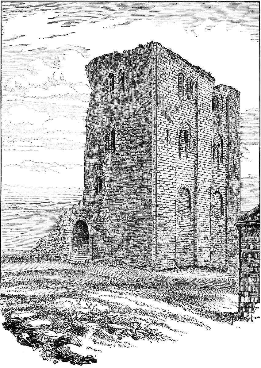
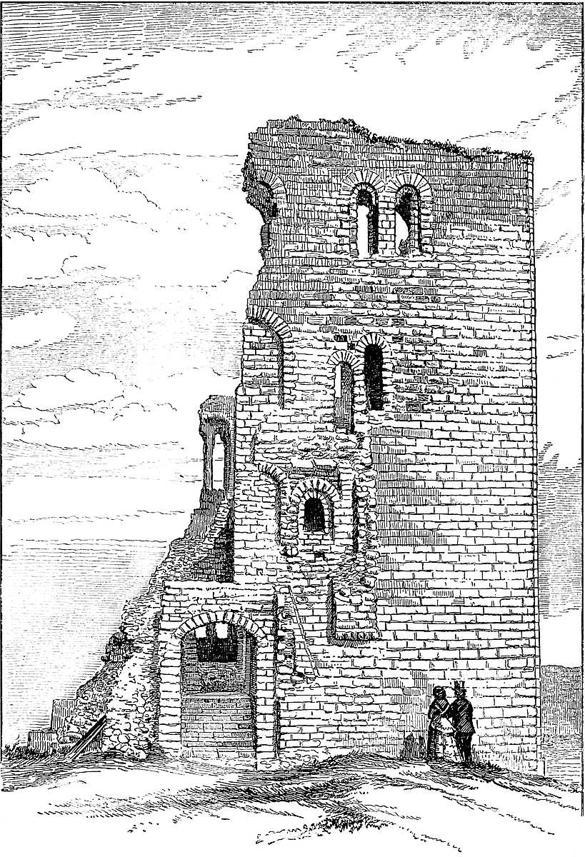
The east, the most perfect face, has the usual flanking pilaster strips, 10 feet 6 inches broad and of a foot projection, which rise unbroken to the summit, and no doubt supported the usual angular turrets, now removed. The angle at which the adjacent faces of the building meet is hollow, and is occupied by a bold round bead, 12 inches diameter; in fact, a three-quarter shaft, but without base or capital. In the centre of the face is a third pilaster, 8 feet broad, and quite plain. On this side the basement floor has no openings. The ground, in fact, is above its level. The first and second floors are marked each by two round-headed recesses, 7 feet broad and a foot deep, the second contains a pair of narrow tall round-headed windows, having side columns, and in the centre a pair of coupled columns, common to both openings. The caps are fluted, and the window arches have a bold torus moulding, the only semblance of ornament throughout the building. The upper floor is marked by no recesses, but there are two pairs of small tall round-headed windows, with square jambs and architraves. The windows composing each pair stand about a foot apart. In the flanking pilasters are two pointed loops, corresponding to the second-floor level, and lighting mural chambers.
The north face probably corresponded with that to the east, with the addition of two loops from the basement, one of which is now closed, as are the two windows above it. One flanking pilaster of this front is gone with its west end.
Of the south face the west end is gone, but what remains is full of interest, as it shows how the entrance was arranged. The face is plain, without any regular pilasters or plinth. Towards its west end is the inner entrance, just beyond which the curtain-wall of the bailey sprang from the keep. This entrance is 7 feet broad, and the depth of the thickness of the wall. The passage is round-headed and ribbed. The inner doorway is round-headed, the outer face segmental. A flight of steps within the passage leads up to the floor of the first story. It is evident from a short pilaster, some springing stones, and certain other indications on the face of the wall, that the entrance was covered here by a small forebuilding. Against the face of the keep was built a rectangular block about 30 feet long and perhaps 20 feet broad, ending against and abutting upon the curtain. It contained a vaulted passage, and over its outer doorway, at its east end, was a large funnel-shaped machicolation for its defence. Within this the vault led on until on the right hand in the keep-wall was the inner entrance already mentioned. There was no portcullis, but above the doorway is an opening or meurtrière, by means of which the entrance could be defended against those who might have forced the outer gate. The ramparts of the forebuilding were on the level of the second floor of the keep, and were reached from it by a small narrow doorway opening from a mural chamber in the south wall. Close east of this is another466 small door, a little higher, the use of which is not very evident, unless it opened upon a hoard or brétasche a little in advance of the stone parapet. A little west of and below these is a third and shorter doorway, which seems intended for the working of the meurtrière over the inner door. It is connected with a small and very narrow mural staircase.
The interior of the keep is not only filled up so as to hide the basement floor, but its eastern part has been converted into a powder magazine, and is inaccessible. It is said that the magazine includes four rectangular mural chambers, one 14 feet by 5 feet in the south wall, two 6 feet and 7 feet square, in the east wall, and one 5 feet by 6 feet in the north wall, but these have not been examined. The first floor was about 32 feet square, but divided into two nearly equal parts by a bold arch running north and south, and springing from two wall piers. The arch is gone, but the broken wall shows it to have been 4 feet 6 inches thick, and to have carried a solid wall, which divided the second and ceased at the floor of the upper storey. In the east wall of the first floor is a central fireplace of 7 feet opening with a round head and of no projection, round-backed, and with a vertical mural vent. On each side of it is a deep recess of 6 feet 9 inches opening, round-headed, and containing a pair of coupled windows already described. There are two similar recesses in the north wall, one on each side of the cross arch, of which the eastern is at present walled up, but seems to have had besides its windows a small lateral door opening into a dark mural chamber, which occupied the north-east angle. The other recess, west of the cross wall, is open, and its two windows remain. In the south wall is a small doorway which leads into a mural chamber occupying the south-east angle, but now inaccessible. At the other end of this wall is the entrance door, and between it and the cross arch a steep narrow stair leading to the opening above the entrance doorway.
At the second floor the cross-wall was pierced by a small doorway near its south end, of which one jamb remains. This floor also has a fireplace in its east wall, resembling that below, but with a segmental arch, while above it, in the wall, is a semicircular arch of relief. On either side is a recess with coupled round-headed windows, the shutter rebates of which are pointed. In the north wall are two doorways leading into mural chambers, and at its western end a recess and double window, as before. In the south wall are two openings; one, a door leading into a mural chamber in the south-east angle, lighted by a loop already mentioned, and the other a large recess within which are the two doorways opening towards the forebuilding. On the other side of the cross-wall, over the main door, are traces of a large recess with coupled windows.
No fireplace remains in the upper floor, which seems to have been occupied by one large chamber, having in its east wall two pairs of coupled windows in deep round-headed recesses, and the same probably in its north and south walls. There may, indeed, have been a fireplace in the west wall.
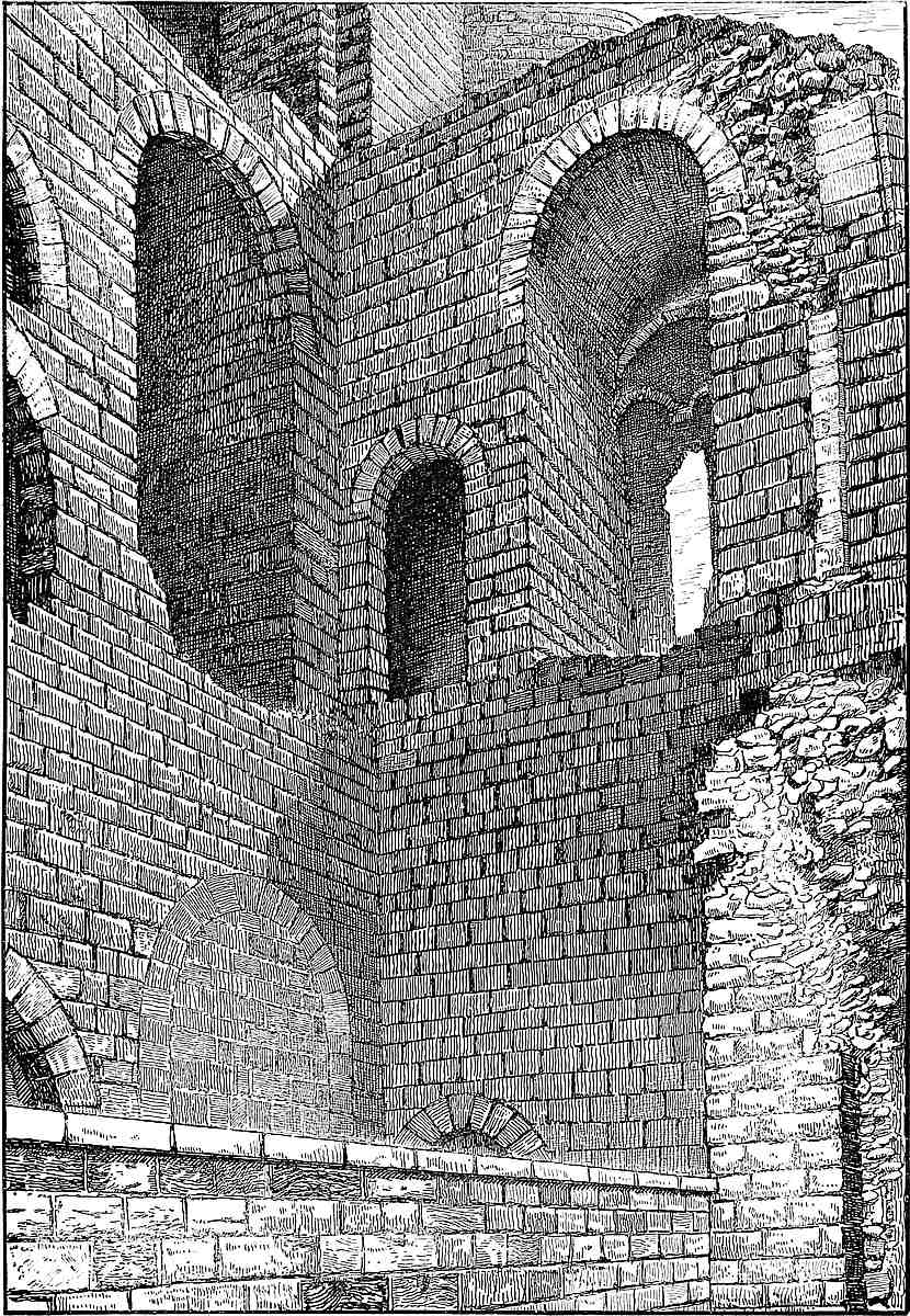
467
The floors throughout seem to have been of timber. There are no traces of a mural staircase leading from one floor to another, but there may have been such in the north-west or south-west angles. Neither is there any mural gallery surrounding the building.
It is in all respects unfortunate that Scarborough Castle is still regarded as a military post. Here, as at Dover, no one is allowed to sketch or measure within the area, although the force employed to see to the observance of this order renders it practically powerless. But the empty powder magazine is locked up, and effectually prevents a thorough examination of the keep; if this were removed, and the basement excavated, an absolutely correct plan of the keep might be obtained, which now is impracticable.
A county that contains within its borders the castles of York and Richmond may yet be proud of the possession of Scarborough, which, though not superior to those, claims with them equal rank. No doubt the circumstances of each are different. The position of Richmond on the Swale, its ancient Norman keep, early and curious chapel, and the considerable remains of its hall and other domestic buildings, no less than the rank and warlike character of its earlier lords, have invested it with a peculiar and unrivalled interest. At York, the castle, spacious in area, and strong, if not striking in position, played no inconsiderable part in the Norman Conquest; and while surrounded with the works of the Romans and Romanized Britons, claims an origin from those of our Teutonic ancestors whose name is embodied in that of England. The claims of Scarborough to rank and fame are of a different though scarcely inferior character. Its position above the Northern Ocean is wild and grand in the extreme. Its area, defined and protected by Nature, is calculated to contain, not a garrison, but an army; and its keep, in itself equal to Richmond or most other Norman structures, is here not a citadel but the mere gateway and key to what is really the fortress, and which rises from the seashore above and behind it.
AMONG the numerous strong places in Monmouthshire, which, from their character and position, seem to have been thrown up during the occupation of that border territory by the Mercians and the English during the eighth and following centuries, Skenfrith holds a conspicuous place. Its fortune, moreover, was, to be adopted, like Caerleon and Grosmount, by the Norman invaders, who placed a keep upon its ancient, though inconsiderable, mound, and girdled its elevated platform with walls and towers of considerable strength,468 so that it became of even greater importance in the twelfth and thirteenth than in the preceding centuries. It stands in the deep valley, and upon the bank of the Munnow, five miles below the castle of Grosmount, and six above that of Monmouth on the same river, besides which it forms the south-eastern point of the celebrated Monmouthshire trilateral, Grosmount and Whitecastle being the two others, so celebrated in Border warfare, and especially in the contest between Henry III. and the Mareschals, earls of Pembroke. Churchyard writes of them as,—
Unlike the elevated and rock-founded castles of Chepstow and Ludlow, the strength of Skenfrith was in the low and marshy character of its position. The Munnow flows within a few feet of its walls, and overflowed into its ample ditches, and a few yards below the castle is the bridge mentioned by Leland. Skenfrith marks the uniting point of several valleys, and even now, with the advantage of modern roads, is by no means easy of approach. Probably, in some measure on this account, it has suffered but little from additions or alterations, and as little from violence. Time, the greatest but least violent of revolutionists, has been the principal agent in the changes that have taken place, and the great obstacle to the study of the castle by the antiquary is the rich and redundant mantle of friendly ivy by which it is draped.
Skenfrith belongs to that family of castles of which Coningsborough and Launceston are the English types, and of which Brunlais, and, in some degree, Tretower, are local examples. Its keep is a cylindrical tower, with a widening or battering base, to which the elder antiquaries gave the name of a Juliet. This stands within an inclosure formed of curtains and bastion towers, in this instance forming a trapezium in plan, of which the northern and southern sides are 74 yards and 71 yards, and the eastern and western 31 yards and 59 yards. The diameters of the area, measured across the keep, are, northern and southern, 48 yards, and eastern and western, 57 yards.
The keep stands unconnected with the curtains, and nearly on the central line of the area, about ten yards from its eastern end. It crowns a low mound, about 6 feet high, and 50 feet broad at the top, evidently artificial. If the mound ever had a proper moat, it has been long filled up. The tower is now about 40 feet high, and may have been 5 feet or 6 feet more. It is a cylinder of 36 feet in diameter, with walls 7 feet thick. Ten feet above the ground is a bold, half-round string or cordon, below which the wall batters, and469 at the base is 10 feet thick, augmenting its diameter there to about 42 feet. The present entrance is to the west, by a doorway of 5 feet 6 inches opening, having an interior door opening inwards and probably having had an exterior door also, but the doorway is now a mere breach in the wall, with but a fragment of the rebate of its inner door. The masonry, and the absence of bar-holes, show this doorway not to be original. Probably it was opened in the Decorated period, when passive strength was less an object, and a first-floor entrance was found to be inconvenient. Such later openings are common in keeps with close basements. There is one at Pembroke.
The basement chamber is circular, 22 feet 4 inches diameter, and its floor is at the ground level. In it are two loops, with flat tops, in recesses splayed to an opening of 3 feet, of which the cills are 3 feet from the ground. The wall is quite plain, and there is no trace of a well. This chamber was 11 feet high; no doubt, a store-room, and must have been entered from the chamber above by a ladder.
The first floor, of the same diameter, was 14 feet high. This was the principal chamber. The floor was of planks resting upon four large beams laid across, the outer beams receiving the ends of some shorter timbers laid at right angles to them. The doorway points about west, and is partly over that of the basement. It was 5 feet broad, and its passage-vault was round-headed, but the ashlar dressings are gone. There is no trace of a portcullis. In the substance of the wall is a square hole, probably once containing an oaken tie, such as was used at Brunlais and at Rochester. This doorway was evidently the original and only entrance to the keep. To the right of the entrance a second door opened into a mural stair, a fragment of the cylindrical shell of which remains. This led to the second floor and battlements. For its support the external wall is thickened by a half-round buttress, solid below, and ascending to the summit. The door and the staircase are utterly ruined. In this floor are two window openings in flat-sided recesses, apparently round-headed. The windows, probably large loops, are broken away, and the ashlar face of the recesses is gone, but the relieving arch in the wall is flat pointed. Near the north recess is a corbel of Decorated aspect, 6 feet from the floor.
The second story, entered by the winding mural stair, is much obscured by ivy. Its floor was of stout plank, resting upon a large single cross-beam, of which one support, a broad plain corbel, remains; the planks fitted into a rude groove or chase, not a set-off, in the wall, which is, therefore, not diminished in thickness. The curve of this story is a little impaired by a projection connected with the stair: and there is a sort of recess, which may have been the kitchen fireplace, the cooking being usually, in these towers, carried on in an upper floor, as at Castell Coch and Morlais. There were three windows in this floor, but of them little is to be seen, nor of what may remain of the ivy-covered battlements. The main floor was plastered, though thinly. It is evident that the floors were470 always of timber. The main strength of a tower of this character was passive, the loops and windows counting for nothing in the defence, but no doubt the battlements had a rampart walk, and the roof, therefore, was either flat, or if conical, sprang, as at Coucy, Coningsburgh, Pembroke, and Marten’s Tower at Chepstow from an inner wall. Nothing can be more senseless than, as some modern architects have done, to cover these towers with a conical roof springing from the outer wall, which thus could not be defended in the only way possible with such structures, from above.
The curtain wall of the single ward within which this Juliet keep is placed is 8 feet thick, and from 30 feet to 40 feet high, the contained area being at a level 6 feet to 10 feet above that outside, and no doubt raised artificially. The four angle towers were cylindrical, 11 feet internal diameter, and with walls 8 feet thick. They have no internal projection, but the angle at each is crossed and filled up by a gorge wall, 7 feet long. Both towers and curtain have an exterior base about 12 feet high, battering below to a thickness of 10 feet, but without a cordon. Each tower is entered from the gorge by a door of 3 feet opening, and its basement is elevated about 4 feet or 5 feet above the inner court. Each has three loops in recesses 4 feet 5 inches deep, and 5 feet 8 inches broad. There are no staircases, though there seem to have been two upper stories, the highest rising above the curtain. The floors were of timber. The arches vary; some are round-headed, others lancet, others drop-pointed. The loops are square-headed. The south-west tower has been taken down, and the present entrance to the place is through the gap.
In the south front, 60 feet from the west end, is a half-round buttress tower, with no internal projection. The breaches in its interior and exterior faces show it to be solid. Opposite to this tower, in the north wall of the court, is a doorway of about 6 feet opening, the pointed arch of which is seen just at the level of the court. As the sill of this doorway must be at about the level of the Munnow, it was probably connected with a short canal for the admission of a boat, like what is seen at Tonbridge and Leeds Castles, and at Caerphilly. In this same wall, but close to the north-east tower, is a small, flat-sided recess, either a door or a window, and 6 feet above the court level. If a door, it must have been for the lifting of stores from a boat upon the mill-leat which flows below it.
There is no trace of a regular gatehouse to this court, but a part of the centre of the west wall has been rebuilt in an inferior manner, and probably represents the entrance. This entrance was likely to have been by a mere doorway in the curtain without a regular gatehouse, like the lesser gateway at White Castle. From this point a slightly-elevated causeway, crossing the court, leads direct to the central tower.
The walls are tolerably perfect, but the battlements have been removed, and the upper stages of the towers are in ruin. It is remarkable 471 that the mural towers are without staircases, and there are no visible mural chambers or garderobes, or, with one doubtful exception, fireplaces, in the castle. The material is the old red sandstone of the district, as was the ashlar. The workmanship is ordinary but pretty good rubble, and the mortar coarsely mixed and freely used. The mill leat, and the Munnow immediately beyond it, form the defences on the north front. Along the other three fronts was a broad and deep ditch fed from the river, and now filled up. As the ground within the walls is 6 feet to 10 feet higher than that immediately outside, they are to that extent revetments. It is pretty clear from the appearance that the original fortress was a raised platform, in its centre a mound, and around it a wet ditch, the whole, no doubt, strongly palisaded.
There is nothing of a Norman character in either the plan or details of the structure. The singular form of the area may be but an accommodation in right lines to an irregular earthwork. Had it been Roman, the platform would scarcely have been raised. The keep tower is clearly early English of the time of King John, or early in that of Henry III. The surrounding walls and towers are of the same date.
The history of Skenfrith is obscure, but it is evident that it was built simply to contain a small garrison, and not at all as a private residence. The area contains no trace of hall, chapel, or kitchen. No lines of foundation are visible, and whatever lodgings were erected were probably of timber, with roofs resting against the wall.
Skenfrith is said, at the entrance of the Normans into the district, to have been held by Bach, a son of Cadivor ap Gwaethvoed, which Gwaethvoed is the reputed ancestor of several families in Monmouthshire and East Glamorgan, and who, or his father, was likely enough to have obtained possession of it during the victorious campaign of Caradoc-ap-Griffith in 1065. The Pipe Roll of the first year of John shows the castles of Skenfrith, Llanteilo or White Castle, Kinton, and Ledbury, to have belonged to the king; and in 1205 (5 John) he granted Skenfrith, Llanteilo, and Grosmount to William de Breos, to hold them as they had been held by Hubert de Burgh, and Geoffrey, Earl of Essex, was allowed 20 marcs which he had paid to De Burgh for fortifying them. This probably was the date of the present masonry. John de Monmouth, a powerful local baron, had some claim upon these castles, which was admitted by the king; but nevertheless, in 1219, De Burgh was ordered to have seizin of the three castles forfeited by the defection of William de Breos. William’s heir was Reginald de Breos, who was in ill-health; he demurred to the decision of the king’s court. In 1220 they were held by De Burgh. In 1223 the king had occasion to send a messenger to Skenfrith, and in 1224 the Sheriff of Hereford was directed to send thither to De Burgh 2,000 quarrels (heads of cross-bow bolts), and all through the troubled reign of Henry III. these castles continued to be of great military importance. At the settlement of Wales by his son they probably were allowed to fall to472 ruin. With most of the surrounding property Skenfrith finally fell to the Duchy of Lancaster. As early as the time of James I. it was presented by the local jury as “ruinous and decayed, time out of the memory of man.”
The parish church, containing some fragments of early English or early Decorated date, stands a few yards west of the castle. It contains an altar tomb, bearing the effigies in a sort of trick of John Morgan, who died 2nd September, 1557, and Ann, his wife, who died 4th January, 1564. On the side of the tomb are figures in relief. The armorial bearings are,—quarterly, 1 and 4, Barry of 9, on six escutcheons, 3, 2, 1, as many lioncels rampant, 2 and 3, three towers, in the nombril point a roundel. Evidently these are the arms of Cecil, and point to the connexion claimed by that family with Wales. Another shield bears on a chevron three sprigs, between three spear-heads; crest, an arm embowed grasping a ——. John Morgan is said to have been of Wayne, in this parish.
AT the head of the inlet known as Southampton Water, between its two principal tributaries of the Test or Anton and the Itchen, intervenes a considerable neck or tongue of gravel, which is thus bounded on three sides by water, and is a position of considerable natural strength, and the more valuable that it overlooks a fine roadstead, having the Isle of Wight for its breakwater. By whom this spot was first occupied is unknown. Bittern, an unquestionable Roman station, under the name of Clausentum, is nearly two miles farther up the Itchen, and upon the opposite bank. Even the origin of the present name of the town is a subject of dispute. The Anton presents a tempting source, but it seems most probable that the name means simply “the town of the southern dwelling,” as opposed to Northam, a place close to the Roman station. Certainly the name has no reference to Northampton.
“Hamtunscire” is mentioned in the “Saxon Chronicle” in A.D. 755, and the town was a Saxon place of some mark, coining money in the reign of Athelstane, and occasionally plundered by the Danes. Canute held it, and his experiment upon the advancing tide is said to have been tried in Southampton Water.
Southampton is named in Domesday, and the Normans found it a convenient port both for military and commercial purposes. It was visited and maintained by the Plantagenet monarchs, who here mustered and embarked their troops for Normandy. Hence the town473 was fortified from an early period, both after the Saxon and the Norman fashion.
The walls enclosed a roughly rectangular space, averaging about 370 yards east and west, by 770 yards north and south, but in actual circuit about 2,200 yards, or 1¼ mile. This area is divided lengthways by the main street, but the western is the larger moiety, partly because it contains the older castle, and partly because of an irregular projection upon what is called the “tin shore.” The north and south gates were upon the main street. There was an east and a west gate, but not at all opposite to each other, nor were the roads cruciform. There is no reason for attributing to the moderately rectangular plan a Roman origin. It was probably dictated by the general figure of the ground.
The surface of the area varies from 15 feet to 35 feet above the adjacent sea level. The northern half is higher than the southern, the western than the eastern. The highest ground, therefore, is in the north-west quarter, where was the castle.
In consequence of this, the wall of this quarter, towards the west, is built against a scarped bank, and is a revetment 30 feet high, whereas elsewhere the wall is built upon ground nearly level, or at best not above 3 feet or 4 feet higher on the inner than the outer side. Besides the castle there is no considerable earthwork, and no reason, therefore, for attributing the defences of the town proper to a period earlier than the incoming of the Normans.
The earthworks of the castle are, however, considerable. The naturally high ground was scarped and pared and somewhat raised, and near the centre of the area the highest point was surrounded by a circular ditch, the contents of which, thrown inward, converted the raised platform into an artificial mound. This, beyond doubt, was the Saxon fortress.
The rectangular area was also well defended. It had the sea for its ditch nearly at the foot of the wall along the west and south fronts. Along the east a broad and deep ditch, wholly artificial, and in part, at least, admitting the sea, ran along the foot of the wall, and divided the town from a strip of lower land, which slopes towards the Itchen, and is now covered by an important suburb. Along the north front a ditch, also artificial, was cut across the ridge; it is said, to a depth allowing it to be filled from the sea. As this would involve a depth of about 40 feet, with a corresponding breadth, the tradition is probably an exaggeration.
The north and east walls, least affected by any irregularities of ground, and nearly straight, are in length about 318 and 790 yards. The south and west fronts are curved and broken to suit the ground, and measure about 320 and 650 yards. The south-west angle is largely rounded off. Of recorded gates, there were the north or Bargate, still standing; the east gate, removed; the spur gate, remaining; the south, or water gate, removed; the west gate and the postern, preserved; Biddles, or Bridle Gate, gone; and the castle water gate, closed up.
474
The mural towers were chiefly drum, or half round. The north front is flanked by two drum towers, and west of the Bar is one, and east of it two, half-round. Upon the east wall, north of the east gate, was one; and, south of it, six, of which one remains, half-round, and one rectangular. At the south-east angle, the south wall was prolonged eastwards as a spur-tower, covering the ditch; this remains. Upon the south wall there were six towers, including the south flank of the spur gatehouse, and, on the opposite flank, the Bugle Tower. All but one are half-round. The west wall had many buttresses, and few towers. There was one where the south wall of the castle joined the town wall; and near the north end is a fine half round tower,—an addition.
Passing to the details, the north gate, called the Bar, is a large, handsome structure, about 60 feet broad by 60 feet deep in the centre. It is of two stages, pierced below by a central and two lateral passages, and contains above a chamber, 52 feet long by 21 feet broad, used for public purposes. In each wing is a staircase. That to the east is old, that on the west may have been so. The side passages are modern. They communicate with the central roadway by two cross arches on each side, of which the two next the north are original, and probably led into the flanking towers. An examination of the central passage shows the original gate to have been late Norman; at least a round-headed portal there placed is probably in that style, though it has rather a Decorated aspect. Then in the early Decorated time two bold half-round flanking towers were added, and still remain. At this time the rear was probably refaced, and four windows and a centre niche inserted, and the council-chamber enlarged, and probably the east staircase added. The Norman gatehouse had an upper room, of which a round-headed door, with a foliated head, remains. Next, in the Perpendicular period, a bold projection, three sides of an octagon, was added to the front. The gateway, thus advanced, is flanked by two bold, narrow buttresses, which run up to a very bold corbel table, having six machicolations in the central face, and three in each of the oblique lateral ones. The battlements are good Perpendicular, and carried round the rear towards the town; one embrasure is occupied by an alarm-bell. This gate has been much injured by restorations. The openings to the rear, archways and windows, have been refaced; but they preserve much of their old type, and have a Decorated aspect. The main passage has been cut away and widened, and the portcullis grooves are gone. When the ditch in front was filled up, a century ago, all trace of the drawbridge was lost. It appears that this bar was formerly a prison, and the curious cross arches were part of the arrangement for that purpose.
West of the Bar much of the wall remains, but is so blocked in by houses as to be invisible. Forty-six yards from the gate is the site of a half-round tower, beyond which the wall extends in a straight line to Arundel Tower, so called from Sir John Arundel, an early governor. This is a drum, 22 feet in diameter, which caps the475 north-east angle of the town. This tower is 50 feet to 60 feet high, and seems to rise out of a rectangular mass of masonry, possibly added to strengthen it. Here the internal level is 30 feet, or more, above the external, being a part, no doubt, of the old earthworks.
Continuing along the west wall, at 763 yards is a bold, half-round tower, 20 feet diameter, and 30 feet high, of excellent rough ashlar, with bold machicolations at the level of the adjacent curtain. This is Catchcold Tower. Built against the bank it looks solid, or like a bastion, but it is said to be hollow, though how entered does not appear. This tower, with the adjacent wall for some feet, is apparently a Perpendicular addition to what seems to be a Decorated wall. Beyond the tower is a flight of steps, modern, ascending 30 feet to the summit of the wall, which is there common to both town and castle. The wall then runs forward obliquely, probably to allow of the inclusion of the earthworks of the castle. It seems in substance Norman. The salient is capped by a rectangular buttress, the hollow angles of which on each side are crossed by low, pointed arches, pierced as garderobes, as at Porchester. This buttress tower is of Decorated date.
Then follows about 134 yards of straight wall, probably Norman, about 38 feet high, and backed to the summit with earth. Upon it a small rectangular buttress marks the junction of the north wall of the castle with the town-wall. Further on are five rectangular buttresses of various dimensions. The three first are evidently additions upon the Norman wall, the rest seem original. Part of the wall here is divided into two stages by a bold horizontal bead. Below are two narrow windows of about 18 inches opening, resembling large loops, and which seem to have had square heads. Above are traces of two windows, apparently round-topped. There must have been an interior chamber, now closed. The central buttress is broad and flat, and here are traces of the old water-gate of the castle, which must have been reached by steps, the ground behind being above 30 feet high. Close north of this water-gate is a large vaulted chamber, built against the town wall, and now closed. This part of the wall now ends in a rectangular projection, probably the root of a tower, and marked the junction of the castle south wall with the town wall.
From hence the wall is low and thin for about 33 yards, marking the end of the castle ditch, and out of the regular line, having, no doubt, been rebuilt in modern times. On the rising ground of the castle counterscarp is the root of another square tower, marking the recommencement of the regular town wall, which then turns inwards so as to protect Biddles or Bridle Gate.
This gate, now removed, opened into a steep and rather narrow ascent called Simnell-street, out of which, on the north side, opens Castle-lane, thought to represent an old entrance to the castle.
At Biddles Gate commences a very curious part of the wall, which, as far south as a little beyond Blue Anchor postern, is unlike any476thing known in England. The original wall, here about 30 feet high and 4 feet thick, with the soil nearly level within and without, seems to have served not only for the town wall, but for the wall of several dwelling-houses within it, the doors and windows of which are visible in the wall, though now closed up. These openings show the wall to have been Norman, and of a moderately early period. This wall was not found sufficiently strong for the purpose of defence, and a second wall, also 4 feet thick, was built against it on the outside. But this second wall was built like an aqueduct, as an arcade, upon tall and slender piers, about 2 feet 2 inches broad, from which, at 10 feet 6 inches high, spring arches mostly semicircular, but some pointed, and two very flat and probably much later, above which was the parapet. The arches are about 12 feet span. The result was to increase the rampart to a walk of 5 feet, with a parapet of 2 feet, and probably a rear wall of 1 foot. Of course, an arcade so placed afforded great shelter for those attacking the wall from without; but to obviate this, while the piers touched the wall, a space like that for a portcullis, a chase about 2 feet broad, was left between the arch and the wall, by means of which any one standing at the base of the wall could effectually be molested with missiles or a long pike. Eighteen arches of this arcade remain. The arrangement is a very curious one, and supposed to be singular. This masque or outer wall may be of late Norman date, but is possibly early English. The piers interfere much with the earlier doors and windows. The wall, where double, is 35 feet high. There are traces of some kind of building outside a part of the wall.
A hole broken through the wall into Blue Anchor-yard shows the rear of the wall, and a little further south is Blue Anchor Postern, an original archway in the wall, much cut about and enlarged, but of which the portcullis chase, worked from the battlements, as at Fishergate, York, still remains. From the postern a very steep, winding narrow lane leads up into the town, between lines of ancient houses, of which two, one on each side, next the gate, are Norman. Both are curious, but that on the south side especially so. It is the shell of a Norman house, of the age of the older part of the wall. It is called, locally, King John’s Palace, but is, in truth, an ordinary Norman private house, and a fairly perfect one. The principal room was on the first floor. The roof is gone, but the door and windows remain. These are coupled, small, round-headed, and divided by a short column, with a slightly sculptured capital. The space within the walls is 43 feet by 45 feet. There is a good Norman fireplace, with hood and flanking columns. In the south and part of the east wall is a mural gallery. The house on the northern side of the lane is 44 feet by 15 feet. There is a good view of the town wall, and a plan of the two houses, in Parker’s “Domestic Architecture of the Twelfth Century,” p. 34.
South of the postern the wall ceases to be double, and is all of one date, and about 6 feet thick. In this part is a flattish rectangular mural buttress tower, much blocked in with houses, but having its477 south hollow angle crossed by a squinch arch carrying a garderobe. Near this is a high pointed doorway, evidently an insertion, of 24 feet opening, leading into Collis-court, and about 60 feet further is the west gatehouse.
This is a perfect and plain rectangular gatehouse, 30 feet deep by 24 feet broad, without buttresses, flush with the wall outside, and of bold projection within. It is pierced by a high pointed vault, of 12 feet opening. The passage has been a good deal mutilated with a view to widening it. Near the centre was a good recessed doorway, the profile of the head of which is still traceable where it has been roughly cut from the wall. Between this and the inner face are two square portcullis grooves, and just within the inner entrance is a chase, 18 inches broad, over the head of the arch. In the vault, in front of the central door-case, are nine holes, about 4 inches square, three in the crown line, and three along each haunch. These latter converge towards the central line.
The gatehouse has a portcullis chamber on the first floor, and a second floor above this. An open stair against the south side leads to the battlement, from which a door, an insertion, opens into the portcullis chamber. These upper rooms are plastered and papered, and nothing can be seen in them.
South of this gate the wall continues in a fairly perfect state for 80 yards, and finally has been pulled down and removed. It may be traced as far as the site of a half-round tower, and some remains of an arch. Beyond this, also, the line of the wall may be traced as far as the site of Bugle Tower, 180 yards from the west gate, and which caps the south-west angle of the town.
The south wall is almost wholly destroyed, and the foundation either removed or covered up by the broad and handsome quay which now intervenes between the base of the wall and the sea. This front was more or less convex, or rather polygonal, the angles being capped with drum towers. There are some traces of the south gatehouse. In the rear of this part of the wall are the site of St. Mary Magdalene’s Hospital, and in Porter Lane what was called Canute’s Palace. A representation of the south gate before 1784 is preserved by Grose. It had a low, broad Edwardian arch, with bold machicolations above, and toward the east it was protected by a long flanking wall, parallel to its approach. It was removed 1830–40.
Forty yards from the south gate was another half-round tower, and thence the wall ran straight east for 83 yards, when it reached the south-east angle of the town. In the rear of this part of the wall, in Winkle-street, is “God’s House,” a Norman church, now restored very badly, and converted into a French Protestant place of worship.
At the south-east angle of the town, in the end of the east wall, is a gate, called God’s House Gate, or South Gate, but which should be called Spur Gate, as it opens upon a work of that class. This gatehouse is rectangular, quite plain, and without buttresses, having478 two upper floors. Its dimensions are 28 feet broad by 23 feet deep, and the south end projects as a low salient of two faces, upon the south wall, now removed. The passage is vaulted with a high pointed arch 12 feet broad. Like the west gate, it had a central recessed doorway, now much cut away, and two portcullis grooves. The vault in front of the door is supported by two, and in rear of it by three, cross-ribs. Altogether, in substance, this gatehouse resembles that of the west gate, and is of early Decorated date. Its front may have been rebuilt when the spur tower was added.
The spur work projects from the northern flank of the entrance of the gatehouse for about 80 feet. It is composed of a sort of lofty gallery, or curtain, terminating in a rectangular tower, about 22 feet square, with buttresses capping the two east or outer angles diagonally. It is of three stories, and is built across the eastern ditch, no doubt to contain and protect its sluice communicating with the sea, which originally flowed up to the wall of the tower. There are seen large arches in the north and east faces, which look as though there had been a passage for boats; but these seem really to have been arches of construction only, intended to throw the weight of the building upon the corners, which probably are more deeply founded than the curtain. In the north face is also a large modern arch, a relic of the canal which was to have been carried beneath the tower. The spur-work and the gatehouse were long used as a Bridewell. All still bear marks of that degrading occupation. The whole spur-work is good Perpendicular. Leland calls this the south gate, and the spur tower the Castellet. Grose gives a view of it about 1770. From the Spur Gate the town wall is tolerably perfect as far as the first half-round tower, 60 yards. From hence the wall may be traced 35 yards to a flat buttress, 14 feet broad and 3 feet deep, of which there are some remains. Beyond this, at 37 yards, is the site of a rectangular tower, 30 feet broad and 24 feet deep These two are said to be additions of the time of Edward VI. They look much older.
From hence to the north-east angle of the tower the wall has been pulled down, but its line may be traced, partly by occasional foundations, partly by its materials which have been used in the houses built on its site, and partly by the direction of the lane called “Back o’ the Wall,” which runs along its rear, and by the parallel road which runs along the counterscarp of the ditch, and is called “Canal Walk,” from an abortive canal which was carried along the line of the ditch at the commencement of the present century.
The east gate spanned East-street, and was taken down in 1772. Grose gives a drawing of it, and attributes its erection to the year 1339, 13 Edward III. Between this gate and the north-east angle was one mural half-round tower.
Of Polnymond Tower, which caps the north-east angle, there are considerable remains. It is a three-quarter drum tower, about 28 feet diameter. From it to the bar, 160 yards, the wall, or part of it, remains, but so clustered with buildings as to be inaccessible479 to ordinary visitors. Here are remains of two half-round towers, and a breach in the wall, called York Gate, probably representing a postern.
The east ditch is marked by a depression, in part due to the canal. The north ditch is completely obliterated and built over, and its breadth is not recorded, and has not been ascertained by probing. If Hanover Buildings mark its counterscarp, it was 46 yards broad; but if, as is much more probable, its limit is marked by Cold Harbour, it was only 24 yards, which tallies with that along the east front.
The castle was very probably the oldest, and perhaps the only præ-Norman fortification connected with the town. It occupied nearly the whole of the north-western quarter of the walled area, and included also the highest ground. In plan it was a rough semicircle, the chord of 124 yards being the town wall, and the arc measuring about 300 yards. There is, however, also a considerable knoll, on the south-east of the area, of about 45 yards diameter, about half of which lay outside the curved enceinte.
This was the keep. Leland calls it the dungeon (donjon), and the “glory of the castle.” “It is,” says he, “both large, fair, and very strong, both by works and by the site of it;” and other writers describe it as a lofty mound. As usual, in forming such works, advantage was taken of high ground to make it the base of an artificial mound encircled by a deep and broad ditch. The keep, no doubt a shell of masonry like Arundel, towered above the rest of the works. Of the curved wall of the enceinte a part remains to the north. It was built on piers about 8 feet square and 9 feet apart, a round-headed arch with a tendency to a point connecting these. The tops of these arches were about 12 feet above the base of the piers, and upon them rested a wall, which carried the battlement. The arches were buried in a bank of earth about 15 feet high. This bank has been removed to allow houses to be built up to the wall, which now, therefore, stands like a Roman aqueduct. The foundation is excellent, so that this plan was adopted solely to save material and to profit by the older bank. The roughness of the masonry shows the height of the bank, above which the remaining wall rises about 4 feet. It is much to be regretted that this curious piece of Norman wall has been so badly treated. About 90 yards of it remain, including eighteen arches. It stops at the Castle-lane, where was the main gate of the castle, removed at the end of the last century.
The wall, beyond the gate, was continued up the mound to the keep, and beyond it till it reached the southern gate, whence it was continued till it again struck the town wall. Thus the keep was upon and formed part of the enceinte, as was usual. From the south gate, also removed in the last century, a winding road, commenced from the wall, led down to Simnell-street, a few yards within the postern.
480
Near the castle, against and within the town wall, is a large subterranean vault, now closed; and, judging from the openings in the wall, there was a corresponding vault to the south of this.
The whole area of the castle is high, and much of it has been still higher, the mound having been lowered, the ditch partially filled up, and the bank along which the wall was built having been removed.
To judge from the material evidence afforded by an inspection of the works, it would appear that the castle represents the Saxon or Danish earthwork, probably the earliest strong place, and was composed of a truncated mound, its circular ditch, and a bank of earth encircling an area, of which the mound or a moiety of it made part: the whole forming a burh of the first class.
The Normans, probably in the reign of Henry I., enclosed the castle and town in a rectangular wall, and dug the east and north ditches. Also the castle was enclosed with a wall built in part on arches, and a shell keep placed on the flat summit of the mound. The wall of the castle, and much of the west wall of the town, and the two houses in Blue Anchor-lane, may be attributed to this period.
Then it became necessary to strengthen the town wall, and this was probably done in the reign of King John, who, it appears, remitted to the citizens £200 out of their fee-farm rents for the enclosure of their town and the thickening of the wall, and perhaps the west and spur gates were begun at that time.
Much must have been done to the fortifications during the reign of Henry III. or Edward I. To this date are probably due the older drum towers and much of the wall connected with them, and the recessing of the Bargate and the addition of its flanking towers.
It appears that the town was attacked by pirates and sacked in October, 1338, 12 Edward III., and in consequence it was strengthened in the next year. The south and east gates may have been of this date, and the spur tower and its gallery, unless this latter be, with the completion of the Bargate, the work of Richard II. This king seems to have done much to the castle.
The vault indicated on the plan as on the north side of the water-gate is at present wholly underground, being built against and within the exterior wall, its floor being about the level of the footing of the wall. The vault measures 55 feet 3 inches north and south, by 19 feet 6 inches east and west, and is about 25 feet high. Sir H. Englefield says it has much the air of a chapel. Others call it a guard-room to the water-gate. A chapel would scarcely have stood north and south, and a guard-room, especially so large a one, however necessary for a main gate, would be quite out of place beside a mere postern. The vault was entered a few weeks ago through a long closed-up opening in the west wall, but the writer has been unable to learn what was then observed.
To the south of the water-gate is, or was, a similar vault, indi481cated by the openings in the wall, one 3 feet and one 1 foot from the ground, both long since built up. Probably these two were the substructures of two buildings which formed a part of the exterior wall, and were used for stores or cellars.
It is difficult to speak too highly of the large scale plan of Southampton executed under Sir H. James, upon which the lines of the old wall, and position of other objects of antiquity, are shown in a manner which leaves nothing to be desired.
TAMWORTH CASTLE stands at the confluence of the Anker with the Tame, on the right bank of either, between the town and the latter river, and close above St. Mary’s Bridge. It occupies a position near the east end of the south, or river front, of the old town, the outlines of which are still indicated by a bank and ditch, showing it to have been in plan a parallelogram, with one side resting upon the Tame, and the east end defended by the Anker. The low ground about the junction of the rivers, the broad meadows on the left bank of the Tame opposite to, and on both banks below the town, in their natural condition a deep morass, must have rendered the place nearly inaccessible upon its east, south, and west fronts; and, no doubt, led to its conversion into a safe residence at a very early period.
As the ground rises from the river, the town and its grand old church occupy positions rather higher than the castle, and which must always have been dry and airy and, in consequence, salubrious.
The line of the town defence upon the east side is known as the King’s Ditch, in reference, it is supposed, to the Mercian Offa. Though without anything like sharpness of outline, and occupied as a nursery garden, the work is by no means obliterated, and may be traced nearly from the Anker below Bolebridge for about 300 yards northwards. It is composed of a raised bank, which formed a terrace behind the wall or palisade, a ditch more or less filled up, and beyond this a slope representing a glacis, or space outside the works, which it was the custom from a very early period to keep clear of cover. Bank and ditch are about 45 feet broad. The Market-street intersects the line of defence, and, being old, probably was crossed by a gatehouse. There are some slight and uncertain traces of masonry upon its north side. Further north, a modern road affords a good section of the bank.
This side joins the north front at a right angle, within which is a sort of tump, remembered as somewhat larger, and which looks as if482 it marked the site of a mural tower, or perhaps a cavalier or small mount.
The defences of the north front skirt the Lichfield and Polesworth road, and are traceable nearly to the cross-road from Seckington. Beyond this, the line, now built over or enclosed in walled gardens, was traced by Dugdale along a front altogether of 400 paces, to a mount marking the north-west corner, from which the line passed at right angles southwards to the river. This would give a space of about 300 yards by 400 yards as the enclosure of the town. Outside the west front the ground sinks rapidly into the meadows, among which, on the river bank, and just outside the town, is the Moat House, an old seat of the Comberfords, still standing in all its dampness, although the moat has been filled up.
The principal bridge, that across the Tame, close below the castle, known as St. Mary’s or Lady Bridge, is of modern construction. It succeeded a mediæval structure, shown in Shaw’s plate of 1780, the precursor of which was probably a bridge, or perhaps a ford, of Saxon times. In Leland’s day, a stone upon it bore the arms of Lord Basset, of Drayton.
Bow, or Bolebridge, crosses the Anker, and leads to the hamlet of Bolehill and to Nuneaton.
The church is a large structure of considerable merit, containing some Norman work, apparently once connected with a central tower, and in which may be seen traces of herring-bone masonry. East of it are some ruins, known as the Deanery, part of which seems also to be Norman. The Market-place, though much altered, represents an early space set aside for trading purposes.
Tamworth has no historical pretensions to either British or Roman origin. The Britons would have designated it from the smaller stream. The earliest mention of it is in the records of the people in whose tongue it is named. Offa, King of Mercia, in a charter of A.D. 781, announces himself as “Ego Offa rex, sedens in regali palatio in Tamoworthige,” an evidence of its distinction at that time, and one which renders it probable that it had an earlier history. Cenwulf dates a charter of A.D. 816, “In vico celeberrimo qui vocatur Tomoworthig,” and other royal charters are dated from it in 841 and 854. So that in the eighth and ninth centuries it was already a royal residence and a place of celebrity.
The Danes ravaged it in common with much of Mercia early in the tenth century, and in A.D. 913–14 it was restored by Æthelflaed,
daughter of Alfred, sister of Edward the Elder, and the foundress of Tutbury, Warwick, and many other well-known Saxon places of strength. She is reputed to have cast up the mound, and to have placed her residence on the summit. She died here A.D. 918–22.
The castle and half the town are in the shire of Warwick; the other half and the church in Stafford. There is no mention of the castle in Domesday.
483
At the Conquest, Tamworth became the property of Robert Marmion, who seems to have fortified it, as such earthworks were fortified in Normandy, and to have made it strong enough to be obnoxious, some time later, to King John, who, in 1215–16, ordered it to be razed. Under Henry III. another Robert was its lord, and Philip Marmion died seized of it in 1291–92. From Marmion it descended to Frevile, thence to Ferrers, thence with Ann Ferrers, at the end of the seventeenth century, it came in marriage to the house of Shirley, from whom, through Compton, it passed to the Townshends, whose representative, Marquis Townshend, is sixteenth Baron Ferrers by writ of 1299, and owner of Tamworth Castle, while Earl Ferrers, the male heir of the Shirleys, is Viscount Tamworth, by creation in 1711.
From the Norman Conquest to 20 Edward I., the castle descended through five generations of Marmions; from thence to 7 Henry V., through six of the house of Frevile, and from thence to 1680 through eleven descents of the name of Ferrers; being twenty-two lords from the Conquest to 1680. King James and Prince Charles lodged here in 1619.
The castle is composed of a mound, a platform, buildings upon the mound, a curtain-wall ascending it, and the remains of a gatehouse.
The mound is wholly artificial, about 50 feet high, circular, and about 100 feet diameter at its flat summit. Its sides stand at the natural slope of mixed dry earth and gravel, the débris of the new red sandstone of the district; and its base may be about 12 feet above the river.
South-east of the mound is a triangular platform, also more or less artificial, and raised about 15 feet above the river. One side is straight, and fronts the water. That to the east is at present a hollow curve, and has evidently been retained by a wall against which it formed a terrace. This side extends northwards to the ruined gatehouse, indications upon which seem to show that part of the platform has been removed, and that it originally extended a few yards eastwards into the present brewery; so that this front was, no doubt, straight, and not, as now, concave.
The third side, or hypothenuse, of the platform lies towards and partly encircles the mound, and is therefore concave; and between the two is a ditch. Excepting this “valley of elevation,” there is no present trace of a ditch at the foot of the mound.
Below the south front, between it and the Tame, and close above St. Mary’s Bridge, is the castle mill, rebuilt in modern times. It is worked by the Anker, which, sweeping round the south-east front of the castle, serves as a mill leat. Above the mill, and between the leat and the line of wall, is a narrow strip of land, now a garden, and probably once a pasture beneath the castle wall.
North of the platform a curtain wall runs from the gatehouse up the mound, with the summit of which its top is level. This wall in plan is angular, or slightly convex, towards the exterior or town side. It is 10 feet thick, and has a rampart wall of 7 feet, a parapet of 2 feet, and a rere wall of 1 foot. The rampart walk or allure was484 probably the only way from the gatehouse to the top of the mound. It rises gently, but has no steps. It is about 20 feet high at the central part, ending and commencing at nothing. It is of herring bone masonry, of flat stones laid obliquely on edge, each course being separated by a horizontal bed, sometimes single, sometimes double, of small stones, resembling flat pebbles. At the deepest there are twenty-one courses. Here and there the surface has been patched, but on the whole the wall is in its original state, very rough, but perfect. The joints are very open. The exterior face is less perfect, and is, besides, concealed by clumsy buttresses, perhaps of Tudor or earlier date. The herring-bone structure is not seen in the rere wall, which is probably a restoration, but it appears in the front parapet for a foot or two above the rampart walk. This is a very remarkable wall, and should be photographed in detail.
The continuation of the wall to the upper lodge or gatehouse from the town is in part old, but of later date than the curtain. The gatehouse itself is chiefly modern, but part is old; and connected with it are the remains of an arch jamb and portcullis groove, probably traces of the main entrance to the castle. This gate leads by a short lane into the market-place. The lower lodge, or entrance from the bridge side, was built in 1810, and with its adjacent wall is wholly of that date.
The mound is crested by a many-sided shell of wall, about 9 feet thick, and from 30 feet to 40 feet high. This wall is in part very old. The base has been supported by a modern facing, which batters considerably, and is about 2 feet high; but above this, for 6 feet or 8 feet, the workmanship is open-jointed rubble, with stones of large but irregular size and shape. The quoins are, however, of ashlar, rude but sound. Above this to the rampart height, the wall seems to have been rebuilt in early times in a better manner, but as though the old work had been left where sound, so that the two run much into one another.
The upper 10 feet of the wall, all parapet, seems of still later date. It is crenellated, and occasionally looped at the rampart level. At the south-west quarter is a loop about 6 feet from the ground, and two others higher up, all which are apparently of the age of the wall, and being near the well probably lighted the offices. This wall is much obscured by ivy. It has been materially altered at two points; on the south side entirely rebuilt for several yards to form the outer wall of the southern private apartments; and on the opposite side by the insertion at the same time of several large late Tudor windows, to light the northern apartments. Under these latter are three heavy masses of stone-work to support balconies. One is of somewhat earlier date and of better design than the others.
In the circuit of the wall, to the south, and commanding the way up the curtain, is a tower 24 feet square, and having 5 feet projection from the wall. Its angles within are plain, but those without are flanked by two narrow pilaster strips, leaving a free angle between them. These strips rise about 20 feet, and clumsily pass into485 a sort of octagon, which at the top of the tower becomes a cylinder, and is so seen on the battlements. These, however, may be an alteration. The tower is about 40 feet high, and the walls are 7 feet thick. It somewhat batters. On its exterior face are two Tudor windows; and about half-way up a string-course, stopped by the pilasters, which in the centre rises as a half-round drip, probably once heading a Norman window. This tower is of rubble, of the date of the wall, with ashlar pilasters. In its outer wall is a very serious crack, which seems to be getting worse.
A few feet south of the tower, and therefore close to the curtain ascent, is the doorway into the keep. This is of small size, with an equilateral arch, plain square jambs continued up through the arch moulding, which is very plain, the angle only being rounded off. The drip, if one there was, has mouldered away. This doorway traverses the wall rather obliquely. The inner front has a ribbed head, and two faces carved upon it near the springing. There is neither portcullis groove nor large bar hole. The defence was a single door.
Between the door and the tower a sort of oriel has been corbelled out at an early period, possibly to defend the approach. At present it has a loop in its basement, and two Tudor windows above, and is surmounted by a small gable of the same date.
Round the base of the wall is a terrace, about 10 feet wide and 8 feet high, above the slope of the mound. The retaining wall is in part old, and is supported by short stout buttresses, apparently of Decorated date. This wall has been patched, and in places rebuilt, in Tudor and later times, and its low circumscribing parapet is mostly modern. What it was, or when constructed, is uncertain. It may have carried a low parapet, a sort of chemisette, defending the base of the keep wall, and intended to supplement the ditch at the foot of the mound. In the last century it was crossed on the south side by a wall, with a gate in it, but this probably was not original.
The buildings within the shell are next to be described. The entrance lies beneath a sort of gatehouse, of the date of the other buildings, having on the right the tower court, and on the left a small court having the outer wall for one of its sides, and in that wall a small doorway, whence a mural staircase ascends, winding with the wall, to the battlements. The inner entrance, opening to the private apartments and hall, is a rather elaborate doorway of the style of James I. This opens into a passage or lobby, having on the right the great hall, on the left a buttery, or modern housekeeper’s room, and in front the way to the kitchen.
The hall lies north and south, and occupies nearly the centre of the enclosure. At each end of it are distinct suites of apartments, having no direct communication save through the hall. On its east side is the tower and tower-court; on its west side the kitchen and kitchen-court.
The hall is 40 feet by 20 feet, the end of honour being the north. The entrance-door is on the middle of the south end. The north486 end is blank. Of the east side, about the south half is occupied by a large oak window-frame, with square apertures, glazed, reaching from about 5 feet high to the eaves of the roof, and looking into the tower-court. In the same side at the north end a door leads by a stair to the northern apartments and the tower. On the west side, in the centre, is a large fireplace; to its north a window similar to the other, but rather smaller; and to its south a door, opening on a stair, leading to the southern apartments.
The roof of the hall is of open-work, supported by two detached and two engaged principals, one against each gable. The stone floor has lately been replaced by boarding. The three doorways are round-headed, of the age of James I. The aspect of the hall is gloomy, the roof heavy and unskilful, the windows unpleasing, and the walls thin and of brick. There are here four good wrought-iron candelabra about 6 feet high.
The southern apartments upon the basement are, with the exception mentioned, private. On the first floor are the library and drawing-room, and one or two private rooms. The library is panelled with oak to the cornice, and along the upper tier of panels are painted Ferrers and his matches. The fireplace is very handsome, and above it is a large atchievement, carved in black oak, of Ferrers and his quarterings, crest, supporters, and motto. The drawing-room, also panelled and larger, has a good fireplace. Each room has a large Tudor window to the south, and is exceedingly cheerful. The second floor is not shown.
The northern apartments lie between the hall and the north wall, in which the windows are pierced. The basement is composed of cellars, on the ground level, opening from the tower and kitchen courts. The first floor contains a large drawing-room and two smaller lateral rooms. All are dismantled, stripped of the panelling, and in a state of decay. The second floor contains bedrooms, also disused. From this floor a door opens upon the rampart of the enceinte wall, where it is seen to be 7 feet thick, and to have a parapet about 10 feet high. Below is the kitchen-court, and against the wall may be seen a sloping water table marking a roof, probably of an early kitchen. At the other end these rooms communicate with the tower, the floors of which are ruinous. The tower basement is entered from the court. The stairs throughout are in rectangular staircases, and each step is a heavy log of oak.
Between the hall and the west wall is the kitchen, fitted up with a modern roof and appliances, but, no doubt, on an old site. At one end of it is the well, about 5 feet diameter, lined with ashlar, and descending to the level of the river. At the other end is the kitchen-court, in which is seen a closed doorway leading into the basement of the northern apartments. It may be of Decorated or early Perpendicular date.
Looking to the rectangular and oblong outline of the defences, the cross-roads, and the position with one open side upon a river, it is difficult not to regard Tamworth as of Roman origin, or as487 modelled by Roman occupation. The Icknield-street, in its course from Birmingham towards Lichfield, passes, it is true, no nearer to Tamworth than Wall, the ancient Etocetum, six miles distant, where it is crossed by the Watling-street; but this latter, in its course to Atherstone or Mancetter, passes through Fazeley, only a mile south of Tamworth; and had it not been for its considerable angle at Wall, it would have passed directly through the town. Nevertheless, Roman towns are generally indicated by history or tradition, or the remains of Roman masonry, or articles of domestic use, and these evidences appear here to be entirely wanting.
But whatever may be the origin of the rectangular bank and ditch, there can be very little doubt but that the mound and platform of the castle were the works of Æthelflaed or her Saxon predecessors, the one to support the usual timber stronghold of the Saxon thanes, the other for the huts and sheds of their retainers and their cattle. Probably a ditch included both mound and platform on the three landward sides, and both these and the river front were strengthened by a palisade. As no mention is made of the town walls, no doubt a similar defence crested the bank all round. This is the arrangement well known to have been usual, both in Normandy and England, in the centuries preceding the Conquest, and a good and much earlier local example of it was given by the Romans at Wall, where a few years since the palisades were discovered preserved in a morass which formed their defence in front.
The Normans seem to have begun by building the enclosing wall, the remaining part of which is certainly Norman, probably early, and older than the keep. The domestic buildings were probably at first below the court at the foot of the mound; afterwards the keep seems to have been filled up by buildings. The main entrance was evidently by the upper gatehouse from the town.
The curtain wall cannot be much later than the Conquest. It is clear that it never was prolonged across the top of the mound, as the slope of its rampart walk only points to the level of the top; probably, therefore, when it was built there was a structure of some sort upon the mound. It is also uncertain whether the curtain recommenced on the opposite slope of the mound, and was continued down by the present lodge towards the mill, in which case the area of the castle would have been about 100 yards across.
The present shell, upon the mound, seems later than the curtain. The entrance door and the middle band of the wall seem additions of one age, perhaps of the reign of John or Henry III. The terrace and the oldest parts of the interior are probably later, perhaps of the time of Edward I. or II.
Leland, writing in the reign of Henry VIII., says, “The castle of Tamworth standeth on a meetly high ground, at the south part of the towne, hard upon the ripe of Anker, at the mouth of it. The base court and great ward of the castle is clean decayed, and the wall fallen down, and therein be now but houses of office of no notable building. The Dungeon hill yet standeth, and a great round tower488 of stone, wherein Mr. Ferrers dwelleth and now repaireth it.... The town of Tamworth is all builded of timber.”—[Itin. iv. 122.]
The base court evidently was the platform, and the great ward no doubt included all the ground south of the present curtain, and between the mound and the mill.
In the east window of the church was a painting, of which a copy is preserved by Dugdale. It represents the Conqueror enfeoffing Robert Marmion with the castle. The king stands in front of a considerable building, fronted by two drum towers of two stories, with conical roofs, and connected by a curtain. In one tower is a gateway, and behind the two are seen, in perspective, the stepped gable of a hall, and the chisel-pointed roof of a rectangular tower.
On the proper right of the king and of the building, in the distance, is the mound, crowned with a wall. This is, no doubt, a representation, rather exaggerated, of the castle, as it stood in the later Plantagenet times.
Dugdale, writing after the civil wars, says, “The Norman castle stood below, towards the mercate-place, where the stables now are.” The mercate-house, rebuilt in Queen Anne’s days, remains; the stables are removed to the other side, towards the bridge. The Norman castle means the domestic buildings.
13 Edward I., Philip Marmion had made a certain “pour presture,” or encroachment, to the injury of the king’s market, on either side of Tamworth Castle, containing a width of 8 feet and a length of 40 feet.
The Mr. Ferrers whom Leland mentions was probably Sir John Ferrers (died 1576), who married Barbara Cockaigne; and the domestic buildings now standing were his work, and, perhaps, the work of his son and grandson.
What originally stood within the shell is unknown, probably some lean-to houses of early English and Decorated date, which were removed, or nearly so, for the present structures. These latest works are mainly of brick, with freestone dressings and door casings.
TAUNTON CASTLE possesses an interest in the eyes of archæologists which its present appearance and its Norman history may not seem to justify, but which depends upon the fact that it is of English and not Norman foundation, that it dates from a period nearly two centuries earlier than any other fortress mentioned in the Saxon Chronicle, and not only is the date of its construction approximatively known, but its existing earthworks, though mutilated, are beyond question original.
489
The castle stands upon one of the many low hummocks of gravel, often with a base of red marl, which rise out of the extensive fen lands of this very singular district, and which, before agriculture had drained the marshes, were even more inaccessible (in military phrase were stronger ground), than even the hill fortresses of the upper country. The Thone, the river whence the town derives its name, rises by many and copious tributaries over a wide sweep of country, north, west, and south, and traversing the low land, which though neither so wet nor so extensive as many of the adjacent levels, was yet broad enough and marshy enough to serve every purpose of defence.
Here, upon the right bank of the stream, Ine, the celebrated leader and lawgiver of the West Saxons, is reputed to have established himself in the year 702, while engaged in securing his frontier against the western Britons, who, under the leading of Geraint, still maintained a footing in the broken ground east of the Tamar, upon Exmoor and among the Brendon and Quantock Hills, holding probably the camps which still remain, but little altered by the lapse of a thousand or eleven hundred years.
This seems to be the origin of the town of Taunton, and here, upon the edge of one of the inosculating branches of the sluggish stream, Ine founded his castle by throwing up banks of earth girdled with deep and formidable ditches, and no doubt further strengthened by stockades of timber, or at best by walls the workmanship of which scarcely deserved the name of masonry. Such as it was it was destroyed, that is, burned, by Queen Æthelburh in 722, who probably however left the earthworks, the better part of the defence, much as she found them.
The spot selected, resting upon the river, is covered by a loop, which has been converted into a mill stream, working a mill placed a little below the castle. This river or north front is tolerably straight and about 180 yards long. The west front, about 168 yards, is formed by what seems to have been a tributary stream called the Potwater, which here joined the river nearly at a right angle. The south and east fronts, of 340 yards, were formed by a curved watercourse, probably artificial, which connected the tributary, by a second junction, with the river, and thus completed the circuit of the defence. The enclosure was thus a sort of quadrant, the river and the brook being the radii, and the curved ditch the arc. The area thus enclosed measures about seven acres, and lies between the river and the town, which covers its east and south sides.
Within this area, occupying its north-east corner and about a quarter of its extent, is the inner court or citadel of the place, roughly rectangular, and measuring about 123 yards east and west, by 73 yards north and south. Its east and north faces rest upon the main ditch and the river, and its south and west faces are covered by a curved ditch, artificial, which gives the eastern outer ditch a second connexion with the river, and divides the outer, called “Castle Green,” from the inner court. The position was a very490 strong one, having the river, and beyond it a morass, towards the north, or threatened side, and to the south a ditch, in part double, and always filled with water.
The inner court is further subdivided into two parts, of which the eastern half seems to have been raised into a sort of platform upon which probably Ine’s actual residence was placed.
The late Mr. Warre, a very great authority in Somerset earthworks, speaks of a mound here, but as I cannot make out that there is any record or tradition of a mound in the technical sense, that is, a conical heap of earth, probably he calls by that name the very considerable bank and contiguous platform of earth, much of which is still seen. What occurred here, and by whom occupied, or what changes took place between the reign of Ine and the end of the eleventh century is not known, but the Normans, accustomed, as far as practicable, to occupy the Saxon seats, soon perceived the advantages held out by the position and earthworks at Taunton, and William Gifford, who held the lordship as Bishop of Winchester in the reign of Henry I., seems to have decided upon building a regular castle. His successors, bishops of Winchester, were much here, and the castle received much addition at their hands, especially in the early Decorated period, of all of which traces more or less considerable still remain. The outer ward is traversed east and west by a road upon which were two gatehouses, of which the western was till recently represented by a fragment of wall and a stone bridge across the moat. Traces of a barbican, in part of timber, were discovered a few years ago while digging on the counterscarp. Of the eastern gatehouse the remains are still considerable. It was of large size, the entrance passage being 60 feet deep, with portals at each end and at the outer end, and a large square portcullis groove. The upper floor contained a fine room, of which on the north side there remain two windows in the early Decorated style, which is that of the whole gatehouse. The gateway was placed just within the ditch, on the counterscarp or town side, on which some foundations, probably of a barbican, were laid open a few years since. The wall of the outer court is gone, save a small fragment on the south-west quarter, neither are there any of the ancient buildings remaining within the area, Bishop Fox’s school, the oldest of them, being later than the period when the defences were of much value.
The defences and contents of the inner ward are less imperfect. The masonry here did not extend actually to the river, the immediate bank of which, as at Leicester, is very low, so that the enclosed ward occupied only about two-thirds of the whole moated area. The walled part is roughly triangular, the base being the east side, and the truncated part open to the west. This area seems further to have been divided by a cross wall into two parts, the keep, hall, and gatehouse being in the western, and in the eastern, the earthworks, which favours the notion of this having been the old English citadel. These earthworks are two banks along the east and south fronts, expanding at their junction into a rectangular platform of about491 80 by 120 feet. The banks have been used as terraces or ramps, the Norman wall having been built against them and along the river edge of the ditch. These banks are about 18 to 24 feet broad and about 10 feet high. Along the east face about 150 feet of the original wall remains tolerably perfect, and is about 25 feet high outside. This is returned along the river or north front, and near the angle is a buried arch at present invisible, and which may have been a postern or a sewer. From the south face the wall has recently been removed. At the south-west corner of this court is a dwelling-house, part of the wall of which is old, either Norman or Edwardian.
The smaller or west court contains the chief remains in masonry, and of these the most remarkable is the keep. This is a well-defined though mutilated tower, standing upon the enceinte wall, of which it forms the north-west angle. It is rectangular, 50 feet north and south, by 40 feet east and west, with walls about 13 feet thick. There is no chamber below ground. The basement is vaulted with a heavy barrel vault, apparently original, and round-headed. Outside are flat narrow pilaster strips, dying into the wall at about 30 feet. There are traces of Norman loops in the wall, which may have been 50 feet high, and probably included three stories. At the north-east angle is a well-staircase leading to the battlements, probably in part an Edwardian addition. The entrance is most likely to have been in the south face, no doubt on the first floor, though there is nothing left to show this.
From the keep, along the north front, the original, though much mutilated, Norman wall, with its flat pilasters and the jamb of one original window, crests the rising ground, as at Leicester, about 50 feet from the river, and, also as at Leicester, evidently formed one side of the hall. At the end of the wall, about 140 feet from the keep, is a postern, with a segmental arch, possibly in substance Norman, though mutilated.
In the centre of the south front, but at the south-east corner of this section of it, is the gatehouse, a rectangular structure, with an Edwardian portal, and some Perpendicular additions, square portcullis grooves, gates, and lodge. In the front are seen the holes for the chains supporting the drawbridge, now replaced by a permanent structure. Above the entrance passage is a chamber.
Right and left of the gatehouse the curtain extends about 70 feet, terminating a short time ago in bold drum towers, of which one is gone, and the other caps the south-west angle of the ward, and connects this front with a short curtain leading to the keep. Against this wall stands a line of buildings ranging with the gatehouse. Opposite, against the north wall, is the hall, modern as to its inner wall, fittings, and roof, but very evidently occupying the site of the original Norman hall and domestic buildings.
The south-west drum tower has been rebuilt or faced, but evidently represents the Edwardian or early Decorated works that replaced the old Norman curtain. The ditch along the west, and part of the492 south fronts of this ward, has been recently filled up. The drum towers, curtain, and keep stood on its edge, and formed its scarp.
Here, then, we have a combination of earthworks dating from the commencement of the eighth century; walls and keep the work of the early part of the twelfth century; and towers and gatehouses towards the end of the thirteenth century or early in the fourteenth century. Bishop Langton executed some additions here in 1490, and placed his arms outside the inner gatehouse. In 1496, the castle was taken by the Cornish rebels who rose against the close taxation of Henry VII., and here massacred the Provost of Penrhyn. Bishop Horne made further repairs here in 1557.
In the Parliamentary wars, Taunton was first occupied for the Parliament, then taken by Lord Hertford for the King, and finally retaken for the Parliament by Blake, who held it against a far superior force. The infamous Jefferies held the “Bloody Assize” in the present hall.
It has been thought that Ine’s castle was confined to the inner ward. No doubt his strong house was there, but the whole enclosure is not larger than Framlingham or other Saxon holds.
The absence of a mound is rather peculiar, and it is remarkable that the Normans should have placed this keep on the lowest ground. Altogether, looking to its very curious though scanty remains, and its very ancient history, Taunton Castle is a work of unusual interest, and it is much to the credit of the Somersetshire archæologists that the keep has been converted into a museum, and the walls and earthworks converted into an embellishment to the ancient town to which the castle unquestionably gave rise.
THURNHAM, called also, from the hill on which it stands, “Godard’s,” Castle, near Maidstone, is a curious example of a Norman castle placed upon what is evidently a British camp.
The camp crowned the high point of a very steep spur, which juts out between a depression on the one side and a small deep combe on the other, in the great escarpment of the lower chalk, about four miles east-north-east of Maidstone. The earthworks were formed by scarping the central knoll, and perhaps raising it a very little, so as to form a slight mound, and thus especially strengthening its weak sides, those towards the root of the spur. On the lower or Thurnham front the defences, naturally strong, are reinforced by a ditch and bank, placed some little way down the hill, far below the body of the fortress, and intended to command the road which here winds up the ridge from the village and church of Thurnham, at the foot of the hill. The ground within this outer defence has been extensively493 opened for chalk, and is so disfigured by heaps of quarry rubbish that but little can be accurately ascertained of its ancient dispositions.
The Norman castle occupied a platform close west of the mound, and probably included within the British camp. Here stand the remains of the gateway and court, but as a trace of masonry is still seen upon the mound, it may be that it was included in the enceinte wall, or that upon it stood one of the circular or polygonal shell keeps which sometimes, with the Normans, took the place of the ordinary square keep, especially where there was an earlier mound to be fortified.
The ruins are not considerable. They are composed of the two parallel walls of a gatehouse, having on either hand two large round-headed recesses, dividing the passage into two bays, and there are besides two small lodge doors, also round-headed, on the east side.
Westwards from the gatehouse runs a low curtain wall, about 13 feet high, and 4 feet thick, for about 80 feet, ending in a broad flat buttress, perhaps the base of a square tower. The wall thence may be traced southwards, along the edge of the steep, whence it seems to have been continued towards the mound. A hollow way, cut in the chalk, winds from below, beneath and close to the west of this wall, and, making a bend, enters the gatehouse from the north. There are no traces of ashlar. Much of the wall shows a face of coursed flints. The work may be late Norman.
On the summit of the knoll is a depression in the soil. This part of the work is so covered with thick bramble and underwood that it cannot be very accurately examined.
Thurnham or Turnham occurs in Domesday, and was one of the numerous manors given by the Conqueror to Bishop Odo, and held under him at the survey by Ralph Curbespine. It then contained a church, and had been held under the Confessor by Sbern Biga.
On Odo’s fall, 19 W. C., it was granted to Gilbert Maminot by the tenure of castle guard under Dover Castle. The holders under Maminot were a knightly family, who took their name from the place. Robert de Turnham held it temp. Henry II., and founded Combwell Priory. Possibly he built the castle. Robert had Robert, who died s.p. 13 John; and Stephen, who died also s.p. 16 John.
In the reign of Edward I., Thurnham was held by Sir Roger de Northwode, who died 13 Edward I., leaving John, who married Joan de Badlesmere, and died 14 Edward II. Their son John died before his father, leaving Roger, who had Thurnham, and married Juliana, daughter of Geoffrey de Say, chief lord of the manor. Their son, Sir John, third baron, died 2 Richard II.; and his son, Roger de Northwode, who was never summoned to Parliament, alienated Thurnham, and died s.p., leaving a brother.
The Northwodes are said to have resided here, but the castle is thought to have been dismantled at an early period. Thurnham Castle is not named in the Ordnance map.
TICKHILL is a place of high antiquity, and both before and for some centuries after the Norman Conquest its importance as a strong place and the head of an extensive lordship was very considerable. Mr. Hunter, the accurate and accomplished historian of the district, suggests “The-Wickhill,” in allusion to the village mount, as a probable etymology for the name, and cites “Thunder-cliffe,” or “Th’ Under Cliffe,” as an analogous case. It seems that near Sheffield Castle was a small green called “The Wick-er,” and “Ticken-hall,” near Bewdley, was the seat of an early fortress.
Tickhill, however, though obviously an early name, is not recorded in Domesday, but is thought to be included in Dadsley, a name still extant in the immediate neighbourhood. In “Dadesleia, Stantone, and Helgæli,” Elsi and Siward held eight carucates,—Roger de Buisli held seven in demesne; there were also thirty-one burgesses, a class whose presence has been held to indicate a burh or castle. Roger de Buisli was tenant in chief of these and other manors, comprising the Honour of Tickhill, a division certainly based upon an earlier fee, of which Tickhill was the chief seat. The Norman Honour numbered sixty-five and three-quarters knights’ fees, and extended from Yorkshire into the shires of Derby, Lincoln, Notts, and Leicester, including one manor in Devon. Tickhill, which seems to have been sometimes called Blythe, which, however, was also the name of a place in the adjacent part of Lincolnshire, was the chief seat of the powerful house of de Buisli during their somewhat brief career.
Roger de Buisli received Tickhill from the Conqueror, who erected it into an Honour in his favour. Roger had a choice in his wide Yorkshire domains of three ancient English seats, Laughton-en-le-Morthen, Mexborough, and Tickhill. He selected Tickhill; and the two other sites retain their English earthworks, unaltered by Norman masonry, and changed only by time. Laughton seems to have been originally superior even to Tickhill, probably as the residence of Earl Edwin, being named in the Domesday Survey. Roger himself probably fortified Tickhill with masonry, the gatehouse and much of the wall being apparently his work. The foundations of the shell-keep look rather later, but may also be of this date. He was also the founder of Blythe Priory, in 1088. He died 1098, and was succeeded by his son Robert, who died childless in the reign of Henry I.
The descent of Tickhill now becomes obscure. Roger had a brother, Ernald, who held six fees under Tickhill; and a sister, Beatrix, from whom descended the Earls of Eu. On Robert’s death, however, Tickhill was claimed by Robert de Belesme, as the next495 heir; and, as he was powerful, and supported his claim by payment of a heavy fine, or bribe, he succeeded. On his death, however, King Henry stepped in and took possession. The castle remained for some time, with some brief intervals, in the Crown. William Fitz-Godric held it in 1142, and Stephen, Earl of Eu, for a time. Ralph, Earl of Chester, had it in 1151–3. Henry II. seems to have settled it upon Eleanor, his queen, who founded the “Chapel of St. Nicholas within the walls.”
It descended to Richard I., and in his absence was seized by Prince John, and besieged for Richard by Pudsey, bishop of Durham. When John inherited it as king, he annexed his mother’s chapel to the chapter of Rouen. John was frequently at Tickhill, which is remarkable, as there was no park or chase annexed to it. He was here six times between 1200 and 1216 for at least eleven days. Early in John’s reign, however, the Earl of Eu, being powerful, claimed Tickhill as the husband of Alice, heiress of Henry, Earl of Eu, and representative of Beatrix, sister of Roger de Buisli. Ralph de Issoudon, or De Lusignan, her husband, an earl in her right, in 1197, seems to have been son of Geoffrey de Lusignan, who was to marry a daughter of King John, in consequence of which the king agreed to restore Tickhill to Ralph and his wife, and John de Bassingbourn was ordered to give possession, which was supplemented by an order to the same effect, 1 Henry III.
Meantime, another claimant appeared, in the person of Idonea, representative of Ernald, Roger de Buisli’s brother, and who had married Robert de Vipont, a baron much employed by John, and not unfrequently in connexion with Tickhill. Thus, in 1204 he was concerned in certain repairs at the castle, as also in 1206, which included a barn and stables. In 1207 he was to be paid for these repairs, and he was also employed upon the king’s castles of Nottingham, Bolsover, the Peak, and Scarborough. In 1208, five dolia of red wine, such as would keep, were to be sent to him at Tickhill, for the king. Idonea, Vipont’s wife, held by descent six fees in Tickhill, and now claimed the rest against Countess Alice, 6 Henry III. Alice had the best of it; but in 9 Henry III. she went abroad, probably to her Norman estates, and in consequence Tickhill seems to have lapsed to the Crown.
Henry III., when king, granted it to Prince Edward, who, in 1254, settled it upon Eleanor of Castile, but in 1259–60, Edward de Lacy, Constable of Chester, used the phrase, “Baronia mea de Tikehull,” as though absolute lord. Prince Edward, however, granted it to his cousin Henry, son of Richard, King of the Romans, in 1263.
In 1296, John, Earl of Eu, revived the family claim. He was grandson of Alphonso (son of John, King of Jerusalem), by a daughter of Countess Alice. His claim was speedily set aside, he being an alien. This was the last assertion of the right, but a century later it was remembered, when Henry V. created William Bourchier Earl of Eu and Lord Bourchier of Tickhill, titles only, not connected with the property, which remained in the Crown.
496
In February, 1322, the castle was besieged for three weeks by Thomas of Lancaster, and this siege was one of the charges brought against him on his trial:—“Et misit homines suos ... ad obsidendum castrum domini Regis de Tikhull; et quædam ingenia, ad projiciendum petras grossas super castrum prædictum, et homines in eodem castro ex parte domini Regis existentes; qui quidem proditores castrum illud, per tres septimanus continuè insultando et debellando, obsederunt, et quosdem homines Regis ibidem interfecerunt.” The castle was defended gallantly by Sir William de Anne, and relieved by the king in person. Tickhill was again settled upon a queen in the person of Philippa, who died in 1369. In 1362, Edward exchanged Tickhill with John of Gaunt, against the honour of Richmond, and it descended with the other estates of the duchy of Lancaster. In the Parliamentary struggle it was held for the king, but surrendered after Marston Moor, and was dismantled. When thus held, its outer defences were the moat and the palisades on the counterscarp. The foundation of the chapel was dissolved, 1 Edward VI. The castle now belongs to the Earl of Scarborough.
Tickhill Castle is an excellent example of a pre-Norman or English earthwork, composed of mound, fosse, and lower ward, converted into a Norman castle. It exemplifies exactly the manner in which the Norman engineers treated earthworks of this description, and how such works gave rise to one of the two great types of a Norman castle, that with the shell-keep. Tickhill is Laughton on a larger scale, the only difference being that the ditch of the mound is not carried wholly round it, but is wanting towards the attached area. Either it was never formed, or, what is not improbable, was filled up when the Norman works were constructed, or, as at Cardiff, at a much later period. Something analogous to this seems to have taken place at Kenilworth.
In the original construction of this fortress advantage was taken of a knoll of soft sandstone rock to form the base of the mound. This was scarped, and the ditch dug, and the material employed in forming the upper two-thirds of the mound. A modern cave in the side shows this natural base. The castle is composed of the mound, and a court or ward appended to its western side, the whole included within a ditch. The mound is conical, about 60 feet diameter at its table-top, and about 60 feet high, above the ward. The ward is a rounded and more or less circular area, save where it touches the mound, and includes about one quarter of its circumference. The exterior ditch follows the figure of this ward, and of the uncovered three-quarters of the mound: hence in plan it resembles somewhat a figure of 8, and it is this notch in the outline that makes it probable that the mound ditch was once complete, and the two parts of the fortress were, as at Barwick, distinct. The domestic buildings stood in the lower ward, on its western edge, opposite to the mound upon which was the keep. The gatehouse stands on the southern edge of the ward, between the domestic buildings and the keep. The curtain is broken down to the east, but elsewhere tolerably perfect.497 The ditch is filled up on the same side, and its place occupied as a kitchen-garden and by stables.
Upon the summit of the mound are seen the foundations of the keep, a decagon, the sides of which average 16 feet 11 inches, of which each angle was covered by a flat pilaster of 4 feet broad, and very slight projection. The door seems to have been towards the south-west, of 4 feet 6 inches opening. It lay between two sides of the exceptional length of 20 feet. The wall seems to have been, at the top of the plinth, 10 feet thick. The shell was apparently faced with ashlar. The whole building has been taken down with some care to the top of the plinth, a mere plain chamfer, formerly about 6 inches above the ground, and now covered to its level. Thus the actual dimensions of the plan are preserved, and the position and breadth of the entrance. It is said there is a well within the area, a few feet inside the place of the door. If so, it is at present effectually concealed.
The keep at this time is ascended by seventy-five stone steps in a straight line on the western face. Possibly this was the original approach. If so, the path from the head of the stair must, as at Tamworth, have passed for 20 feet round the outside of the keep. The steps terminate below under the shelter of the curtain. The two ends of the curtain ascend the mound about two-thirds of its height. Probably they were continued to the summit, but no foundations are now seen at the keep level, and the plinth of the keep shows there was no bond. The curtains which thus ascended these mounds were rarely bonded into the keep, and do not seem ever to have risen to its full height. On the contrary, they seem to have only risen to the level of the top of the mound or to the base of those of the keep, the parapet probably being continued so as to stop the passage round the exterior. This seems to have been the case at Tunbridge, Berkhampstead, and Tamworth. At Hawarden the curtain abuts against the keep about 10 feet high, but with no original bond, and with a doorway in it opening outside the base of the keep.
The curtain which enclosed the lower ward is here from 10 feet to 13 feet thick, and 20 feet to 30 feet high, with a plinth at its interior base. It rises out of a bank which forms a ramp or terrace 15 feet broad, on both outer and inner sides. Inside, this ramp is about 8 feet above the court level. Outside, it forms a walk all round the fortress, being carried by a bridge over the gateway, and in a step or notch round the slope of the mound. The curtain is entire from the mound to the dwelling-house, about 240 feet, along the north front, but to the west it is concealed by the house which represents the domestic buildings of the castle. It also remains from the house to the gatehouse, and about 50 feet or 60 feet beyond it along the south front. Towards the south-east about 300 feet are gone, but the last 78 feet, where it again ascends the mound, are tolerably perfect.
Where the outer wall skirts the mound it forms a revetment 6 feet high, and which may have been higher, and crested with a parapet to defend this front.
498
The exterior ditch is broad and deep, and in part contains water. Formerly it was fed from an adjacent stream, which flowed all round it. Beyond the ditch was a bank of earth, of which traces and portions remain, especially towards the north. It is difficult to say whether there was a second ditch, owing to the encroachments of roads and buildings.
The gatehouse deserves special notice, as an original and early Norman structure. It is 36 feet square, with walls 7 feet 6 inches thick, and has a round-headed gateway at each end, of 12 feet opening, with a plain rebate for doors, but no portcullis or chamfer. The inner space was covered with timber, and there was an upper story. This may have been partially rebuilt; it contains in the wall over the inner door a large Tudor window, probably an insertion.
There is no staircase. The structure much resembles Porchester before the alterations. It is placed upon the curtain, with a bold exterior, and still bolder interior projection. The outer front of the first floor is ornamented with four stiff rude pediments, each a right-angled triangle, with a rude figure at the apex of each and in the hollow angle or gutter, joining each pair. The tympana are filled with small square blocks, each carved with an undeveloped dog-tooth ornament. A plain string marks the division of the two stages, and so far all is Norman.
But although the upper part is unaltered, the lower part has been masked by a Decorated gateway with portcullis groove and pointed arch, while in front of and flanking this arch two walls, 6 feet thick, project 15 feet, and contained between them the drawbridge. Above and upon these, concealing the upper part of the arch of entrance, is a low flat bridge, which carries the exterior walk, or chemin de ronde, over the entrance, and from which the grate was worked. Had it not been for this bridge, and its Decorated connexions, it might have been supposed that the chemin de ronde was a mere modern pleasure walk, whereas it is clear that it was a part of the defence, a work covering the foot of the wall, and no doubt strongly palisaded. There is no trace of a parapet.
The gatehouse seems early Norman, probably with most of the curtain the work of Roger de Buisli before 1089. The keep looks much later, but it must have been part of the original design, and possibly the works begun by Roger were completed by his son. In the Decorated period there were probably considerable additions. Probably when the gatehouse was masked, and the bridge thrown over it, the curtain also was repaired, and a new parapet added, and the chemin de ronde formed. Leland speaks of a hall, now gone. Where the chapel stood is not known. A door case which may have belonged to it has been removed and set up inside the gatehouse, and outside is an old oak door of the style of James I., on which are carved the words,—
499
The entrance-way now leads up to the gatehouse across a modern bridge, over the wet ditch. To the south of the place is a tributary of the river Torne or Thorne, which covered that front.
This is one of the most curious castles in Yorkshire, not only for its pure Norman gatehouse, and the undisturbed foundation of its shell keep, but because it shows how the Norman lords availed themselves of an English seat, and how their architects or engineers accommodated their defences to the already existing earthworks. It should be studied in conjunction with Pickering for the general plan and the Norman works, and with Barwick-in-Elmete and Laughton-en-le-Morthen for the general resemblance of the earthworks. Unfortunately there is no plan.
AMONG the passes that communicate between the open country of the upper Usk and the Wye, in the neighbourhood of Talgarth, Glâsbury, and Hay, and the valley of the lower Usk, there are two especially dangerous, and which, therefore, it behoved the Norman settlers to guard with peculiar care. These are the pass of the Bwlch, between Buckland and Cefn Moel, and the valley of the Rhiangoll. The strip of land bordering on the Usk, which flows close to the west of Mynydd Buckland, is very narrow, and in wet seasons was formerly scarcely practicable; and was besides, to a considerable extent, guarded by the castle of Blaen-Llyfni, which was specially built for the defence of the Bwlch, close to the north of which it is placed.
The Rhiangoll rises in Cwm Catwg, a deep, dark hollow in the Black Mountains, and flows down to join the Usk about three miles above Crickhowel. Near its head, where it lies open towards the north-west, it was guarded by the hill-castle of Dinas, and lower down by Tretower. Still lower down, the Usk itself is protected by the castled mound of Crickhowel, and still lower by that of Abergavenny; so that between the seigniorial castles of Blaen-Llyfni, Dinas, and Abergavenny, and the private posts of Tretower and Crickhowel, the incursions of the Welsh of Brecknock and Radnor were liable to be checked in their advance, and altogether cut off in their retreat.
Tretower stands in the meads of the Rhiangoll, on the left bank of the stream, about a mile above its junction with the Usk, at a point where a tump of gravel rises on the margin of, and a little above, the general level of the meadow, once evidently an impas500sable morass, and even now by no means a favourable specimen of Breconshire farming. The meadow is traversed by several branches of the stream, here reinforced by divers springs and brooklets, which, added to the natural strength of the ground, made the place one of very difficult approach save from the slightly higher ground to the north-east.
Tretower is a chapelry in the parish of Llanvihangel Cwm Du, and seems to have been the private estate of the owners of the castle, who, when the conquests of Edward I. settled the Principality, deserted the small and inconvenient fortress for a larger house a little to its south, now occupied by a farmer, and showing some traces of the Decorated style of architecture.
The castle was a three-cornered enclosure, having two round towers at its northern and southern angles, or the ends of its base, and the keep at its western angle or apex. The two sides are each about 60 yards in length, and the base about 80 yards. The entrance was probably near the centre of the base or eastern curtain, in the line of the present road to the farm-buildings which occupy this outer ward. Fragments remain of the two round towers, and about half of the northern curtain. At the gorge of the southern tower, nearly buried, is seen the crown of a large pointed arch which probably opened into its basement, though its breadth is unusual.
The inner ward, within, or rather capping which, is the keep, is a square of about 23 yards by 18 yards outside, and 17 yards inside measurement, placed at the apex of the triangle; so that three sides of it are exterior to, and one within, the outer ward. It has been destroyed on the north and east sides; but the south side is perfect, and the west very nearly so. The foundations can be traced all round. This ward occupies the whole of a tump of gravel rising about 12 feet above the meadow, which is its defence on the west, south, and east; and it is so built that its lower part serves as a scarp wall, the ground within having been about 6 feet above the narrow bank or terrace outside. There were no towers at the two northern angles, which seem to have been chamfered off with a sort of spreading or buttressed base. From the south wall, at its west end, projects a half-octagonal tower, and at its east end another, much larger. They are but half-octagons, and have no internal projection. The wall was 8 feet thick, and 25 feet high to the battlements. In the remains of the west wall are traces of a recess, perhaps for a loop, a fireplace with a clumsy drop-arch, and higher up a window in the same style. These, in their present form, are late insertions, but probably represent original openings, as on the exterior is a broad flat buttress intended to carry the chimney-shaft. This wall has been a good deal pulled about at an early period. The south wall is exceedingly curious, and though evidently much altered, bears large marks of its original style. Near its west end, in the hollow angle, is a small round-headed doorway opening into a well-stair which led to the battlements, but has been blocked up. 501East of this, an opening in the wall (probably the place of a second door) shows a flight of steps descending in the wall to another door, also round headed, and now nearly buried. The stairs are lighted by an exterior loop. Higher up, at a different level, is a window recess having bold, heavy, flanking, engaged piers fluted in zigzag, and supporting a fragment of an arch-moulding worked in the same chevron pattern. It may be that this was a double window, or two arches of an arcade, for the fragments of the arch-head have somewhat that appearance.
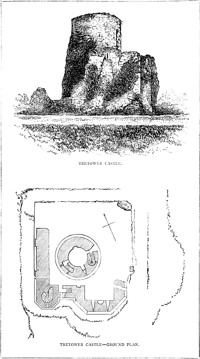
Next, east of this, at the same level, is a doorway of 4 feet by 6 feet opening, in the same fashion and style as the window, with jambs fluted in zigzag and the chevron moulding above. The work is rude, and the ornamentation only partially executed. All these openings have been walled up with early masonry. The east half of this east wall is occupied by a rectangular projection, forming a chamber 10 feet deep by 18 feet broad, which may have been a kitchen, since it contains a fireplace with a round back and gathering up to a cylindrical shaft, and at the ground level is a water-drain; also there are three round-headed loops, of which one is in the west wall, and in the east wall is a small round-headed door, 2 feet 9 inches broad, and opening upon the outer ward; it has no portcullis.
The openings, of which traces remain in this wall, seem to show that the building was originally a rectangular Norman keep, having a basement and a first and a second floor, indicated by the lower door, the entrance to the wall stairs, and the door and window above. The southern projection is probably original, as is the small door in its side. The battlements, of which a part remain on the west wall, are, no doubt, restorations. They are composed of broad merlons with a cruciform loop in each, the cross-arm being very short.
In the exterior of this building, near its ground level, a breach in the masonry discloses a cavity about 14 inches square, which pierces the wall parallel to its faces. This was evidently occupied by a beam, inserted as a tie, as at Brunlas, where also the timber has rotted away, and the cavity been exposed, and has given rise to a number of ingenious conjectures. In the centre of this square enclosure, and leaving only a space of from 7 feet to 9 feet between its exterior and the centre of each side, is the interior keep. This keep is a cylindrical tower, at its base about 43 feet in diameter, and battering inwards to a height of about 10 feet, where it is girt by a very bold, rather more than half-round bead or cordon, which marks the summit of the slope and the first-floor level. Here the tower is about 38 feet in diameter. From thence it continues to batter, though slightly, perhaps 2 feet, to the base of the battlements, which are gone. It is now 70 feet high from the ground level, which originally may have been 5 feet lower, and the tower 5 feet higher, making a total of 80 feet. About half-way up is a plain set-off of about 6 inches, reducing the diameter of the tower by a foot. With this exception the exterior is quite plain. The present entrance502 to the basement or ground floor is on the north-east side, by a broken entrance of modern date, the making of which has been aided by the first-floor entrance, which is immediately above it, and of which it now makes a part. The tower is composed of a basement and three floors, and its interior diameter at the base and first floor is 20 feet. The floors were of timber, and are gone; and the roof seems to have been flat. The basement, now about half filled up, was about 10 feet high, and the wall at its floor about 11 feet 6 inches thick. It was lighted by two loops in the north-west side, the splayed recesses of which are square-headed, and, as in Canterbury keep, have their inner opening closed above, so that the loop was on the level of the first floor. These loops are stopped up outside, evidently by very early masonry. In the south-west side is a door, of which the top is seen unburied, whence a flight of steps leads in the wall upwards and southward into the floor above, and this was evidently the only entrance to the basement floor.
The entrance into the first floor was also the general entrance into the keep. The doorway, much broken, was 4 feet wide and 6 feet high, and about 10 feet above the original ground level. Over the doorway, outside, is a curious drip or hood, forming an equilateral arch, a sort of pediment; and on either side of the doorway are two holes, at the base and near the top, which seem to have carried the base of a wooden structure, probably covering an exterior stair. There is no portcullis. The door enters a passage vaulted with a drop arch, which traverses the wall leading direct by a second door, viz., into the first floor. From this passage, on the left, a door opens into a mural stair, 3 feet 3 inches wide, which ascends in the curve of the wall to the upper floors.
The first floor is 20 feet in diameter, and its walls about 8 feet 6 inches thick; its floor rested on two large parallel beams laid north-west and south-east. To the north-east and south-west are large window recesses, 4 feet 6 inches broad, with drop chamfered arches, and having stone seats. In each was a window of one light, about 2 feet opening, with an equilateral arch, and chamfered edges. In the south jamb of the south-west window is a door, the termination of the staircase, vaulted, and lighted by two external loops, and which has been already mentioned as rising from the basement floor. In the north-west wall is a large fireplace, with a bold flat stone hood dying into the wall above, beneath a bold bead moulding, and below resting upon two short columns with bell caps of a stiff early English character. The columns are cut away below, and in fact form corbels. On either side is a rude circular corbel, either to hold a light, or as at St. Briavel’s, to support the lateral thrust of the hood. This floor is 18 feet high. It was the state-room.
The staircase leading to the second floor, after ascending in the curve of the wall a few steps, terminates in a well staircase 6 feet in diameter, which continues the ascent to the second floor, and passes on to the battlements, as at Chepstow, Carlisle, Ludlow, and503 Newcastle. The staircase opens into the first floor by the intervention of a small recess or lobby in the thickness of the wall, where a door, now broken, opens into the main chamber.
The second floor was also 18 feet high, and had two windows under drop arches, about 2 feet broad and 5 feet high, with equilateral arched heads, closely resembling those below. One opens to the south-east and one to the north-west. The latter has over its outer opening an angular drip, or hood, or pediment, like that over the great entrance below. Here also is a fireplace, and exactly above that in the lower room, and similar to it, only the jambs are rather shorter. The hearth-stone was supported upon a kind of bressummer, formed by a table projecting about 18 inches from the wall below, and appearing as a carved moulding in the lower room. There is a set-off of about 6 inches at this level, to support the floor.
Following the staircase, the third floor is entered by a lobby similar to the one below. The stair is lighted by loops, those near the bottom being flat-topped, those above lancet-pointed. There is one long loop divided by a transom, which forms a part of the set-off on the outside. The third floor has no fireplace, but it has two windows, similar to the others, opening north-east and south-west. The roof seems to have rested upon one main beam, stiffened by spars at either end, the supports of which remain in the shape of two stout plain stone corbels. Thus stiffened, the platform above would have carried an engine of almost any weight. The wall is about 8 feet 6 inches thick at the summit; its thickness above the cordon is, in fact, uniform. To give greater strength to the masonry along the course of the staircase and about the lobbies, the wall is thickened internally by a sort of pilaster, the sharp edge of which remains.
Tretower is a rare, probably a solitary, example of a rectangular Norman keep, which has been gutted, and its central part occupied by an early English round tower. The space between the tower and the keep walls was then roofed in, probably in two floors. The alterations in the exterior Norman wall, blocking up the doors and windows, &c., were probably made when the inner tower was built.
The material of the keep is a hard variety of old red sandstone. The workmanship is good coursed rubble plastered within. The door and window quoins and the fireplaces are of ashlar, well worked, though plain, as is the whole building. The arches of the doors and window recesses are drop. Those of the windows are equilateral, and many of the loops lancet. The inner tower is wholly of one date, apparently late in the early English period.
It is said that Tretower was a residence of the Welsh Lords of Brecknock before the Norman era. If so, they were attracted by the dry gravel tump, covered on three sides by a morass. The Norman occupants seem to have constructed a square tower or keep on the knoll, having, on one side, a base-court, probably also walled in. Late in the reign of Henry III., the Norman keep was gutted, and a central stone tower built, and the triangular base-court enclosed by a curtain and mural towers.
This castle stands in the suburb of the town of Crickhowel, between it and the Usk, on the left bank of that river, and about a furlong from the parish church.
Its principal and most interesting feature is a large conical mound, wholly artificial, about 50 feet high, and on its table top 60 feet diameter north and south, and 50 feet east and west. This mound has been surrounded by a ditch, traces of which remain on the east, south, and west sides. Towards the north it is encroached upon by a pond and some cottages. Appended to the mound, on its east side, and outside of its ditch, is an enclosure of irregular shape, roughly rectangular, but rounded towards the north-west, and including about two acres. It is contained within a low bank, the exterior slope of which has been scarped, and seems to have descended into an exterior ditch. This was the base-court or ward of the castle, the mound being the keep. On the south face of this ward, where the bank would have abutted upon the ditch of the mound, are the remains of two conjoined towers, one rectangular and one round. The loop-like windows of the former are evidently of Decorated date, and the two towers seem of the same age. Upon the north-east corner of the ward, on the counterscarp of the ditch of the mound is part of a round tower, which, with some heaps of earth about it, seems to be the remains of the gatehouse of the keep, which also was probably connected with a protected staircase ascending the mound, the way up which must have been on this side. These are the only buildings actually remaining upon the enceinte of the ward, but it is evident that a wall was carried round its edge, of which the bank probably contains and conceals the foundation. Buck’s drawing, taken in 1741, shows this curtain, and upon its three angles three drum towers, of which one covered the outer entrance, and is opposite to the gatehouse of the keep. The summit of the mound is much broken up, and there are traces of the foundations of buildings which formerly stood here, and which seem to have been contained within a circular or polygonal shell which formed the keep.
It is evident that Crickhowel, like Caerleon, Cardiff, Abergavenny, Brecon, and Builth, was a moated mound with appended base-court, upon which the Normans, on seizing the estate, constructed a castle. The earliest masonry was probably of the date of Henry II., but enlarged and rebuilt in the reign of Henry III.
Blaen-Llyfni, or Blaen-Llevenny Castle, in Brecknockshire, stands above the Llyfni river, a tributary to Llangorse Lake. It was posted to guard the important pass of the Bwlch, above and a little within which it stands. It was in plan a parallelogram, contained within four curtain walls with towers at the angles, and apparently505 a gatehouse towards the north-east. Part of the north wall is standing, but the remainder is a heap of ruins. The castle occupied a natural tump; about 20 feet above the outer level and around it is a ditch, in parts wet. The castle stands on a slope, which, towards the north, is very steep and very strong. It was built by, and long belonged to, the Norman lords of Brecknock; and on the occurrence of an attainder or minority was held by the Crown; hence it is not only mentioned in local story, but occurs from time to time in the records of the realm. It seems of the age of Henry III., or perhaps somewhat earlier. In Buck’s time, 1741, much of the curtain remained and parts of the tower.
THE high broken ground of Needwood Forest, contained between the Trent and the Dove, is brought to a termination eastward by the union of those streams upon the confines of the three shires of Derby, Stafford, and Leicester. About five miles above this confluence, upon the right or Staffordshire bank of the Dove, stand the town and castle of Tutbury, once, according to Leland, a residence of the Saxon lords of Mercia, and named, it is said, from the god Thoth, who presides over Tuesday, and is thought to have been worshipped in the enclosure of the castle. This etymology is supported by Wednesbury; but, however this may be, Tutbury was certainly an ancient stronghold, and possesses in that respect unusual natural advantages.
The castle crowns the head or northern termination of a considerable ridge of new red sandstone rock, which projects from the high ground of Hanbury and Needwood, and forms an abrupt promontory above the broad and level meadows of the Dove. On the south or landward side the hill is partially severed from its parent ridge by a cross valley, within and about which is built the ancient town of Tutbury, celebrated from the days of John of Gaunt until the end of the last century for its attachment to the barbarous sport of bull-running.
The natural position of the castle is strong and well-defined, and has been turned to account from a very remote period, and materially strengthened by Norman and pre-Norman art.
Upon its west, south, and eastern sides the head of the ridge has been further protected by a broad and deep ditch, which thus covers about two-thirds of its circumference. Towards the north, where the hill projects upon the meadows, the ditch ceases, and this front, rising steeply about 100 feet, has been rendered steeper by art, and is further protected by a wide expanse of wet land, traversed506 by a very ancient and broad mill-leat, and by the sinuous channel of the Dove.
Upon the east and north-east fronts, where the area of the promontory was inconveniently large, two extensive semilunar spaces have been left outside the ditch. They are, in fact, outworks upon a large scale, useful for pasturing cattle in turbulent times, somewhat lower than, and commanded by, the main works; covering the ditch, and scarped, though not revetted, towards the field. They are separated by a deep ravine, up which the main approach to the castle ascended from the north-east, the direction of the Dove bridge, and probably of an earlier ford. On this, the east front, the contents of the ditch have been thrown inwards, crowning the scarp by an artificial bank about 15 feet or 20 feet in height.
Upon the south-west and west side the earth has been employed to form a large mound, about 40 feet high, and 70 feet across at its truncated summit, and which renders this front almost impregnable.
The space between the east bank and the west mound, forming the south front, is occupied by the castle buildings, which, built upon the natural soil, crown the scarp of the ditch, and overlook the town.
Opposite, also from the bank to the mound, is the north front, almost precipitous, and defended, therefore, by neither ditch nor bank. The space thus enclosed forms the base-court of the castle, and covers about three acres. It is in plan an irregular circle.
The best view of these magnificent earthworks is from the summit of the mound, which not only predominates over the court of the castle, to its east, but westward rises very steeply about 140 feet from the meadows. The counterscarp of the ditch is here seen to terminate on the north-west, at the base of the mound in a sharply-defined falciform ridge.
The masonry which has been added to these earlier defences is composed of a group of buildings on the south front, flanked by curtains which run, on the one hand, westward towards the mound, and, on the other, eastward, along the top of the bank by which that face is defended. This curtain is 6 feet thick at the top of its plinth, about 6 feet from the ground, to which level it is now reduced. There is evidence that it was about 20 feet high, with a rampart accessible from its flanking towers, and by a double flight of open steps from within. At one point is the vault of a large garderobe, marked in the “Vetusta” drawing by a bartizan turret. This east curtain is broken by a lofty rectangular mural tower, of which the interior wall with a square angle-turret only remains, and which faced the turn of the road up to the castle, on the opposite side of the ditch. The bank has been removed here, so that the tower is built upon the original soil, and its basement entered from the court on a level. This tower is Perpendicular in style, and has evidently been blown up by gunpowder.
At the north end of this curtain, at the north-east corner of the court, is the great gatehouse, a rectangular building pierced by a507 portal, and with lateral lodges. Above were other chambers of more pretention and larger size. This gatehouse is almost all outside the wall. Its south face rakes the ditch, and has a small projecting balcony at the first-floor level, communicating by a shaft with the basement lodge. Its north face looked towards the Dove; only its south and east walls remain. It had no flanking towers, the wall on one side of the gate being pierced by a loop. To it has been added, outside, flanking the gate and blocking up the loop, two thick solid cheeks of wall, from the front of which the drawbridge fell across the moat. The gatehouse seems to be of late Decorated date, its window recesses have half-round heads, and a window above the portal has something like Decorated tracery still remaining, and rudely indicated in the drawing given in the Vetusta Monumenta.” The portal has a flat segmental arch, and outside this is a low drop arch, part of the additions. The details of the drawbridge, to judge from the holes cut in the stone, were peculiar. Two portcullis grooves remain.
The masonry of the drawbridge has been removed, and the ditch here solidly filled up with earth. The road from below, to reach this gate, is continued for some way along the crest of the ditch, within reach of the walls. Lower down it is commanded by the two demilunes. From the gatehouse westward the edge of the steep north front was crested by a curtain wall, probably low and light, of which there are slight traces.
Upon the summit of the mound is a ruined round tower, evidently an erection of very modern times, probably as a summer-house, or an object in a view. There is said to have been an earlier building here, destroyed before the reign of Elizabeth, probably by John of Gaunt, and likely to have been a polygonal shell of masonry. It was called Julius Tower, Juliet being a not uncommon name for such structures.
The castle buildings have been broken down, but what remains is as sharp and fresh as though lately executed. The outer wall and altered windows remain of the great hall, 61 feet long by 29 feet broad, and a group of state apartments at the east end. Here are two very fine crypts, no doubt cellars,—fitting receptacles for the very best of drinks,—entered from the court by handsome doorways and six or eight descending steps. They have been covered with barrel vaults, one of which was ribbed transversely and diagonally, with large carved bosses, probably of the time of Richard II. Above these are handsome rooms, with flush flat-topped chimney-places, with mouldings set with flowers and the “hart lodged,” and what may be a conventional pomegranate. These buildings are in the best and purest Perpendicular style, and the profiles and details of the mouldings are admirably suited to that fine but sometimes rather friable material, red sandstone, here of very superior quality.
In the court is a deep well, still in use. At the west end of the great hall is a brick building, probably the work of some Crown steward or lessee, about the time of Queen Anne or George I.
508
So far as can be observed, the castle exhibits no trace of Norman masonry. All the structures, walls, tower, gatehouse, hall, and apartments are nearly or quite of one date, and are probably the work of John of Gaunt, who resided here very frequently, and in regal state. This is very remarkable, because Tutbury is mentioned in Domesday, was the caput of a very important Norman honour, and the principal seat of the great Norman family of Ferrars, earls of Derby, from the Conquest to their ruin towards the close of the reign of Henry III., since which time it has been, for the most part, in the Duchy of Lancaster.
Shaw, in his “History of Staffordshire,” gives two most exaggerated drawings of this castle. Another, on a larger scale, a view from the east side, taken in the reign of Elizabeth, is engraved in the “Vetusta Monumenta,” vol. i., pl. 39. This, amidst much absurd perspective, shows the gatehouse and east tower, what may be a chapel east window in the state apartments, and a round tower at the east foot of and built into the mound, besides a west curtain with three mural towers upon it.
Tutbury was held for the king, and taken by the Parliament in the wars of Charles I., and subsequently, by order of the House, reduced very nearly to the condition in which it is now seen.
It may be mentioned that an addition to both the defences and the resources of the castle has been provided in the leat, known as the Fleam, in part only an artificial channel, which leaves the Dove about a mile above the castle, is led beneath its walls where it still works a large and very powerful mill, and finally returns to the river some way down, after a parallel course of about three miles.
Although the temporal evidence of the splendour of the house of Ferrars has disappeared, the memory, as usual, of their ecclesiastical beneficence has been preserved. The parish church of St. Mary, once the church of the Ferrars Abbey of Tutbury, still stands a stone’s throw from the castle wall, and seems anciently to have been included within the outer defences. It was founded by Henry de Ferrars, in the reign of Rufus, and has a Norman nave, clerestory, and aisles; and its west end is one of the most perfect and richest Norman fronts in existence. This structure, which had been much misused, was happily placed under the judicious care of Mr. Street, who was engaged to restore the Norman parts, and add a large semi-circular apse to the chancel. This is probably the chapel of St. Mary within the castle, in which (18 Edward I.) Edmund Earl of Lancaster founded a special mass.
Mary Queen of Scots was imprisoned in Tutbury Castle, under the care of George Earl of Shrewsbury, then constable.
ABOUT half-way between the two extremities of Loch Ness, the loch is suddenly reduced by about one-third of its ordinary breadth by the projection from its western shore of a bold headland, under cover of which the glens of Urquhart and Moriston open upon the loch, and contribute to it, across a marshy deposit of gravel and peat, their respective waters.
The headland which is thus partially isolated between these waters and the loch is moderately lofty, and slopes down steeply towards its extremity at the north-east, again to rise and finally to terminate in an oval and rugged knoll of rock, which stands out from 50 feet to 100 feet above both the water and the contiguous land. Upon and covering this knoll is placed Castle Urquhart, which is thus a very prominent object from Lochness, and combines, in a very remarkable degree, natural and artificial defences upon its enceinte and within its area.
The rock, open at each end, and along its north-eastern side towards the loch, is protected on the land side by a deep and broad ditch, quarried across the neck of the peninsula from shore to shore, not, indeed, to the level of the water, by from 10 feet to 12 feet, but to a depth which at one point gives a precipitous height of 30 feet to 40 feet to the face forming its scarp.
In general plan, the castle, like the rock it stands upon, is an irregular oval, reduced to something of an hour-glass figure by the indentation of a small cove near its centre. At the north and most prominent end is the rectangular keep. On the landward front is the gatehouse, and in the side opposite appears to have been a small tower. The enceinte is completed by curtain walls, ranging in thickness and height from 4 feet to 9 feet, and from 20 feet to 40 feet, according as they supported buildings within, or occupied weak or strong points in the defence.
The entrance is by a causeway of masonry, 12 feet broad, having a roadway between parapets, and about 80 feet long from the counterscarp to the scarp of the ditch. At about 40 feet from the counterscarp, and 6 feet beyond the centre of the ditch, there, 10 feet deep, is an opening of 20 feet, formerly occupied by a drawbridge, beyond which the parapets are higher, and probably formed part of some kind of advanced work, for the management and protection of the bridge. This part of the defence occupied the remainder of the causeway proper, about 20 feet, the ditch here being 80 feet broad, and a platform of 20 feet, with a rise of 6 feet, intervening between the end of the causeway and the gate.
The gate is removed about 6 feet to the south of the line of the causeway, so as to check a rush upon it. It is a plain round-headed510 portal of 9 feet opening, between two half-round towers, and above it is the usual small look-out window of the portcullis chamber. Just within the gateway is the square groove, in which hung the portcullis, and beyond is a barrel vault, ribbed at intervals, for gates, and having a lodge door on the left hand. The passage ends in a plain but good round-headed gateway, the coigns and ring stones of which are of excellent ashlar, and which is set in the inner face of the gatehouse. This is a rectangular building, with two half-round towers flanking its outer entrance, and on each side of the central passage is a chamber also barrel-vaulted, but having semi-circular and semi-domed west ends. One of these rooms, as mentioned, opens from its side into the passage, and the other from its end, into the court. The gatehouse had an upper floor, also vaulted, and apparently also a second floor, of which traces remain. Fragments of a chimney-shaft which has fallen from its front, encumber the causeway.
Emerging from the gatehouse, the rugged character of the interior comes at once into view. On the right is a path between two knolls of rock; that on the left moderately high, and not quite extending to the waterward curtain; that on the right high and steep, and its perpendicular face forming the landward curtain, the wall crowning which is 9 feet thick. At the south-east end, where the two ridges unite, is a small circular eminence, which may have been a beacon. This part of the outer ward is a fortress in itself, and upon its highest ground are traces of buildings. A fragment of the waterward curtain still stands about 30 feet high, and 6 feet thick; but there are no traces in this quarter of mural towers.
The gatehouse opens upon the narrowest part of the ward, where it is indented by a small cove. The curtain was carried round this cove, and contained a postern, whence a path led down to the water, here shielded by the cliff. There is a window in the curtain,—a part probably of a building for the protection of the postern and the galleys below.
The way from the gatehouse towards the left leads to the keep. It rises by a steep curve between, on the right, a high wall of some ruined building, and on the left a curious knoll of rock, scarped steeply into a rectangular figure, about 30 feet high, and on the top of which are foundations of a building, 15 feet by 30 feet, which must have been as tall as the upper floor of the gatehouse, and have commanded the adjacent curtain, from which it is separated by a narrow hollow way. Following the curved road, a cross wall is reached, which cuts off the inner from the outer ward, and formed an outwork to the keep. This ward is three-sided,—a sort of quadrant, the keep being at the apex. The land and waterward curtains form the two sides, and the base is a shallow curved ditch, in which is built the wall, and against it are two buildings like barracks. Between their inner ends was the entrance. This ward was exceedingly small, and is now thickly encumbered with ruins.
The keep is an excellent example of the stern rectangular Scottish fortalice of the fifteenth century. It is about 40 feet square, of four511 stages, and built on the steep, so that its basement is above ground on the outer, and below it on the inner, or court side. This basement is 16 feet by 18 feet within, barrel vaulted, with walls 10 feet to 16 feet thick, with a loop rising to the light on the land side. It was evidently the prison. The door is opposite to the loop, and opens into a small lobby, having on the left the foot of the well-stair, and in front a postern, 4 feet wide, flat topped, and closed by a door, which opened on a small platform about 25 feet above the loch, which is reached by a steep winding path. The turnpike stair is 8 feet in diameter, and is contained in the north-east angle of the tower, opening upon each floor, and finally upon the battlements. It makes no external projection, but is seen within, cutting off an angle from each floor. The basement and the highest floor are the only vaulted chambers.
The first floor is lighted by a segmental arched window to the court, and by small square-headed loops towards the water. These vary from 6 inches to 2 feet in breadth of opening, and each has, a little below it, an oeillet-hole, which opens from the window-seat. No fireplace remains, but the east wall is destroyed, in which it may have been. This chamber seems to have been entered only by the well-stair.
The second floor has also openings under flat segmental arches, and on the south side is the main door, opening about 20 feet above the ground, and reached either by wooden steps or some other means now destroyed.
The third floor, or fourth stage, differs from the rest in that a small chamber is contained in the south-eastern angle, the door into which is in the south wall, near its east end. This may have been an oratory, but, as the east wall of the keep is gone, and with it the east end of this chamber, which also is inaccessible, such details as may remain have not been examined. In the west wall of the main chamber is an excellent flat segmental arch in ashlar, which spans a fireplace and a window looking down the loch. This upper story was covered with a vault, in the west side of which are traces of a side arch, covering that over the fireplace and window. Most of the main vault has fallen in.
There do not appear to be remains of any garderobes. The parapet is gone, but the wall is crowned by a bold moulding, and beyond this, at each angle, there is a row of short corbels, which probably carried the usual bartizan turrets. Over the door, at the top of the wall, are four bold corbels, which evidently carried a machicolation for its defence.
Urquhart is more extensive than most Highland castles, and the traces of barracks show that its area was turned to full account. It would contain a garrison of from 400 to 500 men. Though the masonry is rough, it is good, the proportions of the keep are excellent, and the ashlar work used for the doorways, quoins, and window dressings, is well executed. What arches remain are round-headed or segmental, not pointed. At the north-east angle the keep512 has a small short buttress set on anglewise, and one, also short, of a pilaster character, and slight projection, set on the west face of the north-west angle. The curtain springs from the keep, half of which is outside it.
Urquhart is one of the chain of fortresses which stretched across the great glen from Inverness to Inverlochy, and were employed from an early period to defend and overawe the country. By some accounts it is spoken of as belonging to the Comyns of Badenoch, but certain it is that when Edward I. was at Kildrummie, near Nairn, in 1303, he despatched a party who laid siege to this castle, and with some difficulty took it, putting Sir Alen de Bois, its governor, and the garrison, to the sword. In 1334 it was held for Baliol by Sir Robert Lauder, of Quarrel Wood, as governor; and the office seems to have been heritable, for Lauder’s daughter married Chisholm, and their son, Sir Robert Chisholm, of Chisholm, who had Quarrel Wood, had also the constableship of Urquhart, then, and probably always, a royal castle. Chisholm’s title, however, was insecure, for in 1359 David II. disponed the barony and castle to William, Earl of Sutherland, and John, his son.
After this, Urquhart was held under the Crown by the Grants of Freuchie, afterwards of Castle Grant, who, as chamberlains for the Crown, got possession of most of the adjacent lands. In 1509, James IV., under an Act of the Scottish Parliament, granted three-fourths of Urquhart Lordship, and of the Baronies of Urquhart and Glenmoriston, to Grant of Freuchie, and his two sons, from whom descended the Grants of Glenmoriston and Corriemony. The castle has since remained in the Grant family, and is now the property of the Earl of Seafield, whose house of Balmacaan is in the lower Valley of Urquhart.
It appears that the Knights of the Temple had an establishment in the Bay, and brought into cultivation the lands on its eastern shore. Probably they were constables of the castle. On the farm of Phinians is still a place called Temple.
Until after the rebellion of 1745 Glen Urquhart was in a very disturbed state. Grant did not reside there, and the people were continually attacked by the clansmen from Glengarry, Lochiel, and Kintail.
It is difficult to establish with any precision the date either of the early or the present castle of Urquhart. The ditch is no doubt much older than the siege of 1303. The remains of the castle now standing can scarcely be older than the fifteenth century, and probably it was one of those built about the middle of it, in accordance with the strong recommendation published by James I. on his return from his captivity in England.
An excellent account of this part of the Highlands, and of the descent of the Urquhart property, will be found in the “New Statistical Account of Scotland, for Inverness-shire,” p. 43.
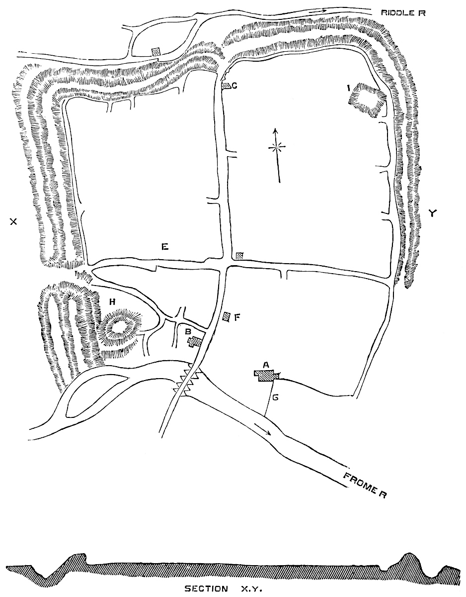
WAREHAM and Corfe are the keys of Purbeck, or rather Corfe is the fortress and Wareham the bridge-head of that bold projection of the chalk of Dorset, the southern headland of which bears the name of the protomartyr of England, and of which the triple spurs of Durlston, Peverell, and Studland form the eastern points, each with its own bay, and the whole protecting from the prevalent west wind the great indentation of the coast between Purbeck and the Needles, in the bight of which opens the harbour of Poole, and, under Hengistbury Head, the mouth of the twin streams that once gave name to Christchurch, before either castle or priory rose upon the banks of the Avon.
To the Northmen, these headlands, bays, and rivers were intimately known. Their long ships here found shelter while the hardy seamen ravaged the country of which they were one day to become joint inheritors. Though called, like Sheppy and Portland, an island, Purbeck is, in truth, not even a peninsula. If, indeed, it were to subside from 50 feet to 100 feet, the great chalk ridge which extends from Lulworth to Studland would alone be visible above the waters, and the low broad valley which marks the course of the Nether Frome and the Piddle would be covered, and form, with Poole harbour, a considerable estuary. Even now the river valleys are low and moist, and in the eighth and ninth centuries were no doubt an impracticable morass. Where nature had done so much, there remained but little needed from art, and accordingly the military remains in Purbeck are scanty. Worbarrow, a strong half-circular camp of banks and ditches, crowns the steep cliff at one end of the great ridge, and Corfe or Corfe-gat, occupies a gap or gate near its centre, while Wareham, posted to the landward of the marsh, and between the two rivers, guards effectually the approach from the north. Camps on sea-cliffs are generally supposed the work of those who used the sea, and drew up their galleys upon the beach; if this be so, Worbarrow must be the work of the Northmen, though in any other position it would be regarded as British. Corfe is probably entirely an English port; what Wareham is forms the subject of the present notice.
Wareham, a town which is still a Parliamentary borough, though one of its members was shorn away in the great struggle for reform, is built upon a knoll of chalk, the eastern extremity of a broad low ridge which descends and becomes narrower from the west and north-west, and finally sinks down into the lowland a little east of the town. This ridge divides the valleys of the Frome and the Piddle, the principal streams of Dorset, and its termination marks the meeting of the waters which flow together into the backwater of Poole Harbour. The Piddle lies to the north of the ridge, and the514 Frome to the south. The town between them is about half a mile broad, and their bridges are connected by its main street. In figure the town is nearly square, the west face about 600 yards, the north face 650 yards, and the area is pretty evenly divided by the main street, which is crossed by a second street, at right angles, thus dividing the town, after the Roman fashion, into four quarters. As at Wallingford and Tamworth the outline of this rectangular figure is an earthwork, within which the town was built, and which is now all too wide for its shrunken prosperity. The defence is a simple bank and ditch, the contents of the latter being piled up to add to the height of the former; but as the area inclosed is naturally high, with a steep slope to the north and east, on these two sides the bank is a scarp only, the river on the north forming the ditch. To the east the ground is not quite so low, and there is no river: here therefore is a ditch. The northern scarp is about 45 feet high, with a slope varying from one and a half to two to one. Its crest is 15 feet broad, and it rises about 15 feet above the ground within and behind it. Towards the west end this bank is rugged and angular; the eastern half is very uniform, and seems never to have been disturbed.
The northern side is straight, or nearly so; the eastern has a low salient near its centre. This side is not carried to the river. There is indeed a hollow way, which seems to represent the ditch, but the bank is wanting for the last 200 or 300 yards. The western face is far stronger, and more perfect. Here the bank, of full size, is carried down to the margin of the river, and the ditch is broad and deep. This was the weak side, the exterior ground being high. This bank also is much cut about, and it is pretty clear that in the Parliamentary wars an attack must have been apprehended from the north-west, as the bank is notched as for embrasures for guns, and there are various small mounds to prevent them from being reached by a lateral and raking fire. The ditch also, instead of being cut to a central line, V-shaped, as usual in mediæval fortifications, and as is the case with this ditch near the river, is broad and flat-bottomed, as though it had been widened and partially filled up to suit the requirements of the art of defence as practised in the seventeenth century.
There is no earthwork along the south or Frome front, towards which the ground slopes gradually. No doubt the river was a defence, as it was on the other front, but the absence of any special work on the south and south-eastern quarters looks as though those who constructed the work came from the sea, and desired to guard Purbeck, whereas the historical presumption is that Wareham must have been thrown up against invaders, and that it was a British fortress against the Saxons, and an English fortress against the Danes.
Of the four pretty equal quarters into which the area is divided, the south-western contains a later and subsidiary work, thrown up upon the bank of the Frome, and a little in the rear of the main defence. This is a conical mound, flat topped, rising about 50 feet above the river, and about 60 feet in diameter at its summit. It has515 a ditch proper to itself, about 60 feet wide, dividing it from the main bank, and to its east and south-east are traces of other and lower earthworks, which no doubt included the base courts or wards usually appended to such mounds. This whole tract, however, is exceedingly obscure, being laid out in lanes and courts and walled gardens. Here stood the Norman castle, built, as usual, upon the earthworks of the English residence.
There is another earthwork, also within and later than the main defence, found in the north-eastern quarter. This is a rectangular inclosure about 60 yards by 30 yards, within a bank of about 4 feet high with a base of 12 feet and an exterior ditch about 6 feet broad. There is an entrance at one end, and the angles are slightly rounded off, and, as the north-east angle rises somewhat with the tail of the adjacent bank, it is clear that it is a later work. This looks exactly like a small Roman camp, though in such a position it seems much out of place. It is called the bowling-green, and may have been laid out for that game. It is difficult to say what it is.
Of the two roads which intersect Wareham, that running north and south is the main one, and leads to Corfe. The Frome bridge over which it is carried is said to replace one built in the reign of William Rufus. The east and west road is an important way in one direction, as it leads from Dorchester, and may well therefore be Roman. After reaching the cross it is continued eastwards, but this branch of it led nowhere from the town.
Wareham, like Wallingford, was well supplied with ecclesiastical establishments, there having been within its limits eight churches and a priory. The priory, originally founded it is said by Adhelm, bishop of Sherborne, who died 709, certainly existed as a nunnery before 876, when the town was taken by the Danes. The church, dedicated to the Virgin, is now the principal church in the place, and Trinity, now used as a school, was probably the chapel of the castle. St. Martin’s is a small church upon the eastern edge of the deep cutting through which the north road enters the town. It has a small late tower, but the nave and part of the chancel seemed early Norman date. The sites are pointed out of the chapels of St. Peter, St. Nicholas, St. John, St. Michael, All Hallows, and another St. John.
Nothing of the masonry of the castle remains above ground, but the adjacent walls evidently contain much old material, and in one of them is an old Norman doorway, with a bold chevron moulding round the head, interspersed with a line of roundels. This no doubt belonged to the castle.
There is a great resemblance in position and plan between Wallingford and Tamworth and to some extent Cardiff, and Wareham. In each case the general earthwork is rectangular, of bold profile, and has a single ditch, and is placed near a river, and on that side unbanked. Each also has a mound towards the river, with its own proper defences, and upon each the Normans placed a shell keep. There is no evidence of Roman occupation of any of these516 places, though the road from Wareham to Dorchester may be Roman, and if the line of the Ackebury ditch from Sarum to Badbury were produced, it would pass close west of this place. Possibly the rectangular defences were the work of the Romanised Britons, the mound being an English addition of the ninth century. The work has never been known as a “Chester.”
Wareham was an important place in the West Saxon kingdom. King Beorhtric, who married the daughter of Offa, and in whose time the Danes first landed in Britain, was there buried in 800. In 876 the Danes attacked and took Wareham, but submitted to Alfred, and retired to Exeter. Florence says of the Danes:—“Castellum quod dicitur Werham intravit; ubi monasterium sancti-monialium inter duo flumina Fraw et Terente it in paga quæ Saxonice dicitur. Downseto, tutissimo situ terrarum situm est, nisi ab occidentali parte tantummodo, ubi contigua est terra.” And it is on that side that the works are the strongest. Some of the Danes left Wareham by sea and some on horseback. In the following year, however, they were again at Wareham, and their fleet was wrecked off Swanage, and 120 ships lost. At this time Wareham became the Danish head-quarters. A century later, in March, 978, King Edward, slain at Corvesgate or Corfe, was buried silently at Wareham, to be translated afterwards to Shaftesbury. In 982, Wulfwin, abbess of Wareham, there died. In 998, the Danes were again there, and in 1015 Canute sailed up the Frome, burning and plundering as he went. Domesday relates that the Confessor held 143 horses in demesne in Wareham. There were two mint-masters, but at the survey the town was in a desolate condition, and many houses were destroyed.
The castle is mentioned in Domesday:—“Of the manor of Chingestone the king has one hide in which he made the Castle of Wareham, and for that he gave to St. Mary’s the church of Gelingham, with its appendages, to the value of 40 shillings.” It is the only castle mentioned in the county. Chingestone is the manor of Corfe Castle, and St. Mary’s the Abbey of Shaftesbury. Robert, Duke of Normandy, was for a time imprisoned in the castle, as was Robert de Belesme, who is here said to have starved himself to death. Town and castle were burned in the wars of Stephen and Maud. Her great champion, the Earl of Gloucester, embarked here on his way to Anjou in 1142, and William, his son, was governor when the town was taken by Stephen. The Earl then retook it, the castle holding out against him for three weeks. It was at that time that he took Lulworth, and probably built “Bow and Arrow” Castle in Portland. King John landed at Wareham in 1205 and visited the place four times, staying about fifteen days in the years 1209–12–15, and 1216. Peter of Pomfret, was hanged here in 1213. Then and long afterwards it was rather a noted seaport, and as late as 1558 ships of fair size reached its quays. The “Castle Hill” was granted away by James I. The western earthwork long bore the name of the “Bloody Bank,” from the execution there of Judge Jeffreys’s victims.
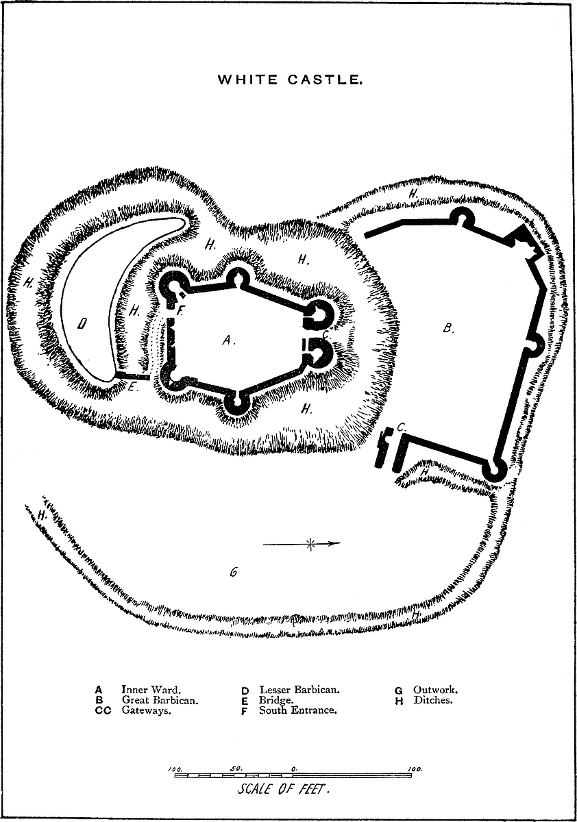
517
During the civil war Wareham was the scene of much fighting, being taken and retaken many times. It was garrisoned by the Parliament in 1642, then taken for the king, then in 1643 retaken for the Parliament. In 1644 the Royalists took it by storm. It was in these wars that the west bank was so much altered, to make it suitable for the defensive system of that day.
WHITE CASTLE, called also from the parish in which it stands, Llanteilo Cresseny, and in the records “Album Castrum,” stands upon very high ground about five miles east of Abergavenny, and commands an extensive and completely panoramic view over a country eminently characteristic of the old red sandstone. Within the wide circumference are mountains and hills green to their summits, deep valleys, oaks and elms of great size and in great profusion, and pastures of unusual richness. It is not to be marvelled at that the Welsh, having lost so glorious a possession, should strive to recover it, or that the English and the Normans, having won, should spare no labour or expense in the construction of strong places to enable them to retain it.
Unlike Grosmount, Skenfrith, Goodrich, and Chepstow, and the other castles upon the Munnow and the Wye, and the seaboard of the Channel, White Castle is far removed from any watercourse or defensible river, and is only to be reached by a long and steep ascent. It is five miles and a half from Skenfrith, and five from Grosmount—Grosmount and Skenfrith being four miles and a half apart—and forms the western and most exposed point of the celebrated trilateral. Its decay is due rather to time than to violence, for its walls and towers are all standing, and what is wanting are those parts which would naturally give way to rain and frost, or from time to time be removed for the rebuilding of houses and cottages in the neighbourhood.
White Castle is also as peculiar in its arrangements as in its position. It has no keep, and so far it resembles the Edwardian castle; but, unlike those structures—of which Caerphilly in South, and Beaumaris in North Wales, are typical examples—its main defences are confined to a single line, covered, however, at the principal entrance by a walled earthwork or barbican, and at the lesser entrance by a second and rather smaller earthwork, without, or with but little masonry. Its ditches also are on a formidable scale, both for depth, breadth, and extent, and altogether, both in position and details, it is not inferior in strength to any castle in the March, and is besides in the first class as regards capacity.
518
It is composed of a central ward, in general figure hexagonal, but oblong and somewhat pear-shaped, its internal diameter, north and south, being 50 yards, and its greatest cross diameter, east and west, 37 yards. The northern end measures, also internally, 15 yards, the southern 18 yards. The sides next to the north end are, in length, 27 yards, those next the south end 23 yards and 26 yards. The wall is 10 feet thick at the base, and slopes externally to 7 feet at a height of 15 feet. In height it is about 30 feet to the rampart walk or allure. The towers at the two southern angles are 18 feet internal diameter, with walls 7 feet thick. The two middle towers are 12 feet, the other two at the northern angles form the great gatehouse, and are 13 feet. They are about 45 feet high. The four southern towers have a basement floor a little below the court level, with one loop; a first floor with three loops, and a second floor, whence was a way to the ramparts of the curtain. There seems, also, to have been an upper or third story. The floors were all of timber, and there are no staircases or mural chambers. The gorge walls of the two southern towers are broken away, that of the western partially so; that of the eastern is perfect, and contains the entrance doorway of 3 feet opening. The gatehouse towers are also entered at the gorge from the court, but the gorge wall is thicker, and contains a series of mural staircases ascending to the summit. These are not “turnpike,” and are not continuous, but begin anew at each floor. The gateway, concealed, save from the front, by the unusually bold projection of the flanking towers, has a passage 10 feet wide and 8 feet deep. The barrel-vault remains, but the ashlar of the internal gate is gone, and its former existence is only shown by a bar-hole. Of the outer gateway two bar-holes remain, and a fragment of the portcullis groove, which is 4 inches square, and placed outside the gate, so that the grate was wholly visible even when raised, unless, indeed, concealed by a timber brattice. It was worked from a machicolation between the towers, now gone. The flanking towers are without loops, that to the left on entering is approached from the vault by a narrow doorway. If there was a drawbridge attached to this gate, its heel must have rested upon a large stone about 10 feet in advance and 6 feet below the level of the portal. The ditch at this point is nearly 100 feet broad, and 30 feet to 40 feet deep. It is evident that there were no bridge-piers of masonry in the ditch, so that the roadway probably rested on trestles.
The opposite and lesser gateway is in the south wall, close to its west end, and flanked, therefore on one side by the south-western tower. It seems to have been a simple opening in the curtain, about 10 feet broad. It is now a mere breach, but the bar-holes remain. There is no sign of a portcullis. The approach to this gate came up along the edge of the ditch, between it and the wall, from the east, and was commanded by two loops in the curtain and by the south-eastern tower.
The area of the court is quite clear of buildings, but a few heaps519 of rubbish show that it contained barrack buildings of timber, with stone basements, placed against the walls, which have been plastered. There is no trace of hall, chapel, kitchen, well, or permanent lodgings, and no ornament of any kind; no moulding, no mural chambers or garderobes, no staircase save in the great gatehouse, and only two small fireplaces, in the first and second floors of the north-eastern gate tower. The towers are not only bold and lofty, and about 60 feet high, but the outer half of their bases is carried many feet down the slope of the ditch, giving them great breadth of base, and a very substantial and massive character.
The great barbican is a very remarkable work, not unlike a similar defence at Castle Rising, which there, however, is confined to an earthwork, whereas here the defences are both in earthwork and masonry. The work is irregular in its shape, concave where it rests upon the counterscarp of the main ditch,—on its other faces convex. In depth, or from north to south, it measures about 56 yards; in breadth, 74 yards. It is defended by a ditch of moderate dimensions, which communicates with the main ditch at each end, but is scarce a quarter of its depth. The curtain wall is very irregular in outline, the west side being made up of about four straight pans of masonry, meeting at various angles. The front is a long straight wall, and the east side, also straight, meets it at a right angle. The curtain of this outwork is about 5 feet thick, and from 15 feet to 18 feet high. Upon it are four mural towers; three, drum-shaped, are 10 feet in internal diameter, with entrances at the ground floor from the court. In height they rise a story above the curtain. They are looped to the field, have timber floors, and their staircases seem to have been of timber. One tower is angular, and has evidently been the kitchen, part of the oven and the outline of the large fireplace being still visible.
The outer gatehouse is placed at the south-eastern corner of the barbican, terminating its wall and resting upon the counterscarp of the main ditch. It is of rude construction, composed of two solid masses or cheeks of wall, 46 feet long and 9 feet thick, rounded at the outer end. Most of the northern wall is gone, and with it the roof or vault of the entrance passage, and the details of the gateway. This sort of entrance between the high and long walls is found at Conisborough and Berkhampstead. The other or inner end of the barbican wall, at the south-west corner, ends abruptly, and probably descended a little way down the counterscarp of the main ditch, so as to prevent an entrance. In the wall is a recess 6 feet 4 inches broad and 3 feet deep, which may have been a public garderobe, similar to that in the wall of the middle ward of Corfe Castle.
The lesser barbican covers the south entrance, the way to which does not, however, appear to have lain across it. It is of earth only,—that is, has no walls, but is of great strength; in shape, and, indeed, in function, it is a lunette. Its diameter, in the direction from the gate outwards, is 20 yards, and its breadth 100 yards. It520 rests upon the counterscarp of the main ditch, here about 20 yards broad. It has, also, on its front and sides, a ditch of its own about 20 yards broad, and communicating with the main ditch. In parts this work seems to have been revetted. It was connected with the main work or body of the castle by a narrow bridge, which sprang from its eastern angle, and of which traces remain. There does not appear to have been any outer gatehouse at this end; probably the approach was by a boat across the ditch, or by a plank bridge upon trestles.
Besides the above-described works there is another and much larger, though less strong, earthwork, which covers the whole east face of the castle, as well as the flanks of its barbicans. It is about 30 yards broad, and outside the main ditch, on which it rests, and upon the ditches of the barbicans. It had also, towards the field, a ditch of its own, now converted into a hollow road. The approach to either gate of the castle, from the east, lay across this outwork, which was probably stoutly palisaded, and intended to give a moderately safe refuge to the peasantry and their cattle, during invasions from the Welsh.
It is evident from the general design, position, and capacity of this castle, that it was not intended, like Caerphilly, for the accommodation of a great military baron, nor like Morlais or Castell Coch for a mere military port. Its central part is nothing but a fortified area, like Framlingham, at which place, however, there seems to have been, as at St. Briavels, a keep. Here certainly there was none. It is and always was a mere shell, composed of a strong and lofty curtain, mural towers, and a gatehouse. There do not appear to have been any of the usual buildings contained within a large castle. The accommodation within the walls seems to have consisted in timber-sheds, resting on stone foundations, and built against the walls. In this way a very large number of soldiers might have been accommodated.
Moreover, the capacity for lodging a large body of troops was not confined to the inner ward. The outworks are also spacious and strong, and could contain a small army, or the élite, or perhaps the cavalry, of a large one, besides affording accommodation for a considerable herd and flock of cattle and sheep. Such a place would be secure against any ordinary inroad of the Welsh, and supported, as it would be, by the equally strong, though less capacious, castles of Grosmount and Skenfrith, not to mention Chepstow and Caerleon, which were not always in friendly hands, not only would the entrance of a Welsh army into Gwent be difficult, but its retreat, once within the line, would be almost impossible.
As to the age of White Castle, it is difficult to speak positively. The earthworks are not at all of an English, still less of a Welsh, character. Nor, as a general rule, did the Normans ever throw up earthworks on so immense a scale. The masonry is probably of the age of John, or, perhaps, even of that of Henry III., contemporary with Skenfrith, or perhaps a trifle later, and the earthworks may be521 of the same date. They are certainly designed to suit a castle in masonry, not the mere palisaded residence of a Mercian Thane. They do not at all resemble the earthworks connected with Offa’s Dyke, or those known to be the work of Æthelflæd or Eadweard. On the whole, it seems more probable that, looking to the extreme importance of the position, the early Norman invaders exceeded the usual character of their earthworks, and designed and executed those which are still seen.
The name White Castle,—in Welsh, “Castell Gwyn,”—is said to be derived from Gwyn ap Gwaethvoed, a brother of the reputed founder of Skenfrith, and one of the Welsh lords of this district. If so, he must have held it during the troubles preceding and subsequent to the death of Harold, but any works that he may have found or thrown up were probably effaced by those of the present castle. The castle was held, with those of Grosmount and Skenfrith, sometimes by the De Breose family, sometimes by the Crown, and, finally, by the Dukes of Lancaster. No doubt it shared in the general neglect of the Border castles; that is, of such as were not the seat of any baronial family. In the time of James I. it was a ruin, and had been so beyond the memory of man.
AMONG the baronial families which rose upon the ruins of the house of Montgomery, and wielded the fragments of that power, which, united in the hands of Earl Roger and Robert de Belesme, had proved so formidable, the lords of Clun, Oswaldestre, and Whittington, De Say, Fitz-Alan, and Fitz-Warine occupied, in the northern parts of the great earldom, and upon the borders of Wales, by much the chief place. De Say indeed, speedily, by an heiress, became absorbed in Fitz-Alan, and probably in the same convenient way, “Felix Austria nube,” the broad lands of Peverel, merged in Fitz-Warine, so that the lords of Oswaldestre and Whittington held about co-equal rule in the Marches, and were alike exposed alternately to the encroachments of their sovereign on the one hand, and to the fiery assaults of the Welsh on the other—dangers which probably prevented them from turning their arms against one another, so that they remained vigorous and warlike for above two centuries, although the battlements of their castles were plainly visible, the one from the other, and scarce two miles apart.
The position of Oswaldestre has already been described. Whittington lay about two miles to the north-east, and about four and a half miles within or to the east of Offa’s Dyke, while Watt’s Dyke522 extended between them. The site of Whittington was probably selected as the centre of a fertile estate, rather than for any very striking military advantages, for the position is low and marshy—a feature of which, however, the ancient engineer largely and judiciously availed himself. By whom or when the original fortress was founded is utterly unknown. Certainly long before its occupation by those Norman invaders, who identified it with their fame. As, like Shrewsbury, Clun, and Oswaldestre, its keep was placed upon a moated mound, its origin, like theirs, may probably be attributed to the reign of Edward the Elder, or the earlier part of the tenth century, and to the fierce Mercian Saxons, who, as early as the middle of the seventh century, seem to have established themselves along the Welsh border.
The central mound, which is the main feature of these and many ninth and tenth century fortresses, is here wholly artificial, about 30 feet in height, and about 150 feet by 100 feet diameter upon its rounded and table summit. At the foot of the mound is a ditch, from 40 feet to 60 feet in breadth, and beyond this are three elevated platforms, as was not unusual. Of these, the first lies towards the north and east, and is also moated. Across it lay the principal entrance from the outer road, and to the keep. On the west side is a second platform, also moated, and in strength rivalling the keep mound itself. The third platform, far superior to these in area, and also moated, is placed beyond them, towards the north-west.
The cluster of four islands, thus protected from the exterior and from each other, is covered to the south and west by three banks and three ditches, arranged concentrically, and including within their sweep about one-third of a great circle of eight hundred yards radius, within which figure, roughly triangular, is contained the castle. The defence upon the north and east was formed, not by banks and ditches, but by a broad expanse of what is still marshy ground, and must formerly have been an impassable morass. This tract was flooded by a small but rapid brook, which descends from the north-west, skirts the ends of the ditches of the castle, and supplied them also with water. At present the brook skirts the south edge of the old morass, and, running in front of the outer entrance, turns off to the south-east, probably again communicating with the ditches of the castle at their other or eastern end. The earthworks thus described, palisaded or even planted with a stout thorn hedge along the outer banks, would possess great strength. The ditches, probably, all contained water, and with the marsh would be only the more impassable were the water drained off and its area replaced by mud. What the Norman baron who obtained the estate found or supplied in the way of defences cannot now be ascertained. Of the masonry now remaining there is nothing which can be regarded as earlier than the reign of Henry III. This could scarcely have been the first masonry employed in the defences; and yet if walls and towers were built in the reigns of Henry II. and John, they would assuredly have been of a substantial and marked character, and would scarcely 523have been removed either by time or the hand of man in the lapse of a century or a century and a half.
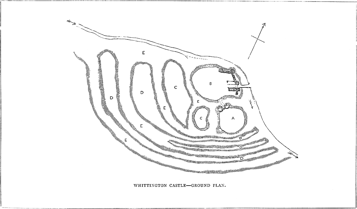
The central mound has been scarped vertically, probably in the time of Henry III., and is included within a revetment wall of great strength, and about 30 feet high. This seems to have been surmounted by a parapet, and to have been reinforced by a number of flanking towers, of which one and a part of two others remain. The most perfect is cylindrical, about 30 feet in diameter, with walls 10 feet thick. Its base is occupied by a circular pit, probably a dungeon; and, if so, a gloomy and damp one, not having a single loop or air-hole. The floor is a foot or two above the bottom level of the ditch, and the platform of timber covering it, the floor of the first story, was on a level with the top of the mound. This stage had two loops, cruciform, with the lower limb very long, and terminating in a dovetail. They are placed in large recesses, low-pointed. There was an upper floor, of which only fragments remain. The pit was probably reached by a ladder, for a door, seen in its base to the east, is an insertion. The first-floor door is represented by a breach on the south-west side. This tower flanked the inner gateway of the keep. Of the corresponding tower, to the west, a portion only remains. It was of the same size and shape, and between the two was a space of 12 feet, occupied by the gateway and drawbridge, of which the pit remains.
A fragment of the base of a similar tower is seen at the south-west angle of the mound, and there were two, or perhaps three more, to the south-east and north-east; but this part of the work is concealed by loose earth and thick vegetation. Altogether, it appears that the keep was a mound, scarped or faced by a strong revetment wall, in a polygonal form, and capping each angle was a lofty round tower, rising out of the ditch. There is said to be a well in the south-west corner, but it is not now visible. From the inner gatehouse a bridge crossed the inner ditch, and landed upon the opposite bank, a few yards in the rear, or west of the outer gatehouse. This was a rectangular structure, having at its eastern or outer end two three-quarter drum towers, corresponding in size and workmanship with those flanking the inner, as do these the outer gateway. They are looped with cruciform and dove-tailed loops, and between them is a depressed pointed arch of plain pattern, chamfered, and with an exterior roll moulding. There is said to be an escutcheon in the wall above the gateway; but if so, it is concealed by ivy. Above is a corbel table, pierced with machicolations. The half of this gatehouse, south of the entrance passage, is tolerably perfect. It contains a chamber in the south wall, in which is a window of three lights, acutely pointed, under an acutely pointed head. The heads of the lights are cinquefoiled, and the apertures in the head quatrefoiled, the whole being late Decorated. This window is said to have been removed from the old parish church when “restored.” The northern half of the gatehouse is nearly all destroyed. There remains part of a curtain wall, passing southwards from the gatehouse524 to the edge of the ditch. A similar wall on the north side passes backwards along the edge of the ditch, and upon it are the remains of two round towers, connected with the gatehouse. What masonry remains is composed of large square blocks of red sandstone. The whole of the older part seems of the reign of Henry III., and is, no doubt, Fitz-Warine work. There is little or no trace of masonry on the several platforms or banks, save that on one bank to the south-west is a mark of a revetment wall which may or may not be old. Probably the masonry was confined to the keep and barbican-like platform occupied by the outer gatehouse, which would include an area for a very sufficient garrison. The banks, like those at Berkhampstead, are narrow, and would scarcely have carried a wall. The ditches were all filled from the brook, with which they communicated at each end.
The castle seems to have been laid out as a fancy garden a century or so ago, as there are traces of pebble-laid walks, and here and there modern brickwork. The church has been rebuilt early in the present century, and is altogether what might be expected. Recently some arches have been inserted in better taste in the Norman style. Mr. Lloyd, of Aston, is the lord of the manor and owner of the castle.
Whittington occurs in Domesday as “Wititone,” when Earl Roger de Montgomery held it, with seven and a half berewicks. King Edward had held it, but in his time it was waste. Ethelred, Edward’s father, had held it as three manors, which seem to have been Maesbury, Whittington, and Chirbury. In Earl Roger’s time it yielded £15. 15s. The berewicks are the later townships, comprising those of Welsh Frankton, Berghill, Daywell, Fernhill, Hindford, Henlle, Ebnall, and half of Old Marton. From Earl Roger, Whittington descended to Robert de Belesme, and, on his forfeiture, passed to Henry I., who seems to have granted it to William Peverel of Dover, whose nephew, William Peverel, held it against Stephen in 1138. The second Peverel died childless. The last one of his co-heirs married Guarin de Metz, sheriff of Salop, in 1083, but the king seems to have resumed possession of the castle, and to have granted it, in 1164, to Geoffrey de Vere, who married Isabel de Say of Clun. Next year, 1165, Henry resumed it, and granted it to Roger de Powys, a Welshman, who held office in South Wales. He was also custos of the Fitz-Alan Castle of “Dernio,” which Mr. Eyton takes to be Edeyrneon Castle, in Merioneth. In 1173 Roger was allowed aid for its repairs. Meredith, son of Roger, succeeded, and was followed by Meyric, Meredith’s brother, who died about 1200. He was called Meyric de Powys of Wales, and paid fifty marcs to King John to have Whittington and Overton. The Powys tenure was that of “king’s messenger in Wales.”
The Fitz-Warines seem always to have kept alive their claim from their ancestor Guarin, though Wrenoc, son of Meyric, succeeded, and paid eighty marcs to John for the villages and castles of Whittington and Overton, but Fulk Fitz-Warine seems to have obtained the525 castle from the Prince of Wales, which John at first resented, but finally, in 1204, confirmed to Fulk, as his “right and heritage,” when he paid 200 marcs and two “destriers,” and gained a judicial decision in his favour. 5 Henry III. he had licence to fortify the castle. The Fitz-Warines continued to hold the castle and manor until the failure of their elder male line, by the death of Fulk, the eleventh lord, in 1420. The Hospitallers held a manor in Whittington by the service of finding a chaplain for the chapel of the castle.
A little before 7 Henry III., Prince Llewelyn laid siege to the castle, and it sustained a severe attack from the Welsh on the Friday preceding Midsummer, 6 Henry IV. It appeared, from an inquiry dated 1 Henry V., that Richard II. had granted the castle, pending the minority of Fulk Fitz-Warine, to Yvion Fitz-Warine, who sold the wardship to Elizabeth, Lady Botreaux, a daughter of Sir Ralph d’Aubigny, and she held it when attacked. Probably she expected the attack to be repeated, for, on the Sunday after Midsummer, Thomas, Earl of Arundel, with soldiers from Oswaldestre, took charge. Elizabeth resigned her wardship to William de Clinton and Anne, his wife, and her daughter.
It is much to be desired that some person resident in this most interesting district would take up the subject of its earthworks, of which there are many of all ages, and some not set down in the Ordnance map. Many of the earthworks are so placed, with regard to Offa’s and Watt’s Dykes, as to show whether they are of earlier date or subsequent to those lines.
Among the most curious of these earthworks is one within the domain of Porkington, and which bears its ancient name of Brogyntyn. It is a regular circle, 50 yards or so across, contained within a bank of earth, about 4 feet to 6 feet high, outside of which is a ditch. The central area has been levelled for a bowling-green, but was, no doubt, always flat, and although a drift has been driven across and below the circle, and the ditch is planted and contains a modern walk, there is no reason to suppose that the character of the work has been materially altered. In Ireland it would be called a rath; but in Ireland it would not crown a rather steep eminence, but be placed in the midst of land that might readily be cultivated, which this could not. It is pretty clear that its figure is intentionally and not incidentally a circle, by no means often the case with Welsh camps.
THE Castle of Wigmore, the head of the Hundred and Honour of that name, the chief seat of the great House of Mortimer, and the centre of that territorial power which made its lords so formidable to their sovereigns, and at last brought about their fall, stands in the north-west corner of the border shire of Hereford, and about eight miles on the English side of Offa’s Dyke. It is one of a chain of strongholds of which Clun, Hopton, and Brampton Bryan, lay to its immediate north, and Lingen and Lyons Hall to its south; while in its rear were posted Croft and Richard’s Castle, assuring to its garrison a speedy communication with the great central fortresses of Ludlow and Shrewsbury.
Most of these castles are of ancient date, and their earthworks testify to the intensity and permanence of the struggle maintained by the Welsh against the encroachments of the colony planted by the English in the latter part of the eighth century, and protected by the mighty work which still bears the name of Offa. These traces of the footsteps of the invader from beyond the Severn may still be observed along the frontier marches of the Principality from Cardiff to Hawarden, posted wherever the valleys laid open the interior of the country; nor along the whole line is there a grander or stronger military work than that for which Wigmore was celebrated long before the Normans crossed the Channel.
But the military virtues, if not triumphs, of the Welsh, identified with this district, ascend to a period before even the common ancestors of Englishmen and Normans appeared in Britain, and were exercised, though equally in vain, against even a greater foe. The great British hill camps of Coxwall-Knoll, Caer Caradoc, Brandon, and Croft-Ambrey, are thought to be evidences of the fierce struggles of the Britons against the Roman legions, though with how little ultimate success against either Roman or Englishman, the parallel lines of Watling-street and the Dyke still give silent but overpowering testimony.
Wigmore, an English creation, bears an English name. It is first mentioned in A.D. 921, when the Saxon Chronicle relates that King Eadweard, in the Rogation days, that is about the 7th of May, “commanded the burh at Wisingamere to be built.” That this command was very rapidly as well as very completely obeyed, is clear from the fact, stated by the same authority, that, in the same year, probably at the commencement of autumn, the Danes with a great army laid siege to the new burh, “beset it round about, and fought against it far in the day, and took the cattle about it; and, nevertheless, the men defended the burh who were therein, and then they (the Danes) abandoned the burh and went away.” A527 strong place which was constructed in five months could not have been a work in masonry, and scarcely in dry walling; but with a proper force of men the earthworks of the mound and inner area might have been executed in that time. But earthworks alone would not have held an army of active Danes at bay. The slopes must have been strengthened with palisades, so as to protect the garrison and enable them to keep the enemy at a moderate distance. Fire was scarcely practicable, as the wood employed must have been green. Moreover, however hard Edward’s soldiers may have worked, it is scarcely probable that they could have done more than throw up the burh proper, or mound, and the banks containing the smaller area attached to it, or have prepared palisades for a larger front, even if formed. We are told that when Queen Æthelflæd’s warriors, in A.D. 916, took Brecenanmere, or Brecknock, by storm, they captured there the king’s wife, with thirty-four persons. The Burh of Brecknock, therefore, held probably but a small garrison: and its mound and inner circle, the parts, no doubt, then defended, are not, in point of size, greater than those of Wigmore, for which certainly one hundred and fifty to two hundred men would form, for a short time, a sufficient garrison. It was, then, to the passive strength of this position, and to its narrow front, that they owed their safety. The cattle taken probably pastured at the foot of the mound and upper area, within what is now the lower ward of the Castle, then, no doubt, but slightly protected.
Of the Lords of Wigmore during the century following the Danish attack, nothing is recorded, but the castle is named in Domesday, Ralph de Mortimer then held Wighemore. Edward had held it. There was half a hyde there, within which was the castle. Ralph held the castle. William the Earl (of Hereford) made it on the waste land called Merestun, which Gunnent held in the time of King Edward. There were two hydes geldable. Ralph had in demesne two plough-lands and four serfs. The burh there paid seven pounds. No doubt the earlier castle had been destroyed, that is, the destructible part of it, and William Fitz Osbern had restored it. That earl had been active in subduing the Welsh insurrection of 1068–9, and in reward for the services of Ralph de Mortimer on this occasion, and in putting down Edric the Forester, he had the grant recorded in Domesday. Dugdale says that he actually besieged Edric in the castle and took it, and thus laid the foundation of the greatness of his family as Lords of the March; but though Ralph de Mortimer put down Edric, there is no evidence that the latter ever owned or held out Wigmore.
The possession of so strong a country, and at the same time of so exposed a frontier, was the secret of the Marcher independence. It was a dangerous power, often selfishly exercised, inasmuch as the lords combined frequently with the public enemy to gain their private ends against the sovereign. At all times, also, it stood in the way of an equal administration of justice, and much retarded the consolidation of the empire.
528
Happily for the greatness of England, Edward I. not only saw this, but on coming to the crown made that consolidation his earliest care. He saw that so long as Wales remained an insurrectionary power, so long would the Marchers be independent, and not to be relied upon as subjects; and with that bold sagacity which marked his character, he proceeded, not merely to put down insurrection as it rose, but to cut off its root. This he attained in 1276–1282, by the destruction of Llewelyn and the erection of the castles of Flint, Denbigh, Ruthin, Conway, Beaumaris, Caernarvon, and Harlech, and the restoration or recovery of those of Hawarden, Rhuddlan, Eulo, Chirk, Bere, Dinas Brân, the tower of Dolbadarn, and some others.
Next, as occasion served, he reduced the Marcher prerogatives, of which a very memorable instance occurred about 1292, when he took advantage of a petty war between De Clare and De Bohun, on the borders of Morganwg, to confiscate the estates of both, which he then regranted, withholding their most objectionable privileges. At the same time, by engaging in the Scottish wars, he both drew from Wales her best men and employed them in the service of England and opened to the Marchers a safe field for their military prowess.
Ralph, the first English Mortimer, died seized of above one hundred and thirty manors, of which sixty-nine lay in Hereford and Salop. Hugh, his son, held also the castles of Cleobury and Bridgenorth, and was active in opposition to Henry II., who laid siege at once to his three castles and so brought him to terms. He died in penitence as a canon of Wigmore abbey in 1185, having confirmed and much augmented his father’s grants thereto. He was buried before the high altar. Lord Hugh is reputed to have built the castles of Caermarthen, Mapudrith, and Cymaron, whichever those latter may be, in South Wales, and therefore may well have been the author of the Norman work still to be traced around the outer ward of Wigmore.
Roger, his son, seems to have found full employment in keeping down the Welsh. He died 1215, and was succeeded by his son Hugh.
Hugh, the fourth lord, adhered to King John. In his time Llewelyn attended a conference at Wigmore. He held for the king the castles of Stratton-dale and Holgot in Salop. He died from wounds received in a tournament, 1227; and was succeeded by his brother.
Ralph, fifth lord, flourished in the first half of the reign of Henry III., very turbulent on the Marches. He built, in Melenydd, the castles of Keventles and Knoclas, and to them added a social strength, marrying dark Gwladys, Llewelyn’s daughter, widow of Reginald de Braose. He died 1246.
Roger, his son, sixth lord, took a lead in Welsh affairs, but with no great success. Llewelyn took four of his castles, Melenydd, Keventles, Radnor, and another. He adhered to Henry, fought at Northampton, and had to flee from Lewes. He aided in the flight of Prince Edward from Hereford, brought him to Wigmore, had a529 command at Evesham, and for his services received the forfeited estates of the earldom of Oxford, opposing on that account the wise restoration proposed by the Dictum de Kenilworth. It was he who at that celebrated castle held the famous tournament, in honour of which the great gatehouse, it is thought, gained its name of Mortimer Tower. It has been supposed that he rebuilt the castle of Wigmore, but most of the work now seen seems of a rather later date. He died in 1282–3, and, said his epitaph at Wigmore—
Edmund, seventh lord, eldest surviving son, succeeded, and commenced his career by attacking the Welsh at Builth, and receiving and transmitting Llewelyn’s head to the king. As some suspicion attached to his loyalty owing to his Welsh blood, he was particularly active in quelling the disturbances that followed on the death of the prince, and it was in putting down one of them in 1303–4, also at Builth, that he received a wound of which he soon after died at Wigmore.
Roger, eighth lord, styled Lord Mortimer of Wigmore, created Earl of March in 1328; served both in Ireland and Scotland. He was governor of Builth Castle, took Cardiff from Hugh le Despenser, and had a grant of Clun. He joined the party of Thomas of Lancaster against Edward II., had a narrow escape for his life while in prison, and in gratitude built St. Peter’s Chapel in the outer ward of Ludlow Castle. In 1322, after the battle of Boroughbridge, he fled to France, and the king seized on Wigmore, causing an inventory to be drawn up of its contents by John de Cherleton, the keeper. There were springholds, the artillery of the age, cross-bows, English and Oriental armour and weapons, a chess-board and a board for talles and draughts, five peacocks in the courtyard, and grain and cattle in quantity. On the earl’s return, followed his intimacy with the “she-wolf of France,” his acquisition of a prodigious number of manors in England, Wales, and Ireland; his seizure at Nottingham Castle, his attainder, and his execution by hanging in 1330. It seems probable that this lord rebuilt the castle, superseding the Norman work by that, in the Decorated style, which still remains.
Edmund, his son, did not recover the earldom. He died young, a few months after his father, in 1331, leaving a son, a minor.
Roger, tenth lord, who succeeded, had livery of Wigmore Castle before he came of age. He obtained the reversal of the attainder and the restoration of the earldom of March in 1352. He served Edward III. in France, recovered much of the Welsh property, including Ludlow and other estates coming by his grandmother, the heiress of Genville; and finally died 1360, being then commander of the English forces in Burgundy.
Edmund, eleventh lord and third Earl of March, his son, succeeded. His abilities were early turned to account by Edward, who530 employed him while under age in negotiating a peace with France, and afterwards as Lieutenant of Ireland. He married Philippa, heiress of Lionel, Duke of Clarence, and thus maintained the ancient honours and influence of his name. He died at Cork 1381.
Roger, his eldest son, became fourth Earl of March. He was by Richard II. made Lieutenant of Ireland, and by descent from the Duke of Clarence declared heir of the Crown. His service was entirely in Ireland, where he was slain. He was followed by Edmund, his son.
Edmund, fifth and last Earl of March, was regarded with excessive jealousy by Henry IV., as heir to the throne, and was kept, during his reign, under surveillance. Henry V., however, employed him in Normandy, and in the next reign he, like his immediate forefathers, became Lieutenant of Ireland. He died 1425, aged twenty-four years, and with him ended the male line of Mortimer of Wigmore.
Among the castles returned as held by him, at his death, in the Marches, were Blaenlevenny, Builth, Clifford, Dinas by Talgarth, Dolveren, Denbigh, Knoclas, Kevenles, Ludlow, Montgomery, Norton, Nerberth, Raidrey, Radnor, Usk, and Wigmore.
Richard, Duke of York, as his sister’s son, was heir of the vast estates of the Mortimers, and transmitted them to his son, Edward IV., when all became merged in the Crown. It was from the Honour of Wigmore that Edward raised most of the power that enabled him to defeat Owen Tudor at no great distance from the castle, and still nearer to Mortimer’s Cross. The castle remained in the Crown till granted away by Elizabeth. In 1601 it was purchased by Thomas Harley, and in 1643 dismantled by the Parliamentary forces, since which it has been a gradually diminishing ruin.
The tract of high and wooded land which lies towards the Radnorshire border, between the waters of the Teme and the Lugg, converges and descends towards the east until it forms a long spit or spur of rock which terminates in the knoll now occupied by the parish church of Wigmore. This ridge—straight, steep, and well defined—is bounded on the south by a narrow valley, down which descends a brook from the high ground of Wigmore Rolls, to fall, just below the church, into the Allcox brook. To the north the ridge is still more strongly protected by the broad expanse that probably gave its termination to the name of the place, and is still called, by reduplication, Wigmore moor and lake, and Leinthal lake; formerly, as their names import, watery tracts, and which are still alternately drained and flooded by the united channels of the Clun and the Teme on their way to Ludlow.
Low on the ridge, and astride upon and occupying its whole breadth, is what remains of the castle. Those who selected the spot were attracted by an immense depression, clear, sharp, and steep, as if cut by art, which here traverses the ridge, and cuts off its531 eastern portion from the higher and broader ground to the west. Upon the eastern verge of this ravine is piled up a mound of earth, in form conical and about 30 feet high, above its rocky base, though 100 feet or more above the bottom of the ravine. The mound is about 30 feet diameter at its flat top. It is probable that when this was formed the natural ravine was slightly deepened, and on the near side rendered steeper by art.
Close east of the mound, and above 40 feet below its top, is a roughly oval area, about 100 feet east and west by 50 feet north and south, encircled by a bank of earth, outside of which was a ditch, which included also the mound, and was probably the work thrown up by King Edward, and so gallantly held against the Danes. It is very strong, the ground falling away steeply on every side, and especially to the north and west. Upon the mound stood the Norman shell keep; the oval contained within a wall, most of which remains, was the inner ward. The mound and its appended oval stood within, and partly on the edge of a far larger area, which included the slopes, and extended nearly to the base of the hill towards the south and south-east, and on those sides protected the citadel. Towards the north and the west the steepness of the ground rendered a second line of defence unnecessary, and the mound and its oval formed there a part of the outer enceinte. This second area was also covered by a ditch which descended from the south side of the mound, and from the north-east part of the oval, and thus formed the outer ward of the castle, in which probably were pastured the cattle driven off by the Danes. The Normans enclosed this also within a wall. This ward was covered by a deep and wide ditch, wholly artificial; and this, again, at one point, by a second ditch across the ridge, towards the south. Within the outer ward, attached to the southern and south-eastern slope of the inner ward, was an enclosure of moderate area, taken, of course, out of the outer ward. The earthworks of this are slight, and it seems to be wholly of Norman origin, and intended as a middle ward.
Thus, then, the original work was composed of a mound with a deep ravine to its west, and placed on the edge of, and in part within, an oval area on its east, the whole encircled by a common ditch. Then, as the mound stood on the edge of the inner ward, so the mound and inner ward together stood on the edge of the outer ward, which covered them to the south and east, and included an area strong indeed, but which required a considerable garrison to defend it. The outermost and partial ditch, as well as the middle ward, were probably later works.
The Norman who first took possession of these formidable works evidently laid his additions upon the English lines, either he or his successor superseding the timber palisades by walls of masonry. Upon the summit of the mound he built, as the foundations still show, a circular or polygonal tower as a keep. From thence a curtain wall sprang from its opposite sides and encircled the small eastern area, forming the inner ward. The wall was so placed that532 it became a revetment to the old bank, which thus took a place as a sort of ramp within the area. The apex of the area, that is, the end opposite to the mound, was capped by what appears to have been a round tower, of which only a heap of ruin remains. North of this, the curtain, which was the outer wall, is still seen to be of considerable strength. What remains is about 6 feet thick and 30 feet high, and is strengthened outside by a square mural buttress, or bastion. To the south a large window-opening and some cross-walls indicate a domestic building. At the south-west angle, next to the mound, is a fragment of a lofty tower containing a well-stair. This marks the junction of one end of the outer curtain with the wall of the inner ward, as the ruined round tower does of its other end. Near this, in the south wall, much choked with rubbish, is an opening with a low, pointed arch, once the gateway between the inner and the outer ward, and which, combined with various indications to be observed in the remaining fragments of the curtain and its tower, shows that, whatever may have been the Norman defences of this ward, they were removed and replaced by what is now seen in the Decorated period.
The tower, of which a tall fragment remains on the south-western side of the inner ward, marks the point of junction between the wall of that ward, the keep, and the wall of the outer ward. This latter wall, descending the steep natural slope, protects the inner ward gate from the west, and shows what appears to have been a postern, and beyond it a rectangular mural tower of bold projection, and marked outside by a bold cordon above its base. This is evidently an original Norman tower. Beyond it, being the southern wall of the ward, the Norman work is distinctly seen. The wall was in process of being rebuilt, and its imperfect junction with the new work is apparent. Of this later date is a curious large rectangular building, on the wall, of bold projection, and divided by a cross-wall into an eastern and a western chamber. It was of two floors, and below them a basement which has been vaulted over and fitted with exterior steps and doorways in the Perpendicular period. The building itself is early and excellent Decorated, as shown especially by the form and detail of a pair of two-light windows. From this tower the curtain, of the same date, extends to the great gatehouse which is to the south-east. This is much broken. It is rectangular, with a portal-vault below and two chambers above; one for the working of the outer, and one for that of the inner portcullis. The rib of the central portal remains, with a drop-arch and a square portcullis groove. In the inner chamber is seen part of a large fireplace with a good Decorated hood. Only one portal-arch remains, but from its position it is pretty clear that there were three. The archway is much choked with rubbish. From the great gatehouse the curtain curves sharply towards the north, enclosing the east face of the ward. Upon it is a bold half-round tower, of which the lower part, well seen from the ditch, and probably solid, is very perfect. It rises only to the533 level of the ward. Thence the curtain turns the north-east corner of the ward to the remains of a polygonal tower, or more probably a square tower with the angles boldly chamfered; and from this it ascended the slope so as to join the inner ward at its north-east angle, where the traces have been mentioned of a large and probably round tower; and thus is completed the circuit of the outer ward.
The middle ward is less easily traced. It seems to have been concentric with the outer ward; like it, appended to the south-east face of the inner ward, but of much smaller area, and much of that area occupied by the steep hill-side.
The most considerable remains of its wall are towards the south-east, and it probably had, on this side, a ditch of its own. The hall and other of the domestic buildings seem to have stood here, on the level part, judging from the very rude outline of the foundations.
Besides these defences, along the east front of the works of the outer ward is a second ditch, carried across the ridge, here very low. Between the two ditches is a platform of no great breadth, the rear of which forms the counterscarp of the outer ward ditch, while the front is scarped into three solid half-round bastions of earth, the outline of which is followed by the counterscarp of the outer ditch. The figure of this earthwork and the freshness of the cutting show that the whole is a late addition, probably by the latter Mortimers, to cover the foot of the outer wall, and, no doubt, strongly palisaded. Again, in advance about a hundred yards on this front, and lower down the hill, a deep ditch has been cut across the ridge, and its contents thrown inwards as a high and steep bank. Again, in advance of this line of defence, the hill, for 60 yards or 70 yards, is scarred with other earthworks of an uncertain and subordinate character and purpose, but evidently old.
A good deal of masonry remains standing in various parts of the castle area, and, no doubt, the main foundations of the whole fortress could, with a little labour, be exposed. Although most of this masonry is of Decorated date, there is evidence that a good deal of it is built upon the Norman outlines; and probably, if search were made, a good deal of buried Norman work would be exposed; and it would be shown, as indeed it now is, to some extent, that the Norman castle covered pretty much the area of the present works.
With the exception of the Norman tower and wall above mentioned, the masonry above ground seems of Decorated date and of excellent character. Enough remains to show, that with the slight exceptions already mentioned, the whole castle was rebuilt in the Decorated period in the earlier part of the fourteenth century. The work is of a very substantial character, and the appearance of the castle when complete, with its large enceinte, deep ditches, and lofty inner ward and keep, must have been grand. The main approach lay from the east. The road branched off from the Watling-street and was carried along the south side of the ridge, between the high534 ground and the brook, on a sort of shelf commanded by the works along the ridge.
It is evident that the earliest fortress was confined to the mound and the small area immediately attached to it, but that the defences of the outer area were speedily added to provide space for flocks, herds, and herdsmen, and a sufficient garrison. The defences, in so thickly wooded a country, would probably be of timber.
Whether the earliest Norman lord erected works in masonry is doubtful; probably not. Probably these were added by his successor at the end of the eleventh or early in the twelfth century. So protected it must have been very nearly impregnable. The walls of the keep and inner ward were quite out of the reach of any catapult, ram, or temporary wooden tower, owing to the steepness of the ground outside. Probably also the wet character of the low ground to the north and south would effectually cover these fronts, as the ravine would the west front. To the east the ground was firm and the country around open, but here the artificer’s defences were multiplied.
The parish church was no doubt built by the Mortimers, though it contains no record of them either in tombs, arms, or inscriptions. It is of large size, and much of the north wall of the nave at its west end is of herring-bone masonry, and an unusually extensive example of it. The opposite or south wall, though faced inside and out with modern plaster, exhibits, high up, a Norman loop, and is evidently of the same, rather early Norman date. It is curious that a rural church of the Norman period should have been laid out with walls so high and a span so considerable. Possibly this was intended for the seat of the religious house which Ralph, the first Mortimer, founded before his death, and which was known as Wigmore Abbey.
NO man of English race, at all acquainted with the history of his country, can enter the city of York without feeling something of that respect for a glorious past of which all men are more or less conscious, and which in the higher and nobler sort acts as an incentive to greatness both in thought and deed. It may, indeed, be that those who dwell within the city, or have been familiar with it from childhood, are less conscious of this feeling than those who visit it as strangers, and to whom the noble river, ancient walls, and535 venerable minster, stand out unassociated with the concerns of every-day life; but, on the other hand, the men of York cannot but feel for their birthplace something of the love of children for a parent, something of the pride of citizens of no mean city, something of that secret charm by which every man, worthy of the name, is attracted to his native land. Not London itself, the capital of the empire; not Canterbury, the seat of that other Metropolitan of our National Church, call up more varied or more brilliant recollections than are inseparably associated with the name and title of York; associated with the fortunes of that great branch of the House of Plantagenet, which, though without success, yet with so steady a persistence, contested the Crown of England.
for the name of the city evokes a long train of the best and noblest of the land, who, during the Wars of the Roses, staked life and fortune upon the House of York; nor, within the four seas of Britain, is there found a city which combines with so flourishing a present so many memorials of the past, so much still visible to the eye, so intimately connected with those centuries during which the English name and nation was being built up. No man can unfold a map of the Northumbrian territory, nor penetrate into its recesses, without observing how copious are the traces of our Scandinavian ancestors. Those names
are still vocal in our ears, and intelligible to our understandings. They speak to us with no uncertain sound of those hardy mariners who crossed the German Ocean in search of prey, and whose long ships were known and dreaded in every creek and upon every river along the seaboard of Britain. Saxons and Danes, Jutes and Angles, each and all have left their traces over the broad plain of York, traces of those long and bloody struggles during which these not remote kinsmen were becoming fused and welded into the Englishman. No Englishman, and most of all no Yorkshireman, can forget that it is neither from the native Briton nor from the Roman colonist, but from these Teuton and Scandinavian sea-kings, fierce and lawless as they were, that we derive all those qualities that have made England a great nation. The history of York, indeed, and of the material defences by which it is still surrounded, is older by some centuries than the history of England and the English people; and long before we arrive at the times of the Scandinavian invaders, we have to deal with the remains of these masters of the world, under whom this city rose to be what its own historian has pronounced it, “a second Rome;” the mart and “emporium of the common produce both of sea and land.”
The history of the metropolis of northern England begins with the536 Roman occupation. When, however, the Romans called this station Eboracum, they evidently did not, as in Colonia or Confluentes, employ a new and altogether Latin name, but as in Mediolanum Isca, or Durolipons, they Latinised one already in use and of native origin. Until recently, strange as it may appear, this was the only positive argument, and it was a strong one, in favour of the pre-Roman existence of the city. Recently, however, researches into the sepulchres around the city have discovered undoubted British burials below those of the English and the Romans; and thus, in the opinion of Mr. Raine, have established the existence of an early British settlement. This discovery, probably, stands alone. No earthwork of distinctly British origin is found within or near the city, nor, indeed, save the ancient river, is there near at hand any physical feature of the country bearing a decidedly British name. No part of the great earthworks by which the city is girt can be attributed to the Brigantes. Though not all of one date, they all evidently belong to ages more advanced, and to a class of works very different from those found scattered along the crests of hills, and usually retaining, even now, their Celtic appellations. Cæsar tells us, when writing of Verulam, that the British towns were strong earthworks in a wood, and such we may suppose to have been the Caer-Evrawc found and taken possession of by the Romans, and out of the name of which they constructed Eboracum. Much, and mainly of an unsatisfactory character, has been written upon the etymology of this, the earliest name of the city. It seems generally to be thought to be connected with the name Eure, now confined to the great river of Yorkshire, above Boroughbridge, but which formerly, it is suggested, may have been borne by the whole stream upon which Caer-Evrawc was situated. But, however this may be, and whether the Roman settlement was by foundation or by adoption, the actual site of York is worthy of a people who proposed to take and hold the country, and to maintain it under law and in order. Central in position, it stands upon a river navigable to the sea, and while the country around was open and admitted of being intersected by roads in every direction, the city itself was protected on one part by a broad and deep river, and on another by a stream which, though of less volume, traversed and saturated a track of marshy and impracticable country. It was evidently to the confluence and character of these two streams, now known as the Ouse and the Foss, that York owes its origin. The Roman station occupied a tolerably level platform, from 25 feet to 30 feet above the Ouse, and about 100 yards from its left or eastern bank. Sometimes, as at Leicester, these stations, when near a river, were extended to its actual edge, and the water became the defence on that side, but here, the river being navigable, that plan would have been unsafe, and a space was left between the fortified area or camp and the river. The precise date of the Roman settlement on the Ouse is unknown. Of the early generals Cæsar probably penetrated but little beyond the Thames, or at most to the crest of the Chilterns.537 Aulus Plautius, Claudian, Vespasian, and Ostorius Scapula, were engaged chiefly in subduing the north and west, the last extending into the midland territory and probably reaching the Humber, where, and in the country of the Brigantes, Suetonius Paulinus probably made a settlement. Agricola, who landed in A.D. 78, and retired finally A.D. 85, completed the conquest of North Britain, and probably established a permanent camp at York. Of course, such a post would be, at first, a mere slight earthwork, set out in the Roman fashion, and protected with palisades and by the discipline of the garrison. Of this first camp nothing is to be distinguished; but it is probable that when it was superseded by a walled station the new defences were built upon the old lines, where they are still to be seen or traced. By whom the Roman walls were originally built is unknown, probably during the second campaign of Agricola, A.D. 79, after the complete subjugation of the Brigantes, and in connexion with the great military roads, of which four radiated from the city, and communicated afterwards with a whole network of subordinate or cross ways, many of which are still in use. Between the times of Hadrian, who landed A.D. 120, and built the Northumbrian wall from sea to sea; of Lollius Urbicus, who twenty years later connected in a similar manner the Firth of Forth and the Clyde, and Severus, who, A.D. 207, re-asserted the Roman power, and reinforced the wall of Hadrian, the country became populous and rich, many walled stations and connected cities had been founded, and the remains of Roman houses scattered far and wide over the country attest its prosperity and internal peace. Ptolemy, writing in the second century, mentions Eboracum as the head-quarters of the 6th Legion, as also is shown by many local inscriptions. It became rapidly a large city, “Altera Roma,” the capital of the North; and from the time of Severus to that of Constantine, both of whom died at York, it was the seat of the Government of Britain, and the head-quarters of the great military power maintained there. It was the chief of the twenty-eight Romano-British cities, and of the two which alone bore the title of Municipium.
The fortress, or military part of the Roman city, was confined to the left bank of the river. The suburbs crossed the Ouse, and were widely extended to the south-west and north. The walled enclosure measured 469 yards north-west and south-east, or up and down the stream, and 550 yards in the direction at right angles. There were four principal gates; those to the north-east and south-west in the centre of their respective sides, those to the north-west and south-east somewhat to the south of, or nearer to, the river than the centre. But it is to be remarked that as the former gates, being in the centre, were 234 yards from each angle, so the latter was also 234 yards from the angles to the south. This looks as though the original walled area had been a square of 468 yards, and that afterwards, when the buildings became of a permanent character, and the lines of the great roads leading up to the gates were fixed by habitations along them, it was found necessary to enlarge the area, and that this538 was done by adding a breadth of 82 yards on the northern side, which would of course throw the north-west and south-east entrances by that much out of centre. If, moreover, we suppose the whole area wall to have been rebuilt when this supposed alteration was made, we shall have an explanation of the modern character of the extant masonry, which is held by those conversant with Roman work to be of a late period. If this be so, it is exceedingly probable that the whole enceinte was then rebuilt, for so important a city would scarcely have been left unwalled during the earlier centuries of its prosperity. Considering the magnitude, population, and wealth of Roman York, and the number of public buildings which must necessarily have accumulated during the four hundred years which elapsed from the conquest by Claudian to the end of the Roman rule, and the presence of some of which is attested by inscriptions and foundations, it is remarked how very few monuments of the period remain above ground, or rather how completely the whole, with one or two exceptions, have disappeared. No doubt, under the 15 feet or 16 feet of débris which are supposed to cover up the Roman city, and the equal depth of later soil which seems to have accumulated since the commencement of the Saxon or English period, must rest covered up many curious remains of the Roman, as well as of the later periods. Some of these are, from time to time, laid bare in the formation of sewers, but the unburied remains of Roman work seem to be confined to one tower and the adjacent wall, and fragments of the wall in another part of the city. The Multangular Tower, forming one corner of the Roman area, is a shell of masonry, 42 feet in exterior diameter, and 20 feet at the gorge, which is open. It is not placed, as in Norman works, so as merely to cap the junction of two walls which would have met at a right angle, but the whole angle is superseded, as in Roman works, by a curve of 50 feet radius, and the tower stands in the centre of this rounding, three-quarters of it, presenting nine facets, being disengaged. The tower and the contiguous walls are 5 feet thick. The Roman part of the work is about 15 feet high. It is of rubble, faced with ashlar, the blocks being about 4 inches by 5 inches or 6 inches, very seldom more. There is one band of five courses of brick that may be traced along the adjacent wall, though the whole has been much injured and patched. Upon the Roman work has been placed an ashlar upper story about 3 feet thick and 12 feet high, pierced by nine cruciform loops, one in each face, and set in a pointed recess, an addition of early English or early Decorated date. The wall, extending south-east from the tower for 53 yards, is of the same date, style, and material. Both formed a part of the defences of the mediæval city. The opposite wall, running eastward, has been partially destroyed, and is now only 4 feet high, and at a short distance becomes buried in the east bank. This part of the wall was evidently destroyed before the earthwork was thrown up, for not only is it buried within the bank, but the later wall of the city is built 4 feet in front of it. It is to be observed that the Roman539 tower and wall, where perfect, are entirely unconnected with any bank of earth, and the ashlar facing, both inside and out, shows this always to have been the case. The wall stands on the natural surface of the ground, and is seen of equal height inside and outside. This feature in the Roman defences is not peculiar to York, but is seen at Porchester, Silchester, and elsewhere. It is evident that the earthworks, which form so important a feature in the defences of York, are all of post-Roman date. Another fragment of the Roman wall is seen in a private [Mr. Gray’s] garden, where it has been covered up by about 12 feet of débris, and has recently been laid open at a point not far from the old northern gate. Here, also, the wall underlies the earth-bank on which the latest wall is built. A third fragment of this Roman wall is exposed in a court close east of Monk Bar. It is about 6 feet high, and is ashlar faced, and until lately was covered up in the earth-bank. Probably there is still much of this wall still covered up, as it is thought that the level of the Roman city is here at least 20 feet lower down. Although so little of the Roman wall is seen above ground, it has been traced at various points, so that it may be considered as established that it included the whole area; that there were four angle towers, and four main gates, of which Bootham Bar represents one, though no trace of Roman work appears in the mediæval structure, which, indeed, probably stands at a much higher level than its Roman predecessor. The line of road from this bar is Roman, and led to Isurium or Aldborough. Of the other three gates, the position has been ascertained by excavation. That between Monk Bar and Mr. Gray’s garden was on the road leading to Derventio or Stamford Bridge. Another was in Low Petergate, close to Christ’s Church, on the road leading to Prætorium or Brough on the Humber. This road crosses the later way at Walmgate Bar. A fourth gate was at the bottom of Stonegate, in front of the Mansion-house, upon a way which traversed the site of the present Guildhall, crossed the Ouse at that point by a bridge, and, passing through the site of the later Micklegate Bar, proceeded in a direct line towards Calcaria or Tadcaster. Besides the fragments of the wall, various other Roman remains have been discovered below the present surface, all of which are shown in the admirable antiquarian map of the city by Mr. Skaif. Beyond the river, and outside the military post, other remains of Roman buildings have also been found, and more especially may be mentioned a pavement laid open just within Micklegate Bar, in the lane leading towards the station. This is particularly important, because it lay under the earth-bank of the city wall, and proves that here also this bank is post-Roman. Besides these remains, situate either within the Roman fortification or within the area of the later city, there have been found other remains scattered over a wider area. Of these the most important are the cemeteries which are found at Clementhorpe, all along the Tadcaster road, and upon the ground between that road and the Ouse, now being excavated for the proposed railway station. Also, on the north side of the river, in front540 of St. Mary’s and the Almery Garth, are traces of burials, the excavations over all which area have been carefully watched by Mr. Raine and others; these discoveries have created and enriched the very valuable Museum of the Yorkshire Society. What is incontestably shown by all these discoveries is that the Roman Eboracum far exceeded the bounds of the military post, and had thrown out suburbs in every available direction far beyond any military defences, showing that the inhabitants were numerous and rich, and lived entirely free from any apprehensions of danger. Although the Foss is most certainly a natural river, and not, as was once supposed, a Roman cut, it seems probable, from its name, that the Romans either altered its course or converted it into a large basin below the city, just above its junction with the Ouse. It is more than probable that the Romans here received and stored their supplies of corn, and that much of the commerce of the city in its palmy and very flourishing period was here carried on. It seems not improbable that much of the low land on the left bank of the river was then a part of the basin, though now, since the construction of the castle weir, silted up and reclaimed.
The Roman armies were officially withdrawn from Britain in A.D. 426–430, and Eboracum, falling into the hands of its but very imperfectly Romanised British inhabitants, became once more Caer-Evrawc. Doubtless, up to that period the Roman buildings, public and private, churches, basilicæ, and domestic dwellings were perfect, nor is it probable that the Britons, tinctured with Roman blood and used to Roman customs, would have injured them; but that they were destroyed, and buried deep in their own ruins before the existing earthworks were thrown up, is certain. By whom, then, and at what period, and as a defence against whom, were these earthworks formed? To answer this question it will be convenient, in the first place, to describe them. These earthworks are, probably, of at least two periods; those upon the right and left bank of the Ouse, and those beyond or upon the Foss, and it is with the former that we have first to do. A ridge or bank of earth from 15 to 40 feet high and of breadth proportionate, was carried round most of the area to be defended, and at its exterior foot was excavated a deep and broad ditch, the contents of which formed the bank; and this ditch, where not at too high a level, was supplied with water from the Ouse. This new earthwork included a space of about three times the area of the Roman station and probably as large as the latest extension of the Roman city. The new area, though not, like the Roman enclosure, rigidly rectangular, was more or less so, and for the most part contained within straight lines, meeting at right angles or nearly so. As the wall and tower at the south-west angle were standing, and more or less perfect, they were accepted as part of the new defence; but, from the wall to the Ouse, a bank and ditch were carried straight to what is now know as Lendal Tower. In the opposite direction, as the Roman wall was broken down, the bank was heaped up over it, and so continued, and probably still541 contains it, along the edge of the Dean’s garden as far as the north-west angle. From thence, the bank, still covering up the remains of the wall, is continued about 600 yards in the direction of and beyond Monk Bar. At two points, namely, in Mr. Gray’s garden, and in a court opening from the bar, the skirt of the bank has been cut away, and the wall is seen below it. Further on, near the site of St. Helen’s Church, the wall turned at right angles, and no doubt had an angle tower. This, however, is gone. Here, therefore, the earthwork leaves the line of the Roman wall, and is continued alone for 144 yards, when it turns outwards nearly at a right angle, and ceases at Layerthorpe, on the banks of the Foss. The earthwork stopped here because it was no longer necessary. The Foss, then, and long afterwards, was not only a broad and deep, though sluggish, stream, but it was connected with a broad tract of marsh, neither land nor water, and in itself an excellent defence. Hence, therefore, the Foss seems to have been the boundary and defence of the new area for about 900 yards, when it flows towards the Ouse, including a long tongue of land, now St. George’s Field, and then a marsh, which was of course left outside the area. Probably the bank recommenced at the bend of the Foss, and was carried across the site of the later castle direct to the Ouse, where about 70 yards of it are still seen, and thus, partly by the Roman wall, partly by an earth-bank, and partly by the river Foss, were completed the defences of the city north of the Ouse. South of that river, the bank again commences near Skeldergate, and reaches to the Bishopsgate angle, about 244 yards, much of which, however, is occupied by the later Bayle Hill. From the angle it is continued for about 750 yards in a nearly straight line, and then, turning at rather above a right angle, it is continued in two straight portions of 227 yards and 340 yards, to the river opposite to Lendal Tower. Such are the earthworks north and south of the Ouse, of which there remain nearly 3,000 yards in length. What is their age, and by whom were they constructed? Not by the Romans, for they rest upon Roman buildings which had been destroyed and more or less buried before the earthworks were commenced. Scarcely by the Picts and Scots, invaders from the north, who came down, from time to time, in force, to burn and destroy, but never to settle or to construct. Scarcely by the Saxons or early English, for these seldom, if ever, employed straight lines in their works of defence, and certainly never on so large a scale. On the whole, it seems to me most probable that, after the withdrawal of the Roman legions, and the occurrence of a few destructive invasions from beyond the northern border, the Romanised Britons, having still much to defend, made a great effort to enclose their overgrown city, and, though not equal to so great a work in masonry, constructed an earthwork which presents, as was to be expected, many indications of Roman castramentation. Should this supposition be sound it will account not only for these works, but for those at Wallingford, Wareham, and Tamworth, which are laid out in rectangular forms, but which are not upon any great Roman542 roads, present no traces of Roman occupation, and the banks and ditches of which are on a larger scale than was usual with the Romans, whose temporary works were but slight, and who employed masonry for those of a more permanent character. The same admixture of British with Roman blood and customs which produced in Ambrosius Aurelianus a chieftain of mixed descent, might well have manifested itself in such works as those of York. Of the interval between the departure of the legions and the first establishment of Deira as a Saxon kingdom, a period of about sixty years, but little has been recorded. It was the period during which the failing energy of the Britons once, and once only, blazed up, and, under the leading of the Gaulish St. Germain, gained over the Picts and Saxons the celebrated Hallelujah victory. Probably it was about this time, during the first quarter of the fifth century, that these earthworks were executed. How the British rule was carried on, and what degree of civilisation was retained by the Romanised natives, is a matter rather of conjecture than of proof. The metropolitan supremacy of the city was, however, maintained, for it comes to light about the middle of the sixth century, no longer, indeed, as a Christian centre, but as the Pagan capital of Deira, under the sway of the Saxon Elle.
In the seventh century York was still a flourishing city, and once more was penetrated by the leaven of Christianity. Here Paulinus in 626 baptised the founder of Edinburgh, who here testified his faith by the construction of a chapel of wood, the humble predecessor of the great Minster of the North. The earlier churches with the Roman temples and basilicæ had no doubt long been destroyed. York had its full share of the calamities which drenched the land with gore during the slow foundation of the English Commonwealth. It was burned in 738 during the archbishopric of Egbert, brother to Eadbert, King of Northumbria. In 867 it was taken by Inguar and Ubba, the sons of the Danish Lodbrog, who severely avenged their father’s death upon the lands watered by the Ouse, massacred the inhabitants and destroyed the city, which, though fortified, does not seem to have been vigorously defended, and no mention is made of the castle. Gudrum, a Danish chief who held the city during the absence of Inguar and Ubba, is thought still to be remembered by the association of his name with the principal street of the city. It is to this period, judging from material evidence, the only evidence afforded, that may most probably be attributed the completion of the earthworks as we now see them, upon the south-eastern front of the city, upon and beyond the Foss.
The dangers which York had most to apprehend during the sixth, seventh, eighth, and ninth centuries, that is from the first appearance of the Vikings upon the shores of Britain, came chiefly from the east, and by the way of the Humber and the Ouse. Hence, the defence of the city on that side, and against a maritime foe, became a matter of vital importance to the earlier Saxon settlers, who had to defend themselves against a brood later from the bowels of the North, and543 possessing all that fierceness of which civilisation had more or less deprived their predecessors. The first object was to defend the river. We learn from the Saxon Chronicles that the English way of effecting this was to throw up two large mounds, one upon each bank. Thus in the eighth and ninth centuries they defended Nottingham, and Hertford, and Stamford, and Buckingham, and thus they would naturally defend York, and this is doubtless the origin of the Castle Hill on the left and the Bayle on the right bank, which may thus be attributed to the ninth century. These mounds are the almost invariable accompaniment of an English aula, or chief residence, and nowhere are they more abundant than in Yorkshire. The date of many of them is recorded in the Saxon Chronicle, and close analogy affords a clue to that of most of the others. Usually they have a circular ditch, proper to, and shutting off the mound, while on one side, also included within its proper ditch, is a base court or area. Tamworth, of which the date is recorded, is an excellent example of such a work, as is Tickhill, and, on a smaller scale, Barwick-in-Elmet and Laughton-en-le-Morthen. The York mounds are of the same character. Clifford’s Hill had, until recently, its proper ditch, fed from the Ouse, and isolating it from the lower ward, now disfigured by the assize courts and prisons, but which also had its ditches, of which the Foss formed and does still form a part. So also the Bayle Hill had its ditch, now filled up, and that this surrounded the hill, and was fed from the Foss, is evident to those who examine it closely, and observe the depression in the later wall, where it is carried over the filled up ditch to reach the slope of the mound. But, to complete the defence of the city from that side, something more was required. The Danes came in their own ships, and would have ascended the Foss and thence attacked the city. An area was therefore traced out beyond the Foss, and which, covering the river and flanking the Ouse, made an attack on that side a work of danger. The Walmgate, as the new outwork is called, is fortified by a curved bank, in the English manner, and which extends about 900 yards, resting on the marsh of the Foss island at the one end, and on the Foss itself at Fishergate on the other. A glance at the map will show how completely this front of the city was protected by the Walmgate works beyond the Foss, by the Foss itself, by the castle in its rear, and by the Bayle Hill and its connected works beyond the Ouse. It is remarkable that such Saxon remains of buildings as are found in York are contained within the two suburbs of Walmgate and Micklegate. Saxon interments in great numbers are found about the city, many laid above those of the Romans, as the British remains are laid below them. The suburb of Walmgate was built upon and traversed by a Roman road, but no Roman remains have been found within it. Probably it lay too low for habitations. If, on the one hand, these fortifications tended to repel enemies, on the other, the great wealth of the city operated as a still stronger attraction to invite them. Notwithstanding the Danish invasions and spoilings, the vitality of the city continued544 strong. Alcuin, who wrote in the same century in which lived Inguar and Ubba, commemorates its wealth and splendour, its love of literature (indicated by the volumes in the cathedral library), and its great commercial prosperity. In 923 the city fell before Bagnald, a Northman, and after the middle of the eleventh century, when Deira was passing into Yorkshire, York was again disturbed by the oppression of Tostig, against whom the whole province rose, and a gemote was held here in 1065, at which, says Freeman, both English and Danish blood were represented. The object of the assembly was in truth the breaking up of the kingdom, and the provincial movement was aided by the Mercians and the Welsh. Happily, however, wiser counsels prevailed, peace was purchased by concession, and Tostig, against whom the revolt was directed, was banished. The defences of York were once more to be tried before the coming in of the Normans. In the fated year 1066, Tostig, encouraged by his Norman allies, hovered over the English shore, and uniting with Hadrada, entered the Humber, and laid up their ships at Riccal, 9 miles below the city. Edwin and Morker left their seats at Laughton and Barwick, and mustered their forces at York, and the armies met at Gate-Fulford, two miles down the river. The two earls were beaten, and York surrendered, and agreed to give hostages at Stamford Bridge, though the actual handing over is thought to have taken place at Aldby, where a mound and foss still indicate the residence of the Northumbrian kings. But though the earls had failed, Harold was not wanting to his duty. Notwithstanding the impending invasion from the south, he marched at once to York, resting neither day nor night. He reached Tadcaster while the city was actually capitulating. He entered York without resistance, left it without delay, and fought and won the battle of Stamford Bridge. Again he marched through York, and upon the Derwent came up with the Norwegian reserve. These he put to flight; then returned, and after passing two days in York, again marched southward, to lay down his life for England at Hastings. York was thus a witness to the last and noblest effort of the great English leader to free his northern capital from the invader, and so, with her defences sorely broken down, and with but little military credit, she awaited the approach of the Normans. The Norman conquest found York a very considerable city, and if her military reputation at that time stood low, events showed this to be due rather to the want of a leader than to the absence of bravery in her citizens. The city was then composed of seven divisions called “shires,” of which one, containing the outer Bayle, belonged to the archbishop. There were 1,800 “Mansiones hospitatæ,” that is, houses paying customary rents, and two castles. William visited York for the first time in the summer of 1068. The citizens received him with submission, and as usual he ordered a castle to be built, and equally as usual the place selected was the mound of the existing stronghold. Its construction and defence were entrusted to William Malet, Robert Fitz Richard, and five hundred selected knights. Malet, who had dis545tinguished himself at Hastings, was sheriff of Yorkshire and a large landholder in the shire. At York William received acknowledgment of his supremacy from Malcolm of Scotland, Æthelwine Bishop of Durham, and Archill a great Northumbrian Thane. It appears from Domesday that of the seven shires one was laid waste in the construction of the castle, and the houses were reduced from 1,800 to about 1,036. Probably the people had been allowed to build up to the castle ditch, and it was necessary to clear an esplanade around it. The submission of York was due to circumstances, and was apparent only. In the following year, 1069, the citizens rose against the Norman garrison. They were joined by Eadgar and the men of Northumbria, and the castle was beleaguered. Of course, little could have been done in so short a time towards substituting masonry for the lighter English works, which were probably of timber, or at best of walling without mortar, and Malet must have confined himself to strengthening the works already in existence. The position, even if only stockaded, was a strong one, and Malet held out until William came to his assistance, harried the city, defiled the minster, and punished the citizens. He now ordered a second castle to be constructed upon the Bayle Hill. That this was a mere stockade is clear from the fact that it was completed in eight days, before he left the city. Rapidly as the works were constructed, still the post must have been very strong, for the mound was high and steep, its ditches broad and deep, and filled with water from the river. But though such works were capable of being held safely by a few resolute men, as at Wigmore, against an army, the defences were familiar to the English, and would not strike them with the same terror as the stony and lofty keeps which the Normans had lately begun to build in Normandy, and which William had commenced in London. William Fitz Osborne was placed in charge of the second castle, which much resembled that recently constructed in his own earldom at Hereford. Even this double bridle failed to restrain the fierce spirit of the English. After a brief rising, which was put down by William’s lieutenants, the people organised a final and more serious attack.
In September, 1069, the Danish fleet once more ascended the Humber. These allies were joined by the men of Northumbria and the English earls from Scotland. The rising threatened William’s throne. He charged Malet and Fitz Gilbert to hold firm, and received from them the assurance that they were safe for a year. They must have repented of their pledge when they beheld the whole population of the city mustering thick as wasps before the castle. The garrison at once fired the adjacent houses to clear the way for the defence, and thus burned a large part of the city, during which they sallied out in force. They were intercepted; three thousand are said to have been slain; the castle fell, and the commander was taken prisoner. The new defences were destroyed, probably by fire, and the north once more was free. The numbers engaged show that the garrison occupied not merely the mound, but the lower ward also. Unfortunately for the English, they had no546 leader capable of meeting William in the field. He marched into the east, met with, partially crushed, and partially subsidised, the invading Danes in the parts of Lindsey, and, such the terror of his name, entered York unopposed. He directed the castle again to be renewed, and then was carried out that wide and terrible devastation of the northern counties, necessary, perhaps, to enable him to hold England, but which has loaded his name with infamy. Upon the completion of his horrid task he kept the Christmas of 1069–70, amidst the blackened ruins of York.
Christmas past, William visited Durham, put down a considerable rising in the country about the Tees, and, after an absence of a few weeks, returned, for the last time, to York. What remains at York of a military character can be attributed to the Conqueror, or to the period of his reign? Probably none whatever. It has been usual to suppose that immediately upon the orders of the Conqueror there were constructed keep and walls, such as we attribute to the Norman period. But this period of architecture lasted nearly to 1200, and it is probable that but very few of the Norman keeps were coëval with William. The Normans had much to occupy them. Their masons, and sometimes even their materials, were imported from Normandy, and it is probable that in most cases, as certainly at York, the new lords availed themselves of such defences as they found ready to hand, and only replaced them with regular masonry by very slow degrees. Of the present walls only the inner part or core of the gateways, and a part of the wall above the Layerthorpe postern, present any distinct Norman features, and these seem late rather than early in the style. It is very difficult to avoid the conclusion that the defences of York, for at least a generation after the Conquest, were a line of palisades along the crest of the earth-bank, similar works about the castle and the Bayle, deep ditches, and gatehouses, very possibly, of masonry.
And now, with a general description of the existing walls, these remarks are brought to a conclusion. It will be observed that the wall follows everywhere the line of the embankment, being built upon it, and, consequently, but seldom of any great height, the steep exterior bank and ditch being reckoned a great part of the defence. The ditch, indeed, is fast becoming a matter of history. A few years ago a good example of it covered the front of the city from the Ouse to the railway arch, but now the works of the new station have encroached most unnecessarily on the ditch, and a part of it is already filled up. It is curious also that the foundation of the wall is, for the most part, very shallow in some places, certainly not above two or three feet. Much of the wall, indeed, of Walmgate rests upon rude, slightly-pointed arches; possibly because the foundation was bad, similar arches are seen below the castle wall of Southampton, intended, like these, to be covered up. It is also to be remarked that parts of the wall, especially the oldest part at Layerthorpe, are not above two or, at the most, three feet thick, so as to afford no possibility of a rampart walk, without which the wall547 would, of course, be of little use for defence. At Layerthorpe this want has been supplied by an inner wall, built upon arches, and carrying the rampart walk. At the wall which contains the precinct of St. Mary, meant evidently for defence, for which a licence was granted by Edward II., it would seem that this rampart walk was an interior construction, or scaffold of timber. Where the wall is decidedly of late date, as near Lendal, it is much thicker, and the rampart walk is an essential part of it, though here the stone steps must have been supplemented below with either timber or a bank of earth. Layerthorpe postern seems to have a regular gatehouse placed upon the inner end of the bridge of the Foss, and forming an appropriate termination of the wall in this direction. Fishergate postern, a portcullised doorway of the style of Henry III. or Edward I., seems to have been a water-gate upon the Foss. The adjacent square tower by which the curtain is ended seems in part of the same date, but to have been partly rebuilt in the Perpendicular period. York is fortunate in its gates, though these have been treated most injuriously. They contain the original Norman gatehouse, a small rectangular building, with a round-headed portal at each end, and a flat timber roof between. There was an upper story, now removed, and hinges for double gates. There is no portcullis, a defence well known to the Normans, but of which they made no great use. In the Decorated period these gatehouses were cased, an outer portal added, and a portcullis introduced at one or both ends. At Monk Bar the portal passage was vaulted. There was added a lofty superstructure with turrets or bartizans corbelled out at the angles, and lateral doors communicated with the adjacent curtains. Each gatehouse had, in advance of it, a rectangular enclosure or pen with embattled walls, and an outer gate opening on the further side of the ditch. Two small doors opened from the first floor of the gatehouse upon the walls of this structure, and thus was formed the barbican. The drawbridge was worked inside, over the ditch. One only of these barbicans remains, that of Walmgate; but those who wish to see other and rather earlier examples of this appendage will find one of a similar type at Carlisle, and a very fine one at Alnwick. The walls have been so patched and repaired that it is difficult to form an opinion concerning their age. They were strong enough in 1138 to hold at bay the Scottish King David, who laid siege to York, during the contest between Maud and Stephen, a short time before his defeat upon the field of Northallerton; but, with the slight exceptions already mentioned, their oldest parts seem of the Decorated period, perhaps of the reigns of Edward I. and II., or even of that of Henry III. The charming little tops to the loops in the Walmgate wall can scarcely be later than Edward II. Much of the superstructure is far later. The walls were ordered to be repaired by Edward III., in July, 1327, before the battle of Nevill’s Cross, and much has been done to them even down to the present day.
The Castle of York, to which the Conqueror directed his special548 attention, ought, one would suppose, to retain some memorials of that age. This, however, is not the case. The wall in the lower ward, upon the Foss, may, in parts, be early in the twelfth century, but the round mural towers cannot be earlier than the reign of Henry III. Clifford’s Tower, indeed, the keep of the fortress, is a very interesting structure. Circular or polygonal keeps, such as Cardiff, or Arundel, or Pickering, were often of the Norman period; but the regular round or quatrefoiled tower, introduced largely by Philip Augustus into France, found its way into England, and the two principal varieties of castle keep of the quatrefoil pattern were at Warwick, now removed, and this at York. It is in plan a quatrefoil of 60 feet and 80 feet diameter, with walls 9 feet thick and 40 feet high, three of the angles above the first floor being occupied by circular turrets corbelled out, and the fourth by a small square projection, which contains, below, the entrance, and above, a small chapel, handsomely arcaded and embellished with the dog-tooth moulding. This keep had a ground floor looped all round, and a first floor with corresponding loops. Probably the chambers were attached to the walls, and supported upon posts and beams, leaving a small open court next the entrance and containing the wall. Two circular staircases lead to the first floor, and from thence to the battlements. The tower has been much injured by attempts, first to destroy and then to repair it. The tower itself looks of the reign of Richard or John. The chapel has been regarded as an addition, if so, it is a very early one. York Castle was notorious in the reign of Richard I., for the dreadful tragedy perpetrated there upon and by the Jews in 1189. The castle was then burned, and we are told that Osbert de Longchamp, governor for the king, and who took up the cause of the Jews, rebuilt the work of Rufus in the castle. Probably this included the keep, very nearly as it is now seen. There was a second and very narrow ward outside the present castle wall, capped with low drum towers, apparently of the reign of Henry III. or Edward I.
“Dum idem Gundulfus, ex præcepto regis Willielmi Magni, præesset operi magnæ turris Londoniæ, et hospitatus fuisset apud ipsum Eadmerum quadam vice ipse cœpit episcopum rogare ut concedet sibi societatem ecclesiæ quam regebat, videlicet, Sᵗⁱ. Andreæ. Quod ei episcopus satis libenter concessit. Et ideo concessit Sancto Andreæ et fratribus ibidem Deo servientibus medietatem piscariæ quæ vocatur Niuue Uuere, quam diu viveret. Cum vero moreretur, totam eam ibidem concessit, et totam terram suam quam habebat in Lundonia, et domos tali pacto, ut ipse et uxor ejus ad Rouecestriam deferrentur et ibidem sepelirentur, omnique anno eorum anniversarium observaretur.”—“Textus Roff.,” Ed. Hearne, p. 212.