*** START OF THE PROJECT GUTENBERG EBOOK 65103 ***
The Project Gutenberg eBook, Legendary Islands of the Atlantic, by William
Henry Babcock
|
Note:
|
Images of the original pages are available through
Internet Archive. See
https://archive.org/details/legendaryislands00babc
|
Transcriber’s Note
Larger versions of most illustrations may be seen by right-clicking them
and selecting an option to view them separately, or by double-tapping and/or
stretching them.
LEGENDARY ISLANDS
OF THE ATLANTIC
AMERICAN GEOGRAPHICAL SOCIETY
RESEARCH SERIES NO. 8
W. L. G. Joerg, Editor
LEGENDARY ISLANDS
OF THE ATLANTIC
A Study in Medieval Geography
BY
WILLIAM H. BABCOCK
Author of “Early Norse Visits to North America”
NEW YORK
AMERICAN GEOGRAPHICAL SOCIETY
1922
COPYRIGHT, 1922
BY
THE AMERICAN GEOGRAPHICAL SOCIETY
OF NEW YORK
THE CONDE NAST PRESS
GREENWICH, CONN.
CONTENTS
| CHAPTER |
|
PAGE |
| I |
Introduction |
1 |
| II |
Atlantis |
11 |
| III |
St. Brendan’s Explorations and Islands |
34 |
| IV |
The Island of Brazil |
50 |
| V |
The Island of the Seven Cities |
68 |
| VI |
The Problem of Mayda |
81 |
| VII |
Greenland or Green Island |
94 |
| VIII |
Markland, Otherwise Newfoundland |
114 |
| IX |
Estotiland and the Other Islands of Zeno |
124 |
| X |
Antillia and the Antilles |
144 |
| XI |
Corvo, Our Nearest European Neighbor |
164 |
| XII |
The Sunken Land of Buss and Other Phantom Islands |
174 |
| XIII |
Summary |
187 |
| |
Index |
191 |
The following chapters are reprinted, with modifications, from the
Geographical Review: III, Vol. 8, 1919; V, Vol. 7, 1919; VI, Vol. 9,
1920; VIII, Vol. 4, 1917; X, Vol. 9, 1920; XI, Vol. 5, 1918.
LIST OF ILLUSTRATIONS
(All illustrations, except Figs. 1, 15, and 23, are reproductions of
medieval maps. The source is indicated in a general way in each
title; the precise reference will be found in the text where the map is
first discussed.)
| FIG. |
|
PAGE |
| 1 |
Map of the Sargasso Sea, 1:72,000,000 |
28 |
| 2 |
The Pizigani, 1367 (two sections) |
40–41 |
| 3 |
Beccario, 1426 |
45 |
| 4 |
Dalorto, 1325 |
51 |
| 5 |
Catalan map, 1375 |
58 |
| 6 |
Nicolay, 1560 |
62 |
| 7 |
Catalan map, about 1480 |
64 |
| 8 |
World map in portolan atlas, about 1508 (Egerton MS. 2803) |
74 |
| 9 |
Desceliers, 1546 |
76 |
| 10 |
Ortelius, 1570 |
77 |
| 11 |
Ptolemy, 1513 |
82 |
| 12 |
Prunes, 1553 |
88 |
| 13 |
Coppo, 1528 |
97 |
| 14 |
Bishop Thorláksson, 1606 |
98 |
| 15 |
Map of the early Norse Western and Eastern Settlements of Greenland, 1:6,400,000 |
103 |
| 16 |
Clavus, 1427 |
104 |
| 17 |
Donnus Nicolaus Germanus, after 1466 |
105 |
| 18 |
Sigurdr Stefánsson, 1590 |
107 |
| 19 |
Zeno, 1558 |
126 |
| 20 |
Beccario, 1435 |
152 |
| 21 |
Pareto, 1455 |
158 |
| 22 |
Benincasa, 1482 |
160 |
| 23 |
Representation of Corvo on fourteenth- and fifteenth-century maps as compared with its present outline |
172 |
| 24 |
Buss Island, probably 1673 |
176 |
| 25 |
Bianco, 1436 |
179 |
1
CHAPTER I
INTRODUCTION
We cannot tell at what early era the men of the eastern Mediterranean
first ventured through the Strait of Gibraltar out on
the open ocean, nor even when they first allowed their fancies
free rein to follow the same path and picture islands in the great
western mystery. Probably both events came about not long
after these men developed enough proficiency in navigation to
reach the western limit of the Mediterranean. We are equally in
lack of positive knowledge as to what seafaring nation led the way.
The weight of authority favors the Phoenicians, but there
are some indications in the more archaic of the Greek myths
that the Hellenic or pre-Hellenic people of the Minoan period
were promptly in the field. These bequests of an olden time are
most efficiently exploited, in the matter-of-fact and very credulous
“Historical Library” of Diodorus Siculus,1 about the time of Julius
Caesar, who feels himself fully equipped with information as to
the far-ranging campaigns of Hercules, Perseus, and other worthies.
His identifications of tribes, persons, and places find an
echo which may be called modern in Hakluyt’s map of 1587,2
illustrating Peter Martyr, which shows the Cape Verde Islands
as Hesperides and Gorgades vel Medusiae. But this, though
curious, is, of course, irrelevant as corroboration. Diodorus
himself was a long way from his material in point of time, but
from him we may at least possibly catch some glimmer of the
origin of the mythical narratives, some refraction of the events
that suggested them.
2
Early Accounts of Big Ships
Small coasting, and incidentally sea-ranging, vessels must be of
great antiquity, for the record of great ships capable of carrying
hundreds of men and prolonging their voyages for years extends
very far back indeed. We may recall the Scriptural item incidentally
given of the fleets of Hiram, King of Tyre, and Solomon,
King of Israel: “For the king had at sea a navy of Tharshish
with the navy of Hiram: once in three years came the navy of
Tharshish, bringing gold, and silver, ivory, and apes, and peacocks.”3
Tharshish is generally understood to have been Tartessus
by the Guadalquivir beyond the western end of the Mediterranean.
The elements of these exotic cargoes indicate, rather,
traffic across the eastern seas. No doubt “ship of Tharshish” had
come (like the term East Indiaman) to have a secondary meaning,
distinguishing, wherever used, a special type of great vessel of
ample capacity and equipment, named from the long voyage
westward to Spain, in which it was first conspicuously engaged.
But this would carry back we know not how many centuries the
era of huge ships sailing from Phoenicia toward the Atlantic and
seemingly able to go anywhere; with the certainty that lesser
craft had long anticipated them on the nearer laps of the journey
at least.
Corroboration is found in the utterances of a Chinese observer,
later in date but apparently dealing with a continuing size and
condition. “There is a great sea [the Mediterranean], and to the
west of this sea there are countless countries, but Mu-lan-p’i
[Mediterranean Spain] is the one country which is visited by the
big ships.... Putting to sea from T’o-pan-ti [the Suez of today]
... after sailing due west for full an hundred days, one
reaches this country. A single one of these (big) ships of theirs
carries several thousand men, and on board they have stores of
wine and provisions, as well as weaving looms. If one speaks of
big ships, there are none so big at those of Mu-lan-p’i.”4
3
This statement is credited to only a hundred years before
Marco Polo. One naturally suspects some exaggeration. But a
parallel account, nearly as expansive and very circumstantial, is
given in the same work concerning giant vessels sailing in the
opposite direction some six hundred years earlier. It begins:
“The ships that sail the Southern Sea and south of it are like
houses. When their sails are spread they are like great clouds in
the sky.” Professor Holmes, drawing attention to these passages
(which he quotes), very justly observes, “who shall say that the
mastery of the sea known to have been attained in the Orient
500 A. D. had not been achieved long prior to that date?”5
The Atlantis Legend
We may be safe in styling Atlantis (Ch. II) the earliest mythical
island of which we have any knowledge or suggestion, since
Plato’s narrative, written more than 400 years before Christ, puts
the time of its destruction over 9,000 years earlier still. It seems
pretty certain that there never was any such mighty and splendid
island empire contending against Athens and later ruined by
earthquakes and engulfed by the ocean. Atlantis may fairly be
set down as a figment of dignified philosophic romance, owing its
birth partly to various legendary hints and reports of seismic and
volcanic action but much more to the glorious achievements of
Athens in the Persian War and the apparent need of explaining a
supposed shallow part of the Atlantic known to be obstructed
and now named the Sargasso Sea. Perhaps Plato never intended
that any one should take it as literally true, but his story undoubtedly
influenced maritime expectations and legends during medieval
centuries. It cannot be said that any map unequivocally
shows Atlantis; but it may be that this is because Atlantis vanished
once for all in the climax of the recital.
Phoenician Exploration
It may be that Phoenician exploration in Atlantic waters was
well developed before 1100 B. C., when the Phoenicians are4
alleged to have founded Cadiz on the ocean front of southern
Spain; but its development at any rate could not have been
greatly retarded after that. The new city promptly grew into
one of the notable marts of the world, able during a long period
to fit out her own fleets and extend her commerce anywhere.
It is greatly to be regretted that we have no record of her discoveries.
Carthage, a younger but still ancient Tyrian colony,
farther from the scene of western action, was not less enterprising
and in time quite eclipsed her; but at last she fell utterly, as did
Tyre itself, whereas Cadiz, though no longer eminent, continues
to exist. However, in her prime Carthage ranged the seas pretty
widely; according to Diodorus Siculus, she was much at home
in Madeira,6 and her coins have been found off the shore of
distant Corvo of the Azores. But it cannot be said that any of the
Phoenician cities, older or newer, has left any traces of exploration
among Atlantic islands other than these or added any mythical
islands to maps or legends, unless through successors translating
into another language. The crowning achievement of the Phoenicians,
so far as we know, was the circumnavigation of Africa by
mariners in the service of Pharaoh Necho some 700 years before
Christ. This would naturally have brought them en route into
contact with the Canary and Cape Verde Islands, and they would
be likely to pass on to the Egyptians and Greeks a report of the
attributes of those islands partly embodied in names that might
adhere.
The Greeks and Romans
We know that the Greeks of Pythias’ time coasted as far
north as Britain and probably Scandinavia and had most likely
made the acquaintance still earlier of the Fortunate Islands
(two or more of the Canary group), similarly following downward
the African shore. Long afterward the Roman Pliny knew Madeira
and her consorts as the Purple Islands; Sertorius contemplated
a possible refuge in them or other Atlantic island neighbors;
and Plutarch wrote confidently of an island far west of5
Britain and a great continent beyond the sea where Saturn slept.
Other almost prophetic utterances of the kind have been culled
from classical authors, but they have mostly the air of speculation.
It cannot be said that the Greeks or Romans devoted
much energy to the remoter reaches of the ocean.
Irish Sea-Roving
Ireland was never subject to Rome, though influenced by
Roman trade and culture. From prehistoric times the Irish had
done some sea roving, as their Imrama, or sea sagas, attest; and
this roving was greatly stimulated in the first few centuries of
conversion to Christianity by an abounding access of religious
zeal. Irish monks seem to have settled in Iceland before the end
of the eighth century and even to have sailed well beyond it.
There are good reasons for believing that they had visited most
of the islands of the eastern Atlantic archipelagoes. We cannot
suppose that this rather reckless persistency ended there in such
a period of expansion. It is quite possible that we owe to this
trait the Island of Brazil, in the latitude of southern Ireland,
as an American souvenir on so many medieval maps (Ch. IV).
It is certain that the “Navigatio” of St. Brendan scattered St.
Brandan Islands, real or fanciful, over the ocean wastes of a credulous
cartography (Ch. III).
The Norsemen
A little later Scandinavians followed along the northern route,
finding convenient stopping points in the Faroes and Iceland,
discovered Greenland, and planted two settlements on its southwestern
shore in the last quarter of the tenth century (Ch. VII).
Some of their ruins, a less number of inscriptions, and many fragmentary
relics and residua are found, so that we can form a good
idea of their manner of life. Such as it was, it endured more than
four hundred years. To contemporary and slightly later geography
Greenland appeared most often as a far-flung promontory
of Europe, jutting down on the western side of the great water;6
but sometimes it was thought of as an oceanic island, with greater
or less shifting of location, and seems to be responsible for divers
mythical Green Islands of various maps and languages.
Less than a quarter of a century after their first landing the
Norse Greenlanders became aware of a more temperate coast line
to the southwest, the better part of which they called Vinland, or
Wineland, but all of which we now name America. Perhaps
Leif Ericsson brought the first report of it as the result of an
accidental landfall close to the year 1000 A. D. Not long afterward,
Thorfinn Karlsefni with three ships and 160 people attempted
to colonize a part of the region. The venture failed, owing
chiefly to the hostility of the Indians at the most favorable
point. The visitors, however, made the acquaintance of the
typical American Atlantic shore line of beach and sand dune
which stretches from Cape Cod to the tip of Florida with one or
two slight interruptions and one or two fragmentary minor
northward extensions. The Norsemen or some predecessor had
observed and named the three great zones of territory which
must always have existed. Among investigators there has been
general concurrence as to their discovery of Labrador and Newfoundland,
to which most would add Cape Breton Island and
more or less of the coast beyond. It has appeared to me that they
made their chief abode in the New World on the shore of Passamaquoddy
Bay behind Grand Manan Island and Grand Manan
Channel, with the racing ocean streams of the mouth of the Bay
of Fundy; and that they found this site inclement in winter and
tried to remove to a land-locked bay of southern New England
but were baffled and withdrew. My reasons have been pretty
fully set forth in “Early Norse Visits to North America.”7 For the
present it is enough to say that the discovered regions seem sometimes
to have been thought of as a continuous coast line, sometimes
as separate islands more or less at sea. But they did not
get upon the maps in any shape until several centuries later.
7
Moorish Voyages
The Moors who conquered Spain took up the task of Atlantic
exploration from that coast after a time. Its islands appear in
divers of the Arabic maps. In particular we know through
Edrisi,8 the most celebrated name of Arabic geography, of the
extraordinary voyage of the Moorish Magrurin of Lisbon, who
set out at some undefined time before the middle of the twelfth
century to cross the Sea of Darkness and Mystery. They touched
upon the Isle of Sheep and other islands which were or were to
become notable in sea mythology. Perhaps these islands were
real, but they are not capable of certain identification now.
These Moorish adventurers seem to have reached the Sargasso
Sea and to have changed their course in order to avoid its impediments,
attaining finally what may have been one of the
Canary Islands, where they suffered a short imprisonment and
whence, after release, they followed the coast of Africa homeward.
Edrisi about 1154 wrought a world map in silver (long lost)
for King Robert of Sicily and also wrote a famous geography illustrated
by a world map and separate sectional or climatic maps.
He devotes some space to Atlantic islands and their legends,
shows a few of them, and believes in twenty-seven thousand;
but the very few copies of his work which remain were made at
different periods and in different nations, and their maps disagree
surprisingly; so that it is not practicable to restore with
certainty what he originally depicted. He seems to have had at
least some acquaintance with the authentic island groups from
the Cape Verde Islands to the Azores and Britain. The fantastic
legends he appends to some of them do not seem to have greatly
affected the prevailing European lore of that kind.
8
Italian Exploration
The Italians of the thirteenth century undertook similar explorations
and temporarily occupied at least one of the Canary
Islands, Lanzarote, which still bears, corrupted, the name of its
Genoese invader, Lancelota Maloessel, of about 1470. On early
fourteenth-century maps and some later ones the cross of Genoa
is conspicuously marked on this island in commemoration of the
exploit. It was probably at this period that Italian names were
applied to most of the Azores and to other islands of the eastern
groups. A few of these names still persist, for example, Porto
Santo and Corvo; but others, after the rediscovery, gave way to
Portuguese equivalents or substitutes. Thus Legname was
translated into Madeira, and Li Conigi (Rabbit Island) became
more prettily Flores (Island of Flowers). About 1285 the Genoese
also sent out an expedition9 “to seek the east by way of the
west” under the brothers Vivaldi, who promptly vanished with
all their men. Long afterward another expedition picked up on
the African coast one who claimed to be a survivor; and it is
probable that the Genoese expedition attempted to sail around
Africa but came upon disaster before it was far on its way. The
thirteenth- and fourteenth-century Italians undoubtedly added
many islands to the maps or secured their places there; but we
have no evidence that they passed westward beyond the middle
of the Atlantic.
Bretons and Basques
The Bretons shared in the Irish monk voyages, their Saint Malo
appearing in tradition sometimes as a companion of Saint Brendan,
sometimes as an imitator or competitor. Also their fishermen,
with the Basques, from an early time had pushed out into
remote regions of the sea. The Pizigani map of 136710 (Fig. 2)
represents a Breton voyage of adventure and disaster near one of9
les îles fantastiques, appearing for the first time thereon. Their
presence on the American shore in the years shortly following
Cabot’s discovery is commemorated by Cape Breton Island.
The Zeno Story
It has been alleged that two Venetian brothers, Antonio and
Nicolò Zeno, in the service of an earl of the northern islands, took
part with him about 1400 A. D. in certain explorations westward,
he being incited thereto by the report of a fisherman, who
claimed to have spent many years as a castaway and captive in
regions southwest of Greenland. The Zeno narrative, dealt with
later (Ch. IX), was accompanied by a map (Fig. 19), which
exercised a great influence during a long period on all maps that
succeeded it, adding several islands never before heard of. Both
map and narrative are recognized as spurious or at best so corrupted
by misunderstandings and transformed by rough treatment
and a post-Columbian attempt at reconstruction as to be
wholly unreliable. It is, indeed, possible that a fisherman of the
Faroes made an involuntary sojourn in Newfoundland and elsewhere
in America from about 1375 or 1380 onward and that his
story induced the ruler of certain northern islands to sail westward
and investigate. But both features are very dubious, and
at any rate nothing was accomplished except the confusion of
geography.
Portuguese Discovery
This brings us down to the rise of Portuguese nautical endeavor,
which seems to have begun earlier than has generally
been supposed but became most conspicuous under the direction
of Prince Henry the Navigator. Its achievements included the
rediscovery of Madeira and the Azores, which in many quarters
had been forgotten, the exploration of the African coast, the
accidental discovery or rediscovery of South American Brazil by
Cabral, and the voyage of Vasco da Gama to India around the
Cape of Good Hope. Perhaps we might insert in the list the
discovery of Antillia. At any rate, it got on the map with a10
Portuguese name in the first half of the fifteenth century, and
several other islands accompanied it. They all certainly seem
to be American and West Indian.
Columbus, Vespucius, and Cabot
Incidentally the Portuguese activity stimulated the enthusiasm
of Columbus, guided his plans, and contributed to the eminent
success of his great undertaking. In Antillia it provided a
first goal, which he believed to be nearer than it really was. He
fully meant to attain it and probably really did so, but without
recognizing Antillia in Cuba or Hispaniola, for he thought he had
missed it on the way and left it far behind. Vignaud insists that
Columbus did not aim at Asia until after he actually reached the
West Indies but sought to attain Antillia only.11 However this
may be, there is no doubt that he found in the island a notable
prompting to his supreme adventure.
The discoveries of Columbus, Vespucius, and Cabot, with
their immediate followers, heralded the opening of an effective
knowledge of the western world and the ocean world to the
centers of civilization. Thereafter the delineation of new islands
did not cease but for a long time rather multiplied; yet they had
little significance or importance, being chiefly the products of
fancy, optical illusion, or error in reckoning. One of the latest
worth considering is the island of Buss (Ch. XII), reported where
there is no land by a separated vessel of Frobisher’s expedition
near the end of the sixteenth century. Afterward it was known
as the Sunken Land of Bus, or Buss, to the grave concern of
mariners.
We are reasonably secure against such imposition now, though
perhaps it is not yet impossible. The old mythical or apocryphal
islands, too, are gone from standard maps and most others,
though you may yet find in cartographic work of little authority
one or two of the more tenacious specimens making a final stand.
About 2,300 years ago Plato wrote of a great and populous
island empire in the outer (Atlantic) ocean, which had warred
against Athens more than 9,000 years before his time and been
suddenly engulfed by a natural cataclysm. According to his
statement of the case this prodigious phenomenon, with all the
splendor of national achievement that shortly preceded it, had
been quite forgotten by the Athenians; but the tradition was
recorded in the sacred books of the priests of Sais at the head of
the Nile delta and was related by these Egyptians to Solon of
Athens when he visited them apparently somewhere near
550 B. C. Solon embodied it, or began to embody it, in a poem
(all trace of which is lost) and also related it to Dropides, his
friend. It is probably to be understood that he further communicated
it to this friend in some written form, for we find Critias
in a dialogue with Socrates represented by Plato as declaring:
“My great-grandfather, Dropides, had the original writing, which
is still in my possession.”12 If so, it has vanished.
Elements of Fact and Fancy in Plato’s
Tale of Atlantis
It is evident that the Atlantis tale must be treated either as
mainly historical, with presumably some distortions and exaggerations,
or as fiction necessarily based in some measure (like all
else of its kind) on living or antiquated facts. Certainly no one
will go the length of accepting it as wholly true as it stands. But,
even eliminating all reference to the god Poseidon and his plentiful
demigod progeny, we are left with divers essential features12
which credulity can hardly swallow. Atlantis is too obviously an
earlier and equally colossal Persia, western instead of eastern,
overrunning the Mediterranean until checked by the intrepid
stand of the great Athenian republic. The supreme authentic
glory of Athens was the overthrow of Xerxes and his generals.
Had this been otherwise we must believe that we should not
have heard of the baffled invasion by Atlantis. Again, we are
asked to accept Athens, contrary to all other information, as a
dominant military state more than 9,500 years before Christ,
when presumably its people, if existent, were exceedingly primitive
and unformidable. Moreover, the sudden submergence of so
vast a region as the imagined Atlantis would be an event without
parallel in human annals, besides being pretty certain to leave
marks on the rest of the world which could be recognized even
now.
The hypothesis of fiction seems reasonably well established.
We must remember that Plato did not habitually confine himself
to bare facts. His favorite method of exposition was by reporting
alleged dialogues between Socrates and various persons—dialogues
which no one could have remembered accurately in their
entirety. It is recognized that in arrangement, characters, and
utterance he has contrived to convey his own theories and conceptions
as well as those of his revered teacher and leader, so that
it is often impossible to say whether we should credit certain views
or statements mainly to Plato or to Socrates. Possessed by his
meditations, he would even present as an instructive example
and incitement a fancied picture of an elaborate system of social
and political organization, chiefly the product of his own brain.
He did this in the “Republic” and apparently had planned a
larger partly parallel work of the kind in the triology of which
the “Timaeus” and the fragmentary “Critias” are the first part
and the unfinished second. A writer (Lewis Campbell) in the
Encyclopaedia Britannica, article “Plato,” states the case very
clearly.
What should have followed this [the Timaeus], but is only commenced
in the fragment of the Critias, would have been the story, not of a fall,13
but of the triumph of reason in humanity.... Not only the Timaeus,
but the unfinished whole of which it forms the introduction, is professedly
an imaginative creation. For the legend of prehistoric Athens and of
Atlantis, whereof Critias was to relate what belonged to internal policy
and Hermocrates the conduct of the war, would have been no other than a
prose poem, a “mythological lie,” composed in the spirit of the Republic,
and in the form of a fictitious narrative.13
Jowett takes substantially the same view in his introduction to
the “Critias,” indicating surprise at the innocent, literal, matter-of-fact
way in which the former existence and destruction of
great Atlantis have generally been accepted as sober declarations
of fact and accounted for in divers fashions accordingly. Nor is
this estimate of the Atlantis tale as primarily a romance of enlightenment
and uplifting a merely modern theory. Plutarch, in a
passage quoted by Schuller, lays more stress on Plato’s tendency
to adorn the subject, treating Atlantis as a delightful spot in some
fair field unoccupied, than on ennobling imagination, and avers
the described magnificence to be “such as no other story, fable, or
poem ever had.”14 But this, whether wholly adequate or no,
surely emphasizes the recognition of romance. Plutarch adds a
word of regret that Plato began the “delightful” story late in life
and died before the work was completed. The precise motive of
the fiction is only of minor importance to our present inquiry.
It seems hardly possible that the development of the composition
in the remaining two parts of the trilogy could have given it a
more authentic historical cast. As the matter stands Atlantis is
rather succinctly reported in the “Timaeus,” more fully and with
mythological and architectural adornments in the later “Critias”
till it breaks off in the middle of a sentence; but the two accounts
are consistent. It seems a clear case of evolution suddenly arrested
but allowing us fairly to infer the character of the whole
from the parts that remain.
If there were any corroboration of the tale, it would count on
the historical side; but it seems to be agreed that Greek literature14
and art before Plato do not supply this in any unequivocal and
reliable form. Certain hints or contributory items will be dealt
with below, but they do not affect the character of the story as a
whole nor tend to establish the reality of its main features.
We do not need to ascribe to Plato all the fancy and invention
in the story. The romancing may have been done in part by the
priests of Sais or by Solon or by Dropides or by Critias; or possibly
all these may have contributed successive strata of fancy,
crowned by Plato. Practically we have to treat the tale as
beginning with him. Its circumstantiality and air of realism
have sometimes been taken as credentials of accuracy; but they
are not beyond the ordinary skill of a man of letters, and Plato
was much more than equal to the task.
Significant Passages from the Tale
The Atlantis narrative has been so often translated and copied,
at least as to its more significant parts, that one hesitates to
quote again; but there are certain items to which attention
should be drawn, and brief extracts are the best means of effecting
this. The following passages are from the Smithsonian
translation of Termier’s remarkable paper on Atlantis reproduced
by that institution. It differs verbally from the translation
by Dr. Jowett but not in the broader features. Of the two
quotations the first is from the “Critias.” It is briefer than
the other, though forming part of a more elaborate and extended
account of the island. Taking his appointed part in the dialogue,
Critias says:
According to the Egyptian tradition a common war arose 9,000 years
ago between the nations on this side of the Pillars of Hercules and the
nations coming from beyond. On one side it was Athens; on the other the
Kings of Atlantis. We have already said that this island was larger than
Asia and Africa, but that it became submerged following an earthquake
and that its place is no longer met with except as a sand bar which stops
navigators and renders the sea impassable.15
15
Termier quotes also from the “Timaeus” dialogue (Critias is
repeating the statement of the Egyptian priests):
The records inform us of the destruction by Athens of a singularly
powerful army, an army which came from the Atlantic Ocean and which
had the effrontery to invade Europe and Asia; for this sea was then navigable,
and beyond the strait which you call the Pillars of Hercules there
was an island larger than Libya and even Asia. From this island one could
easily pass to other islands, and from them to the entire continent which
surrounds the interior sea.... In the Island Atlantis reigned kings of
amazing power. They had under their dominion the entire island, as
well as several other islands and some parts of the continent. Besides, on
the hither side of the strait, they were still reigning over Libya as far as
Egypt and over Europe as far as the Tyrrhenian. All this power was once
upon a time united in order by a single blow to subjugate our country,
your own, and all the peoples living on the hither side of the strait. It
was then that the strength and courage of Athens blazed forth. By the
valor of her soldiers and their superiority in the military art, Athens was
supreme among the Hellenes; but, the latter having been forced to abandon
her, alone she braved the frightful danger, stopped the invasion, piled
victory upon victory, preserved from slavery nations still free, and
restored to complete independence all those who, like ourselves, live on
this side of the Pillars of Hercules. Later, with great earthquakes and
inundations, in a single day and one fatal night, all who had been warriors
against you were swallowed up. The Island of Atlantis disappeared
beneath the sea. Since that time the sea in these quarters has become
unnavigable; vessels can not pass there because of the sands which extend
over the site of the buried isle.16
We have said that all fiction has some root in reality. Even a
myth is commonly an attempted explanation of some mysterious
natural phenomenon or distorted narrative of obscure, nearly
forgotten happenings. Intentional fiction, try as it may, cannot
keep quite clear of facts. We turn, then, to those salient features
of the above excerpts which may in a measure stand for real past
events or puzzling conditions supposed to continue. Beside the
prehistoric grandeur and triumph of Athens, already dealt with,
these are to be noted: the Atlantean invasion of the Mediterranean;
the vastness of the outer island which sent forth these16
armies; its submergence; and the alleged continued obstruction
to navigation in that quarter.
Atlantean Invasion of the Mediterranean
There seem to have been some rumors afloat of very early
hostilities between dwellers on the shores of the Mediterranean
and those beyond the Pillars of Hercules. That geographical
name bears witness to the supposed exertion of Greek dominant
power at the very gateway of the Atlantic, and the legend connecting
this demigod with Cadiz carries his activities a little
farther out on the veritable ocean front. The rationalizing Diodorus,
writing in the first century before Christ but dealing freely
with traditions from a very much earlier time, presents Hercules
as a great military commander, who, having set up his memorial
pillars, proceeded to overrun and conquer Iberia (the present
Spain and Portugal), passing thence to Liguria and thence to
Italy after the manner of Hannibal, much nearer to Diodorus
and even better known.17 It is evident that the earlier part of this
campaign must include warfare beyond the Pillars on at least the
Lusitanian Atlantic front. Furthermore, we are introduced to
the western Amazons, who had their center of power on the
Island Hesperia between Mount Atlas and the ocean and invaded
both the inland mountaineers and their seaboard neighbors, the
Gorgons—also feminine, if no great beauties.18 The poor Gorgons
were subjugated but long afterward developed power again under
Queen Medusa, only to be disastrously overcome by the great
Greek general, Perseus. Both the Gorgons and the western
Amazons seem to have had their abodes on the shores of the
Atlantic Ocean south of the Strait of Gibraltar, along the front of
what we now call Morocco and the region south of it. We cannot
say how much of these tales belongs to Diodorus; but he certainly
did not invent the whole of them and is not likely to have17
contrived their most distinctive features. The myth of Perseus,
like that of Theseus and the Minotaur, meant something dimly
and distantly historic. We think we partly understand the latter
after the excavations in Crete. Similarly, the flights and feats of
Perseus, as given in mythology, may be another way of saying
that he made swift voyages far afield and descended on his
enemies with deadly execution.
These tales as we have them from Diodorus do not represent
the Atlantic coast dwellers as invading the Mediterranean; but
some such incursions would naturally follow, by way of retaliation,
the strenuous proceedings attributed to eastern-Mediterranean
commanders, if, indeed, they did not precede and provoke
them. We need not picture a host of Atlantides pouring through
between the Pillars; but piratical descents of outer seafaring
people were probable enough and might be on a rather large
scale—subject, of course, to exaggeration by rumor. Nor would
any of the threatened people be likely to distinguish closely between
forces from a mainland coast and those from some outlying
island. The enemy might well embody both elements.
Location and Size of Atlantis
The location of Atlantis, according to Plato, is fairly clear.
It was in the ocean, “then navigable,” beyond the Pillars of
Hercules; also beyond certain other islands, which served it as
stepping-stones to the continental mass surrounding the Mediterranean.
This effectually disposes of all pretensions in behalf of
Crete or any other island or region of the inner sea. Atlantis must
also have lain pretty far out in the ocean, to allow space for the intervening
islands, which may well have been, at least in part, the
Canary Islands or other surviving members of the eastern Atlantic
archipelagoes; still it could not have been too distant to prohibit
the transfer of large forces when means of transportation
were slow and scant. This rules out America, apart from the fact
that America (like Crete) still exists, whereas Atlantis foundered,
and the further fact that America is continental, while Atlantis is
described as merely a large island. Besides, what evidence is there18
that America could send forth armies or navies for the invasion
of Europe? Neither the Incas nor the Aztecs nor the Mayas were
capable of such aggressions, and we know of nothing greater
in this part of the world before the very modern development of
the white man’s power.
As to the size of Atlantis, it is not quite clear whether we are
to compare it with Mediterranean Africa and Asia Minor individually
or collectively. Probably Plato merely meant to indicate
a great area without any exact conception of its extent.
If we think of an island as large as France and Spain we shall
probably not miss the mark very widely. The site of the mid-Atlantic
Sargasso Sea would be about the location indicated.
Improbability of the Existence of Such an Island
Now, was there any such great island and populous magnificent
kingdom in mid-Atlantic or anywhere in the Atlantic Ocean about
11,400 years ago? If not absolutely impossible, it seems at least
very unlikely. Through the mouth of Critias Plato tells how the
people of Atlantis employed themselves in constructing their
temples and palaces, harbors and docks, a great palace which
they continued to ornament through many generations, canals
and bridges, walls and towns, numerous statues of gold, fountains
both cold and hot, baths, and a great multitude of houses.19
Such advance in civilization, such elaboration of organization,
such splendor and power would certainly have overflowed abundantly
on the islands intervening between Atlantis and the continental
shore. It is not written that these all shared the same
fate; and in point of fact the Azores, Madeira and her consorts,
the Canary Islands, and the Cape Verde group are still in evidence.
Some of them must have been within fairly easy reach of
Atlantis if Atlantis existed. There is no indication that they
have been newly created or have come up from below since that
time. Even allowing for great exaggeration and assuming only a
large and efficient population in a vast insular territory without19
the ascribed superfluity of magnificence, such a people would
surely have left some kind of lasting memorial or relic beyond
their own borders. Nothing of the kind has ever been found
either in these islands of the eastern Atlantic archipelagoes or
elsewhere in that part of the earth.
The advocates of a real Atlantis try to pile up proofs of a great
land mass existing at some time in the Atlantic Ocean, a logical
proceeding so far as it goes but one that falls short of its mark, for
the land may have ascended and descended again ages before the
reputed Atlantis period. It is of no avail to demonstrate its
presence in the Miocene, Pliocene, or Pleistocene epoch, or, indeed,
at any time prior to the development of a well organized
civilization among men, or, as Plato apparently reasons, between
11,000 and 12,000 years ago. Also what is wanted is evidence of
the great island Atlantis, not of the former seaward extension of
some existing continent nor of any land bridge spanning the
ocean. It is true that such conditions might serve as distant preliminaries
for the production of Atlantis Island by the breaking
down and submergence of the intervening land; but this only
multiplies the cataclysms to be demonstrated and can have no
real relevance in the absence of proof of the island itself. The
geologic and geographic phenomena of pre-human ages are beside
the question. The tale to be investigated is of a flourishing
insular growth of artificial human society on a large scale, not so
very many thousands of years ago, evidently removed from all
tradition of engulfment and hence dreading it not at all but
sending forth its conquering armies until the final defeat and
annihilating cataclysm.
Termier’s Theory of an Ancient Atlantic
Continental Mass
Nevertheless, inquiries as to an ancient Atlantic continental
mass have an interest. We may cite a few of the recent outgivings.
Termier tells us of an east-and-west arrangement of elevated
lands across the Atlantic in earlier ages, as opposed to the20
present north-and-south system of islands and raised folds. By
the former there was
a very ancient continental bond between northern Europe and North
America and ... another continental bond, also very ancient, between
the massive Africa and South America.... Thus the region of the
Atlantic, until an era of ruin which began we know not when, but the end
of which was the Tertiary, was occupied by a continental mass, bounded
on the south by a chain of mountains, and which was all submerged long
before the collapse of those volcanic lands of which the Azores seem to be
the last vestiges. In place of the South Atlantic Ocean there was, likewise,
for many thousands of centuries a great continent now very deeply engulfed
beneath the sea.20
Later he refers to
collapses ... at the close of the Miocene, in the folded Mediterranean
zone and in the two continental areas, continuing up to the final
annihilation of the two continents ... then, in the bottom of the
immense maritime domain resulting from these subsidences, the appearance
of a new design whose general direction is north and south....
The extreme mobility of the Atlantic region ... the certainty of the
occurrence of immense depressions when islands and even continents
have disappeared; the certainty that some of these depressions date as
from yesterday, are of Quaternary age, and that consequently they might
have been seen by man; the certainty that some of them have been sudden,
or at least very rapid. See how much there is to encourage those who
still hold out for Plato’s narrative. Geologically speaking, the Platonian
history of Atlantis is highly probable.21
Floral and Faunal Evidence of Connection with Europe
and Africa
Professor Schuchert, reviewing the paper of Termier above
quoted, agrees in part and partly disagrees. He says:
The Azores are true volcanic and oceanic islands, and it is almost certain
that they never had land connections with the continents on either
side of the Atlantic Ocean. If there is any truth in Plato’s thrilling
account, we must look for Atlantis off the western coast of Africa, and here
we find that five of the Cape Verde Islands and three of the Canaries have
rocks that are unmistakably like those common to the continents. Taking
into consideration also the living plants and animals of these islands,21
many of which are of European-Mediterranean affinities of late Tertiary
time, we see that the evidence appears to indicate clearly that the Cape
Verde and Canary Islands are fragments of a greater Africa....
What evidence there may be to show that this fracturing and breaking
down of western Africa took place as suddenly as related by Plato or that
it occurred about 10,000 years ago is as yet unknown to geologists.22
Termier puts in evidence as biological corroboration the researches
of Louis Germain, especially in the mollusca, which
have convinced him of the continental origin of this fauna in the
four archipelagoes, the Azores, Madeira, the Canaries, and Cape
Verde. He also notes a few species still living in the Azores and
the Canaries, though extinct in Europe, but found as fossils in
Pliocene rocks of Portugal. He deduces from this a connection
between the islands and the Iberian Peninsula down to some
period during the Pliocene.23
Dr. Scharff has devoted some space and assiduous effort to
similar considerations. He reviews the insular flora and fauna,
pointing out that some of the forms common to the islands, or
some of them, and a now distant continent could hardly have
reached there over sea. He comes to the following conclusion: “I
believe they [the islands] were still connected, in early Pleistocene
times, with the continents of Europe and Africa, at a time when
man had already made his appearance in western Europe, and
was able to reach the islands by land.”24
He also points out that the Azores Islands were first known and
named for their hawks, which feed largely on small mammalia,
that presumably would have come thither overland, and also
points out that some of the islands were named in Italian on old
maps Rabbit Island, Goat Island, etc., before the Portuguese rediscovery
in the fifteenth century.25 Those names (on several
fifteenth-century maps St. Mary’s is Louo, Lovo, or Luovo—“Wolf
Island,” cf. Portuguese lobo) are certainly interesting,22
but they may have been given for some supposed resemblance
of outline or other fancy. There is this in favor of Dr. Scharff’s
supposition: the name Corvo in its original form Corvis Marinis
(Island of the Sea Crows) appears to have been prompted by the
abundance of birds of a particular species—possibly cormorants,
possibly black skimmers—and not by any typical bird form
of the island itself. Also Pico, now named for its peak, was called
the Isle of the Doves, and wild doves or pigeons are said to abound
still on its mountain side. But, if we assume by analogy that Li
Conigi (Rabbit Island) and Capraria (Goat Island) were so
named by reason of the pre-Portuguese wild rabbits and goats,
these may be the donations of earlier visitants or settlers—Italian,
Carthaginians, or what not. We cannot well believe that wolves
were voluntarily brought by man to Lovo (Lobo), now St.
Mary’s; but here there may have been some mistake, as of dogs
run wild or some play of imitative fancy, as before indicated. In
any case these archaic island names are a long way from being
convincing evidence of former land connection with any continent,
still less of the former existence of Atlantis.
More recently Navarro, in an argument mainly geological, has
also called attention to the continental character of some species
of the fauna and flora of the eastern Atlantic islands, with the
same implications as his predecessors.26 But there seems to be
little real addition to the evidence of this nature; and no one has
made it more apposite to the existence of Atlantis Island 12,000
or so years ago.
Evidence of Submergence
The great final catastrophe of Atlantis would surely write its
record on the rocks both of the sea bed and the continental land
masses. As to the ocean bottom it would be the natural repository
for vitreous and other rocky products of volcanic and seismic action
occurring above it. Termier relates what he considers very
significant indications at a point 500 miles north of the Azores at23
a depth of 1,700 fathoms, where the grappling irons of a cable-mending
ship dragged for several days over a mountainous surface
of peaks and pinnacles, bringing up “little mineral splinters”
evidently “detached from a bare rock, an actual outcropping
sharp-edged and angular.” These fragments were all of a non-crystalline
vitreous lava called tachylyte, which “could solidify
into this condition only under atmospheric pressure.” He infers
that the territory in question was covered with lava flows while
it was still above water and subsequently descended to its present
depth; also from the general condition of the rock surface that
the caving in followed very closely on the emission of the lavas
and that this collapse was sudden. He thinks, therefore, “that
the entire region north of the Azores and perhaps the very region
of the Azores, of which they may be only the visible ruins, was
very recently submerged, probably during the epoch which the
geologists call the present.” He believes also that like results
would follow a “detailed dredging to the south and the southwest
of these islands.”27
It will be observed that the whole of this very tempting edifice
is built on the declared impossibility of tachylyte forming on the
sea bottom under heavy water pressure. But Professor Schuchert
insists that: “It is not pressure so much as it is a quick loss of
temperature that brings about the vitreous structure in lava.
In other words, vitreous lava apparently can be formed as well
in the ocean depths as on the lands. What the cable layers got
was probably the superficial glassy crust of probable subterranean
lava flows.”28 If that be so, there is, of course, no need to
infer a descent of territory into the depths in that region of the
mid-Atlantic. This tachylyte matter seems enveloped in uncertainty.
On the other hand, it is well known that volcanic outbursts
and earthquakes have been rather frequent and alarming even
in modern times among the islands of the eastern Atlantic archipelagoes,
especially the Canaries and the lowest and middle24
groups of the Azores. In some instances the nearest mainland
also has suffered, as notably on “Lisbon-earthquake day,” and the
various occasions of disturbances cited by Navarro. Also, there
is the memorable instance of a small island that was thrust upward
from the depths before the eyes of a British naval ship’s
crew and remained in sight for several days. Changes of a distinctly
non-volcanic character have also occurred, as when an
appreciable slice of cliff wall broke away from Flores and sank,
raising a great wave which did damage, with loss of life on Corvo,
some nine miles away. Moreover, Corvo was once considerably
larger than it is now in comparison with this neighbor, Flores (or
Li Conigi), if we may trust to the general testimony of fourteenth-century
and fifteenth-century maps. But all these shiftings and
transformations for a long time past have been local and usually
rather narrowly restricted. It does not follow that no depressions
or elevations of greater extent have suddenly occurred in times
before men regularly made permanent records; yet it must be
owned that the belief in any very large sunken Atlantis derives
no direct support from what we actually know of volcanic and
seismic action in that region in historic centuries.
Relation of the Submarine Banks of the North Atlantic
to the Problem
There remain to be considered a small array of undersurface
insular items which seem germane to our inquiry. Sir John Murray
tells us that:
Another remarkable feature of the North Atlantic is the series of submerged
cones or oceanic shoals made known off the northwest coast of
Africa between the Canary Islands and the Spanish peninsula, of which
we may mention: the “Coral Patch” in lat. 34° 57′ N., long. 11° 57′ W.,
covered by 302 fathoms; the “Dacia Bank” in lat. 31° 9′ N., long. 13° 34′
W., covered by 47 fathoms; the “Seine Bank” in lat. 33° 47′ N., long. 14°
1′ W., covered by 81 fathoms; the “Concepcion Bank” in lat. 30° N. and
long. 13° W., covered by 88 fathoms; the “Josephine Bank” in lat. 37°
N., long. 14° W., covered by 82 fathoms; the “Gettysburg Bank” in lat.
36° N., long. 12 W., covered by 34 fathoms.29
25
All of these subaqueous mountain-top lands or hidden elevated
plateaus are conspicuously nearer the ocean surface than the real
depths of the sea—so much nearer that they inevitably raise the
suspicion of having been above that surface within the knowledge
and memory of man. It is notorious that coasts rise and fall all
over the world in what may be called the normal non-spasmodic
action of the strata, and sometimes the movement in one direction—upward
or downward—seems to have persisted through
many centuries. If we assume that Gettysburg Bank has been
continuously descending at the not extravagant rate of two feet
in a century, then it was a considerable island above water about
the period dealt with by the priests of Sais. Apparently the rising
of Labrador and Newfoundland since the last recession and dispersion
of the great ice sheet has been even more. Here the elements
of exact comparison in time and conditions are lacking;
nevertheless, the reported uplift of more than 500 feet in one
quarter and nearly 700 in another is impressive as showing what
the old earth may do in steady endeavor. It must be borne in
mind, too, that a sudden acceleration of the descent of Gettysburg
Bank and its consorts may well have occurred at any stage
in so feverishly seismic an area. All considered, it seems far from
impossible that some of these banks may have been visible and
even habitable at some time when men had attained a moderate
degree of civilization. But they would not be of any vast extent.
Facts and Legends As to Submergences in Historic Times
Westropp has made an interesting and important disclosure of
the legends of submerged lands with villages, churches, etc., all
around the coasts of Ireland. In some instances they are believed
to be magically visible again above the surface in certain conditions;
in others the spires and walls of a fine city may at times, it is
thought, be still seen through clear water. Nearly, if not quite,
every one of them coincides with a shoal or bank of no great
depth, the upjutting teeth of rocks, or a barren fragmentary islet—vestiges
perhaps of something more conspicuous, extended, and
alluring. Westropp says: “When we examine the sea bed, we see26
that it is not impossible (save Brasil and the land between Teelin
and the Stags of Broadhaven) that islands may have existed
within traditional memory at all the alleged sites.”30 In some
cases considerable inroads of the ocean are perfectly well known
to have occurred within relatively recent historic centuries. The
same on a large scale is certainly true of Holland—witness
Haarlem Lake and the Zuyder Zee. Other countries, perhaps
most countries, might be called as witnesses.
In these considerations of known facts and legends still repeated
we are dealing mostly with events of periods not excessively
remote, but the same laws must have been at work and the
same phenomena occurring in earlier millenniums.
If there were men to observe, the legend would follow the
subsidence; and Phoenician or other voyagers would naturally
bear it back to the Eastern Mediterranean, to Plato or the
sources from which Plato derived it.
In any such case the submergence would most likely be exaggerated
and made a great catastrophe, but there were special
reasons why the exaggeration should be enormous in this particular
story. It is the office of a myth or legend to explain. We
see that in Plato’s time the Atlantic Ocean was believed, in part
at least, to be no longer navigable, and with some modifications
this idea persisted far down into the Middle Ages, involving at
least a conviction of abnormal obstacles hardly to be overcome.
The account of Critias is: “Since that time the sea in those quarters
has become unnavigable; vessels cannot pass there because
of the sands which extend over the site of the buried isle.” This
item differs from the other features of the narration put into his
mouth by Plato, in that it related to a present and continuing
condition and in a way challenged investigation—which would
have to be at a distant and ill-known region but was not really
impracticable. It must be evident that Plato would not have
written thus unless he relied on the established general repute of
that part of the ocean for difficulty of navigation.
27
Reports of Obstruction to Navigation in Early Times
We get further light on this matter of obstruction from the
Periplus of Scylax of Caryanda, the greater part of which must
have been written before the time of Alexander the Great. Probably
we may put down the passage as approximately of Plato’s
own period. He begins on the European coast at the Strait of
Gibraltar, makes the circuit of the Mediterranean, and ends at
Cerne, an island of the African Atlantic coast, “which island, it is
stated, is twelve days’ coasting beyond the Pillars of Hercules,
where the parts are no longer navigable because of shoals, of
mud, and of seaweed.”31 “The seaweed has the width of a palm
and is sharp towards the points, so as to prick.”32
Similarly, when Himilco, parting from Hanno, sailed northward
on the Atlantic about 500 B. C., he found weeds, shallows,
calms, and dangers, according to the poet Avienus, who professes
to repeat his account long afterward and is quoted by
Nansen, with doubts inclining to acceptance. It reads:
No breeze drives the ship forward, so dead is the sluggish wind of this
idle sea. He [Himilco] also adds that there is much seaweed among the
waves, and that it often holds the ship back like bushes. Nevertheless,
he says that the sea has no great depth, and that the surface of the
earth is barely covered by a little water. The monsters of the sea move
continually hither and thither, and the wild beasts swim among the
sluggish and slowly creeping ships.33
Avienus also has the following:
Farther to the west from these Pillars there is boundless sea. Himilco
relates that ... none has sailed ships over these waters, because propelling
winds are lacking ... likewise because darkness screens the
light of day with a sort of clothing, and because a fog always conceals the
sea.34
28
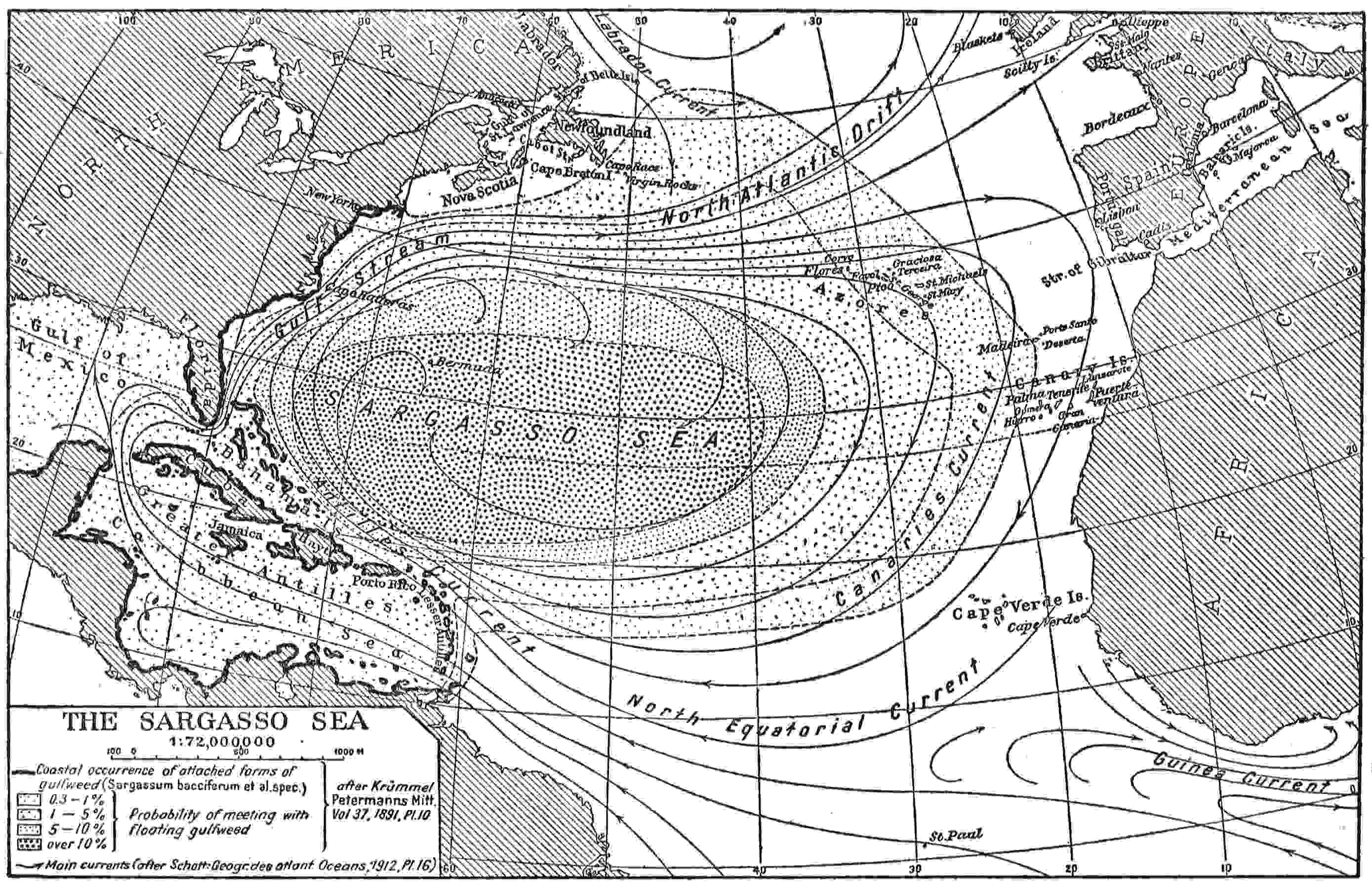
Fig. 1—Map of the Sargasso Sea showing its relation to the Azores, to illustrate its possible bearing on the medieval belief in
the existence of lands or islands beyond. Scale 1:72,000,000. (The map is also intended to help in locating the various existing
islands of the North Atlantic.)
29
Aristotle, as cited by Nansen, tells us in his “Meteorologica”
that the sea beyond the Pillars of Hercules was muddy and shallow
and little stirred by the winds.35 In early life Aristotle was a
pupil of Plato, and, though he afterward developed a widely
different method and outlook, it is likely that their information as
to this matter was in common, being supplied perhaps by Phoenician
and other seamen.
In the passage quoted from Scylax and the first excerpt from
Avienus the courses referred to are apparently too near the mainland
shore to approach that prodigious accumulation of eddy-borne
weeds in dead water which has long given to a great space
of mid-Atlantic the name of the Sargasso Sea. But they show that
huge seaweeds were very early associated with obstruction to
navigation in seafaring minds and popular fancy. Perhaps they
may also have suggested shallows as affording beds of nourishment
for so enormous an output of vegetation. It would not
readily occur to the early seagoing observers that the greatest of
these entangling creations floated in masses quite free, though we
now know this to be the case. In any event, it is evident that
some imperfect knowledge of conditions far west of the Pillars of
Hercules had made its way to Greece. Somewhere in that ocean
of obscurity and mystery there was a vast dead and stagnant
sea, presumably shallow, a sea to be shunned. Gigantic entrapping
weeds and wallowing sea monsters freely distributed were
recognized, too, as among the standing terrors of the Atlantic.
The Sargasso Sea As the Ancient Atlantis
It would be idle and wearying to follow such utterances through
the rather numerous centuries that have elapsed since those early
times. When the Magrurin or deluded explorers of Lisbon, at
some undefined time between the early eighth century and the
middle of the twelfth attempted, according to Edrisi, to cross the
great westward Sea of Darkness they encountered an impassable
tract of ocean and had to change their course, apparently reaching30
one of the Canary Islands. Later the map of the Pizigani
brothers of 136736 (Fig. 2) contains in words and a saintly figure of
warning a solemn protest against attempting to sail the unnavigable
ocean tract beyond the Azores. As will be seen by a modern
map (Fig. 1), this area includes the vast realm of the Sargasso—a
waste of weed, shifting its borders with the seasons but constant
in its characteristics in some parts and always to be found by little
seeking—one of the permanent conspicuous features of earth’s
surface.37 It is described by a writer in the Encyclopaedia Britannica
as nearly equal to Europe in area, a statement hardly
warranted unless by including all outlying tatters and fringes of
Gulf weed floating free.38
It is one of the topics that tempt and have always tempted exaggeration
and misunderstandings. The effect on a bright mind
of current nautical yarns concerning it is shown by Janvier’s
“In the Sargasso Sea,” a narrative almost as extravagant as
Plato’s tale of Atlantis, in its own quite different way. One of the
more moderate preliminary passages may be cited:
And to that same place, he added, the stream carried all that was
caught in its current—like the spar and plank floating near us, so that
the sea was covered with a thick tangle of the weed in which were held
fast fragments of wreckage and stuff washed overboard and logs adrift
from far southern shores, until in its central part the mass was so dense
that no ship could sail through it nor could a steamer traverse it because of the
fouling of her screws.39
31
He admits this theory of formation was inaccurate but later
refers to “the dense wreck-filled center of the Sargasso Sea” and
makes his castaway hero declare:
What I looked at was the host of wrecked ships, the dross of wave and
tempest which through four centuries has been gathering slowly and still
more slowly wasting in the central fastnesses of the Sargasso Sea.40
Sir John Murray naturally gives a more moderate and scientific
account, explaining:
The famous Gulf Weed characteristic of the Sargasso Sea in the North
Atlantic belongs to the brown algae. It is named Sargassum bacciferum,
and is easily recognized by its small berry-like bladders.... It is
supposed that the older patches gradually lose their power of floating,
and perish by sinking in deep water.... The floating masses of Gulf
Weed are believed to be continually replenished by additional supplies
torn from the coasts by waves and carried by currents until they accumulate
in the great Atlantic whirl which surrounds the Sargasso Sea. They
become covered with white patches of polyzoa and serpulae, and quite a
large number of other animals (small fishes, crabs, prawns, molluscs,
etc.) live on these masses of weed in the Sargasso Sea, all exhibiting remarkable
adaptive coloring, although none of them belong properly to
the open ocean.41
Finally we have from the Hydrographic Office the official naval
and scientific statement of the case. In the little treatise already
referred to, Lieutenant Soley tells us that the southeast branch
of the Gulf Stream “runs in the direction of the Azores, where it is
deflected by the cold upwelling stream from the north and runs
into the center of the Atlantic Basin, where it is lost in the dead
water of the Sargasso Sea.”42 As to just what this is the office
answers:
Through the dynamical forces arising from the earth’s rotation which
cause moving masses in the northern hemisphere to be deflected toward
the right-hand side of their path, the algae that are borne by the Gulf
Stream from the tropical seas find their way toward the inner edge of the
circulatory drift which moves in a clockwise direction around the central
part of the North Atlantic Ocean. In this central part the flow of the32
surface waters is not steady in any direction, and hence the floating seaweed
tends to accumulate there. This accumulation is perhaps most observable
in the triangular region marked out by the Azores, the Canaries
and the Cape Verde Islands, but much seaweed is also found to the westward
of the middle part of this region in an elongated area extending to
the 70th meridian.
The abundance of seaweed in the Sargasso Sea fluctuates much with
the variation of the agencies which account for its presence, but this Office
does not possess any authentic records to show that it has ever materially
impeded vessels.43
Perhaps these statements are influenced by present or recent
conditions. It is obvious that giant ropelike seaweeds in masses
would more than materially impede the action of the galley oars,
which were the main reliance in time of calm of the ancient and
medieval navigators. Also it is hardly to be believed that small
sailing vessels could freely drive through them with an ordinary
wind. If the weeds were so unobstructive, why all these complaints
and warnings out of remote centuries? In the days of
powerful steamships and when the skippers of sailing vessels
have learned what area of sea it is best to avoid, there may well
be a lack of formal reports of impediment; but it certainly looks
as though there were some basis for the long established ill repute
of the Sargasso Sea.
Summary
For the genesis of Atlantis we have then, first, the great idealist
philosopher Plato minded to compose an instructive pseudo-historical
romance of statesmanship and war and actually making
a beginning of the task; and, secondly, the fragmentary cues and
suggestive data which came to him out of tradition and mariners’
tales, perhaps in part through Solon and intervening transmitters,
in part more directly to himself. Of this material we may
name foremost the vague knowledge of vast impeded regions in
the Atlantic believed to be shallow and requiring a physical explanation;
then rumors of cataclysms and sunken lands in the
same ocean; then legends of ancient hostilities between dwellers33
beyond the Pillars of Hercules and the peoples about the Mediterranean;
and finally the reflection of the Persian war on the shadowy
ancient past of Athens—Athens the defender and victor,
Athens the Queen of the Sea.
Every solution of the Atlantis problem must be conjectural.
The above is offered simply as the best conjecture to which I can
see my way.
34
CHAPTER III
ST. BRENDAN’S EXPLORATIONS AND ISLANDS
The Lismore Version of the Saint’s Adventures
The fifteenth-century Book of Lismore, compiled from much
older materials, tells us that St. Brenainn (evidently St. Brendan,
the navigator)
desired to leave his land and his country, his parents and his fatherland,
and he urgently besought the Lord to give him a land secret, hidden,
secure, delightful, separated from men. Now after he had slept on that
night, he heard the voice of the angel from heaven, who said to him,
“Arise, O Brenainn,” saith he, “for God hath given thee what thou
soughtest, even the Land of Promise” ... and he goes alone to
Sliab Daidche and he saw the mighty intolerable ocean on every side,
and then he beheld the beautiful noble island, with trains of angels
(rising) from it.44
Thus far, in the rather redundant style of such literature, from
the Life of Brenainn in the Lives of the Saints of this old manuscript.
After a century and a half of disappearance this manuscript
was accidentally discovered in 1814, in a walled-up recess,
by workmen engaged on repairs.
Mr. Westropp holds that this Lismore version is the “simplest
and probably the earliest;”45 but its full-blown development
of certain marvels (such as the spending of every Easter for at
least five years on the back of a vast sea monster as a substitute
for an island) may well awaken a question as to the validity of
this conjecture.
However, the suggestion of the voyage by a dream seems likely
enough, and his mood was in keeping with the anchorite enthusiasm35
of his time. Of course he promptly set forth to find his
“promised land;” at first, in a hide-covered craft, with failure in
spite of long endeavor; afterward, by advice of a holy woman, in
a large wooden vessel, built in Connaught and manned by sixty
religious men, with final success.
Another Version
Another version gives the credit of the first incitement to a
purely human visitor, a friendly abbot, St. Brendan’s aim being
to reach an island “just under Mount Atlas.” Here a holy
predecessor, Mernoc by name, long vanished from among men,
was believed to have hidden himself in “the first home of Adam
and Eve.” To all readers this was a fairly precise location for the
earthly paradise. The great Atlas chain forms a conspicuous
feature of medieval maps, running down to sea (as it does in
reality) near Lanzarote and Fuerteventura, the innermost of the
Canaries, which seem like detached, nearly submerged, summits
of the range.
This narrative is longer and more detailed than that of the
Book of Lismore and gives more plentiful indications of voyaging,
especially toward the end, in southern seas. In its picture of volcanic
fires it recalls occasional outbursts of Teneriffe and its
neighbors. “They saw a hill all on fire, and the fire stood on each
side of the hill like a wall, all burning.” A visit is also recorded
to a neighboring land, apparently continental, which the adventurers
penetrated for forty days’ travel to the banks of a magical
river, whence they brought away “fruit and jewels.” This may
well be meant for Africa, obviously quite near these Fortunate
Islands.
Attempts to Explain the Origin of the Brendan
Narratives
It has been intimated that the narratives of “St. Brendan’s
Navigation” may have originated in misunderstood tales of his
early sea wanderings around the coasts of Ireland seeking for a
monastery site. He was successful in this at least, being best36
known (excepting as a discoverer) for the great religious establishment
at Clonfert, not the first which he founded in the sixth
century but the most widely known and the greatest.
Another explanation casts doubts upon his real existence and
supposes the story of the discoveries to have arisen by confusion
of language with the well-known pagan “Voyage of Bran,” perhaps
the earliest of the ancient Irish Imrama, or sea sagas.
It has also been said that the origin of the Brendan narratives
may be found in “a ninth-century sermon elaborated up to its
present form by the eleventh century.”46 A ninth-century manuscript
is said to be in the Vatican library.
A Norman French Version
A Norman French translation was turned into Norman French
verse by some trouvère of the court for the benefit of King Henry
Beauclerc and his Queen Adelais early in the twelfth century and
partly translated metrically into English for Blackwood’s Magazine
in 1836. It avers that the saint set sail for an
Isle beyond the sea
Where wild winds ne’er held revelry,
But fulfilled are the balmy skies
With spicy gales from Paradise;
These gales that waft the scent of flowers
That fade not, and the sunny hours
Speed on, nor night, nor shadow know.
47
They sail westward fifteen days from Ireland; then in a
month’s calm drift to a rock, where they find a palace with food
and where Satan visits them but does no harm. They next voyage
seven months, in a direction not stated, and find an island with
immense sheep; but, when they are about to cook one, the island
begins to sink and reveals itself as a “beast.” They reach another
island where the birds are repentant fallen angels. From this they
journey six months to an island with a monastery founded by St.
Alben. They sail thence till calm falls on them and the sea37
becomes like a marsh; but they reach an island where are fish
made poisonous by feeding on metallic ores. A white bird warns
them. They keep Pentecost on a great sea monster, remaining
seven weeks. Then they journey to where the sea sleeps and cold
runs through their veins. A sea serpent pursues them, breathing
fire. Answering the saint’s prayer, another monster fights and
kills the first one. Similarly a dragon delivers them from a griffin.
They see a great and bright jeweled crystal temple (probably an
iceberg). They land on shores of smoke, flame, blast, and evil
stench. A demon flourishes before them, flies overhead, and
plunges into the sea. They find an island of flame and smoke, a
mountain covered with clouds, and the entrance to hell. Beyond
this they find Judas tormented. Next they find an island with a
white-haired hermit, who directs them to the promised island,
where another and altogether wonderful holy man awaits them,
of whom more anon.
In this version, as in others, there are passages—such as the
mention of extreme cold and the account of a great floating structure
of crystal—which imply a northward course for their voyage
in some one of its stages. So greatly was Humboldt impressed by
this and by the insistence on the Isle of Sheep, which he identified
with the Faroes, that he restricted in theory the saint’s navigation
to high latitudes.48
The Probable Basis of Fact
But it is noticeable that every version gives St. Brendan the
task of finding a remote island, which was always warm and
lovely, and chronicles the attainment of this delight, though he
finds other delectable islands near it or by the way. The metrical
description before quoted is surely explicit enough, but the Book
of Lismore outdoes it in a very revel of adjectives. As though
praises alone failed to satisfy the celebrant, he introduces the
figure of a holy ungarmented usher—a living demonstration of38
the benignity of the climate. He was “without any human raiment,
but all his body was full of bright white feathers like a dove
or sea mew; and it was almost the speech of an angel that he
had.” “Vast is the light and fruitfulness of the island,” he cried
in welcome and launched forthwith on a prodigal expenditure of
superextolling words outpoured on their new delightful home. It
is all perfectly in keeping with the glow and luxuriance of sun-warmed
shores and the unique airiness of his spontaneous raiment.
Clearly “summer isles of Eden,” and nothing that has to
do with icebergs or wintry blasts, are called for in this case.
About six centuries lie between St. Brendan’s experiences and
the earliest writing purporting to relate them and generally
accepted as to date. Doubtful manuscripts and miscellaneous
allusions—also often doubtful—may lessen the gap; but at best
we have several centuries bridged by tradition only, and that
rather inferred than known. It seems likely that he really
visited and enjoyed some remote lovely islands, not very often
reached from the mainland, such as could in any age have been
discovered among the eastern Atlantic archipelagoes. In doing
so he might well meet with surprising adventures, readily distorted
and magnified; and the first tales of them would be basis
enough for the florid fancy of Celtic and medieval romancers,
growing in extravagance with passing generations.
The Cartographic Evidence
That he found some island or islands was certainly believed,
for his name is on many maps in full confidence. But as to the
particular islands thereby identified we find that conjecture had
a wide range, varying in different periods and even with individual
bias.
The Hereford Map of circa 1275
Probably its first appearance is on the Hereford map of 1275
or not much later,49 the inscription being “Fortunate Insulae sex39
sunt Insulae Sct Brandani.” It is about on the site of the Canary
group, and the elliptical island Junonia is just below. The showing
is uncertain and conventional; also the number six misses the
mark by one; still there can be no doubt that the Canaries as a
whole were intended. Concerning them Edrisi50 had observed,
about 1154: “The Fortunate Islands are two in number and are
in the Sea of Darkness.” Perhaps he had Lanzarote and Fuerteventura,
the most accessible pair, especially in mind. The
surviving derivatives of the last eighth-century Beatus map51 also
bear the inscription “Insulae Fortunate” where the Canary
Islands should be, but they assert nothing of “St. Brandan.”
Doubtless, dimly known, they had been reputed Isles of the Blest
from prehistoric times. If St. Brendan found them, he found
them already the “Fortunate Isles.”
A tradition long survived—perhaps survives still—in the
Canary archipelago supporting this identification by the Hereford
map. Thus Father Espinosa,52 who long dwelt in Teneriffe
and wrote his book there between 1580 and 1590, avers that St.
Brendan and his companions spent several years in that archipelago
and quotes a still earlier “calendar,” date not given, as
authority for their mighty works done there “in the time of the
Emperor Justinian.” Even as late as the eighteenth century an
expedition sailed from among them for an island believed to be
outside of those already known and to be the one discovered by
St. Brendan.
40
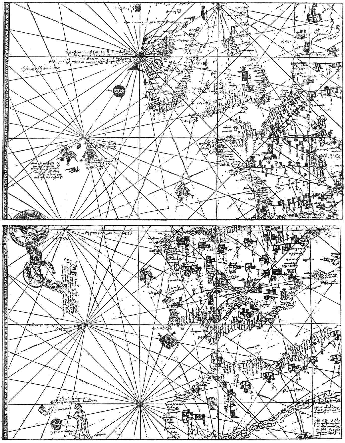
Fig. 2—Section, in two continuous parts, of the Pizigani map of 1367 showing St. Brendan’s Islands, Mayda, Brazil, Daculi,
and other legendary islands. (After Jomard’s hand-copied reproduction.)
(Top panel)((Bottom panel)
42
The Dulcert Map of 1339
The second cartographical appearance of the saint’s name
seems to be in the portolan map53 of Angelinus Dulcert, the
Majorcan, dated 1339, where three islands corresponding to
those now known as the Madeiras (Madeira, Porto Santo, and
Las Dezertas) and on the same site are labeled “Insulle Sa
Brandani siue puelan.” Since “u” was currently substituted for
“v,” and “m” and “n” were interchangeable on these old maps, the
last two words should probably be read “sive puellam.” However
the ending of the inscription be interpreted, there can be no
doubt about St. Brendan and his title to the islands—according
to Dulcert. And that this island group must be identified with
Madeira and her consorts (though Madeira is named Capraria
and Porto Santo is named Primaria) hardly admits of any question.
If the identification of them with the Fortunate Islands especially
favored by St. Brendan were no more than a conjecture of
Dulcert or some predecessor, it still had a certain plausibility
from the facts of nature and the favorable report of antiquity.
Strabo may have borne these islands in mind when he wrote: “the
golden apples of the Hesperides, the Islands of the Blessed they
speak of, which we know are still pointed out to us not far
distant from the extremities of Maurusia, and opposite to Gades.”54
Apparently, too, Diodorus Siculus, writing half a century
or so before the Christian era about what happened a thousand
years earlier still, means Madeira by the “great island of very
mild and healthful climate” and “in great part mountainous but
much likewise champaign, which is the most sweet and pleasant
part of all the rest;”55 whereto the Phoenicians were storm-driven43
after founding Cadiz and which the Etrurians coveted but
the Carthaginians planned to hold for themselves. Even since
those old days there has been a general recognition of Madeira’s
balminess and slumberous, flowery, enticing beauty.
The Map of the Pizigani of 1367
Divers maps of the fourteenth and fifteenth centuries do not
contain the name of St. Brendan (it is perhaps never spelled
Brendan in cartography) and hence do not count either way.
But the identification of the notable map of 1367 of the brothers
Pizigani56 (Fig. 2) is the same as Dulcert’s, the inscription being
also given in the alternative. Like many oceanic features of this
strange production it is by no means clear, but seems to read
“Ysole dctur sommare sey ysole pone+le brandany.” Perhaps it
is to be understood as the “islands called of slumber or the islands
of St. Brandan.” There is at any rate no doubt about the last
word or its meaning. But, as if to place the matter beyond all
question, a monkish figure, generally accepted as that of the
saint himself, is depicted bending over them in an attitude of
benediction.
This map evidently does not copy from Dulcert, for the forms,
proportions, and individual names of the islands all differ. It
calls the chief island Canaria, instead of Capraria or the later
Madeira, and appends a longer name, which seems like Capirizia,
to what have long been known as Las Dezertas, which appear
greatly enlarged on it. Porto Santo is left unnamed on the map,
perhaps because it lies so close to the general name of the group.
First Use of “Porto Santo” as Name of One
of the Madeiras
A claim has been set up by the Portuguese that Porto Santo
(Holy Port) was first applied to this island by their rediscoverers
of the next century in honor of their safe arrival after peril, but
this is abundantly confuted by its presence on divers fourteenth-century44
maps, notably the Atlante Mediceo57 of 1351. Also the
Book of the Spanish Friar,58 dating from about the middle of that
century, contains in his enumeration of islands the words
“another Desierta, another Lecname, another Puerto Santo.”
It would seem to have been a familiar appellation about 1350
or earlier, and the suggestion naturally occurs that it may have
originated in the tradition of the visit and blessing of the Irish
saint. At any rate, the Portuguese, in the fifteenth-century rediscovery,
can have had nothing to do with conferring it.
Animal and Bird Names of Islands
Concerning such names as Canaria, Capraria, etc., which, by
reason of other associations, appear oddly out of place in this
group, the more general question is raised of the tendency to
apply animal and bird names to Eastern Atlantic islands. Goat,
rabbit, dog, falcon, dove, wolf, and crow were applied to various
islands long before the Portuguese visited the Madeiras and
Azores, finding them untenanted; these names long held their
ground on the maps, and some of them are in use even now. The
reason for their adoption piques one’s curiosity. If they could be
taken as throwing any light on the fauna of these islands in 1350,
they might also instruct us as to the probability of prior human
occupancy or previous connection with the mainland. But, of
course, in any significant instances some fancied resemblance of
aspect may have suggested the name.
Madeira
Madeira, meaning island of the woods or forest island, is a
direct Portuguese translation from the Italian “I. de Legname”45
of the Atlante Mediceo and various later maps, and of the
“Lecname” of the unnamed Spanish friar who tells us he was born
in 1305. It is sufficiently explained by the former condition of the
island, the northern part of which is said to preserve still its
abundant woodland. Perhaps the modern name of Madeira
(or Madera) first appears on the map of Giraldi of 1426,59 not
very long after the rediscovery. But, with some cartographers,
the Italian form of the name lingered on much later.
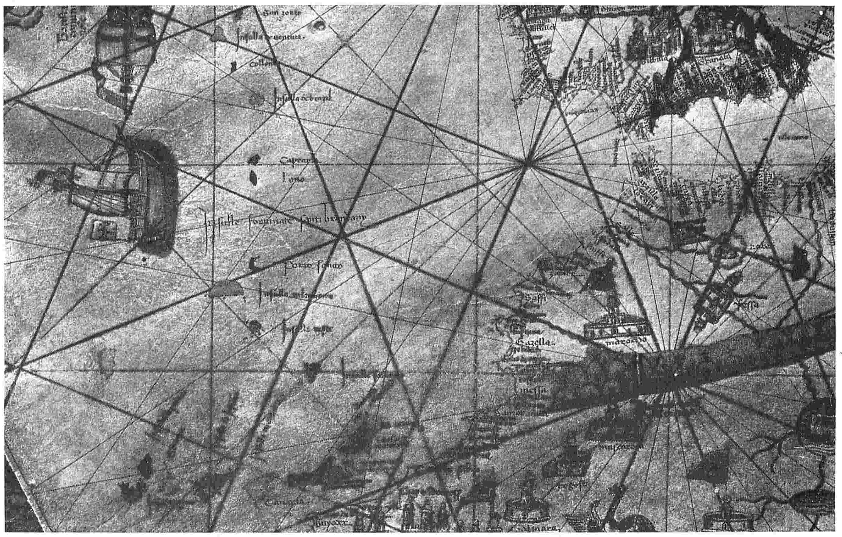
Fig. 3—Section of the Beccario map of 1426 showing St. Brendan’s Islands. (From a photograph in the author’s possession.)
The Beccario Map of 1426
The alternative names, which had been given the Madeira
group by Dulcert and the Pizigani, commemorating both the
general fact of repose or blessedness and the delighted visit of
St. Brendan, were closely blended (in what became the accepted
formula) by the 1426 map of Battista Beccario, which unluckily
had never been published in reproduction. Before the war, however,
the writer obtained a good photograph of a part of it from
Munich and herewith presents a section recording the words
“Insulle fortunate santi brandany” (Fig. 3).60 The first “a” of the
final name may possibly be an “e,” having been obscured by one
of the compass lines; but I think not. Beccario repeats the same
inscription in his very important and now well-known map61
of 1435, substituting “sancti” for “santi” by way of correction.
With no serious variations, this name, “The Fortunate Islands
of St. Brandan” (or Brendan), is applied to Madeira and her
consorts by Pareto (1455;62 Fig. 21), Benincasa (1482;63 Fig. 22),
the anonymous Weimar map formerly attributed to 1424 but46
probably of about 1480 or 1490,64 and divers others. In several
instances (the Beccario maps, for example) the words are almost
as near to the most southerly pair of the Azores, next above them,
as to the Madeiras below, and it is possible that the condition of
special beatitude was understood as extending to the former also.
The Bianco Map of 1448
At any rate, the verdict of the fifteenth century for Madeira
was by no means unanimous. The 1448 map of Bianco,65 which is
very unlike his earlier one of 1436 so far as concerns the Atlantic,
was prepared after all the Azores had been found again by the
Portuguese except Flores and Corvo. It shows the old familiar
inaccurately north-and-south string of the three groups of the
Azores as they had come to him conventionally and traditionally,
for evidently he did not dare or could not bring himself to discard
them. But it also shows a slanting array of islands farther out,
arranged in two groups respectively of two islands and five islands
each and much more accurately presented as to location and direction
than the old Italian stand-bys. These are quite clearly the
Portuguese version, brought down to that date, of the newly rediscovered
Azorean archipelago. But Bianco was obviously put
to it to conjecture what islands these might be. He drew names
from miscellaneous sources: in particular the largest island of the
main group, corresponding to Terceira, bears the title “ya fortunat
de sa. beati blandan.” Nevertheless, he shows and names Madeira,
Porto Santo, and Deserta in their usual places. Evidently
he had given up, if he ever held, all thought of annexing St.
Brendan’s special blessing to them. He seems very confident of
the St. Brandan’s Island of his slanting series, for it is drawn
heavily in black and contrasts with the rather ghastly aspect of
some neighbors. It has nearly the form of a Maltese cross, with
long arms, but there is no reason to suppose that this has any
significance.
47
Behaim’s Globe of 1492
About the same period a Catalan map66 of unknown authorship,
without copying details, adopted the same expedient of
duplicating the Azores by adding the new slanting series. It is
quite independent in details, however, omitting mention of
“St. Brandan” in particular, though Ateallo (Antillia?) is given
in the second group but not in the corresponding place. This
may possibly indicate some confusion of Antillia with St. Brandan’s
Island, such as is more evident in the transfer of the traditional
outline of the former to the latter, little changed, by Behaim
on his globe of 1492.
As it stands, this globe undoubtedly gives an original and
unique representation of St. Brandan’s Island far west of the
Cape Verde group and emphasizes it by showing Antillia independently
in a more northern latitude and less western longitude
and also of quite insignificant size and form. But Ravenstein,
who made a very thorough study of the matter, tells us67 that
this globe has been twice retouched or renovated and that the
only way to ascertain exactly what was originally delineated is
to treat it as a palimpsest and remove the accretions. In particular,
he relates the story of an expert geographer who found the
draftsmen about to transpose St. Brandan’s Island and Antillia;
but they yielded to his protest. Of course, it is impossible to be
quite certain that these map figures are such and in such place
as Behaim intended or that they bear the names he gave. The
presumption favors the present showing, generally accepted as
authentic. It gives the saint only one island, but this a very large
one, set in mid-ocean between Africa and South America.
Possibly this location may be suggested by an undefined coast
line shown by Bianco’s map of 1448, previously mentioned, and,
like Behaim’s island, set opposite the Cape Verde group. In
Venetian Italian it bears an obscure inscription, which calls it
an “authentic island” and is variously interpreted as saying that48
this coast is fifteen hundred miles long or fifteen hundred miles
distant. The map of Juan de la Cosa (1500)68 exhibits off the coast
of Brazil, and with an outline similar to Behaim’s, “the island
which the Portuguese found.” His date is too late to have influenced
Behaim, too early to have been prompted by Cabral’s
accidental discovery of that very year. It is more likely that he
and Behaim both were acquainted with Bianco’s work or that all
three drew from the same report of discovery.
Later Maps
From this time on there is never more than one island for St.
Brendan, but it indulges in wide wanderings. Especially as the
attention of men was attracted to the more northern and western
waters, the map-makers shifted the island thither. Thus the map
of 1544, purporting to be the work of Sebastian Cabot and probably
prepared more or less under his influence,69 places the island
San Brandan not far from the scene of his father’s explorations
and his own. It lies well out to sea in about the latitude of the
Straits of Belle Isle. The Ortelius map of 157070 (Fig. 10) repeats
the showing with no great amount of change. In short, the final
judgment of navigators and cartographers, before the island quite
vanished from the maps, made choice of the waste of the North
Atlantic as its most probable hiding place. Perhaps this westward
tendency in rather high latitudes may be partly responsible
for the hypotheses in recent times which have taken the explorer
quite across to interior North America on a missionary errand.
There is certainly nothing to prohibit any one from believing
them, if he can and if it pleases him.
Conclusion
In general review it appears likely that St. Brendan in the
sixth century wandered widely over the seas in quest of some49
warm island, concerning which wonderful accounts had been
brought to him, and found several such isles, the Madeira group
receiving his special approval, according to the prevailing opinion
of the fourteenth and fifteenth centuries. But this judgment of
those centuries is the only item as to which we can speak with any
positiveness and confidence.
50
CHAPTER IV
THE ISLAND OF BRAZIL
So far as we know, the first appearance of the island of Brazil
in geography was on the map of Angellinus Dalorto,71 of Genoa,
made in the year 1325. There it appears as a disc of land of
considerable area, set in the Atlantic Ocean in the latitude of
southern Ireland (Fig. 4). But the name itself is far older. In
seeking its derivation, one is free to choose either one of two
independent lines.
Probable Gaelic Origin of the Word “Brazil”
The word takes many forms on maps and in manuscripts:
as Brasil, Bersil, Brazir, O’Brazil, O’Brassil, Breasail. As
a personal name it has been common in Ireland from ancient
days. The “Brazil fierce” of Campbell’s “O’Connor’s Child” may
be recalled by the few who have not wholly forgotten that
beautiful old-fashioned poem. Going farther back, we find
Breasail mentioned as a pagan demigod in Hardiman’s “History
of Galway”72 which quotes from one of the Four Masters, who
collated in the sixteenth century a mass of very ancient material
indeed. Also St. Brecan, who shared the Aran Islands with
St. Enda about A.D. 480 or 500, had Bresal for his original name
when he flourished as the son of the first Christian king of Thormond.
The name, however spelled, is said to have been built52
up from two Gaelic syllables “breas” and “ail,” each highly
commendatory in implication and carrying that note of admiration
alike to man or island. Quite in consonance therewith the
fifteenth-century map of Fra Mauro in 145973 not only delineated
and named this Atlantic Berzil but appended the inscription
“Queste isole de Hibernia son dite fortunate,” ranking it as one of
the “Fortunate Islands.”
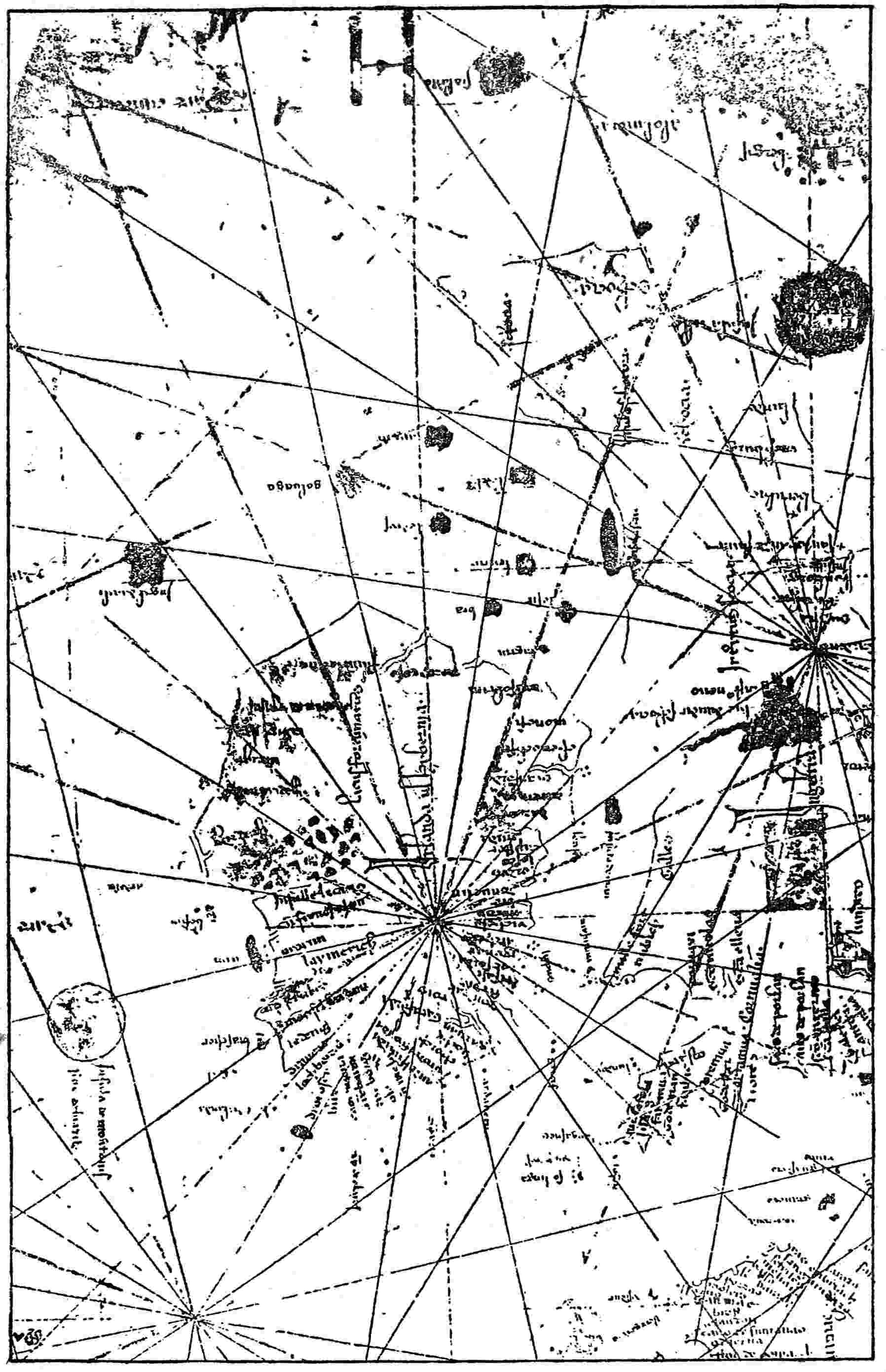
Fig. 4—Section of the Dalorto map of 1325 showing Brazil, Daculi, and other
legendary islands. (After Magnaghi’s photographic facsimile.)
Another Suggested Derivation
On the whole, this seems the more likely channel of derivation
of the name; or, if there were two such channels, then the more
important one. For there is another suggested derivation, of
which much has rightly been made and which we must by no
means neglect. Red dyewood bore the name “brazil” in the early
Middle Ages, a word derived, Humboldt believed,74 by translation
from the Arabic bakkam of like meaning, on record in the ninth
century. He notes that Brazir, one form of the name, as we have
seen, recalls the French braise, the Portuguese braza and braseiro,
the Spanish brasero, the Italian braciere, all having to do with
fire, which is normally more or less red like the dye. He does not
know any tongue of medieval Asia which could supply brasilli
or the like for dyewood. He suggests also the possibility of the
word’s being a borrowed place name, like indigo or jalap, commemorating
the region of origin, but cannot identify any such
place. His treatment of the topic leaves a feeling of uncertainty,
with a preference for some sort of transformation from “bakkam”
which would yield “brazil” probably by a figure of speech.
The earliest distinctly recognizable mention of brazil as a
commodity occurs in a commercial treaty of 1193 between the53
Duchy of Ferrara, Italy, and a neighboring town or small state,
which presents grana de Brasill in a long list including wax, furs,
incense, indigo, and other merchandise.75 The same curious
phrase, “grain of Brazil,” recurs in a quite independent local
charta of the same country only five years later. Muratori,
who garnered such things into his famous compilation of Italian
antiquities, avowed his bewilderment over this strange phrase,
asking what dyewood could be so called; and Humboldt, reconsidering
the whole matter, was no more clear in mind. He calls
attention to the fact that cochineal very long afterward bore the
same name, but evidently without considering this any sort of
solution, as, indeed, it could not well be, since it bears distinct
reference to the South American Brazil, which was discovered
and named centuries later. But the facts remain that grain does
not naturally mean dyewood of any kind or in any form, that
its recurrence in public documents proves it a well-established
characterization of a known article of trade in the twelfth
century, and that its presentation is such as to indicate a granular
packaged material.
Perhaps an explanation may be found in Marco Polo’s experience
and experiments nearly a century later than these Italian
documents. Of Lambri, a district in Sumatra, he writes:
They also have brazil in great quantities. This they sow, and when it
is grown to the size of a small shoot they take it up and transplant
it; then they let it grow for three years, after which they tear it up by the
root. You must know that Messer Marco Polo aforesaid brought some
seed of the brazil, such as they sow, to Venice with him and had it sown
there, but never a thing came up. And I fancy it was because the climate
was too cold.76
The seeds of that Sumatran shrub might well pass for grain
in the sense of a small granular object, as we say a grain of sand,
for example. But, since the plant was not and perhaps could not54
be reared in Italy, it seems unlikely that the seed should be a
valued item of commerce, regularly listed, bargained for, and
taxed. We do not hear of its being put to use as a dye; and, indeed,
the bark or wood of the plant seems far more promising for
that purpose. Like our distinguished forerunners in considering
this little mystery, we must set it aside as not yet fully solved.
“Grain of Brazil” is not repeated in any entry, so far as I know,
after the end of the twelfth century; but brazil as a commodity
figures rather frequently; for example, in the schedules of port
dues of Barcelona and other Catalan seaboard towns in the
thirteenth century, as compiled by Capmany.77 Thus in 1221
we find “carrega de Brasill,” in 1243 “caxia de bresil,” and somewhat
later (1252) “cargua de brazil,” the spelling varying as in
the easy-going fourteenth- and fifteenth-century maps, the word
being plainly the same. But the word and the thing were not
confined to the Mediterranean, for a grant of murage rates of
1312 to the city of Dublin, Ireland, uses the words “de brasile
venali.”78 This is pretty far afield and shows that the knowledge
and use of brazil as taxable merchandise was nearly Europe-wide.
As a rule, it has been taken for granted that the word meant
either some special kind of red dyewood or dyewood in general.
Marco Polo’s account conforms rather to the former version,
while Humboldt seems to lean toward the latter; but there is
singularly little in the entries which tends to identify it as wood
at all or in any way relate it thereto. Such words as carrega,
caxia, cargua, show that it was put up in some kind of inclosure,
and perhaps give the impression of comminution or at least
absence of bulkiness. Most likely many kinds of red bark, red
wood suitable for dyeing, and perhaps other vegetable products
available for that purpose were sometimes included under the
name brazil. People of that time were more concerned about55
results and means to attain them than about exactness in
classification or definition.
It may well be that both lines of derivation of the name meet
in the Brazil Island west of Ireland, that it was given a traditional
Irish name by Irish navigators and tale tellers and mapped
accordingly by Italians, who would naturally apply to it the
meaning with which they were familiar in commerce and eastern
story, so that the Island of Brazil, extolled on all hands, would
come to mean along the Mediterranean chiefly the island where
peculiarly precious dyewoods abounded. We know that Columbus
was pleased to collect what his followers called brazil in his
third and fourth voyages along American shores;79 that Cabot
felicitates himself on the prospect of finding silk and brazilwood
by persistence in his westward explorations;80 and that the great
Brazil of South America received its final name as a tribute to its
prodigal production of such dyes.
Free Distribution of the Name on Early Maps
But there is a curious phenomenon to be noticed—the free
distribution of this name among sea islands, especially of the
Azores archipelago, from an early date. Thus the Pizigani map
of 136781 applies it with slight change of spelling not only to the
original disc-form Brazil west of Ireland and to a mysterious
crescent-form island, which must be Mayda, but to what is
plainly meant for Terceira of the main middle group of the
Azores (Fig. 2). The Spanish Friar, naming Brazil in his island
list about 1350, appears also to mean Terceira, judging by the
order of the names.82 His matter-of-fact tone indicates a long-settled56
item. This carries us well back toward the first settled
date for the Irish Brazil in cartography. Further, the name still
adheres to Terceira, though long restricted to a single mountainous
headland. The explanation remains a matter of conjecture.
Perhaps the Azores islands that bore it borrowed from the older
Brazil west of Ireland. Perhaps also the word had gone about
that islands were notable for dyes—archil, for example—and the
special dye name brazil has been loosely affixed in consequence.
On some of the maps certain alternative names are given,
which do not greatly further our investigation. Thus the very
first one which shows Brazil—Dalorto, 1325—adds Montonis
as a second choice (Fig. 4). This has been understood to mean the
Isle of Rams, linking it with Edrisi’s Isle of Sheep, a quite ancient
fancy, sometimes referred to the Faroes, but of very uncertain
identification. But Freducci,83 1497, makes it Montanis; Calapoda,84
1552, Montorius; and an anonymous compass chart of
1384,85 Monte Orius. In all these the idea of mountains, not
sheep, is dominant. The change from “a” to “o” is easy with
a not very vigilant transcriber, and it is most likely that Freducci
preserves the original form and meaning.
The Pizigani map of 1367 is confused and enigmatic on this
point, as in all its inscriptions. It seems to read (Fig. 2) “Ysola de
nocorus sur de brazar,” but it may best be set aside as too uncertain.
Equally unenlightening is the “de Brazil de Binar” of Bianco’s
1448 map.86 If the “n” be read “m,” the inscription may mean
“Brazil of the two seas;” but the allusion is mystifying.
Fra Mauro’s inscription before quoted merely bears testimony
to Brazil’s benign and almost Elysian repute and its connection
with the Green Isle in fancy.
57
Location and Shape of the Island
The circular form of Brazil and its location westward of
southern Ireland are affirmed by many maps, including Dalorto,
1325 (Fig. 4); Dulcert, 1339;87 Laurenziano-Gaddiano, 1351;88
Pizigani, 1367 (Fig. 2); anonymous Weimar map, probably about
1481;89 Giraldi, 1426;90 Beccario, 142691 and 143592 (Fig. 20); Juan
da Napoli, perhaps 1430;93 Bianco, 1436 and 1448;94 Valsequa,
1439;95 Pareto, 145596 (Fig. 21); Roselli, 1468;97 Benincasa, 148298
(Fig. 22); Juan de la Cosa, 1500;99 and numerous later maps.
Probably the persistent roundness is ascribable to a certain preference
for geometrical regularity, which sowed these early maps
with circles, crescents, trilobed clover leaves, and other more
unusual but not less artificial island forms. The direction must
stand for the tradition of some old voyage or voyages.
58
Significant Shape on the Catalan Map of 1375
But the celebrated Catalan map of 1375100 above mentioned
introduced a significant novelty, converting the disc into an
annulus of land—of course, still circular—surrounding a circular
body of water dotted with islets (Fig. 5). The preferred explanation
thus far advanced connects these islets with the Seven Cities
of Portuguese and Spanish legend.101 But there seem to be nine
islands, not seven, and it is not clear what necessary relation
exists between isles and cities nor whence the idea is derived of
the central lake or sea as a background. Moreover, the Island
of the Seven Cities was most often identified with Antillia far
to the south, and there seems no warrant for identification with
Brazil. All considered, this explanation seems arbitrary,
inadequate, and unconvincing.

Fig. 5—Section of the Catalan map of 1375 showing the islands of Mayda and
Brazil. (After Nordenskiöld’s photographic facsimile.)
The same ring form with inclosed water and islets is repeated
by a map of the next century copied by Kretschmer.102 It varies59
only by showing just seven islets, if we may rely for this detail
on his handmade copy.
Possible Identification with the Gulf of St. Lawrence
Region
Now, in all the Atlantic Ocean and its shores there is one region,
and one only, which thus incloses a sheet of water having islands
in its expanse, and this region lies in the very direction indicated
on the old maps for Brazil. I allude to the projecting elbow of
northeastern North America, which most nearly approaches
Europe and has Cape Race for its apex. Its front is made up of
Newfoundland and Cape Breton Island. The remainder of the
circuit is made up of what we now call southern Labrador, a
portion of eastern Quebec province, New Brunswick, and Nova
Scotia. This irregular ring of territory incloses the great Gulf
of St. Lawrence, which has within it the Magdalens, Brion’s
Island, and some smaller islets, not to include the relatively
large Anticosti and Prince Edward. It has two rather narrow
channels of communication with the ocean, which might readily
fail to impress greatly an observer whose chief mental picture
would be the great land-surrounded, island-dotted expanse of
water. The surrounding land would itself almost certainly be
regarded as insular, for there was a strong tendency to picture
everything west of Europe in that way, even long after the time
when most of these maps were made. Even when Cartier103 in 1535
ascended the St. Lawrence River it was in the hope of coming out
again on the open sea—a hope that implies the very conception of
an insular mass inclosing the gulf, not differing essentially from
the showing of the Catalan map of 1375. The number of the
islands is immaterial. We may picture the Catalan map-maker
dotting them in from vague report as impartially as the far better
known Lake Corrib is besprinkled with islands in most of the old
maps—far more plentifully than the facts give warrant.
60
But it would seem that other observers were more impressed
by the separation of Newfoundland, due to the Straits of Belle
Isle and Cabot and the waterway (of the gulf) connecting them
behind the great island. As a rule the maps presenting Brazil
in this divided way adhere to the accepted latitude, which does
not differ appreciably from that of the St. Lawrence Gulf
region. The dividing passage, mainly from north to south but
slightly curved at the ends which join the ocean, corresponds
fairly well with the facts. The maps of Prunes, 1553104 (Fig. 12),
and Olives, 1568,105 may be cited as instances of this divided form
of Brazil. No explanation seems yet to have been offered except
Nansen’s,106 that the dividing channel represents “the river of
death (Styx),” and Westropp’s,107 that it may be owing to mistaken
copying of a name space or label on some older map. But the
former lacks any better basis than conjectured fancy and the
latter is refuted by the position of the channel on most maps
and by the general aspect of the delineation. As a matter of
fact, the showing of most of the maps differs in little more than
proportions from that of Gastaldi illustrating Ramusio in 1550,108
when the Gulf of St. Lawrence was fairly well known to many,
but appears as a rather narrow channel behind a broken-up
Newfoundland, extending from the Strait of Belle Isle to the
Strait of Cabot. As in the much older map referred to, the
delineation of Gastaldi is perhaps to be explained by concentration
of attention on the waterway and the ignoring of the
wider parts of the expanse. Absolute demonstration of the
causes of the divided Brazil of some maps and the ring of land
inclosing an island-dotted body of water in others is, of course,
impossible; but we can show that in the designated direction
there is a region presenting both of these unusual features, so
that one of the visitors might well be especially taken up with61
one set of characteristics, another with the other set, and might
depict the region accordingly. This is the more probable because
the region was peculiarly exposed to accidental or intentional
discovery from the west of the British islands and is known, in
fact, to have been the first to be reached therefrom of all North
America in times of historic record.
It must not be supposed that Brazil was always thought of as
relatively near Europe. Nicolay in 1560109 (Fig. 6) and Zaltieri in
1566110 prepared maps which show a Brazil Island in distinctly
American waters, practically forming part of the archipelago into
which Newfoundland was supposed to be divided, or at least lying
between it and the Grand Banks. These presentations no doubt
may have been suggested by American discoveries and later
theories, especially as no navigator had been able to find Brazil
at any point nearer Europe; but again they may be at least
partly due to surviving early traditions of the great distance
westward at which this island lay. The Brazil of Nicolay and
Zaltieri is, to be sure, a very small affair; but their maps were
made about two and a half centuries after the earliest one which
shows this island—ample time for many misconceptions to creep
in. Their only value is in their illustration of locality.
The Catalan Map of about 1480
More important in every way is a Catalan map (Fig. 7) preserved
in Milan and reproduced by Nordenskiöld in 1892,111
but since copied partly by Nansen, by Westropp, and by others.
It belongs to the fifteenth century—perhaps about 1480—and
deserves clearly to rank as the only map before Columbus, thus
far reported, which shows a part of North America other than
Greenland. The latter had long before appeared in the well-known
map of Claudius Clavus, 1427112 (Fig. 16), no doubt on63
the faith of the early Norse narratives and subsequent commercial
intercourse, for the Norse Greenland colony is known to
have existed in 1410 and probably did not die out entirely until
much later. The Catalan map of about 1480 shows Greenland
also as a great northwestern land mass beyond Iceland, identifying
it by name as Illa Verde (Green Island). But just south, or
west of south, of this Greenland at a slight interval and southwest
of Iceland is drawn and named a large Brazil of the conventional
circular disc form. Its position is that of Labrador, or
perhaps Newfoundland, as it would naturally have been understood
and reported by the Norse explorers. It can be nothing
but one or both of these regions of America with perhaps neighboring
lands.
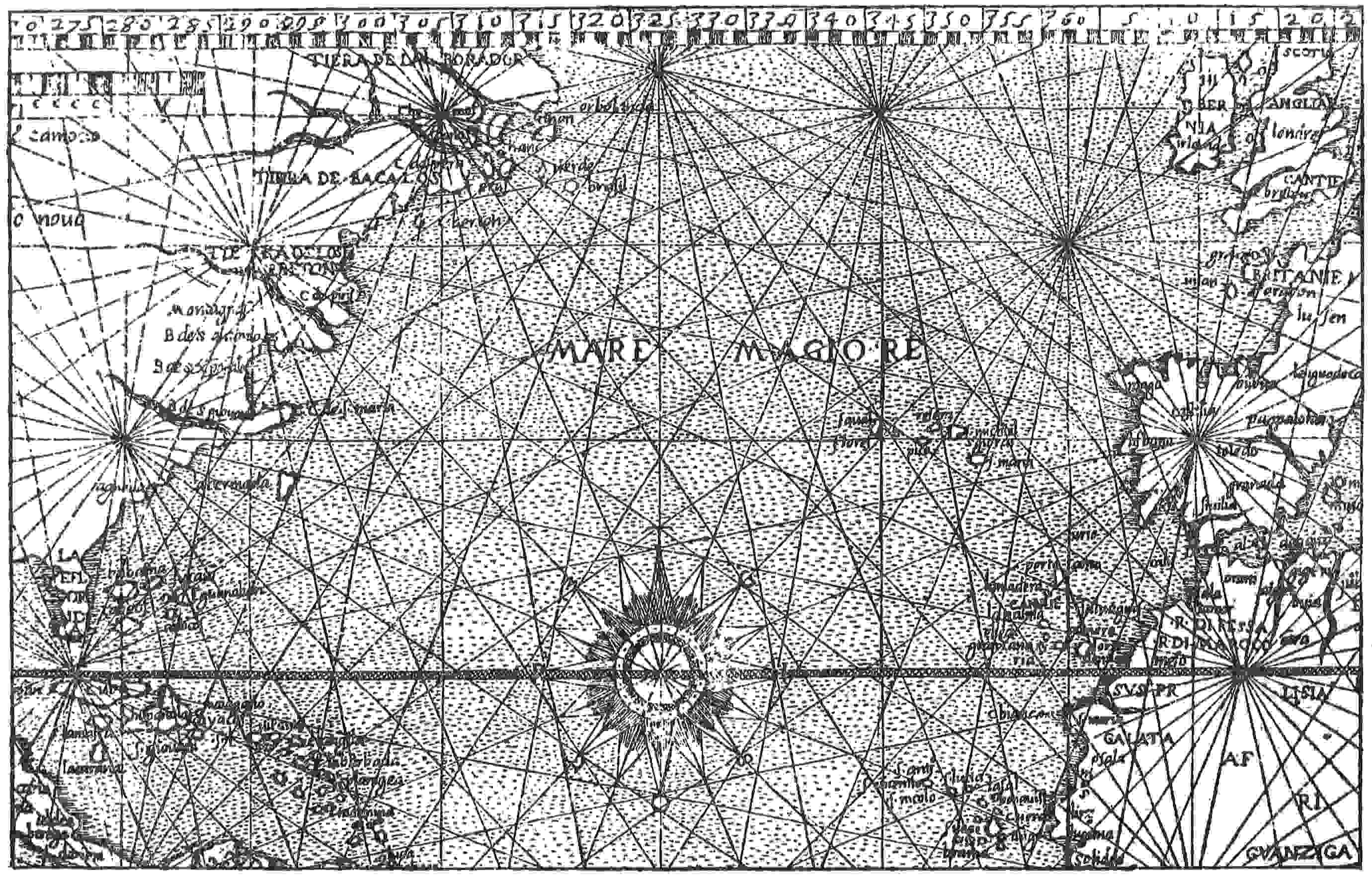
Fig. 6—Section of the Nicolay map of 1560 showing, on the American Side of the Atlantic, Brazil, Man, and Insula Verde, the
first two transferred from the European side. (After Nordenskiöld’s photographic facsimile.)
It is true that this map shows also another Brazil of the divided
kind (in this instance with a channel crossing it from east to
west) located in mid-Atlantic about where Prunes and others
show their bisected Brazil. But this seems only an instance of
conservation and deference for authority, such as has often
been manifested in cartography. Of such deference for authority
perhaps there is no more striking instance than Bianco’s map
of 1448, which places the rediscovered Azores where they should
be but also preserves them, on the faith of older maps, where
they should not be—making a double series. The lesser bisected
mid-Atlantic Brazil of the Catalan map may well be set aside as
a survival without significance.
But the duplication by Bianco in 1448 raises a question of
distance, which must be considered, for his Azores retained from
the maps antedating the Portuguese rediscoveries are far nearer
the coast of Europe than the truth at all warrants; and, so far
as we can judge, the same cautious underestimating was applied
to all oceanic islands as reported. Corvo, for example, is actually
nearly half-way across the Atlantic, yet on all the maps for a long
time is brought eastward to a position much nearer Portugal.
We must suppose that the region about the Gulf of St. Lawrence,
if visited, would be similarly treated, and we cannot tell how
far the minimization of distance might be carried by some
map-makers.
64
Fig. 7—Section of the Catalan map of about 1480 showing Brazil Island and Green Island (Illa Verde). (After Nordenskiöld’s
photographic facsimile.)
65
The Sylvanus Map of 1511
The fact is, this matter does not rest in supposition only, for the
thing has undoubtedly happened. The map of Sylvanus,113 1511,
brings the Gulf of St. Lawrence and surroundings as an insular
body almost as near Ireland as are many of the presentations of
Brazil Island on older maps. He shows in front a single large
island; a square gulf behind it; a bent shore line forming the
border on the north, west, and south; and two gaps well representing
the Straits of Belle Isle and Cabot. The names given
are Terra Laboratorum and Regalis Domus. Nobody doubts
that it illustrates the St. Lawrence Gulf region, though there
has been much speculation as to what unknown explorer has had
his discoveries commemorated here, thirteen years before the
first voyage of Cartier. Why should not a like episode of discovery
and imperfect record have happened at a still earlier
date?
It is not to be supposed that Brazil Island was generally conceived
of by intelligent persons as no farther at sea than it
appears on the map of Dalorto, 1325, and divers later ones.
Peasantry and fisher folk might, indeed, confuse it with the
mythical Isle of the Undying—accessible only to a few chosen
ones but vanishing from ordinary mortal gaze—and thus account
for Brazil’s elusiveness, though so near at hand; but the sturdy
explorers of Bristol114 who kept sailing westward in search of the
island, before and after Columbus, sometimes at least being
away on this quest for many months together, must often have
passed over the very site given by Dalorto and far beyond.
They were looking for solid earth and rock and must have been
convinced that the real Brazil was to be found in remoter seas.
Also, during a great part of the period in which Brazil appeared66
on the maps off the Blaskets and Limerick and unduly close
to Ireland, Italian traders were habitually following the Irish
western coast and trafficking in that port and others and must
often have been blown out, or sailed out by choice, far enough for
a landing on the island if it had actually been where Dalorto
and others pictured it. The total lack of any such happening
must have been convincing to all except devotees of the occult
and those given over blindly to seashore tradition. No doubt the
far westward showing of the fifteenth-century Catalan and the
much later Nicolay and Zaltieri maps accorded with the general
expectation of thoughtful and well-informed navigators.
Omission of the Name in Norse and Irish Records
It may seem strange that the Norse sagas do not mention
Brazil by that name, though its relation to the Scandinavian
colony of Greenland is made so conspicuous on the Catalan
fifteenth-century map above referred to; also that there is no
distinct Irish record of any voyage to Brazil as such, though the
western ports of Ireland were natural points of departure and
return for western voyages and though voyages to a far western
Great Ireland are reported by the Norse from Irish sources.
Perhaps there is no quite satisfactory answer to this. All narratives
of the kind are fragmentary and more or less mythical, and
the name Brazil may often have been used in the reports of
Irish explorers, as it certainly was later the especial goal of the
English, without having left any other trace than the name on
the map and such hints as we have mentioned. The Norse seem
to have adhered to their own names Markland and Vinland, only
mentioning Great Ireland incidentally in the same neighborhood
and Brazil not at all unless the delineation of the Catalan map
be of their suggestion; but no really strong adverse argument can
be founded on these matters of nomenclature and omission where
all references and records are so meager.
There can be no certainty; but from the evidence at hand
it seems likely that the part of America indicated, i. e. Newfoundland
and neighboring shores, was visited very early by67
Irish-speaking people, who gave it the commendatory name
Brazil. Naturally one inclines to ascribe such an unremitting
westward push to the powerful religious impulsion which,
according to Dicuil, carried Irishmen to Iceland in the latter
part of the eighth century and even bore them on, it is reported,
some two hundred miles beyond it. The date, however, may have
been much later. Yet it must have preceded Dalorto’s map of
1325, whereon Brazil first appears by name.
Of evidence on the ground there is nothing; but what have we
now to show even for the perfectly attested visits to the same
region of Cabot and Cortereal? Their case rests on maps,
governmental entries, and contemporary correspondence, luckily
preserved. Earlier visits to Brazil have no epistles, no entries,
to show but must rely on the maps and the general tradition in
the British islands of such a western region across at least a
part of the great sea.
68
CHAPTER V
THE ISLAND OF THE SEVEN CITIES
The mythical islands of the Atlantic (les îles fantastiques) on
the old maps have had divers origins, instructive to study.
Perhaps only one of them derives its name and being directly
from a real human episode of a twilight period in history.
When the Moors descended on Spain in 711, routed King
Roderick’s army beside the Guadalete, and rapidly overran the
Iberian Peninsula, it was most natural, indeed nearly inevitable,
that some Christian fugitives should continue their flight from
the seaboard to accessible islands already known or rumored,
or even desperately commit themselves in blindness to the
remoter mysteries of the ocean. Such an event would afford
a fabric for the embroidery of later fancy. A part of this has
been preserved by record; and it is curious to watch the development
of the story, which takes several forms, not differing widely,
however, one from another.
The Island of Brazil
When Pedro de Ayala, Spanish Ambassador to Great Britain,
found occasion in 1498 to report English exploring activities to
Ferdinand and Isabella, he wrote:
The people of Bristol have, for the last seven years, sent out every
year two, three, or four light ships (caravels) in search of the island of
Brasil and the seven cities.115
There is indeed one well-attested voyage of 1480 conducted
by well-known navigators, seeking this insular Brazil, and it
was not the earliest.
69
The first appearance of that island thus far reported, as we
have seen in the preceding chapter, is on the map of Dalorto116
(dated 1325; Fig. 4) as a disc of land well at sea, westward from
Hibernian Munster; but the Catalan map of 1375117 (Fig. 5) and
at least one other118 turn the disc into a ring surrounding a body
of water which is studded with small islands—apparently nine
in the Catalan map photographically reproduced by Nordenskiöld,
though Dr. Kretschmer draws seven on the other. These
miniature islands have sometimes been thought119 to represent the
seven cities of the old legend; but islets are not cities, and there
seems no reason why each city should require an islet. However,
the coincidence of number, exact or approximate, is suggestive.
Antillia
Antillia (variously spelled) was a home for the elusive cities
more favored than Brazil by cartography and tradition. In
1474 Toscanelli, a cosmographer of Florence, being consulted
by Christopher Columbus as to the prospects of a westward
voyage, sent him a copy of a letter which he had written to a
friend in the service of the King of Portugal. Its authenticity
has been questioned, but it is still believed in by the majority of
inquirers and may be accepted provisionally. In it occurs this
passage:
From the island Antilia, which you call the seven cities, and whereof
you have some knowledge, to the most noble island of Cipango [Japan],
are ten spaces, which make 2,500 miles.120
70
The name Antillia had appeared on the maps much earlier.
As Atilae, or Atulae, it is doubtfully found in an inscription on
that of the Pizigani (1367;121 Fig. 2), identifying a “shore,” not
drawn, on which a colossal statue of warning had been erected.
The location seems to be somewhere in the region where Corvo
of the Azores should appear.
We meet the island name, for the first time unmistakably,
on the map of Beccario (Becharius) of 1435122 (Fig. 20). It is applied
to the chief of a group of four large islands, comparable to
nothing actually in the western Atlantic except the Greater Antilles,
or three of them with Florida (Bimini). They are collectively
designated “Insulle a Novo Repte”—the “Newly Reported
Islands.” Antillia itself is shown as an elongated quadrilateral
having its sides indented by seven two-lobed bays of identical
form, beside another and larger bay in the southern end. Several
subsequent maps repeat the delineation with little change, and
the map of Benincasa (1482;123 Fig. 22) supplies local names for
the bays or the regions adjoining excepting only the lowest but
one on the eastern side, which bay is opposite the middle of the
island name Antillia. The other names as read by Dr. Kretschmer
are Aira, Ansalli, Ansodi, Con, Anhuib, Ansesseli, and Ansolli.
It will be observed that five of them borrow the first syllable
of Antillia. Nobody has explained these names, and they seem
mere products of linguistic fancy. But again the coincidence in
number is impressive, although somewhat offset by the fact that
the next largest island in the group, Saluaga, has a similar71
arrangement of five bays of like form and carries the names, similarly
applied, of Arahas, Duchal, Imada, Nom, and Consilla.
They can hardly be extra bishops’ towns. At least we are in the
dark about them. The anonymous map sometimes attributed to
1424 and preserved at Weimar124 shows in photographic copy
traces of names, or at least letters, on the part of Antillia which
it represents. Its true date is believed to be about that of
Benincasa’s map above cited. But the markings do not seem
to be identical and are very meager.
The Legendary Home of Portuguese Refugees
However, there can be no doubt of Toscanelli’s meaning at
an earlier date in the passage quoted. The same is true of
Behaim’s globe (1492), though he discards the accepted form
of Antillia. He appends a long inscription, translated by Ravenstein
as follows:
In the year 734 of Christ, when the whole of Spain had been won
by the heathen (Moors) of Africa, the above island Antilia, called Septe
citade (Seven cities), was inhabited by an archbishop from the Porto
in Portugal, with six other bishops, and other Christians, men and
women, who had fled thither from Spain, by ship, together with their
cattle, belongings, and goods. 1414 a ship from Spain got nighest it
without being endangered.125
Again, in Ruysch’s map of 1508 there is “a large island in
the middle of the Atlantic Ocean between Lat. N. 37° and 40°.
It is called Antilia Insula, and a long legend asserts that it had
been discovered long ago by the Spaniards, whose last Gothic
king, Roderik, had taken refuge there from the invasion of the
Barbarians.”126
Ferdinand Columbus, living between 1488 and 1539, says that
some Portuguese cartographers had located
72
Antilla ... not ... above 200 leagues due west from the
Canaries and Azores, which they conclude to be certainly the island of the
seven cities, peopled by the Portuguese at the time that Spain was conquered
by the Moors in the year 714. At which time they say, seven
bishops with their people embark’d and sailed to this island, where each of
them built a city; and to the end none of their people might think of
returning to Spain, they burnt the ships, tackle and all things necessary
for sailing. Some Portuguese discoursing about this island, there were
those that affirmed several Portuguese had gone to it, who could not
find the way to it again.127
He relates particularly how “in the time of Henry infant of
Portugal [perhaps about 1430], a Portuguese ship was drove by
stress of weather to this island Antilla.” The crew went to church
with the islanders but were afraid of being detained and hurried
back to Portugal. The Prince heard their story and ordered
them to return to the island, but they escaped from him and
were not found again. It is said that of the sand gathered on
Antillia for the cook room a third part was pure gold.
Galvano tells of a still later visit; or possibly it is only another
version of the same:
In this yeere also, 1447, it happened that there came a Portugall
ship through the streight of Gibraltar; and being taken with a great
tempest, was forced to runne westwards more then willingly the men
would, and at last they fell upon an Island which had seven cities, and
the people spake the Portugall toong, and they demanded if the Moors
did yet trouble Spaine, whence they had fled for the losse which they
received by the death of the king of Spaine, Don Roderigo.
The boateswaine of the ship brought home a little of the sand, and
sold it unto a goldsmith of Lisbon, out of the which he had a good
quantitie of gold.
Don Pedro understanding this, being then governour of the realme,
caused all the things thus brought home, and made knowne, to be
recorded in the house of justice.
There be some that thinke, that those Islands whereunto the Portugals
were thus driven, were the Antiles, or Newe Spaine.128
73
Another Account
The Portuguese historian Faria y Sousa has yet another
version. According to Stevens’ translation:
After Roderick’s defeat the Moors spread themselves over all the
province, committing inhuman barbarities. * * * The chief resistance
was at Merida. The defendants, many of whom were Portuguese,
that being the Supreme Tribunal of Lusitania, were commanded
by Sacaru, a noble Goth. Many brave actions passed at the siege, but
at length there being no hopes of relief and provisions failing, the town
was surrendered upon articles. The commander of the Lusitanians,
traversing Portugal, came to a seaport town, where, collecting a good
number of ships, he put to sea, but to which part of the world they
were carried does not appear. There is an ancient fable of an island called
Antilla in the western ocean, inhabited by Portuguese, but it could
never yet be found, and therefore we will leave it until such time as
it is discovered, but to this place our author supposes these Portugals
to have been driven.129
It is plain that Captain Stevens paraphrases with comments
rather than translates. The original130 avers that the fugitives
made sail for the Fortunate Islands (the Canaries), in order
that they might preserve some remnants of the Spanish race,
but were carried elsewhere. It also specifies that the legendary
island which they are supposed to have reached is inhabited
by Portuguese and contains seven cities—tiene siete cividades.
This last account lacks positive mention of the emigrating
bishops and for the first time names a definite though rather
remote goal as aimed at by their effort. But the movement
from Merida is well accounted for, and a trusted military commander
would seem a natural leader for such an enterprise of
wholesale escape. The bishops, implied by the seven cities,
might well gather to him at Oporto or be picked up on the way.
On the whole it seems the most easily believable version of the
story; though of course it does not necessarily follow that they
really chose any land so remote as Teneriffe and its neighbors—if74
they knew of them—for a new abiding place. Of course the
continuance of Portuguese language and civilization and the
persistence of seven isolated towns through so many centuries
must be ranked with the auriferous sands of Antillia as late
products of the dreaming Iberian brain.
Mythical Location of the Seven Cities
on the Mainland
The citations thus far given identify the Island of the Seven
Cities with some legendary, but generally believed-in patch of
land afar out in the ocean—sometimes with the Island of Brazil,
more often with Antillia. But the earliest of them dates six
or seven centuries after the supposed fact, and it may well be
that a distinction was made at first, which became lost afterward
by blending. In a still later stage of development the name
of the Seven Cities becomes separate and strangely migratory,
not avoiding even the mainland. We know, for instance, what
power the Seven Cities of Cibola had to draw Coronado and his
followers northward through the mountains and deserts of our
still arid Southwest until all that was real of them stood revealed
as the even then antiquated and rather uncleanly terraced
villages of sun-dried brick which are picturesquely familiar on
railway folders and in the pages of illustrated magazines.
But this was not the only part of North America on which
the romantic myth alighted. The British Museum contains in
MS. 2803 of the Egerton collection an anonymous world map,131
(Fig. 8), forming part of a portolan atlas attributed by conjecture
to 1508, which shows, somewhat as in La Cosa’s map of 1500, the
Atlantic coast distorted to a nearly westward trend, with the
Seven Cities (Septem Civitates), represented by conventional indications
of miters, scattered along a seaboard tract from a point
considerably west of “terra de los bacalos” and the Bay of Fundy
to a point nearly opposite the western end of Cuba. The cartographer’s
ideas of geography were exceedingly vague, but apparently
he conceived of Portuguese episcopal domination for the75
coastal country between lower New England and Florida as we
know them now. Perhaps, however, he merely meant to set down
his cities somewhere on the eastern shore of temperate North
America and has strewn them along at convenience.
Fig. 8—Section of the world map in the portolan atlas of about 1508 known as Egerton MS. 2803 in the British Museum, placing
the Seven Cities in North America and the name “Antiglia” in South America. (After Stevenson’s photographic facsimile.)
Incidentally, this map is also interesting as one of a few which
inscribe Antillia, with slight changes of orthography, on some
part of the mainland of South America. In this instance “Antiglia”
occupies a tract of the northwestern coastal country apparently
corresponding to contiguous portions of Colombia, Ecuador,
and Peru.
Later Reappearance As an Island
But the Island of the Seven Cities appeared as such on other
maps and by this name only. Perhaps its most salient showing
is on Desceliers’ fine map of 1546132 (Fig. 9), that entertaining repository
of isles which are more than dubious and names which
are fantastic. He presents it off the American coast about
a third as far as the Bermudas and midway from Cape Breton
to the Bay of Fundy. The size is considerable, the outline
being deeply embayed on several sides and hence very irregular,
almost as much so as Celebes. Two islets lie near two of its
projecting peninsulas. It bears a brief inscription giving the
name Sete Cidades and indicating that it belongs to Portugal.
This choice of location would have been more venturesome a
century later. In 1546 there had been some exploring and much
fishing in these waters but no determined settlement near them,
and they were hardly yet familiar. However, the Ortelius map of
1570133 (Fig. 10), and the Mercator map of 1587134 find it more
prudent to move this island farther south and farther out to
sea, reducing its area, but retaining its traditional name. Not
long after this, except for a local name on St. Michaels of the
Azores, the Seven Cities disappear from geography.
76
Fig. 9—Section of the Desceliers map of 1546 showing the Island of Seven Cities and various other legendary islands. (After
Kretschmer’s hand-copied reproduction.) The names are mostly upside down because on the original south is at the top.
77
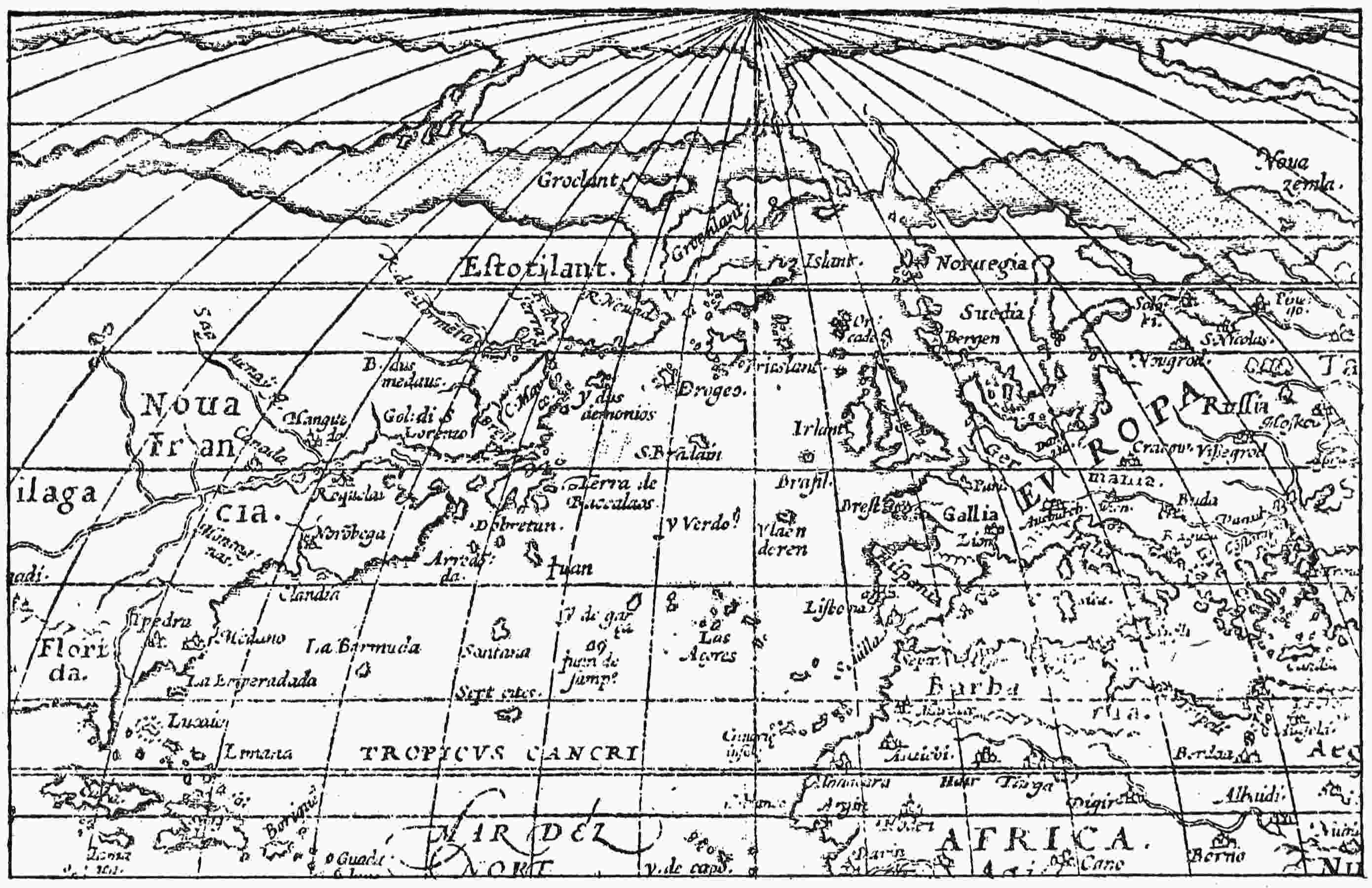
Fig. 10—Section of Ortelius’ world map of 1570 showing, of the legendary islands and regions discussed in the present work, the
Island of Seven Cities (“Sept cites”), St. Brendan’s Islands, Brazil, Vlaenderen, Green Island (Y. Verdo), Estotiland, Drogio,
Frisland, Islands of Demons, La Emperadada, and Grocland. (After Nordenskiöld’s photographic facsimile.)
78
Occurrence of the Name in the Azores
The exception noted is well worth considering. Just as Terceira
retains her medieval name of Brazil to designate one headland,
St. Michaels has still its valley of the Seven Cities. Brown’s
guidebook presents the fact very casually: “St. Michaels. Ponta
Delgada. Brown’s Hotel. About ten people. Among the chief
sights are the lava beds coming from Sete Cidades.... At
Sete Cidades, which is worth a visit, there is a great crater
with two lakes at the bottom, one of which appears to be green,
the other blue.”135
This naïve incuriousness in the presence of something so
significant of course has not been shared by a different order
of observers. Buache136 found here as he thought the genuine
and only Seven Cities of the legend. Humboldt137 opposed this
view with a reminder of the Seven Cities of Cibola. But it is
fair to remember that New Mexico was quite impossible for
the Portuguese of 711 or thereabout, whereas St. Michaels
Island offered an accessible and tempting place of refuge. The
name could not have been derived from settlement in the
former; but it might really be derived from settlement in the
latter. Granting that the fugitives might not be able to maintain
themselves there in safety for many years after the Arabs
had begun their tentative and always uneasy incursions into
the western Sea of Darkness, it still may be that the town or
towns of this hidden island valley might endure long enough
and seem imposing enough and be visited often enough by
Christians from the mainland to supply the nucleus of the most
picturesque and adventurous of legends; and this tale might
follow any later migration into the unknown, or survive and
find new abiding places for the name and fancy long after the79
original colony—archbishop and bishops and congregations,
military commanders, and mailed soldiery—had all been somehow
destroyed or had melted apart and drifted away. All
that remains certain is the continued presence of the name of
the Seven Cities on that spot.
Some ruins are said to have marked it formerly, but very
little is visible now, if we may trust the following description
by an intelligent visitor in the middle of the last century:
Emerging from these sunken lanes, so peculiar to the island of St.
Michael’s, we come to the green hills which border the village and the
valley of the Seven Cities.... From these dull evergreen mountains,
stretching before us without apparent end, we speedily had an
unexpected change. Suddenly the mountain track up which we were
climbing ended on the edge of a vast precipice, hitherto entirely concealed,
and at a moment’s transition disclosed a wide and deeply sunk
valley with a scattered village and a blue lake. The hills which hemmed
them in were bold and precipitous, tent-shaped, rounded and serrated.
Others swept in soft and gentle lines into a little plain where the small
village was nestled by the water side. The lake was of the deepest blue
and so calm that a sea bird skimming over its surface seemed two, so
perfect was its image in the water. The clouds above were floating in
this very deep lake, and the inverted tops of the hills on every side were
perfectly reflected in its bosom. A few women on the shore seemed
rooted there, so steady were their reflections in the water, and the cattle
standing in the shallows stood like cattle in a picture.... The
sides slope gradually from this part of the valley into the level ground
where the village stands. It is a small collection of cottages, without
a church or a wineshop or a store of any kind, and at the time I entered
it was enveloped in clouds of wood smoke which rose from the fires used
in the process of bleaching cloth. This and clothes washing are the chief
occupations of the villagers....
A portion of the lake is separated from the larger one by a narrow
causeway. It is singular to notice the difference made in the two pieces
of water by this small embankment; for, while the large lake is clear
and crystalline, this is thick, green, and muddy, and as gloomy as the
Dead Sea, with no clouds or birds or bright sky reflected in it.138
Perhaps a little excavating archeology might not be amiss in
the neighborhood of the causeway and the green dead lakelet.
But at least it is satisfactory to have a good external account80
of the only site in the world, so far as I know, which still bears
the legendary name. As elsewhere used, this name has certainly
wandered widely and been affixed to many places. Whether
any of these represent real refuges of the original emigrants or
their descendants or others like them no one can quite certainly
say; but there is no evidence for it, and the probabilities are
against it. Certainly no Spanish nor Portuguese community,
of Moorish or of any pre-Columbian times, established itself
in western lands for any great period to make good the aspiration
of the fugitives of Merida.
81
CHAPTER VI
THE PROBLEM OF MAYDA
Of all the legendary islands and island names on the medieval
maps, Mayda has been the most enduring. The shape of the
island has generally approximated a crescent; its site most often
has been far west of lower Brittany and more or less nearly
southwest of Ireland; the spelling of the name sometimes has
varied to Maida, Mayd, Mayde, Asmaida, or Asmayda. The
island had other names also earlier and later and between times,
but the identity is fairly clear. As a geographical item it is
very persistent indeed. Humboldt about 1836 remarked that,
out of eleven such islands which he might mention, only two,
Mayda and Brazil Rock, maintain themselves on modern
charts.139 In a note he instances the world map of John Purdy
of 1834. However, this was not the end; for a relief map published
in Chicago and bearing a notice of copyright of 1906
exhibits Mayda. Possibly this is intended to have an educational
and historic bearing; but it seems to be shown in simple credulity,
a crowning instance of cartographic conservation.
Possible Arabic Origin of Name
If Mayda may, therefore, be said to belong in a sense to the
twentieth century, it is none the less very old, and the name
has sometimes been ascribed to an Arabic origin. Not very
long after their conquest of Spain the Moors certainly sailed
the eastern Atlantic quite freely and may well have extended
their voyages into its middle waters and indefinitely beyond.
They named some islands of the Azores, as would appear from
Edrisi’s treatise and other productions; but these names did82
not adhere unless in free translation. The name Mayda was
not one of those that have come down to us in their writings
or on their maps, and its origin remains unexplained. It is
unlike all the other names in the sea. Perhaps the Arabic impression
is strengthened by the form Asmaidas, under which
it appears (this is nearly or quite its first appearance) on the
map of the New World in the 1513 edition of Ptolemy (Fig. 11).140
But any possible significance vanishes from the prefixed syllable
when we find the same map turning Gomera into Agomera,83
Madeira into Amadera, and Brazil into Obrassil. Evidently
this map-maker had a fancy for superfluous vowels as a beginning
of his island names. He may have been led into it by the
common practice of prefixing “I” or the alternative “Y” (meaning
Insula, Isola, Ilha, or Innis) instead of writing out the word
for island in one language or another.
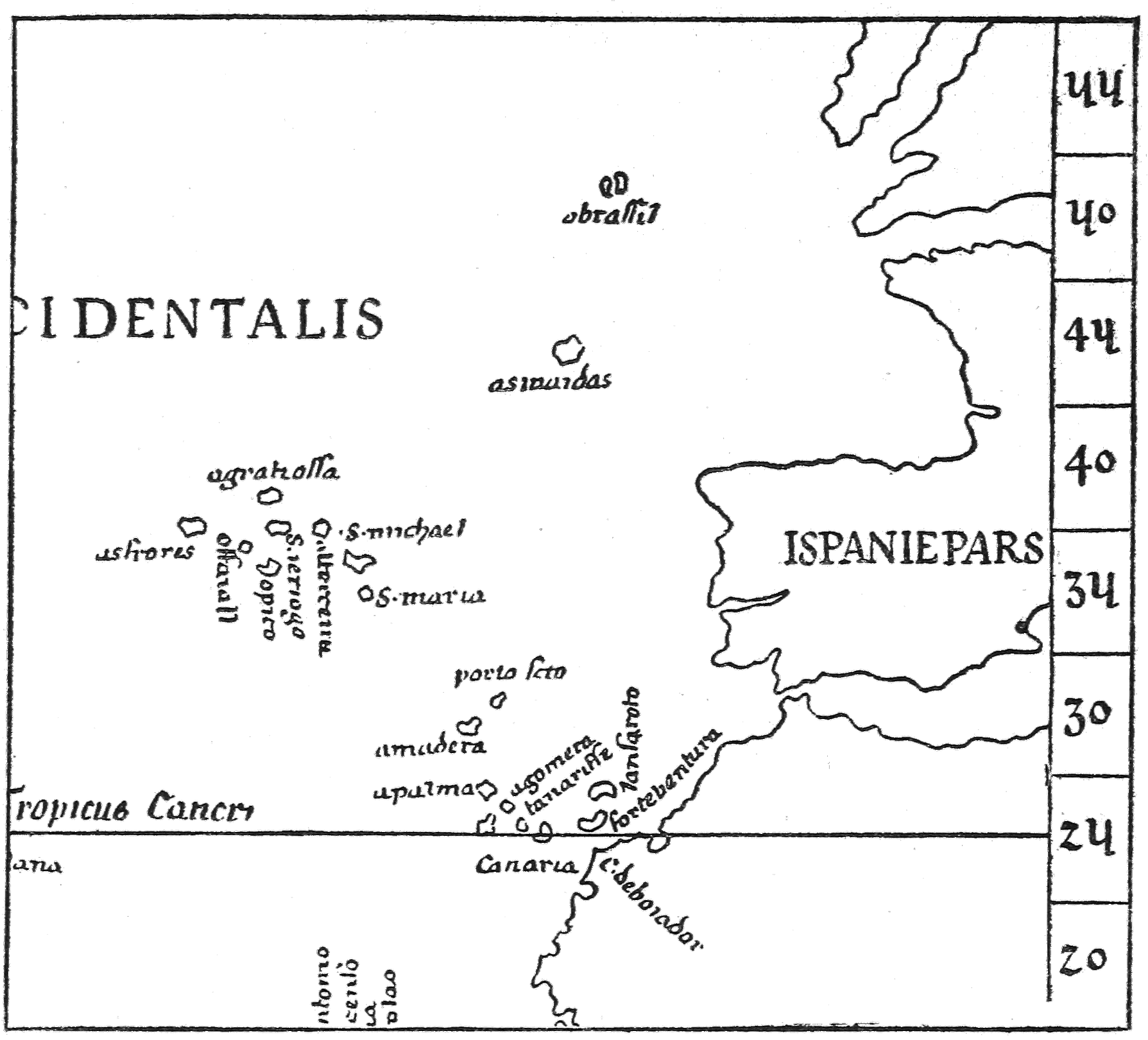
Fig. 11—Section of the map of the New World in the 1513 edition of Ptolemy
showing the islands of Mayda (asmaidas) and Brazil (obrassil). (After Kretschmer’s
hand-copied reproduction.)
However, there is a recorded Arabic association of this particular
island under another name. It had been generally called
Mam or Man, and occasionally other names, for more than a
century before it was called Mayda. Perhaps the oldest name
of all is Brazir, by which it appears on the map of 1367 of the
Pizigani brothers (Fig. 2),141 a form evidently modified from
Brazil and shared with the round island of that name then
already more than forty years old on the charts. The Brazil
which we specially have to do with bears roughly and approximately
the crescent form, which later became usually more neat
and conventionalized under the name Man or Mayda. It
appears south (or rather a little west of south) of the circular
Brazil, which is, as usual, west of southern Ireland and a little
south of west of Limerick. The crescent island is also almost
exactly in the latitude of southern Brittany, taking a point a
little below the Isle de Sein, which still bears that name. In
this position there may be indications of relation with both
Brittany and Ireland. The former relation is pictorially attested
by three Breton ships. One of them is shown returning
to the mouth of the Loire. A second has barely escaped from
the neighborhood of the fateful island. A third is being drawn
down stern foremost by a very aggressive decapod, which drags
overboard one of the crew; perhaps she has already shattered
herself on the rocks, offering the opportunity of such capture
in her disabled state. A dragon flies by with another seaman,
apparently snatched from the submerging deck. Blurred and
confused inscriptions in strange transitional Latin seem to warn
us of the special dangers of navigation in this quarter; the staving84
of holes in ships, the tawny monsters, known to the Arabs,
which rise from the depths, the dragons that come flying to
devour. The words “Arabe” and “Arabour” are readily decipherable;
so is “dragones.” Perhaps there is no statement that
Arabs have been to that island, for their peculiar experience
may belong to some other quarter of the globe; but the verbal
association is surely significant. The name Bentusla (Bentufla?)
applied to this crescent island by Bianco in his map of 1448142
has sometimes been thought to have an Arabic origin; but one
would not feel safe in citing this as absolute corroboration.
The Breton character of the ships, however, may be gathered
(as well as from their direction and behavior) from the barred
ensigns which they carry, recalling the barred standard set up
at Nantes of Brittany, in Dulcert’s map of 1339,143 just as the
fleur-de-lis is planted by him at Paris.
Mayda and the Isle of Man
We have, then, in this fourteenth-century island a direct
recorded association with the Arabs, followed long after by
what have been thought to be Arabic names. We have also a
pictorial and cartographical connection with Brittany and also
an indication of relations with Ireland. This last is fortified
by its next and, except Mayda, its most lasting name.
The great Catalan map of 1375144 (Fig. 5) calls it Mam, which
should doubtless be read as Man, for it was common to treat
“m” and “n” as interchangeable, no less than “u” and “v” or
“i” and “y.” Thus Pareto’s map of 1455145 (Fig. 21) turns the Latin
“hanc” into “hamc” and “Aragon” into “Aragom.” On some of the85
early maps, e. g. that of Juan da Napoli (fifteenth century),146 the
proper spelling “Man” is retained, just as it is retained and has
been ever since early Celtic days, in the name of the home of
“the little Manx nation” in the Irish Sea. That the same name
should be carried farther afield and applied to a remote island
of the Atlantic Ocean is quite in accordance with the natural
course of things and the general experience of mankind. No
doubt the name Man might be derived from other sources,
but the chances are in this instance that the Irish people whose
navigators found Brazil Island (or imagined it, if you please)
did the same favor for the crescent-shaped “Man,” quite overriding
for a hundred years any preceding or competing titles.
Almost immediately there was some competition, for the Pinelli
map of 1384147 calls it Jonzele (possibly to be read I Onzele, a
word which has an Italian look but is of no certain derivation),
reducing the delineation of the island to a mere shred, bringing
Brazil close to it, and giving the pair a more northern and more
inshore location. Another map of about the same period follows
this lead, but there the divergence ended. Soleri of 1385148
reverted to the former representation; and about the opening
of the fifteenth century the regular showing of the pair was
established—Brazil and Man, circle and crescent, by those
names and in approximately the locations and relative position
first stated.
It is true that the crescent island is sometimes represented
without any name, as though it were well enough known to
make a name unnecessary. But during the fifteenth century,
when it is called anything, with a bare exception or two, it is
called Man. Its shape and general location are substantially
those of the Catalan map of 1375 on the maps of Juan da Napoli;86
Giraldi, 1426;149 Beccario, 1426150 and 1435151 (Fig. 20); Bianco,
1436 and 1448;152 Benincasa, 1467153 and 1482154 (Fig. 22); Roselli,
1468;155 the Weimar map, (probably) about 1481;156 Freducci,
1497;157 and others—arguing surely a robust and confident tradition.
Resumption of Name “Mayda”
On sixteenth-century maps this island is still generally presented,
though lacking on those of Ruysch, 1508;158 Coppo,
1528159 (Fig. 13); and Ribero, 1529;160 but suddenly and almost
completely the name Mayda in its various forms takes the place
of Man, a substitution quite unaccounted for. There are hardly
enough instances of survival of the older name to be worth mentioning.
Was there some resuscitation of old records or charts,
now lost again, which thus overcame the Celtic claim and supplied
an Arabic or at least a quite alien and unusual designation?
The little mystery is not likely ever to be cleared up. The previously
mentioned map from the Ptolemy edition of 1513 (Fig. 11),
which perhaps first introduces it, also presents several other87
innovations in departing from the crescent form and shifting the
island a degree or two southward; and these changes surely seem
to hint at some fresh information. That there was no supposed
change of identity is shown by the fact that succeeding cartographers
down to and beyond the middle of that century revert
generally to the established crescent form and to nearly the
same place in the ocean previously occupied by Man, while
applying the new name Mayda. Thus an anonymous Portuguese
map of 1519 or 1520,161 reproduced by Kretschmer, and the
graduated and numbered map of Prunes, 1553162 (Fig. 12), concur
in placing Mayda or Mayd at about latitude 48° N., the latitude
of Quimper, Brittany, and almost exactly the same as that
given by the Pizigani to the crescent island on its first appearance
on the maps as a clearly recognizable entity.
Transference of Mayda To American Waters
The maps made after the world had become more or less
familiarized with the details of modern discoveries, in this case
as in most others of its kind, indicate little except the dying
out of old traditions, whatever they may have been, and haphazard
or conventional substitution of locations and forms or
the influence of the new geographic facts and theories. Thus
Desceliers’ map of 1546163 (Fig. 9), a museum of strangely-named
sea islands, makes the latitude of “Maidas” 47° and the longitude
that of St. Michaels, but not long afterward Nicolay (1560;164
Fig. 6) and Zaltieri (1566)165 transferred the island to Newfoundland
waters. Nicolay calls it “I man orbolunda,” and
places it just south of the Strait of Belle Isle. It is accompanied
by Green Island and by Brazil, a little farther out on the Grand
Banks where the Virgin Rocks may still be found at low tide.
Taken together these three islands look like parts of a disintegrated
Newfoundland. Zaltieri of 1566 gives Maida by that89
name more nearly the same outward location, though it is still
distinctly American. Nicolay’s name “orbolunda” is one of the
many puzzling things connected with this island. His “Man”
may be either a reversion to the fifteenth-century name, or,
more likely, a modification of, or error in copying from Gastaldi’s
map-illustration166 of Ramusio about ten years previously,
which allots the same inclement site to an “isola de demoni”
and depicts the little capering devils in wait there for their
prey. It is likely, though, that Gastaldi had no thought of
identifying it with Mayda. But the neighborhood of the island
of Brazil and Green Island seem nearly conclusive evidence that
Nicolay intended I Man for Mayda and had ascribed to it,
by reason of evil association, the supposed attributes of Gastaldi’s
island. However, Ramusio himself in 1566,167 the same
year as Zaltieri, set his “Man” south of Brazil off the coast of
Ireland. The only really important contributions of these maps
are their testimony to the continued diabolical reports of Mayda,
or Man, and the apparent conviction of Nicolay and Zaltieri
that the island was after all American; a suggestion that could
have had no meaning and no support in the times when America
was unrecognized. Evidently these map-makers did not regard
the inadequate western longitude of Mayda, or Man, in the
older maps as a formidable objection. Presumably they were
well aware how many of the insular oceanic distances as shown
by these forerunners needed stretching in the light of later
discovery. But their views with regard to an American Mayda
seem to have ended with them, so far as map representation is
concerned.
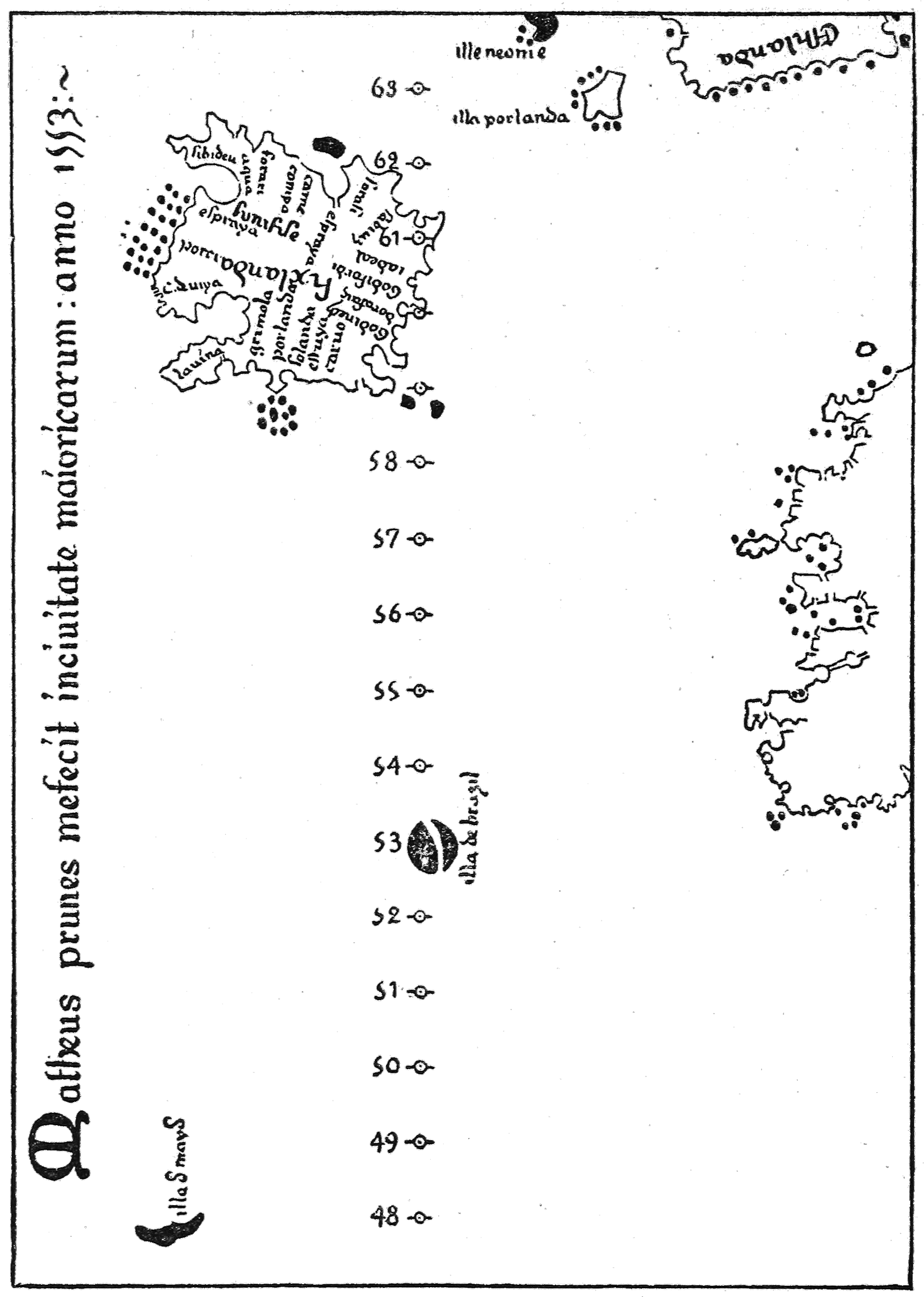
Fig. 12—Section of the Prunes map of 1553 showing Mayda (in latitude 48°),
Brazil, and Estotiland (“Esthlanda”). (After Kretschmer’s hand-copied reproduction.)
Possible Identity of Vlaenderen Island with Mayda
There is another curious and rather mystifying episodical
divergence in the cartography of that period, this time on the90
part of the great geographers Ortelius and Mercator in their
respective series of maps during the latter part of the sixteenth
century, for example Ortelius of 1570168 and Mercator of 1587.169
Ortelius presents as Vlaenderen an oceanic island which certainly
seems intended for Mayda (Fig. 10), while Mercator shows
Vlaenderen as lying about half-way between Brazil and the
usual site of Maida. The word has a Dutch or Flemish look.
Of course there must be some explanation of it, but this is
unknown to the writer. The natural inference would be that
some skipper of the Low Countries thought he had happened
upon it and reported accordingly. This was what occurred in
the case of Negra’s Rock, now held to be wholly fictitious
though shown in many maps; and also in the case of the sunken
land of Buss, now generally recognized as real and as a part of
Greenland but recorded and delineated in the wrong place by
an error of observation. It may be that Ortelius believed in a
rediscovery of Mayda and that for some reason it should have
the name latest given. But, in spite of the prestige of these
great names, Vlaenderen did not continue on the maps, while
Mayda did, though in a rather capricious way.
Persistence of Mayda on Maps Down to the Modern
Period
There would be little profit in listing the maps of the seventeenth,
eighteenth, and nineteenth centuries which persisted
by inertia and convention in the nearly stereotyped delineation
of Mayda but, of course, with slight variations in location and
name. Thus Nicolaas Vischer in a map of Europe of 1670 (?)170
shows “L’as Maidas” in the longitude of Madeira and the latitude
of Brittany; a world map in Robert’s “Atlas Universel” (1757)171
gives “I. Maida” about the longitude of Madeira and the latitude
of Gascony; and on a chart of the Atlantic Ocean published in91
New York in 1814172 “Mayda” appears in longitude 20° W. and
latitude 46° N. But these representations have no significance
except as to human continuity.
The evil reputation which was early established and seems to
have hung about the island in later stages, assimilating the icy
clashings and noises and terrors of the north as it had previously
incorporated the monstrous fears of a warmer part of the ocean,
is surely a curious phenomenon. I have fancied it may be
responsible for the probably quite imaginary Devil Rock,
which appears in some relatively recent maps, perhaps as a
kind of substitute for Mayda, much in the fashion that Brazil
Rock took the place of Brazil Island when belief in the latter
became difficult. The present view of the U. S. Hydrographic
Office, as expressed on its charts, is that Negra’s Rock, Devil
Rock, Green Island, or Rock, and all that tribe are unreal
“dangers,” probably reported as the result of peculiar appearances
of the water surface. Whether the possibility has been
wholly eliminated of a lance of rock jutting up to the surface
from great depths and not yet officially recognized, I will not
presume to say; but it seems highly improbable that there is
anything of the sort in the North Atlantic Ocean except the
lonely and nearly submerged peak of Rockall, some 400 miles
west of Britain, and the well-known oceanic groups and archipelagoes.
Probable Basis of Fact Underlying This
Legendary Island
What was this island, then, which held its place in the maps
during half a millennium and more, under two chief names
and occasional substitutes, designations apparently received
from so many different peoples? One cannot easily set it aside
as a “peculiar appearance of the surface” or as a mere figment
of fancy. But there is nothing westward or southwestward of the
Azores except the Bermudas and the capes and coast islands92
of America. The identification with some outlying island of
the Azores, as Corvo, for example, is an old hypothesis; and the
grotesquery of that rocky islet seems to have deeply impressed
the minds of early navigators, lending some countenance to
the idea. But the Laurenziano map of 1351173 and the Book of
the Spanish Friar174 show that all the islands of the Azores
group were known before the middle of the fourteenth century,
and Corvo in particular had been given the name which it still
holds. Man, afterward Mayda, appears on many maps of the
fifteenth century, which show also the Azores in full. Perhaps
this is not conclusive, for there are strange blunders and duplications
on old maps; but it is at least highly significant. If Man,
or Mayda, were really Corvo or another island of the Azores
group, surely someone would have found it out in the course
of the fifteenth or sixteenth century, just as it came to be perceived
after a time that the Azores had been located too near
to Europe and just as Bianco’s duplication of the Azores in
1448 had finally to be rejected. Mayda, if real, must have been
something more remote and difficult to determine than Corvo.
Perhaps Nicolay and Zaltieri were right in thinking that
Mayda was America, or at least was on the side of the Atlantic
toward America. The latitude generally chosen by the maps
would then call for Avalon Peninsula, Newfoundland, often
supposed to be insular in early days; or perhaps for Cape Breton
Island, the next salient land feature. But that is an uncertain
reliance, for the observations of pre-Columbian navigators
would surely be rather haphazard, and they might naturally
judge by similarity of climate. This would justify them in
supposing that a region really more southerly lay in the latitude
of northern France—for example Cape Cod, which juts out93
conspicuously and is curved and almost insular. Or by going
farther south, although nearer Europe, they might thus indicate
the Bermudas, the main island of which is given a crescent form
on several relatively late maps. But we must not lay too much
stress on this last item, for divers other map islands were modeled
on this plan. We may be justified, then, in saying that Mayda
was probably west of the middle of the Atlantic and that Bermuda,
Cape Cod, or Cape Breton is as likely a candidate for
identification as we can name.
94
CHAPTER VII
GREENLAND OR GREEN ISLAND
The first account of Greenland given to the world, indeed the
first mention of that region in literature, is by Adam of Bremen,
an ecclesiastical official and geographical author.
Adam of Bremen’s Account of Greenland
He interviewed in 1069 the enterprising king Sweyn of Denmark,
and acquired from him divers Scandinavian and other
northern items which Adam embodied about 1076 in his work
“Descriptio Insularum Aquilonis,” the Description of the Northern
Islands. Nansen quotes, with other matter, the following
passages:175
... On the north this ocean flows past the Orchades, thence endlessly
around the circle of the earth, having on the left Hybernia, the
home of the Scots, which is now called Ireland, and on the right the
skerries of Nordmannia, and farther off the islands of Iceland and Greenland....
Furthermore, there are many other islands in the great ocean, of which
Greenland is not the least; it lies farther out in the ocean, opposite the
mountains of Suedea, or the Riphean range. To this island, it is said, one
can sail from the shore of Nortmannia [sic] in five or seven days, as likewise
to Iceland. The people there are blue (“cerulei”, bluish-green) from
the salt water; and from this the region takes its name. They live in a
similar fashion to the Icelanders, except that they are more cruel and
trouble seafarers by predatory attacks. To them also, as is reported,
Christianity has lately been wafted.
It was in fact about seventy-five years since Leif, son of Eric
the Red, according to the sagas, had effected that wafting from
the Christian court of Norway to the still pagan Norsemen of his95
father’s far-western domain. For Adam clearly means these white
people and not the Eskimos, with whom they had not yet come
in contact and of whom no whisper had yet reached the European
world unless it related to relics of former occupancy discerned
on first landing. It is surely matter for astonishment to find the
ruddy followers of hot-blooded Eric described as bluish-green
and so conspicuous in this complexion that it gave their region
its name. Perhaps there is no more curious instance to be found
of the inveterate human tendency to read into any unfamiliar
name some meaning that seems plausible.
It is not clear where Adam supposed Greenland to be located;
perhaps he, too, was not clear about the matter. The earlier of
his two passages on the subject seems to call for something like
the true location in the far west; but the later mention of the
mountains of Sweden has been understood by the most learned
commentators to indicate a site directly north of Norway. King
Sweyn perhaps had a fairly good idea of the sailing courses for
Iceland and Greenland, but his guest may have assimilated the
information rather confusedly. Adam seems convinced that
Greenland was a distinctly oceanic island, with no suggestion
of any near relation to any continent. In this respect he differs
from certain maps of the fifteenth century with which we shall
presently have to deal. We know now that the truth lies between
these views; that the highly glaciated mass which we name in its
entirety Greenland is, indeed, an island and probably the largest
of islands but an island with the aspect and attributes of a
peninsula, being barely severed from that polar archipelago which
crowns our American mainland and being not very remote at
one point from the mainland itself.
Its Insular Character
Adam’s idea of oceanic insulation was accepted in many
quarters, as the maps disclose. Of course, they may not have
derived it from him in all instances, directly or indirectly, but at
least they shared it. Usually the name, slightly changed, becomes
the equivalent “Green Island” in one or another of several96
languages. Thus, to take a very late instance, the map of
Coppo, 1528176 (Fig. 13), discloses near the true site of Greenland
a mass of land elongated from east to west, but clearly all at sea
with no greater land near it, and labeled Isola Verde. There
seems no room for doubt of the meaning or origin of this name.
That any land found there should be an island of the sea was the
natural assumption of geographers at that time. Maps of the
early sixteenth century generally show a scattering of islands
south of North America sometimes approaching an archipelago,
sometimes more widely distributed, and in either case being
substitutes for what we now know as North America and its
appendages.
As “Illa Verde” on the Catalan Map of 1480
In another well-known map177 (Fig. 7), an unnamed cartographer,
said to be Catalan, probably about 1480, delineates an elongated
Illa Verde (using the Portuguese name for island), locating it
southwest of Iceland, which bears the name Fixlanda, but is
easily identifiable by its outline and geographical features. His
Illa Verde runs nearly north and south, approximating more
closely than Coppo’s island the true trend of Greenland. It
also by its greater bulk seems founded on more adequate information.
It is equally at sea and remote from other land, except that
off its concave southern end, with a narrow interval, lies a large
circular island named Brazil, our old mythical acquaintance of
medieval maps not often located so far westward but, as we have
seen in Chapter IV, apparently intended to represent the Gulf of
St. Lawrence region. These two islands strikingly resemble in
general situation and arrangement the Greenland and Estotiland
(Labrador) in a map (Fig. 14) illustrating Torfaeus’ early97
eighteenth century “Gronlandia,”178 except that the rounded outline
of Estotiland is not completed, its proportional area is greater
than “Brazil,” the strait between the two bodies of land is a
little wider, and the lower end of Torfaeus’ Greenland is not
made concave like that of Illa Verde. But again there can be
no doubt that the Illa Verde of the Catalan (if he were a Catalan)
represents the Greenland of Adam of Bremen and the sagas.
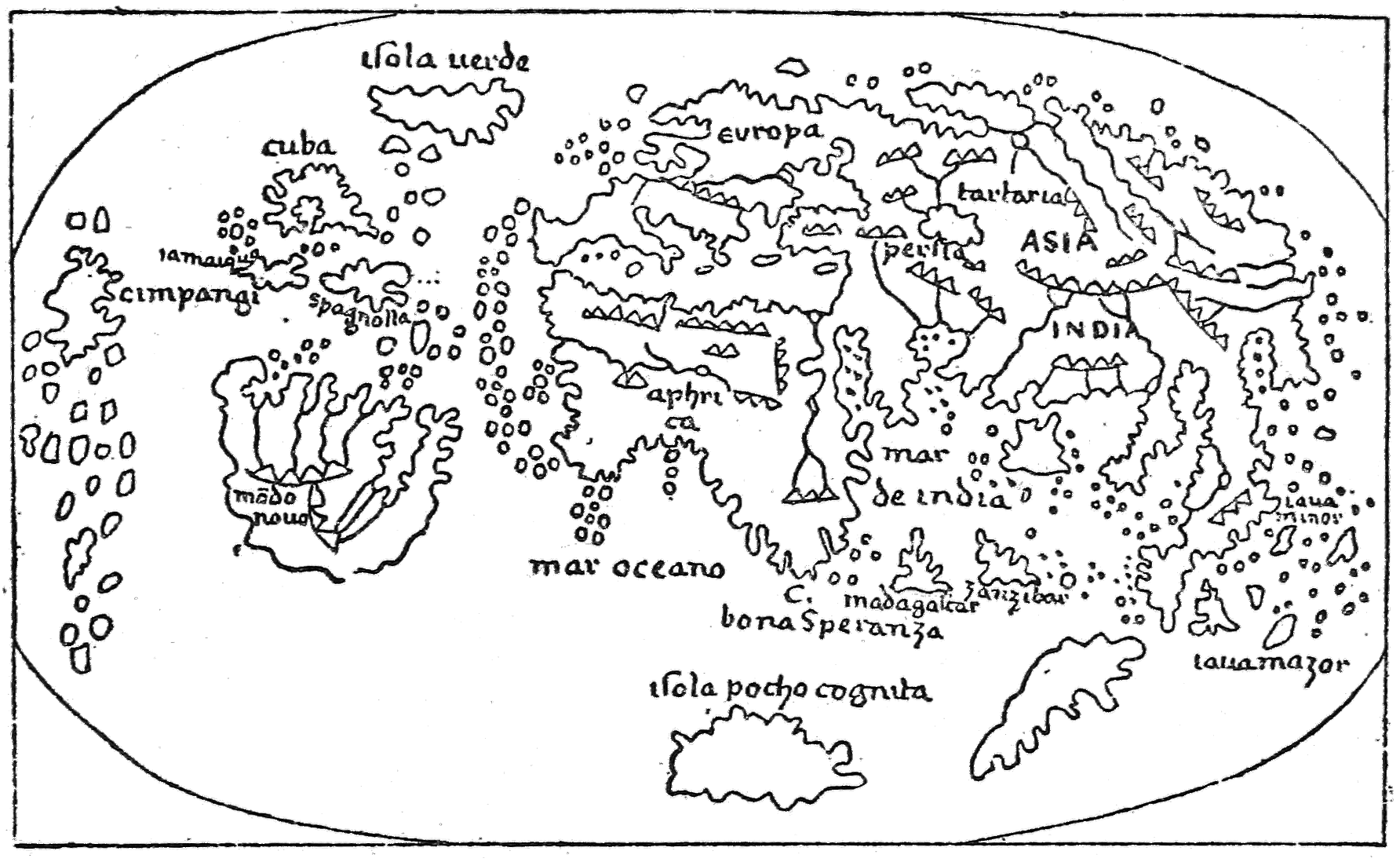
Fig. 13—Coppo’s world map of 1528 showing Green Island (“isola verde”).
(After Kretschmer’s hand-copied reproduction.)
Green Island on Sixteenth-Century Maps
To the same origin, in a remoter sense, we may ascribe the
rather large Insula Viridis of Schöner, 1520,179 which is brought
down to a latitude between that of southern Ireland and that of
northern Spain and something east of mid-ocean. It must seem
that the map-maker had quite lost sight of any relation between
this Latinized Green Island and the true Greenland of the
northwest.
98
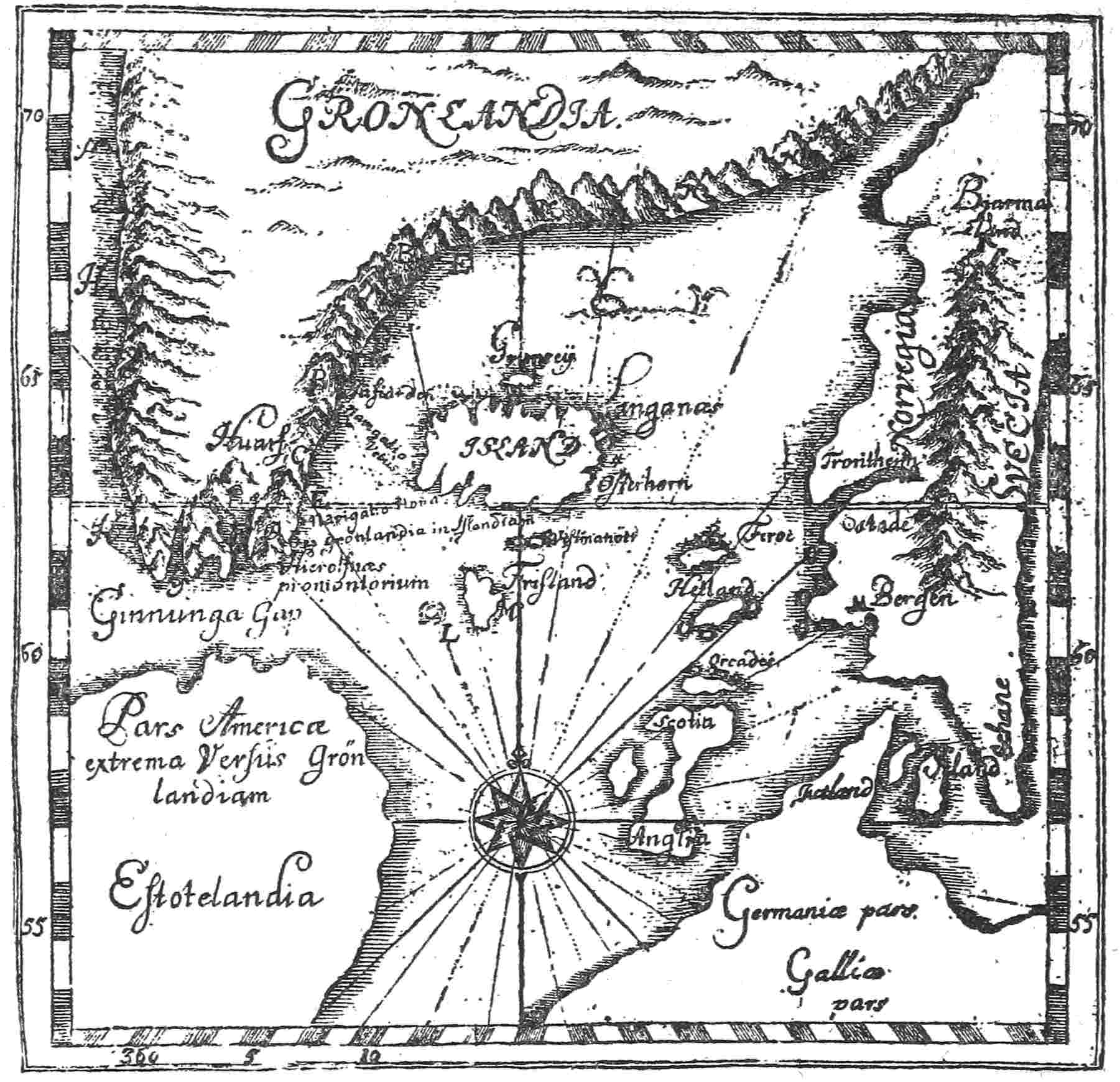
Fig. 14—Bishop Thorláksson’s map of Greenland 1606, showing Estotiland as a
part of America. Cf. with
Fig. 18. (From Torfaeus’ “Gronlandia antiqua,” Copenhagen,
1706, in the library of the American Geographical Society.)
This is even more obviously true of Nicolay’s map of 1560180
(Fig. 6), which carries Verde into the Newfoundland Banks, even
nearer than his Brazil to a broken-up Newfoundland; and of
Zaltieri’s map of 1566,181 which plants Verde rather close to
“C. Ras” (Cape Race), with only a narrow strip of water between.
These cartographers undoubtedly indicated American habitats
for their little island; but they can have had no thought of99
confusing it with Greenland, which they well knew and which Zaltieri
distinctly shows as Grutlandia. They would be far from admitting
a common origin. Perhaps in most of such northern cases a
conception like Coppo’s of Greenland as an oceanic island is at
the root of the derivation; but successive copyings, modifications,
and shiftings may have altered the area, form, and location, while
the clue was gradually lost and only the name remained—hardly
as a reminder, for it is of too general descriptive application.
Various “Green Islands:” Shrinkage of the Name
There is, indeed, one instance of a Green Island with which
Greenland can have had nothing whatever to do. Peter Martyr
d’Anghiera’s sketch map of 1511182 shows a small tropical Isla
Verde near Trinidad; it is apparently Tobago. Doubtless its
luxuriance of vegetation prompted the name.
This may have happened in other instances of warm climates
or even in temperate zones where grass and foliage grow freely;
so that we in many cases cannot distinguish on the maps the
Green Islands, real or fanciful, which acquired their name as a
remote legacy of Eric’s land from those which were called “green”
simply because they were green. Both derivations may sometimes
apply; but the islands of the far northwest bearing that
name, like Coppo’s island and the Catalan’s Illa Verde, must
naturally go into the former category.
As we have seen, Green Islands were scattered rather widely;
but the name occurs most often in the sixteenth and seventeenth
centuries in the middle or eastern part of the ocean to indicate
a small island, having Mayda (Vlaenderen) for its rather distant
consort. Desceliers indeed, in 1546183 (Fig. 9), shows it in the same
longitude as the tip of Labrador, but this is done by carrying
Labrador too far eastward. St. Brandan’s Island is a neighbor
on his map. Ortelius, in 1570184 (Fig. 10) and Mercator, in 1587,185100
represent Y Verde west of Vlaenderen in the region north of the
Azores. In the eighteenth century it still held its ground west of
France in the eastern Atlantic as Isla Verde, Isla Verte, Ile
Verte, Ilha Verde, and Green Island. By the early part of the
nineteenth century it had, after its kind, dwindled to Green Rock—Brazil
Island similarly becoming Brazil Rock—as dubious
rocks became easier to believe in than dubious islands. Perhaps
the well-known actual instances of Rockall and the Virgin
Rocks may have prompted credence in other spears and knolls
of the earth crust here and there reaching the surface.
The Hydrographic Office does not believe in any such Green
Rock or Green Island but supplies, in a letter to the writer, a
mariner’s yarn which is not without interest and may be evidence
for the rock as far as it goes.
“Captain Tulloch, of New Hampshire, states that an acquaintance
of his, Captain Coombs, of the ship Pallas, of Bath, Maine,
in keeping a lookout for Green Island actually saw it on a
remarkably fine day when the sea was smooth. According to the
story, he went out in his boat and examined it and found it to be
a large rock covered with green moss. The rock did not seem
much larger than a vessel floating bottom upward, and it was
smooth all around. The summit was higher than a vessel’s
bottom would appear out of the water, being about twenty feet
above the surface of the sea. Captain Coombs added that if the
object had not been so high he would have thought it to be a
capsized vessel. A sounding taken near this spot shows that a
depth of 1,500 fathoms exists there.”
So Greenland, misunderstood and carried southward, dwindles
to what may be taken for a capsized vessel’s hull, the existence
of which is denied by those who best should know. Or, to take
it the other way about, the traditions of Green Island, dwindling,
prompted the mariner’s fancy to develop a Green Rock; and
Green Island is in numerous instances derived mainly, even if
remotely, from Greenland, reinforced sometimes by implications
of attractiveness.
101
Origin of the Name “Greenland” and Its Justification
There can be no doubt that the Down East sea captain, who
was so quick to perceive green vegetation on his fancied Green
Island, came nearer the true explanation of Greenland’s name
than the good prebendary of Bremen with his bluish-green
Norsemen colored by the sea. It is pretty well understood that
about 985 or 986 Eric Rauda (Eric the Red, or Ruddy), the first
explorer and colonizer of this new region, applied the name at
least partly as an advertisement of fertility and promising conditions
for the encouragement of Icelandic colonists. This is
the way Ari Frode (the Wise), the best informed man of Iceland,
puts it in his surviving Libellus of the “Islendingabok” about a
century later:186
This country which is called Greenland was discovered and colonized
from Iceland. Eric the Red was the name of the man, an inhabitant of
Breidafirth, who went thither from here and settled at that place, which
has since been called Ericsfirth. He gave a name to the country and called
it Greenland and said that it must persuade men to go thither if it had a
good name. They found there both east and west in the country the
dwellings of men and fragments of boats and stone implements such that
it might be perceived from these that that manner of people had been
there who have inhabited Wineland and whom Greenlanders call Skraelings.
And this when he set about the colonization of the country was
fourteen or fifteen winters before the introduction of Christianity here in
Iceland, according to what a certain man who himself accompanied Eric
the Red thither informed Thorkell Gellison.
This last was an uncle of Ari, a man of liberal and inquiring
mind and one of Ari’s most valued sources of knowledge as
to the affairs of earlier generations.
The passage has been often quoted, but that Eric was largely
justified in his nomenclature is less generally known. Greenland
to the intending colonists would naturally mean not the ice-enshrouded
waste of the almost continental interior nor yet the
forbidding cliffs of the eastern coast guarded by a nearly impassable
floe-laden Arctic current, but the really habitable thousand-mile
fringe of uncovered land along the southwestern shore, on102
the average fifty miles wide and occasionally much wider. It
was partly shut in by forbidding headlands and perverse currents,
but feasible of access when the true course was disclosed. Some
parts of this region were, and still are, green with grass and bright
with summer flowers. Nansen, who certainly ought to know,
declares that the Greenland sites chosen would have seemed
more attractive than Iceland to an Icelander. Rink, who was
connected with the Greenland government for a full generation,
mentions certain places with special approval and regards life
in most parts of the inhabited region quite contentedly.187 Professor
Hovgaard tells us:188
Icelandic Settlement
It was on this strip of land that the Icelanders settled at the end of the
tenth century. Though barren on the outer shores and islands and on the
hills, it is covered at the inner part of the fiords on the low level by a rich
growth of grass together with stunted birch trees and various bushes, particularly
willows. On the north side of the valleys crowberries (Empetrum
nigrum) may be found....
Eric settled in Ericsfiord, the present Tunugdliarfik, at a place which
he called Brattahlid, now Kagsiarsuk, in 985 or 986. Two distinct colonies
were founded, the Eastern Settlement, extending from about Cape Farewell
to a point well beyond Cape Desolation, comprising the whole of
Julianehaab Bay and the coast past Ivigtut, and the Western Settlement,
beginning about one hundred and seventy miles farther north at Lysufiord,
[i.e. Agnafiord], the present Ameralikfiord, comprising the district
of Godthaab.
The fiord next Ericsfiord in the Eastern Settlement was Einarsfiord,
now Igalikofiord. These fiords were separated at their head by a low and
narrow strip of land, the present Igaliko Isthmus. It was here, at Gardar,
that the Althing of Greenland met, and here was also found the bishop’s
seat, established at the beginning of the twelfth century. There were as
many as sixteen churches in Greenland, for almost every fiord had its own
church on account of the long distances and difficult traveling between
the fiords.
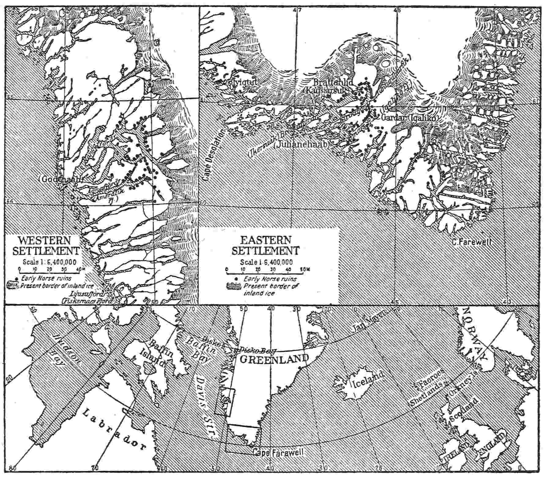
Fig. 15—Map of the early Norse Western and Eastern Settlements of Greenland.
Scale 1:6,400,000. (The inset below. 1:70,000,000, shows the relation of Norway,
Iceland, and Greenland.)
The unfamiliar localities above named may be followed by
the aid of the accompanying map (Fig. 15) copied from Finnur
103
Jónsson’s maps,189 which embody the results of the research
of the best experts and scholars with the aid of relics on the
ground and surviving records. It is apparent that from the
first to last the heart of Greenland was about the low, fairly
fertile, favorable tract near the heads of the two fiords named
for Eric and his friend, Einar, and not far from Eric’s Greenland
home. The Western Settlement was a comparatively
small offshoot, with four churches only, yet it contrived to maintain
existence for between three and four centuries, being at last104
obliterated, as is supposed, by the Eskimos. The main settlement
was still more enduring, having a continuous record of nearly
half a millennium, a history not surpassed in duration by some
far more populous and powerful nations.
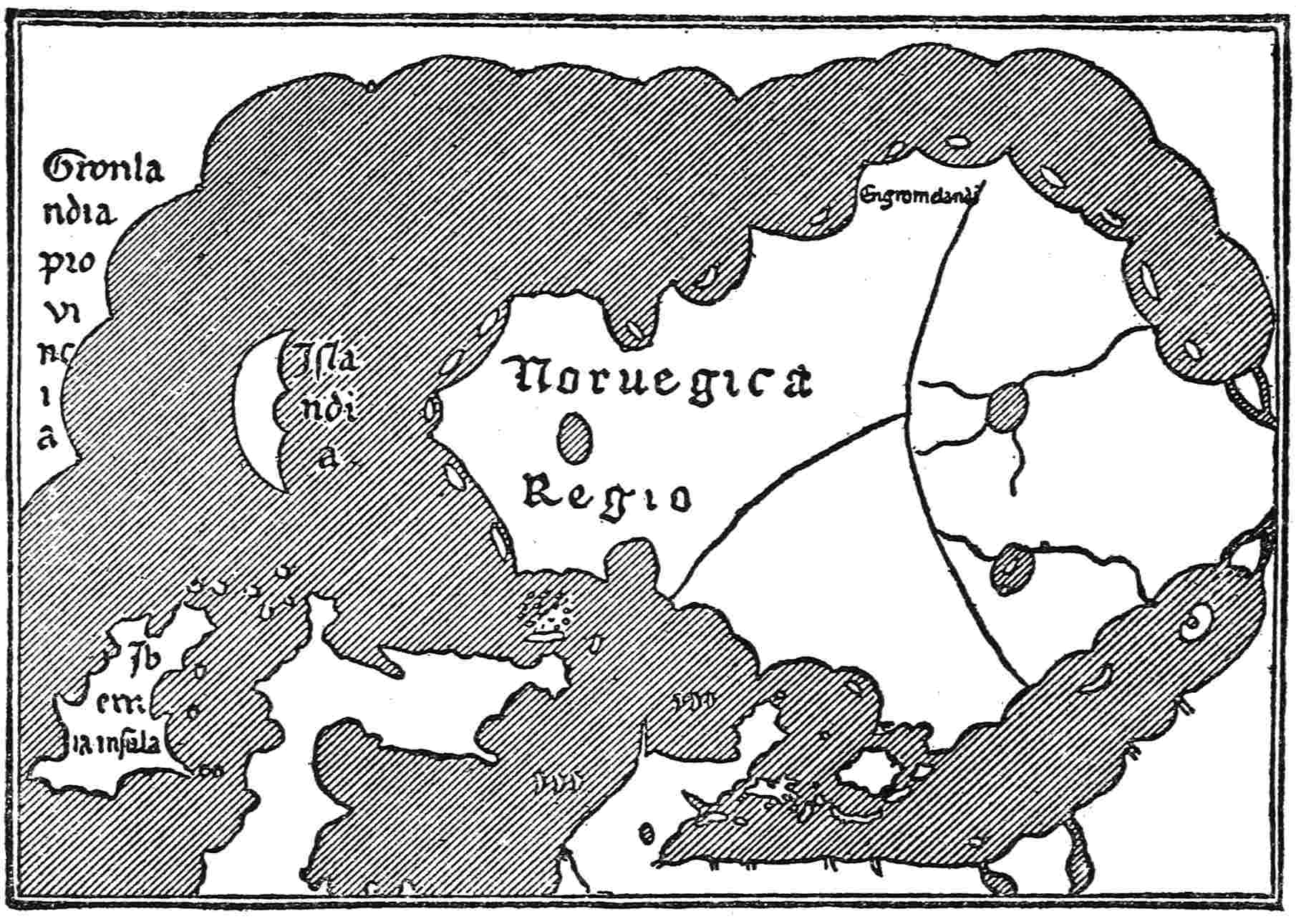
Fig. 16—Section of the Clavus map of 1427 showing Greenland continuous with
Europe. (After Joseph Fischer’s hand-copied reproduction.)
This seems marvelous, if it be true that the entire population
never exceeded 2,000 souls, as Nansen and Hovgaard have
supposed. Rink, on the other hand, estimated the maximum
at 10,000.190 Some intermediate number would seem more likely
than either extreme, if we may hazard a conjecture where
doctors disagree. The prosperity of the colony, such as it was,
seems to have been at its best in the eleventh and twelfth centuries
but was never conspicuous enough to get an outline of
Greenland into the maps until about the time of final extinction.
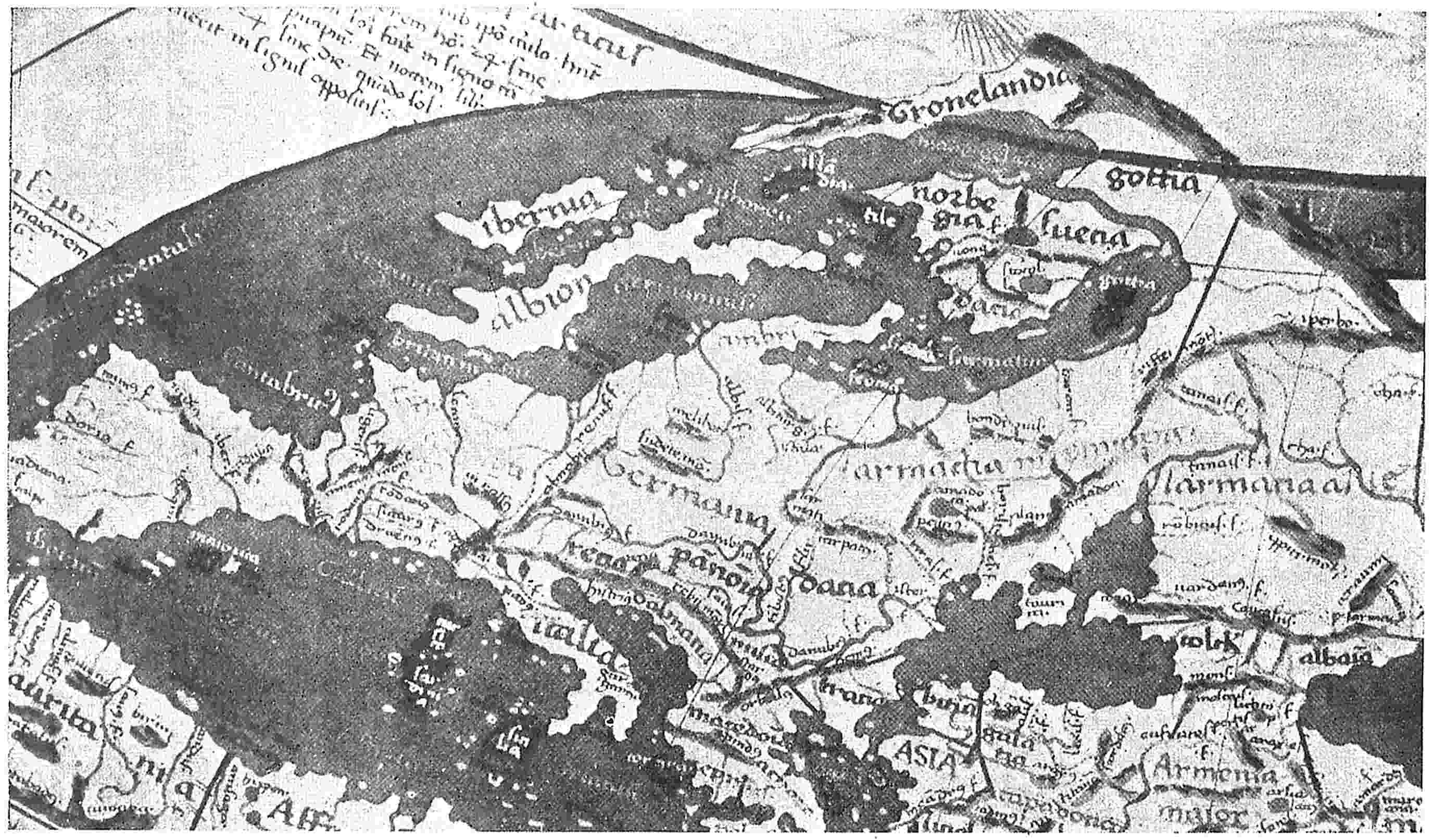
Fig. 17—Section of the world map of Donnus Nicolaus Germanus (after 1466) showing Greenland continuous with Europe.
(After Joseph Fischer’s photographic reproduction.)
105
Greenland as a Peninsula
We must remember, though, that during the earlier part of
this period there were not many maps extant which included the
Atlantic, and of these the greater number were more concerned
with theological conceptions and figures of wonder than with the
sober facts of geography, especially in remote places. About 1300
a remarkable series of navigators’ portolan maps, revolutionizing
this attitude, began to add to the delineation of the Mediterranean,
which they had already developed with considerable
minuteness, something definite of the outer European coasts,
islands, and waters. Step by step they advanced into the
unknown or little known, but perhaps none of them, before the
fifteenth century, can be confidently relied on as indicating
Greenland.
This remained for the Nancy map of Claudius Clavus
(Schwartz), 1427191 (Fig. 16). Greenland is, however, made distinctly
continuous with Europe, being connected thereto by a
long land bridge, far north of Iceland, in accordance with an
hypothesis then prevailing. The second half of the same century
saw this conception of Claudius Clavus greatly popularized.
Divers maps192 appeared, some showing Greenland as a prodigiously
elongated peninsula of Europe, having its tip in the correct
location (Fig. 17), while others ran up a perverse trapezoidal
Greenland from the north coast of Norway.
Probably one or more of the former kind suggested in part the
memorable Zeno map of 1558193 (Fig. 19), professing to be a
reproduction of a map prepared by the Zeni of a past generation
and carelessly damaged by the final editor in boyhood. If not a
total forgery, it is at least untrustworthy, as we shall see in106
Chapter IX, and the same is true of an accompanying narrative
of experiences in Greenland about 1400.
Another map of somewhat later date, by Sigurdr Stefánsson,
probably 1590194 (Fig. 18), is a quite honest presentation of the
traditional views of Icelanders at that time and is distinctly more
modern than the Zeno map in the complete severance of Greenland
from Europe and its union with the great western land mass
which included Helluland, Markland, and Vinland, supposed to
be divided by a fiord from “America of the Spaniards.” Of course,
that union with the Western continent is not precisely accurate
and the eastward trend which he gives his great peninsula is still
less so; but his map, often copied, remains a peculiarly interesting
production.
Life of the Icelandic Colony
To hark back to Adam of Bremen, the charges of special cruelty
and predatory attacks on seafarers in the middle of the eleventh
century awaken some surprise. The life of the people seems
simple and innocent enough, as disclosed by their relics and
remnants, which have been unearthed with great care. As seal
bones predominate in their refuse piles, this offshore supply
must have been their greatest reliance for animal food; but they
had also sheep, goats, and a small breed of cattle. They spun
wool and wove it; they carved vessels of soapstone, sometimes
with decoration; they milked cows and made butter; they
exported sealskins, ropes of walrus hide, and walrus tusks; they
paid tithes to the Pope in such commodities; they boiled seal fat
and made seal tar; they gathered tree trunks as driftwood far107
up the coast and probably brought back cargoes of timber from
Markland; they built substantial houses and churches, using
huge stones in some cases. But they had to import grain, iron,
and many other articles from Europe; and the infrequent visits
of ships from Iceland, Norway, and elsewhere must have made
a break in the monotony of their lives which they could ill
afford to forego. One would expect them to be especially kind
to such visitors.
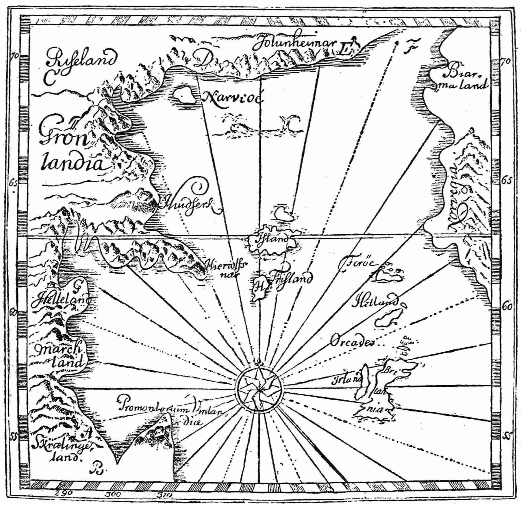
Fig. 18—Sigurdr Stefánsson’s map of Greenland, 1590, showing the severance of
Greenland from Europe and its union with the western land mass which includes
Helluland, Markland, and Vinland. Cf. with
Fig. 14. (From Torfaeus’ “Gronlandia
antiqua,” Copenhagen, 1706, in the library of the American Geographical
Society.)
108
On the other hand, the belligerent spirit which kept up the
bloody feuds of Iceland would not quickly have lapsed from these
transplanted Icelanders in their new home. Moreover, there
were thralls among them and the irritations growing out of
thralldom. Also, while much of their daily routine was quiet
enough, they were subject to savage weather and perils of
navigation, of the fisheries, of hunting far up the coast, where
many of them maintained stations for that purpose at Krogfiordsheath
and other points. Even in getting to Greenland Eric
was able to carry through only about half of the ships that sailed
with him, and Gudrid and Thorbiorn, coming later, incurred
ample experiences of storm and danger. These wild elements of
life would tend to enhance a certain recklessness; and the law
must have been impotent to maintain order in remote fiords
and headlands, even if it had sought to do so.
In the Floamanna Saga, dealing with events not long after the
very first settlement, the thralls of Thorgils murder his young
wife on the eastern coast, where they had all been cast ashore
together. In another of the Greenland tales there is a bloody
contention, freely involving homicide, over the claims of the
church upon the contents of two ships which had come to grief.
No doubt such instances might be multiplied; but in the main
we may believe that the lives of the Greenlanders went orderly
enough in common grooves of very primitive husbandry and
fishing. Adam may have judged by reports of visitors with a
grievance, narrated at second or third hand.
If Greenland had a long history, it was that of a few people in
a remote region and could not present many salient features.
The colony possessed at least one monastery and the beginning
of a literature, including, it is said, the Lay of Atli, revealing a
curious interest in the career of the great Hun Attila, on the part
of a distant colonist hidden in Arctic mists and writing beside
the glaciers. In art, as distinguished from literature, they seem
to have made few advances, if any, beyond mere ornamental
carving or designing on a plane hardly surpassing that of the
Eskimos.
109
Explorations of Early Greenlanders
But in seamanship and exploration their achievements,
considering their numbers and resources, were really wonderful.
All experts agree that Eric’s first exploration was daring, skillful,
persistent, and exhaustive, according to the best modern standards,
and that his selection of settlement sites was exceedingly
judicious; in fact, could not have been improved upon. Then
followed in less than twenty years the discovery of the American
mainland by Eric’s son Leif (or, as some say, by one Biarni,
followed by Leif) and a series of other voyages, including Thorfinn
Karlsefni’s prolonged effort to colonize, involving the tracing
of the American coast line from at least upper Labrador to some
point south of Newfoundland. The precise lower limit is matter
of dispute, but, according to the better opinion, may be found
somewhere on the front of southern New England. These were
followed in 1121 by the missionary journey, as it seems to have
been, of Bishop Eric Gnupsson, who then sailed out of Greenland
for Vinland, we do not know with what result. Subsequent
communication with parts of the American continent was
probably not uncommon, as has been inferred from the accidental
arrival in 1347 of a ship which had sailed from Greenland to
Markland and been storm-driven from the latter westward.
It pursued its course to Norway.
In the opposite (northern) direction we know of at least two
venturesome voyages up Baffin Bay, and, as the records have
reached us almost by accident, we may naturally conjecture
many more.
A British exploring expedition in 1824 acquired a small stone
inscribed with runic characters near some beacons on an island
north of Upernivik on the upper northwestern coast of Greenland.
The original is lost, but a duplicate of it is preserved in the
Copenhagen National Museum. Divers copies195 have been
published. The inscription is thought to date from about 1300,110
translated by various runologists, with differences in detail.
As given by Professor Hovgaard, it reads:
Erling Sigvatsson and Bjarne Thordarson and Endride Oddson built
this (or these) beacon(s) Saturday after “Gagnday” (April 25th) and
cleared (the place) (or made the inscription) 1135 (?).
The year is reported with some uncertainty; and it must be owned
that the body of the text offers several alternatives. Such a
memorial would more naturally be put up by the men who built
the beacons or those of about their time than by a later generation
to commemorate the not vitally important doings of those
who were dead and gone. The year 1300 seems a little late for
venturing so far, as it was about the beginning of a period of
decadence and less than forty years before the Western Settlement
vanished altogether. The date 1135 would better accord
with the climax of Norse strenuousness and Greenland adventure.
Perhaps the runes were carved in the stone earlier than the
runologists suppose. But, whether the original visit took place
in the twelfth century or the fourteenth, and whether the stone
denotes two Norse visits to this place or only one, it is still conclusive
that some Greenlanders had explored well to the northward
along the shore of Baffin Bay in the time of the old colony.
A more extensive exploration was undertaken in 1266 by the
clergy, apparently of the Bishop’s seat, since they traveled home
to Gardar. It appears that certain men had been farther north
than usual but reported no sign of previous occupancy by the
Eskimos (who seem by this time to have awakened some concern
among the Norsemen) except at the unusually broad reindeer-pasture
land and hunting ground of Krogfiordsheath, a little
below Disko Bay. This made a good starting point for the ship,
which was thereupon sent “northward in order to explore the
regions north of the farthest point which they had hitherto
visited,” apparently with a special view of getting more light
on the whereabouts of the heathen and their line of approach.
In these regards the adventure was barren; but the narrative of
one of the priests is interesting so far as it goes:196
111
... they sailed out from Krogfiordsheath, until they lost sight of
the land. Then they had a south wind against them and darkness, and
they had to let the ship go before the wind; but when the storm ceased
and it cleared up again, they saw many islands and all kinds of game,
both seals and whales and a great number of bears. They came right into
the sea-bay and lost sight of all the land, both the southern coast and the
glaciers; but south of them were also glaciers as far as they could see.
That was their farthest point. They then sailed southward,
reaching Krogfiordsheath again and eventually Gardar. On the
way they had noticed some abandoned Eskimo houses but no
living Eskimos.
There is some attempt to indicate latitude by the way shadows
fell in a boat. Also we are told, apparently meaning midsummer
or a little later: “at midnight the sun was as high as at home in
the settlement when it is in northwest.” But speculations as to
their course and distance have given varying results. Some think
they may even have passed into Smith Sound; others that they
may have crossed the Middle Water to the western shore of
Baffin Bay, seeing south of them the glaciers of northeastern
Baffin Land; others still that they did not get very far above
Upernivik; but, whatever the exact limit, it seems to have been
a notable bit of Arctic exploration, prosecuted rather at random
and with scant resources.
The Eskimos
The Eskimos (Skraelings) are referred to in this account as if
already known to the settlers, though uncertain as to their
home quarters and mysterious in their coming and going. Probably
there had been some contact, not wholly friendly, between
outranging members of the two races. The Historia Norvegiae,197
a manuscript of the same century discovered in Scotland, says:
Beyond the Greenlanders toward the north their hunters came across
a kind of small people called Skraelings. When they are wounded alive
their wound becomes white without issue of blood; but the blood scarcely
ceases to stream out of them when they are dead.
112
Whatever may be thought of this magical oddity of surgery, it
at least seems to imply authentically some experiments in piercing
or slashing the living. Whether such collision was a matter of
the thirteenth century only or had first occurred in the twelfth or
still earlier we cannot say. The Eskimo race was the ominous
shadow of the Norse colonist from the beginning, though long
unrecognized as a menace. Apparently there had been a temporary
movement of these people down the western coast about the
tenth century, withdrawing before the first white men appeared.
After that for generations, perhaps centuries, the weaker heathen
wisely kept out of sight, either beyond the water or at hunting
grounds far up the Greenland coast. At last they moved nearer,
and there was occasional contact while still the Norsemen were
formidable. But by the fourteenth century Norse Greenland
had begun to dwindle in power and population, with diminishing
aid and reinforcement from Europe, and the danger drew
nearer. Perhaps there was some special impulsion of the uncivilized
people which resulted in the obliteration of the Western
Norse Settlement, always relatively feeble. Some rumor of its
need having reached the Eastern Settlement, an expedition of
relief was dispatched about 1337, or perhaps a little later, accompanied
by Ivar Bardsen, then or afterward steward of the
Bishop, who tells the tale. Only a few stray cattle were found;
presumably the colonists had been killed or carried away.
The ground thus lost could not be regained. On the contrary,
we may suppose the Eskimos to be getting stronger and drawing
nearer. In 1355 an expedition under Paul Knutson came out to
reinforce the Norsemen; but it returned home in or before 1364
and can have made only a temporary lightening of the load.
In 1379 there seems to have been an Eskimo attack, costing the
Norsemen 18 of their few men. But peace may have reigned as a
rule. At any rate, the ordinary functions of life went on, for it
is of record that a young Icelander, visiting Greenland, was
married by the Bishop at Gardar in 1409; and the last visit of
the Norwegian knorr, or supply ship, occurred by way of Iceland
in 1410.
113
After that nothing is certainly known. There are two papal
letters at different periods of the century, based on very questionable
hearsay information and indicating confusion and general
falling away. There was even a futile effort to reopen
communication in 1492. Probably by that time the Norsemen
and Norse women were all dead or married to the Eskimos.
That particular form of primitive heathendom seems to have
absorbed them.
Greenland was to be rediscovered and repeopled in due season;
but for the time being it had become in European knowledge only
a half-forgotten figure on certain maps, sometimes given with
fair accuracy of outline but sometimes also as an oceanic Green
Island of only indirect relation to reality and passing its name
on to little islands and even fancied rocks far at sea, which
owned nothing in common with the far northern region except
a part of its name.
114
CHAPTER VIII
MARKLAND, OTHERWISE NEWFOUNDLAND
The name Markland, meaning Forest Land, must be, in
one language or another, among the oldest geographical designations
known among men. Nothing could be more natural to
even the most primitive people than to distinguish in this way
any heavily overgrown region which especially challenged
attention, perhaps as a refuge or as a barrier. Its appearance
in any form of record was, of course, very much later. As to
Atlantic regions, the earliest instance other than Norse may be
the “Insula de Legname” of certain fourteenth- and fifteenth-century
portolan charts,198 evidently given by some Genoese or
other Italian navigator to Madeira, the latter name being a
translation of the former, substituted by the Portuguese199 after
their rediscovery. Thus we might say that this island was the
original western Markland, but for the fact that certain Greenland
Norsemen had affixed the name long before to a region
much farther west.
First Norse Account, In Hauk’s Book
The earliest manuscript of the first distinct account of the
Norse Markland is included in the compilation known as Hauk’s115
Book,200 from Hauk Erlendsson, for whom and partly by whom it
was prepared, necessarily before his death in 1334, but probably
after he was given a certain title in 1305. Perhaps 1330 may
mark the time of its completion. Along with divers other
documents, it copies from some unknown original the saga of
Eric the Red, sometimes called the saga of Thorfinn Karlsefni,
an ancestor of the compiler, whose adventures as an early
explorer of northeastern North America constitute a conspicuous
feature of the narrative. Some parts of the saga of Eric the Red
as thus transcribed, especially toward its ending, cannot be
much older than the time of transcription, but verses embedded
in other parts have been identified as necessarily of the eleventh
century; and the body of the tale is, for the greater part,
manifestly archaic.
Another Account, In the Arna-Magnaean Manuscript
Beside Hauk’s Book, there is a corroborative, independent,
but almost identical manuscript copy of the saga—No. 557 of the
Arna-Magnaean collection at Copenhagen.
This saga201 tells us:
Thence they sailed away beyond the Bear Islands with northerly winds.
They were out two daegr (days); then they discovered land and rowed
thither in boats and explored the country and found there many flat stones
(hellur) so large that two men could well spurn soles upon them [lie at full
length upon them, sole to sole]. There were many Arctic foxes there.
They gave a name to the land and called it Helluland.
Thence they sailed two daegr and bore away from the south toward
the southeast and they found a wooded country and on it many animals;
an island lay off the land toward the southeast; they killed a bear on this116
and called it Biarney (Bear Island); but the country they called Markland
(Forest Land).
When two daegr had elapsed they descried land, and they sailed off
this land. There was a cape (ness) to which they came. They beat into
the wind along this coast, having the land on the starboard (right) side.
This was a bleak coast with long and sandy shores. They went ashore
in boats and found the keel of a ship, so they called it Kjalarness (Keelness)
there; they likewise gave a name to the strands and called them Furdustrandir
(Wonder Strands) because they were so long to sail by. Then
the country became indented with bays [or “fiord-cut,” as Dr. Olson translates]
and they steered their ships into a bay.... The country round
about was fair to look upon.... There was tall grass there.
A very severe winter, however, drove them far southward to a
warmer bay, or hop, where they dwelt for nearly a year among
the characteristic products of Wineland; but at last withdrew
after an onslaught of the Indians.
Probably it was from this narrative that Arna-Magnaean
Manuscript 194, an ancient geographic miscellany, partly in
Icelandic, partly in Latin, derived the following statement,
generally ascribed202 to Abbot Nicholas of Thingeyri who died
in 1159.
Southward from Greenland is Helluland, then comes Markland; thence
it is not far to Wineland the Good, which some men believe extends from
Africa, and if this be so there is an open sea flowing between Wineland and
Markland. It is said that Thorfinn Karlsefni hewed a “house-neat-timber”
and then went to seek Wineland the Good, and came to where they
believed this land to be, but they did not succeed in exploring it or in
obtaining any of its products.203
The foregoing view of the relative positions of these regions
along the coast is also illustrated in the well-known map204
(Fig. 18) of Sigurdr Stefánsson (1570, or 1590, according to Storm)
which was evidently based on surviving Icelandic traditions.
117
Later Derivative Records
There is great verisimilitude in the Karlsefni narrative and
these later derivative records. Their geography agrees convincingly
with the facts of the actual coast line from north to
south—namely, first a desolate region, cold, bare, and stony,
the appropriate home of Arctic foxes; secondly, a game-haunted
and very wild forest land, untempting to settlement, unhopeful
for agriculture, but a hunter’s paradise; thirdly, the warmer
country to the south, well suited to cultivation and even producing
spontaneously various kinds of edibles, notably the large
fox grapes from which wine might be made. Helluland, the first,
remains, as Labrador and perhaps Baffin Land, nearly unchanged
excepting some uplift of the shore line; Markland has
suffered great inroads of the lumberman’s axe, but still as
Newfoundland contains much heavy timber in its western part;
Wineland, the third, has become the chief seat of American
civilization east of the Appalachian Mountains. But in the time
of the Norsemen and long afterward Newfoundland was a
veritable Markland, a land of woods, down to its eastern front.205
Its rediscoverers and earliest settlers found it so; and the maps
of Cantino206 and Canerio,207 both attributed to 1502 and certainly
not much later, exhibit the great island pictorially, under
different names, as a mass of woodland with tall trees standing
everywhere, apparently thus commemorating the most distinctive
and conspicuous natural feature of the land.
Labrador as Markland
Some have urged that the southern part of Labrador may have
been Markland; but its trees of any considerable size are to
be found only by following up inlets far into the interior where118
the Arctic current has less power to chill; there is nothing to
indicate that conditions were very different then in this regard;
and to judge by the narrative itself we must not conceive of the
Norse visitors as pausing to explore deeply without allurement,
but rather as hastening down the shore in quest of warmer regions
and ampler pasturage for their stock which they carried with
them, also of a good warm site for settlement, such as Leif
had already reported. They were primarily colonists, not
explorers of the disinterested or glory-seeking type. It was
most natural to sail on; noting only what they could discern
from the sea, or by a brief boat-landing. This would hardly give
them the idea of a forest land in any part of hard-featured,
ice-battered Labrador.
It is probable that, like some later navigators, they would not
think of the Strait of Belle Isle as other than a fiord or inlet,
after the pattern of the great Hamilton Inlet farther north; and
if they guessed Markland to be an island it would be on quite
different grounds—chiefly the natural tendency (which persisted
until long after their time) to consider every western discovery
insular; but they would at least be alive to the distinction between
treelessness and an ample forest cover, and we see that in point
of fact they did distinguish the regions on just this score.
Nova Scotia as Markland
Certainly this might involve the inclusion of Nova Scotia in
the second of the three regions; and there have been many to
champion this peninsula as distinctively Markland. But other
features of Nova Scotia attracted the attention of Karlsefni’s
party and gave parts of that land an individuality distinguished
from that of the forest country. The great cape Kjalarness,
which seems to have been the northern horn of Cape Breton
Island, and the exceedingly long strands, which may now be
represented in part by the low front of Richmond County, are
duly recorded, with no suggestion of their belonging to Markland,
the region farther north. Also on the Stefánsson map above referred
to (Fig. 18), the name Promontorium Vinlandiae is applied119
to a long protuberance apparently meant for this part of Cape
Breton Island, containing the counties of Victoria and Inverness,
and the much earlier statement in Arna-Magnaean Manuscript
194 concerning the sea running in between Markland and Wineland
seems to mark all south of Cabot Strait as belonging in some
sense to the latter region. No doubt the name Markland may
sometimes have been used with vagueness of limitation; but on
the whole it seems most likely that Newfoundland was Markland
almost exclusively. It seems practically certain, at the least,
that the characteristics first noted in Newfoundland supplied
the earlier regional name.
In many of the discussions of this exploring saga there has
been too great a tendency to localize the territorial names,
as though Wineland for example must denote a small area or
short stretch of coast. Professor Hovgaard has even suggested
that there may have been two Winelands—Leif’s Wineland
being much farther south than Karlsefni’s, the name in each
case standing for some one site or place and the territory
immediately about it. This does not accord well with one of the
notes on the Stefánsson map, which gives Wineland an extension
as far as a fiord dividing it from “the America of the Spaniard.”
That may be read as meaning Chesapeake Bay and must at any
rate be taken to suggest great extension for this region, since
the Promontorium Vinlandiae, as already stated, obviously
marks its upper end. Markland need not be conceived as of
equal size, for in truth it represents at most only the wild and
wooded interval between the hopelessly void and barren north
and the great habitable, comfortable, and fruitful region stretching
far below; but so much of parallelism holds as will forbid us
to anchor the name to any one locality on the Newfoundland
shore. Doubtless the long sea front of the great island as a whole
is entitled to the name.
Intercourse between Greenland and Markland
No doubt it is surprising, in view of the deep impression which
Markland obviously made on the Norsemen from near-by treeless120
Greenland and Iceland, to find so few subsequent references to
the name or indications of a knowledge of the region. There is
a well-known and often cited instance recorded in Icelandic
annals—in one instance nearly contemporary—of a small
Greenland vessel storm-driven to Iceland in 1347, after having
visited Markland, the latter name being presented in a matter-of-course
way, much as though it were Ireland or the Orkneys.
This has sometimes been taken as evidence of a regular timber
traffic between Greenland and Markland during the preceding
three centuries and more. It shows at least that acquaintance
with the more southwestern country had been kept really alive
thus long, and that it was not a half-mythical figure on the
frontier of knowledge, to be doubtfully sought for, but territory
that one might visit without claiming the reward of new and
daring exploration or causing any extreme surprise. What
Markland had to offer was so decidedly what Greenland needed,
and the repetition of Karlsefni’s voyage thus far was at all times
so feasible, that one must suppose the trips to and fro were not
wholly intermitted between 1003 and 1347. Only they have left
no clear and unquestionable trace.
Perhaps the nearest approach thereto is a fifteenth-century
Catalan map208 (Fig. 7) preserved in the Ambrosian library in
Milan, which as we have seen in Chapter IV, presents Greenland
(Illa Verde) as a great elongated rectangle of land in
northern waters, having a concave southern end. Below this,
beyond a narrow interval of water, appears a large round
island, the direction certainly calling for Labrador or Newfoundland,
probably the latter. The minimizing of the distance
between these land masses may indicate some report of the ease
with which the crossing was effected. At any rate, unless we
are prepared to set aside the testimony of the map altogether as
mere fancy work, we must acknowledge that some one had a121
general impression of land in mass south or southwest of Greenland
and reasonably accessible therefrom.
Brazil Island in the Place of Markland
The name Brazil given to this island on the map and its disk-like
form link it to the long series, already discussed, of “Brazil
islands,” approximately in the latitude of Newfoundland, on the
medieval maps, beginning with that of Dalorto of 1325209 (Fig. 4).
Usually, as in this last instance, they have the circular form—sometimes,
however, being annular, with an island-studded lake
or gulf inside, and sometimes being divided into two parts by a
curved channel. Usually, too, the station of this Brazil is pretty
near southern Ireland, off the Blaskets, but sometimes it is
carried out into mid-Atlantic, and in the sixteenth-century maps
of Nicolay210 (1560; Fig. 6) and Zaltieri211 (1566) it is taken clear
across to the Banks of Newfoundland or a little nearer inshore.
From various mutually corroborative indications, I have been impressed
with the belief that it is probably a record of some early
crossing of the Atlantic from Ireland; but whatever the explanation,
Brazil Island remains one of the most interesting of map
phenomena. Its name was somehow passed along to Terceira
of the Azores, where there is still a Mt. Brazil, and long
thereafter to the largest of South American countries.
Its appearance near Greenland and as a substitute for Markland
is not easily accounted for. The matter is indeed complicated
on this fifteenth-century map by the appearance of a second
Brazil (of the channeled type) in the middle of the Atlantic.
It may be that the cartographer was familiar with this form and122
kind of presentation in older maps and did not feel warranted
in giving up that “Brazil;” but had received convincing information
of lands southwest or south of Greenland, with some
suggestion of Brazil as a name traditionally associated with such
discoveries, and so drew and named it. Undoubtedly the map
is the work of a man well acquainted with the first disk form of
Brazil and the later channeled or divided form, beside having
some knowledge of later discoveries in Greenland and beyond.
There is a parallel to the two Brazils of his map in the two
series of Azores on that of Bianco (1448).212 The latter cartographer
retained the original Italian-discovered series, inaccurately
aligned north and south, but showed also farther afield the
islands of Portuguese rediscovery, properly slanted northwestward,
omitting only Flores and Corvo, which the rediscoverers
had not yet found or at least had not yet brought to
his notice. Another map of about the same period makes the
same double showing—certainly a curious compromise between
conservatism and progressiveness.
The Zeno Narrative
There is perhaps no other news of Markland before it became
Newfoundland, unless we may put some glimmer of faith in the
much-discussed Zeno narrative213 (Ch. IX), which embodies the
tale of an Orkney islander wrecked on the shore of Estotiland (perhaps
the name was first written Escociland—Scotland) a little
before the opening of the fifteenth century. He professed to
have found there a people having some of the rudiments of
civilization and carrying on trade with Greenland, but ignorant
of the mariner’s compass. The picture given is not incredible
and perhaps receives some support from the really notable works123
known to have been executed by the Beothuks214 of Newfoundland
in their later and feebler, though not quite their latest days—such
as extensive deer fences, to give their hunters the utmost benefit
from the annual migrations. Granted a certain infusion of
Norse blood, or even without it, there is perhaps nothing stated
of the Escocilanders which may not have been true. As to the
name, it is no more strange than Nova Scotia, which still occupies
the coast just to the south, and it may have been applied
in the same spirit.
Very early in the history of European colonization this Markland—which
by its outjutting position was accused of being a
New-found-land, again and again with varying designations
during the ill-recorded centuries—took under the latter name
the position, which it still holds, of the very earliest of the
English colonies of the New World.
124
CHAPTER IX
ESTOTILAND AND THE OTHER ISLANDS OF ZENO
Some of the well-known mythical or dubious map islands of
the North Atlantic make their entry into cartography very
early indeed, apparently as the contribution or record of otherwise
forgotten voyages, though we cannot say with certainty precisely
when or how; others, long afterward, were the products of mirage,
ocean-surface phenomena, or mariners’ fancies working under
the suggestion of saintly or demoniacal legends amid the hazes
and perils of little-known seas, the precise time of their origin
remaining uncertain. As a rule the latter class were less persistent
on the maps and are geographically rather unimportant.
In two cases, however, Estotiland and Drogio, we know the
first appearance of their names before the public, which is very
probably the first use of them among men. They derive a special
interest from being located in America and from an asserted journey
by Europeans to them more than a hundred years before
the first voyage of Columbus. The map which first shows them also
displays divers other Atlantic islands, either of unusual name or unusual
location and area, not conforming at all to the insular tracts
of the North Atlantic basin as we know them now. The fantastic
exhibition as a whole had an immediate, long-continuing, and
considerable—almost revolutionary—effect on the map-making of
the world.
The Zeno Volume
In the year 1558 a volume was printed by Marcolino at Venice,
purporting to give an account of “The Discovery of the Islands
of Frislanda, Eslanda, Engroneland, Estotiland, and Icaria made
by two brothers of the Zeno family, Messire Nicolò the Chevalier
and Messire Antonio.”215 Some of the islands named in the book125
are omitted from this title; and the word “Discovery” must have
been used with willful inexactness, for Greenland (Engroneland)
had been in Norse occupancy for centuries, and Shetland
(Eslanda, Estland, or Estiland) was as positively, though not as
familiarly, known as Great Britain. But the indication of aim
and scope was sufficient.
The name of the author, or, as he calls himself, “the compiler,”
was not given; but he is generally recognized to have been the
Nicolò Zeno of a younger generation, a man of local prominence
and a member of the dominant Council of Ten of the Venetian
republic. In 1561 he edited for Ruscelli’s edition of Ptolemy, a
subsequent edition of the map (Fig. 19) which is the volume’s
most conspicuous feature. His account of the Zeno book’s origin
seems to have been accepted generally and promptly among his
own people, as also the general accuracy of its geography. But, as
Lucas remarks, “An adverse critic of a member of the Council
of Ten, in Venice, in the sixteenth century, would have been a
remarkably bold, not to say foolhardy, man.”216 However, there
are shelters and places of seclusion from even the most arbitrary
power; and it would seem that the eminent younger Nicolò
would hardly have the effrontery to challenge the world in
matters then easily susceptible of disproof concerning his still
more eminent ancestor and kinsman. Surely they must have had
some notable experiences in northern islands on the reports of
which he could rely in a general way, however erroneous or fraudulent
in some important features, though then first advancing
the transatlantic claim to discovery.
Moreover, the dread of the Council could not overshadow
distant geographers like Mercator and Ortelius, whose maps of
1569 and 1570217 (cf. Fig. 10) almost eagerly embody the most126
distinctive Zeno additions, giving them the greatest currency and
implying some sense of the general probability of discoveries by
members of that family. Estotiland and Drogio are very distinctly
shown, the former apparently as Newfoundland united to127
Labrador, the latter as a smaller and more southern island which
may well be Cape Breton Island, pushed a bit offshore, but still
not very far from the mainland.
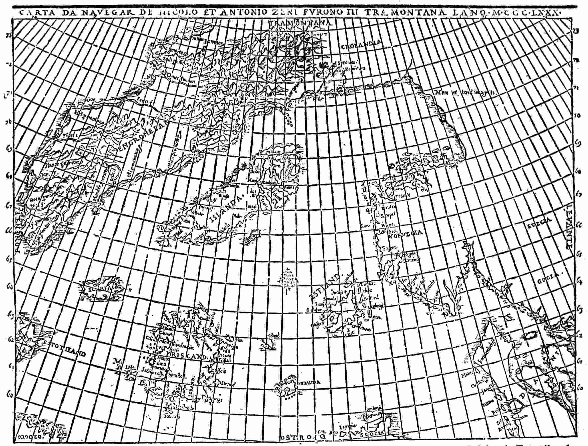
Fig. 19—The map of the northern regions by the Zeno brothers, 1558, showing Frisland, Estotiland,
Icaria, and Drogio. (After Lucas’ photographic facsimile.)
There has been much discussion as to whether the book should
be regarded as wholly a forgery or not, as to the location of these
regions, and as to the derivation and meaning of the names; but
all agree that Estotiland and Drogio were not known before 1558.
Nicolò the compiler reports: “The sailing chart which I find, I
still have among our family antiquities and, though it is rotten
with age, I have succeeded with it tolerably well.” Just what
this success involved is an interesting question. It has been
understood by his most reasonable advocates to include conjectural
restoration, such as the deficiencies of rottenness seemed
to call for, and somewhat more.
Nicolò the younger avers, further, that his ancestor Antonio
wrote a book recording his northern observations and many
facts about Greenland, but that the compiler as a boy had
thoughtlessly destroyed the book with other papers and that the
Zeno narrative as he gives it is made up from fragmentary letters
of the elder Nicolò to Antonio and of the latter to their brother,
Carlo, remaining in Venice; which letters by good fortune
happened to survive.
Nobody except the younger Nicolò is asserted to have seen
the map, the letters, or any of the original documents; though his
parents, it would seem, must have been custodian of them before
him, and he would surely have been likely to display such
precious evidences to some one after awakening to their importance.
But those were less critical and exacting times than the
present, and conceivably it may have been felt that any corroboration
would be superfluous. Yet the fact remains that we are
not informed of any means of testing the accuracy of restoration
or even of demonstrating that there was anything to restore.
First Use of the Names “Estotiland” and “Drogio”
The two names “Estotiland” and “Drogio” are supplied by a
story within a story, an alleged yarn of a fisherman, reporting128
to his island ruler, whom the elder Zeno served. Obviously, the
chances of lapse from truth are multiplied. Either the later
Nicolò or his ancestor of more than a century and a half before
may have wholly invented or more or less transformed it; or
the first narrator may have created his tale out of no real happenings
or have so distorted it by mistake or willful imposture
as to render it wholly unreliable. In its general outlines it is by
no means impossible; but neither would it have been very
difficult to compose such a yarn out of nothing but fancy and
the American information at the command of the younger
Nicolò. It comes to us through the medium of an alleged letter
of his ancestor Antonio, written home to the latter’s brother
Carlo near the end of the fifteenth century. With some slight
compression, the narrative runs as follows:
Six and twenty years ago four fishing boats put out to sea, and, encountering
a heavy storm, were driven over the sea in utter helplessness
for many days; when at length, the tempest abating, they discovered an
island called Estotiland, lying to the westwards above one thousand
miles from Frislanda. One of the boats was wrecked, and six men that
were in it were taken by the inhabitants, and brought into a fair and
populous city, where the king of the place sent for many interpreters, but
there were none could be found that understood the language of the
fishermen, except one that spoke Latin, and who had also been cast by
chance upon the same island.... They ... remained five years
on the island, and learned the language. One of them in particular
visited different parts of the island, and reports that it is a very rich
country, abounding in all good things. It is a little smaller than Iceland,
but more fertile; in the middle of it is a very high mountain, in which rise
four rivers which water the whole country.
The inhabitants are a very intelligent people, and possess all the arts
like ourselves; and it is to be believed that in time past they have had
intercourse with our people, for he said that he saw Latin books in the
king’s library, which they at this present time do not understand. They
have their own language and letters. They have all kinds of metals, but
especially they abound with gold. Their foreign intercourse is with
Greenland, whence they import furs, brimstone and pitch.... They
have woods of immense extent. They make their buildings with walls,
and there are many towns and villages. They make small boats and sail
them, but they have not the loadstone, nor do they know the north by the
compass. For this reason these fishermen were held in great estimation,129
insomuch that the king sent them with twelve boats to the southwards to
a country which they call Drogio; but in their voyage they had such contrary
weather that they were in fear for their lives.
... They were taken into the country and the greater number of
them were eaten by the savages.... But as that fisherman and his
remaining companions were able to show them the way of taking fish with
nets, their lives were saved.... As this man’s fame spread ...
there was a neighboring chief who was very anxious to have him with
him ... he made war on the chief with whom the fisherman then was,
and ... at length overcame him, and so the fisherman was sent over
to him with the rest of his company. During the space of thirteen years
that he dwelt in those parts, he says that he was sent in this manner to
more than five-and-twenty chiefs ... wandering up and down ...
he became acquainted with almost all those parts. He says that it is a
very great country, and, as it were, a new world; the people are very
rude and uncultivated, for they all go naked and suffer cruelly from the
cold, nor have they the sense to clothe themselves with the skins of the
animals which they take in hunting. They have no kind of metal. They
live by hunting, and carry lances of wood, sharpened at the point.
They have bows, the strings of which are made of beasts’ skins. They are
very fierce, and have deadly fights amongst each other, and eat one
another’s flesh.... The farther you go southwestwards, however, the
more refinement you meet with, because the climate is more temperate,
and accordingly there they have cities and temples dedicated to their
idols, in which they sacrifice men and afterwards eat them.
His fellow captives having decided to remain where they were, he bade
them farewell, and made his escape through the woods in the direction of
Drogio, ... where he spent three years. [One day] some boats had
arrived. He went down to the seaside, and ... found they had come
from Estotiland. [They took him aboard as interpreter.] He afterwards
traded in their company to such good purpose that he became very rich,
and, fitting out a vessel of his own, returned to Frislanda.218
Geographical Implication of the Narrative
In spite of plain geographical indications in the above recital,
Estotiland has been located by some random or oversubtle
conjectures in the strangest and most widely scattered places,
including even parts of the British Isles. But a region a thousand
miles west of the Faroes or any other Atlantic islands can be
nothing but American, and the restriction of its commerce to130
Greenland, apparently as a next neighbor, points very clearly
(as Estotiland) to that outjutting elbow of North America, which
culminates in Cape Race, south of Greenland and thrust out
toward Europe. The clear definition of it in the tale as an island,
largely explored by the narrator, approximating the size of
Iceland but more fertile, with mountainous interior, great forests
(such as gave the name Markland to Norse tradition), and rivers
flowing several ways, clearly indicates Newfoundland. The
Zeno map accords with this, and most of the later maps accept
that identification—though often with a great extension of
territory. Thus a French map in the United States National
Museum,219 having 1668 for an entry of discovery and perhaps
dating from about 1700, presents the whole region southeast of
Hudson Bay in an inscription as called Estotiland by the Danes,
Nouvelle Bretagne (New Britain) by the English, Canada
Septentrionale by the French, and Labrador by the Spanish;
but here again Labrador and Newfoundland may have been
chiefly in mind.
Conjectures as to the Derivation of “Estotiland”
Evidently this map-maker attributed the name Estotiland to
the Norsemen of Greenland on the faith of the fisherman’s story,
for no other Scandinavians can be supposed to have fastened a
name on the region in question. But, barring the last syllable,
which is a common affix, the name has an Italian sound rather
than Scandinavian. “East-out-land” has been suggested as a
derivation, but why in this instance should either Norse or
Italian borrow an English name? Another suggestion requires
the use of the first three syllables of the motto “esto fidelis usque
ad mortem” making up “Estofi,” with the appendant “land.”
But there seems no historic link of positive connection, and the
letter “f” would not readily change into “t.” Perhaps “Escotiland”
or “Escociland” (Scotland) is a more likely conjecture (first made131
by Beauvois220), since “c” often resembles “t” in older forms of
handwriting and might readily be misunderstood. The name
may have been applied in the same spirit which has long affixed
“Scotia” (Nova Scotia) to a lower part of the same Atlantic
coast. That the name was ever really thus applied by the Norsemen
seems very unlikely; but Nicolò Zeno may have used it to
help out his fisherman’s yarn as readily as he certainly adapted
“King Daedalus of Scotland” to help out his more mythical
account of Icaria. Or “Estotiland” may be a modification of
Estilanda or Esthlanda, a form sometimes taken by Shetland, for
example on the map of Prunes, 1553221 (Fig. 12). In casting about
for a name, it would be an economy of effort on the part of Zeno or
the fisherman to utilize one that was familiar. But I do not know
that this derivation from Estiland has ever before been suggested.
The Estotilanders
Ortelius, in crediting the discovery of the New World to
the Norsemen, seems to identify Estotiland with Vinland.222
He was so far right that the fisherman’s account of the
people of Estotiland was evidently composed by some one
acquainted with the mistaken ideal of Vinland, or Wineland,
which pictured it a permanent Norse offshoot from Greenland,
perhaps slowly deteriorating but still possessed of a
city and library, letters and the ordinary useful arts of at
least a primitive northern white civilization, trading regularly
with Greenland though archaic enough to lack the mariner’s
compass, and in most respects fairly on a par with the Icelanders,
Faroese, Shetlanders, or Orkneymen of the fourteenth to the
sixteenth century. We know that such Estotilanders did not
exist; that the ground was occupied by Beothuk Indians, possibly
slightly influenced by Greenlanders’ timber-gathering visits,132
with Eskimos for neighbors on one side and Micmac Algonquins
on the other; and that none of these could be thought even so
far advanced in culture as some natives farther down the coast.
But it is interesting to get the point of view of the narrator or
reporter.
Drogio
The tale is of a prolonged residence among these alleged
relatively advanced Estotiland people, followed by a much
longer wandering sojourn, mostly as a captive, in a great “new
world” southwest of it and a final escape. Drogio (also spelled
“Drogeo” and “Droceo” on some maps) was the region through
which this continental territory was entered. It is plainly an
island, to judge by the maps; but, according to the narrative, it
should be close inshore, since no mention is made of water being
crossed by the neighboring chief, who made war on the first
captors and thus acquired the fishermen. This accords curiously
with the facts as to Cape Breton Island, which is barely cut off
by the Gut of Canso, being easily reached by any incursion from
the mainland. It also lies southward from Newfoundland
(Estotiland), but sailing vessels would ordinarily be required to
get to it across the broad Cabot Strait, where the conditions
of storm and shipwreck might well be supplied. It is, indeed,
surprising, since the description of inhabitants and conditions
is so far from the truth, that the geography of Estotiland and
Drogio should be given so much more accurately than in some
carefully prepared and useful maps of the same period, for
example Nicolay’s of 1560223 (Fig. 6) and Zaltieri’s of 1566,224 both
of which represent Newfoundland as broken up into an archipelago;
and the same may be said of Gastaldi’s map illustrating
Ramusio.225
133
It has been generally surmised that the name Drogio represents
some native word, but there is a lack of evidence and a difficulty
in identification. Lucas thinks it may be a corruption of Boca
del Drago,226 a strait between Trinidad and the mainland South
America; but this seems a far-fetched and unsupported conjecture:
All the other island names used by Zeno are of European
origin, and Drogio by its sound and orthography suggests Italy.
Perhaps the best guess we can make would point to the Italian
words “deroga” or “dirogare” as supplying in disparagement a
form afterward contracted to Drogio; for the latter island, lower
in latitude and elevation, was also, according to the narrative,
inferior in the status of its population and might well be spoken
of derogatively. We have seen that a fairly high culture is
imputed to Estotiland; whereas the natives of Drogio were
sunk in mere cannibal savagery. Notwithstanding the plain
implication of the story as to the comparative nearness of the
two regions and the concurrent testimony of the Zeno map,
Drogio has been located by some theorizers at divers different
points of our coast line from Canada to Florida and even as far
afield as Ireland—which is perhaps a shade more extravagant
than Lucas’s South American derivation of the name.
Discrepancies in the Narrative of the Fisherman
There is this to be said for the last-mentioned speculation and
some others, that the statements concerning the mainland natives
are plainly prompted by Spanish accounts of certain naked and
cannibalistic denizens of the tropics, when not due to the
experience of Cortés and his companions among the teocallis
and ceremonial sacrifices of the Aztecs. That any one starting
from Nova Scotia or thereabout could have reached southern
or at least central Mexico and returned alone must have struck
even Nicolò Zeno the younger as incredible, if he had any
conception of the distances and difficulties involved. But probably
he believed the area of temple building to extend farther northward
than it actually did and had little notion of the great waste134
of intervening interior. Besides, it is not explicitly stated that
the fisherman saw these things; and to have gone far enough to
encounter a rumor of them, though a very improbable, would
not be a quite impossible, feat.
As regards the characteristics of the ruder inhabitants who
nearly devoured him, fought for him, and two dozen times
shifted ownership of him from chief to chief, he must surely be
understood to speak from personal observation; but there is a
conspicuous failure of corroboration from internal evidence. We
know a good deal about the Indian tribes of northeastern America
of a time not very much later, and hardly a distinctive characteristic
which he gives will fit what we know. To say that the
Algonquian tribes and their neighbors had not sense to clothe
themselves with the skins of the animals they killed is itself
arrant nonsense; to assert that they habitually ate each other
like Caribs is an imputation without foundation. The total
absence of metals among them is as untrue as the great abundance
of gold in Estotiland, for many of them had at least a little
copper. They did not live wholly by hunting—at least south of
Nova Scotia—but were partly agricultural, raising Indian corn
and various vegetables. They did not depend, in hunting, on
wooden lances with sharpened points, though some backward and
feeble far-southern insular tribes are reported to have done so.
They were expert fishermen with weirs and nets and inducted
many of the white settlers into their secrets, so naturally would
not extravagantly need nor prize the counsel of a white specialist
in the same line, though he might have some things to teach
them. Finally, the really distinctive features of the Indian race
in these latitudes, such as bark canoes and the peculiarities of
maize cultivation, are not mentioned at all.
In view of these discrepancies it is not easy to believe that the
fisherman ever visited America or at any rate ever journeyed
far inland. The nature of the errors rather points to Nicolò
Zeno “the compiler” as their author, since they embody observations
made elsewhere, which the fisherman would not be aware
of and which had not been made in his time, so far as now known.135
The landing by shipwreck on Estotiland in the last quarter of
the fourteenth century, though a startling feature, cannot be
called impossible or perhaps even wildly improbable; and, once
on this side of the Atlantic at that point, some accident might
take him across to Cape Breton Island, whence he well might
travel or be carried a little farther. This sequence of events may
be said to hang well together, and the geographic accuracy as
to Newfoundland and Cape Breton Island may be taken diffidently
as establishing a faint presumption that something like it
really occurred. But farther than this we cannot go, for all other
indications are adverse; and, even if we credit the incongruities
to one of the Zeni and suppose them to take the place of forgotten
or disregarded observations of the original adventurer, we are
without these last, and it is only substituting a vacuum for incorrectness.
Perhaps the only thing that remains to be said in
favor of the story is that if it were wholly the invention of
Nicolò Zeno it would have been natural and quite easy for him
to make his ancestor the discoverer, instead of an unnamed and
insignificant fisherman.
The Zeno Narrative Itself
For the story above considered enters the Zeno narrative only
as the incentive to a voyage of exploration which failed of its
aim; and it is nowhere alleged, unless in the title, that either of
the Zeno brothers discovered anything American. Each of them,
it says, visited Greenland, but that needed no discovery. Briefly
summarized, the Zeno story is that the elder Nicolò, being an
adventurous wanderer like many of his countrymen, was shipwrecked
about 1380 on the island of Frisland and taken into the
service of Zichmni, lord of the Orkneys, then prosecuting the
conquest of the former region. Zeno took part in the warfare of
this chieftain, chiefly against the King of Norway his feudal
lord, also in his various navigations, including a visit to Greenland,
of which this elder Nicolò writes quite fully to his brother
Antonio in Venice, urging the latter to join him in Zichmni’s
service. Antonio did so, after many adventures and hardships136
and incidental delay, and served with him four years, when
Nicolò died, and Antonio succeeded to his honors and emoluments
for thirteen years longer. About 1400 the fisherman returned
with his story of transatlantic experience, and Earl Zichmni
resolved to attempt to reach Estotiland in person. Instead, he
was storm-driven to Icaria, whatever that may be, and again
visited Greenland, exploring parts of its coast. Antonio Zeno
went with him and sailed home separately, under orders, slightly
missing his course and first reaching Porlanda (Pomona) of the
Orkneys and Neome (Fair Island) midway between the Orkneys
and Shetland. He knew then that he was “beyond Iceland”
(i. e. to the eastward) and readily found his way to Frisland.
He was never allowed to return to Venice but wrote his brother
Carlo what he had seen and heard, including the fisherman’s
story.
R. H. Major’s Study of the Zeno Narrative
Major endeavored to end the long-standing discussion as to
the authenticity of the map and the narrative of voyages by an
elaborate and ingenious study, on the hypothesis of an honestly
intended reproduction, the various additions, interpolations,
and changes being due partly to misunderstandings by the
original Zeno brothers, partly to injuries accidentally inflicted
by the compiler and inaccurately repaired, and partly to extraneous
matter of illustration and ornament, which the later
Nicolò Zeno had not the self-control to withhold. This method
of exposition leads to some curious experiences of prodigious
exaggeration backed by a veritable genius for transforming
words. Thus when we read that Zichmni, ruling in Porlanda
and conqueror of Frisland, made successful war on his feudal
superior, the King of Norway, it means, according to Major, that
Henry St. Clair (or Sinclair), who was given the Earldom of the
Orkneys in 1379, had a skirmish with a forgotten claimant to a
part of his territory. A little later in the narrative a warm spring
(108° maximum) on an island of a fiord in the inhabited part of
Greenland, beside which some ruins are found, evolves a monastery137
and monk-ruled village of dome-topped houses on the slope
of a volcanic mountain far up the impossible ice-bound eastern
coast, with house-warming, cooking, and hothouse gardening by
subterranean heat and a continual commerce maintained with
northern Europe—though all this had never been heard of
before. It is true that Major was handicapped by a belief,
formerly prevalent, that the eastern coast of Greenland was the
site of the Eastern Settlement of the Norsemen, though in
modern times that coast is subjected to conditions which make
life hardly practicable; whereas it is now conclusively established
that both of the Norse settlements were on the relatively pleasant
southwestern coast, one settlement being more easterly and the
other more westerly. But at the best such interpretations run
the gauntlet of the reader’s involuntary skepticism. It is often
easier to discard the statements altogether.
The Work of F. W. Lucas
Lucas, writing some years afterward, with the benefit of
recently discovered maps and information, has chosen this
destructive alternative for nearly the whole Zeno narration:
denying that Nicolò Zeno had any map of a former generation
to restore; styling his own keenly critical and exhaustive production
“an indictment,” and branding the book under consideration
as a forgery throughout—with, necessarily, some true
things in it. He has gone far toward making good his case.
Some things not fully accounted for suggest that there may have
been a basis of genuine material, a nucleus of truth; but it must
have been very slight.
Major and his preservative school relied chiefly on three points
of coincidence: a fairly good description of that most unusual
boat, the kayak of the Eskimos; the hot water of the monastery
already mentioned; and the general geography of Greenland,
which is shown more accurately than on many maps of the
sixteenth century and later. But Lucas points out that the
history of Olaus Magnus, or other northern sources, might have
supplied the kayak to Zeno the younger. This may seem rather138
far-fetched in view of the wide interval between Italy and
Scandinavia; but intercourse was regular in 1558, and Zeno was
a man of ample information and intelligence, using material from
many sources and having his attention especially directed to the
north.
A Monastery in the Arctic
The Zeno account of the monastery of St. Thomas is very
extended and particular, going into details of daily life, artificial
agriculture, and traffic. It is the sublimation of cultivation in
hothouse conditions (of volcanic origin), located far up within
the Arctic Circle at a particularly repellent point, where no man
has ever lived or perhaps will live hereafter. Lucas tries to
explain the account—which is interesting in its own way with
a certain wild and preposterous plausibility—by reminiscences
of a favored Scandinavian fortress, the gardens of which were
hardly ever frozen, enjoying “all the advantages which any
fortunate abode of mortals could demand and obtain from the
powers above.”227 But this is manifestly vague, a general picture
of balminess and delightfulness, far removed from a specific
account of roasting food by subterranean heat, warming garden
beds to the forcing point by pipes naturally supplied, and carrying
on an extensive commerce from the polar regions by the aid of a
tame volcano. Certainly the warm spring of southwestern
Greenland is not much more to the point; but neither fortress
gardens nor flowing water should be needed to stimulate a lively
fancy in creating rather obvious marvels. Nicolò knew of volcanoes
in Iceland (as well as Italy), may well have surmised
their activity in Greenland, and would be only one of many who
have amused themselves with speculations as to what might be
accomplished by tapping the great reservoir of heat and energy
below us. It is not necessary to find a precise earlier parallel, to
be sure that there is no corroboration for his tale of ancestral
voyages in such fancies.
139
The Zeno Map
A glance at the Zeno map (Fig. 19) discloses a good approximation
to the general outline, trend, and taper of Greenland, with
certain features which imply information. For a long time it was
thought that no earlier source existed from which this could have
been drawn by Zeno the compiler. But of later years other fifteenth-century
maps showing Greenland have been discovered in
various libraries, notably four by Nordenskiöld,228 out of which or
out of others like them Zeno could certainly have gleaned all that
he needed for judicious copying. In particular the maps of Donnus
Nicolaus Germanus (1466 to 1474, or a little later; e. g. Fig. 17),
elaborated from the map of Claudius Clavus (1427; Fig. 16), seem
to supply the chief features of the Zeno exhibition.229 Sharing an
error common to Clavus and all successors of his school, Zeno connected
Greenland to Europe. He also represented its eastern coast
as habitable at the extreme upper end. It is true that a visitor to
the real surviving Greenland settlement about Ericsfiord probably
would not learn the facts about these matters, so that his
misinformation is no disproof of the visits of the older Zeni to
that country. On the other hand, it would be difficult to point
to any convincing evidence that either of them was ever there.
Kohl suggests230 that the fisherman’s story may be a mere reflection
of the general American knowledge of Greenlanders,
and this might call for the presence of one of the Zeni in Greenland
to hear the story. But, if the Norse of Greenland knew
anything about Newfoundland or Labrador, they could hardly
have credited and passed along these word pictures of cities,
libraries, and kings. The only thing like internal corroboration
is in the geography of Estotiland and Drogio.
140
As Nicolò Zeno followed the disciples of Claudius Clavus in
outlining Greenland, so he took for his guide Mattheus Prunes’
map of 1553231 in dealing with the more eastern islands. Podanda
or Porlanda (Pomona, the main island of the Orkneys) and
Neome (Fair Island) are in both (Figs. 19 and 12). Prunes displaces
these islands to a position west, instead of south, of southern
Shetland (Estiland or Esthlanda), and Zeno simply carries
them both still farther west, while moving them southward; but
his Neome is still in the latitude of the lower end of Shetland.
Long before the time of either of them, the Faroe Islands had
been shown as one territory—see the Ysferi (Faroe Islands) of
the eleventh-century map of the Cottonian MS. in the British
Museum, reproduced by Santarem.232 The main islands are in
fact barely severed from each other by a thread of water.
Frisland
It was, and is, so common to use “land” as a final syllable for
island names (witness Iceland, Shetland, and the rest) that
“Ferisland” would easily be derived from the form of the name
last given and would be as readily contracted into “Frisland.”
We find the latter (Frislanda), indeed, on the map of Cantino
(1502)233 and in the life of Columbus ascribed to his son Ferdinand.234
There seems no doubt of its very early use for a northern
island or islands; apparently primarily for the Faroe group, often
blended as one island.
141
But there seems to have been some confusion in men’s minds
between Iceland and Frisland as northern fishing centers and
neighbors of like conditions. Thus the portolan atlas known as
Egerton MS. 2803, contains two maps235 (one shown in Fig. 8)
naming Iceland “Fislanda,” and the notable Catalan map of
about 1480236 (Fig. 7), first copied by Nordenskiöld, which shows
Greenland as an elongated rectangular “Illa Verde” and Brazil
in the place later given to Estotiland, also depicts a large insular
“Fixlanda,” which is surely Iceland, if any faith may be put in
general outline and the arrangement of islets offshore. Prunes
(1553; Fig. 12) substantially reproduces it, with the same name
and apparently the same meaning. Zeno (Fig. 19) follows him
closely in area and aspect but draws also an elongated Iceland
to the northward, the latter island trending southwestward in
imitation of Greenland and seeming to derive its geography therefrom.
This version of Iceland was probably suggested by one of
the Nicolaus Germanus maps above referred to.
Thus Zeno has two great islands, Frisland and Iceland, the
former being several times larger than Shetland and many times
larger than Orkney. His Frisland gets its name from the Faroes,
its area and outline from Iceland; it is located south of Iceland,
where there never was anything but waste water. No such large
island, distinct from Iceland, ever existed at the north. Certainly,
as shown, it is a mythical island indeed.
Major stoutly argued that any derelictions of the map are to
be explained as the defects of age and rottenness, unskillfully
cobbled by a later hand. This sounds reasonable to one who has
seen how the changes of time deface these old memorials and
how easily outlines and much more may be misread. But in
point of fact the map as we have it answers to the narrative
singularly well. Any blurs or lacunae which needed restoration
must have occurred in very fortunate places. Iceland, Shetland,142
Greenland, Scotland, Estotiland, and Drogio are all not very
far from where they should be. The Orkneys and Fair Island, if
too far west in fact, are only far enough to suit the tale, for
when Antonio sails eastward he comes to them and knows he has
passed east of Iceland, a reflection more likely to occur if the
interval were rather small than if it were very great.
Icaria
Again, when Earl Zichmni and Antonio Zeno with their little
flotilla, fired by the fisherman’s American experiences, strike
westward from Frisland for Estotiland they, indeed, do not
reach that goal but do attain by accident the mysterious Icaria
and find themselves where Greenland can be and is reached
without much difficulty. Now, on the map (Fig. 19), Icaria, about
the size of Shetland, is the most westerly of all the islands not distinctly
American. Draw a straight line from Iceland to Estotiland
and another from the center of Frisland to Cape Hwarf near the
lower end of Greenland, and Icaria lies at the intersection.
Granting the rest of the story, it is shown where they might very
well have stumbled upon it in trying to go farther west.
Of course, it is not there; nothing ever was there except an
ample expanse of sea. Where Zeno got the idea of Icaria is
not known—except as an appended and unimportant myth
from the Aegean; it certainly was not supplied by the facts of
the North Atlantic. Probably the initial “I” stands for island
as usual, and “Caria” is a not impossible transformation of either
“Kerry” (preferred by Major) or “Kilda”—the latter more likely,
for southern Ireland was continually visited by Italian traders,
whereas St. Kilda lay off the trade routes rather far away in the
mists and myths of the ocean and might be a fairer field for
exaggeration and shifting of place. But, with every allowance,
it is hard to see how this small ultra-Hebridean rock pile could
become a large island territory just short of America. Perhaps
it is as well to treat Icaria as merely the unprovoked creation
of the romantic brain of the younger Zeno.
143
Influence of Imaginary Cartography
It may be true that the elder Zeno brothers served for a time
under some northern island ruler, whose name the later Nicolò
Zeno read and copied as the impossible Zichmni; that they then
visited various countries and islands, possibly including the
surviving but dwindling Greenland settlement; that one of
them heard in general outline the adventures of a fisherman or
minor mariner cast away at two points of the American coast;
and that a futile attempt was thereupon made by their patron
to explore the same regions. Every one of these admissions lacks
adequate confirmation and is very dubious; yet they are all
possible. But it is not possible that a map made about 1400
could bear at almost all points the plain marks of copying with
slight changes from maps of the late fifteenth and sixteenth
centuries; and, since the narrative so well fits the map, the two as
we have them must stand or fall together.
Either Nicolò Zeno of 1558 invented the whole matter,
building up his imposture by the aid of maps and information
already existent and accessible, or he actually had some sort of
old sketch map and fragments of letters and has recast them with
more modern aids quite at his convenience, leaving no certain
trace of the original outlines or statements. It comes to much
the same thing in either case.
Also in either case his unscrupulous and misleading achievements
in imaginary cartography remain as historic facts. For
a century or more he supplied the maps of the world with
several new great islands; he shifted others widely into new
positions; he adorned other regions with new names that were
loath to depart; and he presented a story of pre-Columbian
discovery of America which was long accepted as true and is
not wholly discarded even yet.
144
CHAPTER X
ANTILLIA AND THE ANTILLES
There are two names still in common use for American regions,
which long antedate Columbus and most likely commemorate
achievements of earlier explorers. They are Brazil and the Antilles.
The former is earlier on the maps and records; but the case
for Antillia, as an American pre-Columbian map item, is in some
respects less complex and more obvious.
Antillia
A good many decades before the New World became known
as such, Antillia was recognized as a legitimate geographical
feature. A comparatively late and generally familiar instance
of such mention occurs in Toscanelli’s letter of 1474 to Columbus,237
recommending this island as a convenient resting point on the sea
route to Cathay. Its authenticity has been questioned, notably
by the venerable and learned Henry Vignaud,238 but at least some
one wrote it and in it reflected the viewpoint of the time.
Nordenskiöld in his elaborate and invaluable “Periplus” declares:
“As the mention of this large island, the name of which
was afterwards given to the Antilles, in the portolanos of the
fourteenth century, is probably owing to some vessel being storm-driven
across the Atlantic (as, according to Behaim, happened to
a Spanish vessel in 1414), those maps on which this island is145
marked must be reckoned as Americana.”239 The word “fourteenth”
is probably an accidental substitute for “fifteenth.” The
reference to Behaim undoubtedly means the often-quoted inscription
on his globe of 1492, which avers that “1414 a ship from
Spain got nighest it without being endangered.”240 This seems to
record an approach rather than an actual landing. But at least it
was evidently believed that Antillia had been nearly reached in
that year by a vessel sailing from the Iberian Peninsula. Little
distinction would then have been made between Spain and
Portugal in such a reference by a non-Iberian.
Ruysch’s map of 1508 is a little more vague in its Antillia inscription
as to the time of this adventure.241 He says it was discovered
by the Spaniards long ago; but perhaps this means a
rediscovery, for he also chronicles the refuge sought there by
King Roderick in the eighth century.
Peter Martyr’s Identification of Antillia
Both of these representations show Antillia far in the ocean
dissociated from any other land, but in the work of Peter Martyr
d’Anghiera, contemporary and historian of Columbus, writing
before 1511, we have an explicit identification as part of a well-known
group or archipelago. He has been narrating the discovery
of Cuba and Hispaniola and proceeds:
Turning, therefore, the stems of his ships toward the east, he assumed
that he had found Ophir, whither Solomon’s ships sailed for gold, but,
the descriptions of the cosmographers well considered, it seemeth that
both these and the other islands adjoining are the islands of Antillia.242
Perhaps he meant delineations, like those we have yet to consider,
and not descriptions in words; or writings concerning these146
islands may then have been extant which have since vanished as
completely as the celebrated map of Toscanelli.
Among “the other islands adjoining” we may be sure he included
that island of Beimini, or Bimini (no other than Florida),
a part of which, thus marked, occurs in his accompanying map
and has the distinction of owning the fabled fountain of youth
and luring Ponce de Leon into romantic but futile adventure.
Perhaps only one other map gives it the name Bimini; but its
insular character is plain on divers maps (made before men
learned better), with varying areas and under different names.
Other Identifications
Peter Martyr was not alone in his identification of the “islands
of Antillia.” Canerio’s map,243 attributed to 1502, names the large
West India group “Antilhas del Rey de Castella,” though giving
the name Isabella to the chief island; and another map of about
the same date (anonymous)244 gives them the collective title of
Antilie, though calling the Queen of the Antilles Cuba, as now.
A later map,245 probably about 1518, varies the first form slightly
to “Atilhas [i. e. Antilhas] de Castela” and shows also “Tera
Bimini.” This is the second Bimini map above referred to.
It is true that the name Antillia, often slightly modified, was
not restricted to this use but occasionally was applied in other
quarters. Beside Behaim’s globe and Ruysch’s map already mentioned,
a Catalan map of the fifteenth century (obviously earlier
than the knowledge of the Portuguese rediscovery of Flores and147
Corvo)246 presents a duplicate delineation of most of the Azores,
giving the supposed additional islands a quite correct slant northwestward
and individual names selected impartially from divers
sources. One of these is Attiaela, recalling the doubtful “Atilae” of
the warning-figure inscription on the map of the Pizigani of
1367247 (Fig. 2), which may have suggested it, being applied in the
same or a neighboring region. The islands remain mysterious,
perhaps merely registering a free range of fancy at divers periods.
An Antillia of the Mainland
Again, at a much later time, when the exploration of the South
American coast line had proceeded far enough to demonstrate the
existence of a continent, some one speculated, it would seem, concerning
an Antillia of the mainland. One of the maps248 in the portolan
atlas in the British Museum known as Egerton MS. 2803
bears the word “Antiglia” running from north to south at a considerable
distance west of the mouth of the Amazon, apparently
about where would now be the southeastern part of Venezuela.
Also, the world map249 in the same atlas (Fig. 8) bears “Antiglia” as
a South American name, in this instance moved farther westward
to the region of eastern Ecuador and neighboring territory.
But these aberrant applications of the name Antillia in its
various forms were mostly late in time and probably all suggested
by some novel geographical disclosures. The standard
identification, as disclosed on the maps discussed below, at least
from Beccario’s of 1435 to Benincasa’s of 1482, was with a great
group of western islands; as was Peter Martyr’s, much later.
148
The Origin of the Name
Naturally the origin of the word has been found a fascinating
problem. Ever since Formaleoni,250 near the close of the eighteenth
century, called attention to the delineation of Antillia in
Bianco’s map of 1436, discussed below, as indicating some
knowledge of America, there have been those to urge the claims
of the suppositional lost Atlantis instead. The two island names
certainly begin with “A” and utilize “t,” “l,” and “i” about equally;
but “Atlantis” comes so easily out of “Atlas,” and the great
mountain chain marches so conspicuously down to the sea in all
early maps, that the derivation of the former may be called
obvious; whereas you cannot readily or naturally turn “Atlas”
into “Antillia,” and there is no evidence that any one ever did
so. As to geographical items, both have been located in the
great western sea; but that is true of many other lands, real or
fanciful. Something has been made of the elongated quadrilateral
form of Antillia; but Humboldt points out251 that in the description
transmitted by Plato this outline is ascribed to a particular district
in Atlantis, not to the great island as a whole, and that,
even if it could be understood in the latter sense, there seems
no reason why a fragment surviving the great cataclysm should
repeat the configuration of Atlantis as a whole. There seems
a total lack of any direct evidence, or any weighty inferential
evidence, of the derivation of Antillia from Atlantis.
Humboldt’s Hypothesis
Humboldt, in rejecting this hypothesis, advanced another,
which is picturesque and ingenious but hardly better supported.252
His choice is “Al-tin,” Arabic for “the dragon.” Undoubtedly149
Arabs navigated to some extent some parts of the great Sea of
Darkness, and these monsters were among its generally credited
terrors. The hardly decipherable inscriptions in the neighborhood
of an island on the map of the Pizigani of 1367253 (Fig. 2), as we
have seen (Ch. VI), seem to cite Arabic experience in proof of
perils from fulvos (krakens) rising from the depths of the sea,
coupling dragons with them in the same legend and illustrating
it by a picture of a kraken dragging one seaman overboard from
a ship in distress, while a dragon high overhead flies away with
another. It is even true that Arabic tradition established a dragon
on at least one island as a horrible oppression, long ago happily
ended, and that another island (perhaps more than one) was
known as the Island of the Dragon. But in all this there is
nothing to connect dragons with Antillia, and that most hideous
medieval fancy is out of all congruity with the fair and almost
holy repute of this island as the place of refuge of the last Christian
ante-Moorish monarch of Spain in the hour of his despair
and as the new home of the seven Portuguese bishops with their
following.
In passing, we may note that Antela, the version of the Laon
globe hereinafter referred to, is identical with the name of that
Lake Antela of northwestern Spain which is the source of the
river Limia, fabled to be no other than Lethe, so that Roman
soldiers drew back from it, fearing the waters of oblivion. But
as yet no one has taken up the cause of Spanish Antela as the
origin of the island’s name. Probably it is a mere matter of coincidence.
Humboldt admits that Antillia may be readily resolved into
two Portuguese words, ante and illa (island). He even cites
several parallel cases, of which Anti-bacchus will serve as an
example. But he objects that such compound names have been
used in comparison with other islands, not with a continent. In
the present instance, however, the comparison would be with
Portugal, not with all Europe, and the other member of it would150
be a map island which, he says, is as long as Portugal and seems
curiously to borrow and copy Portugal’s general form and is
arranged opposite to that kingdom far beyond the Azores across
a great expanse of sea. It must be remembered that illa is the old
form of ilha, found in many maps, that either would naturally be
pronounced “illia,” and that you cannot say “anteillia” or “antiillia”
at all rapidly without turning it almost exactly into Antillia.
The “island out before,” or the “opposite island,” would be the
natural interpretation. The latter seems preferable. Notwithstanding
the great importance which must always be attached to
any opinion of Humboldt’s, there really seems no need to let
fancy range far afield when an obvious explanation faces us in the
word itself and on the maps.
The Weimar Map
Nordenskiöld, practically applying his test of the presence of
Antillia and arranging his materials in chronological order, heads
his list of “The Oldest Maps of the New Hemisphere”254 with the
anonymous map preserved in the Grand Ducal library in Weimar
and credited to 1424.255 But it seems that this map does not deserve
that position, for it is not entitled to the date; Humboldt,
inspecting the original, made out certain fragments of words and
the Roman characters for that year on a band running from
south to north between the Azores and Antillia; also, in more
modern ink, the date 1424 on the margin. Whatever the explanation,
he was convinced of error by subsequent correspondence
with the Weimar librarian and admitted that it was probably the
work of Conde Freducci not earlier than 1481. Apart from all
considerations of workmanship and map outlines, the use of
“insule” instead of “insulle” and of “brandani” instead of “brandany”
in the inscription concerning the Madeiras marks the map
as almost certainly belonging to the last quarter, not the first
quarter, of the fifteenth century.
151
The Beccario Map of 1426
The second map on Nordenskiöld’s New World list is “Becharius
1426,” a Latinization of the surname of Battista Beccario
and at least not so weird a transformation as Humboldt’s “Beclario
or Bedrazio.” Apparently the year of this map has not been
doubted, but there is a lack of first-hand evidence that the
original contains Antillia. No reproduction of this map had been
published prior to the writer’s paper on St. Brendan’s Islands
in the July, 1919, Geographical Review, nor, so far as is known, has
its extreme western part been copied in any way. The section
there reproduced, and herewith reprinted only slightly curtailed
(Fig. 3), is one of several sent me in response to arrangements,
made before the war, for a photograph of the map, but by
some mistake the very portion that would have been conclusive
was omitted, and all attempts to remedy the error have
failed. But, if there were any inscription concerning recently discovered
islands located as in his later map, some part of it at
least would probably be seen on what I have; and for this and
other reasons I do not believe that Antillia is delineated or named
on the Beccario map of 1426.
The Beccario Map of 1435
The addition to fifteenth-century geography of a great group
of large western islands roughly corresponding to a part of the
West Indies and Florida rests mainly on the testimony of the
following maps now to be discussed: Beccario 1435, Bianco 1436,
Pareto 1455, Roselli 1468, Benincasa 1482, and the anonymous
Weimar map probably by Freducci and dating somewhere
after 1481. Of these the most complete as well as the earliest
is Beccario’s256 (Fig. 20). He gives the islands the collective
title of “Insulle a novo rep’te” (newly reported islands), which153
may refer to the discovery recorded by Behaim for 1414 or
to some more recent experience. The interval would not be
much greater than that between the first landing of Columbus
and the narrative of Peter Martyr beginning with equivalent
words. It is likely, however, that some lost map or maps
preceded Beccario’s, for the artificially regular outlines of
his islands, though in accord with the fashion of cartography in
his time, seem rather out of keeping with a first appearance.
The type had somehow fixed itself with curious minuteness and
was repeated faithfully by his successors. In spite of these impossibly
symmetrical details and some discrepancies as to individual
direction of elongation and latitude, the fact remains that
in the Atlantic there is no such great group except the Antilles
and that the general correspondence is too surprising to be
explained by mere accident or conjecture. Surely some mariner
had visited Cuba and some of its neighbors before 1435.
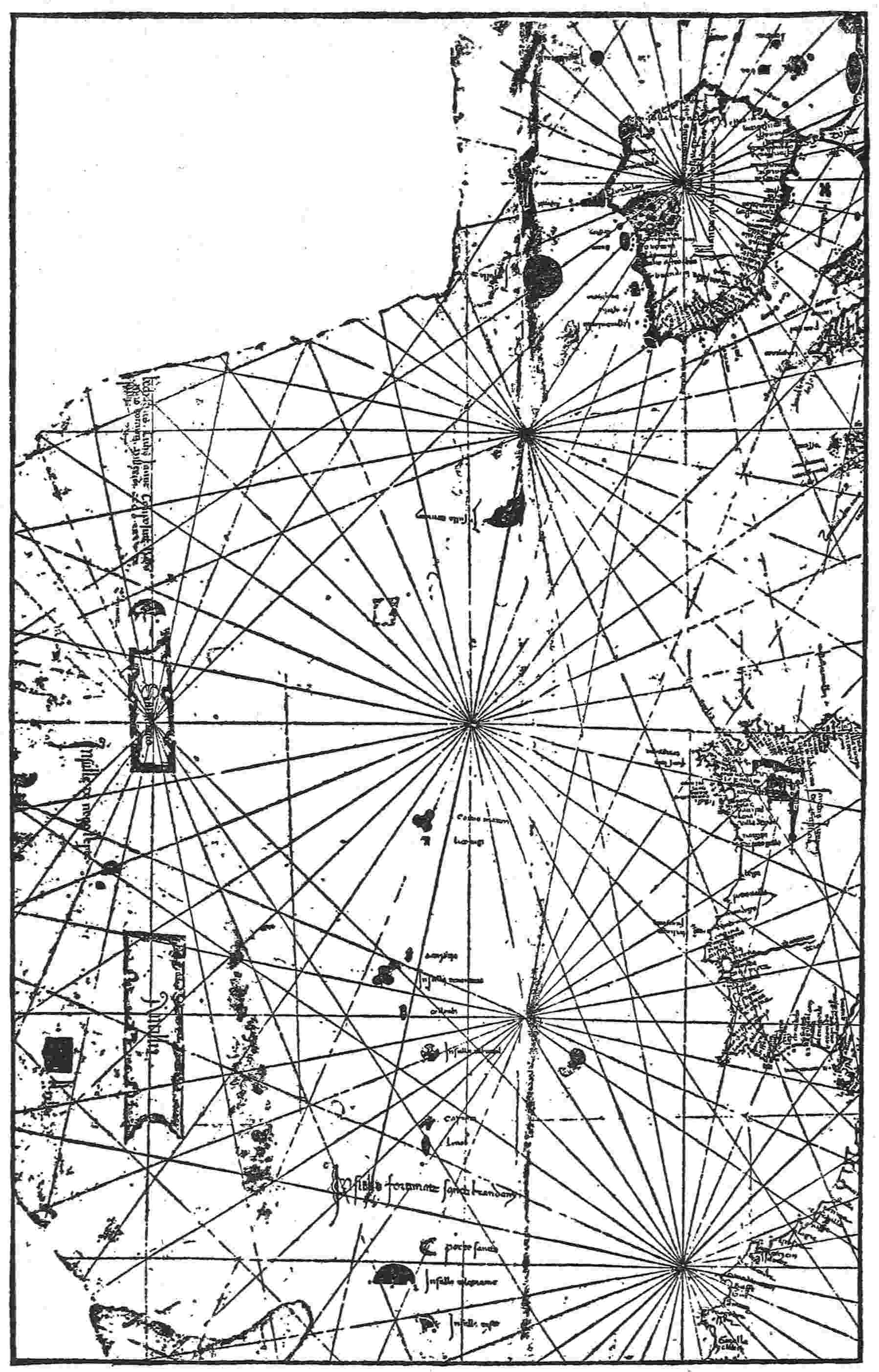
Fig. 20—Section of the Beccario map of 1435 showing the four islands of the
Antilles, St. Brendan’s Islands, Daculi, and others. (After Uzielli’s photographic
facsimile.)
This map of Beccario had been somewhat neglected, with misreading
of the names, before it was taken in hand by the Italian
Geographical Society and reproduced very carefully by photo-lithography.
As regards the island names in particular, this
eliminated some misunderstanding and confusion and made their
meaning plain. Thus rendered, the map affords a convenient
standard for the others, which, indeed, differ from it very little
as to these “Islands of Antillia.”
The Four Islands of the Antilles on the Beccario Map
This group, or more properly series—for three of them are
strung out in a line—comprises the four islands Antillia, Reylla,
Salvagio, and I in Mar. All these names have meaning, easy to
render.
Antillia
The largest and most southerly, Antillia, the “opposite island,”
which I take to be no other than Cuba, is shown as an elongated,
very much conventionalized parallelogram, extending from the
latitude of Morocco a little south of the Strait of Gibraltar to154
that of northern Portugal. As Humboldt says, it is about a
third as wide as it is long; and in this respect it is singularly even
throughout its length. In its eastern front there are four bays,
and three in its western. The intervals on each side are pretty
nearly equal, and each bay is of a three-lobed form resembling
an ill-divided clover leaf. In the lower end there is a broader and
larger bay nearly triangular. The artificial exactness of these
minute details is in keeping with the treatment on divers maps of
the really well-known islands of the eastern Atlantic archipelagoes,
except that the comparative smallness of a Teneriffe, a
Terceira, or even a Madeira, offered less opportunity. The slant
of the island is very slightly east of north, obviously quite different
from the actual longitudinal direction of the even more
elongated Queen of the Antilles.
Reylla
Behind the lower part of Antillia, much as Jamaica is behind
the eastern or lower part of Cuba, and about in similar proportions
of relative area, Beccario shows a smaller but, nevertheless,
considerable island, pentagonal in outline, mainly square in
body, with a low westward-pointing broad-based triangular extension.
He gives it the impressive name of Reylla, King Island,
not ill suited to the royal beauty of that mountainous gem of the
seas.
Salvagio
North of Antillia and nearly in line with it, but at a rather wide
interval, he shows Saluagio or Salvagio (“u” and “v” being equivalent),
which has the same name then long given to a wild and
rocky cluster of islets between Madeira and the Canaries, that
still bears it in the form Salvages. Wherever applied the name is
bound to denote some form of savageness; perhaps “Savage Island”
is an adequate rendering, the second word being understood.
This Salvagio imitates the general form of Antillia on a
reduced scale, being, nevertheless, much larger than any other
island in the Atlantic south of the parallel of Ireland. Like155
Antillia, its eastern and western faces are provided with highly
artificial bays, three in each. Its northern end is beveled upward
and westward. I think this large island probably represents
Florida, similarly situated to the northward of Cuba and divided
from it by Florida Strait. Its area must have been nakedly conjectural,
as much later maps show its line of supposed severance
from the mainland to have been drawn by guesswork.
I in Mar
The inclined northern end of Salvagio is divided by a narrow
sea belt from I in Mar, which has approximately a crescent form
and a bulk not very different from that commonly ascribed at
that time to Madeira. “I,” of course, stands for Insula or one of
its derivatives, such as Illa, a word or initial applied or omitted at
will. “Island in the Sea” is probably the true rendering, though
formerly the initial and the two words were sometimes blended,
as Tanmar or Danmar, to the confusion of geographers. A larger
member of the Bahama group lying near the Florida coast would
seem to fill the requirements, being naturally recognized as
more at sea than Florida or Cuba. Great Abaco and Great Bahama
are nearly contiguous and, considered together, would give
nearly the required size and form; but it is not necessary to be
individual in identification. Possibly Insula in Mar as drawn
was meant to be symbolical and representative of the sea islands
generally rather than to set forth any particular one of them.
The Roselli Map of 1468
The Roselli map of 1468,257 the property of the Hispanic Society
of America, New York City, is nearly as complete as the Beccario
map of 1435. It lacks only the western part of Reylla (a name
here corrupted into “roella”), by the reason of the limitations of
the material. These maps were generally drawn on parchment
made of lambskin with the narrow neck of the skin presented
toward the west, perhaps as the quarter in which unavoidable156
omissions were thought to do the least harm. Because of the
island’s position on the very edge of the skin, its outline, although
unmistakable, is faint and in a few decades of exposure of the original
might have vanished altogether. This raises the question
whether certain outlines, now missing but plainly called for, on
other maps of the same period, have not met with the same fate.
Probably this has happened. Antilia—spelled thus—is plain in
name and outline; so is the island next above it, spelled Saluaega.
The “I” is omitted from I in Mar, as was often done in like cases,
and the words “in Mar” are uncertain, but seem as above. The
island figure is correctly given by Beccario’s standard, and in general
the representation of the island series is almost exactly the
same. Perhaps the most discernible difference is a very slight
northwestern trend given to Antillia, instead of the equally slight
northeastern inclination in Beccario’s case.
The Bianco Map of 1436
The Bianco map of 1436258 (Fig. 25) was the first of the Antillia
maps to attract attention in quite modern times but has suffered
far worse than Roselli’s in the matter of limitation. The border
of the material cuts off all but Antillia and the lower end of
Salvagio, to which Bianco has given the strange name of La Man
(or Mao) Satanaxio, generally translated “The Hand of Satan”
but believed by Nordenskiöld to be rather a corruption of a
saint’s name, perhaps that of St. Anastasio. It remains a mystery,
though one hypothesis connects it with a grisly Far Eastern tale
of a demon hand. The initial “S” is all that Satanaxio has in
common with the names for this island on the other maps that
show it; and, as nearly all of these present very slight changes
from Salvagio, easily to be accounted for by carelessness or
errors in copying, the latter name is fairly to be regarded as the
legitimate one, while Satanaxio remains unique and grimly
fanciful, perhaps to be explained another day. The most that
can be said for its generally accepted meaning is that it corroborates157
Salvagio in so far as it intensifies savagery to diabolism.
One is tempted to speculate as to whether any very cruel treatment
from the natives had formed part of the experience of the
visitors along that shore; but there is no known fact or assertion
upon which to base such an idea. As to the delineation of the
islands, it is quite evident that Bianco showed the same group
as Beccario and Roselli so far as circumstances permitted;
and there is no reason to believe that the islands for which he
had no room would have differed from theirs in his showing, if
admissible, any more than his Antillia differs; that is to say,
hardly at all.
Humboldt was so impressed by this map of Bianco that he took
the pains of measuring upon it the distance of Antillia from
Portugal, making this about two hundred and forty leagues: an
unreliable test, one would say, for the distances over the western
waste of waters probably were not drawn to scale nor supposed to
approach exactness. For that matter, the interval between
Portugal and the Azores, as shown on maps for nearly a hundred
years, was greatly underestimated, and the discrepancy becomes
more glaring as the islands lie farther westward, Flores and Corvo
being conspicuous examples. We should naturally expect to find
the West Indies reported much nearer than they really are by
anyone mapping a record of them. Perhaps the explanation lies
in a disposition of cartographers to expect and allow for a great
deal of nautical exaggeration in the mariners’ yarns that reached
them. A careful man might come at last to believe in the existence
of an island but doubt if it were really so very far away.
The Pareto Map of 1455
Pareto, 1455, has a very interesting and elaborate map259
(Fig. 21) showing Antillia, Reylla, and I in Mar (the latter without
name) in the orthodox size, shape, and position, but with a
great gap between Antillia and I in Mar where Salvagio should
be. Very likely it was there once. Perhaps this is another case of159
fading away. One doubts whether the loss might not still be
retrieved by more powerful magnifying glasses and close study
of the significant interval. Pareto is unmistakably disclosing the
same series of islands as the others. It may be that from him
Roselli borrowed the inaccurate “roella” for Reylla, since Pareto
is earlier in using a similar form (Roillo).
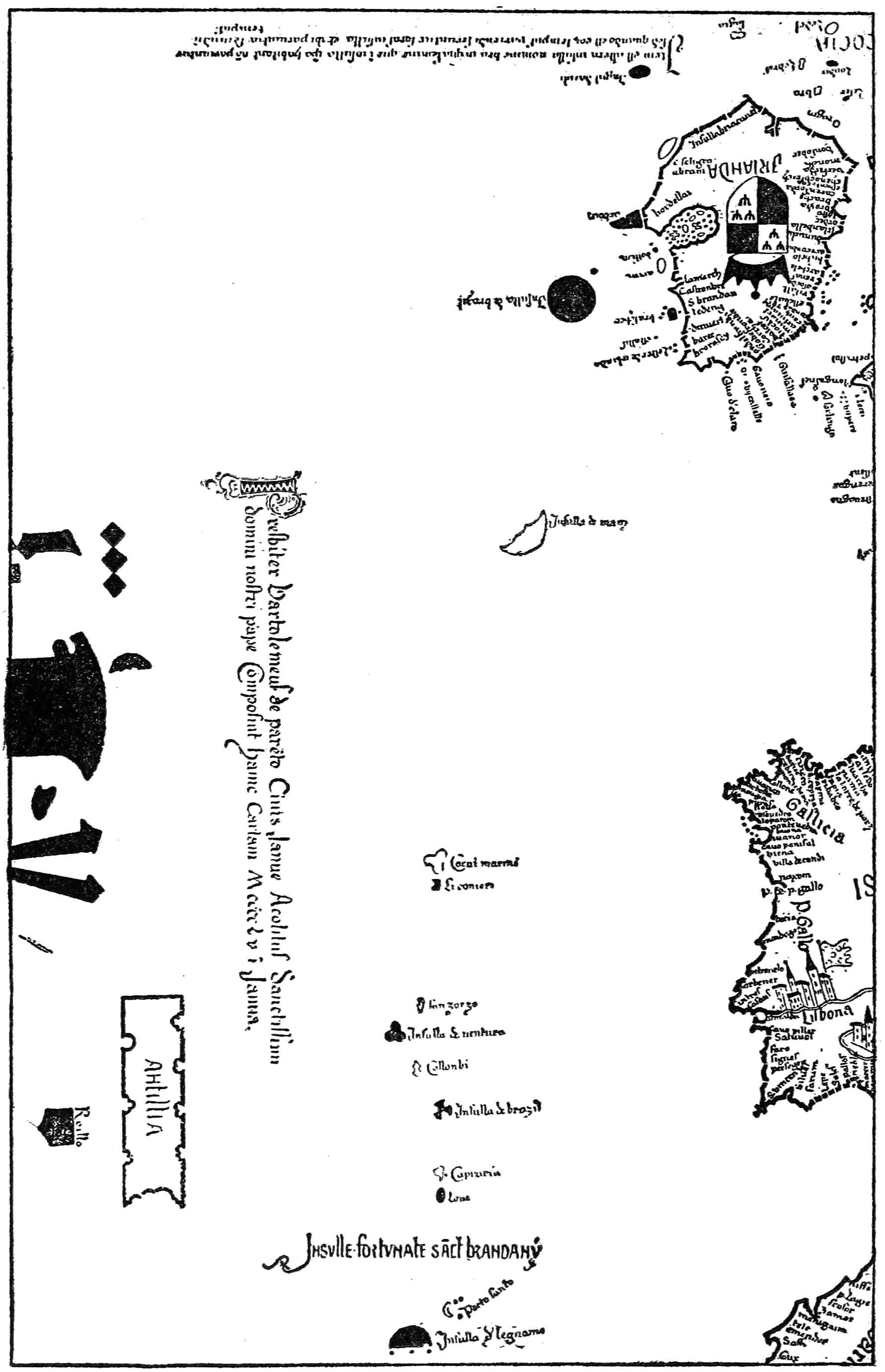
Fig. 21—Section of the Pareto map of 1455 showing the Antilles, St. Brendan’s
Islands, Daculi, and others. (After Kretschmer’s hand-copied reproduction.)
The Benincasa Map of 1482
Benincasa’s map of 1482260 (Fig. 22) presents Salvagio as Saluaga,
and I in Mar without name, but omits Reylla, both name and
figure. The islands shown are in their accepted form and arrangement,
except that Saluaga has but two bays on the western side,
and his map adds a novelty in a series of names applied to the
several bays, or the regions adjoining them, of the two larger
islands. These names (Fig. 22) are twelve in number and seem
like the fanciful work of some Portuguese who was haunted by a
few Arabic sounds in addition to those of his native tongue. Several
of them, like Antillia, begin with “An,” perhaps another illustration
of the law of the line of least resistance. I cannot think
that there is any significance in these bits of antiquated ingenuity,
though, as we have seen in Chapter V, some have believed they
found in them a relic of the Seven Cities legend.
The Weimar Map (after 1481)
The Weimar map,261 though long carefully housed, has suffered
blurring and fading with some other damage in its earlier history.
It is evidently a late representative of the tradition and begins
to wander slightly from the accepted standard. It has been
curtailed also from the beginning, like Bianco’s map of 1436, by
the limitations of the border, which in this instance cuts off the
lower part of Antillia, though the name is nearly intact; but
enough remains to indicate a reduced relative size and a greater
slant to the northeastward than on Beccario’s map. There is, of
course, no room for Reylla, and there is none for I in Mar; but
160
Salvagio is given plainly and fully, with the letter S quite conspicuous.
I cannot read more of the name on the photograph;
but the Weimar librarian reads San on the original, being uncertain
as to the rest. This map bears traces of local names arranged
in places like those of Benincasa but fragmentary and illegible.
Perhaps these names tend to show that the maps belong not only
to the same period, but to the same general school of development.161
The other differences between this map and its predecessors
are trivial. The general idea of the island series is the same
so far as it is disclosed, and it is hardly to be doubted that all
elements of the islands of Antillia would have been presented in
the main on this map as they are by Roselli and Beccario, if there
had been room to do so.
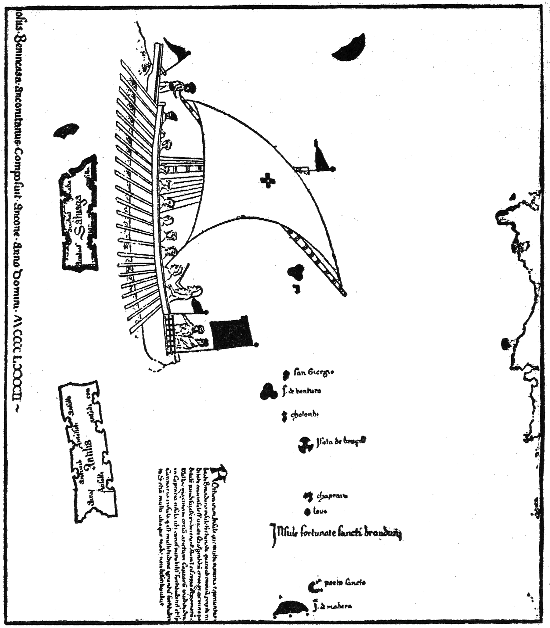
Fig. 22—Section of the Benincasa map of 1482 showing the Antilles, St. Brendan’s
Islands, and others. (After Kretschmer’s hand-copied reproduction.)
The Laon Globe of 1493
The Laon globe,262 1493, though mainly older, certainly had
room enough, but it appears to have formed part of some mechanism
and to have had only a secondary or incidental, and in
part rather careless, application to geography. It shows two
elongated islands, Antela and Salirosa, undoubtedly meant for
Antillia and Salvagio. Perhaps the globe maker had at command
only a somewhat defaced specimen of a map like Bianco’s or that
of Weimar, showing perforce only two islands, and merely copied
them, guessing at the dim names and outlines, without thinking
or caring whether anything more were implied or making any
farther search. This is apparently the last instance in which the
larger two islands of the old group or series, marked by their
traditional names or what are meant for such, appear together.
Other Maps
It may seem strange that certain other notable maps, for example
Giraldi 1426,263 Valsequa 1439,264 and Fra Mauro 1459,265 show
nothing of Antillia and its neighbors. Perhaps the makers were
not interested in these far western parts of the ocean, or the
narratives on which Beccario and the rest based their maps had
not reached them; more likely they were skeptical and unwilling
to commit themselves.
162
It is also true that the Antillia of Beccario and others is made to
extend nearly north and south instead of east and west; that I in
Mar is placed north of its greater neighbor instead of east; and
that the whole chain of islands is moved into considerably more
northern latitudes than the group which we suppose them to represent.
Thus the eastern, or lower, end of Cuba is actually in the
latitude of the lower part of the Sahara, and a point above the
upper end of Florida would be in the latitude of the upper part of
Morocco; whereas in the maps discussed the average location of
the chain from the lower end of Antillia to the most northerly
island, I in Mar, would run from the latitude of northern Morocco
to that of southern France. There are slight individual differences
in this matter of extension, but I believe Antillia always begins
below Gibraltar and ends above northern Spain and a little below
Bordeaux. But some dislocation, of course, is to be looked for in
mapping exploration in an unscientific period. The changes of
direction and extension are not greater than in the American
coast line of Juan de la Cosa’s very important map of 1500,266 not to
mention even more extravagant instances of later date; and
the shifting of latitudes may partly be accounted for by ignorance
of the southward dip of the isothermal lines in crossing the
Atlantic westward. Thus a Portuguese sailor on reaching a far
western island or shore having what seemed to him the climate
and conditions of Gascony would be likely to suppose that it was
really opposite Gascony, though in fact it might be more nearly
opposite the Canaries; and the same cause of error would apply all
down the line. Cuba is not really directly opposite Portugal but
may easily have been believed so.
Identity of Antillia with the Antilles
A more difficult question is raised by the absence of Haiti and
Porto Rico from these maps, with all the more eastward Antilles.
But it is possible that they may not have been visited or even
seen. We can imagine an expedition that would touch Great163
Abaco, coast along Florida and Cuba, and visit Jamaica, returning
out of sight, or with little notice, of the Haitian coast and
barely passing an islet or two of the Bahamas, which, if not sufficiently
commemorated in a general way by Insula in Mar, might
well be disregarded. A report of such an expedition, adding that
Antillia was directly opposite Portugal and of about equal size,
would account fairly for the map which for half a century was
faithfully repeated even in details by many different hands and
evidently confidently believed in.
Unless we accept this explanation, we must assume an uncanny,
almost an inspired, gift of conjecture in some one who,
without basis, could imagine and depict the only array of great
islands in the Atlantic. Certainly the outlines of Cuba, Jamaica,
Florida, and one of the Bahamas will very well bear comparison
with Scandinavia or the Hebrides and the Orkneys as given on
maps of equal or even later date. Some glaring errors are to be
expected in such work, as notoriously occurred in the sixteenth-century
treatment of Newfoundland and Labrador. Applying
the same tests and canons and making the same allowances as
in these cases of distortion of undoubtedly actual lands, we may
be reasonably confident that the Antillia of 1435 was really, as
now, the Queen of the Antilles.
164
CHAPTER XI
CORVO, OUR NEAREST EUROPEAN NEIGHBOR
Far at sea from Portugal, straggling in a long northwestward
line toward America, lies the archipelago sometimes called the
Islands of the Sun or the Western Islands but now generally
known as the Azores. That line breaks into three divisions separated
by wide gaps of sea: the most easterly pair, St. Michael and
St. Mary; the main cluster of five islands, Pico being the loftiest
and Terceira the most important; and the northwesterly pair,
Flores and Corvo. These last make a little far-severed world of
their own, sharing in none of the tremors and upheavals which
from time to time more or less transform parts of the other two
divisions. The remote origin of the pair was volcanic, and Corvo
is little more now than an old crater lifted about 300 feet above
the surface; but the fires have long been dead, and in historic
times the lower strata have never shifted suddenly to produce
any great earthquake. There have been changes, but they must
be attributed for the most part to gradual subsidence.
These two islands, though almost as near to Newfoundland as
to any point in Portugal, cannot be classed as American; yet
Corvo in particular seems to have impressed the imagination of
ancient and medieval explorers with a sense of some special relation
to regions beyond, though possibly only to the entangling
Sargasso Sea of weeds, which would lie next in order southwestward
(Fig. 1), and the menacing mysteries of the remoter
wastes of the Atlantic. It may have been felt as the last stepping
stone for the leap into the great unknown.
Origin of the Name
Flores, the island of flowers, thus prettily renamed by the
Portuguese, is referred to as the rabbit island, Li Conigi, in the165
fourteenth-century maps and records; but Corvo has always
borne, in substance, the same name, one of the oldest on the
Atlantic. Probably the very first instance of its use is in the Book
of the Spanish Friar,267 written about 1350 (the author says he
was born in 1305), rather recently published in Spanish and since
translated for the Hakluyt Society publications by Sir Clements
Markham. After relating alleged visits to more accessible islands
of the eastern Atlantic archipelagoes, from Lanzarote and Tenerife
of the Canaries to São Jorge (St. George) of the Azores, he
continues: “another, Conejos [doubtless Li Conigi], another,
Cuervo Marines [Corvo—the sea crow island], so that altogether
there are 25 islands.”
This account may not actually be later than the Atlante
Mediceo map,268 attributed to 1351—may even have been suggested
by it, as some things seem to indicate. The Friar’s voyages
are perhaps merely imaginary, their variety and total extent
being hardly believable. This very important map has been best
reproduced in the collection by Theobald Fischer; on it the same
name (Corvi Marinis) seems to be applied to both islands collectively,
the plural form “insule” being used to introduce it.
Both names appear on the Catalan map of 1375.269 It is more
than probable that they date at least from the earlier half of the
fourteenth century.
Possibly the name Corvo had been carried over by a somewhat
free translation from the older Moorish seamen and
cartographers, who dominated this part of the outer ocean from166
the eighth century to the twelfth. Edrisi,270 greatest of Arab geographers,
writing for King Roger of Sicily about the middle of the
twelfth century, tells us, among other items, of the eastern
Atlantic:
Near this isle is that of Râca, which is “the isle of the birds” (Djazîrato
’t-Toyour). It is reported that a species of birds resembling eagles is found
there, red and armed with fangs; they hunt marine animals upon which
they feed and never leave these parts.
This statement recalls the cormorants, which are supposed to
be meant by the sea crows, “corvi marinis” of the later maps.
They would naturally flock about the submerged ledges and the
wild shore of Corvo and may be held to suggest either the crow
or the eagle, though not closely resembling either. Everywhere
they are the scavengers of the deep seas. Edrisi mentions a
legendary expedition sent by the “King of France” after these
birds. It ended in disaster. The pictorial record on the Pizigani
map of 1367271 (Fig. 2), of Breton ships in great trouble with a
dragon of the air and a kraken, or decapod, on the extreme
western border of navigation, may conceivably refer to this experience.
Ancient Memorials
But Corvo has even more ancient traditions and associations,
Diodorus Siculus,272 in the first century before the Christian era,
wrote of a great Atlantic island, probably Madeira, which the167
Etrurians coveted during their period of sea power; but the Carthaginians,
its first discoverers, prohibited them, wishing to keep
it for their own uses. If the Etrurians were thus well informed
concerning one island of these eastern Atlantic archipelagoes, it is
a fair conjecture that they had visited the others.
However this may be, it seems that the Carthaginians left
memorials on Corvo. At least this is the most reasonable explanation
of the extraordinary story repeated by Humboldt273 in the
“Examen Critique,” apparently with full faith in its main feature
at least, notwithstanding the fascinating atmosphere of romance
and wonder which hangs about the details. In the month of
November, 1749, it appears, a violent storm shattered an edifice
(presumably submerged) off the coast of Corvo, and the surf
washed out of a vault pertaining to the building a broken vase
still containing golden and copper coins. These were taken to a
convent or monastery (probably on some neighboring island).
Some of them were given away as curiosities, but nine were
preserved and sent to a Father Flores at Madrid, who gave them
to M. Podolyn. Some of them bore for design the full figure of a
horse; others bore horses’ heads. Reproductions of the designs
were published in the Memoirs of the Gothenburg Royal Society274
and compared with those on coins in the collection of the Prince
Royal of Denmark. It seems to be agreed that they were certainly
Phoenician coins of North Africa, partly Carthaginian.
It has been suggested275 that they may have been left by Norman
or Arab seafarers, who certainly journeyed among the Azores
in the Middle Ages. But, as Humboldt points out, that these
should have left a hoard of exclusively Phoenician coins, so much
more ancient than their own, without even a single specimen of
any other mintage, appears very unlikely. On the other hand, it168
is true that Phoenician vessels sailing northward in the tin or
amber traffic would hardly be likely to be storm-driven so far
northwestward as Corvo; St. Michael would have been a more
natural involuntary landfall. This objection does not apply,
however, if we suppose the deposit to be the work not of accident,
but of full intention and deliberation, as the alleged edifice and
vault would certainly tend to show. If these coins were deposited
by Phoenicians who erected permanent buildings, the remoteness
of the island would be only an added reason for commemoration.
The coins might have been immured in the vault for safe keeping
or might have been enclosed in the corner stone, in accordance
with the general custom of placing coins and records in the corner
stones of notable structures.
Of course these details cannot be confidently accepted. As
Humboldt suggests, it is to be regretted that we are without
information as to the period or character of the edifice in question.
But at least it seems most probable that Phoenicians occupied
or at any rate visited this island and deposited coins of
Carthage.
Equestrian Statues
Furthermore, Corvo is one of several Atlantic islands reputed
to have been marked by monuments generally of one type.
Edrisi276 knows of them in Al-Khalidat, the Fortunate Isles—bronze
westward-facing statues on tall columnar pedestals.
There are said to have been six such in all, the nearest being at
Cadiz. Tradition places an equestrian statue also on the island
of Terceira, as repeated in a much more modern work.277 The
Pizigani map of 1367, it will be remembered, shows (Fig. 2) near
where Corvo should be the colossal figure of a saint warning mariners
backward, with a confused inscription declaring westward
navigation impracticable beyond this point by reason of obstructions
and announcing that the statue is erected on the shore of169
Atilie. But perhaps the best and most apposite account is that of
Manuel de Faria y Sousa in the “Historia del Reyno de Portugal:”
In the Azores, on the summit of a mountain which is called the mountain
of the Crow, they found the statue of a man mounted on a horse
without saddle, his head uncovered, the left hand resting on the horse,
the right extended toward the west. The whole was mounted on a pedestal
which was of the same kind of stone as the statue. Underneath some
unknown characters were carved in the rock.278
Apparently the reference is to the first ascent of Corvo after its
rediscovery between 1449 and 1460. The mention of “characters”
recalls those found in a cave of St. Michael, also by rediscoverers,
during the same period, as related by Thevet279 long afterward,
most likely from tradition. A man of Moorish-Jewish descent,
who was one of the party, thought he recognized the inscription
as Hebrew, but could not or did not read it. Some have supposed
the characters to be Phoenician. There is naturally much uncertainty
about these stories of very early observations by untrained
men, recorded at last, as the result of a long chain of transmissions:
but they tend more or less to corroborate the other evidences
of Phoenician presence.
It may be possible that the persistent and widely distributed
story of westward-pointing equestrian statues marking important
islands may have grown out of the ancient mention of the pillars
of Saturn, afterward Hercules, and Strabo’s discussion280 as to
whether they were natural or artificial in origin; but this puts a
severe strain on fancy. We know that the Carthaginians did set
up commemorative columns; and that the horse figured conspicuously
in their coinage. Nothing in the enterprising character of
the Phoenician people is opposed to the idea of incitement to exploration
westward. It seems easier to believe that they set up
these statuary monuments on one island after another than that
the whole tradition has grown out of a misunderstanding. Such170
statues might well vanish subsequently as completely as the great
silver “tabula” map of Edrisi and many other valuable things of
olden time.
Corvo has no statue now; but it is reputed to hold a statue’s
representative. Captain Boid (1834) relates:
Corvo is the smallest, and most northerly of the Azores, being only
six miles in length, and three in breadth, with a population of nine hundred
souls. It is rocky and mountainous; and on being first descried,
exhibits a sombre dark-blue appearance, which circumstance gave rise
to its present name, whereby it was distinguished by the early Portuguese
navigators.... It is not known at what period this island was first
visited, though from a combination of circumstances, it is supposed, about
the year 1460. The inhabitants are ignorant, superstitious, and bigoted,
in the highest degree, and relate innumerable ridiculous traditions respecting
their country. Amongst other absurdities they state, with the
utmost gravity, that to Corvo is owed the discovery of the western world—which,
they say, originated through the circumstance of a large projecting
promontory on the N. W. side of the island, possessing somewhat
of the form of a human being, with an outstretched arm toward the west;
and this, they have been led to believe, was intended by Providence, to
intimate the existence of the new world. Columbus, they say, first interpreted
it thus; and was here inspired with the desire to commence his
great researches.281
Captain Boid was wrong in his derivation of the name Corvo, as
we have seen; wrong also, in another way, in despising the “superstitions”
as “absurd” and refusing them record, for they might
embody some valuable suggestion. Humboldt thought, however,
that the story of the pointing horseman might have grown out of
this natural rock formed in human semblance. No doubt this is
possible; but it would not account for like stories of the other
islands nor the general similitude of their figures. Perhaps an
equally valid explanation might be found in the former presence
of such artificial figures, leaving a certain repute behind them and
causing popular fancy to point out resemblances which would
not have been noticed otherwise.
171
A more recent mention of this pointing rock occurs in “A Trip
to the Azores” by Borges de F. Henriques, a native of Flores.
He says:
Another natural curiosity which has been defaced by the weather and
the bad taste of visitors is a rock resembling a horseman with the right
arm extended to the westward as if pointing the way to the new world.
Some insular writers deny the existence of this rock.282
Need of Exploration
There seems still a good deal of vagueness about the matter,
and Corvo might well be given a thorough overhauling for vestiges
of ancient times. This naturally should be extended to the
submerged area close to the shore, for the outlying reefs and
ridges may mark the site of lower lands where human work once
went on and where its traces and relics may remain. In expanse
the island probably was not always what we find it now, six miles
in length by at most three in breadth (seven square miles in all,
as most accounts compute it) with fringes of rock running off from
the shore, “lifting themselves high above the water in one place,
blackening the surface in another, and again sinking to such a
depth that the waves only eddy and bubble over them.” Mr.
Henriques says elsewhere: “In many of the islands, but especially
in Flores, there are vestiges clearly indicating that formerly as
well as lately parts of the island have sunk or rather disappeared
in the sea.” He cites for instance a notable loss of land in the
summer of 1847.
There is reason to believe that Corvo has dwindled in this way
much more, proportionately, than Flores. One striking indication
is found in the comparison of the present map with those of
the fourteenth and fifteenth centuries. For convenience sketches
of these are appended (Fig. 23). The relative position of the islands
is about the same in all. The form of Corvo varies from the
pear shape of the Laurenziano map (1351),283 and another shape284172
not much later slightly resembling an indented segment of a
circle, to the three-lobed or clover-leaf form which was accepted
as the final convention or standard and first clearly appears
in the great Catalan atlas285 of 1375, repeated by Beccario
1435286, Benincasa 1482287, and others; but all agree in making
Corvo the main island and Li Conigi (Flores) a minor pendant.
Corvo seems in every way to have commanded chief attention,
and in size the difference was conspicuous and decisive. The
difference certainly is great enough now, but conditions and
proportions are reversed. Corvo has but one-eighth the area of
Flores and less than one-tenth the population. In all ways it
lacks advantages and conveniences, taking rather the place of
a poor dependent.
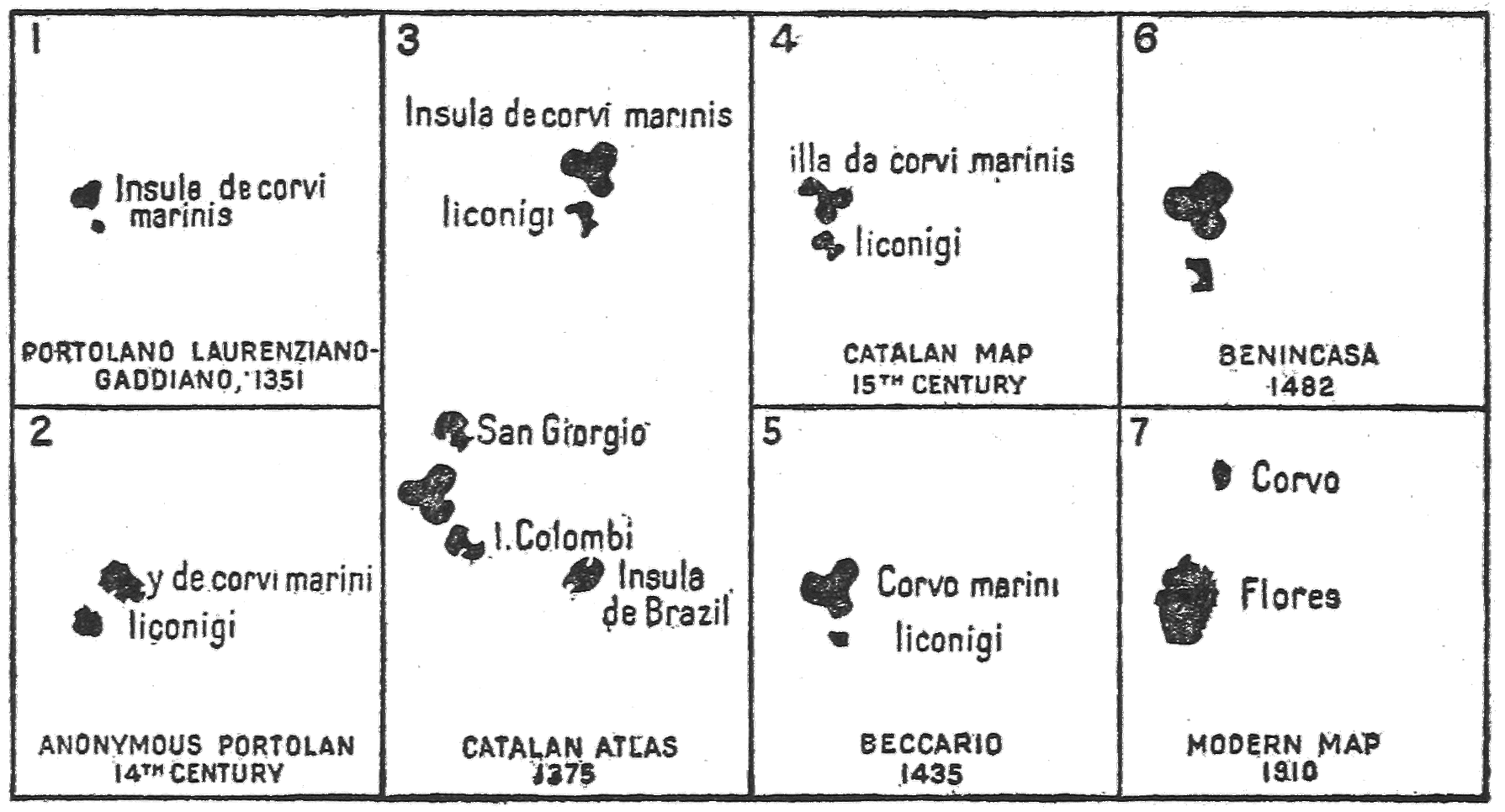
Fig. 23—Representation of Corvo on fourteenth- and fifteenth-century maps as
compared with its present outline. (The sources may be identified from the text.)
173
There is no good reason for discrediting so many of the old
maps. Their makers sometimes went wrong; but they tried to
be accurate and would hardly, through a century or two, persist
in making the northern island the greater one unless it was at
first really so. Of course the most natural solution of the difficulty
is that Corvo’s border has sunk or the sea has risen over it,
completely drowning the territory which made the lobes or
curved outline of the island form in the medieval maps and
leaving only above water its rocky backbone, with the crater for
a nucleus. Apparently those lobes and their contents are just
what might be most profitably dredged for and dived after.
Perhaps the island has not greatly changed since Mr. Henriques
wrote his little sketch of it in the sixth decade of the last century:
The first part of the ride to it [the crater] is through steep and narrow
lanes walled in with stones. Over those walls you can sometimes see the
country right and left, which is divided into small and well-cultivated
compartments by low stone walls. These small fields form narrow terraces,
one above another, looking from the sea like steps in the hills.
An hour’s ride brings you to an open mountain covered with heath where
browse flocks of sheep and hogs, and about an hour and a half more to
the crater on the summit, now a quiet green valley, with a dark, still
pond in the center....
The Corvoites, particularly the women, are a happy and industrious
people and have strong and healthy constitutions. The men in trade
evince a remarkable shrewdness, proverbial among the other Azorians,
but in private life their manners are simple and unassuming....
They are like a large family of little less than a thousand members, all
living in the only village on the island.288
174
CHAPTER XII
THE SUNKEN LAND OF BUSS AND OTHER
PHANTOM ISLANDS
Beside those legendary Atlantic islands that may cast some
light on visits of white men to America before Columbus or have
been at some time linked therewith by speculation or tradition—notably
Antillia and its consorts, Brazil, Man or Mayda, Green
Island, Estotiland and Drogio, the Island or Islands of St.
Brendan, and the Island of the Seven Cities—there are numerous
others, quite a swarm indeed, excusing Ptolemy’s and Edrisi’s
extravagant estimate of 27,000. Sometimes, but not always,
they are of more recent origin and are explainable in various ways.
Several are linked to the idea of volcanic destruction or seismic
engulfment. Of course the colossal and classical instance of
Atlantis comes first into mind, it being the earliest as well as in
every way the most imposing. Most likely the well-known story,
repeated, if not originated, by Plato, developed naturally, as we
have seen, from the insistent need to account for the obstructive
weedy wastes of the Sargasso Sea beyond the Azores and recurrent
facts of minor cataclysms among them.
The next oldest instance, perhaps, is supplied by Ruysch’s map
of 1508,289 an inscription on which avers that an island in the sea
about midway between Iceland and Greenland had been totally
destroyed by combustion in the year 1456. We do not know
his authority for this startling announcement. The spot is where
one would naturally look for Gunnbjörn’s skerries of the older
Icelandic writings; and no one can find them now, unless they
were, after all, but projecting points of the eastern Greenland
coast. Also Iceland is at times tremendously eruptive; and this175
islet, or these islets, would not be far away. The assertion is not
in itself incredible, but there seems no corroboration.
The Discovery of Buss
The “Sunken Island of Buss” presents a suggestion of engulfment
on a more extensive scale. The whole episode is of rather
recent date, Buss being the latest born of mythical or illusory
islands, unless we except Negra’s Rock and other alleged and
unproven apparitions of land on a very small scale, which may
not have wholly ceased even yet. Buss is, at any rate, the one
moderately large phantom map island the time and occasion of
whose origin are securely recorded. For, as narrated by Best and
published in Hakluyt’s compilation, on Frobisher’s third voyage
(1578), one of his vessels, a buss, or small strong fishing craft, of
Bridgewater, named Emmanuel, made the discovery. In his words:
The Buss of Bridgewater, as she came homeward, to the southeastward
of Frisland, discovered a great island in the latitude of 57 degrees
and a half, which was never yet found before, and sailed three days along
the coast, the land seeming to be fruitful, full of woods, and a champaign
country.290
Best must have had his information at second or third hand, with
liberal play of fancy in the final touches on the part of his
informant or himself. His was the first account published, but
not long afterward appeared that of an eyewitness, “Thomas Wiars,
a passenger in the Emmanuel, otherwise called the Busse of
Bridgewater,” repeated in Miller Christy’s admirable little treatise
on the subject.291 Wiars says they fell with Frisland (probably
a part of Greenland) on September 8 and on September 12
reached this new island, coasted it for parts of two days, and
considered it 25 leagues long. There was much ice near it. He
gives no suggestion of fertility, woods, or fields.
176
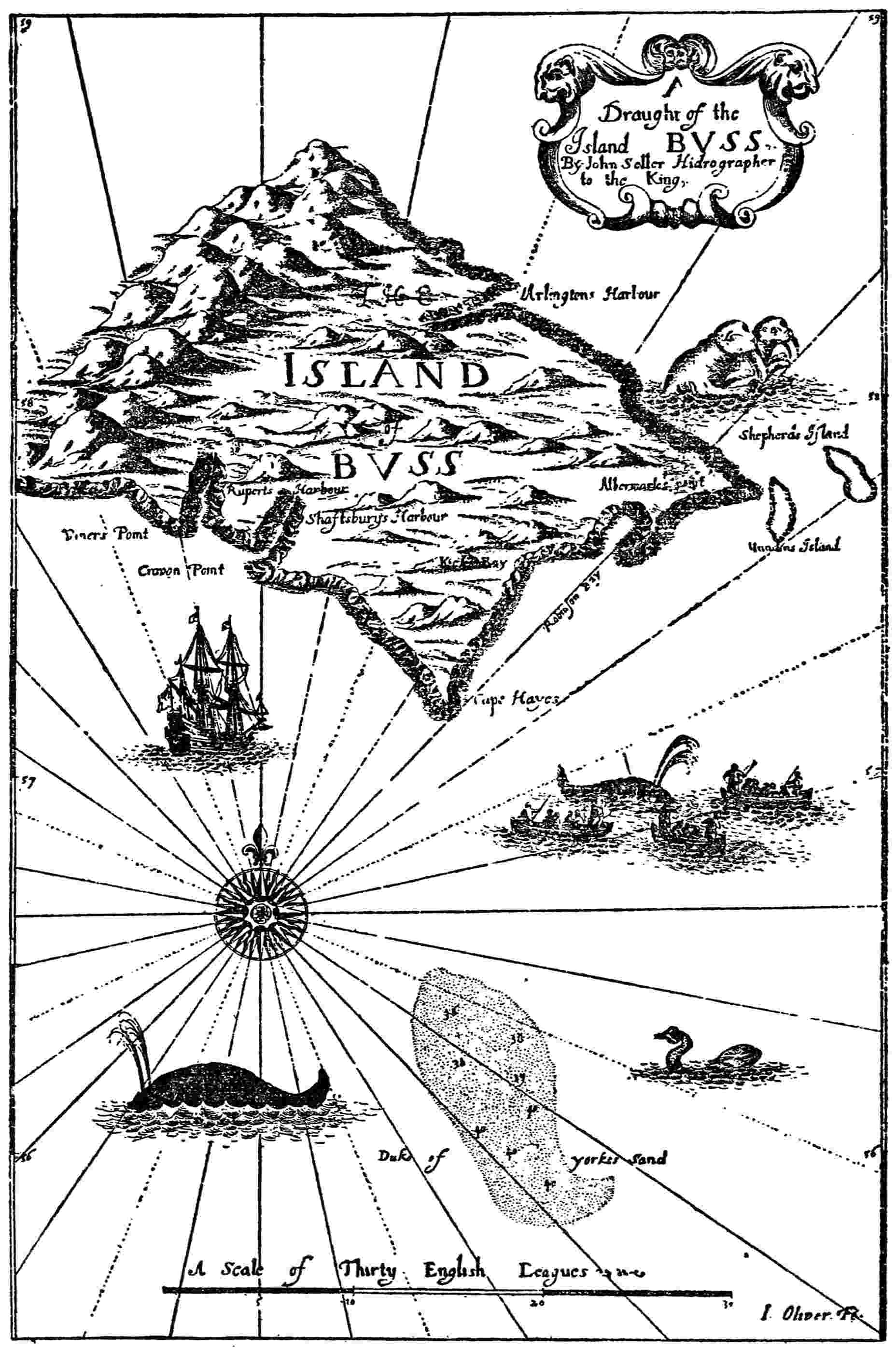
Fig. 24—Map of Buss Island from John Seller’s “English Pilot,” probably 1673.
(After Miller Christy’s photographic facsimile.)
177
Its Disappearance from the Map
The only other witnesses to the visual existence of the island,
so far as recorded, were James Hall (probably by honest mistake)
in 1606 and Thomas Shepherd (gravely distrusted) in 1671.292
Nevertheless an impressive insular figure grew up in the maps,
bearing the name “Buss” to commemorate the vessel that first
found it. In some instances it was made a very large island
indeed. Shepherd’s map, reproduced herewith (Fig. 24), was accompanied
by a brief descriptive narrative which may be attributed
to a fancy for yarning, with no strong curb of conscience
on the fancy. Buss remained an accepted figure of geography for
considerably more than a century.
Quite naturally, however, the efforts of reliable searchers failed
to find this island again, for it was not really there. A theory of
cataclysm seemed more acceptable than to discard outright what
so many maps, books, and traditions had attested. Van Keulen’s
chart of 1745293 led the way with the inscription “The submerged
land of Buss is nowadays nothing but surf a quarter of a mile
long with rough sea. Most likely it was originally the great island
of Frisland.” So the name “Sunken Land of Buss” passed into
general use with geographic sanction. After much disturbance of
mariners’ and cartographers’ minds not only the phantom island
but its legacy, the supposed line of breakers and dangers, vanished
altogether from the records. There is no “Buss” to be found on
maps after about the middle of the nineteenth century, though
the preceding hundred years had been prolific in them. Probably
we must suppose a later date for the cessation of current mention
of the sunken land of that name, in recognition of what, according
to belief, once had been but existed (above water) no longer.
Indeed, even after the opening of this twentieth century the
same hypothesis has revived,294 with scientific support of a178
submarine range in 53° N. and 35° W., really ocean-bottom mountains
8,000 feet high between Ireland and Newfoundland, reported
upon in 1903 by Captain de Carteret of the cable ship
Minia. They are not on the same spot and would still require a
great lift to reach the surface. Of course their past sinking is not
impossible, but there is no need to explain Buss by cataclysm any
more than Mayda or Brazil Island, Drogio or Icaria.
Islands of Demons
Somewhat allied by nature to these reported isles of destruction
and disappearance are the islands of imported diabolism,
appearing on maps now and then through the centuries. Bianco’s
“The Hand of Satan” (1436295; Fig. 25), if correctly translated (see
Ch. X, p. 156), is probably the first to present this quality. He
locates the sinister island well to the southward; but the most
pictorial appearance is Gastaldi’s (for Ramusio) “Island of Demons,”296
with its eager and capering imps at the bleak and savage
northern end of Newfoundland. The preferred site, however,
would seem to be yet a little farther north. Ruysch, in the map
referred to above, which announces the burning up of Gunnbjörn’s
skerries, exhibits two Insulae Demonium near the
middle of the dreaded Ginnungagap passage between Labrador
and Greenland. There is no suggestion of volcanic action in
their case, and it does not appear that any real islands occupied
the spot. The reason for the delineation and the name is still
to seek.
179
The map of 1544, attributed to Sebastian Cabot,297 makes a
single island of them, “marked Y. de Demones”, and brings it
nearer the eastern front of Labrador below Hamilton Inlet.
Agnese298 in the same century enlarges it greatly but still keeps it
just off the Labrador coast. The Ortelius map of 1570299 (Fig. 10)
shows the insular haunt of devils, plural again in form and name,
but retains approximately the site chosen by Cabot. Mercator’s
world map of 1569300 keeps the islands plural beside the upper tip
of Newfoundland, approximating Gastaldi’s position. There180
seems to have been a pronounced and general concurrence of
belief in diabolical evil in the northeastern coast of America,
perhaps because it is there that the Arctic current brings down its
tremendous freight, and tempests are at their wildest, and all
barrenness and bleakness at their worst.

Fig. 25—Section of the Bianco map of 1436 showing the Island of the Hand of
Satan and Antillia. (After Kretschmer’s hand-copied reproduction.)
Saintly Islands
Much farther south, on the lines followed by Columbus and his
Latin successors and in the tracks of vessels plying between the
eastern Atlantic archipelagoes and the West Indies, what may
be considered as a contrary impulse—that of exultant religious
enthusiasm—came into play in island naming. The Island of the
Seven Cities (Ch. V) will be recalled but needs no further
consideration here. St. Anne, La Catholique, St. X, and Incorporado
(in the sense of Christ’s Incarnation) are among the more
conspicuous instances. The second-named was always in low
latitudes. It occurs in the latitude of the tip of Florida, in mid-Atlantic
in the Desceliers map of 1546301 (Fig. 9); also as “La
Catolico” on Portuguese maps, with similar situation. Desceliers
shows Encorporade (Incorporado) about east of Cape Hatteras
and south of western Newfoundland; but he also has Encorporada
Adonda not far from Nova Scotia. Thomas Hood (1592)302 makes
a wild and unenlightened transformation of Incorporado to
“Emperadada” and puts it about opposite the site of Savannah,
but not so far east as the considerable outjutting of the coast
which must be meant for Cape Hatteras and its neighborhood.
However, this location is not very different from that usually
given it. Desceliers has two islands marked St. X, one being in
the longitude of St. Michaels and latitude of Bermuda; the other
in the longitude of eastern Newfoundland and latitude of the
Hudson. In about the same latitude as the latter, and more181
than half way between it and the Azores, an island called St. Anne
is shown. There seems nothing real to prompt the derivation of
these religiously named islands. Perhaps they are merely the offspring
of optical delusion, fancy, and fervor.
Daculi and Bra
On the other side of the Atlantic the much earlier map island
Daculi must be reckoned as of kin to them, since its map legends
deal with beneficent wonder working or magical medical aid, and
its name may be identical with or have originated the saintly one
which still denotes an outlying Hebridean island. Though less
renowned than the island of Brazil and less significant, Daculi
shares with it the record for first appearance of mythical islands
on portolan maps.
Dalorto’s map of 1325303 (Fig. 4) already indicated as the earliest
one of much interest in this special regard, presents many islands
of familiar or unfamiliar names near Ireland and Scotland. Nobody
can mistake the rightly located Man, Bofim, and Brascher
(the Blaskets). Insula Sau must be Skye, though with the outline
of the Kintyre peninsula. Sialand seems to be Shetland.
Tille may be Orkney displaced. Galuaga or Saluaga probably
stands for the main body of the Long Island (Harris, Lewis, etc.)
of the outer Hebrides. Bra is no doubt Barra and has generally
been thus accepted, though out of line with Galuaga and too far
eastward. Brazil, as already reported, is naturally farther at sea
opposite Brascher. Finally our subject for present consideration,
Daculi, lies off the northwestern corner of Ireland, north of
Brazil Island and west of Bra, with which last it has in later maps
a curious legendary association. With Insula de Montonis, as
Brazil is also called on Dalorto’s map, it may be linked in182
another way by their Italian names, for Daculi seems capable
of that derivation, “culla” being “cradle” in that language, plural
“culli,” easily modified to “culi” by careless speech or writing. The
introductory preposition “da” in one use has an especial relation
to nativity; thus Zuan da Napoli means John born at Naples,
that is John of Naples in this sense. The blending of preposition
and noun in one word, “Daculi,” is no more than sometimes happened
on the maps to the article and noun “Li Conigi,” the Rabbit
Island, making it “Liconigi,” now long known as Flores. This
explanation would interpret Daculi as the “Island of the Cradles,”
or “Cradle Island.” Some other derivation may indeed possibly
be as defensible; but it should be borne in mind that Italian
traders ranged very early up and down the Irish coast, and that
name would curiously coincide with the tradition at least afterward
current concerning the island.
To review a few later but still very early maps:—Dulcert, 1339,304
shows some irrelevant changes farther north and east; but his
Hebridean islands repeat very nearly the form given them by
Dalorto (believed by many to be the same man), and there is no
significant change in Bra or Daculi, though the first syllable of
the latter becomes Di.
The Atlante Mediceo, of 1351,305 makes more changes than Dulcert
among these islands and leaves unnamed the one which by
position seems meant for Bra, or Barra. Daculi is largely expanded
and named Insul Dach indistinctly.
The Pizigani map of 1367306 (Fig. 2) modifies many names. Daculi
becomes Insuldacr in one word; but its place remains nearly as in
Dalorto’s map, though most of the other islands are drawn closer
to Ireland, so that Bra is nearly stranded thereon. A line of
inscription seems to relate to Bra—“Ich sont ysula qu—[possibly
pronominal abbreviation] abitabi honõ quõ morit may.” Perhaps183
some of these words should be read differently, and “abitabi”
needs some recasting. I will not attempt to interpret but should
infer that Bra had its troubles. They do not seem to have extended
to Daculi.
Pareto’s fine map of 1455307 (Fig. 21) applies the following more
extended and significant legend to Daculi: “Item est altera insulla
nomine Bra in qua femine que in insulla ipsa habitant non pariuntur
sed quando est eorum tempus pariendi feruntur foras insulla
et ibi pariuntur secundum tempus.” From this we may
gather that the outer island Daculi was believed to afford especial
aid in childbearing to women carried thither after being baffled on
the inner island Bra, and we see readily the appositeness of the
name “cradle” applied to the former. Beccario’s map of 1435308
(Fig. 20), though without the legend, had already adopted in
“Insulla da Culli” almost exactly the form of the name which we
have divined, with apparently that meaning.
St. Kilda seems to me the most plausible original for Daculi
that has been suggested. It is true that Barra is actually south
of the parallel of latitude of that most lonely western sentinel of
the Hebrides, and there is no obvious link of relation between
them. Also the rock islet of North Barra is about as far above it,
equally unconnected and not likely ever to have maintained much
population. But so simple a misunderstanding on the part of the
old cartographers would be no more than what happened to
them all the time, and exact identity of latitude is unimportant.
There is, in fact, no land on the site given Daculi in any of these
old maps; and Bra, as noted, is absurdly out of place for Barra.
How the tradition grew up we do not know. Perhaps it was some
tale picked up by coasting Italian traders, partly misunderstood
and passed on by them to the map-makers at home. St. Kilda,
lost in the mists and mystery of the Atlantic, of holy name and184
miracle-working associations, and out of touch with most tests
of reality, seems a likely place to be linked to some less abnormal
island by a fanciful contribution of saintly white magic, a rumor
originating nobody knows how.
Grocland, Helluland, etc.
On the western side of the Atlantic there are divers instances of
island names given of old—sometimes with considerable changes
of location, area, or outline, or of all three—to regions which we
know quite otherwise. Some of these have been dealt with extensively
already. Greenland has a lesser neighbor, Grocland, on
its western side in divers sixteenth-century maps; which I take to
be a magnified presentation of Disko or possibly a reflection of
Baffin Land brought near. It appears conspicuously in Mercator’s
map of the Polar basin (1569),309 the Hakluyt map of 1587 illustrating
Peter Martyr,310 and the map of Mathias Quadus (1608).311
This is not the place to enlarge on the Helluland, Markland,
and Vinland of the Norsemen beginning with the eleventh
century, as this theme has been dealt with elsewhere.312 But they
were often thought of as islands, as shown by the notice of Adam
of Bremen. Perhaps there was never any great clearness of conception
as to extent or form. But in a general way they may be
identified respectively with northern Labrador, Newfoundland,
and the warmer parts of the Atlantic coast. Great Iceland, or
White Men’s Land, seems also to have been understood as what
we should now call America. Eugène Beauvois located it conjecturally
about the mouth of the St. Lawrence River.313 Dr. Gustav
Storm, on the other hand, thought it was merely Iceland
misunderstood.314
185
Stokafixa
Perhaps the latter explanation is the best yet given of the
mysterious island Scorafixa, or Stokafixa, in Andrea Bianco’s
map of 1436.315 It has sometimes been understood as Newfoundland,
which bore long afterward the name Bacalaos, the equivalent
in a different tongue of the northern “stockfish,” our codfish.
But it would naturally be freely applied to any island in rather
high latitudes which was conspicuous for that fishery, and Stokafixa
seems near of kin to Fixlanda, which figures on divers maps
as a combined suggestion of Iceland and the imaginary Frisland
but with geographical features mainly borrowed from the former.
The first-named identification may be tempting as establishing
another pre-Columbian discovery of America, but it quite lacks
corroboration; and Iceland was a great center of codfishery, distributing
its name and attributes rather liberally in legend and
on the maps. Humboldt incidentally mentions “l’île des Morues
(île de Stockfisch, Stokafixa)” on the seventh map of the atlas of
Bianco, 1436. I do not clearly make out the name on T. Fischer’s
facsimile reproduction;316 but from position and appearance the
island seems meant for Iceland.
Other Map Islands in the Northwestern Atlantic
The Grand Banks and other banks of Newfoundland, with the
Virgin Rocks and perhaps other piles or pinnacles rising from that
bed nearly to the surface so as to be uncovered in some tides;
Sable Island, a rather long way offshore; Cape Breton Island and
fragments of the main shore—may be held responsible for some
map islands such as Arredonda and Dobreton, Jacquet I.,
Monte Christo, I. de Juan, and Juan de Sampo.
186
There are still other islands mostly north of the latitude of
Bermuda and between it and the Azores or northeastern America,
but far at sea, of which one can make little, except as probably
complimenting some pilot, skipper, or other individual, or commemorating
some incident which has nevertheless been generally
forgotten. Thus Negra’s Rock, which has hardly ceased to appear
on the maps, does not really exist but may keep us in mind, by its
rather sinister and mythical sound, that a certain Captain Negra
once thought he saw something solid in the great liquid and reported
accordingly. Of such origin, perhaps, are I. de Garcia,
Y Neufre, Y d’Hyanestienne, Lasciennes, and divers others scattered
over various maps and offering no promise of reward for
hunting down their pedigrees or history. All these distinctly post-Columbian
islands are quite too recent and casual to throw any
light on the earlier historically and geographically significant
“mythical islands” or on what these reveal.
It seems neither practicable nor desirable to recapitulate
minutely in this final chapter the rather numerous distinctive
features of the present work; but attention may properly be
directed to some of its salient conclusions. In stating them positively
as below, here or elsewhere, I do not mean to be offensively
dogmatic but to present concisely my own deductions from evidence
which I have been at some pains to gather.
Atlantis was a creation of philosophic romance, incited and
aided by miscellaneous data out of history, tradition, and known
physical phenomena, especially by rumors of the weed-encumbered
windless dead waters of the Sargasso Sea. There never was
any such gorgeous and dominant Atlantic power as the Atlantis
of Plato, able to overrun and conquer more than half of the
Mediterranean and contend with Athens in a struggle of life and
death.
St. Brendan did not cross the Atlantic nor discover any island
in its remoter reaches, where some maps show islands bearing his
name. He seems, however, to have visited divers eastern Atlantic
islands, now well known; and it is quite likely that most of the
portolan maps of the fourteenth and early fifteenth centuries are
right in linking his name especially to Madeira and her neighbors.
Brazil Island is a conspicuously complex problem. Probably it
represents the region around the Gulf of St. Lawrence, brought
on the same parallel unduly near the Irish shore. Thus understood,
it would be, presumably, but not necessarily, the cartographic
record of some early Irish voyage far to the westward.
It does not appear on any extant map before 1325, but maps
showing the Atlantic and its remoter islands (apart from the
hopeless distortions of Edrisi and certain monks) can hardly be
said to have existed earlier.
188
Man, or Mayda, is frequently a more southern and western
companion of Brazil Island on the old maps and may stand for
Bermuda or for some jutting point, like Cape Cod, on the
American coast. Some indications connect it with the Bretons,
some with the Arabs. It has borne divers names. We cannot tell
who first found and reported it.
The Island of the Seven Cities derived its name from a very
credible Spanish and Portuguese tradition of escape from the
Moors by sea early in the eighth century. It may first have been
localized as St. Michaels of the Azores, where a valley still bears
the name. Afterward it was confused for a long time with Antillia
and still later was distributed rather widely over sea and land, the
Seven Cities not always insisting on being insular but appearing
now just back of the American Atlantic coast line, now in the far
and arid Southwest.
Of the Norse discoveries in America at the opening of the
eleventh century, Helluland represents the northern treeless waste
of upper Labrador and beyond; Markland represents the forested
zone next below, notably Newfoundland, with probably southern
Labrador supplying only timber and game; and Vinland, or
Wineland, represents all that immense region where the climate
was milder and wine grapes grew. Straumey was Grand Manan
Island; Straumfiord, Passamaquoddy Bay with Grand Manan
Channel; Hop, Mount Hope Bay, R. I., or some bay of the
eastern front of southern New England; the Wonderstrands,
some part of the prevalent American coastal front of unending
strand and dune. It is needless to particularize further.
Antillia is Cuba; Reylla, Jamaica; Salvagio, or Satanaxio,
Florida; I in Mar, one or more of the Bahamas. Early in the
fifteenth century some Iberian navigator, probably Portuguese,
visited these islands and made the report that resulted in the
addition of these islands to divers maps. They, in turn, were
among the inciting causes of the undertaking of Columbus.
- Adam of Bremen, 106;
- on Greenland, 94
- Anghiera. See Martyr, Peter
- Animal and bird names, 44
- Antela, 149
- Antiglia, map opp. 74, 75, 147
- Antilles, 144;
- identity with Antillia, 162
- Antillia, 188;
- as an early map item, 144;
- Atlantis and, 148;
- on Beccario map of 1426, 151;
- on Beccario map of 1435, 70, 151;
- on Benincasa map of 1482, 70, 159;
- on Bianco map of 1436, 156;
- Humboldt’s hypothesis of origin of name, 148;
- identity with the Antilles, 162;
- on Laon globe of 1493, 161;
- of the mainland, 147;
- Martyr’s (Peter) identification, 145;
- origin of the name, 148;
- other identifications, 146;
- on Pareto map of 1455, 157;
- on Roselli map of 1468, 155;
- on Ruysch map of 1508, 145;
- Seven Cities (island) and, 69, 188;
- spelling of the word, 146;
- unmentioned on certain notable maps, 161;
- on Weimar map, 150, 159
- Arctic monastery, 136–137, 138
- Ari Frode, 101
- Arna-Magnaean MS. No. 194, 116, 119
- Arna-Magnaean MS. No. 557, on Markland, 115
- Athens and Atlantis, 1, 33
- Atlantic continental mass, theory of Termier, 19
- Atlantic submarine banks, 24
- Atlantis, Antillia and, 148;
- improbability of existence, 18;
- invasion of the Mediterranean, 16;
- location and size, 17;
- Plato’s account, 3, 11, 32, 187;
- Sargasso Sea as, 29;
- submergence, question of, 22;
- Termier on, 14
- Avezac, M. A. P. d’, 8, 114
- Avienus, 27
- Ayala, Pedro de, 65, 68
- Azores, description, 164;
- floral and faunal indications of mainland connection, 21;
- Mayda and, 92;
- names of islands, 21;
- occurrence of name “Seven Cities” in, 78;
- two series on Bianco map of 1448, 122
- Babcock, W. H., “Early Norse Visits,” 6, 115, 172, 184;
- “Indications of Visits,” 46, 57, 71, 86, 150
- Baffin Land, 111, 184
- Bahamas, 155, 163, 188
- Barra, 181, 183
- Basques, 8
- Beauvois, Eugène, 131, 184
- Beccario map of 1426, Antillia on, 151;
- reproduction of a photographed section (ill.), opp. 45;
- St. Brendan’s Islands on, 45
- Beccario map of 1435, Antilles, four islands, on, 153;
- Antillia on, 70, 151, 153;
- Daculi on, 183;
- reproduction of section (ill.), 152
- Behaim globe of 1492, St. Brendan’s Islands on, 47
- Benedict, R. D., 38
- Benincasa map of 1482, Antillia on, 70, 159;
- reproduction of section (ill.), 160
- Beothuks, 123, 131
- Bermuda and Mayda, 93, 188
- Bianco map of 1436, Antillia on, 156;
- reproduction of section (ill.), 179;
- Stokafixa on, 185
- Bianco map of 1448, St. Brendan’s Islands on, 46;
- two series of Azores, 122
- Bimini (Beimini), 146
- Bird names, 44
- Birds, isle of, 166
- Blaskets, 181
- Blunt, E. M., 91
- Boid, Captain, 170
- Book of the Spanish Friar, 44, 55, 92, 165;
- on the Azores, 165
- Bourne, E. G., 55
- Bra, 181
- Brazil (island), on Catalan map of 1375, 58;
- on Catalan map of about 1480, 61;
- on Dalorto map of 1325, 50, 56, 121;
- early maps, occurrence, 55;
- location and shape, 57;
- in place of Markland, 121;
- Mayda and, 83;
- on Nicolay map of 1560, 61, 121;
- Norse and Irish omission of name, 66;
- St. Lawrence, Gulf of, and, 59, 187;
- 192Seven Cities (island) and, 68;
- on Sylvanus map of 1511, 65;
- two on the same map, 121–122
- Brazil (word), derivation, 50, 52;
- spellings, 50;
- various applications, 121
- Brendan (Brandan; Brenainn), St., adventures, Lismore version, 34;
- explanations of Brendan narratives, 35;
- exploration, 34, 48, 187;
- probable basis of fact in narratives, 38
- Brendan’s (St.) Islands, 34;
- on Beccario map of 1426, 45;
- on Behaim globe of 1492, 47;
- on Bianco map of 1448, 46;
- on Dulcert map of 1339, 42;
- Hereford map testimony, 38;
- on later maps, 48;
- on the Pizigani map of 1367, 43
- Bretons, exploration, 8, 84
- Brown, A. S., 78
- Buache, N., 78
- Bullar, Joseph and Henry, 79
- Buss Island, 174, disappearance from map, 177;
- discovery, 175;
- map (ill.), 176
- Cabot, John, 10, 55
- Canary Islands, mainland connection, question of, 21;
- tradition concerning St. Brendan, 39
- Canerio map, 146
- Cape Breton, 118–119, 127, 132, 135, 185;
- Mayda and, 92, 93
- Cape Cod, Mayda and, 92, 188
- Capmany, Antonio de, 54
- Carthaginians, Corvo and, 167;
- statues and coins, 169
- Cartier, Jacques, 59
- Cartwright, George, 123
- Catalan map of 1375, Brazil (island) on, 58;
- Mayda on, 84;
- reproduction (ill.), 58
- Catalan map of about 1480, Brazil (island) on, 61;
- Fixlanda (Iceland) on, 141;
- Greenland on, 62, 96, 120;
- reproduction of section (ill.), 64
- Catholique, La, 180
- Cerne, 27
- Chau Ju-Kua, 2
- Chesapeake Bay, 119
- Christy, Miller, 175, 176, 177
- Churchill Collection, 140
- Clavus map of 1427, Greenland on, 105, 139;
- reproduction of section (ill.), 104
- Coins found in Corvo, 167
- Columbus, Christopher, 10
- Columbus, Ferdinand, “Life of Christopher Columbus,” 69, 71, 140, 144
- Conigi, Li, 8, 165, 172, 182
- Coombs, Captain, 100
- Coppo map of 1528, Greenland on, 96;
- reproduction (ill.), 97
- Corvo, 22;
- ancient memorials, 166;
- comparative representations on maps (ill.), 172;
- equestrian statues, 168;
- Mayda and, 92;
- origin of name, 164;
- Pizigani map of 1367 and, 168
- Cuba, 153, 162, 163, 188
- Daculi, 181;
- on Pareto map of 1455, 183
- Dalorto map of 1325, Brazil (island) on, 50, 56, 121;
- mythical islands on, 181;
- reproduction (ill.), 51
- Dawson, S. E., 48
- Demons, 37, 89;
- islands of, 178
- Desceliers map of 1546, Greenland on, 99;
- Mayda on, 87;
- reproduction of section (ill.), 76;
- saintly islands on, 180;
- Seven Cities (island) on, 75
- Devil Rock, 91
- Diodorus Siculus, 1, 4, 16, 42, 166
- Disko, 184
- Dragons, 37, 83, 149
- Drogio, first mention, 124, 127;
- meaning, 133;
- region designated, 132;
- spelling, 132;
- on Zeno map of 1558, 126
- Dulcert map of 1339, St. Brendan’s Islands on, 42
- Edrisi, “Geography,” 7, 39, 166, 168;
- on the isle of birds, 166
- Egerton MS. 2803. See World map in portolan atlas of about 1508
- Emmanuel (ship), 175
- Emperadada, Encorporada, Encorporade (Incorporado), 180
- Equestrian statues, 168
- Eric the Red, 101, 108, 109, 115
- Eskimos, 110, 111
- Espinosa, Alonso de, 39
- Esthlanda, 131
- Estotiland, 122; derivation, conjectures, 130;
- first mention, 124, 127;
- on Prunes map of 1553, 131;
- region designated, 130;
- on Zeno map of 1558, 126
- 193Estotilanders, 131
- Faria y Sousa, Manuel de, 73;
- on Corvo, 169
- Fischer, Joseph, 61, 105, 116, 139
- Fischer, Theobald, 44, 45, 46, 47, 56, 57, 84, 86, 92, 114, 122, 147, 161, 165, 172, 182, 185
- Fixlanda, 96, 185;
- on Catalan map of 1480, 141
- Flores, 8, 171, 172, 182
- Florida, 146, 155, 163, 188
- Formaleoni, Vicenzio, 148
- Fortunate Islands, 38, 39.
- See also Brendan’s (St.) Islands
- Freducci, Conde, 150
- Frisland, 136, 175, 185;
- Buss Island and, 177;
- confusion with Iceland, 141;
- occurrence of name, 140;
- on Zeno map of 1558, 141
- Galvano, Antonio, 72
- Germain, Louis, 21
- Germanus, Donnus Nicolaus, world map (after 1466), Greenland on, 105, 139;
- reproduction of section (ill.), opp. 105
- Ginnungagap, 178
- Gnupsson, Eric, 109
- Gosch, C. C. A., 175
- Grand Banks, 185
- Grand Manan, 188
- Great Abaco, 155, 162–163
- Great Iceland, 184
- Greeks, early exploration, 4
- Green Island, 95;
- on sixteenth-century maps, 97;
- various islands;
- shrinkage of the name, 99
- Greenland, Adam of Bremen’s account, 94;
- on Catalan map of about 1480, 62, 96, 120;
- on Clavus map of 1427, 105, 139;
- on Coppo map of 1528, 96;
- on Desceliers map of 1546, 99;
- on Germanus (D. N.) map, 105, 139;
- insular character, 95;
- intercourse with Markland, 119;
- life of Icelandic colony, 106;
- on Nicolay map of 1560, 98;
- Norse settlements, 137;
- Norse settlements (with map), 103;
- origin of name, 101;
- on Ortelius map of 1570, 99;
- as a peninsula, 105;
- on Sigurdr Stefánsson map, 106;
- Thorláksson map of 1606 (ill.), 98;
- on Zeno map of 1558, 105, 139
- Greenlanders, early explorations, 109
- Grocland, 184
- Gunnbjörn’s skerries, 174
- Haiti, 162
- Hall, James, 177
- Hand of Satan, 156, 178
- Hardiman, James, 50
- Harrisse, Henry, 144
- Hauk’s Book on Markland, 114
- Hebrides, 181, 182, 183
- Helluland, 115, 116, 188
- Henriques, Borges de F., 171, 173
- Hereford map of 1275, St. Brendan’s Islands on, 38
- Himilco, 27
- Holmes, W. H., 3
- Hood, Thomas, 180
- Hovgaard, William, on Icelandic settlement of Greenland, 102, 109, 110, 115, 116;
- suggestion of two Winelands, 119
- Humboldt, Alexander von, on Antillia, 148;
- on Bianco map of 1436, 157;
- on Corvo, 167;
- “Examen critique,” 37, 52, 55, 78, 81, 148, 167, 169, 185
- Hydrographic Office, 30, 31, 32
- I in Mar, 155, 188
- Icaria, 136;
- on Zeno map of 1558, 142
- Iceland, confusion on maps, 141;
- Great Iceland, 184;
- Greenland discovery and relations, 101;
- on Zeno map of 1558, 141
- Illa Verde, 96.
- See also Greenland
- Imagination in cartography, 143
- Incorporado, 180
- Ireland, submerged lands about, 25
- Irish sea-roving, 5
- Island of the Seven Cities. See Seven Cities (island)
- Islands, cataclysms, 174;
- mythical and scattered, 174
- Italians, exploration, 8
- Jamaica, 163, 188
- Janvier, T. A., 30
- Jomard, E. F., 8, 30, 43, 55, 70, 83, 147, 149, 166, 179, 182
- Jónsson, Finnur, 102–103
- Jowett, Benjamin, 11, 18
- Karlsefni, Thorfinn, 109, 115, 116;
- geography of narrative and later records, 117
- Kilda, St., 142, 183
- Kjalarness, 116, 118
- 194Kohl, J. G., 139
- Kohl collection, 57, 85
- Krakens, 149
- Kretschmer, Konrad, 45, 48, 57, 58, 60, 61, 69, 70, 75, 82, 84, 86, 87, 96, 97, 98, 99, 105, 114, 117, 121, 131, 132, 140, 146, 157, 159, 162, 172, 178, 179, 180, 183
- Krümmel, Otto, 30
- Kunstmann, Friedrich, 146, 180
- Labrador as Markland, 117
- La Catholique, 180
- La Man Satanaxio, 156, 178
- Laon globe of 1493, Antillia on, 161
- Legname, 8, 114
- Leif Ericsson, 109
- Li Conigi, 8, 165, 172, 182
- Lismore, Book of, 34
- Lucas, F. W., 122, 125;
- on Drogio, 133;
- on the Zeno narrative, 137, 138
- Madeira Islands, as the Fortunate Islands of St. Brendan, 42;
- name, 44, 114
- Magnaghi, Alberto, 50, 69, 121, 181
- Major, R. H., 122, 124, 129;
- study of the Zeno narrative, 136
- Malte-Brun, Conrad, 167
- Man or Mam, 83. See also Mayda
- Maps (ills.), Beccario of 1426, opp. 45;
- Beccario of 1435, 152;
- Benincasa of 1482, 160;
- Bianco of 1436, 179;
- Buss Island of 1673, 176;
- Catalan of 1375, 58;
- Catalan of about 1480, 64;
- Clavus of 1427, 104;
- Coppo of 1528, 97;
- Corvo representations, 172;
- Dalorto of 1325, 51;
- Desceliers of 1546, 76;
- Egerton MS. 2803, opp. 74;
- Germanus (D. N.), after 1466, opp. 105;
- Greenland, Norse settlements, 103;
- Nicolay of 1560, 62;
- Ortelius of 1570, 77;
- Pareto of 1455, 158;
- Pizigani of 1367, 40–41;
- Ptolemy of 1513, 82;
- Prunes of 1553, 88;
- Sargasso Sea, 28;
- Stefánsson of 1590, 107;
- Thorláksson of 1606, 98;
- Zeno of 1558, 126
- Marco Polo, 53
- Markland, Brazil (island) in place of, 121;
- Hauk’s Book account, 114;
- intercourse with Greenland, 119;
- Labrador as, 117;
- name, 114;
- Newfoundland as, 114, 188;
- Nova Scotia as, 118;
- on Sigurdr Stefánsson map, 116;
- Zeno narrative and, 122
- Martyr, Peter, d’Anghiera, “Decades,” 145;
- identification of Antillia, 145
- Mayda, Azores and, 92;
- basis of fact about, 91, 188;
- Brazil (island) and, 83;
- on Catalan map of 1375, 84;
- “Man” and, 84;
- modern maps, persistence on, 90;
- name, spelling and origin, 81;
- on Ortelius map of 1570, 90;
- on Pizigani map of 1367, 83;
- on Prunes map of 1553, 87;
- problem of, 81;
- on Ptolemy map of 1513, 82;
- transference, on maps, to American waters, 87;
- Vlaenderen and, 89
- Mediterranean Sea, Atlantean invasion, 16
- Mercator, Gerhard, world map of 1569, 125, 179, 184
- Miller, Konrad, 39
- Minia (ship), 178
- Monastery in the Arctic, 136–137, 138
- Montonis, 56, 181
- Moorish voyages, 7
- Morewood, S., 168
- Mount Hope Bay, 188
- Muratori, L. A., 53
- Murray, Sir John, 24;
- on the Sargasso Sea, 31
- Murray, Sir John, and R. E. Peake, 177–178
- Nansen, Fridtjof, 27, 29, 60, 61, 94, 101, 117
- Navarro, L. F., 22
- Navigation, early obstruction, 27
- Negra’s Rock, 90, 91, 175, 186
- Neome (Fair Island), 136, 140
- Newfoundland, 185; as Markland, 114, 117;
- on Nicolay map of 1560, 132
- Nicolay map of 1560, Brazil (island) on, 61, 121;
- Greenland on, 98;
- Mayda on, 87;
- Newfoundland on, 132;
- reproduction of section (ill.), 62
- Nordenskiöld, A. E., on Antillia, 144;
- “Bidrag,” 61, 96, 120, 139, 141;
- “Facsimile-Atlas,” 1, 48, 71, 75, 90, 99, 105, 125, 145, 161, 174, 179, 184;
- “Periplus,” 27, 42, 56, 57, 58, 60, 61,69, 84, 85, 86, 87, 89, 98, 114, 121, 132, 139, 145, 150, 156, 165, 172, 178, 182;
- on the Weimar map, 150
- Norsemen, early exploration, 5;
- early settlements in Greenland, 103 (with map), 137;
- Eskimos and, 111
- 195Nova Scotia as Markland, 118
- Olsen, J. E., 55
- Ortelius map of 1570, demon islands on, 179;
- Greenland on, 99;
- Mayda on, 90;
- reproduction of section (ill.), 77;
- Seven Cities (island) on, 75;
- Zeno additions on, 125
- Pareto map of 1455, Antillia on, 157;
- Daculi on, 183;
- reproduction of section (ill.), 158
- Payne, E. J., 175
- Perseus, 16, 17
- Peter Martyr. See Martyr, Peter
- Phoenicians, Corvo and, 167;
- early explorations, 1, 3
- Pizigani map of 1367, Corvo and, 168;
- Daculi and Bra on, 182;
- Mayda on, 83;
- reproduction (ill.), 40–41;
- St. Brendan’s Islands on, 43
- Plato on Atlantis, 3, 11, 32, 187
- Podolyn, Johan, 167
- Poole, H. S., 177
- Porlanda (Pomona), 136, 140
- Porto Rico, 162
- Porto Santo, 43
- Portuguese discovery, 9;
- refugees and Seven Cities island, 71
- Promontorium Vinlandiae, 118, 119
- Prunes map of 1553, Estotiland on, 131;
- Mayda on, 87;
- reproduction of section (ill.), 88;
- Zeno islands on, 140
- Ptolemy map of 1513, Mayda on, 82;
- reproduction of section (ill.), 82
- Ravenstein, E. G., 47, 71, 105, 145
- Reeves, A. M., 115, 116, 131
- Reylla, 188;
- on Beccario map of 1435, 154;
- on Roselli map of 1468, 155
- Rink, Henry, on Greenland, 102, 104
- Robert, M., 90
- Rockall, 91, 100
- Rocks, sunken, 91, 100
- Romans, early exploration, 5
- Roselli map of 1468, Antillia on, 155
- Runic inscription in Greenland, 109–110
- Ruysch map of 1508, Antillia inscription, 145;
- island destroyed by combustion, 174
- St. Anne, 180, 181
- St. Brendan. See Brendan
- St. Kilda, 142, 183
- St. Lawrence, Gulf of, possible identification of Brazil (island) with, 59
- St. Michael, (Azores), 78, 168, 169, 188
- St. X, 180
- Saintly islands, 180
- Salvagio, 188;
- on Beccario map of 1435, 154
- Santarem, M. F., 52, 140
- Sargasso Sea, 3, 18, 187;
- as Atlantis, 29;
- map (ill.), 28
- Satanaxio, 156, 178, 188
- Scandinavians. See Norsemen
- Scharff, R. F., 21
- Schott, Gerhard, 30
- Schuchert, Charles, 23
- Schuller, Rudolph, 13
- Scorafixa, 185
- Scylax of Caryanda, 27
- Seller, John, 176
- Seven Cities (island), 68, 188;
- Antillia and, 69;
- Brazil (island) and, 68;
- on Desceliers map of 1546, 75;
- home of Portuguese refugees, 71;
- later reappearance as an island, 75;
- mainland location, 74;
- name in the Azores, 78;
- on Ortelius map of 1570, 75
- Shepherd, Thomas, 177
- Shetland, 131, 181
- Ships, early, 2
- Skraelings, 111
- Solberg, T., 57, 161
- Soley, J. C., 30, 31
- Spanish Friar. See Book of the Spanish Friar
- Stefánsson (Sigurdr) map of 1590 (?), Greenland on, 106;
- Helluland, Markland, and Vinland on, 116;
- reproduction (ill.), 107
- Stevens, John, 73
- Stevenson, E. L., “Atlas of Portolan Charts,” 74, 141, 147;
- “Facsimiles of Portolan Charts,” 57, 86, 155;
- “Maps Illustrating Early Discovery,” 117, 140;
- “Marine World Chart of Nicolo de Canerio Jannensis,” 146;
- “Portolan Charts,” 27
- Stokafixa, 185
- Stokes, Whitley, 34
- Storm, Gustav, 111, 184
- Strabo, 42, 169
- Straumey, 188
- Straumfiord, 188
- Submarine banks, 24
- 196Sylvanus map of 1511, Brazil (island) on, 65
- Tachylyte, 23
- Termier, Pierre, on Atlantis, 14;
- theory of ancient Atlantic continent, 19, 21, 23
- Thevet, André, 169
- Thorláksson map of 1606, reproduction (ill.), 98
- Tobago, 99
- Torfaeus’ “Gronlandia,” 96–97, 98, 106, 107, 116
- Toscanelli, Paolo, 69, 144
- Trouvères, 36
- Tulloch, Captain, 100
- Uzielli, Gustavo, 45, 57, 70, 86, 151, 172, 183
- Valsequa map of 1439, 57
- Van Keulen’s chart of 1795, 177
- Vespucius, 10
- Vignaud, Henry, “Columbian Tradition,” 10;
- on the Toscanelli letter, 144
- Vinland, 188;
- Hovgaard’s suggestion, 119
- Vlaenderen and Mayda, 89
- Weare, G. E., 68
- Weimar map (after 1481), Antillia on, 150, 159
- Westropp, T. J., “Brasil,” 26, 34, 36, 60, 61, 96;
- “Early Italian maps,” 54;
- on submerged lands near Iceland, 25
- Wiars, Thomas, 175
- Wineland the Good, 116. See also Vinland
- Winsor, Justin, 59, 60, 65, 85, 89, 132, 178
- Wonderstrands, 116, 188
- World map in portolan atlas of about 1508, Antiglia on, 147;
- Iceland on, 141;
- reproduction of section (ill.), opp. 74;
- Seven Cities (island) on, 74
- Yule, Sir Henry, 53
- Zaltieri map of 1566, 61, 87, 98, 132
- Zeno, Antonio and Nicolò, 9, 124
- Zeno, Nicolò, the younger, 124, 134, 135, 143
- Zeno map of 1558, Finland and Iceland on, 141;
- Greenland on, 105, 139;
- Icaria on, 142;
- reproduction (ill.), 126
- Zeno narrative, account of the book, 124;
- brief summary, 135;
- discrepancies of the fisherman’s story, 133;
- geographical implication, 129;
- Lucas’ study, 137;
- Major’s study, 136;
- Markland and, 122;
- narrative quoted, 128
Transcriber’s Note
Punctuation, hyphenation, and spelling were made
consistent when a predominant preference was found
in the original book; otherwise they were not changed.
Simple typographical errors were corrected; unpaired
quotation marks were remedied when the change was
obvious, and otherwise left unpaired.
Footnotes originally were at the bottoms of pages. Here, they are just
before the Index.
Illustrations in this eBook have been positioned
between paragraphs and outside quotations. In versions
of this eBook that support hyperlinks, the page
references in the List of Illustrations lead to the
corresponding illustrations.
The text in some maps is in different orientations,
and sometimes indecipherable. Transcriber could not
determine the correct orientation of the map in Fig. 7,
and chose one that made some of the larger words
upright.
The index was not checked for proper alphabetization
or correct page references. Redundant hemi-title
“Index” removed by Transcriber.
*** END OF THE PROJECT GUTENBERG EBOOK 65103 ***
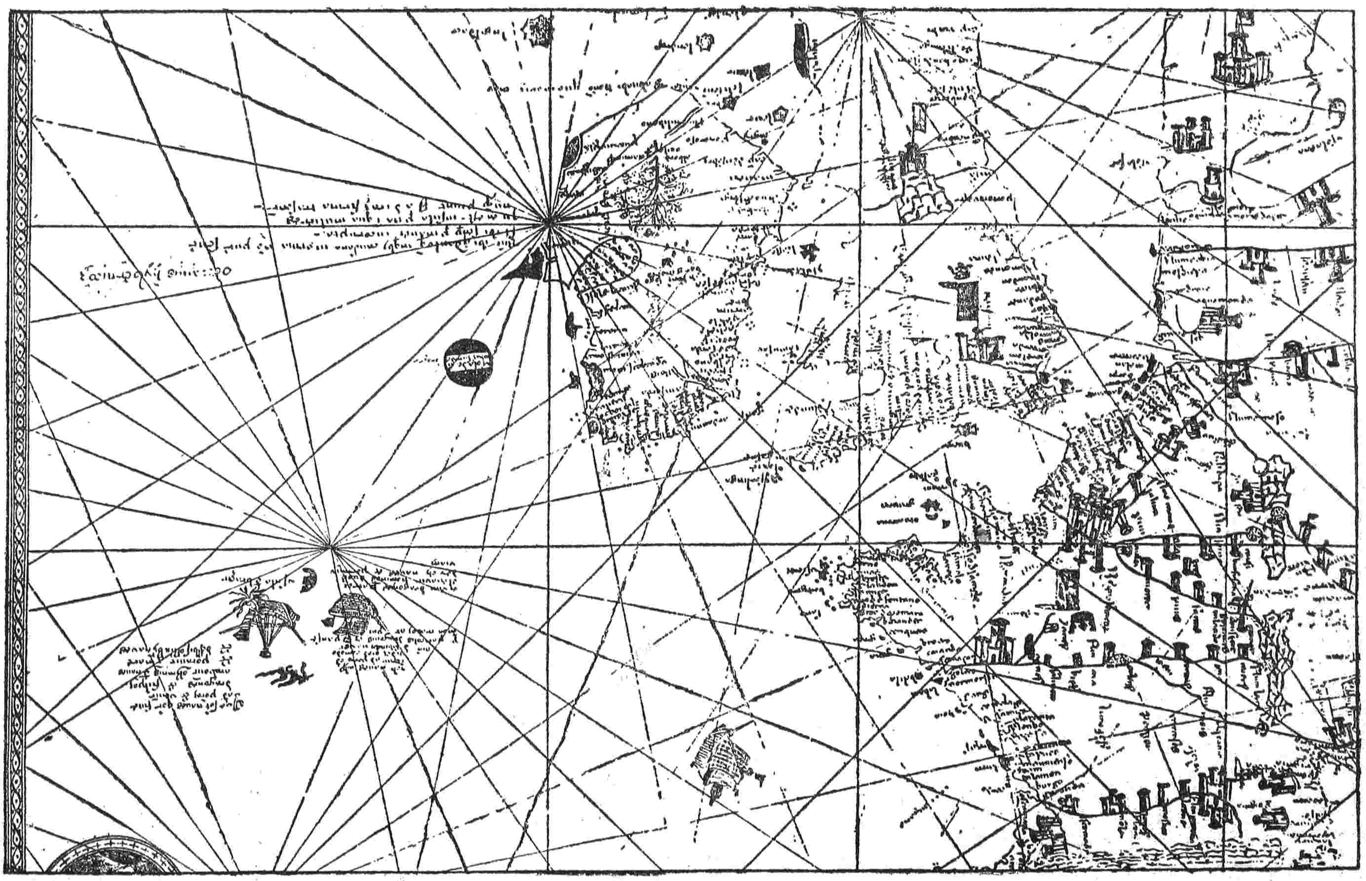
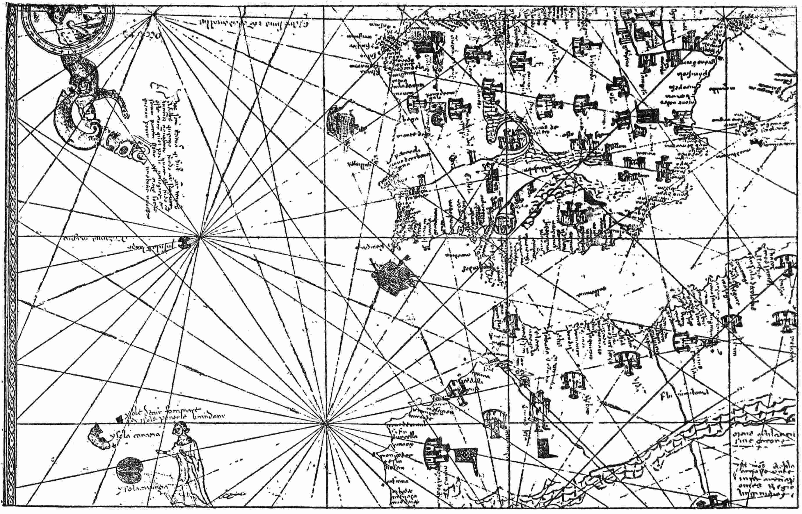