
THE articles comprehended in the present volumes were written at very long intervals of time, some half a century ago, and printed in the Transactions of various Societies in different and distant counties. Many also appeared in the Builder newspaper. Each paper was intended to be complete in itself, and was written with no expectation that they would ever be collected and reprinted as one work. This I mention to account for, and I hope in some degree to excuse, the occasioned iteration of certain views concerning the connexion between the banks and earthworks, the moated mounds of the ninth century, and the buildings in masonry afterwards placed upon them,—which the Author was the first to set forth, and which are explained at length in the Introduction.
The latter and greater part of the work is occupied by minute, and, it is hoped, generally accurate accounts of most of the principal castles of England, and of one or two of a typical character in France and Scotland. The account of Caerphilly was drawn up in 1834. It was, I believe, the first attempt to treat, in a scientific and accurate manner, the plans and details of a great mediæval fortress.
My cordial thanks are due to the editors of the various Archæological Journals in which the original papers appeared, and especially to the late editor of the Builder, Mr. Godwin. I have also especially to thank an old friend and school-fellow, Mr. Murray, of Albemarle Street, for leave to reprint the paper on the Tower of London, and for the use of theviii woodcuts with which he so liberally embellished the original in his “Old London.”
To Mr. Freeman my obligations are of a different and less personal character. Other historians have visited the scenes of events which they were about to describe, but no one has shown himself so familiar with the ancient divisions, civil, ecclesiastical, and military, of English ground, and with the buildings connected with them. His accomplishments as a topographer and as a master of mediæval architecture are peculiar to himself among historians, and materials which in their original form are dry and uninstructive give, in his hands, weight and substance to some of his most brilliant sketches. As a collector of some of these materials, I have often felt surprise and delight at the use to which they have been applied; and, although my work has been rather that of a quarryman or brickmaker, I am sometimes led almost to regard myself as sharing in the glory of the architect.
THE art of construction in Europe from the fall of the Roman empire to the dawn of the Reformation, though of late years much and successfully investigated, has been approached almost exclusively from its ecclesiastical side. This was, for many reasons, to be expected. The service of the altar justified, perhaps required, the highest degree of taste in the design of the temple, and the utmost richness in its ornamentation. Moreover, the greater number of our ecclesiastical buildings are still in use, and even the remains of those that are in decay, being chiefly monastic, are interesting from the intimate connexion of their foundations and endowments with early piety and learning, and from the evidence supplied by their records of the descent of landed property and of the ancestry of the older historic families of the country.
The coëval military structures exhibit, generally, no such splendours of design or excellence of execution, nor do they awaken such sympathies in our breasts. The parish church is the common concern of all who worship within its walls, or whose dead are laid within its sacred precinct; but the castle, always a dangerous and unpopular neighbour, and often associated with local tyranny or the disasters of war, was in most instances ruined or swept away with the general use of gunpowder, and even where preserved, its narrow dimensions and inconvenient arrangements, particulars more or less essential to its value as a place of defence, rendered it, except in a few instances, unfit for a modern residence, and have thus tended to sever it still more completely from the current sympathies and interests of humanity. Nevertheless, there is in these structures, obsolete as they are, or because they are obsolete,2 much to attract those who care to know of the life and customs of former generations. Many of these buildings were the work and residence of persons who have left their mark upon the history of our country. Some, as York, Lincoln, Norwich, Dover, Rochester, Chester, Colchester, Wallingford, have been the seats of Saxon thanes or Danish jarls, succeeding a Roman or perhaps British occupant; others, as Bamborough, Taunton, Sarum, Tutbury, and Hereford, are associated with the earliest, most celebrated, or most patriotic of our purely English kings; others, as the Tower, Windsor, Winchester, Berkeley, Pontefract, Newark, Carisbrook, were the scene of the splendours of our greatest or the miseries of our most unfortunate monarchs; some, as Oxford, Northampton, Lewes, Kenilworth, are connected with great constitutional struggles between prince and subject; some, as Exeter, Bedford, Rochester, Pembroke, Chepstow, and Raglan, remind us of bloody combats and sieges from the times of the Conqueror to those of Charles the First. Some castles, as Sherborne, the Devizes, Malmesbury, Wolvesley, Newark, Farnham, Norham, and Durham, were constructed by lordly ecclesiastics who brought the arm of the soldier to support the brain of the priest and statesman; some again, as Hedingham, Bungay, Axholm, Alnwick, Raby, Tonbridge, Warwick, Wigmore, Powderham, Goderich, and Helmsley, are intimately bound up with the great baronial names of De Vere, Bigot, Mowbray, Percy, Neville, Clare, Beauchamp, Mortimer, Courtenay, Talbot, and De Ros, those “ancient stocks that so long withstood the waves and weathers of time.” Ludlow is identified with the fairest creation of Milton’s genius; Caerleon and Tintadgel glitter bright in mediæval romance; while Shrewsbury, Chester, the Welsh castles, Carlisle, Newcastle, Prudhoe, Ford, Hermitage, Jedburgh, Berwick, and a host of subordinate towers and peels, are celebrated in Marchman’s warfare or Border Minstrelsy, and played a part in the politic but unjust aggressions of our earlier Henrys and Edwards.
The histories and remains of these fortresses are full of interest to the antiquary, whether his branch of study be legal, social, architectural, or military. Almost all the most important of our English castles date, in some form or other, from remote antiquity, and their associations were of slow growth, and deeply rooted in many centuries of the national history. Most were the centres of estates which had become great in the course of many generations, and for the protection of which they were established; and the tenure and services of the tenantry had grown up gradually, so that the3 castle, or rather the fortified hall, was closely connected with the institutions, laws, and customs of the estate, or it might be the shire, wapentake, rape, or hundred, of which it was the defence. Such castles as Belvoir, Clitheroe, Gloucester, Totnes, Dunster, Hastings, Bramber, and Tickhill, were the “capita” or chief seats of ancient sokes, honours, and baronies, having peculiar privileges within their garths and demesnes, with manorial dependencies scattered through many counties, and accumulated in some considerable degree even before the Norman era. Many of the lands were held, even in Saxon times, by the ancient tenure of military service, which, reduced into a system under the Norman kings, often took the form of guarding and keeping in repair some specified part of the lord’s castle, a tower, gate-house, hall, or wall, to be paid either in person as castle-guard, or by the commutation known as ward-silver. Something like castle-guard appears indeed in the history of Norwich castle as early as the seventh century, and it was common in the tenth. Like the castle of Chester, that of Durham was the seat of an Earl-Palatine, the subject of the grim humour of Cœur-de-Lion, who of an aged Bishop made a young Earl, whose successors, more fortunate than those of their lay brother, preserved their Earldom and its more than Vice-regal appendages almost unshorn till the Reformation, and with a splendid remnant of judicial and social power to our own day; and indeed, even now, though his mitre no longer springs out of a coronet, nor is his crozier as formerly combined with a sword, and though the baronial hall has been liberally surrendered for the purposes of education, the lord of Durham is not altogether wanting in pride of place, nor reduced, as yet, even to episcopal poverty.
The “Registrum Honoris de Richmond,” a very curious Custumary, specifies the precise part in that castle that each tenant was to defend. At Belvoir, Staunton tower, at Berkeley, Thorpe’s tower, are so called because families of those names were responsible for them, and at Dover, Magminot and a score of other towers still bear the names of the chief tenants of that important lordship, and thus preserve the memory of a tenure the substance of which has long been abolished. The connexion between the military tenant and his lord was intimate, and much imbued with the ancient Teutonic equality and independence. The lord held his “aula” for his own safety and that of his tenants; their mutual support gave power to the one and security to the others; no man was degraded by such a tenure. The most powerful barons were almost always also tenants holding fiefs under other lords, often far their inferiors in rank and power.
4
It is this ancient history, this connexion with the earliest works of defence, that gives so great an interest to the older castles. When, in later days, and under extraordinary circumstances, it suited the king or some great baron to erect a castle in a new place, the fabric had no root, no associations. The grand characteristic of an old castle, the mighty earthwork, was wanting, and its place was ill supplied by masses of masonry and a ditch of moderate dimensions. No tenants clustered round the place, to it no manors were attached, no dependents held lands by the tenure of its defence. Thus Bere, Beaumaris, Caernarvon, Diganwy, Conway, Harlech, and Caerphilly, grand structures as were most of them, were mere intrusions upon the soil, and when the need that produced them ceased, as they represented no private estate, and were the residence of no great baron, they were left to fall into decay. Not the less are they of great architectural interest. They are mostly of one date, laid out and constructed upon one plan. Though intended for military purposes, within the palace shares with the fortress. The accommodation afforded is ample, the main apartments are spacious, the ornamentation rich. The inner court, gatehouses, and hall of Caerphilly are grander than anything of the sort in Britain.
The castles of a still later period, when built on new sites, were scarcely Castles in the military sense of the term. They were not posted for the defence of a March or a threatened district, but for the residence, more or less secure, of the lord, usually of a newly-acquired estate, very often purchased with the ransoms of prisoners taken in the French wars. Even where the castle most predominated, as at Bodiham, built, as Arundel was largely repaired, with the spoils of war, or at Tattershal, they were rather palace-castles than castle-palaces, and this was especially the case with Bolton, Wressil, and Sheriff-Hutton, works of the latter part of the fourteenth century. In such works the salient towers, loops, embattled parapets, and bold machicolations, are introduced partly for their appearance, partly from custom, but scarcely for any military purpose.
To the student of military architecture, or of the art of the defence of strong places before the introduction of gunpowder, the ground-plans of defensive works and the details of castellated architecture of every period are interesting; sometimes they are to be admired for the grandeur of their earthworks or the enormous strength of their walls; sometimes for their happily-selected site and the skilful disposition of their arrangements for a flanking defence; or, as at Arques, Dover,5 Sarum, and Windsor, for their subterranean outlets and countermines. Some, as Clitheroe and Peak, were structures purely military, intended to contain only a captain and a small garrison, and provided with scanty accommodation, and quite destitute of ornament; in others, as Ludlow, Caerphilly, and Beaumaris, the interior arrangements were on a scale and of a character to accommodate a Royal Court. Even where the walls are destroyed, there often remain, in the earthworks, traces of a much earlier people than the Normans, a people who, as at Old Sarum, Castle-acre, Marlborough, Clare, Tonbridge, and the Devizes, occupied the ground with bank, ditch, and palisade, long before native skill had attained to the construction of wall or tower. Finally, although the stern necessities of war did not admit of the banded shafts, lofty vault, or woven window-tracery of Tintern, or Fountains, or many a less distinguished church, the ornamentation of the richer castles, as Dover, Rochester, Hedingham, Newcastle, Knaresborough, Castle Rising, and Coningsborough, is marked by a chastened fitness peculiar to such works; and of the ruder and less ornate castles, the ruins of very many present a savage grandeur which few who have visited Caerphilly, Harlech, or Scarborough, can fail to appreciate; any more than that union of strength with beauty so conspicuous in Chepstow, Raglan, and Ludlow, which, enhanced by an illustrious history, attains its highest perfection in Warwick.
The history of such castles as are connected with public events is seldom difficult to trace. They are mentioned by the ancient chroniclers, and their repairs and various particulars concerning them are often entered on the Pipe rolls, and in other of the records of the realm. About a score, such as Arundel, Bamborough, Taunton, Wigmore, and Hereford, are named in the Saxon annals, and in charters of the eighth and following centuries; and others, though unnamed in these authorities, may from their general similarity safely be attributed to the same people and period. The castles on the Welsh Marches, as Ludlow, Montgomery, Chester, Rhuddlan, Cardiff, Chepstow, and Pembroke, had their special jurisdictions; their courts of law and of record; their chancellor, chancery, and official seal; the lord’s “Vicecomes” exercised powers of pit and gallows, and his court passed fines and recoveries, and other early instruments for the conveyance of land. In the northern Marches such castles as Norham, Prudhoe, Cockermouth, Alnwick, Naworth, Caerlaverock, and Home, constructed for the defence of an exposed frontier or a debatable district, the home of those who lived by “snaffle, spur, and spear,” are commemorated in the records of either6 country. Others were originally royal castles, as Dover, Canterbury, Winchester, London, Nottingham, and York; or, as Kenilworth, Bridgenorth, and Rochester, fell by escheat or forfeiture into the hands of the crown, and so were maintained at the public expense, and the cost of their repairs charged in the sheriffs’ accounts of each county.
However complete, and it is usually much the reverse, may be the history of a castle, any knowledge we may desire as to its particulars greatly depends upon what may remain of the structure, either in masonry or earthworks, and to understand these the first thing necessary is a plan, and this is just what is wanting in most guides or handbooks of castles. With a good plan not only the age and much of the details of any castle can be ascertained, but sometimes the work recorded in the Pipe or Fabric rolls may be recognised. Original plans indeed there are none; no doubt the military architects, like their ecclesiastical brethren, drew and worked from designs and plans, but these have not been preserved. No such thing is known to exist as an original design or a working drawing of a Norman or even an Edwardian castle. In ecclesiastical researches, from the known uniformity of the arrangements, this want is scarcely felt, but the plan and details of a castle vary with the disposition of the ground or the caprice of the builder, and although a hall, a kitchen, a chapel, a well, and a barrack are indispensable features in a castle, these parts have nothing of the regularity of position of a nave or choir, a cloister, a chapter-house, or a refectory. Nevertheless, great as is the variety in both the plans and details of castles even of the same age, their architects and engineers worked by certain rules, so that if these be studied a clue will be obtained to the age of the work executed. The dimensions, plan, and profile of the earthworks, the presence, absence, or figure of the keep, the thickness of the walls, the plan, figure, proportion and position of the mural towers, the character of the entrance, the material employed, and the particulars of the masonry, all, if carefully observed, afford a clue to the date of the building or of some of its parts, so that as a general proposition, a Norman castle may be known from one of the early English period, or from those of the first or second Edward, and still more readily from those built in the reign of Richard the Second. What these rules are, in what these differences consist, will appear further on.
Mediæval architecture has only been scientifically studied during the last forty or fifty years, and military architecture for a still shorter period. Rickman, who first taught us to read the date of a building in its details, was induced to turn7 his attention to architecture by the advice of Mr. Blore, who died but the other day.
But Rickman, a member of the Society of Friends, scarcely notices castles, and they have by no means shared in the flood of light directed by Willis upon our cathedrals. Rickman’s rules, however, apply as much to one class of buildings as to the other. What has been done, and what has to be done, towards a history of the architecture of castles, though aided by contemporary records and especially by sheriffs’ accounts and Fabric rolls, has been mainly attained by attention to the internal evidence afforded by the buildings themselves and their earthworks. Even where the castle is a ruin, where the ashlar casing has been stripped off, and little left but the rubble and concrete of the interior of the walls, as at Bramber, Saffron-Walden, and Thurnham, and the disintegrating effect of the weather has had full play, it is not impossible, nor very often difficult, to detect the general age of the several parts of the building by the thickness of the walls and the character of the materials and workmanship, as well as by the outline of the works. The absence of ornament and the general removal of window-dressings and door-cases often, it is true, render the absolute date difficult to discover, but even then, the general figure of the openings, the rough contour of the arches, the position and proportion of the buttresses may be detected, and a tolerably safe conclusion formed. Perhaps, on the whole, the greatest difficulties the military antiquary has to contend with are those where, as at Norwich, Lancaster, York, Oxford, Caermarthen, or Haverfordwest, the building is converted into a gaol, or where, as at Appleby and Chilham, it is part of or attached to a modern residence. Warwick, so remarkable on many accounts, is especially so for the skilful manner in which it has been made suitable for modern habitation without materially obscuring its ancient parts, and this merit may be claimed for Tamworth, and perhaps for Raby.
Our county historians are often diffuse upon the descent of a castelry, and the particulars of its area and tenures, but their descriptions of the buildings are seldom intelligible. Even Surtees, so distinguished for the wealth and lucidity of his style, whose history of Durham contains, entombed in folio, chapters that in a more accessible form would have met with far more than antiquarian attention, never attempts scientific description. Hunter, whose histories of Hallamshire and of the Deanery of Doncaster are perfect as records of the descent of families and property, is not at home in architectural detail; and even Whitaker, who, with Hunter,8 was quite aware of the interest which attaches to earthworks, gives plans of but few of them, and says very little about the details of the castles. To come down to the latest period, even Raine, Hodgson, and Eyton, in their histories of Durham, Northumberland, and Salop, so copious and so accurate in all matters of record, pass by with but short notice the various earthworks and castles in which those counties are so rich, and the details of which would be so valuable. We look in vain in the pages of these writers for any general conclusions as to the age, style, and points of resemblance or difference between these works, points which certainly fall within the province of the topographer.
The great work of King, the “Munimenta Antiqua,” three-quarters of a century or more older than most of the above, and full of absurd theories, misplaced learning, and fanciful and incorrect descriptions, recognises the importance of plans and details, and although those given with great show of accuracy are often very incorrect, they are worth a good deal, and with all its absurdities the book is on the whole valuable.
The “Vetusta Monumenta,” a work of the same school and period, includes a few castles, and gives plans and sections of two, the Tower and Hedingham, correctly, and in great detail. Unfortunately, these large and needlessly expensive plates are accompanied by no proper descriptions. The voluminous works of the industrious Britton include very few castles, but what there are, as Rochester, Kenilworth, and Castle Rising, are drawn and planned with extreme accuracy. The drawings of Grose and the brothers Buck serve to show the condition of many English castles a century ago, though the descriptions of Grose are poor, and his drawings are by no means clear. Buck’s perspective is very incorrect, but this allows of the bringing into view more of a building than can really be seen at once, which has its advantages.
Since the rise, during the last twenty years, of numerous county archæological societies, castles have received more attention; but no distinct work has appeared upon English castles, though many of the most remarkable are noticed by Mr. Parker in his excellent works on domestic architecture. More recently has appeared the book of the late Mr. Wykeham Martin upon his ancestral castle of Ledes, a work not only well illustrated and furnished with an excellent ground-plan, but in which the architecture and arrangements of the fortress are treated in a scientific manner, and his conclusions supported, in many instances, by original documents.
England contains many curious and some grand examples of military architecture; but that insular position and those9 industrious habits which have given her internal peace have not been favourable to the erection of fortresses of the larger class: for these we must pass to the Continent, and especially to France. In France not only were the works of imperial Rome of a grand and substantial character, but they were adopted and employed by the people after the fall of the empire, and both Franks and Visigoths, unlike our English Saxons, practised the arts of attack and defence upon Roman principles, and remodelled the older works to meet the later circumstances of the period. In the southern provinces, especially, are still to be found castles and fortified towns such as Tholouse, Narbonne, Beziers, and Carcassonne, where the old Roman circumvallation has been preserved, and may still be recognised amidst the additions and alterations of succeeding ages.
Like the Romans, their successors made use of earthworks and of timber both for attack and defence, and for permanent works employed masonry of a very Roman character. Such accounts as have descended to us of the great sieges of the Middle Ages show that the machines and methods in use were those handed down by tradition from Rome, many of them being such as Cæsar employed, while others were the same as those sculptured on the column of Trajan or described by Vegetius. Mines and countermines, battering-rams, balistæ, catapults, the cat, the mouse, the sow, and a large family of devices for reaching under cover the wall to be undermined, were all derived from Roman warfare, and were employed, if not with the skill and discipline of Rome, with a degree of vigour and boldness that was scarcely less effective.
Moreover, the political circumstances of France were eminently favourable to the construction of great military works. The great duchies and scarcely subordinate kingdoms which afterwards composed the French monarchy were, in the eleventh and twelfth centuries, independent states, each with an open frontier needing defences, and with a brave and wealthy baronage very able and very willing to supply them. Hence France contains within its present borders not only cities of Roman origin and celebrated under the immediate successors of the Romans, but the remains of the castle-palaces of the dukes and barons of Normandy and Brittany; of Burgundy, Provence, Navarre, Flanders, Anjou, and many a lesser province; and he is but little qualified to judge of castles or of fortified mediæval cities who is unacquainted with Arques, or Falaise, or Loches; Coucy or Château-Gaillard, or Etampes; Carcassonne, Avignon, Villeneuve, or Beaucaire, or the splendid restoration of Pierrefonds.
10
The possession of these great works has drawn forth, though tardily, a few writers capable of comprehending and describing them. Those in Normandy are the subject of the well-known lectures of M. de Caumont, delivered at Caen in 1830 and published in 1835. They contain a very interesting section on military works, with plans and elevations which, though roughly executed and on a small scale, are valuable; his descriptions are clear, and his conclusions generally sound. Others, before M. de Caumont, have described particular structures, but he seems to have been the first to attempt a general classification based upon a critical examination of the examples in his own province.
Of detached writings, monographs, may be mentioned those of M. Deville upon Château-Gaillard, Tancarville, and Arques, published in 1828, 1834, and 1839. The first is particularly strong in its history of the castle and of its famous siege, and the last excellent both in history and description; and all three are accompanied by clear ground-plans.
The great work of Viollet-le-Duc, though not confined to military architecture, contains by much the most comprehensive, as well as the most detailed, account of French castles yet given to the world; and as, besides the general resemblance between all European castles, those of the eleventh and twelfth centuries in Normandy are almost counterparts of those of the same period, and often built by the same nobles or their sons, in England, it has deservedly become our chief authority. Also the castles of France, being on a larger scale and often more perfect than our own, M. Le-Duc has been able to explain more satisfactorily than could have been done here, certain details, such, for example, as those of the gateway, drawbridge, and portcullis, and especially of the timber superstructures for vertical defence, known as “hourdes” and “bretasches,” terms represented with us by the “hoard” of a London builder, and the “brattice” of the mining engineer. M. Le-Duc’s work has given occasion and matter for a small volume from the press of Mr. Parker. There is besides a work in German, “Geschichte der Militär-Architectur des fruhern Mittelalters,” by M. G. H. Krieg von Hochfelden, which contains much of great interest concerning German castles, as well as a general notice of those in France and England.
Although military architecture in England, setting aside the works of the Romans, begins with the age, and probably with the actual period, of the Norman Conquest, the country contains numerous examples of military works of an earlier, and in many instances no doubt of a very remote, time. These works, executed in earth, or at least of which no parts11 but banks, mounds, and ditches remain, are sometimes of great size, but usually of extreme simplicity of plan. Of most of them, the Roman again excepted, the relative age is all that we can hope to ascertain, but even from this knowledge we are at present very far; and although it is probable that the simple encampments, of irregular outline, and on high ground, are the work of the earliest inhabitants of Britain, and those of circular or more regular outline, having higher banks, and placed in more accessible positions, are the works of the post-Roman period, yet the outlines are often so mixed, and the arrangement of the mounds and banks so alike, that it cannot always certainly be said what is sepulchral, what merely commemorative or monumental, and what military; what the works of the earlier or later Celts, what of the Saxons, what of their Danish conquerors, and sometimes even, though not often, what is Roman.
The particulars of these various earthworks, so different in plan and extending over so many centuries, deserve a separate notice, and therefore, though originally intended to have been here treated of, it seemed more prudent to lay this branch of the subject aside for the present, in the hope that it may be taken up when the completion of the larger scale Ordnance Maps shall afford more accurate and copious data than now can conveniently be procured. The subject, in fact, should have entered into the instructions given to the officers of the Survey, by which means we should at least have avoided the obscure and sometimes contradictory system of nomenclature by which these works have been designated at different periods of this great, and in most respects admirable, national undertaking.
But, although it be expedient here to pass by in silence those earthworks, irregular, rectangular, or concentric, which have no direct connexion with the subsequent castles of masonry, and therefore with military architecture, there remain, nevertheless, certain earthworks which are so connected, and which must therefore here be noticed, and are of importance sufficient to require a separate chapter for their consideration.
BUT little is recorded of the internal condition of Britain between the departure of the Legions, a.d. 411, and the arrival of the Northmen in force thirty or forty years later; but whatever may have been the effect of Roman dominion, or of the infusion of Roman blood, upon the social or commercial character of the Britons, it is at least certain that they had made little progress in the construction of places of defence. The Romans dealt rather with the country than with the people. The foreign trade under the Roman sway was no doubt considerable, and much land was under cultivation, but the Britons seem to have acquired but few of the Roman arts, and nothing of the Roman discipline. Neither have their descendants, the Welsh, many customs which can be traced distinctly to a Roman origin; and although there are many words in their language which show its origin to be cognate with the Latin, there are comparatively few which can, with any probability, be shown to be derived from the Latin. How far against the Scots and Picts they made use of Roman tactics or employed Roman weapons is but little known. In defending themselves against the Northmen they, no doubt, took advantage of the Roman walls at Richborough and Lymne, and afterwards of Pevensey, but on the whole with only temporary success; and from these they were driven back upon the earthworks of their probably remote predecessors. There is not a shadow of evidence that they constructed any new defensive works in masonry upon the Roman models, or even repaired those that were left to them in the same material.
There do, however, remain certain earthworks which seem to be laid out according to Roman rules, but which contain no traces of Roman habitations, are not connected with great Roman roads, and the banks and ditches of which are of greater height and depth than those generally in use among the Romans in Britain, and which therefore there seems reason to attribute to the post-Roman Britons. Such are13 Tamworth, Wareham, Wallingford, possibly Cardiff, though upon a Roman road, and the additions to the Roman works at York. The name Wallingford, “the ford of the Welsh,” may be quoted in support of this view. It is difficult to understand how it is that there are no remains in masonry which may be attributed to this period, for it is impossible that with the example of the Romans before their eyes, and a certain admixture of Roman blood in the veins of many of them, the Britons should not have possessed something of the art of construction. This difficulty does not occur in Gaul, whence the Romans were never formally withdrawn. On the Continent indeed, generally, buildings are found of all ages, from the Roman period downwards. Gregory of Tours, in his “Historia Francorum,” written towards the end of the sixth century, describes the fortified place of Merliar as of great extent and strength, in which there were included a sweet-water lake, gardens, and orchards; and M. de Caumont cites a description of an episcopal castle on the Moselle in the same century, which was defended by thirty towers, one of which contained a chapel, and was armed with a balista, and within the place were cultivated lands and a water-mill; and there were many such, like the defences of Carcassonne, of mixed Roman and post-Roman work, that is, of work executed before and about the fifth century.
In Britain, the course of events was different. The Northmen, men of the sea, and accustomed to life in the open air, had no sympathies with the Celts, and utterly disdained what remained of Roman civilisation; slaying or driving out the people, and burning and destroying the Roman buildings, which, in consequence, are in England fragmentary, and in most cases only preserved by having been covered up with earth or incorporated into later structures. The Roman works were mostly on too large a scale for the wants of new settlers, and even where these occupied the Roman towns they cared not to restore or complete the walls, but buried what remained of them in high earthen banks, upon which they pitched their palisades, and within which they threw up their moated citadels. The Northmen respected nothing, adopted nothing. Their earliest mission was one of violence and destruction. They appear, in the south and east at least, in a large measure to have slain and driven out the people of the land, and to have abolished such institutions as they possessed. But not the less did they carry with them the seeds of other institutions of a far more vigorous and very healthful character. Whether Saxons, Angles, or Jutes, though landing on the shores of Britain in quite independent14 parties, they had the substance of their speech, their customs, and their gods in common. They had the same familiarity with the sea, the same indisposition to occupy Roman buildings, the same absence of all sympathy with the native Britons. If they still held most of their lands in common, the house and the homestead were already private property. Their family ties were strong, as is shown in the nomenclature of their villages. As they conquered, they settled, and practised agriculture, and as they embraced Christianity they gradually established those divisions, civil and ecclesiastical, sokes and rapes, tythings, hundreds, wapentakes, and parishes, which still remain to attest the respect to which they had attained for law and order, for the rights of private property, and their capacity for self-government.
Much akin to, and before long to be incorporated into the English nation, were the Norsemen from the seaboard country north of the Elbe, the Danes of English history and of local tradition, who in the eighth century played the part of the Saxons in the fifth. They scoured the same seas, and harassed the Saxons as the Saxons had harassed the Britons, only the invaders and the invaded being, generally, of the same blood, finally coalesced, and the distinctions between them became well-nigh effaced; still, for three centuries, the ninth, tenth, and eleventh, the Danish name was the terror of the British Isles. They infested every strand, anchored in every bay, ascended every river, penetrated and laid waste the interior of the country.
Orkney is full of their traces, their language is the key to the topographical nomenclature of Caithness, the gigantic works at Flamborough Head are attributed to them; the great cutting, by which they carried a branch of the Thames across Southwark, is on record. In the year a.d. 1000, Ethelred found them forming much of the population of Cumberland. Such terminations as eye, ness, holm, and by, so common along the shores of England, or over the lands watered by the Trent and the Humber, the Tees and the Tyne, and not unknown on the western coast, show the extent and permanence of their settlements. It does not, however, appear that the Danish earthworks differed materially from those thrown up by the other northern nations in England. Camps tending to the circular form and headlands fortified by segmental lines of bank and ditch belong to all, and all when they settled and acquired property underwent very similar changes in their habits and modes of life.
No doubt, among the earlier works of the Northmen, those thrown up to cover their landing and protect their15 ships, were the semicircular lines of ditch and bank found on capes and headlands and projecting cliffs on various parts of the sea-coast. Usually they are of limited area, as the invaders came commonly in very small bodies, but the Flamborough entrenchment has a line of bank and ditch three and a half miles long, of a most formidable character, and including a very large area.
Along the coast of South Wales are many small camps, probably of Danish origin, such as Sully, Porthkerry, Colhugh, Dunraven, Pennard, Penmaen, five others on the headland of Gower, and five or six along the southern shore of Pembrokeshire. Besides these material traces of the invaders, are a long list of such names as Haverford (fiord), Stackpole, Hubberton, Angle, Hubberston, Herbrandston, Gateholm, Stockholm, Skomer, Musselwick, Haroldston, Ramsey, Strumble, Swansea, savouring intensely of the Baltic. The Dinas’ Head between Newport and Fishguard bays, though bearing a Welsh name, is fortified by an entrenchment due without doubt to the Northmen.
These and similar works evidently belong to the earlier period of the northern invasions, when the long black galleys of the vikings visited at not infrequent intervals the British and Irish shores, before they settled in either land. In the fifth and sixth centuries settlements began to be formed in Britain, and speedily assumed dimensions very formidable to the natives. The south-eastern coast of Britain, infested even in Roman times by the sea-rovers, and thence known as the Saxon shore, had been fortified by the Romans, but the works, intrinsically strong, were too weak in British hands to stem the progress of the foe. In a.d. 530, Cerdic and Cynric took the Isle of Wight, and slew many Britons at a place where Wightgar was afterwards buried, and where he probably threw up the work which bore his name, and afterwards, as now, was known as Carisbroke. In 547, Ida, the “flame-bearer” of the Welsh bards, founded Bebbanburgh, now Bamborough, and enclosed it first by a hedge [hegge], and afterwards by a wall; and in 552 Cynric engaged the Britons at Sorbiodunum, afterwards Searo-burh, and now Old Sarum; as did in 571 Cuthwulf or Cutha at Bedcanford or Bedford, in each of these two latter places, as at Carisbroke and probably at Twynham or Christchurch, throwing up the works which yet remain. The conquest of the Romano-British cities of Cirencester, Bath, and Gloucester, and the whole left bank of the Severn, from the Avon of Bristol to that of Worcester, was the immediate consequence of the victory of Deorham in 571, and was followed by the possession16 of Pengwern, afterwards Shrewsbury, a most important post, and one by means of which the Mercians, and after them the Normans, held the Middle March of Wales. All along the line from Christchurch and Carisbroke, by Berkeley and Gloucester, Worcester, Warwick and Shrewsbury, earthworks were then thrown up, most of which are still to be seen.
With the social changes among the invaders changed also the character of their military, or rather of their mixed military and domestic, works. The British encampments, intended for the residence of a tribe having all things in common, were, both in position and arrangements, utterly unsuited to the new inhabitants. The Roman stations, intended for garrisons, save where they formed part of an existing city, were scarcely less so, nor were the earlier works of the Northmen suited to their later wants. These were mostly of a hasty character, thrown up to cover a landing or to hold at bay a superior force. No sooner had the strangers gained a permanent footing in a district than their operations assumed a different character. Their ideas were not, like those of the Romans, of an imperial character; they laid out no great lines of road, took at first no precautions for the general defence or administration of the country. Self-government prevailed. Each family held and gave name to its special allotment. This is the key to the plan of the later and great majority of purely English earthworks. They were not intended for the defence of a tribe or territory, nor for the accommodation of fighting men, but for the centre and defence of a private estate, for the accommodation of the lord and his household, for the protection of his tenants generally, should they be attacked, and for the safe housing, in time of war, of their flocks and herds.
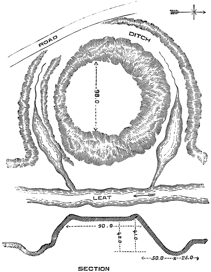
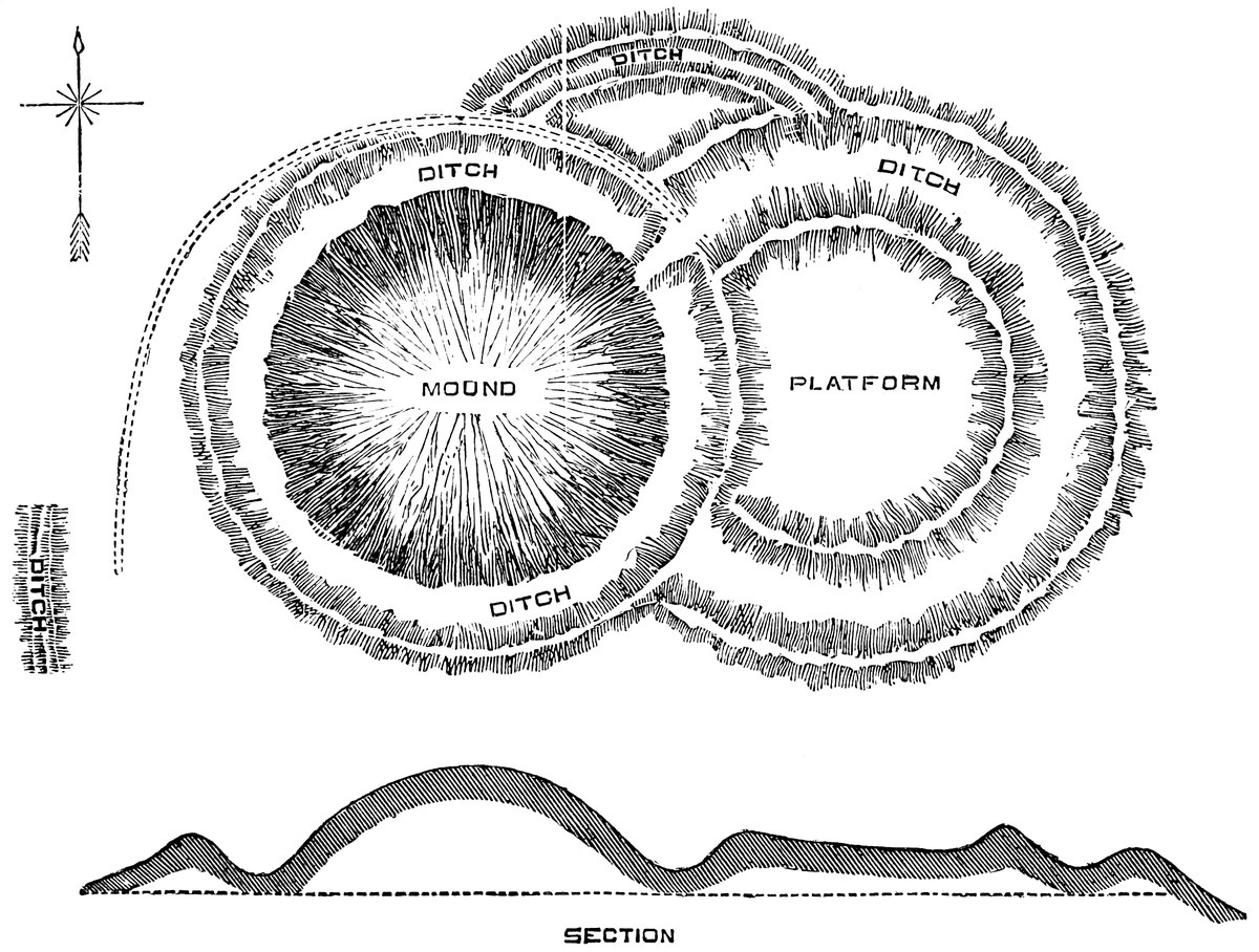
These works, thrown up in England in the ninth and tenth centuries, are seldom, if ever, rectangular, nor are they governed to any great extent by the character of the ground. First was cast up a truncated cone of earth, standing at its natural slope, from twelve to even fifty or sixty feet in height. This “mound,” “motte,” or “burh,” the “Mota” of our records, was formed from the contents of a broad and deep circumscribing ditch. This ditch, proper to the mound, is now sometimes wholly or partially filled up, but it seems always to have been present, being in fact the parent of the mound. Berkhampstead is a fine example of such a mound, with the original ditch. At Caerleon, Tickhill, and Lincoln it has been in part filled up; at Cardiff it was wholly so, but has recently been most carefully cleared out, and its original17 depth and breadth are seen to have been very formidable. Though usually artificial, these mounds are not always so. Durham, Launceston, Montacute, Dunster, Restormel, Nant cribba, are natural hills; Windsor, Tickhill, Lewes, Norwich, Ely, and the Devizes, are partly so; at Sherborne and Hedingham the mound is a natural platform, scarped by art; at Tutbury, Pontefract and Bramber, where the natural platform was also large, it has been scarped, and a mound thrown up upon it.
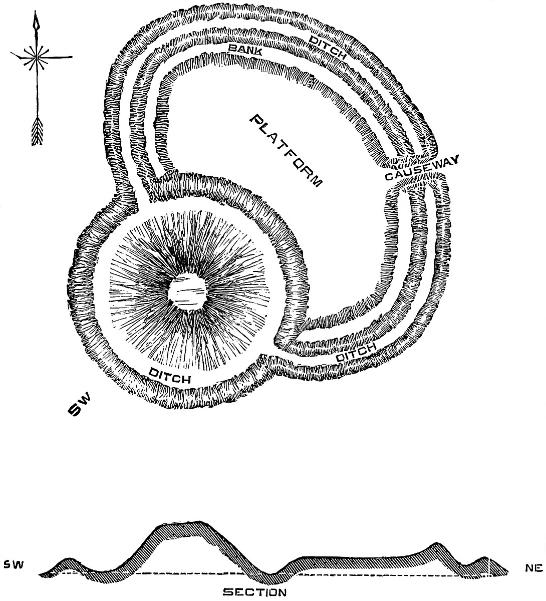
Connected with the mound is usually a base court or enclosure, sometimes circular, more commonly oval or horseshoe-shaped, but if of the age of the mound always more or less rounded. This enclosure had also its bank and ditch on its outward faces, its rear resting on the ditch of the mound, and the area was often further strengthened by a bank along the crest of the scarp of the ditch. Now and then, as at Old Sarum, there is an additional but slighter bank placed outside the outer ditch, that is, upon the crest of the counterscarp. This was evidently intended to carry a palisade, and to fulfil the conditions of the covered-way along the crest of one of Vauban’s counterscarps. Where the enclosure is circular, the mound is either central, as at Pickering, or Mileham, or at Old Sarum, where it is possibly an addition to an older work, such as Badbury, or it stands on one side, as at Tutbury. Where the area is oblong or oval, the mound may be placed near one end, as at Bramber. At Windsor and Arundel it is on one side of an oblong enclosure, producing a sort of hourglass constriction, and where this is the case a part of its ditch coincides with the ditch of the place. Where the court is only part of a circle it rests upon a part of the ditch of the mound. At Sarum there are two ditches concentrically arranged. At Berkhampstead the mound is outside the court. On the whole, as at Tickhill, Castle Acre, and Lincoln, it is most usual to see the mound on the edge of the court, so that it forms a part of the general “enceinte” of the place. Where the base court is of moderate area, as at Builth and Kilpeck, its platform is often slightly elevated by the addition of a part of the contents of the ditch, which is rarely the case in British camps. At Wigmore and Builth, where the mound stands on the edge of a natural steep, the ditch is there discontinued. The base court is usually two or three times the area of the mound, and sometimes, as at Wallingford or Warwick, much more. No doubt the reason for placing the mound on one side rather than in the centre of the court was to allow of the concentration of the lodgings, stables, &c., on one spot, and to make18 the mound form a part of the exterior defences of the place.
The mound and base court, though the principal parts, were not always the whole work. Often there was on the outside of the court and applied to it, as at Brinklow and Rockingham, a second enclosure, also with its bank and ditch, frequently of larger area than the main court, though not so strongly defended. It was intended to shelter the flocks and herds of the tenants in case of an attack. At Norham, the castle ditch was used for this purpose as late as the reign of Henry VIII. There are several cases in which the mound is placed within a rectangular enclosure, which has given rise to a notion that the whole was Roman. Tamworth is such a case, and there, fortunately, the mound is known historically to have been the work of Æthelflaed, as is that of Leicester, similarly placed. From this and from the evidence of the earthworks themselves a like conclusion may be drawn as to the superadded mounds at Wareham, Wallingford, and Cardiff. At Helmsley, as at Castle Acre, Brougham, and Brough, the earthworks stand upon part of a Roman camp, and at Kilpeck and Moat Lane, near Llanidloes, part of the area may possibly be British.
East Anglia contains some fine examples of these moated mounds, combined with rectangular encampments. Castle Acre is an excellent example, as are, in a less degree, Mileham and Buckenham.
When the English lord took up his abode within a Roman camp or station, he often turned the Roman works, whether of earth or masonry, to account, and threw up his bank in one corner, altering the contiguous banks and ditches to suit his new arrangements. Thus at Pevensey, Leicester, Cambridge, Lincoln, Southampton, Winchester, Chichester, Caerleon, Chester, English mounds and base courts are placed within Roman enclosures which either are or were walled. At Auldchester, near Bicester, the Roman Alauna, is a mound of later date than the camp. At Plessy, Tamworth, Wallingford, Wareham, Cardiff, are found mounds decidedly of later date than the enclosing works. There are also cases where the mound is placed within an earthwork with something of a tendency to the rectangular, though scarcely to be pronounced either Roman or Romano-British. Such are Clare, Hereford, Eaton-Socon, where the mound is very small indeed; and Lilbourne. Tempsford is very peculiar: it is a small rectangular enclosure close to the Ouse, and in one corner, upon the bank, is a small mound.
The group of works, of which the mound was the principal19 feature, constituted a Burh. The burh was always fortified, and each inhabitant of the surrounding township was bound to aid in the repair of the works, almost always of timber, a material which the Saxons, like other German nations, appear usually to have preferred for building purposes to stone, though some of their towns were walled, as Colchester and Exeter, and Domesday records the custom of repairing the walls of Oxford, Cambridge, and Chester.
In these English, as before them in the British works, the ditches were sometimes used to contain and protect the approaches. This is well seen at Clun and Kilpeck. At Tutbury the main approach enters between two exterior platforms, and skirts the outer edge of the ditch, until it reaches the inner entrance. The object was to place the approach under the eyes and command of the garrison.
As there are still some archæologists whose experience entitles their opinions to respect, who attribute these moated mounds to the Britons, it will be necessary to point out that the attribution of them to the English, though materially strengthened by the evidence of the works themselves, does not wholly, or even mainly, rest upon it. While the British camps are either præhistoric or unnoticed even in the earliest histories, and the age of the Roman works is only deducible from their plan and style, and from the known and limited period of the Roman stay in Britain, English works are continually mentioned in the chronicles, and the names of their founders and date of the construction of many of them are on record. Thus Taunton was founded by Ine a little before 721–2, when Queen Æthelburh destroyed it. The original earthworks still remaining are considerable, and formed part of the defences of a fortress erected long afterwards. In the ninth century, as the Danish incursions became more frequent, works of defence became more general, and are largely mentioned directly, or by implication, in the Anglo-Saxon chronicle. In 868–9, the Danish army was at Nottingham, a strong natural position, in which it was besieged by the West-Saxons. In 870, the Danes were a whole year at York and wintered at Thetford, where large earthworks remain. In 875 they were at Cambridge, and in 876 at Wareham, a West-Saxon fortress, whence they attacked Exeter, and at all these places are earthworks. In 878, we read that Ælfred “wrought” a fortress at Æthelney, and in 885 the Danes laid siege to Rochester and “wrought” another fortress about their position, no doubt the great mound that still remains outside the castle and the Roman area. In 893, the Danes ascended four miles along the Limen or “Lymne” river in Kent, and there20 stormed a work, “geweorc,” which was but half constructed. In the same year Hæsten entered the Thames and “wrought” him a work at Milton, and other Danes landed at Appledore, at the mouth of the Limen. In 894 Ælfred fought with the Danes at Farnham, where the episcopal keep still stands upon a burh. Hæsten or Hastings had already constructed a burh at Benfleet, which was stormed by Ælfred, who in the same year blocked him up at Buttington, on the Severn. In 896, the Danes threw up a work on the Lea, twenty miles from London, whereupon Ælfred threw up another work on each bank of that river lower down, and diverted the waters through a number of shallow courses, thus effectually shutting in the Danish ships. The Danes, in consequence, marched inland, and crossed the country to Quatbridge, on the Severn, and there “wrought a work” and passed the winter. Some of these works remain, and are good examples of moated mounds.
In the tenth century the number of English fortresses was prodigiously increased, chiefly by the energy of Æthelflaed. Ælfred died in 901, and was succeeded by Eadward, his son, who attacked, in the fortress of Badbury, his cousin Æthelwald, who held Christchurch and Wimborne. In 907, Chester, the Roman walls of which had long lain in ruin, was strengthened, probably by the earthworks still to be seen in its south-western corner, though the mound has been almost entirely removed. In 910, Æthelflaed, sister to Eadward and Lady of the Mercians, comes upon the scene as the greatest founder of fortresses in that century. In that year she built a burh at Bramsbury, and in 913 one at Scergeat or Sarrat, and at Bridgenorth (Oldbury). In 913, about the 14th of April, Eadward built the north burh at Hertford, between the rivers Memera or Maran, the Benefica or Bean, and the Lygea or Lea, upon which long after stood the shell keep of the Norman castle; and after May and before midsummer he encamped at Maldon while Witham burh was being built. Then also the second burh of Hertford, south of the Lea, was built. In the same year, 913, Æthelflaed and her Mercians built the burh of Tamworth in the early summer, and in August that of Stafford; and in the next year, 914, also in the summer, that of Eddesbury, and towards the end of autumn, that of Warwick, on which are still traces of a later keep.
In 915, Æthelflaed constructed a burh at Chirbury, probably in the field still known as the King’s Orchard, and at Wardbury, and before mid-winter that of Runcorn, where was afterwards a Norman castle. In that year the Danes ascended the Bristol Channel and entered Irchenfield, west of Hereford,21 remarkable, amongst many others, for its burhs of Kilpeck and Ewias-Harold, whence they were driven back by the men of Hereford and Gloucester, and of the surrounding burhs. In 916, Æthelflaed stormed the mound of Brecknock, and took thence the Welsh king’s wife and thirty-four persons. Late in the year Eadward was some weeks at Buckingham, and there constructed two burhs, one on each bank of the river, on one of which afterwards stood Earl Giffard’s keep. In 917, Æthelflaed took Derby, the gates of which town are mentioned, and in 918 the burh of Leicester, soon after which she died in her palace in Tamworth. In 919, Eadward went to Bedford, took its burh, the site of Lord Beauchamp’s keep, and there remained for four weeks, during which time he threw up a second burh on the opposite or south bank of the river Ouse. In 920 he constructed the burh at Maldon, and in 921, in April, that at Towcester, which in the autumn he girdled with a wall of stone. In the following May he22 directed the burh at Wigmore to be built, and in August the whole Danish army spent a day before Towcester, but failed to take it by storm. In that year the Danes abandoned their work at Huntingdon and wrought one at Tempsford, and thence moved to Bedford, whence they were repulsed. They also attacked the burh at Wigmore for a day, but without success. This was a busy year. In it the English stormed Tempsford burh, and beset Colchester burh, and slew there all but one man who escaped over the wall. Maldon burh also was attacked by the Danish army, but without success. In November, Eadward repaired the burhs at Huntingdon and Colchester and raised that at Cledemutha. In 922, the same great English leader, between May and midsummer, “wrought” a burh at Stamford on the south bank of the Welland, opposite to that already existing. He reduced the burh at Nottingham, repaired it, and garrisoned it with Englishmen and Danes. In 923, Eadward erected a burh at Thelwall, and in 924 one at Bakewell, and a second at Nottingham, opposite to the existing one, the Trent flowing between them. In 943, Olaf the Dane took Tamworth by storm. In 952, mention is made of the fastness of Jedburgh, and of the town of Thetford. In 993, Bamborough was stormed.
Of the fifty burhs named in the chronicle, about forty-one have been identified, and of these about twenty-nine still exist. Of this number, twenty-two are moated mounds, mostly with base courts also moated. At Taunton, as at Chirbury, there is reason to suppose that there was a mound, and the works at Exeter, Rochester, Colchester, and Pevensey, which are Roman, possibly succeeding earlier British works, have been taken possession of and altered by the English, as is the case also at Chester, where was, and at Pevensey, where still is, a mound. At Rochester is a large mound, though outside the fortress. Rougemont in Exeter is itself a natural mound, and Bamborough, from its great height and steepness, needed neither mound nor earthwork of any kind. Of double burhs, commanding the passage of a river, the chronicle mentions Nottingham and those on the Lea, and others at Hertford, Bedford, Stamford, and Buckingham. Unfortunately, none of these are perfect. At Nottingham and on the Lea both mounds have long been removed; one is remembered at Stamford and Buckingham, and one may still be seen at Hertford. But the only double mounds remaining to show how, in the tenth century, the English defended the passage of a river, are those at York, which are not mentioned in the chronicle.
It appears then, that setting aside works that have not23 been identified, or which have been destroyed before note was taken of them, there are above a score of burhs, the date of the erection of which, and the name of the founder, are entered in a trustworthy record, and which are still to be seen. What then is a burh? A burh is a moated mound with a table top, and a base court, also moated, either appended to one side of it, or within which it stands. But the burhs, the dates of which are on record, and which are thus described, are but a very few of those found all over England, in the lowlands of Scotland, and on the marches bordering on Wales, which from their precise similarity in character to those actually identified must be assumed to be of like date and origin, and may therefore safely be attributed to the ninth and tenth and possibly to the eighth centuries, and to the English people, that is to the Northern settlers generally, as distinguished from the Britons and the Romans.
It happens also that, in very many cases where these burhs are found, they can be shown to have been the “caput” or centre of an estate. It is probable that this was always the case, but as a rule it is only with respect to the very large estates that this can be proved from records. Thus the mound of Wallingford was the seat of Wigod, whose heiress married Robert D’Oyley; Bourne or Brum was held by Earl Morcar in 870; Edwin, Earl of Mercia, Lord of Strafford Wapentake, in Yorkshire, had an “aula” at Laughton-en-le-Morthen, and Conyngsborough was the centre of a royal fee. The English Lord of Richmondshire had a seat at Gilling, the mound of which has not long been levelled. The mound at Halton was the seat of Earl Tosti. At Berry Banks, near Stone, dwelt Wulfer, Lord of Mercia. The chief seats of the English lords of Hallamshire are not known, but in that district the latter thanes were Waltheof, Tosti, Sweyn Lord of Sheffield, and Harold, whose seats must be sought for in the mounds and banks of Castle Hill and Castle Bailey, near Bradford; Castle Hill, at the meeting of the Sheaf and Don; Tickhill, Wincobank, and Mexborough, all moated mounds; also in Lancashire and Yorkshire are Melling and Hornby in Lonsdale, Castle Hills at Black Bourton, Robin Hood’s butt at Clapham, and Sedbury or Sedda’s burh, a well-known mound with oval courts, Castle-dykes at Ledescal and Langwith, Maiden Castle at Grinton, and Kirkby Malessant. The great mound at Clare in Suffolk was the fortified seat of Earl Aluric, who held an enormous estate in that district. Eye, in the same county of Suffolk, the seat of Earl Edric, has a fine mound, as have Thetford and Haughley. The hill of Hedingham and that of Norwich are natural, but24 the latter was raised artificially and fortified with a ditch and horseshoe appendages, probably in the ninth or tenth centuries. Dudley also was a great English residence, as was Bennington mound in Hertfordshire. Hereford was fortified by the great Harold, Ewyas by another Harold; Kilpeck and Richard’s Castle were also early seats, as were the mounds of Clun, Oswestry, and Whittington, in Shropshire. In Scotland upon the mound called the “Butte of Dunsinane,” tradition places the residence of Macbeth early in the eleventh century. The butte stands within an oval area defended, says Pennant, by banks and ditches. Opposite Kingussie on the Spey is a very curious natural mound, rising on three sides out of the marshes of the river, and which is known to have been the residence of the celebrated Wolf of Badenoch. There is also a moated mound with appended courts on the banks of the Clyde.
25
The burhs are mentioned in the early laws of England, but by this time the signification of the word had become extended, so that it was frequently applied not only to a moated mound but to the town that had sprung up around it. By the laws of Æthelstan, every burh was to be repaired within fourteen days after the Rogation days, and money was allowed to be coined at royal burhs. By the laws of Edmund the king’s burh was a place of refuge, and under those of Æthelred, he who fought in a king’s burh was liable to death. Burh-bryce was the violation of a castle or dwelling. Burh-bote, a payment for keeping burhs or fortresses in a state of defence, was a branch of the well-known “trinoda necessitas.” Originally, the English burh was a fortified house, the “Domus defensabilis” of Domesday, the “Aula,” the German “Saal,” of the owner of the surrounding estate or manor, which the tenants were bound to defend; of which the designation may sometimes be Norman, but the thing designated is undoubtedly of far earlier origin. The term burh26 naturally became extended to the cluster of surrounding huts, and a hedge with a ditch was their primary enclosure, the repair of which is provided for in very early Saxon laws. A good stout hedge, even of quickset, is not to be despised, and the cactus and bamboo hedges of India will turn a band of soldiers. The word “Haia” is not infrequent in Domesday, and it there means an enclosure into which wild beasts were driven, “Haia in qua capiebantur feratæ.” It was also used for the enclosure of a park, as the Haye Park, at Knaresborough, and the Hawe Park attached to Skipton Castle. King Ida’s hedge at Bamborough was for the defence of annexed pasture lands, for the castle scarce needed any such addition to its surpassing strength. The word was also extensively used in Normandy, both for a defence and for an enclosure. One of the old Herefordshire castles bears the name of Hay.
The Edictum Pistense of Charles the Bald, in 864 (cap. i.), expressly orders all “Castella et firmitates et haias,” made without his license, to be destroyed, “disfactas,” because they were injurious to the district. “Vicini et circummanentes exinde multas deprædationes et impedimenta sustinent” (“Rerum Gallicarum Scriptores,” vii., 677). Hedges therefore were not always mere enclosures, but sometimes a military defence.
These mounds, where they have descended to us, and have undergone no change at the hands of the Norman architect, are mere green hillocks, clear indeed in their simplicity, though having lost by time the sharpness of their profile, and more or less of their height and of the depth of their ditches. No masonry has ever been observed upon them which could by any possibility be attributed to their founders, or which could be supposed to be part of their original design. It is evident, however, that the earthwork was only the support of some additional defence. On the mound was certainly a residence, and both its crest and base, as well as the appended courts, must have been encircled by some sort of barrier besides the earth-bank. We read that Towcester was defended by a wall, which however was built very quickly, and probably was like a field wall, without mortar. But with or without mortar, no wall could have been placed upon a fresh heap of earth, and that spoken of must have stood upon the natural ground at or around the base of the mound. No doubt Exeter was walled by Æthelstan, and Colchester had walls, partly, as we see, Roman, but partly no doubt, English; and Derby had gates, though of what material is not stated. At Corfe is some masonry, certainly27 older than the Conquest, and part of its outer defences; but Corfe is a natural hill. It is well known that the English were from a remote period conversant with masonry, and constructed churches of stone or timber as suited them best; and nothing is more natural than that they should have employed the former where the object was to resist an attack. But upon a burh, or upon an artificial earthwork of any height, masonry of any kind was obviously out of the question. Timber, and timber alone, would have been the proper material. Timber was always at hand, and it was a material of which, possibly from their early maritime habits, the English were very fond. Also the rapidity with which these burhs were constructed shows that timber must have been largely employed. They were thrown up, completed, attacked, burnt, and restored, all within a few months.
There are not wanting descriptions of these timber-defended works. M. de Caumont cites a curious passage from Ernaldus Nigellus, an author of the ninth century, who relates an expedition under Louis le Debonnaire against the Breton king, Marman, whose strongholds were protected by ditches and palisades.
This however was a Breton work, and there is no mention of a mound. Two centuries later the mound was in general use, and another quotation, taken also from M. de Caumont, from the life of John, a canonised prelate of the church of Terouane, by Archdeacon Colmier, gives an account of the fortress of Merchen, near Dixmude, in which the material employed and the mode of construction are clearly set forth. The original, taken from the “Acta Sanctorum,” is appended to this paper, and is in truth a description of a moated mound, with its fence and turrets of timber, its central dwelling, and the bridge across the ditch rising to the top of the mound. The description is illustrated by the representation of the taking of Dinan, in the Bayeux tapestry. There is seen the conical mound surmounted by a timber building, which two men with torches are attempting to set on fire, while others are ascending by a steep bridge which spans the moat, and rises to a gateway on the crest of the mound.
Many of these mounds under the name of motes (motæ) retained their timber defences to the twelfth and thirteenth centuries, and that too on the Shropshire and Welsh border, crowded with castles of masonry.
28
Ducange defines mota as “Collis, seu tumulus, cui inædificatum est castellum. Olim castella numquam nisi in eminentissimis locis extruebantur. In Flandria vero, humili ac planissima regione, congestis undequaque terrarum molibus, fieri solebant motæ, quibus arces imponerentur”; and adds that mota is the same work known in Dauphigny as “poypia,” and in Auvergne as “mote seigneuriale.” From Lambertus Ardensis he quotes: “Motam altissimam, sive dunjonem eminentem in munitionis signum firmavit, et in aggerem coacervavit.” And Orderic tells that, in 1098, Pain de Mont-Doubleau delivered up to William Rufus, “Fortissimam, quam apud Balaonem possidebat, motam, per quam totum oppidum adversariis subactum paruit.” And in 1119, Fulk of Anjou, with 500 knights laid siege, “ad motam Galterii,” which the king had fortified. Also near Ponte-Corvo was “Motam magnam, quam faciebat facere Dominus Canis cum mulfossis et tajatis ad claudendum Paduanos,” like the great mound at Rochester, just outside the city wall. In the Roman de Rou:—
“Mostier” being the church. Also in “La Bataille des Sept Arts”:—
Also the Consuetudines Trecensis speak of “Le principal chastel ou maison-fort, mote, ou place de maison seigneuriale”: and in Colletus, “Il y a des masures qui ont des droits très considérables; nous avons des simple poypes [ce sont des terres élevées et fossoyées] qui ont les plus beaux droits.” The History of Dauphigny has, in 1290, “Item castrum seu Poypiam de Montlyopart; item castrum seu fortalicium de Pusigniano.” Ducange is copious on this subject.
The use of the mound as the site of the “maison seigneuriale” was general in England, and several such—as Barwick-in-Elmet and Laughton-en-le-Morthen—are still pointed out as the seats of early English nobles and kings; and of others thrown up primarily for defence, as Tamworth and Leicester, and afterwards occupied as royal and other residences, the date is on record.
After the Conquest, the English term “burh” seems to have given place to the Latin “mota,” at least in public records. It is true that in a charter by the Conqueror, given by Rymer, occurs “Et in burgis, et muro-vallatis, et in castellis,” but “burgis” may be held to mean borough towns. In the charter of Matilda, 1141, bestowing the earldom of Hereford29 on Milo de Gloucester, she grants “Motam Hereford et cum toto castello,” words which evidently refer to the mound, now destroyed, and not, as has been supposed, to the right to hold a moot there. Also, in the convention between Stephen and Henry of Anjou the distinction is drawn between “Turris Londinensis et ‘Mota de Windesora,’” London having a square keep or tower, and Windsor a shell keep upon a mound. Probably when, as at Durham, keeps of masonry superseded the “ligna tabulata firmissime compacta,” the fortress ceased to be called a mote, and became a castle; but in very many instances this change was a long time in coming about, and in many of the less important and private residences it never occurred at all. Thus, the moated mounds on the Upper Severn show no trace whatever of masonry, and as late as the reign of Henry III., 159 years after the Conquest, and years too of incessant battling with a warlike and sleepless foe, timber was still the material of their defences. The Close Roll of 9 Henry III., 30 May, 1225, thus addresses the Custos of Montgomery:—
“Rex etc. dilecto et fideli suo Godescallo de Maghelins salutem. Precipimus tibi quod ex parte nostra firmiter precipias omnibus illis qui motas habent in valle de Muntgumery quod sine dilatione motas suas bonis bretaschiis firmari faciant ad securitatem et defensionem suam et parcium illarum.”[1] And not only in the defences of these lesser motes and fortified private houses did timber play an important part. Turrets of timber were prepared for the castle of Montgomery, and even Shrewsbury itself, the seat successively of three most powerful earls and the chief place in their earldom, was by no means wholly a work in masonry. In the reign of Edward I. the jurors appointed to report upon the condition of the castle, state: “Quod unus magnus turris ligneus qui edificatur in castro Salop corruit in terram tempore domini Uriani de St. Petro tunc vice comitis et meremium ejusdem turris tempore suo et temporibus aliorum vice comitum preterea existencium ita consummatur et destruitur quod nichil de illo remansit in magnum dampnum domini Regis et deterioracionem ejusdem castri.” In a French charter of 1329 occurs, “Premierement le motte et les fossez d’entour le motte de Maiex,” and in 1331, “Le motte de mon Manoir de Caieux et les fossez entour.” 30 It appears, then, that from an early period, certainly from the ninth century, it was a common practice in constructing a strong place, whether a private dwelling or a military post, to place it upon the summit of a mound, and to surround both the mound and an appended enclosure with defences of earth, and that in many, probably for some time in all, cases the building within and the defences around such places were of timber, and indeed, so far as they stood on made ground, necessarily so. Sometimes probably, when the front was more extended, as when a small pasture ground attached to the main fortress was to be protected from sudden assaults, recourse was had to a “haia” or “clausura.”
In viewing one of these moated mounds we have only to imagine a central timber house on the top of the mound, built of half trunks of trees set upright between two waling pieces at the top and bottom, like the old church at Greensted, with a close paling around it along the edge of the table top, perhaps a second line at its base, and a third along the outer edge of the ditch, and others not so strong upon the edges of the outer courts, with bridges of planks across the ditches, and huts of “wattle and dab” or of timber within the enclosures, and we shall have a very fair idea of a fortified dwelling of a thane or franklin in England, or of the corresponding classes in Normandy from the eighth or ninth centuries down to the date of the Norman Conquest.
The existence of these mounds in distinct Welsh territory is very curious and requires explanation. That this form of dwelling was in common use among the Welsh is certainly not the case. Where moated mounds occur in Wales it is usually on the border, or near the sea-coast, or in or near the open valleys accessible to the English, which the English or Northmen are known to have invaded in the eighth and ninth centuries. The mound near Llanidloes is an exception, being distinctly within the hills. But that of Tafolwern, from which the Welsh princes dated several charters, is near the open valley. That of Talybont, whence Llewelyn dated a letter to the Archbishop of Canterbury in 1275, and which was afterwards visited by Edward the First, is on a plain within easy reach of the sea. Hên Domen and Rhos Diarbed on the Upper Severn are also good examples. Still, as the Welsh princes intermarried and had frequent communication with the English, they must have been familiar with a form of fortification very simple and easy to construct, and yet very capable of being held against a sudden attack. It must be observed, also, that the English hold upon the Welsh border31 was of a very fluctuating description, and the Welshmen must not only have been perfectly familiar with the English method of construction, but from time to time have been actually in possession of their strongholds. That the Welsh used timber for defensive purposes appears from their law by which the vassals were to attend at the lord’s castle for its repairs or for rebuilding, each with his axe in his hand. In some cases in these Border works there is scarcely any mound, at others the mound is low and hollow in the centre. Caer Aeron and another small earthwork near Builth seem to have been the earthen bases of a mere circular wigwam. Caer Aeron cannot have been a mere temporary structure, as the circumscribing ditch has been cut with considerable labour in the rock.
It is very evident, both from the existence of Offa’s dyke, and from the immense number of these moated mounds thrown up along its course, that the English had early and long possession of large tracts of the border territory. Offa ruled over Mercia from a.d. 757 to 796, and his dyke extends from the mouth of the Wye to that of the Dee. At its northern part, for about forty miles, is a second work, known as Wat’s Dyke, a little in its rear, and thought to be a somewhat earlier work, also by Offa. Before the actual line of a work so galling to the spirit of a turbulent people could have been decided upon there must have been many years of contest along the border, and the English must have had something like permanent possession of the land on either side, and have held estates of which the mounds still existing were the “capita” or chief seats. The dyke, it should be remembered, was rather a civil boundary than a military defence.
It is further to be remarked that moated mounds corresponding precisely in pattern to those in England, are very numerous in Normandy. In size they vary within much the same limits. All have or had a proper ditch, some, as Briquessart and Des Olivets, stand in the centre of the court, some at one end, others on the edge. The court is sometimes circular, most commonly oblong, very rarely indeed rectangular. The outer enclosures have their ditches, which communicate with those of the inner defences. M. de Caumont gives a list of fifty-four of these mounds, within a radius of sixty miles from Caen, and since he wrote many more have been observed. These also were, from an early period, the seats of great landowners, and from very many of them came the knights and barons who accompanied William to England, and there settled in posts very similar. Sir F. Palgrave gives a list of 131 of these fortified residences in the Cotentin, the Avranchin, and the Bessin, which includes32 only six of those mentioned by de Caumont. A large number of those earthworks seem never to have had, at any time, defences of masonry. Others, upon the mounds, had Norman shell keeps.
Besides the British theory, these mounds have been claimed as sepulchral. It is of course possible that such mounds as Arundel or Marlborough may have been originally sepulchral, and therefore older than their defensive additions. To few if any has the crucial experiment of opening them been applied; but this is not a very probable explanation, and could certainly not be applied to those mounds as a class. Among many other reasons for taking this view, it may be observed that sepulchral mounds are always artificial, whereas moated mounds are often natural, and still more frequently partly so. No one could suppose Hawarden, or Dunster, or Montacute, to be sepulchres, and yet these are as much moated mounds as Arundel and Tonbridge. Moreover, sepulchral mounds are not often placed where a defensive work is obviously needed, and most rude nations are superstitious, and would object to dwell upon or around a grave. The Tynewald in Man, Cwichelmsley Knowe in Berkshire, and a work upon the Clyde in Lanarkshire, are the only known sepulchral mounds which have been employed for other purposes, and of these the two former are judicial, not residential. The barrows round York, though smaller than most burhs, are big enough to have carried residences, but do not appear to have been so employed. Moreover, the common testimony of the country has generally given to the moated mounds some name, such as Castle Hill or Burh, indicative of their military origin.
It has been observed that moated mounds are usually near the parish church. This might be expected, since the parish, like the manor, was usually a private estate, and the church was originally provided by the lord for the accommodation of his tenants and himself.
There is a class of mounds due probably to the same people with those above described, but very seldom moated, and not usually accompanied by base courts and enclosures. These are the moot-hills, used for civil purposes, as the holding of courts-leet, of which the mound at Barton, in Northamptonshire, is a fine example. They are not uncommon. There is one near Kenilworth, close to Stoneleigh Church, one at Hawick, one called the Mote Hill, in Hamilton Park; there is also one on the right bank of the Neckar, below Heidelberg. Sometimes they are called toot-hills; hence Tothill Fields, though the mound is gone.
33
In claiming for these moated mounds a northern and in Britain an English origin it would be too much to assert that in no other class of works is the mound employed, or by no other people than the Northmen; but it may be safely laid down that in no other class of early fortification does the mound occur as the leading and typical feature. In Roman and Norman, and possibly in purely British works, the mound may be occasionally seen, like the cavalier in the works of Vauban, as at Kenilworth, or as an outwork, as at Caerphilly, or it may be employed to cover or divide an entrance; but such mounds are of irregular shape, mere detached and elevated parts of the general bank, and not likely to be confounded with the moated mound described above.
Contigit ut in villa, cui Morchem vocabulum est, hospitii mansionem
haberet [Johannes]. Erat autem secus atrium ecclesiae munitio quaedam
quam castrum vel municipium dicere possumus valde excelsa, juxta morem
terrae illius, a domino villae ipsius multis retro annis extructa.
Mos namque est ditioribus quibuscunque regionis hujus hominibus et
nobilioribus, eo quod maxime inimicitiis vacare soleant exercendis et
caedibus, ut ab hostibus eo modo maneant tutiores, et potentia majore
vel vincant pares, vel premant inferiores, terrae aggerem quantae
praevalent celsitudinis congerere eique fossam quam late patentem,
multamque profunditatis altitudinem habentem circumfodere, et supremam
ejusdem aggeris crepidinem vallo ex lignis tabulatis firmissime
confacto undique vice muri circummunire, turribusque, secundum quod
possibile fuerit, per gyrum dispositis, intra vallum, domum vel,
quae omnia despiciat, arcem in medio aedificare, ita videlicet ut
porta introitus ipsius villae non nisi per pontem valeat adiri, qui
ab exteriori labro fossae primum exoriens est in processu paulatim
elevatus, columnisque binis et binis, vel etiam trinis altrinsecus
per congrua spatia suffixis innixus, eo ascendendi moderamine per
transversum fossae consurgit, ut supremam aggeris superficiem
coaequando oram extremi marginis ejus, et in ea parte limen prima
fronte contingat.
In hujus-modi ergo asylo Pontifex, cum suo frequenti et reverendo
comitatu hospitali, quum ingentem populi turbam tam in ecclesia,
quam in atrio ejus, manus impositione, et sacri Chrismatis unctione
confirmasset, ut vestimenta mutaret, eo quod coemiterium humandis
fidelium corporibus benedicere statuisset ad hospitium regressus est,
unde illo, ut propositum perficeret opus, iterum descendente, et circa
medium pontis, triginta quinque vel eo amplius pedum, altitudinem
habentis, certa de causa subsistente, populique non modica caterva ante
et retro, dextra lævaque circumstipante, continuo antiqui machinante
hostis invidia, pons ponderi cessit, et dissipatus corruit, magnamque
illorum hominum turbam cum episcopo suo ad ima dejicit; fragore autem
ingenti e vestigio consecuto, transtris, trabibusque tabulatis, et
ruderibus magno cum impetu pariter et strepitu concidentibus: nebula
quaedam tenebrosa ita omnem34 illam ruinam repente circumfudit, ut quid
ageretur vix quisquam discernere potuerit.
It chanced that in a town called Merchem, Bishop John had a guest-house. There was also close to the court of the church a strong place, which might be regarded as a castle or a municipium, very lofty, built after the fashion of the country by the lord of the town many years ago. For it was customary for the rich men and nobles of those parts, because their chief occupation is the carrying on of feuds and slaughters, in order that they may in this way be safe from enemies, and may have the greater power for either conquering their equals or keeping down their inferiors, to heap up a mound of earth as high as they were able, and to dig round it a broad, open, and deep ditch, and to girdle the whole upper edge of the mound, instead of a wall, with a barrier of wooden planks, stoutly fixed together with numerous turrets set round. Within was constructed a house or rather citadel, commanding the whole, so that the gate of entry could only be approached by a bridge, which first springing from the counterscarp of the ditch, was gradually raised as it advanced, supported by sets of piers, two, or even three, trussed on each side over convenient spans, crossing the ditch with a managed ascent so as to reach the upper level of the mound, landing at its edge on a level at the threshold of the gate.
In this retreat the bishop with his numerous and reverend retinue, after having confirmed a vast crowd of people both in the church and its court, by laying on of hands and the unction of the sacred chrism, returned to his lodging that he might change his vestments, because he had resolved to consecrate a cemetery for the burial of the bodies of believers. When, in again descending from his lodging, in order to effect the proposed work, he halted for some reason about the middle of the bridge, which had there a height of thirty-five feet or more, the people pressing behind and before, and on each side, straightway, the malice of the old enemy so contriving, the bridge yielded to the weight and fell shattered; and the crowd with the bishop fell to the bottom with a great crash of joists, beams, and planks, with great force and noise, while a thick dust at once enveloped the ruin so that scarce any one could see what had happened.
The following is also curious:—
(Ludovicus Grossus, a.d. 1109.) “Puteolum regreditur antiquam antecessorum suorum destitutam Motam castro jactu lapidis propinquam, occupat. Castrum fundibalariorum, balistariorum, saggitariorum, emissa pericula sustinentes; etc.”
IT has usually been assumed that the rapidity of William’s conquest was due to the absence of strong places in England. There is, however, ground for believing that England, in this respect, was exceedingly well provided,—quite as well provided as Normandy; and that, with the possible exception of a very few recently-constructed strongholds, the works in the two countries were very similar in character. The older sites of the castles of the barons in Normandy are nearly all ascertained, and are for the most part distinguished by a moated mound with an appended court or courts also moated. This simple and very effective form of defence has been shown to have been in use among the Northern nations, invaders both of England and the Continent, and in the ninth and tenth centuries was as common on the banks of the Thames, the Humber, and the Severn, as on those of the Seine and the Orne. It was in the eleventh century, and chiefly during the troubles attendant upon the accession and minority of Duke William, that the Normans seem to have adopted a new and more permanent description of fortress, and the old-fashioned structure of timber began to be replaced by walls and towers in masonry, and especially by keeps of that material. Of these the best-known, because the most durable, form was the rectangular, of which not above half a dozen examples can be shown with certainty to have been constructed in Normandy before the latter part of the eleventh century, and but very few, if any, before the English conquest; nor is there known to be in Normandy any specimen of the polygonal or circular form of keep as early as that event. De Caumont, indeed, attributes the rectangular keep of Langeais, in which brick is largely used, to the year 992; but there is great reason to doubt this conclusion, and Du Pin and St. Laurent are probably among the oldest of this form, and do not seem to be earlier than the reign of Duke William; and this is true also of Arques and36 Nogent-le-Rotrou. In Normandy, as in England, the polygonal or shell keep, though on the older site, seems usually to be in masonry, which is the later construction; that of Gisors was built by Robert de Belesme in 1097, and that of Carentan at about the same time. Many even of the most considerable mounds, as Briquessart and Vieux-Conches, show no trace of masonry. The shell keep of Plessis-Grimoult was held by De Caumont to have been constructed before 1047; but if this be so, it is certainly a singular exception. Castle-building in Normandy seems to have preceded the English conquest, if at all, by but a very few years.
The Romans left behind them in Britain many walled towns; but it is not known to what extent these defences were preserved by the Northmen, or in what condition they found them. At the conquest, Chester, Lincoln, Exeter, Hereford, Leicester, Oxford, Stafford, and Colchester, seem to have been already walled, and the walls of Exeter had been repaired or rebuilt by Æthelstan. Canterbury, Nottingham, and York were defended by a ditch. There were also probably some others, and possibly a few military towers in masonry of English workmanship; but there is no evidence of there having been anything like a rectangular keep, notwithstanding the special mention in 1052 of Richard’s Castle, the work of Richard, the son of Scrob. There is no reason to suppose that it possessed a tower of that character, which would have been quite out of keeping with the moated mound which even now marks the spot, and upon which the remains of the shell keep are still to be seen. Still less had the English any shell keeps constructed in masonry. What there really was in the way of military masonry and what was its character are not so clear. It was said of Dover, by William of Poictiers, that it was by Harold “studio atque sumptu suo communitum,” and that there were “item per diversa loca illius terræ alia castra ubi voluntas Ducis ea firmari jubet”; also in the account of the advance of William from Canterbury it is added, “Veniens ... ad fractam turrim castra metatus est,” pointing to a work in masonry, though no doubt it might, as at York, be Roman. Arundel, named in “Domesday” as having been a castle in the reign of the Confessor, was probably, from the size of its mound and the depth of its ditches, as strong as any castle of its type in Normandy; but no masonry has been observed there, either upon or about the mound, of a date earlier than the Conquest, if as early.
That there existed in England, at the Conquest, no castles in masonry of English work it may be too much to assert;37 but it may safely be said that, save a fragment of wall at Corfe, no military masonry decidedly older than that event has as yet been discovered. In 1052, when the Confessor and Earl Godwin came to terms, and the attack on London was set aside, it is stated that Archbishop Robert and his Frenchmen fled, some westward to Pentecost Castle and some northwards to Robert’s Castle; so that these places probably, like Richard’s Castle, were in Norman hands, though it does not follow that they were constructed of the material or in the fashion then coming into use in Normandy.
“Domesday” mentions directly forty-nine castles as existing at the date of the survey, and of these at least thirty-three were on sites far older than the Conquest; and of them at least twenty-eight possessed artificial mounds similar to Arundel and the castles in Normandy. “Domesday,” however, is notoriously capricious both in its entries and omissions on such matters as were not included in its proper view, and its list of castles is nearly as incomplete as its list of churches. Neither were required to be noted. “Of the forty-nine castles recorded,” says Sir H. Ellis, “eight are known, either on the authority of ‘Domesday’ or of our old historians, to have been built by the Conqueror himself; ten are entered as erected by greater barons, and one by an under-tenant of Earl Roger; eleven more, of whose builders we have no particular account, are noticed in the ‘Survey,’ either expressly or by inference, as new.” The fact is, however, that although the number of castles actually mentioned may be only forty-nine, of castles and castelries (which imply a castle) there are named in “Domesday” fifty-two. The castles reputed to have been built by the Conqueror himself are Lincoln, Rockingham, Wareham, two castles at York, Dover, Durham, London, and Nottingham, of which the last four are not mentioned in “Domesday.” Exeter, also omitted, is generally reputed to be one of William’s castles, as was Stafford; which, however, was constructed and destroyed before the date of the survey. “Terra de Stadford in qua rex percepit fieri castellum, quod modo est destructum,” a very short period for the construction and destruction of a work in masonry. Mr. Pearson, who has given great attention to the subject of Norman castles in England, tabulates the result of his researches in the atlas attached to his “History.” He there enumerates, as standing in the reign of the Conqueror, forty-nine castles belonging to the King and fifty to his subjects. Of these, at least thirty-eight have mounds. He gives also a list of fifty-three belonging to private persons in the reign of William Rufus, of which at least five have mounds. Probably there were of each class38 many more than these. Colchester, for example, is not included, nor Farnham, nor Berkhampstede.
Of the ninety-nine castles enumerated by Mr. Pearson as belonging to the reign of the Conqueror, at least fifty are on old sites. These are Arundel, Berkeley, Bramber, Cambridge, Carisbrook, Chester, Clare, Clifford, Caerleon, Coningsburgh, Dover, Durham, Dunster, Dudley, Eye, Ewias, Guildford, Hastings, Huntingdon, Launceston, Leicester, Lincoln, Lewes, L’wre, Marlborough, Montacute, Norwich, Oxford, Pevensey, Pontefract, Quatford, Raleigh, Richard’s Castle, Rochester, Rockingham, Shrewsbury, Striguil, Stafford, Stamford, Tickhill, Tonbridge, Trematon, Tutbury, Wigmore, Windsor, Wallingford, Wareham, Warwick, Worcester, and York. Almost as many are doubtful, and probably not more than two or three, such as Richmond, London, and possibly Malling, were altogether new. The fact is, that all these lists, however valuable they may be as showing what castles were taken possession of or re-edified or strengthened by the Normans, give no adequate idea of the fortresses already existing in England, and omit scores of earthworks as large and as strong as those occupied by the Normans in England or left behind them in Normandy, of a date long before the reign of William,—probably before the end of the tenth century. If, as said by William of Newbury, the castles were the bones of the kingdom, it must be admitted that the English skeleton was a very perfect one. Every part of England, much of Scotland, and the accessible parts of the Welsh border, were covered with strong places, which were, no doubt, defended, and well defended, with palisades, as more suitable to made ground than work in masonry such as was more or less in use for ecclesiastical purposes. If, at the Conquest, no English stronghold held out, it was not that such places were less capable of defence than those in Normandy, but that England was broken up into parties. Harold’s seat was too insecure and the few months of his reign far too brief to allow his great administrative talents to come into play; and his early death left the English without a leader. The power of the other earls was local. There was no organised opposition. Notwithstanding the assertion of Orderic that the English were mere tillers of the soil, a convivial and drinking race, they by no means submitted quietly to the Norman rule; but their efforts for freedom, boldly devised and gallantly executed, were ill-timed and ill-combined, and were in consequence put down in detail. Under such circumstances, the strongholds of the country availed little. Dover, Lewes, Arundel, Bramber, Tonbridge, Rochester, Guildford, Farn39ham, Wallingford, and Berkhampstede, had their strong earthworks been held in force, would have rendered William’s advance too imprudent to have been attempted; and that these and other not far distant positions were well chosen is shown by the fact that they were all adopted by the Conqueror. The conquest of England was made possible, not by the absence of strong places, but by the want of organisation for their defence.
But whatever may have been the character of the defences in use in England before the arrival of the Normans, it is certain that from that period they underwent a considerable and probably a rapid change, though scarcely so rapid as has been supposed. The Normans, who had so long, in common with the English (probably by reason of their common ancestry), employed the moated and palisaded mound, proceeded to carry out in England the important improvements they had already commenced in Normandy. William’s chief object, having conquered, was to secure his conquest; and his first care, on obtaining possession of each division of the kingdom or each capital city or town, was to regard it from a military point of view, and to order the construction of such strong places as might be necessary for the holding of it. How completely, in so doing, he trod in the footsteps of those who had gone before, is shown by what he found and what he did towards the covering of London and the maintaining of his communication with the sea. Thus he found and reinforced castles at Chichester, Arundel, Bramber, Lewes, Hastings, and Dover. On his road he found and strengthened Canterbury, Tonbridge, Rochester, and Ryegate. In London he founded the Tower, an entirely new work; but for the defence of the basin of the Thames he trusted to the ancient sites of Guildford and Farnham, possibly Reading, and certainly Wallingford and Berkhampstede. And so all over the kingdom, such strongholds as were central, in good military positions, or of unusual strength, or were placed in the ancient demesne lands of the Crown, were taken possession of or reconstructed for the sovereign; but every baron or great tenant in chief was permitted,—and, indeed, at first expected, and was no doubt sufficiently ready,—to construct castles for the security of the lands allotted to him, which in the vast majority of instances meant to remodel the defences of his English predecessors. This was under the pressure of circumstances; for William seems always to have been awake to the danger of uniting extensive hereditary jurisdictions, and even from the first to have contemplated governing the counties through the intervention of vice-comites,40 or sheriffs, who were appointed and could be displaced at pleasure. But this policy was at first, in certain districts, necessarily postponed; though even then William made it to be understood that the chief castles of the realm, by whomsoever built, were royal castles; and their actual acquisition was always an important part of the policy of both him and his successors so long as castles were of consequence. Thus Windsor, Cambridge, Exeter, Corfe, Wareham, Winchester, Porchester, Southampton, Carisbrooke, Canterbury, Dover, Lincoln, Rockingham, Nottingham, Stafford, Guildford, Warwick, Marlborough, and York were royal castles from the commencement. Wallingford, Gloucester, Bristol, Oxford, Tutbury, Worcester, though built by subjects, were not the less claimed and officered by the Crown. Even Durham, though held by the bishops, and Leicester, Lincoln, and Huntingdon, by the lords of those earldoms, were from time to time in the hands of the Crown, whose rights over them were of a far more direct character than those it claimed to exercise over the lands and other feudal possessions of the same lords.
Arundel, Shrewsbury, Montgomery, Bridgenorth, and some less important fortresses, fell to the Crown on the overthrow of the house of Talvas; and with this event a number of castles on the Welsh border, built by tenants of Earl Roger, became fiefs in capite, dependent directly upon the Crown. Besides these, there are on record in England about forty or fifty castles built by local barons, which, when it suited the Crown, were taken in hand and repaired and garrisoned at its charge.
Of nearly all the castles on record, as existing in the reigns of the Conqueror and his sons, the sites are well known; and of very many, fragments of the masonry remain. What is very remarkable is, that of this masonry there is but little which can be referred to the reign of either the Conqueror or William Rufus,—that is, to the eleventh century. Of that period are certainly London and Malling, Guildford, Bramber, Carlisle, the gate-house of Exeter, the lower story of Chepstow, the keeps of Chester, Goderich, Walden, Wolvesey, Colchester, and Newcastle, though this last looks later than its recorded date. Newcastle was probably on the site of an earlier castle; at least, the entry in the Hundred Rolls (ii., 119),—“Juratores dicunt quod Vicecomes ... fecit quandam inquisitionem ... super motam castri predictæ villæ,”—looks like it. There is some reason to regard the keep at Malling as the earliest Norman military building now extant in England, and as the work of Gundulf, the41 architect of the Tower keep. The North or Gundulf’s tower at Rochester Cathedral is by the same great builder, and possibly was intended as a military building: if so, it may rank with Malling. Probably there is more of this early masonry; but not much. Dover, Rochester, Porchester, and Hedingham, among our finest examples, are certainly later. Part of Durham Castle is, no doubt, of the age of the Conqueror; but the shell keep has been rebuilt, and it is doubtful whether the original work was of the age of the early Norman chapel and hall attached to it. Speaking generally, those castles in England which belong to what is called the Norman period are too late to be the work of the Conqueror or his personal followers, and too early to allow of any preceding work in Norman masonry (usually sound and solid), having been constructed and swept away. What is the solution of this difficulty? Of what character and material were the great majority of the castles which William ordered to be constructed? Of what character were those mentioned in “Domesday”?
That William ordered many castles to be constructed is certain; and among the orders left with Bishop Odo and William Fitz Osborn, when acting as joint regents of the kingdom, was one specially charging them to see to the building of castles; and no doubt these orders were obeyed. But it has been hastily assumed that the castles constructed were of masonry. The keeps of Dover and Rochester, for example (if such were erected under the Conqueror), were certainly not those now standing, which belong to the reign of Henry II.; and so of Norwich, and probably of Nottingham, now destroyed. And yet the masonry of William’s reign was of a very durable character, as is seen in the Tower of London, and in not a few still standing churches. Also it is stated that William “custodes in castellis strenuos viros collocavit, ex Gallis traductos, quorum fidei pariter ac virtuti credebat.” This looks very much as though the castellans were at first, at any rate, put in charge of existing castles; which must mean that in most cases some temporary arrangement was made, and the existing works strengthened until it was convenient to replace them by others more in accordance with the new ideas of strength and security.
William and his barons evidently employed two classes of castles,—one always in masonry, and one very often in timber. Where a castle was built in a new position, as in London, or where there was no mound, natural or artificial they employed masonry and chose as a rule for the keep42 the rectangular form,—a type said to have been introduced from Maine, and seen at Arques, at Caen, and at Falaise; but where the site was old, and there was a mound, as at Lincoln, Huntingdon, Rockingham, Wallingford, or York, they seem to have been content to repair the existing works, usually of timber only, and to have postponed the replacing them with a regular shell till a more convenient season, which in many cases did not occur for a century.
Nor was the postponement very serious, for the native fortresses, if well manned, were strong, at least for a limited time. The attacks of the Danes upon Towcester, Bedford, and Wigmore are on record; and yet these, of all of which the earthworks remain, were not burhs of the first class, and certainly would not contain a hundred men,—or, even if the base-court were occupied, more than thrice that number,—and the Danish army could scarcely be less than ten times as numerous. The fact is, however, that such a mound as Arundel or Tonbridge, palisaded, could be held for a short time by three or four score of resolute men against a sharp attack from any number, armed as men were armed in the tenth and eleventh centuries. No doubt, towers of masonry were more secure, because less dependent upon the vigilance of the garrison, less obnoxious to fire, and less liable to be taken by surprise. But the Normans were stout soldiers, well disciplined, and could from the first expect no quarter from the insurgent English.
Among the castles ordered by William to be built, one of the most important was York. The order was given in the summer of 1068; and it is known that the new castle was to be upon the old English site, which contained a moated mound of the first class, commanding and protected on one side by the Roman city, and on the others by the swamps and waters of the Ouse and Foss. William’s castle was to be garrisoned by three leaders and five hundred knights, which implied a considerable following. Its area, therefore, must have been spacious, and no doubt included with the mound its ample base-court as seen at the present day. In 1069, the castle was attacked by the citizens in revolt, and was even then capable of being held, and was held, till William came to its assistance. He then ordered a second castle to be constructed upon the Bayle Hill, the mound still to be seen on the opposite or right bank of the river; and this was completed in eight days, before he left the city. A few months later, before September, 1069, the citizens, aided by the Danes, again attacked and burned the castles, which in43 1069–70 were again renewed. Now, York was the metropolis of the most disaffected half of the kingdom. There, if anywhere, a castle of stone would be desirable, and stone could readily have been brought by water; and yet York Castle was constructed and made capable of being defended in a few months, and its subsidiary fortress in eight days; and both soon after were taken and burned, and at once ordered to be reconstructed. It is clear, from the time occupied by the whole sequence of events, that these castles were not of masonry. Moreover, the masonry of the present York keep contains nothing that can be attributed to the eleventh century; but much that is far too early to have replaced a really substantial keep or curtain of Norman date had such been built. Upon the great and artificial mound of Bayle Hill, the site of the second castle, there is neither trace nor tradition of any masonry at all.
The building of a Norman castle required both time and money. The architects, overlookers, and probably the masons, had to be imported from Normandy, and in many cases the stone for the exterior; and as most of the existing square keeps, and very nearly all the shell keeps, are of the twelfth century, it seems probable that the Conqueror was to some extent content with such defences as he found in England; strengthened, no doubt, very materially by the superior skill and resources of his engineers. This is quite consistent with the fact that the art of castle-building did, from the building of the White Tower, undergo a great and somewhat rapid change. It is true of William, both in Normandy and in England, as Matthew Paris observes, “ad castra quoque construenda, rex antecessores suos omnes superabat”; and he, no doubt, as we are told by William of Jumieges, “tutissima castella per opportuna loca stabilavit.” Lanfranc, writing to Roger, Earl of Hereford, before his rebellion, assuring him of William’s confidence, adds, “et mandat ut quantum possumus curam habeamus de castellis suis, ne, quod Deus avertat, inimicis suis tradantur”; and in the subsequent rebellion, it was when Ralph Guader found the men of castles against him, that he left his wife and children to make terms from Norwich Castle, while he himself fled. Lanfranc’s despatch informs William, “Castrum Noruuich redditum est, et Britones qui in eo erant et terras in Anglia terra habebant, concessis eis vita et membris.” Besides the Bishop and Earl Warrene, the castle contained three hundred “loricati,” with cross-bowmen and many artificers of military machines. Also the same prelate charges Bishop Walcher, of Durham, “Castrum itaque44 vestrum, et hominibus, et armis, et alimentis vigilanti cura muniri facite.”
Castles, no doubt, there were at William’s command, many and strong. All that is here contended for is, that whatever he may have desired, William was able to construct but few castles such as London or Durham; and that the greater number of those that remain and exhibit the Norman style of architecture belong, some to the close of the eleventh, and a greater number to the twelfth century. But if William did not actually build so many castles as is supposed, he and his followers certainly restored and occupied an immense number, upon which those who came immediately after him built structures, the ruins of which we now see.
There is much to be learned from the consideration of the positions of these fortresses. William’s first care, on obtaining possession of each district, was to order the preparation of such strong places as might be necessary for the holding of it. But it is evident that he was influenced also by another consideration: he desired to be regarded as the legitimate heir of the Confessor, rather than as the conqueror of the kingdom; and so far as was consistent with his own security, he strove to administer the ancient laws, and to leave the ancient tenures and private estates, and even English owners, undisturbed. This indeed, owing to the strong national discontent, shown by repeated insurrections and by a general current of ill-will of which these were the indications, he speedily found to be out of the question. But even while driving out the native magnates, he was careful to associate the new men, as far as possible, with the past, in the hope (well founded) that before long the “successores et antecessores,” as they are called in “Domesday,” would be looked upon as part of a continued line,—Earl Roger, for example, as the representative of Edwin of Shrewsbury, Hugh Lupus of Morcar, and William Fitz Osbern of Ralph the Earl of Hereford under the Confessor.
And this policy is particularly evident in the sites of the castles. Where circumstances absolutely required it, an entirely new position was selected; but this was extremely rare, and probably did not occur in half a dozen instances, if indeed in more than London and Richmond. Usually it was found that the English lord had attached to his estate an earthwork upon which he and his ancestors had lived for centuries, which was identified with the estate or district, and regarded with45 respect and confidence by the surrounding tenantry. It is surprising to find how completely the leading positions in the country had thus been occupied. The upland passes; the margins of the rivers; the summits, where readily accessible, of the detached hills; the spots rendered strong by cliffs or ravines, or extended or impracticable marshes. Each had its aula, where a succession of lords had identified themselves with their people, afforded them protection, and received in return their support. Such were Guildford, Farnham, and Berkhampstede, in the clefts of the belt of chalk by which London is girdled; Hertford, Bedford, Wallingford, Tamworth, Worcester, Shrewsbury, Durham, and York, upon the banks of deep or rapid streams; Windsor, Belvoir, Lincoln, Corfe, and Montacute, placed on the summit of more or less detached hills, commanding a broad sweep of country; Dover, Scarborough, and Bamborough, upon rugged and lofty sea-cliffs, isolated by deep and formidable ravines; Huntingdon, Cambridge, Ely, and Oxford, more or less covered by marshy fens at that time almost impassable; while attached to and so placed as to overawe their adjacent cities or towns were such fortresses as Exeter, Leicester, Winchester, Chester, Chichester, Taunton, York, Norwich, and Nottingham. Each, including many that belonged to the Crown, represented an English estate. To many of them military service had long been paid; and now into them the knights and barons from Normandy and the lieutenants and governors for the Crown were inserted.
So far, the policy was sound and promised to be successful; but when the new lords began to build castles of stone they became obnoxious to both sovereign and people. The possessor of a strong castle was ever ready for rebellion, and was not uncommonly a tyrant even to his own people, of whom this made him independent: hence, castles properly so called,—buildings in masonry,—were hated by both king and people. The old-fashioned residence, half mansion, half fortress, formed of earth and timber or at best of a rude kind of masonry, such as Scott more by intuition than inquiry attributes to the Saxon Cedric, was strong when held by brave men in sufficient numbers for a short time; but under ordinary circumstances it could easily be attacked, and set on fire. These fortified residences were out of fashion with the Normans, and fell into disuse. The English lords were of the same immediate lineage with their tenants; and if they occasionally squeezed them, they did it as a man squeezes46 his own milch cow, tenderly. But the castle of stone was held by a stranger whose language, arms, and armour were strange to the people, and by them feared and hated. The Norman castle was a purely military building. It was not only strong when well garrisoned, but its passive strength was also great; and when the bridge was up and the gates closed it was at all times safe against an enemy unprovided with military engines. Fire, the ordinary and ready weapon of the populace, against such a wall, for example, as Cardiff (40 feet high and 11 feet thick), or against such a Tower as London, could do nothing. The garrison also, composed in the English times of the tenants of the lord, under the Normans were not unfrequently mercenaries,—men without ruth or conscience, distrusted even by their employers, whose trade was war and whose gain was plunder, and of whom Maurice de Bracy was a very favourable specimen. “Quot domini castellorum,” it was said “tot tyranni.” No wonder, then, that the Norman castles came to be regarded as the symbol of rebellion on the one hand, and of tyranny on the other.
Although the personal attention of the Conqueror was necessarily confined to the chief cities and central towns of England, to Exeter, Gloucester, Nottingham, Lincoln, York, or Durham, his western frontier was not neglected, although he was obliged to depute its ordinary defence to others. The Welsh, hardened by centuries of constant warfare, held with tenacity their strip of mountain land between Offa’s Dyke and the sea, and were ever on the watch to spoil that other more fertile tract which lay between the Dyke and the Severn and the Dee, known as the March. Foremost among the barons of the March were Roger of Montgomery and Hugh D’Avranches, Earl of Chester, to whom later generations gave the surname of the “Wolf.” The caput of this latter earldom, protected by the deep and rapid Dee, was posted at one angle of the old Roman enclosure; and the castle of Earl Roger, girdled by the convolutions of the Severn, was an almost impregnable citadel. From these fortresses these great earls exercised more than regal power over the counties of Salop and Hereford, composing the Middle March. The border barons, their feudatories, succeeded to no peaceful heritage; but by degrees they possessed themselves of the older English possessions upon the border, and along with them of the fortresses by which in Mercian times the Welsh had been held so long at bay. That these were numerous is evident from the remains of their earthworks; and that they47 were strong and well held against the Welsh is evident from the English names along and beyond the frontier. “Domesday,” however, though compiled after Earl Roger had held the Earldom of Shrewsbury about twelve years, only mentions four castles upon his border,—Oswestry, Montgomery, Shrewsbury, and Stanton or Castle Holgate, and the Earl’s house at Quatford. Bridgenorth and Carreghova were built a few years later, in the reign of Rufus; but Bridgenorth represented the burgh of Æthelflæda, the remains of which are possibly seen at Oldbury, as are earthworks of still stronger type, actually employed by Earl Roger at Quatford. Besides these, Wattlesborough and Clun exhibit rectangular Norman keeps; and eleven or twelve more castles in those districts are mentioned in records as early as the reign of Henry I. Altogether, by the close of the twelfth century there were from fifty to sixty castles in the county of Salop alone. Now, although the masonry of these castles, or of such of them as remain, can very rarely indeed be attributed to the Norman period, the earthworks show that they existed as fortresses long before that time; and it seems, therefore, certain that here, as in other parts of England, Earl Roger and his barons made the most of such works as they found ready to their hands; and this applies equally to the Palatinate of Chester and to the southern Marches, where also Norman castles took the place, with more or less of interval, of strongholds of the English type.
IT is rather remarkable that castles should not occupy, even incidentally, a more prominent place in the “Domesday Survey,” as they formed a very important feature in the country; were closely, for the most part, attached to landed property; and were of great political importance. No great baron was without a castle upon each of his principal estates, nor was any bishop secure of his personal safety unless so provided. At the death of the Conqueror, it was the possession of Winchester Castle that gave to William Rufus the royal treasure, and enabled his adherents to acquire the castles of Dover and Hastings, and thus, at the commencement of his reign, to secure a safe communication with Normandy. The king, it is true, had the people on his side and owed his eventual success to their support, but the barons of his party depended largely upon their fortresses. Archbishop Lanfranc held Saltwood, which the earthworks show even then to have been strong; Willam de Warren held Lewes and Ryegate and the strong hill of Coningsburgh in Yorkshire; Chester belonged to Earl Hugh, who was supported by his fifteen barons, each of whom had his castle; and in North Wales the Earl held Diganwy, which, covered in front by the Conwy water, closed the seaward pass from that aggressive district. With the Earl and on the side of Rufus were Robert de Tilliol, who held Flint and Rhuddlan, and Scaleby and other castles on the Scottish border; while Bishop Wolstan, representing the English feeling, held his episcopal castle of Worcester against Urso d’Abitot and a swarm of Marcher barons who crossed the Severn to assail him.
Nevertheless, the lords of the castles were mostly on the side of Duke Robert. Such were Alan the Black and Ribald his brother, the lords of Richmond and Middleham; Stephen of Holderness, strong in his sea-girt rock of Scarborough; the Mowbrays, Geoffrey, Bishop of Coutance, Justiciary to the Conqueror, and a great soldier; and Robert Mowbray,49 his brother’s son, who held the impregnable rock of Bamburgh and the great castle of Axholm in the fens of Lincolnshire; both strong, though in a different kind of strength. With them was the powerful Earl Roger of Shrewsbury with his border following; and at a later period Robert de Belesme, his successor, builder of Bridgenorth and Carreghova, and superior lord of many border castles. In the west, Duke Robert was supported by Bernard Newmarch, who held the castles of Brecknock and Builth, and a large and fortified tract of Monmouthshire; with whom were William of Breteuil, son of William Fitz-Osborn, and lord of Hereford; Roger de Lacy of Ewias; and William Earl of Eu, the owner of the strong rock of Hastings, who at that time held the castle and walled city of Gloucester. Besides these great leaders were, on the same side, Ralph Mortimer of Wigmore; Walter Giffard, whose castle on one bank of the Buckinghamshire Ouse, combined with a similar moated mound on the other, commanded that town and its river; Ralph Guader, who held Norwich; and Hugh Bigot, his successor there, lord of Framlingham, after Norwich the strongest place, both in earthworks and masonry, in East Anglia. Between Bristol and Bath the Mowbrays ravaged the country up to the tower of Berkeleyness, the present castle being then but an earthwork; and with them were Hugh de Graintmaisnel, who held Hinckley and Leicester castles; and William de Carileph, at first one of William’s prime councillors; but who afterwards changed sides, and was enabled to do so with safety from his possession of the keep of Durham. Bishop Odo, who held Rochester Castle (even then a place of great strength), and with it the passage of the Medway, placed there Eustace of Boulogne; and himself, with his brother Earl Robert and five hundred knights, held the Roman Pevensey, strengthened by a mound and some other English additions in earth.
Rufus, however, with far more energy than his brother Robert, had also the popular feeling on his side, which enabled him to make head even against this powerful combination. He laid siege to Pevensey, and took it after a seven weeks’ siege. He then assailed and took Rochester, and finally Tonbridge, held by Gilbert Fitz-Richard, the consequence of which success was the banishment of Bishop Odo. Robert Mowbray was beaten back from before the walls of Ilchester Castle, now utterly destroyed; and Bishop William was forced to surrender Durham. Carlisle, wasted by the Danes in 877, received from Rufus a castle and a keep, now standing; and Newcastle, similarly provided in 1080, also retains its keep, and a gatehouse with some traces of the exterior wall. In 109850 Malcolm of Scotland, the husband of St. Margaret, was slain before Alnwick, then better known as Murielden; and Mowbray was driven from Tynewald Castle back upon Bamburgh, which seems to have been finally taken by means of a “malvoisin,” which in this instance was evidently an entrenched camp thrown up to the west of the castle, and employed probably as the headquarters of a blockade. In this reign also the conquest of South Wales was completed, and the foundations laid of a chain of castles from Gloucester and Hereford to Pembroke, the main links of which were Chepstow and Abergavenny, Caerleon and Cardiff, Builth and Brecknock, Caerkennen, Caermarthen, Cardigan, Tenby, and Carew. How far these Welsh castles were at once constructed of masonry is uncertain. Besides Chepstow, two only, or at most three, and those subordinate, Ogmore, Penlline, and Newcastle, exhibit decided Norman features; but however this may be, neither Fitz-Hamon, Newmarch, nor Arnulph of Montgomery were likely, in the face of foes so formidable, to be satisfied with defences in any way inferior to the strongest of that day.
The reign of Henry I. was prolific in castles. It is probable that to him is due the greater number of our extant rectangular keeps, by the construction of which he carried to completion the plans sketched out by his father, which his brother had been too busy and too much pressed to take in hand. In this reign, especially between 1114 and 1121, most of the Welsh castles were completed. Bristol and Cardiff castles were the work of Robert Earl of Gloucester. Bishop Roger of Salisbury built Sherborne, Salisbury, the Devizes, and Malmesbury; and his brother, Alexander of Lincoln, Sleaford and Newark. “Castella erant crebra per totam Angliam.” Most of these were great and strong, very different from the hasty and unlicensed structures of the succeeding reign.
Henry, like Rufus, commenced his reign with the taking of Winchester with its treasures. Flambard, who had been entrusted with the great episcopal castles of Durham and Norham, was imprisoned in the keep of London. The outlawry of Robert Malet and Robert de Lacy, in 1101, gave Henry their castles in Yorkshire and Suffolk; and in 1102 Ivo de Graintmaisnel was driven from his mound at Hinckley, and forced to flee the country. Also the King obtained, by forfeiture, the castles of William de Warenne, though these were afterwards restored. Henry, in 1103, laid his hands upon Arnulph de Montgomery’s castle of Pembroke, and on those of Robert of Poitou, his brother, between the Ribble and the51 Mersey. The death of William Earl of Moretaine brought in the almost impregnable hill-castle of Montacute, with Trematon, Launceston, Tintagel, Boscastle, and Restormel, and other Cornish fortresses. The fall of Robert de Belesme gave the crown the castles of Arundel,—a lesser Windsor in its plan, and scarcely inferior in its position; of Shrewsbury, the mound of which still towers over the Severn, and dwarfs even the extensive and incongruous railway-station at its foot; of Bridgenorth, where a fragment of the keep shows what it must once have been; and of Carreghova, of which the very traces are well-nigh effaced. Belesme retired to Normandy, where he is said to have been lord of thirty-four castles; but the fragments of his power only betrayed him into further rebellion, so that he ended his life a prisoner and an exile on the castled mound of Wareham.
There still remained, indeed, in private hands a considerable number of castles, the owners of which found it convenient to give way, and thus to retain a portion of their influence. Such were Bourne in Lincolnshire; Malton, held by Fitz-John, in Yorkshire; Beaudesert in Warwickshire; the episcopal castles of Newark and Sleaford, and that of Oakham. There were also Warblington in Hampshire; and in Cumberland, Egremont and Cockermouth.
The rebellion of 1118 gave to Henry the castles of Hugh de Gournay in the west, of Stephen of Albemarle at Scarborough, of Eustace of Breteuil, of Richard de l’Aigle, and of Henry Earl of Eu; together with the Mowbray castles of Thirsk, Malzeard, and Burton in Lonsdale. Nearly the whole of the strongholds thus acquired were retained by Henry in his own hands, and Suger states that in Normandy the principal castles were by him either destroyed or held: “Fere omnes turres et quæcunque fortissima castra Normanniæ ... aut eversum iri fecit ... aut si dirutæ essent propriæ voluntati subjugavit.” In either country he laid hands on the castles; but where the delinquents held in both, it was upon those in England that the forfeiture was most rigidly enforced. Among the exceptions were William de Roumare, who was allowed to hold Lincoln; and similar protection was shown to Ralph de Conches, William de Tancarville, William de Warenne, Walter Giffard, and William d’Albini. Among their castles were Ryegate, Lewes, Coningsburgh, and Castle Rising, Buckingham and Arundel.
It has been said that Henry did not himself construct any new castles. This is probable enough, as all the sites of importance had been occupied by his father; but it is not improbable, judging from the internal evidence afforded by52 their remains, that he completed such of his father’s castles as were left unfinished. Of baronial castles, the grand fortress of Kenilworth, by far the most important strong place in the midland counties, was constructed in this reign, though very probably upon an English site, by the founder of the house of Clinton. In this reign also were probably constructed the masonry of Northampton Castle, by Simon de St. Liz, and that of Old Sarum and Odiham by Bishop Roger. The keep of St. Briavel’s, now destroyed, was reconstructed, or built of masonry; and Ralph Flambard laid the foundations of and seems to have completed the keep of Norham.
The issue of the contest between Matilda and Stephen turned very much upon the castles over which each had control. It was again by the seizure of Winchester Castle and its treasure that Stephen was able to celebrate his coronation in the adjacent cathedral. It was under the walls of Reading Castle, strongly placed between the meeting of the Kennet and the Thames, that he trusted himself to meet Matilda’s adherents, and with them to lay the corpse of her father before the altar of the great Abbey that he had founded, and the ruins of which have long survived those of its secular neighbour. From Oxford, strong in its walled city and partially water-girdled keep, Stephen issued his first charter, so full of promises to his new subjects; and thence he went to Durham, one of the strongest castles of the North, to meet David of Scotland, who had wasted the border from Carlisle to Newcastle, and taken Alnwick and Norham, though foiled before Wark and Bamborough. One of David’s principal concessions was the castle of Newcastle. On the other hand, he obtained the confirmation to him of that of Carlisle, long the gate of Scotland. The two, posted one at each end of the lines of Severus and Hadrian, are still tolerably perfect, as is the impregnable Bamburgh, the Norman keep of which, in Stephen’s time, was new.
From Oxford, still his central stronghold, on his return to the South, Stephen conceded his second charter, less distinct in its promises as the danger of his position seemed less pressing. On the report of his death in 1136, it was trust in their strong castles of Exeter, Plympton, Okehampton, Norwich, Framlingham, and Bungay, that encouraged Baldwin de Redvers and Hugh Bigot to rise in arms. Bath had then a castle and was a walled town. Stephen laid siege to and took the castle, and thence, with two hundred horse, rode to Exeter, where Rougemont, its citadel, was strong and well garrisoned. The siege was a remarkable one, and the warlike machines employed both within and without were of a53 formidable character. The citizens were with Stephen, so the attack was on the city front. The bridge from the city, still standing, was one point of attack. A “malvoisin” was constructed, whence stones were poured in upon the garrison; the walls were ruined, and the towers much injured. Finally the well ran dry, and the garrison surrendered upon terms. Plympton also capitulated, and Norwich was taken.
On Stephen’s arrival from Normandy, in 1137, he secured the castles of Bourne, Wareham, and Corfe, the two latter held by Fitz-Alured and Redvers. A second rising, in 1138, timed with an invasion by the Scots, turned in some degree upon the strength of the castle of Bedford, then including a pair of moated mounds on the opposite banks of the Ouse, of which one is entirely removed, and the other remains deprived of its masonry, and shorn of its fair dimensions. This castle was held by the sons of Milo de Beauchamp, its owner, and only surrendered after a long and severe siege conducted by Stephen in person, which terminated in a blockade. The defence was very able, and the surrender upon fair terms.
Meantime David, linking the interests of Matilda with his own claims to the great earldom of Huntingdon, twice crossed the border in the spring of 1128, retiring as Stephen approached, but a third time returning in August. He took Norham, and much injured its superb keep, built by Bishop Flambard in 1121, a noble ruin which still frowns over the Tweed, and is rich in historical recollections. Bamburgh, Alnwick, and Malton were held for Stephen by Eustace Fitz-John. Parts of the wall and inner gate of Alnwick are of about this date; but Malton has disappeared, though the earlier Roman camp may still be traced. David’s progress was also checked by Clitheroe, a very strong castle, of which the Norman keep, one of the very smallest extant, crowns the top of an almost impregnable rock.
At this period Stephen’s position was most critical. Against him, on the Welsh Marches, Talbot held Goderich and Hereford, while Ludlow and Dudley, Shrewsbury and Whittington, were in the hands of Paganel, Fitz-Alan, and William Peverel. Further south, the barons of Somerset were encouraged against him by William de Mohun from his hold at Dunster, strong naturally and by art; and by Fitz-John at Harptree, a castle in the defiles of the Mendips; while Maminot both held and strongly augmented Dover. Stephen, however, was active and he was brave. Leaving Archbishop Thurstan to muster and encourage his northern supporters, he himself marched south, strengthened the garrison of Bath, and threatened Bristol. Thence he entered Somerset, and took by siege the Lovel54 seat of Castle Cary, of which the earthworks cover a hillside; secured Harptree by surprise, and thence doubled back upon Hereford, which won, he next recovered the old British and English fortress of Pengwern or Shrewsbury. Bristol alone held out, strong in its newly-built keep, and in the presence of Robert Earl of Gloucester, its builder.
The “battle of the Standard,” a.d. 1138, was fought in the open field, under the leadership of D’Aumâle; but it was also named from North Allerton, where, intersected by the railway, are still seen formidable earthworks far older than Bishop Puiset’s castle which surmounted them, and which was afterwards entirely razed by Henry II. The victory of North Allerton was enhanced by the capture of Dover by Stephen’s Queen. The castle of Carlisle still remained in the possession of King David, and thence he renewed the war, and in the following year obtained for his son Henry the earldom of Northumberland; with the exception, however, of the castles of Newcastle and Bamburgh.
When, in 1139, Stephen’s change of policy lost him the support of the clergy, led by his ambitious brother the Bishop of Winchester, his first blow was struck at the episcopal castles. Of these, the Devizes, Sherborne, and Malmesbury belonged to Bishop Roger of Sarum. Malmesbury, an episcopal encroachment upon the adjacent Abbey, was wholly the Bishop’s work, and is now utterly destroyed. Sherborne, a very ancient episcopal seat, still retains its early earthworks, and a keep and gatehouse, the work of Bishop Roger; and although of the Devizes there remain but a few fragments of its circular keep, the earthworks (the grandest in England) show that it may well have deserved its great reputation. These Stephen seized upon, and he also took Newark-upon-Trent, still admired for its lofty and extended front, and for its magnificent Norman entrance. With Newark fell Sleaford, both built by Bishop Alexander of Lincoln, nephew of Bishop Roger, and also a great builder of castles. Sleaford is utterly demolished, and being entirely post-conquestal, had scarcely any earthworks to preserve its memory.
Among the events of this important year were the taking of Nottingham and Marlborough Castles by Stephen; his attack on Ludlow; the appearance on the scene of his rival, the Empress Matilda; and his siege of Arundel, in which castle she took refuge with D’Albini and Queen Adeliza his wife. Nottingham is gone. Of Marlborough only a fine mound remains, upon which stood its circular keep. Much of Ludlow, especially its rectangular keep, played a part in Stephen’s siege, as did a part of the existing exterior wall,55 whence the grappling-hook was thrown by which the King was hooked, and was being dragged up to its battlements, when he was rescued by the Scottish Prince Henry. Arundel preserves its earthworks pretty much as they must have appeared in the reign of the Confessor; and with its shell-keep on its mound, and the original gatehouse at its foot, gives to the modern visitor a fair notion of the appearance of the defences before which Stephen pitched his camp. It was also in 1139 that De Redvers, returning to England, landed under the Conqueror’s castle of Wareham, on the margin of the Poole water. From Wareham he proceeded to Corfe, a seat of the Kings of Mercia, where he was besieged by Stephen.
It was during this period of the war between Stephen, Matilda, and the Church party, that were constructed the multitude of unlicensed castles (“castra adulterina”) employed not merely for the security of the builders, but to enable them to prey upon their neighbours with impunity. Nothing could well be worse than the circumstances under which these castles were built, and the purposes for which they were employed. “Stephen,” says John of Tynemouth, quoted by Dugdale, “concessit ut quilibet procerum suorum munitionem, seu castrum, in proprio fundo facere posset.” William of Jumieges and Malmesbury compare the times to those of Normandy during the minority of Duke William; and other writers declare the state of England to have resembled that of Jerusalem during the Roman siege. There was no rule and no responsibility. The unhappy peasants were forced to labour in the construction of the strongholds of tyranny. It would seem that these castles were built with great rapidity, and with but little expenditure of labour upon earthworks, for in the next reign they were destroyed without difficulty, and scarcely any of their sites are now to be recognised. They were the work of the lesser barons, probably with the connivance of their chief lords, or even of Stephen and Matilda, who were little scrupulous as to the terms on which they accepted assistance. This multiplication of castles without the licence of the sovereign was no novelty, and was forbidden on the Continent by the celebrated “Edictum Pistense” of Charles the Bald in 864, already cited.
Another irregularity was the admission to the title of earl of several persons unfitted to receive so great an honour, and whose only claim to distinction was that they were leaders of mercenaries. Stephen was not in a condition to endow all of them with the third penny of the revenues of a county, the usual appanage of an earl. Many of the earls created by56 Stephen stood, however, in a very different position. Such were Geoffrey de Mandeville, Lord of Plessy and Walden, who accepted the Earldom of Essex from both parties; Alberic de Vere, who built the noble keep of Hedingham, and was the first of the long line of the Earls of Oxford; Hugh Bigot, who held the Earldom of Norfolk; Richard de Clare, who held that of Hertford; D’Aumâle, of Yorkshire; Gilbert de Clare, of Pembroke; Robert de Ferrers, of Derby; and probably William de Ypres, the Earldom of Kent. Stephen seems to have created, in all, eight; and the Empress six,—Cambridge, Cornwall, Essex, Hereford, Salisbury, and Somerset.
From Arundel, Matilda, it is said by Stephen’s courtesy, moved to Bristol, where her brother, Robert Earl of Gloucester, held his castle on the marshy confluence of the Frome with the Avon. Robert also at that time held the royal castle of Gloucester, long since destroyed, and a prison built on its site; and he was probably builder also of the shell-keep still standing upon the mound of Cardiff. At that time Matilda’s friends held Dover, with the square keep of Canterbury, placed just within the enceinte of the yet older city ditch, and almost within bowshot of the still more venerable mound of Dane John. Mention is also made of the castles of Trowbridge and Cerne as recently erected. The latter was taken by Stephen by storm, before the attack on Malmesbury. Trowbridge held out with success.
The great event of 1141 was the siege, or rather the battle, of Lincoln. The castle had been surprised, and was held by Ranulph Earl of Chester and his half-brother William de Roumare. As Stephen approached, Earl Ranulph left the place secretly to procure assistance from the Earl of Gloucester. This was afforded, and the two earls, with 10,000 men, some of them Earl Robert’s Welsh followers, crossed the Trent, and found Stephen drawn up to receive them. The result of the battle was the capture of Stephen, and the confirmation of Earl Ranulph in Lincoln Castle. On this Matilda went to her royal castle at Winchester, a part of the defences of the old Venta Belgarum, and characterised by a large mound, now removed. Here Bishop Henry, safe in his rectangular keep of Wolvesey, still standing near the Cathedral, in the opposite angle of the city, treated with her almost as equal with equal, but acknowledged her as Lady of England. Their accord, however, was neither cordial nor of long duration. Upon the Queen’s return, in some discredit, from London, an open quarrel broke out. She attacked Wolvesey, and the Bishop retaliated upon the royal castle with better success.
57
Under the escort of Brian Fitz-Count and Milo, to whom Matilda had given the Earldom of Hereford and the “Castle and Mote” of that ancient city, she fled from Winchester, Earl Robert guarding her rear. They were pursued. Matilda reached Ludgershall Castle in safety, and then went to the Devizes; but Earl Robert was taken on the way by William of Ypres, and imprisoned in Rochester Castle. Stephen was then a prisoner in Bristol Castle; and in November, 1141, the Earl and King were exchanged. A month later, at the Synod of Westminster, the pains of excommunication were denounced against all who built new castles, or offered violence to the poor,—a significant conjunction.
Stephen’s illness and Earl Robert’s absence in Normandy checked for a short time active hostilities, and meantime Stephen held the Tower of London, and Matilda the castle of Oxford. Late in 1142, Stephen attacked and took Oxford, and blockaded the castle until the winter set in, and the stock of provisions fell short. The Thames was frozen, and the ground covered with snow, by the aid of which Matilda, robed in white, escaped across the river, and fled to Fitz-Count at Wallingford. The castle was then surrendered. Its grand mound is yet untouched; and below it, upon the river, is a large square tower of the eleventh century. Part of the city wall also remains.
Before Reading, Stephen had taken several strong but less important fortresses, such as Bow and Arrow Castle on the Cliff of Portland, which still remains, and Carisbroke, the strength of the Isle of Wight. He took also Lulworth, in Purbeck, represented by a far later residence. Cirencester, which he burned, seems never to have been restored; and Farringdon, built in haste by the Earl of Gloucester, was also swept away. Stephen’s strength, however, lay in London and the east; and that of Matilda about Gloucester and Bristol, and in the west. Stephen also held Pevensey. The great midland barons stood aloof, biding their time. Thus Roger de Bellomont and his brother Waleran, of Meulan, held Leicester with its Roman walls and English earthworks, protected by the meads of the Soar; along the edge of which, and at the foot of the mound, is still seen the Norman Hall, and hard by the stately church of St. Mary de Castro, also in large part Norman. They also held Mount Sorrell, at that time a strong castle built upon a rock of syenite, but now quarried away, both rock and castle, to macadamise the highways of the metropolis. Saher de Quincy was strong about Hinckley, where the early mound, stripped of its masonry (if, indeed, it ever received any), still guards the eastern entrance to the town. The Earl of Chester held58 Lincoln as his own; and the hill of Belvoir, the cynosure of the Midland, was guarded by the grand shell-keep of Trusbut and De Ros, burned down and rebuilt after a tasteless fashion in our own days.
In 1146, death deprived Matilda of the Earls of Gloucester and Hereford. She retired to Normandy; but her place was taken by the younger Plantagenet, her son. In this year also Stephen availed himself of the presence of the Earls of Chester and Essex at his court to seize their persons, and to force them to render up, the one the castles of Lincoln and Northampton, the other that of Plessy, of which the moated mound and contained church are still seen, and Stansted Montfitchet, now almost merged in a railway station, and which then vied with the old castle of the Bishop of London at Stortford. Walden, also thus gained, is still famous for its earthworks, and for the fragment of its Norman keep, composed, like Bramber and Arques, of flint rubble deprived of its ashlar casing.
Earl Geoffrey having thus purchased his liberty, employed it in burning the castle of Cambridge, the mound of which, sadly reduced in size, still, from the interior of the Roman camp, overlooks the river. While in pursuit of the Earl, Stephen is said to have built certain new and probably temporary castles. More probably he refortified with timber some of the moated mounds, such as Clare, Eye, and Bures, of which there are many in Essex and Suffolk. Works in masonry he certainly had neither time nor means then to construct. Soon afterwards the Bishop of Winchester ceased to be papal legate, and found it convenient to support his brother’s party, and persuaded him to refuse permission to Archbishop Theobald to attend the new Pope at Rheims. Theobald, however, defied the King, and on his return took shelter within the unusually lofty walls and strong earthworks of Framlingham, a Bigot castle in Suffolk. About this time mention is made of castles at Cricklade in Wilts, at Tetbury and at Winchcombe in Gloucestershire. At Coventry also there was a castle, and another at Downton in Wiltshire, still celebrated for its moot-hill.
In 1149, York opened its gates to young Henry of Anjou, who assembled a considerable force, with which he met the royal army at Malmesbury, though without an actual collision. Of 1151 is on record a curious convention in which the Earls of Leicester and Chester were concerned, under which no new castles were to be built between Hinckley and Coventry, Coventry and Donnington, Donnington and Leicester; nor at Gateham, nor at Kinoulton, nor between Kinoulton and Belvoir, Belvoir and Oakham, Oakham and59 Rockingham. In 1152 occurred the celebrated siege of Wallingford, held for Matilda by Brian Fitz-Count. Enough of Wallingford remains to show how strong it must formerly have been; and the temporal was fully equalled by the spiritual power, for the town, always small, contained just twice as many churches as apostolic Asia. Stephen, unable to approach the Castle from its landward side, threw up a work still to be traced at Crowmarsh, on the left bank of the river, and there posted his engines. Young Henry, holding Malmesbury, Warwick, and about thirty other not very distant castles, marched to the relief of Wallingford, and invested the lines of Crowmarsh, besieging the besiegers. Stephen advanced to their aid from London, and Henry seems to have moved into the town, holding the passage of the river at the bridge by a special work. Wallingford was thus saved, and Henry, early in 1153, laid siege to Stamford, where, as at York, Hertford, and Buckingham, two mounds commanded the river; and stormed Nottingham, where were similar works upon the Trent. Stephen, falling back into the eastern counties, took Ipswich, a castle of which even the site is lost.
The death of Eustace, Stephen’s son, in August, 1153, paved the way to an arrangement between the rivals. Stephen was to remain King, and Henry became his acknowledged successor. William, Stephen’s surviving son, was to retain the Warenne castles and estates, which included Ryegate, of which traces remain; Castle-Acre, with its mound and other earthworks, placed within a Roman encampment; Castle-Rising, one of the least injured and most remarkable Norman keeps in England; Lewes, with its double mound and strong natural position; and Coningsburgh, an English site of excessive strength, though not then as yet celebrated for its noble tower. He also had the castles of Wirmegay and Bungay, Norwich, and the castle and honour of Pevensey. It was also agreed that the garrisons of the royal castles generally should swear allegiance to Henry and to Stephen; and the castellans of Lincoln, London, Oxford, Southampton, and Windsor gave hostages that on Stephen’s death they would give them over to Henry. It was also agreed at a conference at Dunstable in 1154, that all castles built since the death of Henry I. should be destroyed (a clause which may be taken to show that no absolutely new castles of very great importance had been built by Matilda or Stephen); and that all mercenary troops should be sent back to their own countries. The office of sheriff, as representing the crown in the counties, was to be strengthened.
Stephen died in October, 1154, and his rival ascended the throne as Henry II. without opposition.
HENRY II. was a great builder, and especially of military works. “In muris, in propugnaculis, in munitionibus, in fossatis, ... nullus subtilior, nullus magnificentior, invenitur.” This, however, does not so much refer to new castles, of which he built but few, as to the completion or addition of new keeps to the old ones, such, for example, as Dover.
A few days after his arrival in England he received the fealty of the magnates of the realm at Winchester Castle, and was crowned at Westminster, 19th December, immediately after which he granted to William, Earl of Arundel, the castle and honour of Arundel and the third penny of the county of Sussex. This was probably for life, for upon the Earl’s death in 1176 the castle and county reverted to the Crown, and were re-granted. Notwithstanding this beginning, Henry was fully determined to carry out the policy agreed upon at Wallingford in the face of the nation. A few days later he attended a council at Bermondsey, at which it was decided to order all foreign mercenaries to quit the kingdom on pain of death, and to raze all castles erected in the reign of Stephen. This decision was felt on all sides to be absolutely required; and it was, to a great extent, at once acted upon. Of these “castra adulterina” he destroyed, by some accounts, 375; by others, 1,115. Unfortunately, their names and sites have rarely been preserved, and can only be inferred where a castle played a part in the wars of Stephen and Matilda, and is not afterwards mentioned. These castles were, no doubt, built usually by men of limited means, and in haste; but even a small and badly-built castle of masonry would require some labour and outlay of money for its destruction. Possibly many of these buildings were of timber, upon the existing mounds. Also there are found slight earthworks of no great height or area, the plan of which seems that of a Norman castle, and which not improbably belong to this period. At Eaton-Socon, in Bedford61shire, and Lilbourne, in Northamptonshire, are such earthworks. Farringdon and Mount Sorrel Castles, and those of Stansted and Hinckley, Coventry, Cricklade,and Winchcombe, are thought to have been dismantled at this time. Drax Castle, in Yorkshire, stood out, and was destroyed, as, though far less completely, were Bungay and Tutbury, Thirsk, Malzeard, and Groby. Under the pressure of the times even ecclesiastical buildings had been occupied as castles. Ramsey and Coventry Abbeys were so used by Geoffrey Glanville and Robert Marmion, and the fine church of Bridlington by D’Aumâle.
Henry strove to carry out the new policy without respect for rank or party; but when he threatened the strongholds of the great nobles his difficulties began. Hugh Mortimer and Roger, son of Milo Earl of Hereford and High Constable, old supporters of Matilda, refused to surrender Wigmore, Cleobury, Bridgenorth, Hereford, and Gloucester. Henry at once took action. Leaving Wallingford Castle in the spring of 1155, he laid siege to Bridgenorth, whence one of his letters is dated “apud Brugiam in obsidione.” He also took by siege Cleobury and Wigmore. This success caused the Earl of Hereford to surrender Hereford and Gloucester, where Henry had received much of his education; and on his protestation of submission, the Earl was allowed to retain Hereford. Henry, Bishop of Winchester, Stephen’s brother, was forced to flee the country, and his castles were ordered to be destroyed; and that this order was executed appears from the charge for the work entered in the Pipe Roll for 1155–6. In like manner D’Aumâle, a baron of the house of Champagne, whose power lay in Holderness, and who had commanded at Northallerton, was forced, in January, 1155, after a short resistance, to give up Scarborough, the strongest castle in Holderness, and Skipsea, not far its inferior. Henry also visited Northampton, Nottingham, Lincoln, and York, and some of the western castles and counties. At Windsor the “fermor” of the castle expended £4. 15s. 5d. in his reception “in corredio regis.” According to Mr. Eyton, 140 castles were destroyed in the course of 1155. William of Ypres, a turbulent leader of Flemish mercenaries, who had been created Earl of Kent by Stephen in 1141, was banished. He was one of the “pseudo Comites.”
A part of the new policy, though not at once enforced, was the introduction, to a certain extent, of a money commutation for personal military service. The new payment, under the name of “scutage,” became an important branch of the revenue of the Crown. A rule was also established, which,62 if not always acted upon, was well understood, that no man should build a castle, or convert his dwelling into a “domus defensabilis,” without a licence from the King.
In 1156 Henry went, by way of Dover, to the Continent, where he took Mirabeau and Chinon, one of his charters being dated “Mirabel in obsidione,” and another, “apud Chinon in exercitu”; nor did he return to England till 1157, when he was at Southampton Castle, and went thence to Ongar, Richard de Lacy’s Essex castle, and received from William Count of Mortaine, King Stephen’s son, Pevensey and the Warenne castles, which had fallen to him with the name and estates of that family. Hugh Bigot also gave up Norwich, and made a general submission. Henry then visited Colchester and other Essex castles, and thence proceeded to Northampton. Malcolm of Scotland was fain to follow the example of his English friends, and gave up Carlisle, Bamborough, and Newcastle, together with the three northern counties. His personal submission was made to Henry at Peveril’s Castle in the Peak, on which occasion the sheriff’s expenses on his behalf were considerable. Malcolm was allowed to retain his grandmother’s honour and castle of Huntingdon.
The destruction of so many smaller and later castles restored to their former prominence those of greater strength and older date, which, being for the most part necessary for the defence of the kingdom, were preserved and strengthened, and entrusted to castellans of approved fidelity. Becket, before his ecclesiastical promotion, thus received the castles of the Tower and of Berkhampstead, and the castle and honour of Eye.
One of Henry’s chief difficulties arose out of the position of the marcher-lords, such as the De Clares and the Mareschals, whose almost regal powers, granted originally to enable them to hold the frontier against the Welsh, were more frequently used, in conjunction with the Welsh, to coerce the sovereign.
In 1157 Henry invaded North Wales, and while traversing Counsyth, a Flintshire pass, was for a moment in great personal peril. It was on this occasion that Henry de Essex threw down the standard and fled, and thus forfeited his castle of Raleigh. On his way back Henry repaired the castles of Basingwerk and Rhuddlan, and probably directed the construction of Bere Castle, a very curious fortress with some ornamental details in the Early English style, built upon a detached rock in a valley west of Cader Idris.
In 1158 Henry visited various parts of England. At Carlisle, in January, he knighted Earl Warenne, but refused63 that honour to Malcolm King of Scotland. While there he fortified Wark Castle, the sheriff’s charge for which was £21. 8s. 11d. At Nottingham he gave to Richard de Haia the custody “castelli mei de Lincoln,” showing that he claimed it for the Crown. In August he embarked at Portsmouth or Southampton for Normandy; and while abroad took the castles of Thouars, Amboise, Fretevel, Moulins, and Bon-Moulins. In 1159 he was occupied three months at the siege of Thoulouse, which he failed to take. Other castles in Normandy he took and repaired; others, again, he destroyed; and he built a few altogether new.
In January, 1163, Becket came to England with the King, and gave great offence to the baronage by claiming Tonbridge Castle for his see. Towards the close of the year Henry deprived him of the charge of the castles of Eye and Berkhampstead; and in December admitted him to a personal interview at Oxford Castle. In this year Henry was again at Peak Castle, and in March, 1164, at Porchester. Soon afterwards the strong castle of Tickhill fell to the Crown by escheat; and Henry spent Christmas at Marlborough, a royal castle.
In 1165, after a short visit to Normandy, during which the Queen visited Sherborne Castle, Henry was at Rhuddlan, and caused Basingwerk and the Flintshire castles to be again put in order. This was fortunate, for the campaign was unsuccessful. Expenses on that occasion were allowed at Oswestry (then called Blancmont), Shrawardine, and Chirk Castles. This was an assertion of ownership on the part of the Crown, although Oswestry was part of the private estate of William Fitz-Alan, then a minor. Henry retired to Shrewsbury, and soldiers were brought up from Worcester and Abergavenny, some of whom were quartered in the Corbet Castle at Caus. Grosmont, Llantilio or White Castle, and Scenfrith, the Monmouthshire trilateral, also contributed soldiers. From Shrewsbury, Henry, reinforced, advanced into Powis-land, and encamped on the Berwyn Mountain, where he was near being cut off by the Welsh, and had to take refuge at Shotwick Castle, a small fortress on the root of the peninsula of Wirrall, whence he retired to Chester, and returned to London.
In February or March, 1166, was compiled the return of military fiefs and tenants in chief, known as the Liber Niger, and which professes to represent the feudal military force of the kingdom, though so far only as the division of the land into military fees was then completed. The Liber Ruber states the fees, in the reign of Richard I., to have been64 32,000. Orderic gives them at nearly double this, or 60,000. But there are no data for estimating, with any approach to correctness, the force that the King could bring into the field. Under Henry I. and Stephen, mercenaries were largely employed, drawn mainly from Flanders. The Liber Niger has received very valuable attention at the hands of Mr. Eyton and Professor Stubbs.
Early in Lent in this year Henry embarked at Southampton for Normandy, where he reduced the castles of Alençon and La Roche Mabile, and received a visit from the King of Scotland. Late in the year Geoffrey de Mandeville and Richard de Lacy engaged in an unsuccessful expedition into North Wales, and again strengthened Basingwerk Castle, during which they were attacked by the Welsh. Henry remained absent in Normandy, Gascony, and Brittany about four years, landing at Portsmouth in March, 1170; but he returned to Normandy in June. In October he wrote to Prince Henry, directing him to restore the honour of Saltwood to the Archbishop. On the 29th of December, Becket was murdered, the assassins having rested at Saltwood the preceding night. After the murder they went to Knaresborough Castle, then held by Hugh de Morville as castellan.
In August, 1171, Henry landed at Portsmouth, and early in September was in South Wales, where he took Caerleon from Iorwerth ap Owen, and went on to Pembroke Castle to meet Prince Rhys, to whom he made over a large part of Cardigan. From Pembroke, or rather from Milford, he went, in October, to Ireland, whence he returned, by St. David’s and by Cardiff, to England in April, 1172, and thence embarked from Portsmouth for the Continent in May.
In April, 1173, the confederacy between the King of France and Prince Henry, who carried with him the discontented party among the English barons, broke out into open war in both countries. Henry the elder remained at Rouen, and with the doubtful exception of a short visit to England was content to leave the conduct of the war there to the faithful and able Richard de Lacy.
The English rebellion was of a very grave character. Among the rebels were the Earls of Chester and Leicester, Ferrars Earl of Derby, Mowbray, and Paganel. Ferrars held Groby, Tutbury, Burton, and some other castles; Mowbray held Kinnard’s Ferry Castle in Axholm, Thirsk, and Malzeard, which seem again to have been repaired or rebuilt; David of Scotland, Earl of Huntingdon, held that castle; as did Bishop Puiset Norham and Durham. These northern castles were strong, and supported by the Scottish65 levies; but the great body of the baronage was with the king, and even in the North his party preponderated. It included Umfraville of Prudhoe, De Vesci of Alnwick, Ros of Hamlake, Bruce of Whorlton and Skelton; and in the south almost all the great barons. Lacy laid siege to and burned Leicester town; but the castle seems to have held out. He also, accompanied by Bohun, marched into the North and wasted the border country and the Lothians. The royal castles generally were ordered to be victualled and garrisoned.
In September, Robert, Earl of Leicester, landed at Walton in Suffolk with a body of Flemish mercenaries. Suffolk was, no doubt, selected for the landing as being opposite to the Flemish ports, and under the local influence of the house of Bigot, who held the castles of Framlingham and Bungay, and were hereditary Constables of Norwich, an office often forfeited, but which gave them great influence in the city. Leicester and his Flemings were at once received at Framlingham, and thence besieged Haganet Castle, governed for the king by Ranulph de Broc. This they took; but failed before the walls of Dunwich, and thence marched towards Leicester. Meantime Lacy and Humphrey de Bohun had hurried back from the Scottish border, were reinforced near Bury by the earls of Arundel, Cornwall, and Gloucester, and in October came up with the Flemish army at Fornham St. Geneviève. The invaders were routed, and Leicester and his countess taken and sent prisoners to Normandy. Lacy’s work was, however, but half completed. Mowbray still held Axholm, and Earl David, or probably for him, Anketil Mallori, held Leicester Castle. The King of Scots laid siege to Carlisle, while his brother took the castles of Knaresborough, Brough, and Appleby. In May, 1174, Leicester Castle was still untaken, and the Scots had reduced Warkworth and laid siege to Prudhoe and Alnwick. Lacy was engaged in the siege of Huntingdon, aided by St. Liz, who claimed it. But a second body of Flemings had landed, had attacked Norwich, and much injured Nottingham and Northampton. The Bishop of Lincoln had, however, taken Axholm.
In the midst of this critical state of affairs, Henry landed at Southampton in July, 1174, with his prisoners, whom he sent to Devizes. His arrival coincided with a sudden and material improvement in the state of his affairs. While Henry was engaged in an act of penance at Becket’s tomb, William, King of Scots, was taken before Alnwick. After a short illness in London, Henry went to Huntingdon in time66 to receive the surrender of the castle, and thence to Framlingham, which, with Bungay, was surrendered to him by Hugh Bigot. Prince Rhys, then in alliance with Henry, besieged and took Tutbury, and the Mowbray castle of Malzeard was also taken. At Northampton, in July, Henry received the submission of the Bishop of Durham, with the castles of Durham, Norham, and Northallerton. Thirsk Castle was given up by Roger de Mowbray; Tutbury and Driffield by Earl Ferrars, with Leicester, Mount Sorrell, and Groby.
Henry’s success was complete; but the rebellion showed how dangerous were the great castles to public order, and how necessary it was to dismantle a large number of them, and to keep the rest, as far as possible, in the hands of the Crown. This policy he continued to act upon to the end of his reign, treating all conquered rebels with great clemency as regarded their persons and their estates, but retaining their castles in his own hands. Even Richard de Lacy, to whom the hundred of Ongar was granted in 1174, was not allowed to retain the castle.
In May, 1175, Henry was in England, and in June received the surrender of Bristol Castle from William, Earl of Gloucester. In January, 1176, was held the council at Northampton, at which the kingdom was divided into six circuits, with three justiciaries for each circuit. Among the edicts which they were to enforce were those relating to castles. A strict inquisition was to be made into the tenure by castle-guard, and how far its duties were discharged.
It does not appear to what extent the new regulations were carried out; but the general effect of the new system was to check marauders, and to render insurrections more difficult and less frequent. Northallerton, more than once dismantled, was at last (1177) entirely destroyed; and the Bishop of Durham, its owner, had to pay a fine of a thousand marcs for his share in the last rebellion. Such castles as Durham, Norham, and Scarborough, which it was expedient to preserve, were attached to the Crown, and placed in the hands of faithful castellans. Bamburgh was entrusted to William de Stuteville, and Norham to William de Neville, Scarborough to the Archbishop of York, Berwick to Geoffrey de Neville, and Durham to Roger de Coniers. The assize of arms, by which, in 1180, it became the duty of each freeholder to provide himself with arms and armour according to his means and condition, rendered the commonalty more capable of resisting tyranny, and on the whole tended to strengthen the hands of any not very unpopular sovereign against the barons.
67
The general result of Henry’s domestic policy was undoubtedly successful, and his latter years were untroubled by any serious outbreak. In 1177, he returned to Normandy; but both there, and during his subsequent visits to England, he paid great attention to the castles of each country, visiting many of them, appointing and changing the castellans, and causing the defences to be kept in proper order. In February, 1187, he visited the very singular castle of Chilham by Canterbury. He died in the castle of Chinon, July, 1189.
HOWEVER numerous may have been the castles destroyed under the Convention of Wallingford, or during the subsequent reign of Henry II., they seem to have been almost entirely fortresses of recent date, in private hands, and of little importance as regarded the general defence or the orderly administration of the kingdom. Among those that played at all an important part in the internal wars of the sons or grandsons of Henry, there are missing but very few known to have been built or restored by his predecessors or by himself; and the names that occur in the chronicles of the period, or are entered from time to time in the records of the realm, show that the country continued to be amply provided with castles, and that almost all of the first class were occasionally repaired at the cost of the Crown, and were governed by castellans holding office during the king’s pleasure, whom moreover it was the custom frequently to change. It is here proposed, at some length, to enumerate the fortresses of England and in the Marches of Wales, as they stood at the close of the reign of Henry II., so far at least as their names and positions or any account of them can be recovered.
Taking London as the centre, military and political, of the kingdom, we have, upon the Thames, the Tower, the first and chief fortress founded by the Conqueror, and which he considered sufficient to protect and overawe the city. In the city itself, also upon the banks of the Thames, near the outlet of the Flete, was Baynard’s Castle, the stronghold of the Barons Fitz-Walter, standard-bearers to the City of London, and an important branch of the House of Clare. At various distances from this centre, according to the disposition of the ground, were posted within the northern and southern passes of the chalk ridge, Berkhampstead, an appanage of the earldom of Cornwall, and Guildford, the early keep of which stands in part upon an artificial mound. Also, to the immediate south of London, were the episcopal castle, still69 inhabited, of Farnham, and Earl Warenne’s castle on the hill at Reigate, of which some traces remain. Higher up the Thames were Windsor, Reading, Wallingford, and Oxford, all fortresses of high antiquity and of the first rank. Between the Thames and the sea-coast the country was well guarded, and the communications with Dover, Portsmouth, and Southampton, so important to sovereigns with possessions on the Continent, rendered secure. Dover, called by William the Conqueror, according to Matthew Paris, “Clavis et repagulum,” the key and bolt of the kingdom, was one of its oldest, largest, and strongest fortresses, and covered a nearly impregnable area of thirty-five acres. It crowned the crest of a chalk rock which seemed to rise out of the sea, and steep by nature was rendered still more so by art, and bore traces of Norman, English, Roman, and probably British occupation. Its well of water is particularly specified, according to M. Paris, in Harold’s celebrated covenant with Duke William. Indeed, there seem to have been two wells in the keep, besides another, no doubt that of Harold, in the outer ward, probably a Roman work. The town also was walled. In the rear of Dover lay the city of Canterbury, mentioned in “Domesday” as fortified. It was strong to the landward, with a formidable bank and ditch, revetted by a Norman wall, and towards the water was covered by the marshes of the Stour, at one time navigable up to the quays of the ancient city. At one angle and just within the area, was a strong rectangular keep, a Norman addition, and near it was the Danejohn, a far older moated mound, older even than the bank and ditch of the city, which were laid out at an angle to include it. Near to Canterbury was Chilham, a Norman tower of peculiar form, on the site of a work burned by the Danes in 838–51; and at no great distance was Saltwood, given to the see of Canterbury in 1036, and said to owe the formidable banks and ditches which still surround it to a son of Hengist. West of Dover William d’Abrincis had built the castle of Folkestone, now, with the cliff it stood upon, swallowed up by the sea. It was preceded by an earlier work in earth a little further inland; Sandwich, one of the cinque ports, was also embanked and walled. Between Dover and London, upon the marshy windings of the upper Medway, stood the mound of Tonbridge, with its Norman walls and shell keep, a place of immense strength, and the subject of a long contest between the archbishops and the earls of the race of De Clare. Again, in the rear and upon the same road was the castle of Rochester sharing its defensive strength with the oldest tower of the contiguous70 cathedral and the walled city standing within or on the lines of a Roman enclosure, and commanding the lowest bridge upon the deep and rapid Medway. Many of the castles of Kent, especially those in private hands, were founded in the thirteenth century, or later; but Horton, Eynsford, and Lullingston, on the Darent, and that of Sheppy, on the Swale, are far more ancient. Besides these Otford, an archiepiscopal castle, was the “caput” of an Honour. Cowling is mentioned in Mercian charters in 808. The manor belonged to Leofwin, brother of Harold, and was held by Bishop Odo. Allington Castle was demolished by the Danes and afterwards held by Earl Godwin, and later on by Odo. The Norman additions were probably the work of Earl Warenne. Near to Maidstone is Malling, thought to be as early a Norman keep as any in England, and tolerably perfect though small; Thurnam or Godard’s Castle also has a square Norman keep and some early earthworks, and near to it were the very perfect moated mounds of Binbury and Stockbury. Ledes Castle, still inhabited, has a detached and water-girdled keep and a very complete barbican. The keep of Sutton, afterwards Sutton-Valence, seems to be Norman. Tong Castle, in Bapchild manor on the Swale, attributed to Hengist, was built as a castle by the St. Johns. Bayford Castle occurs in Sittingbourne; and Queenborough, in Sheppey, though called from the queen of Edward III., is probably of much older date. At Alfrington Alfred is said to have had a strong place, called afterwards Burlow. At Verdley, and Castlefield in Hartfield, are vestiges said to represent castles.
In Sussex each rape had its castle, founded probably by the Jutish settlers. Of these under the Norman rule Hastings, almost equal to Dover in its natural strength, though of smaller size, was the head of the barony of the earls of Eu. It is first mentioned in the Bayeux tapestry, where in one of the compartments is written, “Iste [comes Moretaine] jussit ut foderentur castellum ad Hasteng.” This probably relates to the double line of ditches by which the castle is cut off from the body of the hill. The town also was walled. Pevensey, strong in its Roman wall and added English earthworks, was the castle of De Aquila, the seat of the Honour called by the English of “The Eagle.” Here, in 1118, the Custos of Windsor expended £118. 4s. in repairing the palisades (“palicii”) of the castle. Lewes, with its mounds crowning each end of an isolated hill, was the favourite strength of the Warennes, Earls of Surrey. The natural platform, added ditches and mound,71 and square keep of Bramber, on the Adur, rendered almost impregnable this seat of the turbulent and powerful Barons Braose of Gower, who also owned Knepp Castle, nearer the head of the river, where a mound and some Norman masonry may still be seen. Knepp was afterwards held by King John on the attainder of William de Braose, and in 1216 was ordered to be destroyed. Arundel, the only castle named in “Domesday” as existing in the reign of the Confessor, and the seat successively of Earl Roger of Montgomery, of d’Albini, and the race of Fitz-Alan, still overlooks the dell of the Arun, and wears many of its older features; and finally Chichester, also a Montgomery castle, long since destroyed, or reduced to its primal mound, stood within the fortified area of the Roman Regnum. Besides these there seem to have been Norman castles at Eastbourne and Firle, all traces of which have, however, disappeared. Mention is also made of Sedgewick Castle, near Horsham.
More to the west in Hampshire, upon the Havant water, was Boseham, a very famous castle long since swept away; and upon the inlet of Portsmouth, Porchester, a noble combination of Roman and Norman masonry. Within its area is contained a parish church and churchyard, and here was the favourite muster-place for troops destined for Havre. On the opposite side of the Solent, in the centre of the Isle of Wight, is Carisbroke, celebrated for its keep and mound, and its wells of unusual depth, and on the opposite mainland, at the marshy junction of the Stour and the Wiltshire Avon, stands the ancient keep of Christchurch, placed exceptionally upon the mound of the earlier Twynham. Here also is preserved the Castle Hall, a late Norman building, almost a duplicate of a corresponding structure in Fitzgerald’s castle at Adare, near Limerick. Upon the verge of Southampton Water, between the Anton and the sea, occupying a strong peninsula, is the town of that name, still preserving the remains of its Norman walls, and of the keep of a very formidable castle once included within its area.
Inland of this line of castles from the sea northwards to the Thames, the counties of Wilts and Berks showed with Hampshire an abundance of strong places. There, though actually in Hampshire, was Winchester, the British Caerwent and the Roman Venta Belgarum, which in its English days contested with London the supremacy of the South. Strongly fortified with broad and high earthworks and deep ditches, it contained, attached to one angle, the royal castle, and within another, its diagonal, the episcopal keep of Wolvesey, of which the one is now represented by its noble hall, and the72 other by its rectangular Norman keep. The Hall at Winchester, though of very early English date, is after the Norman type, having three aisles. The castle was the prison of Archbishop Stigand in 1066. Before its gates, in 1075, Earl Waltheof was beheaded. Here, in 1102, was tried the memorable dispute for precedence between York and Canterbury. In 1141 it was defended by the Empress Maud, and here Henry II. held several Parliaments, and Cœur de Lion paused when in the adjacent cathedral he was a second time crowned on his return from captivity in 1189.
Scarcely second to Winchester in strength, and its equal in undefined antiquity, is Old Sarum, a hold of mixed but uncertain origin, where the concentric lines of masonry, girdling and crowning the central mound, included the cathedral of the diocese, and to which, according to the historians of Wiltshire, King Alfred caused an exterior bank and palisade to be added. In Wilts was also the Devizes, reputed the finest castle on this side the Alps. “Divisæ quod erat Salesberiensis Episcopi castellum, mirando artificio, sed et munimine inexpugnabili firmatum,” but of which there now remains little besides the gigantic mound and profound ditches. Of Marlborough the burh alone remains, while of Malmesbury, an encroachment of the secular upon the lands of the regular clergy, all traces are removed. Over the Hampshire border is Old Basing, where the Saxons were worsted by the Danes in a pitched battle in 871, which became the “caput” of the fifty-five lordships held by Hugh de Port in “Domesday,” and afterwards of the St. John’s oldest barony. Even in the time of Henry II. it was called the old castle, and in a rather later reign Robert, Lord St. John, had a licence to fix a pale along the base of his mote at Basing, and to maintain it so fortified during the king’s pleasure. The original circle of earthwork is nearly all that now remains. At no great distance is Odiham, once a possession of the see of Winchester, where is an early tower, stripped of its ashlar, and surrounded by marshy ground once famous for its forest sport. Castle Coombe was a famous and very early Wiltshire castle, now reduced nearly to an earthwork, and Warblington, a stronghold of the Montacutes, and the castle of Cirencester are both gone, the latter destroyed by Henry III.
Still further to the west are the castles of Dorset and Somerset, Devon and Cornwall. Wareham, the ancient Frome-mouth, placed between the Frome and the Piddle, once marked the limits of Poole harbour, and was a place of great strength and fame. As early as 876 its west side, the73 root of the twixt-waters peninsula, was criticised as weak. In one corner of its rectangular and pseudo-Roman area, a moated mound has been thrown up, as at Tamworth, by the river-side, and its earthworks and position justify its reputation as the key of Purbeck, of which Corfe was the citadel. Corfe, perched upon the summit and slope of a chalk hill between two clefts whence it derives its name, is now a magnificent ruin. Half its noble rectangular keep still stands, and incorporated into the wall of its middle ward is a fragment of the palace of the old West Saxon kings, probably the only material evidence extant that they ever employed masonry in their military works. Of Sherborne, an ancient episcopal seat, the spacious earthwork still contains much of a late Norman keep, and is still entered through a Norman gatehouse. Ilchester and Shaftesbury Castles are gone, and only a part of the earthworks of that of Dorchester remain. West of Purbeck, in Portland, is Bow-and-Arrow Castle, upon the sea-cliff, a curious and somewhat peculiar structure of early date, built or occupied by the De Clares. From Portland to the mouth of the Exe there do not appear to have been any strong places of importance.
Just within the mouth of the Exe is Powderham, the work of an Earl of Eu and of De Redvers, and their Courtenay successors, and higher up and opposite, Rougemont, the citadel of Exeter, which still exhibits the high banks, deep ditches, and ancient gatehouse, fragments of the defences behind which the citizens braved the fury of the Conqueror. Inland from the Exe is Okehampton, the earliest of the English possessions of the great family of Courtenay, and the work of Baldwin of Exeter, of the lineage but not bearing the name of De Clare. He was the builder also of Tiverton Castle which is now destroyed, as also is Bridgewater. Among the early castles of the district was Stoke Courcy, now a ruin; Stowey, “pulchrum et inexpugnabile in pelagi littore locatum”; and Dunster, the strongest place in the west, the “Domesday” castle of the Mohuns, and after them, as now, of the Luttrells. In the west of Devon there remains the mound of Plympton, a Redvers castle, and the shell keep of Totnes, the work of Joel of that place, and afterwards inherited by the Barons Braose. Barnstaple town was probably walled, and certainly had four gates. At Taunton a Norman keep and part of a Norman hall still stand on the banks of the Tone, and rise out of earthworks attributed to King Ine. At Montacute, the high ground marked by an immense Romano-British camp, ends in the sharp-pointed74 hill which William Earl of Moretaine selected for his castle, of which the name, appropriately transported from his Norman castle, alone remains, and but little more of Castle-Carey, the Lovell seat, besieged and taken by Stephen, or of the Norman keep of Harptree, in a pass in the Mendip range.
Of importance beyond all these more or less local castles was that of Bristol, founded by Robert, Earl of Gloucester, but found too valuable to be intrusted to his successors in the earldom. Its square Norman keep stood between the Frome and the Avon, and was strong both in works and in position. After centuries of contest for its possession between the earls of Gloucester and the Crown, it ceased to be of military value and was taken down. Upon and beyond the Tamar, as at Montacute, Wallingford, and Berkhampstead, may be traced the footsteps of the powerful noble who held the great earldom of Cornwall. Their principal Cornish castles,—Trematon, Launceston, where the town also was walled, and Restormel,—were the work originally of Robert, half-brother of the Conqueror. Their remains are considerable, and their strength and position were such as to give them immense influence in that wild and almost impenetrable district. St. Michael’s Mount remains strongly fortified; Carnbrea, the work of Ralph de Pomeroy, still marks the rocky ridge whence it derives its name, and there are traces of Boscastle, the hold of the Barons Botreaux, and of the Arthurian castle of Tintagel. There are besides in Cornwall a few fortified houses, and a multitude of strong places,—camps rather than castles, very peculiar in character, and probably the work of the native Cornish before the arrival of the stranger.
It appears, then, that south of and upon the Thames and Bristol Avon there stood, at the close of the twelfth century, at least eighty-nine more or less considerable castles, a very large number of which were kept in repair by the sheriffs of the counties and governed by castellans appointed by the king and holding office during pleasure. Of these, at least thirty contained shell keeps placed on moated mounds, and were in some form or other far older than the Conquest; and about seventeen were characterised by rectangular keeps, of which two only, Guildford and Christchurch, were associated with mounds, and of these very few indeed were of pure Norman foundation. Of the remaining forty-two the particulars are doubtful, so they cannot be counted with one class or the other, but most of them are also older than the Conquest.
75
Passing into the middle belt of country extending from the Thames and Avon to the Tees and the Lune, and from the German Ocean to the Severn, the provision for defence is found to be fully equal to that in the South. In the East Anglian province, in the counties of Essex, Suffolk, Norfolk, and Cambridge, the chief strongholds were Colchester, Hedingham, Bungay, Framlingham, Castle Acre, Castle Rising, Norwich, and Cambridge. Colchester, the work of Hubert de Rye or his son, acting in some measure for the Crown, is built of Roman, or quasi-Roman, material upon a Roman site and within the area of a town mentioned in “Domesday” as fortified. It commanded the inlet of Harwich and the Blackwater, and in its rear, higher up the Coln, was the De Vere keep of Hedingham, still a very perfect structure, and unusually though severely ornate. This keep stands upon a natural mound, protected by a formidable ditch, and appended to it is an outer enclosure, older evidently than the keep. In the same county is Rayleigh, celebrated for the extent of its earthworks, and, with Clavering, attributed to Swegen or Suenus, sheriff of Essex under the Confessor, and ancestor of Henry de Essex, Henry I.’s disgraced standard-bearer. The earthworks of both places are, however, probably much earlier than the masonry. There also is Plessy, a Mandeville restoration in masonry, with the parish church within its enclosure; Ongar, for the time the castle of Richard de Lucy; and Stansted Montfichet, the remaining earthworks of which indicate its site. Bishops Stortford, or Weytemore, was an early manor of the Bishop of London, who there had a castle. These four last-named castles all had moated mounds. At Bures also was a moated mound eighty feet high, hence its name of Mount Bures; also at Birch Castle, near Colchester, and at Benyngton were castles. Canewdon was either a castle or a very old fortified house, dating from the time of Henry de Essex, and at Canfield, called from its castle, “Canefield ad Castrum,” the De Veres had a fortress of which the mound is still seen.
Framlingham is the chief castle of Suffolk. It is attributed originally to Redwald, king of East Anglia, at the close of the sixth century. Here there is at present no keep, but the Norman walls, of unusual height, forty to fifty feet, and eight feet thick, still enclose the court, and are protected by enormous earthworks, deep and high and of great extent. This was the chief of the Bigot castles, said to have been built by Hugh Bigot in 1176, and to the same powerful family belonged Bungay, “hard by the river Waveney,” with grand earthworks, a mound, and the remains of a square keep. Walton,76 another Bigot castle, was destroyed by Henry II. Clare, the manor whence the earls of Gloucester and Hertford derived their family name, retains its mound with part of a polygonal keep, and outworks in earth and masonry on a scale commensurate with the power of their lords. The area is occupied in part by a railway station. Eye, the mound of which remains, was a castle at Domesday, the seat of Robert Malet, and afterwards was given by Henry II. to Ranulph, Earl of Chester. Dunwich, though not a walled town, was protected by a deep ditch and high bank, upon which as late as the reign of Henry III. was a palisade.
The chief castle of Norfolk was Norwich, a place of immense strength and high antiquity. Its rectangular keep of great size and more ornate than usual, though much injured by injudicious repairs, and closed against the antiquary by its conversion to the base uses of a prison, still predominates grandly over the fine old city, of which it was long the glory and the dread. Its deep, single ditch, far older than its works in masonry, is now for the most part filled up and built over. The city also was strongly walled. Haganet, a Norfolk castle taken by the Earl of Leicester and his invading Flemings, is utterly destroyed. Mileham, of which the moated mound, though low, and a fragment of a square keep remain, was the work of Alan, son of Flaald, who held the manor from the Conqueror. To him also is attributed the adjacent castle of Burghwood, of which large earthworks remain. Orford, an almost solitary example of a Norman polygonal keep, is tolerably perfect. The keep of Castle Rising, though smaller in dimensions than Norwich, resembles it in type. It is the most highly-ornamented keep in England, and, though a ruin, is well preserved and cared for. Here also is that great rarity, a tolerably perfect and unaltered fore-building and entrance. This keep stands within a lofty bank, beyond which, on one side, is a spacious outwork, also heavily embanked. Castle Acre, best known for its Norman priory, contains also the mound and other earthworks and part of the shell keep of a large castle, and near to these is the town of Lynn, once strongly fortified, and still possessing an early gatehouse. At Thetford, girt by a double ditch, is the great mound thrown up by the Danes in 865–6 to command the then adjacent city, but this post, so important before the Conquest, does not seem to have been occupied afterwards. Other Norfolk castles were Buckenham and Tateshall, of which the date is doubtful, and Marnham, of which it was reported in the reign of Edward I.—“Quod erectio castri de Marnham est in præjudicium77 domini Regis.” Wirmegay, a Warenne castle, strong in its marshy approaches, was certainly earlier. At Weting, near the church, was a castle with a mound, on which a few years ago was a fragment of the keep. It was the seat of De Plaiz, who represented Mont Fitchet, and whose heiress married the ancestor of the house of Howard. There was also a castle at Kenningdale, near Diss.
Cambridgeshire contained but a few castles, the fens presenting little to attract the spoiler, and being in themselves a secure defence. At Cambridge, upon the banks of the sluggish and winding Cam, a prison has taken the place of the castle ordered by the Conqueror; but a part of the mound and a fragment of its subsidiary banks remain, and are not to be confounded with the still earlier Roman enclosure. At Ely a large mound with appended earth banks is thought to have been the site of the ancient castle of the bishop of that see. All traces of masonry are gone, as at Wisbeach. The camp at Castle Camps, the seat of the Saxon Wolfwin, once held a Norman castle, the work of the De Veres. Of Chevely, an episcopal castle, a fragment remains. Burwell, the masonry of which belonged to one of Stephen’s improvised castles, is remembered as that before which Geoffrey de Mandeville received his fatal wound. A fragment of its wall and the mound remain. Swavesey and Bassingbourne were early castles.
Hertford, Bedford, and Buckingham, the inland positions of which were insufficient to secure them from invasions from a foe beyond the sea, were not unprovided with castles. Hertford, visited by the Danes in 894, was fortified by Edward the Elder in 914, who there threw up a burh between the rivers Lea, Mineran, and Bean, and in the year following a second burh on the opposite bank of the Lea. Hertford, says Smith in 1588, has two castles, one on each bank of the Lea. These corresponded to the two banks already mentioned. Upon the still existing mound Peter de Valoines placed the keep ordered by the Conqueror. The Magnavilles next held it, and Henry of Huntingdon calls it, “castrum non immensum sed pulcherrimum.” Berkhampstead, as old, and a far more considerable fortress, and the head of a great Honour, has been mentioned as one of the northern defences of the metropolis. Its mound, wholly artificial, still supports the foundations of a Norman shell keep, and appended to it is a large oval platform, the walls and entrances to which remain. The whole is partially encircled by several concentric lines of bank and ditch, the character of which shows that they were protected by stockades instead of walls of78 masonry. Here the Black Prince spent his latter days, and here he died.
The chief castle of Bedfordshire, the head of the Beauchamp barony, was at Bedford, where the Ouse, menaced by the Danish galleys, was protected early in the tenth century by a mound upon each bank, one of which is now removed and the other was crowned by the keep of the Norman castle. Bedford Castle is famous for two memorable sieges in the reigns of Stephen and Henry III. Of its works, once extensive, the masonry has been removed, the fosse has also been filled up, and the mound somewhat reduced in size. Risinghoe, The Giants hill, on the Ouse below Bedford, seems to have had a shell keep, and at Tempsford is to be seen a curious but small earthwork thrown up by the Danes in 921, and taken by Edward the Elder late in the year. Whether this was the site of the subsequent Norman castle is very doubtful. There was also a castle at Odell or Wahull, the seat of the barons of that name. It is uncertain when was founded Bletsoe, a castle and the head of a Beauchamp barony. Below Bedford, on the Ouse, are the earthworks of Eaton-Socon, also a Beauchamp castle, but dismantled at an early period.
The remains of the castle of Huntingdon, though reduced to banks, ditches, and a mound, nevertheless show how spacious and how strong must have been this chief seat of the broad earldom of Countess Judith and her descendants the kings of Scotland, earls also of Huntingdon. The Danes were encamped here in 921, and the burh which had been ruined was restored by Eadward in the same year. The ditches were fed from the Ouse, which expanded before the castle as a broad marsh, now a fertile meadow. Of the early military history of the castles of Connington, Kimbolton, and Bruck, but little is recorded.
The castle of the Giffards, earls of Buckingham, included one of the two burhs which were thrown up on opposite sides of the Ouse, in 915, to command the river and protect the town. The castle was probably destroyed in the reign of Stephen, and the further mound levelled. The Paganels had a castle at Newport; the Hanslapes at Castlethorpe; the Barons Bolbec at Bolbec, now Bullbanks, in Medmenham; and there seem to have been castles at Winslow, Lavendon, and Whitchurch.
West of this district came Berkshire, Oxfordshire, and Gloucestershire. Windsor, Wallingford and Reading have been mentioned. The keep of Windsor has a late Norman base, and the foundation of a gateway is of that date, as is79 the entrance to a very curious gallery in the chalk, which ran from the interior of the place beneath the buildings and the wall and opened as a postern upon the scarp of the main ditch. The mound upon which the round tower is placed is artificial and was surrounded by banks and ditches much on the plan of Arundel. Reading was an early castle and strongly posted between the Thames and the Kennet, upon an earthwork long before contested between the Danes and the Saxons. The castle is supposed to have been demolished by Henry III., in pursuance of the treaty of Wallingford: no trace of it remains. Wallingford has had better fortune: its mound and enclosure, the seat of the English Wigod, occupy one corner of the rectangular earthworks of the town, and rest upon the river. It was attached to the earldom of Cornwall, and was a place of great strength and splendour. A few fragments of masonry still remain, and some traces of Stephen’s camp on the opposite bank at Crowmarsh. There were also castles, though of small consequence and doubtful age, at Newbury, Brightwell, Farringdon, and Aldworth, the latter the seat of the Barons de la Beche.
Oxford Castle was a place of great antiquity and very strong, and formed a part of the defences of the city. The mound remains and a crypt within it, but the keep is gone. There is seen, however, above the river bank a rude and early square tower of Norman work, now a prison. At Banbury, Alexander, Bishop of Lincoln, built a castle in 1125, which was held by the Crown under Edward II. At Middleton was a strong castle, held by Richard de Camville in the reign of John, and there were others, smaller buildings, at Bampton, Bedington, Dedington, and Watlington, possibly demolished by Henry II. Broughton, the castle of the Lords Say, is in this county. Woodstock, though a royal manor, does not seem to have been fortified. The castles at Ardley and Chipping-Norton were destroyed by Stephen. The latter had a moated mound.
In Gloucestershire, besides Bristol, which was more connected with Somerset, is Berkeley Castle, mentioned in the survey, but in its present form built for its lord by Henry II. in acknowledgment of services rendered to the Duke of Anjou, which remains marvellously little altered to the present day. Gloucester, a royal castle, stood on the Severn bank at one angle of the Roman city. It had a mound and a shell keep, now utterly levelled, and the site partially built over. It was the muster-place and starting-point for expeditions against South Wales, and the not infrequent residence of the Norman sovereigns. Sudeley and Winchcombe were80 early castles; the latter stood near St. Peter’s Church, and was the seat of Kenulph, a Mercian king. There were also castles at Dursley and at Brimpsfield, built by Osbert Giffard. The only Gloucestershire castle of any consequence beyond the Severn was St. Briavels, built by Milo, Earl of Hereford, probably about 1130, upon or near the site of an earlier work, represented by an artificial mound. In the reign of Henry I. it was in the hands of the Crown. It is the special head of Dene Forest, of which the constable of the castle was warden. Here were held the miners’ courts, the usages of which were very peculiar. St. Briavels formed the connecting link between Gloucester and such of the Monmouthshire castles as were in the hands of the Crown. Of smaller castles in this district may be mentioned one at Aylesmore near Dymock, one near Huntley, and others at Ruardean and Penyard.
North of Gloucestershire came the castles of the more purely midland shires of Worcester, Warwick, Stafford, Northampton, Leicester, and towards the eastern seaboard, Lincoln. The castle of Worcester stood on the bank of the Severn, hard by the cathedral. The mound, now removed, was occupied with masonry by Urso d’Abitot, who, however, did not always get the best of it in his conflicts with the bishop. Also on the Severn was Hanley, long since destroyed, and Emly, also a Beauchamp seat. Hartlebury, the episcopal castle, is further inland, as is Dudley, the seat of the Barons Somery, a place of high antiquity and great natural strength.
Warwick was one of the greatest, and by far the most famous of the midland castles, famous not merely for its early strength and later magnificence but for the long line of powerful earls, culminating in the king-maker, who possessed it and bore its name. It was founded as a burh early in the tenth century, and the keep, said to have resembled Clifford’s Tower at York, stood upon the mound: both are now removed. The castle as usual formed a part of the enceinte of the town, and the wall from the west gate to the castle stood upon an early earth bank. Near to Warwick is Kenilworth, the chief fortress of the midland, including a large area, and strongly though artificially fortified. Of the English Kenelm nothing is recorded, but the founder of its Norman work was the first of the house of Clinton, one of Henry I.’s new earls, probably the only extant family descended in a direct male line from the builder of a Norman keep of the first class. The square keep and much of the existing wall are original, but the broad lake, which added so much to its strength and is now drained and converted into meadow, was probably a81 rather later addition, of the age of the gatehouse on the dam, and of the curious earthwork covering its head. The central earthworks are probably very early. Of Maxtoke, also a Clinton castle, there are remains. Of the castle at Fillongley, the chief seat of the Lords Hastings till they married the heiress of Cantelupe, and removed to Abergavenny, only a few fragments remain. Ralph Gernon had a castle at Coventry. Brownsover, Sekington, and Fullbrook castles were probably adulterine, and are known only by vague tradition, and it is doubtful whether the castle of the De Castellos included the burh at Castle Bromwich or was on the site of the later manor house. The burh at Sekington is very perfect. The Limesis had a castle at Solihull, of which the moat long remained, as had the Coleshills at that place. The Birminghams had a castle in the manor of that name, near the church; there were early castles at Erdington, at Studley on the Arrow, and at Oversley, long the seat of the Butlers, whose ancestor was “Pincerna” to the Earls of Leicester. Beldesert, built by Thurstan de Montfort soon after the Conquest, received a market from the Empress Maud, and Dugdale mentions Simili Castle, probably the seat of a family of that name. Ragley was a later castle. Coventry was strongly walled.
The line of the Trent on its passage through Staffordshire was amply fortified. Stafford, otherwise Chebsey castle, constructed by the Conqueror, probably upon the burh thrown up by Eathelflaeda in 913, was destroyed before the date of the Survey, and was, therefore, probably not a work in masonry. The town was fortified. The castle of the Barons Stafford was near the town, but outside it. Its foundations are original. Of the Ferrers castles Chartley is only indicated by a mound. Beaudesert and Burton are destroyed. Tamworth, their chief seat, as that of the Marmions before them, still retains its shell keep and part of the curtain wall, remarkable for its herringbone masonry. It was a royal Saxon residence in the eighth century, and the mound on which stands the keep was thrown up in 931. As at Wareham and Wallingford, it is placed near the river in one corner of a rectangular earthwork open on that side. Tutbury, also a Ferrers castle, occupied a natural knoll above the Trent, raised on one side by an artificial burh, and covered on the other by extensive works in earth of early date, probably original. The present masonry is chiefly the work of John of Gaunt, but the fine old Priory church, founded by the early lords, still stands just outside the ditch. Lichfield is reputed to have had a castle at the south end of82 the town. At the north end is the cathedral, “Lichfield’s moated pile,” defended by a broad and deep ditch, and on one side by a lake or pool. It is not improbable that these works, which are rectangular in plan, were executed by the Romanised Britons, and that their existence caused the selection of this spot as the seat of the bishopric. The Bishop’s castle of Eccleshall has lately been alienated. There was a castle at Heley, and at Alton, now Alton Towers, and at Stourton. Of the castle of Newcastle-under-Lyne, held by the Earl of Chester for John, all trace is lost.
The Northamptonshire castles stood mostly upon the lines of the Nene and the Welland. Northampton, built by Simon de St. Liz, certainly upon an earlier site, was a strongly walled and celebrated place, the scene of important events in English history. Its castle has long been reduced to a few earthworks and a fragment of masonry, and very recently these also have been destroyed. Of Fotheringay, a very ancient fortress, the scene of a siege by Henry III., there remains little in masonry, although the bank and mound are perfect. It was dismantled by James as the scene of his mother’s execution. Barnwell Castle is probably late, as is the fine fortified gatehouse of the Sapcote family, at Elton. At Castle Ashby, all trace of the castle is lost in the grand old house which has succeeded to it. Of Lilbourne, a moderate mound and a rectangular earthwork are the sole remains of the castle. Near Towcester at Moor End in Potterspury, and at Alderton, were castles, probably built and destroyed in the reigns of Stephen and Henry II. Towcester itself does not appear to have been fortified by the Normans, nor the curious burh at Earls Barton, the moot hill for the earldom of Countess Judith. But of all the Northamptonshire castles the most interesting, both from its history and its remains, is undoubtedly Rockingham, founded by the Conqueror upon an old site, standing in its old shire and forest, and which has been always inhabited and cared for. Near to Rockingham, but in Rutland, is Oakham, built by Walkelin de Ferrars in 1180, where the keep is gone, but the original late Norman hall is quite perfect and still in use. Of the defences of this remarkable fortress there remain ditches and banks, with a part of the curtain wall and a large outwork of earth. Belvoir, well deserving of the name, the only other Rutland castle, was the seat of the Todenis, ancestors of the D’Albini and Ros families, and of its present lords. Like Windsor, its circular keep, rebuilt nearly from its foundations, crowns a detached hill, and from its terrace is one of the richest views in England.
83
In Leicestershire, Leicester Castle, the seat of its powerful and turbulent Norman earls, stood, and in part still stands, between the Soar and the Roman Ratæ, the walls of which are said to have been destroyed in 1173. Of Hinckley, the seat of the Grantmaisnils, and the “caput” of their Honour, the mound alone remains by the side of the Roman way. The castle was probably dismantled by Henry II. Groby, a Ferrers castle, has long been reduced to a small mound, and Mount Sorrel, once so strong, is utterly destroyed. By a convention at Mount Sorrel in the reign of Stephen, between Robert, Earl of Leicester, and Ralph, Earl of Chester, already cited, it was agreed that Ralph Gernon’s castle of Raunston should be destroyed and Whitwick strengthened, but that no new castle should be built between Hinckley, Donnington, Leicester, Belvoir, Okeham, and Rockingham. Should any be so built, the two earls agreed to demolish the works. Sauvey Castle was an early work. Of Castle Donnington, the house of the Zouches of Ashby, the early history is obscure.
The main castles of Lincolnshire were Lincoln and Axholme. Axholme, built in the fens of that name, was a place of immense strength, and the head of a barony of the Mowbrays, a race always on the side of disorder. The castle has long been destroyed, and the fen, to which it owed much of its strength, is drained. Lincoln Castle has been more fortunate. The hill of Lincoln has been thought to retain traces of British occupation, and its Roman buildings and English earthworks are very remarkable. Soon after the Conquest 166 houses were destroyed to make room for the castle itself, and 74 more to give space around it. Its enormous banks occupy an angle of the Roman station, and contain parts of the ruined wall and gate, both Roman. The great mound, the larger of two, is occupied by the original shell keep, which, placed at the foot of the cathedral, towers high above the city, and overlooks the broad plain beyond. Often visited by the Norman kings, Lincoln Castle is specially famous for the great battle fought beneath its walls in 1141, in which Stephen was taken prisoner by Robert, Earl of Gloucester, and his men from Glamorgan.
There was a Mowbray Castle at Epworth, now destroyed, and one at Kenefar, laid level by Henry, Bishop of Lincoln, in the reign of Henry II. Bourne or Brun was in 870 the seat of a Saxon Thane, whose mound, after the Conquest, was occupied by the Lords Wake. It was at one time an important place, and the remaining earthworks show its area to have been considerable. Bolingbroke Castle, once the “caput” of an Honour, is now destroyed. Stamford-on-the-Welland84 was guarded by two mounds, thrown up in 922, of which one has disappeared, but the other, as at Bedford and Buckingham, was saved by its incorporation into a Norman castle, to be seen no longer. Sleaford, an episcopal castle, occasionally mentioned in the twelfth century, is now gone, as is the castle of Horncastle, restored to Adelais de Condie in 1151, but at the same time ordered to be demolished, and which probably stood within the walls of the Roman station, of which large fragments remain. Bitham also is gone, taken by siege and levelled by Henry III. in 1218. Folkingham, the “Mansio capitalis” of Ulf the constable, was held by Gilbert de Garod, and long afterwards fell to the Lords Beaumont. Boothby was a fortified house of the Paynells or Paganels, and is of late Norman date. Topclyve Castle was built by Geoffrey, bishop-elect of Lincoln, in 1174.
THE castles of the shires of Nottingham and Derby, of Yorkshire, Lancashire, and Cheshire, complete the tale of the fortresses south of the Tees and Lune. Nottingham, one of the castles ordered and possibly built by the Conqueror, on a rock high above the Trent, contained one of the grandest of the rectangular keeps. It was removed in the seventeenth century, and replaced by a building of about the same dimensions, but of very different character. At the foot of the rock were the two mounds thrown up in the tenth century to command the passage of the Trent, but these also have been removed. Another castle upon the Trent was that of Newark, the work of Alexander, Bishop of Lincoln, in the twelfth century. The very considerable remains include the front towards the river, an imposing mass of masonry, the effect of which is heightened by the great gatehouse upon its flank, a Norman work of very unusual size and splendour. The ground plan of this castle is nearly square, and may represent a Roman encampment. There was a castle at Worksop.
The oldest and most remarkable of the Derbyshire castles is that of Castleton or Peveril in the Peak, with its small but strong rectangular keep, built on the edge of the precipice, at the base of which is the celebrated cavern, one of the marvels of the Peak. Bolsover, now nearly all rebuilt, was also a Peveril castle. Of Sheffield, the castle of the Furnivals and Talbots, placed upon the junction of the Sheaf and the Don, nothing now remains. There seem to have been early castles, or perhaps fortified houses, at Codnor, a Zouch seat, Melbourne, and Gresley. Also Bogis and Hareston were Derbyshire castles in the reign of Henry II.
The wide expanse of Yorkshire contained much worthy of defence, and was inhabited by a race of men not indisposed to provide it. The mounds of York, both of the first class in bulk and elevation, were posted on either bank of the Ouse, here a deep and broad stream. Of these mounds, one stands86 on the junction of the Foss with the Ouse, above a tract of marshy ground, between it and the wall of the Roman Eboracum. Here the Conqueror placed his first castle, and in the keep and within the spacious area below he posted William Malet and his 500 knights and their followers. Amidst much of modern work the old walls may still be traced, and a very fine shell, though of Early English date, still stands on the summit of the mound. The other mound, the Bayle Hill, south of the river, and connected with the earthworks of the later city, was also fortified by William, but in haste and with timber only, which does not appear ever to have been replaced with masonry. The city is strongly fortified with walls and a ditch, and the celebrated gateways or bars contain each a nucleus or core of Norman masonry. Next to York in importance is Scarborough, the stronghold of William le Gros, Earl of Aumarle, and the citadel of Holderness. The castle may be said to contain the whole table top of a rocky promontory, defended on three sides by a precipitous cliff, at the foot of which is the German Ocean, while towards the land is a deep natural depression. The approach was over a narrow causeway, raised upon arches, broken in the centre by a drawbridge and bridge tower, covered at the outer end by a strong barbican, and terminating below a lofty rectangular keep, much of which still remains, and by the side of which was the final entrance, and probably another drawbridge. In the words of Robert de Brunne—
Scarborough is not only a strong castle by nature and by art, but is capable of containing several thousand men,—in fact, a small army. South of Scarborough, also upon the coast, but where the natural advantages of the cliff had to be supplied by enormous earthworks, was Skipsea, held and strengthened by Drogo, William’s Flemish lieutenant in that country. Aldbrough was also a Holderness castle, built by Odo of Aumarle, of which there remain only the mound and the wall.
Between Scarborough and York stood Malton, a seat of Earl Siward, and held by David of Scotland against King Stephen. The masonry is now gone, but the site is still marked by the Roman camp within or upon the edge of which the castle stood. North of Malton is Pickering, once87 the burh of the English Morcar, where are the remains of a shell keep upon the mound. Here the mound is central between and common to both wards. The general enclosing curtain is tolerably perfect, and the whole affords an excellent example of the manner in which the Norman architects dealt with an earthwork when the mound stood in the centre of an enclosure, instead of as usual upon one side of it. On the edge of the Honour of Pickering is Hamlake or Helmsley, the seat of the Barons de Ros before they inherited Belvoir, and where the remains of a very late rectangular keep stand on one side of a rectangular court, having two regular gatehouses, walls built against lofty banks, and beyond them strong and extensive outworks in earth and masonry. It is difficult to form an opinion upon the age of these earthworks. They impinge upon and are certainly later than a small Roman camp. At Mulgrave and Normanby were castles; at the latter are still parts of a rectangular Norman keep. Mulgrave stands on the sea cliff. It was the seat of the Saxon Wada and afterwards the Castle of Nigel Fossard and the Mowbrays. At Gilling some early vaults and walls are worked into the later castle of the Fairfaxes. Thirsk, Black Bourton in Lonsdale, and Malzeard, the “capita” of three Mowbray Baronies, all contained castles of some importance in the twelfth century. Of Malzeard and Bourton the earthworks are considerable. Tadcaster, a place of strength both in Roman and Danish times, possessed also a Norman castle, of which, however, only the mounds remain; and there is even less of Hugh Puisèt’s work of Northallerton, surrendered to Henry II. in 1174, and ordered to be destroyed in 1177. Its earthworks are intersected by a railway. Of Tanfield, a Fitz-Hugh and Marmion castle, there are still some small remains.
The great castle of North Yorkshire is Richmond, so called by Earl Alan, who obtained in 1070 the possessions of the English Edwin, and removed the seat from the adjacent Gilling, where the earthworks long remained, to a stronger position on the Swale. The Norman Castle was built in 1071: it includes a large area, most part of which is defended by a natural cliff. The containing wall is mostly original, and within its substance is a curious small Norman chapel. The rectangular keep is placed at the weakest part of the circuit next to the town, and in front of it are the remains of a barbican. The well-known “Registrum Honoris de Richmond” specifies to which part of the castle the castle guard of each great tenant was due, and the Hall which the family of Scolland were bound to maintain and guard to this day bears88 their name. The town was also walled. Near Richmond are the scanty and late remains of Ravenswath, a Fitz-Hugh castle, and lower down the Swale was Bedale, the castle of “Le beau Bryan de Fitz-Aleyne,” now entirely gone, though the site is still pointed out. The warlike habits of the Lords are, however, represented by a curious portcullis closing the door of the belfry in the parish church. Middleham Castle, on the edge of its celebrated moor, was founded by Ribald, brother to Earl Alan, and ancestor in the female line of the great family of Neville, under whom the Norman keep received its handsome addition and gained its fame. Masham, a castle of the Scropes, is now a mere ruin. Drax seems to have been held by Ralph Paganel as early as the reign of Stephen. Merhall, in Weston, a castle of the Barons Lancaster, is reputed to have been demolished by King John. Killarby, Albruck-on-Tees, and Cawdwell were early castles, as were Armanthwaite, Bowes, Hatlesey, Sigston, and Whorlton. Of Gleaston, the moot-hill remains, which is thought to have been surmounted by a keep; and Hornby was also a Lonsdale castle. The passes of the Lune were, however, more celebrated for their defensive earthworks, due to the Danes or the English, than for Norman castles.
Coningsborough, on the Don, is no less from its position than its architecture one of the most remarkable of Yorkshire castles. Its grand cylindrical tower, supported by buttresses of great depth and height, is superior in design and workmanship to that of Pembroke, and almost rivals Coucy. It stands on the summit of a steep rocky knoll, and has been inserted into an earlier Norman wall, which is built upon the steep edge of the rock and encloses a court of moderate area. Upon the slope are the remains of the entrance and fortified approach, and at the base of the hill is a ditch, or rather a ravine, and on one side beyond it an outwork in earth. Probably the hill has been occupied as a place of strength from a very early time, but the masonry is the work of the Warrens Earls of Surrey, and is worthy of their greatness. Knaresborough Castle, on the Nidd, visited by Henry II. in 1181, occupies the top of a rocky promontory. Here the keep, though of Norman form and dimensions, is of Decorated date, and remarkable for the excellence of its details. The adjacent town has also been fortified, though apparently by a ditch and bank only. Pontefract, another celebrated Yorkshire castle, is also peculiar. Here the castle encloses a large and elevated platform of rock, scarped and revetted all round, and at one end of which, enclosing an earthen mound, is the circular keep. Much of its masonry is of the eleventh or the89 early part of the twelfth century. Its subterranean passages and chambers, of Norman date, are curious. Besides these, Yorkshire contains many other castles connected for the most part with great baronial families, and playing their part in the defence of the country against the Scots. Harewood, reputed a Danish seat, was the castle of Robert de Romeli; Skipton, also built by that family, contains some early parts, and has always been inhabited. Kilton was a castle of Cleveland, as was Castleton, where the Bruces fortified a moated mound. Burton was granted by the Conqueror to the same family, having been a seat of Earl Morcar; Danby was also a Bruce castle, and Skelton Castle, built in 1140, was the head of their barony. There was also the Archbishop’s castle of Cawood, and Crake, a castle of the Bishops of Durham, said to be mentioned in the seventh century. Baynard was a castle of the Lords Wake of Cottingham; Leeds Castle was besieged by Stephen in 1139; Wilton was an early castle of the Bulmers; Guisborough was founded in 1120; Sandal Castle, under the walls of which was fought the battle of Wakefield, was a late Warren castle, but the mound and earthworks are on a large scale and old. Yorkshire contained also a considerable number of fortified houses, some of which bore the names of castles, though whether of early date is uncertain; such were Ryther and Slingsby. There is said to have been a castle at Upsal, and one at Hilderskelf, in the grounds of Castle-Howard. Wressill and Sheriff Hutton in their present forms are very late, but the latter has an early history, and near the parish church are some remarkable earthworks, which it is thought mark the site of an early castle.
Yorkshire is rich in earthworks, and especially in moated mounds. Many have already been mentioned as having been incorporated into later castles; there are others of at least equal age and strength which do not seem ever to have been connected with masonry: such are Mexbrough, Castleton, Wakefield, Levington on the Leven, and others on the Lune. Some of these are known to have been the seats of English Earls and Thanes, and after the Conquest fell into disuse and decay, though at that period they were probably formidable.
Lancashire, in the castle-building age, was not recognised as a county, but was divided between the part then included in Yorkshire and the tract between the Mersey and the Ribble. This latter formed the great Barony of Roger of Poitou, a younger son of Earl Roger of Shrewsbury. His castle of Penverdant or Penwortham is named in “Domesday,” and its colossal mound is still called the Castle Hill, but the “caput” of the barony was the Castle of Clitheroe, the90 small but strong square keep of which stands on the point of a steep promontory of rock, and must have been nearly inaccessible to assault. Upon Earl Roger’s fall, Clitheroe came to the Lacys. The great castle of Lancashire is at Lancaster, well placed high above the broad water of the Lune, and within the area of a Roman castrum, whence it derives its name. Here, as at Carlisle, the railway is so laid out as to show the castle to great advantage. The castle is attributed to Roger of Poitou, but the Norman keep, a grand structure, ninety feet high, appears somewhat later, as is the Edwardian gateway, also a superb specimen of military architecture. Unfortunately, being a prison, the whole is closed against antiquarian visitors. There was a castle at Liverpool said to have been built by the same Roger in 1076. Merhull and Kirkby are Lancashire castles attributed to Gilbert Fitz-Reinfrid. There seems to have been a castle at Manchester, on the Irwell, just outside the old town, in Leland’s time, and one at Greenhalgh, and one near Rochdale, probably at Castleton, where was the burh of the English lord. At Halton is also a lofty burh, as usual near the church, indicating the site of the “aula” of the English lord, and of the keep of his Norman successor. Castlehead in Atterpole, near Cartmel, is also reputed an early castle. The castles of Holland, Hornby, Peel, Thurland, Ulverston, and Glaiston are probably of later date.
Cheshire, the palatine earldom of Hugh, named, probably by his posterity, “the Wolf,” standing upon the Welsh border, demanded and was supplied by many strong places. Chester, the seat of the earldom, represents the Roman Deva, the Castra Legionum; and the Norman castle, with a small and early rectangular keep occupying one corner of the area, stands on the verge of the river Dee. Near to Chester in Wirrall was Shotwick, of which the earthworks remain, and higher up upon the Dee was Holt. Beeston is almost the only remarkable fortress in the county. It stands on the platform of an inaccessible rock. The masonry is probably late, but the deep well may be a part of the Norman castle. All the fifteen barons of the palatinate, feudatories of Earl Hugh, had castles, but these, representing private estates, mostly continued to be occupied and became fortified houses. The sites and more or less of the remains are to be seen of Halton and Kinderton, the castles of William Fitz-Hugh and Venables; Shipbrook of the Vernons; Nantwich of Piers Malbanke; Malpas of Robert Fitz-Hugh; and Dunham of Hamo de Massy. There were also castles at Frodsham, Oldcastle, Uttersford, Pulford, Dodleston, Shockleach, Nantwich, Stockport, Burton, Uller91wood, Runcorn, West Derby, Northwick, Castle Cob, and probably some others. A large number of these sites are marked by moated mounds, and there are besides many similar mounds in the county to which masonry does not appear to have been added.
Thus, between the Thames and the Tees, the Bristol Avon and the Lune, the central parts of England contained at the close of the reign of Henry II. at the least 214 castles, of which about 17 had rectangular and 44 shell keeps. As to the remaining 153, nothing is accurately known, or they are found not to have belonged to either of the great types. Of these castles probably at least 180 stood on old English sites, and very few indeed can be said with certainty to have stood upon altogether new foundations.
There remain to be considered the castles of the northern counties, Westmoreland and Cumberland, Durham and Northumberland, for centuries exposed to invasions from beyond the Tweed, and fortified accordingly. In this tract were at least four castles of the first class,—Durham, Bamburgh, Norham, and the strongly-posted town and castle of Berwick; and of the second class Brough, Appleby and Brougham, Cockermouth, Carlisle, Prudhoe and Newcastle, Ford and Alnwick, and Warkworth. Besides these were others, some perhaps at times almost their equals in importance, but the continued incursions of the Scots were fatal to the English fortresses, as were those of the English to the Scotch, and thus many on both sides the border were again and again burned and levelled, until they were either not rebuilt or only represented by peel towers and castellets, which again were destroyed, so that of very many castles the names only are preserved.
The lake country of Westmoreland was strong and contained little to attract plunderers; but on its edge on the winding Eamont is Brougham Castle, with a pure Norman keep, bearing testimony to the power of the Barons Vipont, its early lords. It stands upon the side of a well-preserved Roman camp, as does Brough, another Norman castle, also with a rectangular keep. A similar keep at Appleby is still inhabited. Kendal Castle is probably an early fortress, though nothing remains of it but an encircling and not very early wall. Westmoreland is peculiarly rich in fortified manor-houses, some of which may be on old sites, though the greater number, like the castle of Penrith, belong to a later period. There were peels or castellets at Bewly, Hartley, Howgill, and Pendragon.
Carlisle is the citadel of Cumberland, and was for cen92turies the most important fortress in the North, playing a considerable part in every Scottish war. The name proclaims it to be of British origin, and its position led to its adoption by the Romans; and, indeed, it is said that the ditch of the southern of the two great lines of defence thrown up by that people divides the castle from the town. Cumberland bears many marks of Danish invasions, and in one of these in the ninth century Carlisle was laid waste, and so remained, until in 1093 William Rufus founded the castle and added the town to his kingdom. His successor raised the town into an episcopal city and completed what was needed in the castle. Patched and neglected as is the keep, still the principal features of the castle and the encircling walls are for the most part original. Rose Castle, the episcopal seat, higher up the river, is on an old site and in part old. Cockermouth, a castle of William de Meschines and the Lords Lucy, remains, and near it, towards St. Bees, is a fragment of Egremont, also built by De Meschines. Scaleby, on the most exposed frontier, a De Tilliol castle—though not of the eleventh century—is perfect; which cannot be said of Bewcastle, built by the Lords de Vaux. Naworth, still inhabited, was inherited by the Howards from the Dacres, who also probably gave name to Dacre, rather a strong house than a castle. Besides these there are or were strong places at St. Andrews, Askerton, Blencraik, St. Bees, Castle-Corrock, Corby, Cannonby, Dalby, Dilston, Down Hall, Dunvalloght, Drawdykes, Greystock, Horton, Harington, Hay-Castle, Heton, Highgate, Irton, St. John’s, Featherstone, Kirk-Oswald, Kyloe tower, Liddell Strength, Linstock, Lorton, Millom, Ousby, Rowcliffe, Shank, Triermain, and Wolsty. Many of these are dotted about the more exposed parts of the county; others are in the rear of the Roman wall.
The castle of Durham, taken alone, is rivalled both in position and grandeur by Bamburgh, but taken in conjunction with the cathedral and attendant buildings,
the group is without an equal. The main feature of the castle is the circular keep, a rebuilding of probably the oldest and most complete of that type in Britain. The lower ward also is spacious, and includes many buildings, some of them of early Norman date. The castle is posted upon the root of the rocky peninsula included by a fold of the Tees, and stands between the city and the grand old shrine and final resting place of St. Cuthbert. The older parts were probably built in the reign of the Conqueror, about 1088, when93 William, having banished Carileph, held the temporalities of the see; other authorities attribute the work to Bishop Comyn in 1072. The two chief castles of the Bishopric are Raby and Barnard Castle, for Norham is virtually in Northumberland. Raby, the celebrated seat of the Nevilles, is of Norman origin, as is Barnard Castle, though its fine round tower is later. In plan this castle much resembles Ludlow, to which its position is not inferior. It is named from Barnard de Baliol. Branspeth, also a Neville castle, is a noble structure, but of later date than Raby. Bowes has a late Norman keep. Besides these may be mentioned Lumley, Staindrop, Streatlam, Witton, Stockton, and Bishop Auckland. In the local quarrels the names also occur of Evenwood Castle, near Auckland, Hilton, Holy Island, and, better known from its later possessors, Ravensworth. The Bishopric was well fortified, and was besides intersected by the deep ravines of the Tees, and possessed the Tyne for a frontier.
“Foremost,”—the quotation is drawn from the writings of an author who, beyond any other of the present day, makes his own mark upon what he writes,—“in interest among the monuments of Northumberland, in the narrower sense of the earldom beyond the Tyne, stand the castles; the castles of every size and shape, from Bamburgh, where the castle occupies the whole site of a royal city, to the smallest pele-tower, where the pettiest squire or parson sought shelter for himself in the upper stage, and for his cows in the lower. For the pele-towers of the Border-land, like the endless small square towers of Ireland, are essentially castles. They show the type of the Norman keep continued on a small scale to a very late time. Perhaps many of the adulterine castles which arose in every time of anarchy, and were overthrown at every return of order, many of the eleven hundred and odd castles which overspread the land during the anarchy of Stephen, may not have been of much greater pretensions. At any rate, from the great keep of Newcastle,—were we not in Northumberland we should speak of the far greater keep of Colchester,—to the smallest pele-tower which survives as a small part of a modern house, the idea which runs through all is exactly the same. The castles and towers then, great and small, are the most marked feature of the county. They distinguish it from those shires where castles of any kind are rare; and the employment of the type of the great keeps on a very small scale distinguishes it from the other land of castles. In94 Wales the Norman keep is not usual; the castles are, for the most part, later in date and more complex in plan; and the small square private tower, the distinctive feature of the North, is there hardly to be found. Northumberland has much to show the traveller in many ways, from the Roman wall onward, but the feature which is especially characteristic is that it is the land of castles.”
Northumberland is said to have contained sixty castles, but this must include many fortified houses and castles of the private gentry. Alnwick, better known as the seat of the earls of Northumberland than from its builder and early lords, is a very fine example of a baronial castle. The keep or central ward includes an open court, entered by a Norman gateway encrusted by a Decorated gatehouse, and round which, incorporated with the curtain, were the hall, kitchen, chapel, and the lord’s lodgings. Most of the court has been rebuilt, but the old lines and much of the old foundations have been preserved, and the effect is probably not unlike that of the original Norman court. The concentric defences, walls, towers, and barbican are old, though not original. The castle stands between the town and the Alne, beyond which is the park. The builder seems to have been Eustace de Vesci in the late Norman period, before 1157. Three miles to the north is the tower of Highfarland. Warkworth, built by one of the Fitz-Richard family in the reign of Henry II., was much injured by William the Lion, who laid siege to it in 1176, but still retains large remains of the original work. Tynemouth, an island fortress, seems to have been a seat of Earl Waltheof; it was long afterwards a Percy castle. Prudhoe, a castle of the Umfravilles, built in the middle of the eleventh century, has a small Norman keep, and most of the original curtain wall. The additions include a barbican and a curious chapel over the gateway. The original castle was attacked without success by William of Scotland in 1174. The castle of Newcastle, high upon the bank of the Tyne and included within the walls of the town, was built by Robert Curthose in 1080, and is a very perfect example of a rectangular Norman keep, with a curious oratory within the fore-building and a great number of mural passages and chambers, so that in many respects it has the appearance of being half a century later than its recorded date. It is also well preserved, saving some injudicious alterations made many years since, and it is accessible to every visitor, being in the hands of the local antiquarian society, and under the95 safe and skilful protection of the historian of the Roman wall.
Bamburgh is probably the oldest, and in all respects the noblest and most historical of the Northumbrian fortresses. It was founded by the flame-bearing Ida in the sixth century, when it was enclosed by a hedge and afterwards by a wall, but most of its circuit was already fortified by a natural cliff of great height. The castle occupies the whole of this elevated platform of basalt, one side of which is upon the sea beach. The wall is built along the edge of the precipice, and rising above all is a magnificent square Norman keep of rather late date, somewhat altered indeed within and still inhabited, but retaining most of its original features, and altogether presenting a very grand appearance. Bamburgh, like Alnwick, has come under the wand of the enchanter, and any reference to it would indeed be incomplete which took no notice of the following passage drawn from the Saturday Review:—“At Bamburgh, above all, we feel that we are pilgrims come to do our service at one of the great cradles of our national life. It is the one spot in northern England around which the same interest gathers which belongs to the landing-places of Hengest, of Ælle, and of Cerdic, in the southern lands. It is to the Angle what these spots are to the Jute and the Saxon. The beginnings of the Anglian kingdoms are less rich in romantic and personal lore than are those of their Jutish and Saxon neighbours. Unless we chose to accept the tale about Octa and Ebussa, we have no record of the actual leaders of the first Teutonic settlements in the Anglian parts of Britain. The earliest kingdoms seem not to have been founded by new comers from beyond the sea, but to have been formed by the fusing together of smaller independent settlements. Yet around Bamburgh and its founder, Ida, all Northumbrian history gathers. Though its keep is more than five hundred years later than Ida’s time,—though it is only here and there that we see fragments of masonry which we even guess may be older than the keep,—it is still a perfectly allowable figure when the poet of northern Britain speaks of Bamburgh as ‘King Ida’s fortress.’ The founder of the Northumbrian kingdom, the first who bore the kingly name in Bamburgh, the warrior whom the trembling Briton spoke of as the ‘flame-bearer,’ appears, in the one slight authentic notice of him, not as the leader of a new colony from the older England, but rather as the man who gathered together a number of scattered inde96pendent settlements into a nation and a kingdom. The chronicler records of him that in 547 ‘he took to the kingdom’; but nothing is said of his coming, like Hengest or Cerdic, from beyond sea. And all the other accounts fall in with the same notion. Henry of Huntingdon, though he has no story to tell, no ballad to translate, was doubtless following some old tradition when he described the Anglian chiefs, after a series of victories over the Welsh, joining together to set a king over them. And all agree in speaking of Bamburgh, called, so the story ran, from the Queen Bebbe, as a special work of Ida. Whatever may be the origin of the name, it suggests the kindred name of the East Frankish Babenberg, which has been cut short into Bamberg by the same process which has cut short Bebbanburh into Bamburgh. Yet Bamburgh was a fortress by nature, even before Ida had fenced it in, first with a hedge and then with a wall. Here we see the succession of the early stages of fortification, the palisade first and then the earthen wall, the vallum, not the murus, of the Roman art of defence. But, whether hedge or wall, the site of Bamburgh was already a castle before it had been fenced in by the simplest forms of art. That mass of isolated basaltic rock frowning over the sea on one side, over the land on the other, was indeed a spot marked out by nature for dominion. Here was the dwelling-place of successive Bernician kings, ealdormen, and earls; here they took shelter as in an impregnable refuge from the inroads of Scot and Dane. Here the elder Waltheof shut himself up in terror, while his valiant son Uhtred sent forth and rescued the newly-founded church and city of Durham from the invader. Here Gospatric the Earl held his head-quarters, while he and Malcolm of Scotland were ravaging each other’s lands in turn. In earlier days a banished Northumbrian king, flying from his own people to seek shelter with the Picts, defended himself for a while at Bamburgh, and gave the native chronicler of Northumberland an opportunity of giving us our earliest picture of the spot. Baeda, without mentioning the name, had spoken of Bamburgh as a royal city, and it is not only as a fortress, but as a city, that Bamburgh appears in the Northumbrian chronicler. He speaks of ‘Bebba civitas’ as ‘Urbs munitissima non admodum magna.’ It did not take in more than the space of two or three fields; still it was a city, though a city approached by lofty steps, and with a single entrance hollowed in the rock. Its highest point was crowned, not as yet by the keep of the Norman, but by a church, which, according to the standard of the eighth century, was a goodly97 one. This church contained a precious chest, which sheltered a yet more precious relic, the wonder-working right hand of the martyred King Oswald. We read, too, how the city, perched on its ocean rock, was yet, unlike the inland hill of the elder Salisbury, well furnished with water, clear to the eye and sweet to the taste. We see, then, what the royal city of the Bernician realm really was. It simply took in the present circuit of the castle. The present village, with its stately church, is, even in its origin, of later date. But by the time that we reach the event in the history of Bamburgh which is told us in the most striking detail, the keep had already arisen; the English city had become the Norman castle. In the days of Rufus, when the fierce Robert of Mowbray had risen a second time in rebellion, the keep of Bamburgh, safe on its rock and guarded by surrounding waves and marshes, was deemed beyond the power even of the Red King to subdue by force of arms. The building of another fortress to hold it in check, the ἐπιτειχισμὁς, as a Greek would have called it, which bore the mocking name of Malvoisin, was all that could be done while the rebel earl kept himself within the impregnable walls. It was only when he risked himself without those walls, when he was led up to them as a captive, with his eyes to be seared out if his valiant wife refused to surrender, that Bamburgh came into the royal hands.”
At Mitford is a very peculiar Norman keep still held by the descendants of its early lords. Bothal, the Ogle Castle, may be old, but its present remains are scarcely so, and this is also the case with Morpeth, a castle of the De Maulays.
Of Berwick Castle the remains are inconsiderable and are encroached upon by the railway station, but the adjacent town has a bank and ditch and a low tower or two or bastion, of its ancient defences, and within these is a citadel of the age of Vauban. Higher up and on the opposite or English bank of the Tweed is the grand episcopal castle of Norham, the special care of the bishops of Durham. Its rectangular keep is of unusual size, and though entirely Norman, of two periods. Parts of its containing wall are also original, as is the gatehouse, and about it are various earthworks, remains apparently of some of the sieges which it has undergone, and beyond these are the lines of a large Roman camp.
Norham, attributed to Bishop Flambard in 1121, was surrendered to Henry II. by Bishop Puisèt in 1174, and was entrusted to William de Neville in 1177. Beneath the walls and within the adjacent parish church Edward entertained and decided upon the claims to the Scottish throne. Among98 the more considerable of Northumbrian castles were Ford, Chillingham, Wark, and the Umfraville castle of Harbottle. There should also be mentioned as occurring in border story, Aydon, Bavington, Belsay, Bellister, Birtley, Blenkinsop, Bywell tower, Burraden tower, Capheaton, Carlington, Chipchase, Cornhill, Cockle Park tower, Coupland, Dale, Duddon tower, Edlingham, Errington, Elsdon, Etal, Eskott, Farne, Fenwick tower, Horton, Houghton, Heaton, Hirst, Hemmell, Kyloe, Langley, Littleharle and Lilburn towers, Lemington, Newton tower, Ogle, Pontland, Simonsburn, Spylaw, Swinbourne, Shortflatt tower, Tarot, Tynemouth, Thirlwall, Wallington, Widdrington, Witton, Williesmotewick, and a few more peels and castellets and early moats, showing where strong houses formerly stood. The fact was, that for many centuries no owner of land near the Scottish border could live without some kind of defence, and a careful survey, while it might fail to discover traces of some of the above, would probably establish those of many as yet unrecorded.
It appears, then, that in the four northern counties there are at least 103 strong places, of which ten boast rectangular Norman, and one or perhaps two, shell, keeps, while of ninety-one little is known.
THERE remain to be enumerated the castles west of the Severn and the Dee up to the Dyke of Offa. To this tract must be added on the one hand the half of Shropshire, which was on the English side of the Severn; on the other, one or two valleys like those of the upper Severn and the Wye, penetrating into the heart of Wales; and to the north and south a tract of seaboard, reaching in the one case to the Conwy, and in the other to Pembroke and including Aberystwith. Of this border-land, divided between the northern, middle, and western Marches, the first was given in charge by the Conqueror to Hugh Earl of Chester; the second to Roger Earl of Shrewsbury, Arundel, and Montgomery; and opposite to the last, most of which was as yet unconquered, was placed William FitzOsbern, Earl of Hereford. In the north and middle Marches the opposing parts of Wales were mountainous and strong, exceedingly dangerous to invade, and of little value to a conqueror; but in the south the country was far more open and more fertile, far less dangerous to the invader, and offering far greater attraction to the cupidity of the settler. The general policy was to penetrate the country by the open valleys and the seaboard, and at certain frequent points to erect castles strong enough to resist a sudden attack, and occasionally capacious enough to contain men and stores sufficient to reinforce troops in the field, or to receive and rally them when worsted.
The three principal fortresses which, placed upon English territory, formed in a military point of view the base for operations in Wales, were Chester on the Dee, Shrewsbury upon the Severn, and Gloucester at the mouth of the same river, the last being under the Mercian kings a place of great strength and importance. Chester and Gloucester were of Roman, Shrewsbury of British origin. In advance of Chester, and beyond the estuary of the Dee, were the castles of Hawarden, Ewloe, Halkin, Flint, Diserth, Rhuddlan, and Diganwy, extending upon or at no great distance from the sea coast as far as the100 Conwy river. More inland and south of these are Caergwrle, Mold, Ruthyn, Denbigh, and Basingwerk, the last nearly upon Watt’s Dyke. Hope Castle is mentioned, but is probably the same with Caergwrle, and Overton, which, though on the Cheshire side of the Dee, was held by the Princes of Powis. It seems to have been founded by William Peverel, and was by him defended against Stephen in 1138. Most of these castles are mere ruins; of others the extant buildings are Edwardian additions. Hawarden, however, has a tolerably perfect circular keep, with a small mural oratory, and an exceedingly complex but later arrangement for defending the approach.
Considerably south of these castles, where the Dee has ceased to be the dividing stream of England and Wales, is the hill castle of Dinas Brân, an early and strong place, by whom built is uncertain, but which was held for long periods by the Welsh Princes. Again, south, upon the Ceiriog river, and a few yards east of Offa’s Dyke, is Chirk Castle, inhabited and much altered, but of early date.
The western side of Shropshire and the adjacent part of Montgomery formed nearly the whole of the Middle March. Earl Roger, its custos under the Conqueror with powers which William only delegated from absolute necessity, and which it took his successors centuries to resume, was the only Norman lord who gave name to a county in the conquered land. Under him and his lieutenants, Roger Corbet and Roger Mortimer, the March was feued out to a number of knights and lesser barons, all of whom built castles, and thus defended the common territory, while protecting their own private estates. The task of construction probably was not so onerous as at first sight might appear. Shropshire and Herefordshire, and especially their most exposed parts, were already studded over thickly with strong places constructed after their own fashion by the Mercian invaders and settlers, and of these it is evident that the new lords availed themselves until they were able to make additions to them in masonry.
Of Shrewsbury Castle, the citadel of the Middle March, and the “caput” of Earl Roger’s earldom, enough remains to show that, though small in area, it was a place of excessive strength. The mound upon which the Earl placed his keep in 1080 still rises to a great height direct from the river, and of the works to make room for which 51 English burgages were swept away there still remain parts of the wall, a gatehouse, and the foundations of a later hall. In the Hundred roll, in the reign of Edward I., occurs the following very curious101 entry:—“Quod unus magnus turris ligneus qui edificatur in castro Salop corruit in terram tempore domini Uriani de St. Petro tum vicecomitis et meremium ejusdem turris tempore suo et temporibus aliorum vicecomitum preterea existencium ita consummatur et destruitur quod nichil de illo remansit in magnum dampnum domini Regis et deteracionem ejusdem castri.” Was this a wooden keep upon the mound? “Quoddam Barbican” is also mentioned, and we are told the “dampnum mote” amounted to 60 marcs, which damage the jurors do not attribute altogether to the Abbot’s Mill, for thirty years earlier the mote of the castle was injured. This can scarcely mean the ditch, for which “fossa” is the word used. It is evidently the mound. The castle formed part of the town wall, and occupied an angle of its area. Both castle and town were included within the foldings of the deep and broad Severn, and indeed often needed its protection.
In advance of Shrewsbury and placed along the most exposed border of the county, and sometimes a little beyond it, were seventeen castles, all strong and of early foundation, though not all of equal importance. Of these, to the south, the principal were Cleobury, Ludlow, Richard’s Castle, Wigmore, Knighton, and Knucklas or Heyhope, some within and others a little to the outside of the dyke. To the west were Clun, Bishop’s Castle, Montgomery, Cause, Abberbury, and Knockyn, and to the north Oswestry, Whittington, Ellesmere, and Whitchurch.
Of these castles Ludlow stood next to Shrewsbury in importance, and was fully its equal in strength, and far its superior in dimensions and architectural display. It was, indeed, a superb Norman castle, the work of Roger de Lacy, in the reign of Rufus, and before it Stephen was foiled and very nearly captured in 1139. The rectangular keep, some of the mural towers, and most of the lower part of the containing wall are original. The curious circular chapel, though Norman, is rather later, and the magnificent hall, kitchen, and lodgings are later still. The castle is built on the eastern bank of the Lug, which here flows down a deep rocky ravine; the town also was strongly walled. Cleobury, to the east of Ludlow, attributed to Roger de Mortimer in 1074, is more probably the work of a later lord in the reign of Stephen. It was taken by Henry II. in 1155. Wigmore, of which the castelry is mentioned in “Domesday,” the chief seat of the great border family of Mortimer, is actually in Herefordshire, but belongs to the Shropshire fortresses. It occupies a rocky ridge, defended by a natural ravine and steep slopes. The small mound that bore its keep remains, and below is102 a Norman tower, and more or less of ancient masonry. The outworks seem to have been strong. Richard’s Castle, the Auretone of “Domesday,” founded by Richard Fitz Scrob in the reign of the Confessor, though also in Hereford, lies between Wigmore and Ludlow, and was closely associated with Shropshire. It retains its ancient mound near the church, and a part of its shell keep, and is still defended by a very formidable ditch. There is, however, no masonry of the age of the Confessor, nor is it probable that the keep was constructed before the reign of Stephen, if so early. Wigmore and Richard’s Castle were the advanced posts of Ludlow. Cleobury Mortimer was held by Ralph Mortimer at the Survey, and probably came to him from the forfeiture of Earl Roger de Britolio. Knighton and Knucklas are on the right bank of the Teme, just outside the Shropshire border. Their exposed position made them very important posts. In 1180 Randulf Puher, Sheriff of Herefordshire, accounted for the expenses of works at the castles of Knighton and Camerino, and a little later, while employed in building a border castle, he was slain by the Welsh. Of Knighton only the mound remains. The masonry, now removed, has been attributed to one of the Lords of Clun. Of Knucklas or Cnoclâs Castle there are scarcely any vestiges. It was probably built by Roger Mortimer soon after the Conquest, its mound, known as Castle Hill, being of course older. Clun Castle is three miles within the dyke, but the intervening country is very rugged, and exceedingly favourable to the operations of undisciplined troops such as the Welsh. Clun was held under Earl Roger by Picot de Say, and became afterwards the castle of Alan the son of Flaald, and the cradle of the House of Stewart. There remains a rough but grand square keep, a mound, strong circumscribing earthworks, and beyond the church an advanced bank and ditch of formidable dimensions. It is evident that those who laid out these earthworks were well aware of the peril of the position. Bishop’s Castle or Lydbury is well within the frontier. It was the residence of the bishops of Hereford from 1085 to 1154, and was taken by storm in 1235. By their possession of this castle the bishops became Lords Marchers. Montgomery was the centre and one of the most exposed castles of the frontier. It occupied the summit of a steep rock, and was almost impregnable. It has, however, been taken, destroyed, and re-built at least twice, so that little, if any, of its masonry is of the time of Earl Roger. It stands just within the dyke.
North of Montgomery, and protected by the well-known103 Long Mountain, is Cause Castle or Alreton, the earliest seat of the Corbets, who named it from the Pays de Caux, whence they came. It was built towards the close of the reign of the Conqueror, and is remarkable for its massive keep and capacious well, and for the rare example of the substitution of a Norman for a native name. North of Cause is Abberbury, the seat of the Fitz Warines before they held Whittington. It was held under Cause. Knockin Castle, the head of the Barony of Strange, was probably built by Guido le Strange in the reign of Henry II. Far more exposed, and having the mountainous ground of Denbigh in its front, is Oswestry, supposed by Mr. Eyton to be the Castel Luare (L’Ouvre) of “Domesday,” the work of Rainald de Ballieul, and long celebrated as a seat of the Earls of Arundel. It is now reduced to a mound and the foundations of a keep. The outworks have been levelled and built over by the encroaching town, and the ditches filled up. The town walls are also removed. Very near to Oswestry is Whittington, founded as a Norman work by William Peverel in 1138, but better known from its later lords the Fitz Warines. This is the castle that defied the Welsh in 1223, and the strength of which lay not only in its shell keep, towers, and gatehouse, parts of all which remain, but in a curious arrangement of outworks in earth, with several broad and deep ditches connected with a morass, the limits of which may still be traced. The original mound, scarped and enclosed like Bungay in a revetment wall by the Norman engineer, is a good example of the manner in which those early fortifications were adapted to the masonry of later times. Ellesmere is a Peveril castle, but was held by the Welsh Princes as late as the reign of Henry III. Whitchurch was founded probably by William de Warren, whose wife was stepdaughter to the Conqueror. It was the Weston of “Domesday,” and by a singular inversion became widely known afterwards as Blackmere. These complete the outer line of defence of the Middle March.
Connected with these were a large number of other castles, mostly, though not always, held by men of lesser rank and power. Wem, now entirely destroyed, was founded by William Pantulf, holding under Earl Roger. Middle Castle was held of the Fitz Alans by the Lords Strange, as was Ruyton. At High Ercal is a moated mound, but whether masonry was ever added to it is doubtful. Srawrthin or Sharwardine had a castle, probably before 1165. There seem also to have been castles at Charlton, Howgate, Braincroft, Corshall, Shipton, Ryton, and Le Botwood. Pulverbach was the castle of Robert Venator in the eleventh century. Tonge was Earl104 Roger’s private demesne, but the castle achieved its fame under the Pembrugge family. Church Stretton or Brockhurst Castle was held direct by the Crown, but was demolished at an early period. At Broymeron, near Tugford, there seems to have been a castle. Corfham was held by Fitz Ponce, the ancestor of the Cliffords. Wattlesborough, an early Corbet castle, still preserves a small but tolerably perfect rectangular keep. Stone has some traces of a castle, and at Hopton is a square keep of Decorated date, on a slightly raised knoll, with some extensive and marshy outworks. Besides these may be mentioned Castle Holgate, thought by Mr. Eyton to be one of the four earliest castles built under Earl Roger, the others being Shrewsbury, Montgomery, and Oswestry, all in some shape of earlier date than the great Survey. Holgate was built by Helgot de Stanton, and used by Henry II. in 1109. Bryn Castle was an early seat of the Gerards; Bromfield and Cainham are destroyed; of Shiffnall little is known; Stottesden was granted in 1159 by Henry II. to Godfrey de Gamaches or Gamage; Stokesay is said originally to have been built by Picot le Say; Tirley, near Market Drayton, was the work of Roger de Corcelle, but taken by Ralph le Botiler of Wem, who left it unfinished in 1281. The Fitz Alans seem to have had a castle at Wroxeter, the Lords Strange at Cheswardine, and at Morton Soret, now Corbet, the Sorets built a castle. West of Ludlow was a castle at Stapleton-en-le-Harness, built probably by the lords of Richard’s Castle. Kinnerley Castle, taken by Llewelyn in 1223, has long since disappeared. Alveton was held by Theobald de Verdon in 1389.
Robert de Belesme, the son of Roger and the third Earl of Shrewsbury, built two castles which played a part in the struggles of the time, and are mentioned by historians. One, Carregchova, was in advance of the frontier, and in Montgomery. It is said to have been built about 1101–2 in great haste. In 1160 it was held and garrisoned by Henry II. It has long been utterly destroyed. The other, Bruges or Bridgenorth Castle, was upon the Severn below and inland of Shrewsbury. Earl Roger had built a castle not far off upon the ancient earthworks of Quatford, opposite to Oldbury, one of the burhs thrown up by Queen Æthelflæda. This castle, of which there remain a mound and a deep well, Earl Robert removed in 1102 to the top of a steep rocky platform above the Severn. It was strong and spacious, and had the church of St. Mary Magdalen for its chapel, and within its area accommodation for some thousands of men. Of all this there remains now little save a fragment of the105 keep and parts of the containing wall. It was besieged by Henry II. in 1155, and was surrendered for political rather than for military reasons.
In advance of the borders of Shropshire are two or three castles of doubtful origin, and which were frequently held by the Welsh. Such were Powis or Pool Castle, attributed to Bleddyn ap Cynfin about 1109; Mathraval, on the Vyrnwy, the residence of the Welsh Princes, but fortified by Robert de Vipont. This was one of the few local castles that resisted the Welsh outbreak of 1212, soon after which it was destroyed. Dolforwin is a small hill-castle on the left bank of the Upper Severn, much resembling Dinas Brân, and far to the west. Deep in the defiles upon the western flank of Cader Idris is the castle of Bere, the remains of which fell into the friendly hands of the late Mr. Wynn of Peniarth, who has shown that the building was of the Early English period of architecture, and unusually ornate in its details. How an early castle came to be placed so far from the border, and in a position by no means abounding in the means of subsistence, is a mystery.
The plain of the Upper Severn, open and fertile, outside the Shropshire border, was contested from a very remote period between the Mercians and the Welsh, and was at times completely and permanently occupied by the former. The Mercian fortresses of this very perilous district were moated mounds similar to those thrown up in England in the ninth and tenth centuries. Of these there are very many along the course of the river or in its tributary valleys, of which the chief are Keri, Hên-domen near Montgomery, Nantcribba a fortified natural knoll, Guilsfield, a burh at Chirbury thrown up by Æthelflæda and now removed, Welsh Pool designated in 1299 as Mota de Pola, a mound on the Luggy, Winsbury, Dudston, Brynderwen, several mounds about Llanidloes and Moat-lane, Tafolwern, a fine mound upon the junction of two streams with the Afon Lwymyn, and whence some of the charters of the Welsh Princes are dated, and a remarkable mound at Talybont near Towyn, whence Llewelyn dated a letter to the Archbishop of Canterbury, and which was visited by Edward I. Very few of these “Mottes” were surmounted by works in masonry, and the accompanying extract from the Close Roll shows that even as late as the reign of Henry III. timber was the recognised material for their defences:—
“Rex etc dilecto et fideli suo Godescallo de Maghelins salutem. Recipimus tibi quod ex parte nostra firmiter precipias omnibus illis qui motas habent in valle de Munt106gumery quod sine dilatione motas suas bonis bretaschiis firmari faciant ad securitatem et defensionem suam et parcium illarum. Teste Rege apud Weston xxx die maii, 9 H iii, 1225.” (Close Roll.) The Brut y Tysogion says that the castles of Llandwnyl, Trevuverw, and Cynfig were begun in 1092 to be built stronger than before; for before that time castles were of wood, and before long the Frenchmen had built their castles over the whole country. Although it is evident that the moated mound was an English and not a Welsh fortification, yet many of these mounds are found in situations where no English household could have lived, and others, like Tafolwern and Talybont, are known to have been Welsh residences, so that it would seem that the Welsh, finding this form of fortification both simple and strong, easily thrown up, and when burned easy to repair, had recourse to it in imitation of their foes. Almost all the castles in Shropshire on the border were held of Earl Roger, or some Lord Marcher by the tenure of castle guard, and many of the lesser castles had lands attached to them held by the same honourable service. The usual condition was attendance upon the lord in time of war, armed, for a period of forty days, or an engagement to defend and sometimes to repair a particular part of the lord’s castle. Lord Coke indeed speaks of tenure by castle guard as always attached to some specific part of a castle. The manor of Hodnet was held by the service of seneschal, and in war by attendance in the outer bailey of Shrewsbury Castle. The inquest on William de Bollers in 1299 shows that he held a tenement in Mariton by the tenure of providing one soldier in war time at the Mote of Poole with a bow and arrow and a bolt for a night and a day. Mr. Eyton takes the Mote of Pool to be Powis Castle, but may it not more probably be the mote which is seen, or was recently to be seen, near the Welshpool railway station? In an old map in 1610 this mound is lettered, “Domine Castell,” and a mill near it the Domen (Tomen, Tumulus, Tump) Mill.
The Southern, commonly called the Western March, from its extension in that direction, included the counties of Radnor, Hereford, and Monmouth, the eastern part of Brecknock, much of Caermarthen and Cardigan, Pembroke and the whole of Glamorgan; that is to say, the country from the Teme to the Bristol Channel, and the whole seaboard of South Wales from Chepstow to Aberystwith, all which territory was thickly set with castles, the footprints of the Norman, and before him to some extent of the Englishman.
Included in South Wales, but in a military point of view107 more connected with Shropshire and the Middle March, was the county of Radnor. This was a mountainous tract, very Welsh, and but a small strip of which was on the English side of the dyke, but the imminence of the danger seems to have led to great encroachments upon the Welsh territory, and to the establishment of a considerable number of castles along the lines specially exposed to attack.
Knighton, the chief castle of Radnor, and Knucklas, both upon the Teme and bordering Shropshire, have been mentioned. South of Knighton was Norton, and again south Old Radnor, Cruker or Pen-y-Craig destroyed by Rhys ap Griffith in the reign of King John, and New Radnor, of which there remains a large mound with concentric entrenchments, and parts of the walls of the town are still to be seen. The castle is said to have been founded by Harold in 1064. Pains Castle or Llanbedr, in Elvet, near the southern border of the county, was so called from Pagan or Payne de Cadurces, Cahors, or Chaworth, Lord of Kidwelly, who built it about 1130, possibly to secure his passage into Caermarthenshire. A few fragments of masonry still remain. Pains Castle was taken by Rhys in 1196, and subsequently besieged by Gwenwynwyn, Prince of Powis, in 1198. Near to Pains Castle, on the left bank of the Wye, was Boughrood Castle, said to have been held by Eineon Clydd in 1140. Fragments of its masonry long remained visible. The passage of the Wye is commanded in this district by the strong castle of Builth. Just outside the county and higher up the river, which here divides Radnor from Brecknock, was Aberedw Castle, built by Ralph de Baskerville, one of the Norman invaders, but speedily taken and held by the Welsh. Still higher up is Rhyader-Gwy, founded it is said by Prince Rhys in the twelfth century, but better known as a castle of the Mortimers. It was taken by assault by the Welsh in the reign of Henry III. The outline of the works may still be traced. Nearer the centre of the county, upon the Ython and the Aran, were other castles. Moelynaidd and Castell Colwyn or Mauds Castle, fortified by the Earl of Chester in 1143, were on the former river, and near them was Cefn-Lys or Castell-glyn-Ython, a rather celebrated Norman castle, but often taken by the Welsh. It was held latterly by the Mortimers, and rebuilt by them in 1142. Dwybod Timpath or Tilloedd, also on the Ython, was a place of great strength of which many fragments of masonry remain. The name has been said to be a corruption of Talbot. This castle was levelled by Llewellyn in 1260. Cwm Aron, on the Aron river, was an early Norman castle,108 destroyed by the Welsh and restored by Hugh Earl of Chester in 1143. This also came to the Mortimers. There are considerable remains of the earthworks. Near to Presteign were Warden and Stapleton Castles, the latter built by Chandos the founder of Goldcliff Priory. There was also a castle at Clyro, and one upon the Lug at Castell Haled or Vallet; and at Clâs Cwm on the Arrow is some masonry said to represent Brynllys Castle.
The remaining parts of South and West Wales containing much open and tolerably fertile land, and having a long and exposed frontier towards the purely Welsh districts of Brecknock, Caermarthen and Cardigan, were the scene of perpetual inbreaks from the Welsh, and required more than usual strength in the defences. The castle of Gloucester, already mentioned, was the base of all extended operations in South Wales. Here the kings of England often held their court, and here their troops were mustered. Brichtric had a castle at Gloucester, but his mound has long been removed, and with it all traces of the Norman building.
Next to Gloucester in strength and importance and far more exposed came Hereford, strongly posted on the Wye, and surrounded by a very fertile territory. Unlike most other cities Hereford is of purely English foundation, though by whom founded is not precisely clear. It was fortified by Harold, and probably received the Norman additions to its castle from Osborne soon after the Conquest. The castle was attacked by Edric the Wild in 1067. Part of the defences of the city remain, and of those of the castle an immense bank and deep wet ditch, now in part being filled up, and formerly communicating with the river Wye. The keep stood upon a large mound now levelled. Herefordshire contained many castles, mostly, however, intended for the protection of private estates, and placed accordingly. Goderich on the Wye is one of the chief. It is large, well built, protected by the river, and has a small but early rectangular keep. It was long held by the Talbots. Ewias Harold and Kilpeck commanded from either side the valley of Irchenfield. Both were strong and had shell keeps built upon mounds of large size. Of Kilpeck parts of the wall remain, and a small Norman church. In 1134 Hugh, son of William Norman, gave to Gloucester Abbey the church of St. David at Kilpeck and the chapel of St. Mary in the castle. Ewias was a stronger place, but nearly all the masonry is now gone. The Harold from whom it derives its distinctive name was an English proprietor before the Conquest. Of the lesser castles were Croft, for centuries the seat of a still109 extant family of that name; Lingen, an early castle built by Turstine de Wigmore; Lyonshall, an early D’Evereux castle; Kingston, of which no trace remains; Almley, reduced to its original mound; Kingsland, reputed a Saxon seat; Weobley, a De Lacy castle in the reign of Stephen; Castle Frome, also built by the Lacys, and now a mound only. Asperton, a Grandison castle built on the edge of the Roman way, is now destroyed, as are Ellington and Mortimer’s Castle at Much Marcle. Of Huntingdon, on the Radnor border, a De Braose castle, the mound remains, as of Eardisley, called in “Domesday” a “domus defensabilis.” Cubbington was a castle of the De la Fields, and Bredwardine of a family of that name who gave place to the Baskervilles. Whitney Castle stood on the Wye, as a little higher up did Clifford, of which the masonry was the work of Ralph de Todeni and his successor Fitz Pons, ancestor of the great house of Clifford, who hence derived their name. The Castelry of Clifford was held at “Domesday” by Roger de Lacy. Wilton Castle on the Wye, the seat of a well-known barony, was built by Longchamp in the reign of Henry I., and of that age were Pembridge and probably Tretire, a Fitz Warine castle now destroyed. Besides these there are others of which less is known; Longtown or Ewias Lacy, built in part of Roman material; Snodhill, probably Norman; Twyford, and Urishay in Peterchurch, a De la Hay work; Eccleswall and Castle Comfort reduced to their mounds; the bank and ditches of the latter seen on a hill-side half a mile from Leominster, are the reputed remains of the palace of Werewald, King of Mercia, late in the seventh century. Mention is also made of Mouse Castle, near Hay; Dorston, a Soler’s castle; Cusop, a mere tower; Bransil, on the Worcestershire border, now a ruin; Kinnersley; Eaton Tregoz, a Baskerville seat in 1251; Moccas, of which the moat remains; and Penyard, probably Norman. It is to be remembered that most of the castles in masonry in Hereford and Radnor were built upon earthworks of far earlier date.
Brecknock, though a wild and mountainous and therefore strongly Welsh county, is penetrated both by the Usk and in some measure by the Wye, of which Bernard Newmarch and his invading followers well knew how to take advantage. The castles on the Wye being common to Radnor and Brecknock, have duly been enumerated. The strongest of them all, Builth, which played an important part in the local wars, was held by the Barons de Braose, the successors of Newmarch. Of masonry there remains but little, but the mound and annexed ditches and platforms are of a110 very formidable character, and justify the reputation of the fortress for strength.
Builth was placed near the junction of the Yrfon with the Wye, and thus commanded the entrance of an important pass leading into Caermarthen. It was, however, by the Usk that Bernard Newmarch marched in 1096 against Bleddyn ap Maenarch, and it was at Brecknock, not far from the Roman Bannium, that he established the strong and spacious castle of which the earlier mound and much of the masonry can still be seen. The possession of Brecknock, Builth, and Abergavenny castles secured the district, which Newmarch parcelled out among about fifteen of his chief followers, some of whom built castles which they continued to hold under his son-in-law, Milo Earl of Hereford, and their successors the Barons de Braose and Cantelupe. Next above Abergavenny was Crickhowell, of which the mound, ditches, and a tower remain. This was the castle of the Turbervilles. Near it is Tretower, an early and very curious structure, where a rectangular keep has been gutted and an early English round tower erected in its centre. Tretower stands in the marshes of the Rhiangol, higher up which stream is Dinas, a hill castle now in ruins, in form much resembling Morlais in Glamorgan, and commanding the pass from Abergavenny to Talgarth and the Wye. Higher up the Wye, upon a pass by which the road cuts off an inaccessible bend of the river, was Blaenllyfni, a large and strong castle usually held by the chief lord himself. Near it towards Brecknock was Pencelli Castle. At Devynock was the tower of Rhyd-yr-Briew, and some miles above Brecknock, near the head of the Usk, a tower at Trecastle, of which the mound remains, was placed at the summit of the regular road between Brecknock and Caermarthen. On the Honddu above Brecknock was Castell Madoc, probably a Welsh fortress, and on the Llyfni between Brecknock and Hereford the Peel of Talgarth and the very remarkable cylindrical tower of Bronllys. The remains of the castle of Hay stand upon the Wye at the north-eastern angle of the county. It was built by Sir Philip Walwyn, destroyed by Henry III. in 1231, and probably rebuilt soon afterwards. A part of it is still standing. The town was walled and had three gates.
Besides these were Scethrog, the tower of Sir Miles Pichard; Burghill, built by Sir Humphrey of that name; Langoed and some others, fortified houses rather than castles, and of which in most cases nothing remains but the moated mounds, only a few of which have been occupied by the Normans.
111
Monmouthshire, though exposed to occasional inbreaks, was, in the eleventh century, and especially after Harold’s Welsh war of 1063, as completely a part of England as Hereford or the contiguous parts of Gloucester. Its western border was the Rhymny, but by much its more important part lay between two very deep and rapid rivers, the Wye and the Usk, and upon each were posted formidable castles; those of Monmouth and Chepstow upon the one river, and those of Newport, Usk, and Abergavenny upon the other. Chepstow is placed upon a cliff on the western or right bank of the river, evidently, like Newport, intended as a “tête du pont” to cover the passage of troops, the river not being there fordable. As the name imports, the settlement is of English origin, though its Domesday designation, Estrighoil, corrupted into Striguil, is Welsh. The castle is divided from the town by a deep ravine, and is altogether outside the wall, which was unusual. The keep, of Norman masonry, may be the work of William Fitz Osborne, Earl of Hereford, or at latest of Roger de Britolio, his son and successor. As early as in the reign of Henry I., Chepstow had come into the possession of the De Clares of the Strongbow line, often called Earls of Striguil. Its possession enabled the Mareschals, successors to the De Clares, to hold their earldom against Henry III. Monmouth Castle occupied the top of a promontory of rock between the Wye and the Monnow, and was long held by a line of border barons to whom it gave a name.
Upon the Usk, the old castle of Newport has long been replaced by a later structure, but parts of Usk Castle, some miles higher up, are old, and Abergavenny, which descended from De Braose through Cantelupe and Hastings to the Nevilles, is still held by the chief of that family, though little remains of it save the original mound. It was at Abergavenny Castle that William de Braose slaughtered, in 1175, a number of unarmed Welshmen, in revenge for the murder of his uncle, Henry of Hereford. Caerleon, between Newport and Usk, though founded by a Norman upon an earlier English site connected with very celebrated Roman remains, was the heritage of a Welsh family, and continued long in their occupation. Between the Usk and the Wye the ground, in itself strong, was strongly occupied.
Upon the Monnow were placed Scenfrith and Grosmont, which with Whitecastle formed the famous trilateral, so important in the war between Henry III. and the Earl of Pembroke. The keep of Scenfrith is a round tower of early date placed within a right-lined enclosure. Though small, it112 was very strong, and its remains are tolerably perfect. Grosmont, also of early date, is somewhat larger, and its remains are also considerable. White Castle is an enormous shell of lofty walls and mural towers placed within a most formidable ditch, beyond which are very extensive outworks both of masonry and earth. It stands very high, commands a most extensive view, and its defences are wholly artificial. All these three castles are reported to have been originally Welsh seats; but their earthworks have an English aspect. They were obviously intended for the general defence of the country, and, as usual, were always in the hands of the great Lords or of the Crown; there were besides several smaller castles or fortified houses, the centre of private estates. Of these were the castles bordering the chase of Wentwood: Dinham, long since a ruin; Penhow, the cradle of the House of Seymour; Pencoed, which still retains some early masonry; Llanvair, built by the Pain or Pagan family; and Castroggy, where is seen a part of the hall and some other masonry. Upon the Ebbw, west of Newport, stood the small castles of Greenfield and Rogeston, and at Castleton is a mound, said at one time to have been accompanied by masonry. On the hill above Ruperra is a very large and very perfect moated mound, but without any trace or tradition of masonry. Llangibby is an old Monmouthshire castle.
The occupation by the Normans of the valleys of the Wye and the Usk no doubt served to protect the exposed flank of Monmouthshire, but beyond the Rhymny in Glamorgan this protection ceased, and the hill territory of Glamorgan contained a native population ever ready to assist their countrymen, who frequently invaded that Lordship from the north-west. The Norman settlers all dwelt in the strip of open and more fertile land from six to twelve miles in breadth that intervened, like the Concan of Western India, between the mountains and the sea, where the remains of their castles are placed so near together as to raise a question as to whence the inhabitants derived their means of subsistence. The chief castle of the Lordship was that of Cardiff on the Taff; but the lord also held castles at Dinas Powis, Llantrissant, Kenfig, and by an early acquisition, at Neath, all which may be presumed to have been intended for the general protection. Cardiff, upon the “via maritima” of the Romans, is a very remarkable fortification. It is rectangular, protected on three sides by a very high bank and ditch, and on the fourth, towards the river, by a very strong wall. In one corner at the river end is a large moated mound still bearing the Norman keep, and which stood upon the line of a second wall113 now destroyed, by which that end of the area was cut off and protected from the rest. The analogy of this work with those of Tamworth, Wareham, and Wallingford, and in some degree with Leicester, is remarkable. It also has some points of resemblance to Hereford. Dinas Powis is a small oblong enclosure of the type of Dinas Brân and Dolforwin, probably of Norman date. It occupies the top of a rock in the gorge of a deep valley, and must have been strong against any mere assault. Llantrissant Castle was of rather larger dimensions. It stood, and indeed a fragment of it still stands, in a notch in the hill high above the plain and many miles from the sea. Kenfig, which stood upon a brook near the sea coast, has been completely swallowed up by blown sand, “consumptum per sabulonem,” and only a fragment is now visible. Neath, the most exposed castle in the whole county, was founded by De Granville, said to be the brother of Robert Fitz Hamon. Save those of the Lord the only castle in the Lordship held by a public functionary was that of the Bishop at Llandaff, which seems to have been always a place of strength, though the gatehouse and enclosing wall still remaining are probably as late as the reign of Henry III. or Edward I.
Proceeding westward, the nearest castles to Cardiff were Sully and Barry, held by families from whom the manors derived their names, as did Bonvileston or Tre-Simon and its castle from Sir Simon de Bonville. Penmark was the seat of the Umfravilles; Fonmon, with its rectangular keep, of the St. Johns; Wrinston, of the De Reignys and Raleighs; Wenvoe, of Le Fleming; and St. Fagan’s, of the Le Sore family. Of Peterston and St. George’s there remain fragments of masonry. East Orchard, the seat of the Berkerolles family, and Beaupré, of the Bassets, probably were originally castles; but the one shows the ruins of a fortified house, the other of a manor-house of the sixteenth and seventeenth centuries. Part of Castleton Castle is old; of Liege Castle there remains a light earthwork only. Llandough was built by the Welsh family, and Llanquian, a round tower, by the De Wintons. Llanblethian Castle was the seat of the St. Quintins, Talavan of the Siwards: at Penlline is a part of a rectangular keep with herring-bone masonry, built by the Norrises. Cowbridge town was an appanage of the chief Lord, and was walled and strongly fortified. St. Donat’s, in its present form, is very late, and it is doubtful whether the Haweys, the early lords, had a castle in this county. Part of Dunraven is old. It was built by the Butlers, who held it under Ogmore. Ogmore, the chief seat in this lordship of the De Londres, lords of Kidwelly, has114 a square keep. It stands on the river whence it is named. Near it are the remains of a small castle of the Cantelupes, known as Cantelupe’s-ton or Cantleston. At Bridgend is a late Norman gateway, the entrance to a small walled enclosure, also probably Norman. It bears the name of Newcastle. Near it is Coyty, a famous Welsh seat, but built or rebuilt by the Turbervilles. The buildings are considerable and tolerably perfect. The adjacent priory of Ewenny was fortified. The Welsh Barons of Avan had a castle upon the Avon river at Aberavan.
The Lordship of Cilvae extends from near the Neath to the Tawe, upon which is posted the castle of Abertawe or Swansea, a structure remarkable for its open parapet with a rampart wall above the arches, the work of Bishop Gower. Swansea was the “caput” of Gower under the Earls of Warwick and the De Braoses, and subsidiary to it were the castles of Oystermouth, still standing, and Lwchwr on the Burry river, called the keys of Gower. Lwchwr is now but a small square tower standing upon a small mound connected with a large Roman camp. Within the peninsula are Penrice, an early castle of that family with a good round keep, and in the same parish, and near the church, a moated mound; Oxwich, a late building of the Mansels, a good example of the transition from the castle to the fortified house; Pennard, a quadrangular castle of the Edwardian type; Weobley and Llanrhidian. At Scurlage and Llandewi were castles, and at Llandimor. Mr. Freeman has remarked that twelve of the sixteen churches of Gower have towers evidently built for defence. The exterior doors, where they occur, are usually insertions. The low country beyond the Burry is protected by Kidwelly, a tolerably perfect early castle built by the De Londres family, and inherited from them by the Chaworths. It stands upon the Gwendreath, and to its north is the strong castle of Carreg-Cennen. But the real defence of Caermarthen is the river Towy, strengthened by the four castles on its banks, Llanstephan, Caermarthen, Dynevor, and Drysllwyn, to which may be added Laugharne, upon an adjacent inlet of the sea, and the tower at Llangattock, which commanded the end of the pass from Brecknock. Near to Llandeilo was Llanymdhyfri, which in 1113 belonged to Richard de Pons. Most of these castles seem to have been established by the De Clares of the Strongbow line, but strong as they were, and usually well defended, they had to bear the brunt of the border war, and were often taken and retaken by and from the Welsh, who at times permanently occupied them.
115
This was much or even more the case with the castles of Cardigan, which, though usually small, and with two or three exceptions not individually of great importance, were very numerous, and collectively served sufficiently well for the ordinary defence of the territory. They were almost all founded by the De Clares and their followers early in the twelfth century. At the head of them and exceptionally strong stood Aberystwith near the north of the county, upon the shore of Cardigan Bay, and partly covered by the junction of the Ystwith with the Rheidol. Its position on the sea and in the rear of the strongest parts of South Wales made it particularly obnoxious to the Welsh; it was exposed to the full fury of the attacks from both North and South Wales, and strong as it was both by art and nature, was often taken and retaken, destroyed and rebuilt. Between it and the extreme limit of the county, the Dyfy, were the lesser castles of Geneur-glyn and Glan-Dyfi, and near it was Stradpythyll Castle, built by Ralph, steward to Earl Gilbert. It was besieged in 1122. Cardigan is traversed obliquely by the Teivi, and near the head of that stream was the great castle of Ystrad-Meyric founded by Gilbert de Clare, of which the ruins remain. Tregaron was lower down, as were a number of other strong places, such as Llanllwyni, Llanfihangel, Llandissul, Llangollen, of which it is difficult to say whether they were castles of the de Clare period or earlier residences. Blaen-porth-gwythian Castle was built by Earl Gilbert before 1112. At Newcastle was a strong castle also on the Teivi, and nearer to the mouth of the river, on the Cardigan bank, the castle of the town of Cardigan. Besides these there occur in local histories the names of Castell-Gwynionydd or Coedvon near Llampeter; Castell Abereinon; Humphrey’s Castle in Llandissil; Blaen Porth near Cardigan; Iscoed, where the mound seems to have had a keep in masonry; Llanven; Llampeter, where the mound remains but the masonry has been removed; Dinerth, the mound of which is called Danish, but where Roger de Clare founded a castle in 1135; Castel Rhos in Llanyrysted, built in 1158; Caerwedro, taken by the Welsh in 1135; and Llanyondri.
Pembroke, far less exposed than Cardigan to the common enemy, is divided by the Haven of Milford, owing to which the southern part of the county, partially peopled by a colony of Flemings, was completely sheltered from the Welsh incursions, and became in fact a purely English territory. It was protected but also dominated by the grand castle of Pembroke, founded by Arnulph de Montgomery, the first Norman invader, but better known as the seat of Strongbow and the116 Mareschals, who thence took the title of their earldom. Pembroke Castle, though a ruin, retains much of its ancient magnificence. The hall, gatehouse, curtain wall, and mural towers still remain, and the grand round keep continues to give mass and character to the whole group. The town also was strongly walled, the castle forming part of the circuit. At the other end of the root of the peninsula, on the sea, was the Castle of Tenby, also attached to the earldom, strong in its position, and also, as its remains show, well fortified. The town of Tenby was walled, and still retains a portion of the wall and one of its gates. Near Tenby was Manorbeer, an early castle, though in its present form probably of the date of Henry III. There is no keep, and the hall is vaulted. The gatehouse remains. The ruins show it to have been strong. It is celebrated as the birthplace of Giraldus Cambrensis or de Barri. Carew Castle no doubt represents an early fortress, and hence sprung, as is supposed, the families of Fitz-Gerald and Windsor, and most certainly that of Carew. Lamphey was a castle of the Bishops of St. David’s and has an arcaded parapet, a poor imitation of that of Bishop Gower at Swansea; and Castle Martin was the residence of the Barons Martin. At Nangle was a fortified house of the Sherbornes, and it is very probable that Stackpole Court was preceded by an early castle built by the founder of the family of that name. North of the Haven, that great fiord which gives its distinctive feature to the name of Haverford, is the strong rectangular keep of Haverford-West, the present state of which reflects utter discredit on the county. It was the work probably of Gilbert de Clare early in the twelfth century, and around it, scattered over the whole face of the county, are an unusually great number of small castles and strong houses, built and inhabited by the Norman knights who followed Arnulph and Strongbow, and whose descendants continued to hold them by military service under the succeeding earls. Such was Upton, the castle of the Malefaunts, of which remain the chapel and the gatehouse; Dale, placed on the root of the peninsula of St. Ann’s Head, belonged to the De Vales; Narberth was founded by the Perrotts; Lawhaden was the chief seat of the Bishop of St. David’s and the “caput” of the Episcopal Barony (of it there remain a fine gateway and some other buildings); Wiston, the castle of Sir Philip Gwys, and afterwards of the Wogans, is mentioned as taken by the Welsh in 1146; Picton is thought to have been founded in the reign of Rufus. Besides these are Wallwyn’s Castle, of which only the mound remains; Castle Byth; Little Newcastle; Castell Hendre or Henry’s Moat; Roche117 Castle, a square keep perched upon a rugged rock, and built by Adam de Rupe, founder of the De la Roche family; Cilgerran, on the Teivi, a very considerable castle, of which much remains: it was held by the chief lords; Nevern, the chief castle of the old barony of Cemaes, afterwards replaced by Newport, of which the remains are considerable. Mention is also made of Benton Castle; of Castle Coning, near St. Dogmell’s; Castleton, built by the family of Castle; and Punch or Poyntz Castle, a grange of the bishops of St. David’s, where there is a large moated mound. Probably there are many other castellets and fortified houses in the northern and more exposed half of Pembrokeshire, the sites of which are confounded with the earlier Raths and circular earthworks of a period preceding the Norman Conquest. The term Rath, and the pattern of the fortification also, are probably imported from Ireland, where a circular bank and ditch surrounded the dwelling-place of almost every landed proprietor, differing from that in use in England and Normandy by the absence of the mound. The Irish enclosure was little if at all raised above the exterior ground, and therefore, though perhaps more convenient, certainly less strong than the moated mound. Of these Raths there are several in Pembrokeshire. Here also is another rather peculiar feature. Many of the church towers, as in Gower, are evidently constructed for defence, intended no doubt as a ready refuge against a sudden and temporary incursion of the Welsh, or a descent upon the coast by the Scandinavian pirates. Such a post, like the Irish round towers, could be held safely for a few hours until the alarm brought relief.
The castles of the Welsh border have not been critically examined, and it is, therefore, difficult to give a list of them that shall at all approach accuracy; it may, however, be stated roughly that there were in Wales at the close of the reign of Henry II. 251 castles and castellets, of which 21 had rectangular keeps, and 20 shell keeps. Of castles of which little is accurately known, or which do not admit of classification, there were about 220.
According to the preceding enumeration, there were at the close of the reign of Henry II. in England and upon the Marches of Wales about 657 castles, of which 55 had rectangular and 96 shell keeps, while of 506 little is known, or else they do not come under one or the other of the regular Norman types. Considering the difficulties which stand in the way of accuracy in obtaining these figures, the above total does not differ very widely from Moore, the only authority on the subject, who gives a list of about 568 of the118 earlier castles, including therein those of the reign of Henry III. and the three Edwards.
With the reign of Henry II. may be said to close the principal castle-building period of English history. Cœur de Lion was scarcely an English sovereign. He designed, it is said, and certainly built, the great fortress of Château Gaillard upon the Seine; but he built no castle in England, nor does any castle of consequence appear to have been founded in his reign. John, his successor, was always moving from one castle to another, exercising in a very unpopular degree the royal prerogative of purveyance. He introduced the Writ known as “Commissimus,” by which castellans were appointed to the royal castles, and he showed his distrust even of his supporters, by continually transferring these officers from one castle to another, lest they should establish any local interest. The siege of Rochester Castle was the great military engineering operation of the reign, in which the outer wall was undermined near one angle, and the gallery carried on beneath the keep, which stood but a few feet within the enclosure. The result was to bring down the wall and the lower part of one angle of the keep, and the place and extent of the mischief may still be traced, owing to the angle having been rebuilt with very indifferent masonry. Almost the last event of his reign was the siege of Dover by Louis of France, who set up a “malvoisin” to overtop the walls, but failed to take the place, though before it for four months. John died at Newark, which, if not the finest castle of the Midlands, contains certainly the grandest Norman gatehouse in England. From his accession in May, 1199, to his death in June, 1207, John dated public instruments from 131 castles in different parts of England, and must have visited a great many more.
Henry III. found his realm over-built with castles, and amongst the vigorous exertions by which William Marshall and Hubert de Burgh restored the royal authority should specially be recorded the sieges of Biham and Bedford castles, two very strong places. The Close Rolls show the extent of the preparations for these sieges. The sheriffs of the whole Midland and westward to the Forest of Dean are directed to provide and forward materials and munitions of war. Carpenters, smiths, quarrymen to dress stone bullets, miners and engineers, are placed under requisition, and from all sides are ordered timber, stone, lead, cord, cable, chain, iron bars, balistæ, catapults, mangonels, crossbows of wood and horn,119 targets, quarrels, arrows, slings, hides to cover the malvoisins, and mining tools. Both castles were stiffly defended, and both were taken. Of Biham no trace remains; of Bedford a fragment of wall and a mound, reduced almost to a mole-hill, still shows that Henry’s work was not done negligently. Towards the end of the reign occurred a still more famous siege, that of Kenilworth. Here, as on the former occasion, Henry commanded in person, and the celebrated “Ban of Kenilworth” shows how complete was his victory. Henry also conducted a campaign in South Wales in which the castles of Monmouth, Usk, Chepstow, Caerleon, and Cardiff played important parts—castles calculated to prove a sharp thorn in the side of an English prince, and to render a uniform and just government impracticable. Henry is not certainly known as the founder of any important English castle, but he added to and restored very many. Skenfrith near Monmouth dates from a little before his time; but Grosmont and White Castle, the two other members of the great border trilateral, may be of that reign. Henry, no doubt, was a great builder, and very princely in his operations; but his works as regards castles were chiefly shown in building, repairing, and adorning the walls and windows of the royal lodgings, halls, and chapels in the royal castles, works which were in all cases carried on outside the keep, within the middle or outer wards, and which in most cases have long since been swept away. Henry found his castles built to his hands, and had no opportunity of introducing any specific style or type of military work. White Castle is a mere pen or enclosure, with high walls and mural towers, though its earthworks, probably of earlier date, are on a great scale.
Castles of the type known as Edwardian or concentric, though taking their name from Edward I., were, as a chronological fact, introduced in the reign of his father, and Caerphilly, one of the earliest, probably the very earliest, of the concentric type, and curiously enough one of the most complete, was constructed by the Lord of Glamorgan in the very last year of Henry’s reign. Caerphilly is second only to Windsor in extent, and second to no mediæval fortress whatever in the skill with which it is laid out, and the natural features of the ground turned to advantage. It was executed, and probably planned, with great rapidity. Its cost must have been enormous, and must have taxed to the utmost the resources of even so wealthy a noble as the Earl of Gloucester and Hertford.
The type thus introduced was adopted by Edward I., and is exemplified in the castles of Harlech and Beaumaris.120 Conway and Caernarvon, though superior in magnificence to these and less symmetrical, are chiefly remarkable because they form a part of the defences of the towns attached to them, the whole being of one date and parts of one plan. The reign of Edward much diminished the value of English castles. Even the fortresses erected by him in North Wales, when their end was attained and the province reduced to subjection, ceased to be of value and gradually fell into decay, and in England when once his rule was established and his power realised, the lords even of the strongest castles did not venture to garrison them against him.
IN a preceding chapter an attempt was made to describe the appearance and to give an outline of the history of those earthworks in England and Normandy upon which the Norman and Anglo-Norman barons founded their chief strongholds, and which, therefore, are connected with the military architecture of either country. It is now proposed to describe the buildings themselves, whether placed within the ancient earthworks or altogether of original foundation, which constituted the fortresses of England in the eleventh and twelfth centuries, through the periods known in ecclesiastical architecture as the Norman and Transition, and which, in military architecture, include the Norman form of castle. What is known as the Norman style of architecture prevailed in England from the Conquest to the close of the reign of Stephen,—that is, from 1066 to 1154; but this latter is necessarily an arbitrary date, since it was by degrees only that one style of architecture passed into another, and the Norman features, though found in all buildings, and especially in castles, down to the end of the reign of Henry II., or 1189, became more and more mixed up with those of the succeeding style.
The castles of the eleventh and twelfth centuries, whether in Normandy or in England, were of two distinct types,—those with the rectangular and those with the shell keep. The former type was almost always employed when the site selected was a new one, the latter where the site was old, and where there existed a “motte” or mound. There are exceptions to this; that is to say, the rectangular keep is occasionally found on an old site, but the shell keep is never found on a new one. The distinction was mainly due to the fact that the massive heavy tower could only be safely founded upon solid ground, whereas the lighter and more widely-distributed weight of the shell keep was better suited to that which was artificial. The shell keep was the most numerous of the two; but the tower type, being of a more solid and more durable character, has lasted longest, and is at122 this time so much the most common that it has been designated by writers of authority as the type, instead of as but one of the two types of a Norman keep. The rectangular and the shell keep never occur in the same castle; and, as a rule, where there is a mound there is no rectangular keep. The only known exceptions to this rule are at Christchurch, Guildford, Clun, Saffron Walden, Mileham, Bungay, and Bramber. At Christchurch and Mileham the mound is low, and the keep walls seem to be carried through it to the solid ground. At Guildford, as at Clun, where the mound is large, the keep is built on its slope, so that the lower end and one-third of the contiguous sides are seen to rest on the solid ground, and thus effectually counteract the tendency of the upper part to slide down. Walden has not been carefully examined, nor is it known whether the foundations at Bungay are carried down to the solid earth. At Bramber there is an oblong natural hill, surrounded by a very deep ditch, in part artificial, while at one end of the hill is a square keep, and near the other a small mound. At Llwchwr, in South Wales, a small square tower stands upon a low and small mound, mixed up with the bank of a Roman camp. The tower, indeed, is not actually Norman, though no doubt early, and it most probably descends to the natural ground. The large rectangular tower at Oxford is not the keep, but a mural tower, though of unusual bulk. The keep there was a shell, and crowned the mound. At Kenilworth there seems to have been a small mound, which has been included within the keep, the walls of which rest upon the natural rock. The mound in this way fills up the basement of the keep, the ground-floor of which is thus raised 12 feet to 15 feet above the exterior level, as in the shell keep of Berkeley and in some degree at Pontefract.
The rectangular keep is, of all military structures, the simplest in form, the grandest in outline and dimensions, the sternest in passive strength, the most durable in design and workmanship, and in most cases by some years the earliest in date. Of the five great fortresses which covered the road from Dover to London, Dover itself, Canterbury, Rochester, and London have square keeps; the fifth, Tonbridge, having an earlier mound, has a shell keep. Farnham and Berkhampstead, Windsor, Wallingford, and Oxford,—fortresses guarding London from the west,—having mounds, have not square keeps. Hedingham and Colchester to the east, having square keeps, are without the mound, though Hedingham, like Corfe and Bramber, stands on a natural hill. Northwards, Warwick and Kenilworth confirm the rule, one having had a mound123 and no square keep; the other a square keep which has absorbed the mound, if mound there was. At Belvoir, the mound, a natural hill, is capped by a shell, as were the artificial mounds of Bedford, Cambridge, Clare, Eye, and Ongar, while rectangular keeps are, or were, found at Chepstow, Ludlow, Bristol and Wattlesborough, Lancaster and Newcastle, and on the moundless sites of Bamburgh, Carlisle, Corfe, Norham, Norwich, Nottingham, Porchester, Scarborough, Knaresborough, Helmsley, and Richmond, and in the less distinguished lordships, some of Norman foundation, of Appleby, Brough, Brougham, Bowes, Castle Rising, Clitheroe, Castleton, Goderich, and Prudhoe. Where there is a rectangular keep it rises high over every part of the fortress, and gives, as at Bamburgh, unity and grandeur to the architectural composition. It is usually, as at Rochester, Dover, Richmond, and Scarborough, placed upon the highest ground within the enclosure, and very rarely indeed in or near the centre, although, as in London, it may have been rendered central by the removal of its original enceinte and the substitution of new and extended lines. At Malling, perhaps the earliest in England of these keeps, and at Helmsley, probably the latest,—for that of Knaresborough, though square, is of Decorated date,—the keep stands on one side of, and forms a part of the enceinte. At Bamburgh, Bramber, Canterbury, Carlisle, Clitheroe, and Rochester, the keep stands clear of, but very near to, the outer wall, of which, at Porchester, it forms one angle. At Kenilworth and Bridgenorth the keep forms an angle of the inner wall; at Norham one face ranges with the outer and one with the inner wall; and at Ludlow the keep is placed on the inner wall, close to the main gateway. At Ogmore it occupies an angle, having one face on the outer and one on the cross or inner wall. Dover stands detached in the middle of what appears to be its original enclosure, and so, probably, did Hedingham and Castle Rising. At Mitford, near Morpeth, is a singular example of a rectangular keep, of which three angles are right-angled, and the fourth face is broken into two planes meeting at a low salient. It is probably late in the period.
These keeps vary in dimensions from 25 feet to 80 feet and even 100 feet in the side, and they are usually from one and a half to two diameters in height to the base of the parapet. Many, perhaps most, have been raised a stage, as Porchester, Bridgenorth, Richmond, Brough, Brougham, Kenilworth, and Norham. In most of these cases the addition was made within the Norman period, and possibly contempo124raneous with the substitution of a covering of lead for one of shingles or stone tiles.
Usually the flat exterior faces are relieved by broad pilaster strips of slight projection from 5 feet to 10 feet wide, by 6 inches in depth, one at the end of and flanking each face, and in the larger keeps one, or even two, between them. The flanking pilasters are commonly placed so as to cover the angle, the two meeting; sometimes, however, they do not quite meet, and the solid angle is replaced by a hollow nook, occasionally, in late keeps, as at Castle Rising and Scarborough, occupied by a bold bead or engaged shaft. In all but the very small keeps these flanking pilasters are continued 8 feet to 10 feet clear above the parapet as the outer faces of square turrets, now usually ruined. At Hedingham one, partly perfect, remains. Those on the White Tower and at Rochester are in part original, and certainly represent, very closely, original structures. At Bowes there seems to have been but one turret, covering the stairhead. The intermediate pilasters usually stop either just below the base of the parapet or below an upper window. At Dover they are carried into the parapet and support slight internal recesses there, but this is very rare. The pilasters usually are divided by strings into stages, marking the levels of the different floors, and all rise from a common plinth, sometimes slight, but sometimes, as at Malling, Kenilworth, Guildford, Scarborough, and Norham, where one side rises from lower ground, the plinth is on that side 8 feet to 10 feet high, and has at Kenilworth and Norham a very bold base. The set-off and string-course are sometimes carried along both wall and pilasters. At Colchester and at the White Tower a projecting half-round forms the apse of the chapel, and the pilasters appear upon it; at Rochester a rounded corner is solid, save at one story, but this is probably due to a reconstruction. The pilasters are one of the most marked features of the Norman style, and their presence at once distinguishes a keep of that period from the fine fourteenth-century towers, as Borthwick and Lochleven, found in Scotland, as well as from towers of Early English date, where the pilasters are bolder and narrower, and often, as at Exeter Castle, chamfered at the angles.
The keep wall is from 7 feet to 14 feet thick, and at the base of the foundation sometimes 20 feet. That of Colchester is reputed to be 30 feet. That of the Tower of London is said to have taken six weeks to pierce, with all modern tools and appliances. The lower 14 feet of the keep of Newcastle is thought to be solid. The wall usually diminishes in thickness as it rises, sometimes by external sets-off of 6 inches, more commonly by an internal125 step of 1 foot at each floor level. Occasionally the exterior face slopes inward or batters, but this is unusual. The summit at the level of the allure or battlement walk is seldom less than 6 feet, and often 7 feet or 8 feet thick. Within, the larger keeps are divided by a cross wall, usually ascending to the summit, and pierced in each floor. Sometimes this wall is confined to the basement and first floor. Kenilworth, a large keep, had no cross wall; Norwich and Canterbury had two, and some have chambers walled off at the ends by secondary cross walls, as Castle Rising, Wolvesey, Colchester, and the White Tower. At Bowes two walls divided the basement into three chambers. Usually these dividing-walls were pierced by doorways, but the openings in the main floor were larger. At Scarborough was, and at Hedingham still is, a single large arch; at Rochester and at Middleham are several arches. At Porchester are only small doorways. Where there is no cross wall its place was, no doubt, supplied by posts of timber. The smaller keeps have a basement and a first floor; the larger, a second and third floor,—the latter being often an early addition.
The basement chamber is almost always at the exterior ground level, and never much below it; it is commonly from 12 feet to 15 feet high, aired, rather than lighted, by one or more narrow loops in each face, splayed and stepped up to within: Richmond has not even these. The basement was evidently always a storeroom. Now and then, as at Scarborough, but not often, its walls contain chambers; more commonly they are solid. In small keeps, as Ludlow and Carlisle, the first was the main floor, or room of state; in the larger, as Rochester, it seems to have been a barrack. The apertures were rather larger than those below, but not much. In the walls were commonly chambers. In the large keeps the main floor, usually the second, was from 25 feet to 30 feet high, generally with windows 2 feet or so broad, and often coupled under a single arch outside. Inside, the recess was splayed, and sometimes descended to the floor level, while in the jambs were door-openings into mural chambers. Some of these castle halls must have been noble rooms. Where there was a cross wall, as at Rochester, Norham, and Middleham, there were two rooms; at Kenilworth the large open space was probably subdivided by a brattice. Usually, in the larger castles, the wall of the main floor is pierced, high up, by a sort of triforium gallery, into which the outer windows open, and which opens into the chamber by lofty and larger arches of 3 feet to 4 feet opening. Possibly these galleries and their windows were intended to give another line of defence;126 but they must have destroyed the privacy of the hall and made it very cold. Above the main floor was an upper floor, probably occupied as private rooms, bratticed off by partitions of wood. Where this floor was not a part of the original building, to gain it seems to have been one object of the addition. It was placed immediately below the roof. The original roof seems to have been inclined at a moderate pitch, such as was necessary to carry off the water from a covering of shingles. The gables did not rise above the parapet, so that there was thus a great loss of space. In the smaller keeps the roof was a simple ridge with lateral gutters; where there was a cross wall the roof was double, with a central as well as lateral gutters. That this was the usual arrangement is clear from the old weather mouldings, which remain in the end walls wherever these have been raised. The original roof having its ridge rather below the parapet, had its side gutters in deep hollows. Of course, no military engine could have been placed on such a roof. Where the walls have been raised the roof has been replaced by a floor, and an upper story introduced with either a flat, or nearly flat, and leaded roof. These additions are almost always late Norman; but at Brougham they are Decorated. At Ludlow, where there was a central ridge with two lateral gutters, the interior has been re-arranged, and a flat roof laid at the ridge level of the old one, gaining a floor without raising the walls. The gables never seem, as in the Scottish towers, to have risen above the parapet. Probably one reason why the Norman roofs were lifted and flattened was to allow of military engines being placed upon them, and the use of lead must have come in rather suddenly just before the close of the Norman period.
The floors of these keeps are almost always of timber; thick rough planks, resting upon stout balks 12 inches or 14 inches square, placed about 2 feet or 3 feet apart, and resting either on a ledge or in regular joist-holes. Such floors exposed the keep to be burned, and once well on fire it would certainly burn till it was gutted. The basement is now and then vaulted, but the vaulting is very rarely original, and when it is so the keep is late. The vaulting at the Tower and at Dover is modern brickwork; the Ludlow vault seems Early English; that at the lower part of Carlisle, that of Porchester, Brougham, Bowes, and Richmond, Decorated; the vaulting at Middleham, Newcastle, and Mitford may be original. The vaulting at Norham, a late keep, may be original, but was more probably inserted at an early period by Bishop Puisèt. That of Bamburgh is an insertion.127 The basement of Bowes was vaulted, but what remains of one rib is either Decorated or later. In a few examples where guns have been mounted on a Norman keep, a brick vault has been sprung over the upper chamber, and the roof filled up and paved. At Dover, Carlisle, and Newcastle, where this has been done, the upper openings of the hall are closed, and the interior of the fabric utterly disfigured. There is certainly no original vaulting of a great chamber higher than the basement.
In most keeps there is a well-stair in one angle, which commences at the ground-level, supplies every floor, and terminates on the roof under the turret-head, but has no communication below with the exterior. This was so originally at the White Tower. There are also other staircases at other levels, beginning on the first, or even the second, floor, and not always reaching the roof. As a rule, one stair, descending to the storeroom, seems to have been enough; but it was thought an advantage to have two or three ascending from the hall or upper floor to the ramparts, for readiness during a siege. At Canterbury there are also two well-staircases in the side walls; and there is one in London. These well-staircases are from 8 feet to 12 feet in diameter, and lighted with loops. Usually they communicate with each floor through a sort of lobby. The stairs are always of stone. As the steps at each angle do not suit the same level of the mural gallery, these latter are coaxed and accommodated, usually very clumsily. Now and then the arrangement is different, the stair stops at the first floor, and is continued at the opposite diagonal. Sometimes, as at Carlisle, Ludlow, and Bamburgh, where the outer door is at the ground-level, the staircase commences in the side of the doorway, and ascends straight in the wall, and, on reaching the next angle proceeds as a well-stair. This is so at Chepstow, where the upper ascent is probably an addition. At Carlisle and Ludlow the staircase stops at the first floor, and is continued at another angle. At Brough, where the outer door is on the first floor, a narrow straight stair rises in the wall to the second. At Prudhoe, it is continued round two sides, and at Richmond. The direction of the staircases may be always detected by the position of the exterior loops, and the general rule seems to be to limit the approach to the stores and main floor, and from the latter to give a free access to the ramparts. The curves and angles in those narrow staircases facilitated the defence of them.
The immense thickness of the walls is usually taken advantage of for the formation of mural chambers. These are rectangular, and sometimes placed in an angle, and ∟-shaped.128 They are vaulted, usually in a plain barrel, or equally plain groining, lighted by external loops, and now and then, though very rarely, have, as at Bowes, a fireplace. In breadth they vary from 4 feet to 6 feet, and they are of all lengths. Usually they are more abundant and larger, in the main and upper floors. They were intended for sleeping-rooms, garderobes, oratories, and well-chambers. At Guildford is a very remarkable oratory, at the first-floor level, ∟-shaped, with a mural arcade. At Brougham the oratory is on the upper floor. At Rochester and Dover the upper gallery does not run all round; and in the latter ends in a prison cell. Some keeps, even with thick walls, contain but few chambers. The two remaining sides of Norham, a late keep, have none, or, at most, one. Dover, also late, is honeycombed with chambers at every level, and even the cross-wall above is threaded by a gallery, a singular example. Newcastle, built in 1080, has very many chambers. Where there are garderobes they have stone seats, and the vent is usually a vertical shaft in the wall, though sometimes there is a shoot upon the exterior surface of it, or, though more rarely, it is corbelled out. At Kenilworth, a fine but late keep, one angle contained a well-stair, and the three others chambers. They are turrets from the ground, and in size larger than usual. They are floored with timber. One angle turret seems to have been wholly occupied by garderobes, and the lower part, at present filled with light soil, was evidently a large cesspool. At Corfe a very large garderobe tower,—perhaps a Norman addition,—is appended to one side of the keep.
Most keeps, even early ones, contain fireplaces. One has been discovered in the Tower, long supposed to be without them. At Dover they are in the cross-wall; at Rochester, where they are very handsome, in the sides. Usually the funnel ascends in the wall; at Rochester and Colchester it forks, and the two flues open a little way up on the face of the wall, concealed in the hollow angle of a pilaster. It is not easy to tell whether a flue is original when the fittings of the fireplace have been inserted; thus, in the Tower closets, where the fireplaces are Tudor, there are no marks in the wall as though it had been cut into to construct a flue, so these may represent original fireplaces, though this is not probable. No doubt open hearths were much used, and fireplaces of iron with flues of wood and plaster, which would leave no trace when removed. The fireplaces in the mural chambers at Dover seem all to be of Tudor date. No fireplace has been discovered in Richmond keep; there is an original one in a mural chamber at Bowes.
129
These keeps, built mainly for security, have but few external openings, and those rarely of any size. Sometimes the narrowest part of the loop is in the centre of the wall, with a splay each way, having the section of an hour-glass. This is seen at Kenilworth and Porchester, late keeps. The arrangement seems a bad one, much aiding the entrance of an arrow. The larger windows, sometimes of 3 ft. or 4 ft. opening, were closed with shutters.
A well was an important accessory to a Norman keep. In Dover there are two—one being in the forebuilding. Sometimes, as at Bamburgh and Castle Rising, its mouth is at the ground level. More frequently its pipe is contained within the wall, and opens into a special well-chamber, as at Dover, Newcastle, and Kenilworth. At Carlisle it is in the wall, and was reached by an internal lateral opening, now converted into an external one. At Rochester it is in the cross-wall; the pipe there ascends to the summit, and has an opening at each floor, and there are traces of some such arrangement at Canterbury. At Porchester the well occupies one angle of the wall, and opens on each floor. At Colchester the well, long closed, has been discovered. It is in the basement, near the entrance. At Hedingham there is known to be a well, but its place is lost. At Bamburgh, one of the most remarkable wells in the country, carried down 145 ft. in whin rock, was only discovered in the last century. At Richmond a hollow octagonal pier, carrying the vault, has been built exactly over the well, which is reached through it. At Arques, in Normandy, where the well is near one angle, a pipe has been built over it, raising the mouth to the first floor. At Bowes, Brough, Brougham, Guildford, Castleton, and Corfe, no well has been discovered, and it is only very recently that one has been laid open in the White Tower, in London.
Great pains were usually taken to cover the entrances of these keeps by a forebuilding, the details of which have been but little studied. Upon one side of the keep, but a part of its structure, was placed a smaller tower, also rectangular, of the length—that is, covering one side—and about one third of the breadth, of the keep, and two thirds of its height. At one end, at the ground level, commenced a straight staircase which rose to near the other end when it stopped at a landing which was the vestibule of the actual entrance to the keep. Above the lowest part of the staircase was a low tower and a strong doorway. Halfway up the staircase was often a second doorway, and sometimes, as at Dover, a second tower. Over the landing at the stair-head was a larger and130 taller tower, also with a strong doorway. Outside this doorway the staircase was often broken by a drawbridge, as at Rochester. The staircase was not always covered over, but was protected by an exterior parapet of some height, as at Berkeley, where the shell keep has a forebuilding, a very unusual example. The battlements of the lower or entrance tower were reached by a little door in the adjacent angle of the keep high up. This is seen at Rochester, and at Middleham and Brougham, where the tower itself is removed. In the keep-wall by the side of the staircase was often a recess for the guard, as at Middleham. The bridge-pit had an exterior parapet concealing those who used the bridge. At Castle Rising where the middle gate is perfect, its battlements are reached by a small door from the keep.
The vestibule at the stair-head was usually a good-sized chamber, often vaulted. In it was the main doorway of the keep, of not less than 6 feet opening, with flanking shafts and moulded architrave. At Castle Rising this ante-chamber is arcaded, and very handsome; at Rochester it is plain, or nearly so. At Dover it contains a guard-chamber, at Newcastle and at Middleham a chapel. The basement below the vestibule was usually a prison, and had a small door into the corresponding basement of the keep. At Rochester are two floors below the vestibule and two above it. The forebuilding is perfect only at Castle Rising, Norwich, Dover, and Newcastle; there are large remains of it at Rochester, Porchester, and Middleham, and some at Hedingham, Corfe, and Kenilworth. At Scarborough, Brougham, Bramber, Canterbury, and Helmsley there are traces only. At Dover there are vaults below the staircase and lower tower, above which is a vestibule and a chapel, and in the first or upper floor a second chapel. Sometimes there is a way from the foot of the staircase of the forebuilding into the basement of the keep, but probably this is not original. It is seen at Dover, Newcastle, and Castle Rising. The White Tower has been so pulled about that it is difficult to say how it was originally entered. The forebuilding is essentially a Norman appendage, and, with the exception of Berkeley, and, perhaps, Chilham and Orford, confined to keeps of the rectangular pattern. It has been supposed to mark a late keep, but there is a forebuilding at Arques usually regarded as a very early one.
In the smaller keeps, and some few of the larger ones, there is no forebuilding, and the entrance is by a plain arch, as at Clitheroe, Goderich, Bowes, Guildford, and Malling. This entrance was on the first floor. In the latter case it is, indeed,131 in the basement, but nevertheless 10 feet above the ground level. The approach in these cases seems to have been by an external staircase of timber. At Chepstow, Carlisle, Bamburgh, and Ludlow, the entrance was by a single doorway at the ground level. In almost all the larger keeps it has been found convenient—probably when they ceased to be used solely as military buildings—to have a large direct entrance at the ground level. Such have been made at London, Rochester, Norham, Kenilworth, Porchester, Guildford, Clitheroe, Hedingham, Colchester, Goderich, Canterbury, Brough, and Malling, and probably Chepstow. Some of these are evidently insertions, taking the place of a loop; others seem to have been original doors opening from the basement of the keep into that of the forebuilding, made external on its destruction, as at Corfe and, perhaps, Kenilworth. At Richmond the removal of the forebuilding has laid open a large Norman arch in the basement which opened into it. Besides these main doors, Ludlow has two doors opening from the keep upon the ramparts of the curtain; and at Rochester is a small door whence probably a plank drawbridge, six feet or eight feet long, dropped upon the adjacent curtain. There is something like this at Helmsley, and in the Norman keep of Adare, in Ireland.
Most keeps contain an oratory; some a regular chapel. Dover is peculiar in having two, both in the forebuilding, in its lower tower. Newcastle has one in its forebuilding, under the staircase and upper tower. Middleham has the remains of a very handsome one at the head of the outer staircase. At Rochester the chapel seems to have been in the forebuilding, high up, beneath the kitchen. At Castle Rising it is on the first floor of the keep, at one end of one of the large rooms. At Guildford and Brougham it was in the wall. The finest and earliest castle-chapel in England is that in the White Tower. It is large, has a nave, aisles, and semi-circular apse, all vaulted. This chapel occupies two stories, and below it are two floors of vaulted crypts, intended for prisons. The chapel at Colchester, though smaller and ruder, resembles in position that in the White Tower.
Of the three drawings here given, the first gives the plan of the White Tower, London, at the second or chapel floor. The three well staircases are there seen, and the outer and cross walls. Here also is shown, in the south wall, the small mural staircase which ends at this level, and affords the only communication with the main floor of the chapel.
133
The next drawing shows a plan of the third or uppermost floor, at the level of the clerestory of the chapel. Here the outer wall is shown perforated all round by a mural gallery, which communicates with the three well staircases and with the chapel.
Finally follows a vertical section of the whole keep from east to west, in which is shown the chapel with its clerestory above and its two tiers of crypts below. These drawings, which more especially belong to the detailed description of the Tower of London which follows in its place, are here inserted as illustrating what is written of Norman rectangular keeps in general.
The kitchen, though a necessary appendage to a keep, is not often to be discovered. Probably the cooking was of a simple character, mostly carried on before an open fire, or by boiling, or broiling over a brazier. There is a kitchen in the forebuilding at Rochester, high up; and one134 at the first-floor level in a mural chamber, at Castle Rising and at Norwich. The kitchen when it was in a distinct chamber was at the level of the hall, or even above it.
The defences of the outer doorway in a Norman keep were usually one or two stout doors of oak, strengthened with iron, and held close by one or two bars, also of oak, which ran back into deep holes in the wall about four inches square. The herse or portcullis, though used in other parts of castles, was rare in the keep. It is a very old method of defence, formed of stone in the Great Pyramid, and the groove for which remains in the city gate of Pompeii. When employed, as in the keeps of Scarborough, Hedingham, and Rochester, it was a single grate, probably of oak spiked and plated with iron, and it was worked from a mural chamber over the archway. Sometimes, from the narrow dimensions of the groove, the grate seems to have been wholly of iron. It was worked by chains or cords wrapped round a cylinder or windlass, such as is still in use in the main gate-house of the Tower. Norman keeps very seldom retain their original parapets or turrets. The parapet was about two feet thick and five feet high. It was either plain or had broad merlons and narrow embrasures. Usually it was a mere continuation of the wall, without corbels or any contrivance to widen the rampart walls, which were of sufficient thickness for the walk. At Rochester, holes are seen at the base of the parapet for beams to carry a brétasche or external gallery, but these probably are not original. The angle turrets are usually mere places of arms, the rampart walks passing through them. Sometimes they have an upper floor reached by a stone stair or a movable ladder.
Much has been said of Norman dungeons, oubliettes, and subterranean vaults, damp and wretched, appliances of Norman tyranny. So far as these keeps are concerned in the matter, they never contain underground chambers of any kind. The basement floor is usually at the ground level, or at most two feet or three feet below it. Where the keep is built on rising ground it may happen that a chamber, the door of which is at the ground level, may have one wall half buried beneath the soil, but there is nothing beyond this. Prisoners of the common sort were not shut up in the keep, space there was too valuable. The basement could scarce have been used as a prison where it contained the castle well, and the mural chambers usually are barred inside. The rooms under the vestibule, and some of the lower vaults at Dover, and the crypts of the Tower of London, and at Colchester, probably were used as prisons. In the upper gallery at135 Dover there is a very evident prison. At Carlisle, where the basement has recently been used as a prison, it probably was not one originally. Large as some of the keeps were, they were not calculated to be held against a long siege or a blockade, and all the spare room would then be needed for provisions and stores. The earlier keeps are very plain. The Tower has not even a moulding save in the chapel, and an exterior blocking over its main tier of windows. No doubt it has been much mutilated, but, had the ornaments been cut off, the courses of freestone that carried them would still be distinguishable from the ordinary rubble masonry. Some of the later keeps exhibit rather rich details, though usually marked by much simplicity, about the doors, windows, and fireplaces. Such is the case at Rochester, Hedingham, Dover and Newcastle, and specially at Castle Rising, one of the most highly ornamented of keeps. Bamburgh has a fine doorway early in the twelfth century; Ludlow and Guildford some arcades; Porchester some good windows. The exterior of Norwich is, or rather was, rudely panelled in tiers of arches. Goderich, otherwise very plain, has an exterior string of hatched or chevron work. In these keeps the arches are usually full-centred, but sometimes segmental, and where flat there is commonly above the lintel a relieving arch with a recessed tympanum, as at Chepstow. At Malling, though there are no mouldings, the first-floor window on one side is the centre of five deep plain full-centred niches in the exterior face, which cannot have been meant for use, and in another face, also outside, are five other niches, all unpierced. Occasionally false arches are turned in the walls, as though a door had been closed up, or the possibility of a new opening provided for. Such are seen at Dover, Norwich, and Guildford. They are thought, but scarcely on good grounds, to be intended to invite an attack where the wall is specially thick.
One or two keeps have buttresses of bold projection, greatly in contrast to the usual flat pilaster. This is so at Colchester and at Arques, where the exterior stair passes through one of them. At Arques also these buttresses are turned to account in the upper story, arches being thrown across from buttress to buttress, upon which are built chambers, and on one face a chapel, through the floor of which missiles could be dropped upon the assailants below. Arques, unfortunately, is built of chalk and flint with little or no original ashlar, and it is, in consequence, difficult to decide between what is original and what has been added.
Norman keeps differ in workmanship as in material. The136 White Tower, built in great haste, is of rubble, rudely coursed, with very open joints; but the plinth, quoins, and pilasters seem to have been of Kentish rag, dressed as ashlar, and also open jointed. Malling is an excellent example of very early Norman rubble, with open joints, and this may also be said of a part of the adjacent abbey church, and perhaps of the tower of the parish church. Guildford contains a good deal of herring-bone work; Chepstow and Penllyne a little. Colchester is partly built of old Roman materials, chiefly brick, and contains some herring-bone work. In the chalk districts flint was largely used, as at Bramber, Dover, Hastings, Canterbury, Thurnham, Berkhamsted, Bungay, and Walden. In the south, or near the sea, the ashlar is often in small blocks from Caen. Corfe is of excellent local ashlar, as is most of Kenilworth. Porchester is of chalk and flint rubble, faced with ashlar outside and partially inside. Hedingham is all ashlar, and altogether the finest keep in England. Bowes is a fine example of ashlar, in a local stone. Whatever Norman masonry may be in church towers, in keeps it is always sound, though often rough, and is very durable. Now and then chain courses of timber are inserted in the heart of the walls, to hold the work together till the mortar shall have set, and it has happened that the wall has been breached and the exposed timbers have been found to have rotted away, leaving cavities, as at Rochester, concerning the use of which much nonsense has been written.
In considering the limited and very inconvenient accommodation afforded by a Norman keep, it should be remembered that it was not meant for a residence, save during an actual siege, and that at such times it often only received the baron’s armed tenants, and not his mercenaries. Indeed, the builders of some of these keeps seem to have mistrusted their own troops as much as they feared those of the enemy. The staircases and galleries are often contrived quite as much to check free communication between the several parts of the building as between its inside and its outside. Further, the excessive jealousy in guarding the entrance, the multiplied doors, the steep and winding staircases, the sharp turns in the passages, although they helped to keep out an enemy, or, if he got in, placed him at a disadvantage, also rendered impracticable the rapid re-entry of the garrison, so that if the court or outer ward were taken by assault, the defenders had scant time to retire into the keep, which was thus liable to a coup de main. Otherwise, with a sufficient and faithful garrison, and ample provision and military stores, a Norman rectangular keep was almost impregnable, so great was its137 passive strength. Its windows were too small or too high for their shutters to be reached by fire-balls, and its walls were too thick to be breached or mined, if properly defended from the summit. This, indeed, was the true method of defence. An ordinary loop in a thick wall, however widely splayed, admitted of but little scope for an archer, or space to draw his bow. The lower loops were entirely for air, not for defence. Higher up, with larger windows, a bow could be used with advantage, but there were no flanking defences, for the angles had no considerable projection, and the shoulders, or lateral faces of the pilasters, were not pierced. With military engines for throwing heavy stones and masses of rock from the roof much might have been effected, but in the early keeps this was not contemplated, and probably not to any great extent in the later ones. An arrow shot from a battlement 50 feet or 70 feet high would lose some of its force in the descent. Of the siege of Rochester certain particulars are on record, and the account of the operations of the besiegers is confirmed by the evidence afforded by the existing keep. Rochester keep stands but 10 feet or 12 feet from the south-east angle of the outer wall, the angle of the keep corresponding with that of the wall. The angle of the wall and part of the adjacent curtain have evidently been removed and rebuilt, with the capping tower, in a later style. Opposite and behind this newer work, the lower part of the angle of the keep has also, at some remote time, fallen away, and with it a few yards of the adjacent sides. These parts have been rebuilt in a rude and slovenly manner, and the junction of the old and new work is very evident. This keep was built about 1130, and besieged by King John for three months in 1215. Military engines produced little effect upon it, but a mine was opened which, says Wendover, first brought down the walls and then a part of the tower. This is what we now see. The keep seems to have been repaired in haste at once, the outer wall probably not till 1225, when Henry III. spent considerable sums upon the castle, and the capping-tower of the curtain is of that date. The attack by sap was the only one to be employed against a rectangular keep, and was rarely practicable. Where, as was often the case, the keep stood upon a rock, the running a mine below it would produce no effect. Where this was not the case, the foundations of the wall were so broad and so solidified as to stand even when much of the soil beneath them was removed. At the White Tower, for example, when it was found convenient to bring a railway from the river quay into the base of the keep for the shipment of stores, about 20 feet of solid138 masonry had to be cut through, and much earth removed, and this, with every aid, was found to be a very tedious and expensive operation. The defence of such a keep was its passive strength alone. The loops were nothing in its defence; the roof being on a slope and of shingle would support no military engine and no great store of stones or heavy missiles. The narrow doorway did not allow of a sally in force, and when seriously attacked the garrison had no resource but to trust to the thickness of their walls, their ample supply of water, their magazines of provisions, and thus patiently to await relief.
Such are the details of the rectangular Norman keeps, of which we have in England about fifty extant or well-recorded examples, dating from the year 1078, when the White Tower was begun, to about the year 1180, to which may be attributed the keep of Helmsley.
WHILE of the rectangular keep there remain many, and some very perfect, examples both in England and Normandy, the SHELL KEEP, though once the most common of the two, has rarely been preserved, and is seldom, if ever, found in a perfect or unaltered condition. There is a difference of opinion as to the date of the introduction of these keeps, whether a little before or a little after the other type. The shell keep, being invariably connected with early earthworks, might be supposed to be the older form; and Arundel, the only castle mentioned in Domesday as existing in the time of the Confessor, has a shell keep; but a tolerably close examination has failed to discover, either at Arundel or elsewhere in England or in Normandy, any masonry of very early character, probably none that can safely be attributed to the eleventh century. The fact seems to be that the early timber structures, which are known to have been erected originally on the moated mounds, were found to be very defensible, and so were retained by the Norman lords until they were able to replace the timber by masonry. The rectangular keeps were either on new sites, or on sites not defended by very strong earthworks, so that their construction, from the first, was in masonry, and thus it came to pass that the shells of masonry, though always connected with the older sites, were of later date than the solid towers. Even at Durham, a castle recorded to have been built by the Conqueror, and of which the keep must always have been on the present mound, though the chapel and connected buildings may be his work, the shell keep contains no Norman masonry; and if, as is to be supposed, there was once a Norman shell, it was probably the work of one of the Conqueror’s sons, or even of Henry II.
A shell keep is always placed upon a mound, either natural or artificial. Of those on natural hills, the most considerable are Belvoir, Durham, and Lewes, but the masonry of the two former is not original, though built upon the old lines. Dunster, the Tor of the early Lords Mohun, has been ex140amined, and the only trace of its keep is a fragment of a drain. Montacute, where the hill is wholly natural, has also been cleared of masonry. But by far the larger number of these mounds are either wholly artificial, or of a mixed character.
In plan and dimensions these keeps are roughly governed by the figure of the mound on which they stand. Most are polygons of ten or twelve sides, not always equal. Some are circular, others polygonal outside and circular within. Others are slightly oval, others more complex in plan. York, for example, approaches to a quatrefoil, 64 feet by 45 feet, and this seems to have been the plan of the long-since destroyed keep of Warwick. Their diameter is rarely less than 30 feet, and seldom exceeds 100 feet.
The wall was usually 8 feet to 10 feet thick, and, as a security against settlement, was generally placed 2 feet to 3 feet within the edge of the mound. Sometimes, as at Lincoln and Tickhill, the walls were strengthened by flat Norman pilasters, but more commonly they were of plain rubble with plinths and angle quoins of ashlar. Cardiff, though without a plinth, has angle quoins, and probably dates from early in the twelfth century. The walls of these keeps were 20 feet to 25 feet high to the rampart walk, which was reached by open interior staircases either of wood or stone. Traces of the latter were visible a few years ago at Cardiff. Such a shell is well suited to be placed upon made ground, which would not have supported a solid mass. At Cardiff, where a heavy tower was long afterwards added, it slipped and fell. The interior of the larger keeps was an open court, around which were placed the buildings—sometimes mere sheds—against the ring wall. Where the keep was large and the castle important, these buildings were permanent, though even in the greater keeps, such as York, timber was largely used. Windsor, before the alterations, contained an open court, as still does the keep of Ledes Castle, which is peculiar in standing upon a small island, completely occupied by it. The present round tower at Windsor, though modern, is built upon the lines of the Edwardian tower, which again was built upon those of a late Norman keep, the foundations of which were laid open by Wyattville, and found to rest upon an artificial mound. Durham keep is said to have been originally open, but to have been closed to accommodate the bishops, who were forced, by the disturbed state of the country, to reside within it. The keep at York, known as Clifford’s tower, is rather Early English than Norman, and probably succeeded a timber structure. It much resembles some of the French keeps built by Philip Augustus. It has a well in the court,141 turnpike stairs to the ramparts, and a chapel over the entrance, much altered in the Decorated period, and which, as is not uncommon, serves as a portcullis chamber. At Hawarden, a small and close, but very curious keep, the oratory is over the entrance.
Tamworth, rather an Early English than a Norman structure, was long the actual residence of a considerable family. It is still inhabited, and contains some crowded and curious buildings, an open court, and a well. Connected with the keep is an earlier curtain-wall with some herring-bone work. The approach to the keep lies along the rampart of this wall. The actual entrance is a small, plain, pointed doorway. At Lincoln the keep is a mere Norman shell. It is nearly circular, and has two original doorways, one (the larger) opening from the castle area, the other opening upon the outer ditch. The mound stands upon the enceinte line of the place, and at the points at which the two curtains abut upon the keep are two mural chambers, which appear to have been garderobes. At Clare the shell was a polygon of fourteen faces, and at each angle was a buttress, triangular in plan, and of three stages, dying into the wall. The shell was 52 feet internal diameter, and the walls 6 feet thick and 25 feet high, with four tiers of putlog holes. The foundations of this keep are of the unusual depth of 6 feet. There is said to have been an underground chamber, which may be doubted. The material is flint rubble, with ashlar buttresses and dressings, but the actual masonry, though, no doubt, generally on the old lines, does not look later than Edward III., if so old. The mound is 53 feet high, and on the enceinte, and traversed by the curtain. The base is about 870 feet in girth, of which about 600 feet are outside, and 270 feet within the area.
At Alnwick the whole inner ward is a shell keep built upon a natural knoll. The main buildings, being the lord’s lodgings, are built against and form part of the wall, and the centre is an open court. The gatehouse is Norman, and part of the foundations of the wall, but most of the superstructure has been rebuilt twice over, though upon the old lines. There is a well in the wall, probably original, but encased in late Norman masonry. Alnwick being a sort of Castle Dangerous, and always open to sudden attack, the lord habitually lived within the keep, which was far more commodious than usual. Tickhill keep was a decagon, of which the foundations remain, to the top of the plinth, with the base of a flat pilaster capping each angle. The entrance was by a small door, just within which was the well. The mound stands on the enceinte, and the curtain runs up it on each side. About a quarter of the142 girth is within the castle area, and the rest outside. Part of Pickering keep is standing; it is late and polygonal. Here the mound is central, and stands on the line of a curtain which divides the area into two parts. At Ewyas-Harold, Builth, and Berkhampstead are traces of the foundations of the keep. At Kilpeck part of the wall is standing, and the well was within it, and is probably older than the masonry. Farnham keep is part of an inhabited dwelling, and has not been examined. At Oswestry is a fragment of the masonry, and at Whittington are traces showing that the mound was revetted, and also, in Decorated times, strengthened by four or five large mural drum towers.
The foundations of Tonbridge keep show it to have been a slightly oval polygon, 86 feet by 76 feet, with fifteen external pilasters at the angles, and walls 11 feet 6 inches thick. This is attributed to Bishop Odo, but the noble gatehouse and walls below are later. The mound covers an acre, and is on the enceinte. Arundel has a good plain Norman doorway from the castle court, and an entrance by a gallery in the curtain from the gatehouse. Here is a chapel on the first floor, at the junction of the curtain with the keep, and near it is the well-chamber. The well is outside, and probably older than the keep wall. In the wall is a turnpike stair leading to the ramparts, and near its foot a small subterranean chamber, but both are later than the keep, and insertions. At Oxford the mound contains a crypt, an addition; but here, as at Wallingford, Hinckley, Leicester and Caerleon, the walls are gone, as at Bedford, so celebrated for its siege by Henry III. The mound at Quatford, having been the seat of Earl Roger, was, of course, fortified, though whether by masonry is unknown. There is, however, a deep well, which must have been within the keep. A tunnel and later flight of steps have been cut, and descend through the skirts of the hill from the outer ward. This passage strikes the shaft a few feet above the water level.
Berkeley, on many accounts one of the most interesting castles in England, has a very curious shell keep, built round a mound, which thus fills up the lower stage. The wall, the lower part of which is thus a revetment, is strengthened by three half-round mural towers, one of which contains the well, and above it the chapel. This keep is also remarkable for the forebuilding covering its entrance, which contains a tower over the lower or outer gate, at the foot of the staircase. This castle is known to have been built soon after the accession of Henry II., and, though Norman, is, of course, late in the style; Orford and Chilham, Norman keeps of a peculiar character,143 also have forebuildings. The keep at Pontefract is very peculiar. The castle covers the table-top of an oval knoll, natural, with precipitous sides of rock. At one end, on the edge of the cliff, is placed the mound, now encased partially in masonry. The masonry begins at the foot of the cliff, as a sort of half-round tower, or rather a cluster of roundlets, built as a retaining-wall. Above, the circle of masonry is completed, includes the mound, and forms the shell keep. The base is honeycombed with passages and chambers, cut in the rock, and partly lined with masonry. In its present condition this keep exhibits masonry of both Decorated and Perpendicular date, but its substance, as also some of its adjacent masonry, is evidently late Norman.
Restormel is rather a round castle than a shell keep, and more Early English than Norman. On the whole, however, it may be classed with the shells. It occupies a natural knoll, and its ring-wall crests the steep slope; against it are the buildings, and within is an open court. Launceston, also, though Early English, belongs to the shell type. It has a central round tower, and a concentric wall much lower, a sort of chemise, the space between the two having been covered in with a flat roof. Possibly Montacute, built by the same lord, may have been after the same pattern; but of Montacute even the ruins have long since perished.
The approach to these keeps seems, in its simplest form, to have been by a wooden bridge over the ditch on the side within the castle, and thence by steps up the mound, as at Lincoln, where, however, they are modern, and the ditch is partially filled up. At Tickhill, and at Hawarden, there is a flight of steps just within, and built against the curtain. At Cardiff recent excavations have disclosed the piles of a timber bridge, which crossed the ditch, and may be older than the remains of the Norman keep. Cardiff, however, thanks to the same excavations, affords an excellent example of the more elaborate approach to a Norman shell keep. Here a thick curtain-wall traversed the court of the castle, and crossing the ditch of the mound was continued up its slope; just within the curtain was a drawbridge across the ditch, beyond which a direct flight of steps led up to the keep. Here, as at Wallingford, the well was on the slope of the mound, just within its ditch. Usually the actual entrance to the keep was by a mere door in the wall, as at Arundel, Lincoln, Tickhill, and Tamworth. At York is a regular gate-house, a part of the shell, which was reached by a very steep bridge, crossing a very formidable wet ditch.
It has been mentioned that these shell keeps, and the144 mounds on which they stand, are usually upon, and form a part of the enceinte or line of the outer defence of the castle, though isolated from it by their proper ditch, of which the main ditch of the place is commonly a part. This is well shown in the old plans of York Castle, and may be actually seen at Arundel, and many other works both large and small, and in other mounted mounds, such as Hên-Domen, near Montgomery, and Brinklow, which have never been defended by masonry. It was, of course, necessary to carry the palisade, and afterwards, if constructed, the curtain, across the ditch and up the slope of the mound to the wall of the keep, and even where the mound was central, as at Pickering and Cardiff, it was upon the division line of the two wards, and, therefore, on the line of a curtain. At Berkhampstead the keep seems to have been, not upon, but outside the line of defence, and to have formed a sort of spurwork connected with the main curtain by a single but very thick wall. Arundel, Durham, Lincoln, Tamworth, Tickhill, Tonbridge, Windsor, and Wallingford, are, or were, good examples of shell keeps on the line of the enceinte wall.
Besides any other approaches, it is evident that the curtain was always made use of as one way to the keep, and at Arundel and Tamworth is still so used, the parapet in front and rear protecting the rampart walk. As, however, it was a fundamental rule in Norman castles that the keep, the final retreat, however many its approaches, should have as few entrances as possible, the curtain usually stopped at the top level of the mound, and was continued only as a parapet, so that those who came along the wall had, on reaching the keep, to pass along its outside a greater or less distance before they reached the doorway. This is well seen at Tamworth. At Arundel the wall is raised to the full height of the keep, as at Lincoln, but this is not usual. At Hawarden the curtain is continued 10 feet or 12 feet high, and so abuts upon the keep, but the rampart walk does not communicate with it.
The position of the well in these keeps has already been noticed. At York and Tickhill it is within the area. That at Arundel is in a tower outside the wall, but a part of it. That at Berkeley is also in a tower, a part of the wall. Those of Alnwick and Kilpeck are in the wall itself; those of Cardiff and Wallingford at the foot of the mound, just within the ditch.
It is much to be regretted that so few of these shell keeps remain, even in ruin, and very few, indeed, in a state at all approaching to their original condition, for, as the representatives145 of a very early form of fortification, and as the chief seats of very ancient estates, and of original English families, they possess a very peculiar interest. Nor are they, when of large size, at all wanting in a noble effect. It is true that upon level ground, as that occupied by the Tower of London, or upon such a ridge as Corfe, or such an elevated platform as Hedingham, the rectangular keep produces a very fine effect, but there are positions in which this is fully equalled by the keeps of the other type. At Durham, where the central tower of the cathedral is equal in grandeur and simplicity to a rectangular keep, it is eclipsed by the adjacent castle. The keep of Belvoir, which, though rebuilt and weak in its details, retains its original outline, would be ill exchanged for the towers even of Norham or Lancaster, and no other structure could be substituted to advantage for the keep of Windsor, crowning and completing its “tiara of proud towers.” Massive as is the rectangular keep, simple, uncompromising, and warlike its features, still, even when seen to its greatest advantage, as on the promontory of Dover or the bold impregnable rock of Bamburgh, it must be confessed to be inferior in grandeur and in completeness of outline to the stern round tower of other days, identified as it is with the early residences of the adventurous Northmen who laid the foundations of the English people.
Thus, of 119 presumed sites of shell keeps, there are set down 31 the evidence for which is imperfect, and 88 for the existence of which there is good evidence, and of these about 40 actually remain in a more or less perfect, or rather, imperfect, condition.
THE transition from the Norman to the Early English style, which in ecclesiastical architecture constitutes a period of great interest, is by no means, at least in England, so strongly marked in buildings of the military type. The rectangular and circular or polygonal keeps, with their Norman features, retained their hold upon English castle-builders through the reigns of Stephen and that of Henry II., 1135–1189, or for a century and a quarter from the Conquest, or even later. At Dover, the dog-tooth ornament and a bead moulding, combined with very decidedly Norman features, mark the Transition period, as do the ornamental details of the rectangular keep of Helmsley, and the particulars of the shell-keeps of Tamworth and York. The later keeps are known by the increased depth of the pilasters, which become buttresses, as at Dover and Clun, and in the twelfth-century keep of Chambois (Orne); sometimes by their improved and fine-jointed ashlar, as at Hedingham; by a more frequent use of the stone of the district instead of that brought from Caen; by the presence of ribs upon the groins of the hip-vaulting of the galleries and mural chambers; by the use of nook-shafts at the exterior angles, as at Scarborough and Castle-Rising; and by the greater tendency to ornament about the rib bosses, door cases, window recesses, and fireplaces; and by the more or less Early English character of such ornamentation. The portcullis is perhaps less rare in the later keeps. There was, however, little change in the internal arrangement so long as the Norman outline was retained, and but little tendency, so far as the keep was concerned, towards flanking defences. Passive strength is still relied upon.
Little is known of the castra adulterina, of which so many score were constructed during the reign of Stephen, and destroyed by his successor. They could scarcely be of the solidity of the Norman keeps, else their demolition would have been a more difficult task. They were probably either of timber, or mere walled enclosures of no great strength. Few, if any of them, represented the chief seats of large148 estates, and being built for the most part on new sites, the earthworks were inconsiderable, and where the works above ground were destroyed there was little left to show where was their site. Among the latest rectangular keeps should be mentioned the tower at Penhow, Monmouthshire, the cradle of the house of Seymour; and that of Fonmon, in Glamorgan, still inhabited. They are small, without pilasters, and with scarcely any Norman features, and belong to the Early English period, as, judging from its foundation laid open and from some fragments dug up several years ago, did the castle of Sully, near Cardiff, and probably that of Dunraven, in the same county, the remains of which are built into a later house.
By degrees, as the Norman towers and shell-keeps fell out of fashion, they were succeeded by towers of a cylindrical form, known as Donjons or Juliets, and this change corresponds to the middle period of the Early English style in ecclesiastical architecture. Scientifically, in a military point of view, this was scarcely an advance, for the defenders of an isolated round tower could not concentrate their fire, and could only protect the foot of the wall by exposing themselves at its summit. On the other hand, with equal material, the round tower was stronger, and more difficult to breach or to bring down by a mine. Also, it admitted of being vaulted in every story, and was thus more solid and less exposed than the rectangular keep to being set on fire, either from within or by balls projected upon its conical roof. Usually, however, in England, only the basement was vaulted, as at Brunless. At Pembroke, the great round tower is vaulted at its summit, as are some of the cylindrical towers in the enceinte; but it is possible that these elevated vaults may be additions. At Coningsborough the basement alone is vaulted, and the vault is entered by a ladder from an aperture in the centre of the dome, under which is the well; the basement, as in Norman and Early English towers generally, being used as a store-chamber, and seldom, if ever, as a prison. In fact, in a single tower, whether rectangular or cylindrical, intended by its passive strength to defy attacks and to wear out the patience of a blockading force, an ample store of provisions was of the first consequence, and to their storage all the spare space was necessarily devoted. In those days, when the keep was the citadel, and not unfrequently used as such, prisoners were not kept within its walls. Dungeons there were none, save in a very few exceptional cases, and the basement or ground-floor was invariably occupied as a magazine.
These donjons were usually entered at the first-floor level, either by an exterior stone stair or by one of timber; or some149times, as at Pembroke, by a drawbridge, which dropped upon a detached pier, whence an inclined plane or a flight of steps descended to the ground level. In their elevated entrance, and in some other respects, these donjons recall the isolated towers erected during the decline of the Roman Empire, of which a good example, but square, remains at Autun. There are only two instances in England of the application of a fore-building to cover the entrance of these towers, but these—Chilham near Canterbury, and Orford in Suffolk—are late Norman, not Early English. Dolbadarn, in North Wales, a rather later tower, but cylindrical, has an exterior stair of stone, which, however, may be an addition.
There were commonly three floors. The basement was for stores. The central floor contained the principal apartment, usually with a fireplace, and sometimes with mural chambers, one of which is almost always a garderobe. The flues of the fireplaces and the shafts of the garderobes are often vertical, and contained within the wall. The upper floor was either for the soldiery or for a bedroom for the lord. The walls are ordinarily 10 feet to 12 feet thick, and there is often a well stair—as at Skenfrith, in Monmouthshire—from the first floor, leading to the upper chamber and the battlements. In some of the ruder towers—as in that by the church of Aghadoe, near Killarney, the ascent from the first floor is by the narrow steps projecting from the interior face of the wall into the chamber. In the larger towers, as at Coucy, there is often a small chamber in the wall, over the main entrance, for the working of a portcullis. Now and then the staircase begins at the ground-level, ends at the first floor, and begins again at the opposite side, as in the rectangular keeps. Thus no one could leave his post on the battlements without the knowledge of the captain, who lived in the main chamber.
Where the cylindrical tower formed the donjon or keep, it was commonly placed within the area, as at Brunless and Skenfrith. At Coningsborough it stands upon the outer wall; at Pembroke on the wall of the inner ward; but in neither case is there any communication between the tower and the rampart of the wall. At Coucy the tower stands on an inner wall, but is girt about with a low concentric wall covering the foundations. At Launceston the annular space thus created between the tower and the girdling wall was roofed over, and there is something similar round the tower of Penrice in Gower. At Tretower a round tower has been built within an older rectangular keep, and the space between roofed over. In these cases the outer wall was about half the height of the150 tower. At Lillebonne and Coucy the tower has its proper ditch.
Coningsborough on the Don is the most complete English example of the Early English or Transition Norman cylindrical keep. Pembroke, though rather later, and of far inferior workmanship, is also, in its proportions and dimensions, a very fine building. Launceston, Tretower, Penrice, Skenfrith, Brunless, and Dolbadarn, are good examples, as are the Danes’ tower at Waterford, and the small and rude, but very curious, tower at Aghadoe. At Nenagh also is a very fine tower, apparently of the Early English type. The round keep of Barnard Castle, though of nearly similar pattern, is of later date. At Whitchurch, near Cardiff, are, or recently were, the foundations of a detached round tower of considerable diameter, the base mouldings of which showed it to be of Early English date. At Caldecot, a fine old Bohun castle, admirably described by Mr. Octavius Morgan, is a round tower, probably Early English, having a ditch of its own. This tower crowns a small and evidently artificial mound. It is now a mural tower upon the line of the outer wall, but it seems to have been cased, and the core is probably, or possibly, the keep of an earlier castle.
Those English towers, though curious, are far inferior to those of the same period remaining in France, whether keeps, such as Étampes, 1160, the plan of which is a quatrefoil; or Roche-Guyon, where one-half of the cylinder is absorbed in a triangular spur; or mural towers, as the King’s Tower at Rouen, that at Carcassonne, and a specially fine one, lately restored, at Pierrefonds. The keep at Nuremberg is also a good example. The tower of the Louvre has long been destroyed, but its base was recently laid open, and found to contain two shafts—those of a well and a sewer.
Probably the round towers, or keeps, are the oldest examples of the form, but very soon afterwards they came into use in England and France as mural towers, flanking and strengthening the enceinte wall. They were especially used to cap an angle or to flank a gateway. There is an example of a round tower capping an angle, of this date, in the Tower of London, known as Bell Tower. Marten’s Tower at Chepstow is a good example of a mural tower of the Early English period, having a fine oratory attached. Its interior is a complete cylinder, but the exterior, or gorge wall, seen within the court, is flat. At Rochester, the angle of the ward next the keep has a circular tower, or rather a buttress tower, as it is not higher than the curtain. In such positions their passive strength was a great advantage.
151
In the latter part of the twelfth and the beginning of the thirteenth centuries, much was done to introduce domestic comfort into castles. Fireplaces, which in the Norman keeps were but recesses in the wall, often with a mere lateral orifice for a smoke-vent, as at Colchester and Rochester, are now adorned with hoods, often of stone, sometimes of wood and plaster, and the flues are capacious and calculated to carry off the smoke. The stone hoods are usually of excellent masonry, and, even when plain, of much elegance of design, resting upon brackets, and these on clustered columns flanking the hearth. The vent or flue is often capped by a chimney-shaft and smoke lanthorn, such as may be seen at Grosmont and St. Briavels castles, or in the remains of the priory at Abingdon. Where the hood was of wood or plaster, with a shaft of the same, or where there was an opening or louvre in the roof, all traces are, of course, gone, and thus is explained the absence of fireplaces in rooms evidently intended for ladies and persons of rank.
In the Norman keeps boarded floors were a necessity, and very ill-jointed and cold they no doubt were, but with the vault the floors were composed of beaten lime and sand. Garderobes continued to be frequent, both in mural chambers and on the battlements, and the shafts were usually vertical, and descended within the wall, having an outlet at the foot of it. The hall chapel, and other buildings, placed usually in the inner ward, were more ornate than in the Norman period.
In addition to the flanking defence afforded by towers upon the line of the enceinte wall, there was in general use a contrivance called a “Brétasche.” This was a gallery of timber running round the walls outside the battlements, and at their level, supported by struts resting upon corbels, and covered in with a sloping roof. Sometimes, in large towers, there were two tiers of these galleries, the upper projecting beyond the lower, and thus affording a very formidable defence. As these galleries concealed the top of the wall, this part was often left in a rude state, and now that the brétasche is gone, such towers, as at Caerphilly, have a very unfinished appearance. The brétasche was only put up when a siege was expected, and examples of it are very rare indeed, although it is evident in numerous instances that it was formerly in use. There remains a fragment of the actual brétasche over the Soissons gate of Coucy; and at Ledes, over the outer gate, is the place of its main beam. The tower of the Palazzo Vecchio at Florence shows by its lines of corbels that it was intended to carry a brétasche, and a door is seen, as at Norham, in the wall, which could only152 have opened upon a timber gallery. Château-Gaillard, the work of Richard I., has what is not unlike a brétasche, executed in stone.
The best example in England of the kind of tower which succeeded to the rectangular and shell keep of the Norman period is the keep of Coningsborough, which, though containing certain Norman ornaments and details, belongs to the Transition period. It stands on the summit of a natural hill, and forms a part of an earlier enceinte wall, which has been clumsily broken to admit it. The tower, about 70 feet high, is cylindrical, about 50 feet diameter at the base, and 40 feet at the summit, but the cylinder is supported exteriorly by six buttresses of great breadth and bold projection. There is a basement domed over with a central hole above the well. The only entrance is in the first floor, about 12 feet from the ground. The upper floors and the roof were of timber. The staircases are in the wall, winding with it. There are two garderobes, two fireplaces, no portcullis, and in the upper part of one of the buttresses is an oratory. The roof was a cone, but sprang from a ring wall, about 3 feet within the battlement wall and the rampart walk. By this means the tower could be defended without a brétasche, which would not have been the case had the roof rested on the outer wall. A similar arrangement may be seen at Marten’s Tower at Chepstow, and at Pembroke.
It is not, however, in England that the best examples of these Early English or Transition keeps are to be found. In rectangular and shell keeps England has some fine remains, but in France Philip Augustus carried the new style of building much further, and even now there remain keep towers of that time which have defied time and the madness of the Revolution, and still remain tolerably perfect. The greatest triumph of the period, in this case early in the thirteenth century, is the tower of Coucy, probably the finest military tower in Europe. It is the keep of a castle which is itself the citadel of a town, also strongly fortified. This wonderful work, a cylinder of fine masonry about 98 feet in diameter, and rising clear and unbroken to 180 feet, was the work of Engerrand III., Sieur de Coucy, and the most powerful Baron of his age. The walls are of great thickness, and the basement and upper floors, three in number, were vaulted, each in twelve deep and pointed cells. A fosse, paved and walled, 20 feet broad and 12 feet deep, the counterscarp of which is raised as the wall of a chemise, surrounds the base, and protects it from the operations of the miner. A drawbridge, crossing this fosse, leads to the first floor of153 the tower by its only entrance, which is protected by a portcullis, an interior meurtrière, and a stout door. From the entrance passage a staircase ascends in the wall, at first direct, and afterwards as a turnpike, and supplies each floor, reaching finally the ramparts. The basement was the store, and above are state and other chambers. The well, of large size, is in the basement, and each floor has its fireplace and garderobe. The roof was conical, and rested upon an internal wall, outside of which was the rampart walk, protected by an unusually lofty parapet, surmounted by a heavy bold coping, and pierced by twenty-four doorways, intended to open into the timber brétasche, while between the doorways are twenty-four loops, intended to be used when the brétasche was not fixed. A curious evidence remains of the manner in which this tower was scaffolded. A double row of putlog holes are seen to wind round the tower spirally, in two parallel lines, showing that as the wall rose it was surrounded by a sloping roadway of timber, of which the main beams were thrust into the wall, and supported by struts, the lower ends of which rested upon blocks in the lower holes. A similar arrangement may be seen in the north-west tower of Harlech Castle, commencing at the top of the curtain-wall. So strong was Coucy keep that when, at the command of Mazarin, powder was exploded in its basement-chamber, and the vaultings throughout, thus lifted, fell, the cylinder, though cracked, was not thrown down. This noble example of a thirteenth-century tower has been successfully repaired by Viollet-le-Duc, who closed the fissure, and made the tower apparently as sound as ever. The vaulting, however, is gone.
Nor does Coucy, though the chief of the towers of the thirteenth century, stand alone in its magnificence. Issoudun, known as La Blanche Tour, is remarkable for the position of its entrance-door, and for its well-stair contained in the projecting spur; Tournebut, Cosson, Verneuil, Chinon, Villeneuve-le-Roi, Semur, Alluye, Bourbon-l’Archambault, and Châteaudun, are a few only of the round towers or donjons scattered over France, and dating from the latter half of the twelfth and from the thirteenth century.
There is a peculiarity in these French towers unknown in England. Where, as at Château-Gaillard, they are exposed on one side to be battered, they are constructed with a projection forming a right-angled salient from the cylinder, which thus becomes keel or boat-shaped in plain. This spur has a fine effect, and being usually solid, adds much to the strength of the tower. This projection, of which Roche-Guyon is a fine example, and which ascends the whole height154 of the tower, is very different from the spur-buttress, by which a round tower rises from a square base. This is especially common in Wales, and may be seen producing a good effect both at Chepstow and Goderich.
Of cylindrical keeps, either of early English or late Norman date, in England, may be mentioned Brunless, near Brecon; probably Caldecot, Monmouthshire; Coningsborough, described above; Dolbadarn, in North Wales; Launceston; Pembroke; Penrice, Glamorganshire; Skenfrith, Monmouthshire; and Tretower, county Brecon. The round tower at Barnard Castle, a very fine one, already mentioned, is later.
The reign of Henry III., 1216–1272, was long, and that prince was a munificent patron of art, and especially of architecture; nevertheless, and notwithstanding the internal dissensions of the period, the reign produced (excepting perhaps in South Wales) but few original castles, and those not remarkable for grandeur. The cause of this was that the country was already rather over-furnished with castles, so active had the Norman lords been during a century and a-half, and the positions of the existing castles being well chosen, and their keeps of a substantial character, it was found better to add to them, when space was needed, rather than construct new ones in new positions. The itinerary of John shows that almost all the great castles of the country were even then built, and the use to which they were so frequently put may well have made the successors of that sovereign anxious rather to destroy than to build. Thus Bedford, a very early and very strong castle, was held by Fulke de Bréauté against the king in person, and was only taken by assault after a vigorous siege of two months, after which it was not only dismantled, but destroyed, its ditches filled up, and the materials of its walls and towers used for other constructions. Sometimes, however, where it was desirable, as in London or at Porchester, or Winchester, or Richmond, to retain the existing castle, either enceinte walls or more extended outworks were added, affording more accommodation for troops or for live stock for the garrison. Palisades gave place to walls, and mural towers and gatehouses, of large size and great strength, were added. Sometimes, as at the Tower of London, an outer ward, encircling the older building, was added; in other cases, as at Corfe, Chepstow, and Barnard Castle, the new ward was applied on one side, or at one end. In these augmented castles the keep was still treated as an interior citadel, a last resource or refuge, and was protected by one or two lines of wall, with mural towers, usually round or half round, and by gatehouses,155 composed of two round towers with the entrance between them, the new area within being proportioned to the importance of the place.
These composite structures are the earliest to which the term concentric is properly applicable. Where the keep is central, and the enceinte double, as at the Tower and Dover, the result is a very perfect example of the concentric type of castle, though of course the parts are of different dates. Of Kenilworth, and probably of Bridgnorth, the original arrangement was concentric, although the central part is a ward or walled enclosure, not a single isolated keep tower, which in these is worked into the line of the inner ward wall. As the outline of most castles was materially affected by the disposition of the ground, it is obvious that no classification as regards chronology can be based altogether upon the ground plan. At Alnwick, for example, the outline of which is probably Norman, and to some extent governed by the ground, the keep stands between two wards, and is the connecting part between them, and so at Chepstow and at Pickering; while at Richmond, also Norman, the arrangement is wholly different, as it is at Porchester, where Roman walls have been turned to account.
South Wales contains some castles which appear to have been altogether built, though possibly on old sites, in the reign of Henry III., as Cilgerran, Manorbeer, Grosmont, and Whitecastle. These, especially Whitecastle, are mere enclosures of irregular plan, within a strong curtain wall, supported by mural towers almost always round, and entered between two such towers as a gatehouse. The domestic buildings or lodgings, as the hall, sleeping-rooms, kitchen, offices, and stables, which in a regular English castle were of masonry, in these Border structures, such as Whitchurch, were partly of timber, with flat or moderately-sloping roofs, built against the walls of the area.
In the royal castles, and others the “capita” of estates and seats of the greater barons, great attention was paid to domestic comfort and splendour. The records of the reign contain many sheriffs’ accounts for additions or repairs for domestic buildings within the castles, for painting the walls in fresco, or filling the windows with stained glass, all showing a vast growth in taste and luxury. More attention, indeed, was paid to these matters than to the military defences, for the pure castles in time of peace were allowed to fall into disrepair, and scarcely any garrisons were kept up within them. When a rebellion broke out, and the castles of a district were threatened, the patent and close rolls are filled with orders to156 the sheriffs, constables, and castellans, to supply timber, nails, lead, cordage, barrels of arrow-heads and cross-bow bolts, calthrops, bow-staves, and now and then military engines, which were collected from all quarters. All, however, was done hastily, and any masonry work erected under such circumstances is generally found to be of inferior quality, and in marked contrast to the masonry of churches and ecclesiastical buildings of the same period.
In the reign of Henry also began to be constructed fortified dwelling-houses, embattled and usually moated, but not regular castles. The invasion of the prerogative, under Stephen, led to its enforcement with strictness in the subsequent reigns, but as there were few new castles, it was chiefly in favour of fortified houses that the licentia kernellare was applied for and granted. The earliest extant licence of this character dates from this reign, and about a score altogether appear to have been issued by Henry. Of these, six only were applied for by considerable barons, and in only two cases for castles of consequence, namely, Dudley and Belvoir.
EVERY castle, if more than a solitary tower or peel, and having more than a single line of defence, has more or less of a concentric character, but in most, even of the largest of the earlier castles, the secondary defences were of small extent and confined to works for the protection of the entrance, as at Richmond and Coningsborough, and such cannot, with any propriety, be called in a general sense concentric. At Richmond, for example, the original castle was an enclosure within a fortified wall of which the keep formed a part, a small barbican covering the entrance, and so of the purely Norman part of Corfe, of Coningsborough, of Brough, of Bridgnorth, and probably of the original Tower of London. None of these were originally concentric, nor can the term be correctly applied to the original castles of the early part of the reign of Henry III., nor even to some of those built by his son. White Castle, Grosmount, Cilgerran, and even Caernarvon and Conway, are mere enclosures, strengthened and fortified by mural towers and gatehouses upon a single line of wall. Salisbury was concentric by necessity, the earthworks leaving the builders no choice in the matter. The concentric arrangement has been supposed to have been introduced by Prince Edward from Syria. That so able a soldier, and so shrewd an observer, added to his knowledge of the military art by what he saw in Palestine is probable enough, but the system of defence for which his reign became celebrated was in truth introduced into England before the death of Henry and before Edward returned from the East. Caerphilly, one of the most complete examples of the concentric lines of defence, was constructed just before Henry’s death, and was the work, not of the sovereign but of a subject. Nevertheless, so great was Edward’s fame, that the system which, though he did not invent, he adopted, has been designated by his name, and the term Edwardian has been applied to that style of fortress, that took the place both of the round tower and of the walled enclosure, and158 carried forward the art of fortification from the Early English to the Decorated period of English architecture.
Edward’s policy, on his return from the East, and accession to the throne, led him not to build, but to pull down castles. In the fourth year of his reign it was enacted: “It is to be enquired of castelles, and also of other buyldings girt with dytches, that the walls, tymber, stone, lead, and other manner of coverynges are worth, and how they may be solde, after the very value of the same walles and buyldinges. And how moche the buyldinges without the dych may be sold for, and what they may be worth, with the gardens, custylages, dove house, and all other issues of the court by the yere.” Probably this mainly related to such unlicensed castles as had escaped the hands of Henry, as none of the older or more important structures were then pulled down. Many of these, indeed, had recently been augmented and embellished, and where it suited his convenience, Edward followed in the same track, strengthening and repairing decayed walls and towers, and adapting them to the changed circumstances of the time. Thus, at Porchester, he rebuilt the inner ward, and much enlarged the contained buildings. The additions to Middleham, an outer ward and gatehouse, are of his reign, and the vast outworks beyond the lake at Kenilworth, and the effect of these and similar alterations was to convert the original castles into those of the concentric type.
But it was in North Wales that circumstances called forth Edward’s talent as a military engineer. In that country the strong places were hill camps, unfitted for modern warfare, and out of the line of his operations. He found there neither English mounds nor Norman keeps, and his works are not only on a grand scale, but they are original. To him are entirely due the castles of Conway and Caernarvon, Beaumaris and Harlech. Possibly Bere Castle and Dolbadarn Tower were strengthened by him, but they rather resemble the early works of his father. In Scotland Edward’s works have been mostly destroyed, but his hand may be recognised at Linlithgow, possibly in the castle at Edinburgh, and in the old fortifications of Berwick.
The first characteristic of a concentric castle is the arrangement of its lines of defence, one within the other, two or even three deep, with towers at the angles and along the walls, so planned that no part is left entirely to its own defences. A wall cannot be advantageously defended unless so arranged that the exterior base of one part can be seen and commanded from the summit of another. A Norman keep or an Early English round tower could only be defended by the159 projection of missiles from the battlements, exposing those who discharged almost as much as those who received them. The employment of mural towers not only added to the passive strength of the wall whence they projected, but when placed within a bowshot distance enabled the defenders, themselves protected, to enfilade the intermediate curtain. By this means the curtain wall, that part of the work least able to withstand the strokes of the ram, became that in defence of which most projectiles could be brought to bear, whilst the towers, which from their distance apart were but imperfectly flanked, were from their form and solidity in little danger of being breached. By this means also material was economised. The walls were less thick, and the defence generally was carried on with more skill and less dependence upon passive strength. In this indeed there was nothing new, but not the less the principle was ignored in the construction both of keep-towers and their successors, the round towers, donjons, or juliets. But in the concentric system a good deal more than this was effected. The parts of the lines of defence were so arranged that the garrison could sally from one part, and so harass the attack upon another. Moreover each part, tower or gatehouse, and sometimes each stage of a building, was so contrived that it could be held separately for a short time. Also, from the concentric arrangement of the lines, a breach of the outer wall did not involve the loss of the place. The second ward, as at Beaumaris, Harlech, Caerphilly, or the Tower, was so narrow that in the event of its being entered from a breach, the assailants were exposed to an attack on either flank, in such a manner that their greater number could not be brought to bear, nor was there room to work a catapult or set up a malvoisin. In these castles, the keep, the main feature in a Norman or an Early English fortress, was dispensed with; it was developed, to speak anatomically, into an open court, strengthened at its sides and angles by gatehouses and mural towers, and having the hall and domestic apartments ranged against the wall along one or two sides. Around this inner ward was disposed a second ward, of narrow breadth, and broken up by cross walls. Sometimes around this second ward was disposed a third or outer ward, usually of large area, so as to accommodate the greater part of the garrison, the horses, and the neighbouring peasants with their cattle. In many castles this outer ward contained a ditch, or even a large sheet of water, as at Ledes, Caerphilly, and Kenilworth, formed by damming back a local streamlet. In such cases the defence of the dam became a matter of prime consequence, and was specially provided for by stout walls along160 its length, and towers or gatehouses at either end. In these castles every part is intended for everyday use. No part is set apart only to be inhabited during a siege. The hall, chapel, and kitchen were habitually used, and constructed on a fitting scale.
As Caerphilly is both the earliest and the most complete example in Britain of a concentric castle, it will be convenient briefly to point out its principal features. The position was selected to close a pass by which the Welsh were wont to issue from the hill country of Glamorgan into Monmouthshire, the way by the sea coast being barred by Cardiff and the castles of the vale. The spot selected lay between the Taff and the Rhymny, upon a gravel bank rising in a low marshy bottom, having mountainous, or at least very high ground to its north, south, and west. The central part of the bank was occupied by a rectangular enclosure, 70 yards by 53 yards, having at each angle a lofty drum tower, and in the centre of each end a broad and lofty gatehouse. On one side of this inner ward was the hall, 72 feet long by 33 feet wide, placed between the chapel and the private apartments, while the gatehouses also contained apartments second only to the hall in magnitude. This inner ward stood within a second and rather larger area, also rectangular, and 106 yards by 90 yards. This middle ward was provided with smaller gatehouses connected with those within, and was contained within a revetment and parapetted wall which descended 20 feet all round into water. Four parapetted bastions, corresponding to the interior towers, capped the four angles, and the side next the hall contained the kitchen and offices, and a water-gate opening from the hall by a broad passage with space for the stowage of boats.
The water by which these two wards were encompassed was on one side a deep and broad lake covering about 16 acres, and on the other side a smaller sheet of water of about 3½ acres. These two waters were connected by cross cuts at each end, traversed, opposite the gatehouses, by drawbridges. One of these dropped upon a tête du pont, a sort of hornwork or ravelin of earth, about an acre and a-half in area, and enclosed within a revetment wall duly parapetted, and probably with a stout palisade on the raised ground within. A branch from the lake encircled this work, and a second drawbridge connected it with the ground outside. At the opposite end of the castle another bridge dropped from the middle ward upon the outer ward, a very remarkable work. This was a raised platform nearly 330 yards long by from 14 yards to 36 yards in depth, covering the whole front161 of the castle, including the two sheets of water. The platform was divided near its centre by a lofty wall embattled on each face, and having a ditch along one of them. On this wall was a strong gatehouse having below a portcullised doorway, with a drawbridge connecting the two parts of the platform, and above, a smaller doorway, also protected by a bridge and portcullis, and guarding the way to the battlements of the outer wall. At one end of the platform was a postern connected with the stables, and at the other a cluster of towers on the outer bank of the lake, containing another postern. In the centre was the great exterior gatehouse, from the gateway of which a bridge dropped upon an enormous pier standing in the middle of the outer ditch, from the exterior face of which a second bridge dropped upon the village street. On the platform was a large corn-mill, and connected with it the dam and sluice by which the waters of the lake were retained and regulated, and which was very strongly fortified. Thus there were two great gates and two posterns at points of the castle distinct from each other, whence large bodies of cavalry could issue, so that the camp of a besieging force could be attacked from four directions, and, in case of failure, the castle could be reached by four entrances, besides two water-gates. In addition to these strategical arrangements, each tower and gatehouse had a portcullised entrance on the ground floor, and in the upper stories the lateral doorways opening on the battlements of the curtains were protected in a similar manner.
In a military point of view, Caerphilly is a work of consummate skill. Unfortunately for its historic fame, the settlement of Wales followed so closely upon its erection that it never attained to any great importance.
Harlech is a concentric castle, probably designed by the architect of Caerphilly. Here also is an inner rectangular ward, with drum towers at the angles and the hall, and other buildings on two sides. This stands within an outer ward, also rectangular, with parapetted walls and bastions. The inner ward has a large single gatehouse, connected with a second and smaller one in the outer ward, from which a drawbridge spanned a deep and broad ditch quarried in the rock. Harlech stands well, and occupies a bold headland of rock which formerly rose out of the sea, from which it is now separated by a broad tract of low land. Its great peculiarity is a covered staircase cut in the rock, defended seaward by a looped parapet, and closed above and below by small gatehouses. This was the water-gate of the fortress, and opened upon a small quay now occupied by the railway.
Beaumaris, another of Edward’s castles, deserves special162 attention from the fact that it stands upon open ground, and its plan is therefore unaffected by any peculiarities of level. It is composed of two wards; the inner rectangular, 58 yards by 66 yards, with high curtain walls, drum towers at the four angles, a gatehouse in the centre of each end and half-round towers in the centre of each side, of which one is the chapel. The apartments were in the gatehouses, and the hall was on the first floor, above the portal. The curtains are remarkable. They are 16 feet thick, but are pierced longitudinally below the ground level by a series of sewers, and above by a mural gallery, the rampart walk being above all. The outer ward is an irregular octagon, the opposite sides being equal. It is strengthened by twelve drum towers. The space between the two walls, forming the ward, is narrow—from 40 to 50 feet broad. At one end is a gatehouse, protected by a double traverse raking the passage, and at the other is a postern, part of a gatehouse, either unfinished or pulled down. From one end towards the sea shore projects a wall 5 yards broad and about 33 yards long, containing a passage looped each way and traversed by a gateway. This is a spurwork, and was connected with the quay, and ended in a round tower. There was but one ditch, which girdled the whole, and was fed from the adjacent sea. It is now filled up.
The additions to the Tower of London, by which its Norman keep and Early English inner ward were converted into a regular concentric castle, are skilfully managed. Here the second ward, as usual, is very narrow, and a broad and deep ditch girdles the whole. One limb of the ditch is, however, represented by the Thames, but between it and the outer wall is a strip of land serving as a quay for the landing of stores, of which the rear is strongly fortified. At each end was a sluice for regulating the water of the ditch, and in the centre a grand and strongly fortified water-tower, with a portcullised canal from the river, known as Traitors’ Gate. The annexed plan of the Tower represents very fairly a composite but concentric castle.
When the size of the fortress did not require more than one ward, as at Pennard in Gower, or where the ground was unsuitable, as at Conway and Chepstow, the concentric arrangement was laid aside. At Chepstow the Norman keep stands upon a steep ridge of rock, occupying its whole breadth. The additions, therefore, were necessarily at each end, so that the whole castle, constructed at various times, is an oblong, composed of five wards opening one from the other, with the keep in the centre. Its plan is, as it were, a slice cut right across a concentric castle.
163
In an Edwardian castle the principal feature was the hall, spacious, well lighted, usually with a handsome fireplace and an open timber roof. At Beaumaris it occupies the first floor of a gatehouse; at Ludlow, Durham, Pembroke, and Conway it is built against the curtain. The domestic apartments opened from the dais end of the hall. The accounts of Henry III. often record works in the halls of castles.164 28 Henry III. a great louvre was ordered for the hall at Woodstock, and a new hall 60 feet by 40 feet at Ludgershall, with offices and two kitchens for the king and his household at one end of it. At Chepstow Henry ordered a hall and kitchen to be constructed of timber.
The kitchen was a very important part of an Edwardian castle. The Norman cookery was probably very simple, and few of their keeps have any discoverable kitchen. The later kitchen was often a great feature in the castle. At Caerphilly, as at Cockermouth, it occupies a large tower. At Ludlow it stood out alone in the court-yard. At Kenilworth its remains are considerable. The oven was often of large size. That at Morlais was 12 feet diameter.
The chapel is also an essential part of an Edwardian castle. Many of the Norman keeps contain mural oratories. In Newcastle, Dover, and Middleham there were regular chapels within the forebuilding. At Guildford the oratory is an ∟-shaped mural cell. At Caerphilly the chapel opened from the lower end of the hall. At Kenilworth foundations of a large chapel, of Decorated date, have been laid open in the outer ward. At Goderich the chapel is connected with the gatehouse, and at Prudhoe. At Beaumaris, Kidwelly, and Oxwich it occupied a mural tower. At Chepstow the chapel was on a large scale, and in the outer ward. There is also, in Martens tower, a charming Early English oratory. In royal castles, in the reign of Henry III., the chapel often appears in the accounts. In one castle Henry orders a chapel to be constructed 25 feet long, and the head of the oriel was to be in the king’s chamber. At Kennington Castle, the chapel was to be wainscotted and provided with a staircase of plaster 30 feet long and 12 feet wide. Its upper part communicated with the queen’s private chapel, and the household sat below. At Winchester the chapel opened into the queen’s chamber, and at Woodstock was a passage between the two, so that the queen could go and return dryshod. Twelve mats for the worshippers were ordered in St. Thomas’ Chapel in Winchester Castle. Many of the larger castles contained regularly endowed chapels, sometimes, as at Windsor, even collegiate. Pontefract and Hastings were so provided. This was also the practice in Scotland. Dalkeith Castle had a chapel endowed in 1377, and to Lord Moray’s chapel, in Bucharm Castle, were attached certain tithes early in the thirteenth century. At Dunster and elsewhere was a provision that the officiating monks, who came from an adjacent priory, should during a siege perform their services at home.
165
An Edwardian gatehouse is a very imposing structure. It was usually rectangular in plan, always flanked in front by two drum towers, and sometimes in the rear by two others containing well-staircases. In its centre was the portal arch opening into a long straight passage traversing the building. Three loops in each flanking tower commanded the bridge of approach, raked the lateral curtain, and covered a point immediately outside the gate. Above the portal was usually a small window, and above that, at the summit, a machicolation set out on corbels, or in its place a sort of bridge, thrown across from tower to tower a couple of feet in advance of the wall, so that a chase or slot was left, down which stones or even beams could be let fall upon those who might be assailing the gate below. Such an arrangement is seen at Neath, Leybourne, and Pembroke, and is not uncommon. Over the town gate at Coucy and at the barbican gate at Ledes the projection was of timber, and part of it remains.
The portal arch, wide enough to admit a wain, or three men-at-arms abreast, was usually of the form known as “drop.” Within, the first defence was a herse or portcullis, and behind it a door of two leaves, opening inwards, and, when closed, held by one or two stout bars of oak, which could be pushed back into cavities in the wall. Behind the door the vaulting was often replaced by a flat roof of timber, through which worked a second portcullis, and then came two lateral doorways opening into porters’ lodges, usually connected with a small prison. At St. Briavels the lodge doors are portcullised. At the end of the boarded space the vault recommenced, and there was a second pair of doors and a second portcullis. These two were intended against assaults from within, each gatehouse being constructed for an independent defence.
Usually, in addition to these gates and doors, the vault was pierced with from one to five square or round holes, about a foot across, called “meurtrières.” These might serve to hold posts to check the entrance of a body of men, or for thrusting pikes down upon them. They have also been supposed to be intended to allow water to be poured down, supposing the passage filled with bushes set on fire, though it is difficult to see how any quantity of water could be obtained, any more than melted lead or pitch, which are spoken of. The first floor of the larger gatehouses contained a handsome chamber with lateral doors leading to the ramparts of the curtain, and sometimes, as at Caerphilly and the Tower, to an oratory. The portcullises were worked through the floor, and their tackle must have given an air of warlike reality to the room, like166 the guns in a state-cabin at sea. At Caerphilly and Chepstow the passage to the curtains is protected by a portcullis and a drawbridge, of which the pit is a deep hollow in the wall.
The walls of these Edwardian castles varied from 25 to 40 feet in height and were from 6 to 8 feet thick, or even more, to allow of mural galleries, as at Chepstow, Caerphilly, and Beaumaris. Upon their top was a path called the “allure,” or rampart walk, protected in front by an embattled parapet, and in the rear by lower and lighter walls. Frequently there was a loop in each merlon, and each embrasure was fitted with a hanging shutter, both of which are seen at Chepstow. Where the curtain crosses a ward or projects as a spur, as at Caerphilly and Beaumaris, it was embattled on both faces. The ramparts were usually reached from the adjacent mural towers, but sometimes, as at Warwick, by an open staircase of stone. Occasionally, where a wall is too slight to allow of a rampart wall, it was, in time of war, provided with a platform of wood, like a builder’s scaffold. This seems to have been the case with the city wall of York where it bounds the cathedral garden.
Mural towers vary much in form and size, but are more usually round, or half-round, or half-round with prolonged sides, than square. Now and then they are polygonal, as at Stokesay, Warwick, Cardiff, and the Bishop’s Gatehouse at Llandaff. Stokesay is of the thirteenth century, but usually these towers are later. Mural towers have seldom much internal projection. In Roman works they are usually solid, but in later castles they are sometimes open in the rear or gorge to prevent their being held when taken by the assailants. The towers of Cologne and Avignon are so open, and at the Tower the Byward and Traitors’ Gate towers are closed only with a wooden brattice. The annexed drawing shows the back view of Traitors’ Gate, with the large arch over the water and the timber-work above it.
Where there was an outer ward and a second wall, this was considerably lower than the inner wall, and commanded from it; and the mural towers often became mere bastions, not rising above the curtains. The second ward, besides being too narrow to allow of troops being massed or machines posted for the attack on the inner wall, was traversed by cross walls with gates, so as to isolate any body of assailants who had breached the outer wall. Such cross walls may be seen at Caerphilly and at the Tower.
The barbican was sometimes a mere walled space attached in front of the gateway, as at Carlisle, Alnwick, Richmond, or the Bars at York. Sometimes it was a tête du pont, detached167 from the main work, and posted at the end of the bridge, upon the counterscarp of the ditch, as at Hawarden, Ledes, and Goderich. At Scarborough it is placed at the outer end of the long raised causeway, which, again, is broken by two drawbridges falling from a low central tower. At Helmsley, as at168 Caerphilly, the barbican partakes of the character of a horn-work. The Tower barbican, called the Spurgate, is a regular low gatehouse, with flanking drum towers or bastions covering the head of the bridge, and itself protected by a loop from the main ditch. At Bridgenorth the barbican contained a kitchen, ordered to be repaired, 17 Hen. III. At Canterbury the barbican, temp. Ed. II., was used as a prison.
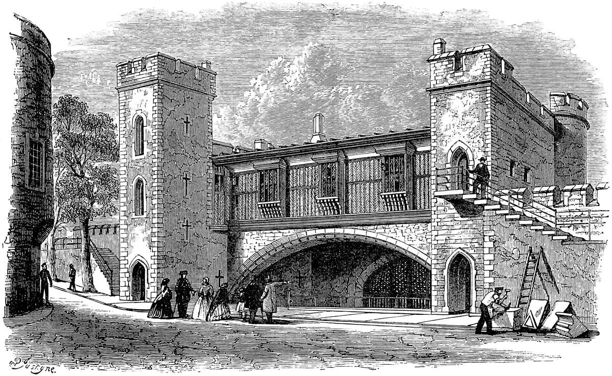
Spelman defines a barbican or “ante-murale” as “munimen a fronte castri aliter ante murale dictum; etiam foramen in urbium castrorumque mœniis ad trajicienda missilia.”
A palisaded embrasure in front of the barbican was known as the “barriers.” They are well represented at the Tower by the stockade covering the entrance.
The drawbridge was an important feature in the defence of a castle. In its most simple form it was a platform of timber turning upon two gudgeons or trunnions at the inner end; when up, it concealed the portal, and when down, dropped upon a pier in the ditch or upon the counterscarp. Its span varied from 8 to 12 feet. The contrivances for working it were various. Sometimes chains attached to its outer end passed through holes above the portal, and were worked within by hand or by a counterpoise. Occasionally there was a frame above the bridge, also on trunnions. In the larger castles the arrangements were very elaborate. Sometimes the bridge was the only connexion between the gateway and the opposite pier; at others the parapets or face walls rested on a fixed arch, and the bridge dropped between them. A fine example of this kind of bridge is seen at the Constable’s Gate, Dover Castle. At Goderich the details are tolerably perfect. The ditch was crossed by a stone bridge, apparently of two arches, but only the outer one is permanent. The roadway of the inner one was a drawbridge. At Caerphilly, in the ditch in front of the main gate, is a large stone pier from which a bridge fell each way. Probably it carried a tower of timber. In Henry III.’s accounts is mention of a brétasche on the bridge of the great tower at Winchester, and of another, covered with lead, upon the new bridge.
The portcullis, the “altera securitas” of the badge of the House of Somerset, always present in the castles of Henry and Edward, was an important part of the defence. It was a strong grating, in the smaller gateways of iron, in the larger of oak, strengthened and shod with iron spikes, and suspended in grooves by two cords or chains, which passed over two sheaves, or sometimes through a single central block, and either were attached to counterpoises or worked, as at the Tower and York gates, by a winch. The grooves are generally169 half-round, with slightly prolonged sides, 4 to 6 inches broad by from 4 to 7 inches deep. Above, in the vault, is a chase through which the grate is worked. Sometimes the portcullis chamber is a small cell in the wall, as at Rochester keep and Coucy, but in large gateways where there are two or three grates, they are worked in the chamber above. At Linlithgow and Thornton Abbey, where the grate is single, it is carried up within the wall and worked in the second story. Sometimes the grate had no lateral grooves, and must have either hung loose or been steadied by its spikes resting on the ground below. This is seen at St. Briavels and at the upper gate of Chepstow, though never with an outer portcullis. Sometimes grooves are cut for a spare grate, but do not appear to have been armed.
Nothing is more remarkable than the provisions for cleanliness in military buildings. At Ludlow, Langley, and Caerphilly Castles are large mural towers appropriated to garderobes. At Goderich they occupy a broad buttress. At Beaumaris the sewers are of very large size, and run within the main curtain like galleries. Such sewers are often supposed to be secret passages, though the garderobes above, and the character of the outlets below, should correct this notion. At Coyty the filth was collected in an enormous vaulted chamber. The ramparts of the curtains are also usually provided with garderobes.
Subterranean chambers were not more frequent in England in the thirteenth and fourteenth than in the eleventh and twelfth centuries, and if we have nothing like the magnificent tiers of vaulting in the tower of Coucy, neither have we anything like the wretched cells and oubliettes found in German castles, and of which those of Baden-Baden are examples. The basement chambers of mural towers are, indeed, often below the level of the court-yard, but they are above that of the ditch outside. At Castel Coch, near Cardiff, is about the worst dungeon in Britain, but even this is not underground.
The posterns in these castles are often very elaborate. There is a very fine one at Windsor, opening in the castle ditch, and intended for the passage of cavalry. This is probably of the age of Henry III. At Caerphilly are two with regular gatehouses and drawbridges. Sometimes the postern is a small door with a grate. That at Goderich was worked in the floor above, so that it required two men in two several places to open or close the postern. At Caerphilly are two water-posterns; one out of which a boat could be lowered into the lake, the other at the water-level, as at170 Ledes and Tonbridge. Harlech water-gate has been mentioned.
The castles both of Henry and Edward combine the palace with the fortress, but the domestic are always subordinate to the military arrangements. Whether absolutely original, as Caerphilly or Beaumaris, or completions of older works, as Corfe, Dover, and the Tower, they usually present a grand appearance, and the masonry is generally excellent.
Very many of our principal towns were walled in during the reigns of Henry and Edward; some—as York, Leicester, Colchester, and Chester—took advantage of the Roman wall. Northampton was walled before 1278. At Winchester the wall was founded upon an early earth-bank. The only licences granted for town walls appear to have been to the men of Harwich and Ipswich, 26 Ed. III.; the Mayor and prud-hommes (probi homines) of Coventry, 37 and 38 Ed. III.; of Salisbury, 46 Ed. III.; and of Winchelsea, 3 Hy.; the defences of Hereford, a very exposed place, seem to have been formed of briars and thorns, placed upon very formidable banks of earth. It sometimes happened that the gatehouses were of masonry, while the rest of the defences were banks of earth stockaded.
The fourteenth century was prolific in castles, chiefly of the smaller class, upon the Scottish border and in Scotland. In England Dacre, Dunstanborough, and Spofforth were built early in that century; the Palace Castle of St. David’s was built in 1342, Caesar’s Tower at Warwick about 1360, and Guy’s Tower in 1394, two magnificent works. Gradually, however, pure castles fell into disuse, and such structures as Bolton and Wressill and Sheriff-Hutton took their place, affecting generally the form of a square court, round which the buildings were ranged, and which was entered by a regular gatehouse. In these, however, the castellate character was employed more from custom than from necessity, and the external windows are large, and the walls of very moderate thickness. Many of the royal castles were left to decay, and others were employed as prisons and handed over to the counties. A short Act of the 13 R. II. orders “that the King’s castles and gaols should be joined to the bodies of the counties, and, where severed, should be reunited.”
Castle-building was from a very early time considered as a royal prerogative, though in the reigns immediately succeeding the Conquest, it was so great an object to hold the country, that the claim seems to have been allowed to slumber. The wholesale destruction of the adulterine or unlicensed castles which followed upon the death of Stephen showed the revival171 of the prerogative, and, in the reign of Henry III., a regular form of licence, “licentia crenellare,” had to be granted before a house could lawfully be fortified. The earliest known of these licences was granted by Henry III. to the Bishop of Winchester in 1257–8, to enable him to fortify the Isle of Portland. Henry granted 20 of these licences; Edward I., 44; Edward II., 60; Edward III., 181; Richard II., 60; Henry IV., 8; Henry V., 1; Henry VI., 5; and Edward IV., 3. A very complete list of these licences, prepared by Sir J. Duffus Hardy, has been printed by Mr. Parker. Of the 382 given by him, only four relate to castles of importance; Belvoir, Bungay, Dudley, and Whitchurch, all of which had been fortified before legal memory. Most of the others relate to manor-houses, some to bishops’ palaces and cathedral closes, some to monasteries, some to houses in cities, and some to castles probably then first built, or perhaps rebuilt on a larger scale. Such were Apley, Aldworth, Amberley, Bodiam, Bolton, Bothal, Cowling, Dunstanborough, Ford, Harewood, Naworth, Penrith, Rose Castle, Stokesay, Shirburne, Tanfield, Tongue, and Wardour, most of which are still standing, and two or three inhabited.
The following, from the Patent Roll, 15 Hen. VI., 1437, is a part of the licence granted to Humphrey, Duke of Gloucester, and his Duchess, who proposed to build a strong house upon the hill now occupied by the Royal Observatory at Greenwich: “Muris petra et calce includere et firmare, et muros illos kernellare, batellare, et turrellare, ac quandam turrim infra parcum prædictum similiter petra et calce de novo construere, edificare, ac tam turrim illam sic de novo constructam et edificatam quam dictum manerium sive mansionem ut præmittitur inclusum, firmatum, kernellatum, imbattellatum, et turrellatum, tenere possint sibi et hæredibus suis prædictis in perpetuum.”
Innis (“Sketches,” 444) gives a corresponding licence from the Earl of Ross, in 1406, for the building of Kilravock.
“Johne of Yle, Erle of Ross ande Lord of the Ilis, to all ande sundry to quhais knawlage thir our present letteris sall come, greeting. Witte us to have gevyn ande grantit, and be thir present letteris gevis ande grantis, our full power ande licence till our luffid cosing, man ande tennand, Huchone de Roos, Baron of Kylravok, to fund, big, ande upmak a toure of fens, with barmkin and bataling, upon quhat place of strynth him best likes, within the barony of Kilrawok, without any contradictioun or demaund, questioun, or any obiection to put in contrar of him or his ayris, be us or our ayris, for the said toure ande barmkyn making, with the bataling,172 now or in tyme to cum. In witnes hereof, ye haf gert our sele to ther letteris be affixt at Inuernys, the achtend day of Februar, the yer of Godd a thousand four hundreth sixte yer.”
Mr. Innis points out that one of James’s first acts on returning from his English captivity was to order the owners of all castles and manor-places to make them habitable and to live in them; and he adds that it is remarkable “How many Scotch castles date from the half century following the above enactment, and all of one design—a stern, square keep, rudely kernellated, and surmounted with a cap-house, partially surrounded by a barbican or barmkin, affording protection to the inhabitants and their cattle from the hurried inroads of rough-handed neighbours.”
THE castle of Alnwick stands upon a moderate eminence on the south bank of, and about 150 yards distant from, the river Alne, which was thus its immediate defence against the Scot. It is about five miles from, and about 200 feet above, the sea-level. Towards the east and south the castle is cut off from the town of Alnwick by a deep combe, once the bed of the Bow Burn. This has been trimmed and scarped by art, and its upper part towards the town has been almost obliterated by modern upfilling.
To the west is a nearly level platform in front of the castle, and separated from it by a ditch wholly artificial, and in part filled up and covered by the stables. This ditch was formerly produced along the south front, and communicated with the Bow Burn ravine. A modern bank of earth conceals the town from the castle on this, the south-western quarter.
The walls of Alnwick town were embattled, and probably built, under a licence to Henry Percy, in 1434, when he constructed the Bond Gate, now standing. It is uncertain whether the town wall was independent of the castle, as at Chepstow, or abutted against its outer wall, as at Carlisle. The main entrance to the castle and its principal postern were both outside the town. The former was approached from it by a town gate, the position of which is remembered, and its name preserved, in the way called “Narrow Gate.” The castle postern opens towards the river. The Lion gateway in the south wall, leading to the town and the railway station, is altogether a modern structure, but may represent a by-gate communicating with the town.
In plan the castle is irregular and many-sided; the west and south sides terminate, the one in the Abbot’s Tower, and the other in the Eastern or Ravine Tower, and are 125 yards and 213 yards long; and the side towards the river, and contained between these two towers, is 226 yards. The area within the walls is nearly 3 acres; that included by the ditch is near 7 acres.
There is no single keep-tower. The keep is in plan an irregular polygon, set round with clustered towers, and containing a central court. This is placed nearly in the middle of the general inclosure,176 with which it was connected at three points: one, on the south, by a bold and lofty gallery which has replaced an original curtain, and projects 35 yards from the keep to a gatehouse which divides the eastern and western wards, and is known as the Middle Gate. The other connexions on the north side were two curtain walls, of which one reached from the keep 33 yards to the Falconer’s Tower, now rebuilt and shifted, and had upon it the Armourer’s Tower, now destroyed; and the other was a curtain, now removed, which extended 20 yards from the keep to the Postern Tower.
By these arrangements the area was subdivided into an outer or western, an inner or eastern ward, and a central open keep. There remained, however, on the north front a three-sided space, bounded by the keep and the two curtains, and flanked by the Falconer’s and Postern towers. This space, open towards the river, is at present protected on that side by a low retaining terrace-wall and bastions of very modern date. A survey of 1567 shows this side open, and no doubt it was so originally; the river, its steep bank, the keep, the flanking towers and curtains, and no doubt palisade, being regarded as a sufficient defence. This disposition is, however, singular and very curious, and looks as though the engineer wished to attract the enemy to this the strongest and most completely flanked part, by a show of weakness by the absence of an outer enceinte. Economy of construction could not have been the motive, for the cross curtains, in length, would go some way towards completing the broken enceinte.
It would seem, from existing fragments and traces of foundations, that the lines of the present enceinte and keep are those of the old Norman fortress. The outline is governed very much by the disposition of the ground, and the shell keep was the approved Norman way of occupying such a knoll, whether natural, as at Durham, or artificial, as at Windsor, or, as here, probably a very slight addition to a natural knoll. A distinct ditch, now filled up, encircled the keep and protected it from its containing wards. Towards the river this ditch seems to have worked out into a steep scarp.
The keep is at this time an open court surrounded by towers. To the south-east, the gatehouse, about 40 feet deep and 20 feet wide, has grand external and internal round-headed Norman arches of 9 feet 2 inches span, the vault between being segmental and crossed by plain chamfered ribs. The exterior arch has a double band of bold chevron mouldings within a circle of double-hatched work. The inner arch has a single chevron band, and above it a band of which the voussoirs have alternate patterns of sunk nail-heads and the heraldic “lozengy.” This is the work of Eustace de Vesci, who died 1157, and may be dated 1150, though possibly a part of his “munitissimum castellum,” which, according to Mr. Tate, was existing in 1135. This Norman gateway is imbedded within a complete gatehouse by Henry de Percy in 1530, of which the main features are two lofty towers, which as half octagons flank the entrance from the eastern ward. Original shields of arms, in177 the Northumbrian fashion, are carved below the parapets; and upon the merlons, which are looped, are some original figures, as at Bothal and Chepstow. The archway is portcullised. The parapets are not machicolated. The vaulting of the interior of these towers is very good, and they contain in the basement the original dungeons, which are described as vaults 10 feet square, aired by loops, while below these are oubliettes, 8 feet by 9 feet, and reached only by trap-doors in the floor above. Over the gateway is the private dining-room. The plan of encrusting an original Norman gateway with later work is very common; the gatehouses at York afford excellent examples of it.
Entering the court, the open part of which is about 24 yards across, on the right, in the wall, is the very curious well. Within a pointed panel are three deep recesses, also pointed, of which the centre contains the mouth of the well, the shaft of which descends in the thickness of the wall. A wooden axle crosses above it, and is fitted in the lateral niches with two wheels, set round with pegs, for winding up the water-buckets by hand. Above, within the panel, in a small niche is a figure of St. James blessing the source. This curious and probably singular well was the work of the first Henry de Percy, in 1312–15; but the figure of the saint is thought to be an insertion of the last century. There is a similar arrangement over the great gate of Goderich Castle for working the portcullis.
Beyond the well is the rear wall of the Great Hall, built by the same Percy, refitted by the first duke, and rebuilt in 1863. The vaults below with their segmental ribbing are original, as is part of the rear and north wall and of the bow, whence the cross curtain ran to the Postern Tower. This is still the state dining-room, 60 feet by 24 feet, and the vaults fulfil their original destination as cellars. At this point is placed a modern cloister supporting a corridor, by which a bye-access is given to the suite of state-rooms. The original entrance to the hall was by six open steps from the court.
Next beyond the hall, pointing to the north-east, is a tower, once the kitchen and scullery, but rebuilt for the second time in 1856, and now the drawing-room, 45 feet by 22 feet. Beyond this, along the north-east front, are the saloon, 42 feet by 22 feet, and an ante-room, 22 feet by 22 feet, built in 1750–86, but newly fitted up. Next to these, and forming the north-west angle of the keep, is Prudhoe Tower, the principal tower in the fortress, upon which the flag is hoisted. This contains the library, 55 feet by 24 feet, and presents two grand bays to the east and west, with a deep re-entering angle between them. This also is modern.
Next, on the west front, follows the chapel, built in 1856, a rectangular tower of bold projection, one principal floor, and a high-pitched roof. The two angles are cut off, so as to form a polygonal apse. This conventional east end points, however, south-west.
Then, facing to the south-west, follow two half-round towers, rebuilt 1750–86, containing state bedrooms, and connected by a178 short curtain, within which is a dressing-room. Finally, between these and the gatehouse, completing the circuit of the keep, and projecting due south, is the gallery, having on the first floor a breadth of one line of five rooms and a corridor, and below, the middle gateway. The rooms are the private apartments of the duke and duchess, and a passage communicating with the kitchens. The gateway, which has a portcullis, is of the date of 1309–15, and built into the south curtain, from the outside of which it projects as a mural tower. The gallery replaced a curtain about 1760, and was rebuilt 1856. The battlements of the gatehouse were probably added about 1407–55.
The entrance to the state apartments is in the central court, beneath the arched vestibule, at the north-west corner. From this a grand flight of steps ascends to an interior vestibule, and thence by a second flight to the guard chamber, which opens into the state-rooms. These are all on the first floor, the basement being occupied by servants’ rooms.
Although the greater part of the keep has been rebuilt in the last and the present century, it still is composed of the seven towers of the early Percies, shown in the plan of 1567, and much, especially of the basement, is old; and what is new is arranged with a close general regard to the older, and, indeed, in many parts, Norman plan. The exterior ditch of the keep is partly filled up, and the drawbridge of the inner gate has been removed. A portcullis remains.
Of the general and exterior enceinte, the most complete and striking portion is the western gateway, a very fine and unaltered example of a gate and barbican of the Edwardian period, 1312–15, in its simplest form. The barbican, about 55 feet long by 32 feet wide, is entered by a large round-headed arch, between a pair of square flanking buttresses, corbelled out above into two turrets, also square. Over the entrance in a sunk panel is a large Percy lion, with their motto, “Espérance.” The arch leads into a passage, 55 feet long by 10 feet wide, for the first 20 feet vaulted, but afterwards open to the sky. This lies between very lofty side walls, embattled each way. On the left, a small side-door led to the counterscarp of the ditch; also on the left another door opens into a mural stair ascending to the battlements. In front is the portal of the gatehouse. This barbican crossed the ditch now filled up. Besides an outer drawbridge, over a loop of the main ditch, it had an inner bridge between its lateral walls, dropping from the gatehouse. This is mentioned in the survey of 1538, and was removed in 1567. The parapets are without machicolations, and the embrasures have no mouldings. The merlons are not looped, and the figures placed upon them date only from 1750–86. Probably in advance of the ditch of this barbican was a barrier or palisade of timber, and the level space in front, commanded by the walls of both town and castle, is what was usually employed for jousting matches or military duels. The adjacent river was a sufficient security against surprise.
The gatehouse, of which the barbican is the covering, is a rect179angle 40 feet deep by 45 feet broad, of slight internal and bold external projection, and presenting to the field two half octagonal towers. The passage is vaulted and has the usual defences of a portcullis and gates. The portals are round-headed. There are lateral lodges, entered one from the passage and one from the court.
Entering the court, the curtain on the left, of considerable height, has Norman foundations, 1150, and an Edwardian superstructure, 1350. Outside, a string-course marks the base of the parapet, and the embrasures have a decorated moulding carried all round. The wall extends to the Abbot’s Tower, but upon it is a small rectangular mural tower, called the Avener’s Tower, 1309–15. The Abbot’s Tower, of the same date, caps the north-west angle. It is rectangular and of three stages, the lowest being vaulted and ribbed with segmental arches, as in the Constable’s Tower, and below the Great Hall. The third stage rises clear of the wall, and is reached by a well-stair, which occupies the north-east angle.
From this a short curtain of mixed date, 1150 and 1350, with a low salient, extends to the Falconer’s Tower, also rectangular, rebuilt, though not exactly on the old site, in 1856, and from which a modern curtain wall runs up to the Prudhoe Tower of the keep. Upon this wall stood the Armourer’s Tower, also rectangular, destroyed in 1856, to improve the view from the library. The removal of this and the Falconer’s Tower are said to have been the only subtractions made from the original military works of the castle.
Returning to the west gate, the curtain on its right extends past the west Garret Tower to the Clock Tower, all rebuilt 1750–86. The latter is circular, with a flat gorge and keel-shaped salient, and caps the south-west angle. Outside the last-named curtain, and reached through it by a gateway, are the stable courts, riding-school, and guest-hall, 135 feet by 35 feet, by 25 feet to the spring of the open timber roof, a very noble structure. These buildings are of modern date, 1856.
From the Clock Tower the south curtain supports on its outside the estate offices. Part of this curtain is 1750–86, part 1309–15. This latter part includes the Auditor’s Tower, 1770, of which the square rear projects into the court and the half-round front outside. Beyond this is a bit of Norman curtain, 1150, against which on the outside is built the modern kitchen, and above which a modern corridor communicates between the duke’s room and the record-room in the Auditor’s Tower. The treatment of this part of the structure by Mr. Salvin deserves especial notice from the happy combination of the features of the Edwardian age with the appliances of the present day. The kitchen, with much to remind the visitor of Durham and Avignon, is as a whole superior to either, and is besides a model of culinary arrangement. These offices, originally within the keep at the east end of the hall, were placed here by the first duke, but were recast and rebuilt by Duke Algernon.
Formerly there stood in the west ward the exchequer and the180 stables. The exchequer was a large rectangular building, applied to the north limb of the west gatehouse, and, like it, embattled. The two ranges of stabling stood a little within and parallel to the curtains next the Clock Tower. These buildings, shown in the survey of 1650, were removed probably about 1755.
Traversing the middle gate, in front is the eastern or inner ward, and on the left the inner or gatehouse of the keep. On the right, outside the curtain, is the steward’s room, and beyond it the Warder’s Tower, mentioned in 1567, but altogether remodelled and rebuilt in 1860 upon a work of 1770. It now contains the Lion gateway, leading to the gardens. Below the gatehouse is an ale-cellar, and above one side of it, attached to the offices, the confectionary.
Beyond, the line of the curtain is irregular. About the salient it is Norman, 1150, and a very good example of the rough walling of the age. Upon it is the East Garret, 1309–15, and it ends in the Ravine Tower, the most eastern work of the castle, and capping an acute angle of the enceinte. This is a good-sized round tower, with a well-stair at its junction with the curtain. It has been much repaired since its foundation in 1309–15. It is defended by the ravine, whence it derives its name.
From hence the curtain trends to the north-west, being in great part Norman, but repaired at what is called the “Bloody Gap.” Beyond this is a garret bartizan, called Hotspur’s Chair. It was the gorge of a half-round tower, now removed, but shown in the plan of 1650. Beyond this the curtain is again mixed Norman and Decorated of 1312–15, to the Constable’s Tower. This is a strong half-round tower, capping a flattish salient to the north-east; it has an exterior entrance by stairs to each of its three floors. From this a short curtain, 1150, leads to the Postern Tower, 1312–15, rectangular, pierced below by the vaulted and portcullised passage of the postern, and vaulted also on the first floor. This tower is a fine example of a Northumbrian military building of the Decorated period. The arches are round-headed or segmental, and it has in its rear wall a remarkable two-light window with a transom, and in the head a foliated circle. There is also a very perfect garderobe with external shoot. From this tower a curtain, now removed, ran upwards to the bow of the hall tower of the keep, and thus completed the defences of this ward. The original postern passage is filled up, or nearly so, with earth, but by the side of the tower a way leads to a terrace walk between the keep and the river, and extending to Falconer’s Tower.
The eastern ward contained the castle chapel and the conduit, supplied with water by lead pipes from an exterior spring called Howling Well. The chapel, a considerable building, stood detached near the Bloody Gap, and was removed in 1755. The ecclesiastical establishment seems to have been on a respectable scale, and included a chantry for the performance of the obits of the family. In this quarter also stood the brew, bake, and slaughter-houses for the use of the garrison.
181
Alnwick Castle is probably the finest extant example of a Norman castle of this type, having an open keep and a complete enceinte; for although most of the present buildings are either of the fourteenth or the nineteenth century, the plan is certainly Norman, and certain detached portions of the construction. It seems also that the keep was never a mere shell, like Cardiff or Arundel, but was always set about with towers and provided with a handsome gatehouse. A notable feature is the use of the round-headed and the segmental arch in the Decorated period. This is not uncommon in the North of England. The very free use of stone warriors upon the parapets, carried to an absurd extent in the repairs of the last century, is also remarkable. They are seen at Bothal, and in Edwardian works both at Caernarvon and Chepstow, but by no means so freely distributed as here. They were obviously intended for ornament only, but, of all figures, that of the eagle at Caernarvon is the only one at all appropriate. No archer would or could have stood on the crest of the parapet. Most of the later figures were very properly removed by Mr. Salvin.
There is found upon the battlements of both walls and towers, in various parts of the castle, a convenient arrangement for hanging a movable wooden shutter in the embrasures, so as to defend the warders from a Scottish shaft, and from the scarcely less keen edge of the bleak winds of the Border. The shutter was suspended horizontally, like a port-lid, but from trunnions, of which one rested in a round hole in one merlon, and the other in a similar hole terminating in a groove in the other, so that the shutter hung freely, and could be lifted in and out if necessary. The arrangement is precisely that applied to the roller of a round towel. Traces of this arrangement remain in various parts of the castle. A perfect example is seen on the barbican. It may also be seen on the east wall of Goderich, at Chepstow, and elsewhere.
The officers forming the staff of this castle as a civil residence, in 1567, were the constable or governor; the porter of the outer gate; the greive, or executive officer or bailiff; the receiver or auditor; the feodary, who looked up the services and tenures; the steward, learned in the law, who administered justice; the clerk of the courts, who engrossed the rolls and kept the records; and the foreign or outer bailiff, who collected the castle-guard and cornage money, and summoned the tenants and suitors. The whole of the annual payment to these officers was £58. 18s.
Looking to the character of the country, so charged with traces of early military earthworks, and to the strong and well-defined natural position of Alnwick, it seems probable that it was occupied as a camp by some of the tribes who, from a very remote period, made this Border their battlefield, and whose defences are still visible in eleven distinct earthworks within a very short distance of the town. If so, they would necessarily have placed their defences to the north and east upon the lines of the present castle. The interior eminence would certainly have been their citadel, and the trench,182 completing their security, would most conveniently have been carried along the general direction of the western front, so as to connect the head of the Bow Burn with the Alne, and thus complete the seclusion of the peninsula. Such a site, so defended, was not uncommonly adopted or constructed by the Northmen and Saxons when they became settled, and they would have placed the timber and palisaded mansion of their thane upon the central entrenched knoll.
Probably the Norman Gilbert Tison, of cloudy memory, who is the reputed pioneer of the Conquest in these wild regions, found and contented himself with some early kind of timber fortress, for the earliest traces of masonry that remain in situ or have been extracted from the walls, though Norman, are of late character, and attributable to Eustace Fitzjohn, who married Beatrix, daughter and heir of Ivo de Vesci, who is thought to have married Tison’s daughter. Eustace, called De Vesci, flourished under Henry I. and Stephen, and died in 1157. He was a likely man to have constructed a great castle, being a baron of considerable power, sheriff of Northumberland, and founder of the abbeys of Alnwick and, in Yorkshire, of Malton. Also he must have felt the want of a strong place, for in his days, in 1135, Alnwick Castle was taken by David I., of Scotland, in the interest of the Empress Maud.
Eustace no doubt built in the first half of the twelfth century a polygonal clustered keep upon the knoll, gave it the gateway we still see, and placed his residence within. Traces of his walls are said by Mr. Tate to have been discovered when the last rebuilding was being executed. No doubt also he cleared out the moat round the keep. To him also must be attributed the general wall of the enceinte, and possibly the ditch outside it; and this would have been strengthened by mural towers, many of which must have stood where their successors are now placed. De Vesci’s work is indicated by the stones being mostly square blocks of moderate size, laid in courses, but in beds more or less wavy, as though the mason used neither line nor level. The joints are open. Beyond question De Vesci constructed a castle in keeping with his wealth, and worthy of the chief baron of the Border.
In July, 1174, William the Lion, on his way back from an invasion of Cumberland, found himself, to his surprise, before Alnwick. William, son of Eustace de Vesci, attacked him. He was unhorsed, captured, and sent into England, and beyond sea, to prison. Eustace, son of William, succeeded in 1190, and was visited by King John, 12th February, 1201, and 24th April, 1209, when the king received at the castle the homage of Alexander, king of Scotland. Four years later, May 14th, John ordered Philip de Ulecote to demolish the castle of Alnwick—a mandate which could scarcely have been obeyed, seeing the king himself was there 28th January, 1213, and 11th January, 1216, no doubt unwelcome visits, for Eustace was a Magna Charta baron. He met his death from an arrow before Barnard Castle in the last year of King John.183 Henry III. visited Alnwick 23rd September, 1256, and Edward I. was the guest of John de Vesci there 30th April and 1st May, and 16th and 17th August, 1291, and 16th August and 13th and 18th December, 1292; and again 22nd, 23rd, 24th, 25th, 26th, and 27th September, 1296; and 26th and 29th June, 1298.
The Barons de Vesci became extinct in 1297, by the death of William, seventh Baron, when the castle and barony were acquired, it is said, to the fraudulent exclusion of the natural son, by Antony Bec, the warlike Bishop of Durham, by whom, in 1309, 3 Edward II., they were sold to Henry de Percy, the representative of a warlike family, whose advent forms an important era in the history of the Border. Percy, as the leader of the Northern barons, made Alnwick his residence, and although in possession only for five years, seems to have rebuilt much of the fabric, the rest being completed by his son of the same name.
The Percy Castle, laid out nearly upon the Norman lines, presented very nearly the appearance of the present structure. The authorship of the Edwardian part of the inner gatehouse is established by the escutcheon of Clifford on its walls, the second Henry de Percy having married a lady of that house. To the first half of this fourteenth century may be attributed, as has already been pointed out in detail, nearly all the leading features of the castle, as it stood at the incoming of the first Duke of the present family. The Percies, though they maintained the reputation of Alnwick as the great Border fortress during nearly four centuries, do not appear to have materially altered the fabric of the two earliest lords. They received here Edward II. in 1311 and 1322, and Edward III. in 1335; but the later earls were much at Petworth and in Yorkshire; and upon the death of the eighth earl, in 1537, and the attainder of his brother, the family ceased to reside at Alnwick, and the castle was neglected. The Percy line ended in Elizabeth, daughter of Jocelyn, the eleventh earl, who, 30th May, 1682, married Charles, Duke of Somerset. Of their children, two had issue, Algernon and Catherine, who married Sir Wm. Wyndham, and eventually conveyed to that family the Percy estates at Petworth, Egremont, and Leconfield.
Algernon Seymour, Duke of Somerset, and by creation Earl of Northumberland, left one child, Elizabeth Seymour, who inherited Alnwick, and married Sir Hugh Smithson, created Duke of Northumberland, and ancestor of the present family.
A survey of Alnwick in 1567 shows the decay then to have been very considerable, and as the Seymour lords preferred their paternal residence, Alnwick became almost a ruin. From this it was redeemed by the first duke, who, under the advice of Adam, restored, and in part rebuilt, the keep; and although he fitted up the interior with plaster and frippery, made the exterior sound and good, and, on the whole, in keeping with the character of the place, and with what remained of the ancient buildings.
Matters so remained until the accession of Duke Algernon, better known as Lord Prudhoe, a naval officer and a good man of business,184 who had travelled much and possessed a cultivated taste, and was of a truly noble and magnificent disposition. While foremost in works of public usefulness connected with his estates, county, and profession, and careful to drain his lands, rebuild the cottages of his labourers, restore the local churches, and provide lifeboats for his dangerous coast, he, under the sound advice of Mr. Salvin, almost rebuilt the castle, preserving with scrupulous care all that admitted of preservation, and adapting his new work to the period of the first and second Percy, the founders of the later castle. Having thus restored the great fortress of the Border with strict regard to the rules of military architecture, he proceeded, under the advice of Canina, to fit up the interior in the style of an Italian palace. The contrast afforded is certainly extreme, and the attempt on so costly a scale was hardy; but the adaptation of the fittings to the irregular plan of the rooms is so well conceived, the materials employed are so rich, and the execution of the details is so skilful, that it is difficult to regard even so great an incongruity as other than a distinguished success.
Much attention has of late years been paid, and by very competent persons, to the history of this castle. Grose gives some particulars, now very valuable; but this and the castles of Warkworth and Prudhoe have been illustrated by the late Mr. Hartshorne, and are treated of also by him with great success in the Northumberland volume of the Archæological Institute. More recently, Mr. Tate has handled the subject of Alnwick Castle with both skill and accuracy in his admirable history of the barony of Alnwick. And finally, in the “Life of William Rufus,” Mr. Freeman has touched lightly but very effectively upon the connexion of Alnwick and its lords with Northumbrian history. In the above sketch free use has, to some extent, been made of the above materials; but the object of the writer has been to treat solely of the fabric of the castle, and that from a military point of view.
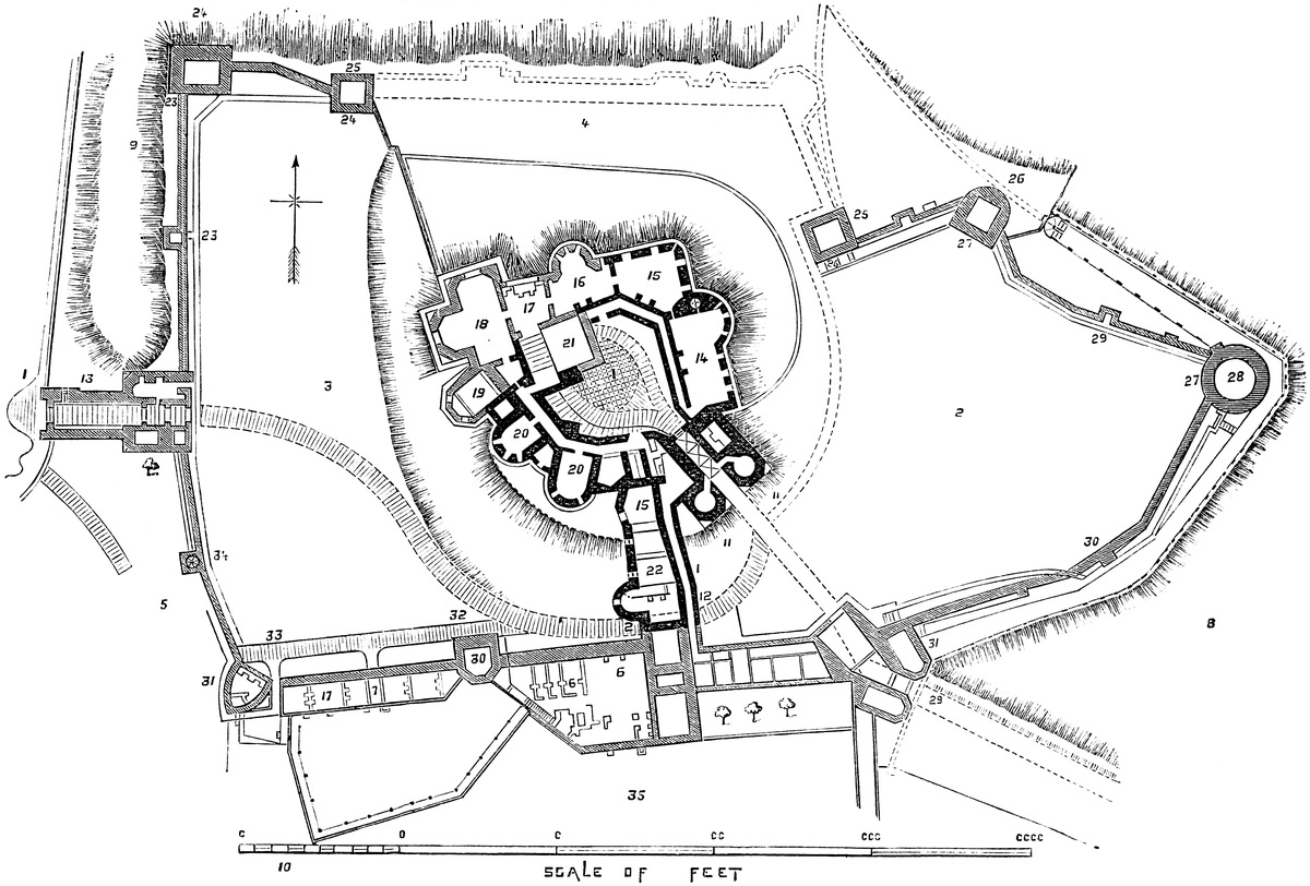
ARQUES is one of the earliest examples of a Norman castle, for which reason, though not an English fortress, it has been thought convenient to include an account of it in these pages. This grand castle crowns and occupies the head of a steep and bold cape or promontory, in this case a spur from the great chalk table-land of the “Pays de Caux.” On the west it is flanked by a short but deep combe or dry valley, and on the east by the deeper and far wider valley of the Bethune and Varenne—streams derived from different sources, but which here meander across a broad and level bottom, above half a mile wide, until, a little below the castle, uniting, they receive the tributary Aulne, and, thus combined, under the name of “la Rivière d’Arques,” fall into the sea at the port of Dieppe.
The castle thus stands above the left bank of the principal valley. It is about 4 miles from Dieppe; and immediately below, and to its north-east, is the village whence it takes its name, remarkable for a church of unusual size, and a most elegant example of the style of the latter part of the sixteenth century. Beyond, upon the right bank, are the remains of the ancient Forest of Arques, a part of the spacious domain of the ancient lords of the fee, and upon the skirts of which, within shot of the castle, was fought, in 1589, a very celebrated battle.
The castle in its present form is composed of a rectangular keep, standing in the south-west corner of an inner ward, in plan something less than a half-circle, having its chord to the west, and contained within an enceinte wall, strengthened by towers and buttresses along its sides and at its southern end, and capping its angles.
Applied to the north end of this is an outer ward, of later date, four-sided, and having drum towers at its four angles.
The main entrance, approached by a steep and winding road from the town, is in the north end, or at the point of the cape, between the two towers. Entering, is a second gatehouse, opening from the outer into the inner ward, also between two towers. A third gatehouse, at the other end of the fortress, leads direct from the exterior into the south end of the inner ward, and thus opens a communication with the root of the cape. There is also a lateral postern with vaulted passages in the west wall of the outer ward.
Outside the wall, encircling it closely, is the ditch, the most striking feature in the whole fortress. This is in general plan not unlike the long section of a pear, the northern end being the smaller, and the western side flattened so as to be nearly straight. The counterscarp of this ditch includes an area of about 5 acres. The ditch itself, measured from the level of the foot of the wall crowning its scarp, is about 60 feet deep, with slopes of 1 foot horizontal to 2 feet vertical, and about 70 feet broad. It is only187 just not too steep to be covered with short turf. The crest of the counterscarp is a ridge about 6 feet broad, and about 20 feet below the level of the foot of the wall. From it descends another slope, equally steep, but much deeper; on the west side descending about 150 feet to the bottom of the valley, and on the east to a rather less depth, as here this “glacis” is succeeded by a sort of broad terrace of pasture land, which falls gently towards the river, the level of which may be 250 feet below the platform of the castle. In many respects these defences resemble those of Bramber, in Sussex.
At the north-west end the ditch is traversed by a very modern causeway of earth, which supersedes the earlier drawbridge. At the south end, where the ground is highest and the ditch about 50 feet deep and 80 feet broad, there remain two engaged piers upon the scarp and counterscarp, and between them two detached piers, of which the outer has fallen against the inner. All are rectangular; and the inner of the detached two is considerably the larger, and probably carried a tower for the protection and working of a double drawbridge. These piers are of flint rubble, cased with ashlar, of which a small part only remains.
At the outer end is the earthwork of a tête du pont, or ravelin, of triangular plan, the passage from which was a little to the east side of the apex. This work was evidently constructed when artillery was in use, and is attributed to Henry IV., during the campaign of 1589. It no doubt represents an earlier barbican, also of earth and timber. There are no traces of masonry beyond the bridge. This work opens upon the ridge of the promontory, which widens and rises somewhat higher to the south. The ground is scarred with banks and ditches, the remains of fieldworks of various dates, both of attack and defence.
The design of this castle ditch is peculiar. The more obvious plan would have been to place the walls upon the edge of the hill, and scarp its sides down to the valley with such steepness as suited the ground. Instead of this, the upper 40 feet of the hill, being chalk rock, was scarped vertically, and then faced or revetted by a wall, upon which was placed the enceinte wall of the inner ward. At the foot of the revetment was then excavated the ditch just described, the material being thrown outwards so as to form an artificial scarp, which thus became a sort of advanced banquette or earthwork beyond the ditch, representing the crest of the glacis, and capable of being held by a line of soldiers, but which, when taken, was too exposed and too narrow to allow of its being held, or of cover being constructed upon it. This banquette was at a rather lower level than the foot of the opposite wall.
Such an arrangement is found in other castles in Normandy, and notably, as pointed out by M. Deville, at Molineaux, De Longueville, Bec de Montagne, and in the later work of Château-Gaillard, where, however, it is less marked.
The keep is rectangular, about 80 feet north and south by 70 feet east and west, and at present about 60 feet high. It stands in the188 south-west corner of the inner ward, close to the enceinte wall, of which its south-west angle forms a part. Its walls at the ground level are about 13 feet thick. It presents three buttresses on the north face and two on the south—the third being a sort of cap thickening and enveloping the south-east angle. These are of the unusual breadth and projection of 9 feet, and they rise to the present, which cannot be above 10 feet below the original summit. At the north-east angle the adjacent buttresses are set square, leaving the angle free. The south face is plain, or nearly so, excepting the cap at its south-east angle, which extends southwards, and is connected with the adjacent enceinte wall. The west face is plain, outside of which was the entrance.
This is composed of a flight of steps, beginning upon the north face, passing by a doorway through its most westerly buttress, and which then, turning, is continued along the west face, until at its south end it lands in the usual square appendage or forebuilding common in these keeps. This staircase was guarded by an exterior wall, and had gateways at its foot and its summit. It was covered over, as appears from marks upon the wall; and above it was no doubt the usual platform for defence. In the basement of the forebuilding, which forms also part of the enceinte wall, was a vaulted chamber opening into the basement of the keep, as at Rochester, either a store or a prison. The landing story was barrel-vaulted, having at one end a loop towards the field, and at the other a door in the wall of the keep.
Entering this door, the staircase is continued southward in the wall of the keep, up a roughly-vaulted, round-headed, mural gallery, until at the angle it reaches the level of the first floor. The gallery now turns the angle, and is continued on the level half-way along the south wall, when it is stopped abruptly. A door on the right leads upon the enceinte rampart, and one on the left probably led into the keep.
The interior of the keep is composed of a basement and an upper or, perhaps, two floors, divided by a north and south wall into two chambers on a floor. This division-wall is said to be original, and ought to be so in a keep of this size, but it looks of the sixteenth century, and may represent an older one. The west basement is much choked up with rubbish. The east chamber is tolerably clear, and shows an exterior aperture in its east wall, near the south end, which communicates with the adjacent south gateway. This may be original, but it is now a mere hole. In the north wall is a short mural gallery, entering a well-stair in the north-east angle, which ascends to the first floor and chapel only. The lower stage was not vaulted. The first floor has four windows on the north side, two in each room, and one on the east side. The second floor had also similar windows on its north, and a vaulted chamber on its east side; no doubt a chapel. This chapel is formed by throwing a vault from buttress to buttress for its floor, and at a higher level for its roof, and above this were the leads. There are traces of similar chambers on the north front. The upper story has been vaulted in six bays, three on each side, duly groined and ribbed, as is shown by the springers. The material and the workmanship, no less than the section of the ribs, show this to be a late addition, probably of the sixteenth century.
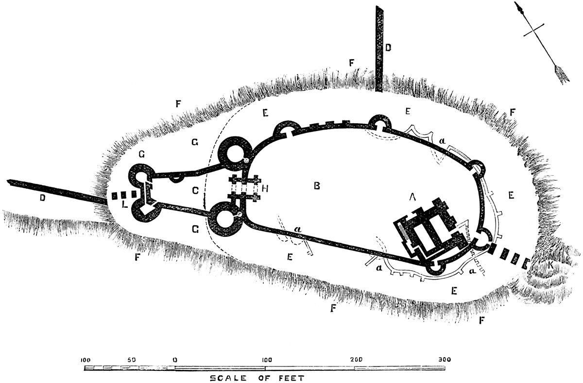
190
The supposed two upper floors were very possibly intended for one floor of state, with two tiers of windows and a chapel above. The chapel seems to have had a barrel round-headed vault, probably groined. The accounts show this eastern side to have been the royal chamber in the fourteenth century. The fireplaces seem to be confined to the upper floors. As now seen, they are of the date of the vaulting.
In the south-west angle of the keep, very near the wall, is the well, of which the pipe was continued at least to the first floor, as in the additions at Richmond. It is about 6 feet diameter, lined with ashlar, and in 1768 was choked up at 254 feet deep, or about the level of the river; a depth now reduced to 30 or 40 feet.
Outside, between the buttresses, are traces of walls, as though the spaces between them had been turned to account below as well as above; but these walls are thin, and do not seem original.
M. Deville cites the public records for the existence in 1318 of four turrets on the keep, roofed with lead.
M. Le Duc, in his Dictionary, Art. “Donjon,” gives a great variety of very curious detail connected with this keep, detail unknown to M. Deville, and for which there should be some authority other than the traces actually existing, which are very unsatisfactory.
The keep is built of large chalk flints grouted copiously in mortar, and cased outside with ashlar, now mostly stripped off and removed. Within, the flints are occasionally laid herring-bone fashion. The ashlar was a calcareous tufa, known in the country, and formed by the trickling of calcareous springs over moss and similar vegetation. It was much used in the earlier French castles. The later ashlar of the vaulting ribs and inserted door-cases seems to be a fine hard limestone, approaching Caen stone in appearance, and perhaps actually that material. Where the ashlar is wanting, the putlog holes are seen, placed with exceeding regularity. The joints of the original ashlar are large, those of the later fine. The new and old ashlar can readily be distinguished; but one flint wall is very much like another.
The inner ward, in length about 160 yards, and in its greatest breadth about 70 yards, is a natural chalk platform, revetted all round by a wall about 8 feet thick, which on the east side is reduced to a parapet, but on the west rises about 20 feet higher, probably its original height. In 1708 this court contained the apartments of the governor and the staff of the garrison, a well, and a chapel. These were probably of the sixteenth century or later, and have now entirely disappeared.
The enceinte wall, which girdles this inner ward, deserves attention, as most of it is of early date. Setting aside the four northern191 towers with their curtains, which are of later date, we have about 380 yards of curtain broken by five mural towers and three rectangular buttresses. Nearly the whole of the wall is faced with flint, with three bands of ashlar. Much of the flint is laid in herring-bone fashion, the repairs, where of brick, being of much later date. The ashlar bands are of tufa. Of the towers two, half round, are on the east front. Of these one, though probably original, has been cased with brick. The other has had an ashlar base, and the upper part, of flint, shows herring-bone work. Each is about 15 feet diameter, with walls 5 feet thick.
Between these towers are three rectangular buttresses; two of 15 feet breadth and 12 feet projection, and one about 7 feet square. The two former contain no herring-bone work, and are probably early additions, perhaps by Henry I.; the latter is original.
On the west face are now no towers, but in 1708 there were two, half round, and of small size, traces of which remain. They were, no doubt, original.
The remaining three towers capped the three salient angles of the south end, the central containing the gateway, and the others flanking it. All are one quarter engaged.
The flanking towers are alike, about 22 feet diameter and 55 feet high from the exterior base, with walls 7 feet thick. The bases are either solid or pierced by steps leading down to the galleries. There is a regular basement story, and above it a floor on the level of the inner ward. They are not vaulted and show no exterior herring-bone work, though one has a little inside. A modern summer-house has been built upon that to the south-east.
The central or gate-tower is 24 feet diameter. It is pierced at the level of the scarp by a portal which opens upon the drawbridge, the piers of which have been described; and there is a stage above this.
The portal ascends towards the keep; its details are much broken down, and little can be made of them.
Of the enceinte of the inner ward there remains to be noted the northern gatehouse. This, the original and, probably, the only entrance to the Norman fortress, though much ruined, does not appear to have been materially altered. It consists in a rectangular building, 40 feet deep by 20 feet broad, set in the centre of the curtain, with which its outer face is nearly flush. It is crossed by an outer, middle, and inner wall, each pierced by an arch of 12 feet opening, through which lies the passage. There remain the rectangular grooves of a portcullis, and a few years ago there was evidence of a second, and in the wall is herring-bone work. The arches are plain, without moulding or chamfer. The inner one is round-headed, and springs from a flat abacus, chamfered below. The joints of the ashlar work are about 1 inch wide. The curtains on either side of this gateway, though much repaired, seem to be original, and there are traces of the old round gate-towers. The pit of the drawbridge remains in front of the gate, upon the original line of fosse.
192
The outer ward no doubt occupies the site of an earlier outwork. It is built against the narrow and north end of the inner ward, is four-sided, about 250 feet north and south, by a mean of 110 feet east and west. Its west side is straight, being the continued line of that face of the old fortress. The east face has a slight re-entering angle, caused apparently by the shape of the ground. At the two southern angles are two large drum towers, which connect the old and newer work, and probably replace two smaller and older towers. These stand in the line of the old ditch, and flank the Norman gateway. That to the south-west, rather the larger of the two, and slightly oval in plan, has a mean diameter of 60 feet; it is of two stages. Both are vaulted, or rather domed. That to the south-east, of 50 feet diameter, is nearly circular, but has a remarkable spur or keel-shaped projection towards the field. It is of three stages, the two lower being domed. These towers are in fact casemates, having embrasures for small culverins towards the field. Each has a well-stair in its southern side, and is entered from the gorge.
The two other towers cap the northern angles of the ward, and flank the main gateway. They are of irregular form, semicircular to the field and angular within. In diameter they are about 40 feet, and about the same height. They are of two stages, which have been domed. The walls of these four towers are from 14 feet to 16 feet thick. They are of flint faced with brick.
Between the gate-tower is the gateway, composed of a larger and smaller portal, the latter very narrow. The present work is modern, but no doubt in this double entry represents the earlier openings. The ditch, two detached piers standing in it, and with these any traces of the drawbridge, are concealed by the modern causeway.
In the west curtain, near the south-west tower, a flight of steps beneath hanging arches of brick descends from the ward level in the direction of the foot of the wall. This is much encumbered with ruin, but seems to have been a postern, opening upon the ditch.
All the works of this outer ward are of flint, rubble-faced with brick, which material forms the lines of the embrasures. The quoins are sometimes of ashlar, as are the extensive string-courses and bands, and the dressings of the openings. Traces of herring-bone work in its west curtain, outside, will be accounted for afterwards.
As the original castle was confined to the inner ward, its ditch everywhere encircled it. When the outer ward was added, the intercepted portion of the ditch was partially filled up, but the new work was included in a new ditch, which was an accurate prolongation of the old one, of equal depth and breadth, and continued in the same direction. Accurate observation will, however, detect two slight shoulders in the counterscarp, showing where began the curve of the old ditch.
Very remarkable in this castle are the subterranean galleries, driven in the chalk rock beneath the lines of the original wall, and193 behind the scarp of the ditch. These are now in part blocked up, but there still remain two or three hundred yards of them of which the direction is known. They are entered by a passage in the inner ward, in its north-west quarter, and by a descent of fifty-four steps near the keep, and possibly from other points now lost. The galleries are about 7 feet high and 6 feet wide, rudely cut, and somewhat singularly laid out. They lie within, without, and beneath the wall, and give off frequent spurs or short passages intended to occupy any space in which a mine was likely to be opened. At this time they have been broken into at three or four points in the scarp of the ditch, about half-way down. They were intended as a system of permanent counter mines to meet any attempt at mining on the part of the besiegers. In one place a large central pier is surrounded by a gallery, whence the branches go off,—an arrangement intended probably to check the progress of those who might break in. So far as is known, these galleries, of which a survey was made in 1708, are confined to the southern half, or four-fifths of the old castle. There are none under the outer ward.
Outside, and to the north-east of the outer gate, are some semicircular platforms, which seem to have played a part in the defence of the castle; but whether before or after the use of artillery is uncertain.
The Bel.—A curtain wall, which originally was about 5 feet thick, and from 15 feet to 20 feet high, commences abruptly upon the crest of the counterscarp in two places; one on the east opposite to the mural tower, which marks about the centre of that front of the castle, and thence descends towards the river; and the other north, close outside of the drawbridge of the main entrance. This latter wall is continued down the hill, and makes a bold sweep towards the town, and, finally reaching the river bank, joins the river wall. The enclosure thus formed contains about twice the area included by the ditch of the castle, and has long been known as Le Bel or La Baile, a form evidently of the Norman-Latin Ballium, called by us the “Bailey.” This enclosure is traversed by the road from Dieppe to Martigny, which passes through the two gates bearing those names. A third, or water-gate to the east, opened upon the river. Upon the north front appear to have been two small half-round mural towers, of which one remains. The river has somewhat encroached upon the lower part of the Bel, and has undermined part of the wall.
The Dieppe gate, which is also that from the town of Arques, was in 1433 called “La Première Port du Bel de Château d’Arques,” and, as such, was the subject of a tenure by castle guard, the tenant being bound to defend it for forty days in time of war. From this gate the approach ascends to the castle, having the curtain-wall as a protection on its right. Where this wall approaches the castle, at either end, it is covered by a broad ditch, continued down the slope.
A flint wall may be of any age, but the remains of the gates,194 which a few years ago showed round-headed arches, prove this inclosure to be of early date, probably one of the earliest additions to the castle, and made by Henry I. No doubt, before the construction of the outer ward, the wall of the Bel was produced so as to unite with those of the castle. M. Deville has discovered a part of this wall worked into the great curtain of the outer ward, which lies in its line, and may still be seen.
Looking to the history of this castle, and to the evidence afforded by its remains, it seems probable that the keep is the oldest part of the masonry, and the work of the Conqueror’s uncle, Guillaume d’Arques, between the years 1039–1043, and it is supposed to be one of the earliest, if not the earliest, of the rectangular Norman keeps known. The chronicle of Normandy, cited by M. Deville, says of William, “Si fist faire une tour moult forte, audessus du chastel d’Arques”; as though there had been an earlier castle, which the aspect of the earthworks renders highly probable.
To the Conqueror or his immediate successor must be attributed the enceinte of the inner ward and the formation of the galleries. The ditch may be much older than the western masonry. The inner ward no doubt formed part of the original plan, and it is only the occasional appearance of round turrets upon the wall that leads to the opinion that any time intervened between the actual construction of the keep and of its surroundings.
The southern entrance, with its gate and two flanking towers, and one or two of the other mural towers or buttresses, seem to be additions, but of the Norman period, probably the work of the Conqueror’s son, King Henry I., who, about 1123, seems also to have enclosed the Bel. Robert de Thorigny—called also “Du Mont,” from his abbacy of Mont St. Michael—a Norman chronicler of the twelfth century, says that King Henry I. “fortified admirably the castle of Arques with walls and a tower.” This has been held to show that the whole structure was the work of Henry, who reigned from 1105 to 1135, and the extreme boldness of the buttresses and superincumbent constructions of the keep no doubt favour this view; but, as M. Deville remarks in the same passage, similar reference is made to Gisors, Falaise, and other castles, known to be of earlier date.
M. Deville is disposed to attribute the southern gate to Charles V., as he finds a record of 1367, charging cost of transport of 6 “nances” of stone, each of 16 to 18 “tonneaux,” from the river to the castle, for the masonry of the new bridge and the new gate of the castle. This material was taken by the king’s direction from the dismantled “manoir” of Veules or Weulles, at St. Valery-en-Caux. The accounts of 1378–80 mention the tower on the bridge behind the keep, its drawbridge, axles, ties, “vergues” or levers 18 feet long, and its beams of 9 feet. This was probably the southern drawbridge and gate, including the opening of the communication between this and the basement of the keep. These works are attributed to Charles V. about 1378–80.195 He probably only pierced the existing central tower, not otherwise altering or rebuilding it.
The next considerable work was the outer ward, which may be attributed to the fifteenth century, subsequently to the general use of brick and the introduction of siege artillery. It is singular that no record of this very considerable work should be preserved, for it included not only the outer ward, a castle in itself, with its enormous towers and massive curtains, but the extension of the very formidable ditch, the repair of the older walls and towers, and finally the fitting up and vaulting of the keep. All this is supposed to have been the work of Francis I., and it is said that the date of 1553 was inscribed upon some of the additions to the keep.
Henry IV., during his occupation of the castle in 1589, may have constructed quarters in the inner ward and repaired what was amiss in the old building; but more probably his traces are to be found in the field works which crown the adjacent hills, and along the high ground towards Dieppe.
It has been thought that the ditch of the castle is a remain of an older fortification, such a work as the early Northmen or still earlier Celts might have constructed. No doubt this was usually the case with the sites of the great Norman castles, both in Normandy and in England, and the position of Arques is a tempting one. There is, however, no positive evidence of an earlier encampment.
It will be observed that the keep is so placed as to command both the inner ward and the most exposed side of the castle,—that along the level ridge of the promontory. It was perfectly capable of holding out when all else was taken, and finally, if threatened with fire or starvation, its garrison had a possible escape by the galleries.
This castle is the triumph of Norman skill. Often attacked, it was never taken by storm. Without being a royal residence it was visited in peace or in war by our Norman kings, from the Conqueror to John, and by most of the kings of France, from Henry I. to Henry IV.; and, after a lapse of 800 years, its oldest parts are still those best worth attention, and are at least as well preserved as the additions of far later date.
ARUNDEL, in its position, magnitude, and history, is one of the foremost of the mediæval military structures of England. English in its origin, Norman by adoption, it is not only among the rare castles recorded in Domesday, but is the only one therein specifically mentioned as in existence before the coming in of Duke William. It was held by Alfred and by Harold, and was granted with its surrounding and dependent lordships by William to the head of196 the great house of Montgomery as an acknowledgment of kinship, and a fitting reward for his distinguished services at Hastings. Three members and two generations of that family held the castle for about thirty-two years. They were followed by Henry I. and his Queen, who held it for half a century, and it has since descended in succession by the lines of D’Albini, Fitz-Alan, and Howard, through seven centuries of inheritance, to its present lord. Though less extensive in area, it is equal to Windsor in antiquity and position, and resembles it closely in type, having an upper and lower ward, and a lofty mound partially interposed between the two, girdled by a deep fosse and crowned by a circular keep. Within its precinct is the Chapel of St. George, and far beyond the walls, but in one direction only, extends its broad demesne. Just beyond the wall of the Norman castle, but probably within the earlier English outwork, stands the fine parish church, a Fitz-Alan gift, and attached to its east end is the chapel of the college founded by Richard, Earl of Arundel, in 1386, and now, by a grant or purchase in the reign of Edward VI., vested in the descendants of its founder, and the private property of the lord of the castle. The buildings of the college are mostly removed, and the chapel contains many tombs of great magnificence and considerable historic interest, beneath which rest the remains of many members of the great house of Fitz-Alan, who loved full well and gave full largely to that church to which their Howard descendant has shown himself a not less liberal benefactor.
The Arun, a principal river of the south, has its sources in Surrey. It traverses the whole breadth, here about twenty miles, of the county of Sussex, and in its passage to the sea cleaves the southern ridge of the chalk by a very striking ravine or dell, which, with the river, gives name to the castle and the town, as well as to the Rape of Arundel, within which they stand. The castle is placed upon a bold bluff of chalk, which rises on the right or western bank of the river, here flowing in easy curves across a broad tract of low and level land, which intervenes between the downs and the sea, from which the castle is distant about four miles. Upon and at the foot of the slope has sprung up the town, which for centuries paid allegiance to the castle and received from it protection and support. Six miles westward of the Arun is Bognor, rich in Roman remains, and as far to the east is the mouth of the Adur, where Shoreham contests with Portsmouth the representation of the ancient Portus Adurni. A few miles north of the castle, Staneway marks the line of the old Roman road between Chichester and London. Various villages, the names of which show their English origin, are thickly posted along the lower course of the Arun; but the name of the river may be British, as are no doubt the hill camps here and there scattered over the downs. The Rape is supposed to be a Jutish division. It includes five Hundreds, and was formerly nearly all forest. The courts were held beneath an oak-tree at Madehurst.
The bluff occupied by the castle is the end of a ridge of high ground, which is specially steep towards the east and south, and197 ascends to still higher land towards the north and west. In this direction lies the park, which covers about 1,100 acres, and includes, between two ridges of the chalk, a deep valley, in the lower part of which, just below the castle, is the lake called Swanbourne, the pool from a very remote period for the use of the mill.
The history of Arundel has been written by Dallaway in his Western Sussex, and by Tierney in a specific work. Whatever may be the value of either production for the history and descent of the lordship, neither gives a full plan of the earthworks of the castle, nor enters at all scientifically into its details from either the military or architectural point of view. Unfortunately, the proximity of the castle to Brighton and some lesser watering-places has caused the exclusion of visitors, save under restrictions so very narrow that it is impracticable to examine the works at all in detail. It appears from Tierney’s history that the castle is protected towards the north or open country by a double line of defence, composed of a bank and ditch, of which the outer includes the present as well as the older park, and is, in places, at least two miles from the castle. The inner line is of much smaller extent, but the two seem intended to protect the town and the port, as well as the site of the castle, and to be rather lines of defence than the remains of a camp, whether British or English. Within both of these, and probably of later date, are the earthworks upon a part of which the Norman castle was founded. These resemble the works common to England with Normandy, and may probably be attributed to the Northern invaders in the eighth or ninth centuries. The high ground is occupied by an oblong inclosure, of which more or less of the original earthbank remains, and outside of which to the south and east was the natural steep, and to the west a natural hollow, deepened and extended round the north front by art. The inclosure is in length 317 yards, and in breadth 83 yards, and includes about 5½ acres. Near the centre of the western side, and forming a part of the enceinte, is a large circular mound, almost wholly artificial, having its proper ditch, which on the outer face is also the ditch of the general enceinte. The mound is about 90 feet diameter at its table summit, and about 230 feet at its base. As the ground rises towards the north, the height is on that side about 50 feet, and on the opposite side about 70 feet from the bottom of the ditch. The Windsor mound is about the same height, but rather larger, being 125 feet across, at its summit. By its projection this work materially narrows the main area, and with the addition of a short cross-ditch, bank, and wall, now gone, divided it into an upper or northern and lower or southern ward, in the latter of which are the domestic buildings. These two wards were the parts of the earlier fortification taken possession of by the builder of the Norman castle, but there is also an inclosure opposite to the mound, and outside the ditch, which runs up to a narrow end towards the north-west. Whether this was fortified with masonry is uncertain, but it certainly was a part of the earlier fortress, and shows its extent and importance. The ditches everywhere being in198 the chalk, and at a high level, were no doubt always dry. Earl Roger, probably, found along the crest of these earthbanks the same sort of defences that he left behind him, on similar banks and mounds, at his paternal castle in Normandy; but whether these were of timber or of masonry is uncertain. They might very well have been of either. It is, however, certain that the earl, or his immediate successors, inclosed the main area within a curtain of masonry, which ran up the mound and placed half of it, as at Lincoln and Tonbridge, outside the inclosure. Upon this curtain, a little south of the mound, was placed the gatehouse, and along it at various points were mural towers, probably square, of which one, on the curtain north of the mound, and known as Bevis Tower, still remains, though more or less altered. The domestic buildings were then, as now, along the sides of the lower ward, and upon the mound was placed a shell keep.
As the public are only permitted to inspect the lower part of the gatehouse, the adjacent curtain, and the interior of the keep, it is impossible to form a correct opinion as to the extent of the original earthworks, or as to the age of the general curtain, or the basement of the domestic buildings, parts of which are said to be of Norman date. That the earthworks were extensive, and in part remain, may be seen from the summit of the keep, and from the upper gate of the park. Dallaway gives a large, but not quite correct, plan of the keep and its mound, the gatehouse and Bevis Tower, and the lower ward; but his plan does not include the higher ward nor the earthworks, nor is it accompanied by any sections. Dallaway and Tierney were not strong in architectural details.
The Gatehouse stands on the line of the curtain, projecting inwards from it, and upon the southern edge or counterscarp of the ditch of the mound. It opens into the lower ward. It is of the early Norman type, resembling that at Tickhill. It is a square of 32 feet, having in the outer and inner faces a large round-headed doorway, quite plain, without even a chamfer, and with a plain sloped abacus. The chamber is, of course, square, and but little broader than the doorways. That towards the ward seems to have been closed by a pair of doors only. The other or outer doorway has a broad portcullis groove, which may or may not be original; more probably not. The covering—the floor of the upper room—was no doubt of timber, and flat. The present vaulting is an insertion. There was always an upper floor, but this has been much altered, chiefly in the Decorated period. The old loops, now blocked, may be traced. Some of the inserted windows are very late. In the south part of the inner doorway was a door opening into a mural stair leading to the upper floor and to the rampart-walk of the curtain, which seems to have been continued through the gatehouse, over the outer portal. The present staircase is exterior, and modern. This is the whole of the original gatehouse, which, with the adjacent and very thick curtain, is probably the work of Earl Roger.
The gatehouse has been extended outwardly in the Decorated199 period. There is appended to it a crooked passage about 10 feet broad and 40 feet long, between thick lateral walls. In its sides are shoulder-headed doorways, which led into lodges and cells, and on the south side is a well-staircase, ascending to the roof. The passage is covered by a very flat-pointed vault. It ends in an outer doorway having a drop arch, and opening between a pair of flanking towers, 20 feet square, rising out of the ditch. These have sub-basement chambers in the ditch, basements at the ground level, and two upper floors. In the doorway is a very broad portcullis groove for a timber frame, and in front was a drawbridge, now replaced by an arch of masonry. This addition to the Norman gatehouse, making with it a very long covered entrance-passage, is attributed to Earl Richard Fitz-Alan, on his return from the wars of Edward I. In very modern times the floor of the passage has been lowered about 3 feet, and the walls underpinned by a plinth. The doors which are not in use have been left unaltered, and show the original level of the sill. Probably the approach to this entrance lay through an outer gate to the north-west, at the upper part of the town, and across the large outwork, now a garden and a carpenter’s yard.
The Keep is a rounded shell of masonry, about 67 feet by 59 feet in the internal cross diameter, and with walls, 8 feet to 10 feet thick, and 20 feet high to the rampart-walk. It is built of rubble masonry, the material chiefly Sussex stone and chalk, but faced outside with small ashlar blocks of Caen stone, close jointed, and with flat pilasters which die into the wall below the base of the parapet. The entrance was by a rather large full-centred doorway to the south-east, probably reached, as at Tickhill and Lincoln, by a flight of steps up the mound, with a timber bridge at their base, as at York. This doorway is not shown to visitors, but Tierney’s drawing represents it as having a bold chevron moulding alternating with rolls or rounds, common to the head and the jambs, and unbroken by imposts. Within, it opened into a recess, also full centred, and having its angle replaced by a bold roll. This, as at Lincoln, was the original entrance, and it seems, though walled up, not to have been otherwise altered. Near this doorway a well-stair has been formed in the wall, ascending from the ground to the ramparts. It is evidently a Decorated insertion, of the same date with a steep flight of steps and a vaulted subterraneous chamber near the centre of the area, probably a cellar belonging to the lodgings which, as at Windsor, were at one time built against the wall all round, leaving a small open court, as at Tamworth and Ledes, in the centre. That there were here such lodgings is evident from the roof corbels in the wall, and that they, as at York, had an upper floor, is shown by a late fireplace, which marks the upper level, and the back of which is formed of tiles set on edge. The parapet was about 8 feet high, and crenellated, and in each merlon was a loop, set in an arched recess. In one merlon is a small full-centred recess, evidently a garderobe. The present parapet seems a Decorated addition. The keep stands, as does the mound, on the line200 of the main curtain, which crosses the ditch from the gatehouse, and ascends the mound, and has a similar continuation northwards. Where the south curtain abuts upon the keep, there stands a broad irregular tower, of about 20 feet in projection by 50 feet in breadth. This contains the well and its chamber, the entrance from the curtain rampart, and an oratory. The entrance is by a vaulted passage, with a portcullis groove at the ground level of the keep. The curtain has a parapet on either face, forming a covered way, and is commanded by a sort of balcony connected with the keep. The well is of unusually large diameter, but not in use. The chamber was at the surface level of the keep, into which it opened by a full-centred doorway. There was also an upper chamber, now ruined. This position of the well, on the outside of the keep, is found elsewhere. At Wallingford it is on the slope, and at Cardiff nearly at the foot of it. The oratory, or chapel of St. Martin, is a small chamber of irregular plan at the first-floor level, and is placed over the entrance passage. It has a large east window, altered at two periods, and two smaller lateral windows, all now closed up. The roof was of timber, and is gone. This oratory had a special endowment, afterwards shifted and expanded in favour of the large chapel in the lower ward. The details of this appendage show that, as at York and Cardiff, it was an addition to the original shell, the ashlar face of which is seen within one of the lower chambers. At Cardiff the added tower was Perpendicular; at York, where it included a small chapel, Early English. Here the addition seems Early Decorated. The chapel is probably the St. Martin’s mentioned in Domesday, and in the Patent Rolls of 1275, and was, of course, dismantled when the endowment was shifted in 1375. The keep is mentioned at different periods as Beaumont, Hautmont, and Grosmont, all names preserving its chief characteristic.
As the English “Aula” was probably on this mound, while the ashlar exterior of its present wall is unquestionably later than the Conquest, it has been supposed that the heart of the wall is original, and that it was cased by the Norman architect. Of such casing there is, however, no appearance. The entrance from the curtain seems to have been cut through the wall, which has been thought there to show traces of early masonry. The wall, however, appears all of one date, and that probably late Norman, as is usual with shell keeps.
Bevis Tower stands upon the curtain and projects from its outer face only. It stands on the north counterscarp of the ditch of the mound, about 42 yards from the keep. It is square, and said to be, in substance, of the age of the gatehouse, but it is not allowed to be seen close. It is called a barbican, but its position scarcely justifies its having been so intended. It looks more like an ordinary mural tower. There is no communication from the keep with the curtain on this side. North of this tower the earthworks of the upper ward seem tolerably perfect, but a request to be allowed to visit them was evidently regarded as a sort of treason.
201
Besides the well attached to the keep was a second, now covered up, in the middle of the lower ward. The habitable part of the castle is mostly or entirely Howard work. Edward, the ninth duke, was a great builder. He rebuilt Worksop, which was burned soon afterwards, in 1761, and he founded Norfolk House in St. James’s Square. What he did here does not appear. The present domestic buildings which line the lower ward to the east, south, and west sides are, in substance, the work of Duke Charles towards the close of the last century, or 1791–1806, and have since been added to. They are what might be expected from the period, and better than the rather earlier work at Alnwick, lately removed. It is said that in the cellars, and built into the outer walls, are parts of the earlier structure, some of Norman date. The hall stood on the east curtain. It had a good Early English door, destroyed in the present century. The hall itself was ruined during the siege of 1643. The present grand entrance to the ward, to the south of the original one, is entirely modern, as are the approach to it and the outer gateway. So also is the Chapel of St. George, which stands along the west wall. The chapel which preceded it, and was taken down in 1796, was 40 feet long by 22 feet broad, and was endowed by Richard, Earl of Arundel, in 1375, with spoils derived from Crecy. The domestic buildings are said to have been augmented at the same time by wealth from the same source. The ecclesiastical endowment, shifted from the oratory of St. Martin to the Chapel of St. George in 1375, was, after about a century, again shifted to the Fitz-Alan Collegiate Church, without the walls.
Arundel is a castle where, if anywhere, traces of English masonry earlier than the Norman Conquest might be expected to be preserved, and no doubt it is just possible that such may be found about the foundations of the Norman walls. What is mainly remarkable about it is the resemblance to Windsor in its general plan; the oblong inclosure encroached upon from one side by the mound and its ditch, so as to divide it into two wards, in one of which are domestic buildings. The older part of the gatehouse, and parts of the curtain near it, may be regarded as Early Norman, the work probably of Earl Roger. The keep seems later, though also Norman. The additions to the gatehouse, the well-tower, and the oratory are probably Decorated. What is wanted is a correct ground-plan, which should include the outworks and the more distant earthworks. The older walls should be critically examined, and especially the basement of the domestic buildings.
The Manor of Arundel, with others in this immediate neighbourhood, was given by Alfred, by will (885), to his brother’s son. It was held by Harold, and afterwards by William, who about or before 1070 granted to Roger de Montgomery the castle and honour of Arundel, with 84½ knights’ fees. Roger, who was of kin to the202 Conqueror, and commanded the Norman centre at Hastings, became Earl of Arundel and Shrewsbury, and held the Castle about twenty-three years, till his death. Domesday describes the Castle of Harundel as having, in the time of King Edward, paid annually for the mill, 40s.; for three “convivia,” or entertainments, 20s.; and “pro uno pasticio,” or pasty, 20s. There was also the church of St. Nicholas, or the parish church, and St. Martin’s, probably the chapel of the castle. There was also another mill which paid ten bushels of corn. The burgh, port, and shipping paid £12 or more.
It is curious that Arundel, Chichester, Shrewsbury, and the Norman Manor whence Roger derived his territorial designation, each possessed a mound. On William’s death in 1088, Earl Roger gave his support to Robert Curthose, whom he invited to land at Arundel. The Prince’s sluggishness alienated his English followers, and the Earl tendered his aid to Rufus. At Earl Roger’s death, in 1094, he bequeathed his Sussex earldom, called also “of Chichester,” to his younger son Hugh, the Hugh Goch of the Welsh, who held both Arundel and Shrewsbury, stood in opposition to William Rufus, and was slain while repelling pirates from the north Welsh coast in 1098. His successor in the English earldom was his eldest brother, who already held the family lordships in Normandy. This was Robert, Earl of Belesme in la Perche, who received at Arundel William Rufus on his arrival from Normandy in 1097.
Earl Robert, the wicked son of a wicked mother, was a bold soldier, and an able, though a very cruel man. He built with great rapidity the strong castle of Brugge or Bridgenorth, and that of Montgomery, called by the Welsh Tre-faldwin, from Baldwin, its early seneschal. His career in England was violent and short. Bridgenorth was besieged and taken by Henry I., who brought the wooden turret known as a malvoisin to bear upon its walls. The Earl went into exile in 1102, and died in 1118.
King Henry held Arundel till his death, when it passed in settlement to his widow, Adeliza, daughter of Godfrey of Louvaine, Duke of Brabant. The Queen Dowager married William d’Albini, a Norfolk noble, known to chroniclers as “William with the strong hand,” the royal dapifer. They received the Empress Maud at Arundel on her landing in 1139, with her brother, the Earl of Gloucester, and in consequence had to stand an attack from Stephen, to whom, it is said, Adeliza pleaded with success the duties of hospitality, and Maud was allowed to retire to Bristol. D’Albini, however, was, on the whole, a supporter of Stephen, though with great judgment. He advised the accord between Stephen and Henry in 1153, and signed the compact as “Earl of Chichester.” Henry, on his accession, acknowledged the service by a grant of the earldom of Arundel in fee with the third penny of the county of Sussex. Earl William died in 1176. By Adeliza, who died in 1151, he left a son, also William, the first of four generations of D’Albinis, and of five persons who held the earldom of Arundel, or, as they called it,203 of Sussex. They were buried at Wymondham, their own foundation. Earl Hugh, the eighth from the Conquest, died childless in 1243. Isabel, his sister, carried on the succession, and married John Fitz-Alan, whose son, on his uncle’s death, succeeded.
This John, head of the great house of Fitz-Alan, Lords of Clun and Oswaldestre, became the ninth earl, and died 1240. He was the first of fourteen earls of the name who held the castle for twelve generations. Of these, the elder line died out in the person of Thomas, fifteenth earl, who died childless in 1415; but the succession was continued by his cousin, Henry Fitz-Alan Lord Maltravers, who died 1580, leaving an heiress, Mary, who married Thomas Howard, Duke of Norfolk. The later Fitz-Alans lived much at Arundel, with which place they became closely identified.
Duchess Mary died 1557, and her husband in 1572. Their son, Philip, became twenty-second earl, since when there have been in all ten generations of Howards who have held the title of Arundel, the present Duke of Norfolk being the thirty-fifth Norman earl, and the thirty-second by descent from Queen Adeliza and William d’Albini.
The castle of Arundel has not played any very important part in English history. Its most famous event is the siege of 1643, when it was besieged by Sir William Waller, who first attacked and took the town, then defended by walls, and finally battered the castle from the tower of the church, where he posted his guns. The siege lasted from the 20th December, 1643, to the 6th of January following, when the place surrendered, and with it the celebrated Chillingworth, who died shortly after. The domestic buildings were then ruined, and seem so to have remained until the last century.
The town was walled round by Richard Fitz-Alan, who had a licence for that work in 1295. There were two gates, one below and on the river, the other called St. Mary’s, at the top of the town. The town wall seems to have abutted upon the castle, which thus formed a part of its defence.
The present duke has built just outside the castle, and not far from the parish church, a large church dedicated to San Filippo Neri, a very noble structure, and fitted up with great simplicity and excellent taste. Unfortunately, it is so placed as to detract materially from the general aspect of the castle from the plain below. Placed a little lower down, it would have left the castle as the predominant figure, permitted the fine old parish church to hold its due place, and have supported and elevated, instead of somewhat oppressing, the whole group.
BARNARD, or Bernard’s, Castle, so called from its founder, Bernard de Baliol, stands in a commanding position on the left bank of the Tees, here the boundary between Durham and Yorkshire. It is a large castle, and was long a very important one, both from its position on the frontier of the bishopric, and from the power of the great barons who built and maintained it.
The castle crowns the summit of a steep and in part precipitous shelf of rock, which rises about 100 feet above the river, and has a projecting shoulder, by means of which the north-western quarter of the fortress is protected naturally by a cliff. The remainder of the area was covered by a deep and broad artificial ditch, now mostly filled up, which intervened between the east and north sides of the castle and the contiguous town, to which it gave name, and the people of which, in the times when the castle was maintained, looked to its lords for protection. The north front of both town and castle received a further defence from the Percy beck, a stream which flows into the Tees about 450 yards higher up.
The area of the castle, within the walls, is rather above 8 acres. In plan it is oblong, having four unequal sides, averaging about 293 yards north and south by 133 yards east and west. The east or town side, the longest, is slightly convex, and measures 336 yards; the west, or that upon the river, 245 yards; the north end, 160 yards; and the south end, 110 yards. The Tees Bridge springs from the rocky bank, below the centre of the western front, and was commanded from the battlements.
The area is divided into four wards, of which the “outer” covers rather more than its southern half, and the “town ward” about the eastern half of the remainder. The other, or north-western quarter, is again subdivided pretty equally into a “middle” ward, and a northern or “inner” ward. The whole area and the several wards are protected, where necessary, by walls and ditches. The curtain along the cliff seems to have been a mere parapet, save where, as in the inner ward, it supported interior buildings. The walls generally vary up to 30 feet in height, and from 4 feet to 5 feet in thickness. The outer ditch of the place, also the town ditch, commenced in a deep ravine close north of the keep, and was carried along the north front, skirting what are called “the Flats”; thence along the east front, between the wall and the town, and thence round the south end, and so beneath a part of the west front, until it is lost in the steep ground near the bridge, having been altogether nearly 700 yards in length. From this ditch branched a second, which traversed the place east and west, from the town ditch to the river bank, and which, placed to the south of a cross-wall, was the defence of the three northern wards from the outer ward.
205
Another ditch, commencing in the ravine below the keep, runs north and south, and joined the preceding ditch, and thus protected the inner and middle wards from the town ward. Finally, from this branched another and still shorter ditch, which ran east and west into the river bank, and formed the defence of the inner from the middle ward; so that each curtain had its separate ditch. All the ditches are shown in Grose’s plan, but the town ditch, though to be traced, has been filled up and built upon. The deepest and broadest of the whole, and it is a formidable excavation, is that proper to the inner ward, something of the elevation of which is due to the heaping up of the contents of the ditch. These ditches seem all to have been dry. They are traversed at their ends by the curtains, and in three places, where the north curtain closes the end of the inner-ward ditch, and where the other end ran out upon the river slope, and where the east curtain closes the great cross ditch, are arched openings in the curtain at the level of the bottom of the ditch. Grose also shows a fourth arch in the wall of the middle ward. These were either drains or posterns. They are so nearly buried that only the tops of some of them are seen. Grose calls them doors, and they may be so. They seem original.
The enceinte of the outer ward seems to have been a mere buttressed and embattled wall, of no very great strength. This ward could only have been held by a very strong garrison. It was probably designed, like the Scottish barmkin, to afford a refuge for the townfolk and their cattle, supposing the town to be taken by an enemy. In the event of a serious siege it would probably have been abandoned. Leland speaks of a fair chapel and two chantries in the first area, with monuments said to be of the Baliols. They were probably in this ward. There was a gate from the town in the east front, opposite the market-place, probably at the present entrance, and an inner gate, at the north-west corner, of which some traces remain, and which led into the middle ward. The drawbridge of this gate is replaced by a causeway of earth, closing the end of the ditch. The slight defence of this outer ward is consistent with the stanzas in the old ballad of the “Rising of the North”:—
The baron was Sir George Bowes, who held the castle for eleven days against the Earls of Northumberland and Westmoreland in 1569, and then, according to some accounts, capitulated on fair terms. Probably Percy beck was then so named.
The town ward, occupying the north-east quarter of the area, much less extensive than the outer ward, was more strongly fortified. Upon its east curtain are the remains of a rectangular building, projecting inwards from the wall, and known as Brackenbury’s Tower. There was also a square tower at the north-east angle. On the north front is a half-round tower, projecting from the wall, and serving to flank a large round-headed doorway, evidently a main entrance from the north, independent of the town. The arch of this portal is composed of three rings of voussoirs, each chamfered, of excellent ashlar, but without ornament. The jambs are also chamfered. They have a plain impost also chamfered, but with a sort of bead-moulding underneath. There is no portcullis. This seems to have been the middle or inner doorway of a regular rectangular gatehouse, the lines of the side walls of which are indicated by toothings on each side of the door. There are remains of similar lateral walls within. With the gatehouse, the drawbridge is, of course, gone, and the ditch has been filled up.
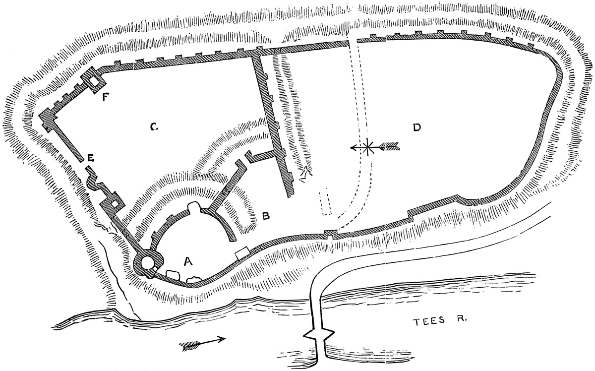
West of this Norman gate, and standing on the counterscarp of the ditch of the inner ward, opposite to the keep, a shoulder in the curtain is occupied by a small rectangular tower, in substance Norman, whence the curtain, of great height and strength, closing the north end of the ditch, runs up to the keep. In its base, in the bottom of the ditch, is seen the upper part of one of the round-headed openings already noticed. This is of 4 feet span, and more like a postern than a drain.
The area of this town ward is occupied as a kitchen-garden, and part of it is locked up, and entry refused. The curtains seem substantially Norman. Grose shows the remains of a drawbridge between this and the middle ward, and no doubt there must have been some such communication.
The middle ward seems to have contained stables and offices, now destroyed. Its communication with the outer and town wards has been mentioned. It had also a drawbridge, superseded by an earthen causeway, at its north-west corner, leading into the inner ward. It is difficult to say whether the ditch was here run out upon the face of the cliff, and has since been filled up, for a cottage has been built on the slope outside, and effectually conceals the point for examination. Grose, however, indicates a doorway in the ditch here, as at the other end, and in the cross-wall dividing this from the town ward.
The inner ward is the most perfect and really curious part of the castle. It is in level about 30 feet above the rest, commands the whole area, and predominates grandly over the Tees. It contains the keep, northern tower, the domestic buildings between them, the curtains and buttresses, and the remains of the gatehouse. The keep caps the north-east angle, and is half within and half without the curtain. It is a very grand piece of masonry, built of blocks of coarse red grit of moderate size, square and coursed, with rather open joints. It is circular, about 40 feet diameter, and about 50 feet high to the base of the parapet, now gone. It rises from the rock. Its base for about 6 feet batters slightly, but above that it is208 cylindrical. It is absolutely without ornament, and there is not even the usual cordon to mark the top of the base. The loops are of unusual length, and slightly dovetailed at the lower end; never cruciform. The original openings are mostly square-headed, and without mouldings or labels. One large window, high up, towards the north, is round-headed, and probably original. Towards the town ward is a five-light late Tudor window, an insertion. Probably the parapet rested on bold corbels, but, if so, they are gone. There are no strut-holes nor indications of a bretasche. Though circular above and towards the field, the southern or interior face is capped by a bold spur, a pyramid cut diagonally, with the apex dying into the round wall about four-fifths of the way up. This spur contains a mural chamber. It is much shattered.
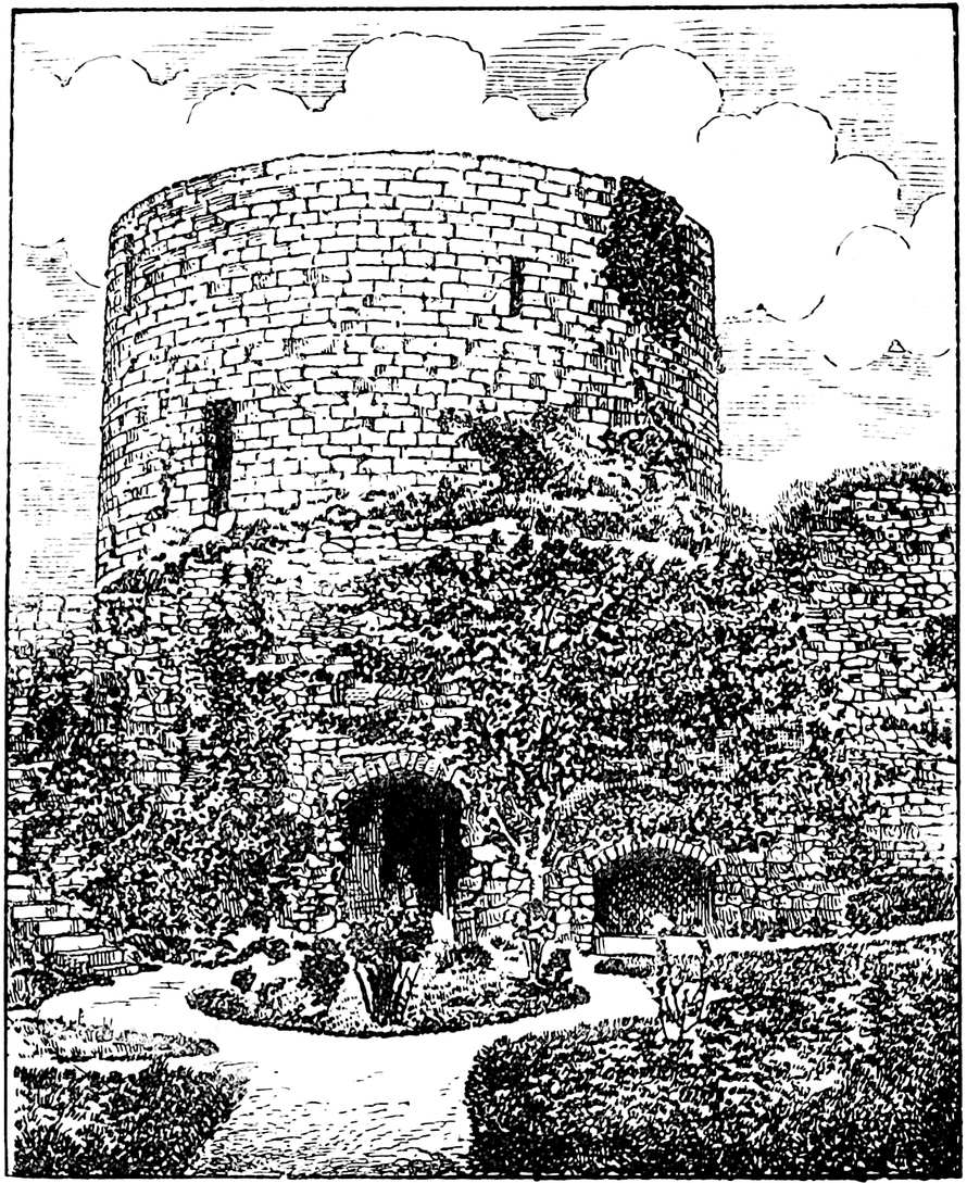
The keep is cylindrical within, and has a basement and three upper floors. All its original openings seem to have been either flat or round-headed. There is no original pointed arch; that over the main door is clearly an insertion. The basement is on the ground level, about 20 feet diameter, and the walls about 10 feet thick, and it is covered in with a flattish dome of inferior rubble, but pro209bably original. On the south side are traces of a fireplace, of which the vertical tunnel remains in the wall. The entrance-door is on the west side, and so also is the main door. It is much broken, and has at present a late flat-pointed arch, but it seems to have been round-headed. It opened not, as now, from the court, but from the passage-room leading to the postern. In the outer wall, a couple of yards to the right of the door, is a recess like a sepulchre in the keep wall, and in it is laid a stone coffin, probably found in the outer ward. The recess may have been a seat; it can scarcely have been a tomb. The entrance-door has no portcullis. In its left jamb a flat-topped mural passage, 3 feet wide, leads into a garderobe which projects outwards between the keep and the curtain, and has a short exterior loop. The shaft of a garderobe in the floor above so drops that it is evident that here, as at Corfe, there was a wooden partition within it.
Entering the keep, on the right a door leads up half a dozen steps into the north side of what is called the guard-chamber, a barrel-vaulted room, 14 feet east and west, by 7 feet, with a loop to the south. This looks very much like an oratory, though it is a passage-room. It is contained partly within the spur buttress, and is evidently the cause of that appendage. From near the west end of the chamber, a second door leads by a mural stair, 3 feet broad, to the first floor, a circular chamber, 21 feet diameter, with walls about 8 feet 6 inches thick. This stair opens by a narrow, round-headed door in the jamb of a doorway, also round-headed, which seems to have led from this floor into the “great chamber,” the withdrawing-room of the hall. In the opposite door jamb, a similar door leads by a mural passage to a garderobe above that already mentioned.
The first floor was evidently the state-room. It has traces of a fireplace to the south side, but the hood is gone, and opposite to it is a round-headed window of 4 feet opening, looking up the Tees. Another window, probably of the same pattern, looked towards the tower ward. This has been altered to suit a Tudor five-light flat-topped window. This seems to have been called “My Lady’s Chamber.”
In the left-hand jamb of the north window, now much broken, another narrow door opens on a mural stair, 2 feet 6 inches broad, which, following the curve of the wall, and lighted by small loops, led up to the battlements, opening, on the way, upon the second floor, of which the floor and roof, both of timber, are now gone. This floor also had a fireplace, and a sort of magnified loop, which did duty as a door, and opened upon the battlements of the hall, and led also to a third garderobe, corbelled out above the other two. This has an open vent, while the shaft of the other two descends within the wall to a sewer, the arched mouth of which is just visible at the foot of the wall, outside.
There seems also to have been a square-headed opening in the stair, to give a way to the top of the ward-curtain, of which the allure was 2 feet 6 inches wide, having a parapet of 3 feet, and a rerewall210 of 2 feet. As the parapet of the keep is gone, the stair terminates abruptly at the level of the rampart wall, where the wall is 7 feet 6 inches thick; and thence is a good view of the castle and town, and of one of the most lovely reaches of the Tees. In 1592 this keep was roofed with lead. The roof was probably always flat.
Mortham Tower capped the north-west angle of the ward, rising from the rock high above the river. It is a mere fragment. It seems to have been of irregular plan, built to fit on to the hollow bend of an existing wall. When it was built, it was thought prudent to strengthen the wall by stout exterior buttresses. The original wall is Norman. The first built part of the tower seems to have been Early English, and its completion Decorated.
The space between Mortham Tower and the keep was occupied by the hall and withdrawing-rooms, the latter being next the keep. The hall was on the first floor, as shown by its two windows in the curtain. These are of two lights, with a transom and trefoiled heads, and an oval quatrefoil in the head. They are placed in recesses with plain segmental arches, and side seats of stone. They are of the best Decorated period, and evidently insertions into an older wall, which has also been strengthened with Decorated buttresses.
Between the hall and the keep were, on the ground-floor, passages leading on the left to what was probably a cellar below the hall, and on the right into the keep, while at its end is a small square-headed postern in the curtain, still in use. Above this passage was the withdrawing-room, placed between the hall and the state floor of the keep; and the window of this room, in the curtain, is the well-known bay which displays in its soffit the “bristly boar” of Richard III. The window is projected over the postern, upon bold corbels and is mainly of good Perpendicular date, but the superstructure has been altered and debased by some very poor Tudor work, similar to the window in the keep, and possibly due to Sir George Bowes. This was called “The Great Chamber” in 1592.
Its gatehouse occupied the south-west angle of this ward, and was built on the edge of the cliff. The remains of it are very scanty. The curtain between it and Mortham Tower seems to have been a mere parapet, cresting the cliff.
The curved curtain connecting the gatehouse with the keep, and covering the two landward faces of the ward, is tolerably perfect. It is strengthened by an exterior buttress and a small tower. This latter, which is placed near the angle of the curtain, towards the keep, contains a basement and upper chamber, both vaulted, though of the latter, which was at the rampart level, only some fragments remain. This tower is rectangular, but the angles are chamfered off. It has no internal projection, and outside, against each of its three faces, is applied a Decorated buttress of 2 feet 6 inches breadth, by 3 feet 6 inches projection at the base. Each is of three stages, and dies into the wall near its summit. Between this tower and the keep is a large buttress, apparently hollow, possibly for the pipe of a garderobe. This also is a Decorated addition. Near it211 the curtain has a flat Norman pilaster strip, but of three stages. It is 4 feet broad, and diminishes from 18 inches to 6 inches projection. It also dies into the wall near the top.
It is not unlikely, from the aspect of the inner ward, that this was a fortress of the tenth century, composed of a cliff on two sides, a ditch on the other two, and a centre more or less nearly circular, and artificially scarped; in fact, a motte, upon which stood the original stronghold. The outer ditches may be of the same date, but from their figure and plan they are more likely to have been a later, probably a Norman, addition. Their contents are thrown inward so as to form a ramp behind the wall.
It is evident that the whole area of the castle, as it now stands, was inclosed by the Normans, and the walls throughout and nearly all the towers are latish in that style. Here and there, spread over the whole enceinte, are remains of Norman work. The pilaster strips on the inner curtain, the arches in the several ditches, the square tower and gate on the north curtain, Brackenbury’s Tower, and much of the wall towards the town are original. In the inner ward the base of Mortham Tower, and the half-round mural tower near the north gate, are probably Early English. The keep, the fragments of the hall, the south-east tower of the inner ward, and most of the remains of other buildings are evidently Decorated. The original walls were mostly of sound rubble, with ashlar dressings. In the Decorated work ashlar was more freely used.
The castle must have undergone almost a rebuilding in the Decorated period. The Norman architect evidently treated the whole inner ward as a shell keep. His successors added part of Mortham Tower, and the Decorated artist, more ambitious, raised the round tower as a keep, added—probably rebuilding—the hall, and completed Mortham Tower, and strengthened or restored the curtain in various places.
Here, as was much the practice in the North, the round-headed arch and the flat lintel were largely employed in the Decorated period. The general style of the work is much to be admired. Strong, sound, massive, very plain, of excellent execution, it is in admirable taste, and in good keeping with a military structure. The keep, though not one of the largest, is one of the finest round towers in England. Its proportions are good, its materials of proper size and rich colour, and its very plainness is indicative of strength.
There is but little Perpendicular work; probably it was of a lighter character, and has fallen and been removed.
Whatever may be regarded as the value of the material evidence of its earthworks, the notion of Bernard Castle occupying the site of an earlier stronghold is unsupported by records. The present town is thought to have risen on the fall of Marwood, a place the very site of which is now forgotten; neither is it a parish, being included in the vast parish of Gainford, the church of which is eight miles distant. From Domesday no aid is to be derived, seeing that this valuable record does not include Durham, nor is212 there any mention of either Marwood or Gainford, still less of the castle, in Hugh Pudsey’s Domesday of Durham, the Boldon Book, compiled in 1133, for this is confined to the bishopric, within which the Baliol fee was not at that time included.
Guy de Baliol received from William Rufus the Barony of Bywell, in Northumberland, and either from that king, or his father, the lordship of Gainford, of which he gave the church to St. Mary’s, at York.
Bernard, his son and successor, was a distinguished adherent of Stephen, but lived into the reign of Henry II., and was one of those who broke up the siege of Alnwick, by the Scots, in 1174, before which time he probably built Barnard Castle. He also seems to have built the church, or rather chapel, of Barnard Castle town, and gave it also to St. Mary’s. He was succeeded by another Bernard, father of Hugh, father of John de Baliol, founder of Baliol College, Oxford, and of St. John’s Hospital, in Barnard Castle town, and regent of Scotland. He was born in the castle. He married Devorgoil, a co-heir of Alan, Lord of Galloway, from whom their son, another John, inherited the deadly claim to the throne of Scotland, which he made good, after a fashion, in 1292. He lost his English estates, and died at Château-Gaillard in 1314.
Edward, his son, became king of Scotland, 1332, but was expelled in 1341, and died childless in 1363.
On the attainder of John de Baliol, Bishop Bek claimed Barnard Castle, probably unjustly, as belonging to the See. As early as 1301 he had seized upon it, and he held it for some time, and to his tenure are attributed the keep and other additions in the style prevailing at the period. Edward I., however, granted it to Guy Beauchamp, Earl of Warwick, who cared little for episcopal claims, which took the form of protests from several successive bishops.
The castle remained in the Earls of Warwick, Beauchamps and Nevilles, for five descents, and here Thomas Beauchamp founded an Augustin Priory about 1381. How it came to be held for a time by the Earls of Westmoreland of the other line of the Nevilles does not appear. It finally, however, vested in Richard Duke of Gloucester, who repaired it, and left his cognisance upon it, as has been stated. On his death it remained in the Crown until it was sold, and after various vicissitudes became the property of the ancestor of the Duke of Cleveland. It was dismantled in 1630, when the spoil of the great hall was carried to Raby.
The bridge across the Tees is a fine one, of two lofty pointed arches, said to have been rebuilt in the last century. The arches are moulded in three sets-off, and beneath, each arch is supported by five bold ribs. If modern, the old type is well followed.
In the adjacent church there are some old parts. There is a good ornate south door with flanking columns and capitals, round-headed, with a chevron moulding on the arch. The opening is wider than usual. The style is late Norman. The base of the tower is set round with several short Early English buttresses. About 12 feet213 west of the tower, in the churchyard, are laid several large blue gravestones of a quality not now used. They seem to have carried brasses, are much worn, and have evidently been removed from the interior of this church or the castle chapel. Under one, on which remains a merchant’s mark, is buried Sir John Hullock, a Baron of the Exchequer, who died July 31st, 1829, and his wife, who died November 18th, 1852.
BEAUMARIS Castle is built upon a marshy flat, close to the sea-shore, and but little above the level of the sea, from which its ditch was supplied. It is an example of a purely concentric fortress, in which the engineer was left free to design his works without being governed, as in most other cases, by the irregularities of the ground.
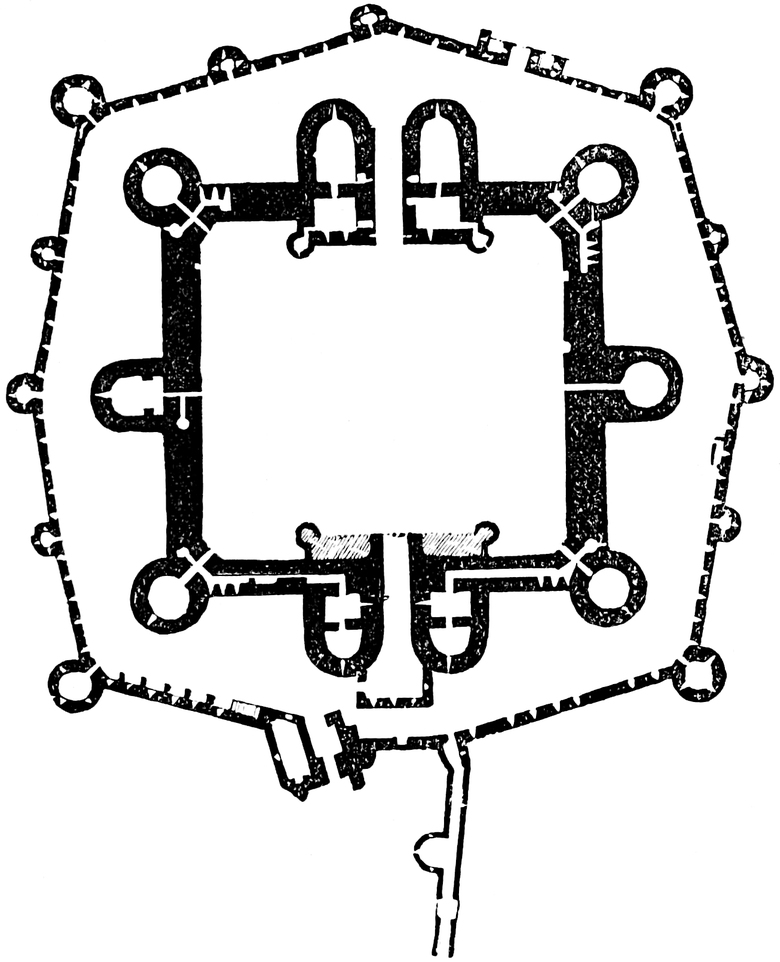
214
Its inner ward is a quadrangle about 50 yards square, contained within four curtain-walls about 16 feet thick and 40 to 50 feet high. At the angles are four drum-towers, three-quarters engaged, of the height of the curtains. On the east and west sides are intermediate towers, half-round, with prolonged sides, of which that to the east, as at Kidwelly, contains the chapel. In the centre of the north and south sides are the gatehouses, of large size and something higher than the other towers. In each a quadrangular part projects into the court, capped at the two angles by round turrets containing staircases. Outside, half-round towers with prolonged sides flank the entrance. The ground-plan here given shows the general arrangement.
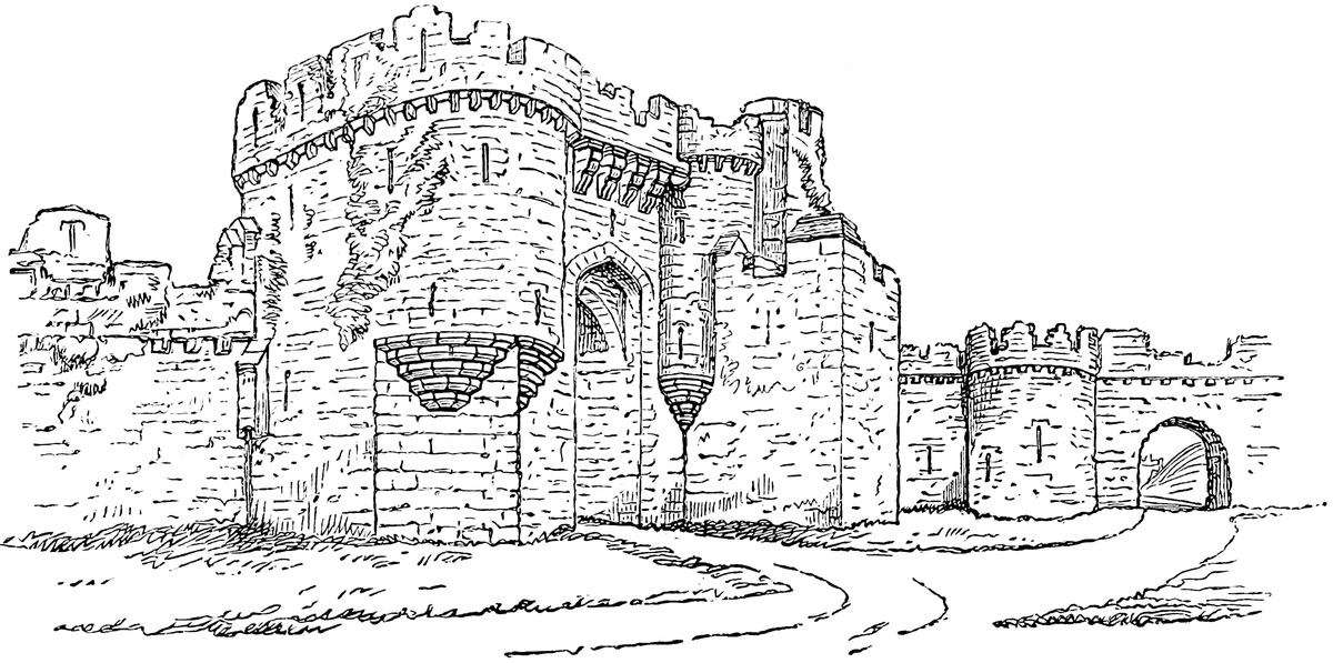
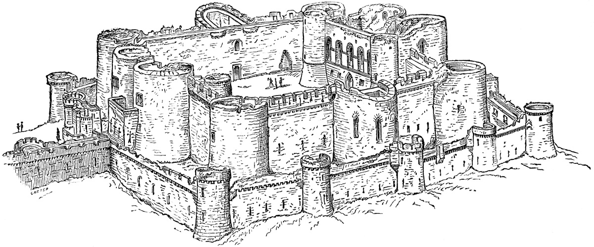
The great hall, 70 feet by 23 feet 6 inches, occupies most of the first floor of the northern gatehouse, and is lighted from the court by five windows, of two lights each, with a transom, as at Stokesley and Ludlow, contemporary halls. The fireplace was on the opposite side. The roof was of timber, but with one stone rib, as at Charing. The southern gatehouse probably also contained a large chamber, now destroyed. The state-rooms and lodgings were in the gatehouses. The portals were of unusual length, and each was guarded by three grates.
The curtains are pierced lengthways by long mural passages, communicating with the tower chambers and the staircases, of which there are many. The rampart walk is of unusual breadth. Under a part of the wall, south of the chapel, the lowest mural gallery is a large sewer.
The chapel, on the first floor, though not much above the ground level, is a beautiful little chamber, entered at its west end from the court by a flight of steps and a short passage traversing the mural gallery. On each side is a vestry. The actual entrance to the chapel is by a double door, trefoiled. The chapel is composed of two bays with a polygonal apse. The whole is groined, and the walls are panelled in two stages all round. There are five lancet loops opening upon the face of the tower, and two windows opening into the chapel, from the vestries. The chapel stands on a crypt, also vaulted.
Outside the south gatehouse a sort of barbican, a hollow square of masonry, has been erected, having an entrance on its west side. It is an addition intended to prevent the portal being raked or carried with a rush.
The ward above described stands detached within the outer ward. This is in figure eight-sided, symmetrical, or nearly so. At its four principal angles, opposite the angles of the inner ward, are four drum-towers, three-quarters engaged. From these towers the walls slope outwards, so as to form salient angles, of which there are thus four, one opposite to the centre of each face of the inner ward, and thus space is given for the gatehouses, the chapel, and its opposite tower. Each salient is capped by a drum-tower, and on each of the sides forming the salient is a smaller tower. There are altogether twelve towers, three of the spaces and one angle being otherwise occupied. These outer towers and curtains are much lower and slighter than those of the inner ward.
There are two gates. The north gate seems never to have been completed, but its remains are very peculiar. There is a main portal in the curtain, and on each side of it a small portal or postern. Outside are four bold but narrow buttresses, one on each side of the main gate, and one outside each of the side gates. The western buttress is of bolder projection than the rest, and is evidently in217tended to cover and conceal a sally from the quarter whence the Welsh were most likely to approach. Each buttress is looped, the two inner ones so as to command the main from the side entrances. The southern entrance is also peculiar, and has a gatehouse and outwork of its own. The gatehouse, shown in the drawing here given, has two towers on quadrangular bases, corbelled out so as to rise to drum summits, producing a fine effect. This outer gate opens upon the sea-shore. Behind, or to its west, was the walled tower. Towards the east it was protected by a spur-work; a long curtain wall, running on from the exterior wall of the castle to the sea-shore, of great thickness, and pierced by a long gallery below, and having above a rampart walk, parapeted on each face. The passage is looped each way and strengthened by a half-round tower on its west face. It seems to have ended in a round tower, now removed. The object of this work was to cover the landing of supplies from the sea, and to prevent an enemy from the east side from creeping round by the sea-shore and so surprising either the castle or the town. The spur has been pierced by a modern archway.
The birdseye view given shows the castle from its south-eastern angle. The root of the spur-work is shown, the outside of the chapel tower with its lancet windows, and the windows of the great hall. There was but one ditch, which embraced the whole structure, and is now filled up.
Beaumaris was probably commenced about 1295, twelve years after the execution of Prince David, and later than Conway, Caernarvon, and Harlech. On the subjugation of Wales it ceased to be of importance, and even in the reign of Edward II. it was out of repair.
ON the left bank of the Ouse, about 50 yards from the stream, within, but upon the eastern edge of, the town, is to be found all that remains of the once-celebrated and very strong castle of Bedford. These remains, though scanty and confined, or nearly so, to earthworks, are very marked and of a durable character, and, although the fame of the castle rests upon its adventures as a Norman fortress, there is reason to suppose that it had an earlier history, and that most of its present relics belong to that earlier and Saxon period.
The principal work is a motte or mound of earth, wholly artificial, placed upon the gravelly plain across which the Ouse winds its way down the broad band of the middle oolite. This mound is circular, now about 15 feet high and 150 feet in diameter at its summit,218 which is perfectly level, and has for above half a century been employed as a bowling-green. The slopes are uniform and moderately steep, and planted with trees and shrubs. On the north side, or that farthest from the river, an excavation has been made for an ice-house; but this is of modern date, and does not appear to have laid open any traces of masonry below the surface of the ground.
Towards the river, and westwards towards the town bridge about a furlong above the castle, the ground is perfectly flat, and under cultivation as a garden; but, on the north and north-east it is rather higher, and here are traces of a ditch at the foot of, and concentric with, the mound, and no doubt a part of its defence upon this its weaker side.
The only masonry that can possibly be old is a small rectangular mass on the south side of the mound, and which now carries a modern summer-house. The ragstone of the country, of which this fragment is comprised, weathers so rapidly that it is difficult to form an opinion upon its age; but, though possibly old, it may be of recent date.
Looking to the position of the mound as regards the river, and to the low and flat character of the ground about it, it is evident that the great strength of the place must have been derived from the Ouse, here deep and broad, and from banks of earth and ditches filled from and communicating with the river. The entire absence of masonry and the disappearance of all but a trace of the surrounding banks and ditches, commemorated in the Chronicles as once so high and deep, are fully accounted for by the circumstances recorded of the famous siege by Henry III.
Bedicanford, or Bedford, was well known to the Saxons, and a town probably of Saxon origin. Here, just outside the town, was buried in 796 the Saxon Offa, king of Mercia, in a chapel long since swept away by the flood waters of the Ouse. Early in the tenth century the town was attacked by a party of Danish settlers from the five burghs, who were beaten off by the townspeople, and shortly afterwards Edward the elder repaired the place, and erected what some call the suburb of Mikesgate, and some a strong place, on the southern side of the river, possibly a cover for the “ford,” which contributed towards the name of the town. Bedford was, without doubt, an important town under the Saxons, and, as at Tamworth, Leicester, Wareham, and Wallingford, had a citadel at one angle of the enclosure, upon the river.
The Barony, also called the Honour, of Bedford, was conferred by William Rufus upon Payn, second son, but eventual heir of Hugh Beauchamp, a companion of the Conqueror, and possibly allied to the greater family of that name, who afterwards held the earldom of Warwick. Hugh was the recipient of many manors in Buckingham, and about twenty in Bedfordshire. Payn is the reputed builder of the Norman castle, described as of great strength, with ditches and ramparts of earth, and which descended to his son Simon, steward to King Stephen. The family, however, afterwards took part against219 the king, who seems to have attempted to settle the fief upon the daughter of the eldest brother, married to Hugh, surnamed “Pauper,” brother to the Earl of Leicester. Milo de Beauchamp held the castle against King Stephen in 1137. The siege lasted five weeks, and was pressed with great energy. It was finally taken by starvation. The author of the “Gesta Stephani” describes the castle as having strong earthworks, “editissimo aggere vallatum.”
Simon de Beauchamp held the castle through the reigns of Henry II. and Richard I., until his death, about the 8th of John. It appears from the red book of the Exchequer that he held 36 and 5–10ths knight fees of the old feoffment, and 8 fees of the new, all in the barony of Bedford. In his time the castle seems to have been held against Henry II. since in the second year of that king, 1155–6, those burgesses of Bedford who were in the castle against the king were fined twenty marks, of which sum they rendered account in 1157–8. In 1190 Simon fined £100 for the governorship of the castle.
William, son and successor of Simon, is described as lord of the strong castle of Bedford, the “caput” of the Honour. He took part with the rebel barons towards the close of John’s reign, and in 1215 admitted their forces into his castle. In consequence it was attacked by the well-known Falk de Breauté, and, not being relieved, was surrendered in November, after a seven days’ siege. John was himself present at Bedford thrice in that year, in all for eight days. He granted the confiscated Honour to Falk.
Falk strengthened and held the castle into the reign of Henry III., and thence ravaged the country below the Chilterns. At first a supporter of the young king, he afterwards resisted his authority, and, at the instance of his oppressed neighbours, Henry de Braibroc was sent to Dunstable in 8th Henry III., 1224, to try their complaints, when thirty verdicts were found against the baron, and fines imposed of £100 under each of them. In revenge, Falk kidnapped the judge and lodged him a prisoner in Bedford Castle, treating him with much indignity. His wife complained to the Parliament then at Northampton, and the king ordered him to give up the judge, but in vain. Henry was probably glad of the opportunity of crushing a very turbulent subject, and appears to have lost no time in punishing the affront. In June, 1224, commenced a series of orders, issued by the king himself, and which show the greatness of his preparations for a siege, and the vigour with which he pushed them forward. On the 22nd of June, Henry was at Bedford in person, and there remained during the siege until the 19th of August, nearly two months. The preparations were both extensive and minute, and the mandates, always described as pressing, were issued to a vast number of sheriffs and other persons as far south and west as Corfe Castle and St. Briavels. They require men, money, arrears of scutage, cord, cable, iron, steel, hides, leather for slings, twine for strings, mangonels, petraries, balistæ, quarrells, stone shot, quarrymen, masons, miners, carpenters, saddlers, wagons for conveying the royal220 pavilions, and almonds, spice, and ginger for the royal still-room. All the smiths in Northampton who can forge quarrell bolts, or feather them when forged, are to work day and night until 4,000 are ready and despatched. Large quantities of wine from the royal stores in London, at Northampton, and elsewhere, are to be forwarded with speed to Bedford. Knights performing castle guard at Lancaster are ordered up: greyhounds are sent for for sport. The sheriff of Bedfordshire is to supply quarrymen and masons with their levers, hammers, mauls, and wedges, and everything necessary for the preparation of stone shot for the mangonels and petraries. Miners come from St. Briavels, in the Forest of Dean. Windsor supplies its master-carpenter and his mates. Cambridge sends cord and cable. Charcoal comes with the iron and steel from Gloucester, and the adjacent abbey of Newenham spares a large quantity of raw stone to be converted into shot.
The details of the material supplied are recorded in the close rolls of the period. The particulars of the siege itself have been preserved by the neighbouring monks of Dunstable, from whose town, and probably from whose monastery, the judge had been taken, and whose fellow-townsmen played an important part in the siege. The king brought with him the Archbishop of Canterbury and divers bishops and abbots, by whose interest was granted to him two men from every hyde of their church lands to work the siege engines; an aid of “carucage” or a mark from each caruca or plough land of demesne, and 2s. from each held in tenancy, gifts which were guarded against being drawn into a precedent by special charter from the king.
Falk left his brother to abide the attack, and sought aid on the lands of the Earl of Chester, Ranulph Blundeville. The earl, however, was with the king, together with Peter de Rupibus, bishop of Winchester, William de Cantelupe, Brian de l’Isle, and Peter de Maulay. All were suspected of disaffection, and in consequence the earl and the bishop left the camp, although the earl was afterwards brought by the Bishop of Chester to his duty. Falk remained at Northampton until he fled to Wales.
The siege operations included on the east front a petrary and two mangonels, which daily battered the opposite tower; on the west front, two mangonels bore upon the old tower; on the north and south fronts were two mangonels, one on each, and each breached its opposing wall. The operations of these seven pieces of ordnance were materially aided by two large wooden turrets, tall enough to command the whole castle, and supported by other smaller turrets, all charged with archers and crossbow-men. There was also the timber covered-way, known as a cat, by the aid of which miners were able to undermine the wall, while the bowmen cleared the battlements above. These works were thickly covered with hides, rendering them proof against fire; and the slingers, of whom there were many, probably kept up a general and incessant shower of pebbles upon all who dared to show themselves on the ramparts.
221
The works were stormed by four vigorous assaults. First the barbican was taken, with a loss of four or five of the assailants. Then entrance was effected into the outer ward. This was the work of the men of Dunstable, and was attended with severe loss. In this ward were stored most of the munitions of the place,—arms, horses and harness, cattle, bacon and live hogs. Much forage was here burned, with the houses and sheds in the ward.
The miners next underworked the wall next the old tower, which wall fell. The resistance here appears to have been obstinate, many lives were lost upon the breach, and ten of the most forward assailants were taken and carried into the interior of the place.
Finally, on the vigil of the Assumption, 14th August, about the hour of vespers, the miners having undermined the foundations of the old tower, fired the props. The walls split, the smoke rose, and, the place being no longer tenable, the garrison hoisted the royal banner, and surrendered, sending out De Braibroc with the wife of Falk, and the other women. Next morning the king took possession. William de Breauté and the garrison were put upon their trial, and he and about eighty of his men were hanged out of hand. Three were allowed to join the Templars in Palestine, and the castle chaplain was delivered over to the archbishop as the spiritual power. It appears from the records that the remainder of the garrison escaped with fines and confiscations. The spoil was considerable, in treasure, provisions, and munitions of war. Henry left for Kemeston (Kempston) on the 18th, but was again at Bedford on the 19th, and at Dunstable on the 26th of August. Even when flushed by success he seems not to have been severe upon those not actually implicated. Alice, widow of the executed William de Breauté, was allowed her dower-lands in Bedford and Cumberland. On the 19th and on the 22nd, Margaret, wife of Falk, was allowed for her subsistence the manors of Heyford and Sabridgeworth. Gilbert de Breauté also was allowed a manor; and Falk, the author of all the mischief, had twenty marks allowed for his personal expenses on his way to exile.
Immediately upon the surrender, Henry broke up the siege establishment. Nine hundred quarrels, the residue of the 4,000, were returned to Northampton, and the sheriff of Beds is debited with the remaining iron, charcoal, &c., collected for the siege operations. The mangonels and heavy artillery were to be taken to pieces and returned to Northampton Castle. Various payments were also made and rewards given, chiefly out of the confiscated De Breauté lands. John de Standon, the king’s miner from the Forest of Dean, had land granted him under St. Briavels.
The castle itself was far too strong and too dangerous to be spared, and the orders for its destruction are very sweeping and specific. By an order of the 20th of August, five days after the surrender, the sheriff is ordered to level the banks, fill up the ditches, and make plane the surface of the outer ward. He is to reduce the mote or mound, and the walls of the inner ward by one-half their height, and222 to level three-fourths of the old tower towards St. Paul’s, that is on the north-west. The stones are to be divided between William de Beauchamp for his proposed house, the church of St. Paul, Bedford, and the priories of Caldwell and Newenham; but the last is to have the larger share, because it supplied stones for shot for the siege.
Five days later came out another order enforcing the former, and directing Henry de Braibroc and William de Pateshull to see to its prompt and accurate execution. It was also specified that William de Beauchamp might, if he pleased, build a dwelling-house on the site, and use the reduced wall of the inner ward, but he was not to raise the mound or the wall above a certain height, or to embattle it. He might only erect it. Braibroc is to see the stone from both walls and mound distributed as directed. September 16th, the sheriffs of Herts, Cambridge, and Hunts were ordered to send men to aid Braibroc and Pateshull in the work of destruction, and they are to take tools with them, and stay until the mound is lowered and the ditches filled up as ordered. Beauchamp was further allowed half the timber from the barn and the old tower.
Thus passed away the strength and glory of the castle of Bedford, the great fortress of the Ouse. Whether William de Beauchamp built upon its site does not appear. He died 44 Hen. III., and within a very few years his name was extinct and his barony divided.
The castle, or its site, probably as the seat of a manor court, is named from time to time in the Inquisitiones post Mortem. Thus, 5 Ed. II., Roger L’Estrange, by Margaret his wife, was seized of “the Castle” and the “site of the Castle” of Bedford; 1 Ed. III., John de Mowbray was seized of the site of Bedford Castle and the fishery of the Ouse; and 40 Ed. III., another John had suit of court in the castle of Bedford; and 50 Ed. III., Elizabeth, wife of John Mowbray, holds of the same castle. Also, 6 Rich. II., another John Mowbray is seized of Bedford Castle and Bedford Barony; and, finally, 8 Hen. IV., Thomas Mowbray, Earl Marshall, holds Bedford Castle in chief, by the service of almoner to the king at his coronation; so that the tenures and privileges attached to the castle remained in force long after the fortress itself had been razed. In Leland’s time, the castle mill,—that great evidence of feudal customs,—remained; and he also mentions the “great round hill” as a burrow for foxes. There were not then any buildings.
It is evident from present appearance that the mandate of Henry III. was strictly obeyed. No trace of a ditch is to be seen between the mound and the river, and the mound itself is so much lower than is usual with works of that diameter as to make it probable that at least one half has been removed and employed in filling up the ditches.
It is not easy to gather from the account of the siege a clear idea of the disposition of the parts of the castle. There were two wards, and the outer, judging from its contents, must have been of considerable area. It probably included the inner ward and the mound,223 and abutted upon the river. The barbican would scarcely be placed upon the river or outside the town, and probably was to the north-west, or near the church of St. Paul.
The inner-ward wall probably surrounded the mound, on the outside of its ditch, and was thus open to attack when the outer ward was taken.
The old tower, last taken, and the fall of a part of which reduced the garrison to surrender, was probably the donjon or shell crowning the mound. This would be of Norman date, and therefore might well be called the old tower, as distinguished from Falk’s additions, and the repairs after the siege by Stephen. Thus, if the explanation be accepted, Bedford Castle had a shell keep or donjon upon a mound, surrounded by a ditch and wall, and this again by another wall, at a greater distance, the principal storehouses and dwelling being, as was usual, in this larger or outer ward. The History of Bedford Castle and of its siege are the subject of an elaborate paper by the late Rev. C. H. Hartshorn, privately printed in 1861.
THE Castle of Berkhampstead stands in the parish of Berkhampstead St. Peter, in the county of Hertford, and, geologically, upon the lower chalk. Its position is in a chalky bottom, on the left bank of the Bulborne rivulet. Between the stream and the castle the ground is naturally low and marshy, but it is now traversed by the Grand Junction Canal and the London and North-Western Railway, which, with the water-course and the turnpike-road, separate the castle from the town.
To the east and north-east of the castle the ground rises steeply towards Whitehill and Berkhampstead Common. To the west and north-west it rises more gradually towards Berkhampstead-place. Between the two, towards the north, is a combe or nearly dry valley, occupied by the old park, called the Berkhampstead estate, and in this valley stands the castle, about 400 yards from its termination in the river.
The constituent parts of the castle are a mound; an inner enceinte or ward; an inner ditch; a second enceinte; a second ditch; a third enceinte, enveloping the northern half only; a ravelin upon the west face; and a third or exterior ditch, also confined to the northern half of the work.
The mound is wholly artificial. It is conical, about 60 feet high and 40 feet diameter at the top, having steep sides and a wet ditch round three-fourths of its circumference. Its top was crowned with a circular shell of wall, about 8 feet thick, of which the foundations224 only remain. Up its southern side is a curtain-wall, much ruined, and about 8 feet thick. This commences at the ground level at the top of the mound, and runs into a fragment of the enceinte wall of the inner ward. It evidently connected this wall with the keep, and was probably, as at Tamworth, parapeted on either face of its rampart walk. It was not continued down the further side of the mound, which was not a part of the enceinte, but a citadel placed outside it, and connected with it only by a single wall.
Probably the ditch of the mound was originally continued all round it, and simply traversed by the wall. Much of the ditch between the mound and the inner ward is filled up, probably very recently, as the process is now in progress, the object being to connect the level sward of the enceinte with the mound for pleasure purposes.
The inner ward is an oval space, about 500 feet north and south by 300 feet east and west. It is encircled by a wall, about 7 feet thick, and now about 20 feet high, and which may have been 4 feet to 5 feet higher. Traces of the crenellations are visible. This wall is broken down in parts, but nearly three-fourths of it remain. The northern, or end opposite to the mound, is concave, the ditch of the mound having been run into it. There is a fragment of a mural tower on the west face, much mutilated and apparently rectangular. In the east face are two openings, one of which may have been a postern. In the north-east quarter a cross-wall seems to have belonged to a domestic building. The gap for the main gateway is at the south end. There are no traces of towers there, and there do not appear, judging from the wall, ever to have been any. The interior terre-plein, or platform, is level, no terrace against the wall, and no trace of a bank against which the wall could have been built. Outside the wall is a space of about 5 feet broad, beyond which the ground falls sharply towards the wet ditch.
The inner ditch is carried quite round both mound and inner ward wall, being in plan an unbroken oval. It is deep and everywhere wet, and in parts it opens out into a pool. This is the case where it gave off the ditch embracing the mound, now in part filled up, and in the south-eastern quarter, where its overflow escapes into the river.
Outside, and forming the counterscarp of this ditch, is the second or middle enceinte. This is a steep and narrow bank, carrying a walk of about 8 feet broad, having about an equal slope inwards towards the inner ditch, and outwards towards the outer. For about its northern two-thirds this bank is very uniform, but at the south-west quarter it swells into a small mound or cavalier, about 22 feet in diameter at top, and about 20 feet high, close to which the land has been cut away to effect a modern entry. Opposite to this, on the south-east quarter, is another rather larger mound, about 30 feet across and 25 feet high; and at this point the bank makes a loop outwards, which somewhat destroys the symmetry of its plan. These two mounds are evidently intended to flank the extremities of the outer bank.
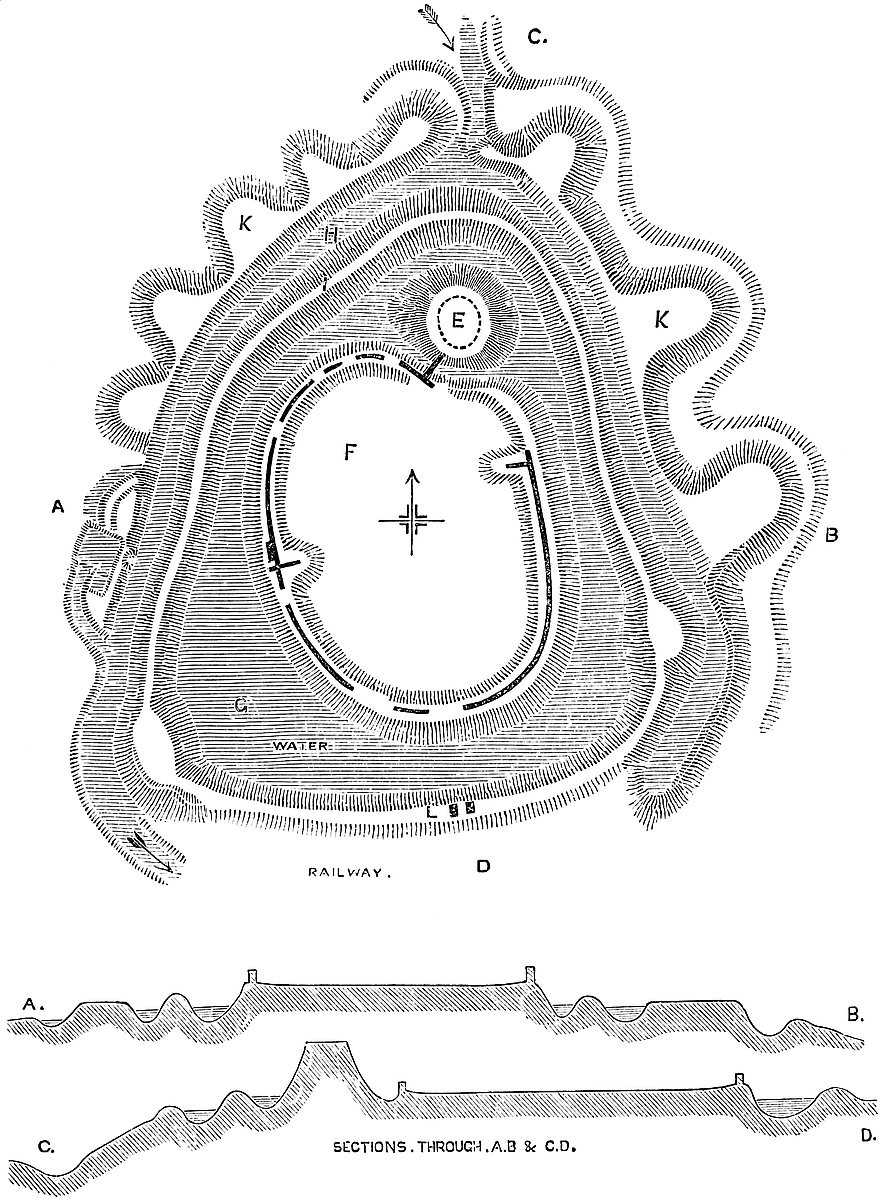
226
This middle bank is perforated by a modern culvert at its southern part, by which the waters of the inner ditch escape; and a few yards east of this the bank is crossed by two parallel walls, 12 feet apart, and which evidently belonged to the outside of the main entrance.
The second or middle ditch, also deep and wet, envelopes the middle bank very regularly. At present it is wanting on the south side, for a short distance, having been filled up and converted into a road when the railway was constructed.
Outside this ditch is the third or outer enceinte, a steep bank, which forms the counterscarp of the middle ditch, and envelopes rather more than the northern half of the castle. It is about 10 feet broad above, and is strengthened outside by eight bastions, also of earth, placed at distances of from 60 feet to 150 feet, and each, at top, about 30 feet broad by 40 feet projection, and rounded. The five best marked of these, being steep and about 20 feet high, lie to the north-west. A small streamlet coming in from the north then cuts the line, and to the east of this, covering the north-east and east faces, the bank is continued for about 580 feet, strengthened by three bastions, which, however, are low, and have nothing of the sharpness of the others. These latter three have scarcely any ditch, but the other five have at their feet a ditch, which, even now, is boggy, and no doubt was once a formidable defence. West of this outer bank, and ranging with it so as to cover part of the west face of the castle, is an earthwork of very doubtful character. Its lines are rectangular, it has a ditch, and it much resembles the early ravelins which were common in the fifteenth century, and not unknown in the fourteenth and thirteenth.
Connected with its ditch is a pond, which appears to have been a mill-pond and fish-stew. No doubt all these extensive ditches were turned to account, and fed the mill which is known to have been attached to the castle.
Berkhampstead is altogether a very striking and a very peculiar fortification. The mound was no doubt an English burh, and, as was not uncommon, had its own defences. The inner enceinte, though not, as is usual, encircled by a bank, was encircled by a steep slope and ditch, which, with a palisade, would have been a very sufficient defence. These probably were the whole of the original works, and within them may well have been held the famous Council of Berkhampstead in 697. The two outer works seem to be later. The outer certainly, from its bastions, must be later than the Conquest, and the middle bank is far too slight in its construction and too sharply preserved to be of remote antiquity. But it is remarkable that there is no trace of any other than the inner enceinte wall, and it is pretty evident that there was never any other. The earthworks, except the mound, would not have carried a wall, and had such been built it would have been liable to be mined and overthrown with very little trouble. Evidently these banks were crested with palisades, and probably careful cutting into them would show traces of the stakes.
227
Further, it is singular that, though there is a second and a third line of defence, there is no middle or outer ward. These lines of defence include ditches only, and not the space which, however narrow, was always left between the walls of castles for the assembling their defenders. Here the garrison of the two outer lines must have been ranged in line close in rear of the stockade, with but room to pass between it and the ditch in their rear.
It should be mentioned that an earthwork, composed of bank and ditch, and known locally as Grimsdyke, traverses the high road above the town, and there are several barrows in the immediate neighbourhood. The Berkhampstead earthworks are quite peculiar, but the neighbourhood is rather rich in military earthworks of a circular character, among which, to the south and west, may be mentioned Bushwood, Hawridge, Cholesbury, and, at a greater distance, Kimble.
The masonry that remains is all of chalk flint rubble, bathed in a pure white mortar, and probably faced with coarse flints, picked, if not squared. Here and there parts of the face remain. This work may be Norman, or it may be later, though probably not much. The absence of towers is remarkable. There is no ashlar at all. This, no doubt, was removed when Berkhampstead Place was built, but there could not have been very much of it.
Berkhampstead was a seat of the Kings of Mercia, and the place of meeting of a council of magnates summoned, in 697, by Wightred, king of Kent; and, at the time of the Confessor, it belonged to Edmar, a thane of Earl Harold. It was evidently a strong place, for when the Conqueror gave it to his brother Robert, Earl of Mortaigne, amongst the vassals there was a certain “Fossarius,” whose duty must have been to clean the castle ditches. Robert is said to have fortified it with a double ditch and rampart, and he held it at Domesday. Moreover, under the Conqueror, it was expanded into a very extensive Honour, of which it was the caput. The manor is named, but not the castle, in Domesday.
The castle seems to have been held by King Stephen and by John, with the earldom of Cornwall. It had suffered in Stephen’s wars, and John gave it, 1206, to Geoffrey Fitzpiers, Earl of Essex, who rebuilt or restored it, and may have erected the present walls. Prince Louis laid siege to, and took it, in 1226. The attack was from the north side, and the castle held out for a considerable time.
Richard, Earl of Cornwall and King of the Romans, brother to Henry III., held it. He wrote to his brother from hence in 1261, and died here in 1271–2, as did his wife Isabel Mareschal in 1239. His son Edmund had the castle, town, and halimote. In 1299 the castle was returned as yielding no rental; but the millpool and the castle ditches let for the fishing at 20s. per annum. There was then a water-mill and a park with deer. It was a part of the dower of Margaret of France, the second wife of Edward I., who died 1317. Edward II. gave it, with the earldom of Cornwall, to Gaveston; and to the Black Prince, as Duke of Cornwall, came from his father the228 castle, manor, vill, park, and honour of Berkhampstead, the lands of which extended into Herts, Bucks, and Northamptonshire. It was put in order for the residence of John of France, and the Black Prince was here not long before his death. It was also used by the favourite of Richard II., Robert de Vere, Marquis of Dublin, who had licence to inhabit it. Here, also, died Cicely Nevill, the mother of Edward IV.
Queen Elizabeth leased it to Sir Edward Carey, whose grandson employed its material to build Berkhampstead Place, since which it has been leased to various persons, and was finally sold to the Egertons, whose descendant in the female line, Earl Brownlow, is the owner also of the adjacent park of Ashridge.
THE Severn, below Shrewsbury, which on the map seems to mark a natural division between England and the southern part of the Principality of Wales, neither is, nor ever has been, really the dividing line. It is not, in those parts even, a county boundary, Gloucester, Worcester, and Salop being astride upon the stream, with large portions of their area upon its western bank. To go back to the sixth century, when the West Saxons, starting from the coast of Hampshire and the Isle of Wight, pressed hard upon the Britons, many indications still show how firm was the resistance, so long as the ground was favourable; but, when once fairly driven over the crest of the Cotteswold, the Britons evidently retired more rapidly across the open country, nor is it until the commencement of the high ground is reached, that we find works which abundantly show how fierce was the struggle, how close and persistent the attack. The high ground which forms the western edge of the Marches is studded thickly with camps, the position and figure of which show them to be British, while the adjacent frontiers of Gloucester, Hereford and Shropshire, are covered with moated mounds, placed both within and without the Dyke of Offa, and which show both the extent of the English conquests and the manner in which they were maintained before and during the eighth and ninth centuries.
The Normans trod very closely in the footsteps of the English, and although their fortresses were of a stronger and more permanent character, they occupy, for the most part, ancient sites. The three counties, from the bordering Chepstow, the home of Strongbow, to Clun, the cradle of the house of Stewart, were bristled thick with fortresses; some, like Chepstow, Goderick, Kilpeck, Ewias, Here229ford, Ludlow, Wigmore, Richard’s Castle, Cleobury, Brampton, Bishop’s Castle, and Clun, either places of great strength, or held by powerful barons; others, as St. Briavels, Wilton, Penyard, Weobly, Croft, Clifford, Whitney, Eardisley, Huntington, Lingen, Hopton, de Botwood, Stoke-Say, or Wattlesborough, either fortified houses or castles of smaller area and inferior strength. Upon the line of the Severn, in the rear of all these, there were but eight of any importance, Bristol, Berkeley, Gloucester, Hanley, Worcester, Hartlebury, Bridgenorth and Shrewsbury, and of these Berkeley was in many respects the most remarkable, and has endured the longest.
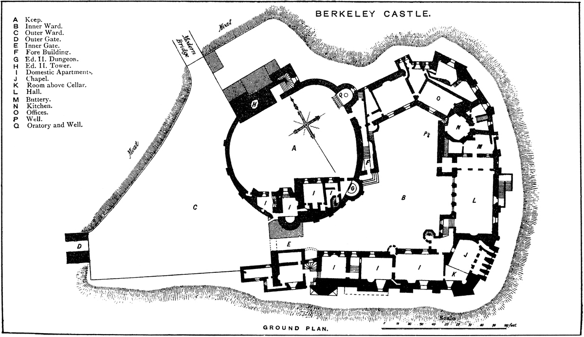
The other castles are either ruins or have altogether been swept away. Of Bristol there remains only a portion of a crypt. Gloucester, Hanley, and Worcester are gone. Of Bridgenorth a part of the keep is all that is seen; and of Shrewsbury a fragment of a Norman gatehouse, the much-altered walls of the hall, and, older than all, the mound that gave character to the whole. Berkeley, on the other hand, has been inhabited from its foundation to the present day. With one temporary alienation to the Crown, it has always been in one family, and it is as little altered as is consistent with modern usages and modes of life.
The castle, church, and borough town of Berkeley, contained within the hundred to which they give name, are placed upon the southern extremity of a tract of ground which rises about 50 feet above the meadows to the south and west, and the drainage whence is carried on by the channel of the Little Avon, which falls into the Pill or Creek of Berkeley, and so reaches the Severn, here expanding into an estuary, the southern shore of which is about two miles distant from the castle. The castle stands upon the southern extremity of the high ground. A few yards to its north is the parish church with its detached tower, and again a little to the north is the town, which has grown up under the protection of its lordly neighbour. A deep and wholly artificial ditch intervenes between the churchyard and the castle, crossing the high ground, and cutting off and isolating the latter, of which it protects the northern and western faces. These, to the south and east, are made secure by the natural declivity, scarped and rendered steeper by art. The meadows out of which the castle hill rises, being but little above the adjacent Severn, were formerly an extensive and almost impassable morass, adding much to the strength of the place. Under the skill and labour of centuries, they have become grass-lands of great beauty and fertility, and form a charming foreground to the castle. Beyond, are elms and oaks often of great magnitude, disposed in frequent hedgerows, and in the distance to the west are the Welsh mountains, and to the east the nearer scarp of the Cotteswold, here and there covered with thriving plantations.
Town and castle stand geologically upon the Old Red Sandstone, which, a very few yards to the east, is succeeded by the Ludlow rocks, which are again covered up by the marls of the Lias and New Red, and towards the Cotteswold by the Lower Oolite.
230
Like Warwick, Windsor, Arundel, and some other ancient piles, noticed by Shakespeare,—
between its town, and its park, now, indeed, disparked, but which extended far and wide to the south-east, and is traversed by an extended avenue. As was the case at Warwick, there is a deer-park entirely detached from the castle.
The main approach to the castle lies through the town, on leaving which, a road, passing the church, leads up to the entrance, and crosses the ditch by a permanent bridge, by which the draw-bridge was superseded by Henry Lord Berkeley in 1587, and beyond and partly standing in which is the outer Gate-house. This is a rectangular building of no great merit, pierced by a portal having a low drop arch on each face. The passage is plainly vaulted in calcareous tufa, and in the crown of the vault are three square holes or meurtrières. There is no upper story, nor, at present, are there any flanking towers or curtain. There is a basement below the road-way level, entered from the ditch, but, probably, at one time filled with earth. This gate-house may be of Decorated date. It has no portcullis. From the ditch, the side walls of the bridge look original, and may have been, as at Goderich, the lateral walls between which was the pit of the draw-bridge.
Entering the outer gate, the visitor finds himself upon a triangular platform, of which the outer gate-house is the apex, and the inner gate-house and part of the keep the base; on the left a modern wall, which replaces the curtain, crests the scarp of the ditch, and forms the north side of the platform 66 yards long. On the right a low parapet, 54 yards long, forms the south side, and caps a revetment wall of about 10 feet in height, at the foot of which the ancient scarp has been laid out in good taste in a terrace garden. This triangular platform is scarcely an outer ward: it is rather a barbican covering the main entrance and the keep. Its area is 7,750 square yards. There is no trace of a second ditch in advance of this side of the keep and the inner gate, but it is very probable that there was one, though, if so, it must have been filled up when the courts were added to the keep, as otherwise it would have completely occupied them.
The keep covers about 35 yards, or above half of the base of the barbican, and lies to the left or north of the gate-house. Part of it has been removed and a large breach formed, showing that the interior is full 22 feet above the ground level outside. The inner Gate-house is in the same position as at Alnwick. It is in truth not a regular gate-house, and has no flanking towers or machicoulis, but the entrance passage pierces a lofty pile of buildings which connect the domestic apartments with the keep, and complete the circle of the main court. The portal is about 11 feet broad and 30 feet deep, and its roof is flat and of timber. It has two drop arches. On the right is a lodge door, and the inner archway has a half round port231cullis groove. Above are two stories through which are doors, no doubt modern, into the keep. Probably the Norman entrance was here, a mere opening in the wall. Much of the structure seems Decorated with later alterations. South of, and flanking the gate, between it and the south-east angle of the place, is a small Tudor building.
The gateway opens into the Great Court of the castle, a roughly rectangular space, having the circular keep encroaching considerably upon its north-west angle, and the remainder of the space set round with domestic buildings built against and completely concealing the lofty curtain.
This court, which is, in fact, the castle, measures outside upon its south face 60 yards, and its east face 72 yards, these two being set nearly at right angles. The north and west faces are about 60 yards and 76 yards, but the north-west angle is occupied by the keep, which covers about 40 yards of the north, and 42 yards of the west face, forming a part of the enceinte. The buildings project about 30 feet, so that the inner and open part of the court is much reduced in area. The curtain, originally thick, has been strengthened outside, probably in the Decorated period, by nearly thirty broad and thick and very clumsy buttresses, some of which probably conceal the early Norman pilaster, for most of the wall is certainly of that date. Some of these buttresses are pierced by loops, showing an immense thickness of wall.
On entering the court, on the left is the high plain wall of the keep, with its forebuilding and exterior staircase ascending to the entrance. On the right are domestic buildings, drawing-rooms, bed-rooms, &c., extending to the south-east corner. The face wall, though much altered, and pierced with Tudor windows, seems in substance Norman with large Decorated alterations. The pointed Norman arches may be traced in the wall. These buildings have a basement and two upper stories. It is uncertain whether they stand upon a vault.
The chapel occupies the south-east angle. The hall is next to it along the east side, and the butteries, kitchen, and offices fill up the north-east angle and the north side as far as the keep. In the south wall, near the gate-house, but at the exterior ground level, is a small pointed doorway, probably a postern, and connected with it a small chamber, about 6 feet below the level of the court, of doubtful age, but with an old doorway. It has a flat roof, and wooden floor of the room above: being filled with the bins of a modern cellar, it cannot be examined.
The Chapel, dedicated to the Virgin, rests on the vault of the great cellar, and measures 29 feet by 18 feet. It is entered by a modern door in the north wall, west of which are traces of what seems to have been the original entrance. It has a rather flat apsidal east end of three faces; the vestry, a mural chamber, opening in that to the south-east. The south side is the outer wall, 14 feet thick; it is pierced by a mural passage, a sort of aisle, at the floor-232level, which opens into the chapel by four foliated arches, each corresponding to a window or loop in the curtain. There is a small Decorated piscina. Against the west wall is a sort of pew of two stages, the upper being an enclosed gallery for the family, opening from the principal rooms.
The roof is open, at a very low pitch, with timber ribs rising from corbels. These, with cross ribs, divide the roof into large panels of a very curious character. The walls of the chapel are Norman, but the roof and fittings are mostly Decorated. Maurice, Lord Berkeley, 38 Edward III., obtained from Pope Urban II. a bull bestowing certain spiritual privileges upon all who worshipped here or in the chapel in the keep.
The Cellar below the chapel is part of the original castle. Its level is a little below the floor of the hall. It is in plan an equilateral triangle about 40 feet in the side. Its roof is vaulted and groined in three hexagonal bays, springing from three shafts of late Norman character. Nine triangular vaultings, abutting on the walls, complete this very curious roof. Opening from this is another vault, also a cellar, at a lower level by about 5 feet. It is much smaller, and has a ribbed and vaulted roof. Unfortunately it is used as a cellar, and obscured by modern fittings. It has a small Tudor window.
From the chapel and drawing-room a broad wooden seventeenth century staircase descends into the hall at its south or dais end, in which is a large and handsome fireplace, probably of the same date.
The Hall is 32 feet broad by 61 feet long, and has an open pointed roof. It is built at the ground level against the east curtain, which is, or was, pierced by four windows, three in the hall and one within the buttery screen. The latter is late Norman, with slender flanking shafts. The other three are full centred, with a keel bead at the angle, and an interior drip. They seem Decorated, and no doubt replace Norman loops. In the west or court wall are four large and lofty flat-topped and somewhat peculiar windows of two lights each, broken into four by a heavy transom. The upper lights are trefoil, the lower shoulder-headed. Between each pair, outside, is a triangular buttress. The entrance from the court is in the west side, at the north end, by a handsome and spacious porch, vaulted and groined. The exterior doorway is an arch composed of four quite plain straight sides, parts of an octagon, similar in outline to those above the Berkeley tombs at Bristol, known locally as the Berkeley arch. This is repeated with the addition of some ornament in the inner doorway, which opens into a narrow strip of the hall cut off by the screen. On the left, in the end wall of the hall, are three fine Berkeley arches opening into the butteries, of which the central was formerly a door. Above this passage, high up, is a small music gallery, probably of Tudor date, or even later. The roof of the hall is poor, but said to be of the fourteenth century. No doubt this represents the original Norman hall, rebuilt, as regards the court wall, in the Decorated period.

233
In the hall are placed, not inappropriately, the earlier charters of the family, protected with glass. Perhaps, however, looking at their extreme value as connected with the castle, it would be safer to restore them to the muniment room, and replace them for public exhibition by photographs.
To the north, beyond the lower end of the hall, are the butteries, kitchen, and pantries, the latter against the curtain. The Kitchen is an irregular hexagon, averaging 13 feet 6 inches in the side. In the three longer sides are recesses for a fireplace, and hoods over cooking-places. The original doors were in the buttery on one side and the scullery on the other, and there were two windows towards the court. The roof is of open work, very plain, heavy and poor, and very high up. It is said to have been brought from Wootton Manor House, and placed here by Henry VII. The scullery, &c. occupy the north-east angle of the court, and, like the adjacent chambers, is of irregular form, governed by the general outline of the castle. The larders, dairy, &c. are against the north curtain, and from the bakehouse a modern vaulted passage leads to the ancient well, which is in the court. The oven is in the north-west corner, and two bold drop-arched stone ribs traverse the chamber, and stiffen its vaulted roof. All these rooms form the ground floor, and carry an upper story. Their front towards the court seems to have been modernised, but in substance they are Decorated, with considerable remains of older Norman walling.
The Keep is the most interesting part of this very remarkable castle, since it is a shell keep of a known date. It is nearly circular, about 50 yards diameter, and the containing curtain-wall is about 8 feet thick, reducing its inner area to near 45 yards. The floor, of earth, is about 22 feet higher than the exterior ground, and, the wall being 40 feet high inside, is about 62 feet outside, the lower 22 feet being a revetment, and very thick. Upon its circuit are three half-round projecting towers or bastion turrets, 20 feet in diameter, of the height of the curtain, which seems to have been open at the rear, or closed only with timber. One of these projects to the east, and is abutted upon by the northern curtain of the castle court. In its base is a well, under a barrel vault, and above, resting upon this, is the oratory, dedicated to St. John the Baptist. The western or end wall of the oratory, and the outer stair leading to it, are modern.
The oratory is at present used as a muniment room. The ecclesiastical features are much injured and obscured. The eastern end is a half round, and there are remains of the flanking shafts of the Norman east window, and a small piscina. It appears to have been vaulted.
The second half-round tower is 64 feet from the former, and projects to the south into the court, commanding the inner face of its entrance, and the approach to the keep. In it, below the ground level, but not much lower than the level of the court below, is a circular dungeon 25 feet deep, into which Edward II. is said to have been finally thrust.
234
The third tower is 50 feet from the second, and projects to the south. Here also has recently been discovered a chamber somewhat similar to the dungeon already mentioned, also not vaulted, and of very rough masonry, as though a mere foundation intended to be filled up with earth. These two last towers are blocked in by later masonry, the first within, the latter both within and without, as it projects into the buildings of the gateway. As this tower could never have been intended to be thus concealed, it points to the conclusion that the keep was built before the wall of the inner court.
Besides these three half-round towers is a fourth, rectangular, and a much larger work, to the north, forming a part of the exterior line of defence. This is known as Thorpe’s Tower, and the family of that name are said to have held their adjacent estate of Wanswell by the tenure of its defence. This tower is 64 feet long by 17 feet deep. It forms a part of the curtain, having a very slight interior projection. At each end it expands into a square turret, that to the west 17 feet, that to the east 20 feet. The western turret and the body of the tower are thought to be solid, which is very improbable. They are not unlikely to have been filled in with earth to increase their power of resistance when the castle was battered from the churchyard. The eastern turret contains a square well-staircase of fifty-four steps, which leads to the battlements, and has a mural chamber on its way. The entrance below to this staircase is by an original full-centred arch, partially blocked up. This tower is somewhat higher than the curtain, with which it does not communicate. It is said to have been originally higher by a few feet more. Even at present it is the highest part of the castle, and hence the family banner is displayed. Below and outside this tower, to the north, are some modern offices.
Between Thorpe Tower and the Well Tower is seen in the wall the outline of a recess for a loop, and above it a segmental arch and Norman moulding, now closed up. The whole south side of the keep area is occupied by a block of building, about 80 feet long by from 20 feet to 30 feet deep. No doubt part of this building may be original, but by far the more prominent part is evidently modern, and sadly out of place. It covers the rear of the two southern half-round towers, which are thus not seen from within.
The entrance to this keep is peculiar. Usually, as at Tamworth, Lincoln, York, Cardiff, and Arundel, the entrance to a shell-keep was at its ground-level, and that of a rectangular keep, as at Castle Rising and Dover, at its first or second floor. Here, however, both conditions may be said to be fulfilled, for although the entrance is on the ground level as regards the interior of the keep, it is the full height of a first floor above the ground outside, and this height is gained by an exterior stair, guarded by a middle and lower gate, and above the latter by a regular tower. This forebuilding is common to rectangular keeps, but does not occur elsewhere in shell keeps. Here the Forebuilding is 72 feet in length, and is applied to the south-east side of the keep, or that within the court. In breadth235 it varies from 15 feet to 10 feet. Five steps ascend to its outer gate, a large full-centred archway contained within a plain chamfered moulding. As the doorway has been blocked and reduced in size by a perpendicular work, its jambs are concealed or may have been removed. Within is a vaulted passage, carried through the gate-tower, which is 15 feet square, and has an upper story. From the doorway twenty-four steps ascend to an open platform, having on the right a high and pierced parapet, and on the left the wall of the keep. At the stair-head a ledge on the right serves as a way to the upper floor over the gateway. This is a small chamber lighted by two windows and a lancet loop. The two larger windows and the door are of Tudor date, as may be the whole room; but, if so, it is a rebuilding, for the original tower must have been on the same pattern. In the room is an ancient bed and some hangings of needlework or tapestry, very early, but scarce of the age of Edward II., whose chamber this is reputed to have been.
A little beyond the stair-head, against the walls, right and left, are seen the rebates of the middle gate, and in front, in the wall of the Oratory Tower, is the weather moulding of a roof. Hence it would seem that the staircase, as at Castle Rising, was covered all the way up.
The main entrance to the keep opens upon the platform at the stair-head. It is a handsome, full-arched doorway with closed tympanum and flat head. It was flanked by highly ornate shafts, of which one remains. This portal opens into a vaulted passage through the keep wall, and enters the keep under an original archway, segmented with Norman mouldings. The jambs are worked in a very bold chevron pattern. From the exterior platform a narrow stair is continued to the battlements of the curtain over the bakehouse; but this may be an addition, for usually every part of a Norman keep was complete in itself, and had no direct communication with any other part of the castle. There is another and parallel stair in the wall, but opening outside and leading to the room above the bakehouse. This is not original.
The keep is constructed of exceedingly rude rubble masonry. Upon two parts of its face are nine narrow and shallow pilaster strips: three towards the barbican, and six between the inner gate and the forebuilding. The keep wall has a rude plinth, with no set-off or string. It is evident that this, as at York, and in other shell-keeps, was lined by lodgings, having an upper floor, placed all round against the wall with an open court in the centre. These were probably of timber. In the part of the keep towards the barbican is a breach about 40 feet broad down to the level of the inner floor. It is said that this part of the wall was partially broken down during General Massey’s attack, and was afterwards enlarged to its present condition, as at Kenilworth, rather as a matter of favour, to render the castle untenable without injuring it as a dwelling. Had the keep been blown up as was usual by gunpowder, it would have presented a very different aspect.
236
If the masonry of Berkeley Castle were to be removed, as at Kilpeck or Ewias Harold, its remains would show a mound of earth, and attached to three sides of it a platform, the whole encircled with a ditch or scarp. It would, in fact, be a moated mound with an appended platform, of a character very common in England, in the Welsh Marches, and in Normandy, and would resemble such works as Tamworth and Towcester, the dates of which are given in the Anglo-Saxon Chronicle. The inference is, therefore, that Berkeley was the seat of an English lord, probably from the ninth century. Had the fortress been an original Norman work, it is scarcely probable that a shell would have been the form of keep selected, or that, having been so selected, its lower 22 feet would have been filled up with earth. Evidently the Norman builder, finding a moated mound of no great height, but of considerable breadth, built his shell round it, as at Pontefract, as a revetment wall, and upon this, when clear of the top of the mound, raised his curtain. At a lower level, along the scarp of the existing ditch, he, or his immediate successor, constructed the walls, which, then as now, contain the whole castle.
All the main walls of the castle are either Norman, or rebuilt upon Norman foundations, or very nearly so. Probably the keep was built first and the court enclosed shortly afterwards. Much was done in the Decorated period. The inner wall of the hall, at least, was rebuilt, and it may have been enlarged. The porch was added, the chapel much altered, and the domestic buildings possibly gutted and recast. Henry VII., when in possession, seems to have made some inconsiderable alterations, and others have been added since.
Berkeley is a rare example of an estate which has descended in the male line from the reign of Stephen, and in the female line from the Norman Conquest. The first of the latter ancestry is entered as the Lord of Berkeley in Domesday; the first of the former is also there entered, though as proprietor of other estates. Few, if any, of our oldest families can say with truth as much, but further than this the Berkeley tenure has been “per Baroniam,” and from the Conquest they have been barons of the realm, first by tenure, and when, in the reign of Henry III., tenure fell into disuse, then by writ; but by one right or the other they have ever sat in the great council of the nation.
There is no reason to suppose that the Romans had any settlement at Berkeley. Their camps and villas are frequent in the neighbourhood, which was traversed by Roman roads, but of their presence in Berkeley itself there is no other evidence than the fact that the two main streets of the town cross in its centre at a right angle, in the Roman manner.
There is, however, evidence of a religious house at Berkeley in the eighth century. Tilhere, Bishop of Worcester, in 778, seems to have been previously Abbot of Beorclea, as was Etheldune, also his successor at Worcester in 915. Tanner thinks the family at Berclea, mentioned in the Acts of a synod at Cloveshoe in a.d. 824, may237 refer to a religious house here. There was also a nunnery, for a charter by Adeliza, queen of Henry I., gives to the church of Reading, Berkeley Hern, that is, the church of Berkeley, with its appended prebends, and the prebends “duarum monalium,” which seems to refer to a nunnery. Camden says the nunnery was suppressed by Earl Godwin in the reign of the Confessor, and preserves a scandalous tale thereupon, which derives some support from a curious entry in Domesday, whence it appears that Gytha, the wife of Godwin and mother of Harold, had Ullcestre, near Berkeley, from her husband, he having bought it from Azor that she might live there till she should live at Berkeley. “Nolebat enim de ipso manerio aliquid comedere pro destructione abbatiæ.”
In Domesday, Berkeley appears as a royal demesne and free borough, which had been held by the Confessor, and belonged to William, but was held of him by Roger, called thence of Berkeley. It was the head of a soke or barony, for attached to it were “Berews,” or members, in twenty-one adjacent parishes. The castle is not mentioned, but in “Ness,” probably Sharpness, was a castellum, or castellet, claimed by the same Roger. His holding in the Liber Niger is set down as 2½ knights’ fees. He gave liberally to Stanley Priory, and died there 1096. William, his nephew, succeeded, and had a son Roger, father of Roger, who all held Berkeley, and are designated by its name. This latter Roger was a partisan of King Stephen, and was turned out of Berkeley by Henry, who gave Berkeley to Robert, son of Hardinge, Præpositus of Bristol, who died 1170, 16 Henry II., aged seventy-five, leaving Maurice Fitzhardinge, his son. To stanch the feud between the dispossessed and the new lord, Henry made up a double alliance: Helen, daughter of Fitzhardinge, was married to a son of Roger de Berkeley, and Alice, Roger’s daughter, to Maurice Fitzhardinge of Berkeley. The result was that the old Berkeleys fell back upon their manor of Cuberley, and finally died out, and the Fitzhardinges, with the estate, bore the surname of Berkeley, and have so continued. At that time the Manor or Lordship, sometimes called the Honour of Berkeley, included above thirty parishes, and extended over most of the hundred. It was rated at 160 hides, and paid a chief rent of £70.
Henry, at the time of the gift, was only Duke of Normandy, and weak, and Fitzhardinge was an important man; hence the duke treats as equal with equal, and with the estate makes a promise to build him a castle to his taste. “Et pepigi ei firmare ibi castellum secundum voluntatem ipsius Roberti,” and, on the other hand, Robert promises to be Henry’s liege. Henry visited Berkeley in 1155, when, no doubt, the present castle was begun. Henry’s charter is in excellent preservation, and is kept at Berkeley.
Another charter by Henry, when king, also there preserved, confirms to Robert Fitzhardinge, Berkelai-Herness Manor by the service of one knight, or, if he prefer it, 100 shillings per annum. A third charter is almost a copy of the second, but states the service at five knights, and is silent as to the composition. There is also a charter238 printed by Dugdale, by which Robert Fitzhardinge grants certain churches to St. Augustine’s at Bristol. These are the earliest title-deeds of the family. St. Augustine’s was founded by this Robert in 1142, and consecrated in 1148. He died 1170.
Maurice, son of Robert, is said to have dug the ditch between the castle and the church. He probably deepened it. He also is reputed to have built the castle exterior to King Henry’s keep, including the two gatehouses. He died in 1189.
Robert, his son, bore the name of Berkeley. He was in arms against John, who held the castle from 1211 till his death in 1216. Lord Robert died 1220. His brother, Lord Thomas, received Henry III. here in 1220. He died 1243. Maurice, his son, here entertained Prince Edward in 1256. He added to the estates, and is said to have strengthened the castle. Thomas, his son, sixth lord, was a great soldier, and served at Bannockburn. He died 1321. Maurice, his son, took part against the Despensers, and was imprisoned by the king till his death, in 1326. Edward seized the castle, which was held by the Despensers. Lord Thomas, his son and successor, received Edward II. here as a captive, 15th April, 1327, and here the king seems to have been murdered by Maltravers and Gournay, 21st September, 1327. A payment was charged to the Exchequer for prayers for his soul in the castle chapel.
Lord Thomas held the castle from 1326 till his death in 1361. He fought at Cressy and Poitiers, and probably made money in the wars, for he is reputed to have made great alterations in the castle, and probably the hall and the Decorated work generally is his doing. He is said to have built Thorpe Tower. He may have raised it, but it is apparently as old as the keep. The Berkeley arch, seen in great perfection in St. Augustine’s Church, now Bristol Cathedral, and here introduced, as was proper, in a plainer form, is attributed to Knowle, Abbot of St. Augustine’s, from 1306 to 1332. The connexion of the Berkeleys with the monks of St. Augustine’s was intimate, and the same architect was likely enough to be employed by both.
Another Thomas, grandson to the former, here received Richard II., in 1386–7. This is the Lord Berkeley mentioned in “Shakespeare’s Richard II.,” when the castle is described as—
Lord Thomas pronounced the deposition of Richard in Parliament in 1399. John of Trevisa, whose translations from the Apocalypse are yet seen on the ribs of the chapel roof at Berkeley, was vicar of this parish during the life of this lord. Lord Thomas left a daughter only, married to Richard Beauchamp, Earl of Warwick, who strove hard, but in vain, to oust the heir male, James de Berkeley. Lord Warwick appeared before the castle in 1418 with an armed force, and his heirs preferred a suit at law which lasted 150 years, varied with occasional combats, one of which, known as the239 battle of Nibley Green, led to the settlement of the dispute, Lord Lisle, the claimant, being slain in the field by William Lord Berkeley. William, the next lord, was created Earl of Nottingham by Richard III., and Marquis of Berkeley by Henry VII., in return for which he alienated the estate from his brother and male heir in favour of the latter king and his heirs male, nor did the Berkeleys recover it until the death of Edward VI. and the failure of the royal male line, when the castle was recovered by Henry, who resumed the title of Berkeley, after an alienation of 61 years 4 months and 20 days.
Henry VII. is said to have erected the kitchen, but probably he only put a new roof upon it.
During the Parliamentary struggle, the Lord of Berkeley seems to have been a moderate Royalist, with strong friends among the Parliamentary leaders. In 1642 it was surrendered to Lieutenant-Colonel Arthur Forbes, for the Parliament, but was not pillaged, and even the arms contained in it were not removed. Probably this moderation was abused, for, 24th September, 1645, being held by Sir Charles Lucas, it was stormed from the churchyard by Colonels Rainsborough and Morgan, and free plunder allowed to the soldiery. Fortunately, at the moment of victory, a pressing order came for the march of the troops to assist Fairfax, on which the plunder was compounded for at 5s. a head. Such goods as were taken away were inquired after and restored, and the chief mischief seems to have been confined to the muniment room, where the charters and title-deeds were torn and mutilated. In 1646 the out-works were destroyed, and the arms, ammunition, and drawbridge removed to Gloucester. Probably the great breach was then made by the workmen employed upon the earthworks, which would account for the careful manner in which the wall has been cut away.
George, Lord Berkeley, was created in 1679, by Charles II., Viscount Dursley and Earl of Berkeley, titles still extant.
ABOUT four miles below the ancient Priory of Robertsbridge, and fourteen, by its own sinuous course, above its junction with the sea below the old Cinque Port of Rye, the Rother, a considerable Sussex river, receives from the north an important tributary known as the Kent Ditch, and, time out of mind, the boundary of the two counties. The waters meet obliquely, and between them intervenes a tongue or cape of high land tapering and falling gradually towards the junction, and occupied by the church, village, and castle of Bodiham.
240
Who was Bodi, or Bode, whose home was here established, is unknown. He was evidently a Saxon, and from the position of his estate, probably an early one, giving name it may be to a tract won in arms from the Britons. Ham is here a very common termination to the proper names of places, varied with Hurst and Den and Ley, and other less frequent but equally Saxon denominations.
The church stands on the high ground, a little north of the centre of the cape, the castle about 600 yards to the south of it, and about half the distance from the Rother, at some thirty feet or so above its level. The Rother, here and lower down, traverses broad patches of lowland, now fertile meadow, but in former days evidently inaccessible morass. The position, therefore, between the two streams with their marshy banks was defended by nature towards the south and east, the quarter from which, after the complete expulsion of the Britons and during the early Saxon period, danger was mainly to be apprehended.
The earlier lords, both Saxon and Norman, who gave name to, and derived their names from, Bodiham, pitched their homestead on the north side of the high ground, some way from the church, and upon the right bank of the Kent Ditch, where the site is still indicated by some earthworks and a moat. Nearer to, but south of the church, on the brow of the hill, above the present castle, are the remains of another earthwork, rectangular and oblong in form, the site probably either of an early residence or a still earlier encampment.
Below this brow, on the southern verge of and just within the slope, it pleased a Lord of Bodiham, having become so by marriage with its heiress, to establish a new residence. Sir Edward Dalingruge, a successful soldier in the rough school of the Black Prince and his captains, of whom his immediate chief, Sir William Knollys, was one of the roughest, having held offices of trust under Richard II., decided here to build a castle suitable to his rank, wealth, and military fame; and having, in the 9th of Richard, 1385–6, obtained the royal licence, he constructed at a vast cost, both in earthwork and masonry, the castle here described.
Bodiham is a building of very high interest. It is a complete and typical castle of the end of the fourteenth century, laid out entirely upon a new site, and constructed after one design, and at one period. It but seldom happens that a great fortress is wholly original, of one, and that a known, date, and so completely free from alterations or additions. It has, moreover, fallen into good hands. Enough, and not too much, has been done to arrest the effects of time and weather. The repairs have been well executed, and in Wadhurst stone, the proper material; and, though well watched, it is open to all who care to visit it.
In plan and details Bodiham belongs to the early Perpendicular style, and occupies a mean position between Caerphilly, a work late in the thirteenth century, and Wressil, only a few years later than241 Bodiham in time, but much later in style and arrangements. Like these castles, it has no keep, and its domestic buildings are constructed within and against the walls of a court, but while Caerphilly, like Harlech and Ledes, is concentric, and has a narrow outer ward, Bodiham and Wressil, like Bolton, have but one ward, one line of defences, and are only rectangular enclosures, with strong and lofty curtains, flanked by still more lofty mural towers. Pennard in Gower, though of the reign of Henry III. or his son, is, on a small scale, of the same general type as Bodiham.
Save the adjacent river and the marsh, the immediate site of Bodiham possesses no natural advantages. A sort of platform was selected upon the sloping ground, about 30 feet above the river’s level, and in it was excavated a rectangular basin, 180 yards north and south, by 117 yards east and west, and about 7 deep. To the east, the containing bank was wholly artificial, formed of the excavated material, as was also the case with the contiguous parts to the north and south. The remaining part of the south bank was also slightly raised.
On the west side, near the north end, a small natural combe descended towards the excavation, of which, being wet, it was regarded as the future feeder. A strong dam was thrown across the lower part of this combe, between it and the excavation, of which it thus formed the bank. No doubt the pool so penned in was intended as a store pond when the moat was low.
In the centre, or nearly so, of the excavation, was left a rectangular island of rather above half an acre in area, raised artificially about four feet, and to be occupied by the future castle, of which the ground plan would thus be a plot of about 50 yards by 46 yards, surrounded by a wet moat from 35 to 65 yards broad. At present a sluice is provided for the occasional emptying of the moat, and probably something of the sort was originally constructed, though it would, of course, be concealed. The fact is, however, that a few vigorous workmen could at any time have cut through the bank in a few hours, and thus have deprived the castle of one of its defences. The mud, however, until dry, would be even a better protector than the water.
Bodiham Castle, then, is a rectangular enclosure 152 feet north and south, by 138 feet east and west, contained within four curtain walls. At each angle is a drum tower, 29 feet diameter, and of three quarters projection, flanking the several faces. In the centre of the north face is the great, and of the south face the lesser, gatehouse, and in the centre of each of the other faces is a square tower. There are thus eight mural towers, four cylindrical, and four rectangular, giving an agreeable variety to the outline. Besides these there is a projection from the east face of 8 feet, containing part of the chapel and the sacristy. The walls and towers all rise direct from the water. The curtain is 40 feet 6 inches high from the water to the crest of the parapet, and the towers are one-third higher, or 54 feet. The outer walls generally are 6 feet 6 inches thick, which242 is also the height of the parapets. The stair turrets rise 14 feet higher than their towers, and the chimneys about 9 feet. Both are octagonal, and are crested with miniature battlements in the late Perpendicular manner. There is no water gate or postern, such as those at Ledes and Caerphilly.
The great gatehouse is a very imposing structure. It is in plan a T, the horizontal limb forming the front of 30 feet breadth, and the vertical limb extending backwards as far, and containing the entrance passage. The front is composed of two towers, rectangular, but having the angles largely recessed, so as to throw forward the central part of each tower as a bold buttress, 15 feet broad by 6 feet deep. The whole projects from the curtain about 15 feet, and between the towers, deeply sunk, is the gateway.
The gateway has a slightly four-centred arch, very plain, and set in the usual square-headed shallow recess, intended apparently to receive the platform of the bridge when lifted. There are traces of the chain holes in the spandrels. The whole is placed in a deeper and plain recess, terminating above in a four-centred arch, which carries the parapet, and has behind it three machicolations which protect the entrance. Over the door is the usual portcullis chamber window, and right and left other windows, all small and lancet, some trefoil-headed, and some plain. Two pairs of loops command the approach, one pair has oylet holes at each end of the slit. The other pair have holes, rather larger, at the lower end only. It is the style of loop that marks the introduction of fire-arms. In the jambs of the portal is a half-round portcullis groove, and a little within a pair of folding doors. The entrance passage, 12 feet broad and 30 feet long, is unusually lofty. It is divided by a cross arch into two chambers, both vaulted. The first, 18 feet long, has on the right and left small lancet doors, leading by a narrow vaulted and ribbed mural passage into the lodges, 11 feet by 10 feet. On the left is a second door opening on a circular well-stair, 8 feet diameter, and unusually steep, leading to the upper chambers and roof, and terminating in a turret at the angle of the gatehouse. The vaulting has fallen in, but it is clear that it resembled that of the second chamber. Beneath the cross archway is a second portcullis, and beyond it the second part of the passage. This is 12 feet square, without lateral doorways, and vaulted. The vault is of four cells, three ribs and two half or wall-ribs springing from each corner corbel, and meeting in one central, four lateral, and four half bosses, placed upon two cross or ridge ribs. They are pierced as in the inner ward gate of the Tower of London, and possibly each contained a flower. The openings are, of the central boss 6 inches, and of the others, 4 inches diameter. These apertures can scarcely have been meant for defence; they are too small, and do not command the four corners of the passage. No doubt a long pike might be thrust down some of them, but scarcely, to be of use, down the half holes next the walls. As to pouring down melted lead, pitch, or oil, such articles were always too expensive to form a part of the243 regular munitions against a siege, nor is there here, nor in portcullis chambers generally, any furnace for heating such materials in any quantity.
The portal leading from this passage into the inner court has a second pair of doors, and beyond them a second portcullis. This chamber is not a part of the regular gatehouse. It forms a sort of porch projecting from it into the court, and has no upper story. A well-stair on the left opened from the court, and led up to the embattled platform which rested on the vault. This subsidiary prolongation of the length and defences of the entrance passage is believed to be peculiar to Bodiham.
Over the outer part of the passage is the portcullis chamber. It has at each end a low four-centred arch, which concealed the head of the grate, when lifted, and above this, at each end, is the customary small window. The lobby between the well-stair and this chamber is groined and ribbed, and in the centre is a large boss carved in foliage. The gatehouse lodges have a pit or sub-basement, perhaps a cellar, perhaps merely a cavity to keep the floors dry. If cellars, they were entered by traps in the floor above. There are also, above the basement, two upper floors.
The lesser gatehouse is placed opposite to the main gate, in the centre of the southern face of the castle, and though equally lofty, is much smaller. It is a plain tower 22 feet square, projecting 15 feet in advance of the curtain, but with no internal projection. The outer gate is in the centre of the tower, and had a portcullis, and behind it were folding doors. The entrance passage is 11 feet square, vaulted as the great gateway, but not so lofty. Right and left are loops raking the curtain. A door in the west wall opens into the usual well-stair, contained within the north-west angle. There is no lodge. The inner portal was closed by doors only. It opened into a passage at the lower end of the great hall.
In front of, and outside this gatehouse, there project 9 feet into the moat two walls about 3 feet thick. They seem to have contained between them a bridge pit, over which a bridge dropped from the gateway, upon a cross wall which remains. The pit is filled up. Opposite, the counterscarp of the moat, 62 yards distant, is revetted, and from it projects a half-hexagonal pier. How this intervening space was traversed is not now seen. Scarcely by a boat, for the pier is evidently intended to support a timber bridge, and a boat could not conveniently be reached from it. Probably there was a footway upon tressels or wooden piers.
Thus much of the two gatehouses, the only towers which are machicolated. Each leads into the court of the castle, an open space 86 feet south and north, by 76 feet east and west; round which are placed, against the curtains, the domestic buildings, 22 to 30 feet in depth, some of one floor, some of two, but all of nearly equal height, and so placed as to conceal the curtain and the lower parts of the towers from the inner court.
Right and left of the great gatehouse the buildings had a ground244 and first floor. Those on the left, or to the east, were rather more ornate, as being nearer to the state apartments. The north-east and north-west towers communicated on each side with these rooms. They have sub-basement pits, with loops, a ground and two upper floors. They differ somewhat in details, but each has a well-stair in its gorge wall, and mural closets and fireplaces at the several levels. The pits are circular, the chambers above hexagonal.
Along the west side are offices, and probably servants’ apartments, and rooms for the garrison. In the centre a large and handsome doorway, with a window on each side and traces of a porch, opens into a small kitchen, a room 21 feet by 16 feet, having on each side a fireplace, with a converging tunnel, and an arched head of 12 feet span and 2 feet rise. There is no hood or projection. The roof was open, and at the battlement level. A gallery seems to have run across above the door, entered from the room to the south, and beneath it in the wall is also a door.
The enclosure next south seems to have been of two floors. The lower room, 38 feet by 22 feet, was probably for stores or for the servants; the upper was the lesser hall. The lower room had two windows to the court and a small door, and perhaps between the windows a shallow fireplace with a bold hood. Above was a noble room of the same size. The lower room opened into the west tower. This, like the east tower, is 25 feet broad, by 21 feet deep, and of 15 feet projection from the curtain. The sub-basement here was evidently a cellar. It has three loops a little above the water-level. A well-stair in the south-east angle leads upwards from the ground-level.
Along the south side were placed the great kitchen, buttery, and great hall. The kitchen, 33 feet by 24 feet, occupies the south-west angle, and communicates with the adjacent angle tower. It has two large fireplaces, of 12 feet span, in the north and south walls. The former has an oven in its west jamb, an afterthought, as it projects into the adjacent room. The other had a large stone hood, of which one springing stone remains, and is buttressed by a corbel, placed in the hollow angle to receive its thrust, as at St. Briavels. The kitchen had an open, lofty roof. Next is the buttery, of two floors, with traces of a cellar below. It is 18 feet by 24 feet, and opened into the hall by three equilaterally arched doorways side by side, each towards the hall, having a deep hollow early Perpendicular moulding. These opened into a passage under the music-gallery.
The hall was about 50 feet long by 26 feet broad, with an open roof. It had, at the dais end of the south wall, a window of two lights, with a transom; the lower pair square-headed, the upper pair pointed. The whole is in a recess, with a flat segmental arch. There are said to have been two windows in the north wall, looking into the court, and here probably was the fireplace, for fireplaces and not central hearths seem to have been in fashion here. The hall door remains. It is a handsome archway with a double ogee moulding. It opened below the music-gallery, and at the other end245 of this passage was the entrance to the lesser gatehouse, so that there was access from the court to the gate, through a passage screened off from the occupied part of the hall. Of course, the lesser gateway was used for foot-passengers only. A passage somewhat similar crosses the lower end, not of the hall itself, but of the vaults below the hall, at Kenilworth.
The state apartments and chapel occupied the east side, and the former seem mostly to have been of two floors.
Behind the end of the hall was a large room, called the armoury, from which opened the south-east tower. Here the sub-basement is hexagonal, and was vaulted and groined. The vaulting has fallen away, but the corbels remain, and the six gables and wall-ribs. Probably this was a private store or cellar, for it has no fire or garderobe, and though the vaulting was elegant, the chamber, being at or a trifle below the water-level, must always have been damp. The upper floors were of timber.
Probably the term armoury is modern, and here were the withdrawing-rooms, to which a passage led from the north end of the dais, outside the hall. There remains a platform of masonry, which seems to have been laid to carry such a passage.
North of these rooms are traces of others, which communicated with the east tower and chapel, and were probably private apartments, with windows to the court. Under the whole was a range of cellars, below the court level, but with doors and loops ascending to it.
Next comes the chapel, 29 feet by 19 feet, having a large pointed window of three lights at the east end. The floor, of timber, covered a cellar, having a loop, rising to the court, and a door in the south wall. The eastern end has a solid raised platform for the altar, and near it a small north window. To the south is a small plain-pointed piscina, and near it a lancet door, opening by steps into a vaulted and groined mural chamber, 11 feet by 6 feet, intended as a sacristy, having two lockers, and a small window to the moat. The chapel door was in the south wall, leading from the lower private apartments. Above the sacristy is a rather larger room, having a door from the upper apartments, and a square-headed window, of two trefoiled lights, looking into the chapel; evidently the lord’s private seat, whence, unseen, he could be present at mass. There was no west door, or direct entrance from the court. The chapel seems to have had an open timber roof.
The masonry throughout the castle is excellent ashlar, the material a fine-grained, soft, but durable sandstone. There is but little ornament. There were seven main well-staircases, each terminating in an octagonal turret, serving as a head. The stairs did not ascend to the top of the turret, which was domed over, and inaccessible. The rooms are almost all furnished with fireplaces, and very many with mural garderobes which seem to have been closed with curtains, or not at all, since there are no marks of doors. Their shafts descend within the walls, and discharge into the moat below the surface.246 The windows generally are small, that of the chapel and of the hall are the only ones even of tolerable size, towards the moat.
The drum towers look older than their real date, their gorge-walls, general proportions and arrangement, well-staircases, and lancet and often trefoiled windows, savouring of the Edwardian period. Their hexagonal interiors, however, and the bold and simple moulding that crowns their parapets, belong to the Perpendicular style. The chimneys throughout are octagonal, well-proportioned, but plain, save the embattled moulding above. They may be later than the castle.
The three armorial shields over the great gateway represent Bodiham or Bodeham, Dalingruge, and Wardeux. The central, being that of the founder, is placed angle-wise beneath his helmet and crest. There were also three shields above the lesser gateway. One was, no doubt, Dalingruge, as before, another was Knollys, out of compliment to that commander.
The battlements generally have a plain ∧ coping, with a beaded ridge towards the field. The merlons are much broader than the embrasures, but are not pierced. The coping is not repeated in the embrasures. No well has been discovered, nor any lead piping, as at Ledes, where the castle was supplied with pure water from a spring at some little distance. On the whole, the castle, for its period, is unusually severe in its arrangements, there being scarcely any traces of luxury. It was a castle, not a manor house, nor palace.
There remains to be described a very singular feature in this castle, the approach to the great gateway. At present, a causeway of earth, about 6 feet broad, springs from the north bank of the moat, and proceeds direct, about 62 feet, towards the opposite gateway. It then stops abruptly, and its head is revetted in masonry, which, however, is modern. Opposite, 11 feet distant, the water flowing between, is an octagon of 16 feet on each face, or 40 feet diameter, rising as an island out of the moat, and revetted all round. There was evidently a shifting bridge of some kind between this octagon and the causeway. Whether this octagon carried any superstructure is uncertain, probably it had only the parapet, of which traces remain.
Crossing the octagon in the same straight line, there is reached a second gap, of 6 feet, and beyond this is a rectangular island about 21 feet north and south, by 20 feet broad, also revetted all round, and on which revetment stood the walls of the barbican. This was, therefore, a rectangular building, traversed by the entrance passage, and having a doorway at either end, the outer guarded by a portcullis, and the inner by doors. The passage was vaulted and apparently groined. It seems to have been of one stage only, the platform resting on the vault and battlements. In the north-west corner was a well-stair, opening from the passage, and ascending to the roof. Grose’s drawing shows this as though it was a side or foot entrance, which does not appear to have been the case. The work is excellent ashlar, but only the west side remains.
247
The barbican is about 54 feet from the great gate, and at present is connected with it by a causeway. As this causeway is here and there seen to be revetted, it may be original, in which case it was possibly broken at either end, and the connection carried on by bridges falling from the barbican and from the great gate. This, however, is conjecture only.
Some doubt has arisen as to how the octagon was originally approached from the main land. This doubt is caused by the presence of a demi-pier of masonry projecting from the west bank a few yards from its north end, and therefore opposite to the octagon. It is therefore supposed that the causeway from the north bank is an addition, and that another causeway, or some kind of communication, was laid from the west bank to the octagon, a much greater distance, nearly thrice as far. No doubt a similar half-pier on the south bank indicates a communication thence with the lesser gateway, but here there seems no reason whatever for the suggested lengthening and bend in the approach. On the whole, for whatever purpose the western pier may have been intended, the evidence is in favour of the approach having always been along the present line. Neither the north nor the west bank is commanded seriously by higher ground. That to the north rises, no doubt, but scarcely so as to give any great advantage to archers posted to annoy those entering the castle, and certainly no greater advantage than could be gained from the rising ground to the west. Possibly the pier was intended for the mooring and protection of the boats employed on that side of the moat. A road, still traceable, led up to this demi-pier.
This double outwork in the moat is peculiar, it is supposed, to Bodiham. At Ledes, indeed, there are two barbicans, but they are not exactly in the moat, but upon the bank, and are deeply intrenched, so as to carry the water round them. At Caerphilly, there is a single large isolated pier in the centre of the moat, now dry, which pier was connected by drawbridges with the great gate and the counterscarp, and may be likened to the octagon in the present instance.
BORTHWICK has been selected and is included in these examples as a noble specimen of military architecture, and the finest extant specimen of the Peel tower so celebrated upon the Scottish border; meaning by a “Peel” a stronghold of which the tower is the only considerable work, and which stands within a walled base-court or barmkin of moderate area. Here, indeed, the dimensions of the tower are those of a Norman keep, and the court, though small, is guarded by bastion towers of large diameter, but still the248 tower is itself the fortress, and was obviously the residence of the lord and his family, not only during a siege, but at all times. Such fortresses as Lochleven and Urquhart on Loch Ness, though far inferior to Borthwick in strength of masonry and grandeur, are nevertheless castles, whereas Borthwick is a Peel.
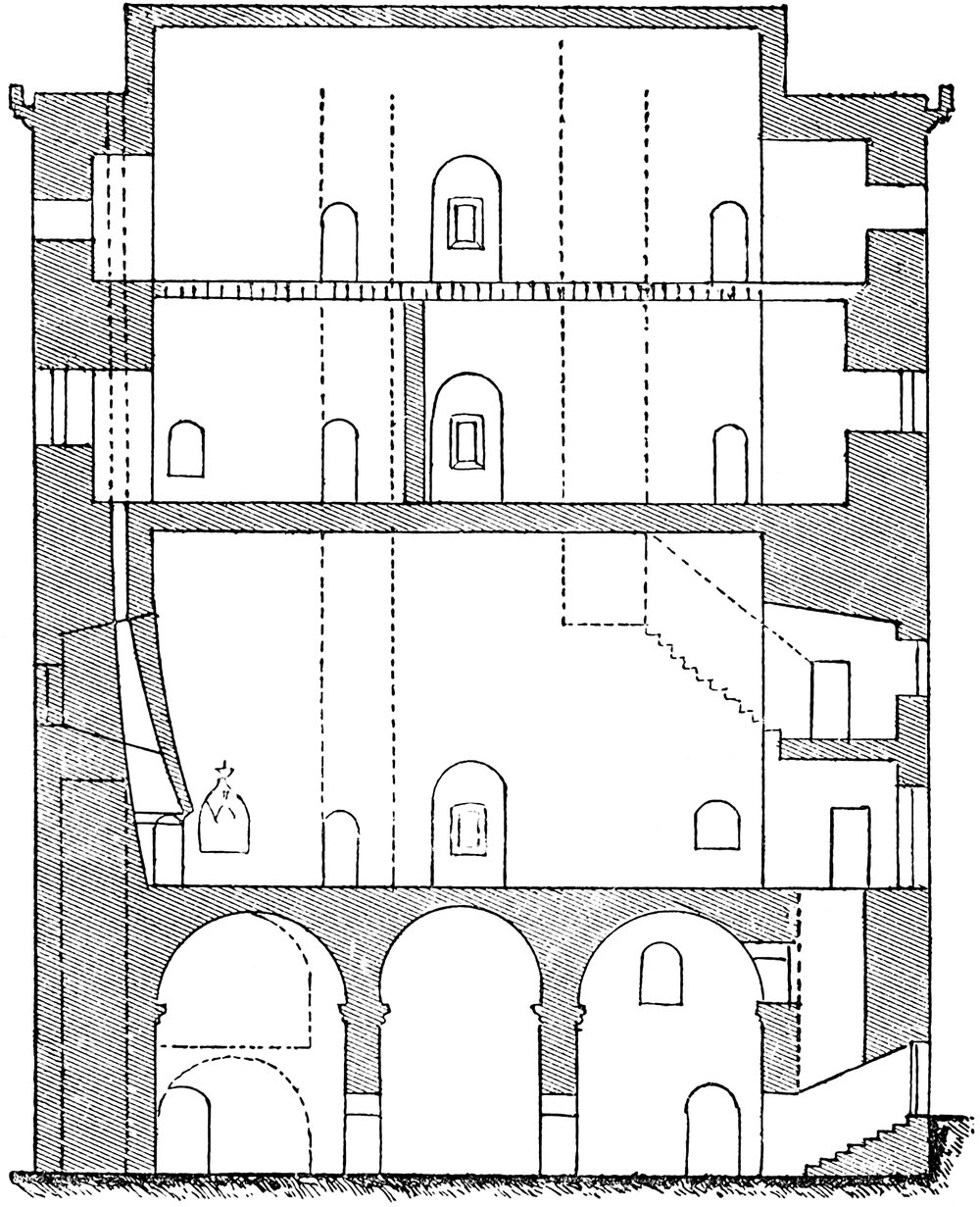
Though a ruin, and deserted probably for a couple of centuries, Borthwick is still in tolerable order, having been preserved by the unusual thickness of its walls and the excellence of their masonry, and the fact that both its basement and uppermost story are vaulted, and the upper vaults protected by stone roofing of a very substantial character. The intermediate timber floors are all gone, and the vast cavities are inhabited by a numerous colony of jackdaws, whose heaps of guano might be removed with advantage. No care has been or is bestowed upon the place, which until recently needed but little; now, however, the rank vegetation on the roof is displacing the tile stones, and the water penetrates the vaults. The grand fireplaces have fallen, and some of the lesser ones are about to fall. At present a few score pounds judiciously laid out would arrest the decay which, unchecked, will certainly in a very few years bring down the upper vaults, and involve the whole structure in irreparable ruin.
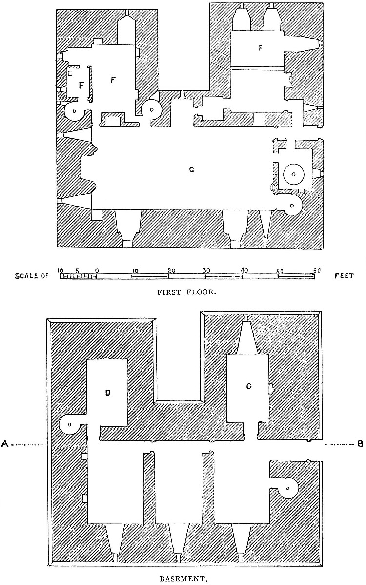
The tower stands upon a tongue of rocky land, protected by deep, rugged, and wooded ravines to the south, east, and north. Down two of these flow the heads of the Middleton burn, and, below the castle, unite, to fall into the Gore water, which, gathering its springs from the adjacent Lammermuirs, flows, parallel to the railway, down a pretty pastoral valley by Gore Bridge, to the South Esk. The tower, placed over the juncture of the three streams, is a very marked object from the railway, contesting the attention of travellers with Crichton Castle, in an opposite direction, but in sight, for a few seconds, at the same time.
The platform, covered by the base-court, is an irregular figure, governed by the ground, rounded to the east, and presenting right angles to the north and south-west. Its dimensions are about 80 yards east and west, by 35 yards north and south. There is a large drum-tower at the south-west angle, and another, with a square rear, in the centre of the south front, and there are traces as of a third capping the south-east angle. These towers are 18 feet diameter, have a basement, a first and second floor, and are about 23 feet high above the court, and 35 feet to the field. In the west front, close to the angle-tower, is a gateway; an opening in a very thick low curtain, round-headed, and probably of the date of the tower. It had a drawbridge and portcullis, and may have had a low upper story. Above the door, outside, is a flat entablature, with mouldings in the Renaissance style, and the adjacent bastion and curtain are pierced with long loops, placed horizontally, evidently intended for musquetoons, and therefore insertions. They are similar to those in the north-east bastion of Berwick town wall. The southern bastion has the original vertical loops for bows and arrows. The west is the weak side, for which nature has done nothing. The curtain accordingly is on that side thickened to 12 feet or 15 feet, and there may have been a ditch, now filled up.
The court was divided by a cross wall, north and south, of no great strength, and the tower stood in the western half, from six to eight yards from the three outer walls. The northern curtain is an irregular heap of ruins; upon it, opposite to the tower door, there seems to have been a mass of masonry ascended probably by steps, and serving as an abutment to the stone arch by which the main or first-floor entrance was reached.
The Tower is rectangular, 74 feet north and south by 69 feet east and west, and from 90 feet to 110 feet high, the latter height being to the ridge of the gables. In the west front is a recess, also rectangular, 14 feet broad and 24 feet deep, so that the building in plan resembles the Greek capital Π, and may conveniently be divided into a body and wings. The recess is not quite in the centre, the north wing being 31 feet and the south 29 feet broad. Also, the 251 latter is rather the shorter, so that the north front measures 69 feet, and the south front 68 feet. The arrangement of the chambers is very simple, all being rectangular and parallel to the sides, but the mode of reaching them by staircases is very complex. The walls are of immense thickness, the north or entrance side being 14 feet, and the other from 10 feet to 11 feet. Those of the recess, being protected, are rather less, and in parts only 6 feet. It is remarkable that these thicknesses are continued with little or no reduction, to the top. The style is simple and severe, and although the material is cut stone, of remarkably fine workmanship both inside and outside the structure, there is scarcely any ornamentation. Over the outer door, in a shallow ogee niche, is a saint or bishop in low relief, and within is a handsome canopied niche for a statue and a sort of seat of state or sedile for the lord. The fireplaces also are good, and the two larger ones of magnificent character and dimensions. These ornaments belong to the Decorated style of architecture, and correspond with the known date of the building, the first half of the fifteenth century. The walls rise from a plain plinth, and are terminated by strong corbels, 2 feet apart, and about 2 feet deep, between each of which was a “meurtrière,” and outside it a low parapet, now removed. As usual with Scottish towers, at each angle was a three-quarter low bartisan resting on the corbels, and probably rising no higher than the parapet. Also, the three high-pitched roofs of the body and wings rise above and within the walls, being set back from 6 feet to 8 feet. The chimneys, where they remain, are tall and handsome, and the three well-staircases opening on the roof were housed in cylindrical turrets with conical roofs, of which one remains, wanting only its finial.
The basement is on the ground level, which is about 5 feet below the exterior ward. Above it is a first floor, which in the body is occupied by the great hall, above which is a second floor containing the chapel and upper hall. Above this is a third floor. The divisions of the wings are less lofty. The north contains six floors, the south five. There are five well-staircases in different parts of the building. Two ascend from the ground level to the first floor and there stop. Two others commence at that floor and ascend to the roof, supplying the intermediate floors, and another commences half-way up the height of the hall, threads two walls as a gallery, and finally rises as a well-stair to the roof. There was thus a ready access from the first and upper floors to the battlements in case of danger.
Basement.—In the body are three chambers placed crossways, east and west, side by side, all 23 feet long, the central 14 feet wide, the others 15 feet. The vault springs 14 feet from the floor, and in each, at the east end, is a large arched recess, high up, narrowing to a loop. At the springing line of each vault is a row of strong corbels, evidently to support a floor, a sort of windowless entresol. These lower chambers communicate by doors, and in the south wall of the most southern is a recess or cupboard. The outer doorway, 6 feet252 wide, at the level of the ground outside, is in the north wall, and is closed by a stout door, within which the passage descends eight steps. In the same wall is a well-stair, which ascends from the basement to the first floor, and there stops. In this, half-way up, is a door into the entresol over the northern chamber, from which level the stair is continued to the first floor. The entresols over the other two chambers were reached by ladders. The whole range clearly was intended for stores, in case of a siege.
From the north and south chambers doors open into the basements of the two wings, also vaulted. The north, the prison, is 18 feet by 12 feet, with a high and narrow loop to the west. In its upper part is also a small door, from the adjacent entresol, which may have opened upon a similar floor above the prison, or may have been an opening to look down into it.
In the left wing is a vault 20 feet long by 12 feet 6 inches broad, and only 8 feet high. This was reached from the adjacent chamber in the body, and contained the well. From this chamber, opening in the south wall, is a well-stair, which rises 10 feet to an entresol, and thence proceeds to the first floor. This entresol, also vaulted, was 18 feet by 12 feet. There is a fireplace and cupboard in the north wall, and in the south a small loop, a mural garderobe, and the door of entrance. From it a rise of 14 feet leads to the first floor, which is thus 24 feet above the basement.
The first floor contains the great hall,—a noble chamber, 51 feet by 24 feet, with walls from 12 feet to 14 feet thick. It is covered by a pointed barrel vault, quite plain, but, with the walls, of excellent ashlar. The height to the crown is about 30 feet. It occupies the whole breadth of the building. In the north end is a mural chamber, 8 feet 6 inches by 7 feet 10 inches, which contains the head of the well-stair from below. This has a door into the hall and another into the entrance passage. This is the passage of the main entrance, 4 feet 7 inches broad, and 14 feet long, having a door at each end, but no portcullis. It is the main entrance to the tower. Outside, it seems to have been approached by a stone arch of about 8 feet span, of which the springing-course is seen under the door-sill. In the vaulted mural passage are the opposite doors, one mentioned already upon the stair-head, the other leading to the kitchen, which occupies the north wing.
At the other extremity of this northern end of the hall a door opens into a well-stair, 7 feet 10 inches in diameter, which here commences, and supplies the upper floor and the roof. The east side of the hall is pierced by two windows, square headed, in deep-splayed arched recesses of 7 feet opening, and 22 feet apart. Besides these, towards the north end is a small light, a mere loop, in a recess of 2 feet 7 inches opening.
The great feature of the hall, after its fine pointed vault, is a grand fireplace, 9 feet broad and 3 feet deep, with a projecting hood of stone, which dies into the wall about two-thirds of the way up, and is supported by two double half-shafts, with bases and carved253 caps and a flowered band above, all in the Decorated style. This occupies the centre of the south end, and on each side of it, high up, are recesses of 5 feet opening ending in loops of 1 foot. The hood is broken down and the fireplace in decay, but its remains are very striking. Along the west side of the hall are various openings. In the centre is a window recess, 5 feet 10 inches broad and 9 feet deep, from which a side opening leads into a vaulted serving-room, 5 feet by 11 feet, which again opens into the kitchen. In the south end of this side a door opens into the withdrawing-room, and another door into a well-stair, which here commences, and communicates with the upper floors of the south wing, and the roof. Near the north end of this side a low arch or buttery-hatch opened direct into the kitchen. Besides these openings, there are two ornamental recesses. The one a niche in the north wall for a statue, about 5 feet high, with a handsome groined and floriated canopy and a base resting upon a half-shaft, probably for a statue of the patron saint of the family. Also in the west wall, near the fireplace, is a sort of sedile, 4 feet broad, with an ogee canopy, containing on a shield the three cinquefoils, the Borthwick arms. The walls of the hall seem to have been either painted or covered with devices, one of which, “Ye Temple of Honour,” was recently to be seen. Here and in the staircases are many masons’ marks. Two of the doors have heads as of three sides of a hexagon, something like the Berkeley arch.
The Kitchen occupied the first floor of the north wing. It is 16 feet by 22 feet, and is spanned by a large flat arch, throwing the western half into a stone hood, under which the principal culinary operations were carried on. There are three recesses with loops in the north and west sides, one of which is blocked by a later oven. There is also a small fireplace. The entrances are from the main door of the hall and from the serving-room, and between is the buttery-hatch.
The Withdrawing-room occupies the south wing, and is 19 feet by 14 feet. It was entered from the hall and from the well-stair, and has recesses and small windows towards the south and west, besides wall cupboards. The south wall contains, in a vaulted chamber, the head of the staircase from the well-room and its entresol; and in this wall also is a mural chamber, 8 feet by 7 feet, with two doors, a window, and, in its flat slab-covered roof, a shaft, probably for a stove chimney. This is called Queen Mary’s room, and was probably her bed-chamber when she visited Borthwick. This and the larger room are plugged for panelling, and the contiguous doorways from the stairs and the hall had a wooden porch shutting them off in the corner of the room, so that there was a passage either from the Queen’s room or the staircase into the hall without entering the withdrawing-room.
Above the hall, a corresponding space, 51 feet by 24 feet, is divided by a cross-wall into an upper hall and a chapel. The upper hall, 27 feet by 24 feet, has a large fireplace, with a stone hood and254 flanking shafts, and near it a window, both in the east wall. In the north wall is a large recess and window and a door into the north-eastern staircase. In the west wall is a window in a recess, and a door which leads by a mural passage into the north wing, and into a garderobe in the north wall.
The Chapel, 24 feet by 21 feet, has a recess of 9 feet wide, in which is the east window, a piscina, and an almbry. It had also two south windows, and between them a small fireplace. In its west wall is the entrance-door from the well-stair, and a door, 2 feet above the floor, from the south wing, which probably opened into a raised seat for the lord. Both chapel and upper hall had a flat timber roof, and were 14 feet high.
The room next above these, the third floor of the body, was of the dimensions of the great hall. It had three windows to the east and one to the north, south, and west. It was entered from the well-staircase in the north-east corner, and that of the south wing, and it had a door direct into the north wing. This room has a long, full-centred barrel vault, which rises about 6 feet above the walls, and is, therefore, to the crown, about 15 feet high. It is probable that this great chamber was broken up by partitions, but it contains no fireplace.
Corresponding to these floors in the body are, in the south wing, five,—the first being the withdrawing-room already described, and 13 feet high. The second has two windows, a fireplace, and a mural garderobe, and is about 11 feet high. The third, the same, and is 8 feet high; the fourth has the same arrangements, and, in addition, a door into the private seat of the chapel. It is 17 feet high. The fifth floor has two windows only, and is about 15 feet high to the crown of its vaulted roof. All the chambers in this wing are of the same size, and one over another.
The chambers in the north wing are over, and of the same size with, the first floor or kitchen, the hood and chimney-shaft of which, built against the west wall, passes up through each floor, tapering as it rises. In this wing there are six floors, most having two windows and some a fireplace. The second floor—that over the kitchen—is entered from the eastern well-stair, whence, at 12 feet above the floor of the hall, a mural passage threads the north wall and its window recess, and leads into the chamber. Hence, ascending in the west wall of the hall 10 feet, it reaches the commencement of a well-stair, which leads to the upper floors and the roof. The uppermost and sixth floor is in the vault of the roof, and is lighted by orifices in its gables.
Besides these chambers in the two wings there are small mural chambers at two levels in the west wall, which are reached from the south stair, and look into the recess on the west front of the tower.
The battlements are still accessible by two staircases, and the three roofs are seen to rise independently from the rampart-walk level. They are high-pitched, and their vaults are covered with cut stone tiles, fitted so as to form ridges and hollows, and so jointed as255 completely, while perfect, to exclude the rain. This roofing has lasted well, and even now only needs relaying and the replacing of a few broken stones. The gables are of cut stone. The stair-heads are about 8 feet high, circular, with conical roofs of ashlar. There seems to have been a low parapet all round, set out upon corbels, and between each pair a square machicolation. There is a clear walk all round, only broken by the chimney-shafts. The parapet has been removed, probably to prevent the tower being held as a military post. The east wall near the top is much injured, it is said, by Cromwell’s shot, when he battered the castle from this side, beyond the ravine.
Borthwick Tower was built under a licence from James II. to Sir William Borthwick of that ilk, dated the 2nd of June, 1430.
Billing gives an excellent view of this tower from the south-west, and a good drawing of the interior of the hall, showing the great fireplace before its fall, and the lord’s seat.
The family of Borthwick, though for centuries the owners of this estate, derive their name from a place on the shore of Borthwickwater, in the shire of Selkirk, whence, at a remote period, they migrated to the lands and castle of Catcune, holding it with Legertwood and Herriot Muir, whence they again removed to Locherwart, to which they gave the name of Borthwick, an inversion common in Ireland, but rare in England and Scotland. Their predecessors at Locherwart were the Hays of Yester.
The first of the name on record was, I., Thomas de Borthwick, temp. David II., and who held lands in Berwickshire. His son, II., Sir William Borthwick, of Catcune, was living 1378, and his son, III., Sir William Borthwick, in 1387–1401, and who was father of, IV., Sir William, of Legertwood, who, in 1410, had a grant from Robert Duke of Albany of the lands of Borthwick and Thoftcotys, in Selkirk; V., another William, son of the last, was one of the hostages sent to England for the ransom of James I. To him, as Willelmus de Borthwic, miles, the king granted, 2nd June, 1430, a letter of licence, “construendi castrum in illo loco qui vulgariter dicitur le Mot de Lochorwort ... ac in eodem castro et fortalicio Constabularium, Janitorem, custodesque necessarios et optimos pro sua voluntate providendi, removendi, et omnia alia quæ ad securitatem et fortificationem dicti castri necessaria fuerint faciendi.”
Such a licence is rare in Scotland, where the nobles were very independent of the Crown, and the country commonly so disturbed that a castle was almost a necessary of life. To the castle so licensed to be built was given the name of Borthwick. It is probable from the term “Le Mot” that there was already a strong place there, for which indeed the position was very suitable. This Sir William seems to have been the first Lord Borthwick. His lineal male descendant, John, the eighth lord, held out his castle for a time256 against Cromwell’s artillery. His son, John, the ninth lord, died childless in 1681, and on his death the castle passed to his sister’s son, Dundas of Harrington, from which family, after two descents, the castle was purchased by Borthwick of Croston, descended from a younger son of the first lord, and his male descendant in the tenth generation claimed, in 1774, the barony, which, however, was ultimately granted to a still nearer male heir.
John, the fifth lord, was a strong partisan of Queen Mary. He it was who ducked the apparitor in the burn, and made him eat his letter of excommunication, steeped in wine. Mary fled to Borthwick Castle, about three weeks after her marriage with Bothwell, 7th June, 1577, and, being followed by the opposing lords, fled thence, on the 11th, to Dunbar, disguised as a page. No doubt she slept in the chamber called by her name. Bothwell, at that time, possessed the adjacent castle of Crichton.
The Borthwick arms carved in the hall of the castle are,—(A) three cinquefoils (sable).
The adjacent church was rebuilt, or nearly so, in excellent taste, in 1850. It has a western tower with a broach spire, a nave, chancel, and round apse, and two transepts, of which that to the south is old, and mainly in the Decorated style, though with some traces of Norman work.
Dr. Robertson, the historian, was born in the manse, which, however, has been rebuilt.
THE Castle of Bôves is here introduced as a good example of a moated mound on the other side of the Channel. The castle and village stand upon the left bank of the valley of the Noye, in the old province of Picardy, above and about a quarter of a mile distant from the stream. The Noye rises near to Crêvecœur-le-Grand, beyond Bretuil, and flows across a district of chalk. Both a little above and immediately below Bôves, it inosculates with the Avre, which rises near to Crêvecœur-le-Petit, and the combined stream, flowing past Longeau, joins the Somme immediately above Amiens, which city is about five miles distant from Bôves. Both the Noye and the Avre exhibit the features which are still more strongly marked in the Somme. They flow sluggishly across broad, flat tracts of peat and gravel, contained within steep and high banks of chalk. The peat has been extensively excavated for fuel, and the cavities are filled with dark peaty water. The supply of coal by railway and canal seems somewhat to have checked the demand upon these turbaries, and the uncut surfaces are highly cultivated as nursery gardens, which appear in patches amidst the pools, and are257 chiefly reached by boats. The poplar is the prevailing tree of these damp, gloomy districts, and it there attains a very considerable size. Below the peat, and at the base and up the sides of the chalk hills, the rock is more or less thickly covered up with beds of gravel and light loam, in which are found the flint implements which have been the subject of so much speculation.
The village of Bôves contains under 2,000 persons, whose chief employment is bleaching in the open fields the cotton cloths manufactured in the neighbourhood. The church, the only public building, is a heavy Doric temple, of modern date. The village is built at the foot of the chalk hill upon which stands the castle, and which has been quarried for building purposes into a cliff of 50 feet to 80 feet high.
The castle, now a mere ruin of no great extent, is chiefly remarkable for its earthworks. It stands upon a chalk ridge, perhaps 150 feet above the valley, and has been isolated towards the south by a curved ditch, about 50 feet deep by 60 feet or 70 feet broad, and about a furlong in length. This ditch works out upon the face of the cliff towards the village, and upon the natural slope in the opposite direction. The ground without, or upon its counterscarp, has not been disturbed. The contents have been thrown inward, and cause the scarp to be crowned by an elevated bank.
On the highest part of the ground, just within the ditch and near its centre, is a mound or motte, with very steep sides, about 50 feet high, and a circular flat top about 100 feet in diameter. This motte has a basis of chalk rock, which has been scarped, and the material added to the summit. The bank proceeds from the mound along the edge of the ditch, and probably was connected with or covered the entrance into the work upon the motte. To the east and north of the motte the ground is tolerably level as far as the edge of the cliff, and of a deep hollow way ascending from the village. This space is now partially occupied by a public cemetery and some farm buildings. West of the motte is a sort of lunated platform, beyond which the slope is again scarped by art. Probably the principal buildings of the castle and its offices occupied these platforms under the motte.
The only masonry remaining stands upon the motte, and consists of the ruins of a tower and a fragment of wall. The tower stands at the junction of the scarped bank with the motte, upon the edge of the ditch. Its remains are quadrangular, with thick walls, of which only the north and south remain. It was of three floors, a basement vaulted in round-headed barrel; a first floor, with timber ceiling; and a second floor, higher, and evidently a room of state. In the basement walls remain three rectangular loopholes, or small window-openings, high up. The upper room may have been vaulted. Its walls show a round-headed gable, but this may have belonged to a coved plaster ceiling. Outside, against one wall, is a plain buttress, 3 feet by 3 feet. The material is chalk rubble, without flints, and faced, within and without, with chalk ashlar, the stones being coursed,258 and about 9 inches long by 6 inches high, with rather open joints. This tower may have contained a small portal. From it extends a fragment of curtain, along the edge of the motte. This has one broken opening, perhaps a window, with a round head. It is difficult to form an opinion upon the age of this masonry. It is possibly late Norman.
There are marks of the foundations of a shell of wall all round the edge of the motte, and of a central rectangular court. At present the summit is planted with trees, and the slopes covered with brushwood.
Bôves underwent a siege from Philip Augustus of which an interesting account was drawn up by Guillaume le Breton. The following is extracted from it:—
“The first barriers being won, the besiegers constructed with osiers, hides and stout planks, a cat, under cover of which picked men filled in the ditch. This done, the knights, under cover of their large shields held against the wall, covered the miners, who, with bars and picks, broke into the wall, propping it up with rough trunks of trees, and then removing the masonry above the level of the foundations. When enough was thus undermined, they set the props on fire and retired. When the props were burnt the wall fell in the midst of a dense cloud of dust and smoke. The besieged then gave way, a body of youth, sheathed in armour, ascended amidst the dust and ruin, massacred some and captured others, while the remainder, retreating, fled into the keep, which, built upon a scarped rock and protected by a double wall, offered a sure asylum.
“Then a machine, contrived for various purposes, was brought to bear upon the keep; sometimes as a mangonel, such as are used by the Turks, it sent a shower of small stones into the air, sometimes a single stone of vast weight was projected with a velocity exceeding that from a sling. Fissures began to appear in the walls, shaken by the repeated blows,” &c.
The history of Bôves is probably that of Amiens. It is supposed to have been thrown up in the ninth century, for defence against the aggressive Northmen, and the character of the earthwork favours this view. Some of the Sieurs de Coucy were lords also of Bôves; and Henry IV., whose wars brought him to Amiens, is said to have occasionally visited Bôves with Gabrielle d’Estrées. The lordship was, during that reign, the property of Philippe de Mornay, son of that Du Plessis Mornay whose name is so intimately associated with the career of Henry. The earthworks are seen to great advantage from the Bôves Station of the Amiens Railway.
THE stronghold known as Bowes Castle consists at this time of a single rectangular tower, unconnected with any other buildings, and bearing no trace whatever of ever having been so connected. This is very remarkable, inasmuch as the tower is in every respect both of plan and detail, a Norman keep, and Norman keeps usually, it may be said invariably, are, as the name imports, connected with or surrounded by other buildings, of which the tower is the strength or citadel.
Brough, Brougham and Appleby, Carlisle and Newcastle, Helmsley, Scarborough, and Richmond, all Norman rectangular keeps of the Northern Counties, are parts only, though the chief part, each of its castle, and it is only to fortresses so composed of parts that it is usual to apply the name of castle, a single structure being usually termed a tower or peel. Bowes, however, is always styled a castle in the records, and it is, of course, possible that it may, in respect of composition, have resembled other castles, and that the stronger and better-built part of the work may have proved most durable. It is, however, clear that no other work in masonry abutted upon, or, at least, was bonded into this tower, nor is there any indication of building or of foundations in the greensward, to which the tower on two of its sides lies open. On another side the churchyard runs up to within but a few feet of the tower, and on the remaining side the cottages show nothing of either old walls, or of the material of which such were likely to have been constructed.
Bowes Keep, if then Keep it may be called, is a rectangular tower rather above 82 feet east and west by 60 feet north and south. It does not, however, stand with the main points of the compass, the actual north being the north-west angle of the description. It is about 50 feet high. Each angle is capped by a broad flat pilaster, 14 feet broad and projecting a foot, and the angle of meeting of each pair is solid. Midway, in the centre of each face, is also a pilaster 8 feet 10 inches broad, and of the same projection with those flanking it. There is no base or plinth or set-off, save where a plain string-course marks the level of the upper floor, and is continued along the whole building, walls and pilasters. The top of the wall is much broken down, no battlement remaining. There do not appear to have been turrets at the angles, save perhaps one at the south-east, containing the stair head.
There is a basement, a main, and an upper floor. The basement, as usual, is at the ground-level. Its walls are 11 feet to 12 feet thick and solid, enclosing an area 36 feet by 58 feet. This again is subdivided by two cross-walls, 4 feet 4 inches thick. One of these, lying north and south, seems to have ascended through each floor, the other at right angles to it was probably confined to the basement. Both walls are broken away, only enough being left to show that such there were. Of the three chambers thus formed, that occupying the west end of the floor was 37 feet long by 16 feet broad (a). Of the two others the southern was 37 feet 10 inches long by 17 feet broad (c), and the northern the same length by 15 feet broad (b).
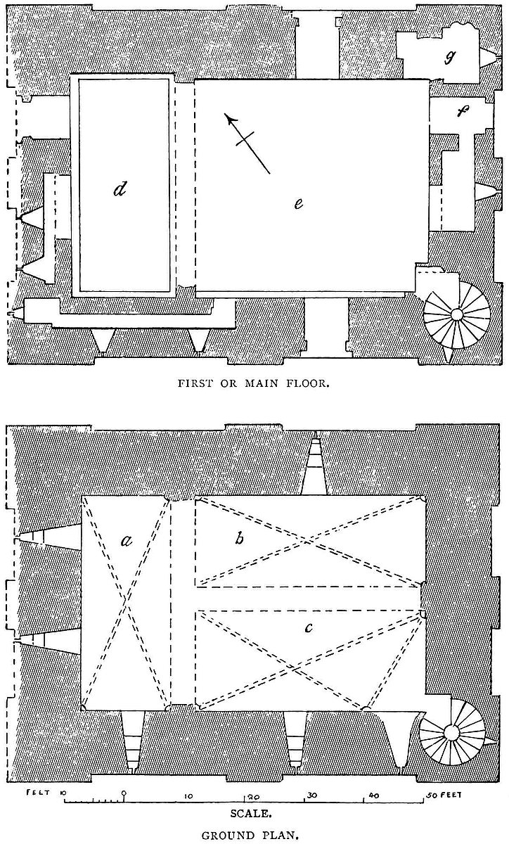
261
The western chamber was certainly vaulted, the corbels whence sprung the ribs or vaults remaining at the four angles. The other two chambers were probably also vaulted, some trace of the angle corbels remaining. A special rib seems to have shut off the south-east angle, probably to give head-room for the staircase doorway. A doorway led from the south to the western chamber, of which the south jamb remains. Probably these chambers were vaulted in two bays, but of this no indication is left. All are lighted by loops, each loop is about 2 inches broad, and 6 feet above the ground, and is placed in a round-headed stepped recess, splayed from an internal breadth of about 4 feet 6 inches. Of these loops there are six. One in the north wall, opening from the north chamber; three in the south wall, of which two open from the south chamber, and the third from the west chamber, which has also two others in the west wall.
The south-east angle is occupied by a well-staircase 11 feet 8 inches diameter, which rises to the roof, communicating by a short lobby with each floor. The only access to the basement was by this staircase from the first floor.
The first or main floor was divided by the cross-wall into a larger east (e) and a smaller west chamber (d), and a shelf or set-off reduces some of the walls by a foot, and enlarges the inner area accordingly. At this level also the walls contained several mural chambers. The main, and indeed the only entrance to the tower was on this floor in the east wall, about 10 feet from the ground. The doorway, a plain rounded arch of 5 feet 4 inches opening (f), led into a passage of 6 feet breadth, opening direct into the eastern chamber. There was no portcullis, and the only defence was a stout door, barred. In the south wall of the passage a small doorway led into a chamber in the east wall, 6 feet wide by 14 feet long, and which has a loop in its outer wall, and no doubt opened by a doorway, now broken down, into the east chamber. On the north side of the doorway, but not communicating with the passage, the north-east angle of the building is occupied by a second mural chamber 14 feet long by 9 feet broad, also vaulted (g). In the north wall of this chamber is a fire-place with a concave back, and at the east end is a loop. It was entered from the east chamber by a doorway, now broken down, in its south wall, and this door led into a small lobby, cut off by a cross-wall from the chamber with the fire-place.
A third mural chamber is entered from the larger room by a small door in the south wall. This opens into a passage 2 feet 6 inches broad, and 33 feet long, lighted by a couple of loops in its south262 wall, and terminating in a small chamber about 8 feet by 4 feet, which occupies the south-west angle, and was lighted by a loop in the west wall.
A fourth chamber was contained within the west wall. It was entered by a doorway now broken down, opening into a passage 2 feet 8 inches broad by 19 feet long, lighted by two loops in the outer wall, one of which was in a garderobe, and in the broken wall is seen a shaft descending from an upper garderobe, possibly in the second floor or on the battlements. The mural chambers are all vaulted. At the south-east angle a doorway and lobby lead into the winding staircase. This main floor was lighted by three windows, one in the north and one in the south wall of the larger apartment, and one in the west wall of the smaller room. These windows are all alike. Their recesses are flat sided and round headed, and are open to the floor-level. They are 8 feet wide. Their framework or tracery is gone, so that it is impossible to say precisely how they were closed in. Their flat sides give to these three window recesses very much the appearance of doorways. This floor was not vaulted, but ceiled with timber in the ordinary way.
The upper or second floor is a mere ruin and inaccessible, only fragments of its walls remaining. The least injured part is about the head of the staircase at the south-east angle. Here the sides of the doorway and one wall of the lobby remain.
The material of the building is a rough strong sandstone, weathered to a dark colour. The walls, inside and out, were faced with coarse ashlar, well executed, and on three of the exterior sides remaining unhurt. The west face has been stripped, no doubt for use for later buildings. The interior also has been almost wholly stripped, just enough remaining to show what has been. The basement is encumbered with the fragments of the vaulting, so that the floor is nowhere to be seen. There may therefore have been a well. The stairs have been designedly broken away, so that the staircase remains an empty cylinder. The entrance to it, at the base, is much broken. The three southern loops are tolerably perfect; one quite so.
On the first floor the larger or eastern chamber was probably the Hall. The main entrance had no forebuilding or exterior covering, nor is there any trace of a stone staircase or of a drawbridge. It seems to have been reached by steps of wood. The chamber in the north-east angle, containing a fireplace, full large for its size, may have been the kitchen. This is the only fireplace now seen in the building, though there may have been others in the cross-wall. The two chambers about the south-west angle seem to have been garderobes, one opening from each of the main rooms. The three windows are unusually large, and being only 12 or 14 feet from the ground, must have much weakened the strength of the place. No doubt the framing or tracery filling up the apertures was heavy and strong, but still no tracery or mullion could have resisted a heavy stone from a catapult, nor indeed could the shell of wall containing263 the staircase. Probably the borderers, whose raids the tower was intended to resist, had no military engines at their command.
As the roof is gone, with the walls that immediately supported it, it is impossible to say whether it was flat or pitched at an angle. There is seen, however, in the west wall, at its north end, a patch of ashlar cut to a low slope, evidently that of a former roof, and there is a like indication in what remains of the cross-wall, at its south end; also about the same level is a square hole, which evidently carried the water from the gutter on one side of the wall to that on the other. The level of these indications of a low-pitched roof is about that of the floor of the upper story, and many feet below even the present top of the wall. It looks as though here, as at Richmond, Ludlow, Porchester, Bridgenorth, Kenilworth, and in many other instances, the original roof had been over the first story, and the second story had been an afterthought, generally not more than a few years later. Possibly the whole wall above the string-course is an addition, but if so it is a very early one.
Bowes tower may safely be pronounced to be very late Norman in style. The cross-walls are certainly original, but the vaulting was probably an addition, and, to judge from the skewbacks of two ribs in the south wall, of the Decorated period. The basements of Norman keeps were very rarely vaulted, and here, as at Brougham, Richmond, and Carlisle, the vaulting looks later than the walls.
The two open sides of the tower, the west and south, show that it was guarded by a ditch at from 40 to 70 feet distance, and this may have been continued all round. The tower stands a few yards south of the highway which traverses this district from east to west, and represents the Roman Way from Greta Bridge by Brough, Appleby, and Brougham, with branches northwards to Alston and Carlisle. At Bowes, as at Brough and Brougham, the road was strengthened by a camp, and Bowes tower stands within the camp, near its western boundary, and to the south of its central line. The ditches of the camp may be traced to the north and west, and partly to the east, and its area is about 130 yards, by 140 yards: to the south the ground falls sharply towards the deep bed of the Greta, and is defended by terraces and scarps, in which, a little west of the centre, is an opening probably for communication with the river. The remains of a Roman bath have been laid open outside the south-east angle, and a fragment of lead pipe, no doubt feeding it, was dug up in the adjacent churchyard. To the west are the remains of four small barrows in Roundhill Close, and the defence of the camp is strengthened by two watercourses at a short distance on the east and west fronts. Besides this camp there is one at Greta Bridge, 6 miles to the east, and two others at 6 and 8 miles to the west, of which one known as Raycross is regarded as a British camp, adopted by the Romans. The cross, commemorated in the name, is said to have been set up in 1067 to mark the boundary then agreed upon between England and Scotland. The further camp is known as Maiden Castle. Bowes is held to be the Roman Lavatræ.264 The position is well chosen, having considerable local elevation. It is 928 feet above the sea, and commands extensive views, especially to the south and east.
As the history of North Yorkshire is as yet unwritten, but little is known as to Bowes, save that both manor and castle were always held by the Earls of Richmond. King John, that most restless of monarchs, was at the castle on the 16th February, 7th of his reign, that is, in 1206, when he thence, “apud Bouas,” addressed a mandate to the Foresters of Nottingham, and again, according to Mr. Hunter’s itinerary, 16th June, in the 14th year of his reign, 1212. “The Earls of Richmond,” says Camden, “here levied a through toll, and set up a gallows.” Rymer also gives a charter of Henry III. to Peter, Earl of Richmond, dated 25th March, 1262, granting and confirming to him, with other lands, “Villas de Richemund et Boghes, cum castris et wapentachiis, et omnibus aliis pertinentiis suis;” and “Bowes castrum” was held of Peter of Savoy, 10 Edward I., and “Bowes Manerium” of John le Dreux the elder, Earl of Richmond, 13 Edward I. 19 Edward I., William de Felton was put in charge of Richmond and Bowes, &c., for the King. John le Dreux, Earl of Richmond, had it 5 Edward III. 36 Edward III., Margaret de Dacre died, seised of Bowes manor, as, 4 Henry VI., did Joan, widow of John de Gray, Chevalier; and, 14 Henry VI., John Duke of Bedford. 22 Henry VI., two parts of the manor or lordship of Bowes were held by John Duke of Somerset. Its present owner is Mr. Pulleine of Clifton. Mention is made of a Bowes in Northumberland in the reign of Edward III. and of a tenement called Bowes in Boulne in Sussex, 4 Henry IV. The castle was probably built late in the 12th century, and dismantled by either Charles or the parliament in the 17th century. It is a very good example of a late Norman keep. The mill, the almost invariable appendage of an early castle, stood upon the river Greta.
OF the shires of England there is none more intensely English than Sussex. Its name, the names of the most central of its two capital towns, of its principal and secondary divisions, of its parishes, and in a very remarkable degree of its inhabitants, are but little changed from those they bore on the eve of the Conquest, and when under the sway of Godwin and Harold. Even the not infrequent marks of Norman occupation, in the form of parish churches, abbeys, and castles of great strength and durability, were many of them grafted upon foundations dating from the days of265 Alfred and Egbert. This is the case with Selsey, the ecclesiastical parent of the see of Chichester, with Bosham, Malling, Steyning, and other religious houses; and Arundel, Bramber, Knapp, Hastings, and Lewes, all great castles in their day, were the seats of English chiefs for centuries, before their banks were crested with walls of masonry, or their mounds crowned with keeps constructed after the Norman pattern. Pevensey, indeed, boasts a still earlier origin.
British remains in Sussex are but scanty. A few of the larger and more elevated of the hill-camps, and those of irregular form, as Cissbury, which includes 60 acres, are supposed to be the work of the Regni, the earliest recorded inhabitants of the district. It is also difficult not to see in the Arun, the Adur, and the Ouse, names corresponding to the Aeron, the Dour, and the Usk or Esk, by which many streams in Celtic countries are still designated. Glynde has been claimed as a Celtic name, but it is very rare, especially in Sussex, to find the name of a parish of other than Teutonic origin.
Of the Roman period the traces are more numerous. The main road intersecting the county from Chichester towards London is undoubtedly of that date, and there seems to have been at least one other from Chichester—the Roman Regnum—to Pevensey. There remain also several rectangular camps, as Goushill, Hollingbury, Ditchling, Highdown, and Brighthelmstone Down, evidently Roman. Chichester, though its Latin name probably includes an earlier appellation, has the Roman cruciform arrangement of its two main streets, though not the rectangular outline. Anderida, Mutuantonis, and Mida, Roman towns of which the site is disputed, seem to have been in Sussex; and at Bognor and other places, pavements and foundations and inscribed stones, and other marks of Roman habitation, have been discovered. Still the remains, whether of British or Roman occupation, are but slight: all that speaks of law, of order, of property, of the family tie, of the forefathers of the people, of civil or religious polity, and of public worship—all of this character which is ancestral, is English. This thorough uprooting of the traces of earlier occupation is due, no doubt, to the position of Sussex upon that part of the British coast most exposed to Saxon and Danish invasion, and which bore the attacks of those formidable invaders when at their earliest and fiercest. Sussex was late to come under the humanising influences of Christianity, remaining Pagan till the middle of the seventh century. The remarkable conservation, to our days, of the names and divisions is probably due to the very peculiar configuration of the district, and to the isolation produced by its steep and lofty frontier ridges, and by the dense woodland which covered, and to some extent does still cover, its central part. As the position of the principal castles is determined by this configuration, a few words concerning it will not be out of place.
Sussex forms the western half of a chalk basin. The chalk rises in a long, narrow, lofty, and very steep ridge, forming the northern,266 eastern, and southern margins of the area, its height, reaching to 800 feet, being known as the Downs. The North Downs divide Sussex from Surrey, the South Downs are the frontier towards the sea. This latter ridge extends from near Chichester to Beachy Head, while the North Downs extend to Folkestone and Dover. The deep wooded area thus enclosed between them is the well-known weald of Sussex. The basin is cut across obliquely by the sea, and the south-eastern frontier of the county thus laid open for a length of about fifty miles. In former days, however, the broad marshes of Pevensey, Winchelsea, and Romney closed this opening with a barrier as effective as the downs themselves.
Upon these downs, and especially upon the range to the seaward, the early sea-kings seem to have pitched their resting-places. Here are still found such hill-camps as Woolstonbury, Caburn, Rookshill, and Cheukbury, circular in form, and therefore neither British nor Roman, and besides these, several others, as Newhaven, Seaford, and Burling, which are segments of circles, and, like Flamborough Head, enclose headlands, and are attributed, with some probability, to the Danes. It seems the general opinion that these circular or segmental earthworks preceded the mounds and banks found in the interior of the country and upon lower ground, the work of the same people after their settlement and civilisation.
Sussex is the only county the primary divisions of which bear the names of rapes; of these it contains six: Hastings, Pevensey, Lewes, Bramber, Arundel, and Chichester, subordinate to which are sixty-five hundreds; each rape contains a portion of seaboard, a river, a haven, and a fortress. The rivers are the Lavant, which nearly encircles the city of Chichester, and falls into one head of the Bosham estuary, the port of Chichester—the name is thought to be a corruption of the Saxon hlifian, a rising, because the springs rise annually from deep sources;—the Arun, which descends the dell bearing its name, cleaving the chalk-range, and reaches the sea at Little Hampton; the Adur, the river of Bramber, which, also by a pass in the chalk, reaches the sea at Shoreham; the Ouse, the river of Lewes, which, through a narrow gorge, now joins the sea at Newhaven, instead of, as formerly, flowing out at Seaford. The Cuckmere is the river of Pevensey, but it leaves that haven far to the east, and descends, also by a gap in the chalk, to the sea, west of Beachy Head; and, finally, the Rother, the river of the rape of Hastings, but the common boundary of Sussex and Kent, and which falls into the sea at Rye. Pevensey Haven, though deprived of the Cuckmere, is the receptacle for a number of lesser streams, by which the upland waters formerly flooded that extensive level.
The fortresses of the rapes are also six:—Chichester, probably of Roman origin, long since destroyed; Arundel, Bramber, Lewes, and Hastings, all of præ-Norman date; Pevensey, of Roman origin. Ella, who landed a.d. 477, took possession of Chichester. All were the seats of English lords, and all were accepted by the Normans as well-chosen positions, and by them were occupied and strengthened.267 Knepp or Knapp Castle, subordinate to Bramber, in the same rape, like it, is of English origin.
Of the six castles, three, Arundel, Bramber, and Lewes, are posted at the upper openings of narrow gaps in the chalk downs. Chichester is placed to the east of and outside the chalk range. Pevensey stands within the weald, among the low marshes by which that tract opens upon the sea; and Hastings, also within the weald, stands upon the sea-cliff, on the rocks and sands to which it has given geologically its name.
All the six, as well as Knapp, possessed, on a larger or smaller scale, the conical mound so characteristic of English strongholds, and each, after the Conquest, became the chief seat of a barony, and was held by a powerful noble. Robert de Eu had Hastings; William de Warren, Lewes; the Earl of Moreton, Pevensey; Chichester fell to Roger de Montgomery, who there founded a castle upon the site of the earlier works, of which part of the mound remains. The castle stood within the city enclosure, in the north-east quarter. It became, with Arundel, the property of the D’Albinis, and was destroyed by order of King John, after which the third Earl of Arundel founded on its site the Grey Friars, of which the house was probably built with the materials of the castle. It is said that upon the mound stood a circular or polygonal keep, as at Arundel, and that the traces of its foundations were long visible on its summit. The mound has survived all its Norman additions, and is the only relic of the ancient fortress that is extant. The city, within which the castle stood, is also an early strong place. The cruciform streets are, doubtless, Roman, as are the coins and inscribed stones occasionally dug up; but the outline of the city is not rectangular, and is enclosed within a bank and ditch of irregular outline, once of formidable strength, and still in parts tolerably perfect. It is not improbable that these earthworks are post-Roman, the work of the Romanised Britons, and therefore earlier than the date of the castle mounds. The later wall was built against the bank, which thus still, where it remains, forms a broad ramp or terrace.
Arundel Castle, next eastwards to Chichester, and its superior in military importance, stands on the right bank of and high above the Arun. The pass is of a more open character than those to the east of it. This castle has already been described.
Knepp Castle is in Shipley parish. It had a shell keep upon the mound, of which traces remain, but which is said to have been destroyed as early as 1216.
Bramber, the castle next eastwards of Arundel, is held to be the English “Brymmburgh,” a fortress upon a brim or brink. It was the head of a barony, and the chief place of the rape to which it has given name, and which includes forty-two parishes. The rape extends about twenty-four miles from the Surrey border to the sea, with a width of about eight miles. Narrow as it is, it contained till 1832 the four Parliamentary boroughs of Shoreham, Bramber, Steyning, and Horsham, returning eight members to Parliament,268 now reduced to three. The castle stands on the west side of, and just above, the channel by which the Adur reaches the sea at Shoreham. The pass thus commanded is four miles long, and half a mile wide; the bottom flat and marshy, the sides very steep and rising to 600 or 700 feet. New Shoreham, founded about a.d. 1200, by the Norman lord of Bramber, stands upon the seashore; but old Shoreham, the English port, is now half a mile inland, the deposits from the river and the débris of the chalk range having encroached considerably upon the sea. Combe and St. Botolph’s, ancient parishes, are placed within the pass, and higher up upon the same side is the village of Bramber, standing upon slightly rising ground at the foot of the western hills, and upon the edge of a broad tract of level land, still wet, and formerly impracticable, across which the sluggish and frequently flooded Adur takes a rather winding course.
The castle is placed a little to the north-west of the village, and, as was the English custom, close to the parish church. From thence a raised causeway is carried across the valley, leading to the village of Sele or Beeding, the Bedinges of Domesday, where was once a religious house dependent upon the castle. The village, composed of one short street, adjoins the causeway, and near it was discovered, in 1839, the piling and piers in masonry of an ancient bridge by which the road was carried across one of the bye-streams of the Adur. A charter of 1075 refers to this bridge and to a chapel upon it, as “Stᵘˢ. Petrus de veteri ponte.” The causeway, however, claims to be of higher antiquity, and to have carried a Roman road across the marsh then probably flooded by the sea.
In the construction of the fortress, advantage was taken of a knoll of the lower or grey chalk, roughly oval in figure, and about 120 feet high above the river. This was levelled on the top and scarped round the sides so as to form a more or less rounded area, 560 feet north and south, by 280 feet east and west. The scarp descended above 180 feet at an angle of 45 feet, or a slope of one to one, into a ditch about 20 feet wide at the bottom, and the opposite side of which, or counterscarp, rose about 40 feet at a similar angle, so that the ditch at the counterscarp level was 100 feet broad, and the crest of the scarp rose 30 feet to 40 feet above the ground opposite. A very formidable defence. Towards the east, where the ground was low, the counterscarp was not above 20 feet high, and to add to the depth of the ditch, it was crested by a light bank, from which the ground sloped towards the marsh. On the north and north-west, where the ditch was at its deepest, and the ground was high, the slope outwards is gentle, falling off for a furlong or so. To the west, where there is a valley now occupied by the railway, the ground is low, and here the outer side of the ditch, forming the crest of the counterscarp, is a narrow ridge, as at Arques, succeeded by a very steep slope. Thus those who approached the place on that side, after toiling up a steep and dangerous ascent, would only find themselves on the outer edge of a deep ditch, with a second still higher and steeper ascent beyond it. Towards the south the ditch crosses instead of skirting the hill, and is much less deep. Here was the entrance, and upon the small tail of the knoll thus cut off is placed the parish church, standing, therefore, just outside the ditch, and in its turn defended by the slope of the hill, and by a hollow way which runs a few yards within the edge of the marsh, the level of which is 8 feet or 10 feet below it.
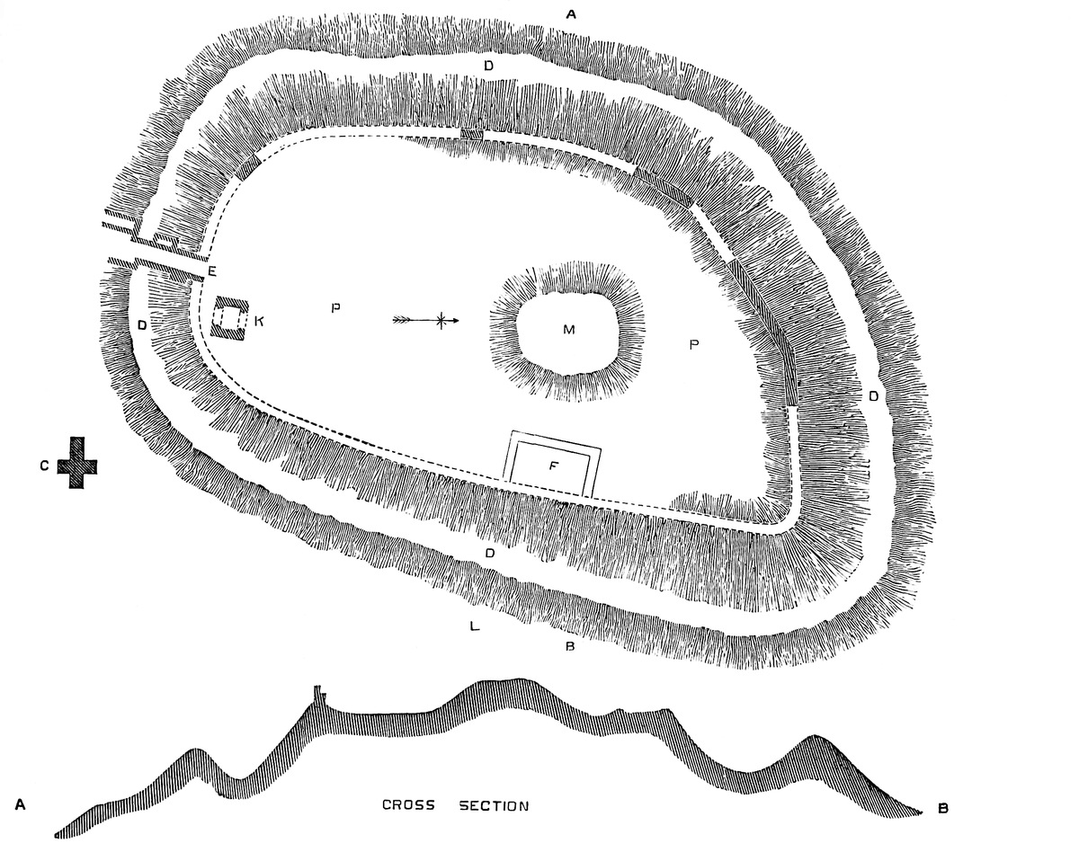
269
Upon the table summit, 160 feet from its northern, and 40 feet from its eastern, margin, was thrown up a conical mound, about 40 feet high, and 70 feet diameter at its summit. It is wholly artificial, and the material has evidently been scooped up from the surface of the area, which has thus been rendered slightly hollow, the surface rising gently towards the mound, and towards the outer margin of the area, that is, the crest of the scarp. The mound does not appear to have had any ditch proper to itself. It has been dug into and disfigured on its southern side. Possibly there have been buildings there. On the north the original and usual form is untouched. The slope is very steep. This was the “burgh” or keep of the original fortress.
What stood upon the burgh, or how the margin of the area was originally defended, is of course a matter of conjecture; but considering the wealth of timber in the district, it is probable that the defences were all of that material, as well as the adjacent church, and thus supposing, we may figure to ourselves the “aula” of Earl Guerd, who was the lord of Bramber during the reign of the Confessor. The position is a very strong one, and the view from it to the east and north-east extensive.
Bramber is one of the castles named in Domesday. It was then a part of the lordship of Washington, and held by Wm. de Braose, the Norman grantee. “Ipse Wills. [de Braiosa] tenet Wasingetune. Guerd comes tenuit tempore Regis Edwardi. Tunc se defend. pro LIX. hid. Modo non dat geldum. In una ex his hidis sedet Castellum Brembre.”
William de Braose here mentioned probably was present at Hastings. A charter cited by Dugdale, dated 1075–6, shows him to have been of Braose, near Saumur, on the Loire. He had an immediate grant of nearly the whole rape of Bramber, and he adopted the castle as his chief seat.
Although local history is silent as to De Braose’s operations, much may be extracted from the evidence of the existing ruins. Around the edge of the table area he or his immediate successor built a wall of enceinte. Where the ground was sound, this was founded upon the edge of the slope, but where the chalk had given way, the foundations were laid 3 feet or 4 feet lower down, so that the wall was built as a revetment, and the ground within formed a ramp against it. Of this wall of enceinte some large portions remain, and its foundations may be traced all round. It was 7 feet to 9 feet thick, from 10 feet to 18 feet high inside, and outside from 20 feet to 30 feet. It was built entirely of large pebbles, as from the sea-beach, laid in very thick beds of mortar. Of course, such stones270 could have no bond, and are about the worst material that could, under ordinary circumstances, have been selected, but so firm is the mortar that the wall remains sound, and in places, even the parapet, 2 feet thick, and composed of the same material, is standing. Towards the north-east is a sharp angle, and another of some boldness towards the south-west, but neither there nor elsewhere do there seem to have been any mural towers, although it must be confessed that a dense underwood of thorn and bramble renders a close inspection of the exterior impracticable.
The Norman keep stood upon or just within the line of the enceinte, at its south end, close to the east of the entrance, and opposite to the church. It was a square of 40 feet, standing north and south, and about 240 feet south of the mound. Its walls at the base were 9 feet 6 inches thick, and at the summit but little, if anything less, and its exterior face was vertical. The basement chamber at the ground level was 21 feet square and 14 feet high, and above it were three stages, all with timber floors. The height to the rampart wall is, by guess, about 70 feet, or a diameter and three-quarters. The first floor, 23 feet high, either rested upon joists which were supported by the north and south walls, now gone, or, which is more probable, upon a ledge in the wall, which is reduced in thickness at that level about 6 inches, as seen on the west side. Only the west wall remains, and the lower 6 feet or 8 feet of the east wall. The north and south walls are entirely removed. The west wall is solid at the base, but the east wall is recessed in a curious way inside, and seems besides to have contained two cavities like cesspits. The whole mass has, however, been so pulled about, that little can be made of it.
At the first floor, also, the west wall is solid, save that in its south end is a short mural passage, vaulted, which seems to have ended in a garderobe, the vent of which is marked by a sort of vertical furrow in the wall. This passage was probably entered by a door in the south wall, near the south-west angle. The east floor, 19 feet high, rested upon six joists in the east and west walls. In its west wall is a full-centred recess, 3 feet deep, 2 feet above the floor, 5 feet wide, with jambs 7 feet high. In the recess is a window 3 feet wide, with jambs 5 feet high, also full-centred. Both recess and window are quite plain, and are not splayed.
The third floor, 14 feet high, also rested on six joists, east and west. This has no window to the west, but in the wall are two recesses for the vertical beams of a roof, and at the base of each a corbel. This looks as though the roof was inclined, as at Bridgenorth and elsewhere, at a low pitch, the north and south walls being its gables.
There are some indications, in a foundation, as of a forebuilding attached to the north face, where probably was the entrance. The material of the keep is chalk flint, laid in copious beds of mortar. The flints are undressed, and the workmanship is coursed rubble, very plain and good, but rather rough, with a tendency to herring-271bone work. The window is dressed with ashlar, as are the hollow quoins of the interior, but there is no ornament, not even the usual Norman pilaster or plinth. The ashlar is probably the malm rock of the neighbourhood, a bed below the chalk, much like that used at Dorchester, and for some of the adjacent Oxfordshire churches. Altogether, this keep seems to be early Norman work, perhaps as early as Malling, and was probably built by the first De Braose before 1095, when his son was in possession.
When the keep was blown up, as it evidently was, with powder, the south and east walls fell in four or five huge masses into the adjacent ditch, where they remain but little altered, though obscured with vegetation. If these were cleared, something more of the detail of the keep might be discovered. The north wall seems to have been broken up and removed.
About 40 feet west of the keep are the remains of the entrance. So far as can now be seen there was no considerable gatehouse, probably only an arch in the curtain, as at Richmond. The fragment of a wall shows the approach to have been steep, and about 40 feet from the gate was a bridge, the pier and counter-pier of which, 13 feet apart, are still standing in the ditch, here not above 90 feet wide and 30 feet deep. The approach to the counter-pier rises steeply from the foot of the hill and passes the church.
The only building of which there are positive traces, beside the keep, within the area, was a rectangular pile, built upon the curtain, 60 feet long, and projecting 24 feet into the area. This is placed opposite to and east of the mound, and the passage between the two was only 15 feet broad. A part of the base of this building remains, and shows a plinth and fragment of wall faced with squared flint. The work looks many centuries later than the keep, and most certainly is not Norman. There is no trace of a well.
The parish church shares the protection of St. Nicholas, in common with Old Shoreham. It is in substance Norman, probably rather later than the castle, and was originally a cross church with a central tower. The nave and central square remain, but the choir and transepts have been removed, and the arches blocked up. The south door of the nave has a plain billet moulding, but the original opening has been walled up, and a smaller segmental doorway inserted. The cruciform plan seems to have been much in use here. It is seen at Old Shoreham, Steyning, and Broadwater.
Bramber has little or no history. The lords were among the wildest, most turbulent, and most unfortunate of the Norman barons. Their founder, William de Braose, received from the Conqueror forty-one lordships in Sussex, chiefly in this rape, and others in Dorset, Hants, Berks, Wilts, and Surrey. He founded St. Peter’s Priory, at Sele.
Philip, his son, adhered to Rufus, but was opposed to Henry I., and was disinherited. He married Berta, daughter of Milo, Earl of Hereford, with whom he had Brecknock, Gower, and other south272 Welsh lordships, and thus laid the foundation of much of the power and most of the misfortunes of his race. He probably founded the strong castles of Oystermouth and of Swansea.
William, the grandson of the founder, recovered the estates. He founded New Shoreham church and port. He also joined in the invasion of Ireland with Henry II., and held the whole kingdom of Limerick in fee. He is accused, though upon scanty evidence, of a wholesale massacre of his Welsh neighbours at Abergavenny. His possessions in England, Wales, and Ireland were enormous, and he also held the Honour of Braose in the Bailliewick of Falaise, in Normandy, and a share of the Honour of Totnes. He married Maud de Hayes or St. Valerie. For some reason not very clearly ascertained, he became obnoxious to King John, and their strife, much embittered by the outspeaking of his wife, led in 1210 to his attainder and exile, and the death of his wife and William their son, it is said of starvation, in the prison of Windsor Castle. He himself died at Paris shortly afterwards, in 1212. He was a considerable benefactor to the Church, and it is recorded of him that he was careful to use God’s name with great reverence. The king seized the Rape of Bramber, and granted the barony to Richard, Earl of Cornwall. Giles, Bishop of Hereford, and Reginald de Braose, brothers of the attainted baron, obtained after a time a share of the estates. Bramber was granted to the bishop, who, however, died within the year. Finally, in the reign of Henry III., Reginald recovered Bramber and Knapp, and most of the rest of the property, and having married Grecia, daughter of William de la Bruere, died 6th Henry III., and was succeeded by William his son.
William de Braose married Eve Mareschal, a co-heir of the great earl. He fell into the hands of Prince Llewelyn, who accused him of too great intimacy with his princess, and put him to death at Builth, it is said, by hanging. He left four daughters co-heirs, whose descendants held the greater part of the estates.
There remained, however, an heir male, in John de Braose, by Maud de Clare: he was the grandson by Maud de Clare of that William who was famished with his mother at Windsor, and he recovered Bramber and Gower. His son was William de Braose, who held Bramber and Gower, and added considerably to the Sussex estates. He is said, in 1262, to have raised a large sum of money from his tenants by foregoing his right of murage. He died at Findon, 1290, 19 Edward I., and was succeeded by John de Braose of Bramber, who married Margaret, daughter of Llewelyn, Prince of Wales. He died at Bramber of a fall from his horse (16 Henry III., 1232), and was succeeded by William, who died 19 Edward I. William was a powerful baron, and active in the wars of Edward I. and II. He was, however, extravagant, and reduced to sell Gower, which led afterwards to disputes between the purchaser and the lawful heirs of the vendor, of whom Aliva, his elder daughter, married John de Mowbray, from whom273 descended, in the seventh generation, Margaret de Mowbray, who married Sir Robert Howard, whence comes the Duke of Norfolk, the present owner of Bramber Castle. The barony is in abeyance. Probably, with the failure of the elder male line of De Braose, the castle ceased to be a residence, but in 1644 it was strong enough to be held by Captain James Temple, for the king, against a strong Parliamentary party, and it was probably in consequence that the keep was blown up, and the castle reduced to its present condition. There is an engraving by Hollar, taken 150 years ago, representing it very much as it now is.
Another branch of the family of De Braose rose to the rank of Barons of Parliament, and held large Sussex possessions. The last male of this cadet branch, De Braose of Chesworth and East Grinsted, died in the reign of Richard II.
Bramber is, like Pontefract, Lewes, and Dudley, an example of a natural hill, scarped and defended by art, and crowned with an artificial mound; but, unlike those castles, it has both a mound and rectangular keep, a rare combination, found also at Guildford and Christchurch. A rectangular keep upon a natural isolated hill, unaccompanied by a mound, though not usual, is not unknown. Examples of it are seen at Hedingham, Corfe, and Bridgenorth. At Bramber, as indeed is the case in many other sites of early fortresses, the original earthworks have survived the Norman additions, and remain pretty much as they must have existed before the Conquest.
THE river Severn, in its course from Shrewsbury to Worcester, passes for several miles down a deep and rugged ravine, within or near to which lie the populous districts of Coalbrook Dale, Iron Bridge, Coal Port, and Broseley, early seats of the iron manufacture, and evidences of the wealth, though scarcely in harmony with the natural beauty, of the country. The ravine commences a little below the ivy-covered ruins of Buildwas Abbey, and terminates twenty to twenty-five miles lower down, about Bewdley and Stourbridge, where it opens out into a valley of a soft and smiling character.
About half-way down, between Pendlestone rock and the incoming of the Worf, the Severn receives upon its right bank the waters from a short but deep and broad valley, which descends obliquely from the north-west, and between which and the main valley intervenes the point of a steep and narrow ridge of rock, rising about 200 feet274 above the river, and upon the nearly level summit of which is placed the town and what remains of the Castle of Bridgenorth. The rock is more lofty, and the position far more striking, than that of Pontefract Castle, the defences of which were also in a great degree natural, and in these respects Bridgenorth may challenge comparison with Coucy, which it also resembles in the relation of the castle to the town. In both places the castle lay contiguous to the town, and their connected defences formed the common enceinte, while the castle had besides a ditch proper to itself.
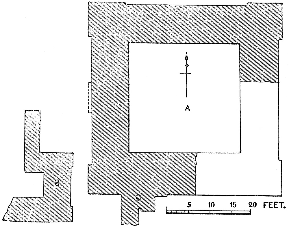
At Bridgenorth the castle occupied the apex and south end of the platform, the broader and northern part of which was covered by the town, and the town walls abutted against those of the castle, while the castle ditch traversed the platform from one face to the other. Of the defences of the town only the north gate remains, and that in a very mutilated and disguised form, but the line of the walls may be traced, partly by the inequality of the ground and the arrangement of the streets, and partly by the existence of the cliff upon which they in part stood. An ancient fortified bridge, standing when Grose visited the place late in the last century, though now rebuilt, crossed the Severn east of the town, and was approached from it by a steep and narrow flight of rock-cut steps, and by a carriage-way cut in traverses almost as steep. This bridge defended the passage of the river, and connected the place with the suburb called the Lower Town upon the left bank. It is this bridge which275 is supposed to have given to the place its early name of Brug, or Breig, the distinctive “North” being an addition, probably in the thirteenth century, when there is said to have been an earlier bridge a little lower down. The town contains several old buildings, and among them, near the bridge, a very fine one framed with timber, in which was born Bishop Percy. There is also the fine parish church of St. Leonard’s, which stands at the north end of the town, east of the north gate, and just within the line of the old walls.
The castle platform is in plan somewhat of an equilateral triangle, each side being about a furlong. Leland says its area is about one-third that of the town. The two sides of this area were protected by a cliff so steep as to render a ditch unnecessary, and the face of which, where it needed support, was, and still is, revetted, the wall and edge of the cliff having been, no doubt, crowned by a parapet. The cliff rises out of a steep talus, or slope. The base of the area was defended by a wall within a ditch, upon which was a great gatehouse, standing in Leland’s time and for a century later. The ditch has been filled up and built over, and the wall removed. Just within its line still stands what remains of the keep, and a few yards to the east of that was the castle chapel, now the church of St. Mary Magdalen, and, until recently, a peculiar with a special jurisdiction. The chapel was collegiate with an endowment for certain prebendaries, disendowed at the Reformation. The present building, constructed in 1796, is a large and distressing example of Telford’s church architecture, in what the great engineer was pleased to regard as the Grecian style. The two buildings stand on the highest part of the castle area, which falls 30 feet to 40 feet towards the southern point. A modern wall has taken the place of the old enceinte. The view thence is very noble, nor does any town in England possess a finer promenade than that with which corporate care has encircled the area.
The fragment of the keep, long known as “the leaning tower of Bridgenorth,” seems to be the only masonry remaining of the castle, for the revetment wall of the cliff looks as though it had been replaced. The keep was a regular rectangular tower of the usual Norman pattern, but in dimensions very unworthy of the powerful earl who built it, or of the celebrated fortress of which it was the citadel. It was 45 feet square, and from 60 feet to 70 feet high to the base of the parapet. On each face were two pilaster strips, 8 feet broad by 6 inches projection, placed close up to but not covering the angles of the tower, which are thus converted into nooks, or hollow angles, of 6 inches in the side, and which, instead of, as usual, terminating above and below in a flat square, end in a sloping surface, as though to receive a column. The pilasters rise from a common plinth, and ascend to the parapet. Whether they were continued upwards so as to form the usual angle-turrets does not appear. Each had two sets-off on the face and outer edge only, reducing the breadth to 7 feet 6 inches and 7 feet. The sets-off were continued round the building. In the west face was also276 another pilaster of the same breadth and 15 inches projection. This died into the wall some feet below the summit, and seems to have been connected with the entrance door, which probably opened in its face, for it is broken away below and a part of the rough backing of an arch is seen. The walls at the base are 9 feet thick, and about 7 feet at the summit. The building is of three stages, a basement, at the ground level, 12 feet high; a first floor, 25 feet; and a second floor rather more, perhaps 30 feet. The floors were of timber. The first floor seems to have rested on a ledge, the upper and the flat roof upon joists, those of the lower lying east and west; those of the upper, north and south. The joist holes in the north wall have been closed by early work, and above is a slight set-off or shelf in the wall, as though the level of the floor had been altered. In the west wall, also, new joist holes, smaller, have been cut above the old ones.
The original roof was very steep, having two slopes and a central gutter, as at Porchester, and the reverse of the arrangement at Ludlow, where the ridge was central, and the two gutters lateral. The weather table remains perfect in the north wall, with a hole 2 feet high by 1 foot broad, to carry the beam which supported the gutter and the feet of the rafters. The table is seen continued horizontally upon the west wall, where it was laid as a flashing to cover the upper edge of the tiling. The walls were brought up to a level line all round, so as to conceal the roof. This arrangement, as at Ludlow, Richmond, Porchester, and the gatehouse of Sherborne, shows that there was no original intention of using the roof as a platform for mangonels and such like heavy machines. The flat roof, of lead, was apparently of later introduction. No traces remain of any mural staircase in the north or west wall, nor of any mural passages.
The basement was, probably, a dark store or cellar, reached only by a trap in the floor above. The entrance seems to have been on the first floor in the west wall, in which also are traces of a loop or small window. The north wall remains perfect. It was most exposed, and is without openings of any kind. In what remains of the south wall is one jamb of an original fireplace, of which is seen the sloping back, and part of a lateral nook and Norman abacus above it. The flanking shaft is gone. In the part of the east wall still remaining is the northern half of a small full-centred window, deeply splayed inwardly. The east and south walls above the first floor are gone. In the west wall, upper floor, is seen the north jamb of a small full-centred window set in a bold splay of hourglass section. North of it, in the same wall, is a small recess, probably for a lamp, and which seems to have been round headed. There, probably, was a fireplace in the south wall.
Projecting from the outside of the south wall, bonded into, and of the same age with it, is a fragment of curtain 7 feet 6 inches thick, in which, as at Kenilworth, is seen the jamb of a doorway, defended outside by a portcullis, the groove of which, square and 5 inches277 deep by 3 inches broad, shows that the grate was of iron. The groove, as at Kenilworth, stops about 3 feet from the ground, the door having been reached by steps. The groove is not open at bottom, but runs up behind a covering wall, as usual, and was evidently worked from the rampart, as is still seen at the Fishergate postern, at York. The door jamb is about 6 feet from the keep. This was evidently the entrance into the innermost ward, in which, or rather upon the wall of which, stood the keep.
A few feet to the west of the keep is a mass of masonry, clearly a part of the forebuilding which covered the entrance. Its face towards the keep is 13 feet long, and towards the south 16 feet. It varies from 3 feet to 6 feet thick, and is at present about 10 feet high. At present it is distant from the keep 3 feet 6 inches, but the two faces were evidently once in contact, and were displaced by an explosion. The mine by which the keep was destroyed seems to have been placed here.
The material of the keep was rubble-stone faced with excellent fine-jointed ashlar. The exterior face of the forebuilding seems to have had a similar casing.
It is not easy to obtain accurate measurements of the keep, so much has been removed, so much injured, and what remains is so obscured with ivy. Moreover, the interior is fitted up for two dog-kennels, kept in a very filthy condition, and with putrid carrion suspended from the walls. The ruins also stand in three distinct enclosures, all locked up. A mine has been sprung between the keep and the forebuilding, and the explosion has removed all the upper part of the latter, and so tilted the keep that it leans at an angle of fifteen degrees eastward from the vertical, and the upper part of the east and south walls are gone. Moreover, the keep seems to have been lifted bodily about three feet towards the east, and the north wall has a large open crack. About fifteen yards from the south-east angle stands a huge ivy-covered mass of masonry, probably the detached angle of the tower. What remains of the keep is held together by the excellence of the cement. The ruin is in a state of great filth and neglect, and it is much to be regretted that the whole area is not converted into a public garden. Judicious excavation would probably throw much light upon the details of the keep, and show the line of its contiguous curtain wall.
The masonry and details of the keep answer very well to the date of 1101 to 1102, to which history assigns it. It is certainly not earlier. The curtain of the inner ward was clearly of the same date, and enclosed a court in the north-west quarter of the general area, of which the keep probably formed the north-east angle, and which was entered on the east side close south of the keep. All else is gone; the “mighty North gate” of which Leland speaks is no more. The very ruins have perished, and the last trace of them, a good Norman arch, discovered while pulling down some houses in 1821, has since been destroyed by local Vandals.
The early history of Bridgenorth is exceedingly obscure. It is278 stated in the Saxon Chronicle that when, in 896, Alfred stranded the Danish ships in the Essex Lea, the Danes left them, traversed England, passed the winter at Quatbridge on the Severn, and there threw up a work. Three of the four original texts are thus rendered. The fourth makes them rest at “Brygce,” or Bridge, on the Severn. Florence of Worcester supports Quatbridge, and mentions the work or fortress. “Brygce,” in the Chronicle, is thought to be an interpolation, both where appended to Quat, and where it stands alone, it being probable that the Severn was not bridged at that time. There are at present two parishes into the names of which Quat enters on the left bank of the river, below Bridgenorth, Quat and Quatford, and upon the river is Danesford. Quat is regarded by Eyton as a corruption of the British “Coed,” a wood, the whole district having been a forest.
In the same Chronicle it is recorded that Æthelflæda, the great lady of the Mercians, a mighty burgh-builder in her day, and called by Henry of Huntingdon “Terror virgo virorum,” built, in 912, a burgh at Bricge, to which Florence adds, “on the western bank of Severn.” Bricge could scarcely be Bridgenorth, which is not even mentioned in Domesday. We ought, however, to find near the river, about Bridgenorth, earthworks thrown up by the Danes and by Æthelflæda, and it will be seen that there remain at the least three distinct works, any one or all of which may be of the ninth or tenth centuries. These are Oldbury, Quatford Castle, and Quatford.
Bridgenorth is not mentioned in Domesday. The Norman castle did not then exist, and there is no reason, strong and tempting as is the site, for supposing that it was occupied either by the Danes or by Æthelflæda. Mr. Eyton is of opinion that the site of the later town and castle is included within a certain two hides of land which in the survey constituted the demesne lands of the Norman Earl of Shrewsbury, within his great manor of Morville. Quatford, not Quatbridge, is mentioned in that record in conjunction with Ardintone. “Ibi,” that is in Ardintone, “Molendinum de iij oris et nova domus et burgum Quatford dictum nil reddens,” “there is a mill worth three ounces (5s. per annum), and a new house, and the borough called Quatford, paying nothing.” In 1085, therefore, it may be accepted that the earl had a new house at Quatford, where, indeed, it is known that at the request of his second wife Adelais, and in acknowledgment of her escape from shipwreck, he founded, about 1086, a collegiate church. The foundation charter of this alludes to the mount nigh to the bridge; the latter, probably an appendage to the new house, the former possibly part of the older earthwork of what is now known as Quatford Castle.
Earl Roger was succeeded in his English Honour and estates by his second son Earl Hugh, who was slain in Wales in 1098, and left the succession open to his elder brother, Robert de Belesme, who had already inherited his father’s estates in Normandy, and was Count of Ponthieu in right of his wife. Robert, who thus became Earl of Shrewsbury, though a cruel tyrant, was a man of great ability279 and energy, not only a great soldier, and “princeps militiæ,” or “Commander of the Forces” to Rufus, but a great military engineer. He selected the site and planned the works of the celebrated castle of Gisors on the Franco-Norman frontier. His brother’s death found him beleaguered in his castle of Balaon by Fulk, Count of Anjou, and the siege was raised by Rufus, who granted him, or confirmed him in, his brother’s Honour. When he came to England is uncertain, probably not before the end of 1099.
On the death, in 1100, of Rufus, Earl Robert took part with Duke Robert, whose claims, however, were not at first brought forward. It was probably while preparing for their open assertion that he decided to fortify the strong position which rose unoccupied scarce a mile from his father’s church and residence. His decision was prompt, and followed at once by his acts. He transferred the “Burgus” of Quatford to a new town on the hill, and with it his father’s house and bridge, which he also rebuilt. The result was the borough town, castle, and bridge of Bridgenorth, the latter structure giving name to the whole as Bridge or Bruge, the distinctive “north” not being added till the reign of Edward II. or III.
With Bridgenorth, Earl Robert also founded the castle of “Caroclove” in Wales, and such was his need that the works were carried on day and night. He also fortified Arundel, Shrewsbury, and Tickhill. His exertions in 1100 and 1101, when he seems to have built the castle, must have been excessive. King Henry, however, was not less active. He despatched Robert, Bishop of Lincoln, to lay siege to Tickhill, while he himself, having commenced with Arundel, proceeded to Bridgenorth. He took it, after a three weeks’ siege, in September, 1102, and this brought to a close Earl Robert’s short tenure of power in England. The earl fled to Normandy, his earldom of Shrewsbury was forfeited, and Bridgenorth was after a time granted to Hugh de Mortimer of Wigmore, the son of one of Henry’s most trusted supporters. In 1126, Waleran, Earl of Mellent, was here imprisoned, as was Meredith ab Llywarch in 1128. In 1130 wine was sent hither for the king’s use, so that Mortimer was probably rather constable for the Crown than the owner in fee.
Mortimer, in the new reign, took the part of Stephen, at whose death he held both Wigmore and Bridgenorth. As he was in rebellion against Henry II., the king took the field against him, and in April, 1155, the castle a second time stood a royal siege. Cleobury, one of Mortimer’s castles, surrendered in July, and Wigmore and Bridgenorth followed. Henry was for some time before the place, and his charter to Stoneley Abbey is dated “apud Brugium in obsidione.” It was at this siege that Hubert de St. Clair is said to have stepped forward to receive the arrow aimed at his sovereign, a romantic but unfounded tale. Henry retained the castle for the Crown, and used it largely as a prison for his Welsh hostages. In 1173–4, when Prince Henry rose against his father, Bridgenorth was victualled at a cost of £22. 5s. 2d. In 1175–6 the king dated a Wenlock Abbey charter from hence. The frequent charges280 for repairs between 1166 and 1189 show the importance attached to this castle by Henry II. In 1176 the Pipe Roll gives a charge of 1d. per day for the castle porter.
King John was six times at Bridgenorth, passing there about fourteen days. He confirmed a charter of incorporation to the town. Both he and his predecessor, Richard, kept up the castle, as is attested by frequent charges for repairs during sixteen years. In 1198 there was paid 6s. 3d. for the hire of the barge in which the wife of Griffith ab Rhys was conveyed from Bridgenorth to Gloucester. In 1203 John presented to a prebend in the castle chapel. In 1209 a stag from the adjacent forest entered the castle through a postern and was captured, and no doubt converted into venison by the castellans. For this they were prosecuted by the verdurers, and the proceedings imply that the castle was then in charge of five persons only, of whom one was the constable. No doubt in time of peace the royal castles were left almost to themselves, and often not even kept in repair. When a war arose they were repaired, garrisoned, and victualled in all haste. So far as repairs went, Bridgenorth, however, seems to have fared well. We read of repairs on the king’s house, on the basement of the castle, on the “Barbe-kana et Pons-tornalis” or barbican and drawbridge; on the turret of the outer wall, the chimney of the great chamber, the castle walls, the tower, the well, the glass windows in the hall, the queen’s oriel, and the chapel.
These charges are continued through the reign of Henry III., and well into that of Edward I., from 1218 to 1281. In 1232 the sheriff was to cause to be repaired the castle stable, and the kitchen within the barbican of the tower, and in 1244–5 was a charge for covering the tower at Brug with lead. This was probably the keep. In 1267, Henry III. and his queen were at Bridgenorth, and it would seem that the Mortimers were still connected with the castle, for, in 1273, on the death of Hugh de Mortimer, Edward I. continued his successor Ralph in the offices of sheriff of the county and constable of the castle.
In 1281 an inquisition was held upon the state of the building, which had latterly been neglected. The timbers of the great tower were rotten, the leaden covering having been carried away; also the castle bridge was broken down, so that carriages could not cross it.
In common with most other castles held by the Crown and therefore not inhabited, Bridgenorth seems to have been allowed to fall into decay from the reign of Edward I., so that probably little remained beyond the walls. At any rate, it played no part in English history until the great rebellion, when the town declared for the king, for whom the castle was garrisoned. The tower was attacked by the Parliamentary forces on the north side, and was entered by a breach near St. Leonard’s Church. Upon this the town was burned up to the castle, which still held out. The Parliamentary batteries are said to have been posted upon the Oldbury earthwork, which is probable enough, though there are no traces of parapets or281 breastworks of that date, which, however, from the distance from the castle and the deep valley between, were probably not needed. The garrison held out three weeks, and capitulated on honourable terms. The castle was blown up, and the materials probably sold.
Any account of Bridgenorth Castle would be very imperfect that did not take notice of the very remarkable earthworks seen in its neighbourhood, and which are evidently connected with the events referred to as of the ninth and tenth centuries. These are three in number—Oldbury, Quatford Castle, and Quatford; and first of Oldbury.
On the left bank of the Severn, about a quarter of a mile below and south-west of the castle, and on the opposite side of the deep dry valley that forms its western defence, the high ground of Oldbury is broken by three deep combes which descend to the river, and between which are two high ridges or knolls, steep towards the Severn and the combe on either side, and on the west connected by a neck with the higher land. The larger of these, that nearest the castle, is known by the inelegant but most descriptive name of “Pan Pudding Hill.” It does, in fact, much resemble in figure a beef-steak pudding just turned over out of the pan in which it was boiled. Naturally oblong, it has been scarped and rounded. The circular flat top is 150 feet diameter. In the centre is a slight nipple-like mound 3 feet high, and a raised bank now about 4 feet high crests its circumference. Towards the river the slope is steep for 50 feet or 60 feet, towards the land it is protected by a cross trench about 50 feet broad and 10 feet to 12 feet deep. Half-way down the slope on the eastern side is a narrow ledge or path which may have been protected by a stockade. Towards the south this ledge expands into a stage or shelf from 90 feet to 100 feet broad, and which is excavated so as to carry a ditch. The arrangements are very simple, and the mound is mainly natural, though scarped and fashioned by art. It was probably here that the Parliamentary guns were posted in the seventeenth century.
Close south of this hill is a second work, lower, smaller, and less clearly defined. Its summit is also circular, and about 100 feet diameter. These two works are of one general type, and probably of one date, and if not the work of Æthelflæda are no doubt of her period. They are either English or Danish, not British. That the main work is older than the Norman fortress is evident from a document of 1299, in which it is called “the old castle.” Moreover, it is the burgh which gives name to Oldbury, the parish in which it is situated.
Quatford Castle is on the left bank of the Severn, one and a quarter miles below Bridgenorth, and a furlong from the river, the intervening ground being a strip of meadow, while Danesford is still the name of an adjacent ford and village. A short steep combe descends from the high ground to the north-east, and, branching below, includes a knoll of rock perhaps 150 feet above the valley and 200 feet above the river. The soft red rock has been pared and282 scarped, and a part of the material employed to give an artificial top to the hill. This is somewhat of an oval, and seems to have had a sort of mound at its east end, now occupied by a modern castellated house. The slopes are steep, especially towards the west, and they are broken by narrow terraces, now walks, but which may have been ditches. The approach is by a sort of causeway on the north-east or least steep side. The summit and sides of the work are converted into a house and gardens, but the general arrangement of the original hill can readily be detected. It must have been very strong, and resembles generally Devizes and similar works of English origin. Probably this is the site of the “nova domus” of Earl Roger, as it was the seat of his English predecessor. It is a very curious work, and deserves to be surveyed on a large scale by the officers of ordnance. It may be mentioned that in the courtyard is a small passage cut in the rock, at an angle of forty-five degrees, and which descends by ninety-four steps to a well, whence the house is supplied. The passage is evidently an addition, the original well shaft descending, as now, vertically from the surface.
A little north-west of the castle, towards Bridgenorth, the tail of a piece of detached highish ground has been cut off by a trench, near a place called, in the inch ordnance, “Dog in the Wall.” It seems to have been a light temporary work for the accommodation of a small body of men.
On the same road, two miles south of the town, is Quatford, close to the parish church of that name, where the road crosses a steep ridge in deep, but probably modern, rock cutting. The ridge abuts upon the Severn, in a bold rocky promontory about 70 feet high. Upon it is thrown up a mound about 30 feet high, and mainly artificial. It is circular, and about 60 feet diameter on the top, which has been much cut about, probably for modern purposes. The sides are steep, about three quarters to one in slope. This mound is divided from the root of the promontory by a trench cut in the rock about 12 feet deep and 12 feet broad, which extends from cliff to cliff, and includes about three-fourths of the mound. Outside this ditch and to the east of it is an area of irregular figure, governed by the outline of the ground. Its north and south sides are defended by a ditch, which to the south is deep and wide. This probably included the east side, but is now superseded by the hollow road. The area is not very large, and would perhaps accommodate about two hundred men.
West of and beyond the road is the church, a building with some Norman remains. It stands rather higher than the camp, and its churchyard would, with a little care, have formed a part of and doubled the area of the camp. Whether it ever did so it is difficult to say, probably not. The ford, which gives part of its name to the village, is still in use when the river is low. It crosses the Severn below the camp.
This camp is omitted in the ordnance map, and of the earthwork283 of Burf Castle, placed a mile and a half to the west on that record, but one side remains.
It may be observed that the character of the surface of the country hereabouts is very favourable for the construction of these earthworks with mounds. There are scores of natural rounded hillocks of red sandstone that have an artificial aspect, and that, with a little scarping, would be strong. There is one, especially, close east of the road between Quatford and Dudmaston Park, that looks very like an English earthwork, and wants nothing but a ditch to make it perfect. Besides the earthworks above described are others in the district which appear to be of the same type. Such are Castle Hill, nine miles south-east from Bridgenorth, and the isolated knoll called “the Devil’s Spittle Dish,” two miles south-east of Bewdley.
BRONLLYS TOWER, on the left bank of the Llyfni, a tributary of the Wye, is situate in the parish of the same name, close north of the town of Talgarth, on the regular and ancient way between Hereford and Brecknock.
The tower occupies the summit of a mound or knoll of earth, in great part artificial, which crowns the steep bank of the adjacent river; rising, perhaps, 60 feet above the stream, and 30 feet or so above the ground to the west of and behind the building. The mound is placed at the apex of an earthwork of rather a pear-shaped outline, of which the river-bank forms the steep east side, while to its base, or north face, has been applied a vallum nearly rectangular, and which may or may not be a Roman addition to a Celtic camp. The mound, which has borne the very considerable weight of the tower in safety, must be of considerably earlier date; and altogether the work resembles much one of those numerous instances in which advantage has been taken of an earlier mound to give elevation to a Norman or early English keep.
There are, however, it is said, remains of masonry, of the character and probable age of the tower, still standing upon a part of the vallum, and indications that, as is known to have been the case, the tower did not stand alone, but was within a base court. These walls are not now of any extent, and seem to be included within a modern house built upon the old enclosure.
This tower is at its base 37 feet in diameter, and batters inwards to 12 feet high, when it is girt by a bold cordon or string-course, much eroded, but apparently of a half-round section, with a water-groove on its under side. Above this the tower is cylindrical, and284 34 feet diameter, or very nearly so, to the summit, which is at present about 60, and may have been 70 feet high. Besides the battering base there is a slight rough set-off, apparently part of the foundation, above ground on the southern face. Round the whole is a walk of about 18 inches broad, so that the mound is about 40 feet across at its top.
The tower is composed of a basement and three floors, above which was the battlement, now completely destroyed. The basement within was cylindrical, 18 feet diameter, with walls 9 feet 6 inches thick, and covered by a pointed vault, the ridge of which runs about north-east and south-west. This room was aired rather than lighted by a stepped recess, terminating in a small loop or hole at a considerable height, through which nothing could be seen. It was entered on the opposite or west side by a trap door in the first floor, which lifted within a window recess, and disclosed a flight of eight very steep stairs, 2 feet 7 inches broad, terminating in a doorway rather above 7 feet from the floor; below which, therefore, was probably a wooden ladder. The rebate shows the door to have opened inwards, and to have had bolts on its outer side. The floor is on the level of the top of the mound, and in its centre is a depression which may indicate a well.
Two openings have been broken into this chamber from the outside, on the east and west sides. Why nine feet of masonry should have been twice pierced, at immense labour, it is difficult to say; nor is there any trace of door or loop which might have made the task easier, or have suggested these openings. The broken walls do, however, show at the very base of the structure, on each side, a horizontal or nearly horizontal square drain, of very rough construction, in the substance of the wall. These holes have been the subject of much speculation. They were evidently drains from the upper floors of the tower, collected to fall into one outlet. Such drains may be seen in the heart of an overthrown solid tower at Corfe. It is not improbable that one of the breaches may have contained a recess or garderobe, which communicated with the drain, and suggested the penetration of the wall in that direction.
The first floor, of 17 feet 9 inches clear diameter, was entered by an exterior door in the wall, at the level of the cordon, or 12 feet above the ground, on the east side. There must have been exterior steps; but they did not bond into the wall, and may have been of wood. The door has 3 feet 3 inches opening, with a drop arch and plain chamfered moulding. It was defended by an interior door; but there was no portcullis or other defence. The door-recess is 4 feet broad, and has a drop arch.
This floor had two windows towards the north and south-west, the openings of which are about 18 inches broad, with plain equilateral heads. The former opens from a recess 7 feet 4 inches broad, having stone side-seats; between which, in the floor, is the trap descending into the dungeon. The other window has a recess 6 feet 10 inches broad, with a stone seat on its left side. In its right, or285 west jamb, is a door 2 feet 5 inches wide, square headed, beneath a drop relieving arch; from which rises a mural stair 2 feet 5 inches broad, lighted by two exterior loops, and with a flat covering, leading to the second floor. The window recesses are segmental, and are formed of excellent limestone tufa ashlar.
The second story had a timber floor resting on twelve corbels, and is cylindrical, like the first, and of the same diameter, but higher. It was the best room. Besides its entrance door on the west, it has on the south-west a fireplace under a flat segmental arch with plain chamfer, above which are two slender octagonal corbels, which evidently supported a hood, probably of timber. There are also two windows beneath drop-arch recesses, towards the south-east and north-east. The former has stone seats; and the latter a light 2 feet broad, with a cinquefoil head, of which the central foil is an ogee. The head is made of two stones only. The moulding is plain, having a shutter rebate inside; and outside, rounded jambs in place of the usual chamfer. This recess has a stone seat on the west side only. In the east jamb is a small square-headed door opening upon a mural stair of 2 feet 5 inches broad, of which nineteen steps remain, and which led to the third floor.
The stair is lighted by a small hole below, and above by a square-headed loop of 9 inches in a recess splayed to 3 feet 7 inches opening. The loop, though about 60 feet from the ground, was closed by one vertical and three horizontal bars. This floor may have been used as a prison.
The third stage has walls 8 feet thick, and had a wooden floor. The stair from below opened into it on the south-east side, but seems to have been continued in the south wall, so as to reach the battlement platform, now entirely gone. This floor has a small mural chamber, no doubt a garderobe, on its west side, the door into which is narrow, and has an arch of two stones, which seems to be four-centred, or of Tudor pattern. This door is placed between a window on the north-west, the recess of which has a flat drop arch; and another on the south-west, of which the recess is broken away. There is also a small fireplace on the north side, and another window to the north-east.
In the wall close south of the mural chamber are two small square shafts, one of which was no doubt a chimney and the other perhaps a garderobe vent from the battlements.
Bronllys Tower presents divers peculiarities. Though of rude masonry, its door and window dressings are excellent. In general design it resembles early English work; but its doors, recesses, fireplace, and corbels, seem of early Decorated, and perhaps, in parts, of Perpendicular work. It is altogether superior in detail to Penrice, which it resembles in dimensions, and it is inferior to Tre-Tower. The walls may be safely assigned to the first quarter of the thirteenth century; but it was no doubt inhabited as a place of defence, and afterwards as a dwelling, for two centuries and a half after this; and from time to time it received certain alterations,286 of which the present fireplace-front, the cinquefoiled and other windows, and the entrance to the mural chamber in the upper floor, may be cited as instances. The vault of the basement is possibly original, but may be an addition.
“ANNE Dorset, Pembroke, and Montgomery,” Baroness Clifford, Westmoreland, and Vesci, hereditary sheriff of Westmoreland, and Lady of the Honour of Skipton, in Craven, was in every way a remarkable woman: she was of high birth, held large estates, was the widow of two considerable peers, and had received and largely profited by an excellent education. To a strong and copious memory she added a sound judgment and a discerning spirit. She was a person of great firmness of character, and passed her life amidst events that exercised and strengthened that quality. Among the many subjects upon which she was informed, and which ranged, says Dr. Donne, from “predestination to slea silk,” was included a very close knowledge of the particulars of her own estates, and a very thorough determination to maintain her houses and castles in good repair. She found the castles of her Clifford and Vipont ancestors, Appleby, Brougham, and Brough, in ruins; she restored and made them habitable, and, though time and the hand of the spoiler have again brought two of them, Brougham and Brough, to decay, their walls still exhibit much of the amending hand of the great Countess, as well as of the original work of her remote ancestors.
Brough Castle covers the whole of a steep knoll which rises 60 feet on the left bank of the Swimdale or Helle Beck, and is about 50 yards from the water. The beck receives the Augill from the south-east, just above the castle, and their combined waters, at times of considerable volume and force, fall into the Eden about a mile and a half lower down. The castle itself is 630 feet above the sea-level, and the encircling fells of Westmoreland and Yorkshire rise to elevations of from 1,000 feet to 2,000 feet. About five miles to the east are the sources of the Greta and the Balder, and a little further off and towards the north the head springs of the Lune, not the noble stream that gives name to Lancaster, but a tributary to the Tees.
Even in this wild and almost impenetrable country are traces of Roman civilisation. The road from Lavatræ (Bowes) to Luguvallium (Carlisle) ran through Brough, which is identified with the station Verteræ, and by Appleby and Brougham, joining at Penrith the main road, the work of the same people, from the south. Five and seven miles to the east of Brough are two Roman camps, and there are others upon the same line of road at Redlands and Kirkby-Thore, and a very perfect one at Brougham. The Roman road at Brough runs generally east and west, and crosses the beck at Market Brough, so called in distinction from Church-Brough, which lies three furlongs to the south of the river, and contains the castle. The collective parish is named “Brough-under-Stainmore.” Verteræ, if identified with the existing camp and castle, stands off the main road, and south of the river, as at Brougham.

288
Verteræ is represented by a rectangular camp, of which the castle covers the northern and higher end, that next to the river. This camp is 157 yards north and south, by 113 yards east and west, of which the platform within the ditch covers 134 yards by 90 yards. Of this area there is cut off at the northern end by a cross-ditch a plot, 90 yards east and west by 50 yards, which is occupied by the castle. This portion is further defended by some additional earthworks, perhaps Norman, to the east and west. The southern fragment of the camp seems to have been used as a sort of outwork to the castle, probably for the protection of sheep and cattle.
The castle was thus placed cross-wise in the camp, and parallel to the river, the action of which has carried away the outer half of its ditch, and converted the slope into a precipitous bank, at the top of which is the curtain-wall. The eastern outwork is composed of the end of the knoll, or ridge, on which the castle stands, and which is scarped into a triangular platform, the base of which, 57 yards long, covers the end of the fortress, and projects 38 yards. The ditch cutting off this work from the body of the place is 23 yards broad, and very deep. The earthworks westward are two banks and ditches, across the tail of the knoll, one 57 yards long, and 47 yards in advance of the main ditch, and the other 84 yards further in advance, and 94 yards long. Both are intended to cut off approaches along the river bank. The cross-ditch covering the south front of the castle is about 30 yards broad, and up it, from the east, came the main approach. These ditches, on the south-east and west fronts, are wholly artificial. There is also a trace of a bank and ditch along the east front of the camp, about 30 yards in advance of the main ditch, and about 60 yards long. A road, which may be Roman, comes up from the south, and crosses the Augill by a bridge, 250 yards above or to the east of the castle, to join the main road over another bridge in Market Brough. Upon this stream is the castle mill. The defences, in masonry, seem to have been confined to the castle proper. There is no trace of such upon the outworks, which probably were stockaded. The ditches were at far too high a level to have been fed from the river; but the soil is retentive, and they seem to have been filled with rain water.
289
The castle is composed of one ward, a trapezium in outline, the east, north, and west sides being at right angles, and respectively 77, 90, and 57 yards, and the south or oblique side, 94 yards. It is, in fact, a right-angled triangle, with the acute angle truncated. The keep is placed at the truncated end, and forms the south-west angle of the ward, its south and west sides being exterior, and in the line of the curtain. The domestic buildings were along the south side, and about the south-east angle, and built against the curtain. Near the centre of that side was the gatehouse, and attached east of it the hall, beyond which a large three-quarter drum tower capped the south-east angle. This and the gatehouse are the only mural towers. The kitchen and chapel, and some later buildings, probably rested against the east wall, and there are slight foundations between the gatehouse and the keep. The north curtain, towards the river, seems to have been free from buildings. Upon it are two buttresses, and in one a garderobe, entered probably by a side door and passage in the wall. This curtain is 3 feet to 5 feet thick, and from 12 feet to 15 feet high inside.
The Gatehouse is placed near the centre of the south side of the castle. It was an oblong building, and formed the west end of a block, of which the hall and withdrawing-room formed the eastern part and remainder. It was composed of a passage between two walls, of which one remains, and is 6 feet 6 inches thick and 45 feet long; the outer 10 feet being outside the curtain. The portal is gone, but the spring-stone remains of the inner doorway, 3 feet 7 inches broad, and recessed 8 feet 6 inches within the inner front. The vault of the passage, about 10 feet long, rested upon three bold ribs, of which the springing-stones remain, and beyond which was the outer gate, of which a part only remains. There was an upper floor, and if the rubbish were cleared away the plan of the gatehouse would be visible. The walls seem Norman, but the ribs, vault, and fittings are probably insertions of the Decorated age.
The Hall was poor. It was on the first-floor level, and had a floor above it, and, therefore, a flat ceiling. The basement is composed of three vaults placed transversely, with flat, slightly-pointed arches. The doors are towards the court, and one chamber has a small Tudor fireplace, in a corner. Each had a loop in the outer end, and in the ends of two are mural garderobes in the substance of the curtain. The hall was not above 12 feet or 14 feet high. In its north side is a round-arched recess, probably the original entrance, by an outer stair; and near it a fireplace. In the south or curtain side are two good late Decorated windows of two lights, rather flamboyant in tone, with plain exterior drips. Above these is a step, or ledge, for the floor of the upper room, and two windows, not directly over those of the hall.
There is no very decided evidence of a Chapel. The Kitchen, probably, was near the north-east end of the hall, and against the east end of the curtain. The withdrawing-rooms were at the east end of the hall, and extended into Clifford’s Tower, a fine bold drum of290 30 feet diameter, which caps the south-east angle of the ward. This tower seems to be of Decorated date, and the base and part of the wall original; but it has been almost rebuilt, probably with the old cut stones, in the Tudor period, to which belong its numerous square-headed windows. Part of it was taken down in 1763.
The Keep stands upon rather the highest part of the enclosure. It is rectangular, 43 feet east and west, by 51 feet north and south, and stands upon the curtain, with which its west and south faces are continuous. As it does not quite cover the whole end of the ward, this is closed by a low curtain, 17 feet long and 3 feet thick, which extends from the keep to the north-west angle of the ward. The keep is composed of a basement and three floors, and is about 60 feet high. The parapet is gone. It has a plinth only on the two exterior faces, where the ground is low, and there are two sets-off which indicate the level of the second and upper floors. At the end of each face is a pilaster, 7 feet broad, and of 6 inches projection, and those adjacent meet and form a solid angle. These pilasters rose clear of the wall to form angle turrets, of which parts remain. From the upper set-off, on the north and south faces, rises an intermediate pilaster, 3 feet broad. The walls at the base are 10 feet thick, and, at the top, 6 feet. The basement is at present nearly filled up with earth and rubbish, concealing much of the east side. Part of the south-east angle fell in in 1792, and obscures the details of the main entrance.
The Basement is at present entered by a plain round-headed doorway of 4 feet 7 inches opening, in the north wall near its east end. This has a rebate for an inner door, but no groove for a portcullis. The outer jambs are broken away. It is pretty clear, from a comparison of its ring-stones with the original arches above, that this entrance is an insertion, probably of the time of James I. or Charles I. In the same side, near the doorway, is a very peculiar air-hole, formed of two loops, 2 feet apart, which converge to a single exterior loop. There are similar loops, of much later date, at Caernarvon. Possibly the basement was divided into two chambers, and one loop opened from each; but there is no trace of any partition. In the west wall there was probably another loop, now converted into a window of 2 feet opening, square topped, set in a bold splayed recess, evidently an insertion of a period when security was no longer the first consideration. The window opens in the line of the plinth, the set-off of which is carried over its head as a square hood-moulding. The south wall was blank, and so, probably, was that to the east. The basement was 13 feet or 14 feet high, with a flat timber ceiling. There certainly were no mural chambers, and no staircase in it. It was probably entered from above by a trapdoor and ladder, and used as a store.
The first floor, about 13 feet high, seems to have had loops in plain round-headed recesses in the north, south, and west sides, of which the latter is broken away, and a two-light Tudor window inserted. The northern loop has also been replaced by a similar window. In291 the south wall the loop is represented by a small square opening. In the ruins of the east side may be traced the remains of a doorway and the base of a lobby and staircase in the wall. It is clear that the external door was in this face, near the south end, and that it opened direct into the first floor, while right and left, in the thickness of the wall, was a mural passage, at its south end a mere lobby, but to the north containing a straight staircase which rises 13 feet by twelve steps, 4 feet 4 inches broad, towards the east angle, where was a small lobby which opened on the second floor, and was lighted by a loop in the east wall.
Thus, the second floor was entered in its east side by a direct mural stair, like those at Carlisle, at Chepstow, and at Ludlow. In each of the sides, north, south, and west, of this floor is an original round-headed recess, and in the east wall, over the mural stair, are traces of a shorter recess, placed higher up, whence seems to have been a passage into a mural chamber in the south-east angle. The southern recess alone contains its original window. This is a small coupled window of two lights, square headed, but within a round-headed arch. The dividing shaft is decidedly Norman, as is the whole character of the opening. The north window is also coupled and round headed, but looks like a Stuart insertion. The east and west windows are square headed, of Tudor date. In the north-west angle is a mural recess with loops, possibly a garderobe, and in the north-east angle a square-headed doorway opens by a lobby into a well-stair, which commences at this level and ascends to the roof. It is 7 feet 6 inches in diameter, and rises 31 feet by forty-six steps to the allure, or rampart walk. This second was originally the principal and uppermost floor, lofty, and with a high-pitched roof, the weather moulding of which is still seen on the east and west walls. The roof ridge was at the level of the rampart walk, and, as the north and south walls seem original, there must have been a deep cavity on either side, with the gutter in its bottom. Subsequently this roof was removed, and replaced by a flat roof, at the rampart level, the line of which is marked by a row of corbels in the north and south walls. The cause of this change, common, probably, to all Norman keeps, was the superior convenience for defence of a flat roof, rendered possible by the introduction of sheet lead as a roofing material.
The third floor was formed by dividing the height thus gained by a floor laid at the level of the springing of the old roof, and thus was created a second floor of 10 feet, and a third of 20 feet. In the west wall was opened a square-headed window, in a splayed recess, and close south of it is a small Tudor fireplace, the flue of which ascends into the south-west turret. The east wall is less perfect, but still shows the line of the old roof, and the jamb of a Tudor window. In the north-east angle is the door from the well-stair.
The floors of the walls were throughout of timber, the joists of the first and second resting in the holes in the north and south walls of the turrets; that at the south-west is probably modern. It contains the flues of several fireplaces which appear to have been inserted292 in the south wall, but which have fallen out. The keep probably had originally no fireplaces. The north-east turret contains the head of the well-stair. The other two turrets seem to have been mere shells, having only the two outer walls. They all rose about 12 feet above the rampart walk, and 5 feet or 6 feet above the crest of the parapet on the outside of the east and south walls of the keep. Near the top are ranges of triangular holes formed by thin tile-stones set on edge, and looking much like pigeon-holes, which they probably were. The row in the south wall has five holes, and in the south-east turret are three. In the east wall are two sets, one of three holes, and one, imperfect, of two. There is one hole in the north-east turret. They are evidently original, and do not appear to communicate with the interior. There is no trace of a regular forebuilding, for which the keep, like Goderich, was too small, but there was probably an open stair, either of wood or stone, ascending to the main door, which was about 12 feet from the ground. The exterior of the keep was quite plain, and of rather rude workmanship. The pilasters are of square stones, and the wall, in part of similar material, and in part of stones of irregular shape, laid as uncoursed rubble. There is no herring-bone work, and no visible trace of Roman material worked up.
The keep is evidently late Norman, and the walls are original, though much pulled about, and with many insertions of the Tudor and Stuart days. This is another example of the high-pitched roof, as at Richmond and Bridgenorth, the whole roof having been concealed by the walls.
Probably the founder of the castle built both the keep and the curtain wall on the lines of the present curtain, and cut the cross-ditch which isolates it from the rest of the Roman camp. The gatehouse and hall, and the south-east tower were probably alterations and additions of the Decorated period. The whole fortress was repaired by Countess Anne, whose hand may be traced throughout the structure. The keep has been split with gunpowder, probably by order of the Parliament, producing fissures in its north and south walls.
Robert de Veteriponte, or Vipont, the head of a great Westmoreland family, to which the armorial bearings of the Musgraves and Lowthers, the Blenkinsops and Hellbecks, show them to have paid early allegiance, is regarded as the founder of the castles of Brougham and Brough, at any rate in their Norman form. His immediate ancestor came over with Duke William of Normandy, and the family first planted themselves in the counties of Devon, Northampton, and York. Robert, the second or third in descent, flourished in the reigns of Henry II., Richard, John, and Henry III., dying in 1228, the twelfth of the latter sovereign. He filled many posts of military trust, was custos of many castles, and sheriff of many midland and northern counties. He was also a justice itinerant, and of the Common Pleas. In 1203 (4 John) he had a grant from the king of the Bailliewick of Westmoreland and the castles of Appleby and Burg, at first during pleasure, but afterwards in293 fee. Possibly the grant was connected with the fact that his mother, Maud, was a member of the great Westmoreland family of Morville, and probably a daughter of Hugh de Morville, one of Becket’s assassins. Robert’s wife, Idonea de Buisli, was heiress of the castle and Honour of Tickhill. He was a man of very great wealth and power, and likely to have taken steps to secure his Westmoreland barony against its northern neighbours. The grant mentions the castles of Appleby and Burgh; and Burgh, that is Brough, was sacked by William of Scotland in 1174. Probably, therefore, there already existed some kind of strongholds at those places, founded, it may be, by the English on the Roman stations. Moreover, the year 1204 is very late indeed for keeps of so decided a Norman type, and it is no doubt possible that De Meschines, or De Morville, the preceding lords of the fee, may have built both castles.[2]
John de Vipont, son and successor, died 25 Henry III., in debt to the king, who gave his estates in ward to the Prior of Carlisle, who neglected the castles. In his time the keep of Brough was out of repair, and the joists rotten. Lord John sided with the barons, and died of wounds received at Lewes. His daughter, and finally sole heiress, Isabel, was married to Roger de Clifford,—the Roger of the inscription over the gate of Brougham,—and who was killed in battle in Anglesea by the Welsh, in the reign of Edward I. Robert de Clifford, their son, lord of the Honour of Skipton, of Appleby, Brougham, and Brough, fell at Bannockburn. There were then two parks at Brough, a mill, and the demesne land. The castle ditches let for the herbage at 6s. 8d. per annum, and the constable had 40s.
Roger, the next lord, was a great builder; he followed the fortunes and shared the fate of Thomas of Lancaster. He is thought to have made the additions to the eastern side of Brougham, where his arms and those of his wife, Maud Beauchamp, were long to be seen. His successor was his brother Robert, whose second and surviving son Roger, proved age 28 Edward III., recovered the family estates which had been forfeited, and kept his castles in repair. He died, 15 Richard II., seized of Appleby, Burgham, and Burgh. The four following lords fell in battle: Thomas in Germany, John in France, Thomas at St. Alban’s, and John at Towton. In 4 Henry V., the castle of Brougham lay waste, and the whole profits of the demesne were not sufficient to repair and maintain it. The next, Henry, was the Shepherd Lord, who, in 1519, held a great feast at Brough, at Christmas, which was followed, in 1521, by a severe fire, in which the castle was burned to the bare walls, and long remained waste. The succeeding lord and his son, both Henry, were the first and second Earls of Cumberland, of whom the latter died at Brougham Castle about 1560. George, the third earl, the admiral, who died 1605, was born at Brough in the last year of Queen Mary, 1558. With his brother Francis, the fourth earl, who entertained King James at Brough for three days 294in 1617, the male line failed, and the estates and baronies came to Countess Anne, the daughter of Earl George. This lady, who repaired Brougham and Brough in 1651–2, was born at Brougham in 1589, in the same room in which her father was born, her mother died, and King James was received. Margaret, her daughter, by the Earl of Dorset, carried the estates to the Tuftons, earls of Thanet, who also inherited the hereditary shrievalty of Westmoreland, until their extinction in the present century. They dismantled Brougham and Brough, and sold the fittings in 1714. The present owner appears to be very attentive to what remains of the two castles. Both are repaired in a very substantial manner.
This very curious pile stands on the right bank of the river Eamont, just below the point at which it is joined from the south by the Lowther, so that the combined stream covers the fortress on the north, as do the two waters and the marshy ground between them on the west front. The castle is placed but a few yards distant from and but a few feet above the Eamont, and between it and the large rectangular camp which marks the site of the Roman “Brovacum,” whence both castle and township derive their names; such, at least, seems the most probable etymology, though a claim has been set up for Burgham, which would have been more tenable had there been evidence of the place having been an English as well as a Roman stronghold.
The Roman road from Brough and Appleby towards Carlisle and Penrith skirts the north-eastern front of both camp and castle, and is carried, by a modern bridge, across the river, a few yards below the latter. Above the castle and upon the Eamont was placed the castle mill, the weir connected with which still remains. The actual site of Brovacum has been claimed for Brougham Hall, on the adjacent high ground; but, however this may be, the camp below is undoubtedly Roman, and an excellent example of the entrenchments of that people. A Roman altar was found, in 1602, at the confluence of the two rivers. What earlier name is embodied in the Roman Brovacum is not known, but “Bro” in South Wales is the old Welsh word for “the hill country,” and is preserved in Brocastle and Broviscin, in Glamorgan. The parish of Brougham is large; the church is called Ninekirks, probably a corruption of St. Ninian’s kirk. The parochial chapel, which stands near Brougham Hall, is dedicated to St. Wilfrid.
The camp is contained within a single bank and exterior ditch, both very well marked, though in height and depth very much reduced. Along the scarp or inner slope of the ditch are traces of a step or terrace, as for a line of palisades, in front of and below the main defence. The area within the ditch is 113 yards broad, and its length, now 134 yards, was probably 198 yards, those being the proportions of the camp at Brough. The ditch is about 25 yards295 broad. The entrance is gone; it was no doubt in the centre of the east side, that towards the road. The angles are, as usual, slightly rounded. The castle stands a few yards north of the camp, the adjacent parts of the latter having been cut away and levelled in forming its outworks. The castle is, in plan, a very irregular four-sided figure; the south and west sides meet at less than a right angle, and are in length 80 yards and 77 yards. The north side, at right angles to the west, and upon the river, is 50 yards. The east side has been partly rebuilt, with a low salient angle. It is in length about 40 yards. This area is the main, or rather the only, court of the castle. The keep originally stood clear within the court, near to its north-east angle; a large gatehouse now occupies that angle, and much of the north front, and is connected with the keep, which, therefore, is no longer isolated. The hall and domestic buildings stand against the south wall, and are continued a short distance along the east wall. A large square tower is placed at the south-west angle, and covers a postern. The west wall is free, and seems to have been low. The castle is about 50 yards from the river, and 30 feet above it. The entrance was from the east, along the bank of the river. A ditch, wholly artificial, and probably filled with rainwater, protected the west, south, and east fronts. Towards the west it is broadest and deepest, that being the exposed front. Towards the river the natural fall and the marshy character of the ground were a sufficient defence. The entrance is, and probably always was, in the east wall, at its north or river end. This part of the enceinte wall is built with a shoulder or re-entering angle, so as to command, for some yards, the approach to the outer gate. The moat is now traversed by a causeway of earth, replacing the earlier drawbridge.
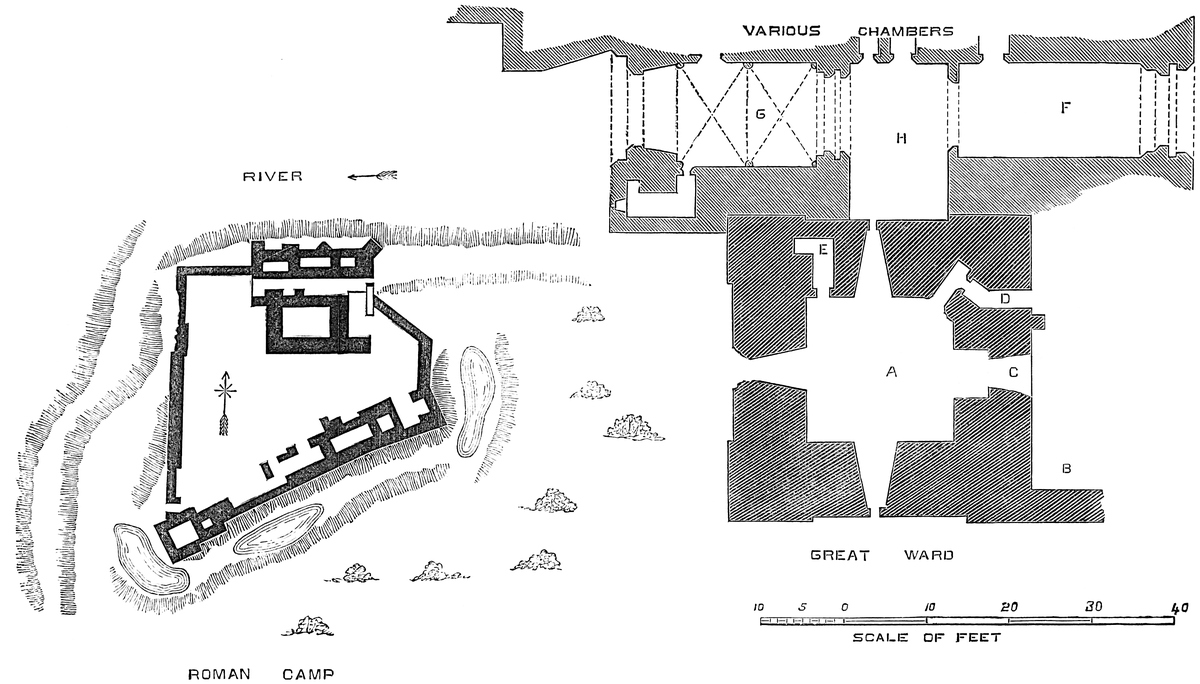
The Gatehouse, rectangular in plan, and 90 feet long by 39 feet broad, occupies the space between the keep and the north wall, and extends either way beyond the keep. It is composed of two parts,—one, a block of chambers, lodges, &c., forms, or rather abuts upon, the curtain; the other, connecting these chambers with the keep, contains the vaulted entrance. The entrance is broken transversely into two parts, separated by a small open court. The outer passage, 34 feet long, belongs to the outer gate; the other, 36 feet, to the inner gate. The keep forms one side and the lodges the other. Thus, there are really two gatehouses,—one abutting on the north-east, and one on the north-west, angle of the keep, each with its own defences and gates, the buildings on the north communicating with both. The exterior portal is in the east wall. It has no flanking towers, being protected by the curtain. The north-east angle is capped by a square buttress, placed diagonally. The gateway has a plain, flat segmental arch over it. Upon a stone are the words, “This made Roger,” and above are two tiers, each of two good Decorated windows of two lights, with trefoiled heads and a quatrefoil in the head, and divided by a transom. Between the two upper windows are three bold corbels, intended to support a machicolation resembling those on each face of the keep. It is said that formerly the arms of Vaux, “checquy,” were carved over the entrance; but it seems probable that they were the arms of Clifford, “chequy, a fess,” or it may have been “a bendlet.” The passage within, 11 feet broad, is vaulted. The first defence was a portcullis, of which the square groove, 6 inches broad by 4 inches deep, remains. Within this is the rebate for a pair of gates, and on the right the small door of a lodge. At the inner end of the passage was a second pair of gates, opening towards the first pair, and beyond them the open court, with the keep wall on the left. Above this outer gateway is a large room, 21 feet east and west, by 32 feet long. In its west wall is a fireplace, and a door opening into the middle chambers. In its north wall a good Decorated window looks upon the river; in the east wall are two windows overlooking the outer gate, and between them, over the gate, a recess for working the portcullis.
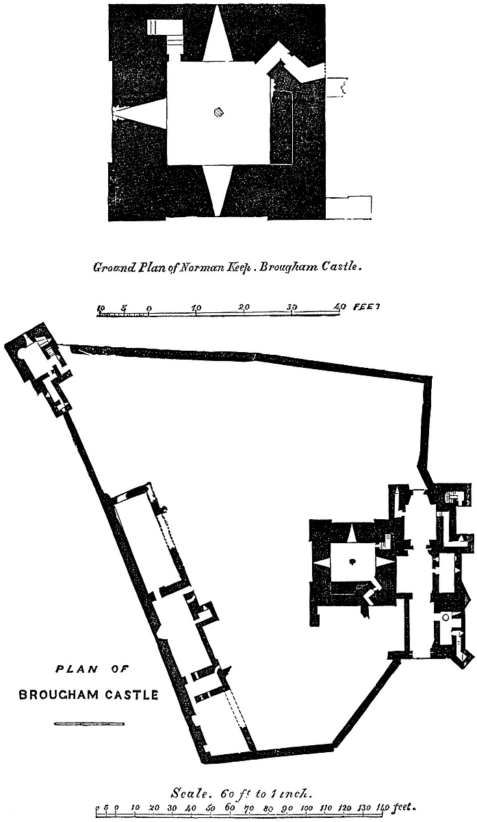
Beyond the open court is the second part of the gatehouse, which commences by a portcullis, backed by a pair of doors, within which is a passage 20 feet long by 16 feet broad, vaulted in two bays with transverse and diagonal ribs springing from six corbels. There are no ridge ribs; the inner or further portal also had doors. The left-hand lodge is a vaulted cell, 11 feet long by 3 feet 3 inches broad. On the right the room is much larger, and leads to the north postern. The exterior or north front of these two gatehouses forms a handsome block, and is pierced by various openings at different levels. At its north-east corner is an angle buttress; then follows one in section a half square, set on diagonally; and west of this, again, is a large square buttress, in one side of which is the north postern, a small shoulder-headed door at the foot of a flight of stairs.
The lofty tower at the south-west angle of the court is about 35 feet square, with an appendage on the east face. It has thick walls and mural passages, and projects but little from the curtain. It has a basement and three upper floors. The first floor was entered by an exterior flight of stairs, which also communicated with the rampart of the west curtain. At its junction with the tower is the postern, the approach to which is guarded by a loop, while nearly over the door discharges the shoot of a garderobe.
Along the south wall are the domestic buildings, of which the chief was the chapel, about 35 feet by 20 feet. This was on the first floor, with a timber floor and open roof. The chamber below was entered from the court by a lancet door. The chapel had a large east window, of which the jambs remain; and in its south or curtain wall are two long trefoil-headed windows, splayed within. Towards the east end are three sedilia, also with trefoiled heads and trefoils in the spandrels, the whole beneath a flat top. There is also a piscina of late Decorated aspect. Near the chapel, towards the south-east angle, the remains of a large fireplace seem to indicate the kitchen, and along the east wall are two windows, and traces of a fireplace between them, all which seem to belong to the hall. At299 the north end, also, on the first floor, are remains of a handsome door in the Perpendicular style, with a four-centred arch beneath a square head. The staircase may have been exterior. Grose shows some walls here in 1775, which are now gone.
The Keep, called in Countess Anne’s time “the Roman Tower,” the only remain of the original castle, is 44 feet square, and, in its present state, of unusual height. Its exterior plinth is confined to the north side. The two western angles are covered by pilasters, 12 feet broad and of 6 inches projection, one on each face, meeting so as to form a solid angle. Two other pilasters, balancing these, cover the east end of the north and south walls, but there are none on the east side, that having been covered by the forebuilding. The south face is prolonged eastwards 12 feet by a wall 5 feet thick, which rises to the third-floor level, and formed the south end of the forebuilding. The pilasters rise to the present summit of the wall, and terminated originally in four square turrets, of which traces remain at the two northern angles. The keep has a basement and three upper floors, of which the uppermost, if not an addition, has been recast. The walls are 11 feet thick at the base, and at least 10 feet at the rampart level. The parapet is gone. There is no external set-off. In the centre of each face, and near the top, are three or four bold corbels, which evidently carried a short machicolation; and in the angles, near the top, are several cruciform loops, slightly fantailed at the top and bottom, and with lateral arms ending in oillets, much resembling those at Kenilworth. Some of these are the lower half of those of the turrets, which, with the parapet, were standing in 1775. At the upper part of the south-eastern angle the wall is corbelled out 12 inches for a breadth of 15 feet on the southern, and rather less on the eastern, face. This is to give a little more space to a mural oratory, which has a loop on the south face, and a small trefoil-headed window towards the east, clear of the forebuilding. On the north face, near the east pilaster, a vertical line of six loops shows the presence of a well-stair from the first floor. The four lower loops have round heads; the two upper have square heads, and are probably later.
The basement is at the ground level. It has splayed loops to the north, west, and south; and in the east side is a recess with parallel sides, and a trace of a rebate of a doorway. This, if original, must have led into a cell below the forebuilding, as at Rochester; but it may be a Decorated insertion. It is nearly covered up with rubbish. In the north-east angle, which has been filled up with a short wall, is a small door opening into a bent passage, which now leads into the open air, at where was the foot of the great entrance-staircase. There may always have been a cell here, but the cross-wall and the outer door are not original. In the west end of the north wall is another recess opening into a garderobe chamber, 5 feet long by 3 feet broad, and original. This basement floor has had a vaulted and ribbed roof, springing from corbels at the angles, and from four others, in the centre of each side. There was, in300 1775, a central pier. As at Richmond, this vault was an insertion replacing timber. The basement was about 13 feet high.
The first floor is 23 feet square. It has round-headed window-openings to the north and west, in round-headed recesses, with beaded angles. In the south wall was a fireplace, probably a garderobe, like that below. In the north-east angle, filled up like that below by a short cross-wall, is a door opening on a well-stair, which occupies that angle, and ascends to the roof. The east wall has been in some measure rebuilt, recently. In it may be seen parts of a large Decorated doorway, evidently inserted to give a direct entrance to the chamber. This floor has had an arcade against its walls, of which traces remain on the south and west sides. The arcade had slender piers and trefoiled arches. It is unusual to find so ornate a room in the first, or, indeed, any floor in a Norman keep: it must have more resembled a chapter-house than a private chamber. The chapel at Castle Rising was so arcaded, and those at York, and in the curtain at Richmond. This floor was about 15 feet high, and was covered by the joists and floor of the room above.
The second floor has round-headed recesses, beaded at the angles, for the windows, in the north and west sides; and a flue, now laid open, occupies the south side. In the east wall is the original entrance,—a plain round-headed arch of 6 feet opening, with a chamfered rebate for an exterior door. There was no grate. Close north of this is a small door entering an oblique passage, which opened, as at Middleham and Rochester, upon the turret over the outer entrance of the forebuilding. The well-stair has no direct opening into this floor, whatever may have been the case before the alterations. There seems to be, as below, a garderobe in the north-west angle.
With this floor the original keep seems to have ended. There is now, however, a third floor, which, if not altogether new, has been remodelled. The walls are very thick, and the four angles within are filled up with short walls, converting the chamber into an octagon, or rather into a square with the angles taken off. One of these fillings-up, that to the north-east, is carried down the whole way. The other three are confined to the top floor, and rest upon brackets. This floor had a large recess and a window in each of the four main faces, of which that to the west is segmental and ribbed. These recesses are now quite inaccessible; but it would appear, from the thickness of the wall, and from certain square apertures outside, that they communicate on the west side with mural chambers. In the north-west angle is a very remarkable fireplace of about 9 feet opening, with a perfectly flat platband, composed of thirteen stones joggled together. This is a very fine example of this kind of work, and it stands quite unaltered. In the opposite, or south-eastern angle, is a shallow-pointed recess, and in it a square-headed doorway, which opens into the oratory. The window recess in the south wall differs from the rest. Its arch was high-pointed, and moulded with deep reduplicated bands, with half-shafts with bell capitals;301 no doubt Decorated, but of Early English character. From the east jamb of this recess a second passage opens into the oratory, and this was probably the principal entrance to it. The oratory is seen from below to be vaulted and groined. It occupies the south-eastern angle of the building.
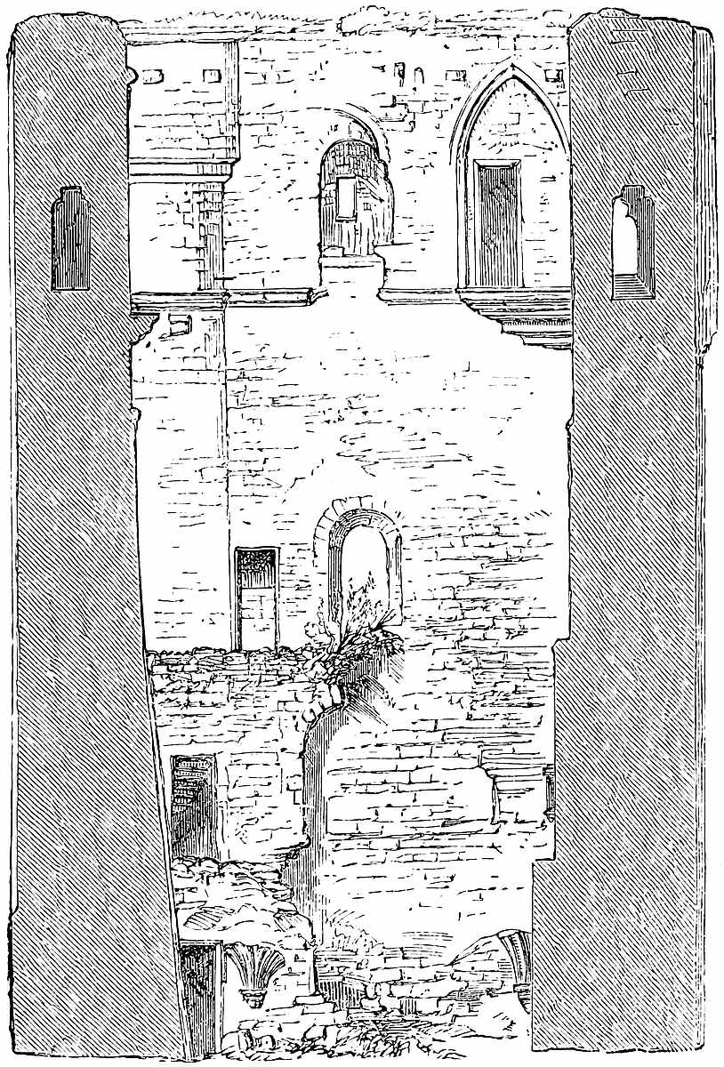
The east face of the keep was covered by the Forebuilding, which evidently contained a straight staircase, which rose from the north-east corner of the keep, and ascended to the main doorway on the second-floor level. This doorway, as at Middleham, is near the south end of the wall, but, notwithstanding, the steps must have begun above the ground level, to reach, without undue steepness, so considerable a height. The wall has been so much injured, and so freely repaired, that the marks of the stairs are no longer visible, but a toothing and some springing stones, as for an arch, seem to302 show that the staircase rose from the north-east angle, under a covered way or low tower, the battlements of which were evidently reached by the oblique passage still seen above in the wall, as at Middleham and Rochester. Below the level of the original doorway are traces of a larger and more lofty doorway, in the ornate Decorated style,—evidently an insertion. This would give direct passage into the first floor of the keep, and was probably inserted when the arcading was introduced, and this converted into the main apartment. There are other toothings and roughnesses in the wall, indicating various alterations. The forebuilding was about 12 feet broad, and contained a basement and two floors, as shown by the openings in the south wall, which are, near the ground, a loop; above it, a small window; and above that a garderobe, corbelled out upon two heavy blocks upon the south wall. Above the line of roof of the forebuilding is to be seen the east window of the oratory, and near it a cruciform loop.
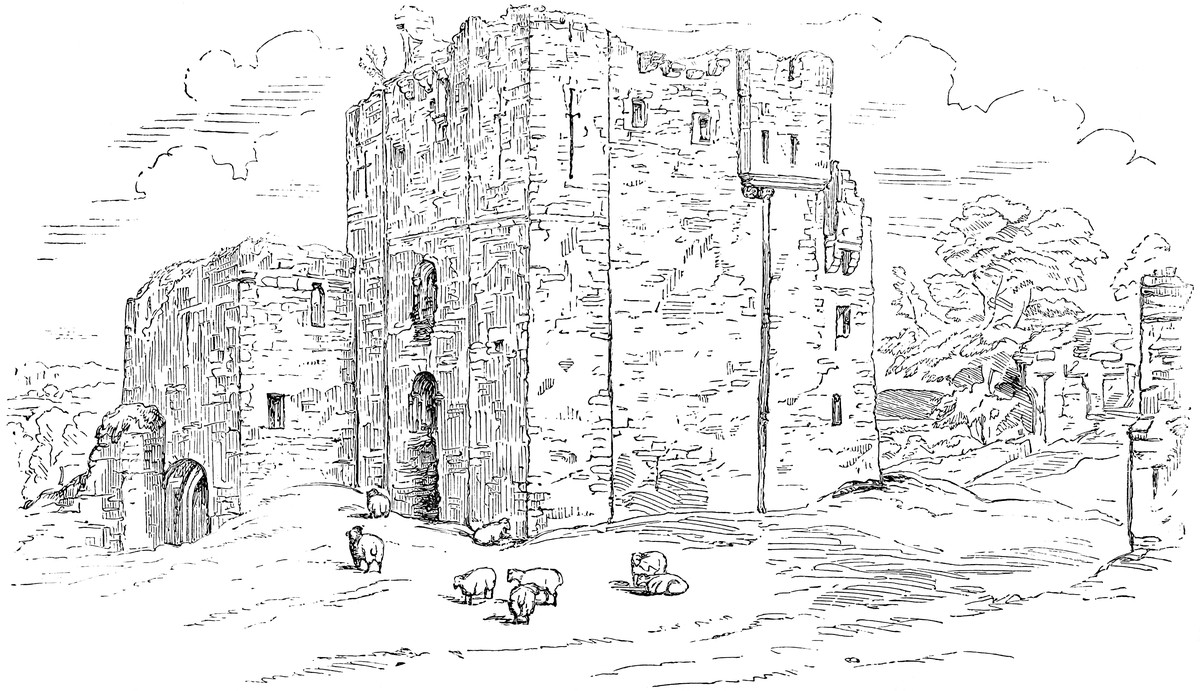
Unfortunately for the close examination of this very curious keep, the upper part is inaccessible, and ladders of sufficient length are not readily to be procured. The architectural history of the castle may be inferred from its details, so far as these are visible. It is evident that the original fortress was a late Norman keep, and it must have been placed within an enceinte pretty closely corresponding to that now seen, and which skirts the edge of the ditch. Of this supposed original enceinte wall, as well as of the domestic buildings and gatehouse, which must have been present in some form or other within it, there remain no very certain traces. The keep, judging from internal evidence, and probably the ditches were the work of Robert de Vipont, very early in the thirteenth century.
In the Decorated period the castle underwent great alterations. The keep was probably raised a story, and an oratory included in the new work. The basement was vaulted, the first floor arcaded, and the forebuilding so altered as to admit of an entrance on that floor. All the rest of the castle, gatehouses, domestic buildings, and the whole of the enceinte wall belong to one general period, and are probably the work of Roger de Clifford, the first of his race who held this property, and the husband of Isabel de Vipont, its heiress, in the reign of Edward I. Usually, when a Norman fortress was remodelled in the Edwardian period, the keep was neglected, and left in its original isolation; here, however, it was decided to turn the keep to account, and to ornament its principal chambers, and connect them with the suite of rooms in the upper floor of the gatehouse.
The drawing represents a section of the keep east and west, looking south. Something of the various additions is here shown, and the springings of the vault of the basement.
The exterior view of the keep is taken from the south-west quarter, and shows, above, the projection for the oratory, and below and beyond it the end wall of the demolished forebuilding. On the left is seen the river gateway of the entrance.
304
There are some peculiarities of detail in this castle which need further investigation. The large windows of the first and second floors of the keep are original; but the half-piers and bell-caps in the exterior jambs look much later, and may be a part of the Decorated additions. It is said that the buildings against the east wall received some alterations from another Roger de Clifford, grandson of the former. It is curious that walls so thick as those of the keep, and of such good material, should have been left solid, for the most part unpierced by the chambers and passages so much affected by the Norman architects. It is also to be observed that the curtain wall is but scantily furnished with flanking defences. Countess Anne mentions “the Tower of Leaguer,” and “the Pagan Tower,” and “the Greystoke State Chamber,” in Brougham Castle.
THE name of Builth, borne at this time by a considerable town, and by a Hundred of the county of Brecknock, is very ancient. As, like Brecon, the town is placed in an open valley, accessible without much difficulty to an enemy from the east, it has suffered from invasion from a very early period, and to these and similar attacks are to be attributed various strongholds, both of earth and masonry, of which the remains are abundant upon the marches of England and Wales, and in such tracts of the latter territory as either Saxon or Norman, having overrun, thought it worth while to retain.
The construction of Offa’s Dyke, in the eighth century, must have been preceded by many years of conquest, and the establishment of many English strongholds throughout the annexed district, and probably also beyond it. Nothing short of a present inability to rise would have kept the Welsh quiet during the construction of such a work, or have forced them to accept, even passively, a limit which cut off a large part of their fairest territory. The fortresses of Builth and Brecon, which resemble in general character those of known English origin elsewhere, were probably advanced posts thrown up either during the wars which preceded the dyke, or to aid the aggressions which followed it. The plan of construction leads rather to the latter conclusion, and points to the ninth or early part of the tenth century.
However this may be, it is certain that when Bernard Newmarch invaded Brecknock, towards the end of the eleventh century, he found the earthworks of Brecon and Builth already existing, and occupied them, as was usual, by works of a Norman character.305 Probably these were at first of timber, for a structure of masonry required time and peace, and generally tradition has imputed the oldest Norman military buildings in Wales to the immediate successors of the conquerors, rather than to the conquerors themselves. Where the age can be safely inferred, either from the design of the building or from its ornament, it is generally found to be of very late Norman, verging upon the early English period.
Newmarch was succeeded by Milo Fitz Walter, who married his daughter. He was created Earl of Hereford by the Empress Maud, in 1140, and received from her the moat, or more probably the “mote” and castle of that city. His sons died childless, Mahel, the last of them, having been killed by the falling of a stone from Bronllys tower. Builth was inherited by his sister Berta, who married Philip de Braose, who, indeed, is said already to have possessed himself of that territory, and to have afterwards married its lawful heiress, as Newmarch had married the Welsh Nest, by way of precaution.
Their son, William de Braose, also a powerful baron in Devon, flourished in the reigns of Henry II., Richard, and John, and died in exile in 1210. His brother Giles, Bishop of Hereford, succeeded, and, dying in 1215, was followed by his brother Reginald. In his time occurs the earliest mention of the castle. In 1219, 4 Henry III., the Sheriff of Gloucestershire is directed to give immediate aid to Reginald de Braose “ad castrum suum de Buetto firmandum et fossatum et trencheyas ibidem faciendas contra inimicos nostros.” Also 12 September, 1223, 7 Henry III., the king directs all the sheriffs of England, excepting those of Stafford, Salop, Worcester, Gloucester, and Hereford, who probably had already, being near, discharged their duty, to raise men and march to Gloucester, the reason being the king’s sure information that Reynold de Braose was besieged in his castle of Builth by Llewelyn and a multitude of armed men. What the result was is unknown, but some years later, in July, 1260, after De Braose’s death, when the castle was in charge of Roger de Mortimer, it was besieged and taken by Llewelyn. Roger was in London, and, as it was his duty to have been at his post, he had a regular remission in form, stating that he was attending Parliament by special precept. It is stated therein that he held the castle “ex ballio” by deputation from Prince Edward. In August, Llewelyn was still in possession, and there remains a precept on the subject, directed to Richard de Clare and others.
Reginald de Braose, who was lord during the siege of 1223, is generally stated to have died in 1221, which seems disproved by Rymer’s record. He died, however, about that time, and was followed by William his son, who, in 1229, was hanged, according to the Welsh, by Llewelyn. On his death, leaving only daughters, the Crown took the castles, and they were granted to Prince Edward, who held them in 1254, when his father renewed the grant.
5 Edward I., some question arose about certain tythes held by the prior and convent of Brecon under William, William his son, ... and Reginald de Braose, Lords of Builth, and it appears from a later306 entry, 13 Edward I., that it was their duty to serve a chapel or chantry within the castle, then called “the King’s Castle.” 25 Edward I., John Giffard was custos, and his allowance was reduced by the treasury because it was more than was usual.
17 Edward II., 1324, a survey was taken of the castle for the Crown. The castle yard and curtilage were worth per annum 12d., and there were 40 acres in demesne of arable at 3d. per acre, total 10s. Also 10 acres of meadow at 12d., total 10s. Also the “communitas patriæ,” hangers on outside the vill, paid the king every second year, for all services and annual rents, 10 cows or 20 marcs in money at the lord’s pleasure, that is, £1. 6s. 8d. for each cow, its money-value at that time. Rents of assize in Lanveir 70s., probably from 75 burgesses. A ferry 4s. per annum. The land of Talevan, in the king’s hands, 2s. The land of Tyr Maukyn, 2s. Pannage of hogs, 20s. The king had there four mills, each at 10s. No villenage there. All pleas and perquisites of the court merchant in Lanveir 57s. per annum. Pleas and payments of the courts “patriæ,” 17s. Ammobrages, 13s. 4d. No royalties, villenage, demesne, or other outgoings. No profits accruing to the king in Builth save the above.
Llanfair is the town of Builth, its Welsh name being Llanfair-ym-Muallt, or St. Mary’s, Builth. Ammobrage is thought by Spelman to be the same with Chevage, a poll-tax paid by villeins to their lord. Jones, the Brecknock historian, gives it a Welsh etymology, and makes it a sort of excise.
The importance of these frontier castles naturally ceased after the settlement of Wales by 3 Edward I., and the Crown no longer cared to retain them. 9 Edward III., Builth Castle was vested in Eubolo le Strange and Alesia his wife, and 14 Edward III. Thomas de Bradestan, Banneret, had “Thlanver” Castle, probably “Blaenlleveny,” and the Lordship of Builth.
16 Edward III., 1342–3, Gilbert Talbot, Justiciary of South Wales, was directed to raise levies in the divisions of Builth, Ewias-Lacy, and Ewias-Harold, and similar precepts were issued in 1367.
34 Edward III., 1360–1, Roger de Mortimer held the castle and cantred of Builth, and 5 Richard II., Edward Earl of March and Philippa his wife held Bewolthe or Beult Castle, as did Earl Roger, their successor, 22 Richard II. On the attainder of the Mortimers the castle fell to the Crown, and so remained till granted away by Charles II., since which it has passed through many hands.
Regard being had to the position of the castle upon an exposed and very dangerous frontier, it is not surprising that its walls and towers were planned with some skill, and executed with great passive strength. But of the works in masonry, scarce a trace now remains above ground, and the site of a fortress which could hold Llewelyn and his armed Welshmen in check, probably for several weeks, is now indicated by heaps of earth of a rather remarkable character, and which, from their position and size, make a feature in the outline of the town from whatever point beheld.
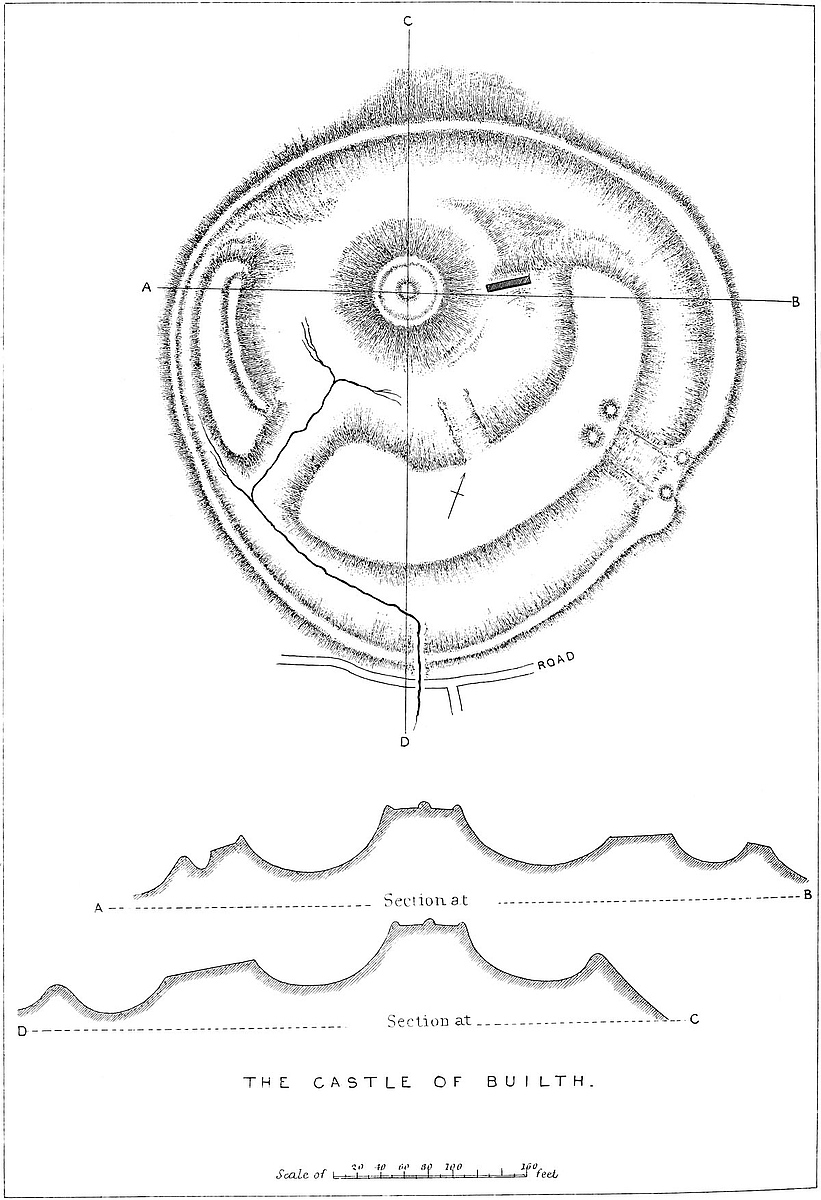
307
Moreover these earthworks, which have survived the masonry that for so many centuries crowned their summits, are, it is evident, of far earlier date than the Norman work, and have only in these latter times resumed much of the appearance which they originally presented.
For they resemble in their general features and in their details, those earthworks nearer to, or within the English border, as Wigmore, Richard’s Castle, Kilpeck, and Ewias-Harold, which again resemble those of Warwick, Leicester, Bedford, and Towcester, the dates and authors of which are on record, and all of which, wherever situated, are quite unlike the grand hill-camps so common on the border, and usually attributed to the British.
Hence a peculiar interest attaches to works such as these at Builth. Not only as regards the English part of the community is there the presumption, amounting almost to demonstration, that they were the work of their proper ancestors, but, what is of interest to all, it is possible to fix an approximate date to their construction, which is by no means the case with the larger and probably older hill-camps.
The town of Builth stands in the north-eastern quarter of Brecknock, in the Hundred of its name, just upon a bold curve of the Wye, which, escaping from the deep valley in which it descends from Rhayader Gwy, and about to plunge into that by which it reaches the more open country near Glasbury and Hay, here traverses a broad expanse of mead overlooked by the town, to which it not improbably gave origin.
On the eastern edge of the town, and, like it, a hundred yards above and as many distant from the river, is placed the castle. It commands a considerable view towards the north, and was within an easy ride of Payn’s Castle and other fortresses upon the middle Wye and the Usk. It stands upon a bank falling steeply towards the north of the river, and, though higher on all sides than the adjacent ground, is approached by an easy ascent from the south, on which side was its entrance.
The castle occupied a plot of ground nearly circular, being about 180 yards north and south, by 190 yards east and west. Its principal feature is a conical mound, table topped, wholly artificial, 60 feet diameter at the top, 200 feet diameter from the centre of the circumscribing ditch, and from the bottom of that ditch 60 feet high. The ditch is carried all round from 100 to 120 feet broad, being narrowest towards the north, the side naturally strong. For about four-fifths of its circumference to the south, the mound is covered by two curved platforms, convex towards the field, and concave towards the rear. That on the south-east is the larger, and from 60 to 90 feet broad and 400 feet long. That on the west is 30 to 35 feet broad and 200 feet long. They are separated by a deep trench about 100 feet broad, which connects the inner with the outer ditch. At their other or northern extremities they end more gradually, but leave the northern front of the mound uncovered. These platforms are in308 their rear about 30 feet above the bottom of the ditch of which they form the counterscarp, and consequently about 30 feet below the top of the mound. They slope gently outwards. The western platform has along its inner edge a narrow steep bank about 6 feet high. This could scarcely have carried a palisade, there being no space for a walk behind it. It looks more as though it had been thrown up during a siege, to cover those who proposed to storm the mound.
Outside and in front of these platforms is a ditch of from 70 to 100 feet broad, and 15 to 25 feet deep. It covers the southern four-fifths of the work, but, towards the north, where the platforms cease, it is continued into and forms part of the inner ditch.
Finally, encircling the whole, is a bank upon the edge of the outer ditch, of variable height and thickness, sometimes narrow and from 5 to 6 feet high, in other parts expanded into a platform of from 12 to 20 feet. This bank subsides into the natural slope of the ground, which is very steep towards the north only.
Although but one small fragment of masonry remains above ground, there are traces of walls where the foundations have been dug up, and here and there are heaps which probably cover the remains of towers. There was evidently a central tower or keep, circular or many sided, covering the top of the mound, and probably, like Bronllys, of early English or late Norman date. The north slope of the mound, covered only by the ditch and bank, formed part of the enceinte, as at Berkhampstead, and from the keep descended eastwards a curtain, of which a part remains, which crossed the ditch, and evidently was carried along the platform so as to include it. There are upon it two small mounds, which seem to have been towers flanking the entrance. How this curtain was continued, whether it was confined to the east platform or whether it traversed the cross ditch, and included the west platform, is uncertain. In either case it must have finally turned inwards, crossed the inner ditch, and reascended the mound to abut upon the keep tower. The castle seems to have been composed of a keep and a single ward, and probably owed much of its strength against a sudden attack to its contracted area. The ditches are far above any source of water from adjacent ground. They seem, however, to have been more or less wet, probably from the rain water. The cross ditch and adjacent parts of the ditches are still boggy, and would form a small pool, but for a drain which has been cut in the outer bank.
The approach seems to have lain through the town of Builth along an existing road, and to have reached the outer barrier where the ditch is partially filled up on the eastern side; thence crossing the platform, where there seems to have been a causeway across the inner ditch, and no doubt from it a flight of steps led up the mound.
OF the three greatest military works executed by Edward I. in Wales, Caernarvon is undoubtedly the chief; nor, indeed, is there any castle in Britain laid out with greater uniformity of design, or in which the resources of the military engineer are more skilfully set forth. Moreover, it has suffered less than any other of equal magnitude from violence, or natural decay, or the rapacity of local builders. Its towers, walls, and gatehouses, stand as firm and free from injury as when they came from the hand of the mason. Floors and roofs, indeed, have been removed, and the interior lodgings, hall, and chapel, are wanting, but their removal, if it took place, has been effected with so much care that it is uncertain whether they were ever erected, and whether the toothings and roughnesses of the contiguous walls were not left with a view to their addition. In these latest days the Crown, always the owner of the pile, has shown unusual zeal for its conservation. Mr. Salvin, than whom no man could more skilfully restore an ancient castle, was consulted upon its necessary repairs, and Mr. Turner, as deputy-constable, watches over the fabric with no common care.
The castle and town of Caernarvon are placed upon the right or northern bank of the Seiont, a river known to fame by the construction upon its meadow of the Roman Segontium, at no great distance above the castle, which, with the town, stands within the junction of the river with the waters of the Menai Strait, so that two sides of the position are protected, the one by the river, the other by the sea. Segontium, or Caer Seiont, seems to have been succeeded by the Welsh camp of Caer-yn-Arvon, so called from its position upon the shore of Arvon, no longer “dreary Arvon,” but one of the most charming spots in North Wales.
The town, founded, with the castle, by King Edward, is somewhat of a parallelogram in plan. It is contained within a curtain wall, strengthened by ten towers, of which two form the east and west gatehouses, and three cap the principal angles of the enclosure. They are either cylindrical or half cylinders, open at the rear.
The south end of the area is closed by the castle, of which the principal face is thus towards and within the town. The opposite or southern face rests upon the Seiont, as does the western, and did, to some extent, the eastern end. Wilson’s picture, taken in the last century, shows the walls rising almost from the water’s edge, and the cross ditch before the Queen’s Gate still open, but at this time a broad quay intervenes between the castle walls and the river, and of the broad and deep ditch separating the fortress from the town only a part remains. The ditch was, probably, deep enough to admit the tidal waters.
The castle somewhat resembles an hourglass in plan, its outline310 being governed by the rocky ridge on which it stands, and which lifts it a few feet above the level of the town. It is in length about 100 yards, and in breadth from 30 to 40 yards, the narrowest part being at the centre. Its outline is polygonal, and on each angle is a tower, also polygonal. Of these there are nine, two of which are double, and form gatehouses. There are also two smaller towers, also polygonal, in the centre of two of the curtains. The ground falls rather steeply from the south-east end, but at its lowest is some feet above the water level.
The main or King’s Gatehouse, a very noble structure, is in the centre of the town front, and occupies a re-entering angle of the wall. It is broad and high, with an unusually lofty and ornate archway, in the upper part of which is a statue of Edward II., who completed the castle, and below this the recessed gateway. Two bold half-octagons flank the entrance, the approach to which was by a drawbridge, now superseded by a work in masonry. The portal is broad and high, vaulted and ribbed, with the usual portcullis grooves, rebates, and bar holes for doors, and meurtrières in the vault. On either side is a lodge, an unusually spacious chamber. Both of the flanking towers are looped, and in that to the right is a mural gallery, with loops completing the command of the approach. The rear of this right-hand tower is prolonged into a square building forming the prison tower, in one angle of which is a well staircase leading to the upper floor of the gatehouse and its roof. At the foot of this staircase a small portcullised doorway opens westwards upon the kitchen.
From the Prison Tower a narrow building connected the gatehouse with the opposite or Exchequer Tower, and thus divided the castle into an eastern or upper, and a western or lower, ward. A handsome archway pierced this building, and opened from one ward to the other. Building and gatehouse are gone, but the jambs of one side, with two portcullis grooves, show that the portal was strong and was ornate.
Besides the King’s Gate the upper ward was entered by a second or Queen’s Gate, a very remarkable structure, seeing that it is placed at the highest part of the fortress, and that the cill of its entrance is some 25 feet above the present ground, and must have been 12 feet or 14 feet more above the bottom of the now filled-up ditch. How this entrance was approached does not appear, if by a drawbridge the pier on which it fell must have been a very lofty structure, and a sort of viaduct must have led up to it. The portal is vaulted and ribbed, and had a portcullis and gates, but the lateral chambers do not open from it. The rear of the gatehouse seems not to have been completed, but close to it, to the west, is the jamb of a small portcullised gateway, with ornate mouldings. Into what it led is not very apparent.
The towers, though differing widely in details, are all of one general type, and probably designed by one hand. Each has a basement at about the exterior ground level, damp and dark, and only to be reached by a ladder from the floor above. Possibly these311 basements were not intended to be used. They were not vaulted, and have no sewers. Each tower has a first floor at the court level, and at this level, or a few steps above it, the wall is pierced all round by a mural gallery, looped to the field and connected with divers mural chambers and garderobes. The second floor has windows of a larger opening, as has the third or uppermost. Each floor has a fireplace, usually a mere opening in the wall, and each is reached by a well staircase, which begins at the first-floor level and ends in a tall turret which rises some 20 feet above the roof. From the upper floor a doorway opens out upon the rampart of the curtain. The floor was all of timber. The roof was almost flat, having a very slight pitch to a central ridge, and was covered with lead.
The curtain, everywhere unusually thick and lofty, along the north side was looped in two stages, showing that it gave support to long ranges of buildings, probably barracks, with thick walls and very low-pitched lead-covered roofs. These buildings are wanting, but the towers and curtains are toothed, to give bond to their walls when built.
The most remarkable part of the castle is the arrangement for the defence of the southern or river front. On this face the curtain is of immense thickness, extending from the Queen’s Gate to the Eagle Tower, and including in that distance the Prince’s and the Exchequer Towers, and two others of smaller dimensions. This wall, from the Queen’s Gate to the Prince’s Tower, contains, at a little above the court level, a broad and lofty gallery, which not only pierces the curtain, but is continued through the walls of the towers, with an occasional vaulted chamber or lobby, as a “place d’armes.” This gallery is looped towards the field, and has an occasional window and door towards the court. It descends by steps so as to preserve its level as regards the court, and in its walls are several garderobes.
Above this, of the same length and similarly constructed, is a second gallery, also looped towards the field, but either the inner wall and roof of this gallery have been removed, or, more probably, never completed, for it now remains as an open platform. The thicker and outer wall, however, is perfect, and carries what is still a broad rampart walk, or allure, reached by occasional flights of steps in the wall from the upper gallery. Thus was provided a triple line of loops, and these loops are not, as was often the case, mere air-holes, but are so contrived as to afford ample scope for the effective use of either longbow or arblast. No body of assailants, however brave, unprotected by armour or unsupplied with regular siege appliances, could have withstood such a line of defence, manned, as it would be, with the first archers in Europe, exposing those without, in front and flank, to a shower of clothyard shafts and iron-pointed quarrells.
The curtain, from the Prince’s to the Eagle Tower, though as thick as elsewhere, is solid below, having only the upper gallery; neither does it communicate with the Eagle Tower, which forms a312 sort of keep or citadel, being in dimensions rather larger than, and in strength fully equal to, any of the others. This tower, also, is of rather superior and certainly more ornate workmanship than the rest. Its mouldings are all of the best Decorated period, and it was evidently intended for the reception of distinguished visitors.
The Well Tower, that next west of the King’s Gate, contains a very remarkable well. The well, with a pipe of 5 feet diameter, descends in the thickness of the wall, in which also is the well chamber, whence the well was worked. The whole, both well and chamber, are in excellent order. Unlike the other towers, the basement of the Well Tower is entered from the court by a steep direct flight of steps. The reason of this is seen in a postern which opens from the floor of the tower in the wall. It is 16 feet above the bottom of the ditch, serving, probably, as an internal communication with the town. The great kitchen does not now exist. It was of large size and rectangular plan, and extended from the Well Tower to the King’s Gatehouse. At one end are seen two curious stone circles, probably intended to carry large iron cauldrons with a space below for a fire. In the side wall, or curtain, are some mural chambers, and a trough with a stone pipe by which water was conveyed from the well-chamber through the wall. There is also the springing-stone of a moulded rib, showing that the kitchen had an open roof. In this wall a straight staircase ascends to the gatehouse, possibly to the cook’s bedchamber.
Opposite to the kitchen a line of foundations shows the position and dimensions of the great hall, 100 feet by 60 feet. It was built against the south curtain, and extended from the Exchequer to the Prince’s Tower, the latter being, probably, at the dais end. From the other end of the hall, a straight staircase led to a postern which opened upon the quay and the river.
Caernarvon is mainly built of limestone. The stones are hammer dressed, and roughly squared, and laid throughout in courses. Ashlar is very freely used, and finely cut. The mouldings employed are characteristic of the Decorated period, and the stone has preserved its surface and arris uninjured.
The absence of the hall and kitchen, the offices and barracks, and of the cross building separating the two wards, gives an incomplete and unfinished appearance to the interior of the castle, but this does not affect its military details and those of its towers, gatehouses, and curtains; these are very perfect and very curious. With the decline of the Decorated period in architecture military defences also began to decline, and the works of Edward III. and his successors, though often palatial in their grandeur, are never of a purely military type, and in this respect are never equal to those of the earlier Edwardian period.
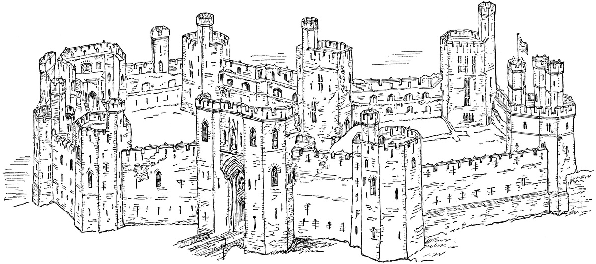
314
Caernarvon was begun in 1283, immediately upon the execution of David, the last Welsh prince. The first work was that of quarrying the cross ditch, and collecting materials and workmen, the latter being drafted from the English counties. Caernarvon, Conway, Criccaeth, and Harlech, were in progress together, and nothing short of the hope of consolidating his kingdom could have induced so economical a sovereign as Edward to incur expenses which, in one year, for Caernarvon alone, amounted to above £3,000. The king was here for the first time in 1284, in which year, April 25th, Edward of Caernarvon was born, probably in the town. By 1295 so little progress had been made that the Welsh, rising in local insurrection, succeeded in burning the town, and taking what was then executed of the castle. How much was then built, or how much they left standing is unknown, but from that time quicker progress was made, and at Edward’s death the castle was certainly in a forward state. The work was continued and completed by his son. The Eagle Tower was covered in in 1316, and the king’s statue set up over the great gate in 1320, and by 1322 the castle was completed for defensive purposes. The chamberlain of North Wales seems to have resided here, and the Exchequer Tower was so called because here were deposited the financial returns for the northern counties, but it may be doubted whether the grand accommodations designed by the original architect for the visits of the sovereign were ever actually executed.
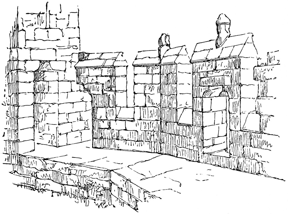
The castle fell into the hands of Owain Glendwr, and was held alternately by king and parliament during the Great Rebellion.
One of the many valuable papers contributed by the late Mr. Hartshorne to the Journal of the Archæological Institute contains an excellent history of this castle; had that gentleman bent himself also to the easier task of its description, this account would have been uncalled for.
315
The larger of the accompanying illustrations gives a bird’s-eye view of the castle from the north-west. In the front and centre is the King’s Gatehouse, and next, on the spectator’s right, is the Well Tower, and beyond it, the Eagle Tower. On the extreme left is the interior of the Queen’s Gatehouse, placed between the Granary Tower on the left and the Black Tower. Opposite to the King’s Gate is the Exchequer Tower, and between it and the Eagle is the Prince’s Tower. In the lower or right-hand court are seen the foundations of the hall; next on the left of the King’s Gate is the Dungeon Tower.
The smaller illustration shows the allure or rampart-walk of the Eagle Tower. The rear wall, if it ever existed, has been removed. The cut shows the merlon, with its contained loop, the plain flat-sided embrasure, and the figures placed upon the ridge of the coping, one of which gives name to the tower. The small, shoulder-headed doorway opening from the tower upon the rampart is also seen.
CAERPHILLY is by very much the most extensive castle in Wales, and is reputed to cover, with its outworks and earthworks, about thirty acres.
The castle owes its celebrity to its great extent, and to the peculiar manner in which one of its towers has been thrown out of the perpendicular by the forces employed for its destruction. Its real merits are of a less obvious but much higher character, and rest upon the great military skill exhibited in its design and construction. It possesses few associations with historical events. But one, and he a falling, sovereign is certainly known to have visited it. It is not, like Kidwelly or Cardiff, the head of a feudal honour or lordship, nor is it surrounded by any franchise or barony. It has not even received the barren dignity of conferring a title of honour upon any of its numerous possessors. It has been celebrated by no bard, and even mentioned only by one.
Neither does Caerphilly possess many of the ordinary sources of interest. It boasts not the architectural decorations of Caernarvon, the commanding position of Conway, nor the picturesque beauty of Raglan. It is simply a ruin of great extent, and possessing that sort of rugged sublimity which is inseparable from an assemblage of lofty walls and massive and partially overthrown towers, though neither bosomed in woods, nor mantled, to any extent, with ivy.
It is remarkable that this castle should have remained altogether neglected, or very superficially noted by the historians of Wales. The earlier authorities, Caradoc of Llancarvan and Giraldus Cambrensis, flourished before the erection of the present edifice, but it316 is singular that silence concerning so immense a structure should have been preserved by Lloyd, and his commentator Powel, and transmitted almost unbroken by the indefatigable, though credulous, author of the “Munimenta.”
It is not, however, difficult to divine the causes of the obscurity in which the early history of Caerphilly is involved, and the absence of any historical associations may perhaps be permitted to account for the continued silence of modern writers.
A castle of considerable magnitude had been erected soon after the Norman invasion of Wales, at Cardiff; a position which, from its proximity to the estuary of the Severn, and the mouth of the Taff, from the fertility of its subjacent meadows, from the protection which it reciprocally afforded to, and received from, the people of the town, and from its greater distance from the mountains, and consequent diminished liability to be surprised by their crafty and warlike inhabitants, was invariably the chief residence of the feudal Lords of Glamorgan; and from hence it followed, as a necessary consequence, that Caerphilly, which, from its dangerous proximity, they were obliged to retain in their immediate possession, fell into comparative neglect, and, although very superior in magnitude to Cardiff, was considered only as its dependency in importance.
It was to the Lord of Cardiff that the feudatories of Glamorgan owed suit and service, and it was to the castle court of that place that they were bound annually to repair.
The castle of Cardiff is mentioned as the residence of great Norman barons; it was more than once honoured by a royal guest, and, even at the far later period of the Parliamentary wars, its acquisition was considered of great importance. Caerphilly, on the contrary, is rarely mentioned by the chroniclers, and as a military post ceased to be of importance upon the death of Llewelyn and the reduction and settlement of the Principality by Edward. These considerations will explain the little notice taken by contemporaries of this magnificent fortress, and the consequent dearth of information respecting its fortunes.
Caerphilly stands upon that wide tract of debateable ground between England and Wales, which was so long contested by both nations under the title of “The Marches,” and which, beneath the Normans, had its own customs and its governors, known as the Lords Marchers.
The castle, though in the Marches, is within the Welsh border, being about a mile from the river Rhymny, the boundary between Monmouth and Glamorgan, and, since the reign of Henry VIII., between England and the Principality, in this direction.
The Lordship of Senghenydd, within which the castle is placed, was granted at the conquest of Glamorgan to Einon of Collwyn, a Welsh lord, whose granddaughter, Nest, “verch Madoc ap Cradoc ap Einon,” married Cadivor ap Cydrich, a grandson of Gwaethvoed, and the father of Ivor Bach, who is described as [mesne] Lord of Senghenydd. Griffith, the son of Ivor, married a sister of Rhys,317 Prince of South Wales, before 1174, when he did homage to Henry II., at Gloucester. By this match the influence of the family, already great, with the Welsh, was much increased and became very great. They dwelt too near Cardiff actually to organise insurrections, but they were always ready to promote them at any favourable opportunity. Many such opportunities occurred during the reign of Henry III., when the Earls of Pembroke wielded the power of the infant lord of Glamorgan, and were continually at war with Henry. Llewelyn, then Prince of Wales, was sometimes in alliance with the earl, and sometimes harassed his rear, descending from the uplands of Caermarthen and Cardiff, and bursting into Monmouthshire across the unguarded pass of Senghenydd. It became the business of Gilbert de Clare, on coming into his lordship, to bar this passage, and this he effectually completed by the construction of Caerphilly. The name of his architect or engineer is unknown to fame, but he was a deacon in his craft, and the earl gave full play to his abilities.
The castle is placed in the midst of a deep and broad hollow, open on the east towards the Rhymny, and divided on the west from the valley of the Taff by the mountain ridge of Mynydd Mayo. North and north-west, at a greater distance, is the concave crest of Mynydd Eglwisilan, and on the south, the long and well-known elevation which separates the hill-country of Glamorgan from the plain, and is intersected by the ravines of the Taff, the Rhymny, and the Ebbw. This ridge is locally known as Cefn Carnau, and, on the road from the castle to the sea, is crowned by the ancient stronghold of Môr-graig. The traveller, who wishes to see Caerphilly to advantage, should descend upon it soon after sunrise in autumn, from one of the surrounding heights, when the grey towers of the castle will be seen rising out of an immense sea of mist.
The whole basin is a part of the Glamorganshire coalfield. The mineral has long been worked on Caerphilly mountain, where it appears on the surface, and the castle is chiefly constructed of the fissile sandstone of the neighbourhood, which appears to have been quarried from a large excavation by the roadside, near Chapel-Martin.
Along the base of the mountains, and extending some way up their skirts, here, as in all the valleys in the neighbourhood, lie vast deposits of gravel and sand, composed in part of the débris of the neighbouring rocks, but chiefly of rolled pebbles, brought down from the northern hills by diluvial agency.
Near the centre of the basin is a bed of gravel, of considerable extent and thickness, the surface of which has been deeply wrought, by some natural process, into a series of furrows and eminences.
A narrow tongue of slightly elevated ground, the termination of a low peninsula of gravel, projects eastwards, and, by its projection, divides a swampy flat of considerable breadth into two portions. These are contained within irregular gravel banks, similar to, though somewhat higher than, the central peninsula. The southern is318 shorter, and almost parallel to it; the northern is prolonged, and curves around its point, until it is separated from the southern only by an inconsiderable gorge. The swamp thus assumes something of the figure of a horse-shoe.
South of the peninsula, the Nant-y-Gledyr, a large rivulet, flows from the south-west, across the swamp, through the gorge, to join the Rhymny.
North-east of the peninsula a smaller spring, partly fed by the Nant-y-Gledyr, flows across a part of the northern swamp; and, north of this again, another spring contributes to the same. Naturally, these waters seem to have found their way, by a depression or gorge, to the north-eastward, into the lower part of the Nant-y-Gledyr, outside of and below the upper gorge already mentioned.
The tongue of land thus guarded was well suited for the purposes of defence, supposing the peninsula to have been converted, by a cross-trench, into an island. Water was abundant, pasturage at hand, and the morass would form a secure front. There is, however, no evidence that the spot was occupied by the Welsh, though it has been supposed that the stronghold of Senghenydd was here situated.
When the castle was constructed the surface of the ground underwent considerable alteration. The first business of the Norman engineer was to provide for the protection of his fortress by a large expanse of water. To effect this, the bed of the Nant-y-Gledyr was dammed up at one gorge, and the northern waters at the other, and the two divisions of the swamp thus formed into lakes, the southern of about 13 acres, the northern of about one or two.
Advantage was taken of a narrow and curved ridge, which proceeded from the root of the peninsula, to divide the northern water into two parts, of which the one formed the middle, and the other the inner, moat.
The inner moat communicated with the southern lake by two cross cuts; one, the old natural termination of the peninsula eastwards, the other, an artificial cut across it on the west; and thus the circuit of the inner moat was completed.
The island which was thus formed, and encircled by this moat, was scarped into curtains and bastions, and faced with stone; and the single cross-cut westward, not being deemed a sufficient defence, the peninsula was divided by a second cross-cut further westward, and the second island, thus formed, was converted into a sort of large horn-work or demi-lune, covering the western approach. This also was scarped and revetted.
Thus, then, the principal features of the ground plan are—the end of the peninsula converted into an island, and defended on the north by the inner north moat, on the south by the lake, on the east by the inner east moat, and on the west by the inner cross-cut—the whole making up the inner moat.
Proceeding outwards, we have, as the boundaries of this moat—on the west, the horn-work, prolonged on the north into the curved319 ridge forming the counterscarp of the inner moat; on the east, the natural bank occupied by the southern half of the grand front; and on the south, the acclivity of the bank of the lake, rising rather steeply. All these form the outer boundaries of the inner moat. The second, or middle, line of defence is less complete, and is confined to the west and northern sides. It begins with the outer cross-cut, west of the horn-work, which communicates at one end with the lake, and at the other with the middle moat. Beyond this middle line of defence is, upon the north-west, a high knoll, the summit of which has been carved into a redoubt; towards the north the northern bank, which is protected westwards by the northern brook, and thickened eastwards into a dam wall; and towards the north-east, east, and south-east, by the continuation of this bank, and the northern half of the grand front, built upon it.
These defences are again strengthened—on the north by one division of the outer moat, formed by the passage of the north brook, and on the east by the other division extending in advance of the grand front, and connected with the Nant-y-Gledyr, near the great drawbridge. These moats are divided by a sort of causeway at the north-east angle of the outworks, reserved for the passage of cavalry from a sally-port. A part of the earth excavated from these outer moats seems to have been thrown up outside, so as to form banks, one of which is occupied by the main street of Caerphilly, the other by the Nant-Garw road.
It is hoped that reference to the plan, and to the bird’s-eye view of the lake, will suffice to render the above description intelligible.
For the purpose of the description of the castle itself, the whole may be considered as composed of five parts, each of which will be further subdivided. These parts are:—
I.—The Grand Front. II.—The Horn-work. III.—The Redoubt. IV.—The Middle Ward. V.—The Inner Ward.
I.—The eastern or Grand Front of Caerphilly is a very fine and complete specimen of a mediæval line of defence. It is composed of a long curtain wall of considerable height and thickness, strengthened on the exterior by buttresses and buttress-towers, rising in the centre into a broad and lofty gatehouse, and terminated, at either extremity, by clusters of towers that protect its sally-ports, and prevent it from being out-flanked. Before it is a broad and deep moat, supplied with water, and crossed by a double drawbridge. In its rear is a second moat, also crossed by a drawbridge. The length of the façade is about 250 yards, the height varies from 20 to 60 feet.
It is divided into the great gatehouse, the northern curtain and postern, and the southern curtain and postern.
The Great Gatehouse stands a little on the north side of the centre. Its line of front is not exactly parallel to those of the curtains, the plan being irregular.
The Gatehouse proper is a lofty oblong building, 50 feet broad by 35 feet deep, and about 60 feet high. It is perforated below by the320 portal, but rises above as a broad tower. Its lateral portions project 6 feet beyond the portal, and form porters’ lodges.
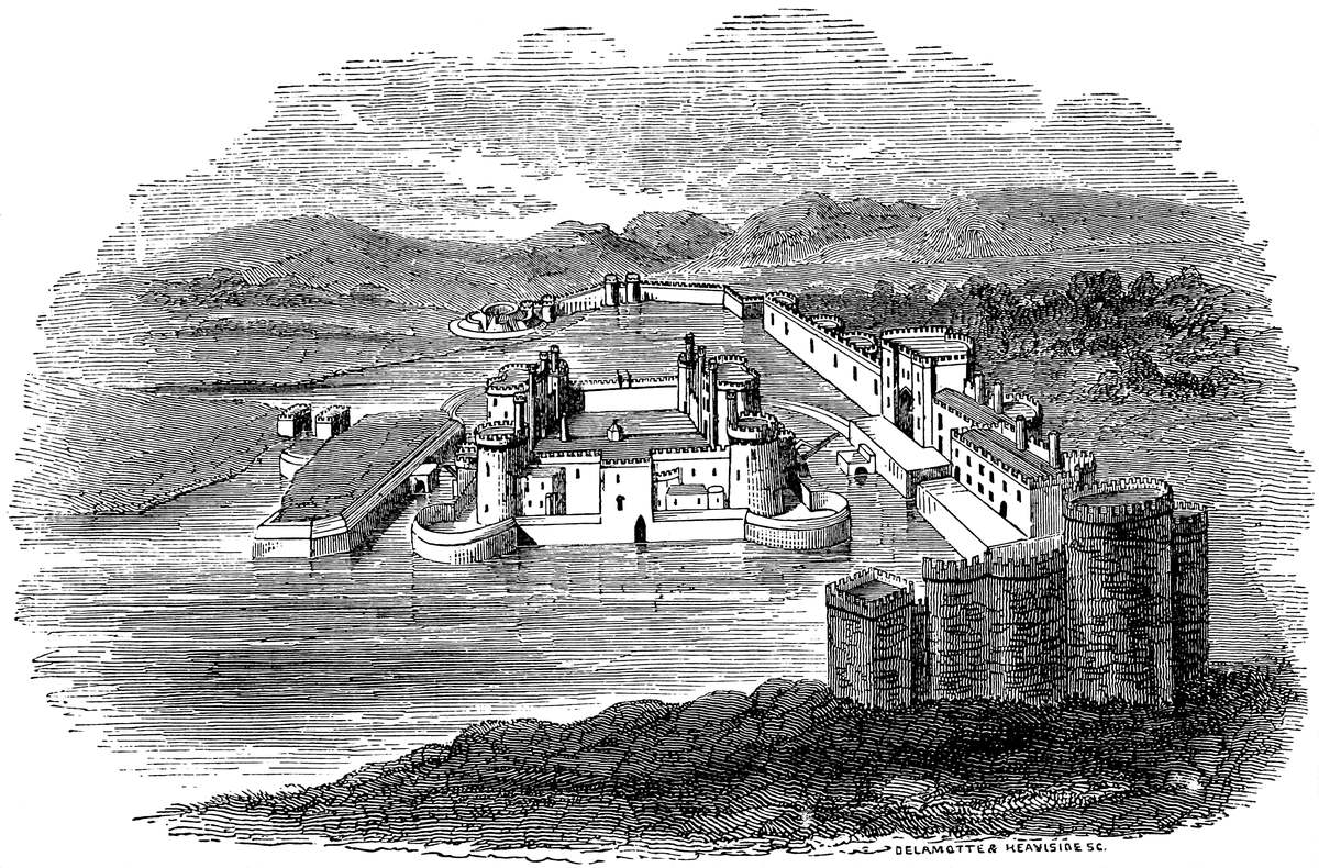
The portal, 10 feet wide by 20 feet high, was defended by gates, portcullis, and stockade. It is guarded by loops on each side from the lodges. Those opening from the portal, measure 20 feet by 10 feet, 321have fireplaces, and were floored with timber. The walls are 9 feet thick, and are looped in various directions for defence.
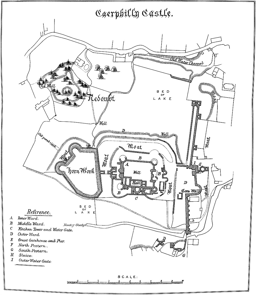
Passing through the gatehouse, behind it is a broad platform, which extends behind the southern curtain, and is scarped and revetted towards the inner moat; on the right of this is a prolongation of the gatehouse westwards, into the gatehouse tower. One of two doorways leads up this tower by a hexagonal well-stair, 9 feet in mean diameter; this opens upon seven apartments in two stories, and terminates in a lofty quadrangular turret. In the first story are devices for working the portcullis, and a small fireplace and oven, probably intended to serve the purpose of a cooking-place for the porter and his assistants. These rooms are vaulted. From this story a passage opens upon the rampart of the northern curtain, and led, probably by a temporary plank bridge, across an abyss in the thickness of the wall, about 29 feet deep and 5 feet wide, and opening below between the grates of a water gate. A passage, at the ground level, leads from the platform through the gatehouse tower, across the ditch or canal from the water gate, to the northern curtain, and was defended by gates, portcullis, and drawbridge.
From the gatehouse a dividing wall, 20 feet high and 6 feet thick, extends westward 80 feet to the edge of the inner moat, and thus cuts off the platform and the whole of the southern from the northern curtain. Each face has been embattled, so that should either curtain be taken, the other could still be defended.
At the union of the gatehouse with the northern curtain, in the latter, at the level of the water’s edge, is a low-browed archway, which could only have been accessible by a boat, and is a water gate. It is defended by two grates, and a cavity open above between them, and thence a covered way, once probably a sort of canal, leads close under, and north of, the dividing wall, to the edge of the inner moat.
This curtain runs northward for 130 yards, and is strengthened exteriorly by three buttress towers, quadrangular and solid below, but hexagonal and chambered above. Each has a projection of 20 feet; they are of unequal breadth. The chambers have each a loop in front, and one at the junction of the tower with the wall on either side. They were accessible only from the rampart.
In the curtain itself are six loops, opening in pairs between the buttress towers. The curtain ends, northward, in a pair of towers, connected by the vault of a portal, the north postern, regularly defended, and opening upon a plot of ground and causeway separating the two parts of the outer moat.
Behind, and parallel to this curtain, at a distance of 19 feet, was a slight wall, 4 feet thick, which formed the back wall of a postern gallery, leading from the gatehouse to the north postern, and forming above a broad flat walk for the defence of the ramparts. This gallery is said to have been fitted up as a stable.
Southern Curtain.—The general plan of this curtain is irregular; it passes south-eastward from the gatehouse, forms a large semicircle,322 and, passing off in a long straight wall, crosses the Nant-y-Gledyr, and terminates in a tête-du-pont and a postern. This wall contains a large mural garderobe tower at its angle, and is supported exteriorly by seven quadrangular solid buttresses. In one place it is perforated for the discharge of the waste waters of the mill, and in another for the passage of the Nant-y-Gledyr, being, at that part, where subjected to great pressure, 15 feet thick. This curtain is accessible from the tête-du-pont; and upon it, through the garderobe tower is a mural chamber, serving as a “place d’armes.” The face of the wall, between the buttresses, is wrought into a concavity, increasing towards the summit, so that any missile dropped from it would be projected outwards. The soil of the platform behind this curtain is 25 feet above the exterior level.
The Platform is a large surface of sward behind the southern curtain, between it and the counterscarp of the inner moat; upon it stood the mill, and from it dropped the inner drawbridge. It increases in breadth from the dam to the dividing wall, where it measures 94 feet.
The Tête-du-pont terminates the southern curtain. It consists of a curve of the wall, westward, into a semicircle, with towers and a postern gate, protected by a bifurcated wall, intended to prevent the curtain from being outflanked. It rests upon the outer edge of the lake.
In front of this great line of defence is a moat, about 60 feet wide, and crossed by a double drawbridge of two spans of 18 feet each at the great gateway, connected with a large pier in the centre of the moat, capable of being converted into a sort of barbican. This moat communicates with, and admitted of being filled from, the Nant-y-Gledyr.
Such is the principal front and eastern line of defence, not only calculated to withstand attacks from the front, flanks, or rear, but also capable of being held out, the southern against the northern part.
From the northern extremity of this front, at the northern postern, a bank of earth, lined inwards, or on its southern face, by a wall, and at one part thickened into a dam, divides the middle from the outer moat, at present skirted by the Nant-Garw road. This is the north bank.
From the same front, from the end of the covered way, close to the dividing wall, a second bank of earth is given off, and, passing westwards to unite with the horn-work, divides the inner from the middle moat, and forms a part of the northern defences of the castle. Its inner face is partially lined by a wall, in which is a sluice-tunnel. This is the curved ridge.
II.—The Horn-work covering the western front of the castle, and placed between the middle and outer gates, is an irregular polygon of about three acres, revetted all round with a wall of 15 feet high, above which is a talus of about 8 feet more. From its south-western face issues one of the feeding springs of the lake. On the eastern, or longest face, is a semi-pier, to receive the drawbridge, of323 20 feet span, from the opposite gatehouse of the middle ward. On the north-western face a similar semi-pier, between half-round bastions, seems to have supported the drawbridge, also of 20 feet span, giving access to the castle in this direction. Possibly each bridge was of two pieces, one dropping from each bank upon a central tressel or timber structure in the ditch.
III.—The Redoubt has already been mentioned as being formed by scraping down a knoll of gravel on the north-west quarter of the castle.
The body of this earthwork is quadrangular, capped at the three outer angles by three bastions, and excavated in the centre into a sort of casemate. The curtain, towards the castle, is intersected by two trenches, separated by a mound or cavalier, and leading into the centre of the work.
Outside the redoubt, and following the curve of its bastions, is a ditch, upon the outer three sides broad and deep, on the fourth side but slightly marked.
The ramparts of the redoubt are unprovided with either parapets for canon or banquettes for musquetry, and the scarp is continued unbroken to the rampart. Neither scarp nor counterscarp, though steep, has any retaining wall.
Beyond its main ditch is a spacious glacis, terminating in three low bastions and a shallow ditch. Both ditches were probably dry.
The whole work resembles much those thrown up in haste during the wars between Charles I. and the Parliament, and has either been partially destroyed, or, which seems more probable, has never been entirely completed. No doubt it was stockaded.
The inner and middle wards of the castle occupy the island, which has already been described as formed out of the end of the peninsula.
This island is scarped into a parallelogram, 111 yards east and west, by 96 north and south. The four angles are capped by large bastions, parts of circles. The intervening straight lines are termed, in fortification, curtains.
The sides or scarps of these bastions and curtains are faced with a stone wall 30 feet high, and surmounted by a parapet of from 5 feet to 12 feet more; and within this enclosure are contained the middle and inner ward.
The inner ward is formed by placing a second parallelogram, smaller than the last, within it. This forms the inner, and the concentric space between the two, the middle, ward.
IV.—The Middle Ward thus presents four divisions, towards the cardinal points, all forming terraces of from 16 to 20 yards broad, and the opposite sides being of nearly equal length. Upon the east and west are the gatehouses; on the south, offices, and a water gate; and, on the north, an open terrace, overlooking the outer defences of the castle on that side.
The Eastern Gatehouse is formed of two low towers, with half-round projections towards the moat, and a portal between the two. The324 walls are thick, and there is a lodge on each side, lighted by three loops. Above these lodges was the battlement. On the north side is a square building, the use of which is unknown. This gatehouse was connected with that of the inner ward, and between the two there seem to have been side doors.
One of these, on the south, led to the Water-tank, lined with masonry, 50 feet long by 20 wide, probably a fish-preserve connected with the kitchen.
In front of this gatehouse, and dividing it from the platform of the grand gate, the moat is about 45 feet wide. As there are no traces of a central pier for the drawbridge which must have crossed this space, it seems probable that it rested on an intermediate tressel of timber, as at Raby and Holt, which admitted of being removed or destroyed in the event of a siege.
The Western Gatehouse is placed opposite to the horn-work, and between them is a moat 60 feet wide. The portal is loftier, and the front broader, than in the eastern gatehouse. There are two chambers on either side of the portal, and above them a first story, with fireplaces and chimneys.
Between this gate and the north-west tower of the inner ward are some later buildings, and a wall, which seems to have been intended to cut off the communication between the gatehouse and the north terrace. On the south side is a similar wall, shutting off the south terrace.
The offices and water-gate passage occupy a part of the south terrace of this ward.
The Water-gate Gallery leads from the hall to the lake, and is big enough to contain a boat. It is vaulted by a succession of narrow arches, in steps, instead of by one sloping vault. Above it are chambers, probably for cooks and attendants in the kitchens.
Against this passage, upon its eastern side, is the Kitchen Tower—a low tower of great strength, having the ground floor vaulted, and recesses, apparently for boiling and stewing, on a large scale. The fireplace is in the upper story.
The kitchen communicated with the hall, and with a sort of yard occupying the eastern end of the south terrace. A well-stair leads down to the lower, and up to the upper, kitchen.
In the yard is the oven, and a passage leading to the tank. Here, also, against the south curtain of the inner ward is a low oblong building, with one or two bows to the south, which seems to have been connected with the kitchen, and, in modern days, would have been the still-room.
V.—The Inner Ward is a quadrangle, measuring 200 feet east and west, by 160 feet north and south. It is contained within four curtain walls, capped at the angles by four round towers, and broken on the east and west sides by two lofty and magnificent gatehouses. The south side of the court thus formed is occupied by the hall and state apartments.
Of the Curtains, those on the north and east, are about 30 feet325 high, including the battlement. That on the south is higher by a story, and the rampart walk is continued along it—below, as a vaulted triforial gallery in the thickness of the wall, above, as an open walk. The triforial passage in the southern curtain is called the Braose Gallery, why, it is difficult to say, since the barons of that name, though lords of Gower, had no property east of the Nedd, in Glamorgan.
The four Bastion Towers which cap the angles of this ward are very marked features in the appearance of the castle. They have a projection, outside the wall, of three-fourths of a circle; are of three stages, with timber roofs and floors; and measure, in exterior diameter, 36 feet, and within, 18 feet; the walls being 9 feet thick. Each story is lighted by loopholes, very large within, but appearing exteriorly as a line. A well-stair leads to the summit of each. These towers open into the court, and upon the battlements. Their type is best seen in the north-west tower.
The Eastern Gatehouse is a superb pile. It is oblong, and has two half-round bows on its eastern side, and two round turrets, of three-quarter circle projection, at the north-west and south-west angles, within the court. The building is traversed by a portal, entered between the bow towers. The arch is “drop,” and the entrance is defended by gates, palisade, and portcullis. Above the opening into the court is a shoot for dropping missiles upon those below. On each side of the portal are lodges, and the second story is a spacious hall or council-chamber, with a large fireplace, and two large and handsome windows looking towards the court. Above this chamber is the battlement. On the north and south sides of this gatehouse are a number of small apartments, mostly vaulted, and some of them used as portcullis rooms. Over the door leading to the ramparts, on the south, is a small oratory or chapel, with a ribbed and vaulted roof, and two Decorated windows.
The Western Gatehouse is on the same plan, but rather smaller, and without turrets towards the court, its staircases being contained within the thickness of the wall. The lodges on each side of the portal are vaulted and ribbed, with ornamental corbels. They open direct into the court. The state chamber above is not so large as in the eastern gatehouse. It rests upon a vaulted floor.
The Hall is built against the south curtain. It measures 73 feet by 35 feet, and was about 30 feet high. It is lighted by four large and lofty windows towards the court, with ogee arches and reduplicated bands of the ball-flower moulding; within are crocketed canopies, in a somewhat stiff, but excellent, style. Between the windows is a broad fireplace, and to the east of them a door, which was the principal entrance on the south side. A door in the curtain leads down a long vaulted passage to the water gate of the lake, and another door leads to the kitchen and bakehouse, in the middle ward. A plain door at the west end opens into some state apartments, and other doors, and a large window at the east end, communicate with a cellar and the chapel.
326
The roof, of timber, sprung from fourteen short clustered pilasters, resting upon heads as corbels, placed against the north and south walls. The north wall is of dressed stone, and carried a stringcourse with ball flowers, about 3 feet above the ground. On the east wall is a stringcourse connected with the drip-stone of the chapel window. The east, south, and western sides were plastered, and probably painted, or hung with tapestry.
The Chapel, east of the hall—evident from its position and large east window—presents nothing remarkable. There are four state apartments west of the hall, two on the ground and two on the first floor. They are lighted from the north, and one of the windows is of great length and cinquefoiled, with a quatrefoil in the head. A staircase in the thickness of the curtain wall leads into the Braose Gallery, as well as to the upper rooms, and to some appendages connected with the sewage, and which seem to have been added.
In the grand court, a little to the north of the eastern entrance, is the well, about 4 feet diameter.
The castle, in its present condition, assumes a very different appearance from that described as its original state, although enough remains to bear out the description.
The eastern, or main front, is in good preservation. The masonry of the three northern buttresses is but little injured, although between them and the curtain are deep fissures, evidently the work of gunpowder, aided by the presence of a long window on either side. The mine was evidently sprung at the gorge of these buttresses, but the quantity of powder introduced has not been sufficient to overthrow them.
Most of the smaller buttresses on the southern flank are unhurt, but the two at the southern extremity are laid prostrate, with their connecting curtain, 15 feet in thickness, forming a chasm, through which the Nant-y-Gledyr takes its undisturbed course. The object of this destruction, which was permanently to empty the lake, has been gained. It is now a meadow.
The lower story of the grand gatehouse, and the piers of its bridge, are in tolerable order; but the upper chambers of the former are much battered, and the staircases rendered inaccessible, above a certain height, by the absence of the newels, and the fracture of the stone steps. The great pier stands alone, but the outer semi-pier is encumbered with cottages. The outer and eastern moat, now of no great depth, is still marshy. At its northern end the sides are cultivated; towards the southern, cottages are built in it. Between these two portions, north of the pier, is the modern entrance, passing through the water gate, now a battered hole 11 feet wide: near it a door has been opened into a sort of cavity below the lower story of the gatehouse, used as a cart hovel. The foundations of the southern curtain, being in the moat, are tolerably perfect. Those of the northern, elevated upon a bank of earth, are much battered.
327
The tête-du-pont, in which the southern curtain terminates, has suffered considerably. The curvilinear wall between the towers is levelled to a breastwork, and the side of the portal towards the lake has been blown quite away, as has been also the entrance and part of the floor of the neighbouring D-shaped tower.
The northern limb of the bifurcated wall, proceeding from the postern, has been blown out of the perpendicular; and, although there is no great danger of its fall, the loose stones adjoining its fissure are a source of danger to the antiquary who may attempt to scale it. Cottages are clustered against the outside of this wall, and its re-entering angle is occupied by a pigstye.
South of the castle, west of the tête-du-pont, the land on the back of the lake is partly in tillage, and partly occupied by cottages; on the north, to the west of the sally-port, the wall between the outer and second moat is reduced to a line of foundation. The peculiar thickness of this wall, where it has served the purpose of a dam, is well seen. The outer moat has, in this direction, been encroached upon by the Nant-Garw road, which tops its counterscarp for about 100 yards. The mill is levelled to the ground. A dry watercourse, and the tunnel enlarged into a breach, still mark the ancient exit of its waters. The drainage of the lake was, of course, fatal to the mill. The modern miller of Caerphilly has removed to the outside of the great southern breach, where he takes advantage of the Nant-y-Gledyr.
The horn-work covering the western entrance remains in excellent preservation, and its revetment, except where in part quarried, is nearly as sound as ever, although its gatehouse and western pier, if ever they existed, have been destroyed. They were probably of timber. The moat, to the west of the horn-work, being still in wet weather the channel of a rivulet, is overgrown with reeds and aquatic plants; to the east or castle side it is swampy in wet weather; and on the south is the bed of the ancient inundation, now a plain of sward, across which a path leads to a spring.
Along the exterior line of defence to the north-west, the redoubt, fosses, and adjacent earthworks are obscured by young trees and brushwood, by the effects of tillage, and by the buildings of the castle farm.
Entering the castle by the east water gate, the wall parallel to the curtain which formed the back of the northern or stable gallery is seen on the right, levelled nearly with the soil, and, consequently, all regular access to the buttress chambers is thus cut off.
The counterscarp of the inner moat is in ruins, choking up the moat. All vestiges of the eastern drawbridge between the grand front and the middle ward have disappeared.
The flanking towers of the eastern gatehouse of the middle ward are destroyed, that on the south completely, and that on the north very nearly so, the ruins of the singular building attached to it having prevented its entire destruction.
At the opposite or western extremity of this ward, the gatehouse328 is in rather better condition. The portal has been broken away below, but the hollow semi-piers connecting it with the horn-work remain. The front of this gatehouse, of great thickness, is perfect, and is garnished with a pair of chimneys; its inner part has been destroyed. The windows in the front are the only vestiges of the upper story.
On the north front of this ward the curtain is much shattered by the fall of the inner towers, and, as all the bastions have been ruined and blown up, their exact line of boundary is scarcely traceable.
Upon the southern side, the wide lake and the strength of the outbuildings have, in some degree, preserved the curtain, but the doorway of the water gate, which opens in it, is much injured. A few feet below its sill, a long black stain marks the height of the water in former times, and gives about 9 feet as the average depth of the lake.
The gallery, kitchens, &c., which occupy this side, are much injured; but in front of the great oven a portion of the parapet remains, here about 12 feet high, and furnished with a loop.
The tank remains, though nearly choked up with stones and brambles. Since the fall of the adjacent wall of the bastion, its position has been insecure. Recently its wall has cracked, and, unless repaired, it may be expected soon to fall into the moat.
Ascending from the eastern gatehouse, across a mass of almost untraceable ruins, the central ward of the castle is entered.
With the exception of a partial breach on the northern side, the curtains of this inner ward have suffered but little, and the height of the parapet and rerewall may still be inferred, by the projections at its junction with the towers.
The eastern gatehouse has been separated by a blast into two portions; of which the inner, towering to a prodigious height, still remains tolerably perfect; while the outer, broken into fragments, has crushed the lower gatehouse beneath its weight, and still encumbers it with its ruins.
The western gatehouse has been more fortunate; the staircases, however, are broken and irregular, and the vaulting injured. Through the floor of its central apartment a hole has been broken into the vaults of the portal, and of one of the lodges beneath.
In the floor of the Braose or triforial gallery are two large holes which open upon a staircase and passage below.
The buildings within the court have suffered severely. The hall is covered by a temporary roof, but the structure of its ancient roof is apparent from the remaining corbels. The pavement has been long removed: the sills of the windows have been cut away, and the tracery and mouldings which adorned them are broken and defaced.
A window and door at the east end have been shattered into one, and the vaulted passage leading to the offices is a shapeless and rugged hole.
329
The vaulted roof of the kitchen is broken, but enough remains to display its original structure. The steps of the water-gate gallery have been removed, but the vaulted roof is but little injured.
In the great court a depression in the sward indicates the ancient well. It has lately been opened a few feet down, but nothing of importance was discovered.
The four bastion towers of this ward deserve special notice, since it is the position of one of them which has conferred upon this castle much of the notoriety it possesses.
That these four towers have been mined and blown up with gunpowder, at some period when the effects of that agent were well understood, is evident on inspection. The mine has been sprung near the centre of each tower, and has produced effects, differing in degree only, upon each. That on the north-east is altogether levelled, on the outside, entirely to the ground, crushing in its descent the very bastion on which its foundation rested—on the inside, the door and a portion of wall, as high as the curtain, only remain. The destruction of the north-western tower has not been by any means so complete. Only a third of its outer circumference has fallen, and the rest, deprived indeed of its floors, remains as firm as ever. The portion which has fallen lies in fragments upon the neighbouring bastion.
At the south-western tower the mine has operated outwards; the whole of the outer portion has fallen upon the bastion and into the ditch, but the inner strip connecting it with the rest of the building, and containing the entrances to the several stories, has been protected by the outbuildings on its southern side, and is unshaken.
The last, or south-eastern, is the celebrated leaning tower, the obliquity of which has been much exaggerated, and absurdly accounted for. In the case of this tower the mine has exploded in a contrary direction from the rest, and the inner portion, with the adjoining curtain, has been thrown into the court, while the outer portion remains standing, although the force of the explosion has thrown the mass out of the perpendicular, so that it overhangs its base, towards the south-west, nine feet. The parapet at its summit remains quite perfect, and is the only one in the castle that is so.
The neighbourhood of these four towers, and the intervening gatehouses, upon which the force of the gunpowder has been chiefly employed, is a chaos of ruins; subverted masses of the gallery, staircases, the vaulting of large portions of the chambers themselves, lie in confusion upon the ground; and the thin mantle of vegetation which has enveloped them, although it adds much to their picturesque beauty, increases in no slight degree the difficulty of accurately comprehending their original disposition.
Throughout this immense building the iron work, even to the staples of the doorways, has been removed; nor is there any lead to be found in the sockets of the window-bars.
The hewn stone forming the door-frames, window-cases, newels of the well-staircases, and in some instances the stairs themselves, have330 been rudely wrenched away, with damage to the walls, for the purpose, probably, of converting them into lime.
Portcullises, stockades, doors, with the roof of the hall, and every particle of timber in the place, have long been removed. Every staircase, gallery, and chamber is pervious to the rain, and exposed to the pernicious force of the frost, yet such and so durable are the materials, and so firm the mortar with which the whole is cemented, that time and weather alone have produced but trifling injuries upon the pile, compared with the wilful destruction of the hand of man.
Before arriving at any general conclusion respecting the age of Caerphilly, it will be proper to make a few remarks upon certain details, on which those conclusions in some measure rest.
And first of the doorways. With certain exceptions shortly to be enumerated, the doorways throughout the building are of the same general character. The arches are “drop,” that is to say, they are obtusely pointed arches, whose centres lie below their spring. This is obviously the best form of the pointed arch for the portals of a castle, and it is that usually employed in the military structures of the Edwardian period. With the same exceptions, the arch-mouldings are composed of a five-sided rib, upon the front and widest face of which a smaller rib, of the same figure, is placed. This pattern of rib-moulding is also very commonly employed in castles.
The principal portals, together with the doors leading from the first story of the towers upon the ramparts, are defended by portcullises, working in a D-shaped groove. This groove passes up as a chase or slot into the chamber above; but there is no evidence of the sort of contrivance employed in raising the portcullis. The portcullis, however, might have been raised by mere manual exertion, and a bar thrust across would be sufficient to retain it securely when raised. The sills are destroyed, so that it does not appear whether the points of the portcullis were received into, or had worn, small holes in them. Besides the portcullis, the larger portals are provided with a chase, but without side grooves, intended, as is presumed, to allow of the use of a sort of wooden frame. Also, in the main portals are four or five square holes or meurtrières in the arch, through which beams to form a stockade might be dropped. It may be observed further that although some of the portal passages are of considerable length, yet the ribs of their vaults are all transverse, never passing diagonally from an angle towards the centre, in the manner employed at Caldecot and elsewhere, to vault a compartment of such passages.
There appears to have been more than one kind of drawbridge employed in this castle. In some places, as at the great gate, and at the passage in its gatehouse tower, the bridge, when drawn up, fitted into a depression, so as to lie flush with the upper wall, from whence, therefore, its length may be inferred. In other cases it simply rested against the wall, making a projection. It331 seems always to have been long enough, when up, to cover the gateway.
The method of hanging the bridge also varied. On the sides of some of the portals a stone has been inserted, into which the horizontal pivots of the bridge (of iron, from the small size of the pintle or hole) fitted; but, connected with the place for the gudgeon or pivot is another groove, which passes up at an angle of forty-five degrees for a few feet, and then passes on horizontally for a few more. It appears as though this were a contrivance, when the bridge was raised, for throwing its lower end upwards and forwards, so as more effectually to shield the upper part of the door, to present an oblique surface to missiles, and, by making the bridge lean back against the wall, to remove the strain from its chains or ropes, and to prevent it from falling, even should they be broken. It may be, however, that into these grooves fitted some lever, or other contrivance for working the bridge; where they occur, there are no holes above for the passage of the drawbridge chains into the portcullis chamber. Similar grooves are seen in the upper gatehouse at Chepstow.
The defences of the great, or water, postern are singular. The grooves, which in other cases form the portcullis slides, here stop abruptly a little above the arch. They are too deep for the hinges of gates, and were probably filled by a defence similar to a portcullis, but which was received into a cavity below. Indeed, as there is only a lofty wall, and no chamber above the postern, the regular plan was inadmissible.
There is a further contrivance for the defence of a gate, consisting of a sort of shoot, opening obliquely downwards from the sill of a window, employed in two places in this castle; one over the door of the eastern inner gateway, and the other over the door of the north-west principal bastion tower; in both cases evidently with a view to the defence of the towers when the enemy had gained the inner court.
The battlements and parapets throughout the castle are of a very plain description. They are massy and flat topped, the coping being a rough slab of sandstone. The height and thickness, together with that of the rerewall and the width of the rampart walk, may be always deduced from a careful inspection of the walls or towers against which they terminate. The parapet and rerewall are usually of the same height, and nearly as high as the top of the doors leading to them.
The embrasures are contained within parallel sides, and bear a small proportion to the merlons, which latter are each perforated by a loop. These details may be seen upon the summit of the leaning tower, or, more conveniently, upon the northern curtain, toward the north-west bastion tower. It is evident, from the unfinished character of the battlements, and the flat undressed coping, that they were intended to be masked by an exterior gallery, or brattice of wood, resting on the stone corbels which still remain.332 For this reason there are no machicolations in stone, or devices for dropping missiles through the floor of a projecting parapet—a contrivance which adds so materially to the grandeur of the towers of Warwick, Raglan, and Cardiff. Over the eastern middle gateway, the parapet has a false machicolation, or slight projection, supported upon a table of corbel blocks, but without apertures, or a projection sufficient to admit of any.
The windows, with certain exceptions, are either loops, or, if larger, of a very plain character. In the hall, however, and in the large rooms of the two inner gatehouses, they are very wide and lofty, and have been highly ornamented. The two latter rooms are so much injured, and the windows so mutilated, that it can only be said, that what little remains of ornament are seen resemble in style the more perfect ornaments of the hall. The oratory attached to the eastern inner gatehouse has a vaulted roof, divided into two square compartments, supported by transverse and diagonal ribs. The two windows towards the south are long and narrow, without a mullion, and trefoiled; their mouldings are only an exterior chamfer. There are some other windows in the gatehouses, looking towards the interior, which are much shorter, but otherwise resemble this. The four hall windows are lofty and well proportioned; they open to within four feet of the ground.
The exterior moulding of the windows is completely gone; that of the door was discovered by removing the grass about its base.
The interior mouldings of the windows are extremely rich, owing to the reduplication of the bands, to occupy the great thickness of the wall. The angles of the mouldings are, at two depths, removed, and their place occupied by a hollow groove, in which the pomegranate ornament is placed at intervals, making up the circle by its projection. Beyond each of these bands of pomegranates are pilaster strips, filleted at their angles, and surmounted by small angular capitals: within is a handsome ogee canopy, enriched with crockets and finials, in a very pure style.
The door has a good internal drip, but its inner moulding is composed of only one band of ball flowers. The outer mouldings are rich. There are three bands of pomegranates, which no doubt were continued, as in the windows, round the arch; and between them are two rows of small disengaged columns, with the circular concave pedestal. Of these only the pedestal remains.
The fourteen corbels upon which the beams of the roof rested are composed of three short clustered columns, connected by their posterior half, and separated by a fillet and bold hollow; above they are crowned with a neat cap moulding, and below, they rest upon three projecting busts, of which the central is the lowest and largest. A fillet runs up the centre of each of these columns, and, pausing at the abacus, is continued up the capital, and finally dies in the astragal. Corbels, of somewhat earlier date, but in general appearance resembling these, may be seen in the keep at Chepstow.
There are no decorations remaining about the fireplace. The333 plain stringcourse along the east end of the hall, returned from the corbel of the chapel window, is perfect. A base tablet is seen at the west end of the north side, but it is destroyed along its length.
A long window in one of the staterooms resembles, though on a much larger scale, the windows of the oratory already described. It appears, however, to have been trefoiled, with a quatrefoil above the head.
There are two small polygonal apartments on either side of the inner western gate, in the vaulted roofs of which a plain diagonal rib rises from a corbel at each angle, and meets its fellow in the centre. The corbels have three flat faces, and terminate in a point, which rests upon some animal, in every case wantonly defaced. They appear to have been lodges.
Caerphilly presents as little architectural decoration, in proportion to its extent, as any castellated building in Britain.
Generally, its series of concentric defences, and the general disposition of its constituent parts, resemble those of Harlech and Beaumaris. The plan of these concentric castles is very peculiar. It is unlike the earlier Norman castles, in which the keep was the principal feature, and in which comfort was sacrificed to safety; and it is also unlike the later castles, which possess not only large interior, but large exterior, windows, as at Sheriff-Hutton, and in which there is no building to which the name of keep could be attached.
Nor is the style of architecture employed at Caerphilly less characteristic of its age; the drop arch, the perfectly plain rib, the general absence of decorations and armorial bearings, the plain battlements, and the absence of machicolations, indicate generally the same period.
The columns of the hall doorway, the concave moulding of their pedestals, the triple cluster of columns forming the corbels of the roof, their bell capitals, and light cap moulding, are due to the Early English style, which prevailed from 1189 to 1307.
On the other hand, the pomegranate moulding, the rich, though chaste and somewhat stiff, canopies of the door and windows, the little pilasters in the windows with the pentagonal capitals, the ogee arches, and the plain fillet running up the columnar corbels of the roof, are marks all belonging to the Decorated style, which prevailed from 1307 to 1377.
The mixture of these two styles, very common in English buildings, denotes a period varying according to the preponderance of either, and in the present instance may legitimately be referred to the latter quarter of the thirteenth century, when the Decorated style was beginning to supersede the Early English. Instances of this transition, and of the ball-flower, or pomegranate, moulding, may be seen round the inside of the choir of Bristol Cathedral, and on the outside of the south aisle of Keynsham Church.
The earlier alterations at Chepstow, and more particularly the334 oratory attached to Martin’s Tower, and the columnar corbels in the keep, may be cited as of an earlier date than Caerphilly, having been evidently placed there before the decline of the Early English style.
The internal evidence of the building, which would place its date about the end of the reign of Henry III., agrees with the evidence of records cited hereafter, in which the castle is referred to, in the year 1272, as having been lately erected by Gilbert de Clare, Earl of Gloucester and Hertford.
Before this period, mention is occasionally made of the castle of Senghenydd, which, from its having been taken, retaken, and more than once utterly destroyed, was evidently a place much contested, but of no great magnitude or passive strength. After the erection of Caerphilly, Senghenydd Castle is not again mentioned. It is therefore not impossible that Senghenydd Castle was a rude fortification of timber and undressed stone, upon the peninsula afterwards occupied by Caerphilly.
Caerphilly having then certainly been founded by Earl Gilbert a little before 1272, the question arises as to whether the whole of it was then built.
The inner ward, its curtains, bastions, gatehouses, with all their contents and appendages, are of one date. The south wall was always of its present height, and therefore always intended to support the roof of the hall, the walls of which are bonded into it. The gatehouses are evidently part of the original plan, and the long windows of the staterooms, and those of the oratory in the inner gatehouse are, in their form and mouldings, precisely similar.
It appears that the curtain connecting the north-west bastion tower with the west gatehouse was originally as low as the northern curtain, but that a sort of gallery, and its superincumbent rampart, have been added. A cluster of buildings has also been added on the outside of the south curtain, at the angle formed by its junction with the south-west tower.
The general design of the middle ward, and most of its buildings, are clearly of the date of the inner ward. The western gatehouse, however, appears to be of somewhat later date; the false machicolations, the holes for the portcullis chains, the chimneys rising above the parapet, and the less durable character of the masonry, seem to indicate this. The walls, moreover, by means of which this gatehouse is connected with the curtain of the inner ballium, though of the same age with the former, are not bonded into, and are separated by fissures from, the latter—a tolerably sure indication of difference of age.
It is not improbable that the whole exterior line of defence on the east, and the horn-work on the west, were the last parts of the castle completed. They form, however, parts of the original design, since, had the ground on which they stand been left unoccupied, the castle would not have been tenable.
With respect to the redoubt, it is perfectly evident, from its335 appearance, that it was thrown up, not only when gunpowder was in general use, but when the science of fortification was pretty well understood. It seems, like the earthworks at Donnington and other castles, to be of the age of Charles I.
The injuries received by this castle are similar to others at Corfe and elsewhere, known to be referable to the same period of civil strife in which the battle of St. Fagan’s, and the occupation of Cardiff, prove the men of Glamorgan to have taken an active part. Nothing, therefore, seems more probable than that the redoubt should have been thrown up hastily by one party for the defence of the castle, and that the dismantling of the whole should have been perpetrated by the other, to prevent such a defence being practicable in future. Though history has afforded no clue as to the one of the contending parties to which either proceeding is to be referred, there can be no doubt but that the blowing up of the towers was the work of the Parliament.
There seems no reason to suppose that the works of Caerphilly were never completed. The flanking towers on either wing rest upon the lake, and the horn-work is a sufficient defence in the opposite direction.
About three-quarters of a mile from Caerphilly, on the Rudry road, are the ruins of the “Van,” or “Ffanvawr,” the ancient and very stately manor-house of the Lewis family, the direct descendants in blood, and the heirs in heritage, of Ivor Bach, on whose land Caerphilly was erected.
Most of the outer walls of the house, and a curious old dovecot, remain standing. They are of the age of Elizabeth or James, but much of the hewn stone employed in the windows, doorcases, quoins, and stringcourses of the lower story, are either of oolite or Sutton stone, and are very evidently a part of the spoils of Caerphilly. Most of these stones have been worked up, and their original ornaments destroyed, but one long stringcourse of Decorated date, evidently much earlier than the wall in which it is embedded, extends along the west front of the house.
These stones could not have been removed from Caerphilly earlier than the reign of Elizabeth, in which reign, or rather in that of Henry VIII., the castle was used as a prison. Probably the central parts were so occupied, and the parts allowed to be spoiled were those connected with the east front. In appropriating the stones of Caerphilly to the erection of their manor-house, the Lewis family, from whom the ground was originally wrested, may have committed a breach of taste, but none had a better moral right to help themselves from that source.
THE castle of Cardiff, though not unknown to border fame, has been the theatre of no great historical event, nor does it present any very striking peculiarities of position, scenery, or structure. Its claim to more than local interest rests upon the character and fortunes of the great barons whose inheritance and occasional residence it was from the 11th to the 15th century, from the reign of Rufus to that of Henry VI. Probably a Roman castrum, and certainly a hold of the local British princes, it was won, in 1090, by the sword of Robert Fitzhamon, lord of the Honour of Gloucester, and by him constituted the “caput” of his newly acquired seignory of Morgan and Glamorgan.
Mabel, the heiress of Fitzhamon, conveyed his possessions, with her hand, to Robert Consul, Earl of Gloucester, bastard son of Henry I., and the reputed builder of the Norman parts of the castle.
They were succeeded by their son William, Earl of Gloucester, who died 1173, leaving daughters only; the inheritance was then for a time held by King John, then Earl of Moreton, by marriage with Isabel, the youngest co-heir; and on her divorce, soon after 1199, by Geoffrey de Mandeville, Earl of Essex, who died, 1216. Isabel’s third husband was Hubert de Burgh, she died childless.
Upon this, Almaric d’Evreux, who married Mabel, the elder co-heir, became Earl of Gloucester; but Mabel’s issue also failed.
Amice, the second co-heir, had married Richard, head of the powerful house of De Clare; and their son Gilbert, Earl of Hertford, thus finally became Earl of Gloucester, lord of that honour, and possessor of the castle of Cardiff. He died 1229.
Four earls of the race of Clare possessed Cardiff Castle for nearly a century; and though chiefly resident at Clare and Tonbridge, did much to adorn the castle and consolidate the seignory.
In 1320, Eleanor, the elder co-heir of the last De Clare, was married to Hugh le Despenser the younger, the minion of Edward II. During the minority or attainder of their son, Hugh d’Audley who had married the second co-heir, had the earldom, and possibly held Cardiff at his death in 1347. The Despensers then reappeared in the person of Thomas, son of Edward, who was son of Hugh and Eleanor de Clare. This Thomas was created earl of Gloucester in 1397, and attainted and beheaded in 1400. His son Richard, who succeeded, died a minor and childless, in 1414.
The earldom of Gloucester was not revived, but, including the first Hugh, five members of this unfortunate race held the seignory and castle for ninety-four years.
Isabel le Despenser, sister of Richard, and the final heiress, was born at Cardiff Castle, which she did much to strengthen and embellish. She married the cousins, Richard Beauchamp, earl of337 Worcester, and Richard Beauchamp, Earl of Warwick. The Earl of Worcester married before 1415–16, and died about 1421, leaving a daughter, whose descendants became barons Le Despenser in her right, but who did not inherit Cardiff. Countess Isabel’s chief works at Cardiff were probably executed after her second marriage, which took place before 1425. Her charter to Cardiff, as Countess of Worcester, in 1423, confirms those of her paternal ancestors. Her son, Henry, Duke of Warwick, succeeded his father in 1439, and died in 1446. His heiress, Anne Beauchamp, had but a brief and nominal tenure of the seignory, dying in 1449, an infant of six years.
The castle then descended to the representative of another Anne Beauchamp, sister and heiress to the duke. She married Richard Nevile, the great Earl of Salisbury and Warwick, who thus added Cardiff to his already extensive possessions. One of the town charters, dated Cardiff Castle, 12th March, 1451, was granted by Richard, Earl of Warwick, Lord le Despenser, &c., and Anne his wife.
Upon the earl’s death, in 1471, Cardiff Castle fell to Anne, his younger daughter and co-heir by Anne Beauchamp, in whose right her husband Richard, Duke of Gloucester, afterwards Richard III., became lord of Cardiff Castle and the seignory, and in the latter capacity granted various charters and confirmations yet extant.
Upon the fall and death of Richard, the claims by heirship were set aside and the castle and seignory escheated to the Crown. They were subsequently granted to Jasper Tudor, Duke of Bedford; but on his death, in 1495, again became crown property. The seignory, with its “jura regalia” and prerogatives of marchership, was not again revived; but Henry VII. and his son leased the lordship to Charles Somerset, who was residing at Cardiff in 1513; and Edward VI. granted or sold the castle of Cardiff, with much of the landed estate and the manorial rights of the old seignory, to William Herbert, the first of the new earls of Pembroke, in whose heirs general the whole has since remained.
The history of this long succession of powerful lords, most of whom set their mark upon the great transactions of their age and country, has invested the castle with something of historical interest; which, however, can scarcely be extended to the particulars of the building itself, the subject of the present paper.
The castle of Cardiff stands upon the broad gravel plain between the rivers Taff and Rhymny, upon the left bank of, and two hundred yards from the former stream, at about the lowest point at which, in ordinary seasons, it is fordable.
The position, having a river in front and rear, and the sea close upon the southern flank, is such as would be selected by a commander skilled in the art of war, and enclosed in an enemy’s country; and such as, with disciplined troops, would be impregnable.
These conditions, the name of the place, and its position upon the well-known “via maritima,” are suggestive of a Roman origin; an opinion, indeed, but moderately supported by scanty discoveries338 of Roman remains, but in unison with the form and character of a part of the earthworks which enter into the composition of the present castle.
These appear to have been a single lofty bank raised from an exterior ditch, and enclosing much of three sides of a quadrangular space, of which the fourth lies open towards the river; a practice by no means unusual in Roman or “quasi-” Roman encampments. It is possible, though scarcely probable, that the earthwork was once complete on the three sides down to the river, and that the south-western part was destroyed to form a very considerable mound, which still remains towering over the banks of the enclosure, and is crowned by the shell of an early multangular keep. Wallingford, Tamworth and Wareham are instances in which a quadrangular earthwork has been in part retained and in part removed by the builders of a Norman castle, and in each of which also there is a mound.
Whatever may have been its origin, the castle of Cardiff covers a plot of ground nearly square in plan, being 200 yards east and west by 216 yards north and south; and bounded on the north and east, and partially on the south, sides, by banks of earth, and on the west and remainder of the south side by a wall. The banks are about 30 feet high, 90 feet broad at the base, and 12 feet at the summit, along which runs a light embattled wall about 6 feet high and 2 feet thick. This wall is mentioned by Meyric, in 1578, as in decay, and it was rebuilt from its shallow foundation of only 2 feet in 1861. It cannot have been intended as a serious military defence, and the recent excavations did not reveal any traces of an older or more substantial work. At the south-east, north-east, and north-west angles, the banks are strengthened, possibly to carry towers, of which, however, no foundations have been discovered. The earthwork is returned about 70 yards along the south, and about 30 yards along the west, fronts, to give support to, and cover the commencement of, the walls of those sides which, with an inconsiderable exception, are evidently very ancient, and were probably executed by Robert, Consul or Earl of Gloucester.
These walls are magnificent works, being 40 feet high and 10 feet thick, and perfectly solid.
The main buildings of the castle are in the line and form a part of the west wall. In the centre of the south side is the gateway, once of the outer ward, now of the general inclosure, a mere arch in the curtain, and, in its present form, probably of the age of Henry VIII., whose arms may have occupied a square stone frame remaining above and on the outside of the gate.
Close west of the gate is a lofty tower, apparently of early English or early Decorated date, and restored by the late Lord Bute. This is the black tower. Though so near the gate it is clear that it never had any direct communication with it, nor was intended as a gatehouse. Meyric describes it as a great tower, some stories high, and covered with lead, with two chambers in each story, the lowest339 being prisons, known as Stavell-y-Oged and Stavell Wen. One, the larger of these prisons, now disused, has a pointed vault and a small loop, high up in the east wall. This tower has four original entrances: one to each of the basement prisons, one from the remains of the great curtain, and one from the ramparts of the castle wall. All are on the north and western faces, and there is no doorway opening towards the great gateway. It is thus clear that this tower, though placed close to the gateway, was never used as a gatehouse.
The northern bank of the general enclosure presents a slight angle outwards, and near the salient a tunnel has been cut through it. This was done about thirty years ago, to give a carriage drive towards the Senghenydd road.
Outside, at the foot of the bank, along the north, south, and east fronts, was a wet ditch, anciently fed by the Taff through the intervention of the mill leat. This moat covered the three fronts, extending as far as the north or Senghenydd gate of the town. In the time of Meyric it was dry and silted up. More recently the eastern portion has been to some extent superseded by the Glamorganshire canal, and the northern, at a lower level, is now a part of the feeder by which the river water is conveyed under the canal to the Dock reservoir. The southern arm has been filled up and built over for many centuries, and its existence is only known from the soft, black soil found in occasional excavations. The mill leat which supplied the lord’s mill, at which the people of Cardiff were bound to grind, and which was occasionally used to flood the low ground for purposes of defence, still runs along the west front of the castle. In the reign of Elizabeth there were three grist-mills and a tucking-mill dependent upon the castle, and one grist-mill was standing in 1660, but was afterwards replaced by a tanyard, removed in 1861, when the new lodge and town bridge were erected. The bridge then destroyed was built about 1796, and replaced a structure of four stone arches, probably of the age of Elizabeth (and referred to in certain Acts of Parliament), placed rather above the castle; so that the high-road from it, towards the west gate of the town, crossed the marsh by a causeway and the leat by a bridge of three arches, and defiled close under the main buildings of the castle. Part of the old gate of the town, with its iron gudgeons, may still be seen in the brushwood a few yards in advance of the great tower, showing how the road entered the town under the castle wall. A small Tudor archway still remains on the right of the old entrance, nearly in a line with the Red House, a building of considerable antiquity, now much altered, and known as the Cardiff Arms Hotel. Recently some excavations between this building and the castle disclosed the foundations of the old town wall, and a large arched passage which might be either a postern or a sewer. It was not followed up.
The area within the castle wall is about 10 acres, and within the counterscarp of the moat about 13 acres.
Within the great enclosure, near to, and a little west of, the centre340 of the north bank, is the Mound, a grand earthwork, which rises from a circular base of 60 yards in diameter to a height of 32 feet above the surrounding ground. Its summit is a platform, also circular, 36 yards across, and crowned by the remains of the keep, called by Leland the White Tower. This is a shell, or polygon of twelve nearly equal sides, 80 feet in diameter, the wall being 9 feet thick and 30 feet high, and constructed mainly of rolled pebbles. This wall is pierced by the putlog holes, so common in the older masonry, especially of this district; and in one of the eastern sides is a fireplace of enormous dimensions, but the chimney of which appears as a mere recess in the wall, with no present traces of a fourth side or front. Near it is a sink, so that this was evidently a kitchen: a part, no doubt, of the buildings which the wall supported. The walls have never been strengthened by buttresses or pilaster strips; but the exterior angles of the polygon are capped with ashlar quoins, which appear to be of the date of the Beauchamp alterations, with some recent additions, one of which may be the fireplace. The entrance was through a lofty and strong gate-tower, duly portcullised on the south side, and of which a part remains. The shell is probably the work of Robert Consul; but the style and finish of the gate-tower testify to its being due to Isabel Beauchamp, or her husband, of Warwick.
This gatehouse was connected with a cluster of towers of great strength, which occupied the southern slope of the mound, and terminated below in a second gateway, which was the first or outer entrance from the middle ward into the keep. Here, though in an older structure, was the reputed scene of the barbarity practised upon Curthose, and of his subsequent imprisonment. Meyric describes the rooms in these buildings as “not so fair as strong.” They were probably barracks. Much of this building fell down late in the last century, and was removed. It was, no doubt, of Norman foundation, and probably altered both by the De Clares and by Isabel Beauchamp.
Since this account was drawn up, the ditch of the mound has been carefully opened out, and once more supplied with water. This laid open the piles of an early bridge, and the arch of a later one, probably of late Norman date, with the base of a gateway at the foot of the mound, and a well close to it. Also were laid bare parts of the steps by which the mound was ascended, laid alongside of a cross wall as at Tickhill.
The keep does not seem to have contained any central building. A plain stone stair, of which traces remain against the wall, led to the battlement, which was also accessible from the gatehouse. Probably an interior lean-to or shed surrounded the court.
On the face of the opposite fronts of the gate-tower of the keep and of the Black Tower, are sections of the great curtain wall, which extended from one to the other. This wall, thus seen to have been 7 feet thick and 30 feet high, and embattled on each face, was probably not the work of the founder of the castle. It was removed341 late in the last century, but the foundations remain, and have been laid open. From Meyric’s description, and an oil painting preserved in the castle, it appears that it was pierced near its centre by a gateway, flanked by one if not two semi-drum towers which projected towards the outer ward, and which, in fact, formed the real gateway to the strong part of the castle. There was a second smaller door, a sort of postern, in the southern drum. The foundations corroborate this view. Probably the curtain was an addition by an early De Clare, after, and probably in consequence of, the well-known and successful attack of Ivor Bach.
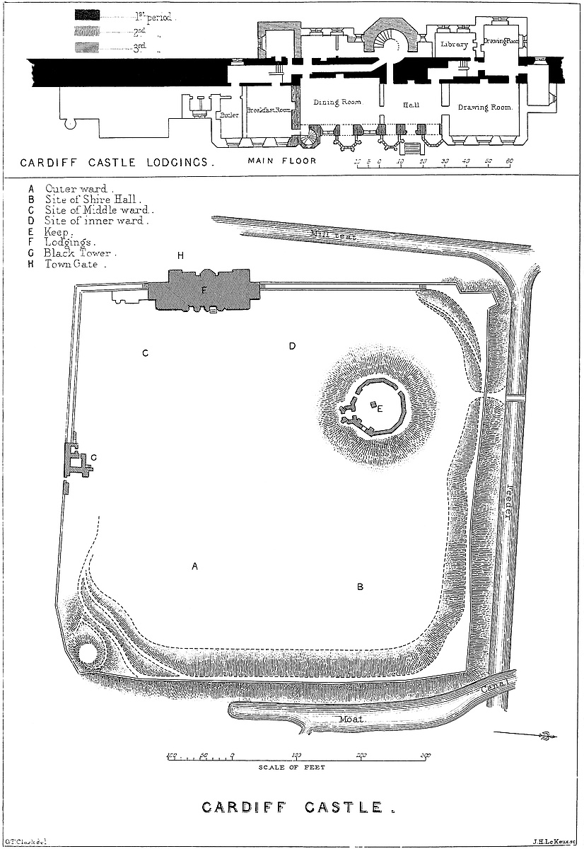
For the completion of the defence it was absolutely necessary that the great curtain should have been continued north of the keep. This portion, however, has been removed. It certainly was never bonded into the keep wall, but a corbel remaining on the north and outside of this may have been connected with it.
The lodgings, or habitable part of the castle, form a rectangular pile, 145 feet long by 55 feet deep, which occupies about two-sevenths of the western side of the court towards the southern end, and thus forms a part of the outer line of defence. This pile is composed of a tower, a central part or body, two main wings, and two lesser wings. All are built against the great Norman wall; the tower and lesser wings outside of it, the remainder inside.
The tower is a bold and well-proportioned octagon of 10 feet in the side, three faces of which project from the outer or west front, while the remainder is incorporated into, and now forms part of, the older Norman wall. It rises from a square base of 26 feet, passing by broaches into an octagon, to a height of 75 feet, or 12 feet above the contiguous buildings. It is boldly machicolated, having five corbel arches on each face, and a lofty parapet above, with two embrasures each way, the intervening merlons, eight in number, being pierced with a cruciform loop or oillet. The four outer or western angles, at the base of the parapet, are capped with bold grotesque heads of animals as gurgoyles.
The base is solid. About 6 feet above the ground it contains a rude chamber, 13 feet square, having a barrel vault, slightly pointed, with doorways, which seem to be original, in its northern and southern, or gable ends. The northern door, now blocked up, was, as late as the last century, a postern; and the chamber was a passage, and seems, from traces of a wall, to have contained a sort of lodge, subdivided into two cells.
Above this chamber is the cylindrical interior of the tower, 13 feet diameter, now a mere shell, occupied by a stair, and vaulted above. There are six windows in two tiers, the lower 38 feet from the ground. They are almost loops, small and square headed, but boldly splayed within, so as to give light and air, and showing the great thickness of the wall. Their arrangement proves the upper part of the tower to have been occupied by two chambers. It is difficult to speculate on the use of the lower part, which must always have been dark, and is rather large for a newel staircase. The342 present stairs and the groining above are very modern, though the latter may cover older work.
The shell is original and untouched. The material is lias ashlar, backed with rolled pebbles from the Taff. The quoins and battlements are chiefly of a white limestone, dressed with care. This tower gives character to the whole mass of the building. It has been compared with Guy’s tower at Warwick, which, though of smaller dimensions, it much resembles; and it is, no doubt, the work of the same nobleman or his wife, possibly of the same architect, and probably was built between the years 1425 and 1439, during which period Richard, Earl of Warwick, was lord of Cardiff.[3] Some of the prints of the last century show a turret rising out of the Cardiff tower; but this seems to have been a fiction, for no traces of such a turret are found, and in that position it would have been inconsistent with the internal arrangements of the tower.
Immediately behind the tower is the central part, or body of the building, about 70 feet by 30 feet, now composed of a dining-room and entrance lobby on the main floor; a basement, with cellars and offices below, and a range of bedrooms above. The tower is divided from this building by the older main wall of the castle, 10 feet thick and 40 feet high, which runs through the whole, and is much cut about and mutilated by later communications.
The present dining-room and lobby appear to have composed a hall, 62 feet long by 18 feet broad and 13 feet high, having a flat ceiling, probably like that of the hall at Warwick. A passage cut through the wall leads from the lobby into the tower at the foot of the stair, and is no doubt as old as the tower. In recent times, probably by the first Stuart, the face of the great wall has been cut away 3 feet, from the floor level upwards, to give a width of 21 feet to the dining-room. Also, about five years ago, a passage 32 feet long and 3 feet wide, was cut like a tunnel through the axis of this wall, to give a way from the tower to the breakfast-room and offices beyond.
The eastern front of this hall, which looks into the middle ward, forms the centre of the present façade. It is divided into three compartments by four octagonal turrets of half projection, about 4 feet in the side. These rise to the roof. That to the south contains a stair, with an original door from the court. The other three consist of two stages of three windows in each, divided by a string-course. In the lower stage the two central turrets are more ornate than the rest, and have their angles capped with slender buttresses surmounted by pinnacles. This tabernacle work is original in the southernmost of the two, but was added to the other when the windows were pierced in it, and it was cased, a few years ago. These turrets are battlemented and looped above, and range with the regular parapet of the building, but they are not machicolated, their structure being but slight. 343 The stair-turret is much older than the rest. The stair, 7 feet in diameter, rudely restored upon an original newel, communicates with the basement as well as with the court, and by doors, now closed up, opened into the hall and bedrooms. It is from the position of these doors, and from the turret windows, that the height of the old hall has been inferred. The stair is lighted by square-headed windows, and above by a small quatrefoiled opening. It leads up to the roof.
The three curtains or wall spaces connecting the four turrets are also pierced by two rows of single windows, six in all—the lower range square headed, the upper pointed. All are of two lights, with a transom. The turret and curtain windows are all alike, save that in the former the lower tier are pointed.
The present entrance door is modern, made by cutting down a window, and probably all the windows have been renewed during the past half-century. A drawing of this front in 1776 shows, however, windows generally resembling the present, excepting that the turret second from the north, like the stair-turret, has no large windows.
Passing into the interior, the three turrets appear as bays from the main and upper floors, the middle one opening by a sort of passage, as though it had been once a mere dark closet, or perhaps a staircase: the other two open by pointed arches with plain, bold, round, and hollow mouldings. The wall is 5 feet thick, and the passage through it is divided by three ribs into two panels, which are continued through the soffit. The bays themselves, 8 feet wide, with walls only 18 inches thick, have five faces, of which the two inner ones are blank, and the three outer pierced by the windows already described. Each of the six angles, and the centres of the two blank sides are occupied by a slender pilaster shaft, rising from a tall octagonal base, and terminating in a delicate cap, decorated with a sort of trefoil. These shafts are arranged above with some ingenuity, so as to support the sixteen ribs of a groined octagonal roof, meeting at a central boss. In the two northern bays and those of the upper story, this boss is a mass of foliage, probably a very modern restoration; but in the southern bay of the three, that next the stair-turret, it bears an original and elaborate armorial achievement. Within a wreath formed of a vine stem, truncated so as to represent the well-known ragged staff of Warwick, is a shield, set anglewise, of Newburgh and Beauchamp quarterly; and in the centre, Despenser, on an escocheon of pretence. The helmet has large tasselled lambrequins, and upon it is placed the Beauchamp crest of the siren’s head, ducally gorged. The whole is painted in colours, probably after the original pattern; and it is obviously the achievement of Richard Earl of Warwick, and Isabel Despenser, who therefore built these turrets, as is also evident from their style. It is, however, probable, that the ribs and groining of the central bay were copied from the others, and added when its windows were opened, and its walls cased or reconstructed.
344
It appears from Meyric’s description, and the drawing, two centuries later, by Grose, that the entrance to the hall in the sixteenth, seventeenth, and eighteenth centuries, was at its southern end, at the south-eastern corner, near which were the kitchens. The turret-stair seems then to have been either closed, or used only for communication between the basement, bedrooms, and roof. Grose shows its outer door, as now, partially below the level of the soil.
At the upper or northern end of the hall, on the site of the present drawing-room, was “a fair dining chamber,” and two other rooms; and, above these, two other stories, this being the part of the castle in which the lord and his immediate family and attendants were lodged. It will be observed that all these arrangements, about the existence of which there can be no doubt, leave the most highly decorated bay window, or oriel, and the staircase, at the lower end of the hall. This could never have been intended when the bay was constructed, and this, therefore, indicates an earlier and reversed arrangement.
It is well known that Earl Henry, son of the Herbert purchaser, made considerable alterations in the castle lodgings; but what they were has not been recorded, nor, as yet, inferred. It may, however, be safely asserted that he actually reversed all the internal arrangements. It is clear that in the hall of Richard Beauchamp, the south, with its heraldic oriel, was the dais end; and this will account for the group of buildings convenient to this end, which he raised outside of the great wall; and thus, also, the entrance to the great tower would open, as was proper, upon the lower end of the hall. Meyric says the Herberts removed the flower-garden to the north from the south end of the building, where, no doubt, it had been placed for the convenience of the occupants of the dais. This also accounts for the turret-stair, which gave a ready egress into the lord’s private garden, and an access downwards into the cellar, and upwards into the first floor, where naturally the safest and best bedrooms would be placed. Also, the drawing of 1776 shows certain broken walls about the southern end of the building, on the side of the modern offices, as though the entrance of the Herberts had been accomplished by the incomplete removal of old buildings, an inference which is strengthened by a tower shown in the old oil painting in the castle. It is, therefore, I think, incontestable that the dais of Richard Beauchamp, and probably of the De Clares, was at the southern, as that of the Herberts was at the northern end. The north wall of the former hall is modern, built by the Stuarts; but the south wall is original, and, from the considerable distance between it and the oriel, it is possible that there was a small withdrawing-room cut off from the hall, into which the staircase turret opened.
The basement is composed of one spacious chamber, or cellar, 62 feet long by 18 feet broad, and spanned by a rather highly-pointed and four-centred vault, without ribs or groins, but of good workmanship, and as perfect as when first constructed. This proves,345 incontrovertibly, the dimensions of the ancient hall above it. It is, of course, of Beauchamp date. At its north end is an original doorway of 4 feet 6 inches opening, with irons for double doors, and holes, showing that these doors were barred from within. One end, possibly of the original oak bar, remains in its hole. There seems to have been a similar door at the southern end; and it is evident from the old work that the turret-stair opened into the south-west angle of this vault. There are also two other openings, each in the old and enormously thick wall, at the south-west angle, which may be original.
The two greater wings are evidently the work of the first Stuart owner, sixty or seventy years ago, when, no doubt, the central wall was first cut into longitudinally. The northern wing is an entire rebuilding of the Herbert residence, of which nothing now remains. The wall between this wing and the central part was built with it, and replaces the original northern end wall of the hall of the De Clares and Beauchamps.
The southern wing is of the same Stuart date, excepting that the wall between it and the central part is original. It is the southern end wall of the old hall. The wing itself covers the old entrance used by the Herberts, and stands on the site of a group of towers, shown in the oil painting in the castle, and of which the entrance was a part. Probably these towers were Clare and Beauchamp work, and demolished by the Herberts. They are shown in the painting, but they are wanting in the drawings of 1776.
There remain to be noticed two lesser wings, or groups of buildings, placed outside the great wall, one on each flank of the building, and each connected with the central octagon tower by a sort of corridor.
Of these wings, the southern appears to be coëval with the tower. Its two lower stories, 14 feet square, are vaulted. The southern corridor, which connects the wing with the octagon tower, communicates in its first floor with the basement story of the tower, and seems to have been the passage from the tower postern towards the interior of the building. The present wall, however, is in part, if not altogether, modern, and presents difficulties which have not as yet been cleared up.
The northern wing and its corridor are Stuart work. This wing is occupied, on the one floor, by the back drawing-room, to enlarge which above 7 feet have been cut away from the face of the great wall.
Seldom has an old wall been so severely treated, or stood the mutilation so well. The gain, however, has been an excellent back drawing-room and study, accessible, by means of these tunnellings, from both the great drawing-room and the lobby.
Altogether, notwithstanding many faults of detail, the general result of the alterations and additions made since 1775 has been decidedly successful. The great court has been cleared, and the keep, though deprived of its ditch and lower gatehouses, still346 presents a venerable aspect, and in summer, when its surrounding thorns are in bloom, one of singular beauty. The Black Tower has been restored nearly after the old pattern. In the main building, the great tower which once capped the north-western angle, has, by additions on the north, been placed in the centre of its front; and within the court, the addition of the south, and reconstruction of the north wing, and the opening of windows in the blind turret, have added much to the completeness of the whole.
In place of the old hall is an entrance lobby and a dining-room, which, with a breakfast-room and drawing-room, all of large size and excellent proportions, a back drawing-room, study, and some smaller apartments, form a suite, quite equal to the aspects and pretensions of the building. The antiquary, indeed, may be permitted to regret the extent to which the internal features have been removed or masked by modern plaster-work and upholstery.
In speculating upon the age, absolute or relative, of the different parts of this castle, our only guide, down at least to the age of Elizabeth, is the internal evidence of its structure, and especially the plans of its basement and main stories. From these it may be safely inferred that the great west wall of the enclosure, the work of Robert Consul or his successor, was originally continued in an unbroken line, the Norman buildings having been in some other part of the court as well as upon the mound. The castle of Robert Consul was probably a rectangular enclosure, 216 yards by 84 yards, contained within three very substantial walls, and possibly a wooden palisade, on the line of which stood the mound and its keep; and east of this enclosure was a second rectangular space, the outer ward, 216 yards by 116 yards, contained within three banks of earth, strengthened by a moat on the north, by a moat and the town gate on the east, and by a moat and the town itself on the south, and perhaps further defended by a palisade of timber or a mere breast-wall along the crest of the bank. The entrance, even then, from the town was, probably, where it now is, by an archway in the curtain opening into the outer ward; and that from the outer into the middle ward was probably in the centre of the intervening defence. There was certainly no tower at the south-west angle, and probably none at the north-west; and the Black Tower also seems of rather later date. The castle was, in fact, in two parts, the one a mere enclosure of strong walls, and a palisade, with a circular mound; the other, and larger part, an enclosure within earthworks.
Such seems to have been the Norman castle, calculated from its enormous passive strength to defy any military machines likely to be brought against it by the Welsh. The next additions were probably the Black Tower and the cross curtain wall; and the next, with a view to the occasional residence of the De Clares, the older part of the present lodgings, built within and against the western wall.
The extent of this structure cannot now be determined; but it is probable that it included the present front or east wall of the centre of the building, the south or cross wall connecting this with the347 great wall, and a corresponding north wall, destroyed by the Herberts or Stuarts, and rebuilt by the latter. There would thus be a clear space of about 61 feet by 18 feet for the hall; and no doubt there were besides kitchens at the northern, and some additional buildings at the southern end. This would give a moderate hall and lodgings, and, with the Black Tower and the keep, afford very fair accommodation for a baron and his train. The southern stair-turret was, probably, an early addition to this work.
Whether the great curtain wall which divided the castle proper from the mere earthen enclosure be regarded as coëval with the outer wall, or of later date, the gateway in it, with the drum towers, of which a sketch and the foundations remain, were evidently later, and probably De Clare insertions.
The extinction of the De Clares, the division of the inheritance, the construction of Caerphilly, and the gradual pacification of the country, were causes which, with the long-continued misfortunes of the Despensers, no doubt led to the partial neglect of Cardiff, or at any rate, for a time, checked any additions to its buildings. Caerphilly, however, once so magnificent, seems to have been found too heavy a burthen, and to have been neglected, and the heiress who closed the line of Despenser was born at Cardiff. Probably this fact, and the ambitious designs of the Beauchamps, led to the partial reconstruction of the castle; which, moreover, had, no doubt, suffered from Owen Glendower. Richard and Isabel Beauchamp evidently built the great octagonal tower, bonding it securely into the old wall. Connected with this, and at the same time, they added, also outside of and bonded into the wall, the southern lesser wing, or that towards the town gate. Within the court they probably remodelled the lodgings, constructing a grand vault below the hall. Also, they added three turrets to the east wall, groining the interior of, at least, two of them as bays from the great hall, and embellishing with their armorial shield that which opened upon the dais. A tower, containing retiring-rooms at the south, and probably kitchens at the north end seem also to have been additions of the same epoch.
Within the court, upon the line of the eastern curtain, and up the slope of the mound, the Beauchamps also seem to have constructed or reconstructed the cluster of buildings of which a fragment only is left. This is that ruined tower which rises considerably above every other part of the enclosure, and adds as much to the picturesque appearance of the castle as it formerly did to its material strength.
The Herberts, in their day, made considerable changes. They seem to have pulled down the kitchens, or whatever buildings existed at the north end of the lodgings, and to have replaced them by an Elizabethan building with large mullioned bay windows. They also pulled down the buildings on the south, and established a kitchen garden on their site. It is probable that the Herbert work was of a much less solid character than that which preceded it, since it has all disappeared.
Towards the close of the last century, in 1778, soon after the348 Stuarts came into possession, under the advice of “Capability” Brown they pulled down the Herbert buildings, cleared the great court, filled up the moat of the keep (then called the Magazine), constructed the two wings, modernised the interior of the lodgings, and left everything, in general features, as lately seen.
It is singular, that in so important a castle as Cardiff no traces should remain of a regular gatehouse. Leland speaks of two gates, the Shire Hall and the Exchequer; of which the former was, no doubt, the present gate, and the latter, probably, that from the outer to the middle ward. That the present occupies the place of the original entrance is pretty certain. Where else could it have been? If cut through the earthworks, or through any other parts of the wall, traces would certainly remain. Probably, therefore, as already stated, and as was sometimes the case, the entrance was a mere gateway in the curtain; and the real barrier was that from the outer into the middle ward, which was certainly of great strength. The outer ward must have been a place of common resort for exchequer and other public business; and the knights’ lodgings were occupied regularly by some persons, though not usually by the owners. The traffic attendant upon this state of things would have made the formalities of gates, portcullis, and drawbridge, inconvenient, and may have been a reason for the usual regular defences of the gateway having been dispensed with. The foundations of these buildings, public and private, have been laid open in the great court.
The only remaining difficulty relates to the defences of the circumscribing embankment. Buck’s general view, published in 1748, and an engraving by Ryland, show an extensive wall, covering the great wall and the earthwork at the north-west angle, and prolonged upon the present course of the feeder. This can scarcely be one of Buck’s common errors in perspective, since he shows also the present wall capping the earthen bank. It is, therefore, possible that there was, on the north front, a wall between the bank and the moat. But, however this may be, it must be remembered that the enemy who surmounted the earthworks still had before him a fortress which for thickness and height of wall was equalled by few in Britain. The chapel of the castle, the Shire Hall, and the knights’ houses stood in the outer ward, and might be burned or destroyed; but the knights themselves, and their followers and effects, would take refuge and be in absolute security in the interior parts of the castle.
Rees Meyric, writing about 1578, has left a minute, and, on the whole, a very intelligible account of the castle as restored by the Earls of Pembroke for their occasional residence, before the building of Wilton. From his description it appears that the principal entrance was from the town by “a fair gate,” having the Black Tower with its prisons on the left, and opening into the outer ward. This ward occupied the eastern part of the general enclosure, being separated from the inner and middle wards by the mound and the strong curtain that extended from the Black to the White Tower or keep.
349
In this outer ward Leland saw the lodgings of the twelve knights of Glamorgan who held their lands by the tenure of castle-guard and the payment of ward silver. In Meyric’s time there remained but one, held by Sir Edward Mansell, and which had belonged to the Bassetts. Here also, near the north-eastern corner, as drawn by Speed and seen by Meyrick, stood the lord’s courthouse, used as the Shire Hall, and in which the lord’s court for the borough was held until late in the last century. This was protected by a special wall, upon which the knights’ lodgings stood and formed a part. A small chapel completed the group. This chapel was granted, with the parish church of St. Mary in Cardiff, by one of the early Norman earls to the monastery at Tewkesbury, and is mentioned in a general charter of confirmation by Nicholas, Bishop of Llandaff (“Dug. Mon.,” ii. 67). The space between the Shire Hall court and the adjacent bank was occupied by gardens and orchards.
The middle ward was entered a little north of the centre of the curtain wall, by a gateway between two drum towers, with a postern in that on the left.
Entering the middle ward, in front was the lord’s lodging, and on the left a stair led to the battlement, and a roadway to the Black Tower, which road was divided by a wall from the woodyard, which, as now, occupied the south-east corner of the court.
On the right, a way, rising rapidly, led to the keep across the ditch of the mound and up its side. This way passed through, and was defended by, two gatehouses duly portcullised, and was further protected by the great curtain, under and along the rear of which it ran. The correctness of this description has been proved by recent excavations.
The middle ward occupied all the space south of the mound, a cross wall dividing it from the inner ward. Its west side was chiefly occupied by the lodgings. The original plaisance, or lord’s garden, was in the south-west corner of this ward, and was by the Herberts converted into a kitchen garden.
The inner ward lay next, north of the middle ward, communicating with it by a door in the cross wall. This ward was also bounded by a part of the ditch of the keep; but it seems to have been of small area, and not to have extended to the north outer wall, but to have been limited by a wall which extended from the north-west angle of the keep, down the slope, towards the north-western angle buttress of the general enclosure. This ward contained the Herbert flower-garden, no doubt placed there for privacy, and to be under the windows of the private apartments, with which it seems to have been connected by an ornamental stone staircase shown in one of the drawings of the last century. A postern opened from this garden, through the great west wall, just outside of the west gate of the town, and not far from the postern of the octagon tower.
The narrow space north of the mound must have been shut off in some way of which there are now no traces.
The main building in Meyric’s time looked, as regards its central350 part, much as it did ten years ago. The south wing and the present kitchens were wanting, and the entrance was up a few steps and by an open terrace to the south-west corner of the pile. Entering, the visitor stood in the hall, 61 feet long by 18 feet broad, and 13 feet 6 inches high, with a flat ceiling. On the right was a door opening into the stair-turret; on the left another, opening through the great wall into the Beauchamp lesser wing. Walking up the hall, the fireplace was on the left, and beyond it a passage leading into the Beauchamp tower; on the right, two bay windows and three ordinary windows lighted the room, and near the centre was a closet occupying the middle turret. At the upper or north end of the hall, doors led into the private rooms, of large size, on both the hall and upper floors, and lighted with large mullioned windows, looking north into the garden, and west through a bay cut in the outer wall. In a second floor were the bedrooms, and, above all, a flat leaded roof, commanding one of the most lovely prospects in Britain.
This description was drawn up in 1861. Since that time the castle has undergone great alterations; several new towers have been added, and the interior has been completely remodelled. Over the vault of the basement is the library, and above that the hall. The details are in that semi-Italian style in which Burges was so great a master, and all that a very refined taste, on the part of both the owner and the architect, could devise, has been executed in a manner and with a profusion which more than rivals Alnwick.
THE city of Carlisle appears first early in the ninth century, in the history of Nennius, as Cair-Luadiit, or Luilid, or the Castra Luguballia, one of the “octo et viginti civitates ... cum innumeris castellis ex lapidibus et lateribus fabricatis,” enumerated by that respectable authority. The fame of Carlisle, however, is due neither to this early mention, nor to the subsequent gift of the place by King Ecgfrid to St. Cuthbert, but rather to its name as a centre of the early cycle of Arthurian romance, well supported by its subsequent celebration in Border tales and ballads. Indeed, whether in fable or in fact, Carlisle enjoys no mean reputation. It played a part in the British, Roman, Saxon, and Danish occupations of the island, and, after having been held as a frontier fortress, by the Scots against the English, became, in its turn, the great stronghold of northern England against the Scots, and the scourge of the wild tribes of the debatable land.
City and castle are naturally strong. The castle occupies a bluff, projecting towards the north, in a position which no doubt created its early, and caused its long-continued importance. Across its front351 flows the deep and rapid Eden, here seven miles from the sands, and a score from its final disappearance in the Firth of the Solway. Above the city, and covering its eastern flank, the Petterill comes down to reinforce the Eden, which river, close below the city and beneath its walls, receives, by two branches, the waters of the Caldew, which thus covers the flank of the post towards the west.
The city, so protected on the three sides on which it was most liable to be attacked, is built upon ground about 60 feet above the Eden, and which, slightly rising, terminates to the north in the prominence occupied by the castle, and which no doubt is the site of the “Caer,” whence, whether of British or Roman origin, the city derives the first half of its name.
Luguballia, or Caer Luel, does not stand upon, but about a mile within, the line of the Roman wall. This great work, coming from the direction of Wallby, and in the line of Linstock and Drawdykes, passed by Stanwix, across the river, to terminate on the Solway, at Dykesfield, near Burgh-upon-Sands.
The castle occupies the northern, highest, and strongest part of the city, about 60 feet above the river. It is built upon the New Red Sandstone rock, and to the east, north, and west the slopes are very steep towards the meads, which fringe to a considerable breadth the left bank of the Eden, and the right of the Caldew. In plan the castle area is nearly a right-angled triangle, of which the right angle is to the south-west, and the long side, somewhat convex, and 256 yards in length, is presented towards the north and east. Of the other sides, that towards the city on the south is 200 yards, and that to the west 143 yards in length. The space within the walls is rather under three acres.
The outer defence towards the city is an artificial ditch, 240 yards long, 30 yards broad, and about 10 yards deep, cut across the high ground from slope to slope, and stopped at each end by the wall connecting the city with the castle, which thus, though an independent work, is made to form part of the general enceinte. Between the castle and the city is an open space, about 78 yards broad, which contains the ditch and a broad glacis, and which, with the castle, lies outside the municipal boundary. On the west side, about 45 yards within this boundary, is Irishgate Brow, the site of the Irish gate of the city. The Scottish gate stood on a somewhat similar position on the east side; and the third or English gate, guarded by the citadel, was at the opposite or south end of the city.
The castle is composed of an outer and an inner ward, the keep standing in the latter. The inner ward forms the eastern end or apex of the area, of which it occupies about a fifth, and it is divided from the outer ward by a cross wall, 90 yards long, upon the low salient of which is the inner gatehouse. The other sides of this ward are the east, 96 yards, and the south, 73 yards. The keep stands in the south-west angle, about 20 feet from the two adjacent curtains, of which the south is thrown out about 18 feet to gain space, and to form a shoulder flanking the outer gate.
352
The main entrance is from the city in the middle of the south front, 40 yards west of the keep, through the great gatehouse. The drawbridge across the ditch was removed in the last century, and is replaced by a bridge of stone, which crosses the ditch and leads up to the gatehouse, called John de Ireby’s or Irby’s tower. It opens into the outer ward.
The plan of this gatehouse is peculiar. It may be conveniently described as a plain structure, 44 feet square and of 20 feet projection in front of the line of the curtain. It is composed of a basement and upper floor, but the entrance, instead of passing, as usual, through the centre of the building, is at its east end. The south-east angle of the building is hollow, forming a nook or recess of 18 feet each way, the two outer sides being walls 6 feet thick, and about half the height of the main building. These walls are provided with parapets, front and rear, so as to form a covered way, which communicates with the east curtain. In front of this inclosure is the outer gate, of 11 feet opening, with a drop-pointed arch, placed in a sunk square-headed panel, intended to lodge the drawbridge when lifted. This entrance leads into an open chamber 12 feet square, commanded by its outer walls. It is, in fact, a barbican, niched in a hollow angle of the gatehouse, with outer walls the height of the curtain. The barbican leads to a second archway, with a portcullis in a square groove, and a gate. Then follows a vaulted passage ending in another gate which opens into the ward. In the passage, on the left, is a lancet doorway opening upon a rising well-staircase, and beyond it a drop-arched door opening into the lodge. On the right hand is a shoulder-headed door, which leads, or did lead, into a staircase. In the front wall of the gatehouse are two corbels, which seem to have carried a small oriel or bartisan, commanding the approach. Appended to the east side of the gatehouse, but entirely within the ward, is a smaller building, fitted on obliquely, as though an addition.
Entering the outer ward, the well is seen at 40 yards’ distance. The buildings within the ward are modern, of various degrees of ugliness, and painfully substantial. Some are detached and harmless; others are built into the old curtain, so as to conceal and more or less injure it. The curtain, which is extremely curious, and most of it original, is best seen from the outside. Besides the gatehouse, it carries but one mural tower,—an original one, open in the gorge, in the centre of the west front.
The gatehouse of the inner ward is placed upon the salient and central point of the cross curtain. It is called the Captain’s Tower. It is rectangular, or nearly so, about 32 feet each way, with a projection from the curtain of 18 feet. There is one floor above the portal, which is central. The gateway is a low drop arch, flanked by a pair of buttresses. The passage is vaulted, and has a door at each end, and at the inner end also a portcullis. Over the outside of the inner gateway is a ring of tracery, unusual, but effective. Much of this gatehouse is Decorated, but the buttresses seem Norman.
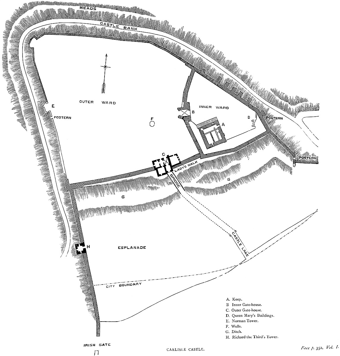
353 There was originally a ditch in front of this wall, and a gate with a drawbridge, all now gone. In later days, a small half-moon battery was thrown up about 8 yards in advance of this gate, and protected by a ditch of its own. This battery was connected by a light field-work, which extended from it to the outer gatehouse, laid in a zigzag form, so as to cover and protect a communication between the two gates, supposing the outer ward to have been breached and entered from the north-west side. These works have been removed and the ground made level.
The cross wall of the inner ward is original, strong, and well built, and backed by a ramp of earth and masonry, containing casemates, one of which has a Perpendicular doorway. These were no doubt added, perhaps by Henry VIII., to enable the wall to carry cannon. In the front of this wall, a little north of the gatehouse, is a large pointed arch of late Norman aspect, now walled up, and which may have been the original entrance.
The Keep is rectangular, 66 feet north and south, by 61 feet east and west, and at present only 68 feet high. It is very plain. There is the common high and stepped plinth, from which rise pilasters, 12 feet broad and 1 foot projection, two on each face, meeting at and covering each angle, which is solid. The walls do not batter, but are reduced slightly by one set-off, at a different level on each face. The window-cases, though in the original positions, are not original. The parapet has been removed, and the summit thus lowered, vaulted and converted into a platform for guns laid en barbette. The south wall is 8 feet thick, the west rather more, and the east and adjacent part of the north wall, 15 feet. The interior contains a basement and two upper floors. It is divided by the usual cross wall, laid north and south. The presumption is greatly in favour of this wall being a part of the original design; it has, however, been so much altered that it is difficult to speak positively as to its age or original height. The entrance is at the ground level, at the north end of the east face. It has a portcullis, probably the work of Edward I.; from its jamb on the left, a straight stair ascends in the east wall to the south-east angle of the first floor, as at Chepstow and Ludlow. The basement has been subdivided into four compartments, which are vaulted in stone. One is a passage against the north wall, terminating in a well-stair in the north-west angle. This stair, now disused, is original, and led to the first floor, but probably no higher. From the passage doors open on the left into two vaults, parted by the cross wall of the building. The east vault is one chamber; the west subdivided by a cross wall into two, the inner entered through the outer. The vaulting is a plain pointed barrel, very evidently an insertion. In the smaller vaults are late stone seats. One of the doorways is of Perpendicular date. These vaults were evidently prisons, intended no doubt for the custody of Border reivers, and probably a late addition. In the north wall is a recess connected with the well.
The first floor, about 16 feet high, is vaulted in modern brick, and354 used as a mess-room. In its north side was a very large fireplace, flanked by Norman columns; but this is now walled up. This floor is now entered solely from the south-east angle, but formerly had also a door near the north-west corner, from the well-stair. There is also a door near the south-west angle, which opens into a second well-stair, which probably led to the upper floors and the battlements. This is now closed, and there is no direct way from the first to the upper floors.
The second floor is reached, at this time, by an exterior door in the west wall, approached by an exterior stair on the north face, and from the rampart on the east. This door is not original, and has been broken through at the place of a recess, probably looped, which led from the second floor into a mural chamber and garderobe in the east wall, and which are seen on the right hand of the door on entering. This second floor is about 16 feet high, and has a timber ceiling. In the east wall, over the present entrance door, is a mural chamber, on the walls of which are some curious carvings by prisoners. One represents the Percy crescent and fetterlock, and another a coat of arms. From this floor a ladder leads through a trap into the upper floor—a modern arrangement.
The third or upper floor is vaulted in modern brick to support the gun platform above. This platform is formed of large slabs of stone, laid down in 1812, which may also be the date of the vault. The walls above are 11 feet thick all round.
The well of the keep is reputed to be Roman, though this is quite as likely to be true of the larger one in the outer ward. When the keep was built, the well, whether new or old, was included within the north wall, between the doorway and the north-east angle, and its pipe was carried up in the wall, no doubt with a lighted chamber at each floor, as indicated by a line of loops still seen in the wall. To make the well available when the keep was shut up as a prison, a hole was cut in the outside of the north wall, near the ground level, into the pipe of the well, and through this the water is still drawn up. The well is 78 feet deep, and its present cill is 92 feet above the sea level.
A curious external stair, probably Edwardian, has been built against the north face of the keep, and leads up, by the well, to the ramparts of the curtain, and so to the door of the second floor of the keep. No doubt its original use was to lead to the ramparts only.
The keep, though much disfigured to make it carry artillery, and much obscured by its conversion into prisons, a mess-room, and store-rooms, is for the most part original, and if cleared, as it should be, of the vaultings of the upper floors, would be a tolerably perfect specimen of a Norman keep, with a full share of mural chambers and appendages.
The hall and other domestic buildings, including what was called Queen Mary’s Tower, most of which were standing at the close of the last century, were ranged at the south-east angle, upon the355 adjacent walls, as shown in Grose’s view. All are now gone save a fragment of panelled work, part of the shell of a grand staircase of early Edwardian date, which led to the chief apartments.
It appears that in the east wall, near its south end, and, therefore, under the midst of these apartments, was, in the last century, a Norman postern with chevron mouldings and a portcullis groove, leading from the inner ward into the field, independent of the city. These details are shown in some of the late views of the castle. Grose, in 1774, shows, obscurely, the position and size of the gateway, and the Norman pilasters by which the adjacent wall was strengthened. The upper part of this curtain seems to have been Early English. All about this angle is now modern.
The space between the keep and its adjacent curtains has been filled up with earth, kept off from the keep by a sort of area wall, and thus the ramparts here, as well as along the cross wall, are made wide enough for cannon. The upfilling is modern, and should be cleared out.
A walk, called the “Castle Walk,” or Castle Bank, has been laid out at the foot of the curtain outside, whence its details may be conveniently studied. The south-east angle, as has been said, is modern, but proceeding north and westward the old Norman part comes into view, and on the north side of the inner ward the Norman pilasters are seen rising from a plinth, but partly concealed by six enormous stepped buttresses of great projection, and Decorated or Perpendicular date, no doubt a great support to the wall and very curious, but, in a military point of view, very much in the way.
From near the centre of the north front there was a spur work, composed of a strong curtain wall, carried down the slope and ending in a round tower. This was of course intended to annoy the enemy should he attack on the west side. The whole is now removed: possibly it was an Edwardian addition. The north face of the curtain and its north-west corner have been much restored in the Decorated period, but most of the west wall is original. Near its centre is a small tower, like the Alnwick Garret Tower, 28 feet broad by 18 feet deep, and about 9 feet projection, and open at the gorge. It is wholly Norman, of the date of the keep. It has a stepped plinth about 10 feet high, with six sets-off of 2 inches each, and on the front face is a central pilaster, dying into the wall at the base of the original parapet. In its north face, high up, is the shoot of a garderobe flush with the face of the wall, and lower down a stone water-spout. About 10 yards south of this tower are traces of a small postern. The wall connecting the castle with the city on this side is of Norman origin; but has some buttresses apparently Edwardian, in one of which is a garderobe shoot, similar to that of the garret tower. Upon this wall, south of the ditch, is King Richard III.’s, or Tile Tower, 26 feet broad by 20 feet deep, of no internal projection. This looks Edwardian, but probably is altered from Norman. It stands about 30 yards north of the city boundary.356 It is said that a few years ago a subterranean passage was discovered between this tower and the keep, and was at once closed up. This is stated in the “History of Carlisle, 1838,” and should be true, but it seems improbable, for the passage must have dipped deep to pass under the ditch.
The south wall of the castle is for the most part original, the Norman pilasters being seen east and west of the gatehouse. East again of these, as far as the keep, the wall seems Edwardian, but beyond that, where it belongs to the inner ward, it is Norman.
The wall between the south-east angle of the castle and the city, about 90 yards long, is mixed Norman and Edwardian, and as it crosses the ditch it makes a zigzag or shoulder, in which is a large round-headed postern gateway, either original or in the place of an original opening, intended, probably, to allow of cattle being driven on to the esplanade and ditch from the meads on the approach of an enemy. Probably there was a way from this gate along what is called the Lady’s Walk, at the foot of the south wall, as far as the great gate. South of this postern, near what is called the city stone, are traces of a large bastion, probably a part of the city defences. The postern is now walled up, and a bank of earth raised against it behind.
The enceinte wall of the castle, being built against the natural slope, is outside about 28 feet and inside 18 feet high. It varies from 8 feet to 10 feet thick.
The plan of the castle—a headland converted into a detached camp by a cross ditch—may be British or English, but the general outline of the masonry, which follows the line of the earthworks, is Norman. The Norman engineer evidently built the enceinte wall along the edge of the slope, and planned the inner and outer ward, and the keep. The castle is generally attributed to William Rufus, who was here in 1092, when Carlisle, from a Scottish, became an English frontier place. The see was created by Henry I., and the first bishop consecrated in 1133, when probably the city wall, of which a part may still be seen below the deanery, was built. Carlisle was taken by the Scots, and besieged by Stephen and by John. The latter sovereign was here four times in the years 1201–6-8, and 1212. In 1204 the constable of Chester was ordered sixty marcs for fortifying the castle. In 1205 certain grass cut in the neighbourhood was to be stored there. In 1215 Robert de Ros was custos of the castle, but in 1216 Robert de Vipont seems to have been in charge of the repairs and the garrison.
In 1222 Henry III. ordered the houses within the castle to be repaired, and two ballistæ of horn and two of wood were to be sent there. Walter Mauclerc was in charge. In 1222 the garrison was continued, and in the king’s pay.
Edward I. used Carlisle in the Scottish wars, and was here in 1293, after the great fire, which much injured both city and castle in the preceding year. Between 1293 and 1307, he was here seven times, often for many days. He kept his last birthday here in 1307, and went forth hence to die in the immediate neighbourhood. To357 his reign are to be attributed most of the Edwardian additions, repairs of the wall and keep, the gatehouses, and the domestic buildings, of which only traces remain. In 1302, Bishop Hatton, then governor, expended £275. 4s. 11d. in works. The Great Hall, supposed to have been then erected, needed repairs in 1344.
Camden says that Richard III. repaired the castle, and the six marvellous buttresses may be of that date, though they look earlier. Henry VIII. appears to have much altered the castle, probably to make it carry artillery. He built a block-house or citadel at the south end of the city, and armed it with cannon, and he repaired the city walls. His work was probably done in haste, for, in 1563, the whole was in great decay, as appears from a survey made by the queen’s order, printed by Grose. Three sides of the keep were in a dangerous state. The Captain’s Tower wanted parapets, as did much of the inner curtain, and all the glass of the great hall and great chamber was decayed. In the outer ward was an open breach, 70 feet long, where the wall had fallen in 1557. The result of this survey was the building a chapel and barrack, and no doubt the reparation of the wall and keep.
Mary Queen of Scots found some sort of accommodation here when she fled from Scotland, and gave name to the lodgings lately pulled down. The castle suffered somewhat during the great rebellion, but escaped being dismantled. It was battered from the west, and taken by the Duke of Cumberland in 1745.
Probably the greatest and most destructive changes are those of modern date. The hall was taken down in 1827, and the chapel and other buildings in 1835.
There are traces of two light field-works in the meads north of the castle, the smaller in the rear of the other, evidently prepared for the reception of the Scots, in 1745, as they approached over the brow at Stanwix.
The castle is far too confined and too much a part of the city for the purpose to which it is applied. The military should be removed, the modern buildings cleared away, the keep restored, and the area laid out for the pleasure of the people of Carlisle, and so as to show off the remains to the greatest advantage.
In the neighbourhood of Carlisle are other military works deserving notice. Such is, at Hayton, Castle Hill, a mound 12 feet high, and 100 feet diameter at the top. Linstock Castle was built before 1133, but is now little more than a farmhouse, into which it was converted in 1768. Scaleby Castle was built by Robert de Tilliol, who had licence to crenellate it in 1307. It was largely repaired in 1596, but retains much of its original character, and has always been inhabited. Naworth Castle was the chief seat of the English Barony of Gillsland, at the Conquest granted to Hubert de Vaux, from whom it descended through the Dacres to the Howards. The present structure was the work of Ralph Lord Dacre, in 1335, and is a good example of the quadrangular castles of that date. Rose Castle was in the Barony of Dalston, and is attributed to 1336,358 when Bishop Kirby had a licence to crenellate. It was also a moated quadrangle. Highhead Castle, on the Ive, is drawn by Buck. Here was a castle in 1326, but the licence is dated in 1342. The castle was rebuilt in 1714. Dalston Hall is a castellated house, probably of the middle of the fourteenth century.
The Roman wall may be traced at various points, both east and west of the passage of the Eden. It is well seen in a field close to Drawdykes, a stiff, square farmhouse, built on the site of a Roman Castellum. The inscription “Diis Manibus,” built into its walls, is said to have been dug up in Carlisle, near the old citadel.
THE river Taff, from its origin under the Brecon Beacons, after a course of about 26 miles through the northern and mountain district of Glamorgan, escapes by a deep and narrow ravine across the last elevation, and rolls its course, unfettered, to the Bristol Channel.
The ridge which it thus finally cleaves, and which divides the hill country from the plain, is part of the great southern escarpment of the coal basin of Glamorgan, supported there by the mountain limestone rising from below, and in its turn reposing upon the old red sandstone, the denuded surface of which forms, under the later horizontal rocks and drift gravel, the basis of the plain. The escarpment, extending for many miles along the contiguous counties of Monmouth and Glamorgan, is traversed, in this immediate neighbourhood, by the three passes of the Ebbw, the Rhymny, and the Taff. The heights bounding the latter river, though in actual elevation below some other parts of the chain, produce a very striking effect, from the abruptness of their rise from the plain.
These heights, on each side of the pass, must always have been regarded by the inhabitants of the country as places of great security. On the right bank of the river, the huge lumpish sandstone mass of the Garth rises to 981 feet above the sea, and is crowned by two remarkable tumuli, well known as landmarks in the vale, and visible even from the distant shores of Somerset. The lower Garth, which rises to the front of the great Garth, opposite to Castell Coch, forms the right bank of the pass.
The elevation on the left bank, though lower, is more precipitous. It presents, in the lichen-stained crags about its summits, and the rich verdure which clothes its sides and base, all those features so well known to geologists as characterising the scenery of the mountain limestone.
Nature has rendered the west and south sides of this height— 359those exposed to any foe from beyond sea—nearly inaccessible. Across the north-eastern side, lines of circumvallation have been hewn out of the rock, the dimensions of which show the value attached to the place, as a fortress, by the Cymry.
There was reason in the choice. From hence the long ships of the Danish rovers could be seen while yet distant from the shore, and timely notice be given, and protection afforded to, the people of the plain, should the ravagers extend their sweep far inwards from the coast. A beacon fire upon the headland of Penarth—celebrated in Anglo-Norman verse for its ancient oak, and long marked by its white church—answered here, or on the opposite Garth, would be repeated from the summits of the distant mountains of Brecon and Caermarthen, and would at once spread the tidings of invasion over the whole of the southern coast.
The Normans, within a century and a half after the conquest of Glamorgan, had completed a chain of castles along the plain country, from Chepstow to Pembroke, and were only exposed to the invasions of the Welsh from the mountain tracts upon the north. To check these they threw up a number of fortresses, either upon, or within the verge of, the hill country, of which Morlais and Castell Coch may be cited as examples.
The site of the Cymric camp was far too difficult of access to allow of the ready transport into it of provisions, or munitions of war, or of a constant and rapid communication with the chief castle at Cardiff. Lower down the scarp, though still high above the plain, the Norman engineer selected a natural platform on the limestone rock, separated from the main scarp by a natural depression, and sufficiently removed from the summit to be out of the reach of any military engines with which the Welsh were likely to be acquainted, or which they were likely to be able to bring, with their forces, against the castle. There is an easy approach to this platform from the east, which probably communicated with the old road, called Roman, and no doubt Cymric, which leads direct from Cardiff to Rubina, and close upon which is the low circular mound, which was the site of a tower of the time of Henry III., at Whitchurch, and the Celtic tumulus of Twmpath. Upon this platform was erected the fortress which is here to be described.
Castell Coch, so called from the red tint of its materials, is, in general plan, a triangle, each angle being capped by a drum tower. Its general divisions are the south, east, and northern towers, the gate tower, the curtains and hall, and the outworks.
The platform occupied by the whole is about 200 yards long by 70 yards broad, and the principal works of the castle occupy its west end. The south face is, in part, precipitous, and from 20 feet to 30 feet high. The north face, towards the upper hill-side, is deepened into a formidable moat, and the east end was defended by a fosse, cut deeply across the rock, and beyond this by two towers, connected by a curtain wall.
The North Tower rises from a square base to a cylindrical super360structure, the north and south angles terminating in buttresses, each the half of a pyramid cut vertically and diagonally across, after a fashion very common in Welsh castles, and well seen in Marten’s tower at Chepstow. The cylinder is 40 feet in diameter. It contains three stories, of which the middle one is on a level with the inner court, or terre-plein, of the place.
The lower story may have been a cellar. It is vaulted, and has two great cross-springer ribs, and two windows opening high above the floor. A narrow passage, vaulted, with steps, leads into it from the court. Its internal diameter is 18 feet, its walls upwards of 10 feet thick. The windows were mere loopholes.
The middle story is also circular and vaulted, with similar ribs. Here, however, the windows open nearly on the level of the floor, though also loops. There is a fireplace, with a flue carried up in the wall. The flue is backed with stone. The entrance to this chamber is also from the court, and, on the east side of the vaulted passage, a gallery passes off in the thickness of the wall, and leads to what was a small garderobe, occupying a square projection on the east side of the tower, at its junction with the curtain. The general dimensions of this story, and the thickness of the walls, correspond with those of the room below.
The upper story contains one chamber, the south and east sides of which are flat, the rest circular. Here are no less than three fireplaces, each of large dimensions, with funnels in the thickness of the wall. It contains also two small recesses, one a sort of sink, and has two windows. There are also two doors, one, on the south side, opening upon the roof and ramparts of the hall and west front, the other, eastwards, leading to the ramparts of the great or northern curtain. Access to this chamber, from below, seems to have been obtained by an exterior stair between the tower and the hall. This story, within, is about 26 feet mean diameter, and the walls vary from 2 feet 3 inches to 4 feet thick. It was roofed flat, with timber, and above were ramparts and a parapet, probably reached by means of a trap-door in the roof. It was evidently the kitchen, here, as at Morlais and Coningsburgh, placed in an upper floor.
This tower is the most perfect of the whole, and in tolerable preservation, although the lower chamber is half full of rubbish; the small apartment connected with the middle story is broken down, and the roof and ramparts are wanting on the summit. This tower, however, is evidently the type of, and has served in the present instance as a clue to, the original plan of the others.
The South Tower corresponded nearly to the last, and, like it, appears to have contained three chambers, and at its junction with the west curtain, a square projection, containing in the middle story a small garderobe, and in the upper, probably a communication with the battlements of the hall. The lower chamber is entered by a vaulted passage, down steps, from the courtyard. The middle or main chamber probably was entered on the level, by a passage361 from the courtyard, and a mural gallery seems to have led from this passage to the window or opening in the south end of the hall. The upper chamber was accessible from the hall battlements, as it probably also was from those of the gateway curtain. It is uncertain whether this tower rose from a square base—probably it did. Its upper part was cylindrical, 40 feet diameter. The walls are 8 feet thick, and the chambers do not appear to have been vaulted. This tower is in a ruined state. The two outer thirds of its circumference have been blown away by a mine, but the part connected with the hall, including a door below, two windows in the lower and middle story, and the small chamber in the wall, remain tolerably perfect, and remove all doubts as to the original elevation and particulars of the whole.
The East Tower corresponds in altitude and general arrangements to the other two, like them containing three stories. It is cylindrical from the base, and 40 feet diameter; but, towards the courtyard, it presents a flat face, with two shoulders projecting at its junction with its curtains. Like the other towers, it has a square projection for a small chamber, here found at its junction outside with the great or northern curtain. The lower story, like those of the other towers, is below the level of the court, but instead of being entered directly by a distinct staircase, a gallery branches off from the passage to the middle chamber, and descends, winding in the thickness of the wall, to a vaulted prison below. This lower chamber is filled up, but its existence is evident enough, and the staircase is seen through a great rent in the wall. The diameter is 18 feet 4 inches, and the thickness of the wall 10 feet 10 inches.
The first floor is entered by a passage from the court, on a level. This chamber had two loops. There is no fireplace, and no trace of a vault, although the walls are above 10 feet thick. On either hand, opening out of the passage leading to this chamber, are galleries in the wall, that on the right descending to the chamber below, that on the left running on a level, to open into a small chamber in the square projection between the tower and the great curtain. Here seems to have been the well. The upper chamber appears to have been entered from the ramparts by a long pointed doorway in the gorge; and over the lower door, leading from this, on the right, a passage leads to a spiral stair in the wall, which evidently gave access to the battlements of the tower. This tower has been rent asunder by a central explosion, but the outer part has only shifted a little.
The Hall stands upon a vaulted chamber, now filled up with rubbish. It occupies the space between the north and south towers, which it connects, its outer wall forming the curtain between them. It is rectangular, 30 feet 8 inches by 17 feet 8 inches, vaulted, with a pointed arch, and having its outer wall 7 feet, and its inner wall 6 feet, thick. In the former are three loops, splayed towards the interior, and having pointed heads. They are high above the base of the wall, and command a fine view. The door was near the362 north end of the opposite side, and possibly there may have been a fireplace on the same side with the door. At the south end is a window, which opens into a sort of gallery in the south tower.
Above the vaulted roof was, probably, a platform, with a low battlement towards the court, and a high one towards the exterior of the castle. This platform communicated with the north and south towers directly, and with the court by a narrow stair, already noticed as leading to the upper chamber of the north tower. The hall is now much mutilated, the vault and part of the east wall being destroyed.
The great curtain is a large irregular segment of a circle, about 80 feet exterior face, and with a chord of about 60 feet. It originally was a wall 3 feet thick, which appears to have been found of insufficient breadth for the use of military engines on the north and north-east battlements, upon these, the weakest sides of the fortress; wherefore a parallel wall was built within and against it, 6 feet thick, extending the whole way from the north to the east tower. The old wall contains seven loops at the courtyard level, and to preserve these an arch, 6 feet diameter, is turned in the new work, opposite to each. Above, there is, of course, a rampart walk of ample width, entered from the tower at either end. The exterior of this wall, below the level of the court, is strengthened by a stone facing, forming the scarp of its moat. This curtain remains tolerably perfect. There is a breach near its junction with the north tower, and the new and inner wall is wanting opposite to the four loops, though traces of it are discernible in the mortar upon the old wall.
The Gatehouse Curtain is much less perfect. It appears to have been slightly convex in plan towards the exterior, and about 28 feet in length between the south and east towers, from both of which its ramparts were, no doubt, entered. It is about 5 feet thick. One loop remains, about 6 feet above the courtyard level, which could only have been used by means of a platform, perhaps of timber. Twenty-one feet from its junction with the east tower, a small half-round tower seems to have projected from the curtain, serving, no doubt, to defend the gateway, which seems to have lain between this and the south tower, and probably consisted in a simple archway and passage, with a portcullis and doors. That the entrance was here, and between these towers, is certain from the causeway leading to it, but the gate-tower, and most of the curtain, are utterly gone.
Thus much of the castle. We next reach the Outworks.
The south and north tower, and the hall curtain, needed no exterior defence. They rise from a very steep bank, and their foundations are of scarped rock and solid masonry. They are quite unassailable from below. The other two sides are more exposed. In front of the south tower is the commencement of the moat, broken by a causeway opposite to the inner gateway, and leading from it to the outer court. Beyond the causeway the moat deepens, and is carried round the east tower and great curtain, steep and deep, and hewn in the rock, so as to render this, the naturally weaker363 side, very strong. The moat, which must always have been dry, ends, opposite to the north tower, in a curious excavation, resembling a water-tank, which, however, it could scarcely have been.
The outer court of the castle occupies the remainder or east end of the natural platform. Its dimensions are about 100 feet long by 40 feet wide. Its southern side, a continuation of the line of the same face of the castle, was defended by a precipice, partly natural, partly scarped by art, though now broken down and filled up. There are no traces of a wall on this side, but probably there was a parapet.
The opposite, north, or landward, side, is defended by a branch from the moat, which, after being interrupted and traversed by a causeway, sweeps round the east end of the works, and terminates in a deep and broad excavation, which is carried to the brink of the cliff, and thus defends also the east end of this outer court.
The west end of the platform, or that towards the castle, is cut off from that building by its proper moat, traversed, as already mentioned, by the causeway leading to the inner gateway. There is no evidence of any walled defence to this court, and yet, without such, the moat on the land side would scarcely have been sufficient to delay an enemy, so as to expose him to the fire from the east tower and gateway curtain, upon which the defence of this side depended.
As the principal object was to command the regular approach from the eastward, the defences were prolonged in this direction. Outside, and on the counterscarp of the moat of the outer court, and 6 feet from the edge of the south precipice, there are traces of a tower, about 30 feet diameter, with what may have been a sort of buttress on its southern side, extending to the precipice. Opposite, on its northern side, and at its junction with a lower curtain, is what appears to have been a well-stair, or the foundation of a distinct turret. There is no moat to the east of the tower, but the ground falls in a natural scarp.
This Lower Curtain, indicated, like the towers, by a mound of earth only, sweeps round, so as to cover the counterscarp of the outer moat, and ends in the roadway tower, about 40 feet diameter, the foundations of which are very distinct, and which must have completely commanded the approach, at a point much in advance of, and below, the outer causeway and the eastern tower. The regular approach, it is clear, lay from the east, and between the precipitous height crowned by the old Cymric camp and the level platform of the castle, and, approaching it by the side least strongly defended by nature, would, at 150 yards from the body of the place, be flanked by the fire of the lower tower, then of the lower curtain, and then of the roadway tower. Supposing these silenced, and the outer causeway reached, the besieger came directly below the east tower, and a part of its adjacent curtains; and as he crossed the outer court, and reached the second causeway, he would be opposed by a fire from the east and south towers, their curtain, and the gateway tower.
364
Even if the place were surprised and entered, each of the three towers, and the platform of the hall, admitted of being defended for a few hours, until aid had been signalled for, and sent from Cardiff. No doubt, before brave men, all defences fail; and the Welsh, who certainly were not wanting in courage, did, according to tradition, more than once take this castle, probably by surprise and escalade; nevertheless, it was a very strong fortress, both by nature and art, and must have been a sore thorn in the side of the mountaineers of Glamorgan.
The present condition of each part of the castle has already been described. It may be added, generally, that the whole is very thickly grown over with brushwood and weeds, so much so that it is difficult to make out the details of the plan of the building. Although no ornaments remain, yet it is clear from the general plan, and from the doorways, that no part of the castle is in the Norman style. It is, probably, Early English, and may very well be of the reign of Henry III., and probably a little earlier than Caerphilly.
Here and there, especially in the outer court, are some handsome Scotch firs, and a number of venerable beeches, the peculiar green of whose foliage marks, from a great distance, the line of the old approach. These, of course, with the wood clothing the hill side, and the ivy upon the walls and towers, should be left untouched; but it is much to be wished that the castle itself, and the works of the Cymric camp above, were cleared of timber and underwood, and a little care taken to encourage fair greensward in their stead.
This castle has descended with the rest of the De Clare estates, and is now the property of the Marquis of Bute.
There are various traditions concerning it, but a great deficiency of recorded information. Being the key of the upper country, it must have witnessed many an inburst of the native Welsh, from the Norman Conquest to the days of Owen Glendower, who is supposed to have descended by this pass when he burned the episcopal palace of Llandaff, and ravaged Cardiff.
Since this account was written the castle has been cleared of rubbish, and completely restored, so as to be again habitable. A well has been discovered in one of the towers, and cleared out, as has also been a very strong dungeon. The restoration is very complete indeed, in excellent taste, and in strict accordance with what has been ascertained of the original structure.
CASTLE RISING, probably so called from its position on ground that is high or rising compared with the low levels of the district, stands about two miles from the estuary of the Wash365 upon its eastern or Norfolk shore. Half a mile north of the village a large tract of low land is traversed by the Babingley river, and it is evident that before this part of the country was drained and reclaimed by tillage, the approaches to the village upon at least three sides, the north, west and east, must have been almost impracticable. These considerations probably governed those who chose Rising as a residence. The soil is light and sandy, like that of the Dunes of Holland, but contains just enough of vegetable mould to support a growth of turf. The trees are chiefly ash and willow of very large size, and upon the slopes of the castle are some noble and very ancient thorns. The richness of the vegetation in and about the village is in favourable contrast with the dreary and barren heath land by which it is surrounded.
The earthworks are on a large scale, and probably the remains of a great English residence, the centre of a large estate; circumstances which no doubt led to the adaptation of this position for the Norman fortress whence the village has derived the prefix to its more ancient name.
The central and principal division of the fortress is composed of an irregular oval area about 67 yards east and west by 80 yards north and south, contained within a broad and lofty bank, which, in its turn, is surrounded by a very formidable ditch. Outside this ditch, covering the east face, is a subsidiary work, also within a bank and ditch. It is in form nearly a parallelogram, but its sides are somewhat irregularly convex, and its angles rounded. Its north end is about 60 yards and its south 70 yards broad, and its length of front 90 yards; but the ends are inclined, so that where it abuts upon the main ditch it is about 80 yards.
This is balanced by a corresponding earthwork on the west point of the central work. This earthwork is about 100 yards north and south by 30 yards broad, and is also contained within a bank and ditch. The ditches of these earthworks do not actually run into the main ditch. A narrow causeway of earth is left between them. The whole exterior girth of the ditch is reported to be 10,803 yards. The central earthwork is about 30 feet high from the inclosed area, and outside is about 60 feet above the bottom of the ditch. It is about 15 feet wide at the top, and, being composed of light soil, has a considerable slope. The banks of the outworks are not so high, being about 20 feet inside and 40 feet outside. Those to the east are, however, higher, and at the points nearly as high as those of the centre. The westward work is altogether of a lighter character, though still of great strength. The works cover about 13 acres. They are wholly artificial.
The main entrance was from the north, along the edge of the counterscarp of the main ditch, and it thus entered the eastern outwork. Near its centre the road crossed the ditch by a bridge, and entered the central ward by a notch in its eastern bank. The western outwork seems to have been entered from the central ward by steps up and down the bank, connected probably with a light bridge over the ditch. It may be that it was only used for cattle.
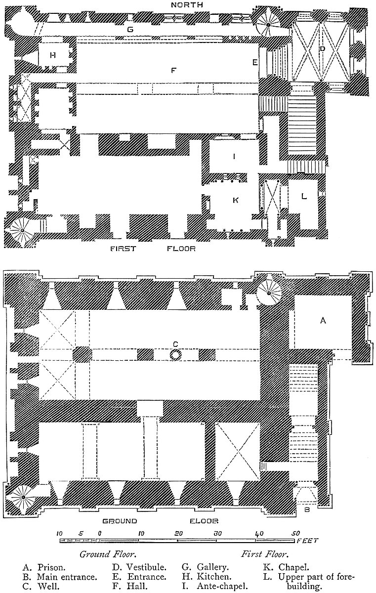
367
It has been thought that these earthworks are of somewhat different dates, and that the central is the oldest. The circle, or irregular oval, with a bank and ditch, with or without a mound, is a not uncommon form of earthwork in England, and is probably the work of the English in the seventh and eighth centuries. That is to say, where the work is on a low site, and the form not governed, as in British works, by the outline of the ground. These English enclosures rarely stand alone. Usually there were one or more appendages outside, and abutting upon the main ditch, as at Laughton and Kilpeck, probably additions, but not much later than the main work. They were usually also at no great distance from the parish church. From the tendency of the outworks at Castle Rising to the rectangular form, they have been supposed, by good authority, to be Roman, and the Romans had no doubt a settlement at Brancaster, about fifteen miles to the north. But Roman works seldom are composed of earthworks of this magnitude, the Roman custom, where great security was needed, having been to build a wall. Also, if the outworks only be Roman, the central work must be British, which is scarcely consistent with what is known of the defences of that people. Most probably the central is an English work, and the outworks either of the same date, or early additions by the same people. But, be the principal origin368 what it may, it is clear that here, as at Norwich, Clare, Hedingham, and Castle Acre, the Norman invader, having grasped the estate of the English lord, proceeded, as in Normandy, to combine the new fashion of castle-building with the old defences.
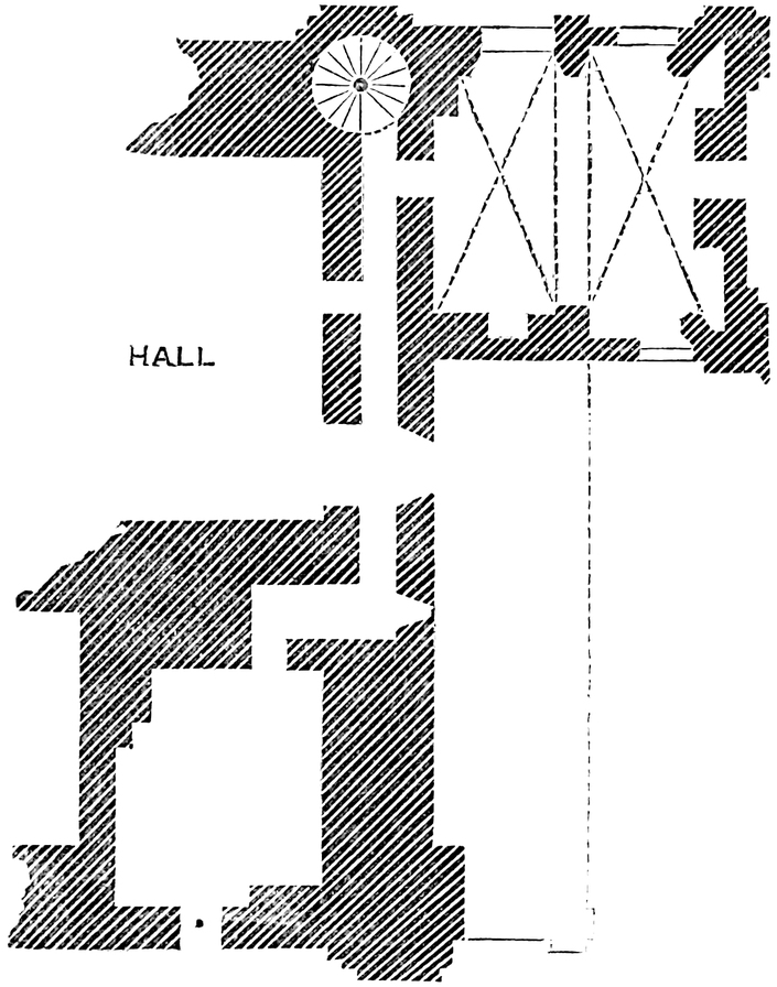
The keep, the chapel, and the gatehouse, the only parts in early masonry of which anything now remains, were probably among the works earliest executed. The Keep is a very noble example of the rectangular Norman type. Not that its area, still less its height, would place it in the first rank, but to considerable dimensions it adds a degree of ornament rarely bestowed upon military buildings, and though a ruin, its parts are unusually well preserved, and excellent both in materials and workmanship. Like Hedingham, it stands within, but not in the centre of, the inner ward. It almost touches the slope of the western bank, and is about thirty yards from the gatehouse and the eastern bank. Between the north and south banks it is nearly midway. It is in plan rectangular, measuring at the base 75 feet east and west, by 64 feet north and south, and, to the rampart walk, 50 feet high. Each face is flanked by two pilasters, 7 feet broad by 6 inches projection. These meet at, but do not cover, the angle, and the nook so formed is occupied by a shaft, not quite detached, and similar shafts take the place of the other angles of each flanking pilaster. Intermediate, on the north and south faces, are three pilasters of 3 feet breadth, and there is one on the east face, all dying into the parapets. The west face is of a complex character. Upon it are two large recesses, 9 feet broad and 2 feet deep, of which one is arched over the near parapet level. There are, besides, four recesses, each of 4 feet opening, by 2 feet 6 inches deep, arched over a little below the first-floor level. All these five recesses have their soffits pierced by the vents of garderobes. The wall has only one slight set-off near its summit. The flanking pilasters have none, the others mostly two, but very high up. There was a square turret at each angle, now nearly gone. At the base of these turrets, the nook-shafts ceased, and the turret angle was solid. The parapet is gone. Considerably below its base were round holes, apparently to take off the water. The walls at the base are, the north and east sides, 7 feet, the south 6 feet 6 inches, and the west 6 feet thick, and this thickness is preserved to the top, or very nearly so. The east face is covered by the forebuilding, here very perfect. This prolongs the north front by 20 feet, and the south by 9 feet. The keep has a basement at the ground level, and a first floor. At two points, however, the upper floor is subdivided so as to give a partial second floor. Part of the forebuilding also, as at Rochester, has a second floor. The entrance is in the south end of the building, in which a straight stair rises to the main door of the keep, which is at the first-floor level. There are well-staircases, 7 feet diameter, in the north-east and south-west angles of the keep, ascending by seventy-six steps from the base to the summit, and communicating with the first floor. It is, however, to be observed that the base of the well-stair is about369 4 feet above the ground-level, so that it is entered by a stair of five steps, projecting into the rooms. This seems to have been the case at Dover, before the floor was raised. It is difficult to discover the reason for it.
The keep is divided into a north and south chamber by a cross-wall, 6 feet thick, which ascends to the roof. The two chambers are 58 feet long; the north 25 feet, and the south 16 feet broad. The north chamber was again divided, equally, longways, by an arcade of four lofty arches, of 11 feet span, springing from corbels in the wall, and from three square piers, 3 feet broad by 4 feet. The spandrel walls of this arcade supported the joists of the floor above. The three eastern arches and their two piers are gone. The western pier gives off two lateral arches north and south, dividing the end bay into two square spaces, which are vaulted and groined and carry upper chambers, shortening by so much the upper great room or hall. This lower room is aired rather than lighted by three loops in the north and two in the west wall, placed high up and in splayed recesses, round-headed. There is also in the north wall a small lobby at the foot of the well-stair, from which there seems to have been a passage rising 3 feet into a mural chamber 8 feet above the ground. In the west end of the great chamber an interior door at the ground-level has been broken. It has a pointed head, and is an insertion. Probably it represents a loop. A round-headed doorway of 4 feet aperture opens in a segmental recess in the cross-wall into the south chamber. The door opened towards the north, and was barred on that side. The recess is groined. The well is in the floor of the north chamber, between two of the piers, under the second arch from the east. It is 4 feet diameter, with a pipe of ashlar rising about 3 feet above the ground-level.
The south chamber was crossed by three plain broad arches, springing from corbels high up in the wall, and carrying the joists of the floor above. The eastern bay, however, is vaulted and groined, and supports the chapel. The other two arches are broken away. This chamber has four loops to the south and one to the west. Its well-stair also has a small lobby in the wall, 5 feet above the floor. In the east end of the south wall is a door ascending four steps, which opens into the staircase of the forebuilding. Although this door, in its present state, appears not to be original, it may be really so. There is one in a somewhat similar position at Dover.
The first floor is also divided into two main chambers by the cross-wall, and each is shortened by the rooms cut off, from one at the east, and from the other at the west, end. The great chambers are, the north, 47 feet by 23 feet, and the south, 42 feet by 15 feet. The north room was the hall. It was entered from the vestibule of the forebuilding by a handsome main door, of 6 feet opening, near the north end of the east wall. Close to it, in the same wall, is a second round-headed door, which descends by ten steps upon the staircase of the forebuilding. This door is evidently an insertion in the place of a loop. A third and small door, segmental, opens into a narrow370 mural passage leading over the middle gate of the fore-building, and by a branch into the chapel. In the cross-wall, a door opens into the south chamber, and near it is a deep round-headed recess, 5 feet from the floor, perhaps a cupboard, and again a recess, 8 feet broad and 5 feet deep, at the floor-level, possibly for a brazier of charcoal, but without a flue. Near the east end of this same wall is a small window, a Decorated insertion, and near it a segmental door, both opening into the ante-chapel. The north wall is pierced by a gallery, 3 feet 6 inches broad, of five bays, between each of which is a plain arch, reducing the way to 2 feet 9 inches. Two of these bays have coupled exterior windows, one pair square-headed, the other round-headed and trefoiled, and on each cusp a disc, as in the recess at Coningsburgh, producing a heavy effect. The fifth bay has a loop. Four of these bays open by large arches, at the floor-level, into the great chamber, of which this gallery thus formed a part. The eastern bay communicates with the well-stair. It is groined, and its side towards the chamber seems to have been partially closed, and there are three small shafts which seem to have opened into the mural chamber below. They cannot be for garderobes, and their use is obscure. This bay has a very handsome window, of two lights, coupled, and the shaft common to the two is worked in a rather remarkable fret or knot. These windows had shutters. There is no trace of glass. The gallery, which is 62 feet long, has a loop at its west end, and a rude opening, probably once a window, of three small lights, near that end in the north wall. The north-west aisle is occupied by a cylindrical shaft, 5 feet 6 inches diameter, which commences with the floor-level, and is open like a fireplace. At the roof-level it is gathered in with brick, and ascends as a chimney-shaft. In its sides are four loops, in two tiers, besides six small round-headed niches higher up, probably for the escape of smoke and steam. At this end the gallery opens into a lofty vaulted chamber, in the east wall of which an opening has been broken into the hall, and in the south wall is a curious low segmental recess, of 10 feet span and 3 feet rise, partly walled up, and in the upfilling some small niches. The great height of this chamber, the vaulted roof, the shaft and steam-holes at one corner, the niches round it, and its position next to the hall, point it out as the kitchen.
In the west end of the hall a door leads into a room corresponding with the kitchen, to the south of it. This is 8 feet by 12 feet, and has three niches in its west and two in its east wall. In its north and south walls are arches of relief, like that of the flat recess in the kitchen. The reason for these three arches, turned in three parallel walls, is not apparent. Two of these might serve to direct the weight of the wall above from the vault below upon the piers, but the third is in the cross-wall, which is solid. The south room had a timber roof, and was probably a sort of still-room, for light cooking or pastry. Between these two rooms a door from the hall opens into an ∟-shaped vaulted passage, ending in a mural vault, 10 feet371 by 5 feet, in the west wall of which are two loops and two double garderobes.
The roof of the hall was of timber, resting on six pairs of principals, of which the corbels that carried the hammer-beams remain. Some are carved as male or female heads, and one represents an animal. The pitch of the gable is marked upon the east wall, across which, at the level of the corbels, is a bold band of chevron work, and upon this rests a window of 2 feet 6 inches opening, which gave light from an upper mural gallery into the roof. In this gable a second opening, 7 feet wide, has been made into the same gallery. This larger window cuts the chevron band, descending somewhat below it. It was evidently an insertion to give more light to the hall, and is opened on one side instead of in the place of the small window, in order that it may be clear of the forebuilding.
The south chamber was entered from the hall by a doorway 5 feet broad, placed in a large recess 5 feet deep. In the south wall are two round-headed windows, trefoiled, with discs on the cusps, and between them a fireplace and chimney-shaft have been inserted, probably during the Tudor period. There is also a sort of cupboard in this wall, and a door opening into a lobby 7 feet by 3 feet 4 inches, which opens upon the south-west well-stair. In the east wall is a small door, a Decorated insertion, opening into the chapel. In the north wall, besides the door from the hall, are a cupboard and a small segmental door, opening into a mural garderobe in the west wall. In the west end are two small doors opening into mural chambers, each containing a garderobe lighted by a loop. It will thus be seen that all the garderobes are upon the west front, and there seem to have been others in the battlements above them. The south chamber had a lofty open roof like that of the hall, but high up in its west gable a window has been opened as though to suit an added interior gallery or balcony at the level of the room above the chapel at the opposite end. This window, however, is the only indication of such an insertion, nor are there any other windows or any traces of floor-joists, only below the window are some joist-holes. This window is of two lights, lancet-shaped and trefoiled. In the central spandrel is a peculiar ornament composed of four loops, which outside are replaced by a small circle. This window stands in a full-centred recess which may be original, but the window itself is an insertion.
Walled off at the east end of the chamber is the ante-chapel, 9 feet by 13 feet, and vaulted. It is placed partly in the cross-wall and partly in the south chamber. It has a door and window into the hall, of which the latter seems an insertion. Also are seen a door and two loops, of hour-glass section, in the opposite or south wall opening into the chapel. In the east wall is a door, whence a narrow passage leads upon the roof of the forebuilding over the middle gate.
The chapel, which could be entered from the hall either through the ante-chapel or round it by a mural passage, has but one original door, which is in its north wall. A second door has been opened,372 in the early English period, in the west wall. The chapel is 13 feet east and west by 14 feet, and has a flat timber ceiling. The southern side has a deep recess, let into the wall of the keep, and in it are the remains of a triple window, probably formed of three loops. In the two jambs of this arch are side recesses. High up in the north wall are the two hour-glass loops from the ante-chapel. The chapel has been much injured; but there are remains of a handsome arcade with detached shafts upon the lower half of the west and north walls, and in the south is what seems to have been a coupled window. In the east wall is a handsome arch of 7 feet 6 inches span, with shafts in front of the piers with carved caps. This opens into a sort of chancel, 5 feet deep by 9 feet wide, with nook-shafts. It is vaulted, groined, and ribbed. There is no boss, but about the intersection of the ribs is some rude carving, from which a lamp seems to have been suspended. There is a window to the east, now broken down, but which was probably composed of three coupled lights, and in the south wall is a recess with a loop. An attempt has been made, apparently in the Tudor period, to insert a fireplace in the north wall.
From the first floor the south-west well-stair leads to the roof only; but the north-east stair, in its way to the roof, has two side openings, of which the first, 2 feet 4 inches wide, leads by a narrow passage up fourteen steps towards the ramparts of the vestibule tower. This is now blocked by the inserted vault, with which that building is covered in. Eight steps above this lower opening a second leads into a gallery in the east wall. Above this opening, seventeen more steps lead to the ramparts of the keep, which are 22 feet above the level of the first floor. The eastern gallery is vaulted, and 32 feet long. From one side of it a door enters the second floor of the forebuilding tower, and beyond it, also in the east or outer side, is a loop. In the west side are two openings, already described, which open into the gable end of the hall roof. At its south end this gallery makes a turn at right angles, and ends in a small bedchamber, 18 feet by 14 feet, which is over the chapel, and has a window to the south. As the parapets are gone, and the ramparts not accessible, the roof above the kitchen cannot be examined; but there does not appear to have been any second floor in that quarter.
The forebuilding is a very perfect and a very good example of this peculiar appendage to a Norman keep. It is composed of three parts,—a lower staircase, an upper staircase, and a vestibule tower. At its south end is the outer gateway, at the ground-level, in line with the southern face of the keep. The portal is full-centred, and flanked by two columns beneath a plain abacus, from which springs the arch with a bold roll-moulding. There is no portcullis. The door opened inwards, and was strongly barred. The wall is 6 feet thick, and the vaulted passage through it, inside the doorway, is segmental and groined. Within, the passage is 8 feet wide, and contains the lower staircase of fifteen steps. In the inner face of the373 wall, over the doorway, is a large, deep recess, probably to lighten the weight on the entrance arch. On the right or outer wall, high up, is a loop, and on the left, at the fourth step, a large door, already mentioned, opens into the southern chamber. It seems to be of late Decorated date, and probably represents an original loop, or it may be a doorway. At the head of this first staircase is the middle or second doorway, of 5 feet opening, also full-centred, with flanking columns. The head, also, has a bold roll-moulding. The wall in which it is placed is 4 feet thick, and the landing 5 feet deep. The portal is recessed, and in the soffit in front of it is an opening, 2 feet broad by 6 inches deep, a shaft or meurtrière from the top of the wall, where is a walk. This seems to have had high parapets, and a loop looking down the staircase. The opening was for the defence of the portal. This door also was barred. Within it rises the second staircase, in the same line, of nineteen steps, 8 feet wide, and ascending to the upper and inner doorway, the door of the vestibule. On the right is a second loop, on the left a clumsy doorway ascending to the hall, already mentioned, and evidently an insertion. The staircase is solid, containing no vault or chamber below. It was roofed with timber, at two levels, of a low pitch, divided by the wall of the middle gate, and leaning against the keep wall.
The doorway at the stairhead much resembles those below. It is set in a deep recess, has flanking shafts, and a roll-moulding round the head. There is no portcullis. The doorway opens into a chamber 14 feet by 15 feet, which is the vestibule to the main entrance of the keep, and at the level of its first floor. It has two windows to the north, two to the east, and to the south the staircase door and a window, which rakes the exterior of the outer wall of the staircase. These windows seem to have been of 12-inch opening, but have been enlarged. They are placed in deep recesses, as in an arcade. In the west wall is the great entrance—a noble archway—deeply recessed, and flanked with four shafts on either side. The exterior arch is 10 feet span, the doorway itself 6 feet. The plinths are unusually high, being 3 feet. The caps are fluted and cushioned. The outer arch is full-centred, the actual doorway segmental. The arch bands are worked in chevron and other mouldings. Close north of the great entrance a plain narrow door opens into the adjacent well-stair, but this is clearly an enlarged loop, which was intended to light the staircase. The original covering of this room, like its present floor, was of timber, but this has been replaced by an ill-executed vault of the early Decorated period. It is arranged in two bays, the dividing rib springing from pilasters let into the north and south walls. Each bay is crossed diagonally by two ribs, springing from corbels of half-octagon figure. The vaulting obscures and spoils the old Norman details of this very handsome chamber.
Below the vestibule is the ground floor, probably a prison, a mere pit, 14 feet by 16 feet, and 21 feet high, aired by two loops very high up in the east wall, and possibly by a third in the south wall.374 In the west wall, the wall of the keep, is a lofty recess beneath the keep entrance, within which a hole has been broken. At present this chamber is entered by a door at the ground-level in the south wall, but this is certainly an insertion. The original entrance must have been by a trap and ladder from the vestibule floor.
The second floor of the vestibule tower was 16 feet square, and had four round-headed windows of 2 feet opening, now converted into shoulder-headed windows. There are two in the north, two in the east, and one in the south faces, each in a plain flat-sided recess, 3 feet broad. In the west wall, where is the entrance from the mural gallery, is a recess, 12 feet broad and 2 feet deep, above the grand entrance of the keep. Its angle is replaced by a nook-shaft, the particulars of which show that though the walls and the position of the windows are original, the floor-level has been raised, and a fireplace inserted in the south wall. Like the vestibule, this room has had its flat timber roof replaced by a high-pitched vault in two bays, groined and ribbed, and with a dividing rib. All the ribs spring from semi-octagonal piers inserted into the old walls. This vault appears outside in the form of a high-pitched roof. It is of the age of that below.
The material of this keep is, in substance, flint rubble, coursed, but it is faced largely with ashlar; and far more attention has been paid to ornamentation than is usual with military buildings. The forebuilding is faced wholly with ashlar, and richly ornamented. Over the outer portal are broad bands of hatched and chevron work, filling up an arcade of two arches, above which is a circle, with a centre carved as a head. The south-eastern angle is occupied by a nook-shaft. The east front, the wall of the staircase, is even more richly wrought. Here are two arcades at different levels, corresponding to the level of each staircase roof, and above is a line of circles, with centres carved as heads. There is a notion that the mural passage over the middle doorway ended in a postern high up in this wall, whence a ladder could be dropped; but there seems no ground for this improbable opinion. Had there been such a postern, the two loops on the stair would have been arranged for its defence; whereas they are too high up to be used, save for light and air. It is curious that the forebuilding should be so much more ornate outside than the keep; whereas at Dover and Rochester, where also it contained a chapel, its outside is remarkably plain. The subordinate staircases, that is, those at the two angles, are clumsily arranged, and there is no arrangement by means of a landing to suit the steps to the level of the floors supplied. No doubt the main stair was that chiefly in use. The keep bears a close resemblance to that of Norwich, especially in the position of its kitchen, north gallery, and chapel. The forebuilding also is on the same plan. The arches generally are full-centred, though a few of the doorways are segmental. Where the mural galleries are at all expanded in breadth, and in the door recesses of the cross-wall and of the outer entrance, the vaulting is lightly groined; and this, which occurs375 also in the Tower of London and at Rochester, produces a good effect, and takes off from the sameness of the barrel-vault. In the kitchen are piled up a heap of fragments of carved stones found in or about the castle. They are in all the styles—Norman, early English, Decorated, and a few Perpendicular. Probably some came from the chapel of St. Nicholas; many of them can scarcely have belonged to the keep. If Castle Rising was built by the architect of Norwich keep, it must be early Norman, for Norwich was besieged 1076, at the revolt of Earl Guader, and Harrod supposes the present keep to have been then standing; but the ornamentation of Castle Rising looks much later, and on the whole there is no reason to refuse assent to the tradition which attributes it to William d’Albini, who died 1176. As usual, there are no subterranean chambers. Though the three doorways of the forebuilding had not, as at Dover, each a tower, each had a distinct defence, the outer from the battlement over the portal, the middle also from a battlement pierced by a shaft, and communicating with the keep, and the inner as a part of the vestibule tower.
The gatehouse stands near the centre of the east side of the keep ward, in the earth bank which has been cut away to allow it to be built. It is 325 yards from the north-east angle of the keep, and of the same age. It is of the usual Norman pattern, a rectangular tower pierced by a passage, with an arch of 12 feet opening at each end, set in the walls, of which the outer is 6 feet, and the inner 5 feet thick. The arches are quite plain, without rebate or chamfer. The passage between the two is also 12 feet wide and 13 feet long, and had a flat timber roof, the floor of the chamber above, now removed. The outer arch has a portcullis groove, 3½ inches broad by 4½ inches deep, and square. In the north wall are two shallow recesses, of 4 feet span by 1 foot 10 inches deep. In the south wall is one similar recess, and a door of 2 feet 6 inches opening, which seems to have led into a well-stair in the south-west angle of the building. In front of the outer gateway the approach, 15 feet wide, lies between two walls, of which the southern still projects 15 feet. They probably protected the drawbridge, and between them was the bridge-pit. Beyond these walls is the great ditch of the place, here about 80 feet broad and 30 feet deep, crossed by a bridge in masonry, of two arches, of which the inner one is walled up. The open arch seems of Tudor date, but the piers look original. The outer end of the bridge rests upon the counterscarp of the ditch, about the centre of the eastern ward.
The gatehouse stood on the ground level, and, therefore, lower than the curtain of the enceinte, which was built on the crest of the earth bank. The original curtain, if one there was, as is probable, is entirely gone, and has been replaced by a brick wall of the age of Henry VII., also nearly all gone. Of this wall there remain, on the south side of the gate, about 12 yards. It is 2 feet thick, but within was lined by an arcade 3 feet thick, which carried the rampart walk, as at Southampton. These arches are 8 feet span, and376 four-centred, with piers 3 feet broad, and within each arch or recess was a loop. There remain three arches and a half. Besides this there is a fragment of curtain south-west of the keep, and traces of foundations along the bank.
In the central ward, a few yards north of the keep, is a well, and further north are the remains of the great chapel. This was composed of a nave, choir or presbytery, and apse. The nave is about 12 feet broad and 25 feet long. The arch into the presbytery was 5 feet broad, and across it is the base of a stone screen with a door of 3 feet. There was a south door and a north window. The font stood in the centre, near the west end. The presbytery was 8 feet long by 9 feet broad, with a loop to the south, and an arch of 6 feet opening into the apse. The apse was rounded, and 8 feet broad by 9 feet long, and had loops splayed internally to the north and east, and probably to the south. It is said that the very early Norman font, now in the parish church, came from hence. The masonry of what remains of this building is of a rude character, and it is probably older than the keep. This is supposed to be the chapel of St. Nicholas mentioned in the records. At present its remains are niched into the bank, and it has the appearance of being the older of the two, though this can scarcely be the case. The sand of the bank is liable to be shifted by the wind, and as late as the commencement of the present century the central ward was much encumbered with it, and the keep more or less buried, so that this is probably the cause of the half-buried condition of the ruins of the chapel.
The keep, chapel, and gatehouse are the only remains of Norman masonry at present seen above ground. The inner ward must have contained domestic buildings on a large scale, fit for the reception of royalty, but the foundations which remain on the south of the keep seem very late, probably of the Tudor period. They are said to be those of the constable’s lodgings. There is no trace of masonry of any kind in the two outer wards.
The parish church, standing in the village of Castle Rising, is a fine example of the late Norman style. Its west front, especially, is very rich, and it has a good central tower. The chancel is rather later. The font is very massive. Its square bowl is covered with carvings of an early character, and it stands upon a plain cylinder, properly copied from the original support. The bowl is said to have come from the castle.
Rising, or rather Snettisham, in which manor it is contained, was a part of the estate of Edwyn, a Dane, and a follower of Canute. So says Dugdale. In Domesday it is entered as a “bervite” of the manor of Snettisham. “Huic manerio jacet una bervita Risinga.” It had belonged to Archbishop Stigand, and, on his forfeiture, William gave it to Bishop Odo, then Earl of Kent. After Odo’s fall, Rufus granted it to William d’Albini, the royal “pincerna,” or butler, son of Roger, and whose younger brother Nigel was ancestor of the great house of Mowbray. The son of William was “William377 with the Strong Hand,” the celebrated Earl of Arundel, and Lord of Buckenham, in Norfolk, who married Adeliza of Louvaine, the Dowager Queen of Henry I., and is the reputed builder of the keep before 1176.
Their son, a third William, died 1190, leaving a fourth William, who died 1221, and whose eldest son, a fifth William, died childless in 1224, when Rising came to his brother Hugh, who left four sisters, co-heirs, of whom Cecily had Rising, and married Roger, Lord Montalt. Their eldest son, John Montalt, died childless, and was followed by his brother Robert, who died 3 Edward I., leaving Roger, who died childless 25 Edward I., and Robert, who succeeded. This Robert de Montalt was a very considerable person, both as a warrior and a statesman. He is locally celebrated for the winning of a very important law-suit against the corporation of Lynn for the tolls of that port and market in the reign of Edward II. Having no issue, he, in 1 Edward III., sold the reversion of Castle Rising to the Crown, for the benefit of Queen Isabella, the “She-Wolf of France,” with remainder to John of Eltham, the king’s brother. In 1331 Isabella came into possession, and here lived in retirement to within a year of her death, which occurred at Hertford in 1358. Edward, with his queen, here visited his mother, in the fourteenth year of his reign.
John of Eltham having died childless, the castle came to the Black Prince, and became part of the duchy of Cornwall, and so descended to Richard II., who exchanged it with John, Duke of Bretagne, who held it in 1397, and occasionally resided there. It was afterwards recovered by the Crown, and granted to Edmund of Langley, Duke of York, from whom it passed to Edward IV., who again annexed it to the duchy, but the castle was probably then in a ruinous state. In the time of Henry VII. it seems to have been repaired. The roof of the keep was then covered with tiles, with great gutters of lead. In the reign of Henry VIII. it was again in decay, and the keep and gatehouse were roofless, and it would seem that the constable’s lodging was the only habitable part. Finally, the king exchanged the castle manor and chase of Rising with Thomas Howard, Duke of Norfolk, and in 1693 it came to another Thomas Howard, ancestor of the Earls of Suffolk and Berks, one of whose descendants still holds it. As late as the 31st of Elizabeth there was a curtain-wall upon the bank which was in danger from the burrowing of the conies, and there was also a gatehouse and a bridge 90 yards long and 7 yards broad. Under the castle, by the tenure of castle-guard, were held the manors of Hunstanton, Reydon, and the Wottons.
CHÂTEAU-GAILLARD, though a French castle, is here introduced as being the work of an English king, and a very remarkable example of the military architecture of the close of the twelfth century.
Château-Gaillard, the “Saucy Castle” of Cœur-de-Lion, the work of one year of his brief reign, and the enduring monument of his skill as a military engineer, is in its position and details one of the most remarkable, and in its history one of the most interesting of the castles of Normandy. Although a ruin, enough remains to enable the antiquary to recover all its leading particulars. These particulars, both in plan and elevation, are so peculiar that experience derived from other buildings throws but an uncertain light upon their age; but of this guide, usually so important, they are independent, from the somewhat uncommon fact that the fortress is wholly of one date, and that date is on record. Moreover, within a few years of its construction, whilst its defences were new and perfect, with a numerous garrison and a castellan, one of the best soldiers of the Anglo-Norman baronage, it was besieged by the whole disposable force of the most powerful monarch of his day; and the particulars of the siege have been recorded by a contemporary historian with a minuteness which leaves little for the imagination to supply, and which, by the help of the place and works, but little changed, enables us to obtain a very clear comprehension of the manner in which great fortresses were attacked and defended at the commencement of the thirteenth century.
Château-Gaillard crowns the almost precipitous head of a bold and narrow promontory of chalk, which, isolated on either hand by a deep valley, stands out from the broad table-land of Le Vexin, at a height of 300 feet above the deep and rapid Seine, which washes and has for ages threatened to undermine its base.
The course of the Seine through Normandy, from below the conflux of the Epte to the sea, is one rapid succession of bold and graceful curves, the concavities of which, bluff and precipitous, are attacked by the advancing stream, in strong contrast to the opposite banks, which, deposited and encircled by it, are low and fertile, and studded with ancient villages, churches, and manor-houses, rising through a mantle of rich, smiling verdure.
At the bottom of one of the grandest of these reaches, on the margin of a vast amphitheatre, stands the saucy boast of Cœur-de-Lion. Right and left are the bold bluffs of the chalk range, masked with turf, green as that of Sussex or Kent, varied by the occasional protrusion of a cliff of chalk, and relieved by a band of vegetation covering up the foot of the steep, and intervening between the high ground and the river. In front, beyond the innumerable islands of379 the Seine, is the tongue of rich low land known as the peninsula of Bernieres, a village, which, with Toeni and Venables—names familiar in Anglo-Norman history—is seen in the foreground. The valley on the right, or east, and immediately below the castle, is that of the Gambon, upon which are the towns of Great and Little Andelys; the former the birthplace—or within a mile of the birthplace—of Nicholas Poussin and Brunel; the latter half-a-mile lower down, upon the junction of the stream with the Seine, and under the immediate command of the castle, and contemporary with its foundation.
Château-Gaillard is composed of two principal parts, the castle proper and the outwork: the one covering the whole head of the promontory, the other occupying the only level ground, being the root of the ridge, from which the fortress could be attacked on equal terms.
The castle proper is composed of a keep; an inner ward, of the enceinte of which the keep forms a part, and which has its own ditch; and an outer ward, within which the inner ward is placed, the two uniting, or nearly so, at the north end. This division of the fortress is therefore concentric. The outwork, in advance of the ditch of the outer ward, has a ditch of its own, and presents its salient or strongest part towards the south.
The keep is a tower of which one half, in plan, is round, and the other projects into the ward as a right angle, or spur—a form of tower well known in French castles. It is 48 feet in diameter, or 55 feet taken at the spur. The walls are 11 feet thick, at the spur 18 feet, and the circular interior is 26 feet. At this time it is composed of a basement and a first floor; nor does there appear to have been a second below the ramparts. In the basement is one window towards the west, or exterior, and a rough aperture towards the east, or the inner ward. There are marks as though this had been a door of 4 feet 6 inches opening; but if so, it was doubtless not original. This keep is not likely to have had an entrance on the ground floor.
The first floor has two windows towards the west, and a door to the north. The windows being on the cliff side, and inaccessible, are moderately large. They are of two lights, flat-headed, beneath an equilateral arch. Their internal recesses are slightly pointed. The doorway, also flat-headed, occupies the space of a window-light. In the other space is a loop, commanding the approach. Both are beneath a round-headed arch, the tympanum being closed.
There are neither mural chambers nor a staircase within the keep. The floors and stairs were of wood. There is no fireplace, nor visible garderobe, and no well. The spur is solid.
The exterior is very peculiar. The lower two-thirds batters considerably all round, so as to add strength to the base, and cause a missile dropped from above to be projected outwards upon an assailant. About half-way up this slope there commences from corbels a series of buttresses, which expand laterally as they rise,380 but have vertical faces. They are, in fact, machicolations, but commencing low down; and, like ordinary machicolations, are connected by a series of arches, carrying the parapet, behind which was a passage for projectiles, as, for example, at Avignon. These exaggerated machicolations give a considerable increase of space to the top of the keep, but they are confined to its inner two-thirds, the outer side being sufficiently secure without them. As the upper part of the keep has been removed, the arches are gone, and only the buttresses remain. One of these defences overhung the entrance.
From a curious representation of the castle in stone in the church of Great Andelys, there is evidence that the keep was surmounted by a second and smaller tower within the rampart walk, and this again by another within that, rising like the tubes of a telescope. These probably were of timber.
A narrow flight of steps, commencing at the ward level, and carried up the outside of the keep, ascended, with two turns, to the entrance. Part of this narrow and dangerous staircase remains. There are also traces of a lean-to building on the east side of the keep, probably an addition.
The material of the keep is flint rubble, grouted in a copious bath of mortar, and faced inside and out with ashlar. The stones are about 1 foot 6 inches long by 6 inches high, and are a hard and durable variety of chalk, with occasional flints. The material is probably local. The workmanship, though plain and without ornament, is good. The joints are moderately open, enough to admit an ordinary lead-pencil.
The inner ward is something of the shape of the human ear, the keep standing in the west or hollow side, and the lobe being to the north or north-east. This ward measures about 200 feet north and south by 100 feet east and west. Its enceinte wall is one of the curiosities of the castle. It is in girth about 500 feet. Of this the keep, a round tower, and an intermediate building, occupy about one-third on the north-west quarter, and the remaining two-thirds includes some plain wall, a gateway, and seventeen segmental buttresses of 9 feet in the chord, placed upon the curtain 3 feet apart. The wall, about 8 feet thick, is plain within. By means of this arrangement great strength was given to the wall, and a series of flanking defences provided on the only face on which the ground admitted of any attack being directed. This part of the wall was probably about 30 feet high, and stood upon a vertical scarp of about 20 feet more. The battlements are gone, so that it does not appear how the wall was crested. A wall similarly buttressed, and of rather earlier date, existed at the Castle of Cherbourg, and there is something a little like it at Caerphilly.
The keep has already been described. It stands in the line of this enceinte, on the west side, which it protects. Annexed to the keep, on the north side, and also a part of the enceinte, is a rectangular building, probably the lodging of the castellan. It is about381 30 feet wide, and 40 feet long, having a basement excavated in the chalk rock. It is of two floors, with fireplaces and segmental arches, and has an appendage on the north, perhaps for offices. It has windows in the curtain looking over the cliff towards the river. Stairs from hence descend to the postern, and the keep stair lies between this building and the keep.
At the northern point outside of, but engaged in, the wall, is the foundation of a round tower, now included in a square bastion, belonging rather to the outer ward than to this.
The postern is common to this and the outer ward, or rather at this point the two run into one, and the postern pierces the common wall. It is a narrow door having a flat top supported by two brackets, and above a round-head arch with closed tympanum. It opens in a re-entering angle of the wall, covered by the bastion, and upon the scarp, so that it must have been reached by a shifting bridge or ladder, the arrangements for working which seem indicated by some recesses for bars just within the portal. There is no portcullis; the defence was a barred door. The cill of this postern is about 30 feet below the base of the keep. It is reached by steps cut in the chalk rock, and but little worn.
The great gateway of this ward opens in the curtain to the east, and had a gatehouse almost entirely within the wall. This gate is considerably below the level of the ward. A steep descent leads to it, and the portal vault has three hanging ribs or arches, with a portcullis inside them, with a square groove. The inner half of the portal is gone; probably there was a second vault and portcullis, and an open space between. The face of the porter’s lodge is gone, but the lodge is seen to have had a plain segmental vault. Outside the gate is a curious square groove as for a portcullis, but it is stopped, and does not descend below the springing level of the gate arch.
This gate opens upon the ditch. The base of the scarp-pier of the bridge remains. The counterscarp has tumbled in. There was, probably, a central pier in the ditch. The present bridge is not original. The approach to this gate left by Cœur-de-Lion was a causeway, formed by leaving the rock uncut. It was over this causeway that the inner ward was stormed and taken.
Just within this gate was a well 270 feet deep, now blocked up.
Outside the enceinte is the ditch, about 20 feet deep, and 30 feet wide at the gate, and along the south front, with vertical sides, but running out to nothing on the steep ground as its ends pass northwards.
This ditch is, in fact, in the outer ward, which envelopes the inner ward. This ward is oblong, about 325 feet north and south, and 200 feet east and west. Its northern half is of an irregular oval form, following the rock, and terminating in two large rectangular conjoined bastions upon the precipitous north end. The southern half is nearly rectangular; having a straight south face 125 feet long, flanked by two drum towers. From these pass off the lateral curtains, forming the east and west front, and ending in two other drum towers, of which that to the east, nearly opposite the inner-ward gateway, is gone. The curtain, from this tower northwards, is also gone. On the opposite or west side it is a mere parapet, cresting the precipice and following its outlines. From the manner in which the inner ward is placed in this ward it occupies nearly all its northern end, but leaves to the south a platform, outside the ditch, of about 140 feet by 100 feet. Here is a rectangular foundation, about 40 feet broad by 60 feet long, and divided lengthways by a wall. Its length is north and south, but here is said to have been the chapel, probably built across one end. It was the work of King John, placed upon a substructure of cellars, and in close contiguity to the castle garderobe in the west wall. “Juxta foricas, quod quidem religioni contrarium videbatur,” says the chronicler. The end walls and the east side are faced with ashlar, but there is now nothing like a chapel. Here, however, it appears to have been, and its roof was visible above the wall. These foundations are interesting, since it was here, through a window in the contiguous wall, that the ward was entered and surprised during the great siege.
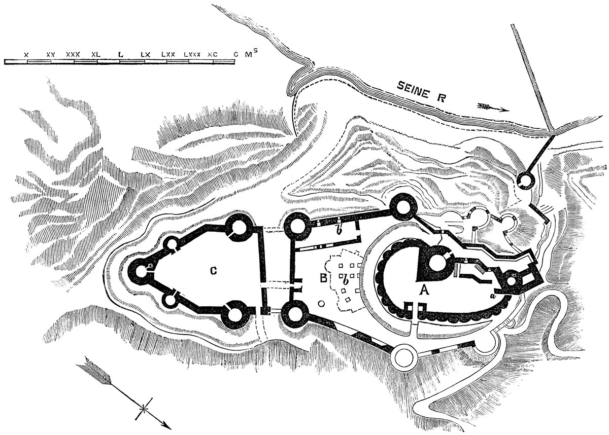
383
No regular gateway remains in this ward. There is an opening in the south curtain which led to the great outwork, but which could scarcely have been the regular entrance. Neither could this have been on the west or north fronts. Probably, therefore, it was to the north-east, where the wall is now wanting. It is said not to have been opposite the inner gateway. At best the approach must have been little suited to wheel carriages. There was a well in the east quarter of this ward.
Mention has to be made of some curious chambers cut in the chalk of the escarpment of the ditch, from which at this time they are entered. There are three or four of these, about 80 feet in length and 7 feet high. They are carved with a sort of rough regularity, with pilasters left against the wall, and bands representing segmental arches. One large octagonal pier has a cap and base, and the latter has the water-bearing hollow of the Early English style, and is evidently original. It is probable, from what is said of these places in the account of the surprise of this ward, that they had a door towards the ditch, but they seem to have been also entered by a round hole, 4 feet across, in the roof, as was the case with the dungeons at Coucy.
The outer ward has its proper ditch, cut with vertical sides across the ridge in front of the south wall, between it and the rear of the outwork. This ditch is about 30 feet wide and 20 feet deep, but runs out to nothing when it reaches the steep ground.
The outwork, ravelin, or outer ward, is an antemural work, intended to cover the only side upon which the castle was open to an attack from level, or rather rising, ground, and to occupy what would otherwise have been a very dangerous platform.
It is in figure an isosceles triangle, having a base of 125 feet, and sides of 175 feet. Each of the three angles is capped by a round tower of 35 feet diameter, having walls 11 feet thick, and which384 seem to have been at least 40 feet high. Besides these, in the side walls, 60 feet in rear of the front tower, are two subordinate towers, also round, of 25 feet diameter; and again, a few feet from these, the curtain is slightly bent, so as to present an obtuse salient to the field. The work, therefore, though in general plan a triangle, has really five angles and as many towers. The front tower has a well-stair at its junction with its western curtain. The curtain is much broken down, but must have been at least 30 feet high, and, near the front, about 12 feet thick, and elsewhere 8 feet.
The rear or gorge wall is not exactly a curtain to the flanking towers. It is placed a little outside of them, on the edge of the ditch; and between it and the east tower was the gateway, the special and independent entrance of the outwork. The north side is gone, but the other side shows the springing of the portal arches and a square portcullis groove. In this gorge wall, not far from the gate, is a large arch, corresponding to that already mentioned in the outer-ward wall. This was, no doubt, a way of communication between the castle and the earthwork. This ditch was crossed by a wall at the east end, which connected the two works and protected the bridge. The west end is filled with ruins. There are now no traces of buildings in the outwork.
The towers of the outwork are of great strength, and have been faced with ashlar. The front tower especially is strong, and does not appear ever to have been mined or breached. Also the rock beneath it is undisturbed. Possibly the breach spoken of at the siege was in the adjacent curtain on the east.
In the rear of this work is the ditch already described, and along its front and flanks is another ditch, proper to the outwork, and the most formidable of all the defences. It is above 30 feet wide, and at the advanced point, where the ground rises, above 40 feet deep. The scarp and counterscarp are vertical.
Besides these regular works are others of a less regular but very formidable character, on the west side. This face of the rock towards the Seine, steep naturally, has been scarped and defended by art. Half-way down the slope is a round tower, connected, it is said, with the work above, by a gallery cut in the chalk. From the tower a wall descended to the river, so that the approaches on this side and the road between the hill and the river were effectually commanded. This wall seems to have terminated on the river bank, in a pier of which traces remain, and which supported one end of a strong dam or weir of piles, which extended across the river, and was part of the original work of Cœur-de-Lion. Several other works were stepped into the rocky slope, and especially covered the west side.
The weir crossed above the island, called formerly D’Andelys, upon which was the octangular fort, erected also by Richard, and of which traces remain. The bridges from this island, either way, to the banks, were of timber, and have left no trace behind.
Finally are to be mentioned the fortifications of the lesser Andelys, now destroyed, and the lake, fed by the waters of the Gambon, and385 which washed the walls of Great Andelys, and completely enveloped the lower town. These additional defences are now destroyed and the lake is drained and filled up, but indications remain sufficient to verify the detailed description of Guillaume le Breton, and to justify M. Deville in his description, and M. le Duc, in his restorations, advanced under the excellent articles “Château” and “Donjon” in his “Dictionary.”
THE town, castle, and priory of Christchurch are placed upon the south-eastern point and edge of a tongue of moderately-high ground, which intervenes between the Stour on the west and the Avon on the east. The two rivers of Dorset and Wilts meander like their prototype,
and flow across broad and marshy tracts of land to unite below Christchurch in a spacious inlet of the bay which is formed, and on the south-east protected, by the headland bearing the suggestive name of Hengistbury. The position is thus strong and convenient: unapproachable, by reason of the marshes, on the east and west; presenting to the north a narrow and defencible front, and placed upon a harbour in former days very suitable for small vessels, sheltered from the prevailing west wind, and having a narrow and easily-guarded entrance from the adjacent channel. Such a position was not likely to be neglected by any people, even in the rudest age, and accordingly the Britons seem to have fortified the headland: and those who drove them out not only gave to that headland its present name, but, finding the inner position better suited to their habits, fortified it with bank and ditch, and within the area so enclosed threw up the usual mound, or burh, the ordinary indication of the residence of an early English chieftain.
The remains of the British period are confined to the double banks and ditches, which still crown the headland, and to the names of the rivers, which there unite. Of a British town or church, Aberdour, as such would have probably been called, no traces are to be found.
The earliest mention of the place in Anglo-Saxon records is in the Chronicle in a.d. 901, where it is recorded, that on the death of Alfred and the succession of Edward the Elder, Æthelwold, his uncle’s son, seized the vill at “Winburne and that at Tweoxneam,” but on Edward’s marching to Badbury, and threatening an attack on386 Winburne, now Wimborne, he fled into the North. This statement is repeated by Florence of Worcester, with the additional information that Tweoxneam was a royal vill. The place, under its better-known name of Twyneham, occurs in a charter by Athelstan, dated387 April 23rd, 939, in which, among other lands, he, the “king wielding all Britain,” gives to God and St. Mary, to St. Michael, St. Sampson, and St. Branwaladre, lands on Avene at Twynham. The character of a royal vill was long sustained, and from Domesday it appears that it had belonged to the Confessor and did then belong to King William. Long before that time, however, a religious house had been founded there, and the canons of Tuinham, or of the Holy Trinity of Thuinam, appear in the Survey as tenants-in-chief. The foundation was probably an early one. Twynburn, or Winburn, on the same Stour a few miles higher up, was founded before 705, and Wareham before 876. In the Confessor’s time, there were twenty-four canons and a dean; and in the reign of Rufus, the latter post was filled by Ralf Flambard, who is said to have rebuilt the college, which was practically re-founded by Richard de Redvers, Earl of Devon, in the reign of Henry I., and whose son, Earl Baldwin, obtained the conversion of the seculars into regular canons of the order of St. Augustin. The mill is recorded in Domesday. In all these transactions there is no mention of the castle.
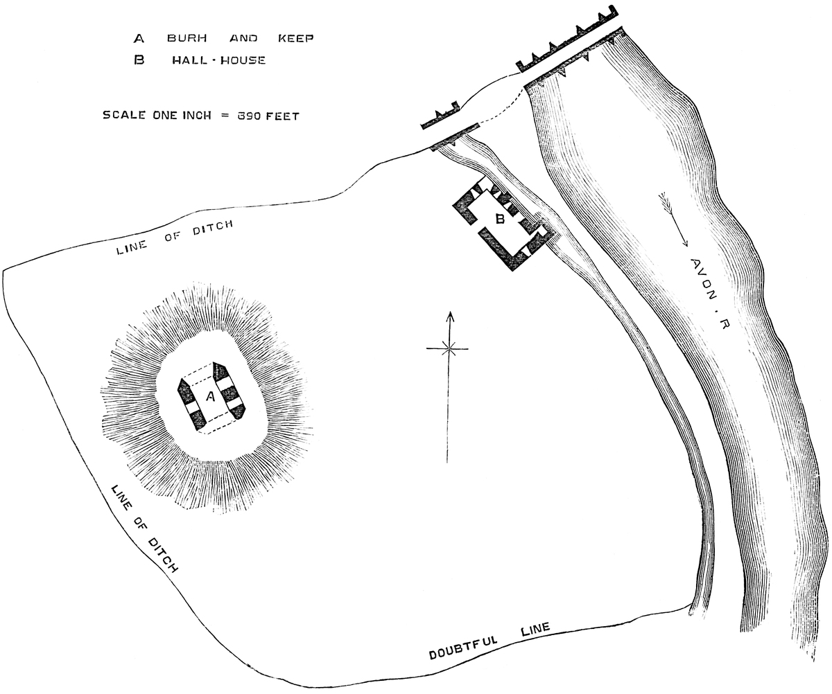
The castle, however, though possibly not a structure in regular masonry until a century later than the Conquest, was certainly a burh long before that event, and probably at least as early as the ninth century, preceding, no doubt, and being the cause of, the vill, or collection of houses. It stands upon the right or west bank of the Avon river, immediately below the ancient bridge which carries the high road across it. Its eastern front stands about 16 yards from the river, and rises out of, and forms, the bank of the Mill Leat, which intervenes between the castle and the Avon. The leat commences about three quarters of a mile higher up, and terminates at the ancient Priory Mill, now called “Place Mill,” 500 yards lower down, where, having started from the Avon, it falls into the Stour. As there seems to have been but one mill, it is to be supposed that the lay and spiritual lords were in accord upon the very interesting topic of multures. At any rate, it lay with the former to cut off the supply of water.
The area of the castle was roughly rectangular, about 110 yards north and south, or parallel to the river, and 150 yards east and west,—dimensions which include the ditch, now filled up, but of which there are indications, with a breadth of 20 yards, along the north and west fronts, now Castle and Church streets. The line of the ditch along the south, or Priory, side is not traceable. The old Priory wall is wanting there, and the ground has been levelled and cultivated as a garden for above a century. Probably the ditch communicated at each end with the mill-stream, and was filled from it, involving at the deepest part not above 12 feet to 15 feet of excavation. No doubt there was a bank within the ditch, thrown up from it, and which has since been employed to fill it up. On the water front no earthworks were necessary. The leat is 25 feet broad, and the river expands suddenly below the bridge to 130 feet in width.
388
In the highest and north-western quarter of the space thus enclosed is the burh, attributed by Norden, with great probability, to Edward the Elder, after the suppression of the rebellion of Æthelwald in 901. This is an oblong mound, wholly artificial, and composed of chalk-gravel. It measures about 160 feet north and south by 150 feet east and west, and has a table summit about 120 feet by 90 feet; it is about 20 feet high. This mound and base court, with the circumscribing bank and ditch, and the watercourse, with, no doubt, a strong palisade, formed the original fortress, which, side by side with the Priory, afforded to the contiguous town temporal and spiritual protection. Here, upon the old site, Richard de Redvers, having before obtained a grant of the manor from Henry I., erected a castle such as was then in use. He walled in the area, placing probably his curtain along the crest of the bank and upon the edge of the mill leat. His keep he built upon the mound, and the hall and domestic buildings upon the line of the wall, along the edge of the water. He is said also to have walled the town. The masonry remaining is but scanty and confined to some fragments of the keep and the hall-house, both of which appear to be original.
The keep is peculiar both in position and in its details. It is, or has been, rectangular, and it stands upon the summit of the mound. It is very unusual, for obvious reasons, to find rectangular keeps placed upon artificial earthworks. At Guildford, where this appears to be the case, it is only partially so, the tower being built on the slope of the mound so that at least one half of it descends to the solid. It is, no doubt, possible that here, the mound being of but moderate height, the foundations may be laid below it; but more probably this is not the case, and the engineer trusted, and securely, to the immense breadth of his masonry to spread the weight and thus avoid unequal settlement. Usually, when keeps are erected on artificial mounds, they are of the shell type, as at Arundel.
This keep is also peculiar in its details. It was a rectangular tower, 50 feet north and south by 46 feet east and west. Its walls were fully 11 feet thick. There are no traces of pilasters, and the angles are chamfered off, the face of the chamfer being about 6 feet. At present only the east and west sides are standing, to a height of nearly 30 feet, and it is difficult to make out from them what were the arrangements of the building. In the west wall is one opening; on the east are two, flat-sided, 8 feet wide, about 18 feet high, and descending to the ground-level. They are closed above by very flat segmental arches—in fact, plat-bands—relieved by obtusely-pointed, if not round-headed, arches of construction in the work immediately above such details, so far as they can be seen or inferred. The low and large openings, the chamfered angles, and the absence of pilasters are utterly unlike what is usual in a Norman keep; though, from the great mass and general figure of the building, it can scarcely be other than Norman. Mitford, in Northumberland, though differing in detail from the present tower, differs quite as much from the ordi389nary type, and that certainly is of Norman date. The work of this keep is a sort of coarse ashlar, rough, but of good quality. Perhaps more details might be discovered but for a thick drapery of ivy, which, in this stage of its decay, serves to protect the building.
The hall, called the Constable’s House, is a rectangular building, 80 feet north and south by 35 feet east and west, placed on the margin of the leat, and rising out of it, so that its broadside forms a part of the outer line of defence towards the east. At present it is detached and stands alone, but it probably ranged with the curtain wall, of which, however, there are now no traces. There seems to have been a building connected with its south-west angle.
The building was composed of a basement and a first floor. At each end was a high-pitched gable, of which the southern only remains. The walls are 5 feet thick, and the interior dimensions therefore 70 feet by 25 feet. The basement is at the ground level and about 1 foot above the top water of the leat, the height of which is regulated by hatches. The entrance from the castle was in the west side, 16 feet from the north end. The doorway, of 5 feet opening, seems to have had a segmental head, but the ashlar has been roughly removed. In the two ends were loops: that to the south has long been closed. In the east side, towards its north end, are two loops. All these loops are mere rectangular slits, evidently intended for air, not defence. Each is placed in a splayed recess, 4 feet 6 inches wide, with a segmental head. Also in the east wall, 4 feet from the south end, is a similar recess, opening into a small door, which led into the garderobe turret. Next, north of this, 12 feet from the south end, is a door opening on the water, 7 feet wide, with a very flat arch, evidently original. The jambs are of ashlar, and they have capitals of a peculiar character. This was evidently the watergate for the admission of stores from the river, here a few yards beyond the leat and a few feet below it. The garderobe turret is a projection, 12 feet square, from the east wall at its south end, standing in the leat, and pierced below by a round-headed arch, or culvert, 4 feet broad, through which the water flows freely, and into which the garderobes discharged. This basement was evidently a store. It is said to have been crossed by a wall. Of this there is now no trace.
The first floor contained the hall, which occupied its whole area. The main entrance was at the south end, near the south-west corner, by a segmental-headed door; in the north wall is a window of two coupled lights, each under a segmental head, with exterior drips, and the whole placed within an exterior round-headed recess, the sides of which contain flanking shafts, nooked. Above, not quite over the centre, is a corbel carved as a human head. The arch-head and tympanum are highly enriched with varieties of the chevron moulding, and upon the chamfers of the lesser drips are rosettes carved with great delicacy. Though heavily draped in ivy, enough is seen of this window to show that it is late Norman, and of great beauty. There are windows similar in type, but less rich in ornament, in the390 side walls, two in each, and probably there were three, indicated by notches in the ivy. In the east wall, 20 feet from the north end, are the remains of a large fireplace, of which the convex back and the upper part of the circular tunnel remain, and above is a tall cylindrical chimney-shaft, probably original. A door from the south end of this wall led into the garderobe turret, which had a loop to the east. There is also a round-headed window in the south gable, which opened into the roof. There was no vaulting; the floor and roof were of timber, the latter open.
The view in Grose, taken in 1783, shows the garderobe turret to the full height of the side wall, and the great chimney-shaft unincumbered with ivy. It also shows the north-east angle unbroken, within which was then contained a well-stair. This angle has now fallen away or been removed, and its broken parts are so encumbered with ivy and rubbish that nothing has been ascertained as to what may remain; but no doubt the staircase ascended from the basement to the main floor and thence to the roof or to the ramparts of the curtain. In Grose’s time, the north wall was encumbered by a cottage and some chimneys and other additions in brick; these have now been removed. The garderobe turret was wilfully pulled down when the castle changed hands towards the end of the last century. There is a letter in the Gentleman’s Magazine complaining of this, and which possibly put a stop to further injuries.
It is remarkable that a building closely resembling this is found at Desmond’s Castle, at Adare, near Limerick. That castle is late Norman, with a rectangular keep, though not on a mound, as the ground is naturally high; and just below the keep, upon the bank of the river, is placed the hall-house. It has a basement on the ground level, evidently a store, with a separate entrance, and above is the hall, with a boarded floor and open roof. The garderobe turret is built out into the stream, has a culvert below, and is nearly perfect. The keep, hall-house, and gate-house are there preserved, and if, as is probable, the entrance at Christchurch was near the river at the foot of the bridge, the relative position of the buildings would be the same. An excellent plan of Desmond’s Castle will be found, with much else of a valuable character, in Lord Dunraven’s “Memorials of Adare.”
Christchurch Castle has not been the scene of any remarkable event, nor does its name occur with any prominence in the history of the country, or even of the county. The manor was first alienated from the Crown by Henry I. in favour of Richard de Redvers, whom he created Earl of Devon. In the “Monasticon” (vi., 304) is printed a grant or confirmation by this earl to the canons of Christchurch of the “Terram usque in aquam de havene, quæ est inter cimeterium et fossatum castelli, messuagium supra ipsius castelli fossatum, quod habent ex dono Gamelini.” This is the first mention of the castle, and would make it earlier than 1137, in which year Earl Richard died. As the masonry of the castle looks twenty or thirty years later, the allusion may be to the earthworks, or older castle;391 and the present building may be the work of Baldwin, the second earl, who granted a charter to the same effect with that of his father, confirming lands between the churchyard and the ditch of the castle (ibid., vi., 303). Earl Baldwin died 1155. In the rolls of Parliament, mention is made of John Randolph, a former justice, as having been warder of the castle in the time of Henry I. Baldwin’s son and successor was Earl Richard, who confirmed his gifts, and died 8 Henry II., 1161, leaving Baldwin, the fourth earl, who died childless, and was succeeded by his brother Richard, fifth earl, who also died childless. The heir was William, called De Vernon, sixth earl, brother of Richard, the third earl, and uncle to the two last earls. He flourished during the reigns of Richard I. and John. Probably during these transitions the Crown stepped in as custos, for in a plea before the Curia Regis, in 1194, a certain Roger Waspail affirms that seizin of certain lands was given to him by Earl John “in werra sua dum fuit in Castello de Cristescherche.” A little later, when Earl William was in possession, the king (2 John) confirmed a settlement made by William de Vernon, Earl of Devon, by which Plympton Castle, the caput of that honour, was to pass to his elder daughter, and Christchurch and the Isle of Wight to Joan, the younger. John was at Christchurch, either the priory or the castle, December 13, 1201. Probably this deed was drawn up before the birth of Baldwin, the earl’s son, or when it was supposed that Baldwin would die childless. As it was, it did not take effect, for though Baldwin died before his father, he left a son, Baldwin, seventh earl, who was also Earl of the Isle of Wight.
In 1210, 11 John, the king was again at Christchurch, on his way from Clarendon to Canford. Baldwin died 1245, leaving a son, another Baldwin, eighth and last earl of the House of Redvers. He died 47 Henry III., 1262–3, and is described as Baldwin de Lisle, Earl of Devon, and he died seized of the manor of Christchurch. It appears from the “Testa de Nevile” that he held that manor “de veteri feoffamento,” by what service is not recorded.
The earl’s heir was his sister Isabel, who married William de Fortibus, Earl of Albermarle, who died in 1260. Isabel succeeded to the whole estate, with the reversion of Christchurch, which was held in dower by Countess Margaret. Countess Isabel died before 1269, leaving one child, Aveline, who married Edmund Crouchback, son of Henry III. She died childless, having inherited Christchurch on the death of the Countess Margaret in 20 Edward I., in which year she also died, having granted or bequeathed Christchurch and some other parts of the earldom to the king, by whom, in 1299, 27 Edward I., the “Castrum de Cristeschurche de Twynham cum burgo et Manerio de Westovre et Hundredo de Cristeschurche” were assigned as part of the dower of Queen Margaret. These possessions, as part of the earldom of Devon, were claimed, in 1315, 8 & 9 Edward II., by Hugh de Courtenay, as heir-general of Countess Isabel, but without success. The castle descended to Edward III., who placed Thomas West in it as custos.
392
In his third year, the king granted to Sir William de Montacute, afterwards Earl of Salisbury, the castle and borough of Christchurch-Twynam, the Manor of Westovre, and the Hundred of Christchurch. The earl died so seized, and his will is dated at Christchurch-Twynam, 20th April, 1397. With the exception of a short forfeiture by Earl John to Henry IV., the castle remained in the Montacutes until Earl Thomas, who died in 7 Henry V., and left it to his daughter and heiress, Alice, who married Richard Nevile. Probably it was regarded as a male fief, for in 32 Henry VI. was a grant of a lease for twelve years of the manor, borough, and hundred, to Richard, Earl of Salisbury, in right of the Lady Alice, his wife, at the rent of a red rose. The leasehold appears to have been extended, and eventually converted into a freehold, as the Christchurch estates were held by the son of Richard and Alice, the king-maker Warwick, and descended to his elder daughter and co-heir, Isabel, who married George, Duke of Clarence. Their son, Edward, Earl of Warwick, held Christchurch till his forfeiture and death, after which (5 Henry VIII.) his estates and the title of Salisbury were allowed to his sister Margaret, executed 1541, and who at her death or forfeiture held the manor, castle, borough, and hundred of Christchurch, which then escheated to the Crown. It is by descent from Countess Margaret, through her granddaughter Catherine Pole, that the inheritors of the Hastings baronies are now claiming the chantry erected for their Plantagenet ancestress in the priory church. They, no doubt, are the heirs-general; the heir male is the Earl of Huntingdon.
From Henry to James, Christchurch remained in the Crown. The latter sovereign granted it to trustees for the benefit of Prince Charles, whence it passed by sale through various hands, and finally was purchased by Sir George Rose in 1790. It is now the property of Lord Strathnairn.
The Priory buildings stood to the south of the church, and but scanty traces of them remain. There are considerable fragments of the containing wall to the south and east, and the fragments of two mural towers and the gateway. On the low ground on the Stour to the south-west, on the edge of the wet land called “QUOMPS,” are traces of a large fish-pond. Beyond the mill are the “convent meadows.” On the corbel shields terminating the drip-stone of the west door of the tower, are, dexter, what appears to be a “cross patonce” for de Fortibus; and, sinister, Montacute quartering Monthermer.
CLIFFORD CASTLE is the most westward of the fortresses by which the line of the Wye is protected in its passage across the county of Hereford, and which appear to have been constructed, some long before, some shortly before, and others shortly after, the Norman Conquest, for the defence of that fertile acquisition against the ever-aggressive Welsh of Brecknock and Radnor.
As early as the first quarter of the ninth century, the Saxons, under Egbert, had reduced Wales to a nominal subjection. And that great prince, having conquered Mercia, and exercising power over all England, is not unlikely to have strengthened the Mercian frontier and the Saxon acquisitions generally on the Welsh side; and to this period may be due, not improbably, such earthworks as those at Cardiff, Caerleon, Shrewsbury, Old Radnor, and Builth, and, now partially destroyed, at Hereford, and wholly so at Worcester: earthworks which, in their main features, resemble those thrown up early in the tenth century at Tutbury, Tamworth, and Leicester by Eadward the elder and his sister, Æthelflæd.
But, whatever may then have been done, it is very certain that during the reign of the Confessor several of his Norman favourites settled in England, and that, among them, Richard Fitz-Scrob had lands in the north of Herefordshire, and there set up and gave name to Richard’s Castle. As this castle was a great cause of offence, it probably was something different from the fortified timber houses of the English Thanes, and may well have been of stone, after the rising Norman fashion. It was certainly a place of considerable strength, and was useful during the invasion of Prince Griffith, in 1052. The fashion, probably, did not extend among the English, for when the same prince invaded Archenfield, and burned Hereford city, in 1055, he entered, apparently without much difficulty, the strong place, or Gaer, by which it was defended, and of which no doubt the banks and ditches, yet remaining, and the mound, known to have been removed, were parts. Harold retook and fortified the city in 1056.
Herefordshire was at that time, and long afterwards, one of the most valuable and most threatened of the English acquisitions on the Welsh border. Before the Norman Conquest, it was under the vigorous sway of Earl Harold, who beat back the Welsh from Rhuddlan to Gloucester and Chepstow, although he was unable to prevent Caradoc ap Griffith from destroying the hunting-seat in course of construction for the Confessor at Portskewet. That Harold encouraged fortified places on these marches is pretty certain, seeing that of the small number of castles recorded in the Domesday Survey no less than ten are named as standing in the marches of Monmouth and Hereford: namely, Wigmore, Clifford,394 and Chepstow, of which Wigmore is reputed one of the oldest Honours in the kingdom; Monmouth; Ewyas, founded before the Conquest, and repaired before Domesday, by Alured de Marleburgh; Avretone; Caerleon, famous for its Roman walls and its mount; Ferrars Castle; Herdeslie; Waterleye. These and several others not mentioned in the Survey, but existing at the time, were strengthened and held by the Norman invaders.
Clifford Castle stands on the right bank of the Wye, at the bottom of one of those short, sharp bends so frequent along the course of this river, and which add so much to its beauty. It crowns a red sandstone cliff about 150 feet above the stream, and close to it. The scarp, naturally steep, has been recently made steeper by art, to allow of the passage of the Brecon and Hereford Railway between the castle and the river. The cliff is part of a knoll of high ground, about half a mile long, and cut by the long-continued action of the river into a semilunar figure. The highest part of this knoll is converted into a narrow tongue by a broad and deep ravine, which descends from the north nearly parallel to the Wye, and terminates in the river bank. A long, tapering ridge is thus isolated between the ravine and the river, and upon this stands the fortress. The ravine bounds the ridge on the south and east, and a natural depression of no great depth crosses the latter at the broad north end. The intermediate part is traversed by two artificial cross ditches, which run from the river to the ravine, about 100 feet deep, but still considerably above the level of either.
The central and highest part thus isolated contains the inner ward; south of this a very small but strong division constitutes the outwork; and on the north is the lower but broader expanse of the outer ward, the three being thus in a line.
The inner ward, of which alone any buildings remain, is roughly quadrangular, about 100 feet square. Along the west or river front are the hall and withdrawing-room. On the south front is a half-round tower and a curtain. The east, or ravine, side is destroyed to the ground level, as is nearly all the north end, in which was the gate-house. The hall, 20 feet by 40 feet, was on the first floor. There was a store or cellar under it, of which the east and south walls are gone. Its entrance, and any light it may have had, were probably given on the court or east side. The hall had a timber floor. It was lighted by three windows in the west or river wall. Of these, the recess of one remains, with a rather low, pointed arch. A door in the north wall led into the withdrawing-room, and one at the south end into the mural tower. The east and south walls are gone. The withdrawing-room occupied the curved angle of the ward between the hall and the gate-house; beneath it was a ground-floor. The south end of the hall, like the west side, was an outer curtain. It abutted against a half-round tower, 30 feet diameter, with walls 9 feet thick, and a gorge wall, 5 feet thick, flush with the inner face of the curtain. This tower seems to have had an under ground-floor, now filled up. The basement has a395 door from the court, in the gorge; another door on the west side, probably a postern, and two loops with wide recesses, opening towards the field. The upper floor also had two loops to the field, a window in the gorge, and on each side a door, one leading obliquely into the hall, and the other into a mural chamber within the curtain, and containing a garderobe, double. The floors were of timber. There is no staircase nor fireplace.
The curtain breaks off towards the south-east angle, where it seems to have expanded and probably abutted against a tower. In it is a mural chamber, a garderobe, single, on the first floor level, and which evidently opened from the destroyed tower. The two garderobes mentioned open by oblique shoots in the wall, about 5 feet from the ground, without any projection. As the whole east or ravine front is gone, it is difficult to say whether there were towers at the south-east and north-east angles; probably there were, and round ones. In the north front are two circular depressions, evidently the place of the two towers of the gate-house, and between them is the entrance. This leads from the outer ward, and crossed the ditch upon a causeway of earth, about 6 feet broad at the top, and the ascent up which from the counterscarp of the ditch to the portal is very steep. The causeway appears to be original, and has been pitched with stones on edge. At the end of this ditch, where it opened on the river bank, it is crossed by a curtain, 6 feet thick, intended to prevent enemies from crawling up the river bank and surprising the adjacent gateway. This curtain is now about 6 feet high, and probably was 25 feet or 30 feet.
The outwork, south of the inner ward, and divided from it by a very narrow but deep ditch, is not easily to be explained. It is the extremity of the ridge, of a triangular figure, 60 feet on a side, and level, showing no trace of earthwork or masonry of any kind. The three scarps are very steep indeed, and quite sharp and clean cut, the soft rock being covered with excellent firm turf. This outwork is so dangerously near to the inner ward, and at so high a level, that it must have been occupied, probably by a stockade or timber structure. It is a very curious work.
The outer ward, at the north end or root of the ridge, is 60 feet or 70 feet lower, and much broader than the inner ward. Its defence on the south is the cross ditch, over which passes the causeway to the inner ward; on the west is the river-cliff, 80 feet to 90 feet high; and on the east and north a steep scarp, partly of red rock, partly rivetted in masonry, and from 10 feet to 20 feet deep. Beyond it is the upper part of the ravine, and the natural depression connecting the ravine with the river bank. This ward is something between a square and a circle, and about 300 feet in diameter. It has evidently been defended by a curtain, probably a low one, on the east and south, or exposed, sides, and the ground, usually level, rises in a sort of ramp to what appears to be the remains of the wall. This ramp is wanting on the river and south faces, which, being covered by the river and the river ward, were probably palisaded only. About the396 centre of the east front is a low mound, apparently the foundations of a round mural tower.
The depressed ground in the centre of the south front indicates that the outer entrance was there; and midway between this and the causeway, leading to the inner ward, are two long heaps of earth and stone with a passage between them. They much resemble the remains of a long gate-house, between the outer and inner gate; but if so, this must have been in the middle of a wall dividing the outer ward into two, of which no trace remains.
This outer ward, never very strong, was evidently intended for the reception of villagers and cattle during the inroads of the Welsh. The earthworks, though deeper and broader than the Normans usually gave to so small a fortress, have nothing of the character of British or Saxon work, and are probably not older than the Conquest, or the reign preceding it. But of the existing masonry none can be safely called Norman. The walls are of inferior and rudely-coursed rubble; no ashlar remains, save a bold cordon or bead, which runs along the top of the lower or battering part of the wall, and this is not carried all round. The arches of the mural tower are flat-pointed. On the whole, the general appearance of the buildings points to the reign of Henry III., and none of it seems of older date. Certainly no decidedly Norman work is seen.
The ditches were substantially dry, though they may have received and retained more or less land-water.
At the base of the slope of the outwork the ravine has been deepened for a rectangular pond, probably a fish-stew, and an early drawing shows water here collected.
Looking from the inner ward upon the river, there is plainly seen, just above the castle, the line of the old mill leat, now a green ditch, and the small eyot upon which must have stood the castle mill. A ripple on the river, here somewhat expanded, shows a ford; and opposite, on the edge of a broad expanse of low, level mead, is the village of Cabalva, said in Welsh to mean a horse-ford. Thus is seen at one view the cliff and the ford which, under the Saxon sway, gave its appellation to the parish, and from which one of the most celebrated of the great English families derived its name.
Clifford, though the cradle of a great race, could have been valuable only while Herefordshire was an unsafe possession. With the settlement of the country under Edward I., it probably fell into disuse and decay. It is far too small and too inconvenient of access to be held, except for safety; and such history as it has is confined to a very early and warlike period.
The castle is reputed with Striguil or Chepstow, Ewyas, and Wigmore, to have been founded by William Fitz-Osborn, one of the companions of the Conqueror, and the first Norman Earl of Herefordshire. He was killed in 1070, and his third son, Roger de Bretuil, who succeeded to his English lands, had forfeited them before the Domesday Survey, when the castle was held by Ralph de Toni, who, by Dugdale, is said to have married Alicia, one of397 Roger’s daughters. However this may have been, he possessed Clifford Castle at the time of the Survey, and died 1102.
How the castle passed from De Toni is unknown, but here Simon, son of Richard FitzPons, was seated, and founded a priory, and he and his brother Richard are said by Dugdale to have adopted the surname of Clifford. Walter de Clifford, son of Richard, was a great Marcher Baron, and living in 1165. His son, Walter the second, was a still more powerful Baron. He died 1222, having married Margaret, daughter of Llewelyn, Prince of Wales, and was father of a third Walter, and of Roger, ancestor of the great house of Clifford, Earls of Cumberland. He may well have been the builder of the existing castle.
Walter, who died 1263, closed the elder line. Maud, his heiress, is said to have married, first William de Longspée, Earl of Salisbury, and, second, John Giffard, of Brimmesfield, who held, probably during her life, Brunless Castle, the manor of Glasbury, and the manor and castle of Clifford, being seized of them at his death, 27 Edward I. Maud’s daughter by Longspée married Henry de Lacy, Earl of Lincoln, and probably upon her mother’s death she obtained her heritage, for in the inquisition held upon De Lacy and his wife, 4 Edward II., the manor and castle of Clifford are included. The castle had probably now ceased to be of importance, for it does not again occur in the inquisitions. It is not usually regarded as having been the caput of an Honour; but Giffard’s inquisition mentions its tenants by knights’ service, and John de Solars, 4 Edward II., holds Paunteleye manor of the “Honour of Clifford,” in the county of Gloucester, which in those days was not always distinguished from other parts of the march.
The Church of Clifford throws no light upon the architecture or owners of the castle. The tower, of considerable size and solid aspect, may be moderately old, but the rest of the building has been rebuilt in the churchwarden manner prevalent in 1836, the roofs, however, having been preserved. Also, from the old building, are preserved a good coffin-lid cross in a circle, placed most unwisely as a cill to the north door; a font, or rather the octagonal bowl of one, probably of Decorated date; and in the chancel, loose on a shelf, a very fine life-sized effigy of an ecclesiastic, robed and tonsured, boldly designed and excellently executed in wood, and which deserves better care.
THE castle of Clitheroe, the chief seat of an ancient and extensive honour, though one of the smallest, is perhaps the strongest, the oldest, and from its position one of the most remarkable,398 of the fortresses of Lancashire. It is placed upon the left, or eastern, bank of the Ribble, here the boundary between Yorkshire and Lancashire, three quarters of a mile from the stream, and about 130 feet above it. It occupies the summit and upper part of a limestone crag, which, precipitous in parts, and very steep on its northern flank, falls, according to the dip of the rock, less steeply towards the south or south-west. Hence, the northern point was selected for the keep and upper ward, and for the lower ward and approaches the shoulder and slopes upon the south. The Roman way from Manchester, by Skipton to York, ascends the399 dale about half a mile east of the rock, which could scarcely have been neglected as a military post by any people who held the district in other than very peaceful times. The town of Clitheroe has sprung up at the foot of the rock upon the north-east.
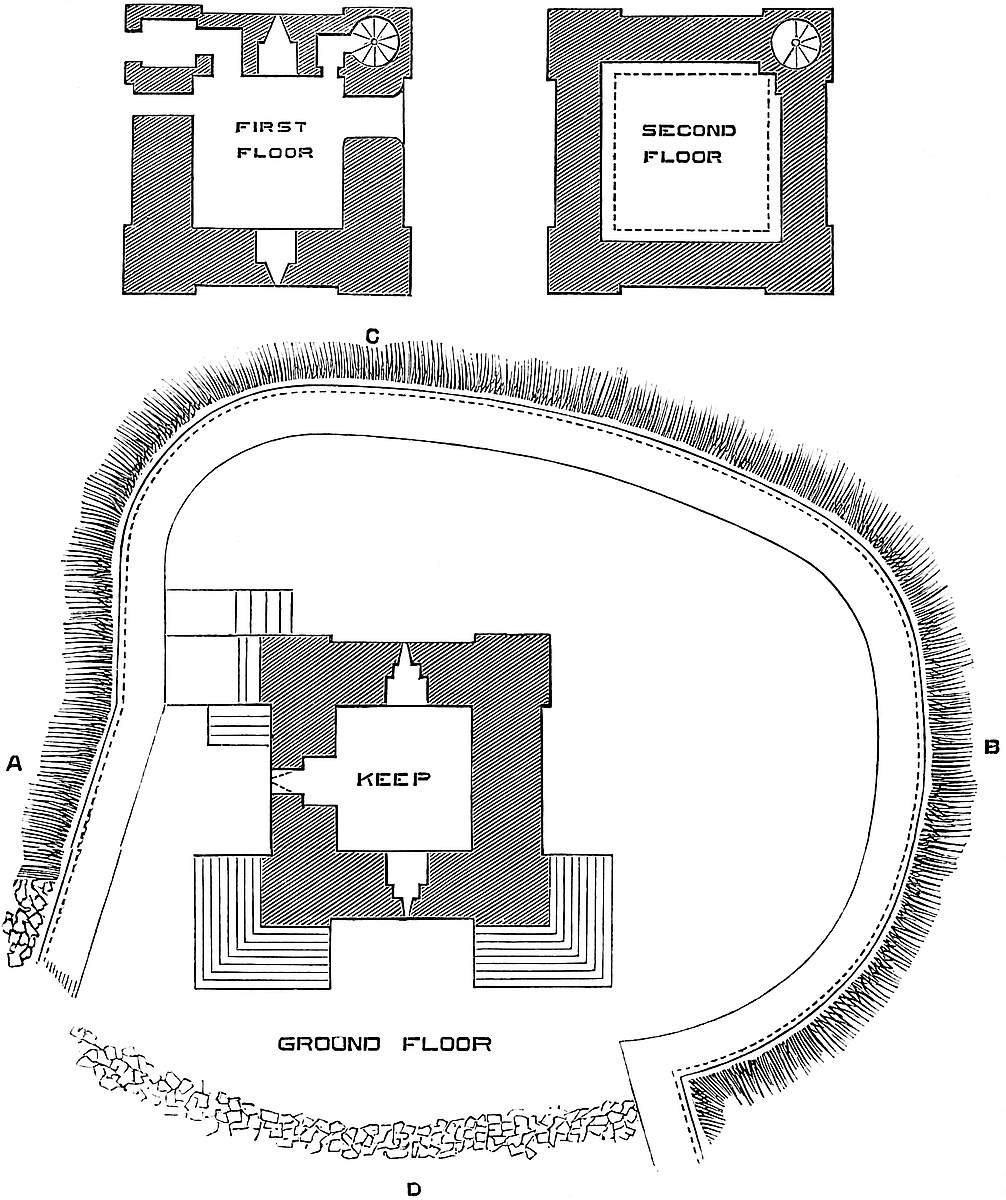
The keep stands within, but close to the east side of, a small rounded area of about 80 feet by 90 feet, contained within a curtain wall, which skirts the edge of the rock. This curtain is 6 feet thick, 12 feet high inside, and from 14 feet to 20 feet outside. The circuit, which has, no doubt, been complete, is broken for about 70 feet on the southern side. This is the breadth of the neck by which the upper ward was united to the lower, and the curtain at each end of the gap is extended southwards and south-eastwards down the steep to include the latter. Thus, what is wanting is none of the exterior400 curtain, only the interior and cross wall between the two wards. The open space is a steep of rugged, broken rock. Probably there was a cross wall and doorway above, and a narrow flight of steps leading to it from below.
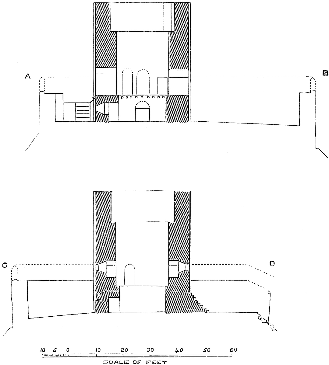
The keep is of rough rubble masonry, with ashlar quoins and dressings. It has neither plinth, set-off, nor string, and preserves its exterior dimensions to the summit. Each angle is capped by two pilasters of 9 feet breadth by 11 inches projection. They unite at the angles, which are solid. The two southern angles are supported by extravagantly-large low buttresses, of modern addition, but it is said they were preceded by buttresses somewhat similar, though of much slighter character.
The keep is 33 feet square and about 43 feet high. The walls are 8 feet thick at the base, and consequently enclose a chamber 17 feet square. This is the basement floor, and at the ground level. It is 9 feet high, and the floor, which covered it above, and is now gone, rested upon nine beams, and was therefore immensely strong. The north, south, and west walls are each pierced by a loop, set in a round-headed recess, 5 feet broad and 5 feet high to the springing. Two of these loops have been converted into open breaches, and the third, to the north, has been walled up and the recess covered with a flat lintel. This floor must have been entered from the room above by a trap and ladder. It was, as usual, a store, the value of these strong small towers depending upon their being well provisioned.
The first floor rested upon a set-off of a foot, and is therefore 19 feet square, with walls 7 feet thick. It is 23 feet high. It has in the north and south walls small square-headed loops, placed in round-headed recesses of 4 feet 6 inches opening. In its west side, close to the north end, is a doorway 2 feet 10 inches broad and 8 feet high, round-headed. In the north wall, on each side the loop, is a door. One of these, flat-topped, of 2 feet 6 inches opening and 6 feet high, leads through a small mural lobby, 4 feet 8 inches by 3 feet 2 inches, into a well-stair, 7 feet diameter, which occupies the north-east angle, and commencing at this level, ascends to the battlements by fifty-four steps. The other door, of 2 feet 11 inches opening, 8 feet high, and round-headed, leads by a passage bent at a right angle and having a barrel vault, into a plain mural chamber, 7 feet by 5 feet, also barrel-vaulted, and which, no doubt, had a loop in its west wall. This wall, however, is now broken away, so that the chamber has much the aspect of an entrance-lobby, which it certainly was not.
The second, or uppermost, floor rests upon a set-off of 2 feet, and is therefore 23 feet square, with walls 5 feet thick, and at present 11 feet high. Singularly enough, it shows no trace of any wall-opening whatever, as though it had been added in modern times for effect only, which, however, does not appear to be the case. The staircase, however, has certainly been repaired, and no doubt originally opened into this floor. The wall at the interior angle is401 thickened somewhat to give space for the stair. The walls may have been a foot or so higher, but scarcely more. The parapet is gone, and was probably another 5 feet. The north-east angle seems to have ended in a small square turret.
The principal entrance was evidently on the first floor, in the east wall, reached by an external stair built against the wall, and ascending from the south end. This is clear from the position and dimensions of the doorway, and from the absence of a loop on this side of the basement, where it would have been covered by the staircase.
The small door of the west wall of the same floor seems to have led upon the rampart of the adjacent curtain, here only 11 feet from the keep. There is such a door at Arques and at Rochester, and also at Helmsley and Adare. This keep contains no fireplace nor garderobe, nor ornament of any kind.
The lower ward has been so altered for domestic purposes, and is so built over, as to be very obscure. It was at least eight or ten times the area of the upper ward, and descended 280 feet down the slope, with an extreme breadth of 150 feet. The modern dwelling-house is built upon the south-east curtain, and no doubt represents, and probably contains, part of the old domestic buildings. Buck gives a view of the southern front of this ward, and shows a large round tower upon one of the angles not now seen.
A convenient ascent skirts the foot of the west curtain, or rather of the cliff upon which it stands, and enters at the upper end of the lower ward, just below the keep. This, however, is probably modern. The old way seems to be represented by the road from the town, which rises on the other or eastern side.
About a furlong to the south of, and much below the castle is a steep straight bank of earth with an exterior ditch, probably an outwork covering the foot of the hill.
The castle is the property of the Duke of Buccleuch, whose steward for the Honour of Clitheroe resides here, and allows visitors to enter the keep unchallenged. The chief rents and royalties of the Honour are vested in the Duke, and are said to be valuable. All is neatly kept, and is in as substantial repair as becomes a ruin; but his Grace’s most commendable zeal does certainly a little obscure the fabric it preserves, and it is to be regretted that the new work was not made more clearly distinguishable from the old.
The name of Clitheroe, though evidently old, and said in part to be British, does not occur in Domesday. Whittaker is of opinion that the place is included in Bernulfeswic, now Burnoldswick, a parish about six miles north-east of the castle, and that it is referred to as the Castelry of Roger of Pictavensis or of Poictou. It is stated that “in Bernulfeswic Garnel held twelve carucates, paying geld to Berenger de Todeni. The manor is in the Castelry of Roger the Poitevin.” Usually Roger is identified with the Castle of Lancaster, but at that time Lancaster Castle was not built, and that lordship did not belong to Roger. Roger was a large tenant in chief402 in the shires of Chester, Derby, Notts, and Lincoln. In Yorkshire and Lancashire he then held but little. The mesne lord, De Todeni, was one of the family who had Belvoir; Dugdale says, the son of Robert de Todeni, who built it. He does not again appear in connexion with this part of England.
Roger is thought to have granted the fee to Roger de Buisli, from whom, or from Albert Greslei, it came to the De Lacys of Pontefract, lords of Blackburnshire, of whom Robert de Lacy is said to have held it under De Buisli. This De Lacy, whose history belongs to Pontefract, is the reputed founder of Clitheroe keep in the reign of Henry I., and certainly the building is not of later date. From that time Clitheroe shared with Pontefract the honour of being the seat of the De Lacy power, and so remained until their estates merged in the earldom and duchy of Lancaster, and this again in the Crown. The founder probably also endowed the chapel of St. Michael within the castle, probably in the lower ward, and which is mentioned in the reign of Henry I. A claim, however, to represent this chapel is set up for the parish church, though this building could never have been within the castle.
Clitheroe, like other strong places in Lancashire, was held for the king in the Parliamentary struggles, and in 1649 the castle was ordered to be dismantled.
Charles II. granted the castle and honour to General Monk, whose son, Christopher Duke of Albemarle, left it to his wife, Lady Elizabeth Cavendish, who again left it to her second husband, Ralph Duke of Montague, from whom it has descended to the present owner.
THE church, village, and castle of Clun are situated near the centre of a spacious amphitheatre of lofty but fertile hills, the summits and upper slopes of which are covered with young and luxuriant plantations, while in the lower parts are occasionally single trees, chiefly oak, elm, and beech, of vast size and great age, the reliques of an ancient demesne, and still standing out and to be distinguished amidst the denizens of the hedgerows, which, though often of large size, all belong to the period of enclosures and cultivation. Across this rich and smiling land, amidst hamlets, churches, manor-places, farmhouses, and cottages, with frequent orchards and gardens, green pastures and root crops, and waving corn-fields, the river Clun pursues its sinuous course, giving life and403 fertility to the scene, which, indeed, is throughout imbued with an aspect of peace and—perhaps rather indolent—prosperity.
The ancient forest of Clun covered a large tract of upland, extending, with a radius of about five miles, to the north and west of the seat of the barony. Its border is that of the county of Salop, and runs along the elevated ridge which, from Bishop’s Moat, on the east, to Castell-cefn-fron, on the west, divides that county from Montgomery, and the water-shed of the Clun from that of the Hafren or Upper Severn. From this latter river the ridge is distant about five miles, and the intervening country is mountainous and broken. The natural division is, in part, strengthened by an artificial work, known as Saeson bank, and placed considerably to the west of Offa’s Dyke, which, here very perfect, runs north and south about three miles west of Clun, and thus bisects the forest and the barony. Which of these earthworks is the earlier is doubtful, but probably the Dyke. Connected with the Saeson bank, and at right angles to it, are two short spurs, the age and object of which are not very evident.
The forest was never very thickly wooded in its upper and more exposed parts, but that it was always scantily inhabited is evident from the fact that it contains but one parish church, that of Mainstone, which stands on the very line of the Dyke, about six miles north of Clun, on the edge of a small brook—the Ffridd. From its singular position may be drawn the inference that it is later than the Dyke.
The water-courses of the forest contribute to form four rather considerable streams, which finally unite to become the river Clun, which thence descends eastwards down a deep and rather narrow valley, by Clunton, Clunbury, and Clungunford, to Leintwardine, where, after a course of about twelve miles, it joins the Teme, the river of Ludlow, and of Tenbury.
The Barony of Clun, called also the Honour and the Hundred, was more extensive than the forest, and included lands of a more settled character to the east and south. Obley, Pentrehodre, Hobendrid, Hobbaris, Larkenhope, Eileston, and Manulton, were members of the manor of Clun, which was co-extensive with the Hundred; and in the “Welshery” attached to it were the hamlets of Aderdely and Bickton, Hodicote, and Newcastle. It appears, in the twelfth century, to have contained five vills and sub-manors, the borough town of Clun, and the manor of Tempsett. Clun was also an ecclesiastical centre. Its noble parish church of St. George was set over the chapels of St. Thomas of Clun, St. Mary of Waterden, St. Swithun of Clunbury, St. Mary of Clunton, St. Mary of Opperton, and the chapels of Edgton and Sibdon. The whole were attached to the great abbey of Wenlock. Many of these chapelries have become independent parishes, and the Hundred of Clun has disappeared as a county division, being absorbed in that of Purslow. In 1837, 8,600 acres of the old forest were enclosed by Act of Parliament, and in 1869, 1700 more.
404
About a furlong below the point at which the collective waters from the forest combine to form the Clun, that stream, there of considerable volume, makes a sharp and sudden bend, in the hollow of which, upon its left or convex bank, is placed the castle. The space thus partially enclosed and protected by the river is about 600 yards in length, and is occupied by a cluster of knolls or tumps of a soft, friable rock, which has been carved and scarped for the purposes of defence, so as to present, with its decomposed and grass-grown surface, much of an artificial aspect. Amongst these knolls stands out one higher and of even a more artificial appearance than the rest. It forms a conical mound, about 40 yards in diameter at its table top, with very steep sides, and in height above its surrounding ditch about 60 feet; and the ditch, again, is about 30 feet above the bed of the river. The ditch covers the mound upon its southern and eastern sides, but to the north and west the slope descends direct to the river level, presenting a very formidable appearance. The more exposed part is further protected by three works in earth, beyond the ditch; of which the larger, to the south-west, is of irregular figure, and about 40 yards deep by 70 yards broad, having four irregular sides, of which the inner is concave, and forms the counterscarp of the main ditch. Towards the river this platform is scarped towards the mound and the adjacent platform; its protection is a ditch, about 7 yards deep by 16 to 18 yards broad. The top is level, save that along the edges of the three outer sides is a narrow bank—a sort of parapet, on which was probably a stockade. At one point, where the platform approaches the mound, is a small spur, as though the ruin of the pier of a bridge, and which was evidently the main entrance to the keep or principal mound. The road to this bridge ascended the platform from the village on the south.
To the east of this is a second platform, of the same height, and about 14 yards deep by 30 yards broad, its larger face being concave, and applied to the main ditch. Its top is level, and has no trace of bank or parapet.
The third earthwork, of no great size, stands to the east of the keep mound, and abuts upon its ditch to the west, and on the river to the north. These two sides are prolonged, and the fork or hollow angle between them is occupied by a depression, formerly a large pool, having a sluice-gate towards the river. Between the bank of this pool and the southern platform is a ditch, which seems to have been used as a hollow way leading to the river front of the mound.
Between the mound and west platform and the river are two lunated patches of meadow about 90 yards deep, the one 70 yards and the other 140 yards long; they were probably employed as a safe pasture in ordinary times for the garrison cattle, which, in case of attack, could readily be taken up the platforms, or driven along the castle ditches into the precincts of the town.
Such are the earthworks as they are now seen, and in general features much, no doubt, as they were seen when the Norman Picot405 took possession of his dangerous grant. They belong to the class known as burhs, or moated mounds, and date from the ninth or tenth century. By whom they were thrown up, or, rather, carved out, is unknown; but it may safely be asserted that they represent the chief residence of one of those Englishmen who invaded and settled upon the Welsh territory, and whose duty it was to defend the western and often-attacked border of the Mercian kingdom. The occupant of such a position must have been a bold and powerful leader; though whether he lived before or after the formation of Offa’s Dyke is doubtful. Possibly a careful examination of the Saeson bank ridge, where it is crossed by the Dyke, might throw a light upon this point, and the researches should extend to Crugyn or Castle Hill, on Bishop’s Castle racecourse, to Bishop’s Moat, Caer-din, Tomen, Castell-cefn-fron or Bryn Amlwg, and some other camps and tumuli on each side the border. Besides these are others, both camps and tumuli, and a remarkable upright stone or maenhir within the forest, all, no doubt, of British date. It must be borne in mind that Clun, though an exposed part of the Mercian territory, was covered to the north-west and north by the English settlements along the Upper Severn, of which there are ample traces from Kerry to Welshpool, on both sides of the Dyke. Looking at the extension of the barony of Clun, westward of the Dyke, to a natural boundary, it seems probable that the barony was founded when the Dyke was no longer the Mercian border, and the English had pushed their settlements up the valley of the Severn. This also would be more consistent with the figure of the earthworks of Clun and of the adjacent district, which resemble those thrown up by Æthelflæda and Edward the Elder early in the tenth century, and of which Wigmore is a recorded example.

The position and estate of Clun, like those of many similar domains in England and within the Marches, were at once taken possession of by the Norman followers of the Conqueror, and held by Picot de Say as a military fief dependent upon Roger de Montgomery at Shrewsbury. Whether De Say or his immediate successors fortified the mounds with masonry after the manner then coming into use in Normandy, or whether they contented themselves with such defences, probably of timber, as they found ready to hand, is not known, but if they had at once built a keep and walls in the Norman manner, it is exceedingly improbable that no trace of works usually so substantial should even now remain, and still more so that they should have been decayed by the middle of the twelfth century, which is probably the date of the older part of the masonry now standing, and which it will be proper next to describe.
The Keep.—This is a large rectangular tower built on the lower edge and up the eastern slope of the mound, and therein resembling Guildford. Its dimensions are 42 feet north and south by 68 feet east and west, and the walls at the base are about 11 feet thick, and rise to about 6 feet at the summit. It is of three stages; the first406 resting on the basement, with its sill about 5 feet below the top level of the mound. The floors are of timber, resting upon sets-off in the side walls. The whole tower is about 80 feet high, its base being about 30 feet above the river. The west wall is entirely gone. The two eastern angles are capped each by two pilasters, 14 feet broad and 1 foot projection, meeting at a solid angle, and carried up without break or diminution to the summit, where they may have supported square turrets. The eastern curtain, between them, has a battering base, and a plain cordon at the first-floor level. The walls are perfectly plain, of coursed masonry, the stones probably hammer dressed; but, being of a perishable character, they are much blistered and decayed. The basement, 40 feet by 45 feet, has a floor about 20 feet above the outer ground level, now covered up with rubbish. There is a small window to the south, and a small square air-hole to the north, high up, as from a dungeon. In the same side, near the middle, is a full-centred doorway, 2 feet 2 inches broad, once closed by a stout door, and opening upon the slope of the mound. It leads into a passage 3 feet 6 inches broad, which entered the chamber, but had on its left a mural staircase of sixteen steps, which led to the first floor. Many of the steps remain, but the inner wall, and most of the hanging arches of the vault, are gone.
The first floor, 23 feet by 45 feet, had two windows to the south, one to the east, and to the north two, with a fireplace between them. The windows are broken into mere apertures, but the recesses are 5 feet to 6 feet broad. The fireplace has a round back and a vertical tunnel. The hood is broken away. There are no mural chambers, but outside, on each face of the eastern angles, are two sham loops.
The second floor has also five windows above, rather larger than those below, and a fireplace in the same position. In each jamb of the east window recess is a small door, which, by a passage, leads into a mural chamber in the two eastern angles. Each, on each of its two outer faces, has a small window.
The third floor has two windows to the north, one to the east, and two to the south, but here the position of the fireplace is between them. From the east window recess are two passages, opening into two chambers, each with two small windows above those of the second floor. The second floor was the stateroom, and the third apparently bedrooms belonging to it. The staircase may have been in the west wall. Of the window recesses, some have arches obtusely pointed, others are segmental. No doubt there was a door in the west wall, opening from the mound. The recesses of the windows of the second and third floors had each an ashlar rib, the only sort of ornament now visible. The keep, though of large size and substantially built, suffers in appearance from the badness of the material, its rough workmanship, and the very sparing use of ashlar in its details.
The summit of the mound was encircled by a curtain wall, of which the upper part of the keep formed a part, so that with the407 rectangular seems to have been combined a sort of shell keep, a most unusual arrangement. Of this shell there remain two fragments; one, a considerable one, towards the north-west, is composed of two nearly half-round towers, or rather bastions, with their converse faces outwards, and a short curtain connecting them, which seems to have been the end of a hall, and to contain some later insertions. The bastions are, no doubt, later than the keep. The other fragment is to the south-west, about 12 feet long by 6 feet thick, and 20 feet high. This also formed part of the general enceinte, but connected with it is a small circular mound, thrown up on the edge of the greater one, and wholly artificial. It is about 21 feet across at the top, and 12 feet to 13 feet high, and possibly carried a small tower; near it a depression seems to indicate the position of the well. The whole surface of the mound is rough and scarred, as though the area had been covered with buildings, as at Tamworth, and of which the foundations had been dug up.
The entrance to the mound could only have been on the western side ascending from the south-west. All the other sides are absolutely impracticable, and this has been so cut about that every vestige of a road is gone. On the platforms are no traces of walls. They may have had gatehouses of some sort, but the outer defences were probably always of timber.
The greater part of the borough, town, or rather village of Clun, is placed to the east—that is, in the rear of the castle; but there are houses on both banks of the river, which is spanned by an ancient bridge of five ribbed arches, with recesses above over the projecting piers. In this direction, a furlong from the castle, is the fine and mainly Norman church of St. George, with a western tower, strong enough to stand a siege, and in pattern resembling those of More and Hope-Say. About a hundred yards beyond or south of the church is a very remarkable ravine, natural, but which has, at that point, been scarped, and the earth thrown inwards to form a bank. This ravine commences some way above the church, and, becoming deeper and more steep, conveys a considerable brook into the Clun, a little below the town. This ravine adds immensely to the strength of the place.
Clun is a borough by prescription, having two bailiffs and a recorder. Recently it possessed a Hundred court for the recovery of small debts, and a court leet. The bailiffs also held a civil court. The Fitz-Alan charter, recognising its prescriptive rights, dates from the reign of Edward II. In the town is an ancient almshouse, founded by Henry Howard, Earl of Northampton, in 1614; and below it, upon the river, the traces of a very considerable millpool, now dry.
Clun is entered in Domesday as held by Picot. Edric had held it. Picot held large possessions (twenty-seven mansions) in the then Hundred of Rinlau, besides Conodovre, Basecherc, and Lentevrde, under Earl Roger de Montgomery. It appears from Mr. Eyton’s researches that Picot was a to-name, and that the grantee,408 as Robert de Say, with Adeloya his wife, and Robert and Henry, his sons, is named in a charter relating to St. Martin of Seez, of the probable date of 1060, and is there described as “Robertus de Sai qui cognominabatur Picot.” Sai was a vill near Exmes, the chief seat of the Norman viscounty of Earl Roger, who was the patron of the house of Seez.
That which in 1060 was a cognomen, in 1086 had become a nomen. In 1074 Odericus refers to him simply as Picod, one of the five whom Earl Roger placed over his new earldom of Shrewsbury, and again as Picot de Sai, when, in 1083, the Earl vowed to found Shrewsbury Abbey. Edric, Picot’s predecessor at Clun, was, without doubt, the Edric Silvaticus, or the Wild, so well known on the Welsh marches. Picot lived till about 1098, and was succeeded by his son, Henry de Say, who flourished in the reign of Henry I., and seems to have been alive as late as 1129–30. In his time, or that of his successor, and probably son, Helias de Say, Clun and Obley were eliminated from Ringau, and erected into an independent Hundred and Honour; becoming, in fact, a marcher lordship, such as Oswestry. Helias left a sole child, Isabel de Say, Lady of Clun, who married—first, William Fitz Alan; second, Geoffrey de Vere, when the barony contained 11¾ knights’ fees; and third, William Boterell, in whose time it seems to have been that the castle was stormed and burned by Llewellyn and his Welshmen.
William Fitz Alan was the son of Alan, son of Flaald, who obtained from the Conqueror the manor of Oswaldestre or Blancminster, which in 1148 had belonged to Meredith ap Blethyn, a somewhat singular instance of a Welsh landholder so far to the east of Offa’s Dyke. Meredith built a castle there, which, on Fitz Alan’s death in 1160, was in the custody of the sheriff, who sank a well there, and provided it with stores and palisades for defence. William Fitz Alan’s next brother, Walter, was ancestor of the House of Stewart. William’s first wife was a niece of Robert Earl of Gloucester. His second was Isabel de Say, by whom he left—
William Fitz Alan, who inherited Clun and Oswestry. He obtained an annual fair from King John for Clun. It seems probable that the Castle of Clun burned by the Welsh was the timber structure inhabited by Edric, and that it was replaced by works in masonry, including the existing keep, by this William, who, dying, 1210, left
William Fitz Alan, who died at Clun about 1215, and was succeeded by his brother,
John Fitz Alan, Lord of Clun and Oswestry, who held the barony but not the castle of Clun, and who died about 1243, leaving a son,
John Fitz Alan, who acquired Arundel Castle from his mother, and died 1267, leaving—
John Fitz Alan, Lord of Clun and Oswestry, and Earl of Arundel, who died 1272.
It was upon his death that an inquisition was ordered into the condition of Clun Castle, which was reported to be small, but pretty well built. The roof of the tower wanted lead, and the bridge to be409 repaired. Outside the castle was a bailey, enclosed with a fosse, and a gate not yet finished. In the bailey stood a grange, stable, and bakehouse. In the town were 183 burgages. The tenants held by castle guard, each finding a serviens and horse for forty days at 4½d. per day. The burgesses were to provide twenty men when the lord hunted.
In 1293, Richard Earl of Arundel received £200 from his Welsh tenants in Tempsett for a charter. At his death in 1301, Clun Castle was worth no more than the expenses of its maintenance, or £20 per annum. There were two water-mills.
Clun continued to be held by a long succession of Fitz Alans, few of whom were likely to have resided, until, the male line failing, Mary, daughter and co-heir of Henry Fitz Alan, married Thomas Howard, Duke of Norfolk, and carried the earldom of Arundel and the barony and castle of Clun into that family in the person of her son, Philip Earl of Arundel, who died 1595, under an attainder. Thomas, his son and successor, was restored in blood, but only partially in property, so that, though titular lord of Clun and Oswaldestre, he never possessed the estates, which were granted by King James to his grandfather’s brother, Henry Howard, Earl of Northampton, who founded the almshouse at Clun. From Henry Howard, Clun and Oswestry passed by will to his nephew, Thomas Howard, Earl of Suffolk, whose younger son, Sir Robert, has a monument in the church of Clun, and by whose descendants the property was sold.
THIS castle occupies the point of a steep and, in part, rocky knoll which intervenes between the confluence of the Derwent and the Cocker, two rivers of Cumberland, the one, on the north, flowing immediately at the foot of the rock, the other, on the south and west, separated from it by an irregular strip of land from 50 yards to 70 yards broad, of uneven surface, and covered by a part of the town which shares its name with the castle. It is not until 120 yards below the castle that the actual meeting of the waters takes place. Two of the sides of the position are thus fortified by nature; the other, the root of the promontory, has no such protection. It seems to have been covered by an artificial ditch, connecting the cliff of the Derwent with the sloping bank of the Cocker. This, however, has been filled up, and all that remains of it is a tradition, confirmed by slight depression in the soil.
The castle, following the outline of the rock, is triangular in plan. Its north and south sides face towards the Derwent and the Cocker, and are in length 110 yards and 120 yards. They crest the slope at410 about 36 feet above the level of the water, and are connected by a base line of 76 yards, in which is the entrance, facing towards the east. The castle commands much of the town, and is placed outside of it to the north and east. The parish church stands within the town upon a height opposite to, and south-west of, the castle, the Cocker in its narrow valley flowing between them.
The curtain within which the castle is contained, is about 30 feet high, and is capped at its western or acute angle by a half-round tower, and at the two angles of the base are two rectangular towers, that to the north-east being the gatehouse. Between them is a small buttress turret, solid, and 8 feet square. There are also two rather large buttresses, additions upon the south curtain near the east end, and three small flat ones upon the older front of the wall, at the west end. On the exterior of the north wall are seven buttresses of various dimensions and dates.
The triangular interior of the castle is subdivided by a cross line of buildings, about 60 yards from the base, into two wards, the lower or eastern, four sided, being the larger, and the upper or inner being a small triangle. Where the cross wall unites at its south end with the curtain is, upon the latter, a small square tower, called the “Bell Tower,” and at the north end a much larger tower, containing the kitchen. Between these, on the cross wall, is the inner gatehouse. The level of the upper ward is about 6 feet above that of the lower. This gatehouse is not central, being 34 yards from the north, and 19 yards from the south curtain. It is rectangular, or nearly so, and in plan a capital T, the outer portal being in the centre of the cross head, the inner one in the foot, and a large chamber in the stem between them. The head is 36 feet broad, with a projection of 18 feet, and the gatehouse is 60 feet deep. The cill of the outer entrance being 6 feet above the outer ward, must have been approached by some kind of bridge or inclined plane, of which all traces are now gone. The outer arch is lofty and segmental, of 9 feet opening. It supports a screen parapet, embattled, behind which is an opening or machecoule 9 feet broad and 4 feet deep. Behind this is an equilateral arch opening into a passage 10 feet deep, vaulted and ribbed from the four angles, the ribs meeting at the centre with two ridge ribs, the central point of the eight being without boss or circle. Beyond the passage is a second arch of 8 feet opening, and beyond it a sort of vaulted passage or vestibule splayed and 9 feet deep, opening into the interior of the gatehouse at the first-floor level. Beyond and right and left of this inner vestibule are two doors of 2 feet opening, one segmental and one shoulder headed. These open each into a small acutely vaulted prison, about 8 feet by 16 feet, lighted by a small loop. From each there opens, in the outer wall, a small door into a mural garderobe. In the centre of each prison is a small square trap, which is the only entrance into the lower prison or dungeon, which is of the size of and vaulted as the upper one, but without any other opening. Two holes in the upper vaults seem intended to carry a horizontal bar411 from which a prisoner or his food might be lowered through the trap. These prisons are placed on each side of, and parallel to, the gateway, in the thick cross head of the T.
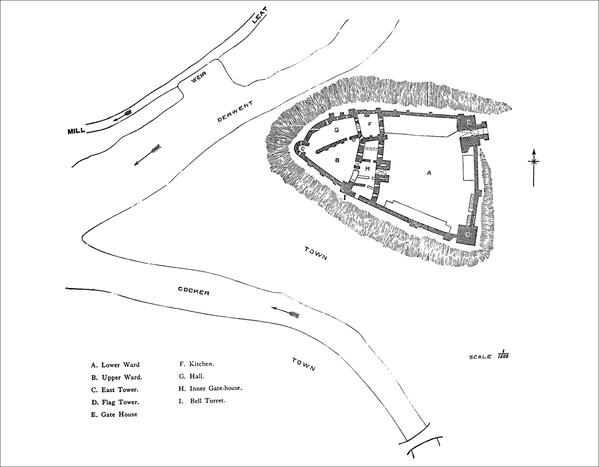
The basement of the gatehouse-chamber, 21 feet broad by 29 feet deep, and about 10 feet high, is quite plain, and without loops. It is entered in the west wall, from the upper ward, by a flight of twelve steps, beneath a lancet doorway. The covering of this room was the timber floor of the gatehouse. The first floor, also 21 feet by 29 feet, has in its side walls two doorways, of 3 feet opening, and acutely pointed, which led into the lateral chambers. In its west wall, but near the north end, is the inner gateway, piercing a wall 9 feet thick, and opening into the upper ward. This passage is vaulted. It has no portcullis, and but one rebate for a door. In the north side of the passage a narrow, shoulder-headed door leads into a small vaulted lodge, looped towards the upper ward.
Entering this ward, on the left, is the door descending to the basement, and further on, right and left, are two doors, each lancet, and at the top of flights of twelve steps, which descended into the basements of the lateral chambers. The gatehouse had an upper floor, now mostly gone.
There were two lateral chambers on each side of the gatehouse, parted by an east-and-west cross-wall, now destroyed. The large spaces thus formed are not quite rectangular. That on the north averages about 26 feet east and west by about 35 feet north and south; and that on the south is a mean square of about 35 feet. Of the four chambers by which these spaces were occupied, the basements of the two next the gatehouse were covered with a pointed vault. Except these, the floors above were timber. The walls of the southern rooms are mostly destroyed, those of the northern are tolerably perfect, and show the windows and fireplaces of a first and second floor, with small mural chambers in the north-east angle. The southern chamber abutted upon the curtain, in which is seen a rude round-headed arch, now a postern, but which has a Norman aspect, and looks as though intended originally for the recess of a loop. The small square bell-turret, of about 18 feet by 10 feet, at the south-west angle of this chamber, stands upon and slightly projects from the exterior of the curtain. The basement looks of the age of the curtain; the superstructure, of that of the cross buildings and inner gatehouse.
At the other or north end of the cross buildings is the kitchen tower, a very remarkable structure. In plan it is nearly rectangular. It is composed of a basement and a first floor. The basement is reached from the upper ward by fifteen descending steps, down a vaulted passage in the wall, at the head of which is a round-headed door of Decorated date. The chamber is about 30 feet square, having a central octagonal pier without base or cap, whence spring eight ribs meeting eight other ribs which spring from corbels in the angles and form responds in the centre of each face. Each of the four bays thus formed is again spanned by ribs springing diagonally412 from the responds. There are no ridge-ribs, and the vaulting spaces are filled up with rubble. The arches are pointed, and the vault about 20 feet high. In the two eastern spaces are square-headed loops, opening on the lower ward and now concealed by a modern building. In the north wall is a small water-drain. This chamber was probably a cellar, introduced and vaulted to place the stone floor of the kitchen on the level of the hall. It is called a chapel, but bears no indication of having been intended or ever used as such.
Above the cellar is the kitchen, the floor of which is level with that of the hall, and about 10 feet above that of the upper ward. In plan it is rather rhomboidal than rectangular. The two eastern angles are right angles, that to the north-west acute, and that to the south-west obtuse. The north and east sides measure 35 feet and 37 feet, and the opposite sides 29 feet and 38 feet respectively. In the south wall are two fireplaces, 11 feet broad by 2 feet deep, with remains of stone hoods, and with square vertical funnels running up a common shaft at the inner end of each fireplace. The funnels also receive those from the fireplaces in the rooms to the south, the whole forming one stack. Over these fireplaces, high up in the south wall, is a large long loop, square headed, and about 2 feet wide. In the east wall are two other loops of the same width, and about 24 feet long, crossed by a transom, square headed, but placed within shoulder-headed recesses. These openings are clearly intended to carry off the vapour. North of these loops is a small door, whence a narrow mural stair ascends 10 feet to a second door that opened upon a gallery along the north wall.
In the centre of the north wall is a bold pier, 7 feet wide by 4 feet deep, from which spring laterally two pointed arches, thus forming two recesses. The soffits are ribbed, one with two and one with three ribs, plainly chamfered. In each recess is a loop, square headed, and opening on the curtain, and above, 10 feet from the floor, is a string which supported the floor of a timber gallery, which ran along this north side, and was carried out in front of the pier, and thus overlooked the culinary operations. It was entered at the east end from the door already mentioned. In its west end was another door, opening into a mural chamber, not now accessible, but which may have communicated with the hall. Above the gallery were two other loops. At the gallery level the pier is pierced by two narrow passages, with round-headed doors, which lead to a small chamber in the curtain, probably a garderobe. Below, the lateral faces of the pier are hollowed, as for cupboards.
The west wall of the kitchen is now chiefly occupied by a large lofty arch, of 15 feet span, and about 30 feet high, evidently a modern insertion together with the wall above, and opening into what was the hall. On the south side of it are traces of a part of the old buttery-hatch. To the north is the only door of the kitchen, 4 feet broad, and shoulder headed, and which opened from the lower end of the hall. It is curious that so large a kitchen should have had no other outlet. Grose gives a drawing taken in 1774, which413 shows this west wall of the kitchen before the great arch was inserted. The wall contains an immense hole or gap, above which, on the outside, is the weather moulding of the high-pitched roof of the hall. The kitchen was very lofty, and had an open timber roof the corbels of the hammer-beams of which remain. Above was the parapet, one side of which belonged to the outer curtain.
Abutting from the west wall of the kitchen, in the rebuilding of which the moulding showing the pitch of the hall roof has been removed, was the east, or lower end of the hall, a building 30 feet wide by about 50 feet long, of which the curtain formed the north side. The south wall is levelled nearly to the ground, but its foundations show its exterior buttresses, and the place of the door in the basement near the east end of the wall. The western wall, dividing it from the withdrawing-room, is gone. The basement below the hall seems to have been about 10 feet high. It was covered by the timber floor. The entrance was in the south wall, close to the east end, probably by an interior stair. One jamb of the doorway remains, richly moulded in the Decorated style, though much decayed. The hall had three large windows in the north wall, which is strengthened outside by three buttresses, evidently added to the older wall when the hall was built. The windows are of the fashion so common in the halls of Decorated castles. They are of two lights trefoiled, with a transom, and in the head a quatrefoil. That next the east end has a stone window-seat, and the others may have been so provided. Outside, the windows have a good drip-stone. Probably the fireplace was in the south wall. In the east wall, near the south end, is a large plain trefoil-headed recess, not even chamfered, resembling a large piscina, with a stone shelf. It was possibly intended to place the dishes upon when received from the adjacent buttery-hatch. South of this a small door leads into a well-stair, which led to the roof, and is lighted by a small and very neat foliated circle. The cant or filling up of the adjacent angle of the kitchen is produced by this staircase. The hall had an open timber roof, some of the corbels of which remain.
The rooms west of the hall extend to and include the western or angle tower. The room next the hall had two large Tudor windows in the curtain; they are flat topped, of three lights, with a transom, and within flat-arched recesses; they are evident insertions. The interior of the west tower is roughly four sided, and the gorge wall is gone. It had a basement with three loops, with large splayed and pointed recesses, and above were three floors, each with an excellent one-light trefoiled window of Decorated date; the two lower are towards the west; the upper, a marked feature in the view of the castle from the town, is towards the south. In the north wall a straight stair leads up to a mural garderobe, the opening of which is projected upon two corbels high up at the junction of the curtain with the tower. The lower part of this tower seems original; the upper part has been rebuilt, no doubt in the Decorated period. Twenty-two feet in the rear of the tower remains the base of a414 doorway which led into these chambers from the upper ward. The well was a yard or two from the entrance to the room below the hall. Its place is now marked by a pump.
The Lower Ward is much obscured by the erection against the north curtain of a dwelling-house, and against the south, of stables, both modern. A building has also been placed against the east wall, connected with the gatehouse. The south-eastern angle is formed by the Flag Tower, 32 feet square, and projecting outwards about 9 feet upon the two curtains. It has a basement and two upper floors, each entered from the court, and the two latter by external separate stone stairs. A third stair, also exterior, ascends from the east curtain to the battlements. The arrangement is altogether peculiar. Moreover, the roof of the tower is high pitched, having the south gable stepped in the Scottish fashion, flush with the outer wall, while the north gable is set in about 3 feet so as to allow of a rampart walk along three sides of the tower. The tower is occupied, and locked up.
The tower corresponding to this, and forming the north-east angle of the ward, is the gatehouse. It is rectangular, 50 feet broad by 22 feet deep, and pierced by the gateway passage, with spacious rooms on each side and above, all inhabited. The outer gateway is round headed, and rather less than half a circle. The passage is vaulted, and has rebates for a central and two outer doors, of which that next the entrance seems to have been inserted to replace a portcullis. Over the front, beneath a long flat label, are five shields of arms: 1. What seems to have been a cinquefoil within an orle of crosslets flory, Umfranville. 2. Barry of 6, Multon. 3. Three luces haurient, Lucy. 4. A lion rampant, Percy. 5. A saltire, Nevile. The gatehouse has two floors over the gateway in the Perpendicular style, and later than the lower part, which is Decorated. To this has been added an upper story, built into the battlements of that below, which appear in the face of the wall.
The portal is flanked by two flat pilasters, which have been partially concealed by the addition of a Barbican, composed of two lateral walls of 18 feet projection, and 7 feet 6 inches thickness, terminating in square piers, which supported a cross arch of entrance, over which was a parapet, now gone. These walls were about 12 feet high, parapeted, and the ramparts reached by two lateral straight stairs niched in the wall. There was no doubt originally a drawbridge to the main gate, which may have been moved forward when the barbican was added. Grose’s drawing shows a sort of ravelin of earth in front of this outer entrance, which probably was thrown up during the Parliamentary struggles. All this front, outside the walls, has been levelled and converted into a garden and approach. Outside the north and south curtains, between the wall and the top of the slope, is a walk of about 9 feet broad.
The accounts of this castle claim for it a very remote origin, and describe the knoll upon which it stands as artificial. This, however, is not the case. The knoll is evidently natural, and the point of a415 tract of high land which is bounded by two rivers. The position is not the less strong, and is such as either Britons, Romans, or Saxons might very well have availed themselves of. There is, however, no positive evidence that they did so, and nothing now seen is of necessity older, or as old, as the Conquest. The foundations of the western tower, and of the greater part of its contiguous curtains, so far as they contain the upper ward, are probably Norman, and may be the work of William de Meschines, in the reign of Henry I. As the works could scarcely have been confined to so small an area as the present upper ward, it is probable that the whole of the present area was included in the Norman castle, and that the cross ditch was then excavated. How the area was then occupied, where was the hall, where the kitchen, does not appear; probably not on the present site, seeing that the windows are evident insertions in, and the buttresses additions to, the north curtain. Moreover, no part of the line of buildings dividing the upper from the lower ward shows any trace of Norman work. Whatever or wherever were the Norman buildings, they probably stood until the Decorated period, or early in the fourteenth century, when the present cross buildings, the kitchen and the hall, seem to have been erected, and much of the curtain rebuilt or strengthened.
The outer gatehouse and the south-eastern tower are not unlikely to be of the same date, though there have been large additions to, and alterations in, the former building, in the Perpendicular period, when the barbican was added. The Tudor windows in the upper ward are the only traces of still later alterations. The effects of the Parliamentary strife upon the building, beyond the removal of the roofs, do not appear to have been serious; and, as the gatehouse seems always to have been inhabited, no doubt some sort of attention was paid to it, and to the flag tower. More recently, a dwelling-house has been built within the area, within one window of which hangs a curious relic of the past, in the shape of an escutcheon of Percy and Lucy quartered, in old stained glass.
The remodelling of the Norman castle in the Decorated period was probably the work of Anthony de Lucy, who held the lordship from 2 Edward II. to 17 Edward III., and was an active soldier, a great military chief in the counties of Cumberland and Westmoreland, and likely enough to put into the best possible order a castle important both to his own estates and to the national frontier committed to his charge.
The Perpendicular additions, including the armorial shields over the gateway, must have been later than 22 Richard II., when Maud, the Lucy heiress, carried Cockermouth Castle to Henry Percy, who agreed to quarter her arms. The Umfranville shield commemorates Maud’s first husband, Gilbert, Earl of Angus. The Nevile shield is that of Henry Percy’s first wife, who was a daughter of Ralph Lord Nevile. As this Henry was a very considerable person, and survived till 1408, it is probable that he built or rebuilt the upper part of the gatehouse between 1388–9 and 1408.
416
Cockermouth Castle has but a scanty history, which perhaps accounts for the perfect condition of its outer walls. In 1221 Henry III. ordered it to be laid siege to, and, if taken, destroyed; but this fate it either escaped, or, if carried out, it was restored a century later with great completeness. It makes no figure in the Wars of the Roses, nor does it appear to what extent it shared in the vicissitudes of the house of Percy. The town seems to have been taken by surprise in 1387 by a band of Scottish marauders. Mary of Scotland rested here, no doubt on her way from Workington to Carlisle, after her landing in Cumberland. In August, 1648, the castle, held for the Parliament, was attacked by the Royalists of the neighbourhood, and held out a month, till relieved by the Parliamentary General Ashton. It seems to have been spared the usual fate of English castles of that period at the hands of one or the other party. In 1688, the only habitable parts were the gateway and the courthouse, probably the adjacent building.
Cockermouth was the “caput” of the barony of Allerdale, usually called in the Inquisitions the Honour of Cockermouth. There is no collected list of the lands held of the Honour, but they seem to have been extensive, and are specified in divers inquisitions from time to time, with the names of their holders. The original grantee seems to have been William, brother of the well-known Ranulph de Meschines, Earl of Chester. He received, either from the Conqueror or from Henry I., the territory of Copland, between the Dudden and the Derwent, and was probably the founder of the castle of Cockermouth, as he was of the Monastery of St. Bees. His son Ranulph died childless, and his heir was Cicely, who married Robert de Romilly, Lord of Skipton. Cockermouth came to Alice, their third daughter and co-heir, who married William FitzDuncan, Earl of Moray, in Scotland, nephew to King Malcolm. Amabel, their second daughter and co-heir, had Egremont, and married Reginald de Lucy, living 20 Henry II.; while Cicely, the elder daughter, married William le Gros, Earl of Albemarle, who died 1179. Their second daughter, Hawise le Gros, married, first, William de Mandeville, Earl of Essex, and secondly, William de Fortibus, in her right Earl of Albemarle, and who (1215) had restored to him by King John the manor of Cockermouth, and (1216) certain confiscated lands held of the Honour. In February, 1221, King Henry ordered the Sheriff of Westmoreland to summon his forces to lay siege to, take, and utterly destroy the Castle of Cockermouth; but later in the year the manor was granted again to the Earl. It is said that this Earl held half the castle, which escheated to the Crown, and was granted in 1323 by Edward II. to Anthony, Lord Lucy, who held the other moiety. The descent, however, is exceedingly obscure. It appears that Richard de Lucy, Amabel’s son, had Egremont, and died about 15 John, leaving Amabel and Alice. His wife, Ada de Morville,417 married secondly, Thomas de Multon, and left issue, while Multon’s two sons by a former wife married—1. Lambert de Multon to Amabel; and 2. Alan de Multon to Alice, the co-heirs.
Lambert’s great-granddaughter, the heiress of Egremont, married Thomas de Lucy, and Alan’s son, Thomas de Multon, took the name of Lucy, and died 33 Edward I., and probably held the Castle of Cockermouth. He was followed by his sons, Thomas, who died childless, 2 Edward II., and Anthony de Lucy, a great baron and military leader in the Western marches. He died 17 Edward III., leaving Thomas de Lucy, who died seized of Cockermouth Castle and Honour 39 Edward III., having married his remote cousin, Margaret de Multon, the heiress of Egremont, and thus reunited the whole inheritance, the second moiety of Cockermouth having been acquired by his father.
Thomas and Margaret had Anthony de Lucy, aged twenty-four, 39 Edward III., and Maud. Anthony had Joan, who died young, 43 Edward III., seized of the castle and Honour, when Maud became the heiress. She married Gilbert de Umfranville, Earl of Angus, who died 4 Richard II. They had but one son, Sir Robert, who predeceased his father, childless. The earl died 4 Richard II., seized of the castle and Honour, and Maud then, 8 Richard II., married Henry de Percy, Earl of Northumberland. The inheritance, failing the heirs of her body, was settled upon the heirs male of her husband, who were to bear the arms of Percy and Lucy quarterly. This remainder took effect, and Cockermouth passed to the descendant of Percy by his first wife, Margaret, daughter of Ralph Lord Neville, whose arms appear over the gateway of Cockermouth, as do those of the Earl of Angus.
Earl Henry was slain at Braham Moor, 1408. Hotspur, his valiant son, fell at Shrewsbury. Henry, the next earl, and lord of Cockermouth, fell at St. Alban’s, 1455, as did his son Henry, at Towton, in 1461. Henry, the next earl, met a violent death in the Tower in 1489, being the fifth lord of Cockermouth of that brave, brilliant, and unfortunate race. Henry, the next earl, died a natural death in 1527, as did his son Henry, childless, in 1537. The next inheritors were his nephews, sons of his brother, Sir Thomas; the earl Thomas, who was beheaded, leaving an only daughter, 1572, and Earl Henry, who died 1585. Henry, the next earl, died 1632, and was followed by Earl Algernon, who died 1668, whose son, Earl Jocelyn, was the last male of the ancient race, his son Henry having died young. Elizabeth, Baroness Percy, the daughter and sole heir, married Charles Seymour, Duke of Somerset. Algernon, their son, created Earl of Egremont and Baron Cockermouth, died 1750, and was father of Elizabeth, the Seymour-Percy heiress; but Duke Algernon had also a sister, Katherine, upon whose son, Sir Charles Wyndham, the earldom and barony, and the castle of Cockermouth, were settled, and so descended to George, the last earl, who died without a successor in 1845, bequeathing Cockermouth to his natural son. Cockermouth Castle, therefore, having418 descended through the houses of De Meschines, De Fortibus, Multon, Lucy, and Percy, can boast a connexion with some of the most celebrated of the northern barons. It has, however, another, and certainly not less brilliant, association. In the adjacent town was born William Wordsworth, and the green court, flower-crowned walls, and gloomy dungeons of the castle are commemorated in one of the sweetest of his sonnets:—
WHEN Hubert of Rie, standing at early dawn between the church and his castle,
welcomed, harboured, and under the escort of his three sons, sent forward his hard-bested lord by the road still known as “Le Voye le Duc,” he probably little thought that the incident would become matter of history, and still less could he have anticipated the splendid reward, for this and other faithful services, his sons were to receive, twenty years later, from that same sovereign in a foreign and then unconquered land. Whether Hubert himself took part in the conquest is unknown; he certainly did not desert his mote and mostier in the Cotentin for any English possessions, but of his sons, Ralph and Adam received lands as under tenants in the counties of Nottingham, Derby, and Kent; and Eudo, called by Dugdale the fourth son, but the principal representative of the family in England, appears in the Survey as tenant in chief of sixty-four manors in the counties of Beds, Cambridge, Essex, Hants, Herts, Huntingdon, Lincoln, Norfolk, Northampton, and Suffolk.
Of these manors twenty-five were in Essex, in which county Eudo,419 entitled from his office “Dapifer,” resided, and his possessions there lay in twelve of its twenty hundreds. In Colchester the lordship and demesne of the town were held by the king. Eudo’s interest there was but moderate, consisting of five houses, 40 acres of land, and a claim to the fourth of certain lands held “in elemosina Regis.” How he maintained his military position we are not told, or why he settled in Colchester. The only Essex castle mentioned in Domesday is Rageneia or Ralegh. “In hoc manerio fecit Suen suum castellum,” nor do any of the old mottes, of which there are several, as Bures, Great Birch, Ongar, Plessy, and Stansted, appear to have belonged to Eudo. His office of Dapifer or Sewer he held under the Conqueror and his two successors, and he so witnessed a charter by William at Honfleur in 1074, and others by Rufus in 1093, and by Henry I. Though described as “Dapifer Domini Regis totius Angliæ,” he seems to have belonged to the ducal not the royal court, for the sewer of England, according to Spelman, was the brother of Robert Fitz Hamon of Morganwg, who appears in the Survey in Colchester and elsewhere as “Hamo Dapifer.” It is related that in consequence of the high character borne by Eudo the burgesses of Colchester moved William Rufus to place him in charge of their town. That he was so placed appears from a document quoted by Dugdale, and his connexion with the place is shown by the Pipe Roll of 31 Henry I., in which, among other entries relating to Colchester, are items for “the lordship of the king’s ploughlands of the land of Eudo Dapifer, 8s. 10d.,” and from “the farm of his land, paid into the treasury, £91. 3s. 0d.” This was after Eudo’s death, when Hamo de Clare was in charge. As the crown held the lion’s share of the town, Eudo’s position there must have been supreme. His first step was probably to build a castle, and upon his own land, for when in 1096 he founded St. John’s Abbey, one of its endowments, specified in the foundation charter, was “omnes proventus capellae, in castello de Colcestria,” which endowment is described in a confirmation by Richard I. (1 R. I.) as “capellam castelii Colcestre, cum decimis et obventionibus,” explained by Morant to have consisted in tythes of certain lands in and about the town.
Eudo’s rank, as an Essex and Colchester land owner and the king’s representative in the town, might very well induce him to erect a castle there. The position was a good one for a district destitute of any very striking inequalities of surface. It was within the Roman area, and covered on two sides by the Coln. The ancient wall, originally Roman, had been repaired by Edward the Elder, and included the town and the proposed site. A legendary document, quoted in the Monasticon [i. 724], states that Eudo built the castle on King Cole’s foundation; “in fundo palatii Coelis quondam regis,” which may be taken to show that there was an older building on the spot. If so it must have been Roman. Most of the chief towns in England contained a castle constructed long before the arrival of the Conqueror, though not a building of stone, and of420 these strong places the king or some great Norman baron usually availed himself, substituting, as occasion served, Norman masonry for the earlier and less perfect defences. Sometimes the castle was within the circuit of the town, as at Chichester, Chester, Leicester, and Lincoln, Roman cities with English additions; sometimes it was outside the town wall, but abutting upon it, as at Carlisle, Warwick, and Winchester. In each case the castle had its own proper defences, so that while, on the one hand, it could be held with the town against a common foe, on the other it could be held against the town, and used to overawe the citizens. Here the castle was placed within the Roman area, in its north-eastern quarter, and stood, not improbably, on the site of some considerable Roman building, to which the existing, but not accessible, sewers are thought to have belonged.
Eudo died in 1120 at his castle of Preaux in Normandy, and was buried here at St. John’s. He lived, therefore, twenty-four years after his religious foundation, and somewhat more than that time after the construction of his castle. He was also the founder, some time in the reign of Henry I., of the hospital of St. Mary Magdalen, in the suburbs of Colchester. He married Rohaise, whom Dugdale in his Baronage, citing Will. of Jumièges, calls the daughter of Walter Giffard, Earl of Buckingham, and widow of Fitz Gilbert, an error which, admitted into the earlier, is corrected in the later edition of the Monasticon, whence it appears that Rohaise was the daughter of Fitz Gilbert and a preceding Rohaise, and was married to Eudo in her nonage, “ante habiles annos nupta est.” She laid the second stone of St. John’s, Eudo himself laying the first. The issue of this marriage was Margaret, Eudo’s sole heiress, who married William de Magnaville, and was mother of Geoffrey Earl of Essex, and in her right seneschal or sewer of Normandy. Geoffrey, who played his cards to great advantage between Stephen and the Empress Maud, received from the latter the lands of Eudo Dapifer in Normandy, with the office of Dapifer, and an option, under certain circumstances, of the lands of which Eudo died seized in England. These, however, he does not seem to have obtained; in the contemporary Pipe Rolls they are accounted for as in the Crown, and they do not appear in the Inquisitions on Geoffrey’s descendants.
The castle, which from the endowment of its chapel must certainly have belonged to Eudo, came into the possession of the Crown. Morant cites a grant of it by Maud to Alberic de Vere, from an early edition of the Fœdera (xiii. 251), but there is no such deed in the later or the latest edition. He also cites a deed in his own possession, of the reign of Richard or John, showing that with other demesne manors the castle of Colchester and the Hundred were in the king’s hands, and in the custody of the sheriff of Essex. In Stowe’s Annals mention is made of a certain Hubert de St. Clare who warded off an arrow from Henry I. at the siege of Bridgenorth in 1165 at the cost of his own life, and whom Stowe421 calls Constable of Colchester, and adds that the king gave his daughter to William de Lanvalai. William, who was an Essex baron, certainly obtained the Constableship from King John (2 John), by a payment of 200 marcs. He died 12 John, leaving William his son, who was made Constable 17 John, but soon after joined the rebels. His daughter Hawise was afterwards given in wardship to Hubert de Burgh, who married her to his son John. King John visited the castle six times, in 1203, 1205, 1209, 1212, 1214, and 1216, staying three days during his two penultimate visits, and eleven days during his last visit. In 1214 Stephen Harengot was in charge in succession to Matthew Mantell; also Hugh de Albemunt, carpenter, had an order for 23 marcs for work done, to which, in 1215, 20 marcs were added for repairs, and the burgesses were informed that Harengot was responsible for the king’s rents. In April of that year Harengot was to have timber from a wood near the town, for its defence, “ad illam claudendam,” and Hugh de Neville was to permit the same. In July, John’s suspicious character led him to substitute for Harengot William de Lanvalai, who had married, as already stated, the daughter of a previous Constable. In this year the castle was besieged and taken by Saher de Quincy, who also burned the town. Both were afterwards recovered by King John.
In March, 1216, is recorded a list of one hundred and thirteen persons, knights, squires, and attendants, cross-bowmen and foot-soldiers, from their names probably French mercenaries, to whom the king gave a safe conduct for a passage from the castle of Colchester to London. In April Harengot was again in charge, and in August he had a credit for 100 marcs out of a fine due of a thousand. This was for the payment of the garrison of the castle. In November, 1217, Richard de Mont Fitchet was ordered to give William, Bishop of London, seizin of Kingsworth wood belonging to the castle of Colchester, and to remove thence his own servants. In July, 1218, the king’s bailiffs of Colchester were to respond for the farm of the town to the bishop, as they had used to do when Harengot held the castle. The bishop was at that time negotiating for the king with the French invaders, who for a time actually held the castle. After John’s death the bishop (October, 2 Henry III.) had a credit on the farm of Colchester for £20 expended “in waristura” (munition) for the castle. In 1222 the sheriff of Essex, then in charge, was to transport certain timber, cut by the Constable of Dover Castle, to the port of Colchester. In January, 1223, the bailiffs of the town had credit from the Exchequer for 100s. advanced by them to the Constable of the castle. The Exchequer seems to have guarded the revenue closely, for in 1224 the Bishop of London is called upon to refund £20 paid to William, late Bishop of London, for the repairs of the king’s castle of Colchester. In April, 1225, the Prud-hommes, “probi homines,” of Colchester are to hand over the farm of the town to the Constable for the repairs of the castle. The Bishop of London seems occasionally to have had charge, for in 1227 he is ordered to send to the king some422 person who may be trusted to deliver over the castle from the bishop to the king.
Hubert de Burgh seems at one time, with the wardship of Hawise de Lanvalai, to have held the Constableship of the castle; so that though not actually hereditary, some regard seems to have been had to descent. De Burgh was dispossessed in 1232, and was succeeded by Stephen de Segrave, and he by Thomas de Clare, who was Constable in 1265–6, when 12 June, 1256, Henry III. granted the castle and the fee-farm of the town to Guy de Montfort for life, he maintaining the castle in repair. He was one of Henry’s unpopular foreign favourites, and was deprived in 1258. William de Wayland followed, who, 18 December, 1273, resigned it to John de Burgh, the last who held the office with any shadow of hereditary claim. In 1275 it was held by Richard de Holebrook, and immediately afterwards the castle became the county prison, in charge of the sheriff, and ceased to possess any military value. In 1347 some of the prisoners taken in France were lodged at Colchester; no doubt in the castle.
The Constable of the castle was also steward of the hundred of Tendring, and bailiff of the same, holding courts for the several manors composing it. The castle was perfectly independent of the town, and like most castles so situated was extra-parochial, and had a separate jurisdiction. Seventeen manors were appendant to it, and paid suit and service at its court. In matters spiritual it was connected with St. John’s. It appears from an Exchequer judgment in 1290, that the abbots of St. John, who received the tythes forming the endowment of the castle chapel, were wont to provide a chaplain, who celebrated the offices three days in each week, either in St. Helen’s Chapel or in the King’s Chapel in the castle, as the Constable might direct. Long afterwards the abbot was fined 12 marcs for having neglected this duty. St. Helen’s Chapel stood, and indeed, though desecrated, still stands about 100 yards north-east of the keep, and just outside the line of the castle wall.
As the castle ceased to possess any military value it was from time to time granted away to various persons. Henry Duke of Lancaster, son of Henry IV., had it in 1404. Henry VI. gave it to his queen, and Sir John Howard had it for life from Edward IV. In those days about 160 acres of land passed with the castle. In 1496–1509 it was held by John Earl of Oxford. Its final alienation was by James I., who gave it in fee, in 1629, to Hay, Earl of Carlisle. The immense thickness of its wall and its central position led to its being held for Charles in the war with the Parliament, when its commander was Sir Charles Lucas, a member of a local royalist family, and the descendant of the grantee of St. John’s Abbey lands. The siege and capture by Fairfax and the subsequent military executions are well-known matters of history. The enceinte wall was probably then pulled down, and the castle rendered untenable. Soon afterwards what remained was sold to a person named Wheeley, who attempted to pull down the keep, with only423 partial success. Since then it has been in the Gray and Round families, and has been properly cared for, as indeed it still is.
The keep, the only remaining portion of the castle, is a peculiar and, in many respects, a very remarkable structure; remarkable for the unusually large area which it covers; for its want, even in its original state, of a proportionate height; for the arrangement and design of its parts and details; for the materials of which it is composed; and for the workmanship by which they are put together. Not only is its origin disputed, but the purpose for which it was constructed is still the subject of a controversy, the settlement of which can only be effected by the internal evidence afforded by the building itself, the minute details of which possess on that account peculiar interest.
It is in plan rectangular, and, at its interior ground-level, which is also, very nearly, that of the top of its exterior spreading plinth, it measures, exclusive of its six projections, 152 feet north and south, by 111 feet east and west, and with its projections 171 feet by 146 feet. The two northern angles are capped by two rectangular turrets, of which the north-west is on the west face 29 feet broad with 8 feet projection, and on the north face 30 feet with 8 feet projection. The north-east turret is 29 feet on the east and 27 feet on the north face, with projections of 8 feet. The south-west turret projects from the south end of the west wall 14 feet, and has a breadth of 40 feet. The south-east turret occupies a similar position on the east front, but is in plan a half-circle with a diameter or breadth of 50 feet, and a projection of 25 feet. The south wall has a buttress on its face at each end. That at the east end is 20 feet broad by 8 feet projection, and that at the west end 12 feet broad by 8 feet projection. This latter protects the entrance.
On the longer or east and west faces are two intermediate pilasters 8 feet broad by a foot projection, and on the north face one pilaster 8 feet broad by 18 inches projection. Against the semicircular turret are placed four pilasters 4 feet 10 inches broad by a foot projection, and at the springing two half pilasters 2 feet 5 inches broad. Turrets, buttresses, and pilasters, with one exception, rise to the present summit unbroken by set-off or string-course. The exception is the north-west turret, which, at the first-floor level, is reduced on its north face from 30 feet to 24 feet, the 6 feet forming a shelf or landing for an entrance door. The plinth is carried round the building and capped by a plain chamfer. Below this the walls spread laterally inside and outside, until at a depth of some 30 feet they have a base of about 30 feet. The part above ground was cased with ashlar which has been stripped off. This excessive depth and breadth of foundation is very unusual. The two northern turrets are solid to the first-floor level, as are the two southern buttresses, one indeed being solid throughout. The south-west424 turret contains a well-staircase which ascends from the basement to the summit. The south-east turret contains a crypt at its ground-level.
The space within the walls, measuring 126 feet by 87 feet, was unequally subdivided. A portion, in width from 36 to 40 feet broad, was walled off at the south end and occupied as an entrance passage, a well-chamber, a prison vault, and the crypt beneath the chapel. The space northwards was again subdivided into an east, west, and middle compartment by two walls running north and south. The eastern compartment, 91 feet by 22 feet, was aired rather than lighted by three loops in the east and one in the north wall. One of these loops was in the last century converted into a door, but has since been walled up. The central loop is now a door. In the south end a small doorway leads into the crypt. This compartment was entered by a doorway in the cross wall, 3 feet 9 inches broad, but having a rebate for a door. The wall is 7 feet thick. The middle compartment was 80 feet long by 15 feet broad, but its western wall, which was 7 feet thick, was removed, it is said, in 1683. A trace of it remains at the south end, and at the north end a projection in the wall shows that the door of communication was at that end. This compartment has a single loop in its north end, and in its south end a doorway leading into the prison vault.
The western or larger compartment from which the others were entered was 90 feet long by 36 feet broad. It had a loop in its north end, and three in its west side. In its south wall was probably the inner doorway corresponding to the main entrance. It is said that there exists a pit or drain beneath the floor of this chamber, a sewer from which, of Roman construction, passes westward through the wall towards the river. The loops throughout this ground floor are of one pattern. They are round-headed, 6 inches wide, in the end of a splayed recess which opens by a set-off into a flat-sided recess 7 feet wide and 3 feet 6 inches deep. These recesses are round-headed, and rise from the floor-level about 12 feet. The recess and the arched head are constructed mainly of tiles. The set-off or reveal is of ashlar. All the arches throughout, of both doors and recesses, are round-headed. The three compartments were covered in with whole timber joists supporting the floor of the upper chamber. The ground floor was about 15 feet high, and, save the vault and crypt, seems to have been intended for stores.
The main entrance is on this floor, at the west end of the south side. A doorway of 7 feet 7 inches opening was flanked on each side by two niched columns with plain bases and capitals, with stiff foliage of Norman character. Above the capitals is a plain chamfered abacus. The head is composed of three members, each a bold roll or bead. The two inner members spring from above the capitals, the outer member, with a dripstone worked in two bands of half-circles, springs from the abacus alone. The abacus is stopped within the portal by a square groove for a portcullis, probably of iron, behind which is a rebate for a door with a hole for a425 stout wooden bar. Five or six steps, now concealed or gone, led up to this doorway, nor are there any traces of a drawbridge. Within the portal, in the wall, here 14 feet thick, on the left, is a small round-headed niche, the flat sides and back of which are carved with low bas-reliefs of certain bishops and saints, including St. Christopher. They are fairly executed, and probably the work of some ingenious porter.
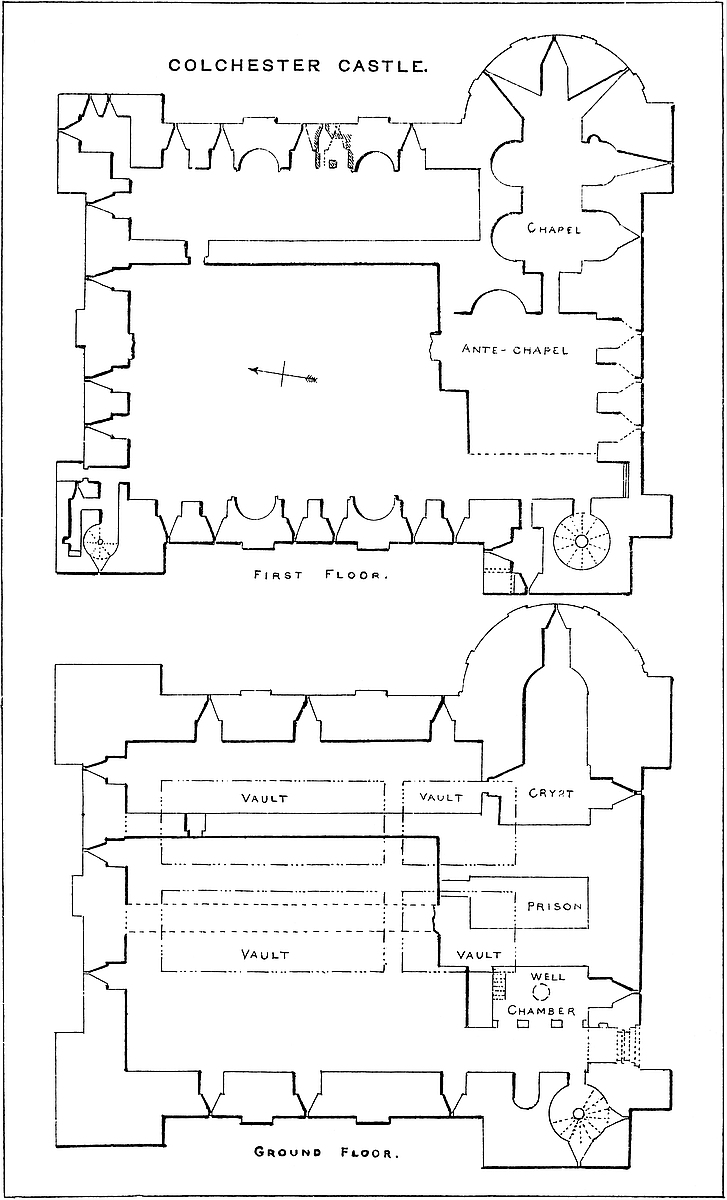
The door opens into a lobby or entrance passage 12 feet broad by 36 feet long. The right-hand wall is an open arcade, modern, but probably representing an older wall, shutting off the well-chamber. The south end is now open, but was crossed by a wall 10 feet thick, which no doubt contained the inner door leading into the great ground-floor chamber. On the left is first the door of the great staircase, then a niche 8 feet broad and 9 feet high and 7 feet deep, and semi-domed. A short passage, vaulted and groined, leads into the great staircase, a cylinder 16 feet diameter, with a newel of 2 feet. It has loops to the south and west, and forty-seven steps lead to the present summit. At the twenty-third step a passage with three steps branches off to the first floor.
The well-chamber, 15 feet by 26 feet, contains the well, now closed by a pump. It is 5 feet diameter and 65 feet deep, and was lined with ashlar, of which the upper part has been stripped off. The well was discovered in the last century. It is said that in it was observed a lateral culvert, intended as a waste-pipe to carry off any overflow that might otherwise injure the foundations. In the south wall was a recess 8 feet broad and 7 feet deep, round-headed and semi-domed, now a window. Probably the buckets stood in it. Here also a modern stair descends to the vaults. The well-chamber is not vaulted. Next east, separated by a wall 9 feet thick, is the prison; this is a barrel-vaulted chamber 15 feet by 30 feet, entered from the middle compartment by a doorway of 3 feet opening; it supports the ante-chapel. East again of this vault a wall, 13 feet thick, divides it from the crypt. The western part of the crypt, the cross limb of the T, is rectangular, 14 feet by 28 feet, vaulted and groined, and entered from the eastern compartment; it has a loop in its south wall. The stem of the T is the crypt proper, 31 feet long by 14 feet broad and 14 feet high to the crown of its barrel vault. Its east end is semicircular and semi-domed. A loop in the centre of the apse has been converted into a window. In this crypt is said to be a drain falling southwards towards the river. This completes the account of the ground floor.
From the staircase a door opens into the lobby above the entrance passage, and which was probably of the same size. At present the east and north walls are modern. The south end of this lobby is occupied by a flat-sided and flat-backed recess, 10 feet broad, 10 feet deep, and about 12 feet high, which has a chink or chase in its floor for the passage of the portcullis. As the recess is wider than the grate there are no lateral grooves. Above is a cavity where was inserted the ring or hook whence the grate was suspended. On the426 left of the staircase door is a smaller door, which opens into a garderobe which shares the turret with the staircase. It is 15 feet 6 inches long by 10 feet 4 inches broad, barrel-vaulted, with loops to the west and north, and beneath each a seat and a shoot in the wall. The loops have been enlarged into windows, and the chamber is used as a record-room. Outside, in the north wall of the turret, close to its junction with the curtain, is a bold deep bracket, composed of seven stones and a tile, at the top projecting about a foot, which may have supported the shaft of a garderobe from the battlements, or may have been connected with some sort of bretasche or timber erection. Its use is not clear. The east wall of the lobby divides it from the modern library, which stands over the ancient ante-chapel, and was probably the principal private apartment in the keep. It had three recesses, no doubt with loops, in its south walls. Two are now windows, and one a fireplace. Outside this chamber, to the north, is a modern corridor, the space of which was apparently a part of the ante-chapel. In its east wall is a round-backed niche 10 feet broad, through which a passage has been broken, most injudiciously, into the chapel. From the ante-chapel a lofty round-headed doorway opened into the west end of the chapel.
The chapel is composed of a nave and apse, and of four lateral recesses or side chapels. It is in length 45 feet and in breadth 15 feet, and 17 feet 6 inches high to the crown of its barrel vault. The apse is semicircular and semi-domed, of the same height with the nave. The westernmost pair of recesses are 14 feet wide and 12 feet deep, with semi-domed ends. The eastern pair are 11 feet wide and 11 feet and 14 feet deep, and both semi-domed. In the east wall of the south recess is a niche as for a side altar. The lateral vaults are accommodated to the main vault. The groins or lines of intersection are plain. The apse has a central recess, now a window, and two lateral smaller recesses with loops, unaltered. As the walls are everywhere very thick and the five original apertures could not have exceeded eight inches, the chapel must have been more than usually dark. It contains no ornamentation of any kind, not even an abacus or plinth. The masonry appears to be rubble of a very ordinary character. It is thickly plastered. This is a very curious and rare example of a castle chapel.
The first floor, north of the chapel and the entrance lobby, is divided into a larger west and a smaller east chamber. The eastern chamber is 21 feet by 88 feet, the western 61 feet by 100 feet, the increase of size over the lower area being due to a slight reduction in the thickness of the walls.
The eastern chamber is entered from the western by a doorway in the dividing wall. In its north end is a loop, in its east wall two fireplaces; north of the one are two loops and one south of the other; between them is a fourth loop and a mural garderobe. This chamber, 3 feet 6 inches by 9 feet 3 inches, has an eastern recess 3 feet wide, and in it a small loop beneath which is the seat, and a shoot opening in the wall. There are two doors opening from the427 main chamber 3 feet 3 inches apart. It is probable that the chamber was divided by a partition of wood, so that there was a fireplace in each room, and the garderobe was common to the two, with a door opening from each. The north-east turret here contains a vaulted chamber, 13 feet by 10 feet and 16 feet high. It has one loop to the north and two to the east, now broken into one. In the west wall is an indication either of a fireplace never completed, or of one walled up. This was probably a bedchamber.
The western chamber may possibly have been subdivided, like the lower floor, by a wall raised upon that now removed; and an unequal space between the loops in its north wall favours this view. More probably, however, the wall was not so raised, and the irregular space may be caused by a wish to keep the loops clear of the external pilaster. The chamber, supposing it to have been of the full breadth, had four loops in the north wall, and in the west wall two fireplaces, having two loops between and two beyond each, six in all. The fireplaces are spacious, round-headed, with rounded backs set with tiles on edge in herring-bone pattern. They stand in a broad pilaster of a foot projection, and are quite plain. They are of tile, of one pattern throughout, and at a height of about 14 feet the flue is stopped, and divides into two branches which open in the face of the wall, one on each side of the pilaster, in the hollow angle, as at Rochester and in the Tower of London. These fireplaces do not seem to have had any hood. Over one of them is a sort of weather moulding of tile, which looks as though part of a hood, such as is still seen over the west door of St. Botolph’s Church. There is, however, a second fragment on the jamb of the fireplace, which could not be part of a hood. These are probably the remains of the weather mouldings of the roofs of cottages built within the area of the keep after the whole was gutted and laid open. The loops of this floor, like those below, are of one pattern. A recess, 7 feet wide, flat-sided and round-headed, commences at the floor-level and rises about 14 feet. At a depth of 3 feet 6 inches is a rebate or reveal, from which commences a splayed recess, ending in a loop eight inches wide.
In the north wall, at its west end, is a plain doorway, and a recess corresponding to a doorway in the outside of the wall, which opened upon the shelf already mentioned, as in the east face of the north-west turret. This shoulder formed a landing, 6 feet by 8 feet, whence a staircase descended by a face of the wall to the ground. The walls show where the staircase was let into it by the discontinuance of the regular coursing, but this also shows the staircase to have been an afterthought. The original staircase was probably of wood. The door has evidently been walled up from an early period. In the west side of this doorway is a smaller lateral doorway opening into a groined lobby, which leads into a staircase and a garderobe, which occupy the north-west turret. The garderobe is 7 feet by 2 feet, with a loop to the east and the seat and drain to the west, and in the north wall a recess as for a lamp. A few feet south of428 the seat and its shoot a second shoot is seen in the outer wall. This probably belonged to a garderobe in the battlements, now gone. The staircase is a well, 6 feet diameter, of which twenty-four steps remain. It evidently led from the first-floor level to the summit. The fragment of the turret seems to show that the original height of the wall was about 32 to 36 feet. This and the main staircase are cut short by the removal of the upper 5 feet or 6 feet of the wall. They open upon the present top of the wall, which has been levelled, and a slight battlement and rear wall built to make the walk safe. There does not seem to have been a second floor.
Many years ago, about 1683, the then proprietor of the castle, ignominiously known as having removed the upper part of the walls and gutted the interior of the building, discovered that a part of the ground floor rested upon vaults. These he opened and examined, and they are still accessible. The vaults are two in number, built side by side, each 22 feet wide and 96 feet long. They are crossed by a wall 6 feet thick, and thus formed into two vaults of 60 feet and two of 30 feet. The wall between them is 8 feet thick. When discovered they were full of earth, so full that it was evident the contents of the foundations had been heaped and used as a centring, the arch being turned upon the earth or the stones laid upon it. Of one vault the roof is flat, held up by the mere cohesion of the masonry. These vaults had no original entrance, and were evidently works of construction only, not intended to be used. Several breaches were made, so that one vault can be entered from the other; and a breach was also made in the north wall of the keep below the exterior ground-level, through which a good deal of this soil was removed, and thus the cavities admit of a partial examination. The masonry is wholly rude rubble, composed of large pebbles and boulders and fragments of stone, uncoursed, and with a very free use of mortar. The vaults are described as pointed, but the excessive rudeness of the work and the nature of the centring would account for any irregularity in the figure of the arches. To the eye they appear rudely semicircular. That these vaults are of the date of the keep is evident from their relations to the other walls, part of which rest upon them. The present entrance is in the floor of the well-chamber.
For some reason, possibly from an apprehension of defective foundation in a wet sandy soil, it seems to have been thought necessary to take extraordinary precautions against an unequal settlement of the parts of the keep. Hence probably the extensive area, the low altitude of the walls, and the excessive breadth of their foundations. Hence, also, probably, the decision to elevate the floor of the interior above the exterior ground, by the use of vaulting. If such was the cause of these unusual precautions, the result has been perfectly successful, for there is no mark of subsidence anywhere to be seen.
Although a main entrance at the ground-floor level is by no means unknown in Norman keeps, and is found at Carlisle, Ludlow, and Bamborough, it was not usual, and an examination of the pre429sent entrance at Colchester leads to the conclusion that it was not originally so here. It is evident not only that the present ornate doorway is an insertion, but that the outer part of the wall above has also been taken down for a considerable height, and clumsily rebuilt. This was done to allow of the insertion of a portcullis. Without this it would have been sufficient to remove the lower masonry only, but the grate required head-room when raised, and to gain this a more extensive alteration was necessary. Immediately above the dripstone are a few courses of ashlar, derived, no doubt, from the old work; but above this the wall is of very inferior uncoursed rubble, very different from the regular courses of stone and tile seen in the wall on either side. When the outer door case was inserted the wall within was also lined with ashlar, and the ring stones of the inner arch and of the entrances to the great staircase were also so cased. Above, the recess into which the portcullis was lifted is of tile, and evidently original; but the floor with the aperture or chase, and the flat back of the recess are later. In all probability there was originally a recess with perhaps a loop where the great doorway now is, and there was certainly a recess above, with probably a loop also. When this door was opened, in the latest Norman period, the original entrance on the first floor, in the north front, was probably walled up, as it still remains. It has been suggested that the great doorway replaced a postern, but posterns in Norman keeps were very unusual indeed, especially at the ground-level, and there seems no reason for supposing one here. Probably when the keep was constructed there was no enceinte wall, but when this was built, the keep became far more secure, and as it was convenient to have an entrance from the town side, the change was made.
There is something to be said for the pertinacity with which this keep has been asserted to be a Roman building. Not only is its design peculiar, but this is also the case with the material employed, and in some degree with the workmanship. The walls, though cased with ashlar on the plinth, and though ashlar is largely employed in the quoins up to the first floor, contain great quantities of the large, square, thick tile so characteristic of Roman work. Moreover, these tiles are mostly whole, as though they had not been employed in an older building, and they are laid in bonding or chain courses, single, double, triple, and even in four courses, with intervening bands of cement stone in small rudely-squared blocks. Sometimes the tiles are laid on edge, sometimes slightly inclined, with here and there a tendency to herring-bone, and the greater part of the interior dividing wall is regular herring-bone, and a very fine example of it. Most of the recesses within the walls were not originally looped, and are round-backed and semi-domed, which is unusual in Norman keeps. Outside the building, high up in the walls, are traces of a number of apertures or perhaps only sunken spaces, about 2 feet 6 inches square. One of these is shown in an early drawing as containing a sun-dial, no doubt an insertion. It430 has been supposed that these represent tablets with an inscription, but there is no evidence for this. What they were for it is difficult even to guess.
All these features, and some others not actually present, have been adduced to justify the opinions of General Roy, King, and others, in favour of the Roman origin of the building, which is asserted to have been constructed to contain and guard the shrine of a Pagan deity, and afterwards to have been converted by the Normans into a fortress. Such conversions of Roman buildings into mediæval fortresses were, no doubt, common enough in Italy and France, and not unknown in England, as at Pevensey and Porchester, but nevertheless there scarcely seems ground for supposing this building to be Roman, or other than a Norman keep.
The combination of the rectangular plan with angle turrets and intermediate pilasters of slight projection is distinctly and peculiarly Norman. As to the unusual dimensions of the building, in size and height Norman keeps varied considerably, from Clitheroe and Goderich up to Norwich or London. The projection of the turrets also varies from mere pilasters as at Bowes and Scarborough to regular turrets as at Dover and Kenilworth. The half-round projection and the chapel within are indeed rare, being confined to Colchester and London, but no one conversant with the smaller Norman churches could hesitate to class these among them. The spreading plinth is also a Norman feature, and is seen at Norham and Kenilworth. Thick and solid walls at the ground floor are also common. One of the most usual Norman arrangements was to place at one angle a well-staircase communicating with each floor and with the roof, while at another angle was a similar staircase commencing at the first floor.
The Norman entrance, though sometimes on the ground floor, was more usually, as originally here, on the first floor. Neither was it always protected by a forebuilding. Neither Goderich, Clitheroe, nor Chester were so protected. The well in Norman keeps, though often in the wall, was also found in other situations. At Norwich and Castle Rising it was within the area, and at Bamborough. Mural chambers, especially for garderobes, are common in Norman keeps, especially at the first-floor level. Here are three, and a larger chamber, besides the chapel and ante-chapel. The shoots of Norman garderobes usually open on the face of the wall, the lower stone projecting a little to keep the filth clear of it, as at Ludlow and Carlisle. The opening of the flues of the fireplaces upon the face of the wall, close to a pilaster, is a purely Norman device. The use of loops on the first floor, though with large splayed recesses, is also Norman, and a part of the jealous system that pervaded those keeps. Usually it was only at the second floor that the loops became windows. In Norman keeps the floors were almost always of timber, the joists being supported, when necessary, by posts or props, as seen at this day in the Tower of London.
As to material the use of new and clear and unbroken tiles by no431 means shows a work to be Roman. Those of St. Botolph’s Priory Church were evidently never used before. The only conclusion is that they were manufactured in imitation of those introduced by the Romans. Neither is the mortar that usually described as of Roman composition. It is decidedly white or light in colour, with a great preponderance of sand, so much so as in some parts to have prevented its setting. Where the mortar is in masses it may contain fragments of tile or stone, but there is no trace of pounded brick in its composition. It is generally ill-mixed, and contains large fragments of sea-shells. The putlog holes in size and position are such as are usually observed in buildings of the eleventh and twelfth centuries, though probably not confined to them. The soffits of the vaulting of the staircase and mural chambers everywhere are impressed deeply with the figure of the boards used as centring, or what is called technically lagging. The carpenter’s work in Norman keeps seems to have been very rudely performed, and the rough boards were spread over thickly with mortar to bring them to a surface. This is well seen at Colchester.
Taking all these features into consideration there ought to be little doubt that Colchester keep is a Norman structure, built probably about the close of the eleventh century, by one of the sons of Hubert de Rie.
The keep is the only part of Colchester Castle now standing. The wall enceinte has long been removed, probably about 1650, but its general line to the east, north, and west is indicated by three earthbanks. To the south the ground has been levelled. The entrance from the town was on this side. This was the main gate, but there was also a second. The area thus enclosed appears to have been rather above three acres. Various Roman remains have been discovered within and about this area.
CONISBOROUGH, or, as it was anciently and more correctly called, Coningsborough or Coningsburh Castle, is one of the most remarkable of the strongholds in the North of England, standing high above the bank of “the gentle Don,” about half-a-mile below its reception of the Dearne, in the midst of a grand sylvan amphitheatre. Its name declares it to have been a seat, and its position to have been a fitting seat, of Saxon royalty; and the mighty earthworks which constitute its most ancient defences, proclaim the value of the possession and the power of the founder: moreover, the great enchanter of romance has thrown a charm over the scene and invested it with an interest not the less deep that it is wholly fictitious. Those, and they are many, who ascend the guarded mount, care little for the great Norman Earl who raised its tower; to them it is peopled with the creations of Scott. The chamber remains, though roofless, in which he places the funeral banquet of Athelstan, and the oratory is still unaltered within which Rowena poured forth her very mingled devotions. The present view must necessarily be of a more prosaic character. It must take notice of the great earls whose tower stands almost unrivalled as an abiding evidence of their feudal magnificence and constructive skill. Although Conisborough may not be compared to Coucy in dimensions, and the power even of the House of Warren pales before that of its more than royal Sires, the lesser but older tower is not inferior to its great rival in position, excellence of material, or delicacy of workmanship.
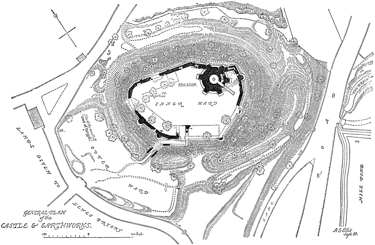
He who selected the hill of Conisborough as the site of a stronghold, if not, as King James said on visiting a similar position, a thief in his heart, must have thought security of the first importance, and have been prepared to expend a vast amount of human labour in obtaining it. What he had to deal with was an isolated knoll of rock and gravel, rising at about 400 yards from the bank of the river to a height of about 175 feet, naturally steep on every side, though rather less so to the south-west, where the exterior ground is somewhat higher. On this side, distant about a furlong, stands the ancient church of St. Peter, and about it the village of Conisborough. The top of the knoll has been levelled and trimmed into a platform of a rounded outline, 90 yards north-east and south-west, by 60 yards in the cross direction, thus enclosing about three-quarters of an acre. From this summit the slopes have been scarped steeply down to the bottom of an immense ditch about 60 feet below the crest. The outer slope or counterscarp of the ditch varies in height, or rather depth, according to the character of the ground, and for about two-thirds of its circumference is crested by a steep bank, which gives the ditch a depth of from 18 to 25 feet, and the exterior slope of which dies away into the natural fall of the hill-side. Towards the south-west, or town side, where the ground occupied by the church is about 25 feet higher than the terre-plein of the castle, the intervening hollow is occupied by a large outwork, resting upon the main ditch, a branch from which embraces and separates it from the town, and thus is formed an outer ward, convenient either for the lodgment of troops or the secure pasture of cattle. The principal approach must always have been on this side and across this earthwork. At no other point could so safe or so convenient an approach have been contrived; scarcely, indeed, one practicable for a horse with a rider on his back, still less for a litter or a vehicle on wheels. Such, as regards the earthwork, was, and still is the original fortress, the seat and stronghold of the king from whose office the borough was named, and, supposing the walls and keep to be removed, and the crest of the platform, the counterscarp of the ditch, and the outer edge of the earthwork to be palisaded, the place434 would still be one of great strength and equal to the accommodation of even a royal following.
When Earl Warren, soon after the Norman Conquest, visited his newly-acquired lordship, he must have been struck with the general analogy of its chief seat to the strong places he had left behind him. The mound or motte, here natural, the circular ditch around it, and the entrenched outworks covering the weaker side, resting upon the ditch and protected by a branch of it, were features as well known in Normandy as in England. No doubt he intended to add to the fortress those works in masonry that were just then become popular upon the Seine and the Orne; but the internal evidence of the oldest remaining work in stone, the encircling wall, shows it not to have been his work. Probably he found the works required at Lewes, Ryegate, and Castle-acre, quite enough to occupy his means, and was obliged to be content with such defences as he found already to his hand, and to his son or grandson is to be attributed the earliest extant masonry, the older part of the curtain, and a part of the outer gatehouse at the foot of the hill. There is no reason to suppose that there ever was a Norman keep. Probably the whole inner ward, as at Exeter and Restormel, was regarded as a shell keep. The present tower is certainly a rather later addition. The view here given shows the ascent from the gatehouse. On the left is seen the exterior of the curtain of the main ward.
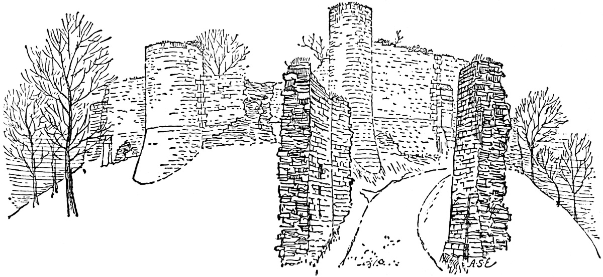
The castle, as now seen, is composed of a keep, an inner and an outer ward, and the steep slope between them. The Outer Ward is the earthwork on the western side. There are no traces of the gateway by which this must have been entered, nor of any curtain wall surrounding it, or buildings within it. Probably its defences were always of timber placed upon the earthbank which crowns the scarp of the ditch and must have been thrown up out of it.
Crossing the centre of the earthwork, the way into the castle reaches and traverses the main or inner ditch by a modern causeway of earth, replacing the ancient drawbridge, and reaches the435 base of the hill between two thick and lofty walls, parallel, and 10 feet apart, like those at the entrance to Berkhampstead. The cross walls which connected them at each end, and were perforated by the portal arches, are gone. The gatehouse thus formed had probably a timber covering, and perhaps an upper floor above the entrance passage, with an embattled platform above all. The lateral walls are, or have been, continued up the hill. That on the left on entering was carried straight up the slope till it abutted upon, and was united to, the curtain of the inner ward. The wall on the right hand springs from a small, solid, round turret which flanks the inner end of the gatehouse. It is carried obliquely up the slope, gradually approaching the upper entrance, which it reaches at a right angle towards the middle of the southern front. This wall protects the roadway from the lower to the upper gate; and is itself commanded from the curtain wall above. It may be said to traverse the Middle Ward, if that term be applied to the slope of the hill between the ditch and outwork below and the containing wall of the inner ward above. It is, in fact, the glacis of the inner line of defence.
Of the Inner Ward there is at this time no trace of an exterior gatehouse. Probably the entrance was a mere archway in the curtain, as at Bridgenorth and Kenilworth, or Cardiff, flanked in addition by a projecting shoulder of the wall which still remains. An exterior gatehouse, though not an unknown, was not an essential feature in a Norman castle. Entering the inner court, the wall to the left shows abundant traces of buildings attached to it. It is evident that here, right and left, were the principal structures for domestic purposes, as the hall, kitchen, and probably the chapel, attached to and with walls bonded into the curtain. The rectangular space between these buildings, 14 feet by 24 feet, may have been, as it was at Tickhill, a gatehouse with a portal opening into the inner ward.
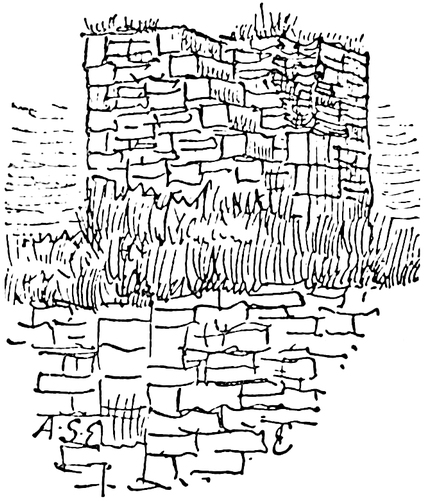
The inner ward is somewhat of an oval figure, but contained within a wall of many straight lengths, in fact a very irregular polygon, fitted to the natural outline of the ground. The older part of this curtain is, in substance, of good coursed rubble, from 6 feet to 7 feet thick, and from 30 feet to 35 feet high. The outer face was of ashlar, and much of it remains, either perfect, or with marks showing where the stones have been stripped off. The angles were quoined with ashlar blocks inside and outside, and there are several exterior pilasters, locally called “pillars,” broad, of slight projection, and with one or two sets-off, being of a late Norman character. In the north-west angle, high up in the wall, is a round-headed arch which probably opened into a tower, capping the angle, but now gone. A part of the west wall seems to have been rebuilt436 when a new hall and kitchen were required, and in it are the remains of a large fireplace, and corbels either for a lean-to roof, or for an upper floor. The battlements are everywhere gone. The north and west walls are tolerably perfect, and much remains of the east, but towards the south the wall is broken down. This part seems the latest, and to have been rebuilt in a slovenly manner. Upon the wall are five small half-round turrets, solid, like those at Knaresborough. The curtain has no bond into the keep, which has been built into its line, so as to form a part of it. At this part, the north-east of the enceinte, in a salient of the curtain, is a small staircase and passage in the wall much blocked with rubbish. King calls it a postern, but it was very evidently a garderobe. The area of this inner ward has been cleared out and the buildings removed, all except the keep. The only traces of walls in the court are along437 its north, west, and south sides, showing that there were buildings against the curtain 310 feet in length by 22 feet in breadth.
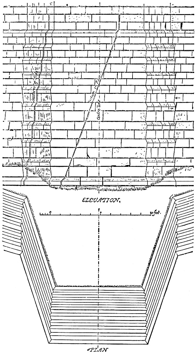
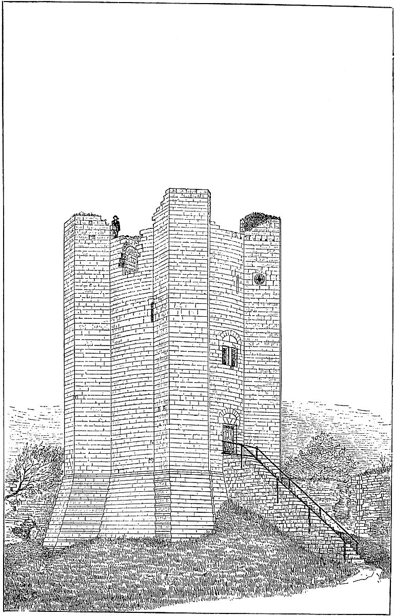
The Keep is the glory of Conisborough, and though inferior in size to Cæsar’s or Beauchamp’s Tower at Warwick, is more than their equal in its masonry, and more complete, inasmuch as it is a keep, and those are subsidiary towers. It stands nearly at the north-east extremity, and at the highest part of the inner ward, actually upon the line of the curtain, of which two of its buttresses and the intermediate wall form a part. It is constantly described as standing upon an artificial mound, which is certainly not the case. Indeed, no artificial mound could bear so concentrated a weight. It stands upon the natural surface, here a rock. It has no special ditch, and the ground shows that it never had any. There was, indeed, no need of the usual ditch, which was represented by the natural steep, and the exterior ditch at its base.
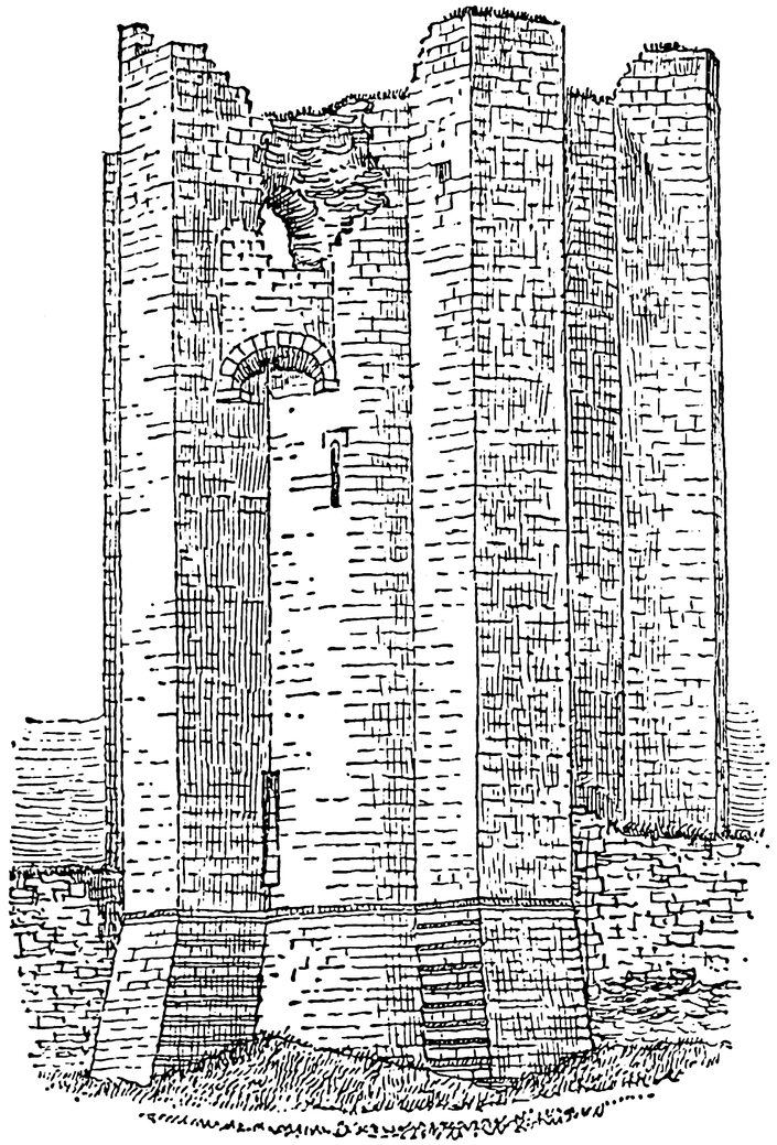
The tower is a cylinder, resting upon a bold spreading conical base. Against it, at equal intervals, are six bold, massive buttresses, having flat faces, but slightly tapering in plan so as to be half-hexagons with two long sides and a short face. They rest upon bases which expand outwards, but very little laterally. The tower438 at the ground-level is 66 feet diameter, from which its buttresses project 9 feet more, so that it covers an interrupted circle of 80 feet. Where the buttresses spring from, or are united to, the tower, they are 15 feet 6 inches broad. They taper in plan 6 feet 6 inches, so that the face of each is 9 feet broad. At 20 feet from the ground the battering base ceases, and the tower is there 52 feet diameter, and the buttresses project 8 feet, while their taper is represented by a base of 14 feet 6 inches, and a face of 9 feet. This is at the first-floor level, and here the walls are 14 feet 11 inches thick.
The exterior of the tower from this level is vertical, being in fact a cylinder, and without any string moulding or set-off above the chamfered top of the base. Inside, the walls are reduced in thickness by three sets-off or ledges, corresponding to the four floors, each floor resting upon a ledge. The wall is thus reduced to 12 feet 6 inches in thickness at the summit. The tower is now at one point 90 feet high, and was originally probably about 120 feet to its conical top. The buttresses, when complete and battlemented, were about 94 feet high. The whole structure is built of a fine-grained light-coloured limestone, in blocks about 12 inches high by from 1 to 3 feet long, laid in courses, not regularly sorted, though the largest stones are in the base. Both inner and outer faces, staircases, and mural chambers, are also of excellent ashlar. The joints generally are rather open, the horizontal joints varying from half-an-inch to one-and-a-half inches, the vertical joints rather closer. The vaulting is mostly sound rubble. The mortar has fallen out of the joints of the ashlar, but the stone is fresh and sharp, and there are no settlements. The courses are all well defined, and may be counted both within and without. Outside, the base is composed of eighteen courses, and the cylinder of sixty-one, from which the buttresses rise seven courses more. Inside, the first floor contains nineteen courses, the second twenty-five, and the third nineteen, being sixty-three for the whole cylinder. The fourth floor is gone, or nearly so. The exterior of the building is perfectly plain, save the two small circular lights of the oratory, which have a sort of ball moulding. There are several loops, but in the whole building but one exterior doorway, and two main windows. All the arches are full-centred; no trace of a pointed arch, and all is of one date. Nothing can be more substantial, plainer, in better proportion, or better suited to the purpose for which it was built.
The interior is divided into a basement and four stages, of which the uppermost was in the roof, and at the battlement level; all are cylindrical. The basement is a domed vault, of which the floor is the natural surface of the rock. It is 22 feet diameter. The walls to the springing are 10 feet high, and both dome and walls are perfectly plain. There are no loops, or even holes, or lateral recesses, or openings of any kind: no seats, no vents, no sewer, so far as can be seen. In the centre is the well, lined with ashlar, and rather above 2 feet diameter. It is said to be 105 feet deep, but is now partially choked up. It must have been sunk as a larger shaft, and439 then lined to its present diameter. Exactly above it is a ragged hole, which represents the only entrance to the basement, and which must have been provided with a ladder. It is evident that this vault was a cellar or store, and by no means a prison. Space here, as indeed in most other keeps, was too valuable to be employed, save in some manner likely to be of use during a siege.
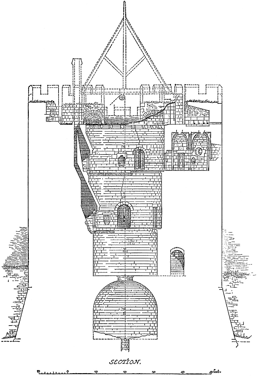
The entrance to the tower is at the first-floor level, on the south-east side, at the top of the base, and therefore 20 feet from the ground. The doorway is 4 feet 9 inches wide, quite plain, and flat topped, but the lintel is composed of five stones joggled together as a platband, and above is an arch of relief, the tympanum of which is formed of two large stones, divided vertically. There was no portcullis, only a stout single door of one valve, stayed by two bars, the holes for which, 7 inches square, are in the right or hinge-jamb 9 inches deep, and in the lock-jamb 6 feet. In the joints near the cill are two holes, evidently for the iron gudgeons of a small drawbridge, so light as to be worked from within the doorway. The present exterior stone staircase is modern, but the original stair was probably much of the same character, only the support must have been separated from the tower by the length of the bridge, probably about 7 feet, or a foot longer than the height of the doorway. It is singular that there should be no portcullis, since it could have been worked conveniently from the window recess above, and its presence would have made the tower absolutely impregnable.
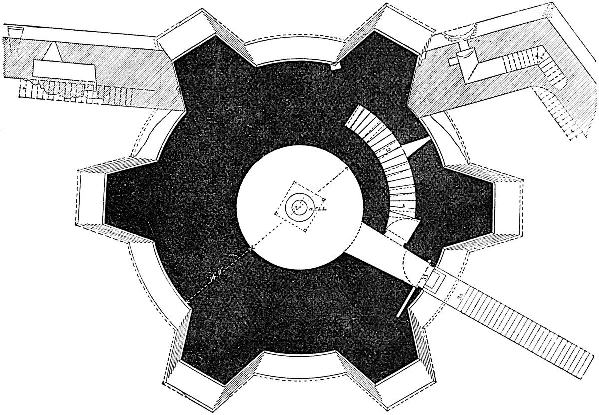
From the doorway a vaulted passage, expanding from a breadth of 5 feet 3 inches to 6 feet 3 inches, leads direct into the first-floor440 chamber. Where this vault terminates in the inner wall it is worked in a curve so as to coincide or be flush with the inner face. This was to be expected, but this is the only arch so terminating. All the others, whether of doorways or window recesses, end square, so that while the central part coincides with the curved face of the inner wall, the ends, or springings, are recessed from 3 to 4 inches, according to the span of the arch, and the appearance is clumsy. This is not so where the opening is square-headed, there the lintel is cut to a suitable curve. It is remarkable that there is no rebate or provision for a door where the entrance passages open into the first floor, and that floor, though 22 feet diameter, and 16 feet 6 inches high, is entirely without any air or light, save what it might receive when the outer door was open. Possibly there was a central hole in the floor above, as in the dome below. There is no drain or fireplace. This, therefore, also was a store.
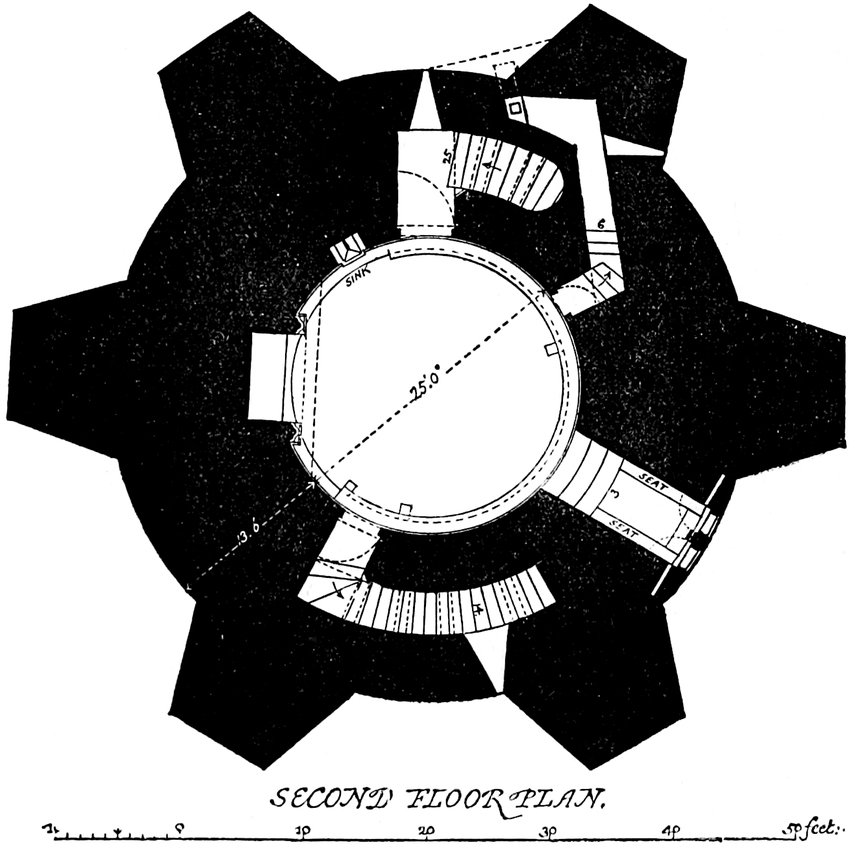
In the right wall of the entrance passage, on entering the tower, is a side doorway whence a staircase ascends, winding with the walls to the second floor. The doorway of 4 feet 1 inch opening, has a rebate for a door opening inwards into a small lobby 5 feet 11 inches deep by 4 feet 8 inches broad, whence rises the staircase of the same breadth. The staircase, of twenty-five steps, winds with the wall, which is 4 feet 2 inches thick on its inner, and 6 feet 2 inches on its outer side. In the latter is a loop. The vault is full-centred, broken by hanging ribs, of a bold square section; it ends above in another lobby, 8 feet deep by 4 feet 8 inches broad, whence a round-headed door-way opens into the second floor. The lobby is lighted by a loop.
The second, or state floor, is 25 feet diameter, having a set-off of about a foot all round to carry the floor-boards, which were further441 supported by joists resting upon plain corbels a little below the ledge. This chamber is 20 feet 4 inches high. It is lighted by one large window of two lights, each 4 feet 4 inches high by 1 foot 10 inches broad, flat-headed, and having an intermediate mullion 2 feet 5 inches broad, in which is a sort of stone staple, containing boltholes for the shutter fastenings. There are also lateral barholes in the walls. The window is placed in a broad and lofty full-centred recess, ascended by two steps from the floor, and having side seats. The lines of the steps are concentric with the wall of the chamber. Outside, the window lintel is composed of stones joggled together, forming and filling up the pediment of a round-headed arch. This window is placed over the entrance door.
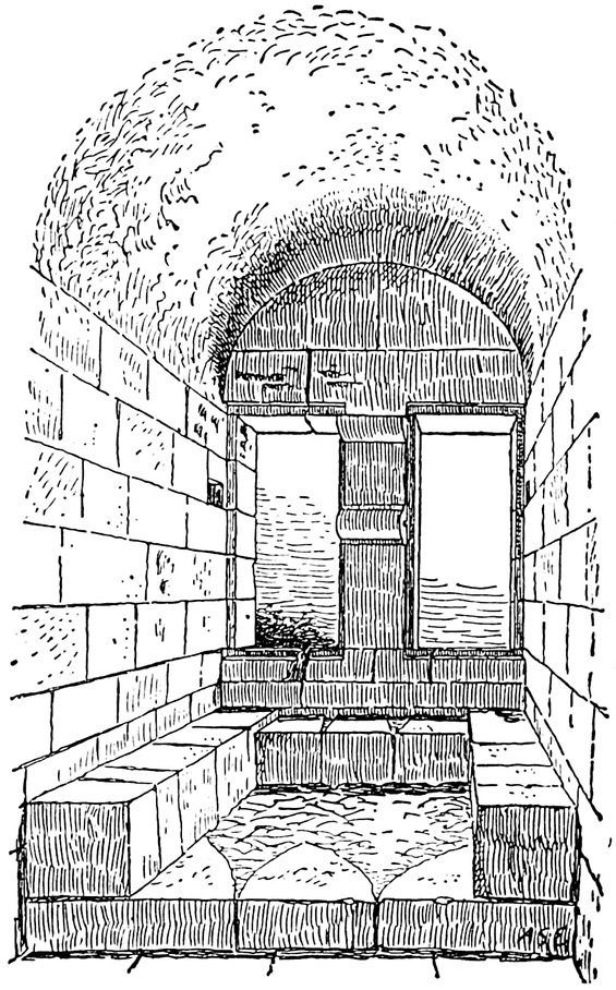
Nearly opposite to the window is a large and handsome fireplace. Its flat lintel, 12 feet long, is partially composed of nine stones, joggled together in a skilful manner, and still in place. These stones are flanked by six others which rest upon the supports. The bar of stone thus composed extends each way to the wall, and is supported near each end by a cluster of three coupled columns with foliated capitals of delicate design and execution. These form the jambs of the fireplace, the back of which is flat, sloping backwards, and, like the rest of the work, of ashlar. The vent is square, and ascends vertically in the wall to the summit. The stone hood, resting on the lintel, is plain. The whole style of this fireplace is late Norman.
On the left of the entrance door, between it and the window, is a small square-headed doorway, 2 feet broad, and no doubt intended to be concealed by tapestry, which opens into a lobby whence an ascent of six steps leads by a passage 10 feet long into a triangular garderobe chamber, in the substance of the wall. The vent discharges by a flush opening in the face of the outer wall above the base. This chamber has an exterior loop.
At the opposite side of the great chamber to the entrance door from below, a door similar to it opens upon a lobby 3 feet 10 inches by 7 feet 6 inches, whence rises a second staircase of thirty-four steps, leading to the third floor. The passage is vaulted like that below, but is only 3 feet 6 inches broad. It also winds with the wall, crossing over the great window, and terminates in a lobby 3 feet442 11 inches broad by 5 feet 5 inches deep, lighted by a loop. The outer wall of the staircase is 5 feet 5 inches thick, the inner wall something less, the whole thickness being 12 feet 6 inches. The lobby opens by a full-centred doorway 3 feet 6 inches broad, into the third floor.
The third or oratory floor, has a set-off of 12 inches for the floor, and is therefore 27 feet diameter. It is 16 feet 6 inches high. To the south-west is a window closely resembling that below, also with steps and side seats. There is also a fireplace above the last, rather smaller and more delicate in its details, but of the same pattern and construction. The lintel is composed of seven stones, joggled; it does not extend from wall to wall, but stops, as is more usual, just clear of the jambs. The vent runs in front of the lower one, and joins it above. Above the lower water drain is a second, in a small sort of piscina recess, round-headed and trefoiled with cusps, but not chamfered.
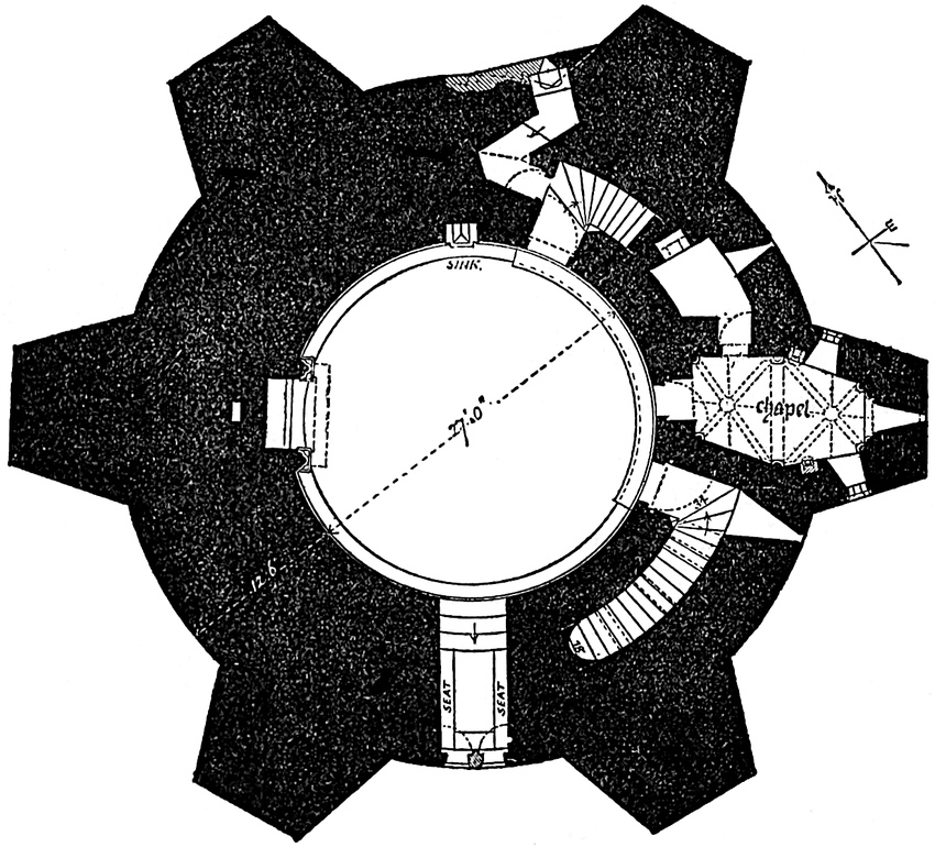
The oratory is a very remarkable feature in this floor. It occupies the south-eastern buttress, opposite to the fireplace. A doorway of 2 feet 6 inches opening, the only flat-topped one on this floor, very plain, and therefore meant to be concealed, opens into a short, straight passage leading direct into the oratory. This is in plan a hexagon, 6 feet 4 inches broad at the west end or entrance, 6 feet at the east or altar end, and having a length of 13 feet 6 inches contained between four sides averaging 6 feet. Its centre or broadest part is 8 feet 8 inches. In each of its four main angles, flanking the entrances and the altar, is a detached or nook-shaft 6 inches diameter, with a foliated capital. The two central angles are each occupied by a half-shaft, from which springs a triple cross443 rib, of which the laterals are plain rolls, and the central worked in a chevron pattern. The area is thus divided into a western and an eastern half, of which the latter is rather the smaller, and may be taken to represent the chancel. Each division is crossed diagonally by two ribs, in section plain bold rolls, at the intersections of which are bosses of which the stones are big enough to form not only the boss, but about six inches of each of its four ribs, and in one case the division between the ribs is carved with flowers, with good effect. The bosses are carved, that to the west with a sort of cross moline, shown in the drawing, that next the altar with flowers. At the main angles the ribs spring from the shafts, but the triple cross ribs spring from a sort of prolongation of the capital and abacus of the half-shafts. The shafts flanking the altar have capitals more ornate than the rest. The east window is a mere loop 6 inches broad and 2 feet 6 inches high, round-headed, and placed in a splayed recess of which the angles are replaced by a bold roll with foliated bases. This, again, stands within a second and shallower recess, flanked with small nook-shafts of which the capitals, delicately carved, range with those in the flanking angles. The head is cut in chevron pattern. Right and left are two small lights, quatrefoiled, but splayed inwards into circular recesses, 2 feet 8 inches diameter. Outside is a hollow moulding containing knobs or balls scarcely seen from below. These windows have been called insertions, but, though no doubt of a somewhat Decorated character, they have every appearance of being original, and similar openings may be seen in444 the west front, and near the summit of the very fine Early English tower of Old Malton Church. Below each light is a trefoil-headed piscina of 1 foot 6 inches opening by 11 inches deep, of which that in the north wall has a minute nailhead moulding. The height to the crown of the vault is about 14 feet, gained by stilting the arch. The altar is gone.
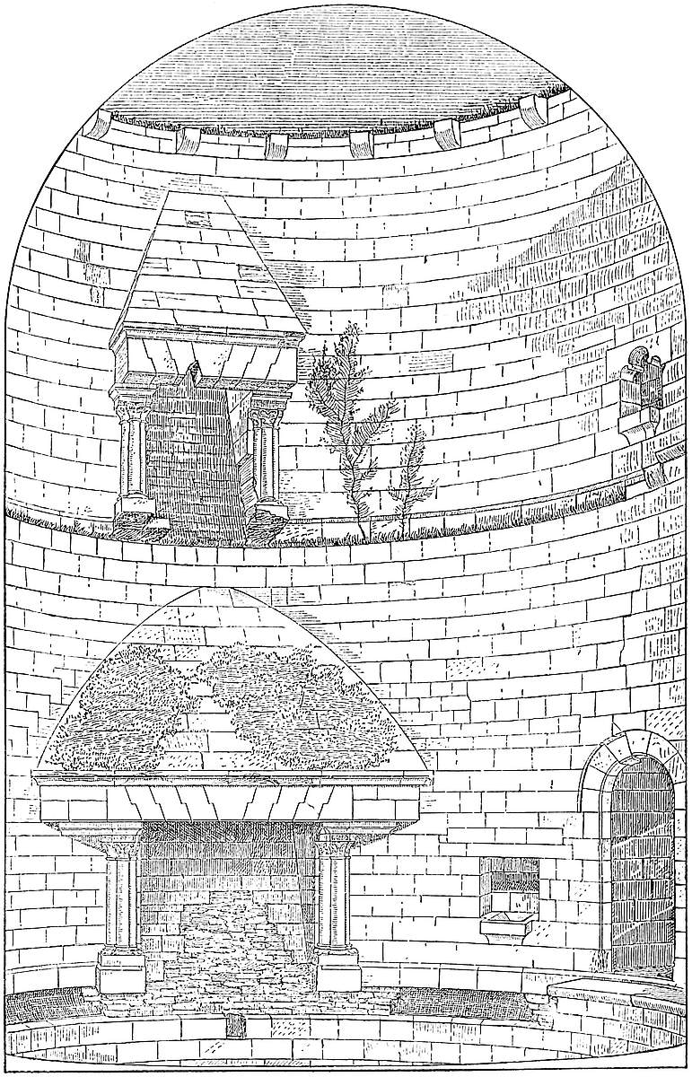
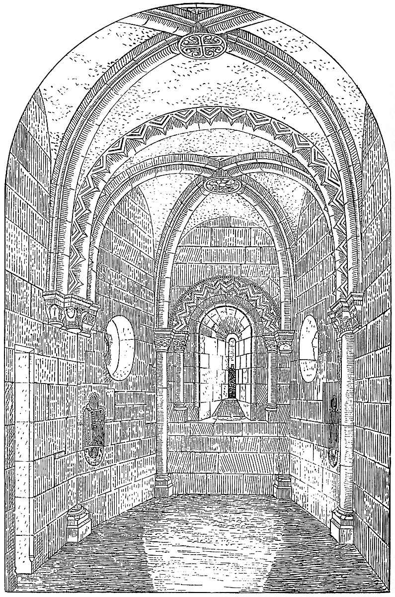
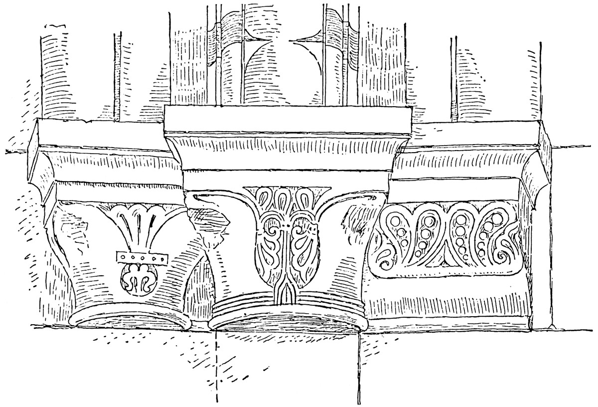
On the left, on entering the oratory, a small flat-topped doorway leads into a mural vestry of irregular form, about 9 feet long by 5 feet broad, with a splayed loop, and in the end wall a trefoil-headed locker 2 feet broad by 1 foot 6 inches deep. The vestry is very plainly vaulted, the arch being a lean-to against the wall of the oratory.
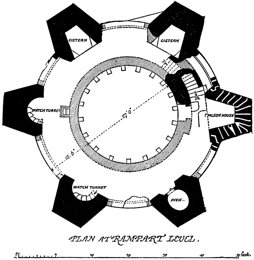
Between the oratory door and the fireplace, to the north, a doorway of 3 feet 4 inches opening enters a lobby 3 feet 10 inches by 7 feet, whence a staircase of twenty-four stairs ascends, winding with the wall, to the battlements and the fourth story. The staircase is 4 feet broad, and vaulted with hanging ribs. The two lower staircases ascend from east to west by the north, this ascends from west to east, also by the north, and passes over the vestry. In the lobby is a door 1 foot 9 inches opening, whence a bent passage 3 feet 4 inches broad, leads to a garderobe, the seat of which rests upon an oblique or squint arch, which springs across the hollow angle between the tower wall and one of the buttresses, and is placed, inconveniently enough, over the loop at the head of the first flight of stairs. Over the seat is a loop. Garderobes so placed, over a hollow angle, are common in the Decorated period, but there is one on the outer wall at Kenilworth, probably late Norman.
445
The staircase from this stage ends under a sort of hood which stands in and nearly blocks up the rampart walk, leaving a passage only 2 feet 3 inches wide between it and the wall of the battlement. The tower wall at the level of the rampart walk is 12 feet 6 inches thick, of which the battlement wall occupies 2 feet, the rampart walk 8 feet, and an inner wall 2 feet 6 inches, within which was the upper or fourth floor. The rampart walk was thus a gallery open above, having the battlement wall outside, and the wall of the upper floor in its rear. The vents of the two fireplaces were connected with this inner wall, and reached its summit by an opening 7 inches by 12 inches, divided by a tile-stone 6 inches thick. This aperture is contained within the base of a chimney-shaft 3 feet 9 inches by 3 feet. This shaft, like the stair-hood, somewhat reduced the breadth of the rampart walk. The upper part is gone. The dividing stones end about 2 feet below the rampart level, above which the vents were combined.
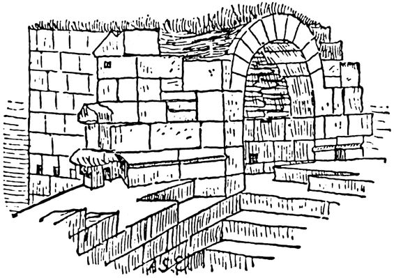
The six buttresses rose as turrets above the crest of the parapet. That to the north-west, near the chimney-shaft, and its neighbour westward, contain half-round recesses, round the curve of which are short staircases, opening from the rampart walk, and which probably ascended to small parapeted platforms, now gone. The buttress to the south contains, as at Orford, an oven, circular, 7 feet across, with a segmental arched door 2 feet wide. The two buttresses to the north and north-east are occupied by two cavities, probably cisterns, half-hexagons in plan, and 2 feet 6 inches deep below the rampart wall level. Each would contain about 650 gallons. The remaining buttress, that above the oratory, contains a half-hexagonal recess or alcove, the floor of which is 9 inches above the rampart wall. It is 9 feet broad at the opening, 5 feet broad at the end, and 8 feet 8 inches deep. It is covered in with a round-headed vault tapering to fit the plan. The height at the entrance is 7 feet 6 inches, and at the inner end 5 feet 7 inches. There are no loops, but the walls of this chamber and the adjacent parts of the parapet are pierced by a number of holes, about 6 inches high by 5 inches broad. These have been supposed to be intended to carry the floor spars of a bretasche or wooden gallery, though they are small for such a purpose, and there are no holes or corbels below for struts. Moreover, these holes are confined to the buttress over the oratory and the adjacent walls, and are not straight (see plan). They extend, it is true, over the main entrance, but had they been intended for its defence they would probably have been placed with the door beneath their centre instead of below one end of the line. That is, they would have been placed in the two flanking buttresses as well as in the bay446 between them. It has been suggested that these are pigeon-holes, and no doubt, during a strict siege a good supply of these birds might have been found useful. There are certain holes in the keep at Rochester, that probably were so intended, and that are, or recently were, so used.
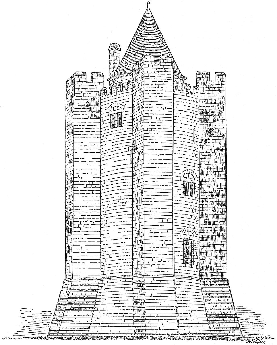
The height of the parapet is 6 feet 6 inches, and the pattern of the coping may be seen at the junction with the buttress turrets, and this also shows that the roof was confined to the inner circle, and did not project over the parapet. There are also traces showing that the embrasures contained, as at Alnwick, a hanging shutter.
447
The inner circle, or chamber within the inner walls, was 27 feet diameter, and its flooring rested upon a range of nineteen plain corbels. Only the lower part of the wall of this chamber remains, but the jambs of a doorway show that it was entered from the rampart walk. The wall, and consequently the chamber, was about 7 feet high, and upon it was a conical covering, the eaves of which must have projected somewhat over, and discharged their water into the rampart walk. This mode of finishing off the summit of a tower, by placing the uppermost floor within the circuit of the rampart walk and leaving the battlements free from the roof, is seen in its greatest completeness at Coucy, and what is there seen illustrates what must have been the arrangement here, at Pembroke, at Martens Tower, Chepstow, and in the smaller and later flanking towers of Holyrood House. It is obvious that unless the roof sprung here from a wall within the parapets, or unless there was a timber gallery carried round outside the wall, such a tower as this could not be defended. Its loops were intended for light and air, not for defence; this could only have been directed from the battlements. Hence the absurdity of covering in towers intended for defence, or at any rate to have the appearance of being defensible, with conical roofs springing from the outer wall.
Of course the accommodations of such a tower as this of Conisborough were not such as to suit its lords, still less their ladies, save under the pressure or in expectation of a siege, a remark which applies to all, save the largest, keeps. The passive strength of Conisborough, and its rocky base, secured it against attacks even if seconded by engineering machinery. No catapult or battering-ram would be at all likely to shake or break it. The peril to be guarded against was a blockade, and with this view there was a well within the tower, and the two lower floors, it is clear, were intended for the storage of provisions. The first floor would be the ordinary room of the constable, or lord, and of his family or guests; the men, probably, also sleeping there. The room above would be the ladies’ room, with the oratory close at hand. The kitchen was above all, and there, also, at the battlement level, would be the lodging of the small garrison, probably of not more than ten or a dozen picked men, with a ready communication with the ramparts.
The fashion of round keep towers, quite different from the shell keeps, came in towards the close of the Norman and during the Early English period of architecture, when frequent communication with the East had affected men’s military ideas. A few, such as Brunless, Tretower, Launceston, and Orford, are found in England of that time, but in France there are many, widely spread, and very grand examples. Philip Augustus was a great builder of such towers. That of the Louvre, of which the circular foundations, with the well and the sewer, were uncovered a few years ago, was his work, and to the same period, though late in it, 1223–30, belongs the Tower of Coucy, probably the finest military structure ever built.
Taking a general view of the Castle of Conisborough, and giving448 due weight to the value of the evidence afforded by its remains, it is clear that the excavation of the ditch, both of the hill and the outwork, and the scarping of the former, were the original and English works, to which an early, though not the earliest, Norman lord added the curtain wall of the enceinte, and much of the lower gatehouse. He certainly also built a hall, kitchen, and lodgings within the inner area. The next addition of importance, the keep, was certainly made a century later. The curtain wall was taken down to make room for a part of it, and not only was there no bond between the old wall and the new tower, but the junction was carelessly and clumsily effected, as may be seen from its present condition. Probably some later alterations were made as regards the hall and lodgings. The wall near the entrance to the inner ward seems to have been partially rebuilt, but subsequently to this there does not seem to have been any addition of importance. The castle was no doubt rendered untenable during the wars of Charles I., and time and neglect have since completed the ruin.
It is singular that so strong and so remarkable a fortress should be but little noticed in the earlier records. Invention, indeed, in the absence of evidence, has attempted to fasten upon it an early history. “Conyng” has, by British antiquaries, been converted into a Breton Conan, and Caer-Conan, thus constructed, has been mixed up with Aurelius Ambrosius and the Kentish Hengist, who is asserted to have here fought, been slain and buried. There is, however, no evidence whatever connecting this place with either the Britons or Bretons, or the Romans, or Hengist. Everything bearing upon its origin is Saxon, but Saxon of a much later date than Hengist. Two tombstones carved in what is generally regarded as a præconquistal style were long seen in the churchyard, and are now placed for security in the church—so securely placed, indeed, as to be scarcely visible. The earliest mention of the place is probably in the testament of Wulfric Spot, the minister of King Ethelred, and the founder, in 1004, of the Abbey of Burton-on-Trent. By this document, printed by Dugdale in his Monasticon [I. 266], Wulfric bequeaths to Ælfred certain lands and fisheries of Cunuzesbury, so that about a.d. 1000 it belonged to that great Saxon. Mr. Hunter, whose history of Conisborough leaves nothing to be desired, points out that this devise was really a very ample one, for the fisheries were not those of the Don but of a part of the Soke of Hatfield, which were of great value. In Domesday, the lord of “Coningesboro” had twenty fisheries at Tudworth, yielding each 1,000 eels, and long afterwards they were important enough to be specially recorded. It seems therefore probable that, at least as early as the year 1000, Conisborough was the head of a large estate or Soke. The name of “Moothill field,” borne by an enclosure about three-quarters of a mile south-east of the castle, indicates the place of the court for the liberty or jurisdiction. The hill has been removed. There is a Moot-hall near the church.
While the castle has retained something of its ancient name, that449 of the ferry over the Don at its foot has undergone translation, and is known as Kingsferry. Who the king was who gave name to both has long been unknown; probably he was of Northumbria. The old Soke, the growth of centuries, received its final consolidation at the Conquest, when it was granted by William the King to William Earl Warren. At that time the fee was probably one extensive parish, for Conisborough seems to have been the mother church of Barthwell, Hatfield, and Sandal, three churches named in Domesday. Conisborough as a parish church, therefore, thinks Mr. Hunter, can scarcely be later than Ælfred, and may be older than even Doncaster itself. Such is the antiquity of the memories and speculations with which this very remarkable place is associated.
Immediately before the Conquest it belonged to Harold the Earl. Earl Warren evidently took it as it stood, and seated himself in the English “Aula” at Conisborough, having about him the twenty-eight vills which either wholly or in part were appended to it, and which included much of the Wapentakes of Strafordes and Siraches. These were the lands “quæ pertinent ad Coningesberc,” and which formed the “Socæ pertinens.”
The possessions of Earl Warren in England were extensive, but were especially valuable in Sussex, Norfolk, and Yorkshire; and what Lewes was to the former Conisborough was to the latter, and as the Soke became an Honour the castle was its “caput.” In Earl Warren’s foundation charter to Lewes Priory in 1078, it is provided that the monks should find him lodgings as he went and returned from Yorkshire, so that when he crossed from Normandy he took Lewes on his way. The connexion between his two lordships he cemented by giving to Lewes the church of Conisborough. Earl William was created Earl of Surrey about 1088, and died in 1089, and among his possessions stand enumerated the Lordship and Soke of Conisborough, with twenty-eight vills and hamlets.
II. William Earl of Surrey, son and heir, supported Robert Curthose against Henry II., and with him retired to Normandy. On being pardoned, and his earldom of Surrey restored, he changed sides and fought for Henry at Tinchebrai. He gave to Roche Abbey the tythe of his Hatfield fisheries. He died 1138.
III. William Earl of Surrey, his son and heir, the third earl, joined in the mixed French, German, and English Crusade in 1145, during which, in 1148, he fell, leaving a daughter and heiress.
IV. Isabel de Warren, who married, first, William de Blois, a natural son of King Stephen; and, secondly, Hameline Plantagenet, natural son of Geoffry Earl of Anjou, and half-brother to Henry II.
William was Earl of Boulogne and Mortaigne, and, by his wife, possibly of Surrey. He died childless 1160.
King Henry seems to have taken and held the earldoms for a while in his own hands, but, in 1163, Isabel married Hameline Plantagenet, who enjoyed her honours and estates and, 12 Henry II., paid scutage on sixty knights’ fees. Hameline bore the probably450 Norman title of Earl Warren, and was an active soldier in his day, a faithful servant to Richard I., and much employed in transactions both of peace and war. Also, though engaged occasionally in Normandy, he appears to have passed most of his time in England, and was by no means an unlikely man to have added the keep to his castle of Conisborough. He died 3 John, 1201, Isabel having died in 1199. Their son succeeded. Earl Hameline founded an endowment for a priest for the chapel of St. Philip and James within the castle. This probably stood in the courtyard for the use of the garrison, for, 11 Edward II., the Earl of Lancaster gave timber from the wood of Conisborough to repair the roof of the chapel within the castle, which therefore could not be the oratory in the keep, which is vaulted. King John was here March 12, 1201, probably taking advantage of the earl’s death to view the castle and possessions.
V. William Plantagenet, or de Warren, son and heir of Hameline and Isabel, who succeeded as fourth Earl of Surrey, was probably then of age, as he had livery at the least of some of his lands, 4 John, 1202. He held the earldom for an unusually long time, and much added to its wealth and consequence. As a Magna Charta Baron, he behaved with great moderation, and upon John’s death he swore allegiance to Henry. He married, first, Maud, a daughter of the Earl of Arundel; and, secondly, Maud, widow of Hugh Bigot, Earl of Norfolk and Earl Marshal, by a daughter of the great William Marshal. He died 1240, 24–5 Henry III., leaving a son, John. Maud, the earl’s widow, had livery, 30 Henry III., of the rod and office of Earl Marshal, as elder co-heir of her brother. She also held the custody of the castles of Conisborough and Chepstow until her death in 1246, 32 Henry III.
Their son and successor, VI. John, fifth Earl of Surrey, who succeeded at five years old, married in 1247, being then very young, Alice le Brun, who died 1290, half-sister of Henry III. In 1254 he paid an aid upon sixty knights’ fees. He lacked much of the prudence of his father, and his general character was scarcely in accord with his famous answer to the “Quo Warranto” of Edward I., to whom, however, he was a better subject than to his sire. He died 32 Edward I., 1304, having held the earldom sixty-four years. He was summoned to Parliament as Earl of Surrey and Sussex.
William his son died 14 Edward I., 1286, and therefore before his father. His son, and the successor to the earldom, was, VII. John de Warren or Plantagenet, sixth Earl of Surrey, a posthumous child, born 1286. When nineteen years of age, he married Joan, daughter of the Earl of Barr, but had by her no issue. 17 Edward II. Conisborough Castle was in the king’s hands, and 18 Edward II. he appointed the Constable. 19 Edward II. the earl recovered his estates, but had surrendered them to the king and his heirs, taking a re-grant for his own life. He was also both451 Earl of Sussex and Earl of Strathern in Scotland. Joan Countess of Surrey was at her castles at Sandal and Conisborough in 1314.
Earl John died 1347, and his will is dated from Conisburgh Castle, and the title of Surrey seems to have gone to Edward Earl of Arundel, son of Alice, Earl John’s sister. Besides natural daughters, he left two sons by Maud de Nerford, John and Thomas de Warren, to whom and their mother he left, with the king’s permission, a very considerable property, including Conisborough. Thomas Earl of Lancaster seems to have obtained from Earl John some sort of forced occupation of Conisborough, which came to an end upon his attainder, so that Earl John recovered and died seized of it.
About its descent there is some uncertainty, for Henry, the brother and heir of Earl Thomas of Lancaster, did homage for the castle, 1 Edward III., to which John, Earl Warren, laid claim. Earl John held it 5 Edward III., and agreed to a grant of 65 acres of the waste lands of the manor by the king to William de Skargill. Similar grants were made in the five following years by the earl and confirmed by the king, with a note that the earl’s tenure was for life only.
Probably the children of Maud de Nerford found it to their interest to allow the Crown to possess the castle, for at Earl John’s death it was held by Edward III., who granted the castle to Edmund of Langley, his fifth son, afterwards Duke of York, who died 1402, from whom it descended to his son Edward, also Duke of York. He fell at Agincourt, childless, 1415, and was succeeded by Richard, son to his brother Richard Earl of Cambridge. He became Duke of York, and was called also Richard of Conisborough, from his birth in the castle. Richard, who was great-grandson of Edward III. and father of Edward IV., was slain at Wakefield, 1460. His second wife and widow, Maud Clifford, held the castle in dower, and lived here. She died 1464. The decay of the castle probably dates from her death, for Edward Duke of York, who succeeded, became Edward IV., and nothing has generally proved more fatal to an independent historic estate than its absorption by the Crown.
Conisborough remained in the Crown, and, though probably the buildings were suffered to fall into decay, some of the offices attached to the castle and domain were kept up. As late as 1522, Sir H. Wyatt and John Melton were bailiffs and stewards of “the lordships of Conysborowe,” keepers of the park, &c., and there were constables and door-wards of the castle. Finally, James II. granted it to Carey, Earl of Dover, from whose family it passed to that of its present owner. King, in his “Munimenta,” has given elaborate plans, and a yet more elaborate history of this castle, but neither can be depended upon. There is also an excellent paper upon it in the fifth volume of the Archæological Journal by Mr. Milward, the plans attached to which seem, however, to be taken from King.
Conisborough Castle deserves a better fate than has of late years452 attended it, or than seems likely to attend it. Its position upon one of the most celebrated of the Yorkshire streams, its grand natural mount, and the striking character of the earthworks by which it is defended, are quite enough to attract public attention; but in addition it has an undoubted though obscure Saxon history, and from the Norman Conquest it was for three centuries or more the residence of a very powerful race of barons, the evidences of whose power and wealth are preserved in the ruins of their fortress. By whom, or precisely when, the present works in masonry were executed, is a question not exactly to be decided. William de Warren, the third and last earl of the old stock, 1138–1148, was a very likely man to have built in masonry this his most important northern castle, and it is probable that he built the enceinte wall of the inner court, and the hall and offices now destroyed. The keep is certainly later, scarcely much earlier than 1200, and is, therefore, probably the work of Hameline Plantagenet, who held the earldom and the castle from about 1163 to 1201. The tower was, no doubt, added for security only, for, though it contains state apartments and an oratory, these were dark and inconvenient, only fit to be inhabited during a siege. The hall and ordinary lodgings were, of course, more spacious and placed in the court, where are still traces of their foundations.
At a still later period, possibly under Earl John, who held the earldom from 1240 to 1304, the Norman curtain seems to have been repaired and strengthened with round bastion turrets, small and solid, along the southern and western faces of the inner ward. Then also the arrangements for crossing the ditch, and defending the lower entrance, were made more elaborate. The work of this period is of inferior quality, and much of it has fallen down. Since this no additions of any importance seem to have been executed.
It is probable that, during the civil war and after the death of King Charles, the curtain wall, domestic buildings, and lower gate-house were broken down, and the keep gutted and unroofed, but since that time, now nearly two centuries and a half, the ruins seem to have been left untouched save by the hand of time. Such is the excellence of the workmanship of the keep that for very many years the walls stood unshaken. During the last quarter of a century, however, the rains of autumn and the frosts of winter have begun to tell upon the structure, and the top of the tower is in a shaky condition. Still, it is not so far gone but that a few pounds judiciously laid out upon it would save it. The upper two or three feet should be removed, stone by stone, and replaced with water-lime or cement. The cost of this would be very trifling indeed; but what should also be done, and what would not by any means involve a very serious expense, is the replacement of the roof and floors. All Yorkshire, and indeed all the Archæological Societies in England, from the Society of Antiquaries down to the most recent local society, must feel an interest in this subject. Probably, if it were brought before the owner of the castle in a proper manner, the453 necessary repairs would be undertaken; if not, surely it would not be difficult to provide the means by private subscription. In any case something should be done at once, for the top of the keep is in that condition that every winter tells severely upon it.
The plans and illustrations appended to this notice of the castle are from actual survey by Mr. A. S. Ellis, and by him presented to the Yorkshire Archæological Society, by whose permission they are here reprinted. They will be found as far superior in accuracy as in completeness of detail to any plans as yet published, and it may be said of them, and it is no slight praise, that they are worthy of the important fortress they are intended to illustrate.
THE castle and town of Conway form together the most complete and the best preserved example of mediæval military architecture in Britain. The works are all of one date and design, apparently by one engineer, at the command of a monarch specially skilled in the art of war, and whose intention here was to command a very formidable pass, and to put a curb upon the boldest, most persistent, and most dangerous of the foes who strove to resist the consolidation of his kingdom. At Conway are displayed all the arts of defence as understood in the thirteenth century. The position is naturally strong, the walls are of unusual thickness, each part of the containing curtains is flanked by frequent towers, and the castle predominates over the whole position, commanding and protecting the town, and forming a citadel within which, as a last resource, a secure shelter would be afforded.
Conway, the Aber-Conwy of the Welsh, stands on the left or western bank of the river whence it derives its name, and which is commemorated by Drayton and Spenser as rich in “precious orient pearls,” and here is widening into an estuary. The southern front of the town is further protected by the marshy bed of the Gyffin, which here joins the Conwy. Town and castle cover a triangular mass of rock, of which the castle occupies the apex projecting into the water. The curtain wall which encircles the town is strengthened by twenty-eight towers, all but two or three of which are half-cylinders in figure, and open from top to bottom in the rear. They rise one stage above the curtain, which also is unusually high. Between two of them there project upon corbels from the curtain at the battlement level a row of twelve garderobes, showing that sanitary arrangements were by no means neglected even in the thirteenth century. There are three gates, each flanked by a pair of towers, defended by double doors, portcullis, grate,454 and drawbridge. One of these, Porth Uchaf, opens landward; a second, Porth-isaf, upon a quay along the water’s edge; and a third, Porth-y-felin, opens in a shoulder of the wall upon the river below the castle, and gave a way to the castle mill. There is, besides, a postern, also below the castle, and opening upon the sea-shore. Besides these defences a thick spur wall, defended above by a double battlement, extends from the sea-front into the sea. Formerly this was carried to low-water mark, and ended in a small round tower, and thus effectually prevented any attempt to turn the flank of the defences and attack the town from the sea-front. The town walls run up to, but their rampart walk does not communicate with, the castle, which, however, forms a part of the enceinte, and has one front with its main entrance within and towards the town.
It is said that the rock occupied by the castle originally extended some way eastward into the estuary, and was, therefore, a point of danger on that side. To remove this, the rock was quarried away and a passage opened, which is now the main channel of the river, and is spanned by the road and railway-bridges of Telford and Stephenson.
It will be observed that Conway is not, like Gloucester and Chester, posted on the English side of the river, as if intended for defence only; like Chepstow, it is placed beyond the stream, and intended as a tête-du-pont to cover the passage of troops across the water.
In plan, the castle is somewhat of a parallelogram, 100 yards east and west, and with a breadth ranging from 35 yards to 40 yards. The northern front is straight, the southern zigzag, following the irregularities of the rock. Its general level is several feet above the nearer parts of the town. There are eight towers, one at each of the four angles, and two, intermediate, upon each of the long faces. There is no gatehouse, a very unusual omission in an Edwardian castle, but one the cause of which is here very obvious. The towers are cylindrical, about 40 feet in diameter, but somewhat flattened and irregular on their interior faces, to enable the rampart walk or allure to be carried on without traversing their interior chambers. To allow of this, bold corbels, or sometimes a projecting shelf of masonry are applied to the internal or rearward face of the tower at the proper level. By this means there is secured an uninterrupted walk all round the place, communicating with, but not traversing each tower.
The area is divided by a very thick cross curtain into two wards. The outer or western is 60 yards long, and contains the great hall, the chapel, the kitchen, and the water-tank; the eastern or inner ward, 40 yards long, contains the smaller hall and the state apartments. At each end the castle is covered by a small platform, at the level of the courts within, and supported by retaining walls of considerable height, crowned by two light parapets, each with three small half-round bastions flanking the curtains. Each of these platforms protects and covers an entrance. The main entrance is at the west end and from the town, and is a very curious piece of engi455neering skill. A causeway of masonry, a viaduct, about 14 feet broad and parapeted on each side, ascended with a very steep slope to a point 13 feet from the gate of the barbican, where it stopped abruptly, and is still seen rising out of the ditch, and about 20 feet high. The barbican is a narrow rectangular space, contained between two walls, ending below in two small round turrets which flank the outer gate, and above is another gate opening on the end of the platform under the north-western main tower. A very ponderous drawbridge, working on trunnions 14 inches in diameter, dropped from the outer gate upon the pier already mentioned. The pier was 4 feet lower than the cill of the bridge, so as to preserve the steepness of the approach. The bridge was balanced by a short and heavy tailpiece or counterpoise which worked in a quadrant-shaped pit below it. The gateway had a portcullis and doors, and within it a staircase in the side wall led to the battlements over the gate. The upper gateway was closed by a stout door only, but was protected by the adjacent bastion of the platform, which has a loop towards it. The entrance thus456 completed was broad enough to admit two horsemen abreast, and the steepness gave the defenders a great advantage over the enemy. The barbican of Conway may conveniently be illustrated by a reference to that of Brampton Brian, which contains the same arrangements, though on a larger scale. The woodcut shows the tower flanking the drawbridge, the outer and inner gates, and between them the mural staircase leading up to the ramparts.
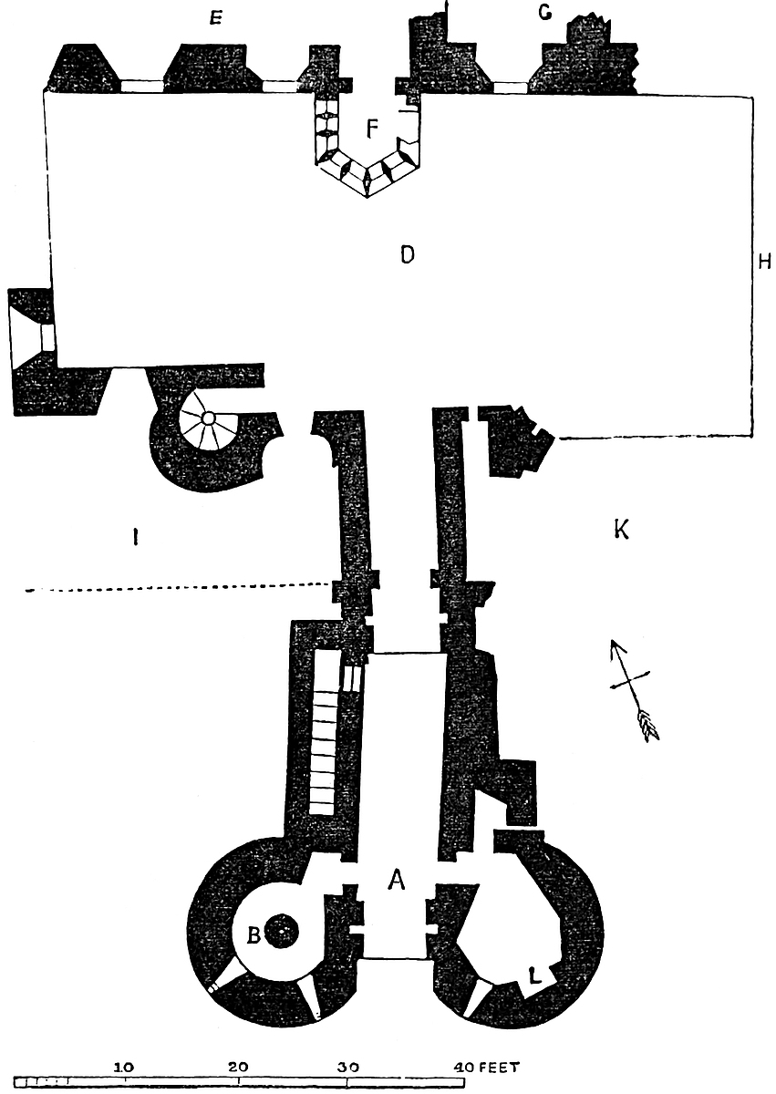
The platform, to one end of which the barbican gives entrance, is about 35 yards long by 10 yards broad, and looked down upon a formidable ditch. In its centre, between two of the main towers, was a short lofty curtain, and in it the main gateway. Above, a row of bold corbels, projecting above 5 feet, included a line of machicolations, and gave great breadth to the rampart of the curtain and great vantage to the defenders. The gateway is acutely pointed, but quite plain, with flat sides. Within, the portal is vaulted and portcullised, and has a broad space in front of the grate, possibly for some kind of additional frame. Above the portal was a portcullis chamber, also in the substance of the wall, and the place where the grate was suspended is still seen. This chamber was reached by a steep narrow stair from the rampart of the curtain,—a very rare arrangement. Entering the gate on the right is a staircase up to the ramparts, looking like a makeshift, and possibly not original. Beyond, also on the right, is the great hall. This, though a spacious, could never have been a handsome chamber, for it is built on a curve, or rather on an irregular polygon, to suit the southern curtain which forms one side of it. It is about 105 feet long by 30 feet broad, and its floor is at the court level. Below was a cellar of about half the breadth of the hall, the rock here cropping up and blocking one side. To this the entrance was by a pit or trap, in which was a doorway opening into a passage by a second doorway in the cellar. This is lighted by loops in the curtain, and at its east end is continued, through a partition, below the chapel. The hall is said originally to have been of smaller size, and to have been enlarged. If this be so, it must have been at the chapel end.
The hall is lighted by four small square-headed windows towards the field, and two larger ones towards the court. The latter are pointed and were of two lights, with quatrefoiled heads, and a quatrefoil in the head. The door is in the same side near its east end. There are three fireplaces, all under hoods, with flanking piers and brackets to receive the thrust of the flat arch. The hall was crossed by seven large chamfered stone ribs of two members, placed very irregularly. Two are standing, one having been lately rebuilt; the other is at the upper end of the hall, and marks its division from the chapel. A plain corbel below the springing of this rib shows the partition to have been of timber, no doubt a carved brattice. The roof was open, and there were timber principals between the stone ribs. It is difficult at first to believe that this long irregular space, with its three unsymmetrical fireplaces, could have been all one room, and at first it appears as though the west end, to the second rib 457 with one of the fireplaces and three windows, might have been bratticed off as a withdrawing-room; but it is evident this was not so. Such a room would have no separate door and no garderobe. The dais of the hall was evidently at the other end, and the withdrawing-room was the first floor of the dungeon tower, which stands at the back of the great fireplace, and is entered by a small door in the jamb of one of the hall windows. This and the floor above were readily accessible from the dais.
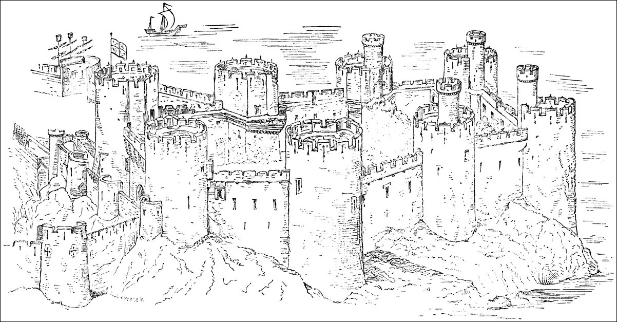
The chapel, bratticed off at the east end of the hall, had also an open roof, with one stone rib. It has two windows to the south and one to the field, and at its east end is a larger, three-light window, with a round head, and a piscina in the south jamb. The tracery is broken away. The great kitchen has been pulled down. It was built against the north curtain, opposite to the hall door. There remains of it a water-trough occupying the seat of a window, and lined with cement. Near the kitchen was a large tank quarried in the rock, lined and cemented, for the storage of water; a culvert brought into it water from the roofs, and leaden pipes have been traced from an exterior spring at some distance. It has been opened to a considerable depth, 14 feet or 15 feet, but was certainly not a well, though possibly one was intended.
The cross wall separating the two wards is of the same height and thickness as the exterior curtains. It is pierced near its centre by a shoulder-headed doorway, closed with a door only, and opening into the inner ward. This door is covered by a sort of lodge on its western face, with a loop towards the main gate.
The inner ward, nearly square in plan, has the state rooms on its south and east sides. These have basement chambers, well lighted and with fireplaces on the ground floor, level with the court; and above these, on the first floor, are the state apartments, with open roofs. First of these, on the right is the smaller hall, 30 feet by 28 feet. It has a door at its west or lower end communicating with a sort of lobby, and so with a main tower, which probably contained the kitchen. At the other or east end is also a door, opening into the withdrawing-room. Towards the court is a central fireplace, between two handsome windows. These were flat-topped, of two lights, and the upper half was filled with Decorated tracery, now broken away. In the remaining side, towards the field, is at one end a small window, and at the other a door opening into a mural chamber, a garderobe. The roof was strengthened by two stone ribs, of which one is perfect, and is not quite so plain as those of the great hall. The withdrawing-room has a fireplace on the north side, and was crossed by two ribs, both broken down. This room has a mural passage in its south wall communicating with a garderobe and large vaulted chamber, also in the wall, and so opening into the ground floor of the south-eastern or king’s tower. Another door opens into the queen’s chamber. This is a large and handsome room, also on the first floor, occupying the east side of the court. Its roof contained two ribs, both removed. At its north end are passages458 into garderobes, mural chambers, and an oratory, all contained in the north-eastern, or queen’s tower. Eleanor, the queen of Edward I., is said to have made use of this chamber.
From the queen’s chamber, at the same level, a wooden passage, a sort of balcony, affixed to the north wall of the lesser hall, led to the kitchen lobby and the kitchen. Lines of corbels, and doors at either end, show the position and length of this gallery.
Below the queen’s apartment a passage leads to a doorway in the curtain, which opens upon the east platform, and was the only postern in the castle. It is shoulder-headed and closed with a door only. But, as at the main gate, the curtain is furnished with a line of bold corbels, forming machicolations for the defence of the wall and gateway. Passages open right and left in the sides of the doorway, and carry staircases in the wall up to the first floor of the king’s and queen’s towers.
The platform upon which this postern opens is called the queen’s bower. It is larger than the western platform. Like it, it has three half-round turrets and a parapet, and in its north end is a doorway from which a steep and narrow and parapeted staircase formerly descended to the water’s edge. This staircase was removed when the suspension-bridge was built.
The towers now remain to be described. They are all of one type, and even their details are closely alike. Each has a basement, the floor of which is considerably above the exterior ground level, though below that of the court within. These chambers can only have been reached by ladders from the floors above. They are ventilated by small air-holes high up, but the probability is that they were put to no regular use, though they may have served for prisons.
The first floor of each tower is entered from the court, and from that level a well-staircase ascends to the second or upper floor, and so on to the roof. Here, in the four western towers, it stops. In the four eastern towers it is carried on, forming a small round turret, 14 or 15 feet high above the roof. None of these floors are vaulted, all have fireplaces in the first and second floors, and all open at the second floor level upon the rampart walk. All also are well provided with garderobes.
The battlements of the towers remain uninjured. The parapets are about 10 feet high, and divided into twelve merlons and as many flat-sided plain embrasures. Each merlon is pierced by a loop, and at the base of each, at the allure level, is a hole ending in a gurgoyle, for the discharge of the rain water.
Two of the towers are furnished with ovens, built in the old fashion, with a flue outside and above the oven door. In the queen’s tower the second floor has an oratory in the east wall. This is a deep and bold recess, divided into nine bays or compartments, three on each side, and three forming an apex. In each bay is a sedile, and above, in the apse, are three lancet windows. The slender shafts between the bays are vaulting shafts, and expand above in fan tracery of a Decorated character. On each side of the459 oratory is a small mural chamber, one a vestry; the other, it may be, a confessional; both have small loops into the oratory. Possibly the whole circular chamber was used as a chapel, to which the oratory was the choir.
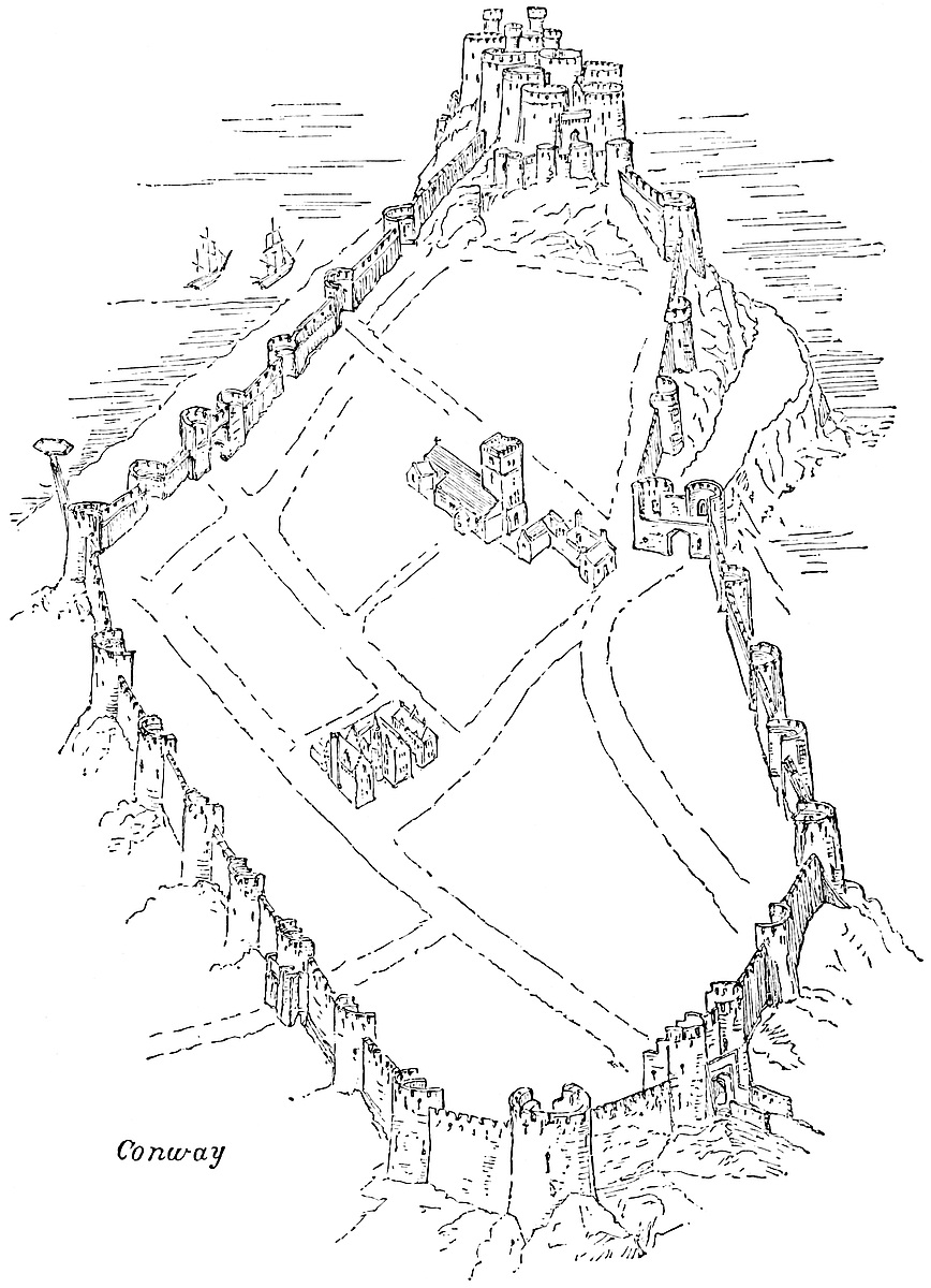
460
Conway, though as strong, is a far less elegant structure than Caernarvon. The masonry, though excellent, is rough uncoursed rubble, and ashlar is very sparingly used. The battlements especially, as at Harlech and Caerphilly, are very bare. They are ill-coped and ill-finished, as though they were intended to be concealed behind a brattice; but, as there are no corbels or places for the struts, this cannot have been intended.
The putlog holes show that round instead of square poles were used in the construction; and here, as at Coucy and in parts of Harlech, they are so placed as to show that the scaffolding was laid as an inclined plane, instead of horizontally, and with ladders. This is also the case with the walls and towers of the town.
Conway Castle is retained by the Crown, but has long been let on lease. Lady Erskine, of Cambo, the last lessee, has lately waived her tenure, and the ruins are now held by the Corporation, and seem sufficiently well cared for. Mr. Jones, who has had charge of the place for nearly half a century, is a very careful and intelligent guardian, and well acquainted with the details and history of the castle.
Conway was begun in 1285. Soon after its completion, Edward I. and Queen Eleanor spent a Christmas here in great state, when, no doubt, the state apartments were occupied. The town was stormed in 1646 by the Parliamentary general, Mytton, who also secured the castle.
Charles II. granted it to Edward, the first Earl of Conway, to grace and give some foundation for his title; but the earl, it is said to annoy the neighbouring gentry, dismantled the castle, and took away the lead, timber and ironwork, broke down the well-stairs, and in other ways injured the structure.
The appended bird’s-eye view of the town is taken from the highest and most western point, just above Porth-Uchaf, and in full view of Porth-y-felin, below which is the bed of the Gyffin. The position of the castle, on its rocky promontory, resting upon the sea, is well shown.
The other view is confined to the castle as seen from the south or the valley of the Gyffin. The four towers on the right mark the angles of the inner ward, the two on the extreme right are the king’s tower in front, and behind it the queen’s tower. The central and front tower is the dungeon tower, attached to the great hall. On the left are seen the two lines of the town wall, abutting upon the castle, and between them the western platform with its bastions, and in the rear the main gate with the line of machicolations above it. One of the seaward towers shows how the rampart walk is carried round it upon a corbelled or bracketed projection.
CORFE Castle is one of the most noteworthy remains in Britain.
The natural position is very striking, and not less so the manner in which it has been fortified by art. It is of high antiquity, associated from the times of the West Saxon princes to those of the Commonwealth with marked historical events; was the palace and the prison of kings and great nobles, and has been commanded by a long succession of powerful Castellans.
The castle crowns an isolated hill, a part of the steep chalk ridge which, under the general name of the Purbeck Hills, with the subordinate elevations of Knowl Hill, and Ninebarrow and Ballard Downs, stretches twelve miles across the peninsula of Purbeck, from Warbarrow Bay and Flowerbarrow Camp on the west, to the foreland between the bays of Studland and Swanage on the east.
To the south, or seaward, is the bold coast line marked by the headlands of Peverel, Durlston, and St. Adhelm’s. Landward, or to the north, is the depression occupied by Poole Harbour and its tributaries the Frome and Trent, or Piddle—waters whose fords are commanded by the grand earthworks at Wareham, which, placed astride upon the ridge terminating in the junction of the two, form the frontier and key of Purbeck, as does Corfe, its citadel.
The castle ridge ranges with the Isle of Wight, and with it forms the southern margin of the well-known chalk basin, of which Dorchester and Beaminster mark the western limit, and Beer Regis, Salisbury, and Winchester that on the north.
The chalk at Corfe dips north at about 70°. It is hard, moderately durable, and thickly charged with flints, which are extensively used in the interior of the castle walls. Below the chalk, and underlying the great gateway of the castle, is a narrow belt of the upper greensand, below which, in succession, are the three Purbeck beds, the Portland stone, and the Kimmeridge clay. The stone beds, here of a most durable character, are used for the ashlar and face-work of the castle.
To the north of and above the chalk are narrow and irregular beds of plastic and London clay, succeeded by a broad expanse of the lower Bagshot sands and clay, out of which the harbour of Poole has been eroded, and the latter of which is worked for the purpose of commerce.
A considerable fault runs along the chalk ridge close north of the castle hill, one of a parallel series traversing that part of the southern coast.
The physical aspect of Purbeck betrays, to a practised eye, its geological composition, and the wild rough moor and marshland about the harbour contrast strongly with the steep but rounded outline462 and green surface of the chalk, upon a summit of which stands the old Norman keep, predominating far and wide over the landscape.
The castle is naturally strong. It occupies the slope and summit of a hill, the base of which covers about 15 acres, and which is placed in a gap or cutting in the ridge already described, of which position its name is said to be descriptive.
South of the ridge, and close behind and covered by the castle, is the town of Corfe, from which the castle hill rises steeply, to descend almost vertically upon its east, west, and north sides. The northern, or highest point, is occupied by the keep and principal buildings of the castle.
The stream called the Wicken, and its tributary, the Byle brook, each turning a mill, flow from the south-west and south-east round either side of the town, and, girdling the base of the castle hill, unite just below St. Edward’s bridge to form the Corfe river, which flows into Poole harbour. Between the town and the castle, where the two streams approach within a furlong of each other, a deep and bold though dry trench has been cut across the root of the peninsula, and thus forms the great outer ditch which divides the castle from the town.
The castle, in its present form, may be called concentric, but it has been constructed, if not designed, at three principal periods, having been originally a Saxon palace, then a Norman, and afterwards an Edwardian fortress.
It is composed of a keep standing in an inner ward, of a middle, and of an outer ward. The survey by Ralph Treswell, in 1586, subdivides the inner ward into two, and shows a wall across the outer ward, which has disappeared, and was probably modern.
In plan it is an irregular triangle, the walls following the crest of the hill. The great gateway caps the southern or lowest angle; the Buttavant Tower, the western; and the inner ward forms the obtuse, highest, or eastern angle. The south-west, the longest front, is concave. It extends 270 yards from the gatehouse to the Buttavant, and its lower two-thirds is the part of the enceinte most jealously defended, and upon the overthrow of which the destroyers have expended their greatest energies. The north, or upper front, too high for attack, measures about 200 yards, and the eastern front about the same.
The area within the walls is about 3¼ acres; but, from the excessive steepness of the ground, much of the outer and part of the middle ward could never have been turned to account. The lower part of the outer, the western portion of the middle, and the eastern part of the inner ward, are the only flat spaces.
The outer, by much the largest ward, is contained within the great gatehouse, the east curtain strengthened by the Horseshoe and Plukenet Towers, and the west curtain, upon which are four mural towers. The steep, upper part of the ward rises to the wall of the inner, and the wall and gatehouse of the middle ward. It is traversed by a fosse, attributed to King John, which extends from463 the Plukenet Tower to the front of the middle gatehouse, and is thence continued outside the works down the hill-side.
A permanent stone bridge, about 100 feet long by 20 feet broad, crosses the moat, and leads up to the great gateway. It is of four arches, springing from three solid piers, and the roadway, which has now no parapets, is about 30 feet above the bottom of the moat. The masonry ceases about 18 feet from the portal, and the interval, now filled with earth, was probably spanned by a drawbridge. The arches are about one-third of a circle, and the voussoirs in two rings, without bond, 8 inches thick, and from 1 foot to 3 feet in length. The piers may be of Perpendicular date, but the arches are probably due to Sir Christopher Hatton.
The outer gatehouse is composed of two drums, flanking the portal, and produced rearward into a rectangular building, now partially destroyed. The drums, about 20 feet diameter, are solid to the base of the upper story, now removed, but of which the lower ends of the loops remain.
The portal, 13 feet wide, enters a vaulted passage, now 26 feet, and which may have been 36 feet long. First is the portal, now without jambs, and beneath a segmental arch, 4 feet 11 inches broad. Then (as shown in the accompanying section, Fig. I.) a chase, or single machicolation, 6 inches broad. Then a second arch, 3 feet 9 inches broad. Then a chase, 5 inches broad, and a circular groove of 9 inches diameter and 7 inches opening, at which the passage narrows by 20 inches, being an opening of 11 feet 4 inches. Then follows an arch of 1 foot 6 inches breadth, and a chase of 16 inches.
Next comes the gateway proper, the jambs of which, 2 feet 4 inches in thickness, project inwards with a double chamfer, so as to reduce the actual entrance to 8 feet.
The door, the space for which shows it to have been of wood, and not above 4 inches thick, was of two valves, the arch behind being flat segmental, with a high springing and 4 feet of breadth, to accommodate them when open. Two stones on each side, which probably carried the iron loops for the hinges, have been torn out. Between them, a central hole, 9 inches by 12 inches, carried the wooden bar. Next is an arch, of which about 5 feet only remain, but which probably completed the passage to its opening into the ward, and perhaps carried a portcullis groove.
Half the doorways into the lodges remain. The lodges themselves were barrel-vaulted, and the vault in the west lodge springs from the ordinary Norman string, composed of a flat abacus and chamfer, as though an older gatehouse had been cased. Instances of this string, indeed, have been pointed out by Mr. Bond in other and certainly later parts of the castle, and of course a plain string of this character may be of any age.
The several arches composing the entrance passage show, at their springings, about a dozen small holes, evidently to carry the centring. Their small size indicates this to have been of iron. These holes are usual.
464
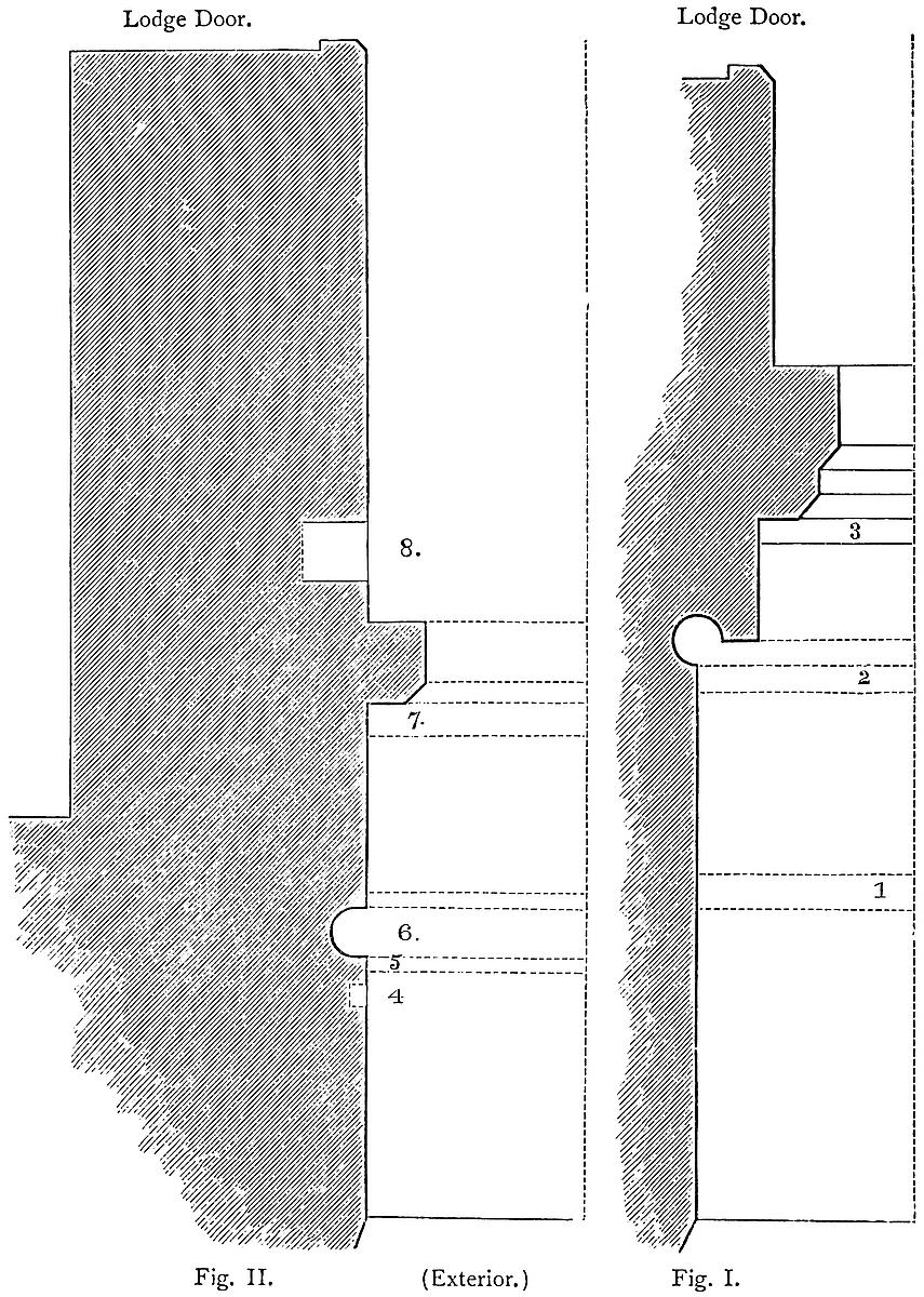
465
In the door-jambs are cut six mortises, three on a side, the lowest 6 inches from the ground. They are each 8½ inches long, 2 inches broad, and 3½ inches deep. They must have been intended to hold boards, though the shallow depth would scarce allow of their insertion. These would, indeed, have been better suited to keep pigs in than warriors out, and perhaps were so used in times of peace. They can scarcely be original, but are probably earlier than the dismantling. The entrance passage falls gently from the interior, so as to give an advantage to the defenders in a contest.
It is difficult to understand the defences of this gateway in the absence of the upper story, from which most of them were worked. There is at present no trace of the drawbridge in the portal, unless, indeed, the pivot-holes on which it turned be concealed by the soil. If the cylindrical pipe, with the opening or slot in its side, contained a sash-weight, of what was it the counterpoise? Scarcely of the drawbridge, for which, even if of lead, unless of inconvenient length, the weight would be too light; and portcullis groove there is none. The 5-inch chase exactly in front of the pipe may have contained a portcullis, or a frame; but, if so, the absence of lateral grooves must have left it very unsteady, except when down upon and fixed in the cill. No doubt, a portcullis with crooked sides or ears might have worked in this tube, but that is scarcely probable. The other chases were, no doubt, intended for the passage of projectiles. They are, however, mere slits across the vault, unaccompanied by lateral grooves as when used for a portcullis, and they do not appear to have been divided by cross septa, as in regular machicolations; but this vault has been riven by an explosion, and restored in part in recent times, so that it is difficult to pronounce upon its details.
From each side of the gatehouse springs a short curtain. That to the east, from 10 feet to 12 feet thick, and about 20 feet high, now mostly destroyed, terminates in the Horseshoe Tower, a mere shell, about 20 feet diameter and 20 feet high, open at the ground floor and across the gorge, and intended to be floored and bratticed with timber, as is not infrequent with mural towers, to prevent their being used against the garrison. It is pierced by three loops on the ground floor. These are mere vertical slits, 7 feet long and 1½ inch broad, splayed deeply, and opening from recesses in the wall. The tower caps the south-east angle of the work, and the loops are directed upon the field, and along the two curtains. The removal of the talus outside shows this tower to stand upon a deep and solid foundation. At the junction of the gatehouse curtain with this tower, the former contains a mural chamber, 6 feet broad, and roofed with five tiers of overhanging slabs.
The east curtain is, for the most part, a mere wall, 8 feet to 10 feet thick, and 10 feet to 15 feet high, exclusive of battlements, and more or less ruined. Loops are to be seen on its exterior, directed downwards so as to rake the scarp. Near the Horseshoe Tower was formerly another mural chamber, called a stable, but more probably a garderobe, and beyond this is a large arch, now walled up,466 which may have been a postern, and commanded by the Plukenet Tower.
This is a mere half-round mural tower, solid to the rampart height, and of no projection within.
Above the rampart it is hollowed into a chamber open behind, with three loops, each 5 feet 6 inches long and 2 inches in the opening. In each of the recesses, on the right, is a small cupboard for the grease or tools needed by the archer. The tower and rampart were ascended by a well-stair on the north or upper side. The arrangements for allowing the archer to shoot downwards so as to rake the steep scarp are well seen here. This tower is named from a bold and well-preserved shield upon its outer face, charged with a bend fusilly, or five fusils conjoined in bend, and held up by two hands which emerge from holes in the stone. This is one of the well-known coats attributed to the Mareschals, Earls of Pembroke; but, as this family was extinct half a century before the date of this tower, and does not appear ever to have been connected with the castle, Mr. Bond has shown it to be more probable that the shield is intended to commemorate Alan Plukenet, constable of the castle in the 54th of Henry III., and a baron in the reign of Edward, his son, and whose arms were either a bend engrailed, or fusilly, represented anciently much in the same way, upon a field ermine, which fur (as Mr. Bond suggests) may have been regarded as a tincture, the lines for expressing which were not then employed, and the spots omitted by the carver.
The curtain from this tower to the Gloriette angle of the inner ward is constructed of much larger stones than those employed lower down. They are as large as many of those in the Norman ashlar, but of ruder workmanship.
Returning to the gatehouse and following the west front, this commences with a short curtain, still standing, and connected with the first mural tower, a drum of rather above half-round projection, capping an angle. It is solid to the rampart level, and above this open at the gorge. Its single chamber has three loops, cruciform, and shorter, wider, and of coarser construction than those of the Horseshoe Tower, though still of excellent ashlar. This tower having been riven by powder is seen to be 10 yards in solid thickness. Its base is perforated by a rude rectangular drain, 18 inches by 12 inches, joined by other drains of 9 inches by 9 inches, all in the solid, and evidently descending from garderobes, one of which seems to have been placed in the curtain close north of this tower.
Next above this is the second or Well Tower, so called from a small depression behind it, said to indicate a well. This tower resembles the last, was, like it, solid in the base, and had one chamber on the rampart, open at the gorge and pierced by three loops.
Close south of it was a small doorway, leading either to a garderobe or a rampart stair. Of this, one jamb is alone seen.
Above the Well Tower is the third, and above the third, and also467 connected with it by a short curtain, is the fourth of these mural towers. This, however, though a tower, is of the nature of an épaulement, or redan, and caps a projection or shoulder of the curtain. It has but two loops, longitudinal only, one towards the field and one raking the south wall. The former is divided into a short upper and long lower part by a narrow plate of stone, which projects inwards like a shelf.
The curtain from this Redan Tower to the gateway of the middle ward is probably earlier than either, and is very lofty. It traverses King John’s fosse. It is constructed of large stones, and resembles, in some respects, the curtain above the Plukenet Tower, at the other end of the same fosse. Below it is solid, above it is pierced by four rude loops, boldly splayed within, and which must have opened from a chamber, of which the curtain was the outer wall, or possibly from a wooden platform.
The fosse, attributed to King John, which traverses the outer ward, is about 20 feet deep, with a vertical counterscarp cut in the chalk rock. The Plukenet Tower and adjacent curtain cross its east end, but these stand upon a ridge of solid rock, showing that the ditch has never been continued into the front in this direction. At its west end the case is different. There it has been cut right into and down the slope, and the curtain crossing and stopping it is built actually in the ditch.
No doubt the present dressing of the counterscarp is due to whoever placed artillery upon its crest. Outside it, by way of glacis, is a level platform, 30 feet broad, known to have been defended by artillery, and in front of which are three steps or benches. The whole work forms a fausse braie at the foot of the glacis of the keep, and a strong defence in front of the gatehouse of the middle ward. A bridge of two arches, of the same age and fashion with that already described, traverses this fosse, here 50 feet broad, and leads up to the middle gateway. A profile cut in one of the gate towers shows where the parapet abutted, which, however, was clearly not original. As in the lower bridge, a space of about 18 feet next the portal, now filled with earth, was evidently intended to be spanned by the drawbridge.
The middle ward is also triangular. Its longer and about equal north and south sides are capped at the acute western angle by the Buttavant Tower, and the base is formed by the middle gatehouse and curtain, and by the revetment wall and gate (now destroyed) of the inner ward.
The gatehouse of the middle ward is a very fine structure. Like the lower gatehouse, which it resembles in general arrangements, it is composed of two drums flanking the entrance passage, and terminating square in the rear.
One, the north tower, rises direct from the fosse, without basement or set-off, and is connected with a short but very thick and lofty curtain, which ascends the steep ground to abut upon the keep. The tower is of bold projection, but flat towards the curtain. Within468 is a lodge with one cruciform loop to the front, and in rear traces of a stair which led to the curtain, and thus by continued steps along its ramparts to the keep.
The other tower rises from the crest of the outer slope, where it appears as a mural defence, upon the west front. Within is a small lodge with three loops, one to the front, one on the flank towards the field, and one, now closed up, to the rear, into the middle ward.
The portal has no jambs, but is entered under a segmental arch, double chamfered, springing direct from the flanking towers. This recedes 4 feet 1 inch, and is succeeded by a rounded portcullis groove, 9 inches broad by 6 inches deep, but having, while within the arch, a flat margin of 3 inches on either side. These margins cease above the arch, and the chase is of the breadth of the groove only.
Behind the portcullis is a second arch, 2 feet 9 inches broad, succeeded by a machicolation, 14 inches broad, and divided by four septa into five square holes. These are placed immediately before the jambs of the gate proper, where the passage is reduced by about 1 foot 8 inches.
Behind the jambs an arch of high spring and flat segmental curve accommodated the folding-doors, when open. These were of wood, and the bar-hole behind them is about 11 inches square. The hinges are gone. Behind this last arch the passage was roofed with wood, and is now open. In the rear are parts of the groove of a second portcullis—“altera securitas”—so that there was probably a stone face to the back front of the gatehouse, all now destroyed. The arrangements of this gateway as far back as the lodge are shown in the accompanying section. See woodcut, Fig. II.
In the wooden roofed space are the doors of the two lodges. The south is square-headed, with shoulders. The north, of the same shape, is protected by a semicircular relieving arch in the wall above. This arch, in design and material, has a very Norman aspect, and may have been preserved from an older work. There are no remains of battlements on this gateway, but on its front are stone corbels, probably intended to carry the hoarding, a feature of military architecture so well described by M. Viollet-le-Duc.[4]
In the exterior portal, near the floor, and a few inches in front of the portcullis groove, is a round hole, 5 inches across and 3 inches deep, which seems to have carried the iron axle of the drawbridge. Above it is another similar hole, no doubt connected with the working of the same defence.
Entering the gateway the road rises rapidly. On the right is the exceedingly steep scarp, at the top of which is the bastion of the keep. On the left is the curtain of the west front. Higher up the way turns to the right, to reach the inner ward, and skirts on the left what seems to have been a formal garden, indicated by a level 469 plot, some foundations of walls, and two alcoves, attributed to Sir John I’Anson, a rector of Corfe towards the end of the last century.
Westward of this the ward seems to have been used for offices, and in part covered over. In the north curtain is a half-round mural tower with four loops, and of one story, open at the gorge. The water-table of a double-gable roof is seen within, and the central gutter projects as a spout outside. Further on is a blocked-up arch, probably an early postern, and, still further, the seat and drain of a large garderobe, beneath an arch in the wall, 8 feet broad. Above is a plain corbel, hollowed to receive the wall-plate of a roof, and no doubt one of a series. The country people call it the gallows. A part of the south curtain of this ward is the most interesting feature of the whole structure.
First, ascending from the gate, upon the left, is the curtain. Then, upon it, a half-round mural tower with three loops, but closed, since its construction, at the gorge by a wall, in which is a small door, which led into a contiguous building. From this tower, westward, the curtain is constructed of flat stones laid in a rude but distinctly herring-bone fashion. In it are three windows and the place of a fourth. These are round-headed, 2 feet 4 inches diameter, and 3 feet 6 inches deep, splayed to 12 inches, when they terminate in a stone plate, out of which is cut a loop of 6 inches opening, and a rebate for a shutter. At present they are 3 feet 6 inches to the springing, but a part may be buried. These apertures are closed by the exterior casing of the wall. This wall at its west end seems to have been returned inwards. Both this wall and these windows have been regarded as part of the old Saxon palace, and this may well be so. They certainly appear older than the Norman work of the keep.
Westward of this old part is a walled-up doorway, with a pointed arch springing from the usual Norman flat chamfered abacus. This looks like transition Norman work. Outside it is masked by the facing. This door, the base of which is buried, seems to have been a postern, although, it must be confessed, in a most inconvenient position for such a means of egress.
The Buttavant Tower, which caps the western angle of the ward, and is a marked object in the outline of the castle, seems to have been an octagon of 7 feet in the side, internal measurement, and of considerable thickness. The casing of the lower part is gone. It had a sub-basement story, and two above this, all floored with wood. A well-stair near the gorge leads to the summit. The curtain from hence to the garderobe is destroyed.
The inner ward occupies the summit of the hill. It also is rudely triangular, the great bastion forming the apex to the west, the Gloriette bastion capping the angle to the south-east, and the obtuse angle to the north-east being formed by the curtain alone. Towards the outer and middle wards the wall is a strong revetment of masonry, crested by the curtain. Elsewhere the earth is only somewhat higher within than without the curtain.
470
This ward contained two gateways, the keep, the Queen’s tower and offices, and a well.
The gateway from the middle ward abutted on the northern curtain. It was probably a mere aperture in a wall, without a regular gatehouse, else it could scarcely have disappeared so completely, even under the crushing weight of the fragments of the keep.
This gate opened into a small court, on the east side of which rose the keep. A second and higher gate seems to have led into the actual ward, and to have been placed close to the foot of the exterior staircase of the keep. This gate is also completely gone. The survey by Treswell in 1586 shows where it stood.
The keep is a quadrangular tower, 60 feet square and 80 feet high, of pure Norman work. The east and west faces were strengthened with five flat pilaster strips, 5 feet 4 inches broad, 18 inches projection, and 8 feet 4 inches apart. On the north and south faces were four similar strips, placed at wider intervals. All rose from a common plinth, and died into the wall a short distance below the battlement, a small portion of which is still visible, not passing into it as at Chepstow and elsewhere, so as to panel the face.
The door of the ground floor, apparently 4 feet wide, and with very late dressings, is at present in the west wall, here 9 feet thick, and may possibly have been always there, although certainly not in its present form. It was covered by the exterior stair. It is placed nearest to the south end, between the second and third pilasters.
The stair, 9 feet broad, is built against the west face of the keep, without bond, and perhaps a later addition. Beneath it is a large open arch, round-headed, springing from flat pilaster jambs, which, continued above the string or cap, panel the soffit of the vault. This arch serves as a porch to the door of the basement of the keep.
The stair terminates in the staircase tower, a rectangular lean-to, or fore-building appended to the keep, forming a vestibule to the main entrance, and said to have carried the stairs leading to the upper floor. It is about 19 feet by 16 feet within, and has a stone bench against its north wall. The door from the exterior stair in the north wall is round-headed, 6 feet 6 inches wide, opening in a wall 6 feet thick, the other two walls being 4 feet. The keep door, between the first and second pilasters, and therefore near the angle of the keep, has been 6 feet broad, now enlarged to 9 feet. It has a flat top, with a semicircular arch of relief in the wall above, not intended to be seen. There was probably a door in the south wall of the vestibule opening upon the great bastion, and there are traces of a covered passage from it into the garderobe tower. This vestibule seems certainly to be of the age of the keep, and to have been occupied by a staircase to the principal floor.
The keep was divided into two great chambers by a wall 6 feet thick. The basement was covered, and the first story floored by ten large whole-timber joists, the cavities for which remain in the south wall. The first floor probably contained a chamber, 42 feet471 long by 28 feet broad, and 24 feet high, which, however, must have been very dark, since the north wall was interior, and the south without windows. Two small doors, probably of rather later construction, open through the south wall into the exterior gallery.
Above this room, forming the third story, was another, apparently of the same size and much more cheerful, and which may have been the hall. A well-stair led from this upwards, in the east wall, near its south end. The water-tables within show a ridge and valley roof, as at Porchester, and probably there was originally nothing above this floor.
The battlements, with a slight exception, are gone, but in the east and west wall, just below the battlement line, are coupled Norman windows, of about 3 feet opening, a pair between each pair of pilasters, thus forming a sort of arcade, not unlike the far later ones at Swansea and Llanphey, but much of which seems always to have been closed. It is remarkable that a building so massive, and the walls of which are so thick, should have been without the usual galleries and mural chambers found in Norman keeps.
Mr. Bond, who is intimately acquainted with this castle, and has brought much critical knowledge to bear upon its details, is of opinion that the upper part of the wall of the keep shows evidence of having been an addition to the original structure, though at no very long interval of time.
Built against the exterior of the keep, on the south side, and projecting into the outer ward, is another lean-to, or appended tower, of about 30 feet in breadth and 20 feet projection. Outside it has three pilaster strips and one on each flank, rising from a common base. At present it reaches only to the floor of the second story of the keep, but it seems to have been higher, and is said to have been lowered by Sir C. Hatton. It is a garderobe tower, and contains on each of its two floors two chambers of about 7 feet by 9 feet. The upper are not accessible; but it is clear that a portion of the eastern lower chambers was bratticed off, to carry the refuse from the upper. In the western chamber is a stone arch, which may be taken to indicate the place of this brattice. The eastern is open on one side, and was evidently closed by a timber partition. These chambers terminate below in two square openings, on the face of the tower, and this supports the notion that the western as well as the eastern chamber was intended for a garderobe.
Between these chambers and the keep wall runs a vaulted gallery, into which they open, and from which two small doors, already mentioned, enter the first floor of the keep. Although the garderobe tower covers only half the face of the keep, this gallery is prolonged over the whole, being protected by a wall, looped. A door at its lower or east end led towards the kitchen, and one at the upper end opened on the great bastion, with access on the right to the vestibule, and on the left to the curtain leading from the keep to the middle gatehouse. Two water-drains from the keep cross the gallery and discharge into the garderobes.
472
This tower, being built against and not bonded into the keep, is evidently later, but resembles it in general style, and must have been added within a very few years. The explosion which shattered the keep has made evident the complete want of bond between the two buildings.
East of the keep the ward is occupied by the remains of various offices, and by the ruins of the Queen’s Hall or Tower. This, with its contiguous buildings, was constructed upon crypts, some of which remain. One is round-headed, with a pointed doorway; another, which supported the Queen’s Hall, seems to have had a very slightly pointed barrel-vault, divided by lateral narrower, but equally high, and therefore pointed, arches, into four bays, two of which contain lancet windows.
Some of the hall windows remain. They are pointed, with drop arch recesses, and stone side seats. The tracery is gone, but the exterior labels remain, terminating in knobs of foliage, and the arris or angle of each recess is occupied by a scroll-bead moulding.
North of this hall and placed across it, east and west, are the remains of what is regarded, with great probability, as the chapel. The west door and that of the hall are placed side by side, in a vestibule or porch, entered on the west side by a staircase.
The doors are pointed, with half-round bead labels, and a scroll-bead moulding running round the jambs and arch. Inside, the chapel door is richer, and has in the arch a double scroll-bead, divided by a hollow, and for the jambs the hollow has been occupied by a detached column of Purbeck marble, which material, though much decayed, is still seen to have formed the base and bell capital. The design, though not highly ornate, is excellent, as is the execution. The whole of this group appears to be early English, of the latter part of the reign of Henry III.
Close to the east of the hall, between it and the curtain, is a depression, said to mark the well. This must have been of great depth—probably to the level of the brook.
The tower spoken of as “La Gloriette” is probably gone, but near it is what may be called the Gloriette bastion, and what seems to be the angular base of a tower capping the south-east angle of the ward, and intended to cover the junction of the wall with the curtain which comes up from the Plukenet Tower. Near to it, westward, is a mural chamber in the curtain, which Treswell’s plan shows as a garderobe, and beyond this an angular bastion, supposed to have been added by Lady Bankes, who seems to have placed a gun there.
The great bastion is a very peculiar work. It is of rounded outline, formed by a very thick and high wall of revetment, which caps the west end of the southern curtain, and projects into the middle ward. At the siege it carried five guns, and was called the New Bulwark. But, although it may then have been widened to carry a battery, it was probably only an addition to the older Norman473 revetment wall supporting the staircase tower. The exterior, and therefore perhaps later, revetment has been injured at the base, and the heart of the work is exposed. It shows very rough filling up.
The south curtain of this ward is about 12 feet thick, but the north and east, being less exposed and having no buildings to support, are much lighter, and present nothing of the strength considered necessary in the lower and more exposed portions of the fortress.
The present condition of the building is completely to be accounted for by the fact that Corfe Castle was “slighted” under a vote of the House of Commons, dated 4th of March, 1645, a period at which the orders of the Commons were not obeyed negligently.
In the outer gateway the drums are blown forwards, the vault split, and the rear of the lodges destroyed. All the upper story is removed.
Eastward the curtain is broken down, but the Horseshoe Tower is not materially injured. The rest of the curtain to the Plukenet Tower is broken down in parts only. That tower and the curtain up to the keep have not been dismantled, and but partially pulled down.
In this outer ward the main force of the destroyers has been spent upon the lower half of the west front, of which the curtains are lifted forwards, and the mural towers rent and shaken, vast fragments of both encumbering the slope. The Redan Tower has escaped, as has the curtain which traverses King John’s fosse.
The gateway of the middle ward presents a singular appearance. A mine has been excavated beneath the outer tower, which has sunk about 10 feet, and moved a little forward, splitting the entrance vault. This can hardly be the effect of powder, but is more probably due to a mine of the old sort, in which the earth was removed, and wooden props introduced, which were afterwards pulled away or burnt.
Of the Buttavant Tower about two-thirds are gone, with part of the north curtain. The great curtain between the middle gatehouse and the keep is unshaken, only its steps and battlements are gone. It is one of the finest curtain walls in Britain, and almost equal to Cardiff.
In the inner ward the devastation has been severe. Of the keep, all the north and two-thirds of the adjacent west wall lie in enormous masses on the sward, and in their fall have utterly crushed the gateways of the ward and their adjacent curtain. The east wall is destroyed at its two ends, but a strip of the central part remains unhurt to its summit, a marvel of Norman masonry, and is completely shrouded in ivy. The south wall and garderobe tower are but little injured. The staircase tower is destroyed, all but a part of the north wall. The broken-down walls of the keep are a sight to see, so vast is the mass of the fragments and so firm the cohesion of the material. They lie in the wildest confusion, and some considerable lumps have474 rolled down the slope, and, bounding across road and brook, rest half buried in the turf beyond.
The Queen’s Tower and offices are destroyed, but, offering less resistance, have been broken up more in detail, and have no doubt been spoiled subsequently for the sake of the ashlar.
The destruction probably exceeds anything known elsewhere in England. The charges of powder, though skilfully disposed, seem to have been larger than was actually necessary; and, certainly, the place might have been rendered untenable with far less destruction of masonry. Even with such mortars as were used in the days of the Commonwealth, the castle could have been commanded from the loftier Challow Hill, close to the east of it.
A few remarks naturally arise out of the above description.
The Saxon residence, of the existence of which there appears to be evidence in the latter part of the tenth century, was no doubt also a place of strength. It is certain that it must have occupied the highest part of the hill, now the inner ward, and the wall remaining in the middle ward will probably be accepted as evidence that it extended over the area of this ward also.
The Normans probably made a clear sweep of any existing buildings in the inner ward, when they commenced the keep and its accessories, and, a little later, the garderobe tower. These are all built of large squared stones, with moderately open joints; thoroughly substantial, sound work, and all the more workmanlike and effective for a certain roughness and boldness in the finish. The ashlar, usually an indication of late work, was here close at hand in the Purbeck quarries, and the general absence of ornament in a royal residence, of vaulting, of triforial galleries or mural chambers, and, with one partial exception, of mural staircases, seem to indicate the work, if not of the Conqueror, of his more immediate successors. The garderobe tower, not particularly late Norman, but certainly subsequent to the keep, seems to strengthen this conclusion.
As the Norman buildings required to be included within an enceinte wall, which would naturally take the crest of this part of the hill, this would necessarily include or supersede the Saxon wall, which, for the same reason, would have followed the same limited outline. Probably, therefore, the curtains of the upper and middle ward contain traces of Saxon and a great deal of Norman masonry, and this applies also to the cross revetment wall between the inner and middle wards, which follows a natural division in the ground. The same natural cause would decide the position of the gates, where we now see them.
The original Norman castle has generally been supposed to have been restricted to the two upper wards, to which, according to Mr. Bond, the great authority for all matters connected with Corfe, King John added the defence of a deep fosse. It is singular, however, that this fosse, while cut right through to the western slope, should stop a little short of the eastern face. The narrow ridge thus left could scarcely have been intended for a passage, for the475 gateway of the upper ward must necessarily, from the disposition of the ground, always have been at the western or lower end of the fosse, and, had a ridge been left as an approach, it would certainly not have been one of almost inaccessible steepness, much exposed to view and to attack, and not defensible by any special work.
The wall, from the Gloriette angle along the ridge, nearly to the Plukenet Tower, has been observed to be of regular Norman work, and, according to Mr. Bond, to show evidence of having been returned inwards, as though it extended along the line of the later ditch. Thus it may be, that before King John’s time the fortress occupied the present upper and middle wards, and a strip of the lower ward along the foot of the glacis of the keep. This is, no doubt, more probable than that it occupied the whole of the lower ward, covering the same area with the present works.
Mr. Bond has been able, by documentary evidence, to fix the date of the great curtain, which connects the later middle gate with the earlier keep tower, at 1236; as with such a curtain there must have been a tolerably strong gate, and, as the present gate is some years later, this was no doubt Norman, though probably very late—say of the age of the curtain traversing King John’s fosse at the lower end. Perhaps the pointed arch with Norman springing-course, in the wall next the Buttavant Tower, may be of the same period—say the reign of Henry II., though the wall itself may be shown, by the evidence of records, to be later.
The lower ward, in its present state, was certainly enclosed towards the end of the reign of Henry III., and in that of Edward I. To this age may be attributed the outer and middle gatehouse, and the four mural towers of the outer ward, as well as the work of the Queen’s Tower, with its hall and chapel. The Plukenet Tower may be assigned to the constableship of that baron, 54 Hen. III., or a little later.
To this period also is to be assigned the facing of the south wall of the middle ward. The ashlar of this age, though it has not the grand, effective boldness of the Norman work, cannot be surpassed for closeness of jointing and general excellence of workmanship. The stones, from 1 foot to 2 feet long, and 8 inches wide, are coursed and well bonded, and their angles are as fresh as when newly cut.
The excessive solidity of the mural towers upon the west front is very remarkable. Possibly this unusual strength was intended to counteract the danger of being mined, for which the soft chalk offered great facilities.
COUCY-LE-CHÂTEAU, town and castle, are built upon and completely occupy the somewhat irregularly-shaped but level summit of a promontory of chalk, the eastern part or root of which is connected with the high land of the upper forest of Coucy, while towards the north and west the termination of the platform stands out boldly and abruptly, from 150 feet to 200 feet above the fertile valleys on either hand, whence spring the tributary waters of the Lette, a stream which flows down from the ancient city of Laon to reach the Oise at Manicamp.
The valleys immediately below and commanded by the castle bear marks of high and early cultivation, and no doubt contributed largely to its support. More distant, chiefly on the eastern and northern sides, are the immense woodland tracts of the high and low forests of Coucy, St. Gobain, and Monceau, while to the south are those of Pinon and Mostier. Occupying fertile spots amidst these forests were the abbeys of Nogent, St. Nicholas, Barizy, and Prémontre, where was the burial-place of the De Coucys, and the remains of which religious houses are interspersed with those of the castles of St. Gobain, Folembray, Anizy, La Fère, Pinon, and many others, showing the value attached to this tract of country by the jealousy displayed in its defence.
The etymology of Coucy has not been explained. The district in which it stands was known as Le Mege in the sixth century, and Coucy was probably included in that part of it granted by Clovis to St. Remi for the archiepiscopal see of Reims, a.d. 500. In 909 it was in the hands of Archbishop Hervé, who, moved by the rising power of the Norman, here first built the castle known henceforward as Coucy.
Whatever may have been the particulars of this fortress, its area must have been identical with that of the latter work, governed by the configuration of the ground; and, whatever may have been its construction, its position could not but endow it with strength and importance. It became at once a place of note. Here, Hervé, Count of Vermandois, imprisoned Charles the Simple, whom he sold to his rival king for the county of Laon. Nevertheless, in 930, Hervé was forced to give up Coucy to Boson, brother to Raoul, king of France. Boson was slain before St. Quentin in 931, and, after a century of vicissitudes, the domain, held by a mere quit-rent of the Church, was in 1037 the signory of Alberic, the founder of the baronial name of Coucy. It is uncertain whether Alberic was of the family of Eudo de Chartres or that of the Counts of Vermandois. By marriage he added Amiens and its adjacent castle of Bôves to Coucy, and is thought to have founded the abbey of Nogent-sous-Coucy.
477
Alberic was succeeded by his son Enguerrand, Sieur de Coucy, Count of Amiens, and Lord of Bôves. He married Ada, heiress of Letard de Roucy, Lord of Marle, second son of Gilbert, Count of Reims, with whom he acquired Marle and La Fère. He—or more probably his son—first assumed the well-known armorial bearings, “Barry of 6, vaire and gules.” He died 1116, leaving Thomas.
Thomas de Marle, de Coucy, his son and successor, long in rebellion against his father, bore a bad name for violence. He lost Amiens; but, again by marriage, acquired Crécy-sur-Serre and Nogent. He died 1130.
Enguerrand II., known as Le Sire de Coucy—this title, it is said, denoting the lord of an allodial fief—held also Marle, Crécy, Vervins, Pinon, and La Fère, in which latter castle he defended himself with success against Louis le Gros and Raoul, Count of Vermandois, in 1132. His reign was one of peace and justice.
This Enguerrand is said to have slain in personal combat a ferocious beast called a lion that infested the neighbourhood; and this tale is no doubt the origin of the lions which were used by the family as crest and supporters. Such tales were common in the twelfth century, only the scene of the exploit was usually more safely laid in Palestine. This combat was commemorated in a bas-relief over the door of the keep at Coucy, and was probably the foundation of a singular ceremony which only ceased at the Revolution. Thrice annually, at Easter, Pentecost, and Christmas, the Abbot of Nogent, or his attorney, entered Coucy by the lower gate, a whip in his hand and mounted upon a crop-eared and docktailed bay. On his poitrel was suspended a seed-bag of white linen filled with wheat, and in a basket certain crescent-shaped cakes stuffed with minced veal, cooked in oil, and called rissoles, probably the earliest mention of a dish which has descended to our own times.
Behind the abbot came a red dog, also with cropped ears and tail, and having a rissole suspended from his neck. This singular procession then entered the castle, and at the base of the keep the abbot made the circuit of a central and three lesser couchant lions there carved in stone, and afterwards embraced the larger beast. This done, he offered the cakes in homage to the lord, who distributed them to the people, and then witnessed the record of the homage by affixing to it a special seal, representing a mitred and crosiered abbot, having for feet the hoofs of a buck. A representation of this ceremony in tapestry long adorned the walls of the castle, and is thought to have been taken into Lorraine after the marriage of a later Coucy with a daughter of that house.
Enguerrand II. died while on a crusade in Palestine about 1148; but his body was laid in his abbey of Prémontre, near the castle, where his effigy remained in 1682.
Raoul de Coucy, son and successor, was under age at his father’s death. He married, about 1169, Agnes of Hainault; and secondly, Alix, niece of Louis-le-Jeune, and sister of Robert de Dreux. By this match he connected himself with the blood royal.478 He accompanied Philip Augustus to Palestine in 1188, and fell before the walls of Acre in 1191. He was buried at Foigny, and his son by Alix was his successor.
Enguerrand III., called the Great, Lord of Montmirail, Oisy, Crèvecour, la Ferté-Ancoul, la Ferté-Gaucher, Vicomte de Meaux, and Châtelan of Cambrai. He was the founder of the present castle, and at the same time walled in the considerable town that had risen under the protection of his ancestors. As he was a child at his accession, his mother administered the signory, and conceded a charter of liberties to the town in 1197, which he confirmed when of age. In 1200, more majorum, he attacked the property of the Church of Reims. In 1210, he joined the Count of Vermandois in the first crusade against the Albigenses, and again in 1219 and 1226; then assisting at the siege of Toulouse and the taking of Avignon. He distinguished himself also at the battle of Bovines.
Enguerrand, though not wanting in territorial power, exercised an influence far beyond that due to wealth or breadth of possessions, and which was in great measure personal. He appears to have submitted with an ill grace to the government of Queen Blanche during the minority of St. Louis, and is said to have even contemplated regal power. However this may be, the consciousness of his influence, no doubt, led him to erect the Castle of Coucy, it is thought, between 1225–1230; and it maybe that in so doing he proposed to himself to cast into the shade the grand tower of the Louvre, the work, a few years before, of Philip Augustus. He is also said to have rebuilt his other castles of St. Gobain, Assis, Marle, Folembrai, and St. Aubyn, and the Hôtel Coucy at Paris.
In 1244, he was in the confidence of St. Louis, and attended a conference of nobles at Chinon, where he supported the plan of a descent upon England; but while assembling his vassals for this purpose he was flung from his horse and killed by his own sword. Of his children by Marie de Montmirail, Raoul II., who fell in the crusade of 1250, and Enguerrand IV., became successively Sieurs de Coucy; but both died childless, and with the last closed the male line of these great barons. Alix, half-sister to the last lords, married Arnoul, Count de Guines. Enguerrand the Great had also a daughter, Mary, who in 1239 became the second wife of Alexander II. of Scotland, and the mother of Alexander III. Mary was a very remarkable person, and exercised the duties of guardian to her son in difficult times in a very efficient manner, devising and executing a vigorous policy of her own.
Arnold Comte de Guines sold Guines to Philip le Hardi in 1282. Alix de Coucy, his wife, was daughter of Enguerrand III. by Marie Dame d’Oisy, his third wife. They had Enguerrand V. de Guines, Sire de Coucy, &c., who lived at the court of his cousin-german, Alexander III., in Scotland, where he married, before 1285, Christine de Baliol. He died 1321.
William, his son and heir, married Isabel, daughter of Guy de Chatillon, Comte de St. Pol. He died 1335, and was succeeded by479 Enguerrand VI., who married Catherine, daughter of Leopold, Duke of Austria. This baron took part in the defence of his province against Edward III., and fell at the battle of Crécy, in 1346, leaving his son an infant.
Enguerrand VII., better known in England as Ingelram de Coucy, was one of the greatest and most powerful barons of his race and age, and, in a warlike age, celebrated as a military leader. He commenced his public life by a war of extermination against the insurgent Jacquerie. He was then one of the hostages in England for King John, and there married Isabel, daughter of Edward III., became a Knight of the Garter (39th on the list), and in 1366 was created Earl of Bedford. The effect, perhaps the price, of these honours was his neutrality in the war between France and England. He claimed the duchy of Austria, and raised 60,000 condottieri to support his rights, but in this he was unsuccessful.
After the death of Edward III. he returned the insignia of the Garter to his successor, and took part with France. Upon Du Guesclin’s death, he was offered, and declined, the sword of Constable of France, but became governor of Picardy. His advice to the king was to anticipate the English attacks.
His second wife was a daughter of the Duke of Lorraine. In 1382, he composed, by fair words, the insurrection of the Maillotins, at Paris. In Picardy he was scarcely less lenient. Doutard, one of their leaders, he sentenced to death, but at the gallow’s foot he was pardoned, by the custom of Picardy, because a woman from the crowd consented to marry him,—a singular legal juxtaposition of hanging and matrimony. Enguerrand took part in the campaign of Charles VI. against Ghent, in which Van Artevelde was killed; and in the following year, after putting down an insurrection at Paris, he joined the war in Flanders, where he won the high approbation of Froissart.
He then went to Italy, and fought at the battle of Arezzo, for which he received the charge of Grand Butler of France. Shortly afterwards, he was prominent in the military and naval preparations for a descent upon England, and seems to have commanded a division of the fleet, and to have been driven upon the coast of Scotland.
In 1390 he took part in the African expedition, landing at Carthage. The closing act of his life was the unsuccessful crusade against Sultan Bajazet, upon his invasion of Hungary, and the battle of Nicopolis in 1396, when Enguerrand was defeated and made prisoner, and so died in 1397, aged 57, the last male of the second line of the Sires of Coucy.
Upon his death, Louis Duke of Orleans obtained possession of the Coucy estates, under cover of a purchase from the heir female. Upon the death of Louis, in 1465, Duke Charles succeeded, and upon his accession to the throne of France as Louis XII., in 1498, Coucy became Crown property, and ceased to retain any individuality, or to be the seat of an independent family. As an appanage of the Crown it was granted to the successive families of480 Orleans, and was thus held by Égalité at the Revolution. It is at present a part of the State domains, and in consequence received a share of the consideration with which the late Emperor regarded all public monuments, and has been most judiciously preserved from further decay by M. Viollet-le-Duc, from whose survey the annexed plan has been made.
The castle occupies the north-western extremity of the platform, of which the remainder is occupied by the town. Upon three sides the natural defence is the steep hill-side, the upper 30 feet or 40 feet of which are rendered vertical by art, and faced with masonry. The (wholly artificial) defences of the town on the south front are a deep ditch, extending from cliff to cliff, and dividing the town from the castle, within which is a curtain wall, flanked at its ends by two round towers containing vaulted chambers, and with a central gatehouse, also so flanked.
The castle is composed of a keep, an inner, and an outer ward. The outer, about thrice the area of the inner ward, intervenes between the inner ward and the town. Its narrow south front has been described. Towards the north-east the hill is very steep, and the revetment wall on this face is not reinforced by buttresses or flanking towers. On the opposite face the ground is far less steep, and the platform projects in a bold salient towards the south-west, the revetment of which is strengthened by eight mural towers or bastions, some half-round and the others rectangular. The south wall is lofty, the others were probably mere parapets. The great gatehouse, or “Porte de Maître Odon,” is now much broken down. The portal arch was pointed, as are two lateral arches for the guard. The square groove of one portcullis remains. The gatehouse seems to have been of the usual rectangular plan, having a central portal arch and passage, and two exterior half-round flanking towers. In this outward ward are to be traced very considerable foundations, and here are found fragments of piers and arch stones, and carved blocks, showing that the buildings erected as stables and barracks for the castellan, and probably, in times of peace, for the lord, were very considerable, and of a handsome character. Here also are the foundations of a church, recently cleared out. They show a single nave, with a semicircular apse, and a transept, the two arms of which have, on their eastern sides, two smaller apses, the three ranging nearly in a line. The building is about 100 feet long by 30 feet broad; has a double west door, and five windows of a side, besides three in the apse and three in each limb of the transept. From its plan and proportions this church has been regarded as part of the original castle, and the only part now remaining. Its actual date is, however, probably of the eleventh century.
The inner or north end of this ward abuts upon the inner ward. This front is occupied by a broad and deep dry ditch, concave towards the outer ward, having a walled scarp and counterscarp, and crossed at each end by the exterior enceinte wall of the place.
481
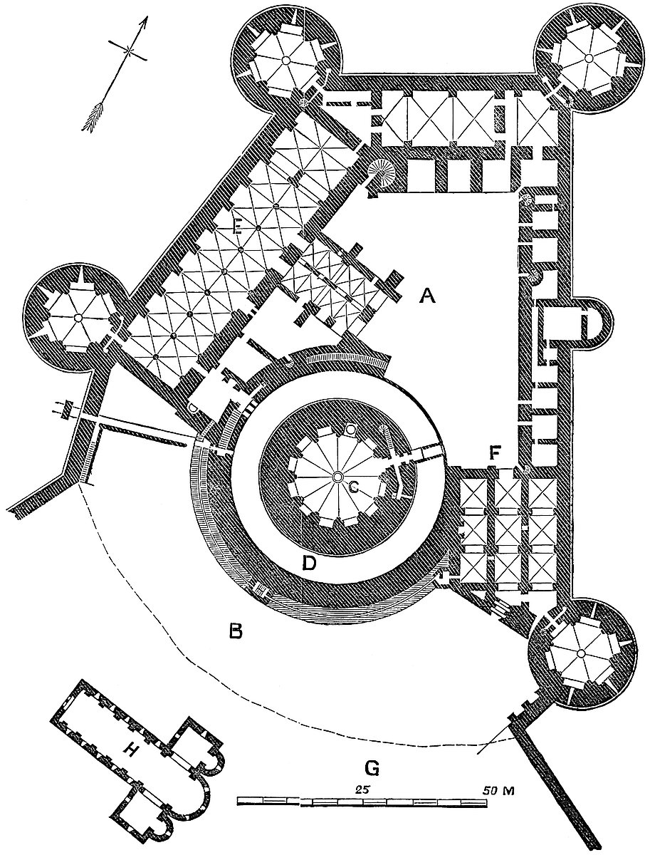
The inner ward, or castle proper, is four-sided. The east face, of 130 yards, and north face, of 60 yards, are both straight, and set at right angles. The east front, of 70 yards, is set at an obtuse angle to the north, but is also straight. Thus breadth is given to the 482 south front, which is 130 yards. This front is also straight, but about five-sevenths of its central part is occupied by the convexity of the great tower and its chemise, which are placed upon the line of the curtain.
The east, west, and north fronts are towards the field, and are formed by facing the scarped rock with masonry, so that they stand 30 feet to 40 feet high to the level of the terre-plein, above which rises the curtain-wall. The south front is covered by the ditch already described, which is segmental in plan, with vertical sides. Near its east end this ditch is expanded from 60 feet to 90 feet, and was there traversed by a long drawbridge, which rested upon three detached rectangular piers, of which the inner one was the largest, and contained two lateral places of arms, and no doubt carried a tower. This bridge led up to the main gate. It is now replaced by a causeway.
At the four angles of the ward are four equal drum towers, 60 feet in diameter, and 105 feet high from the exterior base. They are remarkable for their size and boldness, being engaged only by one-fifth of their circumference. These towers rise from the rock, and contain two domed stages below the terre-plein level. These are entered by a circular hole or eye in the centre of each vault. The terre-plein level of each is a hexagonal chamber, vaulted, having five recesses, of which four are pierced as loops. The entrance is in the gorge, with two lateral passages, one leading to a garderobe and one to a well-stair, ascending to the summit.
The chamber above is similar, but the loops are placed between instead of over those below; and thus the towers have been preserved from those vertical fissures so common when a series of loops or windows occur, as they usually do, in one vertical line. By this arrangement, also, the scope of the archers defending the tower is much increased, every point within arrow range being exposed to fire. There are three floors above the ground-level, or five in all. All are vaulted. A line of corbels at the present summit shows that they were originally defended by a bretasche.
Nearly in the centre of the east face was a small half-round bastion with flat sides, 30 feet in diameter and about 20 feet projection.
Standing in the court, no part of the curtain is visible. Along the central 180 feet of the east front is a range of buildings, called offices, about 30 feet deep, and having three well-staircases, serving the first and second floor, now destroyed. At the south end the space between the curtain and the tower chemise, about 60 feet by 80 feet, is occupied by three aisles of vaulting, each of three bays. The centre of these is the main entrance, or continued portal arch. The lateral bays are for warders and soldiery in charge of the gate. There were two stories above this, now destroyed.
Along the north front was originally a vaulted arcade, 45 feet broad, composed of four bays. To this has been added, in front, an arcade of three arches, open towards the court, and upon the plat483form thus gained have been constructed a terrace and a range of state rooms, of which the principal is the ladies’ hall, or Salle des Preuses, so named from the medallions of nine celebrated women which adorned the great chimney piece. In the exterior was a sort of oriel boudoir, and large windows towards the field. Above this was another story, to construct which the curtain was raised. These buildings were the addition of the Duke of Orleans. A large well-stair, also an addition, led from the court to these apartments.
The west side also has a high curtain, against which is constructed a magnificent chamber, 45 feet broad by 470 feet long, down the centre of which stands a line of ten columns, dividing the space into eleven vaulted and groined bays, of which the northern pair are cut off as a private cellar. On the east side of this chamber are four doors, two near the centre opening into the crypt of the chapel, one south of this, probably the main entrance, and one near the south end, opening into what appear to have been the kitchens, and which lie between this splendid range of magazines and the great tower. Connected with the kitchens are three courts, and a staircase descending to the cellars.
Below the chamber is another of equal size excavated in the chalk, as a cellar, probably about the finest and most spacious ever constructed.
Above, on the first floor, or third stage, was the great hall of the castle, called, from its nine effigies of heroes, La Salle des Preux. It had a wooden roof, two large fireplaces, and a large window at the south end, below which a small door opened upon a light wooden bridge, which dropped upon the curtain of the outer ward, just above the postern.
The chapel was a rectangular building, 60 feet east and west, by 36 feet north and south. It projected from the hall into the court. It was composed of two parallel aisles, vaulted, each in four bays. Its south-east angle was engaged with the chemise of the great tower. Its south-west angle was free, and had two buttresses set on at right angles. This chapel is now destroyed to its foundations. It opened from the great hall.
The keep, or great tower, is the boast of Coucy, and deservedly so, being one of the finest towers in the world, and no doubt the largest and most complete single military building.
It is a plain tower, perfectly cylindrical, of excellent ashlar workmanship, 100 feet diameter at base and summit, and 200 feet high. It rises out of a paved moat, the base being about 12 feet below the level of the terre-plein, and is entered by a drawbridge from the level, all below being solid.
Including the basement, the tower contains three stories. The ground floor, on the level of the terre-plein, is entered by a drawbridge laid across the ditch, and which, when raised, covered a small square-headed portal, under a pointed arch, the entrance to a passage directly piercing the wall. The passage has an interior machicolation and a portcullis, both worked from a small chamber484 in the wall above, which also received the chains of the bridge. Within the portcullis was a stout door barred within, and, on the left and right, passages, one to a mural garderobe with an exterior loop, the other leading to a well-stair, which served the upper rooms and led to the ramparts.
The entrance passage leads direct into a duodecagonal chamber of about 60 feet diameter, having a recess in each floor for stores, one occupied by the entrance, one by a large well, now about 90 feet deep and formerly 200 feet, and one by a chimney.
Each pier is faced by a column, from which springs a rib, the twelve meeting in the centre at an eye, and supporting the vault. Each vaulting cell has a pointed gable, of which two are pierced for light.
The first floor is of the same figure and diameter, and vaulted in a similar manner. One of its recesses is closed by a fireplace with an oven behind it; one gives passage to a very narrow postern, the plank bridge from which drops upon the rampart of the chemise wall, and three are pierced by small windows. One of these window recesses is entered laterally by a small passage from the adjacent recess. This is of fifteenth-century work, made when the recess was walled up to serve as a separate chamber. Another recess has also a lateral passage, entering a small mural garderobe, looped from the outside. In one recess are two windows, one above the other.
The second floor, resembling the other in plan and diameter at its floor level, has a different arrangement at a height of 12 feet. Here the piers cease, and behind, between them and the outer shell of wall, is a gallery, entered by the regular well-stair, but each of the eleven other compartments of which forms a box like that of a theatre, looking down upon the central pit or floor. Two of these boxes are occupied by the detached flues of the two chimneys from below, and two are lighted by windows, which, with the central eye, form the whole and very insufficient light. In this chamber, the next below the battlements, the commander could collect and address a very numerous garrison.
The third floor, that of the ramparts, and open above, is contained within a thick and lofty parapet wall about 10 feet high, and pierced by twenty-four lancet arches and as many intermediate loops. Above these the wall is surmounted by a grand coping, which overhangs both ways about thrice the thickness of the wall, and then slopes upwards into a ridge. It was upon this ridge that were laid the roofing rafters of the bretasche gallery, which enclosed the wall inside and outside. The former was merely as a counterpoise. The latter was of two stories, and rested its main struts upon a line of forty-eight grand corbels, which remain on the exterior face of the wall at the rampart level. The flues appeared above the roof, and three large and highly-crocketed pinnacles were placed astride on the crest of the wall. The stone vault of the upper chamber was covered with lead, with occasional gutter openings outwards.
485
Nothing can be grander than the conception of this tower, nothing more complete than the execution of its details. All is gigantesque, as though for a race above the ordinary stature of man, and the walls within were overlaid with a fine cement, and painted with care. The design of the sculpture is bold and masculine, as becomes a military building; but all is in excellent taste, and admirably executed.
The walls of the keep are tied with chain-courses of timber, laid in mortar, in the centre of the work, as was the custom in France in the twelfth and thirteenth centuries. The timber is exposed below some of the loops. In the upper floors were embedded radiating ties, also of wood.
Two lines of square putlog-holes are seen on the exterior of the keep. They ascend in a spiral, or a right-handed screw, and indicate the manner in which the building was constructed. Horizontal beams, projecting from the upper row, carried the inclined plane or roadway up which the materials were dragged, and these were supported by struts, the feet of which rested in the lower row.
There remains to be described only the chemise, or work designed to cover the base of the keep from the operations of the miner. It has been seen that the base of the keep was solid, and that it stood in a paved fosse, about 20 feet broad, with vertical sides. The exterior side, or counterscarp, of this fosse was a wall, about 8 feet thick, which divided it from the main exterior ditch of the ward, and rose to the level of the first floor of the keep, say 30 feet. The ordinary ascent to its rampart walk was by a stair within the wall, commencing on the right near the keep entrance. It was also reached from the first floor of the keep by a slight bridge, such as was employed at Rochester, and probably in one or two places in the Tower of London. There was also an access from the other end of the wall, from the rooms over the great gateway.
Outside of and at the base of the salient half of this wall was built against it, at the level of the bottom of the exterior ditch, a covered way or gallery, intended to act as a countermine, and still more completely to frustrate attempts against the keep. The gallery is entered from either end, and in its centre rises a sort of buttress against the wall, in which was contained a wooden stair, by which the people on the rampart could communicate with those in the gallery. In the gallery also was a well, for the use of the kitchens, and in the substance of the wall a garderobe.
From the bottom of the keep ditch issued a postern, defended by gate, portcullis, and machicolation, the two latter connected with a small chamber in the wall; from this a wooden bridge led, in the ditch, to a postern in the west and outer wall of the outer ward.
The castle and town, being of one date and from one design, may be regarded as representing a thirteenth-century fortress of the first class, and of the strongest character, in which the internal arrangements, though palatial, were made completely subordinate to the military character and security of the place. The great486 feature of the castle is the keep, which commands the whole, in every part, and from its size and strength could be held with confidence after all the other defences had been taken.
The additions of the fifteenth century, consisting of state-rooms, a hall, and various upper stories, intended for the state and attendants of a court, though not extending to the keep, in some degree injure the military character of the place, and take off from the predominating grandeur of that great central feature. These, however, have for the most part fallen away, and what remains is chiefly original work, so that the appearance of the keep and inner ward is in many respects as they were designed by the great baron, who contemned any title less than king, and was content with the severe simplicity of that of “Sire de Coucy.”
The castle in 1652 fell into the hands of Mazarin, who employed Metezeau, son of him who threw up the famous dyke at Rochelle, to render it indefensible. The engineer blew the chemise wall outwards into the ditch, and exploded a heavy charge of powder in each of the towers. The effect of this upon the keep was to clear out the vaulted stages, and to leave the cylinder like the tube of a vast cannon. Thus, with one or two vertical fissures, it stood till our day; but now these have been closed with great care and judgment, and the cylinder has been hooped with iron, in a manner that is scarcely to be observed, and will preserve it indefinitely.
Those who wish to understand the details of this most curious place, and to acquire a complete and comprehensive view of it as a military work, would do well to read the masterly exposition of M. Le Duc, sold upon the spot, and given also in his “Dictionnaire,” under the articles of “Château” and “Donjon.”
The town is also worth a visit. It contains a good church, and its southern gatehouse is a very massive structure. The portal is very narrow, about 9 feet, acutely pointed, and it opens between two drum towers of one-third projection, and of about 100 feet diameter and 60 feet high. The short curtain between them, occupied below by the gateway, above is convex in plan, and supports two bold brackets, upon which lies a stout beam, a part of the original bretasche, and a rare, if not a solitary, instance of a part of such a structure remaining in place.
The drawbridge is replaced by a causeway, but at the base of the gateway are two large square holes, nearly where the axle of the bridge would rest, but closely resembling drains, which they can scarcely be. There are no marks of external defences, save the bretasche. Probably the bridge, when up, acted as a gate. Within the passage, on each side, is a large lateral loop, then two portcullises, and between them a large machicolation. Within the second grate is a gate, and within this the passage is vaulted for about 16 feet. Then follows an open space, of which the roof was of timber, and then a vault. The inner end of the passage is injured, and repaired. Above, over the portal, is a fireplace of enormous size.
487
This gatehouse is placed in the middle of the curtain which covers the very narrow south-east front of the town. On each side of the gate-towers is a curtain of about 100 feet long, and beyond this a pair of drum mural towers, of half projection. The loops of these towers, like every detail in Coucy, are on a grand scale. Though mere slots, they are 10 feet high, and in three tiers. In front of the wall is a fosse of unusual breadth, wholly artificial, and which, like that of the castle, is dug across the peninsula, from one lateral valley to the other.
THE lordship of Coyty is regarded by the Welsh as an Honour of high antiquity, the estate and seat of a royal lineage, and the inheritance of one of the sons of Jestyn, the last native lord of Morganwg. It is divided into the lesser lordships of Coyty Anglia and Wallia, and it formed one of the “members” of the county under the Norman lords. Being a member, and not in the body of the shire, it is not included in the thirty-six and three-fifths knights’ fees which paid military service to Cardiff Castle; but it was, nevertheless, held under the lord of Glamorgan, and the castle, manor, and members of Coyty appear accordingly in inquisitions of the Earls of Gloucester and their successors in the reigns of Edward I., II., and III. In the 24th Henry VI., for some probably temporary reason, only the castle and a fourth part of the manor are returned in the chief lord’s schedule.
Coyty was granted by Fitzhamon to Sir Pagan, or Payne de Turberville, a knight, who probably held Bere-Turberville and other lands in Dorset, and the manor and castle of Crickhowel in Monmouthshire. Unlike most of the sites of the Norman castles in Glamorgan, Coyty was evidently an earlier place of strength, and its circular and raised area, and its circumscribing moat, much resemble the earthworks so common in England and upon the Welsh marches, and usually attributed to the English of the eighth and ninth centuries. Of this position Sir Pagan judiciously availed himself when he received from Fitzhamon Coyty as his share of the spoil. Probably he found some sort of strong house existing, which he and his immediate successors found it convenient to occupy; for, though the extant masonry cannot be attributed to his age, it is of a date too near to it to have allowed of the decay of a substantial Norman structure. Sir Pagan is reputed to have married Sybil, heiress of the old Welsh lords of Coyty, and thus to have added a title respected by the natives to that acquired by his sword.488 Certain it is that the Turbervilles much inclined to the Welsh side in the frequent disputes between them and the over-lords.
Sir Pagan died, and was followed by his son, Sir Simon, who died childless; and he by his brother, Sir Gilbert, who was father of a second Sir Pagan, who was father of a second Sir Gilbert, who married Maud, daughter of Morgan Gam, lord of Avan, a descendant, and probably the representative, of Jestyn. Gilbert, who was in possession in 1207, may well have been the real constructor of the castle. This view is supported by the evidence of the actual building, the oldest parts of which may be early English, but certainly are not Norman.
The castle is composed of a circular enclosure or inner ward, about 48 yards in diameter; to the north-western side of which is appended a rectangular court, 68 yards long by 43 yards broad, forming the outer ward, and probably an addition. The whole castle is surrounded by a ditch, which varies in breadth from 90 to 100 feet, and in depth from 20 feet to 60 feet. It is far deeper and broader where it protects the circular than where it is continued round the outer ward. It shallows towards the north-west, and at that end is scarcely perceptible. It is probable that the original circular castle was surrounded completely by the ditch, and that this was in part filled up when the outer ward was added. This could be ascertained by probing the ground.
The circular or inner ward is much higher, either naturally or artificially, than the exterior ground. It is enclosed within a strong and lofty curtain-wall, 8 feet thick, upon which are two gatehouses and a drum-tower, and against it the hall, chapel, and other domestic buildings. The interior is an open, irregular, but on the whole four-sided court, about 60 yards in the side.
The principal gatehouse is to the east, and opens upon the churchyard, which forms the counterscarp of the ditch. It is quadrangular, 20 feet broad by 24 feet deep, of which 16 feet project beyond the curtain. A passage cut through a low bank of earth thrown up outside the ditch led from the churchyard towards the portal. A causeway now occupies the place of the drawbridge, the chains for lifting which passed through two holes seen in the spandrels of the gateway. The entrance is 6 feet broad, beneath a pointed arch set in a square-headed recess, intended to house the bridge when lifted. The first defence was a portcullis, the groove of which is large, and intended for a wooden grate, and behind it was a door. The passage was covered in by a plain vault. On the right is a well-stair ascending to the roof; on the left, a sort of lodge, the two windows of which look into the court. The inner archway has fallen, as has the vault.
The gatehouse had two upper floors, each 20 feet by 10 feet. The first, the portcullis chamber, has a window at each end, and two in each side. In the south wall is a fireplace. From this chamber a mural stair leads to the rampart of the south curtain. That of the north curtain is reached from the well-staircase. The second floor489 of the gatehouse has a window in each face. The floor of this room and the roof were of timber, and are gone. The gatehouse is probably of the reign of Richard II. The windows are Tudor insertions.
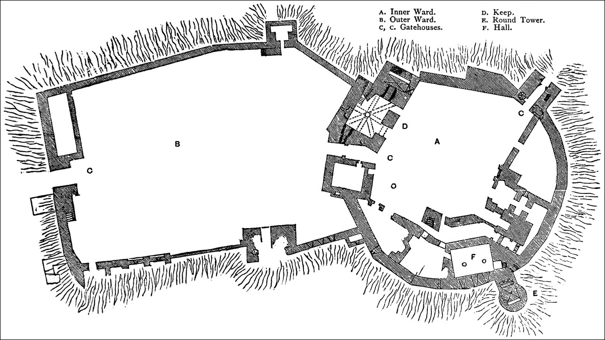
The northern gatehouse, that between the outer and inner wards, is destroyed; but the foundations show a passage 9 feet broad by 33 feet deep, which seems to have traversed a mass of buildings 84 feet broad by 30 feet to 40 feet deep. Of this, the part to the west of the portal, was a nearly rectangular building, 30 feet by 22 feet, having an entrance from the passage, and in its south wall a mural staircase. East of the portal is a much larger building still in part standing, and which seems to have been the keep.
The keep is nearly rectangular, 37 feet by 40 feet, having at its eastern end a projection into the ditch, 18 feet by 24 feet. This projection contained in its basement a plain vault, 15 feet by 9 feet, with two loops; and a culvert, probably a garderobe, has its vent below a recess in the north wall. This recess was probably a prison. The basement of the keep is occupied by a chamber, 28 feet by 22 feet, at the ground level, and vaulted in eight cells, the ribs forming which spring to and from a central eight-sided pier. The arches are pointed. There are two loops in this chamber, and three doors,—one from the court, set in a square-headed recess; a second into the vaulted accessory chamber; and a third to a postern opening into the ditch, and by a mural stair to the chamber above.
The first floor also is composed of two chambers, both vaulted, and the ribs of the large chamber spring from an octagonal pier resting upon that below. There was a second, and a third story roofed with timber. The fireplaces were in the north wall, and the windows in the north and east walls, and of moderate size and Tudor pattern. This tower seems of early Decorated date. A part of it has recently fallen.
The round tower is altogether a very curious and a very unusual structure. It is placed on the south-west front of the inner ward. It is 18 feet diameter, but projects into the ditch 22 feet, being connected with the curtain by a neck of wall 14 feet broad. It is lofty, having a basement and three upper floors. The basement is a huge vaulted receptacle for sewage, with an outlet to the south. The two upper floors are alike in dimensions and use, being 9 feet by 7 feet, and lighted by narrow loops, three on each floor. They are vaulted, and contain garderobes, with shafts into the vault below. The third story had a flat wooden roof, now gone. A well-stair led to the battlements. Laterally, the upper part of this tower is widened by a pair of cheeks resting on a row of corbels, so as to give greater space within. On the east side of this tower, at its base and junction with the curtain, is a postern of 3 feet opening, from which a vaulted staircase ascended to the domestic buildings. This door is protected by a mass of masonry filling up the hollow angles above it, and machicolated at its summit. This part of the castle seems of the age of Henry III.
490
The whole southern side of the court, from gatehouse to gatehouse, is occupied by the remains of the domestic buildings. The hall seems to have had a vaulted basement, 26 feet by 19 feet in plan, with plain ribs springing from two piers, and to have been on the first floor, with windows in the curtain. A long chamber east of the hall, with a long east window, seems to represent the chapel, also on the first floor. In this quarter some excavations made by the late Lord Dunraven have shown the stairs leading to the postern, and some vaulted cellars, and probably the kitchen. All these buildings are of an early Decorated character, and have been much altered in the Tudor period.
The curtain-wall, from the keep to the great gatehouse, is about 20 feet high, and is of the age of the gatehouse, and later than the wall elsewhere. Near the gatehouse it is 20 feet thick. Part of its parapet, 6 feet, and rear wall, 5 feet high, remain. The former is bracketed out on corbels, most of which are removed newels from an older well-stair. This part of the curtain is reached from the gatehouse, and has no communication with the keep. Of the same date with this curtain is the wall on the other side of the gatehouse, southwards for about 16 yards, when there is a junction with the older wall. This part of the curtain is polygonal outside, and curved within, and externally about 40 feet high. Beyond, or northward of the round tower, the height of the curtain is 60 feet, and it is pierced with windows belonging to the hall and other apartments. There remains also, on the wall, a lofty chimney. Towards the junction of this curtain with the wall of the outer ward it is connected with a sort of gallery, looped towards the field, and intended for the defence of the hollow angle where the three walls meet. The dividing wall between the inner and outer ward is nearly destroyed, and does not seem to have been strong.
The well is in the open court, 4 feet diameter, circular, and rudely walled.
The outer ward does not present any very noteworthy features. Its south wall is low, and pierced with windows, as of lodgings. The north wall is strongly buttressed outside. There was an outer gateway in the western wall, now broken down. It seems to have been a mere opening in the wall, without a gatehouse, but flanked by a pair of buttresses. The walls of this ward are about 20 feet high. The northern front of the outer ward, being naturally weak, has been protected by a double ditch, the contents of which are thrown outwards, and form banks. The ditches are dry. In a field to the north-east are some banks and ditches which may have been thrown up when the castle was attacked.
The castle has little to boast of either in material or workmanship. It is mainly built of lias rubble, but the round tower is of sandstone. The mortar generally is of inferior quality, and there is but little ashlar. The roofs were covered with slabs of fissile sand or tile-stone. The southern curtain is probably the oldest part of the castle. It is composed of large boulder or popple-stones, neces491sarily with very open joints. In it are two small trefoil-headed windows of early English or early Decorated date, which appear to be original. They open from the vaulted chamber beneath the hall. The angles of the curtain are quoined with Sutton stone. The castle, built probably in the early English and Decorated periods, seems to have been thoroughly restored and repaired late in the Perpendicular period. It is fast going to decay, and large portions of it have fallen since 1832. It is the property of the Earl of Dunraven; but the ditch belongs to Mr. Nicholl, of Merthyr Mawr, and was planted by his grandfather, the eminent judge.