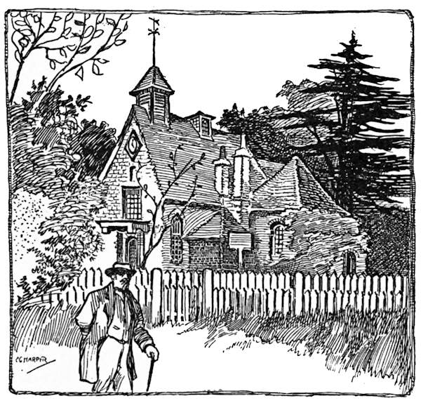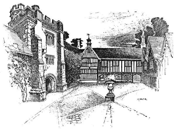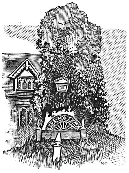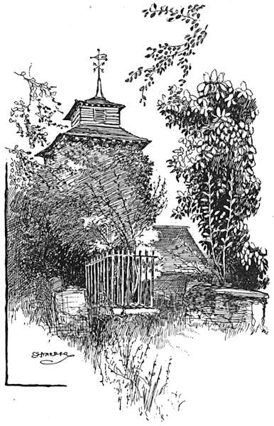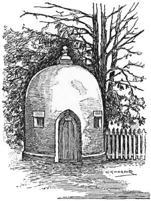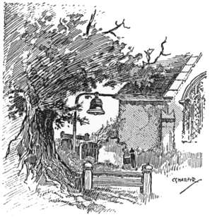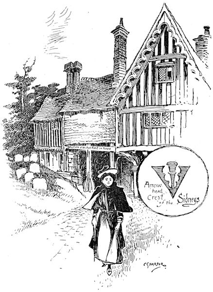
THE OLD LYCHGATE, PENSHURST.
The Project Gutenberg EBook of Cycle Rides Round London, by Charles G. Harper

This eBook is for the use of anyone anywhere in the United States and
most other parts of the world at no cost and with almost no restrictions
whatsoever.  You may copy it, give it away or re-use it under the terms
of the Project Gutenberg License included with this eBook or online at
www.gutenberg.org.  If you are not located in the United States, you'll
have to check the laws of the country where you are located before using
this ebook.


Title: Cycle Rides Round London

Author: Charles G. Harper

Release Date: January 24, 2019 [EBook #58764]

Language: English

Character set encoding: UTF-8

*** START OF THIS PROJECT GUTENBERG EBOOK CYCLE RIDES ROUND LONDON ***


Produced by Chris Curnow, Chris Jordan and the Online
Distributed Proofreading Team at http://www.pgdp.net (This
file was produced from images generously made available
by The Internet Archive)
The Brighton Road: Old Times and New on a Classic Highway.
The Portsmouth Road: And its Tributaries, To-day and in Days of Old.
The Dover Road: Annals of an Ancient Turnpike.
The Bath Road: History, Fashion, and Frivolity on an old Highway.
The Exeter Road: The Story of the West of England Highway.
The Great North Road: The Old Mail Road to Scotland. Two Vols.
The Norwich Road: An East Anglian Highway.
The Holyhead Road: The Mail Coach Route to Dublin. Two Vols.
The Cambridge, Ely, and King’s Lynn Road.
[In the Press.
RIDDEN WRITTEN
& ILLUSTRATED BY
CHARLES G. HARPER
AUTHOR OF “THE BRIGHTON ROAD” “THE PORTSMOUTH ROAD” “THE DOVER ROAD” “THE BATH ROAD” “THE EXETER ROAD” “THE GREAT NORTH ROAD” “THE NORWICH ROAD” and “THE HOLYHEAD ROAD”
London: CHAPMAN & HALL LTD. 1902.
(All Rights Reserved)
When that sturdy pioneer, John Mayall junior, first rode his velocipede from London to Brighton in 1869, in much physical discomfort, and left his two would-be companions behind him in a crippled condition, no one could have foreseen the days when many thousands of Londoners would with little effort explore the Home Counties on Saturdays or week-ends, and ride sixty or seventy miles a day for the mere pleasure of seeking country lanes and historic spots.
There are, indeed, no more ardent lovers of the country, of scenery, of ancient halls and churches, of quiet hamlets and historic castles than London cyclists, who are often, in fact, recruited from the ranks of those pedestrians who, finding they could by means of the cycle extend their expeditions in search of the venerable and the beautiful, have cast away staff and stout walking-boots, and have learnt the nice art of balancing astride two wheels.
So much accomplished, the ex-pedestrian has at once widened his radius to at least thrice its former extent, and places that to him were little known, or merely unmeaning names, have become suddenly familiar. Even the sea—that far cry to the Londoner—is within reach of an easy summer day’s ride.
Few have anything like an adequate idea of how rich in beauty and interest is the country comprised roughly in a radius of from twenty to thirty miles from London. To treat those many miles thoroughly would require long study and many volumes, and these pages pretend to do nothing more than dip here and there into the inexhaustible resources, pictorial and literary, of the hinterland that lies without the uttermost suburbs.
To have visited Jordans, where the early Quakers worshipped and are laid to rest; to have entered beneath the roof of the “pretty cot” at Chalfont St. Giles that sheltered Milton; to have seen with one’s own eyes Penshurst, the home of the Sidneys, and Chenies, the resting-place of the Russells; to have meditated beneath the “yew tree’s shade” at Stoke Poges; to have seen or done all these things is to have done much to educate one’s self in the historic resources of the much-talked-of but little-known countryside. The King’s Stone in Kingston market-place, Cæsar’s Well on Keston Common, the “Town Hall” at Gatton, the Pilgrims Way under the lee of the North Downs, and the monumental brasses of the D’Abernons at Stoke D’Abernon have each and all their engrossing interest; or, if you think them to savour too greatly of the dry-as-dust studies of the antiquary, there remain for you the quaint old inns, the sleepy hamlets, and the tributary rivers of the Thames, all putting forth a never-failing charm when May has come, and with it the sunshine, the leaves and flowers, and the song of the birds.
CHARLES G. HARPER.
Petersham, Surrey, April 1902.
| PAGE | |
| Chenies and the Milton Country | 1 |
| Surbiton to Leatherhead | 22 |
| Ightham Mote and the Vale of Medway | 36 |
| The Darenth and the Crays | 53 |
| Croydon to Knockholt Beeches and the Kentish Commons | 63 |
| In Old-World Essex | 75 |
| Among the Essex Hills | 86 |
| Abinger, Leith Hill, and Dorking | 97 |
| Ripley and the Surrey Commons | 111 |
| Rural Middlesex | 121 |
| Under the North Downs | 131 |
| The Suburban Thames | 155 |
| The Southern Suburbs: Kingston to Ewell, Warlingham, and Croydon | 169 |
| Ewell to Merstham, Godstone, and Lingfield | 177 |
| Hever Castle, Penshurst, and Tonbridge | 186 |
| To Stoke Poges and Burnham Beeches | 199 |
| Dartford to Rochester, Aylesford, and Borough Green | 218 |
| Middlesex and Hertfordshire Byways | 231 |
| The Back Way to Brighton | 251 |
| Barking to Southend and Sheppey | 260 |

| PAGE | |
| The Old Lychgate, Penshurst | Frontispiece |
| Ruislip | 4 |
| Milton’s Cottage, Chalfont St. Giles | 13 |
| Jesus Hospital, Bray | 20 |
| Esher Old Church | 26 |
| Horseshoe Clump | 28 |
| Brass to Sir John D’Abernon | 30 |
| The Hall, Slyfield House | 31 |
| The “Running Horse” | 32 |
| Elynor Rummyng | 33 |
| Sign of the “Running Horse” | 35 |
| Crown Point | 38 |
| Sign of the “Sir Jeffrey Amherst” | 39 |
| Cromwell’s Skull | 40 |
| Ightham Mote | 43 |
| The Courtyard, Ightham Mote | 45 |
| The Dumb Borsholder | 50 |
| The Quintain, Offham | 51 |
| The Waterside, Erith | 54 |
| On the Thames, near Erith | 55 |
| Purfleet, from the Darenth Meadows | 57 |
| The Darenth | 58 |
| Eynesford | 60 |
| The Fool’s Cap Crest of Sir John Spielman | 62 |
| The Little Church of Woldingham | 66 |
| Knockholt Beeches | 71 |
| Cæsar’s Well | 73 |
| The Stocks, Havering-atte-Bower | 76 |
| Navestock Church | 79 |
| Blackmore Church | [xi] 81 |
| Two Churches in one Churchyard: the Sister Churches of Willingale Spain and Willingale Doe | 83 |
| Stock Church | 89 |
| Laindon Church | 91 |
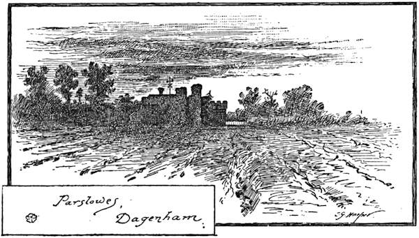
| Parslowes | 96 |
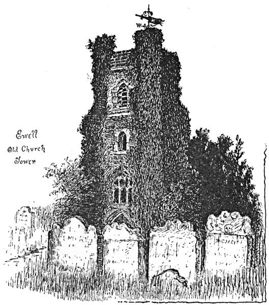
| Ewell Old Church Tower | 98 |
| Evershed’s Rough | 103 |
| Leith Hill | 107 |
| Claremont | 113 |
| Newark Priory | 119 |
| The Little Church of Perivale | 123 |
| Pinner | 127 |
| A Mysterious Monument | 128 |
| Reigate Heath | 134 |
| Westcott | 136 |
| The Little Church of Wotton | 137 |
| Postford Ponds | 139 |
| An Old Weir on the Wey | 141 |
| The Guildhall and High Street, Guildford | 143 |
| Puttenham | 151 |
| The Seven-Dials Pillar, Weybridge | 157 |
| Pyrcroft House | 160 |
| The Ruins, Virginia Water | 164 |
| Carshalton | 173 |
| Leaving Carshalton | 175 |
| The “Town Hall,” Gatton | 180 |
| The Hollow Road, Nutfield | 181 |
| An Iron Tomb-Slab | 183 |
| The Ancient Yew, Crowhurst | 184 |
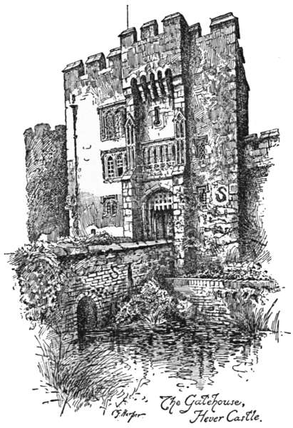
| The Gatehouse, Hever Castle | 189 |
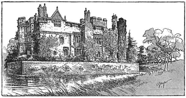
| Hever Castle | 191 |
| Chiddingstone | 195 |
| Sunset on the Eden | 196 |
| A Crest of the Sidneys | 197 |
| Shoeing Forge, Penshurst | 198 |
| Gray’s Monument | 205 |
| The “Bicycle Window,” Stoke Poges | 208 |
| At Burnham Beeches | [xii] 211 |
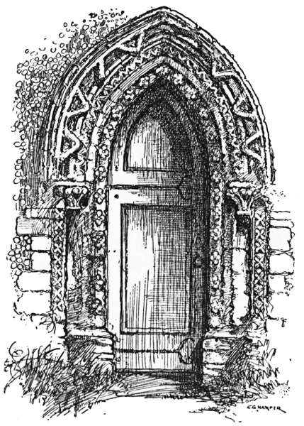
| Stone | 219 |
| Early English Doorway, Stone Church | 220 |
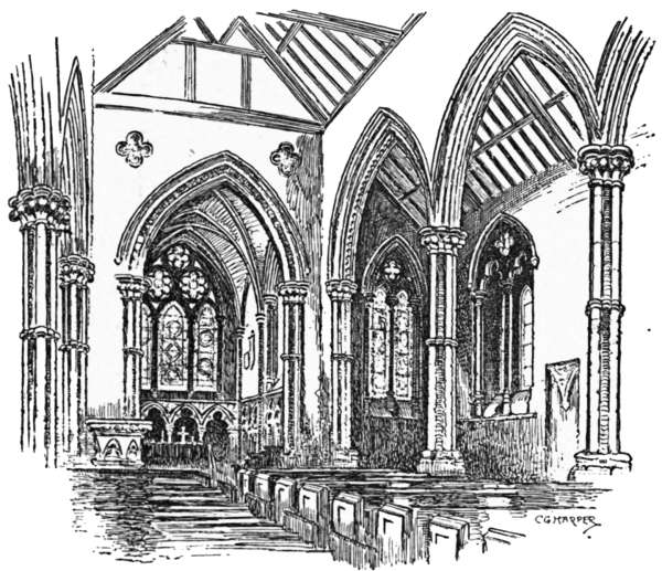
| Interior, Stone Church | 221 |
| High Street, Rochester | 225 |
| Temple Bar | 233 |
| Gough’s Oak | 235 |
| Shenley Round-House | 236 |
| The Church Bell, Shenley | 237 |
| Water End | 242 |
| Flamstead | 245 |
| Mackery End | 247 |
| The North Downs and Marden Park | 253 |
| The “Sackville Lodging,” East Grinstead | 255 |
| Lewes | 258 |
| Barking | 263 |
| Eastbury House | 267 |
| Hadleigh Castle | 269 |
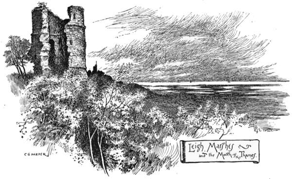
| Leigh Marshes and the Mouth of the Thames | 271 |
| Minster-in-Sheppey Church | 277 |
| Warden Point | 283 |
| Newington | 285 |
| The End | 288 |
| Sketch Maps to each Route. |
CYCLE RIDES
ROUND LONDON
Sight-seeing with ease and comfort is the ideal of the cycling tourist, and this run into a corner of Buckinghamshire and the Milton country comes as near the ideal as anything ever does in a world of punctures, leakages, hills, headwinds, and weather that is either sultry or soaking.
Starting from Southall Station, which will probably strike the tourist as in anything but a desirable locality, we gain that flattest of flat highways—the Oxford road—just here, and, leaving the canal and its cursing bargees, together with the margarine works, the huge gasometers, and other useful but unlovely outposts and necessaries of civilisation, speed along the excellent surface, past Hayes End and the hamlet Cockneys are pleased to call “’illingdon ’eath,” until within a mile and a half of Uxbridge, where a turning on the right hand will be noticed, properly furnished with a sign-post, pointing to Ickenham, Ruislip, and Pinner. Here we[2] leave the dusty high road and its scurrying gangs of clubmen, whose faces, as they scorch along, are indicative of anything but pleasure. It is a pleasant by-road upon whose quiet course we have now entered, going in a mile-long descending gradient, past the grand old trees of Hillingdon Court overhanging the way, down towards Ickenham. It is a perfectly safe and thoroughly delightful coast down here, far away from the crowds, along a lane whose leafy beauty and luxuriant hedgerows might almost belong to Devonshire, instead of being merely in Middlesex. At Ickenham, one of those singularly tiny and curiously old-world villages that are, paradoxically enough, to be found only in this most populous of English counties, are a village green, a pond, and a pump. The pond is, perhaps, not so translucent as it might be, for the reason that the ducks are generally busily stirring up the mud; and the green, being mostly loose gravel, is not so verdant as could be wished; but the pump, occupying a very central position, is at once ornate and useful, and, in appearance, something between a Chinese joss-house, a County Council band-stand, and a newspaper kiosk. Also, it still retains on its weathercock the tattered and blackened flag of some loyal celebration or another, which may mean loyalty in excelsis or merely local laziness. The very interesting old church, with whitewashed walls and with odd dormers in the roof, has some excellent windows and a little timbered spirelet that shows up white against a dense background of trees, and is, altogether, just such a place as Gray describes in his “Elegy,” in whose churchyard sleep the rude forefathers of the hamlet.[3] Suburbia has not yet disturbed this “home of ancient peace,” and it is still worth the very earnest attention of the artist, as also is that grand old Jacobean mansion of Swakeleys, standing in its park, near by.
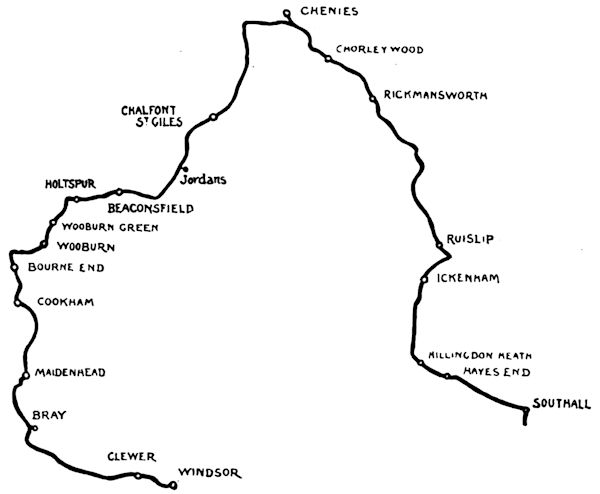
A mile onward is Ruislip, best reached by bearing to the right at the next turning, and then sharply to the left. Round about “Riselip,” as its inhabitants call it, they grow hay, cabbages, potatoes, and other useful, if humble, vegetables; and, by dint of great patience and industry, manage to get them up to the London market. It is only at rare intervals that the villagers ever see a railway engine, for Ruislip is far remote from railways, and so the place and people keep their local character.[4] Two or three remarkably quaint inns face the central space round which the old and new cottages are grouped, and the very large church stands modestly behind, its battlemented tower peering over the tumbled roofs and gable-ends with a fine effect, an effect that would be still finer were it not that the miserably poor “restoration” work of the plastered angles, done by that dreadful person, Sir Gilbert Scott, is only too apparent.
Taking the Rickmansworth road, and presently crossing the road to Harefield, a desolate, half-ruined modern house of large size, apparently never yet occupied, is seen on the right. This is called St. Catherine’s End. Beyond it, on the same side, presently appears an unobtrusive road, with an air of leading to nowhere in particular, and, in fact, abruptly ending on the banks of Ruislip Reservoir. The sound of “reservoir” is not a pleasing one to those who are[5] familiar with the ugly things of that name with which an unbusiness-like Legislature has allowed the water companies to destroy the beauty of the suburban Thames; but there are reservoirs of sorts, and this is one of the picturesque kind. The Regent’s Canal Company made it, many years ago, as a store for refilling that waterway, and it was doubtless more than sufficiently ugly then. But trees have since that time partly covered the hillsides sloping down to it, and that finest of all artists and best of landscape gardeners, Nature, has grown rushes and water-lilies here, and nibbled a bit out of the straight-edged bank there, until the place looks anything but artificial. Wild birds and wild flowers, too, render this a pleasant spot, and there are boats even, in which one may voyage down the mile, or less, of lake, at whose distant end the red-roofed villas of Northwood may just be seen, whimsically like some foreign port.
Returning to the road, the first hill of the journey presents its unwelcome front to be climbed or walked. Duck’s Hill, as it is called, leads to an elevated tableland where the bracken and the blackberry briars grow, and shortly leads down again, by means of an exceedingly steep, though short, fall through a mass of loose stones and thick dust. The gradient and the quality of the road-surface render this bit particularly dangerous. Succeeding this is a more gradual descent, leading to a right and left road. The right-hand, on a down-grade, and one the tourist would fain follow, is not the route, which lies, instead, to the left, and goes determinedly uphill for half a mile. Just when you begin[6] to think this excursion is too much like taking a bicycle out for a walking tour, it becomes possible to mount and ride with comfort; and then, entering Batchworth Heath and Hertfordshire simultaneously, the lodge gates of Moor Park are seen across a wide-spreading green surrounded by scattered houses. It is of little use to describe Moor Park, for the house cannot be seen by the casual tourist, and the cyclist is not allowed in the grounds. The place has passed through many hands, and now belongs to Lord Ebury. It was once the property of a certain Benjamin Hoskins Styles, a forerunner of the modern type of financier, who had grown suddenly rich by speculating in South Sea shares. He caused the hills that faced the house in either direction to be cut through, in order to provide “vistas.” He secured his vistas at a cost of £130,000, which seems a high price to pay for them; but, according to Pope, he also let in the east wind upon his house, and the next owner, who happened to be Admiral Lord Anson, spent £80,000 in trying to keep it out again.
Gradual descents, and two or three sharper ones, lead for a mile in the direction of Rickmansworth, and then a C.T.C. danger-board shows its red warning face over a hedge-top, just as a beautiful distant view of the town unfolds itself below. There are those who, as a rule, disregard danger-boards: if such they be who wheel this way, let them be advised to make this an exception, for it is a long and winding drop down, and ends by making directly for a brick wall, some cottages, and a canal; sufficiently awkward things to encounter on a runaway machine. Those who will not be advised,[7] and are accordingly run away with, are recommended to choose the canal.
But the wise walk down, and, nearing the level, mount again, and wheeling over a switchback canal bridge and a river bridge, come happily into Rickmansworth.
This old town resembles Watford, Ware, and Hertford, but is much prettier. They are four sisters, these Hertfordshire towns, with a strong family likeness but minor differences. Ware is the slippered slut of them, without doubt, and Hertford (if local patriotism will forgive the comparison) the dowdy; Watford the more pretentious; while Rickmansworth is the belle. All are alike in their rivers and canals, their surrounding meads and woodlands, and their breweries.
Green pastures and still waters, hanging woods and old-world ways, render Rickmansworth delightful. One comes into it from Batchworth Heath downhill, and, across its level streets, climbs up again for Chenies, reached past Chorleywood and its common, and a succession of the loveliest parks. Chenies is a place of pilgrimage, for the church is the mausoleum of the Russells, Dukes of Bedford; and if one cannot, in fact, feel any enthusiasm for a family that has exhibited such powers of “getting on in the world,” and has consistently used those powers of self-aggrandisement, while professing Liberal opinions, at least the long and splendid series of their tombs is worth seeing.
The Rozels, as they were originally named, came over, like many other Norman filibusters, with the Conqueror. They did not, for a long while, make any[8] great mark after that event, and history passes them by until 1506. During all those centuries, the Russell genius for getting on lay fallow, and none of them did anything in particular. They just vegetated on their lands in Dorsetshire, at Kingston Russell, near Bridport, until that year, when a quite unexpected happening put the beginnings of promotion in their way. John Russell, heir of the uncultivated bucolic head of the house, had just returned from Continental travels, and had acquired polish and the command of the French, Spanish, and German tongues, accomplishments that would probably have been of no sort of use to him had it not been for the singular happening already hinted at. In the winter of 1506 the Archduke of Austria, voyaging from the Low Countries to Spain, was driven by the fury of the Channel gales into Weymouth. He was most unromantically sea-sick, and landed; although England was at that time no safe place for one of his house. But he preferred the prospect of political imprisonment to the unkindly usage of the seas. Meanwhile, until the king’s pleasure became known, he was sheltered by Sir Thomas Trenchard of Wolveton, near Dorchester; and because Sir Thomas knew no tongue but his own robust, native English, he had his young kinsman, John Russell, over from Kingston Russell, to act as interpreter and entertainer to the distinguished foreigner. Young Russell proved himself so courtly and tactful that when the Archduke visited Henry the Seventh on a friendly invitation to Windsor—where, instead of being clapped into a dungeon, he was royally entreated—he spoke in such high praise[9] of this young Englishman that the king speedily found him a position in the Royal Household. Thus was a career opened up to this most fortunate young man. He was with Henry the Eighth in France, and fought in several battles, losing an eye at the taking of Morlaix and at the same time gaining a knighthood. Diplomacy, which, rather than fighting, is the Russell métier, soon claimed him. Diplomacy, it has been well said, is the art of lying for the advantage of one’s country. Perhaps he had not learned the art sufficiently well, for his great mission to the Continent failed, and he returned, not in disgrace, but, with the inevitable Russell address and luck, to preferment. The times were fatal to honest men, and that Russell survived that troubled era and died in his bed in the reign of Mary, at peace, and ennobled by the title of Earl of Bedford, enriched with the spoils of confiscated religious houses and the lands of attainted and executed friends, is therefore no recommendation of his character, which was that of a cautious time-server and cunning sycophant. He lies here, the Founder of his house, his recumbent effigy beside that of his countess, who brought Cheneys into the family. It is a magnificent monument and the effigies evidently carefully executed likenesses, even down to the small detail of the earl’s eyelid, represented as drooping over the lost eye.
The second Earl of Bedford was a man of greater honour and sincerity than his father, the Founder. His monument and that of his countess stands beside his parents’ altar-tomb, and is of alabaster bedizened to extremity with painting and gilding. He was the[10] first Francis of the family. The last was the man (Francis, 9th Duke of Bedford) who poisoned himself in 1891.
Earl Francis, perhaps, derived his sincerity from his mother. Both were sincere Protestants, while his father was anything you pleased, so long as he could keep his head on his shoulders and put more money in his pocket. The son’s Protestantism was nearly the undoing of him, for the bloody Gardiner would probably have sent him to the stake had he not escaped to Geneva. When Elizabeth succeeded her sister, he returned and served his Queen well and truly, until his death in 1585. He was succeeded by his grandson, Edward, who in turn was followed by his cousin Francis; “the wise earl,” they call him, perhaps because he found, after being released from his imprisonment in the Tower for his political opinions, that it was more peaceful and profitable to busy himself about the draining of the ill-gotten Russell lands at Whittlesea and Thorney, than to contend with Parliament against the Crown. This is indeed wisdom, and worthy of a Russell and a lawyer; for as a lawyer he had been trained before his succession to the earldom had been thought of. His son William reproduced the shiftiness of the Founder, and lukewarmly sided first with King, then with Parliament, and so continually back and forth during the Civil War. They made him a duke before he died—they, that is to say, the advisers of William the Third—and the price paid for it was the blood of his eldest son. The title was given as a kind of solace for the loss[11] of that son, and must have been a bitter kind of plaister to salve grief. That son, William, had not the canny caution of his race, and deserves to be honoured for the self-neglecting enthusiasm for the Protestant religion which brought him to the block in 1683 for his alleged complicity in the Rye House Plot.
The most elaborate monument here at Chenies is that to his father and mother, but more truly to himself; for that fantastic pile of theatrical statuary, exhibiting the Duke and Countess contorted with paroxysms of grief, leads up, as the central point of this stony emotion, to the portrait head of this unhappy patriot who fell under the headsman’s axe.
There are other Russell monuments here, for the family has rarely been averse from post-mortem glorification; but to make a catalogue of them would be wearisome. Among the latest, and the most unassuming, is the plain slab to Earl Russell,—the Lord John Russell of earlier political struggles,—who died in 1878.
Chenies village, let it at once be said, is utterly disappointing, after one has heard so much of its beauties. “A model village,” no doubt, but how depressing these model villages are! And, indeed, the Russells rule “Chaineys” (as it should be pronounced) with an iron rule. The country in which it is set is beautiful, and at the centre of the village a group of noble trees, with a pretty spring and well-house, may be noticed; but that anyone can admire the would-be Tudor architecture of the cottages, almost all rebuilt by a Duke of Bedford about fifty years ago, is surprising. Yet there are those[12] who affect to do so. The village lies just off the road, to the right; and at its farther end stand the church and the manor-house, close to one another.
“Isenhampton Cheneys” is the real name of the place, but the Cheynes who once were paramount here are long since extinct, and the insistent “B” is now on every cottage, gate-post, and weathercock. The church, rebuilt, has the whole of its north aisle appropriated as the Bedford Chapel, so that, even here, you see how the Russells maintain the feudal idea. Froude, indeed, says the gorgeous monuments here are second only to the tombs of the Mendozas, the proudest race in Spain; but true though that be, he is grossly fulsome when he praises the Russells for their “Liberal” ideas. Truth to tell, the family has ever been content to wear the Liberal mask and yet to treat its unfortunate tenants in a manner that many an old Tory race would have neither the courage nor the wickedness to adopt. Ask of the Russell tenantry what they think, and, receiving your answer, the wonder arises how that family can keep up their curious pretence of being “friends of the people.”
Leaving Chenies, and regaining the highway to Amersham, we wheel along until, passing under the Metropolitan Railway at Chalfont Road Station, we take the second turning to the left, leading to Chalfont St. Giles. These three miles form the most exquisite part of the whole tour, from the purely rustic point of view; for they lead down through sweet-scented woodlands where the perfume of the pines and the heavy scent of the bracken (strongly resembling that of ripe strawberries) mingle with the refreshing odour of the[13] soil itself. Nothing breaks the stillness in the daytime save the hoarse “crock-crock” of the pheasants, and, when night comes, the feathered choir from the well-named neighbouring Nightingale Woods tunes up.
Chalfont St. Giles lies down in the valley of the Misbourne, across the high road which runs left and right, and past the Pheasant Inn. It is a place made famous by Milton’s residence here, when he fled London and the Great Plague. The cottage—the “pretty cot,” as he aptly calls it, taken for him by Thomas Ellwood, the Quaker—is still standing, and is the last house on the left-hand side of the long village street. The poet could only have known it to be a “pretty cot” by repute, for he was blind.
Americans, perhaps more than Englishmen, make this a place of pilgrimage; and serious offers were made, not so long since, to purchase the little gabled brick and half-timbered dwelling, and to transport it to the United States. Happily, all fears of such a fate are[14] now at an end; for the parish has purchased the freehold, and has made the cottage a museum, where the literary pilgrim can see the veritable low-browed room where Paradise Lost was written and Paradise Regained suggested, together with the actual writing-table the poet worked at. An interesting collection of early and later editions is to be seen, with Milton portraits, and cannon-balls found in the neighbourhood. No one will grudge the modest sixpence charged for admission by the parish authorities to all who are not parishioners.
The parish church still remains interesting, although three successive restoring architects have been let loose upon it; and there are some really exquisite modern stained-glass windows, as well as some very detestable ones. Their close companionship renders the good an excellent service, but has a very sorry effect on the bad. Notice the very beautiful carved-oak communion rails, which came from one of the side chapels of St. Paul’s Cathedral, given by Francis Hare, Bishop of Chichester and Dean of St. Paul’s. This spoiler of the metropolitan Cathedral is buried here, and a tablet records his dignities. Among other posts, he held that of Chaplain to the great Duke of Marlborough, whose courier, Timothy Lovett, by the way, who died in 1728, aged seventy years, lies in the churchyard, beneath the curious epitaph—
Timothy, it is evident, was not of the touring kind by choice.
Having seen these literary and other landmarks, we can either regain the road, and, passing through Chalfont St. Peter and its picturesque water-splash, where the Misbourne crosses the road by the church, come to the Oxford road, and by the turning to Denham through Uxbridge into Middlesex again; or else, braving a very steep, stony, and winding lane, make for Jordans, that lonely graveyard and meeting-house of the early Quakers, where lies William Penn, founder of the State of Pennsylvania, with many another of his sect. A left-hand fork in the road leads toilsomely in a mile and a half to the solitary shrouded dell where Jordans lies hid, embosomed amid trees. It was precisely for its solitude and comparative inaccessibility that Thomas Ellwood, the friend of Milton, with others of the Society of Friends, purchased Jordans in 1671. They bought it of one William Russell with the original intention of making it merely a burial-ground, but the building of the meeting-house soon followed.
This is the humble, domestic-looking, red brick building the pilgrim suddenly catches sight of when wheeling along the darkling lane. Hepworth Dixon, writing in 1851, says, “the meeting-house is like an old barn in appearance,” but that is scarcely correct. As a matter of fact, it greatly resembles a stable, and indeed is almost precisely identical in appearance with the still-existing range of stables facing Old Palace Green, Kensington; buildings erected at the same period as this.
The stern, austere character of the original Quakers—Cobbett calls them “unbaptized, buttonless blackguards”—is reflected in the look both of their burial-ground and their meeting-house. Nothing less like a place of worship could be imagined. Many in style—or in the lack of style—like it are to be seen in the New England States of the United States of America, to whose then desolate shores many of the early Quakers carried the creed that made them outcasts in their native land; and the American citizens who throng here in summer must often be struck with the complete likeness of the scene to many Pennsylvanian Quaker places of meeting.
The plot where Penn and many others lie is just an enclosed field, and not until recent years were any memorials placed over some of their resting-places. A dozen small headstones now mark the grave of William Penn, the Founder of the State, and others of his family.
Twice a year is Jordans the scene of Quaker worship, on the fourth Sunday in May and the first Thursday in June, when many of the faith come from long distances to commemorative services.
Leaving Jordans, and striking the road into Beaconsfield, we reach that quietly cheerful town in another two miles, coming into it past Wilton Park, on the Oxford road. The little town that gave Benjamin Disraeli his title is a singularly unpretending place, and is less a town than a very large village. Passing through its yellow, gravelly street, and turning to the left, when a mile and a half out, down the Oxford road, at the[17] hamlet of Holtspur, the way to Wooburn Green and Bourne End lies downhill, along the valley of that little-known tributary of the Thames, the Wye, which, some miles higher up, gives a name to High Wycombe. Bourne End has of late years grown out of all knowledge, being now a place greatly favoured by those outer suburbanites who more especially affect the Thames; so that new villas plentifully dot the meads and the uplands towards Hedsor Woods and Clieveden.
And so across the Thames into Cookham and Berkshire. Frederick Walker discovered Cookham, and painted the common and the geese cackling across it, long before Society had found the Thames. He died untimely, and is buried in the old church close by; and since then Cookham has become more sophisticated—pretty, of course, and equally, of course, delightful, but not the Cookham of the seventies. But if, on the other hand, you did not know the village then, and make its acquaintance only now, you will have no regrets, and will enjoy it the more. There is an odd effort at poetry on a stone in the churchyard, which, perhaps, should not be missed. It tells of the sudden end of William Henry Pullen in 1813, and among other choice lines says—
Three parts of the road from Cookham to Maidenhead are exceedingly dull and uninteresting; let us therefore[18] take the towing-path, and cycle along that, ignoring, like everyone else, the absurd prohibition launched a few seasons ago by the Thames Conservancy. Not hurrying—that would be foolishness; for although the river is well-nigh spoiled by Boulter’s Lock, it is still lovely all the way to Cookham, with the most glorious views of Clieveden Woods, rising, tier over tier, on the opposite shore. Here too, of course, have been changes since first Society, and then the Stage, discovered the river a few years ago, and bungalows are built on the meadows; but we must needs be thankful that they were built in these latter days, now that the hideous villas of forty years since are quite impossible.
Nearing Maidenhead, and coming to the Bath road, running right and left, we turn to the right and then down the first road to the left (Oldfield road), then the next two turnings in the same direction, when the old tower of Bray Church comes in sight; that Bray celebrated for its vicar immortalised in the well-known song, who, when reproached with being a religious trimmer and inconstant to his principles, replied, “Not so; for I always keep my principle, which is to live and die the Vicar of Bray.” Simon Alleyn was the name of this worthy, who lived, and was vicar, in the reigns of Henry VIII., Edward VI., Mary, and Elizabeth.
First a Papist, he kept his place by becoming a Protestant, recanting when Mary came to the throne, and again becoming a Protestant under Elizabeth. Called apostate, renegade, turncoat, and denier of Christ, modern times would give him the kindlier name of “opportunist.” At anyrate, his opportunism was successful, for he held office[19] from 1540 to 1588. The ballad originated in 1712, in a song entitled “The Religious Turncoat; or, the Trimming Parson,” which refers to no particular place or person, and has no fewer than eighteen verses, quite distinct from the modern ballad. Thus they run, for example:—
These verses, it will be noticed, place the trimming story a hundred years later.
The churchyard is entered by a lich-gate with a curious old house over it. In the church itself is a monument to William Goddard, the seventeenth-century founder of Jesus Hospital, and Joyce, his wife. That celebrated old almshouse stands on the road as we leave Bray for Windsor. It is a quaintly gabled, red brick building, with a statue of the founder in an alcove over the entrance. A central courtyard has little dwellings ranged round it, and a rather striking chapel, familiar in Frederick Walker’s famous picture, the “Harbour of Refuge,” painted here in 1871-72. Unfortunately, those who are familiar with that beautiful picture (now in the[20] National Gallery) will be disappointed on seeing the real place, for the painter has quite idealised Jesus Hospital, and has imagined many details that have no existence.
Beyond the hospital, a turning to the left leads to Windsor, past Clewer. Windsor bulks hugely from these levels, with huddled houses and the towering mass of the castle lining a ridge above the Thames; the Round Tower, grim and terrible in other days, merely, in these times, a picturesque adjunct to the landscape.
It seems, indeed, that everywhere in these days the iron gauntlet has given place to the kid glove; persuasion is, nowadays, more a mental than a physical process. Only at Windsor these things take higher ground; here for persuasion in this era read diplomacy,[21] where it had used to be a blood-boltered performance, in whose dramatic course axe and chaplain took prominent parts. The castle survives, its mediæval defences restored for appearance sake, but its State Apartments filled with polite furniture, dreadfully gilded and tawdry. It makes a picture, this historic warren of kings and princes; but alas for picturesqueness, Henry the Eighth’s massive gateway is guarded to-day—not by an appropriate Yeoman of the Guard, but by a constable of that singularly unromantic body—the police!
If one is wise, one does not visit Windsor for the sake of the State Apartments, but for the external view of the castle, set grandly, like a jewel, amid its verdant meads. The meads form the most appropriate foreground; the proper time, either early morning or evening, for then, when the mists cling about the river, and the grass is damp with them, that ancient palace and stronghold, that court and tomb of Royalty, bulks larger than at any other hour, both on sight and mind. And, having thus seen Windsor aright, you cannot but return well pleased.
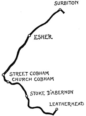
Surbiton, that great modern suburb of Kingston, can conveniently be made the starting-point of many pleasant runs through Surrey. Let us on this occasion start from Surbiton Station, and, making for the high road that runs to Ripley, turn to the left at Long Ditton, where the waterworks are, and so in a mile to the first semblance of rusticity at that well-known inn, the “Angel at Ditton,” as it is generally called by the many cyclists to whom for years this has been a rallying-place; although this is not Ditton at all, and its real name the not very romantically-sounding one of “Gigg’s Hill Green.” We pass the “Angel” on the left; on the right hand stretches the pleasant Green, with roads running away in the same direction to the village of Thames Ditton, a mile away, and worth seeing for those who have the exploring faculty well developed.
But to continue straight ahead, we pass Gigg’s Hill Green only to come to other and larger commons—Ditton Marsh and Littleworth Common respectively—along a road straight and flat for a considerable distance, passing under the long tunnel-like archway of the London and South-Western main line, and emerging from it to a full view of beautiful Esher Hill, a mile and a half away, while away on the left stretch miles of open country.[23] Notice outside a modern, dry, and dusty-looking inn, called the “Orleans Arms,” a tall, circular stone pillar about ten feet in height, with names of towns along the road, and the distances to them, carved on it. This is familiarly known as the “White Lady,” and dates back to the coaching age; for this was the old road to Portsmouth, and was once crowded with traffic.
From this point it is a mile of continuous, though gentle, rise to Esher village—Sandown Park racecourse on the right, under the hill. Notice the very highly ornamental iron gates and railings of the park: a romantic history belongs to them. They came from Baron Grant’s palatial mansion of Kensington House, built but never occupied, and then demolished, which stood in Kensington Gore.
Kensington House is now quite forgot, and on its site rise the stately houses of Kensington Court. It was in 1873 that Baron Grant, bloated with the money of the widow and the orphan, plundered from them in his Emma Mine and other rascally schemes, purchased the dirty slum at Kensington then known as the “Rookery,” and set about building a lordly pleasure-house on its site. Just as it was finished, his career of predatory finance was checked, and he never occupied the vast building. For years it remained tenantless, and was then demolished. “Grant,” as he called himself, died obscurely in 1899. He had in his time been the cause of the public losing over £20,000,000 sterling. The Daily News spoke of him as an Irishman, but it will readily be conceded that his real name of Gottheimer is not strikingly Hibernian. He was, it is true, born in[24] Dublin. So was Dean Swift: but, as the Dean himself remarked, to be born in a stable does not prove one to be a horse.
Although “Grant” died obscurely, and his name and his schemes had long before that time become discredited, it must not be supposed that he was personally ruined with the wreck of his projects. Not at all. He lived and died very comfortably circumstanced, while many of his creditors remained unsatisfied. He could pay debts when he chose, but when he chose not to, there were no means of compelling him. Where have we heard the same story in recent years?
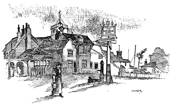
Esher, up along the hill, is a pretty village, with many and varied associations and an extraordinary number of curious relics. It is a charmingly rural place, with a humble old church behind an old coaching inn, and a new church, not at all humble, across the way. The old church and the old inn—the “Bear,” they call it—are both extremely interesting. In the hall of the inn, placed within a glass case, secure from the touch of the vulgar, are the huge boots worn by the post-boy who drove Louis Philippe, the fugitive King of the French, to Claremont in 1848. They are huge jack-boots closely resembling the type worn by Marlborough and his troopers at Blenheim, Ramilies, and Malplaquet.
“Mr. Smith”—for under that plebeian disguise the Citizen King fled from Paris—resided at Claremont by favour of Queen Victoria, and died there two years later.
Claremont is an ominous place, with a tragical cast to its story. Most of those connected with it have been unfortunate, if not before they sought the shelter of its ill-omened roof, certainly afterwards. Clive, the “heaven-born general,” who built it, shot himself; the newly married only child of George the Fourth—the ill-fated Princess Charlotte—died there, under somewhat mysterious circumstances; and the Duke of Albany, who had not long been in residence, died untimely in the south of France, in 1884.
The old church of Esher, long since disused and kept locked and given over to spiders and dust, has a Royal Pew, built for the use of the Princess Charlotte and the Claremont household in 1816. It is a huge structure, in comparison with the size of the little church, and designed in the worst possible classic taste; wearing, indeed, more the appearance of an opera-box than anything else.
The authorities (whoever they may be) charge a shilling for viewing this derelict church. It is distinctly not worth the money, because the architecture is contemptible, and all the interesting monuments have been removed to the modern building, on a quite different site, across the road.
It cannot be too strongly insisted upon that the death of the Princess Charlotte in her eighteenth year made a vast difference in English history—or, at least, English Court history. Had she survived, there would[26] have been no William the Fourth, and Queen Victoria would never have been queen. Think of it! No Victorian Era, no Victoria Station, no Victoria Embankment, no Victoria in Australia, no Victoria in Vancouver Island; and, in short, none of those thousand things and places “Victoria” and “Victorian” we are surrounded with. None of those, and certainly no Albert Halls, memorials, streets, and places commemorative of that paragon of men.
The reflections conjured up by an inspection of Esher old church are sad indeed, and the details of it not a little horrible to a sensitive person. There is an early nineteenth-century bone-house or above-ground vault attached to the little building, in which have been stored coffins innumerable. The coffins are gone, but[27] many of the bony relics of poor humanity may be seen in the dusty semi-obscurity of an open archway, lying strewn among rakes and shovels. To these, when the present writer was inspecting the place, entered a fox-terrier, emerging presently with the thigh-bone of some rude forefather of the hamlet in his mouth. “Drop it!” said the churchwarden, fetching the dog a blow with his walking-stick. The dog “dropped it” accordingly, and went off, and the churchwarden kicked the bone away. I made some comment, I know not what, and the churchwarden volunteered the information that the village urchins had been used to play with these poor relics. “They’re nearly all gone now,” said he. “They used to break the windows with ’em.” And then we changed the subject for a better.
The “new” church—new in 1852—is a very imposing one, also with its Claremont Royal Pew, very like a drawing-room, built on one side of the chancel, high above the heads of the vulgar herd, who often, when the church is open, climb up the staircase to it, and, seating themselves on the chairs, go away and boast of having sat on the seats honoured by the great—thereby proving the vulgarity aforesaid.
The church was built chiefly from the accumulated funds of a bequest anciently left to Esher. This was the piece of land now called Sandown Park and the site of the well-known racecourse, let to the racecourse company at an annual rent. Not until 1899 did it occur to the Vestry that for the Church to be the landlord of a racecourse was a rather scandalous state of affairs, and the sanction of the Charity Commissioners was[28] then sought and obtained for a scheme to sell the land outright for £12,000, this sum to be invested in Consols. These tender consciences obscured the business side of the question, for the land, if not already worth more than that sum, very shortly will be, considering the spread of London’s suburbs. It is rather singular that this freehold, bequeathed so long ago, was once the site of the forgotten Priory of Sandown, which would appear never to have been revived after its Prior and all the brethren perished in the great pestilence, the Black Death, that almost depopulated England in the Middle Ages.
Leaving the village behind and pursuing the Portsmouth road, the woodlands of Claremont Park are left behind as we come downhill towards Horseshoe Clump, a well-known landmark on this road. This prominent object is a semicircular grove of firs on[29] the summit of a sandy knoll, looking over the valley of the Mole, the “sullen Mole” of the poets, flowing in far-flung loops below, on its way to join the Thames at Molesey. This is a switchback road for cyclists thus far, for the ridge on which Horseshoe Clump stands is no sooner gained than we go downhill again, and so up once more and across the level “fair mile,” to descend finally into Cobham Street, where the Mole is reached again. Here turn to the left, along a road marked by a sign-post “Church Cobham,” the original village, off the main road, of which Cobham Street on the Portsmouth road is only an offshoot developed by the traffic of old road-faring days. Church Cobham has, besides its ancient church and “Church Stile House,” a picturesque water-mill and mill-pond beside the road. Beyond, in two miles, the tiny village owning the odd name of Stoke D’Abernon is sighted; village in name only, for the church and a scattered house or two alone mark its existence. The Norman family of D’Abernon gave their name to this particular Stoke, originally a primitive British stockade, or defensible camp, at a ford on the Mole.
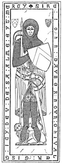
For the happily increasing class of tourists who are interested in archæology, let it be noted here that the chancel of this church contains the earliest monumental brass in the kingdom, the mail-clad effigy of Sir John D’Abernon, dated 1277.
Many of his race, before and after his time, lie here. The life-sized engraved figure of this Sir John, besides being the earliest, is also one of the most beautiful. Clad from head to foot in a complete suit of chain mail,[30] his hands clasped in prayer, heraldic shield on one arm, his pennoned lance under the other, and his great two-handed sword hanging from a broad belt outside the surcoat, this is a majestic figure. His feet rest on a writhing lion, playfully represented by the engraver of the brass as biting the lance-shaft.
A second Sir John D’Abernon, who died in 1327, son of the first, also has his life-sized memorial engraved on brass.
Stoke “Dabbernun,” as the rustics call it, is at once exhausted of interest when its church has been seen.
The road now crosses the Mole by an old red brick bridge, and leads up a gentle rise to Slyfield Farm, a very picturesque old farmstead of red brick, designed in the classic style prevailing in the reign of James the First. This was once the manor-house of the now extinct Slyfield family. Fair speech and presentation of a visiting-card may generally be relied upon to secure the courtesy of a glimpse into the hall of this interesting old house, where an ancient massive carved-oak staircase may be seen, still guarded by the original “dog-gates”[31] that in the times of our forebears kept the hounds in their proper place below stairs.
The road now winds pleasantly through the valley, but not within sight of the river until past the outlying houses of the little village of Fetcham. On gaining the point where the road from Great Bookham to Leatherhead falls into the one we are following, look out for an unassuming left-hand turning past the railway arch, leading in a hundred yards to Fetcham mill-pond. This is a lovely spot, where the wild-fowl congregate, and well worth halting at on a summer’s day, but tucked away so artfully that it will scarce be found save by asking. It is a long sheet of water, with reeds, and an island in the middle, and a peep back towards Leatherhead from the farther end, where the church tower peers above the trees. Flocks of moor-hens, a few couples of stately swans, and some domestic ducks form[32] the invariable feathered company of the pond, and not infrequently the coot takes up his quarters here, with myriads of dabchicks; the great swans and little dabchicks, swimming together on the water, forming the oddest of contrasts: the swans like warships and the dabchicks like little black torpedo-boats.
Cycles can be walked along the path to the far end of the pond, where the road is reached again.
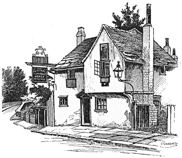
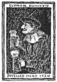
Leatherhead itself lies off to the left, less than half a mile distant, reached by a many-arched bridge straddling athwart the Mole, here a divergent and sedgy stream broken up by osier aits. On the other side of the bridge stands that crazy old inn, the “Running Horse,” claiming a continued existence since the fifteenth century and[33] to have been the scene of the celebrated “tunning of Elynor Rummyng”; but, like the silk stocking so long and so often darned with worsted that no trace of the original material remained, the “Running Horse” has in all these six centuries been so repaired here and patched there that he would be a bold man who should dare swear to a fragment of that old house remaining.
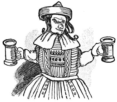
Elynor Rummyng was a landlady who flourished in the time of Henry the Seventh. Skelton, poet-laureate of that day, in a long rambling set of rhymes, neither very elegant nor very decent, describes her and her customers at great length. As for Elynor herself, he says she was so ugly that
with much else in the uncomplimentary kind.
She was, Skelton goes on to say, “sib to the devil”; she scraped up all manner of filth into her mash-tub, mixed it together with her “mangy fists,” and sold this hell-broth as ale—
There is no accounting for tastes, and, reading Skelton, it would seem as though the whole district crowded to taste the unlovely Elynor’s unwholesome brew, bringing with them all manner of goods—
and then, doubtless, there was trouble in the happy home.
Why the crowd resorted thus to tipple the horrible compound does not appear: one would rather drink the usual glucose and dilute sulphuric acid of modern times. The pictorial sign of the old house still proudly declares—
To do that, you would think, it must needs have been both good and cheap. Certainly, if the portrait-sign of Elynor be anything like her, customers did not resort to the “Running Horse” to bask in her smiles, for she is represented as a very plain, not to say ugly, old lady with a predatory nose plentifully studded with warts.
Leatherhead is a still unspoiled little town, beside its “mousling Mole,” as Drayton calls that river. “Mousling,” probably because of the holes, or “swallows,” as they are called, into which this curious river every now and again disappears, like a mouse, as the poet prettily expresses it.
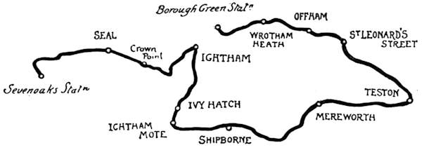
From Sevenoaks, on the South-Eastern Railway, let this tour be begun; from that Sevenoaks Station rejoicing in the eminently cricketing name of “Bat and Ball.” There are reasons sufficiently weighty why the starting-point should not be fixed nearer London, chief among them being the hilly nature of the way. Sevenoaks itself, quite apart from the rather uninteresting character of its long street, does not bulk largely in the affections of the outward-bound wheelman, for to reach it one has a more than mile-long climb. But, setting our faces eastward, and avoiding Sevenoaks town, an easier beginning presents itself along the road to Seal, where, leaving behind the trim gardens and modern villas that form a kind of suburban and secular halo around the railway, we plunge into a woodland district.
Seal village is a harbinger of the Thoreau-like solitudes that succeed along the road to Ightham, standing as it does at the gates of Seal Chart, where, away from the road on either hand, stretch such crepuscular alleys of murmuring pines that even Bournemouth itself never knew. Does there exist a cyclist who can hurry along this road and not linger here, to rest his trusty steed[37] against the corrugated stem of one of these aromatic giants of the forest, and listen to the intoning of the wood pigeons in the cathedral-like half-lights? If such there be, surely he merits the Tennysonian description, “a clod of thankless earth.” The far-spreading woods are unfenced and quite open to the road for one to wander in at will, and never a sound in their solitudes but belongs to the woodlands themselves; the cooing of the pigeons, and the rustling of some “sma’ wee beastie” disturbed by the crackling of the dry twigs under your feet. The squirrels themselves are noiseless and, to the unpractised eye, invisible; but there are many of them overhead, running with lightning speed along the red-brown branches of the pines that so accurately match the rust-red hue of their fur, and so help to conceal them from casual observation.
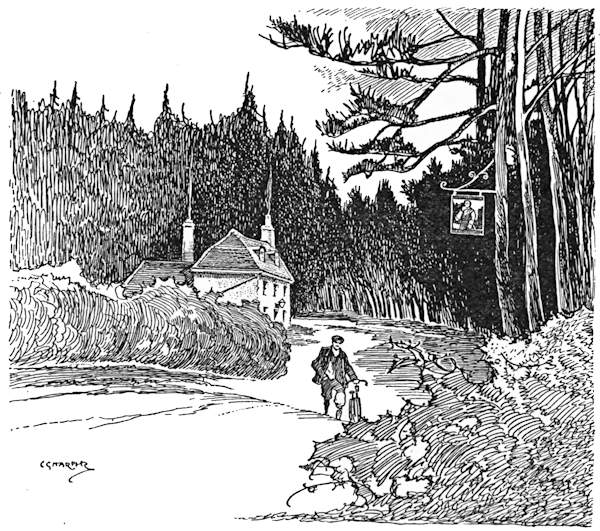
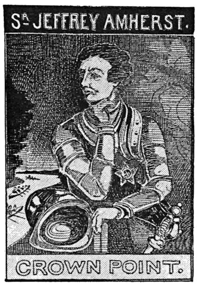
Following the road and the woods for two miles, the highway dips sharply, and takes a left curve just where you glimpse the blue smoke rising from the rustic chimneys of a wayside inn, down on whose lichened roof you look in descending. To dismount here, just as the view begins to disclose itself, is the better way, for only thus will you be in full receipt of the beauty and the exquisite stillness of the scene. The woods recede, like some clearing in a Canadian forest, and, standing back from the road, you see the inn whose roof-tree was first disclosed. On the other side of the highway, swinging romantically from the branches of a great Scotch fir, is the picture-sign of the house, bearing the legend, “Sir Jeffrey Amherst, Crown Point,” and[38] showing the half-length portrait of a very determined-looking warrior, clad in armour and apparently deep in thought; while in the background is a broad river, across whose swift current boat-loads of soldiers, in the costume of two centuries ago, are being rowed.
The scene—the old inn, with the smoke curling peacefully upwards against the blue-black background of the pine-woods, and the picturesque sign swinging with every breeze—is a realisation of the places pictured in the glowing pages of romantic novelists. If one were only a few years younger, and conventions had not come to curb one’s first impulses, there would be no more suitable spot than this where to become an[39] amateur Red Indian, or one of the robber chiefs suitable for such a spot.
The place has rather a curious story. “Crown Point,” as it is generally called, is so named after a place in Canada where Sir Jeffrey Amherst gained a great victory over the North American Indians early in the eighteenth century. Amherst eventually became Field-Marshal and Commander-in-Chief to the Forces, and, retiring and settling in Kent, founded the family of whom the present Earl Amherst is the head. The scenery here is said to greatly resemble that of Crown Point in Canada. The sign of the inn is repainted and kept in repair by Earl Amherst.
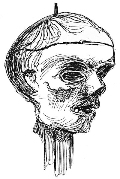
It may be worth noting that an historical relic is[40] preserved in the immediate neighbourhood of this place; no less important an one, indeed, than the skull of Oliver Cromwell, now in the possession of Mr. Horace Wilkinson. Much discussion has arisen respecting it, but there seems no room for doubting that this is the veritable skull (or, rather, mummified head) of the Protector. The relic has a pedigree that traces it back to the stormy night when it was blown off the roof of Westminster Hall, where it had been exposed on a spike after the Restoration. The rusty spike still transfixes it, and on the dried cranium the reddish brown hair is yet to be seen. It has had many odd adventures. Picked up by a sentry on duty at[41] Westminster Hall, it was concealed under his cloak, and afterwards secretly disposed of to some of Cromwell’s descendants, coming, many years later, into the possession of a travelling showman, from whom it was purchased by a relative of the present owner.
Ightham village, to which we now make our way, must by no means be confounded with Ightham Mote, two miles distant from it southward, past the hamlet of Ivy Hatch. Steeply up, and as steeply down, with intervals of welcome flatness, goes the road to the village, always through the pine-woods, and here and there the way is overhung with little craggy cliffs of yellow sand and gravel, as yet untouched by the road-surveyors of the County Council, who will doubtless some day trim away all these rustic selvedges of the forest, and curb and bank them in a straight line. What will the artists do then? Meanwhile, one still has here just one of those characteristic scenes Morland and his school so loved to paint—the hollow road with its steep banks, in whose crumbling earth the great wayside trees have secured what looks like a precarious footing, and the sandy earth where the moles and the rabbits burrow deep amid the gnarled roots. Up on the hillside that looks down upon the road is Oldbury,[42] a Roman encampment, called by antiquaries the “Gibraltar of Kent”; but we will take the tales of its strength on trust, for a bicycle is no aid in exploring hilltop fortifications.
Ightham is a village that looks as though it had at some time aspired to become a town, so urban in character are some of its houses; urban, that is to say, in no ill sense. There is, for instance, the so-called “Town House,” one of the most beautiful and dignified architectural compositions of that late seventeenth or early eighteenth century character which in its Renaissance ideals makes so thorough a departure from the older English Gothic models. By “Town House” you are to understand a building devoted to public purposes; what we should, nowadays, more grandiloquently term a “Town Hall.” There was a time when Ightham bade fair to take on a new era of importance, in the early days of cycling, when it enjoyed a great popularity that was stolen away by Ripley, nowadays itself in the cold shade of neglect.
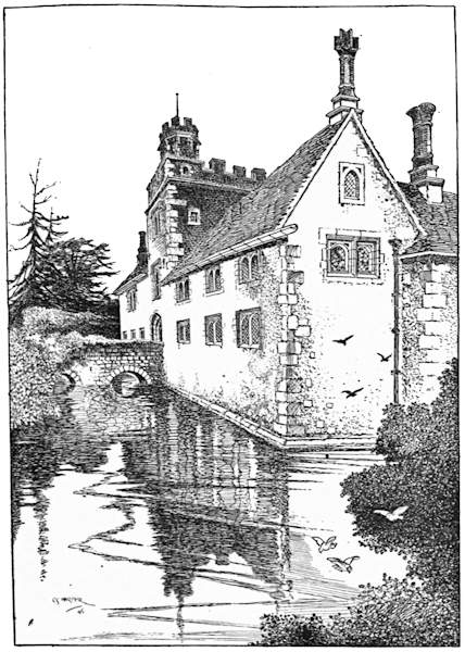
Turning to the right out of Ightham, through the pretty hamlet of Ivy Hatch, the Mote House is reached in two miles of shady lanes. Like many another old English house, Ightham Mote is tucked away coyly from the sight of the casual wayfarer. Looking diligently, you see it on the left hand, on coming down into a hollow, just a glimpse of its magpie black and white north front glimmering through the surrounding woods. It is one of the earliest of the fortified manor-houses, something between a castle and a residence, built when people had greater ideas of [45]comfort than obtained when the Edwardian strongholds were erected, and yet before it was safe to build a house incapable of defence. Nowadays one finds a preference for an open, breezy situation; in those times, if they did not build upon sites difficult of access in one way they did in another; if they did not select a rocky crag they sought some oozy hollow, where, with some little ingenuity, it was possible to form a broad moat by damming the surrounding streams. This was the resort adopted here, and in Ightham Mote to-day one sees the original idea of a watery girdle, from whose inner sides rise defensible walls enclosing a courtyard. The only way across this moat was by a drawbridge, now replaced by masonry, the drawbridge defended by the still-remaining entrance-tower. Originally the ornamental[46] part of the residence was strictly kept within the courtyard. The walls looking outward were either blank or else very sparingly provided with window openings. Later centuries have somewhat altered this, and the picturesque, half-timbered gables and outbuildings tell a tale of increasing security. There are those who will have it that Ightham Mote is the most picturesque old house in England. Perhaps it is, for its moss-grown stone walls, going sheer down into the clear water of the moat, its nodding, peaked gables, reflected in that beautiful ceinture, and the mellow red of the old brick entrance-tower, form a wonderful picture. Five hundred years have passed, and it is still a home. The tapestried hall, with its boldly timbered roof, yet forms the central point of the house, and the bedrooms where the Selbys, the old-time owners, slept for many generations are in use in these latter times. Modernity has crept in with regard to the essentials of comfortable living, but nowhere does it appear to mar the perfect old-world beauty of the place.
The imaginative may yet, without much difficulty in the mental exercise, people the quaint paved courtyard with the conventionally fair ladies and gentle knights of the age of chivalry; those ladies who, to judge by the works of the Old Masters, were so extremely plain, and those knights who could teach the tiger and the hyæna something in ferocity. Not that the old owners of Ightham Mote were men of this kind. Their old home plainly tells us they were not, desiring rather a peaceful seclusion than the ambitions and contentions of courts and camps. Defence, not defiance, was the[47] watchword of those who lived in this picturesque hollow, barred in at night from the chances, surprises, and alarums of the riotous outer world.
The interior arrangements include original fireplaces, carved and painted ceilings, and a chapel. The grounds without and the forest trees beyond are green and luxuriant beyond belief outside the wonders of fairy tales—to whose realms, indeed, Ightham Mote more nearly belongs than to this workaday world. The moat, fed by a crystal stream, is clear and sparkling, and birds and butterflies skim over it and into the thickets of shrubs and wild flowers like so many joyous souls escaped from a life of care and pain to rejoice for ever and ever in sunshine and a careless existence. It is with a sigh that the Londoner turns away from a place whose loveliness fills him with a glorious discontent.
Many of the Selbys lie in Ightham Church, and some have their memorials in the little domestic chapel attached to the Mote House. Dame Dorothy Selby was a very phœnix of all the virtues, if we may believe her epitaph, wherein she is compared with a number of notable biblical characters, all very edifying.
The monument to her “pretious name and honor” is still to be seen on the chancel wall of Ightham Church. She appears to have been a person of many accomplishments. Firstly, a needlewoman of considerable parts—
Then it is claimed for her that she discovered the Gunpowder Plot, in these words—
Moreover—
| Who put on Immortality |
} in the yeare of her { | Pilgrimage 69 March 15. Redeemer 1641. |
O rare and most estimable dame, paragon and phœnix, and very Gorgon of all the virtues, how little are your qualities hid in this, your epitaph!
She looks all those things and more, in her marble bust, that with thin, sharp-pointed nose, and with drawn-down mouth, gives her a very vinegary expression. There can be little doubt of it, the old lady was that terrible creature, the Superior Person.
There is, opposite this worthy lady’s monument, the stone effigy of a very much earlier inhabitant of the Mote—Sir Thomas Cawne, who died in 1374. He is represented in armour, his calm face peering out of his hauberk and chain mail. The window to his memory, over his tomb in the north chancel wall, made according to the directions in his will, still remains.
There will, doubtless, be those who, resting content with Ightham Mote, will decline to follow these wheelmarks farther, for such a place is worth lingering over. For the insatiable sight-seer who will proceed, the[49] way lies as straight ahead as the winding lane will permit to Shipborne, where we turn to the left, passing through the village, and then, in little over a mile, to the right, at the cross-roads, going, with Frith Woods on the left and Dene Park on the right, for two miles farther, turning left where a sign-post points to Hadlow. Many hollows are descended into on the way, where tiny streams run across the wooded roads, and there are correspondingly sharp rises.
Mereworth village, on the borders of the wide-spreading Mereworth Woods, lies up a turning to the right, on the fine broad road leading to Maidstone. Mereworth is remarkable for its hideous church, resembling some of Wren’s City of London churches; with a classical colonnaded porch, windows like those of a factory, and great overhanging eaves, very like those of that “great barn,” St. Paul’s, Covent Garden. A tall steeple, with classic peristyle, completes the outward composition. Now turn to the interior; an even more pagan sight than the exterior prepares the stranger for. It is like a huge room, and is divided into nave and aisles by plaster pillars, painted and grained to resemble marble, with all the fittings in a correspondingly classic style. This objectionable building owed its origin in 1748 to the eighth Earl of Westmoreland, whose seat, Mereworth House, near by, is built somewhat in the same style. The only relic of the old church is the grand monument of his ancestor, the first earl. In the churchyard is the tomb of Evelyn Boscawen, Viscount Falmouth, who married (the epitaph tells us) Baroness Le Despenser.
Here we are come into the Vale of Medway, and two miles of a beautiful road bring us to Wateringbury, where little rills, trickling down to join the greater stream, nourish all these leafy hillsides into such dense growth. There is a curious relic in Wateringbury Church—an old wooden club or mace three feet and a half in length, known as the “Dumb Borsholder,” belonging to the hamlet of Pizein Well, in the Manor of Chart. This was the central figure in the court-leet of the manor, and on those occasions was carried into the court by the head tything-man, or borsholder, as a symbol of authority, much in the same way as the Lord Mayor of London takes the Mace with him on state occasions. But the “Dumb Borsholder” seems to have been regarded both as a symbol and as a person; and, carried into court with a handkerchief passed through a ring at one end, had naturally to be answered for when called upon to put in an appearance. The other end of this club is provided with an iron spike, like a bayonet, with which to break open the doors of refractory tenants. Retired from active service so long ago as 1748, this formidable weapon is now chained up in the vestry.
From here to Teston the way is bordered by hop gardens. Teston Bridge, crossing the Medway in seven Gothic arches, is a beautiful old structure, but Teston Church, although its shingled spire on[51] the hillside looks picturesque, does not improve on closer acquaintance, having been classically re-cast, something in the manner of Mereworth.
Here we turn left, with a three-miles’ run to St. Leonard’s Street and West Malling, off to the right, where the ruins of Malling Abbey are to be seen. Straight ahead is Offham, where one must look out for the quintain on the green, a modern replica of the old English village jousting instrument, consisting of an upright post with a pivoted arm. One end of the arm is thick, and from the other was suspended a bag of flour, or some heavy object. The players in this old sport tilted on horseback at the thickened end. If their lance or staff struck it, and they were not nimble enough, the other end, swinging round, would hit them on the side of the head, unhorsing them. When the[52] hop-pickers are let loose upon the country, with every recurrent autumn, the quintain is taken in until they have gone home again.
A mile or so beyond this point our way crosses the Sevenoaks to Maidstone road, and goes in very hilly fashion to Wrotham, called “Rootam” by the natives. Notice a stone built into the wall by an inn, recounting how a Lieutenant-Colonel Shadwell was shot dead by a deserter, over a hundred years ago. From Wrotham it is a mile distant to Borough Green and Wrotham Station, whence train to Sevenoaks and London.
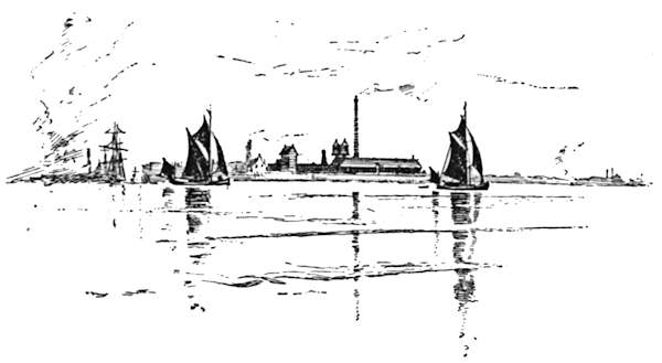
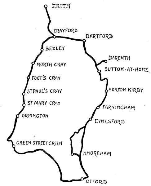
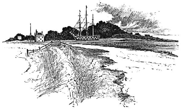
Within this circuit of just upon thirty miles much that is characteristic of Kent, the “Garden of England,” is to be found; much that is busily commercial, a goodly proportion of beautiful, unfrequented country, old-world villages on unspoiled stretches of river, and other villages with many mills polluting the Darenth on its way to the turbid Thames. Kent, in short, is a very varied county, growing fruit and hops, and, by reason of its waterways and its nearness to London, dotted over with factories; and this district here mapped out is a very good exemplar of the whole. Erith, which may be made the starting-point of this ride, is an interesting place, overlooking the Thames, here half a mile wide and crowded with all kinds of shipping; a tarry, longshore, semi-nautical village—or town, should it be called?—with a crazy little wooden pier boasting a picturesque summer-house kind of building at its end, and with a puffing engine of a miniature kind noisily playing at trains along it all day long, and performing mysterious shunting operations in collusion with a few lilliputian trucks. Engine and trucks to the contrary and notwithstanding, Erith is very delightfully behind the times, and is much more in accord with the days of Nelson and Dibdin and the era of tar and hemp than[54] with our own period. Romantically decayed defences against the inroads of the Thames bristle along the foreshore, like so many black and broken teeth; over across the estuary is the Essex shore, and here, at the back, at Purfleet, are, actually, chalk cliffs, giving place along the course of the river to marshes. “R.T.Y.C.” is the legend one reads on the jerseys of many prosperous-looking sailormen lounging here, for Erith is the headquarters of the Royal Thames Yachting Club.
The two miles between Erith and Crayford need detain no one. Half the distance is an ascent, and the rest goes steeply down to the valley of the Cray, where Crayford, the first of the series of villages whose names derive from that little stream, is situated. With all the good-will in the world it is difficult, if not impossible,[55] to say anything in favour of Crayford, which appears to afford congenial harbourage to all the tramps who pervade that peculiarly tramp-infested highway, the Dover road. “A townlet of slums” sums up the place. But note the long rhyming epitaph to Peter Isnell, parish clerk, on the south side of the hilltop church—
and so forth.
The first turning out of the dusty high road to the right, and then to the left, for Bexley (not Bexley Heath, which is quite another and a very squalid place) leads to a pleasant road following the river. From it, on the left hand, within a mile, a glimpse is gained of Hall Place, a beautiful old Tudor mansion built in chequers of stone and flint. An excellent view of it may be had by dismounting and looking through the wrought-iron entrance gates. Then comes the long[56] street of Bexley and its curious spire, and a brick bridge by which we cross the Cray, turning sharply to the left, and soon afterwards as sharply to the right. Very pretty is the river scenery just by Bexley Bridge; millhouse and weir and tall clustered trees making a rare picture. North Cray, the next village of The Crays, as the group is locally known, is one mile ahead. Before entering it notice the long avenue on the left leading to Mount Mascal, and then the lengthy, low white house on the right at the beginning of the village. This is the house where Lord Castlereagh committed suicide in 1822. At the interval of another mile is Foot’s Cray, where the road from Farningham to Sidcup, Eltham, and London crosses our route at right angles. The village chiefly lies at the side, along the[57] London road, and the unpretending old church at the back.
A short interval of country road, and then the outlying houses of St. Paul’s Cray, which, with the adjoining town of St. Mary Cray, forms one long street for the length of over a mile and a half, or, including Orpington, which practically joins on, of more than two miles and a half. They make paper on a large scale at St. Paul’s and St. Mary Cray, and the mills are very prominent objects. Much too prominent at St. Mary Cray is a hideous Congregational temple with a verdigris-coloured dome, and just as prominent and as ugly is the railway viaduct that straddles at a great height over the absurdly narrow street.
Orpington was the scene of the publication of Ruskin’s works during a long series of years before they were published in the usual way in London. It is a pretty[58] village, with an Early English church, a tree-shaded wayside pond with miniature waterfalls, and a general air of “something attempted, something done” to realise Ruskinian ideals. A mile and a half beyond Orpington we come down to the cross-roads leading, right to Farnborough, and left to Sevenoaks. In front, on its hillside, is a great red brick house. This is High Elms, Sir John Lubbock’s place. Turning to the left, we reach the hamlet of Green Street Green, and then, in another mile, Pratt’s Bottom. There is a continual four miles and a quarter ascent from here to the crown of Sepham Hill (or Polhill, as it is now generally called) to give the wheelman pause, and to make him wish he had come the other way round. From the Polhill Arms at the summit the average touring cyclist will observe that he has rather a nerve-shaking descent to make, judging from the elevated position he has reached and from the little world of landscape unfolded before him. Caution and a good rim-brake, to keep control over the machine, are, however, all that are necessary, even[59] though the descent be winding. A tree-covered bank on the right hand, flanking the hill with a certain solemnity, would be more impressive still to the cyclist did he know that this is the site of one of the great circle of forts now building for the defence of London. But the stranger is not cognisant of the fact, and so, unhappily, misses a patriotic thrill in passing.
Continuing the wooded descent towards the Weald, look out for a road on the left leading to Otford, a steep and stony mile and a half. Here, intrepid adventurers that we are, we have crossed the watershed and achieved the valley of the Darenth. Otford was the site of one of the sixteen palaces of the Archbishops of Canterbury. It was built just before the Reformation, by Archbishop Warham, in the reign of Henry the Eighth, and resigned by Cranmer to that very masterful monarch. The ruins of it are still to be seen by the church.
Leaving Otford, turn to the left at the cross-roads, and so, beside the railway, to Shoreham Station. The village lies on a by-road to the left. They make paper there also. It was the birthplace of that not sufficiently appreciated African explorer, Commander Lovett-Cameron, untimely dead. In the church are the flags he carried with him on the Livingstone search expedition. Like “Bobs”—who, according to Mr. Kipling, “don’t advertise”—Lovett-Cameron cared nothing for the réclame that makes reputations with the many-headed; unlike him, he missed his proper meed of recognition.
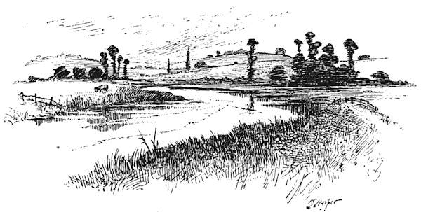
The valley of the Darenth here is very beautiful, and the river at Shoreham expands into the likeness of a great lake. Here is a choice of routes: direct, beside[60] the railway, to Eynesford, or through Shoreham to Eynesford by way of Shoreham Castle and Lullingstone. There is little to choose either way, because the “castle” at Shoreham exists no longer, and Lullingstone Park is forbidden to cyclists. Let us reserve our enthusiasm for Eynesford, an old English village of truly Elizabethan spaciousness, set down in its valley beside the Darenth, with an ancient, eminently sketchable and paintable old bridge spanning the ford that originally conferred the termination of the place-name; with a highly interesting Norman and Early English church, with lofty spire dominating the scene; and with a ruined castle tucked away in a builder’s yard. Little stress need be laid upon Eynesford Castle, because it is now, in short, only a little piece of rubble wall, and therefore to be taken very largely on trust. But the[61] village—to recur to it—is a very beautiful and æsthetically satisfying fact.
Farningham, to which we come after Eynesford, is only moderately interesting. Also, for the benefit of those who may follow in these tracks, it may be noted that it is in a hop-growing district, and when the hop-pickers are let loose upon it the society is not of the choicest. The village lies on the left-hand road; we pursue our way to Horton Kirby, where are more mills and crooked streets, and thence to South Darenth, where there are many factories and curving roads. Turn acutely (and warily) to the left, and, crossing the river, make for Sutton-at-Hone. Darenth lies off to the right. The church is Norman and Early English, and the walls have a plentiful admixture of Roman tiles. See the church, by all means, but do not take that way to Dartford. Return to the point where the road was left, and go by way of the hamlet of Hawley.
Dartford is a town of flour-mills, paper-mills, powder-mills, and factories where they make chemicals and compound drugs. They do not smoke, these great commercial structures, for the most part, but are cleanly, white-painted, boarded structures that find their motive power in the waters of the Darenth. Here is the traditional home of paper-making in England, for it was at Dartford, in the reign of Elizabeth, that John Spielman, a settler on these shores from Lindau, in Germany, introduced the process. Not only that, but he was granted the sole licence for a period of ten years of collecting rags for the making of his paper withal. If you step into the quaint old church of Dartford, you[62] will see, so soon as your eyes become accustomed to the gloom of that crepuscular interior, his tomb with the effigies of himself and his wife, together with shields of arms bearing the fool’s cap, said to have been his crest, and certainly the original watermark of the particular size of paper which from that circumstance has acquired the name. There are many things for the stranger to see at Dartford; among them the Bull Inn, one of the very few remaining of the old galleried coaching inns, with its sign, the great black effigy of a bull, aloft among the chimney-stalks, a most whimsical position. It was on Dartford Green, opposite this old house, that Wat Tyler dashed out the brains of the tax-gatherer who had insulted his daughter. There is no Green now—only a narrow, dingy street; and there are those who would have you believe that Wat Tyler is a myth; that there never was such a man, and that consequently there was no daughter, and no tax-collector whose brains were so summarily scattered. But let us keep our illusions, O scientific historians!
From Dartford to Crayford Station is two miles. Let those who will, cycle the dusty high road to complete the circle; but Dartford Station will serve as well, or better, for returning to town.
Croydon, where this trip is begun, is fortunate among towns, for it is set amidst, or within reach of, great stretches of wild and open common lands, for the most part beautifully wooded and entirely free for the rambler to come and go as he will. Besides these far-spreading open spaces, which, extensive as they are even now, are but the remains of the commons enclosed by the iniquitous Enclosure Act of 1797, good, if hilly, roads lead in almost every direction to quaint and interesting places. Croydon itself, prosperous, handsomely rebuilt of late years, and largely residential, is an example of sudden growth; for its population of less than 6000 persons in 1801 is now reaching nearly to 130,000. These facts, which speak of crowds, and the additional feature of tram-lines running from end to end of the main street, are perhaps not altogether admirable from the point of view of the passing cyclist; but for those who have eyes to see and ears to hear withal, the story of modern Croydon, its enlightened and up-to-date Corporation, and the sight of its palatial Town Hall, the altogether adequate centre of a vigorous municipal life, speak of romance. It is largely owing to this Corporation, composed chiefly of residents and professional men,[64] instead of the gang of local tradesmen who usually bedevil the councils of a town, that the surroundings of Croydon are so pleasant and well kept.
From East Croydon Station in the centre of the town, a ride or walk to South Croydon and the turning to the left where a sign-post marks the way to Sanderstead and Warlingham, among a number of other places, will show the inquiring stranger what manner of town this is, and will astonish those who, having known the shabby Croydon of the past, have not been here of late years. Such an one, however well acquainted with the place of old, must needs ask his way through Croydon’s streets to-day, so changed are they, and so utterly vanished the most of the old landmarks. When Mr. Jabez Balfour comes out of prison, he, the one-time Mayor, will need a guide.
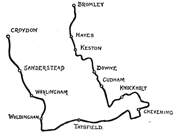
Once past the turning, and Sanderstead reached, along a gently rising gradient, we are in comparatively rustic surroundings. Near the road is the typically countryside church, with blunted shingled spire and sombre yews.[65] In the churchyard lies Sir Francis Head, who died in 1875, whose book, Bubbles from the Brunnen, created a vogue for the German spas and ruined the older Continental resorts. Gradually ascending, the road goes straight ahead to Warlingham, a somewhat bleak and shivery-looking small village, ranged round a more or less ragged and threadbare green at the intersection of several roads. Here we are on a high tableland. The small church, chiefly of Early English date, is seen standing lonely in a flat field, to the left. A modern stained-glass window records the fact that the Book of Common Prayer was first used here in the short reign of Edward the Sixth.
A welcome down gradient now leads along a good road for a mile, and then we turn to the right for Woldingham, to come immediately to a steep descent, followed by an equally steep rise. After a mile and a half of these experiences Woldingham is reached, and with it a high plateau whence there are magnificent views down to the dense woods of Mardon Park and the Caterham valley.
Woldingham has a big and impressive name, a name perhaps descriptive of its geographical position—“the home on the wolds”—but it is a very small and particularly mean and scrubby hamlet. A number of stalwarts live here who do not mind the weary, continuously steep ascent from the station, a mile and a half away. The air is of the freshest and strongest, and healthful in the extreme; but when winter comes and it blows great guns——! When the stormy winds do blow this is, in short, no place for those likely to be[66] nervously apprehensive of their roofs. For this is at the summit of the North Downs, whose steep southern scarp is reached a mile away, along the road marked by a sign-post to Titsey. This is a flat stretch, passing near the modernised tiny church, one of the many claiming to be the “smallest” churches in England. In the little churchyard is the tomb of a suicide, with what seems to be the very uncharitable quotation—“Charity covereth a multitude of sins.” The rugged lane beside the church is a part of the old Pilgrims’ road from Winchester to Canterbury, and the building itself is the mean and unworthy successor of a Pilgrims’ Chapel.
The first turning to the left, past this church, along the road we have been following, almost immediately opens up a wide-spreading view down to the level Weald, lying outstretched with very much the look of a great map. Here, on this plateau overlooking half a county, the Woldingham settlers aforesaid have built their villas, and are with infinite pains and touching[67] pathos trying to induce gardens to grow amid the flints and the thirsty chalk soil. No one can doubt that they will, with constant care and great expenditure, be delightful gardens—a hundred years hence.
There is an uninterrupted view beyond the last of these villas, at Botley Hill, where we are at a height of 868 feet above sea-level. Down below, the railway is seen, like a toy line, and the villages of Oxted and Limpsfield on either side of it, with yellow and green chequers of fields and white ribbons of winding roads gradually losing themselves in the indeterminate distance, where earth meets sky in a vague haze. Here, looking right and left, one sees at its best the characteristic sheer drop of the chalky North Downs into the levels of the Weald, and notices the care with which the villages are ranged under the shelter of these mighty shoulders.
The road between this point and Tatsfield is excellent, following the crest of the hills, and giving a good switchback course.
In less than a mile from this view-point we reach a junction of roads: one on the left to Croydon; our own, ahead to Tatsfield; the road to Limpsfield, down beautiful, but steep and doubly danger-boarded, Titsey Hill; and a lane leading by a back-way to Limpsfield. Titsey Hill’s woods and coppices, open to the road, make a fairy-like halting-place. Tatsfield Church, a mile onwards, beside the road, is a supremely uninteresting building commanding the finest prospects. The village not worth seeing, lies half a mile off the road, to the left, along breakneck lanes of the most homicidal character.
Passing Tatsfield Church, a down gradient leads to[68] several branching roads. The one that goes ahead to the right is our route, and is the Pilgrims’ road. At this point we descend into a pebbly and curving hollow, and climbing up out of it cross the Surrey border and enter Kent. At the next junction of roads to Westerham, Bromley, and Knockholt Beeches keep straight on along the Pilgrims’ road beneath the shoulders of the hills, until brought up against a “No Thoroughfare” gate into Chevening Park.
The rustics here are of the most dunderheaded kind. If you inquire the way to Chevening they don’t know it, whether you try it with a long “Che” or a short; or else gaze, tongue-tied, at you. The proper way, however, is to turn to the right, and, on reaching another barred road marked “No Thoroughfare,” at the end of a half-mile’s run, to turn left along a flat, splendidly surfaced road for another half-mile. Turning then to the left, the grey church tower of Chevening is seen in front.
There is no village, only a few cottages outside the park wall. House and park are the property of Earl Stanhope. Should the tourist wish to explore the course of the Pilgrims’ road, running across the park, he must ask permission as a favour, for in 1780 one of my lord’s ancestors was allowed to stop up the right of way that had existed from time immemorial, and it has been closed ever since by virtue of that special Act of Parliament.
The house is a stately but gloomy building designed originally by the inevitable Inigo Jones, but altered and added to at different periods. Among the notable collections here is the manuscript of the Earl of[69] Chesterfield’s famous (or rather infamous) letters to his son, formulating a course of conduct aptly said to be a vade mecum to perdition. There is one very notable object in the church—a building, to judge from their monuments, expressly devoted to perpetuating the fame and name of the Stanhopes. This is the remarkably beautiful white marble recumbent group representing Lady Frederica Louisa Stanhope and her child; the work of Chantrey, and perhaps his best. It is a touching and very human monument, and a fitting pendant to that other fine work by Chantrey, the “Sleeping Children,” in Lichfield Cathedral.
Lady Frederica Stanhope’s many virtues are hinted at in no uncertain manner on the other side of the monument, in the epitaph to the lady’s husband, “Lieutenant Colonel the Honourable James Hamilton Stanhope,” which says, “His afflicted relatives would have found a melancholy satisfaction in commemorating the many talents and virtues which adorned him, but in laying him by the side of his beloved wife, with no other record than that he was not unworthy to be her husband, they obey his last injunctions.” Could praise be of a more negative kind or uxorious post-mortem compliment farther go?
Returning to the road, which runs eastward for half a mile, and then climbs from these levels up the steep, unrideable Star Hill to the summit of the Downs, we reach Knockholt, obtaining views on the way including the hollow on the extreme right hand, whence the clouds of blue smoke, rising like a column, indicate Dartford and its chemical works, with Shooter’s Hill in front, and the[70] heights of Penge to the left. Passing the hamlet of Knockholt Pound, obtaining its name from an old pound for strayed horses, cattle, and sheep that formerly stood here, we enter Knockholt village, passing a hideous, unfinished freak-building of gigantic size, looking like some prison or barrack, with the addition of a chimney-shaft resembling an observatory. This piling up of stones and mortar on a colossal scale, and in the most disapproved manner—the very negation of style, with sheer walls and plain, rectangular windows—appears to be the amusement of a wealthy gentleman, who is alike his own builder and architect. “Vavasour’s Folly” is the uncomplimentary name by which it is locally known.
Knockholt Beeches, a favourite Saturday afternoon and Sunday holiday-ground for bean-feasters and the like, are most conveniently reached by a lane at the side of the “Crown Inn”; but the machine will have to be lifted over a couple of stiles, unless you like to leave it outside the inn for the bean-feaster to play monkey-tricks with it. For themselves alone the beeches are distinctly not worth seeing, being just a grove of not particularly old nor especially fine trees. The attraction is the view from them towards London; and, standing as the trees do on very high ground, the view is sufficiently remarkable. The Tower Bridge, it may be added as an inducement to visit the spot, can be distinctly seen from here—although the cynical might say that it can be seen better and with less trouble on Tower Hill—and that tiresome, eternally insistent Crystal Palace, from which it seems almost impossible[71] to get away in cycle runs round the south of London, is seen scintillating in the sun as clearly as though it were quite close at hand, instead of being eleven miles distant. A feature of Knockholt Beeches is the Cockney abandonment of the merrymakers here, when ’Enery and ’Enrietta exchange hats and dance to the inspiring strains of the concertina. There are artists who paint the Beeches and the view thence, and to them these corybantic revels are sad stumbling-blocks; which only serves to prove (what we already know) that the days of classic landscape are dead, with Salvator Rosa, Claude, and Turner. Any one of that artistic trio would have seized the grand opportunity, and have composed a picture of Knockholt Beeches in which ’Enrietta would become a sylph and ’Enery a wood-faun.
We have now just the return journey to indicate. Taking the second turning to the right on leaving Knockholt, a road is reached which affords a safe coast to Cudham. Just at the little church of that place,[72] however, a sign-post and a danger-board give us pause, and dismounting, we discover that our road to Downe lies along a sudden, short, and sharp drop, well meriting that warning. A little way on, we can safely mount again for another grand coast, carrying us half-way up the next hill, and then a walk up the remainder brings us through plantations to the hill-crest, whence we drop comfortably into Darwin’s picturesque village. This is the evolutionist’s place of pilgrimage, and Downe House, for forty years the residence of that great man of science, a much-observed retreat. Truth compels the admission that it is an extremely ugly house. Darwin died in 1882, a victim to scientific enthusiasm, having caught a cold on the damp grass of his lawn one night, on going out with a dark lantern to study the domestic arrangements of the earthworms.
From Downe pretty lanes lead to Keston, passing Holwood Park, a lovely estate now belonging to the Earl of Derby, but noted as having been the scene of William Wilberforce’s determination to devote his life to the abolition of slavery, so long ago as 1788. A stone seat, a few hundred yards within the park, marks the spot, and bears an explanatory inscription; and a hoary oak, its decrepit limbs chained and fastened elaborately together, overhangs the scene.
In the pretty churchyard of Keston, situated in a secluded hollow not far from this spot, and removed by a long way from that bean-feaster’s paradise, Keston Common, lies Mrs. Craik, who, when Dinah Muloch, wrote the once-popular John Halifax, Gentleman.
Proceeding, we come to Keston Common, where[73] “Cæsar’s Well” and the charming ponds near it may be sought, unhindered by the bean-feasters aforesaid, who do not roam far from the public-houses. Keston is thought to have been a Roman station on the old Watling Street, hence the name given, in allusive fashion, to the pool—frequently dry in summer—called Cæsar’s Well.
Bordering the Common is the “Fox Inn,” where, on the left hand, down in the hollow, are the twin settlements of “Paradise” and “Purgatory”—the first not particularly desirable, and the second, perhaps, the more preferable of the two. Purgatory is at the bottom of an extraordinarily steep road, which, if not indeed broad, certainly will lead the unwary to destruction. The two places are just groups of labourers’ cottages, and their names are their only remarkable feature.
Glance at the ugly “George Inn” on passing through Hayes. Its sign was painted, many years ago, by Sir John Millais, with a picture of the half-mythical “George and the Dragon” contest; but it hung outside, exposed to the weather, until it became faded, when a former[74] landlord had it repainted, “as good as new,” by a "local artist"!
Through Hayes and Bromley there is a fine broad road, eminently suited for a speedy ending of this somewhat hilly run. Bromley Common, like the adjoining Commons of Keston and Hayes, may be overrun with the week-ender, but not even the raucous van-loads, yelling the latest “comic” songs, can succeed in vulgarising these healthy uplands. From Bromley it is desirable to proceed home by train.
Few cyclists know how old-world the neglected county of Essex really is. So unknown is this part of eastern England that its ill-earned reputation for flatness and want of interest has lasted since the first guide-book writer made the initial mis-statement until the present day. A great gulf separates the West-Ender and the Central Londoner from Essex; a gulf filled with crowded streets and rendered dangerous to the cyclist by the granite setts and tram-lines that characterise the main roads leading from Whitechapel to Bow, Stratford, Ilford, and Romford, beyond which last town only can the country be said to commence. Nor do railways afford so ready a means of intercourse between east and west as could be desired. For the sake, however, of seeing what kind of country this may be, let us, greatly daring, get on to the Great Eastern Railway at Liverpool Street, and take train to Chadwell Heath, following the course indicated by the sketch map. This gives a run of a little over twenty miles, and shows Essex in its most characteristic vein.
Gaining the main road to Romford from Chadwell Heath Station, we follow it for three-quarters of a mile, turning off to the left where a sign-post points the way[76] to Havering-atte-Bower, along a good-surfaced, sandy lane. Here we come immediately to pretty, pastoral country, with spreading views in every direction across the many-patterned fields. Away, four miles to the left, on its striking hillside, is Claybury, the towers of its asylum rubricated in the warm glow of the afternoon sun until they take on a glory like that of a New Jerusalem. Along the road one comes to an old red brick barn, and then to the first of the many old Essex wooden windmills. A gentle rise leads up to the small hamlet of Collier Row, and thence the road goes uphill all the way to Havering, turning to the left at a point duly sign-posted. This is the first taste of the Essex hills. Notice, as you ascend, a[77] red brick house in a park on the right hand. This is the so-called Bower House, the comparatively modern successor of the palace built by Edward the Confessor. Here, in the surrounding park, it was, according to the tradition, that the saintly king, disturbed in his orisons by the song of the nightingales, prayed that they might never sing again at Havering; and so it is (quite incorrectly) said that, even now, the nightingale is a stranger to the surrounding woods. The legend, true or not, does not raise our opinion of the Confessor. Does not the poet finely say, "He prayeth best who loveth best all things, both great and small"?
Although Havering has a long, long history as a royal domain and as the dower-house of queens, little or nothing is left to show the tourist its former importance. A few mounds near the rebuilt and uninteresting church alone bespeak the site of the palace.
As you come up the hill to the tiny village and turn to the left by an ancient elm, whose hollow trunk has been bricked up to help preserve it, notice the old stocks on the green, designed for the accommodation of two. Down a gently sloping road, take the first turning to the right after passing the entrance to Pyrgo Park, and then the first to the right again and past a red brick chapel. Two miles and a half along a pleasant, sandy lane, and then the way divides left and right, beside a pond. Across a broad common, away to the right, are seen the houses of Navestock village; but the church lies half a mile onward, down the left-hand road. This[78] is one of the most curious and one of the most prettily situated churches in Essex, standing on a hilltop and surmounted by groups of graceful wych elms, with the waters of a broad lake, belonging to an adjoining park, seen beyond. Essex is a county entirely devoid of building-stone, and this fact very largely influenced the building of its ancient churches, erected as they were in times when to bring stone from great distances was practically impossible. Flint, being found locally, was often made use of; but the county having practically been one vast forest, timber was the readiest building material, and so we find wood entering largely into the construction of many Essex churches. That of Navestock is an instance, and here it is the tower that is timbered. Massive oak beams form the framing, and are as perfect now as they were when originally erected, over four hundred years ago. The white-painted, weather-boarded exterior is, of course, more recent. The whole is surmounted by a slender shingled spire, and the effect is remarkably like that of a Norwegian church. Patched and altered by many[79] succeeding generations since its first Norman and Early English days, the body of the building is of many styles; and it is plain to see, from the fragments of Norman mouldings and the blocked-up Early English lancets, how utterly without reverence were the old men for the work of their forebears. In the Decorated and Perpendicular periods they inserted the lovely traceried windows whose mouldering mullions yet remain, and in order to do so they cut away without the slightest compunction the narrow slits of the Norman window-openings that merely rendered the darkness of the interior more apparent, and did the same by the larger but still inadequate Early English lights. Inadequate, that is to say, for lighting the building; and it was just for this practical purpose that the men of later periods ruthlessly swept the original work away. That their own work was in[80] the highest degree artistic is but an accident; but this should afford no excuse to the purists among restorers, who have wrought the most widespread havoc in old churches like this by “restoring” buildings to the one uniform style in which they were originally built, and tearing down the traces of all the intervening periods, which, besides being worthy of preservation for their artistry, are really an integral part of the history of such old structures. It is to be hoped that the restorer will not be allowed to wreak his will upon Navestock Church.
Retracing our course from here, and going up the road by which we came, the way to Kelvedon Hatch—or Kelvedon Common, as it is sometimes called—lies up a steep and stony, but happily short, rise, succeeded by one of those prettily-wooded winding lanes so characteristic of Essex, with sunlit peeps between the trees of sloping fields, golden-yellow with waving corn. Very much has been heard of late years of agricultural depression in Essex, and of the impossibility of growing wheat at a profit anywhere in England; but they either achieve the impossible here, or else (a thing inconceivable in a farmer) they grow wheat for the mere pleasure of seeing it grow. As a matter of fact, there is probably more wheat grown in Essex to-day than in any other county of its size.
In one mile, take a turning to the right, then the first to the left, and then the next two turnings to the right again, bringing the explorer to the scattered village of Kelvedon Hatch, a thoroughly Essex village, with the weather-boarded cottages and projecting[81] red brick chimney-breasts you will find scarce anywhere else than in this county. Make straight through the long, flat village street, and then to the left, where a sign-post marks the way to Blackmore. In something like half a mile down this turning, notice the old stocks at “Stocks Corner,” where a sign-post points right for Doddinghurst. Do not turn here, but continue ahead until a post is observed indicating the road to Blackmore to be down a turning to the left. In about two miles from here, when you have been wheeling along a country lane until Blackmore appears to be unattainable, and you have almost given up all hopes of finding it, the spire of the village church is glimpsed across the meadows to the right, and a pretty and easy run leads into the street of this exceedingly beautiful and old-world place.
At Navestock we saw one of the Essex timbered belfries, but at Blackmore we discover the finest example in the county, three-staged, and a very[82] forest of timbering within. A fine old red brick mansion facing the churchyard is known as “Jericho,” and, although its appearance was greatly altered in the time of Queen Anne, really dates back to the days of Henry the Eighth, whose secret retreat it was. Here that Sultan carried on an intrigue with Lady Elizabeth Talbois, who gave birth in 1519 to a son, named Henry Fitzroy, created by his royal father Duke of Richmond and Somerset. Had that son lived, we should doubtless have possessed one more great peerage, left-handedly descended from Royalty, to keep company with those of the Duke of St. Albans, the Duke of Grafton, the Duke of Richmond, the Earl of Munster, and others. But he died, in his seventeenth year, in 1536.
The Court was pretty accurately informed of the King’s whereabouts on those occasions when he secretly visited Blackmore, and whispered that he had “gone to Jericho.” There is, indeed, little doubt of that well-known phrase having originated in this manner. A stream running through the village is still called the Jordan.
Leaving Blackmore for the twin villages of Willingale Spain and Willingale Doe, cross the road at Blackmore, and, turning to the left, pursue a level course along a country road until reaching a solitary fork, which, of course, being solitary and puzzling, has no sign-post.
The right-hand fork looks the most likely, but it is the left, as a matter of fact, that should be taken. This leads past a hamlet where the sign-post vouchsafes a whole gazetteer-full of information; after which, in half a mile, turn to the right (the left turning lands you in a[83] farmyard, and into a duck-pond, very green and slimy). Then a horribly loose, dusty, and stony stretch for a mile, and, turning left, the two churches of Willingale Spain and Willingale Doe are seen, standing in one churchyard. An absurd legend tells how they were built by two sisters who could not agree as to the style of a church they had proposed to build between them. One losing patience and saying that she would build a church of her own, the other is supposed to have answered, “If you’re willing, girl, do!” History, however, disproves this ridiculous story and tells us that Willingale Doe obtained its second name from the old lords of the manor, the family of D’Ou.
There is a curious epitaph in Willingale Spain churchyard to one Charles Davis, who was killed in his thirty-eighth year "by a fall from the elm tree near[84] which he is buried," as the inscription says. He lies, indeed, under the shadow of it.
But this is not the only thing worth note, for, just within the little doorway that leads into the chancel of Willingale Spain Church, may be noticed on the floor a curious monumental brass to Isaac Kello, who died, aged nine years, in 1614, “son to Mr. Bartholomew Kello, Minister of Christ’s Evangell”—
It is not very easy to discover precisely what Mr. Bartholomew Kello, who presumably wrote this, meant by it, but its general tone sounds pathetic enough.
From here a winding lane leads to Fyfield, whose rector has earned some notice by holding cyclists’ parades and by entertaining passing wheelmen. Thence to Chipping Ongar it is an excellent road. From here it will be convenient to take train back to London; first, however, paying a visit to Greenstead Church, a short distance beyond the town, to the right of the road. It lies at the end of a long avenue, and is remarkable for the walls of its nave being constructed of the trunks of oak trees, set upright. The exterior still exhibits the rude rounded surface of the original trunks, worn and furrowed by time; while the adze-marks by which the inner sides have been planed down to something like a flat surface are still visible, although the work dates back to Saxon times. When the church was restored in 1848 the decayed lower portions of[85] these trunks were cut off—five inches of those forming the south wall, and one inch from those on the north side—and the rest preserved by being placed on a brick sill built to the ground level. At the same time the logs were tongued together with strips of oak to prevent dampness penetrating to the church.
The chancel is of late Perpendicular date, and is of red brick; but the body of the church remains an eloquent survival of the ancient steading in a clearing of the green woods that once spread densely over old-world Essex.
The church is dedicated to that most famous of all East Anglian saints, St. Edmund the King and Martyr, who was seized by the Danes in the year 871 at Hoxne, and on his refusing to renounce Christianity, bound by them to an oak, and shot to death with arrows. And not only is it so dedicated, but it owes its very existence, in a curious way, to him; having been originally built as a temporary shrine of logs for his body to lie in on the journey, when it was transferred to London from its gorgeous shrine at Bury St. Edmunds during the troubled years immediately preceding the Conquest. A fragment of stained glass, with a crowned head pictured on it, is let into a little window in the weather-boarded tower, and a portion of the ancient Hoxne oak is preserved at the Rectory, where there is an old painting representing him. It is a singular coincidence that the oak—St. Edmund’s Oak, as it was named—fell at the very time in 1848 when the little church was being restored. The absolute truth of the legend was proved by an ancient arrowhead being discovered almost in the heart of the famous tree.
The title given above to this particular tour is one eminently calculated to astonish those who have derived their ideas of Essex from guide-book writers. It has long been the fashion to describe Essex as a flat and monotonous county. Probably the compilers of those miscalled “guides” have known Wanstead Flats and Barking Level, and have ventured along the Thames marshes; but that anyone who has travelled Essex through could still describe it as flat is simply inconceivable. Certainly no cyclist who knows his Essex well would deny its much more than undulating general character.
This tour is frankly planned for the purpose of visiting the most prominent among the hills of Essex, and so, as some rough roads will be met at one spot, and as some walking, both up and down hill, will be necessary, the itinerary does not extend to more than thirty-four miles. Let it not, however, be supposed that, as a whole, this is a route of hill-climbing and bad roads. Starting at Brentwood, we are upon the main highway from London to Colchester, and on the crest of a steep hill which cyclists coming from London must needs climb. By training to the town we just escape it, and the succeeding five miles along this old coaching highway[87] are chiefly on the down grade. Brentwood is well worth exploring. Its fine broad High Street still retains the decayed trunk of the old oak marking the spot where the Protestant martyr, William Hunter, was burnt in 1555. The trunk is carefully bricked up to preserve it. A monument also serves to keep the martyr’s memory green. The old galleried courtyard of that old-time coaching inn, the “White Hart,” should be seen; it is one of the very few examples now remaining of a bygone style of hostelries whose days ended when railways came in.
Brentwood, originally called “Burntwood,” probably takes its name from a portion of the once dense forest of Essex, burnt at some indefinite period, on whose site the town arose; and, sure enough, along the whole course of this tour—and, indeed, of many another one could make in Essex—relics of this vanished forest are encountered in almost every old church, built more or less largely of ancient timbers. Here at Shenfield, which we reach through a beautiful common, a mile distant from Brentwood, a portion of the nave arcade is of wood, and at Mountnessing, the next place on our itinerary, the tower is framed in massive oak. The name of Mountnessing presents difficulties to local tongues, and so it is known round about these parts as “Money’s End.” Ingatestone, succeeding to Mountnessing, is a decayed coaching town, with a name corrupted from “Ing-atte-Stone”—the Meadow by the Milestone, as some would say. By “stone,” however, it is more likely that the old Roman stone-paved way is meant.
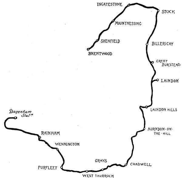
Turning off this high road here to the right, we make for Stock, along a hilly lane. Stock, a scattered village situated on high ground, commanding beautiful views southward toward the valley of the Thames, is of little interest for itself; but here, again, we find a very remarkable church, with ancient timbered and weather-boarded tower, surmounted by a shingled spire, springing from a roofed lower stage with cavernous eaves, the whole dating back to the close of the fifteenth century, and restored, apparently, over two hundred years ago,[89] according to the inscription, “R R. E H 1683,” still sharp and distinct, on the woodwork of the belfry. Like most of these Essex wooden churches, this of Stock is of curiously Scandinavian aspect, and own sisters to it may be found in Denmark, Norway, and Sweden. Even the elaborate tracery and the mullions of the windows in this tower are in wood, and, moreover, in excellent preservation.
From where Stock stands on its ridge, it is nearly three miles to Billericay, very steeply downhill at first, then level, and again downhill to Billericay Station. Yet, after all these descents, one observes that the little town is itself on an elevated tableland. The name of this place is, by the way, a sad rock of offence and a stumbling-block to the stranger, who generally attempts to pronounce it “Bill-erry-cay,” somewhat after the fashion of its spelling. The local shibboleth is, however, “Bill-ricky.” The interior of the church is of the most[90] disapproved churchwarden order of architecture, and the exterior, with humpbacked roof and whimsical, squatty little red brick tower,—said to date back three hundred years, but not looking half that age,—is in a curiously debased Gothic; while there can be no doubt about the mean Late Victorian of the 1897 Jubilee clock, bracketed out from the tower.
Billericay consists chiefly of a long street of nondescript houses, some very tiny, none very large, and few particularly new. A goodly proportion of the loose stones of Essex is strewn over the roadway, some of them large enough to make the ghost of Macadam writhe with disgust at the degeneracy of the times from those he knew.
It is downhill again from the little town to Great Burstead, a mile and a half away, on the left hand. This was the mother-parish of Billericay, but has now shrunken to a cottage or two and a fine old church, very much out of repair. After this come further descents, and then, where a modern inn faces up the road, nearly four miles from the little town of Billericay, turn left, and then first to the right. A little distance ahead appears the odd sight of a church standing solitary on a hilltop. This is the church of Laindon, and we are now coming to those Essex mountains in miniature, the Laindon Hills.
Leaving the cycle beneath the wayside hedge, climb the steep hillside, over hurdles and across grass fields, and then you arrive at one of the most singular churches in the country. Laindon Church is of Early English and later periods, and has the probably unique feature[91] of a priest’s house, or anchor-hold, built on to the tower at the west end, and opening directly into the church. The priest who dwelt here in olden times must have had rather a cosy retreat, in spite of the fact that it is exposed to every wind that blows; for the two rooms, forming a lower and an upper floor, look cheerful and comfortable. Four lattice windows give views away over many miles of beautiful scenery, and the structure itself, built of red brick, plaster, and timber, is of the greatest curiosity and interest. In this odd structure lives either the parish clerk or the sexton, and the casual visitor to the church is like to be startled by the sight of a domestic interior at its west end, and to hear such unusual sounds as the washing of plates and dishes echoing through the building from the direction of the old priest’s habitation.
Regaining the road, a hundred yards or so bring us[92] to a way (too execrable to call a road) running right and left. Turn to the right, and then the first to the left, along a track leading to Laindon Station. Over the railway, and then continuously uphill for a mile, along the worst possible tracks; and then the summit of the Laindon Hills is reached. Passing the post-office it will be noticed that the postal authorities are at variance with most people over the orthography of the place, for it is spelled in a most aggressively prominent and permanent fashion, on an enamelled iron sign, “Langdon.” The London, Tilbury, and Southend Railway adopts the more usual form.
The rail brings many East London excursionists here for half-day outings, and, indeed, the views from the hilltop are worth coming many miles to see, and well worth walking uphill with a cycle. Given a clear day, you have not only the estuary of the Thames from Greenwich to the Nore spread out before you, with the Kent and Essex marshes extending like a pictorial map on either shore, but the eye ranges away out to sea and across the intervening country to the broad silver band of the Medway, running up from Sheerness to Rochester. Other widespread views of sea and land and river are to be found in England, but nowhere else anything to exactly compare with this; for here, enlivening the scene, and conveying some idea of the commercial activity of the Thames and the Port of London, are the great steamers, the sailing vessels, and the lumbering barges, going back and forth so numerously as to convey the idea of fleets. You may read in many books figures of the most painstaking kind, set forth in an[93] endeavour to give an idea of the commercial status of the Thames, but they will not serve to convey anything like the impression you receive from this eyrie. The cycle, after all, is one of the greatest among educational forces.
The road-surveyors who have this particular district of Essex under their control do not appear to have been educated in the gospel of good roads, for as you turn to the right, past the “Crown Inn,” and to the left after passing the modern and ugly church of Laindon Hills, a quite unrideable descent of over half a mile suddenly presents itself. It would be possible to cycle this in comfort and safety were it not for the condition of the road, which bears in its thick and loose gravel a very close approximation to Brighton beach. Having perforce walked this, a sharp turn to the left brings one to a very welcome, good, though hilly road, ascending direct to Horndon-on-the-Hill, a place which has been visible for the last two miles, situated in much the same fashion as the more familiar Harrow-on-the-Hill. Horndon looks impressive from afar, and you approach it expectant; but when you reach it the first thought is that it is a place by no means worth seeing, being just a dusty, gritty, draggle-tailed village that has been making up its mind to be modern for the last half-century, and so has provided itself with some very unlovely shops and houses. The best thing in Horndon-on-the-Hill, a cynic might say, is the view from it of other places: of Laindon, of Vange, and Bowers Gifford, along the high ridge of wooded country to the north-east.
From here we descend gradually to the Thames-side lowlands. Making for Chadwell, and turning to the right on passing the church, a glance backwards will reveal Horndon at its best: the tree-surrounded old church, with the bright vermilion pantiles of the older houses, and the whirling sails of flanking windmills giving a singularly foreign and Dutch-like effect. Take the next turning to the left, and in half a mile to the left again, having previously withstood the specious invitation of a left-hand turn through a gate which only leads to a farm-track. Another mile, and you come to a right and left highway, opposite the “Cock Inn.” Neither of these leads to Chadwell, but there is a lane leading straight ahead, beside the inn; a very retiring lane, and quite difficult to see, if not previously warned of its existence. This leads, for a level two miles, to Chadwell Church. Turn to the right here, along the road to Grays. The other road, straight on, drops sharply to the marshes and to Tilbury Docks, and the surrounding industrial settlements. Tilbury Docks are very impressive, but when cycling you can obtain all the impressions of them that you have any use for from this Grays road, two miles away.
All the way from here to Rainham—some nine miles—is a splendid object-lesson in Thames-side shipping and industries. It is not sufficient to know the Thames only in its fashionable and holiday aspects. To know it as a whole you must also have made some sort of acquaintance with what sailor-men call “London River”—that is to say, the Thames below bridge, where all the business is done. This is not, of course, to say that[95] these succeeding nine miles are ideal from the cyclist’s point of view. The busy and growing town of Grays with the Thurrocks on either side, scarcely to be distinguished from it by the stranger, is only picturesque to those who can find a romance in the riverside work; but the road surface is not so bad. Notice on the right, immediately after leaving Grays, the sham castellated building in a park now in course of being destroyed by the chalk quarries. This is called Belmont Castle. The chalk-pits here, and along the road to Purfleet, are nothing less than stupendous. Railways run between them and the river, where the chalk is shipped, or manufactured as cement on the spot. Purfleet, to which we now come, is a somewhat pleasing old-world riverside place, with a pretty, tree-shaded road running beside the river, where it is pleasant to halt and watch the world’s commerce float by; the passenger steamers, the “ocean tramps,” the fruiters, the wool-ships, the unmistakable oil-tank steamers, and all the very varied traffic coming from or going to distant parts.
Across the river is Erith, and immediately opposite are the hospital ships, off Crayford Ness. One of these—the Castalia—was originally a twin-ship built for the Channel traffic, with the idea of abolishing seasickness. Nearer at hand is the old wooden man-o’-war Cornwall, now a training ship, and beside the road, just here, is a disused hillside chalk quarry turned into a botanic garden.
Purfleet has a picturesqueness all its own, not utterly destroyed by the gunpowder magazines nor by the huge tanks—like gasometers—where oil is stored. So long[96] as the busy perspective of the waterside remains, with the “toil, glitter, grime, and wealth” of the tide, the place cannot fail of interest.
Beyond, through Wennington and Rainham, the marshes spread out on the left, kept from being drowned out by the Thames by the aid of those earthen river walls said to have been originally made by the Romans. Passing through the uninteresting town of Rainham we turn off to the right at Rippleside for the old-world village of Dagenham, set upon a hilly site overlooking the miry flats. Down there, on the inland side, lies Parslowes, the old seat of the Fanshawes, islanded in midst of ploughed fields; riverward trail the smoke-wreaths against the burnished sunset, and as we blunder along the winding lanes for Dagenham Station we meet the agricultural labourer, clumsy and stupefied with long hours of physical toil, slouching off to his evening fuddle at the “Blue Pig.”
Ewell is a convenient starting-point for this trip for South Londoners, and has the additional advantage of being served by two railways. Only in the spring of the year, when the Epsom races are on, and the Derby brings riotous crowds down by road as well as rail, do Ewell and Epsom wake out of their customary quiet. For the rest of the year they are old-fashioned places, even in these villa-building latter days. Ewell, as its name in some sort implies, is a place of springs and running waters, with crooked streets and with an ancient ivy-mantled church tower, all that is left of the old parish church, standing solemn beside the modern building. Just inside the churchyard gate notice a stone to one who lost his life by falling from a horse at Shipton-under-Wychwood, Oxon; and, close by, a monument with urn and a kneeling figure in relief on a pedestal to James Lowe, born 1798, who “met his death from an accident the 12th October 1866. He was the inventor of the segments of the screw-propeller, in use since 1838, and his life, though unobtrusive, was not without great benefit to his country. He suffered many troubles, but bore them lightly.”
Epsom, “town” we should presumably call it, a mile and a half down the road, hints little or nothing to the[98] passing cyclist of its horse-racing fame, save perhaps for stray glimpses gained of the great Grand Stand perched upon the windy Downs, more than a mile away to the left; and if little be told by external appearances of this intimate relation with the foremost classic race in England, still less would the stranger gather that Epsom is a Place with a Past; a past, as a fashionable Spa, scarce inferior to Bath in the days of good Queen Anne. Epsom wells and Epsom salts have had their day and ceased to be.
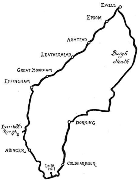
Suburbia is extending its frontiers in this direction, and breezy Ashtead, two miles farther on, down a pleasant road, is now set within the marches of the[99] suburbs, where the opposing camps of market gardeners and speculative builders are pitched cheek by jowl, and bricks and plaster are banishing the broccoli and the peas. At Leatherhead the incursions of villadom are lost in the intricacies of the old-fashioned little town and in the embowering foliage that owes its density to that beautiful stream, the Mole. Leatherhead is situated at the junction of many roads. It is what military men would call a “strategical point,” and, touring on a cycle through the southern and south-western districts outside London, you come to it, whether you will it so or not, again and again. And, just because it is a pleasant place, you do not regret the necessity. The streets of Leatherhead are narrow,[100] and slope steeply towards the river Mole; also, they curve in somewhat puzzling fashion. Our way, however, lies straight ahead, passing that queer old inn the “Running Horse” on the right, where the landlady, Elynor Rummyng, gave short measure in the reign of Henry the Eighth, and was rolled in a barrel for her pains. A very old painted sign, fixed on the front of the house, and now glazed to protect it from the weather, shows a portrait of this iniquitous person, who, if the artist is to be credited, was a phenomenally ugly specimen of humanity, with predatory beak-like nose, covered with warts. Here we cross the Mole by a long bridge, and presently, keeping straight ahead, ascend a sharp rise, which leads on to the rather exposed upper road to Great Bookham and Effingham, those places being singularly provided with parallel roads less than a quarter of a mile apart. A cross-road to the right, when two miles out of Leatherhead, gives access to Great Bookham village. The church, which is interesting, appears to be generally locked up, except during service. In the churchyard notice the very beautiful modern churchyard cross to the memory of Guy Cuthbert Dawnay, killed by a buffalo in Masailand.
Regaining the upper road, Effingham is reached in a mile. The church will be noticed standing, with the tiny village, off to the right. The place gave a title to Lord William Howard, created by Queen Mary “Lord Howard of Effingham,” and it was the son of this nobleman who, as Lord High Admiral, commanded the little fleet that destroyed the Spanish Armada. Knowing this, the tourist approaches Effingham with due[101] reverence and great expectancy. Unhappily, there is nothing whatever in village or church to connect them with the Admiral or others of the Howards. The church itself is utterly modernised.
At the roads that here run right and left stands a large inn, the “Prince Blucher.” Turn to the left, and then, after proceeding for nearly a mile, take the second to the right. We are here on very high ground, having cycled for a long while almost imperceptibly uphill. Away to the left the successive hills of the North Downs are seen: Box Hill and the others towards Reigate, with their wooded crests and the characteristic chalky scars on their southern face, softened to a Corot-like mellowness in the golden sunshine of an autumn afternoon. At the turning to the right, at which we have now arrived, the road goes suddenly down and deteriorates alarmingly, being knobbly and narrow, and partly overgrown with grass. This is Effingham Hill, and unless you would acquire reasons for vividly remembering the place in the way of being thrown off, it is distinctly advisable to walk some way down. This descent leads to a farm in a deep hollow. Through the stony farmyard, and walking up an equally stony rise on the other side, a straight flat road is reached, running for half a mile. Then, where roads right and left appear, turn to the right, and so downhill to where a sign-post stands at the bottom. Turn at this point to the left, along a secluded road through copses which lead presently to the crest of a hill marked by the red danger-board of the Cyclists’ Touring Club. These are the so-called White Downs, and this White Down Hill.[102] There are, as every cyclist knows, degrees of danger on hills so marked by the C.T.C. Some are so little dangerous that this red warning-board is often disregarded; but this particular hill is a mile long, very steep, rough, and strewn with flints and lumps of chalk, and with a sharp curve when nearly at the bottom. It is, therefore, superlatively dangerous, and no one should on any account attempt to ride it. It is no hardship to walk down this hill, for it is no less superlatively beautiful than dangerous. It is a hollow road, or rather lane, with rugged chalky sides, into which the trees have thrust great gnarled and knotty roots, like the fangs of teeth, with steep hillsides stretching away overhead. Great beeches and lesser hazels and hollies make a perfect tunnel of foliage, through whose framing the eye looks down to the Weald, far below.
When this descent is accomplished, the road leads over a railway bridge, whence, to the left, the most beautiful views of the Downs, with the spire of the church on Ranmore Common above and that of Dorking Church below, are spread out. Notice a brickfield on the right, and look for a green road, also on the right, a few yards beyond. This leads to a piece of common land, known as “Evershed’s Rough,” the scene of the fatal accident to Samuel Wilberforce, Bishop of Winchester, on 19th July 1873, when, riding horseback, he was thrown by his horse stumbling. The place is marked by a granite cross ten feet high, simply carved with the initials “S.W.” and a shepherd’s crook, in relief, with the date inscribed in smaller letters. The rebuilt parish church of Dorking, whose lofty spire can[105] be seen from near this spot, is also a memorial to that energetic prelate, whom men called in life “Soapy Sam.” Some day, doubtless, when our civilisation and its records have alike perished, say a thousand years hence, the antiquaries of a new era will be disputing as to the origin and meaning of this lonely cross, with its weatherworn initials and shepherd’s crook.
Cross-roads presently appear down the road. Here a sign-post points ahead for Abinger, with the added information that the first turning to the left should be taken. Turning accordingly, as bidden, a pretty lane is reached, with a very beautiful old pond, fringed with rushes, on the left. This is Abinger mill-pond, and the rust-red roofs of the mill itself can be seen rising from a hollow on the farther side; an old, old building which Nature has long since reclaimed as her own, with lichens growing everywhere, and ferns and wild plants that only the botanist can name luxuriating amid the dampness of the disused mill-wheel.
It is a steep and tiring ascent along a sandy lane to Abinger, where a little church on one side of the road, the “Abinger Hatch Inn” on the other, and a few cottages, comprise the village. Three miles straight ahead is Leith Hill, the tallest in the south of England, rising to a height of close upon a thousand feet. The route lies past Abinger Common, with its well and picturesque well-house in the Norman style, built and dedicated to St. James by Mr. Evelyn of Wotton in 1893. The way to the summit of Leith Hill is through pine-woods and along a road of such excellent surface and so gradual a rise that this hilltop expedition is not[106] at all fatiguing. It leads by degrees half round the hill, and brings one to a point where the road is crossed by a white gate, directly under the tower that crowns the hilltop. To leave one’s cycle here against a tree-trunk, and to clamber up the chalky final ascent to where the tower stands on its flat plateau, is the best plan. Those who are not already high enough can ascend this tower at the cost of a penny a-head, and some six thousand persons annually avail themselves of the privilege. It was originally built in 1766 by a Mr. Hill, of Leith Hill Place, who, dying in 1772, was, according to his injunctions, buried here, under the flooring, when the interior of the tower was filled up with cement and stone. The stone tablet recording that he “led the life of a true Christian and rural philosopher” still remains, and so does the legend (true or untrue) that he was of opinion that the world would be reversed on the Day of Judgment, and so directed that he should be buried head downwards.
The tower, having become ruinous, was restored by Mr. Evelyn, who added the staircase turret. By the sight of it, crowning the summit, Leith Hill can be identified many miles distant, and the view from this hilltop is extraordinarily widespread. The whole of the counties of Surrey and Sussex, as far as the South Downs, is stretched out flat like a carpet, to where the wall of the South Downs alone prevents the sea being disclosed along the length of the Sussex coast. At one point, indeed, it can be seen, and that directly in front, where a notch in those distant hills discloses a something that may be sky and may be water, you think. But as[109] you look, on a sunny afternoon, and continue looking, the sunlight streams down momentarily and wakens a million facets to life, all flashing like diamond-points or flecks of fire. They are the ripples of the English Channel, transfigured by this radiance, and the notch through which you see them is Shoreham Gap.
There are nearer stretches of water that thus mirror the sun’s rays. Frensham Ponds, away in the west, eighteen miles away as the crow flies, glitter like burnished steel, and in sharp contrast with black and sullen Hindhead. Down below, somewhere amidst the woods that are set round about this hill of hills, is another lake, and near it the clustered chimneys of a great mansion. For the rest, the weald at the foot of the tumbled masses of the North Downs is vague, formless, inchoate. There are towns there, we know, and villages, hamlets, roads, and railways; but they are all lost in immensity. Perhaps, if you take literature in your pocket when cycling, the reading of Tennyson’s “Vastness” is appropriate here, for it echoes the sense that comes to one on this hilltop of the littleness of one’s self. (Mem.: If you wish to retain a good conceit of yourself, keep to the plains!)
Clambering down to the road again, and through the gate already mentioned, a beautiful downhill road leads to the hamlet of Coldharbour, nestling amid the foothills and the Alpine valleys in miniature that surround Leith Hill. All the way hence to Dorking are trees: plantations of Scotch firs, larches, and other trees that give an added mountainous character to the scenery. And lonely withal, and steep. Redlands Wood is passed[110] through, and a long, steep hill, danger-boarded. With caution, however, and a reliable brake, there is no reason why this should not be ridden. So, coming swiftly down into the flatlands, we are in Dorking before we know that town is so near.
Turning to the right and through the main street, we are soon out in the open country again, and turning to the left at Betchworth Park, and under the shadow of Box Hill, and in view of the line of yews marking the course of the Pilgrims’ Way, reach the left-hand turning for Burgh Heath and Ewell. Toilsome is the ascent of Betchworth Hill, by which the summit of the North Downs is gained, but beautiful the backward view when this excelsior business is done. Downhill again, however, into Pebble Coombe, and up to Banstead Downs, whence—oh, happiness! you may coast, feet up, with or without a following wind, nearly all the way down into Ewell; some four miles, that is to say, along the best of roads, through open heaths that, whether they are called Burgh Heath, Banstead Downs, Walton Heath, or Epsom Downs, are only portions of one vast high-lying plateau dipping towards the valley of the Thames. Sign-posts are not wanting on these heights—a fortunate circumstance, because the wayfarers are not many.
The Londoner of the southern and western suburbs is fortunate in the many breezy and picturesque stretches of wild commons that form a more or less continual girdle around those districts, at a distance of from fifteen to twenty miles from town. The Surrey Commons, more than those of Kent, are secluded and free from the bean-feast parties that render Keston and Hayes Commons somewhat less desirable than they would otherwise be. It is true that in the neighbourhood of Esher and Oxshott those who have the conduct of the extensive Crown lands that border the commons are beginning to exploit their healthy sites for villa-building; but although this red rash of “desirable residences” among the dark green of the pine-woods is looked upon with disfavour by the rambler in these hitherto unfrequented spots, what cannot be cured must be endured with the best grace at command.
Esher Station is the key to this district for those who hail from town, and sets you down on a common to begin with. In fact, the London and South-Western Railway runs along “common or commonable lands”—as the Parliamentary Bills of the railway companies express it—from Surbiton, and practically cuts Ditton Common in half: more shame to the Parliamentary[112] Committees that ever permitted the deed. But then the South-Western has, for some reason or another, always been allowed to cut up and practically destroy the open spaces along its route, so that there is scarce a common in the south-western suburbs but that line has a cutting through or an embankment across it, with level crossings innumerable, at which those who use the roads must needs wait the pleasure of the railway, until the crowded traffic of passenger and goods trains has passed by!
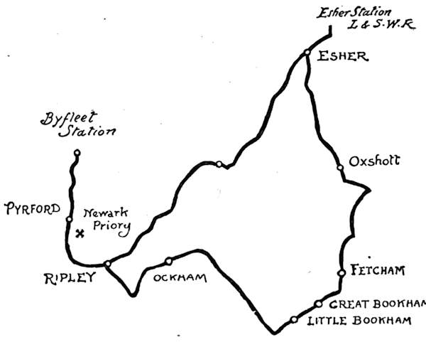
We gain the old Portsmouth road in a few hundred yards from Esher Station, and, turning to the right, climb the hill to the village, through Littleworth Common. Reaching Esher, the way to Oxshott lies to the left, past that old coaching inn the “Bear,” and the old and long-disused parish church that modestly hides itself behind the inn.
The lodge gates of Claremont Park, beside the road,[113] on the lovely common of Esher, are now passed, and within this, perhaps the best-wooded park near London, stands the great classic mansion begun by Lord Clive in 1768. Macaulay tells with dramatic effect how “the peasantry of Surrey looked with mysterious horror on the stately house which was rising at Claremont, and whispered that the great wicked lord had ordered the walls to be made so thick in order to keep out the devil, who would one day carry him away bodily.” Clive made an end by committing suicide in his gloomy mansion in Berkeley Square in 1774. Claremont is now, of course, Crown property; but the arms of Clive still remain on the pediment of the mansion.
From here the road goes straight across Esher and Arbrook Commons, with glimpses into the well-kept[114] park on the way, in sharp contrast with the wilderness of bracken, just turning an “old gold” tint with the first touch of autumn. A rugged, sandy hillock will be noticed on the right hand, amidst the bracken and the blackberry brambles. It is known as Round Hill, and, although apparently and actually of no great height, commands exquisite views. Safely leaving the cycle down below in this unfrequented spot, it is distinctly well worth while to scramble to the summit for the views of the surrounding country. Telegraph Hill—the wooded ridge between Oxshott and Leatherhead—is prominent, and recalls the days before the advent of the electric telegraph in 1838, when this height was one of a series between the Admiralty in London and Portsmouth Dockyard, and fitted with semaphores for signalling. More prominent still, peering over the woodlands of Ruxley Lodge at Claygate, is the castellated outlook tower built by Lord Foley; while dense woods and billowy expanses of gorse-clad commons complete the picture, save on the clearest days, when, faintly to be seen over the ridge of the North Downs, is Chanctonbury Ring, the great hill near Worthing.
From here to Oxshott Station the way still lies through commons. Around the station the builder is busy on the Crown lands, and is creating a modern village. Avoiding a knobbly road on the right, which a sign-post informs us is the way to Stoke D’Abernon, we continue ahead, more by token that in doing so there is a fine road and a good coast downhill. In another mile a sign-post appears directing to Woodlands and Stoke D’Abernon. Here we will leave the Leatherhead[115] road, whose course we have been travelling, and turn to the right, coming in less than a mile, still gently downhill, to another post. Instead of turning to the right here we keep on for half a mile along the road, which now begins to wind about and to take on the character of a country lane. Then look out for a right-hand turning at the corner of a park enclosed by a new red brick wall. This is Randalls Park. Turning down here a hundred yards or so, along a lane where the local authorities delight to blast the scenery by tipping all the potsherds and domestic refuse of the district, the explorer, after enduring much, comes at last to a pretty scene on the river Mole, which here runs in two branches: the first spanned by a substantial bridge, the second bridged by a very long and narrow structure of wood intended for foot passengers only. Wheeled traffic goes through a picturesque water-splash; but the cyclist must perforce dismount and walk his machine over the wooden bridge. From this point, crossing a road running right and left, the way lies ahead, up a sharp rise through Fetcham village and along the road to Great and Little Bookham. At the last-named place we turn off to the right for the four miles’ run to Ockham, famous as being the Waterloo of the Bloomer women; for it was here, at the “Hautboy,” that Mrs. Sprague, the champion of convention, withstood the breeched Lady Harberton, with complete success. Why is there no monument to this historic event?
The route to Ockham is almost wholly through Effingham Common and Blackmore Heath, past solitary Effingham Junction, and thence through woods to[116] Martyr’s Green, where we turn to the left, and so to the “Hautboy” and the village built under the shelter of Ockham Park, the seat of the Earl of Lovelace. The church, standing in the park, is worth seeing. Nailed to the gallery front is the Chancellor of the Exchequer’s Purse worn by Lord Chancellor King, who held the office in the reign of Queen Anne.
Among the eccentric epitaphs often quoted, that on John Spong of Ockham should surely be numbered. He died 17th November 1736, aged sixty years. The lines on his tombstone were written by Daniel Wray, F.R.S. Spong was a carpenter—
Hollis was a bricklayer friend of Spong’s, and appears, at anyrate, to have been spared long enough to escape being a post-mortem butt for Mr. Daniel Wray’s wit.
From Ockham village, roads lead round either side of Ockham Park into Ripley, a mile distant. It is worth while to linger round Ripley for half a day, for the village itself is pleasing and the surroundings are exquisitely pretty. Ripley is a great deal more interesting now to the cycling tourist than ever it was in the[117] days of its cycling popularity. For there is no doubt whatever that the days are gone, never to return, when cycles were stacked by the hundred in the broad village street on Saturdays and Sundays. Ripley has been called the Mecca of every good cyclist, and for some fifteen years its popularity was great among London clubmen, to whom the twenty-three miles from town, and the run home again across the commons that border the Portsmouth road from London, formed a delightful day’s cycling. Indeed, so exclusively was this a place of pilgrimage that the road to it was generally known among cyclists as the “Ripley road,” although, as a matter of fact, Ripley is but an incident along the old coaching highway that stretches a long course of seventy-three miles between London and Portsmouth. So devoted was this class of cyclist to Ripley that many never ventured beyond it, but made that remarkably picturesque old inn, the “Anchor,” and the village green opposite, their lounging and gossiping places, until it was time to start again for home. Ripley was first “discovered” by cyclists in the dawn of the ’70’s, when the very few who wheeled on what were then called velocipedes found a welcome at the rustic “Anchor” at a time when the riders of such new-fangled contrivances were generally looked upon as pariahs, and refused accommodation or even ordinary civility. Such unwonted consideration made the fortunes of the “Anchor,” of the Dibbles who then occupied it, and of the village of Ripley in general; for it became known that here, at least, was a place where the weary wheelman, who trundled his hundredweight or so of old iron[118] painfully along the roads, and called it “pleasure,” could take his peculiarly well-earned rest. Thus the fame of Ripley grew, and with the growth of cycling clubs attained really great proportions. Such early racing cyclists as Cortis, the Honourable Ion Keith Falconer, and “Jack” Keen were the first comers. They have all passed into the Unknown, and so have “the Dibbles,” as the genial family who once occupied the “Anchor” were collectively spoken of; and to-day the tourist may see the memorial windows to Cortis and the Dibble sisters in the ancient chapel of Ripley, hard by the inn, windows erected by club-cyclists who knew them well.
Now that the cycling club is an unnecessary and rapidly decaying institution, Ripley is almost as deserted as it was before its sudden popularity. Not quite, for of course the roads are more frequented nowadays; but it has taken on again something of the old look it wore when it was just the typical decayed coaching village.
Coming into the old-world street, with that truly countrified scent—the scent of the wood-fuel burnt largely instead of coal—the place is delightful. Away on the north side of the road stretches the so-called “green,” in reality a broad and beautiful common, the ideal spot for many a ramble by the winding Wey, with its picturesque weirs and mills and background of solemn firs. Such rambles to be taken preferably without the cycle, to be left conveniently in the village. Or a pretty cycle ride lies across the village street to Newark Priory and Pyrford, two miles distant. It is an unmistakable route, and, coming to the humpbacked[119] bridge across the Wey at Newark Mill, the grey ruins of the Priory are prominent in a meadow on the right hand. The place is quite solitary. No guide to chatter; most probably not even another cyclist. Nothing to pay; only just to lift your machine over a field-gate, and there you are. The fragment of a bridge or an entrance gate may be seen on approaching; a fine piece of work, with alternations of stone and knapped flints. Beyond stand the ruins in romantic solitude, in that low-lying watery situation the old monks loved so well. Indeed, the Wey and its rush-fringed tributaries, that wander so lazily through the level meads, form a very maze. The monks’ fish-ponds are all uncared for now,[120] and their Priory roofless and stripped of almost every fragment of worked stone; but the tall lancet windows remain to show the Early English character of the building, and the sturdy flint walls may last many centuries yet, if only one great ominous fissure, extending almost to the ground, is looked after. There is a quite wonderfully effective view of the ruins from the road to Pyrford, just where the Wey crosses it; but for a grand comprehensive view of the Priory, and the vale in which it stands, one must climb the slight rise to Pyrford itself.
Good roads lead thence to Byfleet Station, two miles distant, for those who desire to return by train; but the more enjoyable course, should daylight last, is to return to Ripley, and to cycle thence back to Esher through Cobham Street, along that splendid highway, the old Portsmouth road. Commons are almost continuous along this route—Ockham Common, Wisley Common, and that of Fairmile—and the scent of the surrounding pine-woods is over them all.
How rural and secluded still are some parts of Middlesex let this run show. To roam far from the madding crowd in this essentially “home county” might seem impossible, but those who summon up the not very great amount of energy required for following the course of this tour will see many places sleepier and more retired than in Devon or Cornwall. They will not remain so very much longer; which is an inducement to see them without delay.
There are many ready ways of beginning this trip; from London to one of the Ealing stations by train—Ealing on the District Railway for preference—or the cyclist resident at Richmond, Kew, or Ealing can start without depending upon outside aid. Starting, say, from Kew, the way lies over the bridge, and thence towards Gunnersbury along the wood-paved road. In half a mile look out for what still, at the time of writing, remains a countrified lane on the left—“Gunnersbury lane,” as it is called—where a sign-post directs to Acton. Past market gardens we go, and come, in little over half a mile, to a turning right and left. Here a left-hand turn, and then the first to the right, which is a long, straight road, planted with[122] young trees, leading direct on to Ealing Common, and straight across it to Hanger Hill.
From here it is a steady rise of a mile up the country road, with dairy farms here and there. Then a somewhat steep descent, with one or two tricky curves and loose patches of gravel where rains have made channels across the road. With caution, therefore, the descent should be made to the valley of the Brent, the more particularly as the dairy farms aforesaid are responsible for many strayed cows generally to be found wandering in the road, and as at the bottom, where a rustic inn stands, our route lies off to the left, along a lane to which there is a very acute turning, up a quite short but sharp rise. It is necessary to have the machine well in hand to negotiate this corner without dismounting. A mile and a quarter of narrow, winding lane, quite flat but with tall hedges on either side, like a Devonshire lane, brings us to Perivale.
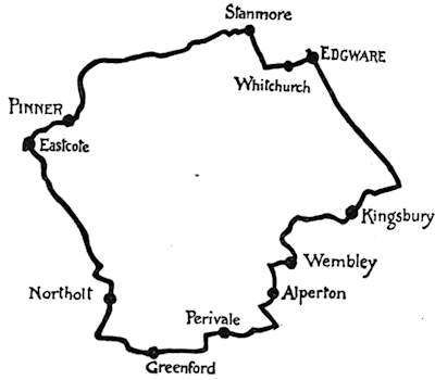
Now Perivale is one of the queerest little places it is possible to set eyes upon. “Little” is said, and the fullest sense of the adjective is to be understood; for besides the church—one of those claiming that curious wrong-end-of-the-telescope kind of dignity as “the smallest in England”—there is only one other building[123] at hand; and that the rectory! Indeed, in the entire parish of 626 acres there are but five houses and thirty-four inhabitants; and this, let it be impressed upon the reader, well within nine miles of London’s five millions of population. Perivale, save for this church and those scattered farmsteads, is just a geographical expression, nothing more; for there is no village, no hamlet, no village shop, and no public-house. All around are the low-lying water-meadows bordering the river Brent.
There are those who refer to Perivale’s ancient alias of “Greenford Parva,” and say its present name is but a corruption of the “Parva” in its old style; and certainly Parva is a description descriptive enough,[124] even though its neighbour, Greenford Magna, be of scarce sufficient size to warrant that adjective of bigness.
Perivale Church is now well cared for, after a long period of spiritual starvation; a whimsical period when the then rector was in the habit of offering a pot of beer to the two or three rustics who alone used to attend service. “It is scarcely worth while to read service for so few,” he would say; “would you like some beer at the rectory instead?” That formula became so well known that the sole reason why even these few appeared so regularly was the chance of being bribed in this manner with a drink. A little later, however, it became so much a matter of general knowledge that thirsty and impecunious souls began in summer time to make Perivale the goal of a pleasant Sunday morning’s walk from Ealing and the neighbouring villages, and the thing grew scandalous. But at this point the congregation had grown so large that the rector, in defence of his cellar, had to resort to his service again, greatly to the disgust of the thirsty throng.
In winter no one came at all, because the Brent had a habit (and has it still) of flooding roads and meadows alike, and leaving church and rectory isolated. At such times the old parish clerk (whose name was the unusual one of Cain) would take up a commanding position overlooking all approaches, and would call out, “Can’t see no one a-comin’, sir; may I put the books up?”
It was this rector who had an incorrigible habit[125] of transposing portions of words; quite unconsciously, of course, but with the most grotesquely laughable results. Local gossip still keenly relishes the recollection of his announcing a hymn, “Kinkering congs their titles take,” and a little later, in his sermon, saying, “My friends, we all of us have our little bits of cuppiness.” It was presumed from the context of his discourse that he really meant “cups of bitterness.” The story goes that this habit became contagious, and that a lady, finding a stranger in her pew, exclaimed, “Excuse me, but you’re occupewing my pie!”
In those days there was no church organ but only a barrel instrument with twenty mechanical tunes, not so tuneful as they might have been had some of the cogs not been missing off the wheels. Being missing, they gave rather a weird twist to the “Old Hundredth” and the others that made up the repertoire.
The interior of the building was then greatly neglected, and the lighting was accomplished by the aid of candles stuck on pieces of tin nailed to the ends of the pews. The church in those days possessed no font, and when the question of providing one came up at a vestry meeting, it was resolved that one be not ordered, “because there are never any christenings for the parishioners of Perivale, nor likely to be any.” In after years, on renovating the church, the ancient font was discovered among some rubbish. It is inscribed, “The gift of Simon Coston, gent., 1665.”
The pretty little church is now well cared for.[126] Notice the very, very ancient and massive timbering of the belfry, also weather-boarded outside, and looking a very curiously un-ecclesiastical object across the meadows. The rectory is also a timber-framed structure of the fifteenth century.
Having thus recounted the short and simple annals of little Perivale, we will take the first road to the left after passing the church, and, crossing the Brent, turn to the right. This is a remarkably pretty road, with the river on one side, fringed with rushes and pollard willows. Little humpbacked bridges carry the road over it, and the wayside is marked with white posts, graduated up to seven and nine feet, to mark the depth of the floods prevalent here in winter. Now come the beginnings of Greenford—properly called “Greenford Magna,” to distinguish it from “Parva” we have just left, down the road. A sharp rise leads past a left-hand turning, immediately followed by one on the right, where Greenford village will be found scattered sparsely along the sides of a steep descent. At the foot of this, just before coming to the rustic little weather-boarded church, there is a lane on the left for Northolt, a mile and a quarter distant. Northolt, despite its somewhat severely sounding name (which, however, merely signifies “north wood,” just as Southall, originally “Southholt,” stands for a woodland once standing to the south), is one of the prettiest and most delightful villages in Middlesex; if it is, indeed, large enough to be called a village at all. Broad selvedges of common line the road where its scattered cottages do not form a street, and the exquisitely weathered and stained and patched little[127] church stands away on a grassy bank, overlooking the scene from amidst a cluster of windy elms. The church is just in the picturesque condition the artist loves and the restorer wants to sweep and garnish into newness.
A long road of three and a half miles runs straight across from Northolt to Eastcote, undulating all the way. Reaching the cross-roads, turn right for Eastcote, which is a hamlet of Ruislip. Here are ups and downs along a tree-shaded hamlet of a few park-like residences and pretty cottages, the road bordered by the lazy waters of the Colne, lying listless, like a moat. Observe, on the right, the queer, old-fashioned, timber-framed cottage that serves the hamlet for a post-office.
Bear to the right at the fork in the road for Pinner, entered by a cluster of cottages and “villas,” built since the opening of the Metropolitan Extension to Harrow and Aylesbury a few years ago. Pinner is a large village in process of being spoiled by its railway facilities.[128] A very broad street, lined with old-fashioned (and some new-fashioned) houses, leads up to the imposing church, which has a singular tall cross on the summit of its tower. Note on the way the “Queen’s Head Inn,” its sign a contemporary (and very bad) portrait of Queen Anne, dated 1705.
An odd tomb, in the shape of a tower, is to be seen in the churchyard. Now thickly overgrown with ivy, it is a picturesque object, but the peculiarity of it is that the body of the person “buried” here—a certain William London, in 1809—is contained in a stone-encased coffin, projecting from the tower, half-way up. The end of the coffin bears an epitaph, which, however, affords no clue to this freak. Legends, that may or may not be well founded, tell that the descendants of William London, a Scotch merchant, retain the property bequeathed by him so long as he remains “above ground.” This tower is[129] supported on arches filled in with ornamental ironwork, on which appear the mysterious words, “BYDE-MY-TYME.” The inquisitive stranger naturally wants to know what he is waiting for, but the mystery is insoluble.
Leaving Pinner behind, turn left by the church, and so, by the second on the right, past Pinner, L. & N.W.R., Station, and along a very good running road, but otherwise featureless, to Stanmore. This is a good run of four miles. At Stanmore, a beautiful but growing village, there is the old ivy-covered tower of the demolished church standing romantically beside the new building. Past this there are many puzzling roads; an unlikely looking narrow one leads to Whitchurch and Edgware, but it is practically useless to try to indicate it here. Ask one of the many people who are always to be found at this corner. The route lies past Canons Park. Whitchurch Church is an ugly, would-be classic building. In the churchyard is the grave of the so-called “Harmonious Blacksmith,” from whose melodious anvil Handel is (incorrectly) said to have obtained the famous tune. It is decorated with a sculptured headstone.
Within a short distance comes Edgware, and, turning to the right, along the road to London, we spin along up Redhill, and then, after doing a mile and a quarter from Edgware, espy a turning on the right with a sign-post directing to Mount Pleasant. This is a steep little climb, leading to a charming country lane down which to coast. Take the next turning to the left, leading to Kingsbury Green, and then to the right, and, still bearing to the right, find a lane on the left, leading past Chalk[130] Hill House and onward, circuitously leftwards to Wembley, around the park, where the colossal unfinished tower constitutes a distressing eyesore. At Wembley turn right, as for Sudbury, and, immediately after passing the station, to the left, coming down through canal-side Alperton (which every inhabitant will persist in calling “Appleton”), to the junction with our outward journey.
So wooded are these lofty hills, so rustic their every bend and fold, and of so wondrous a fertility their bounteous soil, that, were it not for the established fact of mere distance from London lending the west country an additional charm, one would dare to compare this district with South Devon itself. Its actual merits are equal; its distance from town less than thirty miles, as compared with two hundred. But beyond compare are its old cottages, the red brick and timbered farmsteads, and the ancient manor-houses of this corner of Surrey, whose ruddy walls, or green and lichened roofs, exercise the palettes and the pencils of artists innumerable. Surrey farmhouses have their likeness nowhere else, and in no other county shall you seek with equal certainty of success these characteristics, or those clustered chimneys that make every humble home of these valley roads and sequestered bylanes an old-world-mansion, dignified and reposeful.
It could be very persuasively argued, if need were, à propos of the title of this paper, that no one should climb hills if he would keep a proper respect for them. Let the valleys be easefully pedalled and exertion saved, and the fine sense of mystery and the illimitable which hilltops give, whether wreathed in mists or bathed in[132] sunlight, be at the same time preserved. When you climb a hill you know its limits. You know, as a result of your exploration, every minor feature of it, and thus, fully informed, have of necessity something of that contempt engendered by familiarity. Thus are the easefully inclined excused of their easefulness. Not for such the toilsome climb—to discover that the grass of the hilltop is merely the grass of the valley, only of less luxuriant growth. “All is vanity and vexation of spirit,” said the Preacher. He had probably climbed the hilltops and become disillusioned. Thus it is to be an explorer! Why, even those stalwarts who have climbed Parnassus have found the empyrean something too thin, and the grass of those heights not so much rare as rank. Happy, then, those who are content with the level lands, and regard the uplands from that safe and comfortable vantage-point. They keep their illusions, and if they be imaginative there is no reason why lions and tigers, eagles and other fearful wild-fowl, should not inhabit the North Downs, instead of the rabbits and the song-birds that reward the explorer’s gaze.
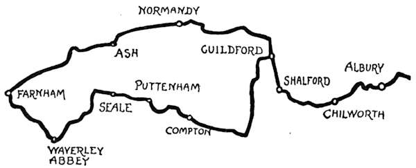
The readiest way to reach this district is by train to Redhill Junction; not that anyone would resort to that modern town—that bald and artless creation of railway[133] times—for any interest attaching to it, but its position makes it the key to a lovely stretch of country.
It is a charmingly happy circumstance that the southern face of the North Downs is followed for many miles—indeed, along the whole extent of that noble range, from Maidstone to Guildford and Farnham—by splendid roads, reasonably level, good, and direct. Those roads are traced in great measure in other pages of this book; let our route now lie from Redhill to Guildford.
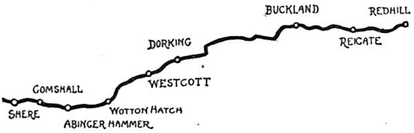
From the grim cluster of asylums, reformatories, and industrial schools at Redhill, one finds solace presently at Reigate, where houses of from sixteenth to late eighteenth century date abound. It is a town typical of the coaching age, to which it owed its eighteenth-century prosperity, and is built in characteristic red brick. Thence to Reigate Heath, on whose fine breezy expanse the curious may discover that prime curiosity, the “Windmill Church.” The old windmill thus converted into a church nearly a quarter of a century ago has a curious history. Now a chapel-of-ease to Reigate, under the style of the “Chapel of Holy Cross,” the first service was conducted on the 14th of September 1880, and has been[134] continued regularly on every Sunday since. The reason for this singular conversion was purely sentimental, the mill standing on the site of one of four ancient wayside oratories established for the use of pilgrims in days when this, the Pilgrims’ road from Southampton to Winchester and Canterbury, was largely travelled. One of the oratories became a prison, another suffered a transformation into a house attached to pleasure-grounds, and the Chapel of Holy Cross became a windmill. The original building, built for worship and used for milling, has long disappeared, and the present one, built as a mill and now used as a church, took its place. No attempt has been made to alter the character of the interior, whose oddly timbered circular space is simply fitted with altar, rush-bottomed chairs, and cocoa-nut matting, the great beams painted and here and there[135] stencilled with ecclesiastical designs. A rental of one shilling a year is paid for the use of the building to Lady Henry Somerset.
All the way from Reigate Heath to Buckland the North Downs are seen going in a procession to the right, beneath them nowadays springing up the country homes of a generation that loves scenery and can scarce understand why our grandfathers did not appreciate it. Thoroughly typical of the old time was Captain Morris, author of those town-loving lines—
His aspiration was denied him, for that eighteenth-century Anacreon died here at Brockham.
A solemn row of immemorial yews along the shoulders of the hills marks where the sandalled feet of pilgrims trod the Pilgrims’ Way. At Buckland a pond, a sign-post, a tall elm, and a church that looks like a barn, and a barn that looks like a church, make up a very pretty picture. Betchworth lies to the left hand, a mile onward, and possesses some stately old houses. To it succeeds Dorking.
Now Dorking, if you can conceive the conjunction, is at once aristocratic and popular. The proximity of that Cockney pleasance, Box Hill, is, of course, responsible for the one, and doubtless the overawing neighbourhood of Denbies and Deepdene accounts for the other. Dorking is celebrated for a mythical battle, for a breed of fowls, and for having been the home[136] of Tony Weller, who kept the “Markis o’ Granby” here. The name of the place was invariably spelt “Darking” a hundred years ago, even by literary folks, and country people still pronounce it in that way. It is a supremely cheerful town, with a very wide High Street.
Beyond the town the North Downs assume a wilder and more wooded aspect, where the modern but pretty hamlet of Westcott stands by the way, and the deep valley and heavy woodlands of Wotton open out delightfully upon the wayfarer. In the “little church of Wotton”—pronounced “Wootton”—lies John Evelyn, the Diarist and lover of trees, with many other Evelyns, and Wotton Park is just beyond, where many trees of[137] his planting yet flourish. Wotton Hatch, a lonely hamlet, overlooks the scene.
At Abinger Hammer and Gomshall, the trickling streams that have followed the valley are dammed[138] up into “hammer ponds,” where, “once upon a time,” iron was forged. But it is nearly two hundred years since the last furnace was blown out and the final hammer rang upon the ultimate anvil at Abinger. The days when iron-ore was dug and smelted in Kent, Sussex, and Surrey are long forgot.
Shiere succeeds to Gomshall in half a mile. Shiere and picturesqueness are synonymous and interchangeable terms; a place composed of a narrow street with queer cottages all tumbled together, as though for warmth, or as if land were scarce and dear.
Now, along a winding but excellent road, we come to Albury; the famous “Silent Pool” lying a little way off to the right, on a fork of the road leading to Newlands Corner. It was the egregious Martin Tupper who made the “Silent Pool” famous, but, truth to tell, it is but a pretty lakelet, whose real name was Sherbourne Pond. Its remarkably clear waters swarm with trout, whose extraordinary tameness is perhaps due to the many visitors, who feed them for the pleasure of seeing them spring out of the water for their food.
Coming to Albury, we enter upon the loveliest section of the whole journey. The long, scattered village, with picturesque old houses and modern cottages, built with rare good taste, leads to Albury Park, the Surrey home of the Duke of Northumberland. The partly ruined church in the park, with the modern Irvingite transept and the curiously domed roof of the central tower, is worth seeing and sketching, as also is the romantically situated St. Martha’s Chapel,[139] crowning one of the most conspicuous hills of the North Downs.
“St. Martha’s” Chapel may really have been “sancti martyris” originally, and dedicated to the “holy blisful martyr,” St. Thomas of Canterbury. It was built in the late twelfth century and was a chapel on the old Pilgrims’ Way. The corruption of the name into “St. Martha’s” can readily be understood.
On the way to Chilworth, Postford Ponds skirt the roadside and form a pretty grouping of water, woodlands, and old farmhouses, with St. Martha’s in the distance. Chilworth, whose not very accessible parish church St. Martha’s Chapel is, lies on the little stream[142] that forms this chain of ponds. But hear what old Cobbett says: “This valley, which seems to have been created by a bountiful Providence as one of the choicest retreats of man, which seems formed for a scene of innocence and happiness, has been, by ungrateful man, so perverted as to make it instrumental in effecting two of the most damnable of purposes; in carrying into execution two of the most damnable inventions that ever sprang from the mind of man under the influence of the Devil! namely, the making of gunpowder and of banknotes.” The banknotes are no longer made at Chilworth, but the manufacture of “villainous saltpetre” still proceeds.
To Chilworth succeeds the wide common of Shalford, leading close by the winding Wey to Guildford town. Here that little river, evidently not so little, ages ago, has cut a deep cleft through the immense rampart of the North Downs, so that the road to the town is quite deeply recessed in a valley, and flat.
Do you know Guildford, and yet not love it—its quaint High Street, the steepest, they say, in all England, built along the slope of this cleft made by the Wey; its churches, Abbot’s Hospital, and that quaintest and most curious of old buildings, the Guildhall?
They do not build Guildhalls of this kind to-day, the architects who are called in to design such things. Perhaps they are not allowed. Nor are they called Guildhalls. “Perish the name!” say in effect the upstart towns of this expansive era, and nothing will serve their turn but “Municipal Buildings.” We know[145] the Municipal Building order of architecture, and, sooth to say, we do not like it, whether it be named Classic or Victorian Renaissance, or labelled in any other style intended to cloak poverty of design and display a crazy patchwork of priggish eclecticism.
Compared with the frowning Keep of Guildford, the Guildhall is, of course, the merest parvenu, having been built in 1683, two years before Monmouth was dragged up to execution on Tower Hill after Sedgemoor fight. But the old Norman tower is four-square and stern, with only the picturesqueness that historic association can find; while the belfried turret of the Guildhall, and its boldly projecting clock, impending massively over the pavement of the High Street, are the pride of the eye and a delight to the artistic sense of all them that love their like.
Leaving Guildford’s picturesque High Street by one of the retiring thoroughfares branching from it on the north side, past that most sketchable of Guildhalls, we come, in something less than a mile, to a crossing of the Wey, and so to a hillside parting of the roads. Here we take the left-hand turning, to the secluded hamlet of Wood Street, whence roads and lanes in plenty—some straight, many devious—lead to that hamlet of “Normandy” where, in 1835, William Cobbett died. If it be true that William the First “loved the red deer like a father,” it may be said with at least equal appropriateness that Cobbett had as great a love for trees. Here, at oddly named Normandy, he oscillated between the equally congenial occupations of harrying a political opponent and of creating plantations, and many[146] of the saplings he planted with his own hands are now grown up to form the woodlands that clothe this countryside.
It was well for Cobbett’s peace of mind that Aldershot Camp, the signs of whose neighbourhood now begin to be evident on our way to Ash and Farnham, had not come into being while he still lived; for, soldier though he had been, and a characteristically independent and sturdy one, he grew to hate the military, and never missed an opportunity of venting his apocalyptic wrath upon the Army. Did he live now, he would find plenty opportunities here, and around his birthplace at Farnham; for the presence of the redcoats—and the blue, the grey, the green, and the khaki coats too—is very much in evidence, alike on the road and on the surface of the road, cruelly cut up by ammunition waggons and guns.
And so through crooked-streeted Ash, with its public-houses dedicated to military commanders distinguished and heroic, or merely Royal, and the stores and the shops showing the unromantic and domestic side of the soldier’s life, which, and not glory, is nearly the whole of Tommy Atkins’s existence, varied with dusty and inglorious drills in gritty barrack-yards and field-days in the Sahara-like Long Valley.
The neighbourhood of Aldershot and its camp is highly interesting to those who take an interest in soldiering (and most feel an attraction that way), but it is utterly destructive of the picturesque.
A mile beyond Ash we cross insensibly from Surrey into Hampshire, and in another mile back again, owing,[147] not to any vagary in the road, an eminently and respectably straight highway, but to the serpentine and elusive character of the county boundary. And thus—through unsponsored new hamlets, the sporadic but unacknowledged offshoots of Aldershot, sprawling yonder across the sandy wastes—to the tail of the Hog’s Back, whose bristles are the larches and firs of this heathy country.
The right-hand way, at the junction of the roads, leads into Farnham, “rather better,” as the country people say, than a mile off. It is conceivable that, at the end of a long day, this might appear to be “rather worse.” Farnham remains itself still, despite its near military neighbour, a quietly prosperous old town, with a long east to west street, and a short and broad one in the middle of the town, running north to the Castle, and beyond it to a very welter of firs and sands. Farnham Castle yet gives its tone to Farnham, for it is still—as it has been for nearly eight hundred years—the residence of the Bishops of Winchester; although, to be sure, the Bishops cut a very small figure nowadays beside that soldier-statesman-churchman, Henry of Blois, who originally built the fortress. Farnham is appropriately sedate and decorous. The ruined Keep is here, in its pretty garden shaded by ancient cedars, and there are a few vestiges of antiquity within the great range of buildings; but very few, for the restorations by Bishop Morley in the late seventeenth century, and those of recent years, have preserved the place as a residence at the expense of archæology. Even so, the picture made by the long and varied front looking down upon[148] Farnham and seeming to block the street, is very grand.
Away on the other side of the main street is the church; the churchyard a place of pilgrimage for the sake of Cobbett, that ardent reformer who frothed at the mouth with political denunciations for forty years, and now lies beneath a closely railed-in altar-tomb on the north side. A more cheerful resort is his birthplace, a very old gabled house, now the “Jolly Farmer Inn,” facing a bridge across the Wey, in Abbey Street.
He was born in 1762; and almost alone, perhaps, among the places with which he was familiar, the house is unchanged.
It is past the railway station that one leaves Farnham for Waverley Abbey. Signs of the hop-growing industry of which this town is a centre are evident to sight and smell in early days of autumn, for then are rumbling carts laden with fat sacks (“pockets,” they call them) of fragrant hops met with at every turn, and the scent of them produces the most furious appetite.
After passing the level crossing take the left-hand road, which leads to Waverley in under two miles, with Moor Park on the left, once the seat of Sir William Temple, the patron of Swift, the “eccentric, uncouth, disagreeable young Irishman” who was that retired statesman’s secretary. How little dignified was the post above that of a lackey may be judged from the flirtation Swift began in the servants’ hall with Lady Giffard’s waiting-maid, a flirtation “which,” says Macaulay, “was to be as widely famed as the passion of Petrarch or of Abelard.” The waiting-maid was[149] “Stella,” and the poor secretary became that terrible genius, Dean Swift.
The park, rugged and impressive, with sombre conifers, is traversed by the Wey. Under a sundial before the house is buried the heart of Sir William Temple, the former owner of the place, at his own request, in a silver box; and at the other end of this domain is that celebrated cavern, “Mother Ludlam’s Hole,” a cave containing a spring, now railed off from vulgar profanation by an ornamental iron railing. It was here that the brethren of Waverley Abbey, it is thought, found the source of their drinking water. “Mother Ludlam” was a chimerical personage of the Robin Goodfellow type, who, according to the superstitious peasantry, supplied suppliants with any article they might require, on their repairing to her cave at the stroke of midnight, turning round thrice, and three times repeating the request; promising to return the borrowed article in two days. The next morning the object wished for would be found outside the mouth of the cavern. This beneficent personage at last lent a cauldron to some ill-principled person or another who forgot to return it, and since then the charm has ceased to work. The proof of this story lies in the fact that the cauldron is to be seen to this day, preserved in the vestry of Frensham Church; a fact, of course, conclusive!
A pretty, rose-entwined cottage by the entrance to Moor Park still goes by the name of “Stella’s,” and opposite, on the right hand of the road, is the lodge gate leading to the grounds of Waverley Abbey, whose[150] scanty ruins stand in a flat meadow beside the river Wey, within sight of dark, pine-clad Crooksbury Hill. The river describes three parts of a circle around these crumbling walls, the poor relics of the first Cistercian Abbey in England. There is, indeed, more left of the Abbey underground than above, for the crypt remains perfect.
Perhaps the most interesting thing about this spot is intangible, and lies in the fact that the title of the Waverley novels derives from these ruined walls, Scott having read those still-existing records of this religious brotherhood,—the “Annales Waverlienses,”—and having been impressed with the musical sound of the name.
Leaving the grounds of Waverley Abbey, the dark, pine-clad mass of Crooksbury Hill lies ahead, and must be climbed to reach Seale and the neighbouring villages that lie down below its northern shoulder, and under the lee of that ten miles’ stretch of the North Downs, from Guildford to Farnham, known as the Hog’s Back. Seale is a sheltered, secluded nook, shut in by pines. Two miles distant from it, following under the ridge towards Guildford, along an unfrequented road, comes Puttenham, owing everything, in a picturesque sense, to its solemn background of hills and woodlands. Without that scenic backing it would be nothing remarkable.
From here we bend in a south-easterly direction, away from the near companionship of the hills and woods, towards Compton, a village remarkable for its little Norman and Early English church, almost hidden[151] from the stranger’s notice by the trees that densely surround it and its unassuming shingled spire. Notice the odd dormer windows in the roof, like those of a dwelling-house. But the great peculiarity here is that the chancel is in two storeys, a most remarkable and unusual device. The exterior of the chancel is commonplace, not to say ugly, and was rebuilt in 1860, when traces of an outside staircase to the upper storey of the chancel were destroyed; but the interior remains particularly beautiful and interesting. The chancel is divided from the nave by a round-headed Norman arch, ornamented with dog-tooth moulding, and immediately over the altar rises another of exactly the same type, but of only half its height. It is this, with its groined ceiling, dividing the eastern end of the building into two[152] floors, which makes the chancel two-storeyed. This upper chamber is conjectured to have served the double purpose of rood-loft and chantry chapel; but beyond conjecture no one has ever been able to go, for the history of the church is silent on this point.
From Compton to the entrance of Loseley Park is a mile. The gates will be seen on the left, and admit to a tree-shaded park, which might almost, from its solitude and wildness, have been the original of the legend of the Sleeping Beauty. Such is Loseley, and such the grey stone Early Elizabethan house, standing ghostlike at the end of the avenue. Loseley was begun by Sir William More in 1515, and never completed after the architect’s full design. Still, it is a large and stately mansion, and contains treasures of stained glass and carvings, of armour and relics, that make it notable indeed. The “Loseley MSS.” preserved here, the correspondence during nearly five hundred years of England’s most famous statesmen and history-makers, is among the best of such collections.
A ramble through the park brings the traveller to a road running right and left. The turning to the right helps us toward the completion of our circle, and leads past another old mansion, Brabœuf House, to the old Portsmouth road, by St. Catherine’s Hill. Here our way lies downhill, to the left, into Guildford; but, before concluding, let us ascend the easy path to the hilltop, and look down to where that elusive companion of the greater part of this tour, the river Wey, runs far below, past picturesque St. Catherine’s Ferry. It is a romantic spot, this hollow on the hillside, through[153] which runs the old highway to Portsmouth. Many years ago some long-dissolved Highway Trust lowered the road through the crest of the hill for the sake of the horses, and “St. Catherine’s Hollow,” as it is known, has since become the spot for a painter. Turner, indeed, painted it, but he was more concerned to show the ruined Chapel of St. Catherine beyond than to linger over the exquisite wildness and ruggedness of these overhanging banks. They are of the yellowest sand and softest sandstone, and here and there they form cliffs not so diminutive but that the sand martins have dug their tunnelled homes in them, and have found safety from attack. The face of these clifflets is as full of these nest-holes as the white cliffs of Dover are of batteries and casemates, and if you are content to wait quietly and to watch patiently, the lively inhabitants of them will be observed coming and going. Other tunnels there are here, bigger and less tidy. These are the burrows of the rabbits. There is a greater tunnel still down below—that of the South-Western Railway, between Guildford and Godalming, which collapsed suddenly one midnight in 1895, burying horses and carriages from the stables of a villa on this hilltop. Animals and carriages alike fell through into the depths beneath and were destroyed. The line was blocked for a week, and during that period this road was strangely peopled with omnibuses imported from London to convey passengers between Guildford Station and the temporary station of “St. Catherine’s,” built in a meadow beside the line, at the other end of the tunnel. The long-since ruined chapel of St. Catherine narrowly[154] escaped complete demolition on that occasion; but it still stands, roofless and desecrated, as it has done for centuries past. Perhaps, in these days of restorations and revivals, it will be brought back to a decent condition of repair, even as was the hilltop chapel of St. Martha’s near by. With this speculation we will make for Guildford, and the conclusion of this lengthy run.
This run of thirty-seven or thirty-eight miles commences at Esher and Claremont Station, situated within a hundred yards or so of the old Portsmouth road that passes through Esher village. Leaving the station behind, you turn to the right at the high road, and so come up a gentle, mile-long incline to Esher, where, instead of wheeling up the long street, the first turning to the right is taken for Hersham. This leads to a fine gravel road passing between Esher new church and the village green, with the lodge gates of Esher Place showing prominently away to the right. In the grounds, in a low-lying meadow by the river Mole, stands the picturesque battlemented Gatehouse, all that is left of the once proud, but unhealthy, palace of Cardinal Wolsey, built long before Hampton Court. When the Cardinal lost favour with Henry the Eighth, that autocratic monarch commanded him to retire to this damp and objectionable retreat. Some of the fallen statesman’s letters are still in existence, written from this spot, complaining of the “moist and corrupt” air.
It is a delightful coast down for some distance towards Hersham, along a quite unspoiled road, crossing a bridge that spans the Mole. Hersham, a hamlet where four roads meet, is in summer a by no means[156] unpleasing place, but the contemplative wayfarer, thinking of its fortunes all round the calendar, wonders how the inhabitants of this, and places similarly remote, can exist through the dull winter’s days without feeling buried alive.
Keeping to the right through Hersham, the way to Weybridge lies along a road bordering Burwood Park, and shaded by solemn pines, coming at length up a slight rise to a heathy expanse just outside Walton-on-Thames railway station. Keep straight on, with the railway on the right hand, for a mile, and then turn right along an excellent straight road for another mile, leading direct down into Weybridge.
That once pleasant village is rapidly being spoiled. Its healthy surrounding of heaths and pine-woods, and its position on the Wey and near the Thames, together with the fact of being situated on the South-Western main line, have caused the building of innumerable villas and the transformation of the quiet, old-fashioned village street into a suburban thoroughfare. The small green is still left, and on it a memorial column to the Duchess of York, who died more than eighty years ago at Oatlands Park, close by. It is surmounted by a pyramidal stone supporting a ducal coronet. If it were[157] not for the very curious history that belongs to it, the column would not be worth much attention.
How few, however, know that history, or that it once stood in the centre of the street at Seven Dials, near Drury Lane! It was the pillar, in fact, that supported the seven-sided sundial once presenting a face to each of the seven radiating streets which centred at that spot. It was originally erected there about 1694, and stood until July 1773, when it was thrown down by a party of adventurers who, possessed by the singular idea that there was treasure buried at the base, excavated it, and found—nothing. The stones then occupied a neglected corner in a London stonemason’s yard for many years, until, indeed, they were purchased in 1822 by the inhabitants of Weybridge for the present purpose. The large block of stone originally supporting the dials may be seen embedded in the pathway near the “Ship Inn,” where it was long used as a mounting-block for horsemen; but it seems, curiously enough, to be only six-sided. The holes where the gnomons of the dials were fixed are still visible in the stone.
Oatlands Park, where the Duchess of York once lived, has long been converted into a riverside hotel, in whose grounds the gravestones of her pet dogs, to the number of sixty or so, are still to be seen. There lie “Pepper,” “Faithful Queenie,” “Topsy” and “Dinah,” and many another. “Julia” has the most elaborate epitaph—
Close by these memorials is still to be seen the two-storeyed grotto built by a Duke of Newcastle at a cost, it is said, of £40,000. It engrossed the labour of two men—father and son—for some years, and is decorated with shells, spars, marbles, and stalactites, said to be of rare varieties, but not a little shabby and dingy nowadays.
From Weybridge we make for Chertsey, crossing the Wey, and running beside the now beautiful canal, and then crossing the equally beautiful Bourne. Soon after passing this stream there is a choice of roads. Do not turn to the left to Addlestone, but keep straight on, past Addlestone Moor, where turn to the right, and then the first to the left. This road leads direct to Chertsey, where it crosses the main street of that place at right angles, close to the railway station.
Chertsey is a quite commonplace little town, with[159] streets of that would-be smartness that succeeds only in being pretentiously mean; and church and Town Hall alike were erected in that most tasteless period which stretched between the beginning and the middle of last century. Chertsey Abbey once stood behind the present church, but the site is now a market garden, and the most interesting relics of it are to be seen in the Architectural Museum at Westminster in the shape of a set of tiles illustrating the legend of King Arthur. There is a house in Guildford Street, however, that should arrest the attention of the literary pilgrim. It is the quaint, Dutch-like red brick mansion where Cowley the poet lived—now named “Cowley House,” partly for that hero-worshipping reason, and partly because since its fine old porch, which once straddled across the pavement, has been destroyed, its old title of “Porch House” has ceased to be descriptive.
At one end of the town is Chertsey Bridge, but the Thames here is at its tamest and the meads on either side at their flattest—admirable, possibly, from the point of view of the cows that graze in them, but not from that of the sight-seer.
Having thus shown our contempt of Chertsey, let us pursue the uneven tenor of our way, returning whence we came until Pyrcroft Road, at the end of the town, is seen, turning off to the right. Having turned into this road, take neither the first to the left nor the one to the right, but keep ahead, on the road past the “Carpenters’ Arms,” and then, having passed that inn, take the left-hand at a fork in the road. This immediately brings the traveller to an old-fashioned[160] lane, bordered on the left by a tall red brick wall, supported at regular intervals by a long series of buttresses, which now appear to be themselves in need of buttressing. Over this decrepit wall can be glimpsed the upper part of the old mansion of Pyrcroft House, which has long enjoyed the local reputation of having served Dickens as a model for the house at Chertsey burgled by Bill Sikes. Sikes and his companions,[161] according to the story, hurried through the main street of Chertsey, and “cleared the town as the church bell struck two. Quickening their pace, they turned up a road upon the left hand. After walking about a quarter of a mile they stopped before a detached house surrounded by a wall, to the top of which Toby Crackit, scarcely pausing to take breath, climbed in a twinkling.” The wall is a particularly high one, and the scaling of it does credit to Mr. Toby Crackit’s agility.
Past this literary landmark the road immediately begins to mount St. Ann’s Hill, passing an inn on the right with the odd sign of the “Golden Grove.” Notice the great tree in front of it, and the summer-house built high up in its branches, and approached by a flight of stairs.
Now comes a rise so steep as to be scarce worth riding. Keep straight on, disregarding two turnings to the left. Here is the summit of St. Ann’s Hill, a delightful open woodland. From this point commences the descent, by a steep lane with loose gravel at all seasons of the year. The cautious cyclist will walk this, down to the junction with the road to Thorpe, where we turn left, and, crossing the Bourne where a pretty mill stands, continue by a winding, but level, gravelled road to the hamlet of Thorpe, pretty and secluded. Continuing through this, we turn to the left for Virginia Water, three miles ahead, passing the railway station of the same name half-way. The place is heralded for some distance down the road by the handsome and imposing buildings of the Holloway Sanatorium. With the exception of that cheery-looking red brick[162] institution, the scanty modern settlement called Virginia Water (although the lake so-called is a mile and a half away) is a singularly depressing place—a wilderness of railway bridges, embankments, and curves, well calculated to undo all the good the air, the pine-woods, and the sandy soil of this district are said to effect. A straight, flat sandy road leads hence, and reaches the real Virginia Water opposite the “Wheatsheaf,” a well-known and very ugly, inn, frequented by picnic parties, and the stopping-place of the summer coach from town.
A gate in the wooden fence beside the inn opens immediately to the lake. The boys who hang about this gate and sell green apples, of which the very sight is almost sufficient to induce stomach-ache, tell the unwary that cycles are not allowed within, thereby deceiving many, and earning innumerable twopences for “minding” the machines. It is well to disregard what they have to say, and to manœuvre the cycle through the gate. Here we are within the bounds of Windsor Great Park. Directly in front stretches the beautiful sheet of water, said, on insufficient authority, to be “the largest artificial lake in England.” It is, however, very large: one and a half miles long, and with two arms, each half a mile in length. It was formed considerably over a hundred years ago by intercepting the waters of the Bourne, a little stream rising near Ascot and falling into the Thames at Chertsey, and by damming them in a natural hollow. The general idea was originated by the Duke of Cumberland, and the design was that of Paul Sandby,[163] one of our early water-colourists. The name given to the lake derives from the Duke of Cumberland being at the time Governor of Virginia.
Surrounded on every side by dense woods of solemn pines, the place is very impressive. Turning to the left, and following the grassy shore for a little way, turn down a road bearing to the left again, away from the water. This leads down to the waterfall, down which the waters of the Bourne splash on their way to liberty and the Thames. The fall is made of great masses of rock piled up ingeniously to resemble a natural ravine. Shaded by trees and fringed by rushes, the scene is really very pretty. The rough stone bridge whence you view it, formed of immense slabs of rock, is not unlike those early British bridges found on Dartmoor—only more elaborate. If only this were not a modern imitation, how professional antiquaries would rave about it, to be sure!
Crossing this, and coming up a rise, one reaches the famous “ruins” by continuing ahead, by the shores of the lake. They stand on a broad lawn stretching away back from the water, and were built to resemble a ruined temple. They are thus sham ruins, and, knowing that, the visitor perversely refuses to receive the romantic thrill otherwise appropriate; which shows that picturesqueness is a matter more of sentiment than of form. As a matter of fact, the columns themselves are genuine antiques, from Corinth and from Tunis, the spoils of ruined temples of those sunny climes, brought here to moulder in the damp and rigours of a northern climate. The “ruins” themselves are growing ruinous, for two[164] of the most picturesque of the Corinthian columns, with their architrave, have recently fallen, and lie, a confused heap, on the grass amid the other prostrate stones carefully arranged in disorder over a century since.
Leaving Virginia Water by the way we came, and turning to the right, as though for Bagshot, a right-hand road is immediately seen, with a finger-post directing to Ascot and Bracknell. This is a fine undulating stretch of sandy road following the palings of Windsor Park as far as the hamlet of Black Nest, where it bears to the left and goes direct, past Sunninghill, to Ascot, Bullbrook, and Bracknell. Nothing is seen of Sunninghill save the post-office on the left hand. A modern inn, also on the left, bearing the sign of “The Wells,” will be noticed.[165] It derives its name from a chalybeate spring in the garden.
Ascot, to which we now come, up a rise, is a depressing backwoods-settlement kind of a place, with no history except that which belongs to a hundred years of horse-racing. The village (for such, presumably, it should be called) is singular in consisting of practically a one-sided street. This is made up of a row of shops and villas and the back of the long range of buildings belonging to the racecourse, a white clock-tower overlooking all. The whole place is built on what was once the desolate heath of Ascot—and looks it! “Royal Ascot” they call it in the racing season, and it may look the part with the fashionable and gaily-dressed crowds then assembled, but few places can possibly appear so forlorn at any other time.
The cyclist welcomes the fine long descent that enables him to hurry away. Indeed, the splendid coasts one may get on the way from Black Nest to Bracknell form practically the only good features of these six miles; and in fine weather they are exhilarating. But when slithering through the mud that succeeds a showery day, with, perhaps, the hoarse-tongued bell of Ascot Priory sounding like a funeral knell in one’s ears, this bit of country weighs heavily on one’s spirits.
Bullbrook, which lies in a hollow and is just a modern hamlet of Bracknell, is succeeded by a sharp rise to Bracknell itself, a little town of no particular interest. Turn down here to the left, past the (modern) church. Coming to Bracknell Station, turn to the left across the bridge that spans the railway, and then the[166] second to the right, if you wish to look at the (also modern) church of Easthampstead. Returning from this, bear to the right, then first to the left, and then to the right again, along the palings of South Hill Park, and you are on the straight four-mile stretch to Bagshot, through the densest pine-woods all the way, with grass rides now and again on either side, giving views of infinities of pines. It is a lonely road, aromatic with the odours of these woodlands, and reverberant with the scurrying of the partridges or the hollow ejaculations of the pheasants. Perhaps a hare or rabbit scuttles across the road, or you may meet a velveteen-coated gamekeeper, his gun under his arm; but never another cyclist. It is a splendid road for speed, going in this direction, and the four miles may be done with ease in a quarter of an hour. Nearing the Bagshot end, the gates of the Duke of Connaught’s seat, Bagshot Park, are passed, and turning to the right, over the railway bridge, Bagshot village is reached, past an old white-faced inn—the “Cricketers.”
Bagshot is not the busy place it was in the old coaching days, when, standing as it does on the old road to Exeter, it did a big trade with passing travellers. Its old inns are mostly gone, with the stories that belonged to them; but the “King’s Arms” remains, and the tale of how the “Golden Farmer” was brought a captive to its door one night. The person who went by that name lived on the hill outside Bagshot, and was known for always paying his debts in gold, instead of by bills or cheques. Contemporary with him was a terrible highwayman who never took anything but[167] gold coin off the coach-passengers whom he plundered on Bagshot Heath, rejecting jewellery or notes. One night a more than usually courageous traveller shot him when his back was turned, and when the wounded highwayman was brought here, he was discovered to be the highly respectable farmer who paid only in specie. He was eventually tried, found guilty, hanged, and gibbeted on his own threshold, on the “Jolly Farmer” hill, on the way to Yorktown.
A winding lane leads out of the south side of Bagshot’s one street to Windlesham, a mile and a half distant, falling to the left across the Windle brook. The village is mildly pretty, the rebuilt church wildly grotesque. Away to the right, in the distance, rise the bleak and barren Chobham Ridges, and three miles and a half onward, away from the Ridges, is Chobham village, the roads to it duly sign-posted and the way alternating with patches of heath and pine trees and with cultivated fields, won with much toil and expense from the hungry Bagshot sands. To the north of Chobham village lies the bleak and barren common, and the hamlet curiously named Up Down. On the common took place the elaborate military picnic, dignified by the name of “manœuvres,” over forty years ago, at a time when the military system of the country was at its lowest ebb of inefficiency.
Chobham village is old-world, and being quite far removed from any railway station, and rather inaccessible, is consequently unspoiled. The Bourne stream runs picturesquely down one side of the village street in a deep and narrow channel, spanned by footbridges[168] and bordered by a row of pollarded limes. Quaint old brick and half-timbered houses are a feature of the place. The church, with sturdy stone tower and leaden spire, is unusually rugged and weather-beaten, and is roofed with stone slabs instead of with the more usual tiles; altogether a homely and cosy village, that seems to have no sort of commerce with the outer world, and would appear to be rather proud of the fact.
Turning back from the village, and then turning to the right, four miles, mostly of ghastly heath, that might fitly have been the scene where the three witches met Macbeth, interpose between this and the hamlet of Ottershaw, where there are cross-roads, a chapel built by Sir Gilbert Scott, and Ottershaw Park, in which, secluded from the road and adjoining the mansion, is a kitchen built in the shape of a church by a former proprietor, who must have had the greatest reverence for his stomach. Turning to the left after passing the cross-roads, we reach Chertsey, past the well-wooded park of Botleys, and come again into that uninteresting town over the level crossing at the railway station.
The circular tour of twenty-eight miles here mapped out does not take us very far afield. It follows the outer fringe of the southern suburbs, and is planned the more especially to afford the Londoner some idea of what the country adjoining the Surrey hills—soon, alas! to be swallowed up by the ever-extending bricks and mortar—is like. It may also prove valuable to those who are seeking a suitable home just beyond London’s smoke.
Starting from Kingston we make for Norbiton Church, and, leaving it to the right, take the next turning to the right beyond. This is Coombe Lane, and though not so direct as the turning just before Norbiton Church, is infinitely preferable, leading gently upwards along a lane with farms and a few scattered houses, and, passing under a railway bridge, coming, in two miles from Kingston Station, to the hamlet of Coombe. Turn here, when up the rise, to the right, where a sign-post marks the way to Malden. A fine coast down leads in a mile to Coombe and Malden Station and the commonplace modern settlement of New Malden.
Now straight ahead, past this spot, turning to the[170] right again at a fork of the roads where a country inn, called the “Plough,” stands and points to Ewell. It is very pretty and rural here. Just after turning down this road we come to Old Malden, with its quaint red brick church on the right hand. Here a very beautiful lane, shaded by a fine avenue, leads on a down gradient for a mile and a quarter, with pretty views on the right to the valley of the not very charmingly named Hogsmill River, and with dense coppices and undergrowth fringing the left. This is the border of Worcester Park. Where this lane ends and joins a broad highway, running to right and left, turn to the left, coming in two miles to Ewell, where the Hogsmill River expands into a broad pond beside the village street, outside the gates of a beautiful park.
Notice the curious fishing temple built into the park wall, overhanging the pond. On the left-hand road, leading to London, is the modern parish church, with the romantically ivied tower of the old building still standing beside it. There are many and puzzling roads at Ewell, but, fortunately, there are many people about of whom to ask the way, and sign-posts are not wanting. If it were a lonely place they would be sought in vain.[171] Take the road to Cheam, resisting all temptations to turn to the right. This brings us to Nonsuch Park, bordering the road on the left hand, and then into the old-world village of Cheam, where the new order of things is only just beginning to make itself felt. There are still numerous old boarded cottages here. The old church, like that of Ewell, has been pulled down, but the chancel still remains, near the new one, and one can look through a grating in the door and get a glimpse at the interior and its monuments well enough.
A mile and a quarter brings us to Sutton, whose High Street we cross just where the historic “Cock” coaching inn stood until pulled down a few years ago. Sutton is, perhaps, although very populous, one of the prettiest suburbs we have. After crossing the High Street the road presently goes steeply down to Carshalton. It is not too steep to coast, only be sure that no tradesmen’s light carts are in the way. Carshalton, with its broad ponds, fed by the Wandle, beside the road, is altogether delightful. Swans majestically sail the broad, if shallow, waters; weeping willows dip their long branches in the stream, and picturesquely wooded islands are dotted here and there. The small boys of Carshalton (“K’shalton,” they call it) are never tired of fishing here from the railings beside the dusty road, and not a few children of a larger growth may be seen casting a line. Now and again they bring out an old umbrella or a worn-out boot discarded by a passing tramp, but the trout, angled for by the thousand fishermen of the place, are coy; and even the usually headstrong “tiddler,” generally caught by the infantile piece[172] of cotton, declines to be caught and immured in the pickle-bottle brought forth for him.
A circular iron railing in the roadway, between the church and the water, encloses a well called “Anne Boleyn’s,” from the tradition that the water first burst forth when her horse’s hoof sank in the then marshy ground.
Having refreshed yourself with a sight of these pleasant waters, continue to Beddington, whose ancient church, on a by-road to the left, has a wonderful store of ancient brasses. Unhappily, the church is not open for prayer, or for antiquaries, and search must be made for the keys. The road now rises, with craggy banks of sand on either side, and then comes to a modern and most elaborate inn, the “Plough.” The road to the right, called Plough Lane, is our route. It leads by pleasant ways, free from houses, to Purley, crossing Russell Hill, whence, beside a field of waving oats, the eye ranges across to Croydon and on to Sydenham Hill, where the Crystal Palace glitters in the sunshine in a manner fully befitting its name.
Down goes the road in a long descent to Purley, where we cross the old Brighton road, and, passing beneath the railway, gently ascend the fine highway to Riddlesdown. Here we are amid the Surrey hills, which spread out in a lovely panorama of hills and valleys to the right. Riddlesdown is a place for picnickers and school treats. Continuing past it, we come to the hamlet of Whyteleafe, and under a railway bridge up a steep lane to the left, which speedily becomes too steep to ride. Half a mile’s walk, and you can mount again.
Inquiring the way to Upper Warlingham along the[175] puzzling by-lanes, that remote village, on its elevated tableland, is reached in less than a mile. When there, carefully ascertain the way to Fickles Hole, situated three miles and a half away, past the tiny village of Chelsham, by rather intricate by-lanes. This, although not so far from London, is an exceedingly lonely country, whose solitary lanes run through thick woods. Very beautiful they are, too.
Coming downhill past Chelsham Church on the left, continue bearing round to the left, and the small hamlet of Fickles Hole, or Fairchild, as it is sometimes called, comes in view, with the “White Bear Inn,” in whose garden stands the great white wooden effigy that used once to adorn the “White Bear,” Piccadilly, a coaching inn standing where the Criterion Restaurant now towers aloft. For many years it stood in the shrubbery of Fairchild House, and frightened the tramps. It once more represents the bruin (or brewing) interest. When strange dogs catch sight of the effigy they generally run away terrified.
Leaving Fickles Hole for Croydon, turn to the left,[176] and by a long downhill lane over Addington Downs to Coombe (not to be confounded with the Kingston Coombe), taking the second turning to the left at a point two and a half miles away, where a sign-post clearly directs to Croydon. Three miles more, by a beautiful road, and we are in the heart of Croydon, whence train home.
This route is the way by which Surbiton, Kingston, and Richmond cyclists reach the Brighton road. We will pick up the route at Ewell, which may be made a starting-point.
It is a long, long ascent toward the ridge of the North Downs, all the way from Ewell to Banstead Heath; not necessarily a tiring one unless a south wind is blowing, but when it blows great guns from that quarter, then—why, then go home and wait until it comes from some other direction! Fortunately, the road-surface is excellent, and, coming in the reverse direction, there is not, probably, such another lengthy and uninterrupted a coast-down in the neighbourhood of London.
Three miles from Ewell, Nork Park, distinguished from far away by its dense hillside woods, is passed on the right, and we come to the beginnings of Burgh Heath. Here, at a turning to the left, there stands, at some distance from the road, an ancient tumulus surrounded by fir trees for the wonderment of those who care to go and seek it. Burgh Heath is a portion of the wild, unenclosed uplands including Banstead Downs, Walton Downs, Epsom Downs, and Walton[178] Heath. The cyclist may notice in passing a number of ramshackle wooden shanties in the midst of the heath. These are the property of the descendants of those squatters who placed them here so long ago that they have obtained a prescriptive right, and cannot be evicted.
At the turning to Tadworth, at a point known locally as “Wilderness Bottom,” keep to the left, unless, indeed, you desire to explore the village, which was notable a little while since as being the country retreat of Lord Russell, the Lord Chief Justice, who resided at Tadworth Court.
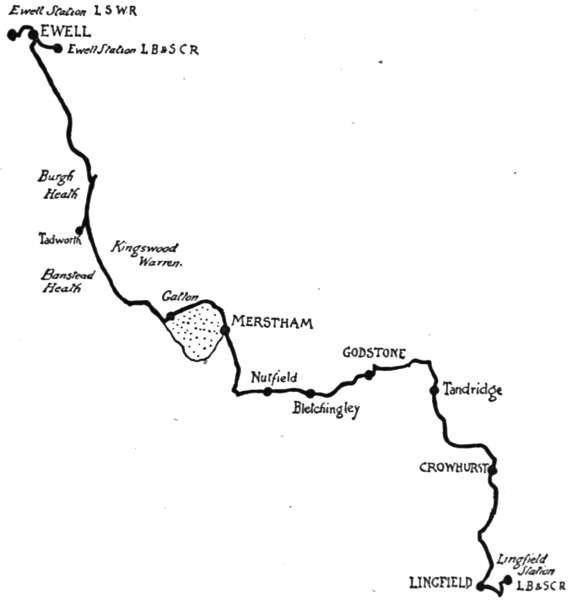
Passing through Kingswood, we come up and down hill, and finally down, to Gatton, against the lodge gates of Gatton Park, once the seat of Lord Monson, but now the property of Mr. Colman, of the famous mustard firm. There is a public footpath through this very beautiful park, and the house is shown from 2 p.m. to 4. Cycles, however, must be left within the lodge gates. But although the pictures are very fine, and the Marble Hall worth seeing, the average visitor will doubtless be much more interested in the so-called “Town Hall” of Gatton, a kind of miniature summer-house in the shape of a classic temple, situated in midst of a lovely clump of scented limes in front of the house. It should be said that Gatton is not, and never was, a village. It is just a big park, with a manorial church adjoining the house. But Gatton was a parliamentary borough, and returned two members to Parliament, from the reign of Henry the Sixth, until it was disfranchised by the first Reform Act in 1832. With the[179] sole exception of Old Sarum it was the rottenest of “rotten boroughs,” and contained not a single elector. It was a “pocket borough,” that went with the Park as a property. Cobbett, who was nothing if not downright and brutally frank, says, “You pass Gatton, which is a very rascally spot of earth.” So it was, for the political power wielded by its owner was almost always exercised in the interest of bribery and corruption, and Lord Monson, who purchased the property in 1830 for £100,000, did so with the idea of securing a splendid investment, to return him about a hundred per cent.; but in less than two years Reform had destroyed its value. So frankly corrupt were those times that we[180] can only wonder why Lord Monson did not cynically prefer a claim for compensation. The “Town Hall,” therefore, is merely a satirical kind of freak, while the inscription of “Vox populi suprema lex,” among others inscribed on the pedestal of the urn that forms the sole ornament of the building, is an example of a former owner’s sardonic humour.
Rather than face the dangerous descent of Reigate Hill, we will, on returning to the Park gates, turn to the right, and make for Merstham, a pretty old-world village on the main Brighton road; bearing continually to the right until opposite the “Feathers,” after which, take the road that dips down to the left, to Nutfield. This goes in winding fashion for two miles, and then comes up a short, sharp rise to the church, standing prominently on a high bank above the left-hand side of the road, and containing a stained-glass window designed by Burne Jones. The apoplectic hue of the figures’ faces is exceedingly unpleasing.
Past the church, where a road runs right and left, turn left, and so through the few houses of Nutfield to Bletchingley, down whose hillside street we come with caution. The old church has an odd tower, and[181] contains a tomb with some pretty Elizabethan verses to Sir Thomas Cadwallader. Note the huge and bombastical monument to a former Lord Mayor of London, occupying the whole of the east end of the south aisle. The effigies of the worthy knight and his lady seem to represent them singing an operatic duet, while attendant marble cherubs, with swollen faces suggestive of toothache, shed stony tears.
In less than two miles we reach Godstone, and, passing its green and village pond, and the “White Hart,” its famous old hostelry, turn sharply to the left, and then take the first broad road to the right.[182] This is the Oxted road; but instead of proceeding quite so far as that village, we will, in a mile and a half, turn to the right for Tandridge, a hamlet with an ancient church, in whose churchyard notice the monument to the wife of Sir Gilbert Scott, the architect who restored (and helped to spoil) so many of our cathedrals. See, also, the ancient oak internal framing of the tower, and the tragical tombstone to Thomas Todman, 1781, aged thirty-one years, at the side of the south porch. Thomas Todman was a smuggler, who was shot dead by a Custom House officer. The inscription is curious. Here it is, oddities of spelling and punctuation preserved:—
Downhill from Tandridge and into the Weald, turning to the left by the railway, and following it for a mile. Then bear to the right, and enter the pretty village of Crowhurst, with its interesting church showing to the right of the road. One of the curios it contains is an elaborate cast-iron tomb-“stone,” on the chancel floor, with figures and raised inscription, dated 1591—a relic of the days when iron was mined and smelted in this Wealden district. This is one of several memorials connected with the Gaynesford family, once Lords of the Manor here, and so remaining for over three hundred and sixty years. Their old manor-house,[183] now a farmhouse, and a very picturesque and interesting one, called Crowhurst Place, is only a mile distant.
It will be noticed that many of the letters on the iron slab are either cast in reverse or upside down. Mrs. “Ane Forstr,” it can readily be seen, was exceedingly proud of her descent. A very odd fact is that exact replicas of this cast-iron slab are found distributed throughout Surrey, and even in some places in Sussex; not always in the most decorous positions. There is, for example, one used as a fire-back in the kitchen of a farm adjoining Crowhurst Church itself, and others have been noted at Ewhurst, Godstone, and Horley, where one formed part of the flooring of a baker’s oven, and occasionally produced breakfast-table terrors in the neighbourhood when the domestic loaf of bread was found to be impressed with “Her lieth,” “deceased,” and other portions of the design, including the shrouded body in the centre. The simple explanation of this odd distribution is that the iron-founding firm must have found the mould ready to their hands when cheap fire-backs were wanted, and so[184] cast them in this guise. It mattered little when few people could read.
The great yew tree in Crowhurst churchyard is among the very largest in the land, measuring thirty-two feet nine inches round its immense trunk at a height of five feet from the ground. It is thought to be about twelve hundred years old, and although it was greatly mutilated over eighty years ago by some local vandals, who thought how fine a thing it would be to scoop out the interior and to fix table and benches inside, for the accommodation of some twenty[185] persons, the tree still flourishes. When this wanton outrage was performed, an ancient cannon-ball was discovered in the very heart of the trunk.
Three miles more of country lanes, and our journey ends at Lingfield, a modern horse-racing centre. Here a train may be found for the return to town.
Here is a circular journey of the apparently modest total of thirty-three miles. If, however, we consider that a portion of it is hilly, and that the whole abounds with places to be seen, why, then, this is by no means a short route. Any portion of this irregularly shaped circle is within easy access of a railway station—Westerham, Edenbridge, Hever, Penshurst, Tonbridge of course—Hildenborough, Sevenoaks, and Brasted—all having stations of their own. It matters little from which point you begin the round. Let us, however, say Westerham, to which access is obtained on the railway by the branch line from Dunton Green. Westerham is a terminus, a large village or small town lying beneath the shadow of the immemorial hills, along whose steep sides, marked by a line of occasional ancient yews, goes the old Pilgrims’ Way between Winchester and Canterbury. The great historic figure connected with Westerham is General Wolfe, the victor of Quebec. There is a cenotaph to him in the parish church, and another in Squerryes Park, just outside the village. The vicarage, too, was his birthplace.
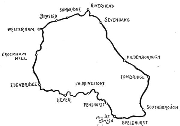
Westerham has nothing in common with modernity. It seems to have had a great era of building in the[187] time of Queen Anne and of the early Georges, and to have exhausted itself in the effort; which is equal to saying that Westerham is delightfully old-world, with great red brick mansions and old gardens, and elbow-room everywhere. Here is the picturesque beginning of the river Darenth, crossing the road on its way down to Darenth and Dartford, to turn many mills, and to finally lose itself in the defiled waters of the lower Thames. The road descends from Westerham to Edenbridge, passing on the way the fork of the road where a guide-post directs by a short route to Chiddingstone, Hever, and Penshurst, viâ Fair Elms. We will not turn here, but continue straight on to Crockham Hill, past the wild beauty of Crockham Hill Common, coming to the modern hamlet and church, set amid wide-spreading hop gardens. Two miles onward from this point we pass Edenbridge Station, and in another half-mile Edenbridge “Town” Station, and finally, in nearly another mile, come to Edenbridge[188] itself, by no means a place of that metropolitan character the traveller would expect to find after all this heralding of railways.
Edenbridge is old-world and pretty, as surely it should be with such a name. It savours of Arcadian delights; and, indeed, when you have left Edenbridge Station behind you are come to a village that has little commerce with the outer world. True, folks hereabouts call Edenbridge “the town”; but there are towns and towns, and this is no centre of activity. The station is half a mile away, the railway conveniently out of sight of the village street, and life here flows as gently, and with as even a current, as that of the little river Eden, that gives the place its idyllic name.
Edenbridge—as surely is fitting—is set round about with apple-orchards, which render it as fragrant in spring as its neighbouring hop gardens do in the late summer months. The first thing, however, that attracts the Londoner’s attention is the quaintness of the one village street, with its tile-hung cottages and the sign of that comfortable old hostelry, the “Crown” Hotel, spanning the width of the road. Edenbridge also contains within its bounds quite a notable clock, of which the inhabitants are justly proud. No stranger can explore the recesses of the old church on the hillside without being presently buttonholed by a villager, who will take him round to where this timepiece shows its black face on the sturdy tower, and will point out to him the singular fact that all the V’s among the gilded numerals are turned the wrong way. But this is not all. The clock—like the heroine of[189] the modern novel—has a “past.” It was made in 1738, and was the clock of St. George’s, Southwark, until 1808, when, on the old church being pulled down, it was sold to the vicar and churchwardens of Edenbridge. It should be a testimony to the health-giving properties of the Kentish air when it is said that since it came down from London it has never known a day’s illness, save only those slight ailments[190] incidental to old age, that can be rectified by the application of a little oil.
When the cyclist has taken his survey of Edenbridge, his next place of pilgrimage should be Hever.
Though only three miles from Edenbridge, and but twenty-seven from Victoria, Hever is not so well known to the excursionist as it should be, when one considers how eminently beautiful and historical is its castle. Here, then, is the way to it. Coming to the bridge across the river Eden, we cross, and look out for a turning on the left hand by a boarded cottage. This leads across a railway and then along a pretty winding lane, bringing one easefully to the spot in two miles. The little Eden wanders erratically through the level lands, and all is quiet and rustic.
Look out for Hever, lest you miss it, for beside its grey old church, with the shingled spire, there is little else. Just a farm, a cottage or so, and an inn—the “Henry the Eighth,” formerly the “Bull and Butcher,” or, as legends would have it, the “Boleyn Butchered.” For this was the Kentish home of the beautiful and unfortunate Anne. They still tell you how Henry, ardent lover, used to come riding through the lanes to see his “dearest pet,” the fair chatelaine of Hever Castle, down yonder, amid the oozy water-meadows, and how, bogged in those miry ways, the rustics would pull the Defender of the Faith out of the sloughs. Here, too, in Hever Church may still be seen the altar-tomb and the magnificent brass of Sir Thomas Boleyn, my Lord of Wiltshire and Ormonde, Knight of the Most Noble Order of the Garter, the [193] ennobled and decorated father of that charmer. Another exquisite brass is that in the chancel to Margaret Cheyne, 1419.
Downhill from Hever Church, surrounded still by its ancient moat, is the unspoiled castle, a small but perfect example of the fortified manor-house of the fourteenth, fifteenth, and sixteenth centuries. The greater part of the present building was erected in the later years of Henry the Sixth, and was added to in Elizabeth’s time. The Boleyns first became connected with it about 1460, when Sir Geoffrey Boleyn, mercer and Lord Mayor of London, purchased the ruined place and commenced to build anew; but before he could complete this reconstruction he was gathered to his fathers, and it remained for his son Sir Thomas—father of the ill-fated Anne—to complete the work Sir Geoffrey had begun.
It is a private residence, and the interior is very charily shown to strangers—on Wednesdays only. The exterior and the moat, however, are always readily accessible, and are very well worth seeing. The lichened castle walls, with their time-stained masonry and vivid patches of red brick, are extraordinarily picturesque, and the windows, occurring at irregular intervals, with the clustered chimneys and mantling ivy, give the place a romantic quaintness all its own. To complete the picture, apple-orchards face two sides of the moat.
The lanes wind greatly, but are merely undulating, on the route to Chiddingstone, two and a half miles distant. Chiddingstone is generally found to be a[194] dream of beauty by enthusiastic visitors; and the visitor to this lovely hamlet cannot help being enthusiastic.
No less beautiful than Hever, but with a beauty of quite a different character, it stands in a hollow at the gates of Chiddingstone Park, whose magnificent elms and chestnuts overhang in summer a row of old timbered houses, sketched many hundreds of times on paper or canvas by enthusiastic artists. The quaint house next the park gates, in the accompanying sketch, is the ideally placed “Castle Inn,” that might, both as regards its situation and its cosy, old-fashioned interior, have inspired a Washington Irving to transports of eloquence. Everyone who has been to the Royal Academy any year knows Chiddingstone, although he may never have visited it; for artists are continually painting this loveliest of Kentish villages, as it is called, and its embowering trees and quaint timbered houses. Behind these houses, in a field, is the “chiding stone,” a large boulder of red sandstone, outcropped from the underlying geological formation, and said to have been a Druidical seat of judgment or place of exhortation.
The roads grow lonely and degenerate (this expression purely from the cyclist’s point of view), into wooded lanes and tracts between Chiddingstone and Penshurst. If, however, you have that which many cyclists have not—that is to say, a real love of natural woodland and copse, where the hazels grow and the bracken and undergrowth are dense—then the walk of two miles by footpaths through the coppices will[195] be not the least enjoyable part of this trip. This brings one to the scattered and very beautiful old village of Penshurst surrounding the ancient baronial home of the Sidneys, Penshurst Place. On three days in the week—Tuesdays, Thursdays, and Fridays—the house is shown at an admission fee of one shilling. It is said that these fees amount in the year to over £300, which gives the annual number of visitors at more than six thousand. The Barons’ Hall is the chief point of interest, and is the oldest part of the historic building, dating back to the fourteenth century.
Most famous of all the warlike and polite Sidneys who owned Penshurst was Sir Philip Sidney, who fell[196] at the siege of Zutphen, and is the hero of that chivalric action, the giving up, when wounded to death, the cup of water for which he thirsted, so that a wounded soldier might quench his thirst. “He has more need of it than I,” said this chivalric soul.
Among the historic pictures here is the remarkable portrait of Algernon Sidney, executed in 1683 on Tower Hill. He met death in characteristic Sidney fashion:—
“Are you ready, sir?” asked the headsman, when he had laid his head on the block; “will you rise again?”
“Not till the general resurrection. Strike on;” and his head was severed from his body.
In the background of the portrait you see the Tower of London and the headsman’s block and axe.
But to complete the round; on good roads, again from Penshurst to Pounds Bridge, through secluded country, and thence to Speldhurst. At Pounds Bridge there is a quite astonishingly quaint and old-world inn, gabled and timbered, and with a sixteenth-century device and monogram on it. From Speldhurst we go through more forest country, and then turn left for Southborough, where we are within hail of Tonbridge and Tunbridge Wells and the great settlements of modern country residences created by the healthy air and fine scenery. Coming down Quarry Hill into the town, the tourist finds Tonbridge more interesting than “the Wells,” because it is quainter and not so fashionable. There are some impressive remains of Tonbridge Castle yet to be seen in the grounds of a park near the end of the High Street, and in that street is the old “Chequers,” a house that no artist nor any amateur photographer can resist.
Crossing the Medway, there now comes a long five and a half miles to Sevenoaks, with only one village; a very little village with the very long name of Hildenborough. Thence it is a climb up the very steep River Hill to Knole Park, bordering the right hand of the road into Sevenoaks. Park and house, the property of Lord Sackville, are open to the public; the park always, the house on Thursday and Saturday afternoons, from 2 to 5 o’clock; on Fridays and Bank Holidays 10[198] to 5. Single visitors, 2s.; parties of four, 6s.; of seven, 10s. There are Reynolds and Gainsborough pictures among the great art collections, and there are as many rooms in the house as there are days in the year; but only seventeen of them are shown.
From the town to Sevenoaks there is a very long and steep run down to the station and to Riverhead. The station is convenient for a return to town, but if it is desired to complete the circle, there are the interesting villages of Sundridge and Brasted to see, on the excellent road to Westerham, with the long array of the North Downs continually in sight.
A glance at the accompanying chart might give the impression of this being a somewhat complicated route; but as a matter of fact, although the outward journey is almost wholly off the high roads, there should be no difficulty in finding the way to Burnham Beeches along this itinerary. The distance to be covered between Egham and Hounslow is, allowing for all possible deviations for exploring, thirty-five miles. Egham is selected solely as a convenient starting-point whence to reach the riverside road to Old Windsor, and by no means for its own sake; for the half-mile or so of high road between the railway station and the point where we turn sharply to the left for Old Windsor is probably the vilest piece of macadam in the Home Counties; if, indeed, the mile-long continuation of it on to Staines is not even worse. The river road is fortunately altogether different, being a long sandy stretch passing through the level of Runnymede, and after the first half-mile affording delightful views of the Thames. To the left hand rises the wooded height of Cooper’s Hill from the water meadows, and over to the right is Magna Charta Island. Where the sandy road dips down to the water just before reaching the village of Old Windsor, notice[200] that old-world inn, the “Bells of Ouseley,” with its sign, displaying five bells, picturesquely swinging from an ancient elm. This sign is a puzzle to the wayfarer. It derives from the once-famous bells in the tower of the long-vanished Osney Abbey at Oxford, celebrated for their sweet tones.
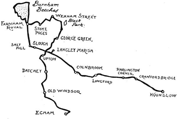
A choice of roads here confronts the tourist. The pleasantest way to Old Windsor is by the easily rideable towing-path for three-quarters of a mile, bringing one to a narrow lane, looking like a private road, leading to past the little church of that village. Old Windsor Church is a prettily situated building, itself of little interest, although there may be those who will find food for reflection in a sight of the last resting-place of “Perdita” Robinson, the discarded early favourite of the “First Gentleman in Europe.” Her career can at least serve to point a moral, if it cannot adorn a tale. “Perdita” died December 26th, 1800; Florizel lived and flourished for close upon thirty years longer. Grown old, wheezy, and corpulent, drawn about Windsor Great[201] Park in a pony-carriage in his last days, and morosely shunning the sight of his fellow-creatures, the once gay Florizel died in 1830, as George the Fourth. He lies in the Royal Vault, but his pretty wanton’s bones moulder, all but forgotten, near the Thames-side towing-path.
Leaving Old Windsor Church behind, the second turning to the right leads into Windsor town. But instead of making for the Royal Borough, we will take the right-hand fork, duly sign-posted, and crossing the Thames by the Albert Bridge, enter Buckinghamshire. In half a mile’s run by the river bank, Datchet is reached by turning to the right and so over the level crossing by Datchet railway station. This is a very much rebuilt village, which in another hundred years (when its modern Elizabethan villas have weathered a little) will begin to be picturesque.
We now take the left-hand road for the old-fashioned hamlet of Upton, the mother parish of Slough, that modern suburban town, the “Sloughforwindsor,” familiar to travellers on the Great Western Railway. It may, perhaps, be remembered that the Slough people, anxious at one and the same time to show their loyalty and to suppress the unlovely name of their town, proposed a few years since to change its title to “Upton Royal,” but nothing came of the project.
Upton, so near that populous place, is singularly retired. It has an ancient and highly interesting Norman and Early English village church, which shares with that of Stoke Poges the honour of being the scene of Gray’s “Elegy in a Country Churchyard”; but the tourist who follows the wheelmarks of the present writer will doubtless,[202] like him and the vast majority of visitors to both places, prefer to think Stoke Poges churchyard the original. In any case, and however well its “ivied tower” answers to the description in the poem, it would be impossible nowadays to deprive Stoke of its fame.
Let not the cyclist by any means omit to look for a singularly puzzling epitaph on a broken flat stone on the north side of the church, whose meaning has been utterly obscured by lapse of time. It runs thus:—
Here Lies the Body of
SARAH BRAMSTONE,
of Eton, Spinster; a person who dared
to be just in the Reign of
George the Second.
Obijt Jan. ye 30th, 1765. Ætat 77.
This is, indeed, strange, for it is impossible to believe that law and order were so hard to preserve in the days of the second George that for a person to “dare to be just” should be so notable a thing. A popular hymn urges us to “dare to be a Daniel,” but what lions lurked in the narrow path that Sarah Bramstone trod? It must be confessed that this sorely piques the curiosity. We know what befell Solomon, Julius Cæsar, William the Conqueror, and hundreds of other highly important historical characters, and know also that even they did not always dare so much; but we shall never know the secret of this tombstone.
Notice, also, on the north side of the church the white marble tomb of George Fordham, the jockey, who died, aged fifty, in 1887, with the odd and significant quotation, “’Tis the pace that kills.” Those who[203] did not know the amiable George might well take that as an aspersion upon his character; but Fordham was the gentlest of jocks and a model husband and father, and this is but a singularly unhappy phrase in such a connection.
Leaving Upton Church, we take a road that leads from opposite it to George Green, crossing the old Bath road, and over the Great Western Railway. A direct road runs thence to Langley Park, through whose recesses there is an entirely unhindered right of way for self and cycle. Black Park is alone worth the ride; a vast stretch of solemn pine-woods, where the breezes die away in hollow murmurs, or sink to absolute silences amid the clustered giant trunks. The sunlight filters down in scanty patches to the carpeting of pine needles, on whose yielding bed you walk with silent footsteps, save for the occasional breaking of a dry twig, whose destruction sounds with startling distinctness in this solitude. Few ever come to these woodlands, and it is likely enough that you will have them all to yourself, excepting, indeed, the wood-pigeons, breaking now and again into a weird chorus of cooing.
But its great lake of about thirty acres is, perhaps, the chief feature of Black Park. Seated by its shore, with the close ranks of the great solemn pines overhanging the sullen water, you see with what appropriateness the park is named. It is a kind of place where you can readily imagine yourself a Robinson Crusoe. Little sandy beaches run out into the water; the inky recesses of the woods look as though they awaited the explorer to come and discover the savages and the big game[204] that doubtless lie hidden there; and, in fact, all you want, to be completely happy, is a raft, a rifle, a suit of goat-skins, a Man Friday, and some enemies to shoot at. It is certainly a spot R. L. Stevenson would have revelled in.
If it were not that Burnham Beeches have to be reached, nothing could be more delightful than to stay here the afternoon, taking tea, perhaps, at the “Plough” at Wexham Street (which must not be confounded with Wexham village). Leaving the lake at the end where it borders the road, turn to the right. In half a mile you reach the pretty hamlet and turn left, then right, then left again. This brings one into the broad road leading from Wexham village to Farnham Royal and Burnham. On reaching this road (which runs right and left), instead of crossing it, turn to the right, and then to the left once more. This brings us into a tree-shaded lane, which dips downwards. On the right, on the edge of the meadow overlooking this lane, a momentary glimpse of a solemn, mausoleum-like monument is caught. This sufficiently notifies the fact that we are at Stoke Poges, for it is the memorial erected to the poet Gray by a descendant of William Penn, who once resided at Stoke Park. The park, of which the great, odd-looking mansion may be seen from Stoke Poges churchyard, has belonged to men of light and leading. It is now the residence of Mr. Bryant, of Bryant & May, who purchased it of Mr. Jeremiah Colman, of Colman’s Mustard.
The melancholy looking monument, looking like a tea-caddy or biscuit-box on a pedestal, bears verses[205] from Gray’s mournful muse—from the “Elegy,” and from the “Lines on a Distant Prospect of Eton College.” Having inspected this, walk a few yards down the lane. Here a white gate on the right, with an old lodge absolutely covered from the ground to the topmost bricks of the chimneys with ivy, appears to lead into the park. This is, however, the entrance to Stoke Poges churchyard. Leaving the cycle here, by the cottage fence, we walk to this place of pilgrimage through a very beautiful modern lych-gate in carved oak. The spire and “ivy-covered tower” of the church appear beyond; the whole, strange to say, quite as beautiful as one expects it to be; with the sole exception that the churchyard is now too large and too crowded with staring white marble monuments to fully realise the rural note of the famous poem. But that is a detail. Under the east window, in the churchyard he has immortalised, Gray is appropriately laid to rest, in a quiet, unpretending tomb, with his mother and his aunt.
Thomas Gray, who has come down to us chiefly as the author of the “Elegy wrote in a Country Churchyard,” as he himself entitles that famous poem, was[206] born at the close of 1716, the son of Philip and Dorothy Gray. Philip appears to have been a “law-scrivener,” and would seem to have always been on the verge of madness. He died when his son was twenty-five years of age. The poet, educated at Eton and at Cambridge, weakly all his life, and cursed with a melancholy that was partly real and partly affected, was the only one of his mother’s twelve children who survived their infancy. Never more than slenderly provided with the means of living, he dallied through his fifty-four years of life with the classics, projecting many things but completing few. His English poems are very few in number, and like the small total of his writings, few even of these are more than fragmentary. His morbid nature may perhaps be guessed from the fact that it was almost only the death of a relative or friend that would inspire him to write. Thus the famous Elegy, begun in 1742 and only completed in 1750, owes its conception and its several slow stages to successive bereavements; and the “Ode on a Distant Prospect of Eton College” originated in the same doleful manner. Save to scholars, Gray’s whole career and repute as a poet are comprised within those two poems, both in the very front rank of English song.
Gray’s muse is unhealthy and ill-assorted with the thought of modern times. Nor was it much better matched with that of his own. His physique influenced his temperament; his narrow and inactive life rendered him morbid, and finally shortened his days. He died in 1771. It is credibly said that he never in his life received more than one single payment of forty guineas[207] for literary work. For the “Elegy,” on which his deathless fame rests, he never received, nor would accept, any pecuniary remuneration. He allowed Dodsley and the other publishers to print it, which they did, reaping fortunes thereby. It is, perhaps, scarce necessary to add that this kind of poet is quite extinct. Gray, who refused the offer of Poet Laureate on the death of Colley Cibber in 1757, was of opinion that it was beneath the dignity of a gentleman to accept payment for his “inventions.” How he would have despised Tennyson, who could drive a very shrewd bargain with his publishers, built up a fortune on his writings, and went into the milk trade!
By the way, it is interesting to read a contemporary “review” of the “Elegy.” Here it is: “An Elegy wrote in a country churchyard, 4to, Dodsley 6d., seven pages. The excellency of this little piece more than compensates for its lack of quantity.” Who wrote that "review"? Was it some draper or grocer, whose objections to short measure were overcome by the excellence of the goods?
Here, at Stoke, Gray spent his vacations with his mother and his aunt. His mother died in 1753. She, good soul, thought this rickety son of hers—as infirm of purpose as he was of body—engaged in reading for the Law, and went to her grave unconscious of his odes. He loved his mother, and on the lichened slab that covers the unpretending red brick altar-tomb in the churchyard you may yet read the epitaph he wrote—" ... beside her friend and sister, here sleep the remains of Dorothy Gray, widow, the careful tender mother of[208] many children, one of whom alone had the misfortune to survive her.”
The “yew tree’s shade” is cast over the south porch from a very ancient tree of that species, and the scene generally accords well with the poem. In this connection, as an additional proof that Gray referred to Stoke Poges, it may be noted that the spire, surmounting “yonder ivy-mantled tower,” is an addition since his time, being little over a century old. This would appear to finally dispose of the claims put forward for Upton Royal by the sticklers for absolute accuracy of description, who have held that if Gray were writing of Stoke, he would have written “spire” instead of “tower.”
The church is very picturesque, and the interior worth seeing for the sake of the ancient architecture and for the curious little fragments of stained glass set in one of the windows, among them one representing a nude angel, or wingless cherub, with a monastic tonsure, blowing a trumpet and bestriding a veritable “hobby-horse,” or primitive bicycle. There is no questioning the antiquity of the fragment, for the date, 1642, appears on another portion of the glass, and so the mystery of the bicycle is unexplained. Every visitor to Stoke Poges visits Gray’s tomb, and no less a matter for pilgrimage has the so-called “Bicycle Window” become[209] of late years. Indeed, to those who have no literary sympathies, this undoubtedly takes the first rank as an object of interest.
Having seen everything, we retrace our steps to the road, and, turning to the left, make for Farnham Royal, where there is a very beautiful modern church, and in the churchyard an extraordinary monument to a Mr. Henry Dodd, who died in 1861, “brickmaker and contractor. Began life as a ploughboy within a mile of St. Paul’s.” On the south side of the churchyard is the grave of Sarah Hart, victim of George Tawell, who administered prussic acid to her, in 1845, at Salt Hill. He had been carrying on an intrigue with the woman and made her an allowance; but fearing that his wife would hear of the connection, determined to put her out of the way. Tawell himself lived at Berkhamsted, in Hertfordshire. His was an evil career. Living in his youth a secret dissolute life, he had been sent to penal servitude in Australia for forgery. Released after a time, he amassed a fortune out there in business, and retired. Dark rumours, however, were current that he acquired a great part of his fortune by poisoning his partner.
The unhappy woman’s grave is unmarked by any stone, but is the nearest mound to the door in the churchyard wall. Tawell was the first criminal arrested through the agency of that then novelty, the electric telegraph. He rushed off to Slough Station after committing the crime, and just succeeded in catching the train to Paddington. He was clad in Quaker dress, and the telegraphist sent a message up to detain "a man[210] in the garb of a Kwaker," the original code not containing the letter Q. He was duly arrested and hanged.
From the church we retrace our steps to the village, and taking the middle one of three roads, past the ornamental well-house in the centre of the street, make for that famous woodland, Burnham Beeches, along a very winding lane, taking every left-hand turning. Along a strip of common land, bordered by refreshment houses, we come downhill to the first glade, where the giant beeches crowd together in a dim light. The purchase of Burnham Beeches, unquestionably the finest piece of natural woodland in England,—finer than anything in the New Forest or in Savernake Forest,—was a noble work of the City of London Corporation, which has thus preserved the spot for ever.
The peculiarly sturdy, stunted, and fantastically gnarled character of Burnham Beeches is due to their having been pollarded at some unknown period. Legends have it that this was done by Cromwell’s soldiers. The inner recesses are weird enough to suggest warlocks and wizards, or Puck at the very least, and Queen Mab herself could find no fitter place wherein to hold her Court than in the crepuscular glades where, amid that purple shade which is the especial glory of Burnham Beeches, a chance patch of sunlight falls, more golden by contrast, on the more than emerald green of the moss, or where the moonbeams filter through on cloudless nights to light Her Majesty’s midnight masques. I would not, being no courtier and unequipped with fairy passwords, adventure alone in the depths of these woodlands at midnight for anything [213] you could promise me. At midday it is another matter.
It is difficult to decide at what period of the year this spot is most beautiful. It has one peculiar glory of the summer and another of the winter, when in the short November and December days the brown leaves that carpet these alleys give out a mist that mingles strangely with the coppery glow of the sinking sun. Amid this impressive coloration the contorted ashen-coloured trunks stand forth strangely ghostlike.
Gray, of course, knew Burnham Beeches very thoroughly. His uncle lived at Burnham when the poet was a youth, and we find Gray writing to Walpole in 1737, in a lively manner quite unexpected of him who was already, in his twenty-first year, the affected prey of melancholy.
But the prig in this precocious young gentleman is distastefully evident in this otherwise very excellent description. The description is in fact delightful; only one could wish the writer of it forty-one, instead of twenty years younger: "My uncle is a great hunter in imagination; his dogs take up every chair in the house, so I am forced to stand at the present writing; and though the gout forbids him galloping after them in the field, yet he continues still to regale his ears and nose with their comfortable noise and stink. He holds me mighty cheap, I perceive, for walking when I should ride, and reading when I should hunt. My comfort amidst all this is, that I have, at the distance of half a mile through a green lane, a forest (the vulgar call it a common) all my own, at least as good as so,[214] for I spy no human thing in it but myself. It is a little chaos of mountains and precipices; mountains, it is true, that do not ascend much above the clouds, nor are the declivities so amazing as Dover Cliff; but just such hills as people who love their necks as well as I do may venture to climb, and crags that give the eye as much pleasure as if they were more dangerous. Both vale and hill are covered with most venerable beeches, and other very reverend vegetables, that, like most other ancient people, are always dreaming out their old stories to the winds. At the foot of one of these squats ME (il penseroso), and there I grow to the trunk for a whole morning. The timorous hare and sportive squirrel gambol around me like Adam in Paradise before he had an Eve; but I think he did not use to read Virgil, as I commonly do.”
The “reverend vegetables” phrase has a strangely modern flavour, and so indeed has this appreciation of the picturesque. Before Gray’s time scenery was not only unappreciated; it was detested. Dr. Johnson, who hated hills, was at one with his generation in this respect. Even Horace Walpole, who ought surely to have known better, calls hills “mountains,” and shudders at the sight of them. Gray has this additional title to fame, that he was the first to tour in search of the picturesque, and, in a sense, invented the taste for it. Wordsworth, who was but little later than Gray, says, “When I was young, there were no lakes or mountains.”
But it is quite impossible within these limits to fully describe the Beeches, or to indicate the route through them. The Corporation has made a magnificent[215] series of broad drives in every direction, with splendid surface for cycling; and if the gradients are severe, there is nothing that cannot, with due care, be coasted. Many picnic parties come to the Beeches, but they rarely penetrate far into these lovely woodland glades; leaving the solitudes to the painters, who are always at work here, producing Academy pictures. Find the Plain, the Ponds, and Hardicanute’s Moat, away in the recesses of the woods. See “Beauty and the Beast”; the one being a graceful silver birch, with a gaunt, knotty, blasted oak standing beside it. For the rest, given a fine day, be content to lose yourself here, amid the fairyland of immemorial moss and lusty bracken, and then, when you are tired of it (or, more likely, when evening is drawing on), inquire of one of the artists who are painting the sunset the way for Farnham Common and Slough. This is a fine down-grade road of three and a half miles leading through Farnham Royal down to Salt Hill, where, turning sharply to the left, we are on the Bath road, twelve miles from Hounslow. Slough adjoins Salt Hill. A mile beyond it, up a lane to the left, is Langley. Langley is a wayside station on the Great Western Railway, set down in a beautiful and secluded neighbourhood, the name clipped and mutilated in modern railway fashion, for its full style is “Langley Marish”—“Marshy Langley,”—or, as some would have it, “Langley Maries,” the church being dedicated to the Virgin Mary. Near the station notice the old-fashioned inn, the “North Star,” nestling under the embankment; a house which obtained its present sign from the first locomotive ever used on[216] the Great Western. The engine of that name was originally built for a Russian broad-gauge railway, but never delivered.
While yet some way from the village, the mellowed red brick tower of Langley Church is seen across the flat meadows. The church owns the very singular feature of an old parish library, contained in a room within the building; not a library consisting merely of a few chained books, but a collection of some five or six hundred volumes, given by Sir John Kederminster, under his will of 1631, to “the town” of Langley Marish. No one ever borrows any of these mighty tomes for home reading, for they are chiefly black-letter works of the Greek and Latin fathers, and dry-as-dust treatises on the Reformation controversy. The room containing all this bygone learning is curiously painted with Renaissance designs, and very interesting.
The Kederminsters, of whom this bookworm Sir John was one, were the old lords of the manor. They built the beautiful almshouses looking upon the churchyard. It may be noted that the grouping of church and almshouses is strikingly picturesque, and that the low-toned brick is eminently paintable. Langley, in short, is one of the very few really beautiful and retired villages so near town.
The curious, who roam the churchyard and read the epitaphs on the simple memorials of the villagers, will notice on one of the many wood-rail tomb-“stones” an inscription to a certain “Mrs. Sarah Wall, the old and faithful, but ill-requited Servant of Lord Carrington, who departed this life June 1832, aged 70 years.”
The story goes that she was grievously affronted by being consigned by Lord Carrington to one of the neighbouring almshouses in her old age, when she had expected more consideration at his hands. She it was who directed the expression “ill-requited” to be painted on the board. A former vicar, disapproving of it, had the words painted out, but in the lapse of years the paint of the rest of the lettering decaying, the offending words have been preserved and stand out with an extraordinary prominence, attracting immediate attention.
Pretty hamlets, still wonderfully rural, considering the short distance from London, line the way home, along the old Bath road, or lie a little way from it. Among them is Cranford; but it is probably too late now to see that pretty place, and so we will continue, through the gathering darkness, along the high road home. Every cyclist knows this road, but it is not everyone who knows it when night has fallen; when the little inns and cottages take on a romantic interest they do not possess by daylight; when red blinds in villagers’ windows shed a comfortable ray, and wayside trees and fields wear an unaccustomed and portentous significance. In short, it is a delightful lamp-lit journey along these closing miles, and a pleasantly cool conclusion to the heat of the day.
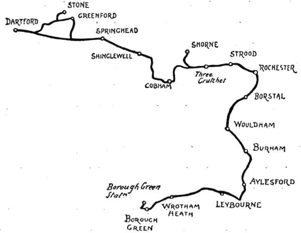
There is an excellent route from Dartford to Rochester, avoiding the Dover road, known to comparatively few cyclists other than local—a road that, instead of passing through places so busy and populous as Northfleet and Gravesend, is rural through the whole of its course, from Dartford Brent to where it joins the better-known way at the top of Strood Hill. The Dover road between these two points is, as just remarked, the “better-known” route, but it is by no means the oldest. That distinction can be claimed most emphatically by this, for it follows the course of that old Roman military[219] way, the Watling Street, and was a portion of the route along which went the pilgrims to the shrine of Thomas à Becket at Canterbury.
Coming uphill from where Dartford is seated in its deep hollow beside the Darenth, a high tableland is reached, and with it a parting of the ways. Our own route is plain to see—straight ahead—and is made additionally clear by the aid of a specially informative sign-post. For those, however, who would take the opportunity, when so near, of seeing one of the most interesting parish churches in the country, it may be hinted that two miles down the Dover road—the left-hand turning—is Stone. Let the stranger be careful when inquiring for Stone, and ask specifically for the church. Otherwise the gaping rustic is apt to smile significantly, Stone being famed for its lunatic asylums.
The interior of the Early English church at Stone is a Westminster Abbey in little, designed probably by the same architect, the stones from the same quarries,[220] and carved by the same masons. It stands on a hilltop overlooking the busy estuary of the Thames, near Greenhithe, and its immediate neighbourhood is made sordid with cement works and chalk pits. A huge factory chimney, some six times the height of church and tower, immediately adjoins the churchyard. When in the fulness of time it falls, there will probably be little left of the church, even as a picturesque ruin.
It is not possible to ride round Stone Church to Greenhithe. The lane leading to it must be retraced, and the Dover road followed until turnings right and left appear. To the left lies the little port of[221] Greenhithe, and on the right the road leads up again to our route for Rochester.
Hasting from the scarred, chalky hillsides and the industries of Stone and Greenhithe, one appreciates more fully the quiet of this fine road; and coming in two miles to Springhead, the Saturday or Sunday cyclist will find that there are others equally appreciative, for the watercress beds and the picnic inns and tea-gardens of Springhead have been famous in all Cockaigne during at least the last seventy years, and the watercresses have by no means lost their freshness nor the place its charm in that space of time. This[222] week-end Arcadia, where the succulent prawn, the cooling cress, and the poetic periwinkle are partaken of in vast quantities, is still in great esteem. The manners and customs of its clients are frank, if unrefined, and their appetites robust, even though their methods be not particularly nice. To see ’Arriet extracting periwinkles from their shells with a hairpin is a lesson in resourcefulness not a little trying.
It is a long climb up to the village of Shinglewell, which rejoices in having an alias; for on all maps you will find the incertitude of cartographers as to what it really should be called proved by the legend “Shinglewell, or Ifield.” Still uphill, we come to a turning that will take us off to the right into Cobham village; the retreat of Tracy Tupman and his wounded love, where, in the “clean and commodious alehouse,” he was discovered by Mr. Pickwick, discussing with a great appetite and a mournful air a not very sentimental meal composed of “roast fowl, bacon, ale, and et ceteras.”
The Leather Bottle is the sign of the inn, and it is to-day, perhaps, the best known among Dickens landmarks. It is still the old-fashioned country inn it was when the great novelist knew and described it, but filled now with Dickens’ relics of every kind. A painted sign hangs out from the front proclaiming this to be “Dickens’ Old Pickwick Leather Bottle,” with a picture of that eminent personage in his “shorts” and gaiters in the inevitable attitude of declamation. In the low-ceiled parlour are many prints and portraits having reference to Dickens and[223] his works. An old “grandfather” clock stands in one corner and a stuffed trout in his glass case (an object without which no country inn is completely furnished) occupies a place of honour.
It is worth while leaving the cycle at the inn and to explore the neighbourhood of Cobham village and park. The village church is well known to antiquaries as containing the largest collection of brasses in England. There are no fewer than twenty-four fine examples, principally to members of the ancient and knightly family of the Cobhams, who once were lords of this and many another manor in Kent, and lived at the Cobham Hall which preceded the Elizabethan and Jacobean building now standing, the seat of the Earl of Darnley. The Cobhams have been extinct for centuries, and Lennoxes, Cliftons, and Darnleys have owned the place since, but none of them have left anything like the impress upon it that the old family achieved. Here, in the village, is that now old almshouse, the New College, founded by a Cobham in place of the Old College, the dissolved religious house founded many years before by an ancestor; and there, on the floor of the chancel in the parish church, are their memorials.
Cobham Park is a lovely expanse of lawns and woods and grand avenues, open to the wayfarer freely to come and go. Deer roam about in great herds, and wild life abounds in the tangled glades. The Hall is shown only on Fridays. Tickets are to be purchased at Rochester and Gravesend. To see the Hall and its great collection of pictures is a quite[224] separate undertaking from touring on a cycle, and so we will journey on towards Rochester, regaining the road and making for a landmark known in all this countryside as the “Three Crouches.” When we arrive at the place, we discover it to be an inn called the “Three Crutches,” displaying a shield of arms bearing a chevron between three aces of clubs. The three aces, distinctly resembling crosses, are the so-called “Three Crutches.” Compare with this the name of “Crutched Friars,” who were originally the “crossed friars,” from the cross they wore on their habits; and with that of the “Crouch Oak” at Addlestone in Surrey, an ancient boundary tree standing at the “cross” roads. The motto, Sub umbra alarum Tuarum—“under the shadow of thy wings”—is seen below.
From this point it is chiefly downhill into Strood and Rochester; very steeply downhill at Strood, too. Through its mile-long street and on to Rochester Bridge, the rude ribs of the ancient castle rise boldly up from the other side of the Medway, with the Cathedral beside it, looking quite humble. Very maritime looks Rochester’s High Street, with the great gilded model of a line-of-battle ship, fully rigged and armed, that serves for vane, twirling over its Guildhall. Over all is the bustle, roar, and rattle of the trains, rolling in thunder over the railway bridge that cuts off the view downstream.
Rochester, adjoining as it does the busy dockyard town and seaport of Chatham, is not one of the slumberous examples among cathedral cities, for its [227] narrow and, if truth be told, dirty streets are crowded with the waggons and carts going to and from railways and wharves. The “Bull Inn” still remains very much what it was when Jingle recommended it to the Pickwickians.
The “Bull” itself is exactly hit off in Dickens’ description of it, and in the hall the “illustrious larder with glass door, developing cold fowls and noble joints, and tarts wherein the raspberry jam coyly withdraws itself, as such a precious creature should, behind a lattice-wall of pastry,” still develops good things for a later generation. A latter-day stupidity had changed the name to the “Victoria and Bull,” but this has been remedied recently, and it is the “Bull” once more.
Other things noticed by Dickens in Rochester are much the same. He calls the projecting clock of the Corn Exchange the “moon-faced” clock. It still impends over the pavement, and its white dial does indeed suggest the moon. But exquisitely exact is that other description in the “Seven Poor Travellers,” where he speaks of the High Street “oddly garnished with a queer old clock that projects over the pavement out of a grave red building, as if Time carried on business there and hung out his sign.” Also, although restorations have since taken place in the darkling cathedral, no description of it, even now, matches that concise and breathless commentary the novelist puts into Jingle’s mouth: "Old Cathedral, too—earthy smell—pilgrims’ feet worn away the old steps—little Saxon doors—Confessionals like money-takers’ boxes at theatres—queer customers, those monks—Popes and Lord[228] Treasurers, and all sorts of old fellows with great red faces and broken noses, turning up every day.”
You enter the Close directly from the High Street, beside or through what all readers of Edwin Drood know as “Jasper’s Gatehouse,” although the real name of it is “Chertsey’s.” The old church of St. Nicholas, patron saint of fishermen and thieves, who (the thieves, not the fishermen) were from that circumstance known as “St Nicholas’ Clerks,” stands side by side with the cathedral, and opposite is the churchyard. It is well known that Dickens’ own wish was to be buried here, but a national desire that he should rest in Westminster Abbey prevailed. This was recalled to the present writer’s recollection by a stranger when recently at Rochester. “He wanted to be buried there,” said the stranger, pointing with his walking-stick. “’Twould have done Rochester a lot of good,” he added regretfully. “You see, he’s wasted where he is; but if he was here, thousands more visitors would come,” and he went away grumbling.
One of the chief Dickens landmarks here is, of course, the place he calls the “Seven Poor Travellers.” This is the charity founded by Richard Watts, in 1579, for the entertaining of “Six Poor Travellers, who, not being Rogues or Proctors, may receive, gratis, for one night, Lodging, Entertainment, and Fourpence each.”
But the old city of Rochester requires, at least, a day for its due exploration, and so we will not linger now by cathedral, castle, or waterside; but, turning sharply to the left, on returning towards Rochester Bridge, steer[229] for Borstal; not by any means because Borstal is beautiful, because that is probably the very last thing anyone would think of saying about this place of mean streets that intercept with their dingy commonplace the beautiful views along the broad valley of the noble Medway. Then, as though this were not sufficient, there is a very grim prison at Borstal—or was, for it has now been converted into a reformatory; and then, again, a number of riverside cement works, to be succeeded at Wouldham by more of the same kind, and, finally, by brick-kilns at Burham. Why, therefore (asks the reader), do we come this way? For reasons of various sorts: because, despite all these disadvantages, the views, as we cycle along with the broad bosom of the Medway spread in front for miles and miles, bearing the rust-red sails of the floundering deliberate barges, are invisible elsewhere, and because the more rural road, by Kit’s Coty House, is an exceedingly hilly one. Notice in the churchyard of Wouldham the tombstone of Burke, the purser of the Victory, for “in his arms,” as the inscription states, “the immortal Nelson died.”
Passing through Burham, take the road to the right leading down into Aylesford, where the Medway narrows and is tamely conducted under the fine old bridge and through a lock, just as though it were a tiny river and unconnected with the imposing estuary just left behind. The grouping of river, bridge, square church tower among the trees, and the long row of gabled houses beneath is particularly charming. When you have taken your fill of this characteristic Kentish scene, proceed along the road leading from the bridge,[230] and, taking the right-hand turning, come to the broad highway that leads to Wrotham Heath and Borough Green, a road that follows in part the valley of one of the Medway’s affluents. Interesting villages lie on either side, only slightly removed from the road, in particular that of Leybourne, half a mile on the right hand. It derives its name from the little stream just named, the Ley Bourne, originally the Lele or Little Bourne. It is curious to observe that your true Kentish man, among such odd enunciations as “d” for “th” (so that the definite article “the” becomes “de”) still says “lil” for “little,” as the tourist may discover. There are interesting remains of Leybourne Castle yet to be seen by turning off the road to the right, and so to the park in which they stand. But the long day closes, and we must not linger on the way; and so, speeding on to Wrotham Heath and turning there to the left, we make for the L. C. & D. R. station of Wrotham and Borough Green.
The borders of Middlesex and Hertfordshire are as yet unspoiled, and still keep their country lanes and old-world villages in very much their original condition. This is chiefly owing, of course, to the lack of good local railway accommodation; and since these uplands in the bracing marches of those two counties are thus left in the most rural and “unimproved” state, we may, from the tourist’s point of view, hope that railway enterprise may for long years yet to come lie dormant and keep the cheap builder away.
In the first instance, however, we must needs be beholden to the Great Eastern Railway for conveying self and cycle to our starting-point, Waltham Station, twelve miles from town. Arrived there, the near neighbourhood of Waltham Abbey tempts us three-quarters of a mile across the river Lea into Essex; for the great Abbey, now the parish church of the town of the same name that has sprung up around it in the lapse of centuries, is a place of pilgrimage. Harold’s body was translated here from Battle, and although all trace of his resting-place is lost, save the traditional spot in the meadow by “Harold’s Bridge,” the Abbey is peculiarly associated with him. The[232] massive tower shows up singularly white above the many old and picturesque houses that converge in narrow streets upon it; and the brimming Lea, like Denham’s description of the Thames—
“Without o’erflowing, full,”
goes in the prettiest of perspectives across the fields, making, with the wayside alders, the old-fashioned canal-locks, and the many water-channels that everywhere abound, pictures for sketcher or photographer. As for colour, notice that remarkably old-world square of bowed and bent, nodding and decrepit houses called the “Cattle Market.” Rarely, indeed, does the painter find so exquisite a tone as that of these ancient red brick buildings.
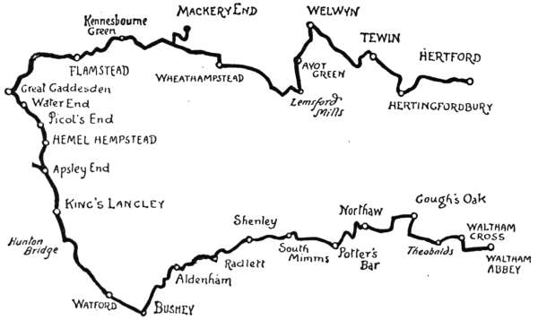
But it will not do to linger at Waltham Abbey, however great the inclination may be to do so. So we retrace our course, and passing the station again, come to Waltham Cross, where the Eleanor Cross, tinkered by restorers, but still lovely, stands in midst of the road[233] beside the old “Four Swans,” whose sign, straddling across the highway, bears the wooden effigies of those fowls. Turning to the right at this point, and wheeling through the village of Waltham Cross, a railway bridge spans the road, and the supremely ugly new station of “Theobalds Grove” appears. Just beyond this, on the left-hand side, is a turning which, leading off as it does through gates, looks like a private road into a park. A park, indeed, it is—that of Theobalds—but there is a right of way. And it is a most beautiful road, or rather lane, with the best of gravel surface to cycle along, and the most gracious of foliage overhead. Half a mile of this, and then comes the most delightful of surprises; nothing less, indeed, than that dear friend of olden days in London City—Temple Bar.
The story of Wren’s beautiful, but inconvenient, entrance to the City of London is a romantic one. Long used as a Golgotha on whose topmost cornice to display the heads of decapitated traitors, it remained at the Fleet Street entrance to London until the increasing traffic necessitated its removal in 1877. The stones were all numbered and stored away in the City stone-yard for some eight years, and meanwhile the City authorities offered them as a gift to several persons or public bodies, without finding anyone to accept the gift. The Benchers of the Temple, who had the opportunity of securing the relic for one of their quiet courts, incredible though it may seem, refused it; but at last the old Bar was accepted by Sir Henry Meux, and re-erected here as an entrance lodge. It is the old familiar Temple Bar, cleaner than of yore, and more easily studied in this quiet spot than of old, in the roaring traffic of Fleet Street; but that it should thus be banished from its native London and be in private ownership seems pitiful. Why not, in these days when it has been proposed to restore the Elgin marbles to Athens—why not agitate for its restitution and re-erection in some quiet City lane?
And now for Gough’s Oak. There are more ways than one of reaching Goff’s (or Gough’s) Oak from here. Let us take the turning to the left, and, avoiding a further turn in the same direction, go by Love Grove, along a series of country lanes. The original Gough was Sir Theodore Godfrey, who “came over with the Conqueror,” as the musty old phrase goes; and on what used to be Cheshunt Common he planted the[235] still existing tree, which fully bears out Dryden’s lines—
It may flourish for another hundred years if it is only left alone, although the giant trunk is quite hollow and full of holes, so that it is hooped and banded round like a barrel to keep it together. The hamlet that takes its name from this venerable relic is a thoroughly rural one of farms and dairies, and quite off the beaten tourist track.
Following the road indicated by the sign-post that stands prominently near the Oak, we make for Northaw,[236] whose name means “Northwood.” The most exhilarating of coasts down through woodlands, with wide views, blue and beautiful, of woods and parks, leads to a cottage or two marked “Cuffleys” on the Ordnance map. Turn to the left here, and so, by a country lane, to the small village of Northaw, with a modern church standing on its pretty green. Thence it is as straight ahead as the winding but splendidly surfaced road will allow, to Potter’s Bar. Here the Great North Road is reached. Continue through the somewhat characterless village and turn off to the right where a sign-post points to Potter’s Bar Station and South Mimms, along what is called Mutton Lane. At a quarter of a mile from South Mimms turn to the left, and the old church tower presently comes in sight. Here we find the Holyhead road running right and left. Turn to the right, and then to the left off the highway, and up the rising gradient of the village street. At once the most concise and most readily understood direction to Shenley is this: “Follow the telegraph poles.”
In under three miles this village is gained—one of the quaintest and most old-world of places, with an[237] old “round-house,” or village lock-up, standing between a horse-pond and the “Queen Adelaide Inn.” Local gossip tells how the last of the long line of petty offenders to be imprisoned here was the then landlord of that inn twenty-three years ago. He had, innocently enough, taken home for firewood a few pieces of wood he had found in a neighbouring park. So they locked him up, and the reeking dampness from the pond nearly killed him.
Shenley Church lies a mile away from the village and has lost its tower. The bells, save one, were removed to the more accessible Chapel-of-Ease in the village, and the one remains in the churchyard, hung in the most extraordinary manner on an iron bar.
Returning to the village, and having found the way to Radlett, we go by a winding lane downhill, and between the two parks of Porters and New Organ Hall. Radlett is a quite modern settlement, of no interest. The name, however, is ancient, and derives from the “Red Leat,” a tributary of the Colne, whose water runs of a reddish hue after rain has washed the[238] red gravel soil through which its course lies. Here we cross the Edgware-St. Albans road and come to Gill’s Hill, a name of dread; for it was here, at Gill’s Hill Cottage, in 1823, that the notorious murder of Mr. William Weare was committed by John Thurtell. A lane on the right hand leads to the still existing house, and many morbid persons go and feast their eyes on it, as did Sir Walter Scott in 1828. This particularly sordid and stupid crime, committed by the gambler Thurtell, and connived at by his confederates, Hunt and Probert, for mere plunder, aroused the widest interest, and contemporary literature, not greatly to its credit, is full of references to the vulgar tragedy. Scott, as we have seen, actually paid a visit to the scene, and Carlyle alludes to it again and again. The thing that most held his imagination and exercised his sardonic humour was the evidence of one of the witnesses on behalf of Thurtell, to the effect that “he was a respectable man: he kept a gig.” To “gigmanity,” as a symbol and token of respectability, Carlyle often recurs.
High Cross, which now comes on our way to Aldenham, is, indeed, high. Higher still is Kemp Row, away to the left, the place where the mitred Abbots of St. Albans hanged criminals literally “high as Haman,” if not, indeed, considerably higher than that biblical personage. By “criminals” you are to understand a very wide interpretation—which, in fact, included such as stole the deer or netted game on the extensive manors of those dignified clergy. Those abbots had their gallow’s as a quite ordinary article[239] of domestic furniture, and turned off many an unlucky poacher with the least possible compunction.
Aldenham is a place with a dignified air, derived from the many parks that surround it. Aldenham House is the seat of the recently ennobled Mr. Henry Hucks-Gibbs, who contended long and expensively in the Law Courts with that master of gall and wormwood, Lord Grimthorpe, as to which of them should have the right to spend a fortune on the restoration of the reredos of St. Albans Abbey.
From here it is a fine run, chiefly downhill, across the breezy heights past Patchett’s Green and Bushey Grove to the long village street of Bushey, well known nowadays for its artistic colony of the Herkomer School. The builder has been busy here, and Bushey and Watford are now practically linked together.
Watford is fast losing its old-time individuality in the amazing extension of Suburbia, but it is still remarkable to the stranger for its beeriness. Big bulks the name of Benskin at Watford, and every third house in the long High Street seems, from a casual inspection, to be an inn.
A curiosity in the shape of a fig tree growing out of a large stone altar-tomb in the parish churchyard is the local marvel at Watford, and if you do not see it, why, then, no Watfordian will consider his town properly explored. It may be seen, within a railed enclosure, outside one of the church windows, and is, of course, the subject of a legend. This is the last resting-place, they tell you, of a lady who on her deathbed exclaimed, “If there be a God, may a tree grow out of my heart!”[240] This shocking and wicked tale is, of course, as absolutely baseless as the equally wicked and shocking story to the same effect told of Lady Anne Grimston at Tewin. The tree is a chance seedling. Anyone malicious or mischievous enough could create countless such miracles by inserting seeds in the crevices of such old tombs.
From Watford the way is bordered for nearly two miles on the left hand by the beautiful lawns and woods of Cassiobury Park, and here and there ancient elms form avenues along the road, and lend a grateful and cooling shade. Cassiobury is the seat of the Earl of Essex, whose notices, setting forth the dreadful things which will be done to trespassers, are plentifully displayed for the length of a mile and a half, and do not add to the sylvan beauties of the scene. Beyond and adjoining Cassiobury is Grove Park, the Earl of Clarendon’s seat, just glimpsed in passing. Now the Grand Junction Canal and the river Gade, flowing in one channel, are seen on the left, and presently we cross over them, turning slightly to the left at the hamlet of Hunton Bridge. A canal is not usually a beautiful object, being straight and formal, and generally with the commonplace surroundings of coal and other wharves; but the Grand Junction, which accompanies the road from this point to Boxmoor and onwards, provides interest and a series of charming pictures all the way. Beside it, at a decent distance, runs the main line of the L. & N.W.R. to King’s Langley.
King’s Langley is a village pretty enough, but of no particular interest; but the church has a claim to inspection, containing as it does the altar-tomb of a[241] former Duke of York; Edmund de Langley, fifth son of Edward the Third, born at the Royal Palace of Langley, 1341, died 1402. It stands in a chapel at the east end of the north aisle, lighted by a stained-glass window, presented by the Queen in 1878, in honour of her “ancestor.” Notice stones in the churchyard to various persons bearing the odd name of Evilthrift. A few fragments of Langley Palace yet remain on a hilltop a mile distant from the village.
It cannot be said that the hamlet of Frogmoor End, which succeeds King’s Langley, is beautiful, neither is Apsley End precisely a poet’s dream. They are quite modern settlements, helping to spoil this once wild and lonely district of Boxmoor. There is a Boxmoor village now, and a railway station beside the road, named after it, but of actual barren moor there is but little.
On the skirts of what was once the moor, we turn to the right, and in a mile and a half reach the little town of Hemel Hempstead, through its suburb, Marlowes. The town is mentioned in Domesday Book as “Hamelamestead,” and the country folk call it “Hampstead,” instead of “Hempstead,” to this day. Like many of these little Hertfordshire towns, it is somewhat scrubby and out at elbows, and is not sufficiently removed from London to be altogether provincial. Its streets are steep and run in perplexing and unlooked-for directions, and its church tower has the characteristic Hertfordshire leaden extinguisher spire developed to an altogether surprising height and tenuity.
But if Hemel Hempstead be not particularly inviting to the cyclist, at least the road that runs thence to Great[242] Gaddesden has supreme charms. Hitherto we have been on high roads; here we are on byways bordered by parks and picturesque hamlets. It is but two miles from the town we have just left, through Piccott’s End and Water End, to Great Gaddesden. At the beginning of Water End there is an exquisitely beautiful bit that Corot himself would have loved to paint; where a group of tall, bushy Lombardy poplars hangs over the old bridge that carries the road over the river Gade, and[243] gives a lovely foreground to a view of an ancient two-gabled, white-faced farmstead amid fertile water-meadows. To lead one’s cycle on to the grass beside the water and to lie here in the sunshine of a hot summer’s afternoon, lulled by the rippling of the stream and the purring of the wind among the poplars, is a delight.
The road now runs past the park of Gaddesden Place, with the river on the right, and crossing another bridge with more poplars, climbs a little rise by a few cottages, and thus, leaving Water End, comes in half a mile to the very, very small village of Great Gaddesden. How almost invariably it is the case that places called “Great” are really microscopically small! The church and village lie off to the left, in the level “dene” beside the Gade, whence the name derives; secluded, unspotted from the world. It is an interesting old church, full of monuments to Halseys and their relatives by marriage: all, to judge from their epitaphs, the salt of the earth, which must have lost its savour now they are gone. The large pieces of pudding-stone that crop up in the churchyard attract attention in this part of the country.
Leaving the village, make straight ahead across the road by which you have come, and charge up the hillside lane as far as you can. Then get off and walk for a quarter of a mile, looking back a moment to where Great Gaddesden nestles in the valley. The summit of this hill reached, the lane winds in pretty and shady fashion for a mile, and then descends to a lonely hollow whence lanes run in three directions. Fortunately, there is a sign-post here. Follow the lane to Markyate. It[244] is not at first a very pleasing lane, being rather plentifully strewed with large, smooth, round flints, the “plums” detached from their native pudding-stone; really looking like big kidney potatoes—but harder. Happily, they soon grow fewer, and leave us free to enjoy the descent through the wooded dell leading to the lodge and gates of Beechwood Park. Do not take either of the roads to right or left, but the narrow lane ahead, which, although narrow, affords excellent riding.
Flamstead is a mile and a half away. One quarter of a mile walk uphill, and then the going is quite level on to the village, situated above a hollow where the little river Verlam or Ver runs, and therefrom originally named Verlamstead. It is quite a small place, with a large church, whose tower has the usual Hertfordshire extinguisher spirelet and is daubed with plaster and bolstered and tied up with red brick debased buttresses and iron tie-rods; and altogether, although old, is exactly like the kind of thing designed nowadays by the very latest school of unconventional, nightmare architects.
Leaving the church on the right, the road bends to the left, descends steeply, and then, turning to the right, joins that broad highway, the old Holyhead road. Friars’ Wash is the name of this junction with that old highway. It was a place where in days of old, when the river Ver ran strong, and roads were not so good as they are now, both friars and other wayfarers occasionally had an involuntary bath.
Turning here to the right hand, and then ascending the first lane branching off to the left from the main road, a steep way leads up to the queerly named Popnuts[245] Green, and on to Kennesbourne Green, where the Harpenden-Luton road is struck. Speeding to the right along this, and taking a left-hand turn at Mutton End, we come steeply down into the valley of the Lea (and into the Lea itself if we are not careful) at Pickford Mill.
The quiet, park-like beauty of Hertfordshire scenery is in no district more lovely than that mapped out here. To follow the course of a river downwards is often a good cycling tip, and one well worth remembering when studying maps for the purpose of planning tours, for it gives, as a rule, a descending gradient. The next few[246] miles of this ride fully bear out these remarks, and, moreover, afford some exquisite peeps of the Lea, bordered by picturesque mills. Pickford Mill and Batford Mill are among the most striking of these. At Batford the view is especially beautiful.
A lane leads from here to the left, towards Mackery End, a Charles Lamb landmark. By this very road that we have come he and his cousin Bridget revisited the scenes of their childhood some forty years later; for it was at the farmhouse of Mackery End that some early days had been passed with the Gladmans, relatives of theirs. “Hail! Mackery End,” exclaims Lamb, writing of this visit, and adding, “this is a fragment of a blank verse poem which I once meditated, but got no farther.” Just as well, perhaps, because the name and subject would scarcely seem to lend themselves to the blank-verse method. The first line, for example, does not compare favourably with “Hail! smiling morn,” does it?
The farmhouse of Mackery End can still be seen, but it is greatly altered. Perhaps the barns and outhouses at the back are contemporary with Elia. A very interesting old house is this Jacobean mansion to which the name of Mackery End is generally given, although the title belongs to the hamlet in general, this being the “End” in the direction of the wide-spreading parish of Wheathampstead. It stands solitary in a meadow, and is dignified and imposing.
Regaining the road from this literary landmark, we pass watercress farms and watery meadows, and, running through a little hamlet, come uphill to Wheathampstead by the railway station. Here turn to the right, and[247] through the village, taking the left-hand turn just beyond the church. It is a long, straggling village, whose downhill or uphill perspectives are alike pleasing. The church—one of the largest in Hertfordshire—has an odd spire; a whimsical elaboration upon the usual Herts method which must surely have been of strictly local design.
Having turned to the left beyond this church, we are upon the Hatfield road, and on high ground, overlooking the Lea. Down below, on the other side of the river, the clustered chimneys and romantic-looking gables of an old house are seen, surrounded by the picturesque litter of a farmyard. This is another Water End, the fine old mansion where Sarah, Duchess of Marlborough, that clever and beautiful shrew, who by turns bullied and coaxed both her husband and Queen Anne, is said to have[248] been born; but the best authorities do not seem to be very sure of this. Beyond, as we continue along the road, the towers and spires of Brocket Hall are seen over the tree-tops. After passing by this park, we desert the Hatfield road by turning off to the left; crossing the Lea again at Lemsford Mills, where we take a turning to the right. This leads presently to a fine broad highway, running right and left; none other, indeed, than the Great North Road. The right hand leads to Hatfield, the left to Welwyn, in which direction we now proceed, uphill, coming in full view of the more than Roman solidity of the great Welwyn Viaduct that carries the Great Northern Railway across the valley of the Mimram stream. It is a steep and dangerous descent into Welwyn; dangerous, that is to say, for the inexpert, for the rash, or the brakeless cyclist. For the rest it simply needs caution—plenty of it!
Welwyn is an old coaching village, and still keeps evidences of its past prosperity. These decayed old coaching towns and villages must needs be a great deal more interesting now than they ever were when in the full flush of their success. In the same way, doubtless, when railways are superseded, the romance of them will become suddenly apparent. Welwyn Church is a queer jumble of ancient and modern. The scorching cyclists who are the curse of the Great North Road are of the opinion that it is a nuisance, projecting as it does into the highway at the bend of the road. So much for the point of view! Dr. Young, the author of that doleful book the Night Thoughts, was rector here, and died in 1765. A constant companion of[249] the high-living, punch-drinking, literary patrons of his age, it seems odd that he should have written such depressing thoughts over the midnight oil.
Being quiet tourists, we leave the Great North Road and its crowds of cyclists without a regret, and, turning to the right by the “White Hart,” come immediately along pleasant byways beside the Mimram. Here we pass under the great viaduct that for some time past has been blotting out the surrounding landscape, and providentially lose sight of it altogether. Crossing the stream just beyond, the park of Tewin Water is skirted, and a left-hand turning in the lane where the park ends brings us across the stream once more, and so to Tewin village, if one can call that a village whose chief characteristic is a plentiful lack of houses. There are legends at Tewin. In a meadow by the church may yet be seen the foundations of old Tewin House, demolished many years ago; and here, it is said, lived that old Lady Cathcart who was four times married, and four times left a widow. The first she wed to please her parents, the second for money, the third because of his title, and the fourth was put in her way “because the devil owed her a grudge and wanted to punish her for her sins.” This last venture of hers was disastrous, and probably prevented her attempting a fifth. It was in 1745 that she married Number Four—a Colonel Hugh Maguire, who took her to Ireland and kept her shut up for nearly twenty years; until, in fact, his death released her. Perhaps he had seen the posy ring she wore, which bore the pleasing sentiment—
“If I survive I will have five,”
and tried to spoil her chances. It was about 1765 that Colonel Maguire died; and the old lady lived until 1789, dying at the age of ninety-seven. Her ill-treatment would not appear to have crushed her, for she danced with the utmost spirit at the Welwyn Assembly Ball in her eightieth year.
Tewin churchyard contains the tomb of another remarkable lady, that of Lady Anne Grimston, who died in 1710. This is a substantial altar-tomb, whence have sprung seven ash trees. The story has it that Lady Anne Grimston was a sceptic, and on her deathbed wished that trees might grow out of her last resting-place if there was any truth in Christianity. Accordingly, here are the trees, sure enough; and they have broken the stonework and interweaved themselves with the iron railings in such a manner that they form a quite homogeneous mass. Many marvel-hunters come to see these champions of revealed religion; but it may shrewdly be suspected that this story, to the discredit of the lady, has been invented to account for the trees.
From Tewin the way to Hertingfordbury and Hertford lies through the lovely park of Panshanger, the seat of Earl Cowper. Hertingfordbury’s name is about the same size as the village. There are fifteen letters in the name and as many houses and cottages. Hertford town, where this run ends, has its picturesque corners, but the taint of Suburbia has long since leavened its old-time provincial air.
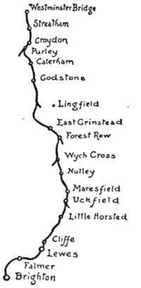
There is no lack of ways to Brighton. Every cyclist knows the way. The way is, of course, that by Croydon, Merstham, Horley, Crawley, Hand Cross, Albourne, and Bolney; but there are several ways of reaching London-on-Sea along good roads. The classic route already named measures 51½ miles, and, like every other way, is measured from the south side of Westminster Bridge. Let us, by way of a healthy change,—for change is the spice of life,—elect to go down by East Grinstead, Uckfield, and Lewes; a route not within the ken of the scorcher, and for that reason the more attractive. This “back way” is but six miles longer than the orthodox route, and has the advantage of being the most picturesque of all. It is identical with the other as far as Croydon and Purley. At that last-mentioned place, rural but a few years since, but no longer so, the route forks to the left, going past a compendious sign-post, large enough for an advertisement hoarding, whereon we may read as[252] we run the notice: “To Riddlesdown, the prettiest spot in Surrey.” If we think that to be something quite apart from the County Council business of properly sign-posting the roads, and due rather to private enterprise, we shall be correct; for it points the way, as a matter of fact, to a paradise of bean-feasters, and was doubtless placed here by some enterprising caterer.
The days when local bodies shall be found charged with the æsthetic mission of guiding to pretty or historic scenes are not yet.
For five miles the road climbs up and up, on its way to the crest of the North Downs and Marden Park, past aforementioned Riddlesdown, where we joyfully leave the swings and the cocoa-nut shies behind, past Kenley and Warlingham stations, with the Downs on the left and a lovely valley on the right, and through Caterham, where there is a military depôt, and where at the ranges the “recruity” is taught the business of shooting. There are many Tommies in the making at Caterham, inchoate guardsmen who have not yet quite lost the shamble of the civilian or acquired the carriage of the soldier and the nice conduct of a swagger-stick.
On the height above Caterham we are on the crest of the North Downs, 777 feet above sea-level, and after admiring the widespread view southward, may reap the reward of the long climb in a breathless coast down two miles of road, past Marden Park, into Godstone, an old-world village rejoicing in the possession of a village green, a pond, and an ancient and[253] picturesque hostelry, recently renamed the “Clayton Arms,” but really the “White Hart,” established in the reign of Richard the Second, whose badge it was.
Bane and antidote succeed on this route with unfailing regularity, and the hamlet of Godstone left behind, the frowning and tremendous ascent of Tilburstow Hill confronts the explorer, who may indeed find a slightly more circuitous and very much less hilly route for the next three miles by taking the left-hand road past Godstone Station, so called perhaps because it is three miles from Godstone and only one and three-quarters from Blindley Heath. This easier way falls into the treadmill route half a mile short of Blindley Heath, which is a modern hamlet arisen on a scene once famous, in Regency days, together with the adjoining Copthorne Common, for prize-fighting contests; notable among them, that famous battle in 1819 between the “Nonpareil” and the “Out-and-Outer,” for whose details[254] the curious reader must be referred to the classic pages of Boxiana.
New Chapel, a hamlet beyond Blindley Heath, is succeeded in four miles by the imposing old town of East Grinstead, a stone-built town of Tudor architecture where assizes were formerly held. Interest is divided between the old “judge’s lodgings,” the noble quadrangular group of almshouses known as “Sackville College,” founded in 1609 by the then Earl of Dorset, and that ancient hostelry, the “Dorset Arms,” over whose doorway there has for some years past appeared a quotation from the present Poet Laureate’s “Fortunatus the Pessimist,” placed there by some landlord more appreciative of the poetry of Mr. Alfred Austin than is commonly the case. It reads—
The bearing of this “lies in the application on it,” as Captain Cuttle remarks. Whether it is intended to convey to the stranger that those of the “Dorset Arms” are all little emperors, from the landlord down to “boots,” or whether it be a hint that they do you well in the matter of accommodation, does not appear.
The explorer who elects to stay the night at East Grinstead, and so continue quietly down the road on the morrow, will find the town and neighbourhood delightful, and—what is more to the point for the jaded Londoner—restful as well. Should he, however, desire to push a little more forward, the smaller and still more quiet townlet of Uckfield, some fourteen miles onward,[257] will fit his whim. From half a mile on the other side of East Grinstead we have been in Sussex, and now the scenery grows even bolder and the roads more lonely. At a mile and a half beyond the old assize town, in a hollow of the hills and beside a stream on the skirts of Ashdown Forest, the little settlement of Forest Row—a Bret Harte-ish, Californian-looking place—is gained. A path to the right, however, by the post-office, leads across meadows to something that California does not, but would be only too proud to, possess—the picturesque ruins of an ancient mansion. Brambletye House, which has sheltered no inmate since the close of the seventeenth century, when a Compton, the last of its owners, married a Spanish heiress and left his country for ever, to reside in the land of the Dons, is the subject of many legends and has given a title and a motive to a romance by one of the Smiths, authors of the Rejected Addresses.
The road, leaving Forest Row, makes its winding way up to Wych Cross and the high tableland of Ashdown Forest, and gives some occasion for the use of the cyclist’s muscles. For “forest,” let long, long plantations of oaks and firs, with gorsy and heathery stretches between, be understood, the whole very solitary. The ironstone of the district renders the road-surface hard and excellent for cycling along. This desirable district is left behind at Nutley, which we leave rapidly behind on the down grade, and so come to Maresfield, standing at a parting of the ways. The left-hand road leads to Uckfield’s long, descending street, whose chief feature is that quaint, old-fashioned coaching inn, the "Maid’s[258] Head," with an immensely long old ballroom provided with an odd minstrels’ gallery at one end. Uckfield was once a thriving place, and its handsome seventeenth and eighteenth century mansions along the one street proclaim that it possessed a cultured society of its own, quite distinct from its bucolic population. London on the one side and Brighton on the other, together with the swiftness and cheapness of modern travel, have filched away the social circle of Uckfield, alike with that of many another townlet.
Onward to Lewes, the county-town of Sussex, the distance is eight miles; the road beautiful and lonely, with but one village—that of Little Horsted—on the way, until quite close to Lewes itself, when the suburb village of Cliffe is passed. Lewes, with its castle, its memories of the great battle in the long ago, its quaint old churches and quainter old houses, piled up against one another along the steep streets, is a place not to be hurried through or properly seen in an hour. There is plenty to see in Lewes, which is a town of closely huddled together old brick houses, several churches, and[259] a grim old castle keep, under which a railway tunnel is now pierced. There is a monument to that doughty seaman, Sir Nicholas Pelham, who died in 1559, to be seen in St. Michael’s Church. He successfully defended Seaford against the French, and the fact is recorded on his tomb, together with a horrible pun on his name—
The cautious cyclist does not put on too much pace in these precipitous ways. Rather, being well-advised, and with the promise of exertion to come, in the great wall of the South Downs that rises before him and seems to forbid farther progress in the direction of Brighton, does he halt and refresh awhile.
Only one village stands along the eight miles on to Brighton. Falmer is the name of it, and it is reached half-way from Lewes. Brighton itself is entered from the north-east, past the cavalry barracks and by its least attractive outskirts.
Southend is a place that labours under many disadvantages. In certain circles, to acknowledge an intimate acquaintance with that salubrious and healthful resort is to be suspect of things unutterable in the Bank Holiday there and back for half a crown way; and the name of Southend—the “Sarfend” or “Soufend” of Cockney speech—certainly brings visions to the mind’s eye of crowded excursion trains or steamboats, where the holiday-making concertina is much in evidence, and the mingled odours of shrimps and water-cresses weight the air as heavily as the scent of the roses in the rose-garden of Omar Khayyam. I am self-condemned by these intimate touches, and indeed I know Southend, and know it in holiday-time and out. I have gone down by cycle and have come up with the concertina; have voyaged from the Port of London to the Port of Southend, and listened the while (however unwillingly) to the music of the band on board playing a once popular ditty called “Three pots a shilling,” or some such romantic title, until, overcome with the exertion, the rolling of the waves, or the effect of the beer they had imbibed—or by all three—they ceased, and a holy calm reigned where the strident cornet and the excruciating[261] violins had but a moment before cast an added melancholy upon the sad sea waves.
Southend, however, is a very fine and a very picturesque place, and extraordinarily bracing; even though the sea of “Southend-on-Sea”—as it prefers to be styled—be indeed half composed of the filthy dregs of London. To it we will make our way by road.
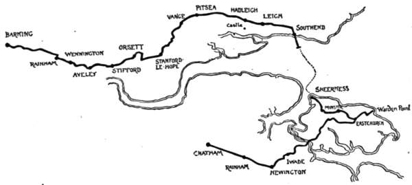
It is the chief disability of this nearest of London’s seaside resorts that one must needs traverse the whole of the unlovely East End in order to reach it, and the cyclist who, like another Strafford, takes for his motto the proud word “thorough,” has no enviable journey before him in his effort to wheel all the way from town. From Whitechapel Church lies his way, down the Commercial and East India Dock roads, and on to Canning Town, where, having crossed the huge iron bridge that spans the Lea and certain of the docks, he finds himself in Essex and within eyeshot of such unpoetic landmarks as Plaistow Marsh, the Northern Outfall Sewer, and the distant pot-bellied gasometers of Beckton. Plaistow and East Ham now lie before him, and, passing[262] these, he comes, across the little river Roding, into the old town of Barking, seven miles from Whitechapel Church and on the edge of the country.
There is a mingled agricultural and maritime air about the distant view of Barking that is not a little alluring; and foreground windmills and fields, and distant views of rust-red sails of barges, peering over ancient roofs, ill prepare the exploratory cyclist for the raw newness and meanness that many of its streets display on a closer acquaintance. Enshrined amid all these modern excrescences are the old Market House and the still older Abbey Gatehouse; this last the sole relic of the once rich and powerful Abbey of Barking, whose Abbess in far-off Saxon days owned a seat in the Witenagemote, the Parliament of that age. It is a mouldering old gateway, this of the old Abbesses of Barking, and oddly at variance with its surroundings; as indeed is the Elizabethan Market House, now the Town Hall. New and old at Barking jostle one another very curiously; the curfew bell still ringing, as a sentimental survival, during six months of every year, as it did in the bad old Norman days, eight hundred years ago.
Flat fields, chiefly serving the useful purpose of the market-gardener, constitute the scenery immediately next the road on leaving Barking; but beyond them, across the turbid estuary of the Thames, made by the witchery of the sunshine to glitter and sparkle as though its waters were of the purest—beyond them rise in the distance the Kentish hills, where the woods of Bostal look down upon busy Plumstead. One mile from Barking, and the traveller sees, rising before him on the[265] right of the flat road, the dark clustered red brick chimneys of an ancient mansion: a furtive-looking, secretive place, for all its size and the fine Tudor style of its architecture. This is Eastbury House, long since abandoned by its owners as a fitting residence, and now occupied by a market-gardener. It was probably the solitary position of the old house and its peculiarly ominous air—as though it could tell a tale an it would—that originally procured it the reputation of being a meeting-place of the conspirators in the Gunpowder Plot. Certainly no scene-painter could devise anything more likely, by the look of it, to have taken part in some dread conspiracy. The very bricks seem to ooze secrets, and in the low doorways and up the darkling staircases Catesbys and Digbys and Guy Fawkeses might reasonably have hidden—only we know they did nothing of the sort, and that the legends about Eastbury House are all fudge and flapdoodle, invented to take away the character of a poor old mansion with no friends of its own. Still, when, as you explore the place, a terrific hullabaloo is heard in one of the staircase turrets and a something black and explosive comes bounding out of a doorway, the incident has perhaps some little heart-shaking qualities, due directly to those legends. It is only when you discover that something to be a spitting and indignant cat, followed by a fox-terrier, that the incident resolves itself into the commonplace.
At Rainham—whose beauties and points of interest, if they exist at all, only reveal themselves to those who have much time to seek them—we do not call a halt, but pass on to Wennington, similarly circumstanced.[266] Beyond this place, instead of taking the Purfleet road, we bear left, and go uphill to Aveley, along a more secluded way than that by the waterside. Interesting old churches here and at Stifford will repay examination and give an interest that the scenery now begins to lack. For here we are come again to the levels and now find ourselves in a tract of country that still retains its old-time name of “Orsett Fen,” even though the fen itself be gone and long level fields take its place. Orsett village itself partakes of this market-gardening and cabbage-growing character, and is distinctly rural, with crazy, weather-boarded cottages a feature of its street. Here our road turns sharply to the right, and again, at the “Cock Inn,” as sharply to the left along a very straight, flat, and dreary highway, whose forbidding character is, however, mitigated by the lovely views of the Essex hills at Laindon and Horndon-on-the-Hill, on the left hand, forming a green and well-wooded range almost at right angles with our course. We have met those hills before in these pages, and somewhat more intimately, and know, therefore, that the distant view of them from these levels is the better part.
Stanford-le-Hope now comes in view, on the other side of a hollow where a little stream flows to the Thames, two miles away, past the suggestively named village of Mucking. Away across the flats comes the bellowing of the great steamships making for Thames Haven, or passing up to or down from London; and when night has come, the red eye of a lighthouse, screwed to piles set in the fathomless mud, winks solemnly at you from out of the vagueness.
We will pass Vange and Pitsea, on their elevated sites, without comment, the last-named leading on to Hadleigh without any intervening village; for Thundersley, midway between the two, is placed half a mile off the road. Thundersley is a very small and very inoffensive little place, in spite of the terrific dignity given by its name. From the high-placed churchyard of its beautiful but dilapidated little Early English church, the eye ranges over Benfleet and Cauvey Island, and over a world of waters and muddy creeks, perhaps not particularly lovely to read about, but beautiful beyond expression in the sunshine.
But Hadleigh, two miles distant, on its steep hillside, presenting a stern and rugged upland to the old pirates who infested the estuary of the Thames in the long ago—Hadleigh takes the palm for historic interest and beauty. Nothing shall be said of Hadleigh Church, fine[270] though it be, and nothing of the Salvation Army’s “Home Colony” for the “submerged tenth,” or the born-tired, or whatever may be the fit and proper title for “General” Booth’s unlovely pets who farm the surrounding fields; Hadleigh Castle only shall be touched upon in these pages. Hubert de Burgh, who built it, built well and truly when he raised its walls, nigh upon seven hundred years ago, and so terrible was the forefront of his fortress, set here on the hilltop,—the first object that attracted the eye of the would-be invader sailing up the Thames,—that the foreign foe on sight of it generally turned tail and fled whence he had come.
Thus it is that Hadleigh Castle has no history in the warlike sort. Its very presence was sufficient. Two hundred years after its towers had been set here to diadem the green hill, the castle was deserted and left to decay, as having served its turn; and since then it has been a quarry to which everyone in the neighbourhood who wanted stone has resorted, so that only the ruined walls of two circular towers are left. But they form a striking and memorable picture, whether you take them for a foreground and gaze thence to Leigh and Southend and the mouth of the Thames, or look upon them and the hill from the pastures below. Constable painted Hadleigh Castle so long ago as 1829, and, truly enough, described its situation as “vastly fine.”
Leigh, that looks so picturesque from this hilltop, keeps that quality even at close quarters. It is a shrimping, winkling, cockling, and whelking town, and[273] all along its maritime street, where beery fishermen, very deliberate in their movements, and broad and patchy in the stern, lounge and gossip, are the most perplexing little cottages and taverns and bothies, with spaces large and spaces small in between; and over all a generous and penetrating scent of shell-fish in process of being cooked. It is a smell that will not be denied, and no wonder, since in almost every one of these little sheds and bothies, and indeed often in the open air, shell-fish and shrimps are, in fact, being cooked by wholesale. That is the business of Leigh, as evidenced by the mountain ranges of winkle and other shells along the foreshore; permanent and indubitable evidence of the success of the local industry.
To reach this part of Leigh—having come from Hadleigh, and carefully negotiated the descent of Bread and Cheese Hill—we turn to the right in midst of the hilltop portion of the village, by the parish church, whose tower is so prominent a landmark, and then walk down the precipitous descent to the fishing community. Between the seashore of Leigh and that of Southend is Westcliff—Westcliff-on-Sea as it is proudly styled, or (still more proudly) “the New Eldorado.” Why styled by so auriferous a name only those responsible for the alluring advertisements of this newly developed building estate can tell; even supposing that they can give a reasonable explanation. Who that has waited weary half-hours at London railway stations has not seen coloured pictorial advertisements of Westcliff; the trees very green, the houses very red, the sea of a more cerulean blue than the Mediterranean in the Bay of[274] Naples, and all the roads as yellow as fine gold? Well, here is the place itself, for comparison.
Southend—maligned Southend, curiously regarded by superior persons as being throughout the year infested with crowds of the worst type of tripper—lies basking in the sunshine, sheltered from northerly winds by rising ground, and looking southward, across where the Thames and the sea mingle, to the Kentish shore and Sheppey, six miles away. Excursion trains and steamboats notwithstanding, Southend, apart from Saturdays in summer and the usual Bank Holiday rush, is not the Cockney pandemonium it is generally represented to be, but a goodly sized and cheerful watering-place, greatly in favour as a residence with many City men, and, with its mild and dry air, one of the healthiest of places for children. The cautious scribe would be afraid to state how far the sea recedes here at the ebb, and certainly one would not like to say how long Southend Pier is now. Some years ago it was a mile and a quarter in length, but since then it has been lengthened, for the purpose of giving a landing-place for steamers at the pier-head at all times of the tide. A pilgrimage from end to end of this structure—doubtless the longest of its kind in England—would be a weariness but for the electric railway that runs its length.
We have now journeyed forty-three miles from London, but if the summer days be long and weather propitious, there is no reason why the tour should not be extended, to include that Isle of Sheppey whose shores are visible from here. Steamers constantly make the passage between this and Sheerness.
Comparatively few cyclists know Sheppey, which is, in fact, very much of an unknown member of the British Isles, even to those who are in a favourable position for reaching it. Does the average man, indeed, stop to consider that the British Isles, all told, large and small, number considerably over two hundred? Of them Sheppey is one of the least remote in point of mileage, but among the loneliest in actual fact, even although its capital—Sheerness—is a large and growing dockyard town.
It is a redundancy to talk of the “Isle of Sheppey,” because its name, deriving as it does from the Saxon “Sceapige” (the “Isle of Sheep”), includes the designation of “island.” It is eleven miles in length, and five miles across its broadest part, and includes the two so-called “isles” of Harty and Elmley, which, once divided from it by slimy creeks, are now practically joined, since modern drainage works have been in progress. Sheppey is a place of the very greatest interest. Its scenery, divided into the marshes that border the Swale, which separates it from the mainland, and into a high ridge or backbone that runs the greater length of the isle, from Sheerness to Warden, is of a peculiarly weird quality, whether you are looking at the low-lying marshlands or at the dull-hued clayey cliffs that face the North Sea, and are continually crumbling away. Trees are few, and grow only in the more sheltered parts of the island. Landing at the jetty by Sheerness railway station, under the guns of the guardship swinging at anchor in the roadstead, and well covered by a circular iron fort springing out of the water,[276] we are in the dockyard town and maritime port of Sheerness, a place, like most towns of the dockyard kind, squalid and mean, coal-gritty and unlovely. There is, it is true, another and a better quarter, Bluetown by name, where the dignified heads of departments and their kind reside, but it does not lie on our line of exploration.
Queenborough, off to the right, is worth seeing by those who have the time. It lies somewhat apart from modern developments, and looks absolutely the same now as when Hogarth drew it, over a hundred years ago, on that down-the-Thames Cockney trip he made with his friends. That is to say, it consists of one long, broad, empty, Dutch-like street, lifeless, and looking quite unlike a place with a history. Originally “Kingborough,” its name was changed by Edward the Third to the one it still bears, in honour of his Queen, Philippa.
A fine road leads from Sheerness on to Minster, past the ugly outlying houses of Miletown. It is with some surprise that the stranger to Sheppey discovers good roads here: the instinctive feeling being, apparently, that coastwise islands are outside the common needs and conveniences of mainlands.
We may turn to the left and reach the coast overlooking the Nore, but our especial business now is to reach Minster, generally called “Minster-in-Sheppey,” to distinguish it from “Minster-in-Thanet.” Minster stands on the higher lands of the island, and, indeed, can be seen from almost every point; its great squat church tower standing on an abrupt hill, surrounded by the little village of brick and boarded cottages, and[279] further with a belt of trees. The square gatehouse, all that is left of the nunnery founded by Saint Saxburga in early Saxon times, stands by the church, and teas are provided there for the weary. Glorious views are obtained from the churchyard; but it is within the church that the great interest of the place lies, for the tomb of Sir Robert de Shurland is here, and here we are upon the scene of that humorous legend of Barham’s—one of the few of the Ingoldsby Legends written in prose. The tomb is in the south aisle, the effigy of the warrior clad in the chain-mail of the thirteenth century. “His hands,” says Barham, “are clasped in prayer: his legs, crossed in that position so prized by Templars in ancient and tailors in modern days, bespeak him a Soldier of the Faith in Palestine. Close behind his dexter calf lies sculptured in high relief a horse’s head.” The local legend upon which Barham founded his story of “Grey Dolphin” is that the Lord of Shurland, happening to pass by the churchyard of Minster, found a fat friar in the act of refusing, unless he was paid for his services, to say the last rites of the Church over the body of a drowned sailor brought for burial. The Baron was not a man with reverence for the dead, or of particularly deep religious opinions, and had—Barham tells us in his legend—already seen to it that the dead sailor’s pockets had been turned inside out, with ill success, for they contained not a single maravedi, but he was incensed by the refusal to bury him. He promptly slew the friar and kicked his body into the open grave, to bear the sailor company. Mother Church was not particularly fond of the greasy friars who at that[280] time infested the country, but she could not brook so flagrant an insult, and accordingly made things extremely unpleasant for the Baron, who, learning that the King lay aboard ship two miles off the coast of Sheppey, swam there and back on his horse, Grey Dolphin, and obtained a pardon. On returning to the shore, he met an old woman who prophesied that the horse who had now helped to save his life should one day cause his death. To render this, as he thought, impossible, the Baron killed Grey Dolphin on the spot. The next year, however, chancing to pass the place, he kicked against the bleached skull of his old charger, still lying on the beach, and, a fragment of bone penetrating his foot, blood-poisoning set in, and he died of gangrene.
Here, then, is the effigy of the horse’s head carved beside it. The Baron’s hands are not, indeed, “clasped in prayer,” for his arms have been shorn off by some vandals at the elbows; but that is a detail. His sword and lance lie by his side. “It was the fashion in feudal times,” says Barham, “to give names to swords: King Arthur’s was christened Excalibur; the Baron called his Tickletoby, and when he took it in hand, it was no joke.”
Sir Robert de Shurland, unlike many of the figures who flit through the merry pages of the Ingoldsby Legends, was thus a very real personage. He lived in the reign of Edward the First, and the fact of his having been granted “wreck of the sea” may have originated the story which purports to account for the horse’s head, swimming through waves, carved conspicuously on[281] his tomb. “Wreck of the sea” was the right of laying claim to anything along the foreshore of a manor; any flotsam and jetsam that could be reached by the point of a lance when riding as far as possible into the sea at low water. Unless thus specifically granted away, the right of Flotsam and Jetsam along the coasts belonged, and still belongs, to the Crown.
The legend has acquired for Minster Church the local name of the “Horse Church,” and is alluded to in the weathervane of a horse’s head, surmounted by a little effigy of a running horse. Before leaving the building, notice the mutilated effigy, supposed to be that of a Spanish prisoner who died in durance on board at the Nore, and also that of a knight, supposed to be Jordanus de Scapeia, whose clasped hands hold a mystic oval sculptured with a little effigy symbolising the soul.
Given calm weather, or with the wind in one’s favour, cycling in Sheppey is a delight, for the roads, with the exception of this that leads down again from Minster, are either quite flat or gently undulating, and the surface is of the best; and there is practically no traffic to prevent one bowling along at high speed. But with the wind against you—and when there is any wind it blows the greatest of great guns across these unprotected flats—there is absolutely nothing for it but to walk. After two miles’ cycling from Minster we come to Eastchurch. Here is a tiny village with a handsome old church, and, a little distance away, the imposing pile of Shurland House, a Gothic, red brick, battlemented building, built by Sir Thomas Cheyney, Warden of the Cinque Ports,[282] about 1550, and the successor of that Shurland Castle inhabited by the Sir Robert de Shurland whom we have seen to be the hero of the Ingoldsby Legend of “Grey Dolphin.”
Turning to the left in the village street of Eastchurch, and bearing to the right at the next turning, Warden is reached in two miles—what is left of Warden, that is to say, for the encroachments of the sea have swept away most of it. All that is left is the inelegantly named “Mud Row,” at whose end a rough bar across the rutty lane prevents one cycling over the edge of the cliffs into the sea. Here is a scene of the wildest desolation. The cliffs, about one hundred feet high, composed of dark, greasy, and crumbling clay, have slipped and fallen in every direction, and the sea at the bottom is discoloured far out with the débris. For many years past this process has been going on, and by this time some eighty acres have been swallowed up and dissolved. In 1836 the parish church was rebuilt with the stones from old London Bridge, demolished in 1832 for the building of the present structure. Delamark Banks, son of Sir Edward Banks, the contractor for the bridge, gave the stones and rebuilt the church, as a tablet removed from it, and now forming part of a garden wall at Mud Row, tells us. But it was not fated to stand long. The sea had sapped up to the church by 1870, and it was then closed. In 1877 it was pulled down, and the heaps of stones still lie by the beach a mile away. At the same time, the bodies of those who had been buried in the churchyard during the previous thirty years were disinterred and removed to Minster. But, as the cliffs continue[283] to fall, the poor remains of the more ancient dead are still exposed here, and bleach in the sun: a grisly sight. It was but a little while ago that the present writer, visiting the spot, observed children engaged in the gruesome and morbid occupation of digging out skeletons for “amusement.” And not the children of ignorant cottagers, for whom there might possibly be some excuse, but of people of perhaps some pretensions to culture and right feeling. Is it not something of a scandal that the ecclesiastical authorities should allow so dreadful a thing? Warden Point, with its village gone but its older inhabitants still thus in evidence, is a melancholy place. The sea heaves and rolls in a muddy discoloration far out, and eats away the island day by day.
Those who have time may, on returning to Eastchurch, visit Leysdown and Shellness, that low, sandy spit looking on the map like Spurn Head in Yorkshire. It looks across the water to Whitstable, and is an historic spot, sharing with Elmley Ferry the fame of being the place where that frantic bigot, James the Second, was captured when attempting an escape into France. Harty, too, in the flats, may be visited. There is a good deal of exploration possible, even in Sheppey. For ourselves, we will just return to Eastchurch, there taking the left-hand road and following it for four miles, when a left-hand turn conducts to King’s Ferry, which, to the cyclist seeking the island from London and Chatham, is the best way of entering. The road is of splendid quality, running through the sad, sage-coloured marshes to where a railway bridge on the line from Sittingbourne to Queenborough and Sheerness—a railway bridge and a road bridge combined—now spans the ancient King’s Ferry, across the quarter-of-a-mile channel of the Swale. The toll is cheap—a penny for self and cycle inclusive.
There are four other entrances, but the King’s Ferry Bridge is the only way by which the cyclist can wheel across into, or from, the isle. There is a ferry from Faversham and Oare to Harty, and another from Sittingbourne and Murston to Elmley.
Five miles of a winding and gently rising Kentish
lane, sandy and bordered with orchards, lead past Iwade.
It is not, evidently, a greatly frequented route, for two
field-gates bar the way, and necessitate a dismount for
opening them. Nearing Newington, a mile of loose[285]
[286]
flints induces the man careful of his tyres to get off and
walk; a change that need be no cause for grumbling
here, for the scene is beautiful, with that soft, rich Kentish
beauty which has earned the county the name of “the
garden of England.”
It is an idyllic and peaceful picture that unfolds itself at Newington, a roadside village, which, like many another place called “new,” is of immense antiquity, standing as it does on that old Roman military way, the Watling Street, between Dover and London, and the successor of a Roman village. Here the cherry, the pear, and apple orchards are at their best, and the hop-gardens are not wanting. Also (another relic of the Romans, who introduced them from Italy), sweet-chestnut trees abound. The ancient parish church is reached at some distance before the high road: a venerable building whose mouldering tower is built in alternate courses of stone and flints. Opposite a postal pillar-box, within a few yards of the church, notice the so-called “Devil’s Stone,” planted at the edge of the road and footpath. A very fine and large effigy of a boot-sole is seen on it. The legend runs that the Devil objected to the church being built, and, placing his back against the tower, and his foot against this stone, pushed. From the illustration, in which this stone and the church are both seen, it will be observed that the Devil must of necessity have been singularly tall to have performed this feat—or to have attempted it. But the builders had built better than they knew, and the church stood immovable. The obvious criticism that the stranger makes on seeing the stone, is that the boot-print is in[287] relief instead of pressed into it. There are things well worth seeing in the old church: brasses and screens, a copy of the eccentric will of an old-time inhabitant, and a curious altar-tomb, with a passage through one of its panels, through which, as a charm, the sick or bewitched were passed to cure them. The church is secluded amid hop-kilns and fruit farms, and backed by a wooded knoll.
It is a run of seven miles from Newington to Chatham, through Rainham, identical in name with the Essex Rainham we have already passed through. One of the finest panoramas in the world lies stretched out below this road, on the right hand, the whole of the way: the panorama, that is to say, of the broad estuary of the Medway, crowded with vessels, large and small, where the Might of the Mailed Hand of England is plain to see, in the big battleships and the smart cruisers that occupy the fairway. Gazing here, down upon these evidences of power, you feel that it is good to be an Englishman, and to have a part and lot in the sovereignty of the sea thus made manifest. And even as you look upon these signs of world-admiralty, a tiny white puff bursts out over the vermicular silver threads where the creeks run through the marshes, and a hoarse roar and a simultaneous concussion of air upon your cheek betoken gun-practice.
A very long and very steep descent leads down from Chatham Hill into the busy town, past the hideous unfinished temple of that mad sect, the Jezreelites, crowning the hilltop and visible for many miles. Jezreel is dead and his sect moribund, but the evidence[288] of his hot gospelling and of the folly of his dupes bulks large in this gigantic pile of bricks and mortar. At Chatham we join on to other runs, described in earlier pages of this volume.
The END
PRINTED BY MORRISON AND GIBB LIMITED, EDINBURGH
Transcriber’s notes:
In the text version, italics are represented by _underscores_, and bold and black letter text by =equals= symbols. Superscripts are represented by ^{} and subscripts by _{}
Missing or incorrect punctuation has been repaired.
Inconsistent spelling and hyphenation have been left as printed.
End of Project Gutenberg's Cycle Rides Round London, by Charles G. Harper

*** END OF THIS PROJECT GUTENBERG EBOOK CYCLE RIDES ROUND LONDON ***

***** This file should be named 58764-h.htm or 58764-h.zip *****
This and all associated files of various formats will be found in:
        http://www.gutenberg.org/5/8/7/6/58764/

Produced by Chris Curnow, Chris Jordan and the Online
Distributed Proofreading Team at http://www.pgdp.net (This
file was produced from images generously made available
by The Internet Archive)


Updated editions will replace the previous one--the old editions will
be renamed.

Creating the works from print editions not protected by U.S. copyright
law means that no one owns a United States copyright in these works,
so the Foundation (and you!) can copy and distribute it in the United
States without permission and without paying copyright
royalties. Special rules, set forth in the General Terms of Use part
of this license, apply to copying and distributing Project
Gutenberg-tm electronic works to protect the PROJECT GUTENBERG-tm
concept and trademark. Project Gutenberg is a registered trademark,
and may not be used if you charge for the eBooks, unless you receive
specific permission. If you do not charge anything for copies of this
eBook, complying with the rules is very easy. You may use this eBook
for nearly any purpose such as creation of derivative works, reports,
performances and research. They may be modified and printed and given
away--you may do practically ANYTHING in the United States with eBooks
not protected by U.S. copyright law. Redistribution is subject to the
trademark license, especially commercial redistribution.

START: FULL LICENSE

THE FULL PROJECT GUTENBERG LICENSE
PLEASE READ THIS BEFORE YOU DISTRIBUTE OR USE THIS WORK

To protect the Project Gutenberg-tm mission of promoting the free
distribution of electronic works, by using or distributing this work
(or any other work associated in any way with the phrase "Project
Gutenberg"), you agree to comply with all the terms of the Full
Project Gutenberg-tm License available with this file or online at
www.gutenberg.org/license.

Section 1. General Terms of Use and Redistributing Project
Gutenberg-tm electronic works

1.A. By reading or using any part of this Project Gutenberg-tm
electronic work, you indicate that you have read, understand, agree to
and accept all the terms of this license and intellectual property
(trademark/copyright) agreement. If you do not agree to abide by all
the terms of this agreement, you must cease using and return or
destroy all copies of Project Gutenberg-tm electronic works in your
possession. If you paid a fee for obtaining a copy of or access to a
Project Gutenberg-tm electronic work and you do not agree to be bound
by the terms of this agreement, you may obtain a refund from the
person or entity to whom you paid the fee as set forth in paragraph
1.E.8.

1.B. "Project Gutenberg" is a registered trademark. It may only be
used on or associated in any way with an electronic work by people who
agree to be bound by the terms of this agreement. There are a few
things that you can do with most Project Gutenberg-tm electronic works
even without complying with the full terms of this agreement. See
paragraph 1.C below. There are a lot of things you can do with Project
Gutenberg-tm electronic works if you follow the terms of this
agreement and help preserve free future access to Project Gutenberg-tm
electronic works. See paragraph 1.E below.

1.C. The Project Gutenberg Literary Archive Foundation ("the
Foundation" or PGLAF), owns a compilation copyright in the collection
of Project Gutenberg-tm electronic works. Nearly all the individual
works in the collection are in the public domain in the United
States. If an individual work is unprotected by copyright law in the
United States and you are located in the United States, we do not
claim a right to prevent you from copying, distributing, performing,
displaying or creating derivative works based on the work as long as
all references to Project Gutenberg are removed. Of course, we hope
that you will support the Project Gutenberg-tm mission of promoting
free access to electronic works by freely sharing Project Gutenberg-tm
works in compliance with the terms of this agreement for keeping the
Project Gutenberg-tm name associated with the work. You can easily
comply with the terms of this agreement by keeping this work in the
same format with its attached full Project Gutenberg-tm License when
you share it without charge with others.

1.D. The copyright laws of the place where you are located also govern
what you can do with this work. Copyright laws in most countries are
in a constant state of change. If you are outside the United States,
check the laws of your country in addition to the terms of this
agreement before downloading, copying, displaying, performing,
distributing or creating derivative works based on this work or any
other Project Gutenberg-tm work. The Foundation makes no
representations concerning the copyright status of any work in any
country outside the United States.

1.E. Unless you have removed all references to Project Gutenberg:

1.E.1. The following sentence, with active links to, or other
immediate access to, the full Project Gutenberg-tm License must appear
prominently whenever any copy of a Project Gutenberg-tm work (any work
on which the phrase "Project Gutenberg" appears, or with which the
phrase "Project Gutenberg" is associated) is accessed, displayed,
performed, viewed, copied or distributed:

  This eBook is for the use of anyone anywhere in the United States and
  most other parts of the world at no cost and with almost no
  restrictions whatsoever. You may copy it, give it away or re-use it
  under the terms of the Project Gutenberg License included with this
  eBook or online at www.gutenberg.org. If you are not located in the
  United States, you'll have to check the laws of the country where you
  are located before using this ebook.

1.E.2. If an individual Project Gutenberg-tm electronic work is
derived from texts not protected by U.S. copyright law (does not
contain a notice indicating that it is posted with permission of the
copyright holder), the work can be copied and distributed to anyone in
the United States without paying any fees or charges. If you are
redistributing or providing access to a work with the phrase "Project
Gutenberg" associated with or appearing on the work, you must comply
either with the requirements of paragraphs 1.E.1 through 1.E.7 or
obtain permission for the use of the work and the Project Gutenberg-tm
trademark as set forth in paragraphs 1.E.8 or 1.E.9.

1.E.3. If an individual Project Gutenberg-tm electronic work is posted
with the permission of the copyright holder, your use and distribution
must comply with both paragraphs 1.E.1 through 1.E.7 and any
additional terms imposed by the copyright holder. Additional terms
will be linked to the Project Gutenberg-tm License for all works
posted with the permission of the copyright holder found at the
beginning of this work.

1.E.4. Do not unlink or detach or remove the full Project Gutenberg-tm
License terms from this work, or any files containing a part of this
work or any other work associated with Project Gutenberg-tm.

1.E.5. Do not copy, display, perform, distribute or redistribute this
electronic work, or any part of this electronic work, without
prominently displaying the sentence set forth in paragraph 1.E.1 with
active links or immediate access to the full terms of the Project
Gutenberg-tm License.

1.E.6. You may convert to and distribute this work in any binary,
compressed, marked up, nonproprietary or proprietary form, including
any word processing or hypertext form. However, if you provide access
to or distribute copies of a Project Gutenberg-tm work in a format
other than "Plain Vanilla ASCII" or other format used in the official
version posted on the official Project Gutenberg-tm web site
(www.gutenberg.org), you must, at no additional cost, fee or expense
to the user, provide a copy, a means of exporting a copy, or a means
of obtaining a copy upon request, of the work in its original "Plain
Vanilla ASCII" or other form. Any alternate format must include the
full Project Gutenberg-tm License as specified in paragraph 1.E.1.

1.E.7. Do not charge a fee for access to, viewing, displaying,
performing, copying or distributing any Project Gutenberg-tm works
unless you comply with paragraph 1.E.8 or 1.E.9.

1.E.8. You may charge a reasonable fee for copies of or providing
access to or distributing Project Gutenberg-tm electronic works
provided that

* You pay a royalty fee of 20% of the gross profits you derive from
  the use of Project Gutenberg-tm works calculated using the method
  you already use to calculate your applicable taxes. The fee is owed
  to the owner of the Project Gutenberg-tm trademark, but he has
  agreed to donate royalties under this paragraph to the Project
  Gutenberg Literary Archive Foundation. Royalty payments must be paid
  within 60 days following each date on which you prepare (or are
  legally required to prepare) your periodic tax returns. Royalty
  payments should be clearly marked as such and sent to the Project
  Gutenberg Literary Archive Foundation at the address specified in
  Section 4, "Information about donations to the Project Gutenberg
  Literary Archive Foundation."

* You provide a full refund of any money paid by a user who notifies
  you in writing (or by e-mail) within 30 days of receipt that s/he
  does not agree to the terms of the full Project Gutenberg-tm
  License. You must require such a user to return or destroy all
  copies of the works possessed in a physical medium and discontinue
  all use of and all access to other copies of Project Gutenberg-tm
  works.

* You provide, in accordance with paragraph 1.F.3, a full refund of
  any money paid for a work or a replacement copy, if a defect in the
  electronic work is discovered and reported to you within 90 days of
  receipt of the work.

* You comply with all other terms of this agreement for free
  distribution of Project Gutenberg-tm works.

1.E.9. If you wish to charge a fee or distribute a Project
Gutenberg-tm electronic work or group of works on different terms than
are set forth in this agreement, you must obtain permission in writing
from both the Project Gutenberg Literary Archive Foundation and The
Project Gutenberg Trademark LLC, the owner of the Project Gutenberg-tm
trademark. Contact the Foundation as set forth in Section 3 below.

1.F.

1.F.1. Project Gutenberg volunteers and employees expend considerable
effort to identify, do copyright research on, transcribe and proofread
works not protected by U.S. copyright law in creating the Project
Gutenberg-tm collection. Despite these efforts, Project Gutenberg-tm
electronic works, and the medium on which they may be stored, may
contain "Defects," such as, but not limited to, incomplete, inaccurate
or corrupt data, transcription errors, a copyright or other
intellectual property infringement, a defective or damaged disk or
other medium, a computer virus, or computer codes that damage or
cannot be read by your equipment.

1.F.2. LIMITED WARRANTY, DISCLAIMER OF DAMAGES - Except for the "Right
of Replacement or Refund" described in paragraph 1.F.3, the Project
Gutenberg Literary Archive Foundation, the owner of the Project
Gutenberg-tm trademark, and any other party distributing a Project
Gutenberg-tm electronic work under this agreement, disclaim all
liability to you for damages, costs and expenses, including legal
fees. YOU AGREE THAT YOU HAVE NO REMEDIES FOR NEGLIGENCE, STRICT
LIABILITY, BREACH OF WARRANTY OR BREACH OF CONTRACT EXCEPT THOSE
PROVIDED IN PARAGRAPH 1.F.3. YOU AGREE THAT THE FOUNDATION, THE
TRADEMARK OWNER, AND ANY DISTRIBUTOR UNDER THIS AGREEMENT WILL NOT BE
LIABLE TO YOU FOR ACTUAL, DIRECT, INDIRECT, CONSEQUENTIAL, PUNITIVE OR
INCIDENTAL DAMAGES EVEN IF YOU GIVE NOTICE OF THE POSSIBILITY OF SUCH
DAMAGE.

1.F.3. LIMITED RIGHT OF REPLACEMENT OR REFUND - If you discover a
defect in this electronic work within 90 days of receiving it, you can
receive a refund of the money (if any) you paid for it by sending a
written explanation to the person you received the work from. If you
received the work on a physical medium, you must return the medium
with your written explanation. The person or entity that provided you
with the defective work may elect to provide a replacement copy in
lieu of a refund. If you received the work electronically, the person
or entity providing it to you may choose to give you a second
opportunity to receive the work electronically in lieu of a refund. If
the second copy is also defective, you may demand a refund in writing
without further opportunities to fix the problem.

1.F.4. Except for the limited right of replacement or refund set forth
in paragraph 1.F.3, this work is provided to you 'AS-IS', WITH NO
OTHER WARRANTIES OF ANY KIND, EXPRESS OR IMPLIED, INCLUDING BUT NOT
LIMITED TO WARRANTIES OF MERCHANTABILITY OR FITNESS FOR ANY PURPOSE.

1.F.5. Some states do not allow disclaimers of certain implied
warranties or the exclusion or limitation of certain types of
damages. If any disclaimer or limitation set forth in this agreement
violates the law of the state applicable to this agreement, the
agreement shall be interpreted to make the maximum disclaimer or
limitation permitted by the applicable state law. The invalidity or
unenforceability of any provision of this agreement shall not void the
remaining provisions.

1.F.6. INDEMNITY - You agree to indemnify and hold the Foundation, the
trademark owner, any agent or employee of the Foundation, anyone
providing copies of Project Gutenberg-tm electronic works in
accordance with this agreement, and any volunteers associated with the
production, promotion and distribution of Project Gutenberg-tm
electronic works, harmless from all liability, costs and expenses,
including legal fees, that arise directly or indirectly from any of
the following which you do or cause to occur: (a) distribution of this
or any Project Gutenberg-tm work, (b) alteration, modification, or
additions or deletions to any Project Gutenberg-tm work, and (c) any
Defect you cause.

Section 2. Information about the Mission of Project Gutenberg-tm

Project Gutenberg-tm is synonymous with the free distribution of
electronic works in formats readable by the widest variety of
computers including obsolete, old, middle-aged and new computers. It
exists because of the efforts of hundreds of volunteers and donations
from people in all walks of life.

Volunteers and financial support to provide volunteers with the
assistance they need are critical to reaching Project Gutenberg-tm's
goals and ensuring that the Project Gutenberg-tm collection will
remain freely available for generations to come. In 2001, the Project
Gutenberg Literary Archive Foundation was created to provide a secure
and permanent future for Project Gutenberg-tm and future
generations. To learn more about the Project Gutenberg Literary
Archive Foundation and how your efforts and donations can help, see
Sections 3 and 4 and the Foundation information page at
www.gutenberg.org Section 3. Information about the Project Gutenberg
Literary Archive Foundation

The Project Gutenberg Literary Archive Foundation is a non profit
501(c)(3) educational corporation organized under the laws of the
state of Mississippi and granted tax exempt status by the Internal
Revenue Service. The Foundation's EIN or federal tax identification
number is 64-6221541. Contributions to the Project Gutenberg Literary
Archive Foundation are tax deductible to the full extent permitted by
U.S. federal laws and your state's laws.

The Foundation's principal office is in Fairbanks, Alaska, with the
mailing address: PO Box 750175, Fairbanks, AK 99775, but its
volunteers and employees are scattered throughout numerous
locations. Its business office is located at 809 North 1500 West, Salt
Lake City, UT 84116, (801) 596-1887. Email contact links and up to
date contact information can be found at the Foundation's web site and
official page at www.gutenberg.org/contact

For additional contact information:

    Dr. Gregory B. Newby
    Chief Executive and Director
    gbnewby@pglaf.org

Section 4. Information about Donations to the Project Gutenberg
Literary Archive Foundation

Project Gutenberg-tm depends upon and cannot survive without wide
spread public support and donations to carry out its mission of
increasing the number of public domain and licensed works that can be
freely distributed in machine readable form accessible by the widest
array of equipment including outdated equipment. Many small donations
($1 to $5,000) are particularly important to maintaining tax exempt
status with the IRS.

The Foundation is committed to complying with the laws regulating
charities and charitable donations in all 50 states of the United
States. Compliance requirements are not uniform and it takes a
considerable effort, much paperwork and many fees to meet and keep up
with these requirements. We do not solicit donations in locations
where we have not received written confirmation of compliance. To SEND
DONATIONS or determine the status of compliance for any particular
state visit www.gutenberg.org/donate

While we cannot and do not solicit contributions from states where we
have not met the solicitation requirements, we know of no prohibition
against accepting unsolicited donations from donors in such states who
approach us with offers to donate.

International donations are gratefully accepted, but we cannot make
any statements concerning tax treatment of donations received from
outside the United States. U.S. laws alone swamp our small staff.

Please check the Project Gutenberg Web pages for current donation
methods and addresses. Donations are accepted in a number of other
ways including checks, online payments and credit card donations. To
donate, please visit: www.gutenberg.org/donate

Section 5. General Information About Project Gutenberg-tm electronic works.

Professor Michael S. Hart was the originator of the Project
Gutenberg-tm concept of a library of electronic works that could be
freely shared with anyone. For forty years, he produced and
distributed Project Gutenberg-tm eBooks with only a loose network of
volunteer support.

Project Gutenberg-tm eBooks are often created from several printed
editions, all of which are confirmed as not protected by copyright in
the U.S. unless a copyright notice is included. Thus, we do not
necessarily keep eBooks in compliance with any particular paper
edition.

Most people start at our Web site which has the main PG search
facility: www.gutenberg.org

This Web site includes information about Project Gutenberg-tm,
including how to make donations to the Project Gutenberg Literary
Archive Foundation, how to help produce our new eBooks, and how to
subscribe to our email newsletter to hear about new eBooks.