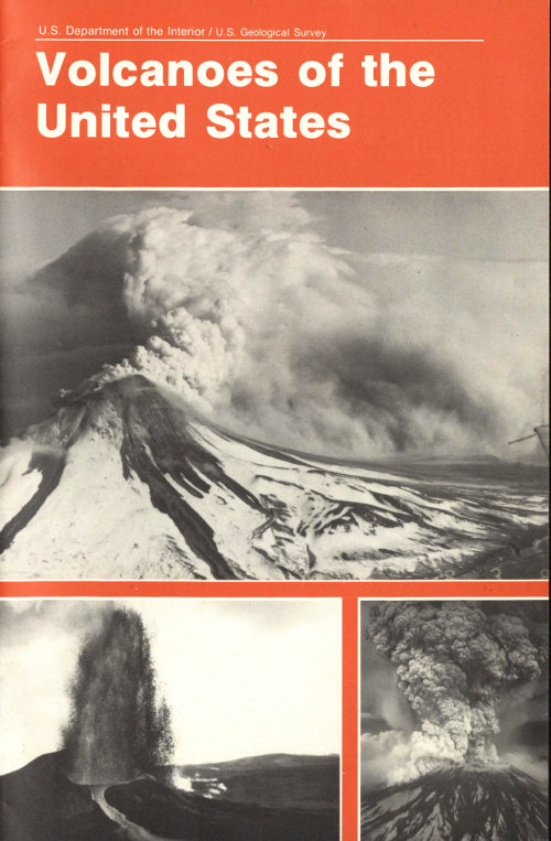
Project Gutenberg's Volcanoes of the United States, by Steven R. Brantley

This eBook is for the use of anyone anywhere in the United States and most
other parts of the world at no cost and with almost no restrictions
whatsoever.  You may copy it, give it away or re-use it under the terms of
the Project Gutenberg License included with this eBook or online at
www.gutenberg.org.  If you are not located in the United States, you'll have
to check the laws of the country where you are located before using this ebook.

Title: Volcanoes of the United States

Author: Steven R. Brantley

Release Date: July 17, 2018 [EBook #57530]

Language: English

Character set encoding: UTF-8

*** START OF THIS PROJECT GUTENBERG EBOOK VOLCANOES OF THE UNITED STATES ***


Produced by Stephen Hutcheson and the Online Distributed
Proofreading Team at http://www.pgdp.net
by Steven R. Brantley
For sale by the US. Government Printing Office
Superintendent of Documents, Mail Stop: SSOP, Washington, DC 20402-9328
ISBN 0-16-045054-3
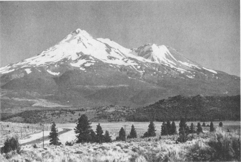
Mount Shasta, California, has erupted at least 10 times in the past 3,400 years and at least 3 times in the past 750 years. (Photograph by Lyn Topinka.)
Few natural forces are as spectacular and threatening, or have played such a dominant role in shaping the face of the Earth, as erupting volcanoes. Volcanism has built some of the world’s greatest mountain ranges, covered vast regions with lava (molten rock at the Earth’s surface), and triggered explosive eruptions whose size and power are nearly impossible for us to imagine today. Fortunately, such calamitous eruptions occur infrequently. Of the 50 or so volcanoes that erupt every year, however, a few severely disrupt human activities. Between 1980 and 1990, volcanic activity killed at least 26,000 people and forced nearly 450,000 to flee from their homes.
Though few people in the United States may actually experience an erupting volcano, the evidence for earlier volcanism is preserved in many rocks of North America. Features seen in volcanic rocks only hours old are also present in ancient volcanic rocks, both at the surface and buried beneath younger deposits. A thick ash deposit sandwiched between layers of sandstone in Nebraska, the massive granite peaks of the Sierra Nevada mountain range, and a variety of volcanic layers found in eastern Maine are but a few of the striking clues of past volcanism. With this perspective, an erupting volcano is not only an exciting and awesome spectacle in its own right but a window into a natural process that has happened over and over again throughout Earth’s history.
The Earth’s crust, on which we live and depend, is in large part the product of millions of once-active volcanoes and tremendous volumes of magma (molten rock below ground) that did not erupt but instead cooled below the surface. Such persistent and widespread volcanism has resulted in many valuable natural resources throughout the world. For example, volcanic ash blown over thousands of square kilometers of land increases soil fertility for forests and agriculture by adding nutrients and acting as a mulch. Groundwater heated by large, still-hot 3 magma bodies can be tapped for geothermal energy. And over many thousands of years, heated groundwater has concentrated valuable minerals, including copper, tin, gold, and silver, into deposits that are mined throughout the world.
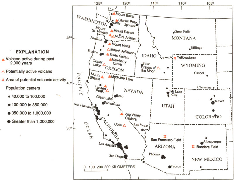
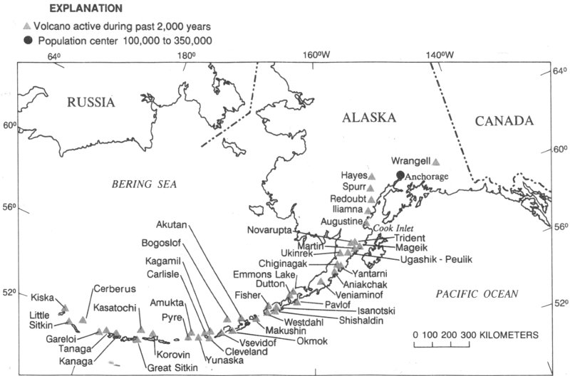
The United States ranks third, behind Indonesia and Japan, in the number of historically active volcanoes (that is, those for which we have written accounts of eruptions). In addition, about 10 percent of the more than 1,500 volcanoes that have erupted in the past 10,000 years are located in the United States. Most of these volcanoes are found in the Aleutian Islands, the Alaska Peninsula, the Hawaiian Islands, and the Cascade Range of the Pacific Northwest; the remainder are widely distributed in the western part of the Nation. A few U.S. volcanoes have produced some of the largest and most dangerous types of eruptions in this century, while several others have threatened to erupt.
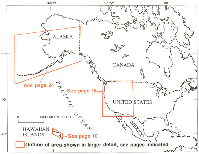
Map of United States showing areas where active volcanoes are located and shown later in more detail.
Scientists at the U.S. Geological Survey (USGS) engage in a variety of research activities in order to reduce the loss of life and property that can result from volcanic eruptions and to minimize the social and economic turmoil that can result when volcanoes threaten to erupt. These activities include studies of the physical processes before, during, and after a volcanic eruption, assessments of volcano hazards, and public outreach to translate scientific information about volcanoes into terms that are meaningful to the public and public officials.
Monitoring volcanoes for signs of activity, another vital component, is carried out by USGS earth scientists at three volcano observatories, which were established to study active volcanoes in Hawaii (1912), the Cascades (1980), and Alaska (1988). These researchers record earthquakes, survey the surfaces of volcanoes, map volcanic rock deposits, and analyze the chemistry of volcanic gas and fresh lava to detect warning signs of impending activity and determine the most likely type of activity that will affect areas around a volcano. During the past 10 years, several warnings of eruptions were issued by the USGS and monitoring of recently active volcanoes in the United States was expanded. Predicting the time and size of volcanic eruptions, however, remains a difficult challenge for scientists.
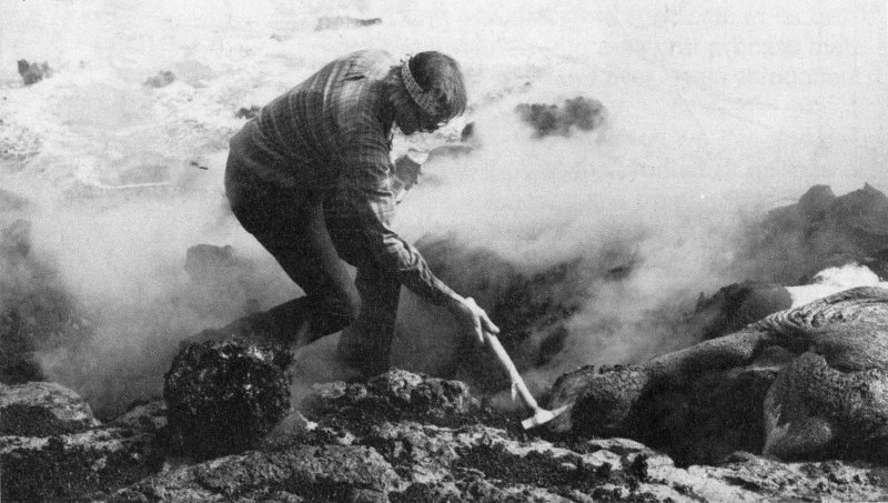
Scientist collects lava sample from lava flow entering the sea on Kilauea Volcano. (Photograph by J.D. Griggs.)
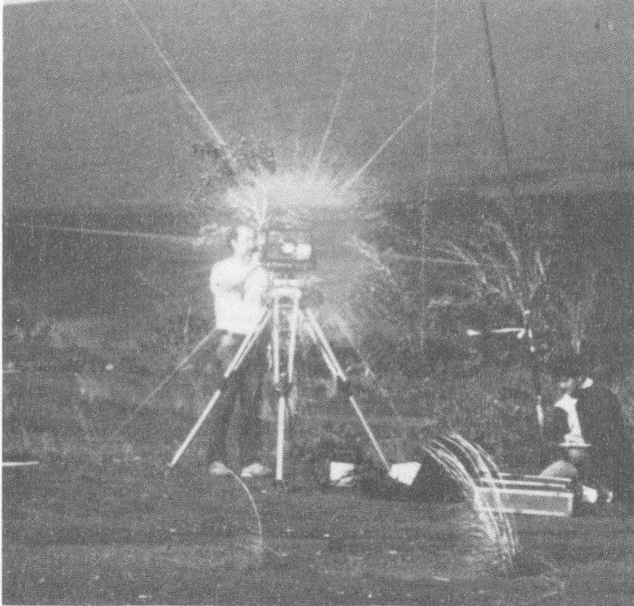
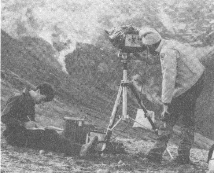
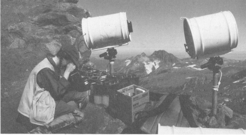
Scientists conducting field studies on active volcanoes in the United States.
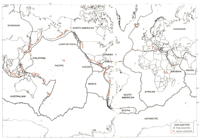
Volcanoes are not randomly distributed over the Earth’s surface. Most are concentrated on the edges of continents, along island chains, or beneath the sea forming long mountain ranges. More than half of the world’s active 7 volcanoes above sea level encircle the Pacific Ocean to form the circum-Pacific “Ring of Fire.” In the past 25 years, scientists have developed a theory—called plate tectonics—that explains the locations of volcanoes and their relationship to other large-scale geologic features.
According to this theory, the Earth’s surface is made up of a patchwork of about a dozen large 8 plates that move relative to one another at speeds from less than one centimeter to about ten centimeters per year (about the speed at which fingernails grow). These rigid plates, whose average thickness is about 80 kilometers, are spreading apart, sliding past each other, or colliding with each other in slow motion on top of the Earth’s hot, pliable interior. Volcanoes tend to form where plates collide or spread apart, but they can also grow in the middle of a plate, as for example the Hawaiian volcanoes.
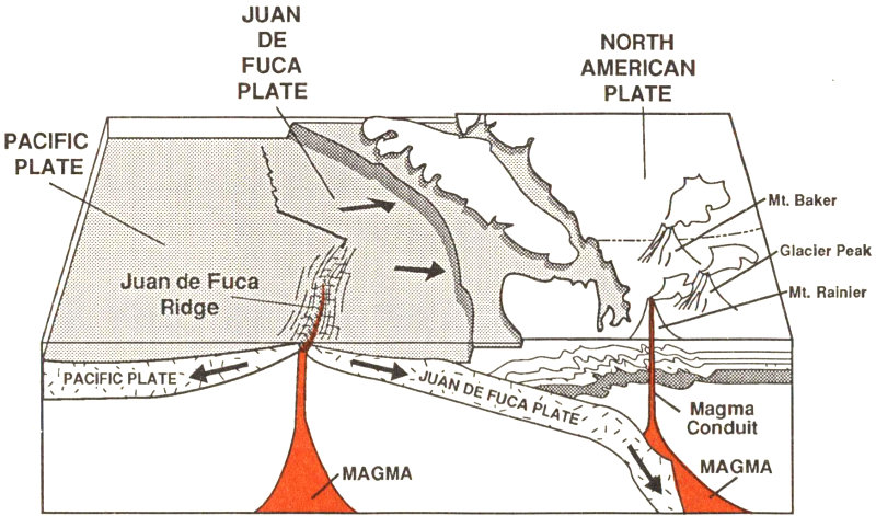
The boundary between the Pacific and Juan de Fuca Plates is marked by a broad submarine mountain chain about 500 km long, known as the Juan de Fuca Ridge. Young volcanoes, lava flows, and hot springs were discovered in a broad valley less than 8 km wide along the crest of the ridge in the 1970’s. The ocean floor is spreading apart and forming new ocean crust along this valley or “rift” as hot magma from the Earth’s interior is injected into the ridge and erupted at its top.
In the Pacific Northwest, the Juan de Fuca Plate plunges beneath the North American Plate. As the denser plate of oceanic crust is forced deep into the Earth’s interior beneath the continental plate, a process known as subduction, it encounters high temperatures and pressures that partially melt solid rock. Some of this newly formed magma rises toward the Earth’s surface to erupt, forming a chain of volcanoes above the subduction zone.
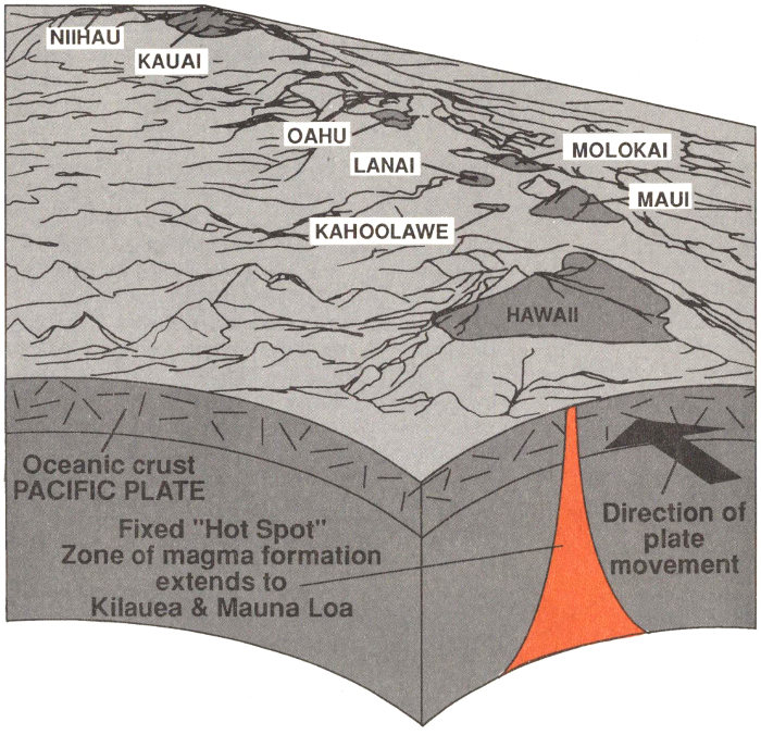
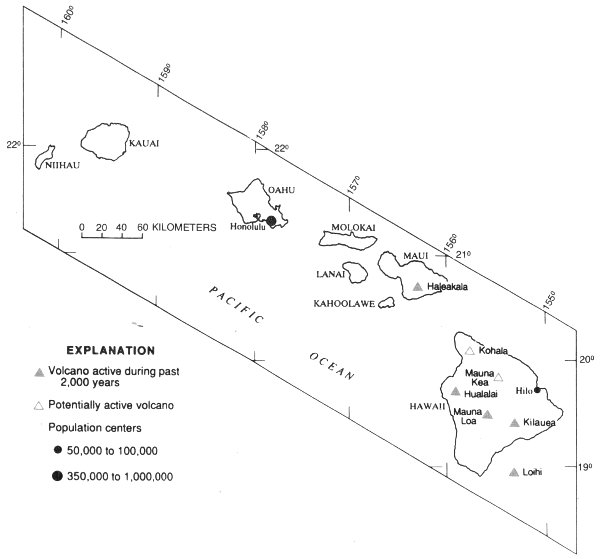
Located in the middle of the Pacific Plate, the volcanoes of the Hawaiian Island chain are among the largest on Earth. The volcanoes stretch 2,500 km across the north Pacific Ocean and become progressively older to the northwest. Formed initially above a relatively stationary “hot spot” in the Earth’s interior, each volcano was rafted away from the hot spot as the Pacific Plate moves northwestward at about 9 cm per year. The island of Hawaii consists of the youngest volcanoes in the chain and is currently located over the hot spot.
Few places on Earth allow closer or more dramatic views of volcanic activity than Mauna Loa and Kilauea volcanoes on the island of Hawaii. Their frequent but usually non-explosive eruptions make them ideal for scientific study. Kilauea’s eruptions are so intensely monitored that scientists have assembled a detailed picture of the volcano’s magma reservoir “plumbing” system and how it behaves before and during eruptions. Studies of these volcanoes and the surrounding ocean floor continue to improve our understanding of the geologic history of the Hawaiian Island chain and the ability of scientists to determine volcanic hazards that threaten island residents.
Hawaiian Volcanoes
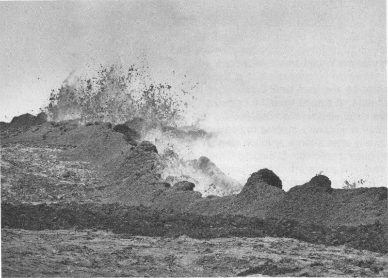
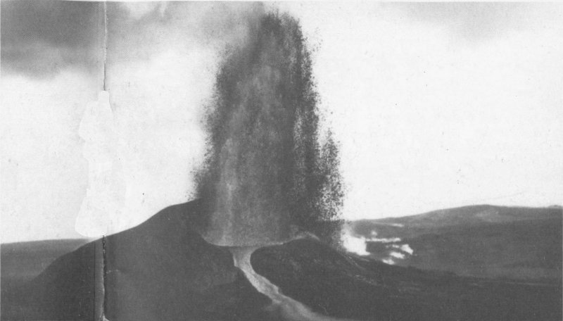
Eruptions of Hawaiian volcanoes are typically non-explosive because of the composition of the magma. Almost all of the magma erupted from Hawaii’s volcanoes forms dark gray to black volcanic rock (called basalt), generally in the form of lava flows and, less commonly, as fragmented lava such as volcanic bombs, cinders, pumice, and ash. Basalt magma is more fluid than the other types of magma (andesite, dacite, and rhyolite). Consequently, expanding volcanic gases can escape from basalt relatively easily and can propel lava high into the air, forming brilliant fountains sometimes called “curtains of fire.”
Lava, whether erupted in high fountains or quietly pouring out, collects to form flows that spread across the ground in thin broad sheets or in narrow streams. The fluid nature of basalt magma allows it to travel great distances from the vent (the place where lava breaks ground) and tends to build volcanoes in the shape of an inverted warrior shield, with slopes less than about 10 degrees. Volcanoes with this kind of profile are called shield volcanoes.
Hawaiian volcanoes erupt at their summit calderas and from their flanks along linear rift zones that extend from the calderas. Calderas are large steep-walled depressions that form when a volcano’s summit region collapses, usually after a large eruption empties or partly empties a reservoir of magma beneath the volcano. Rift zones are areas of weakness within a volcano that extend from the surface to depths of several kilometers. Magma that erupts from the flank of a volcano must first flow underground through one of the volcano’s rift zones, sometimes traveling more than 30 kilometers from the summit magma reservoir before breaking the surface.
Rising more than 9,000 meters from the seafloor, Mauna Loa is one of the world’s largest active volcanoes; from its base below sea level to its summit, Mauna Loa is taller than Mount Everest. It has erupted 15 times since 1900, with eruptions lasting from less than 1 day to as many as 145 days.
The most recent eruption began before dawn on March 25, 1984. Brilliant lava fountains lit the night-time sky as fissures opened across the floor of the caldera. Within hours, the summit activity stopped and lava began erupting from a series of vents along the northeast rift zone. When the eruption stopped 3 weeks later, lava flows were only 6.5 kilometers from buildings in the city of Hilo. Mauna Loa erupts less frequently than Kilauea, but it produces a much greater volume of lava over a shorter period of time.
Lava fountains erupt from along Mauna Loa’s rift zone. Fountains are about 25 meters high. (Photograph by J.D. Griggs.)
Kilauea’s longest rift-zone eruption in historical time began on January 3, 1983. A row of lava fountains broke out from its east rift zone about 17 kilometers from the summit caldera; within a few months, the activity settled down to a single vent. Powerful fountaining episodes hurled molten rock 450 meters into the air and built a cone of lava fragments that quickly became the tallest landmark on the rift zone.
The eruption changed style abruptly in July 1986 when lava broke out through a new vent. Instead of regular episodes of high lava fountaining, lava spilled continuously onto Kilauea’s surface. The steady outpouring of lava formed a lake of molten rock that became perched atop a small shield volcano. By June 1991, the shield was about 60 meters tall and 1,600 meters in diameter, and lava from the eruption had covered 75 square kilometers of forest and grassland, added 120 hectares of new land to the island, and destroyed 179 homes.
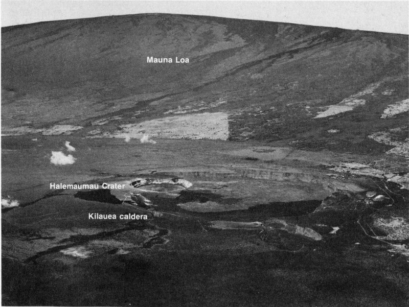
Aerial view of Hawaii’s two most active volcanoes, Kilauea and Mauna Loa. (Photograph by J.D. Griggs.)
Although most of Kilauea’s historical rift eruptions were much briefer, prolonged eruptive activity in the east rift zone from 1969 to 1974 formed a similar shield, Mauna Ulu (Hawaiian for “Growing Mountain”), and an extensive lava field on the volcano’s south flank. The geologic record shows that such large-volume eruptions from the rift zones and the summit area, covering large parts of Kilauea’s surface, have occurred many times in the recent past. In fact, about 90 percent of Kilauea’s surface is covered with lava flows that are less than 1,100 years old.
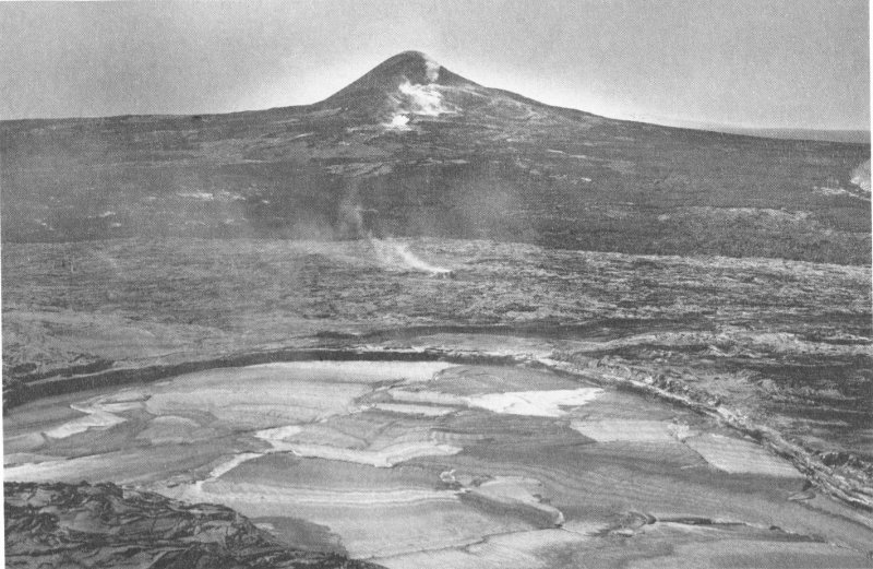
The volcanic cone of Pu’u O’o, named after an extinct Hawaiian bird, towers above an active lava lake (background). (Photograph by J.D. Griggs.)
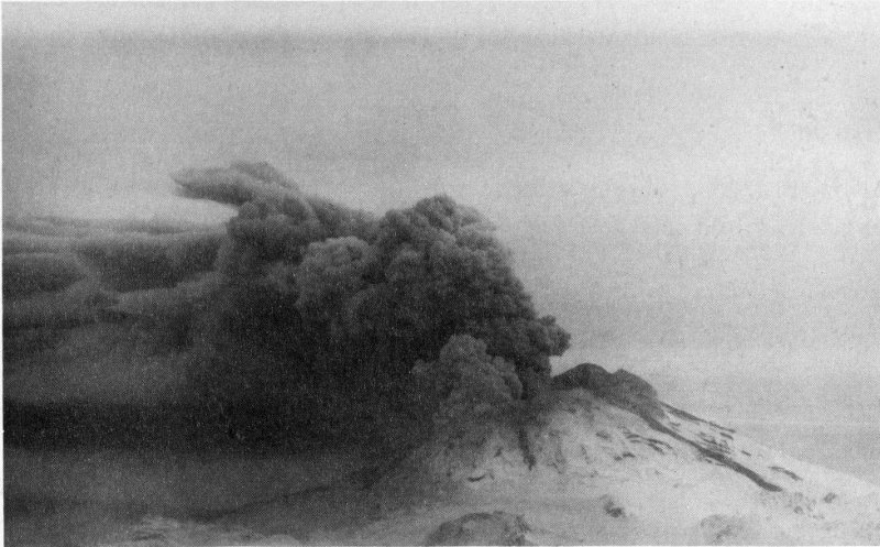
Most eruptions at Kilauea can be viewed at close range, but a few historical eruptions were dangerously explosive. Fast-moving mixtures of ash and gas, called pyroclastic surges, raced across the summit area and into the southwest rift zone during an eruption in 1790. Footprints preserved in a layer of ash 30 kilometers southwest of the summit probably include those of a party of Hawaiian warriors and their families who were crossing the volcano when the eruption struck. An estimated 80 of the 250 people were killed by suffocating clouds associated with the pyroclastic surges. A smaller explosive eruption in 1924 from Halemaumau Crater in Kilauea summit caldera, which killed a photographer who was too close, hurled rocks weighing as much as 8 tons as far as 1 kilometer.
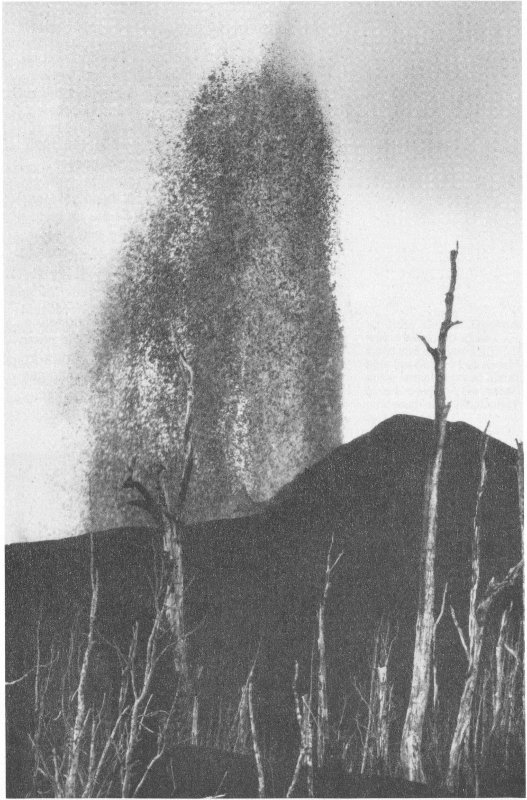
Lava fountain erupting from Pu’u O’o cone. Forty-four episodes of such fountaining between 1983 and 1986 built the cone 255 meters tall. (Photograph by J.D. Griggs.)
Volcanoes of the Cascade Range erupt far less frequently than Kilauea and Mauna Loa, but they are more dangerous because of their violently explosive behavior and their proximity to populated and cultivated areas in Washington, Oregon, and California. The 1980 eruption of Mount St. Helens in southwest Washington dramatically illustrated the type of volcanic activity and destruction these volcanoes can produce. Scientific studies of the eruption of Mount St. Helens and the eruptive histories of other Cascade volcanoes continue to improve public awareness and understanding of these potentially dangerous peaks.
In contrast to Kilauea, Cascade volcanoes erupt a variety of magma types that generate a wide range of eruptive behavior and build steep-sided cones known as composite volcanoes. In addition to basalt, andesite and dacite magmas are common.
Cascade Volcanoes.
These magmas are so highly viscous, or sticky, that expanding volcanic gases cannot easily escape from them. This causes a tremendous build-up in pressure, often leading to extremely explosive eruptions. During such eruptions, magma is shattered into tiny fragments (chiefly ash and pumice) and ejected thousands of meters into the atmosphere or even the stratosphere. Under the force of gravity, sometimes these fragments sweep down a volcano’s flanks at speeds of more than 100 kilometers per hour, mixing with air and volcanic gases to form pyroclastic flows. Rock fragments can also mix with water in river valleys to form lahars (volcanic debris flows and mudflows) that destroy everything in their paths.
Andesite and dacite magmas also erupt to form lava flows. Because these lavas are more viscous (“stickier”) than basalt, they tend to form thicker flows that travel shorter distances from the vent; consequently, andesite and dacite lavas typically build tall cones with steep slopes of more than 20 degrees.
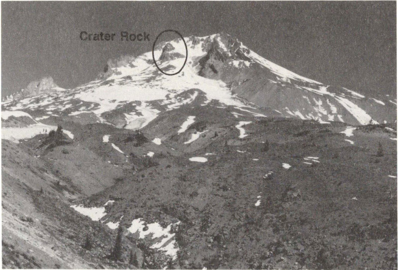
Mt. Hood, Oregon. Eruptions from the volcano about 1,800 and 200 years ago from the Crater Rock lava dome formed a broad apron of rock debris on the volcano’s south side. (Photograph by Lyn Topinka.)
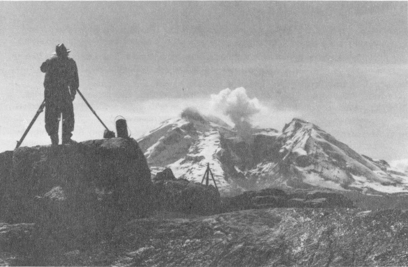
Eyewitness reports of small ashy plumes and active steam vents on Mount Baker dating as far back as the mid-1800’s were clear evidence that the ice-covered volcano had one of the most active geothermal systems among Cascade volcanoes. When new fumaroles and unusually dark vapor plumes appeared abruptly in March 1975, however, people in the Northwest became concerned about an impending eruption and possible avalanches and lahars from Sherman Crater, a vent just south of Mount Baker’s summit. Despite a tenfold increase in the release of heat by the volcano during the next 12 months, which resulted in extensive changes to the ice cover in Sherman Crater and produced minor releases of ash, no eruption occurred. The thermal activity was not accompanied by earthquakes, which generally precede most eruptions, and since 1976, the volcano has not showed additional signs of activity.
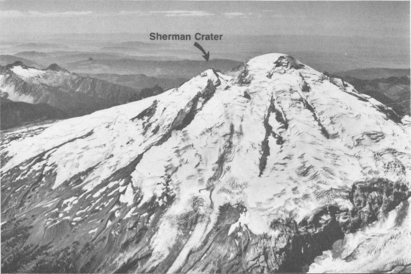
Mount Baker viewed to the west. Increased fumarolic activity occurred in Sherman Crater (left of summit) during the mid-1970’s.
The increased thermal activity between 1975 and 1976 prompted public officials and Puget Power to temporarily close public access to the popular Baker Lake recreation area and to lower the reservoir’s water level by 10 meters. Significant avalanches of debris from the Sherman Crater area could have swept directly into the reservoir, triggering a disastrous wave that would have caused loss of life and damage to the reservoir.
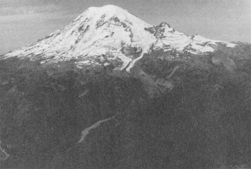
Mount Rainier towers 3,000 meters above the surrounding valleys, all of which have been swept by lahars during the past 10,000 years. Future eruptions will probably trigger similar lahars. (Photograph by David Wieprecht.)
Mount Rainier has not produced a significant eruption in the past 500 years, but scientists consider it to be one of the most hazardous volcanoes in the Cascades. Mount Rainier has 26 glaciers containing more than five times as much snow and ice as all the other Cascade volcanoes combined. If only a small part of this ice were melted by volcanic activity, it would yield enough water to trigger enormous lahars.
Mount Rainier’s potential for generating destructive mudflows is enhanced by its great height above surrounding valleys and its “soft” interior. The volcano stands about 3,000 meters above river valleys leading from its base. Volcanic heat and ground water have turned some of the volcano’s originally hard lava into soft clay minerals, thereby weakening its internal structure. These conditions make Mount Rainier extremely susceptible to large landslides. Several have occurred in the past few thousand years, one as recently as about 600 years ago. These landslides, apparently containing great volumes of water, quickly turned into lahars as they rushed down river valleys.
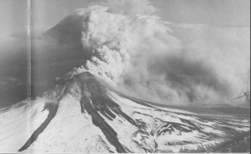
The catastrophic eruption on May 18, 1980, was preceded by 2 months of intense activity that included more than 10,000 earthquakes, hundreds of small phreatic (steam-blast) explosions, and the outward growth of the volcano’s entire north flank by more than 80 meters. A magnitude 5.1 earthquake struck beneath the volcano at 08:32 on May 18, setting in motion the devastating eruption.
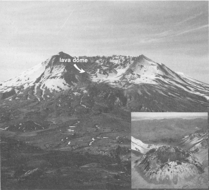
Mount St. Helens crater and lava dome viewed from the north, 1990. Inset: Close view of lava dome with new lava extrusion on top (snow-free part) from the south, 1986. (Photographs by Lyn Topinka.)
Within seconds of the earthquake, the volcano’s bulging north flank slid away in the largest landslide in recorded history, triggering a destructive, lethal lateral blast of hot gas, steam, and rock debris that swept across the landscape as fast as 1,100 kilometers per hour. Temperatures within the blast reached as high as 300 degrees Celsius. Snow and ice on the volcano melted, forming torrents of water and rock debris that swept down river valleys leading from the volcano. Within minutes, a massive plume of ash thrust 19 kilometers into the sky, where the prevailing wind carried about 520 million tons of ash across 57,000 square kilometers of the Western United States.
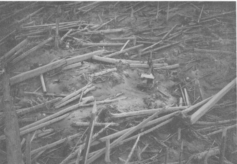
Stand of timber in the process of being harvested was instead knocked over by the lateral blast. An estimated 4 million board feet of timber was destroyed. (Photograph by H.H. Kieffer.)

Small eruption of gas and ash from the lava dome caused by violent release of volcanic gas or the geyser-like flashing of superhot ground water to steam. (Photograph by Dan Dzurisin.)
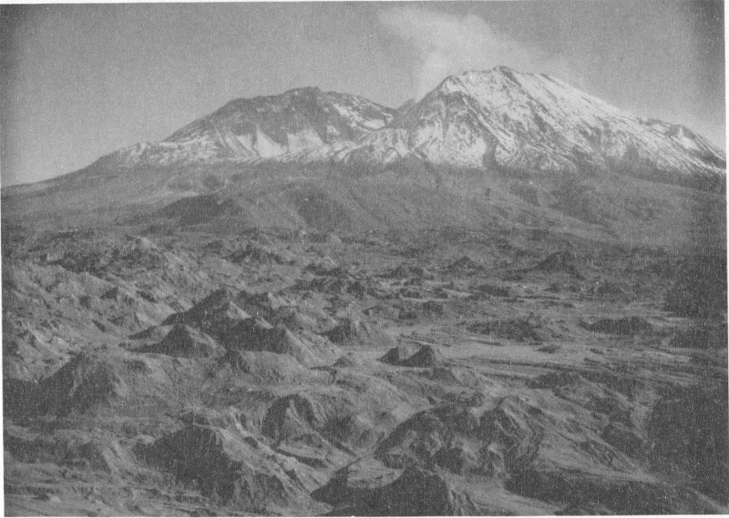
Mount St. Helens towers above the chaotic landslide deposit that fills a former valley to a depth of as much as 195 meters. Note many small hills atop the landslide, called “hummocks” by geologists. (Photograph by Lyn Topinka.)
The well-documented landslide at Mount St. Helens has helped geologists to recognize more than 200 similar deposits at other volcanoes in the world, including several other Cascade peaks. Geologists now realize that large landslides from volcanoes are far more common than previously thought—seventeen such volcanic landslides have occurred worldwide in the past 400 years. Consequently, when scientists evaluate the types of volcanic activity that may endanger people, giant landslides are now included, in addition to other types of volcanic activity such as lava flows, pyroclastic flows, lahars, and falling ash.
Following the 1980 explosive eruption, more than a dozen extrusions of thick, pasty lava built a mound-shaped lava dome in the new crater. The dome is about 1,100 meters in diameter and 250 meters tall.
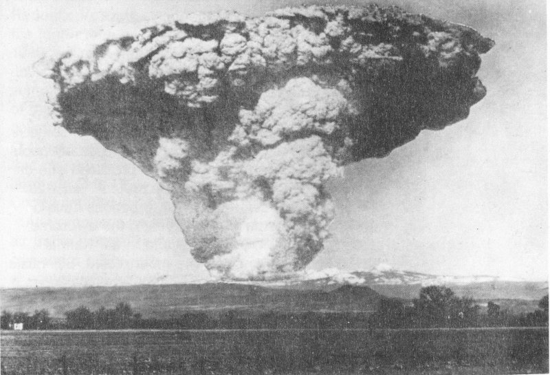
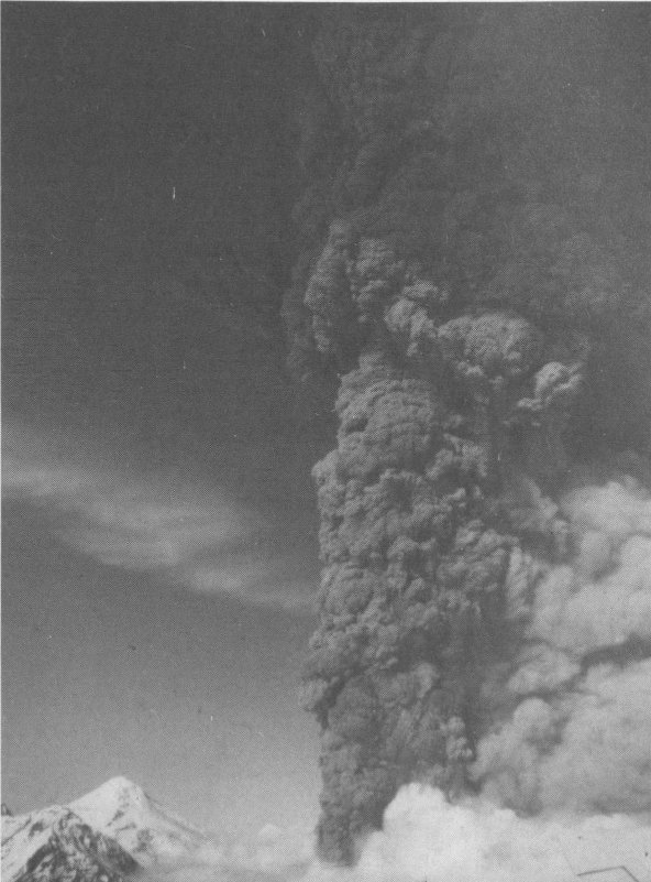
Giant mushroom-shaped ash cloud of May 22, 1915, viewed from 80 kilometers west of Lassen Peak. (Photograph provided by National Park Service.)
Long before the recent activity of Mount St. Helens, a series of spectacular eruptions from Lassen Peak between 1914 and 1917 demonstrated the explosive potential of Cascade volcanoes. Small phreatic explosions began on May 30, 1914, and were followed during the next 12 months by more than 150 explosions that sent clouds of ash as high as 3 kilometers above the peak. The activity changed character in May 1915, when a lava flow was observed in the summit crater. A deep red glow from the hot lava was visible at night 34 kilometers away. On May 19, an avalanche of hot rocks from the lava spilled onto snow and triggered a lahar that extended more than 15 kilometers from the volcano.
The most destructive explosion occurred on May 21, when a pyroclastic flow devastated forests as far as 6.5 kilometers northeast of the summit and lahars swept down several valleys radiating from the volcano. An enormous ash plume rose more than 9 kilometers above the peak, and the prevailing winds scattered the ash across Nevada as far as 500 kilometers to the east. Lassen Peak continued to produce smaller eruptions until about the middle of 1917.
The Alaska Peninsula and the Aleutian Islands have about 80 major volcanic centers that consist of one or more volcanoes. Recent violent eruptions have demonstrated that volcanic hazards do exist in some areas of Alaska, even though it is sparsely populated. Alaskan volcanoes have produced one or two eruptions per year since 1900. At least 20 catastrophic caldera-forming eruptions have occurred in the past 10,000 years; the awesome eruption of 1912 at Novarupta in the Katmai National Monument is the most recent. Scientists are particularly concerned about the volcanoes whose eruptions can affect the Cook Inlet region, where 60 percent of Alaska’s population lives.
Alaskan volcanoes.
Redoubt Volcano, Alaska, erupting on December 16, 1989. (Photograph by National Park Service.)
Redoubt Volcano erupted for the fourth time this century on December 14, 1989. Following several days of strong explosive activity, a series of lava domes grew in Redoubt’s summit crater during the next four months. Most of the domes were destroyed by explosions or collapsed down the volcano’s north flank. Some of these events triggered small pyroclastic flows that melted snow and ice on the volcano to form lahars in Drift River Valley, which empties into Cook Inlet 35 kilometers away.
Ash produced by the eruptions severely affected air traffic enroute to Anchorage, Alaska’s largest city and a major hub of domestic and international commercial air traffic. Many domestic carriers suspended service to Alaska following major explosive events, and several international carriers temporarily rerouted flights around Alaska. On December 15, a jetliner enroute to Japan encountered an ash cloud while descending into Anchorage. The plane quickly lost power in all four engines and lost 4,000 meters in altitude before the pilots were able to restart the engines. The aircraft landed safely in Anchorage, but it sustained more than $80 million in damage.
Lava dome in the summit crater of Redoubt Volcano, which grew between April 21 and June 1990. (Photograph by David Wieprecht.)
Lahars generated during the eruption threatened an oil-storage facility located on the banks of Drift River. Oil is pumped from more than a dozen wells in Cook Inlet to the facility and then loaded onto tankers, which dock just offshore. A lahar on January 2 flooded part of the facility with nearly a meter of water, forcing its shutdown until workers could restore power. This and subsequent lahars prompted the Cook Inlet Pipeline Company to temporarily halt oil production from some oil wells and reduce the amount of oil stored at the facility between tanker loadings.
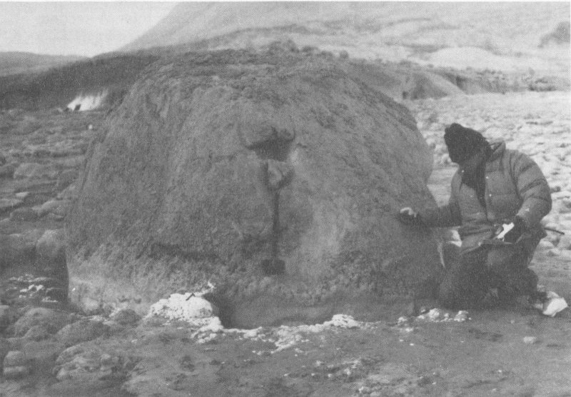
Rock from the lava dome of Redoubt Volcano deposited in a river valley by a lahar during an eruption on January 8, 1990. When found 6 days later, the temperature of the rock was still 145°C. (Photograph by C. Dan Miller.)
Steam plume rises from lava dome atop Augustine Volcano on April 30, 1986. (Photograph by M.E. Yount.)
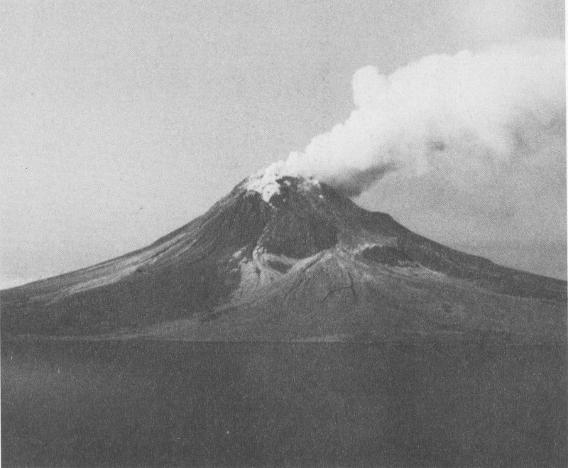
One of the most active volcanoes in Cook Inlet is Augustine, whose symmetrical cone rises 1,254 meters above the sea. Since Captain James Cook discovered and named it in 1778, Augustine has erupted in 1812, 1883, 1935, 1963-64, 1976, and 1986. Curiously, the quiet intervals between these eruptions apparently have shortened from 70 to 10 years.
Augustine’s 1986 eruption was similar to the pattern of events observed in 1976. After eight months of earthquake activity beneath the volcano, a violent explosion began on March 26. Billowing ash plumes rose more than 10 kilometers above the vent, pyroclastic flows sped down the volcano’s flanks into the sea, and ash spread throughout Cook Inlet. A second stage began April 23, when lava began erupting near the volcano’s summit and added about 25 meters to the top of the existing lava dome. Small pyroclastic flows accompanied growth of the dome.
Scientists were worried that this eruption might trigger a giant landslide from Augustine’s steep upper cone, which could enter the sea to create a tsunami (powerful seismic sea wave). At least 12 landslides are known to have occurred at Augustine. The most recent slide took place at the onset of the 1883 eruption when a part of the volcano’s summit collapsed into the sea. Within one hour, a tsunami as high as 9 meters crashed ashore on the coast of the Kenai Peninsula 80 kilometers away. No one was killed and property damage was only minor because the tsunami hit at low tide. Subsequent eruptions have rebuilt a steep cone of overlapping lava domes similar to the cone that existed just before the 1883 landslide.
Pyroclastic flow descending the upper flanks of Augustine Volcano. (Photograph by M.E. Yount.)
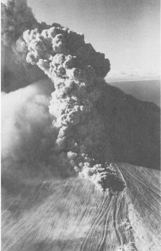
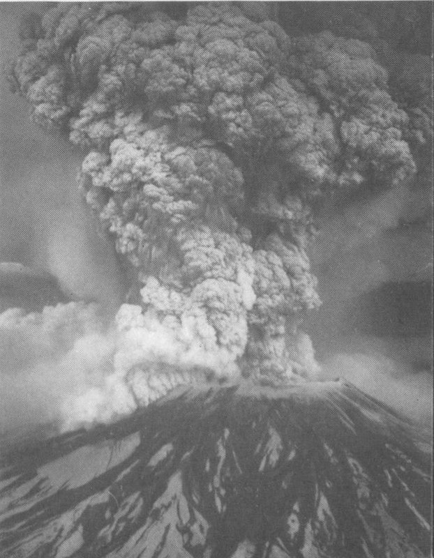
The largest eruption in the world this century occurred in 1912 at Novarupta on the Alaska Peninsula. An estimated 15 cubic kilometers of magma was explosively erupted during 60 hours beginning on June 6—about 30 times the volume erupted by Mount St. Helens in 1980! The expulsion of such a large volume of magma excavated a funnel-shaped vent 2 kilometers wide and triggered the collapse of Mount Katmai volcano 10 kilometers away to form a summit caldera 600 meters deep and about 3 kilometers across. Extrusion of the lava dome, called Novarupta, near the center of the 1912 vent marked the end of the eruption.
Little was known about the spectacular effects of this great eruption until 1916, when a scientific expedition sponsored by the National Geographic Society visited the area. To their amazement, they found a broad valley northwest of Novarupta marked by a flat plain of loose, “sandy” ash material from which thousands of jets of steam were hissing. The eruption had produced pyroclastic flows that swept about 21 kilometers down the upper Ukak River valley. The thickness of the resulting pumice and ash deposits in the upper valley is not known but may be as great as 200 meters. In 1916, the deposits were still hot enough to boil water and form countless steaming fumaroles; hence the expedition named this part of the Ukak River the “Valley of Ten Thousand Smokes.”
Eruptions of andesitic lava flows between 1953 and 1960 built a new cone on Trident’s southwest flank, adding yet another to the volcano’s older complex of three overlapping cones (hence the name Trident). A huge cloud of rising ash was seen on February 15, 1953, in the direction of Katmai National Monument; 3 days later clear weather permitted U.S. 31 Navy pilots to spot a blocky lava flow emerging from Trident’s southwest flank. Slow extrusion of lava during the next 4 months built an irregularly shaped lava dome about 1.5 kilometers long and 600 meters tall. Trident continued to erupt intermittently through 1960, generating three lava flows as long as 4.5 kilometers from the same vent and numerous ash-producing explosive eruptions.
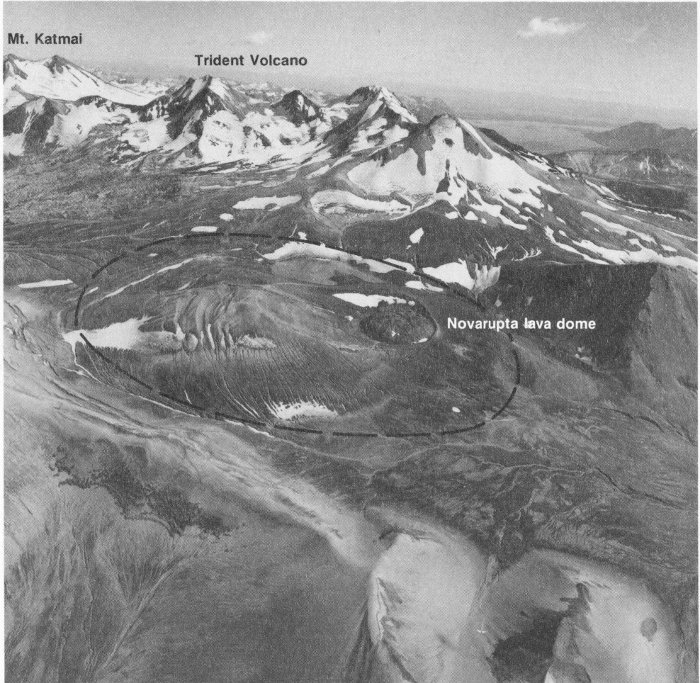
Novarupta lava dome, Mt. Katmai, and Trident Volcano, Alaska. The dome is 380 meters in diameter and occupies a small part of the vent from which about 15 cubic kilometers of magma was erupted in 1912 (dashed line marks approximate outline of vent). (Copyrighted photograph reprinted with permission, Aero Map US Inc., August 21, 1987.)
Small steam plume rises from a cinder cone within the summit caldera of Mount Veniaminof, Alaska. The large pit in the ice formed when lava (dark area) flowed beneath the ice and melted it. (Photograph by M.E. Yount.)
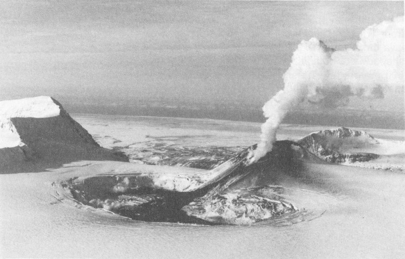
Mount Veniaminof is a massive composite volcano with a summit caldera about 8 kilometers in diameter. Since its formation about 3,700 years ago, the caldera has filled with ice to a depth of at least 60 meters. Between June 1983 and January 1984, a series of small explosions, lava fountains, and lava flows erupted from a small cinder cone within the caldera. The explosions hurled molten lava from the cinder cone, and lava flows melted a pit about 1.5 kilometers in diameter in the ice near the base of the volcano. Water from the melting ice formed a temporary lake.
The summit cone of Mount Spurr consists of a large lava dome built in the center of a horseshoe-shaped crater formed earlier by a large landslide. At the southern edge of this ancient crater is a younger, more active cone known as Crater Peak. Scientists have determined that Crater Peak is the source for at least 35 ash layers found in the Cook Inlet area, all of which were erupted in the past 6,000 years. Until recently, a warm turquoise-colored lake partially filled its crater.
A series of explosive eruptions from Crater Peak on June 27, 1992, generated ash plumes as high as about 14 kilometers, small pyroclastic 33 flows that swept down the south and east sides of the cone, and small lahars. The reawakening of Crater Peak followed nearly a year of increased earthquake activity, which escalated further on June 26, less than 1 day before its first eruption. Not all of the explosive episodes were preceded by a change in seismicity beneath the volcano, a condition that required scientists to maintain a 24-hour watch for extended periods of time in order to issue sudden reports and warnings of eruptive activity. The west side of Cook Inlet received a light to moderate ashfall during the largest explosive episode on August 18; Anchorage was blanketed with about 3 millimeters of ash, causing the Anchorage International Airport to close for a few hours. During an eruption at night on September 17, a spectacular display of lightning and incandescent ballistics and pyroclastic flows were witnessed by hunters who camped about 18 kilometers to the southeast; a faint glow above Crater Peak was also visible from as far away as Anchorage.
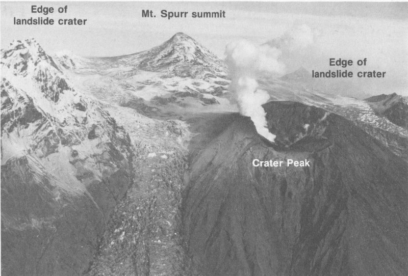
Steaming Crater Peak, a satellite vent on the south side of Mount Spurr volcano, produced three explosive eruptions in 1992. (Photograph by Cynthia Gardner.)
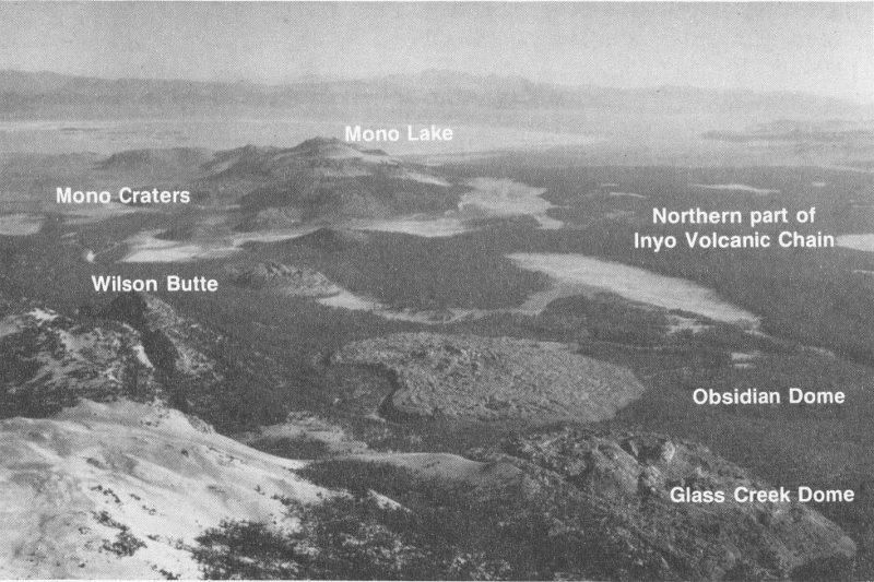
Aerial view of the Mono-Inyo Craters Volcanic Chain, California. Several eruptions occurred along both chains as recently as about 550 to 600 years ago. (Photograph by C. Dan Miller.)
The largest and most explosive volcanic eruptions eject tens to hundreds of cubic kilometers of magma onto the Earth’s surface. When such a large volume of magma is removed from beneath a volcano, the ground subsides or collapses into the emptied space, to form a huge depression called a caldera. Some calderas are more than 25 kilometers in diameter and several kilometers deep.
Calderas are among the most spectacular and active volcanic features on Earth. Earthquakes, ground cracks, uplift or subsidence of the ground, and thermal activity such as hot springs, geysers, and boiling mud pots are common at many calderas. Such activity is caused by complex interactions among magma stored beneath a caldera, ground water, and the regional build-up of stress in the large plates of the Earth’s 35 crust. Significant changes in the level of activity at some calderas are common; these new activity levels can be intermittent, lasting for months to years, or persistent over decades to centuries. Although most caldera unrest does not lead to an eruption, the possibility of violent explosive eruptions warrants detailed scientific study and monitoring of some active calderas.
Recently, scientists have recognized volcanic unrest at two calderas in the United States, Long Valley Caldera in eastern California and Yellowstone Caldera in Yellowstone National Park, Wyoming. Whether unrest at these calderas simply punctuates long periods of quiet or is the early warning sign of future eruptions is an important but still unanswered question.
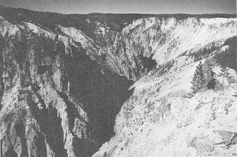
Yellowstone River plummets through the famous Grand Canyon of Yellowstone. Carved by the river, the “yellow” rocks of the canyon are rhyolite lava flows that have been altered by hot water. The lava flows were erupted after the most recent caldera-forming eruption about 600,000 years ago.
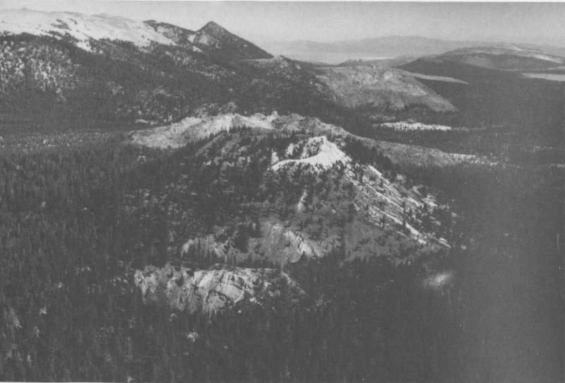
Long Valley Caldera lies on the eastern front of the Sierra Nevada, about 300 kilometers east of San Francisco. A huge explosive eruption about 700,000 years ago formed the caldera and produced pyroclastic flows that traveled 65 kilometers from the vent and covered an area of about 1,500 square kilometers. Ash from the caldera-forming eruption fell as far east as Nebraska. Within the past 40,000 years, eruptions have been restricted to a linear zone of vents, including the Mono-Inyo Craters Volcanic Chain, that extends about 50 kilometers north from the northwest part of the caldera.
This volcanic chain consists of many vents that have erupted in the past several thousand years. Eruptions from vents as recently as 550 years ago produced lava flows, pyroclastic flows, and ash, all of rhyolitic composition. Geologic mapping shows that some eruptions were preceded by ground cracking, suggesting that the ground was pulled apart or stretched as magma neared the surface.
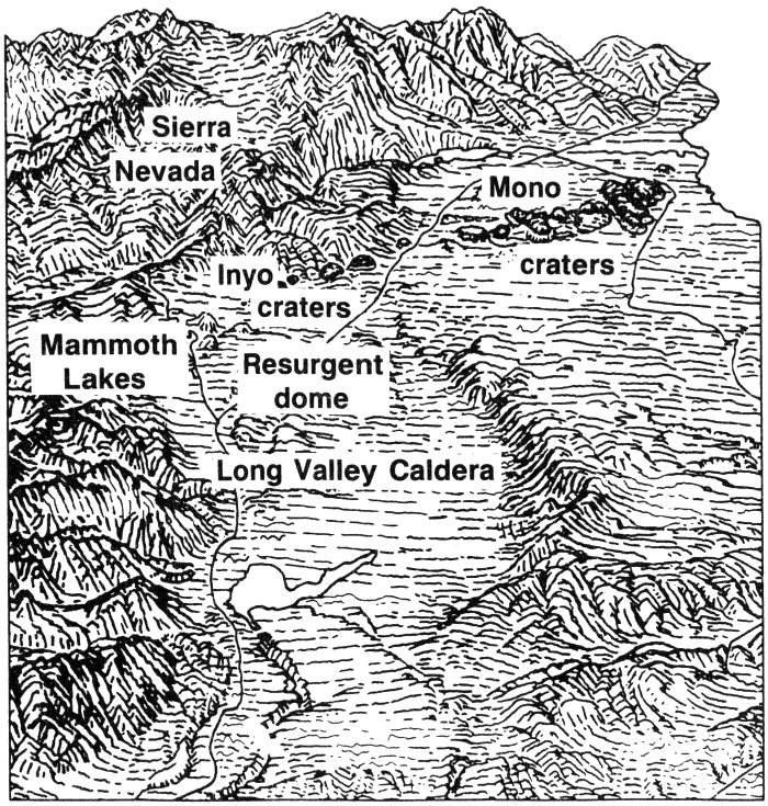
Sketch of Long Valley Caldera and the Mono-Inyo Craters Volcanic Chain in central California, viewed from the southeast. (Sketch by Tau Rho Alpha.)
Three moderate earthquakes south of the caldera and one beneath the caldera on May 25-26, 1980, marked the beginning of unrest that continues into the 1990’s. Swarms of earthquakes beneath the caldera, changes in several hot springs, and the formation of new springs have occurred since 1980. Precise surveys have also shown that the central part of the caldera has risen by more than 50 centimeters since 1975. This unrest is probably related to the stretching (east-west extension) of the Earth’s crust that is known to be occurring in the region around the caldera, and it probably also involves the rise of magma beneath the caldera. Scientists do not know if this unrest will lead to volcanic activity, but the geologically recent eruptions along the Mono-Inyo Craters Volcanic Chain suggest that future eruptions are possible.
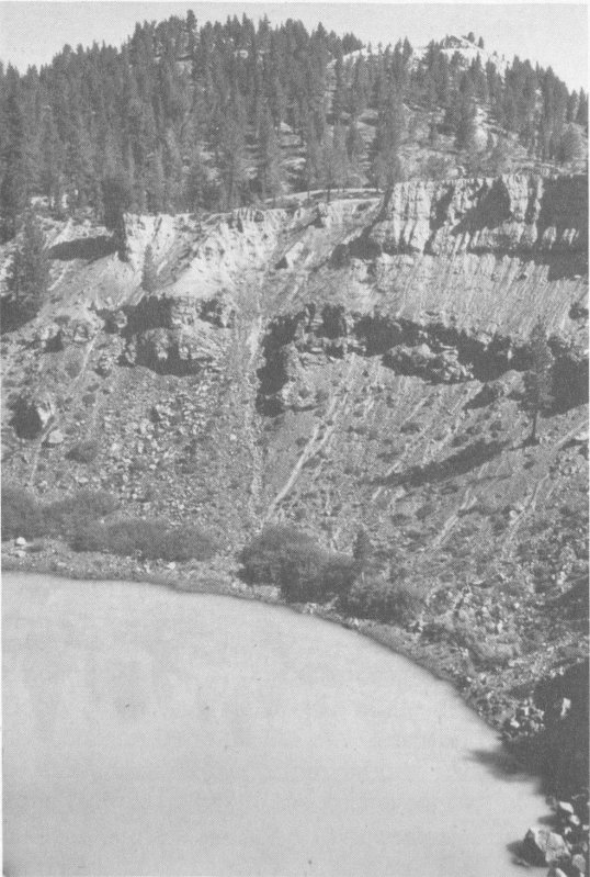
South Inyo Crater, Long Valley Caldera, California. Explosive eruptions formed the crater about 500 years ago. (Photograph by Steven R. Brantley.)
Yellowstone Caldera is one of the largest and most active calderas in the world. The spectacular geysers, boiling hot springs, and mud pots that have made Yellowstone famous—and even the strikingly beautiful Grand Canyon of Yellowstone through which the Yellowstone River plunges—owe their existence to the tremendous volcanic forces that have affected the region during the past 2 million years. Cataclysmic eruptions 2.0, 1.3, and 0.6 million years ago ejected huge volumes of rhyolite magma; each eruption formed a caldera and extensive layers of thick pyroclastic-flow deposits. The youngest caldera is an elliptical depression, nearly 80 kilometers long and 50 kilometers wide, that occupies much of Yellowstone National Park. The caldera is buried by several extensive rhyolite lava flows erupted between 75,000 and 150,000 years ago.
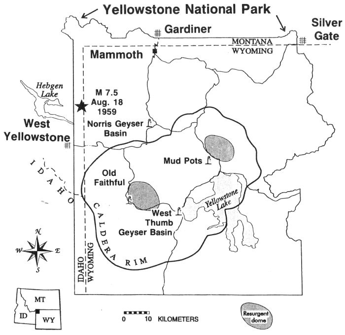
Map of most recent Yellowstone Caldera and its main thermal features. After the caldera formed, many vents erupted thick rhyolite lava flows, and the central part of the caldera was pushed upward to form resurgent domes. The star marks the magnitude 7.5 Hebger Lake earthquake.
The Earth’s crust beneath Yellowstone National Park is still restless. Precise surveys have detected an area in the center of the caldera that rose by as much as 86 centimeters between 1923 and 1984 and then subsided slightly between 1985 and 1989. Scientists do not know the cause of these ups and downs but hypothesize that they are related to the addition or withdrawal of magma beneath the caldera, or to the changing pressure of the hot ground water system above Yellowstone’s large magma reservoir. Also, Yellowstone National Park and the area immediately west of the Park are historically among the most seismically active areas in the Rocky Mountains. Small-magnitude earthquakes are common beneath the entire caldera, but most are located along the Hebgen Lake fault zone that extends into the northwest part of the caldera. A magnitude 7.5 earthquake occurred along this zone in 1959.
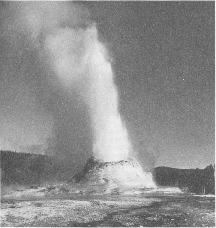
Castle Geyser erupting a column of hot water, Yellowstone National Park. (Photograph by Steven R. Brantley.)
Molten rock has erupted onto the surface of the Earth throughout its 4.5-billion-year history. Although many of these ancient rocks were removed by erosion, volcanic deposits can be found beneath younger rocks in many parts of the United States. To a geologist, such long-lasting volcanic rocks look like those formed by today’s active volcanoes. Many ancient volcanic rocks, however, change somewhat with time, as they become firmly consolidated, buried by younger deposits, and sometimes folded and faulted by the continuous shifting of the Earth’s crust. Even minerals of volcanic rocks may change, if after burial they encounter high pressures and temperatures.
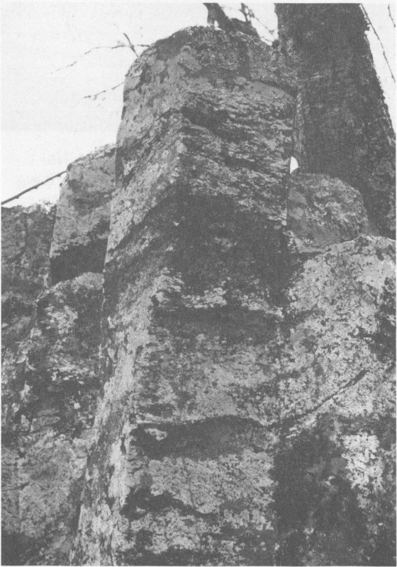
Columnar jointing in an ancient lava flow in the Blue Ridge Mountains, Shenandoah National Park, Virginia. The flow that contains the columns is one of an extensive series of lava flows, each averaging about 200 feet thick, that poured over the land more than 570 million years ago. Columns form as cooling or shrinkage joints when a hot lava flow cools quickly; the columns form perpendicular to the cooling surface. These columns are about .5 meter in diameter. (Photograph by J.C. Reed, Jr.)
Most active volcanoes are built on older volcanic deposits erupted from ancient volcanoes, and visitors to the present-day volcanoes walk or drive across these products of past volcanism. For example, anyone driving across the Cascade Range, sunbathing at Waikiki, or fishing on the Alaska Peninsula is there because old volcanic rocks form the landscape.
One step further back in time from today’s active volcanoes are people who picnic in the White Mountains of New Hampshire, enjoy the autumn colors in the Blue Ridge of Shenandoah National Park, and hike in the rugged Big Bend National Park of Texas. Many of the rocks in these areas were formed by eruptions or by intrusion of magma into the Earth’s crust many millions of years ago. Because volcanic activity has been so important in shaping the Earth, watching active volcanoes today provides a window through which we can glimpse and reconstruct the early volcanic history of our planet.
As we increase our knowledge about volcanic processes, by studying volcanoes erupting today as well as those that have lain dormant for hundreds to thousands of years, we increase our ability to predict when and how volcanoes will erupt. Accurate predictions, presented in terms that are meaningful to public officials, will minimize the number of lives lost and the social and economic upheaval that an eruption can cause.
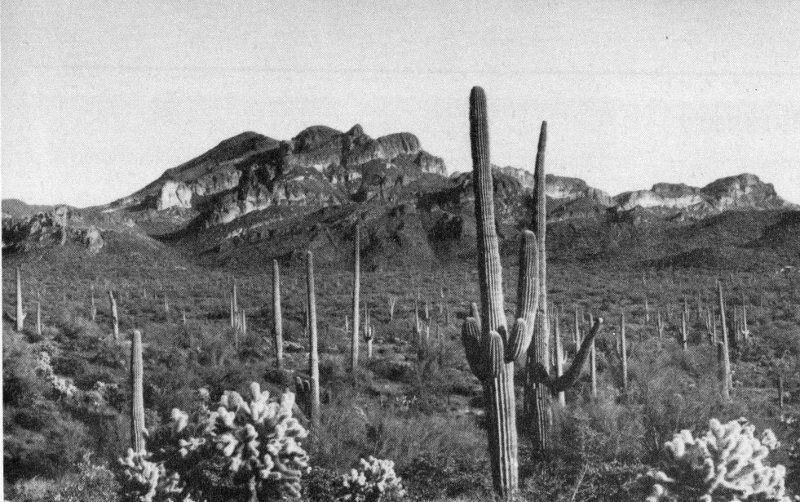
Thick layers of volcanic rocks form the Superstition Mountains, located about 60 kilometers east of Phoenix, Arizona. The consolidated deposits of pyroclastic flows, lava flows and domes, and lahars in the Superstition Mountains and adjacent areas testify to a period of intense volcanism about 17 to 25 million years ago in central Arizona. (Photograph by D.W. Peterson.)
| Andesite | A volcanic rock containing 53-63% silica with a moderate viscosity when in a molten state. |
| Ash | Fragments less than 2 millimeters in diameter of lava or rock blasted into the air by volcanic explosions. |
| Basalt | A volcanic rock consisting of less than 53% silica with a low viscosity when in a molten state. |
| Caldera | A large volcanic depression, commonly circular or elliptical when seen from above. |
| Composite volcano | A steep-sided volcano composed of many layers of volcanic rocks, usually of high-viscosity lava and fragmented debris such as lahar and pyroclastic deposits. |
| Dacite | A volcanic rock containing 63-68% silica with a high viscosity when in a molten state. |
| Dome | A steep-sided mound that forms when viscous lava piles up near a volcanic vent. Domes are formed by andesite, dacite, and rhyolite lavas. |
| Fumarole | A vent that releases volcanic gases, including water vapor (steam). |
| Lahar | A flowing mixture of water and rock debris that forms on the slopes of a volcano, sometimes referred to as debris flow or mudflow. The term comes from Indonesia. |
| Lava | Molten rock that erupts from a vent or fissure; see magma. |
| Magma | Molten rock that contains dissolved gas and crystals, formed deep within the Earth. When magma reaches the surface, it is called lava. |
| Phreatic eruption | A type of volcanic explosion that occurs when water comes in contact with hot rocks or ash near a volcanic vent, causing steam explosions. |
| Pumice | A light-colored volcanic rock containing abundant trapped gas bubbles formed by the explosive eruption of magma. Because of its numerous gas bubbles, pumice commonly floats on water. |
| Pyroclastic flow | A hot, fast-moving and high-density mixture of ash, pumice, rock fragments, and gas formed during explosive eruptions. |
| Pyroclastic surge | Same process as pyroclastic flow but of much lower density. |
| Rhyolite | A volcanic rock containing more than 68% silica with a very high viscosity when in a molten state. |
| Shield volcano | A volcano shaped like an inverted warrior’s shield with long gentle slopes produced by eruptions of low-viscosity basaltic lava. |
| Silica | The molecule formed of silicon and oxygen (SiO₂) that is the basic building block of volcanic rocks and the most important factor controlling the fluidity of magma. The higher a magma’s silica content, the greater its viscosity or “stickiness.” |
| Vent | The opening at the Earth’s surface through which volcanic materials (magma and gas) escape. |
| Volcano | A vent in the surface of the Earth through which magma erupts and also the landform that is constructed by the erupted material. |
| Volcanic landslide | The downslope movement of soil, rock debris, and sometimes glacial ice, with or without water, from the flank of a volcano. |
Scientist surveying lava dome at Redoubt Volcano. (Photograph by G. McGimsey.)
The metric units used in this publication can be converted to English units by using the approximate conversions given below:
| Length | |
|---|---|
| 1 kilometer | 0.6 of a mile |
| 1 meter | 39.37 inches |
| 1 centimeter | 0.4 inch |
| 1 millimeter | 0.04 inch |
| Area | |
| 1 sq. kilometer | 0.4 sq. mile |
| 1 sq. meter | 1.2 sq. yards |
| 1 sq. centimeter | 0.155 sq. inch |
| Temperature | |
| To convert °Celsius to °Fahrenheit, multiply °C by 1.8 and add 32. | |
| To convert °Fahrenheit to °Celsius, subtract 32 from °F and divide the result by 1.8. | |
Decker, Robert, and Decker, Barbara, 1989, Volcanoes: San Francisco, Freeman, 285 p. (An information-packed introduction to the study of volcanoes written in an easy-to-read style.)
Editors, 1982, Volcano: in the series Planet Earth, Alexandria, Virginia, Time-Life Books, 176 p. (A well illustrated and readable general survey of volcanoes and their activity.)
McClelland, Lindsay, Simkin, Tom, Summers, Marjorie, Nielsen, Elizabeth, and Stein, T.C., editors, 1989, Global Volcanism 1975-1985: Englewood Cliffs, New Jersey, Prentice-Hall, 656 p. (A full account of volcanism on Earth based on eyewitness accounts from geologists and other scientists, reporters, travelers, and other keen observers.)
Simkin, Tom, and Seibert, Lee, 1994, Volcanoes of the World (Second edition): Stroudsburg, Pa., Hutchinson Ross, 233 p. (A comprehensive regional directory of worldwide volcanic activity during the past 10,000 years; activity presented in table format.)
Tilling, R. I., 1982, Volcanoes: Reston, Virginia, U.S. Geological Survey general-interest publication, 46 p. (A general introduction for the nonspecialist to the study of volcanoes, with focus on the nature, types, workings, products, and hazards of volcanoes.)
Tilling, R. I., 1984, Eruptions of Mount St. Helens: Past, present, and future: Reston, Virginia, U.S. Geological Survey general-interest publication, 46 p. (A nontechnical summary, illustrated by many color photographs and diagrams, of the abundant scientific data available for the volcano, with emphasis on the catastrophic eruption on May 18, 1980, which caused the worst volcanic disaster in U.S. history.)
Tilling, R. I., 1987, Eruptions of Hawaiian volcanoes: Past, present, and future: Reston, Virginia, U.S. Geological Survey general-interest publication, 54 p. (A nontechnical summary, illustrated by color photographs and drawings, of the eruption history, style, and products of two of Hawaii’s active volcanoes, Kilauea and Mauna Loa.)
Wood, C. A., and Kienle, Jurgen, editors, 1990, Volcanoes of North America—United States and Canada: Cambridge University Press, 354 p. (A rich compilation of volcanoes and volcanic fields in North America that were formed in the past 5 million years; includes more than 250 entries prepared by leading experts in volcanology.)
U.S. Geological Survey
Information Services
P.O. Box 25286
Denver, CO 80225
U.S. GOVERNMENT PRINTING OFFICE: 1996 421-555
Front and back cover (clockwise from top photograph on front) Augustine Volcano, Alaska, 1986.
Mount St. Helens, Washington, 1980.
Kilauea Volcano, Hawaii, 1983.
Mount Spurr, Alaska, 1992.
Mono-Inyo Craters Volcanic Chain inside Long Valley Caldera, California.

As the Nation’s principal conservation agency, the Department of the Interior has responsibility for most of our nationally owned public lands and natural and cultural resources. This includes fostering sound use of our land and water resources; protecting our fish, wildlife, and biological diversity; preserving the environmental and cultural values of our national parks and historical places; and providing for the enjoyment of life through outdoor recreation The Department assesses our energy and mineral resources and works to ensure that their development is in the best interests of all our people by encouraging stewardship and citizen participation in their care. The Department also has a major responsibility for American Indian reservation communities and for people who live in island territories under U S administration.
End of the Project Gutenberg EBook of Volcanoes of the United States, by
Steven R. Brantley

*** END OF THIS PROJECT GUTENBERG EBOOK VOLCANOES OF THE UNITED STATES ***

***** This file should be named 57530-h.htm or 57530-h.zip *****
This and all associated files of various formats will be found in:
        http://www.gutenberg.org/5/7/5/3/57530/

Produced by Stephen Hutcheson and the Online Distributed
Proofreading Team at http://www.pgdp.net

Updated editions will replace the previous one--the old editions will
be renamed.

Creating the works from print editions not protected by U.S. copyright
law means that no one owns a United States copyright in these works,
so the Foundation (and you!) can copy and distribute it in the United
States without permission and without paying copyright
royalties. Special rules, set forth in the General Terms of Use part
of this license, apply to copying and distributing Project
Gutenberg-tm electronic works to protect the PROJECT GUTENBERG-tm
concept and trademark. Project Gutenberg is a registered trademark,
and may not be used if you charge for the eBooks, unless you receive
specific permission. If you do not charge anything for copies of this
eBook, complying with the rules is very easy. You may use this eBook
for nearly any purpose such as creation of derivative works, reports,
performances and research. They may be modified and printed and given
away--you may do practically ANYTHING in the United States with eBooks
not protected by U.S. copyright law. Redistribution is subject to the
trademark license, especially commercial redistribution.

START: FULL LICENSE

THE FULL PROJECT GUTENBERG LICENSE
PLEASE READ THIS BEFORE YOU DISTRIBUTE OR USE THIS WORK

To protect the Project Gutenberg-tm mission of promoting the free
distribution of electronic works, by using or distributing this work
(or any other work associated in any way with the phrase "Project
Gutenberg"), you agree to comply with all the terms of the Full
Project Gutenberg-tm License available with this file or online at
www.gutenberg.org/license.

Section 1. General Terms of Use and Redistributing Project
Gutenberg-tm electronic works

1.A. By reading or using any part of this Project Gutenberg-tm
electronic work, you indicate that you have read, understand, agree to
and accept all the terms of this license and intellectual property
(trademark/copyright) agreement. If you do not agree to abide by all
the terms of this agreement, you must cease using and return or
destroy all copies of Project Gutenberg-tm electronic works in your
possession. If you paid a fee for obtaining a copy of or access to a
Project Gutenberg-tm electronic work and you do not agree to be bound
by the terms of this agreement, you may obtain a refund from the
person or entity to whom you paid the fee as set forth in paragraph
1.E.8.

1.B. "Project Gutenberg" is a registered trademark. It may only be
used on or associated in any way with an electronic work by people who
agree to be bound by the terms of this agreement. There are a few
things that you can do with most Project Gutenberg-tm electronic works
even without complying with the full terms of this agreement. See
paragraph 1.C below. There are a lot of things you can do with Project
Gutenberg-tm electronic works if you follow the terms of this
agreement and help preserve free future access to Project Gutenberg-tm
electronic works. See paragraph 1.E below.

1.C. The Project Gutenberg Literary Archive Foundation ("the
Foundation" or PGLAF), owns a compilation copyright in the collection
of Project Gutenberg-tm electronic works. Nearly all the individual
works in the collection are in the public domain in the United
States. If an individual work is unprotected by copyright law in the
United States and you are located in the United States, we do not
claim a right to prevent you from copying, distributing, performing,
displaying or creating derivative works based on the work as long as
all references to Project Gutenberg are removed. Of course, we hope
that you will support the Project Gutenberg-tm mission of promoting
free access to electronic works by freely sharing Project Gutenberg-tm
works in compliance with the terms of this agreement for keeping the
Project Gutenberg-tm name associated with the work. You can easily
comply with the terms of this agreement by keeping this work in the
same format with its attached full Project Gutenberg-tm License when
you share it without charge with others.

1.D. The copyright laws of the place where you are located also govern
what you can do with this work. Copyright laws in most countries are
in a constant state of change. If you are outside the United States,
check the laws of your country in addition to the terms of this
agreement before downloading, copying, displaying, performing,
distributing or creating derivative works based on this work or any
other Project Gutenberg-tm work. The Foundation makes no
representations concerning the copyright status of any work in any
country outside the United States.

1.E. Unless you have removed all references to Project Gutenberg:

1.E.1. The following sentence, with active links to, or other
immediate access to, the full Project Gutenberg-tm License must appear
prominently whenever any copy of a Project Gutenberg-tm work (any work
on which the phrase "Project Gutenberg" appears, or with which the
phrase "Project Gutenberg" is associated) is accessed, displayed,
performed, viewed, copied or distributed:

  This eBook is for the use of anyone anywhere in the United States and
  most other parts of the world at no cost and with almost no
  restrictions whatsoever. You may copy it, give it away or re-use it
  under the terms of the Project Gutenberg License included with this
  eBook or online at www.gutenberg.org. If you are not located in the
  United States, you'll have to check the laws of the country where you
  are located before using this ebook.

1.E.2. If an individual Project Gutenberg-tm electronic work is
derived from texts not protected by U.S. copyright law (does not
contain a notice indicating that it is posted with permission of the
copyright holder), the work can be copied and distributed to anyone in
the United States without paying any fees or charges. If you are
redistributing or providing access to a work with the phrase "Project
Gutenberg" associated with or appearing on the work, you must comply
either with the requirements of paragraphs 1.E.1 through 1.E.7 or
obtain permission for the use of the work and the Project Gutenberg-tm
trademark as set forth in paragraphs 1.E.8 or 1.E.9.

1.E.3. If an individual Project Gutenberg-tm electronic work is posted
with the permission of the copyright holder, your use and distribution
must comply with both paragraphs 1.E.1 through 1.E.7 and any
additional terms imposed by the copyright holder. Additional terms
will be linked to the Project Gutenberg-tm License for all works
posted with the permission of the copyright holder found at the
beginning of this work.

1.E.4. Do not unlink or detach or remove the full Project Gutenberg-tm
License terms from this work, or any files containing a part of this
work or any other work associated with Project Gutenberg-tm.

1.E.5. Do not copy, display, perform, distribute or redistribute this
electronic work, or any part of this electronic work, without
prominently displaying the sentence set forth in paragraph 1.E.1 with
active links or immediate access to the full terms of the Project
Gutenberg-tm License.

1.E.6. You may convert to and distribute this work in any binary,
compressed, marked up, nonproprietary or proprietary form, including
any word processing or hypertext form. However, if you provide access
to or distribute copies of a Project Gutenberg-tm work in a format
other than "Plain Vanilla ASCII" or other format used in the official
version posted on the official Project Gutenberg-tm web site
(www.gutenberg.org), you must, at no additional cost, fee or expense
to the user, provide a copy, a means of exporting a copy, or a means
of obtaining a copy upon request, of the work in its original "Plain
Vanilla ASCII" or other form. Any alternate format must include the
full Project Gutenberg-tm License as specified in paragraph 1.E.1.

1.E.7. Do not charge a fee for access to, viewing, displaying,
performing, copying or distributing any Project Gutenberg-tm works
unless you comply with paragraph 1.E.8 or 1.E.9.

1.E.8. You may charge a reasonable fee for copies of or providing
access to or distributing Project Gutenberg-tm electronic works
provided that

* You pay a royalty fee of 20% of the gross profits you derive from
  the use of Project Gutenberg-tm works calculated using the method
  you already use to calculate your applicable taxes. The fee is owed
  to the owner of the Project Gutenberg-tm trademark, but he has
  agreed to donate royalties under this paragraph to the Project
  Gutenberg Literary Archive Foundation. Royalty payments must be paid
  within 60 days following each date on which you prepare (or are
  legally required to prepare) your periodic tax returns. Royalty
  payments should be clearly marked as such and sent to the Project
  Gutenberg Literary Archive Foundation at the address specified in
  Section 4, "Information about donations to the Project Gutenberg
  Literary Archive Foundation."

* You provide a full refund of any money paid by a user who notifies
  you in writing (or by e-mail) within 30 days of receipt that s/he
  does not agree to the terms of the full Project Gutenberg-tm
  License. You must require such a user to return or destroy all
  copies of the works possessed in a physical medium and discontinue
  all use of and all access to other copies of Project Gutenberg-tm
  works.

* You provide, in accordance with paragraph 1.F.3, a full refund of
  any money paid for a work or a replacement copy, if a defect in the
  electronic work is discovered and reported to you within 90 days of
  receipt of the work.

* You comply with all other terms of this agreement for free
  distribution of Project Gutenberg-tm works.

1.E.9. If you wish to charge a fee or distribute a Project
Gutenberg-tm electronic work or group of works on different terms than
are set forth in this agreement, you must obtain permission in writing
from both the Project Gutenberg Literary Archive Foundation and The
Project Gutenberg Trademark LLC, the owner of the Project Gutenberg-tm
trademark. Contact the Foundation as set forth in Section 3 below.

1.F.

1.F.1. Project Gutenberg volunteers and employees expend considerable
effort to identify, do copyright research on, transcribe and proofread
works not protected by U.S. copyright law in creating the Project
Gutenberg-tm collection. Despite these efforts, Project Gutenberg-tm
electronic works, and the medium on which they may be stored, may
contain "Defects," such as, but not limited to, incomplete, inaccurate
or corrupt data, transcription errors, a copyright or other
intellectual property infringement, a defective or damaged disk or
other medium, a computer virus, or computer codes that damage or
cannot be read by your equipment.

1.F.2. LIMITED WARRANTY, DISCLAIMER OF DAMAGES - Except for the "Right
of Replacement or Refund" described in paragraph 1.F.3, the Project
Gutenberg Literary Archive Foundation, the owner of the Project
Gutenberg-tm trademark, and any other party distributing a Project
Gutenberg-tm electronic work under this agreement, disclaim all
liability to you for damages, costs and expenses, including legal
fees. YOU AGREE THAT YOU HAVE NO REMEDIES FOR NEGLIGENCE, STRICT
LIABILITY, BREACH OF WARRANTY OR BREACH OF CONTRACT EXCEPT THOSE
PROVIDED IN PARAGRAPH 1.F.3. YOU AGREE THAT THE FOUNDATION, THE
TRADEMARK OWNER, AND ANY DISTRIBUTOR UNDER THIS AGREEMENT WILL NOT BE
LIABLE TO YOU FOR ACTUAL, DIRECT, INDIRECT, CONSEQUENTIAL, PUNITIVE OR
INCIDENTAL DAMAGES EVEN IF YOU GIVE NOTICE OF THE POSSIBILITY OF SUCH
DAMAGE.

1.F.3. LIMITED RIGHT OF REPLACEMENT OR REFUND - If you discover a
defect in this electronic work within 90 days of receiving it, you can
receive a refund of the money (if any) you paid for it by sending a
written explanation to the person you received the work from. If you
received the work on a physical medium, you must return the medium
with your written explanation. The person or entity that provided you
with the defective work may elect to provide a replacement copy in
lieu of a refund. If you received the work electronically, the person
or entity providing it to you may choose to give you a second
opportunity to receive the work electronically in lieu of a refund. If
the second copy is also defective, you may demand a refund in writing
without further opportunities to fix the problem.

1.F.4. Except for the limited right of replacement or refund set forth
in paragraph 1.F.3, this work is provided to you 'AS-IS', WITH NO
OTHER WARRANTIES OF ANY KIND, EXPRESS OR IMPLIED, INCLUDING BUT NOT
LIMITED TO WARRANTIES OF MERCHANTABILITY OR FITNESS FOR ANY PURPOSE.

1.F.5. Some states do not allow disclaimers of certain implied
warranties or the exclusion or limitation of certain types of
damages. If any disclaimer or limitation set forth in this agreement
violates the law of the state applicable to this agreement, the
agreement shall be interpreted to make the maximum disclaimer or
limitation permitted by the applicable state law. The invalidity or
unenforceability of any provision of this agreement shall not void the
remaining provisions.

1.F.6. INDEMNITY - You agree to indemnify and hold the Foundation, the
trademark owner, any agent or employee of the Foundation, anyone
providing copies of Project Gutenberg-tm electronic works in
accordance with this agreement, and any volunteers associated with the
production, promotion and distribution of Project Gutenberg-tm
electronic works, harmless from all liability, costs and expenses,
including legal fees, that arise directly or indirectly from any of
the following which you do or cause to occur: (a) distribution of this
or any Project Gutenberg-tm work, (b) alteration, modification, or
additions or deletions to any Project Gutenberg-tm work, and (c) any
Defect you cause.

Section 2. Information about the Mission of Project Gutenberg-tm

Project Gutenberg-tm is synonymous with the free distribution of
electronic works in formats readable by the widest variety of
computers including obsolete, old, middle-aged and new computers. It
exists because of the efforts of hundreds of volunteers and donations
from people in all walks of life.

Volunteers and financial support to provide volunteers with the
assistance they need are critical to reaching Project Gutenberg-tm's
goals and ensuring that the Project Gutenberg-tm collection will
remain freely available for generations to come. In 2001, the Project
Gutenberg Literary Archive Foundation was created to provide a secure
and permanent future for Project Gutenberg-tm and future
generations. To learn more about the Project Gutenberg Literary
Archive Foundation and how your efforts and donations can help, see
Sections 3 and 4 and the Foundation information page at
www.gutenberg.org


Section 3. Information about the Project Gutenberg Literary Archive Foundation

The Project Gutenberg Literary Archive Foundation is a non profit
501(c)(3) educational corporation organized under the laws of the
state of Mississippi and granted tax exempt status by the Internal
Revenue Service. The Foundation's EIN or federal tax identification
number is 64-6221541. Contributions to the Project Gutenberg Literary
Archive Foundation are tax deductible to the full extent permitted by
U.S. federal laws and your state's laws.

The Foundation's principal office is in Fairbanks, Alaska, with the
mailing address: PO Box 750175, Fairbanks, AK 99775, but its
volunteers and employees are scattered throughout numerous
locations. Its business office is located at 809 North 1500 West, Salt
Lake City, UT 84116, (801) 596-1887. Email contact links and up to
date contact information can be found at the Foundation's web site and
official page at www.gutenberg.org/contact

For additional contact information:

    Dr. Gregory B. Newby
    Chief Executive and Director
    gbnewby@pglaf.org

Section 4. Information about Donations to the Project Gutenberg
Literary Archive Foundation

Project Gutenberg-tm depends upon and cannot survive without wide
spread public support and donations to carry out its mission of
increasing the number of public domain and licensed works that can be
freely distributed in machine readable form accessible by the widest
array of equipment including outdated equipment. Many small donations
($1 to $5,000) are particularly important to maintaining tax exempt
status with the IRS.

The Foundation is committed to complying with the laws regulating
charities and charitable donations in all 50 states of the United
States. Compliance requirements are not uniform and it takes a
considerable effort, much paperwork and many fees to meet and keep up
with these requirements. We do not solicit donations in locations
where we have not received written confirmation of compliance. To SEND
DONATIONS or determine the status of compliance for any particular
state visit www.gutenberg.org/donate

While we cannot and do not solicit contributions from states where we
have not met the solicitation requirements, we know of no prohibition
against accepting unsolicited donations from donors in such states who
approach us with offers to donate.

International donations are gratefully accepted, but we cannot make
any statements concerning tax treatment of donations received from
outside the United States. U.S. laws alone swamp our small staff.

Please check the Project Gutenberg Web pages for current donation
methods and addresses. Donations are accepted in a number of other
ways including checks, online payments and credit card donations. To
donate, please visit: www.gutenberg.org/donate

Section 5. General Information About Project Gutenberg-tm electronic works.

Professor Michael S. Hart was the originator of the Project
Gutenberg-tm concept of a library of electronic works that could be
freely shared with anyone. For forty years, he produced and
distributed Project Gutenberg-tm eBooks with only a loose network of
volunteer support.

Project Gutenberg-tm eBooks are often created from several printed
editions, all of which are confirmed as not protected by copyright in
the U.S. unless a copyright notice is included. Thus, we do not
necessarily keep eBooks in compliance with any particular paper
edition.

Most people start at our Web site which has the main PG search
facility: www.gutenberg.org

This Web site includes information about Project Gutenberg-tm,
including how to make donations to the Project Gutenberg Literary
Archive Foundation, how to help produce our new eBooks, and how to
subscribe to our email newsletter to hear about new eBooks.