The Project Gutenberg EBook of Old Mines of Southern California, by
California State Mineralogist

This eBook is for the use of anyone anywhere in the United States and most
other parts of the world at no cost and with almost no restrictions
whatsoever.  You may copy it, give it away or re-use it under the terms of
the Project Gutenberg License included with this eBook or online at
www.gutenberg.org.  If you are not located in the United States, you'll have
to check the laws of the country where you are located before using this ebook.

Title: Old Mines of Southern California
       Desert-Mountain-Coastal Areas Including the Calico-Salton
              Sea Colorado River Districts and Southern Counties

Author: California State Mineralogist

Release Date: January 31, 2018 [EBook #56478]

Language: English

Character set encoding: UTF-8

*** START OF THIS PROJECT GUTENBERG EBOOK OLD MINES OF SOUTHERN CALIFORNIA ***


Produced by Stephen Hutcheson and the Online Distributed
Proofreading Team at http://www.pgdp.net
Desert-Mountain-Coastal Areas
Including the
Calico-Salton Sea Colorado River Districts
and
Southern Counties
1965
Frontier Book Company
Toyahvale, Texas 79786
Reprinted From
The Report of The State Mineralogist
1893
Limited to 1000 copies
By W. H. Storms, Assistant in the Field.
The mining industry in this county is not as extensive as that of some of the neighboring counties, but there are mines in Los Angeles County of unquestioned value, and others which have a prospective value, dependent to a great extent upon the success achieved in working certain base ores, which occur in comparative abundance.
One of the most interesting mines in the county is located in the rugged mountains about 8 miles from the town of Azusa, in the San Gabriel Cañon. It is commonly known as the Kelsey Mine, and has become famous as a producer of silver ore of fabulous richness.
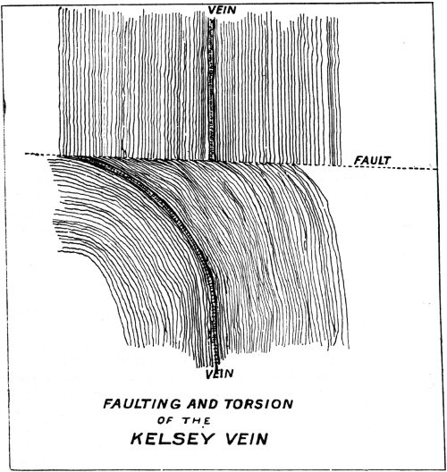
The country is made up almost entirely of metamorphic rocks, having schistose, gneissoid, and massive structure. Both hornblende and mica occur in these rocks abundantly, the former being frequently altered to chlorite, or by further change to epidote. Dikes of porphyritic rock have been intruded into the crystalline schists. In the immediate vicinity of the Kelsey vein are intrusions of a dark green, much decomposed, and shattered rock, probably diorite. Faults, great and small, are numerous throughout the region. Within a few hundred feet of the mine is a great fault, which may be plainly seen cutting the mountain. The displacement must reach many hundreds of feet. It has resulted in bringing in contact on a horizontal plane rocks of entirely different character. On the south side of the fault the rocks are made up of quite regularly bedded micaceous sandstones, more or less schistose, and having a prevailing buff or light gray color. These rocks dip east at an angle of 20° to 30°. On the north side of the fault the rocks are harder, of a dark gray color, and containing considerable hornblende. These rocks are more gneissoid and massive than schistose. The dip is much less regular than on the south side of the displacement. Large, lenticular masses of quartzose and feldspathic rock are of frequent occurrence in the hornblende gneiss, evidently the result of the segregation of the contained minerals. On the whole there is much more evidence of the disturbance on the north side of the fault than on the south side. It is in this area of greatly disturbed strata that the Kelsey vein has formed.
The vein is of the fissure type and occupies the line of a fault plane, that at first, perhaps, was a mere crack, but which has become enlarged by the movement upon themselves of the rock masses forming the walls, resulting in a grinding and crushing of the rocks by the attrition and pressure incident to this movement. Into this crevice mineral waters found their way, carrying in solution the minerals now constituting the vein.
FAULTING AND TORSION
OF THE
KELSEY VEIN
The Ore.—The silver occurs as native and as glance (argentite), possibly partly as chloride and in combinations with sulphur, cobalt, and arsenic. The associated minerals are cobalt bloom (erythrite), a hydrous cobalt arsenate, nickel arsenate (annabergite), carbonate and silicate of copper (chrysocolla), iron oxide, and black oxide of manganese in a gangue of baryta (heavy spar), with calcite (lime spar) and some quartz. A clay selvage usually separates the vein material from the wall, this feature being well developed in places on the foot wall side, as though open crevices had occurred and the finely divided material which was carried by the percolating waters had found a resting place when an open space was reached, the absence of any current permitting the material to settle.
The clay may have been derived in part from the decomposition of the overhanging wall, the fine silt settling by gravity on the foot wall side of the vein. In places a soft, clayey gouge constitutes the entire vein filling, suggesting that the clay selvage and gouge are also partly due to the attrition of the walls. Galena occurs sparingly in small disseminated crystals, but the occurrence is so infrequent as to be scarcely worth mentioning. In width the crevice varies from a thin seam to over 4 feet. A banded structure is not uncommon in the vein.
The rocks inclosing the vein differ in various parts of the mine. A much decomposed rock, containing iron in the form of carbonate, occurs frequently, while a chloritic, more or less schistose, sometimes massive, 5 rock, also plays an important part in this connection. The dike of dark basic rock, resembling diorite, previously referred to, is exposed at numerous places throughout the workings, often in contact with the vein, or close to it. Since its formation the Kelsey vein has been subjected to severe torsion, which has resulted in abrupt fracture and displacement. To me it seemed very probable that the vein was the result of chemical precipitation, and no doubt, to some extent, the replacement of country rock along the line of a fissure or fault plane; that subsequent to the filling in of the vein the region was subjected to further violent disturbances, which fractured the rocks along an east and west course, and causing the turning of a large mass of rock formation lying south of this fault to the west. The vein being included in the general movement, was deflected from its natural course north and south. I came to these conclusions from close observations taken along the surface of the ground on the course of the vein, and in all accessible underground workings.
Most of the ore extracted from these workings has been high grade, usually running over $200 per ton, small lots often assaying several thousand ounces. The property, at the time of my visit last spring, was under the management of Dr. Endlich, E.M. This gentleman was making every effort to systematically open and recover a vein that had been as systematically and outrageously gouged. The workings were in bad condition and at some points were positively dangerous. The mine was gradually assuming an improved appearance and promised to yield better returns than ever before. A good mill has been erected at the foot of the mountain, in the San Gabriel Cañon, where a large stream of water flows during the entire year. An office, boarding house, stables, corrals, etc., had been built for the accommodation of men and animals. In addition to this I found a complete assay office and chemical laboratory, and here Dr. Endlich was experimenting with the rich cobalt and nickel ores. As a result of his labors in this direction he exhibited several bars of cobalt speiss containing a very high value in silver. The assorted ore contains from 7 to 15 per cent in cobalt, 2 to 3 per cent nickel, and from 1,000 to 1,400 ounces silver per ton.
Dr. Endlich thus describes his methods: “The ore is crushed through a twenty-mesh sieve, mixed with sufficient litharge to produce an 8 per cent charge, and enough borax is added to take up the gangue (quartz, heavy spar, carbonate of lime, magnesia, and iron). Carbonate of soda and flour are mixed with the charge. If the percentage of arsenic in the ore is sufficiently high to produce speiss none is added; otherwise some metallic arsenic is mixed in. Some sulphides in the ore and reduced sulphur from the heavy spar are utilized to produce mattes. The mixture is melted in large Dixon crucibles; the slag poured off, and the metallic product allowed to cool. The bars obtained are composed of lead, silver, cobalt, nickel, arsenic, and sulphur, principally; the lead being in the form of sulphide, the cobalt and nickel in the form of arsenides. The bars contained from 4,500 to 7,000 ounces silver per ton. The slag contained a trace of silver, and averaged about 0.75 per cent cobalt, which can be worked over by arsenizing, if desired, and the cobalt obtained in the resulting speiss.”
At this writing about 560 pounds of ore has been treated in this way and the product shipped to Balbach’s works in Newark, N. J., for refining.
This property is situated but a short distance from the Kelsey Mine. The Victoria Mine was operated under English management for an English syndicate two or three years ago. Lately all operations have been suspended. The property, whatever it may be worth, is a monument to mismanagement of the worst sort.
In the month of March, 1892, the report went abroad that rich silver and gold-bearing rock had been found in the mountains north of Lordsburg, 28 miles east of the city of Los Angeles. So glowing were these stories that a general stampede for the new mining field ensued. Farmers left their homes, merchants and clerks in some instances temporarily closed their stores to join in the rush to Lordsburg. Unfortunately the stories proved to be unfounded, and, after three weeks of excitement, all had left the mines excepting a very few, who still had hopes of making a find.
Fifty-five miles by rail northeast from Los Angeles, on the line of the S. P. R. R., is the Cedar Mining District, the principal village being about the railway station called Acton. In the low hills about Acton, which rise out of the valley that skirts the northern base of the San Gabriel range of mountains, are located the gold mines which have been worked for many years by Mexicans and Americans.
This is the name of the principal mine in the district. It was located and worked many years since by Mexicans, but has during the past eight or ten years been in the hands of Americans. The vein strikes northwest and southeast, dipping to the southwest at an angle of 50° from the horizon. The rock is a white, fine-grained, saccharoidal quartz, showing in places bluish bands. It contains free gold in variable amount, with some iron sulphuret. A very large amount of quartz has been stoped from the vein and crushed in various mills.
The Red Rover is quite extensively developed, the new vertical shaft being down over 400 feet. The old inclined shaft, which is sunk on the vein, is down 220 feet. Several levels are run out from both these shafts, which are 200 feet apart. The new shaft was sunk between the main vein and a spur which branches from it. A crosscut was run out toward the spur, which is opened on the surface, but it was found it did not go down. A crosscut was then run toward the main vein, which was found intact, and a drift was carried in 60 feet on the vein.
The country rock is mostly massive metamorphic, very much broken and faulted. Nearly every mine in the district has been displaced more or less by these faults. For some reason the Red Rover has been shut down for some months past. It is understood that operations are to be resumed.
Is situated within half a mile of the Red Rover, and is similar in character. The quartz is said to mill $10 to $25 per ton. The owner has a five-stamp mill, which is complete and does good work. The vein is from 1 to 3 feet in width. It has produced considerable bullion.
Other mines of the vicinity are the Topeka, Union, Escondido, King of the West, and Santa Clara, each of which has seen better days. The first three mentioned have been large producers, but are worked down to the water line, and a base ore proposition now faces the owners in the form of iron pyrites.
Up in the main range of the San Gabriel Mountains, on the north slopes of this rugged chain, are located a number of veins, on which considerable work has been done. The veins are well defined, ranging from 1 to 4 feet in width, striking northwest and southeast, and dipping uniformly to the northeast at a high angle. All of these veins contain gold, but all quickly run into sulphurets. All the mines are idle at present, but something brighter is hoped for. The sulphurets are said to contain sufficient gold to make chlorination profitable. If this is actually the case there is an abundance of material to work upon.
In the region about Acton are many hills of liparite (quartz-bearing trachyte) and tufa, which are identical with the rhyolites of the Calico region—the same violet-brown, porphyritic liparite; the same pea-green and buff-colored tufas; the same conglomerate; in fact, an exact facsimile of the Calico range. There are no great beds of sedimentary rock, however, and these liparite hills are comparatively small, isolated masses. As far as my knowledge goes ores of silver have never been found in these rocks in the Acton district. Careful prospecting may possibly discover such ores.
Owing to the fact that the gold mines of this district have been worked to the water line, almost without exception, what now remains to be done to perpetuate the prosperity of the district, is to concentrate the sulphurets, working them by chlorination in works built in the district. Wood and water are both obtainable at moderate cost, and the sulphuretted ores of this district that contain but a very few dollars per ton should pay. The cost of mining, transportation, crushing, and concentrating should not exceed, ordinarily, $5 per ton of quartz, and the expense of treating the concentrates should be under $10 per ton. Base ores containing $10 per ton as it comes from the vein should realize a profit in this district, and I am told that many of the mines produce rock of a much better grade than that mentioned.
By Harold W. Fairbanks, F.G.S.A.
The topography of this region has been quite thoroughly described by W. A. Goodyear, in former reports of the State Mining Bureau. The structure of San Diego County is comparatively simple. Three main divisions might be made: the desert on the east, the Peninsula range of crystalline rocks in the middle, and the nearly level mesa on the west. The Peninsula range is supposed to represent the southern continuation of the Sierra Nevadas, but in just what relation it stands to the Sierras has been a matter of dispute. The Peninsula range in San Diego County forms one main mountain chain. It maintains this simplicity of structure southward, forming the backbone of the peninsula of Lower California. Northward it becomes broader and more complex, rising in the lofty San Jacinto and San Bernardino ranges on the east, and the Santa Ana range on the west, while the region between is filled with mountains and valleys irregularly disposed.
Complex as is the topography of this region, the geological problems, though often difficult to solve, are quite simple. The higher mountains are formed wholly of ancient crystalline schists and massive rocks, respecting the age of which a great diversity of opinion has existed; while the region bordering the coast consists of unaltered Cretaceous, Tertiary, and Quaternary deposits.
Owing to the very limited time given me to prepare my field notes for the press, they will be given substantially as they were taken in the field, without any attempt at systematic arrangement.
The crystalline rocks of San Diego County are varied in character, and of much interest. No opportunity has been given me to study the large collection made, and the determinations given are simply the result of superficial examination, and are subject to correction.
The bay of San Diego is bordered on the east by gently sloping mesas of modern Tertiary and Quaternary age. These unaltered strata are characteristic of the western slope of the Peninsula range through its whole extent. They sometimes rise as high as 3,000 feet; though in San Diego County they do not exceed 1,500 feet. The upper portion of these beds consists to a great extent of coarse, loosely cemented conglomerates. The rivers issue from the higher mountains through narrow valleys or cañons, and have cut valleys, often quite broad and with very steep sides, through the mesas to the ocean.
The Otay mesa has a height of about 500 feet, the western portion being somewhat higher than the eastern, indicating a recent elevation near the coast. The soil of the mesa is adobe, due to the decay of porphyry mountains to the east. Under the adobe there is a calcareous marl, often many feet thick.
The first exposure of the older rock seen as one goes up the Otay 9 River, is in a hill rising through the mesa about in the center of the grant. It is a part of the extensive porphyry intrusives, which, in southern San Diego County, form a number of high mountains between the granite and the mesa. To this formation belong the San Miguel and Otay peaks. This exposure on the Otay River is a felsitic breccia. It contains a felsite base (intimate mixture of quartz and feldspar), in which are imbedded fragments of felsite and chlorite. No more rocks appear for about 2 miles up the river. Then we reach the base of the long ridges which lead up to the Otay Peak. Some interesting rocks are exposed where the stream issues from the cañon. The greater portion are fine dark to greenish aphanitic rocks, with green chloritic or epidotic nodules. Bunches and dikes of coarse to fine grained porphyritic rocks occasionally appear. They probably belong to the diorite porphyrites. The rock continues very much the same for several miles farther east; at times it is almost wholly feldspar. In the cañon above El Nido Post Office it changes to a light green feldspar porphyry. Near the western edge of the Jamul grant a dark-colored porphyry takes its place, and a little farther east it becomes jet black, with small white feldspar crystals, producing a very pretty effect.
The mesa conglomerates extend along the top of the low hills bordering the valley nearly to the eastern edge of the Jamul grant. A great variety of rocks appear along the Campo road between the Jamul grant and Sheckler’s, on the Cottonwood. Near the eastern end of the grant the porphyry is followed by fine-grained granitic rock, frequently becoming schistose. Numerous dikes and bunches of dark diorite cut through this rock. As Dulzura Post Office is approached, these rocks change to mica and hornblende schists, and are filled with intruded dikes of diorite porphyrites. Bodies of massive syenite and coarse granite were also seen. About Dulzura many of the dikes have the appearance of diabase. Between Dulzura and Sheckler’s the country rock is largely micaceous and chloritic schists. Massive granite forms the high, rugged mountains east, extending in an arm westerly across the road. The schists have a northwest strike, vertical dip, and are evidently of metamorphic origin. They form a strip of country extending in the line of strike from near Sheckler’s to the Sweetwater River, and are situated between the wide belt of porphyry on the west and the coarse intrusive granites on the east, which rise to form Lyon’s Peak and other rugged mountains.
The first rock met east of Sheckler’s, on the Campo road, is coarse hornblendic granite, so decomposed that a fresh specimen could not be obtained. Dikes of fine-grained granite intersect it in every direction. Three miles west of Potrero, mountains of olivinitic diabase rise on the north side of the road. This rock is very similar to many large bodies of intrusives through the mountains between Julian and the Tia Juana River. It has evidently been intruded into the granite, for dikes extend out, intersecting the latter rock.
Potrero is located in a valley of several hundred acres in extent, and surrounded by granite mountains. It has an elevation of 2,400 feet. South of Potrero, along the boundary line, the mountains show large areas of the dark dioritic and diabasic rocks. The hills immediately south of the valley consist of hornblendic gneiss; strike east and west. Eastward, toward Campo, the rock is chiefly a coarse white granite, very easily decomposed. It shows a slightly gneissoid structure for a number of miles. It does not seem to represent the bedding of a sedimentary 10 rock, but of parallelism of the constituents, induced in the magma by movement or pressure. Long, drawn out, lenticular inclusions are often present, and are arranged parallel to the schistose structure. These consist largely of hornblende, with little feldspar.
In the vicinity of Campo the topography of the country changes from that of high mountains and deep, narrow valleys, to an elevated mountain plateau with meadows and rounded granite ridges. The mountains are covered with brush, while live oaks are numerous in the valleys. The country maintains these features while gradually rising to the divide 8 miles east of Campo. The granite is so deeply decomposed along the summit region that no good samples could be obtained. Campo has an elevation of 2,600 feet. The bare, rounded ridges closely resemble those left by glacial action, but their slope is produced simply by the cleaving off successively of the more angular portions in great slabs. Many fine examples of this manner of decay appear about Campo. The corners are decomposed faster than the smooth surfaces, and thus finally a shelly concentric structure results. The fresh massive central portion weathers out like water-worn bowlders. The presence of rugged angular ridges results either from a less inherent tendency to decay, or to a comparative freedom from crushing. Four miles northeast of Campo is an outcrop of coarse hornblendic granite, with large six-sided mica scales and numerous yellow crystals of titanite. The height of the divide is 3,800 feet. Near the summit the rocky ridges all disappear and the country becomes covered with granitic sand. Erosion here is evidently very slight. The country descends gradually on the east to Jacumba Valley, being sandy for some distance. This finally gives place to bare, rocky ridges and cañons. Veins of fine granite, and others of feldspar and quartz, are abundant on the eastern slope.
Before reaching Jacumba Valley a body of mica and hornblende schist is encountered. The schists do not form a regularly defined belt, but often appear as inclusions in the granite. These inclusions have a very variable strike, and from their relation to the granite it is evident that the latter is intrusive.
Jacumba Valley empties northward into the desert through a narrow gorge. It has an elevation of 2,600 feet, the same as that of Campo. It is several square miles in extent, the greater part of which is in Lower California. The warm springs here are considered quite medicinal. The schists just described occupy a large area west and north of the cañon through which the valley empties. They are cut in every direction by dikes of granite and others, consisting of a very coarse aggregate of quartz and feldspar with a little muscovite mica. A high mountain several miles north of the valley is distinctly ribbed all over by them. The schists extend northward toward those which outcrop on the eastern slope of the Laguna Mountains and at Julian, but are cut off by a body of intrusive granite. They undoubtedly belong to the same series. Gold-bearing veins have been found in them a little north of Jacumba Valley.
At the north end of Jacumba Valley, and on the west side of the outlet, is an area of volcanic rock, probably basalt. It forms a table-land, gently sloping toward the valley, and rising 600 or 700 feet at its northern end. It is underlaid by gravels and conglomerates. Just east of this is a black butte, rising perfectly symmetrical to the same height. It consists of bedded lavas, with tufa at the bottom. In spite of the 11 fact that it is shaped like a crater, its structure is different, and it is probably a remnant of the flow which once covered the outlet to the valley.
The high range of mountains between Jacumba Valley and the desert has an altitude of something over 4,000 feet, but where the road crosses it, it is only 3,100 feet. Basalt outcrops also on the eastern side of the valley. North of the road to Mountain Springs it forms a series of plateaus, the highest of which reaches a height of 3,900 feet. It forms the summit of the range, being 800 feet above the granite forming the pass. South of the pass several miles the granite rises much higher and the lava lies along its western slope, extending an unknown distance below the line.
Large deposits of water-worn bowlders and gravels lie along the eastern slope of Jacumba Valley. Among them are pebbles of porphyries, black quartz, and others not seen in place in this part of the county. A short distance west of the summit they are found in beds with gravel and sandstone, dipping southwest. These late Tertiary deposits are overlaid by the volcanic beds. The volcanic plateau which rises so high north of the pass has a thickness of 500 to 600 feet. Massive and bedded lavas form the upper half of this thickness, the lower portion consisting of a volcanic breccia. The beds lie nearly horizontal. On the west are two lower terraces, also capped with lava and abutting against the higher. The whole is underlaid by sand rock of granitic origin. It is nearly level in places, in others it dips to the southwest. It is very strange that these lava beds, with nearly level flowage lines, should be found at such greatly varying elevations about Jacumba Valley, and be underlaid everywhere by such similar tuffs and sandstones. My investigations disclosed no volcanic vent, and it is possible that the lava issued from fissures, as was noticed elsewhere in the county. Another interesting question is the origin of the sandstones and conglomerates. The sandstone underneath the high plateau is higher than the divide at that spot, and the only granite within miles that exceeds it in height, is the narrow ridge which rises on the southeast. The erosion must have been very great along the ridges since the sandstones were deposited, but the valley cannot have changed much. There may have been great elevation along the crest of the range bordering the desert since the deposition of sandstone, tilting up the sandstone and lava on the eastern slope, but elevating without great disturbance those near the summit. Southeast of Mountain Springs is a body of bedded tufas reaching an elevation of 2,300 feet, and dipping to the east away from the range at a considerable angle.
The presence of these modern sandstones at so great an elevation nearly on the crest of the Peninsula range is a very interesting fact. Either Jacumba Valley was a lake, or a great elevation has taken place in comparatively recent times, raising the valley from the sea-level. Appearances indicate that during late Tertiary times this range was almost submerged beneath the sea.
The rocks between the summit and Mountain Springs are chiefly gneissoid, at times granitic. They contain bodies of fine dark mica schist, and many dikes of very coarse muscovite granite. The descent to the desert is very abrupt over bare granite ridges. Mountain Springs, an old stage station, is located on the side of the mountain at an elevation of 2,300 feet. From the springs the road descends along the dry bed of 12 an arroyo to the desert. The most of the distance is through a rocky cañon, where there is an excellent opportunity to study the relations of the gneiss and granite. For some distance down from the springs the rocks continue to be gneissoid, but through the lower end of the cañon they become more massive and coarse, and all the veins characteristic of the gneisses of the higher mountain region disappear. At the upper end of the cañon is a dike of very coarse granite, with large biotite crystals instead of muscovite. This is the only instance in which biotite was seen in one of these coarse dikes. Banded gneiss, varying from very thin to very thick bedded, alternate with other rocks, to all appearances massive granites, but in surface decay the latter break up into slabs of varying thickness, parallel to the schistose structure of the gneisses. The banding is caused by an excess of mica or hornblende, chiefly the latter, arranged in parallel layers. These strata are often very thin, varying from one fourth to one half inch and upwards in thickness. They are very regular, but often discontinuous; stop, and in course of a few feet begin again. These features are generally supposed to indicate metamorphic origin, but at one spot a body of dark mica schist is cut by a dike a foot wide or more of this dark banded gneissose rock. This dike cuts across the stratification of the mica schist, showing conclusively the intrusive nature of at least a part of these gneisses; and it is quite possible that the inclusions of mica schist are the only really sedimentary rocks present. In places the rocks which show this banding have the constituents arranged in the bands independent of any direction. At one spot a distinct, well-defined mass of mica schist, 15 feet across, is imbedded in a granitic rock. At one side this gneissoid structure extends through the inclosing rock and abuts sharply against the mica schist. The banding shows no constant direction; in the cañon it is northeast. The bands sometimes become wavy.
As the cañon opens out to the desert, hills appear on either side formed of volcanic tuffs. They dip northeast 30°. Underneath is a sandstone wholly unconsolidated and dipping in the same direction 40°. This contains no lava pebbles. The fragments of the tuff are quite varied in character and generally quite angular. They are imbedded in a volcanic mud, free from granitic detritus. In some of the strata appear thin beds of lava, seeming to represent a flow. These tufa hills extend northwesterly along the base of the granite mountains for 10 miles or more. It is not known how far they go in a southerly direction. In places they form mountains of considerable size high up on the side of the range. The range of mountains between this point and Carrizo Creek appears also to have some volcanic beds on its southern slope. The open desert at the foot of the mountains has an elevation of 1,200 feet. It slopes gently for miles in an easterly direction and consists largely of loose sand.
Between Mountain Springs and the summit is another illustration of the fact that lamination in a crystalline rock is no proof of its sedimentary origin. A small dike less than 2 inches thick cuts across a coarse biotite gneiss at an angle of 30°. It is separated from the gneiss by a thin layer of quartz and feldspar. It is made up of the same constituents as the gneiss, arranged so as to show a well-pronounced gneissoid structure. This is very similar to the large dikes seen in the cañon.
The road was followed back to Campo, and from there the Laguna 13 Mountains were climbed. The road ascends a long, narrow cañon on the southern slope. At the entrance to the cañon, 4 miles southeast of Buckman’s Springs, the mountains are high and rocky, being formed of thin-bedded gneisses, which, in many places, blend into mica schists. They strike parallel to the mountain axis, a little west of north; dip 70° northeast. Three miles up the cañon the gneiss becomes thick-bedded and is finally replaced by mica diorite, which forms the hills on both sides. Granitic dikes outcrop near the junction and sometimes apparently in the diorite. There is often a blending between the two, as if the intrusion of both took place nearly at the same time. The region east of the southern end of the mountains is formed of coarse granite, decomposed to a considerable depth. The mica diorite extends northward, forming the whole central and western part of the mountains. On the east it is bordered by a slightly higher ridge, forming the crest of the mountains. This rock does not decompose as easily as the granite and gneisses on the west, and there consequently remains a mountain plateau having an elevation of about 5,500 feet. There is a considerable amount of pine timber and open meadows. The dark diorite forms one of the highest peaks of the Laguna Mountains, rising 6,250 feet. The highest portion of the mountains lies to the northeast, and is formed chiefly of a quartzose mica schist. From the eastern crest of the range a most magnificent view of the desert is obtained. The strata on the crest strike north 15° west, dip 70° northeast. The descent of 4,000 feet to Vallecitos is very abrupt. Near the crest it is almost as steep as the dip of the rocks. The mica schists in places approach gneiss in composition, but all of this series of rocks forming the crest and eastern slope very probably belong to the Metamorphic Series. South of this point the Laguna Mountains do not terminate so abruptly, but extend out in long, gradually descending ridges for many miles. The mica diorite extends north of the Laguna about a mile, when the schists on both east and west sides unite and extend north toward Banner. They are intruded by granite and diorite in many places. The body of diorite forming the Laguna plateau is about 8 miles long and 1½ to 2 miles wide. The highest peak is not over 200 feet lower than the Cuyamaca, rising 6,300 feet. The diorite seems to have been intruded in the middle of a considerable area of mica schists, for this rock outcrops on all sides. On the west, toward Pine Valley, they carry the gold veins of the Pine Valley district. The descent is very abrupt to Pine Valley and Buckman’s Springs. The schists and gneisses extend about 3 miles south of the main portion of the mountains, when they are replaced by coarse hornblendic granite.
Buckman’s Springs has an elevation of 3,400 feet. Here are some very excellent soda springs, the only ones I know of in this section of the State. A coarse, dark diabase outcrops in the edge of the mountains just north of Buckman’s and also a little farther south, on the west side of the valley.
A narrow cañon leads up to the divide which separates the valley of the upper Cottonwood from Pine Valley. The western prolongation of the diorite of the Laguna Mountains appears near the road on the divide. The prevailing rock is, however, of a granitoid nature and filled with many large bunches of massive white quartz. Pine Valley has an elevation of 3,800 feet. Gneisses and hornblendic and micaceous schists outcrop between the valley and the divide east of Descanso. The strike 14 is north and south. One mile southeast of Descanso there is another outcrop of the coarse diabase or gabbro which forms so much of the Cuyamaca peaks. Descanso has an elevation of 3,400 feet. The rock which outcrops for a number of miles along the road to Stonewall is a coarse, easily decomposed granite, rising in rounded knobs over a rolling, brush-covered country.
The Pine Valley district lies in a belt of gneissose, mica schist, and quartzose rocks, which extend in a direction a little west of north. They begin about 2 miles south of Pine Creek and extend, probably unbroken, through to Banner and Julian. It is 4 miles north to the Deer Park district. The metamorphic schists widen as this district is approached. They extend from the desert slope to Deer Park, where a body of diorite has been intruded, and from there westward 2 miles to the Cuyamaca grant. A half mile west of the camp the slaty mica schists and quartzites are well defined. A vein of gold-bearing quartz has been traced for several miles in these rocks, and a number of locations have been made on it. The strike is north and south, dip 80° to the east. A body of white crystalline limestone lies in this formation, about 1½ miles southwest of Deer Park. The body of micaceous diorite which extends through this camp is about a mile long, and is quite gneissoid in places. Near its southern end it incloses narrow bands of hornblendic and feldspathic rock, containing garnets. The veins are numerous in this diorite, and extend in every conceivable direction. The diorite has been greatly crushed at some time, with fissures in every direction; hence, the irregularity of the quartz veins. The veins are generally bunchy, and not often very large. They seem simply to follow the exceedingly irregular fracturing of the diorite, which is decomposed to a considerable depth. The work thus far in this district has been confined to the surface, so that nothing can be said in regard to the permanency of the veins. The elevation of the camp is 4,600 feet.
Two miles northward an outcrop of coarse biotite muscovite granite was met. It is about 2 miles long and 1 mile wide, having schists on all sides of it. This is the only example of typical granite (according to Rosenbusch) that was seen in Southern California. A broad valley, occupied by Mr. Harper’s ranch, has been eroded in the center of this granitic mass.
Northward, along the crest of the range overlooking the desert, mica slates appear. They are so little metamorphosed as to closely resemble argillaceous slate. They strike a little west of north, dip 70° to 80° east, and maintain the same character north to Banner and Julian.
The road from Julian to Stonewall crosses mica schist and gneisses for about half the distance. Then we met outcrops of a dark basic rock, ranging from fine to very coarse texture. It extends southward and covers a large extent of country. The three Cuyamaca peaks, the highest in the southern part of the county, are formed of this rock. This rock was again met about half a mile west of the Stonewall Mine. It extends westward across the mountains for at least 2 miles, and some miles south of the main peak. In places it has a schistose structure. Near the outlet of the Cuyamaca reservoirs it is filled with vein-like aggregates of coarse hornblende crystals, which are probably the result of secondary crystallization in fissures or cracks of the almost consolidated magma.
The formation in the vicinity of the Stonewall Mine is biotite gneiss. Toward the east it is not sharply defined from the mica schists. On the 15 west it is generally more granitoid, though at one spot near the lake there are finely laminated schists, dipping 70° southwest. Southward, also, the gneisses become more massive and coarse. At the northeastern base of the main peak a body of coarse granite is partly inclosed in the norite. This norite assumes a dioritic habitus near the granite, with the development of biotite mica.
The valley of the Cottonwood was followed down several miles, when it was left and the Morena Valley traversed to its head. The mountains south of the valley are formed of a dark syenite. North and northwest the higher mountains consist of granite, with a great development of mica and hornblende schists along the slope facing the valley. Many granite dikes have been intruded into the schists. North of Mr. Candler’s there is a great dike of pegmatite, carrying small garnets, tourmaline, mica, and large masses of quartz. This pegmatite dike cuts across the cañon, forming a precipice on its lower side. On the upper side the soil has been retained, forming a small but fertile valley. The strike of the mica schists on the north is quite unusual, being north 75° west, dip nearly vertical. Dark syenite lies on the west of this little valley. Morena Valley has an elevation of 3,400 feet. A rough road leads over the mountains west to McClain’s ranch, a distance of 10 miles; the highest point reached having an elevation of 4,000 feet. Near the summit there outcrops a body of coarse eruptive rock, probably a diorite. It consists of coarse hornblendic aggregates in a light-colored feldspathic matrix. This is followed by syenite, and that by coarse white granite as far as McClain’s. The granite about the valley is coarse, with dark, fine crystalline inclusions. It has every character of a truly eruptive rock, even to the minute spaces between the components, left at the time of crystallization. The road now descends to a branch of the Cottonwood, and from the creek there is a long, gradual ascent to the pass north of Lyon’s Peak. The north side of the pass is formed of another high and rugged granite range. This section is one of the wildest to be found in San Diego County. The mountains are bare granite, often precipitous; the valleys small and covered with brush. Crystalline limestone is reported to have been found in the granite 5 or 6 miles northeast of Renney’s Pass. A very interesting eruptive rock outcrops east of the pass, on the north side of the road. In places it resembles the norite from Cuyamaca peaks. The rock consists largely of large, dark, cleavable crystals filled with small granular crystals of a green color, probably olivine. A large portion of the dark crystals are undoubtedly pyroxene, though there are some showing hornblende cleavage. This is one of the most peculiar and interesting rocks seen in the county, but, from lack of any opportunity to make a microscopic examination, no more definite definition can be given.
Coarse granite extends some distance west of the pass. It is decomposed to such a depth that no specimens could be obtained. A mile west of the pass a fine granite, apparently metamorphic, replaces the other. It contains much quartz, little mica, and yellowish feldspar. Some distance down the new grade a large body of diorite outcrops. It is one of the southern arms of a great mass of coarse, dark rock which forms the high mountains about Dehesa Post Office, on the Sweetwater. A large portion of this rock very closely resembles that forming the Cuyamaca, and is probably a gabbro.
Near the foot of the grade, 2 miles east of Jamul Post Office, this rock 16 is very coarse, with large hornblende crystals. It extends out in the form of arms or dikes into the adjoining granitic rocks. This rock is very tough and heavy. Gneiss outcrops for 2 miles westward. It varies between thin-bedded micaceous strata and thick-bedded, almost granitic forms. It strikes north 15° east, dips 70° to 80° east. Farther down, toward the Oakdale House, this is replaced by coarse eruptive granites. Just below the Oakdale House there is a very interesting contact between granite, quartz porphyry, and diabase. The first rock exposed below the house is a rather dark micaceous syenite. Beyond this the rock becomes coarser, containing large grains of quartz and glassy feldspar, with inclusions of a very dark diabasic rock. In a little cañon which comes down to the road from the east, this rock comes into contact with one which varies from a feldspathic mica schist, through a gneiss, to a quartz porphyry. The junction is very irregular and the two rocks are slightly mixed; sometimes branches of the syenite are partly inclosed in the porphyry. Some portions of the syenite show gas pores, or spaces left at the time of consolidation, one fourth to one half an inch in diameter. They are partly filled with secondary quartz. The next rock exposed up the cañon is a mica schist; strike 15° west, dip vertical. Quartz porphyry follows this, then an irregular dike of granite, in which are imbedded nodules of quartz porphyry, some nearly a foot in diameter. Above the granite there appears a granitoid gneiss, with many cavities, arranged with their longer axes parallel to the schistose structure. This changes into a coarse, knotty granite, containing large nodules of dark petrosilex. A slight blending is noticeable. Farther up this is succeeded by a micaceous quartz feldspar porphyry, showing a somewhat gneissoid structure. It is out at right angles to this structure by jointing planes lying thickly together. It has a milky, vitreous luster, and contains inclusions of very coarse granite. The next rock exposed is a diabase 200 feet across. It is coarse in the middle and aphanitic on the edges. Adjoining it are bunches of granite and a fine, dark, compact mica schist, showing traces of little pebbles in places. The schist changes to a petrosilex, which comes in contact with a dike of very coarse granite. At the upper edge of this granite outcrop, and inclosed in it, is a stratum of fine, dark mica schist and a dike of quartz porphyry. At one end these inclusions are hidden, but at the other they have been bent, fractured, and the pieces separated some distance in the granite. (Fig. 9). This is a most interesting example of the intrusive nature of the granite.
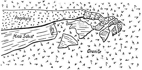
Fig. 9.
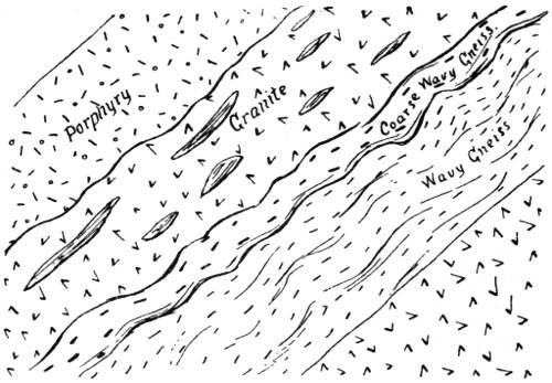
Fig. 10.
The granite dike is bounded on its upper side by one of aphanitic diabase 2 feet wide, followed by granite again. Nodules of the diabase appear in the edge of the granite. A stratum of wavy quartzose gneiss 10 feet wide follows the last dike of granite. It changes across the strike into a coarser gneiss, and that into irregular and partially blended masses of coarse granite, filled with long fragments of porphyry similar to a dike on the east. (Fig. 10.) The quartz porphyry is very compact and brittle, and has a conchoidal fracture. The porphyry dike has a width of 8 feet. About it is still another dike of granite 12 feet across, and containing many long fragments of a diabasic rock, which appears next in the succession.
The diabase is cut by small, interlacing granite seams for 6 or 8 feet, and also contains some large, irregular, lenticular masses of the same rock. Still farther is another dark dike cut squarely across by granite. Fine granite and quartz porphyry dikes occur still farther east. The porphyry dikes all run about north 35° west, average dip 70° southwest. They extend along the summit of a ridge for more than half a mile, when the coarse granite becomes the country rock. On the summit of the hill at the head of the cañon are strata of metamorphic rock, and also some veins of pegmatite, cutting across the porphyry. This wonderfully varied succession of rocks does not cover a width of more than a quarter of a mile. The relations exhibited here prove that the porphyry and diabase, as well as the schists, are older than the granite. The strip of country between the ancient porphyries of San Miguel and the coarse granite of Lyon’s Peak and the ranges north is remarkably rich in its variety of intrusive rocks.
On the north bank of the Sweetwater, just above where the Spring Valley road crosses, is a large exposure of coarse granite, containing so many inclosures of a dark dioritic rock as to present the appearance of a conglomerate. It is cut by bunches and ramifying dikes of fine granite and diorite.
At Dehesa the granite is replaced by norite, which forms a high mountain on the north side of the river, and extends southeasterly 3 or 4 miles, forming two high peaks. In this are veins of hornblende aggregates, and in general appearance the rock bears the closest resemblance to that on the Cuyamaca.
The crystalline rocks exposed between the Sweetwater and El Cajon Valley generally show more of a dioritic composition than granitic. 18 They have a glassy feldspar, much hornblende, and little quartz. There are two varieties: one is light colored, and forms most of the country; the other is darker, occurring in bunches and dikes. Southwest of the valley the rocks are more granitic. On the road to Spring Valley they give place to a hard, light—colored felsitic rock, containing specks of chloritic matter. Masses of granite appear in places, intruded into the rock. As it decays it becomes jointed, and seems to be reduced mostly to kaolin. Near the railroad, northwest of Spring Valley, rocks outcrop which belong to the series of dark intrusives, tuffs, and porphyries so extensively developed west of the granite. The rock here has a fragmental appearance in weathered specimens. It has a dark green color, and is of uncertain composition. The most western exposure of this rock, before it becomes covered by the mesa, has much the same character. It is without doubt an ancient intrusive, very greatly altered. It contains bunchy dikes of white feldspathic composition, which easily reduce to kaolin. The whole exposed width of these rocks west of the granite at this point is over a mile, about half of which is tufaceous. By tufaceous is not necessarily meant a fragmental intrusive deposited in water, but for lack of any other term it is used to designate those fragmental intrusives of plutonic origin which are so abundant in California.
Between the Oakdale House and the Sweetwater River, on the road to the dam, dark quartz mica diorites outcrop. They have been intruded by coarse granite in veins and bunches. A body of dark aphanitic rock, of uncertain origin, is inclosed in the diorite near the river. It may be a portion of the aphanitic rocks associated with the porphyries farther west. A little distance down the river the diorite is succeeded by conglomerate rocks, containing small garnets. The fragments are feldspathic in composition. Dark feldspathic porphyry then forms the prevailing rock for some distance. It shows great variations. Much of it contains no distinct crystals of feldspar, but is mottled by light green felsitic bodies of irregular outline. These contain chloritic substances, which decay out, leaving holes. There is a great variety of these ancient intrusives exposed along the sides of the river north of San Miguel Peak. None of the other crystalline rocks in San Diego County appear so old or show so much alteration.
Farther down the cañon the rock assumes a fragmental appearance, having masses of feldspar in a dark matrix. It finally becomes a pronounced breccia, being formed largely of angular, felsitic fragments. The base in which these fragments lie decays away and leaves them standing out on the surface. This may be a tuff formed in water, but the matrix has undergone such alterations that nothing certain can be said about it. This breccia continues to the lower end of the cañon. An interesting, light-colored dike was observed here. It is so filled with minute spherical amygdules as to resemble in structure an oolitic limestone. The breccia continues as far as the Sweetwater Dam, where it is replaced by feldspar porphyry. The porphyry shows much variation; in places no feldspar crystals are present, chlorite taking their place. These rocks disappear a quarter of a mile west of the dam, and mesa-like hills extend down to Chula Vista. These consist of soft sandstones and some calcareous deposits. Dark rocks, belonging to the series just described, outcrop near the mesa road from San Diego to El Cajon. It forms a long ridge south of La Mesa. The rocks are in part tufaceous, and in part dark green and massive, with felsitic inclusions. Near the 19 Eleven-Mile House the granite is filled with dark, bowlder-like inclusions. Hornblende is an important constituent of the granite. It is more than likely that many of these so-called granites are really diorites. The mesa formation terminates in an abrupt escarpment on the west of Cajon Valley. The valley comprises many thousand acres of very fertile land. Granitic knobs rise in many parts of the valley, showing that the alluvium deposit is underlaid by it at no great depth. North of the valley, for a number of miles, the crystalline rocks are covered by the mesa conglomerates. Granitic rocks are the only ones exposed for many miles east of Lakeside. Just above Forster’s there is a small outcrop of gneiss and mica schist; strike north 35° west, dip 70° northeast. The rock exposed along the grade is a coarse biotite granite, with much quartz and glassy feldspar. A dike of quartz porphyry varying to granite porphyry outcrops by the road at the top of the grade. This does not seem to be sharply defined from the adjoining granite. A dark hornblende granite or diorite begins here and outcrops along the road for several miles toward Ramona. Three miles from the town there appears a dark rock with a somewhat resinous luster. It is probably a diabase. The Santa Maria is a large, plateau-like valley, with low granite hills surrounding it. Light-colored granite, becoming somewhat hornblendic, extends some distance east of Ramona, when it is replaced by a dark diorite. The latter extends along the road for 2 miles. It has glassy feldspar, and in places much mica. Four miles west of Ballena the granite is filled with pegmatitic veins, running in a northwesterly direction. They carry brittle crystals of black tourmaline, garnet, and muscovite mica. East of Ballena the rock becomes coarser and somewhat gneissose, with an abundance of mica. There are no bedding planes, simply a parallelism of constituents. This schistose structure has a northwest direction. The gneiss changes to mica schist on the grade above Santa Ysabel. The schist alternates with occasional strata of quartzite; strike north 25° west. The quartzite is a white, fine, granular variety, containing a little mica. Coarse gneiss outcrops again farther up the grade; at the top it becomes finer, carrying some hornblende, and alternating with strata of fine mica schist; dip northeast. The gneiss often becomes granitoid. The lamination has no constant direction, and resembles a flowage structure. This granitoid gneiss extends to within a mile of Julian, when there is quite a sharp transition to a gneissoid mica schist. That gives place to a fine schist, and a quarter of a mile west of Julian to a pearly hydro-mica schist. The schists strike north 20° to 30° west, dip 70° northeast. At Julian the rock is a dark, thin-bedded mica schist, usually termed a slate. There are also dark felsitic rocks and some gneisses. The belt of dark slaty mica schists is about half a mile wide. Toward the Balkan Mountain the rocks become more gneissoid. This mountain seems to be formed wholly of gneiss and mica schist. In some places the rock is nearly massive, and contains a large amount of quartz.
The rocks forming the mountains near the road from San Felipe to Vallecito are nearly all gneissoid. The real desert begins on leaving San Felipe Valley. The road extends southeast for 5 miles and then turns southwest, descending a narrow, rocky gorge to the head of Vallecito Creek. Near where the road turns to the southwest, the gneisses are cut by innumerable dikes of coarse granitic composition. Many of these run parallel, cutting across the strike of the gneisses, and give the 20 appearance of a bedded formation. In the cañon, before reaching Vallecito Creek, mica schist appears. It is bent and twisted into every conceivable direction, and varies exceedingly in structure and composition in the course of a few feet. The dip is northeast, and often at a small angle. The granite dikes often carry garnets, being quite similar to those between Julian and Banner. They were probably intruded after the eruption of the granite, and the related metamorphism.
At Mason’s granite and gneiss both appear as intrusives in the schists, and are themselves cut by coarse dikes similar to those described. Between this point and Banner, in a direct line, gneiss is the prevailing rock. The high mountain east of Banner is more granitoid.
There is a sandy valley of considerable extent about Mason’s; eastward a low ridge is crossed, and the road descends to Vallecito Valley between barren granite mountains, gradually descending until the open desert is reached. When the granite is hard these mountains are very rugged, but in places they are covered so deeply with soft, decomposed material as to closely resemble the Tertiary deposits farther east. The mountains often show pale purple to brown tints. On examination they appear to consist of a white granite, which has been so shattered as to break up into pieces, averaging not over 2 inches in diameter. This rock presents a very similar appearance for miles, particularly on the north side of the creek.
At Palm Springs the soft clay beds of late Tertiary age begin to appear. They dip in all directions, though that to the south and southwest is the most common. Toward Carrizo Station these are often covered by granitic detritus. The Tertiary beds widen out where the road strikes Carrizo Creek, and at Carrizo Station they have a width of nearly 10 miles. They rest against a granite range north of the creek and south along a long ridge which terminates in Carrizo Mountain. They also extend a long distance up Carrizo Creek. Four miles below the station harder sandstones and strata of shells cap the clay hills. This shell layer near the creek is 10 feet thick and contains pectens and oyster shells, belonging to the Miocene-Tertiary. The clay hills which surround Carrizo Station form a veritable Bad-Land. They show many different colors, and are perfectly devoid of any vegetation. They have been eroded into a most confused network of hills and cañons, and are so soft that it is difficult to travel over them. Six miles below this station and a mile north of the creek there rises a rugged granite range, facing the open desert. It rises from the desert quite precipitously nearly 2,000 feet, but blends westward into the ridges which run east from San Felipe. The granite is coarse and deeply decomposed. Sharp, angular grains of quartz stand out so prominently as to tear anything with which they come in contact. The thin-bedded shell strata rest against the slopes of the mountain, and near the southern end rise against the eastern slope at a very high angle in sharp, jagged points. These strata rise above the granite ridges at the point where they occur, and dip fully 70° to the east. (Fig. 11.) Resting on the summit of this granite ridge, and immediately west of the steeply inclined and jagged points of the Tertiary strata, is the southern outcrop of a bed of coarse, hard sandstone, which rises along the summit of the ridges to the north and dips west, extending down the western side of the range for a thousand feet or more, dipping at an angle of about 30°. This sandstone outcrops along the crest of the ridge for nearly a mile. It is, however, not absolutely 21 continuous, the granite rising through it in places. Near the southern end it is so highly metamorphosed as to be with difficulty distinguished from the granite at the contact. In fact, the two formations have become so intimately united, that a fracture of the granite made near the sandstone, instead of stopping at the contact, extends into the sandstone, so that the two rocks break off together. The contact is so exceedingly irregular that it seemed at first sight as if the sandstone had been intruded by the granite. Deep, narrow crevices extend into the granite, and are filled with sandstone. Some granite bunches are almost inclosed in the sandstone. The most interesting feature of this sandstone is the presence in it of an abundance of well-preserved corals of a type fully as old as the Cretaceous. Fragments of two species of a large oyster and poorly preserved specimens of univalve and bivalve shells are also abundant. There are at least two species of coral, many specimens being at least a foot in diameter. The sandstone is literally filled with them toward the southern portion of the outcrop. They also extend down into the crevices and cavities in the granite. The sandstone shows somewhat less metamorphism toward the north, where it contains some strata of pebbly conglomerate. The granite is intersected by many veins of coarsely crystallized feldspar and quartz. From these veins many of the pebbles in the conglomerate have been derived. At the highest point of the ridge the sandstone has the greatest thickness. Here it is broken up into great blocks 15 feet square, piled in the greatest confusion, as if by an earthquake. One great mass overhangs the almost precipitous granite escarpment at an elevation of 1,000 feet above the desert. Many fractures extend from the sandstones through into the granite. The sandstones, as well as the granite mountains north, have been baked a dull red color by the intense heat of the sun. To account for the peculiar position of this sandstone, as well as the steep inclination of the Tertiary beds at the southern end of the mountain, we must suppose that an extensive fault has taken place along the edge of the range facing the desert. The general inclination of the Tertiary beds to the west and southwest is also evidence of an uplift along this line.
Fig. 11.
Carrizo Mountain was ascended from the north by following up a wash through the clay hills. At the foot of the mountain there is a small outcrop of ancient volcanic rock greatly altered. This rock rests against the limestone which forms a large part of the north end of the mountain. The limestone is crystalline in every portion. The strike, as well as that of the schists and quartzites by which it is inclosed, is north 30° to 40° west, dip 75° to the southwest. The color of the limestone varies from white to streaked and variegated. It was carefully examined for fossils, but no traces of them could be found. The limestone is, however, 22 filled in many places with the holes of borers, and one small incrusting coral and one barnacle were found. The elevation of the north peak is 1,700 feet, and these were found nearly at the top. Everything points to a great elevation here in times so recent that the atmospheric agencies have not yet had time to remove the surface exposed to the ocean waters. Another factor enters into this time computation, however, and that is that in this climate, where the rainfall is so slight, a great many years are required to effect slight changes. Toward the south peak the rock is almost wholly micaceous and quartzose schists. Judging from the great amount of metamorphism shown by these rocks, fossils, if they ever existed, must have been destroyed. At various points on the northern end of the mountain are horizontal deposits of a soft, shaly sandstone full of fossils, similar to those found north of Carrizo Creek. The corals are very large and perfect. Some nearly entire specimens of large oysters were also obtained, but most of the bivalve shells are represented only by casts. With all the exploration which has been done, it seems probable that these beds have never before been seen.
Professor Blake, geologist of the Pacific Railroad Survey, passed up Carrizo Creek in 1853, but, from the statements made, it seems his observations were confined to the immediate vicinity of the road. His is the only geological party that has visited this region up to the present time. The vicinity of Carrizo Mountain is a favorite one for prospectors, and every winter it is visited by a number of parties. As yet no important discoveries have been made, and I cannot say that I think the region is a favorable one. Silver has been reported from the southern slope of Carrizo Mountain, and at one time there was considerable excitement. The mountain, though formed wholly of metamorphic rocks, does not appear to have been mineralized to any extent. Only one dike was seen on the mountain, and that was of a coarse, granitic nature.
There is not the slightest doubt as to the presence of a non-conformity between the Miocene-Tertiary and the coral-bearing sandstones. Specimens of the coral were sent to the National Museum, and were pronounced similar to some from the lowest Cretaceous of Texas. As to the age of the limestone and associated metamorphic rocks, they are unquestionably Carboniferous or older. A float piece of silicious limestone was found containing some shells, but no opportunity for their investigation has yet occurred. The Tertiary beds are covered, wherever any of their original surfaces yet remain, by a great variety of washed bowlders.
With regard to the structure of this eastern slope of the Peninsula range, I can hardly agree with the views before expressed, that there are to be seen here evidences of an enormous fault, to which the steep escarpment toward the east is due. The eastern side of the range, so precipitous in places, has been compared to that of the Sierras in structure and general features. It is true that this descent is very abrupt in places, but in others it is almost as gradual as the western slope. For instance, the gradually descending ridges which extend east from Banner for nearly 30 miles, show no indication of any fault, save at the mouth of Carrizo Creek, where there has undoubtedly been a fault of considerable importance. The very abrupt descent east of the Balkan and Laguna Mountains is due solely to enormous erosion, for both north and south ridges extend past them for many miles into the desert.
The San Jacinto Mountains also send out long arms into the desert, and below the boundary Signal Mountain and a connecting range seem 23 to be merely a spur of the main system. The rocks of the metamorphic belt at Julian and Banner, and farther south, dip to the northeast, indicating a great fold rather than fault, with the most strongly pronounced intrusive granites and diorites at some distance on each side.
It is not generally known that an ancient auriferous gravel channel exists in the county. It begins about a mile north of the old stage station, and 3 miles west of Ballena Post Office, where there rises a hill shaped like a whale’s back (hence the name Ballena), covered with washed gravel and bowlders. The main portion of the channel which has escaped erosion begins south of the stage station, capping a hill which has an elevation above the sea of 2,400 feet, being a little lower than the so-called Whale Mountain. The gravel is 50 to 100 feet thick, and has a width of 2,000 feet or more. It rises 300 to 500 feet above the valleys and cañons on its sides. It extends in a direction a little south of west for about 4 miles, terminating on the south of Santa Maria Valley. A granite ridge runs 2 or 3 miles farther in the same direction, probably preserved by the gravels, which are now gone. A pretty valley, a mile long, has been eroded in the eastern end of the gravels, down to the underlying granite. Placer mining has been carried on for years here in a small way by Mexicans. Gold is said to be scattered everywhere through the gravels, which are often very firmly cemented. Lack of water, for the ridge is higher than any of the surrounding country, has prevented work on a large scale. Lately a mining district has been organized, and it is proposed to bring water 7 miles in pipe. In the gravels are washed bowlders, many of them being 2 feet in diameter and well polished. The remarkable thing about them, however, is that they are nearly all porphyries. The most abundant is a red feldspar quartz porphyry. Quartzite bowlders of all colors are numerous, and there are a few of the basic diorite so common in portions of the county. Garnets are said to be very abundant in the gravels, and many bowlders of a schist carrying them are also present. The matrix of this rock could not be made out in the field; it is very tough and heavy, and has never been seen in place. The red porphyry bowlders resemble those on the mesa farther west, but have never been found in place. Never, in the mountains east or north, has porphyry of this kind been seen, either by myself or described by others. From the old stage station the upper course of the stream was north and south as far as it can be traced. There are indications that one branch extended easterly toward Julian. These gravels appear on a hill surrounded by deep cañons, about 2 miles east of the top of the grade above Foster’s. At the top of the grade the hills on the west are flat-topped, and covered with gravels to a depth of 150 feet. These have much the same character, and probably belong to the same channel. More investigation is needed to determine whether the course of the old stream was down toward the San Diego River, in Cajon Valley, or west toward the high mesas south and southeast of Poway Valley. It seems probable, however, that the stream flowed west, and that the mesas have been formed partly from the bowlders which they brought down. This mesa, as well as the gravels at the head of the grade, has an elevation of 1,500 feet. The source of the porphyry bowlders and the garnetiferous schists of this old river is a matter of great perplexity. The gravel deposit has every characteristic of an old river channel, and not that of an elevated arm of the sea; besides, the presence of gold in the gravels indicates their derivation from the country farther 24 east. The gold may have been derived from Julian or Mesa Grande, or some more remote point. The river must have flowed across the gold belt, but then the question arises, how could a river of such magnitude have existed so near the summit? The only way out of the difficulty is to suppose that a great uplift has taken place along the crest and western slope, coupled with an enormous amount of erosion; and that this stream once, before this great change took place in the configuration of the country, headed many miles to the northeast, far beyond the drainage of the western slope. The bowlders consist largely of hard rocks, and are very smoothly rounded and polished, indicating that they have been transported a long distance, and subjected to attrition through a protracted interval. It is quite possible that this river emptied into or near San Diego Bay, and that the immense beds of bowlder conglomerates about the bay owe their formation largely to this river action.
The first outcrop of crystalline rocks in Mission Valley is about 3 miles above the old Mission, where the San Diego River enters a cañon. It is a volcanic tufa, consisting of grayish to greenish fragments of a fine-grained rock imbedded in a brown matrix. This has a width of about half a mile. Along the cañon, dikes of a greenish amygdaloid have been intruded in the rock, and are particularly numerous north of the river. One of these dikes in the cañon was observed to be amygdaloidal in the center. Farther up the cañon there is a great variety of tufas. The first contains feldspathic and hornblendic fragments nearly blended in a base consisting of crystallized feldspar and dark chloritic particles. Above this is a dike of brownish crystalline rock, much altered; the only distinguishable mineral being feldspar, in small crystals. Then follows another tufa, with nearly blended micaceous fragments. The next rock is a fine crystalline one with very regular bedding planes, a foot or more thick; dip 30° to 40° southeast, strike north 35° east. Then follows a dark, aphanitic, structureless rock for some distance. At one point a branching dike of almost pure feldspathic material spreads out into this aphanitic rock in radiating arms. Apparent bedding planes run through them, as well as the country rock, showing that these planes are not those of sedimentation, but are due to some secondary cause. These rocks occupy the cañon for 1½ miles, and are all undoubtedly of volcanic or intrusive origin. A series of rocks of metamorphic origin outcrops a thousand feet along the cañon. The first of these is a micaceous felsite. That is followed by fine-grained granitic rocks carrying garnets, and this by a hornblendic felsite. The latter finally becomes mixed and blended with a coarse micaceous diorite, containing a glassy feldspar. This rock is the chief one exposed through the cañon. It has granitic and syenitic facies. The tuffs exposed at the mouth of the cañon extend in a direction a little east of south for 3 miles, until covered by the mesas which extend west from Cajon Valley. They show a comparatively uniform character, the fragments being generally nearly blended. The ridge which these rocks form is separated from the granite by an elevated mesa a mile wide. The tuffs are exposed along Chaparral Cañon to within 2 miles of the mission.
The granite ridge at the lower end of Cajon Valley does not extend more than 2 miles north of the cañon, when it becomes covered with bedded deposits and bowlders of late Tertiary age. Granite does not appear in Sycamore Cañon until the northeast boundary of the Cajon grant is reached. High hills of gravel and bowlders lie east of the 25 cañon and extend toward Foster’s. The main body of granite is met at the head of the cañon. It extends along the east side of the road to Poway Valley. Bunches of dark, coarse diorite occur in it in many places. The gravel mesa south of Poway Valley has an elevation of 1,200 feet. Small areas of gravel also remain on the hills northeast of the valley. The granite ridge, flanked by porphyries, does not outcrop very prominently south of Los Peñasquitos Cañon. The ridge southwest of Poway Valley seems to be formed largely of gravels, rising 1,500 feet.
The usual brecciated tuffs outcrop in the gulches and along the creek just above Los Peñasquitos ranch house. They appear along the old road to Escondido for 2 miles. A body of chloritic granite appears in the center in the form of a long dike, extending from the Peñasquitos Creek a mile or more north of the road. Toward the east the breccia becomes finer and almost loses its fragmental character. Between this formation and the granite a dark micaceous felsite, probably metamorphic, outcrops. The fragments in the tuff are diabasic at times and at others largely petrosilicious and feldspathic. The crystalline rock on the east is, perhaps, more nearly diorite than granite, as the feldspar is chiefly a glassy one. Black Mountain is formed of this dark breccia, while the high range of mountains which rises on the north and extends northwesterly between San Bernardino and the ocean, is formed partly of granitic rocks and partly of the tuffs and porphyries, the latter lying on the west.
A rolling, hilly country, containing much good land, stretches north toward Escondido. Remnants of the mesa conglomerates remain in places on the eastern edge of the Peñasquitos grant. The granite is coarse and rises in huge, rounded knobs along the road. A little south of San Bernardino Post Office there rises a conical peak of micaceous diorite. A somewhat similar rock, but more diabasic in appearance, forms the mountain immediately west of the Post Office. This formation extends northwesterly for several miles, having a width of about a mile. The rock over much of this area closely resembles the gabbros and olivinitic diabases from the southern part of the county. It is penetrated by dioritic and granitic veins, in which the structure is often pegmatitic.
At the point where the road stops at the entrance of the cañon of Diablo Creek, this basic formation is replaced on the west by a massive, jointed quartz rock, containing a little feldspar and chlorite, and in places becoming granitoid. It often has a fragmental character, with the quartzose bodies imbedded in a matrix more granitic, or simply darker and chloritic. This rock is quite uniform for 3 miles down the cañon, quartz being the predominating constituent. It is very probable that this represents an original sedimentary terrain. It is followed on the western slope of the range by the dark tuffs before described. Here the matrix is often porphyritic, with a fluidal structure. Portions are real porphyries. A mile east of Olivenheim it resembles diorite porphyrite. The last exposure seen on the west was of the usual tufaceous character. This formation narrows northward, and on the road to San Marcos shows the width of a mile.
Northwest of San Marcos there is a large body of metamorphic rock, chiefly felsite schists and feldspathic quartzites. These extend in a northwest direction toward Buena Vista, but there are not many exposures. Dark diorite outcrops south of Buena Vista, and extends west for a mile and a half, when it sinks under the Tertiary deposits. The last outcrop 26 seen was a dark micaceous diorite. A mile west of this point there is quite an outcrop of diabase containing an excess of dark feldspar. The sandy clays extend west from this point to Oceanside. Near Buena Vista station the diorite is impregnated with green copper carbonates, and a considerable amount of work has been done, but evidently no paying bodies of ore were found. Syenite outcrops near Kelly’s ranch house, and in the hills east. The crystalline rocks come nearer the ocean here than at any other place in the county.
Between Escondido and Moosa Cañon, granites, with bunches of dark diorite, are the only rocks seen. A broad, sandy valley extends up San Luis Rey River to within 5 miles of Pala, when the high granite mountains close in, forming a cañon. The valley widens at Pala, and for many miles a broad, sloping deposit of bowlders and gravel borders the river, and rises high against the foot of Smith’s Mountain. It is often 2 miles wide and represents a great amount of erosion. A mile northeast of Pala is a high hill of diabase, similar to that in the southern part of the county. On the eastern slope of this hill is an enormous pegmatite vein, carrying a very interesting set of minerals. This vein is twenty or more feet wide, and dips west at a small angle. There are masses of great size of almost pure mica and feldspar, or quartz and feldspar—in the latter case very fine specimens of graphic granite have been formed. Near the southern end of this vein is a deposit of lepidolite mica, 10 feet thick at the widest part, and appearing in detached bodies for several hundred feet. It is fine-grained and shows a pale purple color. In places it is pure, in others filled with large radial aggregates of pink tourmaline (rubellite). Some of the aggregates are a foot across, others are long and slender, with arborescent forms. North of the main deposit it is found in quartz in fan-shaped aggregates, the crystals being more than a foot long, but greatly decomposed. Black tourmaline is abundant in the pegmatite surrounding the lepidolite, but in poor, brittle crystals. Green tourmaline is present in places in the form of minute grains. Garnets are also to be found in places. The vein as a whole is inclosed in the diabase.
The western end of Smith’s Mountain shows many bodies of dark dioritic rocks. The major part of the rock is, however, gneiss and mica schist, all very easily decomposed, leaving an immense amount of bowlders and gravel along all of the gulches. Mica schists cover an extensive area along the southern slope of Smith’s Mountain, on the Pauma grant. These are undoubtedly a continuation of the schists of the Julian belt, but carry no minerals. The belt of schists extends nearly if not quite through to Julian. Warner Valley is located at the head of San Luis Rey River. It is entirely surrounded by granite mountains. There is not as great a variety of intrusive rock here as in other parts of the county.
Point Loma forms a peninsula, the greatest length of which is about 6 miles, and greatest breadth, 1½ miles. During Quaternary times it was an island, but owing partly to an elevation of the coast, and partly to the detritus brought down by the San Diego River, it becomes joined to the mainland. It rises 400 feet in almost perpendicular cliffs at its southern end, gradually lessening in height toward Old Town. The rock of which it is formed consists of soft shales and sandstones, the latter often quite consolidated. The strata at the extreme end of the point dip south, but in a short distance turn and maintain a quite 27 uniform dip to the northeast nearly the whole length of the peninsula. This abrupt elevation evidently owes its origin to a fault accompanied by an uplift, and not to erosion. Beginning at Ocean Beach, and following along the base of the cliffs to the light-house, hundreds of faults can be counted. Near Ocean Beach fifteen can be counted in the space of 200 feet. The direction of these faults is nearly at right angles to the strike. The most of them are nearly vertical and clean cut. The throw varies from a few inches to many feet. Sometimes the north and sometimes the south wall has risen. An interesting overthrust fault is exposed in the cliffs north of Ballast Point. (Fig. 12.)
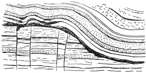
Fig. 12.
A conglomerate of late Tertiary age overlies the Cretaceous rocks unconformably on the extreme end of the point. These conglomerates are firmly cemented and form high cliffs. They dip at an angle of 30° to the southeast. The pebbles are in part derived from the sandstone of the point, and in part from the crystalline rocks east of the mesa. Near the top of this conglomerate are immense, semi-angular bowlders. These have rolled down to the beach and are strewn around the end of the point. Many large ones are to be found a little west of the new light-house, but the greatest of all is on the eastern side. It is fully 10 feet in diameter, and formed of the same kind of rock as that on which the mesa rests 8 miles east of San Diego, viz: a green volcanic tuff. It is a very interesting question as to how these immense bowlders have been transported so far and left in the beds near the top of the cliffs. I can account for it only by supposing that the point with relation to the country back of San Diego was several thousand feet lower at one time, and that a river of great volume, flowing over a steep channel, entered the bay at this place, depositing irregular beds of bowlders. This old river may have been the same one which formed the auriferous gravel channel before mentioned. The fault planes on Point Loma extend through the conglomerate beds, indicating that the elevation took place after the bowlder beds were formed.
An interesting collection of fossils was gathered from the lowest strata exposed, and from the bowlders in the conglomerates. This collection numbers something over sixty Cretaceous species, many of which are new. The fossils are not abundant, nor are they well preserved. Nearly all of these are characteristic Chico (Upper Cretaceous) fossils. There is, however, one species found here in considerable abundance, but rather poorly preserved, which Dr. White has described under the name of Coralliochama Orcutti, and which he has made the chief foundation for a new division of the Cretaceous, termed the Wallala Beds. The name 28 was given on account of the occurrence of this fossil, together with several other species, at or near Fort Ross, Sonoma County, and also at Todos Santos Bay, Lower California, where the best specimens were found. These beds stand in an unknown relation to the other Cretaceous deposits stratigraphically, but have been supposed, on account of the fossils, to indicate a division between the Chico and Shasta groups. I believe, however, that the occurrence of the most important fossil of this supposed division on Point Loma, in the same beds with undoubted Chico fossils, destroys the validity of the supposed Wallala Beds.
In a bluff at the northeastern end of the Point Loma peninsula, west of Old Town, there is a stratum of calcareous sandstone, carrying many fossils belonging to the Eocene, or lowest Tertiary. The strata dip northeast at a small angle, and though they cannot be traced continuously west to the outcrops of Cretaceous rocks, yet from the fact that they have the same dip, leads me to the belief that the two beds are conformable. This younger deposit corresponds to the Tejon, or Division B, of Professor Whitney. Everywhere in the State there exists the closest relation between the Chico and the Eocene. Here on Point Loma they are undoubtedly also conformable, but each is distinct as regards its fauna, for they are separated by nearly a thousand feet of unfossiliferous strata.
False Bay occupies the basin of a synclinal, for the strata dip northeasterly from Point Loma and south from the Soledad Hills. A violent disturbance, forming a great uplifted fold or perhaps a fault, has taken place along a line extending southeast from La Jolla through the Soledad Hills. At the eastern end of False Bay there is a small exposure of Eocene strata, dipping west. Near the mouth of Rose Cañon the strata dip southwest, and at the mouth of the cañon they dip 40° northeast. Along the road which leads over the hills to La Jolla the rocks are tilted at a very high angle to the southwest. The highest point of the Soledad Hills, rising 700 feet, lies over this disturbed region. Unconsolidated bowlder deposits lie on the top of the hills. The strata on the east side of Rose Cañon are well exposed, but do not seem to partake of the disturbance shown on the west. This is probably no unconformity, as they contain Eocene fossils, and the Eocene in other spots appears to be conformable with the Chico. Along the coast between False Bay and La Jolla the strata dip south at a small angle. At La Jolla, near the caves, they have been folded so as to dip very steeply to the southwest for nearly a quarter of a mile across the strike. Near the eastern end of the cliffs a reversal takes place, and they dip northeast at nearly as great an angle. Around the little bay there are no exposures, but a mile northward begins a very high line of cliffs, which extend through to the mouth of Soledad Cañon. This fold at La Jolla brings to the surface fossiliferous strata, bearing a number of species similar to those at Point Loma; among them is the Coralliochama Orcutti. The strata of the high cliffs north of La Jolla dip northerly at a small angle, and show only a few fossils of the Eocene age. The cliffs rise fully 400 feet. At the bottom of the cliffs are shales; higher up are great beds of conglomerate bowlders, chiefly a reddish porphyry.
Coal is reported to outcrop above the water at very low tide somewhere along this stretch of cliffs. It of course must occur in strata of Tertiary age. The coal vein struck in a boring at La Jolla must be Cretaceous. About 3 miles up the coast from La Jolla, there appears a dike of basalt cutting the Tertiary shales. At high tide it is nearly 29 covered by the ocean. It has a course about 30° east of north, and stands vertical. It begins on the north, close in under the high cliffs, but does not extend into them, the only signs being a fault in line with the dike. It is not more than 2 feet wide at the northern point where it is exposed. It is dark and compact and so decayed as to be easily taken for an argillite. The walls of the dike are very smooth and regular, except near the southern point, where it runs into the water. Here it swells to a width of 30 feet. The edges of the dike are compact, while the vesicular portion is in the center, where there is often a flowage structure developed. The central portion is more or less laminated parallel to the wall, and thus is generally a well-pronounced columnar structure developed the whole width. The columns lie horizontally across the dikes and are 12 to 15 inches in diameter. The cavities are wholly or in part filled with calcite. Metamorphism of the adjoining shales is apparent for 2 feet away, but the sea water has so decomposed the shale that it is not so strongly marked as it would otherwise be. The dike projects above the water in places for a distance of 1,000 feet, making its total exposed length about 1,800 feet. In the mesa southeast of Rose Cañon, and along the San Diego River, and back of San Diego, the formation belongs almost wholly to the late Tertiary. It is not certain whether the Miocene is present or not. A number of Miocene fossils have been found in the county, but perhaps the most of them have come from Carrizo Creek. Many fossils are given in Dr. Cooper’s list, as being found in the Pliocene of San Diego, which are more characteristic of the Miocene in other localities. I see no reason for doubting that the Miocene is present, but so intimately related to the Pliocene as to be stratigraphically inseparable from it. In the region between Rose Cañon and the northern boundary of the county, I do not know that Miocene fossils have been found, but in Orange County they are well characterized.
The region occupied by San Diego Bay and the mesa back of it is composed, as far as we know, of Quaternary, Pliocene, and perhaps Miocene strata. Sandstones characterize the lower formation, and loosely cemented conglomerates, increasing in thickness toward the mountains, the upper. These were deposited in a sort of basin, of which Point Loma and the Soledad hills formed the northern and western borders. Many oscillations of level have taken place, the most recent being an elevation of 40 feet, shown by an old beach line on Point Loma. The shells in this beach are the same as those now living in the adjoining ocean. It is a peculiar fact that the mesas are slightly higher near their western terminations than farther east, indicating a recent uplift along the ocean. Water is scarce through this mesa formation. At the end of Point Loma there is a strong sulphur spring exposed at low tide. Its waters may possess medicinal properties, and should be examined.
On the southern shore of False Bay is a large deposit of calcareous tufa. The central portion is quite pure and a number of feet thick; just how thick is not known. It extends along the shore some distance, and often contains bowlders and shells. This is evidently a deposit from some former spring of great size. The mesas lying west of the extensive volcanic tuffs have been derived largely from the decay of the latter, and have heavier soil. North of Soledad they become more sandy, and maintain this character to the Santa Margarita Creek. This light soil, however, is being successfully cultivated in many places and for 30 certain kinds of fruit, without irrigation. The surface of the higher portion of Point Loma, as well as some of the mesas north, is covered with spherical nodules, a quarter to half an inch in diameter, of sand cemented with red oxide of iron. These literally cover the ground in places so that it is difficult to walk. The origin of these at first seemed very puzzling, but on examining the face of a cliff on the top of which these were found, an explanation was reached. They were seen to grow smaller away from the surface of the ground until a depth of 2 feet was reached, when they cease. Their formation is due to the oxidation of the iron in the sandstone, and its segregation in little nodules on the same principle as the formation of concretions.
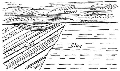
Fig. 13.
The cliffs of Eocene sandstone along the ocean grow gradually lower north of Soledad Cañon. At Encinitos the cliffs are higher again and for a short distance the strata dip south, but toward Oceanside they resume the northerly dip and disappear several miles south of that place. Faults grow less numerous the farther we get from Point Loma. The mesa is low about Oceanside; it was either never very prominent or else the erosion has been great.
On the north bank of the Santa Margarita Creek, near the ranch house, is an interesting cliff of Quaternary sands and gravel, showing a number of strata deposited under different conditions on an old beach. (Fig. 13.)
The Tertiary beds north of the Santa Margarita Creek are very different in outline from those south. Instead of their extending in a gradual slope from the older mountains to the ocean, there arises in them, near their western border, a range of mountains, known as the San Onofre Mountains. These extend parallel to the ocean at an average distance of 2 miles. They rise north of the Santa Margarita Creek and extend to the San Onofre Creek. They have a gradual slope on the west, rising to an elevation of 1,400 feet, but are quite abrupt on the east. Los Flores Creek cuts through the southern end of this range, showing that while the soft, clayey sandstones between it and the Santa Margarita Mountains slope only 5° to 10° southwest, the rocks of the range itself dip west at an angle of 35° to 40°. The formation is a breccia, the fragments of which are argillitic, micaceous, and hornblendic schists. Some of these fragments are of great size, one bowlder of hornblende schist being 8 feet in diameter. Pebbles of white quartz and other hard metamorphics are also present. The soft, coarse sandstone in which the fragments are imbedded show no traces of any granitic matter. The range was ascended 2 miles north of the Los Flores ranch house, 31 and found to consist entirely of fragmental schists, such as those mentioned, dipping southwest at an angle of 45°. The mountains were also climbed at their northern end, near San Onofre Creek. Here there is a very abrupt escarpment on the eastern side. The strata dip toward the ocean at a high angle, while the irregular hills and ridges of soft, light-colored sandstone lying east toward the Santa Margarita Mountains are nearly level. After a careful study of the range the conclusion was reached that its origin was due to a great fault, represented by the very abrupt eastern slope, tilting the elevated portion to the west at a high angle. I believe that this fault took place after the deposition of the Tertiary strata. As far as my observation went the Tertiary beds on the east do not rise to meet the San Onofre range, as they would to a certain extent if it were present when they were deposited; on the contrary, they dip toward it. West of the range the ocean is bordered by very high cliffs of Quaternary clays, and in only two or three places do the Tertiary rocks outcrop. Small patches of sandstone outcrop near the road at the western foot of the mountains; they also dip west at a high angle. Many of the fragments at the northern end of the range show their derivation from a massive crystalline rock. The hornblende schists are generally garnetiferous. Blue glaucophane schists are also very common. South of Mission Viejo Creek, Orange County, there is an outcrop of rock, apparently in place, which greatly resembles these schists. Good outlines of these mountains, indicative of structure, can be seen to great advantage from the San Luis Rey Mission. On the west slope of the San Onofre Mountains, 4 miles north of Los Flores, is an outcrop of a garnetiferous hornblende schist, which certainly appears to be in place. This rises 10 feet above the side of a gulch, and is fully 20 feet across. One mile north and in line of strike with the last is another outcrop of similar rock, which is so large that it certainly seems that it must be in place. The only point north of the San Onofre where this breccia appears is at Arch Beach, Orange County. The Santa Margarita Mountains are bordered by very extensive bowlder deposits, which rise as high as 1,500 feet on their western side.
The topography of the northwestern part of the county between Temecula, Elsinore, and the ocean, is very complicated. This section is occupied by rugged, brush-covered mountains and narrow, deep valleys, with the exception of the Santa Rosa plateau, where the configuration of the county has been entirely changed by extensive lava eruptions, stretching over a distance of 10 miles. This mountain region narrows toward the north to form the Santa Ana range. The variety of rock formations is very large. The northern portion is unsurveyed. On the south are the two large grants, the Santa Margarita and the Santa Rosa. Between these lies De Luz Valley. The Santa Margarita Mountains extend north and south, forming the eastern borders of the grant and rising to an elevation of 3,100 feet. The granite of the region about De Luz Valley is far from being homogeneous. A part of it is undoubtedly intrusive, and a part may represent an original sedimentary formation. Bedding planes are present in much of this supposed metamorphic granite, but generally no schistose structure. The presence of the De Luz warm springs is perhaps due to a dike of dark, aphanitic diorite, which has cut through the granite in an irregular manner. A very interesting breccia outcrops in the bed of the creek below the warm springs. (Fig. 14.)
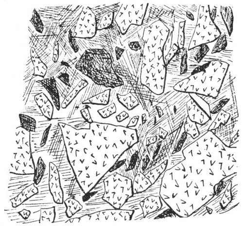
Fig. 14.
The fragments are chiefly granite and an aphanitic rock. They are quite angular, showing only a slight rounding of the corners. Some of the larger fragments are a foot in diameter. The boundaries are very irregular. Long arms of the inclosing granite project into the breccia. The base or matrix varies from a coarse syenitic rock to an aphanite. It often seems to present a blending of different kinds of fragments. Besides the large inclusions there are scattered through the matrix small angular pieces, which are so regular in outline and distribution as to give to the rock the appearance of a porphyritic structure. The granite in the hills west of the valley contains much biotite and quartz in long, rounded grains, presenting a pseudo-porphyritic aspect. This appearance is characteristic of much of the granite of this section. Imbedded in the granite are masses of dark aphanitic rock. The lower granite hills are covered with considerable sandy soil. There are isolated peaks of a coarse white granite, much like that of the Sierra Nevada, arranged in some sort of regularity in north and south lines. One rugged peak of this coarse granite rises 2,500 feet west of the valley. At the northern end of the valley the bedding planes in the finer grained granites are very regular; strike north 45° west, dip 65° southwest. There is, however, no schistose structure present.
A half mile above the warm springs is another conglomerate or tuff, which seems so related to the granite that the latter must really be eruptive. In a little valley southwest of De Luz and just east of the Santa Margarita grant there is a large outcrop of diabase. It has been intruded in a fine-grained, jointed granite. Farther down the valley, on the road to De Luz Station, there is a narrow outcrop of black quartz feldspar porphyry, followed on the east by a dark felsitic mica schist; strike northwest, dip 60° southwest. Immediately west of the deep canons which lead down to De Luz Creek, rises the Santa Margarita Mountains. They consist of a fine-grained granite, verging at times on a quartz porphyry. The main crest is 2 miles long, the highest peak of which is nearly 3,200 feet. The rock is perfectly massive, but shows apparent bedding planes; strike north 30° west, dip 80° northeast. The porphyritic facies of this formation occur in the western slope. On the western slope of the main range, at an altitude of 2,500 feet, there is a plateau-like area of a thousand acres or more of fine grass land. It is 33 dotted with white oak trees. The western slope of this plateau is very abrupt and brushy. The formation is partly porphyry and partly dark diabase and diorite. The most interesting fact connected with the Santa Margarita range is the occurrence of sandstone at an elevation of 2,600 feet on its western slope. The sandstone occupies very limited detached areas in the heads of the gulches, and is evidently the remnant of a once far more extensive formation. The sandstone is largely kaolinitic, and has evidently been derived from the adjoining rocks. At the foot of the southern end of the mountains appears very quartzose rocks, probably of metamorphic origin. Coarse granite has been intruded into them in small bunches. Granite extends southwesterly in the form of a wedge as far as the Santa Margarita ranch house, and is there covered by modern deposits. Between De Luz and Fallbrook the country is gently rolling, with knobs of granitic rocks projecting here and there. About Fallbrook, and for some distance east, the granite does not outcrop much, owing to its easy decomposition. A little east of De Luz Station is a small body of mica schist; dip 30° east, strike north 15° west.
The road from Fallbrook to Temecula leads through a long, narrow valley. On either hand rise high mountains of bare granite. Immense bowlders, 20 to 30 feet across, line the valley, having fallen from the cliffs. The granite here is a coarse rock, rich in biotite, and though great masses could be obtained free from checks, yet does not seem durable. The valley owes its origin to a difference in rapidity of decay along certain lines. On this section there appears no trace of the schist belt extending northwest from Julian. This coarse granite is undoubtedly intrusive and has cut it off.
A wholly different series of rocks is exposed in the Temecula Cañon, not more than 2 miles north of the country just described. This cañon is deep and rocky, taking a very direct course from Temecula to the ocean. At the upper entrance there is a narrow exposure of granite. This is followed by quartzite, dipping 45° southwest. The rocks shortly become massive and are replaced by dark syenitic ones with an excess of hornblende. Two miles down, granite appears for a short distance, and in it a quarry has been opened. The rock can be obtained in blocks of any size from great masses which have broken off and rolled into the cañon. Gneissoid rocks soon replace the granite, and these are followed by hornblendic rocks, which vary from a schistose to a massive structure. In places they contain feldspar and pass into syenites; in others the rock is almost pure hornblende. The greater portion of these rocks are of metamorphic origin. The dip is generally vertical, strike east and west to northwest. The syenites are followed by mica schists, and these by coarse biotite granite about 5 miles above Howe Station. In the granite are many pegmatitic veins, carrying biotite, garnets, and tourmaline. Fine-grained granite, varying at times to syenite, forms the rock along the cañon for many miles below this point.
The most interesting geological feature about this northwestern part of San Diego County is the long plateau, confined chiefly to the Santa Rosa grant. This plateau lies near the western corner of the grant, and extends east nearly to Murrieta. The lava is broken up into detached tables by erosion, which become very strongly pronounced toward the western end of the flow. The western body of lava is the highest. It has a length of nearly 2 miles and is broken into three peaks or ridges, sloping generally a few degrees to the east; height 34 2,850 feet. There are two terrace-like tables lower down its southern slope. The lava is, perhaps, a hundred feet thick at its eastern end, and has been so much eroded toward the western portion that the underlying sandstone is exposed along the crest of the ridge, with lava lying in broken masses along its sides. The sandstones form quite an extensive bed under the lava flow, being 200 or 300 feet thick, and horizontally bedded, wherever bedding is present. The upper part is very soft and granular, the lower portion is hard and stained reddish. It carries many bowlders 6 to 8 inches in diameter, different from any other rock seen in the adjacent mountains: quartzite mica schist, aphanitic rocks, and some granitic ones. These are washed smooth. The sandstones contain much kaolinitic matter, and at one spot show an incipient crystallization. A number of contiguous grains, over a space half an inch in diameter, show the same orientation. Near the bottom the sandstones are impregnated with iron. The western ridge in particular shows a great amount of erosion. The lava is nearly gone in places, but occurs southward in scattered outcrops for half a mile. At the northern end the sandstone rises fully 300 feet above the lava. Lava is present on its sides. Much of the sandstone closely resembles a granite decomposed in situ. Fragments of the mica schist resemble that in the hills west of Temecula. Northward half a mile is the deep cañon of the San Mateo. The country descends very rapidly from the lava ridge, especially so on the north, where the cañon is fully 1,500 feet deep. It is a number of miles in any direction to mountains which are as high as this lava-capped sandstone ridge, and the amount of erosion must have been enormous since it was deposited. Mesa Redonda has an elevation of 2,750 feet, and is separated from the lava just described by a valley fully 800 feet deep, and nearly a mile broad. Mesa Redonda is formed by a lava table, probably basalt, 150 to 200 feet thick. It is quite precipitous on three sides. The lava is bedded, dipping 5° to 8° northeast. Underneath is a body of coarse, friable sandstone, similar to that just described. Some pebbles and bowlders of lava lie in the upper portion of the sandstone. The sandstone consists of angular quartz grains and kaolinic matter, and often presents the appearance as if it had been partly fused by the lava. In the top of the sandstones are pebbles of quartz, feldspar, and mica schist. The sandstone shows no bedded structure, but seems to form a mantle over the hill, following the irregularities of the underlying granite. It descends 700 feet on the southern slope of the mountains which rise so abruptly from De Luz Valley. The lava has spread out in thin sheets on the southern slope of the mountain, descending more than a thousand feet on the east side of Cottonwood Creek. These thin beds are not massive, but are formed of angular lava bowlders. The flows were so thin that they either broke up on cooling, or later through atmospheric agencies. Fig. 15 is a sketch of Mesa Redonda from the north.
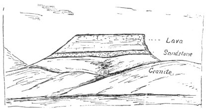
Fig. 15.
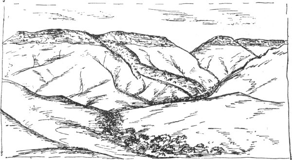
Fig. 16.
Cienega Peak lies east of Mesa Redonda and is separated from it by two gulches opening in opposite directions. It has an elevation of 2,400 feet, and the mesas east rise still less. Sandstone underlies this as it does the other lava flows. Near the eastern end of the southern slope, a lava flow has broken out from a basin-like depression which opens southward, and flowed down the mountain for a mile, descending a vertical distance of 1,800 feet. It appears to have broken up entirely into angular bowlders. The stream was probably very liquid, like the others, and formed a thin flow. It takes a slightly winding course and slopes often 30°. One short branch appears on the western side about half way down, and another on the east near the bottom. The lava descends in successive terraces, like steps, from the crater depression. The width varies from 500 to 700 feet, terminating in a straight line about a hundred feet above the bed of the cañon at the head of De Luz Valley. This distance may represent the amount of erosion since the stream flowed. There are also cañons worn to some depth on each side. The surface of the flow is rounding, and appearances indicate that it descended over a surface not much different from the one now shown. A large part of the bowlders in the creek for several miles are lava. Fig. 16 shows this lava stream as it lies on the mountain side, and also Cienega Peak, from which it flowed. These lava beds appear very prominent from De Luz Valley. The long, winding flow is known locally as the Oak Ridge, on account of its being covered with oaks, while the adjacent mountains are barren and brushy. It is hard to reconcile the appearance of these isolated peaks, with often precipitous sides, and deep valleys between them, showing a great amount of erosion, with the thin sheets spread out on the southern side of the mountain in so many places, which from their position indicate so little erosion since 36 they flowed. It is possible that the mesas, with the high precipitous cliffs, represent remnants of an older flow, and yet the lithological character of the lava seems to point to a single origin. With the exception of the long southerly flow and another short one west of it, the lava everywhere presents bluffs on its southern side, with deep gulches between them. Toward the northeast and east there is a gentle slope. A large part is coarsely vesicular; dense massive portions are mixed irregularly in places with the vesicular. The lava table-lands lie nearly 2,000 feet above De Luz Valley. This abrupt escarpment extends east as far as the lava does, though less marked. There has either been an enormous erosion in the region lying south, or a great fault elevating the plateau. A detached portion of the lava plateau caps the hills west of Murrieta, extending in a north and south line for a distance of 2 miles. Whether these detached portions all had their source in one great flow and have been separated by erosion, or were formed from different sources, was not fully determined. It seems probable, however, that the main portions did belong to one flow, from the fact that they have a uniform slope and are underlaid by similar sandstone, which may once have been the bed of a stream.
The range of mountains lying west of the valley which extends from Temecula to Elsinore, also has the appearance of having been elevated by a fault. From the entrance to the Temecula Cañon, northward past Elsinore, and along the eastern base of the Santa Ana Mountains, these abrupt escarpments and indications of a fault become more pronounced. The eastern part of the Santa Rosa plateau, with its lava fields, forms the southern end of the escarpment. The valley in which are located the towns of Temecula, Murrieta, and Wildomar, rises gradually toward the east. The western portion is very fertile. Artesian water is found at Murrieta. The eastern portion, which rises toward the granite mountains, is more gravelly, while east of Temescal there is a stretch of many miles of these dry gravel hills, probably of Quaternary age. The town of Temecula has an elevation of 1,000 feet. Immediately west and north of the cañon there arise hills of metamorphic rocks, having an elevation of 1,800 feet. They are covered with dense brush on their eastern slopes, but contain some fertile valleys to the west. For several miles the rock is almost wholly metamorphic. It extends south to the cañon and north to the lava plateau. It is chiefly a fine, dark mica schist; strike indistinct but north 60° west, to east and west, dip vertical. On the west it changes to a quartzite. Dikes of granite cut this rock; one is noticeable for several miles by its more pronounced croppings over the hills.
East of Murrieta the granite begins near the boundary of the grant, and forms a line of barren hills extending northerly. East of these the country is less rocky and quite fertile. Many springs abound in the granite through this section. Near the Hot Springs is a dike of granite porphyry. Numerous bunches of a dark, coarse, dioritic rock are scattered through the light-colored country granite. They weather away more slowly than the granite. The metamorphic rocks of the Santa Rosa plateau extend north to the entrance to the cañon, up which the road passes to Parker Deer’s. The strike in the cañon is a little east of north. The metamorphic rocks terminate in a range of hills which form the southern boundary of the Rinconada. Northward the country is formed of rugged granite mountains. The Los Alamos opens westward 37 into deep cañons, which lead down to the coast. A dark dioritic granite is included in the usual light-colored variety, sometimes in bowlder-like masses and sometimes in dike form. The metamorphic rocks extend 2 miles west of Parker Deer’s house. They include mica felsite and dark vitreous quartzite. They are often intruded by granite bosses and dikes of quartz porphyry. The lava table-land lies just south of the ranch house. It is about 40 feet thick, and has underneath a kaolinic stratum 12 to 14 feet thick, which is impregnated with bog iron; one assay has shown 10 per cent. This is quite similar to the sandstone under the table-land farther west, but is less quartzose. A similar deposit, impregnated with iron, was seen north of Mesa Redonda. The Santa Rosa grant consists chiefly of broad, open valleys, having an altitude of 1,700 to 1,800 feet, with rocky ridges between them.
On the trail from Santa Rosa to Howe Station, the metamorphic rocks extend to within a mile and a half of the latter place. They are chiefly light-colored, granular quartzites. Dikes of diabase and gabbro appear in many places on the Santa Rosa grant. Ores of gold, silver, and copper are found in the metamorphic rocks of the grant, but they have never been developed. Selected samples of galena assay several hundred dollars to the ton in silver. The veins are, however, small and bunchy, and it is not probable that they can be profitably worked. The granite varies from one with mica, as the only dark constituent, to one with much hornblende. It is uniformly coarse and of undoubted eruptive origin, judging from the manner in which it has broken through the metamorphic rocks.
The table-land west of Murrieta is about a mile broad and fully as high as that near Parker Deer’s house. It is separated from the lava farther west by a mile of brush-covered hills. The lava was supposed to extend no farther than the big cañon west of Murrieta, but a close examination revealed a small outcrop on the hills about a mile south of Wildomar. The elevation is about 600 feet above the valley. It is perhaps one fourth of a mile across. In places it extends down the hill nearly one third of its elevation above the valley. It presents the appearance of having flowed out of the summit of the hill when it had much the same form as now, and down over its sloping surface. This eruption is fine-grained, and not vesicular. Much of it has a conglomeritic character, appearing to have been broken up when almost solid, and then cemented. The fragments are more or less rounded and elongated, and are at times almost blended in the matrix. There are signs of former solfataric action on the summit, there being a considerable deposit of a light yellowish material, consisting chiefly of alumina and magnesia. Under the lava is sandstone 10 to 20 feet thick, composed of quartz grains and kaolinic matter, exactly similar to that under Mesa Redonda. It would be easily taken for granite decomposed in situ, but for the large quartz grains. The sandstone has an apparent southerly dip. It is very difficult to account for the presence of the sandstone under the lava, unless we suppose it covered the adjacent country, and was only preserved by the greater permanency of the lava. Another hill of lava was found 200 feet lower, about a mile south of this, and west of the cañon leading up to Parker Deer’s. It occupies a sort of depression between three hills, with gulches cutting into it between them. The lava is very similar to that just described.
A long, high ridge running northwest and southeast, adjoining the 38 lava, is very interesting. It is about 200 feet higher, and covered with dense brush, as is all the country in this vicinity. The greater part of the hill is formed of a coarse tuff, whose fragments stand out in sharp relief on the surface of the huge projecting, bowlder-like masses. The matrix, which is darker and softer, weathers out, leaving the surface of the rock covered with a great variety of fragments. Some are scoriaceous or amygdaloidal, others are very coarsely crystalline and porphyritic with feldspar or hornblende. Some of the fragments are themselves tufaceous, containing large masses of hornblende in a dioritic matrix. On the southern end of the hill, a great variety of dikes intersect the tufa. This is in all probability the neck of an old volcano, but appears to have no relation to the modern lavas near it. Owing to the exceeding difficulty of traversing these hills, the exact relations of the formations were not ascertained. About 10 miles east of Temecula, near the point where the creek takes a turn to the southeast and enters a cañon, there has been another lava eruption, but the time at my disposal did not permit me to examine it. A great variety of rocks are exposed along the road from Elsinore to Menifee Valley. For nearly 2 miles east of the station the rock is a white, glassy diorite, with an excess of feldspar. At the point where the road crosses the railroad, metamorphic schists appear. The rock is a fine, dark mica felsite. It is so compact that it breaks with a conchoidal fracture. A great irregularity in strike and dip exists; the average strike is a little west of north, dip northeast. As far as the top of the grade, the rocks are in part metamorphic and part dioritic. There are many dikes; some fine-grained granites, others micaceous diorite porphyrites. The hills along the west side of Menifee Valley seem to be mostly metamorphic, with some bunches and veins of granite.
All of the mountainous region lying south of the road from Temecula to San Jacinto is granite or diorite, excepting a strip of micaceous schist and gneisses near Glen Oak Valley. These strike northwest toward Menifee.
No opportunity was given me to examine the mountainous regions comprised in the San Jacinto range. The line of hills lying northeast of the town and having a northwest direction are composed largely of gneiss and mica schist, with some bodies of white crystalline limestone. In the line of strike these hills finally disappear north of San Jacinto Lake, under Quaternary clays and gravels, which form rather an abrupt rise from the San Jacinto Valley and extend northerly to the San Bernardino Mountains. The deposits show a great deal of disturbance. A part of them may be Tertiary. Dikes of dark, heavy diabase and diorite are common about the sulphur springs north of San Jacinto.
The hills for a distance of 3 miles north of Elsinore are formed of slate and mica schists; strike north 70° west, dip vertical to 45° east. This is a continuation of the same series of rocks exposed on the road to Menifee. A lenticular body of limestone occurs in these slates about 3 miles north and east of Elsinore. It is highly metamorphosed, has a gray to dark color, and is traceable for 500 or 600 feet. At one spot a stratum of quartzite divides it. It was carefully examined for fossils, but none were found. About 4 miles from Elsinore granitic rocks appear, followed by dark diorites in the vicinity of the Good Hope Mine. The Pinacate district, taken as a whole, is rather peculiar. At first sight it seems to be formed of granite, dark diorite, gneiss, mica schist, and other metamorphic rocks, arranged in the most 39 irregular manner. The belt of metamorphics northeast and east of Elsinore is terminated on an irregular east and west line by these granitic bodies, which inclose portions of the schists, and extend into the main body as long, dike-like arms. In the vicinity of the Good Hope Mine the strata of metamorphic rocks inclosed in the granitic rocks have a north and south strike, and are traceable for a mile or more. The veins of the Good Hope Mine are in a dike of light-colored biotite granite. It has considerable width on the surface, 100 feet or more, but below ground some distance it is not over 12 feet. On the surface it is greatly decomposed and cut by numerous small veins, which are so scattered that they hardly pay for working. Below they unite to form larger veins, generally one on the foot and another nearer the hanging wall. The latter is more irregular, often running out at a small angle. The foot wall, a dark compact diorite, is very regular. The walls are separated by well-defined clay seams from the vein matter, the decomposed granite. Clay seams also separate the different veins. The foot wall diorite forms the country rock indefinitely eastward. The hanging wall is a fine, dark brown mica schist. The quartz is generally friable, and the granite vein matter much decomposed. The quartz at a depth of 300 feet carried one third of the gold in the sulphurets. A small amount of silver is also found. This vein is located for over a mile; direction a little east of north, dip 65° west. It is remarkable that there is no barren quartz; all the ore pays for working. In the lower workings the veins become more regular.
The Good Hope is the first mine in this district to reach a paying basis, and that has succeeded in finding a regular, defined quartz ledge. About 3 miles northwest is another vein, which has an east and west direction. It seems to lie wholly in granite, save for a narrow stratum of mica schist on one wall. The vein is located for a mile, but no extensive development has yet been made on it. On the hills, a short distance southwest, is an old Mexican mining camp. Many small veins are found in the vicinity, generally in a dark micaceous diorite. There are also bunch-like masses of coarse white granite, blending into gneiss and the gneiss into mica schist. The strike is exceedingly irregular, changing from north and south to east and west in the course of a few feet. Toward Elsinore mica schist, quartzose, and feldspathic rocks replace the greater portion of the granite. For some distance the schists are cut up by dikes of fine-grained granite, running in different directions, and small bunches of the same rock, often only a few feet across, but sharply differentiated from the schists. Judging from the exposure here, I think we might say that at the time of the metamorphism the action was so intense as to change the sedimentary rocks to mica schists and gneisses and through these to squeeze the liquified portions of the same formation in dikes and fissures. Small fragments of mica schist were noticed in the eruptive masses. In a region like this it is often difficult to draw the line between eruptive and metamorphic rocks. It has been shown before that lamination is no sure indication of sedimentary structure.
Lake Elsinore is bordered on the west by a high and rugged granite range. In the mountains west of Elsinore the granite which cuts off the metamorphic rocks on the Santa Ana range is again replaced by the Metamorphic Series, which are here very greatly altered. They strike a little west of north and dip vertical or at a steep angle to the east. 40 The boundary of the granite is very irregular, and masses outcrop in the metamorphics near the main contact line. Much of this crystalline rock perhaps more truly belongs to the diorites.
The new silver mines lie just north of the San Diego County line, and west of the divide, a position which brings them into Orange County. The formations in which the veins occur vary from a dark brown felsite, often micaceous, to a finely banded quartzose rock. The latter is very compact, and often almost massive. In places hard, blocky argillites appear. The two or more veins found here carry galena bearing silver, and also much magnetite and iron sulphurets, with some of the baser metals. The veins are characterized by a dark red gossan cap on or near the surface. Carbonates are found in this. These deposits exist as impregnations along a fissure, which is not very strongly pronounced. The ore is usually quite massive. The little gangue present is calcite. Not enough development has been made here at the time of my visit to show how extensive the deposits are. The metamorphic rocks extend north along the mountains, forming the summit and eastern slope for a number of miles. Granite borders them on the west toward San Juan. It is probable that this belt of mineral-bearing rocks runs continuously through to Silverado Cañon. At some time this Elsinore basin opened out through the Temescal Valley, but now a low divide separates it from the head of Temescal Creek. Gravel-topped hills lie along the mountains west of the creek. At the terra cotta works a drill was sunk over 600 feet without reaching the bottom of the basin. The Cheney Coal Mine is located 5 miles northwest of Elsinore, in the same basin. The beds dip to the west and southwest, having clay below, and sandstone followed by clay above. The coal is 7 to 8 feet thick, generally solid, but in places showing a parting in the middle. A great deal of faulting has taken place, but there seems to be no system about it. The throw of the faults sometimes amounts to 30 feet, often disturbing the pitch of the vein, and making it greater. The strata evidently belong to the Miocene-Tertiary, for a little farther down the valley fossils of that age are found. This old Tertiary valley, undoubtedly an arm of the sea, opened into the large valleys of San Bernardino and Los Angeles Counties, and extended southerly to Temecula; though south of Elsinore the Tertiary is covered by Quaternary gravels. The depth is unknown, but the width is quite narrow, being from 1 to 2 miles. Not more than a quarter of a mile northeast of the coal mine the metamorphic rocks, quartzites, and hard, blocky argillites outcrop. East of Temescal Creek northward the mountains are formed of a quartz feldspar porphyry of a dark gray color; at times it blends into portions not distinctly porphyritic.
Three miles north of the San Diego County line granite appears again on the east flank of the Santa Ana range and extends north to Cold Water Cañon. Between Temescal Creek and the mountains is a broad, sloping gravel and bowlder deposit of great thickness, resting on the Tertiary. Two miles south of the Temescal Post Office there is an outcrop of soft sandstone carrying Miocene fossils. It dips southwest at an angle of 30°. Extensive clay banks of various colors and nearly horizontally bedded lie along the flanks of the mountains both east and west of the creek. An interesting series of rocks is exposed up Cold Water Cañon. This cañon has been eroded near the northern termination of the granitic portion of the Santa Ana Mountains. The first rock exposed is a micaceous 41 diorite, decomposed to a great depth, but very tough when fresh. This is followed by syenite. A mile up the cañon, near the western edge of this rock and wholly inclosed in it, is a small mass of jasper schist and a lenticular body of semi-crystalline limestone. No traces of fossils were found in it. West of the syenite is another diorite dike. Then follows banded jaspery rocks, sometimes verging on micaceous felsite or quartzites. There are also some slates, and all are often greatly contorted; strike north to northeast. North of the cañon these rocks extend to the summit, while south the Santiago Peak, the highest of the range, and the ridges leading up to it from the east, consist of a coarse quartzose granite, with but little if any triclinic feldspar. A variety of dikes occur near the summit north of the cañon, among them hornblende porphyry, porphyritic granite, and syenite. Fossils were found on the ridge leading up to the summit, north of Cold Water Cañon. They occur in a grayish rock, apparently a fine micaceous felsite. They are poorly preserved, on account of the extreme degree of metamorphism to which the rocks have been subjected. The rocks have become so altered by pressure that they will not break on the lines of bedding, but perpendicular thereto. The fossils consist of impressions of a small bivalve shell. Only about a dozen specimens could be found. The rocks are more altered than any others I have ever seen carrying fossils. These are the first fossils reported from the metamorphic rocks of the Santa Ana range. These fossils when determined will give a clue to the age of the metamorphic gold-bearing rocks of this portion of the State, and also of the granite, concerning which much diversity of opinion has existed.
Dawson Cañon, which heads in the Temescal Mountains, was explored and found to contain interesting geological features. A fine opportunity is given for the study of the relation of the granite to the extensive porphyry intrusives. For 2 miles east of Temescal Creek no eruptives appear; the rocks being wholly of the Metamorphic Series, with exposures of highly altered sandstones, clay shale, conglomerates, etc., striking northwest and dipping southeast at 45° to 50°. About 3 miles up the cañon the argillaceous rocks are replaced by a coarse granite, rich in mica and quartz. This is the prevailing rock up the cañon for 2 miles, and it apparently extends much farther east. It shows a great variation in appearance; much of it contains large crystals of flesh-colored orthoclase. In this granite, particularly on the north side of the cañon, there are dikes of many kinds of rocks. Large dikes of beautiful diorite porphyrites, both light and dark colored, appear in places. At one spot 4 miles from the mouth of the cañon, there are rectilinear dikes of fine-grained granite, intersecting each other like artificial stone fences. For the distance of a mile east, after the granite begins in the cañon, the hills north show nothing but metamorphic schists. The porphyry in the mountains south does not reach the cañon. The great mass of this rock is dark, but in the vicinity of the granite it is lighter colored and more feldspathic, sometimes assuming a granitic structure. In places it is a gray, hard rock, of almost conchoidal fracture, and faint feldspar crystals. The granite near the contact is usually sharply defined, and has a faintly porphyritic appearance at times. The line of junction of the two formations is sharply defined, not only lithologically, but physically. It is difficult to say which is the older. No granite appears in dikes in the porphyry, but there are many dikes of a porphyry-like 42 appearance, resembling the light-colored porphyry in the granite itself. The line of junction is very irregular, and it is certain that the two formations do not belong to the same eruptive mass.
East of the head of Dawson Cañon there is another outcrop of considerable extent of metamorphic rock, micaceous felsites, and other dark schists. A mile west of the Gavilan Mines is a high conical peak formed of coarse, dark diabase. The mines of this district are in white biotite granite, continuous with that of the Pinacate district. The metamorphic rocks south of Dawson Cañon strike east and west, dip north, and extend in a westerly direction nearly to Temescal Post Office. North of the cañon, 2 miles from its mouth, there are a number of outcrops in vein-like forms and in bunches, of a black crystalline material, evidently tourmaline, identical with that at the Temescal Mine. These occur in the metamorphic sandstone and shales. The next large cañon in the Santa Ana range north of Cold Water Cañon shows highly disturbed Tertiary strata at its mouth, dipping away from the range at a high angle. They are soft, white clayey deposits, containing small nodules of selenite. The first of the older rocks exposed in the cañon is a hornblende porphyry, with variations to a granular diorite. For 3 miles up the cañon the only rocks seen are crushed and silicified ones of the Metamorphic Series. They dip, as a usual thing, at a high angle to the east, though in spots it is to the west or horizontal. Quartzose sandstones prevail, with blocky argillitic rocks and conglomerates. Near the summit there are dikes of green tufaceous porphyries.
Temescal Valley is underlaid by clays of a great variety of colors. They are being used very extensively for the coarser kinds of pottery and drain pipe. The Miocene deposits of the valley dip westward from the Temescal range, and instead of also dipping away from the Santa Ana Mountains basin-like, they dip west into the latter range. The dip of these beds 3 miles south of South Riverside is 5° to 10° southwest, and as the Santa Ana Mountains are approached the dip increases, and at a distance of a fourth of a mile, up to the metamorphics, it varies from 45° to vertical. The strata are not exposed all the distance across the valley, but there is no sign of a fold or overthrow; everything seems to point to a gradually increasing dip. This is indicative of an elevation of the region toward Temescal, or a sinking of the Santa Ana Mountains. This is undoubtedly the fault line which follows the range for such a long distance south. Several thin seams of coal outcrop for a distance of 10 miles along the base of the mountains. They have been opened in a number of places and all the strata found dipping into the mountains. The coal seams are often only a few hundred feet away from the metamorphics, and dip toward them at a very regular angle of 45°. Judging from the position of the strata it is not probable that the coal underlies the valley, and as it is so close to the mountains, formed wholly of rocks of the Metamorphic Series, it cannot be of great extent. I believe that appearances point to the whole of the coal beds having been eroded, save the limited, steeply inclined portion at the foot of the mountains. A crowding of the strata against the mountains during the movements along the fault line, have given rise to the steep dip. The highest portion of the Tertiary beds has an elevation of 1,500 feet. A very even, gently sloping plain extends from this elevation toward South Riverside. It is formed of unconsolidated wash from the mountains, deposited on and dipping in the opposite direction from the Tertiary. 43 The Tertiary formation consists of clays in various conditions of consolidation, others chalky in appearance, and a great thickness of argillaceous quartz-sand loosely cemented. Poorly preserved fossils are found in places. Near the southeastern corner of Mr. Hoag’s ranch is a hill with hardened concretionary sandstone outcropping around it. Nearly every portion of this contains fragments of bones supposed to be cetacean. Artesian wells are obtained near Temescal Post Office at a depth of 300 feet. The water is abundant and of excellent quality, and is flumed to South Riverside.
Bunches of granite outcrop in the metamorphic rocks along the east side of Temescal Creek north of Dawson Cañon. At the dam of the San Jacinto Company there is a large outcrop of the beautiful diorite porphyrite, similar to that seen in Dawson Cañon. This extends northwesterly along Temescal Creek toward South Riverside, where it is quarried. It makes an excellent and durable building stone, being compact and free from much mica or hornblende. West of this is a narrow strip of coarse granite, followed by diabase. North of Mr. Hoag’s ranch, and west of the dam, is a dike of black porphyry. Westward the crystalline rocks are overlaid by the Tertiary.
The dam commenced across the Temescal Creek at this point, where it enters the cañon, was intended to have been extended down to the bedrock, and thus bring to the surface the water which flowed beneath the surface channel. The diorite porphyrite is followed on the east by black porphyry.
Geology of the Temescal Tin District.—The Temescal Tin Mine is located in the northern part of the San Jacinto grant, and about 5 miles southeast of South Riverside. This portion of the grant consists of rolling hills. On the west is a large body of porphyry, extending nearly to the Temescal Creek.
The first rock exposed along the road to the mine east of the creek is a dark flinty one. This is followed by a body of black porphyry, with white feldspar crystals. The porphyry is about a mile across, and is followed on the east by massive black crystalline rock, and that by a felsite. These rocks are soon replaced by granite, in which there are dikes of fine-grained, highly quartzose granite. Little black veinlets of tourmaline aggregates are very numerous in the granite, extending through all the rock up to the porphyry. They have a northeast direction. The material forming them is the same as the gangue of the tin veins. A half mile south of the road is a cañon. Here the porphyry is seen extending up to the granite. The granite is greatly broken near the contact, and though there is no blending of one into the other, there is a confused mixture of broken portions of both rocks. Bunches and dike-like bodies of granite are inclosed in the porphyry. The little veinlets of tourmaline seem to have replaced the feldspar and mica, leaving the quartz. These veins grow larger toward Cajalco Hill. Just west of the works is a great mass of the black veinstone, the gangue of the tin ore. This rises in high, rugged croppings, and covers an area of about 300 by 250 feet. This is the greatest body of vein matter to be seen in the district. The tin deposit worked lies in an eastern prolongation of this cropping. The course of the veins is north 45° east, dip 65° to 70° northwest. The country rock is a coarse hornblendic biotite granite. The vein has the usual character of mineral deposits, swelling at times to a width of 8 feet, and then contracting to much less. The highest grade ore is found in 44 the narrower portions, where it is sometimes almost pure tin oxide, running as high as 70 per cent. The vein matter does not consist wholly of tourmaline, but contains quartz grains scattered through it in about the same proportion as in the granite. The tin is not found in the quartzose part of the gangue to any extent, but in the irregular vein-like deposits of pure tourmaline, which lie in the quartzose gangue. The tin occurs in this in bunches and stringers of nearly pure ore, or disseminated through it. This is particularly the case where the width of the vein is 6 to 8 feet. Where it pinches, the whole vein is sometimes formed of the tourmaline aggregate and tin ore. The vein has usually clay seams on both walls; sometimes it is frozen to one wall; wherever the walls come together and cut out the vein matter, the seams remain. The tourmaline vein matter is an aggregate of needle-like crystals. There are two varieties of tin ore: the yellow, appearing in thin layers in an uncrystalline form; the brown, in granular form in the massive specimens, or in small, clear, reddish brown crystals lining cavities. In the latter case it forms handsome specimens. A small amount of arsenical pyrites is present in places in the vein, and iron pyrites in the granite. The quartzose portion of the vein matter often blends into the granite walls, and there are bodies of evidently granitic origin wholly inclosed in the vein matter. A careful study of the vein matter, and its relation to the walls, shows that it is simply a portion of the granite, in which the feldspar and dark silicates, hornblende, and mica have been removed and tourmaline substituted. The quartz has the same character and color as that in the granite, and many transition stages in the process are shown. Where the action has been more intense, near and along the fissures, the quartz has been wholly removed and the tourmaline deposited, together with the tin. Cajalco was the center of this action. The veins decrease in size farther away.
At the time of my visit the mine had been opened to a depth of 180 feet, by two working shafts. The total length opened on the vein is 300 feet. Two levels have been run and work was in progress on the third. The main ore body lies in the center of the workings, and extends downward in the dip of the veins. The ore milled averaged 5 per cent of tin oxide, though large portions, as before stated, are very high grade. The company has also prospected Cajalco Hill by tunnel and open cuts, and one or more of the veins south by shafts. At the time of my visit two of Husband’s pneumatic stamps were in operation. They weigh 900 pounds each, and drop one hundred and thirty-five times per minute.
South and southeast of the works are many bunchy veins of the black tin gangue. They often carry considerable iron. They extend, generally nearly parallel, in a northeast and southwest direction. Some appear as mere bunches on the surface. These veins closely resemble the main vein at Cajalco Hill, and are due to the same action, and it has been supposed that many of them will be found to carry tin, though it is not present on the surface. About 2 miles south the granite is replaced by a banded feldspar porphyry. This cuts off the tourmaline veins. The granite about the works, and especially toward the contact with the porphyry, is cut by many dikes of a fine-grained granite, having an excess of quartz and feldspar. Associated with the porphyry are strata of metamorphic rocks, of a hard, dark, quartzose character. A quarter of a mile northwest of the mine is a bunch-like outcrop of porphyry, carrying silver and copper carbonate. The black veins outcrop for a 45 distance of 2 miles northwest from the mine, extending into the porphyry, which replaces the granite in that direction. The granite extends eastward for many miles.
The general geological features which obtain here are: A semi-circular area of granite over 2 miles in diameter, surrounded on the northwest and south by porphyries and joined on the east to a great body of granitic rocks extending indefinitely in that direction. Around the border of this granite protuberance are many dikes of a fine-grained granite. Cutting through the granite in a northeast and southwest direction are the black tourmaline veins, which form the gangue of the tin ore when it is present.
Tin occurs here under conditions different from any other known deposit. Tin veins are almost always found in granitic formations, but such an extensively developed tourmaline veinstone is remarkable. The direction of the fissure system shown here is an uncommon one in California. The veinstone, together with the associated metals, has probably resulted from a process of sublimation along lines of fracture, removing those portions of the granite easily affected, over a large area, as at Cajalco Hill, and in the immediate contact completely replacing it with the massive aggregate of minute tourmaline crystals.
Thanks are due to the manager, Captain Harris, for the facility freely afforded me for examining the mine, the works, and the country about.
North of South Riverside the Tertiary beds dip at a small angle to the north. The Santa Ana River has cut its course through the hills at the northern end of the Santa Ana Mountains. No outcrop of the metamorphic rocks appears in the cañon. The Tertiary strata no longer dip toward the west, but in the Chino hills north of the river show a great anticlinal arch. Along the south side of the river the beds dip 70° northeast; farther west, near the heart of the range, they dip 60° southwest, strike north 30° west. Near the upper end of the cañon there are fault lines dipping toward the range, which show an elevation of the hanging wall. Bedrock Cañon is the first large one which opens to the Santa Ana River from the western slope of the mountains. Opposite the mouth of this cañon the greatest amount of water appears in the bed of the river, indicating the presence of hard rock only a little distance below. Coal veins are located near the head of this cañon, one 700, the other one 1,300 feet above the river. They dip only a few degrees to the southwest. They are exposed on cliffs facing the mountains to the northeast. Below them are very hard sandstones carrying fossils, probably Cretaceous. One prospect shows a number of seams within a width of 8 feet. The widest is 29 inches, the others much smaller. The other prospects show only one 39-inch seam. Their position, lying so flat high on the mountains, indicates an uplift without great disturbance, while the gypsum mines farther down on the flank of the mountains dip at a high angle to the southeast. It may be that all of the coal deposits of the western slope of the Santa Ana Mountains belong to the Cretaceous, and have been greatly separated by faulting and folding. A deposit of white, granular gypsum has been opened in Gypsum Cañon, 2 miles south of the river. The beds have a thickness of 8 or 10 feet. At one spot a large mass of crystalline dolomite was found. The deposits run with the strata, north and south, and dip west 60°. As we approach Olive, the few croppings seen still dip south or southwest, but at a less angle. South of the mouth of 46 Silverado Cañon a line of hills extends north and south, bordering the Santa Ana Plain. The western portion of these hills is formed of basalt considerably decomposed. The basalt varies from scoriaceous to fine-grained and compact. Its eastern edge was seen to rest on Miocene sandstones, and it dips west at a small angle, perhaps 10°. The lava seems to have been squeezed up in fissures, judging from the way in which it outcrops. Its greatest elevation is 800 feet. At some places the sandstones, where not covered with lava, have been silicified, turned to quartzite, or rendered granitic in appearance. This may be due to an intrusive neck of lava, or more probably to the action of thermal springs.
An interesting fold of the Tertiary strata was observed at the entrance of Santiago Cañon. The sandstones and conglomerates on the eastern side dip to the northeast at an angle of 30°, while those on the west side dip in the opposite direction. The valley has been eroded in the summit of an anticlinal. The rocks of the eastern side rise again against the side of the mountains, thus forming a synclinal. Up the cañon the sandstones on the west maintain a southwest dip of 45° to 50°, and strike north 40° west. The cañon finally leaves the anticlinal, and the rocks dip southwest on both sides. Toward the summit of the hill, north of the Harris Coal Mine, the dip increases to 70°, but on the top they turn so that the strata lie horizontal. Here they consist of clay shale. The strata at the coal mine swing around, and one mile northeast they strike north and south and dip west. This hill seems to form the southern termination of the anticlinal ridge north of Santiago Cañon. Southeast of this point there is a simple monoclinal fold or slope away from the older rocks of the high mountains. There has apparently been a fault extending northwest in this anticlinal ridge, bringing up the clay shales which farther south were shown to belong to the Cretaceous. Harris Coal Mine shows a seam 18 inches wide, shale forming the foot wall and sandstone the upper. There is a fault of 200 feet cutting this coal seam. The sandstone at the mouth of Silverado Cañon dips south 30°, forming bold cliffs. A half mile up the cañon there are heavy beds of clay shale inclosed in the sandstone. Cretaceous fossils appear in the shales, as well as in a coarse sandstone which underlies them. This sandstone is replaced by conglomerates near the contact with the underlying Metamorphic Series. The sandstone rises to a height of 2,500 feet, with bold, almost perpendicular cliffs facing the mountains. Portions of the sandstone containing the fossils are often very much hardened.
The first crystalline rocks met are dark and fine grained, with traces of bowlder-like inclusions, and are evidently eruptive tuffs. Above these are green, dioritic rocks. These intrusives are followed for several miles by sandstone and shale, in which the stratification is often obliterated. In other places thin layers of sandstone and shale are wonderfully contorted. The dip is at a high angle either east or west. In the vicinity of the old Silverado Camp there are dikes and bunches of a green dioritic rock. The mines in the Silverado district are again being developed to some extent. The mineral belt is about 2 miles wide, and extends nearly north and south. The country is formed to a great extent of dikes of greenish to blackish rocks, often showing distinct hornblende crystals. The dip of the metamorphic rocks is east about 45°. There is one main mineral vein located, beginning about a mile 47 north of Silverado, and extending in a southerly direction for 7 or 8 miles. The Quincy Mine is one of the most northern ones. The vein has a width of 2 feet; the ore, silver-bearing galena in a calcite gangue. It carries but little base metal of any kind. The ore has a peculiar appearance, the galena being distributed through the gangue in little leafy crystals or aggregates. The fissure is well defined and regular, with a pale green syenitic rock on the hanging wall, and a dark diorite on the foot wall. This hanging wall rock weathers to a light gray color, producing a rock known as porphyry among the miners. South of this mine a side vein carries much antimony. The Quincy has been opened along a length of 500 feet. The ore is quite uniform, producing one eighth in concentrates. The Quincy camp has an elevation of 2,300 feet. South of Silverado Cañon, in Silver and Pine Cañons, a great amount of work was done during the former excitement. The sides of the steep, rocky cañons are fairly honey-combed with tunnels, which were undertaken without sufficient prospecting, and, of course, never struck anything. The New York Mine spent much money, but did not prove a success. West is the Princess, and farther still, about 1,200 feet above the cañon, is the Blue Light Mine, on which much work has been done and rich ore taken out. The mines south of the cañon are in a feldspathic rock, which weathers white. It is undoubtedly an intrusive porphyry, for traces of feldspar crystals are to be seen. The mines are characterized by a large amount of zinc-blende, iron pyrites, and not a large percentage of lead, making them more difficult to reduce. The porphyry is mineralized in many places where no traces of the precious metals occur. Litigation and poor management seem to be the chief factors in stopping work in this district. Though some of the ore runs into hundreds of dollars to the ton, the most of it is medium to low grade.
About a mile and a half down the cañon from the old Silver Post Office, and in a cañon coming in from the south, is a cropping of dark, somewhat argillaceous limestone inclosed in shales. The limestone does not seem to have been highly metamorphosed, yet the fossils which it contains are almost obliterated. The faint impressions are those of coral stems, stromatopora, and some other low forms of life. Half a mile farther down the cañon is a cropping of brecciated marble. At many points, particularly on the north side of the cañon, there are great masses of apparently conglomeritic character, but with a crystalline structure. The matrix has a green to brown color, and in it are imbedded pebbles of the same degree of fineness, but often distinguished by much brighter red, purple, and green colors. In this cañon, as in others of this range, the water holds much lime in solution, and extensive tufas are frequently to be seen. The basal members of the Cretaceous at the mouth of Silverado Cañon consist of conglomerates passing up into sandstone, and those into shales; dip 55° away from the mountains in the highest ridge, but in the course of a quarter of a mile becoming much less. The change in dip is very sharp, giving the appearance of a fault.
A cañon which enters Silverado Cañon from the northeast near its mouth was followed up nearly to its head for the purpose of investigating some limestone outcrops. The first outcrop in this cañon is the usual dark porphyry. Beyond this the stream has cut a deep cañon through an immense conglomerate of porphyritic and quartzose pebbles. The porphyritic pebbles are dioritic and part red and black porphyries. 48 Some of them are similar to dikes farther up the mountains. Through this great conglomerate bed there are dikes of black porphyry, with pale feldspar. Tufaceous porphyries form a large part of these dikes. The base is purple and the pebbles light green, or the reverse. These conglomeritic porphyries differ from the great beds of sedimentary origin, in having all the pebbles of a uniform character with a crystalline matrix. The sedimentary beds contain pebbles of all sizes and description, in a matrix of small pebbles or coarse sand. Farther up the cañon the great body of the rock is crushed shale and black to gray sandstone; dip vertical, inclining most generally to the east, strike north and south. Two miles up the cañon is a dike of diorite porphyrite, coarse in the middle and fine on the edges. Four miles up is a stratum of gray limestone. More outcrops appear on the north side of the cañon, but whether they belong to the same stratum or different cannot be told, on account of the crushing undergone. These deposits are bunchy, swelling in one case to a width of 100 feet. It is not crystalline. The color is from black to gray. It contains fine specimens of a bivalve shell, and faint traces of corals and univalve shells. These beds are said to extend to the summit, and undoubtedly further examination would reveal more fossils. Several specimens were sent to the National Museum and pronounced Carboniferous in age. We have here, then, the first announcement of the age of the Santa Ana range. This range stands in such intimate relation to the granite and crystalline schists farther south, that an approximate determination of the latter is made possible. Professor Whitney and others following him have classified this range as Cretaceous. Their grounds are utterly untenable stratigraphically, but this discovery of Carboniferous fossils makes the evidence of greater age certain.
On the eastern side of the range, near its northern end, the sandstones were observed to be silicified, being filled with a network of quartz veinlets, exactly similar to the silicification of the metamorphic rocks of the Coast Range proper.
The lowest Cretaceous beds are between Silverado and Williams Cañons, but the fossils are very similar to those generally found through the Cretaceous of this region. The lowest beds are a duplicate of those seen at the mouth of the Silverado Cañon, though apparently a thousand feet lower in the series. Between the two beds there is another conglomerate stratum, carrying bowlders different from any seen in the Santa Ana Mountains. Many of the porphyry bowlders in the basal Cretaceous conglomerates resemble the porphyry about Temescal. The Santa Clara Coal Mine, at the mouth of Silverado Cañon, is undoubtedly in strata of Cretaceous age, though no fossils are found in the strata above till the Miocene is reached. Up the Santiago Cañon as far as Madame Modjeska’s place, the fossils are chiefly confined to the eastern side of the cañon, but the character, dip, and strike of the strata on both sides are the same. The Cretaceous is separated from the metamorphics by a line of cross cañons. The highest portions of the Cretaceous terminate in a line of hills with sharp eastern escarpments.
Shrewsbury Cañon comes in just below Modjeska’s. After passing the Cretaceous, through which the cañon has cut, the Metamorphic Series was seen to consist of slates and sandstones, followed by light-colored granitic rocks, chiefly hornblende and triclinic feldspar. The metamorphic rocks generally dip to the east.
A mile above Modjeska’s the Santiago Cañon cuts through bold cliffs of Cretaceous sandstones and conglomerates, and higher up still has eroded a cañon in the Metamorphic Series. The cliffs, a little back from the stream, rise probably 1,000 feet. Sandstone belonging to the Metamorphic Series outcrops in the cañon for some distance, and is followed by conglomeritic porphyries, containing purple and red bowlders. In some places the inclusions are angular. These rocks are extensively developed about the Santiago Mines and higher up in the mountains.
Just below the Alma Mine, on its western side, the creek has cut through dikes of diorite, which are coarse in the center and fine on the edges. On the hill south of the Alma Mine the diorite is on the opposite or eastern side of the vein. Although the exposures are poor, all the crystalline rocks have the character of intrusives. No blending into the metamorphic rocks has been noticed. About 3 miles up Shrewsbury Cañon several claims are located on the southern continuation of the veins of the Silverado district. Near the head of Santiago Cañon these again appear well defined, and considerable active work was going on here at the time of my visit. The veins here have a direction a little east of south, dipping to the east somewhat less than 45°. It appears that the mineral belt follows a certain line, generally quite regular, without any particular reference to the dikes and bunches of intrusives scattered irregularly here and there. The fissure system has taken a comparatively regular line and the walls may or may not be intrusive. The Alma Mine, the northern claim of the Santiago Silver Mining Company, has been worked by the former operators in a very irregular manner. The veins and stringers as far as exposed lie wholly in the crushed quartzose argillites. A tunnel is now being run to open what is supposed to be the main vein, several hundred feet farther east, and which has syenite on the hanging wall. Other tunnels are being run along the creek, one near a body of granitoid rocks, others in slate or quartzite. The ore is a leafy galena, arranged often in narrow bands with the crystalline orientation different in alternating bands. Sometimes it occurs in the form of large solid bunches. Thus far the ore deposits have been found quite irregular, but it is thought that the main body has not yet been reached. Very little base metal is present. South, on the hill, the Morrow claims have been bonded by the same company and are being opened. On the summit of the hill diorite lies on the eastern side of the veins. Down the southern slope the veins lie wholly in metamorphic rocks; the foot wall being more silicious, the hanging argillaceous. The mineralized portion has a width of 20 feet. A small vein occurs in the upper side, and a heavier one, sometimes reaching 3 feet, on the foot wall. There are occasional stringers in the crushed portions between. The gangue is calcite, with some quartz, all mixed with the broken clayey slates. More zinc-blende and iron pyrites are found here, also a little antimony. In the Alma Mine the richest galena is very fine, and sometimes resembles antimonial ores.
South of these mines, toward Trabuco Cañon, another claim is being worked. South of the Trabuco the conglomerates hide the lode, except at one spot, where it appears and has been worked. The Cretaceous formation grows lower as the Trabuco is approached, and does not appear prominent south of it. In all probability it is covered by the Tertiary, for the elevation and consequent erosion have not been as great in this direction.
By W. H. Storms, Assistant in the Field.
No portion of California has more diversified mineral wealth than the county of San Bernardino. Although its area is comprised largely of rugged mountains and desert waste, yet this county is a producer of gold, silver, copper, lead, and tin, and contains mines of zinc, iron, and manganese, besides deposits of borax, salt, soda, baryta, gypsum, sulphur, onyx, marble, asbestos, and structural material, granite, and sandstone of great beauty and value. Within its borders are found a wide range of geological formations from Paleozoic (if not Archæan) to Tertiary, and a great variety of rocks of igneous origin.
The mines are scattered all over its thousands of square miles of territory, and have already added millions of dollars to the wealth of the State and the world. Many of its mines are of phenomenal richness, and were it not for the expense and extreme difficulty attending transportation in the desert, San Bernardino County would undoubtedly take first place in adding to the mineral wealth of California. The largest and most productive section in the county at present is
No region affords better opportunities for the study of a certain class of ore deposits occurring in eruptive and fragmental rocks than may be found in the Calico District. The mines, condemned at first, came quickly to the front nevertheless, and have for the past twelve years been steady producers of silver bullion. The district is situated 6 miles north of the Atlantic and Pacific Railroad, the nearest station being Daggett.
The geology of the Calico Mountains at first sight looks simple enough, but a more thorough investigation quickly convinced me that there were structural problems to be studied of more than passing importance, as they seemed to have a bearing upon the extent of the ore deposits. The most complex region is that immediately about the town of Calico, in the vicinity of the mines. The balance of the mountain area is more simple.
In a general way the Calico uplift consists of a core of massive rhyolite, overlying which are heavy deposits of light-colored breccia and tufa. Along the flanks of the range, and in some places extending well up into the mountains, are accumulations of undoubted sedimentary origin, sandstone, sandy shales, and argillaceous rocks, which, with some local exceptions, dip away from the central mass on all sides toward the desert plain. While in the district I made some notes on the general geological features, but not having sufficient time at my 51 disposal to complete these investigations, I have determined not to present my views until I have had an opportunity to investigate the region more carefully.
Subsequent to the uplift of these mountains, erosion has carved deep cañons and removed great mountain masses. The central area is now entirely denuded, whereas it was at one time covered with from 100 to 200 feet of tufa and upward of 1,000 feet of sedimentary strata. Not only have these more recent accumulations been removed, but a large amount of the hard, dense liparite has also been disintegrated and carried away by the violent storms which are characteristic of the desert. Faults are very numerous throughout that portion of the mountains lying along the south side of the range. They extend for at least 10 miles in an easterly and westerly direction. The mines occur along this faulted zone.
The rocks of the region are a violet to brown rhyolite, often porphyritic; green, yellow, and white tufa; yellowish and greenish breccia; a greenish gray, fine-grained rock, which has been called hornblende andesite by Mr. Lindgren, and a yellowish or buff to light gray felsitic rock, which may be either rhyolite or an older felsite. It is extremely difficult to distinguish between these rocks, even with the aid of thin sections under the microscope. I think, however, upon structural grounds, that I may call the rock felsite. As this is one of the important questions upon which I have not thoroughly satisfied myself, it will be left until such time as I have opportunity to make the necessary investigation.
The formation of the ore deposits in the Calico District has been a subject of much discussion, and the question has received the closest study and thorough investigation. In my opinion, the ore deposits were formed through the agency of percolating waters carrying mineral solutions, which deposited their contents along fault planes and in certain zones of the country rock, where its brecciated and crushed state offered superior conditions for the deposit of the silver ores and the accompanying baryta. That all of these ore deposits have a common genesis I do not doubt, whether they occur in the liparite, in the tufa, or in the “mud” overhanging country rock, as is the case at the Bismarck, Humbug, Waterloo, and some other mines. The form of the deposits differ somewhat, it is true, for we find the reticulated veins in the King Mine; the segregated deposits in the Odessa and Waterloo; the fissures in the Langtry, in West Calico, and the impregnated deposit in the Humbug. However, all the deposits of the district, of whatever form, I believe are due to a common cause, having been deposited in their various forms from mineral-bearing solutions which derived their contents from the neighboring eruptive rocks (the liparites and tufas), part of the material doubtless arising from great depth, and a portion coming from the adjacent inclosing rocks by what is known as lateral secretion. It is almost an impossibility to find in the Calico region a piece of rock that does not contain more or less silver, from a fraction of an ounce per ton upward.
The phenomena of ore deposition was very thoroughly investigated by Messrs. Louis Janin, E.M., John Hays Hammond, E.M., Ross E. Browne, E.M., and Wm. Irelan, Jr., State Mineralogist, at the time of 52 the lawsuit of John S. Doe vs. Waterloo Mining Company. These gentlemen all agreed upon the origin of the ore deposits, and their opinions coincide with my own and are in accordance with the ideas expressed above. The wide difference in the size and form of the many ore bodies does not in any manner conflict with the theory that in each instance the primary cause of the deposit was a fracturing and crushing of the rock masses and the subsequent infiltration of mineral solutions, which precipitated their contents in the zones and crevices thus prepared for their reception.
SKETCH SHOWING
DISTRIBUTION OF ORE ON THE SURFACE IN THE
SILVER KING MINE
AS IT OCCURS BETWEEN THE FAULT PLANES
CALICO MINING DISTRICT
SAN BERNARDINO CO. CAL.
COPIED FROM EXHIBIT “R”
COURT RECORDS IN THE SUIT OF
JOHN S. DOE VS. WATERLOO MINING CO.
In the Silver King Mine occurs a perfect network of veins, concerning which Mr. Hammond testified: “At the time of the uplifting of the liparite, or at some subsequent time, a fault occurred, which separated a wedge-like mass of liparite from the main mountain mass, and this fault plane was generally conceded to be what might be termed the foot wall of the mineral belt, or zone, or lode. Contemporaneously with this faulting a second fault occurred, which separated the overlying brown tufa from the liparite, which fissure forms the overhanging wall of the mineral deposits of the Silver King Mine. At the same time cross fissures were formed in the liparite mass between the two main fissures. Thus there was a main fissure or plane of contact between the brown tufa and the liparite, and a similar fault plane between the segment of liparite broken off and the main mass of the mountain. Between these two main fissures, and throughout the whole mass of this segment of liparite were innumerable fissures, some similar and equal in size to the main fissures, and others forming a finer system of fissures and cracks, extending through the rocks in all directions, leaving it in a broken and disintegrated, and in many places an almost pulverized condition. Although these finer fissures generally had a parallelism with the two main fissures bounding this segment of rock, yet, in many places, these finer seams or fissures run in every direction through the rock, forming a network, or reticulated mass. The mineral-bearing waters have deposited throughout this mass, from wall to wall, the minerals now found within this zone in the form of baryta, carrying silver. The finding of baryta in the shattered planes of the liparite, which is entirely foreign to the rock itself, is sufficient evidence that a crack or space must have existed prior to its deposition, from the solutions which penetrated this broken zone of a once massive rock formation.”
CROSS SECTIONS OF
SILVER KING MINE
TAKEN FROM COURT RECORDS IN SUIT OF
JOHN S. DOE VS. WATERLOO MINING CO.
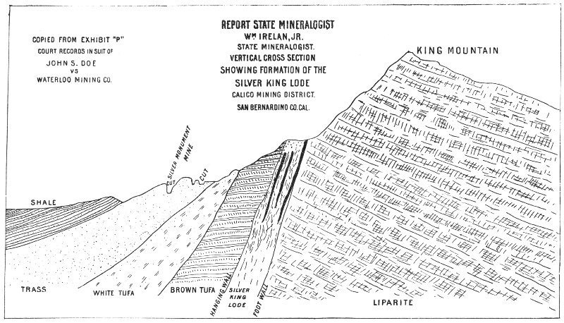
REPORT STATE MINERALOGIST
WM. IRELAN, JR.
STATE MINERALOGIST.
VERTICAL CROSS SECTION
SHOWING THE FORMATION OF THE
SILVER KING LODE
CALICO MINING DISTRICT.
SAN BERNARDINO CO. CAL.
COPIED FROM EXHIBIT “P”
COURT RECORDS OF
JOHN S. DOE
VS.
WATERLOO MINING CO.
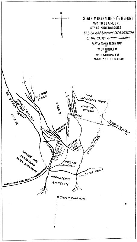
STATE MINERALOGIST’S REPORT
WM. IRELAN, JR.
STATE MINERALOGIST
SKETCH MAP SHOWING THE FAULT SYSTEM
OF THE CALICO MINING DISTRICT
PARTLY TAKEN FROM A MAP
BY
W. LINDGREN, E.M.
BY
W. H. STORMS, E.M.
ASSISTANT IN THE FIELD.
The Odessa Mine offers good illustrations of impregnated masses, as does also the Waterloo. In each of these mines, as in many others, the ore bodies are found in bunches or pockets, varying from little deposits of nominal value to great ore chambers containing thousands of tons of pay rock. In these cases, as at the King Mine, a system of faulting planes marks the general strike of a mineral-bearing zone or lode, but the great rock masses of tufa, in which these ore bodies occur (and also of sandstone in the Waterloo), are quite loose and porous in texture, and undoubtedly the ore bodies in these mines resulted partially, at least, from the impregnation of the rock with the mineral solutions which found an easy passage along the fault planes that had cut the rocks in every direction.
In the Waterloo Mine one of the fault planes exhibited a regularity seldom seen in any mine. It coursed through the light-colored, soft tufa in an easterly and westerly direction, was perfectly true, and as smooth as any hard-finished wall could be made by the most skillful artisan. The fracture was of knife-blade thinness, and its sides were coated with dark red iron oxide. It dipped to the southward at an angle of about 40°. At one time it was considered to be the hanging wall of the lode, but a miner broke through the wall to cut a hitch for a timber and it was found that the overlying rock beyond the slip was ore-bearing also. Stopes in this mine were frequently over ten sets in width, or over 60 feet. At the eastern end of the claim some extremely rich ore was mined from a belt of jasper, a metamorphosed clay shale, which by heat and pressure had become an intensely hard, fine-grained, flinty rock, yet some of this jasper contained over 1,000 ounces of silver per ton.
In West Calico, 2 miles west of the Waterloo, is the Langtry group of claims. The principal development is on the west end of the Langtry Mine. The Langtry may be called the anomaly of the camp, as it is a fissure vein pure and simple, or, more strictly speaking, two fissures.
The strike of these two fissures, which are 60 feet apart, is nearly parallel, but they will undoubtedly meet in depth. That on the south side dips northerly, while the other pitches toward the south slightly. Both stand at a high angle, and it is doubtful if they will converge inside of 250 feet from the surface. The veins are composed principally of a coarsely crystallized baryta with quartz, containing brown iron oxides, lead carbonate, ochre, manganese oxide, and chloride of silver. The average value of the ore was about 22 ounces per ton. The veins vary from a thin seam to over 10 feet in width on the north vein, having an average width of 3 or 4 feet. These veins occur in the “outside” or “mud” country, which lies along the flank of the southern slope of the Calico Mountains. The mud shales and argillaceous sandstones here lie nearly horizontal, the veins cutting them at an angle closely approximating 90°.
The low price of silver during the past two years has resulted disastrously to the mining industry in Calico District. The great Waterloo, for many years the largest producer, and employing not less than 150 men in mines and mills, was closed down, as it seemed foolhardy to exhaust the great ore bodies when the profit derived from the extraction and milling of the ores was merely nominal. For years these mines had kept the sixty-stamp Boss process mill and the fifteen-stamp pan mill at Daggett busy night and day, but in the spring of 1892 the stamps were hung up and the mines closed, awaiting better prices for silver.
The Silver King Mining Company (limited), of London, has continued to operate, dropping twenty to thirty stamps night and day, under the superintendency of William S. Edwards. The King Company owns or controls three important groups of mines in this district, viz.: the Odessa, the Oriental, and the Occidental. The Odessa made a record during the early history of the camp by the production of ores of high grade. The policy which was pursued in those “palmy days”—to gouge out the rich ore whenever it could be found, without regard to future condition of the mine—left most of the mines in very bad shape. The Odessa is now recovering under the new management, and the property is being systematically opened, and it is thought all the ore can be extracted. In this mine are stopes from which thousands of tons of ore have been mined, and there is not a stick of timber of any kind in them.
These old stopes are being cleaned out, new levels opened, and good results are expected in the future. What applies to the Odessa in this respect is true to a great extent of every other large mine in Calico. They were all worked in a hand-to-mouth sort of fashion, and although many of these mines paid handsome dividends, little of the money was ever put back in anything like permanent improvement. All seemed to share a common opinion—that the deposits were superficial, and would not go down, and as a result no one felt like laying out money in an extravagant and unwarranted manner. But the mines have gone down, and the men in charge of the mines to-day can see the result of the mistaken economy of the early operators, and see in Calico an era of recovery of low-grade ore bodies and development work which is calculated to give the mines greater apparent permanency than ever heretofore. December 1, 1891, the King mill was enlarged by the addition of ten stamps, making thirty in all. The Boss process of continuous amalgamation was also adopted.
A system of leasing portions of mining claims, called “chloriding” in Calico, was introduced in the early days, and is still in vogue. Many poor men have made moderate fortunes in the district, and in days gone by all did well. The mines are leased on a royalty of one fourth to one sixth of the ore to the claim owner, according to its value, the owner receiving more as the grade is higher. Chloriders were at work on the Loo, Little Waterman, Humbug, Bismarck, Blackfoot, and other mines, during the past year. The ore obtained in this manner is usually sacked and shipped to a custom mill, where it is crushed, the charges ranging from 58 $9 to $12, according to the character of the ore, some (the more brittle) milling much faster than others.
The Waterloo property consists of four claims. The principal workings are in the Waterloo Mine, where large stopes have been extracted, though considerable amounts of ore still remain in sight. An idea of the extent of some of these Calico mines may be gained from the fact that the great ore body of the Waterloo is 1,100 feet in length, and is known to extend from the surface down to the 525-foot level. At the east end the ore-bearing zone is from 4 to 7 feet in width, widening downward. Going westward it increases in width until it is 60 to 70 feet wide. This mine, like those immediately about Calico, was worked for rich pockets, and, as a natural consequence, the mine was left in bad condition. Jos. D. Kerbaugh, the last Superintendent of the mine, had inaugurated a systematic method of extracting ore and recovered much lost ground. The ore is usually low grade, and this, in connection with the low price of silver, has resulted in the closing up of the mines. A narrow gauge railroad has been in use for several years to transport the ore from the Waterloo group and the King and Red Jacket Mines, owned by the same company, to their mills at Daggett, timber and supplies being brought to the mines on the return trips. The transportation of ore, I was informed, cost 12 cents per ton. The railroad is about 7 miles in length, and runs on a pretty steep grade.
In the upturned sedimentary beds which flank the Calico Hills, dipping outward toward the desert plain on all sides of the uplift, except where purely local disturbances have caused a reverse condition, are bedded deposits of calcium borate and gypsum (calcium sulphate). Five miles east of the town of Calico is the largest known deposit of calcium borate in the district. The bed, or vein, as it is called, was discovered some years since, and finally passed into the hands of the present owners, the Pacific Coast Borax Company, whose extensive works are located at Alameda, near San Francisco.
The borax mine occurs as a bedded vein in the sedimentary strata, which in Tertiary times were uplifted in the Calico range. The sediments are composed of sandstones, sandy clays, and clayey sands, comprising a succession of heavy-bedded, deep-water deposits, and shallow-water, thin-bedded shales and sands. These variations in the character of the strata are numerous, and mark the many oscillations of the region, whose rising or sinking either submerged the strata beneath the waters of a deep lake, or lifted them until the water flowed over the mud flats only in thin sheets, which, exposed to the rays of the sun, sometimes evaporated entirely. Climatic conditions doubtless also were an important factor in the history of these strata, which are upwards of 1,000 feet in thickness.
Underlying the sediments are the tufas of the Calico region, and 59 beneath them is found the mass of liparite which underlies this entire region. The sediments are not materially different from those in the immediate vicinity of Calico. The rocks have not suffered in the region about the borax deposit the slightest metamorphism.
The borax vein is traceable for several thousand feet, striking along the western and northern side of the largest sedimentary hill in the range, and finally passing down a cañon to the eastward, where it becomes a well-defined vein. Toward the western end the borate of lime appears to be much mixed with the sandy sediments, gypsum, and clays, giving the appearance of having been formed near the shore line of the basin in which this great mass of material has been left as a residuary deposit, due to the evaporation of the water containing the calcium borate.
To me it seems that what is now one of the most valuable deposits of mineral in the State was at one time the site of a Tertiary lake of considerable but as yet undetermined size. That although subjected to the same oscillations as the remainder of the region a basin formed, in which the waters collected, carrying with them the mineral salts derived from the rocks of the neighboring country. That finally the climatic conditions became such that the supply of water was less than the loss by absorption and evaporation, and the waters of the lake slowly diminished, it finally disappearing entirely, leaving on the floor of the lake a thick deposit of calcium borate of snowy whiteness.
After the deposition of the borax bed a general subsidence of the region occurred, the waters of the great Tertiary lake once more covering the whole country. Again the sands and finer sedimentary material—the erosion of the mountains—were carried down and found a resting place on the floor of the lake, the borax bed being finally covered with several hundred feet of this detritus. Now, as the same formation in which the borax mine is found, and even the lower members of the rocks of that age, are seen resting upon the high ridges and on some of the peaks of the Calico hills, it would seem highly improbable, to say the least, that these sediments were built up from the ruins of the Calico Mountains themselves, but their source was in more distant ranges.
Besides the regular vein-like deposit of calcium borate found at the borax mine, there are numerous small veinlets in other parts of the district in which calcium borate and gypsum are found filling cracks and cavities, probably as the result of infiltration. So common are these small fissures and beds of borax and gypsum that that portion of the sedimentary strata lying east of the town of Calico is usually spoken of as the borax formation by the miners of the district. To thoroughly investigate all the phenomena connected with these wonderful deposits and their mode of formation would require more time than was at my disposal.
As has been previously stated, remnants of the sediments are still found lying high up on the flanks of the mountains, and even far into the interior of the hills, and there is every probability that the entire region included in the Calico District, as well as the country for many miles around, was at one time buried a thousand feet beneath these stratified rocks.
With the uplift, the strata inclosing the borax mine were tilted and folded, and now the sheet of white calcium borate which once lay glistening in the sun on the bed of a desert dry lake stands like a great vein 60 traversing the country. There are apparently two of these veins in close proximity to each other, but I believe them to be one and the same, being repeated as the result of an anticlinal fold. An ideal cross-section of the borax mine is here given (p. 347), showing the nature of the folding at that point; it is not drawn to a scale, being a sketch only.
To the southward of the mine is seen a large mass of liparite, which has been pushed up from below. I had not the time necessary to trace out the line of fracture, but I am of the opinion that it occurs on the line of the great fault shown on the map of the fault system of the region.
The borax vein is from 7 to 10 feet in thickness Where it has been exposed in the underground workings. The mineral is the variety of calcium borate called colemanite, named in honor of Wm. T. Coleman. It occurs in glassy crystals, some of them having large faces. Many handsome specimens of this mineral are on exhibition in the Mining Bureau museum. The mineral is mined in the same manner as ores of gold or silver. Inclined shafts are sunk on the vein, drifts and levels run, and the stopes carried up as in any other mine.
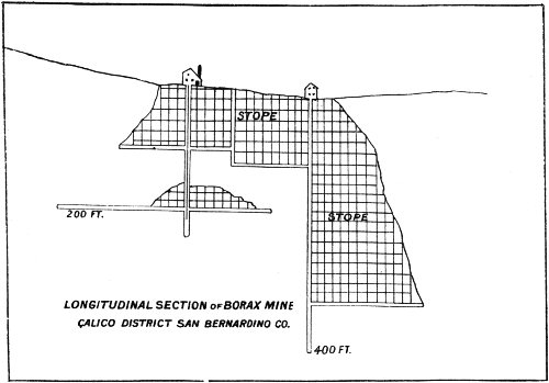
LONGITUDINAL SECTION OF BORAX MINE
CALICO DISTRICT SAN BERNARDINO CO.
The material, when hoisted to the surface, is loaded in great wagons hauled by twenty animals and taken to Daggett, where it is shipped to the works in Alameda. The process of extracting the boracic acid from the rock as practiced in these works is not given to the public. It is known that the mineral is crushed and bolted like flour, after grinding with burrs, but the subsequent treatment is not known outside the works.
To the Superintendent, J. W. S. Perry, I am indebted for a sketch of the underground working of this remarkable mine, which is reproduced above.
The geological age of the Calico uplift has not been accurately determined, though there is little doubt that it occurred during the Tertiary age, probably the Oligocene.
In this county, about 16 miles in a southeasterly direction from Newberry Station, on the A. & P. R. R., and 28 miles easterly from Daggett, are the greatest deposits of iron ore on this coast. They consist of immense beds or masses of hematite and magnetite ore, containing a high percentage of iron, with traces only of sulphur and phosphorus. These mines have been known for many years, and they have had numerous owners by relocation and purchase, but nothing has yet been done with them. Iron men from Pittsburg and Cleveland and elsewhere have visited these mines and secured samples, and all reported favorably on the excellent quality of the ores, but there the matter was dropped.
Located 16 miles from the railroad, and probably 20 miles by any possible line of railway survey, as the grades are heavy, with neither fuel nor water, the problem of their reduction was so formidable that none dared face it, and for years this magnificent property has been waiting for some one with capital and a “process” to come and make the vast wealth available.
This interesting region has come quite prominently into public notice within the past two years. The district is located in a small range of mountains about 35 miles east of the Calico range. The nearest station to the mines is Lavic, on the line of the A. & P. R. R., from which point the mines are 9 miles distant by a good wagon road. Like most other desert mining regions it is destitute of timber, and water is not abundant, though obtainable in the dry lake basin 3½ miles from the mines. The district was discovered about nine years since, and numerous claims have been located. The work of development has been confined to a few of the most promising claims.
The mountain range in which the mines of this district occur is isolated from all others, although evidently a part of a chain extending in a northwest and southeast direction for many miles. This particular group of hills is about 4 miles in length by 1½ in width, and consists of rocks, which are all of plutonic origin. They are mostly quartz porphyry of the normal type, consisting of a fine-grained felsitic ground mass, with macroscopical crystals of quartz and feldspar.
Of several thin sections made for the purpose of microscopic study of these rocks, their behavior under the microscope is so similar that general description will suffice for all. The section is characterized by a micro-crystalline to micro-granular ground mass, sometimes to globulitic. The feldspars are so completely clouded as to leave little clue to their 62 identity. Some still show faintly the parallel lines which are so characteristic of plagioclase, but some of these feldspars are probably orthoclase. These feldspars are plainly distinguishable in the rock mass with the unaided eye. Quartz blebs as large as small peas, with many smaller ones, occur plentifully in all of these rocks. In the section they seem to have been corroded, the outlines being nearly always rounded, though frequently showing hexagonal forms. Most of these quartz grains polarize in brilliant colors. All of the quartzes contain a great abundance of fluid inclusions, some of which show included air bubbles. Numerous very small, colorless, needle-like crystals, which occur in all the quartz, are no doubt apatite prisms. Green, dust-like hornblende as inclusions are not at all uncommon, and in one section a mass of green, fibrous material, having all the optical properties of hornblende, is seen. This inclusion is large enough to be easily distinguished with the unaided eye. There are numerous globulitic, granular, and sac-like inclusions of the ground mass in many of the quartzes, which is characteristic of the quartz porphyries generally. Besides these macroscopic crystals of quartz and feldspar are many hornblendes, some of which are of good size, a few having the typical crystal outlines. It is usually of a bright green color, strongly dichroic, and polarizes in the usual colors. Some of the hornblende is altered to chlorite. Borders of iron ore, probably magnetite, are common, frequently preserving the original outline where the hornblende has suffered great decomposition.
Dark-green basic dikes, which seem to be greatly altered diabase, occur in the district, but have no connection with any of the ore deposits as far as observed.
Numerous dikes, large and small, of a red felsitic rock, occur throughout the district, and seem to bear an important relation to some of the ore deposits. All of the rock is much decomposed, and its identification is not an easy matter. It appears under the microscope to be a finely porphyritic rock, having a somewhat fluidal structure, as shown in the arrangement of the numerous small, lath-like crystals of feldspar. Small blebs of quartz occur quite abundantly. In a general way the rock resembles some rhyolites.
On the northern flank of the range immense masses of red and brown tufa occur, besides great flows of black basaltic lava. These rocks form a terrace-like ridge that extends for several miles along the base of the mountains. Two large cinder cones, one on the northeast end of the range, the other about 4 miles distant in the desert valley to the northward, form prominent landmarks.
The basalt is coarse to fine grained, usually black or dark gray, and is often scoriaceous. It contains plagioclase, augite, and olivine, and abundant magnetite in a micro-crystalline or granular base. Near the foot of the range the basalt has overflowed the beds of tufa, which latter, it is said, contains from a trace to as high as four ounces of silver per ton. As far as I have any knowledge of it, no prospecting has been done in these tufa beds, but the fact that silver exists there at all would lead one to believe that under proper conditions ore bodies of great value may occur.
At the base of the mountains, at an altitude of 1,800 feet, is a dry lake, which drains a large area of country. In this basin water has been obtained by sinking a well 80 feet in depth. Though the well is located 63 near the edge of the basin, there is little doubt that sufficient water can be obtained in this basin for milling purposes.
The principal vein in the district lies along the north side of the main range, and is known as
This great vein, the outcrop of which may be seen for 20 miles, is a “fissure” in every sense of the word, though not a simple one, for it has numerous divergent branches of considerable size. The main fissure, however, is strong and constant, and outcrops boldly for nearly 8,000 feet. It varies in width from 4 to 18 feet. It is everywhere well defined and often shows a banded structure.
The great fissure strikes north 70° west, and dips 65° to 70° to the south. It occurs in the quartz porphyry, which at contact with the vein is usually much decomposed and often shattered and crushed, probably owing partly to the intrusion of a large dike of the red felsitic rock, a tongue of which has cut across the vein about 3,500 feet from its west end. This dike follows the vein for some distance on the hanging wall side coming from the east, gradually nearing the vein until it finally reaches the fissure, cutting the vein in two. Farther westward it again appears on the hanging wall side, showing itself at intervals to the extreme western end of the vein, which comes to an abrupt termination. This felsitic dike is but one of a number that occur in the immediate vicinity.
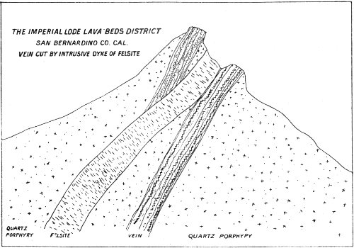
THE IMPERIAL LODE LAVA BEDS DISTRICT
SAN BERNARDINO CO. CAL.
VEIN CUT BY INTRUSIVE DYKE OF FELSITE
Since the formation of the Imperial lode there has been considerable movement within the vein itself. Slips are numerous, the slickensides showing plainly. The fault planes, as far as observed, are confined within the limits of the vein; however, at no place, excepting where the dike intersects it, did I notice any lateral displacement.
Usually the vein is distinctly separated from the inclosing rock, a 64 clay selvage marking the line of the fault plane on either side. In some instances, however, where a brecciated condition of the quartz porphyry is found in contact with the vein, the ore has been deposited to some extent in this broken mass, and in such cases the line of demarkation is not at all plain. These occurrences, together with the branching spurs, seem to indicate perfectly the character of the vein, which before the intrusion of the felsitic dike was more simple than we now find it. My conception of the Imperial vein is that a great fissure formed in this mountain range; that at the time this disruption occurred the hanging wall side of the fault slipped downward, causing a further fissuring and crushing of the rocks on that side of the fault. It is a notable fact that all the branches or spurs of this vein occur in the hanging wall country and are directly connected with the main fissure. This idea is still further substantiated by the additional fact that all, or nearly all, the crushing and grinding adjacent to the fault plane has occurred on the hanging wall side.
Occasionally, in the narrower portions of the vein, a banded structure indicates the probability that the ore now fills what was at one time an open crevice, which slowly filled with ore by precipitation from the mineral waters passing along the fault plane.
At one point on the course of the vein, where it is joined by one of the branching spurs, the felsitic dike has intersected the smaller vein. The occurrence is plainly seen in a cut made at this place, where rich ore was found.
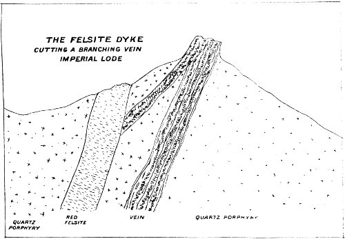
THE FELSITE DYKE
CUTTING A BRANCHING VEIN
IMPERIAL LODE
It will be noticed that both the main vein and the spur occur in the quartz porphyry, and that the red felsite cuts the smaller vein. The displacement on the surface along the strike of the vein is nearly 40 feet. This does not show in the cross-section.
Since the formation of the Imperial vein the mountains have suffered great erosion; the highest point along the croppings rises fully 800 feet above the neighboring cañons.
Although the Imperial vein is a fissure of great length and depth, all the material that is included between the porphyritic walls is not pay ore. The ore occurs in shoots of greater or less extent, the same as in any other vein. The gangue is chiefly quartz, having a pearly luster resembling in appearance some light grayish lead carbonate at a casual glance. Accompanying the quartz, though in minor quantities, are baryta, calcite, and black manganese oxide. The value of the ore lies almost wholly in its silver contents, which occur as chloride and sulphide (argentite) accompanying pyrites, chalcopyrite, and iron oxides. The silver sometimes occurs with copper glance in small bunches in solid masses of lead carbonate. Such ores are very high grade. In one of the branches gold is found with only a small percentage of silver, the reverse condition, however, usually obtains. The silver frequently is found in the same shoots with the base ores and in quartz without any intimate association with either lead, copper, or iron. The galena is sometimes very low grade, carrying only 4 ounces per ton in silver. In one shoot the lead carbonate contains over 200 ounces. It is a notable fact that no good ore is found in quantity without copper in some form, either as sulphide (glance) or carbonate. Chloride of silver is also found associated with iron and manganese, without copper or lead.
There are six lode claims located on the Imperial vein, on all of which considerable work has been done. Beginning at the east end, the vein shows itself on the mountain side close down to the desert wash and not far distant from the basalt flow on this side of the range.
The most easterly claim is called the Sampson, and from it has been shipped some rich ore, the claim producing the highest grade ore, I am told, of any mine on the vein. This claim is joined on the westward by the Morning Star, a deep cañon separating them. From the bottom of this cañon it is 800 feet to the summit of the mine, 1,500 feet farther west. The Morning Star Mine has been quite extensively opened by tunnels and shafts, but for several years past assessment work only has been done, as the ore which was found was too low grade to make shipping profitable.
The Meteor, Mammoth Chief, and Desert Queen succeed each other, respectively, going west. On the Mammoth Chief and Meteor, a great deal of work has been done; and it is claimed ore was shipped approximating $40,000 gross value. At any rate the owners have developed their claims and made a good living at the expense of the ore thus shipped from the vein. On the Meteor a shaft has been sunk a depth of 100 feet, at the bottom of which a drift 40 feet in length has been cut along the vein on an ore shoot which was followed down from the surface. At another point on this claim a shaft of 65 feet in depth has been sunk in ore. A drift at the bottom of this shaft is also in ore, 8 feet of which is exposed and the foot wall not yet reached.
The ore at this point is said to average 30 ounces. I was told that the average of the ore throughout the mine was about 25 ounces, ranging from 12 to 75 ounces, and occasionally much more. Numerous cuts, shafts, and drifts, some of them of considerable size, have been made 66 along the vein on the Meteor and Mammoth Chief for a distance of 800 feet, and although these workings are not connected they have the appearance of being on one shoot of ore. One fact is very evident from an examination of the mine, and it is one of considerable importance. It is, that the ore is of better grade and occurs in greater quantity in the vicinity of the felsitic dike, which, though undoubtedly later than the vein itself, seems to have enriched the ore very materially. The largest shoot of ore I saw has formed very close to the point of intersection of the felsitic dike with the main vein. On the Desert Queen a long tunnel and several crosscuts have exposed ore bodies, some of which contained upwards of 200 ounces silver per ton.
The Imperial lode is one of the most promising veins of which I have any knowledge, but it requires considerable capital to properly and systematically open it. The rock is extremely hard, and the lack of wood and water are drawbacks which prevent the owners from working the mine as it should be worked. It would be difficult to find a vein offering greater natural advantages than are found here, excepting as to wood and water, both of which are obtainable under the usual conditions attending that problem on the desert. Water can be found in the dry lake 3½ miles distant by road, and 1,160 feet below the level of the cañons which cut the vein.
Coal may be delivered at Lavic Station, 5 miles from the lake, for about $9 or $10 a ton. The difficulties are no greater than at Calico, where they seem to have been overcome quite easily. Tunnels may be run in on the vein, getting average backs of about 350 feet above the bottom of the cañons.
Should ever this great vein be worked on a larger scale with abundant capital, a tunnel started at the lake will cut the vein at an average depth of 1,500 feet. Such a tunnel would probably be about 12,000 feet in length. The ore shoots seem to have an average width of about 5 feet as far as exposed, and none of the workings in ore have ever reached the bottom of a shoot. It is one of the most imposing looking veins I ever saw. On the Desert Queen the soft hanging wall has been eroded, leaving the vein standing exposed for fully 80 feet in height.
About 4,000 feet south from the Imperial lode there is a mine of unusual character and interest, called the Tiptop. Originally a silver mine, it is now producing a high-grade copper ore, which is being shipped to Swansea, Wales.
The Tiptop was discovered in 1890, by the strong outcrop of an ore shoot. The country rock on both sides of the vein is quartz porphyry, similar to that inclosing the Imperial lode. The ore occurs along a fault plane, or rather a series of parallel faults, as the result of substitution of ore for the original rock. The faulting of the rocks has resulted in an extensive crushing and breaking up of the porphyry along the line of fracture, exposing large surfaces of rock, thus facilitating the deposition of mineral. As mentioned above, the faulting seems to have consisted of several fractures, nearly or quite parallel, between which the rock was crushed or ground to powder. In places this ore body would seem to possess well-defined walls, but moving in either direction along the strike of this zone the “wall” proves to be 67 simply a faulting plane, beyond which ore again occurs. The result of these parallel fractures is to give to the deposit an appearance of banded structure, like that sometimes noticed in simple fissure veins. This apparently banded structure is entirely due to the planes of displacement.
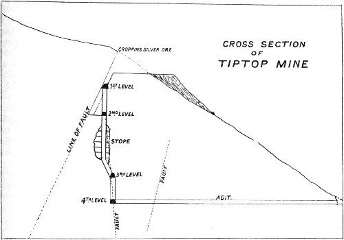
CROSS SECTION
OF
TIPTOP MINE
Doubtless this faulting extends to great depth, though the mineralization is not continuous along the surface for more than 150 feet. At some distance, however, and in line with the strike of the displacement, other ore bodies appear. The ore body where the discovery was made is heavily mineralized with iron oxides, of red, yellow, and black colors.
Much of the original rock has become silicified and bleached to snowy whiteness in the lower part of the deposit, but such masses contain only finely disseminated iron pyrites, low grade in silver. The once sulphuretted ores are so thoroughly oxidized in this surface deposit that they are very porous.
The ores carry on an average about 30 ounces of silver, and for the most part are very free-milling. At the time of my visit an estimate of this silver ore on the dump and in the mine placed its value at, approximately, $20,000. In one portion of this rather remarkable ore deposit considerable quantities of native sulphur occur, associated with a brownish iron oxide and silicious gangue material. As depth is attained the oxidation is less marked, and at 80 feet has apparently given place entirely to sulphuretted ores and silicious rock, low in silver.
The strike of this shoot of ore is north 50° west, dipping northeast at an angle of 70°. At the depth of 65 feet below the croppings, in sinking a winze, which in its downward course follows a slip northward but is vertical as compared with the dip of the vein, a bunch of high-grade, partly oxidized copper ore was discovered. Further development discovered other pockets or bunches of copper ore carrying usually 68 about 15 ounces in silver per ton. When a depth of 120 feet had been reached a crosscut tunnel was run in 235 feet. The course of this tunnel is north 5° west. The face, however, had not reached a line representing the dip of the surface shoot. The tunnel has been connected by winze with the upper workings, and considerable other development accomplished.
By means of these workings the peculiarities of the mine have been exposed. The series of faults which have resulted in the deposit of a considerable quantity of silver ore have been accompanied by another series of fractures which, while independent of the former, were, perhaps, contemporaneous. The second series exhibit no parallelism, but strike in various directions. Along these fault planes occur bunches of copper ore, principally variegated pyrites (bornite), chalcopyrite, and a black “earthy” sulphide, having a shining streak, not sectile, probably a variety of copper glance.
These ores are sometimes associated with iron sulphide, but most of this class may be easily sorted. One class of ores occurs intermingled with the gangue containing about 15 per cent copper. This ore can be separated on any concentrating machine such as a jig, the resulting product being high grade. The ore shipped to Swansea has averaged over 33 per cent copper and 15 ounces silver per ton.
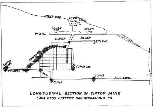
LONGITUDINAL SECTION OF TIPTOP MINE
LAVA BEDS DISTRICT SAN BERNARDINO CO.
The Tiptop consists of two claims. The easterly one, the Kenton, has little or no development, though copper carbonates have been discovered on the ground. All of the workings of the Tiptop that are in copper ore, it should be remembered, are in the country rock on the foot wall side of the series of faults in which the silver ore occurs, and no drift or crosscut had been run into that zone below 80 feet from the surface. The face of the drift on the third level had exposed about 6 feet of good ore at the time of my examination. The drift at that point was 160 feet from the surface. It is not likely, should a crosscut be 69 run under the silver ore shoot from the lower levels of the mine, that oxidized ore will be found at that level, but it will be interesting to know what sort of ore may be found there. Indications of copper on the surface are very slight. In a few places stains and thin seams of copper carbonates occur in the fracture joints of the country rock, but there is nothing to lead one to believe that ore lies beneath that will bear shipment to Europe and return a handsome profit to the owners of the mine, yet such is the case.
Less than a mile from the Tiptop, in a northwestern direction, is another property, the Gladstone, locally known as Halberg’s Gold Mine. It was located several years ago, and after some development was practically abandoned, but afterwards came into the hands of the present owners, who have developed the ground quite extensively, built a long tramway and ore bins, and established a camp.
Nothing was being done at the time of my visit. The mine is something of a curiosity geologically and mineralogically. The ore body, for there is only one of any consequence developed, occurs in the gray quartz porphyry common to the region. A fault has also occurred here, fracturing the country rock in a manner similar to that in the Tiptop, excepting that here there is but a single, simple fault. The ore body consists of a mass of crushed and broken country rock, portions of which still show distinctly the original porphyritic structure. Generally speaking, however, the original rock has undergone an extreme metamorphosis, resulting, in most cases, in more or less complete mineralogical and physical changes. The porphyry has, by gradual replacement, been changed to solid ore, or been silicified to a dense quartzose, sometimes jaspery, rock. Kaolinization of the feldspars has also taken place. As to the origin of these deposits there seems to be little reason to doubt that the ore was deposited by percolating waters, which derived their contents from the neighboring eruptive rocks. These solutions were carried into the fault plane, and reaching the great chamber or crushed mass, found conditions of a superior nature for the precipitation of the minerals they contained. In the pulverized or finely crushed portions the ore deposition has been most complete, entirely replacing the original rock, while in the brecciated portions the ore occurs as incrustations, filling the smaller interstices, but sometimes penetrating the rock fragments themselves.
The ore body is something over 200 feet in length and 30 feet or more in width at the Widest part, but thinning out rather irregularly toward the ends and also downward.
Doubtless it at one time extended some distance upward, but that portion has been eroded. Along the plane of the fault the line of demarkation between ore and porphyry is very distinct, as the two bear not the slightest resemblance, but at the outer edges of the deposit no such line can be discovered. The mineral gradually disappears, leaving only a brecciated mass of whitish rock, which graduates into the normal porphyry. The brecciated condition of the mass is made more plain by the variety of color assumed by the angular fragments. They are various shades of green, red, white, and brown, or yellow, caused by copper carbonates and iron oxides.
Though the original condition of the ore was doubtless sulphide, it now contains, as the result of oxidation, hematite, limonite, magnetite, malachite, azurite, chrysocolla, cerussite, wulfenite, chloride of silver, manganese oxide, and metallic gold. The value of the ore lies principally in the gold contained, though in one portion of the ore body, near its eastern end, rich chloride of silver ore is found, with but little gold. The physical appearance of the ore is no criterion of its gold contents, as two pieces, with identically the same characteristics, will differ widely in value. One may contain $2 or $3 in gold, the other several hundred. Should ever a mill be erected in the district, this ore can be worked to a profit, though this single ore body will alone scarcely justify the construction of a mill.
On the south side of this fissure or slip is a vein which runs nearly parallel with the chambered vein above described. This vein can be traced for several thousand feet. In character the ore is similar to that found in the Imperial lode. Assays running over $200 in gold have been obtained from this ore, and $50 assays are not uncommon. The vein is quite small, ranging from a mere seam to 2 feet. Scarcely any development has been done on this vein, though it promises better results than the large “vein chamber.”
The developments on the Gladstone consist of a shaft 60 feet deep. The first level is cut at a depth of 30 feet from the surface, where drifts have been run for a distance of 30 feet each way from the shaft, on the course of the vein, and a crosscut, 28 feet north. East of this, a 15-foot shaft has been sunk in a good sized cut. A large open cut, 100 feet long, has exposed the upper portion of the ore deposit perfectly. Other superficial work has been done at various points along the vein. A tramway of 1,700 feet has been constructed from the mine to the bottom of an adjacent cañon.
In the vicinity of the mines described in this district are numerous other claims, some of them having considerable development, but all lying idle at the time of my visit. One claim has an 80-foot tunnel, and shows some lead and silver ore of good grade. This claim is patented.
Twenty-three miles northeast from Daggett are the Alvord Mines. The property has changed hands several times, but is now owned by a party of Pasadena capitalists, who have under consideration the reconstruction of their mill, which was burned in September, 1891.
The property consists of six full claims located on one mineral-bearing zone. The strike of the belt is a few degrees south of west. The mine is well equipped. The company also owns a millsite at Camp Cady, on the Mojave River, 9 miles distant from the mines, and valuable water rights at Paradise Springs, 11 miles northwest from the mines, and a spring about 1½ miles east of the camp, which is used for camp purposes only.
The mines lie along a broad zone or belt of crystallized carbonate of lime (calcite), which may be seen for many miles traversing the dark-colored inclosing rocks. A huge dike of porphyritic rock cuts across 71 this belt at an angle approaching 90°. The principal mineralization of the lode occurs east of this dike.
The country rock is described by F. R. Burnham, E.M., formerly the Superintendent, in his report on the property to the company, as rock more or less schistose in character, through which, at frequent intervals, are intruded eruptive dikes. At the east end of the belt is an accumulation of tufa and basalt. The belt dips south at an angle of 75°. The mineralized portion of this lode extends from the porphyry dike east through three full claims, disappearing finally beneath the eruptive rock and desert wash. The dominant point on the lode is 550 feet above the base of the hill.
The entire lode is gold-bearing, some of the iron rock being extremely rich; gold also occurs in the calcite, though it is usually of a lower grade than where accompanied by the iron. Iron sulphide containing gold has been discovered, indicating plainly the origin of the slag-like iron ores and limonite found on the surface.
To Mr. Burnham’s report I am also indebted for information concerning the value of the rock, tonnage, and bullion output to date. He has given arbitrary figures for shipments aggregating $37,000, and an estimate on $13,000 more, making a total of $50,000. This ore was milled mostly at the Camp Cady mill and at Hawley’s mill.
An arrastra was used in the early history of the mine. The average assays made on a ten days’ mill run just prior to the burning of the mill returned $12 75 per ton. Tailings, during the same period, averaged $1 25. Bullion produced, $1,430. It was found very difficult to sort the ore, though it varied constantly in value from $2 to $20 per ton. About 90 per cent of the assay value, it is claimed, was saved in the mill. In looking through a daily record of assays made in July and August, 1891, I find them to range from a trace to as high as $1,750, most of them running from $6 to $18. Mr. Burnham figures 184,000 tons of mill rock in sight, including all grades, besides large amounts presumed to be available, but not blocked out for stoping. The value of the ore is placed at $5 to $6 throughout.
The cost of milling this ore is placed at $2 50, and mining at 50 cents in large stopes. Should the company now controlling the Alvord Mines determine to rebuild their mill it will doubtless again become a bullion producer.
The Oro Grande Mining District is located immediately east of the Southern California Railroad, at the town of Oro Grande. It is commonly supposed to embrace all the mines for some miles around, though, in fact each group of mines or hills has been given a separate name, but as these so-called districts are mostly without organization, all the claims and mines will be considered under one head.
The geology of the district about Oro Grande is complex, the formations being uplifted, greatly faulted, and broken, besides the intrusion of dikes of felsitic rock, diorite, and quartz porphyry. I had not sufficient time at my disposal when at Oro Grande to study out the somewhat intricate geological problem, and will describe the region in general terms.
Commencing at the town of Oro Grande, which stands on the bank of the Mojave River, the country rises in a gentle slope toward the hill half a mile distant; gently rolling hills are reached, which in turn give 72 place to more rugged masses, and finally to a rough mountainous area, the hillsides being almost precipitous. The lowlying country about the base of the hills is mostly made up of schistose micaceous rocks, a quartzose mica schist predominating. The first hills of any consequence are eruptive, mostly a light-greenish felsite and a coarse-grained porphyritic rock. Beyond are prominent hills of a dense, hard quartzite resting upon a crystalline limestone, the highest hills being made up of practically the same materials (quartzite and limestone), in part schistose with some mica schist, jasper, and many intrusive dikes of all the previously mentioned eruptives, prominent among them being diorite of dark-green color.
Within half a mile of the town, and on a lower spur or ridge that makes down from the hills, is located the Embody Mine, which, during the excitement at this locality in 1890, attracted considerable attention. The gold-bearing material is quartzose, micaceous rock of somewhat friable character. The deposit, as I may term it, has the appearance of being an impregnation without definite form.
Were it not for the fact that the shoot of gold rock makes across the strike of the schists, it would resemble some bedded deposits found at the Homestake, Black Hills, South Dakota, where micaceous schists have been silicified and hornblende schists metamorphosed to chloritic schists, the whole carrying gold across a broad zone 1,600 feet in width and 6,000 feet in length. The gold occurs in shoots or vein-like zones, without defining lines of any character. At the Embody Mine, too, little development has been done to make any positive prediction as to the future of the mine. The formation strikes northeast and southwest, and dips 70° southeast.
The country is somewhat broken up, but no considerable masses of shattered rock were observed. The croppings are quite heavily stained with iron oxides of brown and red shades, and this mineralization can be traced some distance. Two shafts, one nearly 100 feet deep, the other about 30 feet, have been sunk on the deposit, exposing rocks of uniform character, all carrying some gold. The width of the gold-bearing zone is undetermined, but it is thought to be from 6 to 20 feet.
As far as I learned, a “mill-run” had never been made on the rock from this mine. Mining operations had been stopped and the property involved in some sort of dispute. The value of the rock was given to me as $8 or $10 per ton.
The principal mine of this district, and the one which gave the camp its fame, is the Carbonate Mine. It was discovered by a man named Collins, who was working in a lime quarry near by. Collins found croppings of ore—limonite and manganese—containing silver. He developed the property somewhat, but it finally passed into other hands, and is now owned by a Los Angeles company, which has opened the mine quite extensively.
The formation which incloses the vein has a general trend northeast and southwest, the dip at the main workings being not over 20°. Here an inclined shaft has been sunk to a depth of 225 feet on the vein. At the bottom the shaft has attained a vertical depth of about 100 feet. 73 Two veins of ore, consisting principally of silicious and earthy iron oxide and black oxide of manganese with carbonate of lime, sometimes crystallized, extend from the surface to the bottom of the incline. These veins are very irregular in size, varying from a mere seam to upwards of 2 feet in places.
The value lies in the lead carbonate and silver which accompany the gangue minerals. The two veins are curiously formed at contact with massive blue limestone and mica schist. The schist is from 1 to 4 feet in width, the ore lying both above and below it, the whole being inclosed between hanging and foot walls of crystalline limestone. At various points in the workings is a light-colored, much decomposed rock, resembling felsite, which has the appearance of having been injected between the strata in a thin sheet. It is a notable fact that where this buff-colored, granular appearing rock occurs in contact with the vein an enrichment of the ore is noticeable, and its absence is marked by the low value of the ore or no ore at all. In this incline, at a depth of 40 feet, a short drift has been run in on ore of good grade. At 180 feet from the collar of the shaft the discovery was made that caused this mine, and, in fact, the entire camp, to become at once the scene of excitement.
At this place a small wedge of crystalline, granular quartz and calcite appeared, and with it flakes of free gold. Just below the point of this discovery the wedge widened to several inches, and the rock was a mass of glittering sheets and shot-like pieces of gold. Assays of the material gave fabulous returns. The ore was broken down on canvas, and every ounce of it sacked on the spot. This was followed down some distance, but gradually thinned out below the 200-foot level, where drifts were run, one 50 feet northeast, the other 40 feet southwest. From these drifts considerable rich quartz was obtained.
In the southwest drift the formation is badly displaced and broken and the vein is lost, a fault having thrown it, but whether up or down could not be determined, as the adjacent rock was so badly fractured. Ore was found at the face and along the sides of some of the cuttings, and some free gold was found on the 200-foot level in the southwest drift. All work on this part of the mine had been suspended some time prior to my visit, the mine having been enjoined.
This question is one which finds its answer, it would seem, in the fact that the sheet of mica schist included between the heavy masses of limestone represents what at one time was possibly a bed of sandy clay or mud, which with the metamorphosis of the region has become a crystalline schist. The planes separating this schist and the limestone above and that below it were evidently planes of weakness, and when the forces which uplifted and fractured the strata exerted themselves these rocks slipped and ground upon each other, causing considerable crushing along these planes; possibly open crevices resulted in some portions. Ore was subsequently deposited in these interstitial spaces, partly by substitution of ore for limestone, no doubt, and partly by precipitation in the crushed mass of lime and schist. The injection of a sheet of felsite into the same plane of weakness can easily be conceived, as such intrusive bodies always follow the lines of least resistance. The extreme richness of the rock, together with its somewhat unusual 74 association of quartz and calcite, attracted no little attention to the property at the time of its discovery.
Southwestward from the deposit just described is a vertical shaft 125 feet deep. This shaft has followed down what seems to be a fissure in the limestone, in which lead carbonate, some galena, limonite quartz, calcite, and manganese oxide occur. This ore was worth at Socorro, New Mexico, $50 per ton for the gold, silver, and lead it contained, and it was shipped there in quite large quantities.
A large stope commences on the northeast side of the shaft at a depth of 30 feet from the top and extends down to the 114-foot level. Considerable ore was standing in sight in the mine at the time of my visit, but nothing was being done. The company have had to stop work, as the owners of the lime quarry claim to have this property included in their patent.
There are scores of other claims in this interesting district, but little development has been done on them. Here and there are encouraging prospects, where carbonate of lead and oxide of iron have been found; but on the most promising of these only 10-foot holes have been sunk. The mineral zones are not well defined, and the prospectors have not the capital necessary to systematically prospect the hills.
Is 5 miles south of Oro Grande. There are a number of claims, the principal one being the Amazon. The formation is similar to that about Oro Grande. In a large dike of diorite occur the ore bodies of the Amazon Mine, which produces copper ores of a fair grade. Several holes were sunk to various depths, ranging from 15 to 30 feet, by the Mormons who settled on the Mojave River years ago. Recently a shaft has been sunk to the depth of 61 feet, and a drift run north 40 feet. The ore is principally copper-iron sulphide (chalcopyrite).
The ore in this mine occurs along slips or fault planes. This peculiar class of deposits has been described under the head of the Tiptop Mine, Lava Beds District, in this county, and as the essential features of this mine are similar to those of the Tiptop, repetition here will be unnecessary. I found a greater mineralization of the limestone in this district than about the Oro Grande, though no prospecting has been done here for lead ores.
Twelve miles northeast from Victor are the Gem quarries, that produce variegated marbles of great beauty. Shades of yellow, chocolate, black, pale blue, crimson and gray, cream-colored, rose, and white. The markings are such as to produce beautiful effects. The croppings are strong, and the surface material is apparently not at all injured by the exposure of centuries to the elements in a region where nearly all rocks decay and disintegrate rapidly. The outcrop stands boldly above the adjacent country rock from 10 to 20 feet. The entire ledge or belt is made up of bands or beds ranging from 3 to 6 feet in thickness. These 75 strata are separated by thin seams or fractures, but it is reasonable to presume that this separating line or joint will disappear as depth is attained. The rock is all susceptible of a high polish, and it withstands a tremendous crushing force. It was said by the owners that this had been determined at 28,000 pounds per square inch.
The quantity is large, the variety abundant, and the beauty approaches that of rare onyx. With these unusual conditions surrounding the deposit, its marketing should become an industry of no small importance. The difficulties of transportation are not insurmountable.
Near Oro Grande and Victor several lime quarries are in operation, constantly giving employment to quite a large number of men. Lime is burned in large kilns, which finds a ready market in Southern California. Granite is also extensively quarried near each of these places, and used for building material, curbing, and paving blocks in Southern California cities. This industry employs, all told, about one hundred men.
Three miles from Hinkley Station, on the Atlantic and Pacific Railroad, between Barstow and Mojave, is located the Kent Mine, a vein covered by two claims. A shaft 80 feet deep and some superficial development have exposed the ore, which varies from 3 to 10 feet in width. The gangue is a rather fine-grained, granular quartz, containing galena and lead carbonate. Assays in gold and silver are obtainable anywhere in the vein. The highest grade carries lead 70 per cent, gold $25, silver 24 ounces. Some of the ore assaying low in lead contains gold and silver in paying quantities.
The property is in a prospective stage only, but is promising. Water can be obtained near the mine, and fuel is but 8 miles distant. The owner bonded the property in May, 1892, and it is at this writing being developed by the prospective purchasers. The ore is of such character that by sorting a milling ore may be obtained, the high-grade lead ore making a very good smelting material.
Three years ago the Black Hawk District, 40 miles east of Victor, on the north side of the San Bernardino range, attracted considerable attention through the extensive operations of an English syndicate at those mines. Development was in progress at that time, and it was planned to build a sixty-stamp mill. The quantity of gold rock, however, proved to be smaller than had been anticipated, and a small experimental mill was built; but from a short time after the completion of this mill to date all operations have been suspended, and the probability of the resumption of work is not bright.
The gold occurred in a reddish oxide of iron in bunches and stringers scattered through a crushed zone of limestone, lying along the flank of the mountains. A party, who for a time was in charge of the property, informed the writer that he had worked the rock without sorting, had endeavored to sort it, and had tried screening it, but that notwithstanding every precaution was taken, he had concluded that it could not be 76 made to pay. The gold-bearing rock was quite rich, but it occurred in too small quantity to make it profitable.
Four miles northeast of the Black Hawk Mines, lying down on the desert, is a formation of limestone and quartzite, resting on a massive crystalline rock, containing quartz, feldspar, biotite-mica, and hornblende. This reef extends from the mouth of Texas Cañon out upon the plain, sloping downward at an angle of approximately 5° for a distance of 4 miles, where it terminates in a bluff 40 to 100 feet in height. Along the entire eastern edge of this deposit it drops off abruptly as though sharply eroded. At the northern end the reef is faced by a low range of hills composed of the above-mentioned hornblende rock. From this point it swings west and with irregular outline extends for 5 or 6 miles toward Rabbit Springs. The entire area, fully 25 square miles, is cut by gulches varying from 20 to 150 feet or more in depth, that have been eroded through the strata and down into the underlying crystalline rocks. These cañons seem to have resulted from natural drainage, being started by slight depressions in the rolling plateau of limestone. On the extreme northern edge at one point, hills of considerable size have been formed by the folding and tilting of the strata. The limestone has been subjected to violent compression, as the whole area is faulted and broken into millions of fragments.
I have examined not less than twenty mining claims on the reef and traveled over the greater part of its area, and am sure I never saw a single piece of limestone that would weigh 300 pounds, most of the pieces measuring under 6 or 8 inches. Considerable masses along certain zones have been granulated, and even pulverized. This fractured rock has all since been loosely cemented by the infiltration of carbonate of lime into the seams. Geologists who have examined this peculiar deposit do not agree entirely upon its mode of formation. Some believe it to be the result of chemical precipitation of carbonate of lime from calcareous springs, similar to the Formation Springs in the Yellowstone Park. There are many things about Silver Reef which would at once suggest the probability of this mode of deposit, but I am very doubtful that such a theory will stand a thorough investigation.
It was asserted that at one time a shaft sunk in the reef passed through the lime deposit and into the “wash” of the desert beneath. On investigation I found that the lime had indeed been cut through, but the underlying rock proved to be crystalline hornblende rock in place, though somewhat decomposed. At any rate it was not desert “wash.” Over considerable areas the lime is underlaid by a stratum of quartzite of variable thickness, less than a foot in some places, and again in others 10 or 12 feet. Over certain limited areas quartzite is wanting altogether. The lime is mostly crystalline, varying in color. A small portion is as white as snow, the greater part is gray or bluish, and some of it black.
For fully 8 miles along the irregular front of the reef silver ores are found. The ore deposits are usually discovered by the cherty masses of silicious rock, which, being harder than the limestone, stand out from its weathered surface in bunches and small, vein-like masses. Often in 77 breaking the cherty rocks, stains of copper carbonate are found, and from such rock silver, and sometimes gold, is obtained. Numerous shafts, cuts, and tunnels have been made on these claims, twenty or more in number, and in every one ore of good grade has been found, although the quantity is usually small. A shipment from a claim called No. 1 returned 129 ounces per ton in the Oro Grande mill. On assaying, 20 ounces can be found on any of the claims, and rock of a higher grade running into the thousands of dollars is not unknown on the reef.
The ore occurs usually as bunches, sheets, or stringers, which “roll” more or less, but in a general way follow the stratification of the limestone downward. These stringers are from 4 inches to 2 feet in thickness, pinching and swelling both longitudinally and on their extension downward. The average of the ores thus far found is probably about $50 per ton. The mines have all been opened by the discoverers, who are men of limited means, and no systematic exploration for larger ore bodies has ever been made. They may exist, though there is no surface indication that such is the case. At one claim, No. 9, I took a large sample for 20 feet across the mineralized zone and found it to assay 11 ounces silver with $2 in gold. This rock was taken from a shallow cut 4 feet in width and 5 feet deep, 20 feet long.
The ore deposits occur without exception in zones of limestone that have been crushed into small fragments, together with much very fine material. In a few places I found in contact or close to the ores what appeared to be a thin intrusive sheet of rock of undoubted igneous origin. The original nature of this rock could not be determined, as it was very much decomposed and bleached. It looked like the white porphyry of Leadville more than anything else I could liken it to, and to a great extent has, doubtless, been the source from which the minerals of the ore deposits were derived. In many places the quartzite which underlies the lime rock contains galena, lead carbonate, wulfenite, zinc-blende, iron sulphide, copper, gold, and silver. Some of this rock contains sufficient lead to be classed as a smelting ore.
The ores of the limestone deposits are chiefly chloride of silver and embolite (chloro-bromide of silver), which is usually accompanied by copper carbonate, sometimes a copper-silver sulphide, wulfenite, lead, and iron in various forms, in a gangue of calcite and quartz, with occasionally manganese oxide. Hornsilver in crystals has been found in the fracture joints and in small cavities of a pure blue limestone, taken from a shaft on one of the claims at the east edge of the district. Pasadena, Riverside, Daggett, and Victor people are the principal owners of claims. Timber can be obtained in the main range 5 or 6 miles back of the mines, and abundance of water can be had from the cañons in the neighboring mountains or from Old Woman’s Springs, 2½ miles east of the principal claims on the reef.
Altogether the district is a most interesting one geologically and also financially, as the high grade of some of the ore had induced the claim owners to sink considerable money in the development of their mines.
On the San Jacinto estate, which is owned by an English syndicate, are located the old Gavilan Mines, which years ago produced from quartz veins considerable gold, the rock being first crushed in numerous arrastras, the beds of which, to the number of fifty or more, are still 78 scattered all about the neighborhood of the mines. In later years, under American management, the quartz was hauled to a stamp mill in the Pinacate District. At the time the rancho became the property of the English people nothing had been done in these mines for many years. During the past two years the old workings have been investigated and a local company organized at Riverside to operate them under lease. At the time of my visit some workmen were industriously engaged in taking down the gallows frame of the hoist and making preparations to vacate the premises, and this in the face of the report that had gone abroad that a good-sized vein of pay rock had been uncovered at the bottom of the mine at the depth of 180 feet. I did not see the alleged ore shoot and could get no satisfaction from the men at work other than vague hints that there was dissension among the Board of Directors.
The veins of the Gavilan Mines are not large, but of good grade, occurring in a granitoid rock. Black tourmaline in a feldspathic and quartz gangue frequently accompanies the gold-bearing rock. The Mexicans worked a large shoot down to the water-line, and judging from the size and number of the dumps these old workings must have been of great extent. The Riverside people had sunk a new shaft at the extreme south end of the mine 180 feet in depth. The entire region is cut by large feldspathic and granitic veins, which course in every direction. These veins are doubtless intrusive dikes of the variety of granite called pegmatite. White scales of muscovite occur sparingly, but tourmaline is abundant.
Forty-five miles from Fenner, on the line of the A. & P. R. R., in the eastern part of the county, near the Nevada State line, is the Vanderbilt District. It lies between Palm District and Ivanpah, at an elevation of 6,000 feet above the sea. Numerous claims have been located on the veins of the district and considerable development done. Messrs. Patton, Taggert & Hall own eight promising claims, which it is their purpose to develop extensively. A shaft 4½ by 6½ feet has been sunk on the vein to a depth of 60 feet, besides which a number of shafts of lesser depth and numerous open cuts have been made, all exposing ore of good grade. The vein is of the branching kind. The veins vary from 5 to 30 feet in width, striking east and west, with a dip to the north of 60°. The gangue is quartz, honey-combed at the surface from the oxidation of the sulphurets it originally contained, small disseminated crystals of which (iron, lead, and copper) begin to show in the rock from the deepest parts of the workings. Some of the rock contains a high percentage of lead in the form of galena and carbonate, but it occurs mostly in bunches and is not evenly distributed through the rock. A shipment of 6,963 pounds to the sampling works at Kingman, Arizona, returned an average assay value of $173 50 per ton, most of which was gold. Another lot averaged $44.
Near the above described property Messrs. Simmons & Roberts have sunk three shafts to a depth of 40 feet each, and Campbell & Beatty put down a shaft 100 feet, all in ore of a character and value similar to that found in the other mines. Both wood and water are obtainable in the district, pine timber growing on the hills, and a good stream of water is flowing down into the desert only 1¼ miles distant from these mines. With the character and grade of the ores found in these veins, and the advantages of wood and water, it would seem that these mines 79 might be successfully operated, particularly as some of the owners are possessed of sufficient means. It is the expressed intention, however, to sink deeper and determine more fully the extent and character of the ore in depth before placing expensive machinery on the ground.
Among the mines that have attracted unusual attention in this county during the past year, the Ibex Mine stands prominently in the front rank. It is located 3½ miles from Ibex Station, on the line of the A. & P. R. R., and not over 11 miles north from The Needles. The Ibex property is in the Ibex Mining District, and consists of seven claims, which were located in 1888, now owned by residents of Riverside and San Bernardino. The principal claim is called the Ibex. The vein strikes east and west, dipping at an angle of 45°. Two shafts, one 60 feet and one 52 feet, had been sunk at the time this information was obtained. At the bottom of the 52-foot shaft a drift 38 feet in length has been run on the vein. Surface cuts and trenches are quite numerous on the several claims, and a large amount of quartz containing gold had been exposed. Free gold could be seen in considerable quantity in some of the porous quartz. The quartz is thoroughly crystalline, showing many cavities as a result of the decomposition and leaching out of the sulphuretted minerals it originally contained. These cavities are all lined with minute quartz crystals, which have been deposited evidently since the removal of the sulphides. Rock of this description is full of gold, seemingly. It is so loose in texture that careless handling shakes out the golden grains. John Anderson, of San Bernardino, one of the owners, volunteered the information that from 2 to 4 feet of this rock sampled $100 to $150 per ton. The owners had determined the latter part of April to ship this free-milling ore to The Needles, where a mill was being constructed. Some of the quartz from the lowest workings contains small crystals of pyrite and chalcopyrite, but it would still be classed as an ore susceptible of free amalgamation. The Ibex property had a promising look in the spring of 1892. Its further development will be looked to with great interest by all interested in desert mines.
Near the south boundary of San Bernardino County, and about 75 miles directly east of Mount San Bernardino, a new mining district has been organized within the past two years, and considerable development work accomplished by the claim owners, who, as usual, are men of limited means.
This district is 22 miles northeast of Cottonwood Springs, 16 miles north of Eagle Mountain, and about 6 miles south from Virginia Dale. The belt is about 1½ miles in width and 5 miles in length. The veins trend north and south.
This new district, which has been named the Monte Negras, or Black Mountain District, has attracted considerable attention by the discovery in one of the claims of nuggets of gold and quartz of extreme richness. At the time of this discovery some newspapers in this county published the report that the mythical “Pegleg Smith” Mine had actually been found, which only added to the excitement produced by the bringing into San Bernardino of several hundred dollars worth of specimens.
I visited this new district in the month of May, 1892, and spent several days in making an examination of the claims and adjacent country. The Monte Negras camp is on the south side of the range of hills 45 miles northeast of Walters Station, on the line of the Southern Pacific Railroad, being reached by a fair desert road. By fair I mean a heavy, but not rough or hilly road.
Walters Station is nearly 200 feet below the level of the sea. From that point every foot of the way is up hill, till a divide near Cottonwood Springs is reached, at an altitude of 3,157 feet, the distance being 27 miles; from there to the foot of the wash, which extends 2 or 3 miles from the base of the mountains, down hill 19 miles, where the altitude is 1,300 feet. The altitude of the camp is 1,520 feet. All the mines lying back in the mountains are at higher, though varying, altitudes, the greatest elevation being 3,500 feet, at the Ramona. The neighboring peaks rise from 200 to 800 feet higher.
This district is distant about 35 miles from Cadiz, on the line of the Atlantic and Pacific Railroad. I have never traveled the road, and know nothing of it, although I am told it is a good desert road. Wood is not obtainable at all in the vicinity of the mines, and water is scarce, but has been obtained by sinking a well in a basin at Virginia Dale, a few miles north of these mines. A shaft was sunk 140 feet in the wash 3 miles south of the most southerly Monte Negras mines, but no water was obtained. Bedrock was not reached at the depth mentioned, but it is not unlikely water may be secured by continuing this shaft downward.
I mention all these drawbacks to what I otherwise believe to be promising property, because I think the difficulties may be offset by the fact that the ore is high grade.
The Monte Negras uplift consists, as far as my observation extended, entirely of eruptive rocks, diorite, quartz porphyry, and fine-grained more or less porphyritic rocks, cut by later dikes of felsite and dark-green or black diorite. Epidote occurs in great quantity throughout the region, usually associated with micaceous iron ore, which is found in the form of veins and bunches everywhere. The iron ores contain no precious metals, and are of no economic importance.
The region, although entirely eruptive, and in part volcanic (large fields of basalt occurring on the western slopes) is in the immediate vicinity of a large hill called Pinto, or Painted Mountain, which is made up of metamorphic strata, chloritic and hornblende rocks, quartzite and mica schist predominating.
The mineral-bearing veins of the Monte Negras District are all of the fissure type, and are mostly quite simple in form. The gangue is quartz, carrying iron and copper sulphurets, and the secondary products of those minerals, iron oxide and copper carbonate, with gold and silver. No lead or zinc was observed. The economic value of the ore lies almost, evidently, in its gold contents, the silver occurring so sparingly as to amount to very little. The bullion obtained from these ores is worth about $17 per ounce. The ore ranges in value from $20 to over $100 per ton. Observations on the principal mines of this district, viz.: Great Eastern, Venus, Columbus, Summit, Porcupine, Schiller, Hillerman, Annie Rooney, Ethel, Republican, Ramona, McKinley Bill, and Revenue, have to be omitted in order to condense the report.
By W. H. Storms, Assistant in the Field.
There has been no marked development of mines in this county since the last report was issued, excepting in some of the districts of the Colorado Desert, of which mention will be made. The general geological and topographical features of this county have been so fully described in former reports that to repeat them here is unnecessary. At various times within the past two years new discoveries have been announced, and these have been developed to a greater or less extent, and in some instances, at least, with encouraging results.
This mine is located a short distance from the town of Julian, and is equipped with a steam hoist and mill combined under one roof. The new shaft, which was started nearly three years ago, was sunk on the vein for 50 feet, at an angle of 75°, at which depth the shaft left the crevice and continued vertically to a depth of 225 feet. From this point a crosscut was started back toward the vein, running at an angle with its strike, the idea being to reach a pay shoot as quickly as possible. The shoot in question was the south extension of that developed in the old workings. The vein was encountered, and the drift continued along its course. At about 30 feet from the point of intersecting the vein in this drift of the shoot was found. It was hard, blue, rather glassy-looking quartz, filled with minute black particles, and showing considerable gold, some of the rock being very high grade.
The drift was continued along the vein, and finally reached a point over the level that had been run south from the old shaft, which is 300 feet deep. This new drift was found to be 14 feet higher than the old level. The mine was completely drained at the time of my visit, and a free circulation of pure air was found throughout the workings. The ground was ready for stoping, but owing to some legal difficulties arising the property was lying idle.
The appended sketch will give an idea of the present development of the Helvetia, which is one of the most promising properties in the district, and a type of the best class of mines of its kind found there.
The Helvetia, like other mines of the district, occurs in the crystalline schists, the quartz being found as lenses inclosed in the country rock. Some of the lenses might be mistaken for fissures, but I failed to see one possessing the characteristics of a “fissure.”
Nearly all the lenses exhibit a tendency to “make” into the hanging wall side of the country rock, the lenses of quartz following each other in a general direction, but at an angle with the stratification of the schists, and are separate and distinct from each other, being separated at the ends (where they sometimes overlap) by the “leaves,” as 82 they may be termed, of the schistose country rock. These lenses were doubtless caused by a compressive stress on the schists, which had a tendency to split them, but was not powerful enough to cause an abrupt fracture. The accompanying sketch may convey an idea of the occurrence of these quartz lenses.
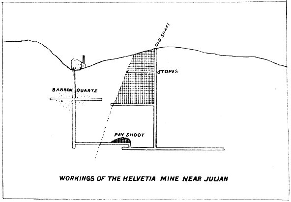
WORKINGS OF THE HELVETIA MINE NEAR JULIAN
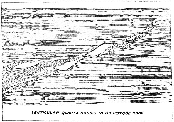
LENTICULAR QUARTZ BODIES IN SCHISTOSE ROCK
By the above sketch it will be observed that there is a tendency on the part of the quartz lenses to follow a given direction, which lies at a small angle across the strike of the schists, and that these lenses are 83 not connected, but occur independently, though all are the result of the same force which flexed and split the strata.
Other mines about Julian were idle at the time of my visit, the most of them being inaccessible, owing to water in the workings. Considerable money has been expended on the Owens Mine in an attempt to drain and recover the workings, but it was abandoned after several months of work and considerable expense.
More activity was exhibited in the mines about Banner than any other part of the district.
This is the largest and most extensively developed mine near Banner. It has earned considerable fame, not only as a producer, but for the peculiarities exhibited in the formation of its bunches of quartz, which contain disseminated grains and masses of pyrite.
The Ready Relief has several levels, all of which are connected by winzes and shafts. The huge bunches of quartz have, from their peculiar form, been denominated “rolls,” and I know of no better term which would convey a clear idea of their appearance. As a result of close observation made at numerous points in the mine and on the surface at the time of my visit, I formed the conclusion that the “rolls” of the Ready Relief Mine simply represent an exaggerated condition of the same sort of flexing of the schists that has produced the other mines of this district. The facts as observed lead me to the belief that the “rolls” or folds of the Ready Relief Mine, and its extensions, both north and south, are the result of a severe compressive stress upon the schists at right angle to a line running nearly northwest and southeast; that this force was exerted in the form of pressure and not of contraction; that as a result of this pressure there is a tendency exhibited on the part of the contorted strata to form a reverse fault and not a normal one, and that this power expended itself before the rocks were forced to yield to the strain to the extent of fracture, the result being an abrupt crumpling of the schists without disruption.
Along this line of disturbance percolating waters have deposited silica in enormous quantities. The schistose folded masses having been completely metamorphosed, massive quartz replacing the crushed and crumpled crystalline rocks, though the lines of its former schistose structure are in many places preserved.
A sketch of a characteristic section is here reproduced, and it may help the reader to form some conception of this unusual occurrence of gold-bearing quartz. The strike of the country rock is about northwest and southeast, and varies but little from this over a wide area. The rock is, generally speaking, a dark gray, rather close-grained, micaceous rock (argillite), having a dip to the east of about 80°. The succession of folds cut across the dip of the schists at an angle about 45° from the horizon.
It will be noticed that in places several of the rolls lie side by side. Where this occurs the pay shoot is very large. The thickness of the individual rolls varies from a few inches to 5 or 6 feet, and where the folds parallel each other a width of 12 to 20 feet or more is not uncommon. These rolls do not extend longitudinally a great distance, but seem to gradually diminish, being followed by others along the strike 84 of the vein. It seems quite evident that had the stress which produced this folding or crumpling of the schists proceeded much farther an abrupt fracture must have resulted, and the Ready Relief vein would have been a fissure having a dip of about 45°.
At the time of my visit the Bailey Bros. were overhauling their mill of ten stamps and were putting in a 12-foot waterwheel of the Pelton style.
Though large amounts of quartz have been stoped from the Ready Relief there were still thousands of tons in the mine. Mr. Bailey informed the writer that the rock averaged about $15 per ton.
The other claims which occur along the same course as the Ready Relief are quite similar from a geological standpoint, though none of them exhibit the peculiarities of the folds in such a marked degree. Among the prominent mines on this belt are the Hubbard claims, which were being operated in the spring of 1892, the Redman, Antelope, Cincinnati Belle, and some others.
This mine is located a short distance east of and parallel with the Ready Relief. It occurs at the contact of mica schist and syenite. A new five-stamp mill was in course of construction at the time of my visit, in which it was intended to crush quartz from the Ruby and Wilcox, an adjoining location. A small force was employed at the mine.
Since the last report was published the Kentuck S came into prominence once more under the ownership of a St. Louis syndicate. A vigorous policy was inaugurated, and for a time all seemingly went well. The shoot of quartz, which had been opened to some depth, crops out along the flank of the steep mountain side. The vein pitches into the hill at a high angle. The manager selected a place to start a new vertical, three-compartment shaft at a point up the hill about 100 feet above the croppings. The shaft was started and was fully equipped. Massive timbers were placed in the most approved style. At a depth of 100 feet the work has reached the level of the croppings, and had cost, it is said, $10,000, and it was still about 125 feet down to a connection with the vein. Here the work was stopped, and has never since been resumed, standing an excellent example of how not to open a mine. The money expended in this shaft would have driven a crosscut tunnel from the base of the hill to the vein, giving at least 500 feet of backs, affording a cheap means of draining, ventilating, and exploiting the mine.
Among the most promising properties I saw about Banner is the Cincinnati Belle, which has made quite a record as a producer of rock of high grade. This mine, together with several other claims, was purchased by a Pomona company in 1890, for the purpose of operating these mines, among them being the Gold King and Gold Queen Mines, of which mention will be made hereafter. The Cincinnati Belle is situated about 3,000 feet northwest from the town of Banner, and is in charge of D. C. Lane.
The shoots or lenses of quartz which constitute the so-called ore bodies of this mine occur in a general course along the strike of the schists, though each succeeding lens to the northeast “makes” into the hanging wall, as indicated in the cut under the head of Helvetia Mine.
The mine was developed by a tunnel of 168 feet in length, of which the first 40 feet required timbering. Near the mouth of the tunnel a shaft has been sunk on the pitch of the quartz lenses, to a depth of 200 feet. Levels were opened at intervals of 50 feet. The first level at the top had been cut 168 feet along the course of the lead; the second 68 feet; the third 120 feet; the fourth, fifth, and sixth each 50 feet. Each level exposed a bluish quartz rock, which returns in the mill from $18 to $40 per ton. It is free milling, and is treated by a simple amalgamation process.
Though this quartz contains some pyrite, which is auriferous, carrying $8 to $10 per ton, no attempt is made to save the sulphide. The mine makes but little water, and all the quartz and waste are hoisted in a bucket. Pine timber is used, which grows in the neighboring mountains above the mine. It costs 11 cents per running foot at the mine. The property was only under process of development at the time of my examination, and as but little stoping has been done, the cost of mining per ton could not be arrived at. The lenses vary greatly in size, ranging from a few inches to 4 feet. The vein or mineral-bearing zone is accompanied by a fissure, which runs along nearly parallel with the quartz at a distance of a few feet on the hanging wall side. This fault has resulted in the crushing of the country rock along its course.
In this vein, as it may be called, the rock has been completely changed, clay, talcose, and chloritic mineral replacing the micaceous rock. This mineral contains some gold. The inclined shaft has two compartments and is substantially timbered throughout. From the mine the company has graded, along the mountain side, 4,000 feet of road, over which the quartz is transported to the mill in the town of Banner at an expense of 75 cents per ton. The mill contains ten stamps.
The mill is quite complete, but poor judgment was shown in the arrangement by the management under whose supervision it was built, which was before the present Superintendent was in charge. As an instance, the rock from the mine when delivered at the mill is dumped into an ore bin outside the mill. The rock is then taken inside as required and dumped on a grizzly. As usual the large pieces fall on the crusher floor, where they are fed by hand into the jaw rock-breaker, which stands above the level of the floor. This sort of management necessitates extra and unnecessary work.
Are located about 4 miles west from Banner, and are owned by the Pomona company, that owns the Cincinnati Belle. Only four men were employed in these mines at the time of my visit, prospecting work only being done. The quartz raised from these workings is hauled 11 miles by road to Banner. The quartz is high grade, and pays well, but no large amount was developed.
Is located about 8 miles southwest from Banner on the Cuyamaca grant, belonging to the Waterman estate. The Superintendent, Waldo S. Waterman, informed the writer that nothing of special interest had been developed in the mine since the publication of the last report (1890).
A few miles to the northwest from Julian is located the Mesa Grande District, where lenses of a yellowish pellucid quartz of semi-granular texture have been developed somewhat. All of this quartz contains gold, and some of it is quite rich; but nothing of consequence has been done of late, further than to organize a stock company.
Near the flourishing little town of Escondido are some old Mexican mines, which have been acquired by a San Diego company. The veins are gold-bearing, the quartz having formerly been worked in arrastras with evidently good results, as the surface workings are quite extensive. Within the past two years, however, little has been done on the property.
The Pine Valley Mines lie 6 miles from the Stonewall and San Diego Stage road, the nearest station being Descanso. Two mills, one of five and one of two stamps, crush the rock taken from the veins in the vicinity. This quartz, it was claimed, would mill over $50 per ton. The veins occur in a formation similar to that about Julian and Banner.
Frequently there have been rumors of the discovery of tin stone in San Diego County, but up to this time no such ores are known to exist outside of the property known as the Temescal Mines, which are located on the line of San Bernardino and San Diego Counties. However, in the large crystalline area which extends over a considerable portion of San Diego County, it would not be strange to find tin stone under conditions similar to those which obtain in the Harney Peak region in the Black Hills of Dakota. There the cassiterite is found in good-sized crystals and finely disseminated grains in a matrix of coarse-grained granite, which has been thrust up through the schists in the form of intrusive dikes of greater or less size. It usually is associated with tourmaline, wolfram, and other black minerals, making it difficult to distinguish it without making a test of some sort. The search for tin in San Diego County has been confined to looking for a black rock similar to that found in the Cajalco Mine.
The Dulzura Mining District is 30 miles east and a little south of the city of San Diego, in a range of rather rugged mountains. Metamorphic rocks occur frequently, but masses of igneous rock have been intruded 87 and constitute large hills throughout the district. Among these rocks are a light, greenish-gray feldspar porphyry, a dark-green, fine-grained diorite, a black aphanitic diorite, sometimes porphyritic, and a light cream-colored or greenish-white felsitic rock. In the immediate vicinity of Dulzura the latter rock occurs in the form of immense dikes striking northwest and southeast, crossing Cottonwood Creek to the south into Mexico. In one of these great dikes, which is several hundred feet in width, the mines of the district are found. They are principally chambered veins occurring on the line of a fault plane which has fractured the felsite, the hanging wall side of the slip going down, the movement causing the rock to become crushed and broken. Percolating waters have carried into the crushed mass mineral solutions, which have deposited the ores, chiefly iron sulphurets, where the most favorable conditions were found along the line of this fault plane. The subsequent oxidizing of the masses of ore thus formed has stained the rock a bright or dark red and sometimes yellow.
The rock contains gold ranging from a trace to $20 or over per ton. It was said the average was about $8. The oxidation of the ore bodies does not extend to any very great depth, the result being the occurrence of sulphuretted ores comparatively near the surface, though it was claimed by the mine owners that the sulphurets contained sufficient gold to make concentration and treatment by chlorination profitable. The mines are quite interesting from a geological point of view, and may, in time, prove equally so from a financial standpoint. No machinery had been built at the time of my visit. The felsite throughout the district, whenever observed, contained a considerable amount of pyrite, the surface rock nearly always presenting a highly mineralized appearance.
The Jamul Portland Cement Mine and works are located on the Jamul rancho, 22 miles east of the city of San Diego. The company began the construction of expensive works in the spring of 1890, which were not completed until June, 1891, at a cost of $50,000. Seven kilns were constructed, together with large buildings. The capacity of the works is about 150 barrels a day. When in operation over forty men are employed at the mine and works.
The transportation problem proved a more serious one than had been anticipated, it costing more to haul cement from Jamul to San Diego than it costs to bring English Portland cement to California by vessel. The cement made by this company has been quite extensively used throughout Southern California.
The John D. Hoff Asbestos Company, of San Diego, is operating an asbestos mine in the San Jacinto Mountains, from the product of which a variety of fire-proof material is made, including roof paints, roofing, boiler and steam-pipe covering, fire-clay goods, etc. This is the only asbestos concern in the southern part of the State, and the business seems to be on the increase. The works are located near Pacific Beach, 7 miles from San Diego. Asbestos is also found near Palm Springs, in the San Jacinto Mountains, and several miles east of Indio.
Near the line of San Bernardino and San Diego Counties, about 5 to 8 miles west from the town of Perris, are the mines of the Pinacate District, all being veins of quartz-bearing gold. In past years this district has produced a large amount of bullion, the quartz being worked in arrastras, the beds of over a hundred of which still may be seen scattered about.
There are numerous springs of small size in the district, but timber is very scarce. The formation is syenite and granite principally; occasionally schistose and gneissoid rocks and quartzites being observed. The entire region is metamorphic, excepting a few dikes of granite (pegmatite) and quartz porphyry. Diorite is found near the Good Hope Mine. The region is one easily accessible, and but 4 to 8 miles from a railroad.
To the northwest of the Good Hope Mine is the Victor Mine, formerly “La Plomo.” This mine is now better known as the Steele Mine. The vein is a foot or more in width, consisting of a highly crystalline quartz, in which is disseminated a small amount of iron and lead sulphuret and lead carbonate. The rock is quite rich in gold, some of it showing gold without the aid of a lens.
A tunnel 900 feet in length had been run to develop the vein, on which an inclined shaft had been sunk to a depth of 200 feet. Besides this work there were numerous other superficial workings, in which quartz of good grade was exposed. The vein occurs in a region of metamorphic rocks, the foot wall containing much quartz and biotite mica. The hanging wall is dark gray color, and quite fine-grained in texture. Hornblende crystals are plentiful throughout the rock. Other rocks in the vicinity are mica schist, chloritic rocks, quartzite, and other more massive crystalline rocks. Granitic dikes (pegmatite) cut the formation on all sides, none of them being very large. These dikes are characterized by their exceptionally coarse crystallization. Good-sized tourmalines, of jet black color, are numerous in the granite.
About a mile northwest from the Victor is the Old Rosalia, now the Santa Rosa, which is opened along the surface for over 1,000 feet by cuts and shafts. The upper portion of the vein was worked out years ago, but new capital has been interested and a new shaft was being sunk at the north end of the property.
The inclosing rock on either side of the vein is very soft and much decomposed, requiring more timber than had ever been used by the former operators. The mine has produced a large amount of gold, which was extracted by working the quartz in arrastras, and in later years in a mill, which still stands on the mine. At the north end it was understood that the shoot of pay rock was still intact, and it is to recover this that the new work was being inaugurated. The balance of the shoot to the south has all been worked out down to the water-line.
Not over half a mile from the Rosalia is the old Santa Fe Mine, which in days gone by was a producer of gold, but its workings had long been abandoned.
Is also in the Pinacate District, 6 miles west of Perris. Several holes have been sunk on the vein, but the entire lower portion of the mine was flooded and could not be examined. The quartz is a bluish, ribbon-like rock, and carries considerable gold. The owner from lack of means is unable to work the mine.
There are numerous other mines or veins in the district, many of which have been worked in former years by Mexicans, who coyoted about, working the narrow seams and crushing the quartz in arrastras. These veins are now abandoned, and no one seems to have sufficient faith in their value to undertake anything like systematic development. The veins mostly lie quite flat in granite or syenitic rocks. They are usually from 4 to 16 inches in thickness and extend some distance. Roads are constructed to nearly all of them. It seems like a region promising good returns on small investments. One ten-stamp custom mill could crush the rock for all the veins of this district. I was informed that much of the rock returned from $60 to over $100 per ton.
Is located south of Perris about 8 miles. The vein contains gold-bearing quartz. The foot wall is a chloritic schist, back of which lies a syenitic rock. The hanging wall is syenitic granite, the hornblende having changed partly to chlorite. The vein is from 1 foot to 30 inches in width, and strikes northeast and southwest, dipping west 80° to a depth of 40 feet, where it flattens out to 65°. The quartz mills about $15 per ton, and contains but a small percentage of sulphurets. There are four shafts on the vein, varying from 35 to 60 feet in depth, the main shaft having a double compartment, being 5 by 11 feet. They have a five-stamp mill.
Within a mile of the Menifee, in a northeasterly direction, a new discovery was made in the spring of 1892 of a quartz vein which occurs on a low mound at the base of low, rolling hills. The vein was small, 4 inches to a foot, quite heavily mineralized, but much broken. Two distinct faults occurred in a length of 90 feet, where the vein had been exposed. Two shafts were down 30 feet each, and water was coming in. The finding of specimen rock had created quite an excitement in the vicinity, and visitors were numerous. The rock, I judged, would pan out about $40, but too small an amount of work had been accomplished to make any estimate of the value of the vein possible.
In the Cargo Muchacho District, 30 miles in a northerly direction from Yuma, the Cargo Muchacho Mine has again been in operation within the past two years. The owners moved the mill from the Paymaster 90 Mine to a site near the former property, laid a double pipe-line 14 miles from the Colorado River, and have supplied the camp with water in this manner. The latest reports from the district are to the effect that the mill and mine are being operated steadily, with satisfactory results.
About one mile north from the Cargo Muchacho is a vein on which several locations have been made. Of these the Pasadena and Peterson claims are most prominent. The vein covered by the locations has been quite extensively opened, and possesses many of the features of the Cargo Muchacho.
The quartz was sent, at no small expense, to a mill at El Rio, on the Colorado River. The expense of mining was seldom less than $2 a ton; transportation to the S. P. R. R. at Ogilby Station, 6 miles, $2 50; transportation by rail to El Rio, 14 miles, 50 cents a ton, making at least $5 a ton. The mill was leased at $10 per day, to which the expense of milling was added, making fully $4 a ton more, or about $9 in all. It was claimed that the rock averaged $16. Doubtless some of it did, but it is probable the expense really exceeded the figures given.
With water pumped into the district it is quite possible that this mine, and the Peterson claim adjoining, may be operated at a profit, which under former conditions was impossible. There are many other gold-bearing veins in the region, but none of them are extensively developed.
Unusual activity has characterized operations about that portion of the Colorado Desert, about 90 miles east of the San Bernardino Mountain, near the line between San Diego and San Bernardino Counties. The Eagle Mountain District is one of these localities. The discovery of rich placers in the dry gulches of that section resulted in a more thorough investigation of its mineral resources and in the finding of some very rich gold-bearing quartz. Considerable work has been done on these claims and the prospects are considered very flattering.
A cemented basin has been constructed to catch the rain water that falls during the winter season, with which it is intended to work the placer mines. The discoverers of these mines, it is said, took enough gold from the gulches, in making the basin referred to, with a dry washer, to pay for making and cementing the basin.
Twenty-six miles in a northeast direction from Walters Station, on the line of the S. P. R. R., at an altitude of 3,004 feet, is Cottonwood Springs. A range of mountains, in which occur granitic and metamorphic rocks and eruptive dikes, strikes east and west across the desert, and in these occur several springs. There is but one mine in the immediate vicinity of the springs, and this is known as
Where a reading of the aneroid indicated 3,300 feet. The formation in which the Coyote vein has formed is micaceous and hornblende schist and gneissoid rock; hornblende granite and dikes of diorite also occur 91 in the vicinity of the vein. The Coyote Mine is a quartz vein from 2 to 4 feet in width. The rock is iron stained and occasionally shows free gold. The vein is developed by two shafts, one about 20 and the other nearly 80 feet in depth, and strikes 5° north of east, having a dip of 46° to the south. The vein appeared to cut the formation at a small angle. A fault, which has occurred within the vein, had evidently puzzled the owners, as at the bottom of the 20-foot shaft they had developed 8 feet of what looked like solid quartz. The vein is really but 4 feet in width at that point, but the fault cutting downward at an angle of 45° and crossing the strike of the vein at an angle of 27° had allowed the hanging wall side of the fault to slip downward, thus doubling the width of quartz, which was much shattered. The miners had quit work, leaving what they considered well enough alone. In the deeper shaft the fault had carried the hanging wall down and to the east a few feet, and the vein was lost altogether. A short drift had been run into the hanging wall, but not finding the vein, work had been suspended. The vein lies on the foot wall side and not more than 4 or 5 feet from the line of the slip.
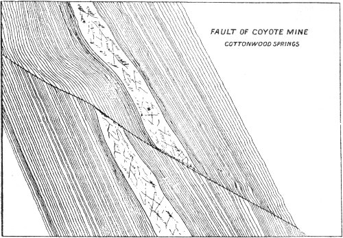
FAULT OF COYOTE MINE
COTTONWOOD SPRINGS
By E. B. Preston, E.M., Assistant in the Field.
The Coahuila Valley, in which Salton Lake is situated, is 90 miles long and from 10 to 30 wide. It separates the San Bernardino range of mountains from the San Jacinto, and forms a part of the great Colorado Desert in San Diego County. In its deepest portions it is 275 feet below the level of the sea; the area of the depressed region is over 1,600 square miles. In its northern portion the valley consists of sandhills and dunes, the former caused by the accumulation of the sand around the 92 scrub and bushes growing in the desert. The southern portion is bare clay. On the borders of the desert palm trees of the fan palm variety occur in a few scattered clusters. The Southern Pacific Railroad passes through the valley on its way to Yuma.
In that part of the depression adjacent to the railroad station of Salton is a salt marsh, where the New Liverpool Salt Company’s works are located, and where a fine quality of table salt is produced, containing, according to an analysis made by Thomas Price, of San Francisco:
| Chloride of sodium | 94.68 per cent. |
| Calcium sulphate | .77 per cent. |
| Magnesium sulphate | 3.12 per cent. |
| Sodium sulphate | .68 per cent. |
| Water | .75 per cent. |
| 100.00 per cent. |
The brine from which the salt is obtained shows a density of 27° Baumé.
The company’s works are situated about 3,000 feet west of the railroad track, and consist of the salt mill and a large storehouse, connected by track with the main line. This branch line extends into the marsh a distance of over 10,000 feet. Beyond the end of the track a borehole was sunk by the company, with the expectation of obtaining water, to a depth of 300 feet, when the work was interrupted.
The strata passed through during the sinking throw some light on the past condition of the desert depression, as well as furnishing some points that may have a bearing on the flooding of this section.
The top covering consists of 6 inches of black mud, resting on a crust of chlorides of sodium and magnesium, 7 inches in thickness. The drill on passing through this crust dropped through 22 feet of a black ooze, containing over 50 per cent of water. Tests of the ooze made at the State Mining Bureau laboratory showed it to consist largely of chlorides and carbonates of sodium and magnesium, the soda salts predominating, besides fine sand, iron oxide, and clay, and a small amount of organic matter. The ooze was resting on a hard clay bottom, through which the drill passed for the entire remaining distance, only varied by two or three streaks of cement. From the shore line of the marsh toward the adjacent mountain ranges, the soil consists of a fine sand, containing clay and a notable quantity of mica, and is strewn with well-preserved shells of Planorbis ammon, Gould, Physa humerosa, Gould, and Amnicola protea, Gould.
In a few spots near the northwest end of the marsh the accumulated cases of a species of Caddice worm are found. Northeast of the marsh the surface slopes gradually upward to where the remains of an ancient sea beach are to be seen, stretching to the south and east to where the Colorado River cuts through on its way to the Gulf of California.
Behind the beach extends a mesa to the foot of the San Bernardino range. Across this mesa are evidences of heavy floods coming down the cañons of the back range, carrying large quantities of debris with them, mostly bowlders of mica schists and granitoid rocks, with some quartz intermixed. On the west side of the marsh the surface has but little elevation until the granitic bluffs of the San Jacinto range are reached. These bluffs are coated for a distance of about 25 feet above the plain with a sponge-shaped incrustation from 2 to 3 inches thick, consisting largely of carbonate of lime, chloride of sodium, sand, clay, and oxide of 93 iron; under the glass some of the pores are seen to contain minute shells of the same varieties as found on the sand of the plain. Where arroyos have been cut through the sands of the plains to the depth of several feet, the exposed sections show a stratified arrangement of the sand, having between the layers a thin division of the same varieties of shells as found on the surface, the whole resting on a firm clay bottom. From the position and regularity, as well as the quantity of these shells, on top of the different strata of sand, while but few are seen scattered through the sand layers, a periodicity of the conditions favorable to their existence and growth, as well as a comparatively sudden cessation of the same, must be inferred. These conditions mean an occasional flooding of the depression for a period of time, during which a shallow body of water was maintained, which evaporated as soon as the water supply was shut off. In what manner this can occur will be shown later on. The plain supports a scant growth of desert shrubs, with some mesquite bushes in the vicinity of the few springs that are found scattered over the desert, most of which are saline. The presence of the extensive line of sea beach proves that at some time the gulf has extended much farther inland than at present, covering the whole of this depression. The Colorado River, in its course south to the ocean, built up a flood plain on a higher level that finally shut off the western part from a direct communication with the sea, and evaporation, with a gradual uplifting of this whole section, finally laid it bare, although leaving a great part of it still below the present sea-level. Under these conditions, whenever more water comes down the river than its banks can contain, the silt-formed shores give way to the increased pressure and permit the excess of water to flow to, and gather in, what is termed the river swamp at the back of the flood plain, from whence it either re-enters the river lower down in its course, or finds its way into the depression.
The Salton Marsh at present acts as the catchment basin for the waters draining from the east side of the San Jacinto range, Carizoo Creek, and a part of the San Bernardino Mountain range, and in times of extreme high waters as a reservoir for the excess in the Colorado River. In the month of June, 1891, a steady flow of water entered the depression from the southeast and continued to the northwest uninterruptedly until an area 30 miles long and averaging 10 miles in width was covered to a depth of 6 feet, measured at the end of the Salton Salt Works branch track. When first examined the water showed a density of 7° Baumé, which gradually increased to 25° Baumé. The mother liquor used in making salt at the New Liverpool works usually shows a density of 27° Baumé. This salt water gave rise to the idea that the waters from the gulf had made an inroad through some underground channel, and to prove the source and possible permanency of these waters several investigating parties were sent out. No such previous incursion had been witnessed by the settlers, but inquiry proved that a similar lake existed here in 1849. Finally one of the parties showed that the Colorado River was the source, and then the question was brought to the attention of the State Mining Bureau to investigate as to the probability of the permanency of the lake and its probable effect on the climate of the surrounding country.
The Colorado in its great length accumulates a large amount of sediment, from 0.1 to 0.4 per cent per gallon, and after this has been 94 deposited the water on evaporation is found to contain 0.14 grammes solid residue, consisting largely of sulphate of soda and chloride of sodium. With the sediment the river is all the time building up its flood plain, and it may not be out of place to recall the general laws that govern the actions of streams while depositing the solid matter they carry in suspension.
Currents bearing sediments deposit a large percentage as soon as their velocity is checked in the least, but pick up deposited sediments again as soon as the current is increased. Thus a variable current is depositing at one point while eroding deposits at other points.
The velocity of a river current varies with the seasons on account of the different volumes of water carried, but it also varies at different points of the river, during the different hours of the day, through the constant action of the laws of erosion and deposition. The banks not furnishing a constant, even resistance, erode in the looser parts, causing each time a deflection of the current, as well as a change in the velocity. This action soon changes a straight stream with an even current, to a serpentine course with currents of different velocities, as the outside of a curve has always greater speed than the inside; consequently the outer edge is eroding while the inner is depositing sediment. The Colorado River, in the lower part of its course from Yuma down, overflows its flood plain, and deposits thereon a certain amount of sediment during every high water. This flood plain extends back for several miles on the west bank, showing a succession of benches or levees running parallel with the stream on a higher level than the back country. The water, when high enough to reach over these benches, gathers in the back part, where it evaporates, leaving a mud that greatly enriches the soil. These levees are the result of the law quoted above, as the water in the regular channel flows swifter than on the flood plain; consequently on the border of the two a large amount of sediment is thrown down. As these border lands are only covered during the highest floods, they maintain a growth of willows and poplars that gives the banks a greater stability, and preserves them to a certain extent from the erosive force of the current.
A source of changes in the direction of the main current is the stranding of logs and tree tops brought down from the upper courses of the river, as the sediment accumulates behind them and forms islands in midstream. Several of these are to be seen in the river channel in passing down the stream.
From soundings made across a section of the river at the railroad bridge at Yuma, the depth was found to vary from 2½ feet to 21 feet. At the meter placed in the main channel the indicator showed a depth of 17 feet.
At ordinary high water, caused by the annual rising of the Gila River, or of the Colorado in its upper reaches, which events usually occur at different seasons of the year, the meter has not been known to show a depth of over 28 feet, but in consequence of a co-equal rise in both streams during the past season, the meter registered over 33 feet. This excess filled the river swamp on the right bank, where the erosive force of the current was most effective.
The course of the river below Yuma for several miles is to the west, until the neighborhood of El Rio station is reached, where sandstone bluffs on the right bank deflect the current back to its general south 95 course. A little back from the river below this point is a small, isolated range of hills, known as Pilot Knob, formed of granite, fissured with seams of dioritic rock. The granite shows lamination, and the surface of the rocks is polished by the constant attrition of the drifting sands. The beach near Pilot Knob is cemented into a calcareous conglomerate, underlaid by sand in a loose state. After resuming its southern course the river for several miles follows a straight reach, until below Hanlon’s Ferry. The tendency of the current to bear more to the right bank shows itself now in the formation of sloughs and inlets that absorb a large proportion of the water and form several islands, shallowing that part of the river that passes down the proper channel.
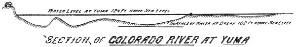
SECTION OF COLORADO RIVER AT YUMA
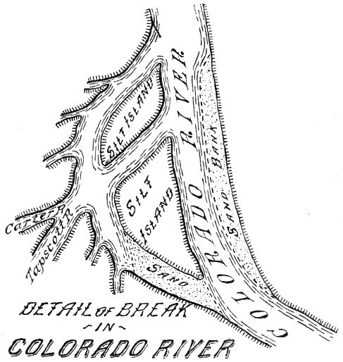
DETAIL OF BREAK
IN
COLORADO RIVER
The accompanying sketch shows the different channels in detail. Formerly the water from these outside channels returned through the bend marked “sand” to the main stream, but at the present time it passes through a crevasse in the bend, marked Tapscott and Carter Rivers, furnishing the largest portion of the water that ultimately found its way into the depression of Salton Lake. During the extreme high water the western bank from El Rio down, which is formed entirely of 96 silt, was broken through in numerous places, and the mostly shallow channels either entered the river again below, or accumulated their waters on the back part of the flood plain, and by following the natural hollows and gullies gradually wound their way in the direction of the old Yuma road. The great force of the current soon cut down below the level of the river bed and relieved in part the congested condition. The grade being gradually to the west, the water cut through the sediment in that direction, partly to the Yuma road, partly farther south parallel to the Rio El Medio, which, judging from analogy, owes its origin to some former similar condition of the river.
Tapscott River may have been formed prior to Carter River, as it has a better defined channel; the latter has no regular channel, but seems to have been caused by the excess of water that could not enter the former, following depressions and sloughs which have no direct connection with one another. At the time these observations were made, the estimated volume of water in the river at the Yuma bridge was about 3,700 cubic feet per second, and at the crevasse forming Tapscott and Carter Rivers, two fifths of the entire volume of water in the river was passing through, but none of it was reaching Salton Lake. Of this two fifths not more than 20 cubic feet per second was running through Carter River.
Beyond Alamo Mocho, which is on the old Yuma road, at the time of the flood, the water flowed into a number of lagoons, and thence into New River, following the old channel that was cut at the time of the 1849 overflow, and thus reaching and forming Salton Lake. All of the water leaving the main river at present finds its way down through the Hardy Colorado back to the Colorado proper, or evaporates.
In the beginning of this article mention was made of a borehole that was sunk by the new Liverpool Salt Company in the salt marsh, and which revealed under a thin crust of mud and salt a depression filled with ooze, composed largely of magnesium and sodium salts. This ooze is probably the final resultant of the evaporations of the former sea water, and which, from the well-known avidity of the magnesian salts for moisture, is kept in this condition of ooze through the natural drainage and seepage waters. This depression may extend beyond the borders of the present marsh toward the gulf, covered over by the sand, and may have some relation with the small so-called mud volcanoes southeast of the lake near the station of Volcano, as well as with some openings in the ground mentioned by one of the gentlemen who investigated these regions between the Colorado River and the lake, and of which he stated that any amount of water running into them did not seem to fill them. Should such a connection exist, the water pouring in from the river would have dissolved the thin salt crust where exposed, and opened a channel, permitting a rapid filling in of the water which formed the lake, for otherwise a body of water running over this light sand and under such a dry, hot temperature would hardly have filled up the depression as rapidly as was the case. Besides, this would explain the reason for the fresh waters of the Colorado River attaining so rapidly a density of over 20° Baumé. Should this supposition prove correct, and it could easily be ascertained by a series of shallow boreholes, it might be expected that every large overflow in the Colorado River in this direction would result in a repetition of Salton Lake.
End of the Project Gutenberg EBook of Old Mines of Southern California, by
California State Mineralogist

*** END OF THIS PROJECT GUTENBERG EBOOK OLD MINES OF SOUTHERN CALIFORNIA ***

***** This file should be named 56478-h.htm or 56478-h.zip *****
This and all associated files of various formats will be found in:
        http://www.gutenberg.org/5/6/4/7/56478/

Produced by Stephen Hutcheson and the Online Distributed
Proofreading Team at http://www.pgdp.net

Updated editions will replace the previous one--the old editions will
be renamed.

Creating the works from print editions not protected by U.S. copyright
law means that no one owns a United States copyright in these works,
so the Foundation (and you!) can copy and distribute it in the United
States without permission and without paying copyright
royalties. Special rules, set forth in the General Terms of Use part
of this license, apply to copying and distributing Project
Gutenberg-tm electronic works to protect the PROJECT GUTENBERG-tm
concept and trademark. Project Gutenberg is a registered trademark,
and may not be used if you charge for the eBooks, unless you receive
specific permission. If you do not charge anything for copies of this
eBook, complying with the rules is very easy. You may use this eBook
for nearly any purpose such as creation of derivative works, reports,
performances and research. They may be modified and printed and given
away--you may do practically ANYTHING in the United States with eBooks
not protected by U.S. copyright law. Redistribution is subject to the
trademark license, especially commercial redistribution.

START: FULL LICENSE

THE FULL PROJECT GUTENBERG LICENSE
PLEASE READ THIS BEFORE YOU DISTRIBUTE OR USE THIS WORK

To protect the Project Gutenberg-tm mission of promoting the free
distribution of electronic works, by using or distributing this work
(or any other work associated in any way with the phrase "Project
Gutenberg"), you agree to comply with all the terms of the Full
Project Gutenberg-tm License available with this file or online at
www.gutenberg.org/license.

Section 1. General Terms of Use and Redistributing Project
Gutenberg-tm electronic works

1.A. By reading or using any part of this Project Gutenberg-tm
electronic work, you indicate that you have read, understand, agree to
and accept all the terms of this license and intellectual property
(trademark/copyright) agreement. If you do not agree to abide by all
the terms of this agreement, you must cease using and return or
destroy all copies of Project Gutenberg-tm electronic works in your
possession. If you paid a fee for obtaining a copy of or access to a
Project Gutenberg-tm electronic work and you do not agree to be bound
by the terms of this agreement, you may obtain a refund from the
person or entity to whom you paid the fee as set forth in paragraph
1.E.8.

1.B. "Project Gutenberg" is a registered trademark. It may only be
used on or associated in any way with an electronic work by people who
agree to be bound by the terms of this agreement. There are a few
things that you can do with most Project Gutenberg-tm electronic works
even without complying with the full terms of this agreement. See
paragraph 1.C below. There are a lot of things you can do with Project
Gutenberg-tm electronic works if you follow the terms of this
agreement and help preserve free future access to Project Gutenberg-tm
electronic works. See paragraph 1.E below.

1.C. The Project Gutenberg Literary Archive Foundation ("the
Foundation" or PGLAF), owns a compilation copyright in the collection
of Project Gutenberg-tm electronic works. Nearly all the individual
works in the collection are in the public domain in the United
States. If an individual work is unprotected by copyright law in the
United States and you are located in the United States, we do not
claim a right to prevent you from copying, distributing, performing,
displaying or creating derivative works based on the work as long as
all references to Project Gutenberg are removed. Of course, we hope
that you will support the Project Gutenberg-tm mission of promoting
free access to electronic works by freely sharing Project Gutenberg-tm
works in compliance with the terms of this agreement for keeping the
Project Gutenberg-tm name associated with the work. You can easily
comply with the terms of this agreement by keeping this work in the
same format with its attached full Project Gutenberg-tm License when
you share it without charge with others.

1.D. The copyright laws of the place where you are located also govern
what you can do with this work. Copyright laws in most countries are
in a constant state of change. If you are outside the United States,
check the laws of your country in addition to the terms of this
agreement before downloading, copying, displaying, performing,
distributing or creating derivative works based on this work or any
other Project Gutenberg-tm work. The Foundation makes no
representations concerning the copyright status of any work in any
country outside the United States.

1.E. Unless you have removed all references to Project Gutenberg:

1.E.1. The following sentence, with active links to, or other
immediate access to, the full Project Gutenberg-tm License must appear
prominently whenever any copy of a Project Gutenberg-tm work (any work
on which the phrase "Project Gutenberg" appears, or with which the
phrase "Project Gutenberg" is associated) is accessed, displayed,
performed, viewed, copied or distributed:

  This eBook is for the use of anyone anywhere in the United States and
  most other parts of the world at no cost and with almost no
  restrictions whatsoever. You may copy it, give it away or re-use it
  under the terms of the Project Gutenberg License included with this
  eBook or online at www.gutenberg.org. If you are not located in the
  United States, you'll have to check the laws of the country where you
  are located before using this ebook.

1.E.2. If an individual Project Gutenberg-tm electronic work is
derived from texts not protected by U.S. copyright law (does not
contain a notice indicating that it is posted with permission of the
copyright holder), the work can be copied and distributed to anyone in
the United States without paying any fees or charges. If you are
redistributing or providing access to a work with the phrase "Project
Gutenberg" associated with or appearing on the work, you must comply
either with the requirements of paragraphs 1.E.1 through 1.E.7 or
obtain permission for the use of the work and the Project Gutenberg-tm
trademark as set forth in paragraphs 1.E.8 or 1.E.9.

1.E.3. If an individual Project Gutenberg-tm electronic work is posted
with the permission of the copyright holder, your use and distribution
must comply with both paragraphs 1.E.1 through 1.E.7 and any
additional terms imposed by the copyright holder. Additional terms
will be linked to the Project Gutenberg-tm License for all works
posted with the permission of the copyright holder found at the
beginning of this work.

1.E.4. Do not unlink or detach or remove the full Project Gutenberg-tm
License terms from this work, or any files containing a part of this
work or any other work associated with Project Gutenberg-tm.

1.E.5. Do not copy, display, perform, distribute or redistribute this
electronic work, or any part of this electronic work, without
prominently displaying the sentence set forth in paragraph 1.E.1 with
active links or immediate access to the full terms of the Project
Gutenberg-tm License.

1.E.6. You may convert to and distribute this work in any binary,
compressed, marked up, nonproprietary or proprietary form, including
any word processing or hypertext form. However, if you provide access
to or distribute copies of a Project Gutenberg-tm work in a format
other than "Plain Vanilla ASCII" or other format used in the official
version posted on the official Project Gutenberg-tm web site
(www.gutenberg.org), you must, at no additional cost, fee or expense
to the user, provide a copy, a means of exporting a copy, or a means
of obtaining a copy upon request, of the work in its original "Plain
Vanilla ASCII" or other form. Any alternate format must include the
full Project Gutenberg-tm License as specified in paragraph 1.E.1.

1.E.7. Do not charge a fee for access to, viewing, displaying,
performing, copying or distributing any Project Gutenberg-tm works
unless you comply with paragraph 1.E.8 or 1.E.9.

1.E.8. You may charge a reasonable fee for copies of or providing
access to or distributing Project Gutenberg-tm electronic works
provided that

* You pay a royalty fee of 20% of the gross profits you derive from
  the use of Project Gutenberg-tm works calculated using the method
  you already use to calculate your applicable taxes. The fee is owed
  to the owner of the Project Gutenberg-tm trademark, but he has
  agreed to donate royalties under this paragraph to the Project
  Gutenberg Literary Archive Foundation. Royalty payments must be paid
  within 60 days following each date on which you prepare (or are
  legally required to prepare) your periodic tax returns. Royalty
  payments should be clearly marked as such and sent to the Project
  Gutenberg Literary Archive Foundation at the address specified in
  Section 4, "Information about donations to the Project Gutenberg
  Literary Archive Foundation."

* You provide a full refund of any money paid by a user who notifies
  you in writing (or by e-mail) within 30 days of receipt that s/he
  does not agree to the terms of the full Project Gutenberg-tm
  License. You must require such a user to return or destroy all
  copies of the works possessed in a physical medium and discontinue
  all use of and all access to other copies of Project Gutenberg-tm
  works.

* You provide, in accordance with paragraph 1.F.3, a full refund of
  any money paid for a work or a replacement copy, if a defect in the
  electronic work is discovered and reported to you within 90 days of
  receipt of the work.

* You comply with all other terms of this agreement for free
  distribution of Project Gutenberg-tm works.

1.E.9. If you wish to charge a fee or distribute a Project
Gutenberg-tm electronic work or group of works on different terms than
are set forth in this agreement, you must obtain permission in writing
from both the Project Gutenberg Literary Archive Foundation and The
Project Gutenberg Trademark LLC, the owner of the Project Gutenberg-tm
trademark. Contact the Foundation as set forth in Section 3 below.

1.F.

1.F.1. Project Gutenberg volunteers and employees expend considerable
effort to identify, do copyright research on, transcribe and proofread
works not protected by U.S. copyright law in creating the Project
Gutenberg-tm collection. Despite these efforts, Project Gutenberg-tm
electronic works, and the medium on which they may be stored, may
contain "Defects," such as, but not limited to, incomplete, inaccurate
or corrupt data, transcription errors, a copyright or other
intellectual property infringement, a defective or damaged disk or
other medium, a computer virus, or computer codes that damage or
cannot be read by your equipment.

1.F.2. LIMITED WARRANTY, DISCLAIMER OF DAMAGES - Except for the "Right
of Replacement or Refund" described in paragraph 1.F.3, the Project
Gutenberg Literary Archive Foundation, the owner of the Project
Gutenberg-tm trademark, and any other party distributing a Project
Gutenberg-tm electronic work under this agreement, disclaim all
liability to you for damages, costs and expenses, including legal
fees. YOU AGREE THAT YOU HAVE NO REMEDIES FOR NEGLIGENCE, STRICT
LIABILITY, BREACH OF WARRANTY OR BREACH OF CONTRACT EXCEPT THOSE
PROVIDED IN PARAGRAPH 1.F.3. YOU AGREE THAT THE FOUNDATION, THE
TRADEMARK OWNER, AND ANY DISTRIBUTOR UNDER THIS AGREEMENT WILL NOT BE
LIABLE TO YOU FOR ACTUAL, DIRECT, INDIRECT, CONSEQUENTIAL, PUNITIVE OR
INCIDENTAL DAMAGES EVEN IF YOU GIVE NOTICE OF THE POSSIBILITY OF SUCH
DAMAGE.

1.F.3. LIMITED RIGHT OF REPLACEMENT OR REFUND - If you discover a
defect in this electronic work within 90 days of receiving it, you can
receive a refund of the money (if any) you paid for it by sending a
written explanation to the person you received the work from. If you
received the work on a physical medium, you must return the medium
with your written explanation. The person or entity that provided you
with the defective work may elect to provide a replacement copy in
lieu of a refund. If you received the work electronically, the person
or entity providing it to you may choose to give you a second
opportunity to receive the work electronically in lieu of a refund. If
the second copy is also defective, you may demand a refund in writing
without further opportunities to fix the problem.

1.F.4. Except for the limited right of replacement or refund set forth
in paragraph 1.F.3, this work is provided to you 'AS-IS', WITH NO
OTHER WARRANTIES OF ANY KIND, EXPRESS OR IMPLIED, INCLUDING BUT NOT
LIMITED TO WARRANTIES OF MERCHANTABILITY OR FITNESS FOR ANY PURPOSE.

1.F.5. Some states do not allow disclaimers of certain implied
warranties or the exclusion or limitation of certain types of
damages. If any disclaimer or limitation set forth in this agreement
violates the law of the state applicable to this agreement, the
agreement shall be interpreted to make the maximum disclaimer or
limitation permitted by the applicable state law. The invalidity or
unenforceability of any provision of this agreement shall not void the
remaining provisions.

1.F.6. INDEMNITY - You agree to indemnify and hold the Foundation, the
trademark owner, any agent or employee of the Foundation, anyone
providing copies of Project Gutenberg-tm electronic works in
accordance with this agreement, and any volunteers associated with the
production, promotion and distribution of Project Gutenberg-tm
electronic works, harmless from all liability, costs and expenses,
including legal fees, that arise directly or indirectly from any of
the following which you do or cause to occur: (a) distribution of this
or any Project Gutenberg-tm work, (b) alteration, modification, or
additions or deletions to any Project Gutenberg-tm work, and (c) any
Defect you cause.

Section 2. Information about the Mission of Project Gutenberg-tm

Project Gutenberg-tm is synonymous with the free distribution of
electronic works in formats readable by the widest variety of
computers including obsolete, old, middle-aged and new computers. It
exists because of the efforts of hundreds of volunteers and donations
from people in all walks of life.

Volunteers and financial support to provide volunteers with the
assistance they need are critical to reaching Project Gutenberg-tm's
goals and ensuring that the Project Gutenberg-tm collection will
remain freely available for generations to come. In 2001, the Project
Gutenberg Literary Archive Foundation was created to provide a secure
and permanent future for Project Gutenberg-tm and future
generations. To learn more about the Project Gutenberg Literary
Archive Foundation and how your efforts and donations can help, see
Sections 3 and 4 and the Foundation information page at
www.gutenberg.org


Section 3. Information about the Project Gutenberg Literary Archive Foundation

The Project Gutenberg Literary Archive Foundation is a non profit
501(c)(3) educational corporation organized under the laws of the
state of Mississippi and granted tax exempt status by the Internal
Revenue Service. The Foundation's EIN or federal tax identification
number is 64-6221541. Contributions to the Project Gutenberg Literary
Archive Foundation are tax deductible to the full extent permitted by
U.S. federal laws and your state's laws.

The Foundation's principal office is in Fairbanks, Alaska, with the
mailing address: PO Box 750175, Fairbanks, AK 99775, but its
volunteers and employees are scattered throughout numerous
locations. Its business office is located at 809 North 1500 West, Salt
Lake City, UT 84116, (801) 596-1887. Email contact links and up to
date contact information can be found at the Foundation's web site and
official page at www.gutenberg.org/contact

For additional contact information:

    Dr. Gregory B. Newby
    Chief Executive and Director
    gbnewby@pglaf.org

Section 4. Information about Donations to the Project Gutenberg
Literary Archive Foundation

Project Gutenberg-tm depends upon and cannot survive without wide
spread public support and donations to carry out its mission of
increasing the number of public domain and licensed works that can be
freely distributed in machine readable form accessible by the widest
array of equipment including outdated equipment. Many small donations
($1 to $5,000) are particularly important to maintaining tax exempt
status with the IRS.

The Foundation is committed to complying with the laws regulating
charities and charitable donations in all 50 states of the United
States. Compliance requirements are not uniform and it takes a
considerable effort, much paperwork and many fees to meet and keep up
with these requirements. We do not solicit donations in locations
where we have not received written confirmation of compliance. To SEND
DONATIONS or determine the status of compliance for any particular
state visit www.gutenberg.org/donate

While we cannot and do not solicit contributions from states where we
have not met the solicitation requirements, we know of no prohibition
against accepting unsolicited donations from donors in such states who
approach us with offers to donate.

International donations are gratefully accepted, but we cannot make
any statements concerning tax treatment of donations received from
outside the United States. U.S. laws alone swamp our small staff.

Please check the Project Gutenberg Web pages for current donation
methods and addresses. Donations are accepted in a number of other
ways including checks, online payments and credit card donations. To
donate, please visit: www.gutenberg.org/donate

Section 5. General Information About Project Gutenberg-tm electronic works.

Professor Michael S. Hart was the originator of the Project
Gutenberg-tm concept of a library of electronic works that could be
freely shared with anyone. For forty years, he produced and
distributed Project Gutenberg-tm eBooks with only a loose network of
volunteer support.

Project Gutenberg-tm eBooks are often created from several printed
editions, all of which are confirmed as not protected by copyright in
the U.S. unless a copyright notice is included. Thus, we do not
necessarily keep eBooks in compliance with any particular paper
edition.

Most people start at our Web site which has the main PG search
facility: www.gutenberg.org

This Web site includes information about Project Gutenberg-tm,
including how to make donations to the Project Gutenberg Literary
Archive Foundation, how to help produce our new eBooks, and how to
subscribe to our email newsletter to hear about new eBooks.