The Project Gutenberg EBook of Armenia (Volume 2 of 2), by H. F. B. Lynch

This eBook is for the use of anyone anywhere in the United States and most
other parts of the world at no cost and with almost no restrictions
whatsoever.  You may copy it, give it away or re-use it under the terms of
the Project Gutenberg License included with this eBook or online at
www.gutenberg.org.  If you are not located in the United States, you'll have
to check the laws of the country where you are located before using this ebook.

Title: Armenia (Volume 2 of 2)
       Travels and Studies

Author: H. F. B. Lynch

Release Date: November 21, 2016 [EBook #53568]

Language: English

Character set encoding: ASCII

*** START OF THIS PROJECT GUTENBERG EBOOK ARMENIA (VOLUME 2 OF 2) ***


Produced by Jeroen Hellingman and the Online Distributed
Proofreading Team at http://www.pgdp.net/ for Project
Gutenberg (This file was produced from images generously
made available by The Internet Archive/American Libraries.)


[Contents]

Newly Designed Front Cover.

[Contents]

Original Title Page.

[Contents]

ARMENIA

TRAVELS AND STUDIES

VOL. II

[Contents]

Lake Van with Sipan from Artemid.

Lake Van with Sipan from Artemid.

Frontispiece, Vol. II.

ARMENIA
Travels and Studies

Nature’s vast frame, the web of human things.

Shelley, Alastor.

Who can foretell our future? Spare me the attempt. We are like a harvest reaped by bad husbandmen amidst encircling gloom and cloud.

John Katholikos
Armenian historian of the Xth century Ch. CLXXXVII.

LONGMANS, GREEN, AND CO.
LONDON: 39 PATERNOSTER ROW
NEW YORK AND BOMBAY
1901

[v]

[Contents]

CONTENTS

CHAPTER I        PAGE

Descend into Turkish Territory        1

CHAPTER II

To Lake Van        11

CHAPTER III

Across Lake Van        25

CHAPTER IV

Van        38

CHAPTER V

From Van to Bitlis        116

CHAPTER VI

Bitlis        145

CHAPTER VII

From Bitlis to Mush—Mush        160

CHAPTER VIII

From Mush to Erzerum        174

CHAPTER IX

Erzerum        198 [vi]

CHAPTER X

Return to the Border RangesΘάλαττα, θάλαττα!        225

CHAPTER XI

Revisit Armenia        237

CHAPTER XII

Across the Central Tableland to Khinis        245

CHAPTER XIII

From Khinis to Tutakh        254

CHAPTER XIV

Down the Murad to Melazkert        264

CHAPTER XV

From Melazkert to Akhlat        276

CHAPTER XVI

Akhlat        280

CHAPTER XVII

Our Sojourn in the Crater of Nimrud        298

CHAPTER XVIII

Round Nimrud by Lake Nazik        314

CHAPTER XIX

Ascent of Sipan        326

CHAPTER XX

Back to the Central Tableland        340

CHAPTER XXI

Our Sojourn on Bingöl        359 [vii]

CHAPTER XXII

Home across the Border Ranges        379

CHAPTER XXIII

Geographical        383

CHAPTER XXIV

Statistical and Political        408

APPENDIX I

National Constitution of the Armenians in the Turkish Empire        445

APPENDIX II

Chemical Constitution of some Armenian Lakes        468

BIBLIOGRAPHY        471

INDEX        497 [ix]

[Contents]

LIST OF PLATES

[Contents]

ILLUSTRATIONS IN THE TEXT

[xii]

[Contents]

LIST OF MAPS AND PLANS

[1]

[Contents]

CHAPTER I

DESCEND INTO TURKISH TERRITORY

October 24.—The track which we were following winds for some distance along the spine of the range. You cross and cross again from the one to the other watershed, overlooking now the open spaces of the southern landscape, now the narrow and encumbered cañon of the Araxes below the adjacent cliffs of the tableland. The rocky parapets and gloomy valleys appear to extend from basin to basin, at right angles to the axis of the chain. West of the crags about us, and isolated from them, rose a shapely mass with black but snow-streaked sides. Darkness was falling when we descended from this lofty position into one of the valleys of the southern slopes. In its recesses we came upon a little Kurdish settlement, which seemed to promise shelter during the night.

Kurtler—Kurds! No sooner have we crossed the frontier than we find ourselves in their midst. The mountains of Kurdistan are more than 100 miles distant; yet these parasites fasten upon the countryside. Still their presence is appropriate and is not unwelcome, so long as they are confined to alpine solitudes like those which surround the village of Chat. Tufts of grass, interspersed with an endless crop of stones, were the only pasture which we had seen for some time. Yet the shepherds were in possession of a considerable stock of hay, against the approach of a winter season which can scarcely lack rigour at an elevation of 6700 feet above the sea. Their habitations just protrude above the level of the ground; and, once within the doorway, you proceed through narrow passages into the very bowels of the earth. In the darkness you stumble upon the forms of cattle or wake a ragged child. We took up [2]our quarters in one of the largest of the subterranean chambers, lit our candles, and spread our carpet on the bare soil. We were surprised to discover that the roof of the apartment was artificial—layers of mud and straw, held together by laths of wood, and supported by huge beams. The walls, too, were built up of rough stones, plastered together; it was evident that the room was only three-parts buried, and that it communicated directly with the outer air. In fact we could see an aperture, the rude counterpart of a window, above the opening to the winding passage through which we had come. On the side opposite this only entrance a square hole in the face of the wall nourished a smouldering fire. The smoke wreathed upwards to a vent in the roof, or was sucked inwards towards the tunnelled approach.

When morning broke we were glad to issue from the fetid atmosphere of this human burrow into the pure mountain air. A few gaunt figures were standing upon the higher stages of the eminence which had provided a suitable site for these underground operations, and which rose like a large ant-hill from the waste of stone. Women squatted before the doors of the straggling tenements, weaving the bright rugs for which their race is famed. We proceeded down the glen, along the banks of a little stream. It finds an easy exit from the heart of the mountains, threading the trough of one of the meridional valleys. After riding for an hour and a half, we opened out the southern landscape from some high ground above the village of Amat (Fig. 108).

Ala Dagh Murad (invisible) Passage of Murad Kilich Gedik
Fig. 108. Plain of Alashkert from the Slopes of Aghri Dagh.

Fig. 108. Plain of Alashkert from the Slopes of Aghri Dagh.

The great plain of Alashkert was outspread before us, bounded on the further side by the snow-capped mountains of the Ala Dagh, which stretched across the horizon from the east. Just before us, this lofty range was seen to recede into the misty background, the outlines bending away towards south-west. But the barrier was resumed at no considerable interval by a chain of hills, less distant, although of humbler proportions, called Kilich Gedik, or the sharp sword. We could just descry the site of Karakilisa, backed by the recess of the Ala Dagh. We knew that the Murad must be flowing through that nebulous passage in the opposite bulwark of the plain. The surface of the ground below us was level as water; the expanse was greatest in the west. In that direction the spurs of the range upon which we stood plunged by a succession of promontories into the floor of the plain. We were reminded of the valley of the Araxes in the [3]neighbourhood of Erivan. Both depressions have the appearance of inland seas at the foot of the mountains, the one on the northern, the other on the southern side. But that of Alashkert is much more elevated (5500 feet), and less sheltered; you miss the presence of those extensive stretches of orchard and verdure which soften the landscape through which the Araxes flows. The eye wanders out over dim, ochreous tracts, broken by patches of fallow, and seamed by white rivulets. Just below the Armenian settlement we reached the margin of the level ground, and cantered along, almost on a compass course. We saw several insignificant villages; but the district was wild, the soil for the most part unreclaimed. Flocks of duck and geese took wing at our approach; cranes, with their long necks, sailed across the sky. In the course of an hour and a half we reached the street of Karakilisa, a distance from Amat, measured direct, of 9 miles.

A motley crowd collected round us as we enquired for the government quarters; a hundred curious faces were upturned towards us, and our ears were greeted with the cry of Ferengi! Ferengi! passed like a shuttlecock from mouth to mouth. The little town was full of stir; new shops and houses were in course of erection; it was evident that trade and traffic were on the increase. We had almost crossed it from end to end, when we were ushered into a modest building, of which the hall or outer chamber was thronged with people, for the most part peasants; while an old servitor or usher, with white beard and a flowing robe, was marshalling the rows of slippers by the threshold of an inner door. At our approach he drew aside the quilted curtain which screened this sanctuary, and turned the handle and bade us pass within. The low divan, which on three sides followed the walls of the apartment, was already occupied by a full complement of seated figures; they appeared to be engaged in deliberation when we broke in upon their séance. A little man with vivacious eyes was directing the conversation; he sat on the only chair behind a table covered with faded baize. Although we could scarcely doubt that our arrival had been announced beforehand, we seemed to take these notables by surprise. The little man rose from his chair; the assembly huddled together in order to give us place on the divan. Compliments were exchanged; coffee and cigarettes were provided; the discussion was adjourned by tacit consent. One by one, after satisfying without displaying their curiosity, the councillors stole from the room.

Fig. 109. Group of Kurd Hamidiyeh Cavalry.

Fig. 109. Group of Kurd Hamidiyeh Cavalry.

[4]

Meanwhile the figure at the table—it was the Kaimakam, or district governor—had examined our numerous and weighty credentials, and had directed a billet to be provided and prepared. Our effects, which arrived later, were not subjected to examination; no excisemen or policemen dogged our steps. Such officials are almost unknown in this happy country! so we reflected with a sense of immense relief. The way they worry the people in the neighbouring empire passes the capacity of the uninitiated to realise. The Greek poet was certainly wrong when he gave expression to the sentiment that anarchy is the greatest of human ills. Here we were, enlightened observers, exchanging order for disorder with rapturous delight! We were free to wander as we willed, to enjoy a British liberty without so much as the restraint of roads and walls. Coming from Russia, the contrast was indeed startling; independence is far preferable to feeling reasonably certain that you will not be knocked on the head by a Kurd.

The Kaimakam escorted us to the adjacent barracks, in which a whitewashed room had been made ready to receive us. It belonged to the quarters of the superior officer—with the rank of Miralai—a Turk of great stature and broad shoulders, to whom we were introduced. He wore a dark blue military tunic of European pattern and material; but he had forgotten to fasten the lower buttons of this imposing garment, as well as the upper ones of the trousers beneath. His mouth and ears and nostrils were of unusual proportions; the expression of the face was kind, and denoted a childlike, buoyant nature—de bonne bête humaine, as one might say. In him we found an agreeable and a sensible companion. He bustled about the place, was accustomed to shave each Friday; he settled every difficulty with eh, wallah! accompanied by a hearty laugh. From time to time the troops were visited by the Liva, or commandant, an aged figure with a beard of snow. He had been at Plevna, and had made the campaign of Bulgaria; but nothing remained of him now but a worn-out body, made doubly infirm by an inveterate habit of getting drunk.

The peculiar care and constant plague of these high officials were the newly-enrolled regiments which, under the name of Hamidiyeh, flatter the vanity but sap the throne of the reigning Sultan. Am I guilty of indiscretion when I say that the prevailing opinion of them in official circles is one of contempt, not [5]unmixed with alarm? Your high-placed Turk will quote at their expense his favourite proverb, the fish begins to stink from the head. The young men are the sons of their fathers, who are Kurds and brigands; the example of the fathers is transmitted to the sons. Something might be done, if the process were arrested—if the recruits were removed from their homes. When I objected that the Tsar’s Cossacks presented in some respects a hopeful analogy, I would be met by the reply that the Russian autocrat employed strong measures, the like of which the Turkish Government was too mild to enforce.

Fig. 110. Group of Karapapakh Hamidiyeh Cavalry.

Fig. 110. Group of Karapapakh Hamidiyeh Cavalry.

Perhaps my reader is already aware that the Hamidiyeh are irregular cavalry, who owe their origin to the endeavour of the Sultan Abdul Hamid to emulate the example which gave to Russia her Cossack troops. They are recruited for the most part among the Kurdish tribes; the name of yeomanry expresses the nature of their military service, but cannot be applied to the class to which they belong. The force is still undergoing the initial process of organisation. At the time of our journey it afforded the principal topic of conversation. Yuzbashis, or sergeants, of the regular army were being poured into the country, and distributed among the villages, to instil into the shepherds the rudiments of drill. Depots of arms were being established in convenient centres; and it was the intention of the authorities to keep the weapons under lock and key, except when they should be required for the annual trainings in spring. Hundreds and thousands of suits of uniform were arriving in the principal towns, loaded on bullock carts. Each regiment had been allowed to exercise its own fancy upon the choice of a distinctive garb. The result was an incongruous mixture of the braids and gold lace of Europe with the Georgian finery of a serried row of silvered cartridge cases, banded across the breast of a skirted coat. How proud they seemed, and how insensible of their ridiculous appearance in our eyes—the long-beaked Kurds, the swarthy Karapapakhs, masquerading down the street of Karakilisa in these strange creations of the tailors of Pera or Stambul! They did not require pressing to consent to be photographed—a group of Kurds (Fig. 109), a group of Karapapakhs (Fig. 110). Some of the principal officers of either regiment are represented in my illustrations; and I would beg my reader to observe the seated Kurd in the Georgian dress—it is Eyub Pasha with his son and nephew. Behind him stands [6]his principal henchman, who, although a Kurd, has seen service with regular troops.

In the caza, or administrative subdivision, of Karakilisa three regiments of Hamidiyeh have been enrolled. Two are recruited from Kurds of the Zilanli tribe; the third from Karapapakhs. This people—who take their name from their caps of black lambskin—are found on either side of the Russo-Turkish frontier, and are no doubt related to the Tartars of Azerbaijan. The Kaimakam informed me—but I question whether his statement, even if true, can apply to more than a small number—that the fathers of those among them who inhabit this district were followers of the famous Shamyl. According to his account they were at that time settled in Daghestan, whence they removed to their present seats. He added that their villages were 8 in number in this caza; that their regiment had a strength of 800 men; and that they had branded no less than 650 horses with the military mark. Their chief, Ali Bey, is a man of hideous features, whom we recognised as the same individual who had been seated in the place of honour, when we broke in upon the deliberations of the Kaimakam. I now learnt the purport of their lively discussion; it had been a question of fixing a price for grain. Months ago Ali Bey had made a contract with the Kaimakam to supply the cereal for Government purposes at a stated price. The time had just arrived for delivering it into the granaries; but the price had risen, almost to famine rates. In the drawer of the green baize table was securely buried the precious document, behind a lock of which alone the Kaimakam possessed the key. How great was the dismay of the wretched official to find that it had been abstracted, and to recognise that the robbery might cost him his place! His despoiler felt quite safe behind his Hamidiyeh uniform and his paper figures of 800 men-at-arms.

But the Kaimakam was not the man to go to sleep beneath an injury; he possessed both energy and brains. He and the Miralai would each evening repair to our quarters, and discuss the events of the day over coffee and pipes. On one occasion, in company with the Miralai, we had awaited to a late hour the arrival of the Kaimakam. When at last he made his appearance, his clothes were covered with dust and he was wearing his long top-boots. His eyes were bright with excitement as he narrated in vivid language the story of his day’s work. Kurds from Lake [7]Balük had made a foray into his district, and had plundered the village of Mangasar, inhabited in equal numbers by Armenians and Mussulmans. He had proceeded in person to the scene of their depredations, and at the head of his motley followers had forced them to retire after a sanguinary fight. What was the origin of this man whose animated face and supple character contrasted strangely with the wooden figures of officers and notables who attended his divan? He told me he was an Albanian; he was, of course, a Mohammedan; but his whole appearance stamped him a Greek. Compared with Kurds like Eyub Pasha, with their resemblance to big birds, he stood on the opposite pole of human development. Although in point of years the youngest of the group, he led them all by the nose. A situation had scarcely been stated when he had already discovered the solution; he shared the feelings as well as the thoughts of the individual to whom he was lending his ear. I have no doubt that he was far the superior of Ali Bey in the successful practice of every kind of deceit. He professed himself my friend; I am sure he took a pleasure in abusing the confidence which I was obliged to affect. We had almost exhausted our stock of money when we arrived in Karakilisa; between us and the town of Van, where we might hope to replenish it, lay the wildest districts of Asiatic Turkey. Semi-civilised communications are entirely wanting in those regions; it was even impossible to hire a caravan. It was necessary to purchase horses; three days were consumed in finding the animals; having selected four, at an average price of £6 apiece, we were without funds to defray our expenses in the town. The Kaimakam might no doubt have advanced the few pounds in perfect safety; but he had cast longing eyes upon my gun. Alleging that he had already spent the last instalment of his allowance, he insisted that the usurers, who would supply him with the money, required that I should leave the weapon in his charge. It was arranged that, the moment the debt had been recovered, he would despatch the valuable pledge to Erzerum. No sooner had we reached Van than I contrived to send him the amount by way of Bayazid. Weeks later, upon my arrival in the capital of his provincial government, the gun had not yet come to hand. The Vali, or Governor-General, was recently dead; no successor had been appointed; the fact that I was an Englishman was scarcely worth recalling to the petty authorities, daily witnesses of the feebleness [8]of the British Government, and full of contempt for the British Power. When my property was at last restored to me through the good offices of Mr. Graves, the whole winter and part of the spring had gone by. The Kaimakam had wreaked his revenge; the weapon came in broken pieces, and the barrels bore the marks of heavy blows.

Fig. 111. Caravan on the Black Sea—Tabriz Trade Route.

Fig. 111. Caravan on the Black Sea—Tabriz Trade Route.

I was unable to ascertain with any accuracy the number of the inhabitants, whether of the district or of the town. The Kaimakam, although extremely communicative on other subjects, professed to have been forbidden to make them known. According to the most recent official statistics, the caza contains no less than 58 villages, and possesses a population of 5377 Mohammedans and 1902 Armenians. For the town in particular I have not had access to any information; but I should judge that the residents might be put down at 1500 to 2000, of whom the Armenians would be nearly two-thirds. With the exception of the shops, the houses are in general little better than the usual village tenements, half buried beneath the ground. But Karakilisa is increasing in importance day by day, being situated on the great avenue of communication between Persia and the Black Sea. Strings of camels, with their finery of coloured tassels, were continually passing at a stone’s throw from our door (Fig. 111). They were bearing the multitudinous wares of Europe for distribution among the Eastern bazars. They proceed by way of Trebizond, Erzerum, and Bayazid to the city of Tabriz. The place has also the advantage of being both a military and an administrative centre; there is always something going on. The [9]fashionable amusement of the day were the Hamidiyeh. A luxurious coffee-house had just been built for their delectation; their name was on every tongue.

It was whispered in fear and terror by the poor Armenians. I visited their bishop, and found him in a state of blank despair. He was afraid to receive me, and sent me excuses—which, however, I refused to accept. After some parley with intermediaries he made his appearance—a stout figure, a thick-lipped, common face. He refused to listen to the simple questions which I addressed to him, and burst out into abuse. Europe, and especially England, had played the part of swindlers towards his miserable race. Their hopes had been incited by delusive professions, which had only served to alarm the Sultan and let loose the Kurds. Nor could they look to Russia, the arch-offender, fanning the agitation for ends of her own. The poor man continued in this strain until he was nearly beside himself; I was obliged to leave him to his rage. His diocese embraces the districts between Zeidikan and Bayazid, and extends southwards to the borders of the vilayet, or Government, of Van. His church at Karakilisa is little better than four stone walls. An ignorant priest imparts instruction in a wretched little building which can scarcely be dignified by the name of school.

Fig. 112. The Kuseh Dagh from the Plain of Alashkert.

Fig. 112. The Kuseh Dagh from the Plain of Alashkert.

One afternoon we made an excursion to the point where the Murad changes direction, and flows through the gap towards the south. Between the barracks in which we were lodged, on the extreme outskirts of Karakilisa, and the river, flowing placidly over the plain, there extends a considerable tract of marshy ground and low covert, the home of plover and innumerable water-birds. We crossed a stream which, coming from Aghri Dagh, passes just beneath the barracks to join the Murad a little further west (Kör Su), and made across the marsh in the direction of a little Armenian village which stands on the left bank of the principal body of water, almost due south of the town. Just below this settlement, called Küp Keran, we forded the Murad, which was winding at the foot of a gentle eminence of the southern border through a pebbly and many-channelled bed. Either shore was quite a museum of living wildfowl; in especial we admired a beautiful species of golden duck of which the wings were flaked with white bands. Avoiding the swamp on the opposite margin, we followed this bank for some distance: and a little later [10]crossed back to the northern side. About a mile and a half below Küp Keran the river describes a beautiful curve, and enters the spacious passage of the hills. It is pushed southwards by rising ground at the base of the Kilich Gedik barrier; but the higher outlines of that range, as well as those of the snowy Ala Dagh in the east, are several miles removed from its shores. It flows towards grassy hills, among which you lose the silver thread which the eye has followed as far as a village, named Dombat. The breadth of the Murad at the bend, where its errant waters had issued from the marsh, did not appear to us to exceed thirty yards. The intense stillness of the scene was in harmony with the quiet sunset which shed radiance over mountain, river, and plain. From the lofty bulwark of the northern chain, beyond the lake-like surface of the steppe, rose the form of a single summit, overtowering its neighbours—the shapely dome of the Kuseh Dagh (Fig. 112). The fantastic profile of the system was drawn across the horizon in hues of opal to the far east. In that direction we could clearly see the magnificent bastions of Ararat, mounting the sky behind these heights. The snowfields were flushed with a delicate madder; we noticed that from this side they appear to gather to a single peak, the eminence upon which we had stood. We remarked the convex modelling of the lower slopes of the system along the opposite margin of the plain. A shorter way was shown us for the return to Karakilisa (Fig. 113), which leaves the river and crosses the head of the marsh.

Fig. 113. Karakilisa from South-West.

Fig. 113. Karakilisa from South-West.

[11]

[Contents]

CHAPTER II

TO LAKE VAN

The principal artery of traffic in Turkish Armenia crosses the land from west to east. It follows the direction of a series of depressions: the plains of Erzerum, of Pasin and of Alashkert. It consists of a carriageable track, or rough road of unequal quality. The bulk of the transit trade between Europe and northern Persia is conveyed on the backs of camels along this route. The wall of protective duties which has been reared by the Russian Government compels this commerce to flow through a Turkish port and to adhere to Turkish soil. It has been stimulated by the efforts of a series of British consuls, resident at Erzerum. Robberies have been punished with great severity; and, at the present day, the traffic is seldom, if ever, interrupted, although it passes through the Kurd-inhabited districts about Bayazid, and the lawless border of the Persian and Turkish empires.

South of this beaten avenue are situated regions which, in spite of the researches of individual travellers, are still but imperfectly known. The lake of Van remains a centre of agriculture and primitive industry; yet it lies beyond a zone of feebly governed country which, year by year, is becoming more difficult to cross. The pest of Kurds has settled firmly upon these richly favoured territories, destroying agriculture and banishing trade. What caravans there are travel in large bodies, and every man is armed to the teeth. Between Erzerum and the town of Van they choose between two routes according to the season of the year. In summer they cross the mountains behind the northern capital, and proceed by the plain of Khinis, crossing the Murad at Melazkert. During winter they make the round by way of Pasin and Alashkert, deviating on the [12]confines of the latter district, and passing the river at Tutakh. The approach through the town of Mush is used only once a year, when the pilgrims journey from Erzerum to the cloister of Surb Karapet. On that occasion the caravan, according to my informants, continues its course as far as Van. By the two first routes it is usual to follow the eastern shore of the lake, which is reached near the little town of Akantz.1

We set out from Karakilisa on October the 29th, mounted on our newly-purchased horses, and accompanied by a zaptieh or gendarme. Our objective was this same Akantz; the principal intermediate stations were Tutakh and Patnotz. I had thought it possible to accomplish the ride in the course of two days; our friends laughed at the idea. I decided therefore to start in the afternoon, with the hope of arriving on the evening of the third day. At a quarter-past three o’clock we were making our way along the marsh to the point where the Murad leaves the plain. After reaching the bend, we proceeded down the passage which receives the river, towards Dombat and the grassy hills which I have already mentioned. On our left hand, at an interval of about 500 yards from the left bank, rose the first gentle slopes of the Ala Dagh system; this high land was answered on the right bank, at about a similar distance, by the outworks of the Kilich Gedik. The Murad pursues its course between these two blocks of mountain, and, a little lower down, forces its way through the narrowing gap. Near Dombat both banks are of considerable elevation, and the ridges appear to cross the direction of the stream. Before arriving opposite the village we crossed the Sharian Su, a tributary which collects the drainage of the western portion of the plain, and which appeared to us to have a volume scarcely less than that of the principal branch.

After passing Dombat—which was said to be inhabited by Kizilbashes—we sank to a valley in which is situated the Kurdish village of Zado, and ascended the ridge on its opposite [13]side. From the summit we commanded a prospect towards Karakilisa, and were impressed by the serpentine course of the river, flowing towards us in a pebbly bed which it threaded by several channels. We were placed at a height of some 250 feet above its waters. On a hillside further south we could now discern our evening station, the little village of Avdi. It was signalised by a green patch, due to vegetable gardens; its surroundings were bleak and bare. Arriving at half-past five, we selected the best of the fifteen tenements as quarters for the night. We were surprised to find a sergeant of the regular army established in this miserable place. He had come to recruit Kurds for the Hamidiyeh, and bitterly cursed his fate.

Next morning we were anxious to reach Tutakh before mid-day in order to pass the night at Patnotz. At a quarter to eight we were in the saddle; it had rained during the night, and heavy clouds hung over the hills. As we rose up the slope, we caught glimpses of the mountains which bound the plain of Alashkert upon the north. The plain itself had long been lost; we were at some distance from the river; we looked across high hills, which engulfed the invisible waters, to the summits of the Ala Dagh. The doubtful track commenced to wind between grassy slopes, strewn with boulders—a belt of country well adapted to guerilla warfare, and reputed the favourite haunt of Kurdish robbers. Horsemen would no doubt be completely at their mercy in the blind recesses of these irregular valleys. At a quarter to nine we approached the Murad, still high above it; the hills rose from either bank. In another half hour we obtained our first view of the cone of Sipan, a gleaming object in the south. Some two miles further the landscape opened, and assumed the character of a vast steppe of broken and uneven ground. Distant ranges encircled the expanse with dim outlines; Sipan alone was clearly defined against the sky. From the Kurdish village of Köshk we obtained a fine view over this country, with its waving surface featured by shadows from the clouds. We had got behind the barrier of the Kilich Gedik; and the whole segment of the circle from north-west to south-west was filled by comparatively level land. We observed a prominent shape in the mountains of the furthest distance, which we identified with the Khamur Dagh. Beyond the Mussulman village of Okhan, the river, which had left us, took a sharp bend, and joined our course. We made our way [14]along it at a rapid trot and reached Tutakh a little after eleven o’clock.

The little township does not possess more than about a hundred houses; yet it is the seat of a Kaimakam whose administrative area includes Patnotz, and meets the boundary of the vilayet of Van. It stands on rising ground, at some little distance from the bank of the river, facing the lofty hills which rise on the opposite shore, and push the Murad towards the west. It is about equidistant from Karakilisa and from Patnotz, a ride of some twenty-three miles from the first, and of twenty-eight miles from the second. The inhabitants are for the greater part Karapapakhs, imported into the district after the last Russo-Turkish war. They can now boast of some 400 houses in the caza, or a population of about 3000 souls. Agriculturists by profession, and by temperament robbers, they appear to be in an extremely prosperous state. Their aged chief conversed with me, and imparted several particulars which I had not known before. He told me that they had emigrated from the province of Chaldir, being dissatisfied with the Russian Government, who had not treated them well in the matter of lands. The Sultan had received them back, settled them in these fertile regions, and allotted to them as much ground as they required. I questioned him with some care about the original seats of his tribe; he was emphatic that they had always lived in Chaldir.2 Taylor tells us that they became possessed of the villages and lands in that province, and in the neighbouring province of Kars, which had been abandoned by the Armenians who followed the army of Marshal Paskevich upon his evacuation of Turkish territory in 1829. According to the chief, their original possessions in Transcaucasia extended from Daghestan to Chaldir. The tribe supplies a regiment of Hamidiyeh for this caza; the head men were resplendent in their new uniforms, of which they seemed very proud. Both here and at Karakilisa I was impressed by the diversity of type which is found among them. Mingled with physiognomies of purely Tartar or Persian character were faces which, with their lighter hair and fairer complexion, might have belonged to a group of Circassians. With the exception of the shops, single-storeyed stone buildings, the houses in Tutakh are [15]the usual loose agglomerations of earth and rough stone. The great majority of the population in the caza are Kurds; a scattering of Armenians are entirely at the mercy of their rapacious Mussulman neighbours.

Our baggage animals, which had started from Avdi with us, arrived at one o’clock. They were in charge of a second zaptieh, to whom I had given instructions to find his way to Akantz as best he could. A little before two we were again in the saddle, making for the adjacent ford across the Murad. The river is fairly broad just opposite the town, having a width at this season of about 100 yards. It had spread beyond its average dimensions in this region, and the water did not reach higher than the horses’ knees. We admired the clear, blue current, sweeping past us—a stream neither sluggish nor impetuous, as befits the beginning of a great river. From the opposite bank we proceeded at right angles to its direction, up the side of the line of high hills. At eighteen minutes after two we had wound our way to the summit; we stood on the surface of rolling downs. A little later, when I thought we had reached the highest point of these uplands, I took the reading of my aneroid. We had reached a level of 5800 feet, or of 560 feet above Tutakh. The exhilarating air, the easy ground, the magnificent prospects rendered our ride most enjoyable. Behind us was the outline of the Kilich Gedik, running from east to west. We could just see the crest of the Kuseh Dagh beyond it, the summit of the dome. Towards the south rose the irregular mass of the Khamur, and the beautiful landmark of Sipan. That graceful mountain stood disclosed to three-quarters of its height. Such are the rewards which Armenia bestows upon the traveller, and which Man is powerless to destroy.

That insignificant creature lives in squalor amid scenes of desolation which are due to himself alone. The soil is rich and loamy; but it is little cultivated, and lies idle beneath a covering of rough grass. The climate is more propitious than that of the corresponding highlands in the more northerly, or Russian portion of the land. The rainfall is probably less; but this disadvantage may be balanced by the earlier maturing of the crops. We rode for an hour without seeing a village, with the heights of the Ala Dagh following our course away on the left. The first settlement which we passed was Milan, inhabited by Kurds, which we were careful to avoid. Those of their number whom we met were [16]armed with numerous knives, and had rifles slung across their shoulders. A little further I called a halt on the requisition of the zaptieh; he was very anxious that the plan of the journey should be changed. It was half-past three o’clock; we could not reach Patnotz before nightfall; if I persisted it was almost certain we should be attacked. In crossing from the territory of the Sipkanli tribe to that of the Haideranli, we should be obliged to run the gauntlet of the armed parties which scoured the frontier between these two hostile tribes. He pointed to a dot on the grassy plain about us which he identified with the village of Köshk. He said that it was the residence of the chief of the Sipkanli, who from his official relations with the Turkish Government would be obliged to shelter us. His counsel was no doubt sound if one could only trust his estimate of our distance from Patnotz. For some time we had been passing between two opposite hill ranges, one on our left front, the other on our right. On our point of course, in the middle distance, these outlines approached one another, leaving between them a wide gap. The ridge on the left, a spur of Ala Dagh, was said to bear the name of Gelarash Dagh; that on the right was called Kartevin Dagh. It would be no short ride to the passage between the two; and this gave access, according to the zaptieh, to the plain in which, upon its further confines, was situated Patnotz. Satisfied by his explanations, I deferred to his judgment, and directed our steps a few points off our true course, towards the village which he had indicated. A shower of soft rain was falling as we entered Köshk at four o’clock.

Fig. 114. Yusuf Bey of Köshk.

Fig. 114. Yusuf Bey of Köshk.

I have already introduced my reader to a Kurdish village; the description of one may be applied to all. But Köshk is distinguished by a single house in the proper sense, a two-storeyed building of stone. It is the abode of Yusuf Bey, chieftain of the Sipkanli, whose portrait I was allowed to take (Fig. 114). His followers gathered round us, a throng of Kurdish warriors, prepared at any moment for a fight. Besides knives, each man carried a rifle; a band of cartridges was fastened across the breast. I examined several weapons; all bore the Russian marks and letters. They told me that they were procured from the Russian soldiers, probably Cossacks, in the frontier districts of Kagyzman and Erivan. When a little later I questioned the chief about this traffic, he expressed surprise that the soldiers should be able to obtain firearms for the purpose of selling them. [17]After some palaver we were ushered into his presence; he happened to be engaged in prayer. A broad divan followed the bare walls of a spacious apartment, and rugs were spread upon the divan. Several tall, lank figures stood on these bright carpets, with stockings on their feet. They faced the window and the light; at the head of one of the two lines was placed an individual whom we easily recognised as the mollah from his humbler stature, stouter person and ampler robes. Their backs were turned towards us as we entered; we advanced a little, but not a muscle of the faces moved. Then the silence was broken by a deep, gurgling sound, which developed into the expression of a series of labials, half a chant, half a spoken prayer. At certain passages the figures bowed to the ground, or dropped to a seated posture, and were still. To us it seemed an ideal rendering of the solemn relation between man and the universe.

Fig. 115. Kurd of Köshk in Gala Dress.

Fig. 115. Kurd of Köshk in Gala Dress.

The litany completed, our hosts at once turned towards us, with a sudden change of countenance which took us by surprise. Yusuf Bey extended to us his massive but almost fleshless hand; his cavernous cheeks were lit by a smile. He and his brother are men of more than ordinary proportions, and both are true types of the Kurd. He told me that they were in daily expectation of attack from Hoseyn Pasha of Patnotz. This miscreant, although under the ban of justice, had been given the title of Pasha by the Turkish Government, partly in order to recruit their new irregulars among his tribe, and partly as a recompense for his bribes. He had quite recently burnt some villages of the Sipkanli, and had reduced the clan to poverty. Judging from the finery which was displayed by the inhabitants of Köshk (Fig. 115), I could only accept the latter part of this statement in a very relative sense. The seats of the Sipkanli extend to the territory of Bayazid; they supply three regiments to the Hamidiyeh. After partaking of supper, we composed ourselves to sleep in the same apartment into which we had been introduced. The night was disturbed by the weird cries which were exchanged at frequent intervals between the patrols in the outskirts and the guard in the village.

Among the forty tenements which constituted this particular settlement we were astonished to find that six were inhabited by Armenians. Imagine the condition of these poor people, in the very jaws of their enemy, who just allows them to exist and no more! The Turkish authorities, a long way distant, would be quite powerless to assist them, even if they had the desire. [18]A poor stableman told us beneath his breath that their lot was desperate, and that some of his countrymen had contrived to escape to Russia.

The rawness of the climate in the plain of Alashkert had disappeared when we reached Köshk.3 The weather became mild, and the sun shone freely from a sky almost devoid of cloud. When next morning we were again in the saddle at twenty minutes after seven, the mown pastures looked green and fresh after the rain of the preceding evening, and it was a delight to breathe the crisp air. We could still see the distant dome of the Kuseh Dagh; the ridge on our left hid the lower slopes of Sipan. We rode towards the still remote promontory of that grassy ridge, and the gap between the outlines in the hills. At a little after eight we had reached the passage; it appeared to have a width of about a mile. It leads from the undulating plains about Köshk to the level plain of Patnotz. The ground falls away by a succession of inequalities to a spacious area of flat alluvial land. Beyond that lake-like surface rises the fabric of a single mountain, the broad base, the vaulted slopes, the massive crown. Sipan was at last exposed from foot to summit, recalling by many a characteristic the majestic Ararat.4 There was the same length of sweep, the same symmetry of structure, the same rounded central form. And if we missed the gardens and the immense expanse of the campagna of Erivan, this open plain seemed to repeat the surroundings of Ararat on a scale exactly suited to Sipan.

Near the opening we passed the tiny village of Burnu Bulakh, inhabited by Kurds. We doubled the long promontory; it was evident it had been pushing us away from our true course. Once rounded, we pursued a south-easterly direction, keeping to the base of the hills to which it belongs. In these solitudes a human figure is an unfamiliar object; great was our surprise to perceive several men running towards us from a recess in the range. Stranger still was the discovery that they did not bear arms; we collected together, and awaited their approach. When they had reached speaking distance, they unfolded their story, and begged for protection at our hands. They were Turks [19]from the province of Kars who had deserted their lands and homes, taking with them all their portable wealth. They said that the Russian Government treated them very badly, favouring the Molokans, and annoying the members of their religion and race. They had resolved to seek new seats beneath the sceptre of the Sultan, and had crossed the frontier in pursuit of this end. Their journey had until yesterday been uneventful; but last evening, as they were approaching the territory of the Haideranli, they had been savagely attacked. The Kurds had despoiled them of all their possessions, and had been induced with difficulty to leave them the clothes in which they stood. Poor fellows! honest, sturdy peasants, returning to their old allegiance and to the stronghold of Islam, only to find the one insulted by robbers and the other a gaping ruin. All we could do was to take them to the prince of the bandits, in the hope that he would be more prudent than his wild bands. Inasmuch as they were without horses it was impossible that they should accompany us to the town of Akantz.

Fig. 116. Sipan from the Plain of Patnotz.

Fig. 116. Sipan from the Plain of Patnotz.

Not less eloquent an illustration of the decay of the Ottoman Empire was the landscape through which we passed. Mile after mile, the eye ranged across the floor of the alluvial plain to the lower slopes of the great volcano which, with the hills circling towards them, compose a basin-like area of vast extent. The fertile soil lies idle, as though the waters had lately receded; in the distance some goats and cattle browsed the burnt and scanty grass. Nature alone has made the most of exceptional opportunities; and Sipan, with this plain on one flank and the lake of Van upon the other, is worthy to rank among the most beautiful objects in the natural world (Fig. 116). There, can be little difference between the level of the expanse on either side; plain and sea have an elevation of about 5500 feet. The summit of the slowly-rising fabric which divides them attains an altitude of 13,700 feet. The history of the mountain may be studied to advantage from this, the northern side. There can be little doubt that it possessed a central crater, of which the walls have fallen in upon the north. The southern rim still stands, presenting an almost horizontal outline of sharp rock, harbouring drifts of snow.5 The processes of denudation have been busy [20]with the slopes of this ancient cone, and have broken the surface into knife-like ridges. We stood for half-an-hour in full face of the pile. After crossing two little rivulets which wandered out from the hills behind us, we arrived at half-past ten in Patnotz.

We found it nothing better than a wretched Kurdish village, with some one hundred huts and numerous stacks of dried manure. It is situated at the foot of the hill range which we had been skirting, and which had gradually been circling round towards Sipan. It overlooks the plain and the opposite volcano. About thirty of the tenements are occupied by Armenian families, and there is a row of shops which rise proudly from the ground. On the further outskirts a large stone building was in process of being erected; the Armenian masons were busy with the work. It was to serve as a school and for other purposes, and was due to the policy in favour with the Sultan, of educating the Kurds. I understood that the funds were provided by the Turkish Government. We rode up to a group of people assembled before this palace, and enquired for the chief. Among them was an individual of heavy build and forbidding features, attired in a long coat of military pattern, and displaying the brass ensign of the Hamidiyeh on the sheepskin cap which he wore. It was Hoseyn Pasha, lord of the Haideranli, and ruler of the territory of Patnotz. The irregular mouth and nose, and the dull, sparkless eyes correspond with the reputation which he bears. But discontent as well as malice was written upon his countenance; and the situation explained the humour of the man. His followers would no doubt argue that he was assisting at his own destruction; this school was the visible evidence of the Ottoman yoke. I have no doubt that he would console them with the assurance of its futility; and I am certain that he would be right. Meanwhile he had appropriated the completed apartments as a residence for himself. I waited for him to invite us to be his guests in his new quarters; but he beckoned to an attendant to find us a room in one of the huts. So I dismounted, and myself led the way into the schoolhouse, obliging him either to affront or follow me. He chose the latter course. Continuing the same tactics, I bade him take a seat by my side on his own divan. In his company was a fine specimen of the Kurdish nation, whose mien contrasted with that of his chief; and a genial Turk who had travelled, and was at once a man of the world and a parasite of the lowest type. This gentleman was delighted to have an opportunity of conversing [21]about the affairs of the outside world; it was to him that I addressed the conversation until the sullen temper of the chief relaxed. When I was able to put some questions in return for those which I had answered, the tongue of Hoseyn Pasha had commenced to flow. He told me he was the titular chief of the Hasananli Kurds, a tribe of which the Haideranli, Adamanli, and Sipkanli were offshoots or species. This widely-spread genus extended to the Persian frontier. I asked him why his people did not cultivate the plain, and augment their wealth and numbers. He replied that in the absence of communications and markets they were not encouraged to take such a course. We lunched off some wretched cheese, inlaid with herbs in Kurdish fashion; and, after commending our companions to his sense of responsibility, took leave at a quarter-past eleven o’clock.

I am sorry that I am not able to present a better description of the features of the country between Patnotz and the lake of Van. I hope that some future traveller will be able to ascend the sides of the hills along the trough of which we rode for many miles. I should advise him to devote at least three days to the journey between Karakilisa and Akantz. The first night would be spent at Tutakh, the second at Patnotz. Hoseyn Pasha was astonished to hear of our intention to push on to our destination by a single stage. But the zaptieh knew of no village in which we might safely sojourn, before reaching the territory of Akantz. The authority of the Turkish Government is little better than a name among the valleys of the Ala Dagh. I was assured that I had formed a wrong conception of the distance, which, measured direct on the map of Kiepert, amounts to no more than twenty-one miles. Arrived at Akantz, I computed that we had covered, from station to station, no less than thirty-six miles. An incident which occurred just after our departure contributed to hasten our steps. A Kurd, mounted on a swift Arab, cantered ahead of us and was soon lost to sight. The zaptieh was certain it was an emissary of the chief, whose treachery he feared. The word would be given to the bands in the district that helpless travellers were passing their way. I think it more probable that he was bearer of orders not to attack us on any account.

From Patnotz we proceeded in an easterly direction towards the ridge which bounds the plain upon the east. It connects with the hills which we had so long been skirting, and which hollow inwards beyond the village. A few minutes before twelve [22]we were on the summit of the low pass, and were leaving behind us the landscape of the plain. We entered a broad valley, which, with a grassy hill range on either side, stretched away towards south-east. The range on our right concealed from view the lower slopes of Sipan, and was distant about a mile. Its elevation above the valley was at first not greater than from 100 to 500 feet; but, as we proceeded, it rose to a more considerable altitude, and, at the same time, came closer up to the track. On our left hand the barrier was more remote and loftier, some five miles off, and some 1000 feet above our heads. The heights were streaked with snow; according to our informants, they belong to the system of the Ala Dagh. We rode for several hours between these two ridges, the ground rising as we advanced. Here and there a little brook threaded the waste soil, flowing towards the west. At one o’clock we came up with a long line of bullock carts, travelling from Erzerum to Van. We counted no less than seventy of these primitive vehicles, crawling over the ground with creaking wheels. Several horsemen accompanied the caravan, their persons bristling with arms of every kind. The leader was a Turk of quality and some importance. He told me that the journey occupied eight days, and that the Murad was crossed at Tutakh. Each of the drivers was said to be in possession of weapons, although they did not happen to be wearing them as we passed.

Three-quarters of an hour later we crossed a nice stream which, according to the zaptieh, flows into the lake. The transparent current pursued for some distance a roughly parallel direction to the south-easterly course upon which we rode. It left us to diverge southwards towards the barrier on our right; but we could not discover at what point it pierced the hills. A few horses were grazing upon its margin, and we wondered to whom they might belong. The track continued to approach the immediate foot of those hills, and they continued to increase in height. But it became evident that the average elevation of the ground had risen, for we were on a level with the higher slopes of the opposite range. At three o’clock we reached the end of the long valley, which narrows towards its head. The hills roll away; you stand on a lofty platform which commands a distant prospect of the lake of Van.

Dismounting on the rough soil, we stood for half-an-hour in contemplation of the scene. All our horses showed signs of [23]fatigue; that of the dragoman was quite exhausted, and his plump rider required to be lifted from the saddle. We had covered, according to estimate, some 18 miles from Patnotz and over 33 from Köshk. The instruments were uncased, and the elevation taken, which I compute in round numbers at 1000 feet above the level of the lake. Below us lay spacious tracts of undulating country—friable soil, modelled into hummock shapes. We could follow the long profile of the hills on our left hand, dying away towards the still remote shore. The waters were scarcely visible beyond the detail of the middle distance—a glimpse of blue in the lap of the expanse. They represent the gulf-like extremity of the inland sea, of which the broad face is hidden from these slopes. But the scale and tendency of the land forms prepared us for such a presence, which they were aptly designed to usher in. We stood on the edge of a great half-circle; the view ranged to some sharp summits, belonging to a ridge on the opposite side of the lake, which must have been some 40 miles away. Our zaptieh knew it under the name of Besh Parmak, or the mountain of the five fingers. The arc of the curve was composed by the heights in that direction, arresting the softness of the vaulted hills and shelving ground. We were shown a long bank which had the appearance of a mound, and was distinguished from similar shapes by its size. It lay in the distant trough of the landscape, and was said to overlook the town of Akantz.

I placed the dragoman on my own horse, and was obliged to perpetrate the cruelty of riding his jaded animal. We had the benefit of the incline; but the nature of the ground was against us, necessitating long winds. Deep gullies obstructed our course; or we were turned aside by rising land. If I have estimated correctly, we were separated from our destination by a space of fifteen miles. We took to the saddle at half-past three; we did not arrive until past seven; and we must have covered some eighteen miles. At half-past four we crossed the first running water, and we were at the first village at a little before five. Karakilisa (Black Church) is well named, for it possesses a little church of black stone, with group of gables and conical dome. It is inhabited by Armenians, and has an air of prosperity; we were refreshed by the rare sight of a group of trees. The next settlement, Hipsinek, was also Armenian; we had emerged from the wild Kurdish zone. As we neared the [24]lower levels, the deep silence of the evening was broken by a loud, rumbling sound. It was a river, descending from the mountains, and flowing in a stony bed. They call it the Buyuk Chai or Erishat; we crossed it, and arrived, soon after, at a village which bears the last of these names. It was half-past six o’clock; the light was uncertain; we were near water and on marshy ground. A villager was hailed; he showed us the way with a lantern to the solid land beyond. We proceeded at a walking pace along the foot of a dark cliff to the houses of Akantz. [25]


1 The following are my estimates of the mileage distances along our route from Karakilisa to Akantz:—

Distances.
Karakilisa-Tutakh 23 miles
Tutakh-Köshk 11
miles
,,
Köshk-Patnotz 17
miles
,,
Patnotz-Akantz 36
miles
,,
Total 87 miles.
 

2 At the time of Taylor’s journey (1868) there were some 13,500 Karapapakhs in the mutesarriflik of Chaldir, which comprised the towns of Olti, Ardahan and Ardanuch. The mutesarriflik of Kars counted 12,900 of this people, and that of Bayazid 2500 (Archives of British Consulate at Erzerum). 

3 Temperature at 9 P.M. 53° F., and at 6.30 A.M. 41°. None of my readings at Karakilisa reached as high as the first of these, though some were taken in the middle of the day. 

4 The comparison was also suggested to Koch, as he approached Sipan from the side of Melazkert (Reise im pontischen Gebirge, p. 428). 

5 Upon my ascent of Sipan during my second journey it was ascertained that the highest ridge of rock, as seen in this illustration, is not actually the southern rim of the crater. It is merely the side of the flat-topped mass of lava, upon which is situated the eastern summit. The western summit is just visible in this illustration. 

[Contents]

CHAPTER III

ACROSS LAKE VAN

The Kaimakam of Akantz was in the company of his notables when we entered his reception room. Along the walls of the bare apartment stretched the usual cushioned seat; a row of figures, serried upon it, lined two sides. It was with difficulty that place was made for us beside him; and several minutes were occupied by the exchange of salutes, each man bowing and raising the hand to the chin and forehead. Coffee and warmth revived the drooping person of the dragoman; such was his command both of the Turkish and the German languages that it cost him little effort to perform his task. While supper and a lodging were being prepared for us, I was able to discuss plans with the Kaimakam. He promised that he would endeavour to procure a trading vessel to take us to Van on the following day. He engaged to despatch our horses thither, as soon as they should recover, by way of the southern shore of the lake. Unlike his colleague of Karakilisa, he proved faithful to his word; but I regret to say that we never saw the dragoman’s horse again. That night and the following day I attended him myself; but he appears to have died a few days after we left.1 It was arranged that on the morrow we should visit the ruins of Arjish. I enquired of our host whether he knew of the remains of a city on the table surface of the cliff above Akantz. He confirmed the information which is given by Vital Cuinet, and said that the place was known to the learned under the name of Kala-i-Zerin. The people call it Zernishan.2 [26]

Fig. 117. Akantz.

Fig. 117. Akantz.

According to the Kaimakam there are no less than 500 houses in Akantz; but I am inclined to consider this figure excessive. A number among them are well built, with good walls and glass-paned windows; and it was a change to erect our camp beds in a clean and airy room. The population is partly Mussulman and partly Armenian. I should say that the former have the preponderance, although not in the proportion which was assigned to them by the same authority of four-fifths of the whole.3 The Armenians possess two churches and a school, administered by a priest. Several regiments of Hamidiyeh have their headquarters in the town. They are recruited among the Haideranli and Adamanli Kurds. Their enrolment has been attended by the usual result—a general relaxation of the law. Robberies are committed under the eyes of the Kaimakam, and stealing is scarcely considered an offence. While our effects were being conveyed to the lake in a little cart, a clever thief made away with the yoke of the oxen.

The morning of the next day was devoted to preparations, and the whole afternoon was occupied by our excursion to Arjish. The site bears a few points west of a line due south from Akantz, [27]at a distance of several miles. But the track across the plain is obstructed by channels of water which compel you to deviate. Leaving the town by the south side, we paused to admire the cluster of houses, embowered in trees, and backed by the high cliff (Fig. 117). A continuation of the same ridge rises behind the gardens and orchards, which are about a mile away, upon the east. Between us and the lake lay a broad zone of alluvial land, of sandy surface broken by green oases. We rode through two considerable villages, Hargin and Igmal. They are almost buried beneath the foliage of tall poplars and forest trees which are supported by a network of irrigation. The last of these two settlements can scarcely be less distant than an hour’s walk from the shore. Beyond them the ground is patched with cultivation, which in turn gives place to a desert, cut by dikes. The ruins adjoin the lake, and accentuate the loneliness of the bleak waste from which they rise (Fig. 118 from the north, and Fig. 119 from the south).

Little is left above ground of the once important borough of mediæval repute. The crumbling walls of a castle, a ruined chapel, a minaret are the principal monuments still erect. The method of building is that of a more cultured age. A recent fire had converted the brushwood into black patches. We looked across the silvery waters to the opposite shore of the lake, from which a range of hills rise. Behind this barrier towers a rocky ridge of serrated outline, which, commencing at a point about east of the ruins, extends westwards and groups together with the magnificent chain on the southern margin of the sea. The arm beside which we stood stretched away by a succession of promontories, to spread towards those distant and snowy peaks in the south.

Fig. 118. Ruins of Arjish from the North.

Fig. 118. Ruins of Arjish from the North.

Arjish played an important part in the history of the Middle Ages; and there can be no doubt that these ruins are those of the mediæval city.4 On the other hand it is quite possible that the name Arsissa, under which Lake Van was known to Ptolemy, may be connected with a much more ancient Arjish, which may well have stood on the high land overlooking the modern town of Akantz. I regretted at the time of my visit, and I have since had reason to deplore more keenly, our inability [28]to protract our stay in the neighbourhood, and to examine the site of the so-called Zernak, or Zerin, or Zernishan, of which I have already spoken. Its situation seems to correspond with that of the plateau of Karatash or Ilantash, where Schulz informs us that he discovered traces of the sites of numerous buildings, and at the foot of which, on the north-east, facing the plain, he copied inscriptions in the cuneiform character, which, according to the translation of Professor Sayce, record the planting of vineyards in this region by the Vannic king Sarduris III., who lived in the eighth century before Christ (c. 735 B.C.).5 The inscriptions are found upon a series of three tablets, hewn in the rock, some eight feet above the ground. One of the tablets is without any characters.6 Close by is the cave where a nest of serpents or large lizards are reputed to have lodged since immemorial times, and have been seen by modern travellers.7 The place is described as being situated about two miles east of Akantz near the road to Haidar Bey.8 Messrs. Belck and Lehmann, who have visited Akantz since I was there, were brought some objects in bronze, of which one represented a serpent, and another contained cuneiform characters. They were found by the natives among the ruins of this Zernak.9 It will be interesting to learn [29]the result of the excavations which they appear to contemplate. In the village of Hargin, through which we passed, they have found a large stele, with a cuneiform inscription of Argistis II. (714-c. 690 B.C.). A second monument, containing records of the same monarch, has been discovered by them in the same district.10 The name Arjish agrees so nearly with that of this Vannic king that one is tempted to suppose that it is derived from it. And we may be rewarded by the bringing to light of a city of Argistis, buried upon the summit of that salubrious plateau of which the cliff backs the houses of Akantz.

Fig. 119. Ruins of Arjish from the South.

Fig. 119. Ruins of Arjish from the South.

The mediæval city of Arjish was sacked by the Georgians in A.H. 605, or A.D. 1208–9. The Arab historian, Ibn-Alathir, who chronicles this event, states that its outcome was the desertion of the place by the inhabitants, so that it remained in the ruinous condition to which it had been reduced.11 But there seems to exist evidence to show that, like Ani, Arjish struggled on through the centuries during which barbarism was increasing its hold upon the land.12 It was known to Marco Polo (thirteenth century) as one of the three greatest cities of Armenia; and at the commencement of the sixteenth century it formed one of the seven fortresses which encircled the lake of Van.13 In the summer of 1838 it was still peopled; but in the winter of that year the waters of [30]the lake rose, until in 1841 they had attained an increase of some 10 to 12 feet. The foundations of the houses gave way and the supply of fresh water failed.14 Arjish was evacuated by its reduced population, and is at the present day not tenanted by a single soul. Marshes extend on either side of the ruins; that on the east appeared to me to be the more extensive.

Fig. 120. Our Boat on Lake Van.

Fig. 120. Our Boat on Lake Van.

We had been warned not to linger too long upon the site; the district is inhabited by some Kurds of ill repute. One of them had been sighted making off to apprise his friends of our presence. Yet darkness had fallen before we were clear of the intricate dikes, among which it would have been easy for an armed man or two to cut off our retreat. The villages lay before us—a mass of gloom in the dimly lighted scene. We were glad to pass within the fringe of their orchards; and a little later we were again in safety at Akantz. Meanwhile the necessary preparations had been completed, and we were informed that a vessel would be ready to receive us after we had partaken of a meal. We set out at nine o’clock; yet not a single light flickered among the houses of the silent town. The boats station at a point about south-east of the settlement, along the margin of the sandy shore. It was after ten o’clock by the time we reached the lake and our craft, from which the long stage was dropped upon the sand to let us in (Fig. 120). The vessel was not decked, and we could spread our carpets within the hollow of her lofty sides. Scarcely a breath of air was stirring; [31]but the breeze was expected, and it was decided to await its approach. We composed ourselves to sleep beneath the stars.

At midnight we set sail. When I awoke at half-past seven, the sky was blue in the zenith above my eyes. Set within that field of brightness, the pale crescent of the moon marked the boundary of a sheet of cirrus cloud. The gauzy tissues deepened as they neared the horizon, and gathered into long banks of heavy vapour, suspended about the summits of the chain of inky mountains which borders the lake upon the south. In that distant and gloomy range I at once recognised the features of the mountains of Kurdistan. It was the same chain that I had followed for weeks upon the waters of the Tigris, threading the vast plains between Diarbekr and the Persian Gulf. Day by day those steep parapets, sharp peaks, and gleaming snows had accompanied the peaceful voyage of my little raft.

How well I now recalled the longing I had then experienced to explore the famous lake on their further side! What a thrill of pleasure I now felt to be floating upon its waters, expanding towards those mountains with the proportions of a sea! The reflection of the blue vault above us paled and whitened as the flood approached that long black line. Bank upon bank, the clouds were serried upon the peaks, shot by the lights from the snows. Here and there the fretted outline of a pearly bed of vapour was drawn across the background of dull opal in the region of the middle slopes; or wreathing forms, like smoke, clinging to the sides of some loftier eminence, broke the horizontal layers.

The scene behind us contrasted the softness of a southern landscape with the stern grandeur of the coast above our prow. The northern shores of the lake were bathed in light; and the hummock convexities of the Ala Dagh, streaked with snow towards the summits, rose against a sky of transparent turquoise, and sank to a surface of more solid substance, but not less pure and not less blue. From these heights, across the long sheet of azure water to dazzling snow in the heaven above our heads, the fabric of Sipan mounted slowly to the flat rim of the central crater, and, sweeping past us, declined, with equal majesty of outline, to low ground in the west. The great volcano composes one whole side of the lake, and faces full south. I observed that the snow-line was perceptibly higher than on the occasion when we had approached the mountain from the north. The western limits of the lake were vague, and, in places, invisible; [32]the mass of Nimrud, dim and cloud-streaked, had the appearance of a long island, rising on the horizon between the sunny slopes of Sipan and the nebulous barrier of the Kurdish chain.

It is this contrast—no chance effect of light and atmosphere—between the more northerly and the more southerly coasts of the vast basin that gives to the lake of Van its own peculiar character and a beauty quite its own. On the one hand, length of sweep in the form, and brilliancy of tone in the colouring—as seen in the curves of the bays, in the profiles of the mountains, in the texture of the soil; on the other, startling steepness, black rocks and deep shadows—one long serration, made more vivid by the snows. Here a scene which recalls the luxuriance of the bay of Naples; there the features, the austere features, of a Norwegian fiord.

A fresh north-easterly breeze filled our huge lateen sail; in the hollow of the white fold were painted large in a russet brown the emblems of a crescent and a star. The ship was heading for a low promontory which showed up yellow against the shades of the distance, and ended in a little island rock. That cape conceals the site of the city of Van, as you approach it from the east. The answering horn of a wide bay rose from the waters in our wake; we were skirting the eastern shore of the sea, with its gentle hills and delicate hues. On the slopes we could just discern a single small village, the only sign of the presence of man.

On we glide, and are soon almost abreast of the promontory, opening the expanse on the further side. The line of the shore curves inwards, and describes a wide half-circle, meeting the base of the stupendous barrier in the south. The whole long range is exposed to view, from foot to cloud-swept summit, from the waters in the west to beyond the waters in the east. The eye is arrested by a strange vision in the middle distance—a bold, black rock, starting from a bed of white mist on the surface of the sea. We learn from the sailors that it is the castled rock of Van. When the mist clears, and the object appears in its true proportions, it becomes a speck against the parapet of the great chain.

We approach the little island; I decide to land upon it; the water shallows, and assumes a hue of pure cobalt. Then the bed of soft white rock shines through the crystal element, and the vessel takes the ground. One steps ashore with the feelings of a Greek mariner, come from afar to a strange land. Gulls circle round us or rest tamely on the rocks; surely we have sailed across the bosom of the high seas. [33]

Fig. 121. Scene on the Island of Ktutz.

Fig. 121. Scene on the Island of Ktutz.

Ktutz is the name of this enchanting spot, a name insulting to a Western tongue (Fig. 121).15 We walked across a narrow stretch of grass, strewn with boulders, in the direction of a crag of the same white limestone, weathered yellow,16 by which the cliff on the opposite shore of the islet falls away before reaching the point. Against that crumbling surface rose the conical dome of an ancient church, surmounting a picturesque group of gables, and, below these, a cluster of mud walls. Several almond-trees, of great age, spread their stippled foliage along the foot and up the side of the cliff. We observed for the first time one of the primitive structures which the people use for drawing water from their wells.17

The figure of a priest advanced to meet us; he greeted us kindly, and offered to escort us to the monastery. The finished masonry of the dome, the careful juxtaposition of black with [34]yellow stone in the roof, evinced the culture of a happier age. The church consists of an outer nave and an inner sanctuary, from which the former is separated by a solid wall. As at Khosha Vank, near Ani, this outer building or pronaos is of larger dimensions than the shrine to which it leads.18 It has probably been added at a later epoch. The nave is accompanied by two broad aisles. The doorway through which you enter the inner chapel is richly carved in the Arab style (Fig. 122). You look from without the open door across deep shadows to the lofty daïs of sculptured stone which supports the high altar in the apse.

Fig. 122. Doorway of the Church at Ktutz.

Fig. 122. Doorway of the Church at Ktutz.

The inner chapel must date back to a remote period, in spite of the ogival arches of the two little doorways in the apses of the narrow side aisles. These betray the direct influence of Arab architecture, and are a solecism among the pointed arches of which the rest of the edifice is built up. It is disposed in the form of a Greek cross; the dome rises from massive piers. The apse on the north contains a chamber in which you are shown [35]the grave of John the Baptist, and a girdle which is said to have belonged to the Saint. Frescos after the taste of the Persians cover the smaller spaces—garlands and wreaths of bright leaves. The archways are painted in quiet blues and reds; pictures of saints are suspended from the walls. Elaborate altar-pieces adjoin the entrance, one on either side of the door. The floor is carpeted with rugs, and an air of comfort pervades the dimly-lit shrine. This twilight serves to soften the gorgeous decorations which the wear of time has assisted to subdue. Neither they nor the interior which they adorn are of striking merit; yet you leave under the impression of a composite charm. We, as Englishmen, were much interested by an old standard clock which, to our surprise, bore on its face the name of Isaac Rogers, London. It ticked away in the heavy quiet, an object so familiar that our guide forgot to point it out.19

He was a pleasant individual, quite young, extremely ignorant and without ambition to learn. He was called the monk Peter, or Petros vardapet. Eight monks were on the foundation of the cloister; of these only four were in residence on the island. We found them each in his cell, sharing the group of little buildings which cluster at the foot of the church. All appeared to be without work or occupation of any kind. They seemed to have passed their lives upon the cushions of their couches, looking across the tremulous shade of the almond trees to the Italian sea and the soaring fabric of Sipan.

It was half-past twelve when we put off; the wind had dropped, and scarcely enabled us to forge ahead. For several hours we lay becalmed on the bosom of the lake, here at its widest, in full face of the murky chain on the horizon, which was reflected in hues of burnished steel. Banks of mist shrouded the landscape, especially in the west, where the mass of Nimrud seemed encircled by the sea. A pest of little midges covered our clothes and blackened our papers; then a shower fell, and yet another, and they disappeared. About four o’clock a nice breeze freshened, coming from the shore of low hills upon our left. It brought with it rain; but a little later the sun triumphed, and burst the canopy of clouds in the south and west. A double rainbow of great brilliancy rose from that near shore, revealing the site of a little village. Our head was pointed to the rock of [36]Van, which, at this distance, shows like an island, even without the assistance of mirage. The long barrier of the Kurdish range declines in that direction, and gives way to a less steep and less gloomy ridge; but that outline again rises on the further side of the city, to culminate in a lofty parapet of saw-shaped edge. Varag—such is the name of this mass—commands the bay in which Van lies from behind a spacious interval of garden and field. In the landscape it strikes the last note of the tumultuous theme which is suggested by the mountains in the south—a final trumpet blast by which the procession marches onwards to the Persian plains.

In the opposite quarter, across the lake, and against the declining slope of Sipan the gardens of Adeljivas might just be seen in shades of grey. Those of Artemid were more distinct—a stretch of softness and verdure along the summit of a low cliff of yellow substance near the foot of the black range. A fragment of rock thrown seawards from those mountains was identified as the isle of Akhtamar. But the site of Van engrossed us, surpassing our expectations, high as these were. The rock, which had appeared at a distance to be an island, projected almost into the waters from a background of plain and without visible connection on any side. Battlements crowned its horizontal outline; while at its foot and along the shore luscious foliage, touched by autumn, covered all the inequalities of the ground. From rock and garden, and from the vague detail of the middle distance the eye was led upwards to the stony slopes of Varag; a bed of cloud lay captive upon them; but the jagged parapet stood out from a clear sky. Here and there, stray fragments of vapour, flushed by the evening, floated outwards from the dense canopy over the mountains in the south. The veiled snowfields of the range were revealed in fitful glimpses of yellow, unnatural light.... We moored our vessel by the side of a cluster of similar craft at the so-called harbour, and took the direction in which the town was said to lie. It is surrounded by a walled enclosure, and nestles at the foot of the rock. Darkness had fallen as we passed down its silent streets, made more gloomy by the shadows from the cliff. The bark of dogs, the sad refrain of an Eastern song were the only sounds which broke the stillness of the night. Then we entered a broad chaussée which stretches inland to the suburb of gardens which usurps the importance of the fortified town. There are situated the Consulates of the [37]European Powers, and the residences of the principal citizens. Poplars of great height rose from the irrigated ground on either side of the road. Side lanes led away from this broad avenue into the park of trees. After a walk which seemed interminable, and which occupied no less than three hours, we arrived at the British Consulate at half-past nine o’clock. [38]


1 Mignan tells us that he purchased a gelding at Sulimanieh which carried him from Baghdad to Tiflis across Kurdistan in 16 days, a distance of at least 800 miles (Winter Journey, etc., London, 1839). I have heard of similar feats in the East, but have not been anxious to place the veracity of my informants to the test. 

2 La Turquie d’Asie, Paris, 1892, vol. ii. p. 710, “Tout près d’Akantz, à 2 kilomètres vers l’est, se trouve une montagne qui renferme une carrière de pierre calcaire, de 3 kilomètres d’étendue, large d’environ 300 mètres. Le sommet de cette montagne se termine par un vaste plateau couvert des ruines d’une ville antique nommée Zernak qui fut très florissante. Les rues de la dite ville sont larges et coupées à angle droit; on retire de ses édifices de belles pierres siliceuses régulièrement taillées dont on se sert pour les nouvelles constructions.” 

3 Cuinet (op. cit.) goes quite astray in his statistics both of the caza and town. He estimates the Mussulman inhabitants of the whole caza at only 5129. Akantz and the villages between it and the lake would alone contain as many or more. 

4 I do not think that Vivien de Saint Martin is justified in supposing that the town which was destroyed by the Georgians in A.D. 1209 was situated in a different locality from that occupied by these ruins (Nouveau Dictionnaire de Géographie Universelle, Paris, 1879–95, sub voce Ardjiz). 

5 Schulz, in Journal Asiatique, Paris, 1840, series 3, vol. ix. p. 322. Sayce, The Cuneiform Inscriptions of Van, in Journal of the Royal Asiatic Society, 1882, vol. xiv. pp. 649 seq., and 1888, vol. xx. pp. 3 and 19. 

6 According to Dr. Belck (Verhandlungen der Berliner Gesellschaft für Anthropologie, etc., 1895, Heft VI. p. 599) the third tablet can never have possessed an inscription. 

7 See especially Müller-Simonis, Du Caucase au Golfe Persique, Paris, 1892, p. 393. 

8 Müller-Simonis, op. cit. pp. 292 and 555. 

9 Verhandlungen der B. G. für Anthropologie, 1898, Heft VI. p. 591. These travellers add yet another name to the supposed ruins, viz. that of Sirnakar. 

10 Verhandlungen der B. G. für Anthropologie, 1898, Heft VI. p. 573. 

11 See the extract from Ibn-Alathir in Fragments de géographes et d’historiens Arabes et Persans inédits, by Defrémery, in Journal Asiatique, Paris, 1849, series 4, vol. xiii. p. 518. 

12 Saint Martin, Mémoires sur l’Arménie, vol. i. p. 136. We know that Ani was a fairly populous town long after the date when it was formerly supposed to have been deserted. 

13 Marco Polo, Yule’s translation, London, 1874, vol. i. p. 47; and “Merchant in Persia” in Italian Travels in Persia, Hakluyt Society, London, 1873, p. 160. The other six castles were Tadvan, Vostan, Van, Berkri, Adeljivas and Akhlat. 

14 Loftus, who visited Arjish in 1852, has collected the facts relative to the inundation (Quarterly Journal of Geological Society, London, 1855, vol. xi. p. 319). 

15 It may help to advance the study of the changes of level in the waters of Lake Van if I record that at the time of our visit (November 2) the island of Ktutz was almost a peninsula. The monks told us that in a few weeks’ time the long neck of sand which almost joined it to the land would be exposed from end to end. In spring the waters cover it. 

16 This rock, a specimen of which I brought home, may be described as a compact limestone, largely consisting of foraminifera and fragments of mollusca and other invertebrate organisms. 

17 The long pole shown in the picture projecting against the sky serves as a lever for lifting the bucket. 

18 The measurements of the interior are as follows:—Pronaos, length 36 feet 2 inches by 34 feet 4 inches. Church proper, length to head of apse, 40 feet 7 inches (25 feet 10 inches to the daïs supporting the altar, and 14 feet 9 inches from the daïs to the wall of the apse); breadth, 24 feet 8 inches

19 The reader of early travels in the East will be familiar with the figure of the European watch and clock maker, to whom he is introduced in some distant city of Asia. 

[Contents]

CHAPTER IV

VAN

Of the various sites which one might select upon the shores of the lake of Van, none would present as great advantages for a populous and self-contained settlement as that of the city from which it derives its name. The great range along the southern coast leaves little respite of even land between the waves and the parapet of rock. The opposite margin of the bosom of waters is filled with the fabrics of those huge volcanoes, Nimrud and Sipan. Sipan, indeed, upon nearer acquaintance, is robbed of some of his apparent extension; and the low outlines on the west and east of the dome-shaped mass upon the horizon will be recognised to belong to a belt of limestone with intrusive igneous rocks which the traveller follows all the way from Akhlat to Adeljivas, and upon which the volcano has built itself up. But those hills, which from the neighbourhood of Van seem to constitute the train of Sipan, are at once rugged and approach closely to the shore. Arjish alone is backed by a zone of fairly even and fertile country; while, as regards the coast between Van and the mouth of the Bendimahi Chai, I do not know that it has ever harboured a considerable city. On the other hand, the alluvial plain which is confined by Mount Varag upon the east, and which may be said to extend from a headland near the village of Kalajik on the north to the high ground just north of Artemid upon the south, affords a considerable area of rich soil, capable under irrigation of producing the choicest fruits of the earth.

Of the beauty of the site it would not be possible to speak too highly; but I tremble to provoke in my English reader a nausea of descriptive writing. The Armenians have a proverb which is often quoted: Van in this world and paradise in the next. The comparison might be justified under happier human circumstances, [39]the perversity of man having converted this heaven into a little hell. Its aptness may be recognised during the course of a walk in the neighbourhood, or from the standpoint of the rock which supports the citadel. In the north across the waters is outspread an Italian landscape—a Vesuvius or an Etna, with their sinuous surroundings, on an Asiatic scale. Nearer at hand and fully exposed, the long barrier of the Kurdish mountains recalls the wildest scenery of the Norwegian coast. From the city herself as from the extremities of the wide basin, the short, sharp ridge of Varag is seen with pleasure to the eye, lifted some 4500 feet above the waters, and, at evening, reflecting the sunset in the most varied hues. The lake is not sufficiently large to separate these various objects by distances which preclude under ordinary conditions the simultaneous enjoyment of the beauty of all from a single shore. And it is large enough to spread at their feet with all the qualities of the ocean—the depth and vastness and changing surface of the high seas.

[Contents]

I.—The Lake of Van

It is about six times as large as the lake of Geneva, having an area of some 1300 square miles. Its western shore is erroneously laid down in existing maps; and this necessitated a particular survey of that region during my second journey, the result of which has been to invest the lake with a shape of greater symmetry—a central body with two arms, one on the north-east, the other on the south-west. The remainder of the outline I have borrowed from the best available sources, adapting them to the position of Van, of which the latitude and longitude are approximately known, and correcting them as well as possible by sketches, and readings to the principal points from the summit of Sipan. If my reader will turn to the map which accompanies this work he will, I think, be able to transfer, with the aid of a few illustrations, the features which are there conventionally delineated into a picture visible by the mind’s eye.

How strange it seems that at the end of the nineteenth century one should be engaged in exploring and mapping this fine country, one of the fairest and most favoured of the Old World! How should we be able to explain, still less to justify, the circumstance to some visitor from another planet? It lies about in the centre of the land area of our hemisphere; the [40]climate is bracing, water is abundant, the sun is warm. Yet it is so little known to the more civilised peoples that their travellers journey thither with the aid of a compass through districts which are now deserts, but which are well capable of supporting the races that are highest in the human scale. The case would appear to have been much the same during the period of the expansion of Greek culture and of the later and beneficent sway of Rome. The knowledge displayed of these regions by representative writers like Strabo, Pliny and Ptolemy is, to say the best of it, vague and fabulous. Yet Strabo, the contemporary of Augustus, was a native of Asia Minor; the countrymen of Pliny had carried the Roman eagles to the Araxes; and Ptolemy wrote during the reign of the Emperor Hadrian whose statue, commemorating his journey through the interior, looked out upon the waves above Trebizond. The first of these authorities plainly confuses the position of Lake Urmi with that of Lake Van; but he is well acquainted with the essential characteristics of both sheets of water, different and strongly marked as these are. The former is described as largest in area, and second in size to the sea of Azof; its name is interpreted to signify the deep blue (κυανῆ ἑρμηνευθεῖσα). The water is salt; and there are salt works in the neighbourhood.1 The peculiar properties which actually distinguish the latter exactly tally with the language of Strabo, who, speaking next of the lake Arsene or Thopitis, says that it is charged with nitre, which word would seem with him to signify carbonate of soda,2 and that it washes clothes as though they had been scoured. He adds that the water is undrinkable and supports only one kind of fish. And he proceeds to relate a circumstance which is repeated and embroidered by Pliny, and which is so curious that I cannot refrain from extracting the whole passage from the work of the last-named writer.3 [41]

Meet also and convenient it is to say somewhat of the river Tigris. It begins in the land of Armenia the greater, issuing out of a great source; and evident to be seen in the very plaine (fonte conspicuo in planitie). The place beareth the name of Elongosine (or Elegosine, Elosine, Elegos). The river it selfe so long as it runs slow and softly is named Diglito; but when it begins once to carry a more forcible streame it is called Tigris, for the swiftnesse thereof; which in the Median language betokens a shaft (sagitta). It runs into the lake Arethusa; which beareth up aflote all that is cast into it, suffering nothing to sinke; and the vapors that arise out of it carry the sent of nitre. In this lake there is but one kind of fish, and that entreth not into the chanell of Tigris as it passeth through, nor more than any fishes swim out of Tigris into the water of the lake. In his course and colour both he is unlike, and as he goes may be discerned from the other: and being once past the lake, and incountreth the great mountain Taurus, he loseth himself in a certain cave or hole in the ground, and so runs under the hill, untill on the other side thereof he breaketh forth again, and appeares in his likenesse, in a place called Zoroanda. That it is the same river it is evident by this, that he carrieth through with him, and showeth in Zoroanda, whatsoever was cast into him before he hid himselfe in the cave aforesaid. After this second spring and rising of his he enters into another lake, and runneth through it likewise, named Thospites; and once again takes his way under the earth through certain blind gutters, and 25 miles beyond he putteth forth his head about Nymphæum. Claudius Cæsar reporteth, that in the country Arrhene, the river Tigris runs so neere the river Arsania, that when they both swell, and their waters are out, they joyne both their streams together, yet so, as the water is not mingled: for Arsanias being the lighter of the twain, swimmeth and floteth over the other for the space wel-neere of 4 miles: but soon after they part asunder, and Arsania turneth his course toward the river Euphrates, into which he entreth.

We need not discuss in this place the phenomenon last mentioned, except to remark that the story may well have been suggested by the propinquity of the sources of the Diarbekr branch of the Tigris to the stream of the Murad, the ancient Arsanias. The country of Arrhene is probably the same as that better known as Arzanene, which is comprised within the present vilayet of Diarbekr. Our present interest in the passage lies in the statements relative to the Tigris, that it flows through two lakes called Arethusa and Thospites. Strabo, in speaking of the same phenomenon, attributes it to one lake only, namely that of Arsene or Thopitis. The river, according to him, rises in the Niphates mountains, by which name he seems to be referring to the Nepat of Armenian writers, the modern Ala Dagh. After flowing through Lake Thopitis it disappears in a chasm at the corner of the lake. It comes to light again in the province of [42]Chalonitis; and, although later on he attributes that province to the Zagros, I cannot help thinking that the sense which his informants wished to convey was that it came to light in the mountains of the peripheral region. The mention of two lakes by Pliny need not perplex us over-much; for his Arethusa no doubt denotes the Arjish arm of Lake Van, and his Thospites the principal body of water with the city of Van, the Dhuspas of the cuneiform inscriptions, upon its eastern shore. Ptolemy, on the other hand, entangles the subject still further by separating the lakes of Areesa—no doubt the Arethusa of Pliny—and Thospitis by four degrees of longitude. This geographer does not give us any indications as to the properties of the lake waters; but he tells us that the Tigris is partly a river of Armenia and that its sources constitute Lake Thospitis. The position which he assigns to the town of Artemita—which is probably the modern Artemid—is further evidence that in speaking of Lake Areesa or Arsissa he was in fact referring to Lake Van. One cannot help concluding that his Thospitis with the town of Thospia was actually the self-same sheet of water. The discrepancy in longitude finds a parallel in the degrees assigned by this writer to Lakes Sevan and Urmi. They are really upon the same degree. Yet Ptolemy, under the names of Lychnitis and Martianes, assigns to them the difference of over four degrees.

I think it is plain that the names Thopitis, Thospites, Arsene, Arethusa, and Areesa or Arsissa, are all applied to the great basin with the two immemorial cities, Dhuspas—the modern Van—and Arjish. Moreover, I should be surprised to learn that any lake exhibiting the same properties had been discovered in the belt of mountains south of Lake Van in which the present sources of the Tigris are found. Put together, the scraps of information retailed by the classical geographers go to show that in their days there existed a widely spread belief that the Tigris drew its waters from the tableland of Armenia, flowed through a lake strongly impregnated with soda, and disappeared in a chasm at its further and narrow extremity (μυχός) to come to light again on the further side of the barrier of Taurus or, in other words, of the parapet of mountains which are aligned upon the south coast of Lake Van. The mention of two lakes by Pliny and Ptolemy may point to a former isolation of the Arjish arm. I have taken the trouble to set forth these accounts—though not with all the care that I should desire—because they have an important [43]bearing upon the subject to which I now proceed—a brief notice of some of the peculiarities which distinguish Lake Van.

It may not be out of place to cast one’s look a little further so as to include the other great lakes. That of Urmi in the Persian frontier province of Azerbaijan has an area of 1823 square miles. Its extreme length from north to south is about 80 miles, and its breadth from east to west 24 miles. It resembles its neighbour on the west in constituting an isolated basin, many rivers flowing in but none out. On the other hand its insignificant depth invests it with the character of a lagoon; the average being probably not more than 20 feet and the maximum some 45 or 50 feet. Evaporation must be very rapid over such a sheet of water; and it is at once situated further south than the lake of Van and at a level which is lower by 1500 feet (Lake Urmi, 4100 feet; Lake Van, 5637 feet). Abnormal salinity is the special feature about the waters of Lake Urmi; and extensive beds of rock salt are found in their vicinity. It has been estimated that they are six times as salt as the ocean, though only three-fifths as heavily charged with saline matter as the waters of the Dead Sea. Viewed from a height they are coloured a deep azure, a characteristic usual with salt lakes. If they are allowed to dry upon the body of the bather it is as though he had been covered with flour, and neither fish nor molluscs can live within them. The shores of the lake, which are in general low, are impregnated with salt; and the margin, upon which are found fragments of fossil coral and shell, shines like a white ribbon by the side of the blue. Three boats of not more than 20 tons burden compose the entire fleet of this inland sea.4

Very different is the description which may be given of Lake Gökcheh (the blue) or Sevan—the Lychnitis of Ptolemy, the lake of Gegham or of Geghark in Armenian literature. It is situated at a level of 6340 feet, and is therefore the most elevated, if also the smallest, of the three great sheets of water upon the surface of the tableland. It lies at a distance of about 130 miles north of the northern shore of Lake Urmi, and close to [44]the barrier of the mountains of the northern peripheral region. Its waters are sweet and support delicious salmon trout; they are said to attain a depth of 360 feet, or, according to another observer, of 425 feet.5 Gökcheh is in fact essentially an Alpine lake, lying restfully in the lap of a circle of mountains of which those on the southern shore are of eruptive volcanic origin. It has an outlet on the west to the river Zanga, and a portion of its waters find their way through this channel to the Araxes. The balance of opinion inclines to the view that this connection is of artificial origin; and when the lake is low, especially in autumn, the stream will be almost dry.6

But both Urmi and Gökcheh sink into obscurity when compared to the lake of Van. Almost as large as the one and perhaps deeper than the other, it at once combines some of the characteristics of either basin and adds others essentially its own. Like Urmi its waters are heavily charged, though with soda rather than with salt. Its great elevation and its juxtaposition to the mountains of the peripheral region recall corresponding features in Gökcheh. But like a book which may borrow much from the work of other writers, and yet produce an effect on the reader which is wholly new, so one opens the landscape of Lake Van with that particular emotion which only very beautiful and original objects can produce. With the wondrous pieces of natural architecture about the margins of this inland sea my reader will become perfectly familiar as this work proceeds. My present object is to fly very low to the ground, and to notice such facts as appeal to the mind rather than to the eye. The extreme length of the lake would seem to measure 78 miles, and the breadth from north to south of the principal body about 32 miles. To all appearance it is very deep except at the north-east and south-west extremities; but no systematic soundings have been taken to my knowledge, though it would be extremely interesting to know whether indications can be traced of the Arjish arm having once composed a separate unit. The principal streams enter the easterly portion of the basin; they are the Erishat or Irshat near Akantz, the Bendimahi Chai, the Marmed and the Khoshab. Several little rivers are collected in the delta below the old Akhlat, and quite a nice stream cascades [45]into the lake at the neighbouring village of Karmuch, which probably collects a portion of the drainage of the plain between Nimrud and Lake Nazik. No issue of the sea has yet been discovered. None of the copious springs which feed the Tigris on the southern side of the parapet of mountain, quite close to the flood washing its northern slopes, has yet been shown to possess any of the strongly marked qualities characteristic of the waters of Lake Van. One of the most remarkable of these springs is situated near the south-west corner of the lake, at Sach in the Güzel Dere or beauteous valley—a valley with a specially appropriate name.7 It has been examined by Major Maunsell, who describes it as issuing from the base of a cliff and immediately constituting a stream 50 yards wide and 18 inches deep. It is quite possible that this source of the Tigris may have given colour to the belief of the ancients that the river flowed through the lake and found an exit at its further end by an underground channel. Another scarcely less interesting fountain in the neighbourhood is that of Norshen at the head of the plain of Mush. It rises in a circular pool with a diameter of 105 feet, from which it wells over into a stream which runs to the Euphrates. The natives hold that it is in connection with the lake in the crater of Nimrud, and relate how a shepherd, whose staff, weighted with a small parcel of coin, had sunk below the surface of that deep mere, had one day been astonished to see the lost object eddying in the current of the pool of Norshen. Careful scrutiny of the spring during my second journey established the conviction that it affords no outlet to Lake Van. Moreover, its position and the delicious flavour of its water point to its being derived from the limestones of the range on the south of the plain.

Analysis of the waters of Lake Van has furnished results which are described as remarkable by the eminent chemist to whom I submitted the sample which I brought home with me, and which I obtained by swimming out from the rocky shore at Erkizan, some distance east of the abandoned Ottoman fortress of Akhlat. The amount of suspended matter has been found to be very trifling; while the proportion of solids in solution, principally carbonates of potassium and sodium, chlorides and sulphates, is very large indeed. It is estimated that the alkalinity is equal [46]to rather more than 3¼ ounces of ordinary soda crystal dissolved in a gallon of water. The presence of a little silica accompanies the alkali. The account given by Strabo of the cleansing properties of the lake is thus confirmed in a striking manner. Indeed, the bather issues from his swim as though his limbs had been rubbed with soap—but with a soap of extremely agreeable quality, leaving a velvety feeling upon the skin. The great buoyancy of the waves enhances the pleasure of such exercise, and they are at once pellucid and sparkling under the ruffle of the breeze. On the other hand they are most unpleasant to the taste. The colour of the sheet of water cannot be given in a single word; and indeed it varies with extraordinary range of scale. A cobalt of great brilliancy is perhaps the most normal hue; but a certain milky paleness is seldom quite absent, becoming invested at morning and evening with an infinite number of delicate tints.8

Only one kind of fish is found in Lake Van, resembling a large bleak. But, often as I have bathed, I have never seen one gliding through the water, or surprised a shoal while following the shore. It is possible that they adhere to the estuaries of the rivers, up which they make their way in large numbers to spawn during the season of spring freshets. It is then that they are caught in great quantities by means of barriers placed at the mouth of the streams with baskets resting against one side. The fish leap the barrier and fall into the baskets, after which they are dried and salted. Seagulls and cormorants haunt the lake, but are not very numerous; nor have I observed a pelican, although these birds are conspicuous on the adjacent lake of Nazik together with many varieties of smaller waterfowl. The main body of the sea never freezes over in winter, rigorous as that season is at this high altitude.

A feature which has occupied considerable attention, especially among German writers, is the fluctuation in level of these [47]Armenian lakes. There can be no doubt that they are all three subject to more or less pronounced periodical changes; and various reasons have been assigned. Do these fluctuations arise from the opening or closing of subterraneous issues or from movements of the earth’s crust? Or may they be accounted for by ordinary climatic conditions, such as the fall of snow and rain and the consequent variation in the volume of the rivers and in the activity of springs? The economic state of the country and the extent of irrigated land within the watershed has been recognised as a factor, but a factor of insufficient importance to produce the recorded results during the period reviewed. In the case of Lake Van we are precluded from attributing these fluctuations to the agency of subterraneous issues. Not a single one of such has yet been discovered. Nor am I aware that any such outlets to Gökcheh or Urmi have been noted by any traveller. The evidence which may be collected in the case of all goes to show that the islands are as much affected as the adjacent shores. It may therefore seem unlikely that the changes arise from movements at the bottom of the lake; for these would lift or depress the islands to some extent.9 If I venture to join in the discussion I would submit the suggestion that we should for convenience group the phenomena under two heads. Temporary variations should be distinguished from any differences of a more permanent nature the existence of which it may be possible to prove.10

It cannot be expected that we should be able to collect evidence of a satisfactory nature in respect of the changes which would fall within the first category. We have to rely upon the statements and even upon the inferences which may be derived from the writings of travellers. Even if we could rest contented with the accuracy and sufficiency of such testimony in the case of lakes which are so much affected by the melting of the winter snows, it would not establish, except in a very approximate [48]manner, the beginnings and ends of the successive phases. Still, the subject is so interesting that it is worth while to collate the observations of which record may be found. In the subjoined table I have endeavoured to perform this task; and it has already been undertaken with great diligence by Dr. Sieger. It will be seen that a certain correspondence may occasionally be traced in the periodical fluctuations which have affected the three sheets of water.11 Perhaps the most remarkable evidence in this sense is that which is furnished by the almost simultaneous observations for 1898. Messrs. Belck and Lehmann for Lake Gökcheh, Mr. Günther for Lake Urmi, and my companion, Mr. F. Oswald, and myself for Lake Van, all bear witness to a rise in quite recent years. Our own investigations were made during the month of July of that year, and were confined to the westerly inlets of the lake. A prominent feature about these inlets was the tendency of the streams to form shallow lagoons behind a narrow barrier of alluvial sand. On the margin or even in the bed of such lagoons one might often see a group of willows. Some had been immersed a foot or two by the rise in the waters; and, while their neighbours on dry land were green and thriving, these were quite dead. The most notable example was observed by Oswald within the little broken-down crater on the southern shore opposite Akhlat. It receives the lake within its enfolding arms. We have called it Sheikh Ora after a little village of that name which was discovered in its south-east corner. Oswald sailed across to examine this interesting spot while I was busily engaged at Akhlat. Between the village and the water he came across a small grove of willows upon which the lake had gained. Those above the water line were evidently flourishing; but those which stood in the lake had been killed and their bark withered, so that many of the stems were quite gaunt and bare. The average diameter of the trunks of the dead and the living was not appreciably different. It was therefore not a question of an advance of the lake dating back very many years. On the other hand there had been time for the chemical properties of the water to exercise their destructive effect.

TABULAR STATEMENT OF THE EVIDENCE OF TRAVELLERS IN RESPECT OF THE FLUCTUATIONS IN LEVEL OF THE THREE GREAT LAKES.

Year. Lake Van. Year. Lake Urmi. Year. Lake Gökcheh.
1806 Jaubert attests a gradual rise in the waters, threatening Arjish and the suburbs of Van (Voyage en Arménie, etc., p. 139). 1811 Morier attests a relapse. The former island of Shahi has become joined to the mainland by a swampy isthmus during the last two or three years (Second Journey, p. 287, seq.).
1812 to 1829 Progressive relapse of about 10 feet during this period attested by Monteith (J.R.G.S. 1833, vol. iii. p. 56).
1838 Brant attests a relapse which, according to the natives, has effected a gain of one mile in ten years to the plain on which Arjish stands (Journal R.G.S. 1840, x. p. 403). 1834 Relapse attested by Fraser since his last visit in 1822 (Travels in Kurdistan, pp. 47 seq., and Narrative of Khorassan, p. 321).
1830 A low level, perhaps a minimum, is attested by Monteith. The canal to the Zanga is an insignificant runnel, supplying the river with the smallest portion of its waters (J.R.G.S. 1833, vol. iii. p. 43).
1838 Loftus records a rise on native authority, commencing during the winter. In twelve months, viz., by the winter of 1839, the lake is said to have risen nearly 6 feet. In the next two years, viz., by 1841, it is said to have risen altogether 10 to 12 feet, necessitating the evacuation of Arjish by the inhabitants, the place becoming an island (Quarterly Journal Geol. Soc. 1855, p. 318). 1838 Autumn. Rise attested in general terms by Rawlinson (J.R.G.S. 1840, vol. x. p. 8) and more precisely in 1839, by Perkins on native testimony (Residence in Persia, Andover, 1843, p. 394). Rise has been gradual.
1856 Lieut. Owerin of the topographical staff of the Caucasus, estimates that nearly ⅛th of the waters of the lake find an egress through the canal to the Zanga (Petermann’s Mitt. 1858, p. 471). Other evidence goes to show that in the forties and fifties the lake was certainly higher than in Monteith’s time.
1847 Hommaire de Hell attests a relapse (Voyage en Turquie, etc., quoted by Sieger, Schwankungen, p. 6).
1850 Layard attests a rise “during the last few years.” Many villages on the margin are partly submerged. Iskele, the port of Van, is still in- habited; but the greater part of the village is under water (Nineveh and Babylon, p. 408). [Layard was perhaps only witnessing the effects of the rise which commenced 1838.]
1859 to 1879 Relapse during this period is assigned to the lake by Brandt (Zoologischer Anzeiger, ii. 523 seq.), from whose observations we may infer a minimum about 1879. Islands had formed; these again had become a peninsula. The canal to the Zanga seems to have been scarcely operative at all.
1852 Loftus attests a considerable relapse during recent years, said by the natives to have commenced in 1850. Arjish is connected by a passable isthmus to the mainland for eight months in the year (op. cit. p. 318). 1852 A relapse is attested by Perkins to Loftus (Quarterly Journal Geol. Soc. 1855, p. 307).
1856 Rise may be deduced from N. von Seidlitz who seems from a distance to have seen Shahi, an island in October (Petermann’s Mitt. 1858, pp. 228, 230).
1863 Strecker records a continuous rise during the years preceding his writing, as evidenced by Turkish officials of his acquaintance (Petermann’s Mitt. 1863, pp. 259 seq.) 1891 Relapse has continued. Trees planted thirty years ago on the margin of the water at the island of Sevan are now standing some 50 feet away, and some 7 to 10 feet above the lake level. (Belck in Globus, vol. lxv. p. 302).
1875 A maximum at about this period may be inferred from the accounts given by Bishop Poghos of Lim to Dr. Belck (Globus, vol. lxiv. p. 157), and by the Rev. Mr. Cole of Bitlis to Dr. Butyka (Globus vol. lxv. p. 73). From this period there appears to have been a gradual relapse until 1892, and possibly later.
1898 Rise dating back several years is attested by Belck and Lehmann. The trees alluded to above are now standing in the water (Zeitschrift für Ethnologie, 1898 p. 414).
1898 Günther chronicles a rise during the last two years on native evidence (J.R.G.S. November 1899, p. 510).
1898 Evidence of Oswald and myself infers a rise during the last few years.

The same phenomenon of a rise in level was apparent on the [50]margin of the large lake in the crater on Nimrud. There the brushwood, representing the growth of many years, was submerged; and much had already perished from want of sustenance. All the evidence points to the fact that such changes are of a temporary nature, and that a period of increase is followed by one of decline. The most probable explanation is that they are due to climatic conditions, which, it is well known, are variously operative over cycles of years. In the absence of any observatory in these countries this question is largely a matter of surmise or, at best, of inference. The existence of such periodical fluctuations may be regarded as having been established; it remains to consider the changes of a more permanent order.

We must not forget that at a period relatively recent in geological time this lake of Van was but a part of an extensive inland sea, which appears gradually to have become divided up into a series of basins. There can be little doubt that down to quite a late geological epoch no such barrier had been constituted between this basin and that of the plain of Mush, which immediately adjoins it upon the west. The waters have left their mark upon the rocky boundaries of that plain; and to their action I do not think we should err in attributing the peculiar appearance of the basal slopes of the Kerkür Dagh, where they face the great depression of Mush. To the same period perhaps belong several terraces which may be traced upon the bush-grown face of the southern coast of Lake Van between Garzik and the Güzel Dere. The highest of these is perhaps the most conspicuous, and may be situated at an elevation of a hundred feet or more above the present level. Just as the waters of the plain of Mush were drained away through a narrow opening in the mountains which hem it in upon the west, so it is quite likely that a similar vent was offered by the gorge which cuts through the parapet of Taurus in the direction of Bitlis, and at the present day affords an easy passage to the caravans from the plains of Armenia into the defiles of Kurdistan. Loftus chronicles a tradition that the waters of Lake Van cover a plain that was once studded with villages and gardens. The streams of Arjish and the Bendimahi Chai—and presumably the Khoshab—are said to have met and formed one large river about midway between Arjish and Bitlis. His informants were under the belief that it had issued from the plain through a hole in the earth; and that when this passage had been closed up by a sudden convulsion the present lake [51]formed.12 This story is at least not lacking in verisimilitude, so far as the existence of a former river is concerned. This river would have probably flowed to the Tigris, of which it would have been the principal branch. The cause of its being dammed up was perhaps the outpouring of lavas from Nimrud, which have formed the plateau between Tadvan and the head of the plain of Mush—a plateau which rises to a height of 680 feet above the lake, and, extending across from Nimrud to the face of Taurus in the south, chokes the entrance to the Bitlis gorge. It is this barrier which actually maintains the lake of Van. No eruptions on this scale are recorded during the historical period; and, of course, it is not impossible that they were originally submarine.

These phenomena, which are partly attested by the ancient lake terraces and in part suggested by the general structure of the country, belong to an epoch which, if quite modern from the standpoint of the geologist, probably lies beyond the range of the archæologist as well as of the historian. Much the same conditions as at the present day appear to have prevailed during the historical period—a vast sheet of water, deep and translucent, dammed up by the volcanic barrier at its westerly extremity. I think there can be no doubt that the permanent tendency of this sheet of water has been to rise in level. Moreover, all the evidence is to the effect that this tendency has been operative in the case of the other two seas. Dr. Belck has recorded that in the year 1890 during the month of July he came across a little lake at the eastern end of Lake Gökcheh, separated from it by a tongue of land scarcely more than 55 yards broad, and connected with it by a stream descending from the mountains and piercing through the isthmus. On the margin of this shallow lagoon, near the outflow of the stream, he discovered an ancient Armenian graveyard of which the stones were under water. When he returned in August of the following year they were only just dry. His visit coincided with the latest stage of a period of decline; and it seems certain that since the time when the cemetery was constituted the norm about which the fluctuations oscillate had risen in a marked degree. The same traveller draws our attention to the interesting circumstance that the three last lines of the cuneiform inscription of Rusas the First (c. 730–714 B.C.), cut in the face of the rock overlooking that same northern lake, have been almost completely destroyed by the erosion of the waters, [52]although placed just above their level in 1891. It seems incredible that the Vannic king should have engraved his memorial in a situation where it would be exposed to the periodical floods.13 As regards Lake Urmi I need only recall the important discovery of Mr. Günther in 1898. In the islands of that sea he found many species of living animals which could not have crossed the stretch of salt water, amounting to a distance of some 10 miles, that at present separates their homes from the shore. In his opinion the zoology affords conclusive testimony of these islands having been joined to the mainland at no very distant date. Upon one of them he found the skeleton of a wild sheep.14 The evidence which may be collected upon the shores of Lake Van all points in the same direction of a progressive upward tendency.

Strecker has thrown out the suggestion that this process may be accountable for the junction of the Arjish arm to the main body; and that we may therefore attach some credence to the statements of Pliny that in his time there were two lakes.15 However this may be, we are not dependent upon such hypotheses, or upon the stories current of submerged causeways or bridges. The three old fortresses of Akhlat, Adeljivas and Arjish all bear testimony to a considerable rise in the level of the lake since the days when they were built. The walls of the first two on the side of the water have either fallen in or are being slowly undermined. Arjish has been permanently abandoned by its inhabitants. Immemorial villages, like that of Kizvag between Akhlat and Tadvan, are being menaced by the latest periodical increase, which seems to have commenced about 1895. Nature herself speaks eloquently in the same sense. An ancient walnut-tree which stands on the rocky bank of the lake in the gardens of Erkizan, a quarter of Akhlat, had already been deprived of a great portion of its foothold when we encamped beneath its boughs in 1898. In the Sheikh Ora crater a giant mulberry, which may have been some 500 years old, was standing with half its roots in the water and was already doomed. The most obvious explanation of this gradual rise in the norm of the lake level is furnished by a cause, which must be constantly operative, namely the increase of sediment deposited upon the bottom. But whether this factor by itself be sufficient to have produced such [53]important changes is a question upon which I am not qualified to pronounce an opinion.16

[Contents]

II.—The Ancient Empire of Van

Deep in the curve of the bay, which with minor indentations extends from the promontory and island of Ktutz to Artemid, lies the isolated rock with the mediæval city at its southern foot and the long line of gardens stretching eastwards across the plain towards the slopes of Mount Varag. These various features are disclosed or suggested in my illustration (Fig. 123), which was taken from those distant slopes. But before I invite my reader to explore the ancient township, something must be said upon a topic which here fascinates the traveller’s interest equally with the characteristics of the strange lake beside which he sojourns. I have already on several occasions remarked upon the insignificance of the human element in these Armenian landscapes. At Van for the first time we become sensible of a different impression, derived, not indeed from the peoples who now inhabit the country, but from the monuments of a remote civilisation which abound in the neighbourhood, and of which the spirit is wafted towards us across the ages. Here the massive substructures of an aqueduct, there the Cyclopean masonry of the fragment of a wall tell the tale of man’s mastery over Nature, and insensibly conjure the vision of the plains crossed by great roads, the rivers spanned by bridges, the fertilising waters brought from afar. Our curiosity is enhanced by the inscriptions in the cuneiform character which are deeply incised in the hard stone of the various works. But it rises to the degree of fervour when we survey the rock of Van, clearly recognised as the very navel of this old polity. Its precipitous sides are quite a library of inscriptions, carved upon their face in spaces polished by human hands. Square-cut shadows disclose the entrances of chambers hewn into the calcareous mass at a considerable height above the level of the plain. And something in the spirit of the works and in the choice of situation at once distinguishes them from the rock dwellings, such as those at Vardzia near Akhalkalaki, with which we have become familiar during the course of our journey south. It is evident that in their original purpose they [54]were only a feature of a large design which mocks the scale of the existing fortifications.

Fig. 123. Van from the Slopes of Mount Varag.

Fig. 123. Van from the Slopes of Mount Varag.

By what people were they inscribed, these regular lines of elegant characters; and who were the kings who sojourned upon this delightful platform, which seems to have been raised by a freak of Nature in the midst of the plain with its westerly extremity almost reaching into the lake? Armenians, Persians, Arabs, Seljuks, Tartars, Turkomans, Turks—all have come and passed or stayed, and none have been able to return an answer to the question invited by the writings on the citadel. They have had recourse to the resources of Oriental legend, or have been content with the explanation that these inscriptions are talismans, sealing treasures long since buried in the heart of the rock. The fame of the place is widely spread over all the surrounding country, forming as it does the kernel of a populous city on the confines of Armenia and Kurdistan. It has been described by the national historian of the Armenians in terms which in many respects portray the existing features in a singularly faithful manner. Moses of Khorene attributes the works to an Assyrian queen Semiramis, and relates on the authority of Mar Abas Katina and from Chaldæan sources the story of her fruitless passion for the reigning king of Armenia, Ara, and of the death of that monarch while resisting her endeavours to obtain his person by force. The queen is said to have accompanied her armies to the northern kingdom, and to have founded the city as a summer residence for her luxurious court. The tale is beset by incidents which reveal its fabulous nature; and the historian informs us that several such legends relating to Semiramis were current among his own countrymen.17 At the same time he deplores the lack of culture among his ancestors, to which he ascribes the absence of native annals.18

It has been reserved for our own age to penetrate the mystery, which, indeed, is only now as I write being dispelled. Quite early in the nineteenth century, while the future excavators of the Assyrian cities were either unborn or were still in their nurseries, a young French student, Jean Antoine Saint Martin, the son of a tradesman in Paris, was fired by the account of the inscriptions at Van contained in the pages of Moses of Khorene.19 [55]Mainly through his efforts the French Government—always solicitous of the interests of culture—were induced to despatch a mission to Armenia in 1827, engaging the services of a young German professor, Friedrich Eduard Schulz. The first report of the explorer was published by Saint Martin in 1828.20 By a piece of misfortune, happily rare in the annals of travel in these countries, Schulz was murdered by the Kurds in 1829. But his papers were recovered and brought to Paris, where they seem to have awaited in obscurity the awakening of interest in Oriental antiquities which was consequent upon the discoveries of Burnouf, of Lassen, and of Rawlinson. An instructive memoir, together with copies of forty-two inscriptions at Van and in the neighbourhood, appeared under his name in 1840 in the pages of the Journal Asiatique. Schulz’s copies have been found to be in the main remarkably accurate, although he had not the smallest knowledge of the language in which they were composed. Little by little the contents of the tablets in a similar character which are spread over Persia yielded up the secrets which they had so long maintained; and the excavations in Mesopotamia furnished Orientalists with the necessary material to enable them to understand the languages of the cuneiform inscriptions furnished in such profusion by the buried cities of the plains. But with the exception of the great tablet in three columns and as many tongues which is such a conspicuous object on the southern face of the rock of Van (Schulz, Nos. IX., X., and XI.), and an inscription on a stone in the remains of a wall at its base (Schulz, No. I.), none of the Vannic records agreed with the syllabaries already discovered, or could be translated into any known language. Schulz had indeed perceived that the first of these monuments contained the names and titles of Xerxes, son of Darius; and when Layard visited Van and took new copies in 1850, it had come to be recognised that this tablet of Xerxes resembled other Achæmenian inscriptions, and was very nearly word for word the same as those of this Persian monarch at Hamadan and Persepolis.21 The characters upon the stone in the wall were exactly the same as those of Assyrian writings; and, although the inscription had not been satisfactorily deciphered when Layard’s book was published, that investigator was able to discern that the language also was Assyrian, while that of all the [56]remainder, in spite of the similarity in character, was peculiar to Van, and baffled decipherment. In the meanwhile other equally perplexing inscriptions had been discovered in districts of the tableland remote from the city of Semiramis; and a partially successful endeavour had been made by the English Orientalist Hincks to read the mysterious texts.22 But the problem remained unsolved for very many years, while the stock of inscriptions collected by travellers in various parts of Armenia was continually increasing. A great step forward was made by the discovery by M. Stanislas Guyard, announced in 1880,23 that the phrase at the conclusion of many of the Vannic texts represented the imprecatory formula found in the same place in their Assyrian and Achæmenian counterparts; and this enabled Professor Sayce of Oxford to proceed rapidly with their decipherment, upon which he had been engaged for some years.24 Mainly as the result of his labours we are now enabled to gather their meaning, and to add a new language and a new people to the museum of the ancient Oriental world. Since he has written, the number of known Vannic texts has been doubled by the German scholars and travellers, Professor Lehmann and Dr. Belck. They have also, in a series of most instructive articles, called up the vanished civilisation from the grave.25

We now know who built Van and by whom these tablets were engraved upon the face of the citadel. As the horizon opens with each advance in our acquisition of the vocabulary and with each addition to the catalogues of texts, we are introduced to no obscure dynasty which slept secure behind the mountains, but to a splendid monarchy which for at least two centuries rivalled the claims of Assyria to the dominion of the ancient world. The native designation of the imperial people was that of Khaldians or children of Khaldis, just as the Assyrians reflect the name of their god, Assur. The constitution of the [57]State was that of a theocracy in which Khaldis occupied the supreme place. The company of the remaining deities were spoken of as his ministers, and the whole land appears to have borne his name.26 It was the wrath of Khaldis that was invoked against whosoever should destroy the tablets; and with him were coupled in a kind of Trinity the god of the air and the sun-god. The seat of Khaldis was the city of Dhuspas, the modern Van; and all conquests were made by the king in his name. Dhuspas was the capital of the territory of Biaina, from which the king derived his title. We can readily trace through literature the corruption of the word Biaina into the existing form, Van; it figures in the shape of Buana in the writings of Ptolemy and in that of Iban as late as Cedrenus.27 In the course of time it had come to be applied to the city; while the name of the city was transferred to the province in which it was placed, and became the Dosp or Tosp of Armenian writers.28 The contemporaries and rivals of the Vannic monarchs, the rulers of Assyria, styled the northern kingdom Urardhu or Urarthu; and this is the same name that appears in the Bible in the familiar form of Ararat. They make no mention of the local appellation of Biaina; although it seems possible that the district called Bitanu or Bitani in the Assyrian inscriptions may be connected with the latter name.29 On the other hand there can be little doubt that the Turuspa of the Assyrian annals is the Dhuspas of the monuments of Van.

The Khaldians take their place in this new chapter of history at least as early as the latter half of the ninth century before Christ. Their language was neither Semitic nor Indo-European; [58]and it is therefore impossible to connect them either with the Assyrians, who were Semites, or with the Armenians, who belong to the Indo-European family. They ruled over the tableland which is now Armenia before the Armenians had appeared upon the scene; and it was the movement of races with which was connected the Armenian immigration that seems ultimately to have occasioned their dispersal and the overthrow of their power. Their dominion appears to have been due in no small degree to the happy choice of Van as their capital. Assyrian history ranges beyond the probable date of that foundation, to a period when Urardhu was perhaps an obscure province in the neighbourhood of the modern Rowanduz in Kurdistan. The Assyrian armies in their marches northwards were opposed by a confederacy of petty princes whose country is called Nairi in the Assyrian inscriptions. That loose term evidently embraced a considerable portion of the Armenian tableland; for it was in the plain of Melazkert that the Assyrian king, Tiglath-Pileser I. (c. 1100 B.C.),30 overthrew the united forces of the kings of Nairi and erected a memorial tablet which has been preserved to the present day.31 In a restricted sense the name Nairi was applied by the Assyrians to the province about the middle and upper course of the Great Zab; and the lakes of Van and Urmi, between which that territory was situated, were both known as the Upper seas or seas of the land of Nairi, Lake Van being sometimes distinguished as the Upper sea of the West, and Lake Urmi as the Eastern or even as the Lower sea.32 The kingdom of Urardhu is for the first time mentioned by the Assyrians in the reign of Ashur-nasir-pal (885–860 B.C.); but it is not before the ensuing reign of Shalmaneser II. (860–825 B.C.) that we have certain evidence of an Assyrian army marching into Armenia to attack the territories not of a league of Nairi princes but of a monarch of Urardhu. This prince, of whom no records have been discovered in Armenia, is called Arame. His capital, of [59]which the site is at present unknown, but which certainly lay to the north of Lake Van, bears the name of Arzasku. Arame was signally defeated in 857 or 856 B.C. and abandoned his capital. His cities as far as the sources of the Euphrates (Murad?) were taken by Shalmaneser in 845 or 844 B.C. When next we hear of a king of Urardhu we are able to recognise in his name the earliest of the rulers who appear in the Vannic texts. And this monarch, Sarduris the First, the contemporary of the same Shalmaneser and his antagonist about 833 B.C., was the founder of the fortress of Van.

No better position for a stronghold against a Power operating from the lowlands in the south could have been discovered by the builders of an empire on the Armenian plains. In the later phases of the history of Armenia the movements of empires and peoples have generally proceeded between the east and the west. Against such currents the city of Van composes a minor obstacle, which they avoid on their more normal and northerly course. Always secure with a fleet on the lake and the passes of Mount Varag fortified, the true military value of the place only advances into first-rate importance when the centres of the hostile forces lie in Mesopotamia. It is screened in that direction by perhaps the most impenetrable section of the entire outer or Iranian arc of the peripheral mountains which support the tableland.33 Moreover, the circumstance that the arc has snapped and sent out a splinter into the districts on the north, represented by the mountains in which the Great Zab has its source, and, further north, by the elevated but not impassable waterparting between the basin of Lake Van and that of the Araxes, has had the effect of concealing Van within the fork of a twofold parapet where it reposes with its back against the complex barrier and defies attack from the south or south-east. The approach from the west along the southern shore of the lake is interrupted by the spurs of the great range; and the Assyrian armies were compelled to make the détour by the plain of Melazkert, gaining the plateau by one of the passes north of Diarbekr and leaving it upon their return home through one of the passages east of Rowanduz where the sea of mountains settles down to a regular course. Such an immense circuit through a hostile country necessitated resources on a vast scale, the existence of which among the Assyrians fills the mind with admiration when we contemplate the squalor of the [60]Oriental empires of the present day. But there can be no doubt that all the advantages lay on the side of their northern adversaries, to whom was offered a reasonable chance of annihilating their hosts, or, in the event of defeat, the secure alternative of shutting themselves up in their capital and there awaiting the passing over of the storm. These considerations serve to explain the comparative immunity and the rapid development of the empire of the successors of Sarduris the First; at a time, too, when Assyria was governed by such warlike monarchs as Shamshi-Ramman and Ramman-nirari.34 It was reserved for Tiglath-Pileser the Third to beard the lion in his den, and to appear before the walls of Van. But even this gigantic figure failed to capture the citadel, although he appears to have destroyed the garden town at its feet (735 B.C.).35 The ultimate effects of his campaign may be measured by the fact that the inveterate and sometimes successful adversary of Sargon (722–705 B.C.) was the Vannic king Rusas the First. And the northern empire is still a force with which the Assyrians have to reckon as late as Ashur-bani-pal, the Sardanapalus of the Greeks (668–626 B.C.).

Fig. 124. Bronze Shield from Toprak Kala (British Museum).

Fig. 124. Bronze Shield from Toprak Kala (British Museum).

Fig. 125. Bronze Fragment from Toprak Kala (British Museum).

Fig. 125. Bronze Fragment from Toprak Kala (British Museum).

So far as our knowledge at present extends we may regard Sarduris the First as the initiator of a remarkable and far-reaching revolution among the peoples of the tableland. The title which this monarch bears, that of king of Nairi, as compared with that of his successors, kings of Biaina,36 connects him with the earlier period of the confederacy of Nairi princes which his dynasty under the ægis of the god Khaldis was destined to supplant. His son, Ispuinis, and his grandson Menuas at once extended the empire and added to the works upon the citadel of Van; and the latter was the principal author of that magnificent canal which to the present day under the fanciful name of Shamiram-Su, or river of Semiramis, conducts the waters of the Khoshab to the suburbs of Van.37 Menuas may, therefore, be considered as the [61]founder of the garden town; although at that time it is probable that it was situated south of the citadel rather than, as is now the case, at some distance to the east.38 During the reign of the successor of Menuas, Argistis the First, the Vannic dynasty reached the zenith of its power. The kinglets of the valley of the Araxes had been dispossessed of their fertile territories, and the great city which was afterwards known as Armavir rose from the banks of the river in honour of the god of Van. The whole extent of the Armenian tableland, such as it is described in the present work, with the possible exception of some of the most northerly districts, was subject to the rulers residing on the shore of the great lake; and their inscriptions recording conquests are found as far east as the province south of Lake Urmi and as far west as the Euphrates near Malatia. In that direction they came in contact with the Hittites; while their neighbours on the east were none other than the Minni of Scripture, residing in the more southerly portion of the Urmi basin and the adjacent districts.39 The inscriptions on the rock of Van enumerate the feats of arms of Argistis the First and Sarduris the Second. No records have yet been found further north than Lake Gökcheh, Kanlija, near Alexandropol, and Hasan Kala, near Erzerum. South of their capital the wild districts of Shatakh, Norduz and Mukus have been scoured by travellers in quest of such monuments, but hitherto without result.

Fig. 126. Ornament from Toprak Kala (British Museum).

Fig. 126. Ornament from Toprak Kala (British Museum).

With one exception no systematic excavations have yet been made upon any of the sites of the cities and strongholds of the Vannic kings. When these shall have been undertaken we may expect to have drawn an impressive picture of the attainments of their people in the arts. The single instance of such efforts—and it is not one of which we need be proud40—has been directed to [62]the low limestone hills which overlook the gardens of Van upon the north, and which in their neighbourhood bear the name of Toprak Kala. In or about the years 1879 and 1880 operations were conducted upon this eminence under the direction, as I have gathered, of Captain Clayton, then our consul at Van, and of Mr. Hormuzd Rassam.41 Tunnels were opened into that part of the site which disclosed the buried remains of an ancient settlement, and which was found to have been covered with buildings composed for the most part of sun-dried bricks. The most important result of the enterprise was the laying bare of a temple, still containing quite a number of bronze shields with cuneiform inscriptions, embossed and chased with ornamental designs and the figures of animals. Some of these may be seen in the British Museum and others in the Museum at Berlin. They represent [63]votive offerings on the part of the kings, and were suspended upon the walls in the manner shown by an existing bas-relief from the palace of Sargon at Khorsabad. Indeed that sculpture portrays the destruction by the Assyrians of the temple of Khaldis in the city of Mutsatsir, not very far from the present town of Rowanduz. The dimensions of the edifice were small, only 69 feet by 44 feet, measured at the foundations. But the walls were built of great blocks of hewn stone, and traces of a pavement in a kind of mosaic were found. The doors appear to have been of bronze. Outside the entrance stood a block of marble which was hollowed out and was probably used for sacrifices. At the time of my visit little was to be seen of this interesting structure, for the vandal townspeople had removed its masonry for building purposes. Large faced blocks, taken thence and perhaps from other edifices, were being rolled down the hillside. Only a fraction of the objects found was brought away by Messrs. Clayton and Rassam; their workmen abstracted the remainder, from whose hands some portions have filtered into Europe. Toprak Kala has quite recently (1898) been the scene of further excavations, this time on the part of Messrs. Belck and Lehmann. They have dug out the substructures of the temple to its foundations, cleared away the rubbish which obstructed a long [64]subterraneous passage, debouching into a large chamber which may have served as a reservoir, and which was fed by an artificial duct deriving its water from a neighbouring spring; and discovered a wine-cellar containing colossal vats, some engraved with Vannic writing and one with a Persian cuneiform inscription. We also owe to their labours the discovery not far from the temple of a space which seems to have been set apart to receive the bones of the sacrificial animals and of the human beings, captives of war, who had been offered up to the god. They have acquired numerous objects, of silver as well as of bronze and iron, including weapons and ornaments of various kinds. But the principal service which they have rendered is the identification of Toprak Kala with the city of Rusas mentioned in the stele near Keshish Göl on the slopes of Mount Varag. The inscription on that monument, if rightly deciphered, leaves little doubt that King Rusas, probably the first of that name, made use of that little lake as a partly natural and partly artificial reservoir, and conducted its waters along the foot of the Toprak Kala heights to the region occupied by the present site of the garden town. The earliest ruler mentioned on the shields is Rusas the Second; while we know from their contents that the temple was built or restored by Rusas the Third in honour of the god Khaldis. All the indications favour the assumption that in consequence of the depredations of Tiglath-Pileser the Third some change was made in the disposition of the city. The heights of Toprak Kala seem in some degree to have usurped the importance of the citadel, and to have been used as defences for the extension of the gardens in that direction.42

The culture of the Vannic kingdom was perhaps borrowed from the Assyrians and was certainly derived from the Mesopotamian plains. The legend of the passion of the queen of Assyria, the consort of the eponymous hero Ninus, for an Armenian king who suffers death at her hands and is restored to life,43 contains, so far as it expresses the intercourse of the pre-Armenian [65]peoples, a considerable kernel of truth. Ara and Semiramis are none other than Tammuz and Istar, the Adonis and the Aphrodite of the Hellenic myth; and the advent from Assyria of the voluptuous queen in quest of a beautiful but reluctant lover may be connected with the introduction from abroad of the worship of Istar.44 However this may be, it is certain that the earliest inscriptions found at Van are in the Assyrian language and character; while those of the successors of Sarduris the First, although composed in the Vannic tongue, show but slight deviations from the cuneiform writing as practised at Nineveh. There is evidence to show that long after the disappearance of the empire of the Khaldians Assyrian influences lingered on in the land. I shall have occasion to remark these traces in the study of the architecture of the church at Akhtamar; and they compose a factor which should never be quite absent from the mind when examining the masterpieces of Armenian mediæval art. The Vannic dynasty are not the symbol of resistance on the part of rude mountaineers to the approach of civilisation moving up from its immemorial seats. Far rather do they represent the beneficent spread of arts and letters over the Armenian plains. The favourite sites of their cities are not the recesses of the mountains of the tableland, but some small eminence from a wide extent of level and fertile ground, as typically embodied by the rock of Van and the mound of Armavir. They are builders of canals to irrigate the land, of roads to traverse even the scarcely passable ridges of the peripheral region, of bridges to span the great rivers. If we are still in the dark with respect to their ethnic affinities, we need harbour no doubts upon the character of the civilisation which they contributed to diffuse.

Like Adonis they have been carried down the stream of time, and over them the eddy has long since closed. The spade of the archæologist reveals the charred remains of their later stronghold on the heights of Toprak Kala overlooking the gardens of Van. But by what people and at what date were they stricken to the ground, and their temples and palaces given to the flames? It is the disadvantage of a history which is derived from inscriptions, that issues as well as origins must remain obscure. I am [66]not aware that any certain answer can be given to the first part of the question, and the date of the supreme catastrophe which must have overtaken the city can only be approximately fixed. The Vannic records differ in one important respect from those of Assyria; they do not contain a single date. The chronology is therefore dependent upon the mention in them of an Assyrian monarch or by the Assyrians of a contemporary ruler of Urardhu. The latest inscriptions hitherto discovered belonging to the northern kingdom are those of Rusas the Third, the son of Erimenas, who lived in the time of Ashur-bani-pal. But a successor of this prince is mentioned in the Assyrian annals as having sent an embassy to Nineveh about 644 B.C. His name is the familiar one of Sarduris, and he takes his place as the third king of that name. It would appear likely that at the time of his embassy he had only just begun to reign; and we should probably be justified in protracting the span covered by the Vannic dynasty at least as late as the death of Ashur-bani-pal (c. 626 B.C.). This date brings us down to the dawn of Oriental history as contained in the works of Greek writers. In the pages of Herodotus the Armenian tableland as well as Assyria form portions of the great empire of Darius (521–486 B.C.) and Xerxes (485–465 B.C.), which had succeeded the loose rule of the Scythians. And this new era has left behind it one of the most impressive of the monuments upon the rock of Van. On its southern face, in full view of the walled town at its base, is inscribed the trilingual record of the Persian conquest. “A great god is Ormazd, who is the greatest of gods, who has created this earth, who has created that heaven, who has created mankind, who has given happiness to man, who has made Xerxes king, sole king of many kings, sole lord of many. I am Xerxes the great king, the king of kings, the king of the provinces with many languages, the king of this great earth far and near, son of king Darius the Achæmenian. Says Xerxes the king: Darius the king, my father, did many works through the protection of Ormazd, and on this hill he commanded to make his tablet and an image; yet an inscription he did not make. Afterwards I ordered this inscription to be written. May Ormazd, along with all the gods, protect me and my kingdom and my work.45 [67]

Years before this noble pronouncement was engraved in its imperishable arrowheads the empire of Assyria had come to an end. Nineveh was laid desolate in 606 B.C. by her Babylonian subjects assisted by the hordes of the Scythian king.46 Within a very brief period of the history of these countries ethnic changes on a vast scale had taken place. New nations had appeared upon the scene. The Cimmerian nomads, followed closely by the wild tribes of Scythia, had penetrated southwards from the countries on the north of Caucasus and swarmed over the settled lands. Ancient kingdoms tottered and fell into the human surge. It is just at this period that we come to hear of the Armenians. All the evidence points to the conclusion that they entered their historical seats from the west,47 as a branch of a considerable immigration of Indo-European peoples crossing the straits from Europe into Asia Minor and perhaps originally coming from homes in the steppes north of the Black Sea. Just as their kinsmen, invading Europe, drove the old races before them, such as the Etruscans, the Ligurians, and the Basques, so the Armenians seem to have filled the void which may have been created by the ravages of the Scythians and to have supplanted the subjects of the old Khaldian dynasty in the possession of the plains of the tableland.

That this revolution was not accomplished until at least as late as the fifth century before Christ may be gathered from the pages of Herodotus. The Armenians are known to this father of historians as inhabiting the mountainous country about the sources of the Halys and those of the Tigris, extending round towards the Mediterranean in the neighbourhood of Cilicia, their boundary on this side being the Euphrates.48 On the other hand the Khaldians or Urardhians have not already disappeared, although they have obviously declined to a subordinate position. They are mentioned under the name of Alarodians,49 and they are [68]joined with the Matienians and Saspeires or Sapeires in the eighteenth satrapy of the Persian empire.50 Herodotus leaves us in the dark as to the exact localities in which they lived, although he indicates that the seats of the Saspeires lay to the south of the Kolchians, who inhabited the southern shore of the Black Sea in the neighbourhood of the Phasis.51 He informs us that Alarodians and Saspeires were both armed like the Kolchians, and the fact that the satrapies were organised with a view to ethnic affinities suggests the possibility that the two names first mentioned had come to be applied to one and the same race. Other considerations seem to point in the same direction. Down to a comparatively recent period we find a people called Chaldians (as written in the Greek character) or Chaldæans occupying the mountains between Trebizond and Batum. There can be little doubt that they represented the remnants of the Vannic people, and they were almost certainly the same as the Alarodians of Herodotus and probably the same as the Saspeires, who have perhaps left their name to the present town of Ispir.52 When the Armenians had expelled the ancient inhabitants from the settled country we know from a most interesting chapter in the Cyropædeia of Xenophon that the latter took refuge in the mountains. They fortified inaccessible peaks and lived by plunder, raiding down upon the plains.53 Our knowledge of the geography may at this point assist our historical investigations; and we may be reasonably sure that we shall find the relics of the dispossessed Khaldians inhabiting the fastnesses of the peripheral ranges which border Armenia upon the north and south.

That this was the case in the northern region is proved by the long survival of the name Chaldia (= Khaldia) among those inhospitable heights. Professor Lehmann has collected with a thoroughness of which his countrymen alone seem capable, a catalogue of passages in Greek and Byzantine writers making mention either of the Chaldian people or of the province to which they gave their name.54 That people are sometimes called Chaldæans [69]in classical authors. But that this was an error seems sufficiently proved by the name of the province—Chaldia; by the survival side by side of the variant form—Chaldians, and by the practice of Armenian writers to distinguish between the name of the tribe on their northern frontiers and that of the Chaldæans. Chaldia with the capital Trebizond formed one of the military themes of the Byzantine empire; and I should like to add yet another reference to the lists of Professor Lehmann, this one taken from the travels of the Castilian ambassador, Don Ruy Gonzalez Clavigo, in the year 1404. Setting out from Trebizond on his way to Erzinjan, we find him travelling on the third day out through the snowy mountains of the province of Chaldia to the castle of Tzanich which stood on a crag; and on the morrow, in the evening, he arrives at the castle of the duke of Chaldia, where all caravans pay toll. The territory formed a part of the empire of the Grand Comneni; and the name has survived to the present day as that of a diocese of the Greek Church with the capital Gümüshkhaneh on the road from Trebizond to Baiburt.55

It is not so easy to trace the remnants of this ancient people in the southern zone of mountains. Their presence there is attested by the march of Xenophon with the relics of the Ten Thousand. A body of Chaldæan or, more properly, of Chaldian mercenaries oppose his passage of the Bohtan branch of the Tigris.56 They are described as of independent spirit and warlike nature, and, like the Karduchi, the modern Kurds, as still maintaining their political freedom. One is tempted to enquire whether the present so-called Chaldæan or Assyrian Christians, who are spread about the districts in the neighbourhood of Julamerik watered by the Great Zab, may not supply the necessary and missing link. But here we approach a thorny and difficult question, upon which the limitations of the present enquiry forbid us to touch.57 It will be better capable of discussion when some unanimity shall have been attained upon the origin and ethnic affinities of the subjects of the old Vannic kings. The Chaldæan Christians are reputed to have fled into the mountains from Mesopotamia as late as the era of Timur. Baghdad and then Mosul [70]would seem to have been the earlier seats of their patriarchate. The name Chaldæan is not one which they apply to themselves, although they believe in their “Assyrian” origin. There is held by some scholars to be the widest etymological and original difference between the name of the people who were called after the god Khaldis and that of the Babylonian Chaldees or Chaldæans. But the question of a possible racial or cultural link between them cannot at present be regarded as already negatived.58

Although the whole subject of the Vannic kingdom has scarcely yet arrived beyond its infantile stages, the knowledge already attained serves to throw quite a flood of light upon the early history of Armenia and of the Armenians. In a former chapter59 I had occasion to remark the obscurity of Armenian chronicles prior to the advent of their Arsakid dynasty. The people known as Armenians to Darius and to classical writers have always been accustomed to prefer the name of their reputed progenitor, Hayk, the son of Togarmah, great-grandson of Japhet. They call themselves the Hayk or children of Hayk. They believe that their ancestor emigrated from Babylon in a north-westerly direction and ultimately arrived upon the shores of Lake Van. They style the line of their primeval kings the Haykian dynasty, and they relate in a fabulous manner the early struggles of this dynasty with the Assyrian Power. Their historians admit that for this period they are destitute of native annals, and they deplore the illiterateness of their forefathers. It would almost seem as if they had presented us with a darkened and legendary account of the history of their predecessors, possibly mingled with the experiences of their own race. That the people of the Vannic kings were not Armenians is proved by the distinctive character of their language. That their empire continued to exist until at least as late as the latter half of the seventh century before Christ is a fact which is beyond doubt. Nothing which we might be inclined to attribute to the Armenians has been found at Toprak Kala. On the other hand, we may gather from Xenophon that after a period of mutual distrust the Armenians intermarried with the Khaldians whom they had dispossessed.60 To this extent they may inherit the blood of that ancient people which gave to [71]Armenia a degree of civilisation which in many respects it has not been privileged since to enjoy.

The Armenians, like all capable and conquering races, borrowed much from the and attainments of the older inhabitants. Their most ancient cities—Van, Armavir, and perhaps Melazkert and Arjish—were foundations of the Vannic kings. The city of Hayk, as it has long been called, in the Hayotz-dzor, south-east of Van, has disclosed to the first essays of the modern archæologist the familiar features of a Khaldian settlement.61 But Persian influences left upon them a more visible impression; and their supreme god during the pre-Christian era was not the Khaldis of the Vannic texts but the Ormazd of the inscription of Xerxes, “who has created this earth, who has created that heaven, who has created mankind.”62

Sequence of the Vannic Kings.63

Arame.—No inscriptions. Known only through those of the Assyrian king, in which he is styled king of Urardhu. Attacked in 860 or 859 B.C. by Shalmaneser II. and again in 857 or 856 B.C. in [72]his capital, Arzasku (site?).64 His cities as far as the sources of the Euphrates were taken by the same monarch in 845 or 844 B.C.

1. Sarduris I.—Son of Lutipris. Three inscriptions (Zeitschrift für Assyriologie, 1899, p. 315) on massive blocks of stone, forming part of a wall which extended from the western extremity of the rock of Van roughly in a northerly direction towards the harbour across the plain (Verhandlungen der Berliner Gesellschaft für Anthropologie, etc., 1897, p. 305). Appears to have been the initiator of the fortifications of the rock of Van. Bore the title: “king of the world (Šar Kiššati), king of Nairi.” Attacked about 833 B.C. by the general of Shalmaneser II.; styled king of Urardhu in the Assyrian inscriptions.

2. Ispuinis.—His son. Several inscriptions, in which he is more commonly associated with his son Menuas. The inscriptions are found as far apart as the Kelishin Pass between Rowanduz and Ushnei, the hill of Ashrut-Darga, east of the village of Salekhane, east of Van and the Van region, and Patnotz, north of Sipan. His title is given in the Vannic text of the Kelishin stele as: king of Nairi, king of Suras (i.e. of northern Syria65), inhabiting the city of Dhuspas; and in the inscription of Ashrut Darga as: king of Biaina, inhabiting the city of Dhuspas. Is probably the Uspina from whom the general of the Assyrian king Shamshi-Ramman III. (825–812 B.C.) captured 11 forts and 200 villages during his campaign against Nairi. His newly-discovered inscription near the Tabriz gate at Van appears to ascribe the construction of the works upon the citadel to himself, his father Sarduris, his son Menuas and his grandson Inuspuas (V. Anth. 1898, p. 575).

3. Menuas.—His son, associated with his father in the government, and afterwards with his own son, Inuspuas. To this king belong the largest number of the inscriptions yet discovered, ranging from the Kelishin Pass and the rock of Tashtepe, near the southern shore of Lake Urmi (Sayce, J.R.A.S. vol. xiv. p. 386; Belck, Z. Assyr. 1899, p. 313), the latter of which commemorates his conquests in the kingdom of Minni (V. Anth. 1894, p. 481) in the east, to Palu on the Lower Murad in the west; and from Van and the Van regions in the south to Hasan-Kala, near Erzerum, in the north. Perhaps his most important conquest was that of a great portion of the valley of the Araxes on the northern side of the Ararat system. [73]Menuas may be regarded as the founder of the original garden city of Van, which probably occupied a somewhat different position than at the present day, and extended to the borders of the lake, where it received the waters of the canal since called the Shamiram Su, coming through Artemid—a work on a great scale, which we now know to have been constructed principally by this monarch, and which provided the volume of irrigation necessary for an extensive settlement. Records his conquests. Extensively restored Melazkert (Z. Assyr. 1892, p. 262; V. Anth. 1898, pp. 569 seq.) and founded Arzwapert, north-east of Arjish. His title is: the great king, the king of Biaina, inhabiting the city of Dhuspas.

4. Argistis I.—His son. Numerous inscriptions which show that he extended the conquests of Menuas, especially towards the north. These inscriptions are found as far north as Kanlija, near Alexandropol, and Sarikamish, on the road from Kars to Erzerum, by which route he probably advanced or retired from the districts north of the Ararat system. From those at Van, which are in fact detailed annals of his conquests, we learn that he met and overcame the armies of Assyria on more than one occasion in the regions south-east of Lake Urmi. His reign represents the culminating point of Vannic empire. He ascribes to himself works upon the rock and in the city of Van; and he was the founder of the city of Armavir in the valley of the Araxes (V. Anth. 1896, p. 313). He bore the title of: the great king, the king of Biaina, inhabiting the city of Dhuspas.

5. Sarduris II.—His son. Numerous inscriptions, distributed over a large area of country, one being found in the south-east corner of Lake Gökcheh, another (discovered by us) near the western summit of the Bingöl Dagh,66 and yet another as far west as the Euphrates near Malatia in Asia Minor. The first and last record conquests in those countries. Ascribes to himself works upon the rock and in the city of Van, and gives a list of his conquests, including some over the Assyrian monarch Ashur-nirari II., 754–745 B.C. (V. Anth. 1898, pp. 570–77). But these successes were followed by disasters which dealt a severe blow at the Vannic kingdom. With the accession of Tiglath-Pileser III. of Assyria (745–727 B.C.) a new area is initiated in the relations of these two great Powers of the day. The clash seems to have come in the year 743 and in connection with the endeavour of Tiglath-Pileser to possess himself of the strong place of Arpad between the present towns of [74]Aleppo and Killis, the key of northern Syria, a country over which the Vannic kings had for several reigns upheld pretensions. Sarduris headed the league against the Assyrians and drew off the king from the siege of Arpad. He was, however, signally defeated “near Kistan and Khalpi, districts of Kummukh” (Kommagene), and pursued as far as “the bridge over the Euphrates, the boundary of his kingdom.” Subsequently, in 735 B.C., Tiglath-Pileser carried the war into the very heart of the Vannic country, and at length appeared before the city of Van. Sarduris was obliged to shut himself up in the impregnable citadel, while his adversary massacred his warriors and his people in the city at its feet, and erected a statue of himself in front of it. He then ravaged the territory of Sarduris over a space of some 450 miles, meeting with no opposition anywhere. (For the sequence of these events, made known to us by the Assyrian inscriptions, see V. Anth. 1896, pp. 321 seq., and Smith’s Assyria, London, S.P.C.K. 1897, pp. 83 seq.). Sarduris increased the importance of the city of Armavir, and ascribes to himself works upon the citadel and in the city of Van. Bore the title: king of kings, king of the land of Suras, king of Biaina, inhabiting the city of Dhuspas. Styled king of Urardhu in the Assyrian inscriptions.

6. Rusas I.—His son. The author of at least two important extant inscriptions, that of Kölani-Girlan (Alutshalu), on the face of a rock overlooking Lake Gökcheh, and that of Topsanä (Sidikan), in the district of Rowanduz in Kurdistan, discovered by Rawlinson and recently examined by Dr. Belck (Zeitschrift für Ethnologie, Berlin, 1899, pp. 99–132). The first records conquests and the restoration of a palace; the second, which has, however, not yet been published, conveys noteworthy facts bearing upon the relations with Assyria. We know from the Assyrian inscriptions that the Vannic kingdom was by no means crushed by the campaign of Tiglath-Pileser; for the son of Sarduris, this Rusas the First, displayed great activity in inciting the neighbouring principalities against the successor of the conqueror, Sargon (722–705 B.C.), among which may be specially mentioned the kingdom of Minni, south-east of Lake Urmi, and the almost impregnable territory of Mutsatsir or Ardinis near Rowanduz. Sargon tells us how, in 714 B.C., he penetrated into Mutsatsir, which contained a temple of the god Khaldis, the god of the Vannic kingdom; how its king Urzana fled, and how he plundered and burnt the city, rifled the temple and carried off the statues of the gods. He relates that Ursa, king of Urardhu (i.e. Rusas I.), upon hearing of this disaster to his ally and of the carrying off of the god, committed suicide. The contents of the inscription of Topsanä throw doubt upon this latter statement. They are to the effect that Rusas restored Urzana to his kingdom, led his armies as far as “the mountains of Assyria,” and restored the offerings to Khaldis in Mutsatsir.

If, as seems probable, the Rusas of the shattered stele of [75]Keshish Göl near Van be this first king of that name, then we must ascribe to this monarch the various works which are mentioned in that inscription (Sayce, No. lxxix.), and which, as Messrs. Belck and Lehmann have conclusively shown, should be referred to Toprak Kala, an eminence from the plain some little distance east of the rock of Van and close to the present garden town. These works appear to have been: the constitution of the Keshish Göl into a reservoir, the conduct of its waters to the Rusahina, or city of Rusas, as distinct from Dhuspas; the laying out of this new city, with numerous vineyards and gardens, and the building of a palace there. Rusas I. may therefore be regarded as the author of the transference of the site of the garden town from the south to the east of the rock of Van, where it was protected by the heights of Toprak Kala. The necessary irrigation was drawn from the Keshish Göl instead of or in addition to that derived from the canal of Menuas. The change was probably made in consequence of the destruction by Tiglath-Pileser of the old town, although he was unable to effect the capture of the citadel or rock of Van (Z. Ethnologie, 1892, pp. 141 seq.; V. Anth. 1893, p. 220; Z. Assyr. 1894, pp. 349 seq.; Deutsche Rundschau, Christmas 1894, pp. 411 seq.; V. Anth. 1898, p. 576; Z. Assyr. 1899, p. 320). Rusas I. is styled Ursa, king of Urardhu, in the Assyrian inscriptions. Those of the Vannic Monarchy, hitherto published, do not furnish a title.

7. Argistis II.—His son. The mention of this ruler in a Vannic text was discovered by Messrs. Belck and Lehmann in an inscription on a shield from the temple at Toprak Kala, now in the British Museum (Z. Assyr. 1894, pp. 82–99; cp. Z. Assyr. 1892, pp. 263 seq.; V. Anth. 1895, p. 595); and two of his own inscriptions have recently been found by these investigators in the neighbourhood of Arjish (V. Anth. 1898, p. 573). They have not yet been published. This prince is alluded to in the Assyrian annals. He appears to have endeavoured to repeat the tactics of Sarduris III. against Tiglath-Pileser III., and to have succeeded in inciting the king of Kummukh (Kommagene) against Sargon. But his efforts only resulted in the subjugation of Kummukh by the Assyrian monarch in 708 B.C. (Smith’s Assyria, 1897, p. 116).

8. Rusas II.—His son. So known to us from the inscription on the shield above mentioned (Z. Assyr. 1894, pp. 82–99, and 339 seq.; V. Anth. 1895, p. 596). Two new inscriptions of this king have been found by Dr. Belck at Adeljivas (V. Anth. 1898, p. 573), in which he is stated to have conquered the Hittites and Moschians. He is also mentioned on a clay tablet discovered by Messrs. Belck and Lehmann at Toprak Kala (Van). He was the contemporary of Esarhaddon of Assyria (681–668 B.C.), and is mentioned in an Assyrian inscription of that reign (H. Winckler, Altorientalische Forschungen, 2nd ser. vol. i. 1898, p. 41; and see Z. Assyr. 1894, p. 341).

9. Erimenas.—Known only from an inscription on a shield from the [76]temple at Toprak Kala, now in the British Museum, as being the father of Rusas III.

10. Rusas III.—His son. Rebuilt the temple of Khaldis on Toprak Kala (shield inscriptions in the British Museum published by Prof. Sayce, No. lii. in J.R.A.S. 1882, pp. 653 seq. For Tuprak Kilissa read Toprak Kala, Van, and cp. Z. Assyr. 1892, p. 266; Z. Assyr. 1894, p. 97 and pp. 339 seq.; V. Anth. 1895, p. 595). An inscription of this king has been found at Armavir (Sayce, lxxxv.). Sent an embassy to Ashur-bani-pal of Assyria about 655 B.C. (Z. Assyr. 1894, p. 342). Bore the title: the great king, inhabiting the city of Dhuspas.

11. Sarduris III.—Known through the Assyrian inscriptions as having sent an embassy to Ashur-bani-pal about 644 B.C. (Z. Assyr. 1894, p. 342).

[Contents]

III.—Van towards the Close of the Nineteenth Century

With the single exception of the remains of a mosque enriched with traceries and Arabic legends in a style worthy of the best traditions of Saracenic art, there remains no vestige in Van of any period of prosperity and splendour subsequent to the era of the pre-Armenian kings. It is true that the whole region is subject to seismic influences, and that many of the monuments of later ages may have succumbed through this cause. There exists a tradition that the isolation of the rock of Van itself is due to an earthquake in very ancient times, resulting in its severance from the heights adjacent on the east. Several visitations of considerable severity have probably occurred during the historical period; thus we learn that in the year 1648 of the Christian era one-half of the wall of the fortified city, as well as churches, mosques and private houses, were shattered by successive shocks and fell to the ground.67 But it is at least doubtful whether posterity has been deprived of many treasures by this agency or by the scourge of such a destroyer as Timur. Van must have occupied a subordinate position among the capitals of the Achæmenian empire; and her ancient temples, together with the structures of her former magnificence, appear to have been demolished at a very early date. A restoration is ascribed to an Armenian king of the Haykian dynasty, who is said to have lived a little prior to the Asiatic conquests of Alexander the Great. But the very fact that this monarch is [77]named Van, and is related to have rechristened the city of Semiramis after himself, invests the story with a fabulous character.68 Greater credit may be attached to the statement of Moses of Khorene that the place was rebuilt by the first ruler of the Armenian line of the Arsakid or Parthian kings.69 A colony of Jews, with the high priest of their nation, were settled in Van by one of his successors, the contemporary of King Mithridates of Pontus and his ally against the Roman Power.70 These Jewish captives appear to have prospered in their new seats; and about the middle of the fourth century of our era they are said to have numbered 18,000 families, who were again transported into captivity, this time into Persia, by the ruler of the new empire which had arisen in Asia, the Sasanian king Shapur.71 Neither Arsakids nor Sasanians appear to have laid much store by the city; and, indeed, the centres of political gravity in the Asiatic world had undergone a marked change since Assyrian times. The tableland of Persia had become incorporated into the imperial systems of Asia, giving ready access into the Armenian highlands. Europe had already appeared upon the changing scene of Oriental despotisms, and the real struggle was between the East and the West. When the Mohammedan empire of the caliphs had supplanted that of the Sasanian fire-worshippers, Persia and Armenia formed parts of the new structure. With the decay of the edifice it might appear that a fresh era had dawned for the Christian Armenians, supported on the west by their co-religionists of the Byzantine dominions, and capable of fortifying Van against the assaults of the Arabs operating from Baghdad and the lowlands in the south. In such circumstances was born the Armenian kingdom of Vaspurakan, which flourished for awhile during the Middle Ages, and of which this city was the capital. We have already glanced at its history while pursuing the annals of its contemporary at Ani, and have had to deplore the lack of cohesion among the Armenians at that period, which precluded them from playing a part of first-rate importance in the world movements of the time. We have seen the kinglets of Van bowing the head to the Seljuk invasion and creeping for safety into the bosom of the Byzantine empire.72 Perhaps we have not overlooked the picturesque interest of the pact they [78]concluded, under which the heirs of the Romans took over the city of Sarduris and Menuas as an outpost of the civilised world. After the Byzantines had been carried away by the storm of barbarism the annals of Van, in so far as it is possible to follow them, are of scarcely more than local interest. The place must have settled down to that long spell of half-conscious existence under which it sleeps and heaves and moans at the present day. Its garrison of Turkomans offered a prolonged resistance to the armies of Timur; and, if the citadel was indeed virgin after the lapse of ages, to the savage Tartar belongs the boast of having torn her defences away. When Van was visited by a European traveller at the commencement of the sixteenth century, the Persian Shahs of the Safavid dynasty were in nominal ownership and a Kurdish chieftain in real possession of the fortress. This individual went so far as to coin money with his own stamp; but he was ejected after a prolonged siege by the general of Shah Ismail the First (A.D. 1502–24) and the inhabitants brought over to Persian allegiance.73 In the year 1534 the keys of the city were brought to the vizier of the Ottoman sultan, Suleyman the First.74 The Ottoman Turks thus became masters of a fortress on the side of Persia which they converted into one of the strongest places in their empire. In the seventeenth century it is said to have fallen to Shah Abbas I.,75 but it was recovered by the Turks. Their rule has perpetuated the abuses of the Kurds; and in the forties of the nineteenth century Van was again in the tender keeping of a rebellious chief of that turbulent people, Khan Mahmud.

In spite of all these revolutions the Armenian people still maintain themselves in large numerical preponderance in the city and neighbourhood of Van. It was about the shores of this lake that, according to their traditions, their ancestor, Hayk, established some of their earliest seats. For at least 2500 years they have kept their hold upon them, and have become accustomed and inured to see the empires come and pass, reaping their harvest of tears from the Armenian peasantry. Since the impressions which I am about to record were committed to paper a fresh massacre has decimated their community. And now, as [79]I put them together, comes a piteous appeal from the American missionaries, despairing of preserving the lives of the famished survivors who have lost their livelihood, but begging for help on behalf of their crowded orphanages. The perspective of history helps to correct the sentiment of blank despondency engendered by the contemporary condition of the Armenian inhabitants. At the time of my visit they numbered two-thirds of the population of the town and gardens of Van. This proportion has no doubt been reduced by recent events; but it is almost equally certain to be redressed. The fecundity of this people is not less remarkable than their persistency; and their presence is needed by the officials who exploit the land. It would seem that the Armenian inhabitants of Van have been increasing during the present century. There can be little doubt that the proportion which their numbers bear to those of the Mussulmans has been tending to become greater. Consul Brant records that in the year 1838 Van contained not less than 7000 families, of which only 2000 are ascribed by him to the Armenians.76 This estimate represents a population of about 35,000 souls, of whom 25,000 would be Mussulmans and 10,000 Armenians. The total agrees approximately with the most reliable statistics which I was able to obtain. At the time of my visit the town, including the gardens, was believed to be inhabited by 30,000 people; but the Mussulmans numbered only 10,000 to the 20,000 of the Armenians. I received the impression that these figures were correct in respect of the proportion of the Armenian and the Mussulman element. In the aggregate they appeared to be a little too low. If we include the population of the caza or neighbourhood of Van, we shall probably not err much in arriving at a total of at least 64,000, made up of 47,000 Armenians and 17,000 Mussulmans. Consul Taylor in 1868 reckoned the inhabitants “of Van and the neighbourhood,” by which he would appear to mean of the town and caza, at 17,000 Mussulmans and 42,000 Christians. For Christians one might almost write Armenians.77 [80]

When one contemplates the vast extent of the garden suburbs and the closely-packed quarters of the walled town, it is difficult to believe that not more than 30,000 people inhabit so imposing a place. Let my reader refer to the plan which accompanies this chapter. I based it originally on one published in the fine book of M. Müller-Simonis,78 and I filled it in during my daily rides. It at once enables me to dispense with a tedious topographical narrative, and serves to show the distribution of Armenians and Mussulmans. On the left of the paper is represented the rock of Van with the cuneiform inscriptions and the city or fortified town at its southern base. On the right extends the hill ridge of Toprak Kala, commencing on the west with the bold crag of Ak Köpri, and making a bay towards the gardens as it stretches in an easterly direction, presenting the side of what is actually a nearly meridional mass. Between the two lies the plain—a bower of leafy gardens, most dense along a line drawn south of Ak Köpri, but continuing westwards from the southerly outskirts of those thickly-planted quarters to the district of Shamiram or Semiramis, south of the citadel. Mussulmans and Armenians are distributed over the area of these suburbs, and they share between them the population of the walled town. Some quarters in the gardens are peopled exclusively by Armenians, some by Mussulmans, and some by both alike. The names which I have placed upon the plan are in some cases those of quarters, and in others of blocks of houses and enclosures. The citadel or rock of Van is occupied by the garrison alone, and none of the townsmen are permitted to ascend that delicious platform.

PLAN of VAN

PLAN of VAN

Engraved and printed by Wagner & Debes, Leipzig

Published by Longmans, Green & Co., London

The tall poplars and luxuriant undergrowth hide the houses of the suburbs as you approach Van from the plain in the south. But penetrate within the foliage and you will find clusters of habitations which grow in frequency and importance as the central avenue is reached. Along that well-trodden thoroughfare—[81]filled at morning or in the evening by a stream of pedestrians and riders, wearing the fez and more rarely the turban, some in flowing Oriental robes, others attired in European dress—a number of stately residences abut on the road with their gardens around them, and dissemble the squalor which for the most part reigns within. Extremely picturesque are some of these lofty houses, with verandahs disposed in various and fanciful manners, as may be seen in my illustration of the dwelling of a wealthy Armenian inside the precincts of the walled city (Fig. 127). The fact that a large number of the inhabitants of the garden town proceed daily to their different places of business in the city partly accounts for the paradoxical smallness of the population, which ebbs and flows between the two. Here in the gardens are the private residences of the Vali or Governor of Van and of the principal officials. Most of the rich Armenian merchants have their dwellings among these quarters, where are also situated the various European Consulates. It is here that are housed the principal schools, and are located the most considerable of the churches. It is therefore scarcely correct to speak of the garden town as a suburb; far rather does it bear to the narrow and crowded streets at the base of the citadel a relation analogous to that of the West End of London towards the City and the Strand.

Fig. 127. House of an Armenian Merchant at Van.

Fig. 127. House of an Armenian Merchant at Van.

Among these groves we spent a pleasant and fairly restful [82]fortnight, housed in the empty apartments of the British Consulate near the cross-roads of Khach-poghan. There, in the great room containing the safe, and the scroll enumerating the consular fees payable by the only two subjects of Her Britannic Majesty who, besides the Consul, are resident at Van, my companions erected their camp beds. Mine was placed in a little chamber on the further side of the spacious landing, which was open to the air. Here I could receive visits and read and write. My windows, paned with glass, looked out upon a sylvan scene of fairy-like character. All this verdure is produced by irrigation; and it is the peculiar quality of such artificial sustenance that plants and trees preserve the perfection which in northern latitudes can only be admired in a conservatory. The storm clouds, dissolving in rain, do not disturb this southern climate and play havoc with the leaves. Moss and mildew are unknown beneath this dry, continental atmosphere and the rays of this brilliant sun. The air is saturated with light, streaming from a heaven which is always blue. Into the liquid canopy start the needle forms of the poplars, forced from the soaking earth with wand-like stems. Apples and peaches and pomegranates—all the hardier fruits which can withstand cold winters—attain a beauty of form and an excellence of flavour which would do credit to better gardeners. Here at Van they grow much as they please. Melons and cucumbers find just the conditions under which they thrive. All this pulsing and exuberance extends unchecked through the long summer; and when the autumn is at length at hand, towards the end of October, the change is only marked by the gradual passing over of shades of green into shades of gold. The leaves remain on their branches until the withered stalks can hold no longer; but of violence there is rarely a trace. The sky becomes black and rumbles; some showers fall, and Sipan is clothed in white to his lower slopes. But the passing darkness of the day only enhances the goldness of a foliage which awaits the first coming of the snows. Such were the phases of the year, which, towards the middle of November, were silently being accomplished before our windows.

These cross-roads, Khach-poghan, are situated almost in the centre of the most thickly-populated districts of the garden town. On the whole it is a painful impression which one receives from daily intercourse with one’s fellow-creatures at Van. The salient feature of the situation is the war between two opposite elements—[83]the one of restless energy, measured almost by a European standard; the other passive, suspicious, fitfully aflame. Neither is endowed with the capacity of government; and the least numerous and least capable rule. The Armenian subject majority spend lives which are certainly laborious and create whatever wealth the city possesses. The Mussulman dominant minority grow fat in the mostly highly-paid sinecures, or employ the most keen-witted among the Christians to devise ingenious schemes for robbing the public or the public funds. Over all presides an imported official of little ability and no education; and a few troops, under the orders of an independent commander, who is a centre for intrigue, redress the balance in favour of the least enlightened and most corrupt.

Things are in the habit of going on in this haphazard manner, jolting and creaking along. But within the last decade or two a new spirit has been born, which my reader knows under the name of the Armenian movement. Here at Van, no less than elsewhere, it has been a clumsy birth, as might be expected from its parentage. It springs from the two elements above indicated, and flourishes most in the circumstances described. In its ultimate origin it is at once a product of economical conditions and a reflection of the spirit of the times. It causes the old elements to ferment beyond recognition and to assume the most incongruous shapes.

The phenomenon is most remarkable in the case of the Turks. One may remark, by way of parenthesis, that there does not appear to be any evidence of an actual settlement of Turks in Van or the neighbourhood. Among the Mussulman inhabitants of the town about six families or clans, comprising each on the average some fifty persons, may be classed as of Turkish descent. Of these the most prominent are the Timur Oglu; then the Jamusji Oglu, or sons of the buffalo driver, and the Topchi Oglu, or sons of the artilleryman. From their ranks was formed a kind of oligarchy, which ruled the city in former times, and, as was natural, developed a fine taste for faction and had its counterparts of Guelphs and Ghibellines. The passion for intrigue has survived among them longer than the ability to indulge it in methods of their own choosing. Their power has been much curtailed by the progressive centralisation of all government at Constantinople. But they still maintain their hold upon much of the machinery of the administration, filling the offices which [84]are not under the direct patronage of the imperial authorities, such as the presidencies of the municipality, the administrative council, and the judicial courts. With the exception of these families there are very few real Turks in Van; and in the country districts the Mussulman population are probably for the most part of Kurdish origin. They speak both Turkish and Kurdish. The more peaceable among them, who are accustomed to settled pursuits, disown the name of Kurds and affect that of Osmanli, or Turks of the ruling race. They do not belong to any Kurdish tribe. Their sympathies are on the whole on the side of law and order; and their aversion to the turbulence of the tribal Kurds counteracts and perhaps outweighs their jealousy of their Christian neighbours.

An enlightened Government would seize upon these points of union and forge from them strong links to connect society in defence of common interests against the excesses of the Kurds. Van is situated upon the threshold of the Kurdish mountains, close to the immemorial strongholds of Kurdish chieftains, whence they descend with their motley followers into the plains. No sooner had the centralising tendencies in the Ottoman Empire come near to establishing upon a permanent basis the unquestioned supremacy of Ottoman rule in these remote districts, than the Armenian movement commenced to make itself felt. The truth is that those tendencies were of impure origin. The officials at Constantinople were concerned with nothing less than the extension of good government. But they were clever enough to perceive that such modern inventions, as, for instance, the telegraph, gave them the means of controlling for their own purposes distant territories which in former times had been left more or less to themselves. The telegraph substituted the authority of a clique in the Palace at Constantinople for the rough-and-ready but often honest and, on the whole, well-meaning methods of a Turkish pasha of the old school. It is quite possible that the good old pashas would have brought about the ruin of the country, which, indeed, was in effect ruined long before they appeared on the scene. But things might have gone on longer; their rule could not have cost one quarter the existing misery; and the travelled person would at least have preferred spending his life in their shadow than within reach of the wings of the eagle of Russia and the quills of her bureaucrats.

From one cause or another the whole character of Mussulman [85]government has undergone a marked change within recent years. It is scarcely possible to recognise in the ruling circles of such a city as Van the Turkey of our fathers. Fear and suspicion are written upon every face. These passions are transmitted to the rank and file of their co-religionists; the air is full of rumours of Armenian plots. In the old days there would have been a riot and quite possibly a massacre; and everything would settle down. At present a swarm of spies, under the direction of emissaries from the Palace, keep the old sores open and daily discover new opportunities for inflicting wounds. All the vices of the Russian bureaucracy have been copied by willing disciples in the capital, and sent down to the provinces to serve as a model. One may assert without exaggeration that life is quite intolerable for an inhabitant of this paradise of Van.

The spies smell out a so-called plot and denounce its authors to the Governor, who, poor man, is tired to death with their reports. If he fail to follow it up, he is accused at Constantinople, and runs the risk of losing his post. If he interfere, his action may quite well lead to bloodshed at a time when his efforts at pacification were commencing to bear fruit. I gathered that a certain Vali of Bitlis had discovered a working solution of the difficulty. His principle was to go one better than the informers, and himself to organise a huge plot against himself. When this sedition had been quelled by his soldiers just at the time that suited him best, his zeal would be rewarded by the despatch of a decoration from the Palace, and he would be left in peace for some time.

Of course the power of the Kurds is daily on the increase in such circumstances as these. The Palace leans towards them; their petty leaders are taken to the capital and invested with high orders. The wretched puppet of a Governor does not dare to overawe them, as even his slender resources would well enable him to do. On the other hand, the former docile, cringing spirit of the Armenians has given place to a different temper. Partly they are goaded by the spies into so-called rebellion; and, in part, they have been aroused to a consciousness of their own real miseries by the persecution of the most respected of their clerical leaders and by the spread of education.

The Armenian movement has had the effect of resolving their community at Van into two distinct parties. The one is animated [86]by the spirit of the present Katholikos, His Holiness Mekertich Khrimean. The memory of his noble life, spent so largely among them, outlives his long absence from their midst. The evidence of his work and example is spread over the city, and may readily be recognised in the demeanour of those who have shared his thoughts and aims. His last period of residence in this, his native place, would appear to have come to an end in 1885. At that time he was bishop of Van as well as abbot of Varag. His labours were directed to the education of his countrymen; “educate, educate”—the girls no less than the boys—may be said to have been his watchword. His personal influence and the power of the pulpit, when occupied by such a preacher, were thrown into the endeavour to awake those dormant feelings which few human beings, however much their spirit may have been broken, are entirely without. To realise their manhood, and what they owed to themselves and their race was the constant exhortation which ran through his sermons and penetrated to the inmost selves of his flock. Schools sprang up in abundance beneath the magic of his individuality, and teachers were imbued with that enthusiasm for their high calling without which their profession savours of drudgery and tends to produce a similar impression upon their pupils. But the spirit of truth is too often akin to the spirit of revolution, and there are bonds from without as well as from within. When the scales fell from the eyes of this downtrodden people, the naked ugliness of their lot as helots was revealed. Their native energies were transferred from the domain of money-making to that of social improvement and political emancipation. The craft of their minds, abnormally quickened by the long habit of oblique methods, exchanged the sphere of commerce for that of politics. What wonder if they infused their politics with a character at which your superior European would sometimes frown and more often smile? He has been trained by a long spell of comparatively pure government; while the Armenians have been a subject race for over nine centuries, are honeycombed with the little vices inherent in such a status, and are quite unused and as yet unfit to govern themselves.

So the old Armenian nature underwent and is still experiencing a process of fermentation and change. At the same time it threw off some of the characteristics which had been hitherto among the most pronounced. Rashness and contempt for calculation took the place of the old qualities of servility and time-serving. [87]In the domain of the community these discarded qualities were represented by individuals and by a party. The watchword of this party has been submission to the powers that are, and the solid argument which underlies the counsels of those who inspire it is based upon the apparent hopelessness of resistance and the tragic failures which such resistance has already involved. But the sympathy of the impartial spectator can scarcely be enlisted on their side, even if his judgment incline to their views. They are not the new Armenians, chastened by sorrow and sobered by reflection, but, for the most part, the very dregs of the old. Their leader in Van is the bishop of Lim, commonly known as Bishop Poghos. This prelate has long been resident in the city. His talents have been employed to counteract the influence of the present Katholikos; and he has stood at the head of his opponents. When Khrimean departed from his see he named Bishop Poghos his vekil or deputy, it would seem in the hope of promoting peace. But the inhabitants do not appear to have favoured this solution, and the bishop has not held the office for the last several years. He did me the honour of coming to see me—a man of great bulk of body and in advanced years. His features are of the blunt order characteristic of so many Armenians; and one might doubt whether he could ever have understood the personality of such a man as Khrimean.

Such, perhaps, is not an unfair analysis of society at Van and of the transformation which the principal elements have been undergoing. Several massacres of the Armenians have done less to exasperate them than the importation of Russian methods into their daily life. The place swarms with secret police. Should a Mussulman harbour a grudge against an Armenian, he endeavours to excite the suspicions of one of these agents; the house is entered and searched from roof to cellar. Perhaps some harmless effusion of patriotic sentiment is found in the desk of a son of the house, a student. The poem is seized and the youth thrown into prison. Arms are said to be concealed, and a pistol may be discovered. The whole family is at once rendered suspect. One might multiply these instances almost to any extent; but my object is not to excite resentment against the Turkish authorities, only to show the folly of their procedure. If they would only return to their old traditions and try to govern less, the situation would be immensely improved.

I feel sure that such counsel would be appreciated and even [88]tendered by the Pasha if he were consulted by those from whom he takes his orders. But it would have been in doubtful taste to speak one’s mind out to him, the intercourse between us having been confined to the courtesy of an exchange of visits. Nor was he the man to enter usefully into a discussion of the subject. He had come to Van in the pursuit of his profession of Governor some twenty months ago. A Mussulman Georgian of good family, whose ancestral estates lie in Russian territory, not far from the coast of the Black Sea, he could probably lay better claim to a preference for straight over crooked dealing than to any of the more special qualities of a statesman. The Mohammedans who emigrate from the Russian provinces into the dominions of the Sultan are most often those who are unable to sustain competition with stronger elements, given fuller economical play under Russian rule. The Vali of Van, notwithstanding his name and a certain dignity of presence, could scarcely hope to occupy a position of equal importance in the empire of the Tsar. I found in him a man of little or no education, about fifty years of age. Tall and of large frame, his features were almost handsome, except, perhaps, the mouth. He habitually wore a smile upon his face. There he would sit in his long, bare room from morning until evening, sipping coffee with his visitors and puffing cigarettes. He appeared to encounter all kinds of difficulties in the vicarious management of his property in Russia; but one could not doubt that the comely beard would grow white in the Turkish service, and the groves of Kolchis know him no more.

We spoke of the Kurds and of the redoubtable Hamidiyeh regiments, of which, he assured me, no less than twenty had been instituted in his vilayet, including the mountainous region of Hakkiari. He stated that their horses had already been branded, and that the prescribed strength of each regiment was from 600 to 700 men. Passing from this magnificent topic to the sphere of prose and of reality, he lamented the want of communications in the country, ascribing most of the troubles of the time to this cause. But when I enquired whether it would be permissible to organise a service of transport on the lake, bringing out a steamer or two and the necessary craft, he replied, as I expected, that one must apply at Constantinople, and that he had no authority to sanction the possession even of a pleasure launch. He had himself embarked upon the enterprise of constructing a road to Bitlis along the southern shore of the lake. But it did not appear to have [89]yet got further than the village of Artemid, less than a half day’s stage. The Vali called my attention to the peculiar hardness of the walls in Van, although built of nothing better than mud. They remain intact for years and years. He also sang the praises of a coal mine, a short way distant, which he hoped would be exploited some day.

Commerce and industry find in the Armenian population of Van a soil in which they would flourish to imposing proportions under better circumstances. The city is not situated upon any artery of through traffic, and a trade with the Russian provinces can scarcely be said to exist. The imports from abroad are carried in bullock carts or on the backs of pack horses by stages of almost endless number. Perhaps the bulk of them are derived from the port of Trebizond, travelling through Erzerum. From that provincial capital there are two main tracks, the one, which is used in summer, by way of Tekman or the plain of Pasin, passing through Kulli and Melazkert; the other, frequented in winter, making the detour along the plain of Alashkert and crossing the Murad at Tutakh. The journey from that township is not without danger as far as Akantz on Lake Van. The caravans are accompanied by armed men, and are constantly on the alert against attack by bands of Kurds. Communications with Persia are conducted principally through the town of Kotur, and, more rarely, through Bashkala. On the south the territory of Van is separated by almost impenetrable mountains from the lowlands of Mesopotamia. But some cotton goods find their way up from the Mediterranean and through Aleppo and Diarbekr along the passage of Bitlis and the southern shore of the lake. I was informed of a more direct route which, after leaving Bashkala, passes by way of Gever, Shemzinar (Shemdinan?) and Rowanduz to Erbil and so to Baghdad. But it was represented as encountering considerable natural difficulties between Shemzinar and Rowanduz.

Native industries, such as the production of various kinds of textiles, as well as a number of small handicrafts, are necessarily confined within very humble limits, owing to the poverty of the country. Wages are low, and the price of bread is apt to become high under a system of commercial rings which involves the Government officials in the artificial production of a famine. At the time of my visit wheat stood at an almost prohibitive figure; yet large quantities of the cereal were reputed to be stored, and [90]no additional supplies were encouraged to come in. Many of my readers will be familiar with the circular wafers, resembling pancakes, which take the place of our loaves of bread throughout the East. Never very palatable, as I think, they are really unwholesome, besides being nasty, in the paradise of Van. They appeared to be compounded of a gritty mud with an admixture of dough. We endeavoured in vain to procure some white bread; the bakeries were said to be forbidden to supply such a luxury to any but the Vali’s table. The wretched bakers are a class subject to constant persecution; the officials have the right and even the duty of inspection; and this is tantamount to asserting that the bread is sure to be bad and its producers at their wits’ end to squeeze from the staple the necessary bribes.

Corruption has wormed its way into every department of the administration. I enquired of a prominent citizen, who impressed me as a man of parts, and to whose house I was obliged to wade through mud which lay ankle deep upon the central avenue of the garden town, whether a municipality were an institution unknown to Van. He replied that, on the contrary, they possessed an elaborate machinery for the regulation of municipal affairs. Were Christians excluded from the body?—By no manner of means.—Then what prevented him and those of equal calibre with him from attending to such important affairs? The answer came that those Armenians who served upon the Board were mere robbers or abettors of robbery. No honest man with a reputation to lose could consent to co-operate; should he make the endeavour he would rapidly be edged out. Such is the manner in which the paper reforms which tickle Europe are in practice transferred to the category of grave abuses.

There must exist a trace of light in every gloomy picture; and at Van the ray falls upon a little band of artisans and craftsmen as well as upon a few of the tradesmen and merchants. These elect are without exception Armenians. Our money matters were adjusted with a promptitude and a spirit of honesty which revealed capacities that came as a surprise after our experiences in Russian territory. Yet there is here no bank in the proper sense of the term. We were in want of warm overcoats, and gave a light cape as a model; it was repeated in a thick cloth imported from European Turkey with a skill which would not disgrace a West-End tailor. My Van coat has since that day been my constant companion; no wet has ever penetrated [91]the coarse but cunning texture, and not a stitch has given way. Work in metal is produced with a sleight of hand and sureness of eye which are nothing less than extraordinary. The jewellers bring you objects which, although fanciful rather than artistic, are little wonders in their way. And from the background of such brighter memories shine the eyes of the great Van cats—as large as terriers, with magnificent tails and long fur, with the gait and fearlessness of dogs.

If you could only forget the shadows or wipe them away like a picture-restorer, there would not be absent other elements of light and hope. But a very long vision would be necessary for their discernment, and senses in other respects keen. For one thing—in spite of the spies, and all the miserable stories of Armenian brides carried off by Kurds who go scot-free—a larger atmosphere seems to surround the immediate political environment, disclosing vistas into freedom. There is none of that feeling of quite irremovable pressure, which in the Russian provinces is already sealing the springs of human activity as a noxious climate sits upon the lungs. Freaks there are, and wicked freaks on the part of Government; nor does there exist any security for life and property. Officials and public bodies are woefully ignorant and hopelessly corrupt. In spite of these real miseries I should not hesitate to consent to endure them, were the alternative the lot of an Armenian in Russia. But this is, perhaps, a purely personal impression which I need not expect my readers to share.

Some acquaintance with the outside world is derived by the citizens as a result of the immemorial custom among the male Armenian inhabitants of migrating for a number of years to Constantinople and returning home when they have amassed a certain competence. Married men leave their families behind. Visits from Europeans are naturally few and far between; but two or three political consuls are generally in residence, and there is a fairly numerous American Mission. The Americans are under the protection of the British Consul; and it is pleasant to recognise these two elements working silently and unseen together in the van of humanity and civilisation. The British Consul deserves a special measure of esteem and sympathy. He fights the same battles as the devoted missionaries; but he has no public, however much limited, to applaud his efforts and stimulate him with their enthusiasm upon his return home. He corresponds [92]with an Ambassador entirely ignorant of the local conditions; his reports moulder in the pigeon-holes of an impalpable Foreign Office; and the least show of zeal is often rewarded by one of those snubs which your British official, and especially the younger diplomatists, have a natural talent for inflicting. The quality lacking to the average Englishman of a heart permeating manners is possessed in a marked degree by the Americans. Their Mission on the extreme eastern outskirts of the garden town is an oasis of human kindliness and light and love. It was presided over by Mr. Greene, assisted by Mr. Allen and by Dr. Raynolds, who was on leave of absence at the time of our visit. The lady workers included Dr. Grace Kimball, with a large medical practice, and Miss Fraser, a young and charming Canadian lady, who was at the head of a staff of Armenian teachers in the school for girls attached to the institution. In their society it was my privilege to spend several pleasant and profitable evenings, making drafts upon the varied experiences of Dr. Kimball, and realising what a blank is presented by social life in Mussulman countries, where freedom of intercourse with women would be regarded as a crime and where cultured women in the true sense are almost unknown.

I received abundant testimony to the morality of Armenian women, even under circumstances which may be regarded as distinctly unfair. Although husbands leave their brides behind when they migrate to Constantinople, infidelity is uncommon. Were it otherwise, the fact could scarcely escape the observation of a lady practitioner. It often happens that a widow, about to marry again, will bring her young child to the feet of the missionaries, beseeching them to bring it up and educate it in her place, as their monument—for so she puts it—before God. But it never occurs that they are offered illegitimate offspring. For this reason, if for no other, they are disinclined to believe the aspersions which are usually cast by the authorities upon the character of Armenian women abducted by the Kurds. A less bright side of the Armenian character was, they said, their inveterate treachery towards members of their own race. In this respect, as well as in the domain of personal chastity, there appears to exist a rough analogy between the Armenians and the Celtic population of Ireland. But one must be careful not to press the resemblance too closely, the two peoples being fundamentally unlike. [93]

The gruesome stories, which we find it difficult to credit in Europe, of the miseries endured by the inmates of Turkish prisons were abundantly confirmed upon unimpeachable evidence. The most ordinary sanitary precautions are neglected, until the cells attain an unspeakable condition. Mussulmans are often able to obtain certain relaxations in the rigidity of their confinement. They plead that it is impossible for them to worship Allah upon floors which are in this state. Perhaps they will be accorded permission to emerge for a time into the open air. Christians are seldom favoured with similar indulgences; and it often happens that an unhappy youth, immured upon mere suspicion, will be sent home in a dying condition, suffering from poisoning of the blood.

The American Mission at Van is only one of the many establishments which have been spread over the face of Asiatic Turkey by the pious enterprise of the Protestant inhabitants of the New World. It is an established etiquette between the various Societies of the same faith, although not necessarily of the same nation, to avoid overlapping into one another’s spheres; and from an early date in the present century the Americans entered this field and made it their own, working their way into Asia Minor and thence into Mesopotamia. Their Society is supported by the Congregational Church of America; and this particular Mission was founded as late as 1871. Their activities are practically confined to the Armenian population professing the Gregorian religion. But I understand that the making of proselytes is no special or paramount object of the teaching which they dispense. If, perchance, these lines should reach an American public, I would venture to entreat the supporters of the Mission to emphasise rather than to check this wholesome spirit of abnegation among the devoted men and women who serve their interests so well. The Church is at the present day the only stable institution which the Armenian people possess. No Armenian of education—whether priest or layman—doubts that it is in need of reform. Reform will come from within as the result of the growing enlightenment which the Church herself is engaged in propagating under extraordinary difficulties among her scattered communities. To wean her children from her, while she is still in the stress of a noble purpose, would be to promote that cruel spirit which lurks in all religions when they are assailed in their instincts of maternity from without. Such [94]an endeavour would be at once in a high degree impolitic, and alien to the highest principles of Christianity—mutual tolerance, humility, love.

The circumstances are not the same as when Luther reared the standard of rebellion; nor are Americans sons of the Armenian Church. Their true mission is to compose rather than to accentuate the internal differences which the strong wine of their personality can scarcely fail to elicit among the congregations with whom they are brought in touch. The Armenians are scarcely less Protestant than themselves in their attitude towards the Church of Rome. I should hesitate to expound such arguments in a manner so didactic were I not convinced that they are recognised in their full force by the thinking minds who influence the aims of the Mission. Throughout the extensive field which is worked from this centre only seventy-five adults have been received into the Protestant Church. But the standard of wholesome living has been incalculably raised both in the material and in the moral sphere. The sick receive skilled treatment; schools are opened in the most needy villages; the alms of Europe, as well as of America, are distributed among the necessitous poor. The effect of a massacre is somewhat softened by the institution of numerous orphanages. Such are some of the results of over twenty years of labour, upon which the Society may look back with unmixed pride. In the eyes of the traveller they are likely to outvalue the long roll of converts which some of the constituents of the Mission might desire to possess. There is always a certain element of selfishness in proselytism which is peculiarly repugnant to the ordinary visitor to distant lands.

The healthy absence or subordination of such an element among the Americans has contributed in no small measure to their success. The missionaries live on good terms with the Armenian clergy, and are sometimes invited to preach in their churches. They are loud in their praise of the tolerance of the Armenian hierarchy. They assured me that no attempt is made in their schools to convert the pupils from their ancestral religion. An early opportunity was afforded me of visiting these schools. They are two in number, one in the gardens and the other in the walled city. To both are attached companion institutions for girls. The school in the gardens was attended by 110 boys and 115 girls. That in the city had only a third of this number. The better-to-do among the people pay a small yearly fee, ranging, [95]according to the standard of education which they may be receiving, from 15 to 60 piastres.79 The highest class are expected to pay the last-named sum. Boys enter the school at seven years of age, and some remain as late as their sixteenth year or even into their eighteenth. The course consists of primary, intermediary and high-school classes; and to each class it would be usual to devote three years. The curriculum of the highest class consists of English and French among foreign languages, algebra and geometry in the domain of mathematics, and physics and physiology in that of natural science. History is taught under certain drawbacks. I saw a copy of Xenophon’s Anabasis which had been abstracted from the trunk of a teacher, and in which the name of Armenia had been erased with a penknife from the map!

Indeed, one of the greatest difficulties under which they labour within recent years consists in the enforced mimicry of Russian methods by the little Turkish officials. Their books are stopped on the road or sent back. Restrictions are placed upon the choice of books; and both Milton and Shakespeare are suspect. The Bible comes through; and a very handsome Bible it is, printed by the Society in modern Armenian. They sell it for a small sum. The Armenian clergy prefer the old, classical Bible, which, however, few of their flock quite understand. The enterprise of the missionaries has also produced a Testament in the Kurdish language, which they dispense to those Armenians living in the recesses of the peripheral region who have forgotten their native tongue.

Mr. Greene was of opinion that the sons of parents who possess some education are not inferior in natural abilities to the average American boy. In the English class I listened to some very fair reading, certainly as good as in the Russian seminary at Erivan. Some very practical theses were expounded; why, for instance, should one sleep in a bed and not on the floor? For four reasons: a floor is cold, dirt collects upon the floor, gases hang to the floor, damp affects the floor. There can be little doubt that the Armenian schools are greatly benefited by competition with the less fashionable American institutions. They at least receive a certain stimulus and some new ideas. This is notably the case in respect of their schools for girls, which owe their development to the American example.

During the course of our stay in Van I visited every school [96]both in the city and the garden town. In no better and surer way is the traveller enabled to gauge the attainments of the community among whom he sojourns. The Armenians possess no less than eleven such institutions, each dispensing both primary and secondary education, and counting as many as 2180 pupils in all, of whom about 800 are girls. The majority, namely six, are purely ecclesiastical foundations, that is to say, they are attached to the churches and largely supported by Church funds. But four are owned and managed by private individuals, attracting to them the children of the wealthier parents. The single remaining unit is contributed by a school for girls which is due to the munificence of a wealthy Russian Armenian, the late M. Sanasarean. It has received the name of Sandukhtean. In numbers it is surpassed by the Church school of Hankusner, which has a roll of 250 maidens. These attend in the private residence of the present Katholikos, the author and patron of the college. The four private schools number about 400 scholars, of whom over 100 are of the female sex. All these schools, with the single exception of Yisusean, are situated among the gardens. This last, of which the name signifies that it is dedicated to Jesus, is attached to the ancient churches of Tiramayr and Surb Paulos in the walled city and close to the foot of the rock.80

The ecclesiastical schools are housed in buildings adjoining the several churches to which they are attached. But they do not necessarily bear the same name as the church. Coming from Russia, it is curious to hear the loud grumblings which are [97]called forth among the Armenians by their obligation to pay to Government a tax of two per cent upon their incomes towards the expenses of education. Government pockets the money but fails to provide a Christian school. In Russia they do not complain of the imposition of the corresponding tax, but would be eager to throw away at least double the amount in consideration of being permitted to retain and develop their own unassisted schools. What the Armenians would desire above all things both in Russia and in Turkey is the refund by Government under certain conditions of the tax levied upon them for education. Taking into account the efficiency of their schools, the purely political nature of the opposition they encounter, and all the peculiar circumstances of the case, one is inclined to come to the conclusion that both Empires would be well advised to accede to the wishes of their Armenian subjects upon this point. At least those wishes are likely to enlist the sympathies of impartial men.

Except for the protection which is afforded in their relations with Government by the close connection with the ecclesiastical organisation, the Armenian schools display a detachment from hierarchical influences which no friend of true education can fail to admire. The teachers are almost without exception laymen; and knowledge is allowed to pursue its own salvation. Formerly there existed in Van an institution for preparing teachers; but it was closed by Government for political reasons some years ago. Its place might probably be taken by the Sanasarean college at Erzerum; yet I only met one master who had been equipped by that wealthy foundation, and the fact deserves remark. The rest had been chosen from the ranks of the best-educated citizens; and, in the absence of any other but a commercial career for young men thus qualified, the teaching staff attracts a fairly high class. No limits are placed by Government upon the standard of instruction—the sentence sounds strange; and one requires to have come from Russia to appreciate the magnanimity of the concession. But Russian methods have crept in within recent years, and the private schools have already been regulated. In all schools gymnastics are rigidly prohibited, on the ground that the boys might be drilled and might rebel! Such puerilities are balanced on the other side by the comparative latitude which on the whole the schools enjoy.

Text-books, translated or compiled from European sources, are supplied by the printing presses of the Mekhitarist order in [98]Venice and Vienna. I enquired why the Bible had not been issued in modern Armenian by the organisers of the Church schools. The reply came that the difference between the ancient and modern tongues was not so great as between Latin and Italian; and that it was desirable that Armenians should be familiar with their best literature, written in the same classical speech. The curriculum comprises, besides the Armenian language, religion and literature, a fairly thorough study of the Turkish tongue, both written and spoken. French is also taught; and two of the masters at Yisusean conversed in fluent French. The natural science course includes astronomy and physical geography; while mathematics, anatomy, geography and general history figure in the routine of one or other of the grades. Leaving out of account the primary course, most of the schools have a higher as well as an intermediary grade. In both a pupil remains some three to four years. He might complete the course in about his sixteenth year. But the majority are much too poor to be able to remain more than half this term; and in the school of Arakh, the largest in Van, I counted only sixteen youths attending classes in the highest grade. Only five were in the last year. About one-half were competent to contribute a small payment, the highest sum being a couple of mejidiehs or 40 piastres a year.

The oldest of these schools are Yisusean and Arakh, both founded nearly fifty years ago. The latter may perhaps serve as a typical example of the scholastic institutions attached to the churches. Its proper name is the somewhat cacophonous one of Thargmanchatz, or the school of the translators—Sahak, Mesrop and their companions. It is situated in the Arakh quarter of the gardens and in the same enclosure with the church. You are shown into a reception-room of moderate proportions with a coarse divan at one end and a few chairs. Upon the walls are suspended a photograph or two, displaying the features of well-known ecclesiastics. A single priest and a bevy of lay teachers will be assembled to do the honours. On the occasion of our visit there were not less than twenty people present, and we were addressed in passable English by one of the teachers who had come from the American school. Coffee was served and cigarettes. No matter what the subject of conversation might happen to be, a certain middle-aged and sour-faced individual who sat in a corner would always insist upon putting [99]in his say. To the remonstrances of his companions he would retort with much vehemence that his only privilege left in life was freedom of speech. In that cause he had withered in prison, from which he had only just been set free, and to which he was likely soon to return. Then he proceeded to heap curses upon the Turks and their government, until I was obliged to say that one of us two must leave the room. As a guest in a Turkish city, it would ill become me to listen to treason against hospitable and considerate hosts. The strange thing about this incident was the fact that these teachers should be willing to harbour such a suspicious character. He did not belong to the school. The reputation of the place was jeopardised by his presence. What children—so one reflected—these people are!

The younger pupils in the primary class will be collected in one vast room, seated on benches or on the floor. They are attired in nondescript and ragged cotton garments; and few even of the older scholars are possessed of suits in cloth. A number of smaller classrooms, with forms and blackboards, are approached from a long passage. Although the windows are all open, an unpleasant odour pervades the air; this is a characteristic which we deplored to our cost in every school at Van. It was evident that not even the American missionaries had yet succeeded in inculcating personal cleanliness. Perhaps some of the young people display the Jewish type—a relic probably of the colony settled in Van by the Arsakid king and said to have been removed into Persia by Shapur. These are by far the most favoured. The vast majority, however, have the less pronounced and more irregular features common among the youth of Europe. But their eyes are all very dark and very bright, shining like big beads. They look extremely intelligent. The little girls did not impress me as being very attractive; though, again, among the older maidens some beautiful Biblical types may be seen. These betray Semitic blood. The teachers in the girls’ schools were all very plain—broad as galleons, with round faces, straight hair and crooked eyes; what was wanting in their busts seemed to have been added below the waist.

Van, at the time of our visit, was the proud possessor of no less a dignitary than a Director of Public Instruction. Whatever may have been his full Turkish title, he was always addressed by the less ornate style of Mudir. By origin he was an Albanian, by religion a Mussulman; he spoke French well, and impressed [100]me strongly as a zealous and capable man. It is a pity, and indeed a shame, that such material is not employed to fill the higher administrative posts. Although the Turkish schools fell more particularly within his province, to him was assigned the regulation of the Armenian private schools. They were constrained to submit their syllabus for his approval, and also their text-books. Changes or additions to their teaching staff were subject to the same sanction. I am not quite sure that these rules did not equally apply to the Church schools; but, however that may have been, they were in practice mildly enforced. The Turkish scholastic system, as it is operative in Van, comprises three grades. There is first the primary; then the secondary, which is termed Rushdiyeh; and last the college or lycée, called Idadiyeh. Of official primary schools not one existed prior to the arrival of the Mudir, only a few months before ourselves. The Mussulmans were in the habit of sending their children to small schools attached to the mosques. This practice had only partially been discontinued since the institution by the new functionary of six primary schools, numbering altogether some 240 boys. Of these fresh foundations I was only invited to visit one. Secondary education was dispensed in three institutions of the Rushdiyeh class to about 350 students in all. The Mudir was in hopes of opening an Idadiyeh during the following summer; and it was also his ambition that Christians as well as Mussulmans should attend the course. The bringing together of the two elements would certainly work to their mutual advantage; and the experiment might succeed if it were tried on social and educational grounds, and not as a political thrust against the Armenian schools.

Of the three secondary institutions only two deserve remark, the third being apparently in an inchoate state. Both are situated on the great avenue leading from the walled town and forming the artery of the gardens. So far as I could ascertain, neither dated more than a few years back. The spacious buildings in which they are housed, the fine classrooms, the dress of the pupils—everything contrasts to their advantage in external matters with the comparative squalor of the Armenian schools. We did not see a single untidy youth; the air was sweet, the floors scrupulously clean. Scholars and teachers, with the exception of a mollah or two, were attired in a distinctive uniform. Such, indeed, was the case in both institutions; but it was a more [101]noticeable feature in the more numerously attended of the two, popularly known as the military school. The Mudir was careful to explain that it was not in fact a military school; that it so appeared was due to the circumstance that they had been unable to obtain good civilian teachers, and had been obliged to have recourse to the military academy at Constantinople. I was the more inclined to give implicit credit to this statement after making the acquaintance of the staff of the purely civilian school. It was evident, however, that the instructors in the companion establishment had not abandoned any of their military methods. They wore their uniforms, and all their pupils, even the youngest, had been drilled. Here again we were introduced to a copy of Russian institutions; and we might almost have been visiting the Russian High School at Erivan. The curriculum included the French, Persian and Arabic languages. The boys had evidently learnt by rote, but had learned well. They could draw maps of the countries of Europe on the blackboard. One of their number stood up and answered all geographical questions with an accuracy which no German boy could excel. The outline of England was rapidly sketched in from memory; and, when I enquired the situations of even Greenwich and Gravesend, they were each assigned their proper place. The population of London was correctly given. Most of the faces one saw around one were extremely intelligent; and only in a few instances were those dull, stupid features conspicuous which are not rare among the settled Mussulman population. All, without exception, were Mohammedans, and the majority the sons of officials. Unlike the Armenian boys, most of whom wear a shapeless cap, every youth had a clean fez with tassel upon his head. In the evening they would canter off on richly caparisoned horses; but, to sum up the relative merits of the Armenian and the Turkish schools, while the first contemplate Knowledge, the second pursue her image, heedless of the resentment which the sensitive goddess keeps in store.

Fig. 128. Interior of Haykavank from the East.

Fig. 128. Interior of Haykavank from the East.

While one is walking through the gardens, paying visits to the various schools, the attention will often be distracted to the very interesting churches, of a type which I have not seen in any other Armenian town. It might not be inappropriate to call them log churches, although the outer walls are built of stone. The oldest is no doubt that of Haykavank, situated in the quarter of the same name. I was unable to ascertain its age. But it [102]represents a transition form from the usual stone edifice to the style of the other four churches in the gardens, in which the columns of the nave, the roofs and the interior fittings are exclusively of wood. The exteriors of all are featureless and plain. In Haykavank the nave is separated from the aisles by four stone piers as well as by sixteen wooden shafts, eight on each side. The face of the daïs supporting the altar is also of stone. Light is thrown upon the interior through three box-shaped structures in the roof, each containing four windows (Fig. 128). The shafts are in every church mere trunks of trees with the bark lopped off them; and at the west end, seen in the background of my illustration, will always be situated a wooden gallery for the women. The floors are carpeted. The most attractive of the five is Norashen, remarkable for its two octagonal domes in wood. The largest is Arakh, with a length inside of 135 feet and a breadth of a little over 56 feet. It appears to have been built as late as 1884 on the site of a smaller edifice. Nor is Norashen said to have been constructed more than about fifty years ago. It is remarkable that of these five churches of the gardens—the remainder are known respectively as Hankusner and Yakob—all, with the exception of the last, are dedicated to the Virgin. The same may be said of two out of six in the walled town. The fact would seem to point to something approaching [103]a cult of the Virgin, though plainly not for the reason for which, according to Voltaire, she was worshipped in old France.

One may be disposed to linger awhile in two of these churches—Haykavank and Hankusner. The first is filled with the musty memories of the dark ages, and the second with the vivid magnetism of a personality which has not yet been removed from our midst. The ancient stone crosses inlaid into the daïs of Haykavank, the painted reliefs of angels in the screen of the altar, and a most barbarous carved panel of the Last Supper are so many survivals of pure mediævalism. The dingy logs and the rickety boxes in the roof, through the little windows of which the sweet light falls, are in harmony with the stiff figures, overlaid with gaudy but faded colours, which turn towards one from the shrine. From an adjoining apartment comes the sound of a chant by the choir at practice—a graceless music, sung through the nose. During a respite from this discord you hear the tick of an old standard clock; and, moving towards it, read the name of its English maker years ago—Markwick Markham of the city of London. It has a companion of its own kind in this same church. Here they have stood and ticked in company for, I wonder, how many years! The colleague is by Michael Paieff of Vienna, and has a song chime, so sweet and clear and pure.... Hankusner, on the other hand, if devoid of any antiquities, is associated with a name which should always be honoured in Armenian history, and with a spirit which calls to the Church to throw off her mediæval fetters and look into the light of the day. It was in that humble structure across the river, beneath the cliff of Toprak Kala, that Mekertich Khrimean was for many years accustomed to address his countrymen, standing upon the low daïs by the altar beneath the roof of logs. His humble residence is situated on the Van side of the stream. You knock, and a man in the garb of a peasant steps forth and holds your reins as you dismount. Yet he is the nephew of the supreme pontiff of the Armenians. He informs you that this was the house in which the Hayrik was born. It is now tenanted by the girls’ school. The rooms are neatly maintained, but their walls of mud are neither plastered nor papered. That which used to serve as his sleeping apartment contains a couple of wooden divans, used as seats by day and couches by night. Two pictures, one in oil and the other a crayon, portray the familiar face in youth as well as in age. What a handsome type, with the magnificent features and silky black [104]beard! The remaining frames, most, no doubt, due to the piety of his relations, display by the side of Armenian texts the title page of a journal upon which figures in all his splendour the eagle of Vaspurakan.

Fig. 129. The Rock and Walled City of Van.

Fig. 129. The Rock and Walled City of Van.

Fig. 130. Street in the Walled City.

Fig. 130. Street in the Walled City.

It is quite a ride from the heart of the gardens to the walled city. The central avenue leads through great open spaces some time before the gate in the east wall is reached. On the left hand, across the fields, lie the less dense plantations of the quarter of Shamiram. The main entrance adjoins the rock which supports the battlements of the citadel, and is called the gate of Tabriz. Extremely picturesque is the appearance from this side of the precipitous ridge, with the long serration of the mediæval wall sharply outlined against the sky, and the ponderous towers crowning the hump of the mass (Fig. 129). It forms the northern side of the irregular parallelogram which is described by the walls of the city at its southern base. The area thus enclosed is of very moderate size, and the central and southern quarters seem pressed for room. These constitute the busy portion of the town, containing the bazars and the mosques. The former are, as usual in the East, thronged with motley figures; and quite a crowd collected as I set up the camera [105]inside a booth upon which were spread out a variety of cheap comestibles (Fig. 130). The mosques, of which there are three besides smaller places of prayer, are not, I think, worthy of remark. Only two, Kaia Chellaby and Khusrevieh, are at present frequented by the faithful. The third, Topchi Oglu, in the more northerly quarter, is now no longer used. Its minaret may be seen on the right side of my illustration depicting the house of a rich Armenian in this district (Fig. 127). In addition, there is at least one mosque in the garden suburb, known as the Hafizieh. Khusrevieh deserves attention for its cuneiform slab, built into the pavement upon the threshold of the building. It was swimming in mud when we elbowed our way towards it through a Friday’s assembly of not too friendly bystanders. I had been informed of the existence of a second tablet, but could not discover its whereabouts.81

But there exists in the city a ruined mosque which mocks these Turkish edifices and is really a noteworthy example of Arab art. It is strange that it does not appear to have been mentioned by any traveller. The Ulu Jami, or great mosque, is situated in the western quarter, under the precipice of the citadel rock, which is here at its highest, and of which the sheer escarpments tower into the sky. The rareness and humility of the adjoining houses permit the view to wander from the remains of this beautiful building along the face of the upstanding limestone [106]to the great tablet with the inscription of Xerxes some little distance east of where you stand. Two great periods of world history are embodied in these two monuments; and, as we gazed upon them, the rock and tablet were bathed in the yellow light of evening, while the mosque was in shade. No one could tell us by whom it had been constructed, nor when it fell into decay. The pigeons build their nests in the crannies of the kiln-burnt bricks of which it is composed. In the centre rises a pillar, seen on the left of my illustration; the angles are filled with the stalactite architecture dear to the Arabs (Fig. 131). The clay traceries upon the walls are as hard as stone and as delicate as ivory (Fig. 132).

Fig. 131. Van: Interior of the Mosque of Ulu Jami.

Fig. 131. Van: Interior of the Mosque of Ulu Jami.

The Armenian churches are in general situated in the close vicinity of the overhanging parapet from which the works of the citadel frown. Although for the most part of considerable antiquity, none has any claim to architectural pretensions, such as one might expect in the capital of the mediæval kingdom of Vaspurakan. Indeed in their original form they are small and quite plain stone chapels; and the church proper has probably been added at a much later period, being furnished with the log pillars and plank boxes in the roof characteristic of the churches in the gardens. Access to the chapel is gained through an opening in the daïs at the east end of the church. The entrance will usually be closed by a door with double folds. In some churches or on some occasions this door will be thrown open when service is being held. The priest will then stand with his back to the congregation upon the step on the threshold of the chapel. On the other hand, I have also attended when one would scarcely divine the existence of such an inner sanctuary. The priest performed his functions upon the daïs of the church before an altar of the usual gaudy order. It is therefore evident that the uses of the larger building oscillate between those of a mere pronaos and a church in the proper sense.

These edifices are six in number: Surb Tiramayr (the mother of the Master, i.e. Jesus Christ), Surb Vardan, Surb Paulos, Surb Neshan or the token, so called from a relic of the Cross, Surb Sahak, Surb Tsiranavor. The last is of almost tiny proportions, and is named after the Virgin with the purple robes. A seventh chapel, close to Surb Paulos, bears the name of Surb Petros, or St. Peter, but was severely shaken by an earthquake a few years ago, and has been partially destroyed to prevent it collapsing. High mud walls, such as may be seen on [107]the left of the photograph of the house in Van (Fig. 127), enclose the courts in which the churches are built. You enter through a low door of great weight after hammering with a ponderous knocker. The most interesting of all is certainly Surb Paulos; and the teachers in Yisusean, who accompanied me on my visit, were inclined to ascribe it to the times of St. Thaddeus. I see no reason to doubt that certain parts of the chapel date back to an epoch before the advent of St. Gregory, when Christianity must have flourished in Vaspurakan. Surb Paulos seems to have served as a model to the other churches; and the chapel is approached through the usual pronaos or church proper. The inside dimensions of the chapel are 57 feet by 27½ feet; and the thickness of the stone wall on the west side, where it is capable of being measured, is not less than 7 feet. Of rectangular shape, the disposition of the interior is not abnormal. You have an apse on the east side, preceded by a daïs or raised stage in stone; and the roof centres in a conical dome of great depth and admirable masonry, in which a row of loophole apertures admit a scanty light. The dome is supported by piers adhering to the walls. There is not a trace of plaster or ornament in the place; and the dark hue of the naked stone enhances the gloom. We observed three blocks which had been built into the walls and were inscribed with cuneiform characters. But they appeared to have been hewn without any regard to the inscriptions, which must have suffered considerable mutilation. Better treatment had evidently befallen a large inscribed slab which had been used as a lintel or upper stone, roofing a niche in a recess of the south wall. The arrowhead writing was well preserved. In this same wall we admired a most beautiful Armenian cross, carved in bold relief upon a stone panel 5 feet high and 4 feet broad. We seemed to be able to read a date—409 of the Armenian era or A.D. 960. My reader is already familiar with these crosses (Fig. 59, Vol. I. p. 271); but I regret that the light in the sanctuary was much too dim to enable me to photograph the most artistic specimen of this form of ornament which I remember to have seen.82

Fig. 132. Van: Frieze in Ulu Jami.

Fig. 132. Van: Frieze in Ulu Jami.

[108]

The citadel crowns the summit of the isolated ridge which forms the northern side of the fortified town. This is the famous rock of Van (Fig. 129). It rises to the height of about 300 feet from level land on all sides. The ridge is narrow in proportion to its length, and has a direction a few points north of an east-west line. In shape it has been compared to the back of a camel, the citadel occupying the hump. The sides of the mass, which is composed of a limestone so hard that it resists a knife, are most precipitous on the south. They are most amenable at the western and eastern extremities. The remains of an ancient wall with inscriptions of Sarduris the First may be discovered at the western end. The wall was probably protracted to the lake in the neighbourhood of the present harbour. There are no houses on the north side. The ground in that direction is waste or disposed for pasture; and a little marsh adjoins in one part the base of the rock. We tried our best, but in vain, to obtain permission to visit the citadel. The Pasha was powerless and the Commandant obdurate. The majority of modern travellers have met with the same refusal, due, no doubt, to a desire to hide the nakedness of the place. The blandishments of Schulz, as well, perhaps, as the hopes he held out of discovering treasure, were successful in effecting a temporary breach in the tradition of official obstinacy. He was admitted within the gate of the inmost fortress, to find it occupied by a garrison of two living creatures—an old janissary and a tame bear. Later visitors, more privileged than ourselves, tell of a few obsolete cannon. The disappointment which is engendered by the attitude of the authorities may be appreciated by the fact that the caves of Khorkhor and other antiquities are included within the fortified area. I have endeavoured in the accompanying note83 to offer some description of them, largely at [109]second hand. The general impression which we may receive is that the ancient works upon the ridge belie the hopes excited by [110]the account contained in the pages of Moses of Khorene. They do not amount to much more than a few groups of chambers excavated in the rock. The purpose which these caves served was almost certainly that of tombs; though they may also have been used as refuges in time of war. It must, however, be remembered that all the ancient structures upon the rock have long since been destroyed. The same fate has befallen even the staircases. Some of the recesses appear to have been destined to receive bas-reliefs; and if such may have been the case, these images have been demolished. Yet enough remains, especially the elegant characters of the many inscriptions, to fill the mind [111]with admiration of that old race and vanished culture. They were certainly not lacking in the instincts of imagination; and, year by year, they must have taken pleasure in gazing out upon the landscape from the grottos constructed to receive them when they died. A people of Cyclopean walls, embossed shields and chariots, they would almost seem to have belonged to the race of giants, preceding the evolution of fox-like man.

Fig. 133. The crag of Ak Köpri.

Fig. 133. The crag of Ak Köpri.

I must not close this chapter and dismiss the memories of the paradise of Van without bestowing some little space upon the surroundings of the city, which abundantly justify the Armenian proverb. The governing feature of the nearer landscape is the lofty parapet of Mount Varag, distant from the citadel some eight miles in an easterly direction and nearly ten miles from the margin of the lake. The plain rises gradually beyond the limits of field and garden to meet and mingle with those slopes. Spurs connect the mountain with the irregular hill mass on the north of the suburbs, which in its totality appears to be known under the name of Zemzem Dagh. Like Varag itself, these hills are composed of a hard limestone; and their south-westerly extremity is signalised by a very bold, detached crag, standing forth like a sentinel (Fig. 133, and see the plan). This portion of the mass is known as Ak Köpri, which means in Turkish “the white bridge.” That is the name of a straggling [112]quarter, inhabited by Mussulmans, on the north side of the little river and close to the crag.84

The stream itself is also called Ak Köpri; and, coming from Van gardens, we crossed it by a little bridge. Standing close to the crag, which we reached after a short ride, the view ranged widely in all directions except that of the cliffs at our back. Looking west and south we had the great plain before us, bounded only at an interval of many miles by low hills circling from Varag into the lake in front of the distant barrier of the Kurdish mountains. Turning round, we commanded a view of uncultivated flats, extending several miles to another line of bare hills ending on the west in a crag, called Kalajik. The only trace of verdure in that landscape were the gardens of the village of Shahbagh. But the outlines of the promontories, the blue lake, the distant fabrics of Nimrud and Sipan, composed into a picture it would be difficult to forget.

The level ground in the direction of Kalajik forms the first of two extensions of the plain of Van, properly called. Retracing our steps for a short distance, we soon turned off in an easterly direction, and rounded the bluff of Ak Köpri. We found ourselves in the bay of cliffs which faces Van gardens; and we were soon standing in front of the great cuneiform inscription, which contains such an interesting list of the gods worshipped by the Vannic people, and of the sacrifices which were appointed for each god.85 The tablet is hewn into the rocky slope of the cliff, about 50 feet above the level and cultivated ground (Fig. 134). Some 10 feet below it is a shallow cave. Three successive jambs recess inwards to the face of the tablet from that of the rock, which has been flattened on either side. The depth of the recess is 4 feet 2 inches. The dimensions of the tablet or polished surface containing the inscription are a breadth of 6 feet 5 inches and a height of about 17 feet 6 inches. From a distance the recessed slab has all the appearance of a door giving access to a grotto behind.

Fig. 134. Van: Cuneiform Inscription of Meher or Choban Kapusi.

Fig. 134. Van: Cuneiform Inscription of Meher or Choban Kapusi.

[113]

After continuing our direction for no great space we mounted to the summit of the cliff. It may be some 200 feet high. But the flat top rises at its southerly extremity to a level of about double that altitude above the gardens of Van. These are the heights of Toprak Kala. From a cleft in the mass we opened out the upper valley of the Ak Köpri Su, the second of the extensions of the plain of Van of which I have spoken (Fig. 135). The mountain in the background of my photograph is Varag.

Fig. 135. Van: Mount Varag from the Heights of Toprak Kala.

Fig. 135. Van: Mount Varag from the Heights of Toprak Kala.

The monastery of Yedi Kilisa, situated on the slopes of that mountain, is the most frequented of the numerous cloisters in the neighbourhood; and thither we made our way on a fine November day. The first snowstorm of the coming winter had raged during the night; and the snow was lying in spite of a brilliant sun. A ride of some seven miles along the windings of the track brought us to the door of the enclosure. We had passed over rising ground, in places furrowed by the plough, but, except for the oasis of the village and monastery of Shushantz, entirely devoid of trees. A mere fleck upon the white canopy of the hills on our right hand had been named to us as the cloister of Surb Khach. Our Armenian friends in Van were fond of speaking of these foundations as centres of light and learning in the older and happier times. They have been scattered with a liberal hand over this magnificent landscape; yet how they have fallen from their estate! Two poor monks, who lived on gritty bread and salted cheese inlaid with herbs, received us at the gate. One was the abbot, or rather the deputy of the abbot; for that office is still held by the present Katholikos, the Hayrik or Little Father of the Armenians. Daniel Vardapet—for so he was addressed—is a type of the better-educated priest. A delicate man some fifty years of age, his features were those of a Casaubon. I am afraid his attainments would not compare with those of that scholar; yet he had the suavity and the speech of a cultivated man. His assistant was a monk of the peasant class. Some fifteen youths were housed in the cloister—the remnant of the school founded there years ago by Khrimean. A cloud of unusual gloom enveloped the destinies of the ancient place; and one might doubt whether the gentle Daniel had ever experienced so many calamities during the thirty-five years which he had passed within these walls. The most severely felt of all the blows which the Turkish Government had been raining upon [114]them was the loss of their printing press. Some short while back the officials appeared and walked off with the precious instrument, of which the voice had been mute for many years. They erected it in Van, and, having kidnapped an Armenian compositor, used it to publish an official gazette. In company with the Mudir I had happened to pass the building where it was lodged; and my companion remarked to me that he was looking forward to obtaining some money for his schools with the proceeds of the sale of the paper.86

Fig. 136. Monastery of Yedi Kilisa (Varag).

Fig. 136. Monastery of Yedi Kilisa (Varag).

The site of the monastery is a dip or pass upon the outline of gentle hills which stretch from the more southerly slopes of the mountain to confine the plain upon the south (Fig. 136). From its windows only a vista of the lake is obtained. The church consists of a larger pronaos with the usual conical dome, communicating on the east by a richly moulded and spacious doorway with a chapel or sanctuary.87 The interior of this chapel recalls features in St. Ripsime at Edgmiatsin. It has four apses or recesses, one on each wall, separated from one another [115]by deep niches. The whole is surmounted by a conical dome (Fig. 137). In the floor of the pronaos are seen three stone slabs with inscriptions. They cover the remains of King Senekerim, of the Armenian mediæval dynasty, his queen Khoshkhosh and the Katholikos Petros. The frame of an altar erected upon the site of these slabs has been stripped of all its ornaments. This act appears to have been committed by the Hayrik, and out of anger against Senekerim.88 The mild features of Daniel Vardapet contracted as we spoke of that monarch; and he assured me with some vehemence that he would dig out his bones and cast them on the rocks were it not for his title of king of Armenia. The chapel of Yedi Kilisa is most interesting to the student of architecture, and is no doubt a work of considerable antiquity. A ruined chapel on the south of the building contains a much-effaced inscription to the effect that it was constructed by the lady Khoshkhosh, daughter of Gagik and queen of Senekerim.89

Fig. 137. Interior of the Church at Yedi Kilisa.

Fig. 137. Interior of the Church at Yedi Kilisa.

[116]

Fig. 138. Van on the Road to Bitlis.

Fig. 138. Van on the Road to Bitlis.


1 Strabo, xi. 529. This account exactly corresponds to the phenomena presented by Lake Urmi, and it is impossible to apply it to Lake Van as Ritter (Erdkunde, ix. p. 784) has done. It is quite true that Strabo has already six chapters back mentioned and described the former under the name of Spauta, which is quite likely a misprint for Kapauta, a corruption of the Armenian name Kapotan, which, in turn, is evidently derived from the Armenian word kapoyt, signifying blue (Saint Martin, Mémoires, i. p. 59). In that passage he rightly places the lake in the Atropatian Media; while in chapter 529 he speaks of it under a different name, that of Mantiane, and says that it extends as far as Atropatia. But that the Mantiane, as described by Strabo, is not our Lake Van, and that the latter is in many respects most faithfully portrayed by him under the name Thopitis in sentences immediately following, there can, I think, be little doubt. 

2 Liddell and Scott, sub voce νίτρον

3 Pliny, Hist. Naturalis, vi. ch. 31, translated by Philemon Holland, London, 1635. I have myself added the sentences in brackets. 

4 I have derived these particulars not from personal observation, but for the greater part from the notices of Abich (Vergleichende chemische Untersuchungen der Wasser des Caspischen Meeres, Urmia und Van-See’s, Mém. Acad. Sc. St. Petersburg, 1859, Series 6 math. et phys. vol. vii. pp. 22 seq.); Loftus (Quarterly Journal Geological Soc. London, 1855, vol. xi. pp. 306 seq.); and Mr. R. T. Günther (Geographical Journal, November 1899, and Proceedings of the Royal Society, October 1899). 

5 Brandt and Wagner quoted by Sieger (Die Schwankungen der hocharmenischen Seen, Vienna, 1888, p. 22). 

6 Dr. W. Belck in Globus, 1894, vol. lxv. p. 302; A. Owerin in Petermann’s Mittheilungen, 1858, p. 471; Professor Hughes in Nature, February 1898. 

7 The traveller journeying along the Güzel Dere on the way from Van to Bitlis cannot fail to be impressed by the insignificance of the water-parting between the small stream, called Sapor Su, tributary to Lake Van, and the brooks which find their way to the Tigris. 

8 To the analysis of my sample by Mr. William Thorp I append that of Dr. Serda of Strasbourg from one brought by M. Müller-Simonis from Van and published on p. 258 of Du Caucase au Golfe Persique, Paris, 1892. I have also thought it well to include the analysis published by Mr. Günther of the water of Lake Urmi. These will be found in the appendix to this volume.

Small lakes impregnated with soda have been found along the south-east foot of the Ararat fabric on the right bank of the Araxes. From sodas so derived an excellent soap used to be made in Alexandropol, and, for all I know, may be still manufactured there. The same practice is related of the inhabitants of Van. See Abich’s article (op. cit. pp. 32 seq.), and Loftus (op. cit. p. 320). 

9 It must, however, be noted that certainly in the case of Lake Van no islands are found far from the shore. The last rise in level took place about 1895; and in that year there was an earthquake at Adeljivas. The inhabitants of Uran Gazi on the slopes of Sipan assured us that this earthquake produced a rise in level of the Jil Göl, adjacent to the village. 

10 The subject is fully discussed by Abich (op. cit.) and by Dr. Sieger (Die Schwankungen der hocharmenischen Seen seit 1800, Vienna, 1888, and Globus, 1894, vol. lxv. pp. 73–75). Notable contributions have been made by Loftus (op. cit.), by Strecker (Zeitschrift der Gesell. für Erdkunde, Berlin, 1869, pp. 549 seq.) and by Dr. Belck (Globus, vol. lxiv. pp. 157 seq. and vol. lxv. pp. 301 seq.; Zeitschrift für Ethnologie, Berlin, 1898, p. 414). 

11 It will, however, be observed that there is a discrepancy between the condition of Lake Gökcheh and that of Lake Van during the seventies and eighties. The testimony of General Schindler and of Dr. Rodler is in favour of the view that Lake Urmi was in agreement with Lake Van during the same period (Sieger, Die Schwankungen, etc., p. 18). 

12 Loftus, op. cit. p. 319. 

13 Globus, 1894, vol. lxv. pp. 301 and 303. 

14 Geographical Journal, November 1899, p. 513. 

15 Zeits. Gesell. f. Erdkunde, Berlin, 1869, vol. iv. p. 550. 

16 Indications of a similar rise in the norm of the level of Lake Göljik in the southern peripheral region have been noted by Prof. Josef Wünsch (Mitth. der K. K. geog. Gesellschaft, Vienna, 1885, vol. xxviii. pp. 15–17). 

17 Moses of Khorene, i. 18. 

18 Ibid. i. 3. 

19 See the memoir of Saint Martin by Brosset prefixed to vol. xiii. of Lebeau’s Histoire du Bas-Empire, and Saint Martin’s article in the Journal Asiatique for 1828. 

20 Journal Asiatique, Paris, 1828, vol. ii. series 2, pp. 160–188. 

21 Layard, Discoveries in the Ruins of Nineveh and Babylon, London, 1853, p. 394. 

22 “On the Inscriptions of Van,” Journal of Royal Asiatic Society, 1848, vol. ix., two papers read by Dr. Hincks on 4th December 1847, and 4th March 1848. 

23 Journal Asiatique, Paris, 1880, vol. xv. series 7, pp. 540–543. 

24 Professor Sayce’s papers are contained in the Journal of the Royal Asiatic Society, vol. xiv. 1882; vol. xx. 1888; vol. xxv. 1893; vol. xxvi. 1894. They should be referred to in the first instance by the student who wishes to penetrate further into the subject. 

25 To the names of Belck, Guyard, Lehmann, and Sayce, should be added that of Professor D. H. Müller of Vienna, the author of several papers on the subject, of which the most important is entitled “Die Keilinschrift von Aschrut-Darga, entdeckt und beschrieben von Professor J. Wünsch, publicirt und erklärt von Dr. D. H. Müller,” Vienna, 1886. 

26 So we read in the newly-acquired text of the stele at Topsana (Sidikan), near Rowanduz:—“Urzana, son of Shekikajana, fled to Khaldia; I, Rusas (i.e. Rusas I. of Van) marched as far as the mountains of Assyria” (Dr. Belck in Zeitschrift für Ethnologie, Berlin, 1899, p. 116). [The translation of this passage appears, however, to have been altered by Messrs. Belck and Lehmann. See Sitzungsberichte der K. K. Preuss. Akad., Berlin, June 1900. It would appear natural that the Khaldians should have called their land after their god, and Dr. Belck (loc. cit.) appears to entertain no doubt upon the point. On the other hand Prof. Sayce informs me that he has never found the name Khaldia in the Vannic inscriptions; and that in Assyrian Khaldia signifies the god Khaldis.] 

27 Cedrenus, Hist. ii. 774. 

28 Saint Martin, Mémoires sur l’Arménie, vol. i. pp. 131 and 138. Cp. Moses of Khorene, iii. 35, “inhabiting Van in the province of Dosp” with the title of the king in the inscriptions “king of Biaina inhabiting the city of Dhuspas.” 

29 Professor Sayce makes the suggestion (Journal of Royal Asiatic Society, 1882, vol. xiv. p. 394). The expression Bitani seems to have been loosely used; but it appears to have been applied to the peripheral region south of Lake Van, and it may survive in the name of the river Bohtan. 

30 Messrs. Belck and Lehmann adopt a later date, viz. c. 1000 B.C. See Verhandlungen der Berl. Gesell. für Anthropologie, 1898, p. 569. 

31 Recently discovered by Messrs. Belck and Lehmann (Verhandlungen der Berl. Gesell. für Anthropologie, 1898, p. 574). 

32 Great confusion has been caused by the fact that the Assyrians had no distinctive names for the two great lakes. The subject is elucidated by Schrader (Die Namen der Meere in den assyrischen Inschriften, Abh. Berl. Akad. Wiss., 1877, Berlin, 1878, pp. 169 seq.; Zeitschrift für Assyriologie, 1886, pp. 81 seq.; Sitzungsberichte der K. Pr. Ak. Wiss. Berlin, 1890, pp. 321 seq.) and by Dr. Belck in Verhandlungen (ut supra), 1894, p. 485. 

33 See Vol. I. Ch. XXI. p. 423. 

34 I retain the former spelling of the names of Shamshi-Hadad and Hadad-nirari. 

35 An admirable account of the operations of Tiglath-Pileser III. is given by Professor Lehmann in the Verhandlungen der Berl. Gesell. für Anthropologie, 1896, pp. 321 seq. The scheme of the defences of the Vannic kings is ably elucidated by Dr. Belck (Zeitschrift für Assyriologie, 1894, vol. ix. p. 350, note). 

36 His next successor, Ispuinis, is styled king of Nairi in the Kelishin inscription and king of Biaina in that of Ashrut Darga. The succeeding monarchs are kings of Biaina, inhabiting the city of Dhuspas (Van). 

37 The best account of the Shamiram-Su or canal of Menuas is that given by Dr. Belck (Zeitschrift für Ethnologie, 1892, pp. 137 seq.). I am under the impression that the greater part of the waters of the canal still find their way to the quarter of Van called Shamiram. 

38 Perhaps Dr. Belck, to whose penetration this discovery is due, has a little exaggerated his point when he assumes the necessity of an interval of 5 kilometres between the former site of the garden town and the rock of Van (Zeitschrift für Assyriologie, 1894, p. 350). It would seem, rather, that the present quarter of Shamiram represents a portion of the old settlement as watered by the Menuas canal. 

39 “Set up a standard in the land, blow the trumpet among the nations, prepare the nations against her (sc. Babylon), call together against her the kingdoms of Ararat, Minni and Ashchenaz ...” (Jeremiah li. 27). The latter kingdom seems to have been situated between the Medes at Hamadan and the Minni. 

40 It must always be remembered that such enterprises are due with us to the energy of individuals, rarely encouraged and inspired by our learned societies or assisted financially by our Government. I trust, however, that the trustees of the British Museum will awake to the fact that excavations of the most comprehensive order can now be conducted in Armenia, and that the soil is practically virgin. With the assistance of the German Embassy at Constantinople Messrs. Belck and Lehmann were enabled not only to dig down the hill of Toprak Kala to the solid rock, but also, as it would appear, to transport their finds to Berlin. 

41 I cannot discover that any report of these excavations has ever been published. But, since writing this chapter, Mr. Hormuzd Rassam’s book, Asshur and the Land of Nimrod (New York, 1897), has come into my hands. Mr. Rassam’s excavations on the hill of Toprak Kala took place in 1880, and some account of them may be found in his work, pp. 377–8. 

42 For the excavations at Toprak Kala the various writings of Messrs. Belck and Lehmann should be consulted (Verhandlungen der Berl. Gesell. für Anthropologie, 1895, pp. 612 seq., and 1898, pp. 578 seq. Cp. also Zeitschrift für Assyriologie, 1894, pp. 356 and 357, note). For the canal and the city of Rusas or New Dhuspas see their remarks in Zeitschrift für Ethnologie, 1892, pp. 141 seq.; Verh. der Berl. Gesell. für Anth. 1892, pp. 477 seq.; 1893, pp. 220, 222, 223; 1898, p. 576; Zeitschrift für Assyr. 1894, pp. 349 seq., and 1899, p. 320. 

43 This is evidently the older form of the legend of Semiramis in Armenia. The Christian hierarchy softened down or obliterated the coming to life again of Ara. 

44 The name of this goddess only occurs in one inscription, viz. Sayce, No. XXIV.; and it is interesting to observe that this is an inscription of Menuas. The name is written ideographically like that of Istar in Assyrian and is rendered Saris by Professor Sayce. It is noticeable that Sariduris or Sarduris is the name borne by three of the Vannic kings. 

45 The Cuneiform Inscriptions of Van, Journal of Royal Asiatic Society, 1882, vol. xiv. p. 678. The languages are Babylonian, Persian and “Protomedic,” placed in parallel columns. 

46 Professor Sayce (Early Israel, London, 1899, pp. 238–239) adopts this date and considers that the classical writers confounded the Scythians with the Medes. A priori this view would seem probable, having regard to the natural evolution of the history of the times. 

47 According to Herodotus (vii. 73) the Armenians were Phrygian colonists and were armed in the Phrygian fashion. The view of the ancients seems to have been that the Phrygians, as well as the Asiatic Thracians, had migrated from Europe into Asia Minor. 

48 Herodotus, i. 72 and 194; v. 49 and 52. In the catalogue of the satrapies of the empire of Darius Armenia is joined with the unknown district of Pactyica (iii. 93). In the Behistun inscriptions of Darius, the Persian and Scythic texts everywhere employ Armenia for the more ancient Assyrian title Urardhu. 

49 For the certain identification of the Alarodians with the inhabitants of the kingdom of Urardhu or Ararat, see Sir. H. Rawlinson’s essay in Rawlinson’s Herodotus, vol. iv. p. 245. 

50 Herodotus, iii. 94, and cp. vii. 79. 

51 Ibid. i. 104. 

52 Professor Rawlinson would identify the Saspeires with the Iberians of later writers (Rawlinson’s Herodotus, vol. iv. p. 233). In view of the prevailing opinion that the old Vannic language has some affinity with modern Georgian, this identification is most interesting. Ispir is situated on the threshold of the northern peripheral region, on the river Chorokh. 

53 Xenophon, Cyropædeia, bk. iii. chs. 1, 2 and 3. 

54 Zeitschrift für Ethnologie, 1892, p. 131; Verhandlungen der Berl. Gesell. für Anthropologie, 1892, p. 487, 1895, pp. 578 seq., 1896, p. 320; Zeitschrift für Assyriologie, 1894, pp. 82 seq., and p. 358, note 1. 

55 Narrative of the Embassy of Ruy Gonzalez de Clavijo, translated by C. R. Markham, Hakluyt Society, London, 1859. 

56 Xenophon, Anabasis, iv. ch. 3, v. ch. 5, vii. ch. 8. 

57 The remarks of Layard (Nineveh and its Remains, London, 1849, vol. i. p. 257) and Badger (The Nestorians and their Rituals, London, 1852, pp. 177 seq.) serve to illustrate the complexity of this question. 

58 Compare the remarks of Sir H. Rawlinson (Rawlinson’s Herodotus, iv. p. 248) and of Professor Lehmann (Verhandlungen der Berl. Gesell. für Anthropologie, 1895, p. 580). 

59 Vol. I. Ch. XVI. p. 286. 

60 Xenophon, Cyropædeia, bk. iii. ch. ii. 23. 

61 Verhandlungen der Berl. Gesell. für Anthropologie, 1898, p. 591. I would especially refer my reader to Dr. Belck’s remarks upon this subject in the same publication, 1895, p. 606. 

62 While this chapter is going through the press some further articles by Drs. Belck and Lehmann come into my hands. These deal with their recent journeys and researches in Armenia (Sitzungsberichte der K. P. Ak. Wiss. Berlin, 1899, pp. 116 seq. and pp. 745 seq.; the same publication for 1900, pp. 619 seq.). 

63 Messrs. Belck and Lehmann commence the sequence: 1. Lutipris, 2. Sarduris I., 3. Arame, 4. Sarduris II., thus attributing to their Sarduris I. the inscriptions which record the construction of the walls from the rock of Van to the harbour. They suppose a Sarduris II., son of Arame, as the antagonist of Shalmaneser II., and suggest that Sarduris I. was the contemporary of Ashur-nasir-pal II. (885–860 B.C.) (Zeitschrift für Assyriologie, 1897, p. 201). This arrangement throws back Lutipris to about 900 B.C. They promise us an essay upon the subject (see Verhandlungen der Berliner Gesellschaft für Anthropologie, 1894, p. 486; Z. Assyr. 1897, pp. 200, 201, 202). At present I do not feel convinced by the grounds they have brought forward. No inscriptions of this Sarduris II. have been discovered; nor does any mention appear to be made of works by a predecessor of the same name or by Arame in the inscriptions near the Tabriz gate at Van which they have discovered (see under Ispuinis infra). Of Lutipris no inscriptions exist; he is only known as the father of Sarduris. Pending further enquiry the hypothesis of Professor Sayce seems to me to hold the field: “I am more inclined to conjecture that Sarduris I. was the leader of a new dynasty; the ill success of Arrame in his wars with the Assyrians forming the occasion for his overthrow ... the introduction of a foreign mode of writing into the country looks like one of those innovations which mark the rise of new dynasties in the East. The consolidation of the power of Darius Hystaspis was, we may remember, accompanied by the introduction of the cuneiform alphabet of Persia” (J.R.A.S. 1882, p. 406). To this I should like to add that it seems consonant with the true order of events that not until after the defeat of Arame was the site of Van most happily selected as a sure stronghold against Assyrian attacks—a choice which was largely instrumental in producing the extraordinary development of the northern kingdom under Ispuinis, Menuas, and Argistis. 

64 May Arzasku have been situated in the great plain at the southern foot of the Ararat system, now known as the district of Alashkert? The inscription of Shalmaneser runs: “From Dayaeni (which Dr. Belck identifies with the district about the modern Delibaba) I struck camp and approached Arzasku, the capital of the Urardhian Arame. The Urardhian Arame was filled with fear ... and deserted his city. To the mountains Adduri he fled up; behind him I followed; a great battle I fought in the mountains.... Arame was compelled, in order to save his life, to take refuge in an inaccessible mountain.” Dr. Belck suggests that Adduri may have been the name applied by the Khaldians to Ararat and the Ararat system; and that it may survive in the modern Akhury or Arguri (V. Anth. 1893. p. 71). 

65 V. Anth. 1896, pp. 323 and 325. The translation is, however, open to question. 

66 The inscription is contained on one face of a recumbent stone which can with difficulty be distinguished from the boulders lying round. The stone has been well shaped and dressed. The characters have been much mutilated by the figure of a cross which has been incised upon the face of the stone. The first line evidently contains the name of Sarduris, while the second was probably occupied by that of Argistikhinis, or the son of Argistis. In line 7 a conquest is recorded, and in line 8 occurs the name of Alusia. Professor Sayce has kindly supplied this brief account of the contents, and I trust that he will publish the text. 

67 Arakel, ap. Abich, Geolog. Forsch. in den kauk. Länd. Vienna, 1882, part ii. p. 440. 

68 Saint Martin, Mémoires sur l’Arménie, i. 138. 

69 Moses of Khorene, ii. 8. 

70 Ibid. ii. 19. 

71 Faustus of Byzantium, iv. 55. 

72 Vol. I. Ch. XVIII. pp. 357, 359. 

73 Merchant in Persia (Italian Travels in Persia, Hakluyt Society, 1873, pp. 179 seq.). The Kurd is called Zidibec. 

74 Von Hammer, Geschichte des Osm. Reiches, iii. 145. 

75 Ritter, Erdkunde, ix. 980. But the date he gives, viz. 1636, will not suit the chronology. 

76 Brant in Journal of R. Geog. Soc. 1841, vol. x. 

77 Taylor in archives of the British Consulate at Erzerum. Report of March 18, 1869. The estimates of Jaubert in 1805 (Voyage en Arménie, etc. p. 138), and of Layard in 1850 (Nineveh and Babylon, p. 392), appear to have reference to the walled town only. The former counts 15,000 to 20,000 souls, the majority Armenian. The latter says that Van may contain from 12,000 to 15,000 inhabitants. Shiel’s figure for the population, including the suburbs, in 1836, of 12,000 people, “of whom 2000 are Armenians,” is plainly in error (J.R.G.S. 1838, vol. x.). Vital Cuinet (La Turquie d’Asie, Paris, 1892, vol. ii. pp. 654, 691), whose statistics I have seldom found reliable, includes 500 Jews in the population of Van—the remnant of the colony transported thither by the Arsakid Tigranes. My enquiries in several quarters elicited replies that no Jews were known to inhabit either the town or the caza, but that there were 25 families at Bashkala.

With regard to any special elements in the population of the town and caza of Van I was informed as follows:—There may be some few score Circassians; but there is no regular Circassian settlement here. The Armenians are practically all Gregorians. Of Chaldæan Christians, whether adherents of their old faith or converts to Roman Catholicism, only a few stray individuals would be found in the town of Van. But I was informed of a settlement of them—Nestorians—about the shores of Lake Archag, north-east of Van. 

78 Du Caucase au Golfe Persique, Paris, 1892, p. 190. 

79 One lira or Turkish pound contains 100 piastres and is equal to 18 shillings. 

80 I append the names and situations of the Armenian schools. Private schools are marked with a P.

Name of School. No. of Male Pupils No. of Female Pupils Where situated.
1. Arakh 450 150 Arakh quarter of the gardens.
2. Norashen 300 ... Norashen quarter of the gardens.
3. Yisusean 200 100 Walled city.
4. Hankusner ... 250 Hankusner quarter of the gardens.
5. Sandukhtean ... 150 Norashen
quarter
,,
of
,,
the
,,
gardens.
,,
6. Khach-poghan 155 ... Central avenue of gardens.
7. Lusavorchean P. 90 30
Central
,,
avenue
,,
of
,,
gardens.
,,
8. Haykavank 85 15 Haykavank quarter.
9. Paragamean P. 50 25 Norashen quarter of gardens.
10. Pusantean P. ... 75
Norashen
,,
quarter
,,
of
,,
gardens.
,,
11. Lukasean 45 10 Norshen-Sufla quarter of gardens.
1375 805
 

81 The text of the slab in this mosque (which he calls the Kurshun mosque) has been copied and published by Dr. Belck in the Zeitschrift für Assyriologie, 1892, vol. vii. pp. 257 seq. See also Verhandlungen der Berl. Gesell. für Anthropologie, 1898, pp. 570, 575 (Sayce, No. LXXX., Journal R.A.S. 1894, p. 707). 

82 For the cuneiform inscriptions in Surb Paulos (Boghos) see Schulz’s Memoir, pp. 298–99; Layard, Nineveh and Babylon, p. 400 (I do not know why he calls it the church of St. Peter and St. Paul); Verhandlungen der Berl. Gesell. für Anthropologie, 1898, pp. 570 and 573, and Zeitschrift für Assyriologie, 1899, p. 320. They are being subjected to fresh examination by Messrs. Belck and Lehmann (Sayce, Nos. XXXI. and XXXII.). In addition to these I noticed a mutilated inscription on a stone in the doorway of Surb Vardan (see Verh. Anthrop. 1898, p. 572), and two inscribed slabs in the apse of the ruined Surb Petros, one in fair preservation (Sayce, No. XLVIII.). I was unable to penetrate into the chapel of Surb Sahak, into the walls of which similar fragments of the stelai of the Vannic kings have been inserted (Sayce, Nos. XLV. and XLVI.). 

83 The most detailed, as well as the most lucid and impressive, account of the Gurab, or rock of Van, is still that of Schulz (Journal Asiatique, 1840, vol. ix. ser. iii. pp. 264 seq.). But the remarks of Layard (Nineveh and Babylon, pp. 395 seq., with woodcuts of the rock chambers), Tozer (Turkish Armenia, London, 1881, pp. 347 seq.) and Müller-Simonis (Du Caucase au Golfe Persique, Paris, 1892, pp. 246 seq.) may be consulted. The only entrance to the citadel is by a path which is conducted up the western declivities of the rock from a point closely adjacent to the gate called Iskele in the north-west angle of the fortified town. In Schulz’s time this path ascended in a north-easterly direction between a double row of modern walls, composed for the most part of mud. After following these walls for some little distance it arrived in front of a solid wooden door, studded with large nails and strengthened by bars of iron. This gate afforded access to the castle, and was never opened except by an express order from the Pasha. The castle enclosure was flanked by walls of greater height and solidity than those without; it contained a number of modern buildings, such as barracks, a small mosque, and a powder magazine. Mr. Tozer was shown a very deep naphtha well in this neighbourhood, running down vertically into the rock. The oil, which he describes as a brown, half liquid mixture, could be reached by means of a pole. The house of the commandant and the prison are situated within the enclosure, where may be seen a number of old bronze cannons, curiously ornamented and quite obsolete. Schulz describes the antiquities upon this portion of the rock as consisting of two groups of cave chambers. 1. The southern front of a mass of rock which immediately adjoins the most elevated part of the whole formation—that part which lower down displays the tablet of Xerxes, and which is crowned by the powder magazine—has been hewn down in a vertical direction for a space of about 60 feet. Nearly in the centre is situated an open doorway, surmounted by a smaller aperture to admit light. Both openings have been damaged by human hands, evidently with intention; and no trace of any ornaments or inscriptions remains. The doorway conducts into a vaulted cave chamber, some 45 feet long and 25 feet high. The rock has been less carefully worked than in the case of the caves of Khorkhor. Nearly in front of the entrance, a second doorway in the opposite wall gives access to a smaller apartment, 20 feet long and 10 feet broad, called the Neft Koïou or spring of naphtha, the fumes of which fill the room. At the time of Schulz’s visit this inner chamber was nearly filled up by a structure in kiln-burnt bricks and very hard mortar, of which the purpose was not apparent. 2. Quite close to the Neft Koïou, in the block of limestone, adjoining it on the left hand, which rises from the tablet of Xerxes to the powder magazine, may be seen a hole of irregular shape and some 3 feet in diameter, through which one crawls into a group of five rock chambers, of which the largest is 30 feet long and 20 feet broad. The walls of these caves are rudely fashioned, without ornament or niches. In one of them Schulz found human bones.

Perhaps the most remarkable and certainly the most famous series of such excavations upon the rock of Van are known by the name of the caves of Khorkhor. They are situated in the steep south-west side of the mass, overlooking a garden which in Schulz’s time belonged to the Pasha, but which is now in a desolate and weed-grown condition. The garden bears the same name as the caves—a name of which the etymology is neither Armenian nor Turkish, and which, according to Professor Sayce, may perhaps be taken back to the word Kharkhar, signifying to excavate, found in Vannic texts (J.R.A.S. 1882, p. 572). The chambers are visited from the same side as the citadel, and at first by the same path. The remains of steps and of even spaces, hewn out of the rock, suggest that one of the principal approaches to the platform in antiquity was taken by this way. But, after following this avenue for some little distance, you turn to the right, leave the stairs, and clamber along the side of the rock, until you emerge through a fissure upon the southern face and see the garden at your feet. From here a staircase of twenty steps, almost obliterated in some places, slopes along the face of a mass of precipitous crags, in which is placed the entrance to the chambers. The limestone has been carefully flattened and polished, and is covered with inscriptions outside. At the commencement of the stair is seen a little grotto, containing a seat which commands fine views over town and plain. On the right of the grotto is a long inscription in three columns, separated from one another by vertical lines. It has suffered not a little from the impact of cannon balls; but is still in a fairly legible condition. It records the conquests of Argistis I. (Sayce, Nos. XXXVII. XXXVIII. XXXIX.). The continuation of this record is found a little further on, at the end of the stair, and after turning an angle of the rock. It is incised upon the outer face of the polished limestone about the doorway to the caves (Sayce, Nos. XL.–XLIV.; see also Hyvernat’s memoir in Müller-Simonis, op. cit. p. 531). This aperture, some 6 feet by 5 feet in dimensions, leads into a chamber 32 feet long, 19 feet broad, and 10½ feet high, which again communicates with four lesser rooms. The walls are hewn out with extraordinary care, and ten niches or oblong recesses, 3 feet high and 2 feet broad, are distributed over the sides of the principal apartment about 3½ feet above the ground. Incisions with holes in the centre are placed in the spaces between each pair of niches, and may have held metal lamps. The floor has been excavated in two places into squares a few inches deep. The smaller rooms are furnished with recesses similar to those described. One of them adjoins a space resembling the head of a pit or shaft, which, however, has been completely filled in with rubble. It probably represents a subterraneous communication with a spring which gushes from the foot of the rock in the garden below.

The remaining excavations and inscriptions are disposed as follows over the circumference of the ridge:—1. East of the Khorkhor, but on the same south face, and approached from the side of the gate of Tabriz, you easily recognise a partly natural and partly artificial platform, fairly high up on the rock. A spacious doorway connects this ledge with a cave of which the dimensions, according to my own measurements, are 31 feet by 21 feet. This chamber communicates with three smaller grottos, one approached by a door in the wall opposite the entrance, and the other two by similar apertures in the adjacent walls. The three subsidiary rooms are long and narrow. The one opposite the entrance contains a daïs and steps at its narrow west end; and that on the left hand is furnished with recesses at each extremity. Lower down on the side of the rock one observes a small aperture to which it is possible to gain access. It only measures some 4 feet by 3 feet. In the stone above has been hewn a long but shallow recess, about 3 feet in width. One wonders whether it may have been destined to receive a coffin. The hole gives access to a chamber 23 feet 7 inches in length and 14 feet in breadth. Three sides are furnished with recesses 2 feet 6 inches in depth, placed 3 feet 4 inches from the ground. 2. Inscription on the rock near the gate of Tabriz, much effaced, but copied and deciphered by Messrs. Belck and Lehmann. It contains the names of the kings Menuas and Ispuinis, together with those of the father of Ispuinis, Sarduris, and his grandson Inuspuas (Verhandlungen der Berl. Gesell. für Anthropologie, 1898, pp. 571, 575). The same travellers mention the discovery by them of three new inscriptions on the ridge, which appear, however, to be of minor importance (ibid. p. 571). 3. On the northern face of the rock, not far from the Tabriz gate and below the line of fortifications, are situated two artificial recesses at an interval of about twenty paces. That on the right contains a long inscription upon the wall which is on your left as you stand within the recess; it records conquests by Sarduris II. (Sayce, No. XLIX.). This grotto bears the name of Khazane-Kapusi or gate of treasure. 4. On the same side, a short distance further west, and upon a surface which has been hewn down vertically and flattened, are seen three tablets incised into the rock, one of them being on a level with the base of the ridge. Each member of the group contains an inscription; and the three inscriptions have one and the same text. It is of Menuas, and appears to commemorate a restoration of the tablets by that monarch (Sayce, No. XX.). 5. On the same side, near the summit, and almost directly above the grotto Khazane Kapusi (Hyvernat ap. Müller-Simonis, op. cit. p. 548), is a large cave, at present comprised within the fortifications, and inaccessible from below. On the right of the entrance is an inscription of King Menuas, purporting that a series of chambers were constructed by him as tombs in this place (Sayce, No. XXI.). 

84 The Armenian gentleman in whose company I visited the locality regarded Ak Köpri as a Turkish misnomer for Ak Karapi, a word which he derived from Kar, a stone, and Ap, narrow way in Armenian. The word would signify the narrows of the white crag, or the narrow way separating the crag from the hill. That is a sample of Armenian etymologies. Another derivation is from Ak Kirpi, the white hedgehog. 

85 Sayce, No. V. It is an inscription of Ispuinis and Menuas, and is known locally as Meher Kapusi (the gate of Meher, derivation unknown) or Choban Kapusi (the shepherd’s gate; so called from a shepherd to whom the “Open Sesame” of the treasure-house, which the slab is supposed to seal, is said to have been revealed in sleep. He entered; but forgot the talisman, and never returned). 

86 Since I have mentioned the name of Daniel Vardapet it is only just that I should add that he stated to me that the press had been hired. 

87 The inside dimensions of this chapel are: extreme length from recess to recess, 38 feel 7 inches, and extreme breadth, 30 feet

88 See Vol. I. Ch. XVI. p. 237. 

89 The statement of Layard (Nineveh and Babylon, p. 409) that the church is a modern edifice is scarcely correct, and is quite erroneous if it be taken to include the inner sanctuary or chapel. 

[Contents]

CHAPTER V

FROM VAN TO BITLIS

The journey from Van to Bitlis may be performed in four days; it is a ride of about a hundred miles. But no traveller will desire to omit a visit to the isle of Akhtamar, which will occupy another day. Nor is it well to press in haste through a country of such manifold interest, and along a coast which for beauty of feature and grandeur of surroundings can scarcely have an equal in the world. It was at Van that, for the first time since setting foot upon Armenian soil, we had been introduced to a civilisation in any sense comparable to the scale and dignity of the landscapes through which we passed; and, although the monuments of that vanished culture belong to a remote antiquity, they are well calculated to divert our minds from the contemplation of the works of Nature, or at least to recall us to a sense of the power of man. The spirit of that race of iron which held in check the Assyrians still lingers over the scene of their exploits. You leave the ancient city with an added element of interest in a country which was the home of so great a people, and which still retains the memorial of their sway. But that country was also [117]the centre of a mediæval kingdom, the contemporary and sometimes the rival of the dynasty which has left us Ani as an example of their craft and taste; and, such is the concern of the modern Armenian in the history of his nation, that long before you will reach Van you will be familiar with the name and arms of the kingdom of Vaspurakan.1 It was therefore with curiosity that we set out upon our journey, and with regret that we were obliged by the season to narrow the sphere of our wanderings to the regular stages of our prescribed route to Erzerum.2

At a little before noon on the 16th of November we mounted our horses in the court of the American Mission, whither we had proceeded to take leave of our friends. We passed by the church of Arakh, and emerged from the zone of gardens upon the surface of the bare plain. The usual stoppages in connection with the baggage, which seldom fails to begin by slipping from the horse’s back to beneath his girth, enabled us to fill our eyes with the vision of the bay and beauteous city which we might never contemplate again (Fig. 138). We had purchased two new horses, [118]one for the dragoman and the other to carry our effects. You require a good animal for the last of these purposes, who will trot along by himself. But throughout our journey we experienced the greatest difficulty in obtaining serviceable beasts at any price. Even at Van my choice was narrowed by the various ailments of the other candidates to a sturdy four-year-old who had not known work. This youngster, an iron grey, was no sooner set at large than he set off at full gallop across the plain. His career was cut short by the rapid overthrow of his load, which dragged him panting to the ground. But we trained him to perfection before reaching the northern capital, and I sold him at a profit in Trebizond. Worse fortune attended our second purchase, that of a seasoned horse of milk-white hue. I noticed that he was limping about an hour out of Van; and, to my surprise, when I came to examine him closer, he proved to be an ingenious substitute for the one I had bought. The colour was the same, and also the appearance; but not the points which had influenced my selection, although they would not appeal to the dragoman’s eye. The knave of an Armenian who had concluded the sale with me had abstracted his former property from my stable, and had put in his place this unsound hack. I sent him back in charge of the zaptieh with a letter to Mr. Devey; but I do not know whether our Consul ever recovered my stolen steed. He most kindly sent me on a fine horse of his own, which reached us safely at Vostan. Such are the tricks of these subtle Armenians, whom long centuries of oppression have ingrained with every kind of turpitude. As we rode along this shore, one regretted God’s covenant, that He would be patient with the hopeless race of man. To overwhelm them in these waters and people afresh the scene of their crimes, would, it seemed to us, be the kindest and wisest plan.

The weather was delightful—a climate mild as spring, made fresh by the expanse of sea. The rays of a hot sun flashed through a crystal-clear atmosphere, which disclosed wide prospects over lake and land. Fragments of white cloud floated above the outline of the Kurdish mountains, less gloomy beneath the newly-fallen snows (Fig. 139). In the west, Nimrud was faithful to its appearance of an island, separated by a strait from the train of Sipan. But to-day we could see the walls of the vast crater—a caldron of which the rim appeared commensurate with the area of the island, rising in a robe of white from the waves. [119]We were pointing towards the high land in the direction of Artemid, the southern limit of the spacious plain of Van. When near the village, we struck a road which the Pasha was building, with the avowed intention of extending it to Bitlis. Workmen were busy upon it, and there was quite a stream of little bullock carts, conveying stones and soil. It follows the margin of the lake, and the drive along it to Artemid will be a treat such as few cities can bestow. The castled rock, backed by the fabric of the great volcano beyond the distant headland of the bay; the noble lake, intensely blue, expanding to the distant Nimrud, yet plashing tamely with tiny wavelets on the sand—these are answered in the opposite direction, across the poplars which hide the village, by the precipitous walls, sharp edges and deep shadows, characteristic of the stupendous barrier in the south. Although the distance between Van and Artemid does not exceed eight miles, it was after two before we arrived. We mounted the side of the hill ridge which meets the lake at this point in a bold and high cliff. Gardens decline along the easier levels towards the invisible margin of the shore. You look across the foliage to the fabric of Sipan, no longer covered by the horn of the bay (Frontispiece).

Fig. 139. Mountain Range along South Coast of Lake Van.

Fig. 139. Mountain Range along South Coast of Lake Van.

Artemid! the Greek name, and the memorials in the neighbourhood of that early civilisation which is revealed by the inscriptions of Van, suggest, no less than the striking site, the [120]possibility of further discoveries, when the place shall have been thoroughly explored.3 A hasty examination would have been of small service, and we were anxious to reach Vostan. So we rode, without halting, through the straggling settlement, and did not draw rein until we had reached a point some two miles beyond it, where it was decided to rest our horses and take lunch. We were still crossing the barrier of hills which support the gardens of Artemid; our situation was elevated, and the view superb. We were able to follow on the horizon the outline of the Ala Dagh, although those mountains were over sixty miles away. They were loftiest on a bearing a few degrees east of [121]north; and in that direction there was a fine peak, overtopping the neighbouring summits which fretted the edge of the long wall of snow-clad heights. A little further west we could see those heights receding towards the south, to the passage of the Murad. In the ridges which bordered the gap we well recognised the outworks which the river pierces between Karakilisa and Tutakh—the same ridges which, from our standpoint on the slopes of the Ararat system, had composed a distant parapet, so faintly seen that we questioned the impression, between the two blocks of mountain on the southerly margin of the plain of Alashkert.4 The landscape south of Ala Dagh was now outspread [122]before us; it was indeed an instructive view. Whatever eminences broke the expanse were comparatively humble; a zone of plains or vast steppes would appear to be interposed between that barrier and the lake of Van. Recalling the prospects about Tutakh, we arrived at the conclusion that those steppes are continued towards the west; and subsequent travel established the fact that they extend from the foot of the plateau of Bingöl Dagh towards the longitude of Bayazid in the east. The only object which arrested the eye in the direction of Ala Dagh was a high hill on the southern shore of the arm of the lake, with a village and gardens at its base. It was said to be the village of Alur. Ararat was not visible; but for the first time we discerned land between Sipan and the crater of Nimrud. The two mountains appeared to be joined by some low hills.

Proceeding at four o’clock, we commenced to descend after half an hour from the range of hills which we had now crossed. In the plain before us, bordering the lake, we could see a winding river which our zaptieh knew under the name of Anguil Su, but which, I believe, is more correctly spelt Enghil Su (Brant’s Anjel Su). It comes from the territory of Mahmudia, where it is called the Khoshab.5 But we had not yet reached the floor of the valley before we were confronted by a swift stream which, fortunately for us, happened to be spanned by a bridge. It was the famous Shamiram Su, flowing towards Artemid along the slopes of the hills. I was informed that it has its source in some springs about two hours distant, near the village of Upper Mechinkert, and that a portion of its waters find their way into the Anguil Su at the neighbouring settlement of Lower Mechinkert. After irrigating the orchards of Artemid, it pursues its course to the gardens of Van, in which it is said to become absorbed.6 There can be no doubt that it is an artificial conduit; left to itself it would join the lake at the foot of this plain. My informant attributed to Semiramis the conducting of it as far as Artemid. We remarked the exceptional pureness of the current. Soon after crossing it, we reached the right bank of the Anguil Su at a convenient bridge. The basin proper of the river may have a width of some two miles, and it is a distance of three or [123]four miles from the bridge to the lake. Looking up the valley, we could follow the outline of the Kurdish mountains as they circled round towards Varag; that ridge itself was concealed by the hills behind Artemid; but, although the range beyond had diminished in height after leaving the lake, it was still the same range of bold parapets and snowy peaks. The most elevated portion lay in the direction of Akhtamar, where there was a lofty mass, known as Mount Ardos.

The stream, which had a greenish hue, was not more than some thirty feet wide; a number of rivulets, driving flour-mills, come in on the left bank. We had left that bank before opening out the village of Anguil or Enghil; it lies below the bridge, on the further side of the river, and consists of some sixty or seventy neat houses, inhabited by Armenians and a few Kurds. On the same shore, about a mile lower down, is situated the village of Mesgeldek. Some high ground separated us from the plain of Vostan; but it dies away before reaching the lake. Gaining the summit of this moderate eminence, we looked across some flats and marshes to a hillside which projects from the foot of the mountains, and forms a promontory of the shore. The foliage which softened the lower slopes of the headland belonged to the gardens of Vostan. We followed the bay of higher land, and reached the village of Atanon after over an hour’s ride from the Enghil Su. Just beyond this Armenian settlement the zone of orchards commences; in the plain below a swift stream flows. An isolated house on its right bank was indicated to us as the residence of the Kaimakam of Vostan. We reached this edifice at ten minutes before seven, having covered a distance from Artemid of about fifteen miles. In the place of the official, who happened to be absent, we were received with great kindness by his brother. We were invited to pass the night in the room of audience; and quilted coverlets, filled with cotton, were spread on takhts or wooden couches, after the manner of the East. After supper and conversation we enveloped ourselves in them, and were not long in falling asleep.

When morning came I commenced to explore and realise our surroundings. Vostan is no town, nor even a village, but is a district or zone of gardens at the foot of the Kurdish mountains about the spurs of Mount Ardos. On the east it extends to the village of Atanon, and on the west to the promontory. The orchards keep to the high land about the base of the range; [124]between them and the lake there is an extensive strip of alluvial soil which, in the neighbourhood of our quarters, had a width of about two miles. I was assured on all sides that there were four or five hundred houses within the limits of the district of Vostan; but people get confused when dealing with an area of this description, and with the dispersed units of which such a settlement is composed. I doubt whether there could be found more than half that number. The Armenian families have emigrated; their room, but not their place, has been filled up, at least in part, by Kurds. As a natural consequence, it is impossible to obtain the bare necessaries of a little corn, or a shoe for a horse. A small church still remains, a memorial of better times, which is said to have existed for many centuries. We could see its plain four walls and small conical dome to the east of the Kaimakam’s house. We were told that it is still attended by a priest.

It is only on the neighbouring slope of the bold promontory that Vostan can be said to assume a concrete existence; and, even there, the group of buildings which feature the hillside are but the remains of the ancient town. You see the relics of an old castle, the ruins of a church, and a mosque where the faithful still pray. On the margin of the lake, below the headland, a little mausoleum of yellow stone still rises above the grassy soil. I set out on foot to visit the site, in the company of the doctor of law for the caza of Kavach. My companion—a man of middle age and intelligent face—bore the name of Mustapha Remzi Effendi, and was known as the Hakim. After jumping many ditches, which often compelled us to deviate, we arrived at the mausoleum standing among the debris of an ancient cemetery, on rising ground, at an interval of a few hundred yards from the peaceful waters of the lake. It is indeed a charming monument, of highly-finished masonry, fresh and clean as on the day when it was completed. In shape it is dodecagonal, and it has an inside diameter of 15 feet 8 inches. The surface of the roof of stone—in form a cone with twelve sides—is relieved by a moulding of geometrical pattern; a sculptured frieze and a long inscription in Arabic character runs round the walls, just below the roof. A familiar feature are the niches with stalactite vaulting; a small doorway, surmounted by a moulding in this character, gives access to the interior from the side of the lake. The Hakim read to me an Arabic inscription which is placed above this entrance; it was translated for me in the following sense. “This mausoleum [125]belongs to the daughter of the ruler here in Vostan, Sheikh Ibrahim.” According to my companion, the name of the lady was Halimeh. I doubt whether her remains still repose within the enclosure of this jewel which is her tomb. The door is gone, and the vault yawns as though it were unoccupied, except by a heap of rubbish and debris. One admires the taste of the architect, who refrained from decorating the interior and left intact the restful influence of the spaces of wall.

From this cemetery we proceeded up the face of the hillside which juts out from south to north and meets the lake. The remains of the castle are situated upon the summit; the mosque and the ruins of the church lie beneath it, upon the middle slopes. The castle has no pretensions to architectural merit, and very little is left of the church. Some stones engraved with crosses in the old Armenian fashion could still be seen in the masonry of the last of these buildings, a mere chapel rather than a church. But the mosque is an edifice of respectable proportions, having inside dimensions of 65 feet 7 inches by 64 feet 4 inches. From the outside it is nothing more than four walls of hewn stone, surmounted by a dome of clay. But when you enter the spacious chamber the eye is pleased by the vaulted ceilings, and by the double series of open arches which support the roof. These arches are three in number in each series, and between each there is a space of wall veil. In this manner one may say that there are a nave and two aisles; but these aisles are of greatest length in the opposite direction to that of the altar, which faces the entrance door. In fact the arrangement is that usual in a Christian church, except for the position of the altar. The ceilings are built of plain kiln-burnt bricks, and neither they nor the walls are decorated in any way. A fine feature is the dome, in the aisle furthest from the door. The membair, or pulpit, on the right of the altar is a richly-wrought structure of wood. An inscription records that it was the gift of Khosrov Pasha, and that the donor restored the mosque in the year of the Hegira 850 (A.D. 1446). I have almost forgotten to mention that between this mosque and the castle is placed a little building with three windows, said to be the tomb of Sheikh Ibrahim.

Who was Sheikh Ibrahim, who was Khosrov Pasha? The answers which I received to these questions did not go far to dispel my ignorance. The Hakim called them Arabs, and connected them with the caliphate; yet he admitted that they [126]were a branch of the family which reigned in Konieh, that is to say, of the dynasty of Seljuk Turks. To Sheikh Ibrahim he attributed the foundation of both mosque and church, with the intention of inducing his Moslem and his Christian subjects to tolerate and respect each other’s creed. He added that the last of this line of rulers was one Izzeddin Shir Bey.

We returned to the house of the Kaimakam, where I joined the remainder of my party. All were in the saddle by ten minutes to four o’clock. We mounted the slope of the hill which forms the promontory, and which we found to be a spur of Mount Ardos. It is crossed at a point behind, or on the south of the castle; the ascent is steep and the decline none too short. Nearing the strip of shore on the opposite side of the barrier, we were impressed by the outcrops of red granitic rock and green serpentine, the beds lying side by side. At half-past four we gained the level, and proceeded at the foot of some hills which are interposed between the range and the shore. These recede after some distance, and circle away from the lake, leaving a spacious bay of low and, in places, marshy ground. On the further horn of the shore we were shown a group of trees and slowly-rising wreaths of smoke. It was Akhavank, known to the Turks as Iskele (the port), the residence on the mainland of the Katholikos of Akhtamar. Although the sand on the border of the water was rather powdery, we found it better than the broken ground inland. It was pleasant too to ride by the side of the crystal water, and look down into the blue depths. Several little villages could be seen at the foot of the hills; they appeared more clearly from the lake next day. We reached Akhavank at ten minutes to six, and I estimate the distance from Vostan at about eight miles.

A two-storeyed white-faced house, an upper room, built out, like a verandah, with large windows overlooking the lake; stables and appurtenances of various application—the whole relieved against a background of poplars and fruit trees—such is Akhavank, the residence of His Holiness the Katholikos Khachatur (given to the cross) of Akhtamar. The house was full of people, and the stables of horses; it so happened that the Kaimakam of Vostan was on a visit, accompanied by a numerous retinue. The interior of the building was bare and uncomfortable, rooms and passages alike. Full decadence was written large on the squalid furniture and cheerless walls. I was ushered into a long apartment, facing the bay, and composing one side of the first floor. [127]A fetid smell of garlic, and the want of ventilation, almost overpowered me. At the further end of the room, on a Kurdish rug, spread on the floor at the foot of the divan, sat or squatted a fat priest, attired in a black robe edged with sable, and wearing the usual black silk cowl of conical form, to which a cross of dim rose diamonds was attached. His back rested on quite a little nest of cushions; a few papers and a little bag lay at his side. On the adjacent couch beside the wall were seated several persons of various types of physiognomy and styles of dress.

I saluted, and received the salute of the figure on the floor; it was the Katholikos of Akhtamar. He spoke of his advanced age and growing infirmities; he was seventy-four years old, and had been possessed of his dignity for no less than thirty years. His tomb was already built; nothing remained but to spend the interval and descend into the grave. This touching sentiment is often used as a becoming pretext for idleness by better people than Khachatur. But, as he spoke, the tongue lolled heavily from side to side, and the voice seemed to struggle with an advanced asthmatic affection. In reply to my enquiry why he did not reside in the island, I received the answer that at Akhavank he was in a better position to receive his guests and satisfy their wants. It is, no doubt, a paying business to keep such a monastery, provided always that you manage it well. You must personally superintend the arrangements for the picnic, or others of lesser station will abstract your clients. You must be careful to keep well with the Government officials, or pilgrims will be afraid to come.

So the Katholikos of Akhtamar discards his pomp, is seen and eats with his guests in the same room round the same tray. On this occasion he was the centre of what was certainly a curious party, assembled against the evening meal. Servants entered with a circular platter on which were arrayed the various viands, and placed it before His Holiness. Requested to seat myself on the right of our host, I endeavoured, as best I might, to fold my legs beneath my body on a carpet by his side. Opposite me sat a Kurd, an old man who was still a giant, with bony hands more than proportionate to his size. From his sunken cheeks projected the beak of a vulture between small and deeply-caverned eyes. One of the pupils had almost entirely disappeared, leaving a patch of red within the hollow of the contracted eyelid, from which a mucous fluid was discharged over the parchment skin. Of such a [128]face smiling could scarcely be expected; my neighbour remained grave, taking his fill of each dish, and fixing me with his single eye. On my right was the Kaimakam, a little man of no particular characteristics, wearing a fez and European dress. Although a Georgian and a relation of the Pasha of Van, you would take him for a Turk. Towards myself he was profuse of compliments and attentions, expressing his regret that he had not been present in Vostan to receive us, and blaming the British Consul for not having written to announce our stay. An officer of zaptiehs whom I had brought from Vostan with me—a mad fellow who had lathered his pony by the wildest manœuvres as we rode along the sands—and some of the principal attendants of the Turkish official, completed the company who were privileged to share the meal of the Katholikos and sit at his pewter tray.

But on that tray my eyes discerned with ill-concealed fright a spectre invisible to my fellow-guests. The shade of Hunger floated over the messes of meat and unpalatable vegetables, swimming in oil or ghee.7 I could not eat the gritty pancake bread, or the salt cheese inlaid with pieces of green straw. Nor was I able with success to emulate the politeness of Julius Cæsar; a sickness came over me when I tried. The old priest was at liberty to dip his fingers into my dishes and pick the choicest bits. I could scarcely swallow a few morsels; but my host was much too stupid to see through the excuses which I made.

I felt that the cross might have joy of Khachatur, and left his presence when the dishes had been removed. On my guard against the prejudice of a bad dinner, I reflected that at Varag the pangs had been the same; yet what pleasant recollections remained of that visit and of the companionship of the quiet Daniel Vardapet! I sought out the steward of His Holiness, and of him enquired for a sleeping-place. Zadò was the name of this personage; he was an Armenian, but looked like a Kurd. He was the most influential of the clerical officials, and certainly smelt the worst. With him came Avò, the trustiest of his henchmen, proud of his antecedents as crossing-sweeper in Stambul. We were by them desired to spread our blankets in the draughty antechamber; but I made them surrender a large, unoccupied room. We were astonished to find within it a stack of cane-seated chairs, and puzzled our heads to discover the purpose for which they were used. Zadò informed us that they [129]were arrayed on great occasions; but nobody was aware that they were objects of necessity to a European or even that they had come from Europe to these wilds.

Dawn had not yet broken when the boatmen we had ordered entered our apartment, and summoned us to avail ourselves of the breeze. In spite of our entreaties over night, the tea and eggs were not forthcoming; hungry we went on board the little bark. The sun rose above the horizon before we put off—a bright and joyous morning, the colours starting from land and sea, and the still waters of the lake becoming every moment more transparent and more blue. A light air, moving from the shore, just ruffled their even surface. The plank was drawn inwards, the broad square-sail set, and we glided easily away.

The crag of Akhtamar lay before us; behind us the sinuous shore at the foot of the parapet of the Kurdish range. Who would expect that these crystal depths should contain such nauseous elements, like a beautiful but poisonous flower? The water of Lake Van is charged with chemical matter, and is briny and putrid to the taste. You remark the absence of fish, and recall the contrast of the teeming inlets of a Lake Geneva or a Lake Lucerne. Nor are the coasts alive with boats and the expanse with white-winged vessels; you rarely find a shallop within the numerous creeks, although at times you may discover quite a fleet of lateen-sailed craft crossing the broad sheet of sea. They are manned almost exclusively by Armenian sailors; and when I asked the eldest among our crew whether there were any of different nationality, he said that with the exception of about five Kurds, only Armenians pursued this calling. They are simple, hardy fellows, easy to get on with; they conduct a small coasting trade. Those who had taken us from Arjish were at Akhavank when we arrived, and were full of joy, kissing our hands, to see us again. I had asked them to convey us to Akhtamar; but they told me it was impossible, as their ship was loading and, besides, it was not their turn.

The island is distant about two miles from the nearest shore and more from Akhavank. At its westerly extremity a bold cliff of hard grey limestone rises to a height of about eighty feet above the waters, in face of the monastic buildings on the mainland. From this crag the ground declines towards the east, and affords a level site for the church and cloister. The bight, where the vessels moor, is situated on the southern coast, not far from the [130]bluff on the west (Fig. 140). Within the space of an hour we were nearing the inlet, and, a little later, stepped ashore.

Fig. 140. Island of Akhtamar.

Fig. 140. Island of Akhtamar.

Besides the cliff and the tiny bay there is not much of Akhtamar; yet the little church looks small, even among such surroundings, the work of a jeweller rather than of an architect. In our company were two young clerics, deputed by His Holiness to escort us, the one a priest of the peasant type and with the ignorance of a peasant, the other a deacon who had been educated at Constantinople and who affected to despise his colleagues and superiors. In spite of his pale face, this second Khachatur (given to the cross) was not less stupid or less indolent than the rest. Two more priests were in residence upon the island; but neither belonged to a higher social or intellectual grade. None among them knew more about the place and its history than a few stereotyped words, learnt by heart. Press them further, and they would burst into an inane giggle, the vardapet of Akhavank giving the cue.

Fig. 141. Akhtamar: Church from South-East.

Fig. 141. Akhtamar: Church from South-East.

How one regretted the society of the well-read monks of Edgmiatsin, from which community and spiritual government this monastery became dissociated during the religious quarrels of the twelfth century.8 We walked to the cloister on the south side [131]of the church; the low mud wall joins the outer wall of the narthex on the west, and is produced so as to form a court. There is nothing interesting in the residence of the monks or in the apartments of the Katholikos. But the edifice which they face is indeed a remarkable monument and, so far as my experience extends, unique. Its dimensions are not large: a length of 48 feet 6 inches and a breadth of 38 feet (interior measurements). The characteristics which impress the eye, accustomed to the beauties of Armenian architecture, are the height of the composition with its lofty walls and central tower, and the elaborate mural decorations. As usual, the effect is marred by the additions of a later age. On the south side a belfry and portico, giving entrance to the interior, are due to the misplaced piety of a katholikos of the eighteenth century; and the same personage contributed the spacious narthex or pronaos which adjoins the church upon the west.9 The eye is obliged to remove these later excrescences before it is enabled to seize the merits of the design. My reader will recognise the first of these features in the illustration taken from the south-east (Fig. 141). The companion picture from the north-west corner exhibits the low narthex coming forward beyond the side of the church (Fig. 142).

Fig. 142. Akhtamar: Church from North-West.

Fig. 142. Akhtamar: Church from North-West.

A work of the first quarter of the tenth century is disclosed in all the freshness of its original appearance.10 Some of the figures which project from the walls have suffered partial fracture; but the rich friezes are almost intact. Beginning at the base, we have first a broad space of plain masonry, enhancing the value of the sculptures above, from which it is separated by a band of deeply chiselled stone. This band, like the friezes, is both continuous round the building and in emphasised relief. It consists of a spiral geometrical pattern, representing the vine. Life-size human figures, interspersed with the forms of animals, compose a series of pictures rather than a procession, and rest upon the moulding just described. They are also in relief, and stare out [132]at the visitor with all the naïveté of the early Middle Ages. Subjects from Bible history succeed one another, varied by the gaunt figures of Christian saints. Here you remark the colossal figure of Goliath, armed with club and shield (Fig. 141); there it is Adam and Eve, standing naked beside the tree of life, and, a little further, the serpent tempting Eve (Figs. 142 and 143). The treatment of the human form is primitive and almost barbarous, recalling the Romanesque. One is impressed with the combination of naturalism, nay of realism, subdued, and at times checked by hieratic convention. These sculptures pass over into a restful region of unworked stone, and are succeeded by a row of heads, the heads of animals and birds, jutting out at irregular intervals from the face of the building. Above them, again, you admire the freedom and extraordinary intricacy of the most elaborate of the friezes. Hunters and wild animals and strange birds are represented, woven together by branches of vine with clusters of grapes. Higher still another band is drawn along the eaves of the roofs, except on the north and south sides of the apse. Rampant animals are the principal subject; but on the north side of the western arm you observe a row of human heads. A somewhat similar frieze is seen below the roofing of the central tower or dome.

Fig. 143. Church at Akhtamar: Sculptures on North Wall.

Fig. 143. Church at Akhtamar: Sculptures on North Wall.

It may perhaps be found that this exterior discloses elements which, blended together, are of high importance to the study of art. The form of the church, the geometrical ornaments are Byzantine in character; on the other hand, of all the churches which we visited during our wanderings none other was decorated with bas-reliefs of human figures after the manner of this edifice. Such treatment would be repugnant to the chaster spirit of the architects of Ani, and may denote that the standard of culture in the southern principality was not so high as in Shirak. The friezes partake of the nature of those with which we are already familiar; but they are more daring and much more freely drawn. They may constitute an important link between the art of the ancient Assyrians and the art of the Arabs and the Byzantines. Layard, who visited Akhtamar, has most pertinently drawn our attention to the resemblance between the principal frieze and the embossed designs on some bronze dishes which were discovered at Nimrud (banks of the Tigris); but he has not noticed that the bulls’ heads which adorned the ends of the arms of the king’s throne at Nimrud are almost exactly reproduced in some [133]of the stone ornaments which project from the face of this church.11

I have said that a narthex of later origin adjoins the building upon the west; it was from that side that we entered the interior. The façade of this narthex is as bald and plain as its inner walls and the rude flagstones of the floor. The ceiling is low; in the centre a shallow vaulting rests upon four arches and piers. It has a length of 32 feet 11 inches, and a breadth, from north to south, of 36 feet 5 inches. It does not contain an altar, and the only object which you remark within it is a large block of stone. Our companions informed me that it is placed over the grave of one Abdul Miseh, a king, as they supposed, of the Artsruni dynasty. If this block be the same as that upon which Layard saw some cuneiform characters, their Abdul Miseh may be a corruption of the name of the great king Menuas, revealed by the researches of Western scholars.12

Four steps lead up from the narthex to the little, undecorated doorway by which we entered the principal building. The interior may perhaps be described as consisting of four apses, the whole surmounted by the lofty dome. A feature are the deep recesses, narrow at the entrance, which are placed one on either side of each apse, and are seen from the outside between the arms of the cruciform figure. The apses on the west and east are deeper than those on the north and south; the most southerly contains a gallery of which the face is adorned with images, two heads of bulls and two of rams, the head of an elephant and of a tiger, carved in full relief out of the stone. In this gallery we were informed that King Gagik had been wont to pray. The walls had been adorned by rich frescos; but little of these remained. The apse on the north communicates with a vaulted chamber and a little chapel, where is preserved the holy oil.

A cemetery surrounds the church, from the south-east corner to the north side. Issuing by the portico on the south, we stopped to remark an ambitious tomb of which the stone was fresh from the chiseller’s tool. On the sides of the recumbent portion were represented the figures of apostles—a frieze which had probably been copied from some rude work of the Middle Ages, [134]and which was coloured in gaudy reds and greens and blues. Upon the upper surface of the slab was engraved a long inscription, and beneath the inscription the grand emblem of the double-headed eagle, with cross and mitre, the eagle of Vaspurakan. The headstone was adorned with the portrait of a katholikos, wearing the cross of diamonds on his cowl. The features were those of our host; it was the tomb of Khachatur, into which he had told us that he was preparing to step. The legend set forth that the grave had been dedicated on September 12, 1893. Following this announcement, came a farewell message from His Holiness, conceived in the following terms:—

I approach thee, O fair grave, with a greeting; my secrets to tell I have no tongue, because they were lost before I came to speak with thee. The generations of my people I grieve to relinquish; I Khachatur, given to the Cross, will obey the Cross (es Khachatur i Khachis ku-pakchim). When I come to thee, all the manifold memories will have vanished. Whatever I may leave behind me—the holy oils, the library, the cowl, the stole, the staff—I leave them to serve as a memory of me for my successors. Lastly I approach my people and entreat them to be loyal to Sultan Hamid, the illustrious, because during my whole life I have found help from him and from his high officers. My soul will be protected by the weekly prayer of my pupils; pray for me weekly for a while and forget me not.

On the east of the building there is a little chapel, now in ruins. I was informed by the Katholikos that it is even older than the church. Returning to the monastic quarters, we asked to be shown the library, and were ushered into a small, whitewashed room. Five little shelves, occupying a single side of the apartment, hold all the manuscripts and books which the monks possess. Neither the vardapet nor the deacon was conversant with their contents; but the manuscripts, so far as we were able to examine them, were all concerned with Biblical subjects. Two stones, engraved with cuneiform inscriptions, are kept in this room.13 The treasure was carried off by the Kurds years ago;14 but our companions were able to produce several mitres and some rich embroideries, of which one piece, worked with the device of the double-headed eagle, appeared to be of considerable age.

After a last look at the remarkable church, with its many faces of fresh pink sandstone, mottled by the subtle reliefs with [135]light and shade, our little party retraced its steps to the peaceful harbour, and embarked on the homeward voyage. The breeze had veered for our convenience to the opposite direction, and wafted us towards the mainland. We passed close to the bold crag, and to the tiny islet which, crowned by the remains of a fort and a diminutive chapel, juts out from the south-westerly extremity of the sea-girt cliffs. Before us lay the horn of the bay on the west of Akhavank, and in the foreground, a second islet, the rock of Arter, which, like its fellow, supports a little shrine. Sipan was seen in all his majesty, sweeping across the horizon, until the outline of the base was covered by the outline of the promontory. From that headland three little barks were stealing towards us, specks of white on the expanse of blue. In the south the snows of Ardos streamed with sunlight above horizontal layers of cloud. I could hear the heavy breathing of my fellow-passengers; the water eddied softly in our wake.

In the space of about an hour the plank was again lowered and the stern allowed to graze the sand. The Kaimakam and his retinue were assembled on the shore—the high officers mentioned in the message on the tomb. I received their greetings and good wishes, and, promising to rejoin them, passed with the dragoman to the apartment of the Katholikos. I found His Holiness seated on the same rug at the foot of the divan, in the same posture and attired in the same ceremonious dress as when he had received us the preceding day. The same cowl with the diamond cross enveloped the forehead, which, judging from the thick lips, flat nose and little eyes, was better hidden than revealed. He beckoned his people to withdraw; we were alone with the Patriarch; Turkish contempt still shrinks from converting the chamber of a Christian prelate into a permanent lodging for a Kaimakam. So our host was free to answer the questions which I addressed to him without fear of being reported by malevolent tongues. He informed me that his patriarchate was quite independent, both of Edgmiatsin and of Constantinople. But he was in the habit of consulting with the Patriarch of Constantinople in respect of such Church matters in which collaboration was mutually useful. Artemid is the easterly limit of his spiritual kingdom, and is included within its area. On the west it comprises a portion of Garchigan, but does not extend as far as Kindirantz. On the south, the cazas of Mukus and Shatakh are either its boundaries or contribute constituent districts. [136]

The practice of their religion he assured me was quite free, emphatically he repeated, “quite free.” The political troubles which convulsed the country were caused by scamps (chapkiner) on the side of the Armenians, and by bad Kaimakams. I questioned him closely as to whether, when he was young, the Armenian population was not much more numerous along this shore. He answered that the country on the south was at that time inhabited by them in far greater numbers than now; but there was no perceptible difference along the coast. He admitted, however, that during his youth there were Armenians residing at Vostan.

At this point in the conversation my host pronounced the name of Zadò; and forthwith divine fragrance announced the presence of the major-domo, attentive to the faintest call. Obedient to his master’s behests, he proceeded to unlock a large wooden box, and to lay out upon the floor a number of tawdry State Orders and Firmans of investiture. Es Khachatur i Khachis ku-pakchim! Some of these objects the Katholikos regarded with especial reverence, devoutly pressing them to his lips. Religion has become a trade with such as this prelate, and they themselves hotel-keepers and show-mongers. Each pilgrim leaves the equivalent of double what he costs. Placing a suitable present in the hands of his Holiness, which he accepted after many protestations, I took leave of Khachatur for ever.

Resuming our journey at four o’clock, we crossed the high land on the west of Akhavank, and again descended to a strip of plain, bordering the shore. On the opposite side of the deep inlet, which was now disclosed to its furthest recesses, lay the arm of the long promontory which encloses the landscape in the neighbourhood of Akhtamar. About halfway in, along that coast, we saw a considerable village, said to be an Armenian settlement, called Mirabet.15 Further inland, at the head of the gulf, is situated the Armenian village of Norkeui; while on the rising ground, at the extremity of the plain, a little to the east of [137]Norkeui, the Kurdish hamlet of Sarik receives the torrent of a long cascade, descending precipitous cliffs. We turned our backs to the lake and passed between the two last-named settlements, towards an opening of the hills on the opposite shore. A stream or little river issues from the cleft and flows towards Norkeui. A single telegraph wire, taken across the plain, followed us on our left hand. At half-past five we were in the fork, entering a long and stony valley, with a main direction from south-east to north-west. It is well watered, and what soil there is has been rendered productive by artificial channels. The swirling current swept past us at the foot of a sparse grove of golden-leaved forest trees. The vista backwards was closed by the broad-shouldered Ardos, with gleaming snows and precipitous sides. Our destination was Enzakh, an Armenian hamlet of some dozen burrows, in a lofty situation at the head of this valley. It was nearly seven when we arrived, having covered a distance of some thirteen miles, and attained an elevation of about 6900 feet.

When we issued from our fetid quarters on the following morning (November 19), a frost lay on the ground. At nine o’clock we were in the saddle, proceeding in a westerly direction in order to cross the wall of the valley. It is lofty, and is scaled by a precipitous path. Before taking the main ascent, we passed by a lonely chapel, surrounded by a stone enclosure. It is known to the Armenians under the name of Surb Yakob (or Agop), and to the Kurds under that of Gubudgokh. The interior consists of a dome, resting on four arches, and a deep apse. The priest was not forthcoming, having left his eyrie to purchase bread. It was nearly ten o’clock when we reached the summit of the ridge at an altitude of about 7600 feet.

Although the ground was flecked with snow in the immediate neighbourhood of where we stood, the sun had already warmed the mountain air. We halted for half-an-hour in order to realise our position. We had come a little south of a westerly course from Enzakh. Our ridge appeared to be a spur from the barrier in the south; but it increased in height as it approached the invisible lake. The mass of rock in that direction was called by our guides Ak Kul; they knew nothing of Kiepert’s Mount Gubudgokh. These heights compose the promontory on the west of Akhtamar, and, in a country of railways, would no doubt be pierced by a tunnel. In the east we could discern the summit of Varag; a succession of ridges lined the west, [138]pursuing an almost meridional direction, the most distant covered with snow. Continuing our march at the back of Ak Kul, I counted no less than six of these parapets, without including those of lesser significance. They appeared to be inclined a few points towards the east. I hammered off a fragment of the characteristic strata, a mica-schist, weathered a pale reddish hue.

For over an hour we were involved in this sea of mountains, our course being clearly indicated by a line of telegraph posts, dipping and rising to the troughs and up the crests. But at a quarter before twelve we emerged from this wild and uninhabited district, and again overlooked the lake. We were approaching the easterly end of the beautiful bay of Baghmesheh (garden of oak), and were about to follow the upper slopes of the lofty block of hills which confine the narrow respite of the shore. Our present position was about two miles distant from the calm water, and at a considerable elevation above its level. We rode for half-an-hour along these slopes, through a bush of oak which nowhere attains the proportions of trees. A few boats were moored against the sand, and we could descry a few huts. Zenith and sea were intensely blue; but grey vapours came floating towards us, concealing all but the shining summit of Sipan. From the further extremity of the bay we again saw the isle of Akhtamar, and, behind it, dimly perceived, the rock of Van.

It cost us little effort to ascend from our track on the hillside to the summit of the ridge which forms a headland on the west. The view from that eminence in a westerly direction recalled none of the landscapes through which we had passed. At our feet lay a plain of perfectly level surface, enclosed on all sides by hills. On the side of the lake a line of heights shut out this plain from the shore, resembling a huge dam. After a descent of half-an-hour we reached the floor of the formation, which is a little more elevated than the surface of the lake. Under this eastern wall lies the Armenian hamlet of Göli, while, on an opposite slope, at the head of the valley into which the plain narrows, is situated the village of Kindirantz. We rode for half-an-hour from the first to the last of these settlements, deviating south of our direct course. I was anxious to visit in his capital the Kaimakam of Garchigan. For Kindirantz is no less a place than the seat of government for that caza, although it [139]cannot boast of more than thirty houses.16 We arrived before two o’clock, having completed a distance of some seventeen miles from Enzakh.

The Kaimakam was at his post and delighted to receive us. We found in him an official who did honour to his country, active and strenuous in spite of his white hair. He had built himself a house with solid walls of masonry, a rare luxury in these wilds. It had of course been erected by Armenian workmen; but he complained of the backwardness and laziness of the Armenians inhabiting his administrative district. He told me that it comprised no less than seventy-six villages, of which only twelve were peopled by that race. But I noted that of the five settlements in the plain of Kindirantz, three, including his place of residence, were Armenian. The largest village in his caza was, he said, Kordikran, inhabited by Kurds. But it was not so well situated for purposes of administration as Kindirantz. The Kurds in his district were all settled on the land, and formed the large majority of the population. They sent recruits to the Nizam or regular army. He assured me that since his arrival in the country complete security for life and property prevailed. I have no reason to doubt his word.

Kindirantz must be five or six miles distant from the lake, and the plain may have a length from north to south of five miles, with an average breadth of about two miles. A nice stream descends from the hills in the neighbourhood of the little town. In connection with this plain I may mention a natural phenomenon which repeats itself every year. When the snows melt in spring and the torrents rush down from the mountains, the plain becomes completely submerged. The line of heights on the side of the lake prevent the egress of the waters, which attain in places a depth of about ten feet. The flood ultimately escapes through three principal subterraneous passages, besides several minor outlets. The water rushes through these natural tunnels in the dam formed by the cliffs, but it takes a considerable time for it all to disappear. When the land is again revealed, the peasants sow their crops, which, in some years, yield an excellent harvest. But it often happens that they are withered by the fierce sun of summer, which has already commenced by the [140]time that the lake has run out. To this cause the Kaimakam attributed the poverty of the neighbouring villages. I have no doubt that the little stream, if properly utilised, would go far towards irrigating their lands; and if a proper tunnel were cut, and reservoirs constructed, the soil might be made as fertile as any in the world.

Fig. 144. Promontory of Surb.

Fig. 144. Promontory of Surb.

(On the left the back of the Sheikh Ora Crater; in the distance Nimrud.)

We proceeded on our journey at four o’clock, accompanied by the Kaimakam, who rode a fiery grey horse. His saddle rested on a light blue cloth, bordered with a yellow fringe; the trappings and bridle were adorned with yellow tassels. He himself was attired in the civil dress of Europe, and wore the fez. He could not control his steed, although a good horseman; the youngster who carried our baggage became enlivened by the example, and set off at a canter with his load. The Kaimakam galloped after him; but our colt was in condition, and showed him his heels until he was arrested at an adjacent village. This escapade cost us time, and it was nearly half-past five before we had scaled the heights on the west of the plain. At our feet lay the lake, about two miles away. It is the peculiar favour of this fascinating seaboard that, often hidden, it is always new and always fair. Not a patch of ragged coast disturbs the impression of ideal beauty, resuming and blending the choicest features of other [141]shores. Our landscape of this evening embraced the westerly extremities of the white, unruffled expanse (Fig. 144). The sun was declining beyond the colossal crater of Nimrud, a true caldron rising from the lake on the opposite margin. Deep shadows clothed the promontories between our standpoint and the mountain, among which a bold headland, seen on the left of my illustration, jutted out in the form of a peninsula. It was named to us after a neighbouring village, the cape of Vanik. During my second journey it was found to conceal a small crater. In the foreground we overlooked the soft foliage of the village of Surb, with fertile fields and a little bay of U-shaped curve. It caught the light from the western sky, and reflected the tender tints on the very threshold of the pale water and gloomy rocks. I was informed that it is inhabited by Armenians and Moslems. We left it on our right hand as we descended by a precipitous path.

West of Surb the mountains descend to the immediate border of the lake, and the track is taken at no great height above the water along their steep and rocky sides. It follows every bend in the outline of the shore. This characteristic was new to us, a crowning variety of the manifold features which rendered memorable our journey along the coast. As we advanced along this path we opened out the majestic Sipan, seen from foot to summit in the failing light. Night was closing when we arrived at a recess in the barrier, harbouring some fine chestnut trees. There is situated the village of Garzik, with thirty small tenements, of which twenty are inhabited by Armenians and ten by Kurds. The Kaimakam had sent forward a horseman, and our arrival was expected; a stable of unusual loftiness had been prepared. Hay had been laid on crates, and rugs spread upon this primitive mattress, destined to be our bed. Our horses rested near us, my colt and the Kaimakam’s show-horse munching peacefully side by side. Our kind friend of Kindirantz related stories to us, while we watched the smoke wreathing upwards to the central aperture in the roof of logs.

One of these stories was suggested by a question which I put to him, whether monogamy was strictly practised by the Christians. He told me—and his statement was confirmed from Christian sources—that the possession of several wives was not an infrequent occurrence among them, in spite of the ban of the Church. Not that the priests were a model of chastity according [142]to his experience, which agreed with the conclusion arrived at by a bishop of Rumelia, his friend and countryman. That prelate had told him that four wives were allotted to a Mohammedan, one to a Christian and all to a bishop. I asked whether the Armenians intermarried with the Kurds in a village of mixed population like Garzik. His answer, which was in the negative, explains the stories of abduction which make such a show in our Blue-books. A Kurd sees a pretty Armenian girl of his own village, and, as often as not, a mutual passion arises between them. The lady is not always an unwilling victim, as our Armenian friends would lead us to suppose.

Fig. 145. Crater of Nimrud as seen on the Road from Garzik to Bitlis.

Fig. 145. Crater of Nimrud as seen on the Road from Garzik to Bitlis.

We slept soundly in spite of the fleas which made a meal upon us, and were again in the saddle at a quarter before eight. After taking leave of the Kaimakam, who returned to Kindirantz, we continued our journey along the path on the mountain-side. For three-quarters of an hour we made our way beneath the precipices, until we again emerged upon a strip of plain. Vanik it is called, after an Armenian village; it has a depth of about a mile. We crossed it in a quarter of an hour, and entered a natural passage between a promontory of the lake and the main range. This passage became a valley of bleak and rugged aspect, and we did not see the lake again. At half-past nine we left the telegraph wires, which we had been following for some distance; they stretched away on our right hand. They are taken by Elmali to Tadvan and Bitlis by a more northerly and less direct course. The prospect opened towards the north; we were in face of the mass of Nimrud, no longer separated by an arm of the sea (Fig. 145). A little later we arrived upon the banks of a stream which flowed along with us for some way. We crossed it by a ford near an ancient bridge of hewn stone which had been allowed to fall into ruin. Pursuing a westerly course, we passed through a considerable village, inhabited by settled Kurds. It is called Gotok, and is distinguished by some caves, adjoining the track, with artificial niches and chambers. It contains no less than seventy tenements, and is included within the limits of the vilayet of Bitlis. It seems a prosperous place. Our stream, which they named Sapor, now flowed off upon our right towards Lake Van. We ourselves took an almost south-westerly direction, while our rugged valley became more spacious and more fair. It assumed the form of a strip of plain, between opposite ridges, stretching away to snow-clad mountains in the [143]south. It is known as the Güzel Dere, or beautiful valley; we thought it deserved the name. We met and saluted a shepherd at the head of his flock; as usual in the neighbourhood of Bitlis, he was armed with a rifle. At half-past eleven we entered a side valley, almost at right angles, on a course a little north of west. We could see our track, climbing the side of a lofty ridge of mountain at the head of this opening. The Güzel Dere was lost to view, extending towards the spine of the chain. A ride of a quarter of an hour brought us to the Armenian village of Sach, situated at the upper end of this side valley. It is composed of fifty houses and possesses a church; but its inhabitants are extremely poor. They subsist on cakes of millet seed, and have little corn or barley, although the soil in these valleys is extremely rich. When I upbraided them with their indolence, I received the answer that labour was useless so long as the peasant was not permitted to enjoy the fruits of his toil.

We halted in this village for three-quarters of an hour, and then commenced the ascent of the ridge. The pass has an elevation of about 1900 feet above Lake Van; and one can readily appreciate the reasons which have influenced traffic to prefer the easier if somewhat lengthier route by way of Elmali. The actual scaling of the parapet occupied half-an-hour; patches of snow clung to the rocks about the summit. It is called the Pass of Bor, from an Armenian village in the opposite valley. We reached that settlement at three o’clock; it lies in the watershed of the Tigris, to which a stream flowed from the further side of the ridge we had crossed, a tributary of the Bitlis Chai. The people of Bor appeared to us to be on the verge of starvation; the women had for the most part been reduced to mere skeletons. It is a place of some size, and I afterwards heard of some interesting tombstones which were said to belong to this township. This upper portion of the valley has a breadth of three-quarters of a mile, and expands as you proceed. We pursued a westerly course, and arrived at the junction with the road from Tadvan. The telegraph wires are carried across the heights on the north of the valley, which at this point are insignificant. We stopped to visit an ancient khan, built of hewn stone and of considerable size. Beside it is a new bridge, also of finished masonry, recalling the grand old days. I was informed that it had been constructed by the present Vali of Bitlis, though, heaven knows! he has no excuse for such lavishness. The stream which [144]it crosses and which flows in a deep gorge is spanned by a less presumptuous structure which might suffice for all ordinary needs. Further evidence of this childish but truly Oriental habit of embellishing your capital while your kingdom is quaking about you was furnished by a metalled road which commences at this point and puts the traveller in a good mood. After passing a second bridge, traversing the chasm of a torrent which came towards us on our right hand, we turned with the valley to a south-westerly direction, which was maintained for about 1½ miles. We then defiled into the deep recesses of the network of valleys in which repose the castle and town of Bitlis. It was after four o’clock, and I estimate the distance from Garzik at 27 miles. Between Kindirantz and that village we covered about 9 miles, which gives a total of just under 100 miles from Van. [145]


1 For the history of the mediæval kings of Vaspurakan who flourished in the tenth century, I would refer my reader to Vol. I. Ch. XVIII. of the present work, to the second volume of Chamchean (History of Armenia, translated by Avdall, Calcutta, 1827, pp. 65 seq.) and to Saint Martin’s translation of the history of John Katholikos, who was an eye-witness of the events which he records during this period, and one of the principal actors in them (Paris, 1841. See the index, sub voce Gagig). The vivid narrative of the last of these writers transports us into that distant age. The eagle which was the emblem of the princes of the Artsruni dynasty appears to have been connected with the ancient prerogative of their family to be the bearers of the golden eagle before the king (see Saint Martin, Mémoires sur l’Arménie, vol. i. p. 424). I have already related how the present ruler of the Armenian Church has taken revenge upon the last of the kings of this dynasty for his cowardly cession of his dominions to the Byzantine emperor (see Vol. I. Ch. XVI. p. 237). 

2 The following are the intermediate distances along the track according to my estimates:—Van to Artemid, 8 miles; Artemid to Vostan, 15 miles; Vostan to Akhavank (Iskele), 8 miles; Akhavank (Iskele) to Enzakh, 13½ miles; Enzakh to Kindirantz, 17 miles; Kindirantz to Garzik, 9 miles; Garzik to Sach, 16 miles; Sach to Bitlis, 11 miles—Total, 97½ miles.

As far as the promontory of Surb the path either leads over little plains interposed between the lake and the mountains, or crosses the rocky spurs which descend from the range into the waters, forming promontories. Of these spurs the most formidable is that which is scaled beyond Enzakh (Pass, 7600 feet); but the descents to the plains of Kindirantz and Surb are both long and arduous. Beyond Surb the track for the first time follows along the base of an almost vertical parapet of mountain, rising immediately from the water’s edge. This romantic course is pursued for some distance west of Garzik; when the lake is left behind, the Güzel Dere is entered, and you pass almost imperceptibly from the basin of Lake Van into that of the Tigris. It now only remains to cross from the Güzel Dere into the valley of Bitlis, which is done by way of the Bor Pass, 7490 feet.

On the whole the route along the southern shore of Lake Van is by no means an easy one. The principal difficulties to an engineer occur between Enzakh and the Güzel Dere. 

3 The compiler of the index to Ritter’s Erdkunde confuses this Artemid with the Ἀρτεμίτα ἡ ἐν τῇ Βαβυλωνίᾳ of Strabo xi. 519, which, according to Ritter (ix. 508), is probably identical with the Artemita in Apolloniatis of Isidorus Charax (Mansiones Parthicæ, c. 2 in Geographi Græci Minores, Paris, 1882), and is to be sought in the district watered by the river Diyala, which joins the Tigris near Baghdad. An Armenian Artemita is mentioned by Ptolemy (c. 13, section 21, and c. 8, section 13, edit. Nobbe, Leipzic, 1843).

Schulz tells us that the present village was in his time sometimes called Atramit (he himself writes it Artamit) “par une transposition de lettres qui rappelle un nom fort significatif dans l’ancienne mythologie orientale” (Journal Asiatique, 1840, ser. 3, vol. ix. p. 310). The same traveller was rewarded for his researches in the vicinity by some interesting finds.

In a little valley about 1¼ miles west of the village (une demi lieue), and about a hundred paces from the lake (environ une centaine de pas au dessus du lac), among a quantity of blocks of stone, fallen from the hill above, he discovered a cuneiform inscription, engraved upon one of these blocks. Professor Sayce translates this inscription as follows:—“Belonging to Menuas of the mother Taririas, this monument the place of the son of Taririas she has called” (The cuneiform inscriptions of Van, Journal R. Asiatic Society, London, 1882, vol. xiv. p. 529). Dr. Belck, on the other hand, would render it:—“This abode, which belongs to Tarias, daughter of Menuas, is called the palace of Tarias” (Verhandlungen der Berliner Gesellschaft für Anthropologie, 1895, p. 608).

At a little distance from this block Schulz found another inscription, which, owing to exposure to damp, was scarcely distinguishable. He describes it as being engraved on a large stone on the left hand of an ancient aqueduct, built up of several layers of massive stones, several five or six square feet in height. They are irregular in shape and not connected by cement; but are held together by their own weight. The conduit which they enclose is square in form, and of sufficient height and breadth to enable one to stand up inside it. Schulz endeavoured to penetrate within it, but was unable to proceed further than some twenty paces, the passage being obstructed by a large block which had fallen in from the colossal wall (Schulz, op. cit. p. 313).

The hillside above this little valley separates it, he goes on to say, from a kind of upper terrace, over which runs the way from Van to Vostan, among masses of rock, detached from the adjacent heights. Between these rocks flows the Shamiram Su, an artificial channel which has its source some nine leagues south of Van, and which, after passing through the gardens of Artemid, has been conducted to the immediate neighbourhood of the city, where it debouches into the lake. So far as Schulz was able to follow its course, it was nowhere embanked by masonry (ibid. p. 313). It was on this terrace, at a distance of 1¼ miles (une demi lieue) from Artemid in a south-westerly direction, immediately by the side of this Shamiram Su, and on the road between Van and Vostan, that he discovered the important inscription which reads according to Professor Sayce:—“To the children of Khaldis the gracious Menuas, the son of Ispuinis, this memorial has selected. Of Menuas the memorial he has named it. To the children of Khaldis, the multitudinous, belonging to Menuas, the king powerful, the king of multitudes, king of the land of Biainas, inhabiting the city of Dhuspas. Menuas says—whoever this tablet carries away, whoever removes the name, whoever with earth destroys, whoever undoes this memorial; may Khaldis, the air god, the sun god, the gods him in public, the name of him, the family of him, the land of him, to fire and water consign” (Sayce, op. cit. pp. 527–28). Messrs. Belck and Lehmann render the word translated by Prof. Sayce as memorial: canal, aqueduct. The rock upon which the inscription was found is known under the name of Kiziltash from its reddish hue.

In the village of Artemid itself Schulz saw the remains of the wall of an ancient edifice on the summit of the cliff. According to Armenian tradition it was formerly a residence of the Armenian kings. Below it he found an ancient conduit (Schulz, ibid. p. 311). I have summarised Schulz’s account afresh because Ritter’s summary of it (Erdkunde, x. 294) misled me.

The inscription on the Kiziltash has been photographed by M. Müller-Simonis, and reproduced in his book (Du Caucase au Golfe Persique, Paris, 1892, p. 252). Professor Sayce conjectures that these inscriptions served to commemorate the completion of the works connected with the Shamiram Su, and even goes so far as to suggest that the monuments erected by Queen Taririas may have given rise to the traditions about a great queen which in the course of time became transferred to the mythical Semiramis (op. cit. p. 529).

Dr. Belck has within recent years found four more inscriptions in or near Artemid which have been translated by Sayce (Journal R. Asiatic Soc. 1893, pp. 8 seq.). Two are without importance; the remaining two are in the sense of the inscription on the Kiziltash, and are therefore canal inscriptions.

Among the notices of Artemid contained in the works of travellers, a few useful remarks may be gleaned. Shiel (Journey in 1836) tells us that in his time it was a large Armenian village of about 350 houses. Brant (1838) speaks of it as populous, and alludes to the quantity of fruit which was grown there. He approached it from the side of Vostan and the Anguil Su, after crossing which he came upon the Shamiram Su, which he describes as an open canal, supported by a wall in some places. Schulz was impressed by the squalor of the houses; according to him it was peopled half by Armenians and half by Mussulmans; the latter dwelt below the cliff, on the border of the lake (Schulz, op. cit. p. 310). Ussher (before 1865) calls it an Armenian village, and adds—“The flat summit of the rocky hill, on the slope of which the village stood, was surrounded by an ancient wall, built of huge stones laid one upon another without mortar or cement of any kind, and resembling somewhat in appearance Cyclopean remains” (From London to Persepolis, London, 1865, p. 324). Müller-Simonis (op. cit. p. 270) speaks of the “grandes substructions du caractère le plus ancien” which support the Shamiram Su at a certain point three-quarters of an hour on the further side of Artemid, coming from Van. 

4 See Fig. 108, p. 2. 

5 For Mahmudia and a striking photograph of the castle there, see Binder (Au Kurdistan, Paris, 1887, pp. 123 seq.). 

6 The course of the Shamiram Su has been followed and described by Dr. Belck (Zeitschrift für Ethnologie, Berlin, 1892, pp. 137 seq.). It is carried across the Anguil Su or Khoshab by means of a conduit, made of wood, which spans the stream. 

7 Clarified fat or butter, which is generally used for cooking purposes in the East. 

8 I would refer my reader for further information concerning the origin of the patriarch etc. of Akhtamar to Ritter (Erdkunde, vol. x. p. 261), and to the authorities there cited. 

9 An inscription over the door of the narthex is to the effect that it was constructed by Thomas, Katholikos of Akhtamar, in the year of the Armenian era, 1212 (A.D. 1762). 

10 In the geography ascribed to Vardan, a work of the thirteenth century (translated by Saint Martin, Mémoires sur l’Arménie, vol. ii. p. 429), it is said of Akhtamar: “On y trouve l’admirable monastère de la croix bâti par Kagig, roi des Ardzrouniens.” According to Chamchean, quoted by Saint Martin (op. cit. vol. i. p. 140), the monastery was founded in A.D. 653 by a prince of the Reshtuni family, named Theodore.

We are informed by Thomas Artsruni (ninth century) that King Gagik brought the stone for building this church all the way from the province of Aghznikh, extending to the Tigris and now comprised within the vilayet of Diarbekr. 

11 Layard, Nineveh and Babylon, London, 1853, pp. 199 and 414. I would ask my reader to compare the illustration of the bronze bull’s head with the head in my photograph (Fig. 141) on the right hand or north of the furthest recess of the apse. 

12 But the stone which Layard saw in the portico has probably been removed to the library. 

13 Of these one was circular in form. If it be the same as Sayce’s No. XXIX. (op. cit. vol. xiv. p. 537) it is an inscription of Menuas recording a visit to the island. 

14 Ussher (op. cit. p. 332) tells us that the Kurds had carried off many manuscripts which they destroyed from sheer wantonness, using the covers to make soles for their boots. 

15 I will not attempt to explain or reconcile with one another the maps of Kiepert, Cuinet, and Glascott (Journal R.G.S. 1840, vol. x.), and the surveys of Hommaire de Hell (Extrait du Voyage en Turquie, etc., Paris, 1859) and others. Such is the ignorance of one’s guides that one cannot do more than question them closely as to the names of villages and put down the information without much confidence in its exactness. What is true of the names of villages is also true of mountains. That portion of the range which lies on the west of Mount Ardos is named Karkar in Kiepert’s map; a friend of mine who had travelled in the country knew it under the name of Varkar. I was not made acquainted with either of these names. 

16 Cuinet places the population of Kindirantz at 4064 souls, which is absurd. Nor are there any Jews in the place. His statistics for the caza include 600 gypsies and some Yezidis; but the Kaimakam assured me that 100 was a better figure for the gypsies, while he was not aware of the presence of any Yezidis. 

[Contents]

CHAPTER VI

BITLIS

Not far south of the line of junction of the volcanic plateau west of Lake Van with the first outworks of the main Taurus range, where the level spaces of the elevated tableland of Armenia break away to the crest and trough of Kurdistan, there, within the threshold of the chain but at the very head of the mountainous country, lies the picturesque town of Bitlis. Coming from the north, the traveller is impressed by a change of scene which is at once sudden and complete. In place of the great plains, divided by irregular mountain masses of eruptive volcanic origin, he is introduced to the regular sequence of ridge upon ridge and valley after valley, which are in fact the steps, or succession of mountain terraces with stratified formation, leading down to the burning lowlands of Mesopotamia. The clouds no longer float in tranquil, feathery beds, but sail across the sky, grazing the peaks. The rivers hiss in the gorges and are white with foam instead of winding with sluggish current over the flats. The glare of the open and treeless landscape is succeeded by the gloom of overhanging parapets; and, while the margin of the streams will be overgrown by willows and poplars, the forest trees, among which the walnut and the elm are conspicuous, flourish upon each oasis of deeper soil. Even the Kurdish shepherds have failed to destroy a vegetation favoured by moisture and shade.

It is a place of beginning and ending, of ways radiating outwards, of ways closing in. South of the town the valleys collect together; slope approaches slope, increasing in acclivity and holding the united waters as in a vice. About the site itself the walls of mountain recede, forming an amphitheatre of commanding heights upon the north. Passages thread their way within the folds of that landscape, following side valleys of which the [146]pleasant spaces caress the eye until they are lost to view in a turn of the fold. The sense of imprisonment, which soon outweighs the romance of a sojourn among the mountains, is a feeling foreign to the genius of these surroundings. Far rather is one diverted by the variety of the expanses which preclude the palling of this essentially alpine scene.

Fig. 146. Bitlis from Avel Meidan.

Fig. 146. Bitlis from Avel Meidan.

Yet, in spite of the comparative openness of such a situation, you do not see Bitlis until you are well within her precincts. The body of the town—the mediæval castle, the minarets and the bazars—lies in the trough of a deep gorge. The river which threads the valley is composed by the union of two main streams, the one coming from the north through a direct passage from the plains of the tableland, the other from the east, the direction of the Güzel Dere and the road to Van. The waters meet at some little distance above the settlement, to bury themselves on a south-westerly course in a ravine or cañon with a depth of about 100 feet. From either side of the ravine rise the slopes of the mountains, leaving no great interval of level ground. The road is taken along the right bank upon the summit of the cliff; and after a few winds reaches the commencement of the houses. They cluster on the cliffs on both sides of the stream and mount the first acclivities of the mountain walls. Of a sudden the valley opens and the river changes direction, settling down to a southerly course. Two side valleys with confluent streams enlarge the views. Tier upon tier the flat-roofed dwellings are terraced up the slopes, and are seen extending into the recesses of the hills. It will be about a quarter of a mile from where you reached the first buildings; and still the castle and the bazars are hidden from sight. It is not until that venerable pile is already passed that the banks of the river flatten. It grazes the eastern side of the platform of rock supporting the battlements, and is soon joined by the tributary to the right bank. These are the most densely-built quarters. Stone bridges with a single span of arched masonry present the most charming prospects up the labyrinth of houses to the castled rock of which the figure is that of a wedge with the broad side facing south. The water bubbles over the boulders in its bed, which is not more than thirty or forty feet wide. From its margin rise the slender stems of willows or poplars. A little lower down the second tributary rustles in, this one to the left bank. But the river soon resumes its burrowing and boring tendency, and compels the houses again to take refuge up the slopes on [147]either side. The expanse narrows and assumes the form of a single trough in the mountains, threaded by a thin line of foam. The most comprehensive view of the city may be obtained from these southern limits, just before the entrance of the affluent from the east. It forms the subject of my illustration, which was taken from a position in the Avel Meidan (Fig. 146)—the quarter in which is situated the American Mission, and where, since the date of my visit, has been established the British consulate, the pioneer of the political and commercial intercourse of the states of the West with this remote Oriental town.

BITLIS AND ENVIRONS

BITLIS AND ENVIRONS

Scale: 1 Mile = 1 Inch or 1 : 63.360

Engraved and printed by Wagner & Debes, Leipzig

Published by Longmans, Green & Co., London

I have endeavoured to portray the principal features in the topography of Bitlis on the little plan—hastily executed upon the spot—which accompanies this chapter.1 The old castle in the well of the expanse, towards which the valleys converge, suggests the appearance, when seen from a standpoint on one of the adjacent heights, of a gigantic starfish. The long feelers of the creature, represented by the valleys covered with houses, straddle somewhat about its slender body. Abundance of water and the shade of trees favour the place as a residence; but these advantages are balanced by the heats which prevail in summer and by the quantities of snow which collect in winter. The southern aspect of the site makes it a trap for the fiery sun; while its elevation of 5200 feet above sea-level enables the snow to lie during the winter months, when it accumulates to a great depth, as in a natural reservoir. On the other hand the houses are the best built in this part of Asia, and their solid walls are almost proof against extremes of temperature. It is quite a pleasure to observe their substantial masonry after the habitual rubble or plastered mud of Eastern dwellings. Here at Bitlis they are composed of blocks of hewn stone, broken by a layer or two of thick beams, to equalise the shock in case of earthquake. The walls are double, and the stone is faced on the side of the interior as well as upon that of the garden or the street. A layer of mud and rubble is sandwiched between the two walls. Very little mortar is used to bind the blocks together, which consist of a yellow lava weathering to a warm grey. This lava is found in abundance in the troughs of the valleys, having presumably flooded down them from the volcanic plateau on the north. A quarry of white marble in the western valley, some three miles [148]distant, supplies ornamental material. Window glass is brought from Europe and extensively employed. There are only wanting our open fireplaces and groups of stone chimneys to complete the resemblance to an English west-country town. In Bitlis the rooms are warmed most usually by braziers and more rarely by European stoves.

The importance of the situation can readily be appreciated when we reflect upon the geographical conditions. The entire section of the Tauric barrier between the Great Zab on the east and this valley of the Bitlis Su upon the west is composed of quite a network of lofty mountains, extremely difficult to cross. To these natural obstacles, which have played an important part in the history of these countries, are added dangers to traffic arising out of the lawlessness of regions which it has never been easy to police. Bitlis commands the approach to the first important natural passage between the districts about Lake Van and the Mesopotamian plains. The avenue of communication is taken down the valley of the Bitlis Su, and, crossing thence into that of the Keser Su, to the town of Sert, a distance of about forty miles. Although this route has not as yet been rendered passable to wheeled traffic, it is well adapted to caravans. At Sert you are already upon the fringe of the lowlands and in a different climate. On your one hand lies Diarbekr, with its ready access to the Mediterranean, and on the other Mosul, upon the navigable waterway of the Tigris, whence in any other country but Asiatic Turkey a service of first-rate steamers would afford quick access to the Persian Gulf. West of Bitlis there are several passages, the routes converging upon Diarbekr; but they are for the most part less accessible to the great plains of the tableland. It is therefore towards this avenue that the traffic is directed between widely distant centres of the plateau country and Aleppo or Baghdad.

It is not so very long ago that this door between highlands and lowlands was in the keeping of a line of Kurdish princes. The Merchant in Persia, who travelled in the early portion of the sixteenth century, describes Bitlis as a town of no great size, ruled by a Kurd in only nominal allegiance to the Shah of Persia, and named in the peculiar jargon of these early adventurers Sarasbec. The castle, with its spacious area, high walls, turrets and towers, was occupied by this petty feudal sovereign.2 A century later the [149]Bey of Bitlis impressed Tavernier with his show of power; he could place in the field no less than 20,000 to 25,000 horsemen besides a quantity of good infantry. He resided in the castle, approached by three successive drawbridges; and his private apartments were situated in the last and smallest of three courts through which the visitor made his way on foot to audience. The Bey acknowledged neither the Sultan of Turkey nor the Shah of Persia, and was courted by both on account of the strategical value of his city, barring the communications between Aleppo and Tabriz.3 When the Jesuits founded a mission in Bitlis in the year 1685 they were kindly received by the ruling Bey. But that prince was in nominal subjection to the Sultan, each successive ruler paying to the Porte a small present as a matter of form upon the occasion of his accession.4 In the eighteenth century the padre Maurizio Garzoni, who sojourned for eighteen years among the Kurds in the interests of the Propaganda at Rome, speaks of the dynasty of Bitlis as one of the five considerable principalities which divided between them the Kurdistan of his day. The remainder were respectively located at Jezireh, Amadia, Julamerik and Sulimanieh.5 The last of this old order of princes at Bitlis was a man of many-sided and remarkable character, whose romantic history one peruses with breathless excitement in the dry reports and correspondence of Consul Brant, the eye and ear of the famous Stratford Canning. His name was Sherif Bey; and he built a fortified palace on the heights which confine the valley on the east. The site of his residence I have indicated on the plan, although it has long ago been razed to the ground. After a life of chequered fortune and fox-like resistance to the Turkish power he was finally overwhelmed by the operations of Reshid Pasha and taken a prisoner to Constantinople in 1849. It appears to have been this prince who first deserted the ancient castle, which has now fallen into complete ruin. Since his overthrow Bitlis has been governed by a Turkish pasha, and it forms the capital of a vilayet bearing its name.

The derivation of that name does not appear to be known, although it was prevalent in the time of the Arab geographers.6 [150]

The place seems to have borne the earlier appellation of Baghesh, and to have belonged to the Armenian province of Beznuni.7 Local tradition ascribes the origin of the castle to the campaigns of Alexander—a persistent belief which has no foundation upon any known facts. A laughable story is gravely related in this connection. The King of Macedon was impressed by the advantages of the site as he journeyed past it at the head of his army. Detaching one of his generals who was called Lais, or Lis, he ordered him to erect a stronghold at the junction of the two streams and to endeavour to complete it against the return of the royal forces. The general executed these commands to the very letter; and when the King retraced his steps to the valley which had excited his admiration, he found it defended against his entry by a formidable fortress. After in vain employing all the arts known to the besiegers of his day, he contrived to possess himself of the person of his revolted subject. When that rebel was introduced to the royal presence, he defended his action against the vehement reproaches of his master in the following brief speech. “My lord ordered me to build him a strong castle, the strongest which should yet have been constructed. How could I better convince my lord of the obedience of his servant than by successfully resisting in that castle the greatest warrior of the world?” Alexander was pleased by the words, but playfully observed in the Persian language that Lis was a very naughty man, bad Lis. The epithet adhered to the name of the general and survives in that of the town to the present day. This is a good example of an Oriental yarn.

The connection of Bitlis with Alexander is probably apocryphal; but the number of Greek coins that are dug up and offered for sale to the traveller argue the extension of the later Hellenic culture into the recesses of this distant valley. During my stay at Akhlat in the course of my second journey several of these pieces in silver, derived from Bitlis and the neighbourhood, were brought into my tent. One of them, a coin of Antiochus the Sixth of Syria, lies before me as I write. Greek inscriptions, perhaps of the Roman period, are said to be forthcoming in the vicinity. But such hearsay should be received with considerable caution; and the same remark will apply to the statement made to Shiel by an aged native that there had existed an inscription on the wall of the castle ascribing its foundation to a date 300 years [151]before the prophet Mohammed.8 The Arabic writings seen on the ruins, but unfortunately not copied or translated by modern travellers, have most likely, almost without exception, disappeared.

The population of the town appears to have increased during the present century. In 1814 it was believed to consist of not more than 12,000 souls, one-half Mussulman, and the remainder Armenian.9 Brant computed the number of families in 1838 at 3000, or from 15,000 to 18,000 souls. Of these, two-thirds were Mussulman, and one-third Armenian, besides 50 families belonging to the Jacobite persuasion.10 In 1868 Consul Taylor speaks of 4000 families, of which 1500 were Christian, that is to say Armenian.11 At the time of my visit the population of the town probably amounted to close on 30,000 souls, 10,000 Armenians, 300 Syrians or Jacobites, and the rest Mussulman Kurd. The official figures for the town and caza, comprising Tadvan and the head of Mush plain, showed a total of just over 44,000 inhabitants, including about 15,500 Armenians. If we would equalise the number of the females to that of the males, 15 per cent must be added to these figures.12 Bitlis owes its somewhat flourishing state mainly to its position as a provincial centre; but it does a trade in gall-nuts and gum, collected in the surrounding country, as well as in loupes or whorls found on the trunks of the walnut trees and exported to France for veneering purposes. The nuts of these trees furnish an oil which is also marketable, and madder root is found in the district and used for dyeing purposes. From the leaves of the oak and other trees, the villagers in the neighbourhood collect manna — an old-world practice still in vogue in Kurdistan.

I would now invite my reader to accompany me in a ride through the town. Our starting-point will be a fine house on the heights of Bash Mahalla, immediately adjoining the road from Van. A stone bridge crosses the road from the precincts of the mansion to the dwelling of the ladies of the family, surrounded by a pleasant garden. The best rooms of the salamlik or larger residence had been placed at our disposal by one of the notables of Bitlis, by name Shemseddin Bey. Adjoining this [152]quarter are the open spaces of the Gök Meidan, where you may admire an old medresseh, now used as a military store—a fine square building in hewn stone with four turrets at the corners, and a rich façade in the Arab style on the south side. The place is overgrown with weeds. Ancient elm trees spread their shade over the ruins of a mosque not many feet away. Adjacent is a cemetery with numerous headstones and two considerable mausolea. In this same district, not far from the residence of the Pasha, is situated the small mosque called Meidan Jamisi. A mollah dispenses instruction to some twenty little boys in a small den of a room close by. Descending the cliff-side to the main valley by a paved way, we pass the little mosque of Dort Sanduk, and the Armenian church of Karmirak. The latter, although presided over by the bishop of Bitlis, is an unpretentious building of four plain stone walls, with two rows of three stone pillars in the interior and crowned by a small dome. The bishop—poor fellow—will probably be in prison; that was his residence on the occasion of our sojourn. Attached to the church is a school with four teachers and over a hundred pupils, who certainly impressed us as better-to-do than at Van. Quite a number were wearing cloth clothes.

The prison, full of Armenians, frowns out from the edge of the cliff. We make our way down the trough of the valley and past the castle. It is nothing better than a shell, the inner structures having fallen in or yielded their masonry to serve as material for other buildings. On an eminence, overlooking the pile, is placed the Turkish High School or Rushdiyeh, with seventy scholars and four instructors. Our visit was expected, but no preparations could conceal the squalor and general decrepitude of the institution. Most of the pupils were quite small boys. Where was the Mudir or Director of Public Instruction? It transpired that he too, although a Mussulman, was in prison. He had been complaining to Constantinople that the military authorities had turned him out of the building destined to serve as a High School, and had converted it into a store. The officers retaliated by locking him up.13

The Syrian church is situated in the same quarter—that of Kizil Mejid, or the red Mejid. Mejid is said to be a proper name. A plain little whitewashed chapel nestles under the cliff, and here the service is read in the Syriac language, and a Syriac Bible lies upon the desk. Not that any of the congregation understand that tongue; they speak Armenian and are familiar with Turkish. The Bible is expounded to them in Armenian, which may be said to be their native tongue. When we reflect that the services of the early Armenian Church were celebrated in the Syriac or the Greek languages, this transformation in the old order of things is not without interest. The attendant priest, a charming man who had come from Diarbekr, seemed half aware of the irony of the situation. He went so far as to say that the Armenians had usurped the Syrian religion and then set up a separate Church. But the differences [153]between the Churches amounts to little more than a divergence in the preparation of the consecrated bread. The Syrians use leavened bread. There was sadness in his voice when he related the fortunes of the Jacobite community. In old days he maintained that they had been much more numerous; and he believed that the principal mosque in Bitlis had originally been a Syrian church. Some had emigrated; the greater number had become Armenians. A Jacobite marries an Armenian wife whom he leaves a widow; the woman brings up the children in the Armenian faith. I enquired why the faithful remnant spoke Armenian to the exclusion of any Syrian dialect. He replied, “Because this earth is Hayasdan (Armenia).” He added that there were some 1500 Syrians in the sanjak of Sert, mostly in the districts of Sert and Shirvan. Their spiritual ruler is the patriarch of Mardin.

The Armenian Catholics are a mere handful among the inhabitants of Bitlis, amounting to not more than fifteen families, of which only three or four represent the converts of the former Jesuit Mission, founded here in 1685. The remainder have become Catholics during quite recent years. Persecution and schism have dealt hard blows at the Catholic community. In 1838 they did not number more than fifty citizens, and their priest had been taken a prisoner by the Gregorian Armenians and cruelly beaten at the monastery of Surb Karapet above Mush plain.14 In the eighties that well-informed and genial ecclesiastic, Father Rhétoré of Van, speaks of them as the most neglected and disorganised body in Bitlis, which had dwindled during the Kupelianist movement and from other causes from thirty to nine families.15 The advent of an energetic pastor, who had studied in the Jesuit college of Beyrut, has infused new life into the flock. He speaks French fluently, has travelled widely, and is an accomplished man. A school has been recently opened. The Catholics of Bitlis have had good reason to resent their treatment at the hands of the Gregorians; but their spiritual leader displayed an antipathy towards the Armenians of the national persuasion in which religious hatred had overcome the bonds of race.

Very different is the attitude of the American Protestant missionaries, whose flourishing establishment is situated in the Avel Meidan within the angle formed by the confluence of the stream from the eastern valley with the main Bitlis river. If their conversions excite the jealousy of the Gregorian hierarchy, their proselytes display no tendency to divest themselves of their nationality, but, on the contrary, remain Armenians to the core. This fact does not increase the goodwill of the Turkish official classes towards the Americans. Founded in 1858, their Mission encountered the same opposition on the part of the Armenian clergy as had formerly been experienced by the Catholics. It was not until after the lapse of seven years that a nucleus of five professed Protestants was formed; and, once a start had been made, progress was rapid. Of late years the labours of the missionaries have been wisely directed to the extension of their [154]schools rather than to the propagation of Protestant doctrine. Debarred from working among the Mussulmans, they have supplied the Armenians with priceless advantages in the shape of a college in the provincial capital, and no less than fifteen schools in the smaller towns and villages comprised within the limits of the vilayet. About one-half of the attendants are and remain Gregorian. The college dispenses three grades of education: the High School, the intermediate and the primary grades. At the time of our visit twenty scholars were included in the first of these categories, fifty in the second, and about sixty in the third. There were fifteen boarders living on the premises. The teachers numbered four, besides the missionaries, the principal teacher having graduated at the important American institution in Kharput. Some eighty girls, some of them boarders, were receiving instruction. Of these the residents were in most cases inhabitants of Bitlis, parents preferring that their daughters should avoid passing to and fro in the streets. The majority pay for their maintenance in kind. They impressed me as being very neat and clean. The Mission was under the direction of Messrs. G. C. Knapp, R. M. Cole, and George Knapp—all zealous, experienced, and amiable men. Their Board have constructed a large church in the quarter, the community supplying a small portion of the funds. There are about 100 professed Protestants in Bitlis, and about three times this number of attendants at service. The Protestants of the whole vilayet may be counted at 1200, including those who have made no public profession.

The valley which stretches eastwards from the quarter of the missionaries is only sparsely built over. The houses belong to the Avekh ward. Fields of cabbage occupy a considerable portion of the level area, which is dotted over by poplars and other trees. At a distance of about two miles from the confluence of the stream is situated among lonely surroundings the Armenian monastery of Astvatsatsin and an adjacent church which belongs to the Jacobite community. The buildings of the cloister have fallen into ruin, and are tenanted by a single priest wearing the dress of a peasant and not distinguishable in other respects from the lowest of the peasant class. When we alighted at the entrance, a figure stepped forth to hold our horses, whose full, round face, large eyes and sturdy limbs, clad in loose trousers, impressed us as belonging to a good-looking youth. But the shirt, happening to open, displayed the bosom of a maiden. The church was so little lighted, one could scarcely discern the architecture; but one may say in general of the monastic churches on the outskirts of Bitlis that they are well-built stone structures, with four plain walls on the exterior, unbroken by any projection on the side of the apse. The interiors display features typical of Armenian architecture—the lofty dome, supported upon arches rising from detached pillars, and the stone daïs at the eastern end in front of the apse upon which the altar is reared. Their peculiarity is a partiality for Arab stalactite ornament, as seen in the capitals of the pillars and in the altar pieces. The most remarkable is Surb Joannes, belonging to the monastery of Amelort in the western valley, or Koms Mahalla. Other examples are Astvatsatsin, in the village of Koms at the head of that [155]valley, and the church of the fortified cloister of this same name among the hills bordering the main stream upon the east. A track from Van and the Güzel Dere, leaving the village of Bor on the north, comes in over the hills at the extremity of the eastern valley.

Fig. 147. Bitlis: Fortified Monastery.

Fig. 147. Bitlis: Fortified Monastery.

Issuing again from this minor trough and regaining the principal artery, we may extend our ride to the fortress enclosure of the monastery last mentioned—a curious receptacle for a sanctuary dedicated to the mother of Christ (Fig. 147). In spite of its massive walls, it was rifled by Kurds during the last Russo-Turkish war; and you may still see the imprints of the large stones which they hurled at the door communicating with the treasury adjoining the apse of the church. The ignorant peasant who was priest in charge informed us that the cloister had been in possession of charms wherewith to raise the dead to life; with these, too, the marauders had made off. A sheep was bleating in the yard; his fat tail had been bitten off by a wolf, while he grazed upon the sward outside. Wolves enter the streets of the town during winter and have been known to carry away the dogs.

Returning by the right bank of the Bitlis river, we may thread our way through the crowded bazars. They are nothing better than roofed passages, narrow and low. An old Khan with a fine doorway in the Arab style, adorned with the figures of two snarling lions, varies the monotony of the shabby booths. The Arab façade with inlays of marble of the Sherifieh mosque adjoins the masonry of the bridge over the western confluent. We were unable to penetrate within the walls of the [156]principal mosque, at the foot of the castle; but it did not appear to offer interesting features. There is a persistent tradition that several of the mosques in Bitlis were formerly Christian churches. A question of still greater interest, but which I regret I have failed to elucidate, attaches to the age of the various edifices. One cannot help remarking a strong family resemblance between them, all being markedly under the influence of the Arab style. They are evidently the outcome of a period or periods of building activity, which I have been unable to locate in the history of the city.

Fig. 148. Tunnel of Semiramis.

Fig. 148. Tunnel of Semiramis.

Not the least interesting among the experiences of a sojourn at Bitlis will be the excursion to the so-called tunnel of Semiramis. You follow the course of the river for a distance of some four miles below the castle along the avenue of communication with Sert. A metalled road has been constructed for some portion of the way, representing the abortive attempts to connect the two centres by a carriageable chaussée. It breaks off within 1½ miles of the tunnel, to be succeeded by sporadic patches of levelled inclines. These fitful reminders of the puny civilisation of the present day struggle forward for no great space into the alpine scene. Limestones on the heights above, dark lavas in the trough below accompany your course. Mineral springs well up in abundance along the path. The tunnel is an artificial work, attributed to the Assyrian queen, which pierces a wall of rock blocking the narrow valley and completely cutting off the path (Fig. 148). The barrier has been formed by deposits of lime and other ingredients left by a spring [157]bubbling in a basin some 150 feet above the track and over 300 feet above the right bank of the river. The water in the pool is clear as crystal to the eye, but it tastes strongly of iron. Iron rust reddens portions of the surface of the rock, and is conspicuous on the huge boulders in the bed of the river, detached by the hissing torrent from the base of the parapet. The tunnel has a depth of 22 feet and a height of about 18 feet. It seemed to constitute the only egress from the gorge. The view from this standpoint, looking down the passage of the mountains, is in the sternest vein of alpine landscapes (Fig. 149).

Fig. 149. Looking down Valley of Bitlis Chai.

Fig. 149. Looking down Valley of Bitlis Chai.

Bitlis, like Van, was in the throes of a Reign of Terror when we were guests within her precincts. The storm was then brewing which was to burst in the Sasun massacre, the forerunner of the whole series of butcheries. The town was full of tales relating to a notorious Armenian conspirator, who not many months ago had been captured in the Sasun region, some said by treachery and others at the hands of a Kurd disguised as an Armenian. His name is Damadean, and he was lodged in the jail at the time of our visit. Sasun is comprised within a section of the same zone of mountains as those which rise about the site of Bitlis. In other words, it is a district of the southern peripheral ranges of the Armenian tableland, and it lies to the south of the plain and town of Mush. The Armenians who inhabit it are on [158]terms of subjection to the Kurdish chiefs, to whom they pay sums fixed by custom for protection against other Kurdish tribes. Each chief has his own Armenian dependants, who are in possession of arms. Being a race of mountaineers they are noted for their courage and stubbornness; and there can be little doubt that Armenian political agitators, such as Damadean, fixed upon them as suitable material for a conflagration. The object of these men is to keep the Armenian cause alive by lighting a flame here and there and calling: Fire! The cry is taken up in the European press; and when people run to look there are sure to be some Turkish officials drawn into the trap and committing abominations. On this occasion the scene of the trouble had been the village of Talori or Talvorik—the same village which played a part in the later tragedies. Its inhabitants earn a livelihood by the primitive exploitation of mines of iron, and there is sufficient wood in the neighbourhood for smelting purposes. Damadean had for some time been busy in the district, and he had endeavoured to effect a coalition between Kurds and Armenians to resist the levy of taxes for Government. At the same time the Vali of Bitlis, Tahsin Pasha, happened to be on bad terms with the authorities at Constantinople. It was said in Bitlis that he was delighted to be afforded an opportunity of recovering favour by suppressing a so-called rebellion. The result of these opposite tendencies was a little piece of warfare, in which Turkish troops, accompanied by the Vali in person, appeared before Talori. Taxes were demanded and refused. The villagers, who had fled to a strong place in the vicinity—where they had already successfully resisted two tribes of Kurds friendly to the Government—stated to the official envoy with much reason that they could not afford to pay a double set of taxes, one to Government and the other to Kurds. If they yielded to the present demand, was it likely that the chiefs would forego payment when the Turkish force had turned their backs upon Sasun? The Vali appears so far to have acted with good sense, that he avoided bloodshed. He recovered the cattle which had been carried off by his Kurdish allies and liquidated his claims from the proceeds of their sale. His services were rewarded by a decoration from Constantinople; and he was able to pose as the restorer of the authority of Government, the ringleader being in his hands. These events occurred in the month of June.

Damadean is a good type of the Armenian revolutionary. [159]He received a sound education in the school of the Mekhitarists at Venice, and he is said to speak both the French and the English languages. Some ten years before our visit he came to Mush as a teacher in one of the Armenian schools. The real miseries attendant upon the social and political lot of his countrymen are nowhere more eloquent than in that remote town. They spoke to the soul of an Armenian who had tasted the liberties of Europe without succumbing to the vices on the surface of European life. The actions of such a neophyte are in so far misguided that they operate upon much too low a plane. They produce disturbance rather than wholesome change. The despairing usher shook off the dust of Mush from his feet; and, when he returned after a protracted absence to pursue his old vocation, the profession was only a cloak to the designs he had matured in Constantinople as a petty conspirator and correspondent of European newspapers. When his plans were sufficiently ripe, he exchanged the dress of his office for that of a peasant in Sasun; and the disguise enabled him to pass to and fro between the town and the adjacent mountains in the capacity of a seller of firewood. Disposing of his logs in the houses of the principal officials, he had ready access to their confidential servants. No move was made of which he had not been apprised. His career was cut short in the doubtful manner already indicated; but it was not calculated to accomplish abiding results. [160]


1 It does not pretend to be more than a very rough sketch plan. It indicates the various mahallas or quarters. 

2 Merchant in Persia, in Italian Travels in Persia, Hakluyt Society, London, 1873, p. 157. 

3 Tavernier, edition of Paris, 1679, vol. i. book iii. p. 303. 

4 Fleurian, Estat présent de l’Arménie, Paris, 1694. 

5 Grammatica e vocabulario della lingua Kurda composti dal P. Maurizio Garzoni, Roma, 1787. See Ritter, Erdkunde, vol. ix. pp. 628, 630. 

6 Abulfeda quotes Ibn Hauqual and Azizi to the effect that Bitlis was a small and prosperous town seven parasangs distant from Akhlat. He adds that in his time it was surrounded by a semi-ruinous wall. 

7 Saint Martin, Mémoires sur l’Arménie, vol. i. p. 103. 

8 Shiel in Journal R.G.S. 1838, vol. viii. p. 73. 

9 Macdonald Kinneir, Journey through Asia Minor, Armenia, and Kurdistan, London, 1818, pp. 393 seq. 

10 Brant in J.R.G.S. vol. x. pp. 379 seq. 

11 Archives of British Consulate at Erzerum. 

12 In detail the figures are: Mussulmans, 27,673; Gregorian Armenians, 15,317; Armenian Catholics, 130; Armenian Protestants, 647; Syrians, 342. Males and females are given separately in the rough census on which these statistics repose; and, owing to the difficulty of access to the women, the latter are always in an apparent minority. 

13 Vital Cuinet (La Turquie d’Asie, Paris, 1892) gravely asserts that there exist 283 scholastic establishments in the vilayet of Bitlis, with 309 teachers and 18,858 pupils of either sex! 

14 Boré, Corr. et Mémoires, Paris, 1840, vol. i. pp. 398, 399. 

15 Rhétoré, Les Missions Catholiques, Paris and Lyons, 1881, pp. 565–567. 

[Contents]

CHAPTER VII

FROM BITLIS TO MUSH—MUSH

At twenty minutes past eight o’clock on the morning of the 25th of November we set out for the neighbouring town of Mush. It is the capital of a sanjak, or larger administrative division, belonging to the vilayet of Bitlis. It is situated on the further side of the wall of mountains which divide the watersheds of the Tigris and the Euphrates, and at a distance by road from the provincial capital of rather over fifty miles. You retrace your steps towards the valley of Bor and the telegraph wires, in order to cross by an easy and almost imperceptible ascent to the volcanic plateau on the western side of Lake Van. The lavas from Nimrud, and perhaps from lesser volcanic fissures near the base of the Kerkür Dagh, have levelled the inequalities of the ground in this direction, and have risen, as it were, to the rim of the basin in which the tributaries of the Tigris have their source. Indeed, as you diverge from the valley on a northerly course through a side valley or opening in the hills, you skirt the margin of a shallow stream, an affluent of the Bitlis Chai, which has its origin on the very lip of the volcanic plateau. We made our way up the current babbling over the rocks, through a bleak but comparatively open scene. On our right was an ancient khan in a ruinous condition, of lesser dimensions than the one on the road from Van to Bitlis which we had already passed. In its neighbourhood the track bifurcates, one branch maintaining a northerly direction, and the other inclining a little eastwards in the direction of Tadvan. Sipan now came in view on our right front, seen from the summit to the middle slopes above the outline of the plateau. A little later, we stood upon the actual floor of this table surface, at an elevation of 800 feet above the higher quarters of the town of Bitlis.

Fig. 150. Kerkür Dagh from the South; Nimrud Crater in the background.

Fig. 150. Kerkür Dagh from the South; Nimrud Crater in the background.

It was ten o’clock. I called a halt, and took a photograph of [161]the Kerkür Dagh, which rose in front of us, hiding Nimrud (Fig. 150). You just obtain a peep of the crater of the giant volcano on the west of that bold elevation. We could not discover traces of a crater on Kerkür, which appeared to compose an isolated mass. The level ground upon which we stood extended in both directions, towards the west and towards the east; but the configuration of this high land was such as to conceal completely the waters of Lake Van. We now commenced a more westerly course, and in another hour had passed the Kerkür Dagh and were in full face of Nimrud (Fig. 151). The heights of the Kerkür are seen on the extreme right of my illustration, descending by bold bastions to the steppe. After a second halt we arrived upon the edge of the plateau, where it overhangs the great plain of Mush. We had been walking or trotting along for a space of nearly an hour, excluding stoppages, from the point at which my first photograph was taken.

Fig. 151. Nimrud Crater from the Volcanic Plateau.

Fig. 151. Nimrud Crater from the Volcanic Plateau.

The prospect from this position was at once far-reaching and instructive. On our right hand, a few miles off, rose the caldron of Nimrud from the table surface upon which we stood. Behind us there was nothing but the undulating steppe. Our barometers were now sensible of a slight decline in elevation—a decline of about 350 feet. We were placed at a level of 5500 feet; abruptly before our eyes the ground fell away to the head of the plain, 1000 feet below. The appearance of the plain of Mush recalled our view from the slopes of Aghri Dagh over the [162]district of Alashkert. Both depressions are in fact the beds of former lakes, to which the mountains descend in bold promontories. On that occasion we were overlooking the breadth of an even area; to-day we were commanding the length. And what a curious commencement of the plain that feeds the Euphrates, this colossal dam, 1000 feet in height and several miles across! The boundaries of the depression are, on the north, the train of Nimrud, which extends for a short distance towards the west. Further on, the line is continued by a range of lofty hills, which, as we looked, extended across the horizon, their summits topped with snow. The Kurdish chain contributes the southern and continuous barrier. Our course was indicated by a distant headland of that southern border, bearing about west-north-west.

The descent to the plain occupied nearly an hour, and it was one o’clock before we were again on level ground. The first steps of the declivity led us past a little village, and along a torrent which contributes its waters to the Euphrates. The name of Morkh is applied both to the hamlet and to the stream. Looking backward, we observed a little conical crater on the flank of Nimrud, resembling a boil, and facing the Kerkür. Eruptive volcanic stones were strewn upon our path. Lower down we threaded our way through some low bush of oak. When we reached the head of the plain, a hill mass of no great height, and evidently of volcanic origin, rose between us and the descending train of Nimrud. We could see the trees of the Kurdish village of Norshen, beneath the mountains of the southern border, and scarcely more than half-a-mile away.

In less than half-an-hour we arrived at a handsome mausoleum, standing in the midst of an ancient cemetery, and now fallen into a ruinous state. It was circular in shape. I was not aware at the time of the existence in this neighbourhood of the spring of which Mr. Ainsworth speaks.1 But at Erzerum I learnt that I had passed by it, and was made acquainted with an interesting theory of its origin. It is said that a shepherd, pasturing his flocks on the slopes of Nimrud, happened to lose [163]his staff, which was weighted with a purse, in the waters that collect in the caldron of that great volcanic mass. A little later the same staff was found on the bank of the stream which issues from this well. Such an occurrence is not improbable on a priori grounds. It is only necessary to recall the connection generally accepted as subsisting between the pool on the summit of the Little Ararat and the Sirdar’s well in the valley at its feet. While in Erzerum I was also given a copy of the Arabic inscription on the mausoleum just described. It records that it is the tomb of a certain emir, Karanlai Agha, who died in the year of the Hegira 689, or of our era 1290.2

Fig. 152. Young Kurd Woman at Gotni, Mush Plain.

Fig. 152. Young Kurd Woman at Gotni, Mush Plain.

Our mid-day stage was the Kurdish village of Gotni, which we reached at two o’clock. It is situated at the foot of the southern border range. With the greatest difficulty we obtained some hay for the horses and a little milk for ourselves. My Swiss had gone in pursuit of the grey colt with the baggage and provisions, and had ended by losing his way. He did not appear before we were all very anxious about him; but the Dutch cheese and white loaves, a present from the missionaries, were not less relished because they arrived after our scanty meal. This was the first village inhabited by Mohammedans in which I was allowed to photograph the women. I obtained this favour by dint of considerable cajolery and judicious presents to the elders and to the ladies themselves. But my success cost me dear during the subsequent journey, and was one of the causes of our bad treatment at Mush. One of my models was a damsel of no little beauty—a full-blooded, strapping girl. It was evident that she was the belle of the whole settlement, and she was certainly an exception and a contrast to the lank creatures who were her comrades (Fig. 152).3 The zaptiehs spoke of the women of Gotni as little addicted to prudery, and, indeed, as amiable sinners. They told me that in exchange for a mirror or kerchief, purchased for ten paras in the bazars, they were in the habit of receiving the supreme favours of these fair ones; and, once [164]contracted, the alliance could always be resumed. A feature of the bargain, upon which they did not fail to lay emphasis, was that their companion provided them with food during their stay.

Proceeding at four o’clock, we arrived in half-an-hour at the promontory which had been our point of course. We were obliged to cross the neck of this rocky cape, in order to avoid a marsh. Nor was the surface of the plain less boggy to which we descended—such is the neglect or inability on the part of the natives to profit by the natural advantages so lavishly bestowed. We were obliged to hug the headlands of the southern barrier for some considerable time. When at last we struck into the open plain on a more north-westerly course, the village which was our goal proved to be completely destitute both of barley and of hay. We were therefore escorted by a peasant to a neighbouring settlement, in the recesses of the spurs. It consisted of some thirty miserable tenements, of which ten belonged to Armenian families and twenty to Kurds. No grain was possessed by this village, but, after much wrangling, a little barley was produced. This sufficed to feed the horses, and we decided to spend the night there; the name of the place was Zirket.

But which of these underground hovels was the least repugnant as a lodging for the night? The first I entered displayed the flicker of a fire of dried manure, and was almost filled by the dim forms of cattle. But I could hear a human cough and the wheezing of sick people; and, as I advanced, I stumbled upon a prostrate figure. It was muffled in a ragged shawl, and I could not see the features; when I touched it on the bare feet it did not move. No better fortune attended a visit to a neighbouring hut; it was more lofty, but it was tenanted by a huddled group of women, one of whom was unable to move from the ground. Returning to my first choice, I ordered the cattle to be ejected, and the sleeper to be taken to an adjacent stable. We slept beside our horses and were attacked in force during the night by a formidable army of minute enemies.

Fig. 153. Armenian Village of Khaskeui. Mush Plain.

Fig. 153. Armenian Village of Khaskeui. Mush Plain.

The ride to Mush on the following day occupied four-and-a-half marching hours. Our average course was a little north of west. The plain in the neighbourhood of our station was some five to six miles broad, and villages became both larger and more frequent. The same line of high hills still composed the northern barrier, and the Kurdish mountains that on the south. Ice lay [165]upon the puddles during the early morning, but was soon melted by the sun. The marshes continued but were less obstructive; they afford food to large flocks of wild geese. The villages in the plain appeared to be for the most part Armenian, but some Armenian villages are in part inhabited by Kurds.4 We halted for a meal in one of the largest of these, the Armenian settlement of Khaskeui (Fig. 153). It is a typical Armenian dwelling-place, resembling a series of ant-hills; but my illustration does not comprise the knot of venerable trees which adjoin it, an unwonted landmark in the expanse. In Khaskeui there are no less than 300 houses and 2 churches, besides ruins of more ancient sanctuaries. But the school had been closed by order of Government, and only one per cent of the peasants could read or write. I found the priest an ignorant man;—poor fellow, he had been lately imprisoned on a summons for withholding taxes. If [166]only Armenian patriots would see to the reform of the rural clergy, what an inestimable harvest the race would reap! The inhabitants of this village were a good example of Armenian peasantry—such broad shoulders, and massive hips! They were fairly well-to-do, some in easy circumstances (Fig. 154). One is impressed by their resolute look.

Fig. 154. Well-to-do inhabitant of Khaskeui, Mush Plain.

Fig. 154. Well-to-do inhabitant of Khaskeui, Mush Plain.

Khaskeui has an open site on the floor of the spacious plain, while Mush nestles under the wall of the southern range. Our course was again directed to one of the headlands of the barrier, bearing about west-north-west. Proceeding at a rapid trot, we reached our landmark in three-quarters of an hour, and, after doubling it, turned due west. We were riding across the fork of one of the deepest and most spacious of the valleys formed by the spurs descending from the chain. High up on the hillside above the head of this opening we admired the position of the famous cloister of Arakelotz Vank—a walled enclosure surmounted by a conical dome.5 The windows of that eyrie must command an immense prospect, for the chain of hills had declined to less significant proportions on the opposite margin of the plain. We ourselves could see the shining summit of Sipan above their long outline. They almost die away at a point about due north of this position, but are soon succeeded by a still more lofty and snow-capped range. The valley is dotted with several villages, and gives issue to a stream called the Arakh. Where we crossed it, the water was trickling over a stony bed which must have been nearly a quarter-mile broad. As we closed the view of this valley, we passed the large Armenian village of Tirkavank, on the side of the hill.

But this recess was no sooner passed than it was succeeded by another inlet of this coast of hills, backed by snow-clad heights. Scarcely less spacious and not less fair than the valley of the Arakh, that of the Garni Chai is enclosed by two protecting promontories, opening towards the expanse of plain. At the head of the western arm, a rocky spur projects into the bay at an angle from the promontory. Increasing in height as it proceeds, it takes the appearance of a rounded hill, rising isolated from the floor of the valley. Screened by the headlands from the winds, yet in full possession of the plain, it is indeed an enviable site. [167]The hill is encircled by tiers of houses—horizontal lines of flat mud roofs—which lead up the eye, like steps, to the vaulted summit. In former times a castle rose from that proud eminence—probably a work of the Armenian Middle Ages. It has been razed to the ground, and the simple houses usurp the space once embellished by the city’s crown. We were soon within the precincts of the town of Mush.

It was evident that our arrival had been expected. Groups of people were collected in the street up which we passed, and were occupying posts of vantage along the route. I have little doubt that their interest in us was due to the attitude of the authorities towards our visit, rather than to curiosity on the part of such semi-animate individuals to see a European enter their town. The presence of the chief of the police, attired in a new greatcoat, from the brass buttons of which flashed the device of the crescent, was alone sufficient to attract a crowd. He stood in front of his office, facing the main street, and saluted us gravely as we wound up the steep ascent over an irregular pavement towards the central bazar. In the foreground of the picture before our eyes rose a massive minaret with a spacious gallery; and we admired the rambling design, composed of the admixture of yellow and brown blocks of stone, which varied the surface of the circular column of masonry. It belongs to the mosque of Aladdin Bey. The humble houses straggle down the side valleys, from which the stalk-like trunks of poplars rise. Looking backwards, the eye rests upon the green of tobacco fields in the main valley; and we noticed that the large leaves had already been gathered, leaving the stems of the plant almost bare. The gaunt sticks were preparing to wither under the first severe frost. Little foliage remained upon the trees in the gardens, and the poplars were already stripped of leaves.

The dwellings are constructed of rubble-stone, faced with mud. Some are whitewashed; but in the case of the greater number lapses of the mud coating reveal the rudeness of the structure behind. The flagstones in the bazar were swimming in filth of every description as we picked our way through the accumulation of heterogeneous objects—bullock carts, piles of straw, the skins of slaughtered animals with the entrails gathered up within the skin. The bazar of Mush is a mere aggregate of miserable open booths, clustering about the base of the minaret. The richest merchant—an Armenian—owned a stall which was [168]not much larger than that of a costermonger. In this booth we observed the figure of a general in blazing uniform, squatted on the boards and gossiping with the shopman. It was none other than the Commandant of the troops. The place was crammed with sightseers, clad in red and blue cottons; their loose shirts, open to the waist, revealed the breasts of the men and the bosoms of the women, in whom bad diet, unwholesome tenements, and ceaseless toil had destroyed the graces natural to their sex. It was painful to see such a collection of miserable human beings; and the lank features and dishevelled locks of the old women haunted us for many a day. From the bazar we were escorted to the government house, in order to be received by the Mutesarrif or chief civil official of the sanjak of Mush.

A wooden staircase, reeking with filth and scattered with the debris of the tumble-down edifice, gave access to the first floor. A vagrant, nondescript crowd thronged the stairs and landing, from which a thick curtain, drawn aside, allowed us to pass into an inner apartment. Seated on the divan before us were several figures, to one of which—a fat old man with a fez and a shabby European coat—we were introduced as being the Mutesarrif. His coarse features, abnormally large ears, and the heavy lobes of the wrinkled under-lids of his dull eyes, prepossessed us against him at first sight. His stomach had become distended with continual sitting, and the scanty hair upon his head was quite white. A smart young man, wearing a fez, was seated upon his left hand, and a mollah with a white turban and dark robes upon his right. The first was his secretary; and the second—a thin-featured, little man, who never moved a muscle during the whole interview—was no less a dignitary than the Mufti of Mush. On either side of this central group were serried the other notables, members of the Mejlis.

Even the Mutesarrif himself appeared afraid to utter a word. No topic of conversation would unloose their tongues. Why had we come? What untowardness would result from our visit?—that was the question buried in those gloomy souls. I elicited the interesting fact that not one of them had ever heard of the code of Napoleon. When I mildly remarked that it was said to be the civil law of Turkey, the Mutesarrif broke in with the observation that he now remembered to have been told that there was such a code.

Bystanders eyed us curiously as we issued from this visit, and [169]I quite expected to be escorted to the jail. We were agreeably surprised to be conducted to the best house in the place—standing by itself in a sunny situation overlooking the valley on the east. I expressed a desire to go to the bath. The answer was that in a couple of hours it would be at our disposal. When we arrived, there was not a single soul within the building except a couple of attendants. Incense had been burnt in the really spacious and comfortable chambers, which were newly swept and fragrant and clean. We were ministered to by an Armenian boy of unusual comeliness—the curves about his sash made it difficult to distinguish him from a girl. When we stepped forth into the night we were awaited by a muffled policeman, who took us home and joined in the circle of our visitors until we retired to rest.

The chief commissary of police with the new coat and the brass buttons—office and uniform modelled on a Russian pattern—had a busy time during our stay. Happily he was by nature an agreeable man; but he was fresh from Constantinople. His poor brain had been crammed with all those irksome regulations which have been spread over the Russian Empire and a great part of Europe, presumably from a Prussian source. An Englishman, it is true, should perhaps endure them with complacency; for does he not owe his wealth and his colonies to the prevalence of this cancer among his neighbours, and to his own complete freedom from the disease? Passports were examined at Mush for the first time since our arrival in Turkey—a country in which the traditionally liberal treatment of travellers is gradually giving place to measures of exclusion. My letters of introduction were read with mingled feelings—disappointment that they rendered necessary very special and delicate treatment, and relief that they clearly placed the responsibility for our visit upon officials in a high place.

We were rarely left alone—not even in our own apartment; for we slept and ate in the principal room of the residence allotted us, from which it was impossible to exclude the master of the house and his companions; and the presence of a single visitor was always accompanied by the entrance of the commissary or his adjutant. One of the two was never absent from our side. The anxiety of such a novel charge sat heavily upon both of them; both looked quite worn out by the time we were ready to depart.

Early on the morning following our arrival we were quite ready to sally forth; but the lesser official was already astir, and [170]besought us to postpone our walk until he should have apprised his chief. The commissary was not long in coming, his toilette half completed; and no sooner had he saluted us than his sleepy eyes fell on the camera case, and he enquired what it might contain. A camera! had we received an iradeh from the Sultan to take photographs of what we saw? All photography was forbidden unless such a permit were forthcoming. So we abandoned the camera with good grace.

Well, whither shall we direct our steps? Let it be to the Rushdiyeh—the Turkish official school. We are informed that the building is under repair. It is actually in a ruinous condition, and no such institution really exists. Then to the remains of the old castle.—There is no such thing as an old castle.—Well, to the site upon which it stood. The climb through the town is really quite worth while. The view from the summit of the hill is extremely pleasing—the bold walls of the valley expanding to the level plain, the mountainous background soaring upwards and white with snow, and in the folds of this expanse the little hill of Mush—a mere button upon which you stand. The neck which connects this eminence with the arm of the main valley is dotted over with the headstones of deserted graveyards, seeming from a distance like bleaching bones. You look down into the glen between the two elevations through which trickles the Garni Chai. In its lap lies a white edifice which is indicated as the barrack, and towards its head you admire the form of a second minaret, resembling its companion in the bazar. The summit of the hill is flat; and, although the houses rise up to the margin, the platform itself is still bare. The debris of the old castle are strewn upon the grass, but not one stone remains upon another. Most have been taken away as building material.

Let us proceed to the school of the Armenian Catholics.—Yes, certainly, if such be our desire.—We wind down the town towards the valley on the east, and arrive before the enclosure of a newly-erected church. That is the Catholic Church;—but where is the school? It is situated just opposite;—oh! but it is closed.—Certainly, the school is closed.—The church at least is open; let us pass in.—Certainly, and we enter the building. The first to enter is the commissary, followed by four policemen in military dress. The bleak walls of the brand-new edifice echo the clank of their boots. A single figure is present—the black-robed figure of a priest; and it crouches on the high altar, visibly trembling, such [171]as we may imagine some male Hypatia of olden times. While I greet the priest from the doorway, a soldier walks across, and dares the wretched creature to address a word to us. On our part there is nothing to be done but to keep our tempers.

A very interesting church!—Now let us visit the remaining churches. That building close by is the principal church of the Gregorian Armenians; it is withal a very poor place. The door is open; we have been expected; not a soul is present. Pursuing our way, we meet an Armenian priest—a young, broad-shouldered, open-faced man. He seems inclined to speak, so we ask him how many churches there may be in Mush. He answers, seven; but the commissary had said four. A soldier addresses him in Kurdish; the poor fellow turns pale, and remarks that he was mistaken in saying seven; there cannot be more than four. I turn to the commissary and ask him to take us to the teacher in the school of the United Armenians—a philanthropic institution with some schools in the provinces and headquarters in the capital. The reply comes that he is absent from town. The school is enjoying a holiday. There can be no doubt that they have all received orders to close their schools; but it is not probable that many schools remain in such a place. The Protestants have closed theirs.

Such are a few of our experiences during our short sojourn at Mush. We were not merely shadowed by the police, but prevented from enjoying any of the profit and pleasure which a traveller seeks in return for all his trouble and expense. To protest to the Mutesarrif would have been worse than useless; and the policy of the British Foreign Office is so weak in these countries that we lose the advantages of our Consular system. When I called upon the chief official to take farewell, I congratulated him upon the possession of such an energetic commissary, and begged that he would recommend him in the despatch which no doubt he was preparing for a suitable reward. His efforts had, indeed, been completely successful; we had scarcely communicated with a single soul in Mush. I thanked him for the politeness with which our seclusion had been effected; and the old man rose, and accompanied me to the door.... What iniquities had they been committing and were desirous of screening? Terror, the most abject terror, was in the air. We drank it in from the very atmosphere about us—a consuming passion, like that of jealousy—a haunting, exhausting spectre, which sits like a blight upon life. [172]Such a settled state of terror is one of the most awful of human phenomena. The air holds ghosts, all joy is dead; the sun is black, the mouth parched, the mind rent and in tatters.

Mush is the most mis-governed town in the Ottoman Empire. Ever since the inauguration of closer relations between Europe and these countries, the testimony of the few Europeans who have realised and noted such facts bears out this judgment almost to the letter. It is less easy to assign any definite cause. The disease has become chronic; and its symptoms are so familiar that the inhabitants have grown callous to their condition. It is only Damadeans, and such imported members of the community, that such deeply-rooted evils impress.

The Mussulman majority are probably almost all of Kurdish origin; and since the enrolment of the Hamidiyeh irregular cavalry they openly profess the name of Kurd. The slopes of the hills around Mush are covered with vineyards and gardens; and in each garden there is a small, two-storeyed house, resembling from a distance a scattering of bathing-machines. The Mussulmans retire to these gardens during summer, and superintend their cultivation. The whole winter through they sit idle in Mush. There they consume a great quantity of tobacco; and all this tobacco is contraband. It is their custom to buy their wives, the best-looking and best-born women sometimes fetching not less than a hundred pounds. All are obstinate in their belief that it was the Prussians who enabled the Russians to conquer Turkey in the last war. Their hope is that this assistance will not be forthcoming in the future, and they are therefore confident of success in the conflict which they foresee. And they pit their Hamidiyeh against the Cossacks.

The Armenian minority are artisans, smiths, makers of everything that is manufactured in Mush. They are carpenters, plasterers, builders. All the keepers of booths which we passed in the bazar plainly belonged to this race. I am unable to supply any reliable statistics for the town itself; but my impression was that the population was certainly less than 20,000 souls. In the cloister of Surb Karapet it was believed that Mush contained nearly 7000 houses, of which 5000 were occupied by Mussulman and 1800 by Armenian families. Although this estimate is certainly too high, it would appear that the population has been increasing. In 1838 Consul Brant speaks of 700 Mussulman families and 500 Armenian, which would give a total of not more [173]than some 6000 or 7000 souls.6 Thirty years later, Consul Taylor, who also visited the place, computed the inhabitants of Mush and the vicinity, not including the plain, as numbering 13,000 souls, 6000 Armenians and the rest Mussulmans.7 In the plain of Mush the Armenians are in a large majority, the official figures for the caza allowing them a total of 35,300, as against 21,250 Mussulmans. Some 2500 of their number are Catholics and about 500 Protestants.8

The origin of the name of Mush is wrapped in obscurity.9 It formed the capital of the old Armenian province of Taron under the rule of the princely family of the Mamikoneans.10 At the present day it contains two considerable mosques with minarets, four churches of the Gregorian Armenians and one of the Catholics. The Gregorian churches are named Surb Marineh, Surb Kirakos, Surb Avetaranotz, and Surb Stephanos. None are of any size or of much interest. There are three fine khans in the neighbourhood of the bazar. Our host informed us that not less than thirty-six Hamidiyeh regiments had been enrolled in the sanjak; but he added that none had yet been constituted in the sanjaks of Bitlis, Sert and Genj. These four sanjaks compose the vilayet of Bitlis. The first portion of his statement was almost certainly false, even on a nominal basis. [174]


1 The Sources of the Euphrates, in Journal R.G.S. 1895, pp. 173 seq. Mr. Ainsworth conjectures that the water of this well, which he describes as a crater fountain having a basin 220 feet in circumference, comes from Lake Van. I should doubt it. The same careful observer is not quite right in speaking of it as “the source” of the Kara Su. It is no doubt one of the sources, but the Morkh Su, already mentioned, is the first of these westward-flowing streams. For further particulars in regard to the pool of Norshen see Chap. XVIII. p. 317 of the present volume. 

2 I am indebted to the excellent Yusuf, dragoman of the British Consulate at Erzerum and my friend from childhood, for a copy and translation of this inscription: “In the name of God, the merciful and most compassionate, this is the tomb of the great emir, Melik-ul-Umara, Karanlai Agha, who was taken from this place of corruption to the place of mercy and immortality, a Moslem, believer in one God, on the 5th day of Ramazan in the year 689.” 

3 My photograph of the belle of Gotni displays such a lack of good features that I must refrain from reproducing it for fear of belying my impression. In its place I offer a picture of one of the best-looking of her less flourishing comrades. 

4 It would probably be safe to say that the Armenian element predominates in the plain proper, and the Kurdish element in the villages bordering upon the plain along the southern border range. Writing in 1838, Consul Brant reported as follows: “In the whole plain of Mush there are not any Mohammedan peasants intermingled with the Armenians: a fact which would clearly point out this country as belonging rather to Armenia than to Kurdistan; indeed the tent-dwelling Kurds are evidently intruders, and the stationary Kurds, it cannot be doubted, belonged originally to the nomad race” (J.R.G.S. 1840, vol. x. p. 347). 

5 I refer the reader with some hesitation to Cuinet’s account of this monastery (La Turquie d’Asie, Paris, 1892, vol. ii. p. 584, vilayet de Bitlis). See also Saint Martin, Mémoires sur l’Arménie, vol. ii. pp. 431, 467. 

6 Brant in Journal R.G.S. 1840, vol. x. p. 351. Koch in the forties estimated the population at 1000 Mohammedan and 415 Armenian families, or a total of about 8000 souls (Reise im pontischen Gebirge, etc., Weimar, 1846, p. 405). 

7 Archives of the British Consulate at Erzerum. 

8 For the Catholics of Mush and Mush plain, see Boré (Correspondance et Mémoires, Paris, 1840, vol. i. p. 398), and Smith and Dwight (Missionary Researches in Armenia, London, 1834, p. 429). They have evidently increased in numbers since the time of these writers. 

9 The subject is discussed by Ritter, Erdkunde, vol. x. p. 816. 

10 Saint Martin, Mémoires sur l’Arménie, vol. i. p. 102. 

[Contents]

CHAPTER VIII

FROM MUSH TO ERZERUM

In travelling from Mush to Erzerum, you cross the block of the Armenian highlands from their southern margin almost to their northern verge. Should the season be that of summer, it is possible to perform the passage on a course nearly as straight as a bee-line. For the mountains which face the traveller from the depressions of this region are, for the most part, but the sides of a higher table surface over which he may ride for miles without drawing rein. But this higher surface is much too elevated to render the journey pleasant, or even safe, at the commencement or during the progress of an Armenian winter. It is more prudent to adhere to the great plains at a lower level, through which the tributaries to the Murad wind their way; and from these to cross to the deeply-eroded bed of the Upper Araxes, which affords a luxurious approach to the northern districts. This route once adopted, two deviations are suggested which will not lengthen the journey by many miles. The first is a visit to the ancient cloister of Surb Karapet (John the Baptist), on the northern border range of Mush plain; the second, a short sojourn in the ancient burgh of Hasan Kala, not far from Erzerum. The northern capital will be reached by convenient stages in six travelling days, the distance covered being about 160 miles.1 [175]

It was the 29th of November, just after half-past nine in the morning, when our party of four Europeans and four Turkish soldiers defiled into the plain from the hill of Mush. The iron-grey colt was being led by one of our new companions, the more docile that he anticipated release. Were we prisoners and these our jailers? I asked the question of the principal man, who was a sergeant with the name of Mevlud Chaoush. A black shawl, reaching to the shoulders, was wound about his head as a protection from the weather. His irregular and forbidding features never broke into a smile, nor did his lips move except to utter a command. We passed several deserted burying fields, with fallen headstones, and forded the Garni Chai, a mere torrent in a wide bed. More than half-an-hour had passed before we doubled the western promontory, and struck our true course across the plain.

We skirted or could see several hamlets—dots in the expanse, which had the appearance, usual in this country, of a sea. No hedges or artificial boundaries parcel the ground; no leafy trees blend in the distance to a soft, grey mass. The harvest had been gathered, and you could scarcely tell the difference between the cultivated and the unreclaimed soil. Marshes, instead of a network of irrigation channels, received the waters babbling down from the southern range. After several halts, rendered necessary by the freaks and misfortunes of the baggage horse, we reached at half-past twelve the considerable Armenian village of Sheikh Alan, near the ford of the Murad. About a mile beyond the village we approached the margin of the noble river which we had followed from Karakilisa to Tutakh.

It appeared to be flowing in two channels through a bed having a width of 200 yards or more. After fording the first of these branches, which was about 30 yards across, we made our way over a beach to the second branch. It was some 100 yards in breadth, the water reaching to the horses’ knees. When we had gained the opposite bank, which was firm and well-defined, we prepared to say good-bye to the Murad. What was our surprise to meet a third and magnificent river, sweeping towards us in an independent bed! It was buffeting its high left bank, at the extremity of a beautiful curve, and the flood was much too deep to venture in. So we followed the current until the bluff sent it swirling to the opposite margin, diffused over a wider space. Even at this point the passage was not without risk; but an [176]experienced villager piloted us safely to the further side. From bank to bank was a distance of about 80 yards, and the wavelets wetted our horses’ flanks. The confluence of the Kara Su, the stream which collects the drainage of the plain of Mush, is situated some little distance above the ford.2

Fig. 155. Monastery of Surb Karapet from the South.

Fig. 155. Monastery of Surb Karapet from the South.

Following with the eye the course of the river, we searched in vain for a gap in the mountains among which it disappeared. These describe a bold half-circle at the western extremity of the plain, not many miles from where we stood. The heights on the north join hands with the heights upon the south, and appear to prevent all issue from the plain. From the ford we proceeded in a north-westerly direction to the village of Ziaret. It is an Armenian settlement with 150 tenements, and possesses a church but no school. The kiaya,3 or head of the village, was quite a civilised individual; and such was his politeness that he sent his own son with me, to wait on me during my sojourn at Surb Karapet. He informed me—the usual story—that there had been a teacher in the village, but that last year he had left (euphemism), and his place had not since been filled.

After a stay in this settlement of an hour and three-quarters, we continued our journey at a quarter before four. Our course was about the same, and we reached the foot of the northern barrier at half-past four o’clock. Although the level of the ground had risen, the ascent to the monastery occupied over an hour. It is situated among the uppermost recesses of the wall of mountain, at an elevation of about 6400 feet, or of 2200 feet above the trough of the plain.4 We wound our way up a cleft in the face of the rock, through a bush of low oak. The temperature fell, and we became enveloped in banks of cloud. A drizzling rain turned to snow before we reached the cloister, and next morning the adjacent slopes were cloaked in white. The monks informed us that it was the first fall of snow which they had experienced during the course of this brilliant autumn.

Fig. 156. Church of Surb Karapet from South-West.

Fig. 156. Church of Surb Karapet from South-West.

[177]

A walled enclosure, like that of a fortress, a massive door on grating hinges—such is your first impression of this lonely fane (Fig. 155). My illustration shows the long line of monastic buildings on the south; the gateway is on the west. You enter a spacious court, and face a handsome belfry and porch, the façade inlaid with slabs of white marble with bas-reliefs (Fig. 156). We were conducted to a long chamber, with walls of prodigious thickness, recalling our Norman refectories. It was nearly six o’clock; the monks received us without surprise, and had probably been forewarned by the Mutesarrif. When I asked for a separate room, it was pleaded that none was vacant; and the preparations of Mevlud to sleep by our side in the long chamber convinced me that resistance would as yet be vain. With the best humour we joined in a meal of extreme frugality, which was spread upon trays and partaken of by all the monks. Of these there were six in residence and six absent, one being confined in a Turkish prison. Four deacons were also of the company; but conversation was difficult in the presence of the silent Mevlud. Our hosts were superior people, judged by the standards in this country; and after supper, over the glow of a number of braziers, we were drawn together by common sympathies. In particular I was attracted to a well-read monk of quiet demeanour, whose personality and name I hesitate to disclose.

The morning broke serene and clear; a brilliant sun embraced the landscape which from the terrace outside the walls, where is situated a little cemetery, was outspread at our feet (Fig. 157). The eye sank to the floor of the plain or was lifted to the summits of the mountains, which were seen in all the variety of their many forms and myriad facets above beds of vapour, clinging captive to the middle slopes. This sea of clouds concealed the river where it issues from the expanse to be buried in the amphitheatre of heights. But my companion, the mild-tempered monk, told me they could sometimes hear from this terrace the hissing of the waters as they enter the passage. They call the place Gurgur, a name imitative of the sound which, when the air is heavy with cloud towards the end of winter, is loud and long-maintained. Then they say that spring is near at hand. He added that the ruins of an Armenian fortress may still be seen within the gorge. Its ancient name was Haykaberd.

Fig. 157. View south from the Terrace at Surb Karapet.

Fig. 157. View south from the Terrace at Surb Karapet.

I must regret the loss of a great portion of my notes, made during the course of this day. The monastery is one of the [178]oldest in Armenia, and was certainly founded by the Illuminator himself. He came hither after his famous conversion of King Tiridates, when many of the princes of the land had espoused his religion and his sacred cause. But that cause and religion had become divested of their peaceful character; and it was rather with torch and sword than with the lamp of the teacher and the staff of the missionary that the Christian saint appeared on the threshold of this beauteous plain. He had been apprised of the existence of two heathen temples, standing on the spot where now the cloister stands. They were an object of especial reverence by a colony of Hindu refugees, long since established under the sceptre of the Armenian kings. They worshipped two idols, which were made of brass, with colossal proportions, and were known in the country under the names of Demeter and Kisane. These interesting figures, with the ancient cult which they represented, were doomed to destruction at the hands of the Christians. The attendant priests raised the alarm among their lay brethren, and St. Gregory and his friends were obliged to reckon with a hostile force. But the Hindu warriors with their Armenian allies were defeated in two battles, and their sanctuaries were razed to the ground. A Christian church was erected upon the site which they had occupied; and the body of St. John the Baptist, translated from Cæsarea, took the place of Demeter and Kisane. These events are related by the Syrian Zenobius, an eye-witness and a lieutenant of the Saint. I had perused his narrative overnight in the pages of Ritter, and I was anxious to know whether it were known to my companion. I found him conversant with every particular of the story, and he expressed his conviction that these heathens were Hindus. He was equally certain that the gypsies, who may still be met with in the country, were descendants of this colony. He told me that their language was known as Sanskrit among the Armenians.5 He led me within the enclosure, and showed me a little chapel situated upon the west of the church. In that chapel he assured me that St. Gregory had said his first mass, and it stood on the site of the temple of Kisane. That of Demeter had been, he said, the larger of the two shrines.6 [179]

What portion, if any, of the present edifice is the work of that remote age, I am unable to pronounce. My impression is that earthquakes are held to have destroyed the original structure. The two chapels on the east, with their polygonal towers and conical roofs, are probably the earliest in date of the existing buildings. I reproduce them on a larger scale, my picture having been taken from the gallery of the monastic buildings on the south (Fig. 158). The body of the church immediately adjoins them; it is spacious, but not remarkable for architectural beauty or richness of ornament. It is in the character of a large conventicle, and the roof is flat. Slabs, inlaid in the floor, cover the graves of princes and warriors, of whom we read in the pages of Armenian historians. The bloody wars against the Sasanians are recalled by the tombs of Mushegh, of Vahan the Wolf and of Sembat. The grave of Vahan is denoted by a slab of black stone, before the entrance to the more southerly of the two chapels. That of Sembat is said to be situated near the threshold of the companion sanctuary, which is dedicated to St. Stephen. Near the wall on the south repose the remains of Vahan Kamsarakan.7 Slabs are wanting in the case of the two graves last mentioned. Inscriptions are found, I believe, on some. The porch and belfry on the west are of no great antiquity, as the reader can see for himself.

What with the Kurds and the suspicions of the Turkish Government this once flourishing monastery has been stripped of much of its glamour; indeed the monks are little better than prisoners of State. The new buildings on the west, erected by Bishop Mampre, have never yet been used. They were destined to receive the printing press, and the relics of the library. But the printing press—the wings of knowledge, said my companion—was placed under the ban of Government as early as in 1874. The library was pillaged by Kurds during the first half of the [180]present century, and its contents burnt or littered about the courts. Nor is it possible for the community to pursue their studies, since any book which deals with the history of their nation is confiscated by the authorities. I think I have already mentioned that the same officials seize and burn our Milton and our Shakespeare. And yet the ambassadors of Europe dally on the Bosphorus, powerless to redress these wrongs and avenge these insults. It is because in Russia they practise similar iniquities, and because Europe stoops to sit at Russia’s feet. Upon such matters we conversed when the air was a little clearer, after a fierce encounter between Mevlud and myself. That sinister personage had presumed to accompany me to my host’s room; but I peremptorily ordered him out. I told him that if he ventured to invade the privacy of a priest’s apartment I would undertake to have both the Mutesarrif and himself dismissed.

Fig. 158. The Two Chapels at Surb Karapet.

Fig. 158. The Two Chapels at Surb Karapet.

We left the cloister—which is generally known under the name of Changalli, from its bells, heard in the plains from afar8—on the morning of the first day of December, a little before noon. Snow lay thickly upon the ground; but the thermometer at eleven o’clock stood at four degrees (Fahrenheit) above freezing point. The atmosphere was free of vapour, and a kind sun shone. We made our way to the heights behind the monastery, and kept zigzagging up and along them for over two hours. When the process had been completed after a tedious ride to the pass, during which the horses would often flounder in the snow, we had not ascended to a difference of level of more than 1500 feet, nor had we progressed more than 3½ miles. The better course, I feel sure, would have been to proceed in an easterly direction along the level terrace or open valley in which the cloister stands, leaving the neighbouring hamlet of Pazu just on our right hand. We could then have climbed the parapet which shelters these lofty uplands; or we might have scaled it in the immediate vicinity of Changalli. The black chaoush and his three myrmidons were indifferent guides.9

Because the pass is no pass in the ordinary sense; it is merely [181]the edge of a tableland. Mile after mile towards the north stretched the undulating snow-field, swept by the winds, pierced by spinous blades of grass. We stood at an elevation of nearly 8000 feet. Below us, infinitely deep, lay the magnificent plain of Mush, bounded on the further side by the barrier of the Kurdish mountains, crossing the landscape from the invisible waters of Lake Van. In one continuous wall they swept across the horizon, serrated, sharply chiselled above the deep valleys opening transverse to the line of the wall. Taurus they call the range, adopting a nomenclature which the West must have borrowed from the East. Taurus was very high where the Murad dives into the mountains; nor did the peaks appear less lofty on its right bank. We saw them circling towards the river from behind the plateau upon which we stood; but I was unable to trace the origin of this northern chain. It formed a marked exception to the outlines north of Taurus, which were vaulted or horizontal. Nimrud was seen to join the two contrasting landscapes, placed across the head of the plain. The neighbouring Kerkür looked more rounded than when we had first observed it, while, north of the Nimrud caldron, the swelling contours of the Sipan fabric were doubly soft in a robe of recent snow.

This was our last complete prospect over that great depression which is known as the plain of Mush.10 We proceeded at half-past two, and rode at a trot over the plateau, first on a northerly and then on a north-easterly course. The rock appeared to be of an eruptive volcanic description. By half-past four we arrived upon the opposite margin, where the ground abruptly sank to a wide trough of broken country, with a small plain, level as water, at its western end. We ascertained that this fresh depression had an elevation of about 5000 feet, or a difference in height of 3000 feet from the pass at which we measured that of the plateau. On the further side rose a cliff of such gigantic proportions that, when we reached the middle slopes of the descent into the hollow, it reminded me of the landscape in the narrows of the Araxes, with those cliffs raised to double their size. From a distance we had wondered at the strange appearance of this flat-edged mass, which seemed to embrace us in a wide segment with precipitous sides. A nearer view disclosed the direction it was pursuing, and [182]enabled us to trace, although in a most imperfect manner, its connection with the orography of the eastern districts. That direction was approximately latitudinal, but inclined a little towards the south. The further east the mass proceeded, the more it lost its cliff-like character, the nearer it approached to the characteristics of a mountain range. In this form it was protracted to dimly visible limits, joining the distant outlines of Sipan.

I had read many accounts of the famous Bingöl Dagh, the parent mountain of the Araxes and of the principal tributaries of the Euphrates, and, in some sense, the roof of Western Asia. None had prepared me for the vision before our eyes. The actual walls of the crater were not, I imagine, visible; but those cliffs had no doubt been covered by deep beds of lava which had added to their height. The greatest eminence on the extinct volcano is that of Demir-Kala, which must be situated not far from the edge of the cliff. It has an elevation of 10,770 feet.11 But the mountain proper is but a wart on the face of the lofty tableland from which it rises, and which it has contributed to shape. I tried to examine the relation of this tableland to the plateau which we had crossed, but was prevented by the lie of the land upon the west.

While descending into the plain, we passed through a Kurdish village of some size, called Randuli. We now opened out the whole extent of the even surface—a floor at the foot of towering cliffs. The plain may have a length, from west to east, of about three miles and a breadth of two miles or less. Water serpents through it in all directions, to collect in a little river which our people knew under the name of Dodan Chai, but which is apparently more generally known as the Bingöl Su.12 Four villages of some importance are situated in the plain—Baskan, Gundemir, Diyadin and Dodan. The last-mentioned is placed at its eastern extremity and close to the river which bears its name. All four are inhabited by Armenians. Having gained the level, we forded the stream above the village, and at six o’clock rode through Dodan. Night was falling; we followed a track which had been made by the bullock-carts, at some little distance from the left bank of the river. We were skirting on an easterly course [183]the base of the northern heights, along the trough of irregular surface which we had overlooked. The soil was deep and black, covered in places by a crop of stones. It seemed as if the valley were choked by the shapes of hills. We were over two hours in reaching Gumgum.

The village or little town—for it is the capital of a caza, the caza of Varto, belonging to the sanjak of Mush—is situated in the long valley of which I have been speaking, between the Bingöl and the block of mountain on the north of Mush. A small river flows below it at some little distance, which joins the Bingöl Su some two or three miles south of the town. The united waters issue into the Murad or Eastern Euphrates about eight miles south-east of Gumgum. The direct road to Mush is taken along the Murad, which, after the confluence, finds a passage through the hills. It reaches the plain at the village of Sikava.

We were received by the Kaimakam, who lodged us in his room of audience, a chamber of which the stone walls were daubed with whitewash, while the massive logs of the ceiling were left bare. A single window, with panes of greased paper, diffused a dim light by day. A little lamp revealed the burly figure of our host, seated on the divan. Beside him, but in shadow, we might just discern a face and features which were recognised as familiar to us. We identified this pleasant countenance and chiselled lineaments with those of the silent chess-player at Mush. It was in fact the Hakim Effendi, learned in the law; though for what purpose he had travelled to these unruly wilds we were unable to ascertain. He had brought his law books with him in a khurjin, or little saddle-bag, which was placed by his side on the couch. So he travels from place to place, the name and shadow of a dispensation which he has not the power to enforce. Even under the eyes of the Kaimakam cases of theft, and even of robbery, are of daily occurrence and go for the most part unredressed. Entering the stable allotted to our horses, I was met by an Armenian woman, a poor old hag with bare feet and in rags. She moaned and wrung her hands, explaining, in answer to my enquiry, that her cows had been displaced to make room for us. She would never see them again—and, in fact, next morning I was grieved to learn that two had been stolen.

The town occupies a fairly high site in the valley, having an elevation of about 4800 feet. A few houses, in the more proper [184]sense of the word, serve to magnify the appearance of the place. But the tenements are for the most part the usual ant-hill burrows; and I do not think that in all there can be more than eighty dwellings, of which ten may be inhabited by Armenians. The Kurds have a large preponderance in the caza; they are, for the most part, of the Jibranli tribe. This tribe furnishes three regiments of Hamidiyeh cavalry, recruited in Varto. The tribesmen spend the summer on the pastures of the Bingöl Dagh, and the winter in villages of their own in the plains. They travel as far as Diarbekr, and even Aleppo, taking their vast flocks to those markets. Or they sell the sheep to middlemen who travel from all parts of Turkey, and establish their headquarters in Khinis.

During the night it froze hard; but on the following morning the air was warmed by a brilliant sun, shining in a clear sky. The thermometer stood at 37° before we again set out. Leaving at a little after eleven, we proceeded on an easterly course, towards the heights which rise behind Gumgum. I was unable to ascertain the exact connection of these hills with the block of the Bingöl; but, whereas we could still perceive that distant outline in the west, it was lost to view as it came towards us, stretching east. The northern barrier was now composed by the hill range already mentioned, which, at this point, appeared to be inclined towards south-east. After crossing a considerable stream, flowing down to the trough of the valley, we commenced at twelve o’clock the ascent of these hills.

Looking backward, one was impressed by the uneven character of the ground from which we rose. The valley is choked with hills, especially on the south-east, and it may have a width of about eight miles. The soil is covered with tufted grass, which must afford fine pasture in spring and early summer. The southern border consists of the mass of mountain which we had crossed from Changalli; but it had sensibly declined and was still declining in height. Beyond its sheet of snow the peaks of Taurus commenced to be visible; and when we reached the pass, before one o’clock, we could see the broad ribbon of the Murad lying in the plain of Mush. The river had passed the gap in the barrier on the north of that plain, which, it was evident, becomes much lower at the point where the passage is effected, the outlines sinking towards either bank.

We were standing in snow, at an elevation of 6600 feet. On our left front rose the cliffs of the Bingöl plateau, that mighty [185]presence which for awhile had been concealed. They were still stretching from west to east, but were seen to turn towards north-east, in the direction of where we knew Khinis to lie. The eye pursued their long perspective into the distance, where, at a point about north-north-east, they broke away into a range of mountains, the range which bounds the plain of Khinis on the north. I was still unable to define the relation of the heights upon which we were placed to the mass from which they appeared to come; but they must contribute to compose the long line of heights which we had seen extending from the Bingöl towards Sipan.

How great a part has been performed by the action of water in shaping the relief of this land may be realised by the frequent occurrence of perfectly flat depressions between the masses of higher ground. Thousands of feet below those levels lie these sheltered spaces, rendered fertile by winding streams. Such was the nature of the little plain to which we descended, appearing land-locked on every side. It is known as the Bashkent ova, or plain of Bashkent, from a Kurdish hamlet through which we presently passed.13 It is situated at the comparatively lofty level of about 6000 feet. On the east it is enclosed by that irregular lump of mountain which we had first seen on the furthest horizon from before Tutakh. Khamur it is called. The ridge was some miles distant; but its outworks, a succession of sand-like convexities, rose from the margin of the plain. The western limit were the cliffs of Bingöl, frowning above the ova, and sending out a spur towards the Khamur on its northern verge. Towards that spur we made our way across the plain, on a north-easterly course. The flat surface has a length of about 3½ miles, and is covered with marshes or rank weeds. Besides Bashkent we could only see a single other hamlet, said to be inhabited by Kizilbash Kurds. We reached the summit of the rounded and opposite heights at half-past two o’clock. They may be described as flanking outworks of the Bingöl plateau, and they have an elevation of about 6550 feet. A little later, while still following along the side of these slopes, we came to a halt and partook of a scanty meal.

At a quarter-past three we were again in the saddle. Our course remained easterly, at about the same level; and at half-past [186]three we were on the top of one of those bulging spurs which project from the side of the cliffs. The horizontal edge of the lofty tableland was now just above us; and, inasmuch as we were now able to pursue a north-north-easterly direction, it is evident that the mass must recede towards the north. Indeed it is probable that it describes a curve, concave to the plain of Khinis; we seemed to get behind the cliffs. On our right hand we were followed by the deformed shape of Khamur, now many miles away. The horizon was fretted by the long outline of the Akh Dagh—a fine, bold range with connections circling towards Khamur.

Fig. 159. The Akh Dagh and the Plain of Khinis from the South.

Fig. 159. The Akh Dagh and the Plain of Khinis from the South.

In a short time this mountain landscape was seen in fuller significance; a vast expanse of level depression was opened out. The black chaoush and his three myrmidons had taken their departure at Gumgum; and I was able to unpack the camera. I directed the lens to north-east, towards the plain and the distant Akh Dagh (Fig. 159); and next to south-east, upon the Khamur.14 We reached the level at about five o’clock, after crossing a spur of the plateau, strewn with volcanic stones. Khinis was seen, a speck in the lap of the plain, towards which we rode at a rapid trot. At a quarter to six we arrived upon the deeply-eroded banks of the river of Khinis, which we forded and entered the town.

By directions of the Kaimakam we were lodged in his own office; he made his appearance early on the following day. A burly old man, with a head of great size and a massive forehead, with huge dimensions below the waist. This habit of body, which seemed to aggravate an advanced asthmatic affection, was due to continued sitting rather than to intemperance of diet. Our conversation was soon directed to the condition of the country—a subject upon which he held strong views. The people of his caza were, he said, almost without exception, liars, rogues and thieves. The Government did what it could; but the officials were not competent, being ignorant men like his humble self. Schools? There was supposed to be a Rushdiyeh in Khinis, but it was a Rushdiyeh only in name. As for the Kurds, they were the plague of his existence; you reaped them where you had not sown. Five houses here, there fifty people—impossible to count or to bring to count. If you wished to get [187]anything out of them, you must borrow a stick from a bear-tamer and beat them about the head.

He proceeded to inform me that the town was the principal centre of the trade in sheep, fattened upon the pastures of the Bingöl Dagh. Merchants come from the great cities, notably from Damascus, and make their arrangements in Erzerum. They bring their own shepherds, whom they send to Khinis when their agents there have concluded the purchase and received the flocks. It is at about the present season—that of early winter—that the trade is at its height. The sheep are driven across the mountains to Diarbekr, whence they are despatched through the plains to the Syrian centre. My host added that it was no very easy matter to get them safely through the snow to the head of the Mesopotamian plains. To me it seems a most remarkable feat.

I asked the Kaimakam whether he could tell me the number of the inhabitants; and, forthwith, he most kindly consulted his registers. According to his figures there are 387 houses in Khinis, besides numerous shops. Of the dwellings 250 are inhabited by Mohammedans and 137 by Armenians. The former are censused at 1350 and the latter at 586. But there is a large discrepancy between males and females in the case of both denominations in favour of the males. He was of opinion that the figures for the Armenians were too low; they evade the census in order to avoid the military tax. Small and large, he put the total of villages in his caza at 287. It forms part of the vilayet of Erzerum, and its borders march with those of the caza of Erzerum.15

He knew of no Yezidis within the limits of his district; but gypsies wander through it in summer. Of Kizilbash Kurds he believed there to be about fifteen villages. The principal tribes in the neighbourhood are the Haideranli and Zirkanli, besides about eight villages of Jibranli Kurds. Four battalions of Hamidiyeh are said to be enrolled in the caza.

I am sensible of the defective standpoint of my photograph of Khinis, taken, to avoid suspicions, before entering the town.16 But it clearly shows the mingling rivers, with their cavernous beds, sunk into the volcanic soil. It shows the castle—of which the [188]ruins display a face of hewn stone upon a structure of agglomerate rubble—and, in the background, behind the picturesque disorder of the clambering township, the distant terrace of the Bingöl plateau. At eleven o’clock on the 3rd of December we were winding our way in the shadowed gorges, about to issue upon the plain on the north.

The day was fine, with a warm sun and a blue sky; the air was fresh and strong. Before us, and on every side, stretched the undulating surface, of rich and friable brown loam. It is subjected to primitive methods of cultivation; but at this season it was difficult to trace the hand of man. We saw no villages; what there are must be hidden in laps of the ground; and Nature, a kind and bountiful Nature, is allowed to revolve her seasons almost in vain. Bright streams come bubbling down from the distant framework of mountains, and wind on a south-easterly course to the far Murad. We passed no less than three of these tributaries to the river of Khinis. The first was flowing between high banks of volcanic rock, and sheltered a beautiful church in the old Armenian style, called Kilisa Deresi, or the church in the valley. Around this monument were grouped the tall headstones of a disused cemetery, some engraved with the elaborate crosses which were so dear to the ancestors of the unhappy people, now the bondsmen of parasite Kurds. Even as we stood in admiration of this charming building, an active Kurd in a showy dress stepped into the path. He vaulted upon the back of a graceful chestnut Arab, which was being led to and fro. We saw him cantering off to the neighbouring Armenian village, and we wondered upon what errand he was bent. At a quarter-past one we commenced to ascend to a passage of the hills which confine the plain upon the north.

Fig. 160. Terrace of Lava resembling Human Fortifications.

Fig. 160. Terrace of Lava resembling Human Fortifications.

In the space of half-an-hour we had reached an elevation of over 6000 feet. We stopped for some little time to fully realise the scene which we were now about to leave behind. The terraces of the Bingöl plateau had been following our steps at some distance on our left hand. We had come in a northerly direction from Khinis; and the heights we were preparing to cross were an immediate spur from that table surface, linking it to the long range on the north of the plain. Both that spur, or connecting ridge, and the range which it joined, tended to incline south-west from a latitudinal course. The plateau itself was now close up; indeed it rose immediately above us, on the west of our winding track. [189]It is therefore plain that it must have pursued a north-north-easterly direction, since it had formed a distant background to the town. I turned the camera upon the flanking ridge (Fig. 160), and then mounted to an adjacent eminence, almost on a level with the surface of the plateau. My illustration shows a formation characteristic of the edge of the terraces, great blocks of stone welded together as if by a human hand. The surface is flat and is covered with rough grass, of which the higher stalks pierced the covering of recent snow.

So little interest is taken by the people in their surroundings that even the Kaimakam was unable to tell me the name of this adjacent range, which forms a lofty barrier to the plain. He was of opinion that it was called the Akh Dagh (white mountain) or Tekman Dagh; to some it was known as the Kozli Dagh. I prefer to retain the name which I heard the most often, that of Akh Dagh. East of these linking hills it assumes lofty proportions; but it appears to die away in the remote south-east.

In the south, far away, rose the mass of Khamur, with hill ranges circling round the plain. Above those humble outlines was revealed the whole fabric of Sipan, some seventy miles distant from where we stood. Such is the extension of these vast depressions; you cannot define their limit; they render easy the traffic of peace or the passage of war. And we may reconstruct in fancy the remote period, when many of these bold landmarks were wreathed in smoke and reflected fires, and thundered with the energy of the Globe. [190]

Proceeding at two o’clock, we reached the pass in twenty minutes; it is just under 7000 feet. We were now in the basin of the Upper Araxes, approaching the districts on the north. The passage into a new sphere could scarcely have been accentuated with more emphasis than on this day. We dived into a dense fog; the cold was intense; and, whereas not a single flake had hitherto lain on the track, it was now all strewn with snow. Nor was the change of a merely local application; it was the commencement of a new order of things.

We rode on a northerly course through beds of vapour over lofty uplands at an elevation of more than 6000 feet. The track had been worn by traffic, tracing upon the snow-fields winding furrows of rich brown soil. A Kurdish village was passed, where our zaptiehs changed with others; and, a little later, we overlooked a considerable depression of the surface—the wide valley of a river it appeared to be. It was clothed with snow and wreathed with mist. We descended into this valley, said to belong to the district of Tekman, and crossed the river, called the Bingöl or Pasin Su. It was flowing due north, and had a breadth of about 15 yards. On the opposite margin of the depression is placed the Kurdish village of Kulli, where we arrived at a quarter-past four. It is situated at a level of about 6000 feet; and, whereas at Khinis (5540 feet) we had enjoyed a temperature of 32° at 10 P.M., the thermometer now registered at 7 P.M. no less than 7° of frost (Fahrenheit).

The settlement consists of about fifty tenements, of which six or seven belong to the Zirkanli tribe and the remainder to sedentary Kurds.17 These latter are liable to service in the regular army. A single house is conspicuous among the huts of mud and stone; it is used as a receptacle for travellers. We found it in the occupation of a detachment of Turkish soldiers, on their way from Melazkert to Erzinjan. Horses and men alike were quartered in the building; but, after some parley, room was found [191]for us. We joined in the circle of officers collected round the open fireplace, in which cakes of tezek glowed. Among other things I learnt that four regiments of Hamidiyeh are enrolled in the caza of Melazkert. They are furnished by the Hasananli tribe.

Next morning before eight we continued our journey, the temperature registering 14° of frost. Mist still hung over the valley; but we soon were raised above it, again ascending to the table surface which borders the depression on either side. Full sunlight streamed upon the undulating snow-field, and was reflected in tiny rays from a thousand little crystals, placed, like diamonds, on the heads of encrusted flowers. It was, indeed, over the face of an immense block of elevated country that our course was directed for some little time. Here and there, especially in the north, it appeared to be broken by chains of mountain; but the closer you approached such an apparent barrier, the more it assumed the familiar features—the flat edges, and the fanciful castles with their Cyclopean walls. At half-past nine we obtained a view of the Bingöl Dagh itself, in the furthest horizon of the south (Fig. 161). We stood at a level of 7130 feet.

Fig. 161. The Central Tableland, Bingöl in the distance, from near Kulli.

Fig. 161. The Central Tableland, Bingöl in the distance, from near Kulli.

At ten o’clock we turned off eastwards to the bed of mist suspended above the river, which lies in a deep trough. Following for awhile along the sides of the lofty cliffs which confine it, we admired the play of the vapours, wreathing like jets of steam. From the edge of the cliffs on either bank, the table surface of the higher levels was seen to stretch east and west, and back to the peaks of the Akh Dagh—a sheet of snow, only broken by the gorge. The Bingöl Su was pursuing a north-north-easterly direction, which became more northerly as we progressed. The fog lifted and disappeared; we descended into the bottom of the gulf, which opened on either side the further we rode. At a quarter to twelve we arrived in the Kurdish hamlet of Mejitli, where we decided to make our mid-day halt. We had come a distance of about 13 miles from Kulli. The river, which had a breadth of about 20 or 30 yards, was flowing some 50 feet below the village, with a rapid current, flashing over the rocks. The site of the village is a little plain on the left bank of the stream having an elevation of about 5800 feet.

It has already been said that the valley of the Bingöl Su, or Upper Araxes, offers an easy approach to the districts on the north. The river pierces a wintry region of the table surface, and traffic is carried along its bed. But some 2½ miles below the [192]village of Mejitli it enters a deep and impassable gorge. You mount to the summit of the lofty precipices which overtower its serpentine course. Again in the saddle at half-past one, we reached this commanding eminence at a quarter-past two. Nor did we descend afresh into the trough of the stream, which proceeded to thread a chaos of mountains in the east.

Fig. 162. Looking down the Valley of the Upper Araxes from below Mejitli.

Fig. 162. Looking down the Valley of the Upper Araxes from below Mejitli.

The view from any point was one of savage beauty (Fig. 162). By slow degrees the flat surface of the elevated plateau was becoming riven and broken up. You could still discern the level snow-fields, burying the stream in the south, and coming towards you on either bank. But the cloak of winter had not yet hidden the yellow grass on the adjacent slopes; while in the east the scene was changing to a wild landscape of hill and mountain, upon which the snow had not yet effected a hold. A few miles further these features increased in definition. The layers of lava gave place to hard limestones, forming peaks which had weathered a soft white. Masses of rock, of a hue which was green as the rust of copper, or red like that of iron, were exposed on the sides of the hills. From a foreground of tufted herbage, sown with yellow immortelles, we looked across this troubled region in which the river wound its way—a ribbon of changing colours, skirting [193]the foot of sweeping hillsides or confined in narrow clefts of stupendous depth. In the far east we caught a glimpse of the snowy dome of the Kuseh Dagh, which overlooks the plain of Alashkert.

At four o’clock the track diverged, and led us over the undulating plateau which still continued, but with less regularity, in the west. A short turn towards north-west brought us almost to the threshold of the broad depression of Pasin. The ground fell away by a succession of convexities to a level surface, deeply seated at our feet (Fig. 163). But far in the north, on its opposite margin, again appeared the cliffs of a plateau, exalted thousands of feet above the plain. It represents the extreme extension of the tablelands of Armenia, to be succeeded by the peripheral ranges in the north. It was carried west and east, across the horizon. In this neighbourhood it is known as Kargabazar.

Fig. 163. Kargabazar, across the Plain of Pasin, from the southern margin of the Central Tableland.

Fig. 163. Kargabazar, across the Plain of Pasin, from the southern margin of the Central Tableland.

We descended into one of the long valleys by which the heights we were leaving meet the plain. If Erzerum be the next objective, you cross to its western side and proceed by way of Ertev. Our own point was Hasan Kala, a more northerly course, leading through the village of Ketivan. That considerable Mohammedan settlement is situated at the end of the valley, whence you issue upon the spacious expanse. We rode at a rapid trot from this southern verge of the plain to the opposite margin, upon which is placed the castle and town. It formed a welcome landmark, which we reached in just an hour, arriving beneath the dusk at half-past six.

The town, which has a population of several thousands, clusters at the foot of a long ridge of volcanic rock which projects from the towering background of mountain into the floor of the plain. The southerly extremity of that precipitous ridge is crowned by lines of battlements, a work ascribed to the Genoese.18 But the present masters of the country have neglected the fortifications, and have fallen back upon Erzerum. Pasin lies at the mercy of their good neighbours, the Russians, who already hold its doors. After fording the river of Upper Pasin, the Kala Su, as it is called—a sluggish stream, flowing in a divided channel—we passed through a feudal gateway within a wall which was in ruins, [194]and groped our way through irregular lanes heaped with filth. Quarters were at last discovered in a new and well-kept coffee-house—a room of some size, with a wooden stage or daïs erected around the bare walls. Upon this stage, behind the half-screen of an open balustrade, a number of loungers in various dress, some wearing the turban, others the fez, others again the Persian lambskin cap,19 were gathered in groups, sipping coffee from delicious little cups, and drawing the fragrant fumes of the Persian tobacco from hubble-bubble or kaleon. In a further corner, away from the light, one could not mistake some tall, lean figures, and features of big birds of prey; we were indeed in the presence of some officers of Hamidiyeh, conspicuous by the brass ensigns on their lambskin caps. They were spreading their coverlets for the night, or were turned towards the wall, bowing the head and then the body in prayer.

We slept in an inner room of this clean little tavern, and resumed our journey at eleven o’clock on the following day. The streets were alive with people, a motley band of human beings—for Hasan Kala, with its warm baths and numerous khans and shops, lies on the main road to Tabriz. It is lifted a little above the face of the plain and has an elevation of about 5600 feet. You look back upon its crumbling walls with a certain sympathy for its fallen greatness, and wonder whether it will again rise, like Kars, from its fallen station under a further advance of the Russian Empire towards the Mediterranean. Behind this deserted fortress—which, nevertheless, I was forbidden to photograph—we admired the huge bulwark of the mountain barrier, mocking the works of man. There was the same flat edge, which had so often excited our wonder, to those formidable cliffs. East and west, in a long and horizontal outline, they were drawn beyond the range of sight. The corresponding features on the south of the plain were less emphasised, the long valleys softening the abruptness of the higher ground.

Pasin—the reader may remember—is one of the principal links of the chain of depressions which connect the extremities of western Asia, and facilitate intercourse between east and west. From the narrows of Khorasan to the fantastic parapet of the Deveh Boyun, it has a length of no less than forty-four miles. Our way to Erzerum led us along this spacious avenue, and, after crossing the humble barrier which I have just mentioned, debouched upon [195]the city on the opposite side. We were able to ride at leisure, along a course direct as an arrow, free to observe the stream of traffic on the highway.

An element of special interest were a number of bullock-carts, laden pell-mell with heaps of Hamidiyeh uniforms, destined for the rank and file. They slowly made their way towards Hasan Kala, groaning and creaking as they went. Long strings of Bactrian camels—huge, large-humped, shaggy animals—defiled with a lulling symmetry of movement and measured, noiseless tread. By their side walked the drivers, Tartars with skins of parchment, their features scarcely visible beneath their sheepskin caps. Of wayfarers there were many, and of the most divergent types. Some were mounted on little hacks, here and there a whole family—turbaned Mussulmans, astride of their overhanging mattresses, to which were attached a jangling cluster of cooking pots. A led horse would be encumbered by a still more formless bundle, which, as you approached, displayed a pair of human feet. Brawny Armenian peasants, a scattering of thick-set Lazes, a Kurdish horseman or two swelled the throng.

There are several large villages in the plain of Pasin; but to what race or mixture of races do the Mohammedan inhabitants belong? I was impressed by the difference in the physiognomy of these people, which was quite unlike the type prevailing among settled Kurds. The question of the racial composition of the non-Kurdish element, inhabiting the districts on the north, remains a subject for further research. The Armenians are in a decided minority in Pasin.20

A broad chaussée with flanking ditches is carried along the plain, almost in a straight line. But many of the culverts have fallen in, forcing vehicles off the road into the soft soil on either side. Still our horses liked the change, wearied by their long journey and much clambering over rocks. The ground was free of snow, even on this fifth day of December, and the air was comparatively mild.21 The further we proceeded, the more the expanse narrowed and the perspective of the two long barriers [196]closed. From afar we fixed our eyes on what appeared to be an artificial earthwork, thrown across the narrow head of the plain. At half-past one we were at the foot of this apparent fortification, with broken ground on either hand. The muzzles of cannon were turned towards us from the flat top of the colossal mound, and from two hills which rose on the south of the road. Indeed we seemed to face a completely impregnable position, impossible to circumvent. And from a distance one would think that the meeting walls of mountain were joined together by a transverse dam.

Approaching closer, the road is seen to find a passage between the hills on the south and the adjacent flat-topped mass. The width of this passage may be about half-a-mile. Once within the answering horns you cross a spacious amphitheatre, in which the secret of the formation is revealed. The two hills belong to the southern wall of mountain, but so also does the mound. And a line of heights circle inwards from behind the two hills, to protract the circle outwards to the horn of the mound. Hills and mound are left behind before those heights are breasted; or, to continue the figure, you scale the tiers of the amphitheatre at the point most remote from the narrow opening on its eastern side.

Such is the position which, due not to man, but to a freak of Nature, arrests the flow of traffic or the tide of battle. The linking heights—the opposite curve of the circle—are widely known through the literature of travel and of Asiatic warfare as the Deveh Boyun, or the camel’s neck. The humps and head are represented, the first by the two hills, and the second by the mound. The pass, to which the road climbs, is situated on the neck of the camel; but a second ridge must be surmounted, which is a little higher, and has an elevation of about 6850 feet.

From the Deveh Boyun to Erzerum must be a distance of several miles, since, although we rode at a rapid trot, we did not reach the city in less than fifty minutes. Two facts, which were unexpected, became clear as we proceeded. In the first place, the position is by no means so strong as it might appear, even to a near view, from the eastern side. There is at least one, and there are probably more than one passage between the mound and the northern wall of the plain. This circumstance, and the peculiar character of the ground on the west of the barrier, which is broken up into precipitous heights, are in favour of the attack, in so far as they necessitate the employment of a considerable [197]defensive force. The second surprise was perhaps more personal; I had formed the conception of a transverse parapet leading immediately into the plain of Erzerum. But the parapet is succeeded by the broken ground of which I have spoken, and of which the heights are crowned with batteries. The road is taken along the face and among the recesses of the southern barrier; and you are already above the picturesque site of the famous fortress before you overlook the full expanse of the level land. We arrived within the enclosure of the circumvallation at a few minutes before three.22 [198]


1 This total is distributed, according to my estimates, as follows:—

Mush–Surb Karapet 25 miles
Surb Karapet–Gumgum 28½
miles
,,
Gumgum–Khinis 24
miles
,,
Khinis–Kulli 23½
miles
,,
Kulli–Mejitli 13
miles
,,
Mejitli–Hasan Kala 22½
miles
,,
Hasan Kala–Erzerum 23
miles
,,
Total 159½ miles.
 

2 I should like to refer my reader to Mr. Ainsworth’s valuable book (Travels and Researches in Asia Minor, etc., London, 1842, vol. ii. p. 383) for a description of the two interesting old bridges which he found, one spanning the Murad, some distance east of our ford, and the other a former bed of the Kara Su. See also Koch, Reise im pontischen Gebirge, etc., Weimar, 1846, pp. 410, 411. 

3 The head man in a Christian village is called kiaya, and in a Moslem village mukhtar. He is responsible to Government. There is no official chief of agglomerations of villages, like the Russian Pristav

4 The accepted average elevation of the plain of Mush appears to be 4200 feet. The readings of my barometers agree fairly well with this figure. 

5 I have already mentioned the presence of gypsies in the caza of Garchigan. I did not meet with any during my first journey. 

6 See the account of Zenobius of Glak as given in the pages of Ritter (Erdkunde, vol. x. pp. 553 seq. and 703), and of Langlois (Collection des historiens de l’Arménie, Paris, 1867, vol. i. pp. 344 seq.). Zenobius is reputed to have been the first bishop of this monastery.

I must add that the work purporting to have been written by Zenobius and called History of Taron, from which Ritter quotes and which is translated in Langlois—and which the monks of Surb Karapet prize so highly—is regarded by modern scholars as a collection of legends made in the eighth or ninth centuries, and valueless as a historical document (see Gelzer, Die Anfänge der armenischen Kirche, in Verhandlungen der könig. Sächs. Gesellschaft der Wiss. zu Leipzig, phil.-hist. Klasse, 1895, p. 123). A much more trustworthy account of the doings of St. Gregory in this neighbourhood is that given in the Agathangelus treatise. I have summarised it in Vol. I. Ch. XVI. pp. 295, 296. 

7 For some account of the doings of all these worthies see the history of John Mamikonean (translated in Langlois, op. cit. vol. i. pp. 361 seq.). 

8 The older names are Glak Vank (from its first abbot), and Innaknean Vank (nine sources). 

9 The moment that I placed my route on my map, I discovered that not the chaoush but my compass had misled me. The direction, as plotted, was quite wrong, as also were the shoots to known landmarks. Happily I was able to fix the position of Dodan with some confidence during my second journey; and the route has been adjusted accordingly. It is evident that the rocks of the plateau behind Surb Karapet must be heavily charged with magnetite. 

10 From Norshen in the east to the passage out of the Murad at Gurgur is a distance of about forty-five miles. Brant, adopting different results, and possibly different measurements, ascribes to the plain of Mush a length of “nearly forty miles” (J.R.G.S. 1840, vol. x. p. 352). 

11 This altitude was ascertained, and the natural features, described with so much hesitation in the present chapter, were elucidated during the second journey (see Ch. XXI.). 

12 Brant, op. cit. pp. 347 seq. 

13 But I must record the fact that the people of Bashkent, when asked the name of their plain, replied, Khinis ova

14 I have not reproduced my photograph of Khamur, for a view of which I may refer my reader to Ch. XII. Fig. 177, p. 252. 

15 In Consul Brant’s time (1838) Khinis belonged to the pashalik of Mush, and was supposed to contain no more than 130 houses. It is described as “a most wretched town” (op. cit. p. 345). 

16 I have decided, after all, not to reproduce this photograph. 

17 It is interesting to compare Brant’s account of Kulli in 1838. His words are:—“It formerly contained a great many Armenian families. I was told that 200 emigrated to Georgia, and only about 15 Mohammedan families now reside among extensive ruins” (op. cit. p. 344). In 1893 the transformation has been completed, and Kulli has become a Kurdish village. The successive steps of the process, which is of general application, may be defined as follows:

1. Emigration or disappearance of Armenians (friends of Turkey make excuses).

2. Lapse into barbarism: enrolment of Hamidiyeh (friends of Turkey exult).

3. Standing nuisance at the doors of Russia (a heavy calm).

4. Russian conquest (Turkey disappears, her friends having preceded her). 

18 See Ritter (Erdkunde, vol. x. pp. 390 seq.), and Brant (op. cit. p. 341). Hamilton (Researches in Asia Minor, etc., London, 1842, vol. i. p. 185) throws doubt upon the popular belief that this and similar castles were built by the Genoese; but I know not upon what foundation he may have based his scepticism. 

19 Which, by the way, is, I believe, made in England out of cloth. Quousque tandem! 

20 I will again cite Brant’s account, written in 1838:—“The greater portion of the Armenian peasantry emigrated into Georgia when the Russian army evacuated Turkey, after the peace of Adrianople; in consequence of which emigration, the population of the villages has been much diminished, and there is a great deal of ground uncultivated for want of hands” (op. cit. p. 341). 

21 The season was, it is true, rather exceptional. But it is a noteworthy fact that all these great plains—Mush, Khinis, Pasin—were without snow at this advanced date. Already in March the snow begins to melt. 

22 Brant estimates the distance between Hasan Kala and Erzerum at only eighteen miles (op. cit. p. 341). If he is speaking of the distance by road he makes, I think, a considerable error. My own estimate is twenty-three miles. 

[Contents]

CHAPTER IX

ERZERUM

We rode through empty spaces, littered with ruin and refuse, haunted by miserable and filthy dogs, to a street of some width, bordered by substantial stone houses, down the incline of which we checked the pace of our mounts. It leads to the north-eastern quarter of the city—a quarter which is numerously inhabited by Christians, and where are situated the Consulates of the European Powers, notably those of Great Britain, France and Russia. The British Consulate is housed in a small but comfortable residence at the northerly extremity of the street. There we were received with emotion by the principal dragoman—an Armenian with a handsome, frank and engaging face, whose curly black hair had become tinged with grey. I had not seen the excellent Yusuf for many a long year, not since the time when he used to delight the fancy of childhood with dainty boxes, or the figures of various animals, which he would fashion with exquisite skill in a kind of silver wire—an art practised by the silversmiths of the East. What tales he would tell us in England of this distant Erzerum! We used, as children, to try and realise the features of the scenes of which he spoke—the great Mesopotamian deserts, the encampments of the Arabs, the khans on the roads to the highlands in which the traveller rested, the mountains and the snow-clad plains. Alas! for the powers of description; how different it all looked, when after many years these various landscapes were successively unfolded before the eyes! Yet they spoke to the very soul of the child grown to manhood, perhaps reviving hidden germs in the lengthy process of heredity, or recalling those early efforts to make pictures of them, or appealing in virtue of none of these causes, but by the magnetic power inherent in themselves. And here at last was Erzerum, with [199]Yusuf standing before the door and running forward with open arms! My reader will, I feel, pardon this little personal digression, embodying, as it does, one of my most permanent memories of the northern capital.

Another link of a not less personal nature must be mentioned in order to explain the length of the sojourn which the present writer made in Erzerum. It extended from the commencement of the really cold weather to the approach of spring. Wesson and Rudolph were committed to the kind offices of the Russian Consul, M. Maximoff, who furnished them with the necessary facilities for returning home through Russian territory by way of Sarikamish and Batum. The Swiss had been experiencing the discomforts of home-sickness; and the resourceful Wesson, who would make a most excellent campaigner, was obliged for private reasons to abandon a nomad life and resume his habits as a Londoner. It was my intention to work up my material in Erzerum, and to devote a fortnight or more to this end. Our Consul, Mr. R. W. Graves, most kindly placed two rooms at my disposal, and insisted upon my being his guest. A friendship sprang up between us, born of similar age and many common tastes; and, speaking for myself, I may say that our solitude à deux in this corner of Asia formed one of the most agreeable experiences of my life. I do not remember having spent a single dull hour. His conversation, charm of manner and kindliness of disposition were a resource which was never wanting to revive one’s intelligence after long hours devoted to writing and to books. I was so happy and he so hospitable that the weeks had become months before all the excuses which waved away the round of duties in England had one by one become exhausted, and I tore myself from his side.

This lengthy stay, followed as it was by two subsequent visits, has made me feel quite at home with the subject of this chapter. And the fact that I have approached Erzerum from the three directions in which it is most accessible, from the east, from the west and from the south, enables me to speak, in so far as a civilian traveller may judge such a question, of the strategical importance of a city which is probably destined to play a leading part in any future struggle between the Russian and the Ottoman Empires. For an Englishman this side of the subject has a special interest; since the possession by Russia of this strong place would mean her control of the head waters of the Euphrates, which issues in the Persian Gulf. It is a maxim of peculiar [200]appropriateness to such a country as Asia that he who is master of the sources of a river is master of the lands through which it flows. On the other hand, such an event would closely affect all Europe; for there would then exist no important barrier between the Asiatic provinces of Russia and the shores of the Bosphorus. Indeed Erzerum resumes in herself the importance of Turkish Armenia as a factor in the world movements of the near future. Mistress of this spot of ground, Russia is mistress of these vast provinces. It is plainly the duty of a writer who has enjoyed the advantages which I have mentioned, not indeed to pander to the feeling of blind animosity against Russia, but to place his readers in possession of the essential facts, in the hope that at least they may not be taken unawares by any advance of the northern empire in this direction.

Our large map will, I hope, make clear and preclude the necessity of minutely describing the topography of the site with its surroundings far and near. What the basin of Lake Van and the plain of Mush are to the southern districts of Turkish Armenia, that are the plains of Pasin and Erzerum to those on the north. They represent depressions of the surface of the tableland and constitute arteries of communication between east and west. The northerly is separated from the southern string of depressions by a block of elevated plateau country, which is most compact and continuous on a line between Mush and Erzerum, and more broken into irregular lines of heights with intervening plains between the northern shore of Lake Van and Pasin. An invader coming from the east and desirous of forcing his way westwards will find all his roads converging on either one or other of the two strings of depressions. The block of lofty tableland, seared by the action of ice and water, and covered for the greater part of the year with snow, causes them to be deflected as by an impassable obstacle, though it is in fact by no means impervious to an army during summer, when the principal difficulty would be the absence of supplies. The geographical position of Russia is decisively in favour of an advance by the most northerly of the two main avenues. She might detach a column to move upon Bitlis; but the objective of this force would be the lowlands of Mesopotamia rather than Asia Minor west of the Euphrates. There can be little doubt that the weight of her onset would be thrown into the northerly channel; and Pasin would fall without a blow being struck. At that [201]moment she would be confronted by the defences of the Deveh Boyun—an impregnable barrier if only held by a sufficient force.

We have seen at the close of the last chapter that the Deveh Boyun consists of a composite ridge, thrown across a narrow portion of the northerly depression, and dividing it into two. It is due to an outbreak of lava—a hard trachyte—which has pursued a direction almost at right angles to the general structure of the country, its elevation being nearly meridional. Similar outbreaks are readily recognisable in the northern border heights of the plain of Pasin; but those ridges are of little geographical importance, losing themselves on the confines of the plain. On the other hand the Deveh Boyun, the most westerly of the series, determines the drainage of the great basin. From its eastern slopes the waters flow to the Araxes, and from those on the west to the Euphrates. On the one hand lies Pasin, and on the other the plain of Erzerum. The height of the pass over the parapet is not more than some 500 to 800 feet above the level of the adjacent plains. But the ridge is defended by a line of modern forts; and, if these were captured, the invading army would find itself enclosed within a space which, while it can scarcely exceed a width of about four miles, can be swept by the fire from heights on the north and heights on the south. These positions, which have all been fortified since the last Russo-Turkish war, rest against the slopes of the parallel walls of mountain, confining the depression on either side.

There does exist, I believe, a narrow passage through an irregular valley between the Deveh Boyun main ridge and the northern wall. But this approach by the flank is commanded by some of the forts already mentioned. Nor would the fate of Erzerum be necessarily determined if both the ridge and the works which protect it had been occupied by the enemy after a series of frontal attacks and great loss of life. There would remain the defences of the Top Dagh, a hill mass, or, as they would say in South Africa, a series of kopjes, separated from the Deveh Boyun by the valley of a small tributary to the Euphrates derived from the wall of mountain on the south. The Top Dagh bristles with forts, of which the most conspicuous are Forts Mejidieh and Azizieh. It immediately abuts on the enceinte of the city which it screens from attack from the east. The city lies with its head upon the talus or accumulated rubble which [202]fans out from the heights on the south. Its feet touch the floor of the plain.

Under modern conditions Erzerum is by far the most important strategical position throughout the length and breadth of the country described in this work. The heights confining the plain on the south are in fact the edge of the great block of tableland interposed between the plain of Mush and the northern capital. Although the ground mass of that lofty stage is composed of stratified and old igneous rocks, yet more recent eruptive volcanic action has played an important part in its configuration. To this agency are due the bold mountains along its northern edge which constitute such a noble background to the town. The most conspicuous peak is that of the Eyerli Dagh, or saddle mountain, so called from the shape of its summit. The loftiest is situated a few miles further east, and stands a little back from the line of heights. It has an elevation of 10,690 feet above the sea, or of 4500 feet above the city. It bears the same name as that of the steep ascent to the plateau, and is known as the Palandöken, or saddle shifter. Between these two commanding peaks is placed a cirque or huge basin from which the detritus is emptied into the plain. It has been supposed that the peaks are only the upstanding sides of a huge broken-down crater represented by the cirque. It seems more probable, however, that this great hollow is due to erosive agencies, and it may originally have been commenced by glacial action.

Standing on the roof of your house in Erzerum, you can scarcely conceive the approach of an invader by a turning movement across those heights. It is, indeed, no easy matter to discover any natural passage; but there are in fact four. The most easterly is Aghzi Achik (his mouth is open—though I cannot agree that such is the case.) It leads over to some villages in Tekman. Further west is the valley called Abdurrahman Gazi after a holy man, reputed to have been the standard-bearer of the prophet, whose tomb is a favourite resort in summer. Next comes the Palandöken, grazing the peak upon its western slopes after finding a way along the eastern declivities of the cirque. The fourth and most westerly is that of Kirk Deïrmen, or the forty mills. Of these the only approach of any importance is that of Palandöken. It constitutes the summer route to the districts on the south. The pass, just west of the peak, has an [203]elevation of 9780 feet, and is commanded on either side by two modern forts. A metalled road, constructed during recent years, at once connects these important outposts with the city and affords tolerable gradients to caravans. As you examine the ground in this direction you observe a fortified hill on the south-west of the enceinte; it is called the Keremitlu Dagh.

The wall on the north of the plain is scarcely less impenetrable, though Nature has cloven it almost through by the defile known as the Gurgi Boghaz, or Georgian gates, down which flows the infant stream of the Euphrates and is carried the road from Olti. But the portion of the Russian possessions from which it leads are mountainous and poor in supplies, and the narrows are blocked on the Turkish side by modern fortifications. In a geographical and geological sense this northern barrier corresponds to that on the south of the depression. A plateau-like character is not one of its least pronounced features—a feature which is presented with startling fidelity in the outline on the north of the plain of Pasin, where the heights are called Kargabazar (Fig. 163, p. 193). West of the Gurgi Boghaz they are broken into peaks, of which the most symmetrical is the beautiful cone of Sheikhjik—a constant source of admiration to an inhabitant of Erzerum. It consists of a mass of trachyte which has welled up from the middle of a crater.1 As these heights extend westwards they have been less subjected to eruptive disturbances; and the fine landmarks of the Akhbaba Dagh, the Jejen Dagh and the Kop Dagh are composed of non-volcanic rocks. But these eminences serve to accentuate the prevailing flatness of the outline, which remains the outline of a block of tableland. Of little comparative width, this mass declines upon the north to the valley of the Chorokh.

Erzerum, it will have been seen, is almost as difficult to get round as it should be impossible to take by direct assault from the east. If only Turkey were a naval power, able to cope with her adversary by sea, it would be a long time before this bulwark of her Asiatic empire could be broken down by a Russian attack. Herein lies the value to Turkey of help from a first-rate naval Power and the hopelessness of her position should it not be forthcoming. With her fleet in undisputed possession of the [204]Black Sea, Russia might laugh at the irresistible defences of Erzerum. It would only be necessary to hold the garrison by an advance on the side of Pasin; and the real attack, if it were ever made, would come from the west, the vulnerable side, delivered by a column which should have been landed at the port of Trebizond, and which there would be nothing to prevent marching to Erzerum along the chaussée. Sevastopol and Odessa rather than Kars and Erivan are the storm centres from which will be let loose the forces that will sweep the Ottoman Empire out of Asia, when we shall be confronted with a brand-new set of barriers, precluding for the second time in history the entrance of commerce and enlightenment into these magnificent territories. In taking leave of this part of the subject, I must not omit to mention the route which a Russian army might be expected to follow in its progress westwards after the fall of Erzerum. As far as Erzinjan the course of the Euphrates would in general be followed, when the northern border heights would be crossed and the entry to Asia Minor effected by way of Karahisar. There are no difficulties to traffic along this avenue. On the other hand, an advance from Mush, the side of the southern depression, could only be undertaken by mountain paths above the course of the Murad, which have never been touched by an engineer. It is therefore probable that the tide of war would be diverted for some time to the lowlands, when it might threaten the south-eastern districts of Asia Minor from the side of Diarbekr.

On three occasions, all during the course of the present century, Erzerum has been at the mercy of Russian armies. In 1829 it was actually taken by Marshal Paskevich, whose troops penetrated as far north as Gümüshkhaneh and to within eighteen miles of Trebizond.2 Recovered by Turkey at the ensuing peace, it was threatened by a similar fate after the fall of Kars in November 1855. It was only saved by the Russian reverses in other quarters and by the early termination of the war (Treaty of Paris, March 1856). In 1877 the Russians forced the Deveh Boyun barrier, which in those days was unprovided with proper defences; but they met with a serious repulse in an attempt to storm the forts on the eastern flank of the enceinte. The investment was not completed until the month of January 1878; and, although the place was held by their armies as a material guarantee during the negotiations for peace, it was retained by [205]the Sultan under the terms of the treaties of San Stefano (March 1878) and Berlin (July 1878). Since the conclusion of that campaign the advantages of the position have for the first time been turned to proper account; and, if in the future the system of forts should be found provided with the most modern ordnance and held by a sufficient garrison, Erzerum may still earn the glory of owing her preservation to the sword rather than to the pen.

But not only is this fortress the key to Turkish Armenia; it also defends the most important of her trade routes. The principal avenue of the commerce between Europe and northern Persia passes through Erzerum. This traffic, which is conducted by means of numerous strings of camels, was originally founded by the Genoese. Its flourishing condition long after the disappearance of these great merchants is attested by the Jesuit missionaries in the latter half of the seventeenth century.3 As early as the year 1690 we hear of a British commercial agent residing in the city.4 In those days even a portion of the trade with India found its way through Erzerum. After the initiation of a service of steamers on the Black Sea in the year 1836, the land routes between the provincial capital and Constantinople or the Mediterranean ports gradually fell into disuse. On the other hand, the trade itself received a great impulse, and has continued to increase year by year to the present day. In place of the almost endless stages of land carriage through Asia Minor, European steamers discharge their goods at the port of Trebizond, whence they are conveyed on the backs of camels through Erzerum and along a series of plains to the Persian city of Tabriz. In the year 1842 it was ascertained that the number of packages disembarked at Trebizond in transit for Persia was about 32,000. In 1898 this trade had increased to over 5000 tons; and in [206]a normal year the value of the imports into Persia is about £600,000. About two-thirds of this trade belongs to Great Britain. It is to be hoped that the trunk railway which already exists in Asia Minor will be extended to Erzerum, where it should be joined by a branch line from Rizeh or Trebizond. From Erzerum it could be continued without the intervention of any natural obstacle through Bayazid to Tabriz; and from Tabriz it would proceed through Teheran and Ispahan until it effected a junction with the Indian railways. The capital to construct this railway should be subscribed in Europe generally; and a certain percentage of interest should be guaranteed on the revenues of Turkish Armenia as a provincial unit, as well as on the revenues of Persia.

The population of Erzerum, especially the Armenian element, has undergone a remarkable oscillation during the nineteenth century. In 1827 it appears to have numbered as many as 130,000 souls.5 Another but lower estimate gives a total at that period of 16,378 families, or from 80,000 to 100,000 souls. Of these 3950 families, or from 19,000 to 24,000 people, were Armenians of the national religion.6 The Russian occupation of the city in 1829 was followed in 1830 by a general emigration of the Armenian inhabitants, who followed the Russian armies upon its evacuation. Those were the days when Russia was assisted to her conquests by Armenians and hailed by them as a deliverer. Numbers of their countrymen—it is said by Armenians not less than 40,000—had already emigrated into the Russian provinces from the frontier districts of Persia in the train of the Russian army when it retired from Tabriz at the peace of Turkomanchai (1828).7 What with the exodus of Armenians both from the city and the plain—which before those times was probably inhabited by an Armenian majority—and the various calamities of a disastrous war, the population of Erzerum had declined to a total of not more than 15,000 souls in 1835.8 Only 120 Armenian families are said to have remained behind.9 At the time of my [207]first visit the inhabitants numbered about 40,000, exclusive of a garrison of 5000 or 6000 men. The official figures assigned some 10,500 to the Armenians, 26,500 to the Mussulmans, 1400 to the Persians and strangers, and about 500 to the Greeks. Of the Armenians some 500 succumbed in the great massacre of 1898. It is evident, however, that the town has been returning to its former condition; and there can be no doubt that with the most moderate instalment of tolerable government the older figures would be soon surpassed. I was informed by the Persian Consul that some 30,000 to 40,000 head of camel were yearly counted as having passed through the city. The money spent by their owners for provisions and sundries in Erzerum amounts to about £T90,000 or, in sterling, £81,000 a year. Such is the value to the city of the Persian trade.

Fig. 164. Erzerum and its Plain from the South.

Fig. 164. Erzerum and its Plain from the South.

The aspect of Erzerum, when seen from without, is sombre and unattractive. This impression is principally due to the colour of the stone of which it is built and to the scarcity of trees. I am tempted to offer my reader two illustrations of the place, the one taken from the higher ground on the south, and displaying [208]the features of the great plain with the city in the foreground and in the distance the lofty outline of the northern heights (Fig. 164); the other looking south-west from the roof of the British Consulate, with the castle in relief against the slopes of the Eyerli Dagh on the right of the picture (Fig. 165). This view does not comprise the peak of Palandöken, situated a little further to the left. The eminence in the centre is a nameless mass, intermediate between the two greater mountains and screening the cirque from the plain. A curious feature in the landscape of the city, when seen from very near, are the chimneys, which look like rows of dove-cots. The smoke escapes at the sides. It is strange that the inhabitants display so little love of verdure, for the sun is always brilliant and productive of glaring lights, while during two or three months of the year its rays are fierce. The few gardens that there are grow quantities of lilac, of a perfection of bloom and colouring and perfume which surpasses any examples I have seen elsewhere. Abundance of delicious water flows down from the heights on the north; and under happier circumstances the slopes and the plain outside the city would be dotted with dwellings embowered in trees. At the present day, when once you have passed outside the enceinte, you feel like a ship which has taken to the open sea. Not a hedgerow, no oasis of foliage diversifies and softens the naked and vast expanse. You steer your course whither you will. For at least five months in the year the ground is covered with snow—an unbroken sheet spread over mountain and plain. Little specks in the landscape are recognised as villages; and now and again a gliding object—it might be a boat on the ocean—moves swiftly towards the city and, approaching nearer, is seen to be a sledge. The climate of Erzerum has been compared to that of St. Petersburg, but the comparison is most unhappy and in many respects fallacious. Sun and sky belong essentially to the South. It is only the great altitude of over 6000 feet above sea-level that produces the rigour of winter and the crispness of the summer nights. My daily observations of temperature during the months of December and January supply the following results. In December the highest reading at 9 A.M. was 37° Fahrenheit, or above freezing-point; and the lowest at the same time of the day was , or 24° of frost. During January the maximum at 10 A.M. was 30° Fahrenheit, and the minimum at the same hour was -19½° centigrade, or below zero of Fahrenheit. Double windows [209]and German stoves are necessaries in such a climate; and, as you take your ride of an afternoon and gallop over the powdery snow, it is necessary to protect the ears against frost-bite. On the other hand, it is not easy to realise the severity of the weather, so brilliant are the rays of the sun. And the warmth of walking exercise completes the illusion of a snowfall in summer, while your spaniel ranges widely over the endless white surface, intent upon his forbidden pursuit of the larks.

Fig. 165. Erzerum from the Roof of the British Consulate: the Citadel in the middle distance and Eyerli Dagh in the background.

Fig. 165. Erzerum from the Roof of the British Consulate: the Citadel in the middle distance and Eyerli Dagh in the background.

The charm of the place—and it has a charm which must appeal to all sensitive minds—consists in the grandiose scale of the surroundings—the sculpturesque beauties of the parallel lines of mountain which meet in the perspective of the west; the subtle effects of light and tint, which are those of some summit in the mountains transferred to the habitable earth. The setting of the sun and the rising of the moon reflect the originality of such conditions. The plain itself must be close upon 6000 feet high; it has a length, from west to east, of eighteen miles, and it is not less than some ten miles across.10 In its trough lies the infant stream of the Western Euphrates, which, rising on the slopes of the Dümlü Dagh,11 a mountain of the northern border, is for some little distance lost in a zone of marshes, almost opposite the city but not less than about five miles away. These marshes are quite an aviary of all kinds of wildfowl, which, besides supplying eggs to the inhabitants of the neighbouring villages, afford most excellent opportunities to the sportsman.

The enceinte, or circumvallation of Erzerum was constructed during the period between the war of 1855 and that of 1877. It consists of a rampart or ramparts of earth with ditches, and resembles the enceinte of Paris. Cannons are mounted upon it at intervals. It embraces an area of about three square miles, and is furnished with four principal gates. That on the west is called the gate of Erzinjan, and the one on the east the gate of Tabriz. The gates on the north and south-west are named respectively the Olti and Kharput gates. Each gate is guarded by sentries. The space enclosed within this rampart is only [210]partially covered by buildings, the town occupying not more than about a square mile of ground. Down to comparatively recent times Erzerum consisted of a citadel and walled city, with suburbs lying outside the walls. These walls, which dated back to the Byzantine period, were double and defended by sixty-two towers. They were further protected by a moat. Their circumference appears to have been not less than three or four miles, and no Christian was allowed to reside within them. They were provided with four gates, bearing the same names as those in the present enceinte. Texier, who visited Erzerum in 1839, records that Greek characters were to be seen upon the gates, and crosses incised in the stones of the walls. Both features were evidently of Byzantine origin. His authoritative testimony is supported by at least two of his predecessors, Hamilton (1836) and Poser (1621). The last-mentioned traveller describes a marble bas-relief and Greek inscription which he saw upon one of the gates. I have little doubt that this bas-relief is the same of which Yusuf spoke to me as having been copied by Consul Taylor in the sixties and taken to the British Museum. The document is, however, not forthcoming in our national treasure-house, and the original has disappeared. Only in the central and more southerly quarters of Erzerum did I observe a few remnants of the old walls. The citadel is still in existence, crowning the highest ground in the city, and it still contains the famous old tower. It seems to have served as a watch-tower, and was provided with a clock which the Russians carried away in 1830. In old days the captain of the Janissaries resided in the citadel; and the only occasion upon which a pasha of Erzerum would enter that sanctuary was if he came to have his head cut off.12

Not many ancient buildings remain in the city, which has not seldom been visited by severe earthquakes. One of the most violent occurred in the month of June 1859, destroying or seriously damaging 4500 houses, overturning several portions of [211]the old walls and levelling nine minarets with the ground.13 The most pretentious edifice is the old medresseh or college, called Chifteh Minareh.Chifteh Minareh or the double minaret (Fig. 166). My illustration is from a photograph taken many years ago, before the caps of both minarets had fallen away. I was unable to obtain permission to enter the edifice, which was being used as a military store. It has been described at some length by more than one of my predecessors, and it is, I believe, an architectural solecism.14 The façade of hewn stone with elaborate traceries contrasts with the brickwork of the pair of circular towers which rise from stone piers on either side. The circumference of each tower is diversified by eighteen small shafts, morticed into the main mass. The space between each pair of shafts is filled by a triangular moulding, of which the edge or narrow side faces outwards. Shafts and moulding are built of reddish kiln-burnt bricks, inlaid with small blue bricks. At the base of either pier is a large panel, framing an elaborate ornament in sculptured stone. Between the uppermost sprays of a bunch of foliage or feathers rests the device of a double-headed eagle. The stalks or quills of the garland rest in the hollow of a small semicircle, which is supported by the interlaced forms of two dragons. The question is suggested whether this double-headed eagle be the well-known emblem of the Roman empire over East and West. But we know that the emblem was adopted by the Seljuk dynasty of the Ortukids and by their successors the Ayubids;15 and, indeed, if one were left to one’s own judgment, one might well suppose that this was a monument of the Seljuk period. On the other hand, a Cufic inscription, communicated to Professor Koch in the forties by the dragoman of the British Consulate, is to the effect that this building and an adjacent mosque were founded by a nameless benefactor during the caliphate of Malek Khan and in the year of the Hegira 351 (A.D. 962). The inscription is described as consisting of two portions, one on either tower.16 Personally I [212]could not discover any trace of Cufic writing, nor, so far as I am aware, has such been observed upon this monument by any of my predecessors. Adjoining the building on the south side is a circular tomb in hewn stone, resembling the mausolea at Akhlat, which are works of the thirteenth century. Tradition ascribes the tomb to a Sultan of Persia.17

Fig. 166. Erzerum: Chifteh Minareh.

Fig. 166. Erzerum: Chifteh Minareh.

Ulu Jami.The large mosque of Ulu Jami is not more than a few steps distant from the entrance to Chifteh Minareh. It has rather a vast interior with several vaulted aisles; but it is devoid of architectural pretensions. I was shown an ancient paper belonging to this mosque, in which it was stated that it had been built by the Head of the Government and Religion, Mohammed el-Fateh, in A.H. 575 or A.D. 1179.

The most pleasing situation in the city is that which is presented by the disposition of the buildings as you make your way southwards up an irregular ravine or gully, down which trickles a little stream. On your right hand the high ground is crowned by the bastions of the citadel; while to your front, on the same heights a little south of these grim walls, rise the slender towers of Chifteh Minareh. The slopes on the east are much gentler, and are covered with houses, terraced up the incline. Here and there you may discern a pile of stones, or a block of masonry abutting on a house. These fragments are the Relics of the old walls.relics of the old walls, which formerly separated the great mosque, the Chifteh Minareh and the citadel from the suburbs with which these buildings are now continuous. One may turn aside among the houses to visit a Holy well.holy well, which is frequented by both Mussulmans and Armenians. The former assert that it is situated on the spot where the successor of Sheikh Abdul Kader of Baghdad is said to have met his death. The latter attribute its origin to a miracle, by which the water welled up from the ground upon which was shed the blood of two of their martyrs, the brothers Isaac and Joseph. They met their fate in A.D. 796.18 The spring rises from the mud floor of a humble little house, and is quite tepid to the touch. [213]

Churches.I need not detain my reader with any description of the churches, because Erzerum has always differed from other Armenian centres in not possessing any remarkable Armenian temples. The early travellers speak of two insignificant chapels, and one of these still remains. During the forties the Armenian inhabitants set about building a more spacious edifice; and Curzon tells an interesting story in connection with the enterprise, which may explain the origin of the number of old sculptured stones which are such a feature in the walls of many an Armenian church. The priests, he says, urged their flock to bring in the tombstones of their ancestors; and the response was so warm that there was quite a rush of able-bodied Armenians, carrying tombstones from the graves of their families on their backs. Many were unable to obtain a place in the walls or windows for their contribution to the structure of the house of God.19 I do not know whether the edifice of which this traveller speaks is the same as the present cathedral. In addition to the little chapel of which I have spoken, this is the only church of the Gregorian community of Erzerum. The city is the centre of one of their dioceses and was inhabited by a bishop at the time of my stay. Monsignor Shishmanean—such was the name and title under which I was introduced to this prelate—received me with some show of state, being attended by all the members of his lay council. He conversed quite fluently in the French language.

Sanasarean school.The popular basis of the Armenian Church is one of its most remarkable features, and, with the rapid spread of education which is now in process among the community, ought before long to be productive of far-reaching reforms. This lay council consists of notables chosen by the people; and, in a vacancy of the see, the patriarch at Constantinople submits to them the names of candidates among whom to choose a successor to their late bishop. In Erzerum this lay body is an operative factor in the life of the community; but I doubt whether its counterpart could be discovered in such centres as Bitlis or Mush. It exercises considerable influence in the government of the Sanasarean school, to a brief account of which I now proceed.

The origin of this institution—designed to dispense a higher standard of education than that which obtains in other Armenian schools in Turkish Armenia—goes back to 1881. In that year Mr. Madatean, one of the three existing Directors, visited the provincial centres at the [214]invitation of a wealthy Armenian gentleman, the late Mr. Sanasarean. He returned to Erzerum with several pupils, chosen among the poorer class. In 1883 the school entered upon its present premises, which have been considerably enlarged since. Its patron, Mr. Sanasarean, died in 1890, bequeathing a sum of about £30,000 to his foundation and directing his executors to draw up a constitution. This charge has now been fulfilled. Two councils have been appointed—one at Constantinople under the presidency of the patriarch, and the other at Erzerum under that of the bishop. Thus the college is under the protection of the Church; and it is with the patriarch or the bishop that Government deals. Three Directors were chosen to preside over the teaching staff, and to dispense instruction themselves. The council of Erzerum consists of this triumvirate, who hold office for life, and of three notables, one of whom vacates his charge every year. It has also been provided that, upon the decease of any member of the triumvirate, his colleagues shall take his place until the number shall have been reduced to one, so that eventually there may be only a single Director. Of the two councils that at Constantinople is supreme. They administer the revenues, which have been increased since the death of the founder by the receipt of at least one substantial legacy. The institution has been launched with every promise of success, although it seems likely to be destined to undergo vicissitudes before attaining a full measure of usefulness.

The Sanasarean college is essentially a boarding college, and day pupils are not encouraged. It has a roll of not more than about eighty inmates, of whom nearly half are the sons of parents in narrow circumstances, and pay nothing for maintenance. About fifteen youths are natives of Erzerum, and the rest are derived from the provinces. A few will have journeyed hither all the way from Constantinople. It is expected of the gratuitous scholars that they shall all become teachers in the various Armenian schools throughout Turkey. Of the sixty members who had already completed the course at the time of my visit one-half had adopted the scholastic profession. I went carefully over the school, and was delighted with the arrangements. The dormitories are large and kept scrupulously clean, and the same may be said of the classrooms. There are a hospital attached and a playground. The technical school is well provided with lathes and all kinds of implements, and some excellent work is forthcoming from the young handicraftsmen. Boys enter the college in about their tenth year, and leave at the age of seventeen or eighteen.

The course comprises a preparatory class and six higher classes. The subjects taught are in the first place the Armenian and the Turkish languages, the former comprising both the ancient and the modern speech. Of foreign tongues French and German are included, but neither Latin nor Greek. The history of the Armenian Church and nation is imparted under great difficulties and without the aid of books. These would be confiscated by the Censor. In mathematics the curriculum provides for algebra and geometry; and in natural science for geography, geology, botany, zoology, astronomy, anatomy, chemistry, and physics. Commercial [215]book-keeping can also be learnt. Music is studied and practised with much appreciation, and there are several tolerable performers on the violin. The prospectus of studies must by law be submitted to Government; but the Mudir or local director of public instruction confines his energies to an occasional and friendly visit. Most of the text-books are German. The teaching staff numbers twelve members, including the Directors; the French master had recently arrived from France. It is desired that the teachers should have passed through this school, and then have completed their studies in Europe. A certain portion of the funds have been set aside to meet the expenses of one or two students during their residence abroad. Two have already proceeded to St. Petersburg, and two more are about to leave for Reichenberg in Bohemia in order to study in a technical school.

Fig. 167. Armenian Youths.

Fig. 167. Armenian Youths.

I offer my reader a group of the scholars of this institution, with a picture of the founder in their midst (Fig. 167). The faces are full of character and determination. Nor should I wish to omit a similar group of the comely maidens of Armenia, taken at Edgmiatsin and showing the national dress (Fig. 168). I received the impression that there was something wanting to the vitality of the school, that the pupils were not using their talents to the best advantage. For instance, when I asked them for the result of x + y × x - y, they were obliged to make the sum [216]and could not supply the result offhand. Personally the Directors are charming men, neither self-assertive nor obsequious. All three have studied in Germany; but not one of them has taken his doctor’s degree. They told me that they had in this obeyed the expressed desire of their patron, M. Sanasarean. But, although there can be little doubt that they made excellent use of their opportunities, it is most pernicious to the interests of the school that their example should be made a precedent. By what means can the Council ensure that the young men sent abroad to study have really penetrated into the inner circle of European scholarship? Only by requiring that they should not return without obtaining its badge. It also seemed to me strange that the pupils passed from class to class by length of residence rather than by merit. Other drawbacks, the first of which might be easily remedied, were the absence of sports and games as a prominent feature of school life, the want of touch with the Armenian schools in the Russian provinces, and the unreality of the diplomas granted by the institution, which have not as yet become the key to a variety of careers. The fact, too, that the minds of the Directors have been filled with the pedagogic lore of Germany militates against success. That so-called science betrays the weaknesses of the powerful German intellect. In Germany its pedantic influence is counteracted by military service; but this wholesome corrective is wanting to the Armenian youth of Erzerum.

Fig. 168. Armenian Maidens.

Fig. 168. Armenian Maidens.

Armenian Catholics of Erzerum.In addition to the Sanasarean college, the Gregorian community possess no less than six ordinary schools. Of these the principal is [217]attached to the cathedral and is named Artsenean. It is attended by about 200 day scholars, and corresponds to an Armenian school of two classes in Russia. The school for girls, called Ripsimean, appeared to be well administered; it has a roll of 350 maidens. The Armenian Catholics of Erzerum province number several thousands of souls; and the city is the seat of one of their bishops. Their school, which is conducted by four French priests, is considered one of the best in the town. It is attended by over 100 pupils, of whom nearly one-third are Gregorians. A little boy of three did the honours of his class, when I availed myself of the kind invitation of the frères. He addressed me in the following speech, delivered with the most graceful gestures:—”Monsieur! Soyez le bienvenu; que le ciel vous protège, cher Monsieur!

American missionaries.The American missionaries have a large establishment with schools in Erzerum. Their mission was founded in 1839. It was presided over during my residence by the Rev. W. N. Chambers, a man in the prime of life with fine physique and a face of great beauty, which corresponds to the nobility and sweetness of his character. His wife and worthy companion—one of the most charming and refined of women—was perpetually busy with her girls’ school. One reflected upon the value to the womanhood of the Armenian race of such an example as hers. In taking leave of the American missions, it is pleasant to dwell upon this memory, which, indeed, illustrates the kind of benefits which they confer upon the country better than all the figures in their reports. They raise the standard of life, and diffuse an atmosphere of wholesome living. I ought to add that their missions are conducted by quite exceptional men and women—of a type and perhaps of a class far higher than one would expect. One admires in them a broad tolerance and entire absence of all cant. One says farewell from the depth of the heart.

Rushdiyeh. Idadiyeh.Education is provided for the Mussulman population by a single but well-appointed institution. It combines the courses of a Rushdiyeh, or High School, with that of an Idadiyeh or lycée. It is housed in a spacious new building in the centre of the town, and I found it occupied by 130 pupils, of whom 45 were boarders. Youths enter the school between their eleventh and fifteenth years, and stay seven years. Of this period three years are spent in the lower and four in the higher course. There are about eight teachers. The majority of the scholars were attired in a quasi-military uniform; the rest were in civil dress. All looked in excellent health. The dormitories were provided with brass bedsteads; and I noticed that the linen was scrupulously clean. Shining napkins were spread out upon the table of the dining-room, which was lined with a row of chairs and provided with crockery. Adjoining the school is a small hospital. The course comprises the same subjects as those in the curricula of the Van schools; and, although this school professes to dispense a much higher standard, it is in fact less advanced than the so-called military school at Van. This is the only Idadiyeh in Turkish Armenia; and the admirable official who acts as coadjutor to an invisible Director of Public Instruction informed me that in the year preceding my visit a Government [218]order had been issued, to the effect that all candidates for subordinate posts in the civil service should be required to produce a diploma from an Idadiyeh. I learnt on the same authority that there existed a Rushdiyeh in each caza of the vilayet of Erzerum with the exception of the caza of Terjan.

We found Erzerum in a condition verging upon famine. During my residence several people died of inanition, and the poorer classes were only just alive. I was informed that there was no lack of grain in the place; but it was all in the hands of merchants, and they refused to sell except at famine prices. A short harvest in 1892 had been followed by insufficient sowing, owing to the consumption of the seed for food. Grain was said to be lying at Trebizond on Government account; but the officials pleaded that they were unable to obtain transport. Some of them, if not all, were no doubt confederates of the Corn Ring. The same state of things was prevalent at Van; and throughout our journey we had great difficulty in obtaining barley for our horses, even when offering exorbitant prices. One may present some conception of the acuteness of the sufferings of the townspeople by recording some particulars of prices and wages. Wheat was selling at 50 piasters a kilé, or about 2½ piasters an oke (2¾ lbs.). The price of bread was 2 piasters an oke. A healthy man requires at least three-quarters of an oke of bread a day, in addition to his ration of sheep’s tail or meat sausage, of which the working classes lay in a provision in the autumn. The wages of a carpenter or skilled labourer are in good times 8 piasters a day. But hundreds of workmen were seeking employment at 1½ piasters, and the best paid among the makers of cigarettes for the régie were receiving a daily wage of 2 piasters. Rice at Erzerum is quite a luxury, and potatoes are so little grown that they may be left out of account. How was a man to pay for his lodging, provide food for his family and himself, and obtain tezek, or cow-dung cakes, for his fire upon the current wages? I was shown the kind of bread upon which the majority were living; it looked like a thin pancake, and its staple consisted of a black grain or seed. But the principal ingredient was mud and chopped straw. The cruelty of the situation was accentuated by the fact that all kinds of comestibles were spread out upon the booths of the bazar. One regretted the absence of the glass windows of our shops. Here the temptation might be touched as well as seen. There is no poor-law, and no poor-houses. People starve in the streets. A [219]Mussulman girl of great beauty came to our house, and begged piteously for food, showing her face. We endeavoured to obtain for her a place as servant in the residence of some Turkish ladies. But it was well known that there was many a brute in Erzerum who, like the Spectre of Hunger in the pregnant lines of Alfred de Musset, demanded kisses as the price of a piece of bread.

The economical condition of the surrounding country is woeful in the extreme. The great plains from Pasin to Lake Van were being raided by bands of Kurds. I shall describe in a future chapter how this predatory people came to be established in the agricultural centres. Erzerum was full of accounts of their open attacks upon the industrious peasantry; and even the Mussulmans, as, for instance, at Hasan Kala in Pasin, were petitioning Government for protection. It is true they did not dare to call their assailants to book as Kurds, but described them merely as brigands. It was well known that these bands were led by officers in Hamidiyeh regiments—tenekelis, or tin-plate men, as they are called by the populace, from the brass badges they wear in their caps. The frightened officials, obliged to report such occurrences, take refuge behind the amusing euphemism of such a phrase as “brigands, disguised as soldiers.” The scourge had almost exhausted the Armenian population, and was now commencing to sit heavy upon the Mussulmans. The Armenians were emigrating as fast as they could. The Russian Consul informed me that he had been obliged to issue no less than 3500 passports to Armenians during the current year. The Russians did not want them; but what were they to do? I learnt from another source that in the caza of Khinis alone 1000 Armenians had left their homes, the majority in abject poverty, and had taken refuge across the frontier.

With a famine in the provincial capital and the adjacent territory stripped by marauders, the inhabitants of any other country would have risen in revolt against the Government. But the population of Asiatic Turkey, in spite of religious differences, are the most easily governed in the world. All the talk about Mussulmans and Christians flying at each other’s throat is talk, and moreover very idle talk. During my subsequent visits to Erzerum it was admitted to me by Turkish officials that the massacres of 1898 were perpetrated in these districts by bands of imported ruffians. The still unavenged guilt of these abominable orgies does not lie upon the Mussulman population. Only on [220]one occasion during my residence did the famished townspeople of the dominant religion come near to measures of insubordination. They sent their women—a method of petition which is neither usual nor lightly to be dismissed—in a body to Government House. Thence the petitioners proceeded to the residence of an official of the Treasury at Constantinople, who had been despatched to Erzerum to make enquiries into the scarcity. The indignant matrons assailed his ears with the pertinent question: neye geldin, whereto didst thou come? Dissatisfied with the answer they received, they smashed the windows of the functionary; but nothing came of the demonstration.

All through that anxious time the civil government was in abeyance; and nothing was set up in its place. The Vali was recently dead; his successor had not been chosen; the deputy Governor was at once a puppet and an imbecile. An honest man with a few policemen at his back could restore not only order but prosperity. There is only one essential of any importance: to reorganise the territorial boundaries of the provinces, select good governors and invest them with extensive powers. If my reader be inclined to smile at the choice of my epithet when applied to a Turkish official, I can only say that I much regret my inability to introduce him personally to the present holder of the office of Vali of Erzerum. I was privileged to make the acquaintance of Raouf Pasha on the occasion of my second visit. His career through a long life has been one of much distinction; he is honest, just, capable, humane. If such a man could only be freed from the leading-strings of the capital, he would go far towards a happy settlement of the Armenian question, and of the still more important question, the continuance of the Ottoman Empire.

The Armenian inhabitants of the provincial capital are undergoing a state of transition from their ancestral customs to the less straitened manners of the West. But these customs die a hard death, and the emancipated Armenian who has studied in Europe must feel their fetters upon his return to his native land. Let us suppose that he wishes to marry; he must have recourse to his mother, or, if she be dead, to a female relation. A bride is chosen for him, whom, as likely as not, he does not see until the marriage ceremony has been performed. If the parents of the bridegroom be still alive, the newly-married couple reside with them; and it is the custom that, while sons and daughters are permitted to [221]speak to their parents, a similar license is not usually accorded to the sons’ wives. Thus a maiden quits a home where freedom of intercourse and speech is allowed her to enter one where she is not permitted to open her mouth. A son may not smoke in the presence of his father; and great are the agonies endured by the younger generation in this respect alone. The earnings of the sons are handed over to the father, who rules the family quite in the patriarchal style.

Fig. 169. Five Generations of an Armenian Family.

Fig. 169. Five Generations of an Armenian Family.

A single family comprises a very large number of members, all living in the same house. In one house in which I visited there were not less than thirty. I photographed a group of five generations in this family, each person being in direct lineal descent. The infant is the son of the pretty young lady on the left of the picture, and it reposes on the lap of her great-grandmother (Fig. 169).

To Erzerum belongs an antiquity which, if not remote, is at least respectable; and her history, or rather the glimpses which we obtain of that history, illustrate the time-honoured struggle between East and West. Founded during the reign of the second Theodosius (A.D. 408–450), at the instance of one of the [222]greatest of the early Armenian patriarchs, and upon the site of a village which dated from ancient times,20 the new city received the name of Theodosiopolis, and was designed to constitute an outer bulwark to the Roman Empire of the East. In the description of this event which we receive from Moses of Khorene the traveller recognises the familiar surroundings of the present town. The emissary of the emperor had journeyed over an extensive tract of country in search of a suitable site. His choice at length fell upon a position in the province of Karin, at the foot of a mountain in which several rivulets had their origin. At no great distance were situated the sources of the Euphrates, which, collecting into a sluggish stream, formed a large marsh, supporting abundance of wildfowl, on the eggs of which the inhabitants lived. The province lay in the centre of the country. Upon this site were laid the foundations of a fortified city, defended by moat and walls and towers. Baths of solid masonry were erected in the vicinity over the hot springs which welled from the ground.21

Seized in the year 502 by the Sasanian king of Persia at the inception of his war with Rome, this remote stronghold was shortly afterwards recovered by the Emperor Anastasius and restored to its former fame.22 The fortifications were enlarged and increased by Justinian;23 but at the close of the sixth century it again fell into Persian hands.24 I do not know that we are able to follow its fortunes during the campaigns of Heraclius, who is said to have assembled there a council of Armenian bishops (A.D. 629?).25 In the year 647 Theodosiopolis became the prize of the Arabs; and more than a century elapsed before it was regained by the Cæsars under Constantine the Fifth (755).26 That monarch razed the walls, reduced the inhabitants to slavery, and transported a great number of Armenians of the Paulician sect [223]to Constantinople and to Thrace.27 Shortly after this event it appears to have been rebuilt by the Mussulmans; and it played an important part during the wars of Leo (886–911) and his son Constantine Porphyrogenitus (911–959) with the Arabs in the neighbouring province of Pasin.28 But the waves of Mussulman conquest were closing in upon the Eastern Empire. About the commencement of the thirteenth century we find the place in the possession of a prince who bears the Turkish name of Toghrul Ben Kilijarslan. From his hands it passed into the dominions of the Sultan of Iconium.29 The Seljuk Sultan was known as the lord of Erzerum, just as his Ottoman successors bore the title of lords of Kars.30 The rule of the Seljuks was followed by that of their Tartar conquerors. In the first half of the fifteenth century Erzerum was in the keeping of the Turkomans, from whom it was wrested by the Ottomans under Mohammed II.31

The name Erzerum dates from Mussulman times, but its exact derivation is obscure. It may either signify the land (Ard in Arabic, Arz in Turkish) of Rum, or of the Roman Empire; or it may be compounded of this last name and of the name of an unfortified town in the vicinity which was known as Artze or Artsn. It is quite probable that this town was at an early date called Artze of Rum to distinguish it from another Artze in the south of Armenia which lay within the Persian sphere.32 Local tradition places the site of the first of these Artzes close to the present city and on or near the banks of the Kara Su. We know that the place was sacked by the Turks in the middle of the eleventh century;33 and according to Saint Martin the survivors took refuge within the walls of Theodosiopolis, to which [224]they transferred the name of their own populous town.34 However this may be, the ancient Armenian name of Karin is still applied to the present city.35 The monuments of the Eastern Empire have been seen in Erzerum by modern travellers; and the chain of history has not been broken in a manner to disparage the identity of the Roman fortress with this key to the Asiatic dominions of the Ottoman Turks. [225]


1 The cone of Sheikhjik was visited by Dr. Wagner in the forties and has been described by him at some length (Reise nach Persien, Leipzig, 1852, vol. i. pp. 231 seq.). 

2 Smith and Dwight, Missionary Researches in Armenia, London, 1834, p. 62. 

3 The Jesuit father, Thomas Charles Fleurian (Estat présent de l’Arménie, Paris, 1694, 8vo, p. 81), speaks of Erzerum as “capitale de la haute Arménie sous la domination du Grand Seigneur ... une fort grande ville ... fort peuplée et fort riche; c’est le centre du commerce de tous ces païs-là. Les caravanes qui vont de Perse à Alep, ou à Smirne, ou à Constantinople; ou celles qui viennent de ces mêmes endroits en Perse passent toutes à Erzerom.” 

4 Tournefort, Voyage au Levant, Paris, 1717, vol. ii. p. 279, and cp. Schillinger, Persianische und Ost-Indianische Reise, Nürnberg, 1707, 8vo, p. 81. It is a relief to read the warm sentiments of Tournefort towards Mr. Prescot (such was the name of the British agent) in contrast to the verjuice with which our contemporary French travellers think it their duty to steep their pens when speaking of English enterprise or its agents in distant lands. The contrast enables us to measure the difference between the France of Louis XIV. and that of the Presidents. 

5 Brant in Journal R.G.S. 1836, p. 201. 

6 Smith and Dwight in op. cit. p. 64. There were also 645 families of Armenian Catholics and 50 of Greeks. The remainder were Mussulmans. 

7 C. F. Neumann, Geschichte der Uebersiedlung von 40,000 Armeniern welche im Jahre 1828 aus der Persischen Provinz Adebaidschan nach Russland anwanderten (from Russian of S. Glinka), Leipzig, 1834, 8vo. 

8 Brant, loc. cit. It is generally supposed that not less than 60,000 Armenians, headed by their bishop, accompanied the retirement of Paskevich’s army. 

9 Smith and Dwight, op. cit. p. 441. 

10 The plain of Erzerum may be said to commence on the west at the village of Titgir. 

11 The excursion to the Dümlü Dagh is a favourite one in summer. The sources of the Kara Su, or Western Euphrates, have been visited and described by Wagner (Reise nach Persien, Leipzig, 1852, vol. i. pp. 237 seq.) and by Strecker (Zeitschrift für Erdkunde, Berlin, 1869, pp. 159 seq.). For a catalogue of the various species of birds found in the marshes of the Kara Su or in the neighbourhood of Erzerum see Curzon, Armenia, London, 1854, chap. x. pp. 143 seq. 

12 For the citadel and old walls of Erzerum the following works may be consulted:—Reyse von Constantinopel, etc., by the Hoch Edelgeborener Herr Heinrich von Poser und Gross-Nedlitz, Jena, 1675, 4o; Tournefort, Voyage au Levant, Paris, 1717, vol. ii. pp. 260 seq.; Morier, Journey through Persia, Armenia, etc., London, 1812, pp. 320 seq.; Macdonald Kinneir, Journey through Asia Minor, Armenia, etc., London, 1818, pp. 366 seq.; Hamilton, Researches in Asia Minor, Pontus and Armenia, London, 1842, vol. i. pp. 178 seq.; Texier, Description de l’Arménie, Paris, 1842, part i. pp. 68 seq.; Koch, Reise im pontischen Gebirge und türkischen Armenien, Weimar, 1846, pp. 274 seq., and Curzon and Wagner in operibus citatis. Koch informs us of a Cufic inscription on the watch-tower in the citadel which was copied by his companion, Dr. Rosen. He adds that it would be published in due course. 

13 Dalyell in Journal R.G.S. 1863, p. 235; Dove, Zeitschrift für Erdkunde, Berlin, 1859, p. 67. The older travellers mention the circumstance that the houses in Erzerum were constructed of wood. Now they are all built of stone. 

14 I would refer my reader to the accounts of Hamilton, Texier, Curzon, Koch and Tozer. 

15 The Merchant in Persia, who travelled in the early part of the sixteenth century, noticed the emblem of an eagle with two heads and two crowns on the buildings of Diarbekr, once the capital of the Ortukids, and mistook it for the imperial arms. See the translation of his work by Charles Grey (Italian Travels in Persia, Hakluyt Society, London, 1873). 

16 Koch, Reise im pontischen Gebirge, etc., Weimar, 1846, p. 284. 

17 Hamilton was informed by his guide that the Chifteh Minareh itself was built by a Sultan of Iran “570 years ago.” That was in 1836. The same traveller speaks of a building in Erzerum somewhat resembling Chifteh Minareh but with one minaret only. It seems to be the same as that described by Texier under the name of Mourgo-Serai. I was assured that no such edifice exists at the present day. 

18 Samuel of Ani in Migne, Patrologiæ cursus completus, series Græca, Paris, 1857, vol. xix. p. 706. 

19 See also Vol. I. Ch. XVI. p. 261. 

20 Procopius, de bell. Pers. lib. i. c. 10. The student must be careful to distinguish this Theodosiopolis from the fortress of the same name on the Khabur. The letter of the emperor to the patriarch Isaac is given by Moses of Khorene, lib. iii. c. 57. 

21 Moses of Khorene, lib. iii. c. 59. Thousands of eggs are still collected in these marshes during spring by the inhabitants of the plain of Erzerum. The hot springs mentioned are evidently those of Ilija, a good hour’s drive to the west of Erzerum. 

22 Nöldeke, article “Persia” in Ency. Brit. 9th edit. vol. xviii. p. 611; Procopius, de Edificiis, iii. c. 5. 

23 Procopius in loc. cit. In the time of Justinian the frontier of Roman Armenia skirted the Persian frontier from the city of Amida (Diarbekr) as far as Theodosiopolis (ibid. iii. c. 1). 

24 Indgidgean, ap. Neumann, quoted by Ritter, Erdkunde, vol. x. p. 759. 

25 Issaverdens, Armenia and the Armenians, Venice, 1878, p. 109. 

26 Indgidgean in op. cit. 

27 Cedrenus, edit. Bekker, p. 463; see Gibbon, Decline and Fall, ch. liv. 

28 Constantine Porphyrogenitus, de Adm. Imp. c. 45. 

29 Von Hammer, Geschichte des Osm. Reiches, vol. i. p. 25. 

30 Kyriakos, ap. Ritter, Erdkunde, vol. x. p. 760. 

31 Travels of Evliya, translated by Von Hammer, London, 1850, vol. ii. p. 108. 

32 Abulfeda, Annales, edit. Reiske, iv. p. 367. For a plan and account of the ruins of the southern Arzen see Taylor in J.R.G.S. vol. xxxv. pp. 26 seq. Evliya speaks of four towns bearing the name of Erzen, viz. Erzen in Mesopotamia, Erzen Akhlat, Erzen Rum, commonly called Erzerum, and Erzenjan (Von Hammer’s translation, ii. 202). The word Erzen or Arzen is discussed by Boré, Corr. et Mémoires, Paris, 1840, vol. i. pp. 184 seq. Strecker (Zeitschrift für Erdkunde, Berlin, 1869, pp. 152, 153) seeks to identify our Artze or Artsn with the site of the modern village of Karars near the right bank of the Kara Su or Euphrates, north-west of Erzerum. 

33 Cedrenus, pp. 772, 773. He speaks of Artze as a κωμόπολις in the neighbourhood of Theodosiopolis which is described as a strong fortress. A vivid contemporary and native account of the sack of Artze is furnished by the Armenian historian, Aristakes of Lastivert. See Prudhomme’s translation in the Revue de l’Orient, Paris, 1863, vol. xvii. pp. 275 seq. 

34 Saint Martin, Mémoires sur l’Arménie, vol. i. p. 68; Tournefort, Voyage du Levant, Paris, 1717, vol. ii. p. 276. 

35 Erzerum is also known to Armenian writers under the name of Karnoy Kaghak (Kalak) or town of Karin, from which the name of Kalikala, used by Arabic authors, is probably derived.

D’Anville is certainly in error when he seeks to identify Theodosiopolis with Hasan Kala in Pasin. 

[Contents]

CHAPTER X

RETURN TO THE BORDER RANGES—ΘΆΛΑΤΤΑ, ΘΆΛΑΤΤΑ!

From Erzerum to the Black Sea, at the nearest point, near Rizeh, is a distance as the crow flies of 88 miles, or, measured to Trebizond, of 114 miles. Yet the distance by the main road to the ancient capital of the Grand-Comneni is little less than 200 miles.1 This large discrepancy is due to the great height of the block of mountain on the north of the plain of Erzerum, and, more especially, to the essential character of the sea of troughs and ridges, interposed between the town of Baiburt and the coast. The Turkish Government have built a magnificent chaussée across this country, constructed in the seventies by French engineers. [226]But whatever its value in time of war, it has failed to revolutionise the methods of transport in vogue from immemorial time. Vehicular traffic is conducted between the termini in summer, and in winter the journey is feasible on a sledge. But the camel, the mule, and the packhorse are still the principal means of carriage, and the caravan has not yet fallen into disuse. With horses which were short of work after their long rest in Erzerum we reached Trebizond during the height of winter in six days.

At this season of the year the traveller is warned to beware of the blizzards which render formidable the crossing of the Kop Pass. The name of that pass is pronounced with a certain degree of terror in the bazars and coffee-houses of Erzerum. Each winter brings its catalogue of disasters to man and beast, buried in the driving snow on those bleak heights. Nor is it easy to perform the passage in a single day from Erzerum, waiting in the city for a favourable occasion. The Kop is situated about forty miles west of the provincial capital; and the barrier upon which it is placed—the wall on the north of Erzerum—can scarcely be surmounted at a more adjacent point while it is covered by the snows. For it is only the continual plying of caravans across a pass which, in this latitude and at so great an elevation above the sea, renders it practicable all the year round. Caravans have chosen the Kop, and there is nothing left to the traveller but to acquiesce in their choice. It was therefore decided to make our first day’s stage at the village of Ashkala, on the banks of the Euphrates, a stage of over thirty miles, and thence, on the following day, should the weather be favourable, to take the ascent of the range.

We set out at eleven o’clock on the morning of the 6th of February—a dim winter’s day, when the sun was struggling with the grey mists spread over the face of land and sky. The thermometer registered no less than 20° of frost (Fahrenheit); plain and mountain were completely covered with deep snow. Even the road scarcely revealed a patch of brown soil, and was distinguishable only by the parallel dints of the ditches in the foreground of the white expanse. But the city was conspicuous on the lowest slope of the southern barrier, where the vaulted summits and bold convexities of that lofty wall of mountain sweep into the lake-like plain. There it lay, a sombre mass, from which projected into the murky atmosphere the outline of a tower, the needle forms of minarets. On its either flank, in a [227]wide half-circle, the chain of heights advanced into the open, more elevated and less contracted towards the north-east, declining but more adjacent on the west. In both directions, the opposite horns of this bay of snow-clad eminences appeared to touch the answering parapet in the north—west and east in a long, straight line, fretted by the shapes of cones and humps, stretched the barrier of that still distant range. The point of apparent intersection between the two outlines are, in fact, the open doors of the plain. In the north-east it is the inlet which leads towards Olti, known as the Gurgi Boghaz: in the west the valley which receives the Kara Su.

Our course was directed towards Ilija, a village of above-ground houses at the foot of the western promontory, near some hot springs. The summer road to Erzinjan diverges towards the west shortly after you have left Erzerum. It is taken across the horn of heights, up a partial opening, which, however, was barely visible. The view across the plain and along the summits of the northern barrier extends from the Deveh Boyun and the distant heights of Kargabazar to the Kop mountain in the west. Several individual heights may be distinguished from their fellows: Sheikhjik, a beautiful cone, north-west of Erzerum; then Akhbaba, a cockscombed outline, and next Jejen, a symmetrical peak. The flat-topped, broad-shouldered mass, which closes the series, is the Kop, beneath whose shadow lies the pass.

In the village of Gez—a cluster of houses, partly Mohammedan and partly Armenian—we made a stay of twenty minutes, and said farewell to some of our friends, who had driven out to meet us in a sledge. Sleighing is much in favour during the winter, both among rich and poor. Little black specks come gliding over the snow-field in the neighbourhood of the town. Taking shape, they are seen to consist sometimes of a lean hack drawing a couple of longitudinal logs, placed upon skates; or a graceful car, drawn by a pair of high-stepping horses, brushes past you at a rapid trot. Near Ilija we crossed a stream of warm water, which proceeded to follow us on our right hand; and at three o’clock we had reached the spot near the extremity of the promontory where the Kara Su might be expected to enter the narrows.

But the river was quite invisible, buried beneath the canopy which stretched to the opposite mountains without a break. [228]After doubling the horn, which was low, and was succeeded by gentle eminences, we made our way down the valley, between these hills and the northern barrier, through a dreary landscape upon which the mist hung. A fine fox with a sweeping brush made off across the snow, and found it difficult to escape from sight. I viewed him away with a shout which surprised our followers, giving vent to a whole season’s abstinence. At four o’clock we passed the lonely station of Yeni Khan; and, an hour later, a road branched off across the hills, leading to Erzinjan. In another half-hour we crossed the mouth of a large side valley through which was hissing a considerable stream. It comes from the mountains on the north, and is called the Serchemeh Chai; the combined waters below the junction with the Kara Su are generally known as the Frat or Euphrates.2 We were surprised to observe the manner in which the connection was effected between this ice-free torrent and the buried Kara Su. Descending to the trough of the valley, the rapid current was introduced into the same bed in which the companion river slept; nor did it dip beneath the canopy, but hurried along by the side of its partner, fretting the edge of the ice. When we crossed, a little later, by a substantial bridge to the right bank, the united ice and flowing water had a width of fifty paces. The valley had narrowed and become almost Alpine in appearance since the bifurcation of the roads. In such surroundings is situated the picturesque village of Kagdarich, just above the bridge, on the right bank.

Again the hills opened after our passage of the river, and, nearing Ashkala, composed a plain. We reached our destination at a quarter to seven, beneath the shadows of night. It is a Mohammedan village of some size, with a few Armenian houses; the houses are above ground. The valley must have in places a width of six or seven miles. Its character became apparent as we rose above it on the following morning, after crossing an affluent to the Frat, called the Kara Hasan Su, which was almost concealed by a crust of ice. Like the plain of Erzerum, it has probably been covered with a sheet of water during no very remote geological period. The floor of the valley presents, in fact, an almost level surface; but a special feature in this second lake-like extension of [229]the Euphrates basin is a bold mass of rock which protrudes in the neighbourhood of the village, isolated from the heights upon the north. The close resemblance of this hill to some of the spurs from those heights suggested the conception of a remote age when this valley was in its infancy, and the mountains which now rise on its opposite margins were integral parts of a single block of elevated land. The further we advanced towards the west, the more the plain narrowed; we were pursuing a diagonal course along the lower slopes of the northern barrier, and we could see the river at some distance, partly ice-encrusted, and partly threading the snow in several tiny channels.3

Fig. 170.

Fig. 170.

February 7.—We had left Ashkala (5520 feet) at half-past eight, with the promise of a perfect day; for the vapours had become collected into shining masses, and the sun was mounting into a clear, blue sky. Just before losing the landscape of the plain, I stopped to take a photograph of the summit-formation of a spur from the northern range (Fig. 170). I was struck by the resemblance of the flat edge of this eminence to the outworks of the Bingöl plateau. A little later we entered a side valley through which flowed a small and partially ice-bound stream. Proceeding up it a short distance on a northerly course, we arrived at eleven o’clock in the pretty alpine village of Pirnakapan. Beyond this Mussulman hamlet, which is graced by a grove of willow trees, the valley becomes a gorge. So steep are the crags which overhang it that in many places they were free from snow. We were now at a level of about 6000 feet, and, as it were, about to take the ascent. The rocks of this region are highly folded, [230]and consist of serpentines and limestones weathered to various hues. Two partridges were seated fearlessly on one of the ledges a few yards from where we rode. The actual climb begins a little further on, where the scene opens and you stand at the bottom of the towering wall. There is situated among the snows the Southern Kop Khan, from which the start is made. You see the chaussée winding in a long series of spirals to a lofty gallery of the range. It covers a distance between Pirnakapan and the pass of about 7½ miles.

To that gallery, which is nearly as elevated as the pass, we proceeded to follow a much shorter track. In half-an-hour we had gained the position after a valiant escalade, and the camera was at once brought to bear. But our enemy was, alas! the sun, an inexpugnable adversary, shedding his rays from just the quarter which we wished to embrace. Regretting the absence of the resourceful Wesson, I was obliged to turn the instrument towards the east-south-east. In that direction we commanded the upper valley of the Euphrates (Fig. 171); but we were robbed of a picture of the important landscape in the south.

Fig. 171. Looking East-South-East from near the Kop Pass.

Fig. 171. Looking East-South-East from near the Kop Pass.

It was a little after noon; the mountains streamed with light, and only above the deeply-seated river valley a heavy mass of vapour hung. All the summits which are seen on this side of that vapour belong to the block of mountain on the north. The conical peak on the left of the illustration is the beautiful Jejen Dagh. Beyond the mist, the distant heights are those of the southern border in the neighbourhood of Erzerum.

In another half-hour we had reached about the highest point upon the undulating snow-fields of the summit region. The Kop itself, the mountain which gives its name to the pass, is a flat-topped mass, rising with steep slopes on the right of the road. The pass has an elevation of 8048 feet. So brilliant was the sun that we were enabled to linger, and to attempt to realise the panorama of the south.

The traveller who should approach Armenia by this well-beaten avenue might fail to discover the characteristics of a great tableland in the configuration of that extensive portion of her area which is outspread from this pass. It is true that the range he crosses resembles a large block of hard material rather than a chain of mountains in the more usual sense. But the outline of this mass is broken into peaks of every shape; and the opposite ranges display the same features, the whole combining to produce [231]the impression of a troubled sea. How different was this landscape from that which I had overlooked from the pass of Zikar on the north! Yet the explanation of this diversity does not, I think, belie the conception which a wide experience had inculcated in my mind—the conception, namely, of a vast mass of elevated country of which a prevailing characteristic is the flatness of its surface. For in this landscape the levelling influence of the lavas are almost absent, while, on the other hand, the operation of the various processes of denudation have been conducted on a colossal scale and with conspicuous results. The ancient sedimentary deposits have been worn by their action into peaks of considerable relative height, while the plains with their lake-like beds have, as it were, usurped the character of the mountains by which they are overhung. Reserving for further study the country between Frat and Murad on the west of Erzerum and Mush, I need only remark that its present aspect from the standpoint of this pass was somewhat foreign from the idea of prevailing flatness which similar prospects had invited me to form.

Two, and only two, distinct chains of heights were visible in the south. The first, which was apparently the lower, was that on the south of Erzerum, the Palandöken and the continuing eminences toward the west. Behind this outline rose a second and also horizontal series, which were identified by my informant, a zaptieh who lives on the mountain, as the range on the north of the Murad or Eastern Euphrates, known to him under the same name as that of the district of Terjan. Between these two chains lay a mass of vapour, suspended above the river which joins the Western Euphrates below the town of Mamakhatun. A third and further range, that of the Kurdish Mountains, beyond the Murad, was not, and, according to the same authority, could not be descried from this pass.4

Proceeding on our northward journey at ten minutes before two, we entered, a little later, a break in the mass. In the hollow flowed a torrent, partially encrusted with ice, the first of the streams which find their way to the Black Sea. As we [232]advanced, this shallow opening became a deep gorge, leading, almost directly, towards the north. The road was taken by easy gradients down this convenient valley, and, after a course of over five miles from the culminating point of the pass, reached the shelter known as the Northern Kop Khan. Here we rested for an hour and a half, continuing our ride at half-past four o’clock. We kept the torrent on our left, still adhering to the gorge, which displayed a fine view backward to the top of the mountain mass. A wall of stupendous height crowned its uppermost end, and displayed the familiar flat edge. The strata, of a marmorised limestone, which overhung the glen were much contorted, like the grain of a knot in a tree. After crossing a stream, in part icebound, which we recognised as the Chorokh, we arrived at a quarter-past six at the little settlement of Maden Khan (5455 feet) near Halwa Maden, distant some 6½ miles from our last halting-place, or about 29 miles by the road from Ashkala.

Fig. 172. On the Banks of the Chorokh above Baiburt.

Fig. 172. On the Banks of the Chorokh above Baiburt.

I do not propose to follow in detail the further stages of our journey to the coast of the Black Sea. But I have not yet taken my reader to the extreme geographical limits of the country which in the present work I am endeavouring to describe. From Maden Khan it was still a ride of one and a half days to the pass where you bid farewell to the Armenian plains. This northerly extension of the highlands of Armenia is watered by the Upper Chorokh.

February 8.—Leaving the cluster of wayside hospices in which we had passed the night, our course was directed westwards [233]down the stream. On either bank rose hills of marble with no great relative elevation, covered, like the valley, with deep snow. The current sometimes flowed in an open channel, and as often plunged beneath a continuous crust of ice. Not a single tree, nor even a bush, was visible in the landscape. A little further down the hills opened, and gave place to a stretch of plain (Fig. 172). At the western end of this expanse they again circled inwards, and the valley took an abrupt turn towards the east. At the mouth of this passage is situated the castle and town of Baiburt, barring the approach to these uppermost reaches of the Chorokh.

But on the west of this picturesque and ruinous fortress the heights which deflect the river to its long course toward the east command the stronghold and detract from its value in modern war. Indeed they constitute an undulating upland or plateau, framed by the convex shapes of distant hills. At about its highest point this plateau has an elevation of some 5620 feet. Leaving the town, we made our way across this upland in a direction of west to west-north-west; and, in a little over an hour, overlooked one of the flat depressions which have already been so often described. Upon its snow-clad surface was placed an Armenian village with three fine buildings, now in ruins, a relic of the old times. What an eloquent memorial those shapely forms and that finished masonry still preserved to a cultured and beneficent race! Varzahan was the name of the village; but we had again been placed under surveillance, and it was impossible to perpetuate the image of these decaying remains.5

Fig. 173. Armenian Cemetery at Varzahan.

Fig. 173. Armenian Cemetery at Varzahan.

The ova or plain of Varzahan, to which we descended, is, in some sense, a westerly extension of that portion of the valley of the Chorokh which lies below the town of Baiburt. Yet it was separated by a range of hills from the trough in the surrounding outlines through which we knew that the river must flow. These hills circle southwards from the latitudinal chain of distant heights which confine this ova and the Chorokh valley alike. A passage is no doubt found by the streams which collect in the plain and find their way to the Chorokh. We were reminded by its appearance of the plain of Erzerum, of which many of the features were reproduced on a smaller scale. It seemed to strike [234]the last note of the distinctive theme to which we had been listening for so many long months. The plain has an elevation of about 5300 feet, and it is possible to scale the heights on its northern border and, in summer, to pursue the journey to Trebizond.6 But in winter you are taken up an opening at its westerly extremity which we may call, after a considerable village which lies within it, the valley of Balakhor. This valley conducts you in a westerly direction, to the ridge or ridges which form the water-parting on the south of the Lycus, and on the west and east of the Kharshut and Chorokh.

It was towards those dividing heights that we set out on the 9th of February from the lonely station of Khadrak in the valley of Balakhor. The stream which waters this valley and finds its way to the plain of Varzahan was buried beneath a continuous canopy of snow. The heights on either side were of insignificant elevation, relative to the general level of the ground. In half an hour a way diverged, well beaten by traffic, leading to Kelkid and Erzinjan. It branched off on the left hand; we were at the head of the valley, surrounded by an amphitheatre of hills. Our course was directed to the wall upon our right; and in another ten minutes we had gained the eminence. We were standing not exactly on a ridge, but on the face of an upland, over which the winds sweep in stormy weather with considerable force. Yet another half-hour brought us to an elevation of 6468 feet, the saddle of the Vavuk Pass. We had arrived upon [235]the boundary line between two vilayets, of Erzerum and of Trebizond.

I was informed that quite recently a Tartar horseman had met his death while carrying the post across this pass. He was overtaken and overwhelmed by a tipe or blizzard before he could reach the shelter of the valleys on either side. Indeed the loss of life to beasts of burden is considerable along this road. No more eloquent evidence could be furnished of the want of humanity in the natives than the callous indifference to the sufferings of dumb animals which day by day is displayed upon these passes. Such a habit of cruelty at once argues a lapse into barbarism, and explains the perpetration of the nameless horrors which so often shock the conscience of the West. We kept passing strings of heavily-laden quadrupeds, which with their dull eyes, drooping heads, and fleshless bodies, covered with sores, had lost the distinctive qualities of the horse. None of them had any thighs to enable them to breast the ascents, and most were incurably lame. Their hocks were bent with curbs or swollen by spavins; one poor beast was dragging his hind legs behind him, and another had one of his forelegs bent almost double. Neither—it could not be doubted—were destined to reach Trebizond. So they crawl over the ground, from year’s end to year’s end, until they close their miserable existence by sinking exhausted on a pass. Even at the moment of liberation they are doomed to a prolonged agony; and, having been martyred all their life by the barbarity of the human animal, they become victims of his perverse humanity in their death. You will see them prone upon the road, where their drivers have abandoned them to kick out their life in the snow. Religious scruples prevent these misguided monsters from giving them the despatch. We were sickened on one occasion by the spectacle of a wretched horse which, with glazed eyes, continued to paw in a convulsive manner a space of ground which in his agony he had cleared of ice. At the end of my revolver I compelled one of the drivers to sever his jugular vein.

Fig. 174. Castle of Kalajik, Upper Kharshut.

Fig. 174. Castle of Kalajik, Upper Kharshut.

From such scenes the traveller turns to the contemplation of Nature, not only with a sense of relief, but under an added consciousness of her sublimity, the high exponent of the harmony of things. The pass of Vavuk divides two landscapes of exactly opposite nature, and leads over into a new climate and a new world. The opposite wall of rock is dotted with low fir trees, [236]which, as you proceed, increase in height and shade. The opposite valley to which you descend is already warm by comparison with the bleak highlands from which you have come. By the time the river is approached, the winding reaches of the Kharshut, free, even at this season, of ice, great rolling masses of cloud are sailing over the mountains, distilling into mingled snow and rain. Even at this distance the senses recognise the sea. All the characteristics of the border ranges, aligned in a deep belt upon the coast, are displayed during the successive stages of a ride of two and a half days. If the forests are less luxuriant than on the side of the Rion, the view in places recalls, even during this season, those tree-clad parapets. Valleys of immense depth are overtowered by rocky precipices; it is essentially a land of crest and trough. And just as the scene contrasts with the Armenian landscapes, so the people and the types are new. The familiar features of the Greek take the place of the Armenians, and the ear is greeted by the language of the Greeks.7 Yet another pass must be traversed, the wintry pass of Zigana (6640 feet), and from its further slopes expands a vista of the distant sea. The thermometer has risen to 62° by the time the seaboard is reached. And there, at Trebizond, the roses blossom in the gardens while the Armenian rivers are buried beneath the ice. [237]


1 Since writing this description, General Sir Charles Wilson’s most admirable Handbook for Asia Minor (London, Murray, 1895) has come into my hands. He gives the distance between Erzerum and Trebizond, measured in miles along the chaussée, at 199¼ miles. Another account makes the total 196½ miles. I enquired in official circles at Erzerum whether there were extant any exact record of the distance; a search was made in the archives with a negative result. A certain proportion of the milestones are still erect; but many have disappeared, the course of the road has been changed in places, and the milestones have been replaced, probably in an arbitrary manner. My own record, which is based on careful estimates of pace and time, is as follows:—Erzerum—Ashkala, 33 miles; Ashkala—Pirnakapan, 10 miles; Pirnakapan—Southern Kop Khan, 2 miles; Southern Kop Khan—Kop Pass, 5½ miles; Kop Pass—Northern Kop Khan, 5⅓ miles; Northern Kop Khan—Maden Khan, 6½ miles; Maden Khan—Baiburt, 10¾ miles; Baiburt (bridge)—Varzahan, 6 miles; Varzahan—Osluk Khan, 6 miles; Osluk Khan—Khadrak, 8 miles; Khadrak—Vavuk Pass, 4½ miles; Vavuk Pass—Murad Khan, 10⅓ miles; Murad Khan—Lower Gümüshkhaneh, 16¼ miles; Lower Gümüshkhaneh—Ardasa, 16½ miles; Ardasa—Southern Zigana hamlet, 9½ miles; Southern Zigana village—Zigana Pass, 4½ miles; Zigana Pass—Upper Hamsi Keui, 10⅛ miles; Upper Hamsi Keui—Jevizlik, 15¼ miles; Jevizlik—Trebizond, 20 miles. Total, 199¾ miles. A carriage (victoria) can be obtained in Trebizond. Such a vehicle, drawn by two horses, together with a cart for the luggage with a team of three, costs for the whole journey £13 : 10s. But, if I may offer a recommendation to the traveller, it is to render himself independent of the chaussée by purchasing horses and riding. Large deductions from the mileage may be made in this way, and the jolting avoided which is inseparable from a metalled road kept in bad repair. Indeed wheeled traffic is as yet quite an anomaly both in Turkey and in Persia. On the other hand, it is extremely difficult to buy good horses in Trebizond, although they may be readily purchased in Erzerum. 

2 According to Strecker (Zeit. Erdk. Berlin, 1869, vol. iv. p. 147) the Serchemeh Chai has a shorter course and brings less water than the Kara Su. I should consider that of these two uppermost constituents of the Frat, the former has the greater average volume. 

3 The basin of Ashkala has been treated in its geological aspects by Abich in his usually masterly manner (Geologische Forschungen in den kaukasischen Ländern, Vienna, 1882, pt. ii. sect. 1, pp. 100 seq.). 

4 Macdonald Kinneir (Journey through Asia Minor, etc., London, 1818, p. 358) seems to have mistaken this Terjan range for that on the south of the Murad. He is respectfully followed by the laborious Ritter (Erdkunde, vol. x. p. 743). But that erudite geographer, to whom we owe so much, should have been more careful to qualify the statement (p. 741) that the range which is crossed by the Kop Pass constitutes the “Nordbegrenzung des armenischen Plateaulandes.” A few months’ personal travel would have stood him in good stead after all his minute analysis of the works of travellers. 

5 But one of them has already been drawn by Layard (Nineveh and Babylon, p. 7); and I here reproduce a photograph taken during our second journey, which shows some interesting examples of old Armenian tombstones with rams’ heads in the cemetery of Varzahan (Fig. 173). 

6 For the stages see Ch. XI. p. 240. The route is shown on my map. 

7 Not that all the people one meets of distinctively Greek type are Christians. Especially in the valleys most remote from the coast, as in that of the Kharshut, the inhabitants of Greek race have largely been converted to Mohammedanism, or have become Mohammedan for prudential or worldly motives. So complete has been the transformation in some places, that, when I asked my host at Besh Kilisa—a man whose physiognomy showed him to be a typical Greek—to what nationality he belonged, he replied “Osmanli.” A section of the inhabitants of Hamsi Keui—a village south of the Zigana—represent a transitional stage. Their children are baptized, but a mollah recites prayers over them. They bear a Mohammedan and a Christian name, as, for instance, that of Ahmed Apostolos. When they die the papa and the mollah dispute the corpse. They have neither church nor mosque. When they meet a Greek they bid him kallispera, and, when a Mohammedan, merhaba

[Contents]

CHAPTER XI

REVISIT ARMENIA

Four years had elapsed since the close of my last journey. Armenia had in the meanwhile been the scene of tragedies which had touched the conscience of the West. Petty disturbances among the mountaineers in the wild fastnesses of Sasun, south of Mush, were magnified by the provincial authorities into the appearance of a revolution, and were suppressed with savage cruelty. The example of a single massacre was not sufficient to overawe the Armenians; the Palace had tasted blood, and their special agents throughout the provinces were eager for the work and its rewards. Against the counsels of their best officials and the entreaties of Turkey’s truest friends, the Palace organised a series of butcheries on a great scale. The events in Sasun were followed by similar atrocities not only in the towns and villages inhabited by Armenians but also in the capital itself. Europe, deeply pledged to secure good government among the Armenians, was unwilling to embark on a policy of decisive action, paralysed by the mutual jealousies of the principal Powers. During those dark times the country had been closed to travellers; and it was only with the greatest difficulty that I was at length enabled to complete the studies which had been interrupted on the former occasion by the rigour of winter.

June 7, 1898.—On a day of early summer, when the air was fresh and the sun warm, my friend Oswald and myself set out from Trebizond, to perform the journey which forms the subject of the last chapter in the reverse sense. I have already described the stages from Erzerum to the Vavuk Pass; but it may be desirable to notice briefly the intermediate section between the sea and that natural threshold of the Armenian tableland. For a distance of over a mile the chaussée follows the coast beneath [238]the shadow of that table-topped mass of dark porphyritic lava which is known as Boz Tepe. The view ranges over the considerable delta of the Pyxitis—a strip of sand and pebbles projecting far into the sea, which is discoloured for some distance by the suspended sediment. But the large prospects are at once lost as you enter the river valley and proceed at right angles to your former course. The stream is swirling along, divided into several channels, and overhung at a respectable interval by tall cliffs. In places the outlines open and disclose a country of rolling hills, as where the large and white-faced monastery of Aiana is seen high-seated in a charming landscape on the right bank. It is indeed an admirable approach to the recesses of the Pontic chain, this valley of Deïrmen. It leads with much of the straightness and space of a church’s nave through the lofty and intricate outworks of the range almost to its spine at the Zigana Pass.

Before we had completed ten miles the wooded heights on either hand were dotted with the dark forms of the first spruce firs. The valley narrows; the walls grow steeper, and tower to a greater altitude; but you never lose the expanse of sky. If the scene recalls Tyrol you are not conscious of confinement; there is none of the chill and darkness of an Alpine glen. The character of the landscape is influenced by the alternation of tuffs with lavas; the latter become much darker and more compact. To the tuffs are largely due the softer spaces of field and garden; while the lava, which has cooled into a roughly columnar structure, produces parapets of immense height and precipitous crags. A little below the town of Jevizlik we stood in wonder at the foot of a cliff composed of a rock of this description. It fills the angle between the main stream and a tributary to the left bank, and it must be at least 1500 feet high. The columns of lava suggested the appearance of an organ of colossal proportions. And what a romantic feature, the bold perspective of the side valley, the cultivation carried upwards by almost impossible gradients, the vivid green of the young corn contrasting with patches of fallow land, coloured a light purplish-brown! Along the summits of the wide amphitheatre of ridges the forest rises against the field of the sky.

Jevizlik, the first station, is reached at about the twentieth mile; it is situated just below the confluence of a considerable stream which comes in on the right bank. A rough road diverges [239]from the chaussée at this point, and follows the course of the tributary. It leads to the famous monastery of Sumelas, a ride or sharp walk of three and a half hours. We passed bands of pilgrims on their way to this resort—whole families, an entire village packed up and piled upon horses, the women astride with their babes beside them, the men on foot. The monastery is built on a ledge of an almost perpendicular wall of mountain, at a height of 4450 feet above sea-level, and of 800 feet above the torrent which hisses at the base of the rock. It is placed almost at the head of the beautiful valley of Meiriman—a valley which, indeed, is narrower than that of the Pyxitis, but which combines in its various stages all the features of this fair land. Orchards and stretches of forest trees clothe the easier gradients at the mouth of the opening—a large circle of heights soaring up into the heaven above purple slopes, where the soil is exposed by the plough. Clusters of wooden châlets overlook the winding river, and each bolder eminence is crowned by a white, stone chapel. As the valley becomes a glen—the term is ill adapted to express the scale upon which Nature has worked—the vegetation increases in luxuriance and changes in character, until the scene assumes that strange and almost supernatural appearance which has found such just expression in the weirdness of the Kolchian myths. The foliage, which almost obscures the light of the brightest day, is composed of alder, lime, walnut and elm, of beech and Spanish chestnut, of ash and, on the higher slopes, of tall firs. Trees of holly, of azalea and of rhododendron supply an undergrowth which at this season is ablaze with bloom. In the autumn the pink, poisonous crocus (colchicum) springs from the rocks, of double the length and size of the ordinary flower. Fungus with crimson stools start from the silver lichen, which diffuses an unearthly light. Long streamers of grey-green lichen float on the lower branches, from which a profusion of creepers are festooned. Here and there the thicket opens to an expanse of lawn. The forest is fed by the clouds collected in this caldron of Nature; and from the month of May to that of October the windows of the monastery are seldom greeted by the rays of the sun (Fig. 175).

Fig. 175. Monastery of Sumelas.

Fig. 175. Monastery of Sumelas.

The traveller to Erzerum who is in search of romantic scenery could not do better than follow this valley of Meiriman. It is the route which I selected upon our return from this second journey; but it is not practicable during the winter months. A steep ascent from the head of the glen leads to a country of grassy [240]uplands, rising gradually to the pass of the Kazikly Dagh. This pass is the more easterly counterpart of the Zigana, but exceeds it in height by more than 1000 feet (8290 as against 6640 feet). The barrier on the north of the plain of Baiburt is crossed at the Kitowa Dagh by a pass of 8040 feet (as against the 6470 feet of the Vavuk Pass). Beyond the Kazikly Dagh there is a fair track which is used by caravans in summer; but between that point and Trebizond they pursue a shorter route. This approach to the plains of Armenia is almost in a direct line, avoiding the long detour by Gümüshkhaneh. The journey from the cloister of Sumelas to Baiburt may be performed in two days.1

On the present occasion we were constrained by perverse orders from Constantinople to follow the chaussée. The tributary, which we crossed at Jevizlik by a bridge of several arches, appeared to bring almost an equal volume of water as the river which it feeds. The upper stages of the main valley are picturesque in character, with none of the gloom and savagery of the vale of Meiriman. The slopes on either side terrace upwards into the haze of the sky; and for some miles above Jevizlik they are alive with settlements. At mid-height you admire the frequent clusters of the villages; the churches are built on projecting pinnacles of rock, and consist of a group of gables surmounted by a dome and approached through a belfry with two storeys of open arches. A white-faced monastery is seen high up on the opposite or left bank of the river; it fills a niche or natural recess in a vertical wall of rock, and its roofs are overhung by the roof of the cave. The stream is spanned at frequent intervals by little stone bridges with single arches, the arches highly curved and the roadway rising to the centre of the bridge. In one place the way which led up the cliff-side to a village was flanked at its upper end by a strong tower from which the inmates could resist attack from below. Above this inhabited zone, at the foot of the firs, near the crests of the ridges, sparse hamlets or isolated châlets are just discerned in the vague detail of the uppermost slopes. A report of guns, sounding distant, comes from one of those eyries where [241]they are celebrating a marriage feast. In the fields, with their strange gradients, men and women are at work, the men lithe of limb, the women square-set, with skirts to below the knee and thick stockings on their legs. It is a dreamy southern scene, in one hand beauty, in the other squalor; and it repeats on a large scale the characteristics of those transverse cuttings which extend from the coast to the highlands of Asia Minor and are inhabited by a population of Greek race.

The chaussée follows the right bank, at some height above the stream, in full possession of the views on either hand. The valley maintains its width; but the nature of the landscape changes; cultivation ceases, and the forest descends to the road. Thickets of rhododendron are seen for the first time—the tree-like bushes with which we are familiar in England and the large flowers. The brakes were a mass of bloom; a little higher we met the azaleas; the yellow azalea and the pale mauve petals of the rhododendron were in the splendour of their latest blossoming. In the lush forest we noticed the beech tree, the walnut, and the maple, the hazel, the oak and the elm; the elders were in full flower, and the cherry trees were conspicuous for their number and size. The more open spaces were covered with masses of forget-me-nots; calices of hellebore, withered yellow, rested on the rank grass; and yellow mullein, filling the air with its subtle perfume, rose from among the rocks. Little waterfalls leapt through the deep shade of narrow clearings; we were nearing the head of the valley. A bed of sandstone, holding the moisture like a sponge, interrupts the lava beds. The ridges circle inwards; the valley becomes an amphitheatre, and its stately character is preserved to the last.

Upon a terrace of this amphitheatre the little settlement of Lower Hamsi Keui commands the long perspective towards the north. It is distant some fourteen miles from Jevizlik and thirty-four from Trebizond. We made our stage at the Upper Hamsi Keui, over a mile beyond the Lower, by a continuous ascent. It is situated above one of the two larger side valleys which converge towards the hamlet first named. It is from here that you commence the first portion of the climb to the Zigana Dagh, through forest glades in which the spruce firs alternate with the beech woods, and which are carpeted with an undergrowth of rhododendron and azalea and tall palm-leaved bracken. As we rose on the following morning above our surroundings we [242]looked in vain for the vista of sea, the horizon being veiled in mist. Our ears were greeted by the song of nightingales, and by the clear call-notes of the cuckoo; while the plashing of innumerable streamlets and waterfalls mingled to a background of tremulous sound. Flocks of sheep were passed on their way to their summer pastures, and we could hear their liquid bells from afar. They were accompanied by shepherds with dogs not much smaller than mastiffs, which had long white hair and tails like a fox’s brush. The side valley is left behind, and then a second and still smaller valley; until the forest ceases and you enter the region of dreary heights. But the azalea still continues, mounting the ridge like our English gorse and not less riotous of flower. Patches of snow remain unmelted even at this season. At the saddle of the pass we had covered about 10 miles and risen nearly 2600 feet (Upper Hamsi Keui, 4060 feet; Zigana Pass, 6640 feet).

The slopes are inclined at an angle of about 30° and the rock is much decomposed. Time was wanting for a careful examination; but Oswald favoured the conclusion that it is hard and holocrystalline, similar in character to that of the Kitowa Dagh further east. The descent is long and gradual from the pass to the valley of the Kharshut, which eats its way through wild mountains to the Black Sea. The road is carried along the heights, on the east of a basin of ridges, by a succession of terraces. In winter, when the snow spreads a carpet at the foot of the fir trees, the view is at once inspiring and superb. But in summer the long stretches of barren yellow talus—a trachyte, decomposed and weathered a staring yellow, fatigue the eye and repel the sense. There is a certain contrast in the vegetation of the southern slopes. The luscious forest has disappeared, and so have the rhododendra; but the azalea and the spruce firs still clothe the walls facing the Pontic winds. On the other hand, the Scotch fir takes the place of its slenderer rival on the parapets which are less exposed to the moisture. At the foot of the main descent are placed at intervals three hamlets with numerous caravanserais. The first is Maden; the other two are known respectively as the Upper and the Lower Zigana (4330 feet). The distance from the pass to the Lower Zigana may be about to 5 miles. Thence it is another 7½ miles to the bridge over the Kharshut (3100 feet). The landscape, of immense extent and of the most savage character, is framed in the south by the serrated [243]outline of the Giaour Dagh, veined with snow and capped by cloud. Between the pass and the hamlets we noticed huge volcanic dikes seaming the hillsides with bold causeways of finely crystalline rock.

The little town of Ardasa on the banks of the Kharshut affords shelter for the night. It is placed at a distance of about 2 miles above the bridge, and of about 24½ miles from the Upper Hamsi Keui. The straggling settlement is overtowered by a cliff some thousand feet in height, perhaps a limestone and coloured a rusty brown. On the summit are seen the fragments of a mediæval castle. Between Ardasa and the pass of Vavuk we followed next day the winding river, tracking it up almost to its source. The valley is fairly open, with a number of side valleys; but the scene is desolate and bare. Not a remnant of the azalea enlivens the landscape; the vegetation adheres to the margin of the water—fruit trees and willows, the large mauve flowers of the field-iris, hawthorn in bloom, the yellow blossoms of the barberry. There is a certain air of comfort in the pretty wooden houses with their gables and wooden roofs, shining white. But this note is often and quickly lost in the sounding discords of a chaotic Nature—the shales and limestones compressed into almost impossible contortions and baked and uplifted by huge bosses of igneous rock. Beyond such a devil’s gorge, which is overhung by a robber’s eyrie, is situated the considerable town of Gümüshkhaneh, famous for its silver mines, now no longer worked. You leave it on your right and pass through a lower suburb, at a distance from Ardasa of about 16½ miles.

Another 10 miles brings you to the large village of Tekke; and about 2 miles further a bridge crosses the Kharshut. It takes a road which here diverges to follow a tributary to the left bank, and which leads across the Giaour Dagh to Erzinjan. We slept at Murad Khan, a comfortable shelter, having made a stage of about 33 miles (alt. 4430 feet). On the morning of the 10th of June we again pursued the river, now become shallow, and were soon passing beneath the castled crag of Kalajik, one of the wonders of the journey to Erzerum (Ch. X., Fig. 174, taken in winter). The size of the ruin and the scale of the outworks, which defend each ledge of the limestone precipice, far surpass the similar fastnesses in this wild valley. At 7 miles we left the stream to ascend by easy gradients the gentle slopes of the Vavuk Pass (6468 feet). At the saddle we had covered a distance of rather over 10 miles. [244]

We stood on the threshold of the Armenian tableland, beneath a new climate and in face of a new scene. The contrast impressed Oswald, who saw it for the first time, and who at once seized the special features of this new world. We had crossed the zone of sparse fir trees; the summit is completely barren; the plain before us, as well as the rounded outlines of the opposite hills, devoid of vegetation of any kind. Only by the margin of a slowly-flowing river beneath us beds of buttercups marked out in patches its idle course. Limestones and shales are the material of this and the further eminences; it is a country of soft, swelling downs on a large scale. The clouds stand arrested on the higher summits of this barrier; the sky beyond is pellucid, the air bracing, the tints warm. As we made our way beneath the night to our distant goal beyond Baiburt the evening star was shining with the brilliance of a beacon, and my friend mistook the milky way for a luminous cloud. When we arrived in Erzerum (6168 feet) on the 14th of June the lilac filled the gardens with its heavy scent. It was commencing to blossom in our native country before we left its shores behind. [245]


1 The following are the stages:—Jevizlik—Sumelas, 10½ miles; Sumelas across the Kazikly Dagh to Tashköpri, 11 miles; Tashköpri viâ Tshörak Khan and across the Kitowa Dagh to Mezere Khan, 18¼ miles; Mezere Khan to Baiburt, 17½ miles. From Baiburt the summer road to Erzerum viâ the Khosabpunar Pass may be taken, the stages being:—Baiburt—Maden Khan, 10¾ miles; Maden Khan to Khosabpunar village on the south side of the pass (8600 feet), 28 miles; Khosabpunar village viâ Maimansur to Erzerum, 29 miles. Total distance from Trebizond by this route, 145 miles, as against the 199 miles of the chaussée. See Ch. X. p. 225. 

[Contents]

CHAPTER XII

ACROSS THE CENTRAL TABLELAND TO KHINIS

The site of Erzerum is already familiar to my reader; he sees her towers and minarets on the southern margin of a lake-like plain, and raised on the daïs of a fan of detritus from the southern line of heights. He knows the large surroundings of that city of inspiring prospects: the long and regular line of the block of mountains in the north, with their Sheikhjik, their Akhbaba, Jejen and Kop; the vague and gloomy passage of the Gurgi Boghaz through those mountains; and in the east the transverse parapet which interrupts the issue eastwards, that freak of Nature, the Deveh Boyun. The southern barrier, which rises in the peak of Palandöken to a height of 4500 feet above the town, would appear to constitute an impassable obstacle to traffic; and in fact precludes it during the winter months. Yet there are several natural openings in the steep slopes of that barrier, leading to the uplands of Tekman on its further side. Of these the principal passage is that of Palandöken, crossing the so-called crater of the Palandöken—Eyerli Dagh.

June 20.—Our course was directed up the fan of detritus to this Palandöken Pass.1 Our little horses, full of corn, curveted along the path through the dreary waste of water-worn stones. Erzerum was soon behind us, lost already in the expanse. What a contrast between these cities of Asia and those of Europe with their suburbs and villas! These repose upon their plains like a ship upon the ocean, which you speak, and all is soon again blank. [246]In half-an-hour from the enceinte we gained a metalled road, which follows the course of a torrent of some size. It leads to two modern forts, planted high on the southern slope, on either side of the pass. The pass itself is placed beneath the peak of Palandöken, upon its western flank. The road goes winding up the gorge, and along the eastern side of the so-called crater, crossing and re-crossing the torrent by a number of bridges.

A nameless and minor mountain of symmetrical proportions and vaulted form rises on the northern margin of the cirque. We passed between it and the slopes of Palandöken, supported by the outworks of the larger mass. Patches of snow lay on the grass at this increased altitude, their melting remnants fringed by bright fieldflowers. On the banks were pulsatillas, with their drooping bells and scent of wine; buttercups and marsh marigolds in the beds of the runnels; forget-me-nots in profusion on every side. Still the scene was bleak in character; and the sailing cumulus clouds sent their shadows over a surface which has been worn by ice and snow and water, and seems alien even to the hardiest plants. Such was the appearance of the irregular caldron on our right hand—a yawning hollow sapping the bases of the adjacent peaks. Closed on the south, it sends its drainage through deep valleys to the plain. The white face of a limestone rock interrupts the more grassy spaces, and is varied by the darker serpentines. The soaring heights around the cirque are of eruptive volcanic origin, and display the lava flows. After a sharp ascent, the chaussée reaches the standing southern wall of this caldron, and is taken, in a fine gallery, for some distance along its northern slope. Its cliff-like outline extends from the heights of Palandöken to those of Eyerli in the west. A turn of the road conducts us to the pass (9780 feet).

It was three o’clock; but the snow lay in sheets over the hollows, and the temperature was only 46° Fahrenheit. Grey clouds veiled the sky in the northern landscape, and were collected in inky masses about the snowy peaks of the Chorokh region. The view in that direction, and along the two parallel lines of heights which border the course of the Frat, impressed us in a double sense. On the one hand it was the great height of the summits in the north, which now showed up behind the cone of Sheikhjik; we concluded that they must belong to the group of mountains in which the Chorokh has its source. The other fact which appeared plain was the rising and massing of both [247]lines of heights in the far west. Following the chain upon which we stood across the slopes of the Eyerli Dagh, or pursuing the outline of the opposite barrier across the plain, the long perspective westwards met in shining masses of mountain, covered with snow and with precipitous sides. In the case of the opposite barrier, Kop and Jejen and Akhbaba were dwarfed and humbled by those Georgian heights upon the one side, and, on the other, by those giants in the west.

A soldier, muffled in an overcoat, descends upon us from the nearest fort, and bids us to desist from our investigations.—The tripod had been erected: and they could see us taking bearings, which in this country, devoid of maps, is regarded as spying. But the bearings had been taken, and we were not loth to leave. The road becomes a track as you descend the southern slopes; we might say farewell to roads for many weeks.

Tekman lies before us—a vast plateau, a continuous basin, stretching towards the foot of a gently vaulted opposite mountain with long horizontal outline and shield-shaped slopes. It is the outline of the Bingöl Dagh; such its appearance at this distance; it is thirty-two miles away as the crow flies. It constitutes the opposite rim of the basin, the counterpart of these heights in the north. Snow is lying in large quantities even upon its lower contours, a fact explained by their northern aspect and rounded shape (Fig. 176).2 The southern declivities of the barrier upon which we are standing are only flecked with snow. Bingöl is little more than the culmination upon the horizon of the long outline of the tableland—a snow-clad ridge of little relative height. In places hard, black rock shows through the shining canopy, just below the crest of the ridge. In the east the highest point is but an eminence of the cliff-like parapet; but in the west there is a low vaulting which resembles a peak. In front of this western summit rises a mass of dark rock.

Fig. 176. Tekman and the Bingöl Dagh from near Khedonun.

Fig. 176. Tekman and the Bingöl Dagh from near Khedonun.

No intervening forms obstruct the view over the basin to that long, low, east-west ridge. Nor further round, towards the east, is the landscape interrupted, except at an immense interval and by imposing shapes. At a distance of fifty-two miles, a second shield-shaped giant is less conspicuous because only streaked with snow. It is Khamur, a volcanic mass beyond the plain of [248]Khinis—a plain concealed by these higher levels, but indicated in places by a sharp edge, where the plateau breaks abruptly to the floor of the plain. As the train of Khamur declines, a very lofty and pronounced mountain towers up into the sky. None of our attendants know its name; but it is the Akh Dagh, seen in profile, the boundary of the Khinis region on the north. It is forty miles distant; such are the limits in that direction; while in the west the eye is arrested by outlines from the adjacent heights. We cannot see Sipan for haze.

A better standpoint than that of the pass from which to realise this region is afforded by the brow of a hill a few miles west of the village of Madrak, to which we mounted on the following day. What a bleak and lonely scene! A country of rolling downs extends on every side, framed by the distant landmarks just described. Yet the prevailing hue is not that of grass, even at this season; but of naked limestone, weathered a pale ochre, or of serpentine, dull-green or bluish-grey. Both rocks compose hills of a gently rounded character; the limestones are most often capped by slabby lavas, which resist the crumbling and contribute to the horizontal appearance of all higher forms. The few clouds which have scaled the barrier of the Palandöken send liquid shadows over the undulating expanse. Of cultivation there is little—in places a patch of light reddish-brown; the stones are thickly strewn upon the fallows. The sparse hamlets, built of mud and stone, are lost in the folds of the hills.

We were disappointed with the flora. We saw whole beds of white anemones; vigorous fennel and slender ferns filled the crevices between the rocks. The long grass was coloured by the ubiquitous forget-me-nots; magenta primulas flourish in the frequent little marshes, and masses of buttercups along the margins of the streams. Such flowers, although common and humble, filled the air with perfume; and few countries in the world are endowed with such strong, sweet air. The earlier hour and the clearer day enlarged the scope of our vision; and the snow-robed Sipan, a second Ararat, was a ghostly presence in the south-east. We strove to identify the outlines on the extreme horizon of the half circle; but several even of the larger masses were not marked on any map. In the west the general level of the country was higher, and with less distinctive forms. In that direction the opposite heights, of Bingöl and of [249]Palandöken—the rims of the basin—appeared in perspective almost to meet. And over the edge of the Bingöl series you could see the mountains on the north of the Murad, emerging in the far south-west. Looking backwards to the northern barrier, we saw the white face of the limestone emerging in patches from the rough grass on its slopes. It is little more than the elevated and broken rim of the plateau country over which we were making our way. The Akh Dagh showed up boldly on the limits of the shallow synclinal described by these wintry, waterworn uplands. Deeply eroded in that direction, they present a flat and more uniform surface as they stretch, mile upon mile, with gently shelving contours, to the opposite slopes of Bingöl.

What track will you follow, or what course will you shape towards Khinis and its fertile plain? The natives take a route by Tashkesen and Chaurma, and descend to the plain over the Akhviran Pass. They travel in armed caravans. We had passed such a cavalcade on the road from Palandöken, at the head of which, surrounded by attendants, armed to the teeth, rode a woman, muffled and veiled. But a portion of this route I had already followed during my former journey; and I was anxious to penetrate into the little-known region in the direction of Bingöl. The Kurdish village of Madrak is situated on the further side of an affluent of the Araxes, at a distance of some eight miles from the Palandöken Pass. Although it lies in a hollow, near a marsh, abounding in snipe, it is about 1000 feet higher than Erzerum (7061 feet). Our zaptieh professed to know a track which led in the desired direction, and which should take us by a direct route to Khinis. Starting at three o’clock, after a morning of storm and rain, we followed a path which conducted us in a southerly direction across the downs. A single hamlet was passed by, and after a ride of over an hour we overlooked a spacious valley and a considerable stream. On its left bank is placed the considerable Kurdish village of Duzyurt; the gay dresses of the inhabitants brightened the scene. We forded the stream, which must join the one on the north of Madrak; the water was pellucid, but barely reached to our horses’ knees. Regaining the uplands on its further side we enjoyed a larger prospect; the whole of Bingöl was exposed to view as well as some of the outlines in the east. Forget-me-nots shed a shimmer of blue through the grass which, as usual in this region, was thickly strewn with stones. At half-past five we were high up [250]and in face of a second river valley; some rude buildings were collected on the down. We followed the course of this valley some little distance towards the east, and pitched our tents near the hamlet of Khedonun (6713 feet).

A band of armed Kurds, richly attired, were watering their horses, or strolling idly along the banks of a little stream. The hamlet is situated on its left bank. The inhabitants of this region are at the present day exclusively Kurds; but I was informed that, as regards the district of Tekman in general, they are of comparatively recent importation. The Armenian inhabitants left en masse with the armies of Paskevich, and the Kurds occupied their vacant villages. The Kurds of Khedonun were said to belong to the Jibranli tribe—a tribe which is strong in the caza of Varto. But among the Kurdish population some have been brought from the distant vilayet of Diarbekr, at the head of the Mesopotamian plains. These belong to the Zireki. Our people fraternised with the horsemen; they composed the escort of a bridegroom who had come to the village from a neighbouring hamlet in quest of a bride. The wedding was to take place on the following day.

Although settled on the land, these Kurds are distinctly tribal, and glory in the fact of being Kurds. Indeed throughout the country which I crossed during my second journey, if I asked people whether their village were “Osmanli,” I received the emphatic answer, “Kurd.” Khedonun may serve as a sample of the settlements of this district. It seemed fairly well-to-do. The wealth of the villagers consists of their flocks and herds, upon the produce of which they subsist. During winter they stable them in the group of buildings which we had passed, and last winter a pack of wolves destroyed their flock. They said that bears abounded in the neighbourhood. They sow a little wheat, and plant some onions and cabbage; they profess to have tried potatoes, but it was a failure, owing to the late frosts. Indeed the night was very cold, not much above freezing; and even at ten o’clock on the following morning the shade temperature was only 62°, although from sunrise the day had been warmed by a brilliant sun. The wedding was extremely picturesque. The procession, all on horseback, made a circuit of the countryside in the lap of which the hamlet lies. The bride was robed in a red shawl, and sat astride of a milk-white horse. A veil of yellow silk, which floated in the breeze, completely concealed her face. [251]On either side rode two women, veiled and dressed in white. The horsemen, in gala attire, followed or flanked the ladies; all proceeded at a walk. But from time to time this irksome restraint was broken through by an explosion of wildness; and a shouting warrior, mad with excitement, would dash forward at full gallop, brandishing his rifle like a stick.

The Araxes, or Egri Chai, as it is called in the district, flows at a little distance south of the hamlet and receives the runnel which skirts Khedonun. That it was the Araxes appeared plain from the volume of water which it brought, from the direction from which it was flowing, and from our subsequent research. Mounting to an eminence south of the village, we observed some lofty mountains on the sky-line in the west. The boldest peak among them lay almost above the course of the river, as it meandered towards the east. One of the Kurds knew that peak by the name of Sheikhjik. The relation of these mountains to the plateau country we were enabled to ascertain at a later date. Looking up the valley we could see that it was carved out of calcareous deposits, overlaid by flows of lava or tuff. These deposits, which are without doubt lacustrine in character, extend for some miles towards Bingöl.

June 23.—After fording the Aras we made our way for some considerable distance up the fairly broad valley of another little river, which was already close to its confluence. The valley favoured our course, having an almost meridional direction; the river was coming straight down from Bingöl. The peculiar charm of this region is the number of delicious streams which furrow the breezy downs. With their grassy valleys and blue surface they refresh and please the eye, and in part atone for the absence of trees. The sides of the valley were seen to consist of a very white lacustrine limestone; these rocks were varied a few miles further, and at length almost superseded, by sheets of dark brown tuff. Among such surroundings is situated the considerable Kurdish village of Kalaji, backed by a low cliff of rectangular blocks of tuff, and overlooking the stream from its left bank. At this point we crossed the river and regained the uplands; our landmarks were again in view. The snowy peak which we called Sheikhjik lay on our right, above high outlines of these undulating downs. Behind us stretched the outline of the Palandöken heights; while before us rose the western and more pronounced eminence of the long ridge of Bingöl. Our guide was making [252]for a village at the foot of Bingöl which bears the name of Kherbesor.

Hitherto we had been pursuing an almost southerly course; it was time that we should be turning towards the east. This wide curve is dictated by a block of limestone hills, which interposes a sea of peaks, with little relative height, between Khedonun and the plain of Khinis. We had now reached the base of the platform which supports Bingöl; it breaks off just on the south of the village of Kherbesor in a line of cliffs, which concealed the eastern summit. We were in the district of Shushar; our further progress was directed up a wide valley between those cliffs and the block of hills with the rounded peaks. The cliffs appeared to consist of a dark lava, overlying calcareous lake deposits, which again overlay the tuffs of the plain of Kherbesor. At a distance of some five miles, we crossed a col (7340 feet) over a ridge of limestone, joining the block of hills to the uppermost extremity of the cliffs. Thence we descended to a spacious and roughly-circular valley, a kind of caldron among the bleak heights. It sends its drainage to the Araxes in a stream which skirts the eastern outworks of the block of limestone hills. The hamlet of Ali Mur, which nestles in the lap of this hollow, has an elevation of 7180 feet. It belongs to the district of Khinis. It takes its name from a grey-beard who became our guide on the following day, and who was the founder of the settlement. Ali Mur and his people are Kizilbash Kurds. He told me that they had found on this site the relics of a village known as Kharaba, and a cemetery which he believed was Mussulman.

Next morning we made our way in a south-easterly direction up the amphitheatral heights. In less than an hour we arrived at the col (7490 feet), a ridge of limestone hardened to marble, just outside the limits of the lavas of Bingöl. This pass lies some miles south-west of that of Akhviran, and, like that pass, leads down from the plateau country to the lower levels of the plain of Khinis. Our immediate surroundings were lofty downs from which rose the ridge of Bingöl, both summits being fully exposed. Beyond a vast trough, in which the plain of Khinis lay, the mass of Khamur loomed large (Fig. 177). In the south-east soared the snowy shape of Sipan, infinitely high.

Fig. 177. Khamur from the Pass between Ali Mur and Khinis.

Fig. 177. Khamur from the Pass between Ali Mur and Khinis.

As we descended we overlooked two deeply-eroded cañons, that on our right hand being much the more pronounced. The stream which flows within it is known as the Bingöl Su; a smaller [253]affluent was coming down the minor cañon. All these waters find their way round the Khamur elevation by a long course to the Murad. The face of the cañon of the Bingöl Su displayed lavas and tuffs to a depth of about 100 feet; these were seen to overlie the limestone, and it was evident that they had come from Bingöl. Similar terraces capped the cliffs of the minor stream. The ride over the tongue of high land which separates the cañons was not only remarkable for the wide prospects which opened before us, but also for the refreshing change to a little vegetation and to a kinder climate. Little oak trees clothe the slopes, and an abundance of wild roses; these and purple peonies were in full bloom. When we reached the bed of the smaller river and, after fording it, followed the Bingöl Su, the pleasantness of our first impression was increased. The valley had become wide, but with high cliffs on either side; that on the right showed a face of lava, capped by tuff. These tuffs in the Bingöl region resemble blocks of masonry, and have the horizontal outline of a wall. The heights on the left bank were of marble. The river winds like a snake through a fairly wide meadow, in which the grass was vividly green. Tall willows spread their shade over the crystal-clear water; and our English fieldflowers, the poppy being most conspicuous, coloured the luscious undergrowth. Grave storks were busy in the marshy places; the song of nightingales was heard in the groves. The limbs relaxed beneath this summer; we were loth to leave the sweet valley after a ride within it of three-quarters of an hour. The river enters a gorge before issuing into the plain; our path took us up the heights above its right bank. For some time we enjoyed fine views over the level country in the east, and then descended to the bed of a tributary. Here I greeted and Oswald admired the lonely “church in the valley.”3 A little later we arrived on the edge of the cañon in which reposes the town of Khinis (5550 feet). [254]

Fig. 178. Kurdish Dancing Boy at Gopal.

Fig. 178. Kurdish Dancing Boy at Gopal.


1 The following are my estimates of the mileage distances along our route to Khinis: Erzerum—Palandöken Pass, 7¼ miles; Palandöken Pass—Madrak, 8 miles; Madrak—Khedonun, 11½ miles; Khedonun—Kherbesor, 8¾ miles; Kherbesor—Ali Mur, 7 miles; Ali Mur—Khinis, 18 miles. Total, 60½ miles. Such estimates throughout this work are based on pace and on time occupied; and the results have been checked by the positions fixed by cross bearings. 

2 The illustration was taken from a hill near Khedonun, almost in the centre of the basin-like area. But the appearance both of basin and of mountain are substantially the same from the Palandöken Pass. I may refer my reader to the similar landscape taken in winter (Ch. VIII. Fig. 161). 

3 See Ch. VIII. p. 188. 

[Contents]

CHAPTER XIII

FROM KHINIS TO TUTAKH

We pitched our tents upon the plain, above the cañon, on soil consisting of a deposit of lacustrine sands and gravels, overlying the lavas and tuffs from Bingöl. Far and wide, in an immense half circle, stretched the even, treeless surface—a surface scarcely less blank or less receptive of the hues of the sky than the waters which once rippled there. In the opposite direction rose the shield-shaped mass of Bingöl; we stood at the foot of the several terraces of lava which mount like steps from the plain to the upper platform, whence volcanic emissions on a large scale have poured towards the lower levels. Following the outline northwards, on the confines of the plain, its general character is that of a long bank, with scarcely perceptible declivity; until, about in the region of the pass over which we had journeyed, it again rises and becomes almost horizontal, curving over into the precipitous marbles of the Akh Dagh, which oppose a barrier of commanding proportions in the north. The flat edge of the Tekman highlands is due to a capping of lava, from which the Akh Dagh [255]limestones are free. In the recess of the curve, and in front of the horizontal outline stands a hill of marble with a gently rounded summit. The eye returns to the series of gloomy terraces leading upwards to the eastern summit of Bingöl. Deep cañons sear the lower slopes.

Khinis was little changed since I had last stood in its gloomy valley; but I noticed a larger sprinkling of Kurds with the vulture features, and a greater display of the Hamidiyeh ensign in their lambskin caps. They appeared to have nothing to do; but the Armenian craftsmen were, as usual, busy at work in their booths. The old, outspoken Kaimakam was dead. I could scarcely conceal my feelings when I was introduced to his successor, who, on his part, was at some pains to dissemble his want of ease. It was my old acquaintance, the Kaimakam of Karakilisa; but I refrained from alluding to the adventure about the gun. I was lost in astonishment at the change in his appearance. Four years ago he was a supple young man, full of spirits, proud of his wit, and spending his leisure in hunting Kurds. He had become middle-aged, almost old. His eyes had lost their lustre and his figure its shape. He rolled on the divan as he spoke. I enquired after Ali Bey, the rascally Karapapakh; the reply came that he too was dead. He had pined away—such was his phrase—under Government surveillance. The resourceful character of my old host was the one quality which appeared to remain to him. My cook had mutinied that morning, and could not be found anywhere; but he soon succeeded in tracking him out. He seemed to regret the society of the stupid miralais, the delighted gallery to which he used to play. A single companion of this description was vouchsafed to him at Khinis—an officer of the regular army stationed in the town to drill the Kurdish yeomanry. I enquired of this individual whether I could be shown a regiment exercising. He replied that they were called out only during April. Had they trained last April? The answer was in the negative, but it was hoped they would do so next year. They were very brave men.

My present object was to follow the course of the Murad from Tutakh to Melazkert.1 By shaping a direct course to the former of these places, we might become involved in an intricate, [256]mountainous country; but, on the other hand, we should avoid the beds of the rivers, and become better acquainted with the configuration of the land. Leaving Khinis soon after noon on the 26th of June, we gained the valley of the Bingöl Su; and, as far as the large Armenian village of Chevermeh, followed its tortuous channel. Low cliffs, composed of lacustrine deposits, border the meadows through which it flows on either hand. Chevermeh, where we forded the stream, has some 150 ant-hill houses; it is surrounded by a pleasant oasis of willow trees, which cluster at the confluence of the Teghtap Su. A few small fields of potato and of vegetable marrow indicated a rather higher standard of life. A hedge of pink wild roses was a pleasure to see. Several very young girls, almost naked, were playing in the shade by the water, and we were surprised to observe the fairness of their hair. Some of the villagers are Protestants, devoted disciples of Mr. Chambers, the head of the American Mission at Erzerum. They are indebted to him for relief during the past years of bad harvests; but they professed themselves confident of an excellent harvest during the present year. The missionaries have established a school and orphanage in their midst. The village reflects the greatest credit upon the Americans, the people being well spoken and polite. They have their share, too, of material prosperity; and we had seldom seen such herds of cattle and droves of horses.

Having gained the heights on the left bank of the river, we struck obliquely across the plain, in the direction of the Akh Dagh, which shone in the softening glow. It is well named the white mountain, being composed of hard calcareous rock, which scarcely supports a trace of vegetation. Seen from in front, it forms a chain many miles in length, inclined, roughly speaking, towards south-east. It has been carved out into valleys of great depth, from which rise a succession of bold peaks. This portion of the plain of Khinis is little cultivated, and in a most haphazard manner. There is, however, an abundance of water, and, if stony, the soil is fairly fertile. From time to time we were compelled to turn aside from a patch of corn which already was in ear. The large Armenian village of Kozli was seen reposing on the basal slope of the Akh Dagh. Another Armenian settlement, that of Yeni Keui, lay directly upon our course. The day was drawing to a close as we approached Dedeveren, a Kurdish village where we decided to camp. We had been travelling through a [257]country which was typically Armenian—a spacious plain, quite treeless, but clothed with warm and delicate hues, and framed in the distance by mountains of great individuality. In one direction it was Bingöl; in another Khamur; while Sipan stood so high that he could be seen from the river valley, always a ghostly presence in the sky. We pitched our tents a little distance west of the village, and looked across its stacks of tezek and wreathing smoke to the dim white form of Sipan. It is characteristic of Kurds that they never approach one another if they have anything to communicate. They remain at a distance and shout. Such clamour is at its height towards evening, when the flocks and herds are brought in from the pastures. Groups of gaily-dressed people had gathered round us; a little boy, stepping forward, makes an offering of a snow-white rabbit. The setting sun sheds a glow of orange and amber above the horizontal outline of Bingöl. A single group of clouds, torn into tatters, as by a storm, repose motionless against the lights of the western sky. As those lights wane a crescent moon has risen above the white mountain, and a little dew falls. Soon the watchman sends his long-sustained cry into the night, arousing the bark and howling of the dogs.

Next morning we proceeded towards the extremity of the Akh Dagh, where it sinks into the plain. After passing a copious spring, welling up in a little basin (the source of the Akher Göl Su), we reached the Armenian hamlet of Gunduz. Our path had led us over ground which was fairly high, and was composed of travertine. A new mountain had come to view behind the Khamur heights. Although of imposing size, it is not placed upon maps; and none of our people knew its name. It was the bold and isolated Bilejan. From Gunduz we made an excursion to the banks of the Bingöl Su, at the large Armenian village of Karachoban. The stream was winding at the base of the Khamur heights, through a river-valley about a mile in width. The fact that these heights are not the train of a volcano, as their appearance might suggest, had already been divined as we made our way at a distance; it was now established beyond doubt. They were seen to consist of lacustrine deposits; higher up, patches of white limestone emerged from the scanty bush. The lavas of Khamur rose at once above and behind them, towering up in terraces. The block of mountain had become low; the river pierces its extremities about two miles below the village. There it assumes its natural course, so long interrupted, and [258]meanders idly to the Murad. The Khamur heights are crossed by a track which we could see from the plain of Khinis in the neighbourhood of Dedeveren. A portion or the whole of that section of the block is known as Zirnek Dagh.

While we were returning to Gunduz a party of four horsemen were seen galloping towards us from Karachoban. They proved to be an officer of zaptiehs and three men. We had received a summons, when in the village, to visit the officer; but had excused ourselves from want of time. It was a forbidding picture, these zaptiehs living at free quarters in an Armenian village. The fierce and almost black face of the officer fawned obsequiously upon us when he had learnt who we were.

From Gunduz we made our way over some grassy heights which continue the outline of the Akh Dagh. They are composed of intrusive rock, mainly basic in character. The marble of the Akh Dagh, dipping to the south-east, is interrupted by them; and the range, as such, is brought to an end. The pass across them is low (6265 feet), but it commands fine prospects over the country beyond the plain of Khinis. A portion of the Akh Dagh comes to view, seen on its reverse side. Two bold ridges were observed, plunging in an east-north-east direction, down from the summit region to a little river. It became clear that the axis of the range, as seen from the plain of Khinis, does not correspond with its axis of elevation. In fact the Akh Dagh appears to consist of a number of ridges, ranged in echelon towards east-north-east. A sprinkling of snow rested on the north-eastern slopes, from which those on the south-west were entirely free. Sipan was exposed from foot to summit, answered further west by another almost insular mass, the sombre rock and jagged outline of Bilejan. Vast tracts of plain were outspread at our feet—without a tree, with only a few rare patches of cultivation, the soil, where exposed by the plough, being coloured a rich brown. The air which we were breathing was strong and invigorating, while the sun, even near five o’clock, was warm. Motionless grey clouds were suspended over the Akh Dagh; towards evening they increased in gloom; it lightened, and a few drops of rain fell. Such is the counterpart upon the tableland of the storms of the Pontic region. A village lay below us at the beginnings of the tracts of plain; it was the Armenian village of Gopal, in which we were to pass the night (5643 feet).

One often wonders, while encamping in such a village as [259]Gopal how the burden of life can be sustained by its inhabitants. Their property, their lives, and the chastity of their women are at stake from day to day. They exist under a perpetual Reign of Terror; and Fear, the most degrading, the most exhausting of human passions, is their companion from hour to hour. Conspicuous in this village were a band of Hasananli Kurds, parasites, no doubt, on the industrious Armenians. A Kurdish agha, in a gay dress which displayed some beautiful embroidered silk, visited us in our tent. We admired the sheath of his dagger, which was finely chased. Between these Kurds and the petty officials and the hungry zaptiehs, the Armenian cultivator hovers on the margin between life and death. From time to time a revolution is invented by an ambitious functionary, and the village becomes the scene of bloodcurdling deeds.

Gopal is situated at the confluence of two little streams which collect the drainage of the mountainous country on the east of the Akh Dagh, and issue upon the plain near the village. The spot is indicated on Kiepert’s map by the site of a place named Karakeupru; but we were assured that no such village exists in the neighbourhood, and that Gopal had never borne this name. Further doubts as to the topography of the map decided us on an excursion to the point where the streams, which unite at Gopal, discharge into the Bingöl Su. Our guide conducted us across the plain, which has here the character of downs, through which the river flows in a deeply-eroded bed. Gopal itself rests on a wide flat of alluvial land; and the level of the plain on the south and east is appreciably higher than that of the plain of Khinis. It has, indeed, been flooded with sheets of lava, which have probably issued from several points of emission at the base of the hills which confine it on the north. These lavas appear to have flowed towards the south-east; in places they are overlaid by calcareous marls. Spaces of grass occur which are almost free from stone, and over which it is a pleasure to canter. On the horizon rise Sipan and Bilejan. In the middle distance we remarked a bold escarpment of limestone which we had noticed at Karachoban. It forms one side of the gorge through which the Bingöl Su issues from the plain of Khinis. The beds were seen to be dipping almost directly towards Sipan; and they are probably continued across the river into the Khamur heights. After a ride of over an hour, we arrived at the tongue of high land filling the fork between the two rivers. Deep below us, at [260]the foot of the cliffs, which are here composed of limestone, meandered the meeting streams. In one direction we looked up the gorge of the Bingöl Su; in another towards the face of the cliff on the left bank of the Gopal Su, which must be several hundred feet high. The village of Murian, on its right bank, a little above the confluence, was a mere speck in the bed of the river at our feet. But we could see its inhabitants running in all directions, the size of ants, and like ants which have been disturbed. Horsemen came spurring up the steep side of the precipice, of which we occupied the neck. Our position was so strong that we had full leisure for our occupations, myself with the mapping, Oswald with the rocks. Krimizi Tuzla is neither at nor near this confluence, as the map of Kiepert shows. The joint waters flow off towards Bayaz Tuzla, which, however, was invisible. The eye follows their winding reaches for some distance as they cut their way through a succession of low, white hills. Murian belongs to the vilayet of Bitlis, and Gopal to that of Erzerum.

In the meantime the horsemen had formed in line on the level ground north of our position. They proved to be a band of Kurds in the employ of a Kaimakam who resides in this remote village. That official stepped forward and saluted us with deference; at his side rode a sergeant of the regular army, commissioned to drill the Kurds. These are members of the great Hasananli tribe. The Kaimakam escorted us for a part of the way to Gopal, over the spacious downs. I employed my brief experience with yeomanry in England in the endeavour to put his retinue through some simple exercises. The sergeant translated the words of command. But it was impossible to keep them in line for any time. They would burst forward, each trooper vying with his neighbour, and careering over the plain, the rifle brandished like a spear. The more I saw of Kurds the deeper grew my impression that they would be completely worthless in time of war.

On the outskirts of Gopal were encamped some gypsies, who subsist by making sieves.2 It was late in the afternoon of the 28th of June before we left the village, and mounted the cliff on the left bank of the stream. For several miles we rode in a north-easterly direction across the upland plain. These levels extend from the ridges of the Akh Dagh, in the west, to a barrier of marble heights which rose on our point of course, and appeared to be continued [261]southwards in a roughly south-east line. The prospect over the region in the direction of Lake Van disclosed an immense area of comparatively even country, limited only by the insular masses of Sipan and Bilejan. These masses were in some sense linked by the long outline of a range of hills, which, in fact, compose the southern edge of the Murad basin, and beyond which repose the waters of the great lake. Khamur was boldly defined in the south-west.

I feel that I shall exhaust the patience of my reader if I follow in detail the remainder of our journey to Tutakh. I have brought him along the outskirts of the important plain of Khinis to the region about Lake Van. In case he may be a traveller, desirous of guidance over the wild country which separates Gopal from Tutakh, I would offer the suggestion that he should shape a direct course by his compass; I doubt that he would be obliged to deviate often or for very far. Such advice would have saved ourselves from getting lost in the intricate districts to the north of such a direct line. Nobody knew the way; there are few villages; and, although the inhabitants appeared to belong exclusively to the Hasananli, each village was at feud with its immediate neighbours, and it was impossible to obtain guides. Moreover the division of the day into tedious units of hours is a process which in that region is unfamiliar and scarcely known. During the summer the few inhabitants are scattered in the yailas; the remnant in the village is largely composed of old men and women, besides the children, male and female, whose naked stomachs are distended by the quantities of gritty bread they are obliged to consume. Such scenes of abject poverty are rarely tempered by a brighter vision—the vision of youth, mature and unimpaired. The few young women and girls, who have not followed the flocks and herds, will be busy at their weaving of material for the black tents, stretching the long strands of goat-hair twine, and adding the woof to the web. Their loose cotton trousers display the slimness of their limbs; and it is a pleasure to watch the rhythm of their bodies, seated by the side of their task with knees apart.

But neither Oswald nor myself regretted our wanderings. By adhering to the higher levels we obtained a picture of structural features, which not only confirmed the studies we had pursued together, but also contributed several interesting facts. It is in this region that the great lines of elevation and mountain-making [262]describe that beautiful curve which attains its greatest orographical significance in the mountains which border the highlands of Armenia and Persia on the north and on the south. In the south it is the line of the Armenian Taurus arching over into that of the Zagros chain; while in the north the wider span of the alps of Pontus and the Chorokh region is deflected into the border range of Russian Armenia and into the mountains of Khorasan.3 Within the area of the Armenian tableland this curve may be clearly traced; for instance, it is conspicuous in the trend of the mountains from Palandöken to Kilich Gedik, and in that of the Aghri Dagh further north. Even in the country over which we were travelling, some distance south of the former of these barriers, and of comparatively even nature, the strike of the stratified rocks displayed the change in direction; while the sheets of lava, which overlay them, were evidently due to zones of weakness, where the stress of bending over had been attended with fracture, and the apex of the arc had given way. Speaking generally, the rocks consisted of older limestone, hardened into marble, and varied by igneous material, crystalline in character and of intrusive origin. Upon this foundation rested layers of later limestone; while over all were outspread the lavas, sometimes covering the entire series, at others swathing the base of marble eminences. These lavas had welled up from fissures, for the most part on the north of our track; they had flowed towards the south, in the direction of the still distant Murad, often following the trough of the river valleys, and sometimes altering the course of the drainage. The change of strike in the stratified rocks was observed in the neighbourhood of the village of Alkhes. There the axis of the limestone folds was almost latitudinal; and, as we neared Tutakh, it assumed a direction of east-south-east. This was also the direction of the several valleys between Alkhes and the Murad.

In many respects the region resembles Tekman; the higher levels over which we passed have an elevation of from 6000 to 7500 feet. But the lavas have played a greater part in its configuration; and the streams, which were mere runnels, have eaten to an immense depth and flow in meridional valleys. Thus we were always either picking our way over a sheet of lava, crumbled into boulders and yellow with fennel, or descending hundreds of feet into a deep valley through which trickled a [263]rivulet. We crossed only one considerable stream—the Kersuk or Kersik. It was winding through a gorge composed of limestone overlying serpentine, and was changing its course from south-east towards the south. At the bend, on the left bank, at some height above the river, is situated the picturesque village of Alkhes. The channel had a breadth of only a few paces; but the water reached to our horses’ girths.

The district about Alkhes, and for some distance west and east, is known by the name of Elmali Dere, or the vale of apple trees. These pleasant trees, with their grey-green foliage, are found in abundance in the valley and side valleys of the Kersik. But the dreary fennel is almost the only plant on the higher levels; nor can the eye, far and wide, thence discern the shape of a tree. In the north the mournful landscape is framed by the mountains which bend south-eastwards into the Kilich Gedik. At Alkhes they were known under the name of Khalias Dagh; at Tutakh, where our informants were better educated, under that of Mergemir. Towards the south, upon the limits of a wide semicircle, rose the snow-clad and still distant summits of the Ala Dagh, rose Sipan and Bilejan. An unknown mountain, of relatively humble proportions, concealed the western slopes of the giant of Lake Van; it proved to be Kartevin, a volcanic and insular mass, on the left bank of the Murad. [264]


1 The following were our stages to Tutakh:—Khinis—Dedeveren, 17 miles; Dedeveren—Gunduz, 8 miles; Gunduz—Gopal, 9 miles; Gopal—Rashan, 8¼ miles; Rashan—Alkhes, 23½ miles, several of which might have been saved; Alkhes—Tutakh, 18½ miles. Total, 84½ miles

2 See Ch. VIII. p. 178. 

3 The subject is discussed, Vol. I. Ch. XXI. pp. 422 seq. 

[Contents]

CHAPTER XIV

DOWN THE MURAD TO MELAZKERT1

The perfume of a hayfield, in which the mowers were busy, greeted our approach to the town of Tutakh. It came as a refreshing change after the dreary lava-sheets overgrown with fennel, and the stony paths, down and up, across the valleys. Great rivers impress their dignity upon their surroundings; and, although we failed to discover the Murad until we were close upon it, the larger folds of the down-like country, and the growing sense of space, appeared to indicate that we were already near our goal. Twenty minutes before our arrival on the outskirts of the settlement, the white waters were seen winding far below us, at the foot of the hills. In the bare brown mountains from which they had issued, curving towards them from the outlines in the north, we recognised the distant horn of the crescent to which they had pointed at Alkhes as the heights overlooking Tutakh.

Those brown slopes indeed belonged to the barrier which the Murad pierces upon its egress from the plain of Alashkert. No trace of stratified rock could be detected upon them; nor was Oswald, on the following day, when he examined a section of the bank of the river, successful in finding among the pebbles, embedded in the side of the cliff, any examples which were not derived from an eruptive origin. The face of the plain itself, through which the river wanders towards the basin of Melazkert, has been flooded with sheets of lava, which have probably flowed in a southerly direction, and which extend at least as far as the right bank. Along the opposite margin rise grassy heights, volcanic in character, and placed like an outer buttress in front of [265]the ridges of the Ala Dagh. These are succeeded by the lavas of the Kartevin. Just below Tutakh the Murad enters a low gorge; but the remainder of its course is spent in a wide, alluvial bed, at the foot of rounded eminences on either shore. Almost exactly at the point where the troubled ridges of the Kartevin Dagh commence to sink into the plain of Melazkert, the heights on the right bank roll away. And, a little lower down, the river reaches the trough of the basin, which is about 450 feet lower than the level of Lake Van.2 There it changes direction with almost startling abruptness, and flows off westwards through an expanse of even ground.

The country upon the right bank of the Murad, over an area which is roughly limited by the town of Tutakh on the north, and by the villages of Dignuk and Murian (on the Gopal Su) upon the south and west, would appear to present features which do not widely differ from those of the higher region we had just crossed. As we overlooked a portion of that area from some of the loftier eminences which border the left bank, we were confronted by the familiar shapes of grassy, treeless downs; of terraces of lava or tuff sloping towards the river, of valleys deeply cut in the barren soil. The single river which effects a confluence through that region is the Kersik; it enters the Murad at the foot of lofty cliffs. But the flowering yellow fennel was either absent or less conspicuous; and its place was taken by a purple vetch, of restful hue and delicate petals, climbing the hillsides, like a heather, yet more intense.

It is interesting to compare this impression of the country, formed during our journey along the river, with the conception of its character already present in our minds before we had reached Tutakh. It was while descending from the upland plain above the left bank of the Kersik, as far north as the village of Alkhes, that we had for the first time obtained a prospect from a comparatively low level over the expanse in the direction of Sipan. We stood nearly at the bottom of a wide valley through which trickled a little stream. Yet the view towards that landmark was almost uninterrupted; we appeared, indeed, to be crossing a gulf-like extension of the great plain from which the mountain soars. As often as we became involved in the intricate down country, [266]while pursuing our easterly course to Tutakh, so, not less often, we emerged upon similar openings, where the downs seemed to tongue into the plain. The Kartevin Dagh was the only eminence which in part screened the volcano; but it did not extend beyond a portion of its westerly slopes.

A fierce sun had already browned the scanty herbage of the hillsides, and at noon the thermometer registered 85° in the shade. We were constrained to abandon our tent, and to seek the shelter of a stone building, one of the few above-ground edifices in Tutakh. A spacious room was placed at our disposal by the authorities, with thick walls and a lofty ceiling, constructed of logs. A carpet of thick felt and the gay trappings of the divan added an appearance of comfort to a sense of coolness. But the carpet was overlying a layer of filthy hay, and the divan was nothing better than a stage of mud and straw. The place was indeed a hotbed for noxious insects; legions of fleas continued and intensified the torments which had been interrupted at the approach of night by swarms of flies. Our visitors in the apartment—one might almost say our companions—were an officer of police, a most intelligent individual, and the Colonel of the Karapapakh Hamidiyeh. The former informed us among other matters that the post to Erzerum is always carried by way of Karakilisa. Caravans proceed in summer across the Kilich Gedik to Zeidikan, and so by Pasin to Erzerum. Between Tutakh and Melazkert one has the choice of two ways; one may follow either the left or the right bank. But the fords lower down are said to be less reliable, and we were recommended to proceed by the left bank. The colonel of Karapapakhs was attired in a Circassian dress and spoke Russian fluently. He told me that his people had emigrated from Zarishat (in the Kars-Kagyzman district) after the last Russo-Turkish war. Their earlier seats had been in Daghestan. By remote origin he asserted that they were pure Turks. They contribute altogether three regiments to the Hamidiyeh, of which two are furnished by Tutakh and by Karakilisa, and the third by the tribesmen of Sivas.

July 2. —The Murad opposite Tutakh had a width of a hundred yards; but it was not deeper than two and a half feet. After crossing the ford we proceeded along the left bank, sometimes winding over the westerly slopes of the grassy eminences which screen the Ala Dagh, at others following the alluvial flat in the bed of the river. Lavas, tuffs, and dark volcanic sands were [267]conspicuous on the heights and in the valleys. Oswald observed the frequent introduction of a conglomerate, consisting of well-rounded pebbles or blocks of lava, interbedded with volcanic sands. It may denote that the lake, which filled the basin of Melazkert, extended at one time to this region. A new landmark rose in the north—the magnificent dome of the Kuseh Dagh; while, among our old companions, Khamur could still be seen, and we were in full view of Sipan and Bilejan. But neither the dreary downs on the right bank of the river—our only prospect of any extent—nor the bed of the river itself, with its pebble-strewn flats of alluvium, afforded any refreshment to the eye. No restful groves cast shadows across the sheen of the water, where, here and there, a flock was browsing on the scanty herbage, or a herd of buffaloes wallowed in the oozy mud. I was reminded of the bed of the Tigris below the town of Diarbekr; and, indeed, the Murad flows through these plains of Armenia with much the same appearance as that of its companion at the head of the Mesopotamian plains. It is a slowly-flowing river;3 and it might, I suppose, be made navigable from Tutakh as far as Karaogli. Locks would be required; but the lower region is so fertile that, with better government, such works might prove remunerative.

We passed through several villages; but they are, for the most part, mere hamlets. One of the largest was Gargalik. With the exception of Baïndir, a Karapapakh settlement, they are inhabited by Sipkanli and Hasananli Kurds. We did not meet a caravan; there were few wayfarers; but from time to time an ill-miened Kurd, armed with a muzzle-loader, rode by, taking stock of us as he passed. At Gargalik, where there is a ford between two villages of this name, we were ushered into the largest of the ant-hill tenements. A burly figure, richly dressed, could just be discerned in the dim light, suffused over the cavernous chamber from an aperture in the roof. The figure was seated on the little daïs which, in such dwellings, divides the chamber from the stable, and from which rise the wooden pillars that support the roof. A strong odour from the horses and cattle, almost beside him, vitiated the air. We waited for some little time while the devotee bowed and muttered, or, with head upraised and lifted voice, uttered the climax of his profession of faith. Then, after a brief silence, he approached us, and received our hands, and welcomed us to his abode. It was Ali Bey, son of the defunct Yusuf [268]Pasha, and chief of all Sipkanli Kurds.4 It was evident that he had been apprised of our approach, for he displayed three imperial decorations on his breast. And he showed us a cigarette-case, of gold encrusted with jewels, the gift of the Sultan, accompanied by an autograph letter. As far as the Kartevin the inhabitants are Sipkanli; lower down the villages are peopled by Hasananli Kurds.

A heavy shower—which was a rare occurrence—and the approach of night decided us, when we were opposite the village of Hasuna, to take shelter there and encamp. It is inhabited by Hasananli, who described themselves as raya, or cultivators, and it is surrounded by patches of cereals. Each head of a family owns his patch and his animals. The men stand about and loiter in the grove of willows; the women work incessantly from morn till night. On the following day we mounted to one of the peaks of the Kartevin Dagh, which rises immediately above the village. The purple vetch, and a shower of tiny blossoms from the white gypsophila, varied the monotony of the arid slopes with their boulders of lava. Flowering flax, the vivid green of wheat, already in ear, softened the base of the ridge up which we climbed. Nearing the summit, we came upon the yellow immortelles; a little apple tree, bush-high, rose from the crevices in the crags of the peak. This crest had an elevation of 7580 feet above the sea, or of 2400 feet above the village. But the ridges on the north attain a greater height, perhaps of several hundred feet. The Kartevin Dagh appeared to us to be a radial mass, with a number of bold ridges and deep valleys. It is entirely of eruptive volcanic origin.

The basin of Melazkert, with the plain at the foot of Sipan in the direction of Patnotz, was unfolded, mile after mile, at our feet. From the parapet upon which we stood a sharp ridge, with precipitous sides, plunged at right angles into the level expanse. At its extremity lies the village of Karakaya, on the right bank of a little river, which loops along the plain, coming from Patnotz. We see it joining the Murad; and we see the bend of the Murad, which, after receiving this, the second of its considerable affluents below Tutakh, turns westwards, and is soon lost to view. A dark speck, almost in the foreground, at a little distance from the larger river, is recognised as Melazkert. The [269]plain of Patnotz is continuous with the plains of the Murad, and both were covered by a single lake in no remote geological period—a lake extending into the plain of Khinis. The appearance of the expanse is not untrue to its origin; and it would seem as if the waters had but recently receded from these gently-shelving and boulder-strewn tracts. Around them rise the great volcanoes: Sipan, seen from base to summit, and still robed in a mantle of snow; Bilejan, the black mountain, with here and there a fleck of snow, with the outline of the Nimrud crater emerging behind; Khamur, above the region towards which the river is flowing; behind Khamur the snow-field of Bingöl. We observe the low, white hills which join the outlines of the two first-named masses, and which screen the lake of Van. The marble peaks of the Akh Dagh rise with startling boldness; and, further round, we follow the outline of the Mergemir. In that direction the fields of lava with their yellow fennel are conspicuous features in the scene. The circle is completed by the ridges of the Ala Dagh, capped with shining snow. And, turning again towards the south, we admire a small blue lake, reposing at the feet of Bilejan. The snows of Taurus just emerge beyond Nimrud.

After regaining our encampment, we resumed our journey in the late afternoon. Almost opposite the village, the heights on the right bank recede, and describe a line of cliffs at right angles to their former course. The country opens to the plain; but the site of Melazkert was hidden by an escarpment on the left bank of the Patnotz river, where a bed of lake-deposits falls away to the alluvial flats. The track is seen winding over the crest of the bank, made conspicuous by the white soil. The evening was far advanced as we approached this high ground from the floor of fine sand, overgrown by bush and clusters of iris, which fills the area between the two rivers. The affluent, which we forded, was perhaps not wider than fifteen yards; but the water was almost uniform in depth, and reached to our horses’ knees. Mounting the little ridge, we made our way over powdery soil, and soon overlooked the dark mass of Melazkert. The light was failing as we passed through the broken lines of ancient walls, near some barracks alive with bugle-cries.

Fig. 179. Melazkert from the North: Sipan in the background.

Fig. 179. Melazkert from the North: Sipan in the background.

We were ushered into the principal room of a single-storeyed stone building, through a dark passage, in which we groped our way. The light of candles fell upon the cushions of a broad divan, and upon the hale complexion of an old man with snow-white [270]hair. He came towards us with outstretched hands, while the chief of our escort introduced us to the Kaimakam of Melazkert. His zaptiehs, to the number of six, had already accompanied us for some distance; we had met them ranged in line and presenting arms. Our host informed us that he was seventy-five years of age, and that a new front tooth was coming in place of one he had lost. He was a native of Bitlis. His sorrow was sincere that he could not lodge us; the town did not possess a suitable house. He therefore begged us to erect our tents in the ancient citadel, where there was a fine site for a camp. We were soon proceeding thither, over ground which sloped upwards to a ruinous cross-wall. The jet of a fountain shone in the twilight from a recess beside the entrance, whence we mounted to a spacious platform, backed by a tower and encircled by walls. Tower and walls alike were massively built.

The moon rose above the tower, which screened the ghost-like Sipan, from a richly mottled bed of cloud. It was a full moon, casting the parapets into darkness, and whitening the roofs of the houses at our feet. A little later, as we were preparing for sleep, the pale gold surface of the orb displayed but a tiny crescent of light. It was the shadow of our globe which was passing across the moon; but the vision was rapidly lost in the bed of cloud.

It had scarcely become day when the deep voice of the venerable Kaimakam was heard beside our tent. He had come to enquire after our needs; and he promised to endeavour to obtain a turkey from one of the Circassian villages in the plain. But when I asked whether he were acquainted with some educated person, capable of indicating to us the various objects of interest, and perhaps of connecting them with the history of the town, his face became a blank, and he was emphatic in declaring that, by Allah! no such individual existed in Melazkert. But was there no school, no Armenian teacher? I pressed him, but he spoke the truth when he answered in the negative. He added: “All the people here are very little people, occupied by the pressing needs of daily life. They have already forgotten what happened forty years ago, and they will remember your visit for forty years. Beyond these limits they have no knowledge whatever.”

PLAN OF THE ANCIENT FORTIFICATIONS OF MELAZKERT

PLAN OF THE ANCIENT FORTIFICATIONS OF MELAZKERT

by H. F. B. Lynch and F. Oswald

Engraved and printed by Wagner & Debes, Leipzig

Published by Longmans, Green & Co., London

The Kaimakam was right; Melazkert is a heap of ruins, from which some pygmies have collected the stones and built tenements. A squadron of cavalry, quartered in the town, may lend a [271]semblance of life; but it is a deceptive semblance, for the place is dead.

We descended from the citadel at the eastern extremity of the town, resolved to conduct a careful search. Let me enumerate in order, proceeding from east to west, the ancient edifices that still remain. All are built of the same black, basaltic lava which forms the material of the towers and walls; but, as this lava is highly scoriaceous in character, the stone cannot be properly dressed. The architect has therefore had recourse to a more suitable agent for the enrichments of his design; a calcareous rock has been brought from a distance and inserted in the dark walls. In such calcareous stone is carved the honeycomb ornament which fills the apex of the arch in two niches on the southern front of a spacious but deserted khan. It is a building in the fine old style, with a lofty and vaulted roof; a square aperture in the centre of the roof admits light and air. Adjoining the khan upon the west are placed the remains of the most interesting monument, the church of Erek Khoran Astvatsatsin.

Its name, the three altars, is evidently derived from the three apses which are a feature in the design. Yet most old Armenian churches are built upon this pattern, if the name apse may be extended to the lateral chapels. In the present case these chapels are almost as large as the apse proper. The nave is separated from the broad aisles by two rows of three pillars apiece; from the pillars spring pointed arches, which appear to have supported a vaulted roof. But the roof has fallen in; we could find no trace of a dome or tower; and the pillars on the north side were strewn in pieces on the floor. The basal stones of two of the columns are octagonal, and were probably taken from some edifice of earlier date.

The interior has been faced with calcareous stone, admitting of fine chiselling. A frieze of honeycomb pattern, and two niches with the same ornament have been introduced into the apse. The floor of the apse is, as usual, raised above the floor of the nave, and the face of the daïs, so formed, is enriched with a relief of little arches, composed of mouldings with geometrical designs. In the centre of each arched space is the figure of a cross. Carved mouldings also adorn the font, adjoining the more northerly of the two chapels. The exterior, which displays the usual black lava, is without any interesting feature.

It was evident that the walls had once been covered with frescos; traces of this form of decoration were found on the capitals, and a few of the larger subjects might still be recognised. In the apse is portrayed the figure of Christ receiving baptism from St. John. The faces of the walls dividing the apse from the lateral chapels are devoted to secular subjects. On the one we discovered the head, and part of the figure of a king, wearing a gold crown. His left hand rested on the richly-chased scabbard of his sword; his right supported a sceptre with a globe. The fresco on the other face was almost obliterated; but a crown and a portion of a head, probably that of a queen, were conspicuous among the faded colours. Both heads rested on golden halos. One can scarcely doubt that these portraits are those of the founders of this church, which was evidently the [272]royal chapel. I copied with difficulty the following almost illegible inscription, placed by the side of the king:—Old Armenian Inscription. Such is all that remains of this pleasing piece of architecture; the interior has an extreme length of sixty-five feet and a breadth of a little over forty feet.

An almost similar edifice is that which is named Surb Sargis; it may have been the general town church (length of interior, sixty-six feet; breadth, thirty-nine feet). It is situated in the portion of the fortress furthest removed from the citadel, and not far from the south wall. It is still employed as a place of worship, but is maintained in a filthy state. The two rows of three pillars are still standing; and one of the pillars is composed of a slab-shaped monolith, engraved with an elaborate Armenian cross. It is evident that it was imported from some other place. The present roof is a rude structure of logs, quite flat, and concealing the features of the former design. The altar-piece in the apse appeared to us to be the old one; but its effect was spoilt by daubs of staring colour. An altar of primitive pattern, composed of a slab of stone, resting horizontally upon a stone column, was standing in the southern side chapel. A little sacristy adjoins the similar chapel on the north, projecting from the outer wall of the church. Abutting on the western front of this sacristy, and extending along the remainder of this outer wall, is placed a small and independent chapel, which repeats the same design. It is known under the name of Arab Kilisa, or church of the Arabs; by which term I presume that the Nestorian Christians are denoted. It is now a mere ruin.

A building of later date than these churches, but no doubt the outcome of a period of comparative prosperity, is the mosque which is placed just beneath the citadel, and which reminds one of similar structures in Bitlis. A nave and two aisles, with two pillars apiece; a low central dome, pointed arches and vaulted ceilings—such are the features of a design which is evidently, to a large extent, a copy by Mohammedans of the Christian architecture. The interior, as well as the pointed arch over the entrance, is built of blocks of pink and black volcanic stone; the outer walls are of faced lava. The recess of the altar is inlaid with white marble. Adjoining the mosque is a medresseh or college. The mosque is well kept up.

We spent nearly two whole days in Melazkert, visiting the remains of the former splendour of the place and occupied by drawing out the plan which accompanies this chapter. We estimated the length of the city at 750 yards, and its breadth at 500 yards. The former measurement was taken from the tower in the citadel to a tower in the walls at the opposite extremity. Both the site, and the character and disposition of the fortifications remind one strongly of Trebizond; and it would be a matter of great interest to determine the nature [273]of the connection to which the similarity of design may have been due. Melazkert is built upon a flow of lava, a feature of little importance in the general configuration of the plain; but this lava sheet descends to the alluvial flats about the Murad in much the same manner as the site of Trebizond shelves to the sea. Like the city by the Euxine, the Armenian fortress is flanked on two sides by ravines; these ravines are indeed flatter than those of its counterpart; but the platform which supports the citadel and palace is 100 feet higher than the trough of the ravine on the north. There are similar little streams trickling along in either hollow; and a similar double line of walls, with towers at intervals, encircles the area of the fortified town. Suburbs there may have been; but they have long since disappeared; the cemeteries are placed outside the walls. The solid octagonal tower at the extreme south-east end of the citadel may quite probably have served as the model for the tower of John the Fourth, at Trebizond. Indeed, could we see this site under the luxuriance of the Kolchian foliage, the resemblance would at once appeal to the eye. The only trees at Melazkert are a few willows; but springs of cold, clear water well up from the ground.

So far as we could judge from a hasty examination, the Murad may at one time have flowed quite near the walls; but the bridge of the mediæval city is at least two miles west of the town. The road is taken over low and marshy ground, and crosses a side torrent of considerable volume, when quite near the bridge. This torrent is said to be derived from springs in the plain; it eats its way through a lava stream. The gorge is spanned by the single pointed arch of an ancient bridge—a structure so massive that it has resisted destruction, and still rears intact its elegant facing of pink and black volcanic stone. Worse fortune has attended the noble structure which once joined the banks of the Murad. Of its thirteen or more piers only four are standing; some have rolled over and compose masses that defy the stream. On those that remain you admire the exquisite masonry, and the skilful variation of black with pink stone. The arches are much pointed, and are close together; the bridge describes a curve down stream. On the opposite margin we remarked the foundations of an ancient road, underlying the grass on the hillside. At the present day a road does not exist in the country, and the river is crossed by fords. [274]

Indeed the city presents a strangely pathetic spectacle of fallen greatness, of a culture which has disappeared—more touching by the contrast with the blank of the present, by the sufficiency and eloquence of the monuments that remain. We are by them enabled to reconstruct the splendour of the citadel, which was perhaps the palace; the stateliness of the double walls with their picturesque towers; the frescos of the churches, the magnificent bridge, the broad, paved road. An Armenian genius produced these works, and a Turk destroyed them. Now only some forty Armenian families grovel among the ruins of a past which they ignore. A few small shops, some kept by Armenians, a few by Kurds, dispense Manchester cottons and some of the necessaries of life. There is not a house that is not built out of the remains of the old town. The little windows are screened with paper or bits of calico. The Kaimakam cannot tell you the number of the inhabitants. His clerk is ill, and he himself has no idea of the number; yet they are not so very many to count. It is possible that he is dissembling; yet he is very ignorant; he laughs at our notion of climbing Sipan. He says that, years ago, during the course of an exceptional season, when the summit had become almost free of snow, one man was said to have reached the top. One can see that it is the snow which appeals to their doubts and raises their fears. What life you see around you is feeble and squalid—wicked, even, in a small way. And it seems as if the storks, which lend sanctity to the decaying towers, were the incarnation of the grave, sad thoughts that rise in the mind.

The history of Melazkert, such as we see the city in these ruins, appears to be little better than unknown. We turn in vain to the pages of Saint Martin or of Ritter even for a few cardinal facts. If the story of the empire of the Grand Comneni, as unravelled by the labours of Fallmerayer, still remains in the vivid language of its illustrious exponent a phantom picture, lacking the reality of life, then the mediæval kingdom of the Armenian kings who reigned in Melazkert may be described as but the shadow of a shade. Their capital occupied the site of one of the oldest of Armenian cities, and derived its name from Manavaz, the son of the mythical Hayk.5 It was possessed by [275]princes of this name during the Arsakid period, tracing their descent to the progenitor of the Armenian race.6 Melazkert was known to the Byzantines as an independent city; but, like Ani, it fell during the eleventh century to the arms of Alp Arslan. The same century witnessed the defeat of the Byzantine Cæsar by the Seljuk conqueror in the neighbourhood of its walls. The fate of Ani appears to have been repeated on the banks of the Murad, for the city can never have recovered under its Mohammedan rulers. At the present day the Armenians, to whom it owed prosperity, have been almost driven away from the neighbourhood. At Hasuna we observed one of their deserted graveyards; and again another between that village and the town. These and the crumbling towers and churches of the ancient fortress are the melancholy landmarks of the progressive ruin of the Armenian inhabitants.7 [276]


1 The stages are as follows:—Tutakh—Gargalik, 12½ miles; Gargalik—Melazkert, 24¾ miles. Total, 37¼ miles

2 The calculation is based on the difference between the level of the lake (5637 feet) and that of the Murad at the old bridge of Melazkert (5174 feet). Both levels were taken with the boiling-point apparatus. 

3 The fall between Tutakh and Melazkert can only amount to about 100 feet

4 This Yusuf Pasha is not the same as the Yusuf Bey who received me at Köshk (see Ch. II. p. 16). 

5 The original name is Manazkert, which the Turks have corrupted into Melazkert. In the older name there perhaps lurks that of Menuas, the Vannic king, who reigned in the ninth century before Christ (see Ch. IV. p. 71). 

6 Saint Martin, Mémoires sur l’Arménie, vol. i. p. 251. 

7 I have transcribed my impressions, as written on the spot. But it is possible that the present aspect of the walls as well as the bridge may be due to the Mohammedan rulers of Melazkert. The great tower in the citadel may well be later than the eleventh century. Still there can be little doubt that the work was carried out by Armenians, and in harmony with the original plan.

Unfortunately almost all the inscriptions have disappeared. We observed a slab of calcareous stone inserted in the north wall, and engraved with an Arabic inscription, but it was much obliterated. A slab of the same material, and in the same condition, containing an inscription, probably in the Syriac character, is built into the Kaimakam’s house. We were told that a number of inscriptions had been abstracted by the son-in-law of Raouf Pasha, Vali of Erzerum.

Outside the citadel, lying upon the ground, we examined a well-preserved cuneiform inscription, engraved upon two sides of a block of granitic rock, unlike any stone found here. I was under the impression that it had already been discovered and translated; so we did not take a copy. I now find that we should have done well to copy it. Scheil (Recueil de travaux relatifs à la philologie et à l’archéologie égypt. et assyr., Paris, 1896, vol. xviii. pp. 75–77) describes and translates an inscription which, he says, was recently discovered at Melazkert by the district engineer, but he does not mention the exact locality. It is an inscription of Menuas, recording a restoration.

Within the citadel, near our encampment, one of those large stones which have been elsewhere described, incised with the elaborate traceries of an Armenian cross, was seen among the debris. It was in excellent preservation, having only recently been dug out in situ

[Contents]

CHAPTER XV

FROM MELAZKERT TO AKHLAT

In one of the ancient towers of the wall on the west was residing a Kurdish chief, surrounded by a posse of his followers. Perhaps he was in some sense a hostage to the Government, or perhaps he was acting in a representative capacity towards the five regiments of Hamidiyeh, each with 500 men, which, he assured me, were furnished by his tribe. His name is Riza Bey, and he is the brother of Fethulla Bey, chief of all Hasananli. His brother resides in the village of Dignuk, on the right bank of the Murad near Melazkert. Riza Bey came to visit us in the citadel and I returned his visit in the tower. His window commanded a fine prospect over the alluvial plain in the direction of the Murad—all the detail, of crumbling cemetery, of willow-grown hollow, of channelled flats, framed by the deep embrasure. My host was seated on a divan, covered with a beautiful Kurdish kilim; he was readily distinguished by his ferocious black moustache. He gave evasive answers to my questions about the annual trainings; one hears so very much, and one sees so very little of this formidable Hamidiyeh! Melazkert is a kind of headquarters for the force; and I feel sure that, if even one regiment were in actual existence, it would have been paraded for our benefit.

Late in the afternoon of the 5th of July we forded the stream in the southern ravine, and, after crossing an extensive and very ruinous cemetery, made our way over the plain of lava which stretches without interruption to the base of the still distant Sipan. Our course was directed to a village on its southern confines, at the foot of those heights which have already been mentioned as extending between Sipan and Bilejan. You may canter the whole way, for the ground is fairly even, although broken here and there by mounds of black boulders, which may represent [277]either minor outbreaks of volcanic matter, or the sites of steam vents through the sheet of cooling lava. In places there is a thin covering of marly deposits; and, where these occur, the soil becomes fertile. But it is little cultivated—only in patches, and in a very primitive fashion. The village proved to be Circassian; its name was Kara Ali; a second Circassian settlement, called Yaralmish, was its close neighbour upon the east. Our track commenced to ascend, immediately beyond Kara Ali, up the face of the opposite heights. The nature of these hills was at once apparent from the character of their forms and from the change in vegetation. We rode over the slopes of downs, resting the eye on fresh pastures, and with the song of the lark in our ears. The purple vetch was resplendent on the cliff-sides. Here and there a white patch disclosed the calcareous nature of the underlying rock. The village of Demian (raya Hasananli, alt. 6690 feet) is situated below the crest of the ridge, in full view of the plain. There we decided to encamp for the night.1

July 6.—What a landscape to wake up to! The side of our tent towards the plain had been left open during the night. We overlooked such an immense expanse of earth—nude, or veiled in transparent mists, and quite unconscious of the presence of man! Even we, who were already accustomed to such visions, had never yet seen the like. Reach upon reach, in large surroundings, we traced the course of the Murad, flowing towards us from Tutakh; loop upon loop, we followed its waters into the dimness of the west, flowing away through the plain. The contrasts in the lighting were less impressive this morning; but last evening the river was thrown into pronouncement, and lay like a parti-coloured riband in the expanse. From vivid whites and tender greys it became a sheen of gold under the red blaze of the setting sun.

The pass, or crest of the ridge (6870 feet), is close behind Demian. Among our landmarks, besides Sipan, the Akh Dagh was most conspicuous, and, although probably less lofty, because quite free from snow, dwarfed the intermediate mass of Khamur. The dome of the Kuseh Dagh was the bold feature of the scene in the north; while Kartevin rose like an island in the plain at our feet. This pass is but the edge of a deep block of hill country, interposed between the plain and the lake of Van. The [278]highest level which we attained, during our passage across it, belonged to the ridge on the north of the village of Khanik, and was a level of 7690 feet. That ridge was composed of Eocene limestone, perhaps a travertine, while the ridge behind Demian displayed the familiar fossils of the widely-distributed lacustrine rocks. Coralline limestones of Eocene epoch, much altered and hardened, perhaps by the action of hot springs, constitute the backbone of the mass; while on its southern side the lacustrine series is represented by the purplish-brown sandstones of the hills behind Akhlat. Sipan has burst through the zone of limestone hills, probably about in the central region; the volcano has been built up upon their debris, and overtowers their almost uniform levels. Yet the stratified rocks are little diversified by volcanic outpourings: and only once, namely just upon our departure from the valley of Khanik, did we ride over such material, a dark volcanic tuff. It is indeed surprising, the limited extension of the flows of lava even from such a giant as Sipan. When we looked across to the mountain from the lofty down behind Demian, the block of hills appeared to compose an outer sheath to the volcano, recessing inwards around its contours. And the plain or pedestal of lava at the foot of Sipan was seen tonguing into the recess at our feet. Through that valley was winding a little stream, which would probably become lost in the plain. We descended into the valley, which supports several Kurdish villages, and rose up the opposite side. From this ridge to the guardhouse on the southern side of the block is the wildest portion of this bleak zone. We passed only one village, the Circassian settlement of Khanik, during our progress from the ridge to Akhlat. The axis or strike of the limestones is in an east-north-east direction; they are carved out into deep and irregular valleys.

Extraordinary precautions had been taken for our safety during the passage of this region. Our escort from Melazkert consisted of eight zaptiehs, and of the head man of the village of Akhviran, a notable of high rank in the Hamidiyeh, who had been commissioned by Riza Bey to accompany us. At Khanik we were met by no less than fifteen zaptiehs; and this little force skirmished up the heights adjoining our track, to protect us from an ambuscade. Arrived at the guardhouse (7560 feet) we were saluted by a detachment of regular cavalry, mounted on snow-white horses. As we rode down this line of troops, an individual [279]in civil dress stepped forward and took our hands. It was the Kaimakam of Akhlat. His servants had prepared tea in the solitary little building which rises like a beacon from the wilds.

Our further progress was a procession. We were sorry to lose the cavalry, who were under orders to return to the guardhouse. They manœuvred in admirable fashion; and the motley zaptiehs, careering in all directions, were a poor substitute to the eye. The Kaimakam rode by our side. But this little touch of humanity was quickly lost and soon forgotten in the emotions which were inspired by the unfolding scene. The landscape of Lake Van, overtake it where you may, can scarcely fail, with a traveller susceptible of such impressions, to bring tears to the eyes. And there it lies, deep down below us, streaming with sunlight, intensely blue and intensely pale. How startling is the change from these rounded forms about us—from the dome of Sipan, wreathed in cloud, from the unbroken circle of the Nimrud crater, islands of mountain in an expanse of plain and hill—to the jagged and snow-capped parapet of the Kurdish mountains, reflected into the mirror of waters on the opposite shore! But this evening we miss the gloom which is wont to envelop those mountains; the clouds are suspended high above the outline of peaks; and the face of the wall is tinted a delicate yellow, relieved by shadows of a pale violet hue. The shadows mark the relief of the almost vertical escarpments, and have the appearance of a long succession of pointed spears. Among the landmarks along those shores we recognise Mount Ardos, broad-shouldered above a headland in the east; a blue shadow in the lake, slightly raised above its surface, may denote the isle of Akhtamar. The long promontory of Zigag juts out from the Nimrud crater towards the beautiful bay of Surb, on the opposite shore.

Almost at our feet we see the top of a leafy tree, then another, and then a long grove. And immediately we enter the deep shade of the gardens which fringe the southern margin of the sea (5637 feet). [280]


1 Our stages were:—Melazkert—Demian, 10 miles; Demian—Akhlat (Erkizan), 20½ miles

[Contents]

CHAPTER XVI

AKHLAT

July 15.—We have spent eight days at Akhlat. They have been days which we shall always remember with delight. Our surroundings, our occupations, the little comforts of our daily life, have been all that we could desire.

We are encamped in an orchard by the side of the lake. The water plashes against rocks, at the foot of a well-defined bank, some twenty yards from our tent. We look across a floor of green, dappled with shade and sunshine, through the varied intervals of the grove of fruit trees, beneath the perfect foliage, to a field of light, with changing colour and ever-changing appearance, whence a freshness is wafted towards us across the flowering grass. Such oases are not, indeed, infrequent in Asia, where they derive enhancement not only from the contrast which they offer to the general treelessness of the land, but also from their special climate—the soil cooled by irrigation, and the leaves developed to a perfection with which we are unfamiliar in the West. Luscious clover, white and red, purple vetch with a delicate perfume, the long, trailing stalks and pale mauve flowers of chicory, luxuriate on the damp soil. The cherries were small and yellow when we arrived; now they hang in bright red clusters before our tent. An old walnut tree protrudes its gnarled branches and thick foliage over the water on the margin of the grove; and two rollers, which have built their nest in an inaccessible crevice of the trunk, flit to and fro, in search of food for their young. The hues of the lake are repeated on their breasts; while on their backs and in their wings this azure blue is subdued and softened by rich browns, resembling the branches where they repose.1 [281]

Our little horses are picketed in the deep trench which divides the orchard from the sterile ground on the north and east. They forget the road beneath the shade of flowering olives, of which the strong scent reaches to our tent. The cook, who has so often mutinied and repented, is now all alacrity and zeal. Our luxuries have been a turkey, some French beans of exquisite flavour, and little cakes of bread, in which our cook excels. The cherries are of the wild species—for the people are too lazy to graft; but, when stewed, they afford a delicious dish. No steamer disturbs our repose; no discordant note is uttered from morn to eventide. We are self-sufficient, mobile, always at home. The world is our house, and we move easily from room to room. It never rains; the moisture is controlled by man, who directs it whither it pleases him and for as long. The air is so dry that, with very little care, all danger of malaria can be kept at bay.

But the old imam, who owns and appears to live in this garden, turned the water one early morning into the channels. He must have known that it would deluge our tent. He might have warned us to surround it with a shallow trench. I took revenge by cutting a trench to the lake. The wizened old thing did not display the smallest resentment. They say he is mad. He sits in the garden all day long, smoking cigarettes of his own manufacture, muttering to himself, his eyes fixed upon the lake. When night arrives he goes to sleep in the grass. He has never worked; but nobody works. The idea of work is not repugnant; it is simply an idea which they do not possess.

Man is here a shadow—a mournful presence. And the women appear conscious of some immense and inexpiable sin. The children are seldom gay; you never hear laughter. Their poor little naked bodies are burnt brown by the sun, and their stomachs are distended by indifferent food.

Each morning we bathe in the lake. The water is delicious to the skin, bracing and at the same time soft. A certain soapiness in its composition produces a cleansing effect; yet to the eye it is transparent as crystal. Swimming out into deep water, the thermometer registered 68°, or exactly the temperature of the shade at 6.30 A.M. The rocky shore shelves down with a measure of abruptness, so that in breezy weather the waves do not break until they reach the ledge. The bather is soon across this fringe of surf.

And the colouring of the water! Riding early to the ruins, [282]or returning towards sunset to our camp, it is always a new effect, or a fresh and startling combination, differing from anything either of us have seen elsewhere. When the surface of the expanse is ruffled, the restless, sparkling water is at once intensely green and intensely blue; an aquamarine so vivid that it must be overpowering, an ultramarine so deep that it may not yield. Twilight lasts but a little time; yet the brief space is many times multiplied by the number and variety of dissolving tints. The landscape of sea and mountain is overtaken by complete stillness. The lake becomes the colour of an iridescent opal, green, blue, and pearly white. The mountains are lightly tinged with delicate yellows and warm greys, faintly shaded in the recesses of the chain of peaks.

The latest aspect of the scene is at once the richest and the most mysterious. All blue has passed from the sky and from the face of the sea, except here and there, under a lingering breath of wind. A dull golden tint is spread over the waters, cloaking the underlying green. In the distance, towards Van, great shadows of indigo lie on the lake, and envelop Varag to half height. From these emerges the crested ridge, a pink madder. Varag rests against a background of vague clouds, purplish-blue, the only touch of redness in the landscape.... Such effects are no doubt enhanced by the sublimity of the surroundings—the wide sea, the Kurdish mountains, Sipan, Nimrud; but they may derive a special quality from the character of the water and from the great elevation of the lake (5600 feet). Its pallor, combined with its blueness, is perhaps the particular characteristic which becomes imprinted upon the mind.

Our only regular visitor is the Kaimakam—Mohammed Fuad Bey—a Circassian of middle stature and in middle age. A frock coat, of black cloth and European pattern, displays the litheness of his figure. His face is remarkable for the brilliancy of the small eyes. He is the hero of a recent adventure with the Kurds. The other day some Hasananli carried off from an Armenian village a considerable body of cattle. The Kaimakam despatched after them a contingent of regular soldiers, with instructions to pursue a prescribed route. He himself followed, accompanied by a single zaptieh. The soldiers appear to have lost their way; and the Kaimakam was alone when he fell in with the marauding band. He rode straight up to them, pointed to the cattle, and ordered them in the name of the Government to give them up. [283]He added that his own honour was at stake. The Kurds of course refused, seeing one unarmed man and a zaptieh opposed to their own numbers and arms. Whereupon the Kaimakam proceeded to drive off the cattle, calling to his attendant, who, however, was too much terrified to be of use. The Kurds at once opened fire. One bullet entered the open overcoat of the official, and came out through the opposite flap. Another pierced the frock coat which he habitually wears. His horse was shot in two places, but was not disabled. This occurred before the Kaimakam could draw his pocket revolver, which he at once aimed at the nearest Kurd. The man fell; his companions gathered round him, and almost immediately made off, carrying the body with them. They appear to have regarded the Kaimakam’s as a charmed life, and to have explained to themselves his courage in this way. The cattle were quickly driven home and restored to the Armenians. This exploit is the principal topic of conversation at Akhlat. The Kaimakam has received neither thanks nor reward. The loss of his horse, which died shortly after from its injuries, has not yet been repaired. The Palace no doubt deplores the loss to the Empire of a Hamidiyeh brave.

I was anxious to visit Akhlat during the course of my first journey; but the lateness of the season compelled me to push on. The project so long deferred is at length realised. The conception of the place which was present in my mind, before we commenced to investigate the ruins, may be expressed in a few words. A number of beautiful mausolea, illustrating the best traditions of Mohammedan art in a manner by far surpassing the similar buildings we had seen elsewhere—a ruined city with mosques and minarets standing on the margin of the lake, and backed by the remains of a still older city, which perhaps dated from the period of the caliphs—such was the idea, so full of promise, which I had gathered from the oral accounts of travellers or formed from conversation in the country. Not much more is to be gleaned from books.2 Writing now that we have completed our plan of the place, examined the monuments, and copied the inscriptions, I propose, in the first place, to submit a few general [284]remarks, and then to resume the experiences of our several excursions, blending them into one.

Akhlat is the name of a district, comprising a number of oases, on the northern shore of the extensive bay which is bounded on its southern side by the long promontory of Zigag. This district is divided for administrative purposes into five distinct quarters. The first is Erkizan, the seat of government for district and caza, where the Kaimakam resides and where we are encamped. The second is Iki Kube, or the two mausolea—so called from a pair of tombs which stand close together in the desert, some distance west of Erkizan. This district comprises the walled city on the shore, as well as the village of Kulaxis, situated in a ravine, a good walk in a northerly direction from the two tombs. The third quarter embraces the area of the older city, and is called indifferently Kharaba and Takht-i-Suleyman. The remaining two are outlying, Tunus, on the east of Erkizan, at an interval of about half-a-mile; and Kirklar, in the opposite direction, west of the quarter of Kharaba and the ravine in which the older city lies. The population of the entire district cannot much exceed 6000 souls, of whom the majority inhabit the quarter of Kharaba or the gardens of Erkizan. Of this number only 200 would appear to be Armenians, residing about the ravine of the older city.

Fig. 180. Piece of Seljuk Pottery from Akhlat.

Fig. 180. Piece of Seljuk Pottery from Akhlat.

The block of limestone hills which we crossed from Melazkert extend from Adeljivas along the shore. In the neighbourhood of Akhlat they recess away towards Lake Nazik, leaving an extensive margin of fairly level land. But the coast itself, between Erkizan and the delta of the streams below the older city, has the character of rounded cliffs, shelving to the lake. The soil is composed of purplish sandstones and conglomerates, which, as you approach the older city, are overlaid with lava and pumice. Both the sandstones and the pumice tend to arid, dusty ground; while the yellow pumice reflects an overpowering glare. Yet this ground, when thoroughly watered, becomes extremely fertile; and it is characteristic of Akhlat that the oases are the most luxuriant, and the intermediate spaces the most sterile of all these shores. Thus Erkizan is a deep belt of shady orchards, while the walled city is surrounded by powdery waste. Groves of aged walnut trees clothe the ground on either side of the ravine of Takht-i-Suleyman; but, if you ride from the walled city towards Kulaxis, the light streams, and the dust rises in clouds. In such a waste [285]the number of rivulets is surprising; and they flow with a vigour which is not less strange.

It is probable that the more ancient city was surrounded by suburbs. The mausolea are spread over a considerable area; and, even in Erkizan, the houses are built up with the faced stones which are characteristic of the ancient masonry. In this quarter we remark, beside the base of a tomb, a capital, enriched with an Arab ornament, and a large stone, elaborately chiselled. Both these objects are observed at random, lying unheeded on the ground. The Government house is a solid stone building; the graceful pointed arch which we notice over a doorway would seem to indicate that the influence of the monuments is still alive. Adjoining it is placed the prison. There are two or three shops, with deep verandahs over the shop, the whole surmounted by the roof. The dwellings are widely scattered; and, if window glass were universal, they would present an appearance both of solidity and of comfort. Little lanes intersect the gardens; the murmur of water and the scent of the flowering olives fill the air with sweetness and pleasant sounds.

Fig. 181. Akhlat: Iki Kube—(The Kala, or Ottoman City, in the background).

Fig. 181. Akhlat: Iki Kube—(The Kala, or Ottoman City, in the background).

Such are some of the notes one makes when on a day of midsummer we wend our way on horseback through the straggling settlement of Erkizan with the purpose of exploring the ancient sites. As we pass the prison, an old Armenian protrudes his head from one of the windows, and begs us to intercede on his behalf. On the outskirts of the oasis we are met by the Kaimakam, mounted on a white mare, with black and yellow trappings, and with a two-months-old foal at foot. In his company, and in that of a green-turbaned khoja, whom he employs as writer, we pass an old mulberry tree on the fringe of the fertile zone, and enter the waste on a westerly course.

A ride of twenty minutes, walking our horses, brings us to the iki kube, or two tombs (Fig. 181 and see the plan, Nos. 1 and 2). They are [286]separated by an interval of about ten yards. Let me describe, once for all, the design of such edifices, known in the country by the name of kumbet. A circular, or drum-shaped structure rests on a deep pedestal, which slopes outwards to a square base. But the four angles of the pedestal are cut away in the shape of a wedge, the point of the wedge resting on the base. The whole is surmounted by a conical roof. On the level of the ground, an arched aperture gives access to a chamber, built in the hollow of the base. In this chamber, or beneath its floor, was presumably placed a coffin; but the catafalques, if such existed, have disappeared. The ground, too, has buried the base in most cases, so that you can only just crawl through the top of the arched aperture. On the other hand, the floor of the circular structure, resting on the pedestal, is high above the ground; and, in the absence of any stairs, you are obliged to clamber up the face of the pedestal, making use of little crevices in the stones. Four open doorways, placed at regular intervals in the circumference, at once serve as entrances to the upper chamber, and as windows, through which the landscape expands on every side.

It is supposed that the prospective occupant of the tomb, or the pious visitors to this place of burial, would sit and rest within this cool, circular chamber, beneath the lofty roof, enjoying the views of the country around. They would, however, have needed a ladder to reach the entrances. The interiors are quite plain; in one instance (No. 1) we observed traces of plaster; but, as a rule, there is neither ornament nor covering of the surface of the masonry, in which one admires the even joints of the blocks of faced stone. The material of these tombs is stone throughout—a pink volcanic stone. All the resources of the decorative sculptor are lavished upon the exterior, especially about the doorways, the four niches in the intervening spaces, and the cornice beneath the roof. In some cases raised stone mouldings enrich the surface of the roof. Sometimes a frieze is carried beneath the cornice, the most effective being hewn out of white marble.3 They are inscribed with sentences from the Koran. The beautiful Arabic letters vary the effect of the elaborate geometrical patterns in the decorated spaces of the walls beneath. The personal inscriptions are usually found over the doorways; and, in some instances, are engraved upon white marble slabs. The two tombs which we are now visiting both possess such inscriptions; the khoja copied them; they are in Arabic prose. Those on the first tomb (No. 1) record that it is the burial-place of a great Emir, by name Nughatay Agha, and of the lady, wife to Nughatay. The date of his death is given as A.H. 678, or A.D. 1279. The second tomb is described as that of Hasan Timur Agha, son of this Nughatay, who died in A.H. 680 or A.D. 1281.4

Quite close to the iki kube, in a north-westerly direction, is situated [287]a third tomb, which is still erect (No. 3). It is less richly decorated than the preceding, and is without any commemorative inscription. Making westwards, we at once enter one of the shadiest of the oases, passing a fourth mausoleum within its fringe (No. 4). A much less tasteful structure than the others, it is also of different design. Within the chamber are ordinary graves, with marble headstones; the inscriptions on the headstones, and on a marble slab in the wall outside, indicate that it was the burial-place of some Kurdish princes of Modkan in the first quarter of the eighteenth century. Almost opposite this tomb, which is without architectural merit, a most curious edifice, quite ruinous, is observed upon some waste land (No. 4b). Built into a pile of massive masonry are some slabs or blocks of stone, of Cyclopean character. The largest has the appearance of a lintel; it is twelve and a half feet long and three in thickness. The recess behind the slabs, upon which it rests transversely, is blocked up by a wall. A portion of a grinding stone is seen lying on the ground, perhaps belonging to a linseed press.

The oasis belongs to the quarter of Iki Kube, and the gardens contain a number of modern dwellings. It is remarkable for the size and leafiness of the walnut trees. The remains of several ancient edifices rise from among the foliage, or are strewn upon the grass. The most notable is a square building of some size, with an octagonal and conical roof (No. 5). The walls are featured by square windows; but the architecture is plain and without ornament, and the appearance is stumpy and without grace. Perhaps it was a tomb like the rest. A smaller mausoleum of similar design is seen by the wayside (No. 6). It is almost buried beneath the ground. Before we leave the oasis, to visit the walled city on the shore, we are shown a subterraneous and vaulted chamber, now used as a store for hay.

We now change direction and cross a zone of desert between the oasis and the walled city. When close to the north-western tower, we pause to admire the site, which commands the whole expanse of the lake. The view is only bounded by the distant ridge of Varag, which rises behind Van. The walls describe the figure of a parallelogram, of which the two long sides have a length of about a quarter of a mile, and descend in a south-easterly direction to the margin of the lake. The breadth of the figure, along the shore, is about half its length. The slope, although gradual, is not inconsiderable; the north-western tower is 130 feet higher than the level of the lake. The wall on the south overlooks a shallow ravine, through which trickles a little stream.

The character of the walls may be described as a single rampart, with hollow towers at intervals, some round, and others pentagonal. The rampart has a thickness of about six feet, and consists of a pile of stone, faced with hewn and jointed blocks after the manner of the old Armenian masonry. But the greater part of this facing has fallen away or been stripped off, displaying the raggedness of the pile within. We could find no evidence of breaches having been made in the enclosure; nor were there any visible traces of its having undergone a siege. The wall along the shore has long since disappeared;5 and the lake has encroached [288]upon its rocky bank. About halfway down the more southerly wall is situated the inner walled enclosure of the palace or citadel. This inner fortress comprises an area which is roughly rectangular, and which is of no great extent. It is flanked along the three inner sides by a rampart and towers, but the city wall is at the same time the wall of the citadel along the fourth or outer side. The site is signalised by a slight projection of the fortification, and by the greater propinquity of the towers to each other. From the tower at the north-eastern angle of the citadel a cross wall is carried down to the sea. The upper portion of the principal enclosure, as well as the space within the citadel, is now completely bare. Nothing but the foundations of houses and buildings can be discovered within that area. The few modern houses are collected in the south-east corner, and have been built from the material of the old fortress. Their inhabitants resemble phantoms rather than human beings; but the orchards, which are confined to this lower part of the enclosure, enhance the picturesqueness of the old kala, sloping down the hillside to the blue water.

Three gateways, from which the gates have disappeared, give entrance to the enceinte, two in the rampart on the north, and one in that upon the south. The upper gate in the north rampart is in a ruinous condition, the plinths having been broken away. The lower entrance is situated about opposite to that in the south wall; a road extends between the two through the cross wall. Both these gateways are surmounted by inscribed slabs. The legend over the first is written in Persian verse, and recounts that the fortress was built by order of Sultan Selim. The date is given in a chronogram as A.H. 976 or A.D. 1568. The inscription upon the second is in Turkish verse, but the chronogram is obscure. It sets forth that the kala was built or restored by Sultan Suleyman the Second (A.D. 1687–1691). The citadel is entered by a handsome gateway, facing towards the sea. This entrance consists of a pretentious piece of architecture, flanked on either side by a tower. The doorway leads into a vaulted chamber, where the passage into the citadel is placed at right angles to the outer door. The inscription above this entrance is in Arabic prose, the characters being relieved by a ground of enamel in various colours. It is to the effect that the fortress was built by Sultan Suleyman, son of Sultan Selim. Suleyman is styled, in the pompous language of the East, the Alexander of his time. It would therefore appear that the citadel is due to Suleyman the First, surnamed the Great, who came to the throne in A.D. 1520; and that other portions of the fortifications were undertaken under subsequent Sultans, notably Selim II. and Suleyman II.

The only buildings of any importance within the enceinte are two mosques, which are rapidly falling into ruin. The largest (No. 18) is placed just opposite the gateway of the citadel, and is of charming proportions and design. The entrance is approached through a spacious portico, which extends the whole length of the wall. The piers or columns, which must have supported the roof of this structure, in the form of a façade, are no longer in their place. But one still admires the [289]vaulted and groined ceilings, the vaulting being done in brick. And through the openings in the side walls, with their ogee arches, pleasant prospects are obtained. The face of the main wall, against which the portico rests, is decorated in a simple and efficacious manner by means of an alternation of bands of white marble with bands made up with blocks of black and of pink lava. The main doorway, which gives access through this wall into the mosque, is surmounted by a pointed arch. A slab of white marble over the door is inscribed with a legend in Persian verse. It relates that the mosque was erected by Sikandar or Iskandar Pasha; a chronogram gives the date of A.H. 976 or A.D. 1568. On either side of the doorway, as well as above it, openings with ogee arches admit light into the interior. In front of, but contiguous with, the portico on its south-west side, a massive circular minaret rises into the sky. It is seen, like a landmark, from afar. It does not taper perceptibly; but the honeycomb cornice which supports the balcony is surmounted by a second tower of smaller diameter. The cupola has fallen from this uppermost shaft. A band of white limestone, and two bands of black lava encircle the even masonry of pink lava. A heart-shaped stone, high up, is engraved with Arabic characters, setting forth the name of the founder, Sikandar Pasha, and giving the date as A.H. 978 or A.D. 1570.

The interior of the mosque is of extremely pleasing design—a circle described by eight pointed arches, springing from a square ground plan. Four of these form recesses at the angles of the square; the remainder rest against the walls. The members of the arches are built of stone; but the walls are lined and the vaultings constructed with narrow bricks. The dome rests on the points of the arches, encompassing the interior with its beautiful curves. From the outside it is octagonal in shape. In the south wall are three apertures which serve as windows; two are of fair size. The dimensions are a square of 42 feet 6 inches. The altar is built of white marble, and the masonry throughout the building is carefully faced and joined.

The second mosque, situated just outside the cross wall, is smaller, but of similar design. The portico is still perfect, the cups of the three ceilings being supported by pointed arches, resting on two columns with uncarved capitals. But this mosque is built throughout of stone, marbles of various hues being introduced. A legend in Persian verse above the doorway is to the effect that it was constructed by the Kazi, Mahmud, in A.H. 996 or A.D. 1587.

Such is the kala or Ottoman fortress, and what it contains. The architecture, although careful, and, in the case of the mosques, pleasing, displays a distinct decline in the arts. The admirable traceries in stone of the so-called Seljuk buildings are nowhere to be found. Persian influences make themselves felt.

We proceed from the kala in a south-westerly direction, on a course about parallel to the outline of the shore. The high ground, shelving to the water, is barren and stony. At a distance of nearly a mile we arrive at an isolated tomb, of which the site is a little headland of the coast, commanding the inner curves of the bay of Akhlat. It is the most [290]beautiful of all the mausolea, in fact the only object of excelling beauty at Akhlat (No. 7, Fig. 182). It stands as a surpassing monument of Arab architecture, engrafted upon the Armenian style. Its masonry is fresh as upon the day when it was completed, six centuries ago. But the ruins of a companion building, which stood not far behind it, and which collapsed, according to my informant, about two years back, are ominous of a dissolution which is perhaps nearer than we might expect. I have therefore reproduced its features in a careful photograph, and have endeavoured to invest them with the hues of reality. I do not know that I need add much to the general description already given of similar edifices. But in this tomb all the merits of the style are seen to culminate;—in none do the proportions attain such exactitude, or the ornament such a combination of extraordinary elaboration with the simplicity and stateliness of the highest art. Tradition relates that these companion tombs are the burial-places of two brothers, and the work of a single architect. For the elder brother was designed the structure which has now fallen, and which is said to have been greatly inferior to that which stands. This individual lived to see the more finished monument erected, and to brood over the invidious contrast between his own and his brother’s tomb. His anger was visited upon the daring architect, who was condemned to lose his right hand. The story sounds plausible, for there exists no personal inscription upon the beautiful tomb. We ignore the name of the personage for whom it was built. On the other hand the fallen structure possessed such an inscription, which our khoja had fortunately copied before it succumbed. It commemorates the great and noble Emir, Shadi Agha, son of the great Emir, Saughur Agha, son of Khaghan Agha. The date is A.H. 672 or A.D. 1273. The language is Arabic prose.

Fig. 182. Akhlat: Isolated Tomb.

Fig. 182. Akhlat: Isolated Tomb.

Although the appearance of the kumbet does not suggest size, the dimensions are about the largest of all these tombs. The upper and circular chamber has a diameter of 22 feet; and each side of the square base which supports the structure is close upon 30 feet long. Although the floor of the lower chamber is partially silted up, it has a height of 16 feet. Beneath the deep cornice runs a frieze of white marble, with an inscription from the Koran. The body of the building is composed of the usual pink volcanic lava. The interior displays no trace of plaster, nor is it ornamented in any way.

Fig. 183.

Fig. 183.

Between the isolated tomb and the ravine of the ancient city, the ground is covered by the headstones of an extensive cemetery, a kind of Kensal Green or Père Lachaise. But our European pattern of marble slabs, with thin incisions, are pale and paltry when compared with these. The fact that a majority of these headstones are still erect attests their extraordinary solidity. In all, or almost all, cases they have the form of a pilaster, surmounted by a honeycomb frieze. The silhouettes of these friezes are extremely picturesque against the lights of the sky. The stone has weathered brown and carries a little lichen. The head of the dead man is placed towards Mecca, turned upon his right shoulder. The headstone faces the feet and the rising sun. The face bears the inscription [291]in Arabic character; on the reverse the ornament, which forms the subject of the accompanying illustration (Fig. 183), is an almost universal feature. Some of these graves are of the same date as the kumbets, or even earlier, while some are rather later. They represent a comparatively high standard of civilisation, in which the arts were cherished and extensively practised.

Continuing our course along the shore, but still high above the lake, we come to the point where the headland breaks away to the alluvial flats of an extensive delta. This delta constitutes the inner recess of the bay, screening a lagoon of some size. It is formed by the deposits of two streams, which meet close to us, and of which the more easterly flows from the ravine of the ancient city. Yet a third stream enters the shallows some distance further west. The strip of alluvium in front of the lagoon extends from this headland to the opposite curve of the bay. It is probable that the gradual rise in level of the lake has caused these little streams to deposit a quantity of sediment out of proportion to their volume. So narrow is the strip of soil, that a peasant is digging a trench across it with nothing but his hands. He is wanting to let out the surplus water from the lagoon. Several tall willows are growing within the delta, to which we immediately descend. From a bush at our side a young cormorant takes wing, and falls clumsily into the lake below. Reversing our direction, we ride up the principal valley, at first over the soft sand. Again commence the orchards, and again the air is scented by the flowering olive trees. The valley becomes a glen, and the bed of powdery silt gives place to slabs of rock. The stream cascades beside us, from one ledge to another, beneath the shade of walnuts, willows, and poplars. Some little children are bathing in the deeply-shadowed water; a tiny calf stands on the shore. And a little further, behind the sparkle and effervescence of a waterfall, the site of the city comes to view. Beyond the single pointed arch and little battlements of a stone bridge, you see the sharp end of a wedge-shaped platform, rising above the detail of the luxuriant valley like the prow of a gigantic ship. It cleaves the valley into two (Fig. 184).

Fig. 184. Akhlat: The Kharab-Shehr, or Site of the Ancient City.

Fig. 184. Akhlat: The Kharab-Shehr, or Site of the Ancient City.

The situation of old Akhlat resembles that of Bitlis; but it is Bitlis shorn of its castle, and without the lofty mountains towering above it on every side. It is nothing more than a valley, cut by water deep into the lava, with a long spit of columnar lava rising up from the valley floor. The direction of this valley is roughly north and south. Of its two branches, that on the east of the citadel is wider but less deep; while that on the west is narrower but more profoundly carved. These side ravines unite at both ends of the citadel; although on the north the junction is less obvious. There is no stream in the eastern ravine. The [292]platform, which supported the citadel, is both highest and most broad towards its northerly end. Its greatest width is about 100 yards, and its length, from end to end, less than 500 yards. Its height above the stream is some 200 feet. The top of the platform is flat; all buildings have been razed; the tread sinks in the powdery soil. It is crossed by two depressions, which must have always been a source of weakness. The almost demolished remains of immensely thick walls still rise in some places from the upper sides.

The ascent to the platform is from the valley on the east; on our way we pass a line of miserable shops and a cluster of houses, built of stone. Caves in the side of the basaltic lava have probably been utilised in the construction of these tenements. The inhabitants have an emaciated and sickly appearance, being in fact extremely poor. A track leads up the cliff to the head of the platform, whence a fine view over the adjacent ravines is obtained. That on the east is almost treeless, but the higher levels of the western ravine are thickly clothed with trees. The verdure descends the clefts in that opposite parapet, which towers above the citadel. Stone houses nestle among the foliage. It is surprising how little remains of the ancient city. On the slope of the eastern valley, which is, comparatively, a low gradient, a portion of the wall of some considerable edifice is still erect, and fairly well preserved. It is an extremely lofty wall, being flanked by buttresses; the masonry is of jointed and faced stone. Below it are observed some remnants of a vaulted edifice, possibly a bath. Beyond the fragment of a wall, and on the surface of the high ground, rises a ruinous round tower. In that direction we notice traces of a rampart.

In the opposite quarter, beyond the western ravine, the standing portion of a ruinous kumbet emerges from the trees on the summit of the cliff, and forms a landmark from afar (No. 9). It is the tomb of the “lord of Emirs”—so runs the inscription—Hasan Agha, son of Mahmud. The date of his death is given as A.H. 672 or A.D. 1273. On the same summit the bases of two large and similar buildings may be discovered among the orchards.

Descending from the platform, we endeavour to trace the line of the walls, which enclosed a considerable area on the east of the citadel, and were brought down into the ravine. The result of our labours is shown on the plan. The round tower, already mentioned, which has an inside diameter of fifteen paces, evidently stood at one of the angles of the line of walls.

Just outside, and on the east of this line of fortifications is situated a little mosque, in pink volcanic stone, and by its side a tomb (No. 8). This kumbet differs in style from all its fellows, the circular structure, which is supported by the usual form of pedestal, being open upon the side that faces away from the wall of the mosque. On that side the conical roof rests on ten short columns, with honeycomb capitals. These columns rise from the lower portion of the drum, which is richly decorated. Above them, and below the roof, runs a frieze with an inscription. In the side opposite the wall of the mosque is an aperture or entrance, set [293]within a recess with honeycomb ornament. The interior of the tomb has a diameter of fifteen and a half feet.6 The inscription, which is the longest of all these personal records, and, indeed, usurps the position which in the remaining mausolea is reserved for verses from the Koran, may be briefly summarised as follows. It is in Arabic prose. “This tomb preserves the remains of the great and laudable king, honoured among the sultans of the world for his valour in war, and for his zeal in the propagation of the Faith—Mubariz-ud-Din, Bayindar Bey, son of the late Rustem Bey. Under the auspices of his royal banner were vindicated the rights of sovereignty and the ordering of government. During his life he triumphed over his enemies with the aid of his victorious armies. He died in A.H. 886 (A.D. 1481). Here also was buried Zen Mohammed, his son, who died in A.H. 894.” The inscription upon the mosque refers to the same personage, as having erected it. But Bayindar is styled “the ransomed emperor” and “the master of the sword and of the pen, the author of the book Majmu-ul-Makarim.”

Having visited these meagre relics on either cliff of the volcanic valley, we descend to the western ravine. The stream is flowing beneath the deep shade of trees, and prattling over ledges of rock. This portion of the ravine is termed Takht-i-Suleyman, or Solomon’s throne, from the appearance of the lofty platform which it skirts. Just north of the citadel the valley narrows, and becomes a deep gorge. We make our way along the side of the cleft. It was once spanned by the single arch of a stone bridge. A little distance further, the stream from Kulaxis joins our stream, coming in on the left bank through a ravine and by a cascade. Pursuing our course up the glen, for the space of half-an-hour from the confluence, we reach the Armenian village of Madavantz.

Madavantz is a semi-troglodyte village, which reminds one of Vardzia (Vol. I. Fig. 18, p. 80). The dwellings are only partially built out from caves in the face of the lava. The place seems as old as the hills. The valley has become extremely narrow, and the cliffs rise with considerable steepness on either bank of the little stream. The village of caves overhangs the right bank. On the left bank is a little church, of which the interior chapel and altar are sunk into the rock. The main body is built out, and is supported on stone columns. The priest informs us that the chapel was built by the Apostle Thaddeus, who also preached at Madavantz. However this may be, it evidently dates from a hoary antiquity, and it is by far the most ancient building in the whole district.7 It is dedicated to the Mother of God—Astvatsatsin.

Let me review, for the sake of the reader who may not have leisure to pursue the excursions which are embodied in the above description, the results and impressions of our visit to these ruins. There are two distinct sites of cities which once were prosperous, [294]but which now harbour a mere handful of miserable human beings. There is the walled fortress on the shore, a work of the sixteenth century, built by order of Ottoman Sultans. It is usually termed the kala, or fortress; while the more ancient site in the ravine north-west of this kala is generally alluded to as the kharab-shehr, or ruined city. In the case of the Ottoman stronghold the walls and two mosques, one with a fine minaret, are still erect. But it is rather the happy choice of situation that impresses the traveller, than any special merit in the architecture. If Akhlat should ever recover her former position, let us hope that the new city will grow around this site. At the present day, even the seat of administration for the district has been removed from the kala to the suburb of Erkizan.

Of the older city in the ravine scarcely a remnant remains, although it is still possible to trace the foundations of the walls. On the other hand, several of the mausolea are still erect, and are distributed over a considerable space of ground. These, and extensive graveyards, are the monuments of that ancient city which have been spared by the ravages of war and the lapse of time. Among the tombs, there is one of particular excellence, reproduced in my illustration (Fig. 182). It would do honour to any school of architecture. It is one of the fine things in the world. A glance at the illustrations of the circular chapels of Ani (Vol. I. Ch. XVIII. Figs. 85, 86, 88), and at some of the elaborate stone traceries of the Armenian style (ibid. Figs. 73 and 77) will throw light upon the source of the inspiration which produced it, or contributed thereto in the greatest degree. This and the several similar tombs at Akhlat are all works of the latter portion of the thirteenth century. A later and less pleasing development is the tomb of Prince Bayindar, erected at an interval of two centuries.

But who was Bayindar, and who the persons with the cacophonous names to whose memory these mausolea were built? The East, which ever opposes the type to the individual, leaves so little for busy History to explore. At a time when Dante was composing the Divine Comedy, and when the Italian cities were commencing to throb with a new life of which every impulse is reflected both in literature and in art, architects, whose names soon perished, were erecting these monuments to princes of whom the names alone remain. What little may be gleaned from the [295]sources at my disposal of the history of Akhlat, may be summarised in the following short account.

The place is first known under the name of Khlath, and as an important Armenian town. Literature thus confirms the surmise which is readily suggested by the little chapel in the gorge at Madavantz. Indeed, one feels that this village of caves is perhaps the oldest of these ancient sites, like the crypt upon which in Europe has risen the edifice of some Gothic cathedral, but which once served as a Druids’ shrine. The shrine still remains; but the churches and monasteries have disappeared which, even as late as the end of the thirteenth century, were flourishing at Akhlat.8 But the city does not appear to have again come into Armenian possession after its conquest by the Arabs during the era of the caliphs. Its close vicinity to the Kurdish mountains and to the passage of Bitlis explains the long sequence of Mussulman rule.

The Byzantine Empire, however, was successful in wresting it from the Mohammedans, but only for a short time. It paid tribute to Leo VI., a successor of the Cæsars (A.D. 886–911);9 and it was annexed to the Empire under Basil the Second (in 993). But it fell to the Seljuk Turks in the eleventh century, from whose hands it passed into those of the Merwanids, a line of Kurdish princes which had arisen from the debris of the caliphate, and whom the Seljuks had dispossessed of their seats about Diarbekr.10 The rule of these Kurds appears to have been so harsh that they were driven out by the inhabitants; a warrior of Turkish descent, who had been the slave of the Seljuk governor of Marand in Azerbaijan, was called in as their Prince. This individual, by name Sokman, founded a so-called Seljuk dynasty, which, under the pompous title of Shahs of Armenia, reigned at Akhlat for upwards of a hundred years (1100–1207).11 They were succeeded by the Ayubids, descendants of the renowned Saladin, and of Kurdish extraction. The great siege of Akhlat by the Sultan of Kharizme (Khwarazm) falls within this period. The event still forms the centre of the slight historical knowledge which is possessed by the least uneducated of the [296]present inhabitants. They attribute to it the present condition of the walls. After two attempts which were unsuccessful, the sultan made desperate efforts to reduce this strong place. Twenty siege machines were brought against it from the side of the sea; and, so complete was the investiture, that the besieged were compelled to kill their dogs for food. It was at last taken by storm (in A.D. 1229). But the triumph of Jelal-ud-Din was not of long duration; his successes aroused the alarm of the Seljuk sultan of Iconium; and the bloody battle of Akhlat at once decided the fate of his prize and sounded the death-knell of the Kharizmian empire.

PLAN OF AKHLAT
Engraved and printed by Published by Longmans, Green & Co., London Wagner & Debes, Leipzig

PLAN OF AKHLAT

The overthrow of that empire by the Mongols afforded a passage to these savage hordes towards the south. They became masters of the city in 1245. We are informed that they made it over to a Georgian princess, who had married a son of one of the Shahs of Armenia.12 To this period are due the mausolea which we still admire, and some of which appear to have been erected to princes of Mongol origin. My authorities throw no light upon the point. I am not aware that Nughatay, or Hasan Agha, or the son of Saughur are known to history. They preserve equal silence upon the period which produced the tomb of Bayindar, master of the sword and of the pen. But we can scarcely doubt that he was a chieftain of the Turkoman horde of the White Sheep into whose possession the greater part of the country had passed during the progress of the fifteenth century.13 Akhlat was incorporated in the Ottoman dominions under Sultan Suleyman the First in A.D. 1533–1534.14

That the place continued to prosper after the catastrophe of the great siege by the Sultan of Kharizme is attested not only by the monuments which have been described, but also by the evidence of books. It was known to Abulfeda at the end of the thirteenth century as a flourishing town, which he compares to [297]Damascus. A century later, it is described by Bakoui as one of the principal cities of Armenia. Its decline appears to date from the commencement of the sixteenth century, though the district no doubt derived a certain glamour from the erection of the fortress on the shore.15 [298]


1 Coracias garrulus, belonging to a family closely allied to the kingfishers and bee-eaters. But what hideous names have been given to this beautiful bird! 

2 The credit of whatever information we already possess is due, among modern travellers, almost exclusively to Englishmen. I may cite Brant (Journal R.G.S. 1840, vol. x. pp. 406 seq.), Layard (Discoveries in the Ruins of Nineveh and Babylon, London, 1853, pp. 24 seq.), and Tozer (Turkish Armenia, London, 1881, pp. 315 seq.). The last of these writers does not appear to have read Layard’s account, which would have saved him some lengthy speculations. Ritter (Erdkunde, vol. x. p. 326) may also be consulted. 

3 The white stone which may be seen inserted in the masonry of some of the tombs at Akhlat is not a true marble, but a compact limestone, easy to chisel. It must have been brought from a distance, perhaps from the opposite shore of the lake, as we met with no such stone in situ during our wanderings. 

4 I am indebted to my friend, Mr. E. Denison Ross, for careful translations of these and the following inscriptions. 

5 Brant (op. cit. p. 407) attests its existence at the time of his visit. 

6 Woodcuts of this tomb are given by Layard (op. cit. p. 24) and by Müller-Simonis (op. cit. p. 313). 

7 Madavantz belongs to the caza but not to the casaba, or home district, of Akhlat. 

8 Geography, attributed to Vardan ap. Saint Martin, Mémoires sur l’Arménie, vol. ii. p. 429. One of these monasteries contained the leather girdle of St. Gregory, and another was consecrated by the saint himself. 

9 Constantine Porphyrogenitus, de Adm. Imp. c. 44, in vol. iii. p. 196 of the Bonn edition. 

10 Lane-Poole, Mohammedan Dynasties, London, 1894, p. 118. 

11 Deguignes, Hist. des Huns, Paris, 1756, vol. i. p. 253; Lane-Poole, op. cit. p. 170. 

12 Saint Martin, quoting Chamchean, Hist. vol. iii. p. 221. 

13 Layard (op. cit. p. 26) mentions a local tradition that all these tombs were built by Sultans of the Ak-Kuyunli (White Sheep) and Kara-Kuyunli (Black Sheep) Turkomans. The inscriptions show that this cannot be the case. The Venetian traveller Barbaro, who visited the country during the first half of the fifteenth century, found it in the possession of the horde of the Black Sheep. They were driven out by the rival horde of the White Sheep under Uzun Hasan (1466–1478).

Layard speaks of Bayindar as a known sultan of the White Sheep horde, I know not upon what authority. 

14 Von Hammer, Geschichte des osmanischen Reiches, vol. iii. p. 143. Akhlat appears to have contained the tombs of some of the ancestors of the Ottoman ruling House (ibid. note to p. 144 on p. 676). 

15 The Merchant in Persia (Travels of Italians in Persia, Hakluyt Society, London, 1873, p. 160), who visited Armenia in the first quarter of the sixteenth century, describes it as follows:—“This Calata (sic) was anciently a large city, as can be seen by the buildings, but is now reduced to a small fortress.” 

[Contents]

CHAPTER XVII

OUR SOJOURN IN THE CRATER OF NIMRUD

July 16.—It was half-past two in the afternoon before our preparations could be completed, the pack-horses having already started with their loads. Our orchard looked untidy, in spite of the care which had been taken to preserve its freshness from the usual litter of a camp. Still the old imam was profuse of gratitude, his wizened face relaxing into a smile which vexed his muscles to produce. Good-bye to our delicious home, and to our two blue-breasted friends! Their loves have already ripened, and their young will soon be fledged. Journeys many, and various homes, and different fates await us—fragments all of universal matter and soul. But when we sink at last upon the lap of Nature, may her bosom reward the constancy of her own devoted lover with the perfume of the memory of this home!

Our course was directed past the iki kube and across the ravine towards Nimrud. Not a ripple awoke the vivid greens and azures of the lake upon the pallor of the surface of pale turquoise. The light was already mellowing as we approached the tomb upon the headland, throwing the proportions into relief with delicate shadows, and enhancing the natural tints of the pink volcanic stone against the background of restful blue. Before us, upon the horizon, the grassy circle of the gigantic crater filled the landscape of the west (Fig. 185, and plan).

Fig. 185. The Nimrud Crater from the Promontory of Kizvag.

Fig. 185. The Nimrud Crater from the Promontory of Kizvag.

Descending into the delta, we forded the two streams and rose up the opposite cliff side. The more westerly of the pair approaches the alluvial flat by a fine cascade over a ledge of lava. These lavas are seen to have followed the course of the valley, as it expands before you towards the north-west. A similar feature was observed in the ravine of Madavantz. It proves that these [299]valleys are older than the lava, which must have poured down them in a very liquid condition.

From the high land, over which we were again making, and which is here covered with pumice sand, we obtained a view of Bilejan. But our attention was soon diverted by the picturesque situation of a large village on our left hand. A rapid if only momentary change in our surroundings had taken us by surprise. It is due to a bed of dark, glassy lava, perhaps an ancient flow from Nimrud, or from a fissure about its base. A deep stream, which is crossed by a bridge, eats its way through the hard rock, and descends by several waterfalls to a lagoon within the bay. The village is placed at some little distance from the shore of the lake, upon a platform of lava on the right bank of the stream. It possesses two small churches, which are evidently very old. On the outskirts, which we crossed, was a small field, planted with marrows, an unusual luxury in this neighbourhood. The inhabitants are all, I believe, Armenians.

But Karmuch and its black valley, with the willows and the waterfalls, were but an incident—and the last incident—in the scene. An almost uniform plain, of very shallow gradient, stretched from all sides towards the crater in the west. Covered at first by pumice, a brown lava comes to the surface, and extends to the actual wall of the circular mass. Dry watercourses seam the entire region, which, however, is so even in its general character, that it would almost seem to have once been covered, up to the base of the crater, by the waters of the lake. At first the soil is barren, supporting only some burnt herbage; in such surroundings we sank to the trough of an extensive depression, in which is situated a deserted cemetery of some size. But when the lava is reached the vegetation commences, and continues to the foot of the higher seams. The spangled blossoms of atraphaxis, which I had not seen since my first journey, were conspicuous, but only here and there. The prevailing flower was a large forget-me-not, almost the size of a little bush; and, later on, a wild pea, pink and white. The higher we rose the more frequent became patches of standing corn, though by whom planted it was difficult to conceive. Our people said they belonged to a distant Armenian village at the foot of the crater, called Seghurt or Teghurt. The soil, where exposed by the plough, was a rich brown. Small blocks of obsidian, coal-black in hue, were scattered over the grass. Now and again a tortoise waddled over [300]the sand. So we rode for a distance of many miles, until the wall of the crater rose like a rampart above our heads. We had reached an elevation of 6880 feet, or of over 1000 feet above the level of Lake Van.

After a short halt, we led our horses up the slope, which has a gradient of 12°. It was covered with grass, and whole beds of wild pea. These sides of the crater are seamed with deep gullies, which display in section the lava-flows. The dark green obsidian of the uppermost beds was glittering in the sun. A direct ascent of twenty minutes brought us to the surface of a natural terrace, at a height of 7900 feet. We were surprised to find a well-used track, making use of this terrace to reach the summit of the circular wall. Less astonishment was aroused by the presence there of a troop of cavalry; they had come to meet us from their camp within the crater. For more than a week, both cavalry and infantry had been patrolling this strange place, in anticipation of our visit. It is indeed probable that, without these extraordinary precautions, we should have found it impossible to carry on our work. That we were able to go where we pleased, whether in or around the crater, we owe to the kindness of the local authorities, and, in particular, to the late Vali of Bitlis. Our excellent friend, the Kaimakam of Akhlat, personally accompanied us, and remained with us during our stay.

The view from this terrace over the landscape of the east is one of the most inspiring that could be conceived. The western inlets of Lake Van, with their long promontories and varied outline—with the precipitous barrier of the Kurdish mountains rising along the one shore, and from the other the fabric of Sipan—are perhaps the most beautiful portion of the inland sea. They scarcely figure upon existing maps. Certainly when you rise above them, and the expanse of the water is spread beneath you, and Sipan emerges free of all lesser heights—while as yet their essential detail has not been lost by distance, but the vast prospects, which they lack, have been regained—these western inlets are the pride of the scenery of Lake Van. The setting sun sheds a mellow light upon the great volcano, robed in snow, upon the white summits of the Kurdish range, upon the dim outline of Varag. Around the field of pale water are shed a thousand delicate hues, over peak and dome, and buried garden and arable. We can still see the lonely tomb upon the headland. [301]On the opposite coast we see Surb, fairest of little bays; the steep cliffs behind Garzik; the arms of the Sheikh Ora crater, almost encircling the lake admitted to its inmost core.

Such is the landscape—so full of light and most ethereal colour—that has dazzled the eye during the ascent of the rampart. We ride on, along the terrace, with the uppermost slope on our right hand. It has a gradient of about 17°, and is largely covered up with white pumice sand. The track worms its way to a fork in the outline, which we reach in about ten minutes. It is just after six o’clock. The ground falls away, and a scene expands before us which Mother Earth, repentant of her orgies, has acted wisely in surrounding with a wall.

The whole circumference of the gigantic circle towers around us, the vaulted slopes of the outer sides breaking down with precipitous cliffs, which, in some places, attain a height of over 2000 feet above the rubble at their base. The impression of height and steepness is accentuated by the lighting—the sun setting behind the crater. The same circumstance increases the weirdness of the vast spaces of the interior, with their multitude of chaotic forms. Flatness is the prevailing characteristic of the bottom of the basin—but the surface has been blown out by subterranean explosions, or sunk into deep pits, or flooded with viscous lavas, oozing up, and cooling into comb-shaped crags. Here it is a shapeless hill covered with white volcanic dust; there a lava stream, resembling rocks from which the tide has receded, that compels a large circuit from point to point. The coarse herbage has already been burnt by the sun, and its hues assimilated to the volcanic sand. These ragged yellows intermingle with the sombre lavas; and the only touch of beauty in this hell of Nature is a little piece of blue at its furthest side. It is just a glimpse that we obtain of the principal lake.

But what is the meaning of these many paths which seam the interior, arguing a considerable traffic to and fro. Are there villages in the crater? We have never heard of any; we are assured that none exist. Not a fire, no light is anywhere visible; but the tracks are broad, and have all the appearance of being regularly used. We feel surprise and express it to the Kaimakam. He answers naïvely that Kurds come here now and then.

After a short halt, the whole party defiles down the narrow path—zaptiehs, cavalry, a detachment of infantry. Looking backwards, it is a long, thin line from base to summit, the [302]number of horses making an imposing array. Arrived at the foot of the wall, we skirt the cliff for some distance in a north-westerly direction. It is our object to find some shade for our camp. But in this search we become involved in some deep ravines, covered with groves of aspen and birch. Juniper conceals the hollows in the rocky surface, and adds to our difficulties in the failing light. None of the trees are of sufficient height for our purpose; and the Kaimakam entreats us to avoid these wooded ravines, which are, he says, the favourite haunt of bears. They descend to the shore of the warm lake. At last we espy a clearing, a kind of platform, free of brushwood, yet close to the aspen groves. It overlooks, at a considerable elevation above it, the mirror of a fresh-water lake. The peaceful water fills the whole western segment of the crater. Great, black masses in the heights about us intensify the darkness; they are composed of obsidian, pure, and black as jet. On a tiny promontory of the opposite shore a shepherd’s fire starts from the shadows. Failing shade, it is just the site for an encampment, and here we erect our tents (Fig. 186).

Fig. 186. The Lake in the Crater of Nimrud.

Fig. 186. The Lake in the Crater of Nimrud.

The morning breaks serene and clear; we have slept, as usual, with our tent open upon one side. It has been chilly during the night; but the temperature rises with great rapidity as the sun mounts above the rim of the crater. A charming landscape is framed within the opening of the green canvas, [303]receiving the mellow light from behind. Beyond the foreground of quivering aspens and white-stemmed, tremulous birches, the eye rests upon the transparent surface of the lake. The opposite segment of the circle of cliffs is mirrored in the water with all the wealth of detail which they possess. Where these images cease, the surface is blue, like any other lake in the recesses of the mountains. We miss the changing effects and splendour of colour, characteristic of the lake of Van.

We descend through the groves to the margin of the water, to take our morning’s bathe. The declivity is pretty steep, and there is a difference of level of 300 feet between our camp and the lake. The wood is still cool and fresh. Tall stalks of flowering yellow mullein rise within it; and the prevailing greenness is relieved by patches of pink from the rosebay willow-herb, or of pale salmon from clusters of poppies. It seems quite a nursery for a variety of insects, this crater of Nimrud. Last evening, as we arrived, the bushes were dotted with sleeping butterflies, reminding us of the appearance of those shreds of coloured cotton which are affixed by devout pilgrims to the shrubs round their sacred place. This morning the air is all hum and bright wings; we notice the swallow-tail in abundance, the marbled white, some clouded yellows, a multitude of fritillaries, a few tortoiseshells.

The water is pure as crystal; but it feels cold, having a temperature of 64° Fahrenheit. To the taste it scarcely differs from ordinary water, although we thought it was at once more pleasant and more bracing to the skin. It is evidently increasing in level. Many of the trees along its margin are submerged. We saw no fish, only some small leeches and fresh-water shrimps.

If only one had a boat, and could take soundings, and could cross to the opposite shore! It is probably very deep. The walls of the crater are so precipitous, that one cannot walk along their base. Nor is it possible to reach their summit, except on the eastern side of the great circle, in which we occupy a fairly central position. It is therefore necessary to make a very long detour when we wish to visit any point on the west of the crater.

From our platform we see the worn tracks in all directions. Yet not a single Kurdish tent, no shepherd, no wayfarer can we descry in the wide landscape of the volcanic basin. We observe [304]paved holes in the ground, where it is evident that bread has recently been baked. There are stone enclosures for penning cattle. More and more clearly we realise that the crater must be inhabited, and that this floating population have decamped at the approach of the soldiers. They will return the moment their backs are turned. Indeed the place has the worst reputation as a harbour of lawlessness; and the Turkish Government might well have disclaimed responsibility for our safety in a spot so remote and wild. They deserve our gratitude for what they have done.

Have all quarry left the haunts of the great hunter, whose name is attached to one of the most remarkable among the mountains of the world? One of our party is prepared to swear that he saw two bears in the dusk of evening; they trotted away at his approach. And indeed, one night, I myself was awakened by something rummaging between the outer and the inner roofs of our tent. There are no dogs here; was it a bear? I rose, but could discover nothing—only the fact that our sentries were in a dead sleep. At nightfall our escort light extensive bonfires, and sing the wailing love-songs of the East. At intervals the bugle sounds; then there rises a loud cheer. The bugle, the cheers, the leaping flames, the tremulous chantings—even our watchmen are not proof against the contrast with such excitement of the heavy stillness of the midnight hours. And perhaps the bears have joined the brigands in taking to flight.


For eight whole days we remained upon the mountain, busily employed in examining the crater and its surroundings, and in making a careful plan. We had been joined by Captain Elliot and Mr. Monahan, Her Majesty’s Consuls respectively at Van and Bitlis. Captain Elliot was desirous of making use of this favourable occasion in order to study Nimrud. He gave us most valuable assistance in measuring the crater; and while he and Oswald were engaged with our telemeter within the basin, I was reading with the prismatic compass from one point to another along the summit of the cliffs. By the time their labours were completed, I had prepared a drawing of the interior, as well as of some of the features of the crater walls.1 [305]

In delicious air, under a warm sun, yet always tempered by a cool breeze, my portion of the task was a pure pleasure. On the other hand, my companions looked fatigued in the evening. When my turn came for work inside the crater, I readily understood the cause. From noon to three o’clock the conditions were most exhausting. The sun flamed above our heads, and the rock reverberated under our feet. Refreshment came when the wind rose, but it was in the nature of a strong draught. On one occasion I let fall a lighted match by accident; it set fire to a whole side of the central hill. Our people and the soldiers cut down branches and made arbours; but, even so, they suffered during the heat of the day. Our cook implored me to move camp, and not deprive his wife and children of their sole support. If only the floating population of the place would allow the little trees to grow into wood! But they need firing more than shade. The shade temperature was never excessive—some 80° to 85°. And the nights were cool, necessitating a double blanket. When we arrived, there still remained a patch or two of last winter’s snow within the wide area of the interior.

INTERIOR OF THE NIMRUD CRATER

INTERIOR OF THE NIMRUD CRATER

Engraved and printed by Wagner & Debes, Leipzig

Published by Longmans, Green & Co., London

The commanding position, the imposing dimensions, the remarkable preservation of the Nimrud crater cannot fail to arouse the curiosity of the traveller, as he sees it from afar or passes it by. In summer it is a circle of grassy cliffs with a vaulted outline; during winter and autumn, when the higher levels are early robed in snow, it is a startling presence against the sky (see Fig. 145, p. 142). From any point you command but a small portion of the vast circumference, which, measured upon our plan, amounts to 14½ miles. Of unequal height, the edge of the basin is most elevated upon the north, where at two points it attains an altitude of nearly 10,000 feet. It is lowest upon the east and west; in either quarter the outline dips to a level of 8100 feet. But the circle is nowhere broken; the rim of the caldron remains intact, although worn down and, in places, chipped. With two great depressions on either side, the lake of Van (5600 feet) and the plain of Mush (4200 feet), such a presence fills the landscape and engrosses the eye.

Nor is the imagination disappointed when the interior of the crater is seen for the first time. I have already described the impression which that view produced upon us, entering it from the east. The lake fills almost the whole of the western half of its area, at a level of 7656 feet. The remaining portion consists [306]of older lava streams, covered with pumice, and of some more recent, which bristle with sharp crags. The eastern shore of the lake is deeply indented, and the volcanic matter has cooled in the form of high banks. The figure described by the walls of the crater is almost exactly circular, the diameter being greatest along an east-north-east line, or between the fork, where we first entered the basin, and the passage in on the west (c and m on plan). The distance between these points is nearly 5 miles (8500 yards). Nimrud is therefore one of the largest perfect craters in the world.2 The period during which it seethed with a lake of molten matter, which overflowed into the lower levels on every side, must date far beyond the limits of history. At the present day not a wreath of smoke ascends from the volcano; though at times a little landslip sends the fine sand into the air, with much the same appearance as a cloud.

But the student of volcanic phenomena could not select a better example of the successive stages of eruptive activity. In an earlier stage we must suppose the walls of the crater somewhat higher, and the area considerably narrower which they enclosed. The earliest lavas, in the case of Nimrud, were of an acid and viscous description (rhyolitic augite-andesites); and, as often as they rose above the lip of the caldron, they did not flow very far. But the later basaltic lavas had a larger extension; and to them is due, in no small measure, the plateau on the east of Tadvan, which acts as a dam to the lake of Van. The molten lava surged against the precipices which confined it, and gradually wore them back. The work of enlargement was advanced by violent explosions, which were principally directed against the western and eastern sides of the volcanic basin. The uppermost and steepest portions of the wall were, on these two sides, completely blown away. This epoch in the life of the volcano, the storm and stress of a tumultuous youth, was followed by the gradual subsidence of its energies. The streams of lava were confined to the interior of the crater, and the deeper portion came to be covered with a lake. It was perhaps at this [307]period that were produced the little craters which figure on the outer slopes of the principal caldron, roughly along meridional lines. Such minor points of emission were also formed within that caldron, and from them proceeded some of the older flows which cover its floor. Explosions again occurred; but their effects were only local. They blew away portions of the little craters, and sent up showers of dust, which, falling to the ground, cloaked the surface of the lava streams. The latest and moribund stage is represented by those bosses of lava which form such a conspicuous feature. The viscous matter welled up along old lines of weakness, and from the chimneys of the little craters. One of these bosses divides a small warm lake from the main sheet of water; others form little peninsulas in the principal lake (C, D, E). They have all the appearance of being fairly recent, and they are not yet overgrown with wood. Finally one may mention some extensive flows of cinder, about the base of the little crater on the outside of the mountain, on the north of the circle of cliffs. They might have issued a few months ago.

To these various manifestations of the expiring forces of the volcano is due the present weird and troubled aspect of the interior, which formed the basis of our first impression. The little wood is confined to the neighbourhood of the lake; the remaining portion is barren and rugged. A high hill, covered with pumice, and about in the centre of this region, affords an admirable standpoint from which to survey the whole (L on plan). The little lakes which figure on the plan are due to the melting snows. I doubt whether you would find a spring of good, fresh water; we all drank the water of the lake. The warm lake is situated beneath the escarpment of the wall on the north, and is almost contiguous with the principal sheet of water (A). Its level is about the same. But it differs from the other lagoons in respect of its colour, which, owing to the abundance of vegetation in its vicinity, is a yellow-green, resembling an English village pool. It is said to possess healing properties; but this I should be inclined to doubt. Oswald, who waded about with unflagging curiosity, hunted out the several emissions of bubbles. Their intermittent nature reminded us of similar phenomena in the shallows of Lake Van. Perhaps the gas is merely due to decaying vegetable matter upon the bottom, and the temperature principally to the powerful effect of the sun’s rays. The water in this lake, as in the big one, is rising in level, [308]a fact which is probably due to the increased action of mineral springs. It is flat and mawkish to the taste.

I should say that it might be possible to ride round the edge of the crater within a space of seven or eight hours. But the outline is so uneven, and the ground in places so difficult, that, at the best, it would prove a very hard day’s work. We devoted considerable portions of several days to making the circuit, revisiting certain of the most important points. The ride is so remarkable, that I propose to follow it in some detail. The changing scenes which you overlook from a moderate height, from choice positions, among immediate surroundings of the grandest order, are nothing less than the geography of this part of Asia, outspread before you beyond the skill of maps.

The large feature, the leading motive of the immense landscape is the likeness, and yet the contrast, between the two great depressions on the west and east of the lofty stage upon which you stand. Both are bounded on the south by the long barrier of the Kurdish mountains; both oppose to that deep belt of serried ridges expanses of perfectly even surface. But, while the one dazzles the eye with its splendour of outline and brilliance of colouring, the other is always dim, grey, vague, and unseizable. Neither view is ever lost for very long. Even while you are in possession of the long perspective of the plain of Mush, stretching to the horizon with a wealth of subdued detail, like the nave of some great cathedral in the West, between the crags in the opposite quarter, through some fork in the outline, the blue lake, the point of a promontory, a glimpse of Sipan may still be seen.

Let us start from the point at which we entered the crater, from a level of 8150 feet (c on plan). It will be early in the morning, when the sky is flaked with cloud—beds of vapour, grey and white, scarcely concealing the field of blue, and unmoved by a breath of wind. Proceeding northwards along the wall of the crater, we rapidly ascend. Our horses’ hoofs sink in the powdery pumice sand, which is held together in places by bushes of flowering spiræa, and by tufts of grass, among which a small species of campanula hangs its pretty little violet bells. The pumice tells the story of the violent explosions to which the present aspect of the crater is due. They have enlarged the circumference of the walls of the basin; and their effect is clearly visible from the interior as one looks to the side of the wall up the edge of which we now ride. Whereas the beds of lava on the north and south walls, which are the most lofty, are seen in section as perfectly horizontal sheets, on this north-eastern wall, as well as upon the face of the corresponding cliff on the west, they have a downward slope. It is obvious that all the layers at the time of emission must [309]have been horizontal around the original crater rim; and the pronounced obliquity of the beds on the western and eastern sides is due to their being exposed by explosive agency at a point where they had commenced to descend to the surrounding plains. The underlying lava is of the usual description, a rhyolitic andesite with a thin selvage, or upper surface, of obsidian, which shines like jet in the sun. The basaltic lavas, with their cloak of pumice, ease the gradient of the slope towards the plain in the direction of Akhlat; but the explosion has produced a steepness up which the horses are obliged to zigzag, in making north, along the edge of the cliff. A turn outwards discloses the harmony of the landscape of Lake Van; a turn inwards the mystery of the scene within the crater. The higher we rise, the more abruptly the outer slope of the wall sinks to the plains about its base. The pumice disappears; the lava gets the upper hand. After a climb of some duration, we reach the summit of the wall on the north, at a point which is almost immediately above the hot lake (b). Our elevation is now 9750 feet; and this lofty level is continued, with little intermission, for some distance towards the west.

The greatest eminence of the cliff stands back from the lip of the crater, say at an interval of 80 yards from the point described. Here, among huge blocks of reddish-brown rock, I take the boiling-point. The mean of this reading with another, registered on a subsequent day, gives a result of 9900 feet. We are therefore standing on the highest pinnacle of the whole circumference. Pinnacle and slope are free of snow; but snow would lie at this season were it not for the steepness of the slope of lava. The lava does not appear to have extended much beyond the foot of the immensely lofty crater wall. Beyond some broad-shouldered bastions, we look down into the plain south of Lake Nazik; we range the shores of that lonely lagoon. Not a tree can be discerned in that wide landscape; no strip of verdure fringes the margin of the blue water; scarcely a patch of cultivation features the plain. The block of limestone hills between us and the dome of Sipan, forming the coast of Lake Van, recess away behind Akhlat towards Lake Nazik; and, from this height, one might suppose that the level of the plain below us were continued to the borders of the inland sea. The conspicuous mountain, besides Sipan, is the rugged mass of Bilejan, rising to a sharp-edged ridge. The outlines in the north, Khamur and Bingöl, remained misty during the whole of our stay. But the delicate bedding of cloud, which may collect towards morning, soon gives way, as the day advances, to a sky of the purest blue.

West of this position, the rim of the crater flattens, although its immediate edge is much broken, apparently by earthquakes, the fissures in the surface of rock necessitating detours outward, towards the lower levels. We are approaching the little crater on the outside of Nimrud, of which mention has already been made. The wall still maintains its considerable altitude, the height of an eminence of huge boulders, by which we pass, being again 9750 feet. The little crater is situated at some distance north of the main basin, but before the ground falls away to the plain. Indeed we are now in the neighbourhood of the extensive flows of basaltic lava which are such a feature on the north-west side of [310]the great crater. Such is the insignificance of the object for which we are making, that it might well pass unobserved from the edge of the cliff. But the curiosity is aroused by a long, low ridge, like a volcanic dike, which, commencing almost at that edge, is produced at right angles, in the direction of the plain. Realising the feature, one observes that the field of lava on the margin of the cliff is raised up into a saddle along a meridional line. A little further northwards, and at a lower level, pasty rhyolitic lavas have oozed up from long, narrow fissures along the eastern base of the ridge. At its extreme end there is a mass of the same lava; and at that point the ground breaks away towards the lower region.

Slanting off from the edge of the cliff in a north-north-westerly direction, we reach the eastern base of the low ridge. It is flanked on this side by deep fissures in the surface of the ground—gloomy chasms, partially filled with perpetual snow. Towards their upper or southernmost end there is a small circular pit, from which protrudes a boss of rhyolitic lava. A little lower down the several fissures combine, and form a long trough. This trough has been partially filled with a mass of lava, which stands up with rugged crags. From the base of this lava an extensive flow of cinders blackens the ground for a considerable distance towards north-east. The trough or principal fissure again splits up into minor cracks, as it reaches the elevated platform of the terminal crater.

In a manner exactly similar to the upwelling of lava within the fissure, the little crater has been filled up with the same pasty matter. This forms the mass at the extreme end of the meridional ridge. The walls of the basin are beautifully modelled, the shape being preserved by a pavement of basaltic lava. The pool of rhyolitic lava is, of course, a much later feature. Like the same phenomena in the interior of the great crater, which are all due to the expiring forces of Nimrud, the appearance of the mass is that of a boss. One cannot fail to be impressed with the contrast which is presented between the smooth and rounded sides of this almost circular basin, and the monstrous pile which has arisen in their midst.

We cross to the further or western side of the terminal crater, observing that its walls are fractured by the lava on the north and south. We descend to another flow of cinders. Hard by is a little Kurdish yaila, at the foot of an extensive patch of snow. We enquire whether they can tell us when these cinders were emitted; for they might have issued a year ago. They answer that they have always known them there. Leaving the hollows, we regain the neighbourhood of the cliff, which is bordered, in this quarter, by a broad field of basaltic lava.

We make our way over this field, in a south-south-westerly direction, towards an eminence of the crater wall on its westerly side. A conical hump rises from the lava at no great distance from the edge of the caldron, and forms a conspicuous landmark, as well from the interior as from the summit of the cliffs (o). The field is extremely even, being composed of a pavement which suggests the appearance of a military road, fallen into disuse. This characteristic is, of course, due to the columnar lava. In places this even surface is overlaid with cindery blocks. [311]Patches of grass occur, from which the snow has just melted; these will be browsed by a dark flock with their Kurdish shepherd. At first the direction of flow which was followed by the lava is towards the region we are leaving behind; but a little further on it inclines towards the plain of Mush. In the neighbourhood of the conical eminence we come across some blocks of obsidian, which are probably due to the last violent explosion.

From the summit of our landmark all these features become clear; we overlook these extensive fields of basalt. Judging from the manner in which they have flowed, it would, at least, appear probable that at one time in the history of the volcano the wall was extremely high on the side of the plain of Mush. Indeed one is surprised at the limited amount of matter which has been outpoured in the direction of that great depression. The conclusion is suggested that the explosion which produced the lake blew away the upper portion of the wall on the west. This conical eminence marks an independent point of emission, which vomited lava after the wall had been thus reduced. The flows are seen to have branched out in all directions, even towards the present edge of the crater.

This eminence is the second conspicuous pinnacle of the circle, as seen from immense distances in the northerly regions. We can see the two summits of the Bingöl rampart, while Bilejan is fully exposed. The long perspective of the plain of Mush is outspread before us, flanked on the south side by the base of the Kurdish mountains, and, on the other, by a line of heights which recall the appearance of the block of limestones between the plain of Melazkert and the lake of Van. To that broad belt of heights the lavas descend with precipitous escarpments, and also to the plain. The dim surface of the level ground is seamed with rivulets, which, towards evening, flash in the light. Sheets of light in the distance represent the course of the Murad, after it has entered the plain. The head of the depression is remarkable for a pronounced terrace along the foot of the heights, perhaps denoting the level of a former lake.3

From this pinnacle, which has an altitude of 9676 feet, we arrive, by a rapid descent, at the fork in the outline which corresponds to the dip in the opposite wall on the east, whence we started on our ride. The elevation of this fork is almost exactly the same, 8140 feet. We are here on the longest axis of the circular ellipse (c-m). A path enters the crater from the direction of the plain of Mush, and debouches on to a little promontory at the foot of the cliffs, the only projection from their abrupt sides. The promontory, which is covered with scrub, is probably due to a local flow of lava; a few little islands are placed at its extremity. It would not be possible to make use of this entrance to reach the high ground on the east of the lake, owing to the steepness of the walls on either side and the absence of any beach. The outline again rises on the south of this passage, although the outward slope is fairly well rounded. But after crossing some bold cliffs, over ground flooded with tuff, you sink for the second time to a considerable hollow (i-k, alt. 8700 feet). This depression on the south-western side of the crater wall is [312]remarkable for a somewhat singular phenomenon. From the edge of the crater you overlook a grassy terrace, some one hundred feet down the cliff-side. The slope of this step-like prominence is inclined upwards from the face of the cliff, so that the edge of the terrace is not much lower than the edge of the crater. It is probable that it represents a piece of the crater wall which has slipped down into the lake. Along the middle of the terrace runs a ridge of lava, about parallel to the cliff. We have already passed several of such dikes.

NIMRUD AND SURROUNDINGS

NIMRUD AND SURROUNDINGS

Engraved & printed by Wagner & Debes, Leipzig

Published by Longmans, Green & Co., London

Rising gradually, we soon leave the terrace behind us, and our attention is directed to the interesting features on the outside. Below us, from the eastern margin of the plain of Mush, rises a volcanic mass of imposing proportions, almost flat and slightly hollow at the top. A number of little conical summits emerge from the platform, and the mountain is thickly covered with brush. The slopes on all sides, except towards Nimrud, appear extremely abrupt. It is separated by a little upland plain from the sides of the crater; and it is clear that the mass has acted like a dam to the flows of molten matter. It has turned them in the direction of Tadvan, as well as towards the plain of Mush. My people confirmed the name under which I have already made it known (Ch. VII. Fig. 150). It is called the Kerkür Dagh.

I have also alluded in a former place (ibid.) to the little parasite cone, high up on the outer wall of the crater on the south. Passing it now from above, it looms much larger; and it is succeeded, lower down, by quite a series of volcanic vents. These are all in the same line with the more pronounced feature, and roughly in the same line with the dike and crater on the north of Nimrud. Rising always higher, we make our way with some caution along an edge which has become knife-like in character. Indeed it is in places not more than 8 or 10 feet wide. On our left hand descend the vertical walls of the crater; on our right a slope of about 30° seems scarcely less precipitous to the eye. The lavas descend with bold bastions towards Tadvan. The highest point on this side of the crater is on this edge; it has an elevation of 9430 feet.

The view embraces the wild ridges of the Kurdish mountains on the south, capped with snow on their topmost peaks. Trees in a hollow and a winding road among the recesses of that barrier are recognised as marking the site of Bitlis. Below us lies the wooded platform of the Kerkür Dagh; the plateau of lava, between the plain of Mush and the shores of the great lake, appears to shelve with gentle gradients towards those waters. We discern the verdure about the village of Tadvan. In the north we may descry both summits of the Bingöl ridge; while the dome of the Kuseh Dagh is a bold, vague presence in the sky. From this lofty portion of the crater wall the descent is rapid and continuous to the beds of pumice which cloak it up on the east. We again overlook the beautiful inlets of Lake Van. We avail ourselves of a track which leads from Tadvan into the caldron (e), in order to reach our camp. The outline of the circle of cliffs again rises a little between this point and the track from Akhlat.

[313]

I have taken my reader a long ride, round the vast circumference of the crater—an excursion which, when presented in the form of a narrative, may be too tedious for his taste. Let me therefore endeavour to present in a summary manner some of the conclusions which were engendered in our minds. Faithful to the laws of eruptive volcanic agency, this huge crater has arisen on the margin of a great depression of the surface of the tableland. In spite of the considerable difference in their present elevation, the lake of Van and the plain of Mush may be regarded as parts of a single basin. Indeed it is mainly due to the emissions of lava from Nimrud that the lake is now separated from the plain. The region on the north of the crater is considerably higher, though in closer connection with the lake than with the plain. Nature has produced this manifestation of violence in the stress of her effort to complete a harmonious design. The curving over of the great lines of mountain-making has resulted in this explosion of forces, usually under control. But as we make our way in silence beneath the stillness of the night, threading the chaos of tumultuous forms on the floor of the crater, we may yet reflect upon the relative insignificance of such violent action, even in a country where it has operated on so great a scale. The stratified rocks are seldom wholly absent in the landscapes, as they are wanting to the savage landscape of the Nimrud caldron; and, when you think you are admiring the long train of a volcano, a closer inspection reveals slowly-built, sedimentary mountains, upon which the volcano has been reared. Nature has preferred regularity of achievement, a quality reflected by the moral sense of Man.4 [314]


1 The accuracy of the results obtained with our Steward telemeter was well tested on Nimrud by these cross-readings from salient points along the edge of the crater. The principal credit, however, for the excellent measurements, taken under great difficulties, owing to the uneven surface of the ground, is due to Captain Elliot, who was ably seconded by Mr. Oswald. 

2 Among craters similar in character to Nimrud the best comparison would seem to be afforded by the Crater Lake of Oregon (Cascade range). The average diameter of this crater is a little more than 5½ miles, and while the inner slopes around the lake are precipitous, those facing outwards to the platform upon which the crater is reared are gentle. The highest point is 8200 feet above the sea, and the lake has a depth of 2000 feet (see J. S. Diller, American Journal of Science, 1897, p. 165). The well-known craters in the Sandwich Islands are much smaller than Nimrud, the largest, Kilauea, having a maximum diameter of 2½ miles

3 Or it may merely represent the terminal walls of lava streams. 

4 A single paragraph in an article by Major Clayton, R.A., entitled “The Mountains of Kurdistan” (Alpine Journal, Aug. 1887), is the only account known to me of the interior of the Nimrud crater. Brant confines himself to the following grotesque description (Journal R.G.S. 1840, vol. x. p. 378):—“The Nimrud range (sic) runs nearly north and south, but at its southern extremity is terminated by a cross range (sic), called the Kerkú Tágh, running east and west.” 

[Contents]

CHAPTER XVIII

ROUND NIMRUD BY LAKE NAZIK

July 25.—A sharp ride of an hour and a half brought us down from the crater to the village of Tadvan. The descent is more continuous than on the side of Akhlat; the outer slopes of the mountain are seared with deep gullies. Crossing the orchards of the straggling settlement, we pitched our tents on the west of the village, upon the margin of a field of late-sown wheat. A line of well-grown willows, fringing the bank of a tiny stream, promised shade during the later hours of the day, when the sun should be at our backs. That welcome shade was indeed commencing to subdue the brilliance of the young corn while the canvas was being stretched. We looked out over the green field across the waters to the smiling landscape of the opposite shore. The curve of the little harbour of Tadvan was turned towards us, backed by a lofty boss of rock. Quite a number of picturesque craft were lying within it; but only one, so far as I know, was laden. She was carrying wood and charcoal from the Bitlis district. The rest were doing nothing, many of the men having families here. All this time I had seen but a single sail upon the lake, besides that of Captain Elliot’s boat. But sea-gulls there are, to give life to the waters, with their beautiful white wings.

Tadvan was in a state of commotion, or what passes as such, in a country where all spirit has been gradually extinguished among the population of Armenian race. Although this village is Armenian, they did not hesitate to betray to the authorities four of their countrymen, who had taken refuge in their midst. These individuals appear to have been under the ban of the law, and, indeed, were alluded to as brigands. One never hears talk of Kurdish brigands; though I have never met a Kurd who was [315]not more or less a brigand, nor an Armenian who either justified or deserved the name. The notorious Ali Bey, police officer at Bitlis, hurried to the scene. He surrounded the hut which harboured the men; fire was opened upon them, which they returned, and a zaptieh was shot. A villager, who tried to mediate, was killed. Then Ali Bey collected straw, and set light to it, and literally burnt them out. I was told that all four succumbed. All this happened a day or two ago. I informed the Kaimakam that I should like to kick the official if he would be so obliging as to come my way. When one is kindly treated by the authorities, one endeavours to avoid getting very angry, except before their face.

We spent several days in the neighbourhood, making excursions, and mapping in these unmapped shores of Lake Van. The Kaimakam was obliged to leave us and return to Akhlat; we were sorry to part, having become mutually attached. The Armenian villages of this district are evidently very old, and have probably existed from the dawn of history. One of the most flourishing is Kizvag, which occupies a situation of ideal quality as a home of Man. It is placed on the southern horn of a beautiful little bay, sheltered on the north by a bold promontory, from which rises a knife-like ridge. This ridge is composed of a lava which has welled up along a latitudinal fissure. One rides there over layers of lava and pumice, some of which show traces of having been deposited in water. The corn was already golden in the fields, very tall in the stalk and heavy in the ear. We had never seen finer crops. Vines flourish along the base of the promontory; but a vineyard is a rare occurrence in these scenes. The air was always radiant and invigorating, in spite of the heat of the sun. Kizvag is a considerable place; but the houses are the usual ant-hills. The dress of the people is gay. The women wear the embroidered aprons which are such a striking feature of their national dress; but the designs were finer than any we had seen. I endeavoured to purchase a few; but all the new ones were vastly inferior; it was only the old ones, now torn and faded, that showed any taste. It is the same in Persia, and Central Asia—everywhere in the East. It is a fact for which one may discover explanations; but none appear altogether adequate.

The lower slopes on the opposite shore of the lake are well wooded, and this pleasing landscape circles round towards [316]Tadvan. The wood is due to the character of the rock, a mica-schist, yielding a fertile soil. But higher up on the face of the range the hard marbles come to view, and, while their surface is well adapted to take the hues of the sky, it is inimical to all vegetation. About a hundred feet above the water, you perceive a well-marked terrace, denoting a former level of the lake. I have already remarked that the level is again rising; and the same occurrence, which was presented in so striking a manner at Arjish (Ch. III. p. 30), is already threatening the village of Kizvag. The hill of Tadvan, at the promontory, is not volcanic, being composed of marble and mica-schist. It is less lofty and extensive than that of Kizvag; the summit is crowned by the substructures of a ruined fort. This fort was erect and proud at the commencement of the sixteenth century.1 Nothing remains at the present day but a deep pit, which was perhaps a reservoir for water. The inhabitants of Tadvan are in a deplorable condition, the women in rags, the children mostly naked. It was pitiable to see the women stretching out their arms towards us, imploring us to give them food. We distributed a little money.

From Tadvan we directed our course towards the head of Mush plain across the volcanic plateau west of Lake Van.2 Our track conducted us past a projecting outwork of the opposite range, well wooded and consisting of mica-schist. The extremity towards Nimrud is faced with lava. You mount gradually above the fertile surroundings of the lake to arid and, therefore, sterile ground. A few patches of burnt grass, some beautiful hollyhocks, with very large white flowers, are about the only vegetation which it supports. On the right hand rises the Kerkür Dagh, covered with flourishing brushwood, and, behind Kerkür, the immense mass of the Nimrud crater. In the opposite direction the barrier of the Kurdish mountains is less bold and imposing than at other points. This is partly, no doubt, due to the flooding against them of volcanic matter. The plateau attains its highest level at about a third of the whole distance from the point where we gained its surface to the head of Mush plain. The altitude by boiling-point was 6320 feet, or 680 feet above Lake Van.

We were impressed by the fact that in the immediate neighbourhood of the Kerkür the ground slopes towards that upstanding [317]mass. And the broad valley, which we knew must contain the beginnings of the Bitlis Chai, was screened by a somewhat higher level of the field of lava. It may be that this is due to the lavas having swept round Kerkür, leaving a slight depression at its southern foot. Oswald rode off to investigate the material of the Kerkür, and found it to consist of a mass of trachyte. The slopes are covered almost to the summit with talus, and it is evidently a very old volcanic boss.

The plateau descends to the plain by two lower terraces, the descent being fairly gradual in each case. The Kerkür is also screened by a bastion-shaped terrace of talus which sinks into the plain. I have already described this stage of our journey (Ch. VII. p. 162); and I shall only pause to give some account of our visit to the pool of Norshen, which I had omitted to examine during my first journey.

About fifty yards west of the tomb of Karanlai Agha lies an almost circular pool. It is slightly embanked for the purposes of irrigation, and, in places, on its margin there are distinct vestiges of masonry. It is thirty-five yards in diameter; and, in the centre, did not appear to be much more than five feet deep. But our guide from the village believed it to be deeper, adding that it had recently drowned a bullock, which had ventured too far in. There is no trace of this pool having arisen in a crater, although the material, through which the spring wells up, is a tuff. The water is crystal-clear, and is furnished in abundance, giving rise to a little river. It is extremely pleasant to the taste, like water which has come from the chalk. It is cold too; for at 7 P.M., while the temperature of the air was 80° Fahrenheit, that of the water was only 51°. The villagers believe that it is derived from the lake on Nimrud. It is much more likely to be in connection with the springs of the chain on the south. The tomb exactly recalled those of the same period at Akhlat; indeed it is of the same date. The upper portion has fallen into ruin. In the adjacent cemetery there are the same headstones with the honeycomb friezes which we admired about the site in the ravine at Akhlat. A stork was standing on the topmost pinnacle of the crumbling edifice, of which the outline was clearly defined on the western sky. The great plain was veiled in haze, due to the intense heat. Beyond the headlands and little promontories, the sun—a red orb—sank behind delicate beds of perfectly settled cloud. [318]

The situation of the pool of Norshen is well adapted to serve as a standard of the elevation of the head of Mush plain. Tested by boiling-point, the level is 4630 feet, which represents a decline of 1000 feet from that of Lake Van. This difference in level is mainly responsible for a distinct change of climate; the plain of Mush is quite a furnace in July. Norshen itself, although high-seated above the floor of the depression, must be one of the hottest places in the plain. It is screened by the volcanic plateau and by the outworks of the great range, under the wall of which it lies. The level ground at its foot has been flooded with lava; and the pavement, thus formed, glows in the sun. There are a few shady trees on the outskirts of the village, but we were obliged to erect our tents in the open, for want of a suitable place among those groves. In the morning the heat became unbearable under canvas. The inhabitants are a surly, unmannerly set of people, all of Kurdish extraction. The news of the death of the Vali of Bitlis had already reached them; and they were evidently quite out of hand. Our zaptiehs—an abominable lot, sent from Bitlis by the deceased Governor—came near to exciting a serious affray. It did not promise well for the success of an excursion into the wildest districts, that those blackguard Kurds at Bitlis had poisoned the Vali, and that our escort seemed as much pleased by the removal of the least vestige of discipline as the unruly people through whose country we were about to pass.

July 30.—Starting at eleven o’clock, we made our way across the plain towards the lofty block of heights by which it is confined upon the north. We could already see our track, showing white among the brushwood towards the summit of that long barrier. Even at its upper end, the plain of Mush is of considerable breadth, the distance, measured direct, between Norshen and the foot of that parapet being about eight miles. Two gently vaulted hills, standing close together, are conspicuous features in the plain. We reached the base of the largest and most easterly of the two in about three-quarters of an hour. Oswald rode off at the canter to examine its composition, while we continued our course. He found it to consist of a cindery lava, the flows radiating outwards, especially towards north-east. It has therefore been an independent centre of emission. The ground which we had been crossing is not cultivated, from want of streams, and the slabby lava was aflame with sun. Pushing [319]our horses, we distanced the hill and were approaching the opposite confines of the plain, when I called a halt in the hamlet of Göl Bashi, the first that we had seen. It takes its name from a delightful spring that wells up in the village, with a temperature of only 55°. Inasmuch as the stream was dry which passes Morkh and Norshen, this pool is perhaps entitled to be regarded as the source of the Kara Su, owing to the permanence of the water which it supplies. Another such source is the pool beside the tomb.

A little river collects below Göl Bashi, fed by this and by other springs. The plain is perfectly flat in that direction, and was green with cultivation. The adjacent farms belong to a bey in Bitlis, who has built a good stone house for his steward in the hamlet. Proceeding on our course, and when near the foot of the wall before us, we rose gradually over the surface of a flow of lava. The flow skirts the base of the opposite parapet for some distance towards the west. At the same time it radiates into the plain. It is strewn with blocks and small fragments of jet-black obsidian, which have come from the cliffs above. High up on the terrace, thus formed, is a grove of lofty oak-trees, by the side of water running down from the face of the cliff. A small Kurdish hamlet nestles beneath them, and an ancient cemetery, buried in foliage. Cattle and a flock of sheep were resting in the shade, the sheep panting, and the bullocks lolling their tongues. Black goats, alert and elastic with life, browsed the lower shoots of the oaks. The ascent of the wall begins at this hamlet of Karnirash, and took us over half-an-hour to complete.

The face of the parapet was seen to be the side of a stream or streams of rhyolitic lava with the usual obsidian. They are overlaid, towards the summit, with a pavement of basaltic lava. These lavas have probably proceeded from Nimrud; but at a time when the crater was in its infancy, and when its walls had not yet reached their ultimate height. For those walls towered high and abruptly above us, nor did we think that these lavas could have welled over from that lofty rim. How far west the emissions may extend it was impossible to determine exactly; but the appearance of the block in that direction, when we reached the summit, seemed to disclose, at no great interval, the stratified rocks. The upper slopes of the barrier are abundantly wooded, though only with dwarf oak. We were astonished at the great size and beauty of the hollyhock petals, large as [320]clematis on our English garden walls. The hollyhock is the flower of the surroundings of Nimrud, as the yellow mullein is the flower of Bingöl. It flourishes on the plateau of tuff to which this pass leads over, blossoming white and, much more rarely, a purple pink. The pass has an elevation of 6950 feet or of 2300 feet above the plain.

We soon lost the little wood as we proceeded over the plain of tuff in a north-north-easterly direction. Nothing but the bare pavement, and here and there a patch of burnt herbage; and only those large white flowers to refresh the eye. On our right hand the vast crater, steeply contoured down towards us; before us Bilejan, again exposed. But the stifling atmosphere of the trough behind us had given place to pleasant breezes, and we rode along gaily over the even ground. All of a sudden I hear shouts in the direction in which we are going; and, coming up, observe a group of men in fierce altercation by the side of a small drove of cattle. They prove to be one of our escort and another zaptieh, unknown to me; the rest are peasants, on foot. Our man is threatening a peasant, bending over on his horse; his comrade has blood on his face. The fellow pays not the slightest heed to my peremptory orders; so I send for the zabet or officer of the company, in whom, however, owing to his fussiness and manifest cowardice, I have not the slightest confidence. The zabet, with his extravagant verbiage, does nothing better than inflame the matter; and the wretched wayfarer is on the point of being murdered when I seize his assailant and pull him off. The would-be murderer then faces round, and, as we are both on horseback, extricates himself and turns on me. In an instant he levels his rifle at my chest, and brings it to the cock. Happily for me, my companions all ride up at the same moment, and force his arm up from behind. None of us can learn the cause of the dispute. I take the man on with the greatest reluctance, fearing he may do worse harm if allowed to rove.

For some short time we had been skirting the immediate outworks of the Nimrud mass; a new feature was introduced when these turned off to the east-north-east, and gave us space in the direction we were pursuing. Before us lay a wide depression of the surface, the levels about us tonguing into that lower ground. The heights on the further side were of no great relative elevation, but they screened a considerable portion of the pile of Bilejan, and they completely concealed Lake Nazik. We [321]could see, at this distance, our track winding across them; they were evidently of volcanic origin. Sipan now came in view; and those heights stretched across the horizon towards the heights on the west of Sipan. The depression did not appear to have much westerly extension; but it was continued, mile after mile, towards the east. I can scarcely doubt that the drainage which collects within it finds its way into Lake Van.

We forded a nice stream of crystal-clear water, flowing into the plain, along the base of Nimrud. At this point we passed an extensive cemetery. Perhaps there was a village in the immediate neighbourhood; but we saw no habitations as we rode across the plain. The trough of the shallow basin is followed by the course of a rivulet, which, at this season, had run dry. According to a single reading of the aneroid, it has an elevation of 6460 feet. The ground consists of a decomposed lava; nor did we observe lacustrine deposits, though one cannot doubt that this plain was once the bottom of a shallow lake.

It was six o’clock before we reached the opposite heights, and commenced to mount the side of a ridge covered with a pavement of lava. But from the summit of this low vaulting we overlooked a second ridge, with a grassy valley of some breadth at our feet. Not a glimpse as yet of the lake. After fording the stream in this hollow, which was flowing towards the plain, we rode through the Armenian village of Mezik, situated at the base of the second and principal ridge. A short ascent brought us to the slope on the further side, whence, at last, the long-hidden waters came to view. We had struck the lake close to its south-western extremity, towards which we lost no time in directing our course. At this upper end there is a marsh and a considerable stretch of alluvial soil, which, however, does not extend to the east of the beginnings of the lake. It was a tedious ride over stony slopes to the floor of these meadows; but still no village was in sight. Mistrusting our escort, but without a guide, I hesitated for a moment whether to follow them up the valley towards the west. But one of them was so positive he knew well where the village lay, that I resolved to try him for a certain time. He proved to be in the right; but the light was already failing when we entered the Kurdish settlement of Nazik.

It is situated out of view of the lake, on the right bank of a pleasant stream, which feeds the marsh along which we had passed. The ridge, against which it lies, is the same that we had [322]crossed, and the same that we had seen from afar. It had first attracted our attention as we descended into the great depression, having a bold conical peak, a little west of the village. The people received us with marked coolness; and no sooner had we commenced to erect our tents by the side of the stream than they offered objections, and bade us remove to some other place. They said that our tent would face that of a great bey on the opposite margin of the water. I answered that I should place ours in such a way as to respect decency; but that, if it were a question of either party moving, it would better become the bey than us, who were his guests. This speech had a good effect; but supplies were not forthcoming, and, as usual, I summoned the mukhtar (head of the village). After much delay they bring me a lean greybeard, with sunken cheeks, beak nose, long yellow teeth and a cavernous voice. He laughs grimly when I address him as mukhtar. It is evident that these people hate the Turks.

July 31.—In the early morning our entire escort appear before the tent, headed by the zabet, whom I admit. He complains that the villagers refuse, for love or money, to supply food for themselves and horses. At the same time the five or six privates approach, and make use of threatening language towards me. Realising how the matter stands, I endeavour to persuade the officer to get out of the place as quickly as possible with his men. He urges that we shall then be at the mercy of these Kurds; I retort that I prefer it so than to be at his. He answers with some reason that to desert us might cost him his post; but I reply that he may regard himself as already cashiered should he dare to disobey my deliberate orders. A compromise is at length arrived at, under which he undertakes to dismiss his men, provided I will allow him to remain. He also begs that he may send the man who attempted my life back to the headquarters at Bitlis. But this last proposal I refuse to entertain. After much palaver, they are all induced to take themselves off, with instructions to await us on the shore of the lake. The villagers, seeing them gone, and ashamed to abuse our confidence, at once adopt a much more friendly tone. The Bey of Nazik, a young man, brings his little brother with him, and converses with us in our tent. On the opposite bank, beyond the willows, lies the encampment of the older bey, who does not appear to belong to the village. His two large tents, of black goat-hair, [323]are open on this side. The coarse canvas, with several supports and considerable span, descends within a few feet of the ground. At the bottom, a screen of reeds at once provides shade and a pleasant draught of air. Similar screens divide the interior into compartments; in the centre sits the bey, an oldish man, who never smiles, by the side of a cradled baby which rarely remits its cries. A young woman, who may be his wife, or one among them, is engaged in swinging to and fro a large vessel of earthenware, which they use for making cheese.

It was eleven o’clock before we again reached the corner of the lake. There we took the boiling-point. We found that the elevation was 6406 feet, or about the same as that of the depression which we had crossed on the previous day. The water tasted like very flat lake water. Proceeding along the southern shore for some distance, we kept the ridge, over which we had ridden last evening, close up on our right hand. It had grown considerably lower and was dying away. It consists of a stream of lava from the little peak which has already been mentioned. Further eastwards, the line of low heights is continued by what appears to be an independent, latitudinal volcanic ridge. The lake widens rapidly from the little bay at its westerly extremity, and describes, so far as we could judge from a hasty survey, a triangular figure of which the base is on the south, and the apex in an inlet of the northern coast. Its greatest length is from west to east. The opposite shore appeared to consist of a block of heights in connection with those west of Sipan, and of streams of lava, descending from Bilejan. The wide stretch of sand along the shore may perhaps be regarded as an indication of a somewhat higher normal level during recent times. From a boss of dark lava, forming a promontory, we obtained a far-reaching view. We could see but a single village on the lake; and that settlement clustered on the extreme point of a little cape, just east of the one upon which we stood. It was Jezirok, partly Kurd and partly Armenian, the only village, as we afterwards learnt, which is placed immediately upon these shores. About half-a-mile away, we overlooked an islet, white with the droppings of waterfowl. Indeed it is a nursery for many varieties of this description, and was alive with wings and sharp cries. Pelicans abound on Lake Nazik, swimming, singly, like swans, over the mirror of waters, or sweeping above our heads with rapid, shooting flight, in movements [324]perfectly combined. There must be fish in plenty beneath that blue surface, which lends a touch of beauty to the dreary, yellow landscape, and derives enhancement from the distant snows of Sipan.

We now left the lake, and gained the further slope of the low ridge on the south, whence the view extends over the broad depression at the foot of Nimrud. Here we remained for some considerable time. While I was engaged in mapping, Oswald made one of his beautiful drawings of the wondrous landscape before our eyes. The northern buttresses of the great crater towered up from the opposite margin of the level ground at our feet. We could plainly see the volcanic dike leaving the rim of the caldron, and bursting the northern wall of the little terminal crater. Turning towards the east, the heights on that side of the lake displayed a number of conical forms. But the outline appeared unbroken, as it extended towards Sipan. Between it and the Nimrud outliers we obtained a distant glimpse of the waters of Lake Van.

Our course was directed towards that vista, over the bare surface of the plain, which widens considerably; it is completely covered over with brown lava. It might be made a granary; yet it is now but little cultivated; and rarely were we deflected by a patch of standing corn from a course almost as straight as a bee-line. Lake Nazik was never in sight, although its waters find an outlet into the great lake.3 We saw only a single village, at some distance on our left hand. Low hills confine the plain upon the east, but a dip in the outline disclosed a deep ravine. The cleft, which was now dry, would give issue to the water collecting in the depression, which we now left behind.

Soon after crossing these heights, we entered the barren highlands on the north of Akhlat. The lava, which is thickly covered with pumice sand, shelves away towards Lake Van. A little river which we forded, coming from the direction of Lake Nazik, must be the same that cascades into the delta below the site of the old city, and is perhaps derived from the lake. Its water had exactly the same flat taste. On our right, in the direction of Nimrud, we observed a broken-down crater, which has sent its principal flows to [325]Lake Van. A little further on we descended into the ravine of Akhlat, and crossed the stream within the hollow; and not long after we were again in our shady orchard, and in the society of the Kaimakam. The old imam was there, squatting among some beanstalks, taking foretastes of paradise. His mad son was not long in coming, nor his scold of a daughter-in-law; while in the morning the pretty little girls made their appearance, slipping gracefully on their errands through the bush. But our home was no longer there; we felt as emigrants feel when their voyage is already prepared. I handed over my rascal zaptieh to the Kaimakam, who consigned him to the prison. The rest of the crew, with their zabet, I dismissed. After resting a single day, we set out for Adeljivas, along the shore of Lake Van. The ride was shorter than we expected, for the position of Akhlat is wrongly placed upon the best existing maps.4 [326]


1 Merchant in Persia, Travels of Italians in Persia, Hakluyt Society, London, 1873, p. 159. 

2 The name Rava is sometimes applied to this plateau. 

3 The Kaimakam of Akhlat, who knows the district well, assured us that there was a permanent outlet. Layard, on the other hand, speaks of an intermittent one (Discoveries in the Ruins of Nineveh and Babylon, London, 1853, p. 21). I regret that I am unable to express certainty on the point. In the case of Lake Bulama, however, I am able to vouch for the fact that its waters find their way to the Murad. 

4 The following are the approximate distances along the route described in this chapter:—Tadvan to Norshen, 12¾ miles; Norshen to Nazik, 23½ miles; Akhlat to Adeljivas, 15 miles

[Contents]

CHAPTER XIX

ASCENT OF SIPAN

August 2.—Walking our horses all the way, we reached Adeljivas in four hours, excluding stoppages. The track follows the shore of the lake the whole distance, and you never lose the expanse of waters. In fact, it is the base of the block of limestones on the west of Sipan that you are skirting throughout the ride; although at first, and for some distance, the stratified rocks are superseded by intrusive material of igneous origin. These sombre heights are flanked by low foothills of purple conglomerate, which have been thrown into a succession of shallow folds, with an axis parallel to the shore. But as you approach Adeljivas the igneous rocks give way, and the conglomerate thins out and disappears. The limestone meets the waters, which it tinges with its own white hue. Hardened almost to the state of marble, it is in places full of corals. The scene becomes remarkable in the neighbourhood of the town, where cliffs of this description and of great elevation descend abruptly into the depths above which you ride.1 Where these recede and leave the shore, giving place to a wide alluvial strip at the foot of Sipan, long concealed, is situated Adeljivas. The castle clings to the cliff; the gardens clothe the alluvial soil. In other respects our journey was not, perhaps, noteworthy. Besides Tunus, we passed only a couple of hamlets the whole way. Such oases of verdure—for the walnuts are especially fine—were much more rare than one would expect. But the district is unsafe; and it was patrolled by soldiers before we passed. This precaution was perhaps due to the presence by our side of the Kaimakam of Akhlat. His colleague of Adeljivas came out to meet us, near the border of his administrative district. [327]The promontories along this shore do not protrude far; but they are bold, and with several prongs or bluffs. They offer no difficulties to the road. Lagoons have been forming on a large scale within the bays, due probably to the rise in level of the lake.

Passing through the enclosure of the ruinous walled city, which recalled the Kala or Ottoman fortress at Akhlat, we encamped among the gardens of the more modern quarter.2 The trees are well grown, and provided us with deep shade. At least one considerable stream descends from the interior; the oasis is of some extent. Early next day we made our way in the lightest of clothing from our tents in the heart of the orchards to the margin of the shore. It was some little distance, but the walk was all that we could wish. The morning is the time to enjoy the picturesqueness of any Eastern town. There will be shadows to give relief to the scene, and light sufficient to bring out the colours. The deep white dust upon the lanes has not yet been disturbed. Draughts of freshness from the groves and gardens keep the air sweet and cool. Such a straggling lane or two, between low walls of mud and stone, took us past an old mulberry tree studded with red fruit, and a fountain gushing forth by the side of the way. So we came to a little valley, opening out towards the lake, and harbouring a swift and shallow rivulet, black with the shadows of an avenue of willows. A mass of foliage, on either side of the adjacent meadows, screened the pleasant place from fortress and suburb, except for a glimpse of the citadel in the west.

We stripped on a narrow margin of pebble-strewn shore, regretting our purple rocks at Akhlat. The water is shallow for some distance out; but, in spite of the embouchures of the irrigation channels, it was most intensely blue. We swam forth, enjoying the buoyancy of the waves, with the distant barrier of the Kurdish mountains before our eyes. Their bare escarpments towered up to their crown of snow. In the reverse direction the landscape was already flooded with light, and the foliage merged into the general brilliancy of tone. A conspicuous object was the ruinous citadel, proudly placed against the cliffs—the single [328]witness in the scene to a period of human masterfulness in direct contrast to the actual insignificance of the human element in this fair and richly-gifted land.

When we returned there were two wooden couches with leather seats, and a couple of chairs, of similar pattern and equal shabbiness, arrayed upon the sward. These unusual objects had been unearthed for our benefit. They were not long in finding occupants among the personages of importance who were desirous of paying us the honour of a visit. The Commandant of the garrison came, accompanied by his aide-de-camp; they were followed by the burly mufti, and by several notables; last of all came the two Kaimakams. It was a medley of striped military trousers and gold lace, of flowing cloaks and white turbans, of black frock-coats and the tasselled fez. Each had a word to say upon the details of the expedition; each could help if one would only give them time. My great regret was that time failed me to receive their suggestions; there were indeed so many things which must be done. First I had to feed and water my horses, for the forage had not arrived in the early morning. When it came, the several owners were at variance, one with another; and I was obliged to seize it by force. Then there were my people, who would surely go without their breakfast rather than take the trouble to procure victuals. These I had provided with great difficulty overnight; but the cook had experienced trouble with his fire. Such everyday concerns were augmented on this occasion by several affairs of much greater consequence. It was necessary to engage at least ten porters; when these had been got together with infinite difficulty, there was no possibility of arriving at terms and a price. By the time the Kaimakam appeared, the orchard was alive with people, all intent on delaying the conclusion of their several bargains for the mere love of talk. That official was of great assistance, because he fixed the price himself, and ordered each man to conclude his business on those terms.

But there was one matter which called for very delicate treatment, and of which the ultimate issue was not so clear. It was most important that our escort, during the journey through the wild districts interposed between Sipan and Bingöl, should be composed of men who might be trusted at least so far as not to involve us in unnecessary brawls. They must obey my orders to the letter; but my authority could only exist by delegation from [329]a higher authority; and it was essential that they should both respect and fear this source. Now the Kaimakam of Akhlat alone inspired me with confidence that his men would think twice before daring to play the fool. But Adeljivas belonged to the vilayet of Van; and his colleague would certainly insist in sending his own zaptiehs at least as far as the borders of that of Bitlis. And at what point in that bleak region could one hope to pick up the others? Fortune came to my aid in arriving at a settlement. It so happened that the Vali of Van had not been informed of our intention to enter his province. Indeed the ascent of Sipan had not formed part of our original programme. Now the Vali was alarmed at the prospect of a possible visit on our part to his capital. Adeljivas was so very near; we should be across in no time. And Van was in a state of unrest. His subordinate had telegraphed overnight that we had arrived, and might return after our excursion to Sipan. This it was in the interest of the Vali to prevent. A message came that very morning, conveying greetings from his Excellency, but enquiring whether we were furnished with a permission to travel, or even with a tezkere, or travelling pass. Of course he well knew that no such documents were in our possession, since the whole question of the right of the Palace to prevent Englishmen from travelling had been raised in connection with our persons. The incident brought the very wind into our sails which we had been courting on every side. We had not the least intention of going to Van. But the Kaimakam of Adeljivas would now be anxious to be rid of us for good and all. When therefore I placed before him the two alternatives, of returning and perhaps proceeding to reason with his Excellency in the capital; or of pushing on direct from Sipan and leaving his territory as fast as possible—the latter course was at once and joyfully approved. And when I made it a condition that the men of the Kaimakam of Akhlat should be allowed to meet us at the base of the mountain upon our descent, this proposal was also accepted without demur.

It was noon by the time these various matters had been decided—not a bad piece of work under the circumstances. There only remained the last and saddest of our duties—to say good-bye to the energetic and admirable official who had accompanied us thus far on our road. What a contrast between this Circassian, lithe of figure and nimble of mind, and his heavy, [330]thick-skulled colleague of Adeljivas! In the latter I had recognised the former Kaimakam of Vostan—him whom I had met at Akhavank. What memories arose of Khachatur and his famous dinner! I learnt that he had already descended to his tomb.... Nothing could be more pathetic than the spectacle of an honest man, endeavouring to cope, not only with the inherent difficulties of his post, but also with the tricks of such rascals in high places as you see on every side. Such is the lot of the Kaimakam of Akhlat. It touched us to the quick. It is quite as sad as the sufferings of the Armenians. In the Turkish service there still remain a number of excellent officials—men well capable of dealing with the Armenian question in a manner conformable at once to humanity and to their country’s good. But they are flouted, and set aside. Some retire, others are constrained to effect a shabby compromise; while the younger or less steadfast become rapidly demoralised, and end as badly as they commenced well.

Two villages had been mentioned as both presenting a good base from which to climb Sipan. One was Norshunjik, and the other Uran Gazi. The first is situated on the south-western side of the mountain, and the second rather more round towards the west. Uran Gazi—a Circassian settlement—was, after some debate, selected, owing chiefly to the reputation and resources of its head men. It may be reached in about two hours from Adeljivas. Riding in a northerly direction, we pursued a winding track which became involved in the recesses of the hills. We must have been close to the break-off of the plateau of limestone on the west of Sipan; but the view towards the east was never open. The limestone was all about us, white and barren as usual, in striking contrast to the verdant scene we had left behind. So high did the escarpments tower, that although we continued to rise at a considerable gradient for a space of about an hour, it was only towards the latter portion of the ascent that we obtained a view of the summit region of the great volcano. But the vista towards the lake was of striking beauty, with the ruinous castle standing up against the blue. Deep below us on our left hand we admired the site of a walled monastery, high-seated in a broad valley. There was more traffic along this track than one might have expected; we kept meeting laden donkeys and a number of wayfarers. The adjacent slopes were, in places, strewn with blocks of lava. [331]

When we reached the pass, we were standing on the edge of an undulating plateau, and were still within the zone of the limestones. A slight descent from this point brought us almost immediately to a shallow but very extensive depression. It had, in fact, the appearance of a vast plain, somewhat of an oval, with an axis roughly from east to west. In the latter direction we could see the plain tonguing into the limestones, or, in other words, the almost latitudinal limestone ridges sinking into the plain. But these were dwarfed in the east by the flows of lava from Sipan, of which the huge frame was now fully exposed. In particular a bold stream plunged down from the summit region, ending in dark, precipitous sides. About in the centre of the depression lay a little lake, fringed by marshes, and bordered by a deep belt of what appeared to be a white efflorescence adhering to its shores. It was the Jil Göl (lake of rushes), once of considerably greater extent. A village, just a speck at the western extremity of the bold ridge of lava, was identified as Uran Gazi. Behind us the limestones stood up like a wall, screening the lake of Van.

Except for the marshes, there was not a trace of verdure in a landscape devoid of trees or even of bush. Far and wide, the surface of the plain was broken only by mounds or gullies—the mounds heaped up with blocks of black lava, the gullies doubly darkened by the same material. Indeed the whole depression has been covered with lava, probably to some considerable depth. Its elevation above sea-level is not much less than 7700 feet.3 These lavas, which must have been of a liquid nature, may have been, in part, emitted from the volcano during its infancy, but have largely issued from fissures in the plain. Flooding into the limestones, they compose such a lofty pedestal that the volcano somewhat loses height. The climber is not ungrateful for their help.

In another three-quarters of an hour we reached Uran Gazi, and were received by two Circassian notables, resident in the village, Murad Effendi and Shakir Effendi. I think I have already observed upon the superiority of the Circassian villages to those of their neighbours, Armenians or Kurds. The bread they make is eatable; fair cheese can be obtained; the tenements are much more solidly built. Great stacks of hay had already been collected against the winter. The Circassian skirted coat and the [332]Circassian cap are still worn; and, indeed, this people cling to all the customs of their native country, from which the Russians have compelled them to wander out. Of our two hosts, Murad was in the prime of life; while Shakir, although advanced in years and with snow-white hair, still retained his vigour and vivacity. It is the vivacity of the Circassians which is so impressive in the moral sphere, just as in the physical sphere it is the brilliance of their eyes. Murad Effendi buckled to, with the result that in an hour and a half all was prepared for the start. Tezek fuel for the fire, and hay for the horses, and for ourselves a lamb and several chickens—such were the burdens which were ready for the shoulders of the porters, four of whom had already arrived.

Fig. 187. Village of Uran Gazi with Sipan.

Fig. 187. Village of Uran Gazi with Sipan.

The position of the village, at the extremity of the bold ridge of lava (Fig. 187), may be taken as representing the furthest westerly extension of the flows of lava from the volcano, as we see it now. The ridge itself has an axis of about west-south-west. At four o’clock we made our way along its southern margin, up the broad valley by which it is separated from similar outliers on the south. The caterjis, with the packs, followed this valley to its head; but our guides, whether from knowledge of the [333]ground or from mere impatience, were not long before they led us right up the wall of the ridge. Dismounting, we dragged our horses over the rocky surface, at considerable peril to their legs. The summit was, however, almost perfectly flat; and, although the upward slope and the craggy nature of the ground rendered progress rather arduous and slow, the breadth of the ridge enabled us to pick a way. In this manner we struggled on for about an hour, when, at six o’clock, I called a halt. The caterjis were not in sight, and, when last we had espied them, they were still in the trough of the valley. There they would have remained, with our tents and baggage, knowing well that we must come to them. I sent an officer with instructions to bring them up by force; and, after waiting until night, we were at length rejoiced by their arrival, and encamped on a stretch of sward below a large patch of snow. Our elevation was 10,300 feet.

August 4.—The ascent of Sipan offers no difficulties whatever at this season, and is, indeed, a delightful excursion. There is the joy of awaking to a landscape so inspiring—such a wide segment of a circle, almost without limits on the horizon, framed by the heights descending upon either side. From the rocky island of the Kartevin to the western slopes of the Nimrud crater, an immense region is outspread at our feet. Flatness of outline is the almost universal characteristic; and the marble peaks of the Akh Dagh, conspicuous even at this distance, are at once an exception and a solecism. Further west, the view extends to the even ridge of the Bingöl Dagh, flecked about the centre with snow. Nearer masses of imposing aspect are Bilejan and Khamur; an unknown mountain, which, later in our journey, we came to know as Kolibaba, rising with lesser proportions between the two. But the plains outdo the mountains, resembling a wide sea—although surely no sea can be surrounded by such commanding objects. The treeless, yellow surface commences deep below us, and stretches without a break to the Kartevin. Low ridges come edging towards it from the block of limestones, which, in the west, appears to encircle the lake of Nazik, and to divide it from that of Gop. The outline of the block grows in height towards Lake Van.

It was two o’clock in the afternoon before we were ready to start upwards, turning our backs upon this scene, and on foot. The ten porters carry our flying tent and our wraps, besides a little tezek fuel for our camp fire, and four long poles for taking [334]measurements. They perform their work in an admirable manner, never grumbling and never stopping to talk. Their features betray their Armenian origin, although they are Mussulmans. The westerly eminence of the summit region towers high above us; but there is no beach of boulders to impede our progress, like upon Ararat, and no causeways to circumvent. The tops of the streams of lava are always fairly level, although they are rocky at the sides. They consist of a basic augite-andesite, with conchoidal fractures, which grows more glassy as you approach the higher region. Stretches of grass are not infrequent, watered by the melted snow. Little runnels descend the slope with a pleasant, gurgling sound, but cease to flow when the sun goes down. In three-quarters of an hour we open out Lake Van, the ridges collecting towards the summit circle. The gradient of the slope is now 33½°, the highest registered on this side of Sipan. We are above and among large patches of snow. But the going is very easy, the ground being covered with turf and flowers. It is quite a little garden of forget-me-nots and pink daisies and buttercups and campanulas. These raise their heads above an undergrowth of pearl-wort. There is no juniper or yellow immortelle to be seen. Soon after four o’clock this flowery slope gives way, and we enter the summit region, with the westerly eminence on our left hand. Before us lies a deep and irregular basin filled up with masses of snow.

Such perhaps is the most concise description of the strange scene about us and at our feet (Fig. 188). My illustration was taken on the following day from the top of the westerly eminence, or western summit of Sipan. Our position now is on the slope of that lofty eminence, on the upper margin of a field of snow, which is not visible in the picture, but which descends to the little lake in the foreground. The lake is known as Kirklar Göl, or lake of the forty Mussulman saints, and is probably due to the dissolving of the snowy sheets which hem it in on either shore. The slope on the opposite, or southern side of the basin is very steep where it sinks to the pool; and it sometimes happens that the snow falls headlong and in a mass into the blue water. West of the lake, and especially beneath the western summit, the edge of the basin is low; indeed we have entered into the summit region by a natural passage or partial cleft.

Fig. 188. Sipan: View from the Western Summit over the Summit Region.

Fig. 188. Sipan: View from the Western Summit over the Summit Region.

Adhering to the skirts of this western summit, or taking refuge upon the snow from the deep rubble on its uppermost slope, we [335]proceed in a north-north-easterly direction towards the northern side of the basin. A new flower clings to the powdery surface above the snow—sweet-scented arabis. The bold bluff of the peak above us joins on to a pronounced ridge, corresponding to the ridge on the right of the illustration, of which, indeed, it forms the counterpart on the north. We now open out a most remarkable object—a round and very lofty mass, built up, it would appear, of rubble, and of such dimensions that not only does it fill the basin on its eastern side, but even destroys and supersedes the peripheral figure. It looks as if it were flat upon the summit, from which rise a number of little conical peaks, like cairns. Its sides are so steep that they are nearly free of snow. We exclaim, “There is Kerkür, piled upon Sipan!” The only feature which we miss is the oak scrub. The mass is well shown in the photograph, but not the second little lake which nestles in a lap of snow at its foot. This pool is separated from the first by a low saddle in the hollow of the basin, of which it collects the waters on the east.

The ridge upon which we stand narrows and becomes knife-like, as it bends towards the northern extremity of the upstanding mass. It provides the scantiest strip of bare but level rock between sheets of snow on either side. On the north it is a cornice of snow above the plains, thousands of feet down. In that direction there would appear to be a tremendous abyss. Nor is the slope towards the basin of tolerable gradient; it is so steep that it would be difficult to descend to the second of the lakes without making a considerable circuit. Still this ridge appears to offer a convenient site for our encampment, owing to its central position. There are a few piles of rocks, nearly as high as a man, which will prevent us being swept into the depths on either side, in case a storm should arise. The only danger would be a sudden drift of snow. I give orders to erect the tent against one of these little screens; and, accompanied by a Circassian, Oswald and I continue our march towards the lofty platform on the east.

Our slender parapet ends in its steep and talus-strewn side, which we commence to scale. We step from block to block, the boulders consisting of a light brown lava, which has broken up with sharp angles. There can be no doubt that this mass is the latest result of eruptive action upon the summit of Sipan. The whole or nearly the whole of the eastern portion of the crater was [336]blown away, and this cone raised upon its ruins. It is almost circular in shape. The level parts of the platform, upon which we emerge from the rocky slopes, are covered with snow and ice; but the cairns, of which there are too many to count, protrude from the white canopy with little beaches of brown rock. It is hard to tell at a first glance which is the highest of these piles. Our Circassian conducts us to one among them on the north of the mass, which, indeed, is the most elevated of all. When we have clambered to the summit, we are amazed to find a screen, rudely erected from the boulders by a human hand. It provides us with just the shelter which we shall require for our observations upon the following day. We have reached an altitude of 13,700 feet.4

PLAN OF THE SUMMIT REGION OF SIPAN

PLAN OF THE SUMMIT REGION OF SIPAN

measured and drawn out by H. F. B. Lynch and F. Oswald in August 1898

Scale 1 Mile = 2 Inches or 1:31.680

Explanation:

  • A. Highest point on the round, boulder-strewn mass composing the eastern summit (point from which the readings to Ararat etc. were taken) Altitude. 13.700 feet
  • B.C.D.E. Similar cairn-like eminences distributed over the surface of this mass.
  • W. Western, summit. Alt. 13.700 feet
  • Y.Z. Conspicuous eminences on the southern rim of the basin
  • F. Narrow ridge composing the northern rim of the basin
  • G. Our camp upon, the ridge. Altitude 13.025 feet
  • 1 Kirklar Göl, small lake
  • 2 Small lake

Engraved and printed by Wagner & Debes, Leipzig

Published by Longmans, Green & Co., London

The sun is setting; so the tripod is rapidly erected, and the bearings of the principal mountains registered with the utmost care. Happily the sky is almost free of cloud. Ararat soars into space, a magnificent object, both peaks of the greater mountain, although almost merged by the perspective, being distinguishable by the naked eye. The bold snow bastion on the west is seen to the fullest advantage. But the Little Ararat is almost hidden by nearer outlines; and only the summit of that graceful cone is exposed. If the mountain of the Ark be without equal, or even rival, in a landscape which in all directions is sublime, it possesses at least a neighbour with many attributes in common—the Kuseh Dagh, beyond the plain of Alashkert. That giant overtops the land forms, almost from the very base—a truly inspiring sight. It is so essentially a great mountain, towering up to a symmetrical, but deeply vaulted dome.

Night is falling as we descend to our little tent upon the ridge at an elevation of 13,000 feet. But our poor porters and the several zaptiehs who have, quite unnecessarily, scrambled up—how shall we protect them against the rigour of the night? They prefer to remain with us; so we wrap them up in the stout red cloth which we have by us for our measuring poles. They cower over the smouldering fire against the screen. But [337]the temperature scarcely sinks as low as freezing-point in the sheltered places, and at dawn the lake below us is free of ice.

August 5.—Neither my companion nor myself are able to sleep, although we are quite fresh for our work next day. The same experience befell our party upon Ararat; at these high altitudes one does not seem to require sleep. We are up before the sun; but the light is already sufficient to disclose the great world, silent at our feet. Not a vestige of cloud is clinging to our mountain; and, as the sun rises, all the outlines in the distance are well defined. To Oswald is apportioned the task of taking measurements, and he starts off over the snow-fields with his telemeter and his poles. I mount to the summit of the platform on the east, which is reached at half-past six. There I erect my instruments in the same cairn which we visited yesterday, and which may be called the eastern summit. The pools on the way are thinly crusted with ice.

With what joy I look out from the well upon the cairn, and am greeted with the sight of Ararat in all his majesty, without a particle of cloud! Every minute the outline grows in distinctness, and each familiar feature becomes clear. How radiant the fabric looks—such a bright presence in the sky, above the summits of the Ala Dagh! Those mountains pass insensibly into the outlines on the east—the horizontal heights of the Persian tableland. Westwards it is a series of plains. The plain of Patnotz, deep below us, joins the plain of Melazkert; that expanse is continued into the region of Bulanik, threaded by the silver channel of the Murad. Kartevin and Bilejan rise like islands from this sea-like surface, in which are lapped the blue waters of Lakes Nazik and Gop. In the north the undulations of the plateau country are continued up to the barrier of the Mergemir—Kilich-Gedik; but that outline is so low that you almost see the plain beyond it, supporting the base of the Kuseh Dagh. Further west the plains are bounded by much bolder masses—Khamur with Bingöl showing up behind. The peak of Palandöken is just perceived. But the Nimrud crater is a conspicuous object—not the least remarkable feature in the scene. How vast it all looks!—stray clouds throwing liquid shadows, and earth reflecting the glow of morning in vague, mysterious lights and hues.

In the opposite direction the contrast exceeds expectation—for one is standing in the border region on the outskirts of the plateau, and near the serried ranges which confine it on the south. [338]Never have I seen those ranges look so steep and savage, the seams rising like spear-points from the water’s edge. Nowhere is their outline more broken into peaks, more exactly the opposite of the outlines on the north. And the contrast is enhanced by the sea to which they descend—the dream-like presence of the sweet sea of Van. Pleasant verdure softens the landscape of the nearer shores, with their sinuous inlets, already deepening to an intense blue.

I remain about three hours upon this summit, and then proceed to the highest eminence on the eastern margin of the circular figure, in order to overlook the eastern arm of Lake Van. On my way there a strange incident occurs. My Circassian has told me that there exists a ziaret, or place of pilgrimage, in the vicinity of this cairn. Curious, and half doubtful, I ask him to show me the spot, which he says is close by. What is my amazement when, opening out a slight hollow of the snowy surface, we see before us a group of Mohammedan women, standing upon the ice with bare feet and ankles, and prostrating themselves before a pair of stag’s horns! Indeed the antlers are so thickly covered with little bits of rag that it is impossible to say for certain to what species of animal they belonged. Stranger still is the fact that a band of women—I count twelve—should have risked their lives in this way. Tantum religio!... And yet the Kaimakam of Melazkert is quite unshaken in his belief that only one man, and he in exceptional circumstances, has ever trodden the sacred summit of Sipan!5

After spending nearly another three hours upon the eastern eminence, during which I draw in the portion of the lake which lies before me, because I recognise several errors in the existing map, I return to our camp upon the ridge. Oswald has just completed his arduous work upon the snow; and the combination of our labours produces the following results, which must be taken as approximate. The long axis of the figure described by the summit region is but little inclined from an east-west line. The centre of the circular mass, to which the eastern summit belongs, is a little north of a line drawn from the western summit in an easterly direction. The ultimate points of this axis are, on the west, the western summit, and on the east, the eminence upon which I last stood. The distance between the two [339]is one and a quarter miles. The breadth of the basin is just under a mile.

The Circassians and the porters dance with delight when the order is given to take down the tent. They appear to have made up their minds that we shall keep them shivering for another night. All give utterance to devout and repeated Alhamdilallahs, thanks be to God! Our last duty is to scale the western summit, and to become familiar with the scene which it commands. We overlook the small circular lake of the Aiger Göl, on the southern slopes of Sipan. It perhaps fills the basin of a parasitic crater. The elevation of this peak is about the same as that of the eastern summit, namely 13,700 feet. On our way down we recognise the traces of a bear; and we reach our standing camp without further incident at about five o’clock. It has been a very full and delightful day.6 [340]

Fig. 189. Grave on the Summit of Khamur.

Fig. 189. Grave on the Summit of Khamur.


1 Oswald took several careful observations of the dip of these limestones. The norm was 50° south by east. 

2 The best account of Adeljivas is that of Tozer (Turkish Armenia, London, 1881, p. 335). The width of the enclosure is given by him as 250 yards, on the side of the shore. The parallel lines of walls descend into the water. Within the enclosure “one ancient mosque with a minaret remains, and also part of another considerable building. The mosque, which is now used as a storehouse for corn, appears to be of the same date as those in the castle of Akhlat; it is massively built of stone, with but little ornament, and its arches are pointed and slightly ogived.” Müller-Simonis has a nice woodcut (Du Caucase au Golfe Persique, Paris, 1892, p. 301). 

3 This is the height of the village of Uran Gazi. 

4 It would require a series of very careful observations to determine whether this eminence—which I shall call the eastern summit—or the western summit of Sipan be the higher. By boiling-point we obtained the following results:—Eastern summit (4th August), 13,590 feet; western summit (5th August), 13,714 feet. But these readings were taken on different days. On the other hand, the aneroid registered:—Eastern summit (4th August), 13,650 feet; eastern summit (5th August), 13,790 feet; western summit (5th August), 13,754 feet. At present the question must be left open—and indeed it is not of much importance. 

5 Such ziarets exist upon almost all the prominent mountains, great or small, in this part of Armenia. The custom no doubt comes down from an epoch of Nature-worship. 

6 It will be recognised from the above description that the summit of Sipan is much more basin-like than that of Ararat. Sipan probably possessed a crater in the proper sense. That of Ararat is so much worn down that it can scarcely be said to exist.

Sipan appears to have been built up by successive lava streams, which became more and more viscous, until that finally emitted had no power to flow at all, and merely welled up, forming the circular mass on the east. The lava composing that mass is spongy and glassy, a glassy mica-andesite. The narrow ridge, upon which we camped, and which may represent the northern rim of the old crater, consists of a slabby rhyolite with impure obsidian; it is covered up with cindery slag. The western summit and surrounding rock is made up of a lava somewhat similar to that on Nimrud—a dull impure obsidian with ill-developed spherulites; the flow structure is well marked. Tuffs were nowhere to be seen. But a bastion on the northern side of the mountain was cloaked with grey pumice sand.

The ascent of the mountain is described by Brant (J.R.G.S. 1840, vol. x. pp. 409 seq.) and by Tozer (Turkish Armenia, pp. 327 seq.). But they both largely underestimate the height. They appear to have been misled by the fact that the highest points are free from snow in midsummer; but the summit region in general is a mass of snow even at that season. On Ararat such piles of rock, on which the snow has been unable to obtain a footing, are found quite near the summit, which is nearly 17,000 feet high. 

[Contents]

CHAPTER XX

BACK TO THE CENTRAL TABLELAND

We were received with the greatest kindness by Shakir Effendi upon our return to Uran Gazi. The vigorous old man came to sit with us in our tent, and gave us some account both of himself and of his people. It appears that he has held the office of Kaimakam of Adeljivas, and that he occupied that dignity for four years. He is the Reis or supreme chief of all the Circassians in these districts; and he gave me a list, which should prove of some interest, of their villages.1 He added that the population was increasing. The founders of the settlement, of whom Shakir was one, came to these seats after the last Russo-Turkish war. They were emigrants from the district of Kars, a home which they had adopted after the Russians came into possession of their native [341]mountains. When the Russians captured Kars they received notice to quit, or, as Shakir put it, they were told to get out (Aideh!). They took ship, and landed upon the shores of the Black Sea within Turkish territory. But no arrangements had been made to settle them anew. They were starving and being decimated by sickness, when the Queen of England came to their aid. Her Majesty told the Turks that they must either find the land without delay or she herself would provide land within her dominions. This speech spurred the Turks on. In this way they became established in Uran Gazi. This kind action on the part of our Queen would always live in their memory. They are on good terms with the Turks, but they are preparing to move on again. That inexorable Russian advance!

As for the Kurds, they regard them as scarcely human beings and do not fear them at all. But they are held in great awe by the Kurds. Unlike the wretched Armenians, they are allowed to carry arms, which they know how to use with effect. And you hear the laughter of children in their villages.

While I was engaged in writing, the indefatigable Oswald scoured the plain in all directions. He found the limestones on its margin highly marmorised, full of corals; they must belong to the Eocene period. The efflorescence on the border of the Jil Göl is not in fact an incrustation, but is due to a bleached felting of confervæ. Rushes abound, but they had already been cut. The waters find an egress through two funnel-shaped basins, near a large crack in a boss of lava. They disappear beneath the ground in little whirlpools, and are believed to come to the surface at Adeljivas. Shakir assured us that, if anything, the lake is now on the increase; it has been increasing since the earthquake which was so destructive at Adeljivas about five years ago. This earthquake did little damage at Uran Gazi. Although the village is now about a mile distant from the lake, good water may be found at any point in the vicinity by digging a short distance down.

August 8.—Nimrud and Sipan having now yielded up their secrets, it was our next object to explore Bingöl. But, on the way, we were anxious to follow the course of the Murad, the reaches of that river between Gop and Charbahur being practically unknown. We were also desirous of climbing Khamur. Our first day’s stage was to be the village of Gop.2 We therefore [342]crossed the plain in a north-westerly direction, the way being indicated by a Circassian guide. After riding about three miles we reached the foot of some low hills, confining the plain on that side. Against their first slopes lay a Kurdish hamlet—Karaghun. Issuing into a valley, we rose above it to the crest of the hills, which, as we expected, were down-like in character. For some little distance our way led over these downs.

But I need not tire my reader by taking him over old ground; he will readily recognise that our surroundings were much the same in character as during our journey across this region from Melazkert. For the second time we were crossing the block of stratified rocks on the west of Sipan; but on this occasion we were already within their northerly and less elevated zone, and we might, no doubt, have descended to the plain, and followed along their base. We struck our former route above the village of Demian, after passing through the same valley to which we had then come down at Akhviran, and which we now entered above the large Kurdish village of Shebu. It is an inlet of the great plain at the foot of Sipan. But our guide preferred to take us along the slope of the mass, all the way from Demian to the village of Leter. For that is the direction which these heights pursue.

I have little doubt that these stratified rocks come up again on the east of Sipan, and the view from the eastern summit disclosed in that direction very similar block-like heights. They probably sink beneath the volcanic system of the Ala Dagh. In this northern zone the downs consist of lacustrine deposits, sandstone, and a limestone full of the little shells known as mytilus.3 The sandstone underlies this mytilus limestone, indicating, as Oswald observed, that the great lake, which once covered this region, grew deeper before the latest earth-movements set in. Throughout the ride from Demian to Leter, a distance of 5¾ miles, we overlooked the flat region which is due to the action of those former waters, and through which the Murad flows. But a gale of wind was in our face; the plain was shrouded in haze—a treeless and little-inhabited district, which might, no doubt, be made fertile and prosperous.

Leter, a large village, partly Kurd and in part Armenian, is [343]situated on the confines of the plain. It is built upon lava, black and slabby in character, which has broken through the lacustrine deposits. Similar bosses, resembling those near Uran Gazi, but larger, rise up from the level expanse beyond. The direction in which the inhabitants pointed towards the village of Gop was plainly not that of the lake of the same name. We had already obtained a glimpse of its waters, lying almost west of where we now stood. Anxious to visit the lake, we shaped a course which we thought would find it beyond a screen of low hills. The plain in that direction was very rudely cultivated, white hollyhocks and a large mauve thistle crowding out the ragged corn. At about 6½ miles from Leter we passed through the first village we had since seen, the large Armenian settlement of Kekeli. And in another ten minutes we stood on the summit of the eminence which had concealed the lake for so long.

It was nothing more than a low hill, an isolated mass of lava rising up from the plain. It was crowned by a little chapel, put together with stone and mud, and provided with a wicker door. Looking through, we discovered a large stone, engraved with a cross, which was, no doubt, the object or symbol of worship. Before it, three little lamps reposed on a horizontal slab. From this standpoint we overlooked the extent of the waters, of which the nearest shore was still some two miles off. The lake is bordered by level ground upon the east and south, and by considerable heights on the west and north. On the west it is Bilejan, sending outwards radial buttresses with deep valleys from a central, meridional ridge; lesser heights in connection with the mountain, and of volcanic origin, descend to the waters along the northern shore. A slight depression separates this series from Bilejan, and they, in turn, sink somewhat steeply into the plain. At that point, and at their foot, lies the large village of Sheikh Yakub, beside which flows the stream giving issue to the lake.

In the opposite direction, beyond the plain on its southern confines, it is overlooked by an extension of the heights on the west of Sipan, which are continued up to the mass of Bilejan. It would appear that volcanic action has been busy throughout this region; and we thought we saw a grassy crater among those heights. Beyond the outline of the barrier emerges a little conical peak, which we recognised as the cone on the west of Nazik. Bilejan itself does not look as if it ever could have possessed a crater, and it is probably due to upwellings of lava [344]along a meridional fissure. The highest points along the central ridge may have an elevation of some 9000 feet.

A brisk breeze was blowing as we made our way to the brink of the water, churning up its muddy depths. Indeed this lake is thickly charged with dark sedimentary matter—a characteristic which has given rise to a name under which some know it, Lake Bulama, or the muddy lake.4 Another and not more savoury feature is its odour, which is fetid and nauseating. An abundance of fresh-water mussels were strewn on the shore, and several pelicans were floating on the waves. In shape the lake appeared to be almost circular. Its elevation, as one would expect, is much less than that of Nazik, being only 5550 feet. In point of verdure its surroundings are quite as mournful as those of its neighbour, while the lake itself does little to relieve their monotony.

From the north-eastern extremity of this unattractive sheet of water we followed the course of the foul stream by which it is drained. It took us to the foot of the heights already mentioned, and through the village of Sheikh Yakub. It is a very large Armenian village, which has probably been prosperous, but which is now in a state of extreme destitution. All the inhabitants were in rags. Boys up to the age of puberty were quite naked, and girls to their fifth or sixth year. The village was full of soldiers, who were standing on the roofs. I summoned their officer, and enquired what their business might be. He answered that Ibrahim Pasha, adjutant of Kurd Hamidiyeh, was about to visit the place. In Gop I ascertained that the object of his visit was to restore some property which had been carried off by Kurds. Such at least was the explanation which I received. It was certainly not a bad idea to quarter all these troops upon starving people; they would think twice before claiming redress a second time. But I suspect that it was a rather clumsy lie.

Gop is situated in the plain, some miles distant from the lake, at the foot of the extreme slopes of the heights which border the northerly shore (alt. 5150 feet). Although the place is the capital of the caza of Bulanik, it is a large village rather than a town. The Kaimakam informed me that there were 400 houses, all but 50 inhabited by Armenians. The district of Bulanik comprises some of the most fertile land in all [345]Armenia, and is of considerable area. Towards the east it includes a large portion of the plain of the Murad below the town of Melazkert; while, on the west, it reaches across the mass of Bilejan and its outliers to a second extensive stretch of fairly level ground. That region slopes away from the northern border heights of Mush plain to the Murad and the opposite heights of Khamur; it sends a tributary to the left bank of the great river, and one of its principal and central villages is that of Liz. The fecundity of the soil is probably due to a happy combination of calcareous marls with the detritus of eruptive rocks. The grain which it produces is of excellent quality, in spite of the fact that the fields will be full of thistles. The peasants are miserably poor. The Kaimakam explained that their rags, and squalor were matter of custom (tabiat); and, in fact, they had plenty of money, hoarded away. It is possible that such an hypothesis may indeed govern some of his actions; but I doubt whether he put it forward in good faith. The main cause of their destitution is plainly the want of security, coupled with the impossibility of exporting their crops. But usury is also a factor of considerable importance, the husbandman having generally borrowed to buy his seed at rates which rob him of most of the earnings of his toil.

From Gop we made a second excursion to the lake, riding to one of the most conspicuous of the volcanic eminences which rise from its northern margin. It is a distance of about four miles. The ascent commences on the outskirts of the village; but it is at first very gradual, the slope consisting of marly clays. These beds were full of mytilus in perfect preservation, and were seen to have been overlaid with tuffs. About halfway, we came to the walled monastery of Surb Daniel, containing the relics of a saint of that name. The ancient chapel has been restored. Over the altar was conspicuous a picture of the Virgin and Child. The one or two resident priests were sunk in abject ignorance, but they were in possession of some good farm buildings within their enclosure. We remained for some time upon the peak which we had selected, and from which we obtained a fine view of the lake and its surroundings. While I was mapping, Oswald sketched. We could see two villages on the level ground south of the lake—Khashlu and Piran. In the plain towards the Murad several settlements were visible upon a line between Leter and Gop. [346]

August 10.—It was ten o’clock in the morning of a fine summer’s day when we resumed our journey, and set out in a north-westerly direction across this spacious plain. Travelling at this season is most agreeable in Armenia; it scarcely ever rains, yet one is never overpowered by the heat of the brilliant sun. Pleasant breezes float across the expanse. The harvest was being gathered in. Our landmarks were in full view—Sipan, Khamur, Bilejan. A little river meanders through the deep soil, on a course towards the Murad. It receives the waters which irrigate the village of Gop, and, among them, those of the stream from the lake. It has its origin some distance east of Gop. It is called the Kör Su. At first our track took us about parallel with its banks; then we crossed it at the large Armenian village of Yungali. Anxious to visit the point of confluence of the Bingöl Su with the Murad, we now diverged towards the north. The nature of the ground compelled us to cross the latter river a little above the junction. It was flowing in a very broad, alluvial bed. In width it may have been about a hundred yards; nor in any place did the water reach much above our horses’ knees. Except for the great islands of mountain about us, we might have been standing upon the Mesopotamian plains. Our approach disturbed a group of large eagles, so heavy that they were obliged to run before taking wing. The Bingöl Su came in through a deep channel, which washed the girths of our horses. It did not seem to be more than forty yards wide. But, although sluggish, it must bring a very considerable volume of water; for its contribution extended to about half the width of the joint river, being clearly distinguished by the quantity of sediment which it sustained. From this confluence we followed the course of the Murad, riding over the plain on the right bank, with the stream. A flock of wild geese were resting in the pebbly bed, nor did the shapely birds move as we passed them by. One of our escort was successful in securing a fine specimen with a bullet, which provided us with an excellent meal next day.

But the features of the landscape soon underwent a change; for the river was approaching the foot of the Khamur heights. At first it was low hills, consisting of lake deposits, which we skirted on our right hand. But near the Armenian village of Karaogli a bold ridge comes into prominence, and it extends all the way to Shakhberat. It is of eruptive volcanic origin. It is an important member of the series of heights of which Khamur [347]forms the dominant mass. East of Khamur that series rises to a considerable elevation before declining to the valley of the Bingöl Su. The highest ridge, as seen from this district, lies some distance towards the north, and is called the Zirnek Dagh. On the other hand, this volcanic parapet comes right up to the river, which follows along its base. At the same time hills started up from the plain upon the left bank. It was evident that they were volcanic and in connection with Bilejan, of which we were opening out the more westerly and less deeply carved side.

These features transformed the scene with startling rapidity; the idle river was no longer able to flow where it pleased. Some two miles below Karaogli it enters a deep gorge, and throughout its course to the plain of Mush it is, with little intermission, confined in a narrow bed. Except during the passage of the block of heights on the north of that plain, the Murad performs no considerable feat. It follows the general trend of the lines of elevation, and one would expect its course to be fairly tranquil through this region. But the lavas tease the river; they have welled up along fissures, and have converted the wide valley into as inhospitable a district as any through which it passes on its long journey to the Persian Gulf.

Our mid-day halt was spent beneath the shade of a grove of willows, on the margin of some fields of hemp and cabbage, which softened the site of Karaogli. But, the village left behind, we soon entered the narrows, the track being taken along the cliff-side, at some considerable height above the hissing, silvery water. The Murad pierces a mass of lava belonging to the ridge on its right bank. It seemed a wayward thing to do; for the ground is lower just south of the gorge, and appeared to invite the river. While still within the cleft, it was spanned by a wooden bridge resting on several piers of solid masonry. This is probably the first bridge over the Murad below Tutakh. Issuing from the cliffs, the tortuous reaches opened out into an easier country, and a wider prospect was unfolded on either side. For the first time we obtained a view over the plain on the west of Bilejan, bordered on the south by the still distant heights, on this side of the depression of Mush. But the volcanic hills on the left bank were not long without a successor; the outline was taken up by a second block of similar origin; and the scene again became restricted to the immediate surroundings of the [348]river, which were stony and bare and bleak. We passed only a single Kurdish hamlet during our ride to the cirque or caldron of Shakhberat. There the river makes an S-shaped bend through a fairly wide valley, enclosed on all sides by volcanic heights. The ridge and peak of Kolibaba is seen to full advantage, confining the valley on the west. Two little Kurdish villages, Arenjik and Shakhberat, lie on the slopes and in the lap of this spacious cirque.

August 11.—The level of the Murad at Shakhberat was tested by two readings of the boiling-point apparatus on successive days. It was found to be 4900 feet. The village commands a view of the summit of Khamur, the highest point of the amphitheatre in which the hamlet is placed. But that lofty ridge is in part screened by the slopes of Kolibaba, and by the parapet which has skirted the right bank of the river all the way from Karaogli. That parapet joins the mass about opposite the summit; and it is only at the head of the valley between Khamur and Kolibaba that the outline and slopes of the principal ridge are fully exposed. The shortest way to the summit, but certainly the steepest, would lead up that valley by a fairly direct course. But our guide preferred to take us by a more easterly approach, up the face of the parapet. He was a very pleasant fellow, a khoja or village priest; and he looked well with his clean white cottons, astride upon his mare. But the notion that we really intended to mount to the actual peak was repugnant to his good sense. Climbing Khamur meant to him proceeding to an adjacent eminence and thence contemplating the airy heights above your head. Such a spot was provided under circumstances of luxury by the site of a hamlet high up on the ridge. A rustling stream flows through it, which has been dammed and made into a lake; and round the pool trees have been planted to shade the flocks. It was indeed a charming foreground to the immense landscape which already extended to Nimrud. But the khoja’s dallying was soon cut short; the track ceased at this village, which bore the unworthy name of Ganibuk. He was forced to lead us across a beach of large boulders, and through some thickets of oak scrub. The ascent became pronounced, and, when at length the flat top was reached, the main mass was still distant, and looked very high.

The composition of the ridge, which we had now surmounted, is at once interesting and typical of the whole region. It [349]consists of a series of deep beds of lake deposits, separated one from the other by bands of lava. At first the lava was seen to be basaltic in character and compact; but towards the summit it became scoriaceous. The fact would seem to indicate that, while the earlier issues were submarine, the latest flows were outpoured when the land had risen above the water, and the present configuration was being attained. The platform upon which we stood was composed of a sheet of lava, and so was the summit of the opposite ridge of Khamur. But as we rode into the shallow trough which separates the two eminences, the greyish-white marls again came to view. We could see them on the escarpments of both ridges, which, further east, became gradually separated by a deep latitudinal valley. We could observe the soft material where it was baked into a yellow porcelain by contact with the cap of lava on the Khamur ridge. Far and wide, towards east and south, the landscape wore the same hues and appearance; the same character appeared to belong to the heights on the north of Mush plain. Descending into the depression and rising again on its further side, we reached the actual peak or highest part of the Khamur ridge after a zigzag climb up a slope overgrown with fennel. We had attained an altitude of 9850 feet.

Although the outline of Khamur assumes a somewhat pointed shape when seen from the south, as from the cirque of Shakhberat, yet the summit is nothing more than a fairly flat and narrow platform, which slopes away with some abruptness on the north and south. The lava upon this platform is slabby in character and may be described as an augite-andesite. There is no crater on the summit and one cannot speak of Khamur as a volcano in the proper sense. In fact it is a considerable block of elevated land, in the western portion of which volcanic action has played a great part. The foundation of the block is probably composed of Eocene limestone, which has been overlaid by later lake deposits. This limestone comes to view in a remarkable manner as you survey the eastern half of the mass. The ridge upon which you stand extends for a mile or two in that direction, and presently sinks to a somewhat narrow upland valley. This depression can be clearly seen from the adjacent region, whence it has the appearance of a notch in the outline of the mountain. Its eastern slope leads over into a very broad block of mountain, of which the central region is hollow and basin-like in shape, [350]and the outer sides steep and high. They are perhaps steepest and most lofty on the south. It is in fact one grand synclinal, described by beds of hard limestone, which, from a distance, groups with Khamur in a single mass. The axis of the mass in that direction is about east-north-east.

The prospect towards the west is not of lesser interest, and is certainly even more strange. Time was wanting to examine this extraordinary region, which, indeed, it would require several days to explore. The ridge of Khamur is joined on to the northern portion of another great block of elevated land. The eastern wall of this plateau projects some distance towards the south, almost up to the right bank of the Murad. But the deep valley, which is formed by this projection and by the ridge of Khamur, is filled up by the lofty pile of Kolibaba—a peninsular mountain, only connected beyond a considerable depression with the slopes of the main ridge. It is plainly of eruptive volcanic origin, and it is somewhat circular in form. Its sides are strewn with talus and clothed with oak scrub. Our guide and the people of the district knew it under the name which I have given, and which they averred to have been that of a holy man who had been buried there. Though who this prophet might have been, or what he wrought, or when he lived, not a soul among them knew. Throughout this district, as far as Bingöl, the tops of mountains will be often crowned by the rude enclosure of some sage’s grave. Such a monument was a conspicuous object on the very peak of Khamur; and with its headstone, a huge slab grimly resembling a human bone, might have been disposed to receive a giant’s remains (Fig. 189).

But to return to the scene before us—this adjacent plateau on the west extends all the way to Bingöl. Indeed it is connected with the southern margin of the Bingöl pedestal by a bold saddle, due to a flow of lava. This feature was, of course, scarcely visible from Khamur; but the continuation of the Khamur ridge might be traced throughout the region, being distinguished by a succession of bold bosses, rising along its northern margin. These peaks are especially pronounced at their inception, and appeared to rise almost immediately from the northern shore of a large lake which was irregular in form. Near its south-east corner lay a second, much smaller and circular lake. Neither figure on any map which I have seen. They are evidently rather deep, for their colour is an intense blue. [351]Such are some of the characteristics of this curious region, which may be included among the Khamur heights. It rises above the Murad with cliff-like sides, which scarcely decline at all to the elevated level of these lonely azure lakes.

The view from the summit of Khamur may be divined by my reader; nor need I attempt to describe it in any detail. It embraces Palandöken and Bingöl on the north; Nimrud, Bilejan and Sipan on the south. On one side lies the plain of Khinis, bordered by the peaks and ridges of the Akh Dagh, which are seen to their fullest advantage. On another it is the basin of the Murad, with Sipan rising in all his majesty from an expanse of level and cultivated ground. In yet another you overlook the plain and village of Liz and the course of a winding river. From no standpoint does the character of the country, as a succession of sea-like plains, become imprinted with greater clearness on the mind. Nor is any district in the nearer Asia better adapted to become the granary of a prosperous and highly civilised land. We descended in failing light by the valley on the side of Kolibaba, and reached our camp with some difficulty in three hours.

August 12.—On the following morning we set out to follow the Murad, as far as its egress from this region through the heights which border the depression of Mush. Much the same features were continued throughout the stage. The cirque of Shakhberat is enclosed upon the west by a stream of lava from Kolibaba. This emission has flowed in an almost meridional direction, and has forced the river to bend away to the south. After passing through the Armenian village of Akrag, which is placed on a higher level of the basin-like area, we breasted the bold ridge which has been formed by this lava, and crossed it just south of a little parasitic cone, emerging from the side of the mountain. Some low oaks flourish among the boulders; the rock is a glassy augite-andesite. The ridge leads over into a little plain, bordered upon the north by the wall of the Khamur plateau, and with a high rim upon the side of the river, which cannot be seen. The plain has evidently been covered by a lake in fairly recent times. A crack in the rim of the basin displays the channel through which it was drained. On the side of Kolibaba an old beach line was visible, some fifty feet above the level of this plain. The soil consists of a black clay which is not cultivated, but which must be very rich. It took us nearly [352]an hour to cross to the opposite side, where it is confined by an outwork of the Khamur heights.

Our further journey, which occupied the better part of a whole long day, need not be followed step by step. We had arrived at a spot where the dominant lineaments of the landscape had already become pronounced. These prevailed with little variety all the way. On the right bank, at an interval of two to three miles or more, rose the wall of the Khamur plateau. The further west we proceeded the more irregular it became, the less distinguishable from the massive spurs which it put out. These outworks descend into the river valley, which is flooded and choked by the lavas. Both in the valley and on these slopes the lavas have the upper hand; but the grey lacustrine marls are seldom absent or for long. They provide favoured stretches, covered with luscious herbage, where a little stream may trickle down from the barren heights. Still the scene remains wild, bleak rather than of impressive ruggedness; there is space along the margin of the river, which flows in a deep cañon through the sombre eruptive rock. Some stunted oak springs from the crevices among the boulders, but it rather enhances than relieves the mournful aspect of the surroundings.

On the left bank a new feature came into prominence: a long and fairly lofty ridge, with perfectly horizontal outline, many miles away on the south. But the slope of this broad mass was continuous to the brink of the river, where it was broken by the stream into cliffs. Its gentle gradient and almost level surface somewhat softened the rigour of the landscape. It was seen to consist of a sheet of lava, which had covered up the marls, and which must have issued in a very liquid condition. The heights upon which it is built are the northern border heights of Mush plain; and this block of heights approaches closer and closer to the Murad, as it eats its way through the district on a westerly course. Such was the character of the country beyond the winding, hissing river throughout the whole stage. Villages there were none, and hamlets few. A single oasis of any importance was observed high-seated upon the slope in the south, near the break in the outline where the Murad pierces through the block. We should have been pleased to spend the night in that extensive and leafy grove, which belongs to a village called Ali Gedik. But we were assured that the river was not passable, and we were obliged to push on to Charbahur. After following a [353]romantic gorge where the Murad has again been wayward, and has preferred to saw a passage through a towering parapet of lava rather than to follow easier ground upon the south, we rode for some distance along a wide stretch of alluvial soil in which the river at length reposes from its arduous labours. The Circassian village of Charbahur is placed at some distance from the waters, on the northern margin of the broad strip of willow-grown land.5

Charbahur is backed by a barren slope of the Khamur heights, and is screened from all freshness on the side of the north. On the other hand, it is exposed to the sultry southern breezes, which find their way through the passage of the Murad, acting like a funnel to the furnace of Mush plain. There were said to be some sixty houses in the village; but I should say that there were more. Some of the tenements are well built, resembling neat cottages; but unfortunately they swarm with fleas. The standard of living is far higher than among the Armenians; but one feels that there is little or nothing in the race. Our impression of the Circassians did not improve upon longer acquaintance; although they are by no means the worthless and predatory people which they are sometimes represented to be. Their conspicuous characteristic is an inordinate love of swagger; and their handsome figures encourage the tendency of their disposition. One afternoon, as we were busy at work, a bugle sounded; and immediately a band of horsemen galloped into the village. One by one they passed our tent at the utmost speed of their horses, jumping to the ground and vaulting back into the saddle, while still at full pace. Those Cossack manœuvres heralded the approach of their chief, Suleyman Pasha, who, it appeared, was riding over from the neighbouring capital of the caza in order to honour us with a visit. When he arrived the place became full of irregular troops, with whom were combined a small detachment of regular cavalry. Dismounting from a well-bred horse, he came towards us with hands outstretched, tall and supple, with a rhythm of movement which at once revealed his Circassian blood. His large and animated eyes, the thin, aquiline nose, the high forehead and the black hair, waving on brow and chin, were set off by the contrast of a very correct uniform—a deep-blue tunic [354]with a pale crimson collar. The voice suited the man; it was resonant and was meant to be so, and his words were accompanied by a profusion of gestures. He was followed by two valuable English pointers, which, however, he did not treat with proper respect. To him the world was a gallery; yet he lacked the mind of the actor; and, while his principal occupation was the giving of orders, his directions were not less empty than his words. But these defects were in the nature of inherited failings; personally he was extremely kind, and, I believe, a staunch friend. He spoke with gratitude, which was sincere, of the service which had been rendered to his countrymen by England and England’s Queen. It has sunk deeply into the hearts of Circassians. At home we are too much imbued with excellent business principles; and few of us realise the value in politics of sentimental considerations, especially when we are dealing with the untrained peoples whose destiny happens to link with ours.

The most interesting occupants of such a village are, no doubt, the girls and young women. They retain their fair complexion even in this climate, as well as their roundness of face and form. Several among them would come to the margin of an adjacent stream, in order to wash their grain. Their bare feet were as shapely as their hands. From Charbahur we made an excursion to the passage of the Murad, riding first to the confluence of the important stream which collects the drainage of the southern slopes of the Bingöl plateau. A ridge from the Khamur heights extends across the wide valley, choking it up and checking the drainage of its considerable extension towards the west. The stream cuts through this obstacle a little west of Charbahur, issuing into the alluvial plain at the Circassian village of Charbahur Tepe. It joins the Murad at the egress of the river from the valley. It comes in beneath the shade of willows and silver poplars. It brings a large addition to the waters of the Murad, and is by far its most important tributary since it received the Bingöl Su. Unhappily this affluent bears the same name as that river; but I need not fear that my reader will confuse the two. This Bingöl Su had a width of about 30 yards; its depth was fairly uniform, and it reached above our horses’ knees.6 The Murad now becomes a stately river, recalling, both by its volume and the manner in which it flows, the course of the Danube [355]in Upper Austria. We forded it at a point some 3 miles down the passage, where it was over 100 yards wide and reached above our horses’ girths. It had descended to a level of 4570 feet.

The cutting through the broad block of mountain which is interposed between the plain of Mush and the long valley through which the river has been flowing for so many miles—a valley which is continued as far west as the little plain of Dodan—is perhaps too broad to be described as a gorge. Yet the heights on either side descend to the margin of the Murad, which has turned at right angles to its former course. It pursues this southerly direction until it has gained the floor of the Mush depression. From the ford we mounted the slopes on the eastern side of the valley, and, after a sharp climb, reached the summit of the block. Our position was a little south of that pleasant grove which has been mentioned, belonging to the village of Ali Gedik. We stood on a sheet of lava; but the limestone was all about us, on the face of the cliff, in the bed of the river, where it formed long ridges, fretting the current into rapids. It was seen to contain fossils of the cretaceous period, and its strike or axis of elevation was towards east-north-east. The heights on the opposite bank appeared to be of similar nature. The view extended over the plain of Mush. Mush itself was seen nestling in a recess of the border range. We could see the village of Sikava, well in the plain, and the almost imperceptible break in the wall of mountain where the Murad issues from the plain. In the north, the line of cliffs belonging to the Bingöl plateau dominated the scene. Bingöl itself was either hidden behind their lofty edge, or could not be distinguished from the mass. We returned to Charbahur not along the valley, but down the gentle southern slope of these heights. Its even nature is due to a flow of basaltic lava. We found the Murad above the junction with the Bingöl Su to be flowing in two separate channels, which we forded and so returned to our camp.

August 15.—To reach Gumgum and the westerly extension of the long valley, it is necessary to cross the ridge from the Khamur heights which I have mentioned; such was our purpose and our next task. We found it to consist of grey lacustrine clays and marls with interbedded lavas. A thick layer of tuff occurs high up on the ridge; and the summit of the whole formation displays a cap of basaltic lava, sloping northwards in [356]the direction of Gumgum. The parapet lessens in height as it stretches obliquely into the valley towards the block on its southern verge; yet even at the lofty col, over which our track lay, it was less elevated than the corresponding ridge which joins the Khamur heights to the Bingöl plateau, and which is surmounted by the road from Gumgum to Khinis. As we descended, a pleasant stretch of fairly even ground lay beneath us, in the lap of which we could see the capital of the caza. It was watered by several streams, which issue from the slopes of the wide amphitheatre described by the Khamur heights and the bold outline of the Bingöl cliffs. One river alone was seen to proceed from the very heart of the Bingöl system, coming into the plain through a tremendous chasm in the cliffs. Above that abyss we obtained a glimpse of the western summit of Bingöl. Further west the great valley was choked up with minor heights, rising up from its floor. On the south it is bounded by the commanding block of mountain which continues, across the passage of the Murad, the long wall of the northern border of Mush plain. Limestones, buff and white, could be seen high up on that flat-topped mass, with the same axis of elevation as those further east. The scene was bleak, without a tree and scarcely a bush.

Gumgum had evidently blossomed since my last visit, for it possessed at least two stone houses above ground, besides several little shops. We found it in a state of extraordinary commotion, owing to the presence of Suleyman Pasha. A troop of regular cavalry, mounted on white horses, had met us on the road. They had been sent as a guard of honour to escort us into the place. The scene before the Government building was extremely picturesque; and what was our astonishment when we beheld, among the medley of Circassian cavalry, a ragged band of horsemen whom we at once identified as Kurds, and in whom we recognised the much-talked-of Hamidiyeh! Here indeed was food for the note-book and the camera! On the steps of the building stood the Kaimakam, not my friend of the first journey; and beside him the Hakim in a black robe. Behind these were gathered the notables, and among them a giant who enhanced the imposing nature of the show. When we had received and returned the greetings of this distinguished company, we were ushered into the presence of the Pasha, seated in an inner room. He overwhelmed us with every token of kindness; and, when the [357]Kaimakam read me a telegram relating to a supply of money, he waved him aside with a gesture of magnificent contempt, and drew from his pocket a reel of gold which he begged me accept. A little speech, modelled on his own, seemed to allay the sting of my refusal; but he insisted upon our taking with us to our camp on Bingöl a detachment of cavalry. This offer was gratefully accepted. Orders were at once given to prepare a repast. The servants left the presence with a deep obeisance; but, alas! it transpired, after a considerable interval, that there were no viands in the house and none to be found. All this time the audience chamber was filled full of as strange a company as it had ever been our privilege to see. Suleyman Pasha appeared to hold a roving commission in connection with the Hamidiyeh. But the men of his own race, settlers in the country, had come in from all directions to do honour to a countryman in his high position, and to a nobleman in whose veins their bluest blood flowed. The Circassians furnish recruits to the regular army, differing in this respect from the tribal Kurds. But, jealous of their ancestral customs, they maintain the irregular cavalry, of which a strong contingent was gathered together in Gumgum. The principal men, one by one, were introduced into the apartment; each bowed low and kissed the Pasha’s hand. To each was assigned a seat on the divan. Most had passed the middle age; their wizened and wrinkled faces harmonised with the drab hues of the Cossack dress. The Pasha was resplendent in his blue and crimson uniform; several swords, in richly engraved and valuable scabbards, rested by his side. Near him sat a grave and gloomy personage in European uniform. His cruel face displayed the true Tartar lineaments and expression; yet he was a Kurd, and the colonel of one of the four Hamidiyeh regiments recruited among the Jibranli tribe. The Pasha treated him with great courtesy, if with a little condescension; but, although he received the many orders which were addressed to him with military obedience, his manner scarcely concealed the irritation which they produced. There was mischief in the man’s face. He is seen on the left of my illustration (Fig. 190); his bugler, a young Kurd, richly attired, is placed on his left hand. Behind him are some of his horsemen, of which in all there were mustered a hundred, after extraordinary exertions on the part of the Pasha. Yet the nominal strength of the regiment is six hundred. The whole force—regulars and irregulars, Kurds and Circassians—were drawn [358]up in a half-circle for our benefit. The regulars were, as usual, a fine body of men; of the rest the very refuse were the Kurds.

Fig. 190. Hamidiyeh Cavalry at Gumgum.

Fig. 190. Hamidiyeh Cavalry at Gumgum.

We did not regret to leave a scene which was pathetic as well as humorous, and to set forth on an expedition to one of the most remarkable of those works of Nature with which Asia—past mistress of violent contrasts—appears to mock the contemporary littleness of her sons. We had experienced the greatest difficulties in obtaining supplies; for the wretched shopmen, alarmed at the inundation of undisciplined soldiery, had absconded after barring up their humble booths. The promise of some cavalry had proved empty; none came or intended coming. We had said good-bye to our excellent escort from Akhlat, of whom the officer, a handsome man with charming manners, had suffered in health owing to the hardships of the journey. But we had been met by our tried and trusted zabet from Erzerum; and to him was attached a fellow-officer from Gumgum with several men. We might have proceeded on a fairly direct course to our mountain, which indeed is situated almost north of the little town. But I was anxious to retrace my former journey as far as Dodan, in order to complete my rough survey of this interesting region, interrupted on that occasion by failing light. Our course was therefore directed up the long valley, with the outline of the stupendous Bingöl cliffs on the one side, and, on the other, that of the border heights of Mush plain. At the hamlet of Alagöz we forded the stream which comes down through the great chasm, and which, perhaps, for want of a better name, we may call the Gumgum Su. It unites at this point with the combined streams which water the plain, and the joint river flows off through a gorge in some minor heights to effect a confluence with the Bingöl Su. I have already mentioned that the valley is choked up with insignificant hills; on its southern margin flows the river last named. Eruptive volcanic action has played a great part in its configuration; and the axis of the masses of lava which rise up from its floor is about the same as that of the plain of Mush. These eruptive hills are varied by heights composed of limestone, or of marls and clays, interbedded with lava and tuff. After a long ride through this wild scene we at length emerged upon the plain of Dodan, level as the lake which it must have supported in fairly recent times. Dodan lay beneath us; but we pushed on to a further village, the picturesque and pleasant settlement of Gundemir. [359]


1 The list is divided into cazas and villages:—Adeljivas caza—1, Uran Gazi; 2, Kogus. Van caza—3, Shikhare; 4, Shikhuna; 5, Azikare; 6, Pakis. Akhlat caza—7, Kholik; 8, Agjavireh; 9, Yogurtyemes; 10, Develik; 11, Khanik. Melazkert caza—12, Serdut; 13, Yarelmish; 14, Kara Ali; 15, Simu. Bulanik caza—16, Gopo. Khinis caza—17, Lekbudagh. Varto caza—18, Charbahur; 19, Charbahur Tepe; 20, Akhpoghan; 21, Zirnek; 22, Budag; 23, Shekan; 24, Aineh. In addition to these—I will not vouch for the spelling—there were, he said, to be found Circassians on the side of Erzerum. 

2 The intermediate distances along the route described in this chapter were as follows:—Uran Gazi viâ Leter and Lake Bulama to Gop, 32 miles; Gop to Charbahur, deviating to the confluence of the Bingöl Su (Khinis) with the Murad, 52¾ miles; Charbahur to Gumgum, 6¾ miles; Gumgum to Gundemir, 9¼ miles. Total, 100¾ miles

3 Mytilus (Congeria) polymorphus. 

4 Layard (Discoveries in the Ruins of Nineveh and Babylon, London, 1853, p. 20) speaks of it under the name of the Lake of Shailu. 

5 The distances are as follows:—Gop to Karaogli (including one considerable deviation), 12¾ miles; Karaogli to Shakhberat, 10 miles; Shakhberat to Charbahur, 30 miles. Total, 52¾ miles

6 A horse’s knee would represent a depth of 1 foot 5 inches, and a horse’s girth 2 feet 9 inches

[Contents]

CHAPTER XXI

OUR SOJOURN ON BINGÖL

Gundemir is an Armenian village of considerable size, better built than is usually the case (Fig. 191). It possesses an ancient church, and the houses cluster round it, rising up the slope of a little eminence from the plain. The place is evidently as old as the hills. Several groves of lofty poplars spring from the surface of the level ground, which extends in all directions except on the north. One will enclose a field of cabbage, another fringes a tobacco plantation, with the large and luscious leaves. Most of the male inhabitants were absent in their yaila; the women were busy threshing this season’s corn. The head man was present, one Avedis Effendi; and he supplied all our wants with the utmost zeal. We were glad to be back in an Armenian village, after our experience of the Circassians at Charbahur.

Fig. 191. Armenian Village of Gundemir: Bingöl Cliffs in the background.

Fig. 191. Armenian Village of Gundemir: Bingöl Cliffs in the background.

From our encampment on the margin of such a grove of shady trees we could study at leisure the features of the plain. I have already noticed its appearance and extraordinary surroundings (Ch. VIII. p. 182); and this second visit enabled me to answer some of the questions which were suggested, but could not be resolved, on the former occasion. While the ova is immediately bounded on the south by the block of heights which we know as the northern border heights of Mush plain, the northern boundary of the whole wide valley—the towering Bingöl cliffs—are distant several miles from the confines of this lake-like depression, in which that valley comes to an end upon the west. The intermediate zone is filled up by hill ridges, of which the axis is the same as that recorded in the last chapter, when we were journeying along the valley from Gumgum. It is an axis similar to that of the plain of Mush. It is evidently a line of volcanic elevation, being almost at right angles to that of the [360]stratified rocks. Of these ridges—with their beaches of lava and sprinkling of oak scrub—two descend and die out into the plain. The more easterly leaves our village close upon the right hand, skirts Dodan, and ends in a series of little cones, which push the river to the very foot of the barrier on the south. Its neighbour on the west composes the heights on the north of the plain. It comes down from the uppermost slopes of the Bingöl plateau, and determines the drainage of the Bingöl Su. It appears to be connected on the south-west with the sheets of lava which have built up the westerly and plateau-like boundary of the plain—a barrier which has been eaten into by a deep cañon through which a stream descends into the plain. The name of that affluent to the Bingöl Su we learnt to be the Sherefeddin Su; it enters the ova at the village of Baskan. The Bingöl Su approaches the plain on a meridional course, bounded on either side by the two ridges above mentioned, and watering the orchards of Gundemir. It has almost crossed the ova when it is joined by its affluent; it then turns eastwards and settles down to a course towards the Murad.

August 16.—It was afternoon before we were ready to start on our journey towards the still distant outline of the Bingöl cliffs. After fording the river, we made our way up its right bank, along the pebbly alluvial bed, which had a width of about a quarter-mile. In half-an-hour we crossed an outlier from the ridge on the west, leaving the river on our right to flow through a gorge between this ridge and that upon the east. Emerging on the further side, we stood in an extensive depression with nothing between us and the base of the cliffs (Fig. 192). On our left hand, the ridge on the west was seen extending in a north-westerly direction to the very face of the opposite parapet; a conical eminence, consisting of lava built up on lacustrine deposits, was a conspicuous feature upon the mass. Its companion on the east had the appearance of being more isolated; and the prospect in that direction was far-reaching over the undulating basin of the Bingöl Su. At the Kurdish hamlet of Chaghelik we again crossed the river, and struck a fairly direct course for the cliffs. The belt of detritus and broken ground which extends along their base is of considerable depth. All the way we were riding over lava, tending to decompose into brown sand. Our track was indicated on the face of the barrier by a very white appearance, due, as we found, to the dust of a pink [361]lava. Layers of lava and tuff were seen in section along that face. The actual ascent occupied nearly an hour; and it was growing dark as we opened out the surface of the plateau. We had attained an elevation of some 8500 feet, or of 3500 feet above Gundemir. Let my reader picture to himself the cliffs of Dover raised to seven times their present height.

Fig. 192. The Bingöl Cliffs with the Head Waters of the Bingöl Su from the Village of Chaghelik.

Fig. 192. The Bingöl Cliffs with the Head Waters of the Bingöl Su from the Village of Chaghelik.

The air was heavy with perfume; yellow mullein, ablaze with flower, rose in profusion from the even sheet of lava. Far and wide it spread before us, sometimes rising to a barren knoll, as often sinking to a grassy hollow. In such a faint depression, by the side of a tiny runnel, we fixed our encampment for the night. The shadows hung about us; but the western sky was shot with fire above a sea of ridges, billowing towards us, and buried in the depths of the landscape before ever they could attain our airy platform. The phenomenon was new; nor were we able to grasp its whole significance until we had become familiar with the relations of this uniform tableland to that country of ridge and trough in the west.

The solitude of the place, and its remoteness from any human settlement disposed us to receive to the full the spirit of our surroundings; nor was the mood disturbed throughout our stay on Bingöl. So plastic is the nature of man that one must regret his confinement in cities, and his exclusion—which is sometimes life-long—from communion with the natural world. Such communion is at once a spiritual and a mental exercise; and the greater grows our knowledge of the phenomena around us, the more complete becomes the fusion of soul with soul. The Hebrews copied from Asia her vastness and her essential harmony, and translated them into their religion and laws; the inspiration has grown feeble during its passage through the ages; but the source is still open from which it sprang. One feels that its ultimate origin must be placed in this country; and that the fables, which are woven around the infancy of our race, resemble the mists which hang to the surface of some stately river, but have been distilled from the solid waters which they veil. The natural setting of those legends are a Bingöl and an Ararat—the one the parent mountain of the fertilising streams, the other the greatest and most imposing manifestation of natural agencies working to a sublime end. And Europe, with her turmoil of intellect and clash of religious opinions, has need of the parent forces from which she drew her civilisation, and of which the [362]spirit speaks to the spirit of the humblest of her sons in the same accents and with the same high purpose as of yore.

We debated on the following morning in which direction we should proceed. Where should we find a yaila from which to draw our supplies during our sojourn upon the mountain? We were as yet a long way west of the so-called crater, and we were led to hope that we might find such a Kurdish encampment just below and on the south of its main wall. We therefore set out in a north-easterly direction over the undulating surface of the plateau. The smoothness of the ground, over which we rode for many miles, is characteristic of this extensive and remarkable tableland, and is due to the slabby nature of the sheets of lava, which must have issued in a very liquid state.1 In this region they are seen to have flowed towards south and west. They support an abundance of yellow mullein which grows to a great height. The flowers of this beautiful plant are as delicate as their perfume; and we did not regret that on Bingöl they take the place of the monotonous fennel. The mullein is the flower of the surroundings of Bingöl, just as atraphaxis spangles the base of the Ararat fabric, and spiræa and giant forget-me-not haunt Nimrud. But violets we had not yet seen; and here they grew in plenty, on the margin of each patch of melting snow. Their perfume was like that of our garden description; and, while the upper petals were mauve, those below paled off into white. The little hollows of the ground were moist and grassy, having collected a little clay. Over such a scene without limits a few white clouds were floating, borne by delicious breezes across the field of intense blue.

After riding for over an hour without any landmark we reached the summit of a meridional vaulting of the table surface, due perhaps to the emission of lavas from a fissure. From this point we could see the western summit of the so-called crater bearing about east-north-east. It looked a mere hill, like any other of the irregular eminences. The trough below us, on the east, was seen by Oswald to slope southwards, and to become trenched by the course of a southward-flowing stream. This rivulet would therefore be the head branch of the Bingöl Su. Beyond this valley we mounted a second meridional ridge, coming towards us from the western summit. The view now [363]extended along the entire wall of the crater, seen on its southern and rounded side. Its basin and steep cliffs have a frontage towards the north, and were, therefore, hidden from sight. A bleak scene lay before us in the hollow, framed on one side by the ridge upon which we were standing, and on the other by the long perspective of the wall on the north, stretching, like a huge rampart, towards the east. Into that hollow we made our way in an east-south-easterly direction, in search of the vaunted yaila. After riding over stony and difficult ground for over an hour, I called a halt, deciding to abandon the quest. We could see that we had reached a point about south of the eastern summit, for the outline of the rampart was already preparing to decline. To proceed further would be to occupy an unsuitable position for the purpose of exploring the mountain. Our tents were erected a little north of the head of the chasm through which flows the Gumgum river. Two zaptiehs were at once despatched with orders to carry on the search, and to bring back with them whatever food they could find. They discovered the yaila at some distance in an easterly direction, but still within reach of our camp. The Kurds supplied us with milk and mutton; but for flour and corn we were obliged to send to Gumgum, and for charcoal all the way to Khinis.

We remained in this camp for six days, finding it to be an excellent situation. From early morning until evening we pursued our work upon the mountain, visiting the basins on the further side of the rampart, taking measurements and ascertaining altitudes (see the two plans accompanying this chapter). It may be best to resume our results in a single picture, embracing first the mountain, next the immediate surroundings, and last the features of the landscape which it overlooks.2

The Bingöl Dagh consists in the main of a narrow and almost latitudinal ridge, with an axis which is inclined towards [364]west-north-west and east-south-east. The little relative elevation of this rampart above the plateau, which supports it as a pedestal or base, is the cause of the insignificant appearance of the mountain, which, in winter, is almost concealed or merged into its surroundings by the continuous sheet of snow (Fig. 161, p. 191, and Fig. 176, p. 247). The fact that it is highest at its eastern and western extremities, and that from those peaks horn-shaped eminences project towards the north, with a curvature convex to the inner area, and with a rapidly decreasing elevation—this fact, together with the abruptness of the face of the ridge on the side of the north, give it the semblance of the standing southern wall of a huge broken-down crater when seen from a distance on that side. A nearer view from the same side destroys the unity of this conception; the crateral area is broken into two. It is seen to consist of a somewhat smaller basin upon the east, and of one rather larger on the west. The two basins, which are both perfectly open towards the north, are divided by a meridional ridge, which is joined to the main rampart at a third eminence, intermediate between the western and eastern summits, and resembling them in character, although not so high. This medial ridge, like the two horns, dies rapidly away into the plateau. From the extremity of the western horn, which opens out in a north-westerly direction, to the recess of the bay formed by its companion on the east is a distance of about 4½ miles. While the western and eastern summits—the highest points on the entire ridge—attain an altitude of 10,750 feet, the level ground just north of the main slope of the detrital fan has an elevation of 9000 feet. On the other hand, the line of cliffs on the south of the rampart by which the plateau breaks away to the valley of Gumgum are over 9000 feet high along their edge. These measurements may serve to define in figures some of the characteristics which I have endeavoured to describe.

Before pursuing a more intimate and detailed study, it may be well to fix in our mind some of the leading positions, and to assign to them convenient names. Our predecessors have given three such names to the principal eminences. The western summit is called by them Bingöl Kala (the Bingöl castle), that on the east Demir or Timur Kala (the iron castle or the castle of Timur), and the intermediate hump, which is joined to the meridional ridge, Kara Kala (the black castle). I took some pains to ascertain whether these names were known to the Kurds, for [365]none of my escort had ever heard of them. The yaila from which we drew supplies was the most considerable in the district, and belonged to one Mahmud Bey. This Kurdish chieftain was absent from his encampment, scared by the presence of Suleyman Pasha, with his demands for Hamidiyeh, in the close neighbourhood of his lair. But his son came to our camp, and one of his near relations, a middle-aged and unusually intelligent man. He said that they knew the mountain under the name of Bingöl Koch, or, translated, the Bingöl caldron. They had no particular designation of the highest parts. When I mentioned the three castles he reflected a little, and then answered that the western eminence was known in old times as Bingöl Kala; but with the other names he was quite unfamiliar. I see no reason on that account to reject these designations. Kara Kala is well adapted to express the prevailing sombreness of that peak with its dark and broken ridge. Demir Kala may serve to remind us of what is probably a historical fact, that the Great Timur, or Cold Steel, marshalled his armies among these congenial surroundings, and here celebrated his victories with women and wine and song. The statement, however, of one traveller that the eastern summit consists of several storeys of walls, put together by a human hand, must be regarded as fabulous. He vouches for the fact, and adds that, according to what he learnt, an iron door had been removed from the castle and taken to Khinis some forty years previous to his visit.3 He supposes the fortress to have been erected by Timur. The manner in which the lavas have cooled upon the rampart suggests the appearance of such a human structure at certain points. But the feature is most noticeable just west of Kara Kala, where the outline assumes the shape of two round towers.

To these names I should like to add one other, for which I have no authority. Just below the western summit a bold, talus-strewn ridge extends from the face of the cliff in a northerly direction, rising as it proceeds into a tumbling mass of lava, and ending in a conical eminence of the same material. Indeed it constitutes an inner wall of the western basin. It may not be inappropriate to call this rampart Aghri Kala, the rough or rugged castle.

The only eminence along the main ridge of a pointed and peak-like character is the western summit, or Bingöl Kala [366](10,757 feet). Its effect is heightened by the rapid decline and termination of the parapet just west of this position, as well as by the increasing flatness of the ridge as it extends towards the east after a gentle descent. At the time of our visit this summit was completely free of snow. On the north it breaks away with great abruptness to the basin; but on the south it slopes off into that vaulted meridional ridge which has been already mentioned during our passage across it to our camp. The western summit can be reached with great ease from the south or south-east, or along the edge of the main rampart. The average gradient will not be more than 15°. It is strewn with talus, like all these slopes; the actual summit is fairly level, and is partially covered with blocks of lava. Following the top of the rampart eastwards from Bingöl Kala, its general character is the first feature which seizes the eye. On the south it presents an evenly-vaulted slope, which is continued in an east-south-easterly direction, almost in a straight line. On the north it is hollowed out in the form of a cirque, which, bounded on the west by Aghri Kala, and by Kara Kala on the east, has the appearance of a crater with three standing sides. The particular feature of the rampart in the direction of Kara Kala and beyond that eminence is the breadth of the platform which it presents. At no other part is it so easy to ride along it, as well as to scale it from the south. The northerly slope of the shallow vaulting is always covered by a sheet of snow, which descends into the cirque. The passage from the south into the western basin lies west of Kara Kala, and is not difficult for unloaded animals. Indeed it is the only pass across the Bingöl rampart, which, further east, increases in the steepness of its northern face.

PLAN OF THE BINGÖL DAGH, OR MOUNTAIN OF THE THOUSAND POOLS

PLAN OF THE BINGÖL DAGH, OR MOUNTAIN OF THE THOUSAND POOLS

(ALSO CALLED THE BINGÖL KOCH, OR CALDRON OF A THOUSAND POOLS)

ON THE NORTH

measured and drawn out by H. F. B. Lynch and F. Oswald in August 1898

Engraved and printed by Wagner & Debes, Leipzig

Published by Longmans, Green & Co., London

Kara Kala projects from the parapet some little distance towards the north, at the head of its meridional ridge. But this feature is not observable from the southern side of the mountain, where the rampart is seen to pursue its long, straight course. The gradient of the southern slope increases as you approach Demir Kala, but does not exceed 23°. The platform along the summit gradually narrows, until in Demir Kala it becomes an upstanding mass of blocks of lava which must be climbed, stepping from block to block. The lava, which east of Kara Kala has shown traces of obsidian, is somewhat scoriaceous and in places weathers a brick red.4 The summit is flat and fairly [367]free of boulders, which, however, are piled in a beach further east. The level at Demir Kala (10,770 feet) is fairly well maintained for some distance, and produces the bold effect of the horn on the east. But the cliff, after turning northwards, soon comes to an end, being separated from the bank-like continuation of the horn by a narrow but passable cleft. This long, meridional bank composes the eastern wall of the eastern cirque, which is bounded on the west by the medial ridge from Kara Kala. The character of the rampart in this eastern basin is much the same as in the western cirque, although more uniform in point of height. From the south it has the appearance of a straight and gently vaulted bank; from the north, that of a curved outline with steep cliffs.

Just as Bingöl Kala is joined on the south to a meridional ridge, so is Demir Kala in connection with another such outside parapet, which continues the main rampart in a south-easterly direction, far beyond the limits of the cirque. This parapet is beautifully vaulted on the south-west, where it determines the drainage of the Gumgum Su. But on the north-east it breaks away to the grassy ground outside the basin with piles of boulders which are somewhat difficult to cross. Indeed it was always a most laborious matter to reach the eastern cirque from our camp. If we took the pass between the western summit and Kara Kala, there was the medial ridge, with its beach-like terraces, to surmount. If, on the other hand, we made our way up the south-western face of the outer parapet, we encountered the difficult descent on the north-eastern side, and, when this feat had been accomplished, we were obliged to ride a long way north before it became possible to cross the bank which confines the basin on the east. For a man on foot it is feasible to descend the cliffs of the main rampart at several points, and a horse may scramble through the cleft formed by the break-off on the north of the wall of the eastern cirque. But such an attempt is not less dangerous than the endeavour to lead an animal up the snow-slope in that cirque. It seems an easy matter; for the snow extends from the floor of the basin to the edge of the cliff, which at the time of our visit was free from snow. But it nearly cost us the lives of a zaptieh and several horses. When the gradient was at its steepest the snow gave way, and the manner in which one horse by a series of plunges reached the summit was a remarkable example of the power of nervous energy.

It is plain from this description that the conception of the [368]mountain, as seen from the north, is likely to be considerably enlarged and modified by a visit to its southern side. Instead of a single ridge we have a series of ramparts, which describe a figure somewhat resembling an H. The transverse bar of the letter represents the main parapet with the three summits, Bingöl Kala, Kara Kala and Demir Kala. The two uprights will correspond with the horns of the basin on the north, and with the connecting ramparts on the south. A medial projection should be added to the transverse bar, in order to include the meridional ridge from Kara Kala. Finally the upright corresponding with the northern horn on the west should be split into two short arms. Of these the inner arm will represent Aghri Kala.

At the risk of becoming tedious, I have thought it well to insist on these features, in order that our statement may enable the practised reader to judge for himself whether Bingöl ought to be regarded as a volcanic crater in the strict sense of the word. Before adducing additional facts, which may point to a negative conclusion, I should like to mention the explanation which appeared to us on the whole more probable of the phenomena with which we are dealing. It is evident that the latest emissions of lava were much more acid and viscous than those which produced the plateau surface of the surroundings of Bingöl. If we assume that all these lavas issued from fissures rather than from a crater, then the formation of such ramparts in the final stages may be readily explained. The molten matter, welling up from its original vents, became too viscous to flow far. It massed in the form of vaulted ridges along the axis of the parent fissures, or in their neighbourhood. I have already noticed the rounded nature of these various ramparts when seen from the south, as from the standpoint of our second camp. The transverse parapet with the principal summits has the appearance of a long, straight bank, flanked at its extremities by two similar banks, which project towards the south like wings. Look where you will, the slopes are gentle, and strewn with fragments of lava, which in some places have the appearance of loose tiles. Within the figure, thus formed, rise the head waters of the Gumgum Su, collecting, with a network of streams, both from the west and from the east. They combine at the head of the great chasm, to flow through its shadowed depths towards the plain.

It is true that this vaulted and bank-like appearance of the ramparts is not characteristic of any of the slopes towards the [369]north. Indeed the exact contrary is the case. But at this stage of the enquiry we are introduced to a feature which is perhaps the most remarkable of all these phenomena, and which it is surprising that none of our predecessors should have observed. When I descended for the first time into the western cirque, Oswald, who had been engaged there in taking measurements with the telemeter, pointed out to me evident traces of the action of ice. Quite close to the cliff on the south the bosses of lava within the basin have been worn by a glacier moving towards the north. Smooth on top, and with an almost flat surface upon the south, they are rough and precipitous on their northern sides. The rock is very distinctly striated, the striæ pointing in a northerly direction. The feature continues and gains in definition as you follow down the cirque. Between the bosses the ground is covered with turf and oozes with water, which collects in pools or little tarns. Blue gentians are found in abundance within these peaty hollows, while the violets scent the air in the neighbourhood of the snow. Some distance further, when you are already outside the limits of the cirque, and have reached a level of about 9000 feet, the moraines commence to form. We visited this district from the west, and made our way in an easterly direction across the moraines. They were seen to consist of a medial and two lateral moraines, of which that in the centre proceeds from the extremity of the meridional ridge from Kara Kala, and must have separated two glaciers, issuing one from either cirque (Fig. 193). The lateral moraine upon the west seemed about in a line with Aghri Kala; but a branch of the glacier must have flowed towards north-west, for the extremity of that ridge has been cut down by the stream of ice. This moraine is so pronounced that it is difficult to realise that there are now no longer glaciers on Bingöl. On both sides it is bounded by a lofty embankment of blocks of rock, embedded in soil. The summit, which is broad, bristles with upstanding boulders, and in the hollows there are a number of lakes and pools. A stretch of level and grassy ground is interposed between this rampart and the medial moraine, which shows a similar embankment on its western side. A little river, collecting the drainage of the western cirque, flows in the trough of this grassy depression. The lateral moraine upon the east is in fact that great fan-shaped bank, which extends northwards from the horn of the eastern cirque. Again in this basin a branch of the glacier has diverged, and broken its way through [370]the cleft in its eastern wall. The floor of the cirque is much more grassy than that of its neighbour on the west, but the masses of rock are striated in a similar manner.

Fig. 193. The so-called Crater of Bingöl from about the centre of the Moraine from Kara Kala

Fig. 193. The so-called Crater of Bingöl from about the centre of the Moraine from Kara Kala

The principal reservoir for the ice and snow has been the broad platform between Kara Kala and the western summit. Thence have issued towards the north extensive fields of moving ice, while the melted snow has poured into the hollow on the south of the platform and has carved down the great chasm. We could not trace the action of ice upon the rocks in that direction. I do not know whether we should be justified in dating the disappearance of these glaciers as far back as the glacial epoch. Striking evidence of the existence of a glacial period in these countries has been collected by a modern traveller in the highlands with their marginal region on the side of the Black Sea.5

We are therefore justified in assuming that the abruptness of the ramparts on the north, as well as the carving out of the main ridge into cirques, is largely due to the erosive action of ice. Leaving this subject, I would ask my reader to follow us in an excursion to the interesting region on the south of the mountain. For perhaps the most remarkable characteristic about Bingöl is the great plateau which it has contributed to form; and the features of that plateau which engrave themselves most deeply into the memory are the towering cliffs with the chasm on the south.

As we surveyed the scene from our encampment—in which there was not a trace of snow—the eye was taken naturally to two particular points. One was a graceful cone, just at the head of the great chasm; the other consisted of a pile of lava on the eastern side of this gorge, and some little distance from its margin. It appeared to emerge from the plateau at about its highest level. It is indicated by the letter x on the plan. To reach it we were obliged in the first instance to cross the intricate ridges and troughs through which the streams find their way into the chasm. But beyond this troublesome zone stretched the undulating table surface, strewn with stones or covered with coarse grass. When we arrived at our landmark we found the pile to be loftier than we expected; indeed its summit is the best standpoint from which to overlook the country on the south and east [371]of Bingöl. The blocks of which it is composed are derived from a lava which may be described as a basalt. They are full of magnetite, affecting the compass. This basalt is part of a stream of the same lava, which is traceable to the upstanding crags of the pile x, as a probable point of emission. Towards the west the flow does not appear to have extended for a great distance; but in the direction of south-east it has travelled further, and has produced important results. It connects the Bingöl and Khamur plateaus, being traceable as far as the foot of a conical eminence on the latter mass. The lava from the south-east rampart of Bingöl has also flowed in that direction, while towards the peak x it has described a curve of exquisite symmetry.

The view embraces that strange plateau on the west of the Khamur ridge and the blue lakes which it supports. The slope of its crinkled surface is towards the plain of Khinis, at its south-western or upper end. So far as we could judge, the mass consists in the main of limestone, capped by lava in the south. Descending from this eyrie I rode to the edge of the cliff, in order to ascertain its height. I stood at a level of 9240 feet, while that of Gumgum, a speck in the plain which stretched from the base of the cliff, is about 4800 feet. On either side, towards the chasm or towards the floor of the plain, the ground was falling away with stupendous precipices. In the trough of the abyss lay the Gumgum river, resembling several fine threads of silver.

Our return journey led us past the yaila of Mahmud beneath the wall of the south-east rampart. It occupied an ideal position, in a spacious meadow, and on the banks of the principal branch of the Gumgum river. The chief’s tent faced towards us on the opposite margin, as we rode along the left bank of the stream. The goat-hair canvas, spread with many supports over a wide area, divided up into compartments by screens of osier, had the appearance of a roof with many gables. In the shadowed recesses one observed a medley of luxurious cushions and of household utensils of every kind. Women, gaily dressed, and unveiled, although very bashful, mingled with the group of men, collected to see us pass. The chief’s son, a mere youth who had just returned from six years’ residence in a school at Galata (Constantinople), was pacing to and fro in a remote part of the meadow, a picture of the out-of-place. Round the tent of the chief, in a wide and respectful circle, were ranged the much ruder tenements [372]of the tribesmen—mere pens of boulders with a strip of canvas overhead. The older women had the weird and witch-like expression which one sees in the faces of the Highland women in the background of a novel by Walter Scott.

Underlying the lava, and at the head of the great chasm, is placed a bed of tuff. It forms the bulk of the beautiful cone already mentioned, which has been preserved and invested with its peculiar symmetry by a capping of hard lava. In the hollows about its base yellow mullein grows in profusion, and campanula with its bell-shaped flowers. Making our way over the col which joins the cone to the plateau of our encampment, we proceeded to lead our horses up the slope. But nothing would induce our zaptieh to take his animal with him; he declared that such an act would be impious on the part of a believer, for we were treading sacred ground. Indeed, when we reached the summit, we found an enclosure of stones, protecting a human grave. It was evidently a place of pilgrimage for the district. Our attendant prostrated himself on the ground outside the boundary and took from within it a handful of dust, which he preserved. I asked him to whom he might be paying so much honour. He replied that it was the grave of Goshkar Baba, or father shoemaker. The holy man had in fact been shoemaker to the Prophet, and had therefore been buried here centuries ago. When I enquired whether he had ever done anything great during his lifetime besides making shoes, he answered, “Bashkar yok”—“No, he did nothing else.” From this eminence we could see the basalt on the face of the cliff below x, overlying streams of lava which were relatively shallow, and were inclined some 6° to south-south-west. The layers on the western side of the chasm are also thin, and slope in the same direction, with a gradient which slightly increases as they approach the edge of the cliff.

It remains to notice some of the features of the panorama which expands from the summits of Bingöl. The view comprises Palandöken, the Akh Dagh, the plain of Khinis; Khamur, with Kolibaba; Sipan, Bilejan, Nimrud. The patience even of an assiduous reader would be exhausted by the attempt to draw its full meaning from this varied scene. We may confine ourselves with more advantage to a particular segment of the circle, taking our standpoint on the western summit, Bingöl Kala (Fig. 194). I may mention that one day, while we were making our way in [373]that direction from our camp on the south of the rampart, Oswald discovered, just behind the actual peak, a large stone with a cuneiform inscription. It was lying on the ground, only distinguishable by an eye like his from the adjacent blocks of lava. Over the almost obliterated characters had been incised the figure of a cross, with a circle at its upper end. This stone may have served to define a boundary, both in the times of the Vannic and of the Armenian Kings.6

Fig. 194. View from western summit of Bingöl or Bingöl Kala

Fig. 194. View from western summit of Bingöl or Bingöl Kala

Fig. 195. Panorama from the hill of Gugoghlan

Fig. 195. Panorama from the hill of Gugoghlan

The scene which forms the subject of my outline sketch extends from east-north-east round to west. The foreground includes the westerly horn of the main rampart, with Aghri Kala, seen in perspective, projecting into the cirque, and, just beyond that ridge, a bank of detritus, probably due to the action of the glacier. The little lakes on the right of the picture belong to the western cirque, and are seen to send streams which tend to meet in the distance, and which flow at the bottom of cañons into the plain of Khinis. Both this series and the pools in the eastern cirque drain into the eastern Bingöl Su. They are in fact the highest sources of the Murad or Eastern Euphrates, and their waters find their way to the Persian Gulf. Looking further into the landscape, we see the back of that long line of cliffs on the further side of which lies the village of Kherbesor (see p. 252). It is an important barrier in a geographical sense, for it constitutes the parting between the head-waters of the Murad and the streams which find their way to the Araxes. The outline rising on the north of these cliffs belongs to a group of limestone hills, which extend to the north-western extremity of the plain of Khinis, and to the pass of Akhviran (a, a). In the background the bold profile which looms upon the horizon represents the extension of the Palandöken heights.

The peak of Palandöken is a well-defined feature; and equally prominent is the break-off in a cliff-like form of the high ground west of the village of Madrak. The outline of that high ground is continued for a long distance westwards (b, b), until it declines behind the ridges in the west. Between Bingöl and that outline, which we may call the Madrak line of heights, the land forms are insignificant and vague. It is that country of rolling downs at a great elevation over which we journeyed from [374]Madrak to Kherbesor. I would ask my reader to observe how the ridges in the west die out into that extensive block of water-worn plateau. Let him follow the outline (c) from a somewhat pyramidal summit on the east of Sheikhjik; or let him notice, both in this drawing and in the one which I shall presently offer, the direction of the Sheikhjik ridge (a), and its tendency to extend into the watershed of the Araxes. West of Sheikhjik he sees quite a sea of ridges; but in the middle distance all the forms are flat and the surface even—the surface of the Bingöl plateau.

Bingöl! the thousand tarns—one grasps the significance of that poetical name at this season of the year. The feature is largely due to the peaty soil which has been deposited by the action of glaciers in ancient times. The lakes and pools which collect the meltings of the deep canopy of snow would be almost impossible to count. In the foreground, between Aghri Kala and the horn of the western cirque, lies such a conspicuous flash of blue water. I am inclined to regard this particular pool as the source of the Araxes; for although it be possible that one or other of the streams which rise outside the rampart may have a slightly longer course, this source is probably the most elevated of all. But the most interesting of all the features in the middle distance is the outline, as seen from behind, of the plateau itself (e, e). Its equality of surface is due to the liquid nature of the lava—a grey, basaltic augite-andesite—and not to flows of tuff. In the west it must fall away to a river valley, separating it from the sea of ridges in that quarter which we noticed from our first encampment on Bingöl. The outline in that direction is in some places the edge of a cliff; but at others it assumes a vaulted form. I shall presently show that this latter shape is due to rounded hills of serpentine, which have acted as a dam to the lavas. A hill of the same form is seen much further east, quite close to the western cirque. Although we did not examine this particular eminence, it is probable that it consists of the same old rock, representing the former configuration of the land. The Bingöl plateau merges insensibly into the highlands of Tekman, and the collective figure may be known for geographical purposes as the Central Tableland.

But that long break-off upon the west to a river valley—with the wild ranges, a solecism in the landscape, towering up upon its further side—is such a strange and fascinating characteristic [375]that, even apart from its great geographical significance, it merits careful study upon the spot. Let me therefore take my reader a distance of many miles and place him upon the summit of a lofty hill at the head of that valley, just west of the village of Gugoghlan. The position is clearly indicated in my sketch from Bingöl Kala, and forms the standpoint of my second sketch (Fig. 195). The hill itself is built up of limestone—probably Eocene—overlying serpentine, and capped by recent lava. On the left of the picture you see in perspective the Bingöl rampart, with Bingöl Kala rising boldly at its western end. You observe the serpentine hills damming up the lavas in two separate zones. The break-off of the Bingöl plateau is now exposed in face, and a conspicuous feature are the cliffs which it forms (e). The head waters of the Araxes are fanning towards us in pronounced cañons, deflected at first by the one zone of serpentines, and a little further by the second zone. But it is the general level of the plateau surface which in fact determines their new direction, and prevents them flowing into the basin of the Euphrates. And this level is due to the massing of the lavas against the bases of the serpentine hills.

Deep down in the valley below you meanders the Merghuk Su, on its way to the Murad. It soon winds away from its almost southern course, to thread the ranges, which already commence to rise from its right bank, with a direction which will probably average south-west. What a contrast between these ridges and the plateau on the east! They have the appearance of stepping up to its very margin, for their axis is about west-south-west and east-north-east. Tier upon tier they rise, one behind another, extending into the far horizon on the south-west. Their eastern limit, as seen in the perspective of the drawing, is the bold mass, like a sentinel, of Sheikhjik. But north of that mountain you observe the gentler outlines (b and c) which were so prominent in the last sketch. The abrupt ending of the outline b—the Madrak line of heights—figures as boldly in this landscape as in that from the summit of Bingöl. And the way in which both outlines die away into the block of the tableland is not less clearly and unmistakably defined.

I might write many pages were I to pursue this subject further; I must content myself with a statement in a very summary form of the conclusions at which I arrived. In the first place it is misleading, and indeed it is incorrect, to speak of [376]a meridional line of elevation with orographical significance as connecting Palandöken with Bingöl. It is strange that such a practised observer as the great Abich should have fallen into such a grave error.7 The lessons which may be derived from the landscape of this important region may, in this connection, be grouped under two heads.

In the first place the fundamental line of elevation is that almost latitudinal line with which we are so familiar, and which may be specified as a west-south-west—east-north-east line. The lie of the country is determined in the principal degree by the strike of the stratified rocks. Between Bingöl and Palandöken the ridges in the west tend to die out into a single block of elevated land. Further east this central tableland becomes split up, and gives rise to mountains rising on the margin of lake-like plains. Such mountains are represented in a striking manner by the Akh Dagh; and we have already observed the commencement of this transition in the outline a, as seen from Bingöl Kala. But the country on the east still maintains its essentially plateau-like character; while the region on the west and south-west of Sheikhjik and the hill of Gugoghlan is continued in all its wildness between the two branches of the Euphrates, into the districts of Kighi and Terjan. The great height of the ridges points to the conclusion that, in addition to the activity of denuding agencies, they owe their characteristics to a more pronounced or less impeded operation of the forces which have determined the elevation of the country as a whole.

In the next place it appears plain that, although volcanic action has no doubt been a factor of considerable importance in producing the level surface of the districts on the north, south, and east, the tendency to a strongly pronounced plateau country is independent of such action. A striking example of this tendency on a very large scale may be derived from the manner in which the outlines north of Gugoghlan mass together and die out into the region of Tekman. Throughout this country, as elsewhere in Armenia, the lava streams have played an important part, and have done more than any actual lines of volcanic mountain-making to determine the drainage of the land.

A little incident of our stay on Bingöl may deserve to be recorded, if only because it furnished us with an opportunity of [377]admiring the vast extent and strange brilliance of the heaven above us during a whole summer’s night. On the last day of our visit we gave orders to our people to move our encampment across the rampart into the western cirque. Oswald and I, accompanied by two or three zaptiehs, proceeded to the eastern extremity of the principal ridge, and remained there, mapping and drawing, until near sunset. Before it commenced to grow dark we descended into the eastern cirque; but the light had already faded before we could surmount the ridge from Kara Kala, and we became involved among its crags and stones. For nearly an hour we groped our way, leading our horses, and coming near to breaking their legs. When we obtained a view over the snow-sheet and the tumbled bosses in the western cirque, we searched in vain for any sign of our camp-fire. By the light of a crescent moon we proceeded to the margin of the snow at the foot of the cliff on the north of the basin. Even from this eminence we could not discover any sign. We then rode down the cirque, towards the open country; still not a trace of our people. The zaptiehs endeavoured to discharge their rifles; and one man accomplished the feat after several misfires. We ourselves filled the air with the reports of our revolvers; but no answering signal came. We were surprised at the absence of any Kurdish encampment in the neighbourhood of the mountain. There was not a glimmer of the lights of a yaila near or far. Was the tale of the frequency of such summer-quarters on Bingöl a fable, or had the Kurds been scared away by the dread of Suleyman Pasha, who might require them to make some show for his paper regiments? Or had we courted an attack by dividing our forces, and were our servants and our papers and our baggage at the mercy of thieves?

It was clearly not to much purpose debating such questions; we had no alternative but to pass the night where we stood. Both were clothed in the thinnest of garments; but our zaptiehs lent us their overcoats, of such material as they were. We established ourselves within a circle of loose boulders, which had probably been reared by shepherds as a pen. The wind came sighing down from the snowfield in the cirque, and blew through the apertures of the low wall. Our poor horses shivered and starved. Oswald and I attempted sleep under the partial cover of a small camp table which we had with us for our mapping. It was to no purpose, for our limbs became numb. Meanwhile [378]the moon had vanished; but the heaven was still alight; one could scarcely see the stars to greater advantage than from the open flats of such a lofty platform. These last nights we had been observing the advances of Jupiter to Venus—a stately and not too intimate intercourse, as becomes gods and stars. Venus, the most engrossing of all the dwellers in the firmament, a true mother of the inhabitants of heaven, had been receiving the somewhat distant approaches of Jupiter, and the wooer had almost mingled with his bride. To-night they had travelled apart—we reflected upon the mournful omen, with something of the impertinence of the astrologers of old who presumed to connect the operations of the celestial bodies with the puny fate of a kingdom or a king. Pacing to and fro, we realised the paradox of perfect discomfort and keen pleasure. One of our zaptiehs appeared to encompass the same result by surrendering his senses to quite an orgy of ecstatic prayer. When at last the suffused splendour of the Milky Way became pale, and the first flush of dawn was thrown over the dim land forms, we emerged from our flimsy harbour and rode towards the west. A little later horsemen were seen, coming towards us at a dangerous speed over the sheet of snow and the rocky ground in the south. They proved to be our escort, wild with excitement, and quite speechless when they arrived. It is strange that none of the natives have the smallest conception of locality; they had encamped miles away from the appointed place. They had been riding all night in quest of their charge, and had by fortune, as a last chance, extended their search to the scarcely ambiguous position of our prescribed tryst.

THE BINGÖL DAGH ON THE SOUTH WITH SURROUNDINGS ON THAT SIDE

THE BINGÖL DAGH ON THE SOUTH WITH SURROUNDINGS ON THAT SIDE

measured and mapped by H. F. B. Lynch and F. Oswald in August 1898

Engraved & printed by Wagner & Debes, Leipzig

Published by Longmans, Green & Co., London

[379]


1 The lava may be described as a fine-grained augite-andesite, grey in colour with distinct augite crystals. It is slightly scoriaceous superficially. 

2 Existing literature on the subject is not satisfactory. I may cite the following:—Koch, Reise im pontischen Gebirge, etc., Weimar, 1846, pp. 365 seq., and p. 333; Der Kaukasus, Landschafts- und Lebens-Bilder, by the same author, published posthumously, Berlin, 1882. See the chapter entitled “Der Berg der tausend Seen.” P. de Tchihatchef (1858), Asie Mineure, part iv., Geology, Paris, 1867, vol. i. pp. 279–285; Kotschy, Reise von Trapezunt, etc., in Petermann’s Mittheilungen, 1860; Strecker, Beiträge zur Geographie von Hoch-Armenien, in Zeitschrift der Gesellschaft für Erdkunde zu Berlin, 1869, pp. 512 seq.; Radde in Petermann, 1877, pp. 411 seq. Of these, Radde’s article is the most reliable, and is, indeed, a valuable contribution, so far as it goes. Abich has endeavoured to make the best of these accounts. See Geologische Forschungen in den kaukasischen Ländern, Vienna, 1882, part ii. sec. 1, p. 77, and pp. 87 seq. 

3 Strecker, op. cit. p. 516. This writer calls the western summit Toprak Kala, or the earth castle. 

4 A fairly compact augite-andesite. 

5 W. Gifford Palgrave, in Nature, vol. v. 1871–72, p. 444; and vol. vi. 1872, pp. 536 seq. 

6 Strecker (op. cit. p. 515) states that he found a stone three feet long and two feet broad, inscribed with cuneiform characters, lying on the ground in a depression east of Kara Kala. It was surrounded by the gravestones of a little cemetery. For an account of the inscription on our stone see Ch. IV. p. 73. 

7 See Geologische Forschungen in den kaukasischen Ländern, Vienna, 1882, vol. ii. pp. 7, 85, and 89. 

[Contents]

CHAPTER XXII

HOME ACROSS THE BORDER RANGES

August 24.—We found our camp a long distance south of the western summit, and, after a short sleep, resumed our journey. We simply followed a compass course to the head of that river valley along which the Bingöl plateau breaks off on the side of the west. The general flow of the lava over which we rode was towards north-west. We crossed the first zone of serpentine hills through a deep valley with heights on either side. Beyond the passage we issued upon a lower plain of lava, where the stream of molten matter had been diverted by the serpentines, and had circled round them, flooding down into the plain. In the section displayed by a river cliff within the limits of this region we observed a bed of columnar lava some twenty feet in thickness, overlying lavas to a depth of some eighty feet. Near this point we reached the first village, the Kurdish settlement of Bastok. It is placed upon one of the head streams of the Aras, which we forded, and, not long after, arrived on the banks of the main channel at the Kurdish hamlet of Shekan. The Aras had already become a little river, and was known to the villagers under that name. We crossed it, leaving it to flow off into an alluvial plain, along the marginal heights of which we rode. This is the first plain in the proper sense of the word through which the Araxes winds. It is situated at an altitude of about 7000 feet, and may be called, from a village on its northern confines, the plain of Altun.

We discovered a Kurdish village at the eastern foot of the hill which had been our landmark and point of course. It bears the name of Gugoghlan. It fronts the plain of the Aras, which, on the north of the hill, is only separated by a low lip of ground from the basin of the Murad. Such is the habit of these water-partings. [380]I remained for two days in this village, drawing and mapping on the hill. Oswald preceded me to Erzerum. Our journey thither led us across the central tableland, a little west of the route pursued during our outward march. I have already dealt with the general characteristics of the region, and shall only add a short account of any fresh features.

Gugoghlan already belongs to the district of Shushar, while the villages on the further side of the Sheikhjik mountain are included in that of Kighi. The western and north-western sides of the Altun plain have been flooded by a lava which appears to have issued from the neighbourhood of Sheikhjik and also from the heights upon its northern margin. Our way to Erzerum took us over this sheet of lava. In a depression between two such flows we passed an extensive yaila, belonging to Zireki Kurds—a tribe of which the main body live about Diarbekr, and of whom these people are a colony. North of the yaila we commenced the ascent of that latitudinal wall of mountain which at once forms the limit of the plain of Altun, and sends the Araxes off towards the east.

It consists of lava overlying lacustrine deposits, and the summit is perfectly flat. You may ride in any direction until you are stopped by a river valley, which will be deeply cut and bordered by commanding heights. I had for guide an old and almost toothless Kurd, whom I had instructed, with some misgivings as to his knowledge, to lead a course as straight as possible to Erzerum. The usual route from Gugoghlan would be by way of Madrak, keeping to lower levels but rather longer.

But at this season of the year when elevation is of no consequence, the snow having long since disappeared, it is just as well to follow the most direct line, and keep as high as possible and near the water-parting. From one side of the flat vaulting the streams will flow westwards, and from the other towards the east. We crossed no less than six tributaries of the Araxes. Of these the first three converged rather closely together, and they probably compose the stream upon which is situated the village of Khedonun. Their valley or valleys have lofty parapets which required to be turned. I observed that the lavas upon the hillsides had in some places cooled in a columnar fashion. The direction of the first and most imposing of these valleys was towards south-south-east. North of the series the country again became flat, and the views far-reaching; we were in fact [381]approaching the spine of the whole block of heights. Two new branches were crossed, both flowing into a wide depression which we overlooked in all its extent. They were separated by a considerable stretch of very elevated land. Their situation points to the conclusion that they take their waters to the stream which skirts the village of Duzyurt. Making our way from one to the other, we rode at the foot of outcrops of lava upon our left hand. Some were circular in form. Blue gentians are found in the grassy places, and the more northerly of the two streams is placed at a level of no less than 9400 feet. The highest point along our route lay some little distance further north, and may have been some 200 feet more elevated. It may be called the pass over this plateau region. The block of heights is separated from those of Palandöken by a depression, which is crossed by a saddle-shaped neck of land. On one side of this vaulting water flows to the Euphrates, and on the other to the Araxes. The affluent to the Araxes is one of the branches of the Madrak river. We forded it near the head of the trough.

We did not pass a single village, not even a yaila, during our ride from the encampment of Zireki Kurds to the Palandöken ridge. The surface of the plateau consists of a slabby lava, which probably overlies the limestone with no great depth. The lavas appear to have issued from approximately east-west fissures at a time when the country had been already carved out into the main features of its present contour. Especially remarkable, as we neared the Palandöken line of heights, was the whiteness of their face where the rock was exposed. The limestone, which perhaps constitutes the bulk of that block, is probably of Eocene age. We struck a course up the slope of those heights a little west of the more westerly of the two forts; and we issued into the so-called crater of Palandöken-Eyerli Dagh, where we encamped by the margin of the first northward-flowing stream.

On the following morning I made the ascent of the peak of Palandöken. The result of my test of boiling-point on this single occasion gives it a height of 10,690 feet. It is therefore about at the same level as the highest points on the Bingöl ramparts on the opposite side of the whole wide basin. Like its close neighbour on the west, the equally bold Eyerli Dagh, it is of eruptive volcanic origin. But the cirque between the two has probably never been a crater; it seems more likely that its peculiar form is mainly due to the erosive action of snow and [382]ice. We had not time to make any careful examination of the wide area which the cirque covers. But this view was suggested by all the phenomena which came under our notice.1 The basin has been cleared out by two gorges, and the matter is deposited on the wide detrital fan which extends some distance into the plain of Erzerum. A patch or two of snow were still visible in the hollows; but the peak and steep, boulder-strewn sides of Palandöken were completely free of snow.

From Erzerum to the coast we took a fairly direct route, travelling by the pass of the Jejen Dagh (8600 feet) to Baiburt, and thence by the passes of the Kitowa (8040 feet) and Kazikly (8290 feet) Daghs to the monastery of Sumelas.2 But the great height of the passes and the general ruggedness of the country are against the prospects of this route as a possible avenue of constant communication between Trebizond and the Armenian fortress. A future railway will probably follow the devious course of the existing chaussée by way of Gümüshkhaneh, or will strike a direct course for the seaboard, issuing at the port of Rizeh.3 But to the traveller who is in search of romantic scenery one may confidently recommend the summer road which we adopted. The passage of the first barrier will afford him a near view of the beautiful peak of the Jejen; while the later journey lies among the summits of the Pontic alps and among some of their wildest glens. The last stage will introduce him to one of the most remarkable valleys in this or any other land. He should endeavour to arrange his visit during his return homewards, when the features of the tableland, with their majesty of form but bareness of surface, are freshly graven upon the mind. The contrast to that landscape which he will find in the Vale of Meiriman is at once sudden and complete. Vegetation of bewildering beauty takes the place of grandeur of outline; and only the impressive scale upon which Nature has moulded her work in Asia remains constant to the end. [383]


1 Both Oswald and myself had read Abich’s account of this so-called crater. He appears to regard it as a volcanic crater in the strict sense. I am inclined to think that his drawing is very much exaggerated (Geologische Forschungen in den kaukasischen Ländern, Vienna, 1882, II. Theil, pp. 73 et seq.). 

2 For the stages see Ch. XI. p. 240. 

3 An account of this route which I have before me gives the distance between Rizeh and Erzerum as only 119 miles. It leaves Ispir (in the Chorokh valley) a little to the east. 

[Contents]

CHAPTER XXIII

GEOGRAPHICAL

My purpose in the present chapter is to collect the threads of that part of the narrative which was occupied with the natural features, and to endeavour to weave them together into a composite but single fabric, capable of being appreciated as a whole. In the pursuit of this object I shall postulate familiarity on the part of my reader with the contents of the companion chapter dealing with the same subject which belongs to my first volume; and it is not without misgiving that I compare the scantiness of my present material with the multitude of facts with which the researches of Hermann Abich have enriched our knowledge of the Russian provinces. I am dependent almost entirely upon the gleanings of my own journeys and of those accomplished by my friends within quite recent years; and it has been impossible to commence the writing of this chapter before the completion of the map embodying these results. What it may, perhaps, be hoped without excessive presumption is that the framework, at least, of our subject, the geography of South-Western or Turkish Armenia, can now be established with some degree of certainty; and that succeeding travellers may be enabled to recognise at a glance the more imperfect parts instead of losing themselves in the almost unknown or falsely known.1

No better standpoint could be selected from which to [384]commence a survey of the geography than the spine of that range whence we descended into Turkish territory during our journey southwards from Kagyzman (Vol. I. Ch. XX. p. 409, and Ch. XXI. p. 436). It carries the present frontier between the Russian and Turkish Empires, and in fact divides the area of Armenia into two parts. In a political sense it forms a boundary of considerable significance, shutting off Russia from the waters which issue in the Persian Gulf. More than once have her victorious armies flooded across this barrier, and not less often have they been compelled by the provisions of the ensuing peace to withdraw to its further side. The length of the range, its ruggedness and the relative height of the passes, compared with the plains on either flank, are features which must have operated throughout history to invest it with an importance unrivalled by the other systems which furrow the surface of the Armenian tableland. From the Kuseh Dagh (11,262 feet) in the west to Little Ararat (12,840 feet) in the east is a distance of nearly 100 miles; and throughout that space the chain is made up of such lofty peaks as the Ashakh Dagh (10,723 feet), Perli Dagh (10,647 feet), Sulakha Dagh (9644 feet) and Khama Dagh (11,018 feet). The passes reach from 7000 to 8500 feet; while the level of the plain of the Araxes does not exceed 3000 feet, nor that of the plain of Alashkert 5500 feet. In appearance the barrier as a whole resembles the mountains of the peripheral regions; there are the same deep valleys, jagged outline, precipitous slopes. It seems some daring invasion of those mountains into the plateau country; and the semblance is accentuated by the beds of marl along its northerly base into which the long transverse parapets plunge (Vol. I. Fig. 106, p. 419). Highly crystalline rocks, such as diabase, and even syenite, of which the spine of the more westerly portion is probably composed, have played the principal part in its configuration, where recent eruptive action has not built up a sequence of volcanic fabrics, such as Kuseh Dagh, Perli Dagh, the peaks about Lake Balük, the Great and the Little Ararat.

This range, to which collectively we may apply the name of Aghri Dagh or Ararat system, constitutes the principal intermediate line of elevation between the northern and the southern zones of peripheral mountains. It has been subjected to intense folding pressure, and during the process of bending over from an east-north-easterly to a south-easterly direction a partial fracture [385]of the arc it describes has taken place. From the western shore of Lake Balük, an upland sheet of water lying at a level of 7389 feet, we are, perhaps, justified in tracing the extension of one branch of the system along the water-parting between the Murad and the Araxes south-east to the Tendurek Dagh, and through that volcano into the line of hills which divides the basin of Lake Van from the streams which find their way into the Araxes. Thence the elevation may be followed into the southern peripheral region, forming, as it were, a splinter from the chain of Zagros which has struggled upwards through the plateau country to its very heart. The prevalence of crystalline rocks, which have been classed by Loftus as granite, has been attested along the inner edge of Zagros all the way from near Khorremabad in Persia past Hamadan to the sources of the Great Zab; and they extend from the western borders of Lake Urmi at least as far as the district of Bayazid.2 It seems probable that they are in connection with the granite rocks of the Aghri Dagh, where they are found to the west of the Perli Dagh along the axis of this northern intermediate system.3

The more northerly and principal branch in an orographical sense would appear to consist almost exclusively of recent volcanic mountains, stretching from Perli Dagh in an east-south-easterly direction to the Pambukh Dagh, west of Great Ararat. In this neighbourhood the line is taken up by the fabric of Ararat, raising the barrier by slow stages to nearly 17,000 feet, and having an axis from north-west to south-east.4 The sequence comes to an end in the Little Ararat, whose slopes descend on three sides to fairly level plains. An interesting feature about the range in its more westerly portion are the outbreaks of andesitic lava along its base upon the north. These eruptions appear to have culminated in the peak of Takjaltu (8409 feet) near Kulpi, which forms a landmark to the districts on that side. Thence the fissure which gave issue to the andesite may be traced westwards, keeping parallel to the chain. The eruptions have disturbed the sedimentary rocks, and their incidence can be certainly attributed to the Miocene period.5 Further east the [386]upwellings of lava along the slopes of the mountains have all the appearance of having been discharged into a sheet of water spread over the surface of the Ararat region.6

West of the Kuseh Dagh, the bell-shaped mountain, this intermediate line of elevation may be plainly followed upon the map along the southern confines of the plain of Pasin through the limestones which the Araxes threads in a landscape of savage grandeur before its entry upon the level expanse. From the left bank of the river the heights are continued for many a mile, until they are distinguished by the Palandöken-Eyerli Dagh volcanic system (10,694 feet) just south of Erzerum. A slight inclination southwards through the Karakaya Dagh into the volcanic Keupek Dagh, and further south into the Khach Dagh, the southern boundary of the province of Terjan, takes the line with clear definition through the Girdim Dagh and the Baghir Dagh into the lofty and extensive barrier of the Merjan-Muzur Dagh (about 12,000 feet), facing the plains about Erzinjan. The progress of the elevation across the Euphrates through Asia Minor to the Mediterranean appears to be indicated on the map of Kiepert by the Sarichichek Dagh, west of Egin, whence it is probably protracted between the Taurus and the Anti-Taurus chains. The Anti-Taurus would appear to be represented in Armenia by the system which enters the country in the Chardaklu Dagh (long. 39, lat. 39.55), and extends in the form of an elevated block of tableland through the Sipikor Dagh, Dadian Dagh (11,000 feet), Kop Dagh into the Dümlü Dagh, north of Erzerum, and the Chorokh region.

The importance of the orographical system which we have now traced from Ararat to Muzur Dagh, and from Lake Balük to the Zagros range, may be appreciated in a geographical sense by one or two reflections. In the first place it provides the natural frontier between the country about Lake Van and the Persian province of Azerbaijan. This frontier may probably be regarded as the natural eastern boundary of Armenia during its course from behind Bayazid to the Avrin Dagh, overlooking the valley of the river of Kotur. At the present day it forms the Turko-Persian border; while the more northerly branch, which effects a junction in the neighbourhood of Lake Balük, divides the Russian and Turkish Empires. As the most pronounced constituent of the Asiatic structural design within the limits of the tableland, the [387]system carries over the Tauric lines of elevation into those which have determined the configuration of the Iranian highlands. It encompasses this result in a most impressive manner, standing up from the plateau region with precipitous slopes on either side and suggesting to the mind the conception of a backbone to the country as a whole. It is at this point that in the Shatin or Aghri Dagh it effects the bend over into Persia, but not without partial fracture and consequent dislocation. At the same time we should be mistaken in attributing to the system functions analogous to those of the mountains of the peripheral regions. Even the Aghri Dagh is deprived of many of the qualities essential to a barrier by its narrowness and by the extension of the open plains on either flank. The border between the Lake Van basin and Azerbaijan consists of a line of hills rather than of mountains in the proper sense. The extension of the elevation along the southern confines of the plains of Pasin and of Erzerum takes the form of the lofty rim of the central region of the tableland, and not of a mountain range. That term might, perhaps, be applied to the cretaceous heights of the Merjan-Muzur Dagh; but these again are probably due to the resistance of the Dersim block, the plateau-like country which they limit upon the north.

I have already traced the course of the mountains of the northern peripheral region, the effective barrier between Armenia and the coast of the Black Sea, throughout their prolongation upon the confines of the tableland, and have drawn the natural frontier inwards in the neighbourhood of Ispir across the valley of the Chorokh to the northern border heights of the plain of Erzerum (Vol. I. Ch. XXI. p. 431). The analogous zone upon the south is composed by the main chain of Taurus, separating the highlands from the low-lying plains of Mesopotamia and buttressing them up on that side. This chain appears to have succeeded in accomplishing the curve into the Iranian direction without undergoing fracture to any material extent. The symmetry of the arc described as seen from the plains about Diarbekr has already enlisted our admiration (ibid. p. 424). The spine of the range may be followed along the southern shore of Lake Göljik to the Palu Dagh, east of the town of Palu. Thence it is taken along the plain of Chabakchur and the left bank of the Murad to the confines of the plain of Mush. Conspicuous with sharp peaks which are seldom free from snow, it stretches [388]past the depression of Mush into the landscape of Lake Van, where it recalls the sombreness of the Norwegian coast. Through the Karkar Dagh (long. 42.47), and, further east, through the Bashit Dagh, west of Bashkala, it makes steps southwards to the threshold of the basin of the Great Zab; and the elevation may be traced on the further side of the river in the peaks of the Jelu Dagh, said to attain a height of between 13,000 and 14,000 feet.7

An impressive feature of this Taurus range, and one which ought not to escape the attention whether of geographers or of political students, is the manner in which it appears to have sunk down along its southern edge between the 39th and 42nd degrees of longitude. In places the girdle of mountains becomes so narrow that its effectiveness as a barrier is much impaired. From the town of Arghana, which must lie almost at the southern foot of the chain, it is a direct distance of not more than 28 miles to the confines of the plains about Kharput. These may be attained from Diarbekr on the lowlands without encountering a greater altitude than less than 5000 feet. The position of the town of Haini (2800 feet) appears to correspond to that of Arghana; and thence the Murad may be reached in 22 miles direct by a pass of only 4200 feet. In such a climate heights like these are quite insignificant, and they would not offer at any season an obstacle of much importance to an army operating from the lowlands in the direction of the Armenian plains. This sinking-down of Taurus has been accompanied, as indeed one might expect, by volcanic action on a considerable scale. The Karaja Dagh, which lies to the south-west of Diarbekr, is not a mountain of much relative height. You may ride at a trot across its long-drawn undulations, admiring the sea-like expanse of the plains around. Yet it represents an extensive outpouring of lavas in recent geological times. It would appear to be in connection with some of the greatest of Armenian volcanoes, and with a string of depressions extending across the plateau. The line may be easily recognised through Nimrud and Sipan to Tendurek and Ararat.

With the exception of the Dersim block, lying to the south of the Merjan-Muzur Dagh, which has not yet been satisfactorily explored, the remaining lines of elevation within the limits of the tableland are probably for the most part derived from the Taurus system. In this connection it is most interesting to take due note of the phenomenon that, side by side with the results of the later [389]earth movements which have most largely determined the existing configuration of the land, an older movement may be discerned with a wide extension in Turkish Armenia, rearing mountains along a south-west—north-east line. We ourselves remarked this phenomenon on an impressive scale in the Akh Dagh, an elevation of highly marmorised limestone, which may well be older even than the Cretaceous period. It rises up on the north of the plain of Khinis (Ch. VIII. p. 186, Fig. 159), which it confines in an east-south-easterly direction. Though we were unable to test the strike of the stratification, the appearance of the ridges of which it is composed almost demanded the conclusion that they were originally members of a series of heights with a north-easterly course. Even as far east as the region to the south-west of Lake Van, where the Taurus is pursuing a general trend towards east-south-east, the strike of the older rocks was ascertained to be north-east. A glance at the map will show that the heights which confine the course of the Gunek Su pursue a north-easterly direction. Those on the right bank, extending to the basin of the Kighi or Peri Su, may be clearly traced into the Taurus on the west of Palu, to be represented further south by the Chembek Dagh and Mastikan Dagh, constituents of Taurus to the south-west of Kharput. In the opposite direction the line may not unreasonably be regarded as extending beneath the volcanic accumulations of the Bingöl Dagh through the Akh Dagh into the hills confining the plain of Alashkert upon the south, known as the Mergemir or Khalias Dagh. The younger movements may find expression in the present trend of the two last-named systems, and, further south, in the Köshmür Dagh, Shaitan Dagh and Javresh Dagh, mountains through which the Kighi Su breaks in a narrow defile after leaving the Khindris Ova or plain. These last extend with impressive orographical distinction to the south-western edge of the Bingöl plateau.

The Köshmür Dagh effects a junction with the mountains of the Dersim; and it would almost seem as if that region had refused to submit to the folding pressure, causing the earth waves to work round it and, like the plateau of Azerbaijan, on the east of Armenia, favouring fracture rather than subordination in any complete sense to the general structural laws.8 Yet I cannot doubt that the Dersim should be included within the limits of the [390]country which forms the subject of the present enquiry. The name appears to be applied more strictly to the mountainous region lying to the east of the upper reaches of the Muzur Su, between that river and the town of Kighi Kasaba. But it may be used to embrace also the country to the south of the Merjan-Muzur Dagh, as far west as the great bend of the Western Euphrates and up to the right bank of the Murad on the south. Separated from the important Turkish military station at Erzinjan by a range of mountains covered with snow during six months in the year, it slopes gradually towards the river on its southern confines, well wooded in many parts, abounding in minerals, but broken and rugged especially in the northern and eastern districts. The original home of an Armenian population, who probably entered their historical seats from the west, it is dotted over with the ruins of Armenian churches, monasteries and villages, and is mainly but sparsely inhabited by Kizilbash Kurds.9 The natural boundary between Armenia and Asia Minor is the course of the Western Euphrates between the town of Kemakh, the burial-place of the Armenian Arsakid kings, and its passage through Taurus below Keban-Maden. North of the Euphrates the line may be drawn in a more or less arbitrary manner from above Egin to the mountains of the northern peripheral region.

The boundary of Taurus is clearly defined from one end of Armenia to the other, describing a symmetrical curve along the threshold of the Armenian highlands, and affording a number of standpoints whence the contrast may be appreciated between the plateau country and the peripheral mountains. A string of great plains extend on its inner or northern side, but plains quite different in character from the lowlands about Diarbekr, and framed in a landscape never wanting in the long-drawn outlines of the loftier levels. The plain of Kharput, with an altitude of something over 3000 feet, commences the series on the west. It is reached from the west and the south by a number of easy approaches, the Tauric barrier being readily surmountable in this neighbourhood. The town is built upon a hill, not far south of the Murad, on the northern confines of the plain; and the old [391]castle overlooks the expanse at a difference in level of about 1000 feet. Various estimates assign a population of from 13,000 to 25,000 souls to this ancient Armenian borough; and, although the Armenians are in great minority in the city, they have a large preponderance among the inhabitants of the surrounding region. It has been estimated that not less than from 130 to 150 villages are situated in the vicinity. The vine flourishes and is cultivated at this moderate elevation; and the dwellings are for the most part constructed of mud and brick with two storeys, in striking contrast to the unhealthy underground burrows in which the peasantry cheat the rigour of an Armenian winter over the greater portion of the area of the tableland. Pear and plum trees grace the outskirts of the settlements, and the mulberry grows in such profusion that the silk crop is often of considerable value. Kharput has become a centre of American missionary effort—on the whole a salutary and civilising influence in these lands. Their educational activities are represented by a well-equipped institution founded in 1876 and bearing the name of Armenia College. Thither flock the Armenian youth from all parts of the country, to grow up beneath the example of the most progressive of Western peoples. Within recent years the value of that example has somewhat diminished in their eyes, owing to the impunity with which the organisers of Palace policy in Constantinople have applied the torch to the property of American citizens and the ban of the censor to the loftiest creations of Western literature. These are little misunderstandings which will disappear.

A fairly level country extends from the territory of Kharput eastwards to the confines of Palu. The Murad wanders in many channels over the expanse, approached at an interval which is always diminishing by the Tauric barrier. The river is forded to the right bank before the castled rock is reached, past which it flows in a single stream. It washes on three sides the steep declivities of the platform upon which the town is built. Palu is described to me as a thriving borough with about 2000 houses, which gives a population of from 10,000 to 12,000 souls. Six hundred are said to belong to Armenian families and the remainder to Kurdish people. A bridge with eight arches and a length of 190 yards connects the place, just to the east of the loop described by the river, with the opposite or left bank. On the north extends a plain in connection with that of Kharput and productive of abundant crops. Rock chambers and a [392]cuneiform inscription of the Vannic king, Menuas, recording his conquests and emblazoned with the name of Khaldis, his supreme god, remind the traveller that he is already approaching the centres of that old civilisation which existed before the Armenians, and was perhaps the highest that these lands have known.10

From Palu a fair track leads through Temran into the Khindris plain, and thence to Erzerum. The passage of the Shaitan Dagh into the plain may be effected at different points, but the pass to Lichig has an elevation of over 8000 feet. The Government are proposing to carry their new carriage-road between Kharput and Erzerum through the gorge of the Kighi Su. Two routes are offered between Palu and the next great plain at the foot of Taurus, comprised within the territory of Chabakchur. The upper route proceeds through Khoshmat to Chevelik in the valley of the Gunek Su, crossing a mountainous region and attaining elevations of 6000 to 7000 feet above the sea.11 The lower follows the gorge of the Murad and is more in use during winter, but it is described in no very favourable terms. The narrows commence just east of Palu and extend to Chabakchur. A waterfall brings to an end the navigation of the river, which is conducted with no small difficulties by means of rafts. When at length the plain is reached communications become better; and the valley of the Gunek Su affords an easy approach to Erzerum, though one which would not be agreeable during winter. Between Chabakchur and the plain of Mush the Murad is again confined in a gorge, and its course is still requiring to be explored. A mule track is forthcoming, which keeps close to the river, passing through the district of Genj. I am informed that it would be impossible to convert into a good road. The more usual route is by Menaskut, entering the plain below Surb Karapet after traversing a mountainous but well-wooded country.

One may say in general terms of the extensive region we are now leaving that the pleasant plains along its southern margin are by no means the dominant feature. The territory lying between the two great rivers, the Western and the Eastern Euphrates, which is bounded on the north by the Merjan-Muzur Dagh with its continuation eastwards in the Baghir Dagh, Girdim [393]Dagh and Khach Dagh; and on the east by the westerly edge of the Bingöl plateau and the water-parting from Bingöl to Palandöken, the mountain landmark just south of Erzerum—all this area, measuring some 140 miles from west to east and on the average 50 miles from north to south, is intersected by a sea of mountains, threaded, indeed, by considerable streams, but always difficult and in winter almost impossible to cross. The constant acclivity towards the north, the height of the barrier on its northern confines, and the indifference of the approaches from the east combine to shut it off from the stream of human movement, which is diverted into other channels. We can scarcely understand the history of these countries without appreciating this fact. Be the movement from east to west or from north to south, the main current is sure to eddy along the outskirts of this territory, either pursuing the broad avenue of the valley of the Western Euphrates, or turning aside from the plateau region and flooding across the peripheral mountains into the lowlands of Mesopotamia. As might be expected under such conditions, the country is for the most part under little control. Strange people who are classed as Kurds, but speak a dialect called Zaza, and for the most part profess a liberal religion which holds the scales between Christianity and Islam, compose the bulk of the inhabitants in the mountainous parts. The Government works from the upland plains, of which there are many and of ample extent, and from such centres as Kighi Kasaba and Pülümer. If my reader will turn to my sketch from the hill of Gugoghlan (Fig. 195, p. 373), he may realise at a glance the rugged nature of this region and the contrast which it offers to the normal surface features. It comprises the ridges in the west and south-west of the panorama; and the Merghuk Su, which meanders towards them, is the name of the head waters of the Kighi Su, issuing in the plains about Kharput. Travellers praise the woodlands which clothe great parts of the country, though they were not visible from the standpoint of my drawing.

The next great plain at the foot of Taurus derives its name from the town of Mush, built against the wall of the range. It extends from north-west to south-east for a distance of over 40 miles, crossed at its lower end by the wandering stream of the Murad, to which it sends a dull and almost stagnant tributary. How clean the line of Taurus stands out on the southern margin of this flat and almost limitless expanse! Under happier human [394]conditions the plain would soon become a garden and granary, favouring the vine and the luscious growth of the tobacco plant as well as all kinds of cereals. At the present day marshes extend over a great part of the area, and the Armenian peasantry—one of the brawniest and most sturdy in the world—have been reduced by the excesses of the Kurds to abject indigence. Mush is in communication at all seasons of the year with the great grain-growing districts of Bulanik and Khinis, and with the plains of Pasin and Erzerum. It is little more than a step—indeed a step in the literal sense—up to the fertile territories on the north of Lake Van. Ready access is always forthcoming through the Bitlis passage to the Mesopotamian lowlands. The Mush plain represents a considerable subsidence of the plateau region, the average elevation being only 4200 feet. Thence you pass across the dam formed by lavas from Nimrud to the much higher level of Lake Van (5637 feet). That inland sea, with the gulf-like extension of the even area up the valley of the Khoshab, the district of Hayotz-dzor, forms the appropriate termination of the string of level spaces outspread at the base of the chain which comes from the Mediterranean during its passage along Armenian soil.

In the companion chapter of the first volume I have endeavoured to suggest the characteristics of the mountains of the northern peripheral region. The corresponding zone upon the south which is occupied by Taurus is distinguished by many similar features. There are the same sharp peaks, precipitous slopes, narrow valleys and swift streams and rivers, composing a landscape which, except for the greater scale of the phenomena, is essentially and constantly alpine in character. Unlike our Alps but like the barrier on the side of the Black Sea, one valley is ever higher than the trough which lies behind it, each crest more lofty than the last, as you journey towards the edge of the tableland whether from the coast of the northern waters or from the alluvial flats which extend to the Persian Gulf. Of moisture there is less among these southern mountains, and we miss the exuberance of the Pontic vegetation. But forests of dwarf oak relieve the sternness of the scenery, and the knots or whorls on the trunks of the numerous walnut trees sustain an industry which attracts the most adventurous of native traders, causes them to sojourn in these wild districts, and enables them to supply the markets of Europe with excellent material for veneering purposes. [395]The summits attain their greatest elevation in the Jelu Dagh, a group of peaks just east of the valley of the Great Zab which are at least as high as 13,000 feet. But by the time the summer is well advanced the landscape is almost free from snow. West of the Zab a labyrinth of valleys feed the long course of the Bohtan Su across the mountainous belt. The barrier has more than trebled in lateral extension since confining the territories of Kharput and Palu. Even the Tigris, which has been idly spreading over the vast alluvial flats about Diarbekr, is compelled to become a mountain stream. Above the primeval village of Hasan Keif it enters the narrow gorge which pierces the foot of Taurus as he reaches out into the plains in the hill range of Midyat. It is in that gorge that the Bohtan effects the confluence; and well I remember the roar of the tributary and the genuflexions of my companions as the swirling water eddied around our raft. The Tigris is henceforward a noble river at all seasons, and when Jezireh is soon passed its brief activity is over and it luxuriates in open spaces till reaching the Gulf.

All this alpine country between the edge of the tableland and the plains of Mesopotamia, which is watered by the numerous constituents of the Tigris, is the original and natural home of the Kurdish people, the true Kurdistan or Kurd-land. These shepherds love the mountains as the Arabs affect the plains; but they need the warm plains during the winter season when their fastnesses are covered with snow. They descend to the foot of the chain with their numerous flocks and herds, and camp on the lower course of some southward-flowing tributary or even upon the banks of the great river. The winter climate of the lowlands is temperate and delicious; the long Kurd with his loose limbs, hollow cheeks and beak nose meets the neat and nimble Arab. The coarse but perky little highland horse is watered from the same flood to which the Arab leads the graceful creature prized beyond all other possessions, of skin like satin, limbs like ivory, and head which is the supreme embodiment of high courage, docility and intelligence. The noiseless raft surprises a group of Kurdish women bathing quite nude upon the margin of the sandy bed. A man is watching over them, and they seem without concern. Two specks are descried upon the bosom of the waters; the current brings them nearer; they are swimmers from the opposite bank with the chest supported on an inflated skin. Within a few yards of your calek they emerge upon the bank, [396]Arab maidens who would delight a sculptor with their slim forms resembling deer, and who have never learnt the sin of human nakedness. Slowly they free the air from the buoyant skins, unbind the bundle on their heads containing their loose cotton garment, and make their way to an invisible village or encampment.

When summer comes the annual migration to the recesses of the mountains has taken place, and whatever Kurds are not detained in the lowland villages, which are fairly numerous in spite of the aversion of the tribal Kurd to a life within walls, have already ended their brief sojourn in the country of the Arabs and are stretching their goat-hair tents upon the upland pastures. Streams of cattle, sheep, horses and goats obstruct the passes; the shepherds have doffed their felt cloaks and clamber over the boulders, their women beside them, mounted or on foot. The glades and gorges become bright with red and blue cottons, and Kurdish girls with comely faces and white ankles are seen on the mountain paths. Long-drawn shouts are carried far across the hiss of the torrents, and wurra, wurra! or ho, ho! announce the locality of the speaker or awake the attention of callous ears. The Kurd is a picturesque and welcome presence among these solitudes, and it is only when he has been severed from his natural surroundings that he becomes odious and an enemy of the human race.

Of the principal communications across Taurus with the tableland of Armenia I have already glanced at those connecting Diarbekr with Kharput and Erzerum through Arghana, and with Erzerum through Haini. The latter is a direct and, in spite of the great elevation of the country which it traverses between the plain of Altun and the northern capital, nevertheless a promising route. Mush plain may be reached from Diarbekr by way of Kulp and the Gozme Gedik Pass (6645 feet). But between this approach and the Bitlis passage the country is ill-controlled, nor am I aware of any favourable and beaten tracks. The Bitlis passage represents the main avenue between the lowlands and the country about Lake Van (Ch. VI. p. 148); from Diarbekr it is entered by way of Zokh and from Mosul through Sert. I shall not stay to discuss the various more or less direct routes across the mountains between Sert and the city of Van; nor can I speak from personal knowledge or even conjecture of those which conduct to Van from Jezireh-ibn-Omar, or from Mosul by the [397]valley of the Great Zab.12 The entire region to the south and south-east of the great lake—Khizan, Mukus, Shatakh, Nurduz—has been scoured in recent years by various travellers whose experiences have not to my knowledge as yet appeared in print.13 I should now propose to dismiss this part of my subject, dealing with the zones of peripheral mountains and the intermediate lines of elevation upon the surface of the tableland which they enclose; and to bring under review some of the remaining features characteristic of the Armenian highlands in their westerly extension from the spine of the Ararat system to the confines of Asia Minor.

Hitherto our study of the orography of this Tauric Armenia has been mainly occupied—it is interesting to recall the fact—with lines of folding of the earth’s crust. Indeed the country as a whole has not been subjected to recent volcanic action in the same degree as the plateau regions lying to the north of the spinal mountains—the territories of Akhaltsykh, Ardahan, Akhalkalaki, Alexandropol and Kars. At the same time it has not escaped the operation of these agencies; nor have they worked upon a less impressive scale. Be it lavas flooding over the sedimentary deposits and levelling the inequalities of the ground—what more startling manifestation could be offered of the process than the Bingöl plateau with its piled-up layers of lava and tuff? Or if volcanoes in the strict sense be matched against volcanoes, there are Nimrud and Sipan to enter the lists with Alagöz and Ararat. Several mountains which are due to eruptive action have been added to the map in the course of my own journeys. Such are Bilejan and Kartevin. The roll will be increased as our knowledge is carried further of the districts on the west of Bingöl and Palandöken.

A striking analogy in some respects to the Russian territories which I have just specified is provided by the surface features of the Bingöl plateau, with its continuation northwards in the shape [398]of a deeply eroded block of land to the confines of the plains of Erzerum and Pasin. This extensive region lies about south-west of the corresponding area of rectangular shape within the Russian frontier. It performs the same function of a roof to the adjacent countries; and just as the one stage gives birth to the Kur and the Arpa Chai, so the other feeds with countless channels the earliest course of the Araxes and contributes the largest proportion of the waters of the Murad. The streams which decline from its north-westerly extremities swell the volume of the Western Euphrates. Built up on the south with lavas and tuffs to the extent of thousands of feet, it has throughout been flooded with volcanic matter. Taken in relation with the general structure of Tauric or Turkish Armenia, we may apply to this elevated stage of the plateau country the designation of the Central Tableland.

My reader is already familiar with the characteristics of the region—the basin-like appearance, the long parapets on the northern and southern edges, in the one case culminating in the volcanic peaks of Palandöken (10,694 feet) and Eyerli, in the other distinguished by the eminences of Bingöl (nearly 10,800 feet). The limits of the Bingöl plateau are clearly defined on three sides, and may readily be recognised on our map. On the north it merges insensibly into the Shushar and Tekman districts, though at some points, as, for example, the cliffs just south of Kherbesor, lines of demarcation may be laid down. How the waters of this plateau converge together in the shape of two fans, as they are precipitated from the highest levels towards the north and towards the east, burying themselves ever deeper into the volcanic soil! The one group is collected in the plain of Khinis, and the other by the course of the Araxes between the plain of Altun and the narrows on the north of Kulli. There in the hollow of the basin the levels are still lofty—the Altun plain with about 7000 feet and Kulli with about 6000. Ascend to the table surface from the beds of the rivers, and you register heights which range between 7000 and at least 9000 feet above the sea. A country with down-like outlines, composed of limestones with intrusive serpentines and Pliocene lake deposits capped by sheets of the ubiquitous lava—an expanse sterile and vast at all seasons, and in winter covered with snow—a softly billowing surface dappled by the shadows of cumulus clouds and shot with colour from a network of blue streams—such, I think, are the [399]most permanent impressions of our journeys across the Central Tableland.

Volcanic action is largely responsible for the configuration of this tract of country, filling up hollows, preserving the sedimentary deposits with overlying sheets of lava. The extent of the operation may best be gauged on the south-western extremities of the Bingöl plateau. There the ridges in the west are seen stepping up, one after another, almost to the margin of the elevated platform where your tents are spread. The setting sun invests them with an added glamour of gold and purple; yet how futile this fretful array against the solid land about you, dimly spread in horizontal spaces beyond sight! The yellow mullein which scents the air springs from the ruin of all those ridges, growing upon the tomb of their deeply-buried remains. But further north, where the sway of the lavas has already become feeble, the same phenomenon, a little modified, may be observed. Survey the scene as it is unfolded northwards from the western summit of Bingöl or from the hill of Gugoghlan (Ch. XXII. p. 373, Figs. 194 and 195). What a contrast between the landscape of the west and that of the east! All those ridges in the west are dying by themselves into the down-like spaces of the Central Tableland. Here the lavas have been a contributing but not the principal cause.

The truth is that we should here be standing quite near the point of greatest constriction between the inner and outer arcs. In other words, it is just west of this region that the greatest compression of the Armenian highlands by earth movements may be supposed to have taken place. A natural consequence of the process would be the ridging up within a narrow space of the normal surface elevations. East of an imaginary line between Bingöl and Palandöken the area becomes enlarged. Room is given for the ridges to spread; they flatten out and almost disappear. At the same time the change from the Tauric into the Iranian direction soon commences to make itself felt. Mountain and gentle hill, the rocks on the heights and those in the hollows are all imprinted with the stamp of a new-born force. In the most central districts we recorded this change in what geologists call the strike between the villages of Kanjean and Alkhes in the region called Elmali Dere or Vale of Apples. There the stratified rocks have been flooded with sheets of lava, which have presumably welled up from fissures. A glance at [400]the map will show that all the outlines are bending over, those on the north-east and those to the south-west of this point. And a little looking brings home the fact that most of the great Armenian volcanoes are situated at or near the bend.

The tendency to a strong-pronounced plateau country is in Armenia, and especially in the south-western territories, independent of volcanic action. Hermann Abich aptly describes the effect of this tendency upon the mountain masses when he speaks of their constant, nearly horizontal summit line.14 Yet the heights which elicited this appreciation belong to the system west of Bingöl, and are mainly composed of stratified rocks. Horizontality is the prevailing characteristic of the outlines on the north of the series of plains from Pasin in the east to Erzinjan in the west. Those outlines belong to a block of elevated land from over 9000 to about 8000 feet above the sea. Lavas have accentuated the feature in the case of the border heights of Pasin (Ch. VIII. p. 193, Fig. 163); but when, further west, the barrier consists of limestones and old igneous rocks, the same appearance of a flat-topped mass, representing a higher stage of the plateau region, is only varied by some beautiful shapes emerging upon the sky-line, such as the Cretaceous peaks of Akhbaba and Jejen. If you draw a section between the western extremity of the plain of Mush against Taurus and the maze of valleys which feed the Chorokh on the north of Erzerum, the true character of the land will be exhibited in a striking manner. You will commence with a level plain of immense extent from west to east and with an average elevation of 4200 feet. Proceeding northwards, you scale a wall of 8000 feet, only to find yourself upon a platform almost as flat as a billiard-table, over which the track leads without much change in level for a distance of many miles. This stage breaks off upon the north to a little plain even as water, lying in the lap of an extensive depression of not more than 5000 feet. You cross the depression with a parapet of 8400 to over 9000 feet closing the landscape with gigantic cliffs before your eyes. It is the edge of the Central Tableland. The journey is long from this, its southern margin, to the corresponding rim upon the north—water-worn downs with an average altitude of over 7000 feet. After registering heights, always on the level, of about 9000 feet, a descent is made to the vast expanse of the Erzerum plain (5700 feet). The mass which [401]rises on the north of that plain contains the sources of the Western Euphrates and leads over to the deep valleys which sustain the Chorokh. It is flat-topped, and attains a level of about 9000 feet.

The most fertile and agricultural districts lie to the east of this section; they are generally separated one from another by mountains of recent volcanic origin, upon which, however, with the possible exception of the Tendurek Dagh, a wreath of smoke is never seen. The plain of Khinis (5500 feet) is screened by Khamur from the plains of Bulanik and Melazkert (5000 feet), where some of the finest grain in the world is grown. Bulanik is divided into a western and an eastern territory by the radial volcanic mass of Bilejan. The line of heights which are interposed between Western Bulanik and Mush plain are probably partly due to lavas which have welled up from fissures, and are easily crossed almost at any point. The plain of Mush (4200 feet) and the level country of almost endless extent between Sipan and the Murad are shut off from the cornfields and orchards of the basin of Lake Van (5637 feet) by the immense circumference of the Nimrud crater and by the block of limestones and lake deposits upon which Sipan is built up. The region between Lake Van and the hills of the Persian border is parcelled out into a number of districts by such volcanic eminences as Varag Dagh, Pir Reshid Dagh,15 and Tendurek Dagh, which last-named mountain has sent its lavas a great distance south into the Abagha Plain.16 All the way from Tendurek to the plain of Khinis eruptive agencies have fastened upon the land on a considerable scale. A large area is occupied by the radial volcanic system known as the Ala Dagh, but very scantily explored. It is succeeded further west by the Kartevin Dagh. The extensive territories between Kartevin on the south, the plain of Khinis on the west, and the Sharian-Mergemir Dagh barrier on the north, are for the most part covered with sheets of lava. But the plains of Alashkert (5500 feet) and Pasin (over 5000 feet) are worthy to rank with the most favoured regions; and this sequence is continued westwards by the plains of the Western Euphrates, commencing with that of Erzerum (from 5750 to about 3800 feet). North again of this series one may specially [402]instance the plain of Baiburt (5000 feet), which is a typical Armenian plain.

As you travel from plain to plain, from one basin to another, the horizon is most often filled by some shapely volcanic outline, slowly rising from the floor of the expanse. Yet the stratified rocks are seldom absent, emerging from the volcanic layers or only capped by a thin sheet of lava. Dominant among them are the limestones of various geological periods, from the Cretaceous and probably earlier, to the Pliocene deposits, when the greater part of the country must have been covered by a lake of fresh or brackish water. Intrusive in the earlier limestones are found a variety of old igneous rocks, such as diabase, gabbro and serpentine. The serpentines combine with the limestones to form rounded hills or downs with soft outlines. Sometimes a cap of lava has preserved a particular piece of limestone, and the result has been a summit with a point like that of a needle overtopping adjacent and undulating forms. Where the old igneous rock occurs in a zone, a sombre landscape is forthcoming, as for instance above the northern shore of Lake Van between Akhlat and Adeljivas. Or when the highly marmorised older limestones have the upper hand, there ensue sterility and glaring light. These latter rocks have a fairly wide extension and compose prominent lines of mountain. For example, they have bestowed upon the plain of Khinis its northern boundary; and nowhere are they seen to greater advantage than in that shining and richly modelled barrier appropriately named the Akh Dagh or White Mountain. During the journey from Gopal to Tutakh on the Upper Murad they were constantly emerging from the sheets of lava; and in the south we found them in the vicinity of the southern peripheral mountains. They alternate with mica-schist in the Elmali Dere and Güzel Dere, districts at the south-western extremity of Lake Van. And they stretch across the water to form the promontory of Tadvan.

A rather later series of limestones would appear to be represented by the slopes over which we climbed to the Vavuk Pass between Gümüshkhaneh and Baiburt. There they are placed on the very threshold of the Armenian tableland; and they are distributed in a wide zone over the northern districts of Armenia, extending all the way from the Merjan-Muzur Dagh in the west to be represented by many a summit of the deeply eroded Chorokh region. The block of heights on the north of the Western [403]Euphrates is composed to a great extent of such limestones; and both in the neighbourhood of the Kop Pass, and during the descent northwards from the pass of Khoshab Punar, we have been able to identify them by the evidence of fossils as belonging to the Cretaceous period. The several startling eminences from the surface of this elevated stage—a surface which is characterised by prevailing flatness and horizontality of the summit-line—are mostly due to upstanding masses of limestone, such as Akhbaba and Jejen. In the south we recognised the fossils of this same series of rocks upon the line of hills which border upon the north the great depression of the plain of Mush, where these give passage to the Murad.

Later still in date, and of almost constant prominence in the landscapes both of the plateau region and of the peripheral mountains, are the limestones of Eocene age. They are, perhaps, more usually associated with softer features, especially when they are interbedded with shales. Writing from memory, one may best recall the incidence of their impressive features at such widely distant points as the Palandöken line of heights, on the south of Erzerum and Pasin, and where they whiten the waters of Lake Van in the neighbourhood of Adeljivas. This pretty town with sweet-sounding name lies at the foot of a lofty cliff composed exclusively of white chalk. As you lunch in one of the caves along the road from Akhlat, numerous corals are observed imbedded in the rock. Even where volcanic action has fastened upon such heights with greatest persistency, the white face of this rock or of the softer Pliocene deposit is seldom absent from the scene. Eocene limestones and Pliocene deposits are prominent over the area of the Central Tableland; and the limestone emerges on the further side of the plain of Khinis to compose the Zirnek Dagh, continuing the outline of Khamur. The almost limitless expanse through which the Murad winds between Tutakh and Melazkert reveals most clearly its essential character as a country of rolling chalk downs beneath the covering of a cloak of lava. The southern limit of that expanse would seem to the eye to be volcanic, misled by the precedent of the immense extension of the train of Ararat. But when the barrier is at length reached it is found to consist of Eocene and Pliocene limestones, forming a pedestal for the fabric of Sipan.

Scarcely a less prominent surface feature are the Pliocene [404]lacustrine deposits,17 crumbling in the hand with masses of freshwater shells. There can be no doubt that at an epoch contemporaneous with the outpouring of lavas a lake or lakes extended from Erzinjan, Erzerum and Pasin across the region now occupied by the Central Tableland, and through Khinis to the plains of the Murad and Sipan. The interior of Asia Minor and the tableland of Persia were covered with lakes at the same date; but that these were salt in the case of Persia is proved by the melancholy saline deserts which disfigure immense tracts of the soil of Iran. In Armenia they have been productive of the greatest fertility, their wholesome sediments having mingled with volcanic matter and become constituent of rich brown loams. It seems likely that the purple sandstones and conglomerates along the northern shore of Lake Van are the representatives of similar conditions within that basin. One is justified in supposing that the waters became gradually more shallow, until they remained only on the surface of the numerous greater and smaller depressions, which still bear their imprint to a degree which must be convincing even to an unpractised eye. A chain of separate lakes was formed, spread broadcast over the land, and washing the promontories of the heights. Such lakes appear to have existed at Alexandropol and in the plain of Erivan; over Pasin, the plain of Erzerum, and that of Erzinjan; in the districts of Khinis, Alashkert, Bulanik and probably Mush, to say nothing of the smaller sheets of water. They were drained away as a result of the increasing elevation of the land as a whole; and, probably, in some cases the process was accelerated by uptilt, causing erosion of the adjacent barriers to be accelerated. The lakes which exist at the present day are almost exclusively due to lavas filling up the mouths of valleys and forming dams on an immense scale.

The relation of geology to geography must always be intimate; and in such a country as Armenia it is scarcely possible to travel without becoming absorbed in the open book of that fascinating study, as day by day the eye is greeted by a [405]new page. The architectural quality of the structural features is perhaps the main incentive, stimulating the curiosity to comprehend the underlying design. But the absence of wood and the sparseness even of vegetation permit and invite the interest to centre in the forms and hues and texture of the material which has been the vehicle of the large idea. Nature is revealed in her sculpturesque rather than picturesque beauties; nor will her admirer regret the nakedness of his love. But the climate suffers from the prevailing treelessness of the landscapes, being deficient in moisture for the most favourable development of the human race. One feels the skin growing contracted as in most Eastern countries, and the native sappiness of the flesh becoming impaired. There is no reason why this country should not be strewn with woodlands, and her plains verdant with a kinder rainfall and extended irrigation. Patches of forest, but thin and miserable, still struggle towards the interior from the luscious zone in the north. They are seen on the sides of the passes at a distance from the villages. But with the exception of the very thinly populated districts of Kighi and the Dersim, and the slopes of the Soghanlu mountains south-west of Kars, the land has been denuded of any covering as a result of progressive economical decline. Centuries of unchecked licence on the part of tribal shepherds—Tartars, Turkomans, Kurds—have brought about the destruction of a source of salubriousness and wealth which under any circumstances would require careful husbanding.

So the clouds are little tempted to descend upon the earth, and the sky lowers without bringing rain. The country streams with light, and the pavements of ubiquitous lava burn like an oven beneath the untempered rays of the sun. In winter the glare is blinding; for the ground is covered with snow, though not generally to any great depth. These are disadvantages which are not entirely without remedy; and there is nothing needed but less perversity on the part of the human animal to convert Armenia into an almost ideal nursery of his race. The strong highland air, the rigorous but bracing winters, and the summers when the nights are always cool; a southern sun, great rivers, immense tracts of agricultural soil, an abundance of minerals—such blessings and subtle properties are calculated to develop the fibre in man, foster with material sufficiency the growth of his winged mind and cause it to expand like a flower in a generous light. One feels that for various reasons quite [406]outside inherent qualities this land has never enjoyed at any period of history the fulness of opportunity. And one awaits her future with an expectant interest.

Both branches of the Euphrates wind their way by immense stages at the foot of these mountains, in the lap of these plains. The eastern branch, called Murad, contains the greater volume, rising in the neighbourhood of Diadin near the base of the Ararat system and traversing Armenia almost from one extremity to the other. The principal affluents are the Bingöl Su, bringing the drainage of the plain of Khinis; the Gunek Su, and the combined waters of the Kighi and Muzur rivers. The more westerly channel is composed in its infancy by two streams of almost equal size, one descending from the Dümlü Dagh and flowing sluggishly through the plain of Erzerum; the other, and perhaps the greater, springing in the neighbourhood of the sources of the Chorokh in the elevated district of Ovajik. The Kelkid and Chorokh are both in their upper courses typical Armenian rivers. The Araxes takes its birth upon the Central Tableland, and its true source is probably represented by the little lake which appears in my drawing from the western summit of Bingöl (Ch. XXII. Fig. 194, p. 373). What a contrast between this wealth of waters, many of which might be rendered navigable, and the hopeless sterility of great parts of the interior of Persia, from which no river finds its way to the ocean!

All these rivers wind slowly and silently over the surface of the tableland, threading landscapes which most often expand beyond the range of sight. They find a tardy issue through the zones of peripheral mountains, where they meet the hiss of torrents and the spray of waterfalls. When one reflects with closed eyes upon the experiences of travel it is not the dividing heights that fill the mind. What are these for the most part but the higher stages of the plateau country? It is the plains, great and small, with their lake-like or sea-like surfaces; and it is the ever-present feature of the volcanic outlines, spaced at large intervals. The streams part on their course to widely distant oceans from a scarcely perceptible rise in the ground. Earth is spread about you, nude and quite unconscious of the restless presence of man. A variety of delicate and transparent tints are shed over the modelling, due to the atmosphere and the volcanic nature of the soil. The hues deepen in the blue ribands of the flowing waters, in the gem-like appearance of those that are still. [407]And when the vision has nearly faded there remain the shapes of Ararat and Sipan, the campagna of Erivan, the ineffable beauty of the lake of Van.... The area of the country which has been delimited within the Turkish frontier measures 35,599 square miles. If we add this figure to the Russian territory (Vol. I. p. 445) we may conceive a geographical unity nearly equal in extent to England and Wales. [408]


1 I must not omit to record the assistance which I have received from the map of H. Kiepert, Provinces Asiatiques de l’Empire Ottoman. The sheets which cover the Armenian country embody the results of my predecessors, which have been compiled with great judgment. I have also had access to two Russian maps embracing portions of the country, (1) scale 10 versts = one inch, 1889, (2) scale 20 versts = one inch, 1899. But the map of Kiepert with all its merit is necessarily sketchy; and the last Russian map is flagrantly incorrect. 

2 See the map of Loftus in Quarterly Journal of the Geological Society, vol. xi. London, 1855, p. 247. 

3 See the map of Abich in Geologische Forschungen in den kaukasischen Ländern, Vienna, 1882, Atlas, Karte I.; and part ii. p. 141. 

4 A fine view of the range at this point is displayed by Abich, op. cit., Atlas table iii. 

5 Abich, op. cit. part ii. p. 155. 

6 Abich, op. cit. part ii. p. 160. 

7 E. Clayton, The Mountains of Kurdistan, in the Alpine Journal, 1887. 

8 For some account of the geology of Azerbaijan see C. Grewingk, Die geognostischen und orographischen Verhältnisse des nördlichen Persiens, St. Petersburg, 1853. 

9 The best account of this country is that of J. G. Taylor, J.R.G.S. vol. xxxviii. 1868. I may also refer my reader to two articles by Dr. Butyka (Mitt. der K. K. geographischen Gesellschaft in Wien, vol. xxxv. 1892, pp. 99–126 and 194–210), who has collected the scanty notices of his predecessors and added his own experiences. I have made use of some unpublished material in the preparation of this part of my map; but it is far from satisfactory

10 See the inscription and translation by Professor Sayce in the Journal of the Royal Asiatic Society, vol. xiv. 1882, No. XXXIII. p. 558. 

11 Tozer, Turkish Armenia and Eastern Asia Minor, London, 1881, pp. 256 seq. 

12 H. Binder describes the route from Mosul through Amadia, Julamerik, Kochannes and Mervanen to Van (Au Kurdistan, en Mésopotamie et en Perse, Paris, 1887). See also W. F. Ainsworth, Travels in Asia Minor, etc., London, 1842, vol. ii. pp. 179 seq., with geological section from Mosul to Lake Urmi. 

13 For the geology of the Taurus between Diarbekr and Kharput an article by W. Warington Smyth in the Quarterly Journal of the Geological Society of London, 1845, vol. i. pp. 330 seq., may be consulted. I do not understand his statement that the breadth of the main ridge of Taurus between Arghana and Kharput is nearly 50 miles. Loftus (op. cit. p. 344) has drawn a geological section from Bitlis through Sert to Jezireh-ibn-Omar. Like the Zagros, the range may be said to consist in the main of nummulitic limestone. 

14 Abich, op. cit. part ii. p. 119 note. 

15 I cannot speak with certainty as to the geological nature of the Pir Reshid Dagh. 

16 For Tendurek, which appears to be in a solfataric condition, see Abich’s article in the Bulletin of the French Geological Society, 2nd series, xxi. pp. 213 seq., and Letter from T. K. Lynch in P.R.G.S. xiii. pp. 243, 244. 

17 The Miocene deposits are found in the valleys, e.g. in those of the Frat (Western Euphrates) and Araxes.

An interesting fact has been brought to my notice by Mr. F. Oswald, my friend and companion during my last journey. There may be seen in the Tiflis Museum the remains of a mammoth which was discovered in the lacustrine deposits of the Alexandropol district. Similar remains had already been found in deposits of similar character and age in the neighbourhood of Khinis by Colonel J. Shiel. These are in the British Museum, where they have been christened Elephas armeniacus

[Contents]

CHAPTER XXIV

STATISTICAL AND POLITICAL

When after the close of the last war between Russia and Turkey the leading statesmen of the European Powers assembled in congress at Berlin in the year 1878, they were approached by delegates from the Armenian people, one of whom was no less a personage than the present Katholikos, or High Priest of the nation, His Holiness Mekertich Khrimean. In answer to the enquiries of the Plenipotentiaries upon what portions of the Ottoman Empire the Armenians—of whom they had heard during their studies of the classics at school and college—still bestowed the glamour of an historical name, the delegates addressed themselves to the excellent map of the late Professor Kiepert and endeavoured to trace upon it the approximate limits of their country, embracing its area by a coloured line. Kiepert’s map, displaying on its face this interesting addition, is now slumbering in the archives of the Berlin Foreign Office, and I have been permitted, by the courtesy of the German Government, to hold it in my hands. So far as I remember, the area comprised within the coloured line corresponds approximately to that which is indicated in a document presented to Congress by the delegates, under the title of a project for an Organic Regulation to be applied to the new Armenian province which they desired to see established. The delegates asked that this province should be administered by Armenian officials; and when they were requested to state what proportion its Armenian inhabitants would bear to the Mussulmans, they furnished figures for the vilayets of Erzerum, Van and Bitlis (excluding Sert) which placed the numbers of the Mohammedans at 528,000 and the non-Mohammedans at 1,172,000.1 All the country between the [409]Russian and Persian frontiers on the east, and a line drawn between Tireboli on the coast of the Black Sea and the confluence of the Kizil Chibuk Chai with the Euphrates on the west, was to be included in the new Government. The northern boundary was the coast line of the Black Sea; while that on the south extended from the Euphrates to the river of Bitlis, and so through the wild districts south of Lake Van back to the Persian frontier. At a congress of Oriental diplomatists both their demands and their statements would have been perfectly understood. One-half of the former might possibly be conceded, and the smallest fraction of the latter accepted. The collective wisdom of Europe assembled in the Prussian capital may perhaps have received a hint in this sense. The delimitation on the map of Kiepert was a far greater puzzle; how many members of Congress had even heard of the publication of the learned and laborious German Professor? But it was evident that there must be districts somewhere containing an Armenian population; so a clause was inserted in the Treaty to the effect that the Porte was pledged to carry out reforms in the provinces inhabited by Armenians.2

The Plenipotentiaries returned to their respective countries immensely pleased with themselves and with their work. Europe forgot all about the Armenians, nor have the Powers collectively displayed up to the present day the smallest interest in the Armenian Question. Only England has taken the matter in the least seriously; and the reaction which marred the results of the far-seeing policy of Lord Beaconsfield—and which was perhaps induced by the theatrical character of that eminent man—prevented us from striking while the iron was still hot. The important position which we had attained in the councils of the Ottoman Empire by the provisions of the Cyprus Convention was early and perhaps irrevocably lost. When Mr. Gladstone’s Government came to deal with the complexities of the Armenian [410]Question, they could scarcely expect to enjoy the goodwill of the Turkish Government, which, out of office, they had done their utmost to disparage and humiliate.

An attempt was made by Mr. Goschen, Ambassador at Constantinople under the Gladstone régime, to grapple with the inherent difficulties of the case. Immediately after the Berlin Treaty a number of able consular officers had been despatched by England over the whole of Asia Minor with instructions to report upon the general condition of the country, and upon the measures of reform, extending over the whole field of Turkish administration, which it would be necessary to recommend. Their reports are an interesting contribution to the literature of Blue-books; but in respect of the Armenian Question our Ambassador cannot have been enabled to extract from them the information which was necessary to provide him with that sure ground upon which to build that he was seeking to acquire. The Armenians themselves, for whom he was working, supplied him with misleading statistics, and seem never to have inspired him with any real confidence as to the soundness of their cause.3 As a consequence, no definite plan was placed before the Porte, and, what is more important, no definite policy seems ever to have been brought to the mind of our Ambassador or of his colleagues representing the signatory Powers. The teasing activity of England in Asia Minor, and the reports of misgovernment in every direction which she showered upon the Porte, seem not only to have alarmed Turkey but the European Powers as well; and it only required a word from Prince Bismarck to dismiss the whole question of Armenian reforms.4 [411]

What was the problem? The Berlin Treaty spoke of the provinces inhabited by the Armenians. But the Armenians have become scattered in considerable numbers over the whole extent of Asia Minor. This dispersal is the consequence of comparatively remote historical events. To require the Porte to introduce reforms in the provinces inhabited by the Armenians, and to supervise the carrying out of the new measures, would amount to little less on the part of Europe than to take the whole of Turkey under tutelage. But there might be certain districts in which the Armenians were in a majority, and where they might be able to provide the necessary machinery of government, enjoying a certain measure of local autonomy while remaining subjects of the Sultan. Neither the Armenians themselves nor the British Consuls appear to have furnished satisfactory evidence towards such a solution. What is needed by statesmen who have to deal with Asiatic problems is an intimate knowledge of Asiatic geography. During all the long series of our investigations into the Armenian Question this side of the subject was almost ignored. The Armenian Project of which I have spoken embraced within the area of the proposed province outlying regions which present such dissimilar economical and political problems, that it would have been an act of political madness to endeavour to weld them together under the rule of a mere Governor-General. Our own Consuls, partly, no doubt, owing to the vague character of their instructions, fell into the same error. For instance, in estimating the population of the Armenian provinces, vast outlying districts were included, such as the sanjak of Hakkiari belonging to the vilayet of Van, where the Armenian inhabitants are few and far between, and where the character of the country and people is so wild and intractable that they could with difficulty be controlled from an Armenian centre. The problems that are presented to a Governor on the tableland of Armenia are quite sufficient to absorb his attention and exercise his resources without the addition to his jurisdiction of the mountains of Kurdistan, which, if Russia were mistress of the country, would be constituted into a military Government and subjected to military law.

It must be my endeavour, in proceeding to the statistical aspect of my subject, to avoid, as far as possible with the existing Governmental areas, this lamentable mistake. As in the case of the Russian provinces, I shall adhere as closely as may be [412]feasible to the natural boundaries of the tableland of Armenia, such as they have been determined in the preceding chapter and delineated on the little map which accompanies the political chapter of my first volume. Just as it was necessary in some instances, when dealing with the Russian territory, to overstep the limits of the natural frontier, so I am now compelled by the statistical units at my disposal to diverge at certain points from that established line. Reference to the map of which I have spoken (Vol. I. p. 452) will enable my reader to compare the geographical with the statistical area. The latter is made up of the Governments or divisions of Governments indicated in the following table. Since this statement was compiled the numbers of the Armenians have been reduced by the massacres of 1895. In the vilayet of Erzerum between 2500 and 3000 people were butchered; in the town of Bitlis not less than 800, in that of Kharput 500, and as many as 2800 in Arabkir. Reliable figures are wanting for the losses in human life throughout the country districts of the vilayets of Van, Bitlis and Kharput. But they must have been considerable, and whole villages were wiped out. About 50,000 to 60,000 Armenians fled into Russia from the eastern vilayets. But many of these have already returned, and a few years of settled government would enable this prolific people to make good the deficiencies in their ranks. Later estimates, affected by such special circumstances, would be more misleading than those which I now present.

TABLE III.—Population of the Armenian Tableland in Turkey (about the year 1890)

Moslems. Christians. Others. Total.
Armenians. Greeks.
VILAYET VAN5
Town of Van 10,000 20,000 30,000
Merkez-Caza of Van 7,000 27,000 34,000
Other Cazas of Van Sanjak 35,229 28,644 63,873
Total 52,229 75,644 127,873 [413]
VILAYET BITLIS6
Town of Bitlis and Merkez-Caza 27,673 16,094 342 (Syrian Christians). 44,109
Other Cazas Bitlis Sanjak 18,593 14,306 ... ... 32,899
Total Sanjak Bitlis 46,266 30,400 ... 342 77,008
Sanjak Mush—
Town and Caza of Mush 21,246 35,328 56,574
Other Cazas 42,572 25,873 68,445
Total Sanjak Mush 63,818 61,201 125,019
Sanjak Genjh—
Town and Cazas 35,370 5,583 ... 40,953
Total of the three Sanjaks 145,454 97,184 342 242,980
VILAYET KHARPUT7
Sanjak Kharput 120,000 85,000 1334 422 206,756
Sanjak Dersim 62,000 8,000 ... ... 70,000
Total 182,000 93,000 1334 422 276,756
VILAYET DIARBEKR8
Caza Palu 45,580 15,150 60,730
VILAYET ERZERUM9
Sanjak Erzerumh—
Town of Erzerum 26,554 10,434 484 1422 38,894
Other Cazas 207,261 57,358 330 1797 266,746
Total Sanjak 233,815 67,792 814 3219 305,640
Sanjak Erzinjan 155,879 31,091 2456 2182 191,608
Sanjak Bayazid 38,801 7,885 ... 568 47,254
Total 428,495 106,768 3270 5969 544,502
Grand Total 853,758 387,746 4604 6733 1,252,841

[414]

The Moslem population may be divided into Turks and Kurds as follows:—

Turks (Sunni Mohammedan) 442,946
Kurds (Sunni Mohammedan and Kizilbash) 410,812
Total 853,758

It may be interesting to add these figures to those which I have given for the Russian provinces. The population of the country as a whole for the statistical area delimited on the map will be represented by the following figures:—

Armenians 906,984
Turks 489,931
Kurds 479,676
Tartars 306,310
Greeks 52,367
Russians 28,844
Others 84,439
Total 2,348,551

In the case of the Turkish provinces I have found it a task of the greatest difficulty to arrive at a statistical estimate of the population upon which it might be possible to rely. The results resumed in Table III. are the outcome of a long and laborious investigation pursued in the country itself, in which I was sometimes aided, but more often bewildered, by the lists which I had in my possession, and which have either already been published, or were furnished to me by private friends. In the absence of a census conducted on scientific principles, any figures can only be approximately correct. Two possible sources of information exist which, in the first instance, it is natural to consult. The first are the official lists which are published in the almanacs of each Government, and which profess to give the numbers both of Mohammedans and of Christians inhabiting each caza or administrative sub-division. The second are the books of the diocesan authorities who, under the 14th and 96th Articles of the so-called Armenian constitution (of which I shall speak later on), are enjoined to maintain complete records of all births and deaths among Armenians in the diocese, and to provide copies to the Central Bureau of the Patriarchate in Constantinople. But the diocesan authorities are chary of recording information which conflicts with the number of Armenians who are placed for purposes of taxation upon the Government lists, and these lists themselves are founded upon a system of which it is the tendency to underrate the number of the population, Mohammedan and Christian alike. Owing to the seclusion of women in the East, [415]no serious attempt is made to count the female population; while in the case of males the figures in the official statistics are derived from the military census, which is at best a very imperfect record, and which each man strives his utmost to evade. All Mohammedan males are liable to be enrolled in the army, while the Christians are obliged to pay an annual tax which exempts them from military service, and which is incident at birth. In the case of the sedentary population it is probable that the Christians evade this census to a greater extent than their Mohammedan neighbours; for the budget of a Christian family is immediately menaced by the birth of a male child. On the other hand, there are extensive districts on the southern portion of the tableland in which the Kurdish tribes inhabiting them are in a state approaching independence, and have never been counted at all. The official lists must for these reasons be used with much discrimination and care. In one Government they will be compiled with some measure of completeness; in another they will be defective as regards the Armenians; in yet another as regards the Kurds. In addition to this source of information there are the estimates which have been made in particular districts by private people engaged in business, and who know their own district well. The figures which emanate from the Armenian Patriarchate, and which have found their way into the Blue-books, have evidently been designed to subserve a political purpose, and may be dismissed under a sense of disappointment and disgust.

Two further points are suggested to me as calling for special remark. In the first place, I am satisfied that the total population of the Turkish provinces is in excess of the figure which I give. That figure only shows a percentage of population to the square mile of less than thirty10; in the Russian provinces, which can scarcely be called populous by comparison, although they probably contain less waste land, the percentage is over forty-nine. Secondly, while the greatest care has been taken to get the totals of the different peoples at least correct in the proportion which they bear to one another, it is probable in the cases of the Armenians and of the Kurds that even for this purpose the figures are a little too low. I have preferred to [416]content myself with reproducing the statistical materials which, however imperfect, I consider the best, and only to mention in this connection the general impression which I have received.11

Among the inhabitants of the Turkish provinces who are classed as Mussulmans there exist considerable differences both of race and of religion; but for our present purpose it is most useful to distinguish them according as they are Turkish or Kurd. Under the former name I have counted the Mussulman population of the northern portion of the Government of Erzerum, or, to use more specific language, of the entire Government of Erzerum, with the exception of the sanjak of Bayazid and the cazas of Khinis, Kighi and Terjan. I have also included as Turkish one-half of the Mussulman inhabitants of the caza of Pasin. In the Governments of Van and of Bitlis the only portion of the population which I have thought it safe to number as Turkish are the Mussulmans in the towns of Van, Bitlis and Mush; as citizens in Governmental centres they are attached, if not by a common origin, at least by a common character and common sympathies to the interests of the ruling race. In the cases of the Government of Kharput and of the Governmental division of Palu, I have been unable to verify by personal acquaintance the estimates which I have adopted as the best; these estimates make the Turkish about as strong as the Kurdish element in the sanjak of Kharput, and a little less numerous in the caza of Palu. That part of the Mussulman population of the sanjak of Dersim who are counted as adherents of Government may most usefully be classed as Turkish and have been included in the roll of Turks. In the several Governments the remainder of the Mussulman inhabitants compose the total which has been given for the Kurds. [417]

To express these results in general language, we may say that the seat of the Turkish population is the country on the north of Erzerum, while the Kurds inhabit the more southerly districts of the tableland, extending to the southern peripheral mountains. But what is the meaning of the name Turkish which has been used to distinguish the one from the other element? We must certainly guard ourselves from the danger of attributing to a convenient political designation an ethnological sense. We are justified in declaring that the Mussulman inhabitants of the northern districts of the Government of Erzerum are not of Kurdish origin; on the other hand, the ground is less tenable if we suppose that they belong to the Turkish race. How large an admixture of Turkish blood may flow within their veins, is a question which it is impossible to determine; it was rather the fertile country on the west of the Euphrates that presented the most attractive settling ground to the invading hordes of Turks. I am given to believe that a considerable number derive from the widely spread Georgian family; but that family has here mixed with other race elements, of which the Turkish is one. In what pertains to national solidarity, in the possession of common interests and common sentiments, these Mussulman inhabitants of the northern districts may justly be classed as Turks. But even this statement is subject to exception and cannot be universally applied. Just as in the northern zone of peripheral mountains there still exist whole districts of which the inhabitants have adopted the Mohammedan religion, but retain their essential affinity to the Greek race to which they belong, so within the statistical area of the tableland among the ranks of the Mussulmans may be found considerable aggregates of people who, although of Armenian origin, profess the dominant creed. In the northern province an important instance of this change in religion rather than in nationality is found in the district of Tortum between Erzerum and the town of Olti; the Mussulman inhabitants of that district are said to be the descendants of the ancient Armenian families who are known to have lived there within historical times.

While the Turkish inhabitants are engaged in agriculture and in those pursuits of urban life which attach to the service of Government or of individuals, or to the less ambitious among the requirements of industry and commerce, the Kurdish population, on the other hand, present a variety of social development which [418]includes both the sedentary and the nomadic state, the organisation of the commune and that of the tribe. A people who were known to a remote antiquity and whose character is already sufficiently familiar in Europe, the Kurds who inhabit the tableland are not only distinguished from one another according to the plane of social life to which they have attained, but are divided by essential differences of language and of creed. From the neighbourhood of the town of Sivas in Asia Minor to beyond Malatia on the south, and between the two branches of the Euphrates to the vicinity of Mush, the Kurds, although classed in the official lists as Mussulmans, neither practise the orthodox religion nor speak the same dialect as their neighbours of presumably kindred race. Branded throughout the Nearer East under the opprobrious name of Kizilbash, they harbour a sullen hatred of the Turkish Government, whose attempts to convert them to orthodoxy they resent; while towards the Christians they are drawn by the impulse of a common antagonism to the existing order, and by the respect in which they hold the Christian religion, in the person of whose Founder they recognise an incarnation of God. Their religion, so far as we know it, bears the impress of the Aryan mind, which seeks for a human embodiment of the Deity; they invest with divine attributes Moses and Jesus, Mohammed and Ali. Their language, although a branch of the Kurdish, contains an admixture both of Persian and Armenian words, and is said to differ so greatly from the prevailing dialect of the Kurdish tongue that those who are familiar with the one are unable to understand the other. While they practise the rite of circumcision and have adopted certain of the observances of Islam, the contempt in which their religion is held by their Mussulman neighbours of the Sunni sect disposes them against the dominant creed, which they regard as a dangerous enemy of their own peculiar faith. In brief, they constitute a separate element in the Kurdish population of the tableland, and the numerical value of this element may be placed at about a third of the total figure which I have given for the Kurds in the Turkish provinces. Their geographical position between and about the two branches of the Euphrates invests them with some contemporary importance from a military point of view; and they hold the wild and mountainous country on the south of the headquarters of the Turkish Army Corps at the town of Erzinjan. In this district, which is known under the name of the Dersim, [419]they have long resisted and continue to resist the imposition of the Turkish yoke. They are here in the tribal and pastoral state; but they have been obliged by the rigour of the climate to dwell in houses, and they cultivate small strips of land. In the country on the west and east of the Dersim the Kizilbashes are peaceful and industrious peasants, of whom most travellers have spoken with respect.

If we draw on the map an imaginary line from Mush through Erzerum towards the sea, the Mussulman population of the Turkish provinces are distributed in the following manner over the area of the tableland. On the north of Erzerum and on either side of this line the Turkish population extend from the Russian border on the east along the banks of the Western Euphrates to its junction with the eastern branch. The country south of Erzerum and on the west of the line is the seat of the Kizilbash Kurds; while on the east are situated the Kurds who profess the orthodox religion and speak the prevailing dialect of Kurdistan. The territorial extension of the Kurdish people varies according as the forces of order are strengthened or decline, but their original home and natural habitation are the mountains which contain the sources of the Tigris. From the Euphrates on the west to the Persian Gulf upon the south the zone of buttress ranges which support the tablelands of Armenia and Persia, and which we know at first under the name of Taurus and then under that of Zagros, is inhabited by tribes of Aryan origin—the Kurds and further south the Lurs—who are distinguished by considerable variations in dialect and in religion, but who present the common characteristic of an inveterate aversion to settled life and to the imposition of the yoke of law. Their manner of living is directly determined by their geographical position and pastoral pursuits. As spring develops into summer and the yellow drought creeps higher and higher up the slopes of the mountain-sides, they ascend from one to another step, from a lower to a higher chain, and arrive, perhaps at the approach of autumn, on the fringe of the tableland. When at length the season is verging upon winter the migration southwards begins. A continuous throng of sheep and goats and horses and weather-worn people of either sex and every age flows slowly down the blighted country, filing by tortuous tracks between the boulders or pausing about the noonday hour by the bed of a shaded stream. At the foot of the range, on the verge of the vast [420]alluvial plains through which the Tigris winds, is placed their winter encampment; their tents are sufficient shelter against the climate of the low country, which even through the colder months is temperate and mild. These yearly migrations of the Kurdish tribes are not conducted without great suffering on the part of the settled population; their granaries are plundered by the shepherd army, and the land which they might have cultivated is occupied by the nomads during winter as pasture for their flocks. But this is a problem which belongs to the southern peripheral region and to the lowlands, rather than to the tableland. The Kurds of the tableland—with the possible exception of the Kizilbashes—are an alien element of the population. The great distance of their pastures from the plains of the Tigris makes it difficult for them, if not impossible, to pursue their instinctive migration; the rigorous winter obliges them to discard their tents and inhabit villages—in a word, to take the first step towards a more settled order, of which the further development is viewed by some of them with just alarm, as incompatible with their tribal organisation and independent life.

We may place at the kernel of the Armenian Question in Turkey the difficulties which arise from the presence of this Kurdish population upon the Armenian plateau. It is true that a considerable number among them have become industrious cultivators and subsist on the fruits of their own toil. According as the period which separates them from their former life is long or short, or the name of their more lawless kinsmen is despised or respected, these peasants will answer the traveller who inquires to what people they belong either by replying that they are Osmanli or by owning to their being Kurds. In the first case they rank themselves with the settled Turkish population; in the second they acknowledge the bond which attaches them to the free life of the tribe. But the weight of this agricultural element lies in the scale of peace; it is otherwise with those Kurds who retain to the full their tribal organisation and who pasture their flocks on the lofty highlands which extend to the plain of Erzerum. It is possible that from a remote period the nomads of Kurdistan proper may have advanced the limit of their summer journey beyond the plain of Mush, to return at the approach of winter to the neighbourhood of Diarbekr. How far their migration should be extended would be determined by the distance which separated [421]them from their winter quarters on the lowlands, and by the degree of resistance which the settled peoples might be able to offer to their unwelcome approach. The fall of the feudal system in Turkey and the decline of the power of the Turkish beys may no doubt have contributed in a sensible manner to open breaches to the Kurds; but it appears that a powerful colony of this people were brought to their present seats in Armenia through a definite act of public policy on the part of the Turkish Power. After the defeat of the Persians in the plain of Chaldiran in 1514 it became necessary to arrive at a permanent settlement of the Kurdish provinces; and it formed part of the plan pursued by Edrisi, the distinguished Minister of Selim the First, and himself a Kurd of Bitlis, to remove a portion of this turbulent people from the country of their home and to settle them along the new frontier of Turkey in the districts bordering upon Persia and Georgia which had been acquired from the Shah. It is said that they were granted a perpetual immunity from taxation on the condition that they would act as a permanent militia upon the border which had been given them to guard.12 Neither the evidence of subsequent history nor the contemporary political situation upon the tableland can be taken to have established the wisdom of a policy which appears to have overrated the capacity of the Kurds whether for benefit or for harm. On the one hand, by adding to the area inhabited by them, the Turkish Government seems rather to have increased the difficulties which have always beset their efforts to hold this people in check; and, on the other, their experience of the value of this militia can scarcely be so pleasant a memory as their persistent continuance in a worn-out ideal might lead us to expect. During the two campaigns against Russia of 1829 and 1854 the Kurdish chiefs played off one Power against another, and are even said to have assisted the invading armies by affording a passage through their adopted country and by providing them with supplies. In the campaign of 1877 the Kurds were the most dangerous element in the Turkish army, and are described by an eye-witness of the several actions in Asia as a grotesque corps of irregular cavalry breaking into groups when resisted and altogether unfitted for the serious operations of war. Their [422]atrocious cruelty towards the wounded and their mutilation of the dead was visited upon the heads of their afflicted protectors in a general execration of the Turkish name. Yet even the bitterness of this disappointment and the scarcely doubtful lesson of several minor wars, which within the course of the past century they have been obliged to conduct against the Kurds, seem not to have convinced the Turkish Government of the folly of endeavouring to humour a people who will never be of any assistance to Government until they shall have lost for ever the power of resistance and ranged themselves on the side of law. The reigning Sultan in his dealings with the Kurds has inclined to the old policy; he has sought at once to civilise them and to render them more efficient from a military point of view. In the wild and seldom-visited country between the plain of Alashkert and the lake of Van I was able to gain a practical acquaintance with the methods that are being pursued. In the village of Patnotz, the principal seat of the notorious tribe of Haideranli, a solid stone structure, which has been built by order of Government to serve the several purposes of a mosque, a school, and a residence for the chief, stands out from the usual cluster of mud hovels—a palace among ant-hills. In every larger Kurdish village I found a petty officer of the Turkish army bewailing the sad fate which had brought him to this exile, and his own impotence to control the slippery people and constrain them to attend his drills. A new name, that of Hamidiyeh, has been given to this irregular cavalry, and they have been liberally supplied with uniforms from the Turkish magazines. The headquarters of the corps are at Melazkert on the Eastern Euphrates or Murad Su, and over thirty regiments have already been registered over the area of the tableland. Each regiment has a nominal strength of about 600 men. But they have never yet manœuvred together, and when in 1892 a detachment from each regiment paraded at Erzerum, I am informed that the whole number did not amount to 2000, and that the sorry spectacle was presented to the Turkish general of a motley company of aged men and half-grown youths, mounted on horses which wanted muscle and had perhaps never tasted corn. It is pleasant to acknowledge the good intentions of the Sultan in endeavouring to educate the Kurds and to organise them in a more efficient manner for the purposes of serious war; the ideal which has no doubt been present to the mind of his military advisers is the example of the Russian corps of Cossacks. [423]But the mild measures at present in favour will never attain this result; it is not under such a policy that the Kurds will be subjected to the regular discipline of a camp. Either the young men must be taken from their native or adopted provinces and trained in the armies of the Empire at a distance from their homes, or the entire people must be made to bend to the yoke of an equal civil law, of which they at present evade the provisions and defy the ministers.

While the Turkish Government have little reason to be satisfied with the results of their experiments with the Kurds, the effects which derive from their presence on the tableland are disastrous in the extreme. Yet it is not the Mussulmans so much as the Armenians who are afflicted by this scourge. Let us pursue a little further our original analysis. Transplanted from their natural camping-grounds, and obliged through the long months of an arctic winter to provide themselves and their animals with shelter and with food, this pastoral people were quartered on the Armenian villages, but were required by Government to pay an annual tax in return for the accommodation which during winter they received.13 But an arrangement which was based on the just principle of ensuring to the Armenian a fair remuneration for the lodging which he furnished and the fodder which he supplied, was put into practice by the local authorities in a characteristic manner: the proceeds of the tax were committed to their own coffers. In 1842, after the promulgation of the celebrated charter of reforms which is known under the name of the Hatti-Sherif of Gulkhaneh, a beginning was made towards the abolition of the system; the Kurds in the neighbourhood of Mush were allotted certain villages which had been vacated by the Armenian emigrants, and the Armenians of the district were relieved of the heavy burden which they had previously been obliged to bear. At the present day the pastoral Kurds of the plateau have all their own villages, and the old system, except in isolated instances, may be said to have disappeared. Yet even now the Kurds justify their raids upon the Armenians on the ingenious plea of the ancient right of quarter which they consider they are entitled to enforce. Policy also dictates a procedure which their tender conscience has approved. The Armenians are at once the most immediate and the least redoubtable among their neighbours. The courageous Kurd equips himself for the [424]foray with a rifle of modern Russian pattern and belts bristling with cartridges; his victims, by a cruel and cynical provision, have been deprived by Government of all arms. Should the Kurd be caught red-handed and arraigned before the civil authority, he will scornfully defy the civil jurisdiction and claim to be tried by his military superiors as a trooper in the Hamidiyeh Corps. When the civil branch has been successfully thwarted, the military authorities are cajoled, while the injured party is rewarded by the visitation of a fresh injury, which he endures without complaint. I can understand that in Kurdistan proper with the lowlands about the course of the Tigris the shepherd problem presents some difficulty; it must always be a task of some magnitude to control a people whose migrations extend over so wide an area and whose country conceals within its countless recesses such inaccessible retreats. On the tableland the case is quite elementary: the pastoral Kurd belongs to a village, and that village is situated in the neighbourhood of the pastures from which he is driven by the winter snows. It cannot be a matter of great difficulty to follow up the robbers to their homes. It is well within the capacity of the existing authorities to enforce against them the necessary measures of police. But the tribal chiefs are well aware of the consequences which would flow from such a change in Turkish policy towards them, and they exert all the means at their disposal to avert it. Upon the tableland they enjoy a parasitical prosperity. Once prevented from levying their supplies of grain and fodder upon the Armenians, and restricted to the legitimate operations of barter with the peasantry or reciprocal trade, their tribes would gradually melt away, and, while a large number would join the ranks of the agricultural population, a remnant only would remain to continue in Armenia the shepherd calling and the tribal life.

The Armenians are distributed in the following manner over the statistical area of the Turkish provinces. Compared with the number of the Mussulman inhabitants, they are in greater strength in the Government of Van than in any other Government. Taking that Government as a whole, but of course excluding the Hakkiari, they exceed by about one-third the total of the Mussulman population. In the town of Van the proportion of Armenians to Mussulmans is about as two to one. In the Government of Bitlis they are in a majority in the neighbourhood of Mush, and in the fertile district of Bulanik, [425]north-west of the lake of Van. On the other hand, they are outnumbered by the Mussulmans in the populous sanjak of Kharput, and in the caza or Governmental sub-division of Palu. In the Government of Erzerum there is scarcely a district in which they are not less numerous than their Mussulman neighbours. Yet, when estimating the relative strength of the Armenian element, we deceive ourselves if we dwell with complacent insistence on the fact of its numerical inferiority. Several factors essential to such an analysis deserve and require attention. In the first place, the most fertile portion of the country is held by the Armenians. The beautiful region about Lake Van, the vast plains of Bulanik, of Mush, and of Kharput are the principal seats of the Armenian peasantry—a peasantry as sturdy as the Mussulman settlers and far more industrious and progressive than they. Another advantage possessed by the Armenians is their favourable geographical situation in relation to the Turks and the Kurds. The Armenian population compose a mass of varying compactness which extends across the tableland from east to west, and may be said in a general manner to divide as with a wedge the two branches of the Mussulman inhabitants. Or the Armenian may be compared to the middle bedfellow of three. Again, the solidarity of the Armenian element, both from a political and a social point of view, is a fact which must not be ignored. Nowhere in a more conspicuous manner than upon the tableland has the Gregorian Church resisted the advances of Rome. According to the statistics supplied by the Catholic patriarch to Mr. Goschen, the number of the Catholics within the limits of our statistical area cannot amount to 20,000 souls. Of these, the great majority inhabit the northern districts of the Government of Erzerum, while in the country of Van and Mush, which is essentially Armenian, there are scarcely any adherents of Rome. It is true that the Protestant community is growing; if we include the Mission of Mardin lying outside our area, they are over 16,000 strong. But the paramount object which is present to the Protestant missionaries is not to subvert the national Church or to attach it to their own denomination, but rather to raise the standard of the national religion and to improve the social condition of the people among whom they have come to live. Finally, we must not overlook the high place which the Armenians already occupy in the economical order of the country, and the fact that the Armenian population is capable [426]of very rapid expansion under kinder circumstances. I have already had occasion to speak in praise of the Armenian peasantry; yet, while agriculture suffers from the disappearance of the Armenian from the soil, the place which he occupies in the less rudimentary grades of civilised life can never be supplied. The worn and crippled machine of industry functions through him alone. His advancement means the progress of the country; his removal is the cause of its decay. Yet the stream of emigration continues, and is gathering fresh volume every year. The general exodus of the Armenian population which ensued upon the retirement into Russian territory of General Paskevich in 1839 has been followed by a gradual process of depletion, which varies in intensity according as harvests are good or disastrous and the Kurds are encouraged or restrained. During my stay in the country the Armenian peasantry of considerable districts were exerting themselves to pay off their debts, and to obtain permission to leave. Many were flying to the Russian frontier to seek an asylum from the Kurds. A change in policy is alone needed to transform a country which is rapidly becoming a desert into a prosperous and progressive province. Behind the Armenian population of the tableland stand their kinsmen who inhabit the less distracted districts of Asia Minor. At the first approach of a better era many of these would seek with eagerness the ancient home of their race. Many of the emigrants into Russia would return to their old seats. The tide now setting to America, whence the Armenians, like the Irish, transmit large sums of money to their less prosperous relations at home, would slacken if it did not cease. A country which even in its wildest regions still retains the traditions of Armenian civilisation, and is adorned with the remains of Armenian architecture, would resume the old order in a spirit essentially new.

Have I wearied my reader with this long and almost exhaustive analysis, at which I can scarcely myself suppress a yawn? At least we may console ourselves with the virtuous reflection that we have been disentangling a difficult subject of which we shall all hear more as the years go by. Most of us—for we are all rulers, and our voices reach far—will some day be expected to pronounce our opinion upon it; I have therefore endeavoured to present the facts in an uncoloured narrative. But it may be asked: why has so little been heard of the Armenians still residing in their native seats? Are they not a [427]handful among the numbers of their countrymen dispersed over the Ottoman Empire, and inhabiting the capital or the great towns of Asia Minor? Sasun, where the massacres commenced in 1894, is surely a district which lies outside the proper limits of Armenia; while Sivas and Trebizond, Diarbekr, Marash and Aintab—cities of which the names are engraved in red upon our memories—are situated at great distances from the Armenian centres. Such reasoning is in a great measure true; it is the Berlin difficulty.

In the absence of reliable statistics I shall refrain from any attempt to trace the distribution of the Armenians over the whole extent of the Ottoman Empire. The total number of Armenians in Turkey was given by the delegates to the Berlin Congress as amounting to 3,000,000 souls. This figure is certainly too high. An Armenian clerical writer, who appears not to err on the side of exaggeration, has placed the entire Gregorian population, that is the great bulk of his countrymen in Turkey, at 1,263,900 souls.14 It is reasonable to suppose that the Armenian subjects of the Sultan number upwards of one and a half millions, of whom some half million may be taken to inhabit the statistical area with which we have been dealing, after considerable additions have been made to supply the deficiencies in the lists. The remainder are spread over the Empire, forming fairly compact communities in the more populous towns. Previous to the massacres of 1895, the Armenians of Constantinople were estimated at 180,000 souls, of whom some 80,000 might be reckoned as immigrants for a certain period from such Armenian centres as Van and Arabkir, and the remainder were permanently established. Other considerable aggregates are forthcoming in Northern Syria and Cilicia, where, besides the towns, the mountainous district of Zeitun is inhabited by a vigorous and brave Armenian peasantry. The towns on the highlands of Asia Minor from the Euphrates to Brusa and Smyrna number large bodies of Armenians among their citizens. The same may be said of those on the lowlands from the Persian Gulf to Diarbekr. Trebizond contains a populous and flourishing settlement, as do most of the rising towns along the coast of the Black Sea. Indeed the Armenian is ubiquitous in the Nearer Asia, from [428]the northern province of Persia to the Mediterranean and the Indian Ocean. Yet this people as a whole can scarcely amount to more than 3,000,000 souls, a round figure of which the principal components are as follows:—

The Armenian tableland (Russian and Turkish provinces) 906,984
Caucasus and remainder of Russian Transcaucasia 450,000
Astrakan and Bessarabia 75,600
Remainder of Asiatic Turkey 751,500
Turkey in Europe 186,000
Azerbaijan province of Persia15 28,890
Colony of Julfa (Ispahan) and remainder of Persia16 14,110
Bulgaria and Eastern Rumelia 5,010
Rumania 8,070
Austria 1,230
2,427,394

Two sets of causes are responsible for the recent outbreaks of Armenian sentiment in regions where this people are an insignificant minority, separated from the natural and historical seats of their race. There is in the first place the political and social inequality between the Christians and the Mohammedans. Just as beside some stagnant pool among the recesses of the rocks the returning tide awakens the folded life of plant and shell, so our Western civilisation, recoiling upon Asia, arouses the hopes which have slept for centuries in the breasts of the Christians of the East. It is not that they are denied religious freedom, as some of their partisans are bold enough to assert. The tolerance of the reigning Sultan is active throughout his empire. The traveller marvels at the liberty, almost amounting to license, which is allowed to the votaries of the several creeds. Take the capital: there are the Greeks with their noisy carnivals, so repugnant to Mussulman austerity. Or the Moslem wayfarer is hustled from the street by some funeral procession with its bevy of priests, conducting an open coffin where the lineaments of the deceased are exposed to a curious and respectful crowd. What invisible force controls all this fermenting human material?... Nor will the favourable impression be diminished by the wider experience of a provincial tour. In the country the sound of Christian bells falls upon the landscape from some cloister nestling in the lap of the hills. In the towns the observance of Sunday effects a change in urban life which is [429]almost as marked as in a Christian state. Trades are suspended, shops are closed, chimes ring from the churches.

What is denied to the Christians is political equality. They are tolerated and they are taxed; but they remain the unbelievers, the victims of a prejudice stronger than any law. In the case of the Armenians they are rigorously prohibited from possessing firearms, and they do not serve in the army. They are excluded from the highest administrative posts. Their share in the provincial government is almost as nothing. The edicts which have pronounced in favour of equality have been inoperative and are in abeyance. At the same time the voice of the West is heard louder and nearer; and the rebellious spirits appeal to the example of Eastern Europe, freed for ever from a Mussulman yoke.

But why did the movement fasten upon these scattered communities—hostages, as it would seem, to the Mussulman power? I think the reason is not very far to seek. Because of the severity with which the outbreaks in Armenia were quelled during 1890 and the preceding years. It was evident to the revolutionary party that the spirit of their countrymen had become cowed in the land where they are native. However real their wrongs—and I think I have testified to their reality—they had learnt by recent experience to endure them in silence without attempting to obtain redress. The movement, suppressed in its place of origin, broke out on new ground.

Sasun, a mountainous region belonging to the southern peripheral zone on the outer margin of the Armenian tableland, was the scene of the first events in the latest recrudescence of the old malady, smothered but not cured. The district extends from the southern slopes of the mountains overlooking the plain and town of Mush, situated upon their northern verge, to the neighbourhood of the town of Hazo. It formed a canton of the old Armenian province of Aghdznik, which is sometimes joined by Armenian writers with that of Korduk, the modern Kurdistan. The name of the canton, Sasun, is said to be derived from Sanasar, one of the two sons of the Assyrian monarch Sennacherib, who, after slaying their father, fled into Armenia.17 His descendants appear to have been known as the Sanasuns or Sasuns18; they were princes of Aghdznik, and occupied the very highest rank at the court of the Armenian Arsakid king.19 Their [430]territories were no doubt occupied by an Armenian population; and the memories of that distant period still linger among the peasantry who are scattered over the wild but in places fertile land.20 But the vicinity of the region to the towns of the lowlands must have rendered wellnigh impossible the maintenance by its inhabitants of their Christian religion during the period of Mussulman expansion. We know from history that its Armenian ruler at the close of the ninth century had adopted a Mussulman name and outwardly professed the Mohammedan religion.21 At the present day some handfuls of Armenian Christians preserve with obstinacy the habits of their race and the practice of their religion among remote fastnesses. The bulk of the population have adopted Islam, are classed as Kurds, and can with difficulty be distinguished from the Kurdish people.

Strange indeed are the anomalies which are presented in these little-known districts of Turkish Kurdistan. On the southern fringe of Sasun live a tribe called the Baliki or Beleke, speaking a mixed language of Arabic, Kurdish and Armenian. Their religion cannot be classed either as Christian or Mohammedan, nor even as that professed by the Kizilbashes. When they make oath it is in the name of a church or monastery. But they possess neither churches nor mosques. Marriage is a rite which they ignore. Their women go about in perfect freedom and unveiled, wearing white trousers like the Yezidis or so-called devil-worshippers. Wives are bought or exchanged—a woman of forty for one of twenty, the owner of the latter being compensated by a few silver pieces. A girl may be purchased from them by a stranger, provided always that you take her away. These Baliki are probably a particular remnant of the old inhabitants, with whom the Armenians, dispersed among them as traders, would scarcely recognise any racial link.

Serfdom is an institution which is not unknown in the country, though its existence is softened over by the Turkish authorities, who shrink from dispensing a purely nominal sovereignty. The serfs, who are Armenians, are known as zer kurri, signifying bought with gold. In fact they are bought and sold in much [431]the same manner as sheep and cattle by the Kurdish beys and aghas. The only difference is that they cannot be disposed of individually; they are transferred with the lands which they cultivate. The chief appropriates as much as he wishes from their yearly earnings, capital or goods; and in return he provides them with protection against other Kurdish tribes. Many stories are told to illustrate the nature of the relation. A serf was shot by the servant of a Kurdish agha who possessed lands in the neighbourhood. The owner of the serf did not trouble to avenge his death on the person of the murderer, still less upon that of the agha, his neighbour. He rode over to the agha’s lands, and put bullets through two of his serfs, the first that he happened to meet.... The serf of a chieftain residing a few hours’ distance from the town of Hazo had settled in Hazo, where he had become treasurer to the Turkish Government. One night his house was attacked by another Kurdish chief, his money carried off and he and his cousin murdered. In this case the owner was not so easily propitiated. He gathered his people together, bearded his fellow-brigand in his lair, killed him, burnt down his house, and put to death every living thing. Both these incidents occurred during the lifetime of people who are still living; the one is related by no less an authority than a British Consul, and the other by an individual in a responsible position, whose sympathies are on the side of the Turkish Government.

On the tableland of Armenia such relations between the Kurds and the Armenians are altogether unknown. Their existence in one form or another among the inaccessible retreats of Kurdistan provided material for the revolutionary propaganda of the agitator, Damadean, whose early doings in the Sasun region I have chronicled in my chapter on Bitlis, and who presents a striking and almost legendary figure even in the sober narrative of the Blue-books.22 This man and his successor Boyajean knew full well that there in Sasun they were breaking virgin ground. They were further encouraged by the fact that the Armenian peasantry of that region were in possession of arms and knew how to use them. The result of their efforts and of the ill-advised action of the local authorities was the Sasun massacre of 1894. It was followed by the massacres of 1895, which devastated the country districts and most of the great towns of the Armenian tableland, but of which the principal and new feature was the occurrence of [432]such tragedies among the Armenian communities spread over the face of the Ottoman Empire.

I have not been able to learn that the condition of these scattered communities presents any special cause for disaffection; and I do not believe that the revolutionary movement, in which they all participated in some degree, was either spontaneous in its nature or indigenous in its growth. Few if any of them are engaged in a struggle for life and death with hordes of Kurds, let loose on territory which is not Kurdish and which is far from being suited to that race of lawless shepherds. Most of them are fairly prosperous citizens in the towns; and whatever grievances they may possess are shared in a greater or a lesser degree by all the Christian subjects of the Sultan. The Armenian cause, as a cause with a justifiable and reasonable aim, is not founded upon any such grievances. For all practical and constructive purposes it is simply a question of the proper government of the provinces of Armenia which are inhabited by Mussulmans as well as by Armenians, but which are raided and drained of their resources by tribal Kurds.

One other aspect of this part of the subject remains to be considered. The massacres of 1895 were certainly not the outcome of a spontaneous rising of the Mussulmans against the Christians. All or nearly all were organised from without. I well remember how, while taking coffee with an official high in the Turkish service in the neighbourhood of a great provincial centre, my host, pointing to the road which we overlooked from the open windows, said: “I can never look upon that road without remembering the occasion when I sat in this very room and saw strange people passing along it—immigrants, so they seemed, from the mountains in the north. Our massacre followed at no long interval.” The Mussulmans of the Armenian provinces are perfectly well aware that their own turn will closely follow upon the disappearance of the Armenians. They will not, indeed, be butchered by imported bands of ruffians; but they will be swallowed by the Kurds. Some of their villages have already been raided by this people, who are less to blame for such natural exercise of their appetites than those who have transplanted or enticed them from their native seats.... I must now pass without any preamble to the larger bearings of the Armenian Question: does it offer any scope for a practical and special solution which need not embrace the reform and rejuvenescence [433]of the Ottoman Empire as a whole? And what are the interests of the progressive states of Europe, and of Great Britain in particular, in the settlement and disposal of the Question?

I. I must repeat with tedious persistency that what is most required is a knowledge and appreciation of the geographical conditions. These I have endeavoured in a lengthy analysis to elucidate. Collective Notes and schemes of reform are of very little value, if it be attempted to apply their provisions indifferently to regions presenting features so distinct and dissimilar as the tableland of Armenia and the mountains of Kurdistan. No solution of the Armenian Question in Turkey would be calculated to contain the elements of permanence which should not be concerned in the first instance with delimitation, and with redistribution of the existing Governmental areas.

The principles upon which such redistribution should proceed are the common-sense principles of grouping together districts which naturally belong together, and of rendering the Governments as far as possible homogeneous. I think it would be found that obedience to these principles would at the same time assist a practical solution of the Kurdish Question. They would point to the formation of three great Governments. One would be constituted by the mountainous districts between the tableland of Armenia and the Black Sea, and might be called the Black Sea Government. It would coincide to some extent with the existing area of the vilayet of Trebizond; but it might seem advisable to include within it regions at present belonging to the vilayet of Erzerum, such as Tortum and the districts on the side of Olti. The second Government would embrace the tableland itself, and its demarcation should be conducted as far as possible in consonance with the natural frontiers, such as they have been determined in the present work. The third Government would be the Government of Kurdistan. It would comprehend a considerable area, from Kirkuk and Sulimanieh on the south-east to Diarbekr and the confines of Kharput on the north-west. Mosul, Jezireh and Diarbekr would be the bases of the administration, these cities on the lowlands being situated in convenient positions to serve as centres from which to control the necessary winter migrations of the Kurdish tribes from their mountains to the agricultural regions bordering on the left or eastern bank of the Tigris. Strong military posts might be [434]established within the mountainous area in the principal towns of Kurdistan.

Of these three Governments that of the tableland should be administered from a suitable centre, which centre would be neither Erzerum nor Van. Akhlat, Melazkert or Khinis would seem to be naturally designated to fulfil the requirements of the case. None of these towns are very far removed from the frontier line of the Kurdish mountains, on which side alone would the new Government be exposed to incursions of the lawless Kurdish element. All of them are favourably placed for intercommunication with the principal Armenian districts. Passage of the tribes from Kurdistan proper into the Governmental area should be rigorously interdicted. It could be prevented by no more formidable measures than the enrolment of a corps of gendarmerie. Such a corps would also suffice to police the districts on the tableland at present inhabited by tribal Kurds.

Reforms or changes of this nature are well within the capacity of the Government at Constantinople. They would not, I think, prejudice their general military administration; it might even be found that they would be in harmony with purely military interests. But the Turks should never forget that they are much more likely to succumb as an empire owing to defects in the civil rather than in the military arm. Europe, with all her want of squeamishness, cannot permanently tolerate civil misgovernment on so great a scale. One after another the friends or allies of the Ottoman Empire in Europe will be compelled to stand aside. Sooner or later the young German Empire will be forced by circumstances to adopt the same attitude as her elder sister of Great Britain. Meanwhile there is growing up with alarming rapidity a situation in the provinces immediately adjoining Russian territory which already invites and may soon require Russian intervention. Russian statesmen are only awaiting the favourable moment in the world movements of the time. Russian troops are already placed within striking distance of the fortress of Erzerum, immediately commanding the roads to the interior of Asia Minor and to the capital. It does not require a long memory to recall the pretexts—nay, the causes—upon which Russia justified her previous aggressions upon Turkish territory. Who shall assert that the present situation on the tableland of Armenia is less aggravated than that which prevailed in the European provinces when the Russian armies crossed the Pruth in 1877? [435]

Administrative changes of the nature I have indicated are, of course, only feasible as a whole through spontaneous action on the part of the Government at Constantinople. Their professed friends but real enemies may try to play upon their suspicions; and will, no doubt, urge that they are being offered in a thinly veiled form the substance of an independent Armenia. But such a consummation, were it even possible in a remote future, need not alarm the well-known solicitude of Oriental rulers for the interests of posterity. If the millions of Mussulmans attached by religion and common interests to the rule of the Sultans were ever insufficient to keep within bounds Armenian ambitions, the presence of such a strong nation upon the high road of the Russian advance would surely be a blessing in disguise. It can scarcely be doubted that in that case the weight of Armenian sympathies would be on the side of the weak Ottoman Empire. But this talk about a revival of the Armenian kingdom is windy and frivolous in the extreme. The Armenians have neither leaders nor a class of leaders; and how long would it take to develop such a class? In the ninth century, when they broke loose from the expiring body of the caliphate, they had their princes and nobles of greater and lesser degree. These families have disappeared without leaving a trace. And is it certain or even probable that, if the old ideal could be again realised, the Armenians in the twentieth century would be prepared to revive a polity which would narrow their activities from the whole wide area of an empire to the confined stage of a petty state?

The example of Bulgaria, sometimes quoted with a shiver of fear in this connection, is not an example in point. There the Christians composed the bulk of the population; and they had no links, such as are present in the case of the Armenians, with the rest of the Ottoman Empire. But, even if the apprehensions of the most nervous could be justified by solid arguments, what is the alternative which they are able to suggest? If they settle the Kurdish Question they are in so far assisting the Armenians; while, if they allow it to settle itself, they are face to face with the ruin of these provinces, which Russia, in the interests of the security of her own frontier, will be constrained and will be invited by Europe to occupy.

But the regulation of Turkish Armenia is not a matter which alone concerns the rulers on the Bosphorus. Europe has always recognised her intimate interest in the affairs of Turkey, and she [436]is specially pledged to secure good government for the Armenians. But her intervention, should it be necessary, would, I hope, be based on the broadest grounds, not in favour of the Armenians alone, but also of the Mussulmans. The constitution of a single new province on the tableland would not be tantamount to controlling the administration of Asiatic Turkey; it is a measure which can be reasonably demanded and readily executed. Moreover, if Europe were again to take up the question, she would be well advised not to recognise any limitations in respect of the qualifications of the new Governor-General. He would, of course, not be an Armenian, and he might very well be a Mussulman and a subject of the Sultan. Or a European might be appointed to the post. In a financial and administrative sense the province would be dissevered from the Central Government; and, in the present state of the country, a loan to the provincial treasury would be necessary to supply the funds for the organisation of the gendarmerie. The new Governor would rule over a somewhat heterogeneous Mussulman majority and a compact Armenian minority, very much their inferior in numbers. But his efforts would be assisted by the homogeneous nature of the provincial area; and his jurisdiction would embrace, not a tract of difficult mountain country, but some of the finest agricultural districts in the world.

The needs of the Armenians living in the capital and in the towns of Asiatic Turkey could be met by the revival of the so-called constitution granted to their nation by Sultan Abd-al-Aziz in 1863. I have thought it worth while to include a translation of this lengthy document, and it will be found in my first appendix. It has the nature of a regulating statute, like the Polojenye in Russia, rather than of what we should understand by a constitution. But, unlike the Polojenye, it is mainly addressed to the development among the Armenians of systematic management of the affairs of their communities. Those communities have always enjoyed the privilege of administering their own institutions, such as monasteries, churches, hospitals and schools. The statute of 1863 provides a complete and democratic machinery for the better organisation and control of such institutions. It wisely avoids, except in the last resort, any interference by Government in these purely internal affairs. I cannot conceive any better training for the Armenian people than that which they would receive by the application of their great [437]intelligence to such practical and concrete ideals. The pitfall which they should avoid, were the statute ever revived, is the attempt to convert it into a political weapon.

II. Europe as a whole is concerned with the future of these Asiatic provinces on the score of her great and growing trade. The particular Powers are also interested on political grounds—to preserve the balance of power. The territory of Turkish Armenia is of first-rate importance whether from the one or the other point of view. As regards trade, it is not only the trade with Armenia that is at stake, but that with the whole of Northern Persia. The great highway of commerce between the ports on the Black Sea and the interior of Persia passes along the avenue of the Armenian plains. The possession of Erzerum by a protectionist Power would effectually stifle this important trade-route, and would cut off Persia from the Black Sea.

Not less far-reaching would be the results in a political sense of such an occupation. The strategical value of the country is difficult to overrate. Turkish Armenia is the sign-post of the Nearer Asia, commanding the roads west, south and east. These issue upon the one side at the Mediterranean seaboards, and, on the other, at the Persian Gulf. The contemporary littleness of the land has served in no small measure to blind our eyes to these facts.

Europe may elect to keep herself blind to such considerations, whether of a commercial or political nature. The question then arises, what are the interests of Great Britain, and upon what lines should her policy be shaped?

In the discussion of all such questions it is a principle of no small value to ascertain not the opinions of statesmen and diplomatists, but those of the proverbial man in the street. Of the former, few, indeed, are at the present day possessed even of an elementary knowledge of such-like Asiatic problems. Layard and Rawlinson have both been long removed from the stage of politics; and these eminent men and stately figures with their Western culture and Eastern sympathies have both already passed from our midst. We can none of us be specialists on each and every question; and it is with a feeling of deep respect that those among us who have, perhaps, acquired some small knowledge of a particular problem, should endeavour to select among their friends those possessed of the divine average, and use them as foolometers—the gauge of common sentiment. [438]

Several different kinds of opinion will be registered. “It is very sad, those poor Armenians; but we are not knight-errants, and there are hard blows going about.”... “Why can’t we leave the Turks alone—they are in possession. Turkey belongs to the Turks and China to the Chinese.”... “So we are to hark back to the miserable policy of bolstering up the Turks! Let them go bag and baggage to the quickest possible perdition; and, if Russia will do the work and remove the nuisance, so much the better for us and the whole world.”... “We can’t expect to have a finger in everybody’s pie. We have already more than we can manage on our hands.” The one conclusion which you may draw from these conflicting utterances is that the balance of common sentiment is, perhaps, in favour of standing aside.

In England the actions of Governments are based on common sentiment. There is no Government in the sense of an enlightened administration, with a reasoned foreign policy and what the French would call a politique de longue vue et de longue haleine. Even our great Indian Empire is ruled on principles which, so far as they relate to external affairs, are little better than the proverbial methods of the ostrich. What Indian Foreign Secretary is even conversant with the affairs of Persia, his next-door neighbour, as one might say? The Indian Government are at the present day sensible of great constriction in their finances, and what are the methods which they pursue? In every direction they draw in their horns, saving a few pounds here and a few there, and pointing with pride to the forcible retirement of a pair or two of distinguished teachers in a great educational establishment. What vigilance and strict economy! But business, at least in the City, is not as a rule conducted by the clerks. There our suspicions are excited by such pettifogging manœuvres, and we keep our eyes open in expectation of the inevitable failure, not less certain than in the case of inflation and extravagance.

At home widespread prosperity, a long start in the industrial race and the complexity of our world-wide transactions have grown like weeds and flowers around the margin of a salubrious well, screening the view and almost the sound of the life-giving waters. We forget the commercial basis of all our wealth and power; and few among us are sensible of a thrill if some vast province of the Chinese Empire be walled round against our trade. Yet foreign commerce is the most delicate of national [439]activities, slow, shy, easily disturbed and swiftly killed. The essential peacefulness of its methods, and the fact that few of the homes it helps to support are even aware of the destination of the goods they contribute to produce—such characteristics are little calculated to compete with the clamour of other interests, such as gold-mines, colonies, pan-Germandom or pan-Saxondom, or any other of the popular cries of the day.

The spirit of adventure lying at the foundation of the British character has been enlisted into African enterprise. One cannot help admiring the undoubted ability with which the organisers of the movement towards South Africa have at once appealed to the imagination of the British people, and won over to their side by careful preparation both the elements in the body politic capable of exercising quiet pressure and the recognised mouthpieces of public opinion. The prettiest women, the most ancient titles have all their share in the movement; and a Press, which cannot be bought, has been successfully persuaded of the excellence of the cause which in full chorus they uphold and applaud. On the Continent similar methods have been pursued by our Boer adversaries; and the result has been a war in print and a war in feeling with our neighbours in Europe of far greater moment than the African battles we have won or lost. For such outbursts, produced by a clever imitation of South African methods, or, perhaps, by spontaneous appreciation on the part of the Boers of the new-born forces of advertisement on a huge scale, the organisers in England can scarcely be held responsible. They have done their work well, however we may judge its effect on character; and we cannot blame them if, absorbed in their own particular problem, they have at the same time thrown cold water on all questions concerning Asia. The prudence of our people, once committed to an important struggle, has also been a factor on their side.

But Africa, this Syracuse of modern Europe, will not always, let us hope, be at our doors. The moment our hands are free I trust they may be directed to the disentangling of some Asiatic knots. Now the interests of Great Britain, under which we may include those of British India, are, I think there can be no doubt, most intimately bound up with the Asiatic provinces of the Ottoman Empire. Starting from the base of the Persian Gulf we have built up by laborious methods, extending over a period of getting on for a century, a commercial system which reaches far [440]into the interior of Mesopotamia and embraces the whole of Southern Persia. At the same time we have erected that northern trade-route of which I have spoken, giving access to our goods from the coast of the Black Sea to the markets of Northern Persia.

What a long and patient struggle in face of almost overwhelming difficulties has been successfully conducted and inch by inch pursued by these various enterprises! With them are associated the names of Brant in the north and of Chesney and Lynch in the south. The correspondence of Consul Brant with his distinguished chief, Stratford Canning, will, I trust, be some day given to the world.23 It displays on its face a union of ideas with the much rarer capacity of translating them into practice by unwearying attention to the minutest details, which, whether the quality may have been inspired by the ambassador or his able subordinate, reflects lustre upon both names. It serves to remind us that the Russian policy of building walls round their possessions is not a policy of recent date. We may regard with legitimate pride the readiness of our ancestors to take advantage of the throwing open of the Black Sea and of the facilities offered by the introduction of steam power; the old land-routes through Asia Minor were rapidly superseded, and a new commercial avenue between Trebizond and the interior of Persia was gradually opened up by a series of patient efforts which would have done credit to the Genoese.

In the south the expeditions of Chesney (1835–37)24 and of Lynch (1837 and following years) were directed to the survey of the rivers Euphrates and Tigris and of the countries through which they flow. The former took his vessels in pieces from the coast of Syria to the Euphrates, while those of the latter—the Nitocris, Assyria and Nimrod—were conveyed by sea to the estuary of the Shat-el-Arab. The labours of these pioneers were thrown away by the British Government, and the project of an overland route from the Mediterranean to India somewhat suffered from the undertaking of the Suez Canal (1860 and following years). It is certain to be revived. On the purely commercial side something was saved by individuals; and, starting from the knowledge acquired by the two eminent explorers, a trade with [441]an annual value at the present day of about a million sterling has little by little been built up. It is carried by river steamers, which also convey the British mails, from the Persian Gulf to Baghdad. These steamers have to contend with a variety of disabilities imposed by the Turkish Government. Their voyages are confined to the Tigris; the Euphrates is kept closed, and they are not suffered to proceed a mile above Baghdad. But the magnificent country through which they pass is growing in wealth through the facilities they provide; and the force of circumstances will sooner or later open wide the doors.

Of even earlier date are our trade-routes from the Gulf seaboard to the tableland of Persia. Indeed it may be said without exaggeration that from Kirmanshah on the north to Beluchistan upon the south the zone of mountains which support that tableland are threaded by a number of arteries, diffusing over the vast body of the Iranian highlands the life-blood of reciprocal commerce. Such facts have not escaped the notice and solicitude of competent observers; but it seems to me that their logical bearing upon the problems of the Nearer Asia has not been examined with sufficient thoroughness. There can be little doubt that the acquisition by Russia of a port on the Persian Gulf would not be tolerated by any British Government.25 Apart from all considerations of a commercial nature, it would imply the necessity of maintaining a powerful fleet in the Gulf, with additional strain on the finances of India. But what if the northern Power were to occupy Turkish Armenia? Would it merely entail the loss of our northern trade-route? I should like to examine in a temperate spirit the possibilities of such a hypothesis, not fearing to look them in the face, but endeavouring to divest my remarks of any alarmist or sensational character.

My reader who may have mastered the facts of the geography will call to mind the intimate connection of the system of tablelands with one another from the borders of India to the Mediterranean. [442]The capital of Persia and her greatest cities are situated upon the tableland; and I cannot conceive that the empire of the Shahs could long maintain its independence after Russia had become possessed of Turkish Armenia. Not less certain would be the fate of Asia Minor, west of the Euphrates; and, indeed, in the contingency which we are discussing, the German Empire might be well advised to bargain away the important railways which she has recently constructed in that country in return for substantial advantages elsewhere. As regards England, I cannot admit, after careful consideration, that the loss to her trade of Turkish Armenia and the presence of Russia on the tableland of Persia would necessarily endanger India. Such a consummation—regrettable as it must be, and avoidable as I believe it is—would deal a hard blow at her trade in the south. But one has to face that common sentiment of which I have spoken, and the corresponding lukewarmness of our rulers in the domain of Asiatic affairs.

It would be a very different thing if we were to suffer any encroachment on the part of Russia upon the zone of mountains supporting on the south the tablelands of Armenia and Persia, and drawn like a long succession of chevaux de frise around the lowlands of Mesopotamia. Her occupation of any part of that zone of mountains would necessarily entail sooner or later the occupation of the whole. The lowlands themselves, the field of our trade, and appointed by Nature as a granary for India with her teeming millions and uncertain harvests, would be at her mercy without striking a blow. Distance is a factor of little importance on the lowlands; they are flat as the sea, and traversed from one end to the other by two magnificent navigable rivers. A Power stationed at Diarbekr is already stationed on the Persian Gulf, with a country of immense potential wealth at her back. For these reasons it would be well that we should recognise as soon as possible that the bedrock of British policy in the Nearer Asia should be the preservation of the integrity of the lowlands with their frame of mountains from Syria to the borders of India.

The conclusion at which I arrive is that the possession by Russia of Turkish Armenia would be attended by consequences which have scarcely been appreciated at all by the majority of my countrymen. I would fain hope that, if this event be indeed inevitable, it may not take us by surprise. Our own path is [443]clearly indicated by the finger of Nature; and the Russian Empire, established in Armenia, would be quite as accessible to attack from the lowlands as our Indian Empire to hostile approach on the side of Asiatic Russia. But in order to safeguard our interests and provide for future contingencies we must accustom ourselves to think a little ahead. It will not be sufficient to beat time, and endeavour to entice Germany into our own particular domain. As a natural commercial ally in her own field of Asia Minor, that Power may render assistance to the common cause. As a competitor in our sphere she would be very much more likely to make her own terms with the northern Empire. Finally—for after all it is as much a question of men as of measures—I should like to contribute my vote as a traveller—whatever it may be worth—in favour of a proposal recently made by a well-informed writer. And the only amendment which one might desire to the proposition he has well expressed is that it should be accompanied by a recognition of what our Foreign Office has already accomplished with the imperfect system which it at present dispenses:—“The machinery of the Foreign Office is not adjusted to perform the new and strange duties which belong to Oriental diplomacy. The ministers and secretaries who are competent officials in Vienna or Rome are lost among the tortuous political pathways of Bangkok, Teheran and Pekin. Never shall we hold our own in Asia until an Asiatic Department is formed, under the charge of an experienced minister of Cabinet rank, with an independent diplomatic staff, trained in the methods, and speaking fluently the languages of the East.”26 [445]


1 See Blue-book, Turkey, No. 6, 1881, p. 127. 

2 The clause in the Berlin Treaty relating to the Armenians is as follows:—Article 61. “La sublime Porte s’engage à réaliser sans plus de retard les améliorations et les réformes qu’exigent les besoins locaux dans les provinces habitées par les Arméniens et à garantir leur sécurité contre les Circassiens et les Kurdes. Elle donnera connaissance périodiquement des mesures prises à cet effet aux puissances qui en surveilleront l’application.

The Armenian delegates to the Berlin Congress presented a memoir to the European Plenipotentiaries in which they set forth their cause. It is published by De la Jonquière in his Histoire de l’Empire Ottoman, Paris, 1881, pp. 39–44. They also drew out a project for an Organic Regulation to be applied to the new province. It was to be administered by an Armenian Governor-General appointed by the Porte with the consent of the Powers. 

3 The statistics of population were supplied by the Patriarch Nerses to Mr. Goschen. They may be found in Blue-book, Turkey, No. 23, 1880, p. 274. Mr. Goschen, writing to Lord Granville on 15th July 1880, says: “My strong feeling is that the Powers cannot commit themselves to any plan until they know the real facts about the population. It would not do to build on a mistaken basis, and I feel convinced that no one has sure ground. The Patriarch’s figures are as exaggerated as those of the Porte on the other side. Again, how to deal with the nomad Kurds? All must depend on the physical force of the two different races and religions. If the Armenians should be in a minority it will be dangerous to give them the same institutions which we should give if they were in a majority, dangerous to themselves” (Blue-book, Turkey, No. 6, 1881, p. 16). And, again, in another despatch of 23rd July: “With regard to the actual project of reforms, the letter of the Patriarch is conceived in such vague phrases that but little advantage is to be derived from it in elucidating the problem to be solved” (ibid. p. 20). 

4 See Lord Granville’s despatch, 10th February 1881: “In consequence of the objections raised by the German Government, Mr. Goschen will not be instructed to put forward the Armenian Question immediately on his return to Constantinople.” 

5 The figures for the town and merkez-caza of Van are based on my own knowledge. Those for the other cazas of Van sanjak are the Turkish official figures for 1890, except in the case of Adeljivas caza, where I have substituted a private estimate. 

6 The figures for Bitlis vilayet are the Turkish official figures for 1893. 

7 The figures for Kharput sanjak are an estimate made for me by Consul Boyajean of Diarbekr, at the instance of Consul R. W. Graves. I had previously calculated that the Christians were in a majority in that sanjak. The population of the Dersim sanjak has been estimated from various sources. The estimate is little better than a guess. 

8 The figures for caza Palu have been furnished by Consul Boyajean. 

9 The Turkish official figures, as annexed to the British Consular Trade Report for 1887, have been adopted for the vilayet of Erzerum.

Except in the cases of Van town and caza, and possibly in those of vilayet Kharput and caza Palu, a large percentage might be added to the figures above given in order to provide for the imperfect registration of females. Under this head the figures for the other cazas of Van might be increased by 10 per cent; those for Bitlis vilayet by 13 per cent; and those for Erzerum vilayet by 7 per cent. 

10 The statistical area with which we are dealing for the Turkish provinces measures 42,814 square miles. If we were to adopt the area delimited by the Armenian delegates to the Berlin Congress, the proportion of Christians to Mohammedans would be still smaller. 

11 It is interesting to compare these results, which were obtained quite independently and before I had seen his estimate, with the figures given by the late Mr. Taylor, for many years British Consul for Erzerum and the surrounding country. Mr. Taylor knew the country intimately, and had travelled extensively in it. On his figures are based those which have been given by his successors in office, and which appear in the Blue-books. After making the necessary deductions for districts annexed to Russia since the date of Mr. Taylor’s reports, his estimate of the population, as adapted to the area with which we are dealing, is as follows:—Turks, 348,350; Kurds, 466,982; Christians, 352,657—total, 1,167,989. This estimate corresponds in a satisfactory manner with mine, after we have made allowance for information, either new or more complete, which has appeared with reference to certain districts since Taylor’s time. The census shows that Taylor under-estimated the Turks who inhabit the northern cazas of Erzerum vilayet. Taylor also placed the Kizilbash Kurds of the Dersim at 110,000. Relying on more recent reports, I place them at 50,000. 

12 Consul Taylor, in alluding to the Kurds of the tableland, has written to the following effect: “The Kurds inhabiting the Erzerum districts, with the exception of the Hakkiari, were originally immigrants from the vicinity of Diarbekr; and there is only one tribe, the Mamakanlu—said to be descended from the Armenian Mamikoneans—who are natives of the soil.” 

13 This tax is known in the country under the name of kishlak, or winter quarters. 

14 Vahan Vardapet, in an Armenian newspaper published in Constantinople, the Djeridei Sharkieh, under date the 3/15 December 1886. 

15 See Curzon’s Persia, vol. i. p. 548. 

16 Ibid. vol. ii. p. 493. 

17 2 Kings xix. 37; Moses of Khorene, i. 23. 

18 Saint Martin, Mémoires sur l’Arménie, i. 163. 

19 Faustus of Byzantium, iii. 9. 

20 For instance the Kurdish Beys of Zokh believe themselves to be descended from the dynasty of Sanasar. Again an Armenian convent, called Norshen, is held in reverence by both the Armenian and Kurdish inhabitants; and the name of that convent is believed to be a corruption of Nor-Shirakan or New Shirak—a name applied to the country by the earliest Armenian writers, Agathangelus (ch. cxxvi.) and Faustus (v. 9). 

21 John Katholikos, ch. xxviii. 

22 See especially Turkey, No. I. 1895, parts i. and ii. 

23 It may be found among the archives of the British Consulate at Erzerum. 

24 Chesney, Expedition for the survey of the rivers Euphrates and Tigris carried on by order of the British Government, London, 1850, 2 vols. folio with maps; Narrative of the Euphrates Expedition, London, 1868, 8vo. 

25 “The preservation, so far as it is still possible, of the integrity of Persia must be registered as a cardinal principle of our Imperial creed.” “I should regard the concession of a port upon the Persian Gulf to Russia by any power as a deliberate insult to Great Britain, as a wanton rupture of the status quo, and as an intentional provocation to war; and I should impeach the British Minister, who was guilty of acquiescing in such a surrender, as a traitor to his country.” “It (i.e. the aggression of Russia upon South Persia and the Persian Gulf) can only be prosecuted in the teeth of international morality, in defiance of civilised opinion, and with the ultimate certainty of a war with this country that would ring from pole to pole.”—Curzon, Persia and the Persian Question, London, 1892, vol. ii. pp. 603, 605, 465. May I, as a traveller, take the present opportunity of contributing my mite of gratitude to Lord Curzon for this considerable work? 

26 “The Amir of Afghanistan,” Quarterly Review, January 1901, p. 167. 

[Contents]

APPENDIX I

NATIONAL CONSTITUTION OF THE ARMENIANS IN THE TURKISH EMPIRE

[Contents]

PRELIMINARIES

The Sublime Porte,
Ministry of Foreign Affairs,
No. 191.

To the Prudent Representative of the Patriarch
(Locum tenens)

Prudent and dear Sir—The Imperial Firman concerning reforms requires that each community shall take into consideration within a given time the privileges and prerogatives which it enjoys, and, after due counsel, shall decide upon the reforms which are in accordance with the circumstances, the civilisation and the learning of the present time. It shall present a list of such reforms to the Sublime Porte in order that the authority and rights granted to the spiritual heads of each community may be placed in harmony with the position and new conditions secured to each community. In accordance with these behests, the outlines of a Constitution for the Armenian nation have been prepared by a Committee composed of certain honourable persons. But at the same time it has been considered appropriate that the ecclesiastical members of the General Assembly and the delegates of the different Quarters should select by a majority of votes a Committee of seven, to whose consideration the above-mentioned project should be submitted. We therefore beg you to despatch within a few days the summons to hold the election of that Committee, and to direct that the Committee shall meet at the Sublime Porte the Committee and functionary appointed specially for this purpose. We beg you also to send us the names of the seven persons thus elected.

(Signature)
Ali.

1862, Feb. 14 (Old style). [446]

[Contents]

Document presented to the Sublime Porte by the National Committee and the Committee of the Government

To the Sublime Porte,
Ministry of Foreign Affairs.

The Imperial Government has from ancient times granted to the different nations under its righteous protection privileges and prerogatives for their religious liberty and the special administration of their internal affairs.

These prerogatives are in their principles uniform for all nations, but they are at the same time adapted to the particular religious regulations and customs of each nationality. And each nationality has used and enjoyed them according to its peculiar manners and customs.

The Armenian nation, like other nations, has had to this day a Patriarch, who has been acknowledged by the Government as the President of the Patriarchal Administration, the representative of the nation, and the medium of the execution of Imperial Orders, and who from ancient times has been elected from the ecclesiastical body by a General Assembly, composed of individuals representing the different classes of the nation.

The Patriarch in his office, which is to preside over the nation and to watch over its interests, has never been exempt from the influence and supervision of the nation, exerted over him through the General Assembly. The proof of this is that the Patriarch has always invited and convoked the General Assembly, and has applied to that Assembly for a decision when a question has been raised by orders of the Sublime Porte.

The Armenian nation about two years ago begged of the Imperial Government to have two Assemblies established in the Patriarchate under the presidency of the Patriarch, one religious, the other political, that they might be participators in and auxiliaries of the office of the Patriarch, and that any deviation on the part of the nation from its ancient regulations and customs, both religious and political, might be prevented.

When these assemblies were established it became necessary to organise other Councils for the administration of the minor affairs of the nation.

But as the authority and duties of each national officer were not definitely defined, it was evident that these efforts to improve the state of affairs in the nation would be the occasion of continual misunderstanding in the different branches of the National Administration, as well as between that administration and the nation. This naturally would be the cause of many irregularities in the execution of justice for all concerned, and of confusion and disputes in the National Administration.

With the object of doing away with the causes of such confusion and dissension, and with the nuisance of the undue claims of different parties, the Imperial Government, with its paternal solicitude for all its subjects, deems it necessary to organise a National Mixed Committee in order to prepare a Constitution in accordance with the peculiar religious and political customs and long-established manners. [447]

Now that Mixed Committee considers it proper according to the outline of the Constitution presented for confirmation to the Sublime Porte,

I. That the office of the Patriarch as the medium between the nation and the Sublime Porte should remain as it was in the old system,

II. That the organisation of the General Assembly should be reformed. The national delegates, instead of being elected by the Esnafs (Artisans)—since the condition of the Esnafs is no longer what it used to be—should be elected by the Committees of churches, that is, by different quarters, in a way that perhaps will be more regular and lawful than the one adopted by the Greeks.

And as Armenians living in the interior of the country rightly complain that they are altogether deprived of participation in the deliberations and decisions of the Patriarchate, a number of the delegates should be elected by the provinces to be added to the number of the delegates of the quarters or sections of Constantinople. The ecclesiastical members, twenty of them, should be elected by the clergy in Constantinople, so that the total number of the members of the General Assembly be 140; their term of office should last ten years, and once in every two years the tenth part should be changed, and new elections take place.

The General Assembly should nominate both the Patriarch and the members of the two Assemblies working under his presidency and should have the supervision of their acts,

III. The administration of religious affairs should belong to the Religious Assembly, the administration of Political affairs to the Political Assembly, and that of mixed affairs to the Mixed Assembly, which shall consist of the other two Assemblies together,

IV. The Religious and Political Assemblies should manage through the Sectional and other Councils all national affairs of the church communities (that is to say, the people of different sections or quarters) under their jurisdiction, and the affairs of the churches, schools, hospitals, monasteries, and other similar national institutions,

V. The centre of the administration should be the National Patriarchate. The Patriarch, as the Official Head of the Patriarchate, should preside both over the General Assembly and over the two National Assemblies, and he should under the inspection of the General Assembly manage all the affairs concerning the nation directly or indirectly,

VI. The administration of provincial communities should be connected with the Central Administration. The Metropolitans should preside over local assemblies which should be organised in the same way as those in Constantinople, and they should be the managers of those local assemblies,

VII. The Provincial Assemblies should be responsible to the Central Administration. Each one of the Councils of this Central Administration should be responsible to the Assembly to which it belongs. The National Assemblies should be responsible to the General Assemblies, the Patriarch responsible on the one hand to the Imperial Government and on the other to the nation (through the General Assembly), [448]

VIII. And, inasmuch as the Imperial Government considers the Patriarch as the natural medium of the execution of the orders given by it to the nation, and at the same time considers him as the head of the National Administration, and it is to him that it addresses its question, if the Government should command the Patriarch to give his opinion on the question asked, the Patriarch should act according to the decision of the Assemblies under his presidency; but, if he be ordered to communicate to the Government the opinion of the nation, then he should convoke the General Assembly and communicate to the Government the final decision of that Assembly,

IX. The National Administration has three kinds of obligations. First towards the Imperial Government, that is to preserve the nation in perfectly loyal subjection and to secure to the nation in general and to individuals in particular the preservation of their rights and privileges on the part of the Government. The second obligation is to the nation, to treat it in true compassion and in a paternal way. The third is to the see of Edgmiatsin, to act in accordance with the religious regulations and laws of the Armenian Church.

These are the features in the Constitution which the Mixed Committee considers desirable. These features are approved by the other Committee which was organised according to the orders of your Excellency, in order to present to the Sublime Porte on behalf of the nation their observations on the Constitution.

Constantinople, 1862.

Signatures of the members of the Committee of the Sublime Porte—Stephanos, Archbishop of Nicomedia, Representative of the Patriarch Elect of Constantinople, three Armenian ecclesiastics, and eight notables.

Signatures of the members of the National Committee, seven notables.

[Contents]

Ordinance of the Sublime Porte

To the Prudent Representative of the
Patriarch Elect of Constantinople.

The Constitution drawn up by the Committee formed at the Sublime Porte for the reforms of the condition and administration of the Armenian Patriarchate, after having undergone certain modifications concerning secular affairs only, was presented to His Imperial Majesty, and, having been approved by His Imperial Majesty, the Imperial Decree, making a law of the features contained in it, was issued to be handed to your Beatitude.

In enclosing to you the above-mentioned Constitution, we commission you to superintend the perfect execution of those features according to the high will of the August Emperor.

[Contents]

INTRODUCTION

The privileges granted by the Ottoman Empire to its non-Mohammedan subjects are in their principles equal for all, but the mode of their execution [449]varies according to the requirements of the particular customs of each nationality.

The Armenian Patriarch is the head of his nation, and in particular circumstances the medium of the execution of the orders of the Government. There is, however, in the Patriarchate a Religious Assembly for religious affairs and a Political Assembly for political affairs. In case of necessity these two Assemblies unite and form the Mixed Assembly. Both the Patriarch and the members of these Assemblies are elected in a General Assembly composed of honourable men of the nation.

As the office and duties of the above Assemblies and the mode of their formation are not defined by sufficient rules, and for this reason different inconveniences and special difficulties in the formation of the General Assembly have been noticed,

As each community is bound according to the new Imperial Edict (Hatti Humayun, 6/18 Feb. 1856) to examine within a given time its rights and privileges, and after due deliberation to present to the Sublime Porte the reforms required by the present state of things and the progress of civilisation of our times,

As it is necessary to harmonise the authority and power granted to the religious chief of each nationality with the new condition and system secured to each community,

A Committee of some honourable persons of the nation was organised, which Committee prepared for the nation the following Constitution.

[Contents]

ARMENIAN NATIONAL CONSTITUTION

Fundamental Principles

1. Each individual has obligations towards the nation. The nation, in its turn, has obligations towards each individual. Again, each individual and the nation have their respective rights over one another.

Hence the nation and its constituents are bound together by mutual duties, so that the duty of the one is the right of the other.

2. It is the duty of each member of the nation to share according to his means in the expenses of the nation, willingly to accept any services asked of him by the nation, and to submit to its decision.

These duties of the individual are the rights of the nation.

3. The duties of the nation are to care for the moral, intellectual, and material wants of its members, to preserve intact the creed and traditions of the Armenian Church, to diffuse equally the knowledge necessary to all men among the children of both sexes and of all classes, to watch over the prosperity of national institutions, to increase the national income in any possible lawful way and wisely to administer the national expenses, to improve the condition of those who have devoted themselves for life to the service of the nation and to secure their future, to provide for the needy, peaceably to adjust the disputes that may arise among the members of the nation—in a word, to labour with self-denial for the progress of the nation. [450]

These obligations on the part of the nation are the rights of its members.

4. The authority which is appointed to represent the nation and to supervise and administer the regular performance of these mutual obligations is called the National Administration. To this body is committed, by especial permission of the Ottoman Government and by virtue of the Constitution, the care of the internal affairs of the Armenians of Turkey.

5. In order that the Administration may be national it should be representative.

6. The foundation of this Representative Administration is the principle of rights and duties, which is the principle of justice. Its strength is to be found in the plurality of voices, which is the principle of legality.

Chapter I

The Central National Administration

I. The Patriarch of Constantinople

His Election and Resignation

Article 1.—The Patriarch of Constantinople is the President of all the National Assemblies and the representative of their executive authority, and in particular circumstances he is the medium of the execution of the orders of the Ottoman Government.

Hence the person to be elected as Patriarch should be a man worthy of the confidence and respect of the whole nation, and he should possess all the qualifications and dignity required by his position. He should belong to that class of bishops who have always been considered as candidates for the office. At the same time he should be worthy of the perfect confidence of the Government, an Ottoman subject beginning at least with his father and above thirty-five years of age.

Article 2.—In case of vacancy of the Patriarchal Throne, in consequence of the death or resignation of the Patriarch, or from any other cause, the Political and Religious Assemblies meet and elect a Representative (locum tenens), and request the Sublime Porte to confirm their choice.

The General Assembly elects the Patriarch, but the Religious and Political Assemblies have the right by a list of candidates to express their opinion in regard to the merits of the candidates.

The election of the Patriarch will take place in the following manner:—

In the first place the Representative (locum tenens) prepares a list of all the bishops within Ottoman territory, indicating opposite each name their qualifications in the sense of the first article, and presents it to the Religious Assembly.

The Religious Assembly convokes a general meeting of ecclesiastics and prepares a list of candidates by secret ballot—that is, each member present writes on a slip of paper the names of all the bishops that he [451]does not consider unfit from a religious point of view. A list of these names is prepared in the order of the number of votes received by each.

The Representative presents this list to the Political Assembly. This Assembly, after an investigation into the political merits of the persons indicated, elects by a majority of votes five candidates and presents this list to the General Assembly.

At the same time the first list prepared by the General Religious Assembly should be hung in the hall of the General Assembly. The General Assembly, after learning from these two lists the opinions of the competent Assemblies concerning the religious and political qualifications of the candidates, elects the Patriarch by secret ballot and by a majority of the votes.

The General Assembly may give its votes to a person outside the list presented by the Political Assembly, but the name of that person must have been indicated in the list prepared by the General Assembly of the ecclesiastics. No one can be elected whose name is not on that list.

If no majority of votes be obtained on the first ballot, the names of those two who have received the largest number of votes are announced by the Representative to the General Assembly, and the second ballot should be on those two names. For this second ballot those of the national deputies who cannot be present may forward their votes in a sealed and signed letter addressed to the Assembly, or to the Representative, or to the Chairman of the General Assembly.

The counting of votes is done by the officers of the General Assembly in the presence of four ecclesiastical and four lay members of the Assembly who act as inspectors.

In case after a second ballot the two candidates receive the same number of votes, then one of them is elected by lot.

Article 3.—After the election a report is prepared, signed by all those present, and it is presented to the Sublime Porte by the Representative, and the election of the Patriarch is confirmed according to the ancient custom by an Imperial edict.

Article 4.—The General Assembly sends a written invitation to the person elected as Patriarch if he be present in the capital, or a special delegate if he be out of Constantinople. On receiving this invitation the newly-elected Patriarch comes to the Patriarchate, and in the Cathedral, in the presence of the General Assembly, takes a solemn oath in the following words: “Before God and in the presence of this National Assembly I publicly vow to remain faithful to the Government and to my nation, and faithfully to see to the maintenance of the National Constitution.” Herewith the office of the Representative comes to an end. Upon the invitation of the Sublime Porte the new Patriarch is admitted to the presence of His Majesty the Sultan, his office is formally confirmed, and he visits the Sublime Porte to announce it.

Article 5.—Should the Patriarch act contrary to the rules of the Constitution he is liable to impeachment.

Article 6.—Only the General Assembly and the Political and Religious Assemblies have the right to bring a charge against the Patriarch. [452]

The accusing or protesting Assembly, with the permission of the Sublime Porte, asks the Patriarch to convoke the General Assembly.

Should the Patriarch refuse to do so, this fact again is reported to the Sublime Porte, which then issues a permit for the General Assembly to hold a sitting under the Presidency of the oldest bishop in Constantinople.

The General Assembly chooses five of its ecclesiastical and five lay members to constitute a Committee of ten, among whom, however, there shall be none of those who have accused or protested. This Committee, after investigating the charges, gives a report to the General Assembly which decides the question by a secret vote. The documents containing this decision should be signed by all who have voted in favour of this decision. If the resignation of the Patriarch be thus decided upon, the two Chairmen of the two Assemblies, accompanied by the presiding bishop, wait upon the Patriarch and present to him this document. The Patriarch on learning the will of the nation is bound to resign. If, however, he does not agree to resign, the matter is reported to the Sublime Porte, which deposes the Patriarch.

Article 7.—The ex-Patriarch after his abdication becomes like one of the diocesan bishops, and the necessary steps will be taken for him by the Mixed Assembly.

Office and Obligations

Article 8.—The duties of the Patriarch are to act according to the principles of the Constitution and to watch diligently over the exact execution of all its points.

The Patriarch refers all business that comes before him to the Assembly to which it belongs for investigation and decision. The takrirs and other official papers of the Patriarch cannot be valid and admissible if they be not also sealed and signed by the Assembly that has given the decision. If there be any urgent business for the consideration of which it might be impossible to await the day of the meeting of the Assembly, or even to convoke an extraordinary meeting, the Patriarch may do what is necessary, taking the responsibility upon himself. But he is bound to make a due record of what he may have done, and to present it for confirmation in its next meeting to the Assembly under the jurisdiction of which the case may come.

Article 9.—The Patriarch before signing any papers containing the decisions of the General Assembly taken in his absence may make his observations concerning them and submit the case to a second consideration, but after this revision he is bound to sign those papers if he does not find there anything contrary to the requirements of the Constitution.

Article 10.—The Patriarch may propose to the competent Assembly or Council the dismissal of any ecclesiastic, teacher, agent of a church, monastery, school, or hospital who has not acted in accordance with the principles of the Constitution.

Article 11.—The Patriarch himself has no right to dissolve and change the Religious and Political Assemblies and the Councils belonging to them, but, if he notice in any of them conduct contrary to the Constitution, [453]first he demands an explanation of the Chairman of the Assembly or the Council. The second time he warns him, but the third time he applies to the General Assembly if the accused be one of the National Assemblies, or to the Political Assembly if he be one of the Councils, and, giving his reasons, he proposes the dissolution of the accused Council or Assembly.

Article 12.—The Patriarch having a salary appointed to him from the National Treasury provides himself for the internal expenses of the Patriarchate.

II. The Bureau of the Patriarchate

Article 13.—There will be a Bureau at the Patriarchate for all necessary national documents. This bureau will be divided into three departments:—

I. The department of correspondence, for the documents sent by the Patriarchate and for those received there.

II. The department of registration, to arrange the papers belonging to the National Assemblies and Councils.

III. The department of census, to record births, marriages, and deaths. From the last department are issued the papers needed for travelling or other personal transactions; also certificates for births, marriages, and deaths.

Article 14.—The Patriarchal Bureau will have a chief who is responsible for all its transactions. The Political Assembly elects him and the Patriarch nominates him. This chief is also the Secretary of the General Assembly.

It is his duty to see that every year he be supplied with copies of the records of births and deaths both in Constantinople and in the provinces, which records he shall have inscribed in the books of the general census of the Patriarchal Bureau. He should be well versed in the Armenian language, and practised in the French and Turkish languages.

Article 15.—This Bureau will have a sufficient number of Secretaries. These Secretaries also must be well acquainted with the Armenian language, and every one must possess all the necessary qualifications for his position. Each Secretary is responsible in his department to the Assembly or Council to which he belongs. All of them are responsible to the Chief of the Bureau.

Article 16.—All papers issued at the office of the census must be confirmed by the Patriarchal seal and by the signature of the Chief of the Bureau.

III. The Patriarch of Jerusalem

Article 17.—The Patriarch of Jerusalem occupies for life the Chair of St. James. He is at the same time the manager of all the holy places belonging to the Armenians in Jerusalem, and the President of the brotherhood of the Monastery of St. James.

It is his duty to act in accordance with the regulations of the Monastery of Jerusalem, and to watch over the faithful execution of those regulations. [454]

Article 18.—In case the Patriarch of Jerusalem act contrary to the regulations of his Monastery he will be liable to have a charge brought against him.

Article 19.—A charge can be brought against the Patriarch either by the brotherhood of the Monastery, or by the Religious and Political Assemblies of Constantinople.

In such a case the General Assembly is convoked, and, if after an investigation the charge should appear well founded, the General Assembly, in accordance with the sixth article concerning the Patriarch of Constantinople, will act as the case requires either by sending an admonition to the Patriarch, or by compelling him to abandon his office, when his office will be given over to a Representative whom the General Assembly shall elect from amongst the brotherhood by a secret vote.

Article 20.—In case of the death of the Patriarch of Jerusalem, the brotherhood elects one of its members as Representative, and he is confirmed by the National Assemblies.

Article 21.—The Patriarch of Jerusalem is elected by the National Assemblies of Constantinople, but the brotherhood has the right to express its opinion in regard to the merits of candidates. Immediately after the death of the Patriarch, the Representative convokes a general meeting of the brotherhood. This meeting prepares a list of names, just as this is done by the General Religious Assembly of Constantinople for the election of the Patriarch of Constantinople, but the list prepared by the brotherhood should contain at least seven names. This list is signed by the brotherhood and sent to the Patriarchate of Constantinople.

Article 22.—The person to be elected as Patriarch of Jerusalem should be at least thirty-five years of age, born an Ottoman subject, and a bishop or doctor (vardapet) belonging to the brotherhood, and not separated from it. Persons who, by the consent of the Patriarch of Jerusalem, have been employed by the Assemblies of Constantinople in some national office are not to be considered as having been separated from the brotherhood.

Article 23.—The Mixed Assembly, composed of the Religious and Political Assemblies, examines the merits of the persons indicated in the above-mentioned list, and, choosing three candidates, presents their names to the General Assembly. The list sent by the brotherhood should be kept hung in the hall of the General Assembly.

Taking into consideration the opinions expressed both by the brotherhood and by the two National Assemblies, the General Assembly elects by secret vote, and by the majority of votes, the one whom it regards as the worthiest in respect of learning as well as of good character.

In the General Assembly no votes should be given for any person whose name is not indicated in the list presented by the brotherhood.

IV. National Religious Assembly

Article 24.—The Religious Assembly consists of fourteen worthy ecclesiastics, who should be at least thirty years old and ordained at least five years ago. [455]

Article 25.—The General Religious Assembly by a secret vote elects three times the number of the members of the National Assembly, and signs this list and presents it to the National General Assembly.

The General Assembly by a secret vote elects out of this list the members of the Religious Assembly. The report is presented by the Patriarch to the Sublime Porte, and the members of the Religious Assembly thus elected are confirmed by Imperial edict.

Article 26.—The Religious Assembly is dissolved in a body once in two years, at the end of April, and is re-elected in the beginning of May. The members of this Assembly cannot be re-elected immediately, but only after the lapse of two years.

Article 27.—When there are as many as three members of this Assembly wanting, either in consequence of resignation or from some other cause, others are elected by the General Assembly to take their places, but until this election shall have taken place, the majority of the whole number is to rule.

Article 28.—The Religious Assembly undertakes the general inspection of all the religious affairs of the nation. Its duties are to develop in the nation the religious sentiment, to preserve intact the profession and traditions of the Armenian Church, to promote the good order of churches and ecclesiastics, and to try to improve the present condition of ecclesiastics, and to secure the welfare of their future. It should visit from time to time the national schools and supervise the teaching of the Christian doctrines, in order to educate worthy and active doctors (vardapets) and priests, and when investigating any religious disputes that may arise in the nation, it should decide them according to the laws of the Church.

Article 29.—When the Religious Assembly cannot itself decide a purely religious question, it convokes all the bishops in Constantinople, the preachers of all the churches, the head priests, and if necessary the Metropolitans of the dioceses in the vicinity, to a General Religious Assembly. Should this General Assembly consider the question beyond its jurisdiction, then the question is referred to the Œcumenical Katholikos (at Edgmiatsin).

Article 30.—All kinds of reports of the Religious Assembly should always be signed by the majority of its members.

Article 31.—The authorisation for ordaining vardapets, whether in Constantinople or in the provinces, is given by the National Religious Assembly. The authorisation for ordaining priests in Constantinople is also given by the same Religious Assembly, and in the provinces by the local Religious Assemblies.

Article 32.—No authorisation for ordaining a new priest is granted until the priests of the church and the Council of the quarter send a written application urging the necessity of such authorisation.

Article 33.—The Religious Assembly elects the preachers (vardapets) for the churches in Constantinople as well as their head priests, and the Patriarch nominates them.

Article 34.—All elections in the Religious Assembly are by secret ballot. [456]

Article 35.—The Religious Assembly should prepare a set of rules with the object of improving the present condition of ecclesiastics, and of securing their future welfare, so that they may perform gratuitously their spiritual affairs.

V. The Political Assembly

Article 36.—The Political Assembly consists of twenty laymen well acquainted with the national affairs and with the laws of the Government.

Article 37.—The members of the Political Assembly are elected by the General Assembly by secret ballot and by a majority of votes, and, the report having been presented to the Sublime Porte by the Patriarch, they are confirmed in their office by an Imperial edict.

Article 38.—The Political Assembly is dissolved once in two years, at the end of April, and the re-election takes place in the beginning of May. The members of this Assembly may be re-elected after the lapse of two years, and, though for the first two years they cannot be candidates for the Political Assembly, still they may be employed in any other national office.

Article 39.—If any member of the Political Assembly shall have been absent from the sittings three times successively without sending a written explanation, a letter is sent to him by the Chairman of the Assembly asking for an explanation of his absence. If no answer be received he is notified by a second letter that in case of his absence at the next sitting he will be considered as having resigned.

Article 40.—When there are as many as three members wanting in the Political Assembly either in consequence of resignation or from some other cause, others are elected by the General Assembly to take their places, but until this election shall have taken place the majority of the whole number is to rule.

Article 41.—The Political Assembly undertakes the general superintendence of the political affairs of the nation. Its duties are to promote the good order and progress of the nation, to examine carefully any useful projects presented to its consideration by the Councils under its inspection and to facilitate their execution.

Article 42.—The Political Assembly refers the questions presented for its consideration to the Councils to which they belong, and it is only after having heard the opinion of those Councils that it can take action. And though it has the right to refuse for good reasons the decision taken by any of these Councils, yet it cannot by itself make a different arrangement in regard to the case in question, but it should once more refer it to the same Council. Neither can the Political Assembly change or dissolve any of the National Councils so long as they do not act contrary to the fundamental principles of the Constitution. But in case of a default of this kind the Assembly demands in the first instance an explanation from the Chairman of the Council in question. The second time it sends a written warning, and on the third occasion it may change the members of the Council, provided always that it shall explain in its biennial report to the General Assembly its reasons for so doing. [457]

Article 43.—Should the Political Assembly consider the solution of any question presented to its consideration beyond its jurisdiction, it refers such question to the General Assembly.

VI. Councils and Committees organised by the Political Assembly

Article 44.—The Political Assembly should organise four Councils for educational, economical, and judicial affairs, and for the inspection of monasteries, and three Committees for financial administration. The term of office of the members of these Councils and Committees is two years, but half of their numbers must be changed at the end of each year.

The President of the Judicial Council is the vicar of the Patriarch of Constantinople.

1. The Educational Council

Article 45.—The Educational Council consists of seven well-educated laymen. Its object is the general inspection of the education of the nation. Its duties are to promote good order in the national schools, to help the Societies that have for their object the promotion of the education of both sexes, to improve the condition of teachers and to care for their future, to raise well-qualified teachers and to encourage the preparation of good text-books.

The Educational Council gives certificates to those students who have finished their course in a national school.

It selects the text-books and holds annual examinations.

But the supervision of the religious instruction belongs to the Religious Assembly, which Assembly selects the text-books for religious learning and the teachers, holds examinations and distributes certificates.

2. The Economical Council

Article 46.—This Council is to consist of seven well-qualified laymen whom the Political Assembly elects by a plurality of votes.

It is to this Council that belongs the general inspection of the financial administration of all national institutions in Constantinople and their properties. It is its duty to watch over the interests of these institutions.

It is its duty to see that each national estate is provided with the proper title-deed. Copies of the title-deeds of all national real estates in the provinces should be kept in the Bureau of the Patriarchate.

No selling or buying of national property is allowed without the knowledge of this Council and without the consent of the Political Assembly and the confirmation of such consent by the seal of the Patriarch.

In Constantinople and in its vicinity no national building can be constructed or repaired without the knowledge of this Council and without the consent of the Political Assembly.

It is also the duty of this Council to inspect the financial administration [458]of the Committees on finances, on wills, and on the Hospital, and to examine at certain times the books of the Councils of different quarters, and present a report to the Political Assembly.

Two months before the beginning of a new year it should ascertain from the Committee on finances the incomes and expenses for the coming year, prepare a budget, and present it to the Political Assembly.

3. The Judicial Council

Article 47.—The Judicial Council is composed of eight persons versed in law, married, and at least forty years of age, four of whom should be ecclesiastics, and the other four laymen.

The vicar of the Patriarch is the President of the Judicial Council, and all the members are elected by the Mixed Assembly by the plurality of votes. The function of this Council is to settle family disputes, and to examine and decide any questions referred to it for solution by the Sublime Porte.

In case the Judicial Council should consider any question beyond its capacity, then, according to the nature of the question, it recommends that it should be referred to the Political or to the Mixed Assembly. Should any person protest against the decision taken by this Council, the question is examined again by one of the above-mentioned Assemblies as the case may require.

4. Council for Monasteries

Article 48.—The monasteries are the property of the nation. Hence the supervision and control of their administration and the management of their finance belong to the nation.

Inasmuch as it is necessary for each monastery to have its own particular regulations, the Mixed Assembly, consisting of the Political and Religious Assemblies of the Central Administration, with due consideration of the opinions of the brotherhood of each monastery, and of the opinions of the Council for Monasteries, prepares a set of rules and presents it to the General Assembly for confirmation. The fundamental principles for such rules are:—

I. The special management of each monastery belongs to its brotherhood, but the right of the general superintendence of them all belongs to the Central Administration, of which the Council for Monasteries is the executive body.

II. The Abbot of each monastery is elected by its brotherhood, and is confirmed by the Patriarch with the consent of the Mixed Assembly of the Central Administration. The person to be elected Abbot should be over thirty years of age, a vardapet (doctor), and a subject of the Ottoman Empire.

III. All monasteries are obliged to promote the moral improvement of the nation. Hence each one, according to its capacity, should have a seminary, a library, a printing office, a hospital, and other similar useful establishments. [459]

The Council for Monasteries is composed of seven persons elected by the Political Assembly by plurality of votes.

Its functions and duties are to superintend the execution of the rules of each monastery, to ascertain the revenues and the expenditure, and to arrange and regulate it all.

This Council elects from the brotherhood of each monastery the managers of the affairs of the monastery. These should perform their duties under the presidency of the Abbot and in accordance with the rules of the monastery, and at stated times should give an account of their doings to the Council for Monasteries.

5. The Committee on Finance

Article 49.—The Committee on finance consists of seven persons versed in financial affairs, who are elected by the Political Assembly by plurality of votes. Its function is the administration of the National Central Treasury.

The revenues of this Treasury are the general national taxes, the incomes of the Bureau of the Patriarchate of Constantinople, and the donations or wills to the nation without the specification of a place. Its expenditure consists of the usual expenses of the Patriarchate and its Bureau, the pecuniary aids granted to the national institutions under the immediate care of the Central Administration, and to needy quarters, and other casual expenses. The Committee collects the revenues and dispenses the expenditure with the knowledge of the Council for the general administration of finance and with the consent of the Political Assembly.

It is its duty to keep the accounts of the Treasury according to the strictest rules of book-keeping, and periodically to present the budget to the Council of the general administration of finance, which Council, after the necessary examination of it, communicates such budget to the Political Assembly.

6. The Committee on Wills

Article 50.—The Committee on wills consists of seven persons—three ecclesiastics and four laymen—elected by the Mixed Assembly by plurality of votes.

Its function is the management of wills in favour of the nation. Its duties are to superintend the execution of the wills in strict accordance with the object and intention of the makers of the wills.

Special rules for the guidance of this Committee should be prepared by the Mixed Assembly with the aid of this same Committee and the General Committee for finance, and they are to be confirmed by the General Assembly.

This Committee on wills should periodically present its accounts to the General Council of Finance, which Council, after the necessary examination, should communicate its report to the Political Assembly. [460]

7. The Trustees of the Hospital

Article 51.—The Trustees of the Hospital shall be nine persons elected by the Political Assembly by plurality of votes. Two of these persons should be physicians furnished with diplomas. The duties of these trustees are to manage the National Hospital, its estates and revenues, and to administer it with these incomes and with the aids received from the Central Treasury.

This establishment should contain four departments, one for the care of the sick who are poor, the second for helpless old men, the third for the insane, the fourth for the education of orphans.

The arrangements and administration of this establishment should always be managed according to medical and hygienic laws.

These trustees are responsible to the General Council of Finances for the financial management of this establishment, and to the Educational Council for the educational department of it, and they should furnish periodically an account to these Councils.

VII. Councils of Quarters

Article 52.—These Councils consist of five to twelve members according to the locality. Their duties are the management of the affairs of their quarter, the care of the church and schools, the care of the poor and the investigation and settlement of disputes that may rise among their people.

Article 53.—Each quarter should have a treasury under the management of its Council. The income of this treasury is derived from the tax paid by the people of the quarter, the revenues of the church and the school, gifts or wills. Its expenses are the expenses of the school and aid given to the poor.

These Councils should keep a regular register of all births, marriages, and deaths in their respective quarters.

Article 54.—These Councils are directly responsible to the different Central Councils for their different departments. For the management of schools they are responsible to the Educational Council, for financial affairs to the Council of Finances, for judiciary affairs to the Judiciary Council. They should furnish periodically an account to each one of these Councils.

Article 55.—These Councils are elected by the people of the quarters, and whosoever shall not be deprived (according to the 67th Article of the Constitution) of the right of voting can take part in their election.

Article 56.—The rules to guide these Councils are to be prepared by the Political and Religious Assemblies.

The office of these Councils lasts four years. They are changed in the beginning of the fifth year, and their members may be immediately candidates for re-election. [461]

VIII. The National General Assembly—Its Organisation and its Duties

Article 57.—The National General Assembly is composed of 140 deputies, of whom

I. One-seventh, that is twenty, are ecclesiastical deputies elected by the ecclesiastics in Constantinople.

II. Two-sevenths, that is forty, are deputies from the provinces.

III. Four-sevenths, that is eighty, are deputies elected by the different quarters in Constantinople.

Article 58.—The members of the Religious and Political Assemblies attend the sittings of the General Assembly, but if they are not elected deputies they have no vote in the General Assembly.

Article 59.—The General Assembly can have no sitting if the majority of its members, that is at least seventy-one persons, be not present.

Article 60.—The functions of the General Assembly are to elect the Patriarchs, to participate in the election of the Katholikos, to elect the chief functionaries of the nation and the members of the Religious and Political Assemblies; to oversee the administration of the National Councils, to settle questions which belong to these Councils but are considered beyond their capacity, and to preserve the National Constitution intact.

Article 61.—The General Assembly will have a sitting

I. Once in two years, according to the old custom, in the latter part of the month of April, to hear the biennial report of the National Administration, to examine the general account of revenues and expenditures managed by financial functionaries, to elect new members for the Religious and Political Assemblies, to settle the national taxation for the next two years.

These biennial sittings should close within two months.

The members of the National Administrative Assemblies who are at the same time deputies in the General Assembly can take part in the discussions in these sittings, but cannot vote in any question except those of taxation and election,

II. To participate in the election of the Katholikos,

III. To elect the Patriarch of Constantinople, and the Patriarch of Jerusalem,

IV. To settle any discord between the Patriarch and the Political or Religious Assemblies. In such cases the parties in discord may take part in the discussions in the General Assembly, but can give no votes,

V. To revise the national Constitution,

Finally, for any question the decision of which belongs to the General Assembly.

But in case of such extraordinary sittings notice is given to the Sublime Porte and its consent is previously obtained.

Article 62.—The Patriarch convokes the General Assembly with the consent of the Political or of the Religious Assembly, or even at the [462]request of the majority of the members of the General Assembly. But before convoking such an extraordinary sitting the reasons for it should be explained to the Sublime Porte and its consent obtained.

The Election of Ecclesiastical Deputies

Article 63.—All the ecclesiastics in Constantinople, at the invitation of the Patriarch, come together in a certain place, and by secret voting and by the majority of votes elect the ecclesiastical members of the National General Assembly from bishops, vardapets, and priests; but the candidates should not be holding any office in the provinces. They should be at least thirty years of age, ordained at least five years ago and under no accusation.

Article 64.—The office of the ecclesiastical deputies lasts ten years, and once in two years the fifth part of them is changed. This fifth part is changed by lot during the first eight years. All those who have ceased to be members either by lot or at the end of the ten years may be re-elected immediately.

The Election of Lay Deputies—Qualifications for Candidates and Election

Article 65.—The national tax and personal merits are considered the basis of the right of being electors.

In order to have the right of an elector a person should pay annually at least seventy-five piasters as national tax.

Those whose personal merits entitle them to be electors are persons employed in Government bureaux and in other Government offices, physicians with diplomas, authors of useful books, school teachers, persons who have rendered some valuable service to the nation.

Article 66.—Persons who are twenty-five years of age are entitled to be electors, provided they be Ottoman subjects.

Article 67.—The following are deprived of their right:—

I. Those convicted of a crime, who, according to the penal laws of the country, are considered as morally dead.

II. Persons who have been condemned by some National Council for fraud in the administration of national affairs and who have been deprived by a decision of one of these Councils of their right to hold any national office.

III. Those who are undergoing a corrective punishment by the Courts of the Government and whose term is not yet finished.

IV. The insane whose complete recovery is not legally confirmed.

Article 68.—Candidates are all those members of the nation who have attained their thirtieth year, are Ottoman subjects acquainted with the laws of the country and with national affairs, and who are not deprived of their right according to the 67th Article of the Constitution.

But at least seven of the eighty deputies to be elected by the different quarters in Constantinople should be persons holding a certain rank. [463]

The Manner of Election

Article 69.—The National Political and Religious Assemblies, with the Chairmen of different Councils, hold a sitting once every two years, in the first part of the month of February, to prepare the list of the deputies to be elected by the quarters of Constantinople and by the provinces, and with the aid of the general census kept in the Bureau of the Patriarchate they decide the number of deputies to be elected by each quarter or by each province, taking as their basis for the quarters in Constantinople the number of the electors, and for the provinces the number of the inhabitants. The number of deputies thus decided upon should be communicated by the Patriarch to each quarter or province.

The office of the deputies lasts ten years, and once in two years the fifth part of the deputies elected by the quarters of Constantinople and by the provinces is changed; the election of this fifth part should take place once in two years by the quarters or by the provinces alternately.

The turn of this alternation should be decided by lot during the first eight years, on condition that in case the number of electors in a quarter or the number of the population in a province is diminished or increased, the number of the deputies to be elected by the quarter or the province in question should be diminished or increased proportionately.

Those who are to take the places of the deputies deceased or resigned should be elected every year two months before the beginning of a new year.

The deputies of the quarters should be elected by the inhabitants of Constantinople. But the deputies of the provinces should be elected by the General Assembly of each province.

Article 70.—The deputies of the quarters or of the provinces need not necessarily be the inhabitants of the same quarter or of the same province, provided they live in Constantinople, are well acquainted with the national affairs of the quarter or of the province they represent, and have, by their love for their nation, by their honesty and justice, deserved the esteem and confidence of their electors.

The national deputies are not regarded in the General Assembly as the deputies of any particular locality, but as the deputies of the nation, all enjoying the same equal rights.

Article 71.—The Patriarch sends a communication to every quarter in Constantinople, in the month of February, in regard to the one-fifth of the deputies to be elected by them every two years, giving notice of the number of the deputies to be elected by each one, and reminding them of the qualifications of electors and candidates.

On receiving this communication, the Councils in the quarters undertake the election of the deputies, but during the process of the election the preacher of the quarter, or in his absence the head of the priests, will preside, and from three to six honourable inhabitants of the place are added to the number of the Council.

The Electoral Council thus formed ascertains the number of those who have the right of election in their quarter, prepares in alphabetical order a [464]list of electors, and causes it to be hung for eight days in the Council hall, which is to be kept open during all this time.

The Electoral Council, in order to facilitate the decision of electors, prepares a list of candidates in three times the number required, and causes this list also to be hung in the Council hall; the electors, however, are in no way bound to follow this list.

In the provinces the members of the Provincial General Assemblies are elected in the same way.

The Voting

Article 72.—A week after the list of electors has been exposed, on a Sunday morning after service the voting is begun in the Council hall in the following manner.

The President of the Council of the quarter, the list of electors in hand, calls upon the electors in turn, who, after having signed their names in the list of electors, write on a piece of paper as many names as there are deputies required, one under the other, indicating before every name the surname, residence, and profession, fold the paper, and drop it in the box that is prepared especially for this purpose. But if the electors for some reason or other cannot personally come to the Council hall, they send their votes enclosed in a letter, which they should sign.

Article 73.—Voting is secret, so the voters should write their papers alone, so that no one else can see the names they write.

Article 74.—The voting should close the same day that it begins. No elector who does not present his vote that day has any right to protest afterwards.

Article 75.—No one can vote in two quarters at the same time.

Article 76.—If the quarters and dioceses that are united for election are near each other, then the electors come together for voting. But if they are far from each other each quarter or diocese holds its own voting, and then the results of the votes of the two parties are united.

Article 77.—After the voting is over, the same day and in the same sitting, in the presence of the Council of the quarter the box is opened, and the votes are counted by officers specially appointed for this purpose and sufficient in number for the number of voters.

Should any discrepancy be discovered, and should the Council of the quarter have any suspicion of fraud, a second ballot is appointed to be held on some other day before the next Sunday.

In the same way, if the required number of deputies be not obtained the first time, a second ballot is held for the rest some other day.

Article 78.—If it so happen that one of the voters has written on his paper more names than are required, the superfluous names are to be rejected. In the same way are to be rejected all papers where the names are not written one under the other.

Article 79.—Those are elected as deputies who have received the largest number of votes exceeding half the number of the voters, and if two persons have received the same number of votes the older one is to be elected. [465]

Article 80.—If no majority be obtained on the first ballot, the Council of the quarter announces the names of the two persons who have obtained the largest number of votes, and the second ballot should be on those two names.

Article 81.—The Council of each quarter presents to the Patriarch the names of those who have been elected deputies in its quarter in an especial report, in which should be exactly indicated the names of those elected, their surnames, residence, profession, and all the circumstances of the election.

The Patriarch presents this report to the Political Assembly, which examines it and verifies the qualifications of those elected.

After that the Patriarch announces officially to every one of the deputies his legal election, and invites them to hold a sitting of the General Assembly on a certain day.

Article 82.—The General Assembly in its first sitting hears the reports examined by the Political Assembly, and confirms the elections and declares the General Assembly legally organised.

The General Assembly can begin its meetings when the majority of the deputies of Constantinople are elected without awaiting the end of the provincial elections, the results of which will be meanwhile communicated to Constantinople.

Article 83.—If a deputy be elected by several quarters or provinces he himself decides which of the elections he shall accept, and, in case he decline to decide, the General Assembly decides by lot.

Article 84.—The list of the deputies should be hung in the hall of the General Assembly made out in alphabetical order, and before each name should be indicated resignation, death, and anything else that may happen. This list should be revised once in two years.

Chapter II

General Laws for Assemblies and Councils

Article 85.—Every Assembly and Council will have its officers, that is a Chairman, a Secretary, and sometimes also a second Chairman and a second Secretary. All these, of course, should be elected from the members of the Assembly. These officers are elected only for one year, but they may be re-elected.

Article 86.—No meeting can be held without the presence of the majority.

Article 87.—A question should be put to vote only after it has been thoroughly examined and discussed, and all decisions should be taken by plurality of voices. In case of a tie, should the President be present the decision will depend upon his vote, and, if absent, it will depend upon the vote of the Chairman.

Article 88.—In order to arrive at a decision in regard to a question discussed in the Mixed Assembly, each of the two Assemblies should vote separately. If the majority of both have arrived at the same decision, [466]then the question is settled. But if the decisions be different, it is considered as difference of opinion, and consequently the final settlement of the question is referred to the General Assembly.

In order that the Mixed Assembly may have a legal meeting the majority of both Assemblies should be present.

Article 89.—Invitations should be sent to the members from the Patriarchate at least six days before the day of the meeting.

Chapter III

National Taxation

Article 90.—Every member of the nation who is of age and capable of earning money is bound to participate in the national expenditure by paying a tax. This tax is annual, and the basis of its distribution is the capacity of the individual.

Article 91.—There are two kinds of national taxes—one general, for general expenses and collected by the Patriarchate for the National Central Treasury, the other special, for the special expenses of each quarter, and collected by the Councils of the quarters for their private treasuries.

Article 92.—The distribution and manner of collection of the general taxes for Constantinople are settled by the Political Assembly and confirmed by the General Assembly. But the special taxes are arranged by the Council of each quarter. In the same way are managed the provincial general taxes and the special taxes for each locality.

Article 93.—The General Assembly will decide and the Sublime Porte will confirm the manner of distribution and collection of the tax which the provinces have thus far been paying to the Treasury of the Patriarchate.

Chapter IV

National Provincial Administration

Article 94.—The Metropolitan is the president of Provincial Assemblies and has their executive power under his control.

His duty is to see that the Constitution is preserved in the provinces.

Article 95.—The Metropolitan cannot reside in monasteries and thus be far from the place of his office, but he will live in the official residence of the Metropolitan, where the Provincial Assemblies also hold their meetings.

When a Metropolitan is at the same time an abbot he can carry on the two offices simultaneously if the monastery be only one day’s journey from the metropolis, paying occasional visits to the monastery, but if the distance be more than one day’s journey, he should appoint a representative in the monastery, and he himself should reside in the city. In case of need, however, he can visit any part of his diocese.

Article 96.—Every quarter in the provinces should have in the same way as those in Constantinople its Council, its treasury, and its officers. [467]

In the metropolis there should be Political and Religious Assemblies, and under the direction of the Political Assembly there should be a provincial Treasury; there should be also a provincial Bureau, where should be kept all the census books of all the people of the diocese.

Article 97.—The election of the Metropolitan is carried on in the Provincial General Assembly in the same way as the Patriarchs, and the report of the election is sent to the Patriarch by the Mixed Assembly. The Patriarch, with the consent of the Mixed Assembly of the National Central Administration, confirms the election and gives due notice of it to the Sublime Porte in order to obtain official authorisation.

Article 98.—The Provincial Assemblies are to be organised on the same plan as those of the Central Administration and have the same functions and duties. But the number of the members of the Provincial Assemblies will be fixed once for all according to the proportion of the inhabitants of each province.

Until the national taxation be fixed in the provinces, the electors of the Provincial General Assembly should be only those who belong to the first, second, and third classes of tax-payers to the Government. And the manner of the organisation of these Assemblies will be decided according to the population of each diocese by the Central Administration after due consultation with Metropolitans.

Chapter V

Revision of the Constitution

Article 99.—The fundamental principles of the National Constitution are unchangeable. But if experience should make it desirable to modify certain points the General Assembly will, five years after the forming of the Constitution, organise a Committee of Revision. This Committee shall consist of twenty members—three from the Political Assembly, three from the Religious Assembly, two from each of the four Councils, and besides these six from the General Assembly or outsiders. This Committee shall report the necessary changes, which, after being ratified by the General Assembly, shall be presented to the Sublime Porte and put in force according to the Imperial edict.1 [468]


1 The General Assembly of the Armenian nation met regularly in Constantinople until 1892. Some of the Provincial Assemblies still continue their meetings. But the Constitution is practically in abeyance owing to the strained relations at present existing between the Palace and the Armenians. 

[Contents]

APPENDIX II

CHEMICAL CONSTITUTION OF SOME ARMENIAN LAKES

Samples of water from Lakes Van, Nazik, Bulama (Gop), and from two lakes in the Nimrud crater were collected by us, carefully sealed, and submitted as soon as possible to the late Mr. William Thorp, B.Sc., for analysis. Unfortunately the samples were not large enough to permit of more than a single analysis in each case, estimating the various constituents in succession. Hence it was not possible to examine for ammonia or organic matter, or for certain compounds of which slight traces may have been present.

With regard to Lake Van, three previous analyses of its water have been made at various times, and the following tables have been prepared in order to facilitate comparison.

[Contents]

LAKE VAN.

Quantities of solids in solution estimated in parts per 100,000 parts of water.

Chancourtois.1 Abich.2 Serda.3 Thorp.
Chlorine 566.679 488.182 579.114 568.9
Carbonates 329.057 249.448 328.637 320.565
Sulphates 212.773 188.476 198.467 203.4
Phosphates ... ... 0.146 0.05
Nitrates ... ... ... ...
Soda 1206.370 862.848 1040.864 1115.916
Potash 29.742 29.238 52.809 39.919
Magnesia 26.211 21.250 27.311 not determined
Lime ... ... 5.240 ...
Strontia ... ... 0.063 ...
Iron oxide ... ... 0.303 ...
Manganese oxide ... ... 0.223 ...
Ammonia ... ... 0.573 ...
Silica 18.000 trace 7.284 7.53
Alumina 3.58 0.347 1.01
Total solids in solution 2260.000 1734.21 2110.979 2248.9
Suspended matter ... ... A little organic matter 0.39

[469]

Calculated composition in parts per 100,000.
Chancourtois. Abich. Serda. Thorp.
Sodium chloride 938.000 810.67 953.835 938.837
Sodium
,,
carbonate
861.000 543.84 714.426 773.110
Sodium
,,
sulphate
333.000 258.68 266.527 369.095
Potassium sulphate 55.000 54.06 97.655 73.819
Magnesium carbonate 55.000 40.71 57.308 not determined
Magnesium
,,
sulphate
... 22.67 ...
not
,,
determined
,,
Calcium carbonate ... ... 4.692 ...
Calcium
,,
sulphate
... ... 5.928 ...
Calcium
,,
phosphate
... ... 0.319 ...
Strontium sulphate ... ... 0.111 ...
Iron carbonate ... ... 0.488 ...
Manganese carbonate ... ... 0.360 ...
Ammonium chloride ... ... 1.699 ...
Silica 18.000 3.58 7.284 7.53
Alumina 0.347 1.01
Nitrates ... ... ... 0.05
Percentage of solids in solution 22.6% 17.34% 21.10% 22.48%

The specific gravity of the water was determined by Chancourtois as 1.0188, and by Abich as 1.0189, both at 19° C. As Abich points out, the water of Lake Van is nearly identical in composition with that of some of the soda-lakes at the south-eastern foot of Ararat, in the Araxes plain. In some of these the chloride, in others the carbonate, and in others again the sulphate of sodium is the predominating constituent. Probably the composition of the waters of Lake Van vary somewhat in different parts of the lake; Abich’s sample was certainly less saline than those of the other analysts.

The following analyses of the extraordinarily saline waters of Lake Urmi are appended for contrast rather than for comparison with those of Lake Van.

[Contents]

LAKE URMI.

Quantities of solids in solution estimated in parts per 100,000 parts of water.

Abich.4 Günther and Manley.5
Chlorine 12,686.8 8,536
Sulphates 929.03 631.2
Soda 10,106.4 6,814
Potash ... 140.2
Magnesia 1,099.3 626.6
Lime 37.7 70.6
Traces of bromides Traces of barium.
... No traces either of bromine or iodine.

[470]

In this case Abich’s sample was a stronger solution than Günther’s, the percentage of solid salts being 22.28 and 14.89 respectively. Yet the relative proportion of the various salts is very similar, as shown by the following comparison of percentages:—
Abich. Günther and Manley.
Sodium chloride 86.37 86.203
Magnesium chloride 6.94 6.816
Magnesium
,,
sulphate
6.08 4.150
Calcium chloride 0.27 ...
Calcium
,,
sulphate
0.34 1.151
Potassium sulphate ... 1.741
100.00 100.061

The specific gravity in the two cases were determined as 1.175 and 1.113 respectively.

The remaining four analyses by Mr. Thorp were made from our small samples of water taken from fresh-water lakes.

Quantities estimated in parts per 100,000.

Lake Bulama. Lake Nazik. Nimrud Crater, Large Lake. Nimrud Crater, Warm Lake.
Chlorine 0.35 1.50 2.15 4.25
Sulphates ... ... ... ...
Nitrates 0.05 0.05 0.08 0.05
Sodium and potassium carbonates 8.80 ... ... 91.13
Magnesia 1.29 ... ... ...
Lime 2.71 3.32 ... 5.82
Iron oxide 0.60 0.01 ... 0.08
Silica 3.5 ... ... 13.8
Alumina 1.71 0.24 ... 0.68
Total solids in solution 25.86 18.74 39.41 114.43
Suspended matter 21.33 0.36 1.88 2.18

The water of Lake Bulama is slightly ferruginous and yet slightly alkaline. The unpleasant odour from the lake doubtless arose from the fermentation of much vegetable matter in suspension and solution; it could not be due to sulphur compounds, since there is an absence of sulphates, and the low proportion of chlorine indicates freedom from animal contamination.

Lake Nazik.—A soft water, with very little contamination.

Nimrud crater.—An accident to the sample of water from the large lake caused the loss of the iron, alumina, lime, and magnesia estimations. Some vegetable matter occurred in suspension.

The water of the warm lake is slightly alkaline, but the ratio of the potassium to the sodium could not be determined. It was rather turbid owing to fine fragments of vegetable matter. It is scarcely conceivable that it can possess healing properties. [471]


1 Comptes-rendus, Acad. des Sciences, Paris, 1847, xxi. p. 1111. 

2 Vergl. chem. Untersuch. d. Wässer d. casp. Meeres, Urmia u. Van-Sees, Mém. Acad. Sc. St. Pétersbourg, 1859, Séries 6, math. et phys. vol. vii. 

3 Müller-Simonis, P., Du Caucase an Golfe Persique, Paris, 1892, p. 258. 

4 Loc. cit. 

5 Proc. Roy. Soc. lxv. p. 312, London, 1899. 

[Contents]

BIBLIOGRAPHY

In the following Bibliography1 an attempt has been made to make the sections relating to Travel and Topography as complete as possible. The other sections are not exhaustive; but they perhaps include the more important and most recent sources of information. Works written in Armenian and Russian have, with certain exceptions, been excluded, as well as those dealing with the Armenian mediæval kingdom of Cilicia.

[Contents]

I. TRAVEL and TOPOGRAPHY

General Authorities.

Ritter (K.) Die Erdkunde von Asien, Berlin, 1832–59, 2nd edit., 18 vols. 8o and index.

Saint Martin (J.) Mémoires sur l’Arménie, Paris, 1818, 2 vols. 8o.

(In Armenian) Alishan (L.) (Mekhitarist), Province of Shirak, Venice, 1881; Province of Ararat, Venice, 1890; Province of Sisacan, Venice, 1893.

Early Travel.

Rubruck (William of) (Guillaume de Ruysbroeck or Rubruquis; Flemish monk (Franciscan); envoy to Khan of Tartary from Pope Innocent VI. and Louis IX.; travelled across Armenia in 1254.) New translation from Latin by W. Rockhill. Hakluyt Soc. ser. 2, iv. Lond. 1900, 8o.

Marco Polo (Venetian merchant; travelled in Tartary, India, Persia, and across Armenia to Trebizond, 1271–95.) First ed. in Italian, Venice, 1496. Eng. trans. with notes by Col. H. Yule, Lond. 1871, 2 vols. 8o. Many other editions.

Odericus of Pordenone (Italian Franciscan; travelled across Armenia c. 1318; a few lines only.) Italian in Ramusio, vol. ii. Venice, 1583, fol. Latin and English in Hakluyt’s Voyages, Lond. 1809–12.

Jordanus (Dominican missionary c. 1330; travelled in Armenia, short account.) Mirabilia Descripta: The Wonders of the East. Trans. from Latin by H. Yule, Hakluyt Soc. vol. xxxi. Lond. 1863, 8o.

Clavijo (Ruy Gonzalez de) (Castilian ambassador to Khan of Tartary, 1403–6.) Historia del gran Tamerlan, e itinerario, ec., Seville, 1582, fol. Eng. trans. by Clements Markham, Hakluyt Soc. vol. xxvi. Lond. 1859, 8o. [472]

Zeno (Caterino) (Venetian envoy to Persia, 1471–73.) Ramusio, vol. ii. Venice, 1583, fol. Eng. trans. by C. Grey, Hakluyt Soc. vol. xlix. Lond. 1873, 8o.

Barbaro (Josafa) (Venetian envoy to Persia, 1471–87.) Venice, 1543; and in Ramusio, vol. ii. Venice, 1583, fol. Eng. trans. by W. Thomas, Hakluyt Soc. vol. xlix. Lond. 1873, 8o.

Contarini (Ambrosio) (Venetian envoy to Persia, 1473–77.) Venice, 1524; and in Ramusio, vol. ii. Venice, 1583, fol. Eng. trans. by W. Thomas, Hakluyt Soc. vol. xlix. Lond. 1873, 8o.

Anonymous Venetian Merchant (Travelled from Aleppo to Persia viâ Bitlis and Lake Van, 1507–20.) Ramusio, vol. ii. Venice, 1583. Eng. trans. by C. Grey, Hakluyt Soc. vol. xlix. Lond. 1873, 8o.

Newberie (John) (English merchant; travelled from Tabriz to Erzinjan by Erivan and Erzerum, 1580–82.) Purchas’s Pilgrims, pt. ii. bk. ix. ch. iii. Lond. 1625, fol.

Cartwright (John) (“The Preacher,” English; travelled from Aleppo to Ispahan viâ Bitlis and Lake Van about 1600?) Lond. 1611; Purchas’s Pilgrims, pt. i. vol. ii. bk. ix. Lond. 1625, fol.; and Churchill’s Collection of Voyages, vol. vii. Lond. 1707–47.

Rhodes (Alessandro de) (Jesuit missionary, 1618–53.) Relazione de’ felici successi della Sante Fede Predicata da Padri della Comp. di Giesu nel Regno di Tunchino, Milan, 1651, 8o; Voy. et Miss. du Père A. de Rhodes, S.J., en la Chine et autres Royaumes de l’Europe avec son retour par la Perse et l’Arménie, Lille, 1884.

Poser (H. von) Reyse von Constantinopel aus, durch die Bulgarey, Armenien, Persien und Indien (1621), Jena, 1675, 4o.

Tavernier (J. B.) Voyages en Turquie, en Perse et aux Indes (1631–64), Paris, 1676, 3 vols. 4o. English translations, Lond. 1678 and 1684. (Many other editions.)

Philippi (F.) (Carmelite monk.) Itinerarium orientale ... (1640), Lyons, 1649, 8o.

Evliya. Travels in Europe, Asia, and Africa in the 17th century. (Trans. from the Turkish by Ritter, Joseph von Hammer), Lond. 1840, 4o.

Boullaye le Gouz. Les Voyages et Observations du Sieur de la Boullaye le Gouz gentilhomme Angevin (1647), Paris, 1653, 4o.

Poullet. Nouvelles relations du Levant (deuxième partie) (1658), Paris, 1668, 12mo.

Melton (E.) Eduward Meltons, Engelsch Edelmans, Zeldzaame en gedenkwaardige Zee-en-Land-Reizen door Egypten, West-Indien, Perzien, Turkyen, Oost-Indien, etc. (1660–77), Amsterdam, 1681, 4o.

Chardin (Jean) Voyages en Perse et autres lieux de l’Orient (1666–77), Lond. 1686 (1st vol.); Amsterdam, 1711, 10 vols. 12mo; Nouv. éd. par Langlès, Paris, 1811, 10 vols. 8o. Eng. trans. Lond. 1720, 2 vols. 8o.

Jesuit Missions (Erivan, Erzerum, Bitlis, 1682 seq.)

Villotte (Père) Voy. d’un Miss. de la Comp. de Jésus en Turquie, en Perse, en Arménie, en Arabie, et en Barbarie, Paris, 1730, 12mo.

Fleurian (T. C.) Estat présent de l’Arménie, Paris, 1694, 8o.

Lettre du Père Monier Lettres Édifiantes, vols. iii. and iv. Paris, 1780, 12mo.
Mémoire de la Mission d’Erzeron
Mémoire de la Mission d’Erivan
Journ. du voy. d’Erzeron à Trébizonde

Monier (Père) Relation de l’Arménie in Bernard’s Recueil de Voyages au Nord, vol. vi. pp. 1–116, Amsterdam, 1729, 12mo.

Chinon (G.) (Capuchin missionary.) Relation nouvelle du Levant ... religion, gouvernement et coutumes des Perses, des Arméniens et des Gaures, Lyons, 1671, 8o.

Careri (G. F. Gemelli) Giro del Mondo (1693) (Trebizond, Erzerum, Kars, Erivan, Nakhichevan), Naples, 1699, 7 vols. 8o. Eng. trans. in Churchill’s Voyages, vol. iv. Lond. 1774, etc.

De Bèze (Père) (Jesuit.) Astronomical observations at Trebizond and Erzerum (1698), published by P. Gouye in Hist. de l’Acad. de Sciences, pp. 85–6, Paris, 1699.

Schillinger (F. C.) Persianische und östindianische Reise, vom Jahr 1699 bis 1702, Nuremberg, 1707, 8o.

Tournefort (J. Pitton de) Relation d’un voyage du Levant (1701–2), Paris, 1717, 2 vols. 4o. Eng. trans. Ozell (J.), Lond. 1741, 3 vols. 8o.

Lucas (Paul) Voyage au Levant (Palu-Erzerum, 1700), The Hague, 1705, 2 vols. 8o.

Ferrières-Sauvebœuf (Comte de) Voyages ... en Turquie, en Perse et en Arabie (1782–89), Paris, 1790, 2 vols. 8o.

Travel in the Nineteenth Century.

Abbott (K. E.) Notes of a tour in Armenia in 1837, Jour. R. Geog. Soc. xii. pp. 207–20, Lond. 1842.

Abich (H.) Geologische Forschungen in den kaukasischen Ländern, 3 Parts and Atlas, Vienna, 1878–87, 4o and fol.

Aus kaukasischen Ländern: Reisebriefe herausgegeben von Frau Abich, Vienna, 1896, 2 vols. 8o.

Geolog. Natur des armen. Hochlandes (Festrede) (1843), Dorpat, 4o pam.

Geolog. Beobacht. auf Reisen in den Gebirgsländern [473]zwischen Kur u. Araxes (1867), Tiflis, 4o pam.

Krystallinischer Hagel in thrialethischen Gebirge, (1871), Tiflis, pam.

Ein Bergkalk-fauna aus der Araxesenge bei Djoulfa in Armenien (1878), Vienna, 4o.

In publications of Acad. Imp. des Sciences de St. Pétersbourg

Ruines d’Ani (lettre et rapport par Brosset, 1845), Bull. hist. phil. ii. 369–76.

Natronseen auf der Araxes-Ebene (1846), Bull. phys.-math. v. 116–25.

Geol. Skizzen aus Transkauk. (Arm. plateau) (1846), Bull. phys.-math. v. 321–43.

Meteorol. Stationen in Transkauk. (1848), Bull. phys.-math. vii. 260–88.

Meteorol. u. klimatol. Beobacht. in Transkauk. (1850), Bull. phys.-math. ix. 1–45.

Soda der Araxes Ebene(1850), Bull. phys.-math. viii. 333–36.

Derniers tremblements de terre dans la Perse septent. et dans le Caucase (Lake Urmi and Ararat) (1855), Bull. phys.-math. xiv. 49–72.

Schwefelreiches Tufgestein in der Thalebene von Dyadin (1855), Bull. phys.-math. xiv. 142–44.

Vergleich. chem. Untersuch. der Wässer des caspischen Meeres, Urmia u. Van-Sees (1856), Mémoires, sér. 6, vii. 1–57.

Das Steinsalz u. seine geol. Stellung im russ. Arm. (1856), Mémoires, sér. 6, vii. 59–150.

Tremblement de terre à Tébriz en 1856 (1857), Bull. phys.-math. xvi. 337–52.

Vergleich. geol. Grundzüge des kauk. arm. u. nordpers. Gebirge (Prodromus) (1858), Mémoires, sér. 6, vii. 301–534.

Occupations au Cauc. (1859), Bull. de l’Acad. i. 209–12.

Recherches géol. en Transcauc. (lettre 1860), ibid. i. 449–52.

Communication sur divers phénomènes, volcan de Tandourek; géologie du lac d’Ourmiah, ibid. 1863, vii. 119–24.

In Journal of R. Geog. Soc. London

Climatology of the Caucasus (1851), xxi. 1–12.

In Zeits. deuts. geolog. Gesell. Berlin

Salzsee von Urmiah (1854), vi. 256.

Letter to Herr Ritter, Sept. 1859, xi. 480–84.

Letter to Herr Rose, Jan. 1860, xi. 484–86.

Das thrialethische Thermalquellen-System (1877), xxix. 820–29.

In Bull. de la Soc. de Géologie de France, Paris

Voy. en Géorg., en Turq. et en Perse en 1862 (Tendurek Dagh) (1864) sér. 2, xxi. 213–20.

In Mitt. K. K. geog. Gesell. Vienna

Erdbeben, vulkanische Erschein, u.s.w. in den kauk. Ländern (1869), iii. 166–75.

In publications of K. K. geolog. Reichsanstalt, Vienna

Die armenisch-georgischen Trachyte (1869), Verh. p. 232.

Die Reihen-Vulkangruppe des Abul u.s.w. (1870), Jahrb. xx. 275–78.

Mitt. aus dem Kauk. (1877), Verh. 29–35.

Hügel bei Digala am Ourmia-See (1877), Verh. 67–69.

In Bull. Soc. Imp. des Naturalistes, Moscow

Ein vermeintlicher thätiger Vulkan an den Quellen des Euphrat. (Tendurek Dagh) (1870), xliii. 1–17.

See also for this Petermann’s Mitth., Gotha, 1871, xvii. 71–73.

See also under Ararat.

Ainsworth (W. F.) Travels and researches in Asia Minor, Mesopotamia, Chaldea, and Armenia, Lond. 1842, 2 vols. 8o.

Travels in the track of the Ten Thousand, Lond. 1844, 8o.

The Sources of the Euphrates, Geog. Jour. vi. pp. 173–77, Lond. 1895.

Alcock (T.) Travels in Russia, Persia, Turkey, and Greece (1828–29) [n. p.], 1831, 8o.

Alishan (L.) Physiographie de l’Arménie, Venice, 1861, 8o.

Anon. Pachalik d’Akhal-tsikhe, Nouv. Annales de Voyage, xliii. p. 110, Paris, 1829.

De la ville d’Erivan, capitale de l’Arménie russe, Jour. Asiat. xii. sér. 2, pp. 254–62, Paris, 1833.

Aus dem Tagebuch einer Reise nach West und Nord Persien, Das Ausland (series of articles), Augsburg, 1850.

Transcaucasia, Georgia, and Armenia, Edinburgh Rev. cii. pp. 520–41, Edinburgh, 1855.

Excursions in Armenia, Fraser’s Mag. lv. pp. 602–11, Lond. 1857.

L’Arménie Pittoresque, Venice, 1871, obl. fol.

Ein Besuch bei den Kurden auf dem Alagös, Das Ausland, lii. p. 475, Augsburg, 1879.

Zur Statistik des Gebietes von Kars, Russische Rev. xxii. pp. 281–84, St. Pet. 1883.

Quer durch Armenien, Globus, lviii. pp. 68 and 83, Brunswick, 1890.

Excursions du 7e Congrès Géologique International (geology of neighbourhood of Kutais and Tiflis), St. Pet. 1897.

Aucher-Eloy (P. M. R.) Relations de Voyages en Orient de 1830 à 1838 (Revues et annotées par Jaubert), Paris, 1843, 2 vols. 8o.

Baer (K. E. von) Der alte Lauf des armenischen Araxes, 1857, 8o pam.

Barkley (H. C.) A ride through Asia Minor and Armenia, Lond. 1891, 8o.

Bélanger (C.) Voyage aux Indes orientales (1825–29), Paris, 1831, 8 vols. 8o.

Belck (W.) Archäologische Forschungen in Armenien, Verh. Gesell. für Anthrop. etc. pp. 61–82, Berlin, 1893.

Untersuchungen und Reisen in Transkaukasien, Hoch-Armenien und Kurdistan, Globus, lxiii. pp. 349–52, 369–74; lxiv. pp. 153–58, 196–202, Brunswick, 1893.

Die Niveau-Schwankungen des Goektschai-Sees, Globus, lxv. pp. 301–3, Brunswick, 1894.

Armenien und seine Bewohner, Mitth. Geog. Gesell. xi. pp. 176–79, Hamburg, 1896.

Belck (W.) and Lehmann (C. F.) Reisebriefe ... Armenischen Expedition (1898–99), Mitth. Geog. Gesell. xv. pp. 1–23, 189–221; xvi. 16–70, Hamburg, 1898–99; see also under Vannic Inscriptions.

Bell (M. S.) Reconnaissances in Mesopotamia, Armenia, Kurdistan, and Azarbaijan (1885–86), Simla, 1889, large 8o.

Around and about Armenia, Scottish Geog. Mag. vi. pp. 113–35. Edinburgh, 1890. [474]

Bent (J. T.) The two capitals of Armenia (Sis and Etchmiadzin), Eastern and Western Rev. Lond. 1892.

Travels among the Armenians, Contemporary Rev. pp. 695–709, Lond. 1896.

Berlin (—) Extrait du Journal d’un voyage de Paris à Erzeroum, Jour. Asiat. sér. 4, xix. pp. 365–78, Paris, 1852.

Besse (J. C. de) Voyage en Crimée au Caucase, en Géorgie, en Arménie, en Asie Mineure et à Constantinople, en 1829 et 1838, pour servir à l’Histoire de Hongrie, Paris, 1838, 8o.

Bianchi (A. de) Viaggi in Armenia, Kurdistan e Lazistan, Milan, 1863, 8o.

Bigham (C.) A ride through Western Asia, Lond. 1897, 8o.

Binder (H.) Au Kurdistan, en Mésopotamie et en Perse. Paris, 1887, 8o.

Bishop (J. B.) Journeys in Persia and Kurdistan (1890), Lond. 1891, 2 vols. 8o.

Blau (O.) Brief von Erzeroum, 1857, Zeits. Deuts. Morg. Gesell. xi. p. 733, Leipz. 1857.

Vom Urmia-See nach dem Van-See, Petermann’s Mitth. ix. pp. 201–10, Gotha, 1863.

Bluhm (J.) Routen im türkischen Armenien, Zeits. Allgem. Erdk. xvi. sér. 2, pp. 346–57, Berlin, 1864.

Bodenstedt (F.) Tausend und Ein Tag im Orient, Berlin, 1850, 8o.

Boré (E.) Arménie (vol. viii. of L’Univers), Paris, 1838, 8o.

Correspondance et Mémoires d’un voyageur en Orient (1837–40), Paris, 1840, 2 vols. 8o.

Borne (G. von dem) Der Jura am Ostufer des Urmiasees, Halle, 1891, 4o pam.

Brant (J.) Journey through a part of Armenia and Asia Minor (1835), Jour. R. Geog. Soc. vi. pp. 187–223, Lond. 1836.

Notes of a Journey through a part of Kurdistan (1838), Jour. R. Geog. Soc. x. pp. 341–432. Lond. 1840.

Brosset (M. F.) Voyage archéologique en Transcaucasie or Rapports sur un voy. arch. dans la Géorgie et dans l’Arménie (includes “Ani” by Khanikoff and “Etchmiadzin” by Brosset, reprinted from Rev. Archéologique, Paris, 1858), St. Pet. 1849–51, 3 vols. 8o and Atlas.

Les Ruines d’Ani, St. Pet. 1860, 4o and Atlas.

In Journal Asiatique, Paris

Description des principaux fleuves de la grande Arménie, d’après le Djihan-Numa de Kiatib Tchélébi, par A. Jaubert avec la trad. d’un fragment arménien du docteur Indjidjian, sér. 2, xii. 458–70, 1833.

In publications of Acad. Imp. des Sciences de St. Pétersbourg

Notice sur Edchmiadzin (1840), Bull. Scient. vii. 44–64.

La plus ancienne inscrip. armén. connue (1857), Bull. hist.-phil. xiv. 118–25 and 168.

Voy. du P. Sargis Dchalaliants dans la grande Arménie (1859), Bull. hist.-phil. xvi. 201–5.

Exam. crit. de la “Descrip. de la grande Arménie” du P. L. Alichan, rel. à la topog. d’Ani (1862), Bull. de l’Acad. iv. 255–69.

Inscript. recueillies par Kästner et Berger (1864), Bull. de l’Acad. vii. 275–77.

Inscript. géorg. et autres recueillies par le P. Nersès Sargisian (1865), Mémoires, viii.

Monuments géorg. photographiés par M. Jermakof (1871), Bull. de l’Acad. pp. 433–64 and 526–48.

Browne (W. G.) In Walpole’s Travels in Various Countries, pp. 176–80, Lond. 1820.

Browne (E. G.) A Year among the Persians, Lond. 1893, 8o.

Browski (L. E.) Der obere Tigris, Globus, liii. p. 43, Brunswick, 1888.

Bryce (J.) Transcaucasia and Ararat, Lond. 1877, 8o; 4th edit. revised with supp. chapter on Armenian question, Lond. 1896, 8o.

Buhse (—) Vorläufiger botanischer Bericht über meine Reise durch einen Theil Armeniens (1847), Bull. Phys.-math. Acad. Sc. vii. pp. 101–8, St. Pet. 1848.

Burgin (G. B.) My visit to Armenia, Quiver, p. 528, Lond. 1897.

Butyka (D.) Das ehemalige vilayet Derssim, Mitth. K. K. Geog. Gesell. xxxv. sér. 2. pp. 99–126 and 194–210, Vienna, 1892.

Meine Reise von Kharput nach Diarbekir (1881), Deuts. Rundschau für Geog. xv. pp. 151–60, 214–22, Vienna, 1893.

Cameron (G. P.) Personal adventures and excursions in Georgia, Circassia, and Russia, Lond. 1845, 2 vols. 8o.

Cappelletti (G.) L’Armenia, Florence, 1841, 8o.

Ceyp (A. J.) Ein Besuch der Euphratquellen, Globus, lix. pp. 349–50, Brunswick, 1891.

Chahan de Cirbied (J.) Tableau général de l’Arménie, Paris, 1813, 8o.

Chantre (Mme. B.) A travers l’Arménie Russe, Paris, 1893, large 8o.

Chantre (E.) Exploration dans le Kurdistan et l’Arménie, Comptes Rend. Congrès Nat. Soc. franç. de Géog. Lyons, 1881.

De Beyrout à Tiflis à travers la Syrie, la Haute Mésopotamie et le Kurdistan, Tour du Monde, lviii. pp. 209–304, Paris, 1889.

Excursions en Transcaucasie, Bull. Soc. Géog. pp. 546–66, Lyons, 1893.

Rapport sur une mission scientifique en Arménie russe, Paris, 1893, 8o.

See also under Armenian People.

Chesney (F. R.) Expedition to the Euphrates and Tigris, Lond. 1850, 2 vols. 4o and maps.

Narrative of Euphrates expedition, Lond. 1868, 8o.

Cholet (A. P. de) Voyage en Turquie en Asie, Arménie, Kurdistan et Mésopotamie, Paris, 1892, 8o. [475]

Clayton (E.) The Mountains of Kurdistan. Alpine Jour. xiii. pp. 293–300, Lond. 1887.

Consular experiences in Turkey, Proc. R. Artillery Institution, xxiv. pp. 427–43, Woolwich, 1897.

Cole (G. R. Fitz-Roy) Transcaucasia, Lond. 1877, 8o.

Corpi (F. M.) The Catastrophe of Kantzorik (mud avalanche, Aug. 1889), Quart. Jour. Geol. Soc. xlvi. pp. 32–35, Lond. 1890.

Curzon (R.) Armenia; a year at Erzeroom, and on the frontiers of Russia, Turkey, and Persia, Lond. 1854, 8o.

Dalyell (R. A. O.) Earthquake of Erzerûm, June 1859, Jour. R. Geog. Soc. xxxiii. pp. 234–37, Lond. 1863.

Depaubourg (W.) Blick auf Armenien, Erman’s Russische Archive, iv. pp. 373–77, Berlin, 1844.

Develay (A.) Autour des lacs de Van et d’Ourmiah, Rev. Scient. xlix. pp. 553–57, Paris, 1892.

Deyrolle (T.) Voyage dans le Lazistan et l’Arménie (1869), Tour du Monde, xxix. pp. 1–32, and xxx. pp. 257–88, and xxxi. pp. 369–416, Paris, 1875.

Dieulafoy (Jane) La Perse, la Chaldée et la Susiane ... (Tiflis, Erivan, Nakhichevan, Edgmiatsin, 1881), Paris, 1887, 4o.

Dilke (A. W.) The Caucasus (Tiflis, Lake Gökcheh, Erivan, Edgmiatsin, Elizabetpol, Baku), Fortnightly Rev. pp. 451–70, Lond. 1874.

Donaldson (E. B.) The Caucasus: A journey to the Garden of Eden, Frank Leslie’s Popular Monthly, xxxvi. p. 433, New York, 1893.

Dove (H. W.) Neuere Arbeiten über das Kaspische Meer, den Urmia und Van Seen, Zeits. Allgem. Erdk. i. sér. 2, pp. 194–200, Berlin, 1856.

Mittheilung aus Erzerum über das Erdbeben von 2 Juni 1859, Zeits. Allgem. Erdk. vii. sér. 2, p. 67, Berlin, 1859.

Du Bois (F.) Excursion aux rapides de l’Araxe, 1834, Nouv. Annales de Voyage, lxx. pp. 314–38 and lxxii. pp. 5–30, Paris, 1836.

Dubois de Montpéreux (F.) Voyage autour du Caucase (1833–34), Paris, 1839–43, 6 vols. 8o, and Atlas fol.

Dulaurier (E.) Tableau topographique de la province de Siounik ou Sisagan dans l’Arménie orientale, Nouv. Annales de Voyage, p. 259. Paris, 1853.

Topographie de la Grande Arménie (trans. of a small portion of Alishan’s large work), Jour. Asiat. xiii. sér. 6, pp. 385–446, Paris, 1869.

Dupré (A.) Voyage en Perse (1807–9), Paris, 1819, 2 vols. 8o; and see Gamba.

Eastwick (E. B.) Three years’ residence in Persia (Tiflis, Erivan, 1860), Lond. 1864, 2 vols. 8o.

Etiévant (C. A.) Fragment du journal d’un voyageur en Arménie, Paris, 1861, 12mo.

Flandin (E.) Souvenirs de Voyage en Arménie et en Perse, Rev. des Deux Mondes, x. pp. 651–81, Paris, 1851.

Fontanier (V.) Rapport sur l’Arménie, etc., Bull. Soc. Géog. xi. sér. 1, pp. 113–24, Paris, 1829.

Voyages en Orient (deuxième voyage en Anatolie, 1830–33), Paris, 1834, 8o.

Fowler (G.) Three years in Persia, with travelling adventures in Koordistan (1831–36), Lond. 1841, 2 vols. 8o.

Fraser (J. B.) A winter’s journey from Constantinople to Tehran (1834), Lond. 1838, 2 vols. 8o.

Frédé (P.) Voyage en Arménie et en Perse, Paris, 1885, 8o.

Freshfield (D. W.) Travels in the Central Caucasus and Bashan, including visits to Ararat, etc., Lond. 1869, 8o.

Freygan (M. et Mme.) Letters from the Caucasus, etc., 1811–12 (original in French, Hamburg, 1816), Lond. 1823, 8o.

Gallois (E.) La traversée du Caucase par la route de Géorgie (Tiflis, Erivan, Ararat), Annuaire du Club Alpin Français, xxii. 339–59, Paris, 1895–96.

Gamba (—) Voyage dans la Russie méridionale ... provinces situées au delà du Caucase (1820–24, appendix by Adrien Dupré), Paris, 1826, 2 vols. 8o.

Garcia Ayuso (F.) Iran o’ del Indo al Tigris. Descripcion geográfica de los paises Iranios, Afghanistan, Beluchistan, Persia y Armenia, Madrid, 1876.

Gardane (A. de) Journal d’un voyage dans la Turquie d’Asie et la Perse, 1807–8, Paris and Marseilles, 1809, 8o.

Gerstenberg (K. von) Das älteste Salzbergwerk der Erde, Das Ausland, xlv. pp. 913–15, Augsburg, 1872.

Goebel (A.) Quellwässer aus Nordpersien nebst Betrachtungen über die Herkunft der Soda und des Glaubersalzes in den Seen von Armenien, Bull. Phys.-math. Acad. Sc. xvii. pp. 241–53, St. Pet. 1858.

Golovin (I.) The Caucasus, Lond. 1854, 8o.

Gordon (C. G.) Letters from the Crimea, the Danube, and Armenia (1854–58), Lond. 1884, 8o.

Günther (R. T.) Contributions to the Geography of Lake Urmi and the neighbourhood, Geog. Journ. xiv. pp. 504–23, Lond. 1899.

Hahn (C.) Künstliche Inseln in den Seen des armenischen Hochlands, Das Ausland, lxiv. p. 98, Stuttgart, 1891.

Hamilton (W. J.) Account of the ruins of the city of Anni in Armenia, Trans. R. Inst. British Architects (1835–36), i. pp. 100–4, Lond. 1839. [476]

Researches in Asia Minor, Pontus and Armenia, Lond. 1842, 2 vols. 8o.

Harris (W. B.) From Batum to Baghdad viâ Tiflis, Tabriz, and Persian Kurdistan (1895), Lond. 1896, 8o.

Harris (J. R. and H. B.) Letters from Armenia, New York, 1897, 8o.

Haurand (R.) Meine Reise im Kaukasus und in Armenien, Wurttembergischen Verein für Handels-geog. p. 51, Stuttgart, 1888.

Haxthausen (A. v.) Trans-kaukasia (completed in 1849). Leipz. 1856, 2 vols. 8o. Eng. trans. by Taylor (J. E.) Transcaucasia, Sketches of the Natives and Races between the Black Sea and the Caspian, Lond. 1854, 8o.

Heidenstamm (C. P. v.) In Swedish: Notes of a Journey from Turkey to Persia (1834), Upsala, 1841, 8o.

Hepworth (G.) Through Armenia on Horseback, Lond. 1898, 8o.

Heyd (W.) Alte Handelsstrassen von Basra nach Trapezunt und Tana, Zeits. Gesell. Erdk. xxii. pp. 338–44, Berlin, 1887.

Hodgetts (E. A. Brayley) Round about Armenia (1895), Lond. 1896, 8o.

Hoffmann (L. F.) Mœurs, usages et coutumes des populations du vilayet de Van, Le Globe, Bull. Soc. de Géog. de Genève, iii. sér. 5, pp. 118–29, Geneva, 1891–92.

Hommaire de Hell (X.) Les steppes de la Mer Caspienne, le Caucase, la Crimée et la Russie méridionale (1838), Paris, 1843–45, 8o.

Lettre adressée à M. Daussy, Bull. Soc. Géog. ix. sér. 3. pp. 119–27, Paris, 1848.

Voyage en Turquie et en Perse (1846–48), Paris, 1854, 3 vols. 8o.

Hughes (T. M’K.) Notes on some Volcanic Phenomena in Armenia, Nature, lvii. pp. 392–94, Lond. 1898.

Jaremba (—) (Visit to warm springs and natural bridge over the Euphrates at Diadin), Das Ausland, p. 576, Augsburg, 1832.

Jaubert (A.) Voyage en Arménie et en Perse (1805–6), Paris, 1821, 8o.

See also Aucher Eloy; Brosset (Description des principaux fleuves de la Grande Arménie).

Johnson (J.) A journey from India to England, through Persia, Georgia, Russia, etc. (1817), Lond. 1818, 4o.

Khanikof (N.) Inscriptions musulmanes d’Ani et les environs de Baku, Bull. hist. phil. Acad. Sc. vi. pp. 193–200, St. Pet. 1849.

Excursion à Ani (1848), Rev. Archéol. xv. pp. 401–20, Paris, 1858; and see Brosset, Voy. Archéol.

Kiepert (H.) Nachträgliches über Hoch-armenien und den Rückzug der Griechen unter Xenophon (nach W. Strecker), Zeits. Gesell. Erdk. xviii. pp. 388–92, Berlin, 1883.

Kinneir (J. M.) Geographical Memoir of the Persian Empire, Lond. 1813, 4o.

Journey through Asia Minor, Armenia, and Koordistan (1813–14), Lond. 1818, 8o.

Klaproth (J.) Description de l’Arménie russe (d’après les notions publiées en Russie), Nouv. Ann. Voy. lxi. pp. 286–312, Paris, 1834.

(See also Schobert.)

Koch (K.) Reise durch Russland nach dem kaukasischen Isthmus, 1836–38, Stuttgart, 1842–43, 8o.

Armenisch-kaukasiche Reise des Prof. Koch und Dr. Rosen (Nachrichten von K. Ritter).

Monatsb. Verhand. Gesell. Erdk. sér. 2, i. pp. 179–88, Berlin, 1844.

Reise im pontischen Gebirge und türkischen Armenien, Weimar, 1846, 8o.

Die kaukasischen Länder und Armenien in Reiseschilderungen von Curzon, K. Koch, etc., Leipz. 1865, 8o.

Der Kaukasus: Landschafts- und Lebens-Bilder aus dem Nachlasse von K. K. Berlin, 1882, 8o.

Kolenati (F. A.) Die Bereisung Hoch-Armeniens (natural history and ethnology), Dresden, 1858, 8o.

Kotschy (T.) Neue Reise nach Klein-Asien, Petermann’s Mitth. vi. pp. 68–77, Gotha, 1860.

Kotzebue (M. von) Narrative of a Journey into Persia ... Yermoloff’s embassy (1817), Lond. 1819, 8o (Germ. ed. Weimar, 1819).

Krahmer (D.) Die altarmenische Haupstadt Ani, Globus, lxviii. pp. 263–67, Brunswick, 1895.

Langlois (V.) Topographie de la petite et de la Grande Arménie par Nersès, Dr. Sarkisian, Jour. Asiat. ix. sér. 6, pp. 256–60, Paris, 1867.

Laval (L. de) Besuch bei Khan Mahmud und Halil Bey in Kurdistan, Das Ausland, pp. 1339 and 1343, Augsburg, 1845.

Schreiben aus Amasia über eine Reise von Erzerum durch das Dudschikgebirge nach Dyarbekir, Das Ausland, pp. 1363 and 1367, Augsburg, 1845.

Layard (A. H.) Discoveries in the ruins of Nineveh and Babylon, with travels in Armenia, etc. (1849), Lond. 1853, 8o.

Lefèvre-Pontalis (C.) De Tiflis à Persépolis, Paris, 1894, 8o.

Loftus (W. K.) On the geology of portions of the Turko-Persian frontier, Quart. Jour. Geol. Soc. xi. pp. 247–344, Lond. 1855.

Lumsden (T.) A Journey from Merut in India to London, through Arabia, Persia, Armenia, Georgia, etc. (1819–20), Lond. 1822, 8o. [477]

Lyall (R.) Travels in Russia, the Krimea, the Caucasus, and Georgia [includes trans. and abridgment of Journal of General Yermólofs Embassy to Persia (1817) (vol. ii. pp. 85 seq.)], Lond. 1825, 2 vols. 8o.

Lycklama a Nijeholt (S. M.) Voyage en Russie, au Caucase et en Perse, dans la Mésopotamie, le Kurdistan, la Syrie, la Palestine et la Turquie (1866–68), Paris, 1872–75, 4 vols. 8o; and see Malte-Brun (V. A.), Bull. Soc. Géog. vii. sér. 6. pp. 647–55, Paris, 1874.

Lynch (H. F. B.) Queen Lukeria of Gorelovka, Harper’s Mag., Lond. and New York, 1896.

Lynch (T. K.) Letter on Consul Taylor’s Journey to the source of the Euphrates (an active volcano: the Soonderlik Dagh), Proc. R. Geog. Soc. xiii. p. 243, Lond. 1869; and see Rorit.

M’Coan (J. C.) Our new protectorate, Turkey in Asia, its geography, races, resources, and government, Lond. 1879, 2 vols. 8o.

Macdonald (A.) The land of Ararat, Lond. 1893, 8o.

Macdonald (R.) Personal narrative of military travel and adventure in Turkey and Persia, Edinburgh, 1859, 8o.

Macgregor (C. M.) Life and opinions (edited by Lady Macgregor) (journey in Armenia (1876) and memorandum on A. as theatre of war, vol. ii. ch. i. and appendices), Edinburgh, 1888, 2 vols. 8o.

Markoff (E.) Geophysik des Goktschasees, Freiburg, 1896, 4o.

Maunsell (F. R.) Kurdistan (Bingöl Dagh, Lake Van, Bitlis, Sert, etc.), Geog. Jour. iii. 81–95, Lond. 1894.

Geography of Eastern Turkey in Asia (Aldershot Military Soc.), Aldershot, 1894.

Eastern Turkey in Asia and Armenia, Scott. Geog. Mag. xii. pp. 225–41, Edinburgh, 1896.

Menant (J.) A travers l’Arménie russe, Nouv. Rev. lxxxvi. pp. 23–37, Paris, 1894.

Mielberg (J.) Magnetische Beobachtungen im Armenischen Hochlände, 1887, Repertorium für Meteorologie, xii. p. 19, St. Pet. 1889.

Mignan (R.) A winter journey through Russia, the Caucasian Alps, and Georgia ... into Koordistan (1829), Lond. 2 vols. 8o.

Millingen (F.) La Turquie sous le règne d’Abdul-Aziz, Paris, 1868, 8o.

Wild life among the Koords, Lond. 1870, 8o.

Moltke (H. von) Briefe über Zustände und Begebenheiten in der Türkei (1835–39), Berlin, 1841, 8o.

Moltke und Mühlbach zusammen unter dem Halbmonde (von R. Wagner), Berlin, 1893, 8o.

Monteith (W.) Journal of a tour through Azerdbijan and the shores of the Caspian, Jour. R. Geog. Soc. iii. pp. 1–58, Lond. 1833.

Notes sur la position de plusieurs anciennes villes situées dans les plaines d’Ararat et de Nakhtchévan et sur les bords de l’Araxe, Nouv. Ann. Voy. xxxii. sér. 5, pp. 129–79, Paris, 1852.

Morgan (E. D.) The mountain systems of Central Asia, Scott. Geog. Mag. x. pp. 337–52, Edinburgh, 1894.

Morier (J.) Journey through Persia, Armenia and Asia Minor to Constantinople (1808–9), Lond. 1812, 4o.

A second journey through Persia, Armenia, and Asia Minor to Constantinople (1810–16), Lond. 1818, 4o.

Moritz (A.) Lebenslinien der meteorologischen Stationen am Kaukasus (1858), Mém. des Savants, Acad. Imp. Sc. viii. pp. 525–36, St. Pet. 1859.

Materials for a Climatology of the Caucasus, pt. i. Meteorological Observations. In Russian and German, Tiflis, 1871–75, 8o.

Morrison (M. A.) Beyond the Frosty Caucasus, Sunday Mag. Lond. 1892.

Mounsey (A. H.) Journey through the Caucasus and the interior of Persia (Tiflis, Erivan, Edgmiatsin, Tabriz, 1865), Lond. 1872, 8o.

Müller-Simonis (P.) and Hyvernat (H.) Du Caucase au Golfe Persique à travers l’Arménie, le Kurdistan, et la Mésopotamie (1888–89), Paris, 1892, large 4o.

Naumann (E.) Vom Goldnen Horn zu den Quellen des Euphrat, Munich, 1893, 4o.

Reisen in Anatolien, Brunswick, 1895, 8o.

Nefediew (—) Erivan, Das Ausland, pp. 461–66, Augsburg, 1839.

Nolde (E.) Reise nach Innerarabien, Kurdistan und Armenien (1892), Brunswick, 1895, 8o.

Ouseley (Sir W.) Travels in various countries of the East (1811–12), Lond. 1819–23, 3 vols. 4o.

Owerin (A.) Cirkulation des Wassers des Goktscha-Sees in Transkaukasien, Petermann’s Mitth. iv. p. 471, Gotha, 1858.

Palgrave (W. G.) Monastery of Sumelas, Fraser’s Mag. lxxxiii. p. 195, Lond. 1871.

Vestiges of glacial action in North-Eastern Anatolia, Nature, pp. 444, 536, Lond. 1872.

Pauli (G.) Von Wan bis an den Tigris, Westermann’s Monatshefte, xliv. No. 67, pp. 73–83; No. 68, pp. 178–91, Brunswick, 1878.

Von Täbris bis Wan, Mitth. Geog. Gesell. xi. pp. 46–89, Lübeck, 1887.

Percy (Earl) Highlands of Asiatic Turkey, Lond. 1901. [478]

Petersen (W.) Artwin, Das Ausland, lvi. p. 886, Stuttgart, 1883.

Aus Transkaukasien und Armenien, Leipz. 1884, 8o.

Pichon (J.) Itinéraire de Djoulfa à Roudout-Kalé par l’Arménie, la Géorgie, l’Imérétie et la Mingrélie, Rev. de l’Orient, pp. 108–21, Paris, 1856.

Pisson (G.) De Trébizonde à Bitlis par Erzeroum, Tauris et Van, Bull. Soc. Géog. Commerciale, xiv. pp. 97–107, Paris, 1891–92.

Races des hautes vallées du Tigre et de l’Euphrate, Rev. Scient. xlix. pp. 557–60 and 581–88, Paris, 1892.

Pohlig (H.) Entstehungs-geschichte des Urmiasees, Verhand. Natur. Verein, p. 19, Bonn, 1886.

Ueber der Sevanga See, Verhand. Natur. Verein, p. 174, Bonn, 1886.

Von Batum über Tiflis und Erivan nach Nordpersien, Westermann’s Monatshefte, pp. 57–68, 189–99, Brunswick, 1888.

Pollington (Viscount, afterwards 4th Earl of Mexborough) Journey from Erz-Rum to Aleppo (1838), Jour. R. Geog. Soc. x. pp. 445–54, Lond.; pub. separately, Lond. 1841, 8o.

Pollington (Viscount, afterwards 5th Earl of Mexborough) Half round the Old World, tour in Russia, the Caucasus, Persia, and Turkey (1865–66), Lond. 1867, 8o.

Porter (Sir R. K.) Travels in Georgia, Persia, Armenia, ancient Babylonia, etc. 1817–20, Lond. 1821–22, 4o.

Price (W.) Journal of travels of the British Embassy to Persia, thro’ Armenia and Asia Minor, Lond. 1833, 2 vols. fol.

Radde (G.) Die Vegetation der Erde, vol. iii., Pflanzenverbreitung in den Kaukasusländern ... bis zur Scheitelfläche Hocharmeniens, Leipz. 1899, 8o.

In Petermann’s Mittheilungen, Gotha.

Briefe über seine Bereisung in Hoch-Armenien (1871), xviii. 206–9, 1872.

(With Dr. Sievers) Reisen in armen. Hochlande (1871), xviii. 367 and 445, 1872; xix. 174–83, 1873.

(With Dr. Sievers) Reisen in Hoch-Armenien (1874), xxi. 56–64 and 301–10, 1875.

(With Dr. Sievers) Reisen in Kaukasien und dem armen. Hochlande (1875), xxii. 139, 1876.

Die Ebene des oberen Frat. xxiii. 260–67, 1877.

Der Bin-göl-dagh, der Tausend Seen-Berg, das Quellgebiet des Aras. xxiii. 411–22, 1877.

Vier Vorträge über dem Kaukasus (1873–74), Ergänzungsband, viii. 1–71, 1874.

Reise im russ. Karabagh (1890), Ergänzungsband xxi. 1–56, 1889–90.

Rassam (H.) Asshur and the land of Nimrod (excavations at Van, 1877–80), New York, 1897, 8o.

Rohrbach (P.) Aus Turan und Armenien (Russian provinces, 1897), Preussische Jahrbücher, xc. pp. 101–32; 280–310; 435–85. Berlin, 1897.

Rorit (M. P.) Identification of the Mount Théchés of Xenophon (trans, by T. K. Lynch), Jour. R. Geog. Soc. xl. pp. 463–73, Lond. 1870.

Rottiers (—) Itinéraire de Tiflis à Constantinople, Brussels, 1829, 8o.

Saad (L.) Zwei türkische Städtebilder aus der Gegenwart (Erzerum; Trapezunt), Petermann’s Mitth. xlii. pp. 282–90, Gotha, 1896.

Saint Martin (V. de) Histoire des découvertes géographiques (Asie Mineure), Paris, 2 vols. 1845–46, 8o.

Site d’Armavir, la plus ancienne cité royale de l’Arménie; Site de l’ancienne Artaxata, Nouv. Ann. Voy. xxxii. sér. 5, pp. 180, 199, Paris, 1852.

Artaxata, ancienne ville d’Arménie; Armavir, Athenæum français, Paris, 1853.

Sandreczky (C.) Reise nach Mosul und durch Kurdistan nach Urumia, Stuttgart, 1857, 8o.

Schachtachlinski (M.) Aus dem Leben eines orientalischen Kleinstaates an der Grenze Russlands, Das Ausland, lx. pp. 23–26, Stuttgart, 1887.

Schobert. Travels in the Caucasus and Georgia in 1807–8 (trans. from the German of J. Klaproth), Lond. 1814, 4o.

Schulze (A.) Eine Reise nach Kurdistan, Das Ausland, lxi. pp. 721–24, 752–54, Stuttgart, 1888.

Schweiger-Lerchenfeld (—von) Erzerum und Erzingdjan, Das Ausland, li. pp. 253–55. Stuttgart, 1878.

Seidlitz (N. von) Das türkische Grusien (trans. from the Russian of Bakradse), Russische Rev., St. Pet. 1877.

Zwischen Kura und Araxes, Russische Rev. xviii. 5 articles, St. Pet. 1881.

Pastuchows Besteigung des Alagös, Globus, lxx. pp. 85–90, Brunswick, 1896.

Sheil (Lady) Glimpses of Life and Manners in Persia (Ani, Gümri), Lond. 1856, 8o.

Shiel (J.) Journey from Tabriz, through Kurdistan, viâ Vân, Bitlis, etc. (1836), Jour. R. Geog. Soc. viii. p. 54, Lond. 1838.

Sieger (R.) Die Schwankungen der hocharmenischen Seen seit 1800 in Vergleichung mit einigen verwandten Erscheinungen, Mitt. Geog. Gesell., Vienna, 1888.

Die Schwankungen der armenischen Seen, Globus, lxv. pp. 73–75, Brunswick, 1894.

Sievers (G.) (See Radde.)

Sijalski. Erinnerungen aus Armenien (Erivan, etc.), Das Ausland, pp. 949, 955, 965, 970, Augsburg, 1839.

Slater (E. T.) Ani, Armenia, Ludgate, Lond. 1897.

Smith (E.) and Dwight (M. G. O.) Missionary researches in Armenia with Memoir on Armenia by J. Conder, Lond. 1834. 8o. [479]

Southgate (H.) Tour through Armenia, Kurdistan, Persia, and Mesopotamia, New York, 1840, 2 vols. 8o.

Sstebnizki (J.) Das pontische Gebirge, Petermann’s Mitth. xxviii. p. 329, Gotha, 1882.

Stocqueler (J. H.) Fifteen months’ pilgrimage ... Journey from India to England through parts of Turkish Arabia, Persia, Armenia, etc. (1831–32), Lond. 1832, 2 vols. 8o.

Strecker (W.) Topographische Mittheilungen über Hoch-Armenien, Berlin, 1861, 8o.

Das obere Zab-Ala Gebiet und Routiers von Wan nach Kotur, Petermanns Mitth. pp. 257–62, Gotha, 1863.

Beiträge zur Geographic von Hoch-Armenien (Ebene v. Erzerum; Quelle des Euphrat; Bingöl Dagh; Rückmarsch der Zehntausend), Zeits. Gesell. Erdk. iv. pp. 144–62 and 512–38, Berlin, 1869.

Ueber die wahrscheinliche ältere Form des Wan-Sees, Zeits. Gesell. Erdk. iv. pp. 549–52, Berlin, 1869.

Nachträgliches über Hocharmenien und den Rückzug der Griechen unter Xenophon, Zeits. Gesell. Erdk. xviii. pp. 388–92, Berlin, 1883.

Street (O.) Changes in the Physical Geography of the Ancient Home of Man in Central and Western Asia, Jour. Amer. Geog. Soc. xii. pp. 193–216, New York, 1880.

Stuart (—) Journal of a residence in Northern Persia, and the adjacent provinces of Turkey (1835), Lond. 1854, 8o.

Suter (H.) Journey from Erz-Rum to Trebizond (1838), Jour. R. Geog. Soc. x. pp. 434–44. Lond. 1840.

Svoboda (—) Among Kurdish Brigands in Armenia, Wide World Mag. iv. 178, Lond. 1899.

Sykes (M.) Through Five Turkish Provinces (Bitlis, Van, Erivan, 1899), Lond. 1900.

Tancoigne (J. M.) Lettres sur la Perse et sur la Turquie d’Asie, Paris, 1816, 2 vols. 8o.

Narrative of a Journey into Persia (1807) (from the French), Lond. 1820.

Taylor (J. G.) Sources of the Tigris, Proc. R. Geog. Soc. ix. pp. 36–40, Lond. 1863.

Travels in Kurdistan, with notices of the sources of the Eastern and Western Tigris, and ancient ruins in their neighbourhood, Jour. R. Geog. Soc. xxxv. pp. 21–58, Lond. 1865.

Journal of a tour in Armenia, Kurdistan, and Upper Mesopotamia (1866), Jour. R. Geog. Soc. xxxviii. pp. 281–361, Lond. 1868.

Tchihatcheff (P. de) Asie Mineure, Paris, 1853–69, 8 vols. 8o, and Atlas, 4 vols. 4o.

Études sur la végétation des hautes Montagnes de l’Asie Mineure et de l’Arménie. Comptes Rend. Acad. des Sc., and printed separately (pam. 8o), Paris, 1857.

Sur l’orographie et la constitution géologique de quelques parties de l’Asie Mineure et de l’Arménie; Sur la géologie et l’orographie d’une partie de l’Arménie, Comptes Rend. Acad. Sc. xlvii. pp. 446–48, 515–17, Paris, 1858.

Reisen in Kleinasien und Armenien (Itineraries, 1847–63), Petermann’s Mitth., Ergänzungsband iv. pp. 1–68, Gotha, 1867.

Telfer (J. B.) The Crimea and Transcaucasia, Lond. 1876, 2 vols. 8o.

Teule (J. C.) Pensées et Notes critiques ... Voyages dans l’Empire du Sultan de Constantinople, Paris, 1842, 2 vols. 8o.

Texier (C.) Description de l’Arménie. la Perse et la Mésopotamie (1839), Paris, 1842, 2 vols. fol.

In Bulletin de la Société de Géographie, Paris

Exploration de l’Arménie, du Kurdistan et de la Suziane, sér. 2, xiv. 376–80, 1840.

Renseignements archéol. et géog. sur quelques points de l’Asie Mineure, de l’Arménie et de la Perse, sér. 2, xv. 26–38, 1841.

Notice sur Erzéroum, fragment d’un journal de Voyage 1839–40, sér. 2, xx. 213–28, 1843.

Itinéraires en Arménie, en Kurdistan et en Perse, sér. 2, xx, 229–52, 1843.

Notice géog. sur le Kourdistan, sér. 3, i. 282–314, 1844.

Thielmann (M. G. F. von) Streifzüge im Kaukasus, in Persien und in der asiatischen Türkei (1872–73), Leipz. 1875, 8o. Eng. trans. Heneage (C.), Lond. 1875, 2 vols. 8o.

Tiele (C. P.) Western Asia, according to the most recent discoveries, Rectorial Address, Leyden Univ. Feb. 1893 (trans. by E. Taylor), Lond. 1893, 8o.

Tomaschek (W.) Sasun und das Quellengebiet des Tigris, Vienna, 1895, 8o.

Tozer (H. F.) Turkish Armenia and Eastern Asia Minor, Lond. 1881, 8o.

Ussher (J.) A Journey from London to Persepolis, including wanderings in Daghestan, Georgia, Armenia, etc., Lond. 1865, 8o.

Vambéry (A.) Life and Adventures (Trebizond, Erzerum, Tabriz, 1862), Lond. 1886, 8o.

Vecchi (F. de) and Osculati (G.) Giornale di corovana o viaggio nell’ Armenia, Persia ed Arabia, Milan, 1847.

Vereschaguine (B.) Voyage dans les Provinces du Caucase (1864–65) (Molokans, Dukhobortsy, etc.), Tour du Monde, xix. 6 articles, Paris, 1869.

Vizetelly (E.) A Winter Ride in Armenia, Eng. Ill. Mag. pp. 135–41. Lond. 1896.

Voulzie (G.) A travers l’Arménie Russe, Rev. Française de l’Etranger et des colonies, xix. pp. 170–76, Paris, 1894. [480]

Wagner (M.) Mittheilungen eines deutschen Reisenden aus dem russischen Armenien, Das Ausland (series of articles), Augsburg, 1846.

Reise nach dem Ararat und dem Hochland Armenien (1843) (Widermann u. Hauff’s Reisen u. Länderbeschreibungen, Lief. 35), Stuttgart, 1848; Ararat and the Armenian Highlands (review of above), Blackwood’s Mag. lxv. pp. 577–89, Edinburgh, 1849.

Der Kaukasus und das Land der Kosaken (1843–46), Leipz. 1850, 12o.

Beiträge zur Kenntniss der Naturverhältnisse im türkisch-armenischen Hochlande, Das Ausland (series of articles), Augsburg, 1851.

Reise nach Persien und dem Lande der Kurden (1843), Leipz. 1852, 2 vols. 8o.

Travels in Persia, Georgia, Koordistan, from the German of Dr. M. Wagner, Lond. 1856, 3 vols. 8o.

Walpole (F.) The Ansayrii and the Assassins, Lond. 1851, 3 vols. 8o.

Warkworth (Lord) Notes from a diary in Asiatic Turkey (1897–98), Lond. 1898, 1 vol. 4o. See Percy.

Weber (W.) Tremblements de terre en Arménie (1888), La Nature, 2o Semestre, August, p. 211, Paris, 1888.

Weeks (E. L.) From the Black Sea to the Persian Gulf by Caravan (1892), Harper’s Mag. xxvi. pp. 651–71, 813–35, Lond. and New York, 1893.

From the Black Sea through Persia and India (1892), New York, 1896, 8o.

Wilbraham (R.) Travels in the Trans-Caucasian provinces of Russia (1837), Lond. 1839, 8o.

Wolff (Joseph) The Koolagh; or Snowstorm at Erzroom, Constitutional Press Mag. pp. 211–14, Lond. 1860.

Wünsch (J.) Reise in Armenien und Kurdistan, Mitth. Geog. Gesell. sér. 2, xxvi. pp. 409–12, 487–96, 513–20, Vienna, 1883.

Die Flussläufe des Kömür, Gerdschanis und Kelkit, Mitth. Geog. Gesell. sér. 2, xvii. pp. 201–19, Vienna, 1884.

Die Quelle des westlichen Tigrisarmes und der See Gölldschik, Mitth. Geog. Gesell. sér. 2, xxviii. pp. 1–21, Vienna, 1885.

Das Quellgebiet des östlichen Tigrisarmes, Petermann’s Mitth. xxxv. 115, 139, Gotha, 1889.

Ein kleinasiatisches Stadtbild (Wan), Oesterreichische Monatsschrift für den Orient, pp. 73–78, Vienna, 1889.

Yermólof (General) See Lyall.

Yorke (V. W.) Journey in the Valley of the Upper Euphrates, Geog. Jour. viii. pp. 317 and 463, Lond. 1896.

Ararat.

Abich (H.) Geologische Forschungen, Part ii. section “Das Erdbeben von Arguri 1840.” See supra.

Die Besteigung des Ararat (1845), Baer u. Helmersen’s Beiträge zur Kenntniss des russ. Reiches, xiii. pp. 41–72, St. Pet. 1849, 8o.

In Ephemeriden der geog. Gesell. zu Berlin

Sendschreiben an A. v. Humboldt über das Erdbeben von Arguri, 1845.

In Monatsb. über die Verh. der Gesell. f. Erdkunde zu Berlin

Geognost. Reise zum Ararat u. Verschüttung des Thales von Arguri (1840), sér. 2, iv. 28–62, 1847.

Geognost. Wanderungen durch den Kauk. u. zum Ararat, sér. 2, iv. 143–64, 1847.

In Bull. de la Soc. de Géog. Paris

Hauteurs absolues du système de l’Ararat, sér. 4, i. 66–78, 1851.

Notice explic. d’une vue du cône de l’Ararat, sér. 4, i. 515–25, 1851.

In Bull. de la Soc. de Géologie de France, Paris

Observations sur le mont Ararat, sér. 2, viii. 265–71, 1850–51.

In Sitzungsb. der k. Akad. der Wissenschaften, Vienna

Fulguriten im Andesit des kleinen Ararat, lx. 150–62, 1869. Eng. trans. Lond. 1869, 8o pam.

In Zeits. deuts. Geolog. Gesell. Berlin

Der Ararat in genetischer Beziehung, xxii. 69–91, 1870.

In Bull. de l’Acad. de St. Pétersbourg

Zur Geologie des südöst. Kauk. (Gletscherende in der Jakob-Schlucht am grossen Ararat), x. 21–40, 1866.

Ueber die Lage der Schneegrenze u. die Gletscher der Gegenwart in Kauk. (1877) (Glacier of Akhury) xxiv. 258–82, 1878.

Allen (T. G.) and Sachtleben (W. L.) Across Asia on a Bicycle (ascended Ararat, July 1891), New York, 1894, 8o.

Anon. Der Ararat (Legends), Das Ausland, 4 articles, Munich, 1830.

Erk-Ura (Akhury), die armenische Kolonie auf dem Berge Ararat, Das Ausland, pp. 729–30, Munich, 1834.

Major Voskoboinikoff’s official account of earthquake of Akhury in 1840, from “The Times,” Athenæum, Feb. 20, p. 157, Lond. 1841.

Visit to Ararat, Fraser’s Mag. lx. 111–21, Lond. 1859.

Arzruni (A.) Reise nach Süd-Kaukasien (ascent of the Little Ararat), Verhand. Gesell. Erdk. xxii. pp. 602–11, Berlin, 1895.

Baker (G. P.) Ascent of Ararat, Alpine Jour. pp. 318–27, Lond. 1879.

Berens (K.) Zwei Besteigungen des Ararat im Jahre 1835, Zweite Besteigung (from St. Petersburger Zeitung, in Brit. Mus. library), St. Pet. 1838, 8o.

Brosset (M. F.) Note sur le village arménien d’Acorhi et sur le couvent de St. Jacques (earthquake of 1840), Bull. Scient. Acad. Sc. viii. pp. 41–48, St. Pet. 1841. [481]

Bryce (J.) Ascent of Ararat, Alpine Jour. viii. pp. 208–13, Lond. 1877.

Armenia and Mount Ararat, Proc. R. Geog. Soc. xxii. pp. 169–86, Lond. 1878.

Transcaucasia and Ararat. See supra.

Chantre (Madame) A travers l’Arménie russe. See supra.

Chantre’s Reisen am Ararat, Globus, lxii. pp. 246–50 and 278–81, Brunswick, 1892.

Chantre (E.) Rapport sur une mission scientifique dans l’Asie occidentale ... les régions de l’Ararat ..., Archives Miss. Scient. et Litt. x. sér. 3. pp. 199–264, Paris, 1883.

L’Ararat, Annales de Géog. iii. pp. 81–94, Paris, 1893.

Dubois de Montpéreux (F.) Voyage au Caucase. See supra.

Dwight (H. G. O.) Armenian traditions about Mount Ararat, Jour. Amer. Orient. Soc. pp. 189–91, New York, 1856.

Ebeling (M.) Der “Begräbnisplatz” und die Inschriften auf dem Kleinen Ararat, Verhand. Gesell. Erdk. xxv. 130–32, Berlin, 1898.

Der Ararat, Zeits. des deuts. u. österr. Alpenvereins, xxx. 144, Graz, 1899.

Edwards (B. B.) Ascents of Mount Ararat, Biblical Repos. and Quar. Observer, vii. pp. 390–416, Andover and Boston, 1836.

Freshfield (D. W.) Early Ascents of Ararat, Alpine Jour. viii. pp. 213–21, Lond. 1877; and see supra, Travels in the Central Caucasus.

Friederichsen (M.) Russisch-Armenien und der Ararat, Mitth. der Geog. Gesell. xvi. 1–15, Hamburg, 1900.

Khodzko (J.) Ascent of Ararat in 1850. Fr. trans. of account in Russ. journal The Caucasus, No. 80, 1850, pub. by Longuinoff in Bull. Soc. Géog. Paris, sér. iv. i. 55–65, 1851; Fr. trans. of Russ. official account, pub. by Brosset in Journal of St. Petersburg, Nov. 1850, No. 227, pp. 1910–13; account communicated by Khodzko to the Club Alpin upon his election as an honorary member, Annuaire du Club Alpin Français, iii. pp. 377–89. Paris, 1876.

König (C.) Die ersten Besteigungen des Ararats, Aus allen Welttheilen, xxv. pp. 3–14, Leipz. 1894.

Leclercq (J.) Histoire des ascensions de l’Ararat, Comptes Rend. Congrès Intern. Géog. 1891, v. pp. 713–22, Berne, 1892.

Voyage au Mont Ararat, Paris, 1892, 8o.

Lynch (H. F. B.) Ascent of Mount Ararat, Scribner’s Mag. xix. pp. 215–35 (reprinted in Mountain Climbing, 1897), Lond. and New York, 1896.

Markoff (E.) Expédition scientifique au Caucase, Ascension du grand Ararat [with ascent of Little Ararat by E. de Kovalevsky and note on glacier in chasm of Akhury], Bull. Soc. Roy. Belge de Géog. xii. pp. 577–92, Brussels, 1888.

Eine Besteigung des Grossen Ararat, Das Ausland, xiii. p. 244, Stuttgart, 1889.

La température minima au sommet du Grand Ararat, Comptes. Rend. Congrès Intern. Géog. 1891, v. pp. 723–25, Berne, 1892.

Oswald (A.) Eine Besteigung des Ararat (1897) (summits of Great and Little Ararat), Jahrb. Schweiz. Alpenclub, xxxv. pp. 157–83, Berne, 1899–1900.

Parrot (F.) Hauteur du Mont Ararat (note based on letter from M. Gamba, French consul at Tiflis), Nouv. Ann. Voy. xliv. pp. 393–95, Paris, 1829.

Reise zum Ararat, Berlin, 1834, 8o. Eng. Trans. Cooley (W. D.) Journey to Ararat, Lond. 1845, 8o.

Rickmer-Rickmers (W.) Ararat, Zeits. des deuts. und österr. Alpenvereins, xxvi. pp. 315–26, Graz, 1895.

Seidlitz (N. von) Pastukhoff’s Besteigung des Ararats, Aug. 1893 [from Zapiski Cauc. Sec. Imp. Russ. Geog. Soc. xvi. pp. 422–42], Globus, lxvi. pp. 309–15, Brunswick, 1894.

Séverguine (Basile) Sur les pierres alumineuses des monts Ararats (read 1810), Mém. Acad. Sc. St. Pét. vol. iii. series 5, pp. 209–14.

Seymour (H. D.) His few lines about his ascent of Ararat in 1845 are to be found in Freshfield’s Early Ascents of Ararat, Alpine Journal, viii. p. 215, Lond. 1877.

Spassky-Avtonomov (K.) Ueber eine neue Ersteigung des Ararat, August 1834, Magazin für die Literatur des Auslands, No. 34, Berlin, 1835.

Stuart (R.) Ascent of Ararat (1856), Proc. R. Geog. Soc. xxi. pp. 77–92, Lond. 1877 (see also Freshfield’s Early Ascents of Ararat, Alpine Jour. 1877).

Venukoff (—) Observations thermométriques sur le sommet de l’Ararat, Comptes Rend. Acad. Sc. cix. Paris, 1894.

Weidenbaum (—) Der grosse Ararat und die Versuche zu seiner Besteigung (trans. by H. Hofmann from the Russian Zapiski Imp. Russ. Geog. Soc. Cauc. Sec. xiii. 1884), Mitth. Vereins Erdk. 133–202, Leipz. 1884.

See also supra Gordon (C. G.), Letters from the Crimea, etc.; Tournefort (J. P. de), Voy. du Levant; Wagner (M.), Reise nach dem Ararat.

The Russian-speaking reader may be referred to Kaulbar’s Aperçu des Trav. Géog. en Russie, St. Pet. 1889, 8o; Mejoff, La Littérature russe sur la Géog. 1865–83; Miansaroff, Bibl. Caucasica, St. Pet. 1874–76, 8o; and to the following periodicals (the list of articles is not exhaustive, but indicates sources of information).

Imp. Russ. Geog. Soc. Cauc. Sec.Izvestiya, Khodzko, iv. 1875; vii. 1882–83; Zapiski—Khodzko, vi. 1864; Weidenbaum, xiii. 1884; Pastukhoff, xvi. 1894. [482]

Russ. Soc. Technology Cauc. Sec.Zapiski, Khodzko, viii. 1876.

Almanac of the Caucasus, 1882, Biog. of J. Khodzko.

Tiflis Gazette, No. 39, 1829, Parrot.

Military Journal, St. Pet. 1831, Parrot.

Bibliothèque pour la Lecture, St. Pet. 1835, xii. Saveliev.

Gazette of St. Petersburg, 1840, No. 267, Gelmersen. < lang=frp>Journal des Mines, St. Pet. 1841–43. Wagner.

Annales de la Patrie, xxxviii. and L’Abeille du Nord, 7 and 8, St. Pet. 1845, Spassky-Avtonomov.

Le Messager Historique, xlvi. St. Pet. 1891, Paquirev.

Russo-Turkish Wars.

Anon. Coup d’œil sur les provinces nouvellement conquises par les Russes, Venice, 1828, 12o.

Remarques topographiques sur quelques cantons transcaucasiens et sur la Perse (par un médecin de l’armée Russe 1827–28), Nouv. Ann. Voy. xlv. pp. 343–60, Paris, 1830.

Théâtre de la guerre dans la Turquie d’Asie, Nouv. Ann. Voy. xlii. pp. 192–205, Paris, 1829.

Armstrong (T. B.) Journal of travels in the seat of war, during the last two campaigns of Russia and Turkey, Lond. 1831, 8o.

Chesney (F. R.) Russo-Turkish campaigns of 1828 and 1829, Lond. 1854, 8o; and in German in “Das türkische Reich in historisch-statistischen Schilderungen,” Leipz. 1854.

Fonton (F. P.) La Russie dans l’Asie Mineure, ou campagnes du Maréchal Paskévitch en 1828 et 1829, Paris, 1840, 8o.

Monteith (W.) Kars and Erzeroum; campaigns of Prince Paskiewitch in 1828–29, Lond. 1856. 8o.

Notes on Georgia and the New Russian Conquests beyond the Caucasus, and descriptions of frontier of Russia and Persia as settled in 1828–29, privately printed, n.d. 8o pam.

Neumann (C. F.) Die Operations-Linie des Generals Paskewitsch in Asien, Allgem. Preussische Staats-Zeitung, No. 254, 13th Sept.; No. 255, 14th Sept., Berlin, 1829.

Steinle (N.) Die russisch-türkischen Kriege in Europa und Asien, Ulm, 1854, 8o.

Uschakoff. Geschichte der Feldzüge des Generals Paskewitsch in der asiatische Türkei (1828–29), Leipz. 1838.


Anon. Visit to Kars while in the hands of the Russians (June 1856), Fraser’s Mag. lv. 160–173, Lond. 1857.

Duncan (C.) A campaign with the Turks in Asia, Lond. 1855, 2 vols. 8o.

Lake (A.) Kars and our captivity in Russia, Lond. 1856, 8o.

Sandwith (H.) Narrative of the siege of Kars, and travels in Armenia and Lazistan, Lond. 1856, 8o.


Anon. La guerre d’Orient en 1877–78, Paris, 1888.

Etude Critique des Opérations en Turquie d’Asie (1877–78), Constantinople and Leipz., 1896, 8o.

Forbes (A.) and others. Daily News Correspondence of the War between Russia and Turkey, Lond. 1878, 2 vols. 8o.

Greene (F. V.) The Russian army and its campaigns in Turkey in 1877–78, Lond. 1880, 8o.

Norman (C. B.) Armenia and the campaign of 1877, Lond. 1878, 8o.

Ryan (C. S.) and Sandes (J.) Under the Red Crescent (English surgeon at Plevna and Erzerum, 1877–78), Lond. 1897, 8o.

Williams (C.) The Armenian Campaign (1877), Lond. 1878, 8o.


Dottain (E.) La Turquie d’Asie d’après le traité de Berlin, Rev. de Géog. iii. pp. 204–18, Paris, 1878.

Kiepert (H.) Die neue russisch-türkische Grenze in Asien, Globus, xxxiv. p. 102, Brunswick, 1878.

Petermann (A.) Map of districts acquired by Russia by the Berlin Treaty of 1878, Petermann’s Mitth. xxiv. p. 321, Plate 16, Gotha, 1878; see also ibid. pp. 365–68, and Plate 20, and p. 393.

Sstebnizki (J.) Die russisch-türkische Grenze in Klein-Asien nach dem Berliner Tractat von 1878, Petermann’s Mitth. xxviii. pp. 129–32, Gotha, 1882.

Data for Map.

Khodzko (J.) Die russischen Aufnahmen im Kaukasus (Trigonometrical Survey), Petermann’s Mitth. x. pp. 361–67, Gotha, 1862.

Osten-Sacken (C. von) Die internationale Aufnahme der türkisch-persischen Grenze, Petermann’s Mitth. xi. pp. 131–33, Gotha, 1865.

Staritzky. Die katastral Vermessung Transkaukasiens, Petermann’s Mitth. x. pp. 84–86, Gotha, 1864.

Tschirikow (E. I.) Ueber die Arbeiten der persisch-türkischen Gränz-Commission, Erman’s Archive für wissenschaftliche Kunde von Russland, xix. pp. 218–24, Berlin, 1860.

Positions:

Gedeonoff (D.) In Russian. Geographical position of 50 points in Turkish Armenia and Kurdistan from astronomical observations made in 1889. (Extracted from [483]Zapiski of War-topographical Bureau, 1891.) St. Pet. 1891, 4o pam.

Glascott (A. G.) Positions in Kurdistan astronomically determined, Jour. R. Geog. Soc. x. p. 432; note respecting the map of Kurdistan, ibid. pp. 433–34, Lond. 1840.

Kulberg (P. P.) In Russian. Astronomical work in the district of Kars and in Asiatic Turkey (1878). (Note on this article with positions of places in Armenia in Petermann’s Mitth. 1880, p. 154. The field telegraph was used to ascertain longitude.) Izvest. Imp. Russ. Geog. Soc. Cauc. Sect. vi. part i. Tiflis, 1879.

Struve (F. G. W.) Astronomical positions in European Turkey, Mount Caucasus and Asia Minor (1828–32). (Extracted from the Bulletin of the Academy of St. Pet. by H. G. Hamilton.) Jour. R. Geog. Soc. viii. pp. 406–11, Lond. 1838.

Altitudes:

Abich (H.) Ein Cyclus fundamentaler barometrischer Höhenbestimmungen auf dem armenischen Hochlande, Mém. Acad. Sc., sér. 7, xxvii. pp. 1–55, St. Pet. 1880.

Höhen auf dem Wege von Erzerum nach Olti und Artvin, Verhand. Gesell. Erdk. xi. pp. 302–303, Berlin, 1884.

Tables of heights in Armenia. In his Geolog. Forsch. part ii. pp. 367–87. See supra.

Anon. Resultate von Höhenbestimmungen im Kaukasus, in Transkaukasien und in Persien, Erman’s Archive, f. wiss. Kunde von Russland, p. 266, Berlin, 1854.

Charkowsky (P. von) In Russian. List of barometrical altitudes in Trebizond vilayet (1881–82), Izvest. Imp. Russ. Geog. Soc. Cauc. Sect. vi. part. i. Tiflis, 1879. See Zeits. Gesell. Erdk. Berlin, 1884, pp. 255–56, for same in German.

In Russian. Altitudes of peaks, passes, etc. on route from Rize through Kyan village to Erzerum, Izvest. Imp. Russ. Geog. Soc. Cauc. Sect. vi. Append. 2, pp. 63–64, Tiflis, 1879–81.

Glamasdin (—) In Russian. Heights in the vilayet of Trebizond registered by aneroid in 1882, Izvest. Imp. Russ. Geog. Soc. Cauc. Sect. viii. p. 76, Tiflis, 1884–85.

Ilyin (P. A.) In Russian. List of altitudes in Asiatic Turkey barometrically determined (1882), Izvest. Imp. Russ. Geog. Soc. Cauc. Sect. viii. pp. 80–82, Tiflis, 1884–85. (Germ. trans. by R. Kiepert in Verh. Gesell. Erdk. Berlin, 1884, pp. 300–302.)

Kiepert (Richard) Höhenmessungen in Armenien und Persien. Translations of three lists of altitudes in the Izvest. I. R. G. Soc. Cauc. Sec.: 1. by D. M. Lupandin, 1881; 2. P. F. Stepanoff, 1881; 3. Positions and altitudes in the district of Kars. Zeits. Gesell. Erdk. xviii. pp. 76–80, Berlin, 1883.

Kusikoff (N. S.) In Russian. Altitudes in Asiatic Turkey determined by aneroid (1880–81), Izvest. Imp. Russ. Geog. Soc. Cauc. Sect. viii. pp. 78–79, Tiflis, 1884–85. (Germ. trans. by R. Kiepert in Verh. Gesell. Erdk. Berlin, 1884, pp. 298–99.)

In Russian. Altitudes in Asiatic Turkey and Persia, barometrically determined (1884), Izvest. Imp. Russ. Geog. Soc. Cauc. Sect. viii. pp. 339–43, Tiflis, 1884–85.

Altitudes in government of Erivan and Asiatic Turkey determined in 1884, Izvest. Imp. Russ. Geog. Soc. Cauc. Sect. ix. pp. 202–204, Tiflis, 1886–88.

In Russian. Altitudes in Asiatic Turkey, Van, Bitlis, Kharput, and Erzerum vilayets, determined in 1885, Izvest. Imp. Russ. Geog. Soc. Cauc. Sect. ix. pp. 392–93, Tiflis, 1886–88.

Routes:

Haussknecht (C.) Routen im Orient (1865–69) nach dessen Original-Aufnahmen redigirt von H. Kiepert, Berlin, 1882.

Tchihatcheff (P. von) Itinerar der kleinasiatischen Reise im Jahre 1858 (vom Verf. durch C. Ritter mitgetheilt; Anmerkungen und Karte von H. Kiepert), Zeits. allgem. Erdk. vi. p. 275, Berlin, 1859.

Reisen und Forschungen in Klein-Asien (1848–58), Petermann’s Mitth. vi. p. 313, Gotha, 1860.

See also Strecker under Travel in the Nineteenth Century.

Maps:

Map of the Turco-Persian frontier made by Russian and English officers in the years 1849–55 (4 miles = 1 inch), Southampton, 1873.

Orographical map of Asiatic Turkey, from the latest sources, coloured to show contours (described in Petermann’s Mitth. 1882, p. 430), Tiflis, 1882.

Reconnaissance survey of north-west Azerbaijan (1894). In library of R.G.S., London.

Carte de la Turquie d’Asie (sans l’Arabie), scale 1:1,000,000, Paris, 1897.

Calvert (H. C.) Map of the country to the north of Erzerum (1857). In library of R.G.S., London.

Khanikoff (N.) Map of Aderbeijan, compiled principally from personal observations and surveys made in the years 1851–55, Berlin, 1862.

Kiepert (H.) Nouvelle carte générale des provinces asiatiques de l’Empire Ottoman (sans l’Arabie) (Railways to 1898), Berlin.

Memoir über die Construction der Karte von [484]Klein-Asien und Türkisch-Armenien in 6 Blätt. von v. Vincke, Fischer, v. Moltke, und Kiepert, Berlin, 1854, 8o.

Statistics.

Cuinet (V.) La Turquie d’Asie, Paris, 1890–95. 4 vols. 4o.

Hippius (A.) Statistische Tabellen von Transkaukasien (from Izvest. Cauc. Sec. Russ. G. Soc. 1889), Petermann’s Mitth. xxxv. p. 178, Gotha, 1889.

Klein (D.) L’Arménie et les Arméniens (estimate of the numbers of the Armenian people), L’Exploration, iv. pp. 267–72, Paris, 1877.

Kondratenko (E.) Ethnographical maps of Transcaucasia (scale 20 versts=1 inch), Zapiski Imp. Russ. Geog. Soc. Cauc. Sect. xviii. supplement, Tiflis, 1896.

Kutschera (H.) Administrative Eintheilung und Bevölkerung der asiatischen Türkei, Oesterreichische Monatsschrift f. d. Orient, pp. 153–57, Vienna, 1877.

Macgregor (C. M.) History, Ethnography, Topography and Resources of part of Asiatic Turkey and Caucasia, Calcutta, 1872, 8o.

Michelsen (E. H.) Das türkische Reich in historisch-statistischen Schilderungen, Art. iv., Leipz. 1854.

Mordtmann (A. D.) Officielle Bevölkerungsziffern aus der asiatischen Türkei (from Turkish newspaper Vakyt, 1879), Zeits. Gesell. Erdk. ii. pp. 132–37, Berlin, 1880.

Ravenstein (E. G.) The populations of Russia and Turkey, Jour. Statistical Soc., Lond. 1877.

Schweiger-Lerchenfeld (F. von) Das neue vilajet Wan, Oesterreichische Monatsschrift für den Orient, pp. 42–45, Vienna, 1877.

Seidlitz (N. von) Volkszählung in Tiflis, 1864, Petermann’s Mitth. xi. p. 233, Gotha, 1865.

Ethnographie des Kaukasus (with coloured map), Petermann’s Mitth. xxvi. p. 340, Gotha, 1880.

Selenoy (G. L.) and Seidlitz (N. von) Die Verbreitung der Armenier in der asiatischen Türkei und in Transkaukasien, Petermann’s Mitth. xlii. pp. 1–10, Gotha, 1896.

Stebnitzky (H. J.) Uebersicht der kaukasischen Statthalterschaft, Petermann’s Mitth. xi. p. 121, Gotha, 1865.

Supan (A.) Vertheilung der Armenischen Bevölkerung in Türkisch-Armenien, Kurdistan und Transkaukasien (nach Cuinet, Selenoy und Seidlitz entworfen), Petermann’s Mitth. xlii. Gotha, 1896.


Statistische Notizen über die Kaukasus-Provinzen, Erman’s Archive f. wiss. Kunde von Russland, p. 196, Berlin, 1854.

Die Bevölkerung der Stadt Tiflis (1876), Russische Rev. xvi. St. Pet. 1880.

In Russian. Statistics of Transcaucasia derived from the family lists of 1886, pub. by order of the Civil Government of the Caucasus by the Transcaucasian Statistical Committee, Tiflis, 1893, 4o. See also the Caucasus Calendar, published yearly at Tiflis.

Note on Russian Census of 1897 giving populations of Transcaucasia, Petermann’s Mitth. xliii. pp. 132–34, Gotha, 1897.

See also under Political: British Parl. Papers, various estimates of the population of certain provinces of Asiatic Turkey.


Maloma (J. D.) In Russian. List of inhabited places in districts of Bayazid and Alashkert, Izvest. Imp. Russ. Geog. Soc. Cauc. Sect. v. pp. 288–302, Tiflis, 1877–78.

Yeritzoff (A. D.) In Russian. List of inhabited points of Erzerum province, Izvest. Imp. Russ. Geog. Soc. Cauc. Sect. viii. Append. 2, pp. 1–160, Tiflis, 1884–85.


Blau (O.) Ueber Rechtschreibung und Deutung türkischer Ortsnamen, namentlich in Klein-Asien. Note on above by Dr. H. Barth, Petermann’s Mitth. viii. pp. 45–51 and 183–84, Gotha, 1862.

Dwight (H. G. O.) Orthography of Armenian and Turkish proper names, Jour. Amer. Orient. Soc. iv. pp. 119–21, New York, 1854.

Nallino (C. A.) La transcription des noms géographiques arabes, persans et turcs, Bull. Soc. Khédiviale Géog. pp. 205–31, 1894.


For Commerce, etc., see Trade Reports (British) from H.M.’s Consuls at Erzerum, Trebizond, and Diarbekr, commencing with those of 1854 from Erzerum and Trebizond (laid before Parliament in 1856, command No. 2078), and with that of 1856 from Diarbekr (laid in 1857, No. 2285). The Reports previous to these are full of interest, but have not been published. Reports on special subjects by H.M.’s Consuls have from time to time been issued, but do not yet appear to have been indexed. [485]

[Contents]

II. ARMENIAN PEOPLE

Anon. Statistische Beschreibung der Provinz Nachitschevan (population, climate, commerce, etc.), Das Ausland, pp. 191–92, Munich, 1834.

The People of Turkey, by a Consul’s Daughter, edited by S. L. Poole, Lond. 1878, 8o.

Arzruni (G.) (In Armenian) Economic position of the Armenians in Turkey. Lecture delivered at Tiflis, 1880, Tiflis, 1894, 8o.

Translations:

GermanDie ökonomische Lage der Armenier in der Türkei, St. Pet. 1880, 8o.

FrenchLes Arméniens en Turquie, leur situation économique, Jour. de l’Orient de Vienne, ii. (4 articles). Vienna, 1881.

Burgin (G. B.) An Armenian Wedding, Chambers’s Jour., Edinburgh, 1896.

The Armenian at Home, Cassell’s Family Mag., Lond. 1897.

Conybeare (F. C.) Armenia and the Armenians, National Rev. xiv. pp. 295–315, Lond. 1889.

Filian (G. H.) Armenia and her people: the story of Armenia told by an Armenian scholar, Hartford, U.S.A. 1896, 8o.

Gatteyrias (J. A.) L’Arménie et les Arméniens, Paris, 1882, 8o.

Macfarlane. Mœurs arméniennes, demande de mariage, Nouv. Ann. de Voy. xlix. 118–21, Paris, 1831.

Nazarbek (A.) Through the storm: Pictures of life in Armenia, Lond. 1899, 8o.

Noguères (E.) Arménie (géographie, histoire, religion, mœurs, littérature, situation actuelle), Paris, 1897.

Orden (—) Die armenischen Frauen, Globus, lxx. 214–17, Brunswick, 1896.

Rohrbach (P.) Armenier und Kurden, Verh. Gesell. Erdk. xxvii. pp. 128–33, Berlin, 1900.

Schweiger-Lerchenfeld (F. v.) Armenien: ein Bild seiner Natur und seiner Bewohner, Jena, 1878, 8o.

Telfer (J. B.) Armenia and its People (country, history, inhabitants, commerce, social customs, etc.), Jour. Soc. Arts, xxxix. pp. 567–84, Lond. 1891.

Ter-Mowsesjanz (P.) Das armenische Bauernhaus; Culturgeschichte der Armenier, Vienna, 1892, 4o.

Ubicini (A.) Les Arméniens sous la domination ottomane, Rev. de l’Orient, i. p. 81, Paris, 1854.

Lettres sur la Turquie (Vol. II. Armenia), Paris, 1851, 2 vols. 12o. Eng. trans. by Lady Easthope, Lond. 1856.

Wolkoff (—) Die Völkerschaften im heutigen Kleinasien (from the Russian of Wronchenko). Das Ausland (series of articles), Augsburg, 1841.

Zwiedenek (F. von) Türkisch-Armenien und seine Bewohner, Oesterreichische Monatsschrift für den Orient, pp. 1–6, 37–43, Vienna, 1891.

Missionary Enterprise.

For Roman Catholic Missions previous to the 19th century, see account of Dominican Mission in 14th century in Sukias Somal’s Quadro della Storia letteraria di Armenia, Venice, 1829, pp. 130 and 201. [See also Galanus (C.) under Armenian Church, and Sommaire Historique des Missionaries de l’Ordre de Saint Dominique en l’Arménie Majeure, n.p., n.d. (in Bibl. Nat. Paris)]. For Jesuit and other missionaries, see under Early Travel. For R.C. Missions in the 19th century, consult

Bulletin de l’œuvre des Écoles d’Orient, Paris, 1871 ff.

Annales de l’Ass. pour la Prop. de la Foi, Paris and Lyons, 1834 ff.

Missions Catholiques, Lyons.

Catholic World, New York.


Barnum (H. N.) Scenes in Armenia and Mesopotamia, Amer. Miss. Herald, pp. 456–60, Boston, 1888.

The Kuzzel-Bash Koords, Amer. Miss. Herald, pp. 343–46, Boston, 1890.

Bassett (J.) Persia, the Land of the Imams (Trebizond, Erzerum, Lake Urmi, 1871), New York, 1886, 8o.

Chambers (W. N.) Fifty years at Erzeroom, 1839–89, Amer. Miss. Herald, pp. 490–94, Boston, 1890.

Cole (R. M.) Story of Bitlis station, Koordistan, Amer. Miss. Herald, pp. 357–60, Boston, 1892.

Dwight (H. G. O.) Christianity revived in the East (Protestants in Armenian Church), New York, 1850, 12mo; new ed., Christianity in Turkey, Lond. 1854, 8o.

Kimball (G.) Dr. Grace Kimball and her relief work at Van, Amer. Rev. of Revs. April, New York, 1896.

Parmelee (M. P.) Life scenes among the mountains of Ararat, Mass. Sabbath School Soc., Boston, 1868.

Pischon (C. N.) Die protestantischen Armenier (detailed account of Protestant enterprises in Armenia in 19th century), Berlin, 1863, 8o.

Pfeiffer (F.) Die Armenier in der Türkei (Verein f. d. evangelischen Armenier), Berlin, 1863, 8o.

Raynolds (G. C.) The station of Van, [486]Eastern Turkey, Amer. Miss. Herald, lxxxviii. pp. 186–89, Boston, 1892.

Smith (E.) and Dwight (H. G. O.) Missionary Researches in Armenia, Lond. 1834, 8o.

West (M. and A.) The Romance of Missions; life and labour in the Land of Ararat, New York, 1876, 8o.

Wheeler (C. H.) Ten years on the Euphrates; Letters from Eden (account of Kharput and district), Boston, 1868.

Wheeler (S. A.) Daughters of Armenia, New York, 1877, 8o.

Wolff (Joseph) Missionary Labours, Lond. 1835.

Wood (G. W.) Article “Armenians” in Cyclopædia of Missions (Protestant Missions from 1830–54), New York, 1860.

Various.

Boré (E.) De la Chaldée et des Chaldéens, Rev. Française, xii. pp. 390–441, Paris, 1839.

Broussali (J.) L’Arménie et ses traditions, La Tradition, ii. pp. 114–18, Paris, 1888.

Chantre (E.) Premiers aperçus sur les peuples de l’Arménie russe, Bull. Soc. d’Anthrop. ix. 81–85, Lyons, 1890.

Recherches anthropologiques sur les Tatars Aderbeidjanis de Transcaucasie ou Turcomans iranisés, Bull. Soc. d’Anthrop. xi. pp. 28–44, Lyons, 1892.

Recherches Anthropologiques dans l’Asie Occidentale, 1890–94, Lyons, 1895, 8o.

Les Arméniens; esquisse historique et ethnographique, Bull. Soc. d’Anthrop. xv. pp. 49–101, Lyons, 1897.

Chopin (—) De l’origine des peuples habitant la province d’Arménie, Bull. Scient. Acad. Sc. viii. pp. 17–20, St. Pet. 1841.

De Morgan (J.) Note sur l’usage du système pondéral assyrien dans l’Arménie russe, à l’époque préhistorique, Rev. Archéologique, xiv. pp. 177–87, Paris, 1889.

Note sur les nécropoles préhistoriques de l’Arménie russe, Rev. Archéologique, xv. pp. 176–202, Paris, 1890.

Mission scientifique au Caucase—vol. i. Les premiers âges des métaux dans l’Arménie russe; vol. ii. Recherches sur les origines des peuples du Caucase, Angers, 1890.

Ellis (G.) Memoir of a map of the countries between the Black Sea and the Caspian, Lond. 1788, 4o. French trans. in de Sainte Croix’s Mémoires hist. et géog. sur les pays situés entre la Mer Noire et la Mer Caspienne, Paris, 1797, 4o.

Ellis (R.) The Armenian origin of the Etruscans, Lond. 1861.

Jensen (P.) Hittiter und Armenier, Strasburg, 1898, 8o.

Kiepert (H.) Ueber älteste Landes- und Volksgeschichte von Armenien, Monatsbericht K. Preuss. Akad. Wiss. pp. 216–42, Berlin, 1869.

Langlois (V.) Note sur l’inscription Arménienne d’un bélier sépulchral à Djoulfa, Rev. de l’Orient, sér. 3, ii. pp. 135–38, Paris, 1855.

Lenormant (F.) Ararat and Eden [A Biblical study], Contemporary Rev. xl. pp. 453–78, Lond. 1881.

Luschan (— von) Die Wandervölker Kleinasiens, Verhand. Gesell. für Anthrop. p. 167, Berlin, 1886.

Murr (J.) Wo steht die Wiege der Menschheit? vom pflanzengeographischen Standpunkte aus beantwortet, Innsbruck, 1891, 8o pam.

Schweiger-Lerchenfeld (— von) Zur Völkerstellung der Armenier, Oesterreichische Monatsschrift f. d. Orient, pp. 189–93, Vienna, 1877.


Alishan (L.) Armenian popular songs, Venice, 1852, 8o.

Anon. Armenian Folk Songs (by E. C.), Fraser’s Mag. new series, xiii. pp. 283–97, Lond. 1876.

Basset (R.) Les anciens chants historiques et les traditions populaires de l’Arménie, Rev. des traditions populaires, xi. p. 322, Paris, 1896.

Bayan (G.) Armenian proverbs and sayings, Venice, 1889, 24o.

Chahan de Cirbied (J.) Mémoire sur le gouvernement et la religion des anciens Arméniens, Mémoires de la Société des antiquaires de France, ii. pp. 262–311, Paris, 1820.

Dulaurier (E.) Études sur les chants historiques et les traditions populaires de l’ancienne Arménie, Jour. Asiatique, sér. 4, xix. pp. 5–58, Paris, 1852.

Chants populaires de l’Arménie, Rev. des deux Mondes, xiv. pp. 224–55, Paris, 1852.

Emin (J. B.) Recherches sur le paganisme arménien (trans. from Russian by de Stadler), Rev. de l’Orient, sér. 3, xviii. pp. 193–244, Paris, 1864.

Garnett (L.) The Women of Turkey and their folklore, Lond. 1880, 8o.

Gelzer (H.) Zur armenischen Götterlehre, Berichte Verh. k. sächs. Gesell. Wiss., phil.-hist. Cl. xlviii. pp. 99–148, Leipz. 1897.

Haīgazn (E.) Légendes et superstitions de l’Arménie, Rev. des traditions populaires, x. pp. 296–97, Paris, 1895.

Kanewski (C.) Ueberreste des Heidenthums bei den Armeniern, Das Ausland, pp. 320–21, Augsburg, 1840.

Lalayantz (E.) Légendes et superstitions de l’Arménie, Rev. des traditions populaires, x. pp. 1–5, 119–20, 193–97, Paris, 1895. [487]

Les anciens chants historiques et les traditions populaires de l’Arménie, Rev. des traditions populaires, xi. pp. 1–12, 129–38, 337–51, Paris, 1896.

Mourier (J.) Contes et légendes du Caucase traduits: Contes arméniens, Paris, 1888, 8o.

Nève (F.) Les hymnes funèbres de l’Église Arménienne (trad. sur le texte arménien du Charagan), Louvain, 1855, 8o.

Petermann (J. H.) Ueber die Musik der Armenier, Zeits. deuts. Morg. Gesell. v. pp. 365–72, Leipz. 1851.

Stadler (A. de) Sur l’ancienne religion des Arméniens païens, Paris, 1864, 8o. See Emin.

Tcheraz (M.) L’Orient inédit (folklore, etc.), L’Arménie (series of articles), Lond. 1889.

Notes sur la mythologie arménienne, Trans. Oriental Congress, 1892, ii. pp. 822–45, Lond. 1893.


Bischoff (F.) Das alte Recht der Armenier in Polen, Oesterr. Blättern f. Literatur, Nos. 28, 33, 37, 39, Vienna, 1857.

Das alte Recht der Armenier in Lemberg, Sitzungsb. Akad. Wiss., phil.-hist. Classe, xl. pp. 255–302, Vienna, 1862.

Brosset (M. F.) Détails sur le droit public arménien, extraits du code géorgien du roi Wakhtang, Jour. Asiat. sér. 2, ix. pp. 21–30, Paris, 1832.

Kohler (J.) Das Recht der Armenier, Zeits. f. vergleichende Rechtswissenschaften, vii. pp. 385–436, Stuttgart, 1888.


Brosset (M. F.) Monographie des monnaies arméniennes, Bull. Scient. Acad. Sc. vi. pp. 33–64, St. Pet. 1837.

Langlois (V.) Numismatique de l’Arménie dans l’antiquité, Paris, 1859, 4o.

Sibilian (C.) Numismatique arménienne, Rev. de l’Orient, sér. 3, xii. pp. 193–205, Paris, 1860.

Thomas (E.) Early Armenian coins, in Collection of Miscellaneous Essays on Oriental Subjects, p. 62, Lond. 1868.


Anon. The Hidden Church on Russian soil. II. The Douthobortsi, by a Russian, Theosophical Rev. xxv. pp. 201–13, Lond. 1899.

Tchertkoff (V.) and Tolstoy (L.) Christian Martyrdom in Russia (The Dukhobortsy), Lond. 1897.

See also Vereschaguine (B.) under Travel in the Nineteenth Century.

Anon. Die deutschen Kolonisten in Transkaukasien (statistics of German colonies), Russische Rev. xv. pp. 108–13, St. Pet. 1886.


Bent (J. T.) Notes on the Armenians in Asia Minor, Jour. Manch. Geog. Soc. pp. 220–22, Manchester, 1890–96.

Goehlert (V.) Die Armenier in Europa und insbesondere in Oesterreich-Ungarn, Das Ausland, lix. 489–91, Stuttgart, 1886.

Stark (H. H.) Armenians in India, Calcutta Rev., Calcutta, 1894.

Le Brun (C. de) Voyages ... en Perse, etc. (Armenians of Julfa, portrait of Armenian woman, vol. i. pp. 232 seq.), Amsterdam, 1718, 2 vols. fol.

Nicolay (—) Schiffart in die Türckey ... (short account of Armenia, picture of an Armenian merchant), Nuremberg, 1572.

Papazean (—) National antiquities of Armenia. Collection of photographs, chiefly of monasteries, descriptive text in Armenian. (In Oriental Reading Room, Brit. Mus.). Vagharshapat (Edgmiatsin), 1889–92, obl. fol.

Racinet (M. A.) Le Costume Historique, vol. iii. (pictures of Armenians and Kurds), Paris, 1888.

[Contents]

III. ARMENIAN LITERATURE

Brosset (M. F.) Collection d’historiens Arméniens, St. Pet. 1874–76, 2 vols. 8o.

Dulaurier (E.) Recherches sur la chronologie arménienne, Paris, 1859, 4o.

Recueil des historiens des Croisades, Documents arméniens, Paris, 1869, fol.

Gelzer (H.) Article “Armenien” in Real-Ency. f. protestantische Theologie, Leipz. 1897. See also Krumbacher, Geschichte der byzantinischen Litteratur, zweite Auflage, Munich, 1898, being vol. ix. of I. von Müller’s Handbuch d. klass. Altertums-Wissenchaft.

Langlois (V.) Collection des historiens anciens et modernes de l’Arménie, Paris, 1867–69, 2 vols. large 8o.

Neumann (C. F.) Versuch einer Geschichte der armenischen Litteratur, Leipz. 1836, 8o.

Nève (F.) L’Arménie Chrétienne, Louvain, 1886, 8o.

Patkanean (K.) Catalogue de la littérature arménienne depuis le commencement du ive siècle jusque vers le milieu du xviie, Bull. Acad. Sc. ii. pp. 49–91, St. Pet. 1860.

In Russian. Bibliographical Sketch of the historical literature of Armenia (from Trans. of Intern. Congress of Orientalists, St. Pet. 1876, pp. 455–511), St. Pet. 1880, 8o.

Sukias Somal (P.) Quadro della storia letteraria di Armenia, Venice, 1829, 8o.


[488]

Brosset (M. F.) Variétés Arméniennes (secret ciphers and Arab figures), Bull. Acad. Sc. vii. pp. 90–99, St. Pet. 1864.

Revue de la littérature historique de l’Arménie, Bull. Acad. Sc. xxii. pp. 303–12, St. Pet. 1877.

Dashian (J.) Katalog der armenischen Handschriften in der k. k. Hof-Bibliothek zu Wien (deutsch-armenisch), Vienna, 1891.

Katalog der armenischen Handschriften in der Mechitharisten Bibliothek zu Wien (deutsch-armenisch), Vienna, 1895.

Dulaurier (E.) Littérature arménienne, Rev. de l’Orient, sér. 3, iii. pp. 95–106, Paris, 1856.

Kalemkiar (G.) Katalog der armenischen Handschriften in der k. Hof- und Staatsbibliothek zu München (deutsch-armenisch), Vienna, 1892.

Korganof (—) Lettre de M. Korganof, procureur du Synode Arméno-Grégorien à l’Académie (catalogue of library at Edgmiatsin, notice of Brosset’s articles, etc.), Bull. hist.-phil. Acad. Sc. i. pp. 59–64, St. Pet. 1844.

Langlois (V.) Mémoire sur les origines de la culture des lettres en Arménie, Rev. de l’Orient, sér. 3, xiv. pp. 200–23, Paris, 1861.

Mourier (—) La bibliothèque d’Etchmiadzine et les MSS. arméniens (Armenian miniature painting, trans. from Russ. of Uvarov in Trans. of Archæological Congress at Tiflis, published at Moscow, 1882), Tiflis, 1885.

Schrumpf (G. A.) On the progress of Armenian studies, Trans. Oriental Congress, 1892, i. pp. 540–53. Lond. 1893.

Strzygowski (J.) Das Etschmiadzin-Evangeliar, Beiträge sur Geschichte der armenischen, ravennatischen und syro-ägyptischen Kunst, Vienna, 1891.

Tcheraz (M.) Les études Arméniennes en Europe, L’Arménie, Jan. 15, seq., Lond. 1890.

Armenian Writers Translated

Agathangelos. Fifth century. History of King Tiridates and the conversion of Armenia to Christianity by St. Gregory the Illuminator, Constantinople, 1709; Venice, 1862. New edition of Greek text by De Lagarde (P.), Göttingen, 1887.

Translations:

Ital.—Tommaseo (N.) Storia di Agathangelo, Venice, 1843, 8o.

French, with Greek text, in Langlois’ Collection. See supra.

Gutschmid (A. von) Agathangelos, Kleine Schriften iii., Leipz. 1892, 8o.

Anania of Shirak (astronomer and mathematician) 7th century. Calendar, Venice, 1821; St. Pet. 1877.

Brosset (M. F.) Extrait d’un manuscrit Arménien relatif au calendrier Géorgien, Jour. Asiat. x. sér. 2, pp. 526–32, Paris, 1832.

Anonymous. 5th century. Life of St. Nerses the Great and genealogy of the family of St. Gregory the Illuminator, Venice, 1853.

Translation:

French.—In Langlois’ Collection.

Arakel of Tauris. 17th century. History, 1602–61, Amsterdam, 1669.

Translation:

French—In Brosset’s Collection. See supra.

Brosset. Des historiens Arméniens des xviie et xviiie siècles, Mém. Acad. Sc. xix. sér. 7, pp. 1–60, St. Pet. 1873.

Aristakes of Lastivert. 11th century. History of the invasion of the Seljuk Turks, Venice, 1845.

Translation:

French—Prudhomme (E.) Rev. de l’Orient, sér. 3, xv. pp. 343–70; xvi. pp. 41–59, 158–84, 268–86, 289–318; xvii. pp. 5–33, Paris, 1863–64.

Asoghigh (Stephanos) of Taron. 11th century. Universal History, from the Creation to A.D. 1004, Paris, 1854; St. Pet. 1885.

Translation:

French—(Books I. and II.) Dulaurier (E.), Paris, 1883, 8o.

Chamchean (Michael) 18th century. History of Armenia from B.C. 2247 to A.D. 1780, Venice, 1784–86, 3 vols. 4o.

Translation:

English (abridged)—Avdall (J.), Calcutta, 1827, 2 vols. 8o.

David Anyaght (the Philosopher) 5th century. Theological and philosophical treatises and translations.

Neumann (C. F.) Mémoire sur la vie et les ouvrages de David, philosophe Arménien du ve siècle, Jour. Asiat. iii. sér. 2, pp. 49–86; 97–153, Paris, 1829.

Eghishe or Elisœus. 5th century. History of Vardan and of the wars of the Armenians, Constantinople, 1764.

Translations:

English—Neumann (C. F.), Lond. 1830, 4o.

Italian—Cappelletti (C.), Venice, 1840, 8o.

FrenchKarabaghy (G.) Soulèvement national de l’Arménie chrétienne au ve siècle contre la loi de Zoroastre, Paris, 1844, 8o, and in Langlois’ Collection.

Nève (F.) L’Arménie chrétienne, pp. 299–316. See supra.

Eznik Koghbetzi (of Kolb or Kulpi) 5th century. Refutation of various sects, Smyrna, 1761; Venice, 1826.

Translations:

FrenchLe Vaillant de Florival (P. E.), Paris, 1853, 8o, and in Langlois’ Collection (Book II.).

German—(Book IV.) Neumann (C. F.) Zeits. f. d. hist. Theologie, i. pp. 71–78. Leipz. 1834.

Dulaurier (E.) Cosmogonie des Perses d’après Eznig, auteur arménien du ve siècle, Rev. de l’Orient, sér. 3, v. pp. 253–62, Paris, 1857.

Wickering (A. de) Eznik de Gog’ph et son traducteur français, Rev. de l’Orient, sér. 3, iii. pp. 207–16, Paris, 1856.

Faustus of Byzantium. 4th and 5th centuries. History of Armenia, A.D. 317–85, Constantinople, 1730.

Translations:

French—In Langlois’ Collection.

German—Lauer (M.), Cologne, 1879.

Latin—Fragments in Procopius, De Bello Persico.

Menevischean (P. G.) Faustus von Byzanz und Dr. [489]Lauer’s deutsche Uebersetzung, Zeits. f. d. Kunde des Morgenlandes, iii. pp. 51–68, Vienna, 1889.

See Gelzer (H.) Die Anfänge der armen. Kirche, Berichte der k. sächs. Gesell. Wiss. pp. 109–74, Leipz. 1895.

Ghevond or Levond. 8th century. History of the Invasion of Armenia by the Arabs, Paris, 1856.

Translation:

French—Chahnazarian, Paris, 1856, 8o.

Gregory the Illuminator. 3rd century. Discourses attributed to, Venice, 1838; Vagharshapat, 1896.

Translation:

German—Schmid (J. M.), Regensburg, 1872, 8o.

Gregory Magistros. 11th century. Poems, Venice, 1868. Letters, not published.

Langlois (V.) Mémoire sur la vie et les écrits du prince Grégoire Magistros, Jour. Asiat. xiii. sér. 6, pp. 4–64, Paris, 1869.

Gregory of Narek. 10th century. Prayers, Venice, 1784.

Homilies and Odes, Venice, 1827.

Collected works, Venice, 1840.

Nève (F.) L’Arménie chrétienne, pp. 256–68.

Hethum II. (King of Cilicia) 14th century. Poem on the history of Armenia, published with the Armenian Bibles of Amsterdam, 1666, Constantinople, 1705; Venice, 1733.

Translation:

French—In Dulaurier’s Recueil. See supra.

Langlois (V.) Extrait du poème du roi Héthoum II., Bull. Acad. Sc. iv. p. 289, St. Pet. 1862.

Indgidgean (L.) 19th century. Ancient Armenia, Venice, 1835, 4o.

Translation:

Italian—Cappelletti (G.), Turin, 1841, 3 vols. Geographical description of ancient Armenia, Venice, 1822, 4o.

Brosset. Description de l’ancienne Géorgie turke, comprenant le pachalik d’Akhaltzikhé et le Gouria, Jour. Asiat. xiii. sér. 2, pp. 459–87, Paris, 1834.

John Katholikos. 10th century. History of Armenia from the origin of the world to A.D. 925, Jerusalem, 1843.

Translation:

French—Saint Martin (J.), Paris, 1841, 8o.

Boré (E.) De l’action du Christianisme sur la société arménienne, Jour. Asiat. i. sér. 3, pp. 209–38, Paris, 1836.

Nève. L’Arménie chrétienne, pp. 317–40.

Kirakos of Gandzak. 13th century. History of Armenia, A.D. 300–1265, Moscow, 1858; Venice, 1865.

Translations:

FrenchBrosset, Deux historiens Arméniens, St. Pet. 1870–71, 2 vols. 4o; Dulaurier (extracts) in Recueil, and in Jour. Asiat. xi. sér. 5, Paris, 1858.

See Brosset, Additions à l’histoire de la Géorgie, Hist. ancienne, pp. 412–37, St. Pet. 1851.

Koriun. 5th century. Life of St. Mesrop, Venice, 1833.

Translations:

GermanWelte, Tubingen, 1841.

French—In Langlois’ Collection.

Lazar of Pharpi. 5th century. History of Armenia, A.D. 388–485, Venice, 1783.

Translation:

French—In Langlois’ Collection.

Karabaghy (G.) Abrégé de la vie ... du Prince Vahan le Mamigonien, Paris, 1843, 8o.

Maghakia Abegha. 13th century (?). History of the nation of archers (Invasion of the Mongols to A.D. 1272), St. Pet. 1870.

Translation:

FrenchBrosset, Additions a l’histoire de la Géorgie, Hist. ancienne, pp. 438–67, St. Pet. 1851, 4o.

Mattheos of Edessa. 12th century. Chronicle from A.D. 952–1136, continued by Gregory the Priest to 1162, Jerusalem, 1869.

Translation:

FrenchDulaurier, Paris. 1858, 8o.

Chahan de Cirbied. Notice de deux manuscrits arméniens contenant l’histoire de Matthieu Eretz, Paris, 1812, 4o.

Dulaurier. Recueil, pp. 1–201.

Nève. L’Arménie chretienne, pp. 341–70.

Mkhithar of Ayrivank. 13th century. Chronological history to A.D. 1289, Moscow, 1860.

Translation:

French—Brosset, Mém. Acad. Sc. xiii. sér. 7, pp. 1–110, St. Pet. 1869.

Brosset. Etudes sur l’historien Arménien Mkhitar d’Aïravank, Bull. Acad. Sc. viii. pp. 391–416, St. Pet. 1865.

Moses of Khorene. Date uncertain. History of Armenia, Amsterdam, 1695; Venice. 1843.

Translations:

Latin (with Armenian text)—Whiston (G. and G.), Lond. 1736, 4o.

Italian—Cappelletti (G.), Venice, 1841, 8o. Tommaseo (N.), Venice, 1849–50, 8o.

German—Lauer (M.), Regensburg, 1869.

French (with Armenian text)—Le Vaillant de Florival (P. E.), Paris, 1841, 2 vols. 8o; and in Langlois’ Collection, vol. ii. See also, for his sources, ibid. vol. i. translations of Mar Apas Catina, Bardesanes, The Pseudo-Bardesanes, Lerubna of Edessa, The Pseudo-Agathangelos, and list of lost fragments of Greek historians preserved in the writings of Armenian authors.

Baumgartner (A.) Dr. M. Lauer und das zweite Buch des Moses Chorenazi, Leipz. 1885.

Burckhardt (—) Review of Carrière’s Légende d’Abgar (sources of Moses of Khorene), Byzantinische Zeitschrift, pp. 426–435, Leipz. 1807.

Carrière (A.) Moïse de Khoren et les généalogies patriarcales, Paris, 1801, 8o. Nouvelles sources de Moïse de Khoren, Vienna, 1893, 8o, and Supplément, 1894. La légende d’Abgar dans l’histoire d’Arménie de Moïse de Khoren, Paris, 1895, 8o.

Gildemeister (J.) Pseudokallisthenes bei Moses von Khoren, Zeits. deuts. Morg. Gesell. xl. pp. 88–91, Leipz. 1886.

Gutschmid (A. von) Moses von Khoren, Klein-Schriften, [490]iii. pp. 332–38, Leipz. 1892, and in English in Encyclopædia Britannica, Lond. 1883. Ueber die Glaubwürdigkeit der armenischen Geschichte des Moses von Khoren, Kleine Schriften, iii. pp. 282–331, Leipz. 1892.

Khalathianz (G.) Zur Erklärung der armenischen Geschichte des Moses von Chorene, Zeits. f. d. Kunde des Morgenlandes, vii. pp. 21–28, Vienna, 1893.

Langlois (V.) Étude sur les sources de l’histoire d’Arménie de Moïse de Khorene, Bull. Acad. Sc. iii. pp. 531–83, St. Pet. 1861.

Petermann (—) Die schriftlichen Quellen des Moses Chorenensis, Berichte Verhand. Akad. Wiss. pp. 87–104, Berlin, 1852.

Saint Martin (J.) Notice sur la vie et les écrits de Moïse de Khoren, Jour. Asiat. ii. sér. 1, pp. 322–44, Paris, 1823.

Vetter (P.) Das Sibyllen-Zitat bei Moses von Choren, Theol. Quartalschrift, pp. 465–74, Tubingen, 1892. Das Buch des Mar Abas von Nisibis (sources of Moses of Khorene), Stuttgart, 1893.


Geography, Marseilles, 1683; Lond. 1736, 4o, with Latin trans.; Paris, 1819, 8o, with French trans.; Venice, 1881, 8o, with French trans.

Translations:

Latin—Whiston (G. and G.), Lond. 1736, 4o.

French—Saint Martin (J.) in Mémoires sur l’Arménie, vol. ii., Paris, 1819, 8o; Soukrean (A.), Venice, 1881, 8o.


Treatise on Rhetoric, Venice, 1796, 1843.

Baumgartner (A.) Ueber das Buch “Die Chrie,” Zeits. deuts. Morg. Gesell. xl. pp. 457–515, Leipz. 1886.

Nerses Clayetzi (of Romkla) or Snorhali (the Gracious), Katholikos. 1066–1173. Elegy on the fall of Edessa, Madras, 1810; Calcutta, 1832; Paris, 1828.

Poems, Venice, 1830.

Pastoral letter with Latin translation, Venice, 1830.

Synodal Address and Letters, Venice, 1848.

Prayer (translated into thirty-six languages), Venice, 1810, 1862, 1882.

Translations:

Latin—Cappelletti (J.) Opera omnia, Venice, 1833.

French—(Synodal address) Dulaurier (E.) Histoire, rites, dogmes et liturgie de l’Église arménienne; (Elegy on the fall of Edessa) extracts in Dulaurier’s Recueil, pp. 223–268, Paris, 1855.

Avdall (J.) Memoir of life and writings of St. Nierses Clajensis, surnamed the Graceful, Pontiff of Armenia, Jour. Asiat. Soc. Bengal, v. pp. 129–57, Calcutta, 1836.

Monike (D. G. v.) Nierses Klaietsi ... und dessen Gebete, Zeits. f. hist. Theol. i. pt. ii. pp. 67–104, Leipz. 1832.

Nève (F.) Le patriarche Nerses IV. dit Schnorhali, L’Arménie chrétienne, pp. 269–86.

Nerses of Lambron. 12th century. Synodal Address to Council of Romkla, Venice, 1787.

Treatise on the institutions of the Church, Venice, 1847.

Letters, etc. (with letters of Gregory Tegha) (Katholikos, 1173–80), Venice, 1838.

Translations:

Italian—(Synodal Address) Aucherian (P.) (with Armenian text), Venice, 1812.

German—(Synodal Address) Neumann (C. F.), Leipz. 1834.

French—In Dulaurier’s Recueil: Reflections sur les institutions de l’Église (extraits); Lettre adressée au roi Léon II.

Orbelean Stephanos. 13th century. History of Siunia, Paris, 1859; Moscow, 1861.

Translations:

French—Brosset, St. Pet. 1864–66, 2 vols. 4o.

Brosset. Projet d’une collection d’historiens arméniens inédits, Bull. scient. Acad. Sc. viii. pp. 177–89 and ix. pp. 253–68, St. Pet. 1841–42.

Traduction de l’histoire d’Etienne Orbélian, Bull. Acad. Sc. vi. pp. 500–1, St. Pet. 1863.

Histoire des princes Orbélians, ibid. viii. p. 177, 1865.

See also Saint Martin, Mém. sur l’Arménie, Paris. 1819, vol. ii. pp. 1–300, for French trans. of a work attributed to Stephanos Orbelean, published in Madras, 1775, about which see Sukias Somal, Quadro della storia letteraria di Armenia, pp. 119–20, Venice, 1829, 8o.

Samuel of Ani. 12th century. History to A.D. 1179 (continued by unknown author to A.D. 1337), Vagharshapat, 1893.

Translations:

Latin—Zohrab, Milan, 1818; and in Migne’s Patrologiæ cursus completus, ser. Græca, xix. pp. 599–742, Paris, 1844–64.

French—In Brosset’s Collection.

Brosset. Samuel d’Ani, revue générale de sa chronologie, Bull. Acad. Sc. xviii. pp. 402–42, St. Pet. 1873.

Dulaurier. Recueil, pp. 445–68; and see his Recherches sur la chronologie arménienne.

Sebeos. 7th century. History of Heraklius, Constantinople, 1851; St. Pet. 1879.

Translations:

Russian—Patkanean (K.), St. Pet. 1862.

German—(part) Hübschmann (H.) Zur Geschichte Armeniens und der ersten Kriege der Araber, Leipz. 1875, 8o.

Prudhomme (E.) Essai d’une histoire de la dynastie des Sassanides, etc., Jour. Asiat. sér. 6, vii. pp. 101–238, Paris, 1866.

Sembat (the Constable) 13th century. Chronicle, Moscow, 1856; Paris, 1859.

Translation:

French—Dulaurier, Recueil, pp. 605–80; Langlois (part), Mém. Acad. Sc. sér. 7, iv. St. Pet. 1862.

Thomas Artsruni. 9th and 10th centuries. Armenian history with an account of the Artsruni family (continued by later writers), Constantinople, 1852.

Translation:

French—In Brosset’s Collection.

Brosset. Notice sur l’historien arménien Thomas Ardzrouni, Bull. Acad. Sc. v. pp. 538–54, St. Pet. 1863. [491]

Sur l’histoire composée en arménien par Thomas Ardzrouni, ibid. xiv. pp. 438–32, 1870.

Néve. Histoire de la Maison des Ardzrounis, Muséon, vi. pp. 373–77, Louvain, 1887.

Thomas Metsobatzi. 15th century. History of Timur, Paris, 1860; Tiflis, 1892.

Néve. Etudes sur Thomas de Medzoph et sur son histoire de l’Arménie au xve siècle, Paris, 1855, 8o.

Exposé des guerres de Tamerlan et de Schah-Rokh dans l’Asie occidentale d’après la chronique arménienne inédite de Thomas de Medzoph, Brussels, 1860, 8o.

Quelques épisodes de la persécution du Christianisme en Arménie au xve siècle, Louvain, 1861, 8o.

Sources arméniennes pour l’histoire des Mongols, L’Arménie chrétienne, pp. 371–82.

Ukhtanes of Edessa. 10th century. History of the religious separation of the Armenians and Georgians, Vagharshapat, 1871.

Translation:

FrenchBrosset (M. F.) Deux historiens arméniens, St. Pet. 1870–71 (2 vols.)

Brosset (M. F.) Etudes sur l’historien arménien Ouktanès, Bull. Acad. Sciences, xiii. pp. 401–54, St. Pet. 1869.

Vardan the Great. 13th century. History, edited by Emin, with Russian translation, Moscow, 1861; Venice, 1862.

Dulaurier. Les Mongols d’après les historiens arméniens (extrait de l’histoire universelle de Vartan), Jour. Asiat. sér. 5, xvi. pp. 273–323, Paris, 1860.

Recueil, pp. 431–43.

Brosset. Analyse critique de l’histoire de Vardan, Mém. Acad. Sc. sér. 7, iv. pp. 1–30, St. Pet. 1862.


Geography (attributed to Vardan), Constantinople, 1728.

Translation:

French (with Armenian text)—Saint Martin, in Mém. sur l’Arménie, vol. ii. Paris, 1819.


Fables (attributed to Vardan), St. Pet. 1899 (N. Marr).

Translation:

French—Saint Martin, Jour. Asiat. sér. i. Paris, 1825.

See Sukias Somal’s Quadro, p. 111.

Conybeare (F. C.) Review of “The Fables of Wardan,” by N. Marr, Folk Lore, pp. 462–75, Lond. 1899.

Zenob of Glak. 4th century. History of Taron, attributed to Zenob of Glak, and continued by John Mamikonean, 7th century, Constantinople, 1719; Venice, 1843.

Translations:

French—Prudhomme (E.) Jour. Asiat. sér. 6, ii. pp. 401–75, Paris, 1863. And in Langlois’ Collection.

English—Avdall (J.) Memoirs of a Hindoo colony in Ancient Armenia, Jour. Asiat. Soc. of Bengal, Calcutta, 1836.

Stackelberg. Review of “Zenob of Glak” (Vienna, 1893) by Khalatheantz (Chalatiantz) in modern Armenian, Byzantinische Zeitschrift, pp. 368–70, Leipz. 1895.

Brosset’s Collection, vol. ii., also contains translations of certain writers of the 17th and 18th centuries. See also his Histoire de la Géorgie (St. Pet. 1851), Voyage Archéologique, and Ruines d’Ani (supra, Travel in Nineteenth Century) for translated extracts from Armenian writers.

History

Artemi of Vagharshapat. Memoirs of his life (trans. from Armenian). English, Lond. 1822, 8o; German by Busse, Halle, 1823, 8o.

Brosset (M. F.) Inscriptions arméniennes de Bolghari, Bull. Scient. Acad. Sc. iii. pp. 18–21, St. Pet. 1838.

Notice historique sur les couvents arméniens de Haghbat et de Sanahin, Bull. Scient. Acad. Sc. x. pp. 303–36, St. Pet. 1842.

Inscriptions arméniennes, Bull. Acad. Sc. i. pp. 399–413. St. Pet. 1860.

Listes chronologiques des princes et métropolites de la Siounie, jusqu’à la fin du xiiie siècle. Bull. Acad. Sc. iv. pp. 497–562, St. Pet. 1862.

Description of the Armenian convents of Haghbat and Sanahin by the vardapet John of the Crimea. In Armenian and Russian with Appendix in French, Mém. Acad. Sc. vi., St. Pet. 1863.

Chahan de Cirbied (J.) Histoire arménienne (détails sur les changements politiques en Géorgie et en Arménie dans les premières années du xixme siècle), Paris, 1818, 8o.

Chahnazarian (—) Esquisse de l’histoire de l’Arménie, coup d’œil sur l’Arménie ancienne et sur son état actuel, Paris, 1856, 8o.

Daghbaschean (H.) Gründung des Bagratidenreiches durch Aschot Bagratuni, Berlin, 1893.

Défrémery (—) Fragments de géographes et d’historiens arabes et persans inédits, relatifs aux anciens peuples du Caucase et de la Russie méridionale, Jour. Asiat. sér. 4, xiv. pp. 447–513; xvi. pp. 50–75, 153–201; xvii. pp. 105–162, Paris, 1849–50–51.

Dulaurier (E.) Étude sur l’organisation politique, religieuse et administrative du royaume de la Petite Arménie (valuable for its bearings on Armenia Proper), Jour. Asiat. sér. 5, xvii. pp. 377–437; xviii. pp. 289–357, Paris, 1861.

Kazem-Beg (M. A.) Derbend-Nâmeh (conquest of Armenia by the Arabs in 8th century), Eng. trans. from the Turkish, [492]Mém. Acad. Sc. pp. 435–711, St. Pet. 1851.

Klaproth (J. von) Mémoire de Jean Ouosk’herdjan, prêtre arménien (events in Armenia in 18th century; monastery of Haghbat; inscriptions at Marmashen, Ani, Haghbat, etc.), in Mém. relatifs à l’Asie, vol. i. pp. 224–309, Paris, 1824.

Extrait du Derbend-Nâmeh ou de l’Histoire de Derbend (trans. from the Turkish), Jour. Asiat. sér. 2, iii. pp. 439–67, Paris, 1829.

Aperçu des entreprises des Mongols en Géorgie et en Arménie dans le xiiime siècle, Paris, 1833, 8o.

Langlois (V.) Place de l’Arménie dans l’histoire du monde, Rev. de l’Orient, sér. 3, iv. pp. 321–331, Paris, 1856.

Lettre sur l’histoire politique, religieuse et civile des Arméniens à l’époque des croisades, Bull. Acad. Sc. iii. pp. 241–248, St. Pet. 1861.

Neumann (C. F.) Geschichte der Uebersiedlung von 40,000 Armeniern, welche im Jahre 1828 aus der persischen Provinz Aderbaidschan nach Russland anwanderten (from the Russian of S. Glinka), Leipz. 1834, 8o.

Petermann (H.) Beiträge zu der Geschichte der Kreuzzüge aus armenischen Quellen, Abh. K. Akad. Wiss. pp. 81–186, Berlin, 1860.

Petermann (J. H.) De Ostikanis, Arabicis Armeniæ Gubernatoribus, Berlin, 1840 4o. See also Brosset, Hist. de la Géorgie, Hist. Ancienne, Additions, etc., pp. 249 seq.

Saint Martin (J.) Histoire des révolutions de l’Arménie sous le règne d’Arsace II., pendant le ive siècle, Jour. Asiat. sér. 2, iv. pp. 402–52; v. pp. 161–207, 336–74, Paris, 1829–30.

Serpos (G. de) Compendio storico di memorie cronologiche concernenti la religione e la morale della nazione armenia, suddita dell’ impero ottomano, Venice 1786, 3 vols. 12o.

[Contents]

IV. VANNIC INSCRIPTIONS

Sayce (A. H.) The Cuneiform Inscriptions of Van, Jour. R. Asiat. Soc. xiv. pp. 377–732; xx. pp. 1–48; xxv. pp. 1–37; xxvi. pp. 691–732, Lond. 1882–88–93–94.

Belck (W.) and Lehmann (C. F.) Pending the publication of a comprehensive account of the travels and researches of these, the most recent workers in this field of discovery, references are here given to various periodicals in which they have recorded their work up to the present time:—

Verhand. der Berliner Gesell. für Anthrop. etc. 1892, pp. 477–88; 1893, pp. 61–82, 217–24, 389–400; 1894, pp. 213–41, 479–87; 1895, pp. 578–92, 592–601, 601–16; 1896, pp. 309–21, 321–27, 586–89; 1897, pp. 302–8; 1898, pp. 522–27, 568–92; 1899, pp. 193–94, 411–20.

Zeits. für Ethnologie (Berl. Gesell. für Anthrop. etc.), 1892, pp. 122–52; 1899, pp. 99–132.

Zeits. für Assyriologie (Berlin, etc.), 1892, pp. 255–67; 1894, pp. 82–99, 339–60; 1897, pp. 113–24, 197–206; 1899, pp. 307–22.

Sitzungsb. der k. preuss. Akad. der Wiss. (Berlin), 1899, pp. 116–20, 745–49; 1900, pp. 619–33.

Nachrichten der k. Gesell. der Wiss. zu Göttingen, phil.-hist. Classe, 1899, pp. 80 seq.

Recueil de travaux relatifs à la philologie et à l’archéologie égyptienne et assyrienne (Paris), 1896, pp. 209–17.

Mittheilungen der geog. Gesell. (Hamburg), 1898, pp. 1–23, 189–221; 1899, pp. 16–70.

Globus (Brunswick), 1893, pp. 153–58.

Deutsche Rundschau (Berlin), 1894, pp. 402–18.

Hyvernat (H.) L’histoire ancienne de l’Arménie et les inscriptions cunéiformes du bassin de Van (in Müller-Simonis’s Du Caucase au Golfe Persique), Paris, 1892, 4o.

Basmadjian (K. J.) Note on the Van Inscriptions, Jour. R. Asiat. Soc. xxi. ser. 3, pp. 579–83, Lond. 1897.

Brosset (M. F.) Notice sur deux inscriptions cunéiformes (Armavir), Bull. Acad. Sc. v. pp. 428–35, St. Pet. 1863.

Rapport sur diverses inscriptions (Armavir), Bull. Acad. Sc. vii. pp. 275–77, St. Pet. 1864.

Sur l’histoire ancienne de l’Arménie, Bull. Acad. Sc. xvi. pp. 332–40, St. Pet. 1871.

De Saulcy. Recherches sur l’écriture cunéiforme assyrienne; inscriptions de Van, Paris, 1848, 8o.

Ducreux (C.) L’Arménie primitive, Rev. Encyclopédique, pp. 336–37, Paris, 1897.

Grotefend. (Inscription of Isoglu, discovered by Mühlbach), Original Papers of Syro-Egyptian Soc., Lond. 1840.

Guyard (S.) Les inscriptions de Van, Jour. Asiat. xv. sér. 7, pp. 540–43, Paris, 1880.

Etude sur les inscriptions de Van (Mélanges d’Assyriologie), Paris, 1883, 8o.

1. Notes sur quelques particularités des inscriptions de Van. 2. Inscriptions de Van; les estampages de M. Deyrolle, Jour. Asiat. i. sér. 8, pp. 261, 517, Paris, 1883.

Note sur quelques passages des inscriptions de Van, Jour. Asiat. ii. sér. 8, p. 306, Paris, 1883.

Etudes Vanniques, Jour. Asiat. iii. sér. 8, pp. 499–517, Paris, 1884.

Hincks (E.) On the Inscriptions at Van, Jour. R. Asiat. Soc. ix. ser. 1, pp. 387–449, Lond. 1848.

Jensen (P.) Die Sitze der Urarto-Chalder zur Zeit Tiglathpileser’s I., Zeits. Assyriologie, xi. pp. 306–9, Berlin, 1897.

Kästner. See Brosset, supra, Notice sur deux [493]inscriptions cunéiformes (Armavir), and Rapport sur diverses inscriptions (Armavir).

Layard (Sir A. H.) Discoveries in the ruins of Nineveh and Babylon (excursion to Van), Lond. 1853, 8o.

Lenormant. Lettres assyriologiques, i. pp. 113–64, Paris, 1871, 4o.

Lerch. See Brosset, supra. Notice sur deux inscriptions cunéiformes (Armavir).

Maspero (G.) Histoire Ancienne des peuples de l’Orient Classique; vol. iii. Les Empires, Paris, 1899, large 8o.

Meyer (E.) Geschichte des Alterthums, vol. i. Stuttgart, 1884, 8o.

Mordtmann (A. D.) Entzifferung und Erklärung der armenischen Keilinschriften von Van und der Umgegend, Zeits. Deuts. Morgenländ. Gesell. xxvi. pp. 465–696; xxxi. pp. 406–38, Leipz. 1872 and 1877.

Mühlbach. (Inscription of Isoglu), Monatsb. Verh. Gesell. Erdk. i. pp. 70–75, Berlin, 1840.

Müller (D. H.) Eine neue Keil-Inschrift von Van, Oesterreichische Monatsschrift f. d. Orient, Vienna, 1885.

Neue Van-Inschriften (Ashrut-Darga) (Armavir), Oesterreichische Monatsschrift f. d. Orient, Vienna, 1886.

Die Keilinschrift von Aschrut-Darga, Vienna, 1886.

Drei neue Inschriften von Van, Vienna Oriental Jour. i. pp. 213–19, Vienna, 1887.

Die Keil-Inschrift von Aschrut-Darga, Denkschriften der Wiener Akad. der Wiss., Vienna, 1888.

Nikolsky (M. V.) (In Russian) The Cuneiform inscriptions of the country beyond the Caucasus, Moscow, 1896, 4o.

Patkanoff (K.) De quelques nouvelles inscriptions cunéiformes découvertes sur le territoire russe, Le Muséon, ii. p. 358, Louvain, 1883.

Rawlinson (Sir H.) Notes on a journey from Tabriz, etc. (Kelishin stele, pp. 12 and 21), Jour. R. Geog. Soc. x., Lond. 1840.

Saint Martin (J.) Notice sur le voyage littéraire de M. Schulz en Orient et sur les découvertes ... dans les ruines de la ville de Sémiramis en Arménie, Jour. Asiat. ii. sér. 2, p. 160, Paris, 1828.

Sayce (A. H.) On the Cuneiform Inscriptions of Van, Kuhn’s Zeits. f. vergleich. Sprachforschungen, xxiii pp. 407–9, Berlin, 1877.

Les inscriptions vanniques d’Armavir; Inscriptions vanniques d’Armavir et de Tsolakert, Le Muséon, ii. pp. 5–9 and 358–64, Louvain, 1883.

Deux nouvelles inscriptions vanniques, Le Muséon, iii. pp. 222–24, Louvain, 1884.

Deux nouvelles inscriptions vanniques (Ashrut Darga and Armavir), Le Muséon, v. pp. 374–78, Louvain, 1886.

Inscription of Menuas, king of Ararat, in the Vannic language, Records of the Past, i. ser. 2, pp. 163 seq., Lond. 1890.

The Great Inscription of Argistis on the Rock of Van; Monolith Inscription of Argistis, king of Van, Records of the Past, iv. ser. 2, pp. 114–46, Lond. 1890.

Presidential Address to the Philological Society (1888) Transactions of Phil. Soc., Lond. 1891.

Early Israel and the surrounding nations, Lond. 1899, 8o.

Scheil (Fr. V.) Note sur l’expression vannique “Gunusa Haubi,” Recueil des travaux rel. à la philologie et à l’archéologie égypt. et assyr. xiv. p. 124 (ed. by G. Maspéro, Paris, 1880, ff.), Paris, 1892.

La stèle de Kel-i-chin, ibid. xiv. pp. 153–60, Paris, 1893.

1. Inscription vannique de Melasgert. 2. Notes d’épigraphie et d’archéologie assyrienne, ibid. xviii. pp. 75–80, Paris, 1896.

Schrader (E.) Die Namen der Meere in den assyrischen Inschriften, Abhandl. K. Akad. Wiss. pp. 169–95, Berlin, 1878.

Zur Geographie des assyrischen Reichs, Sitzungsberichte K. Preuss. Akad. Wiss. pp. 321–44, Berlin, 1890.

Schulz (F. E.) Mémoires sur le lac de Van et ses environs (1827–28), Jour. Asiat. ix. sér. 3, pp. 257–323, Paris, 1840.

Streck (M.) Das Gebiet der heutigen Landschaften Armenien, Kurdistan und Westpersien nach den babylonisch-assyrischen Keilinschriften, Zeits. Assyr. xiii. pp. 57–110; xiv. pp. 103–72, Berlin, 1898.

[Contents]

V. ARMENIAN CHURCH

Anon. Narratio de Rebus Armeniæ, in La Bigne’s Maxima Bibliotheca veterum Patrum, vol. xii. pp. 814–17, Lyons, 1677, fol.

Ecclesiæ Armeniacæ Canones selecti, in Mai’s Scriptorum veterum nova collectio, vol. x. pp. 269–316, Rome, 1838, 4o.

Bianchini (P.) The Armenian Liturgy, with European musical notation, in Armenian, English, French, and Italian, Venice, 1876, 4o.

De la Croix (—) La Turquie Chrestienne sous la protection de Louis-le-Grand, contenant l’estat présent des nations et églises grecque, arménienne et maronite, Paris, 1695, 1715, 12mo.

Katerjian (J.) De fidei symbolo quo Armenii utuntur observationes, Vienna, 1893, 8o.

Dadian (B.) L’église d’Arménie, Revue de l’Orient, sér. 3, ii. pp. 217–26, Paris, 1855.

Dulaurier (E.) Histoire, rites, dogmes et liturgie de l’Église Arménienne, Paris, 1855, 12o.

Fortescue (E. F. K.) The Armenian Church (history, calendar of festivals, translation of Liturgy, notes on rites and ceremonies, account of position of patriarchates and relations with the Turkish Government and Rome), Lond. 1872, 8o.

Gelzer (H.) Der gegenwärtige Bestand der armenischen Kirche, Zeits. f. Wiss. Theologie, xxxvi. pp. 163–71, Berlin, 1893.

Die Anfänge der armenischen Kirche, Berichte Verh. Sächs. Gesell. Wiss. Phil. Hist. Cl. pp. 109–74, Leipz. 1895.

Article “Armenien” in Real-Ency. f. protestantische Theologie, Leipz. 1897.

Issaverdentz (J.) The Armenian Ritual, Venice, 1872–76, 16o.

Armenia and the Armenians, part iii., Ecclesiastical History, Venice, 1875, 16o.

Jacob (R. P.) The ordinal of the Holy Apostolic Church of Armenia, Indian [494]Church Quart. Rev. xi. pp. 211, 363, 465, 1899.

Malan (S. C.) Life and times of St. Gregory the Illuminator, Lond. 1868, 8o.

Divine Liturgy of the Armenian Church (The introduction contains an interesting description of the ritual at Edgmiatsin, translated from the account of an eye-witness (Muravieff)), Lond. 1870, 8o.

Mesrop and Sahak. Rituel arménien, ouvrage classique ive siècle, comprenant toutes les cérémonies sacramentales de l’église arménienne; composée d’abord par les SS. PP. Mesroob et Sahac et augmenté depuis par St. J. Mandaghuni et autres, Venice, 1831–40, 8o.

Neale (J. M.) History of the Holy Eastern Church, General Introduction, vols. i. and ii., Lond. 1850, 8o.

Nève (F.) Constantin et Théodose devant les Eglises Orientales, Louvain, 1857, 8o pam. Reprinted in L’Arménie Chrétienne. Louvain, 1886, 8o.

Picart (B.) Cérémonies et coutumes de tous les peuples du monde; vol. iii. pp. 210–32, De la créance et des coutumes des Arméniens, Amsterdam, 1733. Eng. trans. Lond. 1736.

Ricaut (P.) The Present State of the Greek and Armenian Churches, Lond. 1679, 8o.

Tchéraz, Minas. L’Église Arménienne, son histoire, ses croyances, Le Muséon, xvi. pp. 222–42, Louvain, 1897.

Ter-Mikelian (A.) Die armenische Kirche in ihren Beziehungen zur byzantinischen, vom iv. bis xiii. Jahrhundert, Leipz. 1892, 8o.


Balgy (A.) Historia doctrinæ catholicæ inter Armenos unionisque eorum cum Ecclesia Romana in concilio Florentino, Vienna, 1878.

D’Avril (A.) Documents relatifs aux Églises d’Orient et à leurs rapports avec Rome, Paris, 1885.

Galanus (C.) Conciliatio ecclesiæ armenæ cum romana, Rome, 1650. Vol. i. was republished under title Historia Armena ecclesiastica et politica, Cologne, 1686.

Vernier. Histoire du Patriarcat Arménien Catholique, Paris, 1891, 8o.


Boré (E.) St. Lazare de Venise, Venice, 1835, 8o.

Langlois (V.) Notice sur le couvent de St. Lazare, Venice, 1863, 1891, 12o.

Le Vaillant de Florival (P. E.) Mekhitaristes de Saint Lazare, Venice, 1841, 1856, 12o.


Conybeare (F. C.) The Key of Truth (Paulicians), Oxford, 1898, 8o.

Lombard (A.) Pauliciens, Bulgares et Bons-Hommes en Orient et en Occident, Geneva and Basle, 1879.

Ter-Mkrttschian. Die Paulikianer im byzantinischen Kaiserreiche und verwandte ketzerische Erscheinungen in Armenien, Leipz. 1893, 8o.

[Contents]

VI. POLITICAL

Engelhardt (E.) La Turquie et le Tanzimat (histoire de réformes dans l’Empire Ottoman depuis 1826), Paris, 1884, 2 vols. 8o.

Holland (T. E.) A Lecture on the Treaty Relations of Russia and Turkey, 1774–1853, Lond. 1877, 8o.

The European Concert in the Eastern Question, a collection of treaties and other public acts, Oxford, 1885, 8o.

Rolin-Jaequemyns (M. G.) L’Arménie, les Arméniens et les traités, Paris, 1887, 8o. Eng. trans., Lond. 1891, 8o.

Anon. Rapports sur l’oppression des Arméniens en Arménie, Lond. 1877, 8o.

The Armenian question, by an Eastern Statesman, Contemporary Rev. xxxvii. pp. 533–47, Lond. 1880.

Quelques indications sur les réformes à introduire dans l’administration de l’Arménie, Constantinople, 1880, 8o pam.

Mémoire sur la question arménienne, présenté aux Grandes Puissances à l’occasion du Congrès de Berlin, Constantinople, 1880, 12o pam.

La Question arménienne. Note collective addressée à la Sublime Porte, Constantinople, 1880, 8o pam.

The Case for the Armenians, Lond. 1893, 8o.

Atrocities, Armenian and others, Lond. 1895, 4o pam.

Violations of the Hatti-Humayum, New York, 1895.

The Armenian Question, by a Diplomatist, New Rev. xii. pp. 62–66, Lond. 1895.

Our obligations to Armenia, Macmillan’s Mag. vol. lxxi. pp. 340–45, Lond. 1895.

Historical sketch of Armenia and the Armenians in ancient and modern times, with special reference to the present crisis, by an old Indian, Lond. 1896, 8o.

La vérité sur les massacres d’Arménie (rapports de témoins oculaires, correspondances particulières), par un Philarmène, Paris, 1896, 8o.

Armenia and the Powers: from behind the scenes, Contemporary Rev. lxix. pp. 628–43, Lond. 1896.

The Constantinople Massacre, Contemporary Rev. lxx. pp. 457–65, Lond. 1896.

The Two Eastern Questions (by W.), Fortnightly Rev. lix. pp. 193–208, Lond. 1896.

England’s policy in Turkey (by a Turkish officer), Fortnightly Rev. lix. pp. 286–90, Lond. 1896.

Lord Rosebery’s Second Thoughts (by Diplomaticus), Fortnightly Rev. lx. pp. 615–25, Lond. 1896.

The Eastern Question, Blackwood, clx. pp. 847–58, Edin. 1896.

Achguard (K. S.) Les Arméniens de Turquie (Rapport du patriarche Arménien (Nerses) de [495]Constantinople à la Sublime Porte. Trad. de l’Arménien), Paris, 1877, 8o.

Apcar (S.) The Armenians and the Eastern Question (series of letters by an Armenian and text of “Mémoire” addressed to the Cabinets of Europe), Lond. 1878, 8o.

Argyll (8th Duke of) Our responsibilities for Turkey, Facts and Memories of forty years, Lond. 1896, 8o.

Balgarnie (F.) Interview with Professor and Madame Thoumaian, Great Thoughts, v. pp. 88–90, Lond. 1895.

Benjamin (S. G. W.) The Armenians and the Porte, Atlantic Monthly, lxvii. pp. 524–30, Boston (Mass.) 1891.

Bent (J. T.) Travels among the Armenians, Contemporary Rev. lxx. pp. 695–709, 1896.

Bishop (I. L.) The Shadow of the Kurd, Contemporary Rev. lix. pp. 642–54; and 819–35, Lond. 1891.

Bowles (T. G.) The Cyprus Convention, Fortnightly Rev. lx. pp. 626–34, Lond. 1896.

Broussali (J.) Revendications des Arméniens, Rev. Française, iii. pp. 507–21, Paris, 1886.

Bryce (J.) The Armenian Question, The Century, li. pp. 150–54, New York, 1895.

Clinch (B. J.) The Christians under Turkish rule, Amer. Catholic Quart. Rev. xxi. pp. 399–409, Philadelphia, 1896.

Collet (C. D.) The new crusade against the Turk, I. and Asiat. Quart. Rev. ix. pp. 53–56, Lond. 1895.

Cons (E.) Armenian Exiles in Cyprus, Contemporary Rev. lxx. pp. 888–95, Lond. 1896.

Coode (G. B. M.) The Armenian Church, its history and its wrongs, New Rev. ix. pp. 207–210, Lond. 1893.

Creagh (J.) Armenians, Koords and Turks, Lond. 1880, 2 vols. 8o.

Dadian (M. B.) La société Arménienne contemporaine, Rev. des deux Mondes, lxix. pp. 903–28, Paris. 1867.

Davey (R.) Turkey and Armenia, Fortnightly Rev. lvii. p. 197, Lond. 1895.

Des Coursons (R. de) La Rébellion arménienne, Paris, 1895, 8o.

D’Estrey (H. Meyners) Caucase et Arménie, avenir de la question d’Orient, Annales de l’extrême Orient, ix. 4 articles, Paris, 1886–7.

Dicey (E.) Nubar Pasha and our Asian protectorate (trans. of his Memorandum on administration of Turkish Armenia), Nineteenth Cent. iv. pp. 348–559, Lond. 1878.

Dillon (E. J.) The condition of Armenia, Contemporary Rev. lxviii. pp. 153–189, Lond. 1895.

Dillon (E. J.) Armenia: an Appeal, Contemporary Rev. lxix. pp. 1–19, Lond. 1896. The fiasco in Armenia, Fortnightly Rev. lix. pp. 341–58, Lond. 1896.

Dulaurier (E.) La société arménienne au xixme siècle, sa situation politique, religieuse et littéraire, Rev. des deux Mondes, sér. 2, xix. pp. 209–65, Paris, 1854.

Engelhardt (E.) L’Angleterre et la Russie à propos de la question arménienne (Extrait de la Rev. de droit international, tome xv.), Brussels and Leipz. 1883, 8o.

Eynaud (—) Les Arméniens dans l’Arménie turque (French Foreign Office paper on condition of Armenian people, their numbers, commerce, industries, local government, etc.), Bull. Soc. Géog. sér. 5, xviii. pp. 337–57, Paris, 1869.

Geffcken (F. H.) Turkish Reforms and Armenia, Nineteenth Century, vol. xxxviii. pp. 991–1000, Lond. 1895.

Ghulam-us-Saqlain. The Mussalmans of India and the Armenian question, Nineteenth Century, xxxvii. pp. 926–39, Lond. 1895.

Gladstone (W. E.) The Armenian question, Lond. 1895, 8o pam.

The Massacres in Turkey, Nineteenth Century, xl. pp. 676–80, Lond. 1896.

Greene (F. D.) The Armenian Crisis and the Rule of the Turk, Lond. 1895; revised edition, New York, 1897.

Guinness Rogers (J.) The Massacres in Turkey, Nineteenth Century, xl. pp. 654–59, Lond. 1896.

Harris (J. R.) Letters from the scene of the recent massacres in Armenia, Lond. 1897, 8o.

Harris (W. B.) An unbiased view of the Armenian question, Blackwood’s Mag. pp. 483–92, Edinburgh, 1895.

Haweis (H. R.) A Persian on the Armenian Massacres, New Century Rev. i. pp. 70–76, Lond. 1897.

Heyfelder (O.) Die Armenier mid ihre Zukunft, Deuts. Rundschau, xii. pp. 343–51, Vienna, 1890.

Hobart Pasha. An Anglo-Turkish alliance, Nineteenth Century, xvii. pp. 575–82, Lond. 1885.

Hodgetts (E. A. B.) Armenia (massacres; Russian policy), Twentieth Century, No. 3, pp. 405–12, Lond. 1895.

Hron (K.) Material zur Beurtheilung der armenischen Frage, Allgem. Zeitung, Beilage 241–42, Tubingen, 1895.

Kélékian (D.) La Turquie et son souverain, Nineteenth Century, xl. pp. 689–98, Lond. 1896.

Khalil Khalid. The Armenian Question, I. and Asiat. Quart. Rev. x. pp. 469–72, Lond. 1895.

Knapp (G.) The Story of an Armenian Refugee Nat. Mag. vi. p. 3, Boston (Mass.), 1897.

Lamy (T. G.) La question arménienne (position of Armenian Catholics), Rev. Catholique, Aug. and Dec. 1874 and Jan. 1875, Louvain, 1874–75.

Lanin (E. B.) Armenia and the Armenian people, Fortnightly Rev., Lond. 1890.

Lepsius (J.) Armenia and Europe: an Indictment, Lond. 1897.

Lynch (H. F. B.) The Armenian Question, Contemporary Rev., 3 articles, June, July, September, Lond. 1894.

The Armenian Question: Europe or Russia? Contemporary Rev. pp. 270–76, Lond. 1896.

MacColl (M.) England’s responsibility towards Armenia, Lond. 1895, 8o pam.

The Constantinople Massacre, Contemporary Rev. lxviii. pp. 744–60, Lond. 1895.

Armenia and the Transvaal, Fortnightly Rev. lix. pp. 313–29, Lond. 1896.

Malcolm (J. A.) An Armenian’s Cry for Armenia, Nineteenth Century, xxviii. pp. 640–47, Lond. 1890.

Marillier (L.) La Question arménienne (statistics of massacres), Rev. Chrétienne, sér. 3, iv. pp. 401–20, Paris, 1896.

Nazarbek (A.) Armenian Revolutionists upon the Armenian Problem, Lond. 1895, 8o pam.

Prudhomme (E.) Constitution nationale des Arméniens (trad. de l’Arménien), Rev. de l’Orient, sér. 3, xiv. pp. 1–18, 9–107, Paris, 1861. [This Constitution appears to have been drawn up in 1860, and promulgated in May of the same year. It is much the same as that printed in the Appendix to the present work, but is differently arranged. The article contains a list of the constituencies with their representation.—Note by H. F. B. L.]

Rafiuddin (A.) A Moslem view of Abdul Hamid and the Powers, Nineteenth Century, xxxviii. pp. 156–64, Lond. 1895.

A Moslem’s view of the Pan-Islamic Revival, Nineteenth Century, xlii. pp. 517–26, Lond. 1897.

Ramsay (W. M.) Two Massacres in Asia Minor, Contemporary Rev. lxx. pp. 435–48, Lond. 1896.

Rassam (H.) The Armenian difficulty: results of a local enquiry, I. and Asiat. Quart. Rev. ix. pp. 42–47; x. pp. 49–57, Lond. 1895.

Sadik Effendi. The Armenian agitation: a reply to Mr. Stevenson, M.P., New Rev. ix. pp. 456–65, Lond. 1893. [496]

Safir (—) The Armenian Question, I. and Asiat. Quart. Rev. ix. pp. 48–52, Lond. 1895.

Salmoné (H. A.) The real rulers of Turkey, Nineteenth Century, xxxvii. pp 719–33, Lond. 1895.

The Massacres in Turkey, Nineteenth Century, xl. pp. 671–75, Lond. 1896.

Sandwith (H.) How the Turks rule Armenia, Nineteenth Century, iii. pp. 314–29, Lond. 1878.

Sevasly (M.) The Armenian question, New Rev. i. pp. 305–16, Lond. 1889.

Shaw Lefevre (G.) Constantinople revisited, Nineteenth Century, xxviii. pp. 927–44, Lond. 1890.

Stevenson (F. S.) The Armenian Church, its history and its wrongs, New Rev. ix. pp. 201–6, Lond. 1893.

The Armenian agitation: a rejoinder to Sadik Effendi, New Rev. ix. pp. 648–54, Lond. 1893.

Armenia, Contemporary Rev. lxvii. pp. 201–209, Lond. 1895.

Troshine (Y.) A Bystander’s Notes of the Armenian massacre at Constantinople, Scribner, xxi. pp. 48–67, New York and Lond. 1897.

Vámbéry (H.) Das nationale Erwachen der Armenier, Allgem. Zeitung, 1890, 224–25; Beilage 188–89, Tubingen, 1890.

Zur armenischen Frage, Deuts. Rev. xx. May, pp. 228–44, Stuttgart, 1895.

Vartooguian (A. P.) Armenia’s, ordeal, New York, 1896, 8o.

Watson (W.) The Purple East. A series of sonnets on England’s desertion of Armenia, Lond. 1896, 8o.

Woods (H. F.) (Woods Pasha) The truth about Asia Minor, Lond. 1890, 8o pam.

See also the newspaper L’Arménie (French and English), editor M. Tcheraz, published in London from Nov. 1889 onwards; and the Bull. de l’Œuvre des Écoles d’Orient, vols. xviii. and xix., for letters from the scenes of the Armenian massacres from R. Catholic clergy and others, Paris, 1895–98.

British Parliamentary Papers

Despatch from the Marquis of Salisbury enclosing a copy of the Treaty signed at Berlin, 13th July 1878, Turkey, 1878, No. 38.

Correspondence respecting the condition of populations in Asia Minor and Syria, Turkey, 1879, No. 10; 1880, Nos. 4 and 23; 1881, No. 6.

Correspondence relating to the Asiatic provinces of Turkey, Turkey, 1889, No. 1 (trial of Moussa Bey); continued, 1890, No. 1; 1890–91, No. 1, and 1892, No. 1; 1889, No. 1; 1895, No. 1, Part I. (Events at Sassoon and commission of enquiry at Mush), continued, Part II.; 1896, Nos. 3, 5, 6.

Correspondence respecting the Kurdish invasion of Persia, Turkey, 1881, No. 5.

Correspondence respecting the introduction of reforms in the Armenian provinces of Asiatic Turkey, Turkey, 1896, No. 1; Correspondence relative to the Armenian question, 1896, No. 2. [497]


1 List of Sources.—British Museum Library catalogues; Royal Geographical Society, catalogues and publications; Poole’s Index to Periodicals, 1848–96; Review of Reviews, Annual Index, 1890–99; Catalogue of York Gate geographical library, Lond. 1886; Académie des Sciences de St. Pétersbourg, Tableau général des publications (langues étrangères), St. Pet. 1872. List of books in library of Tiflis Museum, kindly compiled for the author by Dr. Radde. Petermann’s Mittheilungen, Gotha, 1855–1900; Bibliothèque Asiat. et Afric. (Ternaux-Compans H.), Paris, 1841; Bibliotheca Geographica (1750–1856) (Engelmann, W.), Leipz. 1858; Bibliotheca Orientalis (Zenker, J. T.), vol. ii. Leipz. 1861; Catalogue de la Section des Russicæ, St. Pet. 1873; Bibliographia Caucasica et Transcaucasica (Miansarov, M.), St. Pet. 1874–76; Bibliographies Géog. spéciales (Jackson, J.) Paris, 1881; Orientalische Bibliographie (Müller, A.), 1887–96, Berlin, 1897; Bibliotheca Geographica (Baschin, O.), 1891–97, Berlin, 1899; Catalogue des livres de l’imprimerie arménienne de Saint-Lazare, Venice, 1894.

Encyclopædias: Zedler, Leipz. 1732; Ersch. u. Gruber, Leipz. 1820; M’Clintock and Strong, New York, 1867; Ency. Britannica, Lond. 1875–89; Brockhaus, Leipz. 1882; Meyer, Leipz. 1885; Dictionnaire de Géog. Paris, 1879–95; La Grande Encyclopédie, Paris, 1887 seq.; Real-Ency. f. protestantische Theologie (article Armenien by Gelzer), Leipz. 1897.

Special bibliographies: Dubois de Montpéreux, Voyage autour du Caucase, Paris, 1839–43; Saint-Martin (V. de), Hist. des Découv. Géog. Paris, 1846; Müller-Simonis, Du Caucase au Golfe Persique, Paris, 1892; Bibliographie analytique des ouvrages de M. F. Brosset (1824–79), St. Pet. 1887.

Authorities quoted by Ritter, Die Erdkunde von Asien, Berlin, 1832–59; Reclus, Nouv. Géog. Universelle, Paris, 1876–94; Lanier, L’Asie, Paris, 1889. 

[Contents]

INDEX

Abagha Plain, ii. 401

Abaran (Kasagh) river, i. 136, 242, 316

Abas, king of the Bagratid dynasty, i. 352, 390, 407

Abastuman, Russian watering place, i. 48, 53–55, 432

Abazbek, posting station, i. 84

Abbas, Shah of Persia, transports a colony of Armenians to Ispahan and carries off slabs from Edgmiatsin, i. 262, 264 note 5.
Comes into possession of Van, ii. 78.
Reputed to have taken Kars, i. 396

Abdul Miseh, grave of a supposed king of this name, ii. 133

Abdurrahman Gazi, valley and pass into Tekman from Erzerum, ii. 202

Abgar, king of Edessa, who is said to have corresponded with Christ, i. 278,
is claimed by the Armenians as one of their own royal line, ibid.
Receives St. Thaddeus and with his people embraces the Christian faith, ibid. and 277 note 2.
Under his successors his people lapse into polytheism, 278.
The authenticity of the story of Abgar is examined by Professor Carrière, who shows that Moses of Khorene used an Armenian version of this legend which began to form about A.D. 250, ibid. note 2

Abich, Hermann, i. 78, 79, 166, 177, 182, 187, 188, 191, 192, 193, 195, 199, 388, 394, 437, 445. ii. 376, 383, 386; i. 93, 174, 340, 374, 375, 381, 383, 385, 386, 416, 434, 435, 442, ii. 43, 46, 47, 76, 229, 363, 385, 401, notes

Abkhasia, i. 42;
its Bagratid king, i. 356

Abul, Mt., i. 92–95, 104, 105, 119, 441

Abul, village of, i. 92, 93

Abul-Samsar volcanic system, i. 95, 441

Abulsevar (Chawir, Aplesphares), chief of the Beni-Cheddad family, q.v.; styled by Byzantine annalists and Armenian writers prince of Dvin, i. 365; 362, 363, 365 note 1

Abulsevar, prince of Ani, i. 365

Abu-Said, Mongol king of Persia, his edict at Ani, i. 377

Achote, Monseigneur, Superior of the Monastery of Mugni, i. 141

Adamanli, a division of the Hasananli Kurds, ii. 21, 26

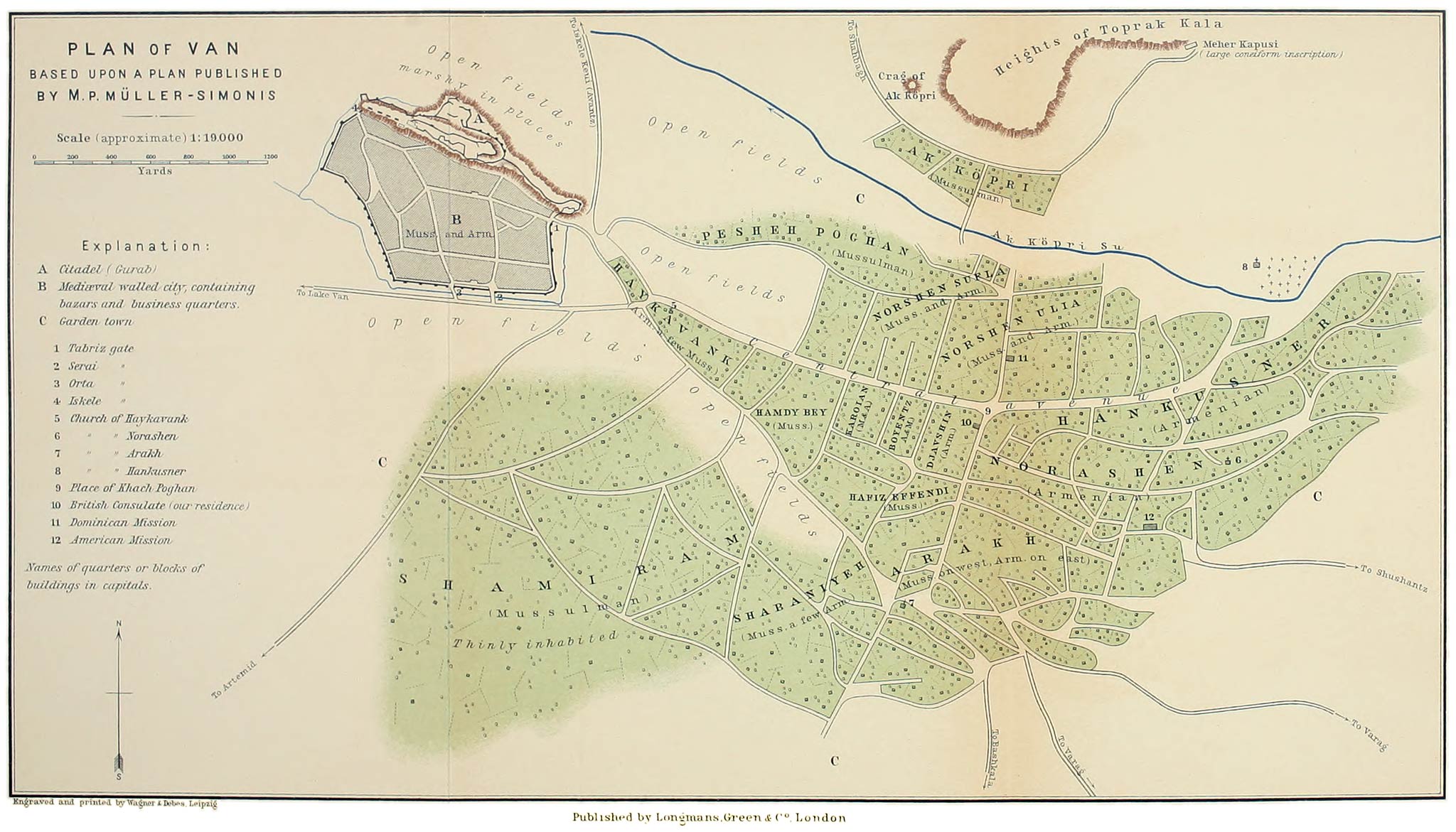
Adeljivas (Lake Van), town of, ii. 326–330, 403.
Mileage to Akhlat, ii. 325 note.
Earthquake there, 47 note 1; 341.
Rise in the level of Lake Van there, 52.
Cuneiform inscriptions there, 75

Adrianople treaty of, i. 36, 125; 397. ii. 204.
Exodus of Armenian population from Erzerum province as a result of, ii. 206

Afrikean, M. Karapet, improvement in wine accomplished by, i. 226

Afshin, Arab Governor of Azerbaijan, i. 341–343, 352

Agathangelus Treatise, our earliest authority for the reign of Tiridates and the events connected with the conversion of the Armenians as a nation to Christianity, i. 291 note.
Von Gutschmid has succeeded in discriminating between the various sources from which the treatise has been built up, ibid., 295 note 1

Aghdznik, ancient Armenian province, ii. 429; i. 309 note 1

Aghri Dagh, name given by the Mussulman peoples to Ararat as well as to the Ararat system, i. 148, 197, 409, 414 (Fig. 101), 415, 419 (Fig. 106), 420 (Fig. 107), 423, 435, 436. ii. 10 (Fig. 112), 384 seq.
Frontier between the Russian and Turkish empires, i. 435. ii. 384.
And see Shatin Dagh

Aghzi Achik, pass over the heights south of Erzerum, ii. 202

Agriculture finds in Armenia extremely favourable conditions, due to the climate and the nature of the soil—a mixture of lavas and lacustrine deposits, i. 87, 105, 442. ii. 255, 345, 404, 405–406.
Character of and seasons in various districts, i. 56, 57, 73, 75, 94, 105, 106;
among the Dukhobortsy, 107; 118, 121, 123;
on the plain of Alexandropol, 131; 133;
in the valley of the Araxes, 142, 202, 203, 229, 316, 318, 444; 321, 326, 410, 411; 443;
in Alashkert and basin of Upper Murad, ii. 3, 15, 19, 277;
in basin of Lake Van, 82, 315;
in plain of Mush, 167, 172, 318;
in plain of Khinis, 188, 256, 258;
in Bulanik, 344–345;
among the Circassians, 331, 353; 359;
in plain of Kharput, 391.
Backwardness in Russian Armenia, i. 56, 139,
and causes, i. 225, 461;
in Turkish Armenia, ii. 21, 164, 218, 219, 259,
and causes, ch. xxiv. passim.
Estimate of the levels at which cereals will flourish in Armenia, i. 107 note

Agrikar Dagh, peak of the Gori Mokri in Northern Armenia, i. 87, 434

Ahmed, Arab Emir, cherishes pretensions to the district of Taron (Mush), i. 343,
and defeats Sembat I., ibid.

Aiana, Greek Monastery of, ii. 238

Aiger Göl, on the southern slopes of Sipan, ii. 339

Ainalu Dagh, Kars district, i. 394

Ainsworth, Mr. W. F., ii. 162, 176 note

Aintab, Mesopotamia, massacre there, ii. 427

Ajara, Mts. and district of, i. 41, 42, 62, 437, 442

Ajars, The, i. 42, 432

Akantz, town on N.E. coast of Lake Van, ii. 26.
Pop., ibid.
Mileage from Karakilisa, 12

Akhalkalaki, town in Northern Armenia (Govt. of Tiflis), visited and described, i. 86 seq., 66 note, 72, 85, 438, 455.
Pop., 86.
Brave defence of by the Turks against the Russians in 1828, 89;
schools in, see under Education

Akhalkalaki, plain of, i. 87 and note.
Character of the soil, 442

Akhalkalaki (Toporovan) river, i. 76, 78, 87, 88, 92

Akhaltsykh, town in Northern Armenia, visited and described, i. 58–61 and 64–71.
History, i. 66–67;
was captured and partly razed by the Russians in 1828, 67;
the Mussulman pop. emigrated into Turkey and the town received large bodies of Armenian immigrants, ibid.;
reasons given by inhabitants for the decline in prosperity, 68;
pop. [498]in 1833, 67;
in 1886 and 1891, 65 and note 2;
description of the modern town, 68;
of the old town, 69;
of the Jewish quarter, 70;
schools in, see under Education.
Mileage to Akhalkalaki, 72

Akhaltsykh river, i. 57, 73

Akhaltsykh-Imeritian Mts., i. 430, 431, 433, 434, 438, 441

Akhashen, valley of, i. 74

Akhashen, village of, i. 75

Akhavank (Iskele), residence on the mainland of the Katholikos of Akhtamar, ii. 126

Akhbaba Dagh, peak of the northern border heights of Erzerum, ii. 203, 227

Akhbaba Dagh, Lake Chaldir, i. 438

Akh Bulakh Dagh, peak of Aghri Dagh, i. 420

Akh Dagh (Tekman Dagh, Kozli Dagh), name applied to the northern border heights of the plain of Khinis, ii. 189.
View of from the south, 186 (Fig. 159);
from the Palandöken Pass, 249;
from village of Demian, 277;
from summit of Khamur, 351;
from Bingöl Dagh, 372.
Appearance of from Tekman, 249,
from the plain of Khinis, 256–258,
from the Kartevin Dagh, 269.
Structure and composition of, 389, 402

Akh Dagh, Akhmangan region, i. 445

Akh Deve (White Camel Hill), Kars-Kagyzman district, i. 412

Akher Göl Su (plain of Khinis), source of the, ii. 257

Akhja Kala, Tartar village on southern slopes of
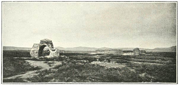
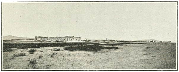
 Alagöz, i. 320

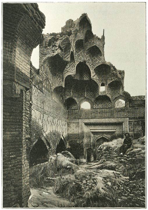
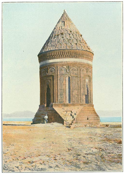
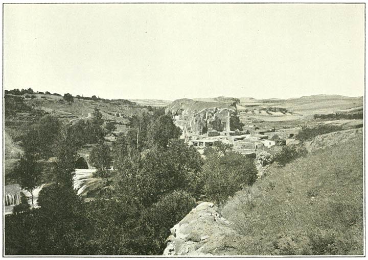
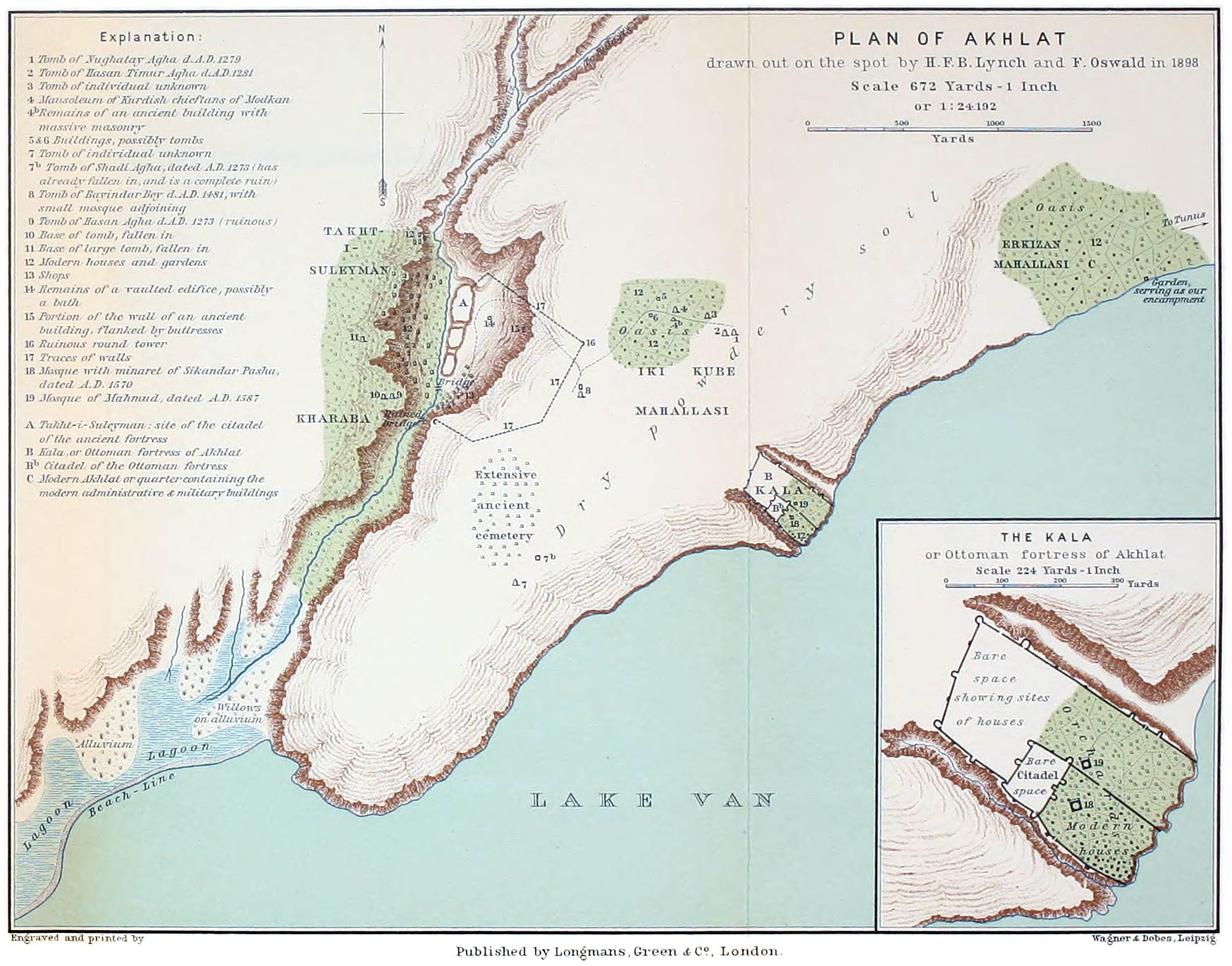
Akhlat, is the name of a district on the north-western shore of Lake Van, which includes:
1st, the ancient city of Akhlat, now known as Kharaba or Takht-i-Suleyman, situated in a ravine some distance from the shore; 2nd, the Ottoman fortress of Akhlat (Kala) on the shore; 3rd, the modern township in the quarter of Erkizan, ii. 284.
Pop. of entire district, ibid.
Characteristics of the site, ibid.
Erkizan described, 285;
the Kala described, 287–289;
the ancient city described, 291–292.
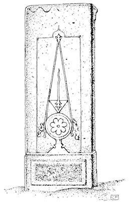
The mausolea or kumbets described and their dates ascertained, 285–293.
The ancient cemetery, 290.
History of Akhlat, 294–297; i. 355, 360, 366.
Mileage to Adeljivas, ii. 325 note.
Plan, ii. 296

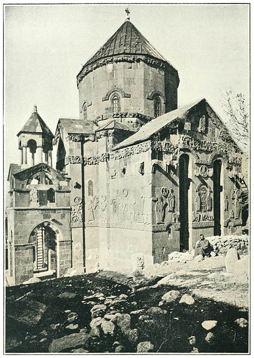
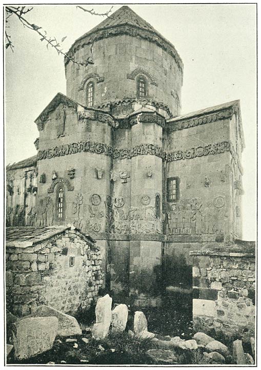
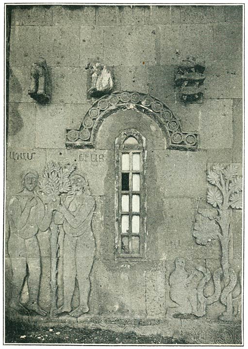
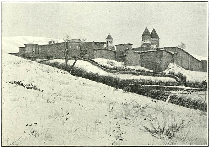
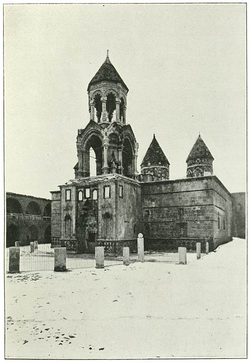
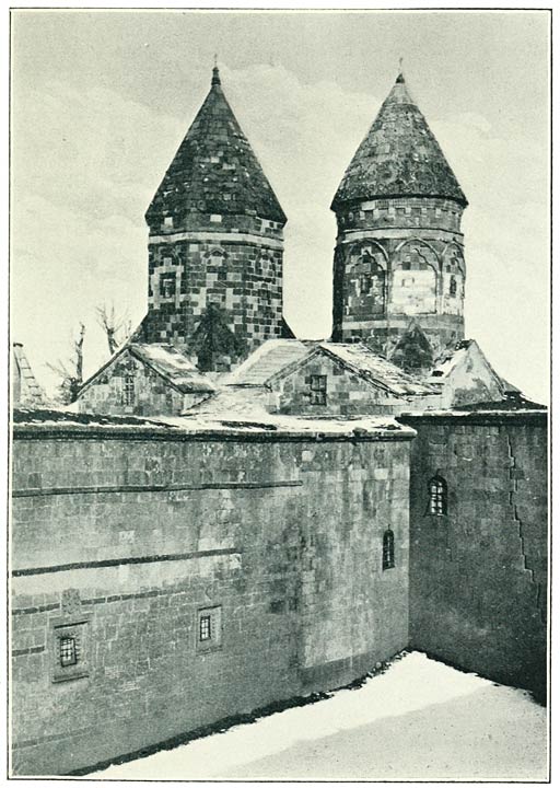
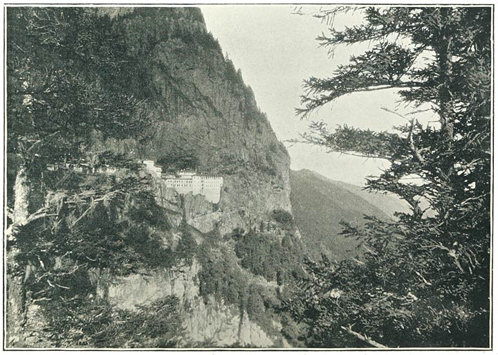
Akhtamar, Lake Van, island and monastery of, described, ii. 129–135;
architecture of the church, 132, and date, 131

Akhtamar, Katholikos of, his jurisdiction and status, ii. 135, and cp. i. 276;
visited at Akhavank, ii. 127–129, 135–136

Akhurean river, see Arpa Chai

Akhury (Arguri, Acorhi, Akuri, Agguri, Arkuri), ancient Armenian settlement on Ararat, destroyed by the catastrophe of 1840, i. 183 seq.;
is said by the Armenians to have been built on the site of Noah’s vineyard, 183;
their attempt to connect it with the Armenian for “he has planted the vine” has probably led to a corruption of the name, ibid. note 4.
May it not be the Adduri of the Assyrian inscription of Shalmaneser II.? ibid.
A willow tree there was said to have sprung from a plank of the Ark, 183,
and the church to have been built on the site of Noah’s altar, erected on his departure from the Ark, ibid.
The date of the church, 184.
Pop. according to Dubois and Wagner, 183, 184 note 1.
There was also at A. a square fortress built of clay, 184;
and a summer palace for the Persian Sirdars of Erivan, ibid.
Account of the catastrophe of 1840, 185–187;
investigations undertaken by the Russian Govt., 187.
Divergent conclusions of Wagner and Abich as to character of convulsion, 188.
What remains of the ancient settlement at the present time, 192, 193.
The old cemetery with the graves of seven brothers said to have been killed by a single snake, 193

Akhury, chasm of, Ararat. Entrance to the chasm, i. 184;
Kurdish village at the mouth of the chasm, 192;
excursion up the ravine, 193;
the peculiar formation of a side valley, ibid.;
which probably owes its distinctive features to the action of ice, 194;
arrival at St. Jacob’s Well and the sacred rose bush, ibid.,
elevation of the site, 195.
The boulders covering the bottom of the ravine are worn by the action of ice and water, 195.
According to Abich the long ridges which appear in his illustration were composed of dirty glacier ice, covered with stone and débris, 195;
but we did not see any ice in the trough of the chasm, 196,
though we admired a lake of glacier water, ibid.

Akhury, New, settlement of Tartars on Ararat, i. 193;
pop., ibid.

Akhviran Pass into the Khinis Plain, ii. 249, 252, 373

Akhviran, village of, ii. 278

Ak Köpri, crag of near Van, ii. 111, 112 note 1

Ak Köpri, river, ii. 112

Ak-kul (Gubudgokh) Mt., west of Akhtamar, ii. 137

Akrag, Armenian village on the Murad near Shakhberat, ii. 351

Akstafa river, tributary to the Kur, ii. 39, 40, 437

Akstafa station, i. 39, 226

Ala Dagh Mts. (Nepat, Niphates), ii. 10, 12, 22, 401.
Seen from Lake Van, 31, 121;
from Kartevin Dagh, 269.
Strabo says that the Tigris rises in these mountains, ii. 41.
Viewed from Tutakh, 265.
A seat of the Thonraki (Thonraketzi), i. 285

Ala Dagh, Chaldiran district, i. 413 note

Ala Göl, i. 434

Alagöz, extinct volcano and natural barrier between Northern Armenia and the valley of the Araxes about Erivan, i. 119, 124, 147, 438, 444; 135, 148, 149, 152, 205, 228, 325, 326, 330, 331, 367, 419, 442.
Seen from summit of Abul, i. 95;
from plain of Alexandropol, 122 (Fig. 23), 127, 134;
from the east, 136 (Fig. 28);
from Erivan, 208 (Fig. 41);
from Ararat, 138;
from the plains on the west, 327 (Fig. 68).
Journey along the southern slopes, i. 316 seq.

Alagöz, hamlet of near Gumgum, ii. 358

Alaja (Tsaghkotz) river at Ani, i. 368, 369

Alaja Dagh, i. 330, 368, 399

Ala-Kilisa, village of Armenian-speaking Greeks, i. 122

Alander, Col., Governor of Akhaltsykh, i. 60, 61, 64, 65, 66

Alarodians, name by which the inhabitants of Urardhu were known to Herodotus, ii. 67 and note 4;
were joined with the Matienians, etc., in 18th satrapy of the Persian empire, 68

Alashkert, plain of, i. 148, ii. 2 seq. and Fig. 108, 384, 389, 400, 401, 404.
Elevation of, ii. 3

Alexander I., Emperor of Russia, extends great privileges to the Protestant emigrants from Würtemberg on their arrival in Georgia, i. 97.
Encourages Protestant missionary enterprise, 99.
His humane and liberal policy towards the Dukhobortsy, 103

Alexander Severus, Roman Emperor, i. 287

Alexandropol (Gümri), Russian fortress town on the Arpa Chai visited and described, i. 124–132, 330, 443, 445, 453, 455, 462, 467. ii. 46 note.
Visited by Emperor Nicholas I. in 1836, i. 125.
History and description of city, 124–125, 127–129;
pop., 124 and note 1;
is almost exclusively inhabited by Armenians, 124;
who have inherited the love of building of their forefathers, 127;
but their churches and other buildings are pretentious and commonplace, 128.
Greek chapel of St. George with Byzantine picture of St. George and the Dragon, 129.
Schools in, see under Education

Alexandropol, plain of, i. 122, 131, 133, 134, 442. ii. 404

Ali Bey, chief of Karapapakhs at Karakilisa (Alashkert), ii. 6, 255

Ali Bey, chief of Sipkanli Kurds, ii. 267, 268

Ali Gedik, village near Charbahur on the Murad, ii. 352

Ali-Kuchak, village on Alagöz, i. 137 [499]

Ali Mur, hamlet of Kizilbash Kurds, district of Shushar, ii. 252

Alkhes, village of the district of Elmali Dere, ii. 262, 263, 399

Allah Akbar Dagh, Soghanlu range, i. 441

Allen, Mr., American missionary at Van, ii. 92

Allen, T. G., and Sachtleben, W. L. Their ascent of Ararat, i. 199

Alp Arslan, Seljuk sultan, captures Tiflis, i. 337,
and Ani, 353, 363,
and Melazkert, ii. 275

Altai Mts., their connection with the structural system of Asia, i. 424, 425

Altun, plain of, Upper Araxes, ii. 379, 398

Alur, village, Van district, ii. 122

Amasia, Turkish settlement on the Arpa Chai, i. 122

Amat, Armenian village, district of Alashkert, ii. 2

American Missions, see Missions

Amisus, ruins of (near Samsun), i. 4

Anak, Parthian of the blood royal, murderer of the Parthian King of Armenia, Chosroes, and father of St. Gregory, i. 288.
View of Von Gutschmid, ibid. note 2

Anania of Shirak, i. 312, note 1

Anastasius, Roman Emperor, ii. 222

Anguil Su (Enghil Su) or Khoshab, river flowing into Lake Van, ii. 122

Anguil, village, ii. 123

Ani, Armenian mediæval town and fortress on the Arpa Chai (Akhurean), now in ruins and uninhabited, visited and described, i. 329, 334, 354–392, 268, 269;
history of, 354–366; 345, 350.
Description of the various buildings and fortifications, 369–390;
distinctive features of the architecture of the Ani buildings, 390;
appeal to the Russian Government for their preservation, 391;
date of the Cathedral, 354, 355.
Mr. Marr’s excavations at Ani, 377–378.
Plan, 309

Ani, the modern Kemakh, ancient Armenian fortress on the W. Euphrates, i. 294;
fane of Aramazd at this place destroyed by St. Gregory and King Tiridates, ibid.

Anti-Taurus Mts., their connection with the structural system of Asia, i. 424;
probable representatives of the A-T. elevation in Armenia, ii. 386

Aplesphares, see Abulsevar

Aplgharib, Pahlavuni family at Ani, i. 382, 383

Apughamir, Pahlavuni family, son of Vahram, i. 382, 383 note 3, 385

Arabion Castellum on the Gt. Zab, i. 277 note 2, 279

Arabkir, massacre at, ii. 412

Arakelotz Vank, plain of Mush, ii. 166

Arakh Su, Mush plain, ii. 166

Aralykh, Russian military post at the foot of Ararat, i. 154–155;
climate of, 202

Aramzalu, village of, district of Erivan, i. 154

Ararat, Mt. (Masis of the Armenians, Aghri Dagh of the Tartars), first view of from the southern slopes of Alagöz, i. 137.
It does not appear that there was an independent local tradition of the Flood, 197;
but the identification of Ararat with the mountain upon which the Ark rested may have been made by Jewish prisoners of war, ibid.
The Ararat of Scripture is the Assyrian Urardhu, ibid. and ii. 57—a geographical designation which appears to have travelled north during the course of time; the historical Urardhu or Ararat is the province around Mt. Ararat, well known as Ararat to Agathangelus and other early Armenian writers, i. 197.
Supposed vestiges of the Flood, 157.
The district has been covered within comparatively recent geological times by a lake, 317, ii. 404
The fabric of Ararat is built up by Great and Little Ararat, i. 197;
though due to eruptive volcanic action, no eruption is known to have occurred during historical period, 197, 188.
View of from the plains about Erivan, 149, 198.
Orography, 148–153, 156, 197.
Vegetation abundant on parts of the mountain, 160;
also partridges, ibid.;
but the fabric is entirely devoid of trees, the only wood being a covert of low birch, 161.
Ascent of, 167–178;
start made from the encampment at Sardar Bulakh, 167.
Three structural divisions to be distinguished in that part of the mountain between Aralykh and the summit, 170.
The great snowfield has a minimum depth of 2000 feet, 171.
The south-eastern summit attained, 176.
Temperature of the air a few feet below the summit, 177 note.
Descent to encampment of Sardar Bulakh, 179.
Best season and starting point for the ascent, 37, 199.
List of successful ascents, ibid.
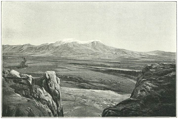
View of Ararat from the summit of Sipan, ii. 336, 337

Ararat, Chasm of Akhury, see under Akhury

Ararat, Monastery of St. Jacob, i. 184

Ararat, Little, i. 149, 150, 160–168 and Fig. 33, 197, 199, 436

Araxes river (Aras, Egri Chai), sources of on the 
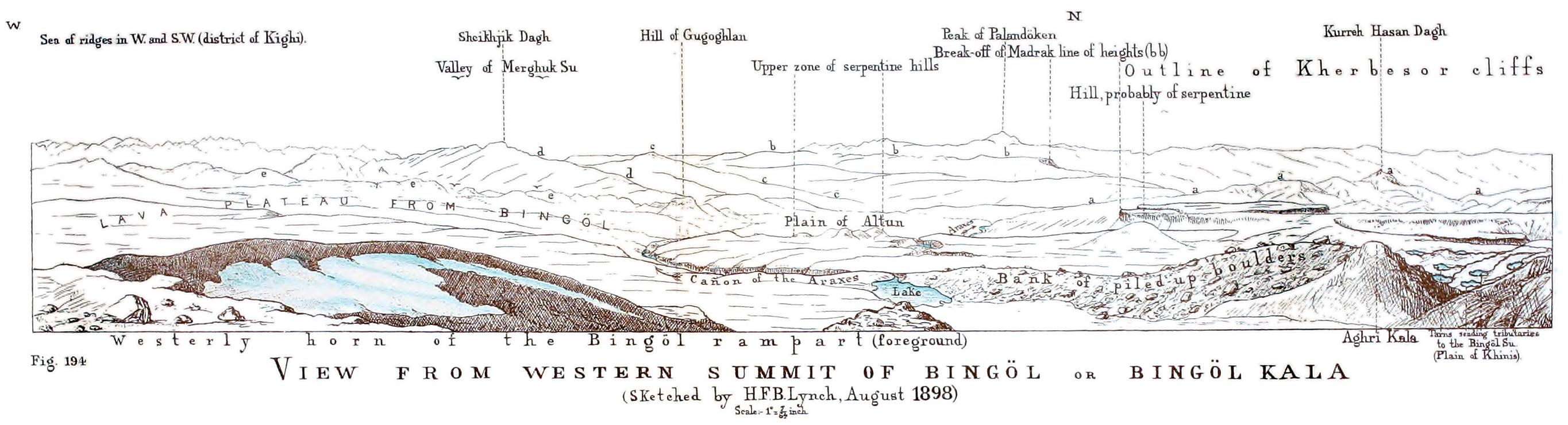
Bingöl Dagh, ii. 374 and Fig. 194;
its course through Armenia, ii. 379, 251, 190, 192 seq., i. 138, 146, 154, 201, 317 seq., 416, 436, 444, ii. 406, and see Bingöl Su

Araxes, plain of the (district of Ararat), i. 130, 137, 138, 146, 154, 201, 206, 317 seq. 444.
Elevation, 146.
Tradition that it was the seat of Paradise, 318

Archelaus, Bishop of Karkhar, author of a disputation with Mani, was probably bishop of a see not far from Van, i. 279 and note 3.
Adoptionist theory, 281

Ardabil, town in Persia, i. 366, 387, 435 note

Ardahan, town and district in Northern Armenia, i. 443; 66 note 1, 430, 431, 432, 437, 438, 439

Ardahan river, see Kur

Ardasa, town of, ii. 243

Ardashir, first Sasanian King of Persia, i. 286;
the supporter of the fire-worshippers, 287;
is harassed by Chosroes, Arsakid King of Armenia, 288,
whose death he encompasses, ibid.

Ardavan, Arsakid King of Persia, i. 286

Ardos, Mt., Lake Van, ii. 123, 126, 135, 137, 279

Arenjik, Kurdish village on the slope of Kolibaba, ii. 348

Arghana, town in Mesopotamia, ii. 388, 396

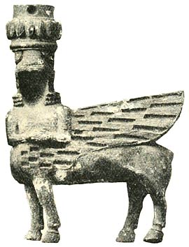
Argistis I., Vannic King, ii. 61, 73

Argistis II., Vannic King, ii. 75.
Inscription of, at Hargin, ii. 29

Arjish, ruins of (Lake Van) some miles south-west of Akantz, ii. 26 seq.
The site to be distinguished from an earlier Arjish, 27 seq. and 71.
Deserted by its inhabitants owing to rise in level of the lake, 30.
Was known to Marco Polo as one of the greatest cities of Armenia, 29

Armavir, ruins of, i. 318, 319, ii. 61, 71, 73–74, 76

Armenak, son or grandson of Hayk, progenitor of the Armenians, i. 318

Armenia, natural boundaries of, i. 428–35, ii. 231 note 1, 235–236, 244, 386–390, 394.
Its connection with the system of the great Asiatic tablelands, i. 421–428.
Geology of, i. 428, ii. 402–404, and passim in the narrative of the journeys.
Characteristics of, i. 52, 86, 428, 429, 436–439, 449, ii. 235–236, 244, 382, 400, 405–407.
It is naturally divided into two parts by the Ararat system—a north-easterly and a south-westerly, i. 409, 435–436, ii. 384.
Limits and characteristics of north-easterly or Russian Armenia, i. 436–445;
area, 445;
Pop. 451.
Do. of south-westerly or Turkish or Tauric Armenia, ii. 386–394, 397–406;
area, 407;
pop., 412–414.
Communications with Armenia, i. 7, 39, 431, 432, 433 note, 437, ii. 89, 148, 203, 205, 225, 239, 240 note, 382, 388, 390, 396.
Routes and communications in Armenia passim in the narrative of the journeys and i. 146, ii. 393

Armenia, history of, seems to fall naturally into four periods,
(I.) the pre-Armenian period, with an obscure interval preceding the rise of the Arsakid dynasty, i. 285–286, ii. 70 and 53–76;
(II.) the Arsakid period, with an interval preceding the evolution of the petty Armenian dynasties of the Middle Ages, i. 286–312;
(III.) the Armenian Kingdom of the Middle Ages, i. 335–364, 391, and
(IV.) a long sleep, dating from the overthrow of [500]that kingdom by hordes of Seljuk Turks towards the close of the 11th century to the advent of the modern epoch, i. 364–367.
Impressive part played in the history of these countries by the Roman Empire of the East, i. 34.
Scanty knowledge of Armenia displayed by Greek and Roman writers, ii. 40
Local Mussulman dynasties have flourished in most of the great Armenian centres, notably Akhlat, q.v. and i. 366.
Mussulman art is well represented by the ruins of the Ulu Jami at Van, ii. 106, and by the mausolea at Akhlat, q.v.
Modern history of, i. 446, 458; 66, 67, 89, 96 seq., 124, 125, 210, 232 seq., 393, 396–399; ii. 78, 148, 149, 204, 205, 223, and see Armenian Movement

Armenian alphabet, i. 312 note

Armenian Church, history of, i. 276–314, and cp. 264.
Ripsimian legend, 256–261.
Differences with the Greek and with the Roman Churches, 313–314 and note 1, 352, 363.
Contemporary importance of the A.C., 231
Hierarchy and Government of the Church:
The katholikos at Edgmiatsin the supreme head, i. 231, 276 (and see 298–300).
Elective character of his office, 231, 233 note 2.
The synod at Edgmiatsin, its antiquity and functions, 234, 235, 218, 220;
revived by the Russian Govt. and provided with a Russian procurator, 234.
The Tsar appoints its members, 235.
Fetters placed upon the katholikos by the Russian Govt., 235.
The Regulating Statute or Polojenye, 233–236.
The twelve bishops at Edgmiatsin, 253.
The bishops, monks (vardapets) and parish priests, 274, 275, and 233 note 2.
The A.C. represents a compromise between opposite principles in the organisation of Christianity, 276 and 307.
Power of the laity, 276; ii. 213.
The patriarch of Constantinople, ii. Appendix I.;
his relations to the katholikos, i. 276.
Regulation of the Armenian Church in Turkey, ii. Appendix I.
Need of reforms in the A.C., i. 469, ii. 93.
Reforming spirit of the present régime at Edgmiatsin, i. 274

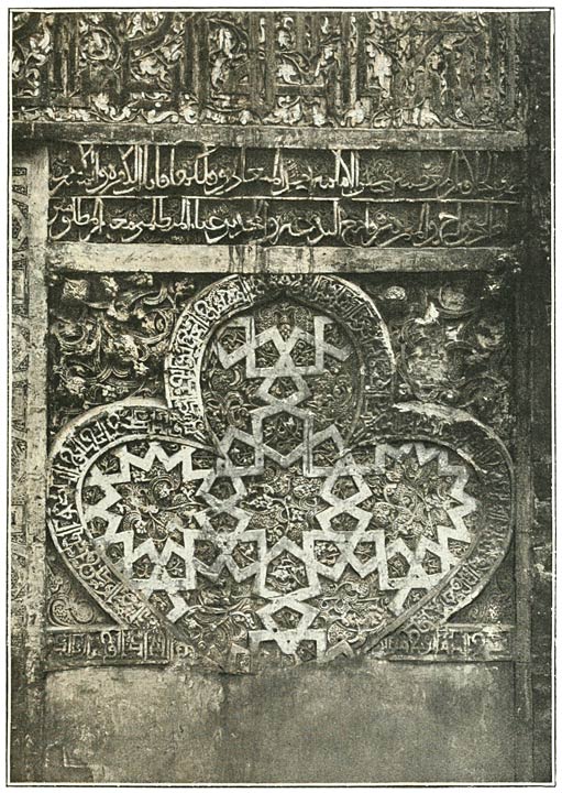
Armenian architecture, i. 63, 131, 262–272, 323, 369–390, 407, ii. 34, 101–102 (the log churches of Van), 106, 107, 114, 115, 131–133, 155, 179, 188, 233, 271.
Love of building among the Armenians at all periods, i. 127, 265, 344.
Their architecture exhibits capacities of the first order, i. 391.
Characteristics of the style, i. 390.
The conical dome, i. 63.
Function of the niche, i. 269.
Possible traces of Assyrian influences, ii. 65, 132.
Their churches exhibit the coupled pier, wand-like pillar and pointed arch at least as early as the commencement of the 11th century, i. 372.
Influence upon them of Mussulman art, i. 391;
their influence upon Mussulman art, ii. 294.
Instance of conveying stone from a great distance, ii. 131 note 2

Armenian language, its harshness to the ear, i. 450, ii. 33, 236

Armenian music, i. 250, 254, 255

Armenian Movement, i. 239–242; ii. 83–87, 157–159, 408, 420–423, 428–429, 432.
The talk about a modern Armenian Kingdom examined, i. 468, ii. 435

Armenian Constitution (in Turkey), ii. 436, and Appendix I.

Armenian law, i. 367

Armenians, The, their capacities and character, i. 255, 314, 391, 465–468.
Fidelity of Armenian women under trying circumstances, ii. 92.
The assistance the A.’s have rendered to the Russian advance, i. 233.
Their disillusionment, ibid.
Will they ultimately enter the Russian Orthodox Church? i. 463.
Their position in Turkey, see under Armenian Movement references to vol. ii.
Ethnology of the Armenians, ii. 67, 390.
They have probably received at various epochs an admixture of Semitic blood, ii. 70, i. 237, 299, 305, ii. 77, 99

Armutli, village near the Araxes, i. 440, 443

Aron-Magistros, General of the Empress Zoe, i. 373

Arpa Chai (Akhurean), i. 119, 121, 442; 122, 131, 327, 328, 363, 367, 368, 376, 377, 381, 386, 389, 453;
confluence with the Araxes, 319

Arpa Göl, i. 439

Arshak, King of the Arsakid dynasty, i. 304, 305, 307, 309

Arshakavan, a city of refuge founded by Arshak, i. 308

Arsissa, Areesa, name by which Lake Van was known to Ptolemy, ii. 27, 42.
See also Van, Lake

Artaxata, ancient Armenian city in the district of Ararat, i. 201; 258, 259, 271, 287 note 3, 288, 293, 294, 304, 305

Artemid (Atramit, Artamit), a village on Lake Van, ii. 119–121; 36, 42, 135.
Researches at made by Schulz, ii. 120 note 1

Arter, Islet of, Lake Van, ii. 135

Artsruni, The, ancient Armenian family of princely rank claiming descent from a king of Assyria, i. 336, ii. 429.
Their vast possessions in Vaspurakan (Van) during the decline of the caliphate, i. 336.
Their territory overrun and their prince captured by the Arab armies, 338.
Their attitude towards the Bagratuni family, raised to royal rank under Ashot, i. 342, 343, 345, 346.
Their prince, Gagik, obtains a royal crown from the Arab governor of Azerbaijan, 345, and allies himself with the Mussulmans against the Bagratids, 346.
But the alliance is broken, 348, and better relations with the Bagratids ensue, 349.
Gagik is crowned by order of the caliph, ibid.
Divergence of policy towards him on the part of the governor of Azerbaijan and of the caliph, 349.
His territories overrun by the former, 350.
Visited by John Katholikos, ibid.
The Artsruni furnish one of the three kinglets of Armenia under Ashot III., 354.
Their country experiences the first shocks of the Seljuk invasions, 356, 357, 359, and their king, Senekerim, bargains away his kingdom to the Byzantine emperor, Basil II., in return for a retreat in the Greek Empire, 357.
Extent of the ceded dominions, ibid.
Significance of the event, 359, ii. 77–78

Artsruni, Thomas, historian, i. 340 note 1; ii. 131 note 2

Artsruni, ——, his ascent of Little Ararat, i. 199

Artvin, town and valley of, i. 430, 443

Artze (Artsn, Arzen, Erzen), unfortified town in the vicinity of Erzerum, ii. 223;
may have been called Artze of Rum to distinguish it from an Artze in Southern Kurdistan, ibid. note 6.
Sacked by the Seljuks in 1049, i. 358

Arzanene (Arrhene), a country comprised in the present vilayet of Diarbekr, ii. 41

Arzasku, site unknown, capital of Arame, king of Urardhu, ii. 59

Arzen, see Artze

Arzian Dagh, Northern Armenia, i. 441

Asbeleff, M., i. 54

Ashakh Dagh, Ararat system, ii. 384

Ashkala, Mohammedan village on the banks of the Euphrates, ii. 226, 228

Ashkala Plain, special features of, ii. 228–229

Ashkhen, queen of Armenia, i. 261

Ashot I., king of the Bagratid dynasty, i. 339 seq.

Ashot II., king of the Bagratid dynasty, i. 347 seq.

Ashot III., king of the Bagratid dynasty, i. 353 seq.;
his tomb at Khosha Vank, 389, 390

Ashot IV., king of the Bagratid dynasty, i. 355 seq.

Ashtarak, a township near Erivan, i. 139, 140, 141, 142

Asia, structural features of, i. ch. xxi. and map

Asoghik, Armenian historian, i. 382, 390

Aspinja, Mohammedan village on the Upper Kur, i. 74, 75;
discontent of the inhabitants, ibid.; 66 note 1

Astishat (District of Mush), place famous for its temples in pagan times, i. 295.
The temples destroyed by St. Gregory, ibid., who erects the [501]first Christian church in Armenia upon the site, 296.
Site of Astishat identified with that of the present cloister of Surb Karapet, 296 note 2

Astrakhan, diocese of the Armenian Church, i. 233 note 2;
emigration of Armenians to, 367

Astvatsadur, katholikos, i. 262, 264 note 5, 268

Atabegs, governors of Upper Georgia, i. 62;
they became independent kings of Georgia, and were suppressed at a late date by the Ottoman Turks, ibid.

Atanon village, near Lake Van, ii. 123

Aternerseh, Bagratid prince of Georgia, i. 341, 343, 344, 345

Athenogenes, Christian Saint, whose bones were obtained as holy relics by St. Gregory, i. 295 and note 3

Athenogenes, son of Yusik and father of Nerses the Great, i. 303, 306

Aurelian, Roman Emperor, i. 281, 289 note 2

Avdi, village between Karakilisa and Tutakh, ii. 13

Avrin Dagh, Persian frontier, ii. 386

Ayubids, dynasty of Kurdish extraction in Mesopotamia, descendants of Saladin, ii. 211, 295

Azat, village in district of Kars, i. 409

Azerbaijan, frontier province of Persia on the side of Armenia.
Nature of the frontier, i. 428, 440.
Geology of, ii. 389.
Governed by semi-independent Arab governors during the decline of the caliphate, whose relations with the kinglets of Armenia occupy a prominent place in Armenian mediæval history, i. 341 seq.
See Afshin, Yusuf.
Exodus of the Armenian inhabitants upon its evacuation by the Russian armies in 1828, ii. 206.
Its Armenian pop. at the present day, ii. 428.
A diocese of the Armenian Church, i. 233 note 2

Baba, Cape, Black Sea, i. 2

Bafra, port on the Black Sea, i. 4

Bagaran, in the province of Ararat, i. 296, 324;
the capital of Ashot I., 340, 350

Bagdad, village, Kutais district, i. 48, 49

Baghdasareantz, Sembat, member of the Society of Evangelical preachers in Shusha, i. 98, 102, 104

Baghmesheh, Bay of, Lake Van, ii. 138

Bagrat-Magistros, governor-general of the eastern provinces, i. 373

Bagratuni or Bagratids, ancient Armenian family of princely rank giving kings to Armenia as well as to Georgia during the Middle Ages, i. 337.
See Armenia, History of, III.
Their Jewish origin, 337.
Their hereditary seats, ibid.

Baiburt, town in the valley of the Chorokh, i. 432, ii. 233, 244, 382

Baiburt, plain of, ii. 402

Baïndir, Karapapakh settlement on the Murad near Tutakh, ii. 267

Baker, G. P., his ascent of Ararat, i. 199

Baku, on the Caspian, i. 226, 449;
Govt. of, i. 447, 449

Balakhor Valley, ii. 234

Baliki or Beleke, tribe in Kurdistan, ii. 430

Balük, Lake, district of Ararat, ii. 7, 384, 385, 386

Baralet, village, district of Shubaret, i. 86

Bartholomew, Saint, i. 277, 279

Bash Abaran, Armenian village, Alagöz district, i. 137

Bashit Dagh, Taurus range, ii. 388

Basil II., Byzantine emperor, intervenes in Armenian affairs, i. 360 and makes an armed peregrination of the country, ibid.
Again marches into the territories of the Armenian kinglets, ibid. and 361.
Inherits the principality of Akhaltsykh, 360, and is named heir to the dominions of the king of Armenia, 361.
Takes over the dominions of the Artsruni family, 357.
His forward policy in Armenia, 361.
Dies before its completion, ibid.

Basil, Saint, of Cæsarea, i. 307, 310; 275

Bashkala, Jews at, ii. 80 note

Bashkent, village of, ii. 185

Bashkent, plain of, ii. 185 and note

Baskan, village, Bingöl district, ii. 182, 360

Basle, Evangelical Mission, see Missions

Bastok, Kurdish village, Bingöl district, ii. 379

Batum, i. 37, 38, 39, 40, 41, 226, 236, 430, 432, 455

Bayaz Tuzla, village, Bingöl district, ii. 260

Bayazid, town near Ararat, i. 37, 160, 321, 435;
Kurds and Karapapakhs in the district, ii. 11, 14 note, 416.
Pop. of the sanjak, 413

Bayindar Bey, tomb at Akhlat, ii. 293, 294;
probably a chieftain of the Turkoman horde of the White Sheep, 296

Behagel, von, companion of Parrot, i. 184, 185, 321, notes

Bejano (Kestano), village on plain of Akhalkalaki, i. 87 note 1

Bejeshkean, Father Minas, i. 32 note 1, 33, 367 note 1

Beka, atabeg, i. 63

Bekant, village of, i. 437

Belck, Dr., i. 197–272, ii. 28, 44, 51, 56 seq.; i. 183, ii. 47, 121, 122, notes

Bendimahi Chai, Lake Van, ii. 38, 44, 50

Beni-Cheddad, Mussulman family belonging to the Kurdish clan of Rewadi, establish a dynasty in Karabagh during the decline of the caliphate, i. 362, 364, 365 note 1, 382.
Become possessed of the Armenian capital, Ani, in A.D. 1072, i. 365.
Lords of Ani until towards the close of the 12th century, ibid., and 366, 371 note 1.
See Abulsevar, Fathlun, Manuchar

Berkri, town near Lake Van, i. 358, ii. 29 note 4

Berlin, Congress and Treaty of, i. 238, 241, ii. 205, 409 note, 410–411

Besh Parmak Mts., Lake Van, ii. 23

Bessarabia, a diocese of the Armenian Church, i. 233 note 2

Bessarion, Cardinal, his account of Trebizond, i. 19

Beth Lapat, Synod of, at which the old Christian church of Persia adopted the Nestorian confession, i. 313

Biaina, territory of which Dhuspas (Van) was the capital, ii. 57

Bilejan Dagh, ii. 257, 258, 269, 309, 311, 333, 343, 347, 351, 372, 397, 401

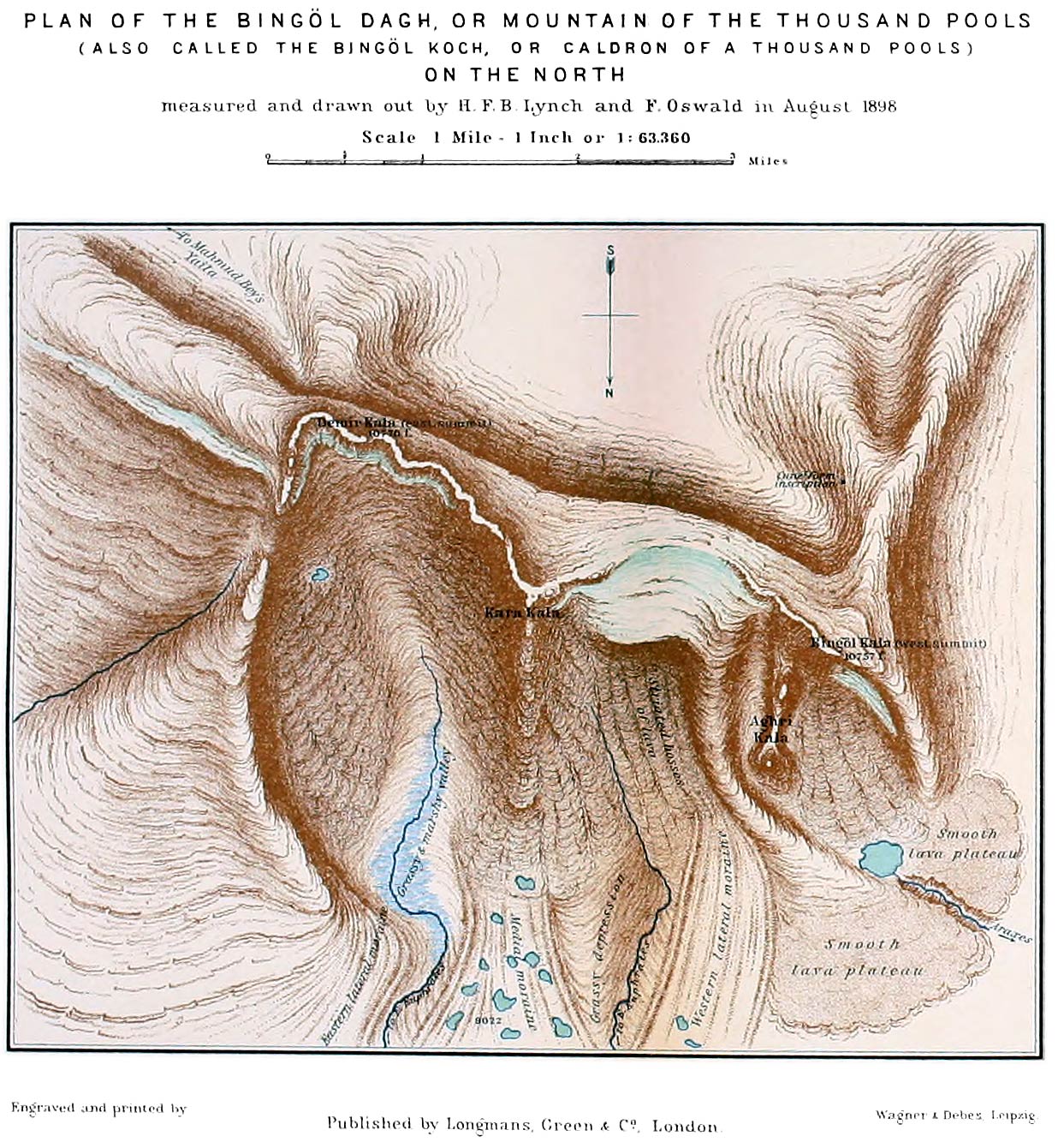
Bingöl Dagh (mountain of the thousand tarns) or Bingöl Koch (caldron of the thousand tarns), parent mountain of the Araxes and of the principal tributaries of the Euphrates, ii. 182;
seen from the highlands above the village of Kulli, 190;
from the Palandöken Pass, 247;
from Tekman, 247, 251, 252, 253;
from Khinis, 254, 255, 257;
from Kartevin Dagh, 269;
from Sipan, 333, 337;
from Nimrud, 311;
from Khamur, 351.
Description of the mountain, 363–377, 389.
Ascent of, 363;
altitude, 364, 366, 367;
names given to the three principal elevations, 364, 365, that of Demir-Kala being slightly the highest, 182.
View from the summit, 372–374.
Traces of ice action on the Bingöl Dagh, 369, 370.
Flora, 361, 362, 369.
Our discovery of a cuneiform inscription, 373.
Inspiring surroundings, 361.
Plans, 366, 378

Bingöl Plateau, ii. 122, 182 185, 188, 189, 374, 398, 399.
The stupendous cliffs by which it breaks away on the south, ii. 182, 358, 359, 360 (Fig. 192), 361, 371

Bingöl Su, name given to several rivers in Central Armenia, notably
1. the Upper Araxes, ii. 190, 191,
2. a considerable tributary of the Murad or Eastern Euphrates flowing through the plain of Khinis and effecting the confluence in Bulanik, ii. 253, 257;
the confluence visited, 346; 373, and
3. a second tributary to the Murad, coming in near Charbahur, ii. 182, 183, 354, 358, 360, 362

Birmalek, Tartar settlement, Alagöz district, i. 325, 326

Bitanu or Bitani in the Assyrian inscriptions may be Biaina, ii. 57, and ibid. note 4

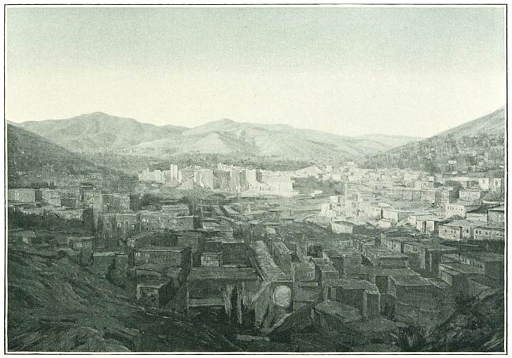
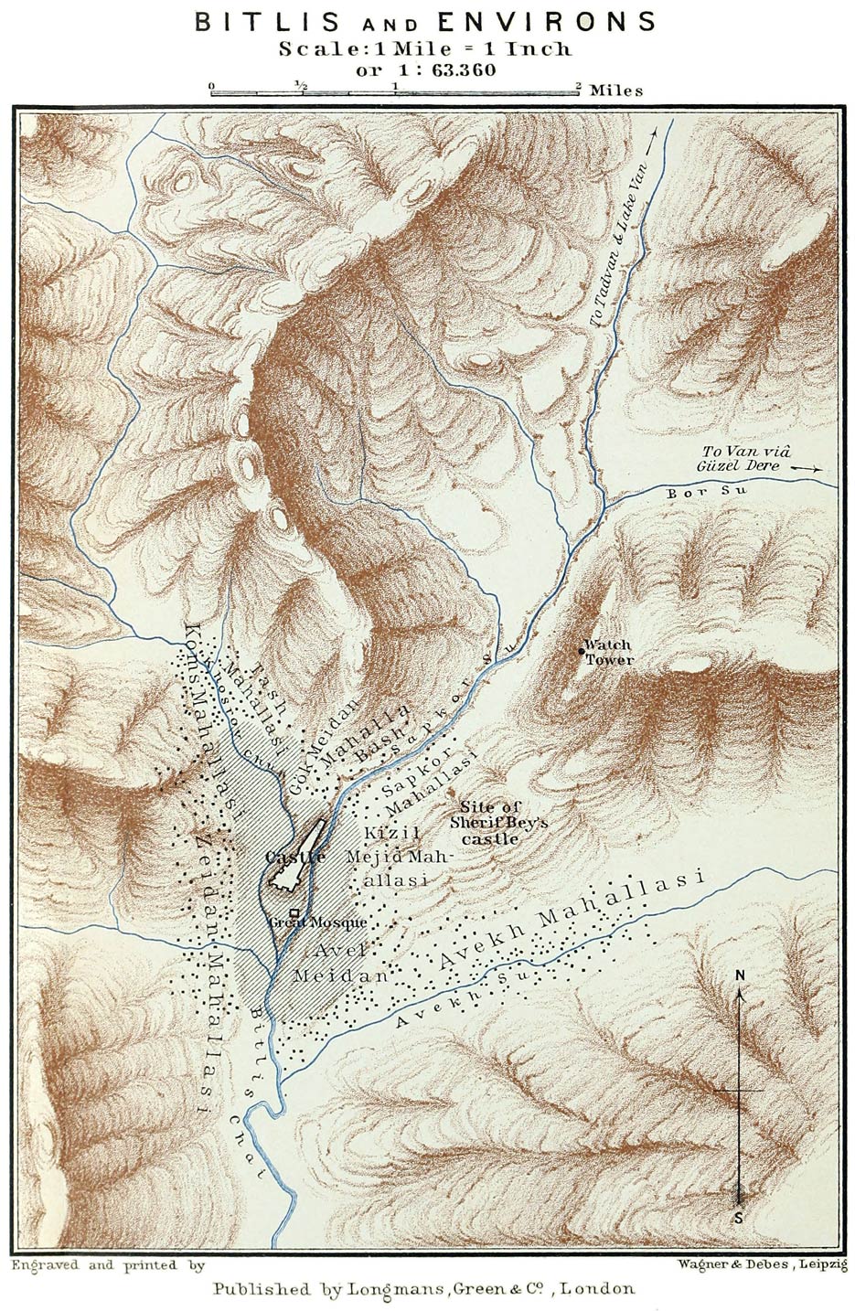
Bitlis, town on the borders of Armenia and Kurdistan, visited and described, ii. 145–157; 51.
Elevation above sea level, 147.
Solidity of the [502]buildings, ibid.
Importance of the situation, 148.
History, 148–151.
Greek coins found in the vicinity, 150.
Pop., 151, 413.
Industries, 151.
The tunnel of Semiramis in the neighbourhood, 156 and Fig. 148.
Political unrest at Bitlis, 85, 157–159, 318, 431.
Plan, 147.
View of, 145

Black Sea (Pontus Euxinus, Euxine) and southern seaboard, i. 1–36, 37, 38, 41–43, 432, ii. 225, 236, 237–240, 382.
Closed to European commerce by the Ottoman Turks in the 15th century, i. 36.
Its free navigation secured by the Treaty of Adrianople in 1829, ibid.
Commencement of steam navigation in 1836, ibid.

Blagodarnoe, Molokan village, district of Kars, i. 403.

Bogdanovka, a Russian settlement on the plain of Akhalkalaki, i. 105; ii 86, 115, 118

Bohtan Su, tributary of the Tigris, ii. 395; 57 note 4

Bor, Armenian village near Bitlis, ii. 143

Bor, Pass of, ii. 143

Borchala, Valley of the, i. 40 note

Borchali, Ouezde, i. 430, 453

Boré, Eugène, i. 348, ii. 153; i. 281, 367 notes

Borjom, Gorge of, i. 39, 430, 443

Boyajean, Armenian revolutionary, ii. 431

Boyajean, Consul, ii. 413

Boz Tepe (Mt. Mithros), i. 9, 12, 13, 32, ii. 238

Brant, Consul James, ii. 44, 79, 151, 173, 182, 206, 440; i. 406, ii. 121, 165, 187, 190, 195, 197, 283, 287, 313, 339, notes

Brosset, M. F., i. 63, 64, 65, 71, 370–380, 382–385, 387–390, 407; 75, 78, 79, 80, 81, 84, 132, 183, 266, 270, 271, 272, 338, 354, 366, notes

Bryce, Rt. Hon. J., his ascent of Mt. Ararat, i. 166, 197, 199.
His description of the valley of the Araxes, 146

Buga Tepe (Kars district), i. 394

Bugutu, Crag of, Alagöz, i. 321, 325

Bulama, Lake, see Gop, Lake

Bulanik, district of, ii. 344, 394, 404, 345, 351, 401, 424, 425

Burnu Bulakh, Kurdish village near Köshk, ii. 18

Butyka, Dr., ii. 49

Buwayhids, Turkish dynasty, i. 353

Buyuk Chai (Erishat), Lake Van, ii. 24

Caffa, port on the Black Sea, i. 36

Canning, Stratford, British ambassador, his correspondence with Consul Brant, ii. 440

Canterbury, Archbishop of, i. 102;
his Mission to the Assyrian Christians, ibid.

Carrière, Prof., i. 278 note

Caucasus Mts., connection of the range with the structural system of Asia, i. 425.
Joined by the Meschic Mts. to the Armenian border chain, 425, 433; 40, 70.
Viewed from the Zikar Pass, 52;
from the summit of Abul, 95;
from Ararat, 198.
Height of the snow-line on, 198 note 2

Chabakchur, plain of, ii. 387, 392

Chaghelik, Kurdish hamlet, Bingöl district, ii. 360

Chakhar Dagh, i. 436

Chalcedon, Council of, i. 312, 313, 348

Chaldæans, name under which the Chaldians, or remnant of the subjects of the old Vannic kings inhabiting the northern peripheral mountains of Armenia, are sometimes alluded to by classical authors, ii. 68, 69

Chaldæans, name sometimes given to the Assyrian Christians inhabiting the recesses of Kurdistan, ii. 69, 70.
Their supposed origin, ibid.
Relations of the English Church with them, i. 102.
Their incidence in Armenia, 451. ii. 80 note

Chaldees, ii. 70 and note 1

Chaldia, see Khaldians

Chaldians, see Khaldians

Chaldir Mts. (Northern Armenia), i. 105, 119, 121, 123, 438, 441

Chaldir, Lake of, i. 439, 443.
How formed, ii. 404

Chaldiran, district in central Armenia, i. 435, ii. 421

Chamar Dagh, i. 431

Chambers, Rev. W. N. and Mrs., American missionaries in Erzerum, ii. 217, 256

Chamchean, Father M. (Chamich), i. 339 note

Changalli, name sometimes given to the cloister of Surb Karapet (Mush district), q.v.

Changly, village, i. 416 note

Chantre, M. and Mme., i. 167, 195 note 1, 199, 434 note

Charbahur, Circassian village near the slopes of the Khamur heights, ii. 353

Charbahur Tepe, Circassian village, ii. 354

Chardaklu Dagh, Tauric Armenia, ii. 386

Chardin, J., i. 209, 211, 256 note, 262, 267

Charshembeh, town in the delta of the Iris, i. 4

Chat, Kurdish village, Alashkert district, ii. 1

Chaurma village, Tekman district, ii. 249

Chavarchan (Ardaz), ancient canton, i. 277 note 2

Chawir, see Abulsevar

Chembek Dagh, Taurus Range, ii. 389

Cheremetieff, General, his reclamations in the valley of the Araxes, i. 226

Chermaly, Armenian village and posting station (Kars-Kagyzman), i. 412

Chernomorsk, Govt. of, i. 447

Chesney, F. R., expeditions of, ii. 440

Chevelik, village, ii. 392

Chevermeh, Armenian village, Khinis district, ii. 256

Chibukh-Naryn-Bashi Dagh, i. 441

Chonchal, lake, i. 105, 106

Chonchal, river, i. 105

Chorzene, name by which district of Kars was known to Strabo, i. 395

Chorokh river, i. 41, 62, 337, 358, 430, 431, 436, 437, 442, 453, ii. 68 note 3, 203, 232, 386–387, 402, 406

Chorsa, see Kars

Chosroes, Arsakid king of Armenia, i. 286–288

Chosroes the Little, Arsakid king of Armenia, i. 301 note, 302

Chunak, pseudo-katholikos, i. 309, 310

Cilicia, mountainous district of Asia Minor. After the Seljuk conquest of Armenia some Armenian emigrants founded a kingdom in these mountains, i. 367,
which endured for almost 300 years, ibid.
These colonists resisted the spiritual guidance of the Roman popes, ibid.;
but as friends of the Crusaders they were at length overwhelmed by the Turks, ibid.
Their descendants still maintain themselves in the district, ibid., and ii. 427.
Status of the katholikos of Sis, i. 276

Circassians, immigrants into Turkish Armenia, ii. 340, 341.
List of their villages, 340.
Characteristics, ii. 331, 332, 353, 354, 356, 357, 359

Clayton, Major, British Consul at Van, ii. 62, 313, 388

Cole, Mr. R. M., American missionary at Bitlis, ii. 154

Comneni, distinguished Greek family, perhaps of Italian origin, i. 35;
called to the throne of the Byzantine Empire, ibid.;
their tragic overthrow, ibid.;
furnish a line of emperors of the Black Sea coasts, ibid.
See Grand-Comneni

Constantine the Great, Byzantine Emperor, i. 293 note 1, 300

Constantine V., Byzantine Emperor, ii. 222

Constantine VII., Porphyrogenitus, Byzantine Emperor, i. 336 note, 352, ii. 223

Constantine X., Monomachus, Byzantine Emperor, i. 353, 362, 363

Constantine XI., Dukas, Byzantine Emperor, i. 373

Constantinople, Council of, i. 312 note

Constantinople, Armenian Patriarchate of, ii. 450 seq.

Conybeare, Mr. F. C., i. 280, 281, 283, 407; 277, 279, 284, 285, 301, 312 notes

Cossacks, i. 158 seq., 401–403

Crimea, emigration of Armenians to, i. 367

Cuinet, Vital, ii. 25; 26, 79, 139, 152, notes

Cuneiform inscriptions, their widespread occurrence [503]in Armenia, ii. 53, 56, 61.
Difficulties attending their decipherment, 54–56.
The ancient civilisation which they disclose, 56–76.
The inscriptions on the rock of Van, 108–110.
Inscription of Choban or Meher Kapusi near Van, 112 and Fig. 134.
Inscription at Akhtamar, 133;
do. at Melazkert, 275 note 2;
on the Bingöl Dagh, 373, 73;
at Palu, 392

Cyprus Convention, ii. 409

Dadian Dagh, ii. 386

Daghestan, i. 447

Dalmatian, Armenian equivalent for Latin, i. 300 note 2

Daly Dagh, peak of the Gori Mokri, i. 434

Damadean, notorious Armenian revolutionary, ii. 157–159; 172; 431

Daniel, Syrian philosopher, i. 312 note 1

Daniel the Syrian, katholikos, i. 299 note 1

Daniel, monk of Tigranocerta, i. 388

Daniel Vardapet, of Varag, ii. 113

Darachichak, summer resort near Erivan, i. 139, 143, 445

David II., king of Georgia, i. 365

David, Prince of Akhaltsykh country, i. 355, 360

David, Prince of Van, i. 356

Dedeveren, Kurd village, Khinis plain, ii. 256

Deir, town in valley of the Great Zab, i. 277 note 2

Deïrmen Dere, valley of the ancient Pyxitis river in the Pontic region near Trebizond, ii. 238; i. 8, 9, 22

Delijan, posting station, Northern Armenia, i. 40

Demian, Pass of, ii. 277

Demian, village of Hasananli Kurds above the plain of 
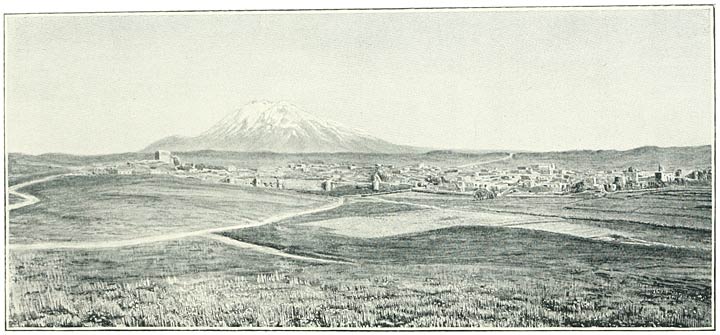
Melazkert, ii. 277, 342.
Mileage to Melazkert and Akhlat, 277 note

Demir Kala, see Bingöl Dagh

Dersim, The, country and administrative division belonging to western Armenia, ii. 388, 389, 390, 393.
Pop., 413, 416.
Its Kizilbash inhabitants, 418

Deveh Boyun, Camel’s Neck, volcanic ridge dividing the plains of Pasin and Erzerum, ii. 194, 196, 227.
Strategical importance to Erzerum, 201, 245;
fortifications on the ridge, ibid.

Dhuspas, ancient name for city of Van, q.v.

Diadin, town on the Upper Murad, i. 272, 297 note. ii. 406

Diarbekr, city on the lowlands of Mesopotamia, i. 359 et passim;
device of double-headed eagle there, ii. 211 note 3;
communications with Kharput and Erzerum, 388, 396;
with Bitlis, 148

Dignuk, village on the Murad near Melazkert, ii. 276, 265

Dimitri, king of Georgia and lord of Ani, i. 365

Diocletian, Roman Emperor, i. 256, 293, 295 note 3, 300

Dittrich, Protestant missionary, i. 98, 99

Diyadin, Armenian village, Bingöl district, ii. 182

Dochus Punar, radial volcanic mountain system in Northern Armenia, i. 73, 94, 438, 440, 441, 443

Dodan, Armenian village, Bingöl district, ii. 182, 358, 360; 180 note 2

Dodan Chai, see Bingöl Su

Dombat, village of Kizilbash Kurds on Upper Murad, ii. 10, 12

Dosp, see Van

Dubois de Montpéreux, i. 62, 64, 71, 75–84, 183, 185, 203, 216–218, 264, 267, 269, 318, 319, 327; 66, 67, 201, 230, 261, notes

Dukhobortsy or Dukhoborians, Russian sectaries settled in Armenia, i. 96, 102–104.
Their settlements visited, i. 105–111.
Character of their religion, 103, 111–112.
Feud arises among their communities, 112–113.
A considerable party resolve to defy the Government, 113, 114.
Govt. retaliates with savage cruelty, 114–116.
Large numbers emigrate to British territory, first to Cyprus and then to Canada, 116.
Reflections, 116, 117, 120.
See also 456, 457

Dümlü Dagh, source of the Western Euphrates, i. 431, ii. 209 and note 2, 406

Duzyurt, Kurdish village, Tekman district, ii. 249, 381

Dvin (Tovin), ancient Armenian city in Ararat district, i. 201 note 1;
the seat of the katholikos transferred to, i. 264 note 5, 265;
its importance in the Middle Ages, 338, 342, 346, 364, 365, 382

Dvin, Council of, i. 284, 301 note 1

“Eagle of Vaspurakan,” newspaper founded by the Katholikos Mekertich Khrimean, i. 240

Ebeling, Herr, his ascent of Little Ararat, i. 199

Edessa (Urfa), town in Mesopotamia, i. 277 note 2, 279, 306

Edgmiatsin (Vagharshapat, q.v.), Armenian 
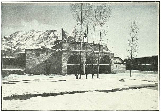
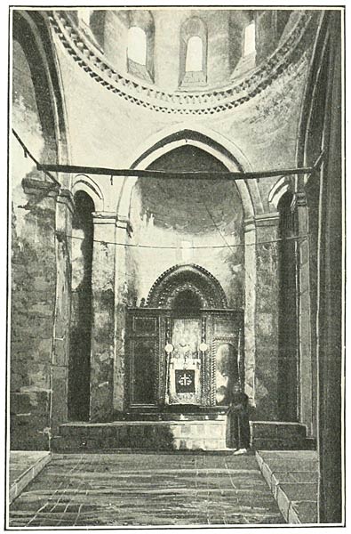
monastery and town in the district of Ararat, visited and described, i. 228–276, 453.
Sometimes called by Armenian writers Nor-Kaghak; origin of this name, 287 note 3.
Known as Uch Kilisa in Mussulman times, 256.
Tradition that the cathedrals and chapels occupy a site of great sanctity in pagan times, ibid. note 2.
Ripsimian legend attributes the origin of the cathedral to a direct mandate of Jesus Christ, 256–261.
The legend examined, 311.
Academy, see under Education.
Plan, 244.

Education, (I.) Russian provinces. The Russian State schools and the Armenian Church schools: their status and regulation, i. 218–220, 273, ii. 97.
The two systems contrasted, i. 220–222.
The Armenian system culminates in the Academy at Edgmiatsin, 272–274.
Several Russian State schools visited and described: at Akhaltsykh, i. 68;
at Akhalkalaki, i. 90;
at Alexandropol, i. 129;
at Erivan, i. 221–224;
at Kars, i. 408;
in villages, i. 203, 316, 332.
The Russian solution of the religious difficulty, 223–224. Armenian schools: at Akhaltsykh, i. 68;
at Akhalkalaki, i. 90;
at Alexandropol, i. 129;
at Erivan, 221;
at Kars, i. 408;
in villages, i. 140, 203, 325.
The teachers are as a rule laymen.

(II.) Turkish provinces. The Turkish State schools and the Armenian Church schools: their status and regulation, ii. 96, 97, 99, 100, 215.
Much greater latitude allowed in Turkey to the Armenian schools, 97;
but Russian methods are creeping in, ibid. and 100.
The two systems contrasted, 101.
The Armenian teachers are laymen and belong as a rule to a high class in society, 97. Turkish State schools visited and described: at Van, ii. 100–101;
at Bitlis, ii. 152 and note 1;
at Mush the school is in abeyance, ii. 170;
at Khinis, ii. 186;
at Erzerum, ii. 217. Armenian schools: at Van, ii. 96–99,
and private schools, ibid.;
at Bitlis, ii. 152;
at Mush the schools are closed;
at Erzerum, 216–217,
and Sanasarean School, 213–216, 97.
In villages they are for the most part closed, cp. ii. 165.
Rigorous Turkish censorship over foreign literature, ii. 95, 180. American Mission schools, culminate in Armenia College at Kharput, ii. 391.
Visited in various centres ii. 94–95, 154, 217, 256. Armenian Catholic schools, ii. 153, 217

Efremovka, Russian settlement and posting-station in northern Armenia, i. 118, 119

Egin, town on W. Euphrates, i. 449, ii. 386, 390

Eleazar, katholikos, i. 262, 263, 270

Elizabetpol (Gandzak), i. 364, 365

Elizabetpol, Govt. of, i. 447, 449; 97, 103 note, 113, 114, 115, 447, 449, 455

Elliot, Capt., British Consul at Van, ii. 304, 314

Elmali Dere or Vale of Apple Trees, district between Khinis and Tutakh, ii. 263, 399

Elmali Dere, Lake Van, ii. 142

Emlekli Dagh, Gori Mokri, i. 434

Enghil Su, Lake Van, see Anguil Su

Enzakh, Armenian hamlet, Lake Van, ii. 137

Ephesus, Council of, i. 312 note, 314 note

Ephraim, katholikos, i. 264 note 5

Erazgavors, town in Shirak, residence of Sembat I., i. 341, 345

Erimenas, Vannic king, known only from an inscription on 
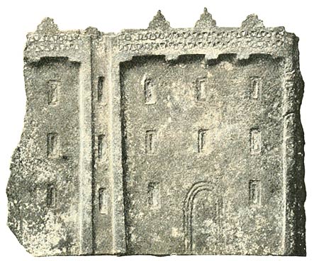
a shield found at Toprak Kala, ii. 66, 75 [504]

Erishat River (Irshat), Lake Van, ii. 24, 44

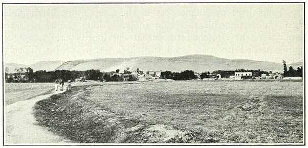
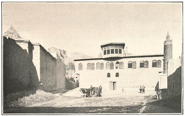
Erivan, the town of gardens, visited and described, i. 
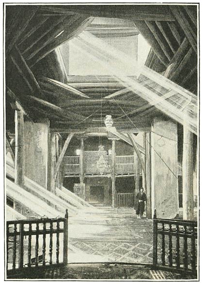
142, 143–146, 153, 206–227, 229, 427, ii. 404.
Derivation of the name and history, i. 209–210, 446.
Industries, 226.
Material prosperity of the Armenian inhabitants, 225, 467;
yet there does not exist a single bookseller’s shop, 225.
Pop. of the town, 209;
of the province, 447, 451.
Schools, see under Education.
View of from the north, Fig. 42, p. 208

Erkizan, quarter of Akhlat, ii. 45, 284

Erovant, Armenian Arsakid king, 1st cent., i. 209

Ertev, village, Pasin district, ii. 193

Ervandakert, ancient Armenian fortress on the Arpa Chai, i. 319, 324

Ervandashat, ancient Armenian city on the Arpa Chai, i. 319, 324

Erzen, see Artze

Erzerum (Karin, Karnoy Kaghak, Theodosiopolis), fortress and capital in Turkish Armenia, visited and described, ii. 198–224, 244, 245.
Derivation of the name, 223.
History, 221–224, 204–205.
Climate, 208 and cp. i. 107 note, 427.
Trade, ii. 205–207, i. 32;
pop. of the town, ii. 206–207, and cp. i. 67, 128;
of the province, ii. 413.
Schools, see under Education.
View of from the south, Fig. 164, p. 207,
from the north, Fig. 165, p. 208.
Mileage to Khinis, 174 note;
to Trebizond, 225, 240.
Route to Rizeh, 382, i. 431,
and to Olti, ibid.
Suggestions for railway communication, ii. 206, 382

Erzerum, plain of, area and elevation, ii. 209.
Connection with other Armenian plains, i. 146, ii. 401

Erzinjan, ancient Armenian town and Turkish military station on the Western Euphrates, i. 348 note, 431, 432, ii. 204, 227, 228, 234, 386, 390, 404, 413, 418.
Statue of the goddess Anahid at E. destroyed by St. Gregory, i. 294

Eugenius, Saint, of Trebizond, i. 36

Euphrates, Western (Kara Su, Frat), its sources in the Dümlü Dagh, i. 431, ii. 209, 401;
fed by the Central Tableland, ii. 398;
its course through Armenia, i. 146, ii. 201, 203, 222, 227, 228 and note, 230, 404, 406;
its valley apportioned to the Roman Empire, i. 306

Euphrates, Eastern (Murad), its sources and principal affluents, ii. 406; 373, 398;
course through Armenia, i. 420, ii. 2, 9, 10, 12–15, 264–273, 277, 342, 343, 346–355; 183, 175, 177;
the ancient Arsanias, ii. 41.
Tiridates and his people baptized on the banks of, i. 296

Eusebius, Bishop of Nicomedia, i. 300

Eyerli Dagh, Erzerum, ii. 202, 245, 381, 398

Eyub Pasha, Kurd Hamidiyeh, ii. 5

Eznik, i. 301 note 1

Ezra, katholikos, i. 270

Fadéeff, General, Governor of Kars, i. 399, 400, 403, 417

Fallmerayer, J. P., historian of Trebizond, i. 33, 34, 19

Fars (Shiraz, Persepolis), i. 286, 287, 340 note 5

Fath Ali, Shah of Persia, i. 217

Fathlun I., Beni-Cheddad, i. 365

Fathlun II., i. 365

Faustus of Byzantium, i. 291 note 1, 303, 311

Feodoroff, companion of Parrot, i. 198 note 1

Fergusson, J., History of Architecture, i. 263, 368, 372 note

Fethulla Bey, chieftain of Hasananli Kurds, ii. 276

Finlay, G., History of Trebizond, i. 33, 34

Flora and fauna. The flora in Armenia is as a rule composed of the species familiar to the traveller in Europe, ii. 246, 248; 208, 253, 256, 265, 268, 269, 303.
It is perhaps most remarkable on the sandy slopes of Ararat, i. 190, 191,
as also on the higher seams, i. 181.
The great mountain masses appear to have their distinctive flowers, ii. 362, and see Bingöl, Nimrud, Sipan.
Wealth and variety of the flora in the regions bordering Armenia on the side of the Black Sea, i. 18, 51, 432, ii. 236, 239, 241, 242, 382

Of big game there is little, ii. 302, 304, 339;
but partridges are found in abundance on the mountains, i. 161, 181;
and the plain of Alashkert is a nursery of wild fowl, ii. 3, 9.
Wild geese are frequent on the rivers, ii. 346,
and pelicans on some of the lakes, 323, 344.
The Nimrud crater is a nursery for all kinds of butterflies, ii. 303.
Remarkable about Lake Van are the rollers (coracias garrulus), ii. 280.
Lizards dart among the rocks, i. 74

Forests, scarcity of in Armenia and causes, ii. 405

Fraser, Miss, member of the American Mission in Van, ii. 92

Frat river, see Euphrates, Western

Frese, General, Governor of Erivan, i. 143, 226, 246, 248, 253

Freshfield, Mr. D. W., i. 198 note

Gagik, Kinglet of Van (Artsruni) and rival of King Sembat I., Bagratid dynasty, i. 345, 346, 348, 349, 350.
Builds the church at Akhtamar, ii. 131 note 2

Gagik I., Shahanshah, King of the Bagratid dynasty, i. 354–355, 360, 373, 382, 383

Gagik II., King of the Bagratid dynasty, i. 362

Galerius, Roman Emperor, i. 300

Galicia, emigration of Armenians to, i. 367

Gandzak, see Elizabetpol

Ganibuk, village, Khamur district, ii. 348

Garchigan, district and caza, Lake Van, ii. 138, 139

Gargalik, village of Sipkanli Kurds on the Murad, ii. 267

Garni, ruined town, village and river, district of Ararat, i. 201, 264

Garni Chai, Mush, ii. 166, 170, 175

Garuts, see Kars

Garzik village, Lake Van, ii. 141

Garzoni, Maurizio, Roman Catholic missionary in Kurdistan in the 18th century, ii. 149

Gegham, Lake, see Sevan Lake

Gelarash Dagh, spur of the Ala Dagh, ii. 16

Gelat, Monastery of, district of Kutais, i. 45, 46, 47

Gelzer, Prof. H., i. 277, 292, 295, 299, 300, 309, 310, notes

Genj, District of, ii. 392

George I. of Georgia, i. 360

George III. of Georgia, i. 365, 366

George IV., katholikos, i. 236, 254, 263, 267, 273

Georgia, i. 429, 432, 433; 37, 39–51; 448.
Glance at the Georgian kingdom during the Middle Ages, i. 337 seq. passim.
It abdicates in favour of the Tsars, 446

Georgians, overlap into Armenia, i. 55–85, 86, 443.
Numbers in Armenia, 451, 455
(often classed as Turks, ibid. and ii. 417).
Their Church accepts the Council of Chalcedon, i. 313.
Unites with the Russian Orthodox Church, 463.
Their curious method of catching fish, i. 76.
Their language, ii. 68 note 3

German colonists, their origin in Transcaucasia, i. 96–99;
met with in Armenia, 410

Gez, village near Erzerum, ii. 227

Ghubanoff, Michael Vasilievich (Dukhobortsy), brother of Lukeria Vasilievna, i. 108

Giaour Dagh, northern border of Armenia, i. 430, ii. 243

Ginal Dagh, i. 434

Girdim Dagh, Turkish Armenia, ii. 386, 392

Glak Vank (Changalli), ii. 180 note 1

Gobet, Mussulman village, Akhaltsykh district, i. 74

Godorebi, Mt. of the Abul-Samsar volcanic system, i. 95

Gökcheh Lake, see Sevan Lake

Göl Bashi, hamlet on Mush plain, ii. 319

Göl Bashi, Pool of, a source of the Kara Su, ii. 319

Göleh, district in northern Armenia, i. 430, 431, 437, 439, 443

Golgat, Armenian village, Alagöz district, i. 133

Göli, Armenian hamlet, Lake Van, ii. 138

Göljik, Lake, ii. 387;
indications of a rise in the level, 53 note [505]

Gop, Lake (Bulama, Lake of Shailu), near Bilejan Dagh, ii. 337, 343, 344.
Analysis of its water, Appendix II.

Gop, large Armenian village, district of Bulanik, ii. 344, 345.
Mileage to Charbahur, 353 note

Gopal, Armenian village, Akh Dagh district, ii. 258, 259

Gopal Su, tributary of the Bingöl Su (Khinis), ii. 260

Gorelovka, see Dukhobortsy

Gori Mokri Mts., Northern Armenia, i. 87, 433

Goschen, Rt. Hon. G. J., ambassador to Turkey, ii, 410

Goshkar Baba (shoemaker to the Prophet), grave near Bingöl Dagh, ii. 372

Gotimeria Dagh, Northern Armenia, i. 430, 431

Gotni, Kurdish village, Mush plain, ii. 163

Gotok, village of settled Kurds, vilayet of Bitlis, ii. 142

Gozme Gedik Pass, Mush plain, ii. 396

Grand-Comneni, line of Greek emperors at Trebizond, i. 35–36

Graves, Mr. R. W., British Consul at Erzerum, ii. 8, 199, 413 note 2

Greeks in Armenia, i. 122, 129, 331, 332, 451, 455;
in the northern peripheral region, i. 432, 456, ii. 236, 237–244

Greene, Mr. F. D., American missionary at Van, ii. 92, 95

Gregory, Saint (Lusavorich or The Illuminator), i. 259–261; 288–301; 200, 201, 204, 254, 262, 264 note 5, 265, 269, 271, 283, 284, 306, 311, 348, ii. 178 and note 2

Gregory Magistros, persecutes the Thonraki, i. 285

Grigor, grandson of St. Gregory, i. 267

Grigor (Pahlavid), father of Vahram, i. 381, 382, 383 note 3

Grigor, son of Vahram, i. 385

Gudubgokh (Surb Yakob), Chapel near Lake Van, ii. 137

Gugoghlan, Kurdish village, Shushar district, ii. 375

Gujaretis, Valley of the, i. 433

Gumbet Dagh, i. 430, 431

Gumgum, village and capital of the caza of Varto, ii. 183, 356, 371

Gumgum Su, affluent of the Bingöl Su (Charbahur), ii. 358, 367, 368

Gümri, see Alexandropol

Gümüshkhaneh, town in vilayet of Trebizond and capital of Greek diocese of Chaldia, ii. 69, 240, 243, 382;
famous for its silver mines, 243.
Communications, i. 432

Gundemir, ancient Armenian village, Bingöl district, ii. 182, 358, 359

Gunduz, Armenian hamlet, plain of Khinis, ii. 257

Gunek Su, affluent of Eastern Euphrates, ii. 389, 392, 406

Günther, Mr. R. T., ii. 43 note, 48 and Appendix II.

Gurgi Boghaz (Georgian Gates), Erzerum-Olti, ii. 203, 227, 245

Gurgur, name given to the passage of the Murad out of Mush plain, ii. 177.
Ruins of a fortress there, ibid.

Guria, Province of, i. 42, 43

Gutschmid, Alfred von, i. 278, 287, 288, 289, 291, 292, 295, 300, 301, notes

Guyard, M. Stanislas, ii. 56

Güzel Dere, Beauteous Valley, Bitlis district, ii. 45, 143, 402

Güzul Dere, village on Alagöz, i. 135

Gypsies, in Garchigan, ii. 139 note.
At Gopal, 260.
Are they the remnant of a Hindu colony? 178

Hadrian, Roman Emperor, i. 12, ii. 40

Haidar Bey, village near Lake Van, ii. 28

Haini, town of, ii. 388, 396

Haji Khalil, village, Alagöz district, i. 135

Hakkiari, district of, ii. 88, 421 note, 424

Halys River, i. 4;
its delta is celebrated for tobacco, ibid.

Hamdun, Arab emir, i. 353

Hamidiyeh, irregular cavalry recruited by the Turkish Govt. among the Kurds and Karapapakhs, ii. 5, 6, 13, 14, 17, 26, 88, 172, 184, 187, 195, 219, 255, 260, 266, 276, 283, 314, 344, 356, 357, 421, 422, 423

Hamilton W. J., i. 33; 32, 367 notes

Hamsi Keui, Upper and Lower, villages, Machka Dere, ii. 241, 236 note

Hargin, village on Lake Van, ii. 27, 29

Hasan Kala, ancient town in Pasin, ii. 61, 174, 193, 219

Hasan Keif, primeval village on the Tigris, ii. 395

Hasuna, village of Hasananli Kurds at the foot of Kartevin Dagh, ii. 268, 275

Haxthausen, A. von, i. 235; 66, 90, 234, 273, notes

Hayk, city of, result of excavations at, ii. 71

Hayk, son of Togarmah, grandson of Japhet, reputed progenitor of the Armenians, i. 318, ii. 70, 78, 274

Haykaberd, ruins of an Armenian fortress near the passage of the Murad from Mush Plain, ii. 177

Hayotz-dzor, district of, Lake Van, ii. 71, 394

Hazo, town of, ii. 429, 431

Heraclius, Roman emperor, i. 314, ii. 222

Heraklea, Black Sea, i. 2

Hieron Oros, see Ieros

Hincks, Dr., ii. 56 note 1

Hindu refugees, their temples at Surb Karapet destroyed by St. Gregory, ii. 178;
the gypsies in Armenia are said to be their descendants, ibid.,
and their language is known as Sanskrit among the Armenians, ibid.

Hindu Kush Mts., i. 423, 424, 425, 435

Hipsinek, Armenian village, Akantz district, ii. 23

Hittites, The, ii. 61

Hiznavuz (Kiznaus), Armenian village near Edgmiatsin, i. 316

Honentz, family of, i. 375

Hoseyn Ali Khan, Sirdar of Erivan, i. 214, 217

Hoseyn Pasha, chief of the Haideranli and ruler of territory of Patnotz, ii. 17, 20, 21

Hrazdan or Zanga River, see Zanga

Huns, The, i. 287, 303

Iberians, The, i. 395, ii. 68 note 3

Ibn-Alathir, Arab historian, ii. 29 and note 2

Ibrahim Pasha, adjutant of Kurd Hamidiyeh, ii 344

Ibrahim Sheikh, unknown ruler at Vostan, Lake Van, ii. 125–126

Ieros (Hieron Oros), cape near Trebizond, i. 8, 13, 33

Igmal, village on Lake Van, ii. 27

Iki Kube, quarter of Akhlat, ii. 284–287

Ilantash or Karatash, plateau of, near Akantz, ii. 28

Ildigiz, Atabeg governor of Azerbaijan, i. 366

Ilija, village in Erzerum district, ii. 227

Imeritia, i. 42, 45, 47, 430

Ineboli, ancient town on the Black Sea, i. 3, 4, 6, 35

Innaknean Vank (Changalli), ii. 180 note 1

Inuspuas, Vannic king, ii. 72, 110 note

Iris, river flowing into Black Sea, i. 4;
its delta is celebrated for its Indian corn, ibid.

Isa, Arab governor, i. 340

Isaac the Great, katholikos, i. 312

Iskandar Pasha, ii. 289

Iskele, harbour of Van city and name of a gate, ii. 36, 49, 108 note

Ismail I., Shah, i. 210, ii. 78

Ispahan, i. 264 note 5, 440

Ispir, town on the Chorokh, i. 431, ii. 68 and note 3

Ispuinis, Vannic king, ii. 60 and note 3, 72.
Inscription of, 110 note, 112

Issaverdens, i. 277 note 2, ii. 222

Jacob, Saint, Bishop of Nisibis, his attempt to ascend Ararat, i. 184, 185; 269

Jacob (James IV.), katholikos, i. 262, 268 note

Jagluya Mts., near Kagyzman, famous for their rich pastures, i. 419 [506]

Jaila, Armenian hamlet, Alexandropol district, i. 119

Jala, Armenian village, Shuragel district, i. 330

Javresh Dagh, Kighi district, ii. 389

Jejen Dagh, ii. 203, 227, 230, 245, 382, 400, 403

Jejen Dagh, Pass of (Khoshabpunar), ii. 382 and 240 note

Jelal-ud-Din, Sultan of Kharizme, ii. 295, 296

Jellap, Armenian village and posting station, Alexandropol district, i. 122

Jelu Dagh, Kurdistan, ii. 388, 395

Jenghiz Khan, Ani sacked by, i. 366, 377

Jerusalem, Armenian patriarchate of, ii. 453

Jesuits, see Missions

Jevizlik, town of Deïrmen Dere, ii. 238;
mileage to Trebizond and Baiburt, 225 note, 240 note

Jezireh, town in Kurdistan, ii. 433

Jezirok, village on Lake Nazik, ii. 323

Jil Göl, Lake of Rushes, Sipan district, ii. 331;
outlet of the waters, 341;
increase in the level, ibid., and 47 note 1

John Katholikos, Armenian historian, i. 335, 341, 344, 345, 346, 347, 348, 350, 352

John the Baptist, Saint (Surb Karapet), cult of in Armenia, i. 283–284, 295

John the Philosopher, katholikos, i. 284

John Sembat, Bagratid dynasty, i. 355 seq., 373, 390

John Zimiskes, Byzantine emperor of Armenian descent, i. 353, 354

Jude, Saint, the apostle, i. 277 note 2

Julfa, village on the Araxes, i. 434, 435, 444

Julfa, New, i. 233 note 2, 264 note 5

Justinian, Roman Emperor, i. 27, ii. 222

Kabak-Tepe or Kizilkaya, Kars district, i. 394

Kagdarich, village on the Western Euphrates, ii. 228

Kagyzman, town near the Araxes, i. 148, 413–417, 419, 459.
Pop. of, 417;
account of town and castle by Evliya, 416 note

Kala-i-Zerin, see Zernak

Kalaji, Kurdish village, Shushar district, ii. 251

Kalajik, village of, Lake Van. ii. 38, 112

Kalajik, castled crag of, near the Vavuk Pass, ii. 243

Kala Su, Pasin district, ii. 193

Kamarlu, village of Armenians and Tartars, Ararat district, i. 154, 201, 203

Kanjean, village in the Elmali Dere, ii. 399

Kanlija, near Alexandropol, cuneiform inscriptions found at, ii. 61, 73

Kanly Dagh, Northern Armenia, i. 437

Kara Ali, Circassian village, plain of Melazkert, ii. 277

Karabagh, country forming an Armenia in miniature on the side of the Caspian, i. 434; 254, 423, 445, 449, 453, 454.
Kurds in, 455 and cp. 364

Karachanta, Mussulman village, Alexandropol district, i. 122

Karachoban, Armenian village on Bingöl Su, ii. 257

Karadagh, northern Azerbaijan, i. 434, 435

Karaghun, Kurdish hamlet, Sipan district, ii. 342

Kara Hasan Su, affluent to the Western Euphrates, ii. 228

Karaja Dagh, Mesopotamia, ii. 388

Karakach Dagh (Gori Mokri, Northern Armenia), i. 87, 434, 438, 441

Karakala, ruins on the Araxes, i. 318, 319, 321

Karahisar, town of (Shabin Karahisar), i. 431, ii. 204

Kara Kala, see Bingöl Dagh

Karakaya Dagh, Tauric Armenia, ii. 386

Karakilisa, Alashkert, ii. 2–10, 266.
Kaimakam of, 7–8, 255

Karakilisa, village near Lake Van, ii. 23

Kara Mehemet, Armenian village on plain of Alexandropol, i. 122

Karaogli, village on Murad, ii. 346, 347

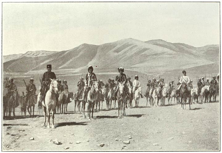
Karapapakhs or Black Caps, ii. 6, 14, 266; i. 455, 456; ii. 5, 267

Karass, Scotch mission at i. 99

Kara Su, Ararat, i. 156, 183, 187, 201

Kara Su, Mush plain, ii. 162 note, 176, 317, 319

Kara Su, Western Euphrates, ii. 209, 228, 406

Karatash, see Ilantash

Kara Vank, Armenian village on Aghri Dagh, i. 418

Karchkhal Mts., Pontic region, i. 430

Karembe, Cape (Black Sea), i. 3

Kargabazar Heights (Pasin), ii. 193, 203, 227.
See also i. 431, 432

Karin, see Erzerum

Karkar Dagh (Lake Van), ii. 388

Karke, Mt. (in Taron), site of heathen temples, i. 295, 296.
Site identified, 296 note 2

Karlik Tepe, Trebizond, i. 34

Karmuch, Armenian village near Akhlat, ii. 45, 299

Karniarch, mountain and landmark near Alagöz, i. 138, 140, 317

Karnirash, hamlet of Kurds, foot of Nimrud, ii. 319

Karri Chai, tributary to the Kur, i. 443

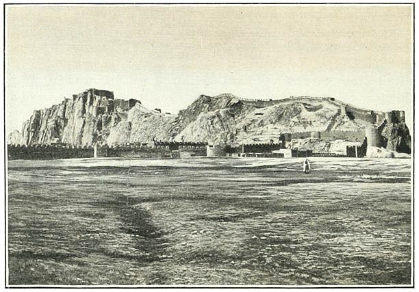
Kars (Karutz), ancient fortified city and modern 
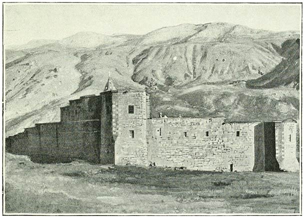
fortress in Northern Armenia, visited and described, i. 393–408; 39, 61, 330, 331, 332, 333, 442, 459.
History, 395–399, 352, 353, 354, 356, 358, 360, 364.
Elevation, 439.
Pop. of the town, 405, 406.
Do. of the province, 451.
View of, 406.
Plan, 395.
Railway from Tiflis recently completed, 40 note

Kars, river of, curiosities attending its course, i. 442, 394, 413

Kartevin Dagh, ii. 16, 263, 265, 268, 277, 333, 337, 397, 401

Kasagh River (Abaran Su), i. 242, 245, 316

Kastamuni, town in Asia Minor, i. 3, 6, 35

Katranideh, Queen of Armenia, wife of Gagik, i. 373

Kazikly Dagh, northern border, ii. 240, 382

Keban-Maden, Euphrates, ii. 390

Kegham, Lake, see Sevan Lake

Kekeli, Armenian village, Bilejan district, ii. 343

Kelkid-Chiftlik, town on the Lycus, ii. 234

Kelkid Su (Lycus), i. 431, ii. 406

Kemakh (Ani), the burial-place of Armenian Arsakid kings, ii. 390.
Fane of Aramazd destroyed by St. Gregory, i. 294

Kemurly, Upper and Lower, Kagyzman district, i. 413, 414, 416

Kerasun, Black Sea, i. 6, 18, 431

Keremitlu Dagh, fortified hill near Erzerum, ii. 203

Kerim, notorious brigand in the Caucasus, i. 153

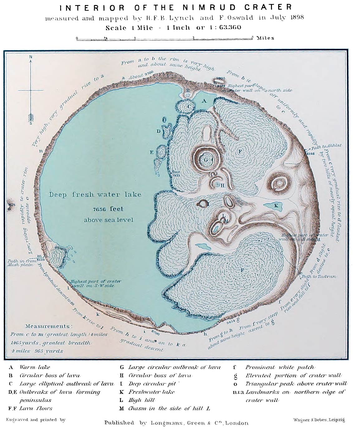
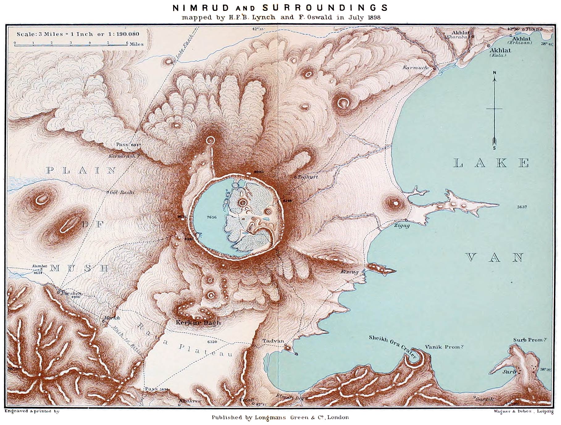
Kerkür Dagh, volcanic pile on the flank of Nimrud, ii. 50, 160–161, 312, 316, 317

Ker Porter, Sir R., i. 201 note, 319, 323, 324, 367, 405

Kersik or Kersuk Su, Elmali Dere district, ii. 263;
confluence with the Murad, 265

Kerwanserai, Kurdish settlement, slopes of Alagöz, i. 135

Keser Su, tributary of the Tigris, ii. 148

Keshish Göl, on the slopes of Mt. Varag, ii. 64;
stele near with inscription of Rusas I., ibid.

Kestano (Bejano), Plain of Akhalkalaki, i. 87 note

Ketivan, Mohammedan village near Hasan Kala, ii. 193

Kety Dagh, Karabagh border, i. 434

Keupek Dagh, Terjan district, ii. 386

Khach Dagh, Terjan district, ii. 386, 393

Khachkar Mts., i. 430

Khadrak station, valley of Balakhor, ii. 234

Khaldians, subjects of the old Vannic kings, their history, language and art, ii. 56–65.
Character of their civilisation, 53, 65, 71, 76, 111, 116.
Was there any racial or cultural link between them and the Chaldees? 70.
Approximate date of their overthrow, 65, 66.
The remnant known to Greek writers as Chaldians and the mountainous country to which they were driven as Chaldia—a name which survives to the present day, 68, 69

Khaldis, supreme god of the old Vannic kings and their people, ii. 57

Khalias Dagh or Mergemir, ii. 263, 269, 337, 389

Khama Dagh, ii. 384 [507]

Khamur Dagh, seen from Köshk, ii. 13,
from Tutakh, 14;
from Bashkent Ova, 185;
from the Palandöken Pass, 247;
from Khinis plain, 257;
from the village of Demian, 277.
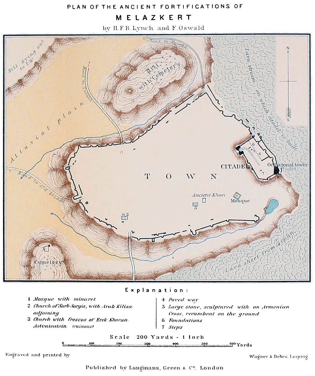
Ascent of the principal ridge, 348–351.
Geological composition of, 257, 349, 371.
Monument on the summit, 350;
view of the surrounding country, 351.
Connection with Bingöl, 350, 371.
Photograph, 252, Fig. 177

Khancharli, village of, Northern Armenia, i. 119

Khanik, Circassian village, Sipan district, ii. 278

Khanikoff, N. V., his ascent of Ararat, i. 199

Khan Mahmud, Kurdish chieftain, ii. 78

Kharaba, ruins of village on the site of Ali Mur, district of Khinis, ii. 252

Kharaba, quarter of Akhlat q.v., ii. 284

Kharput, ancient Armenian town on a hill near the banks of the Murad, ii. 390;
pop. 391;
do. of the province, 413, 425.
Large number of villages in the vicinity, 391;
products of the neighbourhood, ibid.
The Americans have a flourishing Mission and a well-equipped College, ibid.; 388, 396.
Plain of, 390

Kharshut River, ii. 234, 236, 242

Khashkeui, Armenian village on Plain of Mush, ii. 165

Khashlu, village, Bilejan district, ii. 345

Khedonun, village of Jibranli Kurds, ii. 250

Kherbesor, village, Shushar district, ii. 252, 373

Kherbesor cliffs, Bingöl plateau, ii. 373, 398

Khertvis, town at the junction of Kur and river of Akhalkalaki, i. 76;
66 note, 74, 85.

Khindris Plain, ii. 389, 392

Khinis, town of, visited and described, ii. 186–188, 253, 254–255.
Pop. 187.
Emigration of Armenians from the district, 219.
Mileage to Mush and Erzerum, 174 note.
Do. to Tutakh, 255 note

Khinis, plain of, ii. 186, 188, 256–258, 351, 401.
A seat of the Thonraki, i. 285

Khinis, river of, a component of the Bingöl Su, ii. 186, 188, 253

Khizan, region south of Lake Van, ii. 397

Khodzko, J., his ascent of Ararat, i. 199

Khojabek, Armenian village, Akhalkalaki district, i. 105

Khorasan, village at the narrows of the Araxes, i. 146, ii. 194

Khorasan, Province and Mts. of northern Persia, i. 423, 426

Khoren Stephaneh, monk at Edgmiatsin, i. 248

Khor Virap, Monastery near the Araxes, visited, i. 200, 203, 204.
Erected on the site of St. Gregory’s dungeon, ibid.

Khoshab River (Enghil Su) Lake Van, ii. 44, 50, 122, 394.
The waters of the Khoshab basin are taken to the suburbs of Van by the Shamiram Su, 60

Khosha Vank (Kizil Kilisa), Armenian village on the Arpa Chai, i. 328

Khosha Vank, Monastery of (Horomos), visited and described, i. 387–390; 328

Khoshkhosh, Queen, her tomb at Varag, ii. 115

Khosrov Pasha, donor of a pulpit to the mosque at Vostan, ii. 125

Khosrovidukht, sister of King Tiridates, i. 259, 261, 264

Khozapin, Lake, Northern Armenia, i. 87 note

Khram, Valley of the, i. 89

Khram Mts., i. 433

Khrimean, Katholikos Mekertich, i. 236, 242, 246–248, 249, 250, 251–256, ii. 86, 96, 103, 115, 408

Khvandzeh, wife of Shahanshah, i. 375

Kiaya, the head man of a Christian village, ii. 176 note 2

Kiepert, Prof. H., ii. 383 note, 408

Kighi Su or Peri Su, ii. 389, 392, 406

Kighi Kasaba, town of, ii. 390, 393

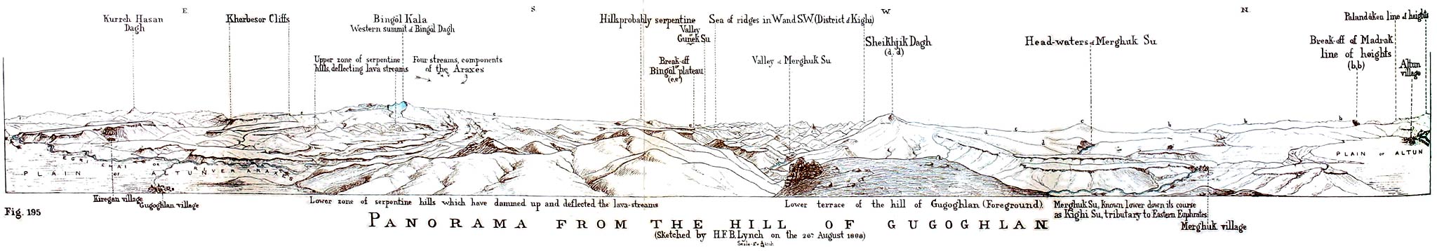
Kighi, district of, view of the from the hill of Gugoghlan, ii. 376.
Eastern limits, 380.
Characteristics, 393, 405

Kilich Gedik Mts., ii. 2, 12, 13, 262, 263, 264, 266, 337

Kilisa Deresi, Armenian Church on the Plain of Khinis, ii. 188, 253

Kimball, Dr. Grace, of the American Mission at Van, ii. 92

Kindirantz, capital of the caza of Garchigan, ii. 138–140

Kindirantz, plain of, natural phenomenon which is repeated every year, ii. 139

Kinneir, Macdonald, ii. 151, 231 note

Kip Göl, crater lake on Ararat, i. 199

Kirakos, katholikos, i. 264 note 5

Kirk Bulakh River (Forty Springs), Erivan, i. 209

Kirk Deïrmen, pass near Erzerum, ii. 202

Kirklar, a quarter of Akhlat, ii. 284

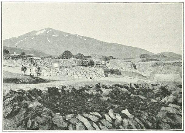
Kirklar Göl, pool on summit of Sipan, ii. 334

Kisir Dagh, Chaldir, i. 394, 438, 441

Kitowa Dagh Pass, ii. 240, 242, 382

Kizilbash, people usually classed as Kurds but professing a distinctive form of religion, ii. 418, 419;
numbers in Armenia, 414, 416 note; 12, 185, 187, 252, 390

Kizil-Goch River, tributary to the Arpa Chai, i. 119

Kizilkaya, see Kabak Tepe

Kizilkilisa, village on the Arpa Chai, i. 328

Kiziltash, cuneiform slab near Artemid, ii. 120, 121

Kizvag, village on Lake Van, ii. 315;
menaced by increase in level of water, 52

Klupffell, M. de, i. 38

Knapp, Messrs. G. C. and George, American missionaries, ii. 154

Koblian Chai, tributary of the Kur, i. 57

Kobulety, station, i. 42

Koch, K., i. 107, 436, 437, 443, ii. 176, 210, 211

Kohanam Dagh (Sepuh), i. 348 note

Kolchis, i. 7, 18, 42, 432, ii. 239;
glances at the history of, i. 62, 343, 344, 345, 349

Kolibaba Mt., Khamur, ii. 333, 348, 350, 372

Komitas, katholikos, i. 263, 264 note 5, 265, 270, 291 note

Koms, quarter of Bitlis, ii. 154

Kop Dagh, ii. 203, 227, 230, 245, 386, 403

Kop Dagh Pass, elevation, ii. 230

Korakhbur, village near Efremovka, i. 118

Kordikran, village in Garchigan, ii. 139

Korduk (Kurdistan), i. 309 note 1, ii. 429

Koriun, i. 291 note, 301 note 1

Kör Ogly Dagh, Abul Samsar, volcanic group, i. 95

Kör Su, tributary of the Murad, district of Bulanik, ii. 346

Kör Su, tributary of Murad, Karakilisa, ii. 9

Köshk, Kurdish village, district of Tutakh, ii. 13–17

Köshmür Dagh, Kighi district, ii. 389

Kotur River, Azerbaijan, ii. 386

Kovaleffsky, his ascent of Little Ararat, i. 199

Kozli, Armenian village on slopes of Akh Dagh, ii. 256

Krasnovodsk Mts., Caspian seaboard, their connection with the structural system of Asia, i. 425

Krimizi Tuzla, village, Khamur district, ii. 260

Ktutz, island and monastery in Lake Van, ii. 32, 33

Kuarkuareh, atabeg, i. 64

Küchik Keui, village near Kars, i. 397

Kuenlun Mts., their connection with the structural system of Asia, i. 424, 425

Kukurt Dagh, Artvin, i. 430

Kulaxis, quarter of Akhlat, ii. 284

Kulli, Kurdish village, Tekman district, ii. 190;
Brant’s account of in 1838, ibid. note 1; 398

Kulp, district of, ii. 396

Kulpi, salt mines of, Ararat district, i. 319, ii. 385

Küp Keran, Armenian village, near Karakilisa, ii. 9

Kur River or river of Ardahan, i. 73 seq.; 56, 63, 94, 118, 394.
Sources and course through Armenia, 443

Kurdistan or Kurd-land, situation, ii. 395; 145, i. 424, 429.
Characteristics, ii. 145, 148, 394.
Divided into five considerable principalities during the 18th century, 149.
Condition of the Armenian inhabitants, ii. 429–431.
Suggestions for the proper government of, ii. 433, 434

Kurds, their antiquity, ii. 69.
Their picturesqueness, ii. 396 and cp. 250.
Portraits of, ii. 5, 16, [508]17, 163.
Characteristics, i. 427, ii. 419.
In Armenia the tribal Kurds are quite out of place, the conditions of their life there being unnatural, ii. 1 and passim in the narrative of the journeys; 420–424.
How they came to their present seats there, 421.
Their numbers in Armenia, i. 451, ii. 414.
Various Kurdish tribes in Armenia visited: Zilanli, ii. 6;
Hasananli, 21, 191, 259, 260, 267, 268, 276, 322–323;
Haideranli (Patnotz, etc.), 16, 20, 26, 422, 187;
Adamanli, 21, 26;
Sipkanli, 16, 267, 268;
Jibranli, 184, 187, 250, 357, 371, 372;
Zirkanli, 187, 190;
Zireki, 250, 380.
See also Kizilbash

Kuseh Dagh, Ararat system, i. 436; ii. 10 and Fig. 112, 193, 267, 277, 312, 336;
altitude, 384

Kuseh Dagh, northern border of Armenia, i. 430

Kutais, capital of Imeritia, visited and described, i. 45–48;
vineyards there, 55.
Govt. of, 447, 449

Kutlerusky, General, takes Akhalkalaki, i. 89

Kzia, River and Plain of, i. 433

Lakes in Armenia, notices of Strabo, Pliny and Ptolemy, ii. 40–43.
The great lakes described (Van, Urmi, Gökcheh), 39, 43–46;
analyses of their waters, 468–470.
Fluctuations in their level, 46–53.
See also 402–404

Lanchkuty, village of, Black Sea coast, i. 43

Layard, Sir A. H., ii. 55, 133; 69, 79, 115, 233, 283, 296, 324, 344, notes

Lazar Pharpetzi, i. 291 note 1, 302 note 1

Lazis or inhabitants of Lazistan, i. 42, 427, 432

Lehmann, Prof. C. F., ii. 56 seq. and see Bibliography, 492

Lemberg, Armenian colony at, i. 367

Leo VI., Byzantine emperor, i. 341, 346, ii. 223, 295

Leontius, archbishop of Cæsarea, i. 295 note 1

Leter, village of, district of Bulanik, ii. 342

Lichig, village of, Kighi district, ii. 392

Liz, town of, Bulanik district, ii. 345, 351

Loftus, W. K., ii. 30, 47, 50, 51; 30, 47, 385 notes

Longworth, Mr., British Consul at Trebizond, i. 11

Lori, town in Georgia, i. 353, 356, 465

Lukas, katholikos, i. 264 note 5

Lukeria Vasilievna, see Dukhobortsy

Lurs, The, i. 427, ii. 419

Lutipris, Vannic dynasty, ii. 71 note 3

Lycus River, see Kelkid

Lynch, Commodore H. B., ii. 440

Macdonald, Sir John, British ambassador to Persia, tomb at Edgmiatsin, i. 266.

Madatapa, Lake, district of Akhalkalaki, i. 87, 118

Madatapa ridge, i. 430

Madavantz, Armenian semi-troglodyte village near Akhlat, ii. 293;
the Church is said to have been built by St. Thaddeus, ibid.

Maden Khan, settlement near Baiburt, ii. 232, 225 note, 240 note

Maden, hamlet near the Zigana Pass, ii. 242

Madrak, Kurdish village, Tekman district, ii. 248, 249; 373, 375, 380, 381

Magaspert, Arpa Chai, i. 442

Mahmud Bey, Kurdish chieftain, Bingöl district, ii. 365

Mahmudia, territory of, ii. 122

Makar, katholikos, i. 220, 236, 264 note 5

Malatia, town in Asia Minor, sacked by the Seljuk Turks, i. 358

Malek Shah, his relations with Ani, i. 365

Mamakanlu, Kurdish tribe said to be descended from the Mamikonean family, ii. 421 note

Mamakhatun, town in the district of Terjan, ii. 231

Mamlun, Arab governor of Azerbaijan, i. 355

Mangasar, village of, Alashkert, ii. 7

Manna, collected by the peasants, Bitlis district, ii. 151

Manuchar, atabeg, i. 64

Manuchar, Beni-Cheddad family, i. 365, 370, 377

Manzara, village, plain of Akalkalaki, i. 105

Marco Polo, ii. 29

Margistan, village of, near Vardzia, i. 79

Markoff, Dr. E., his ascent of Ararat, i. 176, 199

Marmashen, ruins of the monastery of near Alexandropol, visited and described, i. 131, 132; 355

Marmed Chai, Lake Van, ii. 44

Marr, Mr. N., his excavations at Ani, i. 377, 381

Mastikan Dagh, Taurus system, ii. 389

Matthew of Edessa, i. 352–366 passim

Maunsell, Major F. R., ii. 45

Maximin II., Roman emperor, his relations with Armenia, i. 300

Maximoff, M., Russian Consul at Erzerum, ii. 199

Mechinkert, Upper and Lower villages on the Enghil Su, Lake Van, ii. 122

Meiriman, Valley of, Pontic region, ii. 239–240, 382

Mekhitarists, Order of the, i. 291 note 1, 314 note

Mejitli, Kurdish hamlet on the Upper Araxes, ii. 191

Melazkert (Manazkert), ancient town and fortress on the Murad, visited and described, ii. 268–274, 275 note 2; and cp. i. 378.
History, ii. 274–275, 58, 71; i. 34, 355, 358, 360, 364.
Communications, ii. 11, 89, 264, 266, 277.
Hamidiyeh there, ii. 191, 276, 422.
Its central position, ii. 434.
Its plain, ii. 268, 276, 277, 337, 401;
elevation, 265 note.
Plan, 271

Melikoff, Loris, Russian general of Armenian origin, i. 126, 233, 399, 465

Menaskut, district of, Tauric Armenia, ii. 392

Menuas, Vannic king, ii. 60, 72–73, 392; 110, 112, 120, 274, 275, notes

Mergemir Dagh, see Khalias

Merghuk Su, head waters of the Kighi Su, ii. 375, 393

Merjan-Muzur Dagh, Tauric Armenia, ii. 386–388, 390, 392, 402

Merujan, an Armenian bishop of 3rd century, i. 279

Merwanids, Kurdish dynasty, their rule at Akhlat, ii. 295

Meschic or Moschic Mts., i. 40, 41, 47, 425, 433

Mesgeldek, village, Lake Van, ii. 123

Mesrop, inventor of the Armenian alphabet, i. 312

Messalianism, Armenian heresy, i. 284

Mezik, village of, near Lake Nazik, ii. 321

Michael IV., Paphlago, Byzantine emperor, his claims on Ani, i. 361, 362

Midyat, hill ranges of, Mesopotamia, ii. 395

Migry, village, valley of Araxes, i. 434

Milan, Kurdish village, Tutakh district, ii. 15

Mingrelia, Georgian province, i. 42

Minni, The, ii. 61, 72, 74

Mirabet, village of, Lake Van, ii. 136

Missions. (1) The earliest missionary enterprise in Armenia appears to have been that of the Dominicans, ii. 485.
(2) Jesuit Missions were established in the 17th century, ii. 153, 472,
and the Roman Catholic Church is still active in Turkish Armenia, 153, 170, 217,
though it does not make as much progress among the Armenians of the tableland as among their countrymen elsewhere, ii. 425.
(3) Protestant Missions:—the Basle Mission, i. 98–102.
The American Mission (Congregational Church of America) has been established in Asiatic Turkey from an early date in the 19th century, ii. 93;
its activities in Armenia are practically confined to the Armenians (Gregorian Christians), ibid.;
schools, hospitals and orphanages have been opened, 94, 95,
and the standard of living has been raised both in the material and the moral spheres, ibid.
The Mission at Van, ii. 93–95;
at Bitlis, 153, 154;
at Erzerum, 217;
at Kharput, 391.
Activity of the missionaries in the plain of Khinis, 256.
They are viewed with suspicion by the Russian Govt. and experience difficulty in crossing Russian Armenia, i. 102

Mithros, Mount of (Boz Tepe), i. 9, 10, 17

Mohammed II., Ottoman sultan, takes Trebizond and closes the Black Sea to Europe and commerce, i. 22, 36;
takes Erzerum, ii. 223

Mokri Gori (Wet Mountains), Northern Armenia, i. 87

Moldavia, emigration of Armenians to, i. 367

Molokans, Russian sectaries settled in Northern Armenia, their villages visited, i. 410–412; 456, 457.
Molokans at Erivan, 209 [509]

Monahan, Mr., British Consul at Bitlis, ii. 304

Monteith, W., i. 66 note, 90, 232

Morier, J., i. 218, 232, 269; 210, 216, notes

Morkh, village of and stream, ii. 162

Moses of Khorene, national historian of the Armenians, i. 278, 302, ii. 54, 222; i. 291 note

Moses, katholikos, i. 212, 264 note 5

Mosul, town on the Tigris, ii. 148, 396, 433

Mugni, monastery of near Ashtarak, i. 140, 141

Mukus, district of, ii. 135, 397

Müller, Prof. D. H., ii. 56 note

Müller-Simonis, Mr. P., ii. 80; 28, 110, 121, 293, notes

Murad, river, see Euphrates, Eastern

Murad, Mr. Serapion, i. 247

Murad Khan, station near Tekke, ii. 243

Muravieff, Russian general, i. 397

Murian, village on the banks of the Gopal Su, ii. 260

Mushegh, Bagratid king of Kars, i. 353, 395

Mush, town of, visited and described, ii. 166–173.
Pop. of the town, 172–173,
of the sanjak, 413.
Hamidiyeh there, 173.
Communications, 12, 160, 174, 396

Mush, plain of, ii. 161–167, 175–177, 181, 317–319, 355;
length of the plain, 181 note;
the Armenian inhabitants are in a large majority, 173, 424; 50, 195 note 2, 200, 308, 311, 393, 394, 401, 404

Muzur Su, affluent of Eastern Euphrates, ii. 390, 406

Nadir Shah, i. 211, 214, 267, 396

Nahapet, katholikos, i. 271

Nairi, ii. 58, 60

Nakhichevan, town on the Araxes, i. 342, 345, 346, 357

Nakhichevan, New, town of, i. 233 note 2

Nazik, village of, ii. 321–323

Nazik, Lake, visited and described, ii. 321–324; 45, 46, 284, 309, 333, 337;
elevation, 323;
analysis of waters, 470

Nepat, Mt., identified with the modern Ala Dagh (Niphates), ii. 41.
Tiridates and the Armenian people receive baptism in its vicinity, i. 296

Nepiszkaro Dagh, i. 430

Nerses I., katholikos, surnamed The Great, i. 307–309; 264 note 5, 275, 295 note 1, 299, 305, 311

Nerses III., katholikos, surnamed The Builder, i. 264 note 5, 265, 266 note 1, 272, 284

Nerses IV., katholikos, i. 268

Nerses V., katholikos, i. 235, 245, 266, 273

Nerses of Lambron, i. 314 note

Nerses, patriarch of Constantinople, i. 241, ii. 410 note

Nestorianism, adopted by the Christian Church of Persia, i. 313

Nestorians, name sometimes given to the Christians inhabiting the recesses of Kurdistan. See Chaldæans

Nice, Council of, i. 281, 282, 301, 312

Nicholas I. Emperor of Russia, i. 103; 125, 233

Nikephorus Phokas, Byzantine emperor, i. 353

Nikephorus, Byzantine governor of Vaspurakan, i. 360 note

Nimrud, gigantic extinct volcanic crater at the south-westerly extremities of Lake Van, visited and described, ii. 298–313;
views of, Fig. 145, p. 142, and Figs. 185, 186, pp. 298, 302.
Plans, 305, 312; 32, 45, 50, 51, 118, 122, 141, 181, 269, 337, 362, 388, 397, 401

Norashen, Armenian village on the slopes of Alagöz, i. 134

Norkeui, village on Lake Van, ii. 136

Norshen, Kurdish village on the plain of Mush, ii. 162, 318

Norshen, Pool of, ii. 45, 162, 163, 317, 318

Norshunjik, village on the slopes of Sipan, ii. 330

Novo-Bayazet, town of, i. 453

Novo-Michaelovka, Molokan village, i. 411

Nurduz district, ii. 397

Of, village of, Lazistan district, i. 11

Okhan, village of, near Tutakh, ii. 13

Okhtchapert, grottoes of, Erivan district, i. 201 note

Olti, town of, i. 431, 432, 437, 453. ii. 203

Ordubad, town on the Araxes, i. 434, 453

Orlovka, Russian village and small lake, district of Akhalkalaki, i. 106, 115

Ortukids, Turkish dynasty which adopted the double-headed eagle as their emblem, ii. 211 and note 3

Oswald, Herr A., his ascent of Ararat, i. 199 note

Ovajik, upland district north of Erzerum plain, ii. 406

Ozurgeti, capital of Guria, i. 43

Pahlavuni, family of, i. 381, 385

Pakharij, ancient township, province of Terjan, i. 294

Palandöken (Saddle Shifter), peak of volcanic origin, north of Erzerum, ii. 202;
ascent of, and elevation ascertained, 381;
a landmark, 337, 351, 372, 373, 398

Palandöken Pass, ii. 202–203, 244–247

Palandöken-Eyerli Dagh volcanic system, ii. 381–382;
connection of the line of heights upon which it is built up with the structural system of Asia, 386;
the underlying limestones, 403

Palgrave, W. G., ii. 370

Palu, town on the Murad, ii. 391.
Rock chambers and cuneiform inscription there, 392.
Pop., 391;
of the caza, 413, 416, 425

Palu Dagh, ii. 387

Pambak Mts., Northern Armenia, i. 434

Pambukh Dagh, Ararat system, ii. 385

Pap, Arsakid king of Armenia, i. 306–310

Pap, son of Yusik and great-grandson of St. Gregory, i. 303, 299 note 1, 306

Papken, katholikos, i. 301, note 1

Paris, Treaty of, ii. 204

Parkhal Mts., i. 430

Paropamisus Mts., their connection with the structural system of Asia, i. 423, 425

Parrot, F., his ascent of Ararat, i. 199; 149, 157, 183 note, 184, 185, 198, 318 note

Pasin, Plain of, ii. 193–196; i. 146, 148, 414. ii. 11, 200, 201, 387, 394, 398, 400, 401, 404.
Connection with some historical events, i. 358, 360, ii. 223

Paskevich, Marshal, i. 66, 89, 90, 100, 125, 129, 210, 233, 323, 332, 395, 396, 397, 405, ii. 204, 250, 426

Patnotz, village and plain of, Sipan district, ii. 18, 20, 268, 269, 337, 422

Paul, Bishop of Samosata, i. 281, 282, 285

Paulicians, i. 282, 284. ii. 222

Pazu, hamlet near Surb Karapet, ii. 180

Peri Su, Tauric Armenia, ii. 389

Perli Dagh, Ararat System, ii. 384, 385

Petander, General, vice-Governor of Kars, i. 400

Petros II., katholikos, i. 268

Petrovka, German settlement, Kars district, i. 410

Pharen, pseudo-katholikos, i. 299 note 1

Phasis, river, see Rion

Philippos, katholikos, i. 262, 264 note 5, 269

Piran, village near Lake Gop, ii. 345

Pirnakapan, village near Ashkala, ii. 229

Pir Reshid Dagh, Lake Van, ii. 401

Platana, town on the Black Sea coast, i. 8

Poghos, Bishop of Lim, ii. 87

Poland, emigration of Armenians to, i. 367

Pontic Range, i. 423, 430, 431, 433

Poskhov Chai, tributary of the Kur, i. 57

Postukhoff, M., his ascent of Ararat, i. 175, 199

Pribil, M. i. 248, 249, 253, 255

Pülümer, township of, Tauric Armenia, ii. 393

Pyxitis, river, see Deïrmen Dere

Radde, Dr. G., i. 110; 56, 87, 89, 107, 135, 434, notes

Randuli, village of, Bingöl district, ii. 182

Raouf Pasha, Vali of Erzerum, ii. 220

Raphalovich, his ascent of Ararat, i. 199

Rassam, Mr. Hormuzd, ii. 62, 63

Rava plateau, Nimrud district, ii. 316 note 2

Rawlinson, Sir H. C., ii. 437; 67, 68, 70, notes

Reshid Pasha, Turkish general, ii. 149

Rewadi, see Beni-Cheddad

Reynolds, Dr., American missionary at Van, ii. 92

Rhétoré, Père, of Van, ii. 153 [510]

Rion, river (Phasis), i. 2, 40–47, 433

Rion, Plain of the, i. 44, 48, 52, 448

Ritter, K., i. 33, 190, 264, 324, ii. 78; i. 187, 188, 318, 340. ii. 130, 149, 173, 178, 193, 231, 283, notes

Riza Bey, Kurdish chief at Melazkert, ii. 276, 278

Rizeh, port on the Black Sea, ii. 225, 382

Romanus, Byzantine emperor, i. 34, 361, 364

Romkla, in Cilicia, Council of, i. 314 note

Ross, Prof. E. Denison, ii. 286

Rowanduz, town in Kurdistan, ii. 58

Rupenian dynasty (Cilicia), i. 367; 268

Rusas I., Vannic king, ii. 60, 74

Rusas
,,
II., Vannic king, ii. 64, 75
Rusas
,,
III., Vannic king, ii. 64, 76

Rustav, posting station, i. 74

Rzewuski, Col., i. 400

Sach, village in the Güzel Dere near Bitlis, ii. 143;
spring near, 45

Sachtleben, W. L., see Allen, T. G.

Safar, monastery of, Akhaltsykh district, visited and described, i. 61–64, 73

Saffarids, The, petty Mussulman dynasty in Fars and Seistan, i. 340

Safi, Shah, of Persia, takes Erivan, i. 211

Sahak the Great, see Isaac the Great

St. Jacob’s Well, Mt. Ararat, i. 194, 195

St. Jacob’s monastery, i. 184

Saint Martin, J. A., ii. 54, 55

Sajids, Mussulman family ruling in Azerbaijan during the decline of the Caliphate, i. 352, see Afshin, Yusuf

Sakulaperdi Dagh, Northern Armenia, i. 431, 432, 438, 441

Salt deposits, in Armenia, Persia and Turkey, i. 428

Salvarty Dagh, Karabagh border, i. 434

Samsar Dagh, Northern Armenia, i. 95, 434, see Abul-Samsar

Samsar River, tributary of Toporovan River, i. 87

Samsun, town and bay of, i. 3, 4

Samuel of Ani, Armenian historian, i. 352–366, 370 note, 373, 382, 407 note

Sanatruk, son of Abgar, kine of Edessa, i. 277 note 2, 278

Sanasar, son of Sennacherib, ii. 429, 430 note 1

Sanasarean, Mr., ii. 96, 214

Sanislo Mts., Northern Armenia, i. 433, 438, 443

San Stefano, Treaty of, ii. 205

Sapor Su, stream, Lake Van, ii. 45 note, 142

Sapunji, Kurdish hamlet, Alagöz district, i. 326

Sardarabad, town in the valley of the Araxes, i. 444

Sardar Bulakh, well and valley, Mt. Ararat, i. 160–167, 180–182; 158, 199

Sarduris I., Vannic king, ii. 59–60, 71 note 3, 72, 108

Sarduris II., Vannic king, ii. 61, 71 note 3, 73–74, 110 note

Sarduris III., Vannic king, ii. 28, 76

Sargis, Armenian noble who supported the Emperor Michael’s claim to the Armenian kingdom of Ani, i. 361, 362

Sarichichek Dagh, Asia Minor, ii. 386

Sarik, Kurdish hamlet, Lake Van, ii. 137

Sarikamish, Russian frontier station, Kars-Erzerum, i. 401, 411, ii. 73, 199

Sasanian dynasty, their rise, i. 286–288;
intervention in Armenian affairs, 289, 293, 303–306; 302 note 2, 311, ii. 77

Sasun, district of, south of Mush, ii. 157, 158, 429–432;
massacre in, 157, 237, 431;
a seat of the Thonraki, i. 285

Sayce, Prof. A. H., i. 197, ii. 56 note 4

Schulz, F. E. ii. 55; 28, 108, 120 note

Sebeos, Armenian historian, i. 264 note 5

Seda, inscriptions at Ani, i. 382

Seghurt or Teghurt, village on Nimrud, ii. 299

Seidlitz, M. de, i. 448

Seif-ed-Daula, Hamdanid, i. 353

Selim I., Ottoman Sultan, his policy towards the Kurds, ii. 421

Selim II., Ottoman Sultan, restorations at Akhlat, ii. 288

Seljuk Turks, their early incursions and subsequent supremacy in Armenia, i. 356–365; 34, 395, 454, ii. 77, 223, 275, 295; 285

Sembat, Bagratid family, sparapet, i. 338, 339

Sembat I., Bagratid dynasty, i. 341–347

Sembat II., Bagratid dynasty, i. 354, 364, 370, 373; 323 note

Sembat, John, Bagratid dynasty. See John Sembat

Sembat, reputed founder of the Thonraki sect, i. 285

Sembat, Mamikonean, ii. 179

Semenoff, ——, his ascent of Ararat, i. 199

Semo-Karthli, Georgian province of, i. 62–64

Senekerim, King of Van, i. 257, 359, ii. 77–78; i. 356 note 4.
His tomb in the monastery of Yedi Kilisa (Van) desecrated, ii. 115, i. 237.
See also Artsruni, The

Sepuh Mt. (Kohanam Dagh), i. 348 note

Serchemeh Chai, constituent of W. Euphrates, i. 431;
confluence with the Kara Su, ii. 228

Serdica in Illyria, i. 300

Sert, town of, ii. 148, 396

Sevan, Lake (Lake of Gegham or Geghark; Lychnitis; Gökcheh Deniz), ii. 43–44; 42; i. 445; 40, 147, 148, 152, 163, 181, 174, 196, 203, 205, 208, 248, 350, 449, 453, 462.
Fluctuations in level, ii. 48–51.
Cuneiform inscriptions, 73, 74

Sevan, Island and monastery of, ii. 49, i. 350

Seymour, H. D., his ascent of Ararat, i. 199

Shabin Karahisar, see Karahisar

Shagriar, village of, valley of the Araxes, i. 321

Shahapivan, Council of, i. 284

Shahanshah, title, i. 336 note;
and proper name, 375, 376

Shahbagh, village, near Van, ii. 112

Shah Dagh, Lake Sevan, i. 433, 434

Shaitan Dagh, Kighi, ii. 389, 392

Shakhberat, village on the Murad, ii. 346, 348;
mileage to Charbahur, 353 note

Shamiram Su or river of Semiramis (Van), ii. 60 and note 4. 73, 120 note, 122 and note 2

Shamyl, leader of the resistance to Russia on the part of the mountaineers of Caucasus, ii. 6

Shapur I., Sasanian king of Persia, i. 289

Shapur II., i. 302 note 2, 305, 309, ii. 77

Sharian Su, tributary to the Murad, ii. 12

Shatakh, district of, ii. 61, 135, 397

Shatin Dagh, name given to the more westerly portion of the Ararat system. See Aghri Dagh

Shebu, village of, Sipan district, ii. 342

Sheikh Alan, village of, Mush plain, ii. 175

Sheikhjik Dagh, Shushar-Kighi district, ii. 251, 374, 375

Sheikhjik Dagh, northern border heights, of Erzerum, ii. 203, 227, 245

Sheikh Ora, broken-down crater on the southern shore of Lake Van, ii. 48, 52, 301

Sheikh Yakub, village near Gop, ii. 343, 344

Shekan, hamlet on the Aras, ii. 379

Shemakha, town of, i. 449

Shemzinar, district of, ii. 89

Sherefeddin Su, affluent to the Bingöl Su (Charbahur), ii. 360

Sherif Bey, last native ruling prince at Bitlis, ii. 149;
taken prisoner by Reshid Pasha, ibid.

Shiel, J., ii. 121, 151, 404, notes

Shirak, district of, i. 124 note 2, 337, 341, 343, 345, 356, 360, 361, 442 note 1, 459

Shirvan, district of, i. 233 note 2

Shishmanean, Mgr., Bishop of Erzerum, ii. 213

Shishtapa, elevation of, i. 430, 434

Shishtapas, The, Turkish and Armenian villages on the Arpa Chai, i. 118–122, 439

Shuragel, i. 124 and note 2

Shusha, capital of Karabagh, i. 449.
The Basle Mission there, 98–101

Shushan, mother of Vahram Pahlavuni, i. 382

Shushantz, village and monastery, Lake Van, ii. 113

Shushar, district of, ii. 252, 380, 398

Sieger, Dr. R., ii. 47 note, 48

Sikava, village on the plain of Mush, ii. 183, 353

Simon, Saint, the apostle, i. 277

Sipan Dagh, extinct volcano on the northern shore [511]of Lake Van; ascent of, ii. 330–339;
elevation ascertained, 336, 339.
View of the mountain from the plain on the north, ii. 18, 19 (Fig. 116);
from the neighbourhood of Van, 53 (Fig. 123);
from Artemid, ii., Frontispiece.
A landmark, i. 420, ii. 13, 15, 31, 181, 252, 269, 300, 321, 351, 372.
Limited extension of lava flows, 278, 403; 38.
Possible connection with the other great volcanoes, 388.
Plan of summit region, 336

Sipikor Dagh, ii. 386

Sir-er-syrchaly Dagh, i. 434

Sis, capital of Cilicia, i. 264 note 5; 240, 276

Siunik, ancient province of, i. 279, 373 note 2; 342

Sivoloboff, ——, his ascent of Ararat, i. 199

Smith, Eli, i. 70, 98, 101, 434, ii. 206, notes

Soghanlu Dagh, volcanic system, i. 394, 431, 432, 438, 441, 442.
Forest there, i. 125, ii. 405

Somkethian Mts., i. 95, 433

Spasky-Avtonomoff, K., his ascent of Ararat, i. 199

Strzygowski, J., i. 33, 250, 254, 266, notes

Stuart, R., his ascent of Ararat, i. 199

Subotan, village of, near Kars, i. 331

Suflis, town on the Akhaltsykh Chai, i. 57

Suleyman I., Ottoman Sultan, ii. 78;
founder of the kala of Akhlat, 288, 296

Suleyman Pasha, ii. 353, 356, 357

Sülük Lake, Vardzia district, i. 79

Sumelas, Greek monastery near Jevizlik, ii. 239; i. 30;
mileage and intermediate stages to Baiburt, ii. 240 and note

Suram, Pass of, i. 40, 42

Surb, village and bay, on Lake Van, ii. 141, 279, 301

Surb Astvatsatsin, monastery near Bitlis, ii. 154

Surb Daniel, monastery near Lake Bulama, ii. 345

Surb Geghard, monastery, Erivan district, i. 201, 388

Surb Karapet (Glak Vank, Innaknean Vank, Changalli), monastery above Mush plain, visited and described, ii. 176–180; i. 241, 358, ii. 12.
Distances from Mush and Erzerum, ii. 174.
Communications with Palu, 392

Surb Karapet, monastery on the Upper Murad near Diadin, i. 296 note 2; 272

Surb Khach, monastery near Van, ii. 113

Surb Lusavorich, monastery, Erzinjan district, i. 348 note

Surb Yakob (Gubudgokh), monastery above Lake Van, ii. 137

Surmeneh, village, Lazistan district, i. 11.

Tabizkhuro, Lake, i. 87 note, 95

Tabriz, capital of Azerbaijan, a diocese of the Armenian Church, i. 233 note 2, 231.
Tabriz-Trebizond trade route, i. 32, ii. 8, 205, 440.
Marble of Tabriz, i. 262.
Elevation, i. 440

Tadvan, village of, Lake Van, ii. 314–316; 142, 160, 402

Taginaura Dagh, Northern Armenia, i. 430

Tahirids, The, petty dynasty in Khorasan, i. 340

Takht-i-Suleyman (Solomon’s throne), quarter of Akhlat, q.v., ii. 284

Takjaltu Dagh, Ararat system, i. 317, 319, 327, 415, ii. 385

Takjaltu, hill forming part of the Ararat fabric, i. 151, 158, 159, 161

Talin, village on the slopes of Alagöz, i. 322–325.
Ruins in the vicinity, 324.
Site of Bagaran? ibid.

Talori or Talvorik, village in Sasun, ii. 158

Talysh, Armenian village, Alagöz district, i. 320, 324

Tana, river, tributary of the Kur, i. 269

Tandurek Dagh, see Tendurek Dagh

Tapa Dolak, village in plain of Alexandropol, i. 133

Tarasoff, Col., Governor of Akhalkalaki, i. 90, 96, 106

Tarnaieff, leader of a storming party before Erzerum (1877), i. 465

Taron, ancient Armenian province in Tauric Armenia embracing the territory of the modern Mush, i. 295, 306, 338, 343, 348, ii. 173; i. 241

Tartars, The, i. 448, 454, 455;
their numbers in Armenia, 451.
Visited, i. 57, 193, 202, 203, 316, 319, 325, 326;
at Erivan, 209, 211, 213, 214, 222–225.
Sack of Ani by the Tartars under Jenghiz Khan, i. 366

Taurus Mts., their connection with the structural system of Asia, i. 423, 424, ii. 419, 387–407

Tashkesen, village of, Tekman, ii. 249

Tavernier, J. B., i. 211, 256, 262, 367, ii. 149, notes

Tawkoteli Dagh, Abul-Samsar system, i. 433, 438, 441

Taylor, Consul J. G., i. 459, ii. 14, 79; i. 406, ii. 390, 416, 421, notes

Tazaken, village of, Northern Armenia, i. 119

Teghtap Su, tributary of Bingöl Su (Khinis), ii. 256

Teghurt or Seghurt, village on Nimrud, ii. 299

Tekke, village near Gümüshkhaneh, ii. 243

Tekman, district of, ii. 247–251; 190–193, 200, 202, 398

Tekman Dagh, see Akh Dagh

Telfer, Commander J. B., i. 107, 201, 264, 268, 388, notes

Temran, village of, ii. 392

Tendurek Dagh, solfatara, Bayazid district, ii. 401; 385, 388

Tergukasoff, General, i. 465 and note

Terjan, district of, ii. 376, 386, 416; i. 294, 348

Ter-Mikelean, Dr. A., i. 256, 271, 273; 277, 291, 301, 313, 314, notes

Ter-Mosesean, Dr. Mesrop, librarian at Edgmiatsin, i. 249, 250

Texier, C., i. 23, 33, ii. 210; i. 368, 390, ii. 212, notes

Thaddeus, Saint, said to have been sent by Christ to King Abgar of Edessa, and intimately associated with the earliest Christianity in Armenia, i. 277–299; 239, ii. 293.
His relics preserved at Edgmiatsin, i. 269

Thamar, queen of Georgia, i. 338, 366; 55, 80, 83

Thekla, Saint, i. 264

Theodosius I., Roman emperor, i. 293

Theodosius II., Roman emperor, ii. 221

Thonraki (Thonraketzi), Armenian heretics, i. 285

Tian-shan Mts., Central Asia, their connection with the structural system of Asia, i. 424, 426

Tiflis, capital of Georgia, Armenian convent there, i. 253.
Pop., 449.
Glances at the history of, 337, 343, 365.
Communications with Armenia, 39–40, 73 (Borjom gorge), 89, 133, 226, 433, 437

Tiflis, Govt. of, its pop., i. 447, 449, 451.
German colonies there, 97 and cp. 410

Tigranes, Arsakid king of Armenia introduces Jews into Armenia, i. 299 note 3, 305, ii. 77

Tigranocerta, disputed site of, 319 note 2

Tigris River, accounts of by Strabo and Pliny, ii. 40–42.
Course between Diarbekr and Jezireh-ibn-Omar, 395, 396

Tikma, Little, village of German colonists, Kars district, i. 400, 410

Til, statue of Nanea at, destroyed by St. Gregory, i. 294

Timur, or Tamerlan, reputed to have captured Kars, i. 396,
and Van, ii. 76, 78.
His wassail on the Bingöl Dagh, ii. 365.
His method of warfare against the Georgians, i. 81

Tiran, Arsakid king of Armenia, i. 303–304

Tirdat, Armenian architect, restores S. Sophia at Constantinople, i. 373 note 4

Tiridates, Arsakid king of Armenia, restored by the Romans, founder of Christianity in Armenia as a State religion, i. 289–301; 264

Tirkavank, village of, Mush plain, ii. 166

Titgir, village of, Erzerum district, ii. 209 note 1

Toghrul, Seljuk sultan, i. 357, 358, 363

Toghrul Ben Kilijarslan, ii. 223

Top Dagh, fortified hill near Erzerum, ii. 201

Toporovan, Lake, Northern Armenia, i. 87, 95

Toporovan River. See Akhalkalaki River

Toprak Kala, low limestone hills north of Van, ii. 62;
excavations there in 1879 and 1880, and again in 1898, 63.
Site of the City of Rusas or New Van, 64.
The site visited, 113; 80

Tortan, Erzinjan district, temple at destroyed by St. Gregory, i. 294; 348 note

Tortum, Lake and district of, i. 456, ii. 417, 433 [512]

Tournefort, P. de, i. 33, 182, 185; 183, 256, 318, ii. 205, notes

Tozer, Rev. H. F., i. 33; ii. 283, 327, 392, notes

Trebizond (Trapezus), ancient Greek city and flourishing town on the Black Sea, visited and described, i. 7–36.
Glance at the history of the Grand-Comneni or emperors of Trebizond, 34–36.
Pop., 32 note.
Trade, 32, and cp. under Tabriz.
Tabriz-Trebizond trade route, 361, 378, 431, ii. 236, 272–273.
Armenian inhabitants, 427.
Plans, 13, 30

Trialethian Mts., i. 87, 89, 433, 434, 438, 442, 443

Tripoli, town on Black Sea coast, i. 18

Troitskoy, Russian village on Lake Madatapa, i. 118

Tsaghkotz (Alaja Chai), Ani, i. 368, 377, 379 note

Tsaghkotzadzor, Valley of the Flower-garden, Ani, i. 368, 381, 382; 355

Tsinis, village of, near Akhaltsykh, i. 73

Tuman, Lake, i. 87

Tunus, quarter of Akhlat, ii. 284

Turkomanchai, Treaty of, i. 125.
Exodus of Armenian population from the frontier districts of Persia as a result of, i. 454, ii. 206; i. 233

Tutakh, town on the Murad, ii. 14, 266.
Mileage to Melazkert, 264 note.
Do. to Karakilisa and Akantz, 12

Uch Kilisa, see Edgmiatsin and Surb Karapet (Diadin)

Uran Gazi, Circassian settlement on the slopes of Sipan, ii. 330–331, 340–341.
Mileage to Gop, 341 note

Urardhu or Urarthu, name by which the country of the Vannic kings was known to their Assyrian contemporaries, ii. 57.
Tendency of the term to travel north, i. 197.
The Ararat of Scripture, ibid.
Urardhians = Alarodians of Herodotus, ii. 67

Uravel River, tributary to the Kur, i. 73

Urmi Lake, Azerbaijan, ii. 40, 42–43;
fluctuations in level, 48, 49, 52;
analysis of water, 469.
How known in the Assyrian inscriptions, 58.
Elevation and area, 43

Urut, village of, Northern Armenia, i. 443

Ussher, J., i. 405, ii. 121, 134, notes

Vagharshapat, afterwards Edgmiatsin, royal residence during Arsakid period, i. 257–262; 286–314.
Sacked by Shapur, 305, 264 note 5, 266, 272, 382.
Site near the present monastery, 242

Vagharshapat River, see Kasagh River

Vagharshapat, Synod of, i. 313 and note

Vahan Mamikonean, i. 264 note 5, 265

Vahan Kamsarakan, tomb at Surb Karapet, ii. 179

Vahan the Wolf, tomb at Surb Karapet, ii. 179

Vahram, Pahlavuni, i. 361, 362, 382.
Builds monastery of Marmashen, 132, 355.
Builds at Ani, 382

Van (Dhuspas, Turuspa, Buana, Iban), fortress and town of gardens on the eastern shore of Lake Van, visited and described, ii. 36, 37, 38, 39, 53, 76–113.
Pop., 79;
of the Govt. excluding Hakkiari, 412, 424.
History, 54–76, 77, 78, 116, 117, and see Vaspurakan.
Communications, 11, 89, 397 note 1.
Education, see under Education.
Plan, 81,
view of, 53

Van, Lake (Thospitis, Arsene, Arethusa, Areesa or Arsissa), ii. 39–53.
Fluctuations in level, 47–53.
Analyses of water, 468.
How known in the Assyrian inscriptions, 58.
Elevation, 43, 394.
Area, 39.
Character of the scenery about its shores, 31–36, 116, 279, 281, 282, 300, 325, 327, 338

Vanand, Province (Kars), i. 396

Vanik Cape, Lake Van, ii. 141

Varag, Mt., ii. 36, 38, 39, 64, 111, 113 (Fig. 135), 282, 401.
Cloister on, see Yedi Kilisa

Vardzia, troglodyte city of remote antiquity, i. 80,
believed to have been the favourite residence of Queen Thamar of Georgia, visited and described, i. 80–84

Varzahan, ancient Armenian village in the plain of the Chorokh, ii. 233,
with ruins of three fine buildings, ibid.

Vaspurakan, ancient Armenian province of which Van was the capital. The seat of the Artsruni dynasty during the Middle Ages, i. 337–364, ii. 117 note 1

Vavuk Mt. and Pass, i. 430, ii. 234, 235, 240, 243, 402

Verthanes, katholikos, eldest son of St. Gregory, i. 303

Vladikars, colony of Russian sectaries, Molokans, near Kars, i. 410

Vostan, district of gardens about the spurs of Mt. Ardos, Lake Van, ii. 123–126; i. 357

Wagner, Dr. M., i. 184, 187, 188, 193; ii. 44, 121, 203, 209, notes

Wilbraham, R., i. 210, 235, 367, 406, notes

Williams General F., of Kars, i. 393, 397–399

Wünsch, Prof., ii. 53 note

Xenophon, opposed by a body of Chaldæan (=Khaldian) mercenaries at the passage of the Bohtan branch of the Tigris, ii. 69.
His interesting account in the Cyropædeia of the contemporary relations of the Armenians with the remnant of the Khaldians, 68–70.
Site of his camp near Trebizond, i. 31.
Extent of his feat, 285

Xerxes, trilingual tablet of at Van, ii. 66, 106; 55

Yaralmish, Circassian village near Melazkert, ii. 277

Yedi Kilisa (Varag), monastery on the slopes of Mt. Varag, ii. 113–115; i. 237, 240, 359

Yeni Keui, village of, plain of Khinis, ii. 256

Yezdegerd II. of Persia, persecutes the Armenians, i. 312

Yezidis, so-called devil-worshippers, ii. 187, 430

Yungali, village of, Bulanik, ii. 346

Yusik, grandson of St. Gregory and katholikos in the reign of Tiran, i. 303, 304

Yusuf, governor of Azerbaijan, i. 343–352

Yusuf Bey, chief of the Sipkanli at Köshk, ii. 16, 17

Yusuf Pasha, chief of all Sipkanli Kurds, ii. 268

Zab the Great (Stranga), i. 277 note 2, 279 note 3, ii. 69, 148, 388, 395, 397

Zado, hamlet near Tutakh, ii. 12

Zagros Range, i. 423, ii. 385, 397 note 2, 419

Zakare or Zakarea, name of certain Georgian rulers of Ani, i. 370 note 3, 375, 376, 377, 388

Zalka Plateau, Northern Armenia, i. 433

Zanga River (Hrazdan), tributary to the Araxes, i. 208, 211, 212, 215, 216, 229, 357, ii. 44, 49

Zaremba, missionary from Basle, i. 98–100

Zaza, language of the Kizilbashes, ii. 393

Zeda Tmogvi, ruined fortress near Vardzia, i. 80

Zeidikan, Alashkert, village and pass of, ii. 266

Zeitun, mountainous district in Asia Minor inhabited by Armenians, ii. 427

Zemzem Dagh, hills near Van, ii. 111

Zenobius of Glak, Armenian writer, ii. 178

Zernak (Kala-i-Zerin, Zernishan), Ruins of an ancient city near Akantz, ii. 25 and note 2

Ziaret, village of, Mush plain, ii. 176

Zigag, village and Promontory, Lake Van, ii. 279, 284

Zigana Dagh, ii. 241

Zigana Pass, ii. 236, 242

Zigana, villages, ii. 242

Zikar Pass (Zikarski Perival), i. 51, 55, 430, 437

Zirket, village of, Mush plain, ii. 164

Zirnek Dagh, Khamur heights, ii. 258, 347, 403

Zoe, Byzantine empress, i. 373

Zokh, town in Kurdistan, ii. 396, 430 note 1

[Contents]

Printed by R. & R. Clark, Limited, Edinburgh

Colophon

Availability

This eBook is for the use of anyone anywhere at no cost and with almost no restrictions whatsoever. You may copy it, give it away or re-use it under the terms of the Project Gutenberg License included with this eBook or online at www.gutenberg.org.

This eBook is produced by the Online Distributed Proofreading Team at www.pgdp.net as a special project in commemoration of the 100th anniversary of the Armenian Genocide.

This is volume two of a two-volume set, volume one is available from Project Gutenberg as ebook 51492.

Scans for this work are available from the Internet Archive (Vol I., copy 1; Vol II, copy 1).

Keywords: Armenia, Asia -- Armenia.

Related Library of Congress catalog page: 01027168.

Related Open Library catalog page (for source): OL23278843M.

Related Open Library catalog page (for work): OL3796844W.

Related WorldCat catalog page: 744928.

Related LibraryThing page: 1124834.

Encoding

Revision History

External References

This Project Gutenberg eBook contains external references. These links may not work for you.

Corrections

The following corrections have been applied to the text:

Page Source Correction
50 beween between
60 magnificient magnificent
115 commited committed
158, 191, 203, 210, 373, 373, 472 [Not in source] .
208 18½° -19½°
305, 478, 478, 483, 499, 500, 503 [Not in source] ,
336 bowlder-strewn boulder-strewn
383, 400, 497 Herrmann Hermann
390 sa isfactory satisfactory
452 do does
475 504.23 504–23
479 asia tischen asiatischen
480 Sémestre Semestre
480 sudöst. südöst.
480 Schneegränze Schneegrenze
484, 489, 503, 504, 508 . ,
484 Volkszahlung Volkszählung
485 Volkerschaften Völkerschaften
485 Armenai Armenia
486 ) .
486 . )
486 ausbeantwortet aus beantwortet
487 armenien arménien
487 , .
495 unbiassed unbiased
502 [Not in source] ii
506, 510 , ;
506 : ;

Table of Contents

CONTENTS v
LIST OF PLATES ix
ILLUSTRATIONS IN THE TEXT x
LIST OF MAPS AND PLANS xii
I. DESCEND INTO TURKISH TERRITORY 1
II. TO LAKE VAN 11
III. ACROSS LAKE VAN 25
IV. VAN 38
I. The Lake of Van 39
II. The Ancient Empire of Van 53
III. Van towards the Close of the Nineteenth Century 76
V. FROM VAN TO BITLIS 116
VI. BITLIS 145
VII. FROM BITLIS TO MUSH—MUSH 160
VIII. FROM MUSH TO ERZERUM 174
IX. ERZERUM 198
X. RETURN TO THE BORDER RANGES—ΘΆΛΑΤΤΑ, ΘΆΛΑΤΤΑThALATTA, ThALATTA! 225
XI. REVISIT ARMENIA 237
XII. ACROSS THE CENTRAL TABLELAND TO KHINIS 245
XIII. FROM KHINIS TO TUTAKH 254
XIV. DOWN THE MURAD TO MELAZKERT 264
XV. FROM MELAZKERT TO AKHLAT 276
XVI. AKHLAT 280
XVII. OUR SOJOURN IN THE CRATER OF NIMRUD 298
XVIII. ROUND NIMRUD BY LAKE NAZIK 314
XIX. ASCENT OF SIPAN 326
XX. BACK TO THE CENTRAL TABLELAND 340
XXI. OUR SOJOURN ON BINGÖL 359
XXII. HOME ACROSS THE BORDER RANGES 379
XXIII. GEOGRAPHICAL 383
XXIV. STATISTICAL AND POLITICAL 408
I. NATIONAL CONSTITUTION OF THE ARMENIANS IN THE TURKISH EMPIRE 445
PRELIMINARIES 445
Document presented to the Sublime Porte by the National Committee and the Committee of the Government 446
Ordinance of the Sublime Porte 448
INTRODUCTION 448
ARMENIAN NATIONAL CONSTITUTION 449
Fundamental Principles 449
I. The Central National Administration 450
I. The Patriarch of Constantinople 450
II. The Bureau of the Patriarchate 453
III. The Patriarch of Jerusalem 453
IV. National Religious Assembly 454
V. The Political Assembly 456
VI. Councils and Committees organised by the Political Assembly 457
VII. Councils of Quarters 460
VIII. The National General Assembly—Its Organisation and its Duties 461
II. General Laws for Assemblies and Councils 465
III. National Taxation 466
IV. National Provincial Administration 466
V. Revision of the Constitution 467
II. CHEMICAL CONSTITUTION OF SOME ARMENIAN LAKES 468
LAKE VAN. 468
LAKE URMI. 469
BIBLIOGRAPHY 471
I. TRAVEL and TOPOGRAPHY 471
General Authorities. 471
Early Travel. 471
Travel in the Nineteenth Century. 472
Ararat. 480
Russo-Turkish Wars. 482
Data for Map. 482
Statistics. 484
II. ARMENIAN PEOPLE 485
Missionary Enterprise. 485
Various. 486
III. ARMENIAN LITERATURE 487
Armenian Writers Translated 488
History 491
IV. VANNIC INSCRIPTIONS 492
V. ARMENIAN CHURCH 493
VI. POLITICAL 494
British Parliamentary Papers 496
INDEX 497


End of Project Gutenberg's Armenia (Volume 2 of 2), by H. F. B. Lynch

*** END OF THIS PROJECT GUTENBERG EBOOK ARMENIA (VOLUME 2 OF 2) ***

***** This file should be named 53568-h.htm or 53568-h.zip *****
This and all associated files of various formats will be found in:
        http://www.gutenberg.org/5/3/5/6/53568/

Produced by Jeroen Hellingman and the Online Distributed
Proofreading Team at http://www.pgdp.net/ for Project
Gutenberg (This file was produced from images generously
made available by The Internet Archive/American Libraries.)

Updated editions will replace the previous one--the old editions will
be renamed.

Creating the works from print editions not protected by U.S. copyright
law means that no one owns a United States copyright in these works,
so the Foundation (and you!) can copy and distribute it in the United
States without permission and without paying copyright
royalties. Special rules, set forth in the General Terms of Use part
of this license, apply to copying and distributing Project
Gutenberg-tm electronic works to protect the PROJECT GUTENBERG-tm
concept and trademark. Project Gutenberg is a registered trademark,
and may not be used if you charge for the eBooks, unless you receive
specific permission. If you do not charge anything for copies of this
eBook, complying with the rules is very easy. You may use this eBook
for nearly any purpose such as creation of derivative works, reports,
performances and research. They may be modified and printed and given
away--you may do practically ANYTHING in the United States with eBooks
not protected by U.S. copyright law. Redistribution is subject to the
trademark license, especially commercial redistribution.

START: FULL LICENSE

THE FULL PROJECT GUTENBERG LICENSE
PLEASE READ THIS BEFORE YOU DISTRIBUTE OR USE THIS WORK

To protect the Project Gutenberg-tm mission of promoting the free
distribution of electronic works, by using or distributing this work
(or any other work associated in any way with the phrase "Project
Gutenberg"), you agree to comply with all the terms of the Full
Project Gutenberg-tm License available with this file or online at
www.gutenberg.org/license.

Section 1. General Terms of Use and Redistributing Project
Gutenberg-tm electronic works

1.A. By reading or using any part of this Project Gutenberg-tm
electronic work, you indicate that you have read, understand, agree to
and accept all the terms of this license and intellectual property
(trademark/copyright) agreement. If you do not agree to abide by all
the terms of this agreement, you must cease using and return or
destroy all copies of Project Gutenberg-tm electronic works in your
possession. If you paid a fee for obtaining a copy of or access to a
Project Gutenberg-tm electronic work and you do not agree to be bound
by the terms of this agreement, you may obtain a refund from the
person or entity to whom you paid the fee as set forth in paragraph
1.E.8.

1.B. "Project Gutenberg" is a registered trademark. It may only be
used on or associated in any way with an electronic work by people who
agree to be bound by the terms of this agreement. There are a few
things that you can do with most Project Gutenberg-tm electronic works
even without complying with the full terms of this agreement. See
paragraph 1.C below. There are a lot of things you can do with Project
Gutenberg-tm electronic works if you follow the terms of this
agreement and help preserve free future access to Project Gutenberg-tm
electronic works. See paragraph 1.E below.

1.C. The Project Gutenberg Literary Archive Foundation ("the
Foundation" or PGLAF), owns a compilation copyright in the collection
of Project Gutenberg-tm electronic works. Nearly all the individual
works in the collection are in the public domain in the United
States. If an individual work is unprotected by copyright law in the
United States and you are located in the United States, we do not
claim a right to prevent you from copying, distributing, performing,
displaying or creating derivative works based on the work as long as
all references to Project Gutenberg are removed. Of course, we hope
that you will support the Project Gutenberg-tm mission of promoting
free access to electronic works by freely sharing Project Gutenberg-tm
works in compliance with the terms of this agreement for keeping the
Project Gutenberg-tm name associated with the work. You can easily
comply with the terms of this agreement by keeping this work in the
same format with its attached full Project Gutenberg-tm License when
you share it without charge with others.

1.D. The copyright laws of the place where you are located also govern
what you can do with this work. Copyright laws in most countries are
in a constant state of change. If you are outside the United States,
check the laws of your country in addition to the terms of this
agreement before downloading, copying, displaying, performing,
distributing or creating derivative works based on this work or any
other Project Gutenberg-tm work. The Foundation makes no
representations concerning the copyright status of any work in any
country outside the United States.

1.E. Unless you have removed all references to Project Gutenberg:

1.E.1. The following sentence, with active links to, or other
immediate access to, the full Project Gutenberg-tm License must appear
prominently whenever any copy of a Project Gutenberg-tm work (any work
on which the phrase "Project Gutenberg" appears, or with which the
phrase "Project Gutenberg" is associated) is accessed, displayed,
performed, viewed, copied or distributed:

  This eBook is for the use of anyone anywhere in the United States and
  most other parts of the world at no cost and with almost no
  restrictions whatsoever. You may copy it, give it away or re-use it
  under the terms of the Project Gutenberg License included with this
  eBook or online at www.gutenberg.org. If you are not located in the
  United States, you'll have to check the laws of the country where you
  are located before using this ebook.

1.E.2. If an individual Project Gutenberg-tm electronic work is
derived from texts not protected by U.S. copyright law (does not
contain a notice indicating that it is posted with permission of the
copyright holder), the work can be copied and distributed to anyone in
the United States without paying any fees or charges. If you are
redistributing or providing access to a work with the phrase "Project
Gutenberg" associated with or appearing on the work, you must comply
either with the requirements of paragraphs 1.E.1 through 1.E.7 or
obtain permission for the use of the work and the Project Gutenberg-tm
trademark as set forth in paragraphs 1.E.8 or 1.E.9.

1.E.3. If an individual Project Gutenberg-tm electronic work is posted
with the permission of the copyright holder, your use and distribution
must comply with both paragraphs 1.E.1 through 1.E.7 and any
additional terms imposed by the copyright holder. Additional terms
will be linked to the Project Gutenberg-tm License for all works
posted with the permission of the copyright holder found at the
beginning of this work.

1.E.4. Do not unlink or detach or remove the full Project Gutenberg-tm
License terms from this work, or any files containing a part of this
work or any other work associated with Project Gutenberg-tm.

1.E.5. Do not copy, display, perform, distribute or redistribute this
electronic work, or any part of this electronic work, without
prominently displaying the sentence set forth in paragraph 1.E.1 with
active links or immediate access to the full terms of the Project
Gutenberg-tm License.

1.E.6. You may convert to and distribute this work in any binary,
compressed, marked up, nonproprietary or proprietary form, including
any word processing or hypertext form. However, if you provide access
to or distribute copies of a Project Gutenberg-tm work in a format
other than "Plain Vanilla ASCII" or other format used in the official
version posted on the official Project Gutenberg-tm web site
(www.gutenberg.org), you must, at no additional cost, fee or expense
to the user, provide a copy, a means of exporting a copy, or a means
of obtaining a copy upon request, of the work in its original "Plain
Vanilla ASCII" or other form. Any alternate format must include the
full Project Gutenberg-tm License as specified in paragraph 1.E.1.

1.E.7. Do not charge a fee for access to, viewing, displaying,
performing, copying or distributing any Project Gutenberg-tm works
unless you comply with paragraph 1.E.8 or 1.E.9.

1.E.8. You may charge a reasonable fee for copies of or providing
access to or distributing Project Gutenberg-tm electronic works
provided that

* You pay a royalty fee of 20% of the gross profits you derive from
  the use of Project Gutenberg-tm works calculated using the method
  you already use to calculate your applicable taxes. The fee is owed
  to the owner of the Project Gutenberg-tm trademark, but he has
  agreed to donate royalties under this paragraph to the Project
  Gutenberg Literary Archive Foundation. Royalty payments must be paid
  within 60 days following each date on which you prepare (or are
  legally required to prepare) your periodic tax returns. Royalty
  payments should be clearly marked as such and sent to the Project
  Gutenberg Literary Archive Foundation at the address specified in
  Section 4, "Information about donations to the Project Gutenberg
  Literary Archive Foundation."

* You provide a full refund of any money paid by a user who notifies
  you in writing (or by e-mail) within 30 days of receipt that s/he
  does not agree to the terms of the full Project Gutenberg-tm
  License. You must require such a user to return or destroy all
  copies of the works possessed in a physical medium and discontinue
  all use of and all access to other copies of Project Gutenberg-tm
  works.

* You provide, in accordance with paragraph 1.F.3, a full refund of
  any money paid for a work or a replacement copy, if a defect in the
  electronic work is discovered and reported to you within 90 days of
  receipt of the work.

* You comply with all other terms of this agreement for free
  distribution of Project Gutenberg-tm works.

1.E.9. If you wish to charge a fee or distribute a Project
Gutenberg-tm electronic work or group of works on different terms than
are set forth in this agreement, you must obtain permission in writing
from both the Project Gutenberg Literary Archive Foundation and The
Project Gutenberg Trademark LLC, the owner of the Project Gutenberg-tm
trademark. Contact the Foundation as set forth in Section 3 below.

1.F.

1.F.1. Project Gutenberg volunteers and employees expend considerable
effort to identify, do copyright research on, transcribe and proofread
works not protected by U.S. copyright law in creating the Project
Gutenberg-tm collection. Despite these efforts, Project Gutenberg-tm
electronic works, and the medium on which they may be stored, may
contain "Defects," such as, but not limited to, incomplete, inaccurate
or corrupt data, transcription errors, a copyright or other
intellectual property infringement, a defective or damaged disk or
other medium, a computer virus, or computer codes that damage or
cannot be read by your equipment.

1.F.2. LIMITED WARRANTY, DISCLAIMER OF DAMAGES - Except for the "Right
of Replacement or Refund" described in paragraph 1.F.3, the Project
Gutenberg Literary Archive Foundation, the owner of the Project
Gutenberg-tm trademark, and any other party distributing a Project
Gutenberg-tm electronic work under this agreement, disclaim all
liability to you for damages, costs and expenses, including legal
fees. YOU AGREE THAT YOU HAVE NO REMEDIES FOR NEGLIGENCE, STRICT
LIABILITY, BREACH OF WARRANTY OR BREACH OF CONTRACT EXCEPT THOSE
PROVIDED IN PARAGRAPH 1.F.3. YOU AGREE THAT THE FOUNDATION, THE
TRADEMARK OWNER, AND ANY DISTRIBUTOR UNDER THIS AGREEMENT WILL NOT BE
LIABLE TO YOU FOR ACTUAL, DIRECT, INDIRECT, CONSEQUENTIAL, PUNITIVE OR
INCIDENTAL DAMAGES EVEN IF YOU GIVE NOTICE OF THE POSSIBILITY OF SUCH
DAMAGE.

1.F.3. LIMITED RIGHT OF REPLACEMENT OR REFUND - If you discover a
defect in this electronic work within 90 days of receiving it, you can
receive a refund of the money (if any) you paid for it by sending a
written explanation to the person you received the work from. If you
received the work on a physical medium, you must return the medium
with your written explanation. The person or entity that provided you
with the defective work may elect to provide a replacement copy in
lieu of a refund. If you received the work electronically, the person
or entity providing it to you may choose to give you a second
opportunity to receive the work electronically in lieu of a refund. If
the second copy is also defective, you may demand a refund in writing
without further opportunities to fix the problem.

1.F.4. Except for the limited right of replacement or refund set forth
in paragraph 1.F.3, this work is provided to you 'AS-IS', WITH NO
OTHER WARRANTIES OF ANY KIND, EXPRESS OR IMPLIED, INCLUDING BUT NOT
LIMITED TO WARRANTIES OF MERCHANTABILITY OR FITNESS FOR ANY PURPOSE.

1.F.5. Some states do not allow disclaimers of certain implied
warranties or the exclusion or limitation of certain types of
damages. If any disclaimer or limitation set forth in this agreement
violates the law of the state applicable to this agreement, the
agreement shall be interpreted to make the maximum disclaimer or
limitation permitted by the applicable state law. The invalidity or
unenforceability of any provision of this agreement shall not void the
remaining provisions.

1.F.6. INDEMNITY - You agree to indemnify and hold the Foundation, the
trademark owner, any agent or employee of the Foundation, anyone
providing copies of Project Gutenberg-tm electronic works in
accordance with this agreement, and any volunteers associated with the
production, promotion and distribution of Project Gutenberg-tm
electronic works, harmless from all liability, costs and expenses,
including legal fees, that arise directly or indirectly from any of
the following which you do or cause to occur: (a) distribution of this
or any Project Gutenberg-tm work, (b) alteration, modification, or
additions or deletions to any Project Gutenberg-tm work, and (c) any
Defect you cause.

Section 2. Information about the Mission of Project Gutenberg-tm

Project Gutenberg-tm is synonymous with the free distribution of
electronic works in formats readable by the widest variety of
computers including obsolete, old, middle-aged and new computers. It
exists because of the efforts of hundreds of volunteers and donations
from people in all walks of life.

Volunteers and financial support to provide volunteers with the
assistance they need are critical to reaching Project Gutenberg-tm's
goals and ensuring that the Project Gutenberg-tm collection will
remain freely available for generations to come. In 2001, the Project
Gutenberg Literary Archive Foundation was created to provide a secure
and permanent future for Project Gutenberg-tm and future
generations. To learn more about the Project Gutenberg Literary
Archive Foundation and how your efforts and donations can help, see
Sections 3 and 4 and the Foundation information page at
www.gutenberg.org


Section 3. Information about the Project Gutenberg Literary Archive Foundation

The Project Gutenberg Literary Archive Foundation is a non profit
501(c)(3) educational corporation organized under the laws of the
state of Mississippi and granted tax exempt status by the Internal
Revenue Service. The Foundation's EIN or federal tax identification
number is 64-6221541. Contributions to the Project Gutenberg Literary
Archive Foundation are tax deductible to the full extent permitted by
U.S. federal laws and your state's laws.

The Foundation's principal office is in Fairbanks, Alaska, with the
mailing address: PO Box 750175, Fairbanks, AK 99775, but its
volunteers and employees are scattered throughout numerous
locations. Its business office is located at 809 North 1500 West, Salt
Lake City, UT 84116, (801) 596-1887. Email contact links and up to
date contact information can be found at the Foundation's web site and
official page at www.gutenberg.org/contact

For additional contact information:

    Dr. Gregory B. Newby
    Chief Executive and Director
    gbnewby@pglaf.org

Section 4. Information about Donations to the Project Gutenberg
Literary Archive Foundation

Project Gutenberg-tm depends upon and cannot survive without wide
spread public support and donations to carry out its mission of
increasing the number of public domain and licensed works that can be
freely distributed in machine readable form accessible by the widest
array of equipment including outdated equipment. Many small donations
($1 to $5,000) are particularly important to maintaining tax exempt
status with the IRS.

The Foundation is committed to complying with the laws regulating
charities and charitable donations in all 50 states of the United
States. Compliance requirements are not uniform and it takes a
considerable effort, much paperwork and many fees to meet and keep up
with these requirements. We do not solicit donations in locations
where we have not received written confirmation of compliance. To SEND
DONATIONS or determine the status of compliance for any particular
state visit www.gutenberg.org/donate

While we cannot and do not solicit contributions from states where we
have not met the solicitation requirements, we know of no prohibition
against accepting unsolicited donations from donors in such states who
approach us with offers to donate.

International donations are gratefully accepted, but we cannot make
any statements concerning tax treatment of donations received from
outside the United States. U.S. laws alone swamp our small staff.

Please check the Project Gutenberg Web pages for current donation
methods and addresses. Donations are accepted in a number of other
ways including checks, online payments and credit card donations. To
donate, please visit: www.gutenberg.org/donate

Section 5. General Information About Project Gutenberg-tm electronic works.

Professor Michael S. Hart was the originator of the Project
Gutenberg-tm concept of a library of electronic works that could be
freely shared with anyone. For forty years, he produced and
distributed Project Gutenberg-tm eBooks with only a loose network of
volunteer support.

Project Gutenberg-tm eBooks are often created from several printed
editions, all of which are confirmed as not protected by copyright in
the U.S. unless a copyright notice is included. Thus, we do not
necessarily keep eBooks in compliance with any particular paper
edition.

Most people start at our Web site which has the main PG search
facility: www.gutenberg.org

This Web site includes information about Project Gutenberg-tm,
including how to make donations to the Project Gutenberg Literary
Archive Foundation, how to help produce our new eBooks, and how to
subscribe to our email newsletter to hear about new eBooks.