by
J. W. Hendron
Edited by
DOROTHY THOMAS
Drawings by
JOCELYN TAYLOR
THE RYDAL PRESS, INC., SANTA FE, NEW MEXICO
1946
Copyright, 1946, by J. W. Hendron
All rights reserved.
Manufactured by The Rydal Press, Inc., Santa Fe, New Mexico, U.S.A.
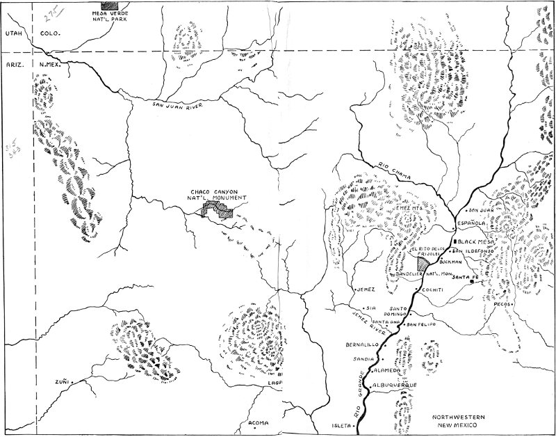
NORTHWESTERN NEW MEXICO
High-resolution Map
To a layman like me it helps a lot
To know a potsherd is just a piece of broken pot;
To know, behind the talk of color, shade, design,
It helped a hungry aborigine to dine;
To see in this broken bit of clay
A brown-skinned baby, clumsy at his play
Cuffed by a weary mother, and whimpering so
Because he broke a dish a thousand years ago!
Hugh M. Miller
By special permission of
New Mexico Magazine.
Printed June, 1936.
My grateful acknowledgements are due to Dr. H. P. Mera and Mr. Stanley Stubbs of the Laboratory of Anthropology, Santa Fe, for their expert advice and criticism in their respective fields; Dr. Leslie Spier, Professor of Anthropology, University of New Mexico, for his helpful suggestions; the late Professor Lansing B. Bloom, Professor of History, University of New Mexico, for helpful information on history; Mrs. Evelyn C. Frey, Bandelier National Monument; Mrs. M. H. Sharp, for the many hours she gave to patient listening and constructive suggestion; Mr. Wayne Mauzy, Museum of New Mexico, for permission to use photographs and cuts; Mr. Natt Dodge, Region Three Office, National Park Service, for his helpful suggestions and time spent in obtaining cuts; my Mother, Mrs. J. H. Hendron, for her encouragement and assistance; and to all others who rendered services.
For my wife
“MISSIE”
who made this book possible by her patient listening and constructive criticism.
Because of my association with the beautiful Canyon of the Rito de Los Frijoles in Bandelier National Monument, New Mexico, and because of my deep interest in this Monument, the loose ends of a story, about the primitive people who made it their home, have been shaping themselves into a history beginning in America long before either Spaniards or Englishmen came to this country.
The material is based upon the work of many students who have done actual research in Frijoles Canyon and adjacent areas. It is a combination of legendary material, observation, speculation, scientific fact and logic. The text in the following pages is not presented as absolute and unquestionable fact in its entirety, and the author does not intend that it be interpreted that way. There will be some, no doubt, who, for the sake of convenience, will mutter indiscreetly about its content—that it isn’t scientific—as if the book had been intended for the exact scientist. Rather, it is meant for the lay reader who visits the Monument area and who would like to understand some of the customs and ways of life of its ancient inhabitants. This ancient world of the cliff dweller of New Mexico is recreated for the visitor through the firing of his imagination by an understanding of the archæological facts revealed here.
Until a great amount of research is done, a more accurate account of the archæology of this area will not be had. But because of the thousands of visitors to Bandelier National Monument each year, and their interest in its ancient inhabitants, this popular narrative is presented. Throughout the text are many uncommon words and names used frequently in New Mexico. The reader will find a helpful list of these with simplified pronunciations and meanings at the end of the book.
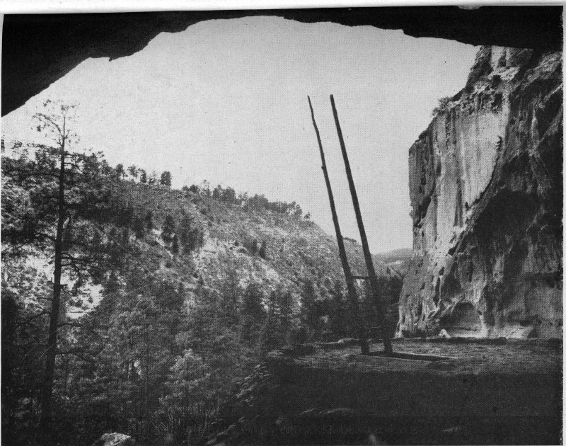
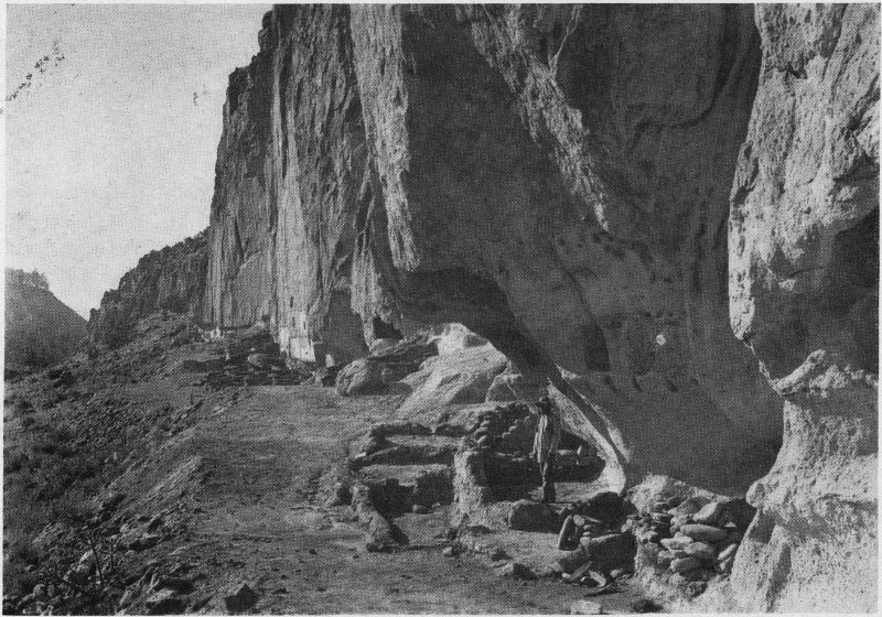
PHOTO BY GEORGE THOMPSON LOOKING UP THE CANYON FROM CEREMONIAL CAVE
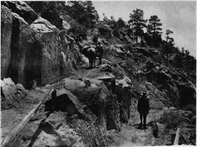
PHOTO BY U.S. FOREST SERVICE THE OLD NORTH TRAIL
It has been some twenty odd years since I, as a child, first peered over the north rim of Frijoles Canyon. This was not so long ago when one thinks of the hundreds of others, still alive, who passed this way before me. I do not pretend to be an ancient but the number of individuals who saw the Frijoles in those days are microscopic when compared with the multitudes who have seen it since. There is not sufficient room here to discuss those who knew the place in the early days, long before my time, except to mention such personages as Adolph Bandelier, Charles Lummis, H. P. Mera, Edgar L. Hewett, Sylvanus G. Morley, A. V. Kidder, Jesse Nusbaum, Kenneth Chapman and many others who have distinguished themselves in the field of archæology or related fields. They all knew the place in its infancy, so to speak, and have contributed their share to the story of primitive Pueblo Indians who lived in the Valley of the Rito de Los Frijoles in times anterior to the coming of the Spanish.
As I remember it, there was a short-cut road into the Frijoles, little more than a cow path which left the Albuquerque-Santa Fe highway just on top of La Bajada Hill. It must have been fifteen miles across La Bajada Mesa west to the Rio Grande. Over the rolling hills of mesa-land the gears of our car ground a good part of the way in low until the little settlement of Buckman on the banks of the Rio Grande was reached. A man by this name, Buckman, used to cut and haul timber from the high potreros; he built a sawmill, and also a narrow bridge across the river here. It was a rickety old bridge with planks for runners but we got across. The 2 winding, bumpy road led us up a steep climb from the Rio Grande to the forested land extending toward the high mountains. Once on top the mesa we drove between two of many high potreros and on into Water Canyon where the road followed the narrow valley for a few miles. We crossed a winding creek several times and drove through green pastures until the high-walled canyon became narrow.
Presently, the road turned to the left winding up the side of the mountain. Fortunately it was not muddy or we might never have made the steep grade. Once on top of the plateau the road headed south and a little west in the direction of Frijoles Canyon a few miles distant. We wound through majestic yellow pines, piñons and scrubby junipers. Here the road turned again and paralleled the Canyon for a few miles, up and down hills, ever twisting and turning. We drove to the top of an old trail which might have been used by ancient Indians some four hundred years ago. I walked to the brink of the Canyon, my mother constantly reminding me not to go too near. The height was terrific. It must have been six hundred feet to the bottom of the gorge—almost straight down. It made me dizzy. I had never seen such a thing before in all my life. It was to me a Hidden Valley and I wondered why any people wanted to come away out here to live—even prehistoric Indians. Of course, it was awe-inspiring but I was too young to be inspired.
There were saddle horses at the brink of the Canyon for folk who couldn’t or who were too lazy to walk down the trail. And then there were benches and tables underneath the pines for picnickers who wanted to eat either before they began the long descent into the valley, or after they returned from it. For years and years people walked or rode horseback up and down the steep old trail. Perhaps some never reached the bottom. Individuals came from all over the world. Some painted, some viewed, some fished, some wrote and some prayed to God that they 3 might make it back to the top. Others, enthralled by the grandeur of the Canyon, desired to cast themselves off its rim into the mystery of its depth. I myself distinctly remember climbing down that old winding trail from the north rim. It seemed that we would never reach the bottom. The trail was a precipitous one, zigzagging and narrow, to the valley floor far below.
At a short distance across the narrow Rito we could see a little stone ranch house surrounded by huge pine trees and box-elders. A woman was standing on the porch probably wondering if we were to be guests for the night at the famous “Ten Elder Ranch.” But my father and I were fishing for mountain trout, and, if I remember correctly, it was he who caught the limit because he was the fisherman, not I. I might have been included among those unschooled people who had in their blood simply the desire for “pioneering” and “roughing-it,” but who understood little about what they saw.
This excursion of ours took place when roads in New Mexico were almost nil. A buckboard would have been better than an automobile with high pressure tires which blew out about twice a day. We broke an axle on the way home and had to spend the night on La Bajada Mesa between the Rio Grande and the highway in what was locally known as “Old Man Pankey’s Pastures.” The Valley of the Frijoles impressed me, then a little boy, and, I well remember the hundreds of smoke-blackened caves hewn out of the soft cliffs by Indians sometime in the dim past. But I knew not the significance of these caves. I knew nothing of the story of how prehistoric Indians lived four hundred years ago. They were merely blackened holes to me occupied by a people about whom I knew little. I remember the ruins of the big community house. It was located across the little river from the stone ranch house. I thought it foolish for Indians to build houses out in the sun when there were so many shade trees close to the Rito. I now believe that this first visit of my 4 childhood created within me the desire to solve for myself the questions then arising in my mind concerning the Canyon. Since that time hundreds of famous personages have passed this way: artists, archæologists, doctors, botanists, psychologists, statesmen, preachers, governors, engineers, students and romancers, each finding satisfaction in his own particular line of interest.
Life in this place two decades ago can best be described by the owner of the old ranch, Mrs. Evelyn C. Frey, who has made Frijoles Canyon her home for twenty odd years. She can tell some very interesting stories about the early days. She knows the country and the trails, the flowers and the birds; and she still calls folks, who live thirty miles away, her neighbors. She recalls many lonely hours spent with her baby in the stillness of the Canyon. She remembers how the sun would go down over the south cliff at twelve noon and then how the day would change toward cold evenings and bitter winter nights. Ofttimes a howling wind would arise, then followed a calm, and in the morning a foot of deep snow. And there was no way out of the valley except over the old north trail. She tells how deer pranced around in full view, unafraid. Wild turkeys rested upon the wall behind the old ranch place and could be seen from her kitchen window. But she was never afraid and said she knew how to use a six-shooter if she had to. Mrs. Frey had told me many times, how, after a rough and tiresome drive from Santa Fe over fire trails, all supplies were packed on horses and mules and brought down to the floor of the Canyon.
A heavy pack mule, once upon a time, loaded with lumber, just didn’t make one of the sharp turns in the trail. It dropped one hundred fifty feet and went to mule heaven, bumping from first one level to another, lumber and all. The carcass was left for the scavengers of the air to feast upon. Mrs. Frey has described how she often bundled her 5 tiny baby up in blankets to protect it from the cold on bitter winter nights, and, bearing the child in her arms she herself had swung into the saddle at the top of the old trail. The narrow path was covered with snow all the way down, and although she was afraid, the faithful horse had always carried them safely to their home.
The time came when pack horses were replaced by a cable-way strung from the north cliff to the floor of the Canyon. It was a thousand feet long and the tram-car was operated by a gasoline engine. This was the way supplies were brought in for the operation of the dude ranch—even the winter’s supply of wood. It was not until 1933 that the old trail was abandoned. At this time an automobile road was blasted from the side of the steep cliff in the lower end of Frijoles Canyon.
The history, if written, might prove far more interesting to many people than the prehistory. There would be some interesting tales to tell about folk and their affairs, but our main concern is with the prehistory. I do not think I exaggerate the situation when I say, despite a visitor’s interest or profession, most guests have come to Frijoles to visit the hundreds of ruins of homes built by the ancestors of some of our present-day Pueblo Indians. The Canyon and its extensive cliff dwellings and pueblo ruins are well-known the world over. Neolithic people, stone age people with implements of bone and stone and wood, lived here in ancient times and when they deserted their homes in the cliffs and on the valley floor, they left one of the most outstanding and spectacular sites in the southwestern part of America to be preserved for posterity.
Could there be, in the Southwest, a man or woman who has not heard something of the Spanish expeditions into the New World during the sixteenth century? And, narrowing it down, about Coronado’s famed Seven Cities of Cibola and how they turned out to be six instead of seven poor little pueblos of stone and mud. They are now reduced to but one called Zuñi. Marcos de Nisa, a Franciscan friar, had led the little army of conquerors to nothing here except grief and disappointment in trade for fabulous stories about gold and silver.
New Mexico was a new country and besides extending the domain of His Majesty, King Charles, and forcing Christianity on the Indians, there were many wonders that would stand investigation. Had it not been for an Indian who was named Bigotes by the Spaniards, the conquerors might never have reached the Rio Grande during that expedition. Bigotes means “whiskers” and his appearance must have been a sight to His Majesty’s soldiers when this half-clad native came strolling into their camp with a few companions from Pecos far to the east. Unlike most of his kind, Bigotes wore a long mustache. He had brought buffalo hides to trade to the Spanish and he persuaded them to visit his country. It was on August 29, 1540, that the little band pushed out under the guidance of Bigotes. On September 7 of that year they reached the Province of Tiguex, which was between the present towns of Albuquerque and Bernalillo.
There were twelve Indian villages on the banks of the Rio Grande within a distance of some fifteen miles or so. The Rio Grande was described by the Spanish, at that time, 7 as large and mighty in a spacious valley two leagues wide. Although the valley was broad and fertile, the Spanish description was certainly an over-estimation. Two leagues equalled five or six miles. They also said that the river froze so hard that laden animals and carts could cross over it. Tiguex was the winter camp of the entire Spanish expedition. It was here that Coronado and his band of weary and disappointed explorers spent that miserable and never-to-be-forgotten winter of 1540-1541. Glowing accounts of how Indians lived were told by the romantic Spanish chroniclers. Still, they found only a poor simple people living by the soil and a little hunting—but no gold.
Tiguex was not the only province along the river. There were others whose people had the same ways and peculiar customs as the people at the Tiguex villages. One of these provinces was that of Quirex. It has been determined that this was the district where the Keres language is spoken today by five very primitive Indian Pueblos. They are Cochiti, Santo Domingo, San Felipe, Santa Ana and Sia. Moved by an indomitable spirit and determination, a small band of soldiers pushed far north from Tiguex, past the Keres-speaking villages where another province was discovered on the upper Rio Grande. It was reported that two very fine villages were to be seen. According to some students these were in the vicinity of the present Tewa-speaking village of San Juan. The entire Indian population moved out at the sight of the Spanish. They retreated into the mountains where they said they had four very strong villages in a rough country where it was impossible for the Spanish to follow on horseback. Had they followed these people they would, no doubt, have found almost inaccessible Indian trails. Instead, they returned to Tiguex and left this northern province in peace. Little did the Spanish realize what extensive villages they might have seen in the rough mountains mentioned by the Indians.
Indians also spoke of villages on rivers flowing into the Rio Grande. Could these villages have been on the banks of the Rio Chama or were they on the Pajarito Plateau? They likely were in the Pajarito region and could have been the same villages mentioned by the Indians living near San Juan. But the towns of the Pajarito remained unexplored, unplundered and unstripped of what little they had. How fortunate were these people to have escaped the attentions of the Spanish with their shining armor, pointed lances and firearms. Otherwise, these poor Indians might have found themselves without adequate clothing and food for the approaching winter of 1541-1542 as did the Indians at Tiguex. But the passing of that second uneventful winter by disheartened and spirit-broken Spanish soldiers ended a chapter which was never to be forgotten by the other little pueblo dwellers. In the spring of 1542, the remnants of the Spanish were gathered together and the return to Mexico was begun. This must have been a day of rejoicing for the Indians at Tiguex. They had experienced a great deal. Murder, insincerity on the part of the Spanish, and violation of their living standards were just a few of their trials.
Life went on in the pueblos. Slowly but surely the Indians reorganized. Summers and winters passed and the Indians tilled their fields of corn for two generations before the Spanish came again. This next expedition up the Rio Grande in 1581 was that of Captain Francisco Sanchez Chamuscado with nine soldiers. This combined treasure-hunt and missionary expedition ended in tragedy. Chamuscado died before he returned to Mexico, and two padres, who accompanied the little party, were murdered by the Indians at Tiguex. So elated were the Indians with their success that they drew pictures of the killings.
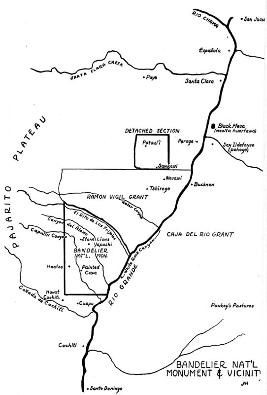
BANDELIER NAT’L MONUMENT & VICINITY
Dreams of conquest and fabulous empires caused the launching of still another expedition into New Mexico in 1583. It was headed by Antonio de Espejo. Espejo, too, passed northward from the villages of the Province of Tiguex which had been visited by Coronado some forty years before and by Chamuscado in 1581. This little handful went north to a place called Cachiti. This was one of the pueblos of the Keres-speaking group mentioned by Coronado. People who were peaceful came from other pueblos and tried to persuade the Spanish to go with them. They told stories of most of the houses being three stories high. The Spanish named this place Los Confiados because the people were not disturbed. But where was Los Confiados? It has never been determined.
It would be a guess to say where these other Indians came from. It has been suggested that they might have come from villages on the Jemez River when they heard of the arrival of the Spanish. There is still another explanation which is also conjectural but possible. These people could have come from villages in the mountains. Archæologists and historians are unable to give us the exact extent of the Keres villages in those days although careful study and research suggest that only seven remained extant at the time of the Spanish Conquest. Yet, who can say that towns were not still being occupied back in the hills? On the forested mesa tops and in the deep water-worn canyons northwest of Cachiti, the Indian Pueblo known today as Cochiti, are hundreds of Indian villages now in ruins. They were occupied, hundreds of years ago, by Indians who were probably speaking the Keres language like the folks at Cochiti, Santo Domingo, San Felipe, Santa Ana and Sia. These people have told some interesting tales, legends mostly, about how all their present villages came to be: about their wanderings, about their Gods and about their troubles with Indians who spoke different languages.
Why was it that Espejo’s chroniclers did not leave us more information about the town of Los Confiados and its people? Was it not important? They told us about Zuñi and its Seven Cities, about the Tiguex villages and Cochiti. Coronado’s 10 little group, some forty years before, had visited the Province of Hemes, now Jemez, whose people spoke yet another language, the Towa. And history tells us that Espejo made a two-day visit to the town of Los Confiados in 1583. This ended his contact with the Indians at Cochiti and other Keres-speaking villages. Could it be that Espejo’s soldiers looked back up into those forbidden and forested hills against a high range of snow-covered mountains northwest of Cochiti and decided that they had seen enough of the Indian? Or were they told that they would have to leave their horses behind and go afoot if they wanted to visit the villages on streams running into the Rio Grande? The thought of wearing heavy armor might not have been too fascinating. And if these people were from villages in the mountains, what was their motive in attempting to lead the Spanish there? Was it a trap? Did they have some other motive in mind, or was their mission one of peaceful intent? Archæologists now tell us that it probably has been centuries since Keres-speaking people lived in these mountains northwest of Cochiti.
If one had sufficient imaginative ability he might work up a hypothetical case of what could possibly have taken place during this February of 1583. To get at the basis of our story and the things to be talked about hypothesis seems to be our only recourse. Nothing seems exact when dealing with early New Mexican history, but this hypothesis could be as correct, possibly, as some of the accounts given by the Spanish possessed of romanticism. But how close were the explorers to Hidden Valley, the like of which they would never again be able to see! They stayed clear of the mountains and kept to the valleys. In all of their travels and wanderings, the Spanish kept out of the watershed between the Jemez Mountain Range and the Rio Grande Valley. It is today known as the Pajarito (little bird) Plateau. The Cañada de Cochiti is its southern boundary, not far from 11 the pueblo of Cochiti. The Rio Grande bounds it on the east, the Rio Chama on the north and the Jemez Mountains on the west. The entire plateau is made up of deposits of soft volcanic ash, known as tuff, and deposits of black basalt. Geologists tell us that all this happened an inconceivably long time ago—three million years, let us say, in geological times known as the Pliocene and Pleistocene periods.
Today the Pajarito Plateau is a profusion of high potreros (narrow mesas), and deep canyons cut by streams and arroyos which carry off seasonal rains. Some of the canyons have sheer vertical cliffs of volcanic ash, hundreds of feet high in places, and this ash is soft enough to be carved and hewn into various shapes and forms. The cliffs are even soft enough for the wind to carve what appear to be statues which stand out as exceptional works of nature. The mesa tops are beautiful. They are covered with thick growths of pine and juniper, piñon and scrub oak. A profusion of flowers dot the landscape during the summer months.
It was the Pajarito Plateau that both Coronado and Espejo failed to plunder, not because of any lack of desire on their part, perhaps, but because it was a forbidden land to them and was marked by defying cliff boundaries which rose to terrific heights. Could one say that the Spanish did not wonder what these hills possessed when they heard about villages on streams which ran into the Rio Grande? And no doubt, if these peaceful people, whom the Spanish followed to Los Confiados, were of the Keres nation—and they likely were—then they knew every valley, stream, trail and water hole in the Pajarito country. Espejo dispatched some of his men to accompany these Indians. Where were they led? Did they go up into the sandy foothills below the Jemez Mountains and its finger-like plateaus or did they penetrate almost inaccessible territory northwest of Cochiti? Or did they march straight north up the almost inaccessible White Rock 12 Canyon of the Rio Grande? They were gone two days from the pueblo of Cochiti. Where did they go? Where was this town of Los Confiados to which Espejo was invited and about which he gave us no fact?
The Keres-speaking people are possessed with legends of having been driven from the Pajarito by a race of “dwarfs” at some time in the remote past. But no one is sure that this race of “dwarfs” was not the Tewa-speaking people from the northern part of the Pajarito region who descended into Frijoles Canyon and drove the Keres from their Hidden Valley long before the Spanish came to America. Nor can one be certain that Keres people were not still living in Frijoles Canyon with the Tewas during Coronado’s time in 1540 or even some forty years later during Espejo’s time. Could one go so far as to suggest that Keres groups still remembered how their ancestors perhaps had been driven from their homes by “the little strong people” and that now they could have a well-earned revenge by directing the attentions of the Spanish toward the Valley of the Frijoles?
Had Espejo been gullible enough, and had the spirit of adventure been strong enough; had it been summer and not February, and had these peaceful Indians been Keres bent on revenge against the Tewas, his soldiers might have been led northwest up the Cañada de Cochiti. After an hour or so the trail would have become so difficult that the Indian method of travel would have been an issue. Horses would have been left behind and the little party would have ascended to the potrero tops on foot; over snow-covered precipitous trails; up and down canyon walls and deep into ancient Keres land.
It would have been no “picnic” even on foot. So rough is the country it is even doubted that the wily Navaho used these trails as has been so often suggested. The Keres might have picked a more direct route; up the banks of the Rio Grande to the mouth of Capulin Canyon, over 13 high potreros, following a dim rough trail which skirted the Rio Grande for several miles then north to the mesa bordering Frijoles Canyon. And it is quite possible that the Spanish could have gone horseback deep into Keres territory, up Capulin Canyon to La Cueva Pintada, the Painted Cave. The cave gets its name from the many pictographs on its walls. Around it are the ruins of many houses built against the cliff at the top of the talus slope. Some of the Indian legends have it that the Painted Cave was one of six towns occupied when their ancestors were driven from the Valley of the Frijoles.
Travel from the Painted Cave on into Keres land probably would have been on foot. Up the rough Capulin Canyon [** Error: possible line-wrapped glossary phrase]for an hour’s march, over snow-covered potrero tops, they would have passed the ruins of innumerable villages. There they might have rested and drunk the icy water from a running creek during this cold month of February. And from there they made their way up to the potrero tops again, winding and twisting, half walking and half climbing and stopping somewhere, in a cave perhaps, to spend the night. And then they marched on to the pueblo of the Stone Lions, now bleak and desolate and worn by time. The pueblo of the Stone Lions, according to the Cochitenos, was the first village built and occupied by the Keres-speaking people after they were driven from the Valley of the Frijoles. The village is known as Yapashi which means “sacred enclosure.”
Only a half-mile away is the Stone Lions Shrine. Carved out of native tuff are the life-size images of two mountain lions and around them is an enclosure—a low wall of blocks of volcanic tuff. It is said that even the Zuñi Indians made pilgrimages to this shrine because they believed this to be the entrance to Shipapolima, the underworld from which their ancestors emerged. It is important even today to the Cochitenos who visit it frequently and leave bits of their ceremonial paraphernalia. Moving along 14 slowly, Espejo’s little party would have trudged up the slopes to the high potrero tops again and then across the steep-walled Canyon del Alamo. They would have had a long march to Frijoles over trails known only to Indians. No, this could hardly have happened. The Spanish might never have survived.
Had these Keres-led Spanish peered into the Frijoles—known to Indians as Tyuonyi—this Hidden Valley in the New World, they would have seen the unbelievable. They would have looked into a valley six hundred feet deep and several hundred feet across. The opposite or north side was a sheer perpendicular cliff of pinkish rock. There were houses terraced high in the air, three or four stories at the base of the cliff. There were cave openings in the cliff, over some of the houses, which led out to open porches built of poles and brush. Small houses of stone and mud extended up and down the north wall of the Canyon almost as far as the human eye could see. People were walking around, microscopic in size because of the distance, climbing up and down tiny ladders to and from the tops of their houses. They were clothed in cotton cloth, hides and furs.
In the center of the valley, seemingly equidistant from both sides, was a huge circular house comprised of many small rooms, one on top of another, with tiny ladders extending from the ground to the roofs. Indians were going in and out of small roof openings. Their house was a veritable fort of primitive style. Four hundred rooms, or more, were built in the form of a circle. The structure had an opening or hallway through one side which led to an inner court or plaza. A sentry was stationed inside the entrance which was a high, thick wall built in the shape of a semi-circle with a narrow opening. A lone Indian, or maybe two, with bow and arrow in hand, might have been seen carrying a deer down a narrow trail. Queer looking creatures were these Indians with long stringy hair tied down by a band around their foreheads. They wore moccasins of deer skin on their feet. Kilts covered their thighs. They could have been a short muscular sort of people much the same as our modern pueblo dwellers. But they were known as the “pygmies” or “the little strong people.”
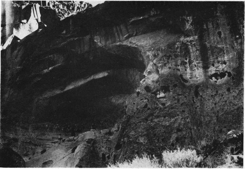
COURTESY MUSEUM OF NEW MEXICO THE PAINTED CAVE
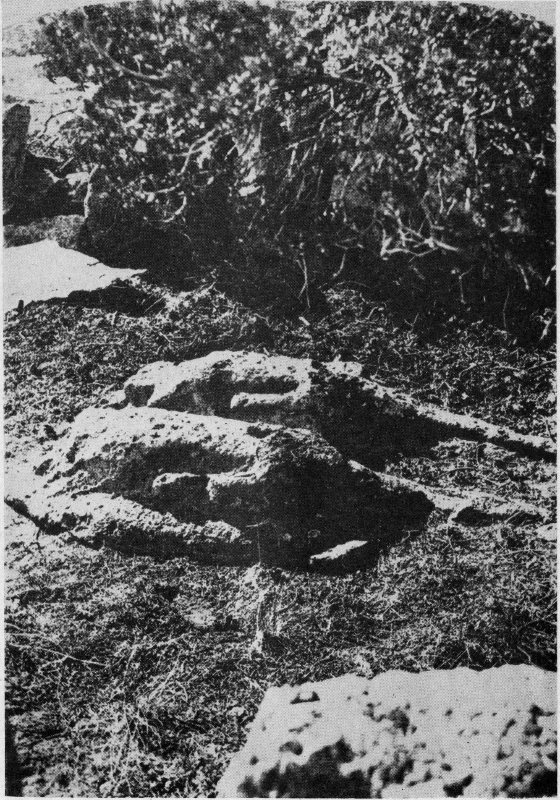
COURTESY MUSEUM OF NEW MEXICO STONE LIONS OF COCHITI
Smoke emerged from tiny openings in the roofs. Occasionally an Indian woman would appear, black hair stringing and her body draped with a manta of cotton cloth or animal skins. The bark of a dog or the gobble of a turkey which the Indians had domesticated might have broken the silence. The waters of the little river far below could be heard rolling over and onward toward the Rio Grande. The occasional thud of a boulder was heard as it bumped down stream.
Only one side of the valley was occupied—the north side. The south side was covered with trees, bare now because winter was here. The south wall of the Canyon was not as conducive to habitation as the north because it was worn down at a sharp angle. There were no vertical cliffs from which to carve out caves and no talus slopes on which to build little houses of stone and mud. No sun directed its rays toward the south cliff. The snow lay there all winter and helped cut it down at a sharp angle from top to bottom. The north side was sunny and dry—a perfect place for habitation.
There were not many people here during these last years of the sixteenth century. Great numbers had gone: but where, and why? A few cronies could have been seen crouching against stone houses at the base of the cliff, basking in the afternoon sun. A woman or two could have been grinding corn on flat stone slabs inside a cliff house, keeping time to a weird monotonous chant sung by old men as they pounded drums. Things were hanging from the ends of roof poles protruding through the front walls of houses—perhaps a piece of highly prized venison. House tops were 16 strewn with corncobs. A weather-beaten corn field had spent itself.
This was the valley known to the Keres as “Tyuonyi.” It was the place where their people had lived only a few generations before. It was a valley over which most any group of primitive people would fight and was a place where the water supply was constant except in times of intense drought. Tyuonyi is a Keres word which signifies a treaty or contract and was so-called because of a treaty made with Tewa-speaking people years before, marking it as the boundary between Keres and Tewa territory. But who was to occupy Tyuonyi, the Hidden Valley and the most ideal spot on all the Pajarito Plateau? It seems that the Tewas (the little strong people) were the ones who occupied it until the very last. This was perhaps the reason why the Keres became envious and that is why to this day they retain a feeling of criticism for the Tewa-speaking people. Legend has it that relations between the two groups in prehistoric times were normally unfriendly.
No Spanish expedition ever reached Hidden Valley, or at least, archæologists have never found anything to indicate such a visit. And I repeat, the Spanish expeditions clung to the low valleys and kept away from the mountains. Tyuonyi then, is our subject. The Spanish never visited it and if they ever heard of its extensive settlement by Pueblo Indians direct mention was never made of it. It was a Hidden Valley in the New World occupied before recorded history began in America. And today its ruins are mellowed with age. It has yet to give up all its secrets about the cliff dweller who hewed three hundred caves from its north cliff with stone axes and knives, and built over twice as many small houses at its base. They constructed five community villages on its floor, and raised corn and beans and squash and pumpkins. And in so doing, these prehistoric pueblo and cave dwellers, and I might say historic, too, left in Hidden Valley so much 17 material evidence about the way they lived that in 1916 the entire area, including some of the ancient Keres land to the south, was created a National Monument. Later, a detached section of ancient Tewa territory, a few miles to the north, was added to the area. It is known today as Bandelier National Monument and is comprised of some 27,000 acres.
The thousands of interested visitors, who go to Bandelier every year to prowl through the ruined homes located in the Valley of the Frijoles, spend an hour or so turning the clock back to Neolithic times when man had only bone, stone and wood tools with which to work. They relax in Hidden Valley—and in imagination try to reconstruct the story connected with these ruins which hold so closely the secrets of the past.
Could one be so bold as to say that the Moslem Invasion of Spain in the eighth century A.D. took place after the first occupation of the Rio Grande Valley by prehistoric Indians? Archæologists, who tell us stories based on the remains of things they have found, broken pottery mostly, say that Indians might have known the Rio Grande before this time. We believe that they have occupied it continuously since about the eleventh century A.D.
Drought seems to have always been one of the main controlling factors in the migrations of Southwestern Indians. The study of tree-rings tells us this. By matching ring patterns formed by the annual growth of certain kinds of trees, pines chiefly, archæologists are able to determine the years in which age-old timbers were cut. Those they are interested in are the ones used by prehistoric Indians long years ago for building roofs on their houses. So naturally, if an Indian had cut a tree down with a stone axe and laid it across the walls of his house, then the year that the tree was cut would correspond to the approximate time his house was built and occupied. Indians did not cut timbers until they were ready to use them. Felling timbers with crude stone axes was somewhat of a chore. Old beams from houses show that long periods of drought reigned in the Southwest. It is thought that these dry spells caused Indian families to leave their homes and seek new lands for settlement and cultivation.
Such a condition seems to have existed in the entire San Juan area of northwestern New Mexico, northeastern Arizona and southwestern Colorado. The greatest of the large 19 centers of Indian population, which may have numbered hundreds or even thousands of people, were the towns of Chaco Canyon in northwestern New Mexico and the Mesa Verde cliff dwellings in southwestern Colorado. Many of these towns, it seems, were abandoned when the great drought was at its height between 1276-1299, a period of twenty-three years. And so we find shifts in population. It is believed that some of these shifts were toward the Valley of the Rio Grande.
Before this time small individual groups or migrant bands took to wandering. Other Indians could have remained even after the time of the twenty-three year drought period, dreading to leave their homes as we would ours today. No, there was no great exodus of population. The people from the great towns in the west did not move out all at one time and completely abandon their homes and desiccated lands. They moved out in small bands, or even families. In some way, a traveler might have reported high mountain ranges, water and fertile lands to the east—the next best to the places they knew as home which they and their ancestors had occupied for hundreds of years.
It is possible that even in the 1000’s A.D., small groups pushed out over dry desert wastes, following sandy arroyo beds—thought of water ever paramount. They were people struggling again for existence. Some likely stopped along the way and built temporary homes. They broke pottery vessels which they had brought along. The archæologist found some of the broken pieces nine hundred years later to help tell the story. Whether these migrant bands had a goal or not is questionable but the Valley of the Rio Grande was finally reached and scant evidence of these early people has been found. More and more Indians moved out of the San Juan area and drifted in a southeasterly direction. Some clung to the valleys, others took to the mountains, but all settled in the general locality where we find most of our colorful and picturesque 20 Indian Pueblos so well-known the world over—northern New Mexico.
It is evident that by constant roaming, and penetrating unknown and fascinating country, some of these primitive Indians stumbled into the deep valleys and upon the high forested mesa tops of the Pajarito Plateau, about twenty miles west of the present city of Santa Fe. The spot on which Santa Fe is located was then nothing but arid mesa land and low foothills ascending to the Sangre de Cristo Range of Mountains. Four things were paramount in the minds of these primitive people. They were water, food, protective shelter and clothing. These were the things the Pajarito offered. Anyone journeying through the deep canyons and over the high mesa tops today could easily see why prehistoric Indians settled here.
For centuries the wind pounded tiny sharp particles against cliff surfaces. It whipped up close to the ground and hollowed out shallow caves. Very likely, these places were not large enough for Indians to crawl in out of the weather but the cliff composition was so soft that these natural caves could easily be made larger. A crude stone of basalt with a sharp edge made a perfect hand axe. Indian men hacked out caves large enough for a little family group to enter. Rain and cold created the necessity for heat. Drills of wood were used to start fires in these crude cave dwellings. Fires made them warm—suffocatingly so. There was no way for the smoke to escape except through a wide front opening. This lack of ventilation created a very serious problem for the early cave dweller on the Pajarito Plateau.
There were other Indians who preferred to build their homes on the high mesas during these early times. Adobe was used almost exclusively to build the low walls of rooms. Some bedded small stones into the walls before they were dry. This helped to hold them together. Others preferred to use larger stone, picked up at random, in building their 21 house walls. The adobe huts were undoubtedly unsatisfactory because of their low resistance to weather. Since older styles of pottery have been found in the ruins of these houses, it is logical to suppose that Indians migrating onto the Pajarito built adobe houses first. Later they dug themselves out homes in the cliffs which gave them greater protection from the weather and from any invaders.
In this wilderness a mule deer could have fed in a little valley or drunk from a creek. This would mean food for the entire family or group if a crude arrow would hit its mark. Small razor-sharp fleshers of chalcedony or basalt were used to remove the hide from the carcass. The hide could be used for making clothing or moccasins. Some of the smaller bones might have been used as drills and awls until better ones could be obtained. A flock of wild turkeys would have solved this problem. Turkey bones made excellent awls. Just what the people used for arrow points during these early times is questionable. Maybe they brought them along from the west. They could have used chipped chalcedony or basalt which was readily found, and quite common in this area. An occasional nodule of black volcanic glass, called obsidian, washed down the creek and was found bedded in its soft sandy bottom. Obsidian might have been more popular during later times as the early dweller in this country may not have discovered the ledges of black glass immediately upon his arrival. Such could have been life on the Pajarito Plateau eight hundred years ago.
More groups of people came in. Hand-hewn caves could have dotted the soft workable walls of every canyon which would support human life. The well-known canyon of today, the Frijoles, was one such place. The lower part of the valley formed a sort of a bulb for about two miles. Its sheer cliffs on the north side rose to terrific heights. And throughout the countless years, as boulders and dust fell from the cliffs, a talus slope or base had formed. A little river, 22 the Rito de Los Frijoles, ran for seventeen miles from its source in the high mountains to the west and emptied into the Rio Grande. This Canyon was the best in the entire Pajarito—the most coveted of all habitable places. The water supply was apparently constant and the valley was broad and open at the lower end, most suitable for agriculture. The floor was densely covered with growths of scrub oak, piñon and pine. This was all that primitive groups needed for successful living. And so we find that some of these wandering Indians from a world a hundred miles to the west, which was to become a thing of the past, penetrated the Valley of the Frijoles over eight hundred years ago. But Frijoles Canyon was not the only place occupied. There were other canyons nearby. There was plenty of room for all. But was there enough water in these other canyons?
Indian families cut their crude shelters deep enough for occupation by several individuals. Caves were uncomfortable, but certainly better than no shelter at all. This was a strange sort of stone which nature had provided. It was very poor to build with, thought the Indian. It was soft and bulky. But years of living would eventually solve the problem. Why worry about it! In time necessity would produce some means of shelter more satisfactory. Later on, more people moved into the area. These people occupied adjacent canyons and mesas as well as Frijoles. During many years population increased and the dwellers on the Pajarito became settled in their locality.
There is no way of telling how many Indians lived in the Valley of the Frijoles during very early times—close to water and well protected. Indians could sit at the openings of their cave homes above the talus slope and see for great distances up and down the Canyon. And it was safe. No jealous enemy lurking above could roll a boulder down on them. Their cave was their protection. But caves were not adequate as homes. Fires could not be built inside without smoking out 23 its occupants. Something better had to replace them. This new soft rock certainly was not suitable for building walls or at least these simple valley folk did not know how to use it. Crude mud huts were erected at the base of the cliff at the same time that caves were occupied as home sites. Mud was all they could find for building walls. It took lots of water to make mud and then it was so soft and crumbly that the little walls cracked and fell when they dried out.
Soon it was found that by picking up small stones and packing them into the soft mud as temper the walls would stand longer. Larger rocks and less mud made better walls and saved a lot of toil and unnecessary labor. There were many rocks to be picked up at random. Walls were raised high enough for the Indian to stand upright inside the rooms. Sharp stone axes of basalt were used to fell small trees which were laid over the tops of walls for the support of the roofs. The blunt ends of the timbers were inserted in holes gouged out of the cliff. Brush and grass were placed over them; thick mud coats were smeared over the top. Holes were cut in the roofs. Fires were built and the smoke could escape through these holes. How much better this than a cave! These tiny rooms were stuffy and smoky inside but not as unpleasant as a cave room. An Indian would soon suffocate inside a cave. During the rainy seasons the roofs leaked and great quantities of mud were stirred up and spread over the top and smoothed down flat. The women could always find more when that washed off. In time weeds and wild grasses took root in these dirt roofs.
But somewhere, somehow, not at Tyuonyi perhaps, but in some nearby valley or on some high mesa top at one of a hundred colony sites, Indian neighbors found that still larger chunks of tuff could be used for building blocks. This would save much labor. So much mud in a wall would not be necessary. It is possible that this use of larger building stones was not a matter of independent origin at any one of many primitive 24 villages on the high mesas and in the deep canyons of the Pajarito. Indians, after years and years of living, simply came into the use of larger building blocks by the trial and error method. They served the purpose better. A dry spell or so, when it did not rain, might have made it necessary to transport more and more water in urns from water holes or nearby streams. This was women’s work and hard work too. And more stone and less mud made stronger walls for houses anyway. Some of the stone was so soft that it could be shaped into blocks to fit into the walls. These blocks did not lay absolutely flat because their surfaces were irregular. Small stones were forced between the cracks and when the mud mortar dried the walls were solid. This practice went on for years and years. Indians experimented with all the materials at their disposal. They could not send an order to the Gods for building materials.
Everywhere on the Pajarito are seen the remains of homes belonging to this period of occupation. There are hundreds of them—small family houses, in deep canyons or in a forest on high mesa tops. Debris has filled them up and today they look like piles of rock. Building blocks are strewn all over the surface. Most of the blocks had been picked up at random after they had been carved by nature. Others were square or rectangular, showing that they had been fashioned by Indian hands.
The Indians who lived in the Valley of the Frijoles communicated with the other groups who lived in deep canyons to the south and to the north. They visited each other and even traded back and forth. Little colonies were formed when one, two, three or four families lived together in a house with several rooms. But the time was to come when this living all over the country would stop; people would come together to live in communities. And the little colony sites would be abandoned forever for the archæologist to discover centuries later.
A touchy subject is that of linguistics. It is a tricky one. But students know that five different languages are spoken among the Pueblo Indians of New Mexico today. They are: Tiwa, Tewa, Towa, Keres, and Zuñian. To be on the safe side, one should not touch too heavily upon languages spoken by Indians, especially in a writing of this kind. But languages and dialects do play an important part in our story. When those early people drifted from Chaco Canyon and Mesa Verde toward the Rio Grande, they spoke a language. But, it is unknown. Students have ideas, but are reluctant to advance opinions based on the ruins they excavate or the artifacts they discover. But, two groups of Indians speaking different languages drifted onto the Pajarito. People speaking different languages have never gotten along well together even from the Tower of Babel until the present time.
It has been mentioned before that Keres-speaking Indians have a legend that long years ago a treaty or contract was made between their ancestors and Tewa-speaking people. It is said that certain loosely defined ranges of territory were to belong to each of the two groups. The meeting place or the place where the treaty was made was called “Tyuonyi.” “Tyuonyi” means “place of treaty.” Thus the dividing line between Tewa and Keres lands became sharply defined by what is now known as “Frijoles Canyon.” But how long was such a treaty to last among primitive people? All the lands to the south of Frijoles Canyon were supposedly Keres and those to the north were Tewa. After this treaty was made, Indians probably spread out on each side of the Canyon like the parting of the waters of the Red Sea. Small house sites dotted the mesas and canyons on both sides. But still, members of both groups could possibly have lived here together. Legend hints at this.
As time went on more houses sprang up at the base of the north cliff and crude pueblos were erected on the floor 26 of the Canyon. Kivas or ceremonial chambers were dug out of the valley floor and lined with walls of rock. Indians gathered cobble stone because they might not have known how to cut blocks during these early times with which to lay masonry walls. They gathered thousands of them and built their kiva walls eight or ten feet thick. This was their attempt to utilize the pieces of crudely shaped felsite or volcanic ash. They laid huge timbers fifteen or more inches in diameter across the walls of their large underground chambers. Then smaller poles of pine were cut and laid on top of the large vigas. Splittings were hacked from down trees. Pine, cottonwood, juniper, piñon—anything that would split easily with crude stone implements—were used for the next roof course. Then brush and grass and mud were put on top. The roofs must have been two or more feet thick but little did the Indians realize that the tremendous weight might crack the big timbers after they dried out. How ingenious were these Indians in their simple way!
Many a moon passed. Many houses were built. Jealousy might have arisen between these two groups of Indians. Who was to raise corn on this or that little patch of fertile ground? Who should have a right to hunt deer and turkey in the Valley of the Frijoles? How could Keres-speaking people go to Tewa kivas or how could Tewas go to Keres kivas? Trouble reigned over the entire plateau and most of it was possibly in the Valley of the Frijoles. Was it ever decided which group should live in Hidden Valley when it was given the name Tyuonyi?
Jealousy could have arisen over pottery. When the Frijoles area was first occupied clay deposits were discovered in arroyos and along river banks. Indian women began moulding pottery with local clays. They discovered mineral pigments. They used paints from wild plants which fired the black designs in fast color in the vessels. The color would never come out. But slowly and surely the women began to 27 depart from the techniques which they and their ancestors had previously used. Out of these techniques new styles of pottery were developed by using local materials. These white wares with black designs became thick and coarse as time went on and probably decreased in popularity as far as usefulness was concerned.
The Keres-speaking people had kin far to the south of the Pajarito Plateau. And these people were ingenious. Sometime in the thirteenth century, it seems, Indians living in the Little Colorado River district of what is now eastern Arizona and western New Mexico, were making a style of red pottery with black designs. This pottery was apparently very popular and spread by trade to the Rio Grande Valley. Indians in this same region eventually learned to produce a glaze paint by using lead-manganese ore. This ware also spread to the Rio Grande and glaze paint was used in decorating pottery from about 1350 A.D. to the time of the Pueblo Rebellion in 1680. It is thought that shortly after its inception and perhaps by 1400 A.D. this red pottery spread by trade to Tyuonyi.
The Keres living here might have brought this red ware in from their southern relatives living below the Pajarito Plateau. On the other hand, it is possible that they might not have lived in the Canyon before the time of the glaze pottery. The most plausible explanation seems to be that the people to the south brought the materials to their kin in the Frijoles. These materials were then transformed into the beautiful new hard red ware to catch the eye of the Tewa-speaking people who likely were modeling inferior white wares with black designs. However, there is a remote possibility that this glaze ware was never manufactured in Frijoles Canyon and this possibility brings up the question as to whether or not the ware was used as a wedge to gain entrance into Tyuonyi. The folk who were living here, either Tewa or Keres, or it could have been both, were making an 28 inferior type of black-on-white pottery with local materials. It was inferior because it was so porous. So, the Tewa-speaking people might have readily accepted this red ware in trade from the Keres. And it seems this trading might have been carried on for a half-century or thereabout. No one is sure. At this particular time there seems to have been a definite decrease in the manufacture or trading of glaze pottery.
Something very drastic must have taken place. Could it be that there was just not enough room in the beautiful Frijoles for two groups of people who spoke different languages? It was easily a prize spot. It was a green valley—a perfect place to live and the water supply was constant. It might have been the envy of Indians for many miles around. There was not this constant water supply either to the north or to the south. Some groups living on the high mesas might even have depended on open basins hollowed out of soft rock to catch the rain water. Great jealousy could have arisen between individuals or even groups. And one might safely guess that love affairs were broken up between Tewa maidens and Keres boys or vice versa. And who can say with certainty that the Tyuonyi was not the earliest known home of the Keres-speaking people in this vicinity? Or that it was not the Tewas from the north who did the encroaching and forced their way into the Valley of the Frijoles and lived and traded pottery with the Keres?
By the time of the fifteenth century, there were many of the Indians living to the north of Tyuonyi. Little house sites were being abandoned. People were drawing closer together to live in larger communities. Surely, the soft volcanic ash from the cliffs was being fashioned into building blocks with stone axes. Some were square, some were rectangular—long heavy four-sided blocks. It had taken Indians years and years, possibly, to learn that this soft stone could be quarried and then shaped. These blocks were definitely better and single thickness coursed masonry walls were in vogue by this 29 time. This was the highest type of prehistoric pueblo architecture on the Pajarito Plateau.
This was most likely the period in which the terraced communal apartment houses were developed and erected. There were centers of population from this time on. There were no more small family houses. Indians built houses with several hundred rooms, at least two, and, in some cases, three stories high. What was the reason? Was it for defense purposes or was it just a normal outgrowth of the discovery of the fashioned block technique? There were several main villages occupied by the Tewa-speaking people to the north. They were all built in defensible positions: on a knoll, a high mesa top overlooking the entire surrounding country, or in a valley away from the cliffs from which heavy objects could be thrown down by enemies. These four villages were Potsui’i, Sankawi, Navawi and Tshirege. Potsui’i was located in a deep valley on a knoll. It was known as “gap where the water sinks.” Sankawi was “gap of the sharp round cactus.” It was built high on a mesa top in a defensible position. A trail was worn in the soft rock by thousands of moccasined feet going and coming from the pueblo. Another of their villages, Navawi, was so-called because of a pitfall gap or game trap. Game coming from either direction on the trail was caught in a deep pit. Tshirege was “House of the Bird People.” It was the largest pueblo on the Pajarito and had extensive villages built at the base of the cliff. The numbers of Indians who lived at these sites during these times cannot be estimated though all four villages were large. It would appear that nothing but Tewas lived here. But there also lived their kin and kind in Frijoles Canyon.
Keres people were living to the south of Frijoles—in large pueblos too. They had been living in this south country for years at Yapashi, “pueblo of the Stone Lions,” and at Haatze, “House of the Earth People.” These were communal apartment houses also but the Keres population on the Pajarito 30 probably was not as great as that of the Tewas in those days. Nobody but Keres lived here to the south of Tyuonyi.
But certainly some groups held on at Tyuonyi. Who can say what happened half a millenium ago? Likely, the Tewas in Frijoles were few. They could have been outnumbered by the Keres people who might have refused to leave their Tyuonyi. Runners could have been dispatched across trails to the north to the big villages for help. War chiefs held council. Warriors were called into action and could have streaked out over age-old trails. Hideous looking creatures with flying black hair, bow and arrow and war club in hand, went whooping and yelling to the Tyuonyi and entered the Canyon at half a dozen places over the north cliff. Two groups of Indians speaking different languages simply could not live in the same valley, farm the same fields, live in the same caves and drink the same water. This was the last of the Keres. They could not hold their own because they were outnumbered and out-fought by “the little strong people.” They were driven off and the Valley of the Frijoles was Tewa from then on.
So these beaten Indians pushed south to move in with their kin at the pueblo of the Stone Lions. Whether they ever went back to Tyuonyi and attempted another stand against “the little strong people” is not known. It has been legendarily hinted that a race of “dwarfs” again attacked them at the pueblo of the Stone Lions, slaughtering many and driving off the rest. But we know of no race of “dwarfs” in the Southwest during either prehistoric or historic times. The poor Keres! They were beaten at every turn. But they knew it and moved on, occupying first one place and then another, moving in for awhile with other kin and kind. The farther away from Tyuonyi, the better!
COURTESY MUSEUM OF NEW MEXICO RUINS OF LONG HOUSE
COURTESY MUSEUM OF NEW MEXICO A PART OF LONG HOUSE RUINS
Haatze, or “House of the Earth People” was their next stop but not for long. They lived here with their kind and then moved on, down to the village of Cuapa only to be attacked again by “the little strong people.” Great numbers were slaughtered, so the legends go, and the remainder driven off and pursued almost to the present town of Santo Domingo. Legend has it that one group went off by themselves and formed the pueblos of Cochiti and Santo Domingo. Another group, it is said, climbed up a high rock and took refuge there from their attackers. The rock is known as the “Potrero Viejo” and here they built a village. One San Felipe legend tells us this: nearly all the people at Cuapa were slain, except a woman with a parrot who hid in a metate and a boy who hid in a store-room. These two moved to the Tiwa-speaking village of Sandia and got a cold reception so they went east to live with the Tanos, where the woman gave birth to five children. Things were made so miserable for them here that they left and moved to the Rio Grande and eventually went to San Felipe. That is why we have the pueblo of San Felipe today. These people still know the Pajarito as their ancestral home and it is not an uncommon thing for them to organize a communal hunt to the homes of their ancestors or trudge to the Shrine of the Stone Lions and paint the noses of the life-size fetiches or sprinkle a little sacred meal—deep in ancient Keres land.
Time has a peculiar way of curing all ills. The Keres had been driven from the Tyuonyi by the “little strong people” and possibly did not make further attempt to re-occupy this Valley of the Frijoles. They were contented to stay in the broad Valley of the Rio Grande where the water supply was constant and where their enemies did not care to go. The boundary line was set. And even the hostile Tewas had probably experienced enough of war and trouble.
Tyuonyi, the Hidden Valley, might have been like an oasis in the desert. Who can say that there was sufficient water in the canyons and on the mesas to the north—that water holes did not go dry and that the Tewas did not have to depend upon waters from the heavens to make their corn grow? And who can say that the waters of El Rito de Los Frijoles dried up? One can only suppose. But judging by climatic conditions as they are today, Frijoles Canyon was one of the main sources of water on the Pajarito. Since water was a controlling factor in the lives of these people, what primitive group of Indians would not fight over the right to live in a well-watered valley—a green and beautiful valley—where adequate shelter was afforded by the vertical walls of a high north cliff? Certain things hint that little time passed before Tewa-speaking groups penetrated the Valley of the Frijoles again and in larger numbers than before. Slowly and surely they trickled in a few at a time. Over a period of years the infiltration was heavy. Deep trails were worn in the soft rock ledges by the passing over of thousands of moccasined feet going to and from the northern villages some ten miles distant. The steam of hatred between the 33 jealous groups could have cooled off but probably never completely. Toward the close of the fifteenth century primitive Tewa farmers, it seems, had again settled in Frijoles Canyon.
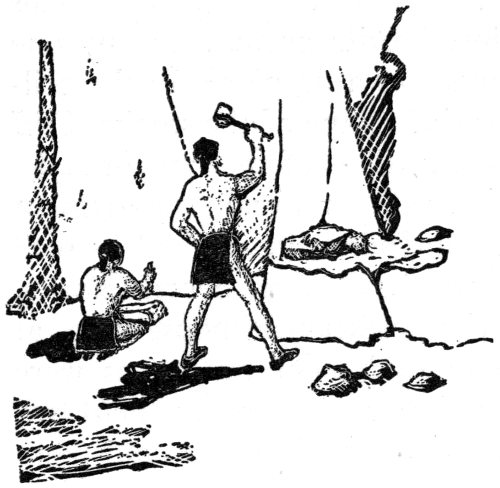
They went to work in earnest this time, building houses; not with mud walls which would wash down when it rained, but with walls of stone, which type of construction their predecessors had begun. Some of the caves occupied by the earlier people could have eroded away while others could have been re-hewn by these later occupants. Who knows? Crumbling remains of old talus houses might have been leveled off at the base of the cliff and new homes built over them. Indian men carved the heavy stones into square and rectangular blocks with stone axes. The stones lay almost flat and the masons did not have to be too careful in their fashioning because small pieces of rock hammered tight in the joints would hold the blocks steady. These walls were laid on footings of smooth-worn river pebbles. Block after block was carved and laid into structures seven feet high. Indian women carried water from the little river in ollas on the tops of their heads and trudged day after day up the steep slopes to the cliff. They gathered clay, perhaps not from Frijoles Canyon, because it was hard to find. They might have traveled miles for enough to apply a thin coating of wash over the stone walls of their homes.
Indian men labored with stone axes to fell the trunks of pines which they used in building roofs to their houses. They gouged holes out of the soft cliff to insert the ends of 34 roof beams and sealed them in tightly with mud mortar. Across these vigas they laid small poles. Many miles were covered to obtain long slender canes and cat-tail stems from the muddy low banks of the Rio Grande for the next roof layer. Then pine needles and brush supplied the next coat. Something leafy had to hold the thick mud coats which were smoothed flat over the top. Sometimes Indian houses had doors in the front walls and sometimes they did not. It all depended upon the wish of the individual builder. Most of the houses had two-pole ladders of pine. Rungs were lashed down tight with willows, pliable reeds or even strings of rawhide or rope made from the yucca fiber. By means of ladders the Indian could climb to his roof-top and go down through a small hatchway or opening. This gave added protection against hostile groups. In any one of many cavate or house rooms was a fireplace. In the ceiling above was an opening for the escape of the smoke. Cliff dwellings were smoky places regardless of the type or style.
Time developed the terraced community apartment house for the prehistoric Pueblo Indian in the cliff as well as in the open flats on the floor of the Canyon. Second stories, it seems, came quite late in the evolution of house types at Frijoles. Narrow mud walls of such poor quality as were built in earlier times at Tyuonyi would never have held two stories but the new walls of fashioned rock would hold them because they were more stable. It stands to reason that when stone and mortar were laid into a wall, the process of drying out transformed the wall into a unit. This process reminds me of an expression I remember from my freshman days in college, that: “Pre-Cambrian rocks are homogeneous in their heterogeneity,” and it is certainly true that stone walls built by our prehistoric friends of the sixteenth century could enjoy the same comment. Floors to these houses were plastered with fine adobe mortar. The rough surfaces of walls were plastered over too, from floor to roof timbers. And the cliff 35 dweller was lucky if no water got inside his house. The secret was to keep them dry. It might not have been an uncommon sight to have witnessed the mudding of roofs by Indian women of sixteenth century Tyuonyi. After a good rain they could have taken advantage of water caught in pottery vessels which had been set outside the houses. This would have saved the women many a weary step to water and return.

One story was not sufficient so up, up, up went the houses to two and three stories. The cliff formed the back walls of the rooms—then Mr. Prehistoric Indian had only three walls to lay instead of four. Walls of stone, ten and twelve inches thick, would hold the weight of one or two additional stories and especially when they leaned against the steady cliff. But additional rooms meant more poles, more cane, brush and mud. When second and third story rooms were added the smoke from fires in rooms below escaped through a front opening. There was no way for the smoke to escape through the upper rooms and the cliff dweller was smart enough not to cut a hole in the floor and let the smoke into his house above. And, too, second and third story rooms likely were much safer than first story rooms. Ladders could be pulled 36 up to the roofs. Who knows that these Tewas were not thinking of revengeful Keres people to the south?
In some cases caves were hewn and used independently of the talus houses to the front but certainly it was impossible to stay inside while large fires were burning. The poor cliff dweller would have suffocated. Many attempts were made to ventilate caves by boring smoke holes above the doorways. But it was impossible to ventilate a cave successfully. Not much of a draft was created. Indians attempted to ventilate their cave homes by cutting as many as three holes through the soft cliff and then plastering the holes on the inside to facilitate the passage of the smoke. They met with little success.
Fires were kindled inside and when smoke filled the room the Indian either had to go outside or into his talus house. I once had an experience with fires in caves. Undoubtedly, the Indian of long ago experienced the same as I. When a fire was kindled the smoke circled around and filled the chamber. The vents did not work. Smoke hovered down to the height of the door and went out at that point leaving a definite line of demarkation around the cave wall. The Indian plastered the wall underneath this smoke line so that his house would not be so filthy and so that he could crouch down and lean his shoulders against it without getting soot all over his back. I have seen cave walls exhibiting as many as thirteen thin plaster coats. Never let it be said that caves were popular places in which to live while large fires were burning inside. Perhaps our prehistoric friend knew that if he built a fire inside his cave the walls would warm up. Then hours later, after most of the smoke had gone out, he could return and be quite comfortable without suffocating. And he, no doubt, would have rolled down a deer skin or matting of corn shucks over the opening to keep out the cold during the winter months.
The majority of the caves at Tyuonyi were connected 37 with the talus houses to the front. Caves entered from second-story rooms were very popular and likely were used, for the most part, as ante-chambers and not as independent dwellings. They were excellent for storage purposes and if the Indian wanted to live he had to hold food over from one season to the next. Covering a period of a little more than a hundred years, let us say, the Indians of Frijoles Canyon cut over three hundred cave rooms in the north cliff. Some were, used independently of the houses to the front but most of them were not. Caves were hewn before houses were built, and likely, a great number of them were cut after the talus houses were erected against the cliff. They built just as many houses as caves, if not more. Houses extended as far as four rows of rooms out from the cliff and they were terraced up as high as three stories. On top of them were open porches which we call “ramadas” today. They were mere shelters with four corner poles and a few cross pieces of juniper or pine with brush and leaves over the top. What delight some old cronies might have had basking in the sun during some hot summer afternoon!
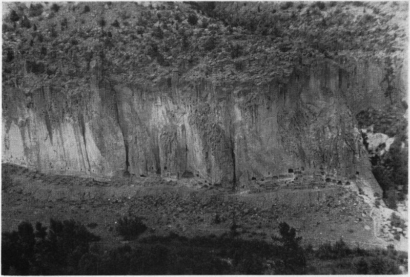
This was the valley of the cliff dweller, the Ancient Tewa more than likely, who built houses and cut caves for almost two miles up and down the north cliff of Frijoles Canyon. Here he could see for great distances—he could look up and he could look down. He could hear the water rippling in the Rito below and he could live in true Indian fashion. But these villages were not built in a day or a year. It took many years. Although there are the ruins of enough houses and caves along the north wall to have housed two thousand primitive Indians, no more than a few hundred ever lived here at one time. There simply wasn’t land enough to farm, or game enough to supply food for a greater number. It would seem that Tyuonyi never had a static occupation but an ever moving one.
The cliff dwellers at Frijoles, like their kin to the north, 38 knew that the only safe method of living was in communities. So they erected what is known today as the “Long House.” One section of the north cliff was almost vertical and its base sloped gently down to the waters of the little river. This must have been the concentration of the cliff homes. Rooms were built side by side for over seven hundred feet. There were few cave rooms here to crawl back into and out of the weather. These people must have learned by experience how uncomfortable caves were, because they stuck to houses with stone walls and roofs of poles and brush and grass and mud. And they built these homes solid against the cliff and even carved recesses in the cliff so that the ends of the building stones would fit perfectly. Then the walls would not slip. The Long House was not very far from water—fifty yards. This was just a step for the women.
Some of the dwellers carved and painted pictures on the back walls of their houses or even in the caves which had barely enough room for three or four people to occupy. Call it writing if you like. It likely was “doodling.” They had no written language. They were forced to record what they thought and what they believed or had seen on the walls of their houses or in the designs of their pottery. Birds were the most common design. A mountain sheep was occasionally drawn, or a squirrel, or a rabbit; perhaps a bear or a katsina—a supernatural being. They might have tried to depict their ancestors emerging from the darkness and climbing up a high pole from the underworld of Sipapu. The awanyu or “plumed serpent” was quite common. It was the guardian spirit of springs. In one cave there was a drawing of a horse and certainly this was not an ancient drawing for the Spanish brought the horse to New Mexico. Some wandering Tewa could have seen the Spanish on horseback—on creatures which Indians thought devoured people. It might have been that other Tewa-speaking people from around the pueblo of San Juan, far to the north, 39 described a horse by pictograph, when they hurried into the mountain homes of their kin after seeing the Spanish in 1540. Or it might have been drawn by some visitor after the evacuation of the Indians. It could even have been someone’s joke.
About a quarter-mile from the cliff dwellings, and where the Canyon becomes narrow, is a deep natural cave. It is eighty feet across and its opening faces the valley one hundred fifty feet above the waters of the Rito. One prehistoric group lived here for a time. They were certainly secluded. Hand holds were gouged from the soft cliffs with sharp pointed rocks and here in this, now called “Ceremonial Cave,” Indians built seventeen first-story rooms and several second-story rooms around the back. They excavated a kiva or ceremonial chamber to the front of the cave. Think of the task these Indians had when they carted water and poles and sticks and perhaps stones up the side of the cliff. Tons of rock were required to build these houses and the ceremonial chamber. This little group built their kiva twelve feet in diameter. It was a circular affair dug to a depth of nine feet and lined with a wall of stone which was plastered on the inside. The floor was of a special kind. It was hard, black and shiny. It had been polished with a smooth stone like the ones the Indian women use today to polish their black pottery. Only this floor was made of blood—animal blood. The Indians carefully saved the blood from animals which they killed and then mixed it with fine silt and soot from the fire and smeared it over their kiva floor in thin layers. When the blood coagulated the plaster hardened and then it was polished by rubbing a smooth stone over it in backward and forward motion. This must have been an important room to have had such an elaborately made floor. But kivas in prehistoric times may have been more important than they are today.
In the floor were six small holes in a straight line. While 40 the plaster was still wet small pieces of oak or some other tough pliable wood was bent in loops and the ends of each piece were pushed down into the soft mud plaster. Then these holes, or round depressions were made around the loops leaving them exposed. These were directly below a horizontal pole suspended from the ceiling. This was a loom. By an arrangement of long straight sticks these ingenious Indians devised a method of weaving. Since it is thought that in years gone by women and children were not allowed in the kivas to break up the complacency of a man’s ceremony, we might suppose that some old man sat here and ran a shuttle through warp cords of cotton strung vertically from roof poles to floor loops. Here he carried on weaving of a ceremonial nature with cotton or animal hair while the smoke from a ceremonial fire in the fireplace circled around making the kiva a very unpleasant place to be despite an elaborate system of ventilation.
These “high-up” cave dwellers had their houses built like the ones at Mesa Verde, completely sheltered by the overhanging cave roof. To the side of the dwellings, situated near the back wall of the cave, was a turkey pen of little cleanliness. When I discovered this pen hundreds of years later, the floor was covered with human feces, turkey and rodent droppings. They had all lived here in times anterior to the coming of the Spaniards—Indians, turkeys and rodents. The Indian hauled his water and food from the valley below. He secluded himself from the bulk of the Indian population at Tyuonyi. The question will always be, why? Of course, there was a small pueblo on the other side of the Canyon on a little knoll across the river but this might have been built, occupied and abandoned before Indians ever occupied the big cave as a place of residence.
And then, there were Indians who preferred to live on the floor of the Canyon in pueblos—terraced community apartment houses. Several hundred yards below the concentration 41 of the cliff dwellings and in the lower end of the Tyuonyi they built such an apartment house. Little is known about it because it has never been excavated. Broken pieces of pottery, the most important tool of the archæologist, are found strewn over its ruins today. Its walls are down now and its rooms are almost completely filled in with debris. This particular group of Indians preferred to have their dwelling close to water and they erected it with stone and mud mortar. This is all that is known of this isolated settlement.
It is quite possible that the most popular dwelling places in Frijoles Canyon were the dwellings at the Long House, so well protected by the sheer vertical cliff wall. These could have been over-crowded. Indians might have cared little about living in other sections of the cliff. It might have been that some of the cliff dwellers had experienced terrible slides when hundreds of tons of loose rock and boulders came tumbling down on their little houses, crushing them like pasteboard boxes and burying the occupants alive. All the man-power in the northern part of the Pajarito Plateau could never have rescued their kin who might have been caught in these cave homes. Those rocks had rolled from the top to stay and there they remain today. One wonders what stories those buried caves hold—if, by chance, the skeletons of the occupants are still there. Indians perhaps have died scratching at the boulders which covered the entrances to their caves or tearing their hair and clutching their throats as they suffocated and fell extended on the hard plaster floors in their rooms. Those caves have never been opened.
It is easy to see that the valley floor could have been more popular as a dwelling place than sections of the cliff more susceptible to slides than the Long House. A part of the main population built and lived in a large terraced community apartment house known as “Puwige” or “pueblo where the women scraped the bottoms of the pottery vessels 42 clean.” This is now the famous ruin known the world over. It has been featured in the National Geographic Magazine and many other publications.
Puwige never existed during the very early occupation of the Canyon. Its initial wall stones were not laid until the beginning of the Great Period. Any Indian family might have erected a few rooms near the little river—close to water. Then another family came along and built a few more rooms. A son took on a wife and the entire family helped to build his house, since house-building was a community proposition. Indian men went to the slopes where boulders had rolled down and broke them with heavy stones and fashioned the pieces into uneven building blocks. This was no small job. Walls were laid in mud mixed by the small brown hands of Indian women. Poles were cut and laid across the walls, then splittings and cane and brush were laid over the tops and sealed with thick coats of mud. Thick coats of crude plaster were spread over the inside of walls and over floors. These Indians had little clay, none for walls anyway, without hauling it in on their backs, so, they poured hot ashes into the mud to make it stick. Hot ashes formed a sort of lime. Coronado, in 1540, found the Indians at Tiguex making a mortar and plaster in this manner. Slabs of basalt were brought in and set edgewise in the rooms as fireplaces. This was the home of the newlyweds—built right next to the groom’s father’s house. The young bride could have come from the Long House to live at Puwige, the community house, with her husband’s family.
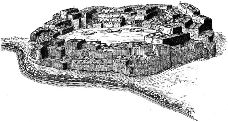
FEDERAL ART PROJECT, NATIONAL PARK SERVICE. CUT COURTESY MUSEUM OF NEW MEXICO ARTIST’S RESTORATION OF PUWIGE
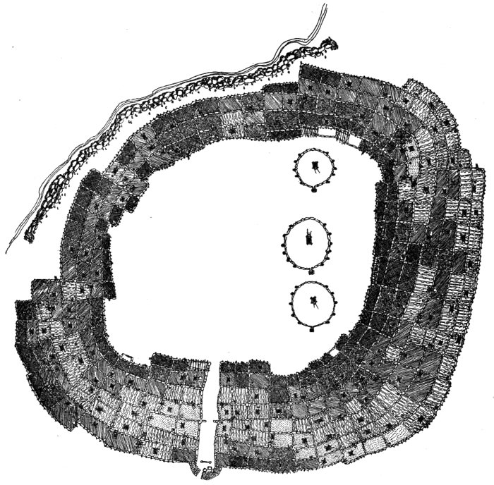
COURTESY NAT’L. PARK SERVICE AERIAL VIEW OF PUWIGE RESTORED
The place on which Puwige was erected was so situated that the Indians had to make walls with sharp turns to follow the contour of the land. This must have been a popular place to live for as time went on more and more rooms were added. Indians evidently preferred this to the vulnerable cliffs. It was not all planned and executed at one time. Some second-story rooms were added and then porches of poles and brush were built. Additions of rooms continued until Puwige was shaped in the form of a crescent with the open part facing the little river which was only a few feet away. Indians lived here for untold years. Something happened. I know not what. It seems that they closed the gap by building three rows of rooms. It was no more a crescent but a circle of rooms built around a large plaza or inner court. Rooms were built in rows, seven deep on the east side of the circle and three on the west side. There were about three hundred rooms on the ground floor and many second and third-story rooms—four hundred in all, more or less. The place was turned into a veritable fort. These people were cunning. They cut seven rooms out through the east side and formed a narrow passageway through which everyone had to pass in order to enter his home. They went from the outside of the pueblo through this narrow passage, dodging obstructions, until they reached the huge inner court. And then they ascended to their respective dwellings by means of small ladders, pulling them to their roof-tops during times of danger. Leave it to the Tewas, “the little strong people,” to find ways and means of protecting themselves from lurking danger.
I was once told a story by some San Ildefonso Indians about this Puwige hallway. Guarding the hallway was a half-circle barricade of stone and mud. It was several feet thick and both ends joined the walls of the main building. Through this circular wall was a small opening. The wall must have stood six or eight feet high to have been effective. Now the Tewas contend that at one time, long ago, a sentry was stationed day and night inside the circle. When Puwige was attacked the alarm was given and a huge boulder was rolled in front of the opening. This was to slow down the attackers. If they were fortunate enough to get by the boulder then it was intended that they stumble over a slab of basalt set edgewise in the passageway. It must have stood a 44 foot or more in the air. If the attackers got by the stone without losing balance, then they encountered numerous wooden posts bedded upright in the dirt floor of the long narrow passage. How confusing and prohibitive! Entrance to Puwige was almost impossible unless “the little strong people” desired it. For the villager, an Indian woman with a water jar on her head, moving along slowly, entrance was easy, but for the enemy—no. Warriors stood on housetops, high in the air, and shot sharp-pointed arrows at enemies. They threw rocks and pottery vessels. They fought with clubs—anything they could get their hands on. Puwige was not easy to penetrate.
Was this Puwige occupied by any particular group or were the people of the cliff houses allowed to scramble down and hurry to the inside for protection? Was it a fort for the entire community or just for the people who lived here? The cliff homes were being lived in at the same time as Puwige and might have been more effective as defense units. There was only one side to protect in the cliff homes—the front. And who were the attackers: Navaho, Keres or other groups? Legend has it that the Navaho plundered the pueblos for years and years and history tells us so. They stole the hard-earned stores of food from the pueblos and ran off with the women and children whom they made slaves. But it isn’t likely that the Navaho, on foot during the days of Puwige, cared much about penetrating the mountain homes. It would have been a chore to carry the loot back with them. The Navajo likely did not relish the idea of coming over the high range of mountains from the west for a few pots of beans and corn. Would it not be more likely that the so-called “little strong people” might have feared attacks during the night by the Keres to the south who had been driven from their Canyon homes? Tyuonyi was “the oasis of the Pajarito” and the Tewas did not intend to be driven from their fertile valley. Some lurking band could have crept over the south cliff when all was quiet—while Tewas were resting peacefully below. And the attackers were quiet too, with their moccasined feet, like the mountain lion which creeps upon a fawn. A falling rock or the crackling of a dead branch would be a dead give-away. This was not to happen to “the little strong people.”
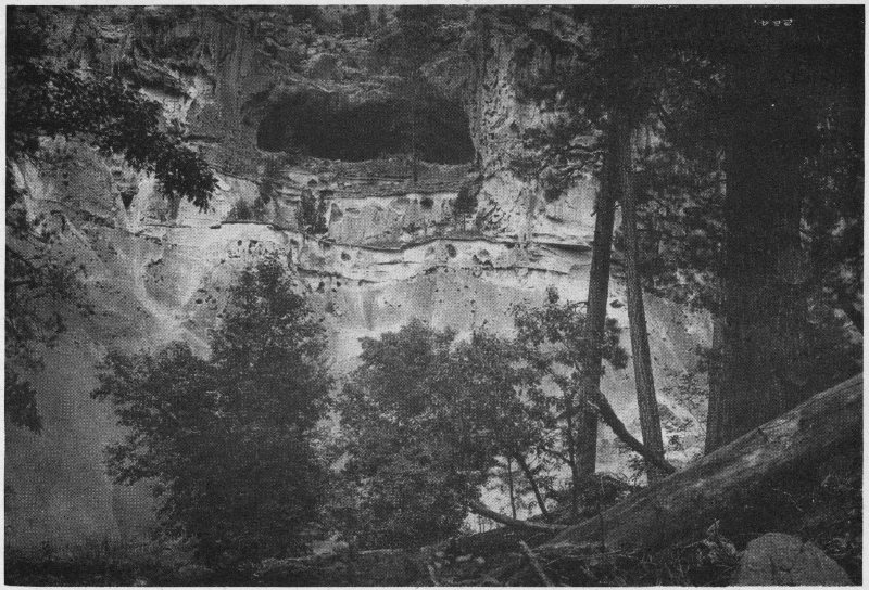
COURTESY MUSEUM OF NEW MEXICO CEREMONIAL CAVE
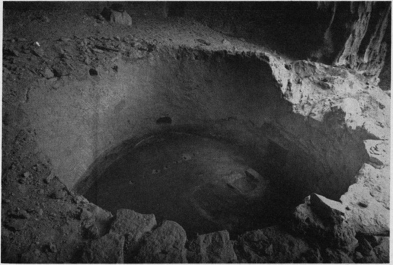
COURTESY MUSEUM OF NEW MEXICO KIVA IN CEREMONIAL CAVE
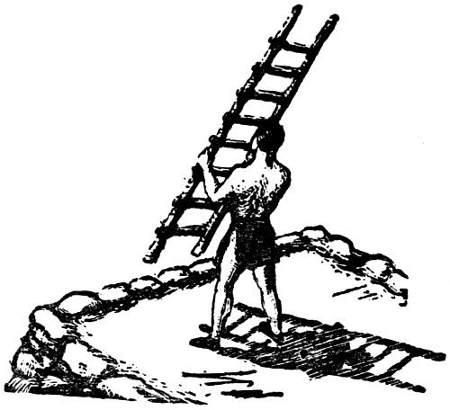
In 1540 the Spanish explorers passed the Keres province and moved northward, it would appear, near the present site of San Juan Pueblo. The entire Indian population fled to the mountains, as you will recall, where they said they had four very strong villages. It is entirely possible that some of these people from the north pushed deep into the mountain country and on to the Valley of the Frijoles where the Spanish could not go on horseback. It was a Hidden Valley. If this had been true, if these northern people had moved into Tyuonyi with their kith and kin and had told about how the Spanish stormed pueblos and shot cannon at other Indians and readily conquered the inhabitants, “the little strong people” might have had incentive to fortify their Puwige against the undesirable attentions of the conquerors. Or it might have been some visitor from the Valley of the Rio Grande who told about depredations at Tiguex. But would a Keres warn a Tewa? We must not overlook the fact that it would have been possible for friendly relations to have existed between the rival groups of people at the time of the Spanish Conquest. They could have lived close together and traded pottery and other articles back and forth. One might go so far as to say that they could have lived at Tyuonyi together a few years prior to its abandonment. But taking all these things into consideration it was likely the Keres whom the Tewas fortified themselves against, and from 46 whom they had probably experienced hostile visits. So they fortified their Puwige and drew up their ladders to the roof-tops in defiance. And the people in the cliffs also drew up their ladders.
Within the inner court of this big community house were three kivas. These deep underground ceremonial chambers lined with rock walls were built adjacent to the rooms on the north side. Puwige was large. It was more than two hundred seventy-five feet across and the tiers of rooms formed a wide band around the outside of the circular court. Why the Indians erected three kivas so close together is uncertain unless it was to have more room in the plaza. It is possible that the kivas were erected first, outside of the village, and as the pueblo grew the three little ceremonial chambers were entirely enclosed within it. But why three kivas inside Puwige? Indians had their reasons. These three ceremonial chambers were small. They were not more than twelve or fifteen feet in diameter. The hard plaster floors were seven or eight feet below the surface of the ground. Their roofs were of poles laid across the stone walls with brush and grass and mud for a covering. Small combination hatchways and smoke vents were cut in the roofs and ladders were put down to the floors as a means of getting in and out. These chambers were likely society kivas of which there were several in every Indian village. Or we might compare them with club rooms in our own society. They were places where the elders met in council, or where they came to spend an hour or so, perhaps a week, visiting with their spiritual fathers. Kivas were places where policy was discussed and decided upon—or a kiva might have been a place where a group of hunters gathered before going on a hunt to pray that their hunt would be successful. We will never know what went on in the secret chambers at Tyuonyi, or as a matter of fact, in any other prehistoric kiva.
And speaking of kivas or ceremonial chambers, some groups preferred to have theirs in the cliffs, hewn out like the smoky cave rooms but generally larger. And the kivas, like the cave rooms, were plastered half-way up the walls whenever they became smoked. This happened quite often if fires were kept burning.
The greatest period of occupation of Hidden Valley must have begun sometime during the fifteenth century. It was to last about a hundred years. With the beginning of this Great Period, the period in which Puwige and all of the talus houses were most likely built and occupied, there certainly must have been some social or ceremonial organization similar to that in the modern pueblos. There were likely two moieties. The dual system where every person in the village belonged to one of two kivas—either Turquoise or Squash, or, Winter or Summer respectively. Presumably a baby born in the winter belonged to the Turquoise kiva. If it was a patrilineal society then the individual might have belonged to the same kiva as his father. Who knows but that it was a matter of personal choice? Each kiva, Turquoise or Squash, had a ruler or cacique whose word was absolute. He was the father of the village to whom villagers looked for guidance and his appointment was for life. The moieties were under the spiritual guidance of the two town chiefs who were responsible for the welfare of the people. An important office was that of cacique. He had been chosen because of his thorough knowledge of chants, sacred rituals, ceremonial procedure and prayers. No one doubted the word of the cacique. And all Indians owed duties to their respective kivas. Although the groups, Turquoise and Squash, were in opposition they also depended upon one another for the common good of the pueblo.
If the dual system was in vogue at Tyuonyi, there must have been two kivas to support it. A peculiar thing, it seems, took place here. At least one tribal kiva was built and 48 was in use before the Great Period of occupation came along. It was a large structure forty-two feet in diameter. Sixty Indians could have crouched down around the inside against the wall. Indian men, years before, excavated a large concave depression in the side of a hill a hundred yards or so down the Canyon from Puwige. Days and days were required to bring in thousands of cobble stones. They labored untiringly. They brought them from the river and they brought chunks from the cliff. Around this deep concave depression which they had laboriously scooped out of the earth with broken pieces of pottery, sticks, flat stones and whatever else they had to work with, Indian men laid stone after stone of this volcanic tuff in crude mortar. They laid a wall ten feet thick. It required thousands of the unworked stones to line this deep pit. It was a circular affair and was their way of creating a semi-subterranean chamber when they did not know how to lay single thickness masonry walls with fashioned blocks.
No prehistoric Rio Grande kiva, that I know of, has an entrance through its wall such as this which was found at Frijoles. They all were entered through the roof. Such things as wall entrances are customary in kivas in the San Juan area but not in the Rio Grande Valley. And these early people dug five pits in the floor of their kiva and lined them with cobble stones. They must have had some use for them of which we know nothing. Pits of this type are something else not seen in prehistoric Rio Grande kivas. They are found in the kivas at Chaco Canyon though, and it is possible that they could have been vestiges of that early culture.
This particular ceremonial chamber had apparently fallen into disuse for a time. But during the Great Period of occupation, when “the little strong people” presumably occupied the Tyuonyi, it was rebuilt. There was little use in going to work and building an entirely new kiva when one was already here and could be rebuilt. The old roofing had 49 fallen to the inside and there were hundreds of pounds of debris in the kiva chamber. All this was cleaned out. Building a kiva was a community enterprise. Men again began cutting and fashioning rectangular blocks from large chunks fallen from the cliff. As each block was fashioned it was laid into a single thickness coursed masonry wall around the inside of the thick wall of cobble stone which belonged to the earlier occupation. The Indian was smart. He laid this circular wall sloping outward toward the top so that the pressure from the heavy roof would be diverted downward when it was laid over the walls. When the wall was finished it was nine feet high from the floor of the kiva to the ceiling. And then to keep it from falling down, the Indians dug underneath the footing stones, and objects modeled of clay which looked like doughnuts were laid in the holes. When we discovered these doughnut-shaped affairs I was mystified until an old Indian from San Ildefonso told me they were put there purposely to hold the wall up, in a spiritual way of course.
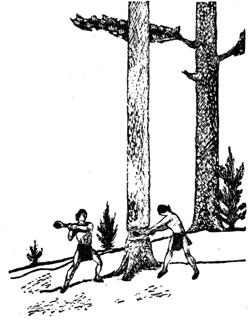
What a large structure this was! It was almost as large as the kivas at Chaco Canyon where the ancestors of these Indians probably lived several hundred years before. There was no kiva this large in the entire Rio Grande Valley. Huge timbers forty-five feet long were required to span its diameter and timbers that large were difficult to carry. But with crude stone axes and obsidian knives these kiva builders penetrated the forest to cut girders for 50 their ceremonial chamber. In the year 1513 A.D. or thereabout, they cut three trees with trunks fifteen inches or more in diameter. It took hours, days perhaps. They hacked and they pounded with their Neolithic implements of toil until all three trees had been felled. I would hate to estimate the time required to fell these timbers but time meant nothing to the Indian. Then there was the job of removing all the branches, needles and bark.
Preparing a girder in prehistoric times was a great task. Green timber is much heavier than seasoned wood. And so these timbers weighing a ton or more were dragged out of the forest to the kiva with stout ropes made of yucca fiber. Sheer strength was all these people had. There were no carts with wheels on them to bear the brunt of the load. Heavy objects had to either be dragged or carried. After much sweat and toil the ends of the huge poles were rolled over into position in shallow trenches worked out for this purpose on both sides of the kiva. These three timbers formed the under structure of the roof. When they were placed exactly like the Indian wanted them, pointed rocks were driven into the ground around the ends and the open spaces were packed with adobe so that these huge round logs would not roll. They placed much smaller timbers of pine across the huge vigas. These were not so difficult to cut and they were laid about three feet apart. From down-timbers of pine, piñon, cottonwood or any other type of fallen trees they hacked and ripped long narrow sections for the next roof course. The splittings were transported in bundles to the kiva and one by one they were laid close together over the small pine poles. Great quantities of thin willow branches, cane or cat-tail stems were used for the next course. Pine needles, brush, yucca leaves and whatever leafy material they could gather was placed on the top. They needed this brush and leafy material because it was to hold the thick heavy mud coats which were spread over the top. Indian women carried urn 51 after urn of water on their heads from the Rito and stamped and mixed this mud. The only chore left was to throw dirt over the top.
When the ceremonial chamber was finished it looked like a huge, low mound—almost level with the ground. The Indians did not forget the square opening in the top for the exit of the smoke. Kivas were stuffy places inside. And as in all kivas there was a ventilator. This had been built during the earlier period of occupation and reused during the Great Period. It was a mere tunnel which looked like a fireplace and it suddenly turned upward like a fireplace chimney. The mouth of the chimney was level with the ground so that the draft would be downward and would go into the kiva and lift the smoke from the firebox to the ceiling and eventually out the square opening. The Indian of Tyuonyi did understand something about ventilating a kiva. He was smart enough to know that if the top of the ventilator was built very far above ground level it would work like a fireplace. Then all the smoke would be drawn to the floor of the kiva and sucked out through the low tunnel. And in this case he could not have remained inside. But he never found out how to ventilate his cave room in the cliff. How unfortunate!
Directly across the kiva in the west side was the entrance which had also been put here years before. It was merely a tunnel with a roof of small juniper branches. The outside end was open and was just large enough for the ends of a two-pole ladder to rest. Indians usually go into their kivas through the roofs, but not here. They climbed down the ladder, stooped, and with knees in a flexed position scurried through the tunnel to the inside.
The five pits in the floor, which have been mentioned before, were apparently no longer needed for they were filled in with dirt and stones tightly packed. A thin layer of dirt was thrown over the entire floor surface. Kiva floors are 52 generally plastered over and during this period of occupation the Tyuonyi women, more than likely, were the ones who smeared four fine coats of adobe over the floor and smoothed it out with their hands.
I have neglected to mention one of the most important things of all—the Sipapu or ceremonial entrance from the underworld. It was the place of ceremonial emergence into this earthly life. Archæologists generally find a small hole in the floor of almost every kiva. But here at Tyuonyi a special kind of Sipapu was made. A piece of soft volcanic ash was formed into a rectangular block and buried edgewise in the floor. A small hole shaped like an icecream cone was drilled in the top as the spirit entrance. The Indians have a legend about this. It is symbolic of the entrance to the land of “Earth Old Women” and of the place where the human race originated. Long ago they climbed up a Douglas Spruce Tree and came into this world through a lake called Sipapu. And when they die the spirits go to Sipapu and on to the underworld. It is said that this lake is located in the sand hills north of Alamosa, Colorado. How important the kiva was to the Indians of Tyuonyi! Sipapu represented the place of creation and to them it was important in no small way. The cacique of each one of the big tribal kivas, both Squash and Turquoise, was a direct representative of the Earth Mother or “Earth Old Woman.”
But the dweller at Tyuonyi had forgotten something. He did not realize how tremendously heavy the roof of his big kiva was. He did not know that the small pine timbers, the splittings, brush, grass, mud and dirt would cause the big pine vigas to bend and sag and crack in the middle. It is a question whether or not the roof fell in during some important ceremony. The situation had to be remedied at any rate. Pine poles, nine or ten inches in diameter were cut so they would support the weight of the roof. Six holes were dug in the kiva floor, two under each of the big vigas. Flat rocks 53 were put in the bottoms of the holes and the ends of the six timbers were inserted and swung into place under the big girders, and driven with heavy rocks into an upright position. The big vigas might have sagged a little but the roof never fell after this time. Flat stones were driven tight around the bottoms of the support posts and the holes in which they rested were packed solid with mud and rocks to keep the timbers from slipping. And this was how the prehistoric Indian at Tyuonyi built his ceremonial chambers in which women were not allowed unless requested by the men. There might have been more than one roof put on this kiva. The first one could have been laid during the latter part of the fifteenth century. It could have fallen and then been rebuilt. Archæologists do know that the last time this large kiva was roofed over was during the early part of the sixteenth century. We found one of the large charred ends of a big roof timber and it had been cut in 1513 A.D. So it was about this time that the last kiva roof was laid. Just how long it was in use is a question. It was surely used until the end of the occupation of Frijoles Canyon sometime near the close of the sixteenth century.
The Indians of Tyuonyi during the Great Period had developed the dwellings in the north cliff extensively to the number of some three hundred caves. There might have been twice as many talus houses to the front, some one story and others two and three stories high. The cliff population centered around the Long House while other groups built houses in different locations at the base of the north cliff. And still other groups built the big community apartment house of about four hundred rooms to a height of possibly three stories and called it “Puwige” or “pueblo where the Indian women scraped the bottoms of the pottery vessels clean.” And they built it in the form of a fort with a narrow hallway through the east side as the only means of entrance. And here they fortified themselves during times of attack 54 by other Indians like themselves who might have been jealous of the watered Valley of the Frijoles. Another group preferred to remove themselves down the Canyon a quarter-mile and they erected a circular pueblo, a miniature of Puwige, seemingly. Still another group preferred to be more isolated and so they chose a deep cave one hundred fifty feet above the Canyon floor in which to build their house and kiva.
One would think, looking at the ruined home sites, that thousands of prehistoric Indians dwelt at Tyuonyi but that was never the case. Although the dwellings were extensive they were not all occupied at any one time. Small groups moved in. Others moved out. They could have taken turns living in Hidden Valley and then returned to the northern villages of Potsui’i, Sankawi, Navawi or Tshirege, where their kin and kind lived. Tyuonyi might have been a place for summer occupation during the growing season. When planting time came little groups trickled in from the large northern community villages and remained for a while. One cannot be sure of what went on in the Canyon. It was a suitable place for continued occupation with the possibility of an influx of population during the summer months. One can only speculate. Scientific investigation reveals nothing in this regard. The legends are scant now—the old men who remembered them are just about gone. So one is left with little about how Indians lived on the Pajarito Plateau during prehistoric times.
It would have been an utter impossibility for thousands of Indians to have lived off the corn, beans, squash and pumpkins raised in the Valley of the Frijoles. But the several hundred who did live here had to eat and in order to eat they had to work. The Indians of Tyuonyi were farmers and were largely dependent upon the products of the soil. Only a small part of their sustenance was from animals and birds. Of course, there was game of all kinds. There were deer, perhaps elk and mountain sheep, bears, turkeys, rabbits, and fish in the creek. But even though this was wild country, several hundred Indians living in the locality would soon have depleted the stock with their communal hunts. In the fall of the year there were grouse in the high mountains and ducks along the Rio Grande. But imagine how difficult it would have been to kill a grouse or a duck with a crude bow and arrow. The deer might have been the prize of the Indians at Frijoles. They ate the meat and used the hides for buckskin. They knew the rabbit and the mouse and knew that the woodrat gathered the edible piñon nuts to store away in its hiding place. The robber, since there was a large crop of the nuts only once every few years! They ate the squirrel. Skunk skins were probably used for ceremonial purposes. The raccoon, however scarce, likely formed part of the diet of the cliff dweller. And although Indians knew the birds of the forest, they probably did not digest the meat of hawks very well. As a matter of fact, most birds were too fast for the ever-seeking valley dweller with his crude weapons.
Few Indian ruins are excavated in which the remains of 56 corn are not found. The ancient inhabitants raised corn—much corn. It was the most important item in their diet. The fields in the lower end of the Canyon were fertile. The valley was a paradise for primitive people. During corn planting time tiny kernels were sown in the rich fertile ground which had been broken with digging sticks and crude hoes. There were likely no large continuous fields in this valley but only small patches where individuals might have had separate fields. Adolph Bandelier suggested that the ancient people irrigated in the Valley of the Frijoles. How lucky they were if this were true. It is more likely that they depended on the waters from the heavens. When it was extremely dry the Indian women transported water from the little river in urns on the tops of their heads. And so heavy were the jars filled with water that they were obliged to use soft pot-rests of grass. Corn was planted in April and was likely sown under a waxing moon so that it would grow with the moon. The Tewas believed that when corn was sown under a waning moon, the seeds quit growing. With careful nursing and watering from April until September, the pigmy ears grew. In the early fall the corn was gathered by the men.
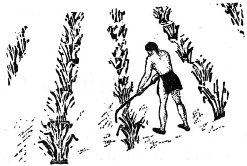
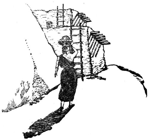
A day at Tyuonyi during “corn gathering month” about 1537 A.D. was an interesting 57 one. The large plaza inside Puwige was swept clean, if customs of yesteryear parallel those of today, and the corn was brought therein. Corn, they believed, had life like people and would be glad to be brought in and housed and protected. It was placed in piles and everybody from the pueblo helped with the husking—men, women and children. And when they finished they might have gone to the cliffs to help their relatives with their husking. As fast as the ears were husked they were thrown on the flat mud roofs of the houses to dry. These Indians did not use all the corn at once. The old women thought of crop failures the next year and so they saved a double amount of the life-giving grains to plant the year after. After all the husking was done, the pueblo was swept clean with brooms made of grass bound with yucca fiber or corn husks. This was in preparation for a festival—a dance perhaps, to observe the gathering-in of the crop. Strange customs these Indians had! While corn was standing in the fields it was the property of the men. As soon as it was gathered, husked and stored, it belonged to the women who were the caretakers, even though they took little part in pueblo life at Frijoles which was predominantly a masculine society.
Not all the four hundred rooms at Puwige were used for dwellings. Perhaps no more than a hundred Indians lived here. The smaller rooms around the inside of the circle, more than likely, were used for storage purposes. If this were so, it was here that great stores of corn were kept—inside the circle, safe from plunderers and robbers. How important this corn was! It might have been offered to the Gods as a request for various favors and Indian women might have taken corn along when they went to look for pottery clay, for clay was a scarce item here. And some of the people might have worn little bags of corn around their necks. Even in prehistoric times a corn cake would have tasted good. Green corn was pounded into a pulp, patted into a 58 cake and then baked on a hearth of black stone over a little fireplace. And Indian women could have greased the little cakes with the fat of a deer to make them tasty. When the corn was all dry old women knelt before their angled metates set in bins and with a hand-piece or mano of black basalt they ground. Their fingernails were worn oblique on the ends from constant rubbing in rhythmic time with a corn-grinding chant sung by the men as they beat a drum or two. And they ground on three or four metates. First, they broke the corn, then by the time it was passed on and ground on each of the metates, it was transformed into fine corn flour. And lastly, it was stored away or perhaps packed over the mountains to other villages. Some of it might have been traded for buffalo hides by traders who penetrated the buffalo region to the east, far out of the realm of the pueblos of the Rio Grande and adjacent mountains.
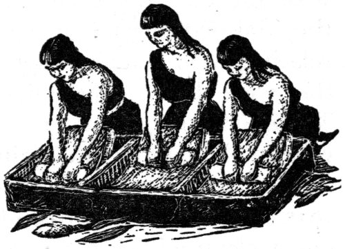
There were many uses for corn. Bundles of grass were bound together at the tops with twisted corn shucks and used as brooms. And even cigarettes could have been made by wrapping corn husks around the dry leaves of some tobacco plant. Only the old men smoked. Smoking could have taken place in one of the kivas at a time when a delegation arrived from another pueblo. Keres and Tewas might have held council at Tyuonyi, about Tyuonyi itself, and passed around from each to other a fire-stick with a glowing end from the fireplace as a lighter. Mats and door-flaps were made of plaited corn husks and it would not have been an uncommon sight to find these coverings over the openings of some of the houses at the base of the cliff. Corn was certainly an important item.
Archæologists have recovered beans also—pinto beans. It was a type known to the Indians before the Spaniards ever thought about the New World. During some of our excavation work I found that the people who had lived in the Ceremonial Cave, far above the concentration of the Canyon’s population, knew about beans as well as the rest of the dwellers. Beans were one of the staple foods. The people at San Ildefonso today know them as “tewatu.” It is possible that the same name was given beans at prehistoric Frijoles.
There were many uses for gourds also. Half-sections were scraped clean of their pulp and used as dippers and ladles. Whole gourds were used as rattles in ceremonial dances. Broken pieces could have been used to scrape and smooth wet pottery before it was fired.
Almost everywhere were products of the earth. And they were used to their fullest extent. These people even knew about cotton. Whether it was ever raised in Hidden Valley is questionable. Pieces of the simple over-and-under weave cloth have been found in the ruins. The growing season in the mountains might have been too short. It might be that these Indians traded with their neighbors to the south for their necessary supply of cotton. Cotton was woven into ceremonial paraphernalia and also into garments. Men wore cotton breech clouts while women wore large mantas of cotton cloth. This cloth was suspended from one shoulder downward covering one side of the breast, wrapped once around the waist and then taken up the back of the shoulder and tied in a knot. A very important item was cotton.
All of the wild plants were utilized and especially when cultivated crops gave out. There were many in the valley growing wild along the fertile banks of the Rio de Los Frijoles. There were gooseberries, currants, the berries of sumac, onions, milkweed, strawberries, blazing star, horsemint, dandelions and prickly pears from the round leaf cactus. 60 Even the ball cactus might have been eaten. And surely many of these were stored for later use. Little did these primitive dwellers know what might befall them. Raids by hostile bands often destroyed their fields. Fire might have been set to the roofs of their homes. A period of drought could have been one of their worries even here in the Valley of the Tyuonyi.
Mother Earth gave the Indian everything. She lavishly produced juniper and piñon wood for fires, choke-cherry, juniper and oak for stout bows. And there was hard wood for the foreshafts of arrows and cane for the hind shafts to which turkey feathers were fastened as guides. She produced sticks for clubbing rabbits to death. There was rabbit brush for yellow paint. The leaves of yucca, when pounded up and dried, could be twisted into stout rope and cord. Extremely tiny cords were used in making fishnets. Strips of yucca were used in making baskets and also for making brushes used in painting and decorating pottery. Stout strips of the tough leaf were used for tying. And the Indian even knew how to extract the medicinal properties from plants. The Valley of the Frijoles produced for the primitive dweller most of the things he had to have for successful living.
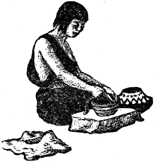
While Indian men, it seems, laid the walls of the houses and repaired them, and cut the heavy roof timbers—while they planted corn and hunted, the women were not idle. The art of pottery making has long been the pride of pueblo women. They did the whole job from beginning to end. They searched the river and arroyo banks for clay and they carried it to their homes where it was kneaded and rolled out into long rod-like strands. All pottery was coiled. They began at the very bottom and brought the long strands of tempered clay round and round in the general shape they desired. And then they patted and smoothed the vessel out with wood or gourd scrapers. When it was dry, they applied a slipping or wash coat over the outside. When this was done the vessel was decorated with various crude designs. It was then put into an open fire smothered with wood, corncobs, pine needles and grasses so that the heat would be retained. This was their method of firing. When a vessel was removed from the fire and the ashes wiped off, a dirty white background with black designs appeared. There were several different types of this ware made at Frijoles. Today we call this pottery a black-on-white ware.
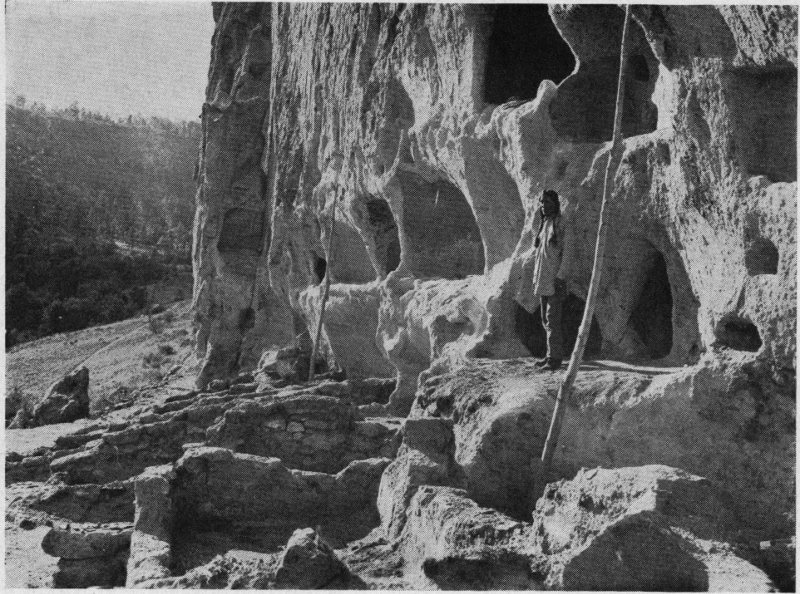
COURTESY MUSEUM OF NEW MEXICO A SECTION OF LONG HOUSE
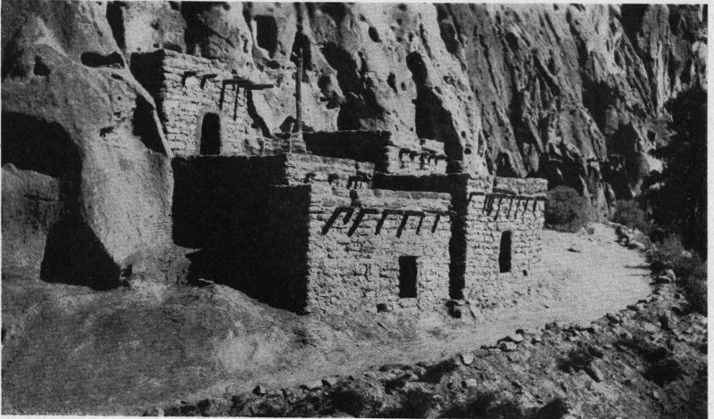
COURTESY NAT’L. PARK SERVICE RECONSTRUCTED CLIFF HOUSE
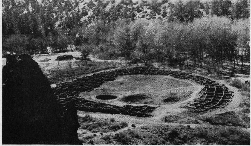
COURTESY NAT’L. PARK SERVICE RUINS OF PUWIGE
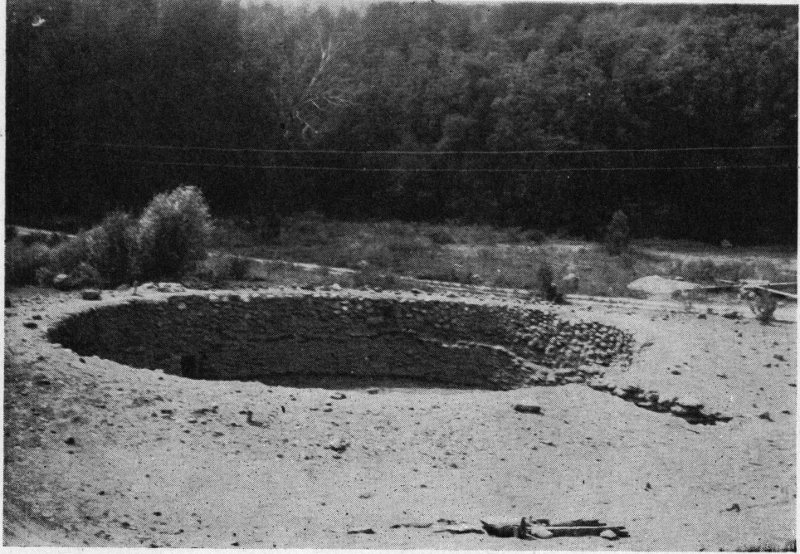
COURTESY NAT’L. PARK SERVICE RUINS OF THE LARGE KIVA
The most common type known to the archæologist today is Biscuit ware. It is so-called because it is exceptionally thick and porous. These Indians made flat squatty bowls, and ollas—the common wide-necked jars. These were inferior types and not nearly as good pottery as was made by other Indian women at other villages. It was tempered with soft volcanic ash. Tiny particles were worked into the soft clay to keep it from cracking and resulted in a soft powdery ware which was easily broken. It is possible that these women were not very well satisfied with their pottery made from local materials. The same thing was true at all the villages on the Pajarito. When water was put in the jars and bowls they became soft. It certainly was not a satisfactory type of ware. And the Indian women might have been very much ashamed. Pottery making was their work, their art and their pride. But the materials in this country simply did not make good hard pottery despite the ability of any individual potter.
However, the Keres women made good hard pottery. They had the clays and the tempers with which to work. They were still making the ware with the slick red finish and glaze designs on the outside which was developed in the Little Colorado district of western New Mexico and 62 eastern Arizona. They were even making the polychromes or multi-colored wares by this time. Trading this pottery might have been the solution to the problem of the Tewas even after the Keres-speaking people had been driven from the Tyuonyi. New generations of Keres might have had a different way of looking at things. Although the red glaze ware had become coarse and heavy by this time, it surpassed the soft Biscuit wares made by these valley women. They were probably glad to accept it in trade. From about 1400 A.D. all through to the abandonment of Frijoles Canyon, the glaze wares were present. The glazes did not stop here but are found at Tewa villages far to the north. These people, too, had been making the same soft ware as did the dwellers in the Frijoles. So it does appear that some sort of a relationship could have existed between Keres and Tewa-speaking groups of people even during these late times.
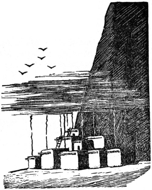
The main occupation, it seems, lasted well up toward the close of the sixteenth century. Several generations of Indians had lived here either in cliff homes or pueblos on the floor of the Canyon. Any night might have witnessed hundreds of tiny smokes emerging from smoke holes in roofs. The glow from tiny fires inside the cliff rooms lighted the doorways in the front walls. A sentry, perhaps, with bow and sharp-pointed arrow was posted at the entrance to Puwige, the big community house, or on some nearby high point where he could comb 63 the landscape with sharp eyes and would warn the pueblo dwellers that warriors were approaching. A summer day would suggest men basking in the sun or attempting to net out fish from the little river below. Women had jars on their heads. Others were gathering berries and greens. A hunter was greeted as he strolled forth triumphantly with wild game for a meal or two. A sudden summer cloudburst of rain or hail—delightful and refreshing and good for the corn too, interrupted the sameness of things. The tiny drops sent an Indian mother with baby on her back scampering for shelter. Children were running and laughing but ever alert. These are only a few of the incidents of six hundred years of living, primitive and insecure living, which went on in the Valley of the Tyuonyi.
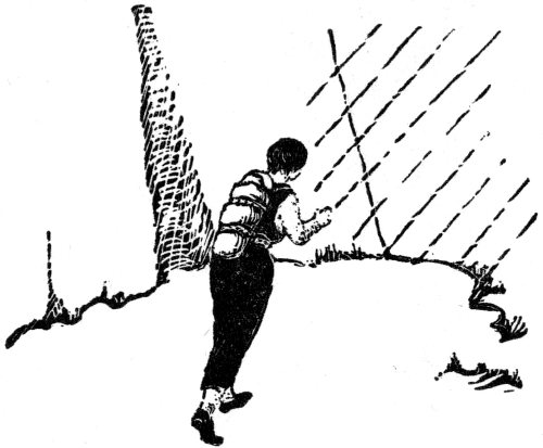
Toward the close of the century the waters from the heavens stopped. Corn fields dried up and the waters of the little river were no more. The curse of the Southwest had hit again. The lands became drier and drier as the days passed. Cliff homes were like ovens as the hot sun beat down upon them. The same thing happened here as happened to their ancestors in the west centuries before. The Tewas, living in the big villages to the north, were experiencing the same thing. There was no water in the canyons. Water holes had gone dry. And there was no water from the heavens to be caught in great rock cisterns. Small groups began to move. Others hung on. Could it be that Hidden Valley was to go the way of all the rest? It was true. Moving was a necessity now.
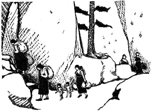
It is not known how many Indians lived at this place during those last days of drought and it is possible that those who might have remained did not wish to be left in Hidden Valley close to Keres land to the south. So, slowly but surely, group after group trickled out of the Valley of the Frijoles, leaving their homes to the mercy of the elements. Within the course of a very short time the entire population had evacuated. They crossed deep canyons and high potrero tops—dry now—and helped to cut just a little deeper the very same old trails in the soft rock, which had been worn down by thousands of moccasined feet for countless generations. Before they left it seems that they must have destroyed almost everything they possessed. Fire was set to the roof of their large kiva. This was the end of the Tyuonyi. Hidden Valley had witnessed its last great occupation. It had been occupied by Indians for six centuries—Indians who had lived, raised corn and beans and squash and pumpkins, and who had fought and died. The occupation of Frijoles possibly 65 was tottering at the time the Espejo expedition came up the Rio Grande Valley in February of the year 1583. A few stragglers could have still been here—who knows? But certainly by the close of the century Tyuonyi was a thing of the past. The roofs to the houses were falling in—timbers were rotting and cracking under the tremendous weight of poles and brush and mud. Walls fell. It was a deserted town with a background as colorful as any other pueblo in the Southwest. Hidden Valley was still here but its actors were no more.
By the close of the sixteenth century, it seems, all of the great towns—the terraced community apartment houses on the Pajarito—had been abandoned. Life in the hills and mountains had grown unbearable because of a shortage of water. These people, I have no doubt, disliked leaving their mountain homes. The mountains were more conducive to successful living than the hot sandy banks of the Rio Grande. But this made no difference now—moving was a necessity. Groups pushed off the mesa tops and down the canyons into the Valley of the Rio Grande. Soon little settlements sprang up. This move certainly must have been a step down for the cliff and pueblo dwellers. They had lived for centuries on the wooded mesa tops near high mountains and had drunk spring water. Now they had only the muddy waters of the Rio Grande. They established the village of Perage on the west bank of the river about a mile west of their present pueblo of Powhoge or San Ildefonso. Other groups could have gone to other Tewa-speaking villages. Just when the pueblo of San Ildefonso was established is not certain but it was long, long ago.
Tewas could live in peace now and raise corn, beans, squash and pumpkins, for here the muddy waters of the Rio Grande were ever flowing. But it was not for the Tewas to say, or think, that they could live in peace. The next Spanish expedition taught them this. The expedition headed by Don Juan de Oñate was the colonizing expedition into New Mexico. In 1598, soldiers, colonists, carts and baggage streamed up the Valley of the Rio Grande and took possession of New Mexico in the name of His Majesty, the King of Spain. This 67 time the occupation was in earnest. Four hundred or more settlers and soldiers marched up the valley, the settlers with everything they possessed in the way of tools and personal effects. Thousands of domestic animals were brought in. The Spanish meant to stay this time.
In the north Tewa country, beyond San Ildefonso, was the Province of Yunqueyunque which is thought to have been located near the present San Juan Pueblo. It was here that the first capital city of New Mexico was established by the Spanish on July 11, 1598. It was called San Gabriel.
It was about this time that the Tewa-speaking people on the Pajarito Plateau were abandoning their homes in canyons and on mesa tops and moving to the banks of the Rio Grande where they built the pueblo of San Ildefonso. These Indians built the pueblo with rows of houses two and three stories high and built their kivas on top of the ground instead of below the ground as they had done in their former homes.
After Oñate had been removed from office as Governor of New Mexico, the Viceroy appointed Don Pedro de Peralta and the capital was moved from San Gabriel to Santa Fe in 1610. Governors changed. Each made new laws. Indians were used as slaves. They produced goods for the Spanish. Children went to school and all went to church. They took on Christianity—yes, but they retained their old beliefs and old forms of worship. Roman Catholic Missionaries built churches in many of the Rio Grande pueblos which the Indians paid for. Some were flogged for not wanting to go to church, but this new form of religion was forced upon them. Hours were long and hard and taxes imposed by the Spanish were exorbitant. This kept up for seven decades.
Rebellion was on the way. Acoma, the Sky City, was the first village to rebel. This was quelled. Then the Jemez, then the pueblos of San Felipe and Cochiti, our Keres-speaking friends, rebelled. Alameda and Isleta were next. But these 68 uprisings were not put down. It all ended up in the bloody and terrible Pueblo Rebellion of 1680. Spaniards were murdered right and left all over New Mexico. The Tewas of San Ildefonso were in sympathy with the Rebellion. They had suffered too, and so they marched with their allies regardless of creed, clan or language spoken, to Santa Fe, the capital city. The remaining little handful of Spanish refugees had gathered in the Palace of the Governors as a last resort. One white cross and one red cross were sent to the Spanish Governor Otermin by the Indians. White meant peace. Red meant war. The Governor chose war. But the cause was hopeless now. The Spanish were outnumbered and their food and water supply had been cut off. Surrender was the only alternative, so, on August 21, the Spanish left the Palace and back-tracked down the Valley of the Rio Grande. The Indian now had his land back. He could live in peace along the banks of the river and raise his crops, so he thought. No more toil and no more taxes. But this Utopia was not to be realized.
Even though the Navaho had taken an active part in the uprisings, he began to cause trouble as soon as the Spanish were out of New Mexico. The Pueblo people had not counted on this. The Navaho had taken everything from the Spaniard that he could use against him, including the horse. As soon as the weakened Pueblo people thought they had rid themselves of trouble and war and killing, the wild Navaho took advantage of the situation. Terror reigned for a decade or more. The Navaho swooped down upon the pueblos at night, plundering and killing. Putting up with the Spanish might have been easier to take than this. But all was to change again. Don Diego de Vargas marched up the Rio Grande with another colonizing expedition, soldiers and missionaries. Pueblo after pueblo was reconquered and Santa Fe was re-entered in 1693. The Pueblo people were not too hard to bring to submission this time. The Spanish would 69 help their warriors to drive off their enemies. The pueblos had had about all they could take from the Navaho.
Then there were the Tewa villages to be dealt with up the Rio Grande between Santa Fe and the pueblo of San Juan. The San Ildefonso Tewa fled to a high black rock known as “Black Mesa.” It had been used by them for years as a place of defense. From its top the country can be seen for miles around. It was here that they held out against the Spanish soldiers from January until September of 1694. They finally surrendered after several unsuccessful assaults at their rock and a siege which lasted for five days. Black Mesa figures considerably in the mythology of the Tewas. They say that during this seven-months period while their people were besieged on the high mesa top, brave men descended through the precipitous gap during the night to the Rio Grande below to get water for their marooned people. Black Mesa is sometimes known as “Mesita Huerfano” or “Orphan Mesa.” It is said that a giant lived here at one time and caught children from the pueblo which he and his wife and daughter ate. He was at last killed by the Tewa War Gods. Legend has it that the giant’s heart is still on the mesa top in the form of a white rock.
We have almost forgotten the Keres-speaking people to the south who were also having trouble. During the Rebellion, the Cochitenos abandoned their pueblo and moved back up the Cañada de Cochiti to Kotyiti. This was, according to their legends, the last site they occupied after being driven from the Tyuonyi and before establishing the present Cochiti on the banks of the Rio Grande. Kotyiti was built on top of a high mesa known to the Spanish as “Potrero Viejo.” It is a mesa about two miles long and several hundred feet high. It was a natural fortress for the Indians, and it was to this fortress that the Keres moved back and built their homes shortly after the beginning of the Rebellion. This fortress was known as “Hanat Cochiti” or “Cochiti 70 Above.” With the coming of Diego de Vargas in 1693, the Indians fled from the pueblo on the river to their mesa and put up a stiff battle, but in vain. After their reconquest, broken and tired of trouble, they moved back to Cochiti in 1694 where they have been ever since.
But what trouble the Tewas of San Ildefonso did have! There suddenly came another outburst of pueblo rebellion in June of 1696 and the people of San Ildefonso burned their beautiful church which had been built for them by the Spanish with Indian labor, sweat, blood and taxes. Two priests were caught in the burning building as well as several other Spaniards. There they all perished. The San Ildefonso Tewa have a legend and a belief that they should always move to the south and never to the north. But someone wanted the pueblo moved to the north. And so there was a contest between good people and sorcerers, and the sorcerers won by witchcraft. The pueblo was moved to the north. The San Ildefonso people believe that this is the reason why they had pestilence and famines, and why their people decreased in numbers. Such trouble they had!
Could it be that during these trying and troublesome years at the close of the seventeenth century, some of these heart-sick and war-weary Indians decided that life back on the high forested mesa tops or in deep canyons to the south where their ancestors had lived, just a century before, would be better than this? Could they tear themselves away from their brethren at night and sneak south, back into the hills and down into deep canyons protected by high vertical cliffs, even into Hidden Valley? Spanish soldiers on horseback could not find them here. They could not follow the old Indian trails. Perhaps those known as the “good people” of San Ildefonso were so opposed to moving their pueblo a little to the north that they refused to have any part in this plan and preferred moving far to the south.
To assume that such a move took place would not be 71 folly even if we had no supporting evidence. Families could have removed themselves to the hills of the Pajarito. Here Hidden Valley offered them protection. It was deep in the south country and water had returned to the creek. The drought period was over and there would be water from the heavens again. The old abandoned dwellings in Frijoles Canyon were in ruins. Roof timbers had rotted and walls had fallen. These were the homes of their ancestors. But with very little work these homes could be made livable again. And so, in a remote section in the lower end of Frijoles, the Indians again went to work in a group of rooms high above the floor of the Canyon. They were a quarter-mile from the ruins of the Long House and Puwige which were in open sight.
Like true cliff dwellers in prehistoric times they rebuilt old homes into new ones. Rooms were cleaned out. The old roof structures were removed from the inside. Loose building stones were removed from the broken-down walls. And the cave rooms above were also cleaned out. Indian men again cut pine timbers for roof poles with crude stone axes. They rebuilt walls and laid the poles over the tops. Indian women mixed mud—good hard Tewa mud. They brought in clay from nearby arroyos or from the Rio Grande and raised their talus houses two stories high. Some of the caves, after a hundred years, had eroded beyond use. Doorways and fronts had fallen. Indians gathered fallen building blocks strewn along the base of the cliff which had been fashioned by their ancestors. They built artificial fronts to the caves and plastered them over with mud. Fine clay mortar was smeared over the floor and rough surfaced walls. Doorways were built in the front walls of houses. Ladders were built. A corn patch was planted. Game likely was plentiful now. Black volcanic glass was chipped into sharp arrow points. A deer or two were brought in triumphantly from a hunt. And they created new homes for themselves and brought life back to 72 Hidden Valley while their kin and kind struggled on and on with Spaniard and Navaho.
Safe at last, they lived again. Corn was harvested in the fall of the year and shucked and stored. Indian women ground corn on old worn metates left there a century before and the men again chanted away in time with the beat of a drum which echoed between steep canyon walls. Baskets were made of juniper and yucca. Blankets of fur and feathers were sewn together. Stout cord was twisted from the fibers of yucca. Indian women made brooms of grass tied with corn husks and yucca fiber to sweep their sooty rooms, while brown-skinned babies rolled in the dust. Gourds were scraped and made into utility vessels and Indian women again carried water in urns on the tops of their heads from the little creek far below.
It undoubtedly took some readjustment to live in the cliffs again after a century of acculturational contact with the Spanish. Just how many Indians or how large a group returned to the Canyon homes is not known. But by this time we see that the Indian had acquired a few things from the Spanish either by trade or thievery. This little group brought with them pieces of metal and wooden objects of possible foreign origin, objects brought in by the Spanish to the Rio Grande. One such object, which we found, was a two-pronged pick of viburnum, elaborately carved on top with a sharp steel blade. It was not much longer than a hair-pin and reminded one of such. Its use is still puzzling. And the Indians brought woolen cloth which was definitely post-Spanish. The Spaniards had brought the sheep to New Mexico. The weave of the cloth was such that it could not be mistaken. Could it have been from a Spanish garment or was it Indian-made? It is even possible that these people were wearing woven garments of wool when they reoccupied the Frijoles.
The little community was a poor one. There is no doubt 73 about it. The Indian made fire in the same old way with fire drills. A blunt round piece of wood was turned so fast in the groove of a flat piece of wood that fire was produced. These people used cultivated tobacco at this time—a variety never before discovered in the Southwest of this early age. During a moment of temptation, the writer rolled a cigarette from part of this Indian mix which he found buried in a small red bowl. He smoked it without any ill effects. It looked like tobacco, smelled like tobacco and tasted like tobacco. Discarded fragments of pipes were found which had bowls of hard wood burned through. Moccasins of deer skin sewn together with sinew were found. Could they have been made in Frijoles Canyon or were they brought into the valley by these Indians? Whichever was the case, they were worn out. One pair was half-soled—not like our half-soles today, but on the inside. A new piece of buckskin had been cut and fitted and sewn to the inside of one of the worn-out moccasins which had been discarded.
The chirp of a turkey hen or the gobble of a gobbler created a dead silence in any primitive household. The calls echoed and could be heard for a half-mile. Even today, we stop and listen and follow the call just for a glimpse of the wild turkey. It is exciting. A tenseness of nerve and muscle envelops a person. An Indian father crept noiselessly down the steep slope to the valley far below—stopped, listened—not a sound but the whining of the wind through the high tops of pines or the caw of a raven flying high above, or the rolling waters of the little river. Following again and picking each step, bow and arrow in hand, ready to draw, he stopped. The turkeys were coming closer and behind a rock he hid or laid close to the little river out of sight. They were almost upon him, feeding peacefully on grasshoppers and bugs. A well directed arrow would mean meat for the whole family. That the Indian used only the feathers of the turkey is an idea of the past. The broken food bones are 74 found in the ruins of ancient homes. Besides using the meat of the turkey for food, the Indian used the feathers for ceremonial purposes and strips of turkey feather spines made excellent wrappings for making arrow guides.
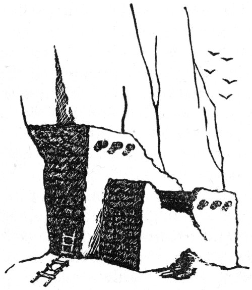
Such was life in Hidden Valley after the conquest of New Mexico by the Spanish. Living in the Tyuonyi at this time was apparently a necessity. It could again have been our Tewa-speaking friends who raised corn, beans, squash and pumpkins in the beautiful and colorful Valley of the Frijoles and who watched the sun, day after day, pass down behind the cliff to the land of Sipapu. But time again had a way of making things right, though not just as the Indian desired it. After the close of the seventeenth century, it seems, Frijoles was abandoned again. The Indians left their cliff homes and moved back to the Valley of the Rio Grande. There was little trouble with the Spanish from then on and the Indian wars were over and all were subdued and the ancient homes in Frijoles continued to crumble and walls continued to fall. A little time was all that was necessary to completely cover the abandoned dwellings. Howling winds beat sharp particles of dirt against crumbling walls and eventually filled them in and covered them. Deep kivas were no more. Small stones, boulders and dust fell from the cliffs covering up talus houses. Huge slides covered many homes and the wind and rain beat against the vulnerable cliff walls and eroded many of the caves almost beyond identification. Indian occupation was ended now but Hidden 75 Valley still remained. The Rito de Los Frijoles continued to cut its course deeper and deeper through the soft volcanic ash as it had done through six hundred years of Indian living. Struggle had ended over the Tyuonyi. It was deserted to the ravages of time. To the south the Keres were settled now, and to the north the Tewas. They were content; and Hidden Valley was left alone.
The early part of the eighteenth century saw the Spanish interested in more than Pueblo Indians. There was the actual colonization of New Mexico and the war with France which drew their attention. New Mexican land was divided into tracts or land grants. The Spanish had combed it all. They knew about the canyon today known as the “Frijoles,” the Tyuonyi of the Cochiti Indians. The tract lay just south of the bounds of what is known as the “Ramon Vigil Grant.” It was in litigation much of the time. The land was cleared, broken and put under cultivation during the latter part of the eighteenth century. The valley floor was cleared and no doubt some of the homes occupied by Indians years before were obliterated. This valley was given the name of El Rito de Los Frijoles sometime prior to the year 1780. For years, people have said that the Canyon derived its name from the fact that Indians raised beans here in prehistoric times. True, prehistoric Indians did grow beans at Frijoles but the derivation of its name probably had no connection with any Indian occupation.
With the coming of a new century, Spanish people were accused of living in the caves of the Rito like barbarians. This picturesque Hidden Valley was a rendezvous for cattle thieves and persons whose characters could be questioned. It was a den for robbers who greatly troubled the people around the country, so, in 1811 the Spanish Governor ordered all its inhabitants to move out. The Canyon must have been occupied more or less continuously throughout the nineteenth century by farming groups of Spanish-Americans. And they were troubled by Indian raids from time to time until the latter part of the century.
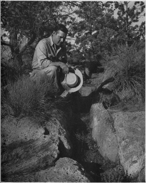
PHOTO BY GEORGE THOMPSON THE AUTHOR AT AN OLD HIDDEN TRAIL
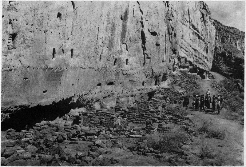
COURTESY NAT’L. PARK SERVICE A PARTY OF VISITORS AT LONG HOUSE
The walls of ancient caves today are pocked with nail holes. Sheepherders might have camped for a while and left initials and dates picked in the soft stone. Cow bones strewn at the base of the cliff, now dry and white and brittle with age, are the only sad memorials of what went on. And many are the hidden legends. Every little canyon in the locality has a name. Something happened to give them their names. One, Water Canyon, was formerly known as “Diesmo” or “Ten-Percent Canyon,” because a priest collected ten percent of the lambs from sheep owners as a tithe for the church and herded his flocks in this valley. Everything has a meaning in this colorful land. There still exists today a circular platform of blocks of tuff on the floor of Frijoles Canyon. Local farmers claim that it belonged to them and their fathers before them. It was used as a threshing floor. I have heard that it was a dance pavilion or platform and was advised that if I brought over some of the Indian women from San Ildefonso and asked them to do what they were supposed to do, they would begin dancing the ring dance. The stories are many but will the truth ever be known? Time is slipping by.
Within quite recent years the Navaho has used the old trails, just passing through, going to some pueblo to trade perhaps. Even Zuñi Indians have passed through the Valley of the Tyuonyi—resting a few minutes and drinking of the waters of El Rito de Los Frijoles as they might have done in years past when they were supposed to have visited the Stone Lions to the south. And Indians from Cochiti have returned to their Tyuonyi during summer months to raise a little corn. These people religiously return to the homes of their ancestors. Even today, certain of the old Tewa men from northern pueblos trudge south into timbered mountainous country and erect shrines near their ancestral homes. 78 They carve miniature pueblos three and four stories high out of volcanic boulders of soft ash. They build altars and burn ceremonial fires. They dig holes in the soft ground, line them with little rocks and cover the holes with green branches from the juniper tree. Many times I have seen evidences of these ceremonies along dry arroyo banks on the Pajarito Plateau.
In 1880, Adolph F. Bandelier, famous Swiss ethnologist, archivist and historian, entered the Valley of the Frijoles.
At the time, he was connected with the Archæological Institute of America and had been sent to New Mexico to work among the Indians who today live in mud-walled pueblos up and down the banks of the Rio Grande. Bandelier spent a great many days at Santo Domingo and Cochiti seeking out legends and myths regarding the people’s past and present and it was from the Cochitenos that Bandelier learned of Tyuonyi. Bandelier’s descriptions of the surrounding country are thoroughly detailed. He must have possessed a very keen mind to have so well described geographical features in such brief association. He entered Frijoles Canyon, the Tyuonyi of the Cochiti Indians, on October 23 of that year.
It has been said that Bandelier lived in the caves of the Rito de Los Frijoles, and, according to stories passed around by hearsay, he could have lived in a dozen different caves. It would be nice, and perhaps poetic, to say that the famous student hung his coat or his hat on such and such a nail, when wire nails such as are found in these caves probably did not exist during Bandelier’s visits to the Canyon. The general opinion among people who remember Bandelier is that he did spend some time in one particular cave high above the Canyon floor. It was a double-chambered cave overlooking Puwige and the entire broad and open lower end of the Canyon. The view was perfect. It might have been here that Bandelier organized some of his notes which resulted in the never-to-be-forgotten ethno-historic novel, 80 The Delight Makers. People have said that Adolph Bandelier lived for years at Frijoles, but this is not true. His investigation of practically the entire Southwest took only five years to complete. So we might limit his stay to days, but those days counted. It was Bandelier’s intent to portray history and archæology in the guise of fiction and here he laid the basis for his famous novel which brought fifteenth-century dwellers of the Tyuonyi to life again.
The works of Charles F. Lummis will never be forgotten—The Land of Poco Tiempo; Mesa, Canyon and Pueblo. Bandelier and Lummis were very good friends and although their opinions and ideas conflicted at times, this friendship was never broken. Many times has Lummis visited Frijoles and many times has he stayed in the old Indian cave rooms, even in quite recent times, when other accommodations were available.
In 1907, Judge A. J. Abbot settled in the Valley of the Frijoles. He built a ranch house out of the ancient building stones of volcanic ash. The stones came from Puwige, the big community house. Cut and fashioned in the sixteenth century or thereabout, by prehistoric Indians, they were used again. The place was known as “Ten Elder Ranch,” because of the box-elder trees growing nearby. The ranch changed hands three times and was subsequently known as “Frijoles Canyon Ranch” until the old buildings were torn down and replaced by modern unique pueblo style buildings designed by government engineers and known as “Frijoles Canyon Lodge.” It would be an utter impossibility to name all of the famous personages who have visited Frijoles or were entertained at the old ranch place. The Commoners and the Nobility, people from the four corners of the globe came, some of them leaving a little remembrance or token of their appreciation—a poem about the Frijoles perhaps, a card, a thank-you letter, an invitation—they are too numerous to mention.
In 1916, the area was created a National Monument and named in honor of Adolph Francis Alphonse Bandelier. It has been known as such ever since. But to the “old timers” it is still the “Rito” or “El Rito de Los Frijoles.” They remember the times they either walked or came on horseback from the north rim into the boundary valley—the valley between ancient Keres and Tewa lands—into a Hidden Valley clustered with the works of primitive Indians, the ruins alone being capable of revealing the incidents of a buried and hidden past. Their heads are gray now and they remember with the semblance of tears in their eyes.
From 1916 until 1932, the entire area was under the administration of the United States Forest Service of the Department of Agriculture. At this time it was transferred to the National Park Service, Department of the Interior. Thousands of visitors go to Bandelier every year chiefly just to look at this magnificent Valley of the Frijoles. A new modern highway replaces the old trail from the north cliff. The visitor now drives down to the valley floor to spend an hour or so on a tour conducted by the National Park Service, to hear the story of how Indians lived in the cliff homes and in pueblos long before Columbus discovered America. They wonder about cliff dwellers while ravens soar above the valley floor and caw just as they did four hundred years ago. They see the visible remains of the great kiva on the Canyon floor and stroll on to Puwige, the big community house. They view over two hundred excavated rooms, four hundred years old. They see the narrow passage through the east side and the remains of obstructions used to slow down the attackers of old. And then they climb to the base of the weathered and sun-drenched cliffs where many an Indian woman swept rubbish from her kitchen out on to the steep slope and ground many an ear of corn on crude metate. Visitors climb into caves, the floors covered with dust and ceilings still blackened with smoke. They push the 82 hands of the clock back to the Stone Age, while the Keres to the south go on living on the banks of the muddy Rio Grande, apparently forgetting that there ever was a Tyuonyi, war or trouble; and while the Tewas to the north, having settled themselves, seem to have forgotten their ancestral home—the “Frijoles,” the National Park Service strives to protect, preserve, and make the ruins in Hidden Valley live again.
A B C D E F G H I J K L M N O P Q R S T U V W X Y Z
A B C D E F G H I J K L M N O P Q R S T U V W X Y Z
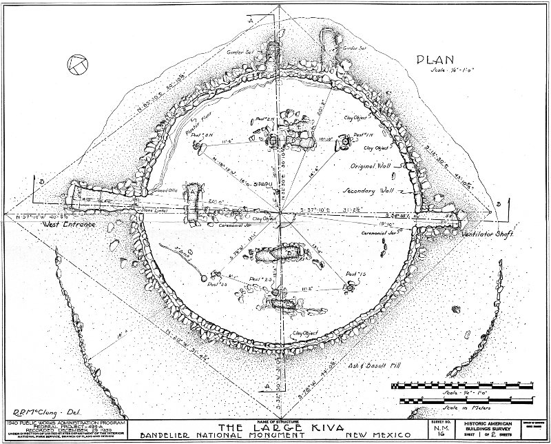
Large Kiva. Ground Plan
High-resolution Map

Large Kiva. Section Drawings
High-resolution Map

Ceremonial Cave. Ground Plan
High-resolution Map
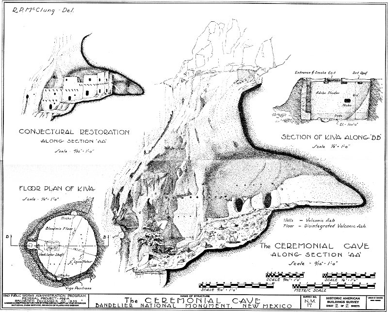
Ceremonial Cave. Section Drawings
High-resolution Map
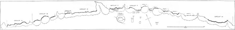
Ground Plan of Frijoles Canyon. Ruins Area
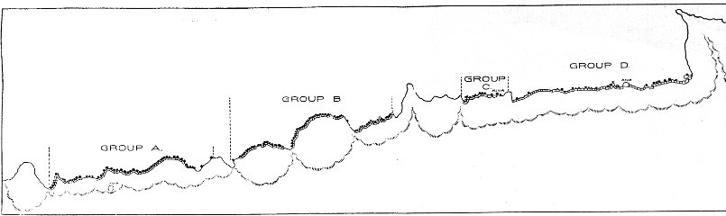
Ground Plan of Frijoles Canyon. Ruins Area (left)
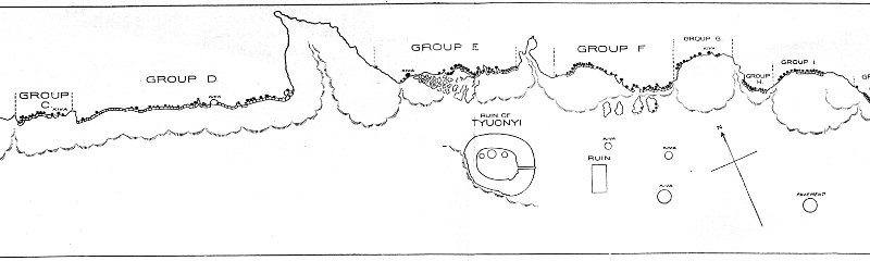
Ground Plan of Frijoles Canyon. Ruins Area (center)
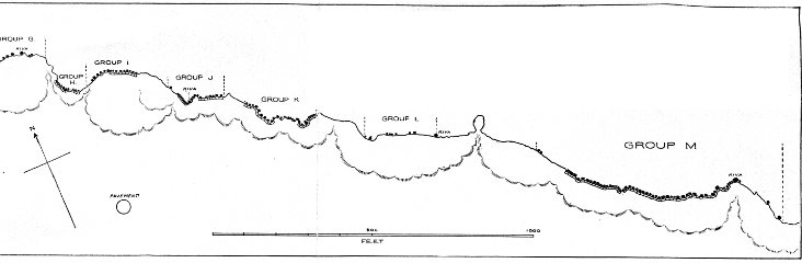
Ground Plan of Frijoles Canyon. Ruins Area (right)
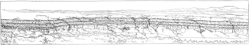
Northern Wall of Frijoles Canyon
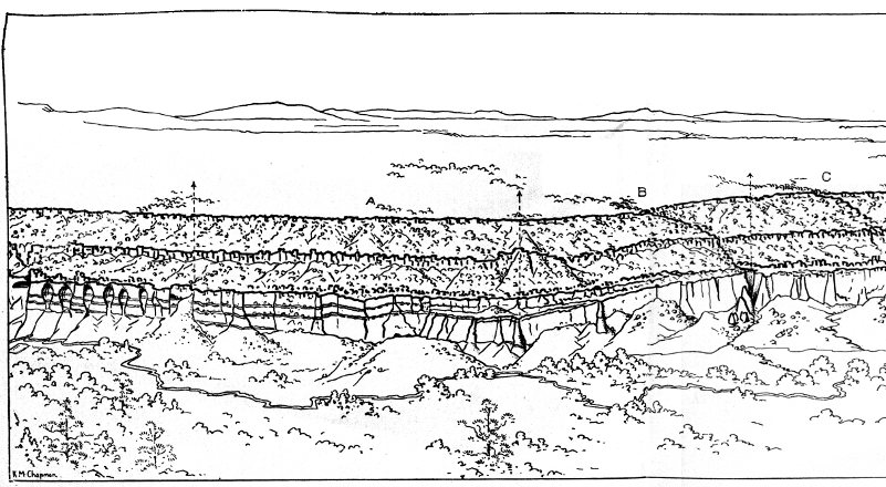
Northern Wall of Frijoles Canyon (left)
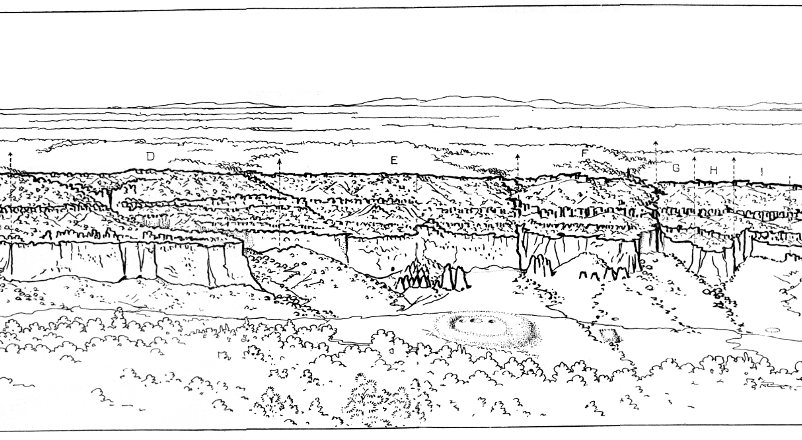
Northern Wall of Frijoles Canyon (center)

Northern Wall of Frijoles Canyon (right)
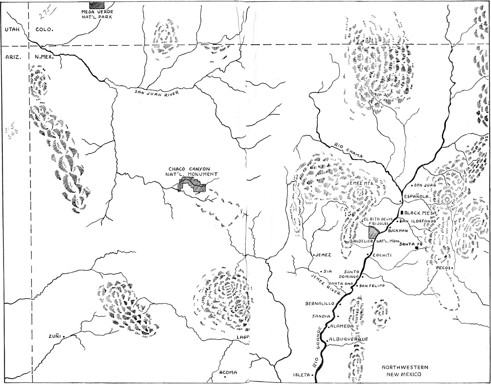
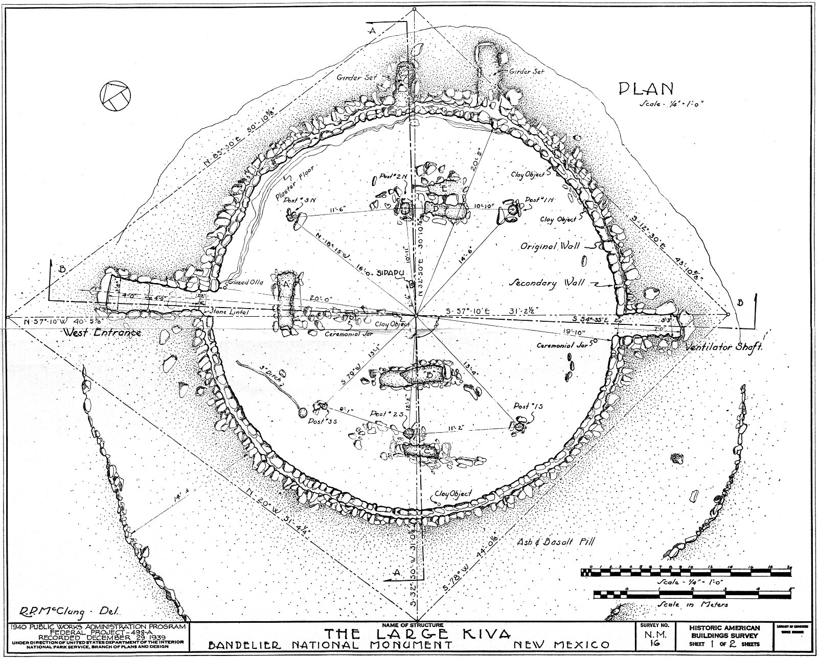
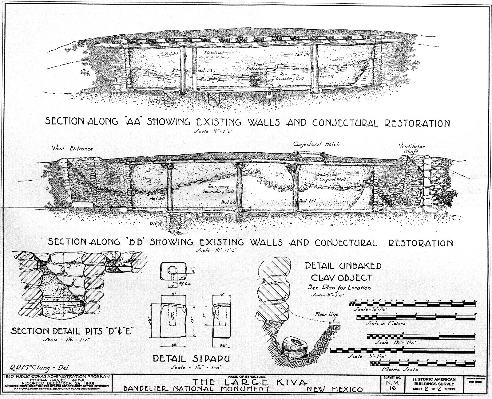
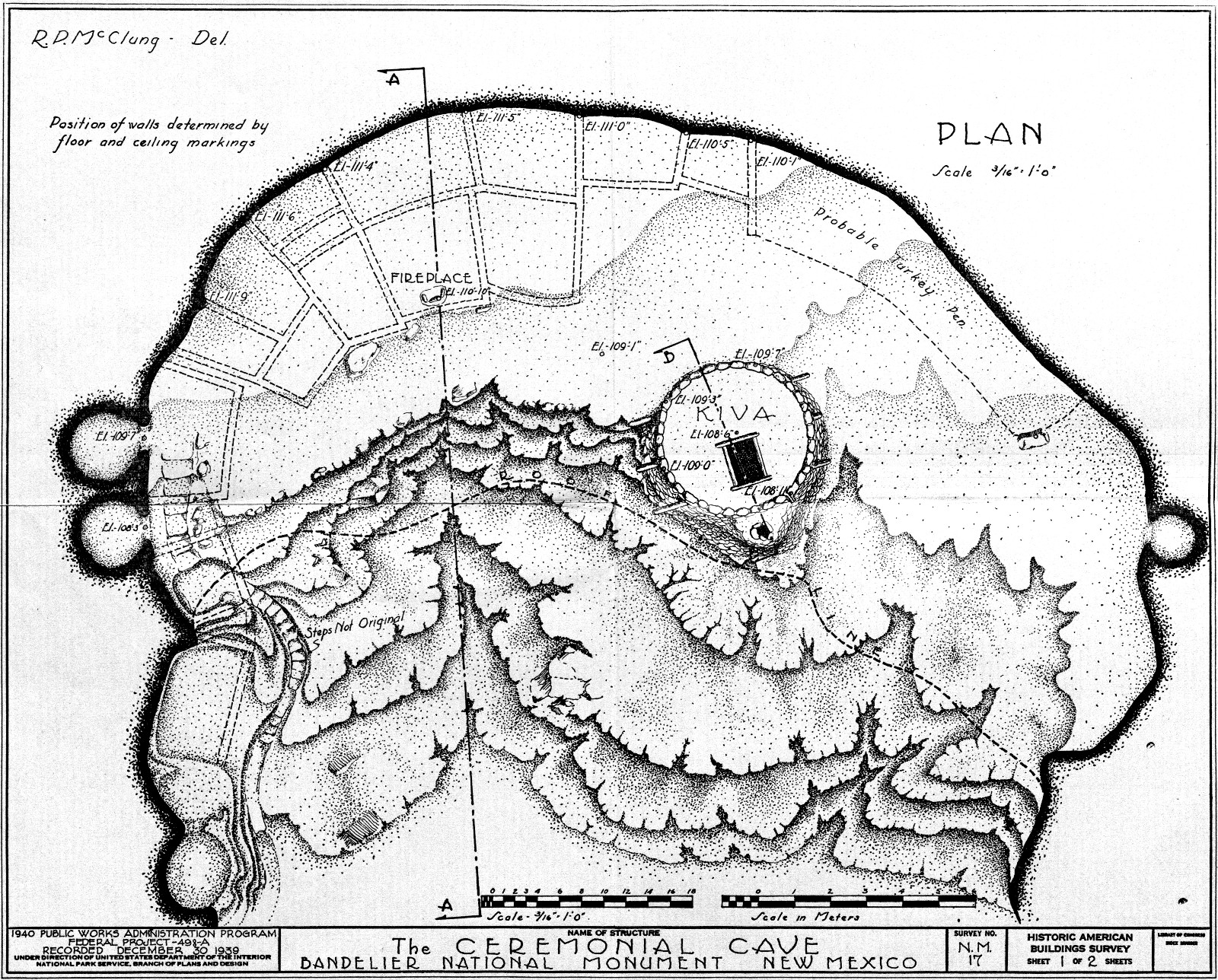
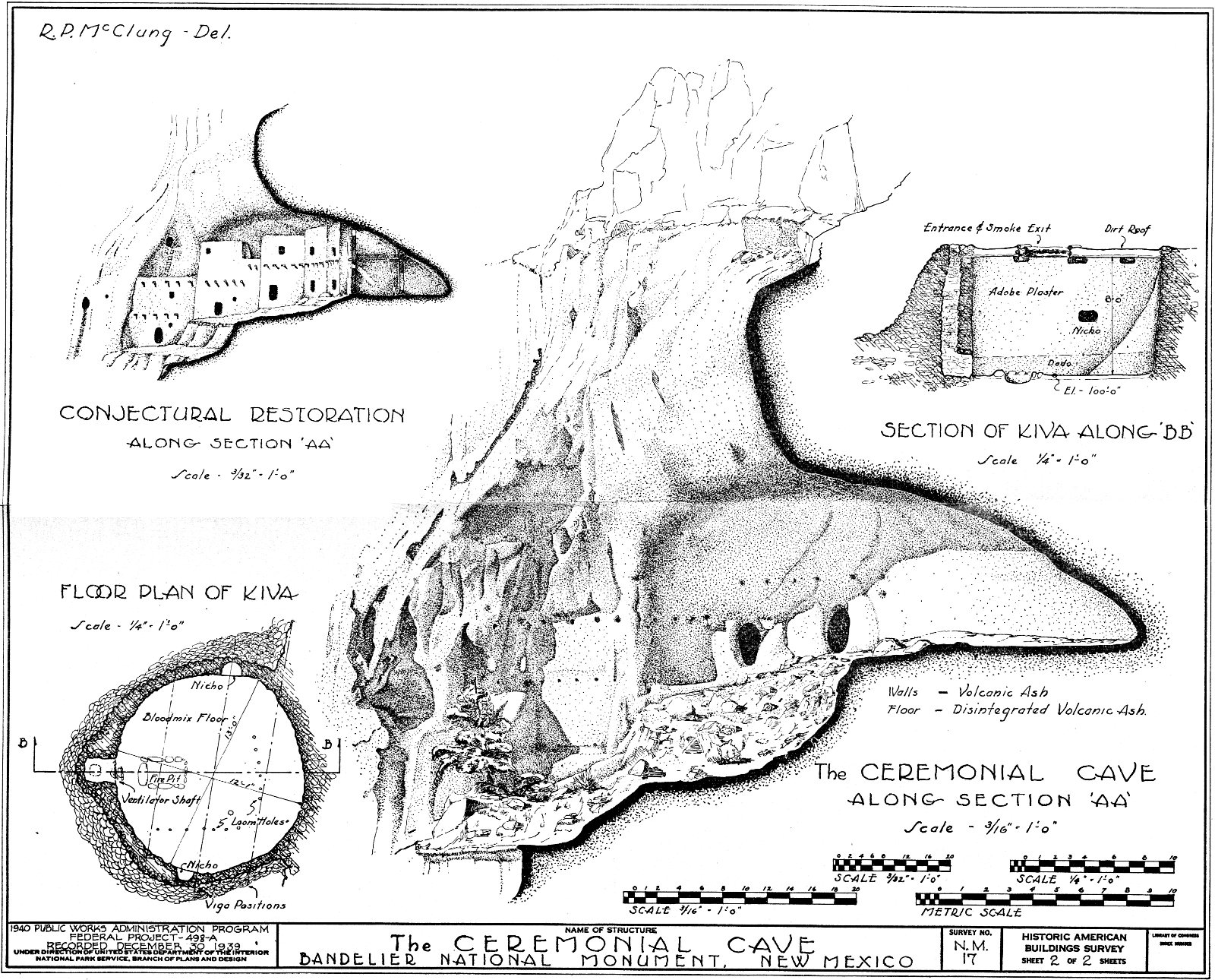