BUREAU OF ECONOMIC GEOLOGY
The University of Texas at Austin
Peter T. Flawn, Director
Guidebook 8
By
William H. Matthews III

August 1969
Second Printing
August 1983
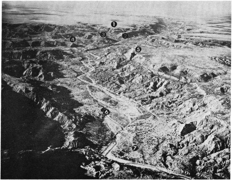
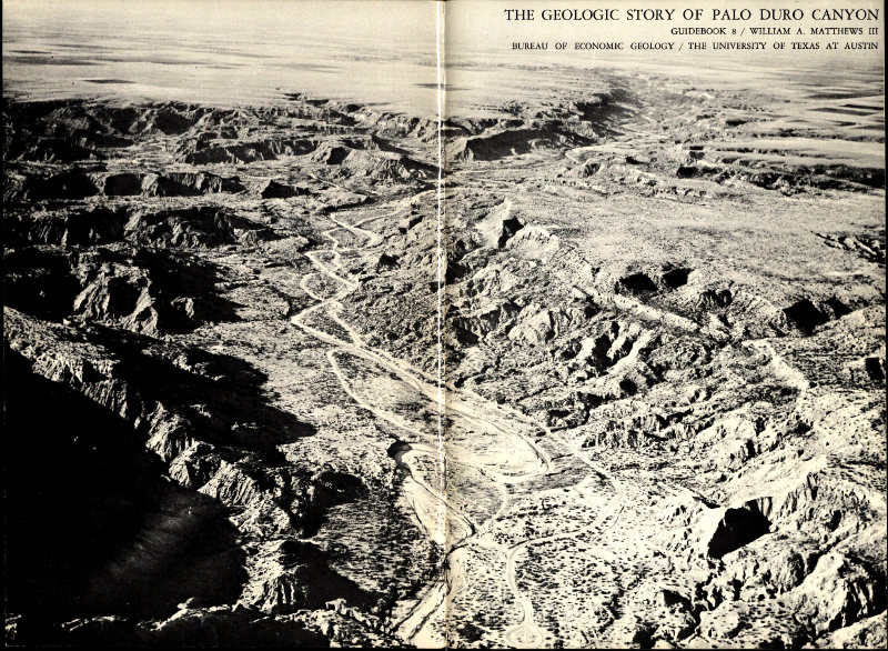
Fig. 1. Aerial view of Palo Duro Canyon showing location of major points of interest: (1) Coronado Lodge; (2) Triassic Peak; (3) Timber Mesa; (4) Capitol Peak; (5) Fortress Cliff; (6) Prairie Dog Town Fork of Red River; (7) The Turnaround (termination of Park Road 5). (Courtesy of Charles A. Wolfin; photograph by W. A. Hester.)
William H. Mathews III[1]
Like the early Spanish explorers who first saw Palo Duro Canyon, today’s visitor is likely to view the impressive canyon with surprise and awe. This great depression—it is more than 2 miles wide and as much as 800 feet deep within park boundaries—contains a fascinating assortment of multicolored geologic formations and erosion-produced rock sculptures of many shapes, colors, and size. The geographic setting of the canyon further heightens its impact on the visitor, for it is surrounded by the level, virtually treeless plains of the Texas Panhandle. (See upper background area in fig. 1, frontispiece).
It is not surprising that this scenic area has been set aside as a State park, for Palo Duro Canyon has long been of interest to man. First, as the hunting grounds of prehistoric Indians who stalked the now-extinct Ice Age mammoths and bison that roamed the valley floor. Later, the canyon was frequented by the Comanches, Apaches, Kiowas, and other Indians of historic time. These tribes, like those before them, found both food and refuge within the canyon. However, it was not until 1876 that Palo Duro Canyon was inhabited by the white man. It was during this year that pioneer cattleman Charles Goodnight herded some 1,600 head of cattle into the canyon and established a camp there (p. 6).
Today’s visitor to Palo Duro Canyon can re-live some of the fascinating history of this interesting area. One can still see a replica of Colonel Goodnight’s primitive dugout, follow the faint trace of the Comanche Trail, or perhaps find the fossil bones of prehistoric creatures that lived hundreds of thousands—even millions—of years ago. But most visitors to Texas’ most colorful canyon are not attracted by its interesting history. They come instead to enjoy the scenery and recreational opportunities that are present. These are readily accessible, for a carefully engineered, hard-surface road leads from the rim of the canyon to the canyon floor. There are campgrounds, picnic areas, concessions, and even an outdoor theatre (fig. 23). The location of these facilities and some of the canyon’s more interesting geologic features are shown on the generalized place map of the canyon (fig. 2).
This publication does not attempt to describe the scenic beauty of Palo Duro Canyon, for this must be seen to be appreciated. Rather, it discusses the geologic setting and origin of the canyon, the methods by which some of the more interesting geologic features were formed, and briefly reviews the history of the area. Hopefully, it will enable the visitor to understand better the meaning behind the canyon scenery, thereby enhancing his visit.
Many people have assisted in the preparation of The Geologic Story of Palo Duro Canyon, and their help is gratefully acknowledged: Professor Jack T. Hughes, Dr. Frank W. Daugherty, Dr. Robert C. Burton, Meade Humphries, and Jim Hughes of the West Texas State University Geology Department provided much information about the area and assisted in the field; help was also provided by Mr. Pete Cowart, Mr. Earl Burtz, Mr. Jerry Tschauner, Mr. Bob Watson, Mr. King, and other park personnel; Mr. C. Boone McClure, of the Panhandle-Plains Historical Museum, furnished some of the photographs; Mr. J. Dan Scurlock, Mr. Bill Collins, and Mr. Harold Allums, of the Texas Parks and Wildlife Department, made available certain maps and statistical data; Mrs. Ples Harper of Canyon assisted in assembling information and photographs for the Pioneer Amphitheatre; and the aerial photograph of Palo Duro Canyon was taken by Mr. W. A. Hester and made available through the courtesy of Mr. Charles A. Wolflin of Amarillo.
Drs. Peter T. Flawn, Peter U. Rodda, and Ross A. Maxwell of the Bureau of Economic Geology read much of the manuscript and offered many helpful suggestions, and Mr. A. Richard Smith provided special information on caves in the Palo Duro area. Special thanks are due to Miss Josephine Casey who edited the manuscript and to Mr. J. W. Macon, cartographer, who assumed responsibility for preparing the maps. Thanks are due also to my wife, Jennie, who critically read the manuscript and took a number of the photographs. Finally, I would like to thank Dr. J. Daniel Powell of The University of Texas at Arlington for invaluable assistance in the field and his enthusiastic co-operation throughout the project.
Palo Duro Canyon’s long and colorful past has created considerable interest among historians, archeologists, and geologists. Historians have traced the written history of man and his effect on the Palo Duro area, but archeologists have delved much further into the past. They have sought out and studied the more enduring records of the canyon’s early inhabitants—their tools, utensils, and weapons. The geologist, however, is interested in history that far antedates even the most primitive human inhabitant of the canyon. The earth scientist has probed the geologic record of the Palo Duro area, using rocks, minerals, and fossils as clues to the geologic history and development of the canyon.
Palo Duro Canyon is unique among Texas’ State parks because of its many contributions to history, archeology, and geology. Here the written record, the artifacts of prehistoric man, and the geologic formations overlap and complement each other in many respects. Although this guidebook is primarily concerned with the geologic history of the canyon, a brief review of its human history is also included.
Archeological studies indicate that the earliest known inhabitants of Palo Duro Canyon lived in the canyon from about 10,000 to 5,000 B.C. These early men apparently hunted the bison and now-extinct elephant-like mammoths that roamed the Palo Duro area during the Ice Age of Pleistocene time (see geologic time scale, fig. 6). Their stone weapons and other artifacts have been found in and around the canyon. It is assumed that these primitive people—like those who came later—were attracted by the streams and springs that are found in the canyon and by game that came there to feed. There is also evidence that the Indians took advantage of certain of the canyon’s geologic features. They fashioned tools, weapons, and utensils from the rocks exposed in the canyon and used certain of the shallow caves and rock shelters as their homes.
Various tribes of Plains Indians of historic times also used Palo Duro Canyon as a camping ground. The presence of these Indians is known from many campsites and burials. In addition, flint chips and stone artifacts, potsherds, ornaments of shell and bone, grinding slabs, stone mortars (fig. 15), and a few pictographs (fig. 3) have provided considerable information about the culture of these people. Among the tribes believed to have frequented the canyon at various times are the Apaches, Cheyennes, Arapahos, Kiowas, and Comanches. However, it is the Comanches who are most closely associated with the Palo Duro area, for the canyon is located near the center of their last homeland. Indeed it was here that the Comanches were finally defeated and driven from this part of the Plains. The battlefield where Colonel Ranald Mackenzie’s troops fought the Comanches is located near the southeast corner of the park (see fig. 7). This skirmish, which took place in 1874, is believed to have been the last major Indian battle in Texas.
Although most of the canyon’s archeological sites have been picked over and many of the artifacts removed, important finds are still occasionally reported. Park visitors who make discoveries of this type are urged to report them to a park ranger in order that they might be called to the attention of the proper authorities.
Although the history of Palo Duro Canyon is rich in Indian lore, it was the coming of the white man that heralded the development of the area. Today it is generally believed that Francisco Vasquez de Coronado was the first white man to view the canyon. Coronado and his men are thought to have camped here during the winter of 1541, as they crossed the High Plains in search of the fabled Seven Cities of Cibola.
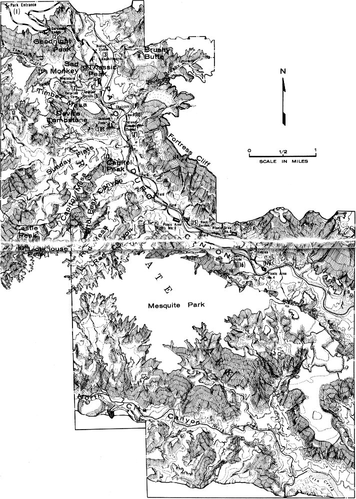
Fig. 2. Place map of Palo Duro Canyon.
Later, during the 17th and 18th centuries, the canyon was a favorite resting place of the buffalo hunters and Indian traders who frequented the Plains. The canyon was also popular during the first half of the 19th century, for it was then that it was occupied by the Comanches and served as a trade center for the Spaniards and Indians who came from New Mexico. These traders, called comancheros, bartered for loot taken by the Comanches on their raids of early settlements and wagon trains that passed through the Panhandle-Plains region.
This same era marked the beginning of American interest in the Palo Duro country. During this period the area was visited by several expeditions including those of Long and Pike and the Texas-Santa Fe Expedition of 1841. However, the canyon was not fully explored or mapped until 1852. This important survey was carried out by a party which was under the supervision of Captain R. B. Marcy.
But it was not until 1876 that the first white man established permanent residence in Palo Duro Canyon. In 1876—just two years after McKenzie’s rout of the Comanches—Colonel Charles Goodnight herded more than 1,600 head of cattle into the canyon. Here he laid out his first permanent ranch and lived in a primitive earthen dugout. Not only was Goodnight’s Palo Duro Ranch the first in the canyon, it is also thought to have been the first commercial cattle ranch in the Texas Panhandle. In later years Colonel Goodnight formed a partnership with John Adair of Ireland, and together they developed the famous JA Ranch—a vast spread of some 600,000 acres. Today’s visitor to Palo Duro Canyon can visit a partially restored dugout similar to that occupied by the canyon’s early settlers (fig. 30).
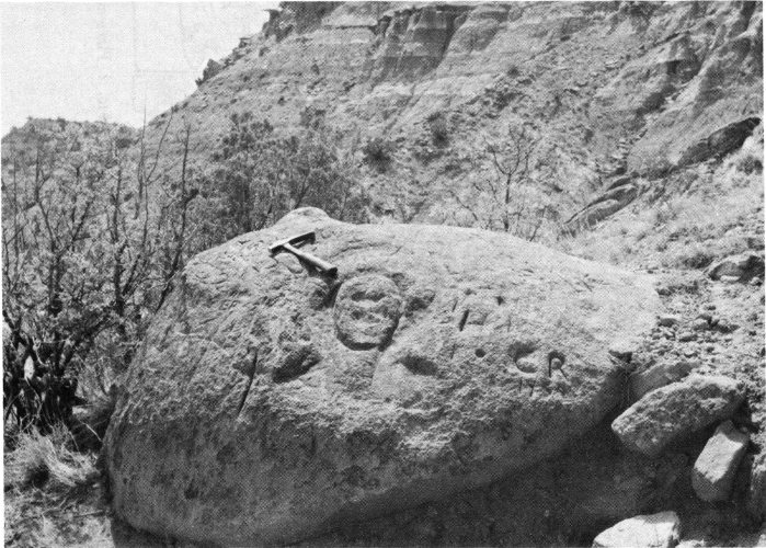
Fig. 3. The face carved on this boulder can be seen along the track of the Sad Monkey Railroad (p. 35). It is believed to have been carved by Indians.
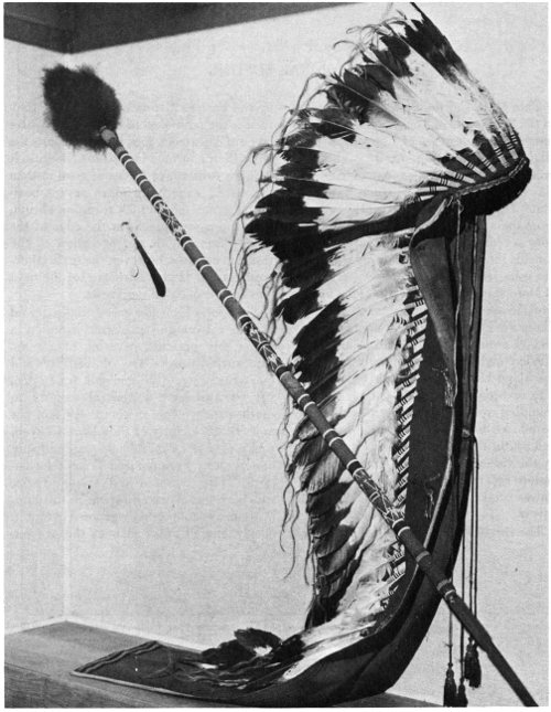
Fig. 4. The war bonnet, war lance, and head feathers of Comanche Chief Quanah Parker can be seen at the Panhandle-Plains Historical Museum in Canyon. (Photograph courtesy Panhandle-Plains Historical Museum.)
From the late 1800s until about 1930, the Palo Duro country remained the domain of the Panhandle-Plains cattleman. It was, nonetheless, a favorite picnic and camping spot of the residents of nearby towns and cities. In 1933 the recreational potential of the canyon was finally recognized and land for the Palo Duro Canyon State Park was purchased by the State of Texas with money obtained through a public revenue bond issue. Today, most of the park revenue received through gate admissions, 8 concession receipts, and mineral leases goes into a fund that pays off the remaining balance of the revenue bonds. During the initial phase of the park’s development, most of the improvements in the area were made by members of the Civilian Conservation Corps who worked under the supervision of the National Park Service.
Currently, Palo Duro Canyon State Park is visited by approximately 300,000 visitors each year and is one of the State’s more popular recreational and scenic areas.
Palo Duro Canyon State Park is located in the Panhandle of Texas (fig. 5) approximately 13 miles east of Canyon on State Highway 217 (see fig. 7). It is about 12 miles south and 8 miles east of Amarillo via Ranch Road 1541 which intersects State Highway 217. The park includes more than 15,000 acres of Palo Duro Canyon, a complexly dissected area which spreads into Randall, Armstrong, and Briscoe counties.
More specifically, the Palo Duro area is situated on the Llano Estacado or High Plains area which comprises approximately 20,000 square miles of Texas and New Mexico (see fig. 5). Generally speaking, the Llano Estacado is a high isolated plateau or broad mesa, rising above the surrounding rolling plains in a nearly flat, island-like mass. On the west, southwest, and south, the Llano Estacado is bounded by the valley of the Pecos River, while its eastern escarpment is drained by the headwaters of the Red, Brazos, and Colorado Rivers.
The rim of Palo Duro Canyon is formed by the Eastern Caprock Escarpment. Caprock is the term used to describe a massive layer of calcareous rock which supports the High Plains surface (see p. 26). Because it is more resistant to forces of erosion than the softer, underlying more or less horizontal strata, the caprock forms an abrupt, precipitous escarpment at the edge of the High Plains. With the exception of the resistant caprock, however, the surficial deposits on the High Plains are for the most part unconsolidated sediments.
The Llano Estacado is essentially devoid of native trees and is characterized by a sparse, but uniform, covering of grasses. The surface rocks are of Tertiary and Quaternary age (see geologic time scale, fig. 6) and have a general easterly to southeasterly slope of about 9½ feet per mile. In the vicinity of Palo Duro Canyon, rocks of Late Cenozoic age are directly underlain by Permian and Triassic formations. These Permian and Triassic rocks, which are discussed elsewhere in this publication, are not normally exposed except in deeply eroded areas such as the canyon.
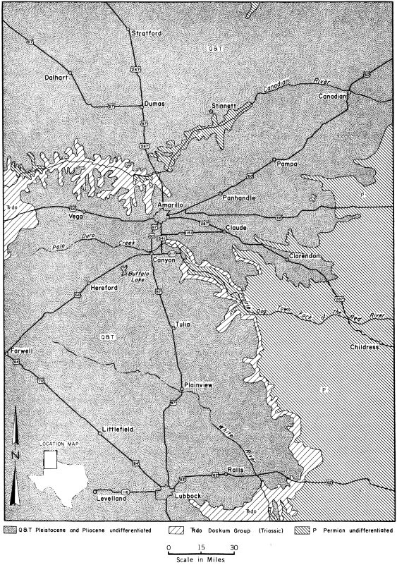
Fig. 5. Generalized geologic map of the Texas Panhandle showing location of Palo Duro Canyon.
Palo Duro visitors—regardless of age—seem to have an innate curiosity about the canyon’s rocks. This is not surprising, for most of the features of the park landscape are composed of or have been sculptured from solid rock. In short, much of the natural beauty of Palo Duro Canyon has been derived from the character of its exposed rock formations and the effect of geologic agents upon them.
Because rocks are the raw materials of geology and the stuff from which landscapes are formed, it will be helpful for the visitor to know something about the general characteristics of rocks and their role in the development of the landscape. Rock is everywhere around us and is one of the most common objects in the world, yet few people can actually define a rock. So, at the outset it should be stated that a rock is a naturally formed aggregate of minerals, and a mineral is a naturally occurring substance which has a fairly definite chemical composition, distinctive physical properties, characteristic internal structure, and which commonly occurs in definite shapes called crystals. Although not an exact scientific or legal definition of a mineral, the above explanation is satisfactory for the purposes of this publication.
Although most visitors show considerable interest in the canyon’s rocks and minerals, few of them know the story behind the rocks. They do not know how the rocks were formed, of what they are composed, how they change, and how they differ. More important, they fail to realize the historical significance of the rocks and how they can be used to interpret events that occurred in the canyon many millions of years ago. Thus, before one studies the geologic story of Palo Duro Canyon, it is helpful to know something about the various kinds of rocks. There are three major classes of rocks in the earth’s crust: igneous, sedimentary, and metamorphic rocks.
Igneous rocks solidified from an original molten state. Common examples of igneous rocks include granite, basalt, and volcanic ash. Although no igneous rocks are found in Palo Duro Canyon, they are widely exposed in parts of West and Central Texas.
Metamorphic rocks were originally igneous or sedimentary in origin. However, these rocks have undergone such great physical and chemical change that they have been transformed into a different kind of rock. Thus, metamorphic changes alter limestone to marble or sandstone to quartzite. No metamorphic rocks crop out in the canyon, but, like the igneous rocks, they are common in some parts of the State.
All of the geologic formations exposed in Palo Duro Canyon are composed of sedimentary rocks. These are rocks that have been formed by the compaction and cementation of rock and mineral fragments called sediments, or by the precipitation of material from solution. Sandstone, conglomerate, shale, and caliche (see p. 26) are examples of sedimentary rocks that are exposed in the canyon.
Sedimentary rocks are typically stratified, that is, they occur in layers or beds called strata. In addition, sedimentary rocks—especially those of marine origin—commonly contain fossils. These fossils are traces or evidence of prehistoric plants and animals that have been preserved in the rocks, and they may provide clues as to the age of rocks and the manner in which they were formed. Fossil remains have been found at a number of places in the park and these are discussed later.
In order to understand better the geologic history and development of the canyon, one should also have some knowledge of the basic principles of earth history and should be familiar with the geologic time scale (fig. 6).
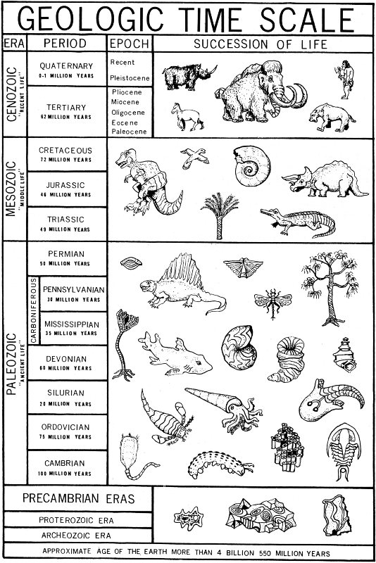
Fig. 6. Geologic time scale. Reproduced from FOSSILS: An Introduction to Prehistoric Life, William H. Matthews III, Barnes and Noble, Inc., 1962.
The geologist has learned that the earth’s physical features have not always been as they are today. It is known, for example, that mountains now occupy the sites of ancient seas. Coal is now being mined where swamps existed many millions of years ago. Furthermore, the earth’s plants and animals have also been subject to great change. The trend of this organic change is, in general, toward more complex and advanced forms of life. However, some forms have remained virtually unaltered while others have become extinct at different points in geologic time.
In order to interpret earth history, the earth scientist gathers evidence of the great changes in climate, geography, and life that took place in the geologic past. He does this by studying the rock formations, the structural relationships of these formations, and the landforms of the area. The record of ancient events is pieced together by studying the stony layers of the earth as one might study a giant history book. Indeed, the sedimentary rocks are the rocky “pages” of earth history, for in them we find the tracks and trails, and bones and stones, which reveal the intriguing story of life long ago.
Much of the basic information which the geologist uses to reconstruct the geologic history of a region comes from his examination and interpretation of bedrock outcrops. Bedrock is the solid unweathered rock which underlies loose earth material such as soil, sand, and gravel. An outcrop, or exposure, is a place where bedrock is exposed at the surface.
The first chapter of earth history begins with the most ancient rocks known. Because they were formed early in geologic time, these rocks are normally found deeply buried beneath younger rocks which have been deposited on top of them. It is for this reason that earth history is read from the bottom up, for the earliest formed rock layers correspond to the opening chapter in our earthen history book. The later chapters are found in the upper younger rocks which are located nearer the surface. Thus, in “reading” the geologic history of Palo Duro Canyon we start with the oldest “chapter” which is recorded in the Quartermaster Formation (p. 17) of Permian age, for these are the oldest rocks exposed in the canyon.
But deciphering earth history is not as simple as it might appear. In many areas the rock layers are not always found in the sequence in which they were originally deposited. In places, great structural disturbances have caused some of the rocky “pages” to become shuffled and out of place; others may be missing completely. Many rocks have been destroyed by weathering and erosion or greatly altered by metamorphism. As a result, the story recorded in these particular rocks is lost forever. These missing “pages” make the ancient story even more difficult to interpret so the geologist must then depend on other evidence that will permit him to “fill in the blanks.”
The record revealed in the rocks indicates that our planet is at least 4½ billion years old and that life has been present for more than 3 billion years. During this vast span of time the earth and its inhabitants have undergone many changes.
The geologic column refers to the total succession of rocks, from the oldest to the most recent, that are found in the entire earth or in a given area. For example, the geologic column of Texas includes all rock divisions known to be present in the State. By the same token, the geologic column of Palo Duro Canyon consists of the geologic formations exposed there. Thus, by referring to the geologic column previously determined for a specific area, the geologist can determine what type of rock he might expect to find in that particular region.
The geologic time scale (fig. 6) is composed of named intervals of geologic time during which were deposited the rocks of the geologic column. These time intervals bear the same names that are used to distinguish the various units of the geologic column. For example, one can speak of Permian time (referring to the geologic time scale) or of Permian rocks (referring 13 to rock units of Permian age in the geologic column).
Both the geologic column and the geologic time scale are based upon the principle of superposition. This basic geologic concept states that unless a series of sedimentary rock has been overturned, a given rock layer is older than the strata above it, and younger than all of the layers below it. Thus, the field relationship of the rocks plus the type of fossils (if present) give the geologist some indication of the relative age of the rocks. Relative age does not imply age in years; rather, it fixes age in relation to other events that are recorded in the rocks.
Within recent years, however, it has become possible to assign ages in years to certain rock units. This is accomplished by a system of rock dating based on very precise measurements of amounts of radioactive elements (such as uranium). When present in the rocks, radioactive minerals change or decay at a known rate so that they are natural “clocks.” This method of dating has made it possible to devise a time scale in years which gives some idea of the tremendous amount of time that has passed since the oldest known rocks were formed. It has also been used to verify the previously determined relative ages of the various rock units.
The largest unit of geologic time is an era, and each era is divided into smaller time units called periods. A period of geologic time is divided into epochs, which, in turn, may be subdivided into still smaller units. The geologic time scale might be roughly compared to the calendar in which the year is divided into months, months into weeks, and weeks into days. Unlike years, however, geologic time units are arbitrary and of unequal duration, and the geologist cannot be positive about the exact length of time involved in each unit. The time scale does, however, provide a standard by which he can discuss the age of fossils and their surrounding rocks. By referring to the time scale it may be possible, for instance, to state that a certain event occurred during the Paleozoic Era in the same sense that one might say that something happened during the American Revolution.
There are five eras of geologic time, and each has been given a name that is descriptive of the degree of life development that characterizes that era. Hence, Paleozoic means “ancient-life” and the era was so named because of the relatively simple and ancient stage of life development.
The eras, a guide to their pronunciation, and the literal translation of each name is shown below.
Archeozoic and Proterozoic rocks are commonly grouped together and referred to as Precambrian in age. In most places Precambrian rocks have been greatly contorted and metamorphosed, and the record of this portion of earth history is most difficult to interpret. Precambrian time represents that portion of geologic time from the beginning of earth history until the deposition of the earliest fossiliferous Cambrian strata. Precambrian time probably represents as much as 85 percent of all geologic time.
The oldest era is at the bottom of the time scale because this part of geologic time transpired first and was then followed by the successively younger eras which are placed above it. This is, of course, the order in which the various portions of geologic time occurred and during which the corresponding rocks were formed.
As mentioned above, each of the eras has been divided into periods, and most of these periods derive their names from the regions in which the rocks of each were first studied. For example, the Pennsylvanian rocks of North America were first studied in the State of Pennsylvania.
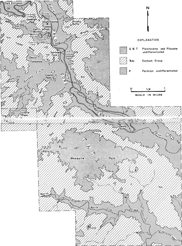
Fig. 7. Generalized geologic map of Palo Duro Canyon State Park.
The Paleozoic Era has been divided into seven periods of geologic time. With the oldest at the bottom of the list, these periods and the source of their names are:
The Carboniferous Period in Europe includes the Mississippian and Pennsylvanian Periods of North America. Although this classification is no longer used in the United States, the term Carboniferous is found in many of the earlier geological publications and on many of the earlier geologic maps.
The periods of the Mesozoic Era and the source of their names are:
The Cenozoic periods derived their names from an old outdated system of classification which divided all of the earth’s rocks into four groups. The two divisions listed below are the only names of this system which are still in use:
Although the units named above are the major divisions of geologic time and of the geologic column, the geologist generally works with smaller units of the column called geologic formations. A geologic formation is a unit of rock that is recognized by certain physical and chemical characteristics. A formation is generally given a double name which indicates both where it is exposed and the type of rock that makes up the bulk of the formation. For example, the Beaumont Clay is a formation consisting of clay deposits that are found in and around Beaumont, Texas. For convenience in study, two or more successive and adjoining formations may be placed together in a group. Thus, the Tecovas and Trujillo Formations have been placed in the Dockum Group. Likewise, a formation may be subdivided into smaller units such as members, which may also be given geographic or lithologic (rock type) names.
As noted above, all of the rocks which crop out in Palo Duro Canyon are sedimentary in origin. They represent four different geological periods: the Permian, Triassic, Tertiary, and Quaternary (fig. 12).
Although these rock formations differ considerably in composition and age, they do not tell the whole geologic story of the area. Long spans of geologic time are not represented by rock units because the region was undergoing erosion or no sediments were being deposited during certain portions of geologic time. Rocks that had formed during one geologic period were removed by erosion during a later period. Thus, segments of the geologic record were destroyed or never recorded. For this reason, much of the geologic history of the Palo Duro area is unrecorded and must be inferred from fragmentary evidence borrowed and pieced together from adjacent areas. Even so, an interesting story can be assembled from the rocks that remain in the canyon today.
In general, the following descriptions of the formations exposed in Palo Duro Canyon State Park follow the procedure that most geologists use in presenting the results of their geologic investigations. The more distinctive characteristics of the rock units are described in order that they may be more easily recognized, and the ways in which the rocks were formed are also considered. With this background it is then possible to review the geologic history recorded in the bedrock of the canyon. A 17 simplified geologic map is presented in figure 7; this shows the distribution of the major rock types in the canyon. The reader will find it helpful to refer to this map when reading the descriptions of the various formations.
The oldest formation exposed in the canyon is the Quartermaster Formation of Permian age (see fig. 6) which is named from exposures along the banks of Quartermaster Creek in Roger Mills County, Oklahoma. One of the more colorful formations in the park, the Quartermaster is composed primarily of brick-red to vermilion shales which are interbedded with lenses of gray shales, clays, mudstones, and sandstones. Averaging about 60 feet thick where exposed in the park, the Quartermaster forms the floor and lower walls of the canyon.
The rocks of this formation are easily examined at many places throughout the canyon and in them can be seen a number of interesting geologic phenomena. Probably the most noticeable of these features are the shining white veins of gypsum that lace the face of the red shale outcrops (fig. 8). A soft, transparent to translucent mineral that can be scratched by a fingernail, gypsum is hydrous calcium sulfate (CaSO₄·2H₂O). Three varieties of gypsum are found in the canyon: (1) satin spar, a fibrous variety with a silky sheen; (2) selenite, a colorless, transparent variety which commonly occurs in sheet-like masses; and (3) a fine-grained massive variety called alabaster. Satin spar is the most common variety of gypsum present and it commonly occurs in thin bands interbedded with the mudstones and sandstones. It is much more noticeable in the shales, however, for it is typically seen in narrow veins which criss-cross the surface of the outcrop and intersect the bedding planes at various angles. Although normally white, some of the satin spar has a soft pink or bluish hue due to the presence of impurities in the mineral.
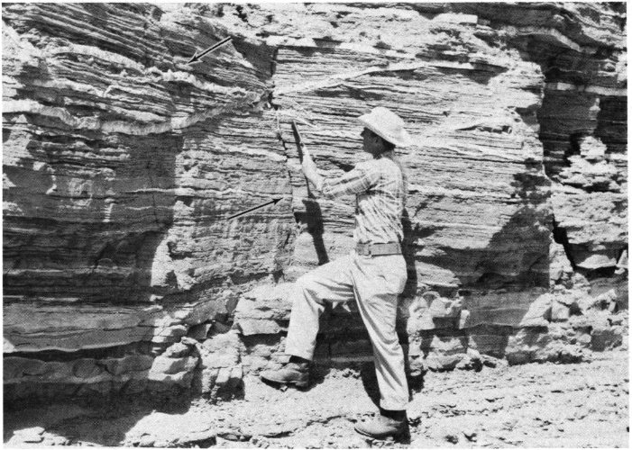
Fig. 8. Veins of selenite gypsum (top arrow) in Quartermaster Formation. Notice diagonal joint to left of geologist’s hand (lower arrow).
The presence of gypsum in the Quartermaster red beds is of special significance to the geologist, for it provides valuable information about the geologic history of the Palo Duro area. It is known, for example, that when a landlocked body of sea water in an arid climate becomes separated from the ocean, one of the most common salts to precipitate is hydrous calcium sulfate, or gypsum. Gypsum may also be precipitated when a lake without an outlet evaporates in an arid climate. Geologic evidence suggests that the sediments which gave rise to the rocks of the Quartermaster Formation were deposited in a landlocked arm of the sea during the latter part of the Permian Period. As evaporation continued and the sea water was reduced to approximately one-third of its original volume, gypsum was precipitated. There must have been periodic influxes of silt- and mud-bearing waters entering the ancient Permian sea, for layers of shale and mudstone are interbedded with the gypsum.
It is believed that much of the satin spar and selenite gypsum was originally anhydrite (CaSO₄). Unlike gypsum, anhydrite does not contain water, but it can be changed to gypsum in the presence of moisture. There are two lines of evidence that indicate an anhydrite origin for the Quartermaster gypsum. First, microscopic examination of gypsum samples reveals the presence of residual anhydrite crystals embedded in the gypsum. Second, many of the gypsum beds have been squeezed into rather gentle folds. These consist of small anticlines, upfolds or arches, and synclines, downfolds or troughs (fig. 9). It has been suggested that this folding took place as the anhydrite underwent hydration, or took on water. As hydration occurred and the anhydrite was converted to gypsum, the gypsum expanded, thereby exerting both lateral and vertical pressure on the beds around it. This produced the crumpled, wave-like folding so characteristic of certain of the gypsum beds. However, there is not complete agreement that the folding in the gypsum is due to the hydration of anhydrite. Certain geologists attribute this deformation to slumping caused by solution cavities, for gypsum is relatively easily dissolved in water. As the gypsum was dissolved and carried away in solution, the removal of the supporting layers of gypsum permitted slumping and consequent deformation in the overlying shales and mudstones. Although some geologists believe that the folds were caused by expansion due to the hydration of anhydrite and others support deformation related to the removal of soluble gypsum, there is general agreement that the folding is local and not related to regional or widespread deformation.
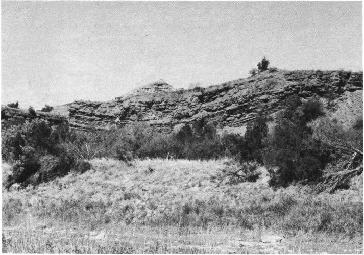
Fig. 9. Sagging beds of Quartermaster Formation have produced this gentle syncline, or downfolding, in the rocks. The “dome” on Capitol Peak can be seen in the background.
Not all of the red Quartermaster shales are uniformly colored. Some of them contain gray-green, circular spots called reduction halos (fig. 10). These spots, which in places give the red shales a distinctive polka-dot appearance, have been produced as the result of chemical change of certain minerals within the shale.
As noted earlier, sediments are usually laid down in horizontal layers. However, in certain environments, sediments may be deposited in such a way that the layers are inclined at angle to horizontal (fig. 11). This structure, called cross-bedding or cross-stratification, is found in certain sandstones and other coarse-grained or fragmental sedimentary rocks. Cross-bedding typically consists of rather distinct inclined layers separated by bedding planes (the surface of demarcation between two individual rock layers). Bedding of this type commonly occurs in sedimentary rocks formed in rivers, deltas, and along the margins of lakes or oceans. The cross-bedding in the Quartermaster and certain of the Triassic formations is believed to have been developed under similar conditions. Although cross-bedding is also common in certain rocks of eolian origin (deposited by wind) none of the cross-bedding in the canyon’s rocks is due to the action of wind.
In addition, some of the Quartermaster strata have ripple marks on their surfaces. These features are common in certain sedimentary rocks and were formed when the surface of a bed of sediment was agitated by waves or currents. The size, shape, and cross section of the ripple marks can be used to tell whether the marks were produced by waves or currents. The ripple marks in the Quartermaster appear to have been formed by the action of waves on a shallow sea floor.
A number of interesting geologic features in the canyon have been formed in part in the Quartermaster Formation. These include the multi-hued Spanish Skirts (fig. 26), the Devil’s Slide (fig. 35), Capitol Peak (fig. 32), and Catarina Cave (fig. 27). The latter is a rather unusual cave in that it has developed in a large mass of landslide debris divided by projecting bedrock of the Spanish Skirts. The cave has been formed by suffosian, a process whereby water enters the landslide debris on the upper slopes and follows buried channels in the landslide removing rock debris as it passes through. The flood water exits at the base of the landslide by means of Catarina Cave. The plan of the cave closely resembles the drainage patterns of surface gullies.
Rocks of the Triassic System (fig. 6) are well represented in Palo Duro Canyon and consist of the Tecovas and Trujillo Formations. These formations are part of the Dockum Group of Late Triassic age.
Having a total thickness of about 200 feet, the Tecovas (which is named from exposures found on Tecovas Creek in Potter County, Texas) consists largely of multicolored shales. Also present are thin layers of soft sandstone, which are disseminated throughout the shales, and a more prominent bed of white sandstone, which marks the middle of the formation. The Tecovas shales overlie the Quartermaster Formation, and the lower zone of lavender, gray, and white shales forms a relatively smooth slope that is easily distinguished from the steeper slopes of gullied red-and-white-banded shales beneath them (fig. 12).
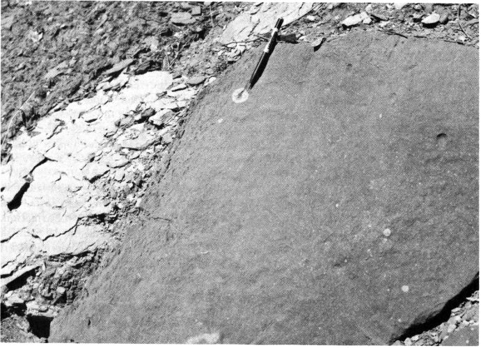
Fig. 10. Chemical reactions in certain of the red Quartermaster shales have produced reduction halos (p. 19) which give the rocks a polka-dot appearance.
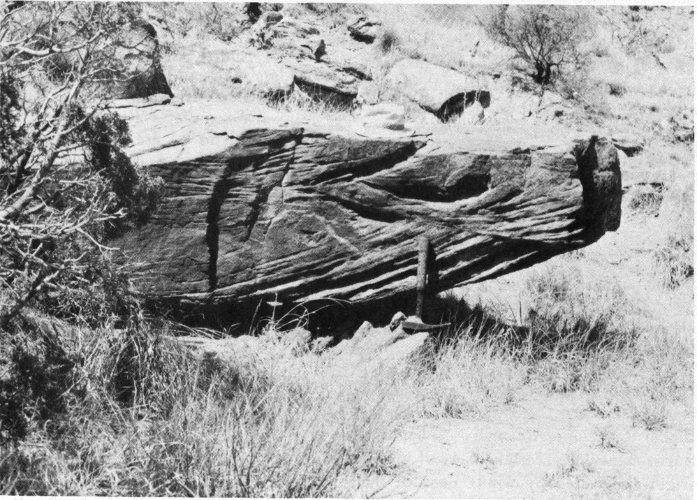
Fig. 11. This boulder, located near the foot of Triassic Peak along the Sad Monkey Railroad track, exhibits the cross-bedding typical of the Trujillo sandstones.
But the contact zone between the Tecovas and Quartermaster shales involves more than a mere change in color. Here is one of the missing “chapters” in the geologic history of the canyon, for part of the Late Permian record and all of the record of Early and Middle Triassic time are missing from the geologic column. Such gaps in the column are represented by unconformities in the rocks. Here the unconformity is an ancient erosional surface between the Tecovas Formation of Late Triassic age and the Late Permian Quartermaster Formation, and there are many millions of years of earth history represented in this missing “chapter” in the geologic story of Palo Duro Canyon. During this vast span of time, thousands of feet of sediments were probably deposited, converted into rock, and then later removed by erosion.
Near the middle of the Tecovas Formation there is a bed of white, crumbly (friable) sandstone. Averaging about 15 feet in thickness, this sandstone contains many joints (small crack-like fractures) along which no appreciable movement has taken place (fig. 8). There are two distinct sets of these joints which intersect each other at right angles. The distinctive joint patterns, the color, and the friability of this sandstone clearly differentiate it from the harder, darker, and more coarse-grained sandstones of the overlying Trujillo Formation (p. 22).
The upper part of the Tecovas consists of a layer of orange shale which overlies the middle sandstone unit and is in contact with the lower part of the Trujillo Formation.
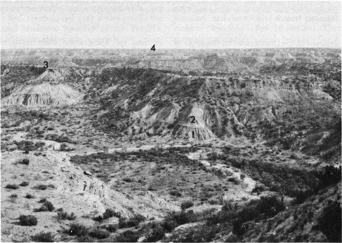
Fig. 12. Taken from the northwest rim near Coronado Lodge, this photograph shows the four major rock units exposed in the park: (1) The Quartermaster Formation which forms the lower wall and canyon floor; (2) Tecovas Formation; (3) Trujillo Formation which caps the mesas; and (4) Ogallala Formation.
The fossils which have been found in the Tecovas Formation suggest that these rocks were derived from sediments deposited in swamps and streams. Unlike the marine 22 deposits of the Quartermaster, the rocks of the Tecovas were formed from continental deposits laid down on the land. Fossils found in the canyon include the bones and teeth of the extinct semi-aquatic reptiles known as phytosaurs (fig. 13) and bone and skull fragments of a primitive amphibian called Buettneria (fig. 14). Coprolites (the fossilized excrement of animals), pieces of petrified wood, and the teeth and bones of lungfish have also been reported from the Tecovas.
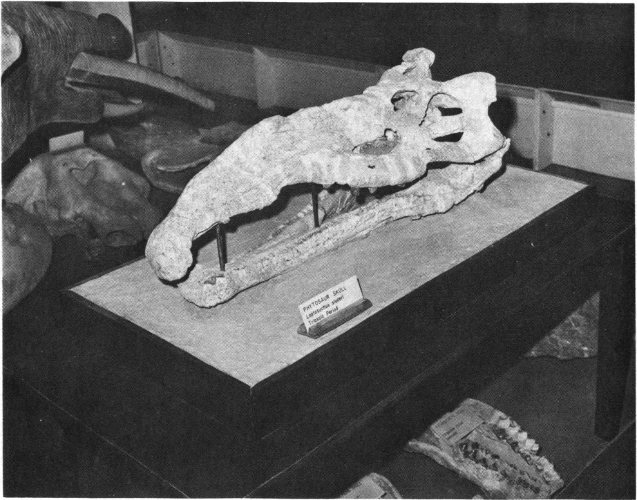
Fig. 13. The skull of this crocodile-like creature called a phytosaur is typical of the reptiles that inhabited the Palo Duro area during the Triassic Period. (Photograph courtesy Panhandle-Plains Historical Museum.)
A number of minerals including hematite, an iron mineral, and psilomelane, a barium-magnesium oxide, occur in the Tecovas. Hematite is an ore of iron and psilomelane a manganese ore, though neither of these is present in commercial quantities in the canyon.
The Tecovas also contains a number of concretions which range from a fraction of an inch to as much as 6 inches in diameter. These spherical masses are generally harder than the fine-grained shaly sands in which they are found and were thus left behind when the surrounding rock was eroded away. Some of these concretions are marked by cracks or veins filled with the mineral calcite. Concretions bearing this type of structure are called septaria, or septarian concretions.
Geodes are also found in the Tecovas Formation. These are rounded concretionary rocks with a hollow interior that is frequently lined with mineral crystals. Well-formed crystals of clear calcite have been found in many of the geodes from the Tecovas.
Among park landmarks that are characterized by the multi-hued Tecovas strata are the middle portion of Triassic Peak (fig. 25), the upper part of the Spanish Skirts (fig. 26), Capitol Peak (fig. 32), and the Devil’s Slide (fig. 35).
Named from rock exposures on Trujillo Creek in Oldham 23 County, Texas, the Trujillo is easy to distinguish from the underlying Tecovas Formation. The contact is quite distinct and lies between the top of the orange Tecovas shale and the base of the massive-bedded, cliff-forming Trujillo sandstone (fig. 25). Although generally fine grained and thickly bedded, there are local concentrations of pebble-sized rock fragments in the Trujillo. The weathered surface of the lower sandstone is stained red or dark brown by iron oxides. However, a fresh, unweathered surface is typically gray or greenish gray in color, and careful examination of the unweathered rock reveals the presence of tiny flakes of mica.
The basal Trujillo sandstone is one of the most conspicuous rock units in the canyon and forms many of the prominent benches and mesas so typical of the Palo Duro landscape. In places the sandstone is cross-bedded (p. 20) and contains channel deposits of coarse sand which suggest that the sediments from which it was derived were deposited in ancient stream beds.
Red, maroon, and gray shales overlie the basal sandstone member of the Trujillo, and these shales are overlain by cross-bedded, coarse-grained sandstone. Another interval of varicolored shales separates the middle sandstone bed from the upper sandstone member. The middle sandstone unit is a conspicuous ledge- or cliff-forming rock and is medium to coarse grained and commonly cross-bedded. In most localities, the upper sandstone is overlain by a section of red and green shales which mark the uppermost limits of the Trujillo Formation. In places, however, this shale section has been removed by erosion and rocks of Tertiary age directly overlie the sandstone.
Although fossils are not common, the remains of Buettneria (fig. 14), leaf imprints, pieces of mineralized wood, and the scattered teeth and bone fragments of reptiles and amphibians have been found. Phytosaur remains, especially teeth, have also been collected from the Trujillo sandstones.
The Indians who formerly inhabited the Palo Duro area (p. 3) put the rocks of the canyon to a number of uses. This appears to be especially true of the rather coarse-grained Trujillo sandstones, which were commonly used for constructing primitive rock shelters. The abrasive surface of the sandstone was especially well suited for grinding grain, and mortar holes have been found in a number of places. One of these (fig. 15) can be seen along the tracks of the Sad Monkey Railroad (p. 35) near the foot of Triassic Peak. The Indians also used the clays of the Quartermaster, Tecovas, and Trujillo Formations to make pottery, and iron and copper minerals such as hematite and malachite were used to make red and green pigments for decoration and war paint.
The Trujillo shales and sandstones can be seen in a number of Palo Duro’s more spectacular geological oddities. These erosional remnants are best developed where blocks of erosion-resistant sandstone protect underlying pedestals of softer shale (fig. 15). This type of differential weathering (p. 31) has produced a number of interesting and unusually shaped pedestal rocks or “hoodoos” (figs. 16 and 20). The most spectacular erosional remnant—and one that has come to be the “trademark” of Palo Duro Canyon—is the Lighthouse (fig. 31). The great jumble of boulders called the Rock Garden (fig. 34) is also composed largely of massive blocks of dislodged Trujillo sandstone. These boulders accumulated on the canyon floor as a result of landslides. In addition, the rock profile known as Santana’s Face (fig. 28) is a naturally sculptured profile in the Trujillo sandstone that forms the cap of Timber Mesa.
The Ogallala Formation is named from exposures around Ogallala in Keith County, Nebraska. There is a major unconformity between the Trujillo Formation of the Triassic and the overlying Ogallala Formation of Pliocene (Late Tertiary) age. Missing here is the geologic evidence for what may have been some of the more exciting chapters in the canyon’s history. There is no record, for example, of the Jurassic and Cretaceous Periods which together encompass almost 24 120 million years of earth history. Also missing is any evidence of what transpired during more than 90 percent of the Tertiary Period, for no rocks of Paleocene, Eocene, Oligocene, or Miocene age are exposed in the canyon. Together these four epochs comprise approximately 47 million years of earth history. It is impossible, of course, to determine how many geologic formations may have been formed and later eroded during the 167 million years represented by this unconformity. However, our knowledge of present-day deposition and erosion suggests that the missing geologic record undoubtedly represents many thousands of feet of rock.
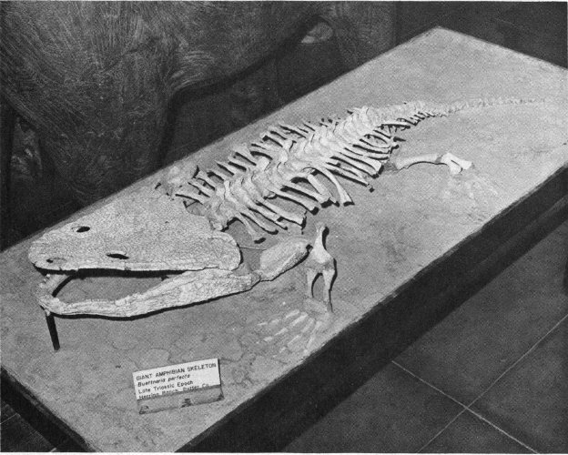
Fig. 14. The skeleton of Buettneria, a large amphibian, found in Upper Triassic strata in the canyon. (Photograph courtesy Panhandle-Plains Historical Museum.)
The lower portion of the Ogallala Formation is composed of a reddish-brown, fine- to medium-grained sandstone that contrasts sharply with the underlying red and green shales that are exposed in the top of the Trujillo Formation. Much of this sandy rock is characterized by pebbles consisting of a variety of igneous, sedimentary, and metamorphic rocks. Because it consists of rock and mineral fragments of varied composition and size, this kind of sedimentary rock is called a conglomerate. The type of rock fragments found in basal Ogallala conglomerates suggests that they were transported to the Panhandle-Plains area by streams flowing southeastward from the Rocky Mountains. As these streams deposited their loads, they left behind a wide spread blanket of sand, gravel, and mud which formed an extensive alluvial plain that extended from western Nebraska to northwest Texas. Although it is less than 100 feet thick in Palo Duro Canyon, in places this great mantle of fluvial (stream-deposited) sediments is as much as 900 feet thick.
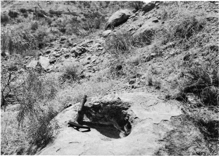
Fig. 15. The depression in this boulder is a mortar hole believed to have been used by the Indians for grinding corn.
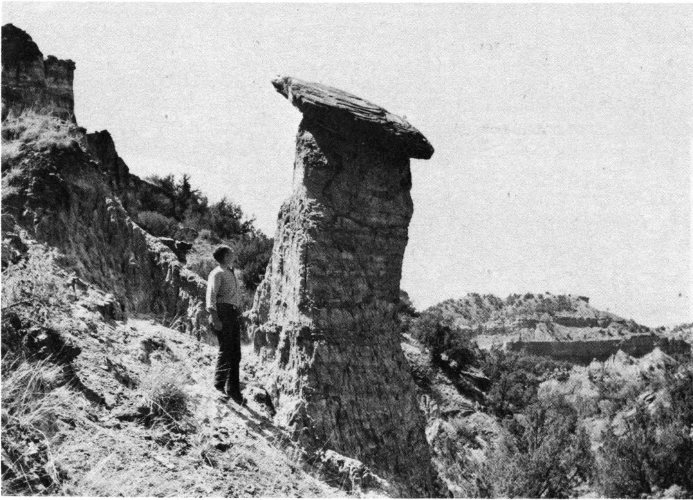
Fig. 16. This pedestal rock, located near the Lighthouse, is capped by a slab of weather-resistant Trujillo sandstone.
Most of the Ogallala Formation consists of a mixture of diverse rock types such as conglomerate, sandstone, siltstone, clay and marl. But the upper part of the formation is characterized by thick caliche deposits. A dull, earthy calcite deposit, caliche typically forms in areas of scant rainfall. It is believed to originate when ground moisture, containing dissolved calcium bicarbonate, moves to the surface where the moisture steadily evaporates leaving a calcium carbonate crust on or near the surface (fig. 17).
Caliche, which derives its name from the Latin calix, meaning “lime,” may be firm and compact or loose and powdery. It is also commonly found mixed with other materials such as clay, sand, or gravel. Caliche commonly occurs in the Trans-Pecos, southwestern Gulf Coastal Plain, and the High Plains area of Texas (see fig. 5, p. 8). In the latter area it typically makes up the “caprock.” Caliche is commonly quarried in these parts of Texas where it is used as road material and as an aggregate.
Good exposures of Ogallala caliche can be seen on the surface around the overlook at Coronado Lodge on the northwest rim of the canyon (fig. 17). Ogallala strata also crop out along the upper reaches of Park Road 5 as it starts to descend into the canyon. But probably the most spectacular exposures of the Ogallala are exposed in the precipitous face of the Fortress Cliff (fig. 33) which forms part of the eastern rim of the canyon.
Also located within the Ogallala Formation is a very important aquifer—a porous, water-bearing rock formation. This fine-to coarse-grained sandstone is very porous and permeable and is the most important single water-producing formation in the Panhandle-Plains area.
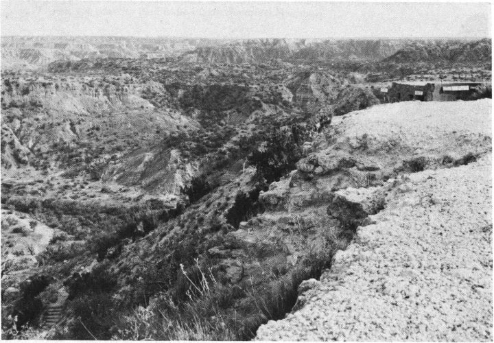
Fig. 17. The white surface in the right foreground consists of caliche (p. 26) in the Ogallala Formation. Coronado Lodge can be seen in the right background.
Opal and chert are locally abundant in the Ogallala conglomerates. The opal, which is found in small cavities in the conglomerate is not of the gem variety but it does fluoresce. Minerals that exhibit fluorescence emit visible colors when exposed to ultraviolet light. For this reason, the Ogallala opal is sought after by rock and 27 mineral collectors. The chert, a flint-like variety of quartz, occurs as nodules in the conglomerate and in a well-developed layer near the base of the formation. Both of these siliceous (silica-bearing) rocks were apparently prized by the Indians, who used them to fashion knives, scrapers, projectile points, and other artifacts. The Indians also learned that flat slabs of caliche were ideal for lining fireplaces and to construct primitive rock shelters.
A number of Pliocene vertebrates have been found in the Palo Duro area. Known as the “Age of Mammals,” the Tertiary Period was characterized by mammals as diverse as were the reptiles of the Mesozoic Era. Among these unusual creatures were such now-extinct species as the saber-tooth cat and the elephant-like shovel-jawed mastodon (fig. 18). The remains of these as well as bones of giraffe-like camels, pony-sized horses, and sloths have been found in the vicinity of the canyon. The grassy plains of Pliocene time were also inhabited by large tortoises which reached lengths of up to 3 feet (fig. 19). Dioramas showing how these animals might have looked, as well as their actual remains, are on display in the Hall of Pre-History in the lower floor of the Panhandle-Plains Historical Museum in Canyon, 13 miles west of the park (p. 35).
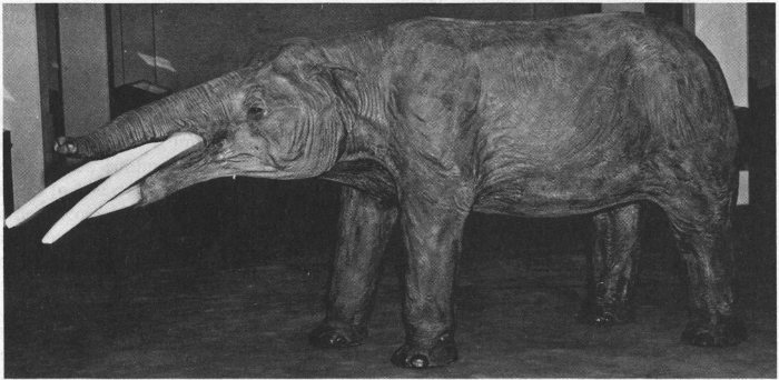
Fig. 18. This life-size model of a shovel-jawed mastodon is typical of the now-extinct, elephant-like creatures that lived in this area during the Pliocene Epoch. (Photograph courtesy Panhandle-Plains Historical Museum.)
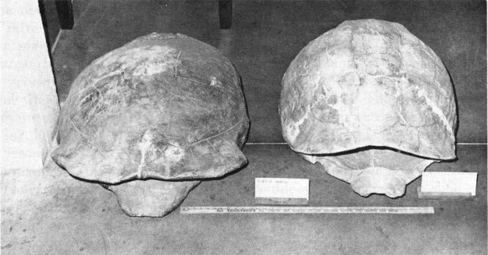
Fig. 19. The carapaces of giant tortoises as much as 3 feet long have been collected from Pliocene rocks in the Palo Duro area. (Photograph courtesy Panhandle-Plains Historical Museum.)
The youngest rocks in Palo Duro Canyon State Park were formed during the Pleistocene Epoch of the Quaternary Period of the Cenozoic Era (see geologic time scale, p. 11). Pleistocene rocks are rather widespread in much of the Panhandle-Plains area and they are mostly composed of sediments which were deposited in stream valleys, in lakes or ponds, or by the wind. Most of the Pleistocene strata in the park area consist of loose deposits of silt and sand which were deposited by wind action. Known locally as “blow sand,” this reddish-brown, silty sand overlies the Ogallala caliche at most points along the canyon’s rim.
The visitor seeing Palo Duro Canyon for the first time may find it difficult to believe that this yawning chasm began as a simple gully. But to the geomorphologist—the geologist who studies the origin and development of landscapes—Palo Duro Canyon is but a gully magnified many times over. This is evident because the shape of the canyon, the nature of its tributaries, and the character of its walls indicate that it has been deepened and lengthened by the downcutting of a stream and widened by other geologic processes.
Palo Duro Canyon is a classic example of a land-form that has been created by the geologic work of running water. Undoubtedly the most important single agent of erosion, running water probably does more to wear away the land than all the other geologic agents combined. This is not surprising considering the fact that the earth’s annual precipitation (such as rain and snow) equals about four billion tons of water. Although the amount of precipitation varies greatly from place to place, the average annual precipitation on land is about 40 inches of water. Of this, roughly 25 percent runs off from the land to form streams.
When one drives through the park and fords the normally gently flowing waters of the Prairie Dog Town Fork of the Red River he may well wonder if this unimposing stream actually is the geologic agent that is responsible for this deep gorge. But the visitor who happens to be present during a severe rainstorm will soon be convinced, for during heavy rains this gentle stream becomes a raging torrent. As the river increases in size it also becomes a more effective land-shaping tool, for the larger and swifter the stream, the more rock material it can carry. Thus, when flowing at peak capacity, this branch of the Red River becomes a moving ribbon of sandpaper whose load of sand, silt, and gravel has cut and scoured the canyon walls and floor for hundreds of thousands of years. How long has it taken the river to carve this remarkable chasm? Although there is no way of knowing for sure, geologic evidence indicates that the canyon has formed during the last one million years—a relatively short time, geologically speaking.
The work of the river is made still more effective by water and sediment which it receives from its tributaries; this added water substantially increases the volume and velocity of the river. Although many of the tributary streams are dry throughout much of the year, they carry large quantities of water during heavy rains. Moreover, because most of these streams flow over rock surfaces which are not protected by thick soil or vegetation, their waters are quickly transported to the master stream. Thus, the volume and velocity of the Prairie Dog Town Fork of the Red River make it possible—especially during flood periods—for the river to carry a large load of rock particles which effectively erodes the stream channel. Where does this rock debris come from? Most of it is eroded from the sides and bottom of the river’s channel.
The river carries its load in a number of ways. Material such as salt and other soluble matter is transported in a dissolved state or in solution. Still more, for example, silt and fine sand, is carried in suspension. These sediments are suspended between the surface of the water and the bottom of the stream channel. Those particles that will not dissolve in water and are too heavy to be carried in suspension, constitute the bottom load of the stream. These larger sediments, such as gravel, cobbles, and boulders, roll, bounce, or slide along the stream bed.
As flash floods course through Palo Duro Canyon, the river uses its load to erode further the rocks over which it passes. Each 30 moving rock fragment literally becomes a cutting tool for abrasion as the loose rock particles slowly wear away the banks and bed of the stream. Eventually the abraded rock fragments become smooth and rounded and the stream channel is gradually worn down to a lower level; it is also widened.
The river also erodes by hydraulic action as loose rock fragments are lifted and moved by the force of the stream’s current. This process is similar to the effect produced when soil is churned up and washed away when water from a garden hose is sprayed on loose earth. The effects of hydraulic action have played an important role in widening the canyon, for recession of the cliffs away from the middle of the canyons has been caused in part by undercutting. Thus, as the soft shale and gypsum beds were removed by the stream, the overlying sandstone formations gradually broke off and fell into the canyon. Once on the canyon floor, most of the slabs and blocks of sandstone were eventually broken up and carried away by the streams as sand and mud. Not all of the boulders have been destroyed in this manner; in places (for example, the Rock Garden) similar boulders are seen today (fig. 34).
Most of the energy of the river has been expended in downcutting, for the canyon has apparently been deepened more rapidly than it has been widened. But as the stream gouged its channel deeper into the bedrock, an ever-increasing expanse of canyon wall was exposed to other agents of erosion. Slowly—almost imperceptibly—the walls of the canyon have been eroded by the processes of weathering and mass-wasting.
Wherever rocks are exposed on the earth’s surface, they are attacked by the agents of weathering. They are dissolved by rainwater, pried apart by frost and ice, and blasted by windblown sand. Some of the changes produced by weathering are purely mechanical, that is, the rock is simply reduced to smaller fragments without being broken down chemically or undergoing any change in its mineral composition. This mechanical weathering, or disintegration, takes place in a number of ways. Changes are especially noticeable in rocks that are subjected to large daily temperature variations. If a crack in these rocks becomes filled with water and the temperature drops below freezing, ice forms. When water freezes it expands by about 10 percent of its volume—this is the reason why water pipes often split open during the winter. Just as in a water pipe, the pressure of the expanding ice is commonly great enough to widen and deepen the crack in the rock. This process, called frost wedging, may ultimately cause the rock to split and fall apart. The cumulative effects of frost wedging have probably played a significant role in prying off large blocks of rocks from the walls and rim of the canyon.
Animals and plants may also hasten rock disintegration. Plant roots commonly grow in rock crevices and as the roots become larger they wedge the rock apart. Burrowing animals such as rabbits, gophers, and ground squirrels also promote rock disintegration. Although they do not attack the rocks directly, their digging exposes new rock surfaces to weathering processes. The holes these creatures make also permit water and air to enter the earth more easily, thereby hastening rock destruction.
Man, of course, promotes more rock disintegration than all other animals combined. Thus, as one explores the canyon’s trails and climbs its walls, he will not only see evidence of the various types of mechanical weathering, he will also be contributing to the further wearing away of the rocks.
Decomposition, or chemical weathering, works hand in hand with mechanical weathering. But unlike disintegration, decomposition produces rock materials that are basically different from the original unweathered rock. These changes are 31 brought about as the result of chemical reactions between minerals in the rocks and water, carbon dioxide, and oxygen. Although the arid climate and severe winters of the Panhandle generally facilitate mechanical weathering, some of the red shales and gypsum deposits show the effect of oxidation, hydration, and other forms of chemical weathering (fig. 10).
Mass-wasting, the erosional process by which rock and soil move downslope in response to the force of gravity, has also been instrumental in shaping Palo Duro Canyon. This type of erosion has been especially active on the walls of the canyon, for here the slopes are steep enough to promote downward movement of earth materials. In a few places there have been landslides which have moved large quantities of rock in a short span of time. But most mass movements have been imperceptibly slow as masses of talus (accumulations of rock debris) on steeper slopes have inched slowly downhill because of their own weight. Talus deposits produced in this way can be seen at the foot of most of the cliffs and erosional remnants throughout the canyon (fig. 20).
Even the most casual observer will soon note that not all of the canyon’s rocks have been equally affected by erosion. Indeed, it is the nature of this differential erosion that gives Palo Duro Canyon the rugged sculptured appearance that accounts for much of its beauty.
Visitors to Palo Duro Canyon commonly ask why the rock formations are so diversely shaped. The answer to this question lies in the rocks themselves. Because the various rock strata are of unequal hardness, they erode at different rates of speed. Hence, the harder, more resistant rocks, such as the sandstones and conglomerates of the Trujillo Formation, form the shelves, ledges, and “caps” of the rock sculptures. The Lighthouse (fig. 31) and other pedestal rocks (fig. 16) are good examples of land-forms produced by differential erosion. The “hoodoos” mentioned earlier are also the products of this type of erosion (figs. 16 and 20).
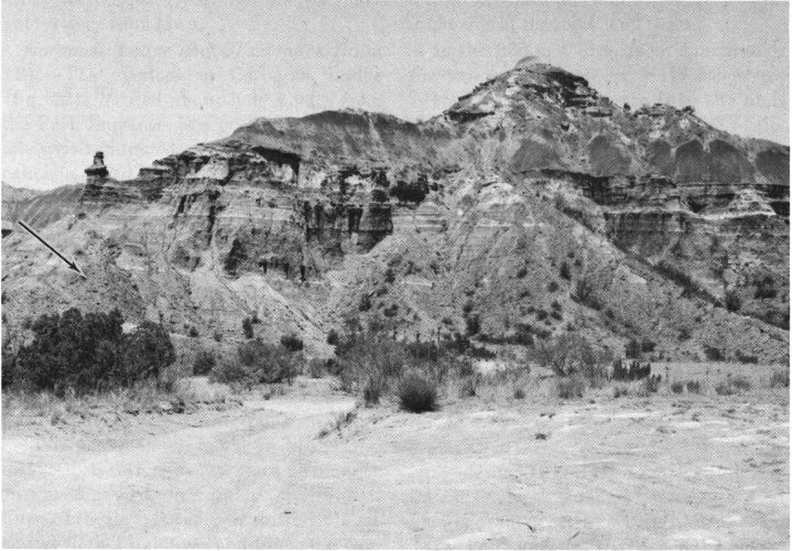
Fig. 20. Talus slopes (arrow) are well developed on the east side of Capitol Peak and in places obscure the Quartermaster red beds. Note the “hoodoo” at the south (left) end of the structure.
Softer rocks like shales and clay are more readily eroded and they normally form slopes rather than cliffs or ledges (fig. 12). Grooves, recesses, and caves have also developed in some of the less resistant rocks such as the shales and gypsum beds of the Quartermaster Formation. Catarina Cave (fig. 27) which has formed in the red and white shales of the Spanish Skirts (fig. 26) is a good example of this type of feature. Caves of this type afforded protection to both man and wild animals since the dawn of history, for their remains have been found in a number of similar caves.
Thus, within a relatively short time—geologically speaking—the familiar land-shaping processes described above have joined forces to provide Texas with one of its most remarkable natural attractions. But interestingly enough, the same geologic processes that created these unusual formations are busily at work destroying them. As time passes and erosion progresses, the caps of the pedestals are worn away and the underlying shales crumble and are washed into the valley below. Yet even as the old land-forms are being destroyed, wind, water, ice, and man are attacking the canyon walls to produce still more of these interesting erosional remnants.
The visitor to Palo Duro Canyon can choose from a number of recreational and educational activities. Moreover, regardless of whether one visits for a few hours to picnic along the banks of the river, or spends a week at one of the well-kept campgrounds, the visit will probably be both pleasant and rewarding. In the pages that follow there is a brief description of certain of the park landmarks and some of the more popular attractions within the canyon. The numbers in parentheses refer to numbers which designate these places on the map of Palo Duro Canyon (fig. 2, pp. 4-5). Hopefully, this information will help one to plan his visit to the canyon and thereby make his stay more enjoyable and worthwhile.
The first stop in the park is the gate at the ranger station (fig. 21). Here one pays a modest admission fee and receives literature and information about the park. The park is open every day of the year, but the entrance gates close at sundown.
The overlook at Coronado Lodge (fig. 22), located about half a mile from the Park Entrance, is a good place to start one’s visit. Situated on a ledge of Ogallala caliche (p. 26), the Lodge is an attractive, rustic structure constructed of blocks of Trujillo sandstone (p. 22). Its picture windows and outdoor overlook provide a matchless view of the canyon and make it possible to become oriented for the descent to the canyon floor. Large, coin-operated telescopes permit close-up views of distant parts of the canyon, and there are museum cases containing objects of historical and geological interest from the Palo Duro area. If possible one should visit the Coronado Observation Point more than once during the visit, preferably at different times of the day. Because of shifting clouds and changing lighting conditions, the canyon presents a continually changing panorama from sunrise to sunset. Open year-round, the Lodge offers a complete line of souvenirs, film, and camping supplies. There is also a snack bar where coffee, sandwiches, and cold drinks can be purchased.
After viewing the canyon from Coronado Lodge, one should take the scenic drive on Park Road 5. This paved, all-weather road descends the northwest rim of the canyon and continues on to the turnaround at Cow Camp, a distance of about 8 miles. Although the present scenic drive was completed in 1951, the path that it follows is essentially that which was laid out by Colonel Charles Goodnight when he established Palo Duro ranch in 1876. The road descends to the canyon floor in a series of well-engineered turns, but because it drops some 800 feet in little more than a mile it is wise to use second or low gear on the descent. One should also observe the posted speed limits (10 to 20 miles per hour) and keep to the right side of the road at all times.
In the 800-foot drop from rim to floor, the complete geologic section of the canyon is traversed, as one passes from the Pleistocene sands through the Ogallala, Trujillo, and Tecovas Formations, before reaching the Quartermaster Formation which is exposed in the canyon floor. Each of these geologic formations is discussed elsewhere in this publication (pp. 16-28).
Upon reaching the canyon floor, Park Road 5 flattens out and from this point it is but a short distance to the Pioneer Amphitheatre, one of the canyon’s newest and most popular attractions. Here, located at the foot of a colorful 600-foot cliff, is a remarkable 1500-seat outdoor theatre of latest design (fig. 23). Each evening during a ten-week summer season, a symphonic drama portraying the history of the Texas Panhandle is presented in the amphitheatre. Information about these productions can be obtained at the Park Entrance, Coronado Lodge, and other points within the park.
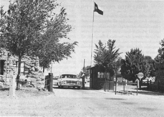
Fig. 21. The entrance gate to Palo Duro Canyon State Park.
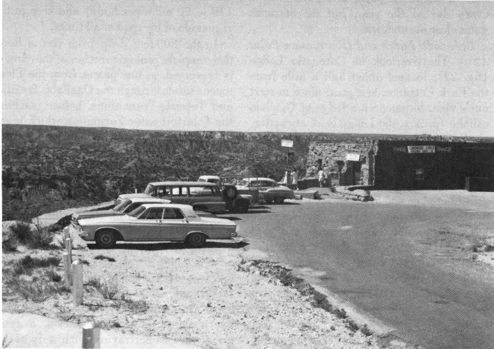
Fig. 22. Coronado Lodge on the canyon’s northwest rim affords panoramic views of the canyon.
The Sad Monkey Railroad begins—and ends—at Sad Monkey, Texas, a small “community” that lies at the foot of Triassic Peak (fig. 24). Unlike most miniature railroads, the Sad Monkey Special is not a “kiddie” ride. Instead, this 2-mile journey provides an opportunity to get away from the road for a closer look at the geologic formations exposed along the track. There are especially good views of the Spanish Skirts (fig. 26), Catarina Cave (fig. 27), and Triassic Peak (fig. 25). These, and other features of geologic interest, are pointed out by an experienced lecturer who also presents a brief review of the geologic history of the area.
Long used by Indians and ranchers as a Palo Duro landmark, the canyon visitor will find Triassic Peak to be equally useful as a geologic landmark. When viewed from the Sad Monkey Railroad Terminal, the south face of Triassic Peak clearly reveals three of the four major geologic formations of the canyon (fig. 25).
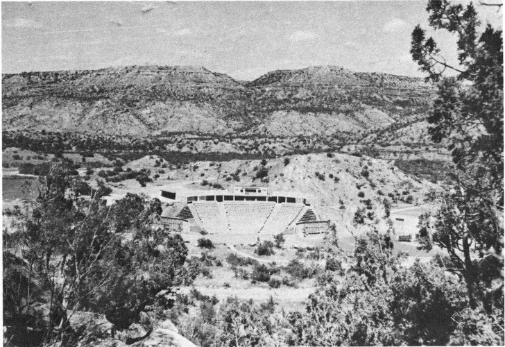
Fig. 23. Located on the canyon floor, Pioneer Amphitheatre is a modern outdoor theatre where symphonic dramas are presented each summer. (Courtesy Mrs. Ples Harper, Texas Panhandle Heritage Foundation, Inc.; photograph by Ron Horn.)
The lower one-third of the peak consists of deeply furrowed, red and white banded shales of the Quartermaster Formation (p. 17). Overlying the Permian red beds are the brightly colored, multi-hued Tecovas shales of Triassic age (p. 19). The composition of the Tecovas is such that the lower shales tend to weather into relatively gentle slopes with rather smooth surfaces. Triassic Peak is capped by a weather-resistant layer of Trujillo sandstone, and this durable cliff-forming sandstone has served as a protective covering to impede the erosion of the softer rocks of the Tecovas and Quartermaster Formations. Although it has withstood the ravages of time exceedingly well, the large blocks of Trujillo sandstone which litter the flanks and foot of Triassic Peak clearly indicate that weathering and mass-wasting have exacted their toll in the geologic past.
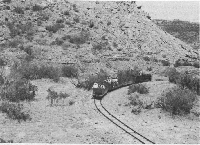
Fig. 24. A trip on the Sad Monkey Railroad is a good place to learn more about the canyon’s geology and get a closer look at the rocks.
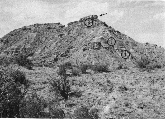
Fig. 25. Excellent exposures of the Quartermaster Formation of Permian age (1) and the Triassic Tecovas (2) and Trujillo (3) Formations can be seen in the south face of Triassic Peak. The feature known as the Sad Monkey is indicated by the arrow.
Sad Monkey, Texas derives its name from the prominent mass of Trujillo sandstone at the southern extremity of Triassic Peak. When viewed in the proper perspective—and with the proper amount of imagination—this massive block of sandstone bears a striking resemblance to an aged and saddened monkey.
Few of the canyon’s features are as well-named as the gaudy Spanish Skirts (fig. 26). The lower part of this multi-colored bluff consists of alternating layers of red and white Quartermaster shale, capped by the colorful maroon and lavender Tecovas shales. Located on the north flank of Timber Mesa, the Spanish Skirts and nearby Catarina Cave can be reached by an easy half-mile path. The trail begins on the west side of Park Road 5, just beyond the Timber Creek bridge located several hundred feet from the Sad Monkey Station.
A short distance west of the Spanish Skirts lies Catarina Cave. This depression has been washed out of the relatively soluble Permian shales (fig. 27).
Like Triassic Peak, Timber Mesa is capped by a thick layer of massively bedded Trujillo sandstone. On the eastern tip of the mesa the sandstone has been eroded in such a fashion that it resembles the profile of an Indian (fig. 28). This feature, called Santana’s Face, is best seen from the park road shortly after leaving Sad Monkey Station.
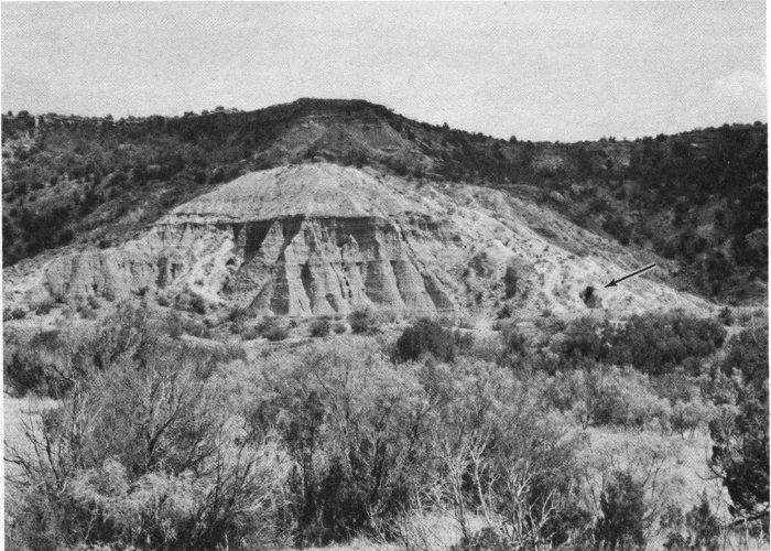
Fig. 26. The gaudy Spanish Skirts are a colorful expanse of Quartermaster and Tecovas strata exposed on the north flank of Timber Mesa. Note the contrast in weathering in the lower, gullied Quartermaster Formation and the smooth slopes of the Tecovas shales above it. Catarina Cave (arrow) is at the right.
The Sky Ride, located near the first water crossing on Park Road 5, transports visitors from the canyon floor to the top of Timber Mesa (fig. 28). The 300-foot ascent is made in ski-lift chairs that are comfortable and safe. The observation area atop the mesa offers an unusually fine view of most parts of the canyon.
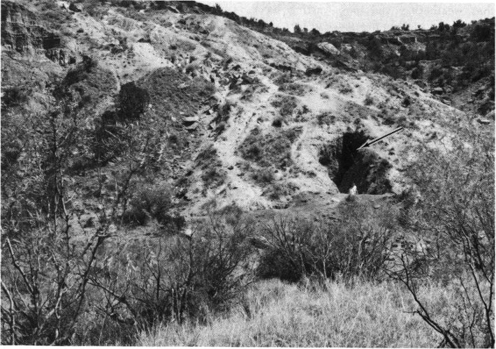
Fig. 27. Catarina Cave (arrow) is easily reached by a half-mile trail from Park Road 5.
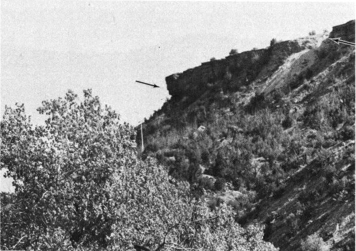
Fig. 28. Santana’s Face (left arrow) has been sculptured from the Trujillo sandstone cap of Timber Mesa. The cable for the Sky Ride (p. 37) passes through the notch indicated by arrow at right.
As it winds through the canyon, the park road crosses the Prairie Dog Town Fork of the Red River seven times in a distance of about 4 miles. These fords, or water crossings as they are called locally, are paved and are normally safe to pass through. They should, however, be avoided during times of heavy rains and flash flooding. Because of stream erosion, especially fine exposures of the Quartermaster Formation are revealed in the stream banks near several of the crossings.
The first of these crossings (fig. 29) is about 1 mile from the Sad Monkey Station and is one of the more popular picnic areas in the park. This area was also popular with earlier residents of the park, for it is believed to have been the campgrounds of both the Kiowa and Comanche Indians.
As mentioned earlier (p. 6) Colonel Charles Goodnight entered the canyon in 1876 with more than 16,000 head of cattle. Although he later established more comfortable quarters, Col. Goodnight first lived in a primitive dugout similar to the one shown in figure 30. A replica of this early shelter has been constructed of mud, stone, and logs and can be seen on the west side of the park road just beyond the first water crossing (see fig. 29).
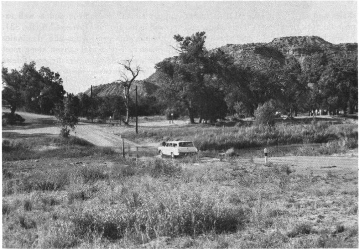
Fig. 29. Now a popular picnic spot, the wooded area near the first water crossing through the Prairie Dog Town Fork of the Red River was a favorite Indian campground.
The unpaved road to the Lighthouse enters Park Road 5 about two-tenths of a mile beyond the first water crossing. Although considered by many to be the canyon’s best-known landmark, the Lighthouse is actually not within park boundaries. It is located in Little Sunday Canyon about 3 miles west of the road and is not easily accessible to the average visitor. Like many of the park’s natural attractions, the Lighthouse is an erosional remnant of colorful Trujillo 40 shales and sandstones (fig. 31). A similar pedestal rock, the Devil’s Tombstone, can be reached by means of a trail which leaves the Lighthouse road and enters Sunday Canyon.
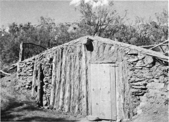
Fig. 30. When Colonel Charles Goodnight settled in the canyon in 1876 he lived in a primitive dugout similar to the one shown here.
Capitol Peak (figs. 20 and 32) is a rather imposing geologic feature that can be seen from a number of points along Park Road 5. There are especially good views in the vicinity of the second water crossing if one will look to the west of the road. Just beyond the crossing an unimproved road leads to the foot of Capitol Peak. The lower part of this feature is composed of Quartermaster shales of Permian age and the upper section consists largely of Triassic Tecovas shales. When viewed from the proper angle, the silhouette of Capitol Peak is thought to resemble the prostrate form of a human (fig. 32). For this reason it has also been called the Sleeping Indian.
The Ogallala Formation of Pliocene age (p. 23) forms the upper rim of the canyon and is well exposed in impressive Fortress Cliff (fig. 33). Although this precipitous cliff dominates the eastern rim of the canyon along most of the scenic drive, especially good views are afforded between the second and third water crossings.
Shortly after fording the river at the fifth water crossing, there is a jumbled pile of boulders on the west side of the road (fig. 34). This accumulation of Trujillo sandstone blocks has been named the Rock Garden. Many boulders such as these have accumulated on the floor of the canyon in ages past. However, most of these have been destroyed by weathering and their fragments removed by the canyon’s streams.
The Devil’s Slide can be reached by an unimproved road that leads southwest from the scenic drive for a distance of about half a mile. Composed of upper Quartermaster and lower Tecovas shales, the surface of this 41 eroded spur is laced with many trails and “slides” that have been made by previous visitors (fig. 35).
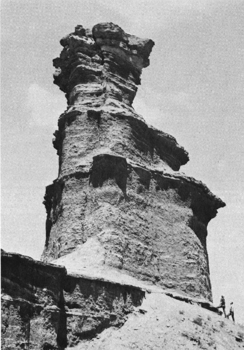
Fig. 31. The Lighthouse, an erosional remnant and the “trademark” of Palo Duro Canyon, exhibits well the geologic phenomenon of differential erosion (p. 31).
A loop marks the end of Park Road 5 and the conclusion of the scenic drive. Located in this area are a number of fine camping areas, picnic grounds, the old stone cottages called the “Cow Cabins,” and rest rooms with shower facilities (fig. 36).
Fig. 32. The “dome” on Capitol Peak is a well-known canyon landmark. Composed of the Tecovas and Quartermaster Formations, the profile of Capitol Peak is referred to as the Sleeping Indian. (The “Indian’s” head can be seen in the right background.)
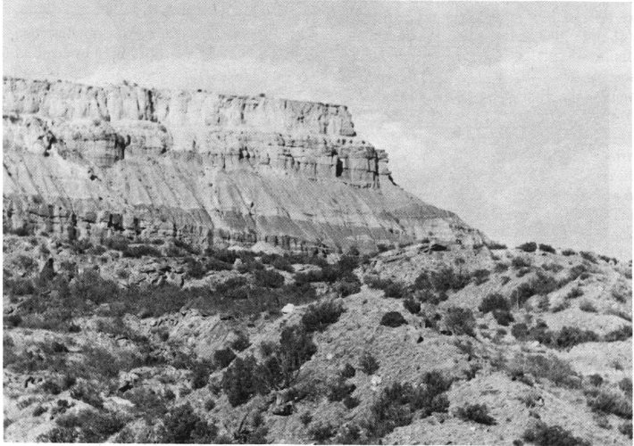
Fig. 33. Fortress Cliff is a prominent feature on the eastern rim of the canyon. Seen here are the precipitous cliffs developed in the Ogallala caliche (p. 26) and the sandstones and shales of the Trujillo Formation.
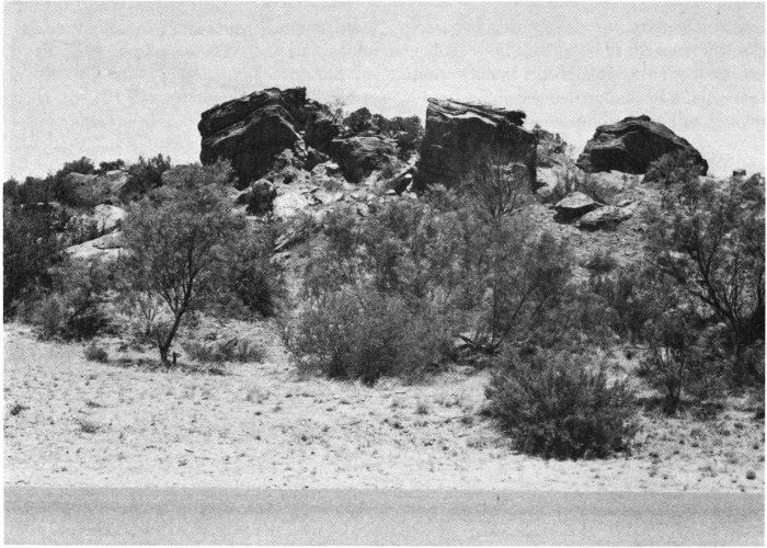
Fig. 34. The Rock Garden is a jumbled mass of Trujillo sandstone boulders that mark the site of an ancient landslide.
There are a number of established trails for the visitor who is interested in hiking. The more popular trails include those to the Spanish Skirts and Catarina Cave (p. 37), the Devil’s Tombstone, the Lighthouse (p. 39), and the Devil’s Slide (p. 40). Park rangers will be glad to provide more complete information about these and other trails within the canyon.
Saddle horses can be rented at the stables located east of the road near the Pioneer Amphitheatre. There are a number of trail rides that can be taken on well-trained horses accustomed to the rugged terrain of the canyon. Additional information may be obtained from the attendants at the stable.
An ample number of well-developed camping and picnic areas are scattered throughout the canyon. Most are located adjacent to or a short distance from Park Road 5; they are equipped with outdoor fireplaces and tables. Running water, rest rooms, and showers are provided in certain areas. Campsites are available on a first-come first-served basis, and there is a 10-day limit on overnight camping. Detailed information on camping regulations and camping areas is available from a park ranger or at the Entrance Station.
Palo Duro Canyon offers many opportunities for both amateur and professional photography. The multi-colored rock formations, erosional land-forms, and plants and animals offer limitless possibilities to the creative and imaginative photographer. Color shots are especially effective, but a haze filter will be helpful when photographing distant objects. Morning and afternoon are the best times for picture taking as the mid-day sun is “flat” and lends little perspective to the canyon scene.
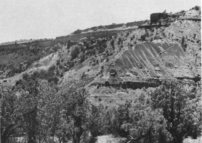
Fig. 35. The Devil’s Slide in the south end of the park is an eroded spur of Tecovas shales. Some of the “slides” made by visitors are indicated by the arrow.
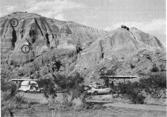
Fig. 36. Outcrops of the Quartermaster (1) and Tecovas (2) Formations provide a geological backdrop for this campsite near the turnaround at the end of Park Road 5.
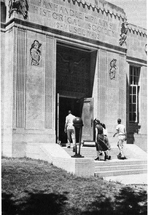
Fig. 37. Located on the campus of West Texas State University in Canyon, the Panhandle-Plains Historical Museum has many exhibits of historical and geological interest that will enhance one’s visit to Palo Duro Canyon State Park. (Courtesy Panhandle-Plains Historical Museum.)
The visitor to Palo Duro Canyon State Park would do well to start his visit at the Panhandle-Plains Historical Museum located on the campus of West Texas State University in Canyon (fig. 37). Here all phases of history—recent, archeologic, and geologic—are depicted in the various halls. In the Hall of Pre-History are the fossilized remains and reconstructions of ancient animals that were entombed in the canyon 46 walls as long as 200 million years ago. Elsewhere there are exhibits and dioramas that portray human history in the Palo Duro area. Beginning with the oldest known evidence of human occupation about 12,000 years ago, there is a succession of displays that tell the story of man in the Palo Duro—High Plains region. These exhibits follow man from the early Indians living in stone shelters, to the horse-using nomadic plains Indians who relied heavily on the great herds of bison and who fought a desperate but losing battle to save their homeland from invasion by the white man. Here, too, is the story of the coming of the Spanish conquistadores, the comancheros (see p. 6), and the advent of the anglican settler. All are portrayed by means of artifacts that represent the different cultures of the region’s colorful past.
The major theme of the Museum is the history of the High Plains during the period of the cattle industry of the open range. One entire hall is devoted to the display of saddles, spurs, lariats, barbed wire, branding irons, a chuck wagon, and a life size model of a typical cowboy of the Old West. The Museum also houses one of the nation’s finest collections of guns of the Old West, the Old World, and guns of today. Other highlights include scale models depicting scenes of the Old West, exhibits of typical rooms from pioneer homes furnished with furniture of that era, a fine assortment of antique vehicles, and famous collections of Western art.
The Panhandle-Plains Historical Museum is easily reached from any of the major highways that pass through Canyon. It is open from 9:00 a.m. to 5:00 p.m. weekdays and from 2:00 p.m. to 6:00 p.m. Sundays.
Brand, J. P. (1956) Triassic System, in Eastern Llano Estacado and adjoining Osage Plains: West Texas Geol. Soc. and Lubbock Geol. Soc., Guidebook, Spring Field Trip, April 6-7, 1956, pp. 8-9.
Cummins, W. F. (1890) The Permian of Texas and its overlying beds: Texas Geol. Survey 1st Ann. Rept. (1889), pp. 183-197.
—— (1893) Notes on the geology of northwestern Texas: Texas Geol. Survey 4th Ann. Rept. (1892), pt. 1, pp. 177-238.
Drake, N. F. (1892) Stratigraphy of the Triassic formations of northeast Texas: Texas Geol. Survey 3rd Ann. Rept. (1891), pp. 225-247.
Evans, G. L. (1949) Upper Cenozoic of the High Plains: West Texas Geol. Soc. and New Mexico Geol. Soc., Guidebook for Field Trip No. 2, November 9, 1949, pp. 1-9.
*——, and Meade, G. E. (1945) Quaternary of the Texas High Plains, in Contributions to Geology, 1944: Univ. Texas Pub. 4401, pp. 485-507.
*Frye, J. C., and Leonard, A. B. (1957) Studies of Cenozoic geology along eastern margin of Texas High Plains, Armstrong to Howard counties: Univ. Texas, Bur. Econ. Geol. Rept. Inves. No. 32, 62 pp.
*——, and —— (1959) Correlation of the Ogallala Formation (Neogene) in western Texas with type localities in Nebraska: Univ. Texas, Bur. Econ. Geol. Rept. Inves. No. 39, 46 pp.
*——, and —— (1964) Relation of Ogallala Formation to the southern High Plains in Texas: Univ. Texas, Bur. Econ. Geol. Rept. Inves. No. 51, 25 pp.
*Girard, R. M. (1959) Bibliography and index of Texas geology: Univ. Texas Pub. 5910, 238 pp.
*—— (1964) Texas rocks and minerals: Univ. Texas, Bur. Econ. Geol. Guidebook No. 6, 109 pp.
Gould, C. N. (1902) The geology and water resources of the eastern portion of the Panhandle of Texas: U. S. Geol. Survey Water-Supply Paper 154, 64 pp.
—— (1907) The geology and water resources of the western portion of the Panhandle of Texas: U. S. Geol. Survey Water-Supply Paper 191, 70 pp.
*Matthews, W. H., III (1960) Texas fossils: An amateur collector’s handbook: Univ. Texas, Bur. Econ. Geol. Guidebook No. 2, 123 pp.
*Patton, L. T. (1923) The geology of Potter County [Texas]: Univ. Texas Bull. 2330, 180 pp.
*Reed, L. C., and Longnecker, O. M. (1932) The geology of Hemphill County, Texas: Univ. Texas Pub. 3231, 98 pp.
*Sellards, E. H., Adkins, W. S., and Plummer, F. B. (1933) The geology of Texas, Vol. I, Stratigraphy: Univ. Texas Bull. 3232 (August 22, 1932), 1007 pp.
West Texas State University Geological Society (1964) Palo Duro Field Trip Guidebook: West Texas State Univ. Geol. Soc., Canyon, 18 pp.
—— (1960) Geology of Palo Duro Canyon State Park and the Panhandle of Texas: West Texas State Univ. Geol. Soc., Guidebook for 1966 SASGS Annual Field Trip, April 15-17, 1966, 58 pp.
Smith, A. R. (1967) Caves of Palo Duro Canyon: The Texas Caver, Abilene, Texas, vol. 12, pp. 145-148.
Abrasion—erosion of rock material by friction of solid particles moved by water, ice, wind, or gravity.
Absolute time—geologic time measured in years. Compare with relative time.
Amphibians—cold-blooded four-footed animals which have gills in youth and lungs in maturity (e.g., frog).
Anhydrite—the mineral calcium sulfate, CaSO₄. See Gypsum.
Anticline—an arch-like fold in the rocks, with the beds dipping in opposite directions on the two sides.
Aquifer—a water-bearing layer of porous and permeable rock.
Aragonite—a form of calcium carbonate (CaCO₃).
Archeozoic—the oldest known geological era; early Precambrian.
Bedding plane—the plane of demarcation between two individual rock layers or strata.
Calcite—a mineral composed of calcium carbonate, CaCO₃.
Caliche—an accumulation of calcium carbonate, commonly white in color, in the soil profile.
Cenozoic—the latest era of geologic time, containing the Tertiary and Quaternary Periods and continuing to the present time.
Chert—dense, hard rock of very fine-grained silica, usually in nodular form. This material is also called flint.
Concretion—a concentration, usually spherical, of mineral matter in sedimentary rocks, produced by deposits from solution; it is harder than the surrounding rock.
Conglomerate—a sedimentary rock composed of rounded, water-worn gravel, usually mixed with sand, and cemented together by another mineral substance.
Coprolite—the fossilized excrement of animals.
Eolian—pertaining to the erosion and the deposits resulting from wind action and to sedimentary rocks composed of wind-transported material.
Epoch—a subdivision of a geologic period, such as the Pliocene Epoch of the Tertiary Period.
Era—a major division of geologic time. All geologic time is divided into five eras: the Archeozoic, Proterozoic, Paleozoic, Mesozoic, and Cenozoic Eras.
Fluorescence—luminescence of a mineral during exposure to radiation (such as from ultraviolet or X-rays).
Fluvial deposit—sediment deposited by streams.
Formation—a rock unit useful for mapping and distinguished primarily on the basis of lithologic character.
Fossil—any remains or traces of plants or animals preserved in deposits of a past geologic age.
Geode—a hollow stone, usually lined or filled with mineral matter.
Geologic age—the age of an object as stated in terms of geologic time (e.g., a Pennsylvanian fern, Cretaceous dinosaur).
Geologic time—all time which has elapsed since the first known rocks were formed and continuing until recent, or modern, times.
Geologic time scale—record of the divisions of earth history.
Gypsum—a mineral, hydrated calcium sulfate (CaSO₄·2H₂O). See Anhydrite.
Hoodoo—a form produced by erosion of rock.
Ice age—the Pleistocene Epoch of the Quaternary Period, Cenozoic Era; a time of extensive glaciation.
Igneous rock—rocks which have solidified from lava or molten rock called magma.
Joint—a fracture in a rock along which there has been no displacement on opposite sides of the break.
Joint System—a series of two or more sets of joints passing through a rock mass and separating it into blocks of more or less regular pattern.
Mass-wasting—erosion caused chiefly by gravity.
Mesozoic—the geologic era between the Paleozoic and Cenozoic Eras; the “Age of Reptiles.”
Metamorphic rock—rock formed from igneous or sedimentary rocks that have been subjected to great changes in temperature, pressure, or chemical environment.
Metamorphism—the process whereby rocks are changed physically by heat, pressure, or chemical environment into different kinds.
Mineral—a naturally occurring inorganic substance possessing definite chemical and physical properties.
Nodule—rounded lump of rock or mineral.
Outcrop—the area where a particular rock formation comes to the surface.
Paleontology—the science which deals with the study of fossils.
Paleozoic—that era of geologic time following the Proterozoic and preceding the Mesozoic.
Period—a basic unit of the geologic time scale into which the eras are divided, such as the Pennsylvanian Period of the Paleozoic Era.
Permian—the seventh and last period of the Paleozoic Era.
Pleistocene—the first of the two epochs of the Quaternary Period, and that which precedes modern time, known as the Great Ice Age.
Pliocene—last and youngest epoch of the Tertiary Period of the Cenozoic Era.
Proterozoic—youngest era of the Precambrian; follows the Archeozoic Era and precedes the Cambrian Period of the Paleozoic Era.
Red beds—a general term for red sandstone, shales, etc., which appear to characterize arid periods in the past.
Ripple marks—wave-like corrugations produced in unconsolidated materials by wind or water.
Rock—any natural aggregate of mineral matter, usually consisting of a mixture of two or more minerals.
Sandstone—sedimentary rock composed of cemented sand grains, usually quartz.
Sediment—material that has been deposited by settling from a transportation agent such as water or air.
Sedimentary rock—rocks formed by the accumulation of sediments.
Shale—a sedimentary rock formed by the hardening of mud and clay and usually tending to split into thin sheets or layers.
Silica—an oxide of silicon (SiO₂).
Siliceous—containing or pertaining to silica.
Silt—fine muddy sediment consisting of particles intermediate in size between clay particles and sand grains.
Siltstone—a very fine-grained sedimentary rock composed of silt grains, and intermediate between shale and sandstone.
Stratified rocks—sedimentary rocks; those formed in beds, layers, or strata.
Stratum—an individual layer of rock formation. (Plural, strata.)
Superposition, law of—in an undisturbed sequence of rocks younger beds overlie older beds.
Syncline—a trough-like fold in the rocks, with the beds dipping inward on either side. See Anticline.
Talus—a mass of rock debris commonly on slopes or at the base of a steep mountain or cliff.
Topography—the configuration of a land surface.
Unconformity—a break in the sequence of rock formations which separates younger strata from older ones; caused primarily by removal of older rocks by erosion before those of a later sequence were laid down.
Weathering—any natural process, mechanical or chemical, whereby rocks are disintegrated or decomposed into smaller particles and ultimately into clay and soil.
A B C D E F G H I J K L M N O P Q R S T U V W X Y Z