
BY
Author of "History of the Indian Tribes of Hudson's River."
"Indian place-names are not proper names, that is unmeaning words, but significant appellatives each conveying a description of the locality to which it belongs."—Trumbull.
PUBLISHED UNDER THE AUSPICES
OF THE
New York State Historical Association.
Copyrighted by the
NEW YORK STATE HISTORICAL ASSOCIATION.
1906.
The locatives of the Indian geographical names which have been handed down as the names of boundmarks or of places or tribes, are properly a subject of study on the part of all who would be familiar with the aboriginal geography of a district or a state. In many cases these names were quite as designative of geographical centers as are the names of the towns, villages and cities which have been substituted for them. In some cases they have been wisely retained, while the specific places to which they belonged have been lost. In this work special effort has been made, first, to ascertain the places to which the names belonged as given in official records, to ascertain the physical features of those places, and carry back the thought to the poetic period of our territorial history, "when the original drapery in which nature was enveloped under the dominion of the laws of vegetation, spread out in one vast, continuous interminable forest," broken here and there by the opened patches of corn-lands and the wigwams and villages of the redmen; secondly, to ascertain the meanings of the aboriginal names, recognizing fully that, as Dr. Trumbull wrote, "They were not proper names or mere unmeaning marks, but significant appellatives conveying a description of the locatives to which they were given." Coming down to us in the crude orthographies of traders and unlettered men, they are not readily recognized in the orthographies of the educated missionaries, and especially are they disguised by the varying powers of the German, the French, and the English alphabets in which they were written by educated as well as by uneducated scribes, and by traders who were certainly not very familiar with the science of representing spoken sounds by letters. In one instance the same name appears in forty-nine forms by different writers. Many names, however, have been recognized under missionary standards and their meanings satisfactorily ascertained, aided by the features of the localities to which they were applied; the latter, indeed, contributing very largely to their interpretation. Probably the reader will find geographical descriptions that do not apply to the places where the name is now met. The early settlers made many transfers as well as extensions of names from a specific place to a large district of country. It must be remembered that original applications were specific to the places which they described even though they were generic and applicable to any place where the same features were referred to. The locatives in Indian deeds and original patents are the only guide to places of original application, coupled with descriptive features where they are known.
No vocabularies of the dialects spoken in the lower valley of the Hudson having been preserved, the vocabularies of the Upper-Unami and the Minsi-Lenape, or Delaware tongues on the south and west, and the Natick, or Massachusetts, on the north and east, have been consulted for explanations by comparative inductive methods, and also orthographies in other places, the interpretations of which have been established by competent linguists. In all cases where the meaning of terms has been particularly questioned, the best expert authority has been consulted. While positive accuracy is not asserted in any case, it is believed that in most cases the interpretations which have been given may be accepted as substantially correct. There is no poetry in them—no "glittering waterfalls," no "beautiful rivers," no "smile of the Great Spirit," no "Holy place of sacred feasts and dances," but plain terms that have their equivalents in our own language for a small hill, a high hill, a mountain, a brook, a creek, a kill, a river, a pond, a lake, a swamp, a large stone, a place of small stones, a split rock, a meadow, or whatever the objective feature may have been as recognized by the Indian. Many of them were particular names in the form of verbals indicating a place where the action of the verb was performed; occasionally the name of a sachem is given as that of his place of residence or the stream on which he resided, but all are from generic roots.
To the Algonquian dialects spoken in the valley of Hudson's River at the time of the discovery, was added later the Mohawk—Iroquorian, to some extent, more particularly on the north, where it appears about 1621-6, as indicated in the blanket deed given by the Five Nations to King George in 1726. Territorially, in the primary era of European invasion, the Eastern Algonquian prevailed, in varying idioms, on both sides of the river, from a northern point to the Katskills, and from thence south to the Highlands a type of the Unami-Minsi-Lenape or Delaware. That spoken around New York on both sides of the river, was classed by the early Dutch writers as Manhattan, as distinguished from dialects in the Highlands and from the Savano or dialects of the East New England coast. North of the Highlands on both sides of the river, they classed the dialect as Wapping, and from the Katskills north as Mahican or Mohegan, preserved in part in what is known as the Stockbridge. Presumably the dialects were more or less mixed and formed as a whole what may be termed "The Hudson's River Dialect," radically Lenape or Delaware, as noted by Governor Tryon in 1774. In local names we seem to meet the Upper-Unami and the Minsi of New Jersey, and the Mohegan and the Natick of the north and east, the Quiripi of the Sound, and the dialect of the Connecticut Valley. In the belt of country south of the Katskills they were soft and vocalic, the lingual mute t frequently appearing and r taking the place of the Eastern l and n. In the Minsi (Del.) Zeisberger wrote l invariably, as distinguished from r, which appears in the earliest local names in the valley of the Hudson. Other dialectic peculiarities seem to appear in the exchange of the sonant g for the hard sound of the surd mute k, and of p for g, s for g, and t for d, st for gk, etc. Initials are badly mixed, presumably due in part at least, to the habit of Indian speakers in throwing the sound of the word forward to the penult; in some cases to the lack of an "Indian ear" on the part of the hearer.
In structure all Algonquian dialects are Polysynthetic, i. e., words composed wholly or in part of other words or generic roots. Pronunciations and inflections differ as do the words in meaning in many cases. In all dialects the most simple combinations appear in geographical names, which the late Dr. J. H. Trumbull resolved into three classes, viz.: "I. Those formed by the union of two elements, which we will call adjectival and substantival, or ground-word, with or without a locative suffix, or post-position word meaning 'at,' 'in,' 'on,' 'near,' etc. [I use the terms 'adjectival' and 'substantival,' because no true adjectives or substantives enter into the composition of Algonquian names. The adjectival may be an adverb or a preposition; the substantival element is often a verbal, which serves in composition as a generic name, but which cannot be used as an independent word—the synthesis always retains the verbal form.] II. Those which have a single element, the substantival, or ground-word, with locative suffix. III. Those formed from verbs as participials or verbal nouns, denoting a place where the action of the verb is performed. Most of these latter, however," he adds, "may be shown by strict analysis to belong to one of the two preceding classes, which comprise at least nine-tenths of all Algonquian local names which have been preserved." For example, in Class I, Wapan-aki is a combination of Wapan, "the Orient," "the East," and aki, "Land, place or country," unlimited; with locative suffix (-ng, Del., -it, Mass.), "In the East Land or Country." Kit-ann-ing, Del., is a composition from Kitschi, "Chief, principal, greatest," hanné, "river," and ing locative, and reads, "A place at or on the largest river." The suffix -aki, -acki, -hacki, Del., meaning "Land, place, or country, unlimited," in Eastern orthographies -ohke, -auke, -ague, -ke, -ki, etc., is changed to -kamik, or -kamike, Del., -kamuk or -komuk, Mass., in describing "Land or place limited," or enclosed, a particular place, as a field, garden, and also used for house, thicket, etc. The Eastern post-position locatives are -it, -et, -at, -ut; the Delaware, -ng, -nk, with connecting vowel -ing, -ink, -ong, -onk, -ung, -unk, etc. The meaning of this class of suffixes is the same; they locate a place or object that is at, in, or on some other place or object, the name of Which is prefixed, as in Delaware Hitgunk, "On or to a tree;" Utenink, "In the town;" Wachtschunk, "On the mountain." In some cases the locative takes the verbal form indicating place or country, Williams wrote "Sachimauónck, a Kingdom or Monarchy." Dr. Schoolcraft wrote: "From Ojibwai (Chippeway) is formed Ojib-wain-ong, 'Place of the Chippeways;' Monominikaun-ing, 'In the place of wild rice,'" Dr. Brinton wrote "Walum-ink, 'The place of paint.'" The letter s, preceding the locative, changes the meaning of the latter to near, or something less than at or on. The suffixes -is, -it, -os, -es mean "Small," as in Ménates or Ménatit, "Small island." The locative affix cannot be applied to an animal in the sense of at, in, on, to. There are many formative inflections and suffixes indicating the plural, etc.
Mohawk or Iroquoian names, while polysynthetic, differ from Algonquian in construction. "The adjective," wrote Horatio Hale, "when employed in an isolated form, follows the substantive, as Kanonsa, 'house;' Kanonsa-kowa, 'large house;' but in general the substantive and adjective coalesce." In some cases the adjective is split in two, and the substantive inserted, as in Tiogen, a composition of Te, "two," and ogen, "to separate," which is split and the word ononté, "mountain," or hill, inserted, forming Te-ononté-ogen, "Between two mountains," "The local relations of nouns are expressed by affixed particles, such as ke, ne, kon, akon, akta. Thus from Onónta, mountain, we have Onóntáke, at (or to) the mountain; from Akéhrat dish, Akehrátne, in or on the dish," etc. From the variety of its forms and combinations it is a more difficult language than the Algonquian. No European has fully mastered it.
No attempt has been made to correct record orthographies further than to give their probable missionary equivalents where they can be recognized. In many cases crude orthographies have converted them into unknown tongues. Imperfect as many of them are and without standing in aboriginal glossaries, they have become place names that may not be disturbed. No two of the early scribes expressed the sound of the same name in precisely the same letters, and even the missionaries who gave attention to the study of the aboriginal tongues, did not always write twice alike. Original sounds cannot now be restored. The diacritical marks employed by Williams and Eliot in the English alphabet, and by Zeisberger and Heckewelder in the German alphabet, are helpful in pronunciations, but as a rule the corrupt local record orthographies are a law unto themselves. In quoting diacritical marks the forms of the learned linguists who gave their idea of how the word was pronounced, have been followed. It is not, however, in the power of diacritical marks or of any European alphabet to express correctly the sound of an Algonquian or of an Iroquoian word as it was originally spoken, or write it in European characters. Practically, every essential element in pronunciation is secured by separating the forms into words or parts of words, or particles, of which it is composed, (where the original elements of the composition cannot be detected) by syllabalizing on the vowel sounds. An anglicized vocalism of any name may be readily established and an original name formed in American nomenclature, as many names in current use amply illustrates. Few would suspect that Ochsechraga (Mohawk) was the original of Saratoga, or that P'tuk-sepo (Lenape) was the original of Tuxedo.
A considerable number of record names have been included that are not living. They serve to illustrate the dialect spoken in the valley as handed down by European scribes of different languages, as well as the local geography of the Indians. The earlier forms are mainly Dutch notations. A few Dutch names that are regarded by some as Indian, have been noticed, and also some Indian names on the Delaware River which, from the associations of that river with the history of the State, as in part one of its boundary streams, as well as the intimate associations of the names with the history of the valley of Hudson's River, become of especial interest.
In the arrangement of names geographical association has been adopted in preference to the alphabetical, the latter being supplied by index. This arrangement seems to bring together dialectic groups more satisfactorily. That there were many variations in the dialects spoken in the valley of Hudson's River no one will deny, but it may be asserted with confidence that the difference between the German and the English alphabets in renderings is more marked than differences in dialects. In so far as the names have been brought together they form the only key to the dialects which were spoken in the valley. Their grammatical treatment is the work of skilled philologists.
Credit has been given for interpretations where the authors were known, and especially to the late eminent Algonquian authority, J. Hammond Trumbull. Special acknowledgment of valuable assistance is made to the late Dr. D. G. Brinton, of Philadelphia; to the late Horatio Hale, M. A., of Clinton, Ontario, Canada; to the late Prof. J. W. Powell, of the Bureau of Ethnology, Washington, D. C, and his successor, William H. Holmes, and their co-laborers, Dr. Albert S. Gatschet and J. B. N. Hewitt, and to Mr. William R. Gerard, of New York.
The compilation of names and the ascertaining of their locatives and probable meanings has interested me. Where those names have been preserved in place they are certain descriptive landmarks above all others. The results of my amateur labors may be useful to others in the same field of inquiry as well as to professional linguists. Primarily the work was not undertaken with a view to publication. Gentlemen of the New York Historical Association, with a view to preserve what has been done, and which may never be again undertaken, have asked the manuscript for publication, and it has been given to them for that purpose.
E. M. RUTTENBER.
Newburgh, January, 1906.
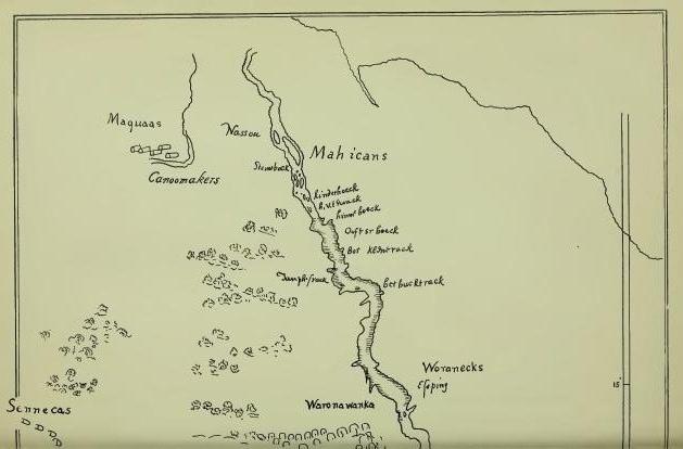
Muhheakun'nuk, "The great waters or sea, which are constantly in motion, either ebbing or flowing," was written by Chief Hendrick Aupaumut, in his history of the Muhheakun'nuk nation, as the name of Hudson's River, in the Stockbridge dialect, and its meaning. The first word, Muhheakun, was the national name of the people occupying both banks of the river from Roelof Jansen's Kill, a few miles south of Catskill, on the east side of the river, north and east with limit not known, and the second -nuk, the equivalent of Massachusetts -tuk, Lenape -ittuk, "Tidal river, or estuary," or "Waters driven by waves or tides," with the accessory meaning of "great." Literally, in application, "The great tidal river of the Muhheakan'neuw nation." The Dutch wrote the national name Mahikan, Maikan, etc., and the English of Connecticut wrote Mohegan, which was claimed by Drs. Schoolcraft and Trumbull to be derived from Maingan (Cree Mahéggun), "Wolf"—"an enchanted wolf, or a wolf of supernatural powers." From their prevailing totem or prevailing coat-of-arms, the Wolf, the French called them Loups, "wolves," and also Manhingans, including under the names "The nine nations gathered between Manhattan and Quebec." While the name is generic its application to Hudson's River was probably confined to the vicinity of Albany, where Chief Aupaumut located their ancient capital under the name of Pem-po-tow-wut-hut Muh-hea-kan-neuw, "The fire-place of the Muh-hea-kan-nuk nation." [FN] The Dutch found them on both sides of the river north of Catskill, with extended northern and eastern alliances, and south of that point, on the east side of the river, in alliance with a tribe known as Wappans or Wappings, Wappani, or "East-side people," the two nations forming the Mahikan nation of Hudson's River as known in history. (See Wahamensing.)
[FN] Presumed to have been at what is now known as Scho-lac, which see.
Father Jogues, the French-Jesuit martyr-missionary, wrote in 1646, Oi-o-gué as the Huron-Iroquoian name of the river, given to him at Sarachtoga, with the connection "At the river." "Ohioge, river; Ohioge-son, at the long river," wrote Bruyas. Arent van Curler wrote the same name, in 1634, Vyoge, and gave it as that of the Mohawk River, correcting the orthography, in his vocabulary, to "Oyoghi, a kill" or channel. It is an Iroquoian generic applicable to any principal stream or current river, with the ancient related meaning of "beautiful river."
It is said that the Mohawks called the river Cohohataton. I have not met that name in records. It was quoted by Dr. Schoolcraft as traditional, and of course doubtful. He wrote it Kohatatea, and in another connection wrote "-atea, a valley or landscape." It is suspected that he coined the name, as he did many others. Shate-muck is quoted as a Mohegan [FN-1] name, but on very obscure evidence, although it may have been the name of an eel fishing-place, or a great fishing-place (-amaug). Hudson called the stream "The River of the Mountains." On some ancient maps it is called "Manhattans River." The Dutch authorities christened it "Mauritus' River" in honor of their Staat-holder, Prince Maurice. The English recognized the work of the explorer by conferring the title "Hudson's River." It is a fact established that Verrazano visited New York harbor in 1524, and gave to the river the name "Riviere Grande," or Great River; that Estevan Gomez, a Spanish navigator who followed Verrazano in 1525, called it "St. Anthony's River," a name now preserved as that of one of the hills of the Highlands, and it is claimed that French traders visited the river, in 1540, and established a château on Castle [FN-2] Island, at Albany, [FN-3] and called the river "Norumbega." It may be conceded that possibly French traders did have a post on Castle Island, but "Norumbega" was obviously conferred on a wide district of country. It is an Abnaki term and belonged to the dialect spoken in Maine, where it became more or less familiar to French traders as early as 1535. That those traders did locate trading posts on the Penobscot, and that Champlain searched for their remains in 1604, are facts of record. The name means "Quiet" or "Still Water." It would probably be applicable to that section of Hudson's River known as "Stillwater," north of Albany, but the evidence is wanted that it was so applied. Had it been applied by the tribes to any place on Hudson's River, it would have remained as certainly as Menaté remained at New York.
[FN-1] "Mohegans is an anglicism primarily applied to the small band of Pequots under Uncas." (Trumbull.) While of the same linguistic stock, neither the name or the history of Uncas's clan should be confused with that of the Mahicani of Hudson's River.
[FN-2] Introduced by the Dutch—Kasteel. The Indians had no such word. The Delawares called a house or hut or a town that was palisaded, Moenach, and Zeisberger used the same word for "fence"—an enclosure palisaded around. Eliot wrote Wonkonous, "fort."
[FN-3] It is claimed that the walls of this fort were found by Hendrick Christiansen, in 1614; that they were measured by him and found to cover an area of 58 feet; that the fort was restored by the Dutch and occupied by them until they were driven out by a freshet, occasioned by the breaking up of the ice in the river in the spring of 1617; that the Dutch then built what was subsequently known as Fort Orange, at the mouth of the Tawalsentha, or Norman's Kill, about two miles south of the present State street, Albany, and that Castle Island took that name from the French château—all of which is possible, but for conclusive reasons why it should not be credited, the student may consult "Norumbega" in Winsor's "Narrative and Critical History of America." Wrote Dr. Trumbull: "Theuet, in La Cosmographie Universella, gives an account of his visit, in 1656, to 'one of the finest rivers in the whole world, which we call Norumbeque, and the aboriginees Agoncy,' now Penobscot Bay."
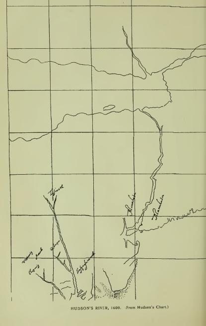
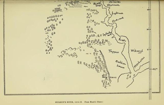
Manhattan, now so written, does not appear in the Journal of Hudson's exploration of the river in 1609. On a Spanish-English map of 1610, "Made for James I," and sent to Philip III by Velasco in letter of March 22, 1611, [FN-1] Mannahatin is written as the name of the east side of the river, and Mannahata as that of the west side. From the former Manhattan, and from it also the name of the Indians "among whom" the Dutch made settlement in 1623-4, otherwise known by the general name of Wickquaskecks, as well as the name of the entire Dutch possessions. [FN-2] Presumably the entries on the Spanish-English map were copied from Hudson's chart, for which there was ample time after his return to England. Possibly they may have been copied by Hudson, who wrote that his voyage "had been suggested" by some "letters and maps" which "had been sent to him" by Capt. Smith from Virginia. Evidently the notations are English, and evidently, also, Hudson, or his mate, Juet, had a chart from his own tracing or from that of a previous explorer, which he forwarded to his employers, or of which they had a copy, when he wrote in his Journal: "On that side of the river called Mannahata," as a reference by which his employers could identify the side of the river on which the Half-Moon anchored, [FN-3] Presumably the chart was drawn by Hudson and forwarded with his report, and that to him belongs the honor of reducing to an orthographic form the first aboriginal name of record on the river which now bears his name. Five years after Hudson's advent Adriaen Block wrote Manhates as the name of what is now New York Island, and later, De Vries wrote Manates as the name of Staten Island, both forms having the same meaning, i. e., "Small island." There have been several interpretations of Mannahatin, the most analytical and most generally accepted being by the late Dr. J. H. Trumbull: "From Menatey (Del.), 'Island'—Mannahata 'The Island,' the reference being to the main land or to Long Island as the large island. Menatan (Hudson's Mannah-atin, -an or -in, the indefinite or diminutive form), 'The small island,' or the smaller of the two principal islands, the Manhates of Adriaen Block. [FN-4] Manáhtons, 'People of the Island,' Manáhatanesen, 'People of the small islands.'" [FN-5] The Eastern-Algonquian word for "Island" (English notation), is written Munnoh, with formative -an (Mun-nohan). It appears of record, occasionally, in the vicinity of New York, presumably introduced by interpreters or English scribes. The usual form is the Lenape Menaté, Chippeway Minnis, "Small island," classed also as Old Algonquian, or generic, may be met in the valley of the Hudson, but the instances are not clear. It is simply a dialectic equivalent of Del. Ménates. (See Monach'nong.) Van Curler wrote in his Mohawk vocabulary (1635), "Kanon-newaga, Manhattan Island." The late J. W. Powell, Director of the Bureau of Ethnology, wrote me: "In the alphabet of this office the name may be transliterated Kanoñnò'ge. It signifies 'Place of Reeds.'" Perhaps what was known as the "Reed Valley" was referred to, near which Van Twiller had a tobacco plantation where the Indians of all nations came to trade. (See Saponickan.) The lower part of the island was probably more or less a district of reed swamps.
[FN-1] Brown's "Genesis of the United States," 327, 457, 459, ii, 80.
[FN-2] Colonial History of New York.
[FN-3] Hudson anchored in the bay near Hoboken. Near by his anchorage he noticed that "there was a cliff that looked of the color of white green." This cliff is near Elysian Fields at Hoboken. (Broadhead.) The cliff is now known as Castle Point.
[FN-4] The reference to Adriaen Block is presumably to the "Carte Figurative" of 1614-16, now regarded as from Block's chart.
[FN-5] "Composition of Indian Geographical Names," p. 22.
Pagganck, so written in Indian deed of 1637, as the name of Governor's Island—Peconuc, Denton, is an equivalent of Pagán'nak, meaning literally "Nut Island." Also written Pachgan, as in Pachganunschi, "White walnut trees." (Zeisb.) Denton explained, "Because excellent nut trees grew there." [FN] The Dutch called it "der Nooten Eilandt," literally "The Walnut Island," from whence the modern name, "Nutten Island." The island was purchased from the Indian owners by Director Wouter van Twiller, from whose occupation, and its subsequent use as a demense of the governors of the Province, its present name.
[FN] Denton's "Description of New York," p. 29. Ward's and Blackwell's islands were sold to the Dutch by the Marechawicks, of Long Island, in 1636-7. Governor's Island was sold in the same year by the Tappans, Hackinsacks and Nyacks, the grantors signing themselves as "hereditary owners." Later deeds were signed by chiefs of the Raritans and Hackinsacks.
Minnisais is not a record name. It was conferred on Bedloe's Island by Dr. Schoolcraft from the Ojibwe or Chippeway dialect, [FN] in which it means "Small island."
[FN] The Objibwe (Objibwai) were a nation of three tribes living northwest of the great lakes, of which the Ojibwai or Chippeway represented the Eagle totem. It is claimed by some writers that their language stands at the head of the Algonquian tongues. This claim is disputed on behalf of the Cree, the Shawanoe, and the Lenape or Delaware. It is not assumed that Ojibwe (Chippeway) terms are not Algonquian, but that they do not strictly belong to the dialects of the Hudson's river families. Rev. Heckewelder saw no particular difference between the Ojibwe and the Lenape except in the French and the English forms. Ojibwe terms may always be quoted in explanations of the Lenape.
Kiosh, or "Gull Island," was conferred on Ellis Island by Dr. Schoolcraft from the Ojibwe dialect. The interpretation is correct presumably.
Tenkenas is of record as the Indian name of what is now known as Ward's Island. [FN] It appears in deed of 1636-7. It means "Small island," from Tenke (Len.), "little."
[FN] The Dutch called the island Onvruchtbaar, "Unfruitful, barren." The English adopted the signification, "Barren," which soon became corrupted to "Barrent's," to which was added "Great" to distinguish it from Randal's Island, which was called "Little Barrent's Island." Barn Island is another corruption. Both islands were "barren" no doubt.
Monatun was conferred by Dr. Schoolcraft on the whirlpool off Hallet's Cove, with the explanation, "A word conveying in its multiplied forms the various meanings of violent, forcible, dangerous, etc." Dr. Schoolcraft introduced the word as the derivative of Manhatan, which, however, is very far from being explained by it. Hell-gate, a vulgar orthography of Dutch Hellegat, has long been the popular name of the place. It was conferred by Adriaen Block, in 1614-16, to the dangerous strait known as the East River, from a strait in Zealand, which, presumably, was so called from Greek Helle, as heard in Hellespont—"Sea of Helle"—now known as the Dardanelles—which received its Greek name from Helle, daughter of Athamas, King of Thebes, who, the fable tells us, was drowned in passing over it. Probably the Dutch sailors regarded the strait as the "Gate of Hell," but that is not the meaning of the name—"a dangerous strait or passage." In some records the strait is called Hurlgate, from Dutch Warrel, "Whirl," and gat, "Hole, gap, mouth"—substantially, "a whirlpool."
Monachnong, deed to De Vries, 1636; Menates, De Vries's Journal; Ehquaons (Eghquaous, Brodhead, by mistake in the letter n), deed of 1655, and Aquehonge-Monuchnong, deed to Governor Lovelace, 1670, are forms of the names given as that of Staten Island, and are all from Lenape equivalents. Menates means "Small island" as a whole; Monach'nong means a "Place on the island," or less than the whole, as shown by the claims of the Indians in 1670, that they had not previously sold all the island. (Col. Hist. N. Y., xiii, 453.) It is the equivalent of Menach'hen, Minsi; Menach'n, Abn., "Island," and ong, locative; in Mass. Mimnoh-han-auke. (See Mannhonake.) Eghquaons and Aquehonga are equivalents, and also equivalents of Achquoanikan-ong, "Bushnet fishing-place," of which Acquenonga is an alternate in New Jersey. (Nelson's "Indians of New Jersey," 122.) In other words, the Indians conveyed places on the island, including specifically their "bushnet fishing-place," and by the later deed to Lovelace, conveyed all unsold places. The island was owned by the Raritans who resided "behind the Kol," and the adjoining Hackensacks. (Deed of 1655.) Its last Indian occupants were the Nyacks, who removed to it after selling their lands at New Utrecht. (See Paganck note.)
Minnahanock, given as the name of Blackwell's Island, was interpreted by Dr. Trumbull from Munnŏhan, Mass., the indefinite form of Munnŏh, "Island," and auke, Mass., "Land" or place. Dr. O'Callaghan's "Island home," is not in the composition. (See Mannhonake.)
Kapsee, Kapsick, etc., the name of what was the extreme point of land between Hudson's River and the East River, and still known as Copsie Point, was claimed by Dr. Schoolcraft to be Algonquian, and to mean, "Safe place of landing," which it may have been. The name, however, is pretty certainly a corruption of Dutch Kaap-hoekje, "A little cape or promontory."
Saponickan and Sapohanican are the earliest forms of a name which appears later Sappokanican, Sappokanikke, Saponican, Shawbackanica, Taponkanico, etc. "A piece of land bounded on the north by the strand road, called Saponickan" (1629); "Tobacco plantation near Sapohanican" (1639); "Plantation situate against the Reed Valley beyond Sappokanican" (1640). Wouter van Twiller purchased the tract, in 1629, for the use of the Dutch government and established thereon a tobacco plantation, with buildings enclosed in palisade, which subsequently became known as the little village of Sapokanican—Sappokanican, Van der Donck—and later (1721) as Greenwich Village. It occupied very nearly the site of the present Gansevort market. The "Strand road" is now Greenwich Street. It was primarily, an Indian path along the shore of the river north, with branches to Harlem and other points, the main path continuing the trunk-path through Raritan Valley, but locally beginning at the "crossing-place," or, as the record reads, "Where the Indians cross [the Hudson] to bring their pelteries." [FN-1] "South of Van Twiller's plantation was a marsh much affected by wild-fowl, and a bright, quick brook, called by the Dutch 'Bestavar's Kil,' and by the English 'Manetta Water.'" [FN-2] (Half-Moon Series.) Saponickan was in place here when Van Twiller made his purchase (1629), as the record shows, and was adopted by him as the name of his settlement. To what feature it referred cannot be positively stated, but apparently to the Reed Valley or marsh. It has had several interpretations, but none that fare satisfactory. The syllable pon may denote a bulbous root which was found there. (See Passapenoc.) The same name is probably met in Saphorakain, or Saphonakan, given as the name of a tract described as "Marsh and canebrake," lying near or on the shore of Gowanus Bay, Brooklyn. (See Kanonnewage, in connection with Manhattan.)
[FN-1] "Through this valley pass large numbers of all sorts of tribes on their way north and east." (Van Tienhoven, 1650.) "Where the Indians cross to bring their pelteries." (De Laet, 1635.) The crossing-place is now known as Pavonia. The path crossed the Spuyten Duyvil at Harlem and extended along the coast east. To and from it ran many "paths and roads" on Manhattan, which, under the grant to Van Twiller, were to "forever remain for the use of the inhabitants." The evidence of an Indian village at or near the landing is not tangible. The only village or settlement of which there is any evidence was that which gathered around Van Twiller's plantation, which was a noted trading post for "all sorts of tribes."
[FN-2] Bestevaar (Dutch) means "Dear Father," and Manetta (Manittoo, Algonquian), means, "That which surpasses, or is more than ordinary." Water of more than ordinary excellence. (See Manette.)
Nahtonk, Recktauck, forms of the name, or of two different names, of Corlear's Hook, may signify, abstractively, "Sandy Point," as has been interpreted; but apparently, Nahtonk [FN-1] is from Nâ-i, "a point or corner," and Recktauck [FN-2] from Lekau (Requa), "Sand gravel"—a "sandy place." It was a sandy point with a beach, entered, on English maps, "Crown Point."
[FN-1] Naghtonk (Benson); Nahtonk (Schoolcraft); Rechtauck (record). It was to the huts which were located here to which a clan of Long Island Indians fled for protection, in February, 1643, and were inhumanly murdered by the Dutch. The record reads: "Where a few Rockaway Indians from Long Island, with their chief, Niande Nummerus, had built their wigwams." (Brodhead.) "And a party of freemen behind Corlear's plantation, on the Manhattans, who slew a large number and afterwards burned their huts." The name of the Chief, Niande Nummerus, is corrupted from the Latin Nicanda Numericus, the name of a Roman gens. De Vries wrote, "Hummerus, a Rockaway chief, who I knew."
[FN-2] See Rechqua-hackie. "The old Harlem creek, on Manhattan Island, was called Rechawanes, or 'Small, sandy river.'" (Gerard.)
Warpoes is given as the name of "a small hill" on the east side and "near ye fresh water" lake or pond called the Kolk (Dutch "pit-hole"), which occupied several acres in the neighborhood of Centre Street. [FN-1] The Indian name is that of the narrow pass between the hill and the pond, which it described as "small" or narrow. (See Raphoos.)
In the absence of record names, the late Dr. Schoolcraft conferred, on several points, terms from the Ojibwe or Chippeway, which may be repeated as descriptive merely. A hill at the corner of Charlton and Varick streets was called by him Ishpatinau, "A bad hill." [FN-2] A ridge or cliff north of Beekman Street, was called Ishibic, "A bad rock;" the high land on Broadway, Acitoc; a rock rising up in the Battery, Abie, and Mount Washington, Penabic, "The comb mountain." The descriptions are presumably correct, but the features no longer exist.
[FN-1] "By ye edge of ye hill by ye fresh water." (Cal. N. Y. Land Papers, 17.) The Dutch name ran into Kalch, Kolack and Collect, and in early records "Kalch-hock." from its peculiar shape, resembling a fish-hook.
[FN-2] "At ye sand Hills near the Bowery." (Cal. N. Y. Land Papers. 17.) Ishpetouga was given by the same writer to Brooklyn Heights, with the explanation "High, sandy banks," but the term does not describe the character of the elevation. (See Espating.)
Muscota is given as the name of the "plain or meadow" known later as Montagne's Flat, between 108th and 124th streets. (Col. Hist. N. Y., xiv.) It also appears as the name of a hill, and in Muskuta as that of the great flat on the north side of the Spuyten Duivel. "The first point of the main land to the east of the island Papirinimen, there where the hill Muskuta is." The hill takes the name from the meadows which it describes. "Moskehtu, a meadow." (Eliot.)
Papinemen (1646), Pahparinnamen (1693), Papirinimen (modern), are forms of the Indian name used interchangeably by the Dutch with Spuyten Duivel to designate a place where the tide-overflow of the Harlem River is turned aside by a ridge and unites with Tibbet's Brook, constituting what is known as the Spuyten Duivel Kill, correctly described by Riker in his "History of Harlem": "The narrow kill called by the Indians Pahparinamen, which, winding around the northerly end of Manhattan, connected the Spuyten Duyvil with the Great Kill or Harlem River, gave its name to the land contiguous to it on either side." The locative of the name is clearly shown in the boundaries of the Indian deed to Van der Donck, in 1646, and in the subsequent Philipse Patent of 1693, the former describing the south line of the lands conveyed as extending from the Hudson "to Papinemen, called by our people Spuyten Duivel," and the latter as extending to and including "the neck, island or hummock, Pahparinnamen," on the north side of the passage, at which point, in the early years of Dutch occupancy, a crossing place or "wading place" was found which had been utilized by the Indians for ages, and of which Jasper Bankers and Peter Sluyter wrote, in 1679-80, "They can go over this creek, at dead or low water, upon the rocks and reefs, at a place called Spuytten Duyvel." From this place the name was extended to the "island or hummock" and to what was called "the Papirinameno Patent," at the same point on the south side of the stream, to which it was claimed to belong in 1701. Mr. Riker's assignment of the name to the Spuyten Duivel passage is probably correct. The "neck, island or hummock" was a low elevation in a salt marsh or meadow. It was utilized as a landing place by the Indians whose path ran from thence across the marsh "to the main." Later, the path was converted to a causeway or road-approach to what is still known as King's Bridge. A ferry was established here in 1669 and known as "The Spuyten Duyvil passage or road to and from the island to the main." In 1692 Governor Andros gave power to the city of New York to build a bridge "over the Spiken devil ferry," and the city, with the consent of the Governor, transferred the grant to Frederick Philipse. In giving his consent the Governor made the condition that the bridge "should thenceforth be known and called King's Bridge." It was made a free bridge in 1758-9. The "island or hummock" came to be the site of the noted Macomb mansion.
The name has not been satisfactorily translated. Mr. Riker wrote, "Where the stream closes," or is broken off, recognizing the locative of the name. Ziesberger wrote, Papinamen, "Diverting," turning aside, to go different ways; accessorily, that which diverts or turns aside, and place where the action of the verb is performed. Where the Harlem is turned aside or diverted, would be a literal description.
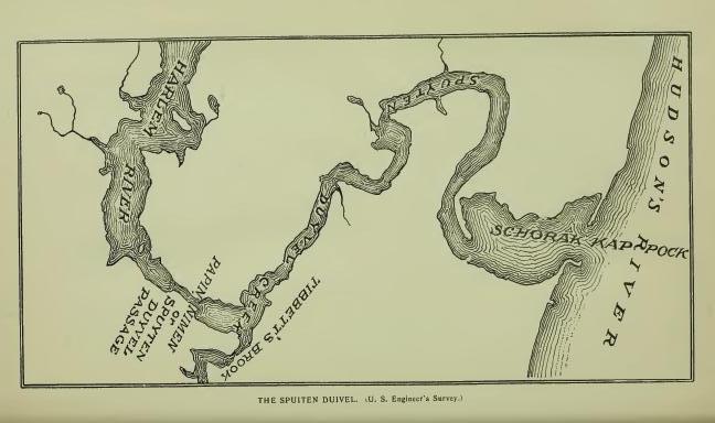
Spuyten Duyvil, now so written, was the early Dutch nickname of the Papirinimen ford or passage, later known as King's Bridge. "By our people called," wrote Van der Donck in 1652, indicating conference by the Dutch prior to that date. It simply described the passage as evil, vicious, dangerous. Its derivatives are Spui, "sluice;" Spuit, "spout;" Spuiten, "to spout, to squirt, to discharge with force," as a waterspout, or water forced through a narrow passage. Duyvil is a colloquial expression of viciousness. The same name is met on the Mohawk in application to the passage of the stream between two islands near Schenectady. The generally quoted translation, "Spuyt den Duyvil, In spite of the Devil," quoted by Brodhead as having been written by Van der Donck, has no standing except in Irving's "Knickerbocker History of New York." Van der Donck never wrote the sentence. He knew, and Brodhead knew, that Spuyt was not Spijt, nor Spuiten stand for Spuitten. The Dutch for "In spite of the Devil," is In Spijt van Duivel. The sentence may have been quoted by Brodhead without examination. It was a popular story that Irving told about one Antony Corlear's declaration that he would swim across the ford at flood tide in a violent storm, "In spite of the devil," but obviously coined in Irving's brain. It may, however, had for its foundation the antics of a very black and muscular African who was employed to guard the passage and prevent hostile Indians as well as indiscreet Dutchmen from crossing, and who, for the better discharge of his duty, built fires at night, armed himself with sword and firebrands, vociferated loudly, and acted the character of a devil very well. At all events the African is the only historical devil that had an existence at the ford, and he finally ran away and became merged with the Indians. Spiting Devil, an English corruption, ran naturally into Spitting Devil, and some there are who think that that is a reasonably fair rendering of Dutch Spuiten. They are generally of the class that take in a cant reading with a relish.
Shorakkapoch and Shorackappock are orthographies of the name of record as that of the cove into which the Papirinemen discharges its waters at a point on the Hudson known as Tubby Hook. It is specifically located in the Philipse charter of 1693: "A creek called Papparinnemeno which divides New York Island from the main land, so along said creek as it runs to Hudson's River, which part is called by the Indians Shorackhappok," i. e. that part of the stream on Hudson's River. In the patent to Hugh O'Neil (1666): "To the Kill Shorakapoch, and then to Papirinimen," i. e., to the cove and thence east to the Spuyten Duyvil passage. "The beautiful inlet called Schorakapok." (Riker.) Dr. Trumbull wrote "Showaukuppock (Mohegan), a cove." William R. Gerard suggests "P'skurikûppog (Lenape), 'forked, fine harbor,' so called because it was safely shut in by Tubby Hook, [FN-1] and another Hook at the north, the current taking a bend around the curved point of rock (covered at high tide) that forked or divided the harbor at the back." Dr. Brinton wrote: "W'shakuppek, 'Smooth still water;' pek, a lake, cove or any body of still water; kup, from kuppi, 'cove.'" Bolton, in his "History of Westchester County," located at the mouth of the stream, on the north side, an Indian fort or castle under the name of Nipinichen, but that name belongs on the west side of the Hudson at Konstable's Hook, [FN-2] and the narrative of the attack on Hudson's ship in 1609, noted in Juet's Journal, does not warrant the conclusion that there was an Indian fort or castle in the vicinity. A fishing village there may have been. At a later date (1675) the authorities permitted a remnant of the Weckquasgecks to occupy lands "On the north point of Manhattan Island" (Col, Hist. N. Y., xiii, 494), and the place designated may have been in previous occupation.
[FN-1] Tubby Hook, Dutch Tobbe Hoeck, from its resemblance to a washtub.
[FN-2] Called Konstabelshe's Hoek from a grant of land to one Jacobus Roy, the Konstabel or gunner at Fort Amsterdam, in 1646.
Keskeskick, "a piece of land, situated opposite to the flat on the island of Manhattan, called Keskeskick, stretching lengthwise along the Kil which runs behind the island of Manhattan, beginning at the head of said Kil and running to opposite of the high hill by the flat, namely by the great hill," (Deed of 1638.) Kaxkeek is the orthography of Riker (Hist. of Harlem); and Kekesick that of Brodhead (Hist. New York), in addition to which may be quoted Keesick and Keakates, given as the names of what is now known as Long Pond, which formed the southeast boundary of the tract, where was also a salt marsh or meadow. In general terms, the name means a "meadow," and may have been that of this salt marsh (a portion of the name dropped) or of the flat. The root is Kâk, "sharp;" Kâkákes, "sharp grass," or sedge-marsh; Sik-kákaskeg, "salt sedge-marsh." (Gerard.) Micûckaskéete, "a meadow." (Williams.) Muscota, now in use, is another word for meadow.
Mannepies is quoted by Riker (Hist. Harlem) as the name of the hilly tract or district of Keskeskick, described as lying "over against the flats of the island of Manhattan." It is now preserved as the name of Cromwell Lake and creek, and seems to have been the name of the former. The original was probably an equivalent of Menuppek, "Any enclosed body of water great or small." (Anthony.)
Neperah, Nippiroha, Niperan, Nepeehen, Napperhaera, Armepperahin, the latter of date 1642 (Col. Hist. N. Y., xiii, 9), forms of record as the name of Sawmill Creek, and also quoted as the name of the site of the present city of Yonkers, has been translated by Wm. R. Gerard, from the form of 1642: "A corruption of Ana-nepeheren, that is, 'fishing stream' or 'fishing rapids.'" Ap-pehan (Eliot), "a trap, a snare." There was an Indian village on the north side of the stream in 1642. (Col. Hist. N. Y., xiii, 9.)
Nepahkomuk, Nappikomack, etc., quoted as the name of a place on Sawmill Creek, and also as the name of an Indian village at Yonkers, may have been the name of the latter by extension. It has been translated with apparent correctness from Nepé-komuk (Mass.), "An enclosed or occupied water-place." [FN]
[FN] This translation is from Nepe (Nepa, Nape, Nippe, etc.), meaning "water," generally, and Komuk, "place enclosed, occupied, limited," a particular body of water. "The radical of Nipe is pe or pa, which, with the demonstrative and definitive ne prefixed, formed the noun nippe, water." (Trumbull.) Nape-ake (-auke, -aki) means "Water-land," or water-place. Nape-ek, Del., Nepeauk, Mass., means "Standing water," a lake or pond or a stretch of still water in a river. Menuppek, "Lake, sea, any enclosed body of water, great or small." (Anthony.) Nebi, nabe, m'bi, be, are dialectic forms. The Delaware M'hi (Zeisb.) is occasionally met in the valley, but the Massachusetts Nepe is more frequent. Gami is another noun-generic meaning "Water" (Cree, Kume). Komuk (Mass.), Kamick (Del.), is frequently met in varying orthographies. In general terms it means "Place, limited or enclosed," a particular place as a field, garden, house, etc., as distinguished from auke, "Land, earth, unlimited, unenclosed."
Meghkeekassin, the name of a large rock in an obscure nook on the west side of the Neperah, near the Hudson, is written Macackassin in deed of 1661. It is from Mechek, Del., "great," and assin "stone." "Meechek-assin-ik, At the big rock." (Heckewelder.) The name is also of record Amack-assin, a Delaware term of the same general meaning—"Amangi, great, big (in composition Aman-gach), with the accessory notion of terrible, frightful." (Dr. Brinton.) Presumably, in application here, "a monster," i. e. a stone not of the native formation usually found in the locality. [FN]
[FN] The Indians are traditionally represented as regarding boulders of this class, as monuments of a great battle which was fought between their hero myth Micabo and Kasbun his twin brother, the former representing the East or Orient, and the latter the West, the imagery being a description of the primary contest between Light and Darkness—Light gleaming from the East and Darkness retreating to the West before it. Says the story: "The feud between the brothers was bitter and the contest long and doubtful. It began on the mountains of the East. The face of the land was seamed and torn by the wrestling of the mighty combatants, and the huge boulders that are scattered about were the weapons hurled at each other by the enraged brothers." The story is told in its several forms by Dr. Brinton in his "American Hero Myths."
Wickquaskeck is entered on Van der Donck's map as the name of an Indian village or castle the location of which is claimed by Bolton to have been at Dobb's Ferry, where the name is of record. It was, however, the name of a place from which it was extended by the early Dutch to a very considerable representative clan or family of Indians whose jurisdiction extended from the Hudson to or beyond the Armonck or Byram's River, with principal seat on the head waters of that stream, or on one of its tributaries, who constituted the tribe more especially known to the Dutch settlers as the Manhattans. Cornelius Tienhoven, Secretary of New Amsterdam, wrote, in 1654, "Wicquaeskeck on the North River, five miles above New Amsterdam, is very good and suitable land for agriculture. . . . This land lies between the Sintsinck and Armonck streams, situate between the East and North rivers." (Doc. Hist, N. Y., iv, 29.) "Five miles," Dutch, was then usually counted as twenty miles (English). Standard Dutch miles would be about eighteen. The Armonck is now called Byram River; it flows to the Sound on the boundary line between New York and Connecticut. A part of the territory of this tribe is loosely described in a deed of 1682, as extending—"from the rock Sighes, on Hudson's River, to the Neperah, and thence north until you come to the eastward of the head of the creek, called by the Indians Wiequaskeck, [FN] stretching through the woods to a kill called Seweruc," including "a piece of land about Wighqueskeck," i. e. about the head of the creek, which was certainly at the end of a swamp. The historic seat of the clan was in this vicinity. In the narrative of the war of 1643-5, it is written, "He of Witqueschreek, living N. E. of Manhattans. . . . The old Indian (a captive) promised to lead us to Wetquescheck." He did so, but the castles, three in number, strongly palisaded, were found empty. Two of them were burned. The inmates, it was learned, had gathered at a large castle or village on Patucquapaug, now known as Dumpling Pond, in Greenwich, Ct., to celebrate a festival. They were attacked there and slaughtered in great numbers. (Doc. Hist. N. Y., iv, 29.) Bolton's claim that the clan had a castle at or near Dobb's Ferry, may have been true at some date. The name appears in many orthographies; in 1621, Wyeck; in treaty of 1645, Wiquaeshex; in other connections, Witqueschreek, Weaquassick, and Van der Donck's Wickquaskeek. Bolton translated it from the form, Weicquasguck, "Place of the bark kettle," which is obviously erroneous. Dr. Trumbull wrote: "From Moh. Weegasoeguck, 'the end of the marsh or wet meadow.'" Van der Donck's Wickquaskeck has the same meaning. It is from Lenape Wicqua-askek—wicqua, "end of," askek, "swamp," marsh, etc.: -ck,-eck, formative.
[FN] The creek now bearing the name flows to the Hudson through the village of Dobb's Ferry. Its local name, "Wicker's creek," is a corruption of Wickquaskeek. It was never the name of an individual.
Pocanteco, Pecantico, Puegkandico and Perghanduck, a stream so called [FN-1] in Westchester County, was translated by Dr. O'Callaghan from Pohkunni, "Dark." "The dark river," and by Bolton from Pockawachne, "A stream between hills," which is certainly erroneous. The first word is probably Pohk or Pak, root Paken (Pákenum, "Dark," Zeisb.; Pohken-ahtu, "In darkness," Eliot). The second may stand for antakeu, "Woods," "Forest," and the combination read "The Dark Woods." The stream rises in New Castle township and flows across the town of Mt. Pleasant to the Hudson at Tarrytown, where it is associated with Irving's story of Sleepy Hollow. The Dutch called it "Sleeper's-haven Kil," from the name which they gave to the reach on the Hudson, "Verdrietig Hoek," or "Tedious Point," because the hook or point was so long in sight of their slow-sailing vessels, and in calms their crews slept away the hours under its shadows, "Over against the Verdrietig Hoek, commonly called by the name of Sleeper's Haven," is the record. Pocanteco was a heavily wooded valley, and suggested to the early mothers stories of ghosts to keep their children from wandering in its depths. From the woods or the valley the name was extended to the stream.[FN-2] (See Alipkonck.)
[FN-1] December 1st, 1680, Frederick Phillips petitioned for liberty to purchase "a parcel of land on each side of the creek called by the Indians Pocanteco, . . . adjoining the land he hath already purchased; there to build and erect a saw-mill." (Col. Hist. N. Y., xiii, 546.)
[FN-2] "Far in the foldings of the hills winds this wizard stream—sometimes silently and darkly through solemn woodlands. . . . In the neighborhood of the aqueduct is a deep ravine which forms the dreamy region of Sleepy Hollow." (Sketch Book.)
Alipkonck is entered on Van der Donck's map of 1656, and located with the sign of an Indian village south of Sing Sing. Bolton (Hist. West. Co.) claimed it as the name of Tarrytown, and translated it, "The place of elms," which it certainly does not mean. Its derivative, however, is disguised in its orthography, and its locative is not certain. Conjecturally Alipk is from Wálagk (surd mutes g and p exchanged), "An open place, a hollow or excavation." The locative may have been Sleepy Hollow. Tarrytown, which some writers have derived from Tarwe (Dutch), "Wheat"—Wheat town—proves to be from an early settler whose name was Terry, pronounced Tarry, as written in early records. The Dutch name for Wheat town would be Tarwe-stadt, which was never written here.
Oscawanna, an island so called, lying a short distance south of Cruger's Station on N. Y. Central R. R., Hudson River Division, is of record, in 1690, Wuscawanus. (Doc. Hist. N. Y., ii, 237.) It seems to have been from the name of a sachem, otherwise known as Weskora, Weskheun, Weskomen, in 1685. Wuski, Len., "New, young;" Wuske'éne Williams, "A youth."
Shildrake, or Sheldrake, given as the name of Furnace Brook, takes that name from an extended forest known in local records as "The Furnace Woods." By exchange of l and n, it is probably from Schind, "Spruce-pine" (Zeisb.); aki, "Land" or place. Schindikeu, "Spruce forest" ("Hemlock woods," Anthony). (See Shinnec'ock.) Furnace Brook takes that name from an ancient furnace on its bank. In 1734 it was known as "The old-mill stream." Jamawissa, quoted as its Indian name, seems to be an aspirated form of Tamaquese, "Small beaver." (See Jamaica.)
Sing-Sing—Sinsing, Van der Donck; Sintsing, treaty of 1645—usually translated, "At the standing-stone," and "Stone upon stone," means "At the small stones," or "Place of small stones"—from assin "stone;" is, diminutive, and ing, locative. Ossinsing, the name of the town, has the same meaning; also, Sink-sink, L. I., ind Assinising, Chemung County. The interpretation is literally sustained in the locative on the Hudson.
Tuckahoe, town of East Chester, is from Ptuckweōō, "It is round." It was the name of a bulbous root which was used by the Indians for food and for making bread, or round loaves. (See Tuckahoe, L. I.)
Kitchiwan, modern form; Kitchawanc, treaty of 1643; Kichtawanghs, treaty of 1645; Kitchiwan, deed of 1645; Kitchawan, treaty of 1664; the name of a stream in Westchester County from which extended to an Indian clan, "Is," writes Dr. Albert S. Gatschet of the Bureau of Ethnology, "an equivalent of Wabenaki-ke'dshwan, -kidshuan, suffixed verbal stem, meaning 'Running Swiftly,' 'Rushing water,' or current, whether over rapids or not. Sas-katchéwan, Canada, 'The roiley, rushing stream'; assisku, 'Mud, dirt.' (Cree.) The prefix ki or ke, is nothing else than an abbreviation of kitchi, 'great,' 'large,' and here 'strong.' Examples are frequent as -kitchuan, -kitchawan, Mass.; kesi-itsooaⁿn or taⁿn, Abn., Kussi-tchuan, Mass., 'It swift flows.' The prefix is usually applied to streams which rise in the highlands and flow down rapidly descending slopes." The final k in some of the early forms, indicates pronunciation with the guttural aspirate, as met in wank and wangh in other local names. [FN] The final s is a foreign plural usually employed to express "people," or tribe. The stream is now known as the Croten from Cnoten, the name of a resident sachem, which by exchange of n and r, becomes Croten, an equivalent, wrote Dr. Schoolcraft of Noten, Chip., "The wind." "Bounded on the south by Scroton's River" (deed of 1703); "Called by the Indians Kightawank, and by the English Knotrus River." (Col. N. Y, Land Papers, 79.)
[FN] Dr. Trumbull wrote in the Natick (Mass.) dialect, "Kussitchuan, -uwan, impersonal verb, 'It flows in a rapid stream,' a current; it continues flowing; as a noun, 'a rapid stream.'" In Cree, Kussehtanne, "Flowing as a stream" In Delaware, -tanne has its equivalent in -hanne. "The impersonal verb termination -awan, -uan, etc., is sometimes written with the participial and subjunctive k" (ka or gh.) (Gerard.) The k or gh appears in some forms of Kitchawan. (See Waronawanka.)
Titicus, given as the name of a branch of the Croton flowing from Connecticut, is of record Mutighticos and Matightekonks, translated by Dr. Trumbull from Mat'uhtugh-ohke, "Place without wood," from which extended to the stream. (See Mattituck and Sackonck.)
Navish is claimed as the name of Teller's (now Croton) Point, on a reading of the Indian deed of 1683: "All that parcel, neck or point of land, with the meadow ground or valley adjoining, situate, lying and being on the east side of the river over against Verdrietig's Hooke, commonly called and known by the name of Slauper's Haven and by the Indians Navish, the meadow being called by the Indians Senasqua." Clearly, Navish refers to Verdrietig Hook, on the west side of the river, where it is of record. It is an equivalent of Newás (Len.), "promontory." (See Nyack-on-the-Hudson.)
Nannakans, given as the name of a clan residing on Croton River, is an equivalent of Narragans (s foreign plural), meaning "People of the point," the locative being Croton Point. (See Nyack.) This clan, crushed by the war of 1643-5, removed to the Raritan country, where, by dialectic exchange of n and r, they were known as Raritanoos, or Narritans. They were represented, in 1649, by Pennekeck, "The chief behind the Kul, having no chief of their own." (Col. Hist. N. Y., xiii.) The interpretation given to their removal, by some writers, viz., "That the Wappingers removed to New Jersey," is only correct in a limited sense. The removal was of a single clan or family. The Indians on both sides of the Hudson here were of kindred stock and were largely intermarried. (See Raritans and Pomptons.)
Senasqua, quoted as the name of Teller's Point (now Croton Point), and also as the name of Teller's Neck, is described as "A meadow," presumably on the neck or point. It is an equivalent of Del. Lenaskqual, "Original grass," (Zeisb.), i. e. grass which was supposed to have grown on the land from the beginning. (Heck.) Called "Indian grass" to distinguish it from "Whitemen's grass." [FN]
[FN] Askquall, or Askqua, is an inanimate plural in the termination -all, -al, or -a. All grass was not described by Maskik, in which the termination -ik is the animate plural.
Peppeneghek is a record form of the name quoted as that of what is now known as Cross-river.
Kewighecack, the name of a boundmark of Van Cortlandt's Manor, is written on the map of the Manor Keweghteuack as the name of a bend in the Croton west of Pine Bridge. It is from Koua, Kowa, Cuwé, "Pine"—Cuwé-uchac, "Pine wood, pine logs." (Zeisb.)
Kestaubniuk is entered on Van der Donck's map as the name of an Indian place or village north of Sing Sing. On Vischer's map the orthography is Kestaubocuck. Dr. Schoolcraft wrote Kestoniuck, "Great Point," and claimed that the last word had been borrowed and applied to Nyack on the opposite side of the river, but this is a mistake as Nyack is generic and of local record where it now is as early as 1660, and is there correctly applied. No one seems to know where Kestaubniuk was, but the name is obviously from Kitschi-bonok, "Great ground-nut place." Ketche-punak and Ketcha-bonac, L. I., K'schobbenak, Del.
Menagh, entered in Indian deed to Van Cortlandt, 1683, as the name of what is now known as Verplanck's Point, is probably from Menach'en (Del.), the indefinite form of Menátes, diminutive, meaning "Small island." The point was an island in its separation from the main land by a water course. Monack, Monach, Menach, are other orthographies of the name.
Tammoesis is of record as the name of a small stream north of Peekskill.
Appamaghpogh, now Amawalk, seems to have been extended to a tract of land without specific location. It is presumed to have been the name of a fishing place on what is now known as Mohegan Lake Appéh-ama-paug, "Trap fishing place," or pond. Amawalk, is from Nam'e-auke, "Fishing-place," (Trumbull.) In the Massachusetts dialect -pogh stands for "pond," or water-place.
Keskistkonck, Pasquasheck, and Nochpeem are noted on Van der Donck's map in the Highlands. In Colonial History is the entry (1644), "Mongochkonnome and Papenaharrow, chiefs of Wiquseskkack and Nochpeems." On the east side of the river, apparently about opposite the Donderberg, is located, on early maps, the Pachimi, who, in turn, are associated in records with the Tankitekes. Pacham is given as the name of a noted chief of the early period. His clan was probably the Pachimi. Keskistkonck was a living name as late as 1663, but disappears after that date. "The Kiskightkoncks, who have no chief now, but are counted among the foregoing savages." (Col. Hist. N. Y., xiii, 303.)
Sachus, Sachoes and Sackoack are quoted as names of Peekskill, and Magrigaries as the name of the stream. The latter is an orthography of MacGregorie's, from Hugh MacGregorie, an owner of lands on the stream. [FN-1] Though quoted as the name of Peak's Kill, it was the name given to a small creek south of that stream, as per map of 1776. Sachus and Sachoes are equivalents, and probably refer to the mouth or outlet of the small or MacGregorie's Creek—Sakoes or Saukoes. Sackonck has substantially the same meaning—Sakunk, "At the mouth or outlet of a creek or river." There was, however, a resident sachem who was called Sachoes, probably from his place of residence, but which can be read "Black Kettle," from Suckeu, "black," and ōōs, "kettle." Peekskill is modern from Peak's Kill, so called from Jan Peak, [FN-2] the founder of the settlement. The Indian name of the stream is noted, in deed of 1695, "Called by the Indians Paquintuk," probably an equivalent of Pokqueantuk, "A broad, open place in a tidal river or estuary." Peekskill Bay was probably referred to. (See Sackonck.)
[FN-1] Hugh MacGregorie was son of Major Patrick MacGregorie, the first settler in the present county of Orange. He was killed in the Leisler rebellion in New York in 1691. The son, Hugh, and his mother, were granted 1500 acres of land "At a place called John Peaches creek." No fees were charged for the patent out of respect for the memory of Major MacGregorie, as he then had "lately died in His Majesty's service in defence of the Province." (Doc. Hist. N. Y., ii, 364.) MacGregories sold to Van Cortlandt in 1696.
[FN-2] Peake, an orthography of Peak, English; Dutch, Piek; pronounced Pek (e as e in wet); English, Pek or Peck.
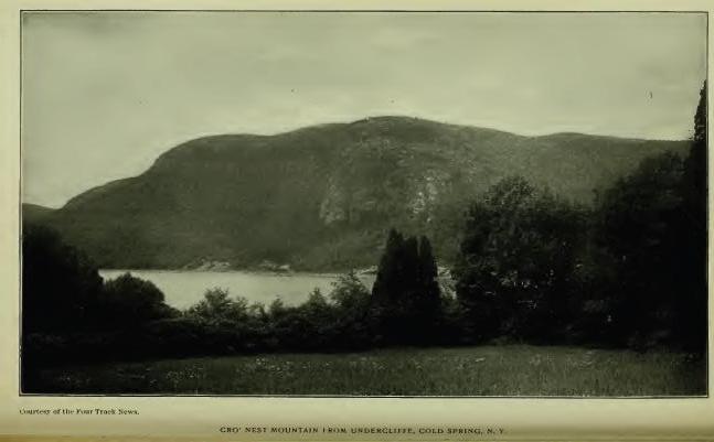
Kittatinny, erroneously claimed to mean "Endless hills," and to describe the Highlands as a continuation of the Allegheny range, belongs to Anthony's Nose [FN-1] to which, however, it has no very early record application. It is from Kitschi, "Principal, greatest," and -atinny, "Hill, mountain," applicable to any principal mountain peak compared with others in its vicinity. [FN-2]
[FN-1] The origin of the name is uncertain. Estevan Gomez, a Spanish navigator, wrote "St. Anthony's River" as the name of the Hudson, in 1525. The current explanation, "Antonius Neus, so called from fancied resemblance to the nose of one Anthony de Hoages," is a myth. The name as the early Dutch understood it, is no doubt more correctly explained by Jasper Bankers and Peter Sluyter in their Journal of 1679-80: "A headland and high hill in the Highlands, so called because it has a sharp ridge running up and down in the form of a nose," but fails to explain St. Anthony, or Latin Antonius. The name appears also on the Mohawk river and on Lake George, presumably from resemblance to the Highland peak.
[FN-2] The Indians had no names for mountain ranges, but frequently designated certain peaks by specific names. "Among these aboriginal people," wrote Heckewelder, "every tree was not the tree, and every mountain the mountain; but, on the contrary, everything is distinguished by its specific name." Kittatinny was and is the most conspicuous or greatest hill of the particular group of hills in its proximity and was spoken of as such in designating the boundmark.
Sacrahung, or Mill River, "takes its name from Sacra, 'rain.' Its liability to freshets after heavy rains, may have given origin to the name." (O'Callaghan.) Evidently, however, the name is a corruption of Sakwihung (Zeish.), "At the mouth of the river." The record reads, "A small brook or run called Wigwam brook, but by some falsely called Sackwrahung." (Deed of 1740.)
Quinnehung, a neck of land at the mouth and west side of Bronx River, is presumed to have been the name of Hunter's Point. The adjectival Quinneh, is very plainly an equivalent of Quinnih (Eliot), "long," and -ung or -ongh may stand for place—"A long place, or neck of land." (See Aquchung.)
Sackonck and Matightekonck, record names of places petitioned for by Van Cortlandt in 1697, are located in general terms, in the petition, in the neighborhood of John Peak's Creek and Anthony's Nose. (Cal. N. Y. Land Papers, 49.) The first probably referred to the mouth of Peak's Creek (Peekskill). Sakunk (Heck.), "At the mouth or outlet of a creek or river." Saukunk (Donck) is another form. (See Titicus.)
Aquehung, Acqueahounck, etc., was translated by Dr. O'Callaghan, "The place of peace." from Aquene, Nar., "peace," and unk, locative. Dr. Trumbull wrote, "A place on this side of some other place," from the generic Acq. The description in N. Y. Land Papers reads, "Bounded on the east by the river called by the Indians Aquehung," the river taking its name from its position as a boundary "on this side" of which was the land. The contemporary name, Ran-ahqua-ung, means "A place on the other side," corresponding with the description, "On the other side of the Great Kil." Bolton assigns Acqueahounck to Hutchinson's Creek, the west boundary of the town of Pelham. The "Great Kil" is now the Bronx.
Kakeout, the name of the highest hill in Westchester County, is from Dutch Kijk-uit, "Look-out—a place of observation, as a tower, hill," etc. It appears also in Rockland and in Ulster County and on the Mohawk. (See Kakiate.)
Shappequa, a name now applied to the Shappequa Hills and to a mineral spring east of Sing-Sing, and destined to be remembered as that of the home of Horace Greeley, was primarily given to locate a tract now embraced in the towns of New Castle and Bedford, and, as in all such cases, was a specific place by which the location could be identified, but which in turn has never been identified. The name is apparently a form of Chepi written also Chappa, signifying, "Separated, apart from, a distinct place." [FN] (See Kap-hack.)
[FN] The word Chippe or Shappa, means not only separate, "The separate place," but was employed to describe a future condition—Chepeck, the dead. As an adjective, Chippe (El.) signifies separated, set apart. Chepiohkomuk, the place of separation. The same word was used for 'ghost,' 'spectre,' 'evil spirit.' (Trumbull.) The corresponding Delaware word was Tschipey. It is not presumed that the word was made use of here in any other sense than its literal application, "A separate place." Bolton assigns the name to a Laurel Swamp, but with doubtful correctness.
Aspetong, a bold eminence in Bedford, is an equivalent of Ashpohtag, Mass., "A high place," "A height." (Trumbull.) See Ishpatinau.
Quarepos, of record as the name of the district of country called by the English "White Plains," from the primary prevalence there of white balsam (Dr. O'Callaghan), seems to have been the name of the lake now known as St. Mary's. Quar is a form of Quin, Quan, etc., meaning "Long," and pos stands for pog or paug, meaning "Pond." The name is met in Quin'e-paug, "Long Pond." The pond lies along the east border of the town of White Plains.
Peningo, the point or neck of land forming the southeastern extremity of the town of Rye, [FN] was interpreted by Dr. Bolton, with doubtful correctness: "From Ponus, an Indian chief." The neck is some nine miles long by about two miles broad and seems to have been primarily a region of ridges and swamps.
[FN] Rye is from Rye, England. The derivative is Ripe (Latin), meaning, "The bank of a river." In French, "The sea-shore."
Apanammis, Cal. N. Y, Land Papers; Apauamis and Apauamin, Col. Hist. N. Y.: Apawammeis, Apawamis, Apawqunamis, Epawames, local and Conn. Records, is given as the name of Budd's Neck, between Mamaroneck River and Blind Brook, Westchester County. Dr. Trumbull passed the name without explanation. It is written as the name of a boundmark.
Mochquams and Moagunanes are record forms of the name of Blind Brook, one of the boundary streams of the tract called Penningo, which is described as lying "between Blind Brook and Byram River." (See Armonck.)
Magopson and Mangopson are orthographies of the name given as that of De Lancey's Neck, described as "The great neck." (See Waumaniuck.) The dialect spoken in eastern Westchester seems to have been Quiripi (or Quinipiac), which prevailed near the Sound from New Haven west.
Armonck, claimed as the name of Byram's River, was probably that of a fishing place. In 1649 the name of the stream is of record, "Called by the Indians Seweyruck." In the same record the land is called Haseco and a meadow Misosehasakey, interpreted by Dr. Trumbull, "Great fresh meadow," or low wet lands. Haseco has no meaning; it is now assigned to Port Chester (Saw-Pits), and Misosehasakey to Horse Neck. Armonck has lost some of its letters. What is left of it indicates Amaug, "fishing place." (Trumbull's Indian Names.)
Eauketaupucason, the name written as that of the feature in the village of Rye known by the unpleasant English title of "Hog-pen Ridge," is, writes Mr. William R. Gerard, "Probably an equivalent of Lenape Ogid-ápuchk-essen, meaning, 'There is rock upon rock,' or one rock on another rock." Topography not ascertained.
Manussing—in will of Joseph Sherwood, Menassink—an island so called in the jurisdiction of Rye, may be an equivalent of Min-assin-ink, "At a place of small stones," Minneweis, now City Island, is in the same jurisdiction.
Mamaroneck, now so written as the name of a town in Westchester County, is of record, in 1644, Mamarrack and Mamarranack; later, Mammaranock, Mamorinack, Mammarinickes (1662), primarily as that of a "Neck or parcel of land," but claimed to be from the name of an early sachem of the Kitchtawanks whose territory was called Kitchtawanuck. [FN] Wm. R. Gerard explains: "The dissyllabic root, mamal, or mamar, means 'To stripe;' Mamar-a-nak, 'striped arms,' or eyebrows, as the name of an Indian chief who painted his arms in stripes or radiated his eyebrows," a custom noted by several early writers. There is no evidence that the Kitchtawanuck sachem had either residence or jurisdiction here, nor is his name signed to any deed in this district. The reading in one record, "Three stripes or strips of land," seems to indicate that the name was descriptive of the necks or strips of land. (See Waumaniuck.)
[FN] "Mamarranack and Waupaurin, chiefs of Kitchawanuck." (Col. Hist. N. Y., xiii, 17.) The Kitchawan is now known as Croton river. It has no connection whatever with Mamaroneck.
Waumaniuck and Maumaniuck, forms of the name of record as that of the eastern part of De Lancey's Neck, or Seaman's Point, Westchester County, as stated in the Indian deed of 1661, which conveyed to one John Richbell "three necks of land," described as "Bounded on the east by Mamaroneck River, and on the west by Gravelly or Stony Brook" (Cal. N. Y. Land Papers, 5), the latter by the Indians called Pockotesse-wacke, came to be known as Mamaraneck Neck, otherwise described as "The great neck of land at Mamaroneck."
Pockotessewacke, given as the name of what came to be known as "Gravelly or Stony Brook," and "Beaver-meadow Brook," [FN] has been translated by Wm. R. Gerard, from "Petuk-assin-icke, 'where there are numerous round stones'"; a place from which the name was extended to the stream, or the name of a place in the stream where there were numerous round stones, i. e. paving stones or "hard-heads." Esse (esseni) from assin, "stone," means "stony, flinty."
[FN] Pockotessewacke and Beaver-meadow Brook. (Cal. N. Y. Land Papers.)
Manuketesuck, quoted by Bolton (Hist. West. Co.) as the name of Long Island Sound and interpreted, "Broad flowing river," was more correctly explained by Dr. Trumbull: "Apparently a diminutive of Manunkatesuck, 'Menhaden country,' from Munongutteau, 'that which fertalizes or manures land,' the Indian name for white fish or bony fish, which were taken in great numbers by the Indians, on the shores of the Sound, for manuring their corn lands."
Moharsic is said to have been the name of what is now known as Crom-pond, in the town of Yorktown. The pond is in two parts, and the name may mean, "Where two ponds meet," or come together. Crom-pond is corrupt Dutch from Krom-poel, "Crooked pond."
Maharness, the name of a stream rising in Westchester County and flowing east to the Sound, is also written Mianus and Mahanus, in Dutch records Mayane, correctly Mayanno. It was the name of "a sachem residing on it between Greenwich and Stamford, Ct., who was killed by Capt. Patrick, in 1643, and his head cut off and sent to Fort Amsterdam." (Brodhead, i, 386.) Dr. Trumbull interpreted, "He who gathers together." Kechkawes is written as the name of the stream in 1640.
Nanichiestawack, given as the name of an Indian village on the southern spur of Indian Hill (so called) in the town of Bedford, rests on tradition.
Petuckquapaug, a pond in Greenwich, Ct., but originally under the jurisdiction of the Dutch at Fort Amsterdam, signifies "Round Pond." It is now called "Dumpling Pond." The Dutch changed the suffix to paen, "soft land," and in that form described an adjacent district of low land. (See Tappan.)
Katonah, the name of a sachem, is preserved in that of a village in the town of Bedford. The district was known as "Katonah's land." In deed of 1680, the orthography is Katōōnah—oo as in food.
Succabonk, a place-name in the town of Bedford, stands for Sagabonak-ong, "Place of ground nuts," or wild potatoes. (See Sagabonock.)
Wequehackhe is written by Reichel ("Mem. Moravian Church") as the name of the Highlands, with the interpretation, "The hill country"—"People of the hill country." The name has no such meaning. Weque or Wequa, means "The end," and -hackhe (hacki) means "Land," not up-land. In other words, the boundary was the end of the Highlands.' [FN]
[FN] "Hacki, land; Len-hacki, up-land." (Zeisberger.) "When they speak of highlands they say Lennihacke, original lands; but they do not apply the same name to low lands, which, being generally formed by the overflowing or washing of streams, cannot be called original." (Heckewelder.)
Mahopack, the modern form of the name of a lake in Putnam County, is of record Makoohpeck in 1765, and Macookpack on Sauthier's map of 1774, which seem to stand for M'achkookpéeck (Ukh-okpeck, Mah.), meaning "Snake Lake," or "Water where snakes are abundant." (See Copake.) In early years snakes were abundant in the region about the lake, and are not scarce in present times. [FN] The lake is ten miles in circumference and lies sixteen hundred feet above the level of Hudson's River. It contains two or three small islands, on the largest of which is the traditionally famous "Chieftain's Rock."
[FN] A wild, wet region among the hills, where the rattlesnake
abounded. They were formerly found in all parts of the Highlands, and
are still met frequently.
Canopus, claimed to have been the name of an Indian sachem and now preserved in Canopus Hollow, Putnam County, is not Indian; it is Latin from the Greek name of a town in Egypt. "Can'pus, the Egyptian god of water." (Webster.)
Wiccopee is of record as the name of the highest peak in the Fishkill Mountains on the south border of East Fishkill. It is also assigned to the pass or clove in the range through which ran the Indian path, now the present as well as the ancient highway between Fishkill Village and Peekskill, which was fortified in the war of the Revolution. An Indian village is traditionally located in the pass, of which "one Wikopy" is named as chief on the same authority. The name, however, has no reference to a pass, path, village or chief; it is a pronunciation of Wecuppe, "The place of basswoods or linden trees," from the inner bark of which (wikopi) "the Indians made ropes and mats—their tying bark par excellence." (Trumbull.) "Wikbi, bast, the inner bark of trees." (Zeisberger.) In Webster and The Century the name is applied to the Leather-wood, a willowy shrub with a tough, leathery bark.
Matteawan, now so written, has retained that orthography since its first appearance in 1685 in the Rombout Patent, which reads: "Beginning on the south side of a creek called Matteawan," the exact boundmark being the north side or foot of the hill known as Breakneck (Matomps'k). It has been interpreted in various ways, that most frequently quoted appearing in Spofford's Gazetteer: "From Matai, a magician, and Wian, a skin; freely rendered, 'Place of good furs,'" which never could have been the meaning; nor does the name refer to mountains to which it has been extended. Wm. R. Gerard writes: "Matáwan, an impersonal Algonquian verb, meaning, 'It debouches into,' i. e. 'a creek or river into another body of water,' substantially, 'a confluence.'" This rendering is confirmed by Albert S. Gatschet, of the Bureau of Ethnology, who writes: "Mr. Gerard is certainly right when he explains the radix mat—mata—by confluence, junction, debouching, and forming verbs as well as roots and nouns." -A'wan, -wan -uan, etc., is an impersonal verb termination; it appears only in connection with impersonal verbs. (See Waronawanka.) Matteawan is met in several forms—Matawa and Mattawan, Ontario, Canada; Mattawan, Maine; Matawan, Monmouth County, N. J.; Mattawanna, Pa.; Mattawoman, Maryland.
Fishkill, the English name of the stream of which Matteawan is the estuary, is from Dutch Vischer's Kil. It was probably applied by the Dutch to the estuary from Vischer's Rak which the Dutch applied to a reach or sailing course on the Hudson at this point. De Laet wrote: "A place which our country-men call Vischer's Rack, [FN] that is Fisherman's Bend." (See Woranecks.) On the earlier maps the stream, or its estuary, is named Vresch Kil, or "Fresh-water Kil," to distinguish it from the brackish water of the Hudson. From the estuary extended to the entire stream.
[FN] Rack is obsolete; the present word is Recht. It describes an almost straight part of the river.
Woranecks, Carte Figurative 1614-16; Waoranecks, 1621-25; Warenecker, Wassenaer; Waoranekye, De Laet, 1633-40; Waoranecks, Van der Donck's map, 1656—is located on the Carte Figurative north of latitude 42-15, on the east side of the river. De Laet and Van der Donck place it between what are now known as Wappingers' Creek and Fishkill Creek. De Laet wrote: "Where projects a sandy point and the river becomes narrower, there is a place called Esopus, where the Waoranekys, another barbarous nation, have their abode." Later, Esopus became permanent on the west side of the river at Kingston. It is a Dutch corruption of Algonquian Sepus, meaning brook, creek, etc., applicable to any small stream. From De Laet's description, [FN] there is little room for doubt that the "sandy point" to which he referred is now known as Low Point, opposite the Dans Kamer, at the head of Newburgh Bay, where the river narrows, or that Esopus was applied to Casper's Creek. On Van der Donck's map the "barbarous nation" is given three castles on the south side of the stream, which became known later (1643) as the Wappingers, who certainly held jurisdiction on the east side of Newburgh Bay. The adjectival of the name is no doubt from Wáro, or Waloh, meaning "Concave, hollowing," a depression in land, low land, the latter expressed in ock (ohke), "land" or place. The same adjectival appears in Waronawanka at Kingston, and the same word in Woronake on the Sound at Milford, Ct., where the topography is similar. The foreign plural s extends the meaning to "Dwellers on," or inhabitants of. (See Wahamenesing and {Waro?}nawanka.)
[FN] . . . "And thus with various windings it reaches a place which our countrymen call Vischer's Rack, that is the Fisherman's Bend. And here the eastern bank is inhabited by the Pachimi. A little beyond where projects a sandy point and the river becomes narrower, there is a place called Esopus, where the Waoranekys, another barbarous nation, have their abode. To these succeed, after a short interval, the Waranawankconghs, on the opposite side of the river." (De Laet.)
"At the Fisher's Hook are the Pachany, Wareneckers," etc. (Wassenaer.)
Mawenawasigh, so written in the Rombout Patent of 1684, covering lands extending from Wappingers' Creek to the foot of the hills on the north side of Matteawan Creek, was the name of the north boundmark of the patent and not that of Wappingers' Creek. The Indian deed reads: "Beginning on the south side of a creek called Matteawan, from thence northwardly along Hudson's river five hundred yards beyond the Great Wappingers creek or kill, called Mawenawasigh." The stream was given the name of the boundmark and was introduced to identify the place that was five hundred yards north of it, i. e. the rocky point or promontory through which passes the tunnel of the Hudson River R. R. at New Hamburgh. The name is from Mawe, "To meet," and Newásek, [FN] "A point or promontory"—literally, "The promontory where another boundary is met." The assignment of the name to Wappingers' Falls is as erroneous as its assignment to the creek.
[FN] Nawaas, on the Connecticut, noted on the Carte Figurative of 1614-16, is very distinctly located at a point on the head-waters of that river.
Neversink is a corruption of Newas-ink, "At the point or promontory."
Wahamanesing is noted by Brodhead (Hist. N. Y.) as the name of Wappingers' Creek—authority not cited and place where the stream was so called not ascertained. The initial W was probably exchanged for M by mishearing, as it was in many cases of record. Mah means "To meet," Amhannes means "A small river," and the suffix -ing is locative. The composition reads: "A place where streams come together," which may have been on the Hudson at the mouth of the creek. In Philadelphia Moyamansing was the name of a marsh bounded by four small streams. (N. Y. Land Papers, 646.) Dr. Trumbull in his "Indian Names on the Connecticut," quoted Mahmansuck (Moh.), in Connecticut, with the explanation, "Where two streams come together." The name was extended to the creek as customary in such cases. The Wahamanesing flows from Stissing Pond, in northern Duchess County, and follows the center of a narrow belt of limestone its entire length of about thirty-five miles southwest to the Hudson, which it reaches in a curve and passes over a picturesque fall of seventy-five feet to an estuary. From early Dutch occupation it has been known or called Wappinck (1645), Wappinges and Wappingers' Kill or creek, taking that name presumably from the clan which was seated upon it of record as "Wappings, Wappinges, Wapans, or Highland Indians." [FN-1] On Van der Donck's map three castles or villages of the clan are located on the south side or south of the creek, indicating the inclusion in the tribal jurisdiction of the lands as far south as the Highlands. From Kregier's Journal of the "Second Esopus War" (1663), it is learned that they had a principal castle in the vicinity of Low Point and that they maintained a crossing-place to Dans Kamer Point. Their name is presumed to have been derived from generic Wapan, "East"—Wapani, "Eastern people" [FN-2]—which could have been properly applied to them as residents on the east side of the river, not "Eastern people" as that term is applied to residents of the more Eastern States, but locally so called by residents on the west side of the Hudson, or by the Delawares as the most eastern nation of their own stock. They were no doubt more or less mixed by association and marriage with their eastern as well as their western neighbors, but were primarily of Lenape or Delaware origin, and related to the Minsi, Monsey or Minisink clans on the west side of the river, though not associated with them in tribal government. [FN-3] Their tribal jurisdiction, aside from that which was immediately local, extended on the east side of the river from Roelof Jansen's Kill (south of opposite to the Catskill) to the sea. At their northern bound they met the tribe known to the Dutch as the Mahicans, a people of eastern origin and dialect, whose eastern limit included the valley of the Housatonic at least, and with them in alliance formed the "Mahican nation" of Dutch history, as stated by King Ninham of the Wappingers, in an affidavit in 1757, and who also stated that the language of the Mahicans was not the same as that of the Wappingers, although he understood the Mahicani. Reduced by early wars with the Dutch around New Amsterdam and by contact with European civilization, they melted away rapidly, many of them finding homes in New Jersey and Pennsylvania, others at Stockbridge, and a remnant living at Fishkill removing thence to Otsiningo, in 1737, as wards of the Senecas. (Col. Hist. N. Y., vii, 153, 158.)
[FN-1] "Highland Indians" was a designation employed by the Dutch as well as by the English. (Col. Hist. N. Y., viii, 440.)
[FN-2] The familiar historic name Wappingers seems to have been introduced by the Dutch from their word Wapendragers, "Armed men." The tribe is first met of record in 1643, when they attacked boats coming down from Fort Orange. (Doc. Hist. N. Y., iv, 12.) A map of 1690 gives them a large settlement on the south side of the creek. There is no Opossum in the name, as some writers read it, although some blundering clerk wrote Oping for Waping.
[FN-3] The relations between the Esopus Indians and the Wappingers were always intimate and friendly, so much so that when the Mohawks made peace with the Esopus Indians, in 1669, and refused to include the Wappingers, it was feared by the government that further trouble would ensue from the "great correspondence and affinity between them." (Col. Hist. N. Y., xiii, 427.) "Affinity," relationship by marriage, kinship generally.
Gov. Tryon, in his report in 1774, no doubt stated the facts correctly when he wrote that the "Montauks and others of Long Island, Wappingers of Duchess County, Esopus, Papagoncks, &c., of Ulster County, generally denominated River Indians, spoke a language radically the same," and were "understood by the Delawares, being originally of the same race." (Doc Hist. N. Y., i, 765.)
Poughquag, the name of a village in the town of Beekman, Duchess County, and primarily the name of what is now known as Silver Lake, in the southeast part of the town, is from Apoquague, (Mass.), meaning, "A flaggy meadow," which is presumed to have adjoined the lake. It is from Uppuqui, "Lodge covering," and -anke, "Land" or place. (Trumbull.)
Pietawickquassick, a brook so called which formed a bound-mark of a tract of land conveyed by Peter Schuyler in 1699, described as "On the east side of Hudson's River, over against Juffrou's Hook, at a place called by the Christians Jan Casper's Creek." The creek is now known as Casper's Creek. It is the first creek north of Wappingers' Kill. Schuyler called the place Rust Plaest (Dutch, Rust-plaats), meaning "Resting place, or place of peace." The Indian name has not been located. It is probably a form or equivalent of P'tukqu-suk, "A bend in a brook or outlet."
Wassaic, a village and a creek so called in the town of Amenia, Duchess County, appears in N. Y. records in 1702, Wiesasack, as the name of a tract of land "lying to the southward of Wayanaglanock, to the westward of Westenhoek creek." (Cal. N. Y. Land Papers, 58); later, "Near a place called Weshiack" (Ib. 65), "and thence northerly to a place called Wishshiag, and so on about a mile northwest of ye Allum rocks." [FN] (Ib. 75.) The name seems to have been applied to the north end of West Mountain, where is located the ravine known as the Dover Stone Church, about half a mile west of the village of Dover Plains. The ravine is 20 to 25 feet wide at the bottom, 1 to 3 feet at the top, 30 to 40 feet long, and 40 to 50 feet high, hence called a church. The Webotuck, a tributary of Ten Mile River, flows through the ravine. Dr. Trumbull ("Indian Names in Connecticut") wrote: "Wassiog, (Moh.), alternate Washiack, a west bound of the Mohegan country claimed by Uncas; 'the south end of a very high hill' very near the line between Glastonbury and Hebron," a place near Hartford, Conn., but failed to give explanation of the name.
[FN] Wallam—the initial W dropped—literally, "Paint rocks," a formation of igneous rock which, by exposure, becomes disintegrated into soft earthy masses. There are several varieties. The Indians used the disintegrated masses for paint. The name is met in some forms in all Algonquian dialects. (See Wallomschack.)
Weputing, Weepitung, Webotuck, Weepatuck (N. Y. and Conn. Rec.), given as the name of a "high mountain," in the Sackett Patent, was translated by Dr. Trumbull, from Conn. Records: "Weepatuck, 'Place of the narrow pass,' or 'strait.'" (See Wassaic.)
Querapogatt, a boundmark of the Sackett Patent, is, apparently, a compound of Quenne, "long," pog (paug), "pond," and att locaaive—"Beginning at the (a) long pond." The name is met in Quine-baug, without locative suffix, signifying "Long Pond" simply.
She'kom'eko, preserved as the name of a small stream which rises near Federal Square, Duchess County, and flows thence north to Roelof Jansen's Kill, was primarily the name of an Indian village conspicuous in the history of the labors of the Moravian missionaries. [FN-1] It was located about two miles south of Pine Plains in the valley of the stream. Dr. Trumbull translated: "She'com'eko, modern Chic'omi'co, from -she, -che (from mishe or k'che), 'great,' and comaco, 'house,' or 'enclosed place'—'the great lodge,', or 'the great village.'" [FN-2] We have the testimony of Loskiel that the occupants of the village were "Mahicander Indians."
[FN-1] The field of the labors of the Moravian missionaries extended to Wechquadnach, Pachquadnach, Potatik, Westenhoek and Wehtak, on the Housatenuc. Wechquadnach (Wechquetank, Loskiel) was at the end of what is now known as Indian Pond, lying partly in the town of North East, Duchess County, and partly in Sharon, Conn. It was the Gnadensee, or "Lake of Grace," of the missionaries. Wequadn'ach means "At the end of the mountain" between which and the lake the Indian village stood. Pachquadn'ach was on the opposite side of the pond; it means "Clear bare mountain land." Wehtak means "Wigwam place." Pishgachtigok (Pach-gat-gock, German notation), was about twenty miles south of Shekomeko, at the junction of Ten Mile River and the Housatonuc. It means, "Where the river divides," or branches. (See Schaghticoke.) Westenhoek, noted above, is explained in another connection. Housatonuc, in N. Y. Land Papers Owassitanuc, stands for A-wass-adene-uc, Abn.; in Delaware, Awossi, "Over, over there, beyond," -actenne, "hill or mountain," with locative -uk, "place," "land"; literally, "A place beyond the hill." (Trumbull.) It is not the name of either the hill or the river, to which it was extended, but a verbal direction. An Indian village called Potatik by the Moravian missionaries, was also on the Housatonuc, and is written in one form, Pateook.
[FN-2] A translation from the Delaware Scha-gach-we-u, "straight," and meek "fish"—an eel—eel place—has been widely quoted. The translation by Dr. Trumbull is no doubt correct.
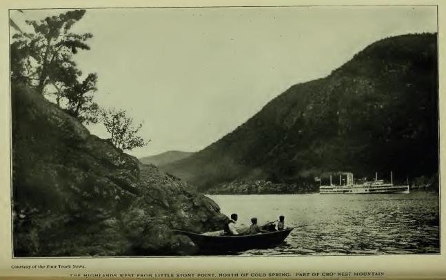
Shenandoah (Shenandoah Corners, East Fishkill) is an Iroquoian name of modern introduction here. It is met in place in Saratoga County and at Wyoming, Pa. (See Shannondhoi.)
Stissing, now the name of a hill and of a lake one mile west of the village of Pine Plains, Duchess County, is probably an apheresis of Mistissing, a "Great rock," and belongs to the hill, which rises 400 or 500 feet above the valley and is crowned with a mass of naked rock, described by one writer as "resembling a huge boulder transported there."
Poughkeepsie, now so written, is of record in many forms of which Pooghkeepesingh, 1683; Pogkeepke, 1702; Pokeapsinck, 1703; Pacaksing, 1704; Poghkeepsie, 1766; Poughkeepsie, 1767, are the earlier. The locative of the name and the key to its explanation are clearly determined by the description in a gift deed to Peter Lansing and Jan Smedes, in 1683: "A waterfall near the bank of the river called Pooghkeepesingh;" [FN-1] in petition of Peter Lansing and Arnout Velie, in 1704: "Beginning at a creek called Pakaksing, by ye river side." [FN-2] There are other record applications, but are probably extensions, as Poghkeepke (1702), given as the name of a "muddy pond" in the vicinity. Schoolcraft's interpretation, "Safe harbor," from Apokeepsing, is questioned by W. R. Gerard, who, from a personal acquaintance with the locative, "A water-fall," writes: "The name refers not to the fall, but to the basin of water worn out in the rocks at the foot of the fall. Zeisberger would have written the word Āpuchkìpìsink, that is, 'At the rock-pool (or basin) of water.' Āpuchk-ìpìs-ink is a composition of -puchk, 'rock'; ipis, in composition, 'little water,' 'pool of water,' 'pond,' 'little lake,' etc." Pooghk is no doubt from ápughk (apuchk), "rock." The stream has long been known as the Fall Kill. Primarily there seems to have been three falls upon it, of which Matapan will be referred to later.
[FN-1] "This fifth day of May, 1683, appeared before me . . . a Highland Indian called Massang, who declared herewith that he has given as a free gift, a bouwery (farm) to Pieter Lansingh, and a bouwery to Jan Smeedes, a young glazier, also a waterfall near the bank of the river, to build a mill thereon. The waterfall is called Pooghkeepesingh and the land Minnisingh, situated on the east side of the river." (Col. Hist. N. Y., xiii, 571.)
[FN-2] Cal. N. Y. Land Papers, 71. There are forty-nine record orthographies of the term, from which a selection could be made as a basis of interpretation. Poghkeepke, for example, might be accepted as meaning, "Muddy Pond," although there is neither a word or particle in it that would warrant the conclusion.
Wynogkee, Wynachkee, and Winnakee are record forms of the name of a district of country or place from which it was extended to the stream known as the Fall Kill "Through which a kill called Wynachkee runs, . . . including the kill to the second fall called Mattapan," is the description in a gift deed to Arnout Velie, in 1680, for three flats of land, one on the north and two on the south side of the kill. "A flat on the west side of the kil, called Wynachkee" (Col. Hist. N. Y., xiii, 545, 572), does not mean that the kill was called Wynachkee, but the flat of land, to which the name itself shows that it belonged. The derivatives are Winne, "good, fine, pleasant," and -aki (auke, ohke), "land" or place; literally, "land." [FN]
[FN] From the root Wulit, Del. From the same root Winne, Willi, Wirri, Waure, Wule, etc. The name is met in equivalent forms in several places. Wenaque and Wynackie are forms of the name of a beautiful valley in Passaic county, N. J. (Nelson.) Winakaki, "Sassifras land—rich, fat land." Winak-aki-ng, "At the Sassifras place," was the Lenape name of Eastern Pennsylvania. (See Wanaksink.) Eliot wrote in the Natick (Mass.) dialect, "Wunohke, good land." The general meaning of the root is pleasurable sensation.
Mattapan, "the second fall," so called in the deed to Arnout Velie (1680), was the name of a "carrying place," "the end of a portage, where the canoe was launched again and its bearers reembarked." (Trumbull.) A landing place. [FN] "At a place called Matapan, to the south side thereof, bounded on the west by John Casperses Creek." (Cal. Land Papers, 108.) (See Pietawick-quasick.)
[FN] Mattappan, a participle of Mattappu, "he sits down," denotes "a sitting down place," or as generally employed in local names, the end of a portage between two rivers, or from one arm of the sea to another—where the canoe was launched again and its bearers reembarked. (Trumbull.) In Lenape Aan is a radical meaning, "To move; to go." Paan, "To come; to get to"; Wiket-pann, "To get home"; Paancep, "Arrived"; Mattalan, "To come upto some body"; logically, Mattappan, "To stop," to sit down, to land, a landing place
Minnissingh is written as the name of a tract conveyed to Peter Lansing and Jan Smedes by gift deed in 1683. (See Poughkeepsie.) Minnissingh is, apparently, the same word that is met in Minnisink, Orange County. The locative of the tract has not been ascertained, but it was pretty certainly on the "back" or upper lands. There was no island there. (See Minnisink.)
Eaquorisink is of record as the name of Crom Elbow Creek, and Eaquaquanessìnck as that of lands on the Hudson, in patent to Henry Beekman, the boundary of which ran from the Hudson "east by the side of a fresh meadow called Mansakìn [FN-1] and a small run of water called Mancapawìmick." In patent to Peter Falconier the land is called Eaquaquaannessìnck, the meadow Mansakin, the small creek Nanacopaconick, and Crom Elbow (Krom Elleboog, Dutch, '"crooked elbow'") Creek. Eaquarysink is a compression of Eaquaquaannessinck. It was not the name of the creek, but located the boundmark "as far as the small creek." The composition is the equivalent of Wequa, [FN-2] "end of"; annes, "small stream," and ink, "at," "to," etc.
[FN-1] "A meadow or marsh land called Manjakan," is an equivalent record in Ulster County. (Cal. N. Y. Land Papers, 133.) "A fresh meadow," i. e. a fresh water meadow, or low lands by the side of the creek.
[FN-2] Enaughqua, L. I.; Yò anûck quaque, Williams; Wequa, Weque, Aqua, Ukwe, Echqu, etc., "end of." The word is met in many forms. Wehque, "as far as." (Eliot.)
Wawyachtanock, Indian deed to Robert Livingston, 1685; Wawyachtanock, Wawijachtanock, Wawigachtanock in Livingston Patent and Watwijachtonocks in association with "The Indians of the Long Reach" (Doc. Hist. N. Y., 93, 97), is given as the name of a place—"The path that leads to Wawyachtenock." In a petition for permission to purchase, in 1702 (Col. Land Papers, 58), the description reads: "A tract of land lying to the westward of Westenhoeks Creek [FN-1] and to ye eastward of Poghkeepsie, called by ye Indians Wayaughtanock." It is presumed that the locative of the name is now known as Union Corners, Duchess County, where Krom Elleboog Creek, after flowing southwesterly, turns at nearly a right angle and flows west to the Hudson, which it reaches in a narrow channel between bluffs, a little south of Krom Elbow Point, where a bend in the Hudson forms the north end of the Long Reach. The first word of the name is from Wawai, "Round about," "Winding around," "eddying," as a current in a bend of a river. The second, -tan, -ten, -ton means "current," by metonymie, "river," and ock, means "land" or place—"A bend-of-the-river place." The same name is met in Wawiachtanos, in the Ohio country, [FN-2] and the prefix in many places. (See Wawayanda.)
[FN-1] Westenhoek is Dutch. It means "West corner." It was given by the Dutch to a tract of land lying in a bend of Housatonuk river, long in dispute between New York and Massachusetts, called by the Indians W-nagh-tak-ook, for many years the name of the capital town of the Mahican nation.(Loskiel.) Rev. Dr. Edwards wrote it Wnoghquetookooke and translated it from an intimate acquaintance of the Stockbridge dialect, "A bend-of-the-river-place." Mr. Gerard writes it, Wamenketukok, "At the winding of the river." Now Stockbridge, Mass.
[FN-2] "Tjughsaghrondie, alias Wawayachtenok." (Col. Hist. N. Y., iv, 900; La Trobe's Translation of Loskiel, i, 23.) The first name, Tjughsaghrondie, is also written Taghsaglirondie, and in other forms. It is claimed to be from the Wyandot or Huron-Iroquoian dialect. In History of Detroit the Algonquin is quoted Waweatunong, interpreted "Circuitous approach," and the claim made that the reference was to the bend in the Strait at Detroit at an elevation "from which a view of the whole broad river" could be had. In Shawano, Wawia'tan describes bending or eddying water—with locative, "Where the current winds about." The name is applicable at any place where the features exist.
Metambeson, a creek so called in Duchess County, is now known as Sawkill. It is the outlet of a lake called Long Pond. The Indian name is from Matt, negative and depreciatory, "Small, unfavorable," etc., and M'beson, "Strong water," a word used in describing brandy, spirits, physic, etc. The rapidity of the water was probably referred to.
Waraughkameck—Waraukameck—a small lake in the same county, is now known as "Fever Cot or Pine Swamp." The Indian name is probably an equivalent of Len. Wálagh-kamik, an enclosed hole or den, a hollow or excavation.
Aquassing—"At a creek called by the Indians Aquassing, and by the Christians Fish Creek"—has not been located. Aquassing was the end of the boundary line, and may be from Enaughquasink, "As far as."
Tauquashqueick, given as the name of a meadow lying between Magdalen Island [FN] and the main land, now known as "Radcliff's Vly," is probably an equivalent of Pauqua-ask-ek. "Open or clear wet meadow or vly."
[FN] Magdalen Island is between Upper and Lower Red-hook. The original Dutch, Maagdelijn, supposed to mean "A dissolute woman," here means, simply, "Maiden," i. e. shad or any fish of the herring family. (See Magaat Ramis.) The name appears on Van der Donck's map of 1656.
Sankhenak and Saukhenak are record forms of the name given as that of Roelof Jansen's Kil (Doc. Hist. N. Y., iii, 612; French's Gazetteer.) Sauk-hannek would describe the mouth or outlet of the stream, and Sank-hannek would read "Flint-stone creek." Sauk is probably correct. The purchase included land on both sides of the creek from "A small kil opposite the Katskil," on the north, called Wachhanekassik. "to a place opposite Sagertyes Kil, called Saaskahampka." The stream is now known as Livingston's Creek. [FN]
[FN] The creek was the boundmark between the Wappingers and the Mahicans. (See Wahamanessing.)
Wachanekassik, Indian deed to Livingston, 1683; Waghankasick, patent to Van Rensselaer, 1649, and other orthographies, is written as the name of a small creek which marked the place of beginning of the northwest boundmark of the Livingston Patent and the place of ending of the southwest boundmark of the prior Van Rensselaer Patent of Claverack. The latter reads; ". . . And so along the said Hudson River southward to the south side of Vastrix Island, by a creek called Waghankasick, thence easterly to Wawanaquasik," etc. The deed to Livingston conveyed lands "On both sides of Roelof Jansen's Kill, [FN-1] called by the Indians Sauk-henak," including lands "along the river's bank from said Roeloff Jansen's Kill, northwards up, to a small stream opposite Catskill named Wachanekasseck, and southwards down the river to opposite the Sagertjes Kill, called by the Indians Saaskahampka." In the Livingston Patent of 1684: "Eighteen hundred acres of woodland lying between a small creek or kill lying over against Catskill called Wachanakasseck and a place called Suaskahampka," and in patent of 1686: "On the north by a line to be drawn from a certain creek or kill over against the south side of Vastrix Island in Hudson's River, called Wachankasigh," to which Surveyor John Beatty added more precisely on his map of survey in 1715: "Beginning on the east side of Hudson's River southward from Vastrix Island, at a place where a certain run of water watereth out into Hudson's River, called in ye Indian tongue, Wachankassik." The "run of water" is not marked on Beatty's map, nor on the map of survey of the patent in 1798, but it is marked, from existence or presumed existence, on a map of the boundary line between New York and Massachusetts and seems to have been one of the several small streams that flow down the bluff from the surface, apparently about two miles and a half north of Roelof Jansen's Kill, in the vicinity of the old Oak Hill station [FN-2] on the H. R. R., later known as Catskill station. While referred to in connection with the boundmark to identify its location, its precise location seems to have been lost. In early days boundmarks were frequently designated in general terms by some well known place. Hence we find Catskill spoken of and particularly "the south end of Vastrix Island," a point that every voyager on the Hudson knew to be the commencement of a certain "rak" or sailing course. [FN-3] Hence it was that Van Rensselaer's first purchase (1630) was bounded on the south by the south end of Beeren or Mahican Island, and the second purchase by the south end of Vastrix Island, which became the objective of the northwest bound of Livingston's Patent. While the name is repeatedly given as that of the stream, it was probably that of a place or point on the limestone bluff which here bounds the Hudson on the east for several miles. Surveyor Beatty's description, "Beginning at a place where," and the omission of the stream on his map, and its omission on subsequent maps of the manor, and the specific entry in the amended patent of 1715, "Beginning at a certain place called by the Indians Wahankassek," admit of no other conclusion, and the conclusion is, apparently, sustained by the name itself, which seems to be from Moh. Wakhununuhkōōsek, "A high point," as a hill, mountain, peak, bluff, etc., from Wakhu, "hill, mountain," uhk, "end, point," and ōōsic, "peak, pinnacle." etc. The reference may have been to a point formed by the channel of the little stream flowing down from the bluff above, or to some projection, but certainly to the bluff as the only permanent objective on the Hudson. The connection of the "small run of water" with the boundmark should entitle it to more particular description than has been given to it by local writers.
[FN-1] Named from Roeloff Jansen, Overseer of the Orphan Court under the Dutch Government. (French.)
[FN-2] Oak Hill station on the Hudson River R. R., about five miles south of the city of Hudson, was so called from a hill in the interior just north of the line of the town of Livingston, from which the land slopes west towards the Hudson and south to Roelof Jansen's Kill.
[FN-3] Vastrix is a compression of Dutch t'Vaste Rak as written on Van der Donck's map of 1656, meaning, "The fast or steady reach or sailing course," which began here. The island is the first island lying north of the mouth of the Katskill. It is now known as Roger's Island.
Nickankook, Kickua and Weckqashake are given as the names of "three flats" which, with "some small flats," were included in the first purchase by Livingston, and described as "Situate on both sides" of the kill called Saukhenak (Roelof Jansen's Kill). The Indian deed also included all land "Extending along the bank of the river northwards from Roelof Jansen's Kill to a small stream opposite Catskill named Wachanekassik." The names of the three flats are variously spelled—Nickankooke, Nickankook, etc. The first has been translated by Mr. Wm. R. Gerard from Nichánhkûk, "At the bend in front." Kickua, the second, is untranslatable. Wickquashaka, Wequakake, etc., is the equivalent of Wequaohke, "End land" or place. The kill flows through a valley of broad and fertile flats, but near the Hudson it breaks through the limestone bluff which forms the east line of the Hudson, and its banks are steep and rocky.
Saaskahampka, Indian deed; Suaskahampka patent of 1684—the southwest boundmark of the Livingston Patent, is described as "A dry gully at Hudson's River." It is located about opposite Sawyer's Creek, north of the present Saugerties or Esopus Creek. Sasco, or as written Saaska, means "A swamp;" Assisku (Del.), "Mud, clay"; Asuskokámika, "Muddy place," a gully in which no water was flowing. (Gerard.)
Mananosick—"Along the foot of a high mountain to the path that goes to Wawyactanock to a hill called by the Indians Mananosick." Also written Nanosick. Eliot wrote, in the Natick dialect, Nahōōsick, "Pinnacle," or high peak. The indefinite and impersonal M' or Ma, prefixed, would add "a" or "the" high peak. The hill has not been located except in a general way as near the Massachusetts line.
Nanapenahakan and Nanipanihekan are orthographies of the name of a "creek or brook" described as "coming out of a marsh lying near unto the hills where the heaps of stones lye." The stream flows to Claverack Creek. The outlet waters of Achkookpeek Lake unite with it, from which it is now called Copake Creek. It unites with Kinderhook Creek north of the city of Hudson.
Wawanaquasik, Claverack Patent, 1649; Wawanaquassick, Livingston Patent of 1686; Wawauaquassick and Mawauapquassek, patent of 1715; Mawanaqwassik, surveyor's notation, 1715; now written Mawanaquassick—a boundmark of the Claverack Patent of 1649, and also of the Livingston Patent, is described in the Claverack Patent, "To the high woodland called Wawanaquasik," and in the Livingston Patent, "To a place called by the Indians Wawanaqussek, where the heapes of stone lye, near to the head of a creek called Nanapenahaken, which comes out of a marsh lying near unto the hills of the said heapes of stones, upon which the Indians throw another as they pass by, from an ancient custom among them." The heap of stones here was "on the south side of the path leading to Wayachtanok," and other paths diverged, showing that the place was a place of meeting. "To the high woodland," in the description of 1649, is marked on the map of survey of 1715, "Foot of the hill," apparently a particular point, the place of which was identified by the head of the creek, the marsh and the heap of stones. The name may have described this point or promontory, or it may have referred to the place of meeting near the head of the creek, or to the end of the marsh, but it is claimed that it was the name of the heap of stones, and that it is from Miáe, or Miyáe, "Together"—Mawena, "Meeting," "Assembly"—frequently met in local names and accepted as meaning, "Where paths or streams or boundaries come together;" and Qussuk, "stone"—"Where the stones are assembled or brought together," "A stone heap." This reading is of doubtful correctness. Dr. Trumbull wrote that Qussuk, [FN-1] meaning "stone," is "rarely, perhaps never" met as a substantival in local names, and an instance is yet to be cited where it is so used. It is a legitimate word in some connections, however, Eliot writing it as a noun in Môhshe-qussuk, "A flinty rock," in the singular number. If used here it did not describe "a heap of stones," but a certain rock. On the map of survey of the patent, in 1798, the second station is marked "Manor Rock," and the third, "Wawanaquassick," is located 123 chains and 34 links (a fraction over one and one-half miles) north of Manor Rock, as the corner of an angle. In the survey of 1715, the first station is "the foot of the hill"—"the high woodland"—which seems to have been the Mawan-uhqu-ōōsik [FN-2] of the text. To avoid all question the heap of stones seems to have been included in the boundary. It now lies in an angle in the line between the townships of Claverack and Taghkanic, Columbia County, and is by far the most interesting feature of the locative—a veritable footprint of a perished race. Similar heaps were met by early European travelers in other parts of the country. Rev. Gideon Hawley, writing in 1758, described one which he met in Schohare Valley, and adds that the largest one that he ever saw was "on the mountain between Stockbridge and Great Barrington." Mass. (Doc. Hist. N. Y., iii, 1039.) The significance of the "ancient custom" of casting a stone to these heaps has not been handed down. Rev. Mr. Sergeant wrote, in 1734, that though the Indians "each threw a stone as they passed, they had entirely lost the knowledge of the reason for doing so," and an inquiry by Rev. Hawley, in 1758, was not attended by a better result. [FN-3] The heaps were usually met at resting places on the path and the custom of throwing the stone a sign-language indicating that one of the tribe had passed and which way he was going, but further than the explanation that the casting of the stone was "an ancient custom," nothing may be claimed with any authority. A very ancient custom, indeed, when its signification had been forgotten.
[FN-1] Williams wrote in the Narraganset dialect Qussuck, stone; Qussuckanash, stones; Qussuckquon, heavy. Zeisberger wrote in the Minsi-Lenape, Ksucquon, heavy; Achsun, stone; Apuchk, rock. Chippeway, Assin, stone; Aubik, rock. Old Algonquian, Assin, stone. Eliot wrote in the Natick (Mass.) dialect, Qussuk, a rock; Qussukquanash, rocks; Hussunash, stones; Hussunek, lodge or ledge of rocks, and for Hussimek Dr. Trumbull wrote Assinek as an equivalent, and Hussun or Hussunash, stones, as identical with Qussukqun, heavy. Eliot also wrote -pick or -p'sk, in compound words, meaning "Rock," or "stone," as qualified by the adjectival prefix, Onap'sk, "Standing rock."
[FN-2] Literally, "A meeting point," or sharp extremity of a hill.
[FN-3] Doc. Hist. N. Y., iii, 1039. The heap referred to by Rev. Hawley was on the path leading to Schohare. It gave name to what was long known as the "Stoneheap Patent." The heap is now in the town of Esperance and near Sloansville, Schohare County. It is four rods long, one or two wide, and ten to fifteen feet high. (French.)
Ahashewaghick and Ahashewaghkameck, the latter in corrected patent of 1715, is given as the name of the northeast boundmark of the Manor of Livingston, and described as "the northernmost end of the hills that are to the north of Tachkanick"—specifically by the surveyor, "To a heap of stones laid together on a certain hill called by the Indians Ahashawaghkik, by the north end of Taghanick hill or mountain"—has been translated from Nash-ané-komuk (Eliot), "A place between." Dr. Trumbull noted Ashowugh-commocke, from the derivatives quoted—Nashaué, "between"; -komuk, "place," limited, enclosed, occupied, i. e. by "a heap of stones laid together," probably by the surveyor of the prior Van Rensselaer Patent, of which it was also a boundmark. The hill is now the northeast comer of the Massachusetts boundary line, or the north end of Taghkanick hills.
Taghkanick, the name of a town in Columbia County and primarily of a tract of land included in the Livingston Patent and located "behind Potkoke," is written Tachkanick in the Indian deed of 1685; Tachhanick in the Indian deed of 1687-8; "Land called Tachhanick which the owners reserved to plant upon when they sold him Tachhanick, with the land called Quissichkook;" Tachkanick, "having the kill on one side and the hill on the other"; Tahkanick (Surveyor's notation) 1715—is positively located by the surveyor on the east side of the kill called by the Indians Saukhenak, and by the purchasers Roelof Jansen's Kill. Of the meaning of the name Dr. E. B. O'Callaghan wrote: "Tachanûk, 'Wood place,' literally, 'the woods,' from Takone, 'forest,' and ûk, 'place'"; which Dr. Trumbull regarded as "the least objectionable" of any of the interpretations that had fallen under his notice, and to which he added: "Literally, 'wild lands,' 'forest.'" It would seem to be more probable that Tachk, Taghk, Tachh, Tahk, etc., represents Tak (Taghk), with formative an, Taghkan, meaning "wood;" and ek, animate plural added, "Woods," "trees," "forest." Dr. O'Callaghan's ûk (ook), "Land or place," is not in any of the orthographies. The deed-sentence, "When they sold him Tachanick," reads literally, from the name, "When they sold him the woods." The name was extended to the reserved field, to the stream and to the mountain. [FN] The latter is familiar to geologists in what is known as the Taconic rocks. Translations of the name from Del. Tuphanné, "Cold stream," and Tankkanné, "Little river," are without merit, although Tankhanné would describe the branch of Roelof Jansen's Kill on which the plantation was located.
[FN] The purchasers claimed but the Indians denied having sold the mountain. It was heavily wooded no doubt. Livingston claimed it from having bought "the woods." The Moravian missionaries wrote, in 1744, W'takantschan, which Dr. Trumbull converted to Ket-takone-wadchu, "Great woody mountain."
Wichquapakat, Wichquapuchat, Wickquapubon, the latter by the surveyor, given as the name of the southeast boundmark of the Livingston Patent and therein described as "the south end of the hills," of which Ahashawagh-kameck was the north. Wichqua is surely an equivalent of Wequa (Wehqua, Eliot), "As far as; ending at; the end or extreme, point." [FN] Now the southwest corner on the Massachusetts line.
[FN] Robert Livingston, who wrote most of the Indian names in his patent, was a Scotchman. He learned to "talk Dutch" in Rotterdam, and picked up an acquaintance with the Indian tongues at Fort Orange (Albany). Some of his orthographies are singular combinations.
Mahaskakook, a boundmark in the Livingston Patent, is described, in one entry, as "A copse," i. e. "A thicket of underbrush," and in another entry, "A cripple bush," i. e. "A patch of low timber growth"—Dutch, Kreupelbosch, "Underwood." Probably the Indian name has, substantially, the same moaning. Manask (Del.), "Second crop"; -ask, "Green, raw, immature"; -ak, "wood"; -ook (ûk), locative. The location has not been ascertained.
Nachawawakkano, given as the name of a creek described as a "creek which comes into another creek," is an equivalent of Léchau-wakhaune (Lenape), "The fork of a river," a stream that forks another stream. Aupaumut, the Stockbridge Historian, wrote, with locative suffix, Naukhuwwhnauk, "At the fork of the streams."
Mawichnauk—"the place where the two streams meet being called Mawichnauk"—means "The fork place," or place where the Nachawawakkano and the Tawastaweka came together, or where the streams meet or flow together. In the Bayard Patent the name is written Mawighanuck and Wawieghanuck. (See Wawighanuck.)
Shaupook and Skaukook are forms of the name assigned to the eastern division of a stream, "which, a little lower down," was "called Twastawekah," known later as Claverack Creek. It may be translated from Sóhk, Mass., "outlet," and ûk, locative, "At the outlet" or mouth of the stream.
Twastawekah and Tawastawekah, given, in the Livingston Patent, as the name of Claverack Creek, is described as a place that was below Shaukook, The root is Tawa, an "open space," and the name apparently an equivalent of Lenape Tawatawikunk, "At an open place," or an uninhabited place, a wilderness. Tauwata-wique-ak, "A place in the wilderness." (Gerard.)
Sahkaqua, "the south end of a small piece of land called Sahkaqua and Nakawaewick"; "to a run of water on ye east end of a certain flat or piece of land called in ye Indian tongue, Sahkahka; then south . . . one hundred and forty rods to . . . where two runs of water come together on the south side of the said flat; then west . . . to a rock or great stone on the south corner of another flat or piece of low land called by the Indians Nakaowasick." (Doc. Hist., iii, 697.) On the surveyor's map Nakaowasick, the place last named, is changed to Acawanuk. From the text, Sahkaqua described "Land or place at the outlet or mouth of a stream," from Sóhk, "outlet," and -ohke, "land" or place. The second name Nakawaewick (Nakaouaewik, Nakawasick, Acawasik) is probably from Nashauewasuck, "At (or on) a place between," i. e. between the streams spoken of.
Minnischtanock, in the Indian deed to Livingston, 1685, located the end of a course described as "Beginning on the northwest side of Roelof Jansen's Kill," and in the patent, "Beginning on the other side of the creek that runs along the flat or plain land over against Minnisichtanock, and from thence along a small hill to a valley," etc. The name has been interpreted "Huckleberry-hill place," from Min, "Small fruit or grain of any kind"; -achtenne, "hill"; -ûk, locative.
Kackkawanick, written also Kachtawagick, Kachkawyick, and Kachtawayick, is described in the deed, as "A high place to the westward of a high mountain." Location has not been ascertained. From the map it seems to have been a long, narrow piece of land between the hills.
Quissichkook, Quassighkook, etc., one of the two places reserved by the Indians "to plant upon" when they sold Tachkanik, is described in the deed as a place "lying upon this (i. e. the west) side of Roelof Jansen's Kill" and "near Tachanik," the course running "thence along a small hill to a valley that leads to a small creek called by the Indians Quissichkook, and over the creek to a high place to the westward of a high mountain called by the natives Kachtawagick." In a petition by Philip Schuyler, 1686, the description reads: "Quassichkook, . . . lying on the east side of Roelof Jansen's Kill," and the place as a tract of woodland. The name was probably that of a wooded bluff on the east side of the creek. It seems to be from Kussuhkoc (Moh.), "high," and -ook, locative—"At, to or on a high place"—from which the stream and the plantation was located. (See Quassaick.)
Pattkoke, a place so called, also written Pot-koke, gave name to a large tract of land patented to Johannes Van Rensselaer in 1649. In general terms the tract was described as lying "South of Kinder-hook, [FN-1] east of Claverack, [FN-2] and west of Taghkanick" (Doc. Hist. N. Y., iii, 617), and also as "Lying to the east of Major Abraham's patent of Claverack." [FN-3] Specifically, in a caveat filed by John Van Rensselaer, in 1761, "From the mouth of Major Staats, or Kinderhook Kill, south along the river to a point opposite the south end of Vastrix Island, thence easterly twenty-four English miles," etc. (Cal. N. Y. Land Papers, 307. See also, Wachanekasaik.) It was an immense tract, covering about eight miles on the Hudson by twenty-four miles deep, and became known as "The Lower Manor of Rensselaerswyck," but locally as Claverack, from its frontage on the river-reach so called. The name was that of a particular place which was well known from which it was extended to the tract. In "History of Columbia County" this particular place is claimed to have been the site of an Indian village situate "about three (Dutch, or nine English) miles inland from Claverack." (Doc. Hist. N. Y., iv, 84.) The record does not give the name, nor does it say "village," but place. The local story is, therefore, largely conjectural. The orthographies of the name are imperfect. Presumably, they may be read from Mass. Pautuckoke, meaning "Land or country around the falls of a stream," and the reference to some one of the several falls on Claverack Creek, or on Eastern Creek, its principal tributary. Both streams were included in the patent, and both are marked by falls and rifts, but on the latter there are several "cataracts and falls of great height and surpassing beauty." "Nothing but a greater volume of water is required to distinguish them as being among the grandest in the world," adds the local historian. The special reference by the writer was to the falls at the manufacturing village known as Philmont, nine miles east of the Hudson, corresponding with the record of the "place" where the Indians assembled in 1663-4. Pautuck is met in many forms. It means, "The falls of a stream." With the suffix, -oke (Mass. -auke), "Land, ground, place, unlimited"—"the country around the falls," or the falls country. (See Potick.)
[FN-1] Kinderhook is an anglicism of Dutch Kinder-hoek, meaning, literally, "Children's point, angle or corner." It dates from the Carte Figurative of 1614-16, and hence is one of the oldest names on Hudson's River. It is supposed to have been applied from a gathering of Indian children on a point of land to gaze upon the ship of the early navigator. It could not have been a Dutch substitute for an Indian name. It is pure Dutch. It was not an inland name. The navigator of 1614-16 did not explore the country.
[FN-2] Claverack—Dutch, Claverrak—literally, "Clover reach—a sailing course or reach, so called from three bare or open fields which appear on the land, a fancied resemblance to trefoil or three-leaved clover," wrote Jasper Dankers and Peter Sluyter in their Journal in 1679-80. Presumably the places are specifically located in the patent to Jan Frans van Heusen, May, 1667, on which the city of Hudson now stands, which is described as "A tract of land which takes in three of the Clavers on the south." From the locative the reach extended some miles north and south and to lands which it bounded. It is still preserved as the name of a creek, a town and a village. Of record it dates back to De Laet's map of 1625-6, and is obviously much older. It is possible that the "three bare places" were fields of white clover, as has been claimed by one writer, but there is no record stating that fact. Dankers and Sluyter, who wrote only fifty-four years after the application of the name, no doubt gave correctly the account of its origin as it was related to them by living witnesses. If interpreted as were the names of other reaches, the reference would be to actual clover fields.
[FN-3] "Major Abraham" was Major Abraham Staats, who located on a neck of land on the north side of "Major Staats' Creek," now Stockport Creek. (See Ciskhakainck.) "West of Taghkanick," probably refers to the mountains now so known. It means, literally, however, "The woods." (See Taghkanick.) There was a heated controversy between the patroon of Rensselaerswyck and Governor Stuyvesant in regard to the purchase of the tract. It was decided in 1652 in favor of the former, who had, in the meantime, granted several small leaseholds. (See Brodhead's Hist. N. Y., i.) The first settlement by the patroon was in 1705 at Claverack village.
Ciskhekainck and Cicklekawick are forms of the name of a place granted by patent to Major Abraham Staats, March 25, 1667, and to his son in 1715, described as "Lying north of Claverack [Hudson], on the east side of the river, along the Great Kill [Kinderhook Creek], to the first fall of water; then to the fishing place, containing two hundred acres, more or less, bounded by the river on one side and by the Great Kill on the other." Major Staats had made previous settlement on the tract under lease from Van Rensselaer. His house and barn were burned by the Indians in the Esopus war of 1663. In 1715, he being then dead, his son, Abraham, petitioned for an additional tract described as "Four hundred acres adjoining the north line of the neck of land containing two hundred acres now in his possession, called Ciskhekainck, on the north side of Claverack, on ye east side of Hudson's River." (Cal. N. Y. Land Papers, 118.) The petition was granted and the two parcels consolidated. The particular fall referred to is probably that now known as Chittenden's, on Kinderhook (now Stockport) Creek, a short distance west of Stockport Station. It may be called a series of falls as the water primarily descended on shelves or steps. It was noted as remarkable by Dankens and Sluyter in 1679-80. [FN] Claverack Creek unites with Stockport Creek just west of the falls. In other connections both streams are called mill streams. In the Stephen Bayard patent of 1741, the name of the fall on Stockport Creek is noted as "A certain fall . . . called by the Indians Kasesjewack" The several names are perhaps from Cochik'uack (Moh.), "A wild, dashing" stream. Cochik'uack, by the way, is one of the most corrupted names of record.
[FN] "We came to a creek, where, near the river, lives a man whom they call the Child of Luxury (t'kinder van walde). He had a sawmill on the creek or waterfall, which is a singular one. The water falls quite steep in one body, but it comes down in steps, with a broad rest sometimes between them. These steps were sixty feet or more high, and were formed out of a single rock."
Kesieway's Kil, described in an Indian deed to Garritt van Suchtenhorst, 1667-8. "A certain piece of land at Claverack between the bouwery of Jan Roother and Major Abraham Staats, beginning at a fall at the kil called Kesieway's Kil." (Col. Hist. N. Y., xiii, 51, 57.) The tract seems to have been on Claverack Creek south of Stockport "Jan Roothers" is otherwise written, "Jan Hendricksen, alias Jan Roothaer." Roth (German) means "red," -aer is from German Haar (hair). He was known locally as "Jan, the red-head." The location of the fall has not been ascertained. Kashaway Creek is a living form of the name in the town of Greenport, Columbia County. On the opposite side of the Hudson the same name apparently, appears in Keesieway, Kesewey, etc., as that of a "chief or sachem" of the Katskill Indians. (See Keessienwey's Hoeck.)
Pomponick, Columbia County. (N. Y. Land Papers.) Pompoenik, a fort to be erected at "about the barn of Lawrence van Alen." (Doc. Hist. N. Y., ii, 90.) Pompoen is Dutch for pumpkin. The name is also written as that of an Indian owner—"the land bought by Jan Bruyn of Pompoen." (Col. Hist. N. Y., xiii, 545.) Pompoeneck is the form of the signature to deed.
Mawighanuck, Mawighunk, Waweighannuck, Wawighnuck, forms of the name preserved as that of the Bayard Patent, Columbia County, described as a place "Lying to the northwest of Kinderhook, about fifteen miles from Hudson's River, upon Kinderhook River and some branches thereof, part of which tract is known by the Indian name of Mawighanuck." The particular "part" noted has not been located, but it seems to have been where one of the branches of Kinderhook Creek united with that stream. (See Mawichnauk.)
Mogongh-kamigh, a boundmark of the Bayard Patent (Land Papers, 245), is located therein, "From a fall on said river called by the Indians Kasesjewack to a certain place called by the natives Mogongh-kamigh, then up the southeast branch," etc. The name means, probably, "Place of a great tree."
Kenaghtiquak, "a small stream" so called, was the name of a boundmark of the Peter Schuyler Patent, described, "Beginning where three oak trees are marked, lying upon a small creek, to the south of Pomponick, called by the Indians Kenaghtiquak, and running thence," etc. It probably stands for Enaughtiqua-ûk, "The beginning place."
Machachoesk, a place so called in Columbia County, has not been located. It is described of record as a place "lying on both sides of Kinderhook Creek," and may have taken its name from an adjacent feature.
Wapemwatsjo, the name of a hill in Columbia County, is a Dutch orthography of Wapim-wadchu, "Chestnut Hill." The interpretation is correctly given in the accompanying alternate, "or Karstengeberg" (Kastanjeberg, Dutch), "Chestnut Hill."
Kaunaumeek, an Indian village sixteen miles east of Albany, in the town of Nassau, Rensselaer County, was the scene of the labors of Moravian missionaries, and especially of Missionary Brainerd. It was long known as Brainerd's Bridge, and is now called Brainerds. The name is Lenape (German notation) and the equivalent of Quannamáug, Nar., Gunemeek, Len., "Long-fish place," a "Fishing-place for lampreys." The form, Kaunaumeek, was introduced here by the Moravian missionaries.
Scompamuck is said to have been the name of the locality now covered by the village of Ghent, Columbia County, perhaps more strictly the head of the outlet of Copake Lake where an Indian settlement is located on early maps. The suffix, -amuck, is the equivalent of -amaug, "fishing place." Ouschank-amaug, from Ousch-acheu, "smooth, slippery," hence eel or lamprey—"a fishing-place for eels."
Copake, the modern form of the name of a lake in Columbia County, is of record Achkookpeek (Doc. Hist. N. Y., iii. 628), meaning, literally, "Snake water," from Achkook, "Snake," and -péek, "Water place," pool or pond. Hendrick Aupaumut, the Historian of the Stockbridge-Mahicans, wrote: "Ukhkokpeck; it signifies snake-water, or water where snakes are abundant." On a map of the boundary line between Massachusetts and New York an Indian village is located at the outlet of the lake, presumably that known as Scompamuck.
Kaphack, on Westenhook River, a place described as "Beginning at an Indian burying-place hard by Kaphack," probably means "A separate place"—"land not occupied." The tract began at "an Indian burying-place," and presumably took its name therefrom. Chépeck, "The dead;" Chépeack, "Place of the dead." (See Shapequa.)
Valatie, the name of a village in Columbia County, is Dutch. It means "Vale, valley, dale, dell," and not "Little Falls," as rendered in French's Gazetteer. Waterval is Dutch for "Waterfall." Vallate, Low Latin for "valley," is the derivative of Valatie, as now written.
Schodac, now covered by the village of Castleton (Schotax, 1677; Schotack, 1768), was the place of residence of Aepjin, sachem, or "peace chief," of the Mahicans. [FN-1] It has been translated from Skootay, Old Algonquian (Sqúta, Williams), "fire," and -ack, "place," literally, "Fire Place," or place of council. It was extended to Smack's Island, opposite Albany, which was known to the early Dutch as "Schotack, or Aepjen's Island." It is probable, however, that the correct derivative is to be found in Esquatak, or Eskwatak, the record name of the ridge of land east of Castleton, near which the Mahican fort or palisaded village was located, from which Castleton takes its name. Esquatak is pretty certainly an equivalent of Ashpohtag (Mass.), meaning "A high place." Dropping the initial A, and also the letter p and the second h, leaves Schotack or Shotag; by pronunciation Schodac. Eshodac, of which Meshodack [FN-2] is another form, the name of a high peak in the town of Nassau, Rensselaer County, has become Schodac by pronunciation. It has been claimed that the landing which Hudson made and so particularly described in Juet's Journal, was at Schodac. [FN-3] The Journal relates that the "Master's mate" first "went on land with an old savage, the governor of the country, who carried him to his house and made him good cheere." The next day Hudson himself "Sailed to the shore, in one of their canoe's, with an old man who was chief of a tribe consisting of forty men and seventeen women," and it is added, "These I saw there in a house well constructed of oak bark and circular in shape, so that it had the appearance of being built with an arched roof." Presumably the house was near the shore of the river and in occupation during the fishing and planting season. The winter castle was further inland. The "arched roof" indicates that it was one of the "long" houses so frequently described, not a cone-like cabin. The "tribe" was the sachem's family.
[FN-1] Aepjin's name appears of record first in 1645 as the representative of the Westchester County clans in negotiating a treaty of peace with the Dutch. In the same capacity he was at Esopus in 1660. He could hardly have been the "old man" whom Hudson met in 1609. In one entry his name is written "Eskuvius, alias Aepjin (Little Ape)," and in another "Called by the Dutch Apeje's (Little Ape's) Island." He may have been given that name from his personal appearance, or it may have been a substitute for a name which the Dutch had heard spoken. Eliot wrote, "Appu, He sits; he rests, remains, abides; Keu Apean, Those that sittest," descriptive of the rank of a resident ruler or peace chief, one of a class of sachems whose business it was to maintain the covenants between his own and other tribes, and negotiate treaties of peace on their behalf or for other tribes when called upon. From his totemic signature he was of the Wolf tribe of the Mahicans. (See Keessienway's Hoeck.)
[FN-2] The prefixed M, sometimes followed by a short vowel or an apostrophe (M'), has no definite or determinate force. (Trumbull.)
[FN-3] The Journal locates the place at Lat. 42 deg. 18 min. This would be about five miles (statute) north of the present city of Hudson. "But," wrote Brodhead, "Latitudes were not as easily determined in those days as they are now; and a careful computation of the distances run by the Half-Moon, as recorded in Juet's day-book, shows that on the 18th of September, 1609, when the landing occurred, she must have been 'up six leagues higher' than Hudson, in the neighborhood of Schodac and Castleton."
Sickenekas, given as the name of a tract of land on the east side of the river, "opposite Fort Orange (Albany), above and below," dates from a deed to Van Rensselaer, 1637, the name of one of the grantors of which is written Paepsickenekomtas. The name is now written Papskanee and applied to an island.
Sicajoock, (Wickagjock, Wassenaer), is given as the name of a tract on the east side of the river extending from Smack's Island to Castle Island where it joined lands "called Semesseeck," Gesmessecks, etc., which extended north to Negagonse, "being about twelve miles (Dutch), large measure." The northern limit seems to have been Unuwat's Castle on the north side of a stream flowing to the Hudson north of "opposite to Rensselaer's Kil and waterfall." Sicajoock (Dutch notation), "Black, or dark colored earth," from Sûcki "Dark colored, inclining to black," and -ock, "land." The same name is written Suckiage (ohke) in application to the Hartford meadows, Conn.
Gesmesseeck, a tract of land so called, otherwise entered of record "Nawanemit's particular land called Semesseerse, lying on the east bank, opposite Castle Island, off unto Fort Orange." "Item—from Petanoc, the mill stream, away north to Negagonse." In addition Van Rensselaer then purchased lands held in common by several owners, "extending up the river, south and north" from Fort Orange, "unto a little south of Moeneminnes castle," "being about twelve miles, large measure." Moeneminne's castle was on Haver Island at Kahoes. Semesseerse is the form of the name in deed as printed in Col. Hist. N. Y., vol. i, p. 44, and Gesmesseecks p. 1, v. iv. Kesmesick is another form and perhaps also Taescameasick. (See Patuckquapaen.) The several forms of the name illustrate the effort on the part of the early Dutch, who were then limitedly acquainted with the Indian tongue, to give orthographies to the names which they heard spoken.
Passapenoc, Pahpapaenpenock and Sapanakock, forms of the name of Beeren Island, lying opposite Coeymans, is from an edible tuber which was indigenous on it. [FN] The Dutch name Beeren or Beerin, means, literally, "She bear," usually called Bear's Island. De Laet wrote "Beeren" in 1640.
[FN] "The Indians frequently designated places by the names of esculent or medicinal roots which were there produced. In the Algonquin language the generic names for tubers was pen, varying in some dialects to pin, pena, pon, or bun. This name seems originally to have belonged to the common ground nut: Apias tuberosa. Abnaki, pen, plural, penak. Other species were designated by prefixes to this generic, and, in the compositions of place names, was employed to denote locality (auk, auki, ock, etc.), or by an abundance verb (kanti-kadi). Thus p'sai-pen, 'wild onions,' with the suffix for place, ock, gave p'sai-pen-auk, or as written by the Dutch, Passapenock, the Indian name for Beeren Island." (J. H. Trumbull, Mag. of Am. Hist I, 387.)
Patuckquapaen and Tuscumcatick are noted in French's Gazetteer as names of record in what is now the town of Greenbush, Rensselaer County, without particular location. The first is in part Algonquian and in part Dutch. The original was, no doubt, Patuckquapaug, as in Greenwich, Ct., meaning "Round pond." The Dutch changed paug to paen descriptive of the land—low land—so we have, as it stands, "Round land," "elevated hassocks of earth, roots," etc. (See Patuckquapaug.) The second name is written in several forms—Taescameatuck, Taescameesick, and Gessmesseecks. Greenbush is an anglicism of Gran Bosch, Dutch, meaning, literally, "Green forest." The river bank was fringed by a long stretch of spruce-pine woods. Dutch settlement began here about 1631. In 1641 a ferry was established at the mouth of the Tamisquesuck or Beaver Creek, and has since been maintained. About the same year a small fort, known as Fort Cralo, was constructed by Van Rensselaer's superintendent.
Poesten Kill, the name of a stream and of a town in Rensselaer County, is entered in deed to Van Rensselaer in 1630, "Petanac, the mill stream"; in other records, "Petanac, the Molen Kil," and "De Laet's Marlen Kil and Waterval." Petanac, the Indian name, is an equivalent of Stockbridge Patternac, which King Ninham, in an affidavit, in 1762, declared meant "A fall of water, and nothing more." "Molen Kil" (Dutch), means "mill water." "De Laet's Marlen Kil ende Waterval," locates the name as that of a well-known waterfall on the stream of eighty feet. Weise, in his "History of Troy," wrote: "Having erected a saw-mill upon the kill for sawing posts and timber, which was known thereafter as Poesten mill, the name became extended to the stream," an explanation that seems to bear the marks of having been coined. From the character of the stream the name is probably a corruption of the Dutch Boosen, "An angry stream," because of its rapid descent. The stream reaches the Hudson on the north line of Troy. (See Gesmessecks.)
Paanpaach is quoted by Brodhead (Hist. N. Y.) as the name of the site of the city of Troy. It appears in 1659 in application to bottom lands known as "The Great Meadows," [FN-1] lying under the hills on the east side of the Hudson. At the date of settlement by Van der Huyden (1720), it is said there were stripes or patches within the limits of the present city which were known as "The corn-lands of the Indians," [FN-2] from which the interpretation in French's Gazetteer, "Fields of corn," which the name never meant in any language. The name may have had an Indian antecedent, but as it stands it is Dutch from Paan-pacht, meaning "Low, soft land," or farm of leased land. The same name appears in Paan-pack, Orange county, which see.
[FN-1] Weise's Hist. of Troy.
[FN-2] Woodward's Reminiscences of Troy.
Piskawn, of record as the name of a stream on the north line of Troy, describes a branch or division of a river. Rale wrote in Abnaki, "Peskakōōn, branche," of which Piskawn is an equivalent.
Sheepshack and Pogquassick are record names in the vicinity of Lansingburgh. The first has not been located. It seems to stand for Tsheepenak, a place where the bulbous roots of the yellow lily were obtained—modern Abnaki, Sheep'nak. Pogquassick appears as the name of a "piece of woodland on the east side of the river, near an island commonly called Whale-fishing Island," correctly, Whalefish Island. [FN] This island is now overflowed by the raising of the water by the State dam at Lansingburgh. The Indian name does not belong to the woodland; it locates the tract near the island, in which connection it is probably an equivalent of Paugasuck, "A place at which a strait widens or opens out" (Trumbull), or where the narrow passage between the island and the main land begins to widen. In the same district Pogsquampacak is written as the name of a small creek flowing into Hoosick River.
[FN] "Whale-fishing Island" is a mistranslation of "Walvish Eiland" (Dutch), meaning simply "Whale Island." It is related by Van der Donck (1656) that during the great freshet of 1647, a number of whales ascended the river, one of which was stranded and killed on this island. Hence the name.
Wallumschack, so written in return of survey of patent granted to Cornelius van Ness and others, in 1738, for lands now in Washington County; Walloomscook, and other forms; now preserved in Walloomsac, as the name of a place, a district of country, and a stream flowing from a pond on the Green Mountains, in the town of Woodford, near Bennington, Vermont. [FN-1] It has not been specifically located, but apparently described a place on the adjacent hills where material was obtained for making paints with which the Indians daubed their bodies. (See Washiack.) It is from a generic root written in different dialects, Walla, Wara etc., meaning "Fine, handsome, good," etc., from which in the Delaware, Dr. Brinton derived Wálám, "Painted, from the sense to be fine in appearance, to dress, which the Indians accomplished by painting their bodies," and -'ompsk (Natick), with the related meaning of standing or upright, the combination expressing "Place of the paint rocks." [FN-2] The ridges of many of the hills as well as of the mountains in the district are composed of slate, quartz, sandstone and limestone, which compose the Takonic system. By exposure the slate becomes disintegrated and forms an ochery clay of several colors, which the Indians used as paint. The washing away of the rock left the quartz exposed in the form of sharp points, which were largely used by the Indians for making axes, lance-heads, arrow points, etc. Some of the ochre beds have been extensively worked, and plumbago has also been obtained. White Creek, in the same county, takes that name from its white clay banks.
[FN-1] Vermont is from Verd Montagne (French), meaning "Green Mountains," presumably from their verdure, but actually from the appearance of the hills at a distance from the color of the rocks reflected in the atmosphere. To the Indian they were Wal'ompskeck, "fine, handsome rocks."
[FN-2] An interpretation of the name from the form Wallumscnaik, in Thompson's Hist. Vermont, states that "The termination 'chaik' signifies in the Dutch language, 'scrip.' or 'patent.'" This is erroneous. There is no such word as chaik in the Dutch language. The ch in the name here stands for k and belongs to 'ompsk.
Tomhenack, Tomhenuk, forms of the name given as that of a small stream flowing into the Hoosick from the north, [FN] takes that name, apparently, from an equivalent of Tomheganic, Mass., Tangamic, Del., a stone axe or tomahawk, referring to a place where suitable stones were obtained for making those implements. (Trumbull.) (See Wallumschack.)
[FN] "At a creek called Tomheenecks, beginning at the southerly bounds of Hoosick, and so running up southerly, on both sides of said creek, over the path which goes to Sanckhaick." (Cal. N. Y. Land Papers, 194; petition of John de Peyster, 1730.)
Tyoshoke, now the name of a church at San Coick, Rensselaer County, is probably from an equivalent of Toyusk, Nar., "a bridge," and ohke, "Place"—a place where the stream was crossed by a log forming a bridge. It was a well-known fording place for many years, and later became the site of Buskirk's Bridge.
Sanckhaick, now San Coick, a place in North Hoosick, Rensselaer County, appears of record in petition of John de Peyster in 1730, and in Indian deed to Cornelius van Ness and others, in 1732, for a certain tract of land "near a place called Sanckhaick." The place, as now known, is near the junction of White Creek and the Wallompskack, where one Van Schaick made settlement and built a mill at an early date. In 1754 his buildings were burned by Indian allies of the French. After the war of that period the mill was rebuilt and became conspicuous in the battle of Bennington, Aug. 16, 1777. It is claimed that the name is a corruption of Van Schaick. Col. Baume, commandant of the Hessians in the battle of Bennington (1777) wrote it Sancoik, which is very nearly Van Schaick.
Schaghticoke, now so written as the name of a town in the northeast corner of Rensselaer County, and in other connections, is from Pishgachtigok Mohegan, meaning "Land on the branch or division of a stream." The locative of the name was at the mouth of Hoosick River on the Hudson, in Washington County. The earliest record (1685) reads, "Land at Schautecógue" (-ohke). It is a generic name and appears in several forms and at several places. Pishgachtigok is a form on the west side of the Housatonic at and near the mouth of Ten-Mile River. It was the site of an Indian village and the scene of labor by the Moravian missionaries. In some cases the name is written with locative, "at," etc., in others, with substantive meaning land or place, and in others without suffix. Writes Mr. Gerard, "The name would probably be correctly written P'skaghtuk-uk," when with locative "at." [FN] Although first of record in 1685, its application was probably as early as 1675, when the Pennacooks of Connecticut, fleeing from the disastrous results of King Phillip's War in which they were allies, found refuge among their kindred Mahicans, and later were assigned lands at Schaghticoke by Governor Andros, where they were to serve as allies of the Mohawks. They seem to have spread widely over the district and to have left their footprints as far south as the Katskill. It is a tradition that conferences were held with them on a plain subsequently owned by Johannes Knickerbocker, some six miles east of the Hudson, and that a veritable treaty tree was planted there by Governor Andros in 1676-7, although "planting a tree" was a figurative expression. In later years the seat of the settlement seems to have been around Schaghticoke hill and point, where Mashakoes, their sachem, resided. (Annals of Albany, v, 149.) In the French and Indian war of 1756, the remnant of the tribe was carried away to Canada by the St. Francis Indians, an organization of kindred elements in the French service. At one time they are said to have numbered six hundred warriors. (See Shekomeko.)
[FN] The root of the name is Peske or Piske (Paske, Zeisb.), meaning, primarily, "To split," "To divide forcibly or abruptly." (Trumbull.) In Abnaki, Peskétekwa, a "divided tidal or broad river or estuary"—Peskahakan (Rale), "branche." In the Delaware, Zeisberger wrote Pasketiwi, "The division or branch of a stream." Pascataway, Md., is an equivalent form. Pasgatikook, Greene County, is from the Mohegan form. Paghataghan and Pachkataken, on the east branch of the Delaware, and Paghatagkam on the Otterkill, Vt., are equivalent forms of Peskahakan, Abnaki. The Hoosick is not only a principal branch, but it is divided at its mouth and at times presents the appearance of running north in the morning and south at night. (Fitch's Surv.)
Quequick and Quequicke are orthographies of the name of a certain fall on Hoosick River, in Rensselaer County. In petition of Maria van Rensselaer, in 1684, the lands applied for were described as "Lying on both sides of a certain creek called Hoosock, beginning at ye bounds of Schaakook, and so to a fall called Quequick, and thence upward to a place called Nachacqikquat." (Cal. Land Papers, 27.) The name may stand for Cochik'uack (Moh.), "Wild, dashing" waters, but I cannot make anything out of it. The first fall east of Schaakook (Schagticoke) Patent is now known as Valley Falls, in the town of Pittstown (Pittstown Station).
Pahhaoke, a local name in Hoosick Valley, is probably an equivalent of Pauqna-ohke, "Clear land," "open country." It is frequently met in Connecticut in different forms, as in Pahqui-oke, Paquiag, etc., the name of Danbury Plains. The form here is said to be from the Stockbridge dialect, but it is simply an orthography of an English scribe. It has no relation whatever to the familiar Schaghticoke or Scat'acook.
Panhoosick, so written in Indian deed to Van Rensselaer in 1652, for a tract of land lying north and east of the present city of Troy, extending north to nearly opposite Kahoes Falls and east including a considerable section of Hoosick River, appears in later records as an apheresis in Hoosick, Hoosack, and Hoosuck, in application to Hoosick River, Hoosick Mountains, Hoosick Valley, Hoosick Falls, and in "Dutch Hossuck," an early settlement described in petition of Hendrick van Ness and others, in 1704, as "land granted to them by Governor Dongan in 1688, known by the Indian name of Hoosack." (Cal. N. Y. Land Papers, 27, 74.) The head of the stream appears to have been the outlet of a lake now called Pontoosuc from the name of a certain fall on its outlet called Pontoosuck, "A corruption," wrote Dr. Trumbull, "of Powntucksuck, 'falls of a brook,' or outlet." "Powntuck, a general name for all falls," according to Indian testimony quoted by the same writer. "Pantuck, falls of a stream." (Zeisb.) Several interpretations of the name have been suggested, of which the most probably correct is from Massachusetts Pontoosuck, which would readily be converted to Hoosick or Panhoosick (Pontoosuck). It was applicable to any falls, and may have had locative at Hoosick Falls as well as on the outlet of Pontoosuck Lake. Without examination or warrant from the local dialect, Heckewelder wrote in his Lenape tradition, "The Hairless or Naked Bear": "Hoosink, which means the basin, or more properly, the kettle." The Lenape or Delaware Hōōs, "certainly means, in that dialect, 'a pot or kettle.' Figuratively, it might be applied to a kettle-shaped depression in land or to a particular valley. Hoosink means 'in' or 'at' the pot or kettle. Hoosack might be read 'round valley land,' or land with steep sides." (Brinton.) Of course this does not explain the prefix Pan, nor does it prove that Hōōs was in the local dialect, which, in 1652, was certainly Mahican or Mohegan. Still, it cannot be said that the tradition was not familiar to all Algonquians in their mythical lore.
Heckewelder's tradition, "The Naked or Hairless Bear," has its culmination at a place "lying east of the Hudson," where the last one of those fabulous animals was killed. "The story," writes Dr. Brinton, "was that the bear was immense in size and the most vicious of animals. Its skin was bare except a tuft of white hair on the back. It attacked and ate the natives and the only means of escape from it was to take to the waters. Its sense of smell was remarkably keen, but its sight was defective. As its heart was very small, it could not be easily killed. The surest plan was to break its back-bone; but so dangerous was it that those hunters who went in pursuit of it bade families and friends farewell, as if they never expected to return. The last one was tracked to Hoosink, and a number of hunters went there and mounted a rock with precipitous sides. They then made a noise and attracted the beast's attention, who rushed to the attack with great fury. As he could not climb the rock, he tore at it with his teeth, while the hunters above shot him with arrows and threw upon him great stones, and thus killed him." [FN]
[FN] "The Lenape and their Legends."
The Hoosick River flows from its head, near Pittsfield, Berkshire County, in Massachusetts, through the Petersburgh Mountains between precipitous hills, and carries its name its entire length. Fort Massachusetts, in the present town of Adams, Mass., was on its borders and in some records was called Fort Hoosick. It was captured by the French and their Indians in 1746. The general course of the stream is north, west, and south to the Hudson in the northwest corner of Rensselaer County, directly opposite the village of Stillwater, Saratoga County. There are no less than three falls on its eastern division, of which the most considerable are Hoosick Falls, where the stream descends, in rapids and cascades, forty feet in a distance of twelve rods. Dr. Timothy Dwight, who visited it in the early part of the 19th century, described it as "One of the most beautiful rivers in the world." "At different points," he wrote, "The mountains extend their precipitous declivities so as to form the banks of the river. Up these precipitous summits rise a most elegant succession of forest trees, chiefly maple, beech and evergreens. There are also large spots and streaks of evergreens, chiefly hemlock and spruce." Though, with a single exception, entered in English records by the name of "Hoosick or Schaahkook's Creek," it was, from the feature which especially attracted Dr. Dwight's attention, known to the Iroquois as the Ti-oneenda-howe, or "The river at the hemlocks." [FN]
[FN] See Saratoga. Ti-oneenda-howe was applied by the Mohawks to the Hoosick, and Ti-ononda-howe to the Batten Kill as positive boundmarks, the former from its hemlock-clad hills (onenda), and the latter from its conical hills (ononda). The late Horatio Hale wrote me: "Ti-ononda-howe is evidently a compound term involving the word ononda (or ononta), 'hill or mountain.' Ti-oneenda-howe, in like manner, includes the word onenda (or onenta), 'hemlock.' There may have been certain notable hills or hemlocks which as landmarks gave names to the streams or located them. The final syllables howe, are uncertain." (See Di-ononda-howe.)
Cossayuna, said to be from the Mohawk dialect and to signify "Lake of the pines," is quoted as the name of a lake in the town of Argyle, Washington County. The translation is correct, substantially, but the name is Algonquian—a corruption of Coossa, "Pine," [FN] and Gummee, "Lake," or standing water. The terms are from the Ojibway dialect, and were probably introduced by Dr. Schoolcraft.
[FN] It is of record that "the borders of Hudson's River above Albany, and the Mohawk River at Schenectady," were known, in 1710, as "the best places for pines of all sorts, both for numbers and largeness of trees." (Doc. Hist. N. Y., iii, 656.) Mass. Kowas-'ktugh, "pine tree." The name is met in many orthographies.
Anaquassacook, the name of a patent in Washington County, and also of a village and of a stream of water, was, primarily, the name of a boundmark. The locative has not been ascertained. Anakausuk-ook, "At the end of a course," or as far the brook.
Podunk, a brook so called in the town of Fort Ann, Washington County, is met in several other places. (See Potunk, L. I.) Its meaning has not been ascertained.
Quatackquaohe, entered on Pownal's map as the name of a tract of land on the south side of a stream, has explanation in the accompanying entry, "Waterquechey, or Quatackquaohe." Waterquechey (English) means "Moist boggy ground," indicating that Quatackquaohe is an equivalent of Petuckquiohke, Mass., "Round-land place," i. e. elevated hassocks of earth, roots, etc. The explanation by Gov. Pownal may supply a key to the translation of other names now interpreted indefinitely.
Di-ononda-howe, a name now assigned to the falls on the Batten Kill below Galeville, Washington County, is Iroquoian and of original application to the stream itself as written in the Schuyler Patent. It is a compound descriptive of the locality of the creek, the reference being to the conical hills on the south side of the stream near the Hudson, on one of which was erected old Fort Saratoga. The sense is, "Where a hill interposes," between the object spoken of and the speaker. The late Superintendent of the Bureau of Ethnology, Prof. J. W. Powell, wrote me: "From the best expert information in this office, it may be said that the phonetic value of the final two syllables howe is far from definite; but assuming that they are equivalent to huwi (with the European vowel values), the word-sentence Di-ononda-howe means, 'There it has interposed (a) mountain,' Written in the Bureau alphabet, the word-sentence would be spelled Ty-ononde-huwi. It is descriptive of the situation of the creek, but not of the creek itself, and is applicable to any mountain or high hill which appears between a speaker and some other object." (See Hoosick.)
Caniade-rioit is given as the name of Lake George, and "The tail of the lake" as the definition, "on account of its connection with Lake Champlain." (Spofford's Gazetteer.) Father Jogues, who gave to the lake the name "Lac de Saint Sacrament" (Lake of the Holy Sacrament), in 1645, wrote the Mohawk name, Andiato-rocte (French notation), with the definition, "There where the lake shuts itself in," the reference being to the north end of the lake at the outlet. This definition is not far from a correct reading of the suffix octe (okte, Bruyas), meaning "end," or, in this connection, "Where the lake ends." Caniade, a form of Kaniatare, is an Iroquoian generic, meaning "lake." The lake never had a specific name. Horicon, which some writers have endeavored to attach to it, does not belong to it. It is not Iroquoian, does not mean "north," nor does it mean "lake" or "silver water," [FN] The present name was conferred by Sir William Johnson, in honor of King George III, of England.
[FN] Horikans was written by De Laet, in 1624, as the name of an Indian tribe living at the head waters of the Connecticut. On an ancient map Horicans is written in Lat. 41, east of the Narragansetts on the coast of New England. In the same latitude Moricans is written west of the Connecticut, and Horikans on the upper Connecticut in latitude 42. Morhicans is the form on Carte Figurative of 1614-16, and Mahicans by the Dutch on the Hudson. The several forms indicate that the tribe was the Moricans or Mourigans of the French, the Maikans or Mahikans of the Dutch and the Mohegans of the English. It is certain that that tribe held the headwaters of the Connecticut as well as of the Hudson. The novelist, Cooper, gave life to De Laet's orthography in his "Last of the Mohegans."
Ticonderoga, familiar as the name of the historic fortress at Lake George, was written by Sir William Johnson, in 1756, Tionderogue and Ticonderoro, and in grant of lands in 1760, "near the fort at Ticonderoga." Gov. Golden wrote Ticontarogen, and an Iroquoian sachem is credited with Decariaderoga. Interpretations are almost as numerous as orthographies. The most generally quoted is from Spofford's Gazetteer: "Ticonderoga, from Tsindrosie, or Cheonderoga, signifying 'brawling water,' and the French name, Carillon, signifying 'a chime of bells,' were both suggested by the rapids upon the outlet of Lake George." The French name may have been so suggested, but neither Tsindrosie or Cheonderoga means "brawling water." The latter is probably an orthography of Teonderoga. Ticonderoga as now written, is from Te or Ti, "dual," two; Kaniatare, "lake," and -ogen, "intervallum, divisionem" (Bruyas), the combination meaning, literally, "Between two lakes." Horatio Hale wrote me of one of the forms: "Dekariaderage, in modern orthography, Tekaniataroken, from which Ticonderoga, means, simply, 'Between two lakes.' It is derived from Tioken, 'between,' and Kaniatara, 'lake.' Its composition illustrates a peculiar idiom of the Iroquoian language, Tioken when combined with a noun, is split in two, so to speak, and the noun inserted. Thus in combining Tioken with Ononte, 'mountain,' we have Ti-ononte-oken, 'Between two mountains,' which was the name of one of the Mohawk castles—sometimes written Theonondiogo. In like manner, Kaniatare, 'lake,' thus compounded, yields Te-kaniatare-oken, 'Between two lakes.' In the Huron dialect Kaniatare is contracted to Yontare or Ontare, from which, with io or iyo, 'great,' we get Ontario (pronounced Ontareeyo), 'Great lake' which, combined with Tioken, becomes Ti-onteroken, which would seem to be the original of Colden's Tieronderoga."
There is rarely an expression of humor in the use of Indian place-names, but we seem to have it in connection with Dekariaderoga, one of the forms of Ticonderoga quoted above, which is of record as having been applied to Joseph Chew, Secretary of Indian Affairs, at a conference with chiefs of the Six Nations. (Col. Hist. N. Y., viii, 501.) Said the sachem who addressed Secretary Chew, "We call you Dekariaderoga, the junction of two lakes of different qualities of water," presumably expressing thereby, in keeping with the entertainment usually served on such occasions, that the Secretary was in a condition between "water and firewater." Neither "junction" or "quality of water" are expressed in the composition, however; but perhaps are related meanings.
Caniade-riguarunte is given by Governor Pownal as the Iroquoian name of Lake Champlain, with the legend, "The Lake that is the gate of the country." (Doc. Hist. N. Y., iii, 1190.) The lake was the route taken by the Algonquians of Canada in their forays against the Mohawks. Later, it became a link in the great highway of travel and commerce between New York and Quebec, via. Hudson's River, in which connection it was literally "The gate of the country." The legend is not an interpretation of the Iroquoian name, however. In the French missionary spelling the generic word for "lake" is Kaniatare of which Caniaderi is an English notation. The suffix -guarûnte, in connection with Caniaderi, gives to the combination the meaning, "A lake that is part of another lake." (J. B. N. Hewitt.) The suffix is readily confused with Karonta, or -garonta (Mohawk), meaning "tree," from which, probably, Fennimore Cooper's "Lake of the Woods." "Lake of the Iroquois," entered on early maps, does not mean that when Champlain visited it in 1609 it was owned by the Iroquois, but that it was the route from Quebec to the Iroquois country.
Matouwackey, Sewanhackey and Paumanackey, in varying orthographies, are names of record for Long Island, derived from Meitauawack (Metaûhock, Nar.), the name of the shell-fish from which the Indians made the shell-money in use among them, [FN-1] called by English Peag, from Wau-paaeek [FN-2] (Moh.), "white," and by the Dutch Sewan or Zeewan, [FN-3] from Sewaûn (Moh.), Sueki (Nar.), "black." This money was both white and black (so called), the latter the most rare and valuable. It was in use by the Europeans as a medium of trade with the Indians, as well as among themselves, by the Indians especially for the manufacture of their historic peace, tribute, treaty and war belts, called Paumaunak (Pau-pau-me-numwe, Mass.), "an offering." [FN-4] Meitouowack, the material, Waupoaeek and Sewaûn, the colors; Paumanack, the use, "an offering." The suffix of either term (hock, hagki, hackee) is generic for shell—correctly, "An ear-shaped shell." (Trumbull.) Substantially, by the corruption of the suffix to hacki (Del.), "land" or place, the several terms, as applied to the island, have the meaning, "The shell island," or "Place of shells." De Laet wrote, in 1624: "At the entrance of this bay are situated several islands, or broken land, on which a nation of savages have their abode, who are called Matouwacks; they obtain a livelihood by fishing within the bay, whence the most easterly point of the land received the name of Fisher's Hook and also Cape de Bay." Van der Donck entered on his map, "t' Lange Eyland, alias, Matouwacks." "Situate on the island called by the Indians Sewanhacky." (Deed of 1636.) "Called in ye Indian tongue Suanhackey." (Deed of 1639.) Than these entries there is no claim that the island ever had a specific name, and that those quoted were from shells and their uses is clear. Generically the island was probably known to the Minsi and neighboring tribes as Menatey, "The island," as stated by Dr. Trumbull; smaller islands being known as Menatan, from which Manathan and Manhatan. The occupants of the island were a distinct group of Algonquian stock, speaking on the east a dialect more or less of the Massachusetts type, and on the west that known as Monsey-Lenape, both types, however, being largely controlled by the Dutch and the English orthographies in which local notings appear. They were almost constantly at war with the Pequods and Narragansetts, but there is no evidence that they were ever conquered, and much less that they were conquered by the Iroquois, to whom they paid tribute for protection in later years, as they had to the Pequods and to the English; nor is there evidence that their intercourse with the river tribes immediately around them was other than friendly.
[FN-1] "Meteauhock, the Periwinkle of which they made their wampum." (Williams.) "Perhaps derived from Mehtauog, 'Ear-shaped,' with the generic suffix hock (hogki, hackee), 'shell.'" (Trumbull.)
[FN-2] Wompompeag is another form quoted as Mohegan, from which Wompum. "Wompom, which signifies white." (Roger Williams.)
[FN-3] Seahwhoog, "they are scattered." (Eliot.) "From this word the Dutch traders gave the name of Sewan, or Zeawand, to all shell money; just as the English called all Peag, or strung beads, by the name of the white, Wampum." (Trumbull.)
[FN-4] An interpretation of Paumanack as indicating a people especially under tribute, is erroneous. The belts which they made were in universal use among the nations as an offering, the white belts denoting good, as peace, friendship, etc., the black, the reverse. The ruling sachem, or peace-chief, was the keeper and interpreter of the belts of his nation, and his place sometimes took its name from that fact. That several of the sachems did sign their names, or that their names were signed by some one for them, "Sachem of Pammananuck," proves nothing in regard to the application of that name to the island.
Wompenanit is of record as the name of "the utmost end eastward" of the Montauk Peninsula. The description reads: "From the utmost end of the neck eastward, called Wompenanit, to our utmost bound westward, called Napeake." (Deed of July 11, 1661.) In other papers Wompenonot and Wompenomon, corrupted orthographies. The meaning is "The utmost end eastward," i. e. from the east side of Napeake to the extreme end. The derivatives are Nar. Wompan (from Wompi, white, bright), "It is full daylight, bright day," hence the Orient, the East, the place of light, and -anit, "To be more than," extending beyond the ordinary limit. The same word appears in Wompanánd, "The Eastern God" (Williams), the deity of light. From Wompi, also Wapan in Wapanachkik, "Those of the eastern region," now written Abanaqui and Abnaki, and confined to the remnant of a tribe in Maine. (See Wahamanesing,) Dr. Trumbull wrote: "Anit, the subjunctive participle of a verb which signifies 'To be more than,' 'to surpass'"; with impersonal M prefixed, Manit, as in Manitou, a name given by the Indians, writes Lahontan, "To all that passes their understanding"; hence interpreted by Europeans, "God." It has no such meaning in Wompenanit, but defined a limit that was "more than," or the extreme limits of the island. No doubt, however, the Indians saw, as do visitors of to-day, at the utmost end of the Montauk Peninsula, in its breast of rock against which the ocean-waves dash with fearful force; its glittering sun-light and in its general features, a Wompanánd, or Eastern God, that which was "more than ordinary, wonderful, surpassing," but those features are not referred to in Wompenanit, except, perhaps, as represented by the glittering sun-light, the material emblem of the mystery of light—"where day-light appears."
Montauk, now so written—in early orthographies Meantacut, Meantacquit, etc.—was not the name of the peninsula to which it is now applied, but was extended to it by modern Europeans from a specific place. The extreme end was called by the Indians Wompenanit, and the point, Nâïag, "Corner, point or angle," from which Adriaen Block wrote, in 1614, Nahicans, "People around the point," a later Dutch navigator adding (War Dep. Map) the topographical description, Nartong, "A barren, ghastly tongue." The name has had several interpretations by Algonquian students, but without entire satisfaction even to themselves. Indeed, it may be said with truth, "It has been too much translated" to invite further study with the hope of a better result. The orthography usually quoted for interpretation appears first in South Hampton Records in an Indian deed of 1640, "Manatacut, his X mark," the grantor being given the name of the place which he represented, as appears from the same records (1662), "Wyandanch, Meantacut sachem," or sachem of Meantac. The Indian deed reads: "The neck of land commonly known by the name of Meantacquit, . . . Unto the east side of Napeak, next unto Meantacut high lands." In other words the high lands bounded the place called Meantacqu, the suffix -it or -ut meaning "at" that place. The precise place referred to was then and is now a marsh on which is a growth of shrub pines, and cedars. Obviously, therefore, Meantac or Meantacqu, is an equivalent of Mass. Manantac, "Spruce swamp," and of Del. Menántac, "Spruce, cedar or pine swamp." (Zeisb.) The Abn. word Mannaⁿdakôô, "cedar" (Mass. -uᶋtugh; Nar. áwtuck), seems to establish conclusively that -ántak was the general generic suffix for all kinds of coniferous trees, and with the prefix Men, Man, Me, etc., described small or dwarf coniferous trees usually found growing in swamps, and from which swamps took the name. [FN] There is nothing in the name or in its corruptions that means "point," "high lands," "place of observation," "fort," "fence," or "confluence"; it simply describes dwarf coniferous trees and the place which they marked. The swamp still exists, and the dwarf trees also at the specific east bound of the lands conveyed. (See Napeak.)
[FN] The Indians had specific names for different kinds of trees. The generic general word was Me'hittuk or M'hittugk, Del., M'tugh, Mass., which, as a suffix, was reduced to -ittuk, -utugh, -tagh, -tack, -tacque, etc., frequently ak, which is the radical. Howden writes in Cree: "Atik is the termination for the names of trees, articles made of wood," etc. Mash-antack-uk, Moh., was translated by Dr. Trumbull from Mish-untugh-et, Mass., "Place of much wood." Mannaⁿdakōō is quoted as the Abn. word for "cedar;" Mishquáwtuck, Nar., "Red cedar." Menántachk, "Swamp" (Len. Eng. Dic.), is explained by Rev. Anthony, "with trees meeting above." Menautac, "Spruce, cedar or pine swamp" (Zeisb.), from the kind of trees growing in the swamp, but obviously antac never described a swamp, or trees growing in swamps, without the prefix Men, Man, Me, etc. Keht-antak means a particularly large tree which probably served as a boundmark. It may be a question if the initial a in antak was not nasal, as in Abn., but there can be none in regard to the meaning of the suffix.
Napeak, East Hampton deed of 1648, generally written Napeaka, Neppeage and Napeague, and applied by Mather (Geological Survey) to a beach and a marsh, and in local records to the neck connecting Montauk Point with the main island, means "Water land," or "Land overflowed by water." The beach extends some five miles on the southeast coast of Long Island. The marsh spreads inland from the beach nearly across the neck where it meets Napeak Harbor on the north coast. It is supposed to have been, in prehistoric times, a water-course which separated the island from the point. Near the eastern limit are patches of stunted pines and cedars, and on its east side at the end of what are called the "Nominick hills," where was obviously located the boundmark of the East Hampton deed, "Stunted pines and cedars are a feature," wrote Dr. Tooker in answer to inquiry. (See Montauk.)
Quawnotiwock, is quoted in French's Gazetteer as the name of Great Pond; authority not cited. Prime (Hist. L. I.) wrote: "The Indian name of the pond is unknown." The pond is two miles long. It is situate where the Montauk Peninsula attains its greatest width, and is the largest body of fresh water on the island. It would be correctly described by Quinne or Quawnopaug, "Long pond," but certainly not by Quawnotiwock, the animate plural suffix -wock, showing that it belonged to the people—"People living on the Long River." [FN] (See Quantuck and Connecticut.)
[FN] The suffix -og, -ock, -uck, is, in the dialect here, a plural sign. Williams wrote -oock, -uock, -wock, and Zeisberger wrote -ak, -wak. Quinneh-tuk-wock, "People living on the Long River"—"a particular name amongst themselves." Kutch-innû-wock, "Middle-aged men;" Miss-innû-wock, "The many." Lénno, "Man"; Lénno-wak, "Men." (Zeisberger.) Kuwe, "Pine"; Cuweuch-ak, "pine wood, pine logs." Strictly, an animate plural. In the Chippeway dialect, Schoolcraft gives eight forms of the animate and eight forms of 'the inanimate plural. The Indians regarded many things as animates that Europeans do not.
Assup, given as the name of a neck of land—"A tree marked X hard by the northward side of a cove of meadow"—means "A cove." It is an equivalent of Aucûp (Williams), "A little cove or creek." "Aspatuck river" is also of record here, and probably takes that name from a hill or height in proximity. "Aspatuck hill," New Millford, Conn.
Shinnecock, now preserved as the name of an Indian village in the town of Southampton, on the east side of Shinnec'ock Bay, for many years in occupation by a remnant of the so called Shinnec'ock Indians who had taken on the habits and customs of European life, appears in its present form in Plymouth Records in 1637, in treaty association with the Massachusetts government. They claimed to be the "true owners of the eastern end of Long Island," but acknowledged the primacy of Wyandanch, sachem of the Montauks, who had been elected by other sachems as chief sachem or the "sachem of sachem" of the many clans. The name is probably from the root Shin, or Schind, "Spruce-pine" (Zeisb.); Schindikeu, "Spruce-pine forest"; Shinak-ing, "At the land of spruce-pines." (Brinton); Schindak-ock, "Land or place of spruce-pines." There was an extended spruce-pine forest on that part of the island, a considerable portion of which remains in the district south of Peconic River in the town of Southampton. The present form of the name is pronounced Shinnec'ock.
Mochgonnekonck is written, in 1643, as the name of a place unlocated except in a general way. The record reads: "Whiteneymen, sachem of Mochgonnekonck, situate on Long Island." (Col. Hist. N. Y., xiv, 60.) Whiteneymen, whose name is written Mayawetinnemin in treaty of 1645, and "Meantinnemen, alias Tapousagh, chief of Marsepinck and Rechawyck," in 1660 (Col. Hist. N. Y., xiii, 58), was son of Mechowodt, sachem of Marsepingh, and probably succeeded his father as sachem of that clan. (Col. Hist. N. Y., xiv, 540.) His last possession was Cow Neck, in the present town of North Hampton, which was given to him by his father; it may have been the Mochgonnekonk of 1643. De Vries met him in conference in 1645, and notes him as a speaker of force, and as having only one eye. Brodhead wrote of him: "Kieft, therefore, by the advice of his council determined to engage some of the friendly Indians in the interest of the Dutch, and Whiteneymen, the sachem of Mochgonnecocks, on Long Island, was dispatched, with several of his warriors, 'to beat and destroy the hostile tribes.' The sachem's diplomacy, however, was better than his violence. In a few days he returned to Fort Amsterdam bearing friendly messages from the sachems along the Sound and Near Rockaway," and a formal treaty of peace soon followed. He was elected "sachem of sachems" by the sachems of the western clans on the island, about the time the jurisdiction of the island was divided between the English at New Haven and the Dutch at Manhattan, the former taking the eastern clans under Wyandanch, and as such appears in the treaties with the Dutch in 1645, '56—His record name is variously written—Tapousagh, Tackapousha, etc. It is frequently met in Long Island Records. Mochgonneckonck the name of his sachemdom in 1643, has not been identified further than that he was the owner of Cow Neck, now called Manhasset (Manhas'et), Queens County, the largest neck or point of land on the coast.
Quaunontowunk, Quannotowonk, Konkhonganik and Konghonganoc, are forms of two distinct names applied respectively to the north and south ends of Fort Pond, as per deed for the tract known as "the Hither Woods purchase," which reads: "The name of the pond is Quaunontowunk on the north and Konkhonganik on the south." Dr. Tooker translated the former from Quaneuntéow-unk, (Eliot), "Where the fence is," the reference being to a certain fence of lopped trees which existed on the north end of the pond, [FN-1] and the latter from Kuhkunhunganash (Eliot), "bounds," "At the boundary place." The present name of the pond is from two Indian forts, one known as the Old Fort, on the west, and one known as the New Fort, on the east, the latter remaining in 1661, the former destroyed, the deed reading, "Where the Old Fort stood." Wyandanch, [F-2] "the sachem of Manatacut,"—later called "The great sachem of Montauk"—had his residence in the Old Fort. He was the first ruler of the Montauks known to the Dutch, his name appearing in 1637. (See Montauk.)
[FN-1] The deed reads: "The north fence from the pond to the sea, shall be kept by the town; the south fence, to the sea, by the Indians." Presumably the fences were there when the land was sold.
[FN-2] Wyandach, or Wyandance, is said to have been the brother of Paggatacut, sachem of Manhas'set or Shelter Island, the chief sachem of fifteen sachemdoms. On the death of the latter, in 1651, Wyandanch became, by election, the successor of his brother and held the office until his death by poison in 1659.
Mastic, preserved as the name of a river and also as that of a village in Brookhaven, is of uncertain meaning. Wampmissic, the name of another village, is supposed to have been the name of a swamp—Mass. Wompaskit, "At or in the swamp, or marsh."
Poosepatuck, a place so called and now known as the Indian Reservation, back of Forge River at Mastick, probably means "On the other side," or "Beyond the river," from Awossi, "Over, over there, on the other side, beyond," and -tuck, "Tidal river."
Speonk, the name of a village in Southampton near East Bay, on an inlet of the ocean, to which flows through the village a small brook, has lost some of its letters. Mas-sepe-onk would describe a place on a broad tidal river or estuary. In the same vicinity Setuck is of record as the name of a place. It may also be from Mas-sepe-tuck. (See Southampton Records.) While the English settlers on eastern Long Island were careful to preserve Indian names, they were very careless in orthographies.
Poquatuck is quoted by Thompson (Hist. L. I.) as the name of Oyster Pond in the town of Southold. It is now claimed as the name of Orient, a village, peninsula or neck of land and harbor on the east side of the pond. Probably from Pohqu'unantak, "Cleared of trees," a marshy neck which had been cleared or was naturally open. The same name is met in Brookhaven.
Cataconoche, given as the name of the Great Neck bounding Smithtown on the east, has been translated by Dr. Tooker from Kehte-komuk, "Greatest field," later known as the Old Man's Field, or Old Field.
Yaphank, Yamphank, etc., a village in Brookhaven, is from Niantic dialect in which Y is used for an initial letter where other dialects employ L, N or R. Putting the lost vowel e back in the word, we have Yapehánek, in Lenape Rapehánek, "Where the stream ebbs and flows." The name is written Yampkanke in Indian deed. (Gerard.) The name is now applied to a small tributary of the Connecticut, but no doubt belongs to a place on the Connecticut where the current is affected by the tide. (See Connecticut.)
Monowautuck is quoted as the Indian name of Mount Sinai, a village in the town of Brookhaven, a rough and stony district on what is known as Old Man's Bay, a small estuary surrounded by a salt-marsh meadow. The name seems to be an equivalent of Nunnawanguck, "At the dry land." Old Man's Bay takes that name from the Great Neck called Cataconche, otherwise known as the Old Man's Meadow, and as the Old Field. "The two neckes or hoeces (hooks) of meadow that lieth next beyond the Old Man's Meadow"—"with all ye privileges and appurtenances whatsoever, unto the Old Field." Presumably Man's was originally Manse (English), pronounced Mans, "the dwelling of a landholder with the land attached," and called Old because it was the first land or field purchased. (See Cataconche.)
Connecticut, now so written and of record Connetquoit, etc, is not the name of the stream to which it is applied, but of the land on both sides of it. It is an equivalent of Quinnituckquet, "Long-river land," as in Connecticut. (Trumbull.) Quinnituk, "Long river"; with locative -et or -it, "Land or place on the long-river." The stream is the outlet of Ronkonkoma Lake, and flows south to Fire-place Bay, where the name is of primary record. There were two streams to which it was applied; one is a small stream in Islip, and the other, the largest stream on the island, as described above. In old deeds it is called East Connecticutt. Fire-place is now retained as the name of a village on Bellport Bay, and its ancient locative on the Connecticut is now called South Haven. [FN]
[FN] There were two places bearing the name of Fire-place, one on the north side of the island on Gardiner's Bay, and one on the south side. The latter is referred to here.
Minasseroke, quoted as the name of Little Neck, town of Brookhaven, probably means "Small-stone land" or place—Min-assin-ohke, r and n exchanged.
Patchogue, Pochough, Pachough, the name of a village in the town of Brookhaven, Suffolk County, on Patchough Bay, is probably met in Pochaug, Conn., which Dr. Trumbull read from Pohshâog, where two streams form one river, signifying, "Where they divide in two." The name was early extended to a clan known as the Pochoughs, later Patchoogues, who seem to have been a family of the Onchechaugs, a name probably the equivalent of Ongkoué (Moh.), "beyond," with -ogue (ohke), "land beyond," i. e. beyond the bay. [FN] (See Moriches.)
[FN] Otherwise written Unquetauge—"land lying at Unquetauge, on the south side of Long Island, in the county of Suffolk." Literally, "Land beyond;" "on the further side of; in the same direction as, and further on or away than." Onckeway, a place beyond Stamford, on Connecticut river. (Col. Hist. N. Y.) "Ongkoué, beyond Pequannuc river." (Trumbull.)
Cumsequogue is given in will of William Tangier Smith as the name of what is now known as Carman's River, flowing to Bellport Bay. It is probably a pronunciation of Accomb-suck-ohke, "Land or place at the outlet beyond." The record name of Bellport is Occombomeck, Accobamuck, etc., meaning, "Fishing-place beyond," which, as the deeds show, was a fishing-place at a freshwater pond, now dried up. The name is readily confused with Aquebogue.
Moriches, a neck of land "lying at Unquetague, on the south side of Long Island, being two necks called by ye names of Mariges and Namanock" (Cal. N. Y. Land Papers, 45), is now in the town of Brookhaven. Namanock seems, from the locative, to be a corruption of Nam'e-ohke, "Fish-place"—Namanock or Namecock. (Trumbull.) [FN] Moriches, or Mariges, is a corruption of Dutch Maritches (Morichi, Mariche), from Moriche Palmita (Latin), meaning, in popular use, any plant thought to resemble a palm. Mauritia a species of Mauriticæ, or South-American palm, so called in honor of Prince Maurice of Nassau. (See Palmagat.)
[FN] Namaus, generic, "a fish"—Namohs, Eliot; Namés, Abn., Namaes, Heck.; Namees, Zeisb.; with suffix -aki, -ohke, etc., "fish-land," place or country. Améessok, Zeisb.; Anmesooak, Abn., Aumsûog, Mass., "small fishes." As a generic suffix, -ama'ug, Mass., -ama'uk, Del., "fishing-place." "Ama'ug is only used at the end of a compound name, where it is equivalent to Nameaug, at the beginning." (Trumbull.) The final syllable, -ug, -uk, etc., is an animate plural. On Long Island, -Ama'ug is frequently met in -amuck; in other places, -amwack, -amwook, -ameock, etc.
Kitchaminchoke, given as the name of a boundmark, said to be Moriches Island, is interpreted by Dr. Tooker, "The beginning place." The description (1630) reads, "Beginning at" a place called, i. e. an object or feature which would definitely locate a boundmark—apparently an equivalent of Schiechi-kiminschi-aki, Lenape, "Place of a soft-maple tree." The territory conveyed extended to Enaughquamuck, which Dr. Tooker rendered correctly, "As far as the fishing-place."
Niamug and Niamuck are forms of the name of what is now known as Canoe Place, on the south side of Long Island, near Southampton. "Niamug, the place where the Indians haul over their canoes out of the North Bay to the South Bay." (Deed of 1640.) Dr. Trumbull translated from Nôe-amuck, "Between the fishing places." Local tradition affirms that centuries ago the Indians made a canal here for the purpose of passing their canoes from Mecox Bay to Paconic Bay. Mongotucksee, the hero of the story, was a chieftain who reigned over the Montauks in the days of their pride and power. The tradition has no other merit than the fact that Niamug was a place at which canoes were hauled across the island.
Sicktew-hacky (deed of 1638); Sicketewackey (Van der Donck, 1656): "All the lands from Rockaway eastward to Sicktew-hackey, or Fire Island Bay"; "On the south coast of Long Island, at a place called Sicktewacky, or Secontague, near Fire Island Inlet" (Brodhead); Seaquetauke, 1659; Setauck Neck, the south bound of St. George's Manor, now Manorville; of record as the name of an Indian clan and village near Fire Island Inlet, with the Marsapinks and Nyacks for neighbors; now preserved in several forms of which Setauket probably locates a place near Secontague. Sicketeuhacky, writes Mr. Gerard, "is the Lenape equivalent of Secatogue, meaning 'Burned-over land.' Whether the mainland or Fire Island was the 'Burned-over land,' history does not tell us." Lands were burned over by the Indians to destroy the bushes and coarse grasses, and probably some field of this character was referred to by the Indian grantors, from which the name was extended to the Neck and to Fire Island, although it is said that fires were kindled on the island for the guidance of fishermen.
Saghtekoos—"called by the native Indians Saghtekoos; by the Christians Appletree Neck"—the name of the Thompson estate in Islip—probably means, "Where the stream branches or divides," or "At the branch," referring to Thompson's brook. The suffix -oos evidently stands for "small." (See Sohaghticoke.) "Apple-tree Neck" is not in the composition, but may indicate that the Indian owners had planted apple trees there.
Amagansett, the Indian name of what is now East Hampton, was translated by Dr. Trumbull, "At or near the fishing place"; root Am, "to take by the mouth"; Amau, "he fishes"; Abn., Amaⁿgaⁿ, "ou péche lá," "he fishes there," (Rasles); s, diminutive or derogatory; ett, "Near or about," that is, the tract was near a small or inferior fishing-place, which is precisely what the composition describes.
Peconic, now so written and applied to Peconic Bay and Peconic River, but primarily to a place "at the head of the river," or as otherwise described, "Land from ye head of ye bay or Peaconnack, was Shinnec'ock Indians' Land" (Col. Hist. N. Y., xiv, 600), is not the equivalent of Peqan'nuc, "a name common to all cleared land," as translated by Dr. Trumbull, but the name given as that of a small creek tributary to Peconic River, in which connection it is of record Pehick-konuk, which, writes Mr. Gerard, "plainly stands for K'pe-hickonuk, or more properly Kĕpehikanik, 'At the barrier,' or weir. Kĕpehikan from Kepehike, 'he closes up,' or obstructs, i. e. 'dams.'" The bounds of the Shinnec'ock Indians extended east to this stream; or, as the record reads, "To a river where they did use to catch the fish commonly called alewives, the name of which creek was Pehickkonuk, or Peconic." (Town Records.)
Agwam, Agawam, is quoted by French as the name of Southampton, L. I. Dr. Trumbull wrote: "Acawan, Agawan or Auquan, a name given to several localities in New England Where there are low meadows—a low meadow or marsh." Presumably from Agwu, "Underneath, below." Another authority writes: "Agawam from Magawamuk, A great fishing place." (See Machawameck.)
Sunquams is given by French as the Indian name of Mellville in Southampton, L. I., with the interpretation, "Sweet Hollow." The interpretation is mere guess-work.
Massaback, a hill so called in Huntington, Suffolk County—in English "Half hill," and in survey (1703) "Half-hollow hill"—probably does not belong to the hill which the English described as "half-hollow," but to a stream in proximity to it—Massabeset, "At a (relatively) great brook." (Trumbull.)
Mattituck, the name of a village in Southold, near the west end of the town, was primarily written as that of a tract of land including the present town of Riverhead, from which it was extended to a large pond between Peconic Bay and the Sound. Presumably the same name is met in Mattatuck, Ct., written Matetacoke, 1637, Matitacoocke, 1673, which was translated by Dr. Trumbull from Eliot's Mat-uh'tugh-auke, "A place without wood," or badly wooded. (See Titicus.)
Cutchogue, Plymouth Records, 1637; "Curchaug, or Fort Neck;" Corch'aki, deed of 1648; now Cutchogue, a village in Southold, in the vicinity of which was an Indian fort, the remains of which and of an Indian burial ground are objects of interest, is probably a corruption of Maskutchoung, which see. Dr. Tooker translated from Kehti-auke, "The principal place," the appositeness of which is not strikingly apparent. The clan bearing the name was party to the treaty with the Massachusetts people in 1637, and to the sale of the East Hampton lands. Their earliest sachem was Momoweta, who acknowledged the primacy of Wyandanch.
Tuckahoe, a level tract of land near Southampton village, takes that name from one or the other of the larger "round" roots (Mass. P'tuckweōō), possibly the Golden Club, or Floating Artmi, a root described "as much of the bigness and taste of potatoes." (Trumbull.) [FN] The same name is met in Westchester County.
[FN] Dr. Brinton writes: "They also roasted and ate the acrid cormus of the Indian turnip, in Delaware taw-ho, taw-hin or tuck-ah, and collected the seeds of the Golden Club, common in the pools along the creeks and rivers. Its native name was taw-kee." ("The Lenape and their Legends.") The name of another place on Long Island, written Hogonock, is probably an equivalent of Delaware Hóbbenac (Zeisb.), "Potatoes," or "Ground-nuts"; Hóbbenis, "Turnips." (See Passapenoc.)
Sagabonock has left only the remnant of its name to Sag-pond and Sag-harbor. It is from Sagabonak, "Ground nuts, or Indian potatoes." (Trumbull.) The name is of record as that of a boundmark "two miles from the east side of a Great Pond," and is described as a "pond or swamp" to which the name of the tuber was extended from its product.
Ketchepunak, quoted as the name of Westhampton, describes "The greatest ground-nut place," or "The greatest ground-nuts." (See Kestaubniuk.)
Wequaganuck is given as the name of that part of Sag-harbor within the town of East Hampton. It is an equivalent of Wequai-adn-auke, "Place at the end of the hill," or "extending to the hill." (Trumbull.) The hill is now known as Turkey Hill, on the north side of which the settlement of Sag-harbor was commenced.
Namke, from Namaa, "fish," and ke, "place"—fish-place—was the name of a place on the creek near Riverhead. (O'Gallaghan.) More exactly, Nameauke, probably.
Hoppogues, in Smithtown, Suffolk County, is pretty certainly from Wingau-hoppague, meaning, literally, "Standing water of good and pleasant taste." The name was that of a spring and pond. In a deed of 1703, the explanation is, "Or ye pleasant springs." Supposed to have been the springs which make the headwaters of Nissequogue river at the locality now bearing the name of Hauppauge, a hamlet.
Massapeage—Massapeag, 1636; Massapeague, Rassapeage—a place-name from which extended to an Indian clan whose principal seat is said to have been on Fort Neck, in the town of Oyster Bay, was translated by Dr. Trumbull from Massa, "great"; pe, the radical of water, and auke, "land," or "Land on the great cove." Thompson (Hist. L. I.) assigns the name to "a swamp on the south side of Oyster Bay," now South Oyster Bay, and it is so applied in Indian deeds. There were two Indian forts or palisaded towns on the Neck. Of one the name is not given; it was the smallest of the two; its site is said to be now submerged by water. The second, or largest, is called in Dutch records Matsepe, "Great river." It is described as having been situated on the most southerly point of land adjoining the salt meadows. Both forts were attacked by Dutch forces under Capt. Pieter Cock and Capt. John Underhill, in the summer of 1644 (a local record says August) and totally destroyed with heavy loss to the Indians. (Doc. Hist. N. Y., iv, 15, 16.) In Prime's and other local histories the date is given as 1653, on the authority of "Hubbard's Indian Wars," and Capt. Underhill is assigned to the command in the attack on the largest fort. The official Dutch record, however, assigns that honor to Capt. Pieter Cock. The year was surely 1644, (Brodhead's Hist. N. Y., i, 91.) The prefix Mass, appears in many forms—Massa, Marsa, Marsha, Rassa, Mesa, Missi, Mas, Mes, etc., and also Mat, an equivalent of Mas.
Massepe, quoted in Dutch records as the name of the Indian fort on Fort Neck, where it seems to have been the name of Stony Brook, is also met in Jamaica Records (Col. Hist. N. Y., xiv, 505) as the name of a creek forming a mowing boundary or division line extending from a certain place "Eastward to ye great creek called Massepe." The name is fully explained by the description, "Great creek." Massepe-auke means "Great creek (or river) land," or place; Mas-sepe-ink, "At or on the great creek." The Indian residents came to be known as the Marsepincks.
Maskutchoung, a neck of land so called forming one of the boundaries of Hempstead Patent as entered in confirmatory deed of "Takapousha, sachem of Marsapeage," and "Wantagh, the Montauke sachem," July 4th, 1657: "Beginning at a marked tree standing at the east side of the Great Plain, and from thence running on a due south line, and at the South Sea by a marked tree in a neck called Maskutchoimg, and thence upon the same line to the South Sea." (Col. Hist. N. Y., xiv, 38, 416.) "By a marked tree in a neck called Maskachoung." (Thompson's Hist. L. I., 9, 15, 47.) It is probably an equivalent of Mask-ek-oug, "A grassy swamp or marsh." A local interpretation reads: "Grass-drowned brook," a small stream flowing through the long marsh-grass, to which the name was extended.
Maskahnong, so written by Dr. O'Callaghan in his translation of the treaty between the Western Long Island clans, in 1656, is noted in "North and South Hempstead Records," p. 60, "A neck of land called Maskahnong." It disappears after 1656, but probably reappears as Maskachoung in 1658, and later as Maskutchoung, which see.
Merick, the name of a village in Hempstead, Queens County, is said to have been the site of an Indian village called Merick-oke. It has been interpreted as an apheresis of a form of Namanock, written Namerick, "Fish place." (See Moriches.) Curiously enough, Merrick was a proper name for man among the ancient Britons, and the corruption would seem to have been introduced here by the early English settlers from resemblance to the Indian name in sound. The place is on the south side of the island. The Indian clan was known as the Merickokes.
Quantuck, a bay so called in Southampton, is of record, in 1659, Quaquanantuck, and applied to a meadow or neck of land. "The meadow called Quaquunantuck"—"the neck of land called Quaquanantuck"—"all the meadows lying west of the river, commonly called or known by the name of Quantuck." One of the boundmarks is described as "a stumpy marsh," indicating that it had been a marsh from which the trees had been removed. The name seems to correspond with this. It is probably from Pohqu'un-antack, "cleared or open marsh" or meadow. (See Montauk.)
Quogue, the name of a village near Quantuck Bay, and located, in Hist. Suffolk County, as "the first point east of Rockaway where access can be had to the ocean without crossing the bay," has been read as a contraction of Quaquaunantuck, but seems to be from Pŏque-ogue, "Clear, open space," an equivalent of Pŏque-auke, Mass.
Rechqua-akie, De Vries; Reckkouwhacky, deed of 1639; now applied to a neck on the south side of Long Island and preserved in Rockaway, was interpreted by the late Dr. E. B. O'Callaghan: "Reck 'sand'; qua, 'flat'; akie, 'land'—the long, narrow sand-bar now known as Rockaway Beach," but is more correctly rendered with dialectic exchange of R and L, Lekau. (Rekau), "sand or gravel," hacki, "land" or place. (Zeisb.) "Flats" is inferred. A considerable division of the Long Island Indians was located in the vicinity, or, as described by De Vries, who visited them in 1643, "near the sea-shore." He found thirty wigwams and three hundred Indians, who were known in the treaty of 1645, as Marechkawicks, and in the treaty of 1656 as Rockaways. [FN]
[FN] The names in the treaty of 1645, as written by Dr. O'Callaghan, are "Marechkawicks, Nayecks, and their neighbors"; in the treaty of 1656, "Rockaway and Canorise." The latter name appears to have been introduced after 1645 in exchange for Marechkawick. (See Canarise.) Rechqua is met on the Hudson in Reckgawaw-onck, the Haverstraw flats. It is not an apheresis of Marechkawick, nor from the same root.
Jamaica, now applied to a town, a village and a bay, was primarily given to the latter by the English colonists. "Near unto ye beaver pond called Jamaica," and "the beaver path," are of record, the latter presumably correct. The name is a pronunciation of Tomaque, or K'tamaque, Del., Amique, Moh., "beaver." "Amique, when aspirated, is written Jamaique, hence Yameco, Jamico, and modern Jamaica." (O'Callaghan.) The bay has no claim to the name as a beaver resort, but beavers were abundant in the stream flowing into it.
Kestateuw, "the westernmost," Castuteeuw, "the middlemost," and Casteteuw, "the eastermost," names of "three flats on the island Sewanhackey, between the bay of North river and the East river." The tracts came to be known as Flatlands; "the easternmost," as "the Bay," or Amesfort.
Sacut, now known as Success Pond, lying on a high ridge in Flushing, is a corruption of Sakûwit (Sáquik), "Mouth of a river" (Zeisb.), or "where the water flows out." The pond has an outlet, but it rarely overflows. It is a very deep and a very clear body of water.
Canarsie, now so written and applied to a hamlet in the town of Flatlands, Kings County, is of record Canari See, Canarisse, Canarise, Canorise (treaty of 1655), Kanarisingh (Dutch), and in other forms, as the name of a place or feature from which it was extended to an Indian sub-tribe or family occupying the southwest coast of Long Island, and to their village, primarily called Keshaechquereren (1636). On the Lower Potomac and Chesapeake Bay the name is written Canais, Conoys, Ganawese, etc. (Heck, xlii), and applied to a sub-tribe of Naniticokes residing there who were known as "The tide-water people," or "Sea-shore settlers." On Delaware Bay it is written Canaresse (1651, not 1656 as stated by Dr. Tooker), and applied to a specific place, described in exact terms: "To the mouth of the bay or river called Bomptjes Hoeck, in the Indian language Canaresse." (Col. Hist. N. Y. xii, 166.) "Bomptjes Hoeck" is Dutch and in that language describes a low island, neck or point of land covered with small trees, lying at the mouth of a bay or stream, and is met in several connections. The point or place described on the Delaware (now Bombay Hook) was the end of the island, known on old maps as "Deep Point," and the "Hook" was the bend in the currents around it forming the marshy inlet-bay on the southwest connecting with a marshy channel or stream, and the latter on the north with a small stream by which the island was constituted. Considered from the standpoint of an Algonquian generic term, the rule is undisputed that the name must have described a feature which existed in common at the time of its application, on the Delaware and on Long Island, and it only remains to determine what that feature was. Obviously the name itself solves the problem. In whatever form it is met it is the East Indian Canarese (English Can'a-resé) pure and simple, and obviously employed as a substitute for the Algonquian term written Ganawese, etc., of the same meaning. In the "History of New Sweden" (Proc. N. Y. Hist. Soc, 2d Ser. v. i.), the locative on the Delaware is described: "From Christina Creek to Canarose or Bambo Hook." In "Century Dictionary" Bambo is explained: "From the native East Indian name, Malay and Java bambu, Canarese banbu or bonwu." Dr. Brinton translated Ganawese from Guneu (Del.), "Long," but did not add that the suffix—wese, or as Roger Williams wrote it, quese, means "Little, small," the combination describing Bambo grasses, i. e. "long, small" grasses, which, in some cases reach the growth of trees, but on Long Island and on the Delaware only from long marsh grasses to reeds, as primarily in and around Jamaica Bay and Gowanus Bay, on Reed Island, etc. True, Ganawese would describe anything that was "long, small," but obviously here the objective product. Canarese, Canarose, Kanarische, Ganawese, represent the same sound-"in (East) Indian, Canaresse," as represented in the first Long Island form, Canari See, now Jamaica Bay.
Keschaechquereren, (1636), Keschaechquerem (1637), the name of the settlement that preceded Canarese, disappears of record with the advent of the English on Barren Island and at Gravesend soon after 1637-8. It seems to describe a "Great bush-net fishing-place," from K'sch-achquonican, "Great bush-net." (Zeisb.), the last word from Achewen, "Thicket"; from which also t' Vlact Bosch (Dutch), modern Flatbush. The Indian village was between the Stroome (tidewater) Kil and the Vresch Kil, near Jamaica.
Narrioch was given by the chief who confirmed the title to it in 1643, as the name of what is now known as Coney Island, and Mannahaning as that of Gravesend Neck. (Thompson's Hist. L. I., ii, 175.) The Dutch called the former Conynen, and the latter Conyne Hoeck—"t' Conijen Conine." Jasper Dankers wrote in 1679: "On the south (of Staten Island) is the great bay, which is enclosed by Najaq, t' Conijen Island, Neversink," etc. Conijen (modern Dutch, Konijn), signifies "Rabbit"—Cony, Coney—inferentially "Small"—literally, "Rabbit, or Coney Island," in Dutch. The Indian names have been transposed, apparently. Mannahaning means "At the island," and Narrioch is the equivalent of Nayaug, "A point or comer," as in Nyack. The latter was the Dutch "Conyne Hoeck." Judge Benson claimed Conyn as "A Dutch surname, from which came the name of Coney, or Conyn's Island," but if so, the surname was from "Rabbit" surely.
Gowanus—Gowanus, 1639; Gowanes, 1641; Gouwanes, 1672—the name of one of the boundmarks of a tract of land in Brooklyn, is probably from Koua (Kowaw, Williams; Curve, Zeisb.), "Pine"; Kowawese (Williams), "A young pine," or small pine. It was that of a place on a small stream, the description in the Indian deed of 1639, reading: "Stretching southward to a certain kil or little low bushes." The land conveyed is described as being "overflowed at every tide, and covered with salt-meadow grass." The latter gave to it its value. The claim that the name was that of an Indian owner is not well sustained. The evidence of the Dutch description of the bay as Boompje Hoek, meaning, literally, "Small tree cape, corner or angle," and the fact that small pines did abound there, seems to establish Koua as the derivative of the name.
Marechkawick, treaty of 1645—Mereckawack, Breeden Raddt, 1649; Mareckawick and Marechkawieck, Rapelie deed, 1630; Marechkourick, O'Callaghan; Marechkawick, Brodhead—forms of the name primarily given as that of Wallabout Bay, [FN] "The bought or bend of Marechkawick"—"in the bend of Marechkawick," 1630—has been translated by Dr. Tooker from Men'achk (Manachk, Zeisb.), "fence, fort," and -wik, "house" (Zeisb.), the reference being to a fenced or palisaded cabin presumably occupied by a sachem and his family of the clan known in Dutch history as the Mareckawicks. The existence of a palisaded cabin in the vicinity of "the bought or bend" is possible, but the name has the appearance of an orthography (Dutch) of Mereca, the South-American name of a teal, (Mereca Americani) the Widgeon, and -wick (Wijk, M. L. G.), "Bay, cove, inlet, retreat," etc., literally "Widgeon Bay." "Situate on the bay of Merechkawick," is entered on map of 1646 in Stiles' "History of Brooklyn." Merica was the Mayan name of the American Continent. It is spread all over South America and was applied to many objects as in the Latinized Mereca Americani. The early Dutch navigators were no doubt familiar with it in application to the Widgeon, a species of wild duck, and employed it in connection with the word -wijk. Until between 1645 and 1656, the Indians residing on the west end of Long Island were known as Marechkawicks; after 1656 they were called Canorise. (See Canar'sie.) Brooklyn is from Dutch Breukelen, the name of a village about eighteen miles from Amsterdam. It means "Broken land." (Breuk.) On Van der Donck's map the name is written correctly. A record description reads: "There is much broken land here."
[FN] Wallabout Bay takes its first name from Dutch Waal, "gulf, abyss," etc., and Bocht, "bend," It was spoken of colloquially by the early Dutch as "The bay of the foreigners," referring to the Walloons who had settled on the north side of the bay in 1625. The first white child, Sarah Rapelie, born in New Netherland, now the State of New York, was born here June 17th, 1625.
Manette, so written of record—"near Mannato hill," about thirty miles from Brooklyn and midway between the north and south sides of the island—has been interpreted from its equivalent, Manitou, "Hill of the Great Spirit," but means strictly, "That which surpasses, or is more than ordinary." (Trumbull.) It was a word in common use by the Indians in application to everything that was more than ordinary or that they could not understand. In this instance it seems to have been applied to the water of a spring or well on the rising ground which they regarded as of surpassing excellence; from the spring transferred to the hill. The tradition is that some ages ago the Indians residing in the vicinity of the hill were suffering for water. They prayed to the Great Spirit for relief, and were directed to shoot an arrow in the air and where it fell to dig and they would find water. They did so and dug the well now on the rising ground, the water of which was of surpassing excellence, or Manitou. The story was probably invented to account for the name. It is harmless fiction.
Rennaquakonck, Rinnegahonck, a landmark so called in the boundaries of a tract on Wallabout Bay, described in deed as "A certain swamp where the water runs over the stones," and, in a subsequent deed, "At the sweet marsh" (Hist. of Brooklyn), is an orthography of Winnegackonck, meaning "At the sweet place," so called from some plant which was found there, or to distinguish the marsh as fresh or sweet, not a salt marsh. The exchange of R and W may be again noted.
Comac, the name of a village in Suffolk County, is an apheresis of Winne-comac, as appears of record. The combination expresses, "Good enclosed place," from Winne, "Good, fine, sweet, beautiful, pleasant," etc., and -komuck, "Place enclosed," or having definite boundaries, limited in size.
Nyack, the name of the site of Fort Hamilton, is a generic verbal from Nâï, "A point or corner." (Nâïag, Mass., Néïak, Len.) The orthographies vary—Naywayack, Narrack, Nanak, Narrag, Najack, Niuck, Narrioch, etc. With the suffix -ak, the name means "Land or place at the point." (See Nyack-on-the-Hudson.) Dankers and Sluyter wrote in their Journal (1679-80): "We went part of the way through the woods and fine, new-made land, and so along the shore to the west end of the island called Najack. . . . Continuing onward from there, we came to the plantation of the Najack Indians, which was planted with maize, or Turkish Wheat." The Nayacks removed to Staten Island after the sale of their lands at New Utrecht. (See Narrioch.)
Nissequague, now so written, the name of a hamlet in Smithtown, and of record as the name of a river and of a neck of land still so known, is of primary record Nisinckqueg-hackey (Dutch notation), as the name of a place to which the Matinnecock clan removed after the war of 1643. (Col. Hist. N. Y., xiv, 60.) The English scribes wrote Nesequake (1650), Nesaquake (1665), Nessequack (1686), Wissiquack (1704), (Cal. N. Y. Land Papers), and other forms. The Indian deed of 1650 (Smithtown Records) recites the sale by "Nasseoonseke, sachem of Nesequake," of a tract "Beginning at a river called and commonly known by the name of Nesaquake River, and from that river eastward to a river called Memanusack." "Nesaquauke River" is the entry in patent to Richard Smith, 1665. The stream has its source in a number of springs in the southern part of Smithtown, the flow of which forms a considerable river. (Thompson.) The theory that "The tribe and river derived their name from Nesequake, an Indian sagamore, the father of Nassaconset" (Hist. Suf. Co.), is not well sustained. The suffix -set, cannot be applied to an animate object; it is a locative meaning "Less than at." In addition to this objection, Nassaconset is otherwise written Nessaquauke-ecoompt-set, showing that the name belonged to a place that was "On the other side" of Nessaquauke. Neesaquauke stands for Neese-saqû-auke, from Nisse, "two," Sauk, "Outlet," and -auke, "Land" or place, and describes a place at "the second outlet," or as the text reads, "At a river called and commonly known by the name of Nesaquake River." The sagamore may have been given the name from the place, but the place could not have taken the name from the sagamore. The estuary, now known as Nissequage Harbor into which the stream flows, extends far inland and forms the west boundary of Nissequage Neck.
Marsepinck, a stream so called in Queens County, from which extended to the land which was sold, in 1639, by "Mechowout, chief sachem of Marossepinck, Sint-Sink and dependencies," and also extended to an Indian clan known as Marsepings, is no doubt an orthography of Massepe and -ing, locative. It means "At, to or on the great river." Mas is an abbreviation of Massa, Missi, etc., "great," and Sepe, means "river." It was probably used comparatively-the largest compared with some other stream. (See Massepe.)
Unsheamuck, otherwise written Unthemamuk, given as the name of Fresh Pond, on the boundary line between Huntington and Smithtown, means "Eel-fishing place." (Tooker.)
Suggamuck, the name of what is now known as Birch Creek, in Southampton, means "Bass fishing-place." (Tooker.)
Rapahamuck, a neck or point of land so called, is from Appé-amuck, "Trap fishing-place." (Tooker.) The name is assigned to the mouth of Birch Creek. (See Suggamuck.)
Memanusack and Memanusuk, given as the name of Stony Brook, probably has its locative "At the head of the middle branch of Stony Brook," Which formed the boundmark noted in the Indian deed. The same name is probably met in Mayomansuk, from Mawé, meaning "To bring together," "To meet"; and -suck, "Outlet," i. e. of a pond, marsh or river. The brook was "stony" no doubt, but that description is English.
Cussqunsuck is noted as the name of Stony Brook referred to in Memanusack. The stream is probably the outlet of the waters of a swamp. In his will Richard Smith wrote: "I give to my daughter Sarah, 130 acres of land at the two swamps called Cutts-cunsuck." The first word seems to stand for Ksúcqon, "Heavy" (Zeisb.), by metonymie, "Stone," -es, "Small," and -uck, locative, "Place of small stone." Ksúcqon may be employed as an adjectival prefix. Eliot wrote, "Qussukquemin, Stone fruit," the cherry.
Mespaechtes, deed to Governor Keift, 1638, from which Mespath (Brodhead), Mespat (Riker), Mashpeth and Mashpett (Co. Hist. N. Y., xiv, 602), now Maspeth, a village in Newtown, Queens County, and met in application to Newtown Creek (Col. Hist. N. Y., xiii, 25), has been translated by Dr. Tooker, "From Mech-pe-is-it, Bad-water place," and by Wm. R. Gerard, "From Massapichtit, verbal describing scattered settlements, as though the Indians who sold the lands had said, 'We include the lands of those living here and there.'" [FN] Flint, in his "Early History of Long Island," wrote: "Mespat Kills, now Maspeth, from the Indian Matsepe, written by the Dutch, Maespaatches Kiletje"—long known as "Dutch Kills." In patent of 1642, for lands described as lying "on the east side of Mespatches Kil," the boundary is stated: "Beginning at the kil and the tree standing upon the point towards the small kil." Obviously there were two streams here, the largest called Mespatches, which seems to be, as Flint states, a Dutch rendering of Matsepe-es, from Mas (Del. Mech), a comparative term—"great," as distinguished from "small," the largest of two, and Sepees (Sepoûs, Sepuus), "a brook." Sepe, Sipo, Sipu, etc., is generally applied to a long stream. The west branch of Mespatt Kill has the record name of Quandoequareus. Flint wrote: "The Canapauke, or Dutch Kills, sluggishly winding its way through the meadows of bronzed grasses." Canapauke stands for Quana-pe-auke, "Long water-land," or "Land on the long water." The stream is a tidal current receiving several small streams. (See Massepe.) Mespatches seems to belong to the stream noted in patent of 1642.
[FN] "Missiachpitschik, those who are or live scattered." (Zeisberger's Onond. Dic.)
Sint-Sink, of record as the name of Schout's Bay, [FN] also, "Formerly called Cow Neck, and by the Indians Sint-Sink," was the name of a place now known as Manhasset. (Col. Hist. N. Y.) It means "Place of small stones," as in Sint-Sink, modern Sing-Sing, on the Hudson.
[FN] Known also as "Martin Garretson's bay." Garretson was Schout (Sheriff), hence "Schout's bay." The neck of land "called by the Indians Sint-Sink," was fenced for the pasturage of cows, and became known as "Cow Neck," hence "Cow bay" and "Cow harbor," now Manhasset bay. (See Matinnec'ock and Mochgonneck-onck.)
Manhasset, correctly Manhanset, means, "Near the Island," or something less than at the island. The locative was long known as "Head of Cow Neck."
Matinnecock is noted in a survey for Lewis Morris, in 1685: "A tract of land lying upon the north side of Long Island, within the township of Oyster Bay, in Queens County, and known by the name of Matinicock," and in another survey: "A certain small neck of land at a place called Mattinicock." Extended also to an island and to an Indian clan. Cornelius van Tienhoven wrote in 1650: "Martin Garritson's Bay, or Martinnehouck, [FN-1] is much deeper and wider than Oyster Bay; it runs westward in and divides into three rivers, two of which are navigable. The smallest stream runs up in front of the Indian village called Martinnehouck, where they have their plantations. The tribe is not strong, and consists of about thirty families. In and about this bay were formerly great numbers of Indian plantations which now lie waste. On the rivers are numerous valleys of sweet and salt meadows." The name has, with probable correctness, been interpreted from Metanak-ok (Lenape, Metanak-onk; Abn., Metanak-ook), meaning, "Along the edge of the island," or, as Van Tienhoven wrote, "About this bay." The same name appears on the Delaware as that of what is now known as Burlington Island. [FN-2] It is corrupted in New Jersey to Tinnicum, and is preserved on Long Island as the name of a village in the town of Oyster Bay.
[FN-1] A corruption from "Martin."
[FN-2] Mattinacunk, Matinneconke, Matinnekonck—"having been formerly known by the name of Kipp's Island, and by ye Indian name of Koo-menakanok-onck." (Col. Hist. N. Y.) Koo-menakanok-onck was the largest of two islands in the Delaware and was particularly identified by the Indian name, which means "Pine-tree-islands place." The name by which the Island came to be known was transferred to it apparently.
Hog's Island, so called by the early settlers, now known as Center Island, has the record description: "A piece of land on Martin Garretson's Bay, in the Indian tongue called Matinnecong, alias Hog's Neck, or Hog's Island, being an island at high tide." (Col. Hist. N. Y., xiv, 435.) "Matinneckock, a neck on the Sound east of Muchito Cove." (See Muchito.) The island is connected with the main land by a neck or beach which was overflowed at high tide.
Caumsett is recorded as the name of "The neck of land which makes the west side of Cow Harbor and the east side of Oyster Bay" (Ind. Deed of 1654), known later as Horse Neck and Loyd's Neck. Apparently a corruption of Ketumpset, "Near the great standing rock." The reference may have been to what was known as Bluff Point.
Muchito, the name of what is now Glen Cove, near Hempstead Harbor, is otherwise written Muschedo, Mosquito and Muscota. It was primarily written as the name of Muchito Neck. It means "Meadow"—Moskehtu (Eliot), "grass;" Muskuta, "A grassy plain or meadow." (See Muscota.)
Katawomoke, "or, as called by the English, Huntington," is written in the Indian deed of 1653, Ketauomoke; in deed of 1646, Ketauomocke, and assigned to a neck of land "Bounded upon the west side with a river commonly called by the Indians Nachaquetuck, and on the east by a river called Opcutkontycke," the latter now known as Northfield-Harbor Brook. The name is preserved in several orthographies. In deed to Lion Gardiner (1638), Ar-hata-amunt; in deed to Richard Smith (1664), Catawaunuck and Catawamuck, and in another entry "Cattawamnuck land," i. e. land about Catawamuck; in Huntington Records, Ketewomoke; in Cal. N. Y. Land Papers, p. 60: "To the eastward of the town of Huntington and to the westward of Nesaquack, commonly called by the Indians Katawamake and in English by the name of Crope Meadow;" in another entry, "Crab Meadow," by which last name the particular tract was known for many years. "Crope" and "Crab" are English equivalents for a species of grass called "finger-grass or wire-grass," and were obviously employed by the English to describe the kind of grass that distinguished the meadow—certainly not as an equivalent of the Indian name, which was clearly that of a place at or near the head of Huntington Harbor, from which it was extended to the lands as a general locative. The several forms of the name may probably be correctly read from Kehti, or its equivalent. Kehchi, "Chief, principal, greatest," and -amaug, "Fishing-place" (-amuck, L. I.), literally "The greatest fishing-place." The orthography of 1638 is especially corrupt, and Ketawamuck, apparently the most nearly correct, the rule holding good in this, as in other cases, that the very early forms are especially imperfect.
Nachaquatuck, the western boundary stream of Eaton's Neck, quoted as the name of Cold Spring, is translated by Dr. Tooker from Wa'nashque-tuck, "The ending creek, because it was the end or boundary of the tract." "Called by the Indians Nackaquatok, and by the English Cold Spring." (Huntington Patent, 1666.) Wanashque, "The tip or extremity of anything."
Opcutkontycke, now assigned to a brook entering Northfield Harbor, and primarily given as the name of a boundary stream (see Katawamake), seems to be a corruption of Ogkomé (Acoom-), "On the other side," and -tuck, "A tidal stream or estuary." It was a place on the other side of the estuary.
Aupauquack, the name of a creek in West Hampton, is entered, in 1665, Aupaucock and described as a boundary stream between the Shinnecock and the Unchechauge lands, "Either nation may cutt flags for their use on either side of the river without molestation." Also given as the name of a "Lily Pond" in East Hampton. Written Appauquauk and Appoquague, and now Paucuck. The name describes a place "Where flags grow," and nothing else. [FN] (See Apoquague.)
[FN] Rev. Thomas James, in a deposition made Oct. 18, 1667, said that two old Indian women informed him they "gathered flags for mats within that tract." (East Hampton Town Records, 156.)
Wading River, now so called, was also called "The Iron or Red Creek," "Red Creek" and "Wading Place," and by the Indians Pauquacumsuck and Pequoockeon, the latter, wrote Dr. Trumbull, "Because Pequaocks, a little thick shell-fish was found there, which the Indians waded for; hence the name 'Wading River,' Quahaug is from this term, and Pequaock, Oyster Bay." "Iron or Red Creek" explains itself. Wading River is preserved in the name of a village in the town of Riverhead.
Assawanama—"a tract of land near the town of Huntington called by the natives Anendesak, in English Eaderneck's Beach, and so along the Sound four miles, or thereabouts, until [to] the fresh pond called by the natives Assaiwanama, where a creek runs into the Sound"—describes "A creek beyond," i. e. beyond Anendesak; from Assawa-amhames.
Aquebogue, Aquebauke—"on the north side of Aquebauke or Piaconnock River" (COl. Hist. N. Y., xiv, 600)—means, "Land or place on this side," i. e. on the side towards the speaker, as is obvious from the description, "On the north side," and from the deed of 1648, which reads: "The whole tract of land called Ocquebauck, together with the lands and meadows lying on the other side of the water as far as the creek," the latter called "The Iron or Red Creek," now "Wading River." The name is preserved in two villages in the town of Riverhead, on the original tract.
Wopowag, more correctly Wepowage, given as the name of Stony Brook, town of Brookhaven, describes a place "At the narrows," i. e. of a brook or cove, and usually "The crossing place." (Trumbull.)
So'was'set, correctly Cowas'sett (Moh.), the name of what is now Port Jefferson, signifies, "Near a place of small pine trees." (Trumbull.) The name was applied to what was long known as the "Drowned Meadow," but not the less a "Place of small pine trees" which was at or near the meadow.
Wickaposset, now given as the name of Fisher's Island, appears to be from Wequa, "End of," -paug (-peauke), "Waterland," and -et, locative—near the end of the water-land, marsh or pond. The island is on the north side of the Sound opposite Stonington, Ct., but is included in the jurisdiction of Southampton.
Hashamomuck, "being a neck of land." (Southold Records.) Hashamomock or Nashayousuck. (Ib.) The adjectivals Hash and Nash seem to be from Nashaué, "Between," and -suck, "The mouth or outlet of a brook." The suffix -momuck, in the first form, may stand for -komuk, "Place"—a place between. The orthographies are very uncertain.
Minnepaug, "being a little pond with trees standing by it." (Southold Records.) The name is explained in the description, "A little pond." In Southampton Records the same pond is called Monabaugs, another orthography of Minnepaug.
Masspootupaug (1662), describes a boggy meadow or miry land. The substantival is Póotapaug, Mass., "A bog." The adjectival may stand for Mass, "Great," or Matt, derogative.
Manowtassquott, or Manowtatassquott, is assigned to Blue Point, in Great South Bay, town of Brookhaven. The record reads: "Bounded easterly by a brook or river to the westward of a point called the Blue Point, known by the Indian name of Manowtatassquott." The name belongs to a place where Menhaden abounded—Manowka-tuck-ut—from which extended to the point.
Ochabacowesuck, given as the name of what is now called Pine Neck, stands for Acquebacowes-uck, meaning, "On this side of the small pines." Narraganset. Cówawés-uck, "At the young pine place," or "Small-pine place." Koowa, Eliot; -es, diminutive; -uck, locative. The name of the tree was from its pointed leaves; Kous, a thorn or briar, or "having a sharp point." (Trumbull.) Acqueb, "This side."
Ronkonkoma, Raconkamuck, Wonkonkoamaug, Wonkongamuck, Wonkkeconiaug, Raconkcamake, "A fresh pond, about the middle of Long Island." (Smithtown Records.) "Woukkecomaug signifying crooked pond." (Indian deed of 1720.) Obviously from Wonkun, "Bent," and -komuk, "Place, limited or enclosed." Interpretation from Wonkon'ous, "Fence," and -amaug, "Fishing-place" (Tooker), has no other standing than that there was a fence of lopped trees terminating at the pond. The name, however, was in place before the fence was made. The explanation in the Indian deed of 1720 cannot be disputed. The pond divides the towns of Islip, Smithtown, Setauket, and Patchoug.
Potunk, a neck of land on Shinnecock Bay, is written Potuncke in Smithtown Records, in 1662. "A swamp at Potunk," is another entry. Dr. Trumbull quoted it as a form of Po'dunk, Conn., which is of primary record, "Called Potaecke," and given as the name of a "brook or river." In Brookfield, Mass., a brook bearing the name is said to have been so called "from a tract of meadow adjoining." In Washington County, N. Y., is recorded "Podunk Brook." (Cal. Land Papers.) The meaning of the name is uncertain, but from its wide distribution it is obviously from a generic—presumably a corruption of P'tuk-ohke, a neck or corner of land. "The neck next east of Onuck is known by the Indian name of Potunk." (Local History.)
Mannhonake, the name of Gardiner's Island—"called by the Indians Mannhonake, [FN] and by us the Isle of Wight"—means, "Island place or country," from Munnohhan, "Island," and -auke, "Land, ground, place (not limited or enclosed), country," etc. (Trumbull.) In common with other islands in Gardiner's Bay, it was recommended, in 1650, as offering rare inducements for settlement, "Since therein lie the cockles whereof wampum is made." "The greatest part of the wampum for which the furs are traded is made there." (Col. Hist. N. Y., xii, 360.) The island was claimed in the deed as the property of the Narragansetts. Dr. Dwight's interpretation of the name, "A place where a number of Indians had died," is a pure invention.
[FN] Manchonacke is the orthography in patent to Lion Gardiner, 1639. (Doc. Hist. N. Y., i, 685.) Dr. Trumbull quotes Manchonat, Narragansett.
Manah-ackaquasu-wanock, given as the name of Shelter Island, is a composition of two names, as shown by the record entry, "All that their island of Ahaquasu-wamuck, otherwise called Manhansack." Ahaquasu-wamuck is no doubt the equivalent of Aúhaquassu (Nar.), "Sheltered," and -amuck is an equivalent of amaug, "Fishing-place," literally, "Sheltered fishing-place." Menhansack is Manhansick in deed of 1652, and Munhassett and Manhasett in prior deed of 1640. (East-Hampton Records.) It is a composition from Munnohan, "Island;" es, "small," and et, "at" and describes a small island as "at" or "near" some other island. The compound Manah-ahaquasu-wanock, means, therefore, simply, "Sheltered-fishing-place island," identifying the island by the fishing-place, while Manhasett identifies it in generic terms as a small island near some other island or place. [FN] The island now bears the generic terms Manhasett. Pogatacutt, sachem of the island, is supposed to have lived on what is now known as "Sachem's Neck." (See Montauk.)
[FN] Perhaps explained by the entry, "Roberts' Island, situate near Manhansack." (Records, Town of East-Hampton.)
Manises, or Menasses, as written by Dr. Trumbull, the name of Block Island, means, literally, "Small island," just as an Englishman would describe it. The Narragansetts were its owners. Its earliest European occupant was Capt. Adriaen Block, who, having lost his vessel by burning at Manhattan, constructed here another which he called the "Onrust" or "Restless," in 1614. It was the first vessel constructed by Europeans in New York waters. In this vessel Block made extended surveys of Hudson's River, the Connecticut, the Sound, etc. Acquiring from his residence among them a knowledge of the Connecticut coast dialects, he wrote the names of tribes on the Hudson in that dialect. Reference is made to what is better known as the "Carte Figurative of 1614-16." There is no better evidence that this Figurative was from Block's chart than its presumed date and the orthographies of the names written on it.
Neversink, now so written as the name of the hills on the south side of the lower or Raritan Bay, is written Neuversin by Van der Donck, Neyswesinck by Van Tienhoven, Newasons by Ogilby, 1671, and more generally in early records Naver, Neuver, Newe, and Naoshink. The original was no doubt the Lenape Newas-ink, "At the point, comer, or promontory." The root Ne (English Nâï), means, "To come to a point," "To form a point," or, as rendered by Dr. Trumbull, "A corner, angle or point," Nâïag. Dr. Schoolcraft's translation, "Between waters," and Dr. O'Callaghan's "A stream between hills," are incorrect, as can be abundantly proved. (See Nyack.)
Perth Amboy, at the mouth of Raritan River, is in part, from James, Earl of Perth, Lord High Chancellor of Scotland, who founded a settlement there, and part from Amboy (English Ambo), meaning any rising or stage, a hill or any elevation. A writer in 1684 notes: "Where the town of Perth is now building is on a shelf of land rising twenty, thirty and forty feet." Smith (Hist. of New Jersey) wrote: "Ambo, in Indian, 'A point;'" but there is no such word as Ambo, meaning "A point," in any Indian dialect. Heckewelder's interpretation: "Ompoge, from which Amboy is derived, and also Emboli, means 'A bottle,' or a place resembling a bottle," is equally erroneous, although Emboli may easily have been an Indian pronunciation of Amboy. The Indian deed of 1651 reads, "From the Raritan Point, called Ompoge," which may be read from Ompaé, Alg. generic, "Standing or upright," of which Amboy, English, is a fair interpretation.
Raritangs (Van Tienhoven), Rariton (Van der Donck), Raretans, Raritanoos, Nanakans, etc., a stream flowing to tide-water west of Staten Island, extended to the Indian sub-tribal organization which occupied the Raritan Valley, is from the radical Nâï, "A point," as in Naragan, Naraticon, Narrangansett, Nanakan, Nahican, etc., fairly traced by Dr. Trumbull in an analysis of Narragansett, and apparently conclusively established in Nanakan and Narratschoen on the Hudson, the Verdrietig Hoek, or "Tedious Point," of Dutch notation, where, after several forms it culminates in Navish. Lindstrom's Naratic-on, on the lower Delaware, was probably Cape May, and an equivalent substantially of the New England Nayantukq-ut, "A point on a tidal river," and Raritan was the point of the peninsula which the clan occupied terminating on Raritan Bay, where, probably, the name was first met by Dutch navigators. The dialectic exchange of N and R, and of the surd mutes k and t are clear in comparing Nanakan on the Hudson, Naratic-on on the Delaware, and Raritan on the Raritan. Van der Donck's map locates the clan bearing the name in four villages at and above the junction of a branch of the stream at New Brunswick, N. J., where there is a certain point as well as on Raritan Bay. The clan was conspicuous in the early days of Dutch New Netherland. Van Tienhoven wrote that it had been compelled to remove further inland on account of freshets, but mainly from its inability to resist the raids of the southern Indians; that the lands which they left unoccupied was between "two high mountains far distant from one to the other;" that it was "the handsomest and pleasantest country that man can behold." The great southern trunk-line Indian path led through this valley, and was then, as it is now, the great route of travel between the northern and the southern coast. (See Nanakan, Nyack-on-the-Hudson, and Orange.)
Orange, a familiar name in eastern New Jersey and supposed to refer to the two mountains that bound the Raritan Valley, may have been from the name of a sachem or place or both. In Breeden Raedt it is written: "The delegates from all the savage tribes, such as the Raritans, whose chiefs called themselves Oringkes from Orange." Oringkes seems to be a form of Owinickes, from Owini, N. J. (Inini, Chip., Lenni, Del.), meaning "Original, pure," etc., and -ke, "country"—literally, "First or original people of the country," an interpretation which agrees with the claim of the Indians generally when speaking of themselves. [FN] Orange is Oranje, Dutch, pure and simple, but evidently introduced to represent the sound of an Indian word. What that word was may, probably, be traced from the name given as that of the sachem, Auronge (Treaty of 1645), which seems to be an apheresis of W'scha-já-won-ge, "On the hill side," or "On the side of a hill." (Zeisb.) Awonge, Auronge, Oranje, Orange, is an intelligible progression, and, in connection with "from Orange," indicates the location of a village or the side of a hill, which the chiefs represented.
[FN] Dr. D. G. Brinton wrote me "I believe you are right in identifying Oringkes with Owine—possibly with locative k."
Succasunna, Morris County, N. J., is probably from Sûkeu, "Black," and -achsün, "Stone," with substantive verbal affix -ni. It seems to describe a place where there were black stones, but whether there are black stones there or not has not been ascertained.
Aquackanonck, Aquenonga, Aquainnuck, etc.. is probably from Achquam'kan-ong, "Bushnet fishing place." Zeisberger wrote "Achquanican, a fish dam." The locative was a point of land formed by a bend in Pasaeck River on the east side, now included in the City of Paterson. Jasper Bankers and Peter Sluyter wrote, in 1679-80: "Acquakenon: on one side is the kil, on the other is a small stream by which it (the point) is almost surrounded." The Dutch wrote here, Slooterdam, i. e. a dam with a gate or sluiceway in it, probably constructed of stone, the sluiceway being left open to enable shad to run up the stream, and closed by bushes to prevent their return to the sea. (Nelson.)
Watchung (Wacht-unk, Del.) is from Wachtschu (Zeisb.), "Hill or mountain," and -unk, locative, "at" or "on." Wachtsûnk, "On the mountain" (Zeisb.); otherwise written Wakhunk. The original application was to a hill some twelve miles west of the Hudson. The first deed (1667) placed the boundmark of the tract "At the foot of the great mountain," and the second deed (1677) extended the limit "To the top of the mountain called Watchung."
Achkinckeshacky; Hackinkeshacky, 1645; Hackinghsackin, Hackinkesack (1660); Hackensack (1685); Ackinsack, Hockquindachque; Hackquinsack, are early record forms of the name of primary application to the stream now known as the Hackensack, from which it was extended to the adjacent district, to an Indian settlement, and to an Indian sachem, or, as Van Tienhoven wrote, "A certain savage chief, named Haickquinsacq." (Breeden Raedt.) The most satisfactory interpretation of the name is that suggested by the late Dr. Trumbull: "From Huckquan, Mass., Hócquaan, Len., 'Hook,' and sauk, 'mouth of a river'—literally, 'Hook-shaped mouth,' descriptive of the course of the stream around Bergen Point, by the Kil van Kull, [FN-1] to New York Bay." Campanus wrote Hócküng, "Hook," and Zeisberger, Hócquaan. [FN-2] The German Hacken, now Hackensack, means "Hook," as in German Russel Hacken, "Pot-hook," a hook incurved at both ends, as the letter S; in Lenape Hócquoan (Zeisb.). Probably simply a substitution.
[FN-1] Before entering New York Harbor, Hudson anchored his ship below the Narrows and sent out an exploring party in a boat, who entered the Narrows and ascended as far as Bergen Point, where they encountered a second channel which they explored as far as Newark Bay. The place where the second channel was met they called "The Kils," or channels, and so it has remained—incorrectly "Kills." The Narrows they called Col, a pass or defile, or mountain-pass, hence Kil van Col, channel of the Narrow Pass, and hence Achter Col, a place behind the narrow channel. "Those [Indians] of Hackingsack, otherwise called Achter Col." (Journal of New Neth., 1641-47, Doc. Hist. N. Y., iv, 9.) . . . "Whether the Indians would sell us the hook of land behind the Kil van Col." (Col. Hist. N. Y., xiii, 280.) Achter Col became a general name for all that section of New Jersey. Kul and Kull are corruptions of Col. Arthur Kull is now applied to Newark Bay.
[FN-2] Heckewelder wrote "Okhúcquan, Woâkhucquoan, or short Húcquan for the modern Occoquan, the name of a river in Virginia, and remarked, 'All these names signify a hook.'" (Trumbull.) Rev. Thomas Campanus (Holm), who was chaplain to the Swedish settlements on the Delaware, 1642-9, and who collected a vocabulary, wrote Hócküng (ueug), "Hook." This sound of the word may have led the Dutch to adopt Hackingh as an orthography—modern Haking, "Hooking," incurved as a hook.
Commoenapa, written in several forms, was the name of the most southern of the six early Dutch settlements on the west side of Hudson's River, known in their order as Commoenapa, Aresseck, Bergen, Ahasimus, Hoboken-Hackingh, and Awiehacken. Commoenapa is now preserved as the name of the upland between Communipaw Avenue and Walnut Street, Jersey City, but was primarily applied to the arm of the main land beginning at Konstabel's Hoek, and later to the site of the ancient Dutch village of Gamœnapa, as written by De Vries in 1640, and by the local scribes, Gamœnapaen. [FN] (Col. Hist. N. Y. xiii, 36, 37.) Dunlap (Hist. N. Y., i, 50) claimed the name as Dutch from Gemeente, "Commons, public property," and Paen, "Soft land," or in combination, "Tillable land and marsh belonging to the community," a relation which the lands certainly sustained. (Col. Hist. N. Y., xiii, 234.) The lands were purchased by Michael Pauw in 1630, and sold by him to the Dutch government in 1638. Although clearly a Dutch name it has been claimed as Indian, from Lenape Gamenowinink (Zeisb.), "England, on the other side of the sea." Gamœnapaug, one of the forms of the name, is quoted as the basis of this claim; also, Acomunipag, "On the other side of the bay." The Dutch did substitute paen for paug in some cases, but it is very doubtful if they did here.
[FN] Jasper Dankers and Peter Sluyter wrote in their Journal: "Gamaenapaen is an arm of the main land on the west side of the North River, beginning at Constable's Hook, directly opposite to Staten Island, from which it is separated by the Kil van Kol. It is almost an hour broad, but has large salt meadows or marshes on the Kil van Kol. It is everywhere accessible by water from the city."
Ahasimus—Achassemus in deed to Michael Pauw, 1630—now preserved in Harsimus, was a place lying west of the "Little Island, Aressick;" later described as "The corn-land of the Indians," indicating that the name was from Lenape Chasqummes (Zeisb.), "Small corn." Ashki'muis, "Sea maize." [FN] (See Arisheck.)
[FN] "The aforesaid land Ahasimus and Aressick, by us called the Whore's Corner, extending along the river Maurites and the Island Manhates on the east side, and the Island Hobokan-Hackingh on the north side, surrounded by swamps, which are sufficiently distinct for boundaries." (Pauw Deed, Nov. 22, 1630; Col. Hist. N. Y., xiii, 3.) Mr. Winfield located Ahasimus "At that portion of Jersey City which lies east of Union Hill, excepting Paulus' Hoeck (Areisheck), . . . generally from Warren to near Grove Street."
Bergen, the name of the third settlement, is met in Scandinavian and in German dialects. "Bergen, the Flemish for Mons (Latin), 'a hill,' a town of Belgium." (Lippincott.) "Bergen, op. Zoom, 18 miles north of Antwerp, 'a hill at (or near) the bank,' or border." The original settlement was on what is now known as Jersey City Heights.
Arisheck—"The Little Island Aressick" (See Ahasimus), called by the Dutch Aresseck Houck, Hoeren Houck, and Paulus Houck—now the eastern point of Jersey City—was purchased from the Indians by Michael Pauw, Nov. 22, 1630, with "the land called Ahasimus," and, with the "Island Hobokan-Hackingh," purchased by him in July of the same year, was included in his plantation under the general name of Pavonia, a Latinized form of his own name, from Pavo, "Peacock" (Dutch Pauw), which is retained in the name of the Erie R. R. Ferry. Primarily, Arisseck was a low neck of land divided by a marsh, the eastern end forming what was called an island. The West India Company had a trading post there conducted by one Michael Paulis, from whom it was called Paulus' Hook, which it retains, Pauw also established a trading post there which, as it lay directly in the line of the great Indian trunk-path (see Saponickan), so seriously interfered with the trade of the Dutch post that the Company purchased the land from him in 1638, and in the same year sold the island to one Abraham Planck. In the deed to Planck the description reads: "A certain parcel of land called Pauwels Hoek, situated westward of the Island Manhates and eastward of Ahasimus, extending from the North River into the valley which runs around it there." (Col. Hist. N, Y., xiii, 3.) The Indian name, Arisheck or Aresseck, is so badly corrupted that the original cannot be satisfactorily detected, but, by exchanging n for r, and adding the initial K, we would have Kaniskeck, "A long grassy marsh or meadow."
Hoboken, now so written—Hobocan-Hacking, July, 1630; Hobokan-Hacking, Nov. 1630; Hobokina, 1635; Hobocken, 1643; Hoboken, 1647; Hobuck and Harboken, 1655-6—appears of record first in the Indian deed to Michael Pauw, July 12, 1630, negotiated by the Director-general and Council of New Netherland, and therein by them stated, "By us called Hobocan-Hacking." Primarily it was applied to the low promontory [FN-1] below Castle Point, [FN-2] bounded, recites the deed, on the south by the "land Ahasimus and Aressick." On ancient charts Aressick and Hoboken-Hacking are represented as two long necks of land or points separated by a cove on the river front now filled in, both points being called hooks. In records it was called an island, and later as "A neck of land almost an island, called Hobuk, . . . extending on the south side to Ahasimus; eastward to the river Mauritus, and on the west side surrounded by a valley or morass through which the boundary can be seen with sufficient clearness." (Winfield's Hist. Hudson Co.; Col. Hist. N. Y., xiii, 2, 3, 4.) In "Freedoms and Exemptions," 1635; "But every one is notified that the Company reserves, unto itself the Island Manhates; Fort Orange, with the lands and islands appertaining thereto; Staten Island; the land of Achassemes, Arassick and Hobokina." The West India Company purchased the latter lands from Michael Pauw in 1638-9, and leased and sold in three parcels as stated in the Pauw deeds. The first settlement of the parcel called by the Dutch Hobocan-Hacking is located by Whitehead (Hist. East N. J.) immediately north of Hobokan Kill and called Hobuk. Smith, in his "History of New Jersey," wrote Hobuck, and stated that it was a plantation "owned by a Dutch merchant who in the Indian wars, had his wife, children and servants murdered by the Indians." In a narrative of events occurring in 1655, it is written: "Presently we saw the house on Harboken in flames. This done the whole Pavonia was immediately in flames." [FN-3] (Col. Hist. N. Y., xii, 98.) The deed statement, "By us named," is explicit, and obviously implies that the terms in the name were Dutch and not Indian, and Dutch they surely were. Dr. A. S. Gatschet, of the Bureau of Ethnology, wrote me: "Hoboken, called after a village on the river Scheldt, a few miles below Antwerp, [FN-4] and after a high elevation on its north side. Ho-, hoh-, is the radical of 'high' in all German dialects, and Buck is 'elevation' in most of them. Buckel (Germ.), Bochel (Dutch), means 'hump,' 'hump-back.' Hump (Low German) is 'heap,' 'hill.' Ho-bok-an locates a place that is distinguished by a hill, or by a hill in some way associated with it." Presumably from the ancient village of Hoboken came to Manhattan, about 1655, one Harmon van Hobocoon, a schoolmaster, who evidently was given his family name from the village from whence he came. He certainly did not give his family name to Hoboken twenty years prior to his landing at Manhattan.
Hacking and Haken are unquestionably Dutch from the radical Haak, "hook." The first is a participle, meaning Hooking, "incurved as a hook," by metonymie, "a hook." It was used in that sense by the early Dutch as a substitute for Lenape Hócquan, "hook," in Hackingsack, and Zeisberger used it in "Ressel Hacken, pot-hook." No doubt Stuyvesant used it in the same sense in writing Hobokan-Hacking, describing thereby both a hill and a hook, corresponding with the topography, to distinguish it from its twin-hook Arisheck. Had there been an Indian name given him for it, he would have written it as surely as he wrote Arisheck. When he wrote, "By us called," he meant just what he said and what he understood the terms to mean. To assume that he wrote the terms as a substitute for Lenape Hopoakan-hacki-ug, "At (or on) the smoking-pipe land." or place where materials were obtained for making smoking-pipes, has no warrant in the record narrative. Hacking was dropped from the name in 1635.
[FN-1] An ancient view of the shore-line represents it as a considerable elevation—a hill.
[FN-2] Castle Point is just below Wehawken Cove in which Hudson is supposed to have anchored his ship in 1609. In Juet's Journal this land is described as "beautiful" and the cliff as of "the color of white green, as though it was either a copper or silver mine." It has long been a noted resort for mineralogists.
[FN-3] Teunissed van Putten was the first white resident of Hoboken. He leased the land for twelve years from Jan. 1, 1641. The West India Company was to erect a small house for him. Presumably this house is referred to in the narrative. It was north of Hoboken Kill.
[FN-4] Now a commercial village of Belgium. The prevailing dialect spoken there was Flemish, usually classed as Low German. The Low German dialects of three centuries ago are imperfectly represented in modern orthographies. In and around Manhattan eighteen different European dialects were spoken, as noted of record—Dutch, Flemish, German, Scandinavian, Walloon, etc.
Wehawken and Weehawken, as now written, is written Awiehaken in deed by Director Stuyvesant, 1658-9. Other orthographies are Wiehacken, Whehockan, Weehacken, Wehauk, obvious corruptions of the original, but all retaining a resemblance in sound. The name is preserved as that of a village, a ferry, and a railroad station about three miles north of Jersey City, and is historically noted for its association with the ancient custom of dueling, the particular resort for that purpose being a rough shelf of the cliff about two and one-half miles north of Hoboken and about opposite 28th Street, Manhattan. The locative of the name is described in a grant by Director Stuyvesant, in 1647, to one Maryn Adriaensen, of "A piece of land called Awiehaken, situate on the west side of the North River, bounded on the south by Hoboken Kil, and running thence north to the next kil, and towards the woods with the same breadth, altogether fifty morgens of land." [FN] (Col. Hist. N. Y., xiii, 22.) The "next kil" is presumed to have been that flowing to the Hudson in a wild ravine just south of the dueling ground, now called the Awiehackan. A later description (1710) reads: "Between the southernmost cliffs of Tappaen and Ahasimus, at a place called Wiehake." (Cal. N. Y. Land Papers, 98.) The petition was by Samuel Bayard, who then owned the land on both sides of Wiehacken Creek, for a ferry charter covering the passage "Between the southernmost cliffs of Tappaen and New York Island, at a place called Wiehake," the landing-place of which was established at or near the mouth of Awiehacken Creek just below what is now known as King's Point. Of the location generally Winfield (Hist.. Hudson Co., N. J.) wrote: "Before the iconoclastic hand of enterprise had touched it the whole region about was charming beyond description. Just south of the dueling ground was the wild ravine down which leaped and laughed the Awiehacken. Immediately above the dueling ground was King's Point looking boldly down upon the Hudson. From this height still opens as fair, as varied, as beautiful a scene as one could wish to see. The rocks rise almost perpendicularly to one hundred and fifty feet above the river. Under these heights, about twenty feet above the water, on a shelf about six feet wide and eleven paces long, reached by an almost inaccessible flight of steps, was the dueling ground." South of King's Point were the famed Elysian Fields, at the southern extremity of which, under Castle Point, was Sibyl's Cave, a rocky cavern containing a fine spring of water.
The place to which the name was applied in the deed of 1658 seems to have been an open tract between the streams named, presumably a field lying along the Hudson, from the description, "running back towards the woods," suggesting that it was from the Lenape radical Tauwa, as written by Zeisberger in Tauwi-échen, "Open;" as a noun, "Open or unobstructed space, clear land, without trees." Dropping the initial we have Auwi, Awie, of the early orthography; dropping A we have Wie and Wee, and from -échen we have -ákan, -haken, -hawking, etc. As the name stands now it has no meaning in itself, although a Hollander might read Wie as Wei, "A meadow," and Hacken as "Hooking," incurved as a hook, which would fairly describe Weehawking Cove as it was.
Submitted to him in one of its modern forms, the late Dr. Trumbull wrote that Wehawing "Seemed" to him as "most probably from Wehoak, Mohegan, and -ing, Lenape, locative, 'At the end (of the Palisades)'" and in his interpretation violated his own rules of interpretation which require that translation of Indian names must be sought in the dialect spoken in the district where the name appears. The word for "End," in the dialect spoken here, was Wiqui. Zeisberger wrote Wiquiechung, "End, point," which certainly does not appear in any form of the name. The Dr.'s translation is simply worthless, as are several others that have been suggested. It is surprising that the Dr. should quote a Mohegan adjectival and attach to it a Lenape locative suffix.
[FN] A Dutch "morgen"' was about two English acres.
Espating (Hespating, Staten Island deed) is claimed to have been the Indian name of what is now known as Union Hill, in Jersey City, where, it is presumed, there was an Indian village. The name is from the root Ashp (Usp, Mass.; Esp, Lenape; Ishp, Chip.), "High," and -ink, locative, "At or on a high place." From the same root Ishpat-ink, Hespating. (O'Callaghan.) See Ashpetong.
Siskakes, now Secaucus, is written as the name of a tract on Hackensack meadows, from which it was extended to Snake Hill. It is from Sikkâkâskeg, meaning "Salt sedge marsh." (Gerard.) The Dutch found snakes on Snake Hill and called it Slangberg, literally, "Snake Hill."
Passaic is a modern orthography of Pasaeck (Unami-Lenape), German notation, signifying "Vale or valley." Zeisberger wrote Pachsójeck in the Minsi dialect. The valley gave name to the stream. In Rockland County it has been corrupted to Paskack, Pasqueck, etc.
Paquapick is entered on Pownal's map as the name of Passaic Falls. It is from Poqui, "Divided, broken," and -ápuchk, "Rock." Jasper Dankers and Peter Sluyter, who visited the falls in 1679-80, wrote in their Journal that the falls were "formed by a rock stretching obliquely across the river, the top dry, with a chasm in the center about ten feet wide into which the water rushed and fell about eighty feet." It is this rock and chasm to which the name refers—"Divided rock," or an open place in a rock.
Pequannock, now so written, is the name of a stream flowing across the Highlands from Hamburgh, N. J. to Pompton, written Pachquak'onck by Van der Donck (1656); Paquan-nock or Pasqueck, in 1694; Paqunneck, Indian deed of 1709, and in other forms, was the name of a certain field, from which it was extended to the stream. Dr. Trumbull recognized it as the equivalent of Mass. Paquan'noc, Pequan'nuc, Pohqu'un-auke, etc., "A name common to all cleared land, i. e. land from which the trees and bushes had been removed to fit it for cultivation." Zeisberger wrote, Pachqu (Paghqu), as in Pachqu-échen, "Meadow;" Pachquak'onck, "At (or on) the open land."
Peram-sepus, Paramp-seapus, record forms of the name of Saddle River, [FN] Bergen County, N. J., and adopted in Paramus as the name of an early Dutch village, of which one reads in Revolutionary history as the headquarters of General George Clinton's Brigade, appears in deed for a tract of land the survey of which reads: "Beginning at a spring called Assinmayk-apahaka, being the northeastern most head-spring of a river called by the Indians Peram-sepus, and by the Christians Saddle River." Nelson (Hist. Ind. of New Jersey) quoted from a deed of 1671: "Warepeake, a run of water so called by the Indians, but the right name is Rerakanes, by the English called Saddle River." Peram-sepus also appears as Wieramius, suggesting that Pera, Para, Wara, and Wiera were written as equivalent sounds, from the root Wil (Willi, Winne, Wirri, Waure), meaning, "Good, fine, pleasant," etc. The suffix varies, Sepus meaning "Brook"; Peake (-peék), "Water-place," and Anes, "Small stream," or, substantially, Sepus, which, by the prefix Ware, was pronounced "A fine stream," or place of water.
[FN] Called "Saddle River," probably, from Richard Saddler, a purchaser of lands from the Indians in 1674. (Col. Hist. N. Y., xiii, 478.)
Monsey, a village in Rockland County, takes that name from an Indian resident who was known by his tribal name, Monsey—"the Monseys, Minsis, or Minisinks."
Mahway, Mawayway, Mawawier, etc., a stream and place now Mahway, N. J., was primarily applied to a place described: "An Indian field called Maywayway, just over the north side of a small red hill called Mainatanung." The stream, on an old survey, is marked as flowing south to the Ramapo from a point west of Cheesekook Mountain. The name is probably from Mawéwi (Zeisb.), "Assembly," where streams or paths, or boundaries, meet or come together. (See Mahequa.)
Mainaitanung, Cal. N. Y. Land Papers, and Mainating in N. J. Records, given as the name of "A small red hill" (see Mahway), does not describe a "Red hill," but a place "at" a small hill—Min-attinuey-unk. The suffixed locative, -unk, seems to have been generally used in connection with the names of hills.
Pompton—Ponton, East N. J. Records, 1695; Pompeton, Pumpton, Pompeton, N. Y. Records—now preserved in Pompton as the name of a village at the junction of the Pequannock, the Wynokie, and the Ramapo, and continued as the name of the united stream south of Pompton Village to its junction with the Passaic, and also as the name of a town in Passaic County, N. J., as well as in Pompton Falls, Pompton Plains, etc., and historically as the name of an Indian clan, appears primarily as the name of the Ramapo River as now known. It is not met in early New York Records, but in English Records, in 1694, a tract of land is described as being "On a river called Paquannock, or Pasqueck, near the falls of Pampeton," and in 1695, in application to lands described as lying "On Pompton Creek, about twenty miles above ye mouth of said creek where it falls into Paquanneck River," the particular place referred to being known as Ramopuch, and now as Ramapo. (See Ramapo.) Rev. Heckewelder located the name at the mouth of the Pompton (as now known) where it falls into the Passaic, and interpreted it from Pihm (root Pimé), "Crooked mouth," an interpretation now rejected by Algonquian students from the fact that the mouth of the stream is not crooked. A reasonable suggestion is that the original was Pomoten, a representative town, or a combination of towns. [FN-1] which would readily be converted to Pompton. In 1710, "Memerescum, 'sole sachem of all the nations (towns or families) of Indians on Remopuck River, and on the east and west branches thereof, on Saddle River, Pasqueck River, Narranshunk River and Tappan,' gave title to all the lands in upper or northwestern Bergen and Passaic counties." (Nelson, "Indians of New Jersey," 111), indicating a combination of clans. Fifty years later the tribal title is entered in the treaty of Easton (1758) as the "Wappings, Opings or Pomptons," [FN-2] as claimants of an interest in lands in northern New Jersey, [FN-3] subordinately to the "Minsis, Monseys or Minisinks," with whom the treaty was made. The clan was then living at Otsiningo as ward's of the Senecas, and seems to have been composed of representatives of several historic northern New Jersey families. It has been inferred that their designation as "Wappings" classed them as immigrants from the clans on the east side of the Hudson. Obviously, however, the term described them as of the most eastern family of the Minsis or Minisinks, which they were.
[FN-1] Pomoteneyu, "There are towns." (Zeisb.) Pompotowwut-Muhheakan-neau, was the name of the capital town of the Mahicans.
[FN-2] So recognized in the treaty of Easton.
[FN-3] The territory in which the Pomptons claimed an interest included northern New Jersey as bounded on the north by a line drawn from Cochecton, Sullivan County, to the mouth of Tappan Creek on the Hudson, thence south to Sandy Hook, thence west to the Delaware, and thence north to Cochecton, lat. 41 deg. 40 min., as appears by treaty deed in Smith's hist, of New Jersey.
Ramapo, now so written and applied to a village and a town in Rockland County, and also to a valley, a stream of water and adjacent hills, is written Ramepog in N. Y. Records, 1695; Ramepogh, 1711, and Ramapog in 1775. In New Jersey Records the orthographies are Ramopock, Romopock and Remopuck, and on Smith's map Ramopough. The earliest description of the locative of the name appears in N. Y. Records, 1695: "A certain tract of land in Orange County called Ramepogh, being upon Pompton Creek, about twenty miles above ye mouth of said creek where it falls into Pequanneck River, being a piece of low land lying at ye forks on ye west side of ye creek, and going down the said creek for ye space of six or seven miles to a small run running into said creek out of a small lake, several pieces of land lying on both sides of said creek, computed in all about ninety or one hundred acres, with upland adjoining thereto to ye quantity of twelve hundred acres." In other words: "A piece of low land lying at the forks of said river, about twenty miles above the mouth of the stream where it falls into the Pequannock, with upland adjoining." The Pompton, so called then, is now the Ramapo, and the place described in the deed has been known as Remapuck, Romapuck, Ramopuck, Ramapock, Pemerpuck, and Ramapo, since the era of first settlement. The somewhat poetic interpretation of the name, "Many ponds," is without warrant, nor does the name belong to a "Round pond," or to the stream, now the Ramapo except by extension to it. Apparently, by dialectic exchange of initials L and R, Reme, Rama, or Romo becomes Lamó from Lomówo (Zeisb.), "Downward, slanting, oblique," and -pogh, -puck, etc., is a compression of -apughk (-puchk, German notation), meaning—"Rock." Lamów-ápuchk, by contraction and pronunciation, Ramápuck, meaning "Slanting rock," an equivalent of Pimápuchk, met in the district in Pemerpock, in 1674, denoting "Place or country of the slanting rock." [FN] Ramapo River is supposed to have its head in Round Pond, in the northwest part of the town of Monroe, Orange County. It also received the overflow of eight other ponds. Ramapo Pass, beginning about a mile below Pierson's, is fourteen miles long. (See Pompton.)
[FN] Dr. John C. Smock, late State Geologist of New Jersey, wrote me of the location of the name at Suffern: "There is the name of the stream and the name of the settlement (in Rockland County, near the New Jersey line), and the land is low-lying, and along the creek, and above a forks, i. e. above the forks at Suffern. On the 1774 map in my possession, Romapock is certainly the present Ramapo. The term 'Slanting rock' is eminently applicable to that vicinity." The Ramapock Patent of 1704 covered 42,500 acres, and, with the name, followed the mountains as its western boundary.
Wynokie, now so written as the name of a stream flowing to the Pequannock at Pompton, takes that name from a beautiful valley through which it passes, about thirteen miles northwest of Paterson. The stream is the outlet of Greenwood Lake and is entered on old maps as the Ringwood. The name is in several orthographies—Wanaque, Wynogkee, Wynachkee, etc. It is from the root Win, "Good, fine, pleasant," and -aki, land or place. (See Wynogkee.)
Pamerpock, 1674, now preserved in Pamrepo as the name of a village in the northwest part of the city of Bayonne, N. J., is probably another form of Pemé-apuchk, "Slanting rock." [FN] (See Ramapo.) The name seems to have been widely distributed.
[FN] Pemé is Pemi in the Massachusetts dialect. "It may generally be translated by 'sloping' or 'aslant.' In Abnaki Pemadené (Pemi-adené) denotes a sloping mountain side," wrote Dr. Trumbull. The affix, -ápuchk, changes the meaning to sloping rock, or "slanting rock," as Zeisberger wrote.
Hohokus, the name of a village and of a railroad station, is probably from Mehŏkhókus (Zeisb.), "Red cedar." It was, presumably, primarily at least, a place where red cedar abounded. The Indian name of the stream here is written Raighkawack, an orthography of Lechauwaak, "Fork" (Zeisb.), which, by the way, is also the name of a place.
Tuxedo, now a familiar name, is a corruption of P'tuck-sepo, meaning, "A crooked river or creek." Its equivalent is P'tuck-hanné (Len. Eng. Dic.), "A bend in the river"—"Winding in the creek or river"—"A bend in a river." The earliest form of the original appears in 1754—Tuxcito, 1768; Tuxetough, Tugseto, Duckcedar, Ducksider, etc., are later. Zeisberger wrote Pduk, from which probably Duckcedar. The name seems to have been that of a bend in the river at some point in the vicinity of Tuxedo Pond to which it was extended from a certain bend or bends in the stream. A modern interpretation from P'tuksit, "Round foot," is of no merit except in its first word. It was the metaphorical name, among the Delawares, of the wolf. It would be a misnomer applied to either a river or a pond. Sepo is generic for a long river. (See Esopus.)
Mombasha, Mombashes, etc., the name of a small lake in Southfield, Orange County, is presumed to be a corruption of M'biìsses (Zeisb.), "Small lake or pond," "Small water-place." The apostrophe indicates a sound produced with the lips closed, readily pronouncing o (Mom). Charles Clinton, in his survey of the Cheesec-ook Patent in 1735, wrote Mount-Basha. Mombasa is an Arabic name for a coral island on the east coast of Africa. It may have been introduced here as the sound of the Indian name.
Wesegrorap, Wesegroraep, Wassagroras, given as the name of "A barren plain," in the Kakiate Patent, is probably from Wisachgan, "Bitter," sad, distressing, pitiable. Ziesberger wrote, "Wisachgak, Black oak," the bark of which is bitter and astringent. A black oak tree on "the west-southwest side" of the plain may have given name to the plain.
Narranshaw, Nanaschunck, etc., a place so called in the Kakiate Patent boundary, is probably a corruption of Van der Donck's Narratschæn, "A promontory" or high point. (See Nyack-on-the-Hudson.)
Kakiate, the name of patented lands in Rockland County, is from Dutch Kijkuit, meaning "Look out," or "Place of observation, as a tower, hill," etc. The highest hill in Westchester County bears the same name in Kakcout, and Kaykuit is the name of a hill in Kingston, Ulster County. The tract to which the name was extended in Rockland County is described, "Commonly called by the Indians Kackyachteweke, on a neck of land which runs under a great hill, bounded on the north by a creek called Sheamaweck or Peasqua." Hackyackawack is another orthography. The name seems to be from Schach-achgeu-ackey, meaning "Straight land," "Straight along," (Zeisb.); i. e. direct, as "A neck of land"—"A pass between mountains," or, as the description reads, "A neck of land which runs under a great hill." Compare Cal. N. Y. Land Papers, 48, 183, etc.
Torne, the name of a high hill which forms a conspicuous object in the Ramapo Valley, is from Dutch Torenherg, "A tower or turret, a high pointed hill, a pinnacle." (Prov. Eng.) The hill is claimed to have been the northwest boundmark of the Haverstraw Patent. In recent times it has been applied to two elevations, the Little Torne, west of the Hudson, and the Great Torne, near the Hudson, south of Haverstraw. (Cal. N. Y. Land Papers, 46.)
Cheesek-ook, Cheesek-okes, Cheesec-oks, Cheesquaki, are forms of the name given as that of a tract of "Upland and meadow," so described in Indian deed, 1702, and included in the Cheesek-ook Patent, covering parts of the present counties of Rockland and Orange. It is now preserved as the name of a hill, to which it was assigned at an early date, and is also quoted as the name of adjacent lands in New Jersey. The suffix -ook, -oke, -aki, etc., shows that it was the name of land or place (N. J., -ahke; Len. -aki). It is probably met in Cheshek-ohke, Ct., translated by Dr. Trumbull from Kussukoe, Moh., "High," and -ohke, "Land or place"—literally, high land or upland. The final s in some forms, is an English plural: it does not belong to the root. (See Coxackie.) In pronunciation the accent should not be thrown on the letter k; that letter belongs to the first word. There is no Kook about it.
Tappans, Carte Figurative of date (presumed) 1614-16, is entered thereon as the name of an Indian village in Lat. 41° 15', claimed, traditionally, to have been at or near the site of the later Dutch village known as Tappan, in Rockland County. In the triangulation of the locative on the ancient map is inscribed, "En effen veldt" (a flat field), the general character of which probably gave name to the Indian village. Primarily, it was a district of low, soft land, abounding in marshes and long grasses, with little variation from level, extending along the Hudson from Tappan to Bergen Point, a distance of twenty-seven miles. Wassenaer wrote, in 1621-25, Tapants; DeLaet wrote, in 1624, Tappaans; in Breeden Raedt, Tappanders; Tappaen, De Vries, 1639; Tappaen, Van der Horst deed, 1651: Tappaens, official Dutch; "Savages of Tappaen"; Tappaans, Van der Donck, are the early orthographies of the name and establish it as having been written by the Dutch with the long sound of a in the last word—paan (-paen)—which may be read pan, as a pan of any kind, natural or artificial—a stratum of earth lying below the soil—the pan of a tap into which water flows—a mortar pit. [FN-1] The compound word Tap-pan is not found in modern Dutch dictionaries, but it evidently existed in some of the German dialects, as it is certainly met in Tappan-ooli (uli) on the west coast of Summatra, in application, to a low district lying between the mountains and the sea, opposite a fine bay, in Dutch possession as early as 1618, and also in Tappan-huacanga, a Dutch possession in Brazil of contemporary date. It is difficult to believe that Tappan was transferred to those distant parts from an Indian name on Hudson's River; on the contrary its presence in those parts forces the conclusion that it was conferred by the Dutch from their own, or from some dialect with which they were familiar, precisely as it was on Hudson's River and was descriptive of a district of country the features of which supply the meaning. DeLaet wrote in his "New World" (Leyden Edition, 1625-6) of the general locative of the name on the Hudson: "Within the first reach, on the west side of the river, where the land is low, dwells a nation of savages named Tappaans," presumably so named by the Dutch from the place where they had jurisdiction, i. e. the low lands. Specifically, De Vries wrote in 1639, Tappaen as the name of a place where he found and purchased, "A beautiful valley of clay land, some three or four feet above the water, lying under the mountains, along the river," presumed to have been in the meadows south of Piermont, into which flows from the mountains Tappan Creek, now called Spar Kill, [FN-2] as well as the overflow of Tappan Zee, of which he wrote without other name than "bay": "There flows here a strong flood and ebb, but the ebb is not more than four feet on account of the great quantity of water that flows from above, overflowing the low lands in the spring," converting them into veritable soft lands. Gamænapaen, now a district in Jersey City, was interpreted by the late Judge Benson, "Tillable land and marsh." Dr. Trumbull wrote: "Petuckquapaugh, Dumpling Pond (round pond) gave name to part of the township of Greenwich, Ct. The Dutch called this tract Petuck-quapaen." The tract is now known as Strickland Plain, [FN-3] and is described as "Plain and water-land"—"A valley but little above tidewater; on the southwest an extended marsh now reclaimed in part." The same general features were met in Petuckquapaen, now Greenbath, opposite Albany, N. Y. Dr. Trumbull also wrote, "The Dutch met on Long Island the word Seaump as the name of corn boiled to a pap. The root is Saupáe (Eliot), 'soft,' i. e. 'made soft by water,' as Saupáe manoosh, 'mortar,' literally 'softened clay.' Hence the Dutch word Sappaen—adopted by Webster Se-pawn." Other examples could be quoted but are not necessary to establish the meaning of Dutch Tappaan, or Tappaen. An interpretation by Rev. Heckewelder, quoted by Yates & Moulton, and adopted by Brodhead presumably without examination: "From Thuhaune (Del.), cold stream," is worthless. No Delaware Indian would have given it as the name of Tappan Creek, and no Hollander would have converted it into Tappaan or Tappaen.
The Palisade Range, which enters the State from New Jersey, and borders the Hudson on the west, terminates abruptly at Piermont. Classed by geologists as Trap Rock, or rock of volcanic origin, adds interest to their general appearance as calumnar masses. The aboriginal owners were not versed in geologic terms. To them the Palisades were simply -ompsk, "Standing or upright rock."
[FN-1] Paen, old French, meaning Pagan, a heathen or resident of a heath, from Pagus, Latin, a heath, a district of waste land.
[FN-2] Tappan Creek is now known as the Spar Kill, and ancient Tappan Landing as Tappan Slote. Slote is from Dutch Sloot. "Dutch, trench, moat." "Sloops could enter the mouth of the creek, if lightly laden, at high tide, through what, from its resemblance to a ditch, was called the Slote." (Hist. Rockl. Co.) The man or men who changed the name of the creek to Spar Kill cannot be credited with a very large volume of appreciation for the historic. The cove and mouth of the creek was no doubt the landing-place from which the Indian village was approached, and the latter was accepted for many years as the boundmark on the Hudson of the jurisdiction of New Jersey.
[FN-3] Strickland Plain was the site of the terrible massacre of Indians by English and Dutch troops under Capt. Underhill, in March, 1645. (Broadhead, Hist. N. Y., i, 390.) About eight hundred Indians were killed by fire and sword, and a considerable number of prisoners taken and sold into slavery. The Indian fort here was in a retreat of difficult access.
Mattasink, Mattaconga and Mattaconck, forms of names given to certain boundmarks "of the land or island called Mattasink, or Welch's Island," Rockland County, describe two different features. Mattaconck was "a swampy or hassocky meadow," lying on the west side of Quaspeck Pond, from whence the line ran north, 72 degrees east, "to the south side of the rock on the top of the hill," called Mattasinck. In the surveyor's notes the rock is described as "a certain rock in the form of a sugar loaf." The name is probably an equivalent of Mat-assin-ink, "At (or to) a bad rock," or a rock of unusual form. Mattac-onck seems to be an orthography of Maskék-onck, "At a swamp or hassocky meadow." Surd mutes and linguals are so frequently exchanged in this district that locatives must be relied upon to identify names. Mattac has no meaning in itself. The sound is that of Maskék.
Nyack, Rockland County, does not take that name from Kestaub-niuk, a place-name on the east side of the Hudson, as stated by Schoolcraft, nor was the name imported from Long Island, as stated by a local historian; on the contrary, it is a generic Algonquian term applicable to any point. It was met in place here at the earliest period of settlement in application to the south end of Verdrietig Hoek Mountain, as noted in "The Cove or Nyack Patent," near or on which the present village of Nyack has its habitations. It means "Land or place at the angle, point or corner," from Néïak (Del.), "Where there is a point." (See Nyack, L. I.) The root appears in many forms in record orthographies, due largely to the efforts of European scribes to express the sound in either the German or the English alphabet. Adriaen Block wrote, in 1614-16, Nahicans as the name of the people on Montauk Point; Eliot wrote Naiyag (-ag formative); Roger Williams wrote Nanhigan and Narragan; Van der Donck wrote Narratschoan on the Verdrietig Hoek Mountain on the Hudson; Naraticon appears on the lower Delaware, and Narraoch and Njack (Nyack) are met on Long Island. The root is the same in all cases, Van der Donck's Narratschoan on the Hudson, and Narraticon on the Delaware, meaning "The point of a mountain which has the character of a promontory," kindred to Néwas (Del.), "A promontory," or a high point. [FN] The Indian name of Verdrietig Hoek, or Tedious Point, is of record Newas-ink in the De Hart Patent, and in several other forms of record—Navish, Navoash-ink, Naurasonk, Navisonk, Newasons, etc., and Neiak takes the forms of Narratsch, Narrich, Narrock, Nyack, etc. Verdrietig Hoek, the northeastern promontory of Hook Mountain, is a rocky precipitous bluff forming the angle of the range. It rises six hundred and sixty-eight feet above the level of the Hudson into which it projects like a buttress. Its Dutch-English name "Tedious Point," has been spoken of in connection with Pocantico, which see.
[FN] Dr. Trumbull wrote: "Náï, 'Having corners'; Náïyag, 'A corner or angle'; Náïg-an-eag, 'The people about the point.'" William R. Gerard wrote: "The Algonquian root Ne (written by the English Náï) means 'To come to a point,' or 'To form a point.' From this came Ojibwe Naiá-shi, 'Point of land in a body of water.' The Lenape Newás, with the locative affix, makes Newás-ing, 'At the promontory.' The Lenape had another word for 'Point of land.' This was Néïak (corrupted to Nyack). It is the participial form of Néïan, 'It is a point.' The participle means, 'Where there is a point,' or literally, 'There being a point.'"
Essawatene—"North by the top of a certain hill called Essawatene," so described in deed to Hermanus Dow, in 1677—means "A hill beyond," or on the other side of the speaker. It is from Awassi (Len.), "Beyond," and -achtenne, "Hill," or mountain. Oosadenighĕ (Abn.), "Above, beyond, the mountain," or "Over the mountain." We have the same derivative in Housaten-ûk, now Housatonic.
Quaspeck, Quaspeek, Quaspeach, "Quaspeach or Pond Patent"—"A tract of land called in the Indian language Quaspeach, being bounded by the brook Kill-the-Beast, running out of a great pond." (Cal. N. Y. Land Papers, 53, 56, 70, 82.) The land included in the patent was described as "A hassocky meadow on the west side of the lake." (See Mattasink.) The full meaning of the name is uncertain. The substantival -peék, or -peach, means "Lake, pond or body of still water." [FN] As the word stands its adjectival does not mean anything. The local interpretation "Black," is entirely without merit. The pond is now known as Rockland Lake. It lies west of the Verdrietig Hoek range, which intervenes between it and the Hudson. It is sheltered on its northeast shore by the range. The ridge intervening between it and the Hudson rises 640 feet. It is a beautiful lake of clear water reposing on a sandy bottom, 160 feet above the level of the Hudson.
[FN] The equivalent Mass. word is paug, "Where water is," or "Place of water." (Trumbull.) Quassa-paug or Quas-paug, is the largest lake in Woodbury, Ct. Dr. Trumbull failed to detect the derivative of Quas, but suggested, Kiche, "Great." Probably a satisfactory interpretation will be found in Kussûk, "High." (See Quassaick.)
Menisak-cungue, so written in Indian deed to De Hart in 1666, and also in deed from De Hart to Johannes Minnie in 1695, is written Amisconge on Pownal's map, as the name of a stream in the town of Haverstraw. As De Hart was the first purchaser of lands at Haverstraw, the name could not have been from that of a later owner, as locally supposed. Pownal's orthography suggests that the original was Ommissak-kontu, Mass., "Where Alewives or small fishes are abundant." The locative was at the mouth of the stream at Grassy Point. [FN] Minnie's Falls, a creek so known, no doubt, took that name from Johannes Minnie. On some maps it is called Florus' Falls, from Florus Crom, an early settler. An unlocated place on the stream was called "The Devil's Horse Race."
[FN] Kontu, an abundance verb, is sometimes written contee, easily corrupted to cungue. Dutch Congé means "Discharge," the tail-race of a mill, or a strong, swift current. Minnie's Congé, the tail-race of Minnie's mill.
Mahequa and Mawewier are forms of the name of a small stream which constitutes one of the boundaries of what is known as Welch's Island. They are from the root Mawe, "Meeting," Mawewi, "Assembly" (Zeisb.), i. e. "Brought together," as "Where paths or streams or boundaries come together." The reference may have been to the place where the stream unites with Demarest's Kill, as shown on a map of survey in "History of Rockland County." Welch's Island was so called from its enclosure by streams and a marsh. (See Mattaconga and Mahway.)
Skoonnenoghky is written as the name of a hill which formed the southwest boundmark of a district of country purchased from the Indians by Governor Dongan in 1685, and patented to Capt. John Evans by him in 1694, described in the Indian deed as beginning on the Hudson, "At about the place called the Dancing Chamber, thence south to the north side of the land called Haverstraw, thence northwest along the hill called Skoonnenoghky" to the bound of a previous purchase made by Dongan "Called Meretange pond." (See Pitkiskaker.) The hill was specifically located in a survey of part of the line of the Evans Patent, by Cadwallader Colden, in 1722, noted as "Beginning at Stony Point and running over a high hill, part of which makes the Stony Point, and is called Kunnoghky or Kunnoghkin." (Cal. N. Y. Land Papers, 162.) The south side of Stony Point was then accepted as the "North side of the land called Haverstraw." The hills in immediate proximity, at varying points of compass, are the Bochberg (Dutch, Bochelberg, "Humpback hill"), and the Donderberg, neither of which, however, have connection with Stony Point, leaving the conclusion certain that from the fact that the line had its beginning at the extreme southeastern limit of the Point on the Hudson, the hill referred to in the survey must have been that on which the Stony Point fort of the Revolution was erected, "Part of which hill" certainly "makes the Stony Point." Colden's form of the name, "Kunnoghky or Kunnoghkin," is obviously an equivalent of Dongan's Schoonnenoghky. Both forms are from the generic root Gún, Lenape (Qûn, Mass.), meaning "Long"—Gúnaquot, Lenape, "Long, tall, high, extending upwards"; Qunnúhqui (Mass.), "Tall, high, extending upwards"; Qunnúhqui-ohke or Kunn'oghky, "Land extending upwards," high land, gradual ascent. The name being generic was easily shifted about and so it was that in adjusting the northwest line of the Evans Patent it came to have permanent abode as that of the hill now known as Schunnemunk in the town of Cornwall, Orange County, to the advantage of the proprietors of the Minisink Patent. [FN] Reference to the old patent line will be met in other connections.
[FN] The patent to Capt. John Evans was granted by Gov. Dongan in 1694, and vacated by act of the Colonial Assembly in 1708, approved by the Queen in 1708. It included Gov. Dongan's two purchases of 1784-85. {sic} It was not surveyed; its southeast, or properly its northwest line was never satisfactorily determined, but was supposed to run from Stony Point to a certain pond called Maretanze in the present town of Greenville, Orange County. Following the vacation of the patent in 1708, several small patents were granted which were described in general terms as a part of the lands which it covered. In order to locate them the Surveyor-General of the Province in 1722, propounded an inquiry as to the bounds of the original grant; hence the survey by Cadwallader Colden. The line then established was called "The New Northwest Line." It was substantially the old line from Stony Point to Maretanze Pond (now Binnenwater), in Greenville, and cut off a portion of the territory which was supposed to have been included in the Wawayanda Patent. Another line was projected in 1765-6, by the proprietors of the Minisink Patent, running further northeast and the boundmark shifted to a pond north of Sam's Point, the name going with it. The transaction formed the well-known Minisink Angle, and netted the Minisink proprietors 56,000 acres of unoccupied lands. (Doc. Hist. N. Y., iii, 986.) Compare Cal. N. Y. Land Papers, 164, 168, 171, 172, and Map of Patents in Hist. Orange Co., quarto edition.
Reckgawank, of record in 1645 as the name of Haverstraw, appears in several later forms. Dr. O'Callaghan (Hist. New Neth.) noted: "Sessegehout, chief of Rewechnong of Haverstraw." In Col. Hist. N. Y., "Keseshout [FN-1] chief of Rewechnough, or Haverstraw," "Curruppin, brother, and representative of the chief of Rumachnanck, alias Haverstraw." In the treaty of 1645: "Sesekemick and Willem, chiefs of Tappans and Reckgawank," which Brodhead found converted to "Kumachenack, or Haverstraw." [FN-2] The original is no doubt from Rekau, "Sand, gravel," with verb substantive wi, and locative -ng, or -ink; written by Zeisberger, Lekauwi. The same word appears in Rechqua-akie, now Rockaway, L. I. The general meaning, with the locative -nk or -ink, is "At the sandy place," and the reference to the sandy flats, at Haverstraw, where Sesegehout presumably resided. There is no reason for placing this clan on Long Island.
[FN-1] Sesehout seems to have been written to convey an idea of the rank of the sachem from the Dutch word Schout, "Sheriff." K'schi-sakima, "Chief, principal," or "greatest sachem." In Duchess County the latter is written t'see-saghamaugh.
[FN-2] Haverstraw is from Dutch Haverstroo. "Oat straw," presumably so named from the wild oats which grew abundantly on the flats.
Nawasink, Yan Dakah, Caquaney and Aquamack, are entered in the Indian deed to De Hart as names for lands purchased by him at Haverstraw in 1666. The deed reads: "A piece of land and meadow lying upon Hudson's River in several parcels, called by the Indians Nawasink, Yan Dakah, Caquaney, and Aquamack, within the limits of Averstraw, bounded on the east and north by Hudson's River, on the west by a creek called Menisakcungue, and on the south by the mountain." The mountain on the south could have been no other than Verdrietig Hoek, and the limit on the north the mouth of the creek in the cove formed by Grassy Point, which was long known as "The further neck." Further than is revealed by the names the places cannot be certainly identified. Taken in the order in the deed, Newasink located a place that was "At (or on) a point or promontory." It is a pure Lenape name. Yan Dakah is probably from Yu Undach, "On this side," i. e. on the side towards the speaker. Caquancy is so badly corrupted that its derivative is not recognizable. Aquamack seems to be the same word that we have in Accomack, Va., meaning, "On the Other side," or "Other side lands." In deed to Florus Crom is mentioned "Another parcel of upland and meadow known by the name of Ahequerenoy, lying north of the brook called Florus Falls and extending to Stony Point," the south line of which was the north line of the Haverstraw lands as later understood. The tract was known for years as "The end place."
Sankapogh, Indian deed to Van Cortlandt, 1683—Sinkapogh, Songepogh, Tongapogh—is given as the name of a small stream flowing to the Hudson south of the stream called Assinapink, locally now known as Swamp Kill and Snake-hole Creek. The stream is the outlet of a pool or spring which forms a marsh at or near the foot of precipitous rocks. Probably an equivalent of Natick Sonkippog, "Cool water."
Poplopen's Creek, now so written, the name of the stream flowing to the Hudson between the sites of the Revolutionary forts Clinton and Montgomery, south of West Point, and also the name of one of the ponds of which the stream is the outlet, seems to be from English Pop-looping (Dutch Loopen), and to describe the stream as flowing out quickly—Pop, "To issue forth with a quick, sudden movement"; Looping, "To run," to flow, to stream. The flow of the stream was controlled by the rise and fall of the waters in the ponds on the hills, seven in number. The outlet of Poplopen Pond is now dammed back to retain a head of water for milling purposes. It is a curious name. The possessive 's does not belong to the original—Pop-looping Creek.
Assinapink, the name of a small stream of water flowing to the Hudson from a lake bearing the same name—colloquially Sinsapink—known in Revolutionary history as Bloody Pond—is of record, "A small rivulet of water called Assin-napa-ink" (Cal. N, Y. Land Papers, 99), from Assin, "stone"; Napa, "lake, pond," or place of water, and -ink, locative, literally, "Place of water at or on the stone." The current interpretation, "Water from the solid rock," is not specially inappropriate, as the lake is at the foot of the rocks of Bare Mountain. At a certain place in the course of the stream a legal description reads: "A whitewood tree standing near the southerly side of a ridge of rocks, lying on the south side of a brook there called by the Indians Sickbosten Kill, and by the Christians Stony Brook." [FN] The Indians never called the stream Sickbosten, unless they learned that word from the Dutch, for corrupted Dutch it is. The derivative is Boos, "Wicked, evil, angry"; Zich Boos Maken, "To grow angry," referring particularly to the character of the stream in freshets.
[FN] Adv. in Newburgh Mirror, June 18, 1798.
Prince's Falls, so called in description of survey of patent to Samuel Staats, 1712: "Beginning at ye mouth of a small rivulet called by the Indians Assin-napa-ink, then up the river (Hudson) as it runs, two hundred chains, which is about four chains north of Prince's Falls, including a small rocky isle and a small piece of boggy meadow called John Cantton Huck; also a small slip of land on each side of a fall of water just below ye meadow at ye said John Cantonhuck." (Cal. N. Y. Land Papers, 99.) Long known as Buttermilk Falls and more recently as Highland Falls. In early days the falls were one of the most noted features on the lower Hudson. They were formed by the discharge over a precipice of the outlet waters of Bog-meadow Brook. They were called Prince's Falls in honor of Prince Maurice of Holland. The name was extended to the creek in the Staats survey—Prince's Kill.
Manahawaghin is of record as the name of what is now known as Iona Island, in connection with "A certain tract of land on the west side of Hudson's River, beginning on the south side of a creek called Assinapink, together with a certain island and parcel of meadow called Manahawaghin, and by the Christians Salisbury Island." The island lies about one mile south of directly opposite Anthony's Nose, and is divided from the main land by a narrow channel or marshy water-course. The tract of land lies immediately north of the Donderberg; it was the site of the settlement known as Doodletown in Revolutionary history. The name is probably from Mannahatin, the indefinite or diminutive form of Mannahata, "The Island"—literally, "Small island." The last word of the record form is badly mangled. (See Manhattan.)
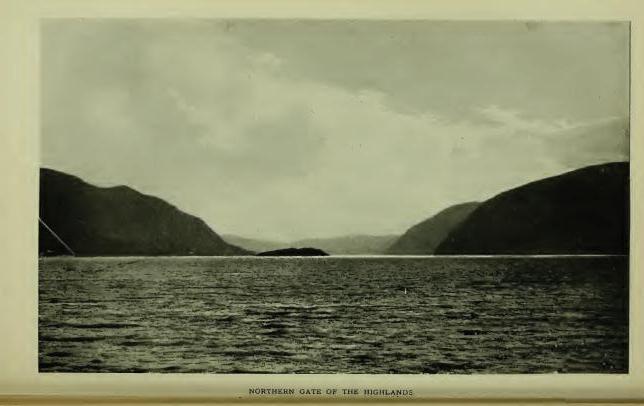
Manahan, meaning "Island"—indefinite -an—is a record name of what is now known as Constitution Island, the latter title from Fort Constitution which was erected thereon during the war of the Revolution. The early Dutch navigators called it Martelaer's Rack Eiland, from Martelaer, "Martyr," and Rack, a reach or sailing course—"the Martyr's Reach"—from the baffling winds and currents encountered in passing West Point. The effort of Judge Benson to convert "Martelaer's" to "Murderer's." and "Rack" to "Rock"—"the Murderer's Rock"—was unfortunate.
Pollepel Eiland, a small rocky island in the Hudson at the northern entrance to the Highlands, was given that name by an early Dutch navigator. It means, literally, "Pot-ladle Island," so called, presumably, from its fancied resemblance to a Dutch pot-ladle. Jasper Dankers and Peter Sluyter wrote the name in their Journal in 1679-80, indicating that the island was then well known by that title. On Van der Donck's map of 1656 the island is named Kaes Eiland. Dutch Kaas (cheese) Eiland. Dankers and Sluyter also wrote, "Boter-berg (Butter-hill), because it is like the rolls of butter which the farmers of Holland take to market." Read in connection the names are Butter Hill and Cheese Island. The same writers wrote, "Hays-berg (Hay-hill), because it is like a hay-stack in Holland," and "Donder-berg (Thunder-hill), so called from the echoes of thunder peals which culminated there." The latter retains its ancient Dutch title. It is eminently the Echo Hill of the Highlands. The oldest record name of any of the hills is Klinker-berg, which is written on the Carte Figurative of 1614-16 directly opposite a small island and apparently referred to Butter Hill. It means literally, "Stone Mountain." The passage between Butter Hill and Break Neck, on the east side of the river, was called "Wey-gat, or Wind-gate, because the wind often blowed through it with great force," wrote Dr. Dwight. The surviving name, however, is Warragat, from Dutch Warrelgat, "Wind-gate." It was at the northern entrance to this troublesome passage that Hudson anchored the Half-Moon, September 29th, 1609. Brodhead suggested (Note K, Vol. I) that Pollepel Island was that known in early Dutch history as Prince's Island, or Murderer's Creek Island, and that thereon was erected Fort Wilhelmus, referred to by Wassenaer in 1626. (Doc. Hist. N. Y., iii, 35.) The evidence is quite clear, however, that the island to which Wassenaer referred was in the vicinity of Schodac, where there was also a Murderer's Creek.
Hudson, on his exploration of the river which now bears his name, sailed into the bay immediately north of Butter Hill, now known as Newburgh Bay, on the morning of the 15th of September, 1709. After spending several days in the northern part of the river, he reached Newburgh Bay on his return voyage in the afternoon of September 29th, and cast anchor, or as stated in Juet's Journal, "Turned down to the edge of the mountains, or the northernmost of the mountains, and anchored, because the high lands hath many points, and a narrow channel, and hath many eddie winds. So we rode quietly all night." The hill or mountain long known as Breakneck, on the east side of the river, may be claimed as the northernmost, which would place his anchorage about midway between Newburgh and Pollepel Island.
Quassaick, now so written, is of record, Quasek, 1709; "Near to a place called Quasaik," 1709-10; Quasseck, 1713; "Quassaick Creek upon Hudson's River," 1714. It was employed to locate the place of settlement of the Palatine immigrants in 1709—"The Parish of Quassaick," later, "The Parish of Newburgh." It is now preserved as the name of the creek which bounds (in part) the city of Newburgh on the south. "Near to a place called Quasek," indicates that the place of settlement was located by the name of some other place which was near to it and generally known by the name. The late Dr. E. B. O'Callaghan read it, in 1856: "From Qussuk, 'Stone,' and -ick, 'Place where,' literally, 'A place of stone,'" the presumed reference being to the district through which the stream flows, which is remarkable for its deposit of glacial bowlders. The correctness of this interpretation has been questioned on very tenable grounds. Qusuk is not in the plural number and -uk does not stand for -ick. Eliot wrote: "Qussuk, a rock," and "Qussukquan-ash, rocks." Qussuk, as a substantive simply, would be accepted as the name of a place called "A rock," by metonymie, "A stone." No other meaning can be drawn from it. It does not belong to the dialect of the district, the local terms being -ápuch, "Rock," and -assin, or -achsûn, "Stone." Dr. O'Callaghan's interpretation may safely be rejected. William R. Gerard writes: "The worst corrupted name that I know of is Wequaskeg or Wequaskeek, meaning, 'At the end of the marsh.' It appears in innumerable forms—Weaxashuk, Wickerschriek, Weaquassic, etc. I think that Quassaick, changed from Quasek (1709), is one of these corruptions. The original word probably referred to some place at the end of a swamp. The word would easily become Quasekek, Quasek, and Quassaick. The formative -ek, in words meaning swamp, marsh, etc., was often dropped by both Dutch and English scribes." This conjecture would seem to locate the name as that of the end of Big Swamp, nearly five miles distant from the place of settlement. My conjecture is that the name is from Moh. Kussuhkoe, meaning "High;" with substantive Kussuhkohke, "High lands," the place of settlement being described as "Near the Highlands," which became the official designation of "The Precinct of the Highlands." Kussuhk is pretty certainly met in Cheesek-ook, the name of patented lands in the Highlands, described as "Uplands and meadows;" also in Quasigh-ook, Columbia County, which is described as "A high place on a high hill." The Palatine settlers at Quasek, wrote, in 1714, that their place was "all uplands," a description which will not be disputed at the present day. (See Cheesekook, Quissichkook, etc.)
Much-Hattoos, a hill so called in petition of William Chambers and William Sutherland, in 1709, for a tract of land in what is now the town of New Windsor, and in patent to them in 1712, a boundmark described as "West by the hill called Much-Hattoes," is apparently from Match, "Evil, bad;" -adchu, "Hill" or mountain, and -es, "Small"—"A small hill bad," or a small hill that for some reason was not regarded with favor. [FN] The eastern face of the hill is a rugged wall of gneiss; the western face slopes gradually to a swamp not far from its base and to a small lake, the latter now utilized for supplying the city of Newburgh with water, with a primary outlet through a passage under a spur of the hill, which the Indians may have regarded as a mysterious or bad place. In local nomenclature the hill has long been known as Snake Hill, from the traditionary abundance of rattle-snakes on it, though few have been seen there in later years.
[FN] "I think your reading of Muchattoos as an orthography of original Matchatchu's, is very plausible. I think Massachusetts is the same word, plus a locative suffix and English sign of the plural. It was formerly spelled in many ways: Mattachusetts, Massutchet, Matetusses, etc. Dr. Trumbull read it as standing for Mass-adchu-set, 'At the big hills'; but I learn from history that Massachusetts was originally the name of a hillock situated in the midst of a salt marsh. It was a locality selected by the sachem of his tribe as one of his places of residence. He stood in fear of his enemies, the Penobscotts, and this hillock, from its situation was a 'bad,' or difficult place to reach. So Massachsat for Matsadchuset or Mat-adchu-set plainly means, 'On the bad hillock.'" (Wm. R. Gerard.)
Cronomer's Hill and Cronomer's Valley, about three miles west of the city of Newburgh, take their names from a traditionary Indian called Cronomer, the location of whose wigwam is said to be still known as "The hut lot." The name is probably a corruption of the original, which may have been Dutch Jeronimo.
Murderer's Creek, so called in English records for many years, and by the Dutch "den Moordenaars' Kil," is entered on map of 1666, "R. Tans Kamer," or River of the Dance Chamber, and the point immediately south of its mouth, "de Bedrieghlyke Hoek" (Dutch, Bedrieglijk), meaning "a deceitful, fraudulent hook," or corner, cape, or angle. Presumably the Dutch navigator was deceived by the pleasant appearance of the bay, sailed into it and found his vessel in the mouth of the Warrelgat. Tradition affirms in explanation of the Dutch Moordenaars that an early company of traders entered their vessel in the mouth of the stream; that they were enticed on shore at Sloop Hill and there murdered. Paulding, in his beautiful story, "Naoman," related the massacre of a pioneer family at the same place. The event, however, which probably gave the name to the stream occurred in August, 1643, when boats passing down the river from Fort Orange, laden with furs, were attacked by the Indians "above the Highlands" and "nine Christians, including two women were murdered, and one woman and two children carried away prisoners," (Doc. Hist. N. Y., iv, 12), the narrative locating the occurrence by the name "den Moordenaars' Kil," i. e. the kill from which the attacking party issued forth or on which the murderers resided. The first appearance of the name in English records is in a deed to Governor Dongan, in 1685, in which the lands purchased by him included "the lands of the Murderers' Creek Indians," the stream being then well known by the name. The present name, Moodna, was converted to that form, by N. P. Willis from the Dutch "Moordenaar," by dropping letters, an inexcusable emasculation from a historic standpoint, but made poetical by his interpretation, "Meeting of the waters."
Schunnemunk, now so written, the name of a detached hill in the town of Cornwall, Orange County, appears of record in that connection, first, in the Wilson and Aske Patent of 1709, in which the tract granted is described as lying "Between the hills at Scoonemoke." Skoonnemoghky, Skonanaky, Schunnemock, Schonmack Clove, Schunnemock Hill, are other forms. In 1750 Schunnamunk appears, and in 1774, on Sauthier's map (1776) Schunnamank is applied to the range of hills which have been described as "The High Hills to the west of the Highlands." 'In a legal brief in the controversy to determine finally the northwest line of the Evans Patent, the name is written Skonanake, and the claim made that it was the hill named Skoonnemoghky in the deed from the Indians to Governor Dongan, in 1685, and therein given as the southeast boundmark of the lands of "The Murderer's Creek Indians," and, later, the hill along which the northwest line of the Evans Patent ran, which it certainly was not, although the name is probably from the same generic. (See Schoonnenoghky.) The hill forms the west shoulder of Woodbury Valley. It is a somewhat remarkable elevation in geological formation and bears on its summit many glacial scratches. On its north spur stood the castle of Maringoman, one of the grantors of the deed to Governor Dongan, and who later removed to the north side of the Otter Kill where his wigwam became a boundmark in two patents. [FN] The traditionary word "castle," in early days of Indian history, was employed as the equivalent of town, whether palisaded or not. In this case we may read the name, "Maringoman's Town," which may or may not have been palisaded. It seems to have been the seat of the "Murderer's Creek Indians." The burial ground of the clan is marked on a map of the Wilson and Aske Patent, and has been located by Surveyor Fred J. McKnight (1898) on the north side of the Cornwall and Monroe line and very near the present road past the Houghton farm, near which the castle stood. The later "cabin" of the early sachem is plainly located.
[FN] Van Dam Patent (1709) and Mompesson Patent (1709-12). The late Hon. George W. Tuthill wrote me in 1858: "On the northwestern bank of Murderers' Creek, about half a mile below Washingtonville, stands the dwelling-house of Henry Page (a colored man), said to be the site of Maringoman's wigman, referred to in the Van Dam Patent of 1709. The southwesterly corner of that patent is in a southwesterly direction from said Page's house."
In the controversy in regard to the northwest line of the Evans Patent, one of the counsel said: "It is also remarkable that the Murderers' Creek extends to the hill Skonanaky, and that the Indian, Maringoman, who sold the lands, did live on the south side of Murderers' Creek, opposite the house where John McLean now (1756) dwells, near the said hill, and also lived on the north bank of Murderers' Creek, where Colonel Mathews lives. The first station of his boundaries is a stone set in the ground at Maringoman's castle."
Winegtekonck, 1709—Wenighkonck, 1726; Wienackonck, 1739—is quoted as the name of what is now known as Woodcock Mountain, in the town of Blooming-Grove, It is not so connected, however, in the record of 1709, which reads: "A certain tract of land by the Indians called Wineghtek-onck and parts adjacent, lying on both sides of Murderers' Kill" (Cal. N. Y. Land Papers, 91), in which connection it seems to be another form of Mahican Wanun-ketukok, "At the winding of the river"—"A bend-of-the-river-place." Presumably the reference is to a place where the stream bends in the vicinity of the hill. The name appears in an abstract of an Indian deed to Sir Henry Ashurst, in 1709, for a tract of land of about sixteen square miles. The purchase was not patented, the place being included in the Governor Dongan purchase of 1685, and in the Evans Patent.
Sugar Loaf, the name of a conical hill in the town of Chester, Orange County, is not an Indian name of course, but it enters into an enumeration of Indian places, as in its vicinity were found by Charles Clinton, in his survey of the Cheesec-ock Patent in 1738, the unmistakable evidences of the site of an Indian village, then probably not long abandoned, and Mr. Eager (Hist. Orange Co.) quoted evidences showing that on a farm then (1846) owned by Jonathan Archer, was an Indian burying ground, the marks of which were still distinct prior to the Revolution.
Runbolt's Run, a spring and creek in the town of Goshen, are said to have taken that name from Rombout, one of the Indian grantors of the Wawayanda tract. It is probable, however, that the name is a corruption of Dutch Rondbocht, meaning, "A tortuous pool, puddle, marsh," at or near which the chief may have resided. Rombout (Dutch) means "Bull-fly." It could hardly have been the name of a run of water.
Mistucky, the name of a small stream in the town of Warwick, has lost some of its letters. Mishquawtucke (Nar.), would read, "Place of red cedars."
Pochuck, given as the name of "A wild, rugged and romantic region" in Sussex County, N. J., to a creek near Goshen, and, modernly, to a place in Newburgh lying under the shadow of Muchhattoes Hill, is no doubt from Putscheck (Len.), "A corner or repress," a retired or "out-of-the-way place." Eliot wrote Poochag, in the Natick dialect, and Zeisberger, in the Minsi-Lenape, Puts-cheek, which is certainly heard in Pochuck.
Chouckhass, one of the Indian grantors of the Wawayanda tract, left his name to what is now called Chouck's Hill, in the town of Warwick. The land on which he lived and in which he was buried came into possession of Daniel Burt, an early settler, who gave decent sepulture to the bones of the chief. [FN]
[FN] The traditional places of residence of several of the sachems who signed the Wawayanda deed is stated by a writer in "Magazine of American History," and may be repeated on that authority, viz: "Oshaquememus, chief of a village, near the point where the Beaver-dam Brook empties into Murderers' Creek near Campbell Hall; Moshopuck, on the flats now known as Haverstraw; Ariwimack, chief, on the Wallkill, extending from Goshen to Shawongunk; Guliapaw, chief of a clan residing near Long Pond (Greenwood Lake), within fifty rods of the north end of the pond; Rapingonick died about 1730 at the Delaware Water-Gap." The names given by the writer do not include all the signers of the deed. One of the unnamed grantors was Claus, so called from Klaas (Dutch), "A tall ninny"; an impertinent, silly fellow; a ninny-jack. The name may have accurately described the personality of the Indian.
Jogee Hill, in the town of Minisink, takes its name from and preserves the place of residence of Keghekapowell, alias Jokhem (Dutch Jockem for Joachim), one of the grantors of lands to Governor Dongan in 1684. The first word of his Indian name, Keghe, stands for Keche, "Chief, principal, greatest," and defined his rank as principal sachem. The canton which he ruled was of considerable number. He remained in occupation of the hill long after his associates had departed.
Wawayanda, 1702—Wawayanda or Wocrawin, 1702; Wawayunda, 1722-23; Wiwanda, Wowando, Index Col. Hist. N. Y.—the first form, one of the most familiar names in Orange County, is preserved as that of a town, a stream of water, and of a large district of country known as the Wawayanda Patent, in which latter connection it appears of record, first, in 1702, in a petition of Dr. Samuel Staats, of Albany, and others, for license to purchase "A tract of land called Wawayanda, in the county of Ulster, containing by estimation about five thousand acres, more or less, lying about thirty miles backward in the woods from Hudson's River." (Land Papers, 56.) In February of the same year the parties filed a second petition for license to "purchase five thousand acres adjoining thereto, as the petitioners had learned that their first purchase, 'called Wawayanda' was 'altogether a swamp and not worth anything.'" In November of the same year, having made the additional purchase, the parties asked for a patent for ten thousand acres "Lying at Wawayanda or Woerawin." Meanwhile Dr. John Bridges and Company, of New York, purchased under license and later received patent for "certain tracts and parcels of vacant lands in the county of Orange, called Wawayanda, and some other small tracts and parcels of lands," and succeeded in including in their patent the lands which had previously been purchased by Dr. Staats. Specifically the tract called Wawayanda or Woerawin was never located, nor were the several "certain tracts of land called Wawayanda" purchased by Dr. Bridges. The former learned in a short time, however, that his purchase was not "altogether a swamp," although it may have included or adjoined one, and the latter found that his purchase included a number of pieces of very fine lands and a number of swamps, and especially the district known as the Drowned Lands, covering some 50,000 acres, in which were several elevations called islands, now mainly obliterated by drainage and traversed by turnpikes and railroads. Several water-courses were there also, notably the stream now known as the Wallkill, and that known as the Wawayanda or Warwick Creek, a stream remarkable for its tortuous course.
What and where was Wawayanda? The early settlers on the patent seem to have been able to answer. Mr. Samuel Vantz, who then had been on the patent for fifty-five years, gave testimony in 1785, that Wawayanda was "Within a musket-shot of where DeKay lived." The reference was to the homestead house of Col. Thomas DeKay, who was then dead since 1758. The foundation of the house remains and its site is well known. In adjusting the boundary line between New York and New Jersey it was cut off from Orange County and is now in Vernon, New Jersey, where it is still known as the "Wawayanda Homestead." Within a musket-shot of the site of the ancient dwelling flows Wawayanda Creek, and with the exception of the meadows through which it flows in a remarkably sinuous course, is the only object in proximity to the place where DeKay lived, except the meadow and the valley in which it flows. The locative of the name at that point seems to be established with reasonable certainty as well as the object to which it was applied—the creek.
The meaning of the name remains to be considered. Its first two syllables are surely from the root Wai or Wae; iterative and frequentive Wawai, or Waway, meaning "Winding around many times." It is a generic combination met in several forms—Wawau, Lenape; Wohwayen, Moh.; [FN] Wawai, Shawano; Wawy, Wawi, Wawei, etc., on the North-central-Hudson, as in Waweiqate-pek-ook, Greene County, and Wawayachton-ock, Dutchess County. Dr. Albert S. Gatschet, of the Bureau of Ethnology, wrote me: "Wawayanda, as a name formed by syllabic reduplication, presupposes a simple form, Wayanda, 'Winding around.' The reduplication is Wawai, or Waway-anda, 'many' or 'several' windings, as a complex of river bends." As the name stands it is a participial or verbal noun. Waway, "Winding around many times";—-anda, "action, motion" (radical -an, "to move, to go"), and, inferentially, the place where the action of the verb is performed, as in Guttanda, "Taste it," the action of the throat in tasting being referred to, and in Popachándamen, "To beat; to strike." As the verb termination of Waway, "Round about many times," it is entirely proper. The uniformity of the orthography leaves little room for presuming that any other word was used by the grantors, or that any letters were lost or dropped by the scribe in recording. It stands simply as the name of an object without telling what that object was, but what was it that could have had action, motion—that had many windings—except Wawayanda Creek?
[FN] "Wohwayen (Moh.), where the brook 'winds about,' turning to the west and then to the east." (Trumbull.) Wowoaushin, "It winds about." (Eliot.) Woweeyouchwan. "It flows circuitously, winds about." (Ib.)
Mr. Ralph Wisner, of Florida, Orange County, recently reproduced in the Warwick Advertiser, an affidavit made by Adam Wisner, May 19th, 1785, at a hearing in Chester, in the contention to determine the boundary line of the Cheesec-ock Patent, in which he stated that he was 86 years old on the 15th of April past; that he had lived on the Wawayanda Patent since 1715; that he "learned the Indian language" when he was a young man; that the Indians "had told him that Wawayanda signified 'the egg-shape,' or shape of an egg." Adam Wisner was an interpreter of the local Indian dialect; he is met as such in records. His interpretations, as were those of other interpreters, were mainly based on signs, motions, objects. Waway, "Winding about many times," would describe the lines of an egg, but it is doubtful if the suffix, -anda, had the meaning of "shape."
The familiar reading of Wawayanda, "Away-over-yonder," is a word-play, like Irving's "Manhattan, Man-with-a-hat-on." Dr. Schoolcraft's interpretation, "Our homes or places of dwelling," quoted in "History of Orange County," is pronounced by competent authority to be "Dialectically and grammatically untenable." It has poetic merit, but nothing more. Schoolcraft borrowed it from Gallatin.
Woerawin, given by Dr. Staats as the name of his second purchase, is also a verbal noun. By dialectic exchange of l for r and giving to the Dutch æ its English equivalent ü as in bull, it is probably from the root Wul, "Good, fine, handsome," etc., with the verbal termination -wi (Chippeway -win), indicating "objective existence," hence "place," a most appropriate description for many places in the Wawayanda or Warwick Valley.
Monhagen, the name of a stream in the town of Wallkill, is, if Indian as claimed, an equivalent of Monheagan, from Maingan, "A wolf," the totem of the Mohegans of Connecticut. The name, however, has the sound of Monagan—correctly, Monaghan, the name of a county in Ireland, and quite an extensive family name in Orange County.
Long-house, Wawayanda, and Pochuck are local names for what may be regarded as one and the same stream. It rises in the Drowned Lands, in New Jersey, where it is known as Long-house Creek; flows north until it receives the outlet of Wickham's Pond, in Warwick, Orange County, and from thence the united streams form the Wawayanda or Warwick Creek, which flows southwesterly for some miles into New Jersey and falls into Pochuck Creek, which approaches from the northwest, and from thence the flow is northwest into Orange County again to a junction with the Wallkill, which, rising in Pine Swamp, Sparta, N. J., flows north and forms the main drainage channel of the Drowned Lands. In addition to its general course Wawayanda Creek is especially sinuous in the New Milford and Sandfordville districts of Warwick, the bends multiplying at short distances, and also in the vicinity of the De Kay homestead in Vernon. In Warwick the stream has been known as "Wandering River" for many years. The patented lands are on this stream. Its name, Long-house Creek, was, no doubt, from one of the peculiar dwellings constructed by the Indians known as a Long House, [FN] which probably stood on or near the stream, and was occupied by the clan who sold the lands. Pochuck is from a generic meaning "A recess or corner." It is met in several places. (See Wawayanda and Pochuck.)
[FN] The Indian Long House was from fifty to six hundred and fifty feet in length by twenty feet in width, the length depending upon the number of persons or families to be accommodated, each family having its own fire. They were formed by saplings set in the ground, the tops bent together and the whole covered with bark. The Five Nations compared their confederacy to a long house reaching, figuratively, from Hudson's River to Lake Erie.
Gentge-kamike, "A field appropriated for holding dances," may reasonably have been the Indian name of the plateau adjoining the rocky point, at the head of Newburgh Bay, which, from very early times, has been known as The Dans Kamer (Dance Chamber), a designation which appears of record first in a Journal by David Pietersen de Vries of a trip made by him in his sloop from Fort Amsterdam to Fort Orange, in 1639, who wrote, under date of April 15: "At night came by the Dans Kamer, where there was a party of Indians, who were very riotous, seeking only mischief; so we were on our guard." Obviously the place was then as well known as a landmark as was Esopus (Kingston), and may safely be claimed as having received its Dutch name from the earliest Dutch navigators, from whom it has been handed down not only as "The Dans Kamer," but as "t' Duivel's Dans Kamer," the latter presumably designative of the fearful orgies which were held there familiarly known as "Devil worship." During the Esopus War of 1663, Lieut. Couwenhoven, who was lying with his sloop opposite the Dans Kamer, wrote, under date of August 14th, that "the Indians thereabout on the river side" made "a great uproar every night, firing guns and Kintecaying, so that the woods rang again." There can be no doubt from the records that the plateau was an established place for holding the many dances of the Indians. The word Kinte is a form of Géntge (Zeisb.), meaning "dance." Its root is Kanti, a verbal, meaning "To sing." Géntgeen, "To dance" (Zeisb.), Gent' Keh'n (Heck.), comes down in the local Dutch records Kinticka, Kinte-Kaye, Kintecaw, Kintekaying (dancing), and has found a resting place in the English word Canticoy, "A social dance." Dancing was eminently a feature among the Indians. They had their war dances, their festival dances, their social dances, etc. As a rule, their social dances were pleasant affairs. Rev. Heckewelder wrote that he would prefer being present at a social Kintecoy for a full hour, than a few minutes only at such dances as he had witnessed in country taverns among white people. "Feast days," wrote Van der Donck in 1656, "are concluded by old and middle aged men with smoking; by the young with a Kintecaw, singing and dancing." Every Indian captive doomed to death, asked and was granted the privilege of singing and dancing his Kintekaye, or death song. War dances were riotous; the scenes of actual battle were enacted. The religious dances and rites were so wonderful that even the missionaries shrank from them, and the English government forbade their being held within one hundred miles of European settlements. The holding of a war dance was equivalent to opening a recruiting station, men only attending and if participating in the dance expressed thereby their readiness to enter upon the war. It was probably one of these Kantecoys that Couwenhoven witnessed in 1663.
There were two dancing fields here—so specified in deed—the "Large Dans Kamer" and the "Little Dans Kamer," the latter a limited plateau on the point and the former the large plateau now occupied in part by the site of the Armstrong House. The Little Dans Kamer is now practically destroyed by the cut on the West-shore Railroad. 'Sufficient of the Large Dans Kamer remains to evidence its natural adaptation for the purposes to which the Indians assigned it. Paths lead to the place from all directions. Negotiations for the exchange of prisoners held by the Esopus Indians were conducted there, and there the Esopus Indians had direct connection with the castle of the Wappingers on the east side of the Hudson. There are few places on the Hudson more directly associated with Indian customs and history than the Dans Kamer.
Arackook, Kachawaweek, and Oghgotacton are record but unlocated names of places on the east side of the Wallkill, by some presumed to have been in the vicinity of Walden, Orange County, from the description: "Beginning at a fall called Arackook and running thence northwesterly on the east side of Paltz Creek until it comes to Kachawaweek." The petitioner for the tract was Robert Sanders, a noted interpreter, who renewed his petition in 1702, calling the tract Oghgotacton, and presented a claim to title from a chief called Corporwin, as the representative of his brother Punguanis, "Who had been ten years gone to the Ottowawas." He again gave the description, "Beginning at the fall called Arackook," but there is no trace of the location of the patent in the vicinity of Walden.
Hashdisch was quoted by the late John W. Hasbrouck, of Kingston, as the name of what has long been known as "The High Falls of the Wallkill" at Walden. Authority not stated, but presumably met by Mr. Hasbrouck in local records. It may be from Ashp, Hesp, etc., "High," and -ish, derogative. The falls descend in cascades and rapids about eighty feet at an angle of forty-five degrees. Though their primary appearance has been marred by dams and mills, they are still impressive in freshet seasons.
Twischsawkin is quoted as the name of the Wallkill at some place in New Jersey. On Sauthier's map it stands where two small ponds are represented and seems to have reference to the outlet. Twisch may be an equivalent of Tisch, "Strong," and Sawkin may be an equivalent of Heckewelder's Saucon, "Outlet," or mouth of a river, pond, etc. Wallkill, the name of the stream as now written, is an Anglicism of Dutch Waal, "Haven, gulf, depth," etc., and Kil, "Channel" or water-course. It is the name of an arm of the Rhine in the Netherlands, and was transferred here by the Huguenots who located in New Paltz. (See Wawayanda.)
Shawangunk, the name of a town, a stream of water, and a range of hills in Ulster County, was that of a specific place from which it was extended. It is of record in many orthographies, the first in 1684, of a place called Chauwanghungh, [FN-1] in deed from the Indians to Governor Dongan, in the same year, Chawangon, [FN-2] and Chanwangung in 1686, [FN-3] later forms running to variants of Shawangunk. The locative is made specific in a grant to Thomas Lloyd in 1687; [FN-4] in a grant to Severeign Tenhout in 1702, [FN-5] and in a description in 1709, "Adjoining Shawangung, Nescotack and the Palze." [FN-6] In several other patent descriptions the locative is further identified by "near to" or "adjoining," and finally (1723) by "near the village of Showangunck," at which time the "village" consisted of the dwellings of Thomas Lloyd, on the north side of Shawangunk Kill; Severeign Tenhout on the south side; and Jacobus Bruyn, Benjamin Smedes, and others, with a mill, at and around what was known later as the village of Tuthiltown. In 1744, Jacobus Bruyn was the owner of the Lloyd tract. [FN-7] The distribution of the name over the district as a general locative is distinctly traceable from this center. It was never the name of the mountain, nor of the stream, and it should be distinctly understood that it does not appear in Kregier's Journal of the Second Esopus War, nor in any record prior to 1684, and could not have been that of any place other than that distinctly named in Governor Dongan's deed and in Lloyd's Patent.
Topographically, the tract was at and on the side of a hill running north from the fiats on the stream to a point of which Nescotack was the summit, the Lloyd grant lying in part on the hill-side and in part on the low lands on the stream. The mountain is eight miles distant. Without knowledge of the precise location of the name several interpretations of it have been made, generally from Shawan, "South"—South Mountain, South Water, South Place. [FN-8] The latter is possible, i. e. a place lying south of Nescotack, as in the sentence: "Schawangung, Nescotack, and the Paltz." From the topography of the locative, however, Mr. William R. Gerard suggests that the derivatives are Scha (or Shaw), "Side," -ong, "hill," and -unk, locative, the combination reading, "At (or on) the hill-side." [FN-9] This reading is literally sustained by the locative.
The name is of especial interest from its association with the Dutch and Indian War of 1663, although not mentioned in Kregier's narrative of the destruction of the Indian palisaded village called "New Fort," and later Shawongunk Fort. The narrative is very complete in colonial records. [FN-10] The village or fort was not as large as that called Kahanksan, which had previously been destroyed. It was composed of ten huts, probably capable of accommodating two or three hundred people. The palisade around them formed "a perfect square," on the brow of a tract of table-land on the bank of Shawongunk Kill. Since first settlement the location has been known as "New Fort." It is on the east side of the stream about three miles west of the village of Wallkill. [FN-11] In the treaty of 1664 the site and the fields around it were conceded, with other lands, to the Dutch, by the Indians, as having been "conquered by the sword," but were subsequently included (1684) in the purchase by Governor Dongan. Later were included in the patent to Capt. John Evans, and was later covered by one of the smaller patents into which the Evans Patent was divided. When the Dutch troops left it it was a terrible picture of desolation. The huts had been burned, the bodies of the Indians who had been killed and thrown into the corn-pits had been unearthed by wolves and their skeletons left to bleach on the plain, with here and there the half eaten body of a child. For years it was a fable told to children that the place was haunted by the ghosts of the slain, and even now the timid feel a peculiar sensation, when visiting the site, whenever a strange cry breaks on the ear, and the assurance that it is real comes with gratefulness in the shouts of the harvesters in the nearby fields. It is a place full of history, full of poetry, full of the footprints of the aboriginal lords, "Further down the creek," says the narrative, "several large wigwams stood, which we also burned, and divers maize fields which we also destroyed." On the sites of some of these wigwams fine specimens of Indian pottery and stone vessels and implements have been found, as well as many arrow-points of flint.
[FN-1] "Land lying about six or seven miles beyond ye Town where ye Walloons dwell, upon ye same creek; ye name of ye place is Chauwanghungh and Nescotack, two small parcels of land lying together." (N. Y. Land Papers, 29, 30.)
[FN-2] "Comprehending all those lands, meadows and woods called Nescotack, Chawangon, Memorasink, Kakogh, Getawanuck and Ghittatawah." (Deed to Gov. Dongan.)
[FN-3] "Beginning on the east side of the river (now Wallkill), and at the south end of a small island in the river, at the mouth of the river Chauwangung, in the County of Ulster, laid out for James Graham and John Delaval." (N. Y. Land Papers, 38.)
[FN-4] "Description of a survey of 410 acres of land, called by the Indian name Chauwangung, laid out for Thomas Lloyd." (N. Y. Land Papers, 44.)
[FN-5] N. Y. Land Papers, 60.
[FN-6] Ib. 169. Other early forms are Shawongunk (1685), Shawongonck (1709), Shawongunge (1712).
[FN-7] From Jacobus Bruyn came the ancient hamlet still known as Bruynswick. He erected a stone mansion on the tract, in the front wall of which was cut on a marble tablet, "Jacobus Bruyn. 1724." The house was destroyed by fire in 1870 (about), and a frame dwelling erected on its old foundation. It is about half-way between Bruynswick and Tuthilltown; owned later by John V. McKinstry. The location is certain from the will of Jacobus Bruyn in 1744.
[FN-8] The most worthless interpretation is that in Spofford's Gazeteer and copied by Mather in his Geological Survey: "Shawen, in the Mohegan language, means 'White,' also 'Salt.' and Gunk, 'A large pile of rocks,' hence 'White Rocks' or mountain." The trouble with it is that there is no such word as Shawen, meaning "White" in any Algonquian dialect, and no such word as Gunk, meaning "Rocks."
[FN-9] The monosyllable Shaw or Schaw, radical Scha, means "Side, edge, border, shore," etc. Schauwunuppéque, "On the shore of the lake." Enda-tacht-schawûnge, "At the narrows where the hill comes close to the river." (Heck.) Schajawonge, "Hill-side" (Zeisb.), from which Schawong-unk, "On the hill-side," or at the side of the hill, the precise bound of the name cannot be stated.
[FN-10] Doc. Hist. N. Y., iv, 71, 72, et. seq. Col. Hist. N. Y., xiii, 272, 326.
[FN-11] Authorities quoted and paper by Rev. Charles Scott, D. D., in "Proceedings Ulster Co. Hist. Soc."
Memorasink, Kahogh, Gatawanuk, and Ghittatawagh, names handed down in the Indian deed to Governor Dongan in 1684, have no other record, nor were they ever specifically located. The lands conveyed to him extended from the Shawangunk range to the Hudson, bounded on the north by the line of the Paltz Patent, and south by a line drawn from about the Dans Kamer. Ghittatawagh is probably from Kitchi, "Great, strong," etc., and Towatawik, "Wilderness"—the great wilderness, or uninhabited district. Gatawanuk seems to be from Kitchi, "Strong," -awan, impersonal verb termination, and -uk, locative, and to describe a place on a strong current or flowing stream. The same name seems to appear in Kitchawan, now Croton River. It may have located lands on the Wallkill.
Nescotack, a certain place so called in the Dongan deed of 1684, is referred to in connection with Shawongunk. It was granted by patent to Jacob Rutsen and described as "A tract of land by the Indians called Nescotack and by the Christians Guilford." (N. Y. Land Papers, 29, 30.) Guilford was known for many years as Guilford Church, immediately west of Shawongunk. The actual location of the name, however, is claimed for a hamlet now called Libertyville, further north, which was long known as Nescotack. The district is an extended ridge which rises gradually from the Shawongunk River-bottoms on the east and falls off on the west more abruptly. The name, probably, describes this ridge as "High lands," an equivalent of Esquatak and Eskwatack on the Upper Hudson; Ashpotag, Mass., and Westchester Co. Esp, Hesp, Ishp, Hesko, Nesco, etc., are record orthographies. (See Schodac and Shawongunk.)
Wishauwemis, a place-name in Shawongunk, was translated by Rev. Dr. Scott, "The place of beeches," from Schauwemi, "Beech wood"; but seems to be an equivalent of Moh. Wesauwemisk, a species of oak with yellow bark used for dyeing. Wisaminschi, "Yellow-wood tree." (Zeisb.)
Wickquatennhonck, a place so called in patent to Jacobus Bruyn and Benj. Smedes, 1709, is described as "Land lying near a small hill called, in ye Indian tongue, Wickqutenhonck," in another paper Wickquatennhonck, "Land lying near the end of the hill." The name means, "At the end of the hill," from Wequa, "End of"; -ateune (-achtenne, Zeisb.), "hill," and -unk, "at." The location was near the end of what is still known as the Hoogte-berg (Hooge-berg, Dutch), a range of hills, where the proprietors located dwellings which remained many years.
Wanaksink, a region of meadow and maize land in the Shawongunk district, was translated by Dr. Scott from Winachk, "Sassafras" (Zeisb.); but Wanachk may and probably does stand for Wonachk, "The tip or extremity of anything," and -sing means "Near," or less than. A piece of land that was near the end of a certain place or piece of land. It is not the word that is met in Wynogkee.
Maschabeneer, Masseks, Maskack, Massekex, a certain tract or tracts of land in the present town of Shawongunk, appear in a description of survey, Dec. 10, 1701, of seven hundred and ten acres "at a place called Maschabeneer Shawengonck," laid out for Mathias Mott, accompanied by an affidavit by Jacob Rutsen concerning the purchase of the same from the Indians. At a previous date (Sept. 22) Mott asked for a patent for four hundred acres "at a place called Shawungunk," which was "given him when a child by the Indians." Whether the two tracts were the same or not does not appear; but in 1702, June 10, Severeyn Tenhout remonstrated against granting to Mott the land which he had petitioned for, and accompanied his remonstrance by an extract from the minutes of the Court at Kingston, in 1693, granting the land to himself. He asked for a patent and gave the name of the tract "Called by the Indians Masseecks, near Shawengonck," i. e. near the certain tract called Shawongunk which had been granted to Thomas Lloyd. He received a patent. In 1709, Mott petitioned "in relation to a certain tract of land upon Showangonck River" which had been granted to Tenhout, asking that the "same be so divided" that he (Mott) should "have a proportion of the good land upon the said river"—obviously a section of low land or meadow, described by the name of a place thereon called Maskeék (Zeisb.), meaning "Swamp, bog"; Maskeht (Eliot), "Grass." The radical is ask, "green, raw, immature." The suffix -eghs represents an intensive form of the guttural formative, which the German missionaries softened to -ech and -ck, and the English to -sh, and is frequently met in X. Heckewelder wrote that the original sound was that of the Greek X, hence Maskex and x in Coxsackie. Maschabeneer, the name given by Mott, is not satisfactorily translatable.
Pitkiskaker and Aioskawasting appear in deed from the Esopus Indians to Governor Dongan, in 1684, as the names of divisions of what are now known as the Shawongunk Mountains south of Mohunk or Paltz Point. The deed description reads: "Extending from the Paltz," i. e. from the southeast boundmark of the Paltz Patent on the Hudson, now known as Blue Point (see Magaat-Ramis), south "along the river to the lands of the Indians at Murderers' Kill, thence west to the foot of the high hills called Pitkiskaker and Aioskawasting, thence southwesterly all along the said hills and the river called Peakadasink to a water-pond lying upon said hills called Meretange." [FN-1] Apparently the general boundaries were the line of the Paltz Patent on the north, the Hudson on the east, a line from "about the Dancing Chamber" on the Hudson to Sam's Point on the Shawongunk range on the southwest, and on the west by that range and the river Peakadasank. The Peakadasank is now known as Shawangunk Kill. The pond "called Meretange," is claimed by some authorities, as that now known as Binnen-water in the town of Mount Hope, Orange County. On Sauthier's map it is located on the southern division of the range noted as "Alaskayering Mts.," and represented as the head of Shawongunk Kill. The same distinction is claimed for Meretange or Peakadasank Swamp in the town of Greenville, Orange County. A third Maratanza Pond is located a short distance west of Sam's Point. The name of the hill has been changed from Aioskawasting to Awosting as the name of a lake and a waterfall about four miles north of Sam's Point, and translated from Awoss (Lenape), "Beyond," "On the other side," and claimed to have been originally applied to a crossing-place in the depression north of Sam's Point, neither of which interpretations is tenable. The prefix, Aioska, cannot be dropped and the name have a meaning, and the adjectival, Awoss, cannot be used as a substantive and followed by the locative -ing, "at, on," etc. Awoss means "Beyond," surely, but must be followed by a substantive telling what it is that is "beyond." The particular features of the Shawongunk range covered by the boundary line of the deed are "The Traps," a cleft which divides the range a short distance south of Mohunk, and Sam's Point, [FN-2] about nine miles south of Mohunk. The latter stands out very conspicuously, its general surface covered by perpendicular rocks from one hundred to two hundred and fifty feet high, the point itself crowned by a wall of rock which rises 2200 feet above the valley below.
[FN-1] Meretange, Maretange, or Maratanza, is from Old English Mere, "A pond or pool," and Tanze, "Sharp" or offensive to the taste. The name was transferred to this pond from the pond first bearing it in the town of Greenville, Orange County, in changing the northwest line of the Evans Patent. (See Peakadasank.) The pond is about a mile in circumference and is lined with cranberry bushes and other shrubbery, but the water is clear and sweet. It lies about three-quarters of a mile west of Sam's Point. Long Pond, lying about four miles north of Maratanza, is now called Awosting Lake. It is about two miles long by possibly one-quarter of a mile wide and lies in a clove or cleft of the hills. Its outlet was called by the Dutch Verkerde Kil, now changed to Awosting. About one mile further north lies "The Great Salt Pond," so called in records of the town of Shawongunk. It is now called Lake Minnewaska, a name introduced from the Chippeway dialect, said to mean "Colored water," which has been changed to "Frozen water." The lake is particularly described as being "Set into the hills like a bowl." It has an altitude of 1,600 feet and a depth of seventy to ninety feet of water of crystal clearness through which the pebbly bottom can be seen. The fourth pond is that known as Lake Mohonk.
[FN-2] Sam's Point is in the town of Wawarsing, about seven miles south of the village of Ellenville and about nine miles south of Mohunk or Paltz Point. It is the highest point on the Shawongunk range in New York State. Its name is from Samuel Gonsaulus, who owned the tract. Gertruyd's Nose, the name of another point, was so called from the fancied resemblance of its shadow to the nose of Mrs. Gertrude, wife of Jacobus Bruyn, who owned the tract. The pass, cleft or clove known as "The Traps," was so called from the supposed character of the rock which it divides. The rock, however, is not Trappean. The pass is 650 feet wide and runs through the entire range. Its sides present the appearance of the hill having slipped apart.
Peakadasank, so written in Indian deed to Governor Dongan in 1684—Pachanasinck in patent to Jacob Bruyn, 1719; Peckanasinck, Pachanassinck, etc.—is given as the name of a stream bounding a tract of land, the Dongan deed description reading: "Thence southwesterly all along said hills and the river Peakadasank to a water-pond lying on said hills called Meretange." The name is preserved in two streams known as the Big and the Little Pachanasink, in Orange County, and in Ulster County as the "Pachanasink District," covering the south part of the town of Shawongunk. The Big Pachanasink is now known as Shawongunk Kill. In 1719, Nov. 26, a certain tract of land "called Pachanasink" was granted to Jacobus Bruyn and described in survey as "on the north side of Shawongunck Creek, beginning where the Verkerde Kill [FN] flows into said river," indicating locative of the name at the Verkerde Branch. In a brief submitted in the boundary contention, it is said that the line of the Dongan purchase ran "along the foot of the hills from a place called Pachanasink, where the Indians who sold the land had a large village and place," and from thence "to the head of the said river, and no where else the said river is called by that name." The evidence is cumulative that the name was that of the dominant feature of the district, from which it was transferred to the stream. It is a district strewn with masses of conglomerate rocks thrown off from the hills and precipitous cliffs. The two forms of the name, Peakadasank (1684) and Pachanassink (1717), were no doubt employed as equivalents. They differ in meaning, however. Wm. R. Gerard writes: "Peakadasank, or Pakadassin, means, 'It is laid out through the effects of a blow,' or some other action. The participial form is Pakadasing, meaning, 'Where it is laid out,' or 'Where it lies fallen.' The reference in this case would seem to be to the stone which had fallen off or been thrown down from the hills." Pachanasink means, "At the split rocks"; Pachassin, "Split stone." In either form the name is from the split rocks.
[FN] The Verkerde Kill falls over a precipice of about seventy feet. The exposed surface of the precipice is marked by strata in the conglomerate as primarily laid down. The entire district is a region of split rocks. Verkerde Kill takes that name from Dutch Verkeerd, meaning "Wrong, bad, angry, turbulent," etc. It is the outlet of Meretange Pond near Sam's Point. It flows from the pond to the falls and from the falls at nearly a right angle over a series of cascades aggregating in all a fall of two hundred and forty feet. The falls are in the town of Gardiner, Ulster County. (See Aioskawasting.)
The lands granted to Bruyn included the tract "Known by the Indian name of Pacanasink," now in the town of Shawongunk, and also a tract "Known by the Indian name of Shensechonck," now in the town of Crawford, Orange County. The latter seems to have been a parcel of level upland. It was about one mile to the southward of the stream.
Alaskayering, entered on Sauthier's map of 1774, as the name of the south part of the Shawongunk range, was conferred by the English, possibly as a substitute for Aioskawasting. The first word is heard in Alaska, which is said, on competent authority, to mean, "The high bald rocks"; with locative -ing, "At (or on) the high bald rocks." This interpretation is a literal description of the hill, and Aioskawasting may have the same meaning, although those who wrote the former may not have had a thought about the latter. [FN] (See Pitkiskaker.)
[FN] High Point, the highest elevation in the southern division of the range, is in New Jersey. It is said to be higher than Sam's Point, and to bear the same general description.
Achsinink, quoted by the late Rev. Charles Soott, D. D., from local records probably, as the name of Shawongunk Kill, is an apheresis apparently of Pach-achsün-ink, "At (or on) a place of split stones." Many of the split rocks thrown off from the mountain lie in the bed of the stream, in places utilized for crossing. "There are rocks in it, so that it is easy to get across." (Col. Hist. N. Y., viii, 272.) Achsün, as a substantive, cannot be used as an independent word with a locative. An adjectival prefix is necessary. (See Pakadasink.)
Palmagat, the name of the bend in the mountain north of Sam's Point, regarded by some as Indian, is a Dutch term descriptive of the growth there of palm or holly (Ilex opaca), possibly of shrub oaks the leaf of which resembles the holly. Gat is Dutch for opening, gap, etc.
Moggonck, Maggonck, Moggonick, Moggoneck, Mohonk, etc., are forms of the name given as that of the "high hill" which forms the southwest boundmark of the Paltz Patent, so known, now generally called locally, Paltz Point, and widely known as Mohunk. The hill is a point of rock formation on the Shawongunk range. It rises about 1,000 feet above the plain below and is crowned by an apex which rises as a battlement about 400 feet above the brow of the hill, now called Sky Top. Moggonck and Maggonck are interchangeable orthographies. The former appears in the Indian deed from Matseyay, and other owners, to Louis Du Bois, and others, May 26, 1677, and is carried forward in the patent issued to them in September of the same year. Moggoneck appears in Mr. Berthold Fernow's translation of the Indian deed in Colonial History of N. Y., xiii, 506. Moggonick was written by Surveyor Aug. Graham on his map of survey in 1709, and Mohunk is a modern pronunciation. The boundary description of the tract, as translated by the late Dr. E. B. O'Callaghan, from the Dutch deed (N. Y. Land Papers, 15), reads: "Beginning at the high hill called Moggonck, then southeast to Juffrouw's Hook in the Long Reach, on the Great River (called in Indian Magaat Ramis), thence north to the island called Raphoos, lying in the Kromme Elbow at the commencement of the Long Reach, thence west to the high hill to a place [called] Warachaes and Tawarataque, along the high hill to Moggonck." The translation in Colonial History is substantially the same except in the forms of the names. "Beginning from the high hill, at a place called Moggonck," is a translation of the deed by Rev. Ame Vaneme, in "History of New Paltz." It seems to be based on a recognition of the locative of the name as established by Surveyor Graham in 1709, rather than on the original manuscript. In the patent the reading is: "Beginning at the high mountain called Moggonck," and the southwest line is described as extending from Tawarataque "To Moggonck, formerly so called," indicating that the patentees had not located the name as they would like to have it located; certainly, that they had discovered that a line drawn from the apex of the hill on a southeast course to Juffrouw's Hook, would divide a certain fine piece of land, which they called the Groot Stuk (great piece), lying between the hill and the Wallkill and fertilized by that stream, which they wished to have included in the grant as a whole. So it came about that they hurried to Governor Andros and secured an amended wording in the patent of the deed description, and Surveyor-General Graham, when he came upon the scene in 1709, to run the patent lines, found the locatives "fixed," and wrote in his description, "Beginning at a certain point on the hill called Moggonick, . . . thence south, thirty-six degrees easterly, to a certain small creek called Moggonck, at the south end of the great piece of land, and from thence south, fifty-five degrees easterly, to the south side of Uffroe's Hook." Thereafter "The south end of the great piece," and the "certain small creek," became the "First station," as it was called. Graham marked the place by a stone which was found standing by Cadwallader Colden in a survey by him in 1729, and noted as at "The west end of a small gully which falls into Paltz River, . . . from the said stone down the said gully two chains and forty-six links to the Paltz River." The "west end" of the gully was the east end of the "Certain small creek" noted in Graham's survey. The precise point is over three miles from the hill. In the course of the years by the action of frost or flood, the stone was carried away. In 1892, from actual survey by Abram LeFever, Surveyor, assisted by Capt. W. H. D. Blake, to whom I am indebted for the facts stated, it was replaced by another bearing the original inscription. By deepening the gully the swamp of which the stream is the drainage channel, has been mainly reclaimed, but the stream and the gully remain, as does also the Groot Stuk. This record narrative is more fully explained by the following certificate which is on file in the office of the Clerk of Ulster County:
"These are to certify, that the inhabitants of the town of New Paltz, being desirous that the first station of their patent, named Moggonck, might be kept in remembrance, did desire us, Joseph Horsbrouck, John Hardenburgh, and Roeloff Elting, Esqs., Justices of the Peace, to accompany them, and there being Ancrop, the Indian, then brought us to the High Mountain, which he named Maggeanapogh, at or near the foot of which hill is a small run of water and a swamp, which he called Maggonck, and the said Ancrop affirmed it to be the right Indian names of the said places, as witness our hands the nineteenth day of December, 1722."
Ancrop, or Ankerop as otherwise written, was a sachem of the Esopus Indians in 1677, and was still serving in that office in 1722. He was obviously an old man at the latter date. He had, however, no jurisdiction over or part in the sale of the lands to the New Paltz Company in 1677. His testimony, given forty-five years after the sale by the Indians, was simply confirmatory in general terms of a location which had been made in 1677, and the interpretation of what he said was obviously given by the Justices in terms to correspond with what his employers wished him to say. In the days of the locations of boundmarks of patents, his testimony would have been regarded with suspicion. Locations of boundmarks were then frequently changed by patentees who desired to increase their holdings, by "Taking some Indians in a public manner to show such places as they might name to them," wrote Sir William Johnson, for many years Superintendent of Indian Affairs, adding that it was "Well known" that an Indian "Would shew any place by any name you please to give him, for a small blanket or a bottle of rum." Presumably Ankerop received either "A small blanket or a bottle of rum" for his services, but it is not to be inferred that the location of the boundmarks in 1677 was tainted by the "sharp practice" which prevailed later. It is reasonable to presume, however, that the name would never have been removed from the foot of the hill had not the Groot Stuk been situated as it was with reference to a southeast line drawn from its apex to Juffrouw's Hook.
Algonquian students who have been consulted, regard the name as it stands as without meaning; that some part of the original was lost by mishearing or dropped in pronunciation; that in the dialect which is supposed to have been spoken here the suffix -onck is classed as a locative and the adjectival Mogg is not complete. Several restorations of presumed lost letters have been suggested to give the name a meaning, none of which, however, are satisfactory. Apparently the most satisfactory reading is from Magonck, or Magunk (Mohegan), "A great tree," explained by Dr. Trumbull: "From Mogki, 'Great,' and -unk, 'A tree while standing.'" It is met as the name of a boundmark on the Connecticut, and on the east side of the Hudson, within forty miles of the locative here, Moghongh-kamigh, "Place of a great tree," is met as the name of a boundmark. Mogkunk is also in the Natick dialect, and there is no good reason for saying that it was not in the local dialect here. There may have been a certain great tree at the foot of the hill, from which the name was extended to the hill, and there may have been one on the Wallkill, which Ankerop said "Was the right Indian name of the place." It will be remembered that the deed boundmark was "The foot of the hill." It is safe to say that the name never could have described "A small run of water and a swamp," nor did it mean "Sky-Top." The former features were introduced by the Justices to identify the place where the boundary-stone was located and have no other value; the latter is a fanciful creation, "Not consistent with fact or reason," but very good as an advertisement.
Maggeanapogh, the name which Ankerop gave as that of the hill called Moggonck, bears every evidence of correctness. It is reasonably pure Lenape or Delaware, to which stock Ankerop probably belonged. The first word, Maggean, is an orthography of Machen (Meechin, Zeisb.; Mashkan, Chippeway), meaning "Great," big, large, strong, hard, occupying chief position, etc., and the second, -apogh, written in other local names -apugh, -apick, etc., is from -ápughk (-ápuchk, Zeisb.), meaning "Rock," the combination reading, literally, "A great rock." In the related Chippeway dialect the formative word for rock is -bik, and the radical is -ic or -ick, of which Dr. Schoolcraft wrote, "Rock, or solid formation of rock." No particular part of the hill was referred to, the text reading, "There being Ankerop, the Indian, then brought us to the High Mountain which he named Maggeanapogh." The time has passed when the name could have been made permanent. For all coming time the hill will bear the familiar name of Mohonk, the Moggonck of 1677, the Paltz Point and the High Point of local history, from the foot of which the place of beginning of the boundary line was never removed, although the course from it was changed.
Magaat-Ramis, the record name of the southeast boundmark of the Paltz Patent, is located in the boundary description at "Juffrou's Hook, in the Long Reach, on the Great River (called in Indian Magaat-Ramis)." (Cal. N. Y. Land Papers, 15.) Juffrouw's Hook is now known as Blue Point. It is about two miles north of Milton-on-the-Hudson, and takes its modern name from the color of the rock which projects from a blue-stone promontory and runs for some distance under the water of the river, deflecting the current to the northwest. The primal appearance of the promontory has been changed by the cut for the West Shore Railroad, but the submerged point remains. The Dutch name, Juffrouw's Hook, was obviously employed by the purchasers to locate the boundmark by terms which were then generally understood. Juffrouw, the first word, means "Maiden," one of the meanings of which is "Haai-rog"; "rog" means "skate," or Angel-fish, of special application to a species of shark, but in English shad, or any fish of the herring family, especially the female. Hook means "Corner, cape, angle, incurved as a hook"; hence "Maiden Hook," an angle or corner noted as a resort for shad, alewives, etc.: by metonymie, "A noted or well-known fishing-place." The first word of the Indian name, Magaat, stands for Maghaak (Moh.), Machak (Zeisb., the hard surd mutes k and t exchanged), meaning "Great," large, extended, occupying chief position. The second word, Ramis is obscure. It has the appearance of a mishearing of the native word. What that word was, however, may be inferred from the description, "Juffrou's Hook, in the Long Reach, on the Great River (called in Indian Magaat-Ramis)," or as written in the patent, "To a certain Point or Hooke called the Jeuffrou's Hooke, lying in the Long Reach, named by the Indians Magaat-Ramis." That the name was that of the river at that place—the Long Reach—is made clear by the sentence which follows: "Thence north along the river to the island called Rappoos, at the commencement of the Long Reach," in which connection Ramis would stand for Kamis or Gamis, from Gami, an Algonquian noun-generic meaning "Water," frequently met in varying forms in Abnaki and Chippeway—less frequently in the Delaware. In Cree the orthography is Kume. The final s is the equivalent of k, locative, as in Abnaki Gami-k, a particular place of water. "On the Great Water," is probably the meaning of Ramis. In Chippeway Keeche-gummee, "The greatest water," was the name of Lake Superior. As the name of the "Great Water," Magaat-Ramis is worthy of preservation.
Rappoos, which formed the northeast boundmark of the Paltz Patent, is specifically located in the Indian deed "Thence north [from Juffrou's Hook] along the river to the island called Rappoos, lying in the Kromme Elbow, at the commencement of the Long Reach." The island is now known as Little Esopus Island, taking that name from Little Esopus Creek, which flows to the Hudson at that point. It lies near the main land on the east side of the river, and divides the current in two channels, the most narrow of which is on the east. Kromme Elleboog (Crooked elbow), is the abrupt bend in the river at the island, and the Long Reach extends from the island south to Pollepel's Island. The name is of record Rappoos, Raphoes, Raphos and Whaphoos, an equivalent, apparently, of Wabose and Warpose, the latter met on Manhattan Island. It is not the name of the island, but of the small channel on the east side of it from which it was extended to the island. It means, "The narrows," in a general sense, and specifically, "The small passage," or strait. The root is Wab, or Wap, meaning, "A light or open place between two shores." (Brinton.)
Tawarataque, now written and pronounced Tower-a-tauch, the name of the northwestern boundmark of the Paltz Patent, is described in the Indian deed already quoted: "Thence [from Rappoos] west to the high hills to a place called Warachoes and Tawarataque," which may refer to one and the same place, or two different places. Surveyor Graham held that two different places were referred to and marked the first on the east side of the Wallkill at a place not now known, from whence by a sharp angle he located the second "On the point of a small ridge of hills," where he marked a flat rock, which, by the way, is not referred to in the name. The precise place was at the south end of a clove between the hills, access to which is by a small opening in the hills at a place now known as Mud Hook. Probably Warachoes referred to this opening. By dialectic exchange of l and r the word is Walachoes—Walak, "Hole," "A hollow or excavation"; -oes, "Small," as a small or limited hollow or open place. "Through this opening," referring to the opening in the side of the hill at Mud Hook, "A road now runs leading to the clove between the ridges of the mountain," wrote Mr. Ralph LeFever, editor of the "New Paltz Independent," from personal knowledge. Tawarataque was the name of this clove. It embodies the root Walak prefixed by the radical Tau or Taw, meaning "Open," as an open space, a hollow, a clove, an open field, etc., suffixed by the verb termination -aque, meaning "Place," or -áke as Zeisberger wrote in Wochitáke, "Upon the house." The reading in Tawarataque is, "Where there is an open space"; i. e., the clove. [FN] The late Hon. Edward Elting, of New Paltz, wrote me: "The flat rock which Surveyor Graham marked as the bound, lies on the east side of the depression of the Shawongunk Mountain Range leading northwesterly from Mohunk, at the south end of the clove known as Mud Hook, near the boundary line between New Paltz and Rosendale, say about half a mile west of the Wallkill Valley R. R. station at Rosendale. I think, but am not certain, that the rock can be seen as you pass on the railroad. It is of the character known as Esopus Millstone, a white or gray conglomerate. I cannot say that it bears the Surveyor's inscription."
It is not often that four boundmarks are met that stand out with the distinctness of those of the Paltz Patent, or that are clothed with deeper interest as geological features, or that preserve more distinctly the geographical landmarks of the aboriginal people.
[FN] The adjectival formative -alagat, or -aragat, enters into the composition of several words denoting "Hole," or "Open space," as Taw-álachg-at, "Open space," Sag-álachg-at, "So deep the hole." The verb substantive suffix -aque, or -ake (qu the sound of k), meaning "Place," is entirely proper as a substitute for the verbal termination -at.
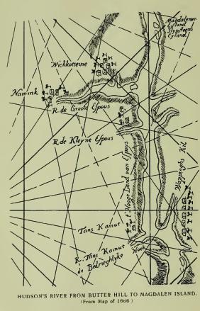
Ossangwak is written on Pownal's map as the name of what is known as the Great Binnenwater (Dutch, "Inland water") in the town of Lloyd. The orthography disguises the original, which may have been a pronunciation of Achsün (Minsi), "Stone," as in Otstónwakin, read by Reichel, "A high rock," or rocky hill. Perhaps the name referred to the rocky bluff which bounds the Hudson there, immediately west of which the lake is situated.
Esopus—so written on Carte Figurative of 1614-16, and also by De Laet in 1624-5; Sopus, contemporaneously; Sypous, Rev. Megapolensis, 1657, is from Sepuus (Natick), "A brook"; in Delaware, Sipoes (Zeisberger). It is from Sepu, "River," and -es, "small." On the Carte Figurative it is written on the east side of the river near a stream north of Wappingers' Creek, as it may have been legitimately, but in 1623 it came to be located permanently at what is now Rondout Creek, from which it was extended to several streams, [FN] to the Dutch settlement now Kingston, to the resident Indians, and to a large district of country. The chirographer of 1614-16 seems to have added the initial E from the uncertain sound of the initial S, and later scribes further corrupted it to the Greek and Latin Æ. (See Waronawanka.)
[FN] The streams entering the Hudson in proximity came to be known as the Kleine Esopus, south of Rondout; the Groot Esopus, now the Rondout, and the Esopus, now the Saugerties. In the valley west of old Kingston was a brook, called in records the "Mill Stream."
Waronawanka, Carte Figurative 1614-16—Warrawannan-koncks, Wassenaer, 1621-5; Warranawankongs, De Laet, 1621-5, and Waranawankcougys, 1633; Waranawankongs, Van der Donck, 1656; Waerinnewongh, local, 1677—is located on the Carte Figurative on the west side of the Hudson a few miles north of latitude 42. On Van der Donck's map it is placed on the west side between Pollepel's Island and the Dans Kamer. De Laet wrote in his "New World" (Leyden edition): "This reach [Vischer's, covering Newburgh Bay] extends to another narrow pass, where, on the west side of the river, there is a point of land juts out covered with sand, opposite a bend in the river on which another nation of savages called the Waoranecks, have their abode at a place called Esopus. A little beyond, on the west side of the river, where there is a creek, and the river becomes more shallow, the Waranawankongs reside. Here are several small islands." In his French and Latin edition, 1633-40, the reading is: "A little beyond where projects a sandy point and the river becomes narrower, there is a place called Esopus, where the Waoranekys have their abode. To them succeed, after a short interval, the Waranawancougys, on the opposite side of the river." Read together there would seem to be no doubt that the Waoranecks were seated on or around the cove or bay at Low Point and the estuary of Wappingers' Creek, and that the Waranatwankongs were seated at and around the cove or bay at Kingston Point, "Where a creek comes in and the river becomes more shallow."
Of the meaning of the name Dr. A. S. Gatschet, of the Bureau of Ethnology, wrote me: "If the Warana-wan-ka lived on a bay or cove of Hudson's River, their name is certainly from Walina, which means 'hollowing, concave site,' and 'cove, bay,' in several eastern languages. A good parallel are the Wawenocks of S. W. Maine, now living at St. Francis, who call themselves Walinaki, or those living on a cove—'cove dwellers'—in referring to their old home on the Atlantic coast near Portland. In the Micmac (N. S.) dialect Walini is 'bay, cove,' and even the large Bay of Fundy is called so. The meaning of k or ka is not clear, but ong, in the later forms, is the locative 'at, on, upon.'"
It is safe to say that at either the Dans Kamer, Low Point, or Kingston Point, the clan would have been seated on a bay, cove, recess or indentation shaped like a bay, and it is also safe to say that Warona and Walina may be read as equivalents, the former in the local dialect, and the latter in the Eastern, and that its general meaning is "Concave, hollowing site." Zeisberger wrote l instead of r in the Minsi-Lenape, hence Woalac, "A hollow or excavation"; Walóh, "A cove"; Walpecat, "Very deep water." The dialectic r prevails pretty generally on the Hudson and on the Upper Delaware. On the latter, near Port Jervis, is met of record Warin-sags-kameck, which is surely the equivalent of Walina-ask-kameck, "A hollowing or concave site, a meadow or field." It was written by Arent Schuyler, the noted interpreter, as the name of a field which he described as "A meadow or vly." Vly is a contraction of Dutch Vallei, meaning "A hollow or depression in which water stands in the rainy season and is dry at other times," hence "hollowing." Ask (generic), meaning "Green, raw," is the radical of words meaning "meadow," "marsh," etc., and -kameck stands for an enclosed field, or place having definite boundaries as a hollow. Awan (-awan, -wan, -uan, etc.), as Dr. Gatschet probably read the orthography, is an impersonal verb termination met on the Hudson in Matteawan, Kitchiwan, etc. Mr. Gerard writes that it was sometimes followed by the participial and subjunctive k. It may have been so written here, but it seems to be a form of the guttural aspirate gh, for which it is exchanged in many cases, here and in Kitchiwangh. In Connecticut on the Sound apparently the same name is met in Waranawankek, indicating that whoever wrote it on the Figurative of 1614-16 was familiar with the dialect of the coast Indians. As it stands the name is one of the oldest and most sonorous in the valley of Hudson's River.
Ponkhockie is the familiar form of the name of the point, cove or landing-place on the south side of Kingston Point. It is from Dutch Punthoekje, meaning, "Point of a small hook, or angle." The local interpretation, "Canoe harbor," is not in the name, except inferentially from the fact that the cove was a favorite landing place for canoes. [FN-1] After the erection of a stockaded redoubt there, the Dutch called the place Rondhout, meaning. "Standing timber," and the English followed with Redoubt, and extended the name to the creek, as of record in 1670. The present form is substantially a restoration of the early Dutch Rondhout. The stockade was erected by Director Stuyvesant, at the suggestion of the Amsterdam Chamber of the West India Company, about 1660. There were Dutch traders here certainly as early as 1622, and presumably as early as 1614, but no permanent settlement appears of record prior to 1652-3, nor is there evidence that there was a Rondhout here prior to 1657-8. Compare Stuyvesant's letter of September, 1657, and Kregier's Journal of the "Second Esopus War" (Col. Hist N. Y., xiii, 73, 314, also page 189), showing that the Rondhout was not completed until the fall and winter of 1660. De Vries wrote in 1639-40, referring to Kingston Point probably: "Some Indians live here and have some corn-lands, but the lands are poor and stony." When Stuyvesant visited the place, in 1658, he anchored his barge "opposite to the two little houses of the savages standing near the bank of the kil." (Col. Hist. N. Y., xiii, 82.) In the vicinity the war of 1658 had its initiative in an unwise attack by some settlers on a party of Indians who had been made crazy drunk on brandy furnished them by Captain Thomas Chambers. Two houses were burned belonging to settlers, and hostilities continued for eight or nine days. "At the tennis-court near the Strand," a company of eleven Dutch soldiers "allowed themselves to be taken prisoners," by the Indians, in 1659. It does not seem probable that the Dutch had a Tennis Court here at that early date, but the record so reads. [FN-2] The hook or cove, was the most desirable place for landing on the south side of the Point. It has since been the commercial centre of the town and city. Punthoekje is certainly not without interesting history.
[FN-1] In early times there were two principal landing places: One at Punthoekje and one north of the present steamboat landing, or Columbus Point as it is called. The Point is a low formation on the Hudson and was primarily divided from the main land by a marsh. It was literally "a concave, hollowing site." The marsh was later crossed by a corduroyed turnpike connecting with the old Strand Road, now Union Avenue. A ferry was established here in 1752 and is still operated under its original charter. The Point is now traversed by rail and trolley roads.
[FN-2] Perhaps an Indian Football Court, resembling a Tennis Court. A writer in 1609 says of the Virginia natives: "They use, beside, football play, which women and boys do much play at. They have their goals as ours, only they never fight and pull each other down." There was a famous Tennis Court (Dutch Kaatsbaan) in the town of Saugerties, which seems to have been there long before the Dutch settlement. The Tennis Court referred to in the text is said to have been near the site of the present City Hall in Kingston, but would that place be strictly "near the Strand"? "Strand" means "shore, beach." It was probably on the beach.
Atkarkarton, claimed by some local authorities as the Indian name of Kingston, comes down to us from Rev. Megapolensis, who wrote, in 1657: "About eighteen miles [Dutch] up the North River lies a place called by the Dutch Esopus or Sypous, by the Indians Atkarkarton. It is an exceedingly beautiful land." (Doc, Hist. N. Y., iii, 103.) The Reverend writer obviously quoted the name as of general application, although it would seem to have been that of a particular place. As stated in another connection, Esopus, Sypous, and Sopus were at first (1623) applied to a trading-post on the Hudson, from which it was extended inland as a general name and later became specific as that of the first palisaded Dutch village named Wildwijk, which was founded a year after Megapolensis wrote. At the date of his writing the territory called Sopus included the river front, the plateau on which Kingston stands, and the flats on the Esopus immediately west, particularly the flat known as the Groot Plat, and later (1662) as the Nieuw Dorp or New Village, [FN-1] as distinguished from Sopus or Wildwijk, or the Old Village, the specific site of which could not have been referred to. Of the site of the Old Village, Director Stuyvesant wrote in 1658: "The spot marked out for the settlement has a circumference of about two hundred and ten rods [FN-2] and is well adapted for defensive purposes. When necessity requires it, it can be surrounded by water on three sides, and it may be enlarged according to the convenience and requirements of the present and of future inhabitants." The palisaded enclosure was enlarged by Stuyvesant, in 1661, to over three times its original size. The precise spot was on the northwest corner of the plateau. It was separated from the low lands of the Esopus Valley by a ridge of moderate height extending on the north, east, and west, and had on the south "a swampish morass" which was required to be drained, in 1669, for the health of the town "and the improvement of so much ground." The Groot Plat in the Esopus Valley was a garden spot ready for the plough and was regarded as of size sufficient for "fifty bouweries" (farms). From the description quoted, and present conditions, it may be said with certainty that the site of the Old Village of Wildwijk was a knoll in an area of prairie and marsh. Neither of the village sites seem to have been occupied by the Indians except by temporary huts and corn-lands. The Wildwijk site was given to Director Stuyvesant by the Indians, in 1658, "to grease his feet with" after his "long journey" from Manhattan. Of the Groot Plat one-half was given by the Indians to Jacob Jansen Stoll in compensation for damages. A commission appointed at that time to examine the tract, and to ascertain what part of it the Indians wished to retain, reported that the Indians had "some plantations" there, "but of little value"; that it was "only a question of one or two pieces of cloth, then they would remove and surrender the whole piece." (Col. Hist. N. Y., xiii, 86, 89.) Instead of paying the Indians for the lands, however, the settlers commenced occupation, with the result that the Indians burned the New Village, June 7, 1663, attacked the Old Village, killed eighteen persons and carried away thirty captives, women and children. The war of 1663 followed, the results of which are accessible in several publications, but especially in Colonial History of New York, Vol. xiii. It is sufficient to say here that the Indians lost the lands in controversy and a much larger territory. Interpretation of the name can only be made conjecturally. William R. Gerard wrote me: "I think Atkarkarton simply disguises Atuk-ak-aten, meaning 'Deerhill,' from Atuk, 'Deer'; ak, plural, and aten, 'hill.' The r's in the name do not mean anything; they simply indicate that the a's which precede them were nasal." The Delaware word for "deer" is Achtuch. Dr. Schoolcraft wrote the tradition that the first deers were the hunters of men.
[FN-1] The land or place on the Esopus flat on which the New Village was founded, is now known as Old Hurley Village. It is repeatedly and specifically designated as "The Groot Plat"—"The large tract of land called the New Village"—"The burnt village called the Groot Plat." (Col. Hist. N. Y., xiii, 275, et. seq.) Hurley was given to it by Governor Lovelace in 1669, from his family, who were Barons Hurley of Ireland.
[FN-2] A Dutch rod is twelve feet, which would give this circumference at less than an English half mile. Schoonmaker writes in "History of Kingston": "The average length of the stockade was about thirteen hundred feet, and the width about twelve hundred feet." Substantially, it enclosed a square of about one-quarter of a mile.
Wildwijk, Dutch—Wiltwyck, modern—the name given by Governor Stuyvesant, in 1650, to the palisaded village which later became Kingston, and then and later called Sopus, is a composition of Dutch Wild, meaning "Wild, savage," and Wijk, "Retreat, refuge, quarter"; constructively, "A village, fort or refuge from the savages." The claim that the place was so called by Stuyvesant as an acknowledgment of the fact that the land was a gift from the Indians, is a figment. The English came in possession, in 1664, and, in 1669, [FN] changed the early name to Kingston. The Dutch recovered possession in 1673, and changed the name to Swanendale, and the English restored Kingston in 1674. (See Atkarkarton.)
[FN] "On this day (vizt 25th) the towne formerly called Sopez was named Kingston." Date Sept. 25th, 1669. (Col. Hist. N. Y., xiii, 435.)
Nanoseck, Manoseck, forms of the name of a small island in Rondout Creek, so "called by the Indians" says the record, may be from Natick Nohōōsik, "Pointed or tapering." The Dutch called it "Little Cupper's Island." Cupper, "One who applies a cupping glass." Another island in the same stream, was "called by the Indians Assinke," that is "Stony land" or place. (See Mattassink.) Another island was called by the Dutch Slypsten Eiland, that is, "Whetstone Island"; probably from the quality of the stone found on it. It lies in the Hudson next to Magdalen Island.
Wildmeet, an Indian "house" so called by the Dutch, means, in the Dutch language, "A place of meeting of savages." It was not a palisaded village. It was burned by the Dutch forces in the war of 1660, at which time, the narrative states, some sixty Indians had assembled at or were living in it. Its location, by the late John W. Hasbrouck, at the junction of the Vernoy and Rondout kills, is of doubtful correctness, as is also his statement that it was "The council-house of all the Esopus Indians." Its location was about two (Dutch) miles from Wildwyck, or about six or seven English miles. Judge Schoonmaker wrote: "Supposed to have been located in Marbletown."
Preumaker's Land, a tract described as "Lying upon Esopus Kil, within the bounds of Hurley," granted to Venike Rosen, April 1, 1686, was the place of residence of Preumaker, "The oldest and best" of the Esopus sachems, whose life was tragically ended by Dutch soldiers in the war of 1660. The location of his "house" is described as having been "At the second fall of Kit Davits Kil." [FN-1] A creek now bears the name of the sachem, who was a hero if he was a savage.
[FN] "Kit Davits' Kil" or the Rondout was so called from Christopher Davids, an Englishman, who was first at Fort Orange, and was an interpreter. He obtained, in 1656, a patent for about sixty-five acres, described as "Situate about a league (about three miles) inland from the North River in the Esopus, on the west side of the Great Kil, opposite to the land of Thomas Chambers, running west and northeast halfway to a small pond on the border of a valley which divides this parcel and the land of John de Hulter, deceased." Ensign Smith wrote: "I came with my men to the second valley on Kit Davietsen's River.. . . Further up in said valley I crossed the stream and found their house." (Col. Hist. N. Y., xiii.) Supposed to have been at LeFever's Falls in Rosendale. (Schoonmaker.)
Frudyachkamik, so written in treaty—deed of 1677 as the name of a place on the Hudson at the mouth of Esopus (now Saugerties) Creek, is written Tintiagquanneck in deed of 1767 (Cal. Land Papers, 454), and by the late John W. Hasbrouck, Tendeyachameck. The deed orthography of 1677 is certainly wrong as there is no sound of F in Algonquian. (See Kerhonksen.)
{TN} {Unable to locate interlinear references to the following two notes which appear on this page.}
[FN-1] Saugerties is probably a corruption of Dutch Zager's Kiltje, meaning in English, "Sawyer's little Kill." The original appears first of record in Kregier's Journal of the Second Esopus War (1663), "They were at Zager's Kiletje"; "To Sager's little Kill"; "To the Sager's Killetje." (Col. Hist. N. Y., xiii, 342, 344.) The first corruption of record also belongs to that period. It was by a Mohawk sachem who visited Esopus and at a conference converted Zager's Kiltje to Sagertjen. Some of the local Dutch followed with "de Zaagertje's." Other corruptions were numerous until the English brought in Saugerties. The original Zager, however, seems to have held legal place for many years. In 1683, in a survey of the Meals Patent, covering lands now included in Saugerties, it is written: "Being part of the land called Sagers," and in another, "Between Cattskill and Sager's Kill." It is also of record that a man known by the surname of Zager located on the stream prior to 1663, obtained a cession of the lands on the kill from Kaelcop, an Esopus sachem, and later disappeared without perfecting his title by patent. Zager is now converted to Sager, and in English to Sawyer. The claim that Zager had a sawmill at the mouth of the stream seems to rest entirely upon his presumed occupation from the meaning of his name. A sawmill here, in 1663, would seem to have been a useless venture. In 1750, ninety years later, one Burregan had a mill at the mouth of the kill. "Burregan" stands for Burhans.
[FN-2] "To Freudeyachkamik on the Groote River." (Col. Hist. N. Y., xiii, 505.) It was probably the peninsular now known as Flatbush, Glasco, etc., at the mouth of the creek. The orthographies of the name are uncertain. An island south of the mouth of the creek was called Qusieries. Three or four miles north is Wanton Island, the site of a traditionary battle between the Mohawks and the Katskill Indians. It is now the northeast boundmark of Ulster County. Neither of these islands could have been the boundmark of the lands granted by the Indians. Wanton seems to be from Wanquon (Wankon, Del.), "Heel"—resembling a human heel in shape—pertuberant. The letter t in the name is simply an exchange of the surd mutes k and l. Modern changes have destroyed the original appearance of the island.
Kerhonkson, now so written as the name of a stream of water and of a village in the town of Wawarsing, Ulster County, is of record in several forms—Kahanksen, Kahanghsen, Kahanksnix, Kahanckasink, etc. It takes interest from its connection with the history and location of what is known, in records of the Esopus Indian War of 1663, as the Old Fort as distinguished from the New Fort. In the treaty of peace with the Dutch in 1664, the fort is spoken of without name in connection with a district of country admitted by the Indians to have been "conquered by the sword," including the "two captured forts." In the subsequent treaty (1665) with Governor Nicolls the ceded district is described as "A certain parcel of land lying and being to the west or southwest of a certain creek or river called by the name of Kahanksen, and so up to the head thereof where the Old Fort was; and so with a direct line from thence through the woods and crosse the meadows to the Great Hill lying to the west or southwest, which Great Hill is to be the true west or southwest bounds, and the said creek called Kahanksen the north or northeast bounds of the said lands." In a treaty deed with Governor Andros twelve years later (April 27, 1677), the boundary lines "as they were to be thereafter," are described: "Beginning at the Rondouyt Kill, thence to a kill called Kahanksnix, thence north along the hills to a kill called Maggowasinghingh, thence to the Second Fall, easterly to Freudyachkamick on the Groot River, south to Rondouyt Kill." In other words the district conceded to have been "conquered by the sword" lay between the Esopus and the Rondout on the Hudson, and extended west to the stream called Kahanksen, thence north to a stream called Maggowasinghingh, thence north, etc. The only stream that has been certainly identified as the Maggowasinghingh is the Rondout, where it flows from the west to its junction with the Sandberg Kill, east of Honk Falls, and this identification certainly places Kahanksen south of that stream. And in this connection it may be stated that the conquered lands did not extend west of the Rondout. The Beekman and the Beake patents were held primarily by Indian deeds. After the conquest the Indians did not sell lands east of the boundary line, but did sell lands west of that line. The deed from Beekman to Lowe distinctly states that the lands conveyed were "within the bounds belonging to the Indians." As the lands on the west of the kill were not conquered and ceded to the Dutch, the Old Fort could not have been on that side of the stream. In reaching conclusions respect must be had to Indian laws, treaties, and boundary descriptions. In the records of the town of Rochester, of which town Wawarsing was a part, is the entry, under date of July 22, 1709, "Marynus van Aken desired the conveyance of about one hundred acres of land lying over against the land of Colonel Jacob Rutsen called Kahankasinck, known as Masseecs," that is the land asked for by Van Aken took the name of Masseecs from a swamp which the name means. Colonel Rutsen's land has not been located; he held several tracts at different times, and one especially on the west line of Marbletown known as Rosendale. Whatever its location it shows that its name of Kahankasinck was extended to it or from it from some general feature. Obviously from the ancient treaty and deed boundaries the site of the Old Fort has not been ascertained, nor has the Great Hill been located. Presumably both must be looked for on Shawongunk Mountain.
The fort, as described by Kregier in his "Journal of the Second Esopus War," was a palisaded village and the largest settlement of the Esopus Indians. He made no reference to a stream or to a ravine, but did note that he was obliged to pass over swamps, frequent kills, and "divers mountains" that were so steep that it was necessary to "haul the wagons and cannon up and down with ropes." His course was "mostly southwest" from Wildwijk, and the fort "about ten miles" (Dutch), or from thirty to thirty-five miles English. It was not so far southwest from Wildwijk (Kingston) as the New Fort by "about four hours," a time measure equal to nine or ten English miles. The Indians did not defend the fort; they abandoned it "two days before" the Dutch troops arrived. No particular description of it has been handed down. Under date of July 31, 1663, Kregier wrote: "In the morning at dawn of day set fire to the fort and all the houses, and while they were in full blaze marched out in good order." And so disappeared forever the historic Indian settlement, not even the name by which it was known certainly translatable in the absence of knowledge of the topography of its precise location. [FN]
[FN] The name has the appearance of derivation from Gahan (Del.), "Shallow, low water"'; spoken with the guttural aspirate -gks (Gahaks), and indefinite formative -an. As a generic it would be applicable to the headwaters of any small stream, or place of low water, and may be met in several places.
Magowasinghinck, so written in its earliest form in treaty deed of 1677 (Col. Hist. N. Y., xiii) as the name of an Indian family, and also as the name of a certain kill, or river—"Land lying on both sides of Rondout Kill, or river, and known by the name of Moggewarsinck," in survey for Henry Beekman, 1685—"Land on this side of Rondout Kill named Ragowasinck, from the limits of Frederick Hussay, to a kill that runs in the Ronduyt Kill, or where a large rock lies in the kill," grant to George Davis, 1677. The Beekman grant was on both sides of Rondout Creek west and immediately above Honk Falls, where a large rock lying in the kill was the boundmark to which the name referred and from which it was extended to the stream and place. The George Davis grant has not been located, and may never have been taken up. Beekman sold to Peter Lowe in 1708, and the survey of the latter, in 1722, described his boundary as running west from "the great fall called Heneck." In Mr. Lindsay's History of Ulster County it is said that the grant was half a mile wide on the southeast side of the stream and a mile wide on the northwest side. Hon. Th. E. Benedict writes me: "The Rondout is eminently a river of rocks. It rises on the east side of Peekamoose, Table, and Lone mountains, and west side of Hanover Mountain of the Catskills, and flows through chasms of giant rocks. All the way down there are notable rocks reared in midstream. The rock above Honk Falls is hogback shape, a hundred or more feet long. It lies entirely in the stream and divides it into two swift channels which join together just above the falls. Here, amid the roar, the swirl and dash of waters breaking through rocky barriers, with the rapids at the falls, the Great Rock was an object to be remembered as a boundmark."
Without knowledge of the locative of the name or of the facts of record concerning it, the late Dr. D. G. Brinton, replying to inquiry, wrote me: "I take Magow or Moggew-assing-ink to be from Macheu (Del.), 'It is great, large'; achsün, 'stone', and ink locative; literally 'at the place of the large stone'." The name does not describe the place where the rock lies. The Davis grant in terms other than the Indian name located one as lying "in the kill," and the other is described in the survey of the patent to Beekman: "Land situate, lying and being upon both sides of Rondout Kill or river, and known by the name of Moggewarsinck, beginning at a great rock stone in the middle of the river and opposite to a marked tree on the south side of the river, between two great rock stones, which is the bounds betwixt it and the purchase of Mr. William Fisher," etc.; both records confirm Dr. Brinton's interpretation. As a generic the name may, like Kahanksan, be found in several places, but the particularly certain place in the Beekman grant was at the falls called Honneck, now Honk.
Wawarasinke, so written by the surveyor as the name of a tract of land granted to Anna Beake and her children in 1685, has been retained as the name of a village situate in part on that tract, about four miles north of Ellenville. The precise location of the southern boundmark of the patent was on the west bank of the Rondout, south of the mouth of Wawarsing Creek, or Vernooy Kill as now called, which flows to the Rondout in a deep rocky channel, the southern bank forming a very steep, high hill or point. It is claimed that the Old Fort was on this hill, and that to and from it an Indian path led east across the Shawongunk Mountain to the New Fort and is still distinctly marked by the later travel of the pioneers. That there was an Indian path will not be questioned, nor will it be questioned that there may have been at least a modern Indian village on the hill, but the Old Fort was not there. At the point where the boundmark of the patent was placed the Rondout turns at nearly a right angle from an east and west course to nearly north, winding around a very considerable point or promontory. The orthography of the name is imperfect. By dialectic exchange of n and r, it may be read Wa-wa-nawás-ink, "At a place where the stream winds, bends, twists, or eddies around a point or promontory." This explanation is fully sustained by the topography. Hon. Th. E. Benedict writes me: "The Rondout at that point (the corner of the Anna Beake Patent) winds around at almost a right angle. At the bend is a deep pool with an eddying current, caused by a rock in the bank below the bend. The bend is caused by a point of high land. It is a promontory seventy-five feet high." The inquiry as to the meaning of the name need not be pursued further. The frequently quoted interpretation, "Blackbird's Nest," is puerile. (See Wawayanda.)
Honk, now so written as the name of the falls on Rondout Creek at Napanock, appears first in Rochester town records, in 1704, Hoonek, as the name of the stream. In the Lowe Patent (1722), the reading is: "Beginning by a Great Fall called Honeck." The Rochester record is probably correct in the designation of the name as that of the creek, indicating that the original was Hannek (Del.), meaning, "A rapid stream," or a stream flowing down descending slopes. As now written the name means nothing unless read from Dutch Honck, "Home, a standing post or place of beginning," but that could not have been the derivative for the name was in place before the falls became the boundmark. The familiar interpretation: "From Honck (Nar.), 'Goose'—'Wild-goose Falls,'" is worthless. The local word for Goose was Kaak. The falls descend two hundred feet, of which sixty is in a single cataract—primarily a wild, dashing water-fall.
Lackawack appears of record as the name of a stream in Sullivan County, otherwise known as the West Branch of Rondout Creek, and also as the name of the valley through which it passes. The valley passes into the town of Wawarsing, Ulster County, where the name is met in the Beekman and in the Lowe patents, with special application to the valley above Honk Falls, and is retained as the name of a modern village. In the Lowe Patent it is written Ragawack, the initials L and R exchanged; in the Hardenberg Patent it is Laughawake. The German missionary orthography is Lechauwak (Zeisb.), "Fork, division, separation," that which forks or divides, or comes together in the form of a fork; literally, "The Fork." Lechauwak, "Fork"; Lechau-hanne, "Fork of a river," from which Lackawanna; Lechau-wiechen, "Fork of a road," from which Lackawaxen—"abbreviated by the Germans to Lecha, and by the English to Lehigh." (Reichel.)
Napanoch, on the Rondout below Honk Falls, is probably the same word that is met in Nepeak, translated by Dr. Trumbull, "Water-land, or land overflowed by water." At or near Port Jervis, Napeneck, Napenack, etc. The adjectival is Nepé, Napé, "Water."
Wassahawassing, in the Lowe Patent and also in the deed to Lowe from Henry Beekman, is probably from Awossi-newás-ing (Del.), "At the point or promontory beyond," or on the other side of a certain place.
Mopochock—"A certain Great Kil called Mopochock," in patent to Joachim Staats, 1688, is said to have been the name of what is now known as Sandberg Kill, but was not, as that stream was in no way connected with the Staats Patent.
Naversing is entered on Pownal's map between Rosendale and Fountain creeks, in the old town of Rochester. The map location may not be correct. The name is from Newás-ing, (Del.), "At a point or promontory." The familiar form is Neversink.
Mattachonts, a modern orthography, preserves the name of a place in the town of Rochester, Ulster County, and not that of an Indian maiden as locally stated. The boundary description refers to a creek and to a swamp. The record orthographies are Magtigkenighonk and Maghkenighonk, in Calendar of Land Papers, and "Mattekah-onk Kill," local.
Amangag-arickan, given as the name of an Indian family in western Ulster (Col. Hist. N. Y., xiii, 505), is probably from Amangak, "Large," with the related meaning of terrible, and Anakakan, "Rushes," or sharp rushes. Amangak is from Amangi, "Big, large, powerful, dire," etc., and -ak, animate plural.
Ochmoachk-ing, an unlocated place, is described as "Above the village called Mombackus, extending from the north bound of the land of Anna Beake southerly on both sides of the creek or river to a certain place called Ochmoachking." (Patent to Staats, 1688.)
Shokan, the name of a village on Esopus Creek, in the town of Olive, has been interpreted as a pronunciation of Schokkan (Dutch), "To jolt, to shake," etc., by metonymie, "A rough country." The district is mountainous and a considerable portion of it is too rough for successful cultivation, but no Hollander ever used the word Schokken to describe rough land. At or near the village bearing the name a small creek flows from the west to the Esopus, indicating that Shokan is a corruption of Sohkan, "Outlet or mouth of a stream." Sohk is an eastern form and an is an indefinite or diminutive formative. Heckewelder wrote in the Delaware, Saucon, "The outlet of a small stream into a larger one." Ashokan is a pronunciation. The same name is met at the mouth of the East or Paghatagan Branch of the Delaware. Shokan Point is an elevation rising 3100 feet.
Koxing Kil, a stream so called in Rosendale, is of record Cocksing and Cucksink—"A piece of land; it lyeth almost behind Marbletown." It is not the name of the stream but of a place that was at or near some other place; probably from Koghksuhksing, "Near a high place." (See Coxackie.) On map of U. S. Geological Survey the name is given to the outlet of Minnewaska Lake, which lies in a basin of hills on Shawongunk Mountain, 1650 feet above sea level.
Shandaken, the name of a town in Ulster County, is not from any word meaning "Rapid water," as has been suggested, but is probably from Schindak, "Hemlock woods"—Schindak-ing, "At the hemlock woods," or place of hemlocks. The region has been noted for hemlocks from early times.
Mombackus, accepted as the name of a place in the present town of Rochester, Ulster County, is first met in 1676, in application to three grants of land described as "At ye Esopus at ye Mumbackers, lying at ye Round Doubt River." In a grant to Tjerck Classen de Witt, in 1685, the orthography is Mombackhouse—"Lying upon both sides of the Mumbackehous Kill or brook." The stream is now known as Rochester Creek flowing from a small lake in the town of Olive. The late John W. Hasbrouck wrote, "Mombakkus is a Dutch term, literally meaning 'Silent head,' from Mom, 'silent,' and Bak or Bakkus, 'head.' It originated from the figure of a man's face cut in a sycamore tree which stood near the confluence of the Mombakkus and Rondout kills on the patent to Tjerck Classen de Witt, and was carved, tradition says, to commemorate a battle fought near the spot," that "for this information" he was "indebted to the late Dr. Westbrook, who said the stump of the tree yet stood in his youthful days." Although the evidence of the existence of a tree marked as described is not entirely positive, the fact that trees similarly marked were frequently met by Europeans in the ancient forests gives to its existence reasonable probability. In his treatment of the name Mr. Hasbrouck made several mistakes. "Place of death" is not in the word, and Dutch Mom or Mum does not mean "Silent"; it means "Mask," or covering, and Bak or Bakkes, does not mean "head," it is a cant term for "Face, chops, visage." Mombakkes is plainly a vulgar Dutch word for "Mask." It describes a grotesque face as seen on a Mascaron in architecture, or a rude painting. Usually trees marked in the manner described included other figures commemorative of the deeds of a warrior designed to be honored. Sometimes the paintings were drawn by a member of the clan or family to which the subject belonged, and sometimes by the hero himself, who was flattered by the expectation that his memory would thereby be preserved, or his importance or prowess impressed upon his associates, or on those of other clans, and perhaps handed down to later generations.
Wieskottine, located on Van der Donck's map (1656), north of Esopus Creek and apparently in the territory of the Catskill Indians, is a Dutch notation of Wishquot-attiny, meaning, literally, "Walnut Hill." A hill and trees are figured on the map. The dialect of the Catskill Indians was Mahican or Mohegan. It seems to have influenced very considerably the adjoining Lenape dialect. On a map of 1666, the orthography is Wichkotteine, and the location placed more immediately north of the stream. The settlement represented can be no other than that of the ancient Wildwijk, now Kingston. The name has disappeared of record, as has also Namink on the Groot Esopus.
Catskill, now so written, primarily Dutch Kat's Kil, presumably from Káterákts, or "Kil of the Katarakts," has come down from a very early date in Katskil. On Van der Donck's map of 1656 it is written Kats Kill, but he never wrote Kil with two l's. Older than Van der Donck's map it evidently was from the frequent reference to the "Kats Kil Indians" in Fort Orange records. Its origin is, of course, uncertain. Reasonably and presumably it was a colloquial form of Katerakts Kil—reasonably, because the falls on that stream would have naturally attracted the attention of the early Dutch navigators, as they have attracted the attention of many thousands of modern travelers. It was the absence of an authoritative explanation that led Judge Benson to inflict upon the innocent streams which now bear them the distinguishing names of Kat's and Kauter's, and to relate that as catamounts were probably very abundant in the mountains there and were naturally of the male and female species, the former called by the Dutch Kauter, or "He cat," and the latter Kat, "She cat," the streams were called by those names. His hypothesis is absurd, but is firmly believed by most of modern residents, who do not hesitate to write Kauter, "He cat," on their cards and on their steamboats, although it is no older than Judge Benson's application. He might have found a better basis for his conjecture in the fact that in 1650, on the north side of the Kat's Kil reigned in royal majesty, Nipapoa, a squaw sachem, while on the other side Machak-nimano, "The great man of his people," held sway; that, as they painted on their cabins a rude figure of a wolf, their totemic emblem, easily mistaken for a catamount, the name of "He cat" was given to one stream, and "She cat" to the other.
Katarakts Kil, as it is met of record—now Judge Benson's Kauter Kil—is formed by the outlets of two small lakes lying west of the well-known Mountain House. A little below the lakes the united streams leap over a ledge and fall 175 feet to a shelf of rock, and a few rod's below fall 85 feet to a ravine from which they find their way to the Kat's Kil. Beautiful are the falls and appropriate is the ancient name "The Kil of the Kataracts." Compare it, please, with Judge Benson's "He cat kil."
The Kat's Kil Indians have an interesting history. They are supposed to have been the "loving people" spoken of in Juet's Journal of Hudson's voyage in 1609. They were Mahicans and always friendly in their intercourse with the Dutch. In the wars with the Esopus Indians they took no part. Their hereditary enemies were the Mohawks who adjoined them on the west side of the mountains, their respective territories following the line of the watersheds. They came to be more or less mixed with fugitives from the eastern provinces, after the overthrow of King Philip. A palisaded village they had north of the Esopus, and fierce traditional battles with the Mohawks. They disappeared gradually by the sale of their lands, and gave place to the Rip van Winkles of modern history.
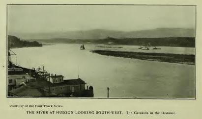
Quatawichnack and Katawichnack, record forms of the name given as that of a fall on Kauter's Kill, now so written, supposed to be the fall near the bridge on the road to High Falls, has been interpreted "Place of the greatest overflow," from the overflow of the stream which forms a marsh, which, however, the name describes as a "Moist, boggy meadow," or boggy land. (See Quatackuaohe.)
Mawignack, Mawichnack, Machawanick, Machwehenoc, forms of the name given as that of the meadow at the junction of the Kauter Kil and the Kat's Kil, locally interpreted, "Place where two streams meet," means, "At the fork of the river." (See Mawichnauk.)
Pasgatikook is another record name of the Katskill, varied in Pascakook and Pistakook. It is an orthography of Pishgachtigûk (Moh.), meaning, "Where the river divides, or branches." (See Schaghticoke.) In patent to John Bronck, 1705, the name is given to "A small piece of land called Pascak-ook, lying on the north side of Katskil creek." The locative is claimed by the village of Leeds.
Teteachkie, the name of a tract granted to Francis Salisbury and described as "A place lying upon Katskill Creek," has not been located. Teke, from Teke-ne, may stand for "Wood," and -achkie stand for land—a piece of woodland.
Quachanock, modern Quajack, the name of a place described as the west boundary of a tract sold to Jacob Lockerman, does not mean "Christian corn-lands," as locally interpreted, although the Indians may have called "the five great plains" the "Christian corn-land" after their occupation by the purchasers. The original word was probably Pahquioke, or Pohqu'un-auke (-ock), "Cleared, opened land," or land from which the trees and bushes had been removed to fit it for cultivation.
Wachachkeek, of record as the name of the first of "five great flats, with the woodland around them," which were included in the Catskill Patent of 35,000 acres, is otherwise written Machachkeek. It is described as "lying on both sides of Catskil Creek," and is claimed to be known as a place west of the village of Leeds. Dr. O'Callaghan interpreted the name from Wacheu, "hill," and -keag, "land" or place—"Hill country," and Dr. Trumbull gave the same meaning from Wadchuauke. The orthography of the second form, however, is probably the most correct—Machachkeek—which pretty surely, from the locative, stands for Maskekeck, meaning, "Marsh or wet meadow."
Wichquanachtekok, the name of the second flat, is no doubt an equivalent of Wequan-achten-ûk, "At the end of the hill," from Wequa, "the end"; -achtene, "hill" or mountain, and -ûk, locative.
Pachquyak, Pachquyak, Paquiage, etc., forms of the name of the third flat (Pachquayack, 1678), given also as the name of a flat "in the Great Imbocht," [FN] is the equivalent of Panqua-auke, Mass., "Clear land, open country." Brodhead wrote Paquiage as the name of the place on the west side of the Hudson to which the followers of King Philip retreated in 1675, but the name may have been that of any other open or unoccupied land west of the Hudson. (See Potik.)
[FN] Dutch Inbocht, "In the bend," "bay," etc. "Great" was added as an identification of the particular bend spoken off.
Paskaecq—"a certain piece of land at Katskill, on the north side of the kill, called by the Indians Paskaecq, lying under a hill to the west of it." Conveyed to Jan Bronk in 1674-5. The name describes a vale, cleft or valley. It is widely distributed. (See Paskack.)
Assiskowachok or Assiskowacheck, the name of record as that of the fourth flat, is no doubt from Assiskeu, "Mud"—Assiskew-aughk-ûk, "At (or on) a muddy place."
Potic, the name of the fifth flat, is also of record Potick, Potatik, and Potateuck, probably an equivalent of Powntuckûk (Mass.), denoting, "Country about the falls." (Trumbull.) From the flat the name was extended to a hill and to a creek in the town of Athens. Hubbard, in his "History of Indian Wars," assigns the same name to a place on the east side of Hudson's River. (See Pachquyak and Schaghticoke.)
Ganasnix and Ganasenix, given as the name of a creek constituting the southern boundary of the Lockerman Patent (1686), seems to be an orthography of Kaniskek, which see.
Waweiantepakook, Waweantepakoak, Wawantepekoak, are forms of a name given as that of "a high round hill" near Catskill. The description reads: "A place on the northeast side of a brook called Kiskatamenakook, on the west side of a hill called Waweantepakoak." (Land Papers, 242.) The location has not been ascertained. Antpéch (Antpek, Zeisb.), means "Head." In Mass. (Eliot), Puhkuk—Muppukuk, "A head." Wawei is a reduplicative of Wai or Way; it means, "Many windings around," or deviations from a direct line. The name is sufficiently explained by the description, "On the west side of a hill," or a hill-side, but descriptive of a hill resembling a head—"high, erect"—with the accessory meaning of superiority. "Indian Head" is now applied to one of the peaks of the Catskills. The parts of the body were sometimes applied by the Indians to inanimate objects just as we apply them in English—head of a cove, leg of a table, etc. (See Wawayanda.)
Kiskatom, a village and a stream of water so called in Greene County, appears in two forms in original records, Kiskatammeeche and Kiskatamenakoak. The abbreviated form, Kiskatom, appears in 1708, more particularly describing "A certain tract by a place called Kiskatammeeche, beginning at a turn of Catrick's Kill ten chains below where Kiskatammeeche Kill watereth into Catrick's Kill," and "Under the great mountain called Kiskatameck." Dr. Trumbull wrote: "Kiskato-minak-auke, 'Place of thin-shelled nuts,' or shag-bark hickory nuts." He explained: "Shag-bark hickory nuts, 'nuts to be cracked by the teeth,' are the 'Kiskatominies' and 'Kisky Thomas nuts' of the descendants of the Dutch colonists of New Jersey and New York." (Comp. Ind. Geographical Names.)
Kaniskek, or Caniskek, of record as the name of Athens, is described in original deeds: "A certain tract of land on the west side of North River opposite Claverack, called Caniskek, which stretches along the river from the lands of Peter Bronck down to the valley lying near the point of the main land behind the Barren Island, called Mackawameck," now known as Black Rock, at the south part of Athens. The description covers the long marshy flat in front of Athens, or between Athens and Hudson. The name seems to be from Quana (Quinnih, Eliot), "Long"; -ask, the radical of all names meaning grass, marsh, meadow, etc., and -ek, formative—literally, "Long marsh or meadow." The early settlement at Athens was called Loonenburgh, from one Jan van Loon, who located there in 1706. Esperanza succeeded this name and was followed by Athens. The particular place of first settlement is described as running "from the corner called Mackawameck west into the woodland to the Kattskill road or path, which land is called Loonenburgh." Athens is from the capital of the ancient Greek State of Attica.
Keessienwey's Hoeck, a place so called, [FN-1] has not been located. It is presumed to have been in the vicinity of Kaniskek and to have taken its name from the noted "chief or sachem" of the Katskill Indians called Keessienwey, Keesiewey, Kesewig, Keeseway, etc. On the east side of the river, south of Stockport, Kesieway's Kil is of record. Mr. Bernard Fernow, in his translation of the Dutch text wrote, "Keessienweyshoeck (Mallows Meadow Hook)," but no meadow of that character is of local record. Kessiewey was a peace chief, or resident ruler, whose office it was to negotiate treaties of peace for his own people, or for other clans when requested, and in this capacity, with associates, announced himself at Fort Orange, in 1660, as coming, "in the name of the Esopus sachems, to ask for peace" with them. [FN-2] He was engaged in similar work in negotiating the Esopus treaty of 1664; signed the deed for Kaniskek in 1665, and disappears of record after that date. In "History of Greene County," he is confused with Aepjen, a peace chief of the Mahicans, and in some records is classed as a Mahican, which he no doubt was tribally, but not the less "a Katskil Indian." Beyond his footprints of record, nothing is known of the noted diplomat. His name is probably from Keeche, "Chief, principal, greatest." Keechewae, "He is chief." (See Schodac.)
[FN-1] ". . . We have, therefore, gathered information from the Mahicanders, who thought we knew of it, that more than fifteen days ago some Esopus [Indians] had been at Keessienwey's Hoeck who wanted to come up [to Fort Orange], but had been prevented until this time, and in order to get at the truth of the matter, we have concluded to send for two or three sachems of the Katskil Indians, especially Macsachneminanau and Safpagood, also Keesienwey, to come hither." (Col. Hist. N. Y., xiii, 309.)
[FN-2] "May 24, 1660. To-day appeared [at Fort Orange] three Mahican chiefs, namely, Eskuvius, alias Aepjen (Little Ape), Aupaumut, and Keessienway, alias Teunis, who answered that they came in the name of the Esopus sachems to ask for peace."
Machawameck, the south boundmark of Kaniskek, was not the name of Barrent's Island, as stated in French's Gazetteer. It was the name of a noted fishing place, now known as Black Rock, in the south part of Athens. The prefix Macha, is the equivalent of Massa (Natick Mogge), meaning "Great," and -ameck is an equivalent of -ameek (-amuk, Del.), "Fishing-place." As the root, -am, means "To take by the mouth," the place would seem to have been noted for fish of the smaller sort. The Dutch called the place Vlugt Hoek, "Flying corner," it is so entered in deed. Qr. "Flying," fishing with a hook in the form of a fly.
Koghkehaeje, Kachhachinge, Coghsacky, now Coxsackie, a very early place name where it is still retained, was translated by Dr. Schoolcraft from Kuxakee (Chip.), "The place of the cut banks," and by Dr. O'Callaghan, "A corruption of Algonquin Kaakaki, from Kaak, 'goose,' and -aki, 'place.'" In his translation of the Journal of Jasper Dankers and Peter Sluyter, in which the name is written Koch-ackie (German notation; Dutch, Kok, "cook"), the late Hon. Henry C. Murphy wrote: "The true orthography is probably Koek's-rackie (the Cook's Little Reach), to distinguish it from the Koek's Reach below the Highlands, near New York." Unfortunately there is no evidence that there was a reach called the Cook's north of the Highlands, while it is certain that the name is Algonquian. Dankers and Sluyter gave no description of the place in 1679-80, but their notice of it indicates that it was familiar at that date. In 1718 it was given as the name of a bound-mark of a tract described as "having on the east the land called Vlackte and Coxsackie." (Cal. N. Y. Land Papers, 124.) Vlackte (Vlakte) is Dutch for "Plain or flat," and no doubt described the Great Nutten Hoek Flat which lies fronting Coxsackie Landing, and Coxackie described the clay bluff which skirts the river rising about one hundred feet. The bluff and flat bounded the tract on the east. From the locative the name may be translated from Mass. Koghksuhk-ohke, meaning "High land." The guttural ghks had the sound of Greek x, hence Kox or Cox.
Stighcook, a tract of land so called, now in Greene County, granted to Casparus Brunk and others in 1743, is located in patent as lying "to the westward of Koghsacky." In Indian deed to Edward Collins, in 1734, the description reads, "Westerly by the high woods known and called by the Indian name Sticktakook." Apparently from Mass. Mishuntugkook, "At a place of much wood." The district seems to have been famed for nut trees. It is noted on Van der Donck's map "Noten Hoeck," from which it was extended to Great Nutten Hook Island and Little Nutten Hook Island, on which there were nut trees. (See Wieskottine, Kiskatom, etc.)
Siesk-assin, a boundmark of the Coeymans Patent, is described as a point on the west side of the Hudson, "opposite the middle of the island called Sapanakock and by the Dutch called Barrent's Island." The suffix -assin, probably stands for Assin, "Stone," but the prefix is unintelligible. Sapanak-ock means, "Place of wild potatoes," or bulbous roots. (See Passapenoc.) Barrent's is from Barrent Coeymans, the founder of the village of Coeymans. The earlier Dutch name was Beerin Island, or "She-bear's Island," usually read Bear's Island.
Achquetuck is given as the name of the flat at Coeyman's Hollow. The suffix -tuck probably stands for "A tidal river or estuary," and Achque means "On this side," or before. The reference seems to have been to land before or on this side of the estuary, or the side toward the speaker.
Oniskethau, quoted as the name of Coeymans' Creek, is said to have been the name of a Sunk-squa, or sachem's wife. Authority not given. The stream descends in two falls at Coeymans' Village, covering seventy-five feet. The same name is met in Onisquathaw, now Niskata, of record as the name of a place in the town of New Scotland, Albany County.
Hahnakrois, or Haanakrois, the name of a small stream sometimes called Coeymans' Creek, which enters the Hudson in the northeast corner of Greene County, is Dutch corrupted. The original was Haan-Kraait, meaning "Cock-crowing" Kill, perhaps from the sound of the waterfall.
Sankagag, otherwise written Sanckhagag, is given, in deed to Van Rensselaer, 1630, as the name of a tract of land described as "Situated on the west side of the North River, stretching in length from a little above Beeren Island along the river upward to Smack's Island, and in width two days' journey inland." Beeren Island is about twelve miles south of Albany, and Smack's Island is near or at that city. The western limit of the tract included the Helderberg [FN] hills.
[FN] Helder (Dutch) means "Clear, bright, light, clearly, brightly," and Berg means "hill" or mountain. It was probably employed to express the appearance of the hills in the landscape. Some of the peaks of the range afford fine view of the valley of Hudson's River.
Nepestekoak, a tract of land described, "Beginning at the northernmost fall of water in a certain brook, called by the Indians Nepestekoak"; in another paper, Nepeesteegtock. The name was that of the place. It is now assigned to a pond in the town of Cairo, Greene County. (See Neweskeke.)
Neweskeke, -keek, about ten miles south of Albany, is described as "The corner of a neck of land having a fresh water river running to the east of it." In another paper the neck is located "near a pool of water called Nepeesteek," and "a brook called Napeesteegtock." The name of the brook and that of the pool is from Nepé, "Water," the first describing "Water at rest," a pool or lake, and the second a place adjoining extending to the stream. Neweskeke means "Promontory, point or corner," [FN]
[FN] This name appears to be a contraction of Newas-askeg, "Marshy promontory,' or a promontory or point near a marsh." (Gerard.)
Pachonahellick and Pachonakellick are record forms of the name of Long or Mahikander's Island, otherwise known historically as Castle Island. It is the first island south of Albany, and lies on the west side of the river, near the main land opposite the mouth of Norman's Kill. On some maps it is called Patroon's Island and Martin Garretson's Island. The first Dutch traders were permitted to occupy it, and they are said to have erected on it, in 1614, a fort or "castle," which they called Fort Nassau. In the spring of 1617 this fort was almost wholly destroyed by freshet. The traders then erected a fort on the west bank of the river, on the north side of Norman's Kill, which they called Fort Orange. This fort was succeeded, in 1623, by one on or near the present steamboat landing in Albany, to which the name was transferred and which was known as Fort Orange until the English obtained possession (1664), when the name was changed to Fort Albany, from which the present name of the capital of the State. [FN-1] In addition to the early history of the island the claim is made by Weise, in his "History of Albany," that it was occupied by French traders in 1540; that they erected a fort or castle thereon, which they were forced to leave by a freshet in the spring of 1542, and that they called the river, and also their trading post, "Norumbega." These facts are also stated in another connection. There is some evidence that French traders visited the river, and that they constructed a fort on Castle Island, but none that they called the river "Norumbega." (See Muhheak-unuk.) By the construction of an embankment and the filling of the passage between the island and the main land, the island has nearly disappeared. [FN-2]
[FN-1] Fort Albany was succeeded by a quadrangular fort called Fort Frederick, built by the English (1742-3) on what is now State Street, between St. Peter's Church and Geological Hall. It was demolished soon after the Revolution. Wassenaer wrote, under date of 1625: "Right opposite [Fort Orange] is the fort of the Maykans which they built against their enemies the Maquas" [Mohawks]. "Right opposite" means "directly opposite," i. e. directly opposite the present steamboat landing at Albany, presumably on the bluff at Greenbush.
[FN-2] The name seems to have been that of the mouth of Norman's Kill immediately west of the island, and to be from Sacona-hillak. "An out-pour of water," the mouth of the stream serving to locate the island. "Patroon's Island" and "Patroon's Creek" were local Dutch names. (See Norman's Kill.)
Norman's Kill, so well known locally, took that name from one Albert Andriessen, Brat de Noordman (the Northman), who leased the privilege and erected a mill for grinding corn, sometime about 1638. On Van Rensselaer's map of 1630 it is entered "Godyn's Kil and Water Val," a mill stream, not a cataract. Brat de Noordman's mill was in the town of Bethlehem, adjoining the city of Albany. The stream rises in Schenectady County and flows southeast about twenty-eight miles to the Hudson. The Mohawks called it Tawalsontha. In a petition for a grant of land near Schenectady, in 1713, is the entry, "By ye Indian name Tawalsontha, otherwise ye Norman's Kill"—"A creek called D'Wasontha" (1726)—from the generic Toowawsuntha (Gallatin), meaning, "The falls of a stream"; Twasenta (Bruyas), "Sault d'eau," applied by the French to rapids in a stream—a leaping, jumping, tumbling waterfall.
Aside from the names of the stream it has especial historic interest in connection with early Dutch settlement and the location of Fort Orange where Indians of all nations and tongues assembled for intercourse with the government. (See Pachonahellick.) Dr. Schoolcraft wrote, without any authority that I have been able to find, Tawasentha as the name of the mound on which Fort Orange was erected, with the meaning, "Place of the many dead," adding that the Mohawks had a village near and buried their dead on this hill; a pure fiction certainly in connection with the period to which he referred. The Mohawks never had a village here, nor owned a foot of land east of the Helderberg range. The Mahicans were the owners and occupants, but neither Mahicans or Mohawks would have permitted the Dutch to build a fort on their burial ground. Heckewelder wrote, in his "Indian Nations," "Gaaschtinick, since called by the name of Norman's Kill," and recited a Delaware tradition, with the coloring of truth, that that nation consented there, under advisement of the Dutch, to take the rank of women, i. e. a nation without authority to make war or sell lands. The tradition is worthless. The Dutch did make "covenants of friendship" here with several tribes as early as 1625 (Doc Hist. N. Y. iii, 51), but none of the character stated. All the tribes were treated as equals in trade and friendship. Whatever of special favor there was was with the Mahicans among whom they located. The first treaty, "offensive and defensive," which was made was by the English with the Five Nations in 1664-5. The Mahicans had then sold their lands and retired to the Housatenuk, and the Mohawks and their alliant nations had become the dominant power at Albany.
Nachtenak is quoted as the Mahican name of Waterford, or rather as the name of the point of land now occupied by that city, lying between the Mohawk and the Hudson. Probably the same as the following:
Mathahenaak, "being a part of a parcel of land called the foreland of the Half-Moon, and by the Indians Mathahenaack, being on the north of the fourth branch or fork of the Mohawk." Matha is an orthography of Macha (Stockbridge, Naukhu; Del. Lechau), with locative ûk, "At the fork"—now or otherwise known as Half-Moon Point, Waterford.
Quahemiscos is a record form of the name of what is now known as Long Island, near Waterford.
Monemius Island, otherwise Cohoes Island and Haver Island, just below Cohoes Falls, the site of Monemius's Castle, or residence of Monemius or Moenemines, a sachem of the Mahicans in 1630, so entered on Van Rensselaer's map. Haver is Dutch, "Oat straw." (See Haverstraw.)
Saratoga, now so written, was, primarily, the name of a specific place extended to a district of country lying on both sides of the Hudson, described, in a deed from the Indian owners to Cornelis van Dyk, Peter Schuyler, and others, July 26, 1683, as "A tract of land called Sarachtogoe" (by the Dutch), "or by the Maquas Ochseratongue or Ochsechrage, and by the Machicanders Amissohaendiek, situated to the north of Albany, beginning at the utmost limits of the land bought from the Indians by Goose Gerritse and Philip Pieterse Schuyler deceased, there being" (i. e. the bound-mark) "a kil called Tioneendehouwe, and reaching northward on both sides of the river to the end of the lands of Sarachtoge, bordering on a kil, on the east side of the river, called Dionandogeha and having the same length on the west side to opposite the kil (Tioneendehouwe), and reaching westward through the woods as far as the Indian proprietors will show, and the same distance through the woods on the east side." The boundary streams of this tract are now known as the Hoosick (Tioneendehowe), and the Batten Kill (Dionondehowe), as written on the map of the patent. The boundaries included, specifically, the section of the Hudson known as "The Still Water," [FN-1] noted from the earliest Dutch occupation as the Great Fishing Place and Beaver Country, two elements the most dear to the Indian heart and the most contributive to his support, inciting wars for possession. Specifically, too, the locative of the name, from the language of the deed and contemporary evidence, would seem to have been on the east side of the river—"the end of the lands of Sarachtoge, bordering on a kil on the east side of the river, called," etc., a place which Governor Dongan selected, in 1685, on which to settle the Mohawk Catholic converts, who had been induced to remove to Canada, as a condition of their return, and which he described as a tract of land "called Serachtogue, lying upon Hudson's River, about forty miles above Albany," and for the protection of which Fort Saratoga was erected in 1709; noted by Governor Cornbury in 1703, as "A place called Saractoga, which is the northernmost settlement we have"; topographically described, in later years, as "a broad interval on the east side of the river, south of Batten Kill," and as including the mouth of the kill and lake Cossayuna. (Col. Hist. N. Y.; Fitch's Survey; Kalm's Travels.) On the destruction of the fort, in the war of 1746, the settlement was removed to the opposite side of the river and the name went with it, but to which it had no legitimate title. (See Kayauderossa.)
Apparently the Mahican name, Amissohaendiek, is the oldest. It carries with it a history in connection with the wars between the Mohawks and the Mahicans. At the sale of the lands, the Mahicans who were present renounced claim to compensation "because in olden time the lands belonged to them, before the Maquas took it from them." [FN-2] (Col. Hist. N. Y., xiii, 537.) It is this section of Hudson's River that the only claim was ever made and conceded of Mohawk possession by conquest.
The Mohawk name, Ochseratongue or Ochsechrage, became, in the course of its transmission, Osarague and Saratoga, and in the latter form, without reference to its antecedents, was translated by the late Henry R. Schoolcraft "From Assarat, 'Sparkling water,' and Oga, 'place,' 'the place of the sparkling water,'" the reference being to the mineral springs, one of which. "High Rock," was, traditionally, known to the Indians, who, it is said, conveyed Sir William Johnson thither, in 1767, to test the medicinal virtues of the water; but, while the tradition may recite a fact the translation is worthless.
With a view to obtain a satisfactory explanation of the record names, the writer submitted them to the late eminent Iroquoian philologist, Horatio Hale, M. A., of Clinton, Ontario, Canada, and to the eminent Algonquian linguist, the late Dr. D. G. Brinton, of Philadelphia. In reply, Mr. Hale wrote: . . . "Your letter has proved very acceptable, as the facts you present have thrown light on an interesting question which has heretofore perplexed me. I have vainly sought to discover the origin and meaning of the name Saratoga. My late distinguished friend, L. H. Morgan, was, it seems, equally unsuccessful. In the appendix of local names added to his admirable 'League of the Iroquois,' Saratoga is given in the Indian form as Sharlatoga, with the addition, 'signification lost.' There can be no doubt that the word, as we have it, and indeed as Morgan heard it, is, as you suggest, much abbreviated and corrupted. One of the ancient forms, however, which you give from the old Dutch authorities, seems to put us at once on the right track. This form is Ochsechrage. The 'digraph' ch in this word evidently represents the hard guttural aspirate, common to both the Dutch and the German languages. This aspirate is of frequent occurrence in the Iroquois dialects, but it is not a radical element. As I have elsewhere said, it appears and disappears as capriciously as the common h in the speech of the south of England. In etymologies it may always be disregarded. Omitting it, we have the well-known word Oserage—in modern Iroquois orthography Oserake, meaning 'At the beaver-dam.' It is derived from osera, 'beaver-dam,' with the locative particle ge or ke affixed.
"In Iroquois r and l are interchangeable, and s frequently sounds like sh. Thus we can understand how in Cartier's orthography Oserake (pronounced with an aspirate) became Hochelaga, the well-known aboriginal name of what is now Montreal. That this name meant simply 'At the beaver-dam' is not questioned. It is rather curious, though not surprising, that two such noted Indian names as Saratoga and Hochelaga should have the same origin. In Ochseratongue the name is lengthened by an addition which is so evidently corrupted that I hesitate to explain it. I may say, however, that I suspect it to be a 'verbalized' form. It may possibly be derived from the verb atona, 'to become' (in its perfect tense atonk), added to osera, in which case the word would mean, 'where a beaver-dam has been forming,' or, as we should express it in English, 'where the beavers have been making a dam.'
"With regard to the Mahican name Amissohaendiek or Amissohaendick (whichever it is) I cannot say much, my knowledge of the Algonquin dialects not being sufficient to warrant me in venturing on etymologies. I remark, however, that 'beaver' in Mahican, as in several other Algonquin dialects, is Amisk or some variant of that word. This would apparently account for the first two syllables of the name. In Iroquois the word for 'beaver-dam' 'has no connection with the word 'beaver,' but it may be otherwise in Mahican." . . .
Dr. Brinton wrote:
. . . "I have little doubt but that the Mahican term is practically a translation of the Iroquois name. It certainly begins with the element Amik, Amisk or Amisque, 'Beaver,' and terminates with the locative ck or k. The intermediate portion I am not clear about. There is probably considerable garbling of the middle syllables, and this obscures their forms. In a general way, however, it means 'Place where beavers live,' or 'are found.'"
Father Le June wrote Amisc-ou, "Beaver," an equivalent of Amis-so in the text. Dr. Trumbull wrote: "Amisk, a generic name for beaver-kind, has been retained in the principal Algonquian dialects." The district was a part of Ochsaraga, "The beaver-hunting country of the Confederate Indians," conquered by them about 1624. The evolution from Ochsera-tongue (deed of 1683) appears in Serachtogue (Dongan, 1685); Serasteau (contemporary French); Saractoga (Cornbury, 1703); Saratoga (modern). The Ossarague, noted by Father Jogues, in 1646, as a famous fishing-place, is now assigned to Schuylerville.
Aside from its linguistic associations, the Batten Kill is an interesting stream. It has two falls, one of which, near the Hudson, is seventy-five feet and preserves in its modern name, Dionandoghe, its Mohawk name, Ti-oneenda-houwe, for the meaning of which see Hoosick.
[FN-1] "At a place called the Still Water, so named for that the water passeth so slowly as not to be discovered, yet at a little distance both above and below is disturbed and rageth as in a sea, occasioned by great rocks and great falls therein." (Col. Hist. N. Y., x, 194.)
[FN-2] The war in which the Mahicans lost and the Mohawks gained possession of the lands here occurred in 1627, as stated in Dutch records (Doc. Hist. N. Y., iii, 48), sustained by the deed to King George in 1701. (Doc. Hist. N. Y., i, 773.) There was no conquest on the Hudson south of Cohoes Falls.
Sacondaga, quoted as the name of the west branch of the Hudson, is not the name of the stream but of its mouth or outlet at Warrensburgh, Warren County. It is from Mohawk generic Swe'ken, the equivalent of Lenape Sacon (Zeisb.), meaning "Outlet," or "Mouth of a river," "Pouring out," and -daga, a softened form of -take, "At the," the composition meaning, literally, "At the outlet" or mouth of a river. (Hale.) Ti-osar-onda, met in connection with the stream, means "Branch" or "Tributory stream." (Hewitt.) The reference may have been to the stream as a branch of the Hudson, or to some other stream. The stream comes down from small lakes and streams in Lewis and Hamilton counties, and is the principal northwestern affluent of the Hudson.
Scharon, Scarron, Schroon, orthographies of the name now conferred on a lake and its outlet, and on a mountain range and a town in Essex County, is said to have been originally given to the lake by French officers in honor of the widow Scarron, the celebrated Madam Maintenon of the reign of Louis XVI. (Watson.) The present form, Schroon, is quite modern. On Sauthier's map the orthography is Scaron. The lake is about ten miles long and forms a reservoir of waters flowing from a number of lakes and springs in the Adirondacks. Its outlet unites with the Hudson on the east side at Warrensburgh, Warren County, and has been known for many years as the East Branch of Hudson's River. The Mohawk-Iroquoian name of the stream at one place is of record At-a-te'ton, from Ganawatecton (Bruyas), meaning "Rapid river," "Swift current." (J. B. N. Hewitt.) A little valley at the junction of the stream with the Hudson at Warrensburgh, dignified by the name of "Indian Pass," bears the record name of Teohoken, from Iroquois generic De-ya-oken, meaning "Where it forks," or "Where the stream forks or enters the Hudson." (J. B. N. Hewitt.) The little valley is described as "a picture of beauty and repose in strong contrast with the rugged hills around." (Lossing.)
Oi-o-gue, the name given by the Mohawks to Father Jogues in 1646, at Lake George, to what we now fondly call Hudson's River, is fully explained in another connection. The stream has its sources among the highest peaks of the Adirondacks, the most quoted springlet being that in what is known as "Adirondack or Indian Pass," a deep and rugged gorge between the steep slopes of Mt. Mclntyre and the cliffs of Wallface Mountain, in Essex County. The level of this gorge is 2,937 feet above tide. [FN-1] The highest lakelet-head sources, however, are noted in Verplanck Colvin's survey of the Adirondack region as Lake Moss and Lake Tear-of-the-clouds on Mount Marcy, [FN-2] the former having an elevation of 4,312 feet above sea-level and the latter 4,326 feet, "the loftiest water-mirror of the stars" in the State. The little streams descending from these lakes, gathering strength from other small lakes and springlets, flow rapidly into Warren County, where they receive the Sacondaga and Schroon. Between Warrensburgh and Glen's Falls the stream sweeps, in tortuous course with a wealth of rapids, eastward among the lofty hills of the Luzerne [FN-3] range of mountains, and at Glen's Falls descends about sixty feet, passing over a precipice, in cataract, in flood seasons, about nine hundred feet long, and then separates into three channels by rocks piled in confusion. In times of low water there is, on the south side of the gorge, a perpendicular descent of about forty feet. Below, the channels unite and in one deep stream flow on gently between the grained cliffs of fine black marble, which rises in some places from thirty to seventy feet. At the foot of the fall the current is divided by a small island which is said to bear on its flat rock surface a petrifaction having the appearance of a big snake, which may have been regarded by the Mohawks with awe as the personification of the spirit of evil, according to the Huron legend, "Onniare jotohatienn tiotkon, The demon takes the figure of a snake." (Bruyas.) Under the rock is a cave over which the serpent lies as a keeper, extending from one channel to the other and which, as well as the snake, comes down to us embalmed in Cooper's "Last of the Mohegans," though some visitors with clear heads have failed to discover the snake. In times of flood the cave is filled with water and all the dividing rocks below the fall are covered, presenting one vast foaming sheet.
At Sandy Hill the river-channel curves to the south and pursues a broken course to what are known as Baker's Falls, where the descent is between seventy and eighty feet—primarily nearly as picturesque as at Glen's Falls, untouched by Cooper's pen. The bend to the south at Sandy Hill is substantially the head of the valley of Hudson's River. Throughout the mountainous region above that point several Indian names are quoted by writers in obscure orthographies and very doubtful interpretations, the most tangible, aside from those which have been noticed, being that which is said to have been the name of Glen's Falls, but was actually the name of the very large district known as Kay-au-do-ros-sa. In Mohawk, Sandy Hill would probably be called Gea-di-go, "Beautiful plain," but it has no Indian name of record. The village stands upon a high sandy plain. It has its traditionary Indian story, of course; in this section of country it is easy to coin traditions of the wars of the Mohawks, the Hurons, and the Algonquians; they interest but do not harm any one.
[FN-1] This famous Pass is partly in the town of Newcomb and partly in the town of North Elba, Essex County. Wall-face, on the west side, is a perpendicular precipice 800 to 1,000 feet high, and Mt. Mclntyre rises over 3,000 feet. The gorge is seldom traversed, even adventurous tourists are repelled by its ruggedness.
[FN-2] By Colvin's survey Mount Marcy has an elevation of 5,344.411 feet "above mean-tide level in the Hudson." It is the highest mountain in the State. Put four Butter Hills on the top of each other and the elevation would be only a few hundred feet higher.
[FN-3] French, "Spanish Trefoil." "Having a three-lobed extremity or extremities, as a cross." Botanically, plants having three leaves, as white clover, etc. Topographically, a mountain having three points or extremities.
Kay-au-do-ros-sa (modern), Kancader-osseras, Kanicader-oseras (primary), the name given as that of a stream of water, of a district of country, and of a range of mountains, was originally the name of the stream now known as Fish Creek, [FN] the outlet of Saratoga Lake, and signifies, literally, "Where the lake mouths itself out." Horatio Hale wrote me: "Lake, in Iroquois, is, in the French missionary spelling, Kaniatare, the word being sounded as in Italian. Mouth is Osa, whence (writes the Rev. J. A. Cuoq in his Lexique de la langue Iroquois), Osara, mouth of a river, 'boudhe d'un fleure, embouchure d'une riviere.' This word combined would give either Kauicatarosa or Kaniatarossa, with the meaning of 'Lake mouth,' applicable to the mouth of a lake, or rather, according to the verbalizing habit of the language, 'the place where the lake disembogues,' literally, 'mouths itself out.'" To which J. B. N. Hewitt added the explanation, "Or flood-lands of the lake—the overflow of the lake."
[FN] "About Kayaderossres Creek and the lakes in that quarter." "The chief tract of hunting land we have left, called Kayaderossres, with a great quantity of land about it." (Doc. Hist. N. Y., ii, 110.) The stream drains an extensive district of country, flows into and becomes the outlet of Saratoga Lake, and is now known as Fish Creek and Fish Kill, a very cheap substitute for the expressive Mohawk term.
Adirondacks, or Ratirontaks, a name now improperly applied to the mountainous district of northern New York, is said to have been primarily bestowed by the Iroquois on a tribe occupying the left bank of the St. Lawrence above the present site of Quebec, who were called by the French Algonquins specifically, as representatives of a title which had come to be of general application to a group of tribes speaking radically the same language. [FN-1] The term is understood to mean, "They eat trees," i. e. people Who eat the bark of certain trees for food, presumably from the climatic difficulty in raising corn in the latitude in which they lived. [FN-2] Horatio Hale analyzed the name: "From Adi, 'they'; aronda, 'tree,' and ikeks, 'eat.'" The name was not that of the district, nor is it convertible with Algonquin. The later is a French rendering of Algoumquin, from A'goumak, "On the other side of the river," i. e. opposite their neighbors lower down. (Trumbull.) Schoolcraft gave substantially the same interpretation from the Chippewa, "Odis-qua-guma, 'People at the end of the waters,'" making its application specific to the Chippewas as the original Algonquins, instead of the Ottawas. The accepted interpretation, "Country of mountains and forests," is correct only in that that it is descriptive of the country. The record names of the district are Cough-sagh-raga and Canagariarchio, the former entered on Pownal's map with the addition "Or the beaver—hunting country of the Confederate Indians," and the latter entered in the deed from the Five Nations to the King in 1701. (Col, Hist. N. Y., iv, 909.) Cough-sagh-raga is now written Koghsarage (Elliot) and Kohserake (modern), and signifies "Winter" or "Winter land"; but the older name, Cana-gariarc-hio, means, "The beaver-hunting country." [FN-3] It is not expected that this explanation will affect the continuance, by conference, of Adirondacks as the name of the district; but it may lead to the replanting of the much more expressive Iroquoian title, Kohsarake, on some hill-top in the ancient wilderness.
[FN] The specific tribe called Algonquins by the French, were seated, in 1738, near Montreal, and described as a remnant of "A nation the most warlike, the most polished, and the most attached to the French." Their armorial bearing, or totem, was an evergreen oak. (Doc. Hist. N. Y., i, 16.) It is claimed that they were principally Ottawas, residing on the Ottawa River. (Schoolcraft.) The primary location of the language is only measurably involved in the first application of the name, the honor being claimed for the Chippewa, the Cree, and the Lenni-Lenape. The Eastern Algonquins substituted for the Iroquois Adirondacks, Mihtukméchaick (Williams) with the same meaning.
[FN-2] The bark of the chestnut, the walnut, and of other trees was dried, macerated, and rolled in the fat of bears or other animals, and probably formed a palatable and a healthful diet. Presumably the eating of the bark of trees was not confined to a particular tribe.
[FN-3] "Coughsaghrage, or the Beaver-Hunting Country of the Confederate Indians. The Confederates, called by the French Iroquois, surrendered this country to the English at Albany, on the 19th day of July, 1701; and their action was confirmed the 14th of September, 1724. It belongs to New York, and is full of Swamps, Lakes, Rivers, Drowned Lands; a Long Chain of Snowy Mountains which are seen. Lake Champlain runs thro' the whole tract. North and South. This country is not only uninhabited, but even unknown except towards the South where several grants have been made since the Peace."
So wrote Governor Pownal on his map of 1775. There is no question that Coughsaghraga means "Winter." It may also mean "At the Beaver-dam," or "In the country of Beaver-dams." Kohseraka may be a form of Hochelaga or Ochseraga. Osera means "Beaver-dam" as well as "Winter," wrote Horatio Hale. (See Saratoga.) In explanation of Canagariachio Mr. Hale wrote: "Kanagariarchio is a slightly corrupted form of the Iroquois word Kanna'kari-kario, which means simply 'Beaver.' It is a descriptive term compounded of Kannagare, 'Stick' or club, Kakarien, To bite,' and Kario, 'Wild animal.' It is not the most common Iroquois word for Beaver, which, in the Mohawk dialect is Tsionuito, or Djonuito. That the word should be understood to mean 'The Beaver-Hunting Country,' is in accordance with Indian usage."
Mohawk, the river so called—properly "the Mohawk's River," or river of the Mohawks—rises near the centre of the State and reaches the Hudson at Cohoes Falls. Its name preserves that by which the most eastern nation of the Iroquoian confederacy, the Six Nations, is generally known in history—the Maquaas of the early Dutch. The nation, however, did not give that name to the stream except in the sense of occupation as the seat of their possessions; to them it was the O-hyoⁿhi-yo'ge, "Large, chief or principal river" (Hewitt); written by Van Curler in 1635, Vyoge and Oyoghi, and by Bruyas "Ohioge, a la riviere," now written Ohio as the name of one of the rivers of the west, nor did they apply the word Mohawk to themselves; that title was conferred upon them by their Algonquian enemies, as explained by Roger Williams, who wrote in 1646, "Mohowaug-suck, or Mauquawog, from Moho, 'to eat,' the cannibals or men-eaters," the reference being to the custom of the nation in eating the bodies of enemies who might fall into its hands, a custom of which the Huron nations, of which it was a branch, seem to have been especially guilty. To themselves they gave the much more pleasant name Canniengas, from Kannia, "Flint," Which they adopted as their national emblem and delineated it in their official signatures, signifying, in that connection, "People of the Flint." When and why they adopted this national emblem is a matter of conjecture. Presumably it was generations prior to the incoming of Europeans and from the discovery of the fire-producing qualities of the flint, which was certainly known to them and to other Indian nations [FN-1] in pre-historic times. When the flint and steel were introduced to them they added the latter to their emblem, generally delineated it on all papers of national importance, and called it Kannien, "batte-feu," as written by Bruyas, a verbal form of Kannia, "a flint," or fire-stone, the verb describing a new method of "striking fire out of a flint," or a new instrument for striking fire, and a new emblem of their own superiority springing from their ancient emblem. The Delawares called them Sank-hikani, [FN-2] or "The fire-striking people," from Del. Sank or San, "stone" (from Assin), and -hikan, "an implement," obviously a flint-stone implement for striking fire, or, as interpreted by Heckewelder, "A fire-lock," and by Zeisberger, "A fire-steel."
The French called them Agnié and Agniérs, presumably derived from Canienga (Huron, Yanyenge). The Dutch called them Mahakuas, by contraction Maquaas, from Old Algonquian Magkwah (Stockbridge, Mquoh), Bear, "He devours, he eats." As a nation they were Bears, tearing, devouring, eating, enemies who fell into their hands. Bruyas wrote in the Huron dialect, "Okwari, ourse (that is Bear); Ganniagwari, grand ourse" (grand, glorious, superb, Bear), and in another connection, "It is the name of the Agniers," the characteristic type of the nation. They were divided in three ruling totemic tribes, the Tortoise (Anowara), the Bear (Ochquari), and the Wolf (Okwaho), and several sub-tribes, as the Beaver, the Elk, the Serpent, the Porcupine, and the Fox, as shown by deeds of record, of which the most frequently met is that of the Beaver. On Van der Donck's map of 1656, the names of four tribal castles are entered: Carenay, Ganagero, Schanatisse, and t' Jonnontego. In the recently recovered Journal of a trip to the Mohawk country, by Arent van Curler, in the winter of 1634-5, the names are Ouekagoncka, Ganagere, Sohanidisse, and Tenotoge or Tenotogehooge. In 1643, Father Isaac Jogues, in French notation, wrote the name of the first, Osseruehon, and that of the last, Te-ononte-ogen. Rev. Megapolensis, the Dutch minister at Fort Orange, wrote, in 1644, the name of the first Assarue, the second Banigiro, and the last Thenondiago. On a map republished in the Third Annual Report of the State Historian, copied from a map published in Holland in 1666, the first is called Caneray (Van der Donck's Carenay), and the second, Canagera. [FN-3] The several names refer in all cases to the same castles tribally, in some cases, apparently, by the name of a specific topographical feature near which the castles were located, and in some cases, apparently, by the name of the tribe. Cramoisy, in his Relation of 1645-6, referring to the visit of Father Jogues to the Mohawks, wrote: "They arrived at their first small village, called Oneugiouré, formerly Osserrion." (Relations, 29: 51), showing very clearly that those two names referred to one and the same castle. What Oneugiouré stands for certainly, cannot be stated, though it seems to read easily from Ohnaway (Cuoq), "Current, swift river," indicating that it may have referred to the long rapids. [FN-4] Chief W. H. Holmes, of the Bureau of Ethnology, wrote me: "According to our best expert authority, an Iroquoian, Onekagoncka signifies 'At the junction of the waters,' and Osserueñon, Osserrion, Assarue, etc., signifies 'At the beaver-dam.'" Accepting these interpretations, the particular place where the two names seem to come together is at the mouth of Aurie's Creek "where it falls into Mohawk's river." (See Oghracke.) As generic terms, however, they would be applicable at any place where the features were met and would only become specific here from other locative testimony, which we seem to have.
The first castle or town was that of the Tortoise tribe; the second, that of the Bear tribe; the third, that of the Beaver (probably), and the fourth, that of the Wolf tribe. On Van der Donck's map there are four, and Greenhalgh, in 1677, noted four. In a Schenectady paper of the same year the names of two sachems are subscribed who acted "for themselves" and as "the representatives of ye four Mohock's castles." The French invaded the valley in 1666, and burned all the castles of the early period, and the tribes retreated to the north side of river and established themselves, the first at Caughnawaga; the second about one and one-half miles west of the first; the third, west of the second, and the fourth beyond the third, in their ancient order as Greenhalgh found them in 1677. The French destroyed them again in 1693, [FN-5] and the tribes returned to and rebuilt on the south side of the river in proximity to their ancient seats. After the changes which had swept over the nation, three castles are noted in later records—the "Upper" at Canajohare, the "Lower" at the mouth of Schohare Creek, and the "Third" on the Schohare some sixteen miles inland.
While the early castles were known to the Dutch traders prior to 1635, and their locations marked, approximately, on their rude charts which formed the basis of Van der Donck's and other early maps, it was not until the recovery and publication in 1895, of Van Curler's Journal [FN-6]that much was known concerning them prior to 1642-44, when the Jesuit missionaries and the Dutch minister at Fort Orange, Rev. Megapolensis, went into the field. Van Curler's Journal, supplemented by the Relations of the Jesuit Fathers and Rev. Megapolensis's notes, enables us now to almost look in upon the early homes of the "barbarians," as they were called.
The Mohawks were the most important factor in the "Five [Six] Nations Confederacy," particularly from the standpoint of their proximity to and relations with the Dutch and the English governments, primarily in trade and later as alliants offensive and defensive under treaty of 1664 and more definitely under treaty of 1683. (Doc. Hist. N. Y., i, 576.) Their written history is graven in no uncertain colors on the valley which still bears their name, as well as on northeastern New York, marred though it may be by claims to pre-historical supremacy which cannot be maintained. When Van Curler visited them the nation was at peace, and the occupants of the towns and villages engaged in the duties of home life. He wrote that "Most of the people were out 'hunting for deer and bear"; that "the houses were full of corn and beans"; that he "saw maize—yes, in some of the houses more than three hundred bushels." He added that he was hospitably entertained, was fed on "pumpkins cooked and baked, roasted turkeys, venison and bear's meat," and altogether seems to have fared sumptuously. Rev. Megapolensis wrote of them, that though they were cruel to their enemies, they were very friendly to the Dutch. "We go with them into the woods; we meet with each other, sometimes at an hour's walk from any house, and think no more of it than if we met with Christians." The dark side of their character may be seen in a single quotation from Father Jogues's narrative, as related by Father Lalemant: "Happily for the Father the very time when he was entering the gates, a messenger arrived who brought news that a warrior and his comrades were returning victorious, bringing twenty Abanaqois prisoners. Behold them all joyful; they leave the poor Father; they burn, they flay, they roast, they eat those poor victims with public rejoicings." Gentle and affable in peace, with many evidences of a rude civilization, they were indeed "Demons in war."
Faithful in their labors among them were the Jesuit Fathers. They were men who were ready to suffer torture and death in the propagation of their faith, as several of them did. The conflict of those heroes of the Cross in the valley of the Mohawk, inaugurated by the capture and martyrdom of Father Jogues and his companion, Rene Goupil, in 1646, did not deter them; the wars of the nation with the French aided them. So successful were they that many of the nation were drawn off to Canada and became zealous partisans of the French and a scourge to English settlements, especially emphasized in the massacre at Schenectady in February, 1689-90. Those who remained true to the English became no longer "barbarians" in the full sense of that word, but "Praying Maquas." The subsequent story of the nation may be gleaned from the pages of history. At the close of the Revolution the integrity of the Six Nations had been effectually broken, and the castles of the Mohawks swept from the valley proper. The history, of the latter nation especially, needs to be studied, not in the wild glamour of fiction, but in the realm of fact, as that of an original people, native to the soil of the New World, clasping hands with the era of the origin of man; a people who, when they were first met, had borrowed nothing, absolutely nothing, from the civilizations or the languages of the Old World—the Ougwe-howe, the "real men" of the Mohawk Valley.
The locations of the castles or principal towns of the nation, as noted in Van Curler's Journal, has given rise to considerable discussion, particularly in regard to the location of the first of the series and its identity under the different names by which it was called. Van Curler was not an "ignorant Hollander wandering around in the woods," as one writer states; on the contrary, he was an educated man and one of the best equipped men then in the country for the trip he had undertaken, and instead of "wandering around in the woods," he was conducted by Mohawk guides. He wrote that he left Fort Orange in company with Jeronimus la Crock, William Thomasson, and five Mohawks as guides and bearers, "between nine and ten o'clock in the morning," December 12, 1634, and after walking "mostly northwest about eight miles" (Dutch), stopped "at half-past twelve in the evening" (p. m.) "at a little hunters' cabin near the stream that runs into their land, of the name of Vyoge." His hours' travel and his miles' travel to this point were either loosely stated in his manuscript or were misread by the translator. [FN-7] A Dutch mile is one and one-quarter hours' walk and the equivalent of three and one-half English miles and a fraction over. Van Curler no doubt estimated his miles by this standard and not as correct measurements of rough Indian paths. He certainly did not walk eight Dutch miles in three hours. Twenty-four English miles would have taken him to a point northwest of the later Schenectady stockade, which, in 1690, was counted as twenty-four English miles from Fort Orange by the road as then traveled. The "little hunters' cabin" at which he stopped and which he located "near the Vyoge," he explained in his notes of his second day's travel, as "one hour's walk" from the place where he crossed the stream, which would have taken him to a crossing place west of Schenectady, noted in a French Itinerary of 1757 as about one and one-quarter leagues west of the then fort at that settlement, and, presumably, by the canal survey of 1792, as at the first rift west of the beginning of deep water one and one-half miles (English) east of the rift referred to, from which point the survey gave the distance "to the deep water at or above the mouth of Schohare creek" as twenty-five miles. In going to, or from, the crossing-place he "passed Mohawk villages" where "the ice drifted fast," and gave his later travel as "mostly along the kill that ran swiftly," indicating very clearly that he passed along the rapids. Why he crossed the Mohawk when there was a path on the south side, is explained by Pearson's statement (Hist. Schenectady) that the path on the north side "was the best and most frequently traveled path to the Mohawk castles," and held that reputation for many years. It was a trunk line from the Hudson with many connecting paths. In considering his miles' travel the survey of 1792 may be safely referred to. [FN-8] His miles' travel, which he wrote as "eleven" (Dutch) he wrote on his return as "ten," which, counted as standard Dutch, would have been about thirty-five English miles; if counted by General John S. Clark's average of shrinkage, about thirty, which would have taken him from the hunters' cabin to a point two or three miles west of the mouth of Schohare Creek.
Referring particularly to his Journal: On the morning of the 13th, at three o'clock, he left the "little hunters' cabin" where he passed the night, spent one hour in walking to the crossing-place, crossed "in the dark," resumed his march on the north side "mostly along the aforesaid kill that ran swiftly," and after marching ten miles arrived, "at one o'clock in the evening" (p. m.) "at a little house half a mile" (Dutch) "from their First Castle." When he stopped he was so exhausted by the rough road that he could scarcely move his feet, and hence remained at the "little house" until the next morning, when he recrossed the Mohawk to the south side "on the ice which had frozen over the kill during the night," and "after going half-a-mile" (Dutch), or say one and one-half English, arrived "at their First Castle," which he found "built on a high mountain." It contained "thirty-six houses in rows like streets." The houses were "one hundred, ninety or eighty paces long," and were no doubt palisaded as he called the castle a "fort." The name of the castle, he wrote later, was Onekagoncka. The crossing was the only one which he made to the south side of the Mohawk in going west. Where, aside from a fair computation of his miles' travel, did he cross? Certainly he did not cross on the ice which had frozen over the rapids east of the mouth of Schohare Creek, for they were never known to freeze over in one night, if at all. Certainly he did not cross east of the rapids, for they extended three and one-half miles east of the mouth of the creek. Obviously, if he crossed Schohare Creek on the ice and "did not know it," as one writer suggests, he must have crossed it in going to the castle, which would surely locate the castle west of the stream. There is not the slightest notice of the stream in his Journal, nor is there any place for it in the harmony of his narrative. The tenable conclusion, from the comparison of his miles and from the natural facts, is that he crossed "on the ice" which had frozen over the deep water "at or above the mouth of Schohare Creek"; that his march took him to the vicinity of Aurie's Creek, or substantially to the castle which Father Jogues called Osseruenon, the site of which is now marked by the Society of Jesus with the Shrine, "Our Lady of Martyrs," whether that castle was east or west of Aurie's Creek, evidences of Indian occupation having been found on a hill on the west side of the creek as well as on a hill on the east side. [FN-9] These evidences, however, prove very little in determining the location of a particular castle three hundred years ago; they only become important when sustained by distances from given points or by natural features of record.
The locative conclusion stated above is more positively emphasized by counting Van Curler's miles' travel and his landmarks in going west from Onekagoncka, and by the natural features which he noted in his Journal. Leaving Onekagoncka, he wrote that he walked "half a mile" (Dutch) "on the ice" which had frozen over the kill, or say one and one-half English miles, and in that distance passed "a village of six houses of the name of Canowarode." It was near the river obviously. Walking on the ice "another half mile" (Dutch), he passed "a village of twelve houses named Senatsycrossy." After walking "another mile or mile and a half" on the ice, he passed "great stretches of flat lands" and came to a castle which he first called Medatshet, and later Canagere, which he denominated "The Second Castle." His distances traveling west "on the ice" were evidently more correctly computed than they were on his march on the rough path "along the kill that ran swiftly." His miles from Onekagoncka to Canagere are given as two and a half (Dutch) or about nine miles English. The actual distance is supposed to have been about eight. He found the castle "built on a hill without any palisades or any defence." He located it east of Canajohare Creek, a stream which has never lost its identity. When Van Curler visited the castle it contained "sixteen houses, fifty, sixty, seventy or eighty paces long."
Detained in this castle by a heavy fall of rain which broke up the streams—the "January thaw" of 1635 in the Mohawk Valley—Van Curler resumed his journey on the 20th, and "after marching a mile" (Dutch), came to Canajohare Creek which he was obliged to ford. After crossing and walking "half a mile" (Dutch), he came to what he called the "Third Castle of the name of Sohanidisse," later written by him Rohanadisse, and by Van der Donck Schanatisse, suggesting the name of the hill on which it stood, which Van Curler described as "very high." It contained "thirty-two houses like the others"; was not palisaded. The very high hill, and the flat lands which he referred to, remain.
On the 21st, before reaching the second stream which he noted later as having crossed, he wrote that "half a mile" west of Canajohare Creek he came to a village of "nine houses of the name of Osquage," which gave name to the stream now known as the Otsquage, which he also called Okquage and Okwahohage, "Wolves"—a village of the Wolf tribe. On the 23d he forded the Otsquage, and after going "half a mile" (Dutch) west of that stream, came "to a village named Cawaoge." It had fourteen houses and stood "on a very high hill." On his return trip he wrote the name Nawaoga; on old maps it is Canawadage, and has since 1635 been known as the Nowadage or Fort Plain Creek. He did not cross this stream, but after stopping at the village for a short time moved on "by land," presumably inland either north or south, and "going another mile" came to the "Fourth Castle," which he called Tenotoge and Tenotohage, and Father Jogues called Te-ouonte-ogén, and also "the furthest castle." It was no doubt the principal castle of the Wolf tribe, strongly palisaded to defend the western approach to the seat of the nation, as was Onekagoncka to guard the east. It was, he wrote, composed of fifty-five houses like the others. It stood in a valley evidently, probably on the bank of the creek, as he wrote that the stream (Otsquaga) which he had crossed in the morning "ran past" the castle; that he saw on the opposite (east) "bank" of the stream "a good many houses filled with corn and beans," and also extensive flat lands. Further than this topographical description the location of the castle cannot be determined. [FN-10] Van Curler's miles to the castle from Onekagonka, as nearly as can be counted from his Journal, were about six Dutch or about twenty-one English, or as General Clark counted Dutch miles, about eighteen English. As Van Curler traveled "on the ice" for the most considerable part of the way from Onekagoncka, and followed necessarily the bend in the river and diverged at times from the shore line, exact computation of his miles cannot be made. General Clark located the castle at Spraker's Basin, thirteen miles by rail west of Aurie's Creek. Van Curler located it on the west side of Otsquage Creek. On Simeon DeWitt's map of survey of patents in 1790 (Doc. Hist. N. Y., i, 420), the direct line from the west side of the mouth of Otsquage Creek to the west side of the mouth of Aurie's Creek is fifteen and three-tenths miles; following the bend in the Mohawk, as Van Curler did, it is seventeen and one-half miles. Granting that the lithographic reproduction of the map may vary from the original, it nevertheless shows conclusively that Onekagoncka must have been located at or near Aurie's Creek, The suggestion that it was located on a hill on the east side of Schohare Creek is untenable, as is also the suggestion that it was at Klein, eight miles east of Schohare Creek. There may have been villages at a later date at the places suggested, but never one of the ancient castles. Counted from the east or from the west there is no location that meets Van Curler's miles, or Father Jogues' "leagues," so certainly as does Aurie's Creek. (See Oghracke.)
In addition to the locations of the ancient castles, Van Curler's notes supply interesting evidence of the strength of the Mohawks when the Dutch first met them, which was then at its highest known point in number and in the number of their settlements, namely: Two hundred and twenty-five "long houses" in castles and villages, without including villages on the lower Mohawk "where the ice drifted fast," which he passed without particular note, and those in villages or settlements which he did not see. Two hundred and twenty-five houses were capable of holding and no doubt did hold a very large number of people, packed as they were packed. Father Pierron reported, in 1669, after the French invasion of 1666, that he visited every week "six large villages, covering seven and one-half leagues distance," around Caughnawaga where he was stationed. In almost constant wars with the French, and with the Hurons and other Indian tribes as allies of the French, their number had dwindled to an estimate of eighty warriors in 1735. The story of their greatness and of their decay is of the deepest interest. No student of American history can dispense with its perusal and be well-informed in the events of the pioneer era.
[FN-1] Arent Van Curler, in 1635, in his "Journal of a Visit to the Seneca Country," wrote: "I was shown a parcel of flint-stones with which they make a fire when in the forest. These stones would do very well for flint-lock guns."
Roger Williams wrote of the Narraganset Indians in 1643: "I have seen a native go into the woods with his hatchet, carrying a basket of corn with him, and stones to strike a fire." Father Le June wrote, in 1634: "They strike together two metallic stones, just as we do with a piece of flint and iron or steel. . . . That is how they light their fire." The "Metallic stones" spoken of are presumed, by some writers, to have been iron pyrites, as they may have been in some cases, but the national emblem was the flint.
[FN-2] "Sankhicani, the Mohawk's, from Sankhican, a gun-lock." (Heckewelder.) The name appears first on the Carte Figurative of 1614-16, in application to the Indians of northern New Jersey (Delawares), who were, by some writers, called "The Fire-workers." They seem to have manufactured stone implements by the application of fire. Presumably they were "Fire-strikers" as well as the Mohawks. Certainly they were not Mohawks. Were the Mohawks the discoverers of the fire-striking properties of the flint?
[FN-3] State Historian Hastings writes me: "The map of which you inquire, appeared originally in a pamphlet published at Middleburgh, Holland, at the Hague, 1666. It was first reproduced by the late Hon. Henry C. Murphy in his translation of the 'Vertoogh van Nieu Nederland,' etc. His reproduction gives Canagere, as the name of the second castle, and Caneray as the name of the first, precisely as they appear in order in our reproduction in our Third Report."
[FN-4] Oneongoure is a form of the name in Colonial History. In the standard translation of Jesuit Relations it is Oneugiouré. Oneon is a clerical error. The letters u and ou represent a sound produced by the Indian in the throat without motion of the lips. Bruyas wrote it 8{sic ȣ?}; it is now read w-Onew. Adding an a, we have very nearly M. Cuoq's Ohnawah, "current," "swift river"; with suffix gowa, "great," the reference being to the great rapids near which the castle was located. The omission of the locative participle shows that it was not "at" or "on" the great rapids.
[FN-5] "Their three castles destroyed and themselves dispersed." (Col. Hist. N. Y., iv, 20, 22.) The castles referred to Caughnawaga, Canagora, and Tiononteogen. A castle on the south side of the Mohawk, said to have been about two miles inland, escaped. Presumably it was the village of the Beaver family, but we have nothing further concerning it. The attack was made on the night of Feb. 16, 1693. The warriors of the first two castles were absent, and the few old men and the women made little resistance. At the third, the warriors fought bravely but unsuccessfully. The three castles were burned; that at Caughnawaga was given to the flames on the morning of February 20, 1693.
[FN-6] Journal of Arent van Curler, of a visit to the Seneca country, 1634-5 O. S., translated by General James Grant Wilson, printed in "The Independent," N. Y., Oct. 5, 1895. Republished by National Historical Society.
[FN-7] General Wilson wrote me that the Journal was translated for him by a Hollander, now (1905) dead, and that the manuscript had passed out of his hands. The question of hours and miles is not important here. On his return travel he gave the distance from the little hunters' cabin (which in the meantime had been burned), as "A long walk," which will not be disputed. It may be added that it is not justifiable to count his two days' travel as one, and count the two as thirty-two English miles from Fort Orange. The two days' travel are very distinct in the Journal.
[FN-8] Doc. Hist. N. Y., iii, 1087.
[FN-9] Father Jogues noted in his narrative a "torrent" which passed "At the foot of their village"—a brook or creek which was swollen by rains into a torrent, and from which, on the later recedence of the water, he recovered the remains of the body of his companion, Rene Goupil, who had been murdered and his body thrown into it, probably with the expectation that it would be carried down into the Mohawk, "At the foot of their village," or at the foot of the hill on which the village stood.
[FN-10] In the town of Minden, four miles south of Fort Plain, on a tongue of land formed by the Otsquaga Creek and one of its tributaries, are the remains of an ancient fortification, showing a curved line two hundred and forty feet in length, inclosing an area of about seven acres. The remains are, of course, claimed as belonging to the age of the mound-builders, but with equal probability are the remains of the ancient fort which Van Curler visited.
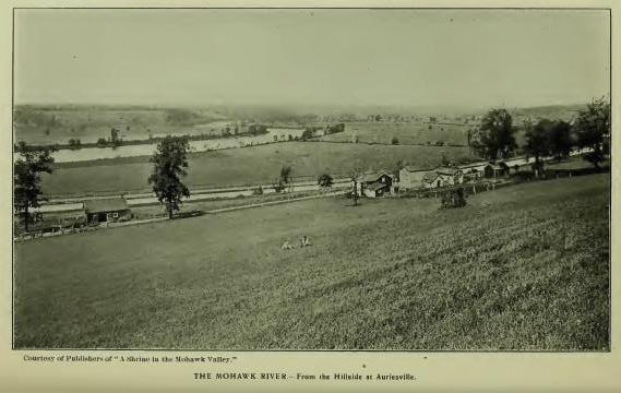
Kahoos, Kahoes, Cohoes, Co'os, forms of the familiar name of the falls of the Mohawk River at the junction of that stream with Hudson's River, has had several interpretations based on the presumption that it is from the Mohawk-Iroquoian dialect, but none that have been satisfactory to students of that dialect, nor any that have not been purely conjectural. One writer has read it: "From Kaho, a boat or ship," commemorative of Hudson's advent at Half-Moon Point in 1609. Beauchamp repeated from Morgan: "A shipwrecked canoe," and, in another connection: "From Kaho, a torrent." Another writer has read it: "Cahoes, 'the parting of the waters,' the reference being to the separation of the stream into three channels at its junction with the Hudson." The late Horatio Hale wrote me: "Morgan gives, as the Iroquois form of the name, Gä-hŏ-oose (in which ä represents the Italian a as in father), with the signification of 'ship-wrecked canoe.' This, I presume, is correct, though I cannot analize the word to my satisfaction." The obvious reason for this uncertainty is that the name is not Mohawk-Iroquoian, but an early Dutch orthography of the Algonquian generic Koowa, "Pine"; Koaaés, "Small pine," or "Small pine trees"; written with locative it, "Place of small pine trees"; now applied to a small island. On the Connecticut River this generic is met in Co'os and Co'hos. The "Upper Co-hos Interval" on that stream (Sauthier's map) [FN-1] was a tract of low small pine trees, between the hills and the river, corresponding with the topography at the falls on the Hudson. The Dutch termination -hoos, meaning in that language, "Water-spout," may have given rise to the interpretation "The Great Falls," but if so the reading was simply descriptive. The presumption that the name was Mohawk-Iroquoian was no doubt from the general impression that the falls were primarily in a Mohawk district, but the fact is precisely the reverse. The Hudson, on both sides, was held by Algonquian-Mahicans when the Dutch located at Albany, and for some years later, and the Dutch no doubt received the name from them, as they did others. What few Mohawk names are met in this district are of later introduction. It may be noted that there is no element in the name in any dialect which refers to falls. [FN-2] When the falls were first known they were regarded as the most wonderful in the world, and even as late as 1680 they were so called by visitors. In early days the stream poured a flood nine-hundred feet wide and eight feet deep over a rocky declivity of seventy-eight feet, of which forty feet was perpendicular, in addition to which are the rapids above and below. The roar of the falling waters, and in the breaking up and precipitation of ice, was very distinctly heard at Fort Orange, nine miles distant, and the hills on which Albany now stands trembled under the impact. Primarily the falls were much higher than they are now, the stream having cut its way through one hundred feet of rock which rises on either side in massive wall. Below the falls the water separates in four branches or "Sprouts," the northerly and the southerly one reaching the Hudson five miles apart, at Waterford and West Troy respectively.
[FN-1] "L. Intervale-Cowass or Kohas (Coas) meadows." (Pownal's Map.)
[FN-2] The name having been submitted to the Bureau of Ethnology for interpretation, the late Prof. J. W. Powell, Chief, wrote me, as the opinion of himself and his co-laborers: "The name is unquestionably from the Algonquian Koowa."
Wathoiack, of record as the name of "The Great Rift above Kahoes Falls" (Cal. Land Papers, 134, etc.) is also written Wathojax, D'Wathoiack, and DeWathojaaks, means, substantially, what it describes, a rift or rapid. The cis-locative De locates a place "On this side of the rapid," or the side toward the speaker. The flow of water is between walls of rock over a rocky bed, and the rapids extend for a distance of thirty-five or forty feet. (Ses Kahoes.)
Niskayune, now so written as the name of a town and of a village in Schenectady County, is from Kanistagionne, primarily located on the north side of the Mohawk, Canastagiowane (1667) being the oldest form of record. The locative description reads: "Lying at a place called Neastegaione, . . . known by the name of Kanistegaione." West of Schenectady the Mohawk is a succession of rapids. At or below Schenectady it makes a bend to the northeast in the form of a crescent, around which the water flows in a sluggish current. At the north point of the crescent was, and probably is a place called by the Dutch the Aal-plaat (Eel-place), marked on maps by a small stream from the north which still bears the name, and which formed the eastern boundmark of the Schenectady Patent. In Barber's collection it is stated that there was an Indian village here called Canastagaones, or "People of the Eel-place." Naturally there would be fishing villages in the vicinity. The location of the Aal-plaat is particularly identified in the Mohawk deed for five small islands lying at Kanastagiowne, in 1667, and by the abstract of title filed by one Evart van Ness in 1715. (Cal. Land Papers.) The name is from Keantsica, "Fish," of the larger kind, and -gionni, "Long"—tsi, "Very long"—constructively, "The Long-fish place," the Aal-plaat, or Eel-place, of the Dutch. The suggestion by Pearson (Hist. Schenectady) that the name "was properly that of the flat on the north side of the river," is untenable from the name itself. The reading by the late Dr. E. B. O'Callaghan: "From Oneasti, 'Maize,' and Couane, 'Great'—'Great maize field'"—is also erroneous. The generic name for the field or flat was Shenondohawah, compressed by the Dutch to Skonowa. In the vicinity of the Aal-plaat was the ancient crossing-place of the path from Fort Orange to the Mohawk castles, in early days regarded as the "Best" as it was the "Most traveled." The path continued north from the crossing as well as west to the castles.
Schenectady, now so written, is claimed by some authorities to be an Anglicism of a Mohawk-Iroquoian verbal primarily applied by them to Fort Orange (Albany), with the interpretations, "The place we arrive at by passing through the pine trees" (Bleecker); "Beyond the opening" (L. H. Morgan); "Beyond (or on the other side) of the door" (O'Callaghan), and by Horatio Hale: "The name means simply, 'beyond the pines.' from oneghta (or skaneghet), 'pine,' and adi or ati, a prepositional suffix (if such an expression may be allowed), meaning 'beyond,' or 'on the other side of.' The suffix is derived from skati, side. It was equally applicable to Albany or Schenectady, both being reached from the Mohawk castles by passing through openings in the pine forest." Mr. Hale's interpretation, from the standpoint of a Mohawk term, is exhaustive and no doubt correct, and the correctness of the preceding interpretations may be admitted from the combinations which may have been employed to determine the object of which askati was "one side," as in "Skannátati, de un coste du village," or the end of, as in "Skannhahati, a l'autre bout de la cabane" (Bruyas). The word does not appear to mean "beyond," but one side or one end of anything. Aside from a critical rendering, it would seem to be evident that all the interpretations are in error, not in the translation of the name as a Mohawk word-sentence, but in the assumption that Schenectady was primarily a Mohawk phrase, instead of a confusion of the Mohawk Skannatati with the original Dutch Schaenhecstede, the primary application of which is amply sustained by official record, while the Mohawk term is without standing in that connection, or later except as a corrupt Mohawk-Dutch [FN-1] substitution. The facts of primary application may be briefly stated. The deed from the Mohawk owners of the Schenectady flats, in 1661, reads: "A certain parcel of land called in Dutch the Groote Vlachte, lying behind Fort Orange, between the same and the Mohawk country called in Indian Skonowe." Skonowe is the equivalent of the Dutch "great flat," and nothing more. Its Mohawk equivalent is written on the section Shenondohawah, which the Dutch reduced to Skonowe. (See Shannondhoi.) Van der Donck wrote on his map (1656), in pure Dutch, Schoon Vlaack Land, or "Fine flat land." It was not continued in application to the Dutch settlement, the proprietors of which immediately (1661) gave to it the Dutch name Schaenechstede, "as the town came to be called." (Munsell's Annals of Albany, ii, 49, 52; Brodhead's Hist. N. Y., i, 691.) Under that name the tract was surveyed (1664), and it has remained apparent in the synthesis of the many corrupt forms in which it is of record. Schaenechstede is a clear orthographic pronunciation of the Dutch Schoonehetstede, signifying, literally, "The beautiful town." The syllable het is properly hek, "fence, rail, gate," etc., and in this connection indicates an enclosed or palisaded town. In 1680, Schaenschentendeel appears—a pronunciation of Schoonehettendal, "Beautiful valley," or the equivalent of the German Schooneseckthal, "Beautiful corner or turn of a valley." The German Labadists, Jasper Bankers and Peter Sluyter, made no mistake in their recognition of the name when they wrote Schoon-echten-deel in their Journal in 1679-80, describing the town as a square set off by palisades. [FN-2] Unfortunately for the Dutch name it was conferred and came into use during the period of the transition of the province from the Dutch to the English, with the probability of its conversion to Mohawk-Dutch, as already noted. Certain it is that the name is not met in any form until after its introduction by the Dutch, and is not of record in any connection except at Schenectady, the statement by Brodhead, on the authority of Schoolcraft, that it was applied in one form, by the Mohawks, to a place some two miles above Albany, as "the end of a portage path of the Mohawks coming from the west," being without anterior or subsequent record, though possibly traditional, and it may be added that it was never the name of Albany, nor is there record that there ever was a Mohawk village "on the site of the present city of Albany," nor anywhere near it. The Mohawks did go there to trade and on business with the government and occupied temporary encampments probably. The occupants primarily were Mahicans. The evolution of the name from the original Dutch to its present form may be readily traced in the channels through which it has passed. Even though clouded by traditional and theoretical rendering, the truth of history will ever rest in Schoonehetstede (Schaenechstede) and in the interpretation which it was designed to express by the intelligent men who conferred it. It is not expected that the correction will be adopted, now that the term has passed to the domain of a "proper name." With the aroma of assumed Mohawk origin and the negative "beyond" clinging to it, it will remain at least as a harmless fiction, although the honor due to a Dutch ancestry would seem to warrant a different result. By ancient measurements Schenectady is "about nine miles (English) above the falls called Cahoes" (1792).
[FN-1] A considerable number of the early settlers had Indian wives. (Dominie Megapolensis wrote: "The Dutch are continually running after the Mohawk women.") The children, growing up with Indian relatives, among the tribes and with men speaking so great a variety of tongues, built up a patois of their own, the "Mohawk-Dutch," many words in it defying the dictionaries of the schools. Many words are untranslatable save by the context. (Hist. Schenectady Patent, 388.)
[FN-2] Memoirs Long Island Hist. Soc, i, 315.
Shannondhoi and Shenondohawah are record forms of the name of a section of Saratoga County now embraced in Clifton Park, Half-Moon, etc. It is a sandy plain running west from the clay bluffs on the Hudson to the foot of the mountain, and extends across the Mohawk into Schenectady County. The name is generic Iroquois, signifying "Great plain," and as such was their name for Wyoming, Pa., where it is written Schahandoanah (Col. Hist. N. Y., vi, 48), and Skehandowana (Reichel). Scanandanani, Schenondehowe, Skenandoah, and Shanandoah, are among other forms met in application. Skonowe is followed on Van der Donck's map of 1656, by the Dutch legend Schoon Vlaack Land, literally, "Fine, flat land," and for all these years the name has been accepted as meaning, "Great meadow," or "Great plain." The late Horatio Hale wrote: "The name is readily accounted for by the word Kahenta (or Kahenda), meaning 'plain'—frequently abridged to Kenta (or Kenda)—with the nominal prefix S and the augmentative suffix owa (or owana)." "The great flat or plain in Pennsylvania was called, in the Minsi dialect, 'M'chewomink, at (or on) the great plain.' From this word we have the modern name Wyoming. The Iroquois word for this flat was Skahentowane, 'Great meadow (or plain),' a term which was applied also to extensive meadows in other localities and became corrupted to Shenandoah." (Gerard.)
Quaquarionu, of record, Calendar Land Papers, p. 6: "Bounds of a tract of land above Schenectady purchased of the Mohawk Indians, extending from Schenectady three miles westward, along both sides of the river, ending at Quaquarionu, where the last Mohawk castle stands." The deed of same date (1672) reads: "The lands lying near the town of Schenhectady within three Dutch miles in compass on both sides of the river westward, which ends at Kinaquariones, where the last battle was between the Mohawks and the North Indians." (Col. Hist. N. Y., xiii, 465.) Canaquarioeny is the orthography in another deed. In Pearson's History of Schenectady: "Lands lying near the town of Schonnhectade within three Dutch miles [about twelve English miles] on both sides of the river westward, which ends at Hinquariones [Towareoune], where the last battle was between the Mohoax and North Indians." The last battle in that section of country explains the text. Father Pierron, in 1669, located the battle "In a place that was precipitous, . . . about eight leagues [French] east of Gandauague" (Caughnawaga), or about sixteen miles English, and modern authorities have added, "A steep rocky hill on the north side of the Mohawk, just west of Hoffman's Ferry, now called Towareoune Hill, east of Chucktanunda Creek, a stream which is supposed to have taken its name from the overhanging rocks of the hill." [FN] Dr. Beauchamp, on the authority of Albert Cusick, an educated Tuscarorian, translated: "Kinaquarioune, 'She arrow-maker,' the name of a person who resided there." Rev. Isaac Bearfoot, an educated Onondagian, especially instructed in the Mohawk dialect, and an educator on the Canada Reservation, supplied to W. Max Reid of Amsterdam, N. Y., the reading: "Ki-na-qua-ri-one, 'He killed the Bear,' or, the place where the Bears die, or any place of death. It seems to have been used to denote the place of the last great battle with the Mahicans." The battle referred to occurred on the 18th of August, 1669. An account of it is given in Jesuit Relations, iii, 137, by Father Pierron, the Jesuit missionary, who was then stationed at Caughnawaga. The war which was then raging was continued until 1673, when the Governor of New York succeeded in negotiating peace and by treaty "linked together" the opposing nations as allies of the English government, a relation which they subsequently sustained until the war of the Revolution, when the Mahicans united with the revolutionists.
[FN] In a deed of 1685 is the entry: "Opposite a place called Jucktumunda, that is ye stone houses, being a hollow rock on ye river bank where ye Indians generally lie under when they travel."
Onekee-dsi-enos is of record in a deed of land purchased by one Abraham Cuyler of Albany, in 1714, "from the native owners of the land at Schohare, on the west side of Schohare creek, beginning on the north by a stone mountain called by the Indians Onekeedsienos." (Cal. N. Y. Land Papers, 110.) The name is probably an equivalent of Bruyas' Onueja-tsi-entos, a composition from Onne'ja, "Stone"; tsi or dsi, augmentative, "Very hard," such as stones used for making hatchets, axes, etc., and entos, plural inflection—"very hard stones," or "where there are hard stones." The location has been claimed for Flint Hill at Klein, Montgomery County, which, it is said, the name correctly describes. Positive identification, however, can only be made from the lines of the survey of Cuyler's purchase. It has also been claimed that the Mohawk castle called Onekagoncka by Van Curler in 1635, and the Osseruenon of 1642, was located at Klein, about eight miles east of Schohare Creek. This claim is based on what is certainly an erroneous computation of Van Curler's miles' travel, but particularly on the location on Van der Donck's map of Carenay directly north of a small lake now in the town of Duane, Schenectady County. Van der Donck's map locations are merely approximative, however, and of no other value than as showing that the places existed. On an ancient map reprinted by the War Department at Washington, the lake and the castle are both located east of Schenectady. The old maps are from traders' descriptions in general terms.
Onuntadass, Onuntasasha, etc., "six miles west from Schoharie between the mountains of Schoharie and the hill called by the Indians Onuntadass" (Cal. N. Y. Land Papers), describes a hill or mountain—Ononté—with adjective termination es or ese, meaning "long" or "high." Jonondese, "It is a high hill." The hill has not been located. The name could be applied to any long or high hill.
Schoharie, now so written as the name of a creek and of a county and town, would properly be written without the i. The stream came into notice particularly after 1693-4, when the Tortoise tribe retreated from Caughnawaga and located their principal town on the west side of the stream a short distance south of its junction with the Mohawk, taking with them their ancient title of "The First Mohawk Castle," and where its location became known by the name of Ti-onondar-aga and Ti-ononta-ogen; but later from the location on the creek about sixteen miles above its mouth of what was known in modern times as "The Third Mohawk Castle," more frequently called "The Schohare Castle," a mixed aggregation of Mohawks and Tuscaroras who had been converted by the Jesuit missionaries and persuaded to remove to Canada, but subsequently induced to return. "A few emigrants at Schohare," wrote Sir William Johnson in 1763. In the same district was also gathered a settlement of Mahicans and other Algonquian emigrants. From the elements which were gathered in both settlements came what were, long known as the Schohare Indians. The early record name of the creek, To-was-sho'hare, was rendered for me by Mr. J. B. N. Hewitt, of the Bureau of Ethnology, T-yoc-skoⁿ-hà-re, "An obstruction by drift wood." [FN] In Colonial History, "Skohere, the Bear," means that the chief so called was of the Bear tribe. He was otherwise known by the title, "He is the great wood-drift."
[FN] "Schoharie, according to Brant, is an Indian word signifying drift or flood-wood, the creek of that name running at the foot of a steep precipice for many miles, from which it collected great quantities of wood." (Spofford's Gazetteer.)
Ti-onondar-aga and Tiononta-ogen are forms of the name by which the "First Mohawk Castle" was located after the Tortoise tribe was driven by the French from Caughnawaga in 1693. The castle was located on the west side and near the mouth of Schohare Creek, as shown by a rough map in Doc. Hist. N. Y., iii, 902, and also by a French Itinerary in 1757, in the same work, Vol. i, 526. [FN-1] For the protection of the settlement, the government erected, in 1710, what was known as Fort Hunter, by which name the place is still known. The settlement was ruled over for a number of years by "Little Abraham," brother of the Great King Hendrick of the "Upper Mohawk Castle," at Canajohare. Its occupants were especially classed as "Praying Maquas," and had a chapel and a bell and a priest of the Church of England. In the war of the Revolution they professed to be neutral but came to be regarded by the settlers as being composed of spies and informers. So it came about that General Clinton sent out, in 1779, a detachment, captured all the inmates, and seized their stock and property. [FN-2] There were only four houses—very good frame buildings—then standing, and on the solicitation of settlers, who had been made houseless in the Brant and Johnson raids, they were given to them. It was the last Mohawk castle to disappear from the valley proper.
Ti-onondar-ága and Te-ononte-ógen are related terms but are not precisely of the same meaning. The first has the locative particle ke, or acu, as Zeisberger wrote it, and the second, ógen, means "A space between," or "between two mountains," an intervale, or valley, a very proper name for Schohare Valley. It is a generic composition and was also employed in connection with the "Upper (Third) Mohawk Castle" (1635-'66).
[FN-1] The settlement included "Some thirty cabins of Mohawk Indians" in 1757. as stated in the French Itinerary referred to, Rev. Gideon Hawley described it, in 1753, as on the southwest side of the creek "Not far from the place where it discharges its waters into Mohawk River." The place is still known as "Fort Hunter," although the fort and the Indian settlement disappeared years ago.
[FN-2] A detachment of one hundred men, sent out for that purpose, surprised the castle on the 29th of October, 1779, making prisoners of "Every Indian inmate." The houseless settlers took possession of the four houses and of all the stock, grain and furniture of the tribe. The tribe made claim for restitution on the ground of neutrality, which the settlers denied. They had come to hate the very name of Mohawk.
Kadarode, of record in 1693 as the name of a tract of land "Lying upon Trinderogues (Schohare) creek, on both sides, made over to John Petersen Mabie by Roode, the Indian, in his life time, [FN] principal sachem, by and with the consent of the rest of the Praying Indian Castle in the Mohawk country" (Land Papers, 61), is further referred to in grant of permission to Mabie, in 1715, to purchase additional land "known as Kadarode," on the east side of the creek, and also lands "adjoining" his lands on the west side of the stream. (Ib. 118.) By the DeWitt map of survey of 1790, Mabie's entire purchase extended east from the mouth of Aurie's Creek to a point on the east side of Schohare Creek, a distance of about four miles, the territory covering the presumed site of the early Mohawk castle called by different writers from names which they had heard spoken, Onekagoncka, Caneray, Osseruenon, and Oneugioure, now the site of the Shrine, "Our Lady of Martyrs." The Mohawk River, west of the long rapids, above and including the mouth of Schohare Creek, flows "in a broad, dark stream, with no apparent current," giving it the appearance of a lake—"a long stretch of still water in a river." The section was much favored by the Tortoise tribe, whose castle in 1635 and again in 1693-4 was seated upon it. The record name, Kadarode, has obviously lost some letters. Its locative suggests its derivation from Kanitare, "Lake," and -okte, "End, side, edge," etc. Van Curler wrote here, in 1635, Canowarode, the name of a village which he passed while walking on the ice which had frozen over the Mohawk; it was evidently on the side of the stream. Carenay or Kaneray, Van der Donck's name of the castle, may easily have been from Kanitare. The letters d and t are equivalent sounds in the Mohawk tongue. The aspirate k was frequently dropped by European scribes; it does not represent a radical element. The several record names which are met here is a point of interest to students.
[FN] Roode was living in 1683. An additional name was given to him in a Schenectady patent of that year, indicating that the name by which he was generally known was from his place of residence. He could easily have been a sachem in 1635.
Oghrackee, Orachkee, Oghrackie, orthographies of the record name of what is now known as Aurie's Creek, appear in connection with land patented to John Scott, 1722. In the survey of the patent by Cadwallader Colden, in the same year, the description reads: "On the south side of Mohawk's river, about two miles above Fort Hunter, . . . beginning at a certain brook called by the Indians Oghrackie, otherwise known as Arie's creek, where it falls into Maquas river." (N. Y. Land Papers, 164.) In other words the name was that of a place at the mouth of the brook. Near the brook at Auriesville, which takes its name from that of the stream, has been located the Shrine, "Our Lady of Martyrs," marking the presumed site of the Mohawk castle called by Father Jogues Osserueñon, in which he suffered martyrdom in 1646. [FN] The Indian name, Oghrackie, has no meaning as it stands; some part of it was probably lost by mishearing. The digraph gh is not a radical element in Mohawk speech; it is frequently dropped, as in Orachkee, one of the forms of the name here. Omitting it from Colden's Oghrackie, and inserting the particle se or sa, yields Osarake, "At the beaver dam," from Osara, "Beaver dam," and locative participle ke, "At." (Hale.) This interpretation is confirmed, substantially, by the Bureau of Ethnology in an interpretation of Osseruenon which Father Jogues gave as that of the castle. W. H. Holmes, Chief of the Bureau, wrote me, under date of March 8, 1906, as has been above stated, "The term Osserueñon (or Osserneñon, Asserua, Osserion, Osserrinon) appears to be from the Mohawk dialect of the Iroquoian stock of languages. It signifies, if its English dress gives any approximation to the sound of the original expression, 'At the beaver dam.'" This expert testimony has its value in the force which it gives to the conclusion that the castle in which Father Jogues suffered was at or near Aurie's Creek. The relation between Megapolensis' Assarue and Jogues's Osseru is readily seen by changing the initial A in the former to O.
Aurie's, the present name of the stream, otherwise written Arie's, is Dutch for Adrian or Adrianus (Latin) "Of or pertaining to the sea." It is suggestive of the name Adriochten, written by Van Curler as that of the ruling sachem of the castle which he visited and called Onekagoncka in 1635. The only tangible fact, however, is that the stream took its present name from Aurie, a ruling sachem who resided on or near it.
In this connection the several names by which the castle was called, viz: Onekagoncka, Carenay or Caneray, Osserueñon, Assarue, and Oneugiouré, may be again referred to. As already stated, the "best expert authority" of the Bureau of Ethnology reads Onekagoncka as signifying, "At the junction of the waters," and Osserueñon, in any of its forms, as signifying "At the beaver-dam." Possibly the names might be read differently by a less expert authority, but Oneka certainly means "Water," and Ossera means "Beaver-dam." Add the reading by the late Horatio Hale of Oghracke, "At the beaver-dam," and the locative chain is complete at the mouth of Aurie's Creek (Oghracke). Tribally, the names referred to one and the same castle, as has been noted, and the evidence seems to be clear that the location was the same. There is no evidence whatever that any other than one and the same place was occupied by the "first castle" between the years 1635 and 1667. It is not strictly correct to say that "castles were frequently removed." Villages that were not palisaded may have been frequently changed to new sites, but the evidence is that palisaded towns remained in one place for a number of years unless the tribe occupying was driven out by an enemy or by continued unhealthfulness, as the known history of all the old castles shows; nor were they ever removed to any considerable distance from their original sites.
Van Curler's description of the castle has been quoted. He did not say that it was palisaded, but he did call it a "fort," which means the same thing. Rev. Megapolensis wrote, in 1644: "These [the Tortoise tribe] have built a fort of palisades and call their castle Assarue." It was not an old castle when Van Curler visited it in 1635, or when Father Jogues was a prisoner in it in 1642, but in its then short existence it had had an incident in the wars between the Mohawks and the Mahicans of which there is no mention in our written histories. On his return trip Van Curler wrote that after leaving Onekagoncka and walking about "two miles," or about six English miles, his guide pointed to a high hill on which the immediately preceding castle of the tribe had stood and from which it had been driven by the Mahicans "nine years" previously, i. e. in 1627, when the war was raging between the Mohawks and the Mahicans of which Wassenaer wrote. It was obviously about that time that the tribe, retreating from its enemies, rallied west of Schohare Creek and founded the castle of which we are speaking, and there it remained until it was driven out by the French under De Tracey in 1666, when its occupants gathered together at Caughnawaga on the north side of the Mohawk, where they remained until 1693 when their castle was again destroyed by the French, and the tribe found a resting place on the west side of the mouth of Schohare Creek. The remarkable episode in the early history of the castle, the torture and murder of Father Jogues in 1646, is available in many publications. The location in Brodhead's and other histories of the castle in which he suffered as at Caughnawaga, is now known to be erroneous. Caughnawaga was not occupied by the tribal castle until over twenty years later.
[FN] The site of the Shrine was approved by the Society of Jesus mainly on examinations and measurements made by General John S. Clark, the locally eminent antiquarian of Auburn, N. Y., who gave the most conscientious attention to the work of investigation. The data supplied by Van Curler's Journal, which he did not have before him, may suggest corrections in some of his locations.
Senatsycrossy, written by Van Curler, in 1635, as the name of a Mohawk Village west of Canowarode, seems to have been in the vicinity of Fultonville, where tradition has always located one, but where General John S. Clark asserts that there never was one. It may not have remained at the place named for a number of years. Villages that were not palisaded were sometimes removed in a single night. Van Curler described it as a village of twelve houses. It was, presumably, the seat of a sub-tribe or gens of the Tortoise tribe. Its precise location is not important. A gens or sub-tribe was a family of the original stock more or less numerous from natural increase and intermarriages, and always springing from a single pair—the old, old story of Adam and Eve, the founders of the Hebrews. The sachem or first man of these gens was never a ruler of the tribe proper. They did sign deeds for possessions which were admitted to be their own, but never a treaty on the part of the nation.
Caughnawaga, probably the best known of the Mohawk castles of what may be called the middle era (1667-93), and the immediate successor of Onekagoncka of 1635, was located on the north side of the Mohawk, on the edge of a hill, near the river, half a mile west of the mouth of Cayuadutta Creek, in the present village of Fonda. The hill on which it was built is now known as Kaneagah, writes Mr. W. Max Read of Amsterdam. Its name appears first in French notation, in Jesuit Relations (1667), Gandaouagué. [FN] Contemporaneous Dutch scribes wrote it Kaghnawaga and Caughnawaga, and Greenhalgh, an English trader, who visited the castle in 1677, wrote it Cahaniaga, and described it as "about a bowshot from the river, doubly stockaded around, with four ports, and twenty-four houses." The most salient points in its history are in connection with its wars with the French and with the labors of the Jesuit missionaries, who, after the murder of Father Jogues and the destruction of the castle in which he suffered and the peace of 1667, were very successful, so much so that in 1671 the occupants of the castle erected in its public square a Cross, and a year later a very large number of the tribe under the lead of the famous warrior Krin, removed to Canada and became allies of the French. The members of the tribe who remained occupied the castle until the winter of 1693, when it was captured and burned by the French, and the tribe returned to the south side of the river and located on the flats on the west side of Schohare Creek, where they were especially known as "The Praying Maquaas," and where they remained until 1779, when they were dispersed by the Revolutionary forces under General Clinton. Caughnawaga is accepted as meaning "At the rapids," more correctly "At the rapid current." It is from the Huron radical Gannawa (Bruyas), for which M. Cuoq wrote in his Lexicon Ohnawagh, "Swift current," or very nearly the Dutch Kaghnawa; with locative particle -ge or -ga, "At the rapids." It is a generic term and is met of record in several places. As has been noted elsewhere, the rapids of the Mohawk extend at intervals fifteen in number from Schenectady to Little Falls, the longest being east of the mouth of Schohare Creek. The rapid or rift at Caughnawaga extends about half a mile.
[FN] The letters ou, in Gandaouaga and in other names, represents a sound produced by the Mohawks in the throat without motion of the lips. Bruyas wrote it 8. {sic ȣ?} It is now generally written w—Gandawaga.
Cayudutta, modern orthography; Caniadutta and Caniahdutta, 1752. "Beginning at a great rock, lying on the west side of a creek, called by the Indians Caniadutta." (Cal. Land Papers, 270.) The name was that of the rock, from which it was extended to the stream. It was probably a rock of the calciferous sandstone type containing garnets, quartz and flint, which are met in the vicinity. "The name is from Onenhia, or Onenya, 'stone,' and Kaniote, 'to be elevated,' or standing" (Hale). [FN] Dr. Beauchamp translated the name, "Stone standing out of the water." The meaning, however, seems to be simply, "Standing stone," or an elevated rock. Its location is stated in the patent description as "lying on the west side of the creek." The place is claimed for Fulton County. (See Caughnawaga.)
[FN] The same word is now written as the name of the Oneida nation. Van Curler's trip, in 1635, extended to the castle of the Oneidas, which he called' Enneyuttehage, "The standing-stone town." (Hale.)
Canagere, written by Van Curler, in 1635, as the name of the "Second Castle" or tribal town, was written Gandagiro by Father Jogues, in 1643; Banigiro by Rev. Megapolensis; Gandagora in Jesuit Relations in 1669, and Canagora by Greenhalgh in 1677. The several orthographies are claimed to stand for Canajohare, from the fact that the castle was "built on a high hill" east of Canajohare Creek. It was, however, the castle of the Bear tribe, the Ganniagwari, or Grand Bear of the nation, and carried its name with it to the north side of the Mohawk in 1667. Ganniagwari and Canajohare are easily confused. The creek called Canajohare gave a general locative name to a considerable district of country around it. It took the name from a pot-hole in a mass of limestone in its bed at the falls on the stream about one mile from its mouth. Bruyas wrote "Ganna-tsi-ohare, laver de chaudiere" (to wash the cauldron or large kettle). Rev. Samuel Kirkland, the noted missionary to the Oneidas, wrote the same word "Kanaohare, or Great Boiling Pot, as it is called by the Six Nations." (Dr. Dwight.) The letter j stands for tsi, augmentative, and the radical ohare means "To wash." (Bruyas.) The hole was obviously worn by a round stone or by pebbles, which, moved by the action of the current, literally washed the kettle. Van Curler described the castle as containing "sixteen houses, fifty, sixty, seventy, or eighty paces long, and one of five paces containing a bear," which he presumed was "to be fattened." No matter what may be said in regard to precise location, this castle was east of Canajohare Creek.
Sohanidisse, a castle so called by Van Curler, and denominated by him as the "Third Castle," is marked on Van der Donck's map Schanatisse. It is described by Van Curler as "on a very high hill," west of Canajohare Creek, was composed of thirty-two long houses, and was not enclosed by palisades. "Near this castle was plenty of flat land and the woods were full of oak trees." The "very high hill" west of Canajohare Creek and the flat lands remain to verify its position. It is supposed to have been the castle of the Beaver tribe—a sub-gens.
Osquage, Ohquage, Otsquage, etc., was written by Van Curler as the name of a village of nine houses situated east of what has been known since 1635 as Osquage or Otsquage Creek. The chief of the village was called "Oguoho, that is Wolf." Megapolensis wrote the same term Okwaho; Van Curler later wrote it Ohquage, and in vocabulary "Okwahohage, wolves," accessorily, "Place of wolves." From the form Osquage we no doubt have Otsquage or Okquage.
Cawaoge, a village so called by Van Curler, was described by him as on a "very high hill" west of Osquage. On his return trip he wrote the name Nawoga; on old maps it is Canawadoga, of which Cawaoge is a compression, apparently from Gannawake. For centuries the name has been preserved in Nowadaga as that of Fort Plain Creek.
Tenotoge and Tenotehage, Van Curler; t' Jonoutego, Van der Donck; Te-onont-ogeu, Jogues; Thenondigo, Megapolensis—called by Van Curler the "Fourth Castle" and known later as the castle of the Wolf tribe, and as the "Upper Mohawk Castle," was described by Van Curler as composed of fifty-five houses "surrounded by three rows of palisades." It stood in a valley evidently, as Van Curler wrote that the stream called the Osquaga "ran past this castle." On the opposite (east) side of the stream he saw "a good many houses filled with corn and beans," and extensive flat lands. It was undoubtedly strongly palisaded to defend the western door of the nation as was Onekagoncka on the east. Te-onont-ogen, which is probably the most correct form of the name, means "Between two mountains," an intervale or space between, from Te, "two"; -ononte, "mountain," and -ogen, "between." The same name is met later at the mouth of Schohare Creek. General John S. Clark located this castle at Spraker's Basin, thirteen miles (railroad) west of Auriesville and three miles east of Nowedaga Creek. The correctness of this location must be determined by the topographical features stated by Van Curler and not otherwise. General Clark did an excellent work in searching for the sites of ancient castles from remaining evidences of Indian occupation, but the remaining evidence of names and topographical features where they are met of record must govern. In this case the creek that "ran past the door of this castle," is an indisputable mark. The French destroyed the castle in October, 1666. In the account of the occurrence (Doc. Hist. N. Y., ii, 70) it is described as being surrounded by "A triple palisade, twenty feet in height and flanked by four bastions." The tribe did not defend their possession, only a few old persons remaining who were too feeble to follow the retreat of the warriors and kindred. The tribe rebuilt the castle on the north side of the Mohawk under the name of Onondagowa, "A Great Hill." The French destroyed it again in 1693, and the tribe returned to the south side of the river and located on the flat at the mouth of the Nowadaga or Fort Plain Creek, where the government built, in 1710, Fort Hendrick for its protection, and where it became known as the Upper or Canajohare Castle.
Aschalege, Oschalage, Otsgarege, etc., are record forms of the name given as that of the stream now known as Cobel's Kill, a branch of Schohare Creek in Schohare County. Morgan translated it from Askwa or Oskwa, a scaffolding or platform of any kind, and ge, locative, the combination yielding "At or on a bridge." Bruyas wrote Otserage, "A causeway," a way or road raised above the natural level of the ground, serving as a passage over wet or marshy grounds. Otsgarage is now applied to a noted cavern near the stream in the town of Cobel's Kill.
Oneyagine, "called by the Indians Oneyagine, and by the Christians Stone Kill," is the record name of a creek in Schohare County. J. B. N. Hewitt read it from Onehya (Onne'ja, Bruyas), "stone"; Oneyagine, "At the broken stone," from which transferred to the stream.
Kanendenra, "a hill called by the Indians Kanendenra, otherwise by the Christians Anthony's Nose"—"to a point on Mohawk River near a hill called by the Indians Kanandenra, and by the Christians Anthony's Nose"—"to a certain hill called Anthony's Nose, whose point comes into the said river"—"Kanendahhere, a hill on the south side of the Mohawk, by the Christians lately called Anthony's Nose"—now known as "The Noses" and applied to a range of hills that rises abruptly from the banks of the Mohawk just below Spraker's. The name is an abstract noun, possessing a specialized sense. The nose is the terminal peak of the Au Sable range. The rock formation is gneiss, covered by heavy masses of calciferous limestone containing garnets. "Anthony's Nose," probably so called from resemblance to Anthony's Nose on the Hudson.
Etagragon, now so written, the name of a boundmark on the Mohawk, is of record "Estaragoha, a certain rock." The locative is on the south side of the river about twenty-four miles above Schenectady. (Cal. N. Y. Land Papers, 121.) The name is an equivalent of Astenra-kowa, "A large rock." Modern Otsteara-kowa, Elliot.
Astenrogen, of record as the name of "the first carrying place," now Little Falls, is from Ostenra, "rock," and ogen, "divisionem" (Bruyas), literally, "Divided or separated rock." The east end of the gorge was the eastern boundmark of what is known as the "German Flats," which was purchased and settled by a part of the Palatine immigrants who had been located on the Livingston Patent in 1710. The patent to the Germans here was granted in 1723. The description in it reads: "Beginning at the first carrying place, being the easternmost bounds, called by the natives Astenrogen, running along on both sides of said river westerly unto Ganendagaren, or the upper end [i. e. of the flats, a fine alluvial plain on both sides of the river], [FN] being about twenty-four miles." (Cal. N. Y. Land Papers, 182.) The passage between the rocks, now Little Falls, covered a distance of "about three-quarters of a mile" and the rapids "the height of thirty-nine feet," according to the survey of 1792. The Mohawk here breaks through the Allegheny ridge which primarily divided the waters of the Ontario Basin from the Hudson. The overflow from the basin here formed a waterfall that probably rivaled Niagara and gradually wore away the rock. The channel of the stream was very deep and on the subsidence of the ice sheet, which spread over the northern part of the continent, became filled with drift. The opening in the ridge and the formation of the valley of the Mohawk as now known are studies in the work of creation. The settlements known as the German Flats were on both sides of the river. The one that was on the north side was burned by the French in the war of 1756-7. It was then composed of sixty houses. The one on the south side was known as Fort Kouari and later as Fort Herkimer. The district shared largely in the historic events in the Mohawk Valley during the Revolution. There are very few districts of country in the nation in which so many subjects for consideration are centered.
[FN] Ganendagraen is probably from Gahenta (Gahenda), "Prairie."
Keht-hanne, Heckewelder—Kittan, Zeisberger—"The principal or greatest stream," i. e. of the country through which it passes, was the generic name of the Delaware River, and Lenapewihittuck, "The river or stream of the Lenape," its specific name, more especially referring to the stream where its waters are affected by tidal currents. In the Minisink country it was known as Minisinks River, or "River of the Minisinks." At the Lehigh junction the main stream was called the East Branch and the Lehigh the West Branch (Sauthier's map), but above that point the main stream was known as the West Branch to its head in Utsyantha [FN-1] Lake, on the north-east line of Delaware County, N. Y., where it was known as the Mohawk's Branch. It forms the southwestern boundary of the State from nearly its head to Port Jervis, Orange County, Where it enters or becomes the western boundary of New Jersey. At Hancock, Delaware County, it receives the waters of what was called by the Indians the Paghkataghan, and by the English the East Branch. The West Branch was here known to the Indians as the Namaes-sipu and its equivalent Lamas-sépos, or "Fish River," by Europeans, Fish-Kill, "Because," says an affidavit of 1785, "There was great numbers of Maskunamack (that is Bass) and Guwam (that is Shad) [FN-2] went up that branch at Shokan, and but few or none went up the East [Paghkataghan] Branch." [FN-3] In the course of time the East or Paghkataghan [FN-4] Branch became known as the Papagonck from a place so called. The lower part of the stream was called by the Dutch the "Zuiden River," or South River. In early days the main or West Branch was navigable by flat-boats from Cochecton Falls to Philadelphia and Wilmington. Smith, in his "History of New Jersey," wrote: "From Cochecton to Trenton are fourteen considerable rifts, yet all passable in the long flat boats used in the navigation of these parts, some carrying 500 or 600 bushels of wheat." Meggeckesson (Col. Hist. N. Y., xii, 225) was the name of what are now known as Trenton Falls, or rapids. It means, briefly, "Strong water." Heckewelder's Maskek-it-ong and his interpretation of it, "Strong falls at," are wrong, the name which he quoted being that of a swamp in the vicinity of the falls, as noted in Col. Hist. N. Y., and as shown by the name itself.
The Delaware was the seat of the Lenni-Lenapé (a as a in father, é as a in mate—Lenahpa), or "Original people," or people born of the earth on which they lived, who were recognized, at the time of the discovery, as the head or "Grandfather" of the Algonquian nations. From their principal seat on the tide-waters of the Delaware, and their jurisdiction on that stream, they became known and are generally met in history as the Delawares. In tribal and sub-tribal organizations they extended over Pennsylvania, Delaware, Maryland, Virginia, New Jersey, and New York as far north as the Katskills, speaking dialects radically the same as that of the parent stock. [FN-5] They were composed of three primary totemic tribes, the Minsi or Wolf, the Unulachtigo or Turkey, and the Unami or Turtle, of whom the Turtle held the primacy. They were a milder and less barbaric people than the Iroquoian tribes, with whom they had little affinity and with whom they were almost constantly in conflict until they were broken up by the incoming tide of Europeans, the earliest and the succeeding waves of which fell upon their shores, and the later alliance of the English with their ancient enemies, the confederated Six Nations of New York, who, from their geographical position and greater strength from their remoteness from the demoralization of early European contact, offered the most substantial advantages for repelling the advances of the French in Canada. Ultimately conquered by the Six Nations, and made "Women," in their figurative language, i. e. a people without power to make war or enter into treaties except with the consent of their rulers, they nevertheless maintained their integrity and won the title of "Men" as the outcome of the war of 1754-6. Their history has been fully—perhaps too favorably—written by Heckewelder and others. The geographical names which they gave to the hills and streams of their native land are their most remindful memorial. While western New York was Iroquoian, southern New York was Lenni-Lenape or Algonquian.
[FN-1] Also written Oteseontio and claimed as the name of a spring. The lake is a small body of water lying 1,800 feet above tide level, in the town of Jefferson, Schohare County. It is usually quoted as the head of the West Branch of Delaware River.
[FN-2] "Guwam; modifications, Choam, Schawan. The stem appears to be Shawano, 'South,' 'Coming from the south,' or from salt water." (Brinton.)
[FN-3] Affidavit of Johannes Decker, Hist. Or. Co. (quarto) p. 699: "Called by the Indians Lamas-Sepos, or Fish Kill, because they caught the shad there." (Cal. N. Y. Land Papers, 698, et. seq.)
[FN-4] Paghkataghan means "The division or branch of a stream"—"Where the stream divides or separates." The Moravian missionaries wrote the name Pachgahgoch, from which, by corruption, Papagonck. The Papagoncks seem to have been, primarily, Esopus Indians, and to have retreated to that point after yielding up their Esopus lands. (See Schaghticoke.)
[FN-5] Two slightly different dialects prevailed among the Delawares, the one spoken by the Unami and the Unulachtigo, the other the Minsi. The dialect which the missionaries Learned, and in which they composed their works, was that of the Lehigh Valley. We may fairly consider it to have been the upper or inland Unami. It stood between the Unulachto and Southern Unami and the true Minsi. (Dr. Brinton.) The dialects spoken in the valley of Hudson's River have been referred to in another connection.
Minisink, now so written and preserved as the name of a town in Orange County, appears primarily, in 1656, on Van der Donck's map, "Minnessinck ofte t' Landt van Bacham," which may be read, constructively, "Indians inhabiting the back or upper lands," or the highlands. [FN] Heckewelder wrote: "The Minsi, which we have corrupted to Monsey, extended their settlements from the Minisink, a place named after them, where they had their council seat and fire," and Reichel added, "The Minisinks, i. e. the habitation of the Monseys or Minsis." The application was both general and specific to the district of country occupied by the Minsi tribe and to the place where its council fire was held. The former embraced the mountainous country of the Delaware River above the Forks or junction of the Lehigh Branch; the latter was on Minnisink Plains in New Jersey, about eight miles south of Port Jervis, Orange County. It was obviously known to the Dutch long before Van der Donck wrote the name. It was visited, in 1694, by Arent Schuyler, a credited interpreter, who wrote, in his Journal, Minissink and Menissink as the name of the tribal seat. Although it is claimed that there was another council-seat on the East Branch of the Delaware, that on Minisink Plains was no doubt the principal seat of the tribe, as records show that it was there that all official intercourse with the tribe was conducted for many years. Schuyler met sachems and members of the tribe there and the place was later made a point for missionary labor. Their village was palisaded. On one of the early maps it is represented as a circular enclosure. In August, 1663, they asked the Dutch authorities at New Amsterdam, through Oratamy, sachem of the Hackinsacks, "For a small piece of ordnance to use in their fort against the Sinuakas and protect their corn." (Col. Hist. N. Y., xiii, 290.) In the blanket deed which the tribe gave in 1758, to their territory in New Jersey they were styled "Minsis, Monseys, or Minnisinks." Minsis and Monseys are convertible terms of which the late Dr. D. G. Brinton wrote: "From investigation among living Delawares, Minsi, properly Minsiu, formerly Min-assin-iu, means 'People of the stony country,' or briefly, 'Mountaineers.' It is the synthesis of Minthiu, 'To be scattered,' and Achsin, 'Stone.' according to the best native authority." Apparently from Min-assin we have Van der Donck's Minn-essin; with locative -k, -ck, -g, -gh, Minn-essin-ks, "People of the stony country," back-landers or highlanders. Interpretations of less merit have been made. One that is widely quoted is from Old Algonquian and Chippeway Minnis, "Island," and -ink, locative; but there is no evidence that Minnis was in the dialect spoken here; on the contrary the record name of Great Minnisink Island, which is supposed to have been referred to, was Menag'nock, by the German notation Menach'hen-ak. Aside from this Minnissingh is of record at Poughkeepsie, in 1683, where no island is known to have existed, and in Westchester County the same term is met in Men-assink (Min-assin-ink), "At a place of small stones." The deed description at Poughkeepsie located the tract conveyed "On the bank of the river," i. e. on the back or ridge lands. (See Minnis-ingh.) The final s which appears in many of the forms of the name, and especially in Minsis, is a foreign plural.
[FN] "Minnessinck ofte t' Landt Van Bacham," apparently received some of its letters from the engraver of the map. Ofte—Dutch and Old Saxon, av—English of—was probably used in the sense of identity or equivalency. Bacham—Dutch, bak; Old High-German, Bahhoham—describes "An extended upper part, as of a mountain or ridge." In application to a tribe, "Ridge-landers," "Highlanders," or "Mountaineers." On the Hudson the tribe was generally known as Highlanders. The double n and the double s, in many of the forms, show that e was pronounced short, or i.
Menagnock, the record name of what has long been known as "The Great Mennissincks Island"—"The Great Island of the Mennisinks"—is probably an equivalent of Menach'henak (Minsi) meaning "Islands." The island, so called, is a flat cut up by water courses, forming several small islands.
Namenock, an island so called by Rev. Casparus Freymout in 1737, is probably an equivalent of Naman-ock and Namee-ock, L. I., which was translated by Dr. Trumbull from Mass. Namau-ohke, "Fishing place," or "Fish country"—Namauk, Del, "Fishing place." Perhaps it was the site of a weir or dam for impounding fish. Such dams or fishing places became boundmarks in some cases. The name was corrupted to Nomin-ack, as the name of a church and of a fort three or four miles below what is now Montague, N. J. On Long Island the name is corrupted to Nomin-ick. (See Moriches.)
Magatsoot—A tract of land "Called and known by the name of Magockomack and Magatsoot"—so entered in petition of Philip French for Minisink Patent in 1703, is noted in petition of Ebenezer Wilson (same patent), in 1702, "Beginning on the northwest side of the mouth of Weachackamack Creek where it enters Minisink River." The creek was then given the name of the field called Maghaghkamieck; it is now called Neversink. Magatsoot was the name of the mouth of the stream, "Where it enters Minisink River," or the Delaware. It is an equivalent of Machaak-sók, [FN] meaning, "The great outlet," or mouth of a river. Although specific in application to the mouth of the river, it is more strictly the name of the stream than that which it now bears. (See Magaat-Ramis.)
[FN] Machaak, Moh., Mechek, Len.; "Great, large"; soot, sók, sóhk, sauk, "Pouring out," hence mouth or outlet of a river.
Maghagh-kamieck, so written in patent to Arent Schuyler in 1694, and described therein as "A certain tract of land at a place called Maghaghkamieck," which "Place" was granted, in 1697, to Swartwout, Coddebeck, and others, has been handed down in many orthographies. The precise location of the "Place" was never ascertained by survey, but by occupation it consisted of some portion of a very fine section of bottom-land extending along the northeast side of Neversink River from near or in the vicinity of the junction of that stream and the Delaware at Carpenter's Point to the junction of Basha's Kill [FN-1] and the Neversink, in the present county of Sullivan, a distance of about eleven miles. In general terms its boundaries are described in the patent as extending from "The western bounds of the lands called Nepeneck to a small run of water called by the Indian name Assawaghkemek, and so along the same and the lands of Mansjoor, the Indian." It matters not that in later years it was reported by a commission that the patent "Contained no particular boundaries, but appeared rather to be a description of a certain tract of country in which 1,200 acres were to be taken up," the name nevertheless was that of a certain field or place so distinct in character as to become a general locative of the whole, as in the Schuyler grant of 1694. It may reasonably be presumed that the district to which it was extended began at Carpenter's Point (Nepeneck) and ended on the north side of Basha's Kill. (See Assawaghkemek.) The same name is met in New Jersey on the Peaquaneck River, where it is of record in 1649, "Mechgacham-ik, or Indian field" (Col. Hist. N. Y., xiii, 25); noted as an Indian settlement in the Journal of Arent Schuyler, in 1694, giving an account of his visit to the Minissinck country, in February of that year, in which the orthography is Maghagh-kamieck, indicating very clearly that the original was Maghk-aghk-kamighk, a combination of Maghaghk, "Pumpkin," and -kamik, "Field," or place limited, where those vegetables were cultivated, and a place that was widely known evidently. [FN-2] The German missionaries wrote Machg-ack, "Pumpkin," and Captain John Smith, in his Virginia notes of 1620, wrote the same sound in Mahcawq. No mention is made of an Indian village here. If there was one it certainly was not visited by Arent Schuyler in 1694, as is shown by the general direction of his route, as well as by maps of Indian paths. To have visited Maghaghkamik in Orange County would have taken him many miles out of his way. Maghaghkamik Fork and Maghaghkamik Church lost those names many years ago, but the ancient name is still in use in some connections in Port Jervis, and most wretchedly spelled.
[FN-1] Basha's Kill, so called from a place called Basha's land, which see.
[FN-2] Kamik, Del., Komuk, Mass., in varying orthographies, means
"Place" in the sense of a limited enclosed, or occupied space;
"Generally," wrote Dr. Trumbull, "An enclosure, natural or artificial,
such as a house or other building, a village, or planted field, a thicket
or place surrounded by trees"; briefly, a place having definite
boundaries. Maghkaghk is an intense expression of quality—perfection.
Nepeneck, a boundmark so called in the Swartwout-Coddebeck Patent of 1697—Napenock, Napenack, Napenough, later forms—given as the name of the western or southwestern bound of the Maghaghkamick tract, is described: "Beginning at the western bounds of the lands called Nepeneck." The place is presumed to have been at or near Carpenter's Point, on the Delaware, which at times is overflowed by water. It disappears here after 1697, but reappears in a similar situation some twenty miles north at the junction of the Sandberg and Rondout kills. It is probably a generic as in Nepeak, L. I., meaning, "Water land," or land overflowed by water. "Nepenit 'In a place of water.'" (Trumbull.) Carpenter's Point or ancient Nepeneck, is the site of the famous Tri-States Rock, the boundmark of three states.
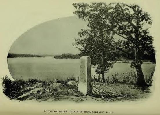
Assawaghkemek, the name entered as that of the northeast boundmark of the Swartwout-Coddebeck Patent, and described therein, "To a small run of water called Assawaghkemek . . . and so along the same and the lands of Mansjoor, the Indian," is known by settlement, to have been at and below the junction of Basha's Kill and the Neversink, from which the inference seems to be well sustained that "the lands of Mansjoor, the Indian" were the lands or valley of Basha's Kill, which the name describes as an enclosed or occupied place "beyond," or "on the other side" of the small run of water. The prefix Assaw, otherwise written Accaw, Agaw, etc., means "Beyond," "On the other side." The termination agh, or aug, indicates that the name is formed as a verb. Kemek (Kamik) means an enclosed, or occupied place, as already stated. The translation in "History of Orange County," from Waseleu, "Light, bright, foaming," is erroneous, as is also the application of the name to Fall Brook, near the modern village of Huguenot. In no case was the name that of a stream, except by extension to it.
Peenpack, (Paan, Paen, Pien, Penn) is given, traditionally, as the name of a "Small knoll or rise of ground, some fifty or sixty rods long, ten wide, and about twenty feet high above the level of" Neversink River, "on and around which the settlers of the Maghaghkamik Patent first located their cabins." It has been preserved for many generations as the name of what is known as the Peen-pach Valley, the long narrow flats on the Neversink. Apparently it is corrupt Dutch from Paan-pacht, "Low, soft land," or leased land. The same name is met in Paan-paach, Troy, N. Y., and in Penpack, Somerset County, N. J. The places bearing it were primary Dutch settlements on low lands. (See Paanpaach.) Doubtfully a substitution for Algonquian from a root meaning, "To fall from a height" (Abn., Paⁿna; Len. Pange), as in Abn. Panaⁿk'i, "Fall of land," the downward slope of a mountain, suggested by the slope of the Shawongunk Mountain range, which here runs southwest to northeast and falls off on the west until it meets the narrow flats spoken of. The same feature is met at Troy.
Tehannek, traditionally the name of a small stream on the east side of the Peenpack Knoll, probably means "Cold stream," from Ta or Te, "cold," and -hannek, "stream." It is a mountain brook.
Sokapach, traditionally the name of a spring in Deerpark, means, "A spring." It is an equivalent of Sókapeék, "A spring or pool."
Neversink, the name quoted as that of the stream flowing to the Delaware at Carpenter's Point, is not a river name. It is a corruption of Lenape Newás, "A promontory," and -ink, locative, meaning "At the promontory." The particular promontory referred to seems to have been what is now known as Neversink Point, in Sullivan County, which rises 3,300 feet. The name is generic and is met in several places, notably in Neversink, N. J. (See Maghaghkameck.)
Seneyaughquan, given as the name of an Indian bridge which crossed the Neversink, may have its equivalent in "Tayachquano, bridge—a dry passage over a stream." (Heckewelder.) The bridge was a log and the location said to have been above the junction of the stream with the Mamacottin.
Saukhekemeck, otherwise Maghawam, so entered in the Schuyler Patent, 1697, apparently refer to one and the same place. The locative has not been ascertained. The patent covered lands now in New Jersey. The tract is described in the patent: "Situated upon a river called Mennissincks, before a certain island called Menagnock, which is adjacent to or near a tract of land called by the natives Maghaghkamek." (See Menagnock.)
Warensagskemeck, a tract also conveyed to Arent Schuyler in 1697, described as "A parcel of meadow or vly, adjacent to or near a tract called Maghaghkamek," is probably, by exchange of r and l and transpositions, Walenaskameck; Walen, "hollowing, concave"; Walak, hole; Waleck, a hollow or excavation; -ask, "Grass"; -kameck, an enclosed or limited field; substantially, "a meadow or vly," [FN] as described in the deed.
[FN] Vly is a Dutch contraction of Vallei, with the accepted signification, "A swamp or morass; a depression with water in it in rainy seasons, but dry at other times." A low meadow. Walini, (Eastern), hollowing, concave site.
Schakaeckemick, given as the name of a parcel of land on the Delaware described as "lying in an elbow," seems to be an equivalent of Schaghach, meaning "Straight." level, flat, and -kamick, a limited field. The tract was given to one William Tietsort, a blacksmith, who had escaped from the massacre at Schenectady (Feb. 1689-90), and was induced by the gift to settle among the Minisinks to repair their fire-arms. He was the first European settler on the Delaware within the limits of the old county of Orange. He sold the land to one John Decker, and removed to Duchess County. No abstract of title from Decker has been made, and probably cannot be. Decker's name, however, appears in records as one of the first settlers, in company with William Cole and Solomon Davis, in what was long known as "The Lower Neighborhood"; in New Jersey annals, "Cole's Fort." The precise location is uncertain. In History of Orange Co. (Ed. 1881, p. 701), it is said: "It is believed that further investigation will show that Tietsort's land was the later Benj. van Vleet place, near Port Jervis." In Eager's "History of Orange County" (p. 396), Stephen St. John is given as the later owner of the original farm of John Decker. Decker's house was certainly in the "Lower Neighborhood." It was palisaded and called a fort.
Wihlahoosa, given, locally, as the name of a cavern in the rocks on the side of the mountain, about three miles from Port Jervis, on the east side of Neversink River, is probably from Wihl (Zeisb.), "Head," and -hōōs, "Pot or kettle." The reference may have been to its shape, or its position. In the vicinity of the cavern was an Indian burial ground covering six acres. Skeletons have been unearthed there and found invariably in a sitting posture. In one grave was found a sheet-iron tobacco-box containing a handkerchief covered with hieroglyphics probably reciting the owner's achievements. Tomahawks, arrow-heads and other implements have also been found in graves. The place was long known as "Penhausen's Land," from one of the grantors of the deed. The cavern may have had some connection with the burial ground.
Walpack, N. J., is probably a corruption of Walpeék, from Walak (Woalac, Zeisb.), "A hollow or excavation," and -peék, "Lake," or body of still water. The idea expressed is probably "Deep water." It was the name of a lake.
Mamakating, now so written and preserved in the name of a town in Sullivan County, is written on Sauthier's map Mamecatink as the name of a settlement and Mamacotton as the name of a stream. Other forms are Mamacoting and Mamacocking. The stream bearing the name is now called Basha's Kill, the waters of which find their way to the Delaware, and Mamakating is assigned to a hollow. The settlement was primarily a trading post which gathered in the neighborhood of the Groot Yaugh Huys (Dutch, "Great Hunting House"), a large cabin constructed by the Indians for their accommodation when on hunting expeditions, [FN-1] and subsequently maintained by Europeans for the accommodation of hunters and travelers passing over what was known as the "Mamacottin path," a trunk line road connecting the Hudson and Delaware rivers, more modernly known as the "Old Mine Road," which was opened as a highway in 1756. The Hunting House is located on Sauthier's map immediately south of the Sandberg, in the town of Mamakating, and more recently, by local authority, at or near what is known as the "Manarse Smith Spring," otherwise as the "Great Yaugh Huys Fontaine," or Great Hunting House Spring. [FN-2] The meaning of the name is largely involved in the orthography of the suffix. If the word was -oten it would refer to the trading post or town, as in "Otenink, in the town" (Heckewelder), and, with the prefix Mamak (Mamach, German notation), root Mach, "evil, bad, naughty" (Mamak, iterative), would describe something that was very bad in the town; but, if the word was -atin, "Hill or mountain," the name would refer to a place that was at or on a very bad hill. Presumably the hill was the objective feature, the settlement being at or near the Sandberg. There is nothing in the name meaning plain or valley, nor anything "wonderful" about it. Among other features on the ancient path was the wigwam of Tautapau, "a medicine man," so entered in a patent to Jacob Rutzen in 1713. Tautapau (Taupowaw, Powaw), "A priest or medicine man," literally, "A wise speaker."
[FN-1] Indian Hunting-houses were met in all parts of the country. They were generally temporary huts, but in some cases became permanent. (See Cochecton.)
[FN-2] Fontaine is French—"A spring of water issuing from the earth." The stream flowing from the spring is met in local history as Fantine Kill.
Kau-na-ong-ga, "Two wings," is said to have been the name of White Lake, Sullivan County, the form of the lake being that of a pair of wings expanded, according to the late Alfred B. Street, the poet-historian, who embalmed the lake in verse years before it became noted as a fashionable resort. (See Kong-hong-amok.)
"Where the twin branches of the Delaware Glide into one, and in their language call'd Chihocken, or 'the meeting of the floods';" [FN-1]
The "Willemoc," [FN-2] and "The Falls of the Mongaup," are also among Street's poetical productions.
[FN-1] "Formerly Shohakin or Chehocton." (French's Gaz.) In N. Y. Land Papers, Schohakana is the orthography. Street's translation is a poetical fancy. The name probably refers to a place at the mouth of the northwest or Mohawk Branch of the Delaware, and the northeast or Paghkataghan Branch, at Hancock, Del. Co.
[FN-2] Willemoc probably stands for Wilamauk, "Good fishing-place." There were two streams in the town, one known as the Beaver Kill and the other as the Williwemack. In Cal. N. Y. Land Papers, 699, occurs the entry: "The Beaver Kill or Whitenaughwemack." The date is 1785. The orthography bears evidence of many years' corruption. It may have been shortened to Willewemock and Willemoc, and stand for Wilamochk, "Good, rich, beaver." It was, presumably, a superior resort for beavers.
Shawanoesberg was conferred on a hill in the present town of Mamakating, commemorative of a village of the Shawanoes who settled here in 1694 on invitation of the Minisinks. (Council Minutes, Sept. 14, 1692.) Their council-house is said to have been on the summit of the hill.
Basha's Land and Basha's Kill, familiar local terms in Sullivan County, are claimed to have been so called from a squaw-sachem known as Elizabeth who lived near Westbrookville. "Basha's Land" was one of the boundmarks of the Minisink Patent and Basha's Kill the northeast bound of the Maghaghkemik Patent. Derivation of the name from Elizabeth is not well-sustained. [FN-1] The original was probably an equivalent of Bashaba, an Eastern-Algonquian term for "Sagamore of Sagamores," or ruling sachem or king of a nation. It is met of record Bashaba, Betsebe, Bessabe, Bashebe, etc. Hubbard wrote: "They called the chief rulers, who commanded the rest, Bashabeas. Bashaba is a title." "Chiefs bearing this title, and exercising the prerogatives of their rank, are frequently spoken of by the early voyagers." [FN-2] (Hist. Mag., Second Series, 3, 49.) The lands spoken of were the recognized territorial possession of the chief ruler of the nation or tribe. The "squaw-sachem" [FN-3] may have held the title by succession or as the wife of the Bashaba.
[FN-1] Basha's Kill was applied to Mamcotten Kill north of the village of Wurtsboro, south of which it retained the name of Mamacotten, as written on Sauthier's map. Quinlan, in his "History of Sullivan County," wrote: "The head-waters of Mamakating River subsequently became known as Elizabeth's Kill, in compliment to Elizabeth Gonsaulus. We could imagine that she was the original Basha, Betje, or Betsey, who owned the land south of the Yaugh House Spring, and gave to the Mamakating stream its present name; but unfortunately she was not born soon enough. Twenty-five years before her family came to Mamakating, 'Basha's land' was mentioned in official documents." It appears in the Minisink Patent in 1704.
[FN-2] A. S. Gatschet, of the Bureau of Ethnology, wrote me: "The Bashas, Bashebas and Betsebas of old explorers of the coast of Maine, I explain by pe'sks, 'one,' and a'pi, 'man,' or person—'First man in the land.'"
[FN-3] Squaw, "Woman," means, literally, "Female animal." Saunk-squa stands for "Sochem's squaw." "The squa-sachem, for so they call the Sachem's wife." (Winslow.)
Mongaup, given as the name of a stream which constitutes in part the western boundary of Orange County, is entered on Sauthier's map, "Mangawping or Mangaup." Quinlan (Hist. Sullivan County) claimed for it also Mingapochka and Mingwing, indicating that the stream carried the names of two distinct places. Mongaup is a compression of Dutch Mondgauwpink, meaning, substantially, "At the mouth of a small, rapid river," for which a local writer has substituted "Dancing feather," which is not in the composition in any language. Mingapochka (Alg.), appears to be from Mih'n (Mih'nall plural; Zeisb.), "Huckleberry," and -pohoka, "Cleft, clove or valley"—literally, "Huckleberry Valley." Street, writing half a century ago, described the northern approach of the stream as a valley wreathed (poetically) in whortle berries—
"In large tempting clusters of light misty blue."
The stream rises in the center of Sullivan County and flows to the Delaware. The falls are said to be from sixty to eighty feet in four cascades. (Hist. Sul. Co.) Another writer says: "Three miles above Forestburgh village, the stream falls into a chasm seventy feet deep, and the banks above the falls are over one hundred feet high."
Meenahga, a modern place-name, is a somewhat remarkable orthography of Mih'n-acki (aghki), "Huckleberry land" or place.
Callicoon, the name of a town in Sullivan County, and of a stream, is an Anglicism of Kalkan (Dutch), "Turkey"—Wilde Kalkan, "Wild turkey"—in application, "Place of turkeys." The district bearing the name is locally described as extending from Callicoon Creek to the mouth of Ten Mile River, on the Delaware. Wild turkeys were abundant in the vicinage of the stream no doubt, from which perhaps the name, but as there is record evidence that a clan of the Turkey tribe of Delawares located in the vicinity, it is quite probable that the name is from them. The stream is a dashing mountain brook, embalmed poetically by the pen of Street. (See Cochecton.)
Keshethton, written by Colonel Hathorn in 1779, as the name of an Indian path, is no doubt an orthography of Casheghton. In early years a trunk-line path ran up the Delaware to Cochecton Falls, where, with other paths, it connected with the main path leading to Wyoming Valley, [FN] the importance of the latter path suggesting, in 1756, the erection of a fort and the establishment of a base of supplies at Cochecton from which to attack the Indians under Tedyuscung and Shingask in what was then known as "The Great Swamp," from which those noted warriors and their followers made their forays. (Doc. Hist. N. Y., ii. 715; Ib. Map, i, 586.) Colonel Hathorn passed over part of this path in 1779, in pursuit of Brant, and was disastrously defeated in what is called "The Battle of Minnisink."
[FN] "The first well-beaten path that connected the Delaware and Susquehanna Rivers, and subsequently the first rude wagon road leading from Cochecton through Little Meadows, in Salem township, and across Moosic Mountains." (Hist. Penn.) It was with a view to connect the commerce from this section with the Hudson that the Newburgh and Cochecton Turnpike was constructed in the early years of 1800.
Cochecton, the name of a town and of a village in Sullivan County, extended on early maps to an island, to a range of hills, and to a fall or rift in the Delaware River, is written Cashieghtunk and in other forms on Sauthier's map of 1774; Cushieton on a map of 1768; Keshecton, Col. Cortlandt, 1778; Cashecton, N. Y. Land Papers, 699; Cushietunk in the proceedings of the Treaty of Easton, 1758, and in other New Jersey records: Cashighton in 1744; Kishigton in N. Y. records in 1737, and Cashiektunk by Cadwallader Colden in 1737, as the name of a place near the boundmark claimed by the Province of New Jersey, latitude 41 degrees 40 minutes. "On the most northerly branch of Delaware River, which point falls near Cashiektunk, an Indian village, on a branch of that river called the Fish Kill." (Doc. Hist. N. Y., iv, 177.) In the Treaty of Easton, 1758, the Indian title to land conveyed to New Jersey is described: "Beginning at the Station Point between the Province of New Jersey and New York, at the most northerly end of an Indian settlement on the Delaware, known by the name of Casheitong." Station Point, called also Station Rock, is about three miles southeast of the present village of Cochecton, on a flat at a bend in the river, by old survey twenty-two miles in a straight line from the mouth of Maghaghkamik Creek, now Carpenter's Point, in the town of Deerpark, Orange County. Cochecton Falls, so called, are a rocky rapid in a narrow gorge covering a fall of two or three hundred feet, the obstruction throwing the water and the deposits brought down back upon the low lands. The Callicoon flows to the Delaware a few miles northeast of the falls. Between the latter and the mouth of the Callicoon lies the Cochecton Flats or valley. The precise location of "Station Point or Rock," described as "At the most northerly end" of the Indian village, has not been ascertained, but can be readily found. The late Hon. John C. Curtis, of Cochecton, wrote: "Our beautiful valley, from Cochecton Falls to the mouth of the Callicoon, was called, by the Indians, Cushetunk, or low lands," the locative of the name having been handed down from generation to generation, and an interpretation of the name which is inferentially correct. There is no such word as Cash or Cush in the Delaware dialect, however; it stands here obviously as a form of K'sch, intensive K'schiecton (Len. Eng. Dic.); Geschiechton, Zeisberger, verbal noun, "To wash," "The act of washing," as by the "overflow of the water of a sea or river. . . . The river washed a valley in the plain"; with suffix -unk (K'schiechton-unk—compressed to Cushetunk), denoting a place where the action of the verb was performed, i. e. a place where at times the land is washed or overflowed by water, from which the traditionary interpretation, "Low land." [FN-1]
The Indian town spoken of was established in 1744, although its site was previously occupied by Indian hunting houses or huts for residences while on hunting expeditions. In Col. Mss. v. 75, p. 10, is preserved a paper in which it is stated that the Indians residing at Goshen, Orange County, having "Removed to their hunting houses at Cashigton," were there visited, in December, 1744, by a delegation of residents of Goshen, consisting of Col. Thomas DeKay, William Coleman, Benj. Thompson, Major Swartwout, Adam Wisner, interpreter, and two Indians as pilots, for the purpose of ascertaining the cause of the removal; that the delegation found the residents composed of two totemic families, Wolves and Turkeys; that, having lost their sachem, they were debating "Out of which tribe a successor should be chosen"; that they had removed from Goshen through fear of the hostile intention on the part of the settlers there, who "Were always carrying guns." Later, a delegation from the Indian town visited Goshen, and was there "Linked together" with Colonel De Kay, as the representative of the Governor of the province, in their peculiar form of locking arms, for three hours, as a test of enduring friendship. [FN-2] It was the only treaty with the Indians in Orange County of which there is record.
Aside from its Indian occupants the town is historic as the point forming the old northwest boundmark of New Jersey (Lat. 41 degrees 40 minutes), as recognized in the Treaty of Easton. (See Pompton.) From its association with the history of three provinces, the story of the town is of more than local interest. The lands were ultimately included in the Hardenberg Patent, and most of the Indian descendants of its founders of 1744 followed the lead of Brant in the Revolution. They probably deserved a better fate than that which came to them. They are gone. The long night with its starless robe has enveloped them in its folds—the ceaseless wash of the waters of the Delaware upon the beautiful valley of Cochecton, hymns their requiem.
[FN-1] Probably the same name is met in Sheshecua-ung, the broad flats opposite and above the old Indian meadows, Wyoming Valley, where the topography is substantially the same.
[FN-2] A belt was presented by the Indians to Col. De Kay, but what became of it neither the records or tradition relates.
Here we close our survey of the only monuments which remain of races which for ages hunted the deer, chanted songs of love, and raised fierce war cries—the names which they gave and which remain of record of the hills and valleys, the lakes and waterfalls, amid which they had their abiding places. Wonderfully suggestive and full of inferential deductions are those monuments; volumes of history and romance are linked with them; the most controlling influences in making our nation what it is is graven in their crude orthographies. Their further reclamation and restoration to the geographical locations to which they belonged is a duty devolving on coming generations.
[From De Laet's "New World," Leyden Edition.]
"Within the first reach, where the land is low, there dwells a nation of savages named Tappaans. . . . The second reach extends upward to a narrow pass named by our people Haverstroo; then comes Seyl-maker's (Zeil-maker's, sail-maker's) reach, as they call it; and next, a crooked reach, in the form of a crescent, called Koch's reach (Cook's reach). Next is Hooge-rack (High reach); and then follows Vossen reach (Foxes reach), which extends to Klinckersberg (Stone mountain). This is succeeded by Fisher's (Vischer's) reach, where, on the east bank of the river, dwells a nation of savages called Pachamy. This reach extends to another narrow pass, where, on the west side of the river, there is a point of land that juts out covered with sand, opposite a bend in the river, on which another nation of savages, called the Waoranecks, have their abode, at a place called Esopus. A little beyond, on the west side, where there is a creek, and the river becomes more shallow, the Waronawankongs reside; here are several small islands. Next comes another reach called Klaver-rack, where the water is deeper on the west side, while the eastern side is sandy. Then follow Backer-rack, John Playser's rack and Vaster rack as far as Hinnenhock. Finally, the Herten-rack (Deer-rack) succeeds as far as Kinderhoek. Beyond Kinderhoek there are several small islands, one of which is called Beeren Island (Bear's Island). After this we come to a sheltered retreat named Onwee Ree (Onwereen, to thunder, Ree, quick, sudden thunder storms), and farther on are Sturgeon's Hoek, over against which, on the east side of the river, dwell the Mohicans."
A work of the character of that which is herewith presented to you would be eminently remarkable if it was found to be entirely free from typographical and clerical errors. No apology is made for such as you may find, the rule being regarded as a good one that the discoverer of an error is competent to make the necessary correction. Whatever you may find that is erroneous, especially in the topographical features of places, please have the kindness to forward to the compiler and enable him to correct.
Respectfully, E. M. RUTTENBER, Newburgh, N. Y.
{Transcriber's note: The page numbers indicated below refer to pages in the separate article, "Footprints of the Redmen," and are not in sequence with the complete published volume of proceedings. The HTML and e-book versions of the article have hyperlinks to the names indexed.}
{Transcriber's Note: Some of the original index entries are incorrect. The corrected page numbers are shown in braces {p.} Alphabetical placement errors are left as in the original.}
| Achquetuck | 177 |
| Achsinink | 148 |
| Ackinckes-hacky | 104 |
| Adirondacks | 187 |
| Aepjin (Sachem) | 59 |
| Agwam (Agawam) | 83 |
| Ahashewaghick | 51 |
| Ahasimus | 106 |
| Aioskawasting | 146 {145} |
| Alaskayering | 148 |
| Albany | 178 |
| Alipkonck | 26 |
| Amagansett | 83 |
| Amangag-arickan | 168 |
| Anaquassacook | 69 |
| Anthony's Nose | 31, 217 |
| Apanammis | 33 |
| Appamaghpogh | 30 |
| Aquackan-onck | 104 |
| Aquassing | 46 |
| Aquebogue | 98 |
| Aquehung | 32 |
| Arackook | 139 |
| Arisheck | 106 |
| Armonck | 33 |
| Assawagh-kemek | 224 |
| Assawanama | 98 |
| Assiskowackok | 173 |
| Assinapink | 126 |
| Assup (Accup) | 77 |
| Aschalege | 216 |
| Aspetong | 32 |
| Astenrogan | 217 |
| Athens | 174 |
| Atkarkarton | 158 |
| Aupaumut, Hendrick | 11 |
| Aupauquack | 98 |
| Aurie's Creek | 210 |
| Basha's Land | 229 |
| Bergen | 106 |
| Callicoon | 230 |
| Canagere | 214 |
| Canajohare | 214 |
| Canarsie | 88 |
| Caneray (Carenay) | 191 |
| Caniade-rioit | 70 |
| Caniade-riguarunte | 72 |
| Canniengas | 189 |
| Canopus | 36 |
| Casperses Creek | 44 |
| Cataconoche | 80 |
| Catskill | 170 |
| Caughnawaga | 213 |
| Caumset | 96 |
| Cawaoge | 215 |
| Cayudutta | 214 |
| Cheesek-ook | 117 |
| Chihocken | 229 |
| Chouckhass | 133 |
| Ciskhekainck | 56 |
| Claverack | 55 |
| Cobel's Kill | 216 |
| Cochecton | 231 |
| Comac | 92 |
| Commoenapa | 105 |
| Connecticut | 80 |
| Copake | 59 |
| Cronomer's Hill | 130 |
| Cumsequ-ogue | 81 |
| Cussqunsuck | 94 |
| Cutchogue | 84 |
| Dans Kamer | 183 {138} |
| DeKay, Colonel Thomas | 232 |
| Delaware River | 219 |
| Delawares, or Lenni-Lenape | 219 |
| Di-ononda-howe | 70 |
| Dutch Racks (Rechts) | 234 |
| Eaquoris-ink | 45 |
| Eauketaupucason | 34 |
| Esopus | 155 |
| Espating | 111 |
| Essawatene | 121 |
| Etagragon | 217 |
| Fall-kill | 44 |
| Fish-kill | 37 |
| Fort Albany | 178 |
| Fort Frederick | 178 |
| Fort Orange | 178 |
| Frudyach-kamik | 162 |
| Ganasnix | 173 |
| Gentge-kamike | 183 {138} |
| German Flats | 217 |
| Gesmesseecks | 61 |
| Glens Falls | 136 {186} |
| Gowanus | 90 |
| Greenwich Village | 17 |
| Hackingsack | 104 |
| Hahnakrois | 177 |
| Hashamomuck | 99 |
| Hashdisch | 140 |
| Haverstraw | 124 |
| Hoboken | 107 |
| Hog's Island | 96 |
| Hohokus | 115 |
| Honk Falls | 166 |
| Hoosick River | 67 |
| Hopcogues | 85 |
| Horikans | 71 |
| Hudson's River | 12 |
| Jamaica | 88 |
| Jogee Hill | 134 |
| Jogues (Father) | 12, 185, 193 |
| Kackkawanick | 54 |
| Kadarode | 209 |
| Kahoes (Kahoos) | 200 |
| Kakeout | 32 |
| Kakiate | 116 |
| Kanendenra | 217 |
| Kaniskek | 174 |
| Kapsee (Kapsick) | 17 |
| Katawamoke | 97 |
| Katonah (Sachem) | 35 |
| Kaphack | 59 |
| Kaunaumeek | 58 |
| Kau-na-ong-ga | 228 |
| Kay-au-do-ros-sa | 187 |
| Keessienwey's Hoeck | 175 |
| Keht-hanne | 218 |
| Kenagtiquak | 58 |
| Kerhonkson | 162 |
| Keschsechquereren | 90 |
| Keshethton | 231 |
| Kesieway's Kill | 57 |
| Keskeskick | 22 |
| Keskistk-onck | 30 |
| Kestateuw | 88 |
| Ketchepunak | 85 |
| Kewighec-ack | 29 |
| Kinderhook | 54 {55} |
| Kingston | 155 |
| Kiosh | 15 |
| Kiskatom | 174 |
| Kitchaminch-oke | 82 |
| Kitchiwan | 27 |
| Kit Davit's Kil (Rondout) | 161 |
| Kittatinny | 31 |
| Koghkehaeje (Coxackie) | 176 |
| Koghsaraga | 188 |
| Koxing Kil | 168 |
| Lackawack | 167 |
| Lake Champlain | 72 |
| Lake George | 71 |
| Lake Tear-of-the-clouds | 185 |
| Little Falls | 217 |
| Longhouse Creek | 137 |
| Machackoesk | 58 |
| Machawameck | 175 |
| Magaat-Ramis | 152 |
| Magatsoot | 222 |
| Magdalen Island | 46 |
| Maggeanapogh | 151 |
| Maghagh-kamieck | 223 |
| Magopson | 33 |
| Magow-asingh-inck | 164 |
| Maharness | 35 |
| Mahask-ak-ook | 52 |
| Mahequa | 122 |
| Mahopack | 36 |
| Mahway | 112 |
| Mainaitanung | 113 |
| Mamakating | 227 |
| Mamaroneck | 34 |
| Manah-ackaquasu-wanock | 101 |
| Manahan | 127 |
| Manahawaghin | 106 {126} |
| Manhaset | 95 |
| Manhattan | 13 |
| Mananosick | 49 |
| Manette | 91 |
| Manises | 101 |
| Mannhon-ake | 100 |
| Mannepies | 23 |
| Manowtassquott | 99 |
| Manuketesuck | 35 |
| Manussing | 34 |
| Marechkawick | 91 |
| Maretange Pond | 145 |
| Marsep-inck | 93 |
| Maschabeneer | 144 |
| Maskahn-ong | 87 |
| Maskutch-oung | 84 {86} |
| Massaback | 85 {84} |
| Massape-age | 85 |
| Masseks (Maskeks) | 144 |
| Mas-seps | 86 |
| Masspootapaug | 99 |
| Mastic | 79 |
| Mathahenaak | 180 |
| Matinnec-ock | 95 |
| Matouwackey (L. I.) | 73 |
| Mattachonts | 168 |
| Mattapan | 44 |
| Matteawan | 37 |
| Mattituck | 84 |
| Mawe-nawas-igh | 38 |
| Mawichnauk | 53 |
| Mawighanuck | 58 |
| Mawignack | 171 |
| Mattasink | 120 |
| Meenahga | 230 |
| Meghkak-assin | 24 |
| Menagnock | 222 |
| Menagh | 29 |
| Menisak-congue | 122 |
| Memanusack | 94 |
| Memorasink | 143 |
| Merick | 87 |
| Mespaechtes | 94 |
| Metambeson | 46 |
| Minasser-oke | 81 |
| Mingapochka | 230 |
| Minnahan-ock | 17 |
| Minnepaug | 99 |
| Minnischtan-ock | 54 |
| Minnissingh | 45 |
| Minnisais | 15 |
| Minisink | 220 |
| Mistucky | 133 |
| Mochgonneck-onck | 78 |
| Mochquams | 33 |
| Mogongh-kamigh | 58 |
| Moggonck (Maggonck) | 148 |
| Moharsic | 35 |
| Mohawk River | 189 |
| Mohawk Castles | 191, 211 |
| Mombackus | 169 |
| Mombasha | 116 |
| Monachnong | 16 |
| Monatun | 16 |
| Monemius Island | 180 |
| Mongaup | 230 |
| Monhagen | 137 |
| Monowautuck | 80 |
| Monsey | 112 |
| Montauk | 75 |
| Mopochock | 169 {167} |
| Moriches | 81 |
| Muchito | 96 |
| Muhheakun'nuk | 11 |
| Murderer's Creek | 130 |
| Muscota | 19 |
| Much-Hattoes | 129 |
| Nachaquatuck | 97 |
| Nachawakkano | 53 |
| Nachtenack | 180 |
| Nahtonk (Recktauck) | 18 |
| Namaus | 81 |
| Namenock | 222 |
| Namke | 85 |
| Nanichiestawack | 35 |
| Nannakans | 28 |
| Nanapenahaken | 49 |
| Nanoseck | 161 |
| Napanoch | 167 |
| Napeak | 76 |
| Narranshaw | 116 |
| Narratschoan | Errata |
| Narrioch | 90 |
| Navers-ing | 165 |
| Navish | 28 |
| Nawas-ink | 124 |
| Nepeneck | 224 |
| Nepah-komuk | 23 |
| Neperah (Nipproha) | 23 |
| Nepestek-oak | 177 |
| Nescotack | 143 |
| Neversink | 102, 226 |
| Neweskake | 178 |
| Newburgh | 128 |
| Niamug (Niamuck) | 82 |
| New Fort | 142 |
| Nickankook | 49 |
| Niskayune | 201 |
| Nissequague | 93 |
| Norman's Kill | 179 |
| Norumbega | 179 |
| Nowadaga | 215 |
| Nyack | 92, 120 |
| Ochabacowesuck | 100 |
| Ochmoach{k}-ing | 165 {168} |
| Oghrackee | 210 |
| Oi-o-gue | 12, 189 {185} |
| Old Fort | 164 |
| Onekee-dsi-enos | 206 |
| Onekagoncka | 191 |
| Oneyagine | 217 |
| Oniskethau | 177 |
| Onuntadass | 207 |
| Orange | 103 |
| Oscawanna | 26 |
| Osquage (Ohquage) | 215 |
| Ossangwack | 155 |
| Osserrion | 191 |
| Osseruenon | 191 |
| Pachonahellick | 178 |
| Pachquyak | 173 |
| Pagganck | 15 |
| Pahhaoke | 67 |
| Palmagat | 148 |
| Pamerpock | 115 |
| Panhoosick | 67 |
| Paanpaach (Troy) | 63 |
| Papinemen | 19 |
| Paquapick | 111 |
| Pasgatikook | 172 |
| Paskaecq | 173 |
| Passaic | 111 |
| Passapenoc | 61 |
| Patchogue | 81 |
| Pattkoke | 55 |
| Peakadasank | 146 |
| Peconic | 83 |
| Peekskill | 30 |
| Peenpack | 225 |
| Peningo | 33 |
| Peppineghek | 29 |
| Pequaock (Oyster Bay) | 98 |
| Pequannock | 111 |
| Peram-sepus | 112 |
| Perth Amboy | 102 |
| Petuckqua-paug | 35 |
| Petuckqua-paen | 62 |
| Pietawickqu-assick | 41 |
| Pishgachtigok | 42 |
| Piskawn | 63 |
| Pitkiskaker | 145 |
| Pocanteco | 25 |
| Pochuck | 133 |
| Pockotessewacke | 34 |
| Podunk | 69 |
| Poesten Kill | 62 |
| Pollepel Eiland | 127 |
| Pompoenick | 58 |
| Pompton | 113 |
| Ponkhockie | 157 |
| Poosepatuck | 79 |
| Poplopen's Creek | 125 |
| Poquatuck | 79 |
| Potic | 173 |
| Potunk (L. I.) | 100 |
| Poughkeepsie | 43 |
| Poughquag | 41 |
| Preumaker's Land | 161 |
| Primary Explanations | 3 |
| Prince's Falls | 126 |
| Quachanock | 172 |
| Quahemiscos | 180 |
| Quantuck | 87 |
| Quaquarion | 205 |
| Quarepogat | 42 |
| Quarepos | 33 |
| Quaspeck | 121 |
| Quassaick | 128 |
| Quatackqua-ohe | 69 |
| Quatawichnack | 171 |
| Quauntowunk | 78 |
| Quequick | 65 {66} |
| Quinnehung | 31 |
| Quissichkook | 54 |
| Quogue | 87 |
| Ramapo | 114 |
| Rapahamuck | 94 |
| Rappoos | 153 |
| Raritangs | 102 |
| Reckgawank | 124 |
| Rechqua-akie | 87 |
| Rennaquak-onck | 92 |
| Rockaway | 87 |
| Roelof Jansen's Kill | 47 |
| Ronkonkoma | 100 |
| Runboldt's Run | 133 |
| Sachus (Sachoes) | 30 |
| Sacondaga | 184 |
| Sacrahung | 31 |
| Sacut | 88 |
| Sagabon-ock | 85 |
| Sag-Harbor | 85 |
| Saghtekoos | 83 |
| Sahkaqua | 54 |
| Sam's Point | 146 |
| Sanckhaick | 65 |
| Sankagag | 177 |
| Sankapogh | 125 |
| Saponickan | 17 |
| Saratoga | 180 |
| Saaskahampka | 49 |
| Saugerties | 162 |
| Saukhenak | 47 |
| Schaghticoke | 65 |
| Schakaec-kemick | 226 |
| Scharon (Schroon) | 184 |
| Schenectady | 202 |
| Schodac | 59 |
| Schoharie | 207 |
| Schunnemunk | 131 |
| Scompamuck | 59 |
| Senasqua | 29 |
| Senatsycrossy | 212 |
| Seneyaughquan | 226 |
| Shannondhoi | 204 |
| Shandaken | 169 |
| Shappequa | 32 |
| Shaupook | 53 |
| Shawanoesberg | 229 |
| Shawangunk | 140 |
| She'kom'eko | 42 |
| Shenandoah | 43 |
| Sheepshack | 63 |
| Shildrake | 27 |
| Shinnec'ock | 77 |
| Shokan | 165 |
| Shorakkapoch | 21 |
| Sickajoock | 61 |
| Sickenekas | 61 |
| Sicktew-hacky | 82 |
| Siesk-assin | 176 |
| Sing-Sing | 27 |
| Siskakes | 111 |
| Sint-Sink | 95 |
| Skoonnenoghky | 123 |
| Sleepy Hollow | 26 |
| Sohanidisse | 215 |
| Sokapach | 225 |
| So'was'set | 99 |
| Speonk | 79 |
| Spuyten Duyvil | 21 |
| Stighcook | 176 |
| Stissing | 43 |
| Stoney Point | 123 |
| Succabonk | 36 |
| Succasunna | 104 |
| Sugar-Loaf | 132 |
| Suggamuck | 94 |
| Sunquams | 84 |
| Taghkanick | 52 |
| Tammoesis | 29 |
| Tauquashqueick | 46 |
| Tappans | 117 |
| Tawalsentha | 13, 179 |
| Tawarataque | 154 |
| Tehannek | 225 |
| Tenotoge (Tenotehage) | 215 |
| Tenkenas | 15 |
| Tete-achkie | 172 |
| Ticonderoga | 71 |
| Ti-oneenda-howe | 69 |
| Tionondar-aga | 208 |
| Titicus | 28 |
| Tomhenack | 65 |
| Torne | 117 |
| Tri-States Rock | 224 |
| Tuckahoe | 27, 84 |
| Tuxedo | 116 |
| Twastawekah | 54 |
| Twischsawkin | 140 |
| Tyoshoke | 65 |
| Unsheamuck | 94 |
| Valatie | 59 |
| Van Curler's Journal | 193, 194 |
| Vastrix Island | 48 |
| Verkerde Kill | 147 |
| Wachanekassick | 47 |
| Waichachkeekok | 172 |
| Wading River | 98 |
| Wahamanesing | 39 |
| Wallabout Bay | 91 |
| Wallam | 41 |
| Wallumsch-ack | 64 |
| Walpack | 228 {227} |
| Wanaksink | 144 |
| Wapemwatsjo | 58 |
| Wappingers' Creek | 39 |
| Waragh-kameck | 46 |
| Waranawonkongs | 155 |
| Waranecks | 38 |
| Waronawanka | 155 |
| Warpoes | 19 |
| Wassahawassing | 167 |
| Wassaic | 41 |
| Watchunk | 104 |
| Wathoiack | 201 |
| Waumaniuck | 34 |
| Wawanaquasik | 50 |
| Wawarasinke | 166 |
| Wawayanda | 134 |
| Waweiantepakook | 173 |
| Wawyacbtanock | 45 |
| Wechquadnach | 42 |
| Wehawken | 109 |
| Wehtak | 42 |
| Weputing | 42 |
| Weque-hackhe | 36 |
| Wesegrorap | 116 |
| Whalefish Island | 63 |
| Wicopee | 36 |
| Wickaposset | 99 |
| Wichquapakat | 52 {53} |
| Wichquaskeck | 24 |
| Wickqu-atenn-honck | 144 |
| Wieskottine | 170 |
| Wildmeet | 161 |
| Wihlahoosa | 227 |
| Wildwijk (Wiltwyck) | 160 |
| Winegtekonck | 132 |
| Wishauwemis | 143 |
| Woerawin | 137 |
| Wompenanit | 74 |
| Wopowag | 99 |
| Wyandanch (Sachem) | 79 |
| Wynokie | 115 |
| Wynogkee | 41 {44} |
| Yaphank | 80 |
| Yonkers | 23 |
Through an oversight in revising manuscript written several years ago, Narratschoan (page 121) was assigned to the Verdrietig Hoek Mountain. It should have been assigned to Butter Hill, and Klinkersberg should have been assigned to the Donderberg. Klinkers is from Dutch Klinken, "To sound, to resound." It describes, with the suffix -berg, a hard stone mountain or hill that resounds or echoes—Echo Hill. Narratschoan, the name of Butter Hill, is from Nâï, "It is angular, it corners"—"having corners or angles." (Trumbull.) The letters -atscho stand for -achtschu, Zeisb., -adchu, Natick, "Hill or mountain," and -an is the formative. The combination may be read, "A hill that forms an angle or corner." To recover the Indian name of Butter Hill compensates in some degree for oversight referred to.
Brodhead (Hist. N. Y., i, 757, note), it will be seen by those who will examine, made the same mistake in locating Klinkersberg that is referred to above. The "Vischer's Rack" or "Fisherman's Bend" was clearly the bend around West Point. The Donderberg, or Klinkersberg is the elevation immediately north of Stony Point.