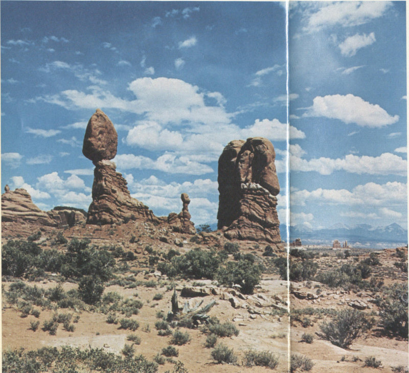
BALANCED ROCK, guarding The Windows section of Arches National Park. Rock is Slick Rock Member of Entrada Sandstone resting upon crinkly bedded Dewey Bridge Member of the Entrada. White rock in foreground is Navajo Sandstone. La Sal Mountains on right skyline. (Frontispiece)
By S. W. Lohman
Graphics by
John R. Stacy
GEOLOGICAL SURVEY BULLETIN 1393
UNITED STATES DEPARTMENT OF THE INTERIOR
ROGERS C. B. MORTON, Secretary
GEOLOGICAL SURVEY
V. E. McKelvey, Director

U.S. GOVERNMENT PRINTING OFFICE: 1975
For sale by the Superintendent of Documents, U. S. Government Printing Office
Washington, D. C. 20402
Stock Number 024-001-02598-1
According to former Superintendent Bates Wilson (1956), Prof. Lawrence M. Gould, of the University of Michigan, was the first to recognize the geologic and scenic values of the Arches area in eastern Utah and to urge its creation as a national monument. Mrs. Faun McConkie Tanner[1] told me that Professor Gould, who had done a thesis problem in the nearby La Sal Mountains, was first taken through the area by Marv Turnbow, third owner of Wolfe cabin. (See p. 12.) When Professor Gould went into ecstasy over the beautiful scenery, Turnbow replied, “I didn’t know there was anything unusual about it.”
Dr. J. W. Williams, generally regarded as father of the monument, and L. L. (Bish) Taylor, of the Moab Times-Independent, were the local leaders in following up on Gould’s suggestion and, with the help of the Moab Lions Club, their efforts finally succeeded on April 12, 1929, when President Herbert Hoover proclaimed Arches National 2 Monument, then comprising only 7 square miles.[2] It was enlarged to about 53 square miles by President Franklin D. Roosevelt’s Proclamation of November 25, 1938, and remained at nearly that size, with some boundary adjustments on July 22, 1960, until it was enlarged to about 130 square miles by President Lyndon B. Johnson’s Proclamation of January 20, 1969.
According to Breed (1947), Harry Goulding, of Monument Valley, in a specially equipped car, traversed the rugged sand and rocks of the Arches region in the fall of 1936 and, thus, became the first person to drive a car into The Windows section of Arches National Monument. Soon after, a bulldozer followed Harry’s tracks and made a passable trail.
When my family and I visited the monument in 1946, the entrance was about 12 miles northwest of Moab on U.S. Highway 163 (then U.S. 160), where Goulding’s old tire tracks led eastward past a small sign reading “Arches National Monument 8 miles.” This primitive road crossed the sandy, normally dry Courthouse Wash and ended in what is now called The Windows section. At that time there was no water or ranger station, nor were there any picnic tables or other improvements within the monument proper, and the custodian was housed in an old barracks of the Civilian Conservation Corps near what is now the entrance, 5 miles northwest of Moab.
Former Custodian Russell L. Mahan reported (oral commun., May 1973) that soon after our initial visit in 1946 a 500-gallon tank was installed near Double Arch in The Windows section and connected to a drinking fountain and that two picnic tables and a pit toilet were added. At that time the only access to Salt Valley and what is now called Devils Garden was a primitive dirt road which, according to Breed (1947, p. 175), left old U.S. Highway 160 (now U.S. 163) 24 miles northwest of Moab, went 22 miles east, 3 then followed Salt Valley Wash down to Wolfe cabin (fig. 1).
According to Abbey (1971), who served as a seasonal ranger beginning about 1958, a sign had by then been erected at the crossing of Courthouse Wash which read:
WARNING: QUICKSAND
DO NOT CROSS WASH
WHEN WATER IS RUNNING
The ranger station, his home for 6 months of the year, was what Abbey described as “a little tin housetrailer.” Nearby was an information display under a “lean-to shelter.” He had propane fuel for heat, cooking, and refrigeration, and a small gasoline-engine-driven generator for lights at night. His water came from the 500-gallon tank, which was filled at intervals from a tank truck. At that time there were three small dry campgrounds, each with tables, fireplaces, garbage cans, and pit toilets. By that time an extension of the dirt road led northward to Devils Garden, and some trails had been built and marked.
Bates Wilson became Custodian of the monument in 1949 and later became Superintendent not only of Arches but also of the nearby new Canyonlands National Park (Lohman, 1974) and the more distant Natural Bridges National Monument. In the fall of 1969, Bates told me of some of his early experiences in the undeveloped monument, including the evening when 22 cars were marooned on the wrong (northeast) side of Courthouse Wash after a flash flood. Bates and his “lone” ranger brought ropes, coffee, and what food they could obtain in town after closing time, threw a line across the swollen stream, had a tourist pull a rope across, then took turns wading the stream with one hand on the rope and the other balancing supplies on his shoulder. After a fire had been built and hot coffee and food passed around, the spirits of the stranded group rose considerably, except for one irate woman from the East, who refused to budge from her car. Bates and his helper finally got the last car out about 1 a.m., after the flood had subsided, and Mrs. Wilson then supplied lodging and more food and coffee for those who needed it.
During and for sometime after World War II and the Korean War, lack of maintenance funds and personnel had prevented improvement of the facilities in many of our national parks and monuments, particularly in undeveloped ones like Arches. The day was saved through the wisdom and foresight of former Park Service Director Conrad L. Wirth, who saw the need and desirability of putting the whole “want” list into one attractive, marketable package. In the words of Everhart (1972, p. 36):
Selection of a name is of course recognized as the most important decision in any large-scale enterprise, and here Wirth struck pure gold. In 1966 the Park Service would be celebrating its fiftieth anniversary. What a God-given target to shoot for! Why not produce a ten-year program, which would begin in 1956, aimed to bring every park up to standard by 1966—and call it Mission 66?
The ensuing well-documented and cost-estimated plan for Mission 66 was enthusiastically backed by President Dwight D. Eisenhower and approved and well supported by Congress to the tune of more than $1 billion during the 10-year period. For Arches, this included a new entrance, Park Headquarters, Visitor Center, a museum boasting a bust of founder Dr. Williams, and modern housing for park personnel, all 5 miles northwest of Moab. By 1958 (Pierson, 1960) a fine new paved road between Park Headquarters and Balanced Rock (frontispiece) was completed. These badly needed improvements were followed by the completion of the paved road all the way to Devils Garden, the building of the modern campground, picnic facilities, and amphitheater in the Devils Garden, and the construction of turnouts and marked trails.
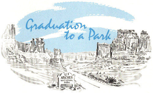
Arches graduated to a full-fledged national park when President Richard M. Nixon signed a Congressional Bill on November 16, 1971. The change in status was accompanied by boundary changes that reduced the area to about 114 square miles. The loss of most of Dry Mesa, just east of the present boundary (fig. 1), was offset in part by gains of new land northwest of Devils Garden. The present (1974) boundaries, roads, trails, and named features of the park are shown in figure 1.
The park was virtually completed at graduation time, and so far this change in status has shown up mainly in new entrance signs, a new 1972 brochure and map, and a very informative “Guide to an Auto Tour of Arches National Park,” keyed to numbered signs at parking spaces. About all that remain to be added are new wayside exhibits, some boundary fences, and spur roads and trails.
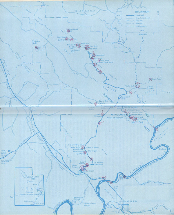
ARCHES NATIONAL PARK, showing location in Utah,
boundaries, streams, highways and roads, trails, landforms, principal
named features, and the city of Moab. The reader is referred
to figure 7 and to road maps issued by the State or by oil
companies for the locations of other nearby towns and features.
Visitors also may obtain pamphlets, from the entrance station
or from the National Park Service office in Moab, which contain
up-to-date maps of the park and the latest available information
on roads, trails, campsites, and picnic sites. (Fig. 1)
High-resolution Map
Although Arches had officially become a park in November 1971, it was not formally dedicated until May 15, 1972. The ceremony began by having the Federal, State, and local dignitaries and other guests totaling 140 persons board the Canyon King, a 93-foot replica of a Mississippi River sternwheeler (Lansford, 1972; Lohman, 1974, fig. 69), for its maiden voyage down the Colorado River. After about half an hour, the heavily laden boat became stuck on a sandbar, and after a 90-minute wait the passengers were rescued by jet boats. This delayed a luncheon at the Visitor Center put on by the Moab Lions Club. Following the luncheon, Park Superintendent Bates Wilson made a brief welcoming address, then introduced J. Leonard Volz, Director of the Midwest Region of the National Park Service, who served as master of ceremonies. Speakers included Utah Governor Calvin L. Rampton, Senator Frank E. Moss, a representative of Senator Wallace F. Bennett, Representatives Sherman P. Lloyd of Utah and Wayne Aspinall of Colorado, and Mitchell Melich, Solicitor General of the Department of Interior, representing Secretary Rogers C. B. Morton. After the speeches, a commemorative plaque, donated by the Canyonlands Natural History Association, was unveiled by Senator Moss and Mr. Melich.
Most of the color photographs were taken by me on 4- × 5-inch film in a tripod-mounted press camera, using lenses of several focal lengths, but a few were taken on 35-mm film, using lenses of various focal lengths. I am grateful to several friends for the color photographs credited to them in the figure captions. The black and white photographs were kindly loaned from the Moab and Arches files of the National Park Service. The points from which most of the photographs were taken are shown in figure 13.

The Canyon lands in and south of Arches were inhabited by cliff dwellers centuries before the first visits of the Spaniards and fur trappers. Projectile points and other artifacts found in the nearby La Sal and Abajo Mountains indicate occupation by aborigines during the period from about 3000-2000 B.C. to about A.D. 1 (Hunt, Alice, 1956). The Fremont people occupied the area around A.D. 850 or 900, and the Pueblo or Anasazi people from about A.D. 1075 to their departure in the late 12th century (Jennings, 1970). Most of the evidence for these early occupations has been found in and south of Canyonlands National Park (Lohman, 1974), but some traces of these and possibly earlier cultures have been found also within Arches National Park.
Ross A. Maxwell (National Park Service, written commun., 1941) investigated two caves in the Entrada Sandstone in the upper reaches of Salt Wash that contain Anasazi ruins. He mentioned that perhaps a dozen or more other caves should be checked for evidence of former occupation and, also, that he found several ancient campsites littered with flint chips and broken tools.
One cave Maxwell explored some 5 miles north of Wolfe Ranch and north of the park is about 300 feet long and 100 to 150 feet deep. It contains the remains of one or more ruins of a structure he thought may have covered much of the floor. The remaining parts of walls now are only two to four tiers of stones in height, although originally they may have been more than one story high. 10 Maxwell explored a second cave on the east side of Salt Wash, about 2 miles north of Wolfe Ranch, which contains 16 storage cists of adobe.
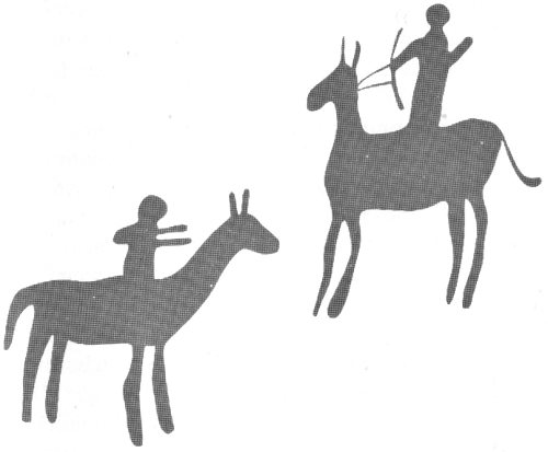
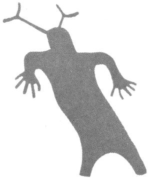
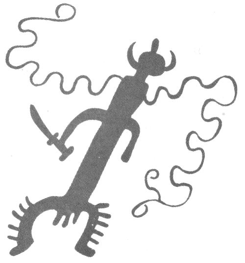
The faces of many older sandstone cliffs or ledges are darkened by desert varnish—a natural pigment of iron and manganese oxides. The prehistoric inhabitants of the Plateau learned that effective and enduring designs, called petroglyphs, could be created simply by chiseling or pecking through the thin dark layer to reveal the buff or tan sandstone beneath. Most petroglyphs were created by the Anasazi, but those showing men mounted on horses were done by Ute tribesmen after the Spaniards brought in horses in the 1500’s. The Fremont people and some earlier people painted figures on rock faces, called pictographs, and some of these had pecked outlines.
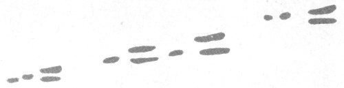
The so-called “Moab panel” was described by Beckwith (1934, p. 177) as a petroglyph, but, as pointed out by Schaafsma (1971, p. 72, 73), it comprises figures having pecked outlines and painted bodies, which actually are combinations of petroglyphs and pictographs. This beautifully preserved group of paintings is shown in the upper photograph of figure 2. Mrs. Schaafsma goes on to say, concerning the “Moab panel”:
The long tapered body, the antenna like headdresses, and the staring eyes are characteristic features of Barrier Canyon style figures elsewhere * * *. Of special interest here are the large shields held by certain figures. A visit to this site indicated that the shields, although apparently of some antiquity, have been superimposed over some of the Barrier Canyon figures. Whether or not this was done by the Barrier Canyon style artists themselves or later comers to the site is impossible to tell.
Although definite proof seems lacking, she suggested (written commun., Nov. 3, 1973) that the “‘Barrier Canyon style’[3] * * * is earlier than the work in the same region clearly attributable to the Fremont.” Note the three bullet holes in and near the right-hand shield. A ledge above the panel that contained petroglyphs during her earlier visit had fallen to the base of the cliff by the time my wife and I inspected the panel in September 1973.
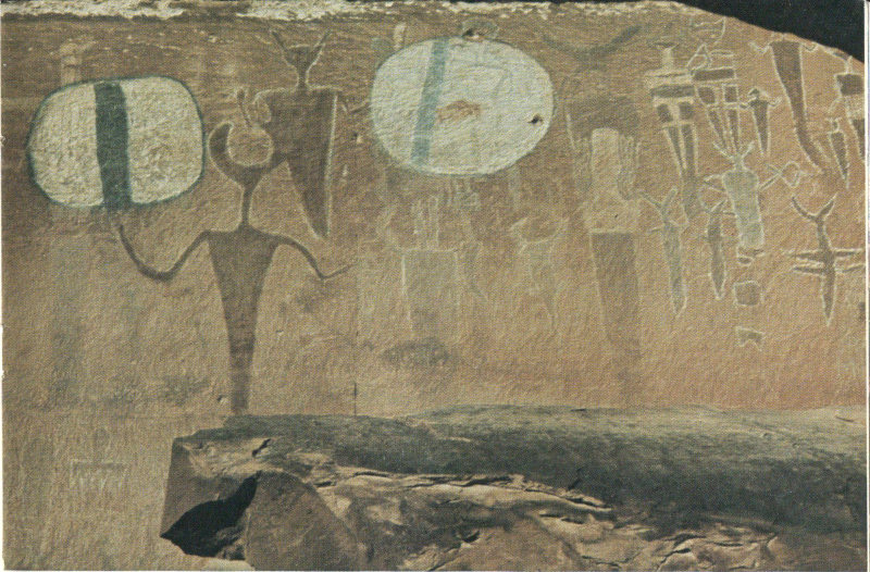
ROCK ART IN ARCHES NATIONAL PARK. A (above), “Moab panel,” on cliff of Wingate Sandstone above U.S. Highway 163 between Courthouse Wash and Colorado River, believed to be the work of “Barrier Canyon” style people. B (below), Petroglyphs on ledge of sandstone in Morrison Formation on east side of Salt Wash just north of Wolfe Ranch, believed to have been cut by Ute tribesmen. (Fig. 2)
Mrs. Schaafsma believes the petroglyphs in the lower photograph of figure 2 to be the work of Ute tribesmen, not only because of the horses, but also because of the stiff-legged appearance of the mountain sheep. Note the bullet hole above the panel.
Later arrivals in and near Arches National Park included first Spanish explorers, then trappers, cattlemen, cattle rustlers and horse thieves, followed in the present century by oil drillers, uranium hunters, jeepsters, and tourists. Butch Cassidy, the Sundance Kid, and other members of The Wild Bunch are known to have frequented parts of what is now Canyonlands National Park (Baker, Pearl, 1971), but it is not certain whether or not any of them traversed what is now Arches National Park.
The first settler in what is now Arches National Park was a Civil War veteran named John Wesley Wolfe, who was discharged from the Union Army about 3 weeks before the Battle of Bull Run because he suffered from varicose veins. In 1888 his doctor told him he had to leave Ohio for a dryer climate or he would not live 6 months, so he took his son Fred west and settled on a tract of 150 acres along the west bank of Salt Wash, where his “Wolfe cabin” still stands (figs. 1, 3). From family letters and newspaper clippings compiled by Mrs. Maxine Newell and other members of the National Park Service (Maxine Newell, written commun., 1971), we learn what life in the area was like:
We have started a cattle spread on a desert homestead. We call it the Bar-DX Ranch. Fred and I live in a little log house on the bank of a creek that is sometimes dry, sometimes flooded from bank to bank with roaring muddy water. We are surrounded with rocks—gigantic red rock formations, massive arches and weird figures, the like of which youve [sic] never seen. The desert is a hostile, demanding country, hot in summer, cold in winter. The Bar-DX Ranch is a day’s ride from the nearest store, out of the range of schools.
Although John Wolfe had promised his wife and his other children that he would return home the first fall that his cattle sales netted enough money, he and Fred stayed on and on, and his wife refused to go west and join her husband and son. Eighteen years later he sent money from his pension check to his daughter, Mrs. Flora Stanley, his son-in-law, Ed Stanley, and his two grandchildren, Esther and Ferol, to join him and Fred at the ranch. Their train was met at Thompson Springs (now Thompson), Utah (fig. 7), by John Wolfe for the 30-mile ride to the ranch by horse and wagon. Sight of the tiny log cabin with only a dirt floor brought tears to his daughter’s eyes, but her spirits rose considerably after John Wolfe promised to build a new log cabin with a wooden floor. But the children were enchanted with this strange country, with the building of the new cabin, and, especially, with getting to go rabbit hunting with Grandpa Wolfe. The Stanleys stayed at the ranch until Esther was 10, then moved to Moab to await the arrival of their third child, Volna.
In 1910 John Wolfe sold the Bar-DX Ranch, and the entire family moved to Kansas. John Wolfe later moved back to Ohio, and died at Etna, Licking County, on October 22, 1913, at the age of 84, 25 years after his doctor had warned him to move to a dryer climate or face an early death.
Wolfe had sold his spread to Tommy Larson, who later sold it to J. Marv Turnbow and his partners, Lester Walker and Stib Beeson. The old log cabin gradually came to be known as the “Turnbow cabin,” and this name appeared on early maps of the area by the U.S. Geological Survey and on early pamphlets by the National Park Service, partly because Marv Turnbow served as a camphand in 1927 assisting in the first detailed geologic mapping of the area (Dane, 1935, p. 4). In 1947 the ranch was sold to Emmett Elizondo, who later sold it to the Government for inclusion in what was then the monument.
From information supplied by Wolfe’s granddaughter, Mrs. Esther Stanley Rison, and his great-granddaughter, Mrs. Hazel Wolfe Hastler, who visited the cabin in July 14 1970, the original name Wolfe cabin, or Wolfe Ranch, has been restored, and appears on the newer maps and pamphlets. (See fig. 1.) What remains of Wolfe’s Bar-DX Ranch is shown in figure 3.
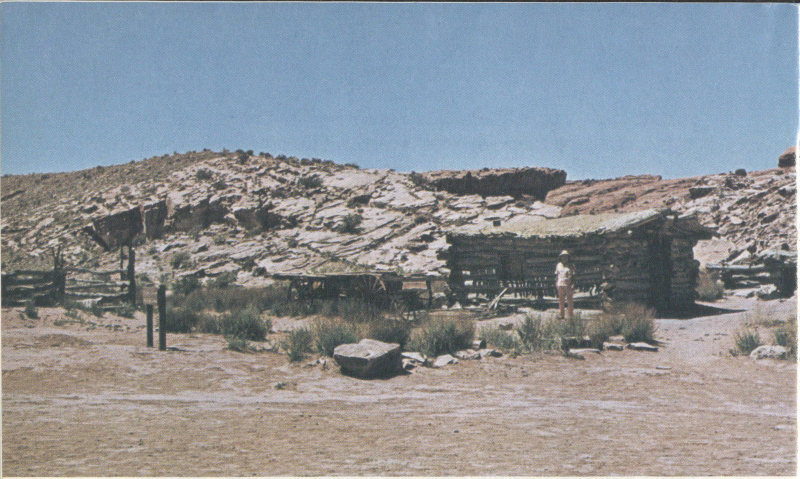
WOLFE’S BAR-DX RANCH, on west bank of Salt Wash at start of trail to Delicate Arch. Left to right: Corral, wagon, “new” cabin, and root cellar. “Old” cabin, which formerly was to right of photograph, was washed away by a flood in 1906. (Fig. 3)
Arches National Park is surrounded by active uranium and vanadium mines and by many test wells for oil, gas, and potash; it is underlain by extensive salt and potash deposits. Oil and gas are produced a few miles to the north and east, and potash is being produced about 12 miles to the south (Lohman, 1974).
Uranium and vanadium have been mined on the Colorado Plateau since 1898 (Dane, 1935, p. 176) and in the Yellow Cat area (also called Thompson’s area), just north of the park (fig. 1), since about 1911 (Stokes, 1952, p. 7). The deposits in the Yellow Cat area occur in the Salt Wash Sandstone Member of the Morrison Formation (fig. 4). According to Pete Beroni (U.S. Atomic Energy Commission, oral commun., August 6, 1973), some ore is still being produced in the Yellow Cat area, and the production of vanadium ore will increase as soon as the uranium mill at Moab is converted to also handle vanadium ore. The 15 Corral and so-called Shinarump mines along the southwest side of Moab Canyon just north of Sevenmile Canyon (fig. 1) are still actively producing uranium ore from the Moss Back Member of the Chinle Formation, according to Mr. Beroni.
The occurrences of salt and potash in and near the park and the attempts to find oil and gas nearby are discussed in a recent report (Hite and Lohman, 1973), and the deposits beneath Moab, Salt, and Cache Valleys are discussed in later chapters.
In 1955 and 1956 the Pacific Northwest Pipeline, known also as the “Scenic Inch,” was constructed by the Pacific Northwest Pipeline Corp. to transmit natural gas from wells in the San Juan Basin of northwestern New Mexico for a total of 1,487 miles to the Pacific Northwest, with additional pickups from gas fields in northeastern Utah, northwestern Colorado, and southwestern Wyoming (Walters, 1956). This 26-inch pipeline follows the general route of U.S. Highway 163 from Cortez, Colo., past Moab to Sevenmile Canyon 10 miles northwest of Moab, where it turns abruptly to the northeast and crosses about the middle of Arches National Park. It crosses the park road and the flat area between the Fiery Furnace and the southeast end of Devils Garden, but the scars are so well healed that most visitors are unaware of its existence unless they happen to look southwestward across Salt Valley, where the filled excavation is still visible. The filled trench also appears in the lower middle of figure 23.
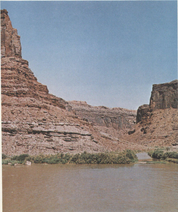
Unlike Canyonlands National Park a few miles to the south, Arches was not on the route of the famous early-day river expeditions of John Wesley Powell or of most of those that followed; however, the southeastern boundary of the park is the Colorado River, formerly the Grand, which was traversed by the first leg of the ill-fated Brown-Stanton expedition (Dellenbaugh, 1902, p. 343-369; Lohman, 1974).
The canyon of the Colorado River along the southeastern park boundary is deep and beautiful and is a favorite stretch of quiet water for boaters and floaters. Partly paved State Highway 128 on the east bank is a part of a 16 most scenic drive from Moab to Cisco—a small railroad town about 32 miles northeast of the eastern border of figure 1 (fig. 7). This road has been variously called the “Moab Mail Road,” the “Cisco Cutoff,” the “Dewey Road,” or the “Dewey Bridge Road” after an old suspension bridge (fig. 7) across the Colorado River at the old townsite of Dewey about 12 miles south of Cisco. During the summer this deep colorful canyon may be viewed at night by artificial illumination. Each evening one-half hour after sundown, an 80-passenger jet boat leaves a dock north of the highway bridge, carries passengers several miles upstream, then floats slowly downstream followed by a truck on the highway carrying 40,000 watts of searchlights which play back and forth on the colorful red canyon walls, while the passengers listen to a taped discourse. The entire trip requires about 2 hours.
The spectacular arches and red rocks of Arches and vicinity have been used to advantage in making color movies and color TV shows. Parts of the recent Walt Disney film “Run, Cougar, Run” were filmed beneath Delicate Arch (fig. 43), in Professor Valley of the Colorado River just east of the park (fig. 7), and in other sections of the canyon country.
Ever since military jet aircraft broke the sound barrier, there has been a growing number of protests from concerned citizens, organizations, and National Park Service officials concerning the dangers sonic booms have posed to Indian ruins and delicate erosional forms in our national parks and monuments, such as natural bridges, arches and windows, balanced rocks, and natural spires or towers. Many instances of damaged ruins, roads, erosional forms, and broken windows were reported. My wife and I can vouch for the destructive power of such booms, for in October 1969, while we were having breakfast at Squaw Flat Campground in The Needles section of Canyonlands National Park, a particularly severe blast from a low-flying jet not only violently rocked our jack-supported trailer but broke the windshield of our car.
At Arches National Park, particular fear was felt for Landscape Arch (fig. 53), thought to be the longest natural 17 stone arch in the world, and many a special round trip from headquarters involving 47 road miles and 2 trail miles was made to check on the condition of this arch after especially loud sonic booms were heard. Finally, in April 1972, following a rash of newspaper and magazine articles that spread across the nation, the Secretary of the Air Force put a virtual stop to this danger by ruling that, except in an emergency (Moab Times-Independent, April 12, 1972):
Supersonic flights must not only avoid passing over national parks, they also may not fly near them, according to the new regulation. For each 1,000 feet of altitude, the pilot must allow one-half mile between the flight path and the park boundary. The regulation also prohibits supersonic flights below 30,000 feet (over land) so the high speed planes must allow 15 miles between the nearest park boundary and the flight path.
Let us hope that with the aid of this long-needed regulation and cooperation from visitors, the arches will remain intact for many more generations to see.
Geologists have divided the United States into many provinces, each of which has distinctive geologic and topographic characteristics that set it apart from the others. One of the most intriguing and scenic of these is the Colorado Plateaus province, referred to in this report simply as the Colorado Plateau, or the Plateau (Hunt, C. B., 1956, fig. 1). This province, which covers some 150,000 square miles and is not all plateaus, as we shall see, extends from Rifle, Colo., at the northeast to a little beyond Flagstaff, Ariz., at the southwest, and from Cedar City, Utah, at the west nearly to Albuquerque, N. Mex., at the southeast. Arches National Park occupies part of the Canyon Lands Section, one of the six subdivisions of the Plateau. As the names imply, the Canyon Lands Section of the Plateau comprises a high plateau generally ranging in altitude from 5,000 to 7,000 feet, which has been intricately dissected by literally thousands of canyons.
Arches National Park is drained entirely by the Colorado River, whose deep canyon borders the park on the southeast (fig. 1). Most of the park is drained by Salt Wash, which enters the Colorado River just southeast of The Windows section, but the southwestern part is drained by Courthouse Wash and Moab Canyon, whose flows join the Colorado just west of the bridge on which U.S. Highway 163 crosses the river.
When viewed at a distance of 1 foot, the shaded relief map (fig. 1) shows the general shape of the land surface in and near Arches National Park to the same horizontal scale as it would appear to a person in a spacecraft flying at a height of 250,000 feet, or about 47.5 miles. This map 19 was prepared from part of the reverse side of a plastic-relief map[4] at a scale of 1:250,000 by the U.S. Army Map Service of the Moab quadrangle, using a simple time- and money-saving method (Stacy, 1962).
The vivid and varied colors of the bare rocks and the fantastic buttes, spires, columns, alcoves, caves, arches, and other erosional forms of Arches National Park result from a fortuitous combination of geologic and climatic circumstances and events unequalled in most other parts of the world.
First among these events was the piling up, layer upon layer, of thousands of feet of sedimentary rocks under a wide variety of environments. Sedimentary rocks of the region are composed of clay, silt, sand, and gravel carried and deposited by moving water; silt and sand transported by wind; and some materials precipitated from water solutions, such as limestone (calcium carbonate), dolomite (calcium and magnesium carbonate), gypsum (calcium sulfate with some water), anhydrite (calcium sulfate alone), common salt (sodium chloride), potash minerals, such as potassium chloride, and a few other less common types. Some of the beds were laid down in shallow seas that once covered the area or in lagoons and estuaries near the sea. Other beds were deposited by streams in inland basins or plains, a few were deposited in lakes, and the constituents of deposits like the Navajo Sandstone, were carried in by the wind. The character and thickness of the exposed sedimentary rocks and the names and ages assigned to them by geologists are shown in the rock column (fig. 4) and in the cross section (fig. 8). The history of their deposition is summarized on pages 98-102. Figure 4 was compiled mainly from generalized sections given by A. A. Baker (1933), Dane (1935), McKnight (1940), and Wright, Shawe, and Lohman (1962), and, in part, from Hite and Lohman (1973).
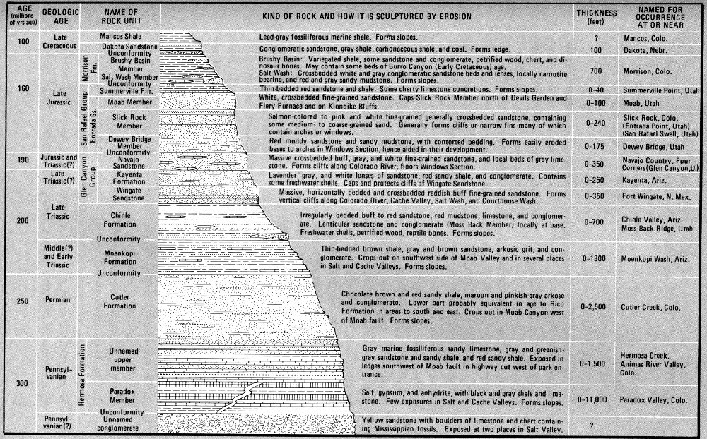
ROCK COLUMN OF ARCHES NATIONAL PARK. Average thickness of units 250-1,000 feet is exaggerated two times; those less than 250 feet, four times. 1 foot = 0.305 meter. (Fig. 4)
Not exposed in the area but present far beneath the sedimentary cover and exposed in several places a few miles to the northeast are examples of the other two principal types of rocks—(1) igneous rocks, solidified from molten rock forced into or above preexisting rocks along cracks, joints, and faults, and (2) much older metamorphic rocks, formed from other preexisting rock types by great heat and pressure at extreme depths. Igneous rocks of Tertiary age (fig. 59) form the nearby La Sal Mountains. The particles comprising the sedimentary rocks in the area were derived by weathering and erosion of all three types of rocks in various source areas.
Arches National Park and nearby Canyonlands National Park are both in the heart of the Canyon Lands Section of the Plateau; therefore, it is only reasonable to wonder why the differences in their general character seemingly outweigh their similarities. First, let us consider the similarities. Both parks are underlain by dominantly red sedimentary rocks, both parks feature unusual erosional forms of sandstone, and both contain beautiful natural arches, although the arches in Canyonlands are restricted almost entirely to the southeastern part of The Needles section and are in much older rocks than those in Arches.
To be sure, differences in the rocks themselves play a part in the dissimilarity of the two parks, and these differences are of two types. First, there are lateral changes in the character of the strata, known to geologists as facies changes, brought about by differences in the environment, in the type of materials, and in the mode of deposition even within relatively short distances. Thus, during parts of the Permian Period while sand, later to be known as the Cedar Mesa and White Rim Sandstone Members of 23 the Cutler Formation, was being deposited in the southern part of Canyonlands, red mud, silt, and sand of the Cutler were laid down farther north in Canyonlands (Lohman, 1974, fig. 9), and similar, though somewhat coarser, beds of the Cutler were laid down at Arches (fig. 4). Further comparisons of the rock columns in the two parks show that while limestones of the Rico Formation were being deposited in a shallow sea in the southern part of Canyonlands, additional red mud, silt, and sand of the Cutler were being laid down above sea level in areas to the northeast. The source of the coarser materials was the ancient Uncompahgre Highland, which stood above sea level from Late Pennsylvanian time to Late Triassic time (figs. 7, 59). Although wider and longer, it occupied about the same position as the present Uncompahgre Plateau between Grand Junction and Gateway, Colo. Streams eroded the hard igneous and metamorphic rocks from this ancient landmass and dumped the material into basins to the northeast and southwest. The basin to the southwest, now called the Paradox basin (after Paradox Valley, Colo.), at intervals contained shallow seas and lagoons, which I will discuss later.
Comparison of the rock columns for the two parks also reveals other differences. Both parks contain exposures of rocks as old as the Pennsylvanian Paradox Member of the Hermosa Formation. However, only in the Horseshoe Canyon Detached Unit of Canyonlands are rocks as young as the Jurassic Entrada Sandstone, whereas all the spectacular natural arches that make Arches famous were formed in the Entrada Sandstone, and Arches also contains several younger formations of Jurassic and Cretaceous age (fig. 4).
A commonly asked question is “Why are most of the rocks so red, particularly those in which the arches were formed?” This can be answered with one word—iron, the same pigment used in rouge and in paint for barns and boxcars. Various oxides of iron, some including water, produce not only brick red but also pink, salmon, brown, buff, yellow, and even green or bluish green. This does not imply that the rocks could be considered as sources of 24 iron ore, for the merest trace, generally only 1 to 3 percent, is enough to produce even the darkest shades of red. The white or nearly white Navajo Sandstone and the Moab Member of the Entrada Sandstone contain little or no iron.
As pointed out by Stokes (1970, p. 3), microscopic examination of the colored grains of quartz or other minerals shows the pigment to be merely a thin coating on and between white or colorless particles. Sand or silt weathered from such rocks soon loses its color by the scouring action of wind or water, so that most of the sand dunes and sand bars are white or nearly so.
Perhaps the greatest geologic contrast between these two closely adjacent parks lies in their different geologic structure—the kind and amount of bending and breaking of the once nearly flat lying strata. Consolidated rocks, particularly brittle types, are subject to two types of fracturing by Earth forces. Joints are fractures along which no movement has taken place. Faults are fractures along which there has been displacement of the two sides relative to one another (fig. 6). As noted in the report on Canyonlands National Park (Lohman, 1974), the strata there, particularly along the valley of the Green River, are virtually flat lying or have only very gentle dips. Along the Colorado River above the confluence with the Green, however, the slightly dipping strata are interrupted by several gentle anticlinal and synclinal folds (fig. 5) and by at least one fault (fig. 6). The largest of these folds—the Cane Creek anticline, which crosses the Colorado River north of Canyonlands—has yielded oil in the past and is 25 now yielding potash by solution mining of salt beds in the Paradox Member of the Hermosa Formation.
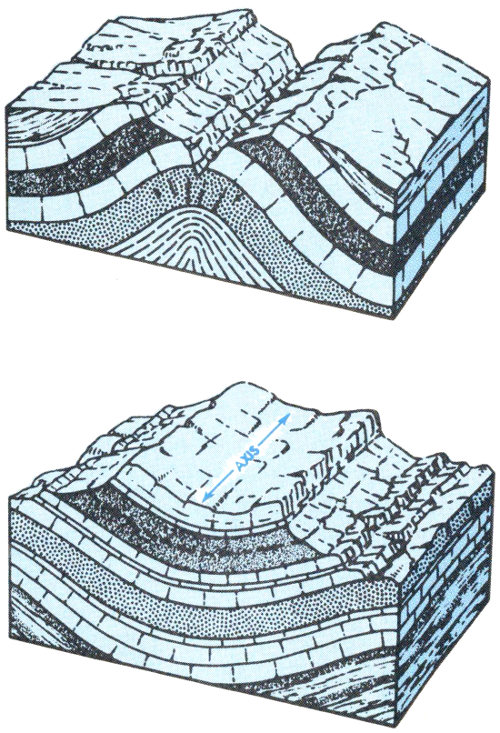
COMMON TYPES OF ROCK FOLDS. Top, Anticline, or upfold; closed anticlines are called domes. Bottom, Syncline, or downfold; closed synclines are called basins. From Hansen (1969, p. 31, 108). (Fig. 5)
In strong contrast to Canyonlands, Arches National Park contains three northwesterly trending major folds and is bordered on the southwest by a fourth. The largest and most important are the collapsed Salt Valley and Cache Valley anticlines, which separate the two most scenic groups of arches and other erosional forms—Eagle Park, Devils Garden, Fiery Furnace, and Delicate Arch on the northeast, and Klondike Bluffs, Herdina Park, and The Windows section on the southwest. Farther southwest is the Courthouse syncline, containing the attractive group of erosional forms called Courthouse Towers (fig. 1). 26 Finally, near the southwest edge of the park, is the Seven Mile-Moab Valley anticline (also known as the Moab-Spanish Valley anticline), whose southwest limb is cut off by the Moab fault (figs. 7, 23). The folds just named and the sharply contrasting geologic structures of the two parks are well shown on sheet 2 of the geologic map of the Moab quadrangle (Williams, 1964), and the geologic formations are shown in color on sheet 1.
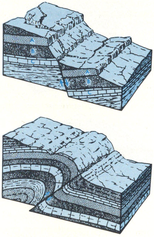
COMMON TYPES OF FAULTS. Top, Normal, or gravity fault, resulting from tension in and lengthening of the Earth’s crust. Bottom, reverse fault, resulting from compression in and shortening of the Earth’s crust. Low-angle reverse faults generally are called overthrusts or overthrust faults. In both types, note amount of displacement and repetition of strata. Displacements may range from a few inches or feet to many thousands of feet. From Hansen (1969, p. 116). (Fig. 6)
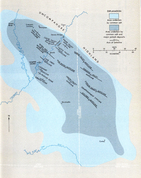
PARADOX BASIN, in southeastern Utah and southwestern Colorado, showing the extent of common salt and major potash deposits in the Paradox Member of the Hermosa Formation, and the salt anticlines. Adapted from Hite (1972, fig. 1B). (Fig. 7)
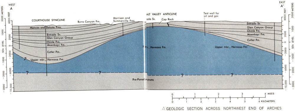
GEOLOGIC SECTION ACROSS NORTHWEST END OF ARCHES NATIONAL PARK, showing strata beneath Courthouse syncline and Salt Valley anticline. For line of section, see figure 9. Caprock consists of gypsum and shale, from which common salt has been leached by ground water, covered by alluvium. Heavy slanted lines near crest of anticline are faults. Adapted from Hite and Lohman (1973, fig. 13). (Fig. 8)
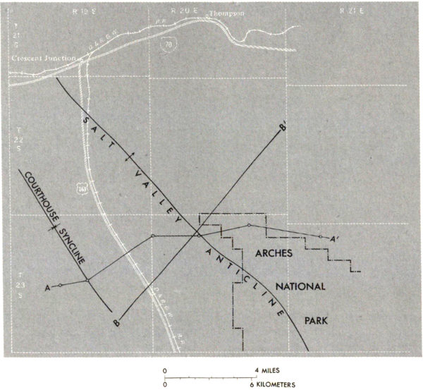
INDEX MAP OF NORTHWESTERN PART OF ARCHES NATIONAL PARK, showing axes of Courthouse syncline and Salt Valley anticline, line of section A-A′ in figure 8 and line of section B-B′ in figure 10. Open circles along line of section are sites of test wells for oil, gas, or potash. Adapted from Hite and Lohman (1973, fig. 12). (Fig. 9)
Arches National Park and most of nearby Canyonlands National Park lie within what geologists have termed the “Paradox basin,” which contains a remarkable assemblage of sediments called the Paradox Member of the Hermosa Formation. These deposits were laid down in shallow seas and lagoons during Middle Pennsylvanian time, roughly 300 million years ago (fig. 59). As indicated in figure 4, the Paradox Member contains, in addition to shale and limestone, minerals deposited by the evaporation and concentration of sea water—common salt, gypsum, anhydrite, and potash salts. For this reason such deposits are 30 collectively called evaporites. Figure 7 also shows that the northeastern part of the Paradox basin, which is the deepest part, contains a series of partly alined anticlines which have cores of salt and, hence, are called salt anticlines. As might be expected, roughly alined synclines intervene between the anticlines, but are not shown because of space limitations. According to Cater (1970, p. 50): “The salt anticlines of Utah and Colorado are unique in North America both in structure and in mode of development.” To this may be added that they also are relatively rare in the world.
A section across the Salt Valley anticline and the Courthouse syncline in the northwestern part of the park is shown in figure 8, and the axes of these structures are shown in figure 9.
Normally, a series of roughly parallel northwestward-trending folds would result from shortening of a segment of the Earth’s crust by compressive forces from the northeast and the southwest, but such does not seem to be the origin of these folds. The folds occur in a relatively narrow belt along the northeastern part of the Paradox basin, the deepest part, which was broken by a series of northwesterly trending normal faults (fig. 6) that cut the deep-lying Precambrian and older Paleozoic rocks (fig. 8) prior to the deposition of the salt-bearing Paradox Member of the Hermosa Formation. Movement along these faults continued intermittently during and after deposition of the Paradox, however, and resulted in the formation of a series of northwesterly trending ridges and troughs. Following Paradox time, normal sediments derived from a rising landmass to the northeast began to fill the basin. These sediments accumulated most rapidly and to greater thicknesses in the fault-derived troughs. Salt differs from normal sediments in two properties critical to the development of salt anticlines: first, salt is considerably lighter (fig. 10), and, second, salt under pressure will flow slowly by plastic deformation, much like ice in a glacier flows slowly downstream. Thus, salt in the troughs underlying the thicker and heavier masses of sediments was squeezed into the adjoining ridges, causing them to 31 rise. Once started, this process tended to be self-perpetuating, as the flow of salt from beneath the thick masses of sediments in the troughs made room for the accumulation of still greater thicknesses of normal sediments. Consequently, the troughs receiving most of the sediments began to form downfolds, or synclines, and the ridges receiving little or no normal sediments began to form huge salt rolls that later were to become the cores of the salt anticlines when finally the ridges too were buried by sediments. Thus, the cross section (fig. 8) shows about 12,000 feet of the Paradox Member beneath the crest of the Salt Valley anticline and only about 2,000 feet beneath the Courthouse syncline. Near the middle of these structures farther to the southeast, all the Paradox Member has been squeezed out from beneath the bordering synclines.
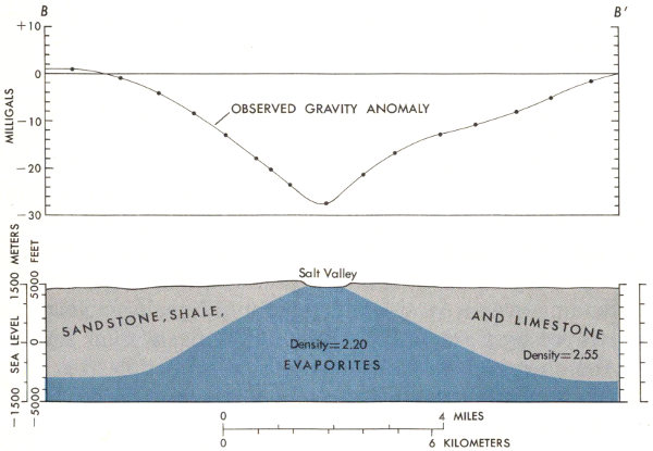
GRAVITY ANOMALIES OVER SALT VALLEY, along line B-B′ shown in figure 9, and relative densities and shapes of rock bodies beneath. Densities are in grams per cubic centimeter. Gravity values are in milligals, as shown. The standard acceleration of gravity is 980.665 centimeters per second per second; 1 gal is equal to 1 centimeter per second per second, and 1 milligal is one thousandth of a gal. Modified from Case and Joesting (1972, fig. 2). (Fig. 10)
The general shape of the Salt Valley anticline is shown also by cross-section B-B′ (fig. 10), taken along the northeast-southwest 32 line B-B′ in figure 9, which is based upon so-called gravity anomalies over Salt Valley. The lighter Paradox Member, having an average density of 2.20, has a lower gravitational attraction than the heavier rocks on each side, which have an average density of 2.55.
By this time you are doubtless wondering why prominent upfolds of the rocks, such as the Salt Valley anticline and associated Cache Valley anticline and the Seven Mile-Moab Valley anticline, now underlie relatively deep valleys bordered by prominent ridges. The formation of these valleys was not simple and involved many steps extending over a considerable amount of geologic time, as portrayed by Cater (1970, fig. 13; 1972, fig. 4). For a part of the story, let us reexamine the cross section (fig. 8); the rest of the story will be told in the section on “Uplift and Erosion.”
Figure 8 shows that the unnamed upper member of the Hermosa Formation and the overlying Cutler and Moenkopi Formations are thickest beneath the Courthouse syncline but wedge out against the flanks of the anticline. Although the Chinle Formation and younger rocks appear to extend across the fold, and may have extended across this part of the fold, in Colorado all rocks older than the Jurassic Morrison wedge out against the flanks of the salt anticlines (Cater, 1970, p. 35) and also in the widest part of the Salt Valley anticline southwest of the section in figure 8. The salt anticlines were uplifted in a series of pulses so that some formations either were not deposited over the rising structures or were removed by erosion before deposition of the next younger unit. By Morrison time the supply of salt beneath the synclines seems to have become used up; hence, the anticline stopped rising, and the Morrison and younger formations were deposited across the structures. Thus, in figure 4, the minimum thickness of all units older than the Morrison is given as zero. Figure 4 shows the marine Mancos Shale to be the youngest rock unit exposed in the park, but the Mesaverde Group of Late Cretaceous age and possibly the early Tertiary (fig. 59) Wasatch Formation may have been deposited and later removed by erosion.
Next among the main events leading to the formation of landforms in the park was the raising and additional buckling and breaking of the Plateau by Earth forces partly during the Late Cretaceous but mainly during the early Tertiary. After uplift and deformation, the Plateau was vigorously attacked by various forces of erosion, and the rock materials pried loose or dissolved were eventually carted away to the Gulf of California by the ancestral Colorado River. Some idea of the enormous volume of rock thus removed is apparent when one looks down some 2,000 feet to the river from any of the high overlooks farther south, such as Dead Horse Point (Lohman, 1974, fig. 15). Not so apparent, however, is the fact that younger Mesozoic and Tertiary rocks more than 1 mile thick once overlaid this high plateau but have been swept away by erosion. In all, the river has carried thousands of cubic miles of sediment to the sea and is still actively at work on this gigantic earth-moving project. In an earlier report (Lohman, 1965, p. 42) I estimated that the rate of removal may have been as great as about 3 cubic miles each century. For a few years the bulk of the sediment was dumped into Lake Mead, but now Lake Powell is getting much of it. When these and other reservoirs ultimately become filled with sediment—for reservoirs and lakes are but temporary things—the Gulf of California will again become the burial ground.
According to Cater (1970, p. 65-67), who made an intensive study of the salt anticlines, collapse of their crests seemingly occurred in two stages—the first stage following Late Cretaceous folding; the second following uplift 34 of the Plateau later in the Tertiary. Solution and removal of salt by ground water played the leading role in the ultimate collapse.
TILTED BLOCK OF ROCKS IN CACHE VALLEY GRABEN, viewed to the east toward Cache Valley from point on gravelled side road to Wolfe’s cabin, about half a mile east of paved road. Steep slope on left composed of Jurassic Morrison Formation, hogback on top formed by Dakota Sandstone of Late Cretaceous age, and gentle slopes to right composed of the Mancos Shale of Late Cretaceous age. (Fig. 11)
As shown by Dane (1935, pl. 1, p. 121-126), collapse of the Salt Valley and Cache Valley anticlines was accompanied by considerable faulting and jointing, particularly along their northeast sides; by the upward intrusion of two large areas of the Paradox Member of the Hermosa Formation, one just northwest of the park and one in the middle of Salt Valley south of the campground; and by two downdropped masses of rock known to geologists as grabens (pronounced gräbǝns)—one just northwest of the park and one called the Cache Valley graben, which extends both east and west from Salt Wash. The Cache Valley graben has preserved from erosion the youngest rock formations in the park, as shown in figure 11.
The remarkable jointing of the rocks on the northeast limb of the Salt Valley anticline is shown in figure 12. All the arches in this section of the park were eroded through thin fins of the Slick Rock Member of the Entrada 35 Sandstone, and some, like Broken Arch, figure 16, are capped by the Moab Member.
Differences in the composition, hardness, arrangement, and thickness of the rock layers determine their ability to withstand the forces of fracturing and erosion and, hence, whether they tend to form cliffs, ledges, fins, or slopes. Most of the cliff- or ledge-forming rocks are sandstones consisting of sand deposited by wind or water and later cemented together by silica (SiO₂), calcium carbonate (CaCO₃), or one of the iron oxides (such as Fe₂O₃), but some hard, resistant ledges are made of limestone (calcium carbonate). The rock column (fig. 4) shows in general how these rock formations are sculptured by erosion and how they protect underlying layers from more rapid erosion. The nearly vertical cliffs along the lower reaches of Salt and Courthouse Washes and the Colorado River canyon upstream from Moab consist of the well-cemented Wingate Sandstone protected above by the even harder sandstones of the Kayenta Formation. (See figs. 21, 22.) To borrow from an earlier report of mine (Lohman, 1965, p. 17), “Vertical cliffs and shafts of the Wingate Sandstone endure only where the top of the formation is capped by beds of the next younger rock unit—the Kayenta Formation. The Kayenta is much more resistant than the Wingate, so even a few feet of the Kayenta * * * protect the rock beneath.” In some places, as shown in figures 19 and 20, the overlying Navajo Sandstone makes up the topmost unit of the cliff.
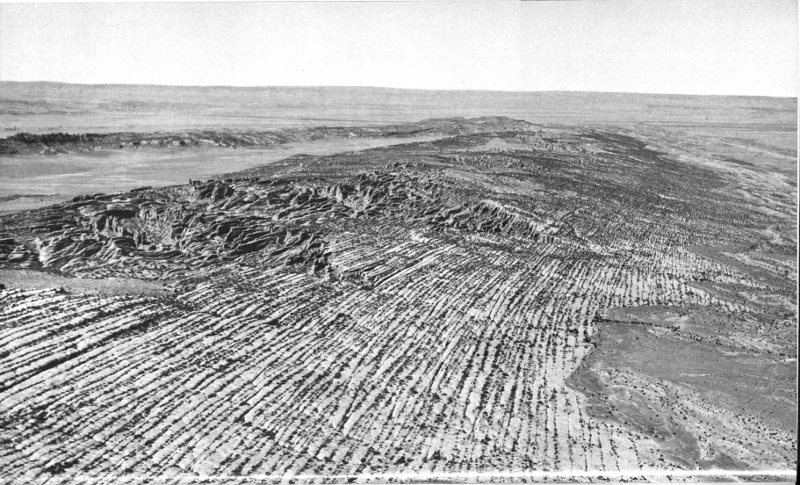
JOINTED NORTHEAST FLANK OF SALT VALLEY ANTICLINE, viewed westward from an airplane. Light-colored wedge in middle background is Salt Valley bordered on extreme left by Klondike Bluffs. Dark-colored fins and pinnacles on left, of Slick Rock Member of the Entrada Sandstone, form Devils Garden. Sharp pinnacle above valley is the Dark Angel. (See fig. 57.) White bands of sandstone extending to foreground are composed of Moab Member of the Entrada. Note vegetation in the joints. Photograph by National Park Service. (Fig. 12)
Last but far from least among the factors responsible for the grandeur of Arches National Park and the Plateau in general is the desert climate, which allows one to see virtually every foot of the vividly colored naked rocks, and which has made possible the creation and preservation of such a wide variety of fantastic sculptures. A wetter climate would have produced a far different, smoother landscape in which most of the rocks and land forms would have been hidden by vegetation. On the Plateau the vegetation grows mainly on the high mesas and the narrow flood plains bordering the rivers, but scanty vegetation also occurs on the gentle slopes or flats.
The combination of layers of sediments of different composition, hardness and thickness, the bending and breaking of the rocks, and the desert climate, has produced steep slopes having many cliffs, ledges, and fins with generally sharp to angular edges, rather than the subdued rounded forms of more humid regions.
Among the questions commonly asked by visitors are, “How do arches form?”, “Why are some openings called windows, others arches?”, “What is the difference, if any, between arches or windows and natural bridges, such as those at Natural Bridges National Monument?”, and “How many arches are there in Arches National Park?” Before taking up the origin and development of arches, I shall attempt to explain the differences between the three types of natural rock openings named above and comment upon the number of arches.
INDEX MAP, showing localities where
most of the photographs were taken.
Arrows point to distant views. Numbers
refer to figure numbers. (Fig. 13)
High-resolution Map
I believe most geologists and geographers are in general agreement with Cleland (1910, p. 314) that “a ‘natural bridge’ is a natural stone arch that spans a valley of erosion. A ‘natural arch’ is a similar structure which, however, does not span an erosion valley.” According to this definition, Natural Bridges National Monument includes three true bridges, whereas all the larger rock openings in Arches National Park with which I am familiar are properly termed “arches,” but some are called windows. If we were to distinguish between arches and windows, we might say that arches occur at or near the base of a rock wall, as do the doors of a house or building, whereas windows are found well above ground level. This distinction was not followed in naming the rock openings in the park, however; for example, Tunnel Arch (fig. 14) is considerably higher above the ground than North Window (figs. 37, 38) or South Window (fig. 39).
As to the number of arches in the park, I might begin by saying that there is no universal agreement as to how large a rock opening must be to qualify as an arch. The pamphlet formerly handed to visitors entering the park proclaimed that “Nearly 90 arches have been discovered, and others are probably hidden away in remote and rugged parts of the area,” but the average visitor probably sees less than a third of this number.
David May, Assistant Chief of Interpretation and Resource Management, Moab office of National Park Service (oral commun., Oct. 1973), believes that if only those in the park having a minimum dimension of 10 feet in any one direction were considered to be arches, the number would boil down to about 56 or 57. The most complete count of arches and other openings in all of southeastern Utah was made by Dale J. Stevens, Professor of Geography at Brigham Young University, during the period February through April 1973. He considered those with openings of 3 feet or larger and found more than 300 in southeastern Utah, of which 124 are in Arches National Park, although he stated that several areas of the park were not intensively searched because of time limitations (written commun., July and Sept. 1973). The 124 arches 41 and openings are distributed among the several named areas of the park, as follows: Courthouse Towers, 13; Herdina Park, 11; The Windows section, 25; Delicate Arch area, 3; Fiery Furnace, 19; Devils Garden, 25; upper Devils Garden (northwest of Devils Garden), 14; Eagle Park, 2; and Klondike Bluffs, 12.
Professor Stevens generally used a range finder or a steel tape to measure the width and height of the openings and the width and thickness of the spans, but estimated a few of the dimensions. In the text descriptions of arches or captions of figures that follow, I am including all or part of these measurements, without further acknowledgment.
All the arches in the park were formed in the Entrada Sandstone, mainly in the Slick Rock Member but partly in the Slick Rock and Dewey Bridge Members, and a few in the Slick Rock Member occur not far beneath the base of the overlying Moab Member. The sandstone of the three members is composed mainly of quartz sand cemented together by calcium carbonate (CaCO₃), which also forms the mineral calcite and the rock known as limestone, but the Dewey Bridge Member also contains beds of sandy mudstone. Limestone and calcite are soluble in acid, even in weak acid such as carbonic acid, HHCO₃, also written H₂CO₃, formed by the solution of carbon dioxide (CO₂) in water. Ground water, found everywhere in rock openings at different depths beneath the land surface, contains dissolved carbon dioxide derived from decaying organic matter in soil, from the atmosphere, and from other sources. Even rainwater and snow contain a little carbon dioxide absorbed from the atmosphere—enough to dissolve small amounts of limestone or of calcite cement from sandstone. The calcite cement in the Entrada and in many other sandstones is unevenly distributed, however, so that all the cement is removed first from places that contain the least amounts, and, once the cement is dissolved away, the loose sand is carried away by gravity, wind, or water.
Both nearly flat but slightly irregular beds of sandstone and relatively thin walls or fins of sandstone are prime 42 targets for this differential erosion. Potholes, as shown in figure 18A, may be formed in relatively flat beds by the dissolving action of repeated accumulations of rainwater or snowmelt, even in arid regions like the Plateau.
Relatively thin walls, or fins as they are called in parts of the Plateau including Arches, are targets for the formation of alcoves and caves by solution of cement and removal of sand by gravity, wind, and water, aided by the prying action of frost in joints, bedding planes, or other openings. Once a breakthrough of a wall or fin occurs, weakened chunks from the ceiling tend to fall, and natural arches of various shapes and sizes are produced. Arches form the strongest shapes for supporting overlying rock loads, as the rock in the arch is compressed toward each abutment by the heavy loads. Blocks of compressed rock beneath a relatively flat ceiling tend to be dislodged also by expansion due to release of pent-up pressure, until a strong self-supporting arch is formed. Release of pent-up pressure in rock walls may help also in initiating the formation of alcoves or caves in cliff faces. Man, including the ancient Greeks, Romans, Egyptians, and others, has long made use of arches in building bridges, aqueducts, temples, cathedrals, and other enduring edifices.
As vividly shown in figure 12, the Entrada Sandstone on the northeast flank of the Salt Valley anticline has been broken by Earth forces into thin slabs mostly 10 to 20 feet thick between nearly parallel joints, but, as will be noted in the descriptions of individual arches, some rock walls are only 1 or 2 feet thick, whereas others are 50 feet thick or more. Some weak or thin slabs have weathered away, leaving the stronger or thicker ones as towering fins, particularly in the Fiery Furnace and Devils Garden areas. Jointing on a less spectacular scale also has broken the Entrada in areas south of Salt Valley, leaving walls or fins of rock.
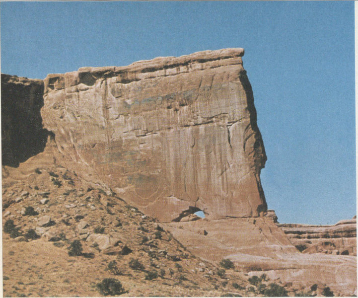
TUNNEL ARCH, reached by short trail north of main trail through Devils Garden. Opening is 26½ feet wide and 22 feet high; span is about 14 feet thick. (Fig. 14)
Although all the arches in the park were carved from the Entrada Sandstone, slight differences in their mode of origin or placement within the Entrada allow them to be grouped into three classes: (1) vertical arches formed in the Slick Rock Member alone or in the Slick Rock and Moab Members, (2) vertical arches formed mainly in the Slick Rock Member but partly in, and with the aid of, the incompetent underlying Dewey Bridge Member, and (3) horizontal arches, or so-called pothole arches, formed from the union of a vertical pothole and a horizontal cave. Hereinafter, the three members will be referred to alone, without reference to the Entrada.
“BABY ARCH,” just southwest of Sheep Rock in Courthouse Towers area. For details, see text. (Fig. 15)
Before giving examples of arches in each of the three classes, it is appropriate to remark that the arches and other erosion forms in the park represent but a fleeting instant in geologic time. Many of the pinnacles or piles of rock may be the broken remains of former arches, and many of the arches we see may be gone tomorrow, next year, or a few hundreds of years and, certainly, before many thousands of years. On the other hand, many new arches will form by the processes described above as the geologic clock ticks on.
BROKEN ARCH, reached by a ½-mile trail leading northward across field that separates Fiery Furnace from Devils Garden. White thin-bedded unit at top is the Moab Member, which rests upon the massive salmon-colored Slick Rock Member. Opening is 59 feet wide and 43 feet high. (Fig. 16)
Tunnel Arch (fig. 14) is a good example of an arch eroded entirely within the massive Slick Rock Member. Just southwest of Sheep Rock (fig. 31) is an unnamed opening in the lower part of the Slick Rock Member which I call “Baby Arch,” because it is one of the newest ones visible from the park road (fig. 15). It is only 25½ feet wide and 14 feet high and penetrates a wall 14 feet thick. Note that the breakthrough probably began along the prominent recessed bedding plane at the base of the arch. Its youthfulness is also indicated by the sharp, angular breaks in the ceiling and by the pile of freshly fallen rocks. Some visitors have asked park personnel why they have not cleared away such debris! Despite its youthfulness, the ceiling has already taken on the shape of an arch.
Broken Arch (fig. 16) was formed near the top of the Slick Rock Member and is strengthened and protected by the more resistant overlying Moab Member, which forms the upper half of the span. The crest is only 6 feet thick at the thinnest point and is not broken as the name seems to imply.
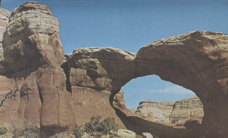
Double Arch (fig. 17), “one” of the most beautiful in the park, is in The Windows section near the east end of the road. The southeast arch, which is 160 feet wide and 105 feet high, is the second largest in the park, but the west arch measures only 60 feet wide and 61 feet high. In common with most arches in The Windows section, these two arches of the Slick Rock Member rest upon bases of the weak, easily eroded Dewey Bridge Member. More rapid erosion of the Dewey Bridge undercut the arches and hastened their development.
DOUBLE ARCH, in The Windows section. (Fig. 17)
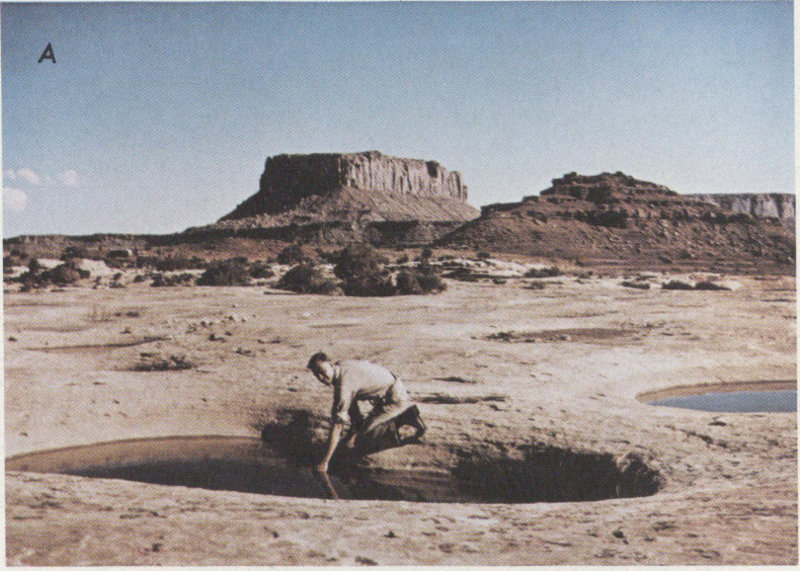
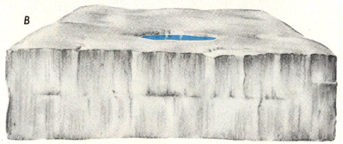
PROBABLE STEPS IN FORMATION OF POTHOLE ARCH. A, Original pothole probably formed in relatively level bed of sandstone, such as this one, which is in an older rock unit—the White Rim Sandstone Member of the Cutler Formation, a unit not present in Arches. This pothole, which contains 4 feet of water, is in nearby Canyonlands National Park (Lohman, 1974, fig. 17), just north of the edge of the White Rim, about 4½ miles north of the confluence of the Green and Colorado Rivers. Photograph by E. N. Hinrichs. B, Pothole is being deepened by solution while cliff is receding toward pothole by weathering. C, As erosion continues, pothole and cave in cliff face are growing deeper. D, Pothole Arch formed by union of vertical pothole and horizontal cave. E, Telephoto view of Pothole Arch from park road near stop 14. Visible span is 90 feet across and 30 feet high. (Fig. 18)
The cause of the wavy bedding in the Dewey Bridge Member, as shown in figure 17 but as better shown in the frontispiece, is not known for sure but generally is regarded to be the result of irregular slumping during or just after deposition of the sediments in a body of water, caused by the weight of overlying sediments.
The last example I shall take up is Pothole Arch (fig. 18), which differs from all the other examples in that this arch is roughly horizontal rather than vertical. Most park visitors, including me, were not aware of this interesting feature until after publication of the pamphlet “The Guide to an Auto Tour of Arches National Park,” which, as previously noted, may be purchased at the Visitor Center. Pothole Arch caps a ridge high above the road half a mile northwest of Garden of Eden, so only those who happened to look up at the right place were aware of its existence.
A different mode of origin than that given in the caption for figure 18 is depicted on a poster in the Visitor Center, which shows the pothole being formed by a waterfall having an apparent flow rate of several cubic feet per second. Potholes can be formed in this manner in places where sufficient streamflow is available, either continuously or following rainstorms, but I believe the process depicted in figure 18 is a more likely mode of origin for Pothole Arch.
As aptly stated on a poster in the Visitor Center, how to see the park depends in part upon the question “How long can you stay?” Inasmuch as the park entrance and Visitor Center are beside a through U.S. Highway (163), many motorists first become aware of the park’s 51 existence from the entrance sign, and some take time for at least a quick visit, such as a round trip to The Windows section, which can be made in an hour or so.
For those who have or take more time and are able to walk at least short distances, a visit of 1 or 2 days is a very rewarding experience. Others, particularly avid shutterbugs and those with camping gear, profitably spend from several days to a week or more and hike all or most of the trails.
Regardless of how long you plan to spend, I urge at least a brief stop at the Visitor Center, where excellent displays and a narrated slide show help materially in conveying just what the park has to offer. At the counter you can purchase a copy of “The Guide to an Auto Tour of Arches National Park,” which explains the views from each of 25 numbered stops along the park road, as well as other reports describing arches or other parks and monuments.
The park is open the year round, but, like most high deserts, it gets rather hot in the summer and cold enough in the winter for occasional snows and is sometimes closed temporarily because of heavy snowfall. The weather generally is ideal during the spring and fall. Even though summer daytime temperatures may exceed 100°F (37.8°C) and slow down hikers, the nights are cool enough for comfortable sleeping beneath ample covers.
Before beginning our trip through the park proper, let us consider a beautiful part many people fail to realize actually belongs to the park—the Colorado River canyon forming the southeastern boundary.
The southeastern boundary of the park for about 11 miles is the Colorado River, from the bridge on which U.S. Highway 163 crosses the river to a point upstream about half a mile below the mouth of Salt Wash. Illuminated night float trips down part of this reach are run during the summer, as noted on p. 16. Partly paved State Highway 128 follows the southeast side of the river for about 30 miles to Dewey Bridge, then goes northward about 15 miles to Cisco, where it connects with Highway I-70.
The rocks of the Glen Canyon Group form the southernmost corner of the park, as shown in figure 19. About 2 miles northeast of the bridge, we cross the axis of the Courthouse syncline (fig. 9), which brings the Navajo Sandstone down nearly to river level, as shown in figure 20. The underlying Kayenta Formation is largely hidden by vegetation and alluvial deposits in this view.
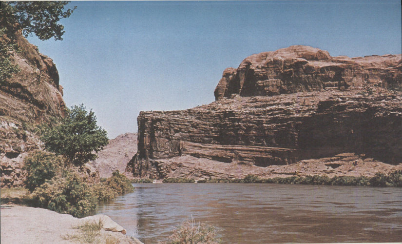
GLEN CANYON GROUP, forming southernmost point of park, as viewed across the Colorado River from State Highway 128 half a mile above Moab bridge carrying U.S. Highway 163. Massive sandstone forming about the lower third of cliff is the Wingate Sandstone, darker thin-bedded sandstones and mudstones forming middle section of cliff comprise the Kayenta Formation, upper cliff is the lower part of the Navajo Sandstone. Note that the saltcedar (tamarisk), which lines both banks of the river, is in full bloom. (Fig. 19)
NAVAJO SANDSTONE CLIFFS, bordering west bank of Colorado River in Courthouse syncline, from State Highway 128 about 2 miles above the Moab bridge. Note rounded domes at top of cliff. (Fig. 20)
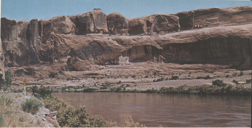
MOUTH OF SALT WASH, viewed across Colorado River from point on State Highway 128, 11 miles above Moab bridge. Dark cliffs on upper right and left are of Wingate Sandstone capped by thin protective cover of resistant sandstone beds of the Kayenta Formation. In background Wingate is overlain by entire Kayenta Formation and lower part of the Navajo Sandstone. Wingate is underlain to river level by weathered slope of the Chinle Formation. Water in Salt Wash is largely backwater from the bankfull river; actual flow in wash generally is much less but at times reaches flood proportions. (Fig. 21)
About 11 miles above the Moab bridge is the mouth of Salt Wash (fig. 1), as viewed from State Highway 128. (See fig. 21.) Seventeen miles above the bridge (east of area shown in fig. 1), we get an excellent view of the southeast end of the highly faulted Cache Valley anticline, as shown in figure 22. The background shown in the 56 photograph formerly was the easternmost part of the former monument, but when the monument graduated to a park on November 16, 1971, this part of Cache Valley along with most of Dry Mesa was withdrawn from the park and put under the supervision of the Bureau of Land Management, also a part of the Department of the Interior.
SOUTHEAST END OF FAULTED CACHE VALLEY ANTICLINE, viewed northwestward across Colorado River from a point on State Highway 128, 17 miles above Moab bridge. High cliff of Wingate Sandstone on left is capped by thin protective layer of the Kayenta Formation. About upper third of slope below base of cliff is the Chinle Formation, below which is the Moenkopi Formation extending to high-water level. Note bent and broken beds on right. (Fig. 22)
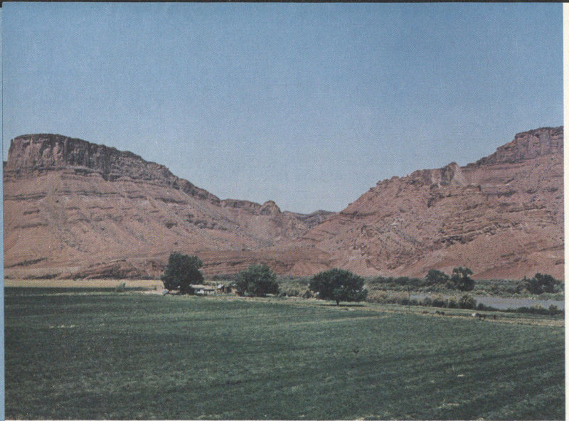
As noted on page 16, part of “Run, Cougar, Run” was filmed just upstream from the irrigated field in the foreground of figure 22, in a wide part of the valley called Professor Valley (fig. 7). This valley and the Richardson Amphitheater on the southeast side of the river were named after a Professor Richardson who settled in the area in the 1880’s. The long abandoned townsite of Richardson was 1¼ miles due east from the point from which figure 22 was taken.
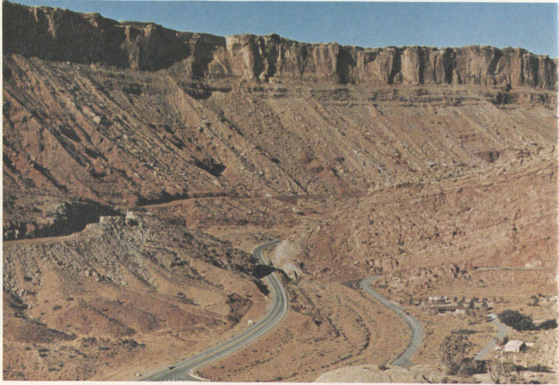
The junction of the park road with U.S. Highway 163 is shown at the lower left of figure 23, and the entrance station, Visitor Center, parking lot, and several buildings are seen at the lower right. Several residences for park personnel and other buildings are shown in figure 25. As shown in the lower part of figure 23, the geology at the park entrance is rather complex, as the park boundary here is partly along the Moab fault and partly along a branch fault—both in the Seven Mile-Moab Valley anticline (fig. 7). The Moab fault extends northwestward from Moab for more than 30 miles (McKnight, 1940, p. 120, 121, pl. 1).
As shown in figure 23, soon after leaving the checking station the park road begins to ascend the first of several switchbacks, and cuts first into the Slick Rock Member, then the Dewey Bridge Member, and finally the Navajo Sandstone the rest of the way to and beyond the top of the hill.
From points a mile or so up the hill may be seen interesting features in several directions.[5] The view to the southwest is shown in figure 23, to the west are the Three Penguins (fig. 24). A good view of the Moab Valley is had by looking southeastward (fig. 25). A well in the Navajo Sandstone at the base of the hill supplies water to all the residences and to the Visitor Center, where a drinking fountain and modern restrooms are available to the public. Storage is provided by a steel tank hidden in a ravine above the buildings shown in figure 25.
To the north the wall of Entrada Sandstone is cut by a normal fault (fig. 6), as shown in figure 26.
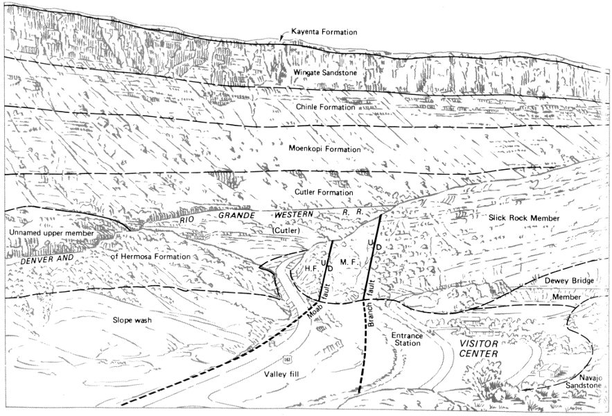
FAULTED SEVEN MILE-MOAB VALLEY ANTICLINE. Top, View toward the southwest from park road about 1 mile above entrance station. Bottom, Geologic interpretation of photograph in part after McKnight (1940, pl. 1). Moab fault and branch fault (both normal faults, fig. 6) unite just beyond ridge of Slick Rock Member. Total vertical displacement along both faults is about 2,500 feet. H.F., unnamed upper member of Hermosa Formation; M.F., Moenkopi Formation; D, downthrown side of faults; U, upthrown side. Valley fill and slope wash of recent (Holocene) age obscure faults and underlying rocks. The original sequence of the rocks may be visualized by placing the Navajo Sandstone, the upper part of which is exposed at the lower right, on top of the Kayenta Formation, the lower few feet of which cap and protect the cliffs of Wingate Sandstone in the background. The Pacific Northwest (gas) Pipeline mentioned on page 15 is buried beneath the slice of the Moenkopi Formation between the two faults, which accounts for the disturbed appearance of the rock. (Fig. 23)
THREE PENGUINS, viewed westward from park road about 1 mile above entrance station. Penguins are carved in massive Slick Rock Member seen resting upon thin-bedded Dewey Bridge Member. (Fig. 24)
MOAB VALLEY, viewed southeastward from park road about 1 mile above entrance station. Moab fault in about middle of valley, hidden beneath recent (Holocene) valley fill and slope wash, separates unnamed upper member of Hermosa Formation just above U.S. Highway 163 on right from Navajo Sandstone forming hills on left and ledges in foreground. Park Service residences at base of hill. White patch bordering Colorado River on northwest is tailings pile of Atlas Corporation’s uranium mill. Moab and Spanish Valley are beyond river, and south end of La Sal Mountains forms distant skyline. (Fig. 25)
FAULTED WALL OF ENTRADA SANDSTONE, north of park road about 1 mile above entrance station. Fault is nearly vertical and normal (fig. 6), but fault trace slopes steeply downward to right, separating upthrown Slick Rock and Dewey Bridge Members on left from downthrown Slick Rock Member on right. Light-colored rock in foreground is Navajo Sandstone. Displacement probably does not exceed 50 feet. (Fig. 26)
PARK AVENUE, viewed to the north along trail. (Fig. 27)
About 2.3 miles from the entrance station is a turnoff and parking area at the south end of the Park Avenue trail (stop 2), which is about 1 mile long and ends at another parking area 1.7 miles farther north. An interesting hike is best made from south to north in a downhill direction, and hikers generally meet the cars of relatives or friends awaiting them at the northern parking area. The trail begins in a canyon cut in the soft Dewey Bridge Member and walled by high fins of the Slick Rock Member (fig. 27), but farther north the canyon is floored by the bare Navajo Sandstone. The avenue was named from the resemblance of the east wall to a row of tall buildings. Atop the west wall, just to the left of the view in figure 27, are two balanced rocks (fig. 28). The one on the left, which resembles somewhat the head of an Egyptian queen, is offset to the right along a bedding plane, and this offset may have been caused by an earthquake.
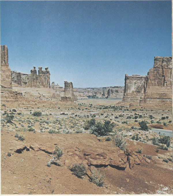
As we progress toward Courthouse Towers proper, lofty fins and monoliths lie mostly on our left, and to the right are fine distant views of the La Sal Mountains (stop 4). A general view of the Courthouse Towers is shown in figure 29, and closeups of two of the named rock sculptures—the Three Gossips and Sheep Rock—are shown in figures 30 and 31. Just beyond Sheep Rock, which some think resembles the Sphinx, we see “Baby Arch,” shown in figure 15.
Five miles from the entrance station, the road crosses Courthouse Wash on a modern bridge (stop 6)—a distinct improvement over the two tracks in the sand we used in 1946. The Courthouse syncline, named after the wash, extends northwestward through here. (See figs. 8, 9, 20.) About a mile west of the bridge, Professor Stevens found another pothole arch. A mile and a half north of the bridge is stop 7, where attention is called in the booklet to the vast area of “petrified dunes” east of the road, which are simply dunelike exposures of the crossbedded Navajo Sandstone formed originally by the cementation of a vast area of sand dunes. My view of these was taken about 1 mile beyond the stop (fig. 32).
BALANCED ROCKS ON SOUTH WALL OF PARK AVENUE, at south end of trail. (Fig. 28)
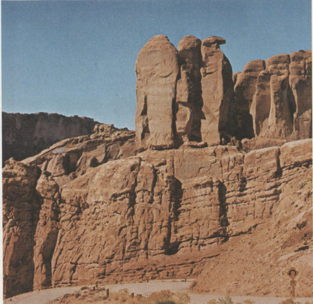
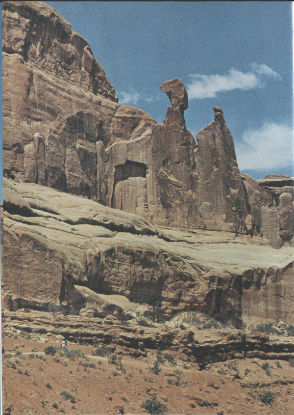
COURTHOUSE TOWERS, viewed to the northwest from point on park road about three-fourths of a mile northeast of the south end of Park Avenue trail. Sandstone towers are Slick Rock Member resting on Dewey Bridge Member, which also forms foreground. Three Gossips at upper left, Sheep Rock just beyond. The Organ and Tower of Babel are on right. (Fig. 29)
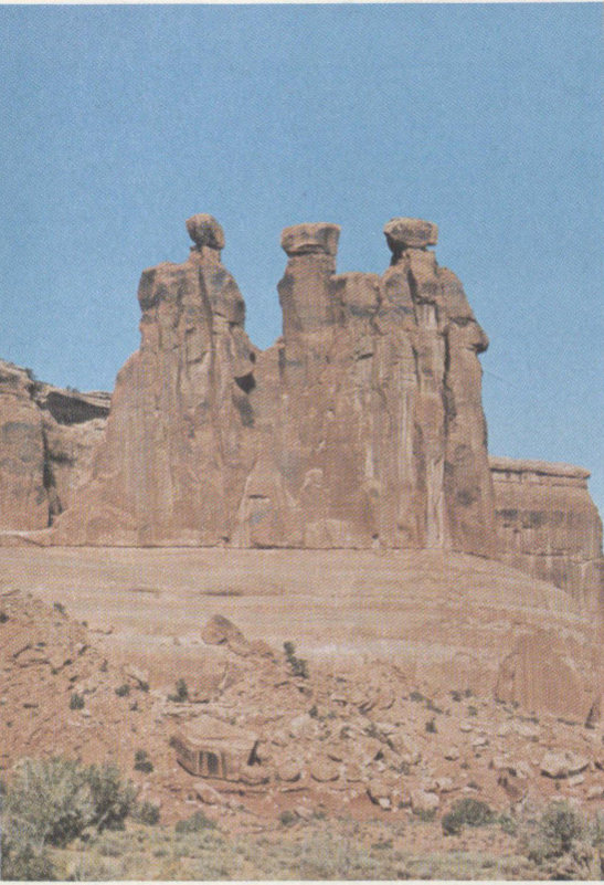
THE THREE GOSSIPS, shown at upper left of figure 29. (Fig. 30)
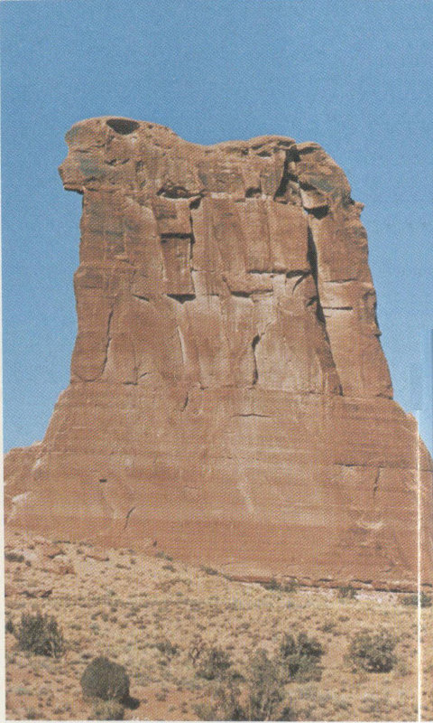
SHEEP ROCK, shown on center-left skyline in figure 29. (Fig. 31)
West of the road between the petrified dunes and The Windows section, the Entrada Sandstone, particularly the Dewey Bridge Member, has been weathered into grotesque spires and pinnacles resembling the so-called “hoodoos and goblins” in Goblin Valley State Park, just north of Hanksville, Utah. Typical examples of “hoodoos and goblins” are shown in figure 33 (near stop 8). It seems reasonable to assume that some of these spires are the skeletal remains of former arch abutments. From here may be seen North and South Windows and Turret Arch on the skyline to the northeast (figs. 37-40).
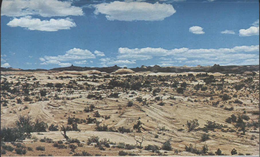
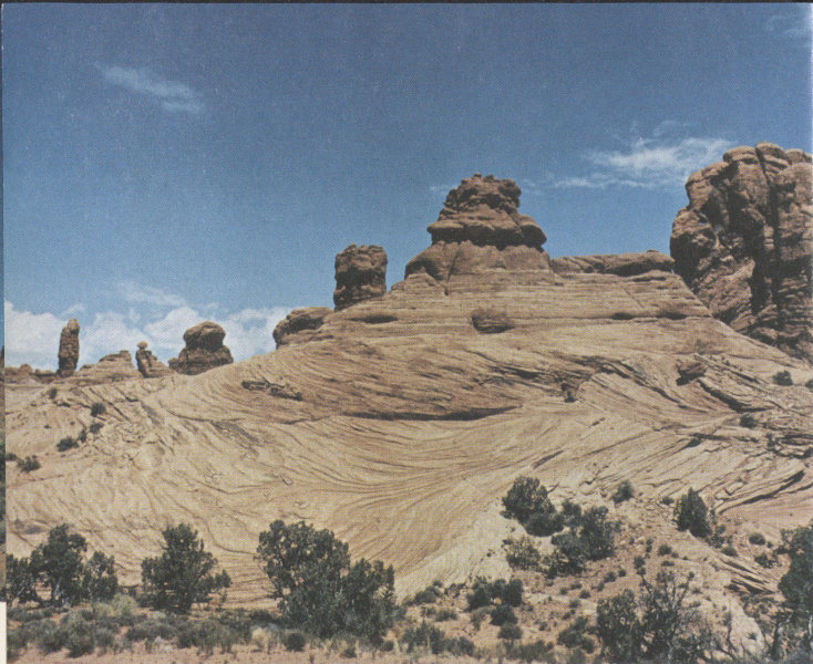
PETRIFIED SAND DUNES, looking northeast from park road 2.7 miles north of Courthouse Wash. The Navajo Sandstone was once a huge sandpile of dunes laid down by winds during an arid interval, so it is interesting to note that the irregularly weathered sandstone once again resembles a pile of crossbedded dunes. See also figure 35. (Fig. 32)
“HOODOOS AND GOBLINS,” weathered from Dewey Bridge Member, viewed northwest from park road about 2½ miles north of Courthouse Wash. (Fig. 33)
The Windows section, one of the most beautiful parts of the park, once was the only readily accessible part of the former monument and is still the only collection of arches seen by many visitors who either do not have or do not take time to travel farther north. All the arches and erosion forms are on or near a high crest called Elephant Butte (Dane, 1935, p. 126, 127), which separates Salt Valley from the Courthouse syncline. The ridge also marks the south edge of several minor anticlines and synclines termed by Dane the “Elephant Butte folds.”
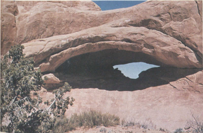
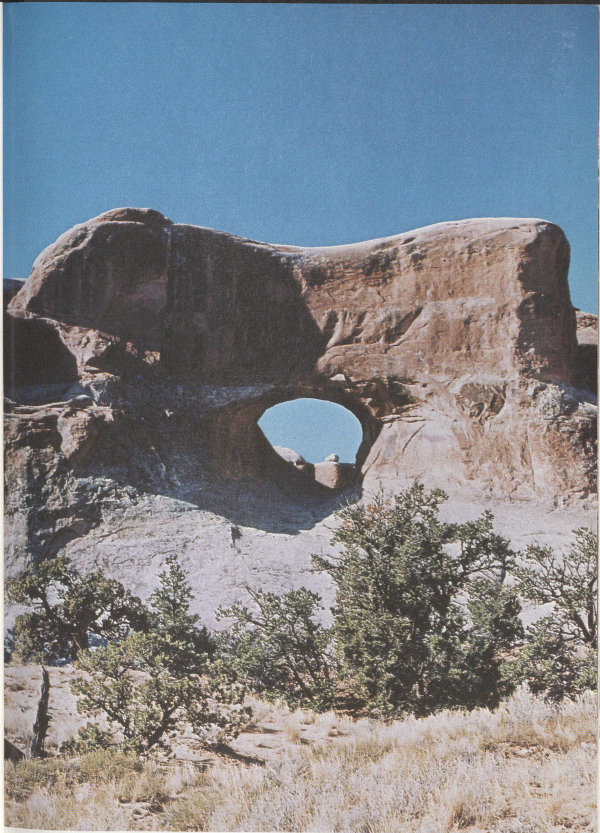
EYE OF THE WHALE, one of several arches in Herdina Park, just south of jeep trail about 2 miles northwest of Balanced Rock. Cut in Slick Rock Member. Front opening is 60 feet wide and 27 feet high, but back opening is only 35 feet wide and 11 feet high. Photograph by Professor Dale J. Stevens, Brigham Young University. (Fig. 34)
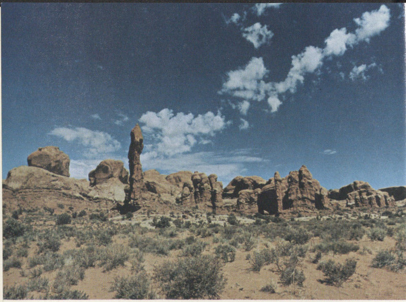
Guarding the approach to The Windows section is Balanced Rock (stop 9). As shown in the frontispiece, it is accompanied on the right by another balanced rock and a third one may be seen in the distance. The original route to The Windows section, pioneered by Goulding, passed just north of Balanced Rock. Traces of the old road between here and the Garden of Eden parking area are still visible but no longer used. To the west, however, a part of the old road is the starting point of a jeep trail leading northwestward through Herdina Park to a point near Klondike Bluffs, where it joins the dirt road in Salt Valley (fig. 1). Visitors having four-wheel-drive vehicles may wish to drive at least as far as Eye of The Whale (fig. 34), 70 which is about 2 miles northwest of Balanced Rock. There are several picnic tables at the beginning of this jeep trail, but no water.
INTRICATE CROSSBEDS IN NAVAJO SANDSTONE, on north side of road between Garden of Eden and Cove of Caves. Red crest is basal part of Dewey Bridge Member. (Fig. 35)
Just beyond Balanced Rock, a branch paved road turns eastward 2½ miles to the main parking lots in The Windows section. Between the Garden of Eden (stop 13) and Cove of Caves are spectacular exposures of the Navajo Sandstone showing the crossbedding typical of the original dunes (fig. 35). Just east of the crossbedded Navajo Sandstone, shown in figure 35, we pass Cove Arch and Cove of Caves (stop 10) on the north side of the road (fig. 36).
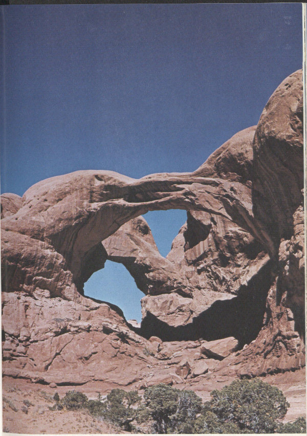
Just around the curve east of Cove of Caves is the first of two parking lots (stop 11) forming a one-way loop at the end of this branch of the road. From the loop may be seen the greatest concentration of readily accessible arches 71 in the park, all of which are roofed by the Slick Rock Member and floored by the Dewey Bridge Member. Let us take the short paved trail from the upper lot to the southeast, where we come first to North Window (fig. 37). If we walk through this arch and climb the rock beyond (fig. 37 caption), we see one of the best views in the park (fig. 38). A short walk south of North Window brings us to South Window (fig. 39). The other side of this arch may be reached either by walking around the nearby southeast end of the fin or by walking through North Window. A short walk to the southwest brings us to Turret Arch—the one seen through North Window in figure 38. Figure 40 was taken from the southwest side of Turret Arch, viewed northeastward toward South Window, one corner of which appears at the left. Both North and South Windows may be seen in one photograph taken from points near Turret Arch.
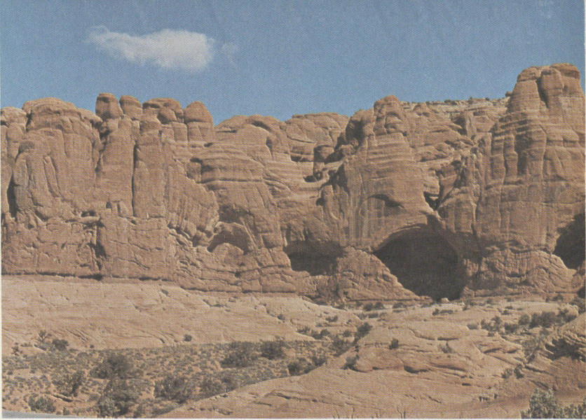
COVE ARCH AND COVE OF CAVES, on north side of road just west of Double Arch and Parade of Elephants. Arch at left and three of the caves on right are roofed by Slick Rock Member and floored by Dewey Bridge Member. Arch is 48½ feet wide and 34 feet high. In time the caves will eat through the 30-foot-thick fin and become arches. Note sharp contact between Dewey Bridge Member and Navajo Sandstone. (Fig. 36)
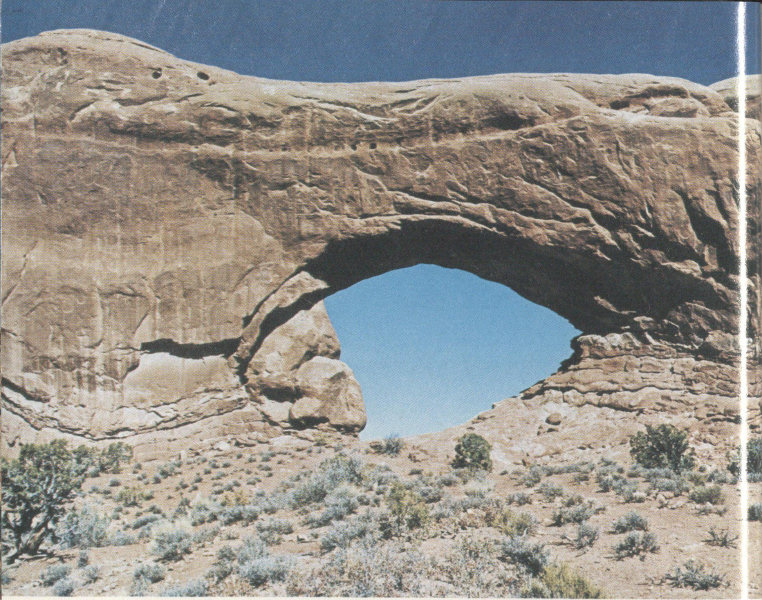
NORTH WINDOW, viewed to the northeast. Large rock seemingly partly blocking left end of arch actually is the southeast end of a fin some 50 feet or more beyond the arch, from which figure 38 was taken. Arch is 93 feet wide and 51 feet high. (Fig. 37)
From the lower parking lot (stop 12), a short walk by paved trail takes us to spectacular Double Arch, shown in figure 17. This arch is visible from the parking lot but is best seen and photographed from at or near the end of the trail. Looking westward from near the trail’s end, we see the Parade of Elephants, shown in figure 41. This feature is described on pages 16 and 17 of “The Guide to an Auto Tour of Arches National Park” as “whimsical stone statuary resembling a circus pachyderm parade. With tail in trunk, the elephants rumble toward you along a sandstone roadway.”
Ribbon Arch, on the north side of Elephant Butte, is one of the most delicate ones in the park (fig. 1). Although it is 50 feet wide and 55 feet high, the rock span is only 1½ feet wide and 1 foot thick.
On the way back to the intersection with the main park road, we pass stop 14, from which may be seen Pothole Arch (fig. 18). One and one-half miles north of the intersection with the main road is the Panorama Point parking area (stop 15), which affords fine distant views of Salt and Cache Valleys and points beyond. A roadside exhibit portrays the gradual development of the Salt Valley anticline, which supplements my description on pages 27-32. A parking space a short distance farther down the hill (stop 16) provides good distant views of the Fiery Furnace. I tried several telephoto shots from this viewpoint, but preferred my closeup views, such as the one shown in figure 44.
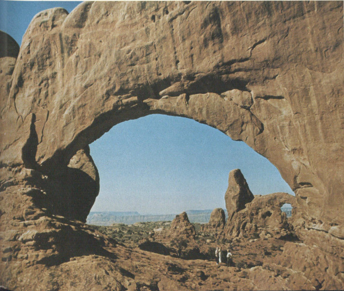
LOOKING SOUTHWESTWARD THROUGH NORTH WINDOW, from fin shown beyond left side of North Window in figure 37. Turret Arch (fig. 40) is seen at right middle ground, south rim of Moab Valley to left of arch, Colorado River canyon forms left skyline. (Fig. 38)
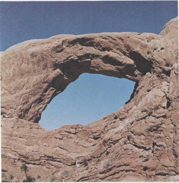
SOUTH WINDOW, viewed toward northeast. Arch is 105 feet wide and 66 feet high. See text. (Fig. 39)
Two and a half miles northeast of the road intersection near Balanced Rock, a gravelled side road leads northeastward to several points of considerable interest. The photograph in figure 11 was taken from this side road about half a mile northeast of the intersection. About 2 miles to the northeast, just beyond Salt Valley Wash, is a parking area (stop 17) at the beginning of the trail past Wolfe’s Bar-DX Ranch (fig. 3) to famed Delicate Arch, which is featured on the front cover. Although the trail to the arch is only 1½ miles long, it crosses several hills at the outset, then climbs 500 feet, mostly on bare Entrada Sandstone, so is considered quite strenuous, particularly 75 in hot weather. The Park Service advises hikers to carry water. The Walt Disney crew, cameras, gear, cougars, and all climbed this trail in the hottest part of the summer of 1971 (see p. 16), while my wife and I were working in the vicinity. Visitors who do not wish to make the hike may get a distant view of Delicate Arch by driving to a parking area (stop 18) 1.3 miles farther east.
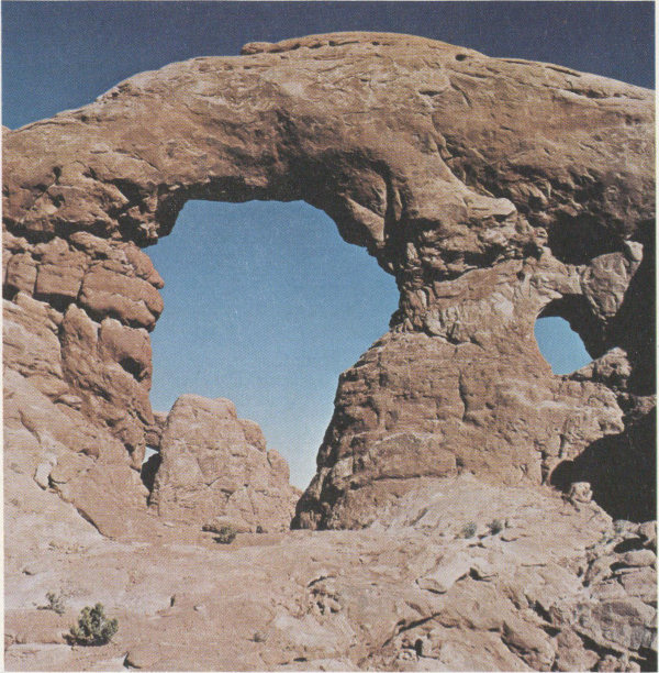
TURRET ARCH, viewed northeast toward South Window, part of which is visible on left. Small opening on right is visible also in figure 38. Largest arch is 39 feet wide and 64 feet high; smaller one is 12 feet wide and 13 feet high. A still smaller one, not visible in the photograph, is 8 feet wide and only 4½ feet high. (Fig. 40)

PARADE OF ELEPHANTS, viewed west from end of trail to Double Arch. Two elephants are on right, one on left. (Fig. 41)
After leaving Wolfe’s Ranch, the trail to Delicate Arch crosses Salt Wash on a suspension foot bridge (fig. 42). Just beyond the bridge, a short walk to the left (north) leads to the Ute petroglyphs shown in the lower photograph of figure 2. The most difficult part of the trail, on bare sandstone, is marked by cairns of stones placed at sufficient intervals to keep hikers from losing the barely visible trail. When the summit finally is reached and the last corner rounded, one suddenly sees perhaps the most sublime view in the park—famed Delicate Arch, framing part of the La Sal Mountains beyond (fig. 43). This graceful arch and mighty Landscape Arch (fig. 53) were considered to be in serious jeopardy during the era of sonic booms, but hopefully this danger now is past. (See p. 16-17.)
It may be of interest to shutterbugs that professional photographer Hal Rumel lugged an 8- × 10-inch camera plus a heavy tripod and accessories up the steep trail to get the excellent photograph of Delicate Arch shown in figure 43. The late afternoon sun intensified the red somewhat, but my shots made earlier in the day using both 4- × 5-inch and 35-mm equipment resulted in unwanted shadows, even though the salmon color of the Slick Rock Member was more nearly normal.
After leaving the junction with the side road, the main park road traverses slices of vertical strata squeezed between faults along the north side of Salt Valley, then gradually climbs out of the valley for about 2 miles to a parking area (stop 19), from which good views are had of the southeast end of Salt Valley and of the grabens in the west end of Cache Valley. (See fig. 11.)
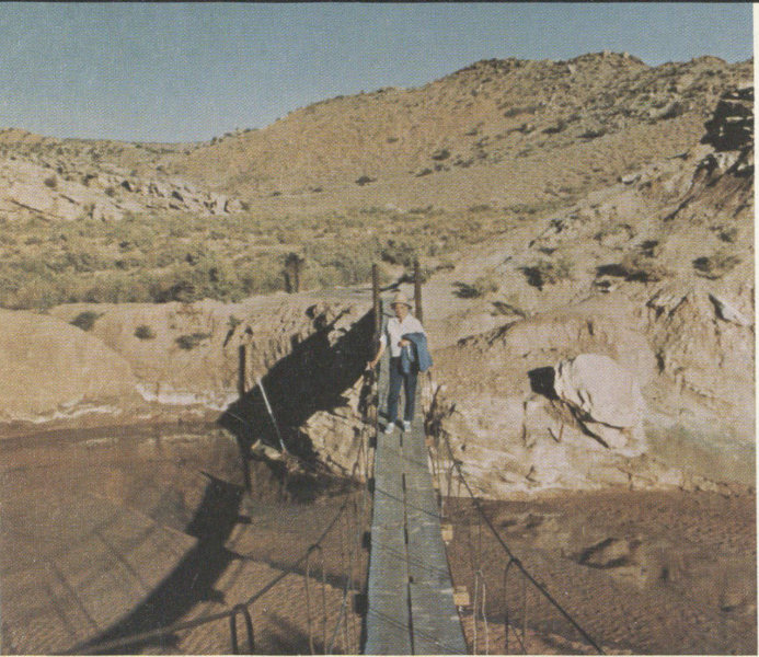
SUSPENSION FOOT BRIDGE ACROSS SALT WASH, in front of Wolfe’s cabin at beginning of Delicate Arch trail. (Fig. 42)
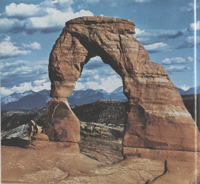
DELICATE ARCH, from end of trail 1½ miles above Wolfe’s Ranch. The opening is 33 feet wide and 45 feet high. The left abutment is only 5 feet wide at the narrowest point. The arch is carved near the top of the Slick Rock Member, and the top of the span, 19 feet thick, is capped by a few feet of the more resistant Moab Member, as is Broken Arch (fig. 16). Photograph by Hal Rumel, Salt Lake City. (Fig. 43)
About half a mile farther uphill is a parking area for viewing the southeastern part of the Fiery Furnace (stop 20), a vast array of towering fins and pinnacles of the reddish Slick Rock Member separated by narrow slots, vaguely resembling flames shooting skyward. The view of the Fiery Furnace in figure 44 was taken about 1 mile farther up the hill. It is not difficult to get lost among this myriad of fins and narrow slots, so ranger-guided tours are conducted during the summer.
About 1 mile farther northwest is a parking area (stop 23) from which a short walk to the north end of Fiery Furnace leads to a narrow slot between high fins (fig. 45), along which a short sandy trail leads to a recess along the southwest wall containing Sand Dune Arch (fig. 46). This hidden arch receives sunshine only near the middle of the day and is a delightful, shady place to rest.
From the entrance to the slot leading to Sand Dune Arch, a trail goes half a mile north across an open field to Broken Arch, shown in figure 16. This field, which separates the Fiery Furnace and Devils Garden areas, is seen from the air in figure 12.
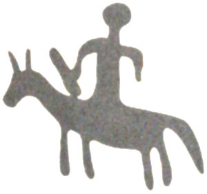
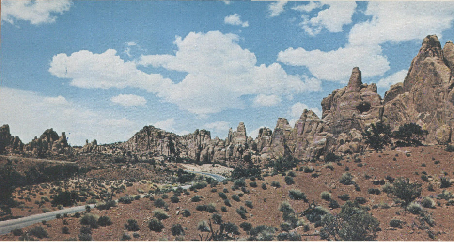
FIERY FURNACE, viewed northwest along park road about 1 mile northwest from stop 20. Fins and spires are of the jointed Slick Rock Member (fig. 12), but the top of the Dewey Bridge Member is seen to the right of the curve in the road. (Fig. 44)
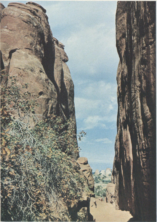
TRAIL TO SAND DUNE ARCH, looking northwest away from arch, between towering fins of Slick Rock Member, at northwest end of Fiery Furnace. Southeast end of Devils Garden in distance. (Fig. 45)
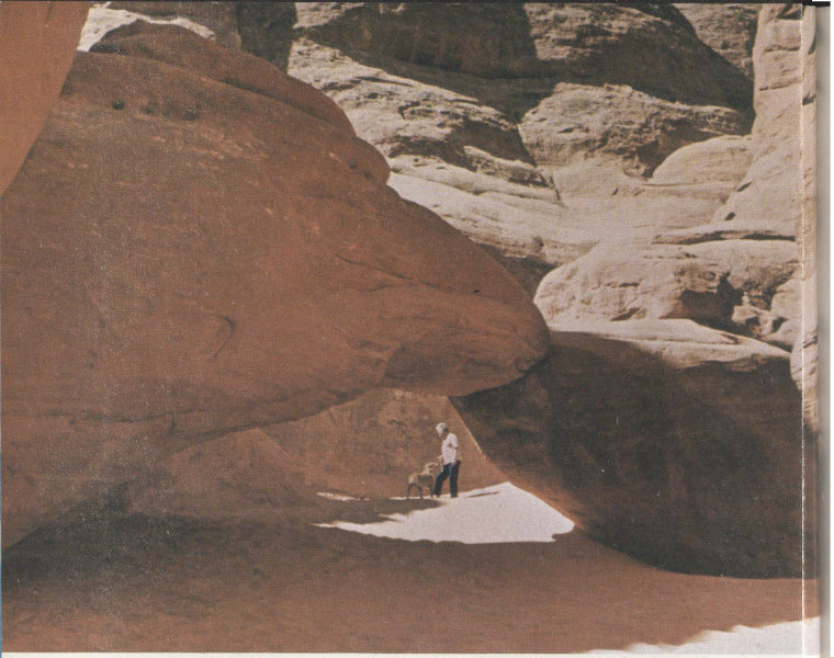
SAND DUNE ARCH, in recess along southwest wall of narrow slot shown in figure 45. Slick Rock Member. (Fig. 46)
Before proceeding to the end of the paved road, let us take an unimproved side road, which turns south about a third of a mile beyond the last stop, in order to see more of Salt Valley and to visit Klondike Bluffs in the northwestern part of the park. After descending 2.3 miles of winding road we reach the normally dry bed of Salt Valley Wash, and turn abruptly to the northwest. For the next three-fourths of a mile the “road” is simply two tracks in the loose, sandy bed of the wash, which obviously should not be travelled when flooded or when there is even a hint of rain. In dry weather, however, this road may be travelled by ordinary passenger car. This stretch of the wash cuts through an intruded block of the Paradox Member of the Hermosa Formation consisting mainly of gray and brown gypsum, the common salt having been 83 dissolved out by ground water. Such an intrusive block of salt-bearing rock is known to geologists as a diapir—not to be confused with the garment (diaper) worn by infants.
From here on the road traverses a rather uninteresting stretch of valley north of Salt Valley Wash. Eleven miles from the starting point, the road reaches an intersection from which a side road leads southwestward three-fourths of a mile to a parking area at the foot of Klondike Bluffs, which form the south side of Salt Valley. From here, one may make a strenuous hike over a primitive trail about 1½ miles long to beautiful Tower Arch (fig. 47).
The valley road continues northwestward from the intersection to and beyond the northwest end of the park and connects with roads to Crescent Junction, Thompson, and the Yellow Cat mining district, north of the park (p. 14).
Let us return to the paved road and continue our tour of the park.
Turning left (northwest) at the intersection with the paved park road, we enter Devils Garden—another large maze of towering red fins separated by narrow slots, which resembles the Fiery Furnace. After a third of a mile, we reach stop 24 and walk 100 feet or more to the north for a good view of Skyline Arch (fig. 48). This arch is very appropriately named, as it forms the skyline viewed either from the road on the south or from the campground on the north, from points south of the amphitheater. Less well known is the fact that Skyline Arch is clearly visible to the naked eye or through binoculars from stretches of Highway I-70 (or old U.S. Highways 6 and 50) about 11 miles to the north. Most arches and other erosion forms do not change appearance much from day to day or year to year, but some, like “Baby Arch” (fig. 15), show evidence of relatively recent origin. In November 1940 (Abbey, 1971, p. 42) Skyline Arch suddenly doubled in size by the fall of a large rock that occupied what is now the northwest half of the arch. Photographs taken before and after this event appear on pages 24 and 25 of the road guide and also in the museum at the Visitor Center.
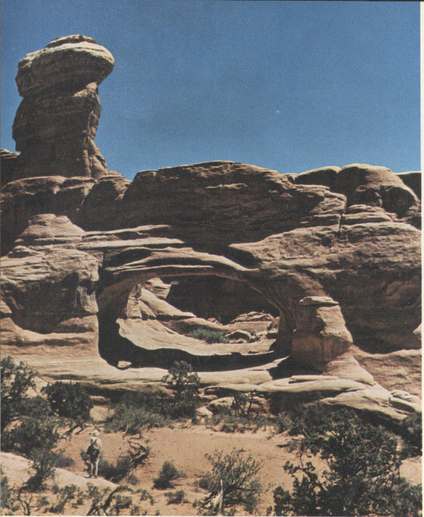
TOWER ARCH, on Klondike Bluffs, viewed eastward. Arch is in Slick Rock Member but tower on left, after which arch was named, is capped by a protective layer of the resistant Moab Member. Opening is 88 feet wide and 43 feet high. Photograph by Robert D. Miller. (Fig. 47)
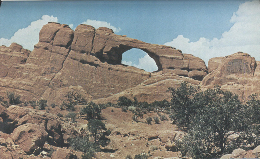
SKYLINE ARCH, viewed north from point about 100 feet north of stop 24, in Slick Rock Member. Although fins are vertical, note that the strata seem to dip about 15° to the right, although the actual dip is to the northeast. (See fig. 50.) (Fig. 48)
Another half mile brings us to a one-way (to right) loop at the end of the park road. Just beyond the beginning of the loop is a parking lot and very attractive picnic area containing several picnic tables shaded by piñon pines at the foot of a towering red fin of the Slick Rock Member. Just north of this picnic ground, a paved side road leads eastward into a truly beautiful, well-equipped campground comprising both back-in and drive-through campsites for trailers, campers, or tents; three pairs of modern restrooms, hydrants, and drinking fountains; and an amphitheater, where illustrated campfire talks are given nightly during the summer. The east end of the campground is shown in figure 49.
CAMPGROUND IN DEVILS GARDEN, viewed northwestward across turn-around at southeastern end. (Fig. 49)
Devils Garden in general and the campground in particular are on the crest of a ridge separating Salt Valley to the southwest from the Sagers Wash syncline to the northeast, which lies north of Yellow Cat Flat and north of the 87 area shown in figure 1. From the higher parts of the campground striking views are to be had toward the north and northeast, particularly late in the afternoon, as shown in figure 50.
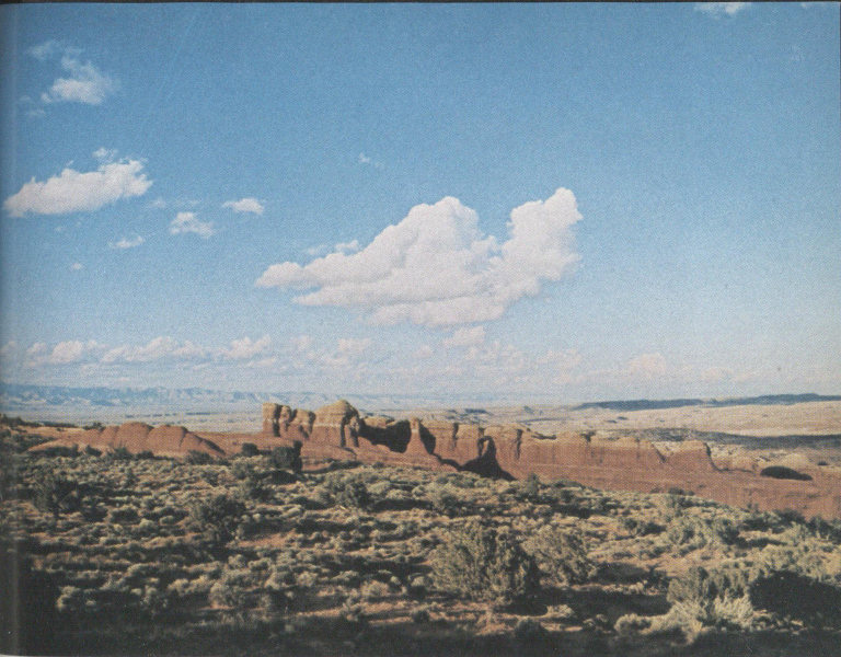
VIEW NORTH FROM CAMPGROUND, in late afternoon. Reddish Slick Rock Member capped by light-colored Moab Member are seen dipping northeastward toward Sagers Wash syncline. Book Cliffs, north of Thompson, are 16 miles north on left skyline. (Fig. 50)
In about the middle of the one-way loop at the end of the park road is a well that supplies water to the campground from early in the spring until the return of freezing weather late in the fall. The well, which was drilled in 1962 to a depth of 900 feet, obtains a small amount of water from the Wingate Sandstone. No water was found in the overlying Navajo and Entrada Sandstones because of the pronounced dip of the rocks toward the northeast, which allows any water in these rocks to drain northeastward (Ted Arnow, written commun., 1963). Water from this well is pumped to a steel tank in a high part of the 88 campground, whence it flows by gravity to the three sets of restrooms.
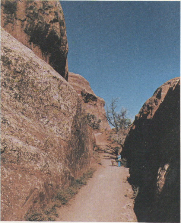
SOUTHEASTERN PART OF DEVILS GARDEN TRAIL, viewed northwestward. Narrow slot between fins of Slick Rock Member indicates local spacing of joints. (Fig. 51)
At the northwest end of the one-way loop is a large parking area for use by people hiking the Devils Garden trail. This trail leads to seven of the most interesting arches in the park, all of which are in the Slick Rock Member, and there are many more farther to the northwest. The approximate distances to the seven arches are given in the paragraphs that follow. The trail is paved for about 1 mile as far as Landscape Arch (fig. 53), but from there to Double O Arch (fig. 56) the trail is primitive, and the Park Service recommends rubber soles as part of the trail is on bare sandstone. For these reasons, many visitors hike only as far as Landscape Arch.
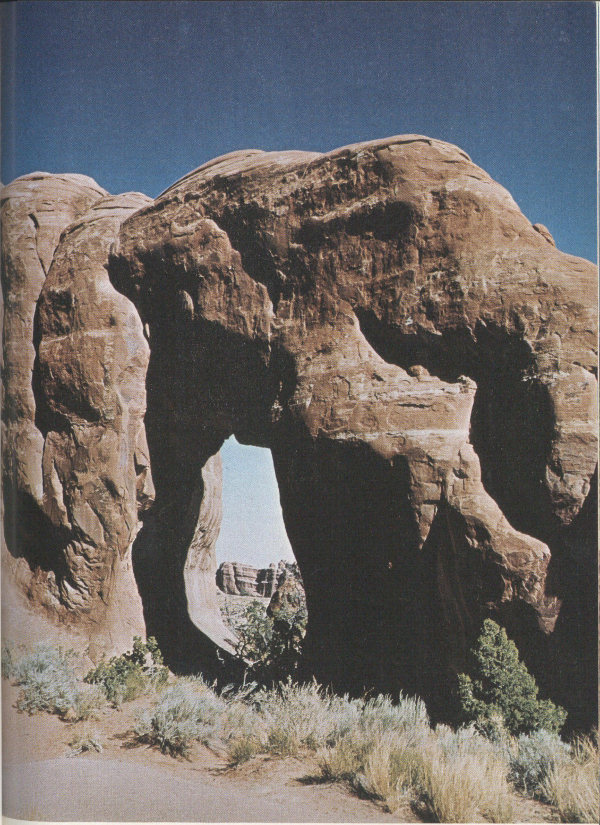
PINE TREE ARCH, viewed northeastward. Opening is 46 feet wide and 48 feet high. Fin is 30 feet thick. (Fig. 52)
Much of the trail, particularly the first part, lies in a narrow slot between fins of the Slick Rock Member, as shown in figure 51. After about half a mile, a side trail to the north leads to a Y, the right-hand fork of which goes to Tunnel Arch (fig. 14). The left-hand fork leads to Pine Tree Arch, obviously named for the piñon pine framed by this arch (fig. 52).
At the end of the improved part of the trail, we reach Landscape Arch (fig. 53), claimed by the Park Service to be the longest known natural arch in the world. According to Ouellette (1958) it is 291 feet long and 118 feet high, but Professor Stevens’ measurements indicate it to be 287 feet long and 106 feet high. At its thinnest point on the right, the span is only 11 feet wide and 11 feet thick. In 1958 three young men made what was claimed to be the second known ascent of Landscape Arch, using ropes and other climbing gear, after which they walked across (Ouellette, 1958). This crossing was made with the permission of a park ranger, but such permission is no longer given, for the safety of both the arch and of would-be climbers.
Wall Arch is about a quarter of a mile beyond the end of the improved part of the trail, and another three-fourths mile brings us to Navajo Arch (fig. 54) and Partition Arch (fig. 55). A distant view of Partition Arch may be had just before reaching Landscape Arch. Part of the remaining trail to Double O Arch (fig. 56) is on the top of a low sandstone fin, in part between somewhat higher fins and in part above lower slots.
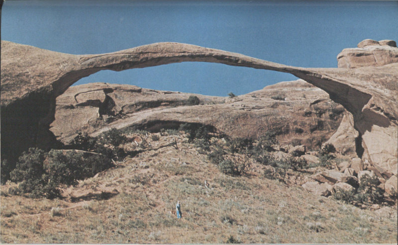
LANDSCAPE ARCH, viewed southwestward from near end of improved part of Devils Garden trail. Note that ground beneath arch is covered by slope wash and near the middle with what appears to be a small landslide. Slick Rock Member here is more nearly buff than salmon colored, because of a smaller content of iron oxide. Fresh breaks and angular blocks of stone at right abutment indicate relatively recent rock falls. See text for size. (Fig. 53)
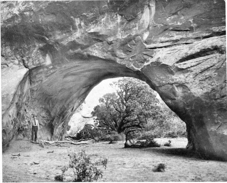
NAVAJO ARCH, viewed northeastward from a branch of Devils Garden trail. One of few arches having a flat soil-covered floor. Opening is 40½ feet wide. Photograph by National Park Service. (Fig. 54)
Beautiful Double O Arch (fig. 56) is at the end of the Devils Garden trail about 2½ miles northwest of the trailhead. About half a mile northwest of the trail’s end is a prominent landmark called Dark Angel (fig. 57), which is visible in figure 12 and from the unimproved road in Salt Valley.
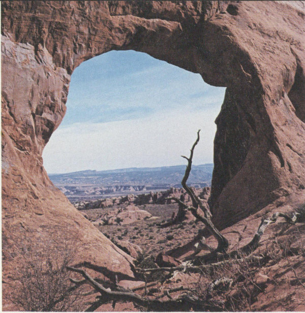
PARTITION ARCH, viewed southwestward from near Devils Garden trail. Arch frames part of south wall of Salt Valley and, on skyline, mesas south of Moab Valley. Opening is 27½ feet wide and 26 feet high. A smaller opening to the right measures 8½ feet wide and 8 feet high. Photograph by Dawn E. Reed. (Fig. 55)
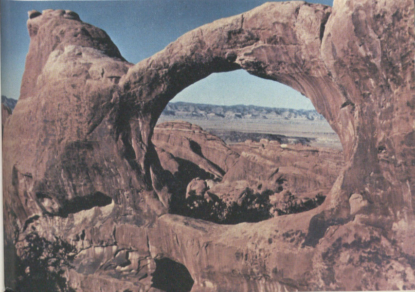
DOUBLE O ARCH, viewed about north from northwest end of Devils Garden trail. Large opening is 71 feet wide and 45 feet high; small one at lower left is 21 feet wide and 11 feet high. Span of large opening is 11 feet wide and 6 feet thick. Arch frames a part of the Book Cliffs about 14 miles to the north. Photograph by Hildegard Hamilton, Flagstaff, Ariz. (Fig. 56)
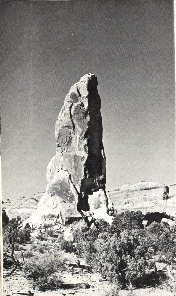
DARK ANGEL, a shaft of the Slick Rock Member that is an erosional remnant of a once high, narrow fin. About one-half mile northwest of Double O Arch. Photograph by National Park Service. (Fig. 57)
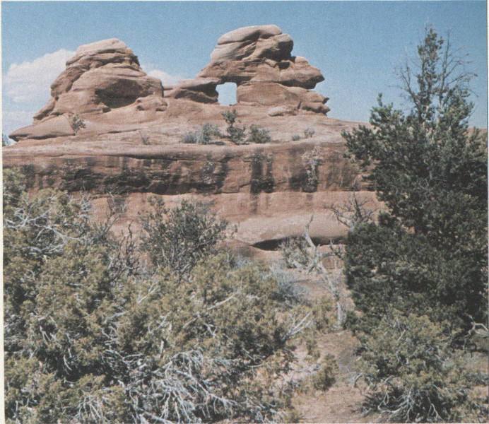
“INDIAN-HEAD ARCH,” in upper Devils Garden. Arch and most of head are in Slick Rock Member, top of head is basal part of Moab Member. Opening is 4 feet wide and 4½ feet high. Photograph by Professor Dale J. Stevens, Brigham Young University. (Fig. 58)
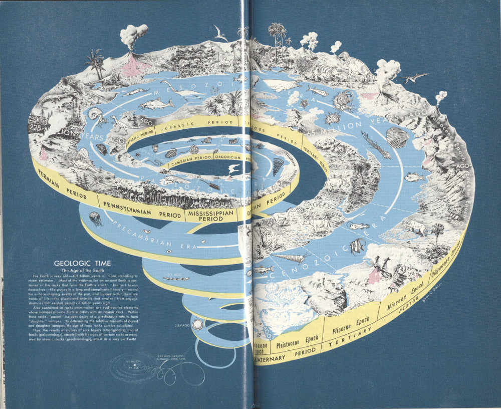
GEOLOGIC TIME SPIRAL, showing the sequence, names, and ages of the geologic eras, periods, and epochs, and the evolution of plant and animal life on land and in the sea. The primitive animals that evolved in the sea during the vast Precambrian Era left few traces in the rocks because they had not developed hard parts, such as shells, but hard shell or skeletal parts became abundant during and after the Paleozoic Era. (Fig. 59)
GEOLOGIC TIME
The Age of the Earth
The Earth is very old—4.5 billion years or more according to recent estimates. Most of the evidence for an ancient Earth is contained in the rocks that form the Earth’s crust. The rock layers themselves—like pages in a long and complicated history—record the surface-shaping events of the past, and buried within them are traces of life—the plants and animals that evolved from organic structures that existed perhaps 3 billion years ago.
Also contained in rocks once molten are radioactive elements whose isotopes provide Earth scientists with an atomic clock. Within these rocks, “parent” isotopes decay at a predictable rate to form “daughter” isotopes. By determining the relative amounts of parent and daughter isotopes, the age of these rocks can be calculated.
Thus, the results of studies of rock layers (stratigraphy), and of fossils (paleontology), coupled with the ages of certain rocks as measured by atomic clocks (geochronology), attest to a very old Earth!
Professor Stevens found 14 arches in what he called upper Devils Garden, northwest of Double O Arch, and two arches in the northwesternmost extension of the park known as Eagle Park (fig. 1). One of the unnamed arches in upper Devils Garden is shown in figure 58. I am tentatively calling it “Indian-Head Arch,” because of the rather obvious resemblance.
This ends our journey through Arches National Park, but there remains for consideration a summary of the principal geologic events leading to the formation of this beautiful part of the Colorado Plateau and a brief comparison with the geology of other national parks and monuments on the Plateau.

Having finished our geologic trip through Arches National Park, let us see how the arches and other features fit into the bigger scheme of things—the geologic age and events of the Earth as a whole, as depicted in figure 59. As shown in figure 4, the rock strata still preserved in the park range in age from Pennsylvanian to Cretaceous, or from about 300 million to 100 million years old—a span of about 200 million years. This seems an incredibly long time, until one notes that the earth is some 4.5 billion years old, and that our rock pile is but 1/23 or 4½ percent of the age of the Earth as a whole. Thus, in figure 59, the rocks exposed in the park occupy only about the left half of the top whorl of the spiral.
But this is not the whole story. As indicated earlier, younger Mesozoic and Tertiary rocks more than 1 mile thick that once covered the area have been carried away 99 by erosion, and if we include these the span is increased to about 250 million years, or nearly a full whorl of the spiral.
Deep tests for oil and gas tell us that much older rocks underlie the area, and we have seen that some of these played a part in shaping the park we see today. In addition to the Precambrian igneous and metamorphic rocks, there is about 2,000 feet of Paleozoic sedimentary rocks older than the Pennsylvanian Paradox Member of the Hermosa Formation, most of which was laid down in ancient seas. This includes strata of Cambrian, Ordovician, Devonian, Mississippian, and Pennsylvanian ages (fig. 59). There are some gaps in the rock record caused by temporary emergence of the land above sea level and erosion of the land surface before the land again subsided below sea level so that deposition could resume. Silurian rocks are absent, presumably because, here, the Silurian Period was dominated by erosion rather than deposition.
While Pennsylvanian and Permian rocks were being laid down in and southwest of the park, a large area to the northeast, called by geologists the Uncompahgre Highland (because it occupied the same general area as part of the present Uncompahgre Plateau), rose slowly above sea level. Whatever Paleozoic rocks were on this rising land plus part of the underlying Precambrian rocks were eroded and carried by streams into deep basins to the northeast and southwest. Thus, while some marine or near-shore deposits were being laid down in and south of the park, thousands of feet of red beds were being laid down by streams between the park and what is now the Uncompahgre Plateau. During part of Middle Pennsylvanian time, a large area, including the park, known as the Paradox basin, was alternately connected to or cut off from the sea, so that the water was evaporated during cutoff periods and replenished during periods when connection with the sea resumed. In these huge evaporation basins were deposited the salt and gypsum plus some potash salts and shale that now make up the Paradox Member of the Hermosa Formation.
Arches National Park contains four northwesterly trending 100 major folds—the Salt Valley and Cache Valley salt anticlines, the Courthouse syncline, and the faulted Moab-Seven Mile anticline, which forms the southwestern border. How these folds were formed was explained on pages 27-32. The history of their growth, however, was a long one that began about 300 million years ago in the Pennsylvanian and ended about 50 million years ago in the early Tertiary. The growth of these folds occurred in two stages. The first stage, which involved the development of the salt cores of the anticlines, ended in the Jurassic with the beginning of Morrison time; the second stage, which involved additional folding that intensified the magnitude and shape of existing folds, occurred in the early Tertiary and was followed later by collapse of the salt anticlines. The formation and collapse of the Salt Valley and Cache Valley anticlines was accompanied by pronounced jointing (fig. 12), which allowed differential erosion to produce the tall fins in which the arches were formed.
The old Uncompahgre Highland continued to shed debris into the bordering basins until Triassic time, when it began to be covered by a veneer of red sandstone and siltstone of the Chinle Formation (Lohman, 1965). The area remained above sea level during the Triassic Period and most, if not all, of the Jurassic Period, although the Jurassic Carmel Formation was laid down in a sea that lay just to the west.
Late in the Cretaceous Period a large part of Central and Southeastern United States, including the eastern half of Utah, sank beneath the sea and received thousands of feet of mud, silt, and some sand that later compacted into the Mancos Shale. This formation, as well as all younger and some older strata, has long since been eroded from most of the park area, but a little of the Mancos is preserved in the Cache Valley graben (fig. 11), and the entire Mancos Shale and younger rocks are present in adjacent areas, such as the Book Cliffs north of Green River, Crescent Junction, and Cisco (figs. 7, 50, 56).
The land rose above the sea at about the close of the Cretaceous and has remained above ever since, although inland basins and lakes received sediment during parts 101 of the Tertiary Period. Compressive forces in the Earth’s crust produced some gentle folding of the strata at the close of the Cretaceous, but more pronounced folding and some faulting occurred during the Eocene Epoch, when most of the Rocky Mountains took form. During the Miocene Epoch igneous rock welled up into older rocks to form the cores of the nearby La Sal, Abajo, and Henry Mountains. Additional uplift and some folding occurred in the Pliocene and Pleistocene Epochs.
Much of the course of the Colorado River was established during the Miocene Epoch, with some additional adjustments in the late Pliocene and early Pleistocene Epochs (Hunt, C. B., 1969, p. 67). Erosion during much of the Tertiary Period and all of the Quaternary Period plus some sagging and breaking of the crest of the anticlines, brought on by solution and lateral squeezing of salt beds beneath the Moab-Seven Mile, Salt Valley, and Cache Valley anticlines, combined to produce the landscape as we now see it.
The Precambrian rocks beneath the area are about 1.5 billion years old; so an enormous span of time is represented by the rocks and events in and beneath Canyonlands National Park.
If we consider the geologic formations that make up the national parks (N.P.), national monuments (N.M.) (excluding small historical or archaeological ones), Monument Valley, San Rafael Swell, and Glen Canyon National Recreation Area, all in the Colorado Plateau, it becomes apparent that certain formations or groups of formations play starring roles in some parks or monuments, some play supporting roles, and in a few places the entire cast of rocks gets about equal billing. Let us compare them and see how and where they fit into the “Geologic Time Spiral” (fig. 59).
Dinosaur N.M., with exposed rocks ranging in age from Precambrian to Cretaceous, covers the greatest time span (nearly 2 billion years), but has one unit—the Jurassic Morrison Formation—in the starring role, for this unit contains the many dinosaur fossils that give the monument its name and fame, although there are several older 102 units in supporting roles. Grand Canyon N.P. and N.M. are next, with rocks ranging in age from Precambrian through Permian (excluding the Quaternary lava flows in the N.M.), but here there is truly a team effort, for the entire cast gets about equal billing. Canyonlands N.P. stands third in this category, with rocks ranging from Pennsylvanian to Jurassic, but we would have to give top billing to the Permian Cedar Mesa Sandstone Member of the Cutler Formation, from which The Needles, The Grabens, and most of the arches were sculptured; the Triassic Wingate Sandstone and the Triassic(?) Kayenta Formation get second billing for their roles in forming and preserving Island in the Sky and other high mesas.
Now let us consider other areas with only one or few players in the cast, beginning at the bottom of the time spiral. Black Canyon of the Gunnison N.M., cut entirely in rocks of early Precambrian age with only a veneer of much younger rocks, obviously has but one star in its cast. Colorado N.M. contains rocks ranging from Precambrian to Cretaceous—equal to Dinosaur in this respect, but Colorado is unique in that all the rocks of the long Paleozoic Era and some others are missing from the cast; of those that remain, the Triassic Wingate and the Triassic(?) Kayenta are the stars, with strong support from the Jurassic Entrada Sandstone.
All the bridges in Natural Bridges N.M. were carved from the Permian Cedar Mesa Sandstone Member of the Cutler Formation, also one of the stars in Canyonlands N.P. In Canyon de Chelly (pronounced dee shay) N.M. and Monument Valley (neither a national park nor a national monument, as it is owned and administered by the Navajo Tribe), the De Chelly Sandstone Member of the Cutler Formation—a Permian member younger than the Cedar Mesa—plays the starring role.
Wupatki N.M. near Flagstaff, Ariz., stars the Triassic Moenkopi Formation. Petrified Forest N.P. (which now includes part of the Painted Desert) has but one star—the Triassic Chinle Formation, in which are found many petrified logs and stumps of ancient trees. The Triassic-Jurassic Glen Canyon Group (fig. 19), which includes the 103 Triassic Wingate Sandstone, the Triassic(?) Kayenta Formation, and the Triassic(?)-Jurassic Navajo Sandstone, receives top billing in recently enlarged Capitol Reef N.P., but the Triassic Moenkopi and Chinle Formations enjoy supporting roles.
The Triassic(?)-Jurassic Navajo Sandstone, which has a supporting role in Arches N.P., is the undisputed star of Zion N.P., Rainbow Bridge N.M., and Glen Canyon National Recreation Area, despite the fact that the latter is the type locality of the entire Glen Canyon Group. The Navajo also forms the impressive reef at the east edge of the beautiful San Rafael Swell, a dome, or closed anticline, now crossed by Highway I-70 between Green River and Fremont Junction, Utah.
As we journey upward in the time spiral (fig. 59), we come to the Jurassic Entrada Sandstone, which stars in Arches N.P., with help from the underlying Navajo Sandstone, and a supporting cast of both older and younger rocks. The Entrada also forms the grotesque erosion forms called “hoodoos and goblins” in Goblin Valley State Park, north of Hanksville, Utah.
Moving ever upward in the spiral, we come to the Cretaceous—the age of the starring Mesaverde Group, in which the caves of Mesaverde N.P. were formed, and which now house beautifully preserved ruins once occupied by the Anasazi, the same ancient people who once dwelt in Arches N.P. and nearby areas.
This brings us up to the Tertiary Period, during the early part of which the pink limestones and shales of the Paleocene and Eocene Wasatch Formation were laid down in inland basins. Beautifully sculptured cliffs, pinnacles, and caves of the Wasatch star in Bryce Canyon N.P. and in nearby Cedar Breaks N.M. This concludes our climb up the time spiral, except for Quaternary volcanoes and some older volcanic features at Sunset Crater N.M., near Flagstaff, Ariz.
Thus, one way or another, many rock units formed during the last couple of billion years have performed on the stage of the Colorado Plateau and, hamlike, still lurk in the wings eagerly awaiting your applause to recall them 104 to the footlights. Don’t let them down—visit and enjoy the national parks and monuments of the Plateau, for they probably are the greatest collection of scenic wonderlands in the world.

Many reports covering various aspects of the area have been cited in the text by author and year, and these plus a few additional ones are listed in “Selected References.” A few works of general or special interest should be mentioned, however.
Between 1926 and 1929 the entire area now included in the park was mapped geologically in classic reports by Dane (1935) and by McKnight (1940). These men and their field assistants mapped the area by use of the plane-table and telescopic alidade without benefit of modern topographic maps or aerial photographs, except for topographic maps of the narrow stretch along the Colorado River mapped under the direction of Herron (1917). Only small sections could be reached by automobile, so nearly all the area was traversed using horses and mules or by hiking. This work plus mapping done in nearby areas to the south and to the north (Stokes, 1952) during the uranium boom of the mid-fifties was used by Williams (1964) in compiling a geologic map of the Moab quadrangle at a scale of 1:250,000.
Several early reports on the Colorado River and its potential utilization contain a wealth of information and many fine photographs, including two by La Rue (1916, 1925) and one by Follansbee (1929).
You may be interested in brief accounts of the geology of other national parks and monuments, or other areas of special interest, such as the reports on the Uinta Mountains by Hansen (1969), Mount Rainier by Crandell 105 (1969), Yellowstone National Park by Keefer (1971), and ones by me on Colorado National Monument (Lohman, 1965) and Canyonlands National Park (1974).
For those who wish to learn more about the science of geology, I suggest the textbook by Gilluly, Waters, and Woodford (1968).
I am greatly indebted to Bates Wilson, former Superintendent, and to former Assistant Superintendent Joe Carithers, for their splendid cooperation in supplying data and information; to Chuck Budge, former Chief Ranger; Dave May, Assistant Chief of Interpretation and Resource Management; Joe Miller, former Maintenance Engineer; Bob Kerr, new Superintendent; Maxine Newell, Park Historian and member of the staff at Arches National Park; Jerry Banta, former Park Ranger at Arches; and Carl Mikesell, Park Ranger at Arches, for their many favors.
I am grateful to several colleagues and friends for the loan of photographs, for geologic help and data, and for reviewing this report. I am also deeply grateful to my wife, Ruth, for accompanying me on all the fieldwork and for her help and encouragement.
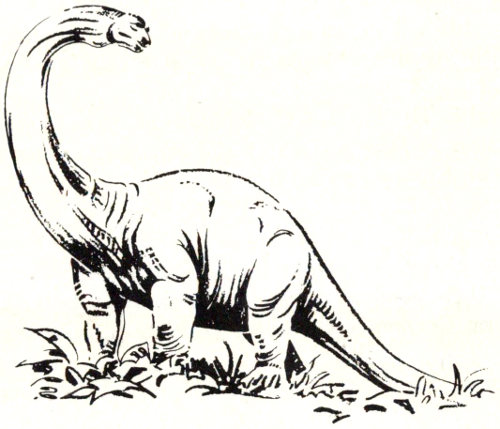
A B C D E F G H I J K L M N O P Q R S T U V W X Y Z
[Italic page numbers indicate major references]
★U.S. GOVERNMENT PRINTING OFFICE: 1975—679-138
This eBook contains “relative” links to other Project Gutenberg eBooks. These links function correctly whether the books are read online, or installed on a local drive or a website.
To install these books in another file system, create a subdirectory for each eBook, as in this outline:
Each eBook is in a separate directory; its directory name is the Project Gutenberg number for the eBook.
Each eBook directory may contain files in various formats; only the HTML files are relevant here; other files are optional.
HTML files are in a subdirectory consisting of the Gutenberg number followed by “-h”.
The HTML file itself has a name consisting of the Gutenberg number followed by “-h”, with a file extension of “.htm”.
Associated media files (such as images, MIDI files, etc.) are contained in a further subdirectory “images”
To view these files, open any of the “*-h.htm” files in a web browser.