|
Some typographical errors have been corrected; a list follows the text. List of Illustrations (etext transcriber's note) |
![[Image not available]](images/i_001_lg.jpg)
VALLEY OF THE NOON-DAY SUN.
COMPRISING
ITS TOPOGRAPHY, HISTORY, RESOURCES, PEOPLE,
NARRATIVES, INCIDENTS, AND PICTURES OF TRAVEL,
ADVENTURES IN HUNTING AND FISHING.
AND
LEGENDS OF ITS WILDERNESSES.
BY
WILBUR G. ZEIGLER AND BEN S. GROSSCUP
————————
WITH MAP AND ILLUSTRATIONS
————————
RALEIGH, N. C.
ALFRED WILLIAMS & CO.
CLEVELAND, O.
WILLIAM W. WILLIAMS
{2}
Copyright, 1883
By Wilbur G. Zeigler and Ben S. Grosscup
| INTRODUCTION. | |
|---|---|
| The Culmination of the Alleghanies—Area—The Grand Portal—The Blue Ridge—The Smokies—Transverse Ranges of the Central Plateau—Ancient Mountains | 7 |
| THE NATIVE MOUNTAINEERS. | |
| The “Moon-eyed” People—Ottari and Erati—Musical Names—Legendary Superstitions—The Devil’s Footprints—His Judgment Seat—A Sacred Domain—Cherokee’s Paradise Gained—Aboriginal Geography—Sevier’s Expedition—Decline of the Tribe—Younaguska—A White Chief—The Qualla Boundary—A Ride Through the Reservation—Yellow Hill—Constitution and Faith of the Band—Characteristics—An Indian Maiden—Soco Scenery | 15 |
| IN THE HAUNTS OF THE BLACK BEAR. | |
| Bruin’s “Usin’-Places”—Pointers—A Hunting Party—Stately Forests—Wid Medford—Sticking a Bear—Trials of Camping-Out—A Picture—Frosted Mountains—Amid the Firs—Natural History—In Close Quarters—Scenic Features—The Drive Begins—An Ebon Mountain—Judyculla Old Field—Calling In the Drivers—A Snow Storm—The Vale of Pigeon—A Picturesque Party—Through Laurel Thickets—At Bay—The Death Shot—Sam’s Knob—Bear Traps—An Old Hunter’s Observation | 45 |
| THE VALLEY OF THE NOON-DAY SUN. | |
| The Nantihala—Woodland Scenes—Monday’s—Franklin—Evening on the Little Tennessee—The Alleghanies’ Grandest Highway—The Valley River Range—Lonely Wilds—The Prince of Sluggards—Murphy—A Swiss Landscape—An Animated Guide-post—At the “Hoe-Down”—Apprehensions of Harm—A Jug in My Hands—Pine Torches—The Shooting Match—“Hoss-Swoppers”—Discouraging{4} Comments—The Fawning Politician—Cat-Stairs—The Anderson Roughs—Campbell’s Cabin—No Wash-Basin—The Devil’s Chin—Soapstone and Marble Quarries—A Stinging Reception—Deer—A “Corn-cracker”—Robbinsville | 79 |
| WITH ROD AND LINE. | |
| The Tow-head Angler—The Brook Trout—Points—The Paragon Month for Fishing—Artificial Ponds—Trip to the Toe—Anti-Liquor—Rattlesnakes—Mitchell’s Peak—A Ghost Story—In Weird Out-lines—Burnsville—Pigeon River—Cataluche—Mount Starling and its Black Brothers—Whipping the Stream—Striking a Bargain—An Urchin’s Ideas—Swain County Trout Streams—In Jackson and Macon—A Grand Cataract—Trout, Buck and Panther—In the Northwest Counties | 107 |
| AFTER THE ANTLERS. | |
| The Heart of the Smokies—Clingman’s Dome—Prospect from the Summit—Mounted Sportsmen—A Mountain Bug-Bear—Charleston—The Dungeon—A Village Storekeeper—Beautiful River Bends—At the Roses’—A Typical Mountain Cabin—Quil’s Wolf story—A Quick Toilet—The Footprints of Autumn—Knowledge from Experience—The Ridge Stand—Buck Ague—On Long Rock—A Superb Shot—The Buck Vanishes—Acquitted Through Superstition—The Hunter’s Hearthstone | 137 |
| NATURAL RESOURCES. | |
| The “Tar-Heel” Joke—Tobacco—Favorable Conditions for Gold Leaf—A Ruinous Policy—Hickory—Shelby—In Piedmont—Old Field Land—General Clingman’s Story—Watauga County—Unequalled Pastures—Prices of Lands—Stock Raising—The French Broad Tobacco Slopes—Fair Figures—Henderson and Transylvania—The Pigeon Valley—The Extreme Southwest Portion—Character of Wild Range—Horticulture—The Thermal Zone—Forests for Manufacturers—The Gold Zone—Mica Mines—Corundum—Iron Deposits—The Cranberry Ore Bank—Copper, Lead, Tin, and Silver—Precious Stones | 167 |
| HISTORICAL RESUME. | |
| Early Emigration—Daniel Boone—The “Pennsylvania Dutch”—Conservatism—The Revolutionary Forces—The King’s Mountain Battle—“Nollichucky Jack”—The Prisoner’s Escape—The State of Franklin—The Pioneers—Formation of Counties—The Western North Carolina Railroad—During the Late War—Restless Mountains—Scientific Explorations—Calhoun’s Observation—The Tragedy of the Black Mountains—Later Surveys—Representatives of the Mountain People | 213 |
| IN THE SADDLE. | |
| Mounting in Asheville—A Surly Host—Bat Cave—Titanic Stone Cliffs—Chimney Rock Hotel—The Pools—A Sunset Scene—The Shaking Bald—The Spectre Cavalry Fight—A Twilight Gallop Through McDowell County—Pleasant Gardens—The Catawba Valleys—On the Linville Range—Table Rock and Hawk-Bill—The Canon—Innocents Abroad—The Fox and the Pheasant—Linville Falls—A Dismal{5} Woodland—Traveling Families—Grandfather Mountain—The Ascent—A Sunday Ride—Blowing Rock—Boone—Valle Crucis—Elk River—The Cranberry Mines—On the Roan—Cloud-Land Hotel—A Hermit’s History—Above a Thunder Storm—Bakersville—Traces of a Prehistoric People—The Sink-Hole and Ray Mica Mines—Cremation—Drawing Rein | 237 |
| BEYOND IRON WAYS. | |
| Stage Riding—The Driver’s Story—Waynesville—Court Week—Prescriptions for Spirit. Frument.—Before the Bar—An Out-Door Jury Room—White Sulphur Springs—A Night’s Entertainment—The Haunted Cabin—A Panther Hunt—The Phantom Millers—Light on the Mysteries—Micadale—Recollections—Soco Falls—Webster—An Artist’s Trials—Above the Tuckasege Cataract—Hamburg—A Cordial Invitation—Cashier’s Valley—Whiteside—A Coffee Toper—Horse Cove—Golden Sands—Ravenel’s Magnificent Site—Hints for the Mounted Tourist—The Macon Highlands—A Demon of the Abyss—A Region of Cascades and Cataracts—Through Rabun Gap—Clayton, Georgia—The Falls of Tallulah—An Iron Way | 279 |
| A ZIGZAG TOUR. | |
| The Mountains as a Summer Resort—On the Western North Carolina Railroad—Sparkling Catawba Springs—Glen Alpine—Marion—Asheville—Romantic Drives—Turnpike—Arden Park—Hendersonville—Flat Rock—The Ante-War Period—Cæsar’s Head—Brevard—A “Moonshine” Expedition—A Narrow Escape—How Illicit Whisky is Sold—Along the French Broad—An Excited Countryman—Marshal—Warm Springs—Shut-in Gap—Paint Rock—A Picture of the Sublime | 333 |
| Tables of Altitude, Population, Area of counties, and Temperature | 371 |
| PAGE | ||
| 1. | Valley of the Noon-day Sun | Frontispiece. |
| 2. | Unaka Kanoos | 13 |
| 3. | A Soco Lass | 37 |
| 4. | Mount Pisgah | 43 |
| 5. | The Final Struggle | 74 |
| 6. | The Warrior Bald | 82 |
| 7. | A Narrow Water-way | 102 |
| 8. | A Glimpse of the Toe | 119 |
| 9. | On the Cataluche | 128 |
| 10. | Ochlawaha Valley from Dun Cragin | 135 |
| 11. | On the Little Tennessee | 145 |
| 12. | Silver Springs | 173 |
| 13. | The French Broad Canon | 182 |
| 14. | Swannanoa Hotel | 211 |
| 15. | Sparkling Catawba Springs | 235 |
| 16. | The Watauga Falls | 266 |
| 17. | Macon Highlands | 293 |
| 18. | The Junaluskas | 316 |
| 19. | The Cullasaja Falls | 329 |
| 20. | Up the Blue Ridge | 338 |
| 21. | Bold Headlands | 354 |
| 22. | Cascades of Spring Creek | 369 |
| ——— | ||
| Dr. W. C. Kerr’s Map of Western North Carolina (used by permission of State Board of Agriculture). | ||
 HE great mountain system that begins in that part of
Canada south of the St. Lawrence, and under the name of the Alleghanies,
or Appalachians, extends southward for 1,300 miles, dying out in the
Georgia and Alabama foot-hills, attains its culmination in North
Carolina. The title of Appalachians, as applied by De Soto to the whole
system, is preferred by many geographers. Alleghany is the old Indian
word, signifying “endless.” It is ancient in its origin, and in spite of
its being anglicized still retains its soft, liquid sound. It was not
until a comparatively late year that Western North Carolina was
discovered to be the culminating region. Until 1835 the mountains of New
Hampshire were considered the loftiest of the Alleghanies, and Mount
Washington was placed on the maps and mentioned in text books as the
highest point of rock in the eastern United States. It now holds its
true position below several summits of the Black, Smoky, and Balsam
ranges.{8} From the barometrical measurements of trustworthy explorers, no
less than 57 peaks in Western North Carolina are found to be over 6,000
feet in altitude. The more accurate observations being taken by means of
levels, by the coast survey, may slightly reduce this number.
HE great mountain system that begins in that part of
Canada south of the St. Lawrence, and under the name of the Alleghanies,
or Appalachians, extends southward for 1,300 miles, dying out in the
Georgia and Alabama foot-hills, attains its culmination in North
Carolina. The title of Appalachians, as applied by De Soto to the whole
system, is preferred by many geographers. Alleghany is the old Indian
word, signifying “endless.” It is ancient in its origin, and in spite of
its being anglicized still retains its soft, liquid sound. It was not
until a comparatively late year that Western North Carolina was
discovered to be the culminating region. Until 1835 the mountains of New
Hampshire were considered the loftiest of the Alleghanies, and Mount
Washington was placed on the maps and mentioned in text books as the
highest point of rock in the eastern United States. It now holds its
true position below several summits of the Black, Smoky, and Balsam
ranges.{8} From the barometrical measurements of trustworthy explorers, no
less than 57 peaks in Western North Carolina are found to be over 6,000
feet in altitude. The more accurate observations being taken by means of
levels, by the coast survey, may slightly reduce this number.
It was John C. Calhoun who, in 1825, first called particular attention to the southern section of the system. His attention had been turned to it by observing the numerous wide rivers, and tributaries of noble streams, which, like throbbing arteries, came forth from all sides of the North Carolina mountains, as from the chambers of a mighty heart. He saw the New river flowing towards the Ohio; the Watauga, the Nolechucky, the French Broad, the Big Pigeon, the Little Tennessee, the Hiawassee, and their thousand tributaries, pouring from the central valleys through the deep gaps of the Smokies into the western plains, and uniting with the branches from the Cumberland mountains to form the stately Tennessee; the Yadkin, the Catawba, the Broad, the Chatooga, and the headwaters of the greatest streams south of Virginia that empty into the Atlantic. From these observations he reasoned rightly that between the parallels of 35 degrees and 36 degrees and 30 minutes, north latitude, lay the highest plateau and mountains of the Atlantic coast.
The region, as measured in a bee line through the center of the plateau from Virginia to Georgia, is 200 miles in length. Its breadth, from the summits of the parallel rampart ranges of the Blue Ridge and Smokies, varies from 15 to 65 miles, and includes within this measurement a plateau expanse of 6,000 square miles, with an altitude of from 2,000 to 4,000 feet. Inclusive of the eastern slope, the off-shooting spurs of the Blue Ridge and the South mountains, the average breadth is 70 miles. A portion of the piedmont section, properly a part of the mountain district, would be taken in the latter measurement.{9} The counties are 25 in number, reaching from Ashe, Alleghany, and Surrey in the north to Macon, Clay, and Cherokee in the south.
After the bifurcation of the Blue Ridge and Smoky mountains in Virginia, embracing with a wide sweep several counties of that state and Ashe, Alleghany, and Watauga of North Carolina, they almost meet again in the northeastern limit of Mitchell county. Here, in collosal conjunction, through their central sentinel heads, the two ranges seem holding conference before making their final separation. The Grandfather, the highest peak of the Blue Ridge and the oldest mountain of the world, stands on one side; the majestic Roan of the Smokies, on the other, connected by the short transverse upheaval known as Yellow mountain. This spot is poetically spoken of as the grand portal to the inner temple of the Alleghanies; the Grandfather and the Roan being the two pillars between which hangs, forever locked, the massive gate of Yellow mountain. The high table-land of Watauga forms the green-carpeted step to it. Trending southwest, between the two separating ranges,—the Blue Ridge bending like a bow, and the Smokies resembling the bow-string,—lies wrapped in its robe of misty purple, the central valley, comprising 13 counties.
The western rampart range, bearing the boundary line between North Carolina and Tennessee, lifts its crest much higher than the Blue Ridge; is more massive in its proportions; less straggling in its contour; but with lower gaps or gorges, narrow and rugged, through which flow all the rivers of the plateau. Generically known as the Smoky mountains, it is by the river gorges divided into separate sections, each of which has its peculiar name. The most northerly of these sections is termed the Stone mountains; then follow the Iron, Bald, Great Smoky, Unaka, and the Frog mountains of Georgia. Twenty-three peaks of the Smoky mountains are over 6,000 feet in altitude,{10} the loftiest being Clingman’s Dome, 6,660 feet. The deepest gap is that of the Little Tennessee, 1,114 feet.
The eastern rampart range—the Blue Ridge—trends southward with the convolutions of a snake; its undulations rising seldom above a mile in altitude and sinking sometimes so low that, in passing through its wide gaps, one is not aware that he is crossing a mountain range, the fact being concealed by the parallel spurs rising, in many instances, to a higher altitude than their parent chain. In spite of its depressions, and, when compared with the Smoky mountains, the low average elevation of its crest, it is the water-shed of the system. Not a stream severs it. On the east every stream sweeps toward the Atlantic. On the west the waters of its slopes are joined at its base line by those flowing down the east or south side of the Smoky mountains; and, mingling with the latter, pour through the deep passes of the loftier range into the valley of the western confluent of the Tennessee.
From the Blue Ridge is thrown off many short ranges, trending east and south across the submontane plateau. In character of outline they are similar to the parent chain. This plateau, known as the Piedmont, walled on the west by the Blue Ridge, diversified by mountains and hills, and seamed by the Yadkin, Catawba, and Broad rivers and their affluents, incloses in its limits many beautiful and fertile valleys. The outer slope of the Blue Ridge, overlooking Piedmont, is abrupt in its descent and presents wild and picturesque features; cascades marking the channels of the streams. Further south, where the range bends around the South Carolina and Georgia lines, bold escarpments of rock and ragged pine-set declivities, seamed by cataracts, and beaten on by a hot and sultry sun, break sheer off into the southern plains. The inner slope of the Blue Ridge throughout its entire length from Virginia to Georgia, as contrasted with the outer slope, is more gentle in its descent; is{11} heavily wooded and diversified with clearings. The Smoky mountains present similar characteristics—richly wooded descents toward the central valley; rocky and sterile fronts toward Tennessee.
The reader must not imagine that the central valley or plateau, of which we have been speaking, is a level or bowl-shaped expanse between the ranges described. On the contrary, its surface is so broken by transverse mountain ranges and their foot-hills that, by means of vision alone, the observer from no one point can obtain a correct idea of the structural character of the region. From the loftiest peaks, he can see the encircling ranges and the level lands beyond their outer slopes; but below him is rolled an inner sea of mountains, which, when looked upon in some directions, seems of limitless expanse. The transverse chains, comprising the Yellow mountain, the Black, Newfound, Balsam, Cowee, Nantihala, and Valley River mountains, hold a majority of the highest summits of the Alleghanies.
The Black mountain chain, the highest of these ranges, is only 20 miles long, and has 18 peaks in altitude over 6,000 feet; the highest of which, Mitchell’s Peak, 6,711 feet above sea-level, is the sovereign mountain of the Alleghanies. The Balsam range, the longest of the transverse chains, is 45 miles in length and crested by 15 wooded pinnacles over 6,000 feet high. The parallel cross-chains have, nestling between their slopes, central valleys, varying in length and width, and opening back into little vales between the foot-hills and branching spurs. Through the lowest dip of each great valley, sweeps toward the Smokies a wide, crystal river fed by its tributaries from the mountain heights.
The great valleys, or the distinct regions drained each by one of the rivers which cut asunder the Smokies, are six in number. The extreme northern part of the state is drained by the New{12} river and the Watauga. Between the Yellow mountain and the Blacks lies that deeply embosomed valley region watered by the head-springs of the Nolechucky. Next comes the widest and longest plain of the mountain section—the valley of the French Broad. The Big Pigeon winds through the high plateau between the Newfound and Balsam mountains. The region of the Little Tennessee comprises not only the wide lands along its own banks, but those along its great forks—the Tuckasege, Nantihala, and Ocona Lufta. West of the Valley River mountains the country is drained by the Hiawassee.
Geologically speaking, the mountains of North Carolina are the oldest in the world. During the period of general upheavals and subsidences of the crust of the earth, these mountains were the only lands remaining throughout firm above the surface of the ocean. Rocks of the Archæan or earliest age are exposed, and with their edges turned at a high angle lie upon the beds of later periods of formation. North of the southern boundary of Virginia, the structural character of the mountains is different.
The entire region is mantled with forests to the summit of every peak; the valleys and many of the adjacent coves are cleared and inhabited by a happy, healthy, and hospitable people. It is rich in picturesque scenery—romantic rivers, luxuriant forests, majestic mountain heights, valleys of exquisite beauty, quaint villages, cliffs, and waterfalls. It is rich in a life-giving climate, brilliant skies, fertile lands, pastured steeps, and timber and mineral wealth.
It is of this country—the Heart of the Alleghanies—that in the following pages we have treated in as full, concise, and entertaining a manner as we could conceive and carry into execution.{13}
![[Image not available]](images/i_014_lg.jpg)
UNAKA KANOOS.
 E are excluded from a knowledge of ancient American
history by an impenetrable veil of mystery and silence. The past has
left us only relics—relics of things and relics of races—which are
interpreted by an unreined imagination. Before Europeans set foot on the
western shore of the Atlantic, before the Indians occupied the forest
continent, there dwelt on all the sunniest plains and fertile valleys a
race well advanced in mechanical and æsthetic art, skilled in war and
consecrated in religion. It came and flourished and perished, leaving
only monuments of its existence in the form of works of earth, and works
of stone—mounds, forts, and pottery. The old mounds scattered
everywhere are the sepulchres of illustrious dead, and because of their
number, the race has been designated the “Mound Builders.” They
inhabited, among other places, the{16} southern Alleghanies, the largest
number of mounds being found in the upper valley of the Little
Tennessee. Most of the rich mica dikes bear evidence of having been
worked centuries ago. The marks of stone picks may still be seen upon
the soft feldspar with which the mica is associated, and tunnels and
shafts show some knowledge of mining. The fact that a great many ancient
mounds all over the country contain skeletons, encased in mica plates,
associates these diggings with the builders of the mounds.
E are excluded from a knowledge of ancient American
history by an impenetrable veil of mystery and silence. The past has
left us only relics—relics of things and relics of races—which are
interpreted by an unreined imagination. Before Europeans set foot on the
western shore of the Atlantic, before the Indians occupied the forest
continent, there dwelt on all the sunniest plains and fertile valleys a
race well advanced in mechanical and æsthetic art, skilled in war and
consecrated in religion. It came and flourished and perished, leaving
only monuments of its existence in the form of works of earth, and works
of stone—mounds, forts, and pottery. The old mounds scattered
everywhere are the sepulchres of illustrious dead, and because of their
number, the race has been designated the “Mound Builders.” They
inhabited, among other places, the{16} southern Alleghanies, the largest
number of mounds being found in the upper valley of the Little
Tennessee. Most of the rich mica dikes bear evidence of having been
worked centuries ago. The marks of stone picks may still be seen upon
the soft feldspar with which the mica is associated, and tunnels and
shafts show some knowledge of mining. The fact that a great many ancient
mounds all over the country contain skeletons, encased in mica plates,
associates these diggings with the builders of the mounds.
The earliest traditional knowledge we have of the habitation of the southern highlands has been handed down by the Cherokees. They say that before they conquered the country and settled in the valleys, the inhabitants were “moon-eyed,” that is, were unable to see during certain phases of the moon. During a period of blindness, the Creeks swept through the mountain passes, up the valleys, and annihilated the race. The Cherokees in turn conquered the Creeks, with great slaughter, which must have occurred at a very ancient date, for the country of their conquest and adoption is the seat of their religious legends and traditional romances.
No definite boundaries can be assigned to the land of any Indian tribe, much less a nation of proud and warlike mountaineers who were happy only when carrying bloodied tomahawks into an enemy’s country. The tribe was distinguished by two great geographical divisions, the Ottari, signifying “among the mountains,” and the Erati, signifying “lowland.” Provincial historians have designated them as “In the Valley” and “Overhill” towns, the great highland belt between the Blue Ridge and Smoky mountains being designated as a valley. The ancient realm of the tribe may, in a general way, be described as the headwater valleys of the Yadkin and Catawba on the east; of the Keowee, Tugaloo, Flint, Etowa and Coosa on the south, and the several tributaries of the Tennessee{17} on the west. There were 60 towns, and 6,000 fighting men could at any time be called by the grand chief to the war path. It was the military prowess of these warriors that gave to the nation the most picturesque and most secure home of all the American tribes. A keen and delicate appreciation of the beautiful in nature, as associated with the grandeur of their surroundings, inspired them to unparalleled heroism in its defense against intrusion. They successfully withstood neighboring tribes, but their contest with the whites was a contest with destiny, in which they yielded only after a long and bloody struggle. The ancient nation of the mountains, expelled from its home, crippled and enervated, but improved in some respects, has found a home in the less picturesque and distant west; but has left a dissevered and withered limb which, like a fossil, merely reminds us of a bygone period of history.
If any one doubts that the Cherokees possessed an appreciative love of country and a genuine sympathy with nature, let him turn to his map, and pronounce those Indian names which have not been cruelly, almost criminally, displaced by English common-places. Let him remember too that there is a meaning in their euphony, and a suggestiveness in their melody. It is a grievous fault, the more grievous because it is irreparable, that so many of the bold streams which thunder down forest slopes and through echoing cañons, have lost those designations whose syllables glide from the tongue in harmony with the music of the crystal currents. Of many natural features the names are preserved, but their meanings have been lost.
East of the Blue Ridge, in North Carolina, very few geographical names of Indian origin have survived. In the valley of the French Broad there is also a barrenness of prehistoric nomenclature. From this circumstance it is argued, and the argument is well sustained, that there was no permanent habitation of Indians in these two localities. The villages were{18} located in valley, and were known by the name of the streams. In some instances, traditions became associated with the name, and in them we have a key to an unwritten scroll. A village, furthermore, gave to a region an importance which made its name widely known, not only in the tribe but among traders and other white adventurers, and thus made it a fixture. There is the additional negative evidence of no permanent habitation, in the fact that mention is no where made, in the annals of military expeditions against the Indians, of villages east of the Balsam mountains. Hunters and warriors penetrated the forests for game, and carried the tomahawk to every frontier, frequently making the Upper Catawba and French Broad valleys their camping ground. While we know nothing about the facts, the presumption is reasonable that at least all the larger rivers and their tributaries were given names by the Indians, which perished with the change of race and ownership.
Catawba is not of Cherokee origin. The river takes its name from the tribe which inhabited its valley until a recent date; South Carolina. It was a species of vandalism to substitute French Broad for Agiqua and Tocheeostee, the former being the name applied by the Erati, or “over the mountain” Cherokees, to the lower valley, and the latter by the Ottari, or “valley” towns, to the upper or North Carolina section below Asheville. “Racing river” is a literal translation of the term Tocheeostee. Above Asheville, where the stream is placid and winds snake-like through the wide alluvions, it took the name Zillicoah.
Swanannoa is one of the most resonant of Indian names, though in being accommodated to English orthography it has lost much of its music. It would be impossible to indicate the original pronunciation. I can, perhaps, tell you nearer how to utter it. Begin with a suppressed sound of the letter “s,” then with tongue and palate lowered, utter the vowel sound of “a” in swan{19} four times in quick succession, giving to the first as much time as to the second two, and raise the voice one note on the last. The word is said to have been derived from the sound made by a raven’s wing as it sweeps through the air. Before white settlers came into the country that species of bird was very plentiful along all the streams, and at their points of confluence were its favorite roosting places, whence, aided by the scent of the water, it sallied up stream in search of food. Hundreds collected at the mouth of the Swanannoa, and the name was the oft repeated imitation, by the voice, of the music of their wings, as they whizzed past the morning camp-fire of the hunter or warrior bands, on the bank of the stream. The hungry, homely, and hated raven is indeed an humble origin for a name so beautiful, applied to an object so much applauded for its beauty.
If the upper tributaries of the French Broad ever had names worthy of their character which have been displaced by such colloquialisms as Cathey’s creek, Davidson’s river, Mills’ river, and Little river, they perished with the race more in sympathy with nature than the inhabitants of the last century. By some chance that gentle stream which snakes through the flat valley of Henderson county, has preserved an Indian designation, though it is probably a borrowed one. Ocklawaha is the name which we find in old legal documents, and its tributary, which gives the county’s capital a peninsular situation, is designated the Little Ocklawaha—a barbarous mixture of Indian and English. The word is of Seminole origin, and means “slowly moving water.” It was applied to a river in Florida by the natives, and to this Carolina stream by the “low country” people who found summer homes beyond the Blue Ridge, because of the applicability of the name and its resemblance in some other respects to the original Ochlawaha. Reverence of antiquity and the geographical genius of the red race, can not be claimed as an argument in favor of the re-substitution of the{20} Indian designation for the present universally used colloquialism, “Mud creek,” as homely as it is false in the idea it suggests. Ochlawaha is not only more pleasing to the ear, but gives a much more faithful description of the landscape feature designated, and hence has sufficient claims to the public recognition which we take the lead in giving it.
Going southward, and crossing the Blue Ridge and Green river, which derives its name from the tint of its water, we come to the Saluda range, the fountain of a river of the same name. The word is of Catawba origin, as is also Estatoa. Toxaway, or more properly spelled Tochawha, is Cherokee, but we have no satisfactory interpretation of its meaning.
The Balsams are rich in legendary superstitions. The gloom of their dark solitudes fills even the hurried tourist with an unaccountable fear, and makes it impossible for him to suppress the recollection of tales of ghosts and goblins upon which his childish imagination was fed. The mountains assume mysterious shapes, projecting rocks seem to stand beckoning; and the echo of cascades falls upon the ear like ominous warnings. No wonder then, that it was a region peopled by pagan superstition, with other spirits than human. It is the instinct of the human mind, no matter what may be its degree of cultivation, to seek an explanation of things. When natural causes can not be discovered for the phenomena of nature, the supernatural is drawn upon. The Cherokees knew no natural reason why the tops of high mountains should be treeless, but having faith in a personal devil they jumped at the conclusion that the “bald” spots must be the prints of his horrid feet as he walked with giant strides from peak to peak.
Near the Great Divide, between the waters of Pigeon river and French Broad, is situated the Devil’s Court-house, which rises to an altitude of 6,049 feet. Near it is Court-house mountain. At both places his Satanic majesty was believed to sit in{21} judgment, and doom to punishment all who had been wayward in courage, or had departed from a strict code of virtue, though bravery in war atoned for a multitude of sins.
The devil had besides these a supreme court-house, where finally all mankind would be summoned for trial. This was one of the great precipices of the Whiteside mountain, situated in Jackson county, at the southern terminus of the Cowee range. There is no wonder that the simple minded pagans supposed that nature had dedicated this structure to supernatural use, for it excels in grandeur the most stupendous works of human hands. It consists of a perpendicular wall of granite, so curved as to form an arc more than a mile long, and rises 1,800 feet from the moss-blanketed rocks which form the pavement of an enclosed court. About half way up there is a shelf-like projection, not more than two feet wide, which leads from one side to a cave. This was supposed to be the inner room of the great temple, whence the judge of human conduct would come to pronounce sentence at the end of the world. That this important business should be entrusted to Satan is a mythological incongruity. A certain sorcerer, or medicine-man, taking advantage of the popular superstition about the place, made the cave his home, going in and out by the narrow shelf. He announced that he was in league with the spirits of the next world, and consequently could go in and out with perfect safety, which fact caused him to be recognized as a great man. There have been found, in the vicinity of Whiteside, Indian ladders—that is, trees with the limbs trimmed so as to form steps. What they could have been used for we are unable to conjecture; certainly not to scale the mountain sides, for such a thing would be impossible.
Old Field mountain, in the Balsam range, derives its name from the tradition that it was Satan’s bed-chamber. The Cherokees of a recent generation affirm that his royal majesty was{22} often seen by their forefathers, and even some of the first white settlers had knowledge of his presence. On the top of the mountain there is a prairie-like tract, almost level, reached by steep slopes covered with thickets of balsam and rhododendron, which seem to garrison the reputed sacred domain. It was understood among the Indians to be forbidden territory, but a party one day permitted their curiosity to tempt them. They forced a way through the entangled thickets, and with merriment entered the open ground. Aroused from sleep and enraged by their audacious intrusion, the devil, taking the form of an immense snake, assaulted the party and swallowed 50 of them before the thicket could be regained.
Among the first whites who settled among the Indians and traded with them, was a party of hunters who used this superstition to escape punishment for their reprehensible conduct. They reported that they were in league with the great spirit of evil, and to prove that they were, frequented this “old field.” They described his bed, under a large overhanging rock, as a model of neatness. They had frequently thrown into it stones and brushwood during the day, while the master was out, but the place was invariably as clean the next morning “as if it had been brushed with a bunch of feathers.”
But there is another legend of the Balsams more significant than any of these. It is the Paradise Gained of Cherokee mythology, and bears some distant resemblance to the Christian doctrine of mediation. The Indians believed that they were originally mortal in spirit as well as body, but above the blue vault of heaven there was, inhabited by a celestial race, a forest into which the highest mountains lifted their dark summits. It is a fact worth noticing that, while the priests of the orient described heaven as a great city with streets of gold and gates of pearl and fine gems, the tribes of the western continent{23} aspired to nothing beyond the perpetual enjoyment of wild nature.
The mediator, by whom eternal life was secured for the Indian mountaineers, was a maiden of their own tribe. Allured by the haunting sound and diamond sparkle of a mountain stream, she wandered far up into a solitary glen, where the azalea, the kalmia, and the rhododendron brilliantly embellished the deep, shaded slopes, and filled the air with their delicate perfume. The crystal stream wound its crooked way between moss covered rocks over which tall ferns bowed their graceful stems. Enchanted by the scene she seated herself upon the soft moss and overcome by fatigue was soon asleep. The dream picture of a fairyland was presently broken by the soft touch of a strange hand. The spirit of her dream occupied a place at her side, and wooing, won her for his bride.
Her supposed abduction caused great excitement among her people, who made diligent search for her recovery in their own villages. Being unsuccessful, they made war upon the neighboring tribes in the hope of finding the place of her concealment. Grieved because of so much bloodshed and sorrow, she besought the great chief of the eternal hunting grounds to make retribution. She was accordingly appointed to call a council of her people at the forks of the Wayeh (Pigeon) river. She appeared unto the chiefs in a dream, and charged them to meet the spirits of the hunting ground with fear and reverence.
At the hour appointed the head men of the Cherokees assembled. The high Balsam peaks were shaken by thunder and aglare with lightning. The cloud, as black as midnight, settled over the valley; then lifted, leaving upon a large rock a cluster of strange men, armed and painted as for war. An enraged brother of the abducted maiden swung his tomahawk, and raised the war whoop; but a swift thunderbolt dispatched him before{24} the echo had died in the hills. The chiefs, terror-stricken, fled to their towns.
The bride, grieved by the death of her brother and the failure of the council, prepared to abandon her new home and return to her kindred in the valleys. To reconcile her the promise was granted that all brave warriors and their faithful women should have an eternal home in the happy hunting ground above, after death. The great chief of the forest beyond the clouds became the guardian spirit of the Cherokees. All deaths, either from wounds in battle or disease, were attributed to his desire to make additions to the celestial hunting ground, or on the other hand, to his wrath which might cause their unfortunate spirits to be turned over to the disposition of the evil genius of the mountain tops. Plagues and epidemics were sometimes supposed to be the work of sorcerers, witches and monsters, human and superhuman. Once during an epidemic of smallpox, so says a traditional tale, a devil in human form was tracked to the headwaters of Tusquittee, where he was apprehended in a cave. They saluted him with a volley of poisoned arrows, which he tossed back with derisive laughter. After several repetitions with the same result, a bird spoke to the disheartened warriors, telling them that their enemy was invulnerable, except one finger which, if hit, would cause his instant death. As in the case of Achilles, of Troy, the vulnerable spot received a fatal shot, and the plague ceased its ravages. The bird was of the variety of little yellow songsters—a variety protected as sacred down to within the memory of the man from whom the writer received this legend.
We return now to the discussion of Indian names, with which the narration of incidents, connected with the geographical nomenclature of the Balsam mountains has slightly interfered. The Indian names of the French Broad have already been given. The present name has an historical signification to commend its{25} continued use, if nothing more. Prior to the treaty made between England and France in 1763, the latter nation claimed all the country drained by the Mississippi, the ground of this claim being actual settlement near the mouth of that river and at several places along its course. International customs gave the claim validity, though the English never admitted it. Adair, an early historian, says: “Louisiana stretched to the head-springs of the Alleghany and Monongahela, of the Kenawha and Tennessee. Half a mile from the southern branch of the Savannah is Herbert’s spring, which flows into the Mississippi. Strangers who drank of it, would say they had tasted of French waters.” In like manner, traders and hunters from the Atlantic settlements, in passing from the headwaters of Broad river over the Blue Ridge, and coming to the streams with which they inosculate, would hear, as Adair did, of the French claim, and call it most naturally “French Broad.”
Watauga and Nollichucky are Cherokee designations, but the latter should be spelled Nouachuneh. We are unable to learn the original name of New river. Estatoa, flowing from the Black mountains, has been shortened to “Toe.” The Pigeon was originally Wayeh, which has been simply translated.
The reader should be reminded before going further into this subject that absolute accuracy in the importation of the Cherokee into our language cannot be attained. In the first place no combination of English letters can be made to represent the original sounds, nor can they be uttered by the English mouth. Then again, the same syllables with different inflections have different meanings. The English spelling is merely an attempt at imitation, and the meanings, given by those who profess to know, are sometimes only guesses. In spelling, uniformity is chiefly to be sought. One rule, however, should be followed implicitly: never use a letter whose sound requires closing the lips. A Cherokee said everything with his mouth{26} open. “Tsaraghee” would come nearest a correct pronunciation of the name of the tribe, yet in its application to a mountain in Georgia it is “Currahee.”
The country occupied by the Cherokees down to within the memory of men still living, embraced the valleys west of the Balsam mountains. The first white settlers adopted the geographical nomenclature of the natives, which is still retained. Junaluska, the name of the picturesque mountain group overlooking the Richland and Scott’s creek valleys, was applied by white settlers in honor of the intrepid war chief who commanded the Indian forces in Alabama, belonging to Jackson’s army in the war of 1812. He was an exemplary man, honored by his people and respected by the whites. The State, in recognition of his military services, granted him a boundary of land in the Cheowah valley, known as the Junaluska farm, on which he was buried in 1847.
Tennessee, the name of the largest river in upper Carolina, is of Indian origin, but was written by the first explorers, “Tennasee.” Kalamutchee was the name of the main stream formed by the Clinch and Holston. The French named the whole river Cosquinambeaux which happily perished with the old maps.
The principal tributary of the Little Tennessee above the Smoky mountains is spelled differently on almost every map. The best authority, however, derived from the Indians themselves, through intelligent citizens, makes it a word of three syllables, spelled Tuckasege. Most old maps give it an additional syllable by doubling the final “e.” The English signification of the word is “terrapin.” There was a town of the same name above the site of Webster, and near it a pond which abounded in the water species of that reptile. The shells were much sought and highly prized by the Indians for ornaments. The couplet of mountains which divide the Tuckasege from Cashier’s{27} valley, are locally known by the English signification “Terrapin,” but the original, “Tuckasege,” should be restored.
Ocona Lufta, the name of the pearly stream which flows through the Indian settlement, is derived from its having been a nesting place for ducks and other water fowls. One of its affluents, the Colehmayeh, is derived from Coleh, “raven,” and Mayeh, “water.” The English “Raven’s fork” is in common use among the whites. Soco, the name of another tributary of the Lufta, means “one.”
Charlestown, in Swain county, occupies the ancient site of the Indian village of Younaahqua or Big Bear. Wesuh, meaning “cat,” has taken the colloquialism Conley’s creek for its name. The post hamlet of Qualla town, in the present Cherokee settlement, is an English name modified to suit the Indian tongue. A white woman named Polly, familiarly “Aunt Polly,” opened a small store. Her Indian customers, unable to give the sound of “p,” their speech being open-mouthed, substituted the “q” sound, which came into general use and finally changed the word. Qualla is a very common name for Indian women.
The euphonious name Nantahala seems to be little understood. The most commonly given interpretation is “maiden’s bosom,” though that meaning can only be derived by a stretch of metaphor. If the word, as supposed by some interpreters, is compounded of Nantaseh and Eylee, it means “between ridges,” whence by far-fetched simile “maiden’s bosom.” But it is more probably compounded of Nantaseh and Eyalee, which literally means “The sun between,” or “half way,” hence “noonday sun.”
The Hiawassee was known among the earliest explorers as the Euphrasee, which was perhaps the name applied by a more southern tribe. The largest affluent of the Hiawassee is the Valley river, known by the Cherokees as Ahmachunahut, meaning “long stream.”{28}
Cullasaja is the old name of that tributary of the Little Tennessee which heads in the Macon highlands, and is noted for the beauty of its cascades. The English signification of the word is “sweet water.” Sugar fork is the local designation, though the maps preserve the old and rich sounding original.
Satoola, the name of a high peak overlooking the upper Macon plateau, has been mercilessly pruned to “Stooley.” Horse Cove is the homely appellation of a parquet-shaped valley within the curved precipice which leads from Satoola to Whitesides. Sequilla, the old Indian name, has a much better sound. Cowee, the designation of the great transverse chain which divides the Tuckasege from the Tennessee is a corruption of Keowe, the form which still attaches to the river. It means “near”, or “at hand.”
The writers regret that they are unable to give the meaning of all the words of Indian origin which appear upon the map. They regret still more that they are unable to restore to all places of general interest the rich accents of the Cherokee tongue. It is a subject which will require long and patient study. Public interest must also be aroused, so that designations long since laid aside, when made known, will be locally applied.
We will now trace the rapid decline of the most warlike of all the Indian tribes, and conclude with an account of the remnant band known as the Eastern Cherokees. One of the first white invasions of the picturesque dominion of the ancient tribe was made by slave traders, late in the seventeenth century, in the interest of West India planters. Hundreds of strong warriors were bound and carried from Arcadia and freedom to malarious swamps and bondage, where they soon sank under the burden of oppressive labor. Cherokees made better slaves than any other Indians, on account of their superior strength and intelligence, and consequently were the most sought. Neighboring{29} tribes were incited to make war upon them by the offer of prizes for captives. After long suffering and much bloodshed, the governor of Carolina, in response to the solicitations of the head men of the tribe, interposed the authority of his government. The Cherokee nation in return acknowledged Great Britain as its protector, and permitted the erection of British forts within its territory. Emissaries of France attempted to win the allegiance of these Indians with presents of gaudy blankets, and arms for the chase. While their affections vacillated between the two nations, the tribe proved loyal in the end to its first vow. In the French war in the year 1757, the Cherokees bore arms against France, with which nation most of the red race were in alliance. On their return from the forks of the Ohio, after the fall of Fort Duquesne, being poorly fed, they raided the settlements and carried away a large number of negro slaves. These taught their masters the elements of farming.
The Cherokees remained loyal to the king during the Revolution, and, associated with tory guerrillas, engaged in many acts of bloody violence. The transmontane settlement, on the Holston in East Tennessee, was the chief object of the tribe’s malignant jealousy. For six years, the little band of settlers held their lives in their hands, struggling incessantly with blood-thirsty foes and slowly devouring poverty.
The Indians themselves suffered incursions from both sides of the mountains. Their villages on the Tuckasege, Little Tennessee and the Hiawassee were frequently destroyed, the country pillaged, corn burned and ponies led away. Ramsey thus describes an expedition of Tennesseeans under command of Colonel John Sevier, the lion of the western border:
“The command, consisting of 120 men, went up Cane creek (from the Holston), crossed Ivy and Swanannoa,” thence through Balsam gap to the Tuckasege. “He entered and took by surprise the town of Tuckasege. Fifty warriors were slain,{30} and fifty women and children taken prisoners. In that vicinity the troops under Sevier burnt 15 or 20 towns and all the graneries of corn they could find. It was a hard and disagreeable necessity that led to the adoption of these apparently cruel measures.” The lower and valley towns afterwards suffered a similar fate.
An incident illustrative of the times is associated with the naming of Fine’s creek in Haywood county. The Indians were in the habit of making sallies down the Pigeon into the Tennessee settlements, then returning to their mountain fastnesses. On one of these expeditions they were routed and followed by Peter Fine and a company of plucky militia. The Indians were overtaken in camp beyond the mountains, one killed and the property recovered. The whites were in turn followed by the Indians, and, while sustaining a night attack, Vinet Fine, the major’s brother, was killed. A hole was cut in the ice, and, to conceal the body from the savages, it was dropped into the creek. It is appropriate, therefore, that the stream should be called Fine’s creek.
Soon after the Revolution the Cherokees made a session of all their lands between the Tennessee and Cumberland rivers. More than 12,000 Indians were present at the council. Monnette’s History gives the prophetic speech of an old chief—Oconnastotee. He began by describing the flourishing condition of his nation in the past, and the encroachments of the whites upon the retiring and expiring tribes of Indians, who left their homes and the seats of their ancestors to gratify the insatiable thirst of the white people for more land. Whole nations had melted away, and had left their names only as recorded by their enemies and destroyers. It was once hoped that they would not be willing to travel beyond the mountains so far from the ocean on which their commerce was carried on. That fallacious hope had vanished, for the whites had already{31} settled on the Cherokee lands, and now wished to have their usurpations sanctioned by treaty. When that shall have been done new sessions will be applied for, and finally the country which the Cherokees and their forefathers occupied will be applied for. The small remnant which may then exist of this once great and powerful nation will be compelled to seek a new home in some far distant wilderness.
But a few years elapsed before the beginning of the fulfillment of this prophesy. Emigration after the Revolution became a mania. The Watauga passes were filled with teams en route for the Holston valley, and roads were constructed up the Blue Ridge to the garden valley of the upper French Broad.
The Indians were soon forced to retire beyond the Balsams, into the valley of the Little Tennessee and its upper branches. Tennessee acquired, by purchase and otherwise, most of the Cherokee territory in that state, while Georgia adopted a harsh and oppressive policy, calculated to produce discontent. As early as 1790, a band of low country Cherokees emigrated beyond the Mississippi, from which time, as the hunting grounds became more and more contracted, discouragement and a desire to go west, became general among the clans below the Smoky mountains and Blue Ridge. Several treaties ceding portions of their domain were made, and finally a faction representing themselves as agents of the tribe, in 1835 surrendered “all rights, title, and possession to all the lands owned and occupied by the Cherokee Indians,” in exchange for lands west of the Mississippi. The North Carolina Indians and a portion of those in Georgia and Tennessee protested vigorously against the terms of the treaty. Under the leadership of the proud warrior Junaluska, they were among the most valiant of General Jackson’s soldiers in the second war with Great Britain. They now vainly appealed to the same General Jackson as President{32} of the United States, for the privilege of remaining in the land of their fathers.
By a treaty made in 1819 the Cherokees had ceded all their lands, “saving and reserving one section for each family who chose to remain.” The clans that desired to emigrate were given lands and transportation. The treaty of 1835 provided for an exchange of all the eastern reservations for lands in the west, without discretion; but through the influence of Colonel W. H. Thomas, the treaty was so modified that certain towns were to have money compensation for their reservations under the treaty of 1819, with which to purchase new homes in their native land. These were to be held in fee simple by as many as chose to remain.
A large percentage of the tribe denied the validity of the treaty altogether, and only yielded when the force of General Scott’s army was brought to bear, in 1837. It is in those who accepted the advice and offices of Colonel Thomas, and remained in North Carolina, we are chiefly interested. Their kin who voluntarily emigrated or were driven west of the Mississippi have progressed steadily in the useful arts, have schools, churches, farms and cattle.
The Eastern Band, as those who remained and purchased farms, and their descendants are known, has been steadily decreasing in numbers, there being at present but slightly above 1100 souls.
Colonel Thomas, who was, until recent years, the chief of the band, was born in the Pigeon river valley, and, at a very early age, left an orphan. Felix Walker, the Congressional representative from the Western North Carolina district, had two stores, one at Waynesville and one in the Indian country, on Soco, in which latter store young Thomas was placed as clerk. Most of the customers being Indians, he soon learned to speak and write Cherokee. These linguistic attainments made him{33} invaluable to the tribe for the transaction of public and private business. Younaguska (Drowning Bear), the reigning chief, adopted the lad into his family and tribe, and gave him entire clerical charge of public affairs.
The chief, Younaguska, was an extraordinary Indian. He was acute, vigorous, and determined; qualities which made him both respected and feared by his people. He knew how to control their weaknesses and use their superstitions.
The Cherokees, like all Indians who come in contact with the whites, became intemperate. Younaguska, though himself addicted to the use of whisky to excess, determined upon a reformation of his people. He sank into a trance, so heavy that the whole town supposed him to be dead, though some signs of life remained. Anxiously they watched and waited for fifteen days, when it was determined to perform the funeral rites according to their ancient usages. The tribe assembled. The plaintive notes of the funeral song began to mingle with the roll of the Lufty. They marched and counter-marched, 1,200 of them, around the prostrate body of their chief. Then came a sudden pause and fright, for the dead had returned to life! An old familiar voice was summoning their attention. He spoke with deep feeling, telling his people that he had been in a trance; that he had communed with the great spirit; that his long service for his people was not yet ended; he was to remain with them as many years as he had been days in the “happy hunting ground.”
Having thus given to his speech the authority of inspiration, he proceeded to tell them that he had served them upwards of 40 years without any pecuniary consideration whatever. His sole aim had been to promote their good. Their happiness in the future was his chief concern. He was convinced that intemperance was the cause of the extermination of the Indian tribes who lived in contact with the whites. As an example{34} he referred to the previous and present condition of the Catawbas, with whom they were acquainted. He deplored the scenes of dissipation so common among his own people, and closed by directing Mr. Thomas, from whom this account has been derived, to write the following pledge: “The undersigned Cherokees, belonging to the town of Qualla, agree to abandon the use of spirituous liquors.” The old chief signed first and was followed by the whole town. This pledge was enforced with the rigor of a written law, its violation in every instance being punished at the public whipping post. Younaguska expressed pleasure in the knowledge that his people confided in him. He advised them to remain where they were, in North Carolina, a State more friendly and better disposed toward the red man than any other. Should they remove west they would there too soon be surrounded by the whites and perhaps included in a State disposed to oppress them.
Younaguska’s influence over them was well nigh omnipotent, and was exerted uniformly with a view to their improvement. Colonel Thomas, whose acquaintance with public men was extensive, has declared that this old Indian was the intellectual peer of John C. Calhoun. There is certainly a place in history for the individual, whatever be his race, who can elevate a band of warriors and hunters into a community of agriculturists, capable of raising their own food and manufacturing their own clothing.
Before Younaguska died he assembled his people and publicly willed the chieftainship to his clerk, friend and adopted son, W. H. Thomas, whom he commended as worthy of respect and whom he adjured them to obey as they had obeyed him. He was going to the home provided for him by the great spirit; he would always keep watch over his people and would be grieved to see any of them disobey the new chief he had chosen to rule over them. It was therefore under the most auspicious{35} circumstances that Colonel Thomas became chief of the Eastern Band of the Cherokees. He had been with them long enough to know their character. He made himself absolute in everything, and required the strictest obedience. He kept constantly in their minds the injunction of Younaguska, and warned them at every critical juncture of the danger of incurring the displeasure of the spirit of their old chief. Councils were held according to the ancient usages of the tribe, but they did little more than confirm the transactions of the chief.
Colonel Thomas, as provided by the treaty of 1835, used the funds of the Indians in the purchase of homes. He provided for their education and encouraged religious exercises among them. When the war broke out he led four companies into the Confederate army. They showed capacity for discipline and were not wanting in courage; but like a great many of these highlanders, they had no interest in the cause, and employed the first opportunity to desert, some of them joining the Federal army and many finding their mountain homes. During the war the tribe’s internal affairs were in chaos, its councils were without a head, and its members lapsed into dissipation and laziness. The ban of an adverse fatality seemed to rest over these unfortunate pilgrims on their way from barbarism to civilization.
Their chief was stricken with nervous disease when his services were most needed, and years of confusion and imposition followed. There were rival pretenders to the chieftainship, who divided the band into factions and threatened at one time a contest at arms. The animus of this whole affair was the avarice of several white adventurers who were seeking to control the business of the tribe in order to get into their own hands the claims due the Indians from the United States. Even under such circumstances these people demonstrated their capacity for self government. One of the contestants, whose English name was John Ross, was forced to abandon his pretensions,{36} and Lloyd Welsh, his competitor, soon after died. A written constitution had in the meantime been adopted, which is still in force. Nimrod Jarrett Smith, an intelligent and educated member of the tribe, was elected by popular vote to the chieftainship for the term of four years, and has since been re-elected.
The Eastern Band of Cherokees have title in fee simple to 50,000 acres of land on the Ocona Lufta and Soco creek, known as the Qualla boundary. A few small tracts belonging to individual Indians are included. Besides this boundary, there are belonging to the band and individuals 1,521 acres in detached tracts lying in the counties of Cherokee, Graham, Jackson, and Swain. According to the census of 1880, there were living in the Qualla reserve, 825; in Cherokee county, 83; in Graham county, 189, and in Macon county, 12, making a total of 1,109. This number is ten per cent. less than in 1870. The Graham county Indians live along the head branches of the Cheowah, those in Cherokee county on Valley river.
The Indians have no towns, nor does their manner of life differ in many particulars from that of the white people among whom they reside. A stranger, unless he sees the inmates, does not distinguish an Indian cabin from a white man’s, nor, with few exceptions, an Indian’s little cove farm from one of its class cultivated by a white man.
The valley of Soco is the locality of densest Indian population. The fields, originally of average fertility, are worn out by bad farming. There is an abundance of fruit—apples, peaches and plums. The predominant crop is corn, which is reduced to meal by the simple little mills common to the mountain country. Small herds of ponies are frequently seen by the wayside. These, and a few cattle, are the main sources of revenue upon which the people rely for what money they need. Taxes and expenses incident to their government, including schools{37} is the extent of cash demands made upon them. They manufacture their own clothing. The primitive dress of the warriors and hunters consisted of deer skin leggins and moccasins, a highly colored shirt, and a kind of turban ornamented with feathers. The moccasins alone survive, the dress of an Indian in all other respects being like that of his white neighbor. The Cherokee women of the present generation are unattractive. Some of the young children who attend school are clean and neat in person and dress, which is more than can be said of many of the mothers. The women are seldom seen upon the road without burdens, though the men rarely carry anything. The lower valley of the Soco is barren of scenic interest, yet these metamorphosed representatives of a primitive population cannot fail to occupy the attention of the tourist. You may be interested in some of the details of our trip from the mouth of the Ocona Lufta to Soco gap.
![[Image not available]](images/i_038_lg.jpg)
A SOCO LASS
The loquacious innkeeper at Charleston started us off with a comfortable breakfast and the information that the distance to Yellow Hill, the residence of Chief Smith and Cherokee seat of government, was about eleven miles, and from there to Waynesville, through Soco gap, was twenty-five. Two hours’ ride through the sandy, but well cultivated valley of the Tuckasege brought us to the Ocona Lufta. From this point the road follows the general course of the stream, but, avoiding its curves, is at places so far away that the roar of the rapids sounds like{38} the distant approach of a storm. At places the road is almost crowded into the river by the stern approach of precipices, and then again they separate while crossing broad, green, undulating bottoms. Overtaking an old squaw and a girl probably ten years old, we inquired the distance to Yellow Hill. The old woman shook her head and gave us an expressionless look, indicating that she did not understand. The girl in good English gave us intelligible directions. We learned subsequently that nearly all the Cherokee children can speak and write English. Many of the old folks can understand our language, but will not admit it. I began asking some questions of a stoop-shouldered, heavy-set fellow about the country. He stood dumb, but when I told him I wanted to buy a few peaches his eye brightened, and the words “How many?” were distinctly uttered.
We arrived at Yellow Hill about 11 o’clock. Chief Smith resides in a comfortable house of four rooms, situated on top of an elevation in the midst of a plain of considerable extent. In an open yard near the house is a frame building used for a school-house, meeting-house, and council-house. We found Chief Smith in his residence, writing at a table covered with books, pamphlets, letters, and manuscripts. The room is neatly papered and comfortably furnished. The chief received us with cordiality. He was dressed in white starched shirt, with collar and cuffs, Prince Albert coat, well-fitting black pantaloons, and calf-skin boots shining like ebony. He is more than six feet tall, straight as a plumb line, and rather slender. His features are rough and prominent. His forehead is full but not high, and his thick, black hair, combed to perfect smoothness, hung down behind large protruding ears, almost to the coat collar. He has a deep, full-toned voice, and earnest, impressive manner. His wife is a white woman, and his daughters, bright, intelligent girls, have been well-educated.{39} One of them was operating a sewing-machine, another writing for her father.
Under the present constitution the chief’s term of office is four years. His salary is $500 a year, and $4 a day additional when on business in Washington. No one but a Cherokee of more than 35 years of age is eligible to the chieftainship. There is an assistant chief who receives $250 yearly. He is one of the council, and in the absence of the chief performs his duties. There are in addition three executive advisers. The council consists of two delegates to every 100 persons. It is presided over by the chief, who has the veto power, but who is not at liberty to act in any matter of public policy without the authority of the council. Every male Indian over sixteen years old, and every white man who has an Indian wife, is allowed to vote. No one is eligible to office who has ever aided and abetted, or in any way joined the whites in defrauding the tribe; neither can any one hold office who denies the being of a God, or of a future state of rewards and punishments. There is general satisfaction with the present government, and Mr. Smith declares there is entire loyalty in all the settlements.
A public school is maintained, and even the old and middle-aged are better educated than the whites in many communities. The young are taught in both Cherokee and English. It is unfortunate that no public fund is provided for the advanced education of the more intelligent of them, that they might become teachers. Others should be placed in shops where they would become artisans. Finely engraved pipes, ornaments, and well made baskets show their capacity in this direction. Their industry at present is not commendable.
The christianization of the Cherokees was begun in 1801, by Moravian missionaries. It was easy to adapt their old faith to the new creed, and many were converted. Other churches have since taken up the work, Baptists deserving the most{40} credit, and next to them the Methodists. They are naturally devout, and most of them are in regular communion with the church, thereby imposing marriage laws and other social regulations. Christianity has strengthened and solemnized the marriage tie, which in the prouder but more barbarous condition of the tribe was a very weak relation. Boys used to choose their wives at sixteen to eighteen years of age, live with them a few years and then abandon them and their families. It not unfrequently happened that after rioting with strange women for a period, they came back to their first choice, unless their places had been taken by others. Prostitution was common, though considered the most disgraceful of crimes, and punished by shearing the head. This punishment has been discontinued. Although there has been a healthy change in social morals there is room for improvement.
Rigid seriousness is a marked element of Indian character, and is written in unmistakable lines upon their faces. The Cherokee language is not capable of expressing a witticism, and anything like a joke is foreign to their nature. They have a great many so-called dances, but none of them, like the dance of the negro, is the effervescence of irrepressible joy. The Indian dances as a preparation for some coming event; he never celebrates. It seems to be a legacy of his heathen ideas of making sacrifice to the great spirit, apparently involving much painful labor. In the primitive days the whole tribe danced before making war, and the warriors danced before going into battle. It is still their custom to go through these melancholy perambulations before every contest of strength, such as a game of ball or a wrestling match. The funeral dance and the wedding dance are performed with the same stern immobility of features.
From Yellow Hill our party started to Qualla post-office, a collection of a half-dozen unattractive houses, inhabited by{41} whites, but at one time the council house of the band. The Ocona Lufta crossed our path at the beginning. The purity of the stream seemed to forbid the intrusion of a dirty hoof, but there was no time to indulge sentiment. The ford is shallow, and angles down stream. My horse mistook a canoe landing, almost opposite, for his place of destination, his rider’s attention being absorbed in the blocks of many colored granite and transparent crystals of quartz, which form the bottom pavement. Three-fourths way across, the water was smooth and touched the horse’s neck. Another length, a plunge, and the horse was swimming; still the lustrous bottom shone with undiminished distinctness.
On our way through Quallatown to Soco creek, we passed numerous wayfarers carrying corn, fruit, baskets, and babies. One woman had a bushel of corn tied in a sack around her waist, a basket of apples on her head, and a baby in her arms. A slouchy man was walking at her side empty-handed and scolding, probably because she was unable to carry him. Under a peach tree before a cabin stood a witch-like squaw and half a dozen unattractive children. “Is this the Soco road?” was asked. “Satula” issued from her grim old mouth, and her finger pointed at the peaches.
“No, Soco; is this Soco?” nervously urged our companion, pointing up the stream.
“Uh,” she grunted out, and handed him one peach, from which we inferred that “soco” means “one.” A white woman in the vicinity confirmed our guess, and told us that “satula” is equivalent to the phrase “do you want it?”
Pause, and look at an “Indian maiden” by the road side. We did. Who, that has read Longfellow, and Cooper, and Irving, could pass without looking? She certainly could not have been the inspiration of Longfellow’s Hiawatha. She stands, in my recollection, with fishing rod in hand—about five{42} feet tall, and 140 pounds in weight. Black, coarse, knotted hair hangs down her back to the waist. Under her low forehead is a pair of large, black eyes, which, unfortunately, are devoid of expression. Her cheek bones are wider than her forehead and almost touch the level of her eyes. A flat nose, straight mouth, and small ears, complete the physiognomy which showed no sign of thinking. Her neck is short and thick, and her shoulders broader than her broad hips. Her waist is almost manly. A gown of homespun, patched and dirty, half conceals her knees. With a glance at a large, but clumsy, pair of ankles, and flat feet, we pass on out of the Indian settlement along the rapids of Soco. We had not been approached by a beggar, or asked to buy a penny worth of anything during the whole day.
The scenery along the torrents of Soco creek, down the western slope of the Balsams, rivals in variety and picturesque effect that of any place in the Appalachians. There are no grand chasms, nor grand cascades. There is nothing, indeed, which calls for superlative adjectives, unless, possibly, we except the immensity of the trees, the unbroken carpeting of moss, and the perfect grace of tall ferns. There is, in the curves of the torrent, as it bounds over precipices and down rapids, compelling us to cross its noisy channel at least twenty times; in the conformation of the glens through which we rode; in the massiveness and towering height of the great chain, up whose side we were climbing; in the white fragments of rock, which reflect the sun light from the stream’s channel and the highway; in the rounded cliffs, so modest that they keep themselves perpetually robed in a seamless vesture of moss; in the ferns, the shrubs, the trees, in the absolute solitude and loneliness of the place,—there is something so complex in its effect upon the interested student of nature that he is unwearied by the two hours and a half required to make the ascent.{43}
![[Image not available]](images/i_044_lg.jpg)
MOUNT PISGAH.
West Asheville in the Foreground.
HE black bear, native to North America, still exists in
large numbers on the wildest ranges of the southern mountains. The work
of extermination pursued by hunter and trapper proceed more slowly
against him than against his fellow inhabitant of the wilderness—the
deer, in which every faint halloo of mountaineer, or distant bay of the
hounds, strikes terror; and whose superior fleetness of limb only serves
to carry him to the open river—his slaughter ground.
Bruin’s usual haunts are in those melancholy forests which hood the heads of the Black, Smoky, and Balsam ranges, and deck a few summits of the Blue Ridge, resorted to either from liking, or to avoid his enemies; and it is only when pushed by hunger or when his tooth has become depraved by a bait of hog, taken during one of these starving periods, that he appears on the lower slopes or in the cultivated valleys. However,{46} there are some localities, much lower than those mantled by the fir forests, where the black bear still roams. In some sections of the lower French Broad he is occasionally seen. The region of the Great Hog-back, Whiteside, Satoola, and Short-off, afford some sport in this line for the hunter; while among the Nantihalas frequent successful hunts are undertaken.
For bear-driving in the Black mountains, the best place for a stranger who really wishes to kill a bear, and who feels himself equal to so arduous a tramp, is “Big Tom” Wilson’s, on Cane river. To reach it, you take the stage from Asheville to Burnsville, and then ride or walk from the village 15 miles to the home of the old hunter. He is familiar with every part of the mountains. He it was that discovered the body of Professor Mitchell. Another good starting point would be from some cabin on the Toe river side, reaching it by leaving the main traveled road at a point, shown you by the native, between Burnsville and Bakersville. A start might be made on the Swannanoa side; but the guides close at the base of the mountains have become perverted by too much travel from abroad, and will show more anxiety about securing pay for their accommodations and services than interest in driving up a bear. Judging, however, from the number of traps set in the latter locality, one would form the idea that bears pay frequent visits to the cornfields.
For a drive in the Smoky mountains, read the sketch on deer hunting. The region of the Cataluche, 22 miles north of Waynesville, is an excellent place to visit. The log-cabin of Tyre McCall on the head-waters of the French Broad, and near Brevard, would afford fair headquarters for him who wished to rough it. Deer and bear roam on the Tennessee Bald within five miles of the cabin. Tyre is a horny-handed but hospitable host, and would hunt with you in earnest.
In the Nantihalas, Alexander Mundy’s is the point from{47} which to start on a bear hunt. Further into the wilderness, on the far boundary of Graham county, rise the Santeelah and Tellico mountains. At Robbinsville information can be obtained regarding the best hunter with whom to remain for a week’s sport.
With this slight introduction, the writer proposes to convey to the reader some idea of what bear hunting in the heart of the Alleghanies is like; what one must expect to encounter, and what sort of friends he is likely to make on such expeditions. Besides the usual equipments carried by every hunter, it would be well to take a rubber blanket and have the guide carry an ax.
It was one night about the 1st of December that we were in camp; eight of us, huddled together under a low bark roof, and within three frail sides of like material. Around the camp lay seventeen dogs. The ground beneath us was cold and bare, except for a thin layer of ferns lately bundled in by some of the party. Before the front of the shelter, lay a great fire of heavy logs, heaped close enough for a long-legged sleeper to stick his feet in, while his head rested on the bolster log. The hot flames, fanned by a strong wind, leaped high and struggled up into the darkness. On long sticks, several of the group were toasting chunks of fat pork; others were attending to black tin pails of water boiling for coffee, while the remaining few were eating lunches already prepared. The wood crackled, and occasionally the unseasoned chestnut timber snapped, sending out showers of sparks. Around and within the circle of fire-light, stood the trees with stripped, gaunt limbs swaying in the wind. Above, clouds rolled darkly, concealing the face of the sky.
The temporary camp of a party of mountaineers on the hunt for Bruin, as viewed by night, presents a scene of unique interest. It is a shelter only for the time being; no one expects to return to it, for by the following night the hounds may be 20{48} miles away, and the drivers and standers toasting bear steaks in their cabins, or encamping on some distant height preparatory to resuming on the morrow the chase of a bruin who had through one day eluded their pursuit. The mountain straggler often sees by the trail which he follows, the ashes and scattered black brands of an extinguished fire, and the poles and birch bark of an abandoned camp. At this view he imagines he has some idea of a hunter’s camp; but it is like the conception of the taste of an oyster from a sight of the empty shell.
Situated as above described, we were improving an opportunity afforded for devouring the whole oyster. Our encampment was on Old Bald; not the famous shaking mountain, but of the Balsams, eight miles south of Waynesville. A few days previous, a denizen of Caney Fork, while crossing the mountain by the new dug road, came face to face with a black bear, gray about the nose and ears, and of enormous size, as he said. Did you ever hear a tale where the bear was not of size too large to swallow? The denizen of the valley had no fire-arms with him, so both, equally frightened, stood staring at each other, until the denizen of the mountain shuffled into the beech woods. This report considerably interested the Richland settlers. They laid their plans for an early hunt, and had them prematurely hatched by information brought in by the highest log-chopper on the creek, that his yard had been entered the last past night by some “varmint,” and a fine hundred-pound hog (otherwise known as a mountain shad) killed and eaten within the pig-pen. The log-chopper had followed the trail for some distance, but without avail.
That same afternoon our party climbed the mountain by an old bridle-path, arriving just before sunset at a place admirably suited for a camp. Two steep ridges, descending from the main mountain top, hold between them the channel of a sparkling brook. Its water is crystal in clearness and icy cold. The{49} wood, principally beech, is green with casings of moss, and the cold rocks in the brook’s bed and on the slopes above it are covered with a like growth. Where the trail enters the water the ground is level on one bank, and here we decided to kindle our fire, and, as the air was quite chilly, bearing indications of a storm, to erect a light shelter.
Dry leaves and twigs make excellent tinder for a flint’s spark to settle and blaze in, and enough seasoned logs, bark, and limbs always lie scattered through this forest to afford campfires. Our’s was soon flaming. The loosened bark of a fallen beech furnished us the material for the roof and sides of a shelter, which we built up on four forked limbs driven into the ground and covered with long poles. It was secured against wind assaults by braces.
Near where we encamped, and below on the Beech Flats, stand trees as stately and magnificent as any ever touched by woodman’s ax. We noticed several cherries measuring four and a half feet through, and towering, straight as masts, 70 feet before shooting out a limb; poplars as erect and tall to their lower branches and of still greater diameter; chestnuts from 15 to 33 feet in circumference, and thousands of sound, lofty linns, ashes, buckeyes, oaks, and sugar maples. A few hemlocks considerably exceed 100 feet in height. A tree called the wahoo, grows here as well as on many of the ranges. It bears a white lily-shaped flower in the summer. Numerous cucumber trees are scattered on the slopes. These with the beech, water birch, black birch or mountain mahogany, black gum, red maple, and hickory, form the forests from the mountain bases to the line of the balsams. On the Beech Flats there is no underbrush, except where the rhododendron hedges the purling streams. In places the plain path, the stately trees, and the level or sloping ground, covered only with the mouldering{50} leaves of autumn, form parks more magnificent than those kept in trim by other hands than nature’s.
The best hounds, known as the “leaders,” were fastened to poles stuck in the ground at the corners of our lodge. This was done to prevent them starting off during the night on the trail of a wolf, raccoon, or wildcat, thereby exhausting themselves for the contemplated bear hunt. The rest of the pack were either standing around, looking absently into the fire, or had already stretched themselves out in close proximity to it.
“The way them curs crawl up to the blaze,” said Wid Medford, “is a shore sign thet hits goin’ ter be cold nuff ter snow afore mornin’.”
No one disputed his assertion, and so, relative to this subject, he spun a story of how one of his hounds, one night many years since, had crept so close to the camp fire that all of his hair on one side was burnt off, and Wid awoke to detect the peculiar scent and to feel the first flakes of a snow storm that fell three feet deep before daylight. As though this story needed something to brace it up, Wid continued: “Whatever I talk of as facts, you kin count on as true as Scriptur.”
Israel Medford, nicknamed Wid, the master-hunter of the Balsam range, is a singular character, and a good representative of an old class of mountaineers, who, reared in the wilderness, still spend most of their time in hunting and fishing. He possesses a standard type of common sense; an abundance of native wit, unstrengthened by even the slightest “book-larnin’;” is a close observer, a perfect mimic, and a shrewd judge of character. His reputation as a talker is wide-spread; and, talking to the point, he commands the closest attention. His conversation abounds in similes; and, drawn as they are from his own observation, they are always striking. He is now sixty-five years old, and has been all his life a resident of Haywood county.{51}
That night as he sat cross-legged close to the fire, turning in the flames a stick with a slice of fat pork on it, with his broad-brimmed hat thrown on the ground, fully exposing his thick, straight, gray locks, and clear, ruddy, hatchet-shaped face, bare but for a red mustache, lighted up with youthful animation, he kept shaking the index finger of his right hand, while in his talk he jumped from one subject to another with as much alacrity as his bow legs might carry him over the mountains.
“What I don’t know about these mountings,” said he, directing his keen blue eyes upon one member of the group, “haint of enny profit to man or devil. Why, I’ve fit bars from the Dark Ridge kentry to the headwaters of the French Broad. I’ve brogued it through every briar patch an’ laurel thicket, an’ haint I bin with Guyot, Sandoz, Grand Pierre, and Clingman over every peak from hyar to the South Caroliny an’ Georgy lines? Say?”
“What do you mean by ‘brogued it’?” was asked.
“Crawled, thets what hit means; just as you’d hev to do ef you perused every pint o’ the mountings; ef you went through Hell’s Half Acre; ef you slid down the Shinies, or clim the Chimbleys.”
“Hit’s rough thar,” remarked a broad-shouldered, heavy-mustached young fellow, named Allen.
“Rough?” resumed Wid, “wal, I reckon hit is.”
“But a man can git in rough places right on this slope, can’t he?” some one inquired.
“In course,” remarked another hunter, “Wid, you cum powerful nigh peeterin’ out nigh hyar, wunct, didn’t you?”
“Yes,” said Wid, now devoting his attention partly to a boiling pot of coffee, “Thet day war a tough un. Hit war a hot summer day. We,—thet is, Bill Massey who’s awmost blind now, Bill Allen who gin up huntin’ long ye’rs ago, my brother El, me, an’ sev’ral others,—we started a bar on the{52} Jackson county line nigh Scotts creek in the mornin’. We driv till arter-noon, an’ in the chase I got below hyar. I heered the dogs up on Ole Bald, an’ abearin’ down the ridge-top I was on. Powerful soon I seed the bar comin’ on a dog-trot under the trees. He war a master brute!”
“How big, Wid?”
“Four-hunderd an’ fifty pound, net. Thinks me to myself, ‘Gun fust, knife next’; fer, you see, I war clean played out with the heat and long run, an’ I war in favor o’ bringin’ the thing to a close; so I brought my ole flint-lock to my shoul’er. This is the very gun I hed then,” and he tapped the battered stock of a six-foot, black-barreled, flint-lock rifle.
“I wouldn’t hev your cap arrangements. This kind never misses fire; an’ rain never teches hit, fer this ’ere kiver, ter put over the pan, keeps hit as dry as a tarripin hull.”
“Go on with the story,” exclaimed an interested auditor.
“Jist tend ter brilin’ your bacon, Jonas, an’ let me travel ter suit my own legs. I fetched my gun to my shoul’er an’ fired. The brute never stopped, but I knowed I’d hit him, for I hed a dead sight on his head; an’, like blockade whisky, a ball outer thet black bore allus goes to the spot. He’s a thick-skulled varmint, I thought. I dropped my gun, an’ pulled my knife. On he cum. He didn’t pay no more tenshun to me then ef I’d bin a rock. I drew back a step, an’ as he brashed by me, I bent over him, grabbin’ the ha’r o’ his neck with one hand, an’ staubed him deep in the side with the knife in the other. Thet’s all I knowed for hours.”
“Did you faint?” some one asked.
“Faint?” sneered Wid, sticking out his square chin and showing his teeth. “You ass! You don’t reckon I faint, do you? Women faint. I fell dead! You see all the blood in me jumped over my heart into my head, an’ ov course hit finished me fer a time.”{53}
“A dead faint,” was suggested.
“I don’t like thet word, stranger. But, the boys an’ dogs cum on me a second arter. Bill Allen cut my veins an’ in a short time I cum round, but I war sick fer a week.”
“How about the bear?”
“Hit lay dead by the branch below, staubed clean through the heart.”
Before the story ended, a noise like thunder came rolling to us through the forests. Owing to the strange time of the year for a thunder storm, we were slow in realizing that one was brooding, but repeated peals and long rumbling echoes, preceded by vivid flashes of light in the northern sky, soon convinced us of this fact. The wind changed, grew stronger, and soughed dismally through the trees. Rain began pattering on the bark roof: it came in slight showers, ceasing with each gust and flaw, then descending in torrents. The fire grew fiercer under these attempts to smother it, and with the shifting of the wind, much to our discomfiture, smoke and sparks were driven under the roof. Occasionally, a strong blast would make us draw up our feet as the flames, leveled to the ground, whirled in on us.
The situation became unendurable, and in a lull of the storm we crawled out in the open air; tore down our camp, and changed it around with its back wall towards the wind. This occupied but a few minutes, and we were soon ensconced again. It was a wretched night. We lay tight together, like spoons, the six middle men being well protected from cold, but not from leaks in the roof. The two end men fared less comfortably with one side exposed. No one slept unless it was the gray-headed Medford, hardened by 1001 nights of like experience. The rain ceased before morning, but the temperature was considerably below the freezing point, and icicles had formed on the end of the roof fartherest from the fire. All{54} night we had shifted and changed our positions, and the gray light of dawn found us in the ashes, seemingly close enough to the fire to blister our faces, suffering in martyr-like submission with smoke in our eyes and backs cold.
I never saw a man with a good appetite for breakfast after a night of wakefulness beside a camp fire. After a long tramp, you can eat the roughest food with relish, but there is nothing tempting about hot coffee without sugar and cream, dry cornbread and fat meat, in the ashes, on a cold, raw morning before the stars have paled in the sky. However, on the unpleasant prospect of seven hours elapsing before another snack, on this occasion we did stuff down some solid food, and drank copiously of the coffee.
At this time an artist, seated at some distance up the brook, would have seen a spectacle of striking interest for the subject of a painting. In the center of his canvas he would have placed a huge fire with blaze, ten feet high; behind it, half hidden by smoke and flame, the outlines of a rude shelter; around it, their rugged features brightly lighted up, a group of shivering mountaineers, some wrapped to their hat rims in blankets, others with closely buttoned coats, and all squatting on the ground or standing leaning on their rifles; the dogs in all imaginable postures, either crouched close to the fire, or, outside the human circle, struggling for the possession of a dry crust; the great, mossed trunks of trees springing from the ferny rocks and slopes on which moved fantastic shadows. He could have shown the stillness of the air by the straightness of the column of ascending smoke, and the winter chill by the gaunt branches encased in ice. But the sounds of camp life—striking characteristics of the scene—would have eluded him. No brush could have conveyed to the canvas the snarling of the dogs, the laugh of a strong-lunged hunter, or Wid’s startling imitation of the{55} hoot of the owl, awakening the echoes of the gorges and responses from the night-bird just repairing to his roost.
We ascended Old Bald by a trail termed the “winds.” It was icy underfoot, and some of the party had severe falls before we issued, from the dwarf beeches, upon the bare backbone of the range. Although no breeze was stirring that morning on the north side of the mountain, a bitter, winter blast was sweeping the summit. It cut through our clothing like wizard, sharp-edged knives that left no traces except the tingling skin. This blast had chased off every cloud, leaving clear, indigo-blue depths for the sun, just lifting over Cold Spring mountain, to ride through. As we reached the bare, culminating point of the narrow ridge between Old Bald and Lone Balsam, the sun had cleared himself from the mountain tops; and, red and round, doubly increased in size, he was shedding his splendor on a scene unsurpassed in beauty and wild sublimity. The night rain, turning to sleet on the summits of the mountains, had encased the black balsam forests, covering the Spruce Ridge and Great Divide, in armors of ice. They glistened like hills and pinnacles of silver in the sunlight. Below the edges of these iced forests, stood the deciduous trees of the mountains, brown and bare. No traces of the storm clung to them. The hemlocks along the head-prongs of the Richland were green and dark under the shadows of the steep declivities. No clouds were clinging to the streams through the valleys, and visible in all the glory of the frosty morn, lay the vale of the Richland, with its stream winding through it like an endless silver ribbon. The white houses of Waynesville were shining in the sunlight pouring through the gap towards the Pigeon. No smoke was circling above their roofs. The quiet of night apparently still pervaded the street. High, and far behind it, rose the mystic, purple heights of the Newfound.
On the side towards the south the scene was different.{56} Mountains are here rolled so closely together that the valleys between them are hidden from sight. There are no pleasant vales, dotted with clearings or animated by a single column of cabin smoke. No evergreens are to be seen beyond the slope of the Balsams. That December morning the vast ranges looked black and bare under the cutting wind, and far off, 30 miles on a bee-line through space, rose Whiteside and its neighboring peaks, veritably white from snow mantling their summits.
Medford had been right in his prediction; snow had fallen, but not in our immediate vicinity. Before noon, as we had good reasons to believe, the wintry character of the scene would be changed under the influence of the sun in an unclouded sky. As we descended into the low gap between Lone Balsam and the next pinnacle of the Balsams, Ickes, who had started in advance, came out in sight, on the ridge top, at a point some distance below us. Just at the moment he appeared, a turkey rose, like a buzzard, out of the winter grass near him, and was about to make good its flight for the iced forests beyond, when his gun came to his shoulder, a flash and a report succeeded, and the great bird whirled and fell straight downward into the firs. The mountaineers yelled with delight. Shot-guns being little used in this section, shooting on the wing is an almost unheard of art. Not one of those bear hunters had ever seen a shot of like nature, and the unostentatious young sportsman was raised to a high notch in their estimation. When we reached him, he had already descended into the grove and returned with his game. It was somewhat bruised, and feathers considerably ruffled from falling through tree-tops upon a rocky ground.
A mountain turkey is no small game. This one was a magnificent specimen; a royal turkey-gobbler, that by stretching his brilliant neck would have stood four feet high. Stripped of his{57} green and blue bronzed plumage, and prepared for the oven, he weighed 24 pounds. In the neighborhood of Waynesville I have bought the same birds about Christmas time for 50 cents a piece, and the hunter, who, with heavy rifle, had ranged the cold mountain top before day-break, and then brought his game eight miles down the winding trail, felt satisfied with this sum (all he had asked) as compensation for his labor and skill as a sportsman. Perhaps he weighed the fun of killing the bird on his side of the scales.
We now reached the edge of the great forests of the balsam firs,—forests which mantle nearly every peak above 6,000 feet in altitude in North Carolina. The balsam is one of the most beautiful of evergreens. When transplanted, as it is occasionally, to the valleys of this region, it forms an ornamental tree of marked appearance, with its dark green, almost black, foliage, its straight, tapering trunk and symmetrical body. In the rich dark soil in some of the lofty mountain gaps it attains to a height of 150 feet, and in certain localities growing so thickly together as to render it almost impossible for the hunters to follow the bear through its forests. It is of two sorts, differing in many particulars, and termed the black and white or male and female balsams. Every grove is composed of both black and white balsams, and no single tree is widely separated from its opposite sex. The black balsam has a rougher bark, more ragged limbs, and darker foliage than the white. The latter is more ornamental, with its straight-shooting branches and smooth trunk; it bears blisters containing an aromatic resinous substance of peculiar medicinal properties. A high price is paid for this balsam of firs, but it seems that the price is not in proportion to the amount of time and labor necessary to be expended in puncturing the blisters for their contents, for very little of it is procured by the mountaineers. It covers every high pinnacle of the Balsam mountains. On some slopes,{58} however, extending only a few hundred yards down from the top before blending, and disappearing into the deciduous forests; but on other slopes, like those descending to the west prongs of the Pigeon, it reaches downward for miles from the summit of the mountains, forming the wildest of wooded landscapes.
Although the observer, from the outer edge of this sombre wood-line, fails to see any foliage but that of the balsam, when he enters the shadows he discovers a number of trees and shrubs, peculiar to the firs forests of the extreme mountain heights. Of the trees indigenous to the valleys, the wild cherry and hawthorn appear to be the only species growing here. The most ornamental of the trees of the firs forests is the Peruvian, with its smooth, slender trunk, and great branches of brilliant red berries, which appear in the early fall and hang until the severest frosts. Its bark and berries taste like the kernel of a peach-pit, and are frequently mixed by the mountaineers in their whisky, as a bitters having the flavor of peach brandy. Here also spring the service tree, with its red, eatable berry, ripe in August; the balsam haw, with its pleasant tasting black fruit; the Shawnee haw; the Peru tree; the small Indian arrow wood; and thick in some of the most darkly shaded localities, hedges of the balsam whortle-berry, a peculiar species of that bush, bearing in October a jet black berry, juicy and palatable, but lacking the sweetness of the common whortle-berry, which is also found on heights above 6,000 feet in altitude.
Scattered near these hedges, are great thickets of blackberry bushes. It is a fortunate thing for the hunters obliged to break through them (sometimes for hundreds of yards), that they are singularly free from briers. While the berries are ripe in July in the valleys, these are green, and it is not until September and October that they become mature. The bears grow fat in such gardens. Peruvian berries are a great delicacy for{59} them. That day, on the Spruce Ridge, Wid Medford called my attention to a small tree of this kind, no more than four inches through at the base, with branches broken on its top about 15 feet from the ground. Deep scratches of an animal’s claws were visible in the bark. It had been climbed by a bear a month since; and a good-sized bear at that, judging from the distance he had reached from where his claws had left their imprint to the highest broken branch. The wonder was how so heavy an animal had climbed a tree so slender.
In this connection, I had with the old hunter an interesting talk containing considerable information concerning the habits of the black bear. Whatever Wid Medford says on natural history can be accepted as truth gained by him through long years of experience, close observation, retained by a good memory, and imparted, as such matters would be, without any incentive for exaggeration. His quaint vernacular being the most fitting medium for the conveyance of the sense of his remarks, it is not necessary to clothe it in the king’s English.
“Wid,” I asked, “do bears sleep all winter?”
“Thet calls fer more o’ an answer than a shake or nod o’ the head. Bears go inter winter quarters ’tween Christmas an’ New Ye’r. The ole he bats fast his eyes an’ never shuffles out till about the fust o’ May. The bearing she has cubs in Feb’ry, an’ then she comes out fer water an’ goes back till April fust, when she mosies out fer good.”
“What are their winter quarters?”
“Caves, holler trees, or bray-sheaps cut by them and piled high ’ginst a log. When they git it high nuff, they dig a tunnel from the furder side o’ the log, an’ then crawl through an’ under the brashe.”
“Do they quarter together?”
“No, sar’ee; every one alone.”
“What is their condition when they come out?”{60}
“Fat as seals.”
“That would be the best time to kill them, wouldn’t it?”
“Yes, but you’d hev to be quick about it.”
“Why?”
“In jist a few days they grow ez lean ez a two-acre farmyer’s hoss, arter corn hez been a dollar an’ a half a bushel fer three month, an’ roughness can’t be got fer love or money. Jist figger to yerself the weight of an animal under sich sarcumstances. The fust thing they eat is grasses, weeds, an’ green stuff fer a physic, an’ hit has a powerful effec’ on runnin’ ’em down to skin an’ bone. They’re mighty tender-footed tho’ when the daylight fust hits ’em sq’ar in the eyes, an’ hit don’t take long fer the dogs ter git ’em ter stan’ an’ fight.”
“How are their hides in April and May?”
“Fine; the ha’r is thick, long, an’ black; but they soon begin ter shed, an’ hit’s not till cold weather agin thet they make fit skins fer tannin’.”
“What do they sell at?”
“Three dollars is a fa’r price fer a prime hide.”
It is a fact worth mentioning, that these same hides are sold at $10, and even as high as $15 in the cities.
“Now,” I inquired with considerable interest, “will a black bear attack a man?”
“Hit ’pends on sarcumstances. He wouldn’t tech the illest human, ’les he war cornered an’ hed to fight his way out, or he war wounded, or hit war an ole she with cubs. In sich cases, look out, I say! I memorize one time thet I war in a tight box. Hit war down on Pigeon, whar the laurel is too thick fer a covey o’ patridges ter riz from. Thar war one straight trail an’ I war in it. My gun war empty. I heered the dogs a-comin’ an’ knowed without axin’ thet the bar war afore ’em. I never hed no objections ter meetin’ a varmint in a squar, stan’-up fight,—his nails agin my knife, ye know; so{61} without wunct thinkin’ on gittin’ outer the way, I retched fer my sticker. The tarnal thing war gone, an’ thar war me without a weepin’ big enuff to skin a boomer. I run along lookin’ at the laurel on both sides, but thar warn’t a place in it fer a man ter git even one leg in. Ticklish? You’re sound thar! I didn’t know what the devil ter do, an’ I got all in a sweat, an’ drawin’ nigher, nigher, up the windin’ trail I heerd the varmint comin’. Wal, I drapped on my elbows an’ knees squar across the narrer path, so narrer thet I hed ter hump myself up. I kinder squinted out one side, to see the percession, ye know. Hit cum: a big monster brute, with a loose tongue hangin’ out, an’ red eyes. He war trottin’ like a stage-hoss. He never stopped, even to sniff me, but puttin’ his paws on my back, as tho’ I war a log, he jist leaped over me an’ war out o’ sight in a jerk. The dogs war clus on his heels, a snappin’ away, an’ every one o’ ’em jumped over me as kerless like as him, an’ raced along without ever stoppin’ ter lick ther master’s han’.”
“Do you like hunting?” I asked, as he finished.
“Good law!”
That was his sole answer, but with the astounded look on his face, it expressed everything.
“Wid, your life has been one long, rough experience. If you had it to live over again, knowing as much as you do now, how would you live?”
As though the question was one he had thought over again and again, without hesitating a moment, he laid his hand on my shoulder and said:
“I’d git me a neat woman, an’ go to the wildest kentry in creation, an’ hunt from the day I was big nuff to tote a rifle-gun, ontil ole age an’ roomaticks fastened on me.”
Just after shooting the wild turkey we prepared to separate. The hounds were all leashed with ropes and fresh bark straps. Four of the hunters held them in check. This was done to{62} prevent them starting on the track of a wild cat or wolf. The Judyculla drive was the first one to be undertaken. It is a wild, tumbled forest of balsams, matted laurels and briers, on the south slope of the Spruce Ridge. When a bear is started in the valleys, or on the slopes above it, he always climbs the mountain, crossing through one of its lowest gaps, and then plunges down the rugged heights into the wilderness lying on the opposite side.
The stands for the Judyculla drive are on the backbone between the Spruce Ridge and the Great Divide. Through some one of them Bruin always passes on his way to the waters of Richland creek. The drivers with fourteen dogs now descended the ridge, and four of us, designated as standers, with three dogs, entered the forest of balsams. The three dogs were to be held in check by one of the standers, and only to be loosened to take up the fresh trail when Bruin should cross, as he might, through one of the mountain gaps. At fifteen steps one seems to be in the heart of the woods. The light, so strongly shed on the open meadows beyond the outskirts, is lost; the thickly set trees intercept it and one’s sight from detecting that an open expanse lies so near.
The transition from the broad daylight of the meadows to the darkness of the fir forests is not always as sudden. The approach from the Cold Spring mountain side is entirely different. For the first few square rods the trees—straight, beautiful evergreens—are set widely apart. A green, closely-cut sward, soft for the foot, covers the rounded mountain side. The few rocks lying here are so green and thick-grown with moss and lichens that they appear like artificial mounds. Over all broods a slumberous silence, unbroken but for the march of the forces of the storm, the tinkling bells of lost cattle, the voice of an occasional hunter, the singing of the mountain boomer, or the howl of wolves. It seems like a vast cemetery.{63}
Although in December, a luxuriant greenness mantled everything, except where beds of ferns had found root and then faded with the approach of autumn, or the yellow leaves of the few scattered hard wood trees lay under foot. The rich, black soil was well grown with that species of grass that dies during the summer and springs up heavy and green in the fall. Mosses, with stems and leaves like diminutive ferns, covered every ledge of rock and crag, and formed for the trail a carpet soft and springy. This trail is as crooked as a rail fence, and as hard to follow as it would be to follow closely the convolutions of a rail fence, where every corner had been used as a receptacle for gathered rocks, and left for nature to plant with the hazel and blackberry. It was hard enough to crawl up and down the moss-mantled rocks and cliffs, and over or under an occasional giant balsam that, yellow with age, had fallen from its own feebleness; but, along the narrow backbone approaching the Great Divide, a recent hurricane had spread such devastation in its path as to render walking many times more difficult.
For two miles, along this sharp ridge, nearly every other tree had been whirled by the storm from its footing. They not only covered the path with their trunks bristling with straight branches; but, instead of being cut off short, the wind had torn them up by the roots, lifting thereby all the soil from the black rocks, and leaving great holes for us to descend into, cross and then ascend it was a continual crawl and climb for this distance.
There were only three stands, and Wid and I, with the three dogs, occupied one of these. It was a rather low dip in the ridge. We seated ourselves on a pile of rocks, upholstered with mosses, making an easy and luxurious couch. A gentle hollow sloped down toward where lay the tangles of the Judyculla drive. A dense, black forest surrounded us. Where the hollow reached the center line of the ridge it sunk down on the{64} other side rather abruptly toward the Richland. This was the wildest front of the mountain. At one point near the stand an observer can look down into what is called the Gulfs. The name is appropriate. It is an abyss as black as night. Its depth is fully 2,000, possibly 2,500 feet. No stream can be seen. It is one great, impenetrable wilderness.
The bear-hunters are the only men familiar with these headwaters of the Richland. At the foot of the steep, funereal wall lies one spot known as Hell’s Half-acre. Did you ever notice, in places along the bank of a wide woodland river, after a spring flood, the great piles of huge drift-logs, sometimes covering an entire field, and heaped as high as a house? Hell’s Half-acre is like one of these fields. It is wind and time, however, which bring the trees, loosened from their hold on the dizzy heights and craggy slopes, thundering down into this pit.
The “Chimbleys and Shinies,” as called by the mountaineers, form another feature of the region of the Gulfs. The former are walls of rock, either bare or overgrown with wild vines and ivy. They take their name from their resemblance to chimneys as the fogs curl up their faces and away from their tops. The Shinies are sloping ledges of rock, bare like the Chimneys, or covered with great thick plats of shrubs, like the poisonous hemlock, the rhododendron, and kalmia. Water usually trickles over their faces. In winter it freezes, making surfaces that, seen from a distance, dazzle the eye.
The trees began to drip as we sat there, and the air grew warm. With this warmth a little life was awakened in the sober and melancholy forest. A few snow-birds twittered in the balsams; the malicious blue-jay screamed overhead, and robins, now and then, flew through the open space. The most curious noise of these forests is that of the boomer, a small red squirrel, native to the Alleghanies. He haunts the hemlock-spruce, and the firs, and unlike the gray squirrel, the presence of man{65} seems to make him all the more noisy. Perched, at what he evidently deems a safe distance, amid the lugubrious evergreen foliage of stately balsams, he sings away like the shuttle of a sewing-machine. The unfamiliar traveler would insist that it was a bird thus rendering vocal the forest.
Wid had been silent for several minutes. Suddenly he laid his hand softly on my knee, and without saying a word pointed to the dogs. They lay at our feet, with ropes round their necks held by the old hunter. Three noses were slightly elevated in the air, and the folds of six long ears turned back. A moment they were this way, then, as a slight breeze came to us from the south, they jumped to their feet, as though electrified, and began whining.
“Thar’s suthin’ in the wind,” whispered Wid. “I reckon hits the music o’ the pack. Sh——! Listen!”
A minute passed, in which Wid kicked the dogs a dozen times to quiet them, and then we heard a faint bell-like tinkle. The likening of the baying of a pack of hounds to the tinkling of bells is as true in fact as it is beautiful in simile. There is every intonation of bells of all descriptions, changing with distance and location. It was a mellow, golden chiming at the beginning; then it grew stronger, stronger, until it swung through the air like the deep resonant tones of church bells. Did you ever hear it sweeping up a mountain side? It would light with animation the eyes of a man who had never pulled a trigger; but how about the hunter who hears it? He feels all the inspiration of the music, but mingled with it are thoughts of a practical nature, and a sportsman’s kindling ardor to see the “varmint” that rings the bells.
It steadily grew louder, coming with every echo right up the wooded slope.
“They’re on the trail now, shore,” remarked Wid, “an hit-’ll keep the bar hoppin’ ter climb this ’ere mounting without{66} whoppin’ some o’ ’em off. I reckon I’d better unlimber my gun.”
Suiting the action to the word, the old hunter laid his flintlock rifle across his knees, and with deliberation fixed the priming anew in the pan. As he did so, he kept talking; “Hark sharp, an’ you kin hear my slut’s voice like a cow-bell. She’s the hound fer ye tho’. Her legs are short, her tail stubby an’ her hide yaller, but thar’s no pearter hound in the kentry.”
“Are they likely to wind and overtake the bear coming up the mountain?” I asked.
“Yes, sar; a dog travels the faster comin’ up hill, but when wunst the varmint turns ter go down hill, the pack mought ez well try ter ketch a locomotion an’ keers. I’ve heered tell thet them things go sixty mile an hour. Wal, a bar is trumps goin’ down hill. They don’t stop fer nuthin’. They go down pricipises head-fust, rollin’ an’ jumpin’. Now a dog hez to pick his way in sich places.”
We waited; the baying was bearing towards the east below us. Then it seemed ascending. An expression of astonishment spread over Wid’s face. “Hits cur’ous!” he exclaimed.
“What?”
“Why them dogs is racin’ like deer. Thet proves thet the bar is fur ahead, an’ they’re close to the top o’ the ridge at Eli’s stan’. The bar must hev crossed thar. But Good Jim! why aint he shot? Come, lets git out o’ this.”
The three dogs tugged on ahead of us. We traveled through a windfall for a quarter of a mile, and then came into the stand to find it vacant, and the hounds baying on the slopes, towards the Richland. They had crossed the gap, hounds and hunters, too; for a moment after we heard the musical notes from a horn wound by some one in the lower wilderness. It was wound to tell the standers to pass around the heights to the lofty gaps between the Richland and the waters of the Pigeon.{67}
As was afterwards related, the bear had passed through Eli’s stand, but Eli was not there on account of his mistaking and occupying for a drive-way a gully that ended in a precipice on either side of the ridge. He, with the other stander, soon joined us and we pushed along the trail, towards the summit of the Great Divide.
This mountain stands 6,425 feet above the sea, and is the loftiest of the Balsams. Among the Cherokees it is known as Younaguska, named in honor of an illustrious chief. Except when the king of winter, puffing his hollow cheeks, wraps the sharp summits in the pure white mantle of the snow, or locks them in frosted armor, the Great Divide with its black, unbroken forests of fir, ever rises an ebon mountain. Its fronts are gashed, on the east, south and north sides, by the headwaters of the Pigeon, Caney Fork and Richland. For the reason of the two last-mentioned streams springing here, the mountain is termed by some geographers the Caney Fork or the Richland Balsam mountain.
Three distinct spurs of mountains, forming portions of the great Balsam chain, lead away from it as from a hub. One, trending in a due west course, splits into various connected but distinct ranges; and, after leaping a low gap, culminates in a lofty cluster of balsam-crowned peaks, known as the Junaluska or Plott group, seven of which are over 6,000 feet in altitude. The spur towards the north terminates in Lickstone and its foot-hills; while the one bearing east, a long, massive black wall, holding six pinnacles in altitude above 6,000 feet, breaks into ranges terminating in the Cold mountain, Pisgah, and far to the south, the Great Hogback.
From this description the reader may have some conception, however faint, of the majesty of the Balsam range, the longest of the transverse chains between the Blue Ridge and the Smokies, and forming with its high valleys, numerous mountains{68} and those lofty summits of the Great Smoky chain towards which it trends, the culminating region of the Alleghanies.
On the south brow of the Great Divide, only a few feet lower than the extreme summit, lies an open square expanse of about 20 acres embosomed in the black balsams. It has every feature peculiar to a clearing left for nature to train into its primitive wildness, but in all its abandonment the balsams have singularly failed to encroach upon it; and, as though restrained by sacred lines which they dare not pass, stand dense and sombre around its margin. Its gentle slope is covered thick with whortleberry bushes, in this instance, contrary to the nature of that shrub, springing from a rich, black soil. Only one small clump of trees, near the upper edge, mars the level surface of the shrubs. It is called the Judyculla old field, and the tradition held by the Indians is that it is one of the footprints of Satan, as he stepped, during a pre-historic walk, from mountain to mountain.
We were informed by mountaineers that flint arrow heads and broken pieces of pottery have been found in this old field, showing almost conclusively that some of the Cherokees themselves, or the nation that built the many mounds, laid the buried stone walls and worked the ancient mica mines, occupied it as an abiding place for years.
There are other bare spots on these mountains known as scalds, and like this old field, situated in the heart of fir forests. They are grown with matted ivy, poisonous hemlock and briers, but traces of the fire, that at recent date swept them of their timber, are to be seen. In a few years the wilderness will have reclaimed them; but the Judyculla old field will remain, as now, a mysterious vistage, which the mutilations of time cannot efface.
Through a dark aisle, leading from the summit of the Great Divide, we descended to the Brier Patch gap, and here one of{69} our number was stationed, while the rest of us toiled up a nameless black spur, crossed it and dropped slowly down to Grassy gap. It was past noon, and while we listened to the low baying of the hounds in the depths, we munched at a snack of corn bread and boiled corned beef. In the meantime, Wid was examining the trail from one slope to the other. He would peer closely into every clump of briers, pulling them apart with his hands, and bend so low over the grasses along the path, that the black strip in his light colored trousers, hidden by his brown coat tails when he walked erect, would be exposed to view.
At length he paused and called us to him. The branch of a whortleberry bush, to which he pointed, was freshly broken off, and in the black soft soil, close to the trail, was the visible imprint of a bears’ paw. Bruin evidently had a long start on the pack, and having climbed up from the gulf, had passed through Grassy gap, and descended to the Pigeon. We now all fired our guns in order to bring the hunters and hounds as soon as possible to us.
It was 4 o’clock, and the shadows were growing bluer, when up through the laurel tangles, out from under the service-trees, hawthornes, and balsams, came the pack,—one dog after another, the first five or six, in quick succession, and the others straggling after. Wid seemed to deliberate a moment about stopping them or not; but, as they raced by, he cut the thongs of the three dogs which we had kept all day, remarking: “Let ’em rip. Hits too late fer us to foller, tho’. We’ll hey ter lay by at the Double spring till mornin’. I’d kep’ ’em in check, too, but hit may snow to-night and thet wud spile the scent an’ hide the track. They’ll cum up with ’im by dark, an’ then badger ’im till daylight an’ we’uns git thar.”
“Won’t they leave the trail at dark?” was asked.
“Never! Why, I’ve knowed my ole hounds ter stick to hit{70} fer three days without nary bite o’ meat, ’cept what they peeled, now an’ then, from the varmint’s flanks.”
All the hunters soon came straggling in; and as a soft, but cold evening breeze fanned the mountain glorified with the light of fading day, and the vales of the Pigeon grew blue-black under the heavy shadows of the Balsam range, we filed into the cove where bubbles the Double spring, and made preparations for supper and shelter similar to the previous night.
As it grew darker the breeze entirely died away, leaving that dead, awful hush that oftentimes precedes a heavy snow storm. The branches of the mountain mahogany hung motionless over the camp. Around, the stripped limbs of ancient beeches, and the white, dead branches of blasted hemlocks, unswayed and noiseless, caught the bright light of the fire. The mournful howl of the wolves from points beyond intervening dismal defiles, now and then came through the impenetrable darkness to our ears.
Snow began steadily falling,—that soft, flaky sort of snow, which seems to descend without a struggle, continues for hours, and then without warning suddenly ceases. All night it fell, sifting through our ill-constructed shelter, burying us in its white folds and extinguishing the fire. Notwithstanding the presence of this unwelcome visitant, we slept soundly. Sleep generally finds an easy conquest over healthy bodies, fatigued with a late past night of wakefulness, and an all day’s travel through rugged mountains.
I awoke to find my legs asleep from the weight of a fellow-sleeper’s legs crossed over them. As I sat up, leaning my elbows on the bodies of two mountaineers packed tight against me, I saw the old hunter, on his hands and knees in the snow, bending over a bed of coals surrounded by snow-covered fire-logs. Some live coals, awakened by the hunter’s breath, were glowing strong enough for me to thus descry his dark form, and{71} the clear features and puffed cheeks of his face. He had a struggle before the flames sprung up and began drying the wet timbers. It was still dark around us, but a pale, rosy light was beginning to suffuse the sky, from which the storm-clouds had been driven.
While part of the company prepared breakfast, the rest of us picked our way through the shoe-mouth-deep snow to the summit of Cold Spring mountain. It was the prospect of a sunrise on mountains of snow that called us forth. The sky was radiant with light when we reached the desired point; but the sun was still hidden behind the symmetrical summit of Cold mountain, the terminal peak of the snowy and shadowed range looming across the dark, narrow valley of the upper Pigeon. Light was pouring, through an eastern gap, upon the wide vale of the river far to the north. In its bottom lay a silver fog. Snow-mantled mountains embosomed it. It resembled the interior of a great porcelain bowl, with a rim of gold appearing round it as day-light grew stronger. Fifty miles away, with front translucent and steel-blue, stood the Black mountains. Apparently no snow had fallen on them. Their elevated, rambling crest, like the edge of a broken-toothed, cross-cut saw, was visible.
After breakfast we started on the backbone of the Balsam range for the Rich mountain, distant about eight miles. It was a picturesque body of men, that in single file waded in the snow under the burdened balsams, and crawled over the white-topped logs. The head youth from Caney Fork had his hat pulled down so far over his ears, to protect them from the cold, that half of his head, flaunting yellow locks, was exposed above the tattered felt, and only the lower portion of his pale, weak face appeared below the rim. His blue, homespun coat hardly reached the top of his pantaloons; and his great, horny hands, and arms half way to the elbows protruded from torn sleeves.{72} There was no necessity for him to roll up his pantaloons; for so short were they that his stork-like legs were not covered by fifteen inches from the heels. Next behind him came Wid, with his face as red as ever, and his long hair the color of the snow. Then followed Allen, a thick-set, sturdy youth from the Richland. He gloried in his health and vigor, and to show it, wore nothing over his back but a thin muslin shirt. He whistled as he walked, and laughed and halloed till the forests responded, whenever a balsam branch dislodged its snow upon his head and shoulders. Noah Harrison, another valley farmer, who likes hunting better than farming, came next. He was a matter-of-fact fellow, and showed his disrelish to the snow by picking, with his keen eyes, his steps in the foot-prints of those ahead. Jonas Medford, a stout, mustached son of the old hunter, followed behind the three young fellows who wore store clothes and carried breech-loading shot-guns, instead of the rifles borne by the natives.
When half-way round the ridge, we caught faint echoes from the hounds below. The sound was as stirring in tone as the reveille of the camp. A minute after, our party was broken into sections, every one being left to pick his way as best he could to the scene of the fight between the dogs and bear. Naturally, the three young fellows in store clothes stayed together. A balsam slope is the roughest ever trodden by the foot of man. The rhododendrons and kalmias are perfect net-works. In them a man is in as much danger of becoming irrecoverably entangled unto death as a fly in a spider’s web; but, in the excitement caused by that faint chiming of the hounds, no one seemed to think of the danger of being lost in the labyrinths.
Luckily, before we three had proceeded 100 yards down a steep declivity, we struck the channel of a tiny brook. Hedges of rhododendron grow rankly along it, on both sides, and almost meet over the clear, rushing water. It would be impossible for{73} a man to penetrate these hedges for any great distance, unless time was of no object whatever. The path of the torrent affords the path for the hunter. We had on rubber boots, and so waded in, following it down a devious course. It was an arduous walk. At times slippery rocks sent us floundering; boulders intercepted us, and the surface of deep pools rose higher than our boot-tops. For two miles we pushed on, our ardor being kept aflame by the increasing noise of the pack, and a few minutes later, we reached the scene of the struggle.
The fight between two dogs on a village street affords great interest to the mixed crowd that gathers around it; cocks pitted against each other collect the rabble, and the bull fight of Spain furnishes a national amusement; but of all fights that between a pack of ravenous dogs and a frenzied bear is the most exciting. But few persons are ever accorded a sight of this nature. It can never be forgotten by them. This is what we saw on issuing from the laurel: A white wintry expanse, free from undergrowth, on which the trees were set a little further apart than usual; back of us the stream; while across the open expanse, at the distance of twenty yards, a leaning cliff with the wild vines on its front sprinkled with snow, and its top hidden from view by the giant hemlocks before it. Close at the base of one of these hemlocks, reared on his haunches, sat a shaggy black bear. He was licking his chops; and, holding his fore paws up in approved pugilistic style, was coolly eyeing ten hounds, which, forming a semi-circle, distant about ten feet before him, were baying and barking with uplifted heads and savage teeth exposed. One poor hound, with skull cracked by Bruin’s paw, lay within the circle. At the foot of a hemlock near us sat two bleeding curs, and one with a broken leg began dragging himself toward us.
By exposing ourselves we lost our chances for a shot; for, as soon as we came in view, the hounds, encouraged by the sight{74}
![[Image not available]](images/i_075_lg.jpg)
THE FINAL STRUGGLE.
of men, sprang at their antagonist with redoubled fury and increased yelping. It would have been impossible for us to have made a shot with our shotguns without having killed or disabled several of the hounds; so with triggers cocked we{75} bided our time and with interest watched the combat. Judging by his methods of defense, Bruin was an adept in that line. He had had time for experience, for he was a great, shaggy fellow with gray tufts of hair on his head. He showed his teeth and growled as the dogs kept jumping at him. A twelve hour fight, in which several of the pack had been rendered incapable of attack, had given caution to the remainder, and they were extremely wary about taking their nips at him.
During the melee that for the next minute ensued, one savage hound was caught in the clutches of the bear and hugged and bitten to death; while, taking advantage of the momentary exposure of his sides, the others of the pack fell upon old Bruin until he was completely hidden under the struggling mass. He had just shaken them off again and recovered his balance, when a rifle shot sounded, and a puff of white smoke arose from under a spruce at the edge of the laurel thicket. The noise of the fight had prevented us hearing the approach of Wid, the old hunter. I looked from him at the group. Bruin had fallen forward on his face. Every dog was on his body, now writhing in its death throes.
“Too bad ye didn’t git a chance to kiver him,” said the old man, “but hit wouldn’t done to kill the dogs no way.”
If I had had any idea of the game being thus easily taken from me, I would have availed myself of the minute before Wid’s appearance by killing the bear, and several dogs with him if necessary to that end. My companions were of the same mind. One by one the hunters straggled in. The animal was skinned where he lay; and then, packed with hide, meat, blankets and our guns, we descended the middle prong of the Pigeon to the road through the picturesque valley.
It was fortunate for us that the bear stopped to rest on the middle prong. Had he continued on a sharp trot he would have escaped us; for, when closely hounded, Bruin travels{76} directly toward Sam’s Knob, a peak lying between the Rich and Cold mountains. It is the most inaccessible mountain of the range, and few persons have ever scaled its summit. The wildest woods and laurel, interlocked with thorns and briers, spring from its precipitous sides; while the voices of cascades and cataracts arise from its shadowy ravines. It is the safe retreat of Bruin. But what cannot be accomplished on this mountain by rifle and hound is attempted by traps. The true hunter is not prone to pursuing any other than open warfare against the black bear. While the sale of their hides and meat nets him a respectable sum each year, his chief incentive for slaying them is his passionate love for the chase.
Two kinds of traps are used. The common steel trap is familiar to nearly every one. Its great springs seem strong enough to splinter a man’s leg. They are carefully set on bear trails in the densest labyrinths, and covered with leaves and grasses to conceal them from the luckless “varmint” that walks that way. No bait is required. On some of the peaks there is far more danger to be apprehended by the mountain straggler from these steel traps than from rattlesnakes. One must be careful how he ventures into close paths through the lofty mountain thickets. However, the neighboring mountaineers are aware where these traps are set.
The wooden trap is used in some localities. It consists of a wide half log, about twelve feet in length, with level face up. With this log for a bottom, a long box is formed by using for the sides two similar half logs, fastened with flat sides facing each other along the edges of the bottom log. Into one end of this box is pinned a heavy timber inclined at an angle over the bed of the box, and supported by sticks constructed like a figure four, baited with bread and honey, or meat. Rocks are fastened to its elevated end to increase its weight. The bear, attracted by the sweet smell of the honey, ventures in, pulls{77} the figure four to pieces, and is crushed down by the fallen cover. If not killed he is effectually pinned until the merciless trapper unintentionally shows some mercy by ending his struggles.
As the white-haired Wid said: “Traps is good fer ’em ez hunts rabbits, an’ rabbit huntin’ is good fer boys; but fer me gim me my ole flint-lock shootin’-iron, an’ let a keen pack o’ lean hounds be hoppin’ on ahead; an’ of all sports, the master sport is follerin’ their music over the mountings, an’ windin’ up, with bullet or sticker, a varminous ole bar!”
It is one of those numerous chef-d’œuvre of creation which God has scattered over the earth, but which He conceals so frequently on the summit of naked rocks, in the depth of inaccessible ravines, on the unapproachable shores of the ocean, like jewels which He unveils rarely, and that only to simple beings, to children, to shepherds, or fishermen, or the devout worshippers of nature.—Lamartine.
 N Macon county, North Carolina, is a section of country
so seldom visited by strangers, that few persons living beyond its
limits are aware of its existence, except as they find it located on the
map. In pomp of forest, purity of water, beauty of sky, wildness of
mountains, combining in a wonderful wealth of sublime scenery, the
valley of the Nantihala river is not surpassed by any region of the
Alleghanies. While a great portion of Macon and of other counties have
had attention occasionally called to them by magazine articles, and by a
few novels with plots laid in the familiar picturesque sections, the
Nantihala and the mountains mirrored on its surface, have to this day
remained an unrolled scroll. This is not strange, from the fact of the
wild and rugged nature of the mountains, its few inhabitants, its
remoteness from railroads, and the roughness of the highways and trails
by which it is traversed. Even{80} the ambitious tourist who enters Western
North Carolina with the purpose of seeing all the points of picturesque
interest, finds his summer vacation at a close before he has completed a
tour of those scenic sections lying within a radius of fifty miles from
Asheville.
N Macon county, North Carolina, is a section of country
so seldom visited by strangers, that few persons living beyond its
limits are aware of its existence, except as they find it located on the
map. In pomp of forest, purity of water, beauty of sky, wildness of
mountains, combining in a wonderful wealth of sublime scenery, the
valley of the Nantihala river is not surpassed by any region of the
Alleghanies. While a great portion of Macon and of other counties have
had attention occasionally called to them by magazine articles, and by a
few novels with plots laid in the familiar picturesque sections, the
Nantihala and the mountains mirrored on its surface, have to this day
remained an unrolled scroll. This is not strange, from the fact of the
wild and rugged nature of the mountains, its few inhabitants, its
remoteness from railroads, and the roughness of the highways and trails
by which it is traversed. Even{80} the ambitious tourist who enters Western
North Carolina with the purpose of seeing all the points of picturesque
interest, finds his summer vacation at a close before he has completed a
tour of those scenic sections lying within a radius of fifty miles from
Asheville.
The musical name of Nantihala, as applied to the river, is a slight change from the Cherokee pronunciation of it—Nanteyaleh. Judging from the fact of different interpreters giving different meanings for the name, its signification is involved in obscurity. By some it is said to mean Noon-day Sun, from the fact of the mountains hugging it so closely that the sunlight strikes it only during the middle of the day. The other meaning is Maiden’s Bosom.
The river is wholly in Macon county. Rising near the Georgia boundary, amid the wilds of the Standing Indian and Chunky Gal mountains—peaks of its bordering eastern and western ranges—it flows in a northerly and then north-easterly direction, and after a swift course of fifty miles, empties its waters into the Little Tennessee. The ragged, straggling range, sloping abruptly up from its eastern bank, takes the name of the river. This range breaks from the Blue Ridge, in Georgia, and trends north, with the Little Tennessee receiving its waters on one side, and the Nantihala, those on the other. The Valley River mountains, forming the Macon county western boundary, run parallel with the Nantihala range. It is in the narrow cradle between these two chains that the river is forever rocked.
Through most of the distance from its sources to where it crosses the State road, the river flows at the feet of piny crags, under vast forests, and down apparently inaccessible slopes. Its upper waters teem with trout, and its lower, with the gamiest fish of the pure streams of level lands. The red deer brouses along its banks, and amid the laurel and brier thickets which shade its fountain-heads, the black bear challenges the pursuit{81} of hounds and hunters. Near the State road are gems of woodland scenery, where all the natural character of the stream—its wildness—is absent; and under the soft sunlight and cool shadows of quiet woods, beside a swift, noiseless stretch of water, on which every leaf of the red-maple and birch is mirrored, and along which the gnarled roots of the whitened sycamore offer inviting seats, the stroller is vividly reminded of some lowland river, familiar, perhaps, to his boyhood. At these places, the basin is just such a one as you would like to plunge headlong into. The grass is green and lush along the banks, and the interlacing hedges, and brilliant vines drooping from the over-arching trees, would render concealment perfect. If you are not afraid of ice-cold water, a swim here would be most enjoyable, but even at noon in July or August, the temperature of the stream is near the freezing point.
From the leaning beech, one can look down into the trout’s glassy pool, and see him lying motionless in the depths, or catch a glimpse of his dark shape as he shoots over the waving ferny-mossed rocks, and disappears under the cover of the bank. The king-fisher is not an unfamiliar object. His sharp scream as he flies low over the waters will attract the attention of the observer. Ungainly herons may be startled from their dreaming along the stream; and flocks of plover, seemingly out of their latitude, at times go wheeling and whistling high above the woods.
Monday’s has a place on the map. Why? It is a cheerful, home-like country tavern. Extensive cleared lands stretch back to the green forest lines. A board fence fronts the neatly-kept lawn, on whose elevated center rises a two-story weather-beaten frame house. The steep, mossy roof is guarded at either end by a grim, stone chimney. Large windows look out upon a crooked road, and a long porch with trellised railing is just the place to tip back in a hard-bottomed chair, elevate your{82} feet, and enjoy a quiet evening smoke. The river is out of sight below the hill, but at times the music of its rapids can be distinctly heard. The ranges of the Nantihala and Valley River rise on either side the valley. The only wagon-ways to this point are across these ranges, from Franklin on the east and Murphy on the west.
![[Image not available]](images/i_083_lg.jpg)
THE WARRIOR BALD.
Franklin, the county seat of Macon, is situated in the heart of one of the most fertile sections of the mountains—the valley of the Little Tennessee. Its site is on a great hill on the west bank of the river. As the traveler, approaching from the east, winds through the lands lying along the banks of the slow-flowing stream, he will be attracted by the broad, level farms, and, if in summer or early fall, by the wealth of the harvest. One of the most charming views of the village and the magnificent valley is on the road coming from Highlands. You will halt your horse. Let it be on a summer evening, just as the shadows have crept across the landscape. The green and yellow fields will lie in the foreground pervaded with a dreamy quiet. Below, you see the covered bridge, and the red road, at first hidden behind the corn, at some distance beyond, climbing the hill and disappearing amid dwellings, buildings, and churches whose spires rise above the cluster. Far in the background looms the dark, bulky form of the Warrior Bald, of the Nantihalas, and further to the south, the long, level-topped continuation of{83} the range. If old Sol is far down, the bright green glow that marks the last moment of the day will crown the summit of his sentinel peak. A moment later the stars are seen, and as you ride on and ascend the hill, the faint mists of the river will be visible, gathering as if to veil the scene.
You are on the village streets. A few shop lights gleam across the way, but there is no bustle before any of them, and you will imagine that the villagers, careful of their health, retire at sundown. Some of them certainly do, but it is no unusual thing to hear laughter on the hotel porch even as late as midnight, and no deaths or arrests chronicled the next morning. The hotel keeper, Cunningham, is a queer character. He is a good-natured landlord, an excellent story-teller, and a shrewd horse trader. The first two accomplishments are appreciated by travelers. The curiosity about the hotel porch is the chairs. They are too high for a short man to get into without climbing, and so large that he will feel lost in them. At sight of these great chairs ranged about the hotel door, the traveler will imagine that he has dropped into a colony of giants.
Franklin is a growing town. This is due to the fact of its being in the center of a farming and mining country. It is a market for grain, and in past years for the mica taken from several paying mines in the vicinity. It is 71 miles distant in a southwest course from Asheville, and about 30 miles from Clayton, the seat of Rabun county, Georgia. A fine brick court-house has lately been built in the village center.
From Franklin the State road toward the Nantihalas leads across hills and through valleys to the Savannah, whose meanderings it follows under heavy foliaged forests. The road from the eastern base of this range across the summit to the opposite base, winds through a lonely wilderness. It is the grandest highway of the mountains. At the commencement of the{84} ascent stands a primitive toll-gate, one of the many obnoxious guardians to state roads. A quarter will be demanded before passage is permitted. The house of the toll-gate keeper is on one side. There is moss on its roof and green vines on its front. The skeleton of a venerable saw-mill, whose straight, perpendicular saw is allowed to rust through a great part of the time, stands on the opposite side below a beaver-like dam. The sound of crashing waters continually breaks the silence of the great woods.
The distance over the mountain is 12 miles, and but one house, a log cabin, empty and forlorn, almost hidden in a dark cove, is to be seen. The woods are as dense as those of the lowlands, and so well trimmed by nature, so fresh and green are they, so invigorating the air that circles through them, that one, if he ever felt like retiring to some vast wilderness, might well wish his lodge to be located here. All the mountains of the Nantihala range are exceedingly steep. To ascend this one, the road winds back and forth in zigzag trails, so that in reaching one point near the summit, you can clearly see three parallel roads below you. The view from the top of the pass is one never to be forgotten. Higher spurs of the Nantihalas shoot up in rugged magnificence across the gorge that falls away from the brow of the peak on which the highway winds. In spite of the rocky and perpendicular character of the slopes of these neighboring peaks, black wild forests cover them from bases to summits. Dazzling white spots on the front of the nearest mountain show where some enterprising miner had worked for mica. In one direction there is a valley view. It is toward the east. Its great depth renders one dizzy at the prospect. White specks on yellow clearings in the green basin mark the few farm houses. A streak of silver winds through it, vanishing before the eye strikes the bases of the Cowee mountains, which wall the background.{85}
All along the lofty pass, the road is crossed by little sparkling streams pouring over the mossed rocks, under the birches and pines. By one of these roadside rivulets is an enchanting spot for a noonday lunch.
The western slope is less precipitous than the eastern, and after a descent through an unbroken forest, the traveler arrives at Monday’s. The most direct course to Charlestown, Swain county, is down the river; but for the next ten or twelve miles the mountains so crowd the stream that no road is laid. A bridle-path winds through the forbidding fastnesses, occasionally in sight of the stream. From Brier Town, a scattered settlement, the falls of the river can be reached by a walk of four miles. These falls, on account of their inaccessibility, are seldom visited, except by the cattle herder and hunter. They pour over the lip of a ragged cliff in a wild gorge, hidden by lofty and precipitous mountains.
The State road crosses the river on a bridge just below the fork of the road to Hayesville, the county seat of Clay. A mill and several houses are clustered near the bridge; but a moment after passing them you ascend the Valley River mountains. It is a well graded road, through chestnut and oak woods, for five miles to the lowest dip in the mountains. There is no view to be had, except of one wild valley that presents no striking features, but in the utter loneliness brooding over it. Down the slope you go through one of the densest and most luxuriant forests of the mountain region. It is a tremendous labyrinth of monarch hemlocks and balsams, so heavily burdened with{86} foliage that their greenness approaches blackness, and renders the air so cold that the traveler riding through them, even in the middle of the morning, shivers in his saddle. The laurel grows to twice its customary height, affording safe coverts for the bear and wolf. The ground is black. A stream flows along by and in the road, the only noisy occupant of the solitude visible and audible at all times.
Wild scenes appear as the base of the mountain is neared. As you advance under the shadows, around the foot of a steep ridge, bounded by a stream making mad music over the boulders, suddenly before you will tower a vine-mantled wall with top ragged with pines, cleaving the blue sky. Then, after lingering along the foot of this wall, as though loath to leave the cool greenness of its mossed rocks and woods, the road issues into a small circle of cleared land, where the ranges, drawing apart for a short distance, have allowed man to secure a foothold. In most of these confined dells it is, however, a feeble foothold; due, principally, to the indolence of the occupant. These homes are pictures of desolation;—a miserable log cabin with outside chimney crumbled to one-half its original height, and the end of the house blackened and charred from the flames and smoke poured upward along it; the roof heaped with stones to keep it in place; the door off its wooden hinges; the barn an unroofed ruin, and the clearing cultivated to the extent of one small patch of weed-strangled corn. The family who live in such a place will be alive, however, and outside as you go by. The man on the bench before the door will shout “howdy,” and continue smoking his pipe with as much complacency as if he had a hundred acres of golden wheat within his sight, a well filled granery, and cows weighing 1,200 instead of 500 pounds. From four to ten children, all about the same size, clustered along the fence, will excite wonder as to how they have lived so long.{87}
Lazy men can be found in all countries; but no lazier specimen of humanity ever lived than one existing at present near the Tuckasege in Jackson county. We heard of him one night at a dilapidated farm-house of an ex-sheriff of that county. It can better be told in the exact words of the conversation through which we learned of the specimen’s existence; but, in order for you to fully appreciate it, it will be necessary to give an idea of the appearance of the house and its surroundings. The farm of level land was first owned by an enterprising farmer. The house, a large, log one, was built by him 40 years ago. It now consists of a main building of two stories, with a wing in the rear. It first struck us that the house had never been completed; for on riding toward it we found ourselves under a long roof extending from the main building. The loft and roof overhead were intact, and were supported by posts at the two corners out from the house. It was apparently a wing that had never been sided or floored.
After supper as we sat by the moonlight-flooded window, on inquiring of our host why the large wing had never been finished, he answered:
“Finished? Why, it war finished, but when the old man died, his son and heir, one of the no-countist fellows what ever lived, moved in. Wal, ye see them woods, yander?”
“Yes.”
“Not more ’en fifty yard away.”
“Just about that.”
“Wal, do you know thet thet man war too cussed lazy to go to them woods for fire wood, and so tore down thet wing, piece by piece, flooring, sidings, window sashes, doors—everything but the loft and roof, and he’d a took them ef he hadn’t been too lazy to climb up stairs.”
“Wonder he didn’t take the whole house.”
“I spect he would ef I hadn’t bought him out when I did.{88} Why, man! this whole farm-yard was an apple orchard then. How many trees do you see now?”
“Three.”
“That’s all. Chopped down, every damned one of ’em, for the fire-place. Lazy, why, dog my skin!—”
“Where is he now?”
“He lives in a poor chunk of a cabin over in them woods, close enough now to fire-wood, shore.”
Down further on the Valley river the landscape grows more open, and the rugged mountains become softened down to undulating hills, drawn far back from the stream, and leaving between them wide vales, rich in soil, generous in crops, and in places over three miles in width. This is in Cherokee, the extreme southwest county of North Carolina. Murphy, the county-seat, is a small, weather-worn village, located in nearly the center of the county. The Western North Carolina Railroad, as projected, will, on its way to Ducktown, soon intersect it.
Just before reaching Valley river, the traveler will notice a large, white house, situated in a fine orchard. Mrs. Walker’s is known through the western counties as a place of excellent accommodation. At this point, the road to the lower valley of the Nantihala, turns abruptly to the right. It is a rough way through an uninviting country, thinly inhabited, poor in farming lands, and devoid of scenery. After miles of weary travel, the road disappears from the sunlight into a deep ravine. A stream disputes passage with the swampy road, which is fairly built upon the springy roots of the rhododendrons. It seems to be the bottom of some deep-sunk basin, which at one time was the center of a lake, whose waters, finding a way out, left a rich deposit for a luxuriant forest to spring from. The trunks of the trees are covered with yellowish-green moss. Matted walls of living and dead rhododendrons and kalmias line the way. Your horse will stumble wearily along, especially if it is soon{89} after a rain; and if a buggy is behind him, it will take a good reinsman to keep it from upsetting in the axle-deep ruts, over low stumps and half-rotten logs. Keep up your spirits, and think little of the convenience of the place for the accomplishment of a dark deed. Soon it comes to an end, and a firmer, though rough, road leads into an open forest, and gradually descends a narrow valley between prodigiously high mountains.
The passage of Red Marble gap is now made, and the valley of the Nantihala again entered twelve miles below where the State road crosses at Monday’s. The first view of it will cause you to rise in your stirrups. It is a narrow valley, with one farm-house lying in the foreground. Around it rise massive mountain walls, perfectly perpendicular, veiled with woods, and in height fully 2,000 feet. Directly before you is a parting of the tremendous ranges, and through this steep-sided gap, purple lines of mountains, rising one behind another, bar the vision. The picture of these far-away ranges, in the subdued coloring of distance, is of inspiring grandeur. The river is unseen at this point; but, if the Cheowah Mountain road is ascended, its white line of waters will be visible, as it issues from the wild gorge at the head of the valley; and; bickering along between wood-fringed banks, by the farm-house, under and out from under the birches, at length disappears in the wilderness leading toward the great gap.
Widow Nelson lives in the only visible farm-house,—a low, ill-constructed, frame dwelling with a log cabin in the rear, and small barn near by. It is a hospitable shelter or dinner-place for the traveler. On the widow’s porch is always seated a fat old man named Reggles. He is short in stature, has red, puffed, smooth-shaven cheeks, and appears like “a jolly old soul.” You will hear his sonorous voice, if you draw rein at the fence to make inquiries concerning distances; for he is an animated, universal guide-post, and answers in a set manner all questions.{90}
So few settlers live along the Nantihala that the strongest friendship binds them together; and every one considers all the people surrounding him, within a radius of ten miles, his neighbors. The social ties between the young folks are kept warm principally by the old-fashioned “hoe-downs.” During a week’s stay in the valley, we improved an opportunity to attend one of these dances. Satisfactory arrangements being made, one evening before dark we started with Owenby, a guide. A branch road led to our destination,—a path, that, though a faint cattle trail in the beginning, had grown, after being traveled over by the mountaineers’ oxen and their summer sleds, into a road. As is usually the case, it followed up an impetuous little torrent. At a small, log cabin, where we stopped after proceeding a mile on one journey, we were joined by a party of twenty young men and women; and with this body we began the ascent to Sallow’s, where the dance was to be held. Still enough twilight remained for us to find our way without difficulty. All walked with the exception of three men, who, each with his respective young lady seated behind him, rode mules, and led the way. After a steady climb for several miles we halted before the dim outlines of another little cabin. The mounted ones dismounted and fastened their steeds.
“I reckon we’ll surprise ’em, fer it ’pears they’ve all gone to roost,” remarked Owenby, as we silently stepped over the leveled bars of the fence into the potato patch bordering the road. Not a streak of light shone through a crack of the cabin, not a sound came from the interior. One of our party pushed the puncheon door, which easily swung open with a creak of wooden hinges.
“Come to life in hyar! Up an’ out! Hi, yi, Dan and Molly!” he yelled, while following his lead we all crowded into the single room. The fire had smouldered until only a{91} few coals remained, and those were insufficient to throw any light on the scene.
“Good Lord! what does this mean?” growled, from a dark corner, some one who was evidently proprietor of the premises.
“Hit means we’re hyar for a dance, ole man; so crawl out,” laughingly returned our self-constituted spokesman.
“Well, I reckon we’re in fer it,” continued the disturbed, as we heard a bed creak, and bare feet strike the floor. “Pitch some pine knots on the fire, and face hit an’ the wall while wife an’ me gits our duds on.”
A few seconds after, the host and hostess were ready to receive company, and a blazing pine fire illuminated a room 20 × 25 feet in dimensions. The beds were one side and the frowsy heads of eight children stuck with wondering faces out from the torn covers. Two tables and a few chairs were on the middle floor, and numerous garments and household articles hung on the walls. The light from the great, gaping fire-place, in one end of the room, showed the party off to advantage. The girls were attired in their best garments; some of light yellow, though blue dresses preponderated. The characters of most interest to all present were two good-natured-looking young men dressed in “biled” shirts, green neckties, “store-boughten” coats, and homespun pantaloons. With self-important airs they accepted and immediately covered two chairs before the blazing hearth. One of the twain had a home-made banjo on his knee; the other, a violin. The necessary scraping and twanging to get the instruments in tune took place; and then the older musician announced that the ball was open.
“Trot out yer gals,” said he; “There mustn’t be enny hangin’ back while these ’ere cat-gut strings last. Git up an’ shine!”
After some hesitation four couples stepped into the center of the floor, forming two sets. Each one separated from and{92} stood facing his partner. Then the music struck up, and such music! The tune was one of the liveliest jigs imaginable, and the musicians sang as they played. The dancers courtesied and then began a singular dance. There was no calling off; it was simply a jig on the part of each performer. The girls danced with arms akimbo, reeling sideways one way, and then sideways the other. Their partners, with slouched hats still on their heads, hair swinging loosely, every muscle in motion and all in time with the music, careered around in like manner. The rest of the party stood silent and interested looking on; and on the whole scene blazed the pine knots.
At intervals, parties of two, three, or more, of the men slipped out of the door, then in a few minutes returned, apparently refreshed by a draught of the night air, or something else. After the finish of one of the dances, in which we strangers engaged, a fierce-mustached mountaineer tapped me on the shoulder, whispering as he did so: “Come outside a minnit.”
I hesitated for a moment, hardly knowing whether I would better follow or not; then I stepped after him. As the light shone through the open door, I saw that three men were outside with him. The door shut behind me. It was intensely dark, every star was blotted out, and a damp, chilly wind was sweeping down the mountain. We walked a few steps from the house.
“What do you want?” I asked in an apprehensive tone.
No one spoke. I attempted to repeat the question, but before I could do so, the man who had invited me out, said: “We don’t know your principles, but we seed you ’aint got the big-head, an’ like yer way o’ joinin’ in. We want to do the fair thing, an’ no offence meant, we hope, whichever way you decide.—Won’t you take a drink?”
I had feared some harm was intended, possibly for dancing with the girl of one of the fellows. I felt relieved. In the{93} darkness I felt a small jug placed in my hands, and heard the corn-cob stopper being drawn from it.
For several hours longer the dancing kept up, and so did the outside drinking, the motions of the drinkers growing wilder as they joined in on the floor. It was two o’clock when the musicians’ powers failed them. Preparations were made for departure.
“Hits blacker outside ’en the muzzle o’ my old flint-lock,” remarked Sallow, as he opened the creaking door; “I reckon ye’d best light some pine knots ter see yer way down the mounting.”
Each man selected a knot from a pile near the fire-place; lighted it, and with flaming torch filed out into the night. The mules were mounted, each animal carrying double, as spoken of above; and then into the dark, still forest we went. The scene was striking. Those in front were close in one body, the torches, with black smoke curling upwards, being held high in air, rendering the carriers visible, and lighting up the woods with a strange glare. The lights wavered and danced in circles, as if those who held them were unsteady on their feet. Now and then, one of the boisterous mountaineers would fire off his pistol, giving rise to shrill screams from the fair sex, loud laughs from their partners, and causing the mules to jump in a manner terrifying to their riders. However, no accidents occurred, and journeying on, we soon reached our temporary quarters, well satisfied with the night’s experience.
On this occasion the hilarity of a number of the party proved damaging to them. Some one gave in evidence of their carrying concealed weapons; and, soon after, several arrests were made and convictions followed. The law against carrying concealed weapons is stringently enforced in the mountain section of the State, and with good results.
Shooting matches are frequent, in the valley of the western{94} section. The prize is generally a beef. The time is in October, when the cattle, in sleek condition, are driven down from the mountain summits. Notice of the proposed match is communicated to the settlers; and, on the stated day, the adepts in the use of shooting-irons, assemble, with their cap and flintlock rifles, at the place of contest. The gray-haired, rheumatic, old settler, with bear scratches, will be there. His eyes are as sharp as ever, and the younger men, who have never shot at anything larger than a wild-cat or turkey, must draw fine beads if they excel him. Every beef makes five prizes. The hind quarters form two; the fore quarters the next two; and the hide and tallow the last choice. Sometimes there is a sixth prize, consisting of the privilege of cutting out the lead shot by the contestants into the tree forming the back-ground for the target. The value of a beef is divided into shilling shares, which are sold to purchasers and then shot off. The best shots take first choice, and so on. Three judges preside.
It is an interesting sight to watch the proceedings of a shooting-match. If it is to be in the afternoon, the long open space beside the creek, and within the circle of chestnut trees, where the shooting is to be done, is empty; but, just as the shadow of the sun is shortest, they begin to assemble. Some of them come on foot; others in wagons, or, as is most generally the case, on horseback galloping along through the woods. The long-haired denizen of the hidden mountain cove drops in, with his dog at his heels. The young blacksmith, in his sooty shirt-sleeves, walks over from his way-side forge. The urchins who, with their fish-rods, haunt the banks of the brook, are gathered in as great force as their “daddies” and elder brothers.
A unique character, who frequently mingles with the crowd, is the “nat’ral-born hoss-swopper.” He has a keen eye to see at a glance the defects and perfections of horse or mule (in his own opinion), and always carries the air of a man who feels a{95} sort of superiority over his fellow men. At a prancing gait, he rides the result of his last sharp bargain, into the group, and keeps his saddle, with the neck of his horse well arched, by means of the curb-bit, until another mountaineer, with like trading propensities, strides up to him, and claps his hand on the horse’s mane, exclaiming:
“What spavined critter ye got a-straddle ov to-day, Bill?”
“He aint got nary blemish on ’im, you old cross-eyed sinner!”
“Bill, thet hoss looks ez tho’ he hed the sweeney, wunct?” remarks a looker-on.
“Hits an infernal lie!” returns Bill, emphatically.
“Yas,” begins a cadaverous-cheeked, long-drawn-out denizen from over the mountain, who has circled clear around the animal and his rider: “He’s the very hoss-brute ez hed it. Tuk hit when they wuz drivin’ ’im in Toe Eldridge’s sorghum mill.”
The rider, meanwhile, begins to look discouraged.
“He kicked Tom Malley powerful bad, ef thet’s the animal Tom uster own,” chimes in another observer.
“Mebby you thinks this hoss needs buryin’,” remarks Bill, sarcastically; “He’ll hev more life in ’im twenty ye’r from now than airy o’ you’uns hey ter-day.”
“Ef he aint blind on his off side ye kin ride over me,” says one critic; turning the horse’s head around, and then dropping the bridle as Bill reaches over to strike him.
“He’s a good ’un on the go, tho’;” and at this bland remark of a friendly farmer, Bill begins to revive.
“You’re right,” exclaims the rider.
“Is thet so!” thunders a heavy-set fellow, following his utterance by clasping Bill around the waist and hauling him off the steed, which proves to be old enough to stand still without demurring.{96}
“I reckon I’ll try him myself, Bill,” he says, as he thrusts one foot into the stirrup, and throws a long leg over the saddle, “and ef he’s got a fa’r gait I mought gin ye a swap. Look at yan mule, while I ride him sorter peert for a few rod.”
An examination on the part of both swappers always results in a trade, boot being frequently given. A chance to make a change in horseflesh is never let slip by a natural-born trader. The life of his business consists in quick and frequent bargains; and at the end of a busy month he is either mounted on a good saddle horse, or is reduced to an old rack, blind and lame. The result will be due to the shrewdness or dullness of the men he dealt with, or the unexpected sickness on his hands of what was considered a sound animal.
One or more of the numerous candidates (Democratic, Republican, Independent, or otherwise) for county or state honors will likely descend on the green before the sport is over. He will shake hands with every full-fledged voter present,—shaking with his own peculiar grip, which one, with some plausibility, might be misled into believing meant “God bless you,” instead of “Be at the November polls for me—and liberty.” Most of the men understand the soft solder of the fawning politician, and exchange winks with one another, as in succession each one is button-holed by the aspirant.
It is generally an orderly crowd, and arrangements are soon made for the first shot. At sixty yards from the white piece of black-centered paper, the shooter lays himself flat on the ground; and, with his rifle (covered with a long tin shade to keep out the glaring sunlight) resting over a rail, he takes deliberate aim and pulls the trigger. A center shot meets with applause. Thus the day goes by, until every share has been blazed away, the beef is butchered and divided, and the lucky marksmen stagger homeward, each with his quarter in a sack on one shoulder and his rifle on the other. If daylight still{97} remains, some of the crowd often engage in a squirrel hunt. It is no trouble to kill gray squirrels in any of the woods. The crack marksman with a rifle generally barks his squirrel. Barking a squirrel is one of the fine arts. The hunter takes aim and fires at the upper edge of the limb on which the squirrel sits, instantly killing him from concussion created by the splintered bark.
But let us pursue the river from the Cheowah mountain to the Little Tennessee. It is a distance of twelve miles, and not once do the road and stream part company. At Widow Nelson’s it is a white winding-sheet of rapids, as far as the eye can reach. A hundred yards by the house, and the mountains draw themselves together again. The road straggles around the foot of a cliff. The waters roar and splash beside it. Overhead, the foliage is of a brilliant green, and the sky usually a transparent blue. By the dilapidated dwelling of Widow Jarett you soon pass. There is a cleared tract of land here. Across the river, with its foot in the water, one of the Nantihala range towers 2,000 feet above the valley. You must lean back to look upward along its green face and see the edge of the summit. Up one steep ravine is a trail leading to Brier Town. It is termed the Cat’s Stairs. Your mule must be dragged by the bridle if you attempt the ascent.
Three miles down the stream, as you issue from the forest on the brow of a gentle declivity, a wild picture lies spread before the eyes. You are looking across a long pent-in vale. On one side the Anderson Roughs, lofty and impending, with steep ridges, one behind the other, descending to the river, reach away to where the blue sky dips in between them and the last visible perpendicular wall that frowns along the valley’s opposite border. The wildness of the scene is heightened instead of softened by the vision of Campbell’s lowly cabin in the center of the narrow corn-fields. You see the smoke above its blackened{98} roof; several uncombed children tumbling in the sunshine; the rail fence close by its frail porch; and, beyond it, the limpid Nantihala, smooth and turbulent alternately, and filling the ears with its loud monotone. (See Frontispiece.)
“Buck” Campbell is a whole-souled fellow; his wife, a pleasant woman. If you have time, stop here. Excepting the good-natured bearing of the mountaineer and his wife, you will see nothing inviting about the place, until the table is set for supper, out in the open air, at one end of the cabin. The meal will be an appetizing one. Between each bite you take of a smoking piece of corn-dodger, you can look up at the shadowed front of the Anderson Roughs (for long since the western wall has intercepted the sunlight from pouring on it), and watch how the shadows thicken, while still the sky is bright and clear above. The signification of noon-day sun, as applied to the river, will strike you forcibly. Late in the morning and early in the evening the valley is in shade. There is but one room in the cabin, consequently you will all sleep together, and awake in the morning feeling that there is something in the humblest path of life to keep a man happy.
Every morning, except in winter, a heavy fog fills the valley. This is unfavorable for the cultivation of small grain, consequently corn is the only profitable production on the Nantihala. Issuing from the cabin, you jump the fence and go to the river to perform your ablutions. A tin basin is not one of Campbell’s possessions. You are sure of clean water, however; and, leaning over the river’s bosom, you have something to act as a mirror, while you comb your hair with your fingers. If you yell for it, a towel will be brought by one of a pair of black-eyed youngsters, fondly called “Dutch” and “Curly” by their father. Campbell says he believes in nicknaming his children; for he does not see why they should go by their proper names{99} any more than people should call him “Buck,” instead of Alexander.
By 9 o’clock the mist has rolled itself in clouds and drifted up the heights, a belt of sunshine is half way down the mountain on the west, and day has fairly dawned. If it is in the early fall, the drum of the pheasant may be heard from the near woods. The quail has ceased his piping for the season, but he has by no means migrated, as one might infer from his silence; for if you stroll through the fields, great bevies will frequently rise from your feet and start in all directions with such a whirr of wings that you will jump in spite of yourself. I have started wood-cock in the wet tangles of the mountain streams, but they are rare birds.
Only two houses are between Campbell’s and the mouth of the river, ten miles below. This sort of a solitude is not infrequent on a highway across a mountain range, but the like is seldom seen along a river. Rich forests are entered just below Campbell’s. The trees grow to an unusual height. With underbrush they cover all the landscape, except the few cliffs on the summits of the peaks, and at the water’s edge. The variety is something remarkable. I counted twenty-three distinct species of timber in one woodland. The road, at times, winds around the mountain 100 yards above the river. It sparkles directly below through the trees. Across the gorge the Nantihalas lift their shaggy heads, at some points, like that of the Devil’s chin, exposing bare rocks above the clambering forests. Storms through this section are fierce, but of short duration. With the wind bearing down the river, a flash of lightning in the clear, narrow strip of sky will be the first premonitor of the storm. Then a black shroud will drift over half the strip; and with it comes, along between the valley’s green walls, thin clouds like smoke that fling themselves upon the piny spurs of the mountains, hiding them from view. Immediately you hear{100} the rain drops pattering through the leaves, and the trees swaying beneath a blast that soon carries off the rack. Frequently not a drop of rain will touch you, while close by, the mountain steeps are drenched. The waters of the river grow deeper, roar louder, and a few minutes after the last rain drop fell, a sullen flood is sweeping between the banks. It is strange in how short a time a flood is created in a mountain valley, and how soon it wears itself away. At your stand far down the valley, you may not even know that a storm has been visiting the sources of the stream, for the black clouds rolled over the summits of the lofty mountains have escaped your observation. But a few minutes elapse, and the fords are impassible. Wait patiently, however, and you can see the waters subside and the landmarks appear as before.
Between Campbell’s and the next farm there is an exposed vein of soap-stone. From all indications it is inexhaustible, but at present it is unworked. Wherever cliffs are exposed, huge marble slabs, white and variegated, extend into the river. Where these slabs cross the road, their angular corners make a road-bed of the roughest character. At every road-working the gaps between the rocks are filled up, but the next freshet carries away the filling. It is not advisable to attempt a journey over it, except on horseback or a-foot. The Western North Carolina railroad will occupy the larger portion of this road. The question is, Where will they lay, for the mountaineers, a road in place of the one they have taken? The requirements of the statute will not be complied with, unless a miracle is performed.
Miller’s is a frame house that, from the fact of loose clapboards hanging to it, looks well ventilated. If it was ever painted, there is no evidence to show it; for the sides are as dingy as twenty years could make them. A two-story porch is in front, and before that a treeless, grassless yard. Miller looks like{101} Rip Van Winkle. The last time we passed, he was carrying an armful of fodder to some starved-looking cows. It was 2 o’clock, and we had had no dinner. On inquiring whether our wants could be satisfied, he directed us to his “old woman.”
One of our number unfastened the rickety gate, and walked towards the house. A vicious dog came forth with loud barking from a hole under the porch, where he had been premeditating an onslaught. The sight of a stone in the hand of the new-comer caused him to defer operations until a more convenient season.
“Can we get something to eat here?” was asked of the woman who had appeared to call the dog under shelter.
“I’ll see,” she said, and turned to go in.
A line of bee gums on the sagging upper porch had already been observed by our forager, and consequently he was not taken by surprise when a swarm of bees alighted on his head and shoulders. Nevertheless, he was discomforted, and without waiting for the returns he struck in a straight line for the fence. The dog, with considerable alacrity, followed suit, and succeeded in securing a nip as he scaled the rails. The bees reached us all just at that time, and turning up the collars of our flannel shirts, we started our horses up the road like racers bearing down on the winning pole. This was our only attempt to call at Miller’s.
The scenery for the next four miles is a series in close succession of views wilder than any on the French Broad. There is nothing like it elsewhere in the Alleghanies. The valley between the mountains, through which the Nantihala pours, is much deeper than that of any other mountain river. The only passage-way that equals it in narrowness alone is the cañon of Linville river, lying below the falls, and between the craggy steeps of Jonas Ridge and Linville mountains. At the most picturesque points the waters sweep in thundering rapids over{102} great marble ledges. The road is stone-paved at the feet of broken-fronted cliffs, dripping with icy water, green with mosses, or brown in nakedness of rock. Across the narrow channel, brilliant leafed birches lean over the agitated current. At the margin of the stream the slope of the opposite mountains begins, which, with impending forests on their precipitous fronts, lift themselves to dizzy altitudes. At times whimpering hawks, circling above the crags, may be heard and seen; but rarely will any other evidences of life be manifest. In two places abandoned clearings lie by the road. They are over-run with wild blackberry bushes and clumps of young forest trees. Two roofless cabins are in their centers; and a few apple trees rise above the rank growth of briers. From appearances, one would judge it to be a score of years since last a barking dog raced back and forth behind the scattered fence rails concealed by the thickets; or its owner, from the entrance to the cabin, saluted the passing traveler.
![[Image not available]](images/i_103_lg.jpg)
A NARROW WATER-WAY
About one mile below Miller’s is a spot eminently characteristic of the Nantihala’s scenery. The valley has narrowed to a cañon. The road runs through a dense wood. Not a rock is exposed under the trees, or on the perpendicular faces of the mountains. You seem to be in a great, deep well. Only a small circle of sky is visible.
In the course of its windings, the road at length is crowded into the river and fording is necessary. There is no danger, unless the water is high from a freshet; and there is nothing to dread in the passage, unless you are on foot. In the latter case you must wade. The water is too deep for rolling up your{103} pantaloons, but your upper garments may be kept on and dry, unless the swift current and slippery rocks conspire to give you a gentle ducking. The river is quite wide at this only ford on the valley road. From mid-stream a long stretch of river is visible. Usually a shimmer of sunlight lies on the ripples down its center, while cool shadows darken its surface by the banks. The green trees lean lovingly over it, and a soft breeze, as constant in its blowing as the flowing of the water, will fan your face. A fascinating solitariness pervades the picture; and this was enhanced, when we saw it, by a group of three deer, a buck and two does, which, with the antlered monarch in the lead, had just left the forest and were standing knee-deep in the icy water at some distance from our point of observation. A moment they stood there with erected heads looking toward us; and then, with quick movements, regained the nearest bank and disappeared into the wild wood.
If the traveler is observant, he will notice, soon after passing the ford, a long dug-out fastened to the bank at the end of a beaten path; and between the trees see a lonely cabin on the opposite side of the river. The dug-out and a slippery ford near by, are the only links connecting the cabin’s occupants with a road. The spot appears too isolated to be either pleasant or romantic. One of the many fish traps seen in all the mountain rivers is near this cabin. It is built, like they all are, in a shallow reach of the river. It consists of a low V shaped dam, constructed of either logs or rocks, with angle pointing down stream. The volume of the water pours through the angle where is arranged a series of slats, with openings between, large enough to admit the passage of a fish into a box set below for its receptacle. Every day its owner paddles his canoe out to the angle of the dam, and empties the contents of the box into the boat. This method of fishing is unsportsmanlike, to say the least.{104}
Near the head of one of the islands of the Nantihala, the road from over Stecoah mountain appears on the opposite bank, and by a wide ford reaches the main road. By the Stecoah mountain highway, it is twenty miles to Robbinsville in the center or Graham county. There are no scenes of striking grandeur along the route, but the traveler will be interested in way-side pictures. A primitive “corncracker” at one point is likely to produce a lasting impression. It is a tall, frail structure with gaps a foot wide between every two logs. Through these cracks can be seen the hopper, and the stones working at their daily bushel of grain, deposited therein at dawn by the miller, and left, without watching, to be converted into meal by his return. One would conceive that other mills than the gods’ grind slowly. It is a small volume of water that pours through the flume, by means of a race,—a long, small trough, made of boards, rotten and moss-grown, and elevated on log foundations, about ten feet above the ground. Reaching back toward the wooded hill-side, fifty yards away, it receives the waters of a mountain stream. I have seen mills in the mountains, forming with roof, hopper, and all, a structure no larger than a hackney coach.
Along the road to Robbinsville, for fifteen miles, the predominating family is Crisp. It is Crisp who lives in the valley, on the mountain side, in the woods, by the mill, on the bank of Yellow creek, and in numerous unseen cabins up the coves. In fact Crisp seems ubiquitous. Robbinsville has eight or ten houses, one of which serves for a hotel; a store; a court-house, church, and school-house. Near it flows Cheowah creek, through fertile valleys. The finest tract of land in the county is owned by General Smythe, of Newark, Ohio, and is called the Junaluska farm. It is situated near the village, on the banks of Long creek, and consists of 1,500 acres, 400 or{105} 500 acres of which are cleared valley land of rich, loamy soil. In this locality a number of Indian families own homes.
After this slight digression, let us turn to the Nantihala. A short distance from the Stecoah highway ford, the river empties into the Little Tennessee. Just before reaching that point, the road diverges from beside the crystal current; the valley widens out; a deeper roar of mightier waters arises; and, soon after, having reached the bank of the Little Tennessee, you enter its ford, and, turning in the saddle, take a parting look at the closely parallel mountain ranges, and the narrow space between them, known as the valley of the Noon-day Sun.
 TREAMS, from which the angler can soon fill his basket
with trout, are not wanting in these mountains. It is the cold, pure
waters, that spring from the perpetual fountains of the heights, that
this royal fish inhabits. Show me a swift and amber-colored stream,
babbling down the mountain slope under dense, luxurious forests, and,
between laureled banks, issuing with rapids and cascades into a
primitive valley, and I will insure that in it swims, in countless
numbers, the prized fish of the angler. You or I may not be able to
demonstrate this assertion; but the urchin with smiling face, yellow
hair, torn shirt, suspenderless pantaloons, bare feet, and legs nude to
his knees—this untaught boy, who lives in yonder homely hut amid the
chestnut trees—{108}will soon convince you of the truth of what I say, and
besides, give you a few points, impossible to secure from piscatorial
books, on how to catch the trout. I do not mean to say that the angler
will meet with success at every point on one of these streams; for along
its lower stretches, as the primeval character of the valley vanishes,
as the water grows warmer under frequent floods of sunshine, and, losing
its resinous color, flows with glassy surface between more open banks,
the sport becomes less captivating, until only the chub and shiner rise
to the fly.
TREAMS, from which the angler can soon fill his basket
with trout, are not wanting in these mountains. It is the cold, pure
waters, that spring from the perpetual fountains of the heights, that
this royal fish inhabits. Show me a swift and amber-colored stream,
babbling down the mountain slope under dense, luxurious forests, and,
between laureled banks, issuing with rapids and cascades into a
primitive valley, and I will insure that in it swims, in countless
numbers, the prized fish of the angler. You or I may not be able to
demonstrate this assertion; but the urchin with smiling face, yellow
hair, torn shirt, suspenderless pantaloons, bare feet, and legs nude to
his knees—this untaught boy, who lives in yonder homely hut amid the
chestnut trees—{108}will soon convince you of the truth of what I say, and
besides, give you a few points, impossible to secure from piscatorial
books, on how to catch the trout. I do not mean to say that the angler
will meet with success at every point on one of these streams; for along
its lower stretches, as the primeval character of the valley vanishes,
as the water grows warmer under frequent floods of sunshine, and, losing
its resinous color, flows with glassy surface between more open banks,
the sport becomes less captivating, until only the chub and shiner rise
to the fly.
The best trout-fishing, like the best hunting, is to be found in the wildest sections. The advance of civilization lessens the sport as rapidly as it thins the herds of deer along the wooded margins of the streams. Whether it be the disturbance of the waters by the line of active saw-mills, that with each year reaches deeper into the mountain solitudes, and the receding of the forests beneath the woodman’s axe; or the advent of the barefoot angler, that effects this change, makes no difference with my statement; for it is advancing civilization that brings them both.
But few persons are unfamiliar with the trout. What they have not learned from actual experience concerning its habits and appearance, has been obtained from books. The trout has been a standing theme for poets, and more has been written about it than any other fish. That honest and enthusiastic old angler, Isaak Walton, thus sums up, in a few words, his nature and habits:
“The trout is a fish highly valued in this and foreign nations. He may be justly said, as the old poet said of wine, and we English say of venison, to be a generous fish: a fish that is so like the buck, that he also has his seasons; for it is observed that he comes in and goes out of season with the stag and buck. Gesner says his name is of German offspring, and says he is a fish that feeds clean and purely, in the swiftest streams, and on the hardest gravel; and that he may justly contend with all fresh-water fish, as the mullet may with all sea-fish, for precedency and daintiness of taste, and that, being in right season, the most dainty palates have allowed precedency to him.”
The brook trout of the North Carolina mountains seldom exceeds a foot in length, and weighs from a few ounces to three-quarters of a pound. It is of a brown color on its back with darker brown, reticulated stripes. Its sides are of a lighter color and speckled with bright pink and golden, round dots, while its belly is silver white or light yellow. The dorsal fins are reddish; the first row of fins behind the gills and those on its belly are generally edged with white and black. This is its usual appearance, but trout caught in the same pool often vary in their colors. Different waters also change the shade of the body-coloring and strikingly vary the hue of the spots. In deep pools the trout is of a darker shade with deep red spots; while in the shallow ripples it runs to the other extreme, showing a silver belly and sides sprinkled with bright pink. It has no scales; nor does it require—like its scaleless brothers, the slimy cat-fish and bull-pout—hot water and a scraping knife to fit it for the table.
The mountaineer’s plan of frying it with its head on in butter and corn-meal is the best for the palate. The color of the trout when cooked is generally salmon-yellow, but frequently it is as white as the flesh of a bass. It would require a finely tempered palate to discover any difference between the two varieties. As you buy them of the native fish-boy, at the rate of a cent a piece, it takes a long string to make a respectable meal for a man with a mountain appetite. The quaint pronunciation of “mounting” for mountain might better be used, in this connection, to convey an exact but wider meaning. I have knowledge, from seeing the feat performed, of one man who, in a single meal, devoured twenty-seven of these fish, and that without apparent discomfiture. However, he probably picked out the smallest of the fry.
For fishing in the mountain brooks, the most important thing required is a pair of rubber boots. Those knee-high will{110} suit the purpose; for, although in the wildest streams a man is compelled to wade almost all the time, he can avoid the deepest holes by springing from rock to rock. The kind used for marsh, duck hunting, which reach to the hips, would be too burdensome to wear for miles down an impetuous current. As far as rods are concerned, a slender birch cut from the bank of the stream will answer every purpose of a ringed and jointed rod; for reels with lines of fifty or more yards can not be used with any advantage. A silk or hair line, as long as the pole, is all the length required. If the sportsman, however, wishes to indulge in fishing for bass, salmon, or perch in the broad creeks or rivers, it would be well to have the angler’s complete outfit. In many sections he can take a turn at this sport in connection with what is considered the higher branch of the art. As for artificial flies, have a supply with you, and use the one nearest like the one in season; or, what is better, let the tow-head urchin give you a suggestion. It makes a great difference in the choice of your flies whether the stream is crystal in clearness, or is slightly discolored by a recent rain; and whether you have ventured out before breakfast, or the day is drawing to a close. It would be strange if at the latter hour a white or yellow fly, like those dropping on the surface of the stream, could not be used with pleasing returns.
The best fishing I ever saw done was by a mountaineer, one day in early June, who used a green-winged, yellow-bodied, artificial fly with a stick-bait worm strung on the hook. As we followed down the current, at every cast of his line he pulled a speckled trout from the water. The stick-bait is a small, white worm found in tiny bundles of water-soaked twigs along the edges of the stream. The twigs seem glued together, and when opened, reveal an occupant. In early spring, with a light sinker on your line, the common, red angle-worm on a featherless hook can be used with advantage.{111}
A great deal has been written on how to catch trout, but these kindly suggestions are of about as much value as rules on how to swim without practice in the water. It requires a knack to catch trout; it is really an art; and no one can ever succeed in bringing into camp a long string of the speckled beauties, until after a novitiate of several days actual fishing,—or unless he meets and strikes a bargain with a small boy who has had a successful morning sport.
May is the paragon of months for the angler. Take it in the middle of the month, and if the tourist following and whipping some well-known trout stream, fails to catch fish, let him neither condemn the stream or the season, but with reason draw the conclusion that he is a bungler in the art of trout-fishing. The genial breezes and soft skies should draw every genuine lover of nature to the mountains. The deciduous forests of the valleys are again beautiful with their fresh foliage, destroying the contrast of the winter between their dun outlines and the green fronts of the higher pine groves, or the bodies of the giant hemlocks scattered in their midst. Winter’s traces, however, are not fully concealed; for there is still a line of bare woods between the green line slowly creeping up the slopes and the lower edges of the lofty, black balsam wildernesses. But every day, new sprouts of leaves appear, and soon the entire body of the wood-lands will have donned its summer mantle. The grass is of a bright green on the hill-sides; in the orchards, the apple trees are in full bloom; while the blossoms of the cherry are being scattered on the wings of breezes from the aromatic balsams. The valleys, on either side the narrow woods lining the banks of the streams, are dark green with sprouting fields of wheat and rye, or of lighter shade where the tender blades of the corn are springing.
In the forests which belt the streams, the bell-wood is white with blossoms, and every dog-wood white with flowers.{112} “When the dog-wood is in bloom, then is the time to catch trout,” is a true, though trite, observation. At the same time the sassafras is yellow with buds, and the red maple, purple. A straggler along the wood-land path, between hedges of the budding kalmia, or ivy as the mountaineers term it, will be regaled with the delicious fragrance of the wild-plum and crab-apple whose white and pink blossomed trees are often entirely hidden by the clumps of alder or the close sides of the hedges. The wild grape also sheds an unequalled perfume. The path occasionally issues from the shrubbery, and pursues its way under the open trees, with the hurrying stream on one hand, and pleasing glades on the other. The woodland is vocal with the robin, red-bird and oriole, and the liquid murmur of the stream. The early violet still graces the sides of the path, and the crimson-tipped daisy is to be found in sunny spaces.
Let the evening come. At its approach, the keen-piped “bob-white” of the male quail grows less and less frequent in the fields, and after its call has entirely ceased, and the mountains grow gray, then finally resolve to black, formless masses, the cry of the whip-poor-will rings wild and peculiar out of the darkness above the meadows. If the night is free from rain, the forests and clearings will be ablaze with fire-flies. Millions of these insects spring into life with the dusk. Every yard of air is peopled with them; and for one who has never ventured into the country at night, their bright bodies flashing above the road, and under and amid the branches of the trees, would certainly fill him with profound astonishment.
As has been described in the geographical sketch, in this volume, Western North Carolina is a mountainous expanse, measuring about 200 miles in length by an average breadth of mountain plateau of 30 miles, yet in all this area there is not one lake. This seems a singular fact when contrasted with what is known of the waters of other mountain regions. There is{113} no lack of water, however, in the Carolina mountains. It gushes up from thousands of springs in every valley, on every mountain slope and summit; but nowhere does it find a deep, wide basin in which to rest itself before hurrying to the sea. There are a few ponds in some of the valleys, but they are small, and are all artificial. Many are stocked with trout, from which the owners’ tables are easily supplied. One of these ponds is at Estes’ place near Blowing Rock. Trout are, at intervals, bagged in the brooks near by, and then freed in its waters. The tourist can be paddled in a boat over the clear surface, under which the standing trunks of the flooded trees are visible, and may be fortunate enough to pull out a few fish; but the fascination of killing the game in the mountain torrents is wholly lost.
Colonel Hampton, of Cashier’s valley, has a well stocked trout pond formed by the dammed up waters of Cashier creek. A screen fastened into the dam allows the escape of nothing but the water. The spawn is deposited high up the channels of the limpid streams, which empty into this pond. A fortune could be made in fish culture in the Carolina mountains. The valley of Jamestown, six miles east of Cashier’s valley, is admirably suited for an enterprise of this kind. A lake of six square miles could be formed here by damming, at a narrow gorge, a fork of Toxaway.
The headwaters of all the rivers may be whipped with success for trout. An exception to this general statement must be made of the slow-flowing Little Tennessee; the headwaters of its tributaries, however, teem with speckled habitants. Those streams most widely known as trout streams, while they, in fact, afford fine sport, are not to be compared with many loud-roaring little creeks, almost wholly unknown, even by the denizens of the vales into which they descend. Let the angler go to the loneliest solitudes, strike a stream as it issues from the balsams;{114} and, following it to its mouth through miles of laurel tangle, he will cover himself with glory. It will be a well filled basket which he carries; therefore his wet clothes, his bruised body, tired legs, and depleted box of lines and flies left behind him on the branches of the trees, ought not to discourage him from trying it again.
For the angler of adventurous spirit and fond of the picturesque, that prong of the Toe river which flows between the Black mountains and the Blue Ridge, would be the stream for him to explore. With its North fork, this fork unites to form a wide and beautiful river, which flows along the line between Yancy and Mitchell counties, and empties into the Nolechucky. Its course is due north. Along its upper reaches, for mile after mile, not a clearing is to be seen; not a column of smoke curls upward through the trees, unless it be from the open fire before the temporary shelter of a benighted cattle-herder, or a party of bear-hunters; not an echo from the cliffs of dog or man; only the sombre, mossy woods, the rocks, crags and the stream beside the primitive path; the loud roar of rapids and cascades, or the low murmur of impetuous waters, sweeping under the rich drapery of the vines. One is not only outside the pale of civilized life, but is widely separated from visible connections with humanity. Let him shout with all the strength of his lungs, no one will hear him or the deep, sepulchral echo that comes up from the black-wooded defiles. A jay from out a wild cherry may answer him, or an eagle, circling high over-head, scream back as if in defiance to the intruder.
Here are the trout. Every few yards there are deep, clear pools, whose dark-lined basins make the surface of the waters perfect mirrors, strong and clear; so that the handsome man, for fear of the fate of Narcissus, would better avoid leaning over them. Such pools are the haunts of trout of largest size. They dwell in them as though protected by title-deeds; and old{115} fishermen say that every trout clings to his favorite pool with singular tenacity. Natural death, the delusive hook, or larger fish that have been ousted from their own domains, are all the causes that can take the trout from his hereditary haunts. Here, in the still waters under a bridging log, or in some hole amid the exposed water-sunk roots of the rhododendron, lie the king trout, during the middle of the day, on the watch for stray worms, or silly gnats, and millers which flit above, then drop in the waters, with as much wisdom and facility as they hover around and burn up in the candle flame.
My presumption, in the following suggestions, is that the angler is able-bodied, not disinclined to walking, and of the male gender. Leave the railroad at Black Mountain station. From the station it is six miles to the foot of the Black mountains. The walking is good along the roads, if no rain is falling. One board nailed to a post on the bank of the Swannanoa, will inform you that in the direction you have come is “Black Mt. deepo 4 mi.” This will convince you that some one in the neighborhood believes in the phonetic system of spelling. The Swannanoa presents a few beautiful pictures along the roadside. The farm-houses, with great chimneys on the outside at both gable ends, will look queer to the Northerner; and to one who lives in a marshy, sandy, or prairie section of country, the old fences along some stretches of road, made wholly of boulders gathered from the fields, will excite interest. Many of them are overrun with vines, and in sections are as green as the hedge that lines the side of the rocky road nearest the stream. There are a number of foot-logs on the route, but it requires no skill to cross them, even if rude railings are not at their sides. It might be advisable to state that there is a house in the vicinity where pure whisky and apple-jack can be bought, for it is a wise thing to have a little liquor in one’s pocket, on a mountain excursion. It is an antidote for{116} the bite of a rattle-snake; and simply to provide for such a dread emergency, should it be carried. There is a prevalent idea that whisky drank during a mountain climb is a help to a man. It is the worst thing a person can use at such a time. Water only should be drank; and, if that does not help the exhausted climber, it takes no wise head to advise an hour’s rest under a forest monarch beside the path.
Now, as there has been a casual mention made of rattle-snakes, a few words on that subject is suggested. There are few of them in the mountains, the numbers varying according to the condition of the country. From most sections they have disappeared, and it is only by singular mischance that the traveler stumbles across one. During four summers, in which the writer traversed all of the mountain section, he saw but one live rattle-snake, and only four dead ones. However, he heard many snake stories; but he knows of only two men who were bitten by the venomous reptiles. The mountaineers say that in one of the summer months the snakes undertake a pilgrimage, crossing the valleys from one peak to another. This report conflicts with the stories of their hereditary dens. Perhaps they return after the flight of the summer. From the same source, we learn that in August the snake is blind, and strikes without the customary warning whirr of his buttoned tail. Published natural histories are silent on this subject, and too close observation from nature is dangerous. Also, at night in summer, the rattle-snake forsakes the grass and rocks, and pursues its way along the beaten paths. There is nothing particularly startling in this latter statement, except to the trafficker in “moon-shine,” and the love-lorn mountain lad. Still, if one who is at all timid, desires or is required to take an evening walk, he can avoid all danger by taking to the grass himself.
There are well-known cures for snake-bite, applied externally, but this does not detract one particle from the fact of their efficacy.{117} They consist in binding the opened body of the snake itself to the wound; or, if a live chicken can be caught, cutting that open in front and applying it to absorb the poison. All these means will fail, however, if a leading artery has been directly struck; otherwise, a man with strong constitution can struggle through.
Before you reach the mountain, engage the services of a guide to the summit of Mitchell’s Peak, and then down the east side to the Toe. Do not allow this senseless name to prejudice you against the stream. It is as beautiful as the name is barbarous. The original name, as given by the Indians, was Estatoe, pronounced with four syllables. Before you engage any one’s services determine on the price. If you intend to scale Mitchell’s Peak only, and then descend again to the valley of the Swannanoa, as the path is a plain one, you might as well go alone as pay $2.50 per day to the professional guide. That is their regular charge.
The climb up the Black mountains is arduous, and a half-day is required to complete it. Along the path is a wealth of timber that will one day entice into the forest depths something livelier than the perpendicular saw and its overshot wheel. After a five mile tramp, the second base of the Black is reached. Here, on an open, grassy tract, once stood the summer residence of William Patton, of Charleston, South Carolina. All that remains of it are the loose stones of its foundation, and a few mouldering timbers. Cattle, grazing in this common pasture, will ring their bells and low in notice of your arrival. Ravens croak from the balsams, and sail with wings expanded overhead. Close before the vision, appalling in its funereal coloring and immensity of height, rises the front of the Black mountain, the king of the Appalachians, arrayed in those forests which scorn to spring elsewhere but on the loftiest of ranges.{118}
For the next five miles the bridle-path leads through woods similar to those described at length in the sketch on bear hunting. If thin puffs of cloud are scurrying through the trees and brushing against you, do not betray your ignorance by asking the guide where the smoke comes from. They have every appearance of smoke, and it is the most natural thing in the world for you to ask this question. On Mitchell’s Peak it is advisable to remain all night, and a shelving rock, a short distance down from the summit, will furnish excellent quarters after wood is brought for a great fire before it. Eat your cold snack, drink a cup of clear, hot coffee, and, rolling up in your blanket dream of trout fishing in the Toe. Most likely they will be waking dreams; for a high old fire blazing in your eyes, and a cold rock under you, are not conducive to slumber. Even in May your back will almost freeze while your front grows hot enough to crackle.
If no clouds wrap the pinnacle of Mitchell’s Peak, this, the highest mountain east of the Mississippi, will afford to the enthusiastic angler the grandest of prospects,
No two mornings will present the same panoply of cloud over the eastern mountainous horizon, the coloring will vary, the mists will cling in differing silver folds in the hollows of the hills, but changeless in its outlines will lie the soft purple mountain ocean.
Mitchell’s Peak rises to an elevation of 6,711 feet, and forms one of the spurs in the short, lofty backbone of a range termed, from the somber forests covering its upper slopes, the Black mountains. The range is about twenty miles in length. It is wholly in Yancy county, and trends due north toward the Iron mountains. A wide gap, filled with low mountains and the valleys of the Toe, stretches between its northern terminal point, Bowlen’s Pyramid, and the Smokies. On the summit of Mitchell’s{119} Peak is the solitary grave of Professor Elisha Mitchell, piled round with stones, and at present bare of monument.
The descent to the Toe is a difficult journey down the east slope of the mountain. The exact distance in miles is unknown. You can guess at it as well as the guide, and most likely there will be no difference between his and your figures; for his will be stretched by exaggeration, and your’s by the tediousness of the descent. As soon as you reach the stream pay and dismiss him, and pursue your way, casting your flies where the water is most inviting. There is no reason why 100 trout should not grace the angler’s string by the time he has finished for the day, and, at some humble cabin far below, is snugly ensconsed for the night.
![[Image not available]](images/i_120_lg.jpg)
A GLIMPSE OF THE TOE.
There are many spots of rare, sylvan beauty in the region of the upper Toe; many spots of wild and melancholy magnificence,—dells that seem the natural haunts for satyrs and fawns, and where a modern Walter Scott might weave and locate some most fascinating fictions. The mountaineer is apparently devoid of superstition; and, as far as the writer could{120} ascertain, no legends, like those of the Catskills, shed their hallowed light on any portion of the solitude. In lieu of a legend let him tell a ghost story.
One ghost has no known grave; the other’s lies beside the stream in an umbrageous dale high up in the mountains. The careless stranger passing down the mountain would not perceive it. It is a low mound scarcely rising above the level ground. Covering it are light-green mosses, as ancient apparently as the lichens which decorate the trunk of the two-hundred-year-old water birch standing in lieu of a headstone at one end of it. There are no rocks or stones to be seen, except on the opposite side of the tree where its roots are exposed. The stream is noisy; but it could not be otherwise in so rocky a channel, and so is excusable for disturbing the quiet of the grave. There are other trees shadowing the circle, but beside the monarch birch they sink into insignificance. In the grave was once placed the cold form of a white-haired old man; but half a century has passed since then, and what was flesh and bone has long ago resolved to natural dust.
This dust was Daniel Smith. He came from Tennessee, up the Nolechucky and the Toe to this dale. His widowed daughter and her baby boy were with him when he built a log cabin, and formed a clearing. On the same side of the creek, fifty steps from the grave, there is a space of several acres grown with trees of fewer years and lesser height than the surrounding pristine forest. In the center of this fresh wood, amid the brambles and briers, the straggler, by pulling them aside, will perceive a few crumbling stones piled in a heap like the ruin of a chimney. If there is a single timber concealed under the bushes, the foot will sink through it without resistance. It is the site of Smith’s cabin. A lofty locust with wide-spread branches springs, from where once was the hearth-stone. Where the babe crept on the puncheon floor, tree-sprouts, with{121} thorns and thistles, are entangled. It is a desolate spot rendered doubly so by the knowledge, had from sight of the chimney stones, of what once was there; and by the black balsams which appear along the steep above it. It seems that Hood had seen it before he wrote the verse:
The old man showed no liking for outside associations, and scarcely ever appeared at the cabins of the settlers far below him. This disposition became more marked after the death of his daughter when the boy was about ten years old. He was a bright, blue-eyed, curly-haired, little fellow, and always went a-fishing with the old man, who was an ardent angler. Never was father more wrapped up in his child, than this venerable fisherman in his grandson. He was never seen without the boy; and the stray hunter coming down the trail, often saw their forms before him,—the silver-haired man with his fishing rod, and the merry, laughing boy with his hand clasping his grandsire’s. But Death came. During a heavy flood the boy was accidentally drowned, and his body was never recovered.
The old man was now thought to be crazy. He allowed no one to enter his cabin, and some said he fished from morning till night, in the insane hope of catching his boy, whom he imagined, was transformed to a trout. One who had watched him from his concealment in a thicket, said that every fish the old man caught, he examined carefully, as if searching for some peculiar mark, and mumbled to himself: “No, no, not Will this time. Strange where the boy is!”
One day Daniel Smith’s dog, cowed apparently by hunger, appeared at a Toe river cabin. The fierce nature of the animal was gone; he begged piteously with his eyes and voice, and{122} then ate ferociously all that was given him. The settlers, suspecting the worst, went to Smith’s cabin; forced in the door, and found the occupant dead. They buried him under the water birch, where the mound marks the place. The same figures which attracted the attention of the stray hunter fifty years ago, are seen by the hunter and traveler to-day; but while they interested then, they frighten now; and no one, familiar with the story, passes through the dale without turning his head in dread and hurrying on. At night, when the moon bathes in golden light the dark forests, the straggler professes often to have seen before him, in plainly visible, but weird, out-lines, the stooped figure of the old angler and his blithe, bare-foot companion.
There is good fishing in Cane river, on the west slope of the Black mountains. If the angler prefers to try the latter stream, instead of the Toe, he can, at a point a short distance before reaching the summit of Mitchell’s Peak, turn to the left and follow down a plain trail, fishing as he descends, to “Big Tom” Wilson’s. From Wilson’s it is fifteen miles to Burnsville. It is a small, country village, amid sublime surroundings. From the high knoll, where stands the academy, a pleasant prospect can be obtained. In the morning, as it opens over the rolling peaks in the east; or, as the sun descends behind the receding lines of purple ranges, the scenes presented in their glory of cloud-coloring, their brilliant effect of light and shade, and the soft, poetic splendor of the mountains, are of beauty too divine, and of duration too transient, to be caught by the painter.
Thirty miles west of Asheville, fine sport can be had along the Pigeon. Leave the railroad at Pigeon River station. No teams can be procured here; so if you are disinclined to walking ten or twelve miles, continue your trip to Waynesville, and then drive to the desired point. It is an inviting walk up the river. The stream flows broad, deep, and clear, through{123} rich valleys, affording fine farming land. The level fields are green with oats, corn and wheat; the farm houses are painted white, the yards neat in appearance, and everything in keeping with the fertility of the soil. The valley views are extremely picturesque; for you are amid some of the loftiest mountains of the system. The Balsams lie toward the south; and if you follow up the right fork, you will be exalted by the sight of these mountains looming along the horizon. The fishing is excellent, but the east prong is generally preferred.
Up the east prong, the wild beauty of stream and woods cannot be surpassed. There is such a richness about the foliage, such a purity in the waters, such an inspiration of atmosphere, that too long-continued companionship might be disastrous to your outside, worldly connections. Cold mountain rises on the west; Pisgah on the east. This latter peak is a famous height for the sight-seer. It is easily accessible, and from its summit the view is almost boundless. The broad valleys, watered by the Hominy and French Broad, stretch toward the eastern limit. The vales of the Pigeon lie on the west and north. All around, the skirts of the plateau are pinned by mountains loftier than the one beneath your feet. To the south and west the Balsams; to the north and northwest the Smokies; and on the other verges of the horizon, the Blue Ridge, Saluda, Swannanoa, Craggy, Black, Iron, and Newfound ranges. Your standpoint is one of the most symmetrical of peaks, and is always marked out by the observer on the streets of Asheville and Hendersonville.
There are agreeable people living on the Pigeon, and among them you will fare well, especially if you are an expert angler. Explore the wildest ramblings of the stream, and whip every pool from the white falls down to the valley known as the old Lenoir farm, where there is such a pleasant mingling of wild{124} and rugged mountain scenery, with rich pastoral landscape, that one can never weary of viewing it.
A famous fishing ground is that section of the great Smokies watered by the Cataluche. Besides the trout-fishing, there is enough in this region to allure into it not only the angler, and hunter, but the painter and poet. It is wildly romantic in every feature. By the well-traveled road that leads from Waynesville to Knoxville, Tennessee, the tourist can reach it by a 22 mile drive from the former village. The country along Jonathan’s creek is as fine as that along the Pigeon. An air of prosperity pervades; and as one rattles on over the pebbled road, by the pink and white flowering hedges on one side, and the green fields on the other, the friendly salutations received by him from every man, woman, and child, will convince him that he is not in a land of strangers, and that, if any accident befall him, kind and willing hands will be ready to render assistance. Besides the farm dwellings and their out-buildings, noisy mills are situate along the stream; and in cleared spaces amid the woods, at intervals, can be seen country churches and log and frame school-houses. Leaving the valley, the road ascends Cove Creek mountain, whereon can be obtained a wide-sweeping view of nestling vales and receding mountain ranges. Now follows a long ride around mountain brows, until at length you draw rein before a small, unpainted, frame house, hanging between the highway and the abrupt edge of a deep valley, on whose steep side a road, like a great yellow snake, winds downward to the river. If it is at the close of a bright afternoon, the golden streaks of light, gleaming from the gaps and across the pine-capped tops of Mount Starling and its black, brother peaks of the Smokies, will set in indescribable splendor the mountains to the east; and darker will lie the shadows filling the cañon, within whose depths, 1,000 feet below you, glistens the waters of Cataluche.{125}
In spite of the steepness of the cañon’s side, lofty woods cover it, and are as thickly planted along the descending road that, after leaving the main highway at the frame dwelling just mentioned, no glimpses can be had of the lower landscape. If the angler has not brought a jointed rod with him, before he has traveled far down this winding way, he can secure from the roadside an excellent pole in the shape of a long, lithe birch. There is a tumultuous ford of the river to cross just after reaching the narrow valley, and then the road leads up stream.
Our party of sixteen ladies and gentlemen, which, on a fishing excursion, visited the Cataluche river in the early part of June, 1879, put up at Mr. Palmer’s, the first farm house reached after passing the ford. At that time a high, pine picket fence enclosed the yard surrounding a roomy house, with large, open hall through its center, and a long, wide porch in the rear. In spite of our numbers, the farmer and his wife volunteered to accommodate us all, and did so in a satisfactory manner.
The river is no more than 100 yards from the house, and soon after our arrival that day two of us, with our rods, started for its banks. It was just before dusk, and white millers and gnats were fluttering above and dropping on the rapid water. The stream seemed perfectly alive with trout, coming up in sight with a splatter to secure these dainty morsels. The hour was propitious, and we improved it. Without moving from a line of smooth, deep-flowing pools, we secured a mess of forty trout before it became too dark to cast our lines. Even if you have no fishing tackle with you, it is interesting at evening to sit beside a stream and watch the trout secure his prey. A miller drops on the water, the swift current carries it for a few feet; then there is a splash and the insect has vanished. If you had looked sharp, you would have seen a wary trout dart through the water, rise to the surface, slap the miller with his tail to kill it, and almost with the same movement suck it into his{126} mouth. For the very reason that the live fly floats down stream this ought to instruct the angler to let his artificial fly drift in the same manner; and then, as the quick jerk informs him that a trout has struck, pull the line up the current. You must be as quick in your movements as the fish is in his, or you will lose him.
After brushing through the weeds and briers and climbing a rambling, rail fence, we came out on the road beside one of our friends and a small boy, who appeared to be striking a bargain over a long string of trout. The boy “counted on” there being a hundred fish in the lot, and just at our arrival he had accepted seventy-five cents for them, and was making the transfer. We signified our perfect willingness to keep dark to the rest of the party on how he had secured them. The young angler was a bright-looking little fellow, with the clearest of complexions, ruddy cheeks and dark hair. He was barefooted and wore a straw hat, homespun pantaloons, jacket, and tattered shirt; and, as we stood with him in the road, he regaled us as follows:
“Did you catch all those trout yourself?” was asked.
“Yes, sir; an’ all ov ’em sence dinner. I heerd you’uns war comin’, an’ I knowed some o’ you all cud’nt ketch trouts by yourselfs, so I reckoned on arnin’ a little by fetchin’ in a string.”
“What did you catch them with?”
“This ’ere.”
He exhibited a hair line and a fly made of a crooked pin, wound with a small piece of red flannel and a black and white feather. “I hid the pole up yander,” he continued, pointing behind him.
“What, all with a pin hook?” exclaimed the purchaser of the trout.
“Law! yes. Why not? A pin hook’ll do ef you haint got{127} enny other; but I’d like powerful well to hev one o’ them store hooks you’uns hev.”
We gave him one forthwith, and then asked: “When is the best time to fish, son?”
“When the signs air in the head; the signs in the awmanac, you know.”
“Oh, yes. When you haven’t fly hooks, what bait is the best?”
“Young hornets.”
“What baits do you use for young hornets?” was next asked, and rightly deemed a very important question under the circumstances.
“Rob a nest,” he answered, and continued: “Grasshoppers is good, too; so is stickbaits. I don’t keer much which I hev; they’re all good.”
“Well, you’re an expert, my son. Why, I believe he could catch trout without hook, line, or bait,” remarked the purchaser, with a laugh.
“In course, I could,” returned the boy in a matter-of-fact voice; “I don’t need no hooks or bait, I don’t.”
“Come, buddy; no fish stories now.”
“I’d use a snare. They’re fust-rate tricks whar the water is still an’ a little riley. You see I make a runnin’ noose in a long horse ha’r, or two or three ov ’em tied together on the end o’ a pole. I watch behind a log till I see a big trout, an then I drap the noose over his head, an’, with a quick jerk, snake him out. I’ve caught lots that a way.”
This method of fishing, as described by the boy, is often practiced. It is an outrage that nets are used in some of the trout streams. Hundreds of fish are frequently killed in a few hours by this unsportsman-like practice. In some counties (and it ought to be in all) it is a direct infringement of the law; and{128} such practices should be exposed on every occasion, and punished to the full extent of the statute.
![[Image not available]](images/i_129_lg.jpg)
ON THE CATALUCHE.
Whip-poor-wills whistled their shrillest that June night, and the air was ablaze with millions of fire-flies. A grand scene was revealed when the round, yellow moon came creeping up from behind the ragged ridge that walls the eastern bank of Cataluche. The pines along the summit of the ridge, stood out like black skeletons. A light, almost as bright as day, flooded the shut-in valley, casting dark shadows on the stony ground under the giant forest trees, silvering their tall tops, and whitening the bare, mast-like pines, standing girdled in the fields of sprouting corn. The valley was resonant with the roar of the river. A refreshing evening breeze swept the porch of the old farm-house, carrying with it a sleepy influence which knocked the props out from under the drowsy eye-lids of our party, and caused one after another to steal away to bed.
The more enterprising and enthusiastic anglers were out and fishing before breakfast; but after that meal we all went. We pursued every bend of the romantic stream, catching trout at every cast of our flies. One day in particular is to be remembered. A soft, warm shower had fallen, and then cleared brightly by 9 o’clock. The best of breezes, one from the south, was blowing through the hemlocks. The current of the stream was slightly riled; thus everything being propitious for{129} the sport. From one pool alone, ten gold and pink-spotted trout were taken that morning. It was a spot where a steep cliff, festooned with vines, lifted itself from the water on one side. On the other, was a wide curve of the bank, and along it grew azaleas and rhododendrons under the pines. The Rhine-wine colored waters lay dark in this picturesque basin; and from them were lifted trout after trout, beguiled by the treacherous fly. Between four and five hundred fish were brought in that evening.
There are many other streams in the Great Smoky mountains about equal in excellence to Cataluche. Among these are the Ocona Lufta, Forney, Hazel and Eagle creeks in Swain county. Soco is a natural trout stream; but, flowing as it does through the Cherokee reservation, its waters have been so whipped by the aboriginal fishermen that it can not be recommended to the angler. On its banks the angler, starting from Waynesville, will travel to reach the Ocona Lufta. The waters of the Ocona Lufta, even at its mouth in Tuckasege river, are of singular purity, and through some portions of its course, from racing over a moss-lined bed, appear clear emerald green. Above the Indian town the valley grows narrow, and prosperous farmers live along its banks. The forests are rich in cherry and walnut trees, and all necessary water power is afforded by the river. Joel Conner’s is a pleasant place to stop.
Forney creek empties into the Tuckasege at some distance below Charleston. The ride to its mouth will interest even the most practical of travelers. At times, the waters create a tumultuous uproar over a broken channel; then with startling silence they run smooth and swift for a hundred yards, and, making a bold sweep around a craggy mountain, disappear as though the earth had swallowed them. There are several islands in the stream; and at one place there is a twin pair lying close together in a channel wider than usual. Wild ducks{130} will often be seen keeping their unwavering flight around the bends; and frequently from the water edge of a clump of alders, spice-wood and thunderberry bushes, a blue heron, with lank neck outstretched, will sail lazily out over the river. The mail man, mounted on a cadaverous horse, with leather mailbags upon his saddle, is apt to meet the tourist; but, differing from the general run of the natives, he travels on time and is loath to stop and talk. Not so with the man who, with a bushel of meal over his shoulders, is coming on foot from the nearest “corn-cracker.” At your halt for a few points in regard to your route, he will answer to the best of his ability; and then, if you feel so inclined, he will continue planted in the road and talk for an hour without once thinking of setting down his load. The fishing in Forney creek is excellent. It is in a rugged section, and at its mouth the scenery is wild enough to hold forth fine inducements. Hazel and Eagle creeks empty into the Little Tennessee in a still more lonely and less inhabited section, a number of miles below the mouth of the Tuckasege.
The Nantihala river is prolific in trout near its pure sources; and, along its lower reaches, is alive with other fish, among which the gamey black-bass is enough to allure the angler. A man may be an expert bass fisher, but a veritable failure at trouting. When one discovers this fact, with a sound pole, long line and reel, try the minnow and trolling-hook at the mouth of the Nantihala. In the Tuckasege his efforts may be rewarded with a salmon. A number of these royal fish were placed in this stream a few years since, and are now frequently landed. Nearly every creek that empties into the Tuckasege teems with trout. Among these are the north fork of Scott’s creek, Dark Ridge creek, and Caney Fork, all in Jackson county. A gentleman of undoubted veracity, who has whipped nearly every stream in the mountains, pronounces the Dark{131} Ridge creek to be the best of any he ever cast a fly in. Its head-waters can be struck by turning from the State road about seven miles from Waynesville, and pursuing a left-hand, unfrequented road, into the wilderness. There are no farms along its banks. Great, silent forests, in which the locust and hickory attain enormous size, embosom it. Its edges are wild with tangled rhododendron and kalmia; its waters, small in volume, but cold and crystal.
Fourteen miles south of Webster, the county-seat of Jackson, is the most stupendous waterfall of the mountains. It is said that on certain evenings, when that dead quiet, prophetic of a storm, dwells in the valley, the dull roar of the falls can be heard eight miles down the river. It is on the Tuckasege, about 20 miles below its sources. There are three ways to reach it; two from above, on either bank, and one from below, on the west bank. The one way by the east bank is exceedingly arduous. To approach it from the west bank, the traveler journeys up the Cullowhe road from Webster. It is a delightful ride, over a picturesque highway, to where the river is struck at Watson’s. By dismounting there, you can follow, without difficulty, on foot down stream to the desired point. This latter approach is preferable to the one undertaken by our party. We left the highway about three miles below Watson’s. It is a rough walk of two miles to the waters, half a mile below the falls. There is no trail to follow, and it requires some activity to scale the rocks, jump the logs, and crawl through the thickets. Hard by the river, over a cliff 200 feet high, Rough-running brook pours its waters in rain and mist. If a certain guide’s story is to be believed, over this cliff, three deer, closely followed by an eager pack of hounds, once plunged unwittingly.
Along this part of the river the trout are thick and hungry enough to afford all the sport you wish; and, if there is a dark sky and dark water, it will be a gala-day. The scenery of the{132} falls is as interesting as the fishing. On the left rises a gray, granite cliff, perfectly plumb with its base, 150 feet above the river. It is somewhat mantled with green vines and mosses, and a few shaggy cedars cling to its front. On the right, the cliff is less precipitous, and on it the forest and its undergrowth springs dense and rank. In front pours the water, a great sparkling cloud. For 60 or 70 feet down, it is a perpendicular, unbroken sheet; then a projecting ledge catches and breaks it into two columns, to fall through the last 25 feet of space. The frowning cliffs, primeval pines, gigantic boulders, and the vista of blue sky sighted through the cañon, form a picture of striking sublimity. If you do not object to getting wet from the mist and rain created by the cataract, you can stand on a great rock in the whirling pool and fish for trout and salmon, with success, for hours. The cliff on the right can be scaled by a boy or man, and the river ascended for a mile to Watson’s house on the road. However, before reaching the road, the upper falls are to be passed. Here the scene is different. For several hundred feet the waters pour over a bare mountain’s face, whose slant is several degrees from a perpendicular. At its base the stream widens out, for there are no cliffs to hem it in, and huge boulders being absent, a level, little lake lies buried in the forests. A fine point from which to view this fall is half way up the mountain on the opposite side of the river.
Fair fishing is still to be found in the Cullasaja. It can be reached from either Franklin or Highlands. In a beautiful valley, close by the bank of this stream, stands the homestead of a pioneer settler of the country, Silas McDowell. It is only a few years since he ended his pilgrimage. In his old age he took great delight in narrating his early experiences in the wilderness. The first trout fishing expedition undertaken by him in 1839, and told by him to the writer, will serve as an illustration of what the primitive angler had to encounter.{133}
One bright morning, he, with two young companions, started up the Cullasaja. As a matter of course, they had excellent sport, and met with no adventure, until, in the ravines of Lamb mountain, a magnificent, antlered buck, startled by their sudden appearance, leaped up from behind a cliff and started up the stream. There was no outlet for him on either side, for the walls of the gorge are perpendicular. A short distance ahead, a cliff, over which the water tumbled, would stop his career. They had no guns with them, and, although the game was securely bagged, their only way to kill him was with stones. They pushed on pelting him with these. At length, maddened with the stoning, the old stag turned and rushed by them, breaking the narrator’s fishing rod as he passed. Just then he fell between two large boulders, and one of the young men, springing on the animal’s back, soon dispatched him with his knife. They sank the carcass in the cold, rushing water; fished until noon, catching several hundred trout, and then returned home to send two servants with a pack-horse after the game. The return of the servants was expected that evening, but it was not until the following afternoon that they appeared. They related that they had found the deer, but it was dark before they were ready to start. Thinking it was best to wait for the moon to rise, they placed the deer on a large, flat rock in mid stream, and then laid down beside it to sleep until that time. An unusual sound awoke them, and by the moonlight they saw an immense panther crossing the foot-log toward them. He had scented the fresh meat, and was about to investigate, but on the unexpected awakening of two human beings, he fled, as much startled as they were. The night was intensely cold, and finding it impossible to start, and also being afraid of wild animals along the lonely way, they remained on the rock until the sun had risen and warmed their numbed bodies. Thus they accounted for their long absence.{134}
A few miles from Brevard, the headwaters of the French Broad, and farther south, on the Jackson county side, the streams hidden in the wilderness of the Hog-back and emptying into the Toxaway, and the head-waters of the Chatooga, can be recommended to the followers of Isaak Walton. The writer does not know from actual experience of any trout inhabiting the Linville waters, but there are sign-boards on the banks prohibiting fishing.
Close on the Mitchell and Watauga county boundary, is the Elk river, a famous trout stream. The best approach is from Tennessee, up the narrow-gauge railroad, through Carter county, to the Cranberry mines. From the old forge to Louis Banner’s, or Dugger’s, the distance is eight miles. The road winds upward along a clear, dark stream, rushing over light-colored rocks. Steep mountain sides, heavy with wild, brilliant forests, darken the highway with their shadows. In the morning and evening, the woods are filled with melodious birds. Logging camps are numerous in this neighborhood, the solitudes resounding with the crash of falling timbers and the songs, or more likely the oaths, of the lumbermen. Besides catching trout in the Elk, there is a good chance for killing deer along its margin, or in some of the vast hemlock forests in which the high valleys of the southwest corner of Watauga are embosomed. In Ashe county, the tributary creeks to the North fork of New river rise amid picturesque mountains, and teem with trout.{135}
![[Image not available]](images/i_136_lg.jpg)
OCHLAWAHA VALLEY, FROM DUN CRAGIN.
![[Image not available]](images/ant_lg.png)
The Smoky chain, whose summit bears the long boundary line of North Carolina and Tennessee, attains its culmination between the deep, picturesque gaps of the French Broad and Little Tennessee, and is known as the Great Smoky mountains. For the distance of sixty-five miles it forms a mighty barrier, affording, with the exception of the Big Pigeon, no passage-way for mountain waters, and broken, except toward its southern end, by no gaps less than 5,000 feet in altitude. Nineteen peaks of over 6,000 feet in altitude, and 14 more within 400 feet of these figures, connected by massive ridges and interspersed by peaks but{138} little lower than those just mentioned, make a marked cluster of massive mountains.
Clingman’s dome, 6,660 feet high, the most elevated summit in the range, is 372 feet higher than Mount Washington of the White Mountains, and only 47 feet lower than the loftiest peak of the Appalachian system. From its dome-shaped summit, in close communion with the clouds, and encircled by a dense grove of balsams, high above the line of scrubby oak and beech, and higher still above the majestic forests of cherry, locust, chestnut and the walnut, which clothe its lower slopes, the observer, as from the basket of a balloon, looks down upon a varied world spread wide and rolling beneath his feet. To the north lies that level and fertile portion of East Tennessee, watered by the French Broad and the Holston. Villages dot the plains; and, afar, the crests of the Cumberland mountains and their spurs form with the transparent sky a purple horizon. On the other hand, the lofty heights of the Bald, Black, Blue Ridge, Balsam, Cowee and Nantihala ranges, with lapping ends and straggling summits, make a distant, circling, boundary line to a central ocean of rolling mountains. Directly south, one obtains a wide-spread prospect of the most wild and picturesque portion of the eastern United States—that land embraced by the counties of Swain and Macon—the once romantic habitation and hunting ground of the Cherokee Nation. Here lies the fertile valley of the upper Little Tennessee, and its picturesque but almost uninhabited lower reaches; the emerald green Ocona Lufta with its rich lands; the Indian reservation on the banks of the Soco; the beautiful Tuckasege, and the narrow and wildly romantic vale down which courses the Nantihala.
A noticeable feature of these mountains is their smooth, bald summits; not a sterile baldness like that of ranges higher or in more rigorous climates, but only bald as far as concerns the growth of trees and underwood. Atmospheric forces have{139} played their parts on the pinnacles. What once must have been sharp crowns of rock, have, with time, storm, and frost, become rounded hillocks. Due, perhaps to the sweeping winds, the dense balsam forests—the characteristic tree of the loftier heights of the Smoky, Black, Balsam and Blue Ridge—stop around the brows of the extreme tops, leaving, oftentimes, perfectly level tracts of treeless land, in some instances of 1,000 acres in extent. The soil is a black loam. A heavy sward, green, even in winter, covers these meadows. On them, around occasionally exposed surfaces of rock, the scarlet, blossom-bearing rhododendron, and clumps of heather, similar to that on the Scottish hills, are found. Every spring, thousands of cattle, branded, and sometimes hung with bells, are turned out on these upland pastures. It is an unequalled grazing land. Water wells forth even from the extreme higher edges of the forests, and on every slope are crystal streams.
The same striking difference, between the slopes of the Blue Ridge, is seen in the Great Smoky mountains. On the Tennessee side, the soil is sterile, in comparison with the North Carolina side. Bare, rocky faces are exposed to a stronger sun-light; the streams flow through slaty channels, heaped with gigantic boulders, and a sultry air pervades at the mountains’ base; still, flourishing forests cover the winding hollows, secluded coves, and even the craggy heights. One notable mountain cluster, the Chimneys, terminate in sharp, thin spurs of rock, differing in this particular from all the peaks of the Alleghanies south.
The North Carolina side is a luxuriant wilderness, where, not content with spreading overhead an unbroken roof of branches, brilliant with a foliage like that of tropical forests, Nature has carpeted the ground with mosses and grasses, and planted in vast tracts impenetrable tangles of the rhododendron and kalmia. These tangles are locally called “Hells,” with a{140} proper noun possessive in remembrance of poor unfortunates lost in their mazes. There is no better timbered country in the United States. The wild cherry, of large growth, is found here in abundance, and other hard woods of a temperate clime attain majestic heights. The arrowy balsam shoots up to 150 feet, and the mast-like cucumber tree dangles it red fruit high above the common forest top.
The valleys are cleared and filled with the pleasant homes of hardy mountaineers. These farms, to the careless observer, appear to be the only marks of civilized life on the Smokies; but high above the main traveled roads, amid vast forest solitudes, beside small mountain streams, and in rich coves under sheltering ridges, are located many quiet cabins with no approach except by trail ways and known only to the tax-collector and cattle-herder.
Some of these trails, or poorly-worked roads lead the unsuspecting tourist into thickly-settled localities. Such a surprise awaits him if, at the cañon of the Cataluche, he leaves the highway leading from Haywood county to Knoxville. It is the most picturesque valley of the Great Smoky range. The mountains are timbered, but precipitous; the narrow, level lands between are fertile; farm houses look upon a rambling road, and a creek, noted as a prolific trout stream, runs a devious course through hemlock forests, around romantic cliffs, and between laureled banks.
But, to the observer from Clingman’s Dome, the clearings on the slopes of the Smokies are hidden from the eye. On all sides stretch wild, black forests, funereal in their aspect, wakened only by the cry of the raven, or the tinkle of the bell of some animal lost in their labyrinths. The great wildernesses of the deciduous trees lie below, mantling the ridges and hollows. In vain the eye endeavors to mark their limit: it is blanked by the misty purple into which the green resolves itself. Here, for the{141} bear, deer, wolf, and panther, appears the natural home. Nowhere is there a more perfect roaming ground for these animals; but the hound, rifle, and trap, brought into active use by the Indians and mountaineers, have greatly thinned out the game; still, no better hunting is to be found east of the Mississippi.
Swain county, along the Graham county line, appeared the least inhabited section; and when, in the early part of October, we contemplated a deer drive, the above information regarding the skirts of the Great Smokies tended to drift us down the Little Tennessee. Our approach lay from that point in Haywood county which was then the terminus of the Western North Carolina Railroad, via Waynesville, Webster, and Charleston. We were mounted on stout horses, and were dressed in a manner anything but conspicuous; still, a party of four men, each with a Remington rifle or a breech-loading shot-gun, strapped for easy carrying across his back, forms a cavalcade of striking interest to denizens of mountain ways and the citizens of quiet villages.
Had we paid any attention to the opinion that, in the wilderness, we would be taken for revenue officers, and, as such, shot on sight by blockaders, we would have ridden uneasily. There is bravery in numbers, and then we knew better than to give countenance to such fears. Blockading, or “moonshining” as it is sometimes called, because the distiller works by the light of the moon, is not as prevalent in these mountains as is generally supposed; and, besides, it is growing less with every year. That an unobstrusive stranger stands in danger of being shot down by a blockader on suspicion of any kind, is a bug bear, in spite of its prevalence, almost too absurd for consideration. For the commission of a crime of this nature, it would take a strange combination of circumstances: a distiller with a murderous cast of mind; a tourist representing himself to be a United{142} States officer, and the presence of an illicit still. Now, the blockader, like the majority of drinking men, is a good-natured fellow, who, while he deems himself a citizen of the United States, confounds natural with civil liberty, and believes he has the right to manufacture, drink and sell whisky in whatever manner he pleases so long as he does not interfere with the private rights of his neighbors. The tourist is generally a voluble fellow, anxious to make friends as he travels, and showing stronger inclination to have his bottle filled than to burst copper boilers or smash any barrels of mash. The still is hidden in retreats where a stranger would be as likely to stumble upon it as he would to finding the philosopher’s stone.
The tourist, traveling the lonely mountain highways, need have no fears as to the safety of his person or his pocket. It is true that murder cases are often on the county dockets, but these are the results of heated blood, and not of cupidity. Honesty is a strong trait of the mountain people.
Charleston, the county-seat of Swain,—a pleasant little village, whose existence dates only from the formation of the county in 1871,—is situated by the Tuckasege river, and at the foot of Rich mountain. It is in the midst of a new country. The two most conspicuous buildings, standing directly opposite each other at one end of the village street, are the new and old court-houses. The former is a substantial brick structure, likened by a wag, who draws his comparisons from homely observations, to the giant hopper of a mill, turned upside down. The old, frame court-house has its upper story used as a grand jury room, and its lower floor, as formerly, holds the jail. The dark interior of the “cage,” used for petty misdoers, can be seen under the front outside stairs, through a door with barred window. An apartment fitted up for the jailer is on the same floor, and, by a spiked, open slit, about six inches by two feet in dimensions, is connected with the “dungeon.” For its peculiar{143} purposes this dungeon is built on a most approved pattern. It is a log room within a log room, the space between the log walls being filled up with rocks. It is wholly inside the frame building. Besides the opening where the jailer may occasionally peek in, is another one, similar to that described, where a few pale rays of daylight or moonlight, as the case may be, can, by struggling, filter through clapboards, two log walls, spikes, and rocks, to the gloomy interior. A pad-locked trap-door in the floor above is the only entrance. The daily rations for ye solitary culprit, like all our blessings, come from above—through the trap-door. Here, suspected unfortunates of a desperate stripe awaiting trial, and convicted criminals, biding their day of departure for the penitentiary or gallows, are confined in dismal twilight, and in turn are raised by a summons from above, and a ladder cautiously lowered through the opening in the floor. This invitation to clamber is always responded to with alacrity by the occupant below. As Swain county is particularly fortunate in having few crimes committed within its borders which call for capital or very vindictory and exemplary punishment, the dungeon is seldom put in use.
Along the main thoroughfare, and on the few side streets, are neat white dwellings; well-stocked stores, where a man can buy anything from a needle to an axe; and two good village hotels. Like all communities, they have churches here, and possibly (for the writer does not speak on this point from observation) on some grassy knoll, under the silence and shadows of noble forest monarchs, may be found a few head-marked graves forming the village cemetery.
The post-office is a good place, at the arrival of the mailhorse, to survey and count the male population of Charleston; or, after papers and letters are distributed, to meet, in the person of Postmaster Collins, an intelligent man who will vouchsafe all information desired on matters of local and county{144} interest. In the middle of the day, you can sit on the counter in any of the stores and discuss politics or religion with the merchant, who, in his shirtsleeves, and perched on a pile of muslins and calicoes with his feet on a coal-oil barrel, smokes a pipe of home-cured tobacco, and keeps his eyes alternately on the ceiling and the road, as though expectant along the latter for the white or Indian customer.
Here we heard how a few years since a deer was hounded into the river, and then in deep water was easily lassoed by a native, towed to shore, and, rendered docile through fright, was led like a lamb through the village street. This story heightened our ardor to be on the hunt; so, leaving the village early on a foggy morning, we that day accomplished thirty-five miles of travel and arrived at our destined quarters on the height of the Smoky mountains.
The character of a river can not be known by a single view of its waters. One must follow it for miles to know its peculiarities, and wherein its picturesqueness differs from other streams. The mountain rivers are admirably suited for investigations of this nature. The levelest and oftentimes the only accessible way for a road is close along the streams. The Little Tennessee is, through many of its stretches, looked down upon from winding highways; but it is not until the traveler leaves Charleston and strikes the banks some few miles below, that the grandeur of its scenery is manifest. Here begins the close companionship between river and road, that is not broken until by the impetuous waters the heart of the Smoky mountains is cut asunder.
The scenery is similar to the French Broad, but the scale is considerably enlarged. There is a greater volume of water, and a wider reach between the banks; the mountains, whose wood-adorned fronts rise from the sounding edge of the current, are loftier in height, and in some places, like that before{145} the farm house of Albert Welsh, present a distinctive feature in their steep, rocky faces. In the vicinity of the mouth of the Tuckasege, some charming pictures are to be found. Take it at the hour preceding an October sunset, when the shadows thrown by wall and forest lie dark and heavy on the slopes and levels; when the sunlight is strong, and an evening serenity pervades the scene: the steep mountains flame with the gorgeous coloring of autumn, mingled with the changeless green of the pines; crimson vines gleam in the sunlight smiting the cliffs which they festoon; and, in shadow, at the feet of the mountains, “like some grave, mighty thought threading a dream,” glides the silent river.
![[Image not available]](images/i_146_lg.jpg)
ON THE LITTLE TENNESSEE.
Occasionally, the stream makes a long, straight sweep; then again, abrupt bends throw it in zigzag course. A few flocks of teal and wood ducks, apparently even wilder than when in marsh-water, rose occasionally from placid faces of the river. They were out of gun-shot at the start, and before settling, never failed to put the next lower bend between them and their disturbers. The mountains so encroach on the river that little arable land is afforded; houses are consequently far apart, in some places miles of road being devoid of a clearing.
Eagle creek rises in Ecanetle gap. A narrow trail winds on the wild banks along its waters. At its mouth we turned from the Little Tennessee, and for ten miles pursued this trail without passing a house. The forest was lifeless and unbroken throughout. Twilight came as we traveled,{146} and just after it became dark enough to see a phosphorescent log that glowed, like a bed of burning lime, across our path, through the laurel appeared a vista of cleared land embosomed in a dark forest. The starlight revealed it. In the center stood a double log house, with a mud-daubed stone chimney at each low gable, above which flying sparks made visible a column of smoke. The two doors were open, and through these streamed the lights from the fire-places. No windows marred the structure; but chinks, through which one might easily stick his rifle to blaze away at a wild turkey in the corn field, or at a revenue officer beyond the fence, made the exterior of the hut radiant with their filtration of light. Several low outbuildings were in the enclosure.
As Sanford’s horse struck against an intact row of bars which closed the trail, the savage yelping of a body of unseen dogs startled the quiet of the scene. In an instant a bare-headed woman, with a pan in her hand, appeared at one door, and at the other a bushy-headed man leaned outward.
“How are you?” yelled Sanford. “Do Jake and Quil Rose live here?”
“Shet up, ye hounds, ye!” addressing his dogs; then to us, “I reckon they do. Who be you uns?”
By that time both doors were crowded with young and old heads, and two men came toward us. After a parley, in which we explained who we were, and the object of our visit, the bars rattled down, our horses stepped after each other into the clearing, and in succession we grasped the hands of the Rose brothers.
“Ef yer hunters,” said one, “we’re only too glad to see ye; but at fust we didn’t know whether ye war gentlemen or a sheriff’s posse, the road-boss or revenue galoots. Now lite, go to the house, and take cheers while we stable the nags.”
As directed, we entered one of the two rooms of the cabin,{147} leaving behind us the night, the quieted dogs and the October chill that comes with the darkness. A hot log fire, leaping in the chimney place, around which were ranged four children and a woman preparing supper, threw on the walls the fantastic shadows of the group, and enabled us to mark every object of the interior. On the scoured puncheon floor furtherest from the chimney, were three rough bed-steads, high with feather ticks and torn blankets. Against the walls above the bed-steads were long lines of dresses, petticoats and other clothing. No framed pictures adorned the smoky logs, but plastered all over the end where rose the chimney, was an assortment of startling illustrations cut from Harper’s Weeklies, Police Gazettes, and almanacs, of dates (if judged by their yellowness) before the war. A few cooking implements hung against the chimney. Over half the room reached a loft, where one might imagine was stored the copper boiler and other apparatus of a still, slowly corroding through that season immediately preceding the hardening and gathering in of the corn. A table, with clean spread on it, and set with sweet potatoes, corn-dodger, butter and coffee, stood in the center of the room. At this board, on the invitation of the brother known as Quil, we seated ourselves to a repast, rude to be sure, but made delicious to us from a long day’s travel. The wife of the mountaineer, as if out of respect to her visitors, and following a singular custom, had donned her bonnet on sight of us; and, keeping it on her head, poured out the coffee in silence, and, although seated, partook of no food until we had finished.
In the lines preceding these, and in those which immediately follow, the writer has attempted to present to the reader a true picture of an extreme type of mountain life,—that of a class of people, hidden in mountain fastnesses, who, uneducated and unambitious, depend for scanty subsistence upon the crops of cramped clearings and the profits of the chase. Their state of{148} perfect contentment is not the singular, but natural result of such an uncheckered existence.
The Rose brothers, are known as men good-natured, but of desperate character when aroused. They have been blockaders. Living outside of school districts, and seemingly of all State protection, they refuse to pay any taxes; having only a trailway to their door, they pay no attention to notices for working the county roads. Thus recognizing no authority, they live in a pure state of natural liberty, depending for its continuance upon their own strength and daring, the fears of county officers, the seclusion of their home, and their proximity to the Tennessee line. Only one and a half mile of mountain ascent is required to place them beyond the pursuit of State authorities. One of them once killed his man, in Swain county, and to this day he has escaped trial. They are men of fine features and physique. Both wear full, dark beards; long, black hair; slouch hats; blue hunting shirts, uncovered by coats or vests, and belted with a strap holding their pantaloons in place. High boots, with exposed tops, cover their feet and lower limbs. They are tall and broad-shouldered. Thus featured, figured, and accoutered, they appeared to our party.
All the children had been covered with feather beds, when we six men and two women formed a wide circle before the fire that evening. Naturally, our conversation was on hunting, and Kenswick opened the ball by inquiring about the state of deer hunting.
“We allers spring a deer when we drive,” responded Jake.
“Do you never fail?”
“Never; but sometimes we miss killin’ ’im.”
“They must be thick around here,” remarked Sanford.
“Not so powerful. Why, just a few ye’r ago, Brit Mayner killed nine in one day. He couldn’t do hit now.”
“Gittin’ scurce; every man on the Smokies owns dogs, an’ they’re bein’ hounded to death.”
“How about bears?” asked Kenswick.
“Gittin’ scurce, too. We generally kill eight or ten now in the season agin twenty a short time back.”
“When is the best season for bear,” began Kenswick, but Sanford, who had stepped to the door, interrupted him.
“Oh,” said he, “let information about bears rest until we hunt for them, and let me ask if that is a wolf I hear howling. Listen!”
“By George!” exclaimed Kenswick, “it does sound rather wolfish.”
“Hit’s one, shore enough,” returned Quil. “We hear ’em every winter night from the door.”
“They must do damage to your sheep.”
“Reckon they do; but not much worser ’en dogs.”
“How do you destroy them?”
“Trap ’em, an’ shoot ’em.”
“Will they fight a pack of hounds well?”
“Prime fighters, you bet! But, dog my skin, I got the holt on one the other day that he didn’t shake off!”
“Hold of one! How was that?” two of us asked together.
Jake threw a rich pine knot on the fire; Kenswick ceased puffing his pipe for an instant; Sanford came from the door, and, leaning against the chimney, stuck one of his feet toward the blaze; Mrs. Jake Rose with her sister-in-law exchanged compliments in the shape of a tin snuff box, in which the latter dipped a chewed birch stick and then rubbed her teeth; and Quil began:
“This day war four weeks ago when I went down on Forney creek to see Boodly about swoppin’ our brindled cow-brute fer his shoats, want hit?” nodding to his wife.
“Wal, I hed my rifle-gun an’ the dogs fer company, countin’ on gittin a crack at some varmint along the way. On Bear creek, the dogs trottin’ by my side got ter snuffin’ in the rocks an’ weeds, an’ all o’ a sudden, barking like mad, broke hell-bent through the laurel and stopped right squar’ at the branch. Thar was cliffs thar, and the water, arter slidin’ down shelvin’ rocks fer a piece, poured over a steep pitch. I clumpt hit up an’ down the bank, lookin’ sharp fer deer-signs, but seed nuthin. Then thinks me ter myself, I’ll cross the stream, an’ call the dogs over. The nighest way to cross war across the shelvin’ rock above the fall. I waded in thar. Do ye know, the blamed thing was so slick and slimy that my feet slipped, an’ I cum down ker splash in the waters. I tried to clutch the rocks, but couldn’t, an’ as quick as ye can bat yer eyes, over the short fall I went, strikin’ bottom on sumthin’ soft an’ ha’ry.”
“A wolf?” some one asked.
“Yes, dog my skin! Hit was the dry nest of a master old varmint under thet fall. He war as fat as a bar jist shufflin’ out o’ winter quarters, an’ he only hed three legs. One gone at the knee. Chawed hit off, I reckon, to get shet o’ a trap.”
“What, will they eat off the leg that is fastened to free themselves from a trap?” asked Kenswick, excitedly.
“In course they will, an’ so’ll a bar,” continued Quil. “But I didn’t find this all out until arterwards. Thar I war astraddle o’ thet varmint’s back, an’ my fingers in the ha’r o’ his neck.”
“That’s a pretty stiff story, Quil,” remarked Sanford.
“Stiff or not, hits the truth, so help me Gineral Jackson!”
“Go on, go on!”
“Wal, the wolf snarled and struggled like mad, but I hed the holt on ’im. I didn’t dar’ to loose my holt ter git my knife, so I bent ’im down with my weight, and, gittin’ his head in the water, I drowned ’im in a few minutes. Then I toted and drugged ’im out to the dogs.”{151}
“Was it an old sheep-killer?” I asked.
“Thet’s jist what he war. He hed been livin’ nigh the settlement fer months, till he war too fat ter fight well.”
Quil’s story was a true one, with the exception that in the narration he had taken the place of the actual hunter. After it was finished, conversation lagged, and hanging our coats for screens over the backs of chairs, we jumped upon and sank from sight into the feather beds.
Early the following morning, some little time before daylight had sifted through the chinks of the cabin, when all out-doors was wrapped in the gloom of night, and but one premature cock-crow had sounded in my ears, I heard the feet of the occupant of an adjoining bed strike flat on the floor, followed by the noise of thrusting of legs into pantaloons. Then there was a noise at the chimney-place, and soon a fire was in full blaze, crackling and snapping in a spiteful way, as it warmed and filled the room with its glow. As soon as this light became strong enough, and I was sufficiently aroused to distinguish objects about me, I saw that Quil Rose was up and stirring; and, a minute after, I perceived the white, night-capped head of the lady of the house shoot, like a jack-in-the-box, up above the bed-clothes. I thought of Pickwick and the lady in curl-papers, so I laid quiet. It is curious in what a short space of time a mountain woman will make her toilet; for that covered head had not appeared above the bed more than one minute before Mrs. Rose was in morning dress complete, even to her shoes; and quietly rolling up her sleeves, was making active preparations for an early breakfast.
Corn-meal, water, and salt were soon stirred up for the dodger; the small, round skillet with cover (Dutch oven they call it) was set over a bed of coals; the tea-kettle was singing on the fire, and some chunks of venison boiling in the pot.
While Mrs. Rose was thus engaged, one by one we began{152} crawling out, but not before Quil had come to my bed, stooped down at the head, thrust his hand under, and lo! by the light of the snapping logs, we saw him draw forth a gallon jug without a handle.
“I reckon we’ll have a dram afore breakfast,” said he, with a jolly twinkle in his eye, and smack of his lips, as he poured out a glass of liquor as clear as crystal, and handed it around.
“Hit costs us jist one dollar a gallon, an’ I’ll ’low hit’s as pure as mounting dew,” remarked the head of the family, as he drained off a four-finger drink.
By the time we were dressed, breakfast was ready, and we moved around the neatly-spread table. Coffee and buttermilk were poured; the corn dodger was broken by our fingers, and these, together with stewed-apples and venison made up our morning’s repast.
“The sooner we’re off now, the better,” said Quil, as he took down his rifle from the buck-prongs fastened in the cabin wall, and drew his bullet-pouch and powder-horn over his head and arm.
We stepped from the cabin’s door into the gray light of the morning. The peaks of the Smoky, through which winds Ecanetle gap, were black in shade, while the jagged rim of mountains, toward the east, was tipped with fire, and above was an azure sky without a speck of cloud upon its face. Below us, as seen from the edge of the rail fence, looking far down across red and yellow forests, the fogs of the lower valleys, lying along the stream, appeared like great rivers of molten silver. This effect was caused by the sunlight streaming through the gaps of the mountains, upon the dense masses of vapor. The glory was beyond description.
The best time to visit this country is in October. The tourist who, after several months’ sojourn among the mountains, leaves for his lowland home, loses, by only a few weeks, the most pleasant season of the year. In this month is fully realized the truth of Shelley’s words:
The skies are intensely blue, seldom streaked with clouds, and the rain-fall is the least of the year. The atmosphere is free from the haze, that through a great part of the summer pervading the air, renders the view less extended. In it one can distinguish tree-top from tree-top on the heights thousands of feet above him; and the most distant mountains are brought out in bold relief against the sky. The days are mild and temperate.
Then it is that Autumn begins to tint the woodlands. Strange to say, although the forests on the summits are the last to bud and leaf in the spring, their foliage is the first scattered underfoot. Along the extreme heights on the northern slopes, the foot-prints of Autumn are first perceived. This is not because of stronger sunlight or deeper shade, but is due to the difference of forest growth between the north and south sides of the ranges. She earliest changes to a dull russet and bright yellow the upland groves of buckeye and linn, above whose margin the balsams remain darker and gloomier by the contrast; and touches into scarlet flame the foliage of the sugar-maple scattered widely apart amid the sturdier trees.
As the days go by, in the valleys the buckeye drops its leaves; the black-gum, festooned by the old gold leaves of the wild grape, gleams crimson against the still green poplars; the{154} hickory turns to a brilliant yellow amid the red of the oaks; of a richer red appears the sour-wood; the slender box elder, with yellow leaves and pods, shivers above the streams; the chestnut burrs begin to open, and drop their nuts; acorns are rattling down through the oak leaves, while on the hill-sides from the top of his favorite log, the drum of the pheasant resounds, as though a warning tattoo of coming frosts.
On the farms the scene is all animation. Although some corn-fields have already been stripped of their blades, leaving the bare stalks standing with their single ears, others are just ripe for work, and amid their golden banners, are the laborers, pulling and bundling the fodder. Stubble fields are being turned under and sown with grain for next year’s wheat. The orchards are burdened with rosy fruit; and at the farm-houses, the women are busy paring apples, and spreading them on board stages for drying in the sun.
At this time the cattle, turned out in the spring to pasture on the bald mountains, are in splendid condition, and no more tender and juicy steaks ever graced a table than those cut from the hind quarters of one of these steers. The sheep, just clipped of their wool (they shear sheep twice a year in these mountains) afford the finest mutton in the world. But let us return to the hunt.
There was a sharp tingle of frost in the atmosphere. Our breath made itself visible in the clear air, and even Kenswick’s naturally pale face grew rubicund.
“I’ll swear,” said he, blowing upon his fingers, “this is colder than I bargained for. A man must keep moving to keep warm. No stand for me this morning. I’m going in the drive. Why, I’d freeze to sit still for even half an hour waiting for a deer.”
“Hit’s powerful keen, I’ll ’low,” returned Quil, “but hit’ll be warmer directly the sun done gits up. You cudn’t stand{155} the drive no how, an’ yer chances wud be slim fer a shot. Ef ye want to keep yer breath, and the starch in yer biled shirt, ye’d better mind a stan’. Yeh! Ring; Yeh! Snap; Hi! boys.”
At the latter calls, three hounds came leaping around the corner of the cabin, joining the four which were already at our heels. It was a mongrel collection of half starved curs. Two of them, however, were full blooded deer dogs. Their keen noses, clear eyes, shapely heads, and lithe limbs, put us in high hopes of the successful result of the day’s hunt. By tying ropes around the necks of the two old deer dogs, Quil carried into execution his proposition to “yoke up” the leaders; and, forthwith, explained that, at the instant of springing the first deer, he would loosen one hound, whom three of the other dogs would follow. The next plain scent he would reserve for the remaining leader and two followers.
Some of the old hunters of the Smokies have reduced dog training to a fine art. They keep from three to eight hounds, who in a drive, hold themselves strictly to their master’s orders. None of them need to be “yoked,” or leashed, and simply at his word, when a scent is sprung, one hound so ordered will leave the pack and follow alone, and so on, giving each hound a separate trail. This plan of training the hounds does not prevail to as great an extent as it did a few years since when the game was more plenty.
Brushing through the wet weeds and rusty, standing stalks of blade-stripped corn, we climbed a rail fence and entered a faint trail along the laureled bank of a trout stream. This stream we crossed by leaping from rock to rock, while the hounds splashed through the cold waters. The forest we were in was gorgeous under the wizard influence of autumn; chestnut and beech burrs lay thick under foot, and the acorn mast was being{156} fed upon by droves of fierce-looking, bristled hogs, running at large on the mountain.
The long blast of a horn, and a loud barking, arrested our attention, and soon after we were joined by a short, thick-set young man, whom Quil introduced as Ben Lester. He was the picture of a back-woods hunter. The rent in his homespun coat strapped around his waist, looked as though done by the claws of a black bear. His legs were short, and just sinewy enough to carry him up and down ridges for 40 miles per day. A good-natured, honest, and determined face, bristling with a brown moustache, and stubble beard, of a week’s growth, surmounted his broad shoulders. His hands were locked over the stock of a rifle as long as himself. The ram’s horn, that signaled us of his presence, hung at his side, and three well-fed, long-eared hounds, were standing close by him; one between his legs.
The plan for the hunt was as follows: Lester and the Rose brothers were to do the driving, taking in a wild section, lying far above and north of the Little Tennessee; we four city boys were to occupy drive-ways, and watch for, halt, and slay every deer that passed. Lester volunteered to show me to my proposed stand. He proved himself to be an intelligent and educated fellow, but of taciturn disposition. I succeeded in starting him, however, and it was this way he talked:
“November is the prime time for hunting deer, but this month is very good. You see, the deer, owing to the thinness of hair, are red in the summer. As the weather gets cooler, their hair grows longer, and their color gets blue. If you shoot a deer in the deep water before the middle of October, he’s liable to sink, and you lose him.”
“Why is that?”
“His hair is what buoys him up. He’d sink like a stone, in the summer or early fall.”{157}
“Where are the most deer killed?”
“On the river. Sometimes they steer straight for the water. If the day is hot, they’re sure to get there in a short time. On cool days, they’ll sometimes race the hounds from morning till night; and then, as a last hope, with the pack on their heels, they’ll break for the river.
“Do the hounds follow by the ground scent?”
“No. The best hounds leap along snuffing at the bushes that the deer has brushed against.”
“When, where, and on what do they feed?”
“Here, I know, where the deer have become timid on account of so much driving, they doze in the day-time, and feed at night. The heavy woods along the upper streams afford excellent coverts for their day dreams. In summer picking is plenty; in winter they brouse on the scanty grass, the diminished mast, and the green but poisonous ivy.”
“Poisonous ivy?”
“Yes. It is singular, but it has no effect on them. It will kill everything else. Why, one buck, killed here several winters since, had been living on ivy, and every dog that fed on his entrails was taken with the blind staggers and nearly died.”
“What’s a slink?”
“A year-old deer. When past a year old, the male deer is called a spike-buck. It is said that, with every year, a prong is added to their antlers, but it’s a mistake. I never saw one with more than six prongs; and in these mountains there’s a certain deer, with short legs, known as the ‘duck-legged buck,’ that has been seen for the last fifteen years, and in some unaccountable manner, on every drive he has escaped. Now he has only six prongs.”
“Have you ever seen him?”
“Yes; once five years ago, and again last fall.”
“Did you ever hear of a stone being found in a deer?”{158}
“Yes, the mad stone. People believe it will cure snake-bite and hydrophobia. Here’s one. It was found in the paunch of a white deer that I shot this fall was a year ago; and, mind you, the deer with a mad-stone in him is twice as hard to kill as one of the ordinary kind.”
“A fact?”
“Yes. Five bullets were put in the buck that carried this.”
The stone he showed was smooth and red, as large as a man’s thumb, and with one flat, white side. The peculiar properties attributed to it are, in all probability, visionary. The idea of its being a life preserver for the deer which carries it, savors of superstition.
“Now,” said Lester, coming to a halt on the ridge; “here’s your stand. You must watch till you hear the dogs drop into that hollow, or cross the ridge above you. In such case, the deer has taken another drive-way, and it’s no use for you to wait any longer. Start on the minute, as fast as you can go it, down this ridge a quarter of a mile to a big, blasted chestnut; then turn sharp to the right, cross the hollow and follow another leading ridge till you strike the river. You know where the Long rock is?”
“Yes.”
“Well, make right for it, and stand there.”
He disappeared with his hounds, leaving me alone in a wooded, level expanse. It was then full morning, and the ground was well checkered with light and shadow. My seat was a mossy rock at the base of a beech tree, and with breech-loading shot-gun, cocked, and lying across my knees, I kept my eyes fixed on the depths of forest, and waited for the bark which would announce the opening of the chase.
Soon it came,—a loud, deep baying, floating, as it seemed, from a long distance, across steeps, over the trees, and gathering in volume. One of the deep-mouthed hounds had evidently{159} snuffed something satisfactory in the dewy grasses or on the undergrowth. His baying had been reinforced by several pairs of lungs, and the drive was under full head-way. Now it would be faint, telling of a ravine, rhododendrons, and trees with low umbrageous branches; then would come a full burst of melody, as the noses of the pack gained the summit of a ridge, or swept through an open forest. But, all in all, it grew louder. It was still far above me, on the spurs of the Smokies, and seemed bearing across the long ridge on which I rested. Then again it turned, and, in all its glorious strength, swept below me, through the deep hollow. My excitement reached its climax just then, for suddenly there was a discord in the music, and every hound was yelping like mad.
“Yip, yip, yip!” they rang out.
The quick barks told a new story,—the hounds had sighted the game, and, for the moment, were close on its haunches. It was manifest that the drive-way I was on was not to be taken. The guide’s instructions for seeking the river were now to be followed. Starting on a quick pace through the woods, I traveled as directed, and was soon on the leading ridge. One rifle shot startled the forest as I ran; and, in the evening, at Daniel Lester’s pleasant fireside, by the Little Tennessee, Kenswick told the following story:
Jake Rose had selected for him an excellent stand; admonished him to keep his eyes peeled, his gun cocked, and not take the “buck-ague” if a deer shot by him. He heard the chorus, and watched and panted. Suddenly, under the branches of the wood, appeared a big, blue buck, making long leaps toward him. Just as he was about to pass within 20 steps, Kenswick jumped out from behind his tree, and yelled like a Cherokee. The buck stopped, as though turned to stone, in his tracks, and gazed in amazement at the noisy Kenswick, who already had his gun at his shoulder. He tried to draw a bead, but his{160} hands shook so, that he could not cover the animal by a foot. The buck snuffed the air, made a leap, and was away as Kenswick, in utter despair, pulled the trigger, and sent a ball from his Remington whistling through the oak leaves.
“Why!” he exclaimed, in the excitement of telling it, “look at my arm.” He held it out as steady as a man taking sight in a duel. “Isn’t that steady? Now why the devil couldn’t I hold it that way then?”
“Buck ague,” answered Ben Lester, quietly; and then the old and young hunters, around that fireside, laughed uproariously.
The barking of the hounds, like my pace, stopped for a moment at the report of Kenswick’s gun. Ten minutes after, I was on the Long rock on the bank of the Little Tennessee. This stand merits a description, for from it probably more deer have been killed than at any other single point in the mountains of Western North Carolina. It is at the Narrows. Here, in the narrowest channel of its course, from below where it begins to merit the name of a river, this stream, of an average width of 150 yards, pours the whole drainage of the counties of Swain, Jackson, Macon, one-half of Graham and a small portion of Northern Georgia, between banks eighty-five feet apart. The waters are those of the rivers Tuckasege, Cullasaja, Nantihala, Ocona Lufta, and the large creeks Soco, Scott’s, Caney Fork, Stecoah, Forney, and Hazel, heading in the cross-chains of the Balsam, Cowee, Nantihala, and Valley River mountains, and on the southern slope of the Great Smoky.
For 100 yards the stream shoots along like a mill-race. Brown boulders, the size of horses, coaches and cabins, are piled at the edges of the current. At the entrance to the Narrows, a line of rocks forms a broken fall of several feet. Over it the waters are white, and the trees wet with spray. Above its roar, no rifle shot, or hound’s bay can be heard a few feet away.{161} Long rock is a dark boulder projecting into the river, at its very narrowest point, 100 yards below, and in full sight of the white rapids. The hunter leaves the road, jumps and clambers over a succession of immense boulders, and at length seats himself on Long rock. The water, close at its edge, is forty feet deep. A steep mountain, following the river round every bend, showing square, mossed rocks under the heavy autumn-tinted forests on its front, rises close along the river’s opposite edge. A few sand-bars, below the stand, reach out from the mountain’s foot. There is one narrow band of sandy bank directly opposite the stand. Projecting boulders shield it from the rush of waters. On this sandy bank the deer, if frightened when swimming down mid-stream, will climb out, affording just the shot desired by the hunter. If not frightened, they will pass on to the smooth-water sand-bars below, and then, leaving the water, disappear up the mountain.
The drive-way, for which Long rock is a stand, comes down to the river a few yards above the fall described. There are no rapids on the Tennessee, but what can be swum by the deer. In many instances, to cool his body and baffle the hounds, he keeps the center of the stream for a mile or more, sometimes stopping in the water for hours before resuming his course. The hounds, when the deer is in sight, follow him in the water, and generally succeed in drowning him before he reaches the bank.
A deer in the water can be easily managed, but, as seen by the following anecdote, there is considerable danger in venturing in after one. Still living in the Smoky Mountain section of the Tennessee, is an old hunter, by name, Brit Mayner. In the days when his limbs were more supple, he was brave, even to foolhardiness, and, on one occasion, as told by a participant in the hunt, he came near losing his life. A deer had been run to the river, and in mid-stream was surrounded by the hounds.{162} Through the great strength and endurance of the deer, the hounds were kept in the water until Mayner, becoming impatient, decided to settle the fight by his own hand. He divested and swam out. At his first pass at the deer, the hounds took umbrage, and fiercely attacked him. It was deer and dogs against man. All were in earnest, and it was only by his expertness as a swimmer that Mayner escaped being drowned.
That morning I reached the river, and covered the stand. The sun’s rays, striking the open water, were bright and warm. Only a slight breeze was blowing, and the frostiness of the air had disappeared. There was no shadow over the rock; and, sweating from my rapid run, to make myself comfortable I threw off my coat, vest and shoes.
A position on the deer stand, when one must keep his eyes on the running water, is most tiresome, even for a few hours. The hunter on Long rock can, however, study his surroundings without much imperiling his reputation as a sportsman; for, unless he turned his back entirely on the upper stream, it would be impossible for a deer to reach his point unnoticed. The white rapids, the mountains around the distant bend, the rich-colored wooded slopes on both sides, the sound of waves dashing against the banks, and the swash of water among the piles of rock, has, in all, something to make him a dreamer, and pass the hours away uncounted.
An hour passed, and then I noticed a dark object amid the white foam of the rapids. A moment later it was in the smooth, swift-flowing waters, and bearing down the center of the current. My blood jumped in my veins as I saw plainly the outline of the object. There was the nose, the eyes, the ears, and, above all, a pair of branching antlers, making up the blue head of what was undoubtedly a magnificent buck.
When he was within 50 yards of Long rock, I jumped to my feet, hallooed at the top of my voice, took off my hat and{163} waved it aloft. The buck saw me. I dropped my hat and leveled my gun. He tried to turn and stem the current, but it was too strong, and bore him to the sand-bank, directly opposite my stand. What a shot he would have made in the water! His feet touched bottom, and then his blue neck and shoulders appeared, but not before the report of my gun rang out. True, my hand trembled, but, with a fair bead on his head, I had made the shot. Through the smoke, I saw him make several spasmodic efforts to draw his body out of the water, and then, still struggling, he fell back with a splash.
As I stood there, in my stocking feet, and feeling a few inches taller, I had no doubt that the deer was dead, but I was all at once startled by the danger I was in of losing him. The current before the sand-bank kept moving his body, and I saw plainly that in a few minutes it might drift him into swifter waters, where he might sink. To lose the game, at any hazard, was out of the question. In a twinkling, my pantaloons and shirt were off, besides the clothes of which I had previously denuded myself, and a second after, I had plunged head-first into the Tennessee.
The current bore me down stream like an arrow, but an accomplishment, picked up in truant days, came in good stead, and with a few, strong strokes, I reached and climbed out on a sand-bar, at some distance below where I had made the plunge. As I rose to my feet, I was dumb-founded to see an antlered head rise from behind the rocks where lay the supposed slaughtered deer. Then the whole blue form of a buck appeared in view, and leaped from sight, up the rocks, and under the trees on the mountain’s steep front. The sight chilled me more than the waters of the Tennessee. It was the very buck I had shot.
I hurried up the bank, clambered over the cold rocks, and reached the sand-bar where my game had fallen. It was bare!{164} I could not convince myself of its being a dream, for there were the imprints of the hoofs. I picked up the shattered prong of an antler. It had been cut off by a charge of buckshot. The mystery of the fall and subsequent disappearance was explained. My shot had hit one of his antlers and simply stunned him for a moment. Just then a voice rang from the rocks across the river:
“Are ye taking a swim?”
“No, just cooling off,” I answered.
It was Ben Lester who spoke, and with him was Sanford and the dogs.
“Where is the deer that came this way? What luck have you had? Why aint you here watching?” yelled Sanford.
I did not stop to answer his volley of questions, but plunged into the river, and reached the opposite bank. Then, dressing myself, I explained.
“Well,” said Lester, as I finished, “no more could have been expected.”
“Why?” I asked rather indignantly; for, although I fully realized that I had proved myself a miserable shot, I did not like being accused of it in terms like these.
“No one could have done any better,” he answered.
“No better?”
“Not a bit. It was the duck-legged buck!”
“Are you sure?” I asked, feeling like a drowning man sighting a buoy; for here lay the shadow of an excuse for my failure.
“Of course. I saw him leave you. I’ll bet my last dollar that he has inside of him a mad-stone as big as your fist!” Then shaking his head, and talking half aloud to himself; “Strange, strange, strange! Fifteen years old, and still alive!”
I did not attempt to scatter his superstition by telling that in reality I had hit the buck, and that it was wholly due to my poor marksmanship that he escaped. Sanford then told how{165} he had topped a doe at his stand and killed her,—the only game secured that day. In the afternoon the Rose brothers brought it with our horses, as we had directed, to the house of Daniel Lester.
Lester’s is an unpretentious, double log house, situated in the center of a tract of cultivated hill-side land on the north or east bank of the Little Tennessee, thirty-three miles from Charleston, North Carolina, and three miles from the Tennessee state line. It is approached by a good wagon-road from Charleston, or from Marysville, Tennessee, the head of the nearest railroad. The view from the door-way is of exquisite beauty, especially towards evening when the wine-red October sun is sinking amid the clouds beyond the mountain summits at the far end of the river, and pours a dying glory over the scene. Daniel Lester is a man of prominence in the county. His is a North Carolinian hospitality, and we will always hold in pleasant remembrance our short stay at his humble dwelling.
The most pleasant time of the hunt is the evening of the hunt, when darkness has fallen, all the party is within the same doors, a rousing fire roars and leaps in the great, open chimney, and flings its light in every face, the faucet of the cider-barrel is turned at intervals, chestnuts are bursting on the hot hearth-stones, and after every man in his turn has recounted his day’s experience, the oldest hunter of the group tells his most thrilling “varmint” stories, till the flames die down to glowing coals, and midnight proclaims the end of the day in which we were after the antlers.
HAT clever humorist, Mark Twain, represents himself as
once patriotically telling the Secretary of the Treasury, that his
annual report was too dry, too statistical; that he ought to get some
jokes into it, wood cuts, at least; people read the almanac for the fun,
etc. The humorist’s idea is not new. It was unintentionally put into
practice by a much respected old geographer, who wrote the statistical
treatise on the earth’s surface, which occupied many long hours of our
pleasure loving youth, in obstinate efforts at memorizing. That
venerable book contained, with wood cuts and all, probably the most
successful joke in school literature. We remember this sentence: “The
staple productions of North Carolina are tar, pitch, resin, and
turpentine.” The picture represented a gloomy forest, a rude still, and
a group of dirty men. A crowd{168} of later writers of school geographies
have thought this canard on a great state, with varied industries, too
good to be lost, but remembering that every ounce of fiction, to be
palatable, must contain a drachm of truth, added lumber. It has now been
stereotyped, “pitch, tar, turpentine, and lumber.” If anyone has been
fooled by the books of his youth, six hours travel from the coast
westward, during which he will see broad fields of corn and plantations
of cotton and tobacco, will lead him to an appreciation of the “tar-heel
joke.” North Carolina does lead all the states in the production of
resin and turpentine, but that industry does not employ one-thirtieth of
her active capital, nor constitute one-fifteenth of her gross
production. Her lumber resources constitute a real and important source
of wealth and will receive some attention in this sketch.
The state of North Carolina could probably get along without the rest of the world more comfortably than any territory of equal size in the western hemisphere. With its eastern border dipping into the tropical gulf stream and its western border projecting more than a mile skyward, the state possesses a climate almost continental in its range. An old poet describing the spread-eagle breadth of his country said that it stretched
From a climatical and botanical point of view North Carolina is as large as the country described by the poet’s couplet. But it is not the whole state we propose to discuss. That subject is too long for the prescribed brevity of our paper, which will permit us to do but partial justice to the particular section included in the scope of this volume. We begin with agriculture, the most varied of the three divisions of productive industry.
The line of 800 feet altitude follows the general direction of the Blue Ridge, and crosses the counties of Gaston, Lincoln,{169} Catawba, Iredell, Davie, Forsyth, and Stokes. The best cotton lands of the State lie east of this line, but cotton is successfully raised in all the counties we have named. There was a time when planters chose cotton lands with the greatest regard for soil and climate, but experience has greatly increased the cotton producing area, which, by the aid of improved fertilizers, may be still further enlarged. The crop, without the aid of artificial stimulants, can not be profitably raised in North Carolina above the line of 800 feet altitude. It has been cultivated for more than home consumption only within the last few years. Most planters have realized profitable returns, though the probabilities are that it is not the most remunerative crop.
Present tendencies indicate that tobacco will become the chief staple agricultural product of Western North Carolina. The value of a crop, especially where transportation is high, does not depend so much on the number of pounds as on the price of each pound. This is why North Carolina has the advantage of all other tobacco producing states. It can easily be shown that the piedmont and transmontane table lands have advantages over the other sections of the state in which they are included. While the crop of Ohio, which produces a heavy dark leaf, weighs more than double the crop of North Carolina, yet where estimates are made upon the basis of market value the latter state will be found to stand first. The heavy leaves of dark soils contain a large percentage of nitrogen and are charged with nicotine, rendering them unpleasant to the taste and smell, and injurious to the health. Not only is the bright yellow leaf of the Southern Alleghanies singularly free of these unpleasant and unhealthful properties, but the golden beauty of its color gives it a value far above any American tobacco. “It is an undeniable fact,” says Colonel Cameron in his Sketch, “that North Carolina is the producer of tobacco, unequalled even in Virginia; and yet, owing to the course trade has{170} taken, she is deprived of her due credit both in quality and quantity. Until within a few years, when she has built up some interior markets, Virginia had absorbed her fame as well as her products.”
It is the experience of planters, that a soil composed of sand mixed with clay and gravel, is most favorable to the production of the gold leaf. The conditions of climate are: cool nights, copious rainfall in summer, and a dry September. These climatic conditions are more perfectly filled in Western North Carolina than anywhere in the country. So far as relates to soil, there are portions of every county, with the possible exception of Watauga, which is too elevated, admirably adapted to the crop. We will briefly speak of localities, beginning with the piedmont belt, which consists of an irregular plain, sloping from the foot of the Blue Ridge toward the southeast. The surface is undulating and well drained, but even and easily cultivated; except where the South mountain chain, and its projecting spurs, have made precipitous slopes. The prevailing timber is yellow pine, post oak, and hickory, and in the valleys and on the foot-hills, poplar, white oak, elm, and other hardwoods abound. Large areas are yet in native forest, and smaller tracts are covered with what is known as old field growth—scrub oak and pines. There is too much of that desolation called “old field” to make the landscape attractive to the tourist. Any who are interested in agriculture, and those departments of business based upon it, should survey with care the piedmont belt of counties.
The valleys of the Broad, Catawba, and Yadkin, offer for all kinds of husbandry an inviting field. The soil is composed of a mixture of sand and loam, with an impervious clay sub-soil. The climatic conditions are equally auspicious. Abundance of rain, low humidity, cool nights, temperate days, and equable seasons, contribute alike to the luxuriance of plants and the{171} health of animals. The headwater valleys of the three rivers we have named, resemble each other in all essential particulars. The uplands, which constitute the water-sheds, have in their soil a larger percentage of clay, and are consequently less desirable than the bottoms, yet with care and intelligent cultivation, grasses could be grown with profit. The yield of corn, wheat, and oats, will compare favorably with any other locality in the South. It is by no means extravagant to say that soil of the more favored localities has, for cereals, double its present capacity. Though the region has been settled for a century, no attempt, except on the part of a few individuals, has been made to reduce agriculture to the basis of an economic science. The native population has been tardy in taking hold of tobacco culture, the most remunerative of all crops. It was indeed left to immigrants to experiment, and prove the adaptability of the soil and climate to the plant. The experimental period is now passed, and but a few years remain till the surplus lands are purchased by progressive planters. Prices have already increased. Farms which five years ago begged purchasers at three to five dollars per acre, now sell readily at from eight to twenty. The only danger to a further increase is the disposition, common to the human race, to kill the goose which lays the golden egg. A great many localities in Western North Carolina are already suffering from this ruinous policy. Immigration is needed, both for the good of the country and the advancement of values, but people are not disposed to leave all the associations and security of home, without some strong inducement. The many tempting inducements which Western North Carolina offers, in various fields of enterprise, will quickly and surely be destroyed by a sudden and radical advance of prices. This remark applies to the timber and mineral tracts, as well as agricultural lands.
The growth of the new town of Hickory furnishes an illustration{172} of what a little leaven of industry will do in one of these old and rather dead communities. Prior to 1867 there had been nothing more than a country tavern at the present site of the town. The completion to, and long rest at, that point of the Western North Carolina railroad, brought into existence a small hamlet, which was incorporated as “Hickory Tavern.” But a little more than ten years ago, a new air began to blow, which set things astir, and has been keeping them astir ever since. In 1870, the township had a population of 1,591, the village existing only in a scattered street and a name; in 1880, the enumeration showed a population of 3,071, and the village, itself, has a population of not less than 1,400. Its trade is larger than that of any town between Salisbury and Asheville, commanding, by its location, several counties. Tobacco, which can always be relied upon for a cash return, has been the main instrument in stimulating general industry. Business being of a productive character—that is, converting raw material into merchantable goods—is upon a safe and substantial basis. There are two warehouses for the sale of leaf tobacco, four tobacco factories, several saw-mills, planing-and shingle-mills, etc., the Piedmont wagon factory, and an iron foundry. The healthfulness of the climate attracts all the people during summer which two hotels and a number of private boarding-houses can accommodate. St. Joseph’s Academy of the Blue Ridge, a Catholic seminary of some celebrity, is located in the village. There is also a flourishing Protestant institution for women, known as Claremont College; a third institution of learning, is Highland school; the three, together with the public school, giving the place unusual educational advantages. The railroad depot stands in the center of the spacious public square, around which most of the mercantile business is done. The railroad cannot be said to have been built through the town, the town has been built around the railroad station. The business{173}
![[Image not available]](images/i_174_lg.jpg)
SILVER SPRINGS.
Property of Hon. J. L. Henry.
buildings are mostly of brick, and substantial, while the residences show thrift and taste on the part of their owners.
Shelby is the second town in size in the piedmont belt, having a population of 990 in 1880. It is pleasantly situated in the valley of First Broad river, and is surrounded by good lands. An experienced planter ranks Cleveland county, of which it is the capital town, first in the belt in adaptation to the culture of tobacco. Shelby is likely to be visited by all who review the historic field on Kings mountain. There is near the town, one of the oldest health and pleasure resorts in the state.
Rutherford and Polk counties, drained by the Broad river, on the west and northwest, are elevated to the summit of the Blue Ridge, and are cut by its projecting spurs, and by the straggling chain of the South mountains. Their southern portions are level, and contain many acres of good land.
The valley of the Catawba, in Burke and McDowell, is unexcelled in the piedmont region for corn, wheat, oats, and vegetables. The soil is a clay loam, mixed with sand. The sub-soil is an impervious clay, which prevents the filtration of applied fertilizers. Better improvements than are found in most localities bespeak thrift. The trade of the upper Catawba, and its tributaries, goes to Morganton and Marion. Alexander, Caldwell, and Wilkes, are fast taking high rank as tobacco producing counties, though it is probable Catawba will maintain the lead in this industry.
A few words to the intending immigrant may not be amiss. It is not wise to select “old field land,” with a view to raising it to a good state of cultivation. Most of those footprints of desolation are beyond recovery. Those which are not, it will not pay to attempt to recover as long as soils less worn remain purchasable at reasonable figures. A Philadelphia colony made the experiment, against which we warn, in Burke county, near{176} Morgantown, a few years since. Like most Northerners who come south, they brought with them the ideas of northern farm life, and the methods of northern agriculture. With characteristic egotism, they never, for a moment, doubted their ability to build up what the native had allowed to run down and abandon as worthless. They purchased, at a round price, a large tract of old fields, built comfortable frame houses, and furnished them expensively. But much use and abuse had exhausted the clay of its substance, and, in spite of deep ploughing and careful seeding, it yielded no harvest. Their furniture was sold at a sacrifice, and they returned, to Pennsylvania, disheartened. If they had selected the best lands, instead of the worst, and been content to live economically, as poor people must live, the result might have been different. The folly which has made old fields, makes trying to resuscitate them none the less foolish, though buyers are frequently made to believe the contrary. The question naturally comes up: why are there so many of these ugly blots, marked by scrubby pines, upon the face of an otherwise fair landscape? The answer is, indifferent farming, resulting, in a great many cases, from the ownership of too much land. There was no object in saving manures, and ploughing deep, when the next tract lay in virgin soil, awaiting the axe, plough, and hoe. The writer remarked to a farmer, in Burke county, that his corn looked yellow and inquired the reason.
“Waal,” said he, “I gin hit up. I’ve worked that thar patch in corn now nigh onto forty year, and hits gin worster and worster every year. I reckon hits the seasons.”
To an intelligent planter in Catawba, I explained my inability to understand how soil, originally good, could be made so absolutely unproductive.
Evidently taking my question to imply some doubt as to the virginal fertility of which he had been telling me, he pointed{177} significantly to an adjoining field, where a woman was plowing, or, more properly speaking, stirring the weeds with a little bull-tongue plow, drawn by a fresh cow, while the calf, following after, with difficulty, kept in the half made furrow. “You see what kind of work that is,” said my friend, “but in spite of it, they will harvest 15 bushels of wheat to the acre.” When, a little further along, I saw a wooden-toothed harrow in the fence corner, I was ready to give nature considerable credit.
During the same ride, while crossing a sand ridge, we came where some men were making a clearing. The prevailing growth, standing close together, was a species of pine, uniformly about one foot stumpage, and reaching, mast-like, to the altitude of sixty feet. Between these were scrub oaks four to six inches in diameter, making the thicket so dense that to ride a horse through it would have been difficult.
“It strikes me,” said I, “as rather a strange fact, that those pines are all the same size. What species are they?”
“Those,” replied my friend, “are what we call old field pine. You asked me back there how land could be so completely worn out; here we have an example. That piece of land was cleared, may be, 100 years ago. It was then worked in corn, corn, nothing but corn, for may be twenty years, or more; not a drop of anything put on. It was then completely worked out, and turned public to grow up in timber again. Now it has been shaded and catching leaves for many a year, and has got some nutriment on top. They will work it in corn or wheat till there’s no substance left. The bottom was all taken out by the first working, and there will be nothing left to make a growth of trees a second time. When they get it worked out this time, it’s gone forever; over here on this side is a specimen. That field was cleared a second time ten years ago; now you see it won’t hardly raise Japan clover, and never will.”
“Don’t you try to sell these old fields, and old field forests,{178} to men who come in here from abroad to make purchases?” I inquired.
“Well, it’s natural for us to get something out of this waste when we get the chance. But you’ve traveled in these parts, and seen large bodies of good land to be bought at low figures, and you may say that anybody that comes here will be treated right.”
“Suppose,” said I, “that on these better tracts Yankee methods should be adopted—after every few years of cultivation, seed the land down to grass, which feed to stock in barns; feed your corn fodder steamed, and use your wheat and oats straw for stable bedding. In that way almost all the vegetation taken off the soil is returned in a decomposed and enriched form.”
“Generally speaking,” said my companion, “I have little faith in Yankee ways in the South. I used to have a plantation in the low country, and have seen lots of those fellows come down with nickel-plated harness and steel plows. Most of them would begin to cultivate our friendship by telling us we didn’t know anything about our business. But we noticed that they all had to come to our ways, or sell out. The idea of Northern newspapers, that our plantations before the war were not worked systemically, is a mistake. Still I think your idea of farming in this elevated country is correct. You see here, with the exception of long, rigid winters, the climate is essentially northern, owing to our elevation. Every experiment at improved farming has been successful, though very few have been made.”
We were reminded by this of a story told by General Clingman, of Asheville, at the expense of an intelligent citizen of Buncombe county, whose residence was on Beetree creek, a branch of the Swanannoa. “As the surface of the stream was almost level with the surface of the ground, my fellow-citizen,” says Clingman, “being of good intellect and general reading, saw on reflection that he could with little trouble{179} utilize its waters. He constructed his stable just as near to it as possible, and then cut a slight ditch to the stream, and with the aid of a hastily made gate of boards, he could at will let the water into his stable. When, therefore, his stable became rather full of manure, he had only to turn his horses on the pasture for a day, raise his little gate, and in a few minutes the stream of water was carrying everything away, and left the stable much cleaner than it would have been had he used a mattock and spade. His neighbors all admired his ingenuity in being able to devise such a labor-saving operation.”
Watauga is the highest county of the Appalachians. Few of its valleys dip below 3,000 feet above tide level, while a few peaks of its boundary chains lift to about 6,000. The spurs projecting into this highland basin are neither high nor abrupt, and the ascent from the interior to the crest of the great chains of the Blue Ridge, the Yellow mountain and the Stone and Iron, is at places so gradual as to be imperceptible. The bottoms along the Watagua river and its many branches, and along the New river and its branches in Watauga and Ashe counties, are well adapted to almost all the cereals, to vegetable roots, and to the hardier varieties of fruits. Ashe county bears a general resemblance to Watagua, but is about 1,000 feet lower, and consequently warmer. The climate of both counties is almost identical with the famous butter and cheese districts of central and western New York. Indeed, few sections of the eastern part of the United States are more inviting for stock raising and dairying. All the heavy mountain ranges of the southern Alleghanies furnish a large amount of wild vegetation nutritive for almost all kinds of domestic animals. The lofty tops are heavily sodded. Being cool and well watered, they are unsurpassed as pastures during at least seven months in the year. Stock in some localities has been known to subsist upon them during the entire year, but no prudent ranger{180} will fail to provide for his cattle and horses at least three months’ feed and two months’ valley pasture. Sheep cannot with safety be turned out on the distant mountain range, but in most localities they will find abundant subsistance upon the nearer slopes. Almost anywhere on the luxurious uplands a goat would think himself in a paradise. A gentleman of large experience in the stock business in Ashe county informed the writer that most failures result from an attempt to keep larger herds than the valleys will sustain. Experience had taught him that it is never safe to multiply the number of horses and cattle beyond the number of acres of tillable valley land, while twice that number of sheep can be kept. The mountain slopes, however, now almost a waste of woodland, are fertile, and might be reduced, at small outlay, to valuable pastures, and thus the capacity of the country increased tenfold. These slopes are not, as in most mountain countries, rocky and broken by exposed ledges. To the very top there is a heavy covering of earth, surfaced by a black vegetable mold, which only needs the assistance of sunlight to bring forth grass in profusion. By simply grubbing out the undergrowth and deadening the large trees, the capacity for stock, of almost any locality of the trans-Blue Ridge portion of North Carolina, could be quadrupled. The price of valley land in Ashe, Alleghany and Watauga counties ranges from ten to fifteen dollars per acre. The mountains are purchasable at prices ranging from forty cents to three dollars per acre, the average price for any large tract being about one dollar.
The writer knows of only two large ventures having been made in sheep raising; one in Haywood county, and the other in Graham. They both resulted in total failure, due, however, wholly to the inexperience of the operators, or ignorance of the shepherds employed by them. In the first instance, inadequate valley pasturage had been provided, upon which to support{181} a flock of about 500 sheep during the few cold months of the winter. The flock, through exposure and scanty feed, became so reduced in number, before the opening of an early spring, that its owner abandoned his project.
In Graham county, a northern gentleman having purchased the largest and one of the finest farms in that locality, discovering that the surrounding range was admirably adapted for sheep raising, on a large scale, shipped in a flock of 800 merino sheep. They were ill attended by ignorant shepherds, and all of them soon died.
Through care in the purchase of a valley farm, adjacent to fair upland, and bald, mountain-summit pastures, and in the matter of selecting competent hands, together with some personal attention to the business on the part of the operator, there is no reason why large profits might not flow from a venture in this line.
The remarks upon stock-raising in Watauga and Ashe counties, will apply in general to every other county of the intermontane division of the state, though, of course, some counties are more favored than others, and the natural conditions vary in detail in each. Yancey and Mitchell have large tracts adapted to this industry. The experiment of raising tobacco has been found successful in the lower and more sandy portions of Mitchell. This remunerative crop is no longer an experiment in Yancey, the soil and climate in the western part being well adapted to it.
The French Broad valley, from an agricultural point of view, is deserving of special attention. The territory embraced is divided into four counties—Madison, Buncombe, Henderson, and Transylvania.
I was riding with a friend one afternoon in September, through the cañon of the French Broad. We were occupying the steps to the back platform of the last car, feasting, for the twentieth{182}
![[Image not available]](images/i_183_lg.jpg)
THE FRENCH BROAD CAÑON.
time, upon the ever-changing display of beauty. “This,” said my friend, interrupting the silence, “is all very impressive. No one, whose feelings have any communion with nature, can escape the charm of these bold precipices, robed with vines, and crowned with golden forest. These curves are the materialization of beauty. That surging, dashing, foaming, torrent, gradually eroding its channel deeper into the adamantine granite, is a grand demonstration of the superiority of force over matter. The great drawback to this valley is its poverty of useful productions. Western North Carolina, it strikes me, may be compared to a great picture or poem; we never fail to derive pleasure from it, yet there is nothing in it to make money out of, or even to furnish a respectable living. While the scenery here is all that can possibly be desired, and the climate is almost perfect, this country can never be anything more than it is now, except, perhaps, in the number and size of its summer hotels. It hasn’t the resources.”{183}
“What is the extent of your knowledge of this country?” I inquired.
“Oh, merely what I’ve seen from the railroad line, but I suppose it’s pretty much all alike.”
My friend was mistaken, in supposing that the wealth of the Southern Alleghanies consists wholly in scenery and climate. He was also mistaken in supposing that railroad views had afforded him any considerable knowledge of the country.
Madison county, back of the river bluffs, is almost wholly a succession of hills, coves and narrow valleys, nine-tenths of it timbered with a heavy growth of hard and soft woods. The slopes are remarkable for fertility, there being small particles of lime percolated through the soil. The cultivated grasses grow rank, and the cereals yield satisfactory harvests. But owing to the limited area of the valleys, and the almost entire absence of level land, ordinary farming can never be carried on in Madison with remunerative results. Too much labor is required to cultivate an acre of the slopes for the ordinary return in wheat or corn. It is in tobacco that the Madison county farmer has found his Eldorado. I know of no industry which offers so much inducement to the poor laborer as the cultivation of this crop. There is no staple product which derives its value so exclusively from labor, or yields to that labor a larger return. A few figures will serve to illustrate. Uncleared land can be purchased at an average price of $3 per acre, in small tracts. About one-third of the purchase will be found adapted to tobacco, making the cost of tillable land $9 an acre. Basing our estimates upon the production of the last three years, a yield of $200 from each acre planted may be expected. In addition to such other small crops as are needed to yield food for his family, an industrious man and two small boys can clear, prepare the soil, and cultivate four and one-half acres a{184} year, which, if properly cured, will bring in the market $900—money enough to pay for three hundred acres of land.
The sunny slopes are considered by planters best adapted to the crop. Sand and gravel is the needed composition of soil, and a forest growth of white pine indicates auspicious conditions. The east side of the French Broad has been found to have more good tobacco land than the west, but the ratio we have given is not too great for either side. The crop leaves the soil in excellent condition for wheat and grass after four years’ cultivation, though at the present prices of land, planters would find it economical to sow in wheat and seed to grass after two years’ cultivation in tobacco. The gross aggregate of the crop of 1882 in Madison county will probably be $250,000. W. W. Rollins, of Marshall, is extensively engaged in the business, the number of his tenant families being about sixty.
Up the river, into Buncombe county, the valleys widen, and the acreage of comparatively level land increases; the settlement becomes denser, and the proportion of cleared land to native forest, is greater than in any county west of the Blue Ridge.
The valleys of Hominy creek, Swannanoa, and Upper French Broad, contain several thousand acres which could be cultivated with improved machinery. The soil is of average fertility—well adapted to the cereals, grasses and tobacco—but in many localities its capacity has been lowered by use and abuse. Some valleys, naturally fertile, are almost wholly exhausted. There has been, however, marked improvement, both in farming methods and farming machinery, within the last five years.
Above Buncombe, in the French Broad valley, are Henderson and Transylvania counties, embraced within high mountain chains, and formed of a basin-like territory, which bears some evidence of having once been a lake. It is a surprise, to most{185} people, to find, within a few miles of the crest of the Blue Ridge, a marsh of such extent as exists in Henderson county.
The French Broad changes its character at Asheville, below which place it is a torrent, and above a placid, almost immobile stream, rising to the slightly higher altitude of the upper valley, in terraces, rather than by gradual ascent. Its shallow channel is bordered by alluvial bottoms—deposits carried from the mountain slopes—varying in width from a few rods to five miles, making, with a background of mountains rising massively in the distance, a landscape of surpassing beauty. A conservative estimate places the number of acres of first bottom land along the upper valley of the French Broad and its tributaries at 20,000, and twice that number of acres could be cultivated with sulky plows and harvested with self-binding reapers. Cane creek, followed by the Henderson and Buncombe county line, drains considerable low land—at places near its mouth almost marshy. On the opposite side of the French Broad there is a wide expanse of alluvial land, cut by Mill’s river, and extending for a distance of two miles up that stream, where the valley becomes second bottom and slope.
Ochlawaha (Mud creek, locally named) emptying into the French Broad from the east, like its Florida namesake, is a lazy, sluggish stream. Its headsprings are in the crest of the Blue Ridge, all the way from the high Pinnacle and Hebron range to Sugarloaf and Bearwallow. The immediate basin of the stream from a short distance below Flat Rock, to its mouth, bears a unique character, being the only marsh in Western North Carolina. Its width varies from one fourth to two miles, and its length may be estimated at ten miles. A rank growth of vegetation is annually submerged. A soil of vegetable mold several feet in depth has been formed. Recent surveys show that the decline is sufficient to admit of perfect drainage, which{186} would make this one of the most valuable agricultural and grazing tracts in the country.
The crest of the Blue Ridge, in Henderson county, is an undulating plateau, which will not be recognized by the traveler in crossing. The Saluda mountains, beyond Green river, are the boundary line of vision on the south. The general surface features of the central part of this pearl of counties will be best seen by a glance at the pictorial view from Dun Cragin, near Hendersonville.
Above the mouth of Ochlawaha the bottoms of French Broad gradually widen. The foot hills being the fartherest distance apart above the mouth of Little river, Boylston creek, Cathey’s creek, Davidson’s river, Little river and both forks of French Broad all have tempting valleys. It should be remarked that a large percentage of the land in these fair and fertile bottoms has been badly worn by much poor farming, but very little is worn out, so that there is yet not only hope but certainty of redemption by proper management. The expense of reinvigorating exhausted tracts is materially lightened by the presence of limestone outcrops.
As a grazing district the upper French Broad has advantages over any other section of equal extent, though there are elsewhere small localities which surpass any portion of it. These advantages are, extent of level tillable land for hay and grain, altitude which insures low temperature and healthfulness, and third, proximity to the best wild range in the Balsams and Blue Ridge. The scientific agriculturist will be able to draw conclusions from the following recapitulations of conditions: abundance of rain, perfect drainage, warm sun, cool breezes, and an alluvial soil with occasional outcrops of lime rock.
All the good grains produce well. Vegetables grow to a large size. Experiments in the culture of tobacco have been successful in the main, and the industry may become an important{187} one. The population is more intelligent than in most rural districts. The one great thing needed is adequate and cheap transportation facilities. One railroad taps this territory at Hendersonville, but more are needed. There remain large tracts of unimproved lands which might be reduced to a state of cultivation. What is locally known as the Pink Beds, in the northwestern part of Transylvania, a dense forest plateau, is an absolute wilderness in which a lost traveler might wander for days before finding his way to a settlement. Among the spurs of the Balsam range and Blue Ridge, and in the valley of Green river there are many thousand acres of forest.
The Pigeon river in North Carolina is exclusively the property of Haywood county. Its water sheds are, on the west the main chain of the Balsam range, and on the south and east the Balsams and New-found mountains. The political division follows almost exactly this line. The principal tributaries of the Pigeon, each draining fine valleys, are, on the west Cataluche, Jonathan’s creek and Richland creek; on the east Fines creek. The main channel is divided by Cold mountain into two prongs. The valley of Pigeon throughout its whole length is wide and undulating, except where it cuts its way through the Smoky mountains into Tennessee. Below the junction of Richland creek the soil is a mixture of sand and gravel. Farther up it partakes more of a clayey character. The fertility of the mountains is evidenced by the great size and variety of the forest growth. The ranges being high, the coves are long, and give to the distant view from the valley a peculiarly pleasing effect. Good crops of corn, wheat, oats, buckwheat, etc., can be raised almost to the crest of the highest mountains. The Balsams furnish more wild range than any other chain. Haywood has for many years had the reputation of being the best wheat county in the transmontane portion of the state, and with proper cultivation has the capacity to sustain that reputation.{188} The culture of tobacco in the northern and lower portion has been entirely successful, and will soon become an important element of industry.
Across the Balsam range into Jackson and Swain counties we recognize newer settlements. This fact partially accounts for sparcer population and less extensive tracts under cultivation. But a better reason is found in the more broken condition of the country and consequent narrowness of the valleys. Of the fertility of the mountains in Jackson there can be no doubt, for the trees are larger and of finer texture than of any other locality. Swain county differs from Jackson in having more river bottom land, a sandier soil, and a warmer climate. About one-third of its territory is a wilderness, unpenetrated except by hunters and herders. We refer to the great Smoky mountain chain and its southward spurs. The valley of the Tuckasege is not wide but embraces many valuable farms. There is nothing like a continuous stretch of bottom along its affluents. The Little Tennessee is bordered at places by wide and fertile alluvions. Swain county has the conditions of soil and climate requisite to the production of the very best quality of gold leaf tobacco. Having mild winters, the fertile slopes of the Cowee and Smoky ranges might be reduced to valuable pastures.
The valley of the Tennessee and its branches placed Macon first of the counties west of the Balsam range in population and wealth. With the assistance of its valuable mineral deposits, it will probably be able to maintain its position. Above Franklin wide bottoms stretch from both sides of the Little Tennessee, exposing several thousand acres of level surface, with a soil of gravel and vegetable loam, washed from the neighboring slopes and higher altitudes of Northern Georgia. The ascent of the Cullasaja to the crest of the Blue Ridge is very gradual until an undulating plateau of several miles length and varying width is reached. On this plateau is the village and settlement of Highlands.{189} If you reach it from Franklin, and doubt that you are on the top of a mountain range 3,700 feet high, express yourself to any resident and in fifteen minutes he will have you looking over a precipice of 1,100 feet, while far below you in the blue distance waves the upper plain of South Carolina. The climate of the Macon highlands is cool and bracing. The showers, which are at all seasons numerous, are, however, warm, the clouds coming from the heated low lands farther south. Wheat and oats produce well, and corn yields a fair harvest. But the most promising hope of this section, agriculturally speaking, lies in dairying and stock raising. Land is cheap, and both indigenous and cultivated grasses grow luxuriantly.
At Franklin the traveler will certainly hear of the Ellijay, whose valley is a competing candidate for admiration, with the princely peaks which hide it in their evening shadows. There are some substantial improvements in the valley of Burningtown creek. The best wild range, in Macon county, is in the Nantihala mountains. I was shown a five-year-old horse which was born in the mountains, and had “never received a mouthful of grain or cured roughness.” Many farmers leave their cattle out to range all winter. Sheep raising would be profitable, if carried on extensively enough to afford the employment of a shepherd. It must not be inferred, from what has been repeatedly said pf wild range, grazing, and stock-raising, that the mountain slopes, which comprise two-thirds of the surface of the intermontane country, are covered with a sod of indigenous grasses. They are rather marked by the absence of grasses, as all deep-shaded forests are. It is on the treeless tops that cattle subsist and fatten, the tufts under the trees being only occasional, except where a fallen tree or cliff has made an opening for heat and light to enter. There are among{190} the trees, however, abundance of herbs and shrubs upon which sheep and goats would subsist.
Of Clay, Graham, and Cherokee counties, little need be said. All the trans-Balsam counties bear a general family likeness. The valley of the Cheowah, near Robbinsville, is the most attractive part of Graham. The valley of Hiawassee, with its tributaries, Nottelley and Valley river, belongs to the sixth natural division of Western North Carolina. There is, in both Cherokee and Clay counties, a large percentage of level land. Speculators have invested largely in the former, mainly on account of the iron and marble deposits which lie exposed.
Taken altogether, the best results, agriculturally, are to be obtained from the cultivation of the grasses, vegetables, and tobacco. The cereals can never be produced with profit beyond the narrow limit of home demand.
The subject of horticulture is, in North Carolina, an important one. Vegetables, grains, and grasses, of the same variety, flourish in a wide range of territory, but fruits are tender darlings of climate. In regard to temperature, the heart of the Alleghanies is a peninsula of the northern north temperate zone projecting into the southern. While this fact has been known, and its advantages appreciated for more than half a century, there has been inexplicable tardiness in utilizing it. How much longer will the great South continue to buy, in the markets of the North, what can be produced more cheaply and of better quality in her own highland valleys? The piedmont region is adapted to a great variety of semi-temperate fruits. The persimmon, grape, plum, and thorned berries, are found, wild, abundantly everywhere. We know of no instance in which the cultivated varieties of these fruits have failed, when properly planted and attended. The peaches raised in the shade of the Blue Ridge are of unexcelled flavor. They will stand comparison with the best Delaware productions. Apples{191} and pears may be classed among the piedmont fruits, but the former are of better flavor on the higher altitudes. Grapes grow large and mature thoroughly in the cool dry month of September. The vines seem large and healthy.
It is only in the lower valleys that peaches of good size and flavor can be raised. The plumb, that most difficult of all fruits to protect from destruction by insects, grows on the slopes to full ripeness. Experiment with cultivated grapes has been limited, but the luxuriance and variety of the wild vines, indicate a soil and climate favorable to this industry. The nativity of the Catawba is traced to this highland region, and is still found, side by side with the fox and blue wine grape. There is nothing more beautiful in rural scenery, than these luxuriant vines, winding and entwining among the branches of a spreading tree, until they have completely smothered it in their tendril grasp.
The apple finds a congenial home among these southern mountains. In flavor, and perfection of development, this fruit will compare with the choicest production of Michigan. The trees grow large and healthy; there are fewer, than in most sections, of those destructive insects which burrow the wood and sting the fruit. The winters are never cold enough to freeze the buds, and frost need not be looked for after the blossoming season, making the crop much more reliable than at the North. Abundance of moisture gives the fruit full size, and the autumns being cool and long, the ripening process is slow and natural. The whole mountain country is adapted to apple orchards. At present, the upper French Broad valley—Henderson and Transylvania—excel all other sections, both in quality and quantity. Tons of apples are annually wasted, which, if carried to the market at reasonable cost of transportation, would furnish no inconsiderable revenue.
Horticulturists are just beginning to appreciate the advantages{192} of the thermal or “no frost” zone. It was Silas McDowell, of Macon county, who first called attention to the existence of certain belts along the southern slope of the Blue Ridge and projecting spurs, wherein the fall of frost was unknown, and the season more than a fortnight earlier in spring, and later in fall than the adjacent slope on either side. So marked is the effect that a green band, in early spring, seems to be stretched across the side of the mountain. The line on both sides is clearly defined, and does not vary more than a few feet from year to year. The scientific bearings of this singular phenomenon are intelligently discussed by Mr. McDowell, in a paper published in the Smithsonian Reports in 1856. An explanation for the existence of such a belt is derived from a theoretical knowledge of the directions and commingling of air currents, determined by the conformation of the slope.
Sections of this frostless zone are found on almost every spur of the main chain of the Blue Ridge from Catawba county to Georgia, the largest area in any unbroken tract being on the side of Tryon mountain in Polk county. Its economic value for fruit and vegetable culture is inestimable. Like conditions of climate exist nowhere on the continent. The season is as long as in Southern Georgia and South Carolina, while, on the other hand, the thermometer never ranges higher than in New York, Ohio or Michigan. These conditions, for grapes, pears, peaches and apples, are perfect. The climatic conditions with respect to moisture are favorable, and in some respects superior to famous fruit growing districts.
The forest growth of Western North Carolina is a subject in which there is at present a wide and growing interest. Of the territory west of the river Catawba, more than three-fourths is yet covered with the original forest. Almost every variety of hard wood, indigenous to the eastern part of the United States, is found on the piedmont plain, or on the mountain slopes.{193} Within a day’s journey for an ox-team grow the steel-like persimmon, the inelastic hemlock, and the impervious balsam fir. The trees in most localities are so thick as to form an impenetrable shade. Their size and quality depend mainly upon fertility and altitude. While there are poplars six feet in diameter, at the stump, and sixty feet to the first limb, cherries four feet stumpage, and walnuts eight, these are the exceptions, and the ones that become celebrated. The thousands upon which the operating lumberman must rely for his returns, are of profitable size, but not giants, as the uninitiated might infer from advertising circulars or occasional notices in the local newspapers.
Yellow pine is found in the piedmont region in considerable size and quantity. The quality is inferior to the best southern pines, but it serves very well for most domestic purposes. White pine of superior grade and large trees are found in many of the mountain valleys, but its growth can not be said to be general. The regions likely to become available, are in Madison county, Haywood and Swain. The largest white pines in the state are in the latter county on the banks of Larkie creek.
Oaks, of almost every variety, abound everywhere. It is the boast of the state that nineteen of the twenty species of oak are found within her territory; at least fourteen are found west of the Catawba river. The common white oak, which is the most valuable, grows in every valley and cove lower than 4,000 feet, and, in solidity and tenacity, is far superior to the growth of lower altitudes. The same is true of ash and hickory, which abound everywhere. The white hickory of the piedmont plains is being already purchased, and manufactured into spokes and handles. The white ash of the mountain valleys has a fine grain and firm texture. The best growth may be looked for in the dark coves. North Carolina hickory commands a ready market, large quantities being consumed by the{194} export trade. The factory at Greensboro draws a large percentage of its supplies from the western section.
Black walnut, here, as elsewhere, was the first wood hunted out by speculators. But few trees remain within available reach of transportation east of the Blue Ridge, and those in the western counties which are yet standing, have been sold to speculators. More than twenty million feet of walnut timber have changed ownership since 1880. As fast as the railroad creeps through the valley toward its western terminus, these princes of the forest are being reduced to lumber and shipped to northeastern markets. In quality, southern mountain walnut takes high rank; in size, it compares with the trees of the flat-lands of the north. A tree was cut in Haywood county recently which measured over eight feet across the stump, and forty-seven to the first limb. Four feet stumpage is not an extraordinary size.
The predominant growth of the mountains, both in the piedmont and trans-Blue Ridge sections, is chestnut. On some ridges it is almost the exclusive growth, but occurs, in diminished numbers, though increased size, in the dark coves. The great trees are of no value, except for rails, fire-wood, and charcoal; the young and vigorous are of greater value as a cabinet wood, and for house finishing. Tons of nuts fall to the ground annually. The mountain farmer, in fact, relies upon the chestnut as a staple food for his hogs. In addition to its uses, the chestnut tree is a factor in giving character to the landscape. Its creamy bloom blends beautifully with the mellow pink of the kalmia, and brilliant scarlet of the rhododendron.
Next to the chestnut in the glory of its bloom, comes the locust. This tree, as a scattered growth, may be found almost everywhere. It grows tall and symmetrical, and ranges in diameter from six inches to two feet. Locust is a valuable commercial{195} wood. It is little effected by dampness or earth, and is consequently used for fence posts, and in ship-building extensively. It is also used in the manufacture of heavy wagons, for hubs.
Poplars in the Southern Alleghanies attain great size and in symmetry of form excel all other trees. The use of its lumber are almost as varied as oak, and being somewhat scarcer, it commands a higher price in the market. It is found on almost every slope and in every valley. The poplar blossom contains more sugar than the bloom of any other forest tree. The bee keeper among the Alleghanies can always rely on well filled honey combs.
Black birch is a wood just beginning to receive the attention of manufacturers, and the day is not far distant when it will take a high place among cabinet woods. The rapid consumption of walnut is warning far-seeing lumbermen to cast about for a substitute. Black gum and black birch seem to be the most available candidates. There are several varieties of birch, but none equals the product of the Southern Alleghanies in beauty of grain or richness of color. It is mainly a cove growth, and attains to workable size. Black gum is found, but only as isolated trees.
Cherry, which of American woods for ornamental purposes, is second only to walnut, is found in some sections of the mountain regions in great abundance. The Smoky range, together with its projecting spurs from the Virginia line south, is noted for the size of its cherry forests. The vicinity of Roan mountain and the headwaters of the Ocona Lufta excel all other sections. The high coves of the Balsam range also contain large and valuable trees.
Maple, linn, sycamore, cucumber, mulberry, sassafras, dogwood, sourwood, gopher, and buckeye is a partial list of the remaining deciduous trees.{196}
Above all, enveloping the summits of the highest ranges in impenetrable shade, silent and somber, stand forests of balsam fir. The general character of these dense, dark thickets is described elsewhere. The wood itself remains briefly to be spoken of. The fir of the North Carolina Alleghanies differs from the species in the far north, both in the size of the tree and in the smoothness and density of the wood. It may be looked for in the three localities, each, however, embracing a large area of territory—the culmination of the Balsams at the corners of Haywood, Transylvania and Jackson; on the great Smoky chain, and within the ellipse of the Blacks. The “female tree,” which is cone shaped and has limbs to the grounds, is worthless except for the resin of the blister drawn out by puncturing the bark at a certain season of the year, and used as the base of medicinal preparation. The “male tree” grows to a diameter of two feet, and has a straight, clear trunk to the length of thirty to sixty feet. The wood is straight, fine grained, firm, and unelastic. It is highly charged with acetic sap, which makes the green lumber very heavy. When dried it becomes light—lighter than white pine. In color it is as white as the paper on which this is printed, and the density and firmness of the grain makes it susceptible of high polish. The same structure renders it impervious to water. The writer was shown a churn made of balsam staves which had been in use for thirty years. The wood under the surface was not even stained. This wood has received no attention from wood manufacturers, but it may some time be valuable for ship-building, buckets, and for house-finishing. For the latter purpose it will rival in color and surface the world-famed satin wood of California.
The arborescent kalmia and rhododendron, which grow along almost every mountain stream, have a practical use. The ivy and laurel, as they are locally called, attain, in some of the fertile coves,{197} a diameter of three inches, and the roots are even larger. Their graceful crooks and turns and bulbous, burly roots, make them exceptionally fine timber for all kinds of rustic devices—fences, flower urns, chairs, etc. The wood can be worked only when green; dried, it becomes as hard as bone. Its density, hardness, and mottled grain, make it a valuable wood for pipe bowls and knobs, also for light tool handles and shuttles. No use is made of these shrubs at present, except for rustic furniture.
At present, Hickory manufactures more lumber than any other town in the state west of the Catawba. Highlands, on the Blue Ridge, probably deserves the second place, though the industry is only in its infancy. We have no hesitancy in saying that the forests in the western section are intrinsically more valuable than in the middle belt of North Carolina, or in any part of South Carolina. Five thousand square miles of area are awaiting enterprising dealers and manufacturers in wood. Capital, transportation inducements, and business capacity, aided by mechanical skill, are needed—three requisites to the development of a great industry, with which the region can be supplied only from abroad.
Thus far this sketch has been written mainly from personal observation. We now come to a subject, however, in the treatment of which authorized publications and the investigations of other individuals must be relied upon. Our errors in what shall be said upon the subject of mineralogy will be errors of omission. There has never been anything like a systematic exploration of the Southern Alleghanies. This statement will surprise no one familiar with the country, for such a task would involve years of expensive labor, an investment which the state legislature has never shown an enthusiastic willingness to make. We might quote a page of axioms applicable to this subject. “What is worth doing, is worth doing well,”{198} “The most economy is sometimes the greatest folly.” But we forbear the repetition of platitudes. The state publications tell us, with well-founded pride, that North Carolina was the first government in America to order a geological survey. Can she, on that account, afford to be the last state to publish a full exposition of her geological structure and mineral resources? Private enterprise, however, is annually adding to the stock of information, and gradually the general character of mineral deposits is becoming known. We were told by many a hostess during our rambles that she “had kep’ a powerful site of them rock-hunters.” The mineral excitement was highest from 1872 to 1875. Mr. King, in a paper published in Scribner’s Monthly, descriptive of a trip through the mountains in 1874, says:
“Wherever we went we found the ‘rock hunters’ had been ahead of us, and a halt by the wayside at noon would generally bring us to some denizen of the neighborhood who would say ‘Good mornin’, gentlemen; after rocks?’ And then would produce from his pockets some specimens, which he was ‘mighty certain he did’nt know the name of.’ Many a farmer had caught the then prevalent mica fever, and some had really found deposits of that valuable mineral which were worth thousands of dollars. There is no danger of over-estimating the mineral wealth of this mountain country; it is unbounded. There are stores of gold, silver, iron, copper, zinc, corundum, coal, alum, copperas, barytes, and marl, which seem limitless. There are fine marble and limestone quarries, whose value was unsuspected, until the railroad pioneer unearthed it. The limestone belt of Cherokee county contains stores of marble, iron, and gold; Jackson county possesses a vast copper belt, and the iron beds of the Yellow mountains are attracting much notice. The two most remarkable gold regions are in Cherokee and Jackson counties. The valley river sands have been made in former times to yield handsomely, and now and then good washings have been found along its tributaries. The gold is found in various and superficial deposits in the same body of slates which carries limestone and iron. Before the war liberal arrangements had been made for mining in Cherokee, but since the struggle the works remain incomplete. It is supposed that the gold belt continues southward across the country, as other mines are found in the edge of Georgia. The gold in Jackson county is obtained from washings along the southern slopes of the Blue Ridge, near the mountains known as ‘Hogback’ and ‘Chimney Top,’ and Georgetown creek, one of the head streams of Toxaway, yielded several thousand dollars a few years ago. In this wild country, where the passes of the Blue Ridge rise precipitously eight hundred and a thousand feet, there lie great stores of gold. Overman, the metallurgist, unhesitatingly declares that he believes a second California lies hidden in these rocky walls. The monarch mountain ‘Whiteside’ is also said to be rich in gold.”
We are of the opinion that Mr. King overestimated the value{199} of the mineral deposits to which he has here referred, having been somewhat misled by the prevalent excitement of the time, though of course there is no telling what may be concealed in the hidden fissures of these mighty masses of uplifted granite. While it is not probable that a second California or Colorado exists in this section of the Alleghanies, there is sufficient evidence in the things seen, and the hope of things unseen, to stimulate the zeal of explorers and excite the cupidity of operators. The value of minerals, already taken out, has passed the enumeration of thousands, and the surface of the jewel-field has not yet been marked out. About 160 minerals, simple and compound, have been found within the region of which this volume professes to treat. Many of them are extremely rare, some of them of great economic value. What we shall say in this connection, is for the information and interest of the general reader. The scientist will derive his information from the technical pages of special publications. But the explorer, who goes ahead of him, will do better service by opening the great book of nature, and exposing to the world its unknown treasures.
There is written evidence that the followers of DeSoto made an exploring expedition into the Cherokee country, in search of gold. Whether or not they reached the mountains of North Carolina, is unknown. They were probably led to search for the metal in this locality, by the ornaments worn by the Indians, or information derived from them. Late in the last century, the Cherokees had preserved a tradition of a very valuable silver mine, in the Smoky mountains. They also found stones “of various colour and beautiful lustre, clear and very hard.”
About 1827, was the date of the gold excitement in Mecklenburg county, from which it spread to, and both ways along, the Blue Ridge. The discovery of this metal in Burke county, was an accident. In a little valley at the foot of the South{200} mountains, about twelve miles from Morganton, on the way to Rutherfordton, lived an old gentleman named Brindle. A traveler stopped at his house one night, and told the story of the discovery of gold in Mecklenburg, astonished the family, particularly by his account of its great value, and the character of the metal. Mrs. Brindle, who had, in the meantime, been an attentive listener, finally interrupted: “I took a stone, powerful like that, from a chicken’s crop yisterday. I ’lowed it was so curious, I laid it up.” She thereupon produced a piece, the size of a pea, of pure gold. The traveler, of course, was quick to see how the precious stone had got into the chicken’s crop, and reasoned that there must be more where that one came from.
The Brindletown mines, as the diggings in this locality have since been known, have yielded many thousands of dollars, obtained merely by washing the sand and gravel. Quartz, containing a very large percentage of gold, has been found in these south mountain spurs and valleys. The practical difficulty experienced by miners, is the incontinuity of veins, for which even the richness of the gold deposit, where it is found, does not compensate. Upon the whole, at Brindletown, the best results have been obtained from washings of the drift deposits. Colonel Mills is, at present, the largest operator. The region includes a tract taking in the corners of McDowell, Burke, Rutherford, and Cleveland. Gold is found in the washings of the First Broad below Shelby; in Polk, at Sandy Plains, Morrill’s mills, Hungry river, Pacolet river, and other places. Rutherford county is rich in gold. Along the John’s river, in Burke, there are prospects which are favorable to an extensive mining industry. The placers also follow Lower creek into Caldwell county. It occurs in placers and veins in Catawba, and in placers in Watauga, Ashe, and Alleghany. It must not be understood that mines are being operated everywhere gold is found. In{201} fact, there are very few places where anything is being done, and the work at other places is carried on in a very primitive fashion.
In the French Broad valley gold exists in placers and veins near the warm springs; on Cane creek, and elsewhere in Buncombe, and in placers on Boylston creek, in Transylvania. Further exploration of the upper French Broad valley will undoubtedly discover other localities. In the valley of the Little Tennessee, gold has been found near the Ocona Lufta river, and on Soco creek, in Swain county; at the head of the Tuckasege, in Jackson; in the vicinity of Highlands, and on Briertown creek, in Macon; and in Graham. Beyond the water-shed, in Jackson county, is a region rich in gold. In the Horse cove, or Sequilla valley, a few years ago, a hand could pan out two to five dollars per day. It has never been found or even looked for except in placers. The zone runs across Cashier’s valley into the Georgetown and Fairfield valleys. Its existence, in quartz veins, near Chimney Top mountain, is well established. The deposits in Georgetown valley have yielded more largely than any other locality in this region. The zone seems to pass around the southern base of Hogback mountain, thence across the Blue Ridge into Transylvania, making its appearance, as has been noted, on Boylston creek. We are indebted to the Rev. C. D. Smith, of Franklin, for the following incident:
Several years ago, in Hogback mountain, deposits of gold were discovered in a ravine, which were worked up to a spring pouring over the rocks. It was noticed that gold came up in the sands from the spring. In order to pan these daily deposits, a basin was formed, and rich yields resulted. However, the miners became impatient; and, naturally inferring that the source of the gold was a solid vein, they applied a heavy blast, which scattered the rocks, and provided an outlet for the water, for the spring with its gold ceased flowing. No vein was discovered.{202} They “had killed the goose that laid the golden eggs.”
Mica has yielded more money to this mountain region than any other of her store of minerals. The zone follows almost the direction of the Blue Ridge. Productive mica veins are found only in granite dikes, and when the mica zone is spoken of the zone of these dikes is meant. There are exposures of mica outside the belt, but no productive mines have yet been found. Neither can all dikes be relied upon, for they may be filled with barren matter or the crystals may be too small for use. There seems to be a law of size which holds good throughout the vein, and by which proprietors are guided. Other dike deposits, again, are all that could be desired in respect to size and quality but the mica is worthless, either because of imperfect crystalization making it gnarled and gummy, or it is spotted by magnetite, some of it in the form of very beautiful clusters of vines and ferns. It is a remarkable fact that the mica veins which have yielded the best returns bear evidences of ancient work. The Clarissa Buchanan mine, in Mitchell; the Ray mine, in Yancey; and the Bowers mine, in Macon, were operated by the much-speculated-about prehistoric race of mound-builders. Other mines, in each of the localities named, were operated. In some, as in the Ray mine, shafts were sunk deep into the feld-spar, and in others tunnels were run in, showing that the miners were men of some advancement in the arts. It is proved, by an examination of the dump-piles, that mica was the object of the search, and that only large and clear crystals were taken away. They worked only in fieldspar, probably having no tools for removing anything but soft rock. Their work always stops when a granite ledge interferes with further progress. Little more is known of the use to which these people put mica, than of the people themselves. Many of the mounds in the North contain large sheets, over skeletons, from which it is inferred that it was used to cover the bodies of illustrious{203} personages after interment, and that use may account for the zeal with which it was sought. It has been inferred by some archæologists that it was used for mirrors and windows in their temples, which is not improbable, though there is little evidence to sustain the theory.
Mica mining in Mitchell county has been attended with better results than in any other locality. The Sinkhole mine near Bakersville was nearly half a mile long, the crystals imbedded in kioline (decomposed feldspar) and the rubbish easily removed. Tons of mica were taken out of this mine. The Clarissa Buchanan mine has been worked to the depth of more than 400 feet. In Yancey county the Ray mine, near Burnsville, has yielded more mica than any other in that locality. The fissure takes a zigzag course up the face of the mountain. The dike shows no signs of exhaustion, though for more than a decade of years its annual yield has been very large. There are deposits of mica in Buncombe county, but all attempts to open profitable mines have thus far been failures. There are several prospects in the south part of Haywood county. A promising mine was opened on Lickstone mountain, from which a large quantity of merchantable mica of fine quality has been taken. It is a granite dike about 100 feet wide and 100 yards long. It yielded some crystals which cut plates nine by twelve inches. It is owned jointly by W. F. Gleason and the Love estate. No work has been done on this mine for some time past, though practical miners still consider it a good property.
Dike fissures in Jackson have encouraged explorations in that county. Several mines have been opened, and some good merchantable mica taken out. Operations, however, were soon abandoned. This fact is not conclusive evidence that even some of the openings might not make profitable mines under the management of a skillful and experienced operator. “There is nothing certain beneath this sod.”{204}
The zone passes from Jackson into Macon county, which is next to Mitchell in its wealth of mica. The Brooks mine, at the head of Cowee creek, was the first opened. It was energetically worked, and for a few years yielded satisfactory returns. Work has been done on more than a dozen openings in the county, and a merchantable product obtained from most of them. As is always to be expected, a very large percentage of these openings proved failures; others were made failures by incapable management. Only one mine has stood a prolonged test of energetic work—the Bowers mill, on Burningtown creek. The proprietor and superintendent, Charles Bowers, is of the third generation, in direct line, of mica miners, and consequently has the advantage not only of a long personal experience, but also the communicated experience of his father and grandfather in the mines of New Hampshire. Mr. Bowers has been working on the same dike for about eight years. It is 200 yards long and 12 feet wide, with a central granite vein about two feet thick. It cuts an east and west spur of the ridge transversely, and dips at an angle of ten degrees from a vertical line. It has been worked to the depth of 250 feet, and a shaft sunk 50 feet deeper. The quantity of mica and character of crystallization is unchanged at that depth. There are several good prospects in Macon, which remain untouched, because the owners, who know nothing about mining, are unwilling to offer inducements, the prospect being held at a price as high as a workable mine would command. An incident to the point is told of a Jackson county man who had found a few crystals of glass, and imagined himself a rich man. A miner one day examined his prospects, and found every indication against the probability of it being a workable deposit. He made up his mind, however, to have some fun for his pains and, very seriously, without giving an opinion of the prospect, asked the proprietor of the land, who was happy in the imageined{205} possession of a competency, what he would sell the mine for. The miner’s manner and question raised the owner’s confidence still higher. “I jist reckon,” he replied, “I don’t want ter git shet of thet thar place. There’s a fortune thar fur me an’ my chil’ern arter me, an’ you furners haint goin’ to git hit.”
Corundum is a crystaline mineral of varying color, and next in hardness to the diamond. It is, consequently, a valuable abrasive, and its use, in the mechanical arts, for that purpose is increasing. It occurs, usually, associated with chrysolite. There is a zone of chrysolite dikes extending from Mitchell county to Union county, Georgia, in which, at various places, corundum has been struck, but not generally in sufficient quantity to pay for mining. Specimens have been found in Mitchell, Yancey, Buncombe, Madison, and Haywood counties. In Jackson there are several good prospects, but no mines have been opened. The localities are Scott’s creek, Webster, and Hogback mountain. Macon is the only county in which this mineral has been practically and profitably mined. Specimens have been found at various places, but the largest exposure, and the only mine of importance, is at what is known as Corundum hill, near the Cullasaja river, about 10 miles from Franklin. Here was the first discovery of the mineral west of the French Broad. The mine, which is owned by Dr. Lucas, is not being worked at present; it is said, on account of inconvenience of transportation. The outcrop covers 25 acres. The chrysolite zone makes a bend in crossing the Tennessee valley, and seems to disappear until the Nantihala mountains have been reached, beyond which, on Buck creek, in Clay county, it reappears, and forms the largest mass of chrysolite rock in the United States, the area covered being over 1,400 acres, over all of which corundum has been found, some masses weighing as much as 600 pounds. There are other outcrops in Clay, which are no doubt very rich in corundum. Specimens have been obtained in the Hiawassee{206} valley. Some garnets of very rich color have been found, associated with corundum; a ruby is said to have been obtained in Madison county, and Mr. Smith entertains the hope that sapphire may yet be discovered. Specimens of corundum, associated with amethyst and garnet, have been found in McDowell, Burke, and Rutherford counties.
Chrome ores are found in several of the counties west of the Blue Ridge and in the piedmont belt. It probably exists in all of them.
There are large deposits of iron ores in several localities, which will, when developed, be of great economic value. The prevailing varieties are magnetite and hematite. The former is the technical name for magnetic ore, gray ore, and black band; the latter for specular ore, red ore, etc.
There is a vein of ore, of good quality, stretching from King’s mountain, on the South Carolina line, to Anderson’s mountain, in Catawba county. It consists of two parallel veins, of variable width; is of a shaly character and mostly magnetic. It was reduced in forges and bloomeries as early as the revolution, and during the late war, forges were erected and tons of iron manufactured. Southwest of Newton, iron of a superior quality is found, being remarkable for its malleability and toughness. During the war it was wrought in bloomeries and manufactured into spikes, cannon, and shafts for the iron-clads.
There are many valuable beds of limonite or brown ore, extending in a zone from the northeastern foot-hills of the South mountains, into the Brushy mountains. A bed near the town of Hickory is reported to be five or six feet thick; ten miles west are pits from which ore was obtained during the war, and six miles away ores were smelted thirty years ago. These pits are now all filled up, but it is hoped that the growth of manufacturing will stimulate industry in the iron business. There are large quantities of ore in Caldwell county, and this zone{207} extends into Alexander. There are several beds along the Yadkin river.
Beds of limonite exist in the Linville range, in workable quantities, but it makes an inferior metal unless mixed with hematite or magnetite, which is found not far away. There is an exposure of hematite one mile west of Swanannoa gap, in Buncombe, which gives to Ore mountain its name.
The Cranberry ore bank in Mitchell, is pronounced by Professor Kerr “one of the most remarkable iron deposits in America.” Its location is on the western slope of Iron mountain, in the northwest part of the county, about three miles from the Tennessee line. It takes the name Cranberry from the creek which flows near the outcrop at the foot of the mountain. The surrounding and associated rocks are gneisses and gneissoids, hornblende, slate, and syenite. The ore is a pure, massive, and coarse granular magnetite. The steep slope of the mountain and ridges, which the bed occupies, are covered with blocks of ore, some weighing hundreds of pounds, and at places bare, vertical walls of massive ore, 10 to 15 feet thick, are exposed, and over several acres the solid ore is found everywhere near the surface. The length of the outcrop is 1500 feet, and the width, 200 to 800 feet. (State Geological Report).
This ore has been quarried and used in country forges for half a century, which, alone, evidences remarkable purity. Several analyses have been made by Dr. Genth, which show upwards of 90 per cent. of magnetic oxide of iron, and about 65 per cent. of metallic iron. There is not even a piece of sulphur, which is the dread of iron workers. The completion of branch railroad has brought this ore into the market. Professor Kerr affirms that it excels in quality the deposits in Missouri and Michigan.
Outcrops of magnetic ore extend along the Iron mountains as far as Big Rock creek, at the foot of the Roan. These deposits{208} are now attracting more attention than ever before, and will, at an early date, become the basis of a great industry.
There are ore deposits along the North fork of New river, which resemble those of the Cranberry bank. There are other localities in Ashe, and also in Watauga, which show outcrops of promise.
Magnetite is found on the head of Ivy, in Madison county. There are several surface exposures of a good quality of ore. The extent of present explorations does not justify any predictions with regard to this deposit. There is also a bed of ore near the public road which leads from Asheville to Burnsville. It is hard, black, and of resinous luster. On Bear creek, near Marshall, and on Big Laurel are exposures of magnetite. There is another exposure about three miles from Alexander’s station. About five miles west of Asheville is a bed of limonite several feet thick.
A bold outcrop of magnetic ore is found in the northeastern part of Haywood county. Surface indications are flattering. The deposits of Jackson and Macon counties are encouraging explorations, but have never been developed.
Last, but greatest in importance, are the ores of Cherokee.
The region of the Valley river seems to be the culmination of the mineral wealth of the Alleghanies. Gold, silver, marble, limestone, and sandstone are associated with massive beds of brown ore, which yields an iron already celebrated for its malleability and strength. The breadth of the iron and marble range is from two to more than three miles, and occupies the bottom of a trough which has been scooped out by the streams. The direct valley range is about 24 miles in length, and there is a branch more than six miles long, which follows Peach Tree and Brasstown creeks, making the whole iron range upwards of 30 miles. The ores were used in forges by the Indians, and{209} have always since been used by the country blacksmiths in preference to the manufactured iron.
Little attention has been given to the copper deposits of Jackson and Haywood counties since the war though there can be little doubt of the existence of ores in workable quantities. The copper belt in Jackson occupies the middle portion of the county, from the head-waters of Tuckasege river northward to Scott’s creek and Savannah creek. Good specimens have been found in a great many places, but mines have been opened only on Waryhut, Cullowhee, and Savannah creeks. At each of these several mines the vein is about eight feet thick. Its associated rocks are syenitic. There is a belt running across the north part of Haywood county with outcrops in the spurs of the Balsam range.
There is in Ashe and Alleghany a copper producing district of importance. Elk knob and Ore knob, Peach bottom, Gap creek and other localities contain stores of copper. The works at Ore knob are the largest in the Alleghanies, and the deposit of ore in quantity and quality is said to rival the Lake Superior region.
Lead, tin, and silver are found in various localities, but as no mines have ever been opened, nor satisfactory results obtained from the meager explorations which have been made up to this time, we leave the subject without discussion.
The rarest of the rare gems is the diamond, a very few specimens of which have been found. The first stone identified was discovered at Brindletown, in Burke county, in 1843. It was an octohedron, valued at one hundred dollars. A second was soon after found in the same neighborhood. The third was discovered in Twitty’s mine, in Rutherford county, in 1846, and was first identified by General Clingman, of Asheville. Cottage Home, in Lincoln county, and Muddy creek, in McDowell, have each furnished specimens.{210}
Garnet is found in the Southern Alleghanies, both as massive crystaline rock and individual crystals, rich in color and brilliant. Some valuable gems of a brownish red color have been taken from the mica and corundum mines of Mitchell, Yancey, and Macon counties. On account of richness and beautiful play of colors, the crystals of Burke, Caldwell, and Catawba counties are excellent material from which to cut gems. The best locality is about eight miles southeast of Morganton, where there are blocks almost transparent, weighing 10 pounds. About four miles from Marshall, in Madison county, is a locality rich in garnets. The writer has seen beautiful specimens picked up from the ballasting of the railroad. A few specimens of amethyst have been found associated with garnet.
It will be impossible to discuss all the minerals of Western North Carolina, or even all those of common commercial value. The interest of 10 years ago had in some measure died out on account of the apparent failure of all the railroad projects. It matters little of how great intrinsic value the resources of any section may be; their actual value will be insignificant unless by rapid and cheap transit they can be made a part of the great world. The flesh and rose colored marbles of Cherokee and the Nantihala are worth no more now than common granite, but carried to the great markets where art is cultivated and beauty appreciated, they will command tempting prices. The prospect of an early completion of through lines of railroad and the actual completion of the greater portion of the Western North Carolina system, has given new stimulus to the investigation of hidden resources, and is bringing in the skill and capital necessary to their economical development.{211}
![[Image not available]](images/i_212_lg.jpg)
THE SWANNONOA HOTEL.
Asheville.
There is much in the race we spring from affecting both the individual and the community. The physical and mental traits we derive from our ancestors, are not more marked and important in directing our destinies than are the prejudices, aspirations and traditions we drink in from childhood. No profound observers of human nature will ever estimate the conduct or capacities of a people without first looking at their genealogical table and noting the blood which flows in their veins.—[Senator Vance.
HIS observation is illustrated by the character of the
settlements of both the Carolinas. Most of the first immigrants to the
coast country of South Carolina were English capitalists, who purchased
large plantations. The coast country of the north State drew its
population from Virginia and from Barbadoes. The whole east line of
settlement was English. Large plantations and numerous slaves were
acquired, and the inhabitants after the second generation lived in
comparative ease and luxury. Those of the south were particularly
devoted to the cultivation of manners and mind, a degree of excellence
being eventually attained, which has never been equalled elsewhere on
the continent.
The emigrants to the plains beyond the line of terraces and hills were of entirely different stock, character, and situation in{214} life. They belonged to that sturdy race, now so widely distributed over the whole country, which is known in history as Scotch-Irish. Their ancestors were of pure Scotch blood, but lived in the north of Ireland, whence they emigrated to America, landing at New York, Baltimore, and other northern ports. The first arrivals found home near the eastern base of the Alleghanies in Pennsylvania, but being annually joined by new immigrants of their own blood and fatherland, the best lands were soon filled to overflowing. The tide of immigration still continued, but an outlet was found toward the south, through which it swept along the entire base of the mountains into the inviting valleys of Carolina, and eventually crossed them into Georgia. There is to the present day marked homogeneity of character within this belt, from Pennsylvania to Virginia southward. Scattered families of other nationalities followed into the wilderness, but so largely did the Scotch-Irish prevail over all other races that the amalgamation of blood which followed brought about no perceptible change.
A long period elapsed from the time emigration from the north of Ireland began until the Pennsylvania and Virginia plains had been filled; and the Yadkin, in North Carolina, was reached near the middle of the last century. So strong was the opposition, natural and human, encountered at every point, that only dauntless courage and determined spirit was able to overcome it. A wilderness had to be reduced in the face of a cruel and cunning foe. Being poor, they purchased small farms, and the number of their slaves was never large. Unlike the plantation lords of the South State coast, they devoted themselves to rigorous labor, the number being few who had time to devote to the cultivation of manners, or to pleasure, and fewer still had the financial ability to educate their children.
Between 1750, the date of the first settlement on the upper Yadkin, and the Revolution, a period of 25 years, the best{215} lands were occupied to the base of the Blue Ridge. Even that barrier was scaled, and the germs of civilized industry planted along the Holston before 1770.
A character of the times, typical of a class of early settlers, was the famous Daniel Boone, whose life is the inspiration and light of western annals. Being but a lad, when his father removed from Pennsylvania, and settled on the Yadkin in 1754, the wildness and beauty of his new home made him a recluse of nature. In early youth he became a hunter, a trapper, and fighter of Indians. When the country around him filled up, he left his home and plunged again into the depths of the wilderness beyond the mountains. After a period, crowded with blood-chilling adventures in Kentucky, he returned to his old home, but the growth of settlement had deprived it of its romance. He again crossed the Blue Ridge and pitched his camp in the Watauga plateau. There is a curious old church record in existence, which shows that he cursed “with profane oaths” a fellow Baptist for building a cabin within ten miles of his. His ideal of complete happiness was to be alone in a boundless wilderness. He once said: “I am richer than the man mentioned in Scripture who owned the cattle on a thousand hills. I own the wild beasts in more than a thousand valleys.” He expired at a deer stand, with rifle in hand, in the year 1818. It was of him that Byron wrote:
The class of settlers of which Boone is mentioned as a type, is not large; but it was the class, to paraphrase a line of Scott, which dared to face the Indian in his den. They were hunters of wild animals and wild men. But there was a larger class, the equal in sturdiness of the former, and though less romantic in conduct, entitled to recognition by posterity. They were{216} the men who cleared farms and built up houses and towns. In the valleys of the Yadkin and Catawba, is found a large percentage of population of German descent, which is the source of the German blood found in the western counties. Not far behind the Scotch-Irish pioneers, by the same route, came the astute hard-working ancestors of this class of citizens. Many were scattered through Virginia, and some drifted even beyond the line of the old North State. The least mixture of blood is found in the valley of the Catawba. It is a mongrel German, known in the North as “Pennsylvania Dutch.” The traveller from central Pennsylvania will frequently forget, while in the Catawba valley, that he is away from home. Governor Vance, whose long political career has familiarized him with all sections of the state, declares that in agriculture, as a general rule, they have excelled all other classes, especially in thrift economy and the art of preserving their lands from sterility. “To this day there is less of that desolation, known in the South as ‘old field,’ to be seen among the lands of their descendants, than amongst any others of our people.... A sturdier race of upright citizens is not to be found in this or any other state. Their steady progress in wealth and education, is one of their characteristics, and their enduring patience and unflinching patriotism, tested by many severe trials, proclaim them worthy of the great sires from whom they sprang.” Like their kin in Pennsylvania, and scattered over other states, west and south, “they are Lutheran in religion and Democratic in politics, and they are as steadfast as the hills in each.”
The Scotch and Germans of the upper plains and valleys, from which the trans-montane counties drew the bulk of their population, exist in the rural districts unmixed. There has been, until very recently, little immigration since the opening up of the great West soon after the Revolution, the growth of population being almost wholly a natural increase. It is further{217} a fact, to the disadvantage of this community, as a similar condition of things is to all other old communities, that many of the most enterprising children of each generation leave their homes for fields of industry in new sections. Conservatism in the old community is an inevitable result. The western section of North Carolina is a conspicuous example. The same statesman, whom we have already quoted, a native there, has said:
“A very marked conservatism pervades all classes of North Carolinians. Attachment to old forms and institutions seems to be deeply implanted in them, as a part of their religion. They almost equal the conservatism of Sydney Smith’s man, who refused to look at the new moon, so great was his regard for the old. . . . North Carolina was, I believe, the last state in the Union to abolish property representation and suffrage in her legislature. The name of the lower branch, house of commons, was only changed in 1868. John Doe and Richard Roe died a violent death and departed our courts at the hands of the carpet-bag invasion the same year. This horde, also, with the most extraordinary perversion of its possible uses, unanimously deposed the whipping-post as a relic of barbarism, to which our people had clung as the great conservator of their goods and chattels.”
The present generation of Highlanders may be proud of the revolutionary record of their ancestors, though there were among them numerous tories, the proportion being one King George man to four revolutionists. Representatives from the west are found among the signers of the Mecklenburg declaration of independence in 1775, and by subsequent conduct they proved their enthusiasm in the cause of liberty. Their chief peril was to be apprehended from tory brigands and the Cherokees, incited to blood and cruelty by British agents. The danger was greatest in the summer of 1780, after Lord Cornwallis had made his victorious raid through the South. The liberty men were disheartened, and not a few went over to the tory militia, of which Colonel Patrick Moore appeared as the commander in North Carolina. He published both inducements and threats, as a means of increasing his forces, and was meeting with a degree of success dangerous to the patriot cause, when three companies of old Indian-fighters, under command{218} of Colonels Shelby, McDowell, and Sevier, attacked him, with successful results. This was a small event in itself, but it encouraged the liberty party, and showed the British commander that there was a force in the scattered settlements of the mountain foot-hills which he had reason to fear.
Colonel Ferguson, with a nucleus of 100 regulars, had collected a band of 1,200 native Tories, from the foot of the mountains, in South Carolina. His progress northward was “marked with blood, and lighted up with conflagration.” For this reason he was selected to operate against the western settlements of North Carolina.
The mountain men made one dashing and successful onslaught on his advancing divisions, and then retired to the mountain fastnesses, for consultation and organization. Ferguson pursued as far as Rutherfordton (then Gilbert town), whence he dispatched a messenger to the patriots with the threat that if they did not lay down their arms he would burn their houses, lay waste their country, and hang their leaders.
This cruel threat aroused the settlers adjacent to the mountains, on both sides, and north, into Virginia. More men were willing to go to the field than it was prudent to have leave the settlements. Their fame as “center shots,” with the rifle, was well known to the British regulars, who feared to meet them; but the chivalric Ferguson was stimulated by this fact to greater watchfulness and exertion.
Ramsey draws this picture of the Revolutionary forces.
“The sparse settlements of the frontier had never before seen assembled a concourse of people so immense, and so evidently agitated by great excitement. The large mass of the assembly were volunteer riflemen, clad in the homespun of their wives and sisters, and wearing the hunting shirt of the back-woods soldiery, and not a few of them the moccasins of their own manufacture. A few of the officers were better dressed, but all in citizen’s clothing. The mien of Campbell was stern, authoritative, and dignified. Shelby was stern, taciturn, and determined; Sevier, vivacious, ardent, impulsive, and energetic; McDowell, moving about with the ease and dignity of a colonial magistrate, inspiring veneration for his virtues, and an indignant sympathy for the wrongs of himself{219} and co-exiles. All were completely wrapt in the absorbing subject of the Revolutionary struggle, then approaching its acme, and threatening the homes and families of the mountaineers themselves. Never did mountain recess contain within it a loftier or more enlarged patriotism—never a cooler or more determined courage.”
Carrying their shot-pouches, powder-horns and blankets, they started from the Watauga, over Yellow mountain, to the head of the Catawba. Ferguson broke up his camp at Gilbert town (Rutherfordton), on the approach of the patriots. This was the most westward point he reached, in the execution of his threat to lay waste the country. The tories of his command quailed on the approach of so large a body of riflemen, and many of them deserted the royal standard. Ferguson dispatched for reinforcement, and took his position on King’s mountain, from which he declared “God Almighty could not drive him.”
After being in the saddle thirty hours, in a dashing rain the patriots, on the afternoon of October 7, 1780, arrived at the foot of the mountain. This, one of the most historic spots in the South, is located on the North Carolina border in Cleveland county. The area of its summit is about 500 yards by seventy.
The mountaineers approached the summit in divisions so as to make the attack from opposite sides simultaneously. The center reached the enemy first, and a furious and bloody fight was commenced. The royalists drove the attacking division down the mountain side, but were compelled to retreat by an onslaught from the end and opposite side. The battle became general all around, Ferguson’s forces being huddled in the center. The mountain men aimed coolly, and shot fatally, giving away before a fierce charge at one point, and charging with equal fierceness from another. The British commander, at length, gave up the idea of further resistance, but, determined not to surrender, made a desperate attempt to break through the lines. He fell in the charge with a mortal shot. A white flag asked for terms of capitulation; 225 royalists and 30 patriots lay dead upon the field; 700 prisoners were taken in{220} custody; 1,500 stand of arms captured, and a great many horses and other booty which had been taken from the settlers, restored to the rightful owners. More than all, the frontier was freed from the ravages of a merciless foe.
The captured arms and booty was shouldered upon the prisoners and taken to a point in Rutherford county, where a court martial was held. Thirty of the tories were sentenced to death for desertion and other crimes they had committed, but only nine were executed. One of these was Colonel Mills, a distinguished leader. The remaining prisoners and captured arms were turned over to General Gates, commander of the Continental army in the South.
John Sevier, one of the leading spirits in the King’s mountain affair, and commander of the transmontane militia, was a brilliant, daring, dashing character; the idol and leader of bold frontiersmen, who nicknamed him “Nollichucky Jack.” The whole of Tennessee then belonged to North Carolina, but the settlers on the Holston were so far removed from the seat of government that, practically, they were without government. Sevier and his friends conceived the idea of organizing a new state, which, being in the nature of a measure for self-protection, was unquestioned west of the mountains as a just and proper proceeding, but by the home government denounced as an insurrection. The new state was named Franklin, in honor of the Philadelphia philosopher and patriot. For four years there was civil contention, which, in one instance, resulted in contact of arms and bloodshed. After this the parent state adopted a radical policy for the restraint of her premature liberty-seeking child. “Nollichucky Jack,” the governor of the insurrectionary state, was arrested for “high treason against the state of North Carolina,” and taken to Morganton for trial.
The prisoner’s chivalric character and gallant military services, on the one hand, and the extraordinary nature of the indictment{221} on the other, gave the trial momentous interest. The village streets were crowded with old soldiers and settlers from far and near, eager to catch a glimpse of the court. There were others there with different purposes. The chivalry of the infant settlement of Tennessee; the men who had suffered with the trials of frontier life and savage warfare, who had fought under him to establish their country’s freedom, and who loved him as a brother, armed to the teeth, had followed the captive across the mountains, determined to “rescue him, or leave their bones.” Their plan was to rescue him by stratagem, but if that failed, to fire the town, and in the excitement of the conflagration make their escape.
On the day of trial, two of the “Franks,” as they were called, leaving their companions concealed near the town, and hiding reliable sidearms under their hunting shirts, rode up before the court-house, one of them on “Governor” Sevier’s fine race mare. He dismounted, and with the rein carelessly thrown over her neck, stood with the manner of an indifferent spectator. The companion having tied his horse, went into the court-room. Sevier’s attention, by a slight gesture, was directed to the man outside. During a pause in the trial, the bold “Frank” stepped into the bar, and with decided manner and tone, addressed the judge: “Are you done with that there man?” The scene was so unusual, the manner and tone of the speaker so firm and dramatic, that both officers and audience were thrown into confusion. The “Governor” sprang like a fox from his cage, one leap took him to the door, and two more on his racer’s back. The quick clash of hoofs gave notice of his escape. The silence of the bewildered court was broken by the exclamation of a waggish by-stander: “Yes, I’ll be damned if you haint done with him.”
Sevier was joined by his neighbors with a wild shout, and they bore him safely to his home. No attempt was made to{222} re-arrest him. The State of Franklin died from various causes, and a few years later the new State of Tennessee honored “Nollichucky Jack” with the first governorship, and later, by an election to the United States Senate.
Recall a picture of the mountain soldier a century ago, during the heroic or military period: a tall, athletic form, hardy appearance, noiseless step, and keen pair of eyes—attired in an upper garment of blue home-spun, fringed at the bottom, and belted with wampum; deerskin leggins and buckskin moccasins, and armed with a large knife, tomahawk, and long rifle. This emblem of antiquity is now found only in museums.
Before the close of the Revolution there was a well-beaten road from the Catawba to the Watauga, the path of travel from Carolina to the incipient states west of the Alleghanies. South of this, except by hunters and Indian traders, the passes of the Blue Ridge had not been crossed. The fame of the luxuriant highland valleys was widespread, however, when an extinguishment of the Indian title opened them up to the settler.
It was a miscellaneous throng that filled the narrow roads leading from the head-waters of the eastward streams, in search of homes and lands in the cool upper plateau. Ahead, on horse-back, was a far-seeing man of middle age, a member of the legislature, whose industry had rewarded him with a small fortune, with which he would purchase a fertile tract of wild land, and hold it for an advance of price. Slowly moving along behind was a boat-shaped, great covered wagon, drawn by four oxen. It contained the family and household goods of a man whose earthly possessions amounted to but a few dollars besides. Then followed the foot emigrants of a still poorer class, badly clad, and scantily fed. The man and woman and larger children carried upon their backs, an axe, a few agricultural tools, a couple of cooking pots, and a light bundle of bed clothing. The man with the wagon would purchase a few hundred{223} acres of valley land, erect a cabin, such as may yet be seen any where in the rural districts, make a clearing, and eventually become a prosperous citizen. The foot emigrant, without examining titles or running lines, built a hut where it suited him, deadened the trees on a few acres, which, cultivated with the hoe, yielded bread for his family. A flint-lock rifle, saved from the soldiering times, supplied meat and clothing. Neither the freehold settler nor the “squatter” was able to convert more than the hides of wild animals into money with which to make annual purchases of such supplies as could not be raised. The squatter had the advantage from a cash point of view over the land owner, for he had no taxes to pay, and more time to devote to the chase. Alive to this advantage he had no incentive to aspire to the ownership of property; an indifference to worldly condition characterized his simple life, an indifference which his children and his children’s children have inherited. It was different with the freeholder; he knew of the luxury of low country civilization; he had himself tasted the sweets of a substantial prosperity, and looked forward to their full enjoyment in his new home in the mountains. When times grew better he was able to purchase a few slaves, give his children an elementary education, and live in a comfortable house. From this class of the settler ancestry is descended the substantial element of the present generation of native mountaineers. They are famous business and professional men, who would be a credit to any community. They own nearly all the land, and inhabit the most inviting farms. Many of the wealthier land owners were not far behind the first settlers, and their posterity may be found in almost every county, some of them continuing to control large boundaries.
The nucleus of settlement was on the French Broad, at the mouth of the Swannanoa. It was there that the first white child was born, in the inter-montane plateau—James M. Smith.{224} In the year 1795, a wagon passed from South Carolina, through Mill’s gap, down the French Broad, to the prosperous settlements in Tennessee. Scores of emigrants, intending to go on to the West, were charmed by broad stretches of valley between the mountains, and went no further. The Indians frequently showed hostile intentions, but the occasion for alarm was never great enough to deflect the tide of settlement. The best lands on the French Broad and Pigeon were occupied by freeholders, and the smoke of squatters’ cabins rose in almost every cove, before the Cherokee treaty of 1819 opened up the valleys beyond the Balsams, which were rapidly occupied by settlers mainly from the piedmont and trans-Blue Ridge regions. East Tennessee made slight contributions. The buying up of cove lands, by actual settlers, from speculators, or the state, began after the valleys were filled, and many small farms on mountain sides have been acquired by “undisturbed possession.”
The counties of Western North Carolina, in the year 1777, were all embraced in Burke, Wilkes, and Tryon. Ashe was carved off Wilkes, in 1799, and Alleghany off Ashe in 1859. Tryon, which bore the name of the most obnoxious of the colonial governors, was divided into Lincoln and Rutherford, in 1779, and the hated name obliterated. Cleveland was cut from both these counties in 1841. Caldwell was taken from Burke in 1842, and McDowell was erected out of territory from Burke and Rutherford; and Catawba from territory from Lincoln, in the same year. Easton was carved off Lincoln in 1846. Buncombe was erected in 1791, out of territory previously embraced, partly in Rutherford, but mainly in Burke. It is the parent stem of all the trans-Blue Ridge counties, excepting Ashe and Alleghany. The first branch was Haywood, in 1808, from which Macon was taken, in 1828, and Jackson in 1850. From territory of both these Swain was made in 1871. Cherokee was cut off Macon in 1839. From its territory Clay was formed in 1861, and Graham in 1872. Henderson was cut off Buncombe in 1838; Polk from Henderson and Rutherford in 1855; and Transylvania from Henderson and Jackson in 1861. Yancey was erected from Buncombe in 1833; Watauga from Yancey, Wilkes, Caldwell, and Ashe, in 1849. Madison was erected of territory from Buncombe in 1850; and Mitchell in 1861, from territory from Burke, McDowell, Caldwell, Watauga, and Yancey.
Two elements, in the settlement and population of the mountain country, have not been considered in the foregoing pages. The one is, happily, well nigh extinct, the other is the main hope of the future. In early times, criminals and refugees from{225} justice made the fastnesses of the wilderness hiding places. Their stay, in most cases, was short, seclusion furnishing their profession a barren field for operation. A few, however, remained, either adopting the wild, free life of the chase, or preying upon the property of the community. The latter occupation has been entirely abandoned by their posterity. There was a time when it was unsafe to turn a good horse out to range on the grassy mountain tops, but that time is passed. There are communities in the mountains in which all the commands of the Decalogue are not punctiliously observed, but “Thou shalt not steal,” is seldom violated. Cattle and horses pasture on every range, stables are everywhere without locks, houses are left open, and highway robbery is remembered only as a tradition of the past.
By the element in the settlement referred to as the hope of the future, we mean those classes who have come for the purpose of engaging in business, and to establish summer homes, attracted by salubrity of climate and beauty of scenery. Representatives of the latter class have handsome estates at several places in the French Broad valley and along the Blue Ridge.
Immigration for business purposes is just starting. The mineral deposits and the lumber stores are bringing in good citizens from abroad. With abundant resources, both of material and power, there is a wide field here for manufacturers. The native population has not husbanded the capital needed to start the ball rolling. Although settled for 100 years, Western North Carolina is a new country in many respects, but the day of its rapid development is near at hand.
The great obstacle to development in the past has been the section’s isolated position, an obstacle now almost removed. The building of a turnpike from South Carolina to Tennessee was justly regarded a great public improvement when it was completed in 1827, but during the last half century horses have{226} been too slow to carry on the world’s work. General Hayne, of South Carolina, was one of the first projectors of a railroad through the mountains. It was to run from Charleston to Cincinnati, a line which there is good reason for believing will be pushed to completion at no distant day. The original project was given chartered form in 1835.
The Western North Carolina road was also an early project, and is a part of the system of public improvements contemplated by the state government. A charter was granted in 1855. The state authorized the issue of bonds for three-fourths of the stock, the remaining one-fourth being subscribed by private individuals. R. C. Pearson was chosen president, and J. C. Turner engineer. It was the latter gentleman who first surveyed a route over the Blue Ridge via Swannanoa gap. The construction of this road reached to within five miles of Morganton, when the war opened and all operations were stopped. After the war, under the successive administrations as president of A. M. Powell, S. M. D. Tate, and Major J. W. Wilson, work was continued. The latter gentleman, combining the office of engineer with that of president, took the first locomotive around the coils and through the tunnels into the Swannanoa valley. The road was sold and passed under its present management, which is associated with the Richmond & Danville company, in the spring of 1880. It has been completed to its junction with the E. T. V. & G. R. R., and is being pushed over and through the massive transverse chains of the plateau to its western terminus. The scenery along its lines is spoken of at various places in the following pages. The Blue Ridge has been crossed by the Spartanburg & Asheville railroad, and there is good ground for hope that the Carolina Central will be extended from Shelby to Asheville at an early day. All these enterprises are necessarily expensive, and consequently show{227} the confidence which capitalists place in the future of the region whose resources will be opened up.
On account of the secluded position of Western North Carolina, there is little to be said under the head of military reminiscences. The mountain men, in the War of 1812, shouldered their rifles and marched to distant climes, in defense of their country’s honor.
During the late struggle, this section escaped the desolation which the greater portion of the South suffered. Stoneman’s Federal cavalry made a raid, after the “surrender” of Lee into the trans-Blue Ridge country. He passed by Hendersonville and Asheville, whence a Confederate fort had been erected. Dividing into small squads, his men pillaged the country as they went west.
A dare-devil expedition was accomplished by the Federal raider Kirk, who, with his company of 325 East Tennesseeans, crossed the mountains, through Mitchell county into Burke, surprised a larger force of Confederates, and succeeded in capturing all their stores and taking the men prisoners of war.
The mountain men were divided in sentiment and action during the war. Most of the property holders joined the Confederate forces, while the poorer classes refused to volunteer, and, when conscripted into the service, deserted at the first opportunity. There were exceptions, of course, with respect to both classes—some of the larger freeholders being Union men, and some of the poor people in the coves being enthusiastically loyal to the state.
The Southern Alleghanies, though “the oldest in the world,” have not yet settled down to a state of absolute rest. Shocks and noises in several localities have frequently been felt and heard, much to the discomfort of inhabitants of the vicinity. There are reminiscences in the northern part of Haywood county of shocks as early as 1812, and from time to time ever{228} since. The restless mountain is in a spur of the New Found range, near the head of Fine’s creek. General Clingman was the first to call public attention to it, which he did in an elaborate paper in 1848. There are cracks in the solid granite of which the ridge is composed, and towards its foot, chasms four feet wide, extending at places in all directions, like the radiating cracks made in a rock by a light blast of gunpowder. There are evidences of trees having been thrown violently down, and a trustworthy gentleman declares that a huge oak was split from root to top by the opening of a chasm under it. General Clingman says:
“I observed a large poplar tree which had been split through its center so as to leave one-half of it standing 30 or 40 feet high. The crack or opening under it was not an inch wide, but could be traced for hundreds of yards, making it evident that there had been an opening wide enough to split the tree, and that then the sides of the chasm had returned to their original position without having split so as to prevent the contact of broken rocks.”
A great mass of granite was broken into fragments, and after one of these shocks every loose stone and piece of wood was moved from its original place. These jars, accompanied with noise, used to occur at intervals of two or three years, but none have been felt for some time.
About the year 1829 occurred a violent earthquake, covering a limited area, in Cherokee county. One of the Valley River mountains was cleft open for several hundred yards, making a chasm which is still visible.
Silas McDowell, a careful observer, late of Macon county, stated, in a paper, that there was a violent shock on the divide between Ellijay and Cullasaja many years ago. A chasm opened in the north side of the mountain, accompanied with crashing sounds. Satoola mountain, bounding the Highlands plateau, it has been stated, has crevices from which smoke issues at intervals.
In Madison county there is a mountain which has been known{229} to rumble and smoke. The warm springs are heated by volcanic action, probably by hot gas from the earth’s molten interior, seeking an outlet through crevices in the rocks and coming in contact with underground water currents.
The most famous of the restless mountains of North Carolina is “Shaking Bald.” The first shock, which occurred February 10, 1874, was followed in such quick succession by others, as to cause general alarm in the vicinity. This mountain for a time received national attention. Within six months more than 100 shocks were felt.
The general facts of these terrestrial disturbances have never been disputed, but concerning their cause, there has been widely diversified speculation. Is there an upheaval or subsidence of the mountains gradually going on? Are they the effect of explosions caused by the chemical action of minerals under the influence of electric currents; are they the effect of gases forced through fissures in the rocks from the center of the earth, seeking an outlet at the surface? These are questions on which scientists differ. Be the cause what it may, there is no occasion to fear the eruption of an active volcano.
The scientific exploration of the grand summit of the Alleghany system, was hinted at in the introduction, but on account of the great names associated with the subject it is worthy of fuller treatment. The extraordinary botanical resources of the mountains were first made known by one of the most distinguished botanists of his day, Andre Michaux, who made a tour of the valleys and some of the heights in 1787. In 1802 his son, an equally distinguished botanist, scaled the loftiest range. Both these naturalists reported having found trees and other specimens of alpine growth, that they had observed nowhere else south of Canada. This was the first hint that the Black mountains were the highest summits east of the Rockies.{230} This judgment was based entirely upon the plant life of the region explored.
It was from entirely different data that John C. Calhoun arrived at the same opinion in 1825. David L. Swain, afterwards governor and president of the State University, was then a member of the legislature from Buncombe, his native county. Calhoun was Vice-President of the United States. Meeting each other in Raleigh, the latter made a playful allusion to their height, saying that in that respect they were like General Washington. “We can also,” said the Vice-President, “congratulate ourselves on another fact, that we live in the vicinity of the highest land east of the Rocky mountains.”
“The suggestion,” says Governor Swain, “took me entirely by surprise, and I inquired whether the fact had been ascertained? He replied that it had not been by measurement, but a very slight examination of the map would satisfy me it was so.”
Dr. Elisha Mitchell, of the State University, five years later, concurred in the opinion of Vice-President Calhoun, and announced to the Board of Public Improvements his intention to make a systematic geographical exploration. In the year 1835, with no other interest than that of contributing to scientific knowledge, he made the first barometrical measurements west of the Blue Ridge. With great labor and infinite patience he climbed the several peaks of the Blacks. In the language of a subsequent explorer: “At the time Dr. Mitchell gave his observations with regard to the height of the Black mountain it was more inaccessible than now, by reason of the progress of the settlements around its base, so that he was liable to be misled, thwarted by unforeseen obstacles, in his efforts to reach particular parts of the chain, and when he did attain some point at the top of the ridge, nature was too much exhausted to allow more than one observation as to the immediate locality.” Any one{231} who has left the beaten path, and attempted to penetrate the tangled thickets of laurel on the slopes of the Black, will have some conception of the explorer’s difficulty.
Dr. Mitchell’s report was the first authoritative announcement of the superior altitude of the highest southern summit to Mt. Washington. This report gave rise to much controversy among geographers, but its correctness was soon universally yielded.
In 1844 Dr. Mitchell again visited the region, making observations in the interest of both geology and geography, and to confirm his former measurements. About this time Hon. Thomas L. Clingman, then a member of Congress, and a man of scientific tastes, began to make observations in different sections—the Balsams, Smokies, and Blacks. In the latter group he subsequently published that he had found a higher peak than the one measured by Professor Mitchell. In the controversy which followed, the fact of General Clingman having measured the highest point of ground was undisputed. The question was: Had Dr. Mitchell measured the same peak, or had he mistaken another for the highest, and ceased his investigations without going to the top of the true dome?
Admitting the possibility of having been mistaken, the Professor, in the summer vacation of 1857, embraced the first opportunity to review his measurements. Accompanied by his son, Charles Mitchell, he began at the railroad line to run a line of levels, that he might test the accuracy of his barometer. They reached the Mountain house, half way up the Black, at noon on Saturday, June 27th. Dismissing his son and assistant, the professor left, saying he intended to cross the range by the route he had gone in 1844, desiring to see the guide who at that time accompanied him. On Monday Charles Mitchell climbed to the place appointed to meet his father, but the day passed without his appearance. The next day passed. “He must have met with some accidental delay,” was the consolation.{232} But another day’s absence dispelled this hope. On Thursday morning the alarm was spread. Messengers were sent across the range to the valleys below. He had not reached the place for which he had started. Friday evening the report of his disappearance reached Asheville. From every direction came men of all grades and avocations in life. Following them came their, wives and sisters, anxious to help in the search for the lost man’s body in that wilderness of more than 100,000 acres, whose funereal gloom conceals caverns and pitfalls into which the incautious traveler may disappear.
At least 500 men were engaged in the search, which began on Friday, within one day of a week after the professor was last seen. It was Tuesday before the trace of human footsteps was discovered. Thomas Wilson, who had acted as the professors’s guide, in 1844, in following the course they had then taken, distinguished a mark in the green turf, near the highest summit. Wilson declared it to be the summit they had both been on, and the professor had measured. The old hunter, followed by rugged mountaineers, hurried down a branch of Cane creek. The marks of the wanderer became plainer, as the ground became rougher. Down a splashing stream they followed for more than a mile, to a sheer waterfall of about forty feet. A broken laurel branch and torn moss told the story. Below in the circular pool fourteen feet deep, of crystal water, lay the body perfectly preserved.
The place has been thus described:
“The pure waters enveloped him in their winding sheet of crystal; the leaping cataract sang his requiem in that wondrous and eternal song, of which old ocean furnishes the grand, all comprehensive key. Cream and white flowers flaked the billowy thickets of the dark green laurel, and tall conical firs, delicately tapering spruces, interlocked their weeping branches, from shore to shore.”
Enveloping the body in a sheet, they carried it up the mountain to the summit, whence, at the request of the family, it was conveyed to Asheville for burial. A year later it was {233}dis-interred, re-carried, and amid a large concourse of people, deposited on the very pinnacle of the Appalachians. There rests the “Christian hero’s dust.”
Since his death, Professor Mitchell’s claim to the credit of having measured the peak which bears his name is admitted. He measured a great many other pinnacles, but owing to the imperfection of his instruments and other causes, he was somewhat inaccurate. The credit of having made the first extensive survey and accurate measurements, is due Arnold Guyot, professor of physical geography in Princeton college. He was assisted in his long and unremunerated task, covering three summer vacations, by General Clingman, M. E. Grand-Pierre, and E. Sandoz. Their survey was begun in the Blacks in 1856. Professor Guyot’s report has been revised and completed by Dr. W. C. Kerr, the late state geologist of North Carolina.
To Dr. Curtis, of the University, the state is indebted for an exposition of its botanical resources. He embodied in his collection and several reports, the researches of Professors Gray and Carey, who, as early as 1841, traversed the highest ranges. Had Dr. Curtis’ labor been appreciated by the state government, North Carolina would have one of the best collections of botanical specimens in the country.
We have now briefly sketched the settlement and leading incidents in the progress of this highland country. The reader has no doubt reached the conclusion that the mountaineers must be a happy people, for “their annals are tiresome.” Should he visit the region, and stop in the homes scattered through the picturesque valleys, he will find the confirmation of that conclusion. If the inhabitants have little beyond the lavishments of nature to boast of, they have the compensating knowledge that they have little to be ashamed of. Their race and blood has furnished to the country three of its Presidents—Jackson, Polk, and Johnson; but greater than any of these, of the same kin,{234} was that splendid specimen of statesmanship, John C. Calhoun, born in the sub-montane district of South Carolina. The same race has given to the gallery of frontier heroes, Daniel Boone, of the Yadkin, and David Crockett, of the Nollichucky. Old Buncombe itself has filled the governor’s chair with two incumbents, Swain and Vance; has given the State University a president, Swain; and to the United States Senate two of the most useful representatives the state has ever had—Clingman and Vance. Of such ancestry, and of such representatives of its capacity for development, any section might be proud. Of the attention its natural features has received from the outside world, it has scarcely less reason for pride and congratulation.{235}
![[Image not available]](images/i_236_lg.jpg)
THE SPARKLING CATAWBA SPRINGS.
HERE is something in a long ride on horseback that time
cannot obliterate. At its recollection one feels again the motion of the
horse, and can well imagine the bridle-reins in his fingers. With these
sensations come the cool breath of morning, the smooth stretches of road
through sunlight and shadow, the rough trail by wild, rushing waters,
the vistas of rich meadows and fields, and the green and purple outlines
of mountains. Such scenes become so impressed upon the memory that one
might well question with Byron:
This sketch is of a ride taken by the writer, through some of the most scenic sections of the mountains. Treating, as it{238} does, of the country and people as they are, the tourist in quest for information, preparatory to a trip through the same region, need look no further than these pages.
In the interest of my pocket, I hired a sound young horse, at thirty-three and a third cents per day. He was my selection from several that could have been taken from the same class of people, at a schedule of prices ranging from twenty-five to fifty cents. If the tourist intends traveling for a month or more, the wisest plan is to buy a horse, and then sell at the finish. Money can be saved by this operation, unless being ignorant concerning horse flesh, he falls into the hands of an unscrupulous jockey.
It was in August, and clear bright skies for a season were predicted by the weather prophets, when, early one morning, I mounted my steed before an Asheville hotel. In the saddle-bags for myself was an extra suit of blue flannel, two pairs of socks, a rubber coat, comb, and brush; and for the horse two shoes and a paper of nails, to provide against losses which might occur twenty-five or more miles from where a horse-shoe could be procured. Country blacksmiths depend to a large extent upon their customers to furnish the materials for their work.
There is a road that winds from the center of Asheville, onward down hill and up, by pleasant door-yards, white-washed, stone-wall fences, and trimmed groves, to the bridge over the Swannanoa-river. Just beyond it, a wide road, turning sharp toward the left, is the route to Hickory Nut gap, and the comparatively level county of Rutherford beyond.
From this point the road runs through pleasant valleys, by mills, small streams, dwellings, and under forests, for eight miles, to the base of the mountains, whereon is the opening of the noted gap—the gateway to the picturesque region of Broad river. On the summit of the pass a limited view can be had of{239} Buncombe county valley lands, dotted with cornfields, checkered with forests and mountain-bounded.
The road now begins to descend through beautiful sylvan scenes, combining all the gloom, luxuriance, wildness, and beauty of rocks, vines, pines, rhododendrons, crystal waters, dark ravines, and blue streaks of sky.
Where the Broad river crosses the road with a wide sweep, I drew rein before a frame dwelling, whose scanty farm lands gave no promise of yields which would afford enough extra money, by ten years’ savings, to be used in painting its dingy sides. Fastened to it was a porch with one end concealed by trailing vines, choked with dust. Before the weed-grown potato patch was a rickety, board fence, on the top of which was seated a man dressed in seedy, dusty, brown shirt, pantaloons, hat, and shoes.
Upon my inquiry whether dinner could be afforded here for horse and man, he slid lazily off his perch with the remark:
“Plenty oats an’ hay; no corn. Will ye lite?”
The man started with my horse for the stable, and I went toward the house. High steps reached up to the porch. On the latter stood a table, white with powdered plaster of Paris, and covered with dental instruments and teeth for false sets. Before it sat at work a middle-aged man.
“Pleasant day,” I said.
“Eh? What’s that?” wrinkling his narrow forehead.
“Fine weather,” I repeated.
“Can’t hear you,” shoving his chair a little nearer mine. He was evidently deaf.
“A pleasant day, this!” I thundered.
“Damn the weather! Where you from?”
“Asheville.”
“What’s your business?
“Seein’ the country?” Then with a cynical curl of his lip, “Poor business,” and he continued, whittling at his plaster cast.
I felt interested in the man. His cordial manners prompted me to fall on his neck, but I restrained myself. Then I took up the examination.
“You’re not a native. You have a foreign air about you, you have,” I shouted.
“You’re right.”
“Where do you hail from?”
“Been living with the Osage Indians for the last twelve years.”
I thought as much. He was all Indian, and I concluded to avoid him, but he did not intend to drop the subject so easily.
“Do you see that Osage relic?” pointing to an Indian blanket hanging on a hook against the wall. “That’s one of the things I brought back with me. I’m a man with a history. I can give you some points about a country that is a country.”
He again lapsed into silence. On the invitation to procure points, I determined to interview him.
“What were you doing among the Indians? Hunting?” I asked.
“No.”
“A trader?”
“No.”
“A dentist?”
“No.”
“What then?”
“None of your damn business!”
I felt disconcerted. Evidently, the man was a gentleman,—he objected to being interviewed. The tack looked like a bad one; clouds a little too electric for fine sailing. A thin-haired woman in a calico dress and rough shoes, with a care-worn{241} expression on her pale face, was sitting at one end of the porch. She now spoke, in a voice inaudible to the unapproachable:
“Don’t pay any attention to him. He’s been drinkin’. Hit allers makes him ugly.”
“Who is he?” I whispered.
“My husband. We’ve been married a year; soon arter he cum from the West.”
And then she sighed and looked out across the rickety fence, the roaring waters of the Broad river, the brown mill and the few houses by it, and then at the stony-faced mountains beyond. I sighed in sympathy.
A bare-footed black girl stuck her head out of the door and announced that dinner was ready. Being tired and hungry, I was not backward in answering this notice, and moved into the dining-room. On my plate, after helping myself from everything on the table, were a chunk of fat pork, a piece of doughy, hot, wheat bread, and some boiled green beans. A tin cup of butter-milk was beside the mess to wash it down. Let me say right here that this was an exceptional meal! I have been on many tramps and rides through the Carolina mountains, but never had I met with such a reception and such fare. They were not backward in demanding half a dollar, the usual price asked by the mountaineer for supper, lodging and breakfast for man and his horse.
The man in brown, as he mended my saddle bags after dinner, filled my ears with a recital of the mysteries of Bat cave. He represented it as the wonder of the mountains. Its gloomy depths contained chambers of marvelous dimensions, while bats, the unholy habitants of darkness, stuck to the walls and flitted in its precincts. He volunteered as a guide, and as it lay on the way to Chimney Rock hotel, I mounted and rode along with him.
By the bouldered river, before the guide’s cabin, I tied my{242} horse, and, by means of a foot-log, crossed to the opposite bank. It was a half-mile walk. We waded through the soft soil of several corn-fields, pitched almost perpendicular on the mountain side; climbed a number of rail fences; and after a steep ascent over tree-trunks and rocks, we arrived at the mouth of the cave. An air as cold as a winter lake breeze came from the darkness. It chilled us through and through. We went in without torches. There were rifts in the apex of the roof, high above, through which sunlight poured, dimly lighting up the whole interior. It failed most miserably to meet my expectations.
“Where are your bats, Dotson?” I asked.
“Hit’s cu’rous; I don’t see nary one.”
Dotson shaded his eyes, as he spoke, and peered down into a well-like hole, that broke away from our feet, and whose opposite wall, rock-piled in front, ascended straight upward till the sides closed.
“Nor do I,” I returned; “where are they?”
“Hit ’pears they aint ’ere. I ’low they been skeered out,” he drawled, rubbing his cheek.
That was all the satisfaction I obtained in regard to bats. A little curiosity is connected with the cave, from the fact that it is in granite rocks. At some convulsion of the mountain’s crust, the walls of granite were rent asunder, and then their tops, meeting again, left an opening between them. The air in it is cold and dry, for there is no water dripping in its interior. There is another smaller, but deeper, cave near the one just described. Torches are needed and one must crawl to enter it. The rocks around it are also granite.
I was on my horse again. The scenery for the next two miles is of a sublime description. The stone portals of a collossal gateway rise against the sky. The large mountain on the north is the Round Top. It presents a red cracked-stone front,{243} and resembles the venerable ruins of a massive building, once swept by fire. Opposite to it is a line of Titanic stone cliffs—the front of Chimney Rock mountain. A luxuriant forest grows half way up its precipitous slope to the foot of the cliffs of bare rock, in height over 1,000 feet. A silver thread of water can be seen springing from the top-most edge, and falling down the bare face. It is the highest water-fall in the mountain system. The eastern end of the mountain projects its top forward, an abrupt headland. Its summit is covered with trees. From the glimpses caught of it along the shaded river, one might liken it to the bare forehead of some Cæsar, with laurel crown, overlooking the distant lands of Rutherford county.
Around the traveler, as he rides, are beautiful wood-land landscapes. A river, dammed with brown boulders, flows by the roadside. Where its channel narrows, it runs deep and smooth under the birches, oaks and pines; then at the shallows, among the rocks, it becomes a foaming torrent. The road is on a stone causeway, high above the crooked stream. Between the over-arching trees, glimpses of level road, yellow and dusty, can be seen at times. In the center of the valley, that widens out from the foot of the stone-fronted mountains, is a comfortable farm-house, enlarged for summer boarders, and kept by General G. W. Logan. It is the central point to view this scenic region of the mountains. It is reached by good roads from Rutherfordton, seventeen miles; Hendersonville, nineteen miles; Asheville, twenty-three miles; and Shelby, the terminus of the Carolina Central railroad, forty miles distant.
One mile from the hotel are the Pools. The stream is known as Pool creek. It seeks its level down a steep ravine, clothed principally with pines and oaks. Over three ledges of brown rock, whose edges still remain abrupt, the crystal waters of the stream plunge in quick succession, in as many thundering cascades. Where the cascades fall are basins, or pot-holes,{244} formed perfectly round by the whirling of the waters. They are from ten to fifteen feet in diameter and of fabulous depth. The lower one is the largest, and has been sounded (as any one in the neighborhood, with straight face, will tell you) to the depth of 200 feet without striking bottom. Fifteen feet of the stock end of a giant pine projects out of it. The beauty and wildness of the spot could not be enhanced by a knowledge, even if true, that a depth of more than 200 feet of water lay in the lower pool.
On the edge of the ford of the river, our party halted to witness a sunset. It was an admirable point for observation. Before us spread a level, yellow field, forming the bottom of a beautiful, little valley. High mountains bound this vale on north and south, while directly in front of us, like companion sentinels, guarding the western gateway down which the sun was to march, stand Round Top and Chimney Rock mountains. Behind Chimney Rock, trending toward the west, arise in close succession, a number of mountains with distinct, broken summits,—a long palisade, fencing the gap in whose depths rushes the Broad river. In the center of the west, stands Bear Wallow mountain, the last visible knob of Hickory Nut gap. The sun was sinking behind the white cumuli that capped this mountain. Streamers of golden light, like the spokes of a celestial chariot, whose hub was the hidden sun, barred the western sky. The clouds shone with edges of beaten gold. Their centers, with every minute, changed to all hues imaginable. The fronts of the sentinel mountains were somber in the shadows, while the gap was radiant with the light pouring through it, and every pine on the top of the palisade stood black against the glowing sky.
It was dusk a few minutes after, but the roar of the river continued; the scents of summer filled the air; the trees bowed in luxuriant greenness over the road; the chirping of insects made{245} musical the valley; the mountains rose gloomy and magnificent in the twilight.
The famous Bald mountain forms the north wall of the valley. Its sterile face is distinctly visible from the hotel porch. Caves similar to Bat cave are high on its front. In 1874, Bald mountain pushed itself into prominence by shaking its eastern end with an earthquake-like rumble, that rattled plates on pantry-shelves in the cabins of the valleys, shook windows to pieces in their sashes, and even startled the quiet inhabitants of Rutherfordton, 17 miles away. Since then rumblings have occasionally been heard, and some people say they have seen smoke rising in the atmosphere. There is an idea, wide-spread, that the mountain is an extinct volcano. As evidence of a crater, they point to a fissure about half a mile long, six feet wide in some places, and of unmeasured depth. This fissure, bordered with trees, extends across the eastern end of the peak. But the crater idea is effectually choked up by the fact that the crack is of recent appearance. The crack widens every year, and, as it widens, stones are dislodged from the mountain steeps. Their thundering falls from the heights may explain the rumbling, and their clouds of dust account for what appears to be smoke. The widening of the crack is possibly due to the gradual upheaval of the mountain.
The region of the gap is famous for sensational stories. In 1811, when known as Chimney Rock pass, a superstitious tale of a spectre cavalry fight, occurring here, was widely published in the newspapers of the day. The alleged witnesses of the spectacle were an old man and his wife living in the gap before Chimney Rock fall. So much interest was created in Rutherfordton by its recital, that a public meeting was held and a delegation, headed by Generals Miller and Walton, with a magistrate and clerk, visited the old couple and took their affidavits, to this effect: For several evenings, while shadows{246} filled the pass and sunlight still lingered on the mountain summits, they had seen, from their doorway, two bodies of cavalry advance toward each other across the sky. They heard the charge sounded, and saw them meet in conflict, with flashing swords, groans, shouts of victory, and then disappear. Three more settlers testified as witnesses of the same vision. They were all believed trustworthy, but evidently deluded by some natural phenomenon. Giving credence to the tale, explanations were advanced, but none are satisfactory.
It is a half-day’s ride of unmarked interest from the bank of Broad river across the Bald mountains to the Catawba. The road is an old mail route to Marion, McDowell county. The air was hot and sultry in the middle of the day, when, after crossing the Bald mountains, I traveled over the foot-hills through woods of scrubby oaks and pines. The road was white, dry, and dusty. The branches of the impoverished trees, hanging with a melancholy droop, seemed panting with heat, and craving the presence of a breeze. Hawks circled overhead, and on a rail fence, visible at one break in the forest, a line of crows was roosting, with their glossy black plumage reflecting the sunlight. Their cawing heightened the effect of the scene. A ride alone through such scenery, and under such influences, tells upon one’s strength and spirits. After winding through a beautiful valley, and a moment later fording the Mill fork of Catawba river, I found myself in the little village of Old Fort. Its houses line a wide street, running parallel with the Western North Carolina railroad, and range along several short cross streets. A wooded hill rises back of it. During the Revolutionary war, and after, a fort with a strong stockade, enclosing a spring, stood on the bank of the stream. There were no battles fought here, but many depredations by Cherokees occurred, in which several people were killed in the vicinity. It is from this fort that the town takes its name.{247}
About an hour before sunset, on that August day, I left Old Fort, by way of a well-traveled road, for Pleasant Gardens. There is many a level stretch for a gallop along this road, and I improved the opportunities afforded for a rapid push on my journey. Through the country I went, with the fields on my right, and the woods of the hills on my left; past large, pleasant-looking farm houses in the midst of ancestral orchards and wide-spreading farm lands. The streams are clear, but slow and smooth-flowing. The number of persimmon trees and hollies along the roadside mark a difference between the woods of this section and those of the higher counties.
It was after one of my easy gallops, that, bursting from a twilight wood, I beheld lying before me a valley scene of striking beauty. A broad and level tract of farming land, covered with meadows, corn and pea-fields, stretched away from the forested skirts of the hill-sides. From my point of observation not a house dotting the expanse could be seen, and not even the sound of running water (a marked feature of the higher valleys) disturbed the evening stillness. A cool pleasant breeze was stirring, but it scarcely rustled the leaves overhead. The dark outlines of Mackey’s mountains filled the foreground, making a broken horizon for the blue sky. On the right lay low hills. On the left the summits of a lofty line of peaks, behind which the sun was sinking, were crowned with clouds of flame, while the scattered cat-tails held all the tints and lustre of mother of pearl. That night I stopped in Pleasant Gardens, one of the richest and most beautiful valleys to be found in any land. It is miles in extent. John S. Brown was my hospitable and entertaining host. The large, frame house and surroundings vividly reminded me of my native state. Everything showed evidence of thrift and neatness, and withal a certain ancestral air, one that only appears with age, overhung the approach to, and portals of, the mansion. It was built a century{248} ago, but many additions and repairs have been made since the original log-raising. Osage-orange hedges line the path to it under the cluster of noble trees. On the left as you approach, only a few feet from the house’s foundations, flows Buck creek with swift, clear waters: a trout stream in a day before civilization had cleared its banks.
Under a clouded sky I mounted my horse on the third morning of my journey, and set out from Pleasant Gardens. The fording of a stream is of so frequent occurrence in a trip through the Carolina mountains, that one is apt to have a confused recollection of any one river or creek that he crosses, although few are devoid of beauty or wildness. Those of the Catawba, as it flows through McDowell county, have lost the characteristics of the mountain ford. Boulders and out-cropping ledges of rock are absent; the rush and roar of crystal waters have given place to a smooth and less transparent flow, or noiseless, dimpled surface; the banks are of crumbling soil, and, instead of rhododendrons and pines, alders and willows fringe the waters’ edges.
The great valleys of the Catawba are covered principally with unfenced fields of corn. The road leads through rustling acres, where one’s horse, guided with slack rein by absent-minded rider, can, as he walks along, break a green ear of corn from the standing stalk, without stretching his neck over a fence. To prevent cattle from running at large through these thickly-planted lands, gates are swung across the roads at the division fence of each plantation, and from necessity, the traveler must open them to ride through; and then, from moral obligation, he must shut them behind him. The farm-houses are home-like in appearance. They denote prosperity, happiness and culture in the families inhabiting them. Many are of antique architecture, and set back on level lawns, under ornamental trees and flourishing orchards.{249}
Toward the middle of the morning, the sharp outlines of the Linville mountains showed themselves in the east, and after an abrupt turn from the Bakersville road, I struck the North fork of the Catawba, and rode twelve miles along its picturesque course. Its waters have a peculiar, clear, green hue, and speak of speckled trout in their depths and shaded rapids. Without a guide, I could have followed up the North fork, under the shadows of Humpback mountain, and, by a trail, have crossed the ridge to the Linville falls; but by this route the wild scenery of the Linville cañon is lost. Bryson Magee was my guide to the Burke county road along the summit of Bynum’s bluff. Just after a slight shower, he overtook me as he was returning from a day’s work for a North Fork farmer. He had an open, tanned countenance, fringed by a brown beard, and capped by a head of long hair, hidden under the typical mountain hat—a black, slouch felt, with a hole for ventilation in the center of the crown and minus the band. An unbleached, linen shirt, crossed by “galluses” which held his homespun pantaloons in place, covered his body. He wore shoes and walked leisurely.
“Is there anyone on this road who can guide me up Bynum’s bluff?” I asked him, after returning his “howdy.”
“Why, some niggers live nigh hyar who could do hit, but they’re all at work two mile below.”
“Any one else I could get?”
“Not a soul, except—”
“Who?” I asked.
“Wal, stranger—I reckon you’s a furriner—I kin do hit, but I’m powerful tired: worked all day.”
When we arrived at his log cabin, he had definitely determined to go. It was then four o’clock, and clouds were driving thick and dark across the sky. We tied the saddle-bags to the saddle, and then began the ascent. Bryson led my horse; I walked on behind.{250}
Before we had proceeded 100 yards, a light rain began falling. This did not deter us, for Bryson, like all the denizens of the coves, was callous to dampness, heat, and cold, and as for myself, a rubber coat came in play. The flinty ground was set with whortleberry bushes—a true indicator of sterility. These berries were ripe, and we gathered them, as we tramped along the trail, while the clouds grew heavier around us, and the rain swept in blinding sheets through the scrubby forest. There was no thunder to add variety to the storm, only the moan of the wind, and the sound of tree tops swaying in the gusts. The water poured in streams from my hat, and my legs, to the knees, were soaked from contact with wet bushes; but gradually it cleared over-head, and when we reached the main road, on the summit of the ridge, the clouds had parted, and through their rifts the sun, still an hour high, poured a burning glory over the dripping forests.
Looking southward in the direction the guide pointed, a mighty, rock-topped mountain, lifting itself into the sunlight above the fog, was visible. It appeared like a stone wall rising from the ocean. Squared off in sharp outlines, without trees or lesser visible vegetation on its level summit, it presents a striking contrast to the other peaks of the Alleghanies south. It is the Table Rock mountain, 3,918 feet in altitude. Hawk-bill, a peak named from its top being crowned with a tilted ledge of moss-mantled rock, resembling the beak of a hawk, stood before me as I turned toward the left. Its altitude is 4,090 feet. Both these peaks are accessible for climbers, and are much visited by tourists curious to examine the character of their rock formation.
“We jist hit it,” broke forth the guide, “a minute more an’ we wouldn’t seen ’em. See, the fog’s crawlin’ up, slow but shore.”
It was as he had said. The massed vapors in the low sunk{251} vales were being driven upward, and a moment later they had enfolded Table Rock and Hawk-bill, and were creeping through the woods around us. I now handed him fifty cents, the price for a day’s common labor through that section, and, shaking hands, we separated. It was five miles to the nearest house, and lacked only one hour of sunset. Three miles had been passed over, when a sound, as of some distant waterfall, struck on my ears. It was a soft, steady, liquid murmur. Halting my horse, I sat in the saddle and listened, then dismounted, tied, and walking through the weeds a few steps, reached some broken rocks at the edge of a precipice. Clinging to a tree, I leaned over and looked below through perpendicular space over 1,000 feet. I shouted from the sensations created by the wonderful wildness of the scene.
At first sight down into a cañon, that seemed almost fathomless, I saw an inky, black band stretched through the depths, with surface streaked with silver. It was the Linville river, but distance rendered its waters motionless to the vision. A thin mist lent an indescribable weirdness to the scene, and seemed veiling some mighty mystery in its folds. “Wrapping the tall pines, dwindled as to shrubs in dizziness of distance,” it was being shaken from its foothold by varying breezes, broken into separate sheets of vapor, and pushed upward along the perpendicular walls. It curled and twisted weirdly through the tangled pines, filling black rents in the opposite mountain’s face, shielding a ragged, red cliff here and there, but at every movement mounting toward the cañon’s rim. Soon the profile faces on the upper cliffs jutted out in clear air; the brick-like fronts of rock, in pine settings across the chasm became plainly visible; the lower forests stood free; the dark river, sweeping in an acute angle, within stone drop below, tossed upward its eternal echo; the mists had clustered in thick clouds on the{252} summit of an unknown peak, and then all grew dusky with the approach of night.
A scene is sublime, according to its power to awaken the sense of fear; the more startling, the more sublime. The view of Linville cañon from the Bynum’s Bluff road possesses, in the writer’s opinion, more of the elements of sublimity than any other landscape in North Carolina. The region of the Linville is one of scenery grandly wild and picturesque. The only region that approaches it in wildness and sublimity—being somewhat similar in the perpendicularity of its mountains and the clearness of its stream, but contrasting by the fertility of its soil and luxuriance of its forests—is the Nantihala River valley.
The Linville range is a spur of the Blue Ridge, separated from the latter by the North Fork valley. It trends south, and for a distance is the dividing line between Burke and McDowell. Its highest altitude is about 4,000 feet. Jonas’ Ridge runs parallel with it on the east, and between them, through a narrow gorge, over 1,000 feet deep, flows Linville river. The rocks of these mountains are sandstones and quartzites. The soil is scanty and sterile, and the forests scrubby. The falls are distant from Marion on the Western North Carolina railroad, about twenty-five miles, and reached as the writer has described. From Morgantown, on the same railroad, they can be reached by a day’s ride in conveyance over the highway on the summit of the mountains. Hickory is also a point from which to start, and one frequently taken by tourists.
That night I dried my clothes at T. C. Franklin’s fireside, one mile from the falls of the Linville. Around the crackling logs (this was in August) was a small party, such as is often collected at mountain wayside farm-houses. Steaming their clothes with me at the broad hearth, were two Philadelphia lawyers. A few days previous, closing their musty tomes, filing away their legal documents, and reconciling importunate{253} clients with fair promises, they had locked their doors to silence, dust and cobwebs, and started southward. In Virginia they each bought a horse, and equipped like myself, they were doing the mountains. It was not only their first visit to Western North Carolina, but their first trial in that mode of traveling; and, like all innocents abroad, they had gathered some interesting matters from personal experience. While the good-wife rattled away at the plates on a table just cleared by us of everything in the shape of food, in spite of the steady patter of rain on the roof, warmed by the glowing fire, and growing enthusiastic over mutual praise of the mountain scenery, we drifted into the following conversation:
“That view from the Roan eclipses everything I have ever seen in the White, Green, Catskill and Virginia mountains; but I would not ascend it again for all the views from Maine to Florida, if I had the same experience to pass through,” said one, whose black hair, eyes, beard and dark complexion gave him a brigand appearance.
“No,” returned his pleasant, fair-faced companion, “You know the peril of your being abroad nights. Some one else, less timid, might actually shoot you.”
“Were you in danger of being shot?” I asked.
“Yes; shot for a highwayman,” answered he of the open countenance, and then he laughed.
“How so?”
“Oh! Hal’s joking about the shooting business. I was taken for a robber; that’s a fact; but what I mean by an unpleasant experience was our being lost on the Roan.”
“I intend to ascend the Roan. Is the way hard to find?” I spoke to the dark-visaged man.
“It is from the Tennessee side. We took that route, with explicit directions how to reach the hotel on the summit. It was only fifteen miles distant from our stopping-place, but it{254} rained, and a dark morning gave us a late start. From Cranberry to the foot of the Roan we pursued a trail way, and a tangled pursuit it was. At the base of the mountain we wound ourselves up in a net-work of log roads that, cut by the lumbermen, branched out in every direction, crossing and recrossing each other in the great woods. Extricating ourselves from this, we climbed the mountain, arriving on the ridge about sunset. Just before gaining the ridge, we met a party of four tourists on foot, whom we saluted and left behind. A painted gate led us astray, and we followed the ridge leading to the Little Roan. We retraced our steps in the rain and darkness, and took shelter near the delusive gate in an empty but comfortable cabin, erected evidently for lost wayfarers. I went out after we had started a fire, and found the party of four men seated on a log in the rain at some distance from the cabin. I invited them to return with me, but they declined. I said nothing more, considering them non compos mentis.”
“A singular party. Did you discover any reason for their refusal?”
“Yes,” began the one addressed as Hal, “Mat’s face, dress, and figure frightened them; and, as they told the landlord in the morning, in spite of their being well armed, they preferred an all night’s roost in the rain to falling into the clutches of a highwayman.”
“Well, that’s so” said Mat, nodding his head and smiling; “However, we were lucky in finding the cabin before they did. Had they got there first, they would have barred the door against us, and, perhaps, warned us away with a few pistol shots.”
Our social ring was at this point broken up by a party who seemed too much preoccupied with themselves to join us, and so we separated for the night. The party in question consisted of two newly married couples. The knots had been tied in{255} Morganton, a few days previous, and they were then on their bridal tour. They drove up in the rain, unharnessed and tied their horses under the dripping trees (for the stable was full), and came in upon us.
On the next morning, under a clear sky, I wound my way on foot under the limbs of kalmia and rhododendrons to the Linville falls. It is a wild approach. Over the hedges tower ancient hemlocks with mossed trunks. The blue-jay screamed through the forest, and around the boles of the trees and along the branches, squirrels, known as mountain boomers, chased each other, halting in their scampers to look down on the disturber of the solitude. Once, a brilliant-breasted pheasant, roused by my footsteps, from a bed of fern-crested rocks, sprung in air close before me, and with a startled whirr, sailed up a shaded ravine. A sportsman, with a shot-gun, could easily have winged the bird in its flight, thereby securing a valuable trophy for the taxidermist. The cock pheasant of the mountains has not a shabby feather on his body: They are found in many sections of the mountains, but not in great numbers. The hollow drum-like sound caused by beating their wings against their bodies, is in most instances their death tattoo. At its sound from the neighboring cove, the hunter takes down his rifle, creeps near the favorite log, and generally makes a dead shot.
An old mountaineer, famous as a narrator of bear and fish stories, was particularly fond of telling one relating to pheasant shooting. One autumn day, having already marked the forest locality from which the drum of a pheasant resounded every morning, he crept near with his rifle. The bird had just jumped in place and was drumming within his sight. He took deliberate aim and fired. On running to the log he discovered a red fox struggling in his death throes on the opposite side of the log, and in his mouth a dead pheasant. Reynard, as the{256} mountaineer explained, marking the frequented log, had secreted himself close beside it, and, while the mountaineer was aiming, was preparing to seize the bird, and did so at the moment the trigger was pulled.
The heavy thunder of the falls swept through the forest, increasing as I advanced. The path diverged at one point, and, taking the right hand trail, by means of the roots of the laurel, I descended a cliff’s face in cool, dismal shade. At the bottom, I came out on a black ledge of rock, close to the river. A stupendous fall was before; stern walls of a rocky cañon, 100 feet high, around me, and a blue sky smiling above. I climbed a stair-way of moist rocks, and walked along the path on the cliff’s front to a point directly before the fall’s face. The great volume of the Linville river, formed from drainage for fifteen miles back to the water-shed of the Blue Ridge, here at the gap between Jonas’ Ridge and the Linville mountains, has cut asunder a massive wall, leaving high perpendicular cliffs towering over its surface, and then, with a tremendous leap, pours its current down through space, fifty feet, into the bottom of the cañon. It seems to burst from a dark cavern in the mountain’s center. A pool, sixty feet across, looking like the surface of a lake with dark waves white-capped, spreads in a circle at the base of the cliffs. After recovering from the dizziness of its plunge, the river, leaving the piny walls on either side, rushes along in view for a short distance, and then disappears around the corner of a green promontory.
If one, in retracing one’s steps, takes the left hand trail at the point of divergence, and follows it to the edge of the cliffs, a magnificent downward view will be obtained, both of the foot of the cataract, and above, where its waters race in serpentine course, increased in velocity by the plunges over smaller falls only a few yards up the gorge.
A wilder solitude, a more picturesque confusion of crags,{257} waters, woods, and mountain heights, can scarcely be found. But even here, man once fitted for himself a dwelling-place; for plainly visible across the tops of the trees, was a little cabin on a small, sloping clearing. No smoke curled upward from its weather-worn roof; its doors had been torn away and chimney leveled. A few cows pastured before it.
After dinner I left Franklin’s to ride over a good road up the Linville river. The afternoon passed without any occurrences or scenes of marked interest, and the sun was slowly sinking toward a mountain-rimmed horizon when, making a last inquiry in regard to my route, I entered a wilderness, unbroken by human habitation for nearly five miles. It was a great, green-lined way. Linns, birches, and hemlocks met over-head, rendering dark the shadows. Under this forest, grow in richest luxuriance dark hedges of rhododendron, too dense for easy penetration, and reaching up to the lower branches of the trees. It was late in season for their flowers, still many of them were white and purple with bloom. So deep and luxuriant was the foliage of the forest and its undergrowth, and so cold the waters of the stream that crossed and recrossed or occupied the road-bed itself, that the air was chilly at the hour in which I rode, and must be so even at noon-day.
The shade continued to deepen, and the chilliness of the air increased; still, in spite of the apparent great distance I had covered, no house presented itself, and in only one place did the branches of the trees separate themselves sufficiently to see out. Then, far beyond, I saw the black summit of the Grandfather. That was all. The waters of the stream are of a rich, Rhine-wine color. At one point that day, I noticed, attached to a fence above the stream, a board bearing the words, “No fishing allowed on this land.” This is the only posted warning against angling that I have seen, or know of, in the mountains.
In that twilight hour the stream seemed to sing a doleful{258} refrain over the smooth boulders and gnarled ivy roots. An owl hooted from its hidden perch in a mossed pine; and a scared rabbit, interrupted in its evening meal on an apple dropped by some lonely wayfarer, fled across the road, and disappeared in the gloom of the thickets. A more dismal woodland for a twilight ride could not well be imagined in the possibilities of nature. It would naturally be more dismal to the unfamiliar traveler, tired with a long day’s ride, and despairing of reaching a farm-house before the approach of a cloudy night.
Suddenly the forest on one side opened, and a clearing of dead, girdled trees, with brush fires blazing here and there among the white, standing trunks, lay before me. Further on was a meadow and a small house, from whose chimney a wreath of smoke was ascending straight to the zenith. Over the house and farm loomed the rock-crowned summit of the Peak of the Blue Ridge. An unshapely ledge cropped from the mountain’s top.
I was now on the summit of one of the gaps of the Blue Ridge, at an elevation of 4,100 feet. On one side down a gradual descent through the wilderness described, flow the waters of the Linville on the way to the Atlantic; on the other, close on the dividing line, wells up the spring forming the Watauga, whose waters mingle with the Mississippi. A short mile below this point, down the Watauga side, is Calloway’s, at the foot of the Grandfather, as the sign-board directly before the gate will tell the man who stops to read it. In the dusk, I dismounted here, tossed my horse’s bridle to a barefooted boy, and then lugged my saddle-bags to the porch before the unpainted front of a new addition on an old house. I was well received and seated.
Beside the road, before the house, was presented that evening a scene that merits description. It was the camp of a family who, having abandoned one home, was seeking another. An{259} open fire blazed on the ground. Its light shone on a white covered, rickety wagon, at whose rear end were feeding, out of a box strapped there, a mule and a horse. The mule was all ears; the horse all ribs, backbone, and neck, plainly appearing through a drum-tight hide. Around the fire was a squalid group consisting of a man, woman, and four small boys. The man and boys were barefooted, and wore nothing but hats, breeches, and shirts. The woman had on a tattered gown, and had her pinched features concealed within a dark bonnet. At that moment they were drinking coffee in turns from a single tin cup, and eating corn bread. The pinched features, straggling hair, and sallow, almost beardless face of the man, made his a visage of stolid apathy. At intervals, a gust, sweeping down the narrow valley, would lay low the flames and whirl the smoke in a circle, enveloping the group, and awakening a loud coughing from the woman. My supper was not ready until after I had seen the last one of the family crawl after the others into the wagon for the night.
The next morning I went out to talk with them as they ate breakfast.
“Where are you from?” I asked.
“Tenesy,” answered the man, giving the accent on the first syllable, a pronunciation peculiar to the uneducated natives.
“How do you come to be here?”
“Movin’. Got ejected in Tenesy, an’ we’re now huntin’ a new place.”
“Where?”
“Dunno. We reckon on squattin’ somewhar in the Blue Ridge.”
“Will you buy or rent the property?”
“Buy?” answered he, with an expression of astonishment on his face; “What do you reckon I’d buy with, stranger? I ain’t got a copper, an’ thet mule, hoss, wagin, an’ hay an’ corn{260} in hit, an’ them harnesses, could’nt be swapped fer much land, I reckon. All I’ve got? Yes, ’cept the ole woman an’ them boys. I’ll jist put up a cabin somewhars in the woods, plant a crap, an’ stick thar till they done driv me out.”
After this reply, he leaned forward and poured out another cup of coffee for himself and family, as I slowly turned and walked away. No more poverty-stricken families can be found than some of these occasionally seen moving through the mountains. This one had property in a team and wagon, but I have met them traveling on foot and carrying their sole possessions.
A family of the latter description I came across near the Ocona Lufta in Swain county. It was a warm May day, and the road was dry and dusty. I was on foot with a companion from the Richland valley. On descending a short hill to a small stream gliding out from under a clump of wayside willows, we met the party. There were eight of them, as destitute, ragged, forlorn, and withal as healthy a family as I ever saw. The father and husband was fully 70 years of age. His long gray hair, although unkempt; his wrinkled face, and mild blue eyes, had something in all to arouse reverence and pity in the most thoughtless of mankind. He was dressed in an unbleached muslin shirt, much the worse for wear; a pair of pantaloons so completely covered with patches that it would have taken an artisan tailor to distinguish the original ground-work; a pair of cloth suspenders, and a battered hat. He was bare-footed, and carried on his shoulders half a bushel of corn. The wife and mother was much younger. Her face was stolid enough to be utterly indifferent to their condition. She had on the least possible quantity of clothes to cover her form, and a calico bonnet on her head. Under her arm was a bundle of spring onions, probably gathered from some convenient yard near which they had encamped in true gypsy fashion. The eldest daughter, a{261} grown woman, was no better attired than her Mother. She had in her possession a roll of tattered blankets. The five remaining, frowzy children, barefooted and ragged like their sire, had in their respective keepings, a coffee-pot, two or three gourds and an iron kettle. This was the whole family with a full inventory of their worldly possessions. They said that they were moving back to Tennessee; that they had been burnt out; that the head of the family could not earn more than 20 cents per day; that it was “split the Smoky mountings or bust.” We were under the impression that the 20 cents per day included the board for the family. We gave them some small change and tobacco and then separated.
The Grandfather mountain, in the extreme southern corner of Watauga county, is the highest point of the Blue Ridge. The elevation is 5,897 feet, and being 35 miles in an air-line distant from the loftier summits of the Black mountains, and fifteen miles from the Roan, over-topping as it does all the nearer peaks by an altitude of nearly 1,000 feet, it commands an almost limitless view of mountain country. It merits the name of Grandfather, for its rocks are of the Archæan age, and the oldest out-croppings on the globe. Two other reasons for its name are ascribed; one from the profile of a man’s face seen from the Watauga river; the other from the resemblance of the rhododendrons, when clad in ice and snow, to the white, flowing beard of a patriarch.
Differing from all the mountains of the South, dense labyrinths of rhododendrons and pines begin at its base. The traveler enters their shadows by the road-side, and for two and a half miles, the distance from Calloway’s to the summit, they are continually with him. Although the first two miles are often accomplished on horseback, it is too steep for easy riding. The path winds like the trail of a serpent, brushing by the bases of low, vine-draped cliffs, around yellow hemlocks, and{262} disappearing in the rocky channel of a torrent, or into hedges of rhododendrons.
On the morning that I made the ascent, I was impressed with the noticeable absence of birds. Not a note from a feathered songster resounded through the forest. No life was visible or audible, except occasionally on the cliffs, quick-eyed lizards, of the color of the rocks, appeared and then disappeared in the mossed crevices of the stone.
One-half mile from the summit, under a tall, dark cliff whose cold face seems never to have been kissed by sunlight, bubbles a large spring. Its water is of a temperature less than eight degrees above the freezing point. This, as far as is known, is the coldest spring south of New York state. Here the steepest part of the ascent begins. At intervals old logs are piled across the narrow trail, and in places rocks have set themselves on edge. Grasses grow rankly with weeds and ferns. These, covered with the moisture of the clouds that had dropped with the night about the forehead of the Grandfather, and only lifted with daylight, wet the person pushing through them as thoroughly as if he had fallen in the torrent.
The summit of the mountain is a narrow, ragged ridge, covered with balsams. If these trees were cleared from the central pinnacle, a sweeping view toward every point of the compass could be obtained, without change of position. As it is, they obstruct the vision, and to see out on every side it is necessary to move to three points, all close together, known as the Watauga, Caldwell, and Burke views.
Let the reader imagine himself stationed at one of these views. Mantling the steep declivities are the wildernesses of black balsams. A cool breeze swings and beats their branches together. The sun rides in an atmosphere so clear that there seems no limit to vision. A precipice breaks away from your feet, but you do not notice where it ends; for at the attempted{263} downward look, the mountains below, like the billows of a stormy ocean stilled in their rolling by some mighty hand, crowd upon the vision. They have all the colors of the ocean, wave beyond wave, surge beyond surge, till they blend in with the sky, or hide their most distant outlines in the cumuli bounding the horizon. You fancy hearing the sound of breakers, and look directly below as though seeking for the reason of no roar arising from the waves lying at the base of the headland. Then the dream of the sea vanishes. There lie the forests, dwarfed but real, dark green, covering the unsightly rocks and ending at brown clearings, in whose centers appear farm-houses, the almost invisible fences running wild over the hills, the yellow road revealed at intervals, and the silver threads of streams.
It was on a beautiful Sunday morning that I left Calloway’s and rode down the western slope of the Blue Ridge. A quiet, seemingly more hallowed than that of other days, was brooding over the valley through which, beside the Watauga, the road descended. The fields and meadows were vacant; and the mountaineers, observant of the Sabbath, were all within their homely dwellings, or assembled at the meeting-house of the neighborhood. This place of prayer is a plain, unpainted, frame building, enclosed by a rail fence, beside the road. Just before reaching it your horse must splash through a roaring, crystal ford of the Watauga. When I passed it that morning, services had already begun, and the sounds of a hymn, sung by all the congregation, in strong, melodious chorus, came wafted through the trees. A long line of saddled horses and mules were ranged along the fence, or tied to the rhododendron hedges on the opposite side of the road. The house seemed packed; for many of the men were standing bare-headed in the sunlight before the crowded door, and a number of young folks were gathered in groups about the yard, the latter more intent on their own conversation than on what was doing indoors.{264} Some of them nodded to me as I passed. This manner of the mountaineers saluting every one, friend or stranger, is a pleasant one, and prevents, in the traveler, all feelings of loneliness arising from his being in a strange country.
At one point on the road, the further rocky end of the Grandfather mountain presents the distinct features of a face. You can see it looking out from its head-dress of firs, like a demi-god, holding eternal watch over the myriad mountains and valleys.
The vicinity of Blowing Rock is a summer resort. It is a lofty plateau of the Blue Ridge, covered with dense forests, level farms, and crossed by smooth highways. Good country accommodations are offered here for the tourist. From the edge of the mountain wall, which overhangs Caldwell county, two points—Blowing Rock and Fairview—afford admirable stands, for overlooking the piedmont country. The views are similar in character. From Fairview the valley of the John’s river, embosomed in green mountains, lies in the low foreground; while rolling back, spread ranges, picturesque in outline and purple coloring. In the morning or evening, when the sunlight is thrown aslant across them, bathing the fronting slopes in fire, and leaving, under the opposite brows, gloomy shadows, so long drawn out that many of the valleys are as dark as they are silent, the scene is such that one can never tire of viewing it, or ever lose the impressions that even one sight of it will awaken.
A ride of eight miles from the center of the plateau resort, will bring the traveler to Boone, the county seat of Watauga. Along the way several sweeping landscape prospects are afforded. In one of the dense woods I passed men engaged in clearing a laurel thicket. The soil where the laurel springs being generally rich, it requires, after its clearing, nothing but a slight plowing, and enough corn for planting, to have the{265}
![[Image not available]](images/i_266_lg.jpg)
WATAUGA FALLS.
expanse, which, during the last season, was blooming with white and purple rhododendron flowers, transformed into a green and tasseled corn-field.
Boone, the most elevated county seat east of the Rocky mountains, is 3,222 feet above the sea. Its population numbers about 200, and lives along a street rising and falling with the hills. Due to the fact of no majestic mountains arising round it, there is, in its surroundings, less of the attractive features that distinguish the most of the mountain county seats. Near the stream which flows on one side of the town, Daniel Boone, the famous hunter, is said to have encamped while on a hunting tour. It is from this tradition of the camp that the village took its name.
An afternoon ride from Boone will land the traveler at Elk river. The scenery on the route is picturesque. In the valleys they were raking hay that August day. One valley in particular, by the Watauga, is of captivating loveliness. The mountains rise around it, as though placed there with no other purpose than to protect its jewel-like expanse from rough incursions of storm. It lay smooth and level under the warm sunlight. Nothing but grass and clover covered it—in some fields wholly standing, in others being laid low by the reapers. It is evidently a stock farm; for large droves of sleek, fat cattle were grazing in some of the meadows. A cheerful farm-house and large out-buildings stand on one side of the road. The noise of a spinning wheel, coming from the sunlight-flooded porch where a gray-haired matron was visible, blended with the sounds from the fields—the lowing of cattle, the noise of sharpening scythes, and laughter from rosy-cheeked girls and men, who, pausing in their work, looked for a moment at the travel-worn horse and rider. This valley I would love to live in.
As a county perfectly adapted for stock-raising, Watauga{268} cannot be surpassed. One and three-quarters miles off the road you are now pursuing, is the Marianna falls of the Little Dutch creek. It is easily approached by the foot-traveler. After reaching the stream from above, by descending a winding, trail you come out on the flat rocks directly below and before the fall. It is eighty-five feet high and makes a perpendicular descent over mossed and lichened rocks.
Valle Crucis lie on the left of the way that winds under the trees along the base of one of its mountain limits. It is a valley containing probably 600 acres, and noted for its beauty. The name is taken from its imaginary resemblance to a cross. The length of the valley, running between the rounded parallel ranges, is compared to the upright piece of the cross, and the openings between these ranges on either side where green levels reach back, to the arms. From the best point of observation which I gained, it seemed a perfect square—a vivid green lake, fringed with the rich foliage of the forests which decked the slopes of the bordering mountains.
A little religious history is connected with this Valley of the Cross. On one spot in it there are still to be seen amid weeds and luxuriant grasses the scattered ruins of a building. They are all the remaining evidences of a mission school, founded many years since by the Episcopal Church of the state. It was under the particular supervision of Bishop Levi S. Ives; and it was here that, 30 years ago, he openly renounced loyalty to his church and went over to the Roman Catholic faith. With this singular apostacy, work at the mission school closed, and the building gradually assumed its present proportions.
Over lonely mountains the road now leads to Elk river. I rode for mile after mile that evening without seeing a cabin or farm-house. The scenery along the Elk has something decidedly romantic in its features. On one hand would be perched a moss-grown cottage on the mountain slope, with a{269} few giant hemlocks, allowed to stand at the time of the general clearing, overshadowing it. Below, on the other hand, would lie fertile fields, watered by the noisy Elk, and enclosed on three sides by the dark and sober forests of the hemlock. The serenity of the evening was not disturbed by the farewell whistling of the quails; the rattling of the bells from the cows coming homeward across the pastures; the barking of a dog behind the barnyard fence, and the opening cry of the whip-poor-will.
The moon had turned from silver to gold; the stream under the spruces was sparkling where no shadows fell athwart its surface, and a cold, evening breeze, the usual companion of night over the mountains, was rustling the black foliage of the trees, when I dismounted at a hospitable farm-house on the Elk, where I had a wholesome supper; shared a bed with the farmer’s son, a graduate of the North Carolina University; had an early breakfast, and before sunrise, mounting my horse, I was on the way toward the foot of the Roan. An old forge, where the iron taken from the mountain near by was smelted, stands by the road. It was abandoned a few years since. The Cranberry mines are a mile off the main road. They are in Humpback mountain, Mitchell county, North Carolina, and included in a tract of 4,000 acres, owned by the Cranberry Iron & Coal Company of Philadelphia, of which A. Pardee is president. Mines have been worked in this mountain for the last half-century. They are now being operated on a large scale. The narrow-gauge railway, an off-shoot of the E. T:, V. & G. R. R., runs to the tunnel; and the raw ore is transferred by rail to furnaces in the North. The tunnel to the ore bank is run in on a level from the railroad, to a depth of 325 feet. Both steam and hand drills are being worked. The vein now struck appears inexhaustible. It was discovered half a mile above on the mountain side, and then the lower tunnel was projected in to it.{270} The company’s saw-mill is in active operation near by. A town will soon be in existence here.
From the Tennessee side the ascent of the Roan is arduous, and if one has not taken precaution to secure explicit directions, he may be obliged to sleep out all night in the gloomy woods, in this regard being more unfortunate than the two travelers whom I met on the Linville. Profiting through their misfortune, I learned every crook of the way, and with only the steepness of the ascent to discomfit me, arrived at sunset on the summit of that majestic mountain. The scene below, in every direction, except where the Little Roan uplifts its gray dome, was one tumultuous mountain ocean, rolling with rough and smooth swells alternately toward the ragged horizon:
One hundred and twelve feet below the extreme top of Roan mountain is situated Cloudland Hotel, over 6,200 feet above the sea, and the highest habitation east of the Rockies. There is enough novelty in the situation of a summer resort at so lofty an altitude to captivate the tourist, even were there no attractions of sky, climate, scenery, or the aspect of the mountain top itself. It is a beautiful, rounded meadow, where the rocks, which one would naturally expect to see exposed, are hidden under a soil clad with luxuriant grasses, mountain heather, and clumps of rhododendrons, and azaleas. Sombre forests of balsam stretch like natural fences around the edges of the treeless expanse, which, for over two miles, pursues the center ridge of the mountain. At one end of the Roan, naked granite cliffs descend into soundless gorges, and the sublimity of the view from the brow of the precipice is indescribable.{271} The mountain brooks teem with speckled trout, and a series of beautiful cascades on one wild slope will attract the lover of nature. From June until October the air is balmy and bracing, the temperature ranging during the summer from 58° to 73°.
The regular route to Cloudland is over a turnpike from Johnson City, a station on the East Tennessee, Virginia, & Georgia railroad. A line of comfortable, covered stages make the trip of thirty-two miles every Monday, Wednesday, and Friday. For travelers coming from Eastern North Carolina and beyond, conveyances can be obtained at Marion, on the Western North Carolina railroad; distant 45 miles.
The slopes of this mountain are covered by vast tracts of cherry and other hard-wood trees. Its timbered wealth is incalculable. Saw-mills have lately sprung into place, and the bases and gentle uplands are now crossed with fresh roads and dotted with loggers’ camps. General Wilder, of Chattanooga, the owner of Cloudland Hotel and of most of the mountain, is the principal operator in this line.
As related by General J. W. Bowman, one of the first citizens of Mitchell county and descendant of a Revolutionary patriot, the summit of the Roan was the rendezvous for the mountain men of the Washington district and Watauga settlement, assembling for the march ending in the battle of King’s mountain.
In Yancey county, visible from the Roan, and forty-five miles from Asheville, is a peak known as Grier’s Bald, named in memory of David Grier, a hermit, who lived upon it for thirty-two years. From posthumous papers of Silas McDowell, we learn the following facts of the hermit’s singular history. A native of South Carolina, he came into the mountains in 1798, and made his home with Colonel David Vance, whose daughter he fell in love with. His suit was not encouraged; the young lady was married to another, and Grier, with mind evidently{272} crazed, plunged into the wilderness. This was in 1802. On reaching the bald summit of the peak which bears his name, he determined to erect a permanent lodge in one of the coves. He built a log house and cleared a tract of nine acres, subsisting in the meantime by hunting and on a portion of the $250 paid him by Colonel Vance for his late services. He was twenty miles from a habitation. For years he lived undisturbed; then settlers began to encroach on his wild domains. In a quarrel about some of his real or imaginary landed rights, he killed a man named Holland Higgins. At the trial he was cleared on the ground of insanity, and returned home to meet his death at the hands of one of Holland’s friends. Grier was a man of strong mind and fair education. After killing Higgins, he published a pamphlet in justification of his act, and sold it on the streets. He left papers of interest, containing his life’s record and views of life in general, showing that he was a deist, and a believer in the right of every man to take the executive power of the law into his own hands.
While I was at the hotel a terrific thunder storm visited—not the summit of the Roan—but the valleys below it. It came after dark, and from the porch we looked out and down upon the world in which it raged. Every flash of lightning was a revelation of glory, disclosing a sea of clouds of immaculate whiteness—a boundless archipelago whose islands were the black peaks of the mountains. Not a valley could be seen; nothing but the snowy bosom of this cloud ocean, and the stately summits which had lifted themselves above its vapors. In the height of the storm, the lightning blazed in one incessant sheet, and the thunder came rolling up through the black awful edge of the balsams, producing somewhat similar sensations to those which fill the breast of a superstitious savage at the recurrence of an every-day storm above him.
When I descended the mountains on the following afternoon,{273} the ravages of the storm were visible on several splintered oak trees, which lay prone across some of the wayside clearings and Big Rock creek was high and still roaring, with its excess of water.
At sight, of the rocky fords of this stream, the traveler would naturally form the opinion that it flows through wild, rugged scenery, in a country devoid of clearings. There is, however, fine farming land, cleared and occupied, along Big Rock creek. One portion of it, in particular, of soil rich and fertile, is settled by a prosperous and hard-working class of people, who, during the late war, sided with the North. It is now said that they will allow none, except white men, to stay, either permanently or as day laborers, in their community. The reason given is that they fought to liberate the negro from bondage, and, having thus helped him, they wish to be free from all contact with him. The same feeling prevails in other isolated localities through the mountains, one being on the Little Tennessee, in the region of its lower reaches, near the state line.
Bakersville, with a population of 500 people, is eight miles down from the summit of the Roan. It is situated on Cane creek. The town has been in existence only twenty-one years, is substantially built up, and growing rapidly. The mica interests are doing considerable to enrich it. An Indian town was once situated here, and to this day, although unused for 100 years, the old beaten trail of the red man, leading from Turkey Cove to the Nollichucky, is still visible, by the bank of the creek, under the bending grasses which grow along its edges, but still refuse to spring where the moccasin-footed aborigines, for probably centuries, wended back and forth from Tennessee.
Here, near the village, for one night’s encampment, in the course of their flight from Morganton, halted the “Franks” with “Nollichucky Jack,” their spirited and beloved leader. The details of his escape from trial are given in another chapter.{274}
The 400 acres of valley, in which the town is situated, was a land grant of 1778, from North Carolina to William Sharpe and John McKnitt Alexander, clerk of the famous Mecklenburg convention. The old grant, with the surveyor’s plat of date September 30, 1770, and the great wax seal of the state attached, is among the archives of the county.
The Clarissa mica mine, in operation about three miles from the village, is a point of attraction for the tourist. At present work is going on more than 400 feet under ground, the passage down being through a dismal hole. If you attempt the descent, the daylight will be appreciated on your return.
The blocks of mica, after being blasted from the quartz and granite walls in which they lie embedded, are brought to the company’s shop in Bakersville. Here it is again sorted, the bent and otherwise worthless mica being thrown aside. That which appears merchantable is piled on the table before the workmen. Block by block it is taken and split into sheets, sufficiently thin to be cut by large iron shears. Specks or flaws in the mica are discovered by the workman holding each sheet, in turn, between his eyes and the light through a window, before him. The defects are remedied by again splitting the piece and taking off the thin defective layer. When entirely clear it is marked off in rectangular shapes, with patterns, and then cut by the shears. The sizes are assorted, and then wrapped and tied in pound packages. The value of mica ranges from half a dollar to three or four dollars per pound, the price depending upon the size.
The Sink-hole mines, near Bakersville, now abandoned, have some interesting facts connected with them. Years ago, a series of closely-connected, round, basin-like holes in the soil of a slope, creating some curiosity as to why and by whom they were formed, induced investigations. One was dug into, and in the center of its bottom, embedded in the rock, was discovered{275} a vein of mica, which was followed until exhausted. The other holes were then worked in turn by the miners, several thousand dollars’ worth of mica being obtained. All efforts to strike the vein, beyond the line of the holes, proved unsuccessful. There was no mica discovered in the vicinity outside the sink-holes. In some of them curious stone tools were found, and the surface of the rock, around the mica blocks, in many instances, was chipped and worn, as though done by instruments in the hands of persons trying to extricate the mica. These ancient operations are attributed to the Mound Builders. In this connection, I had a conversation with Garret Ray, of Burnsville, containing the following:
When a boy, Mr. Ray had his attention attracted by a line of stone posts set, with about fifteen feet of space between each, on a mountain slope of his father’s farm. Years after, upon gaining possession of the property, he carried into execution a long-cherished idea of investigating the mystery of these posts. They marked a valuable mica vein, whose limits did not extend beyond them. There was no evidence that the located vein had ever been worked. By what surface indications or arts the mica was first discovered by the pre-historic practical miners, can only be answered by an oracle.
Many other traces have been discovered through the mountain country of a people who inhabited it before the advent of the Cherokees. Among the numerous mounds to be seen by the traveler in the broad valleys of the region, the one at Franklin undoubtedly takes precedence in shapeliness of outline. A few years since it was opened and a quantity of stone tools and ornaments taken from it. Eight miles southeast of Franklin, in the year 1820, soon after the transfer of that section by the Cherokees to the whites, a negro tenant of Silas McDowell, while at work plowing, discovered, fifteen inches under ground, a stratum of charcoal, and under this a burned clay slab, bearing{276} on its lower side the imprint of the face and form of a man. Unfortunately, the slab, which was seven by four feet in dimensions, was broken into pieces, thus destroying a relic of untold value to the archæologist. The former inmate of this sepulchre was probably buried and then cremated by the race, according to its religious rites.
The Pigeon valley has been a great field for the relic hunter. Mr. Osborne, living about three miles south of the Pigeon River station, has, for a number of years, acted as an agent for a Richmond gentleman, in collecting the most curious of the ornaments and pieces of pottery turned up by the farmer’s plows. At least 2,000 of these relics have passed through his hands. Among a few which the writer saw at Mr. Osborne’s farm-house, was a group of men seated around a great bowl and smoking the pipe of peace. It consisted of one entire piece of soapstone, the figures being sculptured in correct proportions. They were raised about three inches above the ground part on which they were resting. Another was of two men struggling with a bear. Thousands of arrow and spear heads have been found in the valley. That the latter have no commercial value is evident from the fact that the long walks from the front fence to the house of the above mentioned farmer, are paved with them. Stone walls upon hill slopes have been unearthed in the vicinity. After this digression let us return to the journey.
The ride, by the nearest road from Bakersville to Burnsville, will lead the traveler for some distance along the banks of the Toe river. Deep, wide fords are to be crossed, and lonely forests ridden through. To the lover of nature, the solitude of some portions of the road will have in them nothing of a depressing nature. Burnsville is described in another chapter. From the latter village the road leads direct to Asheville. The dark outlines of the Black mountains are visible throughout a great part of the way. The road was in splendid condition{277} when I traveled over it, and enabled me, with a sound horse, to arrive, in good shape, in the county seat of Buncombe, after an interesting horse-back journey of more than 300 miles.
 AINLY the mountaineers beside the ancient stage-road,
up the Blue Ridge from McDowell county into Buncombe may listen for the
old-time winding of the driver’s bugle, the rumbling of strong-spoked
wheels, and the rattling of trace-chains; or wait to see the familiar
outlines of four gray horses, hallooing reinsman and loaded Concord
stage swinging round some bold cliff, and drawing nearer up the rich
green avenue of the forest: the days of staging by this route into
Asheville are over. But “Jehu” with his prancing steeds and swaying
coach is not, in this region, a being of the past; for the whistle of
the locomotive has only served to drive him further into the mountains.
AINLY the mountaineers beside the ancient stage-road,
up the Blue Ridge from McDowell county into Buncombe may listen for the
old-time winding of the driver’s bugle, the rumbling of strong-spoked
wheels, and the rattling of trace-chains; or wait to see the familiar
outlines of four gray horses, hallooing reinsman and loaded Concord
stage swinging round some bold cliff, and drawing nearer up the rich
green avenue of the forest: the days of staging by this route into
Asheville are over. But “Jehu” with his prancing steeds and swaying
coach is not, in this region, a being of the past; for the whistle of
the locomotive has only served to drive him further into the mountains.
To those who are little familiar with stage-riding, there is in{280} it something of pleasing novelty. I never see the old red vehicle lumbering along without having awakened in my mind some one of Dickens’ many vivid pictures of rapid drives, where, in his words:—“Houses in twos and threes pass by us, solitary farms, ruinous buildings, dye-works, tanneries and the like, open country, avenues of leafless trees. The hard uneven pavement is under us, the soft deep mud on either side. Sometimes, we strike into the skirting mud, to avoid the stones that clatter us and shake us; sometimes, we strike into ruts and stick there. The wind is rushing after us, and the clouds are flying after us, and the moon is plunging after us, and the whole wild night is in pursuit of us.”
One of the stage routes, now in operation, is from the present terminus of the Western North Carolina railroad at Pigeon River, to Waynesville, ten miles distant. If the time-table is the same it was when we last traveled over the new-laid rails from Asheville, up the Hominy valley, over dizzy trestle-works, and burst through a narrow mud-cut between the hills into the wide valley of the Pigeon;—if it is this way, I say, the tourist will take a late dinner at a large brick farm-house beside the station, and then secure a place with the colored driver on the top of the stage. A jolly crowd is packed away inside. Perhaps, if you are an agreeable fellow, one of the young ladies may prefer a perch outside with you, and thus help to fill up the boot and hinder the spread of the reinsman’s elbows as he rounds some of the coming curves. Trunks and band-boxes are piled up behind you. You wave your hand to the landlord; the driver gives a parting wink at the cook who is peering through the shutters of the kitchen; and then, responsive to the crack of the whip, the horses start, and whirling behind it a cloud of dust, the stage begins its journey.
There is nothing particularly enchanting about the landscape for the next ten miles. The road beneath is beaten hard, and{281} smooth as a floor. It is not always so agreeable riding over, however, for it is of red clay; and in winter, with snows, thaws, and rains, it becomes almost impassible. They tell of empty wagons being stalled in places during the inclement seasons. I have a vivid recollection of helping, one dark April night, to unload a light Jersey wagon, drawn by two stout horses, in order to release the hub-deep sunken wheels, and allow us to proceed on our way from Waynesville.
Now a broad valley is whirled through, with humble cottages along the way; then a hill is ascended, the stage rising slowly, and then rattling on behind the lively trotting of the horses as you pass down the opposite declivity. The driver over mountain roads always trots his horses going down hill. It is necessary in order to make up for the delay incurred in the long, wearisome ascents, and the horses, in contradiction to first principles, appear to stand up well under it.
Again you strike the Big Pigeon. Concealed by its wood-bordered banks, it has passed through the valley, and now through vistas of vines, azaleas, chinquapin bushes, locust and beech trees, reveals its limpid waters, swift and slow, in turns, as the basin is deep, or a pebble-shingled bottom throws it in splashing rapids. Pairs of whistling sand-pipers run teetering over the sands, and then fly on down the river at your noisy approach; turtle doves, with “shocking tameness,” only rise from the road when some of the pebbles, struck up by the horses, shower around them; a surly dog, from a weather-worn dwelling, leaps through the broken pickets of the fence, and for a hundred yards follows, barking, close to the wheels; long open fields extend on one side; and then the driver, with foot on the break, with loud “whoa,” stops the sweating horses before a country store. He reaches down under his feet, into the giant pocket of the stage, and draws forth a pad-locked leather mail-bag which he tosses down into the outstretched arms of{282} the bare-headed post-master, grocer, and township magistrate combined.
“How yer to-day, squire?” asks the driver.
“Good. How’s yourself?”
“Bettah.”
“Who you got inside?”
“Party from Alabam’, I reckon.”
“Where they going?”
“White Sulphur; an’ say, look a heah, foh dis in-foh-ma-shun bring me out a twist o’ backer.”
The recipient of the bag passes through a crowd of six or eight men about the door-way, and enters the store. A few minutes elapse in which the “Jehu” fires some tongue shots at the loungers; then the mail-bag is returned, the foot is taken from the break, the whip cracks, and away you go. Another store is passed with a saw-mill opposite to it, and the river, blocked until it spreads to twice its customary breadth, pouring and thundering over a substantial dam. The noise of waters and the saw is deafening; then, in a twinkling, it is all still, and you are trotting along between green hedges, and great clouds of dust envelope the barking dogs which follow.
Along the way is seen the prepared trail for the iron horse which is to supersede stage-travel;—the great yellow dirt embankments through the fields; the deep grading sinking dizzily close at the roadside; the short curves through narrow valleys, and the swallowing of it all by the solitary woods.
If you are fortunate enough to ride with the same good-natured driver whom we had, and he is in mellow mood, you may be interested for an hour by a story which he is fond of telling. For fear that you might get the wrong man, I will tell it in condensed form.
In the fall of 1877, the driver was employed on the stage route from Asheville to Henry’s. He was an old reinsman, but the{283} road was unfamiliar to him from the fact of his being only lately transferred from another branch. One afternoon in November, with the highway slippery under-foot from a cold sleet, he left Asheville with the heavy stage and a party of five persons inside,—an old, white-haired man and four women. He was unavoidably delayed at different points, so that, when he began the actual descent of the Blue Ridge, a black, cold night enveloped the landscape. With his teeth chattering, he lighted the lamps, drew on his gloves again, mounted to his place, and began rumbling downward. Over-head the trees creaked and groaned in the hollow blast; the horses slipped in turns as they pushed along, and the huge stage would occasionally slide, in spite of the locked brake, down on the flanks of the rear span. Even with this uncomfortable state of affairs, he could have driven along without much hazard, but suddenly the lamps went out. Through strange carelessness he had forgotten to refill them when he left the stables. The darkness was like that of a soundless mine: it was almost palpable. Staggered with the situation, he checked his horses. He must go on, but how could he? Near at hand he knew was the most dangerous place in the whole road, where even a slight pull to one side would send the stage and its occupants rolling down a declivity, steep, deep and rugged enough to smash the former, and kill every one of the latter. The horses, accustomed to the way, might possibly be trusted; but then that possibility! It was too slippery to lead them, and besides his foot must be on and off the break in turns. It was imperative for him to be at Henry’s that night, both on account of his express duties and his passengers, who would freeze before morning. He sat shivering on the stage top.
He heard the stage door open below, but knew not for what reason, nor whose feet were striking the ground, until a voice came up out of the pitchy darkness:{284}
“Why don’t you go on?”
It was the old gentleman who spoke.
“Can’t. Don’t you see de lamps ar’ out?”
“What of that? We must go on.”
“Dar’s a bad pitch right yeh, an’ I wouldn’t risk hit foh no money.”
“Do you know exactly where we are? I can’t distinguish anything.”
“Yes, at de cliff spring.”
“The cliff spring. I remember it. All right;” and, saying this, the elderly passenger was climbing up beside the driver. “Let me take the reins,” he continued.
“You!” exclaimed the driver.
“Yes. I know this road like a book. I’ve driven over it many as dark nights as this, during forty years of my life.”
And as the driver told it to me: “I done jist let dat ole man pull dem ribbans outer my han’s, an’ I hel’ onter de brake, while he put dose hosses down aroun’ dat ben’; an’ in less ’en an houh we wuz stannin’ afoah de Henry hotel. Hit beat de debbil how dat wrinkled, rich-lookin’ ole fellah driv! Couldn’t fine out a ting ’bout him; no one peered ter know him. An’ I’m done badgered ter know who he wuz, enny how. He’d a made a crackin’ ole stage drivah; an’ dar’s no use talkin’ on dat pint!”
So went the story. Meanwhile your journey is progressing. The stage has rattled around a bend, leaving the neat, home-like, brick dwelling of Dr. Samuel Love, on the top of a wooded hill, beside the road; and then, before you, stretches an enchanting mountain landscape. On the summit of a plateau-like expanse, in the center of the scene, is a picturesque village. You see the clustered white frame and brick buildings, with the smoke curling above them from home fires; the modest church steeples, and, perhaps, if it is growing dusky, you may hear{285} the mellow chiming of bells through the evening air. Majestic mountains rise on all sides into the blue sky. Afar, Old Bald, his brethren Balsams, Lickstone mountain, and Mount Serbal, lift their heads. In lofty outlines, the Junaluska group of Balsams stand black against the glowing western sky. Across a low, plank bridge, which covers a little stream coming from the rabbit-haunted hedges of a valley meadow,—up a mild declivity of hill,—through a long, yellow street with dwellings, a church, a court-house, a jail, hotels, and stores, on either side,—and you are in the center of Waynesville.
Waynesville, the county-seat of Haywood, is 2,756 feet above the ocean. Of the peaks in sight around it, five attain a height of 6,000 feet and upwards. Every mountain is clothed from base to summit with heavy woods. That chain arising in the south in lofty outlines, black with firs, is the Balsam. The Haywood mountains, bounding the northern line of vision, are, owing to their distance, arrayed in purple, and usually crowned with white masses of clouds, which at sunset turn to orange, run to molten gold and then blazing with scarlet resolve into darkness. The village occupies the most elevated portion of the plateau. Two parallel streets, crossed by four or five shorter ones, make up the general ground-work of the town. Interspersed with vacant, weed-grown lots, the dwellings and buildings, occupied by about 300 people, face on these winding thoroughfares. A few locust trees border the rough, stony walks. Apple and peach trees hang over thickly-planted gardens within the unpainted long board fences before many of the houses.
The head-center for daily congregation seems to be the postoffice. Its red-mud-splattered front and porch-posts whisper of a rainy season and stamping horses to the tourist who stands on the hard level road. The mosses on the porch roof also speak of dampness and age. Opposite the post-office, in 1882,{286} was still standing, intact and in use, the county’s venerable hall of justice. To some it may appear a sarcasm to use that title for it: still, justice is no less likely to preside in pristine purity within battered, worm-eaten doors, above a tan-bark floor, under a low ceiling, and surrounded by dingy walls, than within frescoed ceilings, stone walls and chiseled columns!
However, the court days for the old hall are past. A new and imposing brick structure has just been erected at the north end of the village. That an air of enterprise is circulating is evident. Numerous new buildings, with fresh-painted or brick fronts have lately arisen in place, making striking contrasts with the old rookeries of fifty years existence standing here and there.
The village was named in honor of “Mad Anthony” Wayne in the long gone years of its birth. Until the last half decade of years it has rested in a quiet little less profound than that of the dreamy valleys around it. Of late new energy has been infused into it. The world beyond the mountain limits of this hidden hamlet is beginning to hear of it as a summer resort. Acting upon this knowledge, the tourists with every season now come trooping up from the low-lands. The grading, bridges, and embankments for the railroad are all completed, and even before many months Waynesville will have the cars within its corporate boundaries.
In all the mountain towns court-week is the marked event of the year. There is a spring and fall term. As the counties increase in population, the two terms are frequently lengthened into weeks. At such times the village streets are packed with a mass of humanity. The court might well be likened to a magnet, the limit to its attraction being the boundaries of the county; and within that circle, during the periods of its operation,{287} having an irresistible, invisible power to draw every citizen into the county-seat. They are all there at some interval of its proceedings.
As a court-day in any one of the villages is typical of what is seen at such times in all the others, the writer will use as an illustration one which he spent in Waynesville. It was at the time of the fall term; the month being October. On the Sunday preceding the opening Monday, the honorable judge, having closed court in the neighboring county, drove into the village. The usual number of lawyers from scattered villages who go on the circuit soon came straggling in on horse-back not far in his honor’s wake. Later in the evening and the next morning others of the profession entered on foot, pursuing this method of traveling as though desirous of saving a little money, or perhaps having none either to save or spend. The days of the circuit are interesting ones for this legal coterie. It has its jovial, crusty, bumptious, bashful, boyish, and bald-headed members; old pettifoggers, young shysters, and the brilliant and erudite real attorney. The active out-door exercise enjoyed in following the court in his rounds tends to make the village lawyer a good-natured fellow, and besides, even if his practice is poor, he has no exorbitant office rent to worry him. He ought certainly to be a healthy, contented specimen of humanity.
Even before all the shop-keepers had opened their doors and swung back their shutters to exhibit newly stocked counters, the farming population began pouring in. Now and then the broad hat of a man on foot would appear above the crest of the hill; then would follow a strong team of horses drawing a white-covered, Pennsylvania wagon; next, a slow-moving ox team with hooped and canvassed vehicle. These tents on wheels would disgorge into the street either a whole family or a crowd of men evidently from the same neighborhood. On other occasions they (the wagons) loaded with apples and possibly a barrel{288} of hard cider, would be longer in getting relieved of their contents. The Jerseys of independent valley farmers came rattling in at a later hour. The general way of coming to town, however, is in the saddle. Horses and mules, with good, easy gait, are always in demand through this country, and the number of them ranged along the street fences appears strange to the Northerner.
That morning I saw on the street several Indians from the banks of Soco creek twenty miles distant. They were not arrayed in the picturesque pomp of the savage, but in the garb of civilization—home-spun coats and pantaloons, muslin shirts, and black hats. One of them, mounted on a stout little bay pony, was trying to sell his animal to some one in a crowd of horse-traders. Ponies can be purchased of the Cherokees at prices ranging from forty to seventy-five dollars. At present, however, there are very few of the full-blooded stock in the reservation. The other aborigines whom I chanced to see were, with moccasined feet, threading their ways through the crowds of lighter-complexioned, blue-clothed dwellers of the forests.
The strongest drink sold openly during court-week is cider. Several wagons, holding barrels containing it, occupy stations close by the court-house door. A supply of ginger cake is sold with the cider. Whiskey can be procured at the drug store, but only on prescription. To the uninitiated it is a mystery where so many prescriptions come from; but perhaps a certain judge from a lower county, who some time since presided in this court, might rise and explain. The judge in question was exhausted from travel, and badly under the weather. Upon his arrival in the village he dispatched a negro to the drug store for a bottle of this singularly accredited panacea for all evils. The druggist refused to comply with the request, sending back word that he was obliged in all cases to conform to the requirements of the law, and that his honor should consult{289} a physician. Later in the day the judge himself appeared at the drug store, and taking a package of paper from his pocket, cooly counted off sixteen prescriptions. Said he:
“I have consulted my physician. You may fill one of these now; hang the others on your hook, and fill them as I send my order.”
Whether the judge called for them all during the time he presided on that bench, is no part of the story.
In the practice before the bar of the tribunal there is no marked difference between the proceedings of the mountain county court and those of the courts of other states practicing under the code. It has a peculiar but beneficent feature, however, in the rapidity with which cases are disposed of. One great end of justice, too frequently neglected—that wrongs shall be promptly righted—is hereby secured. A false and irreversible judgment of the court occurring, as may be, upon too hasty examination of a case, is no worse for the litigant than the trial of the heart between hope and despair for long, weary years before a decision is rendered, even though that decision be just.
I witnessed one murder case disposed of in two days, when, anywhere in the North, the same trial would have occupied as many weeks. The call of the crier from an upstairs window announced that the court was open. During the course of the morning I went in. Seats arranged on a scale ascending from the lawyers’ tables to the rear wall were crowded to overflowing. The single aisle was filled so that one could hardly elbow one’s way in. The crowd changed considerably in its make-up during the morning session; for uninterested auditors were continually sliding out of one of the handy windows and others crawling in to fill the vacancies. Some wormed their way out through the aisle.
In regular routine, cases were called, facts stated by attorneys,{290} usual examination and brow-beating of witnesses, wrangling of counsel, hammering for order by the sheriff, the old practitioner’s quiet and plausible argument to the drowsy jury, the spread-eagle burst of oratory on the part of the fresh blossomed sprig of the law, the charge of the judge (which, in truth, is generally the settlement of the whole proceeding), and then the departure of the twelve confused peers to a house on a back street, or a vacant lot near by, where, on a pile of lumber, they resolve the abstruse questions involved and bring in a verdict according to the facts.(?) Judgment pronounced forthwith, or suspended on motion.
At 12 o’clock the court adjourned, and the crier appearing at the front door gave vent in high-strung monotone to the following: “Hear ye! hear ye! This honorable court is now adjourned.” Here he took breath and went on again: “The good people of Haywood will take notice that at 2 o’clock the Honorable General Clingman will address them on the issues of the day!”
This sounded queer to a stranger; court adjourning to give way for a political speech. A number of elections were to take place in November. It was fit that the people should be prepared to cast their ballots with discretion. In accordance with this view, during that fall term of court, the respective candidates of either party for the offices of solicitor, representative, senator, and state offices were given the afternoons of the session to enlighten the populace with their wisdom on state and municipal affairs, and sway them with their eloquence. With the afternoon speeches, ended the court day.
The White Sulphur Spring Hotel is three-quarters of a mile from the village. It was by the stage line that we approached it in the summer of 1882. The mail-bags had been flung down to the good-natured-looking post-master, and several passengers distributed at the hotels on the village street, when we turned{291} down a hill toward Richland creek, first passing several plain dwellings and two churches. One of the churches (the Episcopal) is a well-built little house of worship. The creek must be forded, and then follows a delightful stretch of road along its banks, until, after swinging around several corners, rattling over rivulet bridges, speeding by a house or two on knolls in fields, we passed through a frame gate into the grounds of the Sulphur Spring.
The grounds are naturally adapted for a summer resort. A grand forest, principally of oaks, covers about eight acres of level ground, through which, with green sward on either hand, winds the road toward the hotel. The hotel is a large farmhouse, remodeled and added to until its original proportions and design are lost. Near it, at the foot of a low wooded hill, is a line of cottages connected with the main structure simply by a graveled walk, which also leads to the sulphur spring bubbling up in a stone basin within a small summer-house. There is a comfortable, healthy air about the hotel and its surroundings.
Close in the rear of the resort buildings rises a line of mountains, lofty in height, but forming only the foot-hills to the Junaluska group. The highest pinnacle of the foot-hill range is Mount Maria, so named in honor of the wife of Major W. W. Stringfield, the proprietor of the Spring property. From the wide porches of the hotel sublime mountain prospects can be obtained. A smooth, cultivated valley, a mile or more in length, by a half-mile wide, fills the foreground to these views. Some portions of it are covered with corn, and in the meadows are generally grazing a hundred head of cattle. A pleasant pastoral air pervades this foreground picture set in the emerald frame of the forests. And then in the distance is discerned the green front of Mount Serbal, and beyond it the black summits of the Richland Balsam mountains. Just across the creek,{292} which flows outside the grounds, lies the prepared railroad bed. It is only a minute’s walk from it to the hotel.
Of all country roads for quiet rambles or delightful horseback rides, there are none in the mountains to excel the one up Richland creek, from the White Sulphur Spring, to the base of Old Bald. The forests all along the stream are cool and refreshing. Where the road comes down to its fords under the concealing chestnuts and oaks, long foot-logs reach from bank to bank. The old mill at one of these fords presents a picture for the artist—the brilliant beech that rustles around it; the crystal race; the roar in the flume; the piles of old logs and scattered timber; and the open, dingy front of the structure itself.
On crossing the state road, the Richland creek road enters a large, unfenced forest, where nearly every evening, in spring, summer, or fall, teamsters, who are either farmers or root buyers, encamp for the night. Their Pennsylvania wagons are like great white-covered scows strangely mounted on wheels. At night, with the light of camp fires thrown on them, they are spectral in their whiteness. Often, in the darkness of the forest, while on our way from the village to our temporary home in the country, we have suddenly run upon these encampments after their fires have smouldered, and only been awakened to a knowledge of their presence by the sharp barking of wakeful dogs.
One particular night, well worth remembering, I was returning on foot from Waynesville after a late wait there for the irregular evening mail. It was cloudy and quite dark, even where the state road, which I was trudging over, runs between open fields. On branching into the Richland creek road and into the forest just mentioned, the change to still deeper darkness would have made it difficult for me to avoid stumbling over the rocks that here and there are scattered on the way, and even to keep clear of tree boles, if the bright light of a high fire had not{293}
![[Image not available]](images/i_294_lg.jpg)
THE MACON HIGHLANDS.
illuminated the outer margin of the wood. Under a gigantic poplar two large white wagons were visible, and between them was the fire. A group of men was seated near it. At my approach two dogs sprang up growling from the scattered hay where the horses were feeding, but at the warning yell of some one who was evidently their master, they became quiet again. The group consisted of four men seated on the end boards taken from the wagons, and laid on the ground. They were playing cards, and having a good time. I was about to pass on, but recognizing the face and voice of one member of the party, I stepped up to them, and was in turn recognized by him.
“Wal, glad to see you,” said he, dropping the pack of cards he was dealing, and jumping to his feet.
“Howdy!” exclaimed the others in turn as I spoke to each. “Why, what are you skulking round the woods so late at night for?” continued the first speaker.
He was a good-natured and intelligent young man, by name Upson, whom I had met once before in an adjoining county at a country store, where he was exchanging dry-goods and tinware for ginseng, Solomon’s snake roots, herbs and mica. I answered his question, and upon urgent invitation seated myself by the fire. Two of the party were going to Asheville to attend Federal court. The elderly man and owner of one wagon was journeying in company with the young trader and his wagon to the Asheville market. The interrupted game of seven-up was never resumed. In the course of conversation Upson spoke of mica mining, and after stating that he was a Georgian, and had been in the mountains only a few years, he related a thrilling story, which I will give as nearly as possible in his own words, and call it{296}
THE HAUNTED CABIN.
On one of the highest ridges of the Nantihala mountains, twenty-five miles from Franklin, Tabal and I had been out prospecting for mica for several days. With a blanket apiece, a pick, a spade and a quantity of provisions we had left the valley, intending to open a spot on the mountain, where mica had been discovered cropping out. All the afternoon of the 26th of February, and all day of the 27th, we worked at the surface mica, and had followed a promising vein of the mineral for several feet into the crumbling rock. The weather had been fine, and the night of the last mentioned date came on with fair and clear skies. Wrapped in our blankets, we slept by a roaring fire, under a shelving rock, in a thicket of black firs. By morning the weather had changed; a cold wet wind was sighing through the pines; the sky was overcast with dull heavy clouds, and the last day of February bid fair to end in a snow storm.
Tabal was rather uneasy, and wished to start for the settlement immediately; but with a nicely sorted-out pile of mica at our feet, and a solid block twelve inches square shining from the bottom of the excavation, I insisted on remaining until there was a decided change for the better or worse; so, after our morning repast, we went steadily to work again.
We did not notice the increasing coldness of the wind, and were only awakened to a sense of our dangerous position, when snow began to fall. To be caught on a mountain summit over 6,000 feet high in a snow storm was something little to be desired; and, with that idea, Tabal threw down his pick and proposed starting with haste for the settlement. Affairs did look threatening, and I concluded that his proposition was not to be despised. Hiding our tools and mica, with our blankets over our shoulders, we struck out on the trail for the valley.
The snow fell thicker and faster around us; and at the end{297} of our first mile it was an inch deep. The way-worn path beneath our feet was of the same appearance as the forest slopes, all seeming one open wilderness, with nothing but occasional blazes on the scrub-oak tree trunks to mark the path of descent. Tabal needed nothing of the kind to find his way. So familiar is he with the whole range that, in the darkest night he could reach the valley without a wandering footstep. After two hours of slow travel the snow lay shoe-mouth deep, and the bitter wind, as it swept across the ridges, chilled and buffeted us, until, half frozen, with wet and benumbed feet, exhausted by ten miles of wading, and bruised by falls and slides, I felt my strength giving way. It was then half-past four by my watch; the snow was a foot in depth, and still falling.
“Only three mile further,” said my companion, when he noticed how I was lagging in my pace, “and we’ll fetch up at Ramear’s cabin. Cheer up, man, an’ in a few minutes we’ll be all right, I ’low.”
With this encouragement I quickened my footsteps and struggled on. Another mile had been slowly reeled out behind us; we had left the ridge and were in a hollow or cove, when a cabin suddenly appeared before us.
The place was one of the wildest and dreariest of the mountains. On one side rose a forest of balsams; with somber foliage covered with the white mantle of the storm; almost perpendicularly upward it trended. Tangled laurel spread over the bottom land, and interwoven with the ivy, hedged the banks of a stream fresh from its sources. On the other side a rocky bluff, crowned with snow and clad in evergreen vines, loomed up like the crumbling wall of some ancient castle, with its summit lost in the veil of the falling snow.
The cabin was jammed into a niche of this wall some twenty feet above the path we were following. It was a log hut of the humblest pretensions, tottering from age and decay on its{298} rock foundation. In the shadow of the precipice, most gloomy it appeared, with its snow-burdened roof, moss-grown front, rough-plastered log chimney, and doorless entrance opening into a black interior. It looked to have been deserted a score or more of years, and its surroundings, unkept by the hand of man, by Nature were again being trained into primitive wildness. A cataract came pouring down by the cabin’s site. A regular ascent of steps led up to it through the laurel.
In spite of the place’s uninviting aspect, I welcomed it as a safe refuge from the storm and the night. Tabal seemed not to see it, and was plodding steadily ahead a few feet in advance of me.
“Hold on!” I called. “Here is a shelter for the night. No need of going further.”
He turned with a strange expression in his face.
“For God sake, don’t stop hyar! We must go on. Nothin’ could hire me to stop in thet ’air shell.”
His set determined way of speaking, together with his words, I could not at that time account for, and without waiting for an explanation, replied: “Stop here we must, in half an hour ’twill be night,” and pushing through the snow-burdened laurel, in a few steps I gained the cabin door.
A violent hand was laid on my shoulder that instant. My blanket was almost torn from my grasp, and I reeled backward, with difficulty rescuing myself from falling.
It was Tabal who had thus struck me. Taken by surprise at his uncalled-for action, I could but listen to what he said.
“Come, come, we must make tracks from this place! You’d better die in the snow a peaceful death than be toted away by hants. Thar be a power ’o hants hyar. I’ve seed ’em an’ seed blood, blood! on the floor and nary man in the settlement but what’s heerd ’em. Don’t for all ye love in the world,{299} don’t stop hyar, but foller me and in two mile we’ll be at Ramear’s.”
As he finished his excited remarks, with one hand still on my shoulder, he was standing partly in the cabin; while I, puzzled at his extraordinary statement, and with the earnest, almost desperate, manner in which he urged me to leave the spot, had sunk down on a half-rotten log that lay across the doorway. I really could have gone no further if I had wished, and instead of what I had heard from him awakening my fears and strengthening me to travel on, it aroused my curiosity to remain and see upon what his superstition was based.
On making known to him my exhausted condition and determination to remain, an abject terror overspread the mountaineer’s face, and for several minutes there was a struggle within him whether to stay and brave the well known horrors of the place, or to expose his cowardice by leaving and pushing on alone in the darkness and driving snow. The latter alternative did not hold out very bright prospects, and in spite of professed superstition, mountaineers dread nothing much more than being called cowards. Meanwhile I laughed down and shamed his fears, and the bribe of a half gallon of “moonshine” completed the business.
The gloom of the continuing storm, and the rapidly approaching night, rendered the gorge almost destitute of light. Every minute it grew darker, but objects about the interior of the cabin were still distinguishable. There was but one room, with rotten board floor, strewed with the mouldering leaves of several autumns, and grown with moss along the edges of the walls. Fungi choked the interstices between the logs, and over them snow had sifted, and fallen in streaks upon the floor. An unboarded window opposite to the solitary door looked out upon the grim, stony cliff that rose not ten feet away. A fire-place, filled with snow, was at the end of the room, and over{300} three-fourths of the apartment was a loft, rather shaky in appearance.
We scraped the snow from the hearth; Tabal, under my instructions, tore off a pile of well-seasoned boards from the loft floor, and soon a crackling fire brightened and cheered the interior of the cabin. My companion was now more at his ease, and spreading our blankets, we laid down with our feet to the grateful fire.
As I spread out my blanket I noticed a pool of fresh blood, fully two feet in diameter on the floor by my hand. I covered it instantly, fearful that Tabal might see it. How did it come there?
“Tabal,” I said, “tell me now what you meant by this hut having ghosts or ‘hants’ as you term them; and why do you think it so haunted?”
He responded with a long story which I will make short: The cove had been cleared thirty years before by Cummings, a denizen of the mountains. One night when he was on a spree in the settlement, his wife, in a crazy fit, hung herself to a cabin rafter. Cummings, with his household property and progeny, deserted the premises, and for many years the cabin remained unoccupied, until a party of hunters made a night’s lodging there, and in an altercation a man named Gil True was instantly killed by an enraged companion. Strange sights and sounds were connected with it after the first death, and more after the second. Every superstitious old woman told some terrible tale about it, until it had become known throughout the country as the “haunted” cabin.
After this narrative the train of thoughts which it awakened and the strangeness of my situation prevented me from going immediately to sleep, and hours elapsed before I was in the arms of “Nature’s fond nurse.” Tabal’s regular snoring I suppose put me in that condition.{301}
How long I slept I know not, but I awoke with a start. Terrible, blood-curdling cries, like those from a woman or child in distress, came from the end of the room opposite the chimney.
The fire was still blazing, and by it I saw that Tabal was awake, lying half raised from his blanket, and with eyes fixed on the back of the room, was intent on listening. Several piercing cries, with intervals between, rang out, and the last one had just died down, when there was a sound of some heavy body falling on the roof, a rumble, then a terrific crash, after which all was darkness, blackest darkness in the room.
Successive creakings of the cabin, and sputterings and hissings from the fire-place ensued.
I attempted to call out but could not.
I leaned over and reached, in the darkness, for my companion. He was not there—nowhere on his blanket, which I felt still unrolled. I groped around the room.
Nothing!
The room was deserted, and I was alone in the haunted cabin.
I leaned out of the door. It was as black outside as in. Again I attempted to call, and then my voice broke from me. The halloo rang out, echoed along the cliff, and instantly seemed swallowed by the night; but no answer came.
With these efforts courage returned, and I stepped back into the center of the apartment. As I did so, I heard a fall on the window, then one on the floor, and the pit-pat of feet sounded plainly as something brushed against my legs, and shot with sudden velocity out of the cabin door.
“What else,” I thought; “what other unaccountable things were to happen? Tabal was right; the cabin is haunted.”
I drew out a large clasp-knife from my pocket, opened it, and retreated to one corner of the room. I stirred not, scarcely breathed. For hours I stood there, as rigid as a statue. Again{302} the foot-falls resounded through the room; again a fall on the window by the cliff—then death-like stillness again intervened.
In the black, unbroken silence, I heard nothing but the action of my heart, thumping, thumping, till it seemed it would beat the breath from my chest, and all the while I was, in vain, seeking a solution for these mysteries of the night. Where was Tabal? What caused the blood spots, the horrible cries, the crash, the fire’s extinguishment, and the foot-falls?
Gray light began to sift in. It grew stronger, brighter, and the light of morning filled the room. Black objects assumed regular outlines, became distinct, regained their natural shapes, and everything around me was revealed. There lay the tumbled blankets; the fire-place filled a foot high with snow. I started. The crash and following darkness were explained. A snow slide off the cliff had struck the roof and then fallen down the chimney.
I went to the door. A man’s footprints long and far between, led from the door-step down through the laurel. Tabal had disappeared in that direction. I expected to see footprints besides those of the mountaineer,—the footprints of the owner of the footfalls in the night,—but none were there, at least, no human tracks, but, instead, in the snow were prints like those of a dog. What did this mean?
I ran to the window. The same impressions were on the snow-covered sill, and then beyond on the near ledge of the cliff. Some animal had entered by the window, rushed through the cabin, and then re-entering, had retreated by the same way to the cliff. That it was a wild-cat or panther I was convinced; and this conviction was strengthened when my mind reverted to the cries, which were similar to those made by the cat species.
The whole mystery seemed cleared up. The wild, rugged precipice held on its face a den of panthers; the cabin was{303} another retreat of theirs, and the bloody pool on the floor was the mark of some recent feast.
Gathering up the blankets I followed in Tabal’s footprints for half a mile, when I met him coming towards me with the settler he had remained with during a part of the previous night. My appearance to him was like one raised from the dead. We returned to the cabin, and my conclusions were confirmed by their immediate affirmations that, “nairy varmint but a painter hed made them tracks, an’ they ’lowed the cabin mought not be hanted arter all.”
Soon after this night’s adventure, a systematic hunt was organized; and in the chase four panthers which had had their hereditary den in the cliff’s face were killed. With this slaughter all reasonable fears of the cabin’s being haunted vanished, and now it is made the usual rendezvous for hunters driving bears or deer in that locality.
“Wal,” exclaimed one of the Federal court witnesses, “thet’s a blamed good way to git red o’ hants!”
“Now,” said Upson, directing his speech toward me, “we would like to hear from you.”
“I have no personal experience to relate,” I replied, “but can tell you something, similar in nature to your story, as it was told me by an old resident of Graham county.”
Immediately there was a hearty invitation extended me to begin; so without ceremony I preluded what follows with the announcement that the tale was the one of
THE PHANTOM MILLERS.
Three years ago, while taking a tramp through the wilderness of the Santeetlah and Unaka mountains, I stopped for a few days with an intelligent, elderly farmer on the bank of Cheowah river. One pleasant afternoon, during the time of my visit, I took a ramble with my host over his extensive farm. Through{304} the cool woods, upward along the roaring stream, we slowly walked for probably half a mile, when suddenly the rough wagon-trail we were following led away from the river; and, looking through the thick undergrowth in the direction where with redoubled roar the waters still kept their way, I saw the outlines of an old building.
“What ancient looking structure is that?” I asked, pointing toward it.
“That,” my companion answered, “is a worn out mill.”
“Why,” I returned, “this is the first mill I have noticed on the river. It does, in fact, appear dilapidated; but, looking at the heavy thickets and tall trees that stand so close to it, I should think that at the time it was abandoned it might have been in pretty good condition. See, there’s a tree apparently fifteen years old thrusting its whole top through a window, and the casements that are around it are not yet rotted away.”
“You are a close observer,” said Mr. Staley, “but, nevertheless, we quit running that mill because it couldn’t be worked.”
“Why so?” I asked with interest.
“Because it was haunted!”
“Haunted! A haunted mill!”
“Yes, sir; the subject is one I don’t like to commence on, but I suppose now you must hear it.”
“Yes, by all means, but wait first till I see the mill.”
I pushed through the tangled thickets under the scrubby oaks, and a minute after stood before the structure. It was a mill which even at this date would, if new, have been suited to a more open country. The side that faced us was farthest from the river. One door, up to which rotten steps led, and two windows, through one of which the tree before mentioned, spread its heavy limbs, were on the front. The siding was falling and hanging loosely in places from the upright timbers, and the entire structure was fast becoming a skeleton, for all the{305} clapboards had been torn by the wind or thievish hands from the three remaining sides. The roof, in part, had fallen in, but had been caught by the shaky stringers of the upper, half-story floor. The spot on the river bank was peculiarly suited for a mill site. The channel of the stream above was rock bound, the banks being steep and narrow. Just before it reached the mill the body of waters compressed into an impetuous volume, shot over a fall of twenty feet. An outlet had been blasted through the solid rock close by the side of the fall, and a wooden race set up leading to the mill. This race had long since disappeared, worn away by time and water. The old wheel, though, hung in its place beside the structure almost under the fall, and above the mad waters, boiling and foaming below.
Going around to one of the sides, we managed to clamber in and on the plank floor. There was half a partition through the center, forming on either side two rooms, each about 20 X 25 feet in dimensions. The mill-stones were yet in place, but the hopper and grain bins were missing.
We seated ourselves on the floor at the back side of the building, and with our feet hanging over the green, rotten wheel, with the thin spray of the cataract now and then touching us, and the turbulent river sweeping onward below, he began as follows:
“When I came here from Charleston, South Carolina, and settled, in the spring of 184-, the first thing I found necessary, after building my house, was a mill. As many families, apparently, lived in these valleys then as live here now. I was compelled to go to Murphy, a distance of eighteen miles, to get my flour and meal, or take my grain to a primitive hopper, two miles below on this river, and wait a day for it to grind a bushel. Either was an exasperating procedure. This site seemed the best adapted one along the river. The race was formed, a{306} foundation laid, and, by the aid of a temporary saw, enough lumber was gotten out to finish this mill complete by the following summer.
“Well, time went by; the mill run smoothly, and with it I managed to make enough to keep my family. One morning, however, on entering here I saw that the wheel, which I left running for the night, in order to grind out an extra amount of meal, had stopped, while the water was still pouring on it. On examination I found the dead body of a young man, a farmer, who lived on the slope of Deer mountain, hanging fastened to the lowest paddle of the wheel. All that could be learned of his untimely end was that he had left home for an evening’s trout-fishing the day before. He had undoubtedly fallen into the deep, swift stream above; had been drowned; swept through the race down on to the wheel; and, his clothes catching on the splintered paddle, he had hung there.
“A short time after the last sad occurrence, a neighbor’s boy fell through the trap door and broke his neck. Superstitious people then began to whisper that a spell was on the place. They had had, as yet, no ocular demonstration of what they imagined and reported, but such was the influence that my mill was avoided at night, travelers beating a new path around it through the forest. Of course, this talk had no effect upon me, and in fact I rather liked it, for, as far as I was able to perceive, it kept a class of indigent mountaineers away from the mill, whom I had reason before to suspect of grinding their corn surreptitiously at night.
“But in the spring of 1861 something really strange did occur. My youngest brother was one day with me at the mill. I had left him inside here while I had gone some distance back into the woods to get a second-growth hickory. Probably half an hour had passed and I was returning, when just before coming in sight of the mill I heard angry voices. One voice was{307} that of my brother, the other I could not recognize; neither had I time to consider, for suddenly the report of a fire-arm sounded in that direction. I hallooed loudly at the moment I heard it, and at the same time came out of the wood. A comparatively clear space, with the exception of a few large trees, was between me and the mill. I saw no one near but my brother, and he was leaning partly out the front window there, where now grows the red maple.
“ ‘Halloo! what have you shot?’ I shouted.
“There was no answer.
“The day was growing terribly dark. Black clouds, heavy with moisture, were filling and piling deep the entire face of the sky between these circling mountains. The lightning had not yet begun to play, but it would not have taken a prophet to tell of its speedy coming.
“I was somewhat surprised at hearing no return to my salute; and as I drew nearer I noticed that his face was deadly pale. I ran up the steps. I caught hold of him. He had fainted. I laid him in the doorway. My first thought was that he had been shot by some one and was in a death faint. I tore his shirt open, discovering a small red mark under the nipple. Five minutes after he was a corpse. But where was he who fired the fatal shot? I had seen no one, and in vain I looked around the mill.
“Meanwhile the storm burst with appalling fury. One of the first flashes of lightning struck a monarch ash, whose decaying stump stands just over there, not thirty feet from the mill’s front. In some manner it struck the tree and ran down its bark, then cut through its base, or struck the bole at once; for the whole body of the ash fell with a resounding crash. I was knocked down and blinded for an instant by the electricity. It was the hardest rain that has drenched these mountains since{308} 1840. All night long it continued, and I remained in the mill with my dead brother.
“It must have been past midnight when, in the pitchy darkness, I heard hoarse cries, hollow shouts, and groans, that seemed to proceed from without the mill, but which swept through the open rooms with chilling and horrible earnestness. The building shook in the wind and storm; the doors rattled on their hinges; the cataract’s roar increased with the swelling flood; but yet above all these deafening sounds, at intervals, rang this muffled voice. I must confess that I laid it to the supernatural.
“Morning and calm came together, and with the first streaks of light two of my farm-hands appeared. The storm had made a havoc before the mill. Lengthways, and down the center of the road the ash had fallen, the body of the tree lying close against the base of that great hollow oak you see still standing. We carried the body home. Who had killed him was the unanswered question on every one’s lips. Well, we buried the mysteriously murdered man in the old churchyard down the river, and the day after I went on business to Murphy. As fortune would have it I was just in time to be drafted into the Confederate army. I had only a day to spare to go to my house and return.
“The occurrences of that stormy night had unavoidably kept me away from the mill, and on my flying visit home before taking a long departure, I had no time to go to it. My wife told a strange story of ghostly cries, strange flames and apparitions which had been heard and seen at the mill for two nights by one of the farm-hands and a neighbor. Nothing could hire any of the men in the neighborhood to go near the place, even in the daytime. The description of the sounds coincided singularly with what I had heard. Having no time to investigate, and thinking these fears would wear away, I left{309} orders for one of the hired men to run the mill during my absence.
“Four years passed, and I had returned from the war. What changes had taken place is not my intention to relate only to speak of the mill. The fears of the mountaineers had caused it to be abandoned. The one whom I had designed to work it had wholly disregarded my orders. By a train of petty circumstances connected with this man’s refusal to run the mill, together with the superstitious ideas of the people, all the mountaineers began to take their grain to the lower “corn-cracker.” This course was not adopted by all until several of the more venturesome ones had actual, unexplainable encounters with ghosts at my mill.
“A few days after my return I went up to look at the forsaken place. I found the underbrush rather heavy, fair-sized trees springing up, the old ash lying undisturbed where it had been struck down, and consequently the old road was lost. Everything within the mill, though, was in excellent condition. What struck me as curious was that the mill appeared never to have stopped running; for the stones were not mossed in the least, but on the contrary were still white with flour. The floor was also white, and a close observer would at once have declared that a supply of wheat had been ground there that week.
“ ‘Jist so,’ said an old neighbor who was with me. ‘In course these hyar stones never quit runnin’ at night, ez I tole yer; but hit ain’t no humin bein’s ez runs ’em. Many a night I’ve cum up the new road over yander, an’ stopped an’ shivered as I heered the ole wheel splashin’ round, seed lights an’ seed yer brother standin’ right hyar at this winder, I’ll swar! Why didn’t I sarch into the matter? Didn’t I though! But the hants all fled when I cum near, and nuthin’ but an owl hooted overhead; an’ one night I war knocked flat by some devil unseen,{310} an’ next thing I knowed I woke up a mile from hyar. Ye don’t catch me foolin’ round sich things.’
“He went on to tell how the meal, which he had ground in the daytime, had made persons sick, and also helped to stop business. That night I determined to watch the ghostly millers in their midnight toils. A man named Bun volunteered to stay with me. Just after dark we came up here and ensconced ourselves in a close thicket near the fall, and about fifty feet from the mill. The hours passed by monotonously. It was late in the night, when suddenly, above the dull roar of the fall, I heard an owl’s hoot up the river road. This would not have attracted my attention, had not another hoot sounded at once from down the road, and then another came from just before the mill. Nothing further was heard to these calls, which I deemed were signals; but, a few moments after, a light flared up in the mill, and through the unboarded side we saw two figures in white garments.
“ ‘Let’s steal out of this,’ whispered Bun, in a trembling voice. ‘Didn’t I say it war ha’nted?’
“I commanded him to remain silent if he loved his life. The wheel was started, and the two ghosts began to pour corn from a bag into the hopper. I had no idea that they were anything but living men; but the light was faint. Their faces were covered with some white substance, and I failed to recognize them. A little reason began to creep into Bun’s superstitious brain. We crept closer. Then we saw that they were talking, and their voices reached us. The sounds dazed me, and I started as if shot. It was not our language these shadows conversed in; it was a strange tongue, but I recognized it. It was the dialect of the Cherokees!
“Under the impulse of the discovery, I leveled my rifle, aimed the barrel in the darkness, and fired. Both millers stopped in their work, and in an instant an intense darkness wrapped the{311} scene, followed by a crashing in the thickets on the farther side of the mill. Several owl hoots ensued, then all was silent. Having no means of procuring a light, we did not venture to enter the mill that night, but quickly found our way home. The next morning I returned here at an early hour. A bag of corn, some ground meal, and a few drops of blood on the floor, were what I discovered in the grinding-room; these were enough to convince the most skeptical of the mountaineers of the truth of what Bun and I related of our night’s adventure.
“The conclusion drawn was this: A settlement of half-civilized Cherokees over the mountains, being in need of a mill, taking advantage of this one being unused, and also of the mountaineers’ fears, had, by managing to play the role of spectres, secured a good mill, rental free, for two or three years.
“My shot that night, together with a sharp watch kept up for some time, during which we fired, on two occasions, at parties approaching the place after dark, had the desired effect, and the mill was run no more.”
“But who killed your brother? What were the cries that you heard? And why was the mill, after you discovered who the millers were, deserted?” I asked.
“The murder remained a mystery until a few days after we drove out the Indians. The discovery occurred in this way: I determined to have the old road cleared out and go to working again. The fallen ash was first attacked. As we rolled away a severed part of it from before the hollow in that oak, standing there, one of the choppers noticed a pair of boots in the rotten wood within the hollow. He pulled them out and a full skeleton was dragged with them. Part of the clothes was still preserved on this lately securely-sepulchred corpse. A revolver was also scraped out the rubbish. It was the body of a man who had disappeared four years since, as believed up to that time, for the war.{312}
“Of course, I had no doubt but he was the murderer of my brother. He had fired the shot; heard my rapid approach, and, knowing that to step from behind the tree would reveal himself, he squeezed up into the hollow trunk of the old oak. The lightning played the part of a slow executioner. It was probably some time before he attempted to make exit from his confinement. His endeavors, of course, were fruitless. Then he began calling in his terror for help. These were the cries I heard during that stormy night. Afterwards he probably became unconscious through fright. His dreadful cries at intervals for a few days were what startled the mountaineers, who, had they been less superstitious, might have rescued him from a horrible lingering death. His motive in taking the life of my brother remains a mystery.
“This revelation sickened me, and reviving, as it did, sad recollections, I had the men stop work for a few days. In that time a heavy flood aided in breaking down and sweeping away the worn-out race. I never attempted to repair it, and the old mill was left to rot and molder in solitary idleness.”
We had been so engaged with the stories that the rising of the wind had passed unnoticed, and suddenly a few rain drops fell upon us and the fire. I was about to resume my walk, but was prevailed upon to remain, because of the storm. It began pouring in a few minutes; and, crawling with two of the party into one of the wagons, in spite of the novelty of the situation, I enjoyed a sound sleep on a pile of herb bags and under the rain-beaten wagon-cover.
The valley watered by that prong of Richland creek, which rises in the balsams of the Great Divide and beech groves of Old Bald, is one of great beauty. It is quite narrow. The stream flows through its center, overhung with oaks, buckeyes, beeches, maples, black gums, and a dozen other varieties of{313} trees, and fringed with laurel, ivy, and the alder; while at intervals cleared lands roll back to the mountains. Lickstone, with gentle slope, walls it on one side; a lofty ridge on the other, and the black front of the Balsams shuts off at its southern end all communication with what lies beyond, except by a steep winding trail and unfinished dug road over a mountain 5,786 feet in altitude. The road along the creek’s bank, upward from the place of nightly encampments, possesses all the charms of a woodland way. At places the umbrageous branches of monarch trees cross themselves overhead; beautiful vistas of a little stream, streaked with silver rapids and losing itself under the bending laurels, are presented at every turn; at intervals, branch roads wind away into some mountain cove; and here and there, disappearing into leafy coverts, are smooth-beaten by-paths, which tell of a log school-house back in the grove, a hill-side meadow, or some hidden lonely cabin. Wayside log cabins and a few frame farm-houses, all widely separated, are occasionally seen; the noise from a sooty blacksmith shop attracts attention; a weird mill rises amid the chestnut trees; while the roar of waters in its rotten flume awakes the landscape.
The most picturesque location for a house in this valley, is owned and dwelt upon by W. F. Gleason, at present United States commissioner for a portion of the western district. It is an old homestead site on the round top of a little hill, which forms a step, as it were, to the wooded mountain ridge towering above it. Before the front of the dwelling, 100 yards away, down the hill and across a level strip of land, runs the Richland around the edge of a chestnut grove which springs on its opposite bank. Through the shady grove, beyond the rivulet bridges, is the Richland road, up which the traveler will come, and (unless he notices the branch path and turns under the trees) which he will follow through woodland scenery like that{314} described. From the door-yard of the commissioner’s unpretentious dwelling, a mountain-walled picture is presented. Old Bald, the Balsams, Lickstone, Wild Cat, Wolf’s Pen, and the ridge in the rear of the house, whose highest point is the Pinnacle, bend around the valley like the ragged-brimmed sides of a bowl with one rather deeply-broken nick in the rim through which are visible the purple fronts of the Haywood mountains. The valley view is too confined to be interesting, and only one cabin, the indistinct outlines of an old farm-house, and a few acres of cleared land amid the forests, are to be seen. It was at this sequestered country home where, for several seasons while sojourning in the Alleghanies, we made our head-quarters. Of the gorgeous sun-rises over Lickstone, witnessed by us from the low porch of the cottage; of the full-moon ascents above the night-darkened rim of the same mountain,—we might write with enthusiasm, but with perhaps too tedious detail for the reader.
During one of these sojourns, we roomed in an old frame house in the valley, distant about three hundred yards from the hill-side place just described. In the early October mornings, our way when going to breakfast, was along a beaten path through the chestnut grove, where the ground would be covered with nuts larger than any which ever find their way to the market. Those short walks in the bright, clear mornings are indelibly stamped in memory. Again the creaking, wood-latched gate of the unpainted mansion closes with a rattle; the great piles of waste mica around the shops gleam in the sunshine; the birds twitter in the green vines so heavily clustered in the buckeyes that the limbs of contiguous trees meeting, form overhead rich arbors for the passers beneath; the rough planks of the bridge across one smooth branch of the stream shake under our footsteps; the chestnut woods, turning yellow, drop their dry burrs in our path; the two long, hewn-top logs,{315} with their crooked hand-rail, bridging one of the maddest and most musical of mountain streams, tremble as we run across them; the bordering alders sparkle with dew-drops; the frame farm-yard gate stands shut before us. Over this we leap and go chasing up the hill. If the family is still slumbering, a gun is taken from its stand beside the chimney; a whistle given for a dog, whose quick appearance, bright eyes, and wagging tail show his pleasure; and at the foot of the hill the black-berry thickets are beaten, until before the yelping dog a shivering rabbit bounds out in sight, whose race is perhaps ended rather abruptly.
For mountain parties both Lickstone and Old Bald offer exceptional attractions. The ascent of the latter peak and the character of the views from its summit are described in the sketch on bear hunting. Lickstone can be easily ascended on foot or on horse-back, and is admirably situated for the observer to bring within his ken the most prominent peaks of eight surrounding counties, and see unrolled below him a mountain-bounded landscape of beauty and grandeur beyond the power of delineation by poet or painter. Lickstone takes its curious name from a huge flat rock near the summit of the mountain, whereon the cattle-herders used formerly to place the salt brought by them to the stock which range the summit meadows. On the east slope are located valuable mica mines.
An interesting day’s journey, from Waynesville, is to and from Soco Falls. The road can be traveled over by carriage, and leads up Jonathan’s creek to its source. The falls are on the distant slope of the mountain, sixteen miles from the village. The headwaters of the Soco rise in a dark wilderness. At the principal fall, two prongs of the stream, coming from different directions, unite their foaming waters by first leaping over a series of rocky ledges, arranged like a stairway. Into a boiling basin, fifty feet below, the stream whirls and eddies{316} around, and then, with renewed impetuosity, rushes down the gradual descent to the valley. By following down the road, the traveler will soon find himself in the Indian reservation.
![[Image not available]](images/i_317_lg.jpg)
THE JUNALUSKAS.
One mile from Waynesville, on the state road toward Webster, is a level and well-cultivated farm of about one hundred acres, forming a portion of the wide, cleared valley between the base of the hills, on one side, and the wood-fringed Richland on the other. It is the property of Sanborn and Mears, two{317} young men who have lately moved into the mountains. With enlarged ideas on farming, they are bringing the naturally rich soil into a state of perfection for grain and grazing. A cheery, comfortable farm-house stands under the door-yard trees beside the driveway. Behind the house the ground rises gradually to the oak woods along the summit of the hill. In the front, visible from the doorway, is a wide-sweeping mountain prospect. The valley, broad, open, level, diversified with farms and forests, crossed by winding fences and roads hidden by green hedges, extends away for two miles or more, to the steep fronts of lofty mountains. It is these mountains which so enhance the picture, giving it, morning and evening, soft shadows, sunlight intensified by shooting through the gap between the Junaluskas and Mount Serbal, and a peaceful, pleasing slumber, like that of a noble grayhound at the feet of his trusted master. A portion of this prospect is given in the accompanying illustration.
From Waynesville to Webster, twenty miles distant, there was no regular hack or stage line running in 1882, but either saddle-horses or carriages can be obtained at reasonable rates in Waynesville. There are no scenes along the route that the traveler would be likely to retain in memory. Hills, mountains, woods, and farms fill up the way, with no particularly striking features. Dr. Robert Welch’s farm, about two miles from the village, is one which will not be passed unnoticed. The large, white residence, white flouring mill opposite, high solid fences formed from rocks picked from the roads and fields, and level lands of several hundred acres, make up a pleasant homestead.
Webster is an antiquated village, on the summit of a red hill, silently overlooking the Tuckasege river. It has a population of about 200, and is the county-seat of a large and fertile section of the mountains. About forty-five miles south of the{318} village, by the way of the river road, is Highlands, an objective point for the tourist. East La Porte is one of the points passed on the river. It is a country post, with two stores, a school-house or academy, and a few houses. The academy, resembling a Tell chapel, is situated on a hill-top in a bend of the Tuckasege. As this structure rises from the forest-crowned hill, around whose base sweeps the sparkling river, with a line of distant mountains for its back ground, it is extremely picturesque.
The road up Shoal Creek mountain, on the way to Cashier’s Valley and Highlands, is noted for its wild scenery. Frail wooden bridges span deep ravines echoing with the roar of waters; the road winds at times around the steep side of the wooded mountain; then again it dips down to the margin of the stream. The falls of Grassy creek are close in full view at one point. The water of this stream in order to empty into the larger stream, flings itself over a perpendicular cliff, falling through space with loud roar and white veil-like form.
The stupendous falls of the Tuckasege are near this Shoal creek road, but it is not advisable for the tourist to attempt the tramp to them by this wild approach. In our last pilgrimage up the mountain we attempted it. A few incidents which occurred on this trip may prove interesting to the reader. The artist was with me. Stopping at McCall’s lonely cabin, we hired a twelve-year-old boy for a quarter to act as our guide. The day was uncomfortably warm. We led our horses up a mile ascent, so steep, that in scaling it not a dry spot remained on our underclothes. Then we tied the panting animals and walked and slid down a mountain side whose steepness caused us to grow pale when we contemplated the return. When we reached the dizzy edge of the precipice above the thundering cataract, the artist, unused to so arduous a journey, was in such a state of prostration, that he could not hold a pencil between{319} his thumb and fingers. To sketch was impossible; to breathe was little less difficult for him. We rested a few minutes, viewing from above the mad plunge of white waters, and then, with the small boy’s help, I carried, pushed, and pulled my exhausted companion up the ascent to the horses. How many times he fell prostrate on that desolate mountain slope, stretching wide his arms and panting like a man in his last agony, we failed to keep account of.
The last spoonfull of medicine in a flask taken from the saddle-bags enabled him to mount his horse, and we rode off around a flinty mountain with warm air circling through the trees and the hollow voice of the upper falls of the Tuckasege, seen below us in the distance, sounding in our ears. We dragged our horses after us down a steep declivity; passed a muddy-looking cabin; wended through a deserted farm under an untrimmed orchard, with rotten peaches hanging to the limbs; startled several coveys of quails from the rank grass; entered a green, delicious forest alive with barking gray squirrels; and then, through several rail fences and troublesome gates, reached the sandy road leading into Hamburg,—a store with a post office. It is the ancient site of a fort of that name erected for use in case of Indian depredations.
Here we tried to get something to more fully resuscitate the still trembling artist, but everything had gone dry; and all the encouragement we received was a cordial invitation, from a man who was hauling a log to a neighboring saw-mill, to come and spend a week at his house, and he would have a keg of blockade on hand for us. This manner of the mountaineers of inviting strangers to visit them is illustrative of their warm-hearted natures. W. N. Heddin was the logger who extended this invitation. I had met him once before while on a tramp through Rabun county, Georgia, where he was then living. A minute’s stop at his house, on that occasion to procure a drink{320} of water, was the extent of our acquaintance. His farm was situated at the base of a frowning, rocky wall called Buzzard cliffs, and although just outside the North Carolina line deserves some mention, because of certain interest connected with it. This interest is gold.
The sand in the beds of some of the smooth-flowing rivulets down the sultry southern slope of the Blue Ridge have, as regards the precious mineral, panned out well in the past. Over thirty years ago the stream through Heddin’s property was discovered to contain gold; and for a time, as he related, was worked at the rate of ten pennyweights a day per man. After living with the gold fever for many years, he lately sold his property, and removed across the Blue Ridge.
Declining Heddin’s proffered hospitality we pushed on, gradually but imperceptibly ascending the Blue Ridge. I was riding on ahead. Suddenly my companion called to me.
“Say, I’ve lost my overcoat.”
“Too bad! Shall we return and search for it?”
“No; but it’s strange how I’m losing everything.”
“Yes. You lost your pipe yesterday; your breath this morning, and now it’s your coat.”
“Just so; and do you know, I’m getting demoralized. Something worse is going to happen. Say!”
“What?”
“If you hear anything weighing about one hundred and ten pounds fall off my horse, turn and come back, will you?”
“Yes. Why?”
“You’ll know I’m lost. Hang me, but I feel cut up!”
The overcoat was not recovered by its owner; and fortunately the fall, of which forewarning had been given, did not occur.
We easily ascended the Ridge. Luxuriant forests—perfect tropical tangles—spread over the last portion of the way. A{321} stream with water the color of a pure topaz flows under the rich green rhododendron hedges. Down the slope toward Cashier’s Valley the road is of white sand, beaten as level as a floor. A drive in easy carriage over it with the broad-sweeping limbs of the cool trees overhead, would be delightful. These woods were filled with insects termed “chatteracks” by the natives. Their shrill chirping toward evening is much louder than the noise of the locust, and fairly deafens the traveler. Locusts also joined in the chorus, giving a concert as melodious as it was singular and primeval.
Cashier’s Valley is a mountain plateau of the Blue Ridge, 3,400 feet in altitude, from four to five miles long and a mile and a half wide. Attracted by its climate, freedom from dampness, its utter isolation from the populated haunts of man, the rugged character of its scenery, and deer and bear infested wildwoods, years since, wealthy planters of South Carolina drifted in here with each recurring summer. Now, a few homes of these people are scattered along the highland roads. One residence, the pleasant summer home of Colonel Hampton, the earliest settler from South Carolina, is situated, as it appears from the road, in the gap between Chimney Top and Brown mountain, through which, twenty miles away, can be seen a range of purple mountains. A grove of pines surrounds the house. Governor Hampton formerly spent the summers here, engaged, among other pastimes, in fishing for trout along the head streams of the Chatooga, which have been stocked with this fish by the Hampton family.
The sun had hidden himself behind the western ranges, but daylight still pervaded the landscape, when through a break of the forest of the hill-side around which the road winds, we came out before the massive front of a peculiar mountain. Whiteside, or in literal translation of the Cherokee title, Unakakanoos, White-mountain, is the largest exposure of perpendicular,{322} bare rock east of the Rockies. It is connected, without deeply-marked intervening gaps, with its neighboring peaks of the Blue Ridge; but from some points of observation it appears isolated—a majestic, solitary, dome-shaped monument, differing from all other mountains of the Alleghanies in its aspect and form. The top line of its precipitous front is 1,600 feet above its point of conjunction with the crest of the green hill, which slopes to the Chatooga, 800 feet lower. The face of the mountain is gray, not white; but is seared by long rifts, running horizontal across it, of white rock. With the exception of a single patch of green pines, half-way up its face, no visible verdure covers its nakedness.
Below the eastern foot of the mountain spreads away rolling valley-land, with hills forest-crowned, fertile depths drained by the Chatooga’s headwaters, and portions of it laid out in cultivated fields, and dotted with farm-houses. At the base of Whiteside, on one of a series of green rounded hills, lives an independent, elderly Englishman, named Grimshawe; and near by, in a commodious, sumptuously-furnished dwelling, partially concealed by a hill and its natural grove, resides his son, a pleasant man, with a healthy, English cast of countenance. In the dark we passed unseen the latter place; and, pushing along on our dejected and dispirited steeds, fording the cold, splashing streams, disappearing from each other under the funereal shadows of the melancholy forests, climbing the cricket-sounding hills, we at length drew rein before the almost imperceptible outlines of a low building arising under some gaunt trees.
I dismounted, tossed my bridle to my companion, felt my way through a trembling gate, stumbled upon a black porch and approached a door through whose latch-string hole and gaping slits rays of light were sifting. My rattling knock was responded to by a savage growl from an animal whose sharpness of teeth I could easily imagine, and whose presence I felt{323} relieved in knowing was within. Then the door opened, and a queer looking man stood before me. He was very short in stature. His face was thin and colorless. A neglected brown moustache adorned his upper lip. His hair was long and uncombed; and his person, attired in an unbleached, unstarched shirt and dirty pantaloons, was odorous with tallow. This was Picklesimer.
“Can my friend and I stay here all night?” I asked.
“I reckon. Our fare’s poor, but you’re welcome.”
The door swung wider. Several children, fac similes of their sire, and a woman were eating at a table lighted by a tallow dip,—a twisted woolen rag laid in a saucer of tallow and one end of it ablaze. There was nothing inviting in this picture; but a shelter, however miserable, was better than the night; and rest, in any shape, preferable to several miles more of dark riding. In a few minutes our supper was ready. Picklesimer sat opposite to us and to keep us company, poured out for himself a cup of black coffee.
“Coffee is good fer stimilation,” said he.
“That’s so,” said the artist.
“When I drinks coffee fer stimilation,” he continued, running his fingers back through his hair, “I drinks it without sugar or milk.”
We had evidently struck a coffee toper.
“Do you drink much of it?” inquired my companion, as Picklesimer began pouring out another cup full.
“I drinks three and four cups to a meal. Hits powerful stimilation;” and then he rolled his dark, deep-sunken eyes at us over the rim of his saucer as he tipped the contents into the cavity under his moustache. Evidently he drank coffee as a substitute for unattainable blockade. Our host had no valuable information to impart; so, soon after supper we retired to a{324} room set apart for us, and sank away for a sound night’s sleep in a high bed of suffocating feathers.
After our breakfast the next morning we went out on the porch. We supposed Picklesimer, too, had finished his repast, but were deceived. A minute after, he followed us with a full cup of steaming coffee which he placed on the window-sill, as it was too hot to hold steadily in his fingers, and interlarded his remarks with swallows of the liquid. His charges were one dollar apiece for our lodging, fare, and the stabling and feed for our horses. We then shook hands and departed. For days his short figure, with a steam-wreathing coffee-cup in hand, was before my eyes, and in my ears the words:
“I drinks hit fer stimilation.”
Horse cove lies in the extreme southern part of Jackson county, and within only three or four miles of the Georgia line. Its name is about as euphonious as Little Dutch creek, and is applied to this charming valley landscape for no other reason than that a man’s horse was once lost in it. Black Rock, with bold, stony, treeless front, looms up on one border, and on another, Satoola, with precipitous slope, wood-covered, forms a sheltering wall for the 600 acres of fertile, level land below. A hotel keeps open-doors in summer within the cove. The picturesqueness is heightened by the sight of an elegant and substantial residence, strangely but romantically situated, on the very brow of Black Rock. It is the property of Mr. Ravenel, a wealthy Charlestonian.
Through Horse cove there is a road leading to Walhalla, South Carolina, the nearest railroad depot, twenty-five miles away. It is a decidedly interesting route to be pursued by a tourist. You will follow the Chatooga river, into Rabun county, Georgia, along a picturesque course of falls and rapids, by primitive saw-mills, unworked and decaying, through a wild and cheerless tract of uncultivated mountain country, where{325} miserable farm-houses, and none others, but seldom show themselves, and where the unbroken solitude breeds blockade whisky stills, in its many dark ravines and pine forests. It would bother any officer, in penetrating this section, to definitely ascertain when his feet were on North Carolina, Georgia, or South Carolina soil.
The road, however, which we wish to take the traveler over, leads up the Blue Ridge, in zigzag course, through the forested aisles of Black Rock. Three miles and a half is the distance from its base to the hamlet of Highlands. The engineering of the road is so perfect that, in spite of the precipitousness of the mountain, the ascent is gradual. Let the man on horse-back pay particular attention to his saddle-blankets while ascending or descending a mountain. If he wishes to keep under him a horse with a sound back, he will have to dismount every few minutes, unbuckle the girth, and slip the blankets in place. Among the worst of uncomfortable situations for the horseman, is that of being a hundred miles from his destination with a sore-backed saddle animal, which will kick or kneel at every attempt to mount. Imagine yourself, at every stopping-place, morning and noon, leading that horse to a fence upon which you, in the manner of a decrepit old fossil, are obliged to climb, to throw yourself with one leap into the saddle. The rosy-cheeked mountaineer’s daughter will most assuredly laugh at you, and ascribe to inactivity the fact of your inability to mount from the ground. A sorry figure! In every mountain stream forded, your steed will kneel to let the water lave his back. No chance for dreaming on your part. But worst of all, how disagreeable must a man’s sensations be, over the knowledge of the sufferings of the animal under him. Get down and walk would be my advice.
A word more on the subject of saddles and the beasts they cover. If it is a mule, see that you have a crupper on him. In{326} descending a mountain it is impossible to keep a saddle, without the restraint of a crupper, from running against a mule’s ears. At such times, if you have objections to straddling a narrow neck which need not necessarily be kept stiff, you must walk. A breast-strap is often a valuable piece of harness to have with you for either horse or mule.
On gaining the gap of the mountain the traveler will find himself on a lofty table-land of the Blue Ridge, about 4,000 feet above ocean level. Whiteside, Satoola, Fodderstack, Black Rock, and Short-off support it on their shoulders, while their massive heads rise but little above the level. From the center of the plateau, such of these mountains as are visible appear insignificant hills when compared with their stupendous fronts and azure-lancing summits as seen from the contiguous valleys at the base of the Blue Ridge. This table-land contains 7,000 acres of rich land, shaded by forests of hard-wood trees and the sharp pyramidal-foliaged pines. The streams that drain it are of the color of topaz, except where sleepless mills have dammed the waters, and, giving them depth without apparent motion, have left dark, reflecting expanses, unrippled except when, at your approach, the plunging bull-frog leaves his widening rings, or a startled muskrat betrays by a silvery wake his flight to a sequestered home among the roots of the stream-ward-leaning hemlock.
In the most elevated portion of the center of the plateau is situated a thriving hamlet of one hundred or more people; a colony, strictly speaking, above the clouds, and appropriately called Highlands. It was founded in 1874 by Mr. Kelsey and Mr. Hutchinson, men of the same enterprising and enthusiastic mould that all founders of towns in primitive countries are cast in. Our first sojourn at Highlands was with Mr. Kelsey in 1877. Only a few dwellings and as many green clearings were to be seen; still, with an arder which to us seemed savoring{327} of monomania, the projector had already laid out by means of stakes, streets of an incipient city, and talked as though the imaginary avenues of the forests were already lined with peaceful homes and shadowed by the walls and spires of churches. His aspirations are being slowly realized. The village, with a nucleus of men of the spirit of its founders, is rapidly assuming respectable proportions. Along the principal thoroughfare and parallel side streets are many pleasant dwellings, culminating with one of the cross streets in headquarters comprising a good hotel kept by a genial landlord, several stores, the post-office, two churches, and a school-house which is kept open for full and regular terms. A wide-awake newspaper, on a sound financial basis, made its first issue in January, 1883.
The farming lands surrounding the village are being settled principally by northern families. A railroad at no distant day will penetrate this plateau. A practicable route has been surveyed along the summit of the Blue Ridge from where the Rabun Gap Short Line crosses at the lowest gap in the range. A subscription list, in the form of enforceable contracts wherein each signer has bound himself to grade ready for the ties and rails certain sections of the route, has been completed. The prospects for the coming of the iron horse are of an encouraging character. The most convenient route to reach Highlands for the traveler who has not already entered the mountains for the summer, is from Walhalla, South Carolina, distant twenty-eight miles, on the Blue Ridge railroad.
The lofty altitude of this plateau, and the precipitous fronts of its rimming mountains, bespeak, for its neighborhood, scenes of grandeur,—waterfalls, gorges, mad streams, crags, and forests which, when looked upon from above, with their appalling hush, wave back the observer. Whiteside, a few miles from the village, is a point which no sojourner in the mountains should fail to visit. A sight down a precipice’s “headlong perpendicular”{328} of nearly 2,000 feet has something in it positively chilling. As the observer to secure a fair view lies flat on the ground with part of his head projected over a space of dread nothingness, the horrible sensations created, which in some minds culminate in an overpowering desire to gently slip away and out in air, are fancifully attributed to the influences of a “demon of the abyss.” The pure, apparently tangible air of the void, and the soft moss-like bed of the deep-down forest bordered by a silver stream, have an irresistible fascination, especially over one troubled with ennui. Get the guide to hold your feet when you crawl to the verge.
There is a grand mountain prospect from the summit of Whiteside. The landmarks of four states are crowded within the vision. Mount Yonah, lifting its head in clouds, is the most marked point in Georgia; a white spot, known as the German settlement of Walhalla, is visible in the level plains of South Carolina; the Smoky Mountains bounding Tennessee line the northwestern horizon, and on all sides lie the valleys and peaks of the state, in which the feet of Whiteside are rooted.
The falls of Omakaluka creek, three miles west of Highlands, are a succession of cascades, 400 feet in descent. The most noteworthy cataract, of the plateau region, is located about four miles from Highlands, and known as the Dry Fall of the Cullasaja. The name was given, not for the reason of the fall being dry, but because of the practicability of a man walking dry-shod between the falling sheet of water and the cliff over which it plunges. The way to reach it is by the turnpike wending toward Franklin twenty-two miles from Highlands. This road is smooth as a floor, and runs for miles through unfenced forests, principally of oak and hemlock. After pursuing it for three miles, a sign board will direct you to turn to your left down a slope. You can ride or walk, as suits your convenience. It is a pleasant ramble along a wooded ridge, before{329} you reach the laureled bank of the river. Meanwhile the solemn and tremendous roar of the cataract has been resounding in your ears; and it is therefore with a faint foreshadowing of what is to be revealed that you pass between the shorn hedge of laurel, to the edge of a cliff, below which, between impending cañon walls, fringed with pines, leaps the waters of the Cullasaja, in a sheer descent of ninety feet.
![[Image not available]](images/i_330_lg.jpg)
The descent from Highlands into the level valley of the Cullasaja is one possessing panoramic grandeur to an extent equalled by but few highways in the Alleghanies.{330}
Six waterfalls lie in its vicinity. Down the wooded slope winds the road, at times sweeping round points, from which, by simply halting your horse in his tracks, can be secured deep valley views of romantic loveliness.
On this descent a series of picturesque rapids and cascades enlivens the way; and, in a deep gorge, where, on one precipitous side the turnpike clings, and the other rises abruptly across the void, tumbles the lower Sugar Fork falls. They are heard, but unseen, from the narrow road. The descent is arduous, but all difficulties encountered are well repaid by the sight from the bottom of the cañon.
From the foot of the mountain, on toward Franklin there is little of the sublime to hold the attention. From this village the traveler en route for iron ways would better travel toward the Georgia state line, which runs along the low crest of the Blue Ridge. The road winds beside the Little Tennessee, following it through wide alluvial bottoms until this stream which, thirty miles below, is a wide and noble river, has dwindled to an insignificant creek. At Rabun gap you pass out of North Carolina.
The scenery of the southern slope of the Blue Ridge, in Northern Georgia, is justly celebrated for its sublimity and wildness. Although outside the prescribed limit of this volume, its proximity alone to the picturesque regions of the high plateau of the Alleghanies, should entitle it to some notice.
From Rabun gap it is four miles to Clayton, a dilapidated village, consisting of a few houses grouped along a street which runs over a low hill. On the north it is vision-bounded by the wooded heights of the Blue Ridge; on the south, a stretch of low land, somewhat broken by ridges, rolls away. It is the capital of Rabun county.
Twelve miles from Clayton are the cataracts of Tallulah. A comfortable hotel stands near them. The scenery in their{331} vicinity is of wild grandeur. Through a cañon, nearly 1,000 feet deep, and several miles long, the waters of the Tallulah force their way. The character of the scenery of the chasm is thus described:
“The walls are gigantic cliffs of dark granite. The heavy masses, piled upon each other in the wildest confusion, sometimes shoot out, overhanging the yawning gulf, and threatening to break from their seemingly frail tenure, and hurl themselves headlong into its dark depths. Along the rocky and uneven bed of this deep abyss, the infuriated Terrora frets and foams with ever-varying course. Now, it flows in sullen majesty, through a deep and romantic glen, embowered in the foliage of the trees, which here and there spring from the rocky ledges of the chasm-walls. Anon, it rushes with accelerated motion, breaking fretfully over protruding rocks, and uttering harsh murmurs, as it verges a precipice—
The other points of interest are the valley of Nacoochee, Mount Yonah, the cascades of Estatoa visible from Rabun gap, and the Toccoa Falls, five or six miles from Tallulah. At Toccoa the journey can be ended by the traveler striking the Atlanta & Charlotte Air Line.
 LTHOUGH the Alleghanies south of the Virginia line have
for many years been recognized as a summer resort, they have never
received due appreciation. The recognition has been almost wholly on the
part of Southerners. The people of the North, at the yearly advent of
the hot season, have had their attention turned to the sea shore, the
lakes, and the mountains of Vermont and New Hampshire. To go south in
summer seemed suicidal. Within comparatively late years the dissipation
of this false impression has begun; and other ideas than hot, sultry
skies and oppressive air have been associated in the minds of an
initiated few with the contemplation of a journey to North Carolina. A
knowledge of valleys 3,000{334} feet high, with mountains around as high
again, situated north of the thirty-fifth parallel north latitude, has
had some effect to bring about this change. The climate in such a
country would naturally be mild, pleasant and invigorating. To avoid
being statistical the figures of mean, extreme and average temperatures
of different seasons taken with accuracy for a number of successive
years, will not be given here; by comparison of the table of mean
temperatures with observations taken throughout the United States and
Europe, the climate of Asheville is found to be similar to that of
Venice, being the same in winter, and varying not more than two degrees
in any of the other seasons. The altitude of the entire mountain
country; the freedom of its air from dust; its excellent drainage; clear
skies; spring water and invigorating breezes recommend it to the notice
of invalids, and particularly to those with pulmonary diseases. The
winters, while more rigorous than those of the neighboring lowlands of
the South, are extremely mild when compared with the temperature of the
states north of this region. The mountain heights are frequently capped
with snow, but the fall in the valleys is light; sometimes the winter
passing without a snow storm.
LTHOUGH the Alleghanies south of the Virginia line have
for many years been recognized as a summer resort, they have never
received due appreciation. The recognition has been almost wholly on the
part of Southerners. The people of the North, at the yearly advent of
the hot season, have had their attention turned to the sea shore, the
lakes, and the mountains of Vermont and New Hampshire. To go south in
summer seemed suicidal. Within comparatively late years the dissipation
of this false impression has begun; and other ideas than hot, sultry
skies and oppressive air have been associated in the minds of an
initiated few with the contemplation of a journey to North Carolina. A
knowledge of valleys 3,000{334} feet high, with mountains around as high
again, situated north of the thirty-fifth parallel north latitude, has
had some effect to bring about this change. The climate in such a
country would naturally be mild, pleasant and invigorating. To avoid
being statistical the figures of mean, extreme and average temperatures
of different seasons taken with accuracy for a number of successive
years, will not be given here; by comparison of the table of mean
temperatures with observations taken throughout the United States and
Europe, the climate of Asheville is found to be similar to that of
Venice, being the same in winter, and varying not more than two degrees
in any of the other seasons. The altitude of the entire mountain
country; the freedom of its air from dust; its excellent drainage; clear
skies; spring water and invigorating breezes recommend it to the notice
of invalids, and particularly to those with pulmonary diseases. The
winters, while more rigorous than those of the neighboring lowlands of
the South, are extremely mild when compared with the temperature of the
states north of this region. The mountain heights are frequently capped
with snow, but the fall in the valleys is light; sometimes the winter
passing without a snow storm.
For tourists from the western, north-western and southern states, the great line of the East Tennessee, Virginia & Georgia railroad will place them, at Morristown, in connection with a branch railway penetrating the heart of the mountains, and after a journey across the state line, via Warm Springs and the French Broad, will land them in the streets of the capital of Western North Carolina. Another route for Southerners is the Spartanburg & Asheville railroad leading up from South Carolina to within eighteen miles of Asheville. The thoroughfare for travelers from the eastern and northern states is via the Richmond & Danville system of railroads to Salisbury, and{335} there changing to the Western North Carolina railroad, which now crosses the entire breadth of the Alleghanies.
The traveler over the Western North Carolina railroad is first brought within view of the dim, waving outline of the Blue Ridge, as the train rounds a bend just before reaching Hickory—a center of trade, spoken of in another connection. This village is an agreeable place to spend a few weeks. Many persons make it the starting place to distant points in the mountains, while the number amounts to hundreds annually, who take the stage here en-route to one of the oldest and most popular resorts west of the Catawba—Sparkling Catawba springs, seven miles distant.
The road leading from Hickory to Catawba Springs, is so level and well worked that less than an hour need be occupied in the journey. Rolling fields of corn, cotton and tobacco, alternating with forests of pine, oak and hickory, line the way. On the right the distant view is bounded by the horizon obliquely resting upon an undulating surface; on the left by the ever changing outline of mountain peaks, twenty to forty miles distant. The stage at last turns, rumbles down a gentle hill, crosses a bright stream, and stops at the entrance gate of the resort. While the gate is being opened, there is time for a hurried glance at the surroundings. The creek just crossed, enters a level plat of smooth-shorn lawn, shaded by large forest trees, under which, without order in their arrangement, are several low white building—bath houses, tenpin alley and spring shelters. Your eye will soon settle upon an interesting group around and within a low iron railing which guards the sparkling mineral fountain. There are seen, with cup in hand, old and middle-aged men and women, heavy-eyed and sallow-faced, drinking the health-giving water; going to and fro, and mingling with them are the airy devotees of pleasure—men and women; last but noisiest and most numerous are the children{336} playing and chasing across the lawn. The stage goes a few rods further, and then turns into a winding drive, through the wooded amphitheater shown in the illustration on page 235.
Around the semi-circular summit of the hill up which you have ridden, is a row of sixteen cottages, containing from two to four rooms each. Half way round is a three-story hall known among guests as the “Castle.” On the extreme left are two other large buildings; one containing the reception rooms, and office on the ground floor, the other the kitchen and dinning-room, and over them the dancing hall. There is ample accommodation in these buildings for 300 guests, and nearly that number has occupied them at one time. The grounds consist of 250 acres—forest, fields and orchards.
Every resort has its sunrise views, its sunset views, its lover’s walks and lover’s retreats, flirtation corners and acceptance glens. All these places at Catawba springs are at proper distances, and conveniently secluded. The Catawba river is one mile away, and Barrett’s mountain five. From the summit of the highest peak the entire chain of the Blue Ridge from Swannanoa gap to Ashe county is in plain view. Lying before it and jutting into its spurs, is seen the whole valley of the Upper Catawba.
The altitude of Catawba springs is 1,200 feet. The prevailing winds being from the north and west over the mountain summits, produce cool climate. Eighty-nine was the maximum temperature last season.
The principal spring which has given to the place its reputation as a health resort, contains a variety of minerals in solution. A sparkle is given to the water by the constant ebullition of phosphoric and carbonic gases. There are four other springs within a radius of fifty steps, one of them being pure freestone.
There is nothing of scenic interest between Hickory and{337} Morganton—the oldest village in the mountain district, having been founded during the Revolution. It subsequently became the home of the leading spirits among the western settlers. From a society point of view the town sustains its ancient reputation for polish and cleverness. The business buildings are mostly old, but the avenues are pleasant, and the residences inviting. There are several commanding views of scenery in the vicinity, that from the dome of the Western Insane asylum surpassing all others in scope. It is a charming panorama of cultivated fields, winding rivers, and distant slopes terminating in rugged peaks. The asylum building itself is a magnificent structure, having a capacity of 400 patients. The grounds consists of 250 acres, mostly covered by the native forest.
Thirteen miles from Morganton, and two miles off the road to Rutherfordton, is Glen Alpine. The building, as first seen from the gate of the lawn, might be taken for the villa of a capitalist, so homelike is it in appearance. Its capacity is 200 guests, though the façade view does not indicate a structure half so large. Adjoining are small buildings for gaming purposes. The terrace on which the hotel is situated, is surrounded on three sides by slopes stretching from peaks surmounting the South Mountain range, the highest being Probst’s knob, in the rear. That elevated summit affords an extended view in all directions. The South Mountain peaks are within range. Overlooking the Catawba valley, the Blue Ridge and its spurs are seen in perfect outline all the way from Hickory Nut gap to Watauga. Above and beyond the Blue Ridge several peaks of the Blacks may be counted, and far in the distance on a clear sky will be distinguished the hazy outline of the Roan. There is a mineral spring in the vicinity of the hotel, which is the attraction for many people afflicted, but by far the largest number of guests are pleasure seekers.
Piedmont Springs hotel, about fifteen miles from Morganton{338} in Burke county, is open for the reception of guests during the summer months.
After leaving Morganton, going west, following the Catawba river, you have occasional glimpses of Table Rock, Hawk-Bill, and Grandfather, on the right, and the frowning Blacks in front. Marion is the last town, east of the Blue Ridge, where traveling equipages can be procured. It is a pleasantly located village, of something less than 1,000 inhabitants, having two hotels, a variety of stores, and a newspaper printing office. It is from this point that most commercial travelers drive to reach their customers at Burnsville, Bakersville and other points in Yancey and Mitchell counties. Sightseers, going to the Roan, fishermen and hunters, to the Toe or Cane river wildernesses, may leave the railroad at this point with advantage. The base of the Blue Ridge is only five miles distant.
![[Image not available]](images/i_339_lg.jpg)
ON THE BLUE RIDGE.
Leaving Marion, heavy grades, deep cuts, and a tunnel remind the traveler that he has entered the mountains. His previous traveling has been between them, through the broad valley of the Catawba. Henry’s station, which is merely a hotel and eating-house, stands at the foot of a long and steep slope. By climbing the bank a short distance, to the top of a small hill, opposite the building, the observer will, from that point, see seven sections of railroad track cut off from each other by intervening{339} hills. If seven sticks, of unequal length, should be tossed into the air, they could not fall upon the ground more promiscuously than these seven sections of railroad appear from the point indicated.
The elevation to be overcome in passing from Henry’s to the Swannanoa valley is 1,100 feet, the distance in an air line about two miles—the old stage road covering it in a little less than three, an average grade of 400 feet to the mile. Of course the railroad had to be constructed on a more circuitous route, which was found by following the general course of a mountain stream, rounding the head of its rivulets, and cutting or tunneling sharply projecting spurs. At two places, a stone tossed from the track above would fall about 100 feet upon the track below; one of these is Round Knob, the circuit of which is more than a mile. The whole distance to the top, by rail, is nine and three-quarters miles. The grade at no point exceeds 116 feet to the mile, and is equated to less than that on curves. There are seven tunnels, the shortest being eighty-nine feet, and the longest,—at the top,—Swannanoa, 1,800. The total length of tunneling was 3,495 feet. During the ascent the traveler catches many charming glimpses of valley, slope, and stream. The view just before plunging into the blackness of Swannanoa tunnel is enchanting. A narrow ravine is crossed at right angles, between whose cañon walls, far below, glistens the spray of a small torrent. The background of the picture is the delicately tinted eastern sky, against which appears, in pale blue, the symmetrical outline of King’s mountain, sixty miles away. It is an interesting experiment, in making this trip, to pick out some point on the top of the ridge, say the High Pinnacle, easily distinguished as the highest point in view from Henry’s; fix its direction in your mind, and then, at intervals, as you round the curves of the ascent, try to find it among the hundred peaks in view.{340}
After the long tunnel is passed, you are in the Swannanoa valley. The next hour takes you rapidly through the fields and meadows of this highland bottom, bordered by mighty mountains, until the train enters the Asheville depot.
In the center of the widest portion of that great plateau, watered by the French Broad and its tributaries, is situated the city of the mountains—Asheville, the county-seat of Buncombe. To obtain some idea of the location of the place, picture to yourself a green, mountain basin, thirty miles in breadth, rolling with lofty rounded hills, from the crest of any of which the majestic fronts of the Black and Craggy can be seen along the eastern horizon; the Pisgah spur of the Balsams, the Junaluskas and Newfound range, looming along the western; in the northern sky, far beyond the invisible southern boundary of Madison, the misty outlines of the Smokies; and towards the south, across Henderson county, the winding Blue Ridge. Amid such sublime surroundings, at an altitude of 2,250 feet, stands the city on the summits of a cluster of swelling eminences, whose feet are washed by the waters of the French Broad and Swannanoa. Close along the eastern limit of the city arises a steep, wooded ridge, whose most prominent elevation, named Beaucatcher, affords an admirable standpoint from which to view the lower landscape.
The habitations and public buildings of 3,500 people lie below. You see a picturesque grouping of heavy, red buildings, dazzling roofs, a great domed court-house, a white church spire here and there, humble dwellings clinging to the hill-sides, and pretentious mansions amid fair orchards on the green brows of hills; yellow streets, lined with noble shade trees, climbing the natural elevations, sinking into wide, gentle hollows, and disappearing utterly;—this for the heart of the city. Around, on bare slopes of hills, low beside running rivulets, on isolated eminences, and in the distance, on the edges of green, encircling{341} woods, stand houses forming the outskirts. Three hundred feet below the line of the city’s central elevation, through a wide fertile valley, sweeps smoothly and silently along, the dark waters of the French Broad. It is through sweet pastoral scenes that this river is now flowing; the rugged and picturesque scenery for which it is noted lies further down its winding banks. At the east end of the substantial iron bridge which spans the stream, is the depot for the Western North Carolina railroad. From your perch you may perceive, wafted above the distant brow of the hill, the smoke-rings from the locomotive which has within the past two hours “split the Blue Ridge,” and is now on its way toward the station.
If it is a clear, sunny day, the beauty of the scene will be indescribable: the city on its rolling hills, the deep valley beyond, and, far away, Pisgah (a prince among mountains), the symmetrical form of Sandy Mush Bald, and between them, distant thirty miles, the almost indistinct outlines of the majestic Balsams. A transparent sky, a mellow sunlight, and that soft air, peculiar to this country, which covers with such a delicate purple tinge the distant headlands, add their charms to the landscape.
In a stroll or drive through the city you will find it remarkably well built up for the extent of its population. If it were not for the knowledge of its being a summer resort, one would wonder at the number and capacity of its hotels. The Swannanoa and Eagle, two commodious, elegant, and substantial buildings, stand facing each other on the main thoroughfare. Several other good public houses, although less pretentious, line the same street. There is a busy air about the square before the court-house and on the streets which branch from it.
Men of capital are beginning to locate here. With every summer new houses are growing into form on the many charming sites for the display of costly residences. The smooth{342} streets arise and descend by well-kept lawns, orchards, and dwellings. A home-like air pervades. There are few towns in the United States which, for natural advantages, combined with number of population, and pleasant artificial surroundings, can compare with Asheville. Besides advancing in commercial and manufacturing importance, Asheville will, at no late date, be spoken of as the city of retired capitalists.
As early as the War of 1812, Asheville was a small hamlet and trading post. Twenty years after, it received its charter of incorporation. Morristown was the original name; which was changed, in compliment to Governor Samuel Ashe. The county was named in honor of Edward Buncombe. In 1817 Felix Walker was elected to the House of Representatives. On one occasion, while Walker was making a speech in Congress, he failed to gain the attention of the members, who kept leaving the hall. Noticing this, he remarked that it was all right, as he was only talking for Buncombe, meaning his district. The expression was immediately caught up, and used in application to one speaking with no particular object in view.
At present, Asheville is the principal tobacco market west of Danville, on the Richmond & Danville system, four large warehouses being located here. Two newspapers are published in the city. The Citizen, a Democratic weekly and semi-weekly sheet, one of the best papers in the state, is the official organ of the Eighth district. The News is a weekly Republican paper.
Among the societies worthy of notice, is the Asheville club, comprising about forty members. Its organization is for social purposes. A pleasant room has been fitted up for its headquarters, where the members can while away their leisure hours in reading and conversation.
Before the advent, into Asheville, of the railroad, in 1880, tourists approached the mountain city by stages from either the terminus of the Western North Carolina railroad, at the eastern{343} foot of the Blue Ridge; from Greenville, South Carolina; or up the French Broad from Tennessee. With the present speedy and convenient way of reaching it, the influx of new-comers increases with every season. Every day during the months of July, August, and September, when the season is at its height, the business portion of Asheville resembles the center, on market days, of a metropolis of twenty times the size of the mountain town. The streets, especially before the hotels, are thronged with citizens, and the crowds of summer visitors, on foot or in carriages, returning from or starting on drives along some of the romantic roads. Parties on horseback canter through the streets, drawing short rein before suddenly appearing, rattling, white-covered, apple-loaded wagons, driven by nonchalant drivers, and drawn by oxen as little concerned as those who hold the goad or pull the rope fastened to their horns; the only animated member of the primitive party being the dog which, in the confusion, having his foot trodden upon by one of the reined-up, prancing horses, awakes the welkin with his cries as he drags himself into a blind alley.
Even in daytime a dance is going on in the Swannanoa ball-room on a level with the street. The strains of music from it and whirling figures seen from the sidewalk, will be enough to clinch the opinion that you are in a gay and fashionable summer resort. Every week-day night dances are held at both the Swannanoa and Eagle. If you are single, there is little doubt but you will participate in this revelry; if you have lost the sprightliness of youth or the happy chuckle of healthy later life, in vain you may tuck your head under the pillow and vent your empty maledictions upon the musicians and their lively strains.
There are a number of pleasant drives out of Asheville. One is on the old stage-road leading up from Henry’s, a station for a few years the terminus of the slow-moving construction of{344} the railroad. You drive or walk down the hill towards the south by houses close upon the road and several rural mansions back in natural groves. A heavy plank bridge, with trees leaning over either approach to it, spans the slow, noiseless Swannanoa. Instead of taking the bridge, turn sharp to the left and wind with the smooth road along the stream. There is a rich pulseless quiet along this river road that is truly delightful. At places the vista is of striking tropical character. The brilliant trees, their flowing green draperies, the seemingly motionless river! If you have time, you can follow on for miles until where the waters are noisy, the bed shallow, rhododendrons and kalmia fringe its banks and the gradual rise of the country becomes perceptible. It is the route generally taken from Asheville to the Black mountains. Another drive is to the White Sulphur Springs, four miles from the city. The way is down the steep hill on the west to the French Broad, across the long bridge, and by the village of Silver Springs, where lately a comfortable hotel has been erected. The lands of this village being level, close on the river bank and connected by the bridge at the depot, afford excellent sites for manufactories. The road now leads up a winding ascent, around the outskirts of Takeoskee farm (the extensive grounds, overlooking the river, of a wealthy Asheville citizen), through woods and cultivated lands to the Spring farm.
Big Craggy is an objective point for the tourist. The easiest route to it is via the road towards Burnsville and then up Ream’s creek, making a morning’s drive. A carriage can be taken to the summit of the mountain.
A portion of the old stage road to Warm Springs is an inviting drive. It runs north from the court-house, over the hills and then down the French Broad. Exquisite landscape pictures lie along the ancient thoroughfare. The country residence of General Vance will be passed on the way. Peaceful{345} farm-houses, surrounded by green corn lands, yellow wheat fields, clover-covered steeps, and dark woods, will file by in panoramic succession. As late as 1882, the stages pursuing this road were the only regular means of conveyance from Asheville to Marshal and Warm Springs. The road was as rough as it was picturesque. From the fact of its being hugged for miles by the river and beetling cliffs, this could not have been otherwise. At times the horses and wheels of the stage splashed in the water of the river where it had overflown the stone causeways; again, boulders, swept up by a recent freshet, rendered traveling almost impossible. A considerable portion of the road has been appropriated for the bed of the railroad, and all that was once seen from a stage-top can now with more comfort be looked upon from a car window.
Sixteen miles west of Asheville is a model country hotel, at Turnpike. For long years it was the noonday stopping place for the stages on the way from Asheville to Waynesville. Since the railroad began operation it has become a station, and when we last came through from the West it was the breakfast place for the passengers. It is situated at the head of Hominy valley, amid pleasant mountain surroundings. John C. Smathers, the genial, rotund proprietor, will, with his pleasant wife and daughters, render the tourist’s stay so agreeable that the intended week of sojourn here may be lengthened into a month. John C. is a representative country man. What place he actually fills in the small settlement at Turnpike, can be best illustrated by giving the reported cross-examination which he underwent one day at the hands of an inquisitive traveler:
“Mr. Smathers,” said this traveler, “are you the proprietor of this hotel?”
“Yes, sir.”
“Who is postmaster here?”
“Who keeps the store?”
“I do.”
“Who runs the blacksmith shop?”
“I do.”
“How about the mill?”
“Ditto.”
“Anything else?”
“Well, I have something of a farm, let me tell you.”
“And as a Christian?”
“I am a pillar in the Methodist church; the father of thirteen children; and my sons and sons-in-law just about run the neighboring county-seat.”
With a low whistle the traveler surveyed John C. from head to foot.
The trip from Asheville to Hendersonville, Cæsar’s Head, and the mountains of Transylvania should not be omitted by the tourist. The first place you pass, on the State road, ten miles from your starting point, and twelve from Hendersonville, is Arden Park. The estate, consisting of more than 300 acres, is owned by C. W. Beal. The unwooded portion is well improved and under a good state of cultivation. Upon an elevation near the center of the farm, is situated the residence of the proprietor, and near it the commodious buildings of Arden Park hotel, which are annually open for the reception of guests during the summer months.
Surrounded by the ordinary scenes of rural farm life, this hotel partakes more of the character of a country house than any other in Western North Carolina. The view from the front veranda is over an expanse of undulating fields, stretching down to the French Broad and rising beyond; and is bounded in the distance by massive spurs of the high Pisgah mountains, behind which the sun hides itself at evening. More than 100 acres of the estate is in the native forest, making, with its winding{347} roads and paths, a pleasant park. The river, only one mile distant, will afford the angler an opportunity to utilize his skill and the more idle pleasure-seeker many an interesting stroll.
The park is richly favored with springs, both of mineral and soft freestone water. A chalybeate spring, near the hotel, has been analyzed, and found almost identical in its properties with the famed “Sweetwater,” in Virginia. The interior of the main building is peculiarly attractive. The parlor, hall, and reception room are finished in handsome designs with native woods—chestnut, oak, and pine.
On the main thoroughfare, one mile from the hotel, is the village of Arden, laid out a few years since by Mr. Beal. Upon completion of the Spartanburg and Asheville railroad, it will be the intermediate station between Hendersonville and Asheville. At present both village and hotel are dependent upon the daily stage line.
The visitor to Arden hotel will find it a pleasant home-like place. Its surroundings are beautiful, but not grand. It will be found an agreeable place to rest and enjoy the comforts of wholesome country living. A large percentage of the company the past two seasons came from the coast regions of South Carolina.
Hendersonville is the hub of the upper French Broad region. This prosperous village, the second in size west of the Blue Ridge, is situated on the terminus of a ridge which projects into the valley of the Ochlawaha, and overlooks a wide stretch of low bottom lying within a circle of mountains. When the county was formed in 1838, a point on the river six miles distant was designated as the site of the seat of justice, but a more central location was generally desired, and accordingly the law was amended two years later and the seat removed to Hendersonville.
The town has a cheerful appearance. The main street is{348} wide and well shaded by three rows of trees, one on each side and one through the center. Several of the business houses are substantially and artistically built of brick, giving the stranger a favorable opinion of the thrift and enterprise of the merchants. A number of handsome residences give additional evidence of prosperity.
The population of Hendersonville numbers about one thousand. Seventeen stores transact the mercantile business, and five hotels keep open doors to the traveling public. As in all resort towns, private boarding houses are numerous. The moral and educational interests of the community are ministered to by churches, a public school, and an academy of more than local reputation.
There seems to be a harmony of effort among the citizens to make the stay of strangers pleasant, by furnishing them both information and entertainment. Several mountains in the vicinity afford extensive landscape views. “Stony,” four miles distant, commands the whole Ochlawaha valley and a wide sweep of the curving French Broad. The country embraced within the view from Mount Hebron is more rugged and broken. A good standpoint from which to view the village, valley, and bordering mountains is Dun Cragin, the residence of H. G. Ewart, Esq. Thirteen miles of plateau and valley intervene between that point and Sugar Loaf; Bear Wallow is about the same distance; Shaking Bald twenty-five miles away, and Tryon twenty-one. A part of the view is represented by the illustration on page 135.
Sugar Loaf mountain, one of the most conspicuous points seen from Hendersonville, has associated with it an historical legend of revolutionary times. The Mills family, living below the Ridge, were noted tory leaders. Colonel Mills and his brother William were both engaged on the royalist side in the battle of King’s Mountain. The former was captured, and{349} afterward hanged by the patriot commanders at Guilford C. H. The latter escaped, with a wound in the heel, and made his home in a cave in the side of Sugar Loaf, living on wild meats, and sleeping on a bed of leaves. There he remained till the close of the war when, his property having been confiscated, he entered land in the French Broad valley, and became one of its earliest settlers. In the cave there are still found evidences of its ancient occupancy—coals, charred sticks, and bones.
Hendersonville is reached by two routes—by stage, from Asheville, and by rail from Spartanburg, on the Air Line. The latter road, the usual course of travel from the south, in making the ascent of the Blue Ridge, does not circle and wind as does the Western North Carolina; but its grade, at places, is almost frightful. One mile of track overcomes 300 feet of elevation. One bold, symmetrical peak is in view from the train windows during most of the journey, and from several points of interest in the upper valley. Tryon mountain may be styled the twin of Pisgah, and both, in shape, resemble the pyramids of Egypt. From Captain Tom’s residence, in Hendersonville, both may be seen, in opposite directions. Tryon preserves the name of the most tyrannical and brutal of North Carolina’s colonial governors. It was his conduct, in attempting to destroy the instincts of freedom, which precipitated the Mecklenburg declaration of independence in 1775.
The Spartanburg and Asheville railroad at present terminates at Hendersonville. It is partially graded to Asheville, and there is some prospect of its early completion.
The attractions of this section of the grand plateau of the Alleghanies, was made known to the coast residents of South Carolina about the year 1820. Four years after that date, Daniel Blake, of Charleston, pioneered the way from the low country, and built a summer residence on Cane creek. Charles Bering was the founder of the Flat Rock settlement, in the{350} year 1828, and made a purchase of land, built a summer residence, about four miles from the site of the present county-seat and near the crest of the Blue Ridge. His example was followed by Mitchell King and C. S. Memminger, Sr., a year or two later. The community soon became famous for refinement, and the place for healthfulness of climate and beauty of scenery.
The Flat Rock valley is about two miles wide and four miles long, reaching from the Ochlawha to the crest of the Blue Ridge, and may be described as an undulating plain. It embraced, before the war, about twenty estates, among others the country seats of Count de Choiseue, the French consul-general, and E. Molyneux, the British consul-general. The valley, until recently, was reached in carriages by the low country people.
At the opening of summer the planter or merchant and his family, taking along the entire retinue of domestic servants, started for the cool, rural home in the highlands, where the luxurious living of the coast was maintained, to which additional gaiety and freedom was given by the invigorating climate and wildness of surroundings. Carriages and four, with liveried drivers, thronged the public highways. The Flat Rock settlement brought the highest development of American civilization into the heart of one of the most picturesque regions of the American continent. Wealthy and cultured audiences assembled at St. John’s church on each summer Sabbath. The magnificence of the ante-war period is no longer maintained; the number of aristocratic families has decreased, and some of the residences show the dilapidations of time; yet a refined and sociable air pervades the place, which, with the recollections of the past, makes it an interesting locality to visit. All who may have occasion to stop, will find a good hotel and hospitable{351} entertainment at the hands of Henry Faunce, Esq., an eccentric but interesting landlord of the old school.
From Hendersonville to Buck Forest is twenty miles over a fair road. This place derives its name from the fact that the hills and mountains in the vicinity are reported to abound in deer. Of late years the amount of game has been rapidly decreasing, but even yet a well-organized and well-conducted chase is seldom barren of results. Buck Forest hotel is an old-fashioned frame house, situated in the midst of wild and inviting scenery. The traveler will recognize the place by the sign of an immense elk horn on a post, and by a line of deer heads and buck antlers under the full length veranda.
From Hendersonville to Cæsar’s Head is twenty miles. There are two roads—one up the valley of Green river, and the other to Little river, thence up that stream through Jones’ gap. Cæsar’s Head is also reached by stages from Greenville, South Carolina, on the Air Line railroad, distant twenty-four miles. The Little River road leads through the picturesque valley of the upper French Broad region. After traversing wide and fertile alluvions, the road enters, between close mountain slopes, a narrow gorge, through which the river, for a distance of four miles, rushes and roars in a continuous succession of sparkling cascades and rapids. The most noted point is Bridal Veil falls, so named from the silvery appearance of the spray in sunlight. It is not a sheer fall, but an almost vertical rapid with numerous breaks. On a bright day the colors of the rainbow play between the cañon walls.
Cæsar’s Head is a place about which much has been written, but no pen can describe the overpowering effect of the view from that precipice. I shall attempt to give only a few outlines to enable the reader, by the aid of his imagination, to form some idea of the bold and broken character of this part of the Blue Ridge.{352}
One evening in August I crossed the state line through Jones gap, and rode along the backbone of the spur. A dark cloud had mantled the mountain tops all the afternoon. So dense was it, that the deep gorge of Little river had the appearance of a tunnel, reverberating monotonously with the sound of falling waters. On the south side of the ridge the cloud clung to the ground, making it impossible during the last three miles of the ride to see ten feet in any direction. No rain was falling, yet drops of water were soon trickling down the saddle and the chill of moisture penetrated my clothing. It was fast growing dark when a sound of laughter signaled the end of the journey. The indistinct outline of a large white house appeared a moment later, and on the long veranda sat numerous groups of men and women.
My thoroughly dampened condition must have appealed to the sympathies of the manager of the hotel, for I had scarcely entered my room when a servant appeared at the door with a tray of needed stimulants, after the fashion of the hospitable southern planter. Every attention was bestowed upon me, and a short time after I was in as agreeable a condition as I have ever been before or since. In the journal for the day, written up that evening, is this concluding sentence, which I had no inclination to change afterwards: “This establishment is managed by a man who knows his business, and is liberal enough to give his guests what they have a reasonable right to expect.”
At daybreak I joined Judge Presley, of Summerville, who has spent nine summers here and knows the surroundings perfectly. From an eminence near the hotel, the peaks of the Blue Ridge and its spurs can be counted for tens of miles in both directions, those in the distance resembling in the morning light, parapets of massive castle walls. “Do you see,” said the Judge, pointing in a northeasterly direction, “that oval line{353}
![[Image not available]](images/i_354_lg.jpg)
BOLD HEADLANDS.
Table Rock and Cæsar’s Head.
against the sky? That is King’s mountain, on the border of the state, seventy miles from here. Now, look the other way, between yon pyramid-shaped peaks. There you see what might be a cloud. It is Stone mountain, near Atlanta, Georgia, 110 miles distant. You have overlooked an expanse of 180 miles of country.”
It was still clear when, an hour later, our party arrived at the ledge of rock called Cæsar’s Head. A strong imagination is required to see any resemblance in the profile to a man’s head, much less to a Roman’s of the heroic type. We are inclined to believe the story told by a mountaineer. An old man in the vicinity had a dog named Cæsar, whose head bore a striking resemblance to the rock, and being desirous to commemorate his dog, the appellation, “Cæsar’s Head,” was given to the rock. But this is a point not likely to be considered by the tourist, first dizzied by a glance down the precipice into the “Dismal” 1,600 feet below. The view is strikingly suggestive of the ocean. Our standpoint was almost a third of a mile above the green plain of upper South Carolina, its wave-like corrugations extending to the horizon line. Patches of foamy white clouds jostled about the surface, and above them, white caps floated upon the breeze. The breaker-like roar of cataracts, at the base of the mountain, completed the deception. Boldest and most picturesque of the numerous precipitous headlands, is Table Rock, six miles distant. There are several glens and waterfalls in the vicinity of the hotel, numerous walks leading to views of mountain scenery, and drives through solitary glens. The view from the top of Rich mountain is broadest in its scope, taking in the Transylvania valley. The “Dismal,” that is, the apparent pit into which you look from the “Head,” may be reached by a circuitous route, but the labor of getting there will be rewarded only by disappointment. I spent a forenoon climbing down and an afternoon climbing out. It is a{356} good place for bears to hibernate and snakes to sun themselves, nothing more. I was reminded, by this foolish exploit, of a paragraph from Mark Twain:
“In order to make a man or boy covet anything, it is only necessary to make the thing difficult to attain.... Work consists of whatever a body is obliged to do, and play consists in whatever a body is not obliged to do. This is why performing on a treadmill, or constructing artificial flowers is work, while rolling tenpins or climbing Mount Blanc is only amusement. There are wealthy gentlemen in England who drive four-horse passenger coaches, twenty or thirty miles on a daily line, in summer, because the privilege costs them considerable money, but if they were offered wages for the service that would turn it into work, and then they would resign.”
Brevard, the capital town of Transylvania, is a center from which to make several short journeys to scenic points. In reaching it from Cæsar’s Head, take the Conestee road, which runs over an undulating plateau declining gently from the base of the hills which mark the crest of the Blue Ridge, and then down the narrow gorge of the Conestee fork. There are few houses to mar the wild beauty of nature. Seven miles from Brevard is the waterfall bearing the name of the stream. The ruin of a primitive mill is the perfect complement of the natural picturesqueness of the scene. The road finally descends into a narrow bottom, which gradually widens until it is lost in the broad stretch of the level valley of the main stream.
The village of Brevard consists of about fifty houses. It is situated a short distance from the French Broad. The distance from Asheville is thirty-two miles; from Hendersonville, the nearest railroad point, a third less. One of the most noted places reached from Brevard is Shining Rock, seen from mountain tops thirty miles distant. It consists of an immense precipice of white quartz, which glistens in the sunlight like silver. The precipice is 600 feet high and about a mile long. Parties will find protection from a passing storm, or if need be over night, in a cave near the base of the mountain.
The road from Brevard to Hendersonville runs through the widest part of the French Broad valley, and part of the way{357} follows the river bank. The Government has expended $44,000 in deepening and straightening the channel between the mouth of Ochlawaha creek and Brevard. The result is a sixteen inch channel for a distance of seventeen miles. A small boat makes semi-weekly excursion trips during the summer months. It was once pushed as far up as Brevard, but in ordinary stages of water, twelve miles above the landing is the limit of navigation. The road from Brevard to Asheville, is through the valley of Boylston, at the mouth of Mill’s river, and around the base of long projecting spurs of Pisgah.
When near Brevard, just four years ago, while Redmond, the famous moonshiner, lived in the neighborhood, and a little blockading was still going on in the Balsams, I made a midnight journey, the details of which may be of general interest. One afternoon, during a deer drive through the wilds and over the rugged heights of the Tennessee Bald, I advanced far enough in my month’s acquaintance with a fellow, Joe Harran, to learn that he was formerly a distiller, and even then was acting as a carrier of illicit whisky from a hidden still to his neighbors.
After the hunt, as we walked toward my boarding-place, I expressed a wish to go with him on a moonshine expedition. He readily agreed to take me. We were to go that night.
I retired early to my room, ostensibly for the purpose of a ten-hour sleep. At nine o’clock there was a rap at my door, and a moment after Harran was inside. He had a bundle under his arm, which he tossed on the bed. Said he:
“The clothes ye hev on air tu fine fer this trip. My pards mout tak’ ye fer a revenoo, an’ let a hole thro’ ye. Put on them thar,” and he pointed to the articles he had brought with him.
“Is it necessary?”
“In course. Ef hit war’nt, I wouldn’t say so. Ef ye’r{358} goin’ moonshinin’, ye must be like a moonshiner. Hurry an’ jump in the duds, fer we’ve got nigh onto seven mile ter go ter git to the still, an’ ef we don’t make tracks, the daylight’ll catch us afore we gits back.”
I took off an ordinary business suit, and a short space after stood transformed into what appeared to me a veritable mountaineer, after the manner of Harran, except that my friend had granted me a tattered coat to cover the rough shirt, and my pants were not tucked in my boots, because the latter were not exactly of the pattern most suitable for the occasion.
“I reckon ye’ll do, tho’ ye don’t look ez rough ez ye mout ef yer har war long; but pull the brim o’ the hat down over yer eyes, an’ I ’low when I tell ’em yer a ’stiller from Cocke county, over the line, they’ll believe hit, shore.”
We went outside, climbed the rail fence, and found ourselves in the road.
“Hold up,” said Harran, “we mustn’t fergit these things,” and from a brush pile he drew out two enormous jugs and a blanket.
“You don’t mean to say,” said I, in amazement, as he stood before me with a jug in each hand, “that you intend carrying those things seven miles, and then bring them back that distance filled with whisky!”
“In course. I mean that they’re goin’ to the still an’ back with us, but I don’t reckon me or you are goin’ to tote em.”
“What then?”
“Wait an’ see.”
We wound along the crooked valley road for several rods, until, in front of a cabin, my companion stopped, sat down his jugs, and unwound from his waist something that looked like a bridle.
“Hist!” said he, in a low tone, “I reckon they be all asleep{359} in the house. Jist ye stay hyar, an’ I’ll catch the filly in yan lot.”
This was more than I had bargained for. The expedition we were on was bad enough, but horse-stealing was a crime of too positive a kind. Of course I knew Harran only intended to borrow the horse for the evening, but if we were caught with the animal in our possession, and going in an opposite direction from the owner’s farm, what was simply a misdemeanor, might, from attendant circumstances, be construed into a crime to which no light penalty was attached. But Harran was over the fence and had the filly in charge before I could prevent him. Talking was then of no use. He had done the same thing a hundred times before. He said there was no danger. I was not convinced, but, having started, I determined to proceed, let come what might. He let down the rails of the fence, led the filly through, threw the blanket over her back, and, tying the jugs, by their handles, to the ends of a strap, slung them over the blanket.
“Now git up an’ ride ’er,” said he, “an’ I’ll walk fer the first few mile.”
“No riding for me until I get out of this locality,” I answered. “I have no intention of being seen by chance travelers on a stolen horse, with two demijohns hanging before me, and in the company of a moonshiner. It would be a little too suspicious, and next fall there might be a case in court in which I would be the most important party. You may ride.”
Harran laughed long and rather too loudly for safety; but seeing I was in earnest, he mounted. We started. It was a clear, moonlight night. The air was just cool enough to be comfortable. We followed the country road for four miles without meeting a person, and only being barked at once by a farmer’s dog; then we turned into a narrow trail through a dense chestnut forest. At this point my fellow traveler dismounted and I{360} filled his place. He walked ahead, leading the way along the shaded aisles, while after him I jogged with the two jugs rubbing my knees with every step the horse made. We were to ascend and cross the ridge that rose before us, and then wind down through the ravines on the opposite slope until we reached the still. The top was gained by a steep climb of two miles, during part of which ascent the filly carried nothing but the earthenware luggage. On the summit we found ourselves in a dense balsam forest.
Down the opposite side, as we descended, even with the bright light of a full moon overhead, we were surrounded by a darkness, formed by the shadows of the trees, that made the path almost imperceptible to me. Harran seemed to have no trouble in tracing it.
“Almost thar,” said the moonshiner, as he slapped my leg, while the filly stopped for a drink at a cold, bubbling stream coursing along the roots of the laurel: “Now, swar by God and all thet’s holy, ye’ll never breathe to a livin’ soul the whereabouts o’ this hyar place.”
I swore, reserving at the same time all an author’s rights of revelation except as to the whereabouts.
“The spot’s not a hundred yards from hyar.”
We turned into a ravine, and went upward along the stream. The sides of the ravine grew steeper. Suddenly I heard a coarse laugh, then caught a glimmer of fire-light, and by its blaze, for the first time in my life, I saw the mountain still of an illicit distiller. We paused for a moment and Harran whistled three times shrilly.
“All right. Come ahead!” yelled some one. A minute later, obedient to this return signal, we had stopped at our destination. The ravine had narrowed, and the sides were much steeper and higher. The place was well shut in. An open shed, roofed, and with one side boarded, stood before us.{361} Within it was a low furnace throwing out the light of a hot fire. Over the furnace was a copper still, capable of holding twenty-five gallons. Several wash-tubs, a cold water hogshead, and two casks, evidently containing corn in a diluted state, stood around under the roof. Close to this still-house was a little log cabin. The two distillers, who greeted our arrival, ate and slept within this latter domicil. The smoke from the still curled up through the immense balsams and hemlocks that almost crossed themselves over the top of the ravine.
The two distillers looked smoky and black, and smelled strongly of the illicit. They, like my friend, were in their shirt sleeves, and dressed as he was. Their hats were off, and their long brown locks shaking loosely over their ears and grizzled faces, gave them a barbarous appearance.
“We ’lowed ye would’nt come, Joe, afore to-morrer night. Who’ve ye got thar on the filly?” inquired one of the pair.
“He? thet’s John Shales, a kin o’ mine. He’s started up a still over’n the side, an’ not knowin’ exact how tu run hit, he kum along with me tu see yer’s an’ pick up a bit,” answered Harran by way of introduction, as I jumped from the horse, and he, removing the jugs, tied the animal to a post of the still.
“Thet’s all right. Glad to see yer,” said the first speaker in a hearty, good-natured voice, extending his hand to me for a fraternal grasp, which he received, continuing at the same time, “My name’s Mont Giller.”
“And mine’s Bob Daves,” sang out the second of the pair as he clinched my hand.
“Hev ye enny o’ the dew ready fer my jugs, an’ fer my throat, which is ez dry ez a bald mounting?” asked Harran.
“I reckon we kin manage to set yer off,” answered Daves.
One of the casks in the shed was tipped, a plug drawn from its top, and a stream like the purest spring water gushed into{362} a pail set below it. This was whiskey. The jugs were filled. Each of us then imbibed from a rusty tin dipper. In keeping with my assumed character, I was obliged to partake with them. We took it straight, my companion emptying a half-pint of the liquid without a gurgle of disapproval or a wink of his eyes.
While the men worked in the light of the furnace fire, and talked in loud tones above the noise of the running water flowing down troughs into the hogshead, through which wound the worm from the copper still, I listened and “j’ined” in at intervals, and this I learned:
One of the men was a widower, the other a bachelor. It was two miles down that side of the mountain to a road. The corn used in distilling they bought at from twenty-five to fifty cents per bushel, and “toted” it or brought it on mule-back up the trail to the still. They had no occasion to take the whisky below for sale. It was all sold on the spot at from seventy-five cents to one dollar per gallon, according to the price of corn. Those who came after the liquor, came, as we had, with jugs, and thereby supplied the tipplers in the valley, usually charging a quarter of a dollar extra for the trip up and back—nothing for the danger incurred by dealing in it.
The older man, Giller, I noticed, had been eyeing me rather suspiciously for some time. His observation made me rather uneasy. At last, while I was seated on a large log before the fire, Giller approached me, and, as though by accident, brushed off my hat. Not thinking what he was up to, as I naturally would do I turned my face toward him.
“By—!” exclaimed he. “Hit’s all a blasted lie. You’re no moonshiner. You’re a revenoo; but yer tricked right hyar.”
I saw a big, murderous-looking pistol in his hand and heard it click. I suppose I threw up my hands. “Hold on, hold{363} on!” I exclaimed. “Don’t shoot! for heaven’s sake, man, don’t shoot! it’s a mistake.”
“Wal, I don’t know ’bout thet. We’ll hev Harran explain this thing while I keep a bead on yer head.”
Of course, Harran and the other moonshiner were by us immediately.
“What’s the matter with you, Mont, yer goin’ to shoot my cousin? That’s a perlite way to treat yer comp’ny. What to hell air ye up to?”
He had grabbed the excited and suspicious moonshiner by the arm.
“Let go ’o me,” said the latter, “I know thet man thar is no kin o’ yours, Joe Harran. He’s cl’ar too fine a sort fer thet, and ef ye don’t prove to me thet he haint a revenoo and ye haint a sneak, I’ll shoot him first an’ then turn ye adrift on the same road.”
Daves, on hearing this speech, surveyed me critically with an unfavorable result for myself, and then, in turn, drew a horse pistol, and cocked it swearing as he did so.
I saw the game was up as far as my being John Shales was concerned, so I decided to come out if possible in true colors, and also as wholly antagonistic to revenue officers. It took some time for an explanation; but on Harran’s vouching in decidedly strong terms as to the truth of what I said, they lowered, uncocked and slipped their “shootin’-irons” into their pockets.
They were by no means satisfied, though, and we left them with lowering countenances and malicious muttering, against my companion for daring to bring a stranger into their camp.
We made a safe trip across the mountain, and at 2 o’clock in the morning struck the road. I was riding.
“Hold on hyar,” said Harran.
I held in the horse. We were before an unpretentious farmhouse.{364} The moon had just disappeared behind the western ranges, and the landscape was dark and uncomfortably cheerless, for a chill wind had sprung up. Harran went up to the yard fence, reached over and lifted up a jug. He brought it to me, shaking it as he did so. A ringing sound came from it.
“That’s silver,” said he.
“What does that mean?” I inquired in a curious tone.
“Why,” he returned, while he turned the jug upside down in his hat and shook it, “here’s two dollars an’ a half in dimes. I reckon thet Winters wants two gallon o’ the dew, an’ this hol’s two gallon, jist.” He said he “ ’llowed he’d be wantin’ some soon, an the jug, he sed, would be in the ole place. Ye see, now, he’ll find hit thar in the mornin’ but he’ll never know how hit cum thar, or who tuk his money.”
“What is the object of being so secret about it?”
“Why, what ef I’m arrested, an’ he’s hauled up ez a witness. What kin he swar to about buying whiskey o’ me? Nothin’. He’ll hev the whiskey all the same though, won’t he? Ha, ha!”
He filled the jug and four others on the way down. All had money with them, either inside or lying on the corn-cob stopper. It was a cash business. At the proper place he turned the filly in the barn lot, and a few minutes after we were at my boarding-house. Before we parted for the night—it was almost daylight—I reckoned up for him his account of purchases and sales for the expedition. He had a profit in his favor of two dollars and a quarter, and a little more than a gallon of the “dew.” All I had gained was experience.
The ride from Asheville down the French Broad will be to the stranger a revelation of the beautiful and sublime. For over forty miles you wind through the pent-in valley of the river, losing sight of its current only in one or two instances, where, for a short space, the skirts of the encroaching mountains are drawn back, and the track, following close on their{365} edges, leaves woods or bare rolling meadows between it and the stream. On account of the newness of the bed, and the frequent sharp curves, the speed of the train is comparatively slow. There are other drawbacks to contend against. An amusing incident, in which several minutes of time were lost, occurred on our last journey down the river. The train had just attained full headway, when a man in blue jeans arose in an excited manner from his seat, near us, and, grabbing the bell-cord, pulled it in desperation. The train came to a stand-still. The conductor rushed in, demanding why the signal had been given.
“I got on the wrong train,” returned the countryman, leisurely gathering up his satchel, “and I wants ter git off.”
The conductor turned red in the face, and amidst the laughter of the passengers, assisted the man to make his departure in a hurried manner.
On the same trip, while we were rounding a bend below Warm Springs, the hat of a passenger who was standing on the rear platform, was blown from his head. The train was stopped for a time to allow the unfortunate man to run back and find the relic. He searched until he found it and then regained his place.
For several miles after leaving Asheville, low, undulating hills, sloping upward from the river, fill the landscapes. The water runs deep and dark around these bends, and no rapids of any consequence break the smooth surface of the stream; but as further down you go, sweeping along over the rattling rails, piles of huge drift logs, and clusters of Titanic boulders appear at intervals, and the country becomes wilder and more rugged. The foot-hills begin to roll higher, and with steep, stony fronts staring at each other across the intervening space of waters, resemble the severed halves of hills thus rent in twain by the impetuous river. On, on, the scenery becomes more grandly{366} wild and beautiful. Now passes an old-fashioned country farmhouse—extensive portico bordering the front, and huge brick chimneys at each end—with dingy barn; pine log-cabins fast falling to decay around it; rail-fences encircling, and then meadows, fields, and forests sweeping back on three sides. The old road lies before the fence, and a stretch of white sand, shaded by willows and alders, comes down to the restless river. Alexanders, a wayside station, has long been known as a summer resort. As early as 1826 a hotel, located on the present building’s site, was the only tavern between Asheville and the Tennessee line.
The old man, smoking his pipe of home-cured tobacco, and daily seated on the veranda, has not yet become so familiarized with the vision of the iron horse and whirling coaches as to abandon his custom of walking to the gate as the train draws in sight. The women appear at the windows; the inmates of the barn-yard disappear behind the out-buildings.
Then comes a sudden stop to valley scenery, and you are passing between frowning walls of clay and rock, forming cañons. Then across the stream ascends a high mountain—the ancient stage-way at its base, and oak and chestnut forests receding upward—with a deep ravine in its front holding the waters of a mountain torrent that gleam white through the rustling foliage of the steep; then woods of pine above; then bare precipices, festooned with evergreen vines and mosses, set on top with lonely pines, and, above all, blue unfathomable space.
The lower lands are not the only stretches occupied by the mountaineers. Rugged steeps, trending hundreds of feet up from the river, become smoothed into gentle ascents, and on the thin soil, rich from thousands of years of decayed vegetation, log cabins expose themselves to view under the shadow of the mountain still rising above:—lofty perches for farms and famlies;{367} unfortunate situations for children; no schools; no society; no people for companionship outside their respective families; nothing but the wildness of nature, blue skies, lofty peaks, the roaring French Broad—and the occasional fleeting trains.
Something interesting is to be found in the picturesque village of Marshall. Its situation is decidedly Alpine in character. Its growth is stunted in a most emphatic manner by these apparently soulless conspirators—the river, mountain and railroad. The three seem to have joined hands in a determination regarding the village which might read well this way: “So large shalt thou grow, and no larger!” It is sung by the river, roared by the train and echoed by the mountain. Sites for dwellings, in limited numbers however, can still be stolen on the steep mountain side above the town. Such a location is unfavorable for a man whose gait is unsteady; for a chance mis-step might precipitate him out of his front yard, with a broken neck. There is no lack of enterprise and prosperity here. The tobacco interests of Madison county are extensive, and this village—the county-seat—is reaping wealth from this source.
A continued series of rocky walls and dizzy slopes now borders the rail for mile after mile. Their sides are covered with pines and noble forests of hard-wood trees, and ivy, grape and honeysuckle vines mantle the bare spots of the cliffs. Stretches of roaring rapids and cascades become frequent; green mountain islands arise in the center of the stream;—it is one stern mountain fastness. The two most noticeable cliffs are Peter’s Rock and Lover’s Leap, both of them overhanging the old turnpike. The former was named in remembrance of a hermit, who, as legend whispers, lived at its base before the Revolutionary war. An Indian legend has it that two crazy lovers leaped into the French Broad and eternity from the top of the other massive wall.
Before you can possibly become wearied by this rugged panorama,{368} the mountains on the railroad side of the river, losing their foot-hold on the river’s margin, draw back, leaving a wide pleasant valley. The low ranges bend round it in picturesque lines; the French Broad, with majestic sweep, flows through it; the crystal water of Spring creek, liberated at last from its cradling wilderness, passes through bordering groves to empty into the larger stream. The train stops at a railway station. A cluster of small houses stand on one side of the depot, and a little farther down the track are the elegant residences of Major Rumbough and Mrs. Andrew Johnson. Across on the distant heights, can be seen white dwellings—mountain homes in strict sense; but nearer at hand in the center of the valley, almost wholly concealed by the trees which surround it, are visible the outlines of a hotel; it is Warm Springs, the largest watering resort in Western North Carolina.
The main building of three stories, with its side two-story brick wing, is 550 feet long. A new and large addition has been, within a few late years, built on in the rear. The structure presents an imposing front with its wide, high portico supported by thirteen white pillars. A green lawn, with graveled walks and driveways, and set with locust trees, lies before it; and beyond this, in view, flows the river, swift and deep, again, churned into rapids, and at either end swallowed by the mountains.
In the locust grove and near the banks of the French Broad and Spring creek, are the wonderful warm springs. Bath houses are erected over them. The temperature of the water is from 102° to 104° Fahrenheit. The baths are invigorating and contain remarkable curative properties, especially beneficial for rheumatic, gouty, and chronic invalids of all classes. The water, although highly impregnated with minerals, is tasteless. These springs were discovered in 1785, by a company of Tennessee militia, while in pursuit of a band of Cherokee warriors.{369} As early as 1786 invalids came here to try the effect of the water. Now, in the height of the summer, as many as six hundred guests at one time crowd this fashionable resort.
![[Image not available]](images/i_370_lg.jpg)
CASCADES, NEAR WARM SPRINGS.
Lately the Warm Springs property has passed into the hands of a company of men well fitted by capital and experience to increase the popularity of the place, both as a summer and winter pleasure resort and sanitarium. Mr. Gudger, the superintendent, was for a number of years in charge of the State Insane asylum, and is consequently well adapted to the business he has entered into. Great improvements are being made in the buildings, and every convenience added for the welfare of guests. This to the votary of pleasure: The next to the largest ball-room in the state is here.{370}
The falls of Spring creek, not far distant up that stream, are cascades of marvelous beauty. A number of the surrounding mountain summits command magnificent prospects. Deer can be started in neighboring fastnesses and driven to the river. As a bridge spans the stream directly before the hotel, the picturesque spots on the opposite bank can be reached. The famous Paint Rock is six miles below. The spot is well worth visiting. It is an immense wall of granite arranged in horizontal layers projecting over each other in irregular order and towering in weird proportions above the road, which lies close at its base between it and the river. The rocks present dark red faces, and it is from the natural coloring that the name is taken. On some of the smooth-faced layers black-lettered names can be deciphered; some left by Federal soldiers who, during the war, swept around this bend and up the river.
Near here Paint creek comes dashing down between bold cliffs to empty into the French Broad. A toll-gate on its banks bars the way, and over-head looms Paint mountain, whose summit, bearing the Tennessee boundary line, is wound round by the road towards Greenville, the old home of Andrew Johnson.
From the railroad between Warm Springs and Wolf creek, in Tennessee, glimpses of some of the wildest scenery of the French Broad can be obtained. Cliffs three hundred feet or more in height lean dizzily over the river. The most noteworthy of these rocky ramparts are termed the Chimneys. They are lofty, piled-up, chimney-like masses of stone standing out before bare walls of the same rocky exterior. At the first bridge below the Springs, Nature has wrought a terrific picture of the sublime. The river runs white-capped and sparkling below; the wild tremendous fronts of rocky mountains, seared with ravines frowning with precipices and ragged with pines, close around. Bending in sharp curves, the railroad penetrates the picture, leaps the long iron bridge and disappears.{371}
From Professor W. C. Kerr’s report of altitudes. The railroad altitudes were obtained from J. W. Wilson. Only those mountain and valley heights of particular interest are given.{375}
| AREA OF COUNTIES. | |
| (From State Report.) | |
| Square miles. | |
| Alleghany | 300 |
| Ashe | 450 |
| Buncombe | 620 |
| Burke | 400 |
| Caldwell | 450 |
| Catawba | 370 |
| Cherokee | 500 |
| Clay | 160 |
| Cleaveland | 420 |
| Forsyth | 340 |
| Graham | 250 |
| Haywood | 740 |
| Henderson | 360 |
| Jackson | 960 |
| McDowell | 440 |
| Macon | 650 |
| Madison | 450 |
| Mitchell | 240 |
| Polk | 300 |
| Swain | 420 |
| Transylvania | 330 |
| Watauga | 460 |
| Yadkin | 320 |
| Yancey | 400 |
POPULATION OF THE WESTERN COUNTIES, 1880.[A]
| Total. | Colored. | County-seats. | ||
| Alleghany | 5,486 | 519 | Gap Civil | |
| Ashe | 14,437 | 966 | Jefferson | 196 |
| Buncombe | 21,909 | 3,487 | Asheville | 2,116 |
| Burke | 12,809 | 2,721 | Morganton | 861 |
| Caldwell | 10,291 | 1,600 | Lenoir | 206 |
| Catawba | 14,946 | 2,477 | Newton | 583 |
| Cherokee | 8,182 | 386 | Murphy | 170 |
| Clay | 3,316 | 141 | Hayesville | 111 |
| Cleaveland | 16,571 | 2,871 | Shelby | 990 |
| Graham | 2,335 | 212 | Robbinsville | 47 |
| Haywood | 10,171 | 484 | Waynesville | 225 |
| Henderson | 10,281 | 1,388 | Hendersonville | 554 |
| Jackson | 7,343 | 752 | Webster | 107 |
| McDowell | 9,836 | 1,897 | Marion | 372 |
| Macon | 8,064 | 669 | Franklin | 207 |
| Madison | 12,810 | 459 | Marshall | 175 |
| Mitchell | 9,435 | 503 | Bakersville | 476 |
| Polk | 5,062 | 1,144 | Columbus | 71 |
| Rutherford | 15,198 | 3,288 | Rutherfordton | — |
| Surry | 13,302 | 2,075 | Dobson | — |
| Swain | 3,784 | 550 | Charleston | — |
| Transylvania | 5,340 | 517 | Brevard | 223 |
| Watauga | 8,160 | 746 | Boone | 167 |
| Wilkes | 19,181 | 1,924 | Wilkesboro | 200 |
| Yancey | 7,694 | 325 | Burnsville | — |
[A] United States Census Report
MONTHLY, SEASONAL, AND ANNUAL MEAN TEMPERATURES FOR A PERIOD OF YEARS AT SEVEN STATIONS, AND THEIR AVERAGE FOR THE WESTERN DIVISION.
| Name of Station. | January | February | March | April | May | June | July | August | September | October | November | December | Spring | Summer | Autumn | Winter | Year | No. Years Observations. |
| ° | ° | ° | ° | ° | ° | ° | ° | ° | ° | ° | ° | ° | ° | ° | ° | ° | ||
| Asheville | 37 | 39 | 45 | 52 | 63 | 69 | 74 | 71 | 66 | 53 | 43 | 37 | 53 | 72 | 54 | 38 | 54.3 | 6½ |
| Bakersville | 34 | 37 | 38 | 54 | 61 | 66 | 72 | 74 | 65 | 50 | 43 | 36 | 51 | 71 | 52 | 36 | 52.5 | 1 |
| Boone | 33 | 34 | 36 | 49 | 57 | 65 | 69 | 70 | 62 | 47 | 34 | 30 | 47 | 68 | 48 | 32 | 48.7 | 2 |
| Franklin | 38 | 42 | 45 | 54 | 63 | 70 | 70 | 70 | 65 | 52 | 42 | 41 | 54 | 70 | 53 | 40 | 54.4 | 2 |
| Lenoir | 36 | 40 | 45 | 56 | 66 | 73 | 76 | 73 | 67 | 55 | 43 | 37 | 55 | 74 | 55 | 38 | 55.5 | 3 |
| Murphy | 38 | 42 | 45 | 56 | 65 | 71 | 74 | 72 | 66 | 53 | 41 | 38 | 56 | 72 | 53 | 39 | 55.2 | 2½ |
| Highlands | 29 | 33 | 46 | 52 | 58 | 64 | 71 | 69 | 61 | 49 | 48 | 29 | 52 | 68 | 53 | 30 | 50.7 | 1 |
| Western Division | 36 | 39 | 41 | 53 | 62 | 69 | 71 | 71 | 64 | 51 | 41 | 36 | 52 | 70 | 52 | 37 | 53.1 |
AVERAGE MONTHLY, SEASONAL AND ANNUAL MAXIMA, MINIMA AND RANGE OF TEMPERATURE FOR A PERIOD OF YEARS AT FOUR STATIONS AND FOR THE WESTERN DIVISION.
| Name of Station. | January | February | March | April | May | June | July | August | September | October | November | December | Spring | Summer | Autumn | Winter | Year | No. Years Observations. |
|
| ° | ° | ° | ° | ° | ° | ° | ° | ° | ° | ° | ° | ° | ° | ° | ° | ° | |||
| Maxima | 63 | 65 | 71 | 80 | 82 | 83 | 86 | 85 | 81 | 75 | 68 | 63 | 82 | 86 | 81 | 65 | 86 | ||
| Asheville | Minima | 10 | 10 | 12 | 30 | 42 | 49 | 61 | 57 | 45 | 29 | 17 | 7 | 12 | 49 | 17 | 7 | 7 | 6½ |
| Range | 53 | 55 | 59 | 50 | 40 | 34 | 25 | 28 | 36 | 46 | 51 | 56 | 70 | 37 | 64 | 58 | 79 | ||
| Maxima | 57 | 58 | 64 | 73 | 75 | 81 | 84 | 82 | 79 | 74 | 55 | 51 | 75 | 82 | 79 | 58 | 82 | ||
| Boone | Minima | 4 | 6 | 11 | 26 | 38 | 50 | 57 | 53 | 40 | 32 | 30 | 22 | 11 | 50 | 30 | 4 | 4 | 2 |
| Range | 53 | 52 | 53 | 47 | 37 | 31 | 27 | 29 | 39 | 42 | 25 | 29 | 64 | 32 | 49 | 54 | 78 | ||
| Maxima | 62 | 66 | 71 | 82 | 85 | 88 | 91 | 87 | 85 | 82 | 67 | 63 | 85 | 91 | 85 | 66 | 91 | ||
| Lenoir | Minima | 14 | 15 | 14 | 36 | 47 | 58 | 66 | 52 | 50 | 29 | 18 | 9 | 36 | 50 | 18 | 9 | 9 | 3 |
| Range | 48 | 51 | 57 | 46 | 38 | 30 | 25 | 35 | 35 | 53 | 49 | 54 | 49 | 41 | 67 | 57 | 82 | ||
| Maxima | 64 | 67 | 73 | 81 | 88 | 88 | 89 | 89 | 84 | 78 | 65 | 74 | 88 | 89 | 86 | 74 | 89 | ||
| Murphy | Minima | 9 | 14 | 15 | 35 | 47 | 59 | 64 | 57 | 44 | 24 | 11 | 6 | 15 | 57 | 11 | 6 | 6 | 3 |
| Range | 55 | 53 | 58 | 46 | 50 | 29 | 25 | 32 | 42 | 54 | 54 | 68 | 73 | 32 | 75 | 68 | 83 | ||
| Maxima | 61 | 63 | 69 | 78 | 82 | 84 | 86 | 87 | 82 | 76 | 63 | 63 | 82 | 87 | 82 | 63 | 87 | ||
| Western Division | Minima | 8 | 10 | 13 | 30 | 42 | 53 | 61 | 56 | 43 | 28 | 19 | 12 | 13 | 53 | 19 | 8 | 8 | |
| Range | 53 | 53 | 56 | 48 | 43 | 31 | 25 | 31 | 39 | 48 | 44 | 51 | 69 | 34 | 63 | 55 | 79 | ||
COMPARATIVE TABLE OF MEAN TEMPERATURES.
| Year. | Spring. | Summer. | Autumn. | Winter. | |
| ° | ° | ° | ° | ° | |
| Western Division | 53 | 52 | 70 | 52 | 37 |
| Asheville | 54 | 53 | 72 | 54 | 38 |
| Bakersville | 52 | 51 | 71 | 52 | 36 |
| Paris, France | 51 | 51 | 65 | 52 | 38 |
| Dijon, France | 53 | 53 | 70 | 53 | 35 |
| Venice, Italy | 55 | 55 | 73 | 56 | 38 |
| Boone, North Carolina | 49 | 47 | 68 | 48 | 32 |
| Munich, Germany | 48 | 48 | 64 | 49 | 32 |
The tables of temperature given are taken from Dr. Kerr’s State Geological report.{380}
![[Image not available]](images/i_map_lg.jpg)
(large view 250kb) (larger view 1mb)
Swannanoa Hotel,
ASHEVILLE, N. C.
| AVERAGE TEMPERATURE. | |||||||||||
| Jan. | Feb. | Mch. | April | May | June | July | Aug. | Sept. | Oct. | Nov. | Dec. |
| 38.1 | 39.8 | 44.7 | 53.9 | 61.5 | 69.1 | 71.9 | 70.7 | 63.8 | 52.9 | 43.8 | 37.3 |
| Location 35 deg. 36 min. N. lat. 2,250 feet above the sea.Location 35 deg. 36 min. N. lat. 2,250 feet above the sea. | |||||||||||
Location 35 deg. 36 min. N. lat. 2,250 feet above the sea.
![[Image not available]](images/i_383_lg.jpg)
MT. PISGAH (5.763 feet above sea). VIEW FROM SWANNANOA HOTEL.
The recent additions and improvements to the “Swannanoa Hotel” have made it complete in all its appointments, and the owners and proprietors, Rawls & Carter, are determined that it shall always maintain its rank as the leading and largest hotel in Asheville. The Swannanoa is now kept open the year round. Northern visitors to Asheville for the winter and spring months, as well as for the summer, who stop at the Swannanoa, have their wants carefully studied and attended to. The rooms and halls are large and well ventilated for the summer, and yet arranged to be well heated in the winter. Superb views of surrounding mountains from the rooms and porches. Mountain, Well, and Cistern Water, Hot and Cold Baths, Electric Annunciator, Laundry, Barber Shop, Billiard Rooms, and Telegraph Office across the street are some of the comforts of this popular resort. In the summer, a band of music is engaged for the entertainment of the guests. Headquarters also for capitalists seeking investments, and other business men visiting Asheville. For cut of hotel see page 211.
For further particulars, apply to the owners and proprietors.
RAWLS & CARTER.
EDWARD J. ASTON,
Real Estate and Insurance Agent,
Asheville, North Carolina.
| GRAIN, STOCK AND TOBACCO FARMS, |
ADDRESS WALTER B. GWYN, LAND AGENT, Asheville, North Carolina. |
MINES. MILL PROPERTY, TIMBER LANDS |
MARTIN & CHILD,
REAL ESTATE AGENTS,
Asheville, North Carolina.
For the sale of farming, grazing and timber lands, mines, mill property, city property, &c.
Strict attention given to titles.
All properties placed with this agency for sale fully advertised free of cost in this country and in Europe. Parties wishing to buy or rent property of above description, write for descriptive circular and price list.
FRED. C. FISHER,
ATTORNEY-AT-LAW,
Waynesville, Haywood county, North Carolina.{384}
For fine Stereoscopic Views of
“THE LAND OF THE SKY”
OR
The Beauties of Western North Carolina, East Tennessee and Northeast Georgia Scenery,
SEND TO
NAT. W. TAYLOR,
Photographic Artist and Publisher of Steroscopic Views.
One dozen mailed to any address for $1.50, post paid.
Send for Catalogue.
SILVER SPRINGS HOTEL.
J. L. HENRY, ESQ., Proprietor.
(On the West side of the French Broad, near the Asheville Depot.)
This Hotel possesses all the conveniences and advantages of a suburban location, and complete appointments.
The verandas afford pleasing views in every direction. Within the large lawn are several mineral springs—Iron, Sulphur, and Magnesia. See illustration on page.
Arden Park Hotel.
10 miles from Asheville, 12 miles from Hendersonville.
Supplies all the attractions and conveniences of
A RURAL HOME,
Reached by daily stages from both Asheville and Hendersonville. For particulars address
Arden Park Hotel, Arden, North Carolina.
FLEMING HOUSE,
| JOHN T. PATTERSON, | MARION, |
| Proprietor. | Mcdowell, Co., N. C. |
The largest and best hotel in McDowell county arranged for the accommodation of summer boarders. Good livery attached. Sample rooms and other conveniences for business men.
Sparkling Catawba Springs,
CATAWBA COUNTY, N. C.
THIS FAVORITE WATERING-PLACE WILL BE
O P E N M A Y F I R S T, T O S E L E C T G U E S T S.
Situated 55 miles northwest of Charlotte, 60 miles west of Salisbury, and 6 miles from Hickory, on the Western N. C. Railroad, in the shade of the Blue Ridge. The location has special advantages, being surrounded by a beautiful and extensive woodlawn of native growth and carpeted with green. The bracing mountain atmosphere, with the health-restoring properties of their waters, render these Springs a most desirable resort for Invalids and Pleasure Seekers.
The Mineral Waters embrace
BLUE AND WHITE SULPHUR AND CHALYBEATE,
and from the known benefit derived by well attested cures in their use as an alterative and tonic influence over the lymphatic and secretive glands, they are unsurpassed, and never fail to increase the appetite, the digestion and assimilation, thereby imparting tone and health to the person.
BY THE USE OF THESE MINERAL WATERS,
Diseases of the Liver, Dyspepsia, Vertigo, Neuralgia, Ophthalmia or Sore Eyes, Paralysis, Spinal Affections, Rheumatism, Scrofula, Gravel, Diabetes, Kidney and Urinary Diseases, Consumption and Chronic Cough, Diarrhœa, Constipation, Piles, Asthma, Diseases of the Skin, Tetter, Indolent Ulcers, Amenorrhœa, Dysmenorrhœa, Leucorrhœa, General Debility, Sleeplessness, and Nervous Prostration, from mental and physical excess, have disappeared.
Analysis of Water: Spring No. 1.—Chlorine, Carbonic Acid, Silica, Phosphoric Acid, Alumina, Sulphuric Acid, Magnesia Oxide, Lime (trace), Iron (trace), Magnesia, Soda Salts (large), Lithia, Potash, Bromide. Spring No. 2.—Chlorine, Silica, Phosphoric Acid, Alumina, Arsenic, Sulphuric Acid, Oxide Magnesia, Soda Salts, Potash, Bromide, and Magnesia. Spring No. 3.—Chalybeate. Spring No. 4.—One of the finest Freestone Springs in the State. All within the grove but a short distance from each other, etc., etc.
The improvements consist of two large three-story buildings, and fourteen cottages, capable of accommodating, comfortably, 300 persons.
All the Amusements usually furnished at first-class watering-places, will be found here. A good supply of Ice always on hand.
PLUNGE, SHOWER, WARM SULPHUR, TURKISH, HOT AIR, and MEDICATED VAPOR BATHS, Furnished when desired.
Another Mineral Spring has recently been discovered one mile from this place, which Visitors will have the benefit of.
BOARD: $30.00 Per Month. Deductions Made for Families.
REDUCED RATES have been Arranged on all Railroads to this Point.
How to Reach the Springs: Take the Western N. C. Railway at Salisbury to Hickory; take Carolina Central Railroad to Lincolnton, thence the Chester Narrow Gauge to Newton; take the Charlotte, Columbia and Augusta Railway to Statesville, thence the Western N. C. Railroad to Hickory; or take the Chester and Lenoir Narrow Gauge at Chester or Gastonia, to Newton. Good conveyances will be at Newton and Hickory for passengers on the arrival of each train.
Dr. E. O. ELLIOTT, Proprietor.
McINTOSH & CO.,
DEALERS IN
DRUGS, MEDICINES, and CHEMICALS
PAINTS, OILS, VARNISHES, DYE-STUFFS,
ETC., CHOICE PERFUMES.
PURE WINES AND LIQUORS
FOR MEDICINAL USE.
FRENCH AND AMERICAN POLISHED
PLATE AND WINDOW GLASS.
FINE CANDIES AND DRUGGISTS SUNDRIES.
Highest Cash Price Paid for ROOTS, HERBS, SEEDS, etc.
HAYWOOD
WHITE SULPHUR SPRINGS
Near Waynesville, N. C.
OPEN ALL THE YEAR.
THE MOST PICTURESQUE PLACE IN NORTH CAROLINA
2,716 Feet Above Tide-water; 32 Miles West of Asheville,
A Delightful Summer Resort,
In the Very Midst of the Great Balsam Mountains. Terms Reasonable.
PLACES OF INTEREST AROUND THE SPRINGS.
| NAME. | Altitude | Number |
| in feet. | of miles. | |
| Waynesville, C. H. | 2756 | 1 |
| Love’s View | 2950 | at the place |
| Spring Hill | 2850 | at the place |
| Mount Maria Love (Rocky Knob) about | 5000 | 1 |
| Jonathan’s Creek (trout stream) | 3000 | 6 to 10 |
| Cataloochee (trout stream) | 2500 | 20 |
| Tennessee Line | 2000 | 32 |
| Indian Nation | 2300 | 20 |
| Soco Falls, about | 4000 | 16 |
| Soco Gap, about | 4250 | 15 |
| Soco (Bunche’s) Bald | 6200 | 18 |
| Bunche’s Creek Falls | 4000 | 20 |
| Scott’s Creek, 8 miles; Balsam Tunnel | 3200 | 7 |
| Crab-tree Bald, about | 6000 | foot 13, top 16 |
| Chambers’ Mountain, about | 5000 | 9 |
| Pisgah | 5757 | 18 |
| T. Lenoir’s Farm | 2800 | 12 |
| Pigeon River | 6 to 12 | |
| Pigeon River Ford | 12½ | |
| Cold Mountain | 6063 | 10 |
| Lickstone Mountain (carriage road to top) | 5800 | 7 |
| Caney Fork, Balsam, and Great Divide | 6425 | 10 |
| Mount Serbal (Westner’s Bald) | 6100 | 8 |
| Mount Junaluska (Plott) | 6225 | foot 3, top 5 |
| Mount Clingman, about | 6690 | top 50 |
| Mount Buckley, about | 6650 | top 52 |
| Webster, 20 miles; Franklin | 1900 | 40 |
| Hendersonville | 2167 | 45 |
| Charleston, Swain County | 1700 | 38 |
| De Hart’s Springs | 1600 | 48 |
| Micadale | 3000 | 3 |
Splendid drives all around the Springs. Scenery not surpassed, if equalled, east of the Rocky Mountains.
W. W. STRINGFIELD, Proprietor.
Waynesville, N. C.
Cæsar’s Head Hotel,
SITUATED UPON
CÆSAR’S HEAD MOUNTAIN
A spur of the Blue Ridge, in Greenville county, South Carolina, 3,500 feet above Tide Water. Climate unsurpassed, Scenery varied, grand, and beautiful. The thermometer ranges during the hot months from 50° to 70°. Freestone and Chalybeate Springs. Temperature 52° to 54°. Twenty-six miles north of Greenville, South Carolina, and twenty-four miles west of Hendersonville, North Carolina. Easily reached by daily hacks from either place, over good roads, which have been lately improved. A Post Office at the Hotel, and daily mail. Accommodations good, having been enlarged and improved. Terms moderate. Billiards, nine-pins, and other amusements for guests. A resident physician. See author’s notice.
| F. BARTOW BEVILLE, | E. M. SEABROOK, | |
| Superintendent. | Proprietor. |
![[Image not available]](images/i_390_lg.jpg)
|
Pre-eminently Popular. WHEELER & WILSON’S Standard Sewing Machine. | |||
| The | S | ILENT, WIFT, IMPLE, UBSTANTIAL | No. 8 | |
|
Wheeler & Wilson Manufacturing Company, North Main St., Asheville, N. C. | ||||
SOMETHING CHOICE!
Lovers of the weed, who enjoy a really good smoke, should always ask for Holmes’ Golden Leaf, Holmes’ Land of The Sky, Holmes’ Pisgah. These brands are manufactured from the celebrated Tobaccos grown in Western North Carolina, free from all perfumeries, adulterations, or impurities, and are prized for their Superb Smoking Qualities. Ask your dealer for Holmes’ Tobacco and take no other. Orders from the Trade Solicited.
E. I. HOLMES & Co., Proprietors.
Asheville, N. C.
J. A. FRANK’S
CHARLESTON HOTEL, SWAIN COUNTY.
A comfortable house neatly furnished.
HEADQUARTERS for TOURISTS and BUSINESS MEN.
THE FRANKLIN HOUSE.
Franklin, Macon county, North Carolina.
A warm welcome and comfortable entertainment for all travellers; a good livery stable connected, stages and carriages sent to any point. Horses and mules bought and sold.
D. C. CUNNINGHAM, proprietor.
THE
Western North Carolina Railroad
CONNECTS: At Salisbury, N. C., with the Richmond and Danville Railroad. At Statesville, N. C., with the Charlotte, Columbia and Augusta Railroad. Also, at Paint Rock, with the East Tennessee, Virginia and Georgia Railroad. Thus offering an All Rail Route from NORTH, EAST, SOUTH, and WEST, to
“THE LAND OF THE SKY.”
TRAVERSING THE MOST BEAUTIFUL SCENERY ON THIS CONTINENT.
☛ During the Summer season, Excursion Tickets can be Purchased at all the Principal Cities.
| A. B. ANDREWS, | V. E. McBee |
| President. | Superintendent. |
| M. SLAUGHTER, General Passenger Agent. |
THE HERREN HOUSE.
Altitude 2,770 feet,
A. L. HERREN, PROPRIETOR,
WAYNESVILLE, N. C.
| House new. Located centrally. attention to his guests. Prices moderate. |
The proprietor will give his undivided Saddle-horses and teams furnished guests. |
| M. D. LEGGETT, Prest. G. W. STOCKLY, Vice Prest. And Treas. Business Manager. |
WM. F. SWIFT, Sec’y. N. S. POSSONS, Supt. W. J. POSSONS, Ass’t. Supt. |
![[Image not available]](images/i_392_lg.jpg)
THE
BRUSH ELECTRIC CO.
Late Telegraph Supply Co., manufacturers of
Brush Electric Light Machines, Lamps and Carbons.
Brush electro-plating machines and apparatus, and storage batteries.
Office 379 Euclid avenue. Works, Mason street crossing C. & P. R. R.
CLEVELAND, O.
U. S. A.
TURNPIKE HOTEL.
BUNCOMBE COUNTY, N. C.
This is the oldest established resort west of Asheville. It is located on the W. N. C. railroad, and amid lofty mountains. A pleasant place for summer sojourners and their families. Mineral and free-stone springs on the farm. Rates moderate.
JOHN C. SMATHERS, Proprietor.
WAYNESVILLE HOTEL,
WAYNESVILLE, N. C.
In the center of the village. A new building, with new furniture throughout. Rates moderate.
JOHN C. SMATHERS, Proprietor.
![[Image not available]](images/i_393_lg.jpg)
Over 1,000 are now in use, and can be run with perfect safety in cotton-gin, house or barn.
The New Fire-proof Traction Farm Engine,
MANUFACTURED BY
D. JUNE & Co., FREMONT, OHIO.
WESTERN HOTEL,
(Formerly Bank Hotel) ASHEVILLE, N. C.
H. K. RHEA, Proprietor.
The Western Hotel is situated on the Public Square, in the very center of the city. It has lately changed proprietors and under the present management the best accommodations at reasonable rates will be afforded tourists and commercial travelers.{393}
Hot and Warm Springs Hotel.
WARM SPRINGS, MADISON COUNTY, N. C.
J. H. RUMBOUGH, W. W. ROLLINS, H. A. GUDGER, WARM SPRINGS COMPANY.
![[Image not available]](images/i_394_lg.jpg)
H. A. GUDGER, Manager.
First class Hotel open all the year, as a great summer and winter resort for invalids and pleasure seekers. Bathing pools unsurpassed, temperature 102° to 104° F. Fine Hot Spring for drinking, 117° F. Accessible by railroad from Tennessee and North Carolina. Resident physicians, beautiful mountain scenery, mild and equable climate, fine fishing and hunting, fine band of music, finest ball-room in the South (just completed), billiards, ten-pin alley, croquet, electric annunciators, new and full supply of spring mattresses—in fact, a thorough renovation and refurnishing make it unsurpassed by any watering place in the South.
This powerful Mineral and Electric water effects speedy and radical cures in almost all cases of Chronic and Sub-Acute Gout and Rheumatism, Dyspepsia, Torpid Liver, Paralysis, Afflictions of the kidneys, Scrofula, Chronic Cutaneous diseases, Neuralgia, Nephritic and Calcelous disorders, Secondary Syphilis, and some other diseases peculiar to females.
The railroad depot is within one hundred yards of Hotel, and passengers landed at that point from Tennessee and North Carolina. A Telegraph Office, in communication with all points, is also on the grounds. Visitors will find many attractions added since last season, and the manager will see personally to the comfort of his guests, and will spare neither pains nor expense to make them comfortable. The table is made a specialty, and is supplied with all the delicacies of the season.
RATES OF BOARD:
Per month of four weeks, $40 to $60 according to location of room and accommodations required.
Per week, from $15 to $17.50.
Per day, $2.50.
Children under 10 years of age and colored servants half price.
Special rates made with families.
| For further information apply to March 1, 1883. | H. A. GUDGER, Manager. Warm Springs, N. C. |
| Typographical errors corrected by the etext transcriber: |
|---|
| watered by by the head-springs=> watered by the head-springs {pg 12} |
| sounds like the the distant=> sounds like the distant {pg 38} |
| the trees indigenious to the valleys=> the trees indigenous to the valleys {pg 48} |
| plung headlong into=> plunge headlong into {pg 81} |
| Miller’s is frame house=> Miller’s is a frame house {pg 100} |
| sunlight lies on the the ripples=> sunlight lies on the ripples {pg 103} |
| even if a rude railings=> even if rude railings {pg 115} |
| of the the two-hundred-year-old=> of the two-hundred-year-old {pg 120} |
| ten or or twelve miles=> ten or twelve miles {pg 122} |
| ON THE LITTLE TENNESEE=> ON THE LITTLE TENNESSEE {pg 145} |
| amid the the sturdier trees=> amid the sturdier trees {pg 153} |
| its gone forever=> it’s gone forever {pg 177} |
| Almost anywhere on the luxurious uplands a coat would think himself in a paradise=> Almost anywhere on the luxurious uplands a goat would think himself in a paradise {pg 180} |
| The valleys of Hominy creek, Swanannoa=> The valleys of Hominy creek, Swannanoa {pg 184} |
| was discoverh=> was discovered {pg 202} |
| from the Tennesee line=> from the Tennessee line {pg 207} |
| Seveir=> Sevier {x 6} |
| the new State of Tennesse=> the new State of Tennessee {pg 222} |
| he had definitely detertermined=> he had definitely determined {pg 249} |
| pours it current down=> pours its current down {pg 256} |
| The narrow-guage railway=> The narrow-gauge railway {pg 269} |
| threee miles south=> three miles south {pg 276} |
| responsive to the the crack=> responsive to the crack {pg 280} |
| they revolve the abstruse questions=> they resolve the abstruse questions {pg 290} |
| prevades this foreground=> pervades this foreground {pg 291} |
| into a ntche of this wall=> into a niche of this wall {pg 297} |
| as rigid as a statute=> as rigid as a statue {pg 301} |
| traveled over by carraige=> traveled over by carriage {pg 315} |
| to the steep ronts of lofty mountains=> to the steep fronts of lofty |
| mountains {pg 317} |
| but its strange how I’m loosing everything=> but it’s strange how I’m losing everything {pg 320} |
| with their appaling hush=> with their appalling hush {pg 327} |
| the Tocca Falls=> the Toccoa Falls {pg 331} |
| last but noisest=> last but noisiest {pg 335} |
| A carriage can be be taken=> A carriage can be taken {pg 344} |
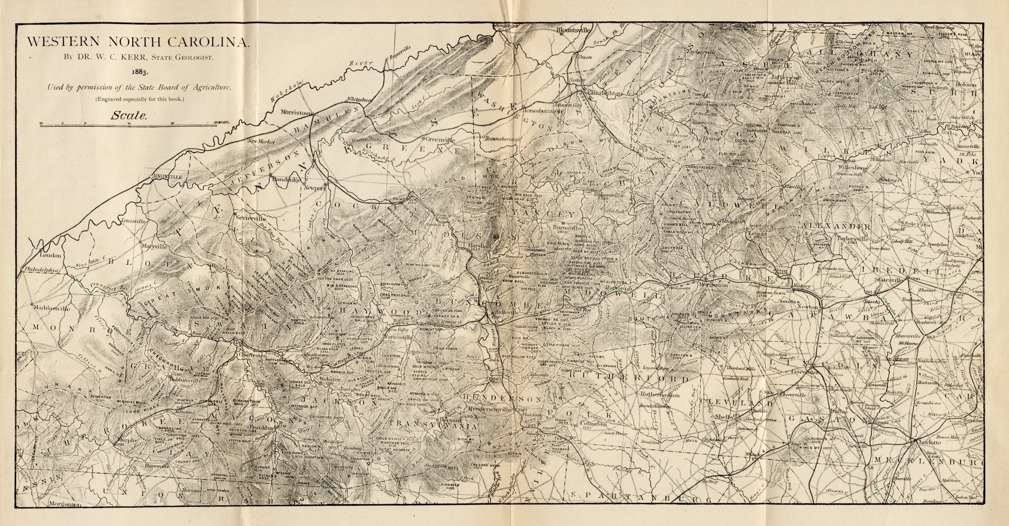