BY
CHARLES FRANCIS SAUNDERS
Author of “Finding the Worth While in California,”
“The Indians of the Terraced Houses,” etc.
WITH MAP AND ILLUSTRATIONS
“The Sun goes West,
Why should not I?”
Old Song.
NEW YORK
ROBERT M. McBRIDE & COMPANY
1918
Copyright, 1918, by
Robert M. McBride & Co.
Published May, 1918
TO
M. H. R.
Kinswoman most dear
This little volume is affectionately inscribed.
No part of the United States is so foreign of aspect as our great Southwest. The broad, lonely plains, the deserts with their mystery and color, the dry water courses, the long, low mountain chains seemingly bare of vegetation, the oases of cultivation where the fruits of the Orient flourish, the brilliant sunshine, the deliciousness of the pure, dry air—all this suggests Syria or northern Africa or Spain. Added to this are the remains everywhere of an old, old civilization that once lived out its life here—it may have been when Nineveh was building or when Thebes was young. Moreover, there is the contemporary interest of Indian and Mexican life such as no other part of the country affords.
In this little volume the author has attempted, in addition to outlining practical x information for the traveler, to hint at this wealth of human association that gives the crowning touch to the Southwest’s charm of scenery. The records of Spanish explorers and missionaries, the legends of the aborigines (whose myths and folklore have been studied and recorded by scholars like Bandelier, Matthews, Hough, Cushing, Stevenson, Hodge, Lummis, and others) furnish the raw material of a great native literature. Painters long since discovered the fascination of our Southwest; writers, as yet, have scarcely awakened to it.
Someone—I think it was that picturesque historian of our Southwest, Mr. Charles F. Lummis—has summed up New Mexico as “sun, silence and adobe;” and of these three components the one that is apt to strike the Eastern newcomer most forcibly is adobe. This homely gift of nature—hard as brick in dry weather, plastic as putty and sticky as glue in wet—is the bulwark of the New Mexican’s well-being. His crops are raised in it; he fences in his cattle with it; he himself lives in it; for of it are built those colorless, square, box-like houses, flat-roofed and eaveless which, on our first arrival in New Mexico, we declared an architectural abomination, and within a week fell eternally in love with. An adobe house wall is anywhere from two to five feet thick, a fact that conduces 2 to coolness in summer, warmth in winter, and economy at all seasons. Given possession of a bit of ground, you grub up a few square yards of the earth, mix it with water and wheat chaff, and shovel the mixture into a wooden mold. You then lift the mold and lo! certain big, brown bricks upon the ground. These the fiery New Mexican sun bakes hard for you in a couple of days—bricks that are essentially the same as those of ancient Babylon and Egypt, and the recipe for which (received by the Spanish probably from their Moorish conquerors) is one of Spain’s most valued contributions to America. Old Santa Fe was built entirely of this material, and most of latter day Santa Fe still is, though there is a growing disposition on the part of the well-to-do to substitute burned brick and concrete.
As a rule these adobe dwellings are of one story, and the more pretentious are constructed partly or entirely about an inner court, such as in Spain is called a patio, but in New Mexico a plazita, that is, a little plaza. A cheerful sanctuary is this plazita, 3 where trees cast dappled shadows and hollyhocks and marigolds bloom along the sunny walls. Upon it the doors and windows of the various rooms open, and here the family life centers. By the kitchen door Trinidad prepares her frijoles and chili, while the children tease her for tidbits; upon the grass the house rugs and serapes are spread on cleaning days, in kaleidoscopic array, and beaten within an inch of their lives; here, of summer evenings Juan lounges and smokes and Juanita swings in the hammock strumming a guitar, or the family gramophone plays “La Golondrina.”
Comparisons are always invidious, but if there be among the cities of the United States, one that is richer in picturesqueness, in genuine romance, in varied historic, archaeologic and ethnologic interest, than Santa Fe, it has still I think to make good its claims. The distinction of being the oldest town in our country, as has sometimes been claimed, is, however, not Santa Fe’s.[1] Indeed, the exact date of its founding 4 is still subject to some doubt, though the weight of evidence points to 1605. Nor was it even the original white settlement in New Mexico. That honor belongs to the long since obliterated San Gabriel, the site of which was on or near the present-day hamlet of Chamita, overlooking the Rio Grande about 35 miles north of Santa Fe. There in 1598 the conqueror of New Mexico, Don Juan de Oñate (a rich citizen of Zacatecas, and the Spanish husband, by the way, of a granddaughter of Montezuma) established his little capital, maintaining it there until the second town was founded. To this latter place was given the name La Villa Real de Santa Fé de San Francisco de Asís—the Royal City of Saint Francis of Assisi’s Holy Faith. Naturally that was too large a mouthful for daily use, and it was long ago pared down to just Santa Fe, though Saint Francis never lost his status as the city’s patron. In point of antiquity, the most that can justly be claimed for it 5 is that it is the first permanent white settlement in the West.
The situation of Santa Fe is captivating, in the midst of a sunny, breeze-swept plain in the lap of the Southern Rockies, at an elevation of 7000 feet above the sea. Through the middle of the city flows the little, tree-bordered Rio de Santa Fé, which issues a couple of miles away from a gorge in the imposing Sierra Sangre de Cristo (the Mountains of the Blood of Christ), whose peaks, often snow-clad, look majestically down in the north from a height of 10,000 to 13,000 feet. The town is reached from Lamy[2] by a branch of the Atchison, Topeka and Santa Fe Railway, which climbs due north for 18 miles through an uninhabitated waste dotted with low-growing piñon, juniper and scrub. At the station a small army of bus, hack and automobile men greet you with enthusiasm, and to reach your hotel you have only the choice of them or your own trotters, for street cars there 6 are none. In Santa Fe, however, no place is far from any other place—the population is but a scant 8500. Of these a large percentage is of Spanish blood, and Spanish speech and Spanish signs engage your attention on every hand.
The hub of the city is the Plaza—warm and sunny in winter, shady and cool in summer. Seated here on a bench you soon arrive at a lazy man’s notion of the sort of place you are in. Here the donkeys patter by laden with firewood—dearest of Santa Fe’s street pictures; here Mexican peddlers of apples and dulces, piñones and shoe-strings ply their mild trade, and Tesuque Indians, with black hair bound about with scarlet bandas, pass by to the trader’s, their blankets bulging with native pottery, or, in season, their wagons loaded with melons, grapes, apples, and peaches. Of afternoons the newsboys loiter about crying the papers, and you have a choice of your news in English or Spanish; and on Sundays and holidays the band plays athletically in its little kiosk, the crowd promenading around and around the while very much as in Old 7 Mexico, and strewing the ground behind it with piñon and peanut shells.
Close to the Plaza, too, cluster many of the historied spots of Santa Fe; indeed, the Plaza itself is a chief one. On this bit of ground it is confidently believed that Oñate must have camped in 1605—if it was 1605—when the capital was transferred from San Gabriel; and there is no doubt whatever that here was the seething center of the famous Pueblo revolt of 1680, when 3000 infuriated Indians cooped the entire Spanish population of Santa Fe within the Governor’s Palace opposite, and kept them there for a week. Then the whites made a brave sortie, caught and hanged 50 Indians in the Plaza and escaped to Old Mexico—their exit being celebrated shortly afterwards in this same Plaza by the Indians’ making a bonfire of all Spanish archives and church belongings they could lay hands on. Here 13 years later came De Vargas, the re-conqueror of New Mexico (bearing it is said the very standard under which Oñate had marched in the original conquest), and with his soldiers knelt before 8 the reinstated cross. And it was in this Plaza in 1846, during our Mexican War, that General Stephen Kearny ran up the Stars and Stripes and took possession of the territory in the name of the United States. It was the Plaza, too, that formed the western terminus of the Old Santa Fe Trail—that famous highway of trade that bound New Mexico with Anglo-Saxondom throughout the Mexican regime in the Southwest and until the iron horse and Pullman cars superseded mules and Conestoga wagons. At the old adobe hotel known as La Fonda, a remnant of which still stands at this writing just across from the southeast corner of the Plaza, travelers and teamsters, plainsmen and trappers found during half a century that boisterous brand of cheer dear to the pioneer soul—cheer made up quite largely of cards, aguardiente and the freedom of firearms, but gone now, let us trust, out of the world forever since the world has lost its frontiers.
Facing the Plaza on the north is the ancient Palacio Real or Governor’s Palace—a long, one-storied adobe building occupying 9 the length of the block, and faced with the covered walk or portico (they call such a portal in New Mexico) which in former years was a feature of every building of importance in Santa Fe. Within its thick walls for nearly three centuries the governors of New Mexico resided—Spaniards, Pueblo Indians, Spaniards again, Mexicans and finally Americans.[3] In 1909 the building was set aside as the home of the Museum of New Mexico (since removed to a handsome edifice of its own in the New Mexico style of architecture across the street), and of the School of American Research.[4] Some careful restoration work was then done, necessary to remove modern accretions and lay bare certain interesting architectural 10 features incorporated by the original builders, such as the handwrought woodwork, the fireplaces, doorways, etc., so that the edifice as it appears today is outwardly very much as it must have looked a century or two ago. The festoons of dried Indian ears, however, which are said to have been a rather constant adornment of the portal in old times, are now, to the relief of sensitive souls, humanely absent. Within, the Palace is a mine of information for the curious in the history, archaeology and ethnology of our Southwest, and a leisurely visit to it makes a useful preliminary to one’s travels about the State. The building is open to all without charge.
A short block from the Plaza is the Cathedral of San Francisco, whose unfinished trunks of towers are a prominent feature in Santa Fe’s low sky-line. You may or may not get something from a visit to it. It is a modern structure, still incomplete, built upon and about an older church believed to date from 1622. Beneath the altar reposes all that is mortal of two seventeenth century Franciscan missionaries 11 to the New Mexico aborigines. Of one of these, Padre Gerónimo de la Llana, I cannot forbear a word of mention. He was a true brother of Saint Francis, and for many years ministered lovingly to the Indians of the long since ruined pueblo of Quaraí, a place of which more later. At Quaraí he died in 1659, and his body was interred in the old church there whose walls still stand, one of the most striking ruins in New Mexico. To his Indians he was no less than a saint, and when (under attacks from Apaches, doubtless) they abandoned their pueblos about 1670, they bore with them what remained of their dear padre santo to Tajique, a pueblo some 15 miles distant, and buried him there. But in those days Apaches never ceased from raiding, and from Tajique, too, some years later, those Pueblo folk were forced to flee—this time across the rugged Sierra Manzano to Isleta on the Rio Grande. That was a journey of too great hardship, I suppose, to admit of carrying the now crumbled padre with them; so he was left in his unmarked tomb in a savage-harried land, to 12 be quite forgotten until 85 years later (in 1759) pious old Governor F. A. Marin del Valle heard of him. A search was speedily set on foot and after a long quest the bones of Padre Gerónimo were found, brought to Santa Fe, and becomingly once more interred. Then, alas! the poor brother dropped out of mind again until in 1880, when during some work upon the new Cathedral, the discovery of an inscription set in the wall 121 years before by Governor del Valle led to the finding of the grave. I think you will be interested to read the quaint Spanish epitaphs of this fine old friar, and of his companion, too, Padre Asencio de Zárate, sometime of Picurís pueblo. They may be found behind the high altar, which hides them.
Also in the Cathedral, it is believed, rests the mortality of Don Diego de Vargas, el Reconquistador, but unmarked. You will find many an echo of him in Santa Fe, for he it was who in 1692 re-conquered New Mexico for Spain after the Pueblo uprising of 1680 had swept the Spaniards out of the province and for twelve years kept them 13 out. Every year in June Santa Fe celebrates its De Vargas Day, when a procession, bearing at its head an image of the Virgin, marches from the Cathedral to the little Rosario Chapel that is dedicated to Our Lady of the Rosary (or as Santa Féans sometimes call her, La Conquistadora, the Lady Conqueror). It occupies the spot, on the city outskirts, where according to tradition De Vargas knelt on the eve of his second entry into the capital (December 16, 1693), and invoking the blessing of the Virgin upon his arms, promised her a chapel if she vouchsafed him victory on the morrow. It is a scant half-hour’s stroll thither from the Plaza, and you will enjoy the walk through the city’s half foreign scenes, though the building itself is disappointing because of its handling by tasteless renovators. Much more picturesque, though modernized with an astonishing steeple, is the little church of Guadalupe, standing amid Lombardy poplars on the south bank of the river. A quiet, reposeful, little temple, this, with beautifully carved ceiling beams and a curious, if crude, altar-piece 14 representing the appearances of Mexico’s Heavenly Patroness to Juan Diego.
Of the churches in Santa Fe, however, the one that is made most of by visitors, is the square-towered adobe of San Miguel. It is a pleasant twenty-minute walk from the Plaza (and, by all means, do walk when you go, for the way thither is too picturesque to be whisked over in an automobile)—through quiet, unpaved streets lined with one-storied adobe houses and often too narrow to accommodate any but a mere thread of sidewalk, where you bump into burros and, like as not, have utter strangers tip their hats to you with a buenos dias, señor. You pass the Bishop’s sequestered gardens and the high-walled grounds of the Convent and Academy of the Sisters of Loretto, with glimpses through a postern gate of old-fashioned flower beds; and further on, the touching little cemetery of the Sisters, each simple grave marked by a cross whereon vines and fragrant flowers lean lovingly; and so, on stepping stones, to the south side of the little Rio de Santa Fe. Then mounting the hill past more gardens 15 where hollyhocks—la barra de San José (St. Joseph’s rod) the New Mexicans call them—nod at you over the walls, and children prattle in Spanish and women sing at their work, there you are before old San Miguel.
Your first feeling is a bit of a shock, for the renovator’s hand has fallen heavily upon San Miguel and, frankly speaking, it is a rather hideous old church as viewed from the street. When, however, you have rung the sacristan’s bell and a Christian Brother from the adjoining Catholic college has come with the keys to usher you within, you pass in a twinkling into the twilight heart of the Seventeenth Century. Here are blackened, old religious paintings said to have been carried by the Conquistadores as standards of defense in battle; a wonderful old bell inscribed with a prayer to St. Joseph and bearing an all but illegible date that looks surprisingly like 1356, and maybe it is; a charming old wooden cross-beam supporting the coro, or choir gallery, its color mellowed by time and its surface carved with rude but beautiful flutings and flourishes 16 by some long-vanished hand of the wilderness; and so on—all delightfully embellished by the naïve expositions of the kindly Brother who acts as cicerone. And do not leave without a glimpse through the side door of the sunny quiet garden close, that lies between the church and the college building. As to the age of San Miguel, there has been much misinformation given—claims of its dating from 1543 being quite groundless. The known fact is that it was established as a chapel for the Mexican (Tlascalan) Indians who were part of the original Santa Fe colony. It therefore dates from some time on the hither side of 1605. In 1680 it suffered partial destruction in the Pueblo uprising, though its walls survived; and, after some repairs by order of De Vargas, it was finally restored completely in 1710, by the Spanish governor of that time, the Marquis de la Peñuela. The record of this fact inscribed in Spanish upon the main beam of the gallery is still one of the interesting “bits” in the church. Probably it is safe to call San Miguel the 17 oldest existing building for Christian worship in the United States.
If you are in a hurry you may “do” Santa Fe and its immediate environs in a carriage or an automobile in a couple of days, and departing secretly think it a rather overrated little old place. To get into the atmosphere of it, however, you should drop hurry at its gates and make up your mind to spend at least a week there, and longer if you can. Lounge in the Plaza and watch the ebb and flow of the city life that gathers here; drop into the Indian trading stores and get a taste for aboriginal art. White man’s schooling has brought about of late years a decline in the quality of Indian handicraft, but there is still a lot of interest in these Santa Fe curio shops—Navajo and Chímayo blankets, Pueblo pottery, Navajo silver jewelry, Apache baskets, moccasins, bead-work, quaint tobacco pouches, Spanish and Mexican things—serapes, mantillas, rusty daggers, old silver snuff boxes—and what not. Mount the hill at the city’s northern edge, and sit on the 18 ruined walls of the old garita (where the Mexican customs used to be levied upon imports by the Santa Fe Trail). There you get a magnificent bird’s-eye view of the city in its mountain fastness, and if the day be waning you will have a sunset for your benediction, long to remember. Extend your rambles sometimes to the outskirts for unadvertised sights—the little ranches with their outdoor threshing floors of beaten earth where in August you may see the wheat tramped out by horses, sheep or goats, and winnowed by tossing in the breeze; paisanas washing their linen on stones by the brookside as in Italy or Spain; and the gaunt descansos or crosses of rest, marking stopping places of funerals, and carving in illiterate Spanish scrawled upon the wood, prayers for the repose of departed souls. If you are fortunate enough to have a little Spanish, your enjoyment will be enhanced by stopping at humble doorways for a bit of chat with Juan Bautista the woodchopper, or Maria Rosalía the laundress. You will be civilly welcome, if you yourself are civil, and be handed a chair, if there be one, and 19 will be refreshed to learn something of the essential oneness and kindliness of the human family whether clothed in white skin or brown. It is this pervading air of Old Worldliness that makes the peculiar charm of Santa Fe for the leisurely traveler—its romance and its history are not altogether hidden away in books, but are an obvious part of its living present.
Moreover, Santa Fe is the starting point for numerous interesting out-of-town trips. These are story for another chapter.[5]
Of course you must make the trip—a half day will suffice for it—from Santa Fe to Tesuque, a village of the Pueblo Indians 9 miles to the north, and you should pronounce it Te-soo´kay. If your knowledge of Indians has been limited to the variety seen in Wild West Shows and historical pictures, you will be surprised at those you find at Tesuque. This is a quaint adobe village around a spacious plaza upon which an ancient, whitewashed Catholic church faces. The houses when of more than one story are built terrace-like, so that the roof of the first story forms a front yard to the second. Ladders lean against the outer walls, by which access is gained to the upper rooms. The 21 population of about 150 live very much like their Mexican neighbors, raising by irrigation crops of corn, beans, peaches, melons, and alfalfa, accepting meanwhile from the liberal hand of Nature rabbits, piñones and wild plums, and pasturing sheep and cattle on the communal pueblo lands which Spain granted them centuries ago and which our Government confirmed to them upon the acquisition of New Mexico. Their method of town building is not borrowed from the whites, but is their own; and because the Spanish Conquistadores of the sixteenth century found the region sprinkled with such permanent villages, called pueblos in Spanish, they named the people Pueblo Indians—a term which well characterizes them in contra-distinction to the nomadic tribes, whose villages moved as the tribe moved.
Tesuque is a type of a score or so of pueblos scattered along a line of some 300 miles in northern New Mexico and Arizona. Formerly the dress of these Indians was quite distinctive, but association with the whites has modified its quality of late years, though it still retains some of the old features—particularly 22 in the case of the women, who are more disposed than the men to conservatism. Their native costume is a dark woolen gown belted at the waist and falling a little below the knees, and a sort of cape of colored muslin fastened about the neck and hanging down the back. The lower part of the legs is often swathed in a buckskin extension of the moccasins in which the feet are encased. The hair is banged low upon the forehead and both women’s and men’s are clubbed at the back and bound with red yarn. The native attire of the men is a loose cotton shirt worn outside short, wide trousers. Instead of a hat a narrow banda of colored cotton or silk is bound about the hair.
Each village has its local government—and a very competent sort it is—of a democratic nature, a governor, as well as a few other officials, being elected annually by popular vote. Besides these, there is a permanent council of old men who assist in the direction of affairs. Most of the Pueblo Indians are nominal adherents to Roman Catholicism, but have by no means lost hold 23 of their pagan faith. On the patron saint’s day a public fiesta is always held. After mass in the church, there are native dances and ceremonies, accompanied by feasting continuing well into the night. November 12, St. James’s Day, is the day celebrated by Tesuque, and visitors are many.[6]
The Pueblos are as a class industrious, fun-loving, and friendly to white visitors. They are naturally hospitable and quickly responsive to any who treat them sympathetically and as fellow human beings. The lamentable fact that white Americans have too often failed in this respect, acting towards them as though they were animals in a zoo, is largely responsible for tales we hear of Indian surliness and ill-will. Pueblo women are skillful potters, and while Tesuque does not now excel in this art, one may 24 pick up some interesting souvenirs both in clay and beadwork. At any rate, you will enjoy seeing these things being made in the common living-room of the house, while the corn is being ground on the metates or mealing stones, and the mutton stew simmers on the open hearth. A knowledge of values first obtained at reputable traders’ shops in Santa Fe, is advisable, however, before negotiating directly with the Indians, as they are becoming pretty well schooled in the art of charging “all the traffic will bear.” Tesuque produces a specialty in the shape of certain dreadful little pottery images called “rain gods,” which must not be taken seriously as examples of sound Pueblo art.[7]
Thirty-three miles north of Santa Fe on the Denver and Rio Grande Railway is the village of Española, where a plain but comfortable hotel makes a convenient base for visiting several points of interest in the upper 25 Rio Grande Valley. A mile to the south is Santa Clara pueblo,[8] long famous for its beautiful shining black pottery almost Etruscan in shape. The clay naturally burns red, but a second baking with the fuel (dried chips of cattle manure), pulverized finely and producing a dense black smoke, gives the ware its characteristic lustrous black. Seven miles further down the river but on the other side, is another pueblo, San Ildefonso, a picturesque village of 125 Indians, near the base of La Mesa Huérfana. This is a flat-topped mountain of black lava, on whose summit in 1693, several hundred Pueblos entrenched themselves and for eight months stubbornly resisted the attempts of the Spanish under De Vargas to bring them to terms. That was practically the last stand of Pueblo rebeldom, which thirteen years before had driven every Spaniard from the land. San Ildefonso has public fiestas on January 23 and September 6.
Six miles north of Española and close to the Rio Grande is San Juan pueblo, with a population of about 400 Indians. Here one 26 is in the very cradle of the white civilization of the Southwest. At this spot in the summer of 1598, Don Juan de Oñate—he of the Conquest—arrived with his little army of Spaniards, his Franciscan missionaries, his colonist families, a retinue of servants and Mexican Indians, his wagons and cattle, to found the capital of the newly won “kingdom” later to be called New Mexico. The courtesy of the Indians there, who temporarily gave up their own houses to the Spaniards, was so marked that their pueblo became known as San Juan de los Caballeros (Saint John of the Gentlemen). Oñate’s settlement—of which no vestige now remains—is believed to have been situated just across the Rio Grande from San Juan, about where the hamlet and railway station of Chamita now stands. San Juan pueblo is further distinguished as the birthplace of Popé, the Indian to whose executive genius is due the success of the Pueblo Rebellion of 1680. A picturesque figure, that same Popé, of the timber dramatic heroes are made of. It is said that, while meditating the rebellion, he journeyed to the enchanted 27 lagoon of Shípapu, the place where in the dim past the Pueblos had emerged from the underworld and whither they return at death. There he conferred with the spirits of his ancestors, who endued him with power to lead his people to victory.[9] The San Juan women make a good black pottery similar to that of Santa Clara. On Saint John’s Day, June 24, occurs a public fiesta, with procession and dances, attracting visitors, white and red, from far and near.
Having got thus far up the Rio Grande, let nothing deter you from visiting Taos (they pronounce it Towss). By automobile it is about 50 miles northeast of Española or you can reach it quite expeditiously by Denver & Rio Grande train to Taos Junction and auto-connection thence about 30 miles to Taos.[10] Situated in a fertile plain, 7000 feet above the sea, in the heart of the Southern Rockies, Taos is one of the most charming places in America. It is in 28 three parts. There is the outlying hamlet Ranchos de Taos; then the picturesque Mexican town Fernandez de Taos, famous in recent years for a resident artist colony whose pictures have put Taos in the world of art; and lastly, there is the pueblo of Taos. From very early times the pueblo has played an important role in New Mexican history. It was here the San Juaneño Popé found the readiest response to his plans of rebellion. Later the location on the confines of the Great Plains made it an important trading center with the more northern Indians. The annual summer fair for cambalache, or traffic by barter, held at Taos in the latter part of the eighteenth century, was a famous event, the Plains tribes bringing skins and furs and Indian captives to trade for horses, beads and metal implements. The commercial opportunities combined with the fertility of the soil and an unfailing water supply led to the founding of Fernandez de Taos by whites. In the days of Mexican supremacy part of the traffic over the Santa Fe Trail passed this way and a custom house was here. The 29 ruins of a large adobe church in the pueblo form a memento of the troublous days of 1847, when a small rebellion participated in by Mexicans and a few Taos Indians took place here and the American governor, Bent, was murdered. At Fernandez de Taos, the famous frontiersman Kit Carson lived for many years, and here his grave may still be seen.
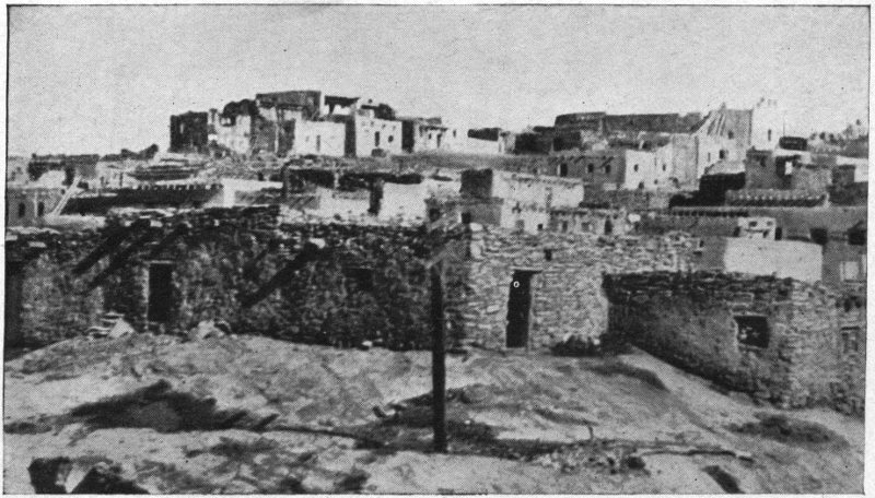
Taos pueblo, housing an Indian population of about 500, is the most northern in New Mexico, and perhaps the most perfect specimen existing of Pueblo architecture. It consists of two imposing pyramidal house clusters of 5 to 7 stories—aboriginal apartment houses—and between them happily flows the little Rio de Taos sparkling out of the Glorieta Cañon near whose mouth the pueblo stands. The three-mile drive or walk from Fernandez de Taos is very lovely, with the pueblo’s noble background of mountains before you, their purple and green flanks wonderfully mottled and dashed in autumn with the gold of the aspen forests. The men of Taos are a tall, athletic sort, quite different in appearance 30 from the more southern Pueblos. They wear the hair parted in the middle and done at the side in two braids which hang in front of the shoulders. They are much addicted to their blankets; and one often sees them at work with the blankets fastened about the waist and falling to the knees like a skirt. In warm weather they sometimes substitute a muslin sheet for the woolen blanket, and few sights are more striking than a Taos man thus muffled to his eyebrows in pure white.
Annually on September 30th occurs the Fiesta de San Gerónimo de Taos, which is one of the most largely attended of all Pueblo functions. Crowds of Americans, Mexicans and Indians (a sprinkling of Apaches among Pueblos of several sorts) line the terraced pyramids and make a scene so brilliant and strange that one wonders that it can be in America. The evening before, near sundown, there is a beautiful Indian dance in the plaza of the pueblo, the participants bearing branches of quivering aspens. With the sunset light upon the orange and yellow of the foliage as the 31 evening shadows gather, it is an unforgettable sight. Yes, you must by all means see Taos. There are hotel accommodations at Fernandez de Taos.[11]
But Española serves, too, as a base for outings of quite another sort. One of these is to the remarkable prehistoric cliff village known as the Puyé in the Santa Clara Cañon, about 10 miles west of Española. Here at the edge of a pine forest a vast tufa cliff rises, its face marked with pictographs of unknown antiquity and honeycombed with dwellings of a vanished people, probably ancestors, of some of the present-day Pueblos.[12] These cliff chambers are quite small, and their walls bear still the soot from prehistoric fires. Climbing by an ancient trail to the summit of the mesa of which the cliff is a side, you come upon the leveled ruins of what was once a magnificent, 32 terraced community house, built of tufa blocks and containing hundreds of rooms. Rambling from room to room, picking up now a bit of broken pottery, now a charred corn-cob, poking into the ashes of fireplaces where the last embers were quenched before history in America began, you experience, I hope, a becoming sense of your youth as a white American. And the view from this noble tableland—a view those ancient people had every day of their lives! One wonders had they eyes to see it—the lovely valley of the Rio Grande, purple chain after chain of mountains on every side, the jagged peaks of the Sangre de Cristo, the Glorietas, the Jemes, and dim on the far horizon, the Sierra Blanca in Colorado.
Also dotting the same plateau (this region by the way, is now called Pajarito[13] Park) are numerous other prehistoric community houses—the Otowi (with its curious tent-like rock formations), the Tsánkawi, the Tchrega—all of absorbing interest to the archaeologic mind, but offering not much 33 that seems new to the average tourist who has seen the Puyé. One, however, known as the Tyuonyi in the cañon of the Rito de los Frijoles[14] should not be missed. It may be reached via Buckman, a station on the D. & R. G. 12 miles south of Española. Thence it is about 15 miles over all sorts of a road to the brink of Frijoles Cañon. A steep foot-trail there leads you down, a thousand feet or more, into the gorge and after a short walk you are at the comfortable ranch house of Judge A. G. Abbott, custodian of the Bandelier National Monument, under which name the neighboring ruins are officially designated by the United States Government, which owns them.[15] Considered merely as scenery, the little, secluded cañon is one of the loveliest spots in New Mexico, with its stretches of emerald meadows, 34 its perennial stream and its peaceful forest of stately pines. But it is the human interest given by the vacant houses of a forgotten race—the cavate dwellings of the pink and white tufa cliffs and the ruined communal dwellings on the cañon floor and on the mesa top near by—that brings most visitors. That noted ethnologist, the late Adolf F. Bandelier, wrote a romance with the scene laid here and at the Puyé. It is entitled “The Delightmakers,” and a reading of it will not only lend a living interest to these places, but yield a world of information as to the mind and customs of the Pueblo Indians. Visitors have the School of American Archaeology at Santa Fe to thank for the painstaking work of excavation extending over years, that uncovered many of these ancient dwelling places of their centuries of accumulated debris.
To return to Española. Ten miles to the eastward in the valley of the Santa Cruz river is the quaint little church of Santuario, a sort of New Mexican Lourdes, famous these many years for its miraculous cures. A trip thither makes a noteworthy day’s 35 outing. It may be done by automobile over a road of many tribulations, but a horse and buggy are more satisfactory and far more in keeping with the primitive country. My own visit was achieved on foot, eased by a lift of a couple of miles from a kindly Mexican on horseback, who set me up behind him, en ancas, as they call it. It was mid-August—a season which in northern New Mexico is as sunshiny and showery as a sublimated Eastern April. The intense blue of the sky was blotted here and there with piled-up cloud masses, which broke at times in streamers of rain upon the purple ranges of the Sangre de Cristo ahead of me—and after that, descending shafts of light. As soon as I had crossed the Rio Grande and Española was behind me, I was in pure Mexico. The Santa Cruz Valley is an agricultural region, but it is the agriculture of centuries ago that is in vogue there. Wheat, for instance, is trodden out by horses, sheep or goats, on outdoor threshing floors of beaten earth, winnowed by tossing shovelfuls into the air, washed of its grit and dirt in the nearest acéquia, then spread out in 36 the sun to dry, and finally ground in primitive little log mills whose rumbling stones are turned by tiny water wheels. Little New Mexican Davids, bare of foot and dreamy-eyed, loiter along behind their nibbling flocks in the stubble of the shorn fields or the wild herbage of the river bottom. Peaches and melons, onions and corn, lie drying on the roofs, and strips of meat hang “jerking” from stretched lines in the plazitas of the houses. The cross is still a dominant feature in this land of yesterday. Now it glitters on the belfry of the family chapel among the trees of some ranch; now it is outlined against the sky on the crest of a hill, a calvario of the Penitentes;[16] now it crowns a heap of stones by the wayside, where a funeral has stopped to rest.
Of the villages strewn along this delightful way, some are hamlets of half a dozen straggling little adobes drowsing under their rustling cottonwoods. Others are more important. One particularly I remember—Santo Niño. That means “village of the Holy Child,” and His peace that placid morning seemed to rest upon it. The streets were narrow shady lanes, where irrigation ditches running full made a murmuring music, flowing now by adobe walls, now by picket fences where hollyhocks and marigolds and morning-glories looked pleasantly out. It was a village not of houses merely, but of comfortable old orchards, too, and riotous gardens where corn and beans, chilis and melons locked elbows in happy comradery. I think every one I met was Mexican—the women in sombre black rebosos, the men more or less unkempt and bandit-appearing in ample-crowned sombreros, yet almost without exception offering me the courtesy of a raised hand and a buenos dias, señor. Santa Cruz de la Cañada—another of these villages—deserves a special word of mention, for next 38 to Santa Fe it is the oldest officially established villa (a form of Spanish organized town), in New Mexico, dating as such from 1695, though in its unincorporated state antedating the Pueblo Rebellion. Long a place of importance, its ancient glory paled as Santa Fe and Albuquerque grew. Today it numbers a scant couple of hundred inhabitants, but it is interesting to the tourist for its fine old church facing the grassy plaza of the village. The church interior is enriched with a number of ancient pictures and carvings of an excellence beyond one’s expectations.
Then there is Chímayo, into which you pass just before crossing the river to Santuario. To the general public Chímayo appeals because of its blankets and its apricots, but to me it remains a place of tender memory because of a certain hospitable tienda de abarrotes (or, as we should say, grocery store). Entering it in the hope of finding crackers and cheese, wherewith to make a wayside luncheon, I was given instead a characteristic Mexican meal as exquisitely cooked as ever I had; yet it was 39 but a couple of corn tortillas, a bowl of pink beans done to liquidity, and a cup of black coffee. As to the blankets of Chímayo, they are woven in sizes from a pillow-cover to a bed-spread, of Germantown yarn, and you find them on sale everywhere in the curio shops of the Southwest, competing in a modest way with the Navajo product. The weaving is a fireside industry, prosecuted in the intervals of other work both by women and men, and the bump-bump of the primitive looms is the characteristic melody of the place.
I had to ford the little river, shoes and stockings in hand, to reach Santuario, and was not sure when I got there. An old paisano, sitting in the shade of a wall, informed me, however, that the little cluster of adobes on a hillside, into which I soon came from the river, was really the place—“of great fame, señor. Here come people of all nations to be cured—Mexicans, Americans, Apaches—from far, very far.” The adobe church, half hidden behind some huge cottonwoods, was open—of crude construction without and within, but very picturesque. 40 Passing within the wooden doors, which are curiously carved with a maze of lettering that I found it impossible to decipher, I was in a twilight faintly illumined by the shining of many candles set upon the floor in front of a gaudy altar. Upon the walls hung beskirted figures of saints in various colors and wearing tin crowns. There were, too, crude little shrines upon which pilgrims had scrawled their names. A figure of San Diego on horseback with a quirt on his wrist, cowboy style, was particularly lively, I thought. In a room adjoining the altar is a hole from which pilgrims take handfuls of earth—red adobe, apparently—the outward instrumentality that is depended upon for the cures.
The history of this queer chapel is interesting. Long before it was built the efficacy of that hole of earth was believed far and wide, and the place resorted to by health seekers. Finally in 1816 a pious paisano named Bernardo Abeyta, who had prospered greatly in his affairs, was impelled to erect this church as a testimony of gratitude to God. Dying he bequeathed it to 41 Doña Carmen Chaves, his daughter, who kept for all comers the church and its pit of healing, and lived in a modest way upon the fees which grateful pilgrims bestowed upon her. After her death, the property descended to her daughter, who maintains it in the same way. It is said the fame of the spot is known even in old Mexico, whence pilgrims sometimes come.[17] The earth is utilized either internally dissolved in water, or outwardly made into a mud wash and rubbed on the body. The chapel is dedicated to El Señor de Esquipulas—the Christ of Esquipulas—Esquipulas being a little village of Guatemala whose great church enshrines a famous image of the Lord believed to perform miraculous cures.
For a glimpse in small compass of the unsuspected picturesqueness of rural New Mexico, I know of nothing better than this little jaunt from Española to Santuario.
NOTE: Horseback tours through the Pecos and Santa Fe National Forests are practicabilities, with Santa Fe, Española or Buckman as a base. There is a company or two at Santa Fe that make a specialty of outfitting parties, furnishing riding and pack animals, cooks and all needful accessories, for a fixed sum. Trout fishing is good in many of the mountain streams. You may arrange your own itinerary, or if you do not know what you want, trips will be outlined to suit your particular interests. In the latter event, a consultation with the Supervisor of the Santa Fe National Forest, whose office is in Santa Fe, would be helpful. For people of sound wind who like to see the world from mountain tops, a trip over the Dalton Trail to the Pecos River and thence to the Truchas Peaks is repaying. From that elevation of about 13,000 feet, there is a magnificent outlook over much of New Mexico and some of Colorado and Arizona.
Albuquerque is the metropolis and trade heart of central New Mexico, and the talk of its solid citizens runs naturally on cattle and wool, mines and lumber, grapes and apples and the agricultural glories of the Rio Grande valley. The average tourist gives it only the half-hour during which the train stops there, and remembers it mainly for the noteworthy Harvey Indian collection at the station (a liberal education, by the way, in the handicraft of the Southwestern aborigines) and for the snap-shots he tried to take (and was foiled in) of the picturesque Pueblo pottery sellers on the platform.[18] In itself, indeed, the busy little city has not a great deal that is distinctive 44 enough to interest tourists excepting the Spanish quarter known as Old Albuquerque, on the outskirts—a picturesque survival of the Hispanic regime. There stands the old church dedicated to the city’s patron saint, San Felipe. As a base to visit certain other places, however, Albuquerque is very convenient. For instance, there is the pueblo of Isleta, 12 miles south.
It is from Isleta that many of the pottery makers come whom you see offering their wares on the railway platform at Albuquerque, and a pleasant day may be put in rambling about the streets of the pueblo, chatting and trafficking with the hospitable people, who are a very wide-awake, independent sort of Indians. You may go thither by train; or you may drive (a much better way), following the west bank of the Rio Grande, and enjoying the beauty of a typical bit of rural New Mexico, now austere and sun-scorched, now relenting in vineyards, fields of corn and lush alfalfa, and orchards of apple and peach, sandwiched between sleepy little Mexican villages smothered in trees and old-fashioned flowers. 45 Much of New Mexico is as foreign in aspect as Spain, and the flat-roofed, eaveless ranch houses, low and rambling, with enclosed plazitas, and high-walled corrals adjoining, into which the teams are driven at night and the gates shut to the outer world, bring to you the atmosphere of Don Quixote or Lazarillo de Tormes. Architecturally, Isleta differs widely from the orthodox pueblo type, its houses being usually of one story and extended over a liberal area, as must needs be to shelter its thousand or so of people. They are quite up-to-date farmers, these Isleteños, and the pueblo is as busy at harvest time as a beehive, what with fruit drying, corn husking, and alfalfa baling.[19] Their homes are generally neatly kept, often adorned within with bright-colored blankets, pretty water ollas, and the whitewashed walls hung with pictures of Virgin and saints—impressing you as homes of a thrifty and well-doing race. Indeed these people are reputed the 46 richest of all the Pueblos. It is, I believe, a matter of record that in 1862, when a detachment of the United States army was stranded penniless in New Mexico, an Isleta Indian loaned it $18,000 cash, simply taking the commander’s receipt as evidence. After waiting patiently for twelve years for the government to have the politeness to return the money without being asked for it, and hearing nothing, he and the governor of Isleta, accompanied by the local United States Indian agent, made a trip to Washington to see about it. Through the personal interest of President Grant, the money was at last returned.
On August 28, St. Augustine’s Day, occurs the annual public fiesta, with the usual open air Indian dances after mass in the church. The large circular estufa, or native ceremonial chamber, entered by a ladder let down through an opening in the roof, is a conspicuous feature of the pueblo. You will find such places, in one form or another, in all the Pueblo villages, and in the Cliff Dwellers’ towns. They were originally used as the sleeping apartments 47 of the men. Nowadays the men sleep at home, but the estufas are still resorted to by them as a sort of club-room or lounge when religious ceremonies are not going on inside. Despite membership in the Roman Catholic Church the average Pueblo’s main hold on the unseen that is eternal is through his primitive pagan faith, whose rites he still practices. Entrance to the estufas is not, as a rule, readily granted to white people, and should never be undertaken without permission first obtained. As a matter of fact, there is on ordinary occasions nothing to see but a dimly lighted chamber with bare floor and walls, and a small, boxed-in fire-pit near the base of the ladder.
To the big old adobe church of Saint Augustine in the center of the pueblo, there attaches a queer legend sure to delight the traveler whose interest is less in historical verities than in the fanciful flights of the human mind. I refer to the tradition of the Rising of Padre Padilla’s Coffin. Among the Franciscan friars who accompanied Coronado on his famous march to what he 48 called Quivira—the country of the Wichita Indians in Kansas—was Padre Juan de Padilla. This intrepid servant of God (when Coronado turned homeward), remained with two lay brothers on the Kansas plains with the view of Christianizing those Indians. The outcome of the matter was that he was killed by them on November 30, 1544. Now tradition has it that somehow in the heavenly ordering, the body of the martyred padre got miraculously transferred from Kansas to a place under the church altar at Isleta; and it is firmly believed (and the belief is backed up by the circumstantial testimony of solid citizens) that periodically the coffin, which is a section of a hollowed cottonwood trunk, rises plainly to view in the church, disclosing to whomsoever may then be present, the padre rather mummified but still in his black whiskers. To prove it there are people who will show you bits of his gown nipped off surreptitiously by eye-witnesses and preserved as precious amulets.[20]
Northward from Albuquerque for 40 miles, the beautiful valley of the Rio Grande contains much of appeal to the student of history and of Indian life. That is the region called in the chronicle of Coronado’s expedition, the Province of Tigüex (pronounced tee-wesh); and here that doughty conquistador spent his first New Mexican winter (1540-41) at a pueblo now vanished, in the neighborhood, it is believed, of the picturesque town of Bernalillo[21] 17 miles north of Albuquerque. It was a winter so marked with wanton deeds of deviltry by the soldiery towards the peaceably disposed natives, that the whole region was soon seething in revolt—but helpless revolt because of the guns and horses of those profligate swashbucklers, who disgraced the Christianity they professed.
Several pueblos are still extant in that stretch. There is Sandia, a moribund little 50 place 10 miles from Albuquerque, and within walking distance of Alameda Station on the railway, but hardly worth the trip. North of Bernalillo a couple of miles is a summer pueblo, Ranchitos de Santa Ana (the little farms of Santa Ana), occupied during the growing season by Indians whose home pueblo, Santa Ana, is a dozen miles to the northwest in a virtual desert overlooking the saline flats of the Jemes River. Thither they go to dwell in winter and eat up the crops raised in summer beside the great river. In the same direction 13 miles beyond Santa Ana (25 from Bernalillo) is the important pueblo of the Jemes (Hay´-mes) Indians, about 500 in number.[22] The village is beautifully situated at the mouth of San Diego Cañon. Its public fiesta is held on St. James’s Day, November 12, and is much attended by Americans, Mexicans, 51 Pueblos, Navajos and Apaches. The region nearby is sprinkled with ruins of old pueblos which are the subject of considerable literature of the antiquarian sort. A capital and reliable popular article on the Jemes Indians by Mr. A. B. Reagan, appeared in the April, 1917, issue of “El Palacio,” the journal of the Archaeological Society of New Mexico. A few miles before reaching Jemes the traveler passes the once powerful, but now small pueblo of Sia (See-a), with a population of barely 100. Its decline is attributed in part to remorseless inter-killing on suspicion of witchcraft, a sort of superstition that the Pueblos, unlike ourselves, have not yet outgrown. Its festival is on August 15, the Feast of the Assumption of Our Lady, and is attended by many visiting Indians, especially Navajos, who give it a special tinge of picturesqueness. From Albuquerque Jemes may be reached directly by auto-mail stage which passes the pueblo and then proceeds 13 miles further to Jemes Springs postoffice in San Diego Cañon. Near this place are some medicinal springs of local repute—iron, soda 52 and sulphur—and a modest hotel of the country sort. The stage leaves Albuquerque daily except Sunday, and if you do not mind a bit of roughing it, the trip (about 50 miles to Jemes pueblo) will be an experience to talk about.
Continuing up the Rio Grande from Bernalillo, you next come (10 miles from Bernalillo, or 3 from Algodones Station on the Santa Fe) to the pueblo of San Felipe at the foot of a long, black, treeless mesa on the west bank of the river. Its fine, white Mission church, dating back some 200 years, is a prominent sight from the car windows of Santa Fe trains. The ruins of a previous church and pueblo of the San Felipeños are visible on the summit of the mesa, and a climb to them will reward you, at least with a fine view of the Rio Grande valley. San Felipe’s principal public fiesta is held May 1.
Another dozen miles up the river—but now on the east side—is the pueblo of Santo Domingo, whose 800 Indians are about the most set-in-their-ways of any in New Mexico. This conservatism serves, however, 53 to make their Green Corn Dance (held on August 4, the feast day of their patron Saint Dominic), of especial worth, because the ceremony has been comparatively little debased by the hybrid innovations which are spoiling many of the native rites of the Pueblos. There are some preliminary ceremonies the afternoon before, which it is interesting to view. The pueblo is easily reached, as it is but a couple of miles from Domingo station on the Santa Fe railway. The visitor is forewarned that there is a particularly strong objection at Santo Domingo to picture-taking and cameras are blacklisted. Even artists of the brush have been ejected from the village. In passing, it should be stated that the dances of the Pueblos are not jollifications as among white people, but religious ceremonials—expressions of thanksgiving to their supernal protectors for blessings received and prayers for favors to come, as rain and bountiful crops. Santo Domingo is famous for its beautiful pottery—a heavy ware, but remarkable for an almost Greek grace of 54 form, adorned with geometric designs in black on pink or creamy white.
Still ascending the Rio Grande, you reach (by a pleasant drive of 10 miles from Domingo Station) the pueblo of Cochití (co-chee-teé), where the ethnologist Bandelier once lived for a time, and studied the race he came to know so well. It has more the appearance of a Mexican village than of an Indian pueblo, for the houses are generally of one story and detached one from another. The people, too (there are about 250), seem more or less Mexicanized, but are hospitable and good-natured. The local tradition is that it was the ancestors of the Cochiteños who occupied the cliff dwellings of the Rito de los Frijoles. One who is robust enough for horseback tours may secure a guide at Cochití and ascend to that wild and beautiful region by immemorial trails through a rugged mountain country dotted with ruins of several former homes and shrines of the Cochití people, who in prehistoric times seem to have been confirmed wanderers. The principal public fiesta at this pueblo occurs on July 14, Saint 55 Bonaventure’s Day, and is well worth attending, though I know of no especial features distinguishing it. Pottery is made here, too—some of it of a queer type running to animal forms, corpulent and impossible. Both Cochití and Santo Domingo may be readily visited in one day, if arrangements are made in advance through the Santa Fe agent at Domingo. They are equally easy of access from Santa Fe and Albuquerque.
Southeasterly from Albuquerque some 20 miles the Manzano Mountains lift their piny crests and drift southward to the Gallinas. From their feet eastward stretches the wide treeless Estancia Valley, and in the lap of it lies a noteworthy cluster of saline ponds and lagoons, whose bitter waters, shining in the blistering sun, are a mockery to the thirsty. These are “the accursed lakes”[23] of Pueblo tradition—originally fresh and abounding in fish, they say, but now lifeless and undrinkable, cursed of the ancient gods because of the sinfulness of a witch who dwelt there once. If you would know how this change came about, you should read the 57 tale called “The Accursed Lake” in Mr. Charles F. Lummis’s delightful book “Pueblo Indian Folk Stories.” These lakes are all heavily alkaline except one and that is saline—a source of salt from time immemorial to the Indians of the pueblos. Coming from near and far, they would plant their prayer plumes by its white margin and sprinkle its waves with sacred meal in recognition of the divine largesse they were about to receive. For the Indian tradition is that this lake was the abode of a divinity whom they called Salt Old Woman or Salt Mother, and the salt was her free gift to men. She is circumstantially described as wearing white boots and a white cotton dress, and carrying in her hand a white abalone shell, which was so soft and pliable that she could fold it like a handkerchief.[24] It is said the salt of this lake has found its way through barter to Parral in Old Mexico.
To the tourist the attraction in the Estancia Valley is the presence of some quaint old plaza villages dating from the days of the Spanish occupation, and certain imposing 58 ruins of Franciscan Mission churches of seventeenth century construction standing in the midst of crumbled Pueblo towns. These are not in the open valley but in the foothills of the Manzanos and the Gallinas, and are easily visited from Mountainair, an American town on the “Belén Cut-off” of the Santa Fe Railway. Here is a small hotel, and automobiles may be hired.
The most famous of the ruins is the Gran Quivira at the edge of the Gallinas foothills, 24 miles south of Mountainair. They are the remains of a large pueblo of low, stone houses, covering altogether about 80 acres and once housing perhaps a couple of thousand souls. There are the ruins of several estufas, of irrigation works, and of two Christian churches. The pueblo occupies the narrow crest of a ridge overlooking a vast, lonely, cedar- and piñon-dotted plain that reaches to far-off, dreamy mountain ranges. It is in a solitude of solitudes wrapped in the silence of death, and as almost everywhere in the plateau region of northern New Mexico and Arizona, one has the feeling of being alone on the roof of the world, 59 though the elevation here is really but 6800 feet. The most conspicuous feature of this shattered town is the larger of the two churches whose gaunt, gray, roofless walls of flat limestone pieces laid in mortar and rising to a height of 30 feet, are visible to the traveler long before he reaches the place. Seen “from the northeast, through vistas of cedars and junipers,” to quote Bandelier, “the ruins shine in pallid light like some phantom city of the desert.” Adjoining the church, are the ruins of a convento of several small rooms and a refectory, built about an interior courtyard. The whole has an unfinished appearance, and Bandelier believed that work on the building was suddenly interrupted and never resumed.
Indeed, the whole place is shrouded in mystery—its beginning and its end are alike in the twilight. No record has been left by the old chroniclers of any mission called Gran Quivira; but there is frequent mention by them of Tabirá, whose location fairly corresponds to this. That was a town of the Piro Pueblos, where an important Mission was established about 1630 by Padre 60 Francisco de Acevedo. It ceased to be heard of after half a century, and it is believed that repeated raids of the barbarous Apaches—the red terror of the peacable Pueblos—caused the abandonment of the village. In all human probability that Tabirá is this Gran Quivira, but how the latter name became attached to these ruins has never been satisfactorily explained; for, as has already been stated, Quivira was Coronado’s name for the country of the Wichitas, far away in Kansas. The Piro people, who are believed to have inhabitated this pueblo (and that of Abó, of which something shortly), are about as extinct as their towns. Only an insignificant remnant, and these speaking an alien tongue, exist today, in the Mexican State of Chihuahua.
The hill which the Gran Quivira ruins occupy is of limestone, and underlaid, as limestone hills often are, with hollownesses that give back in places an audible echo to one’s footfalls. Popular fancy has been caught by these givings-off of the underworld, and all sorts of fables have attached themselves to this desolate place. These have 61 mostly to do with buried treasure. It has been thought, for instance, that here in the caverns of this hill is really the store of gold and jewels, the hope of which, like a will-of-the-wisp, lured Coronado on and ever on, to disappointment and a broken heart. Another tradition (quoted by Mr. Paul A. F. Walter, in “The Cities That Died of Fear”[25]) tells of a hidden cave in the hill where the last Piros are said to have retreated with their belongings, including vast treasure brought from Mexico by the Franciscan Fathers,[26] and that an earthquake sealed them and their treasure up together. Of course, such stories have brought hither innumerable treasure seekers, who for years have gophered the hill industriously but have got nothing but sore muscles, arrowheads, and broken pottery. The most picturesque of these delvers was 62 a blind woman, a Mrs. Clara Corbyn, who acquired homestead rights on the north end of Gran Quivira. Lacking the wherewithal to finance excavations, she traveled the country over from the Pacific to the Atlantic, endeavoring to procure money backing for her scheme, and to that end even wrote a musical romance, which she called “La Gran Quivira.” Failing, she died not long ago in Los Angeles—of a broken heart, it is said—and the Museum of New Mexico eventually secured her homestead interest.[27] The major portion of these ruins belongs to the United States, forming the Gran Quivira National Monument.
Abó, that other dead pueblo of the Piros, is about 12 miles southwest of Mountainair, or 4 miles west of Abó station on the Santa Fe Railway. Gran Quivira you see on its hilltop for miles before you reach it, but of Abó your first view comes with the shock of an unexpected delight. Your car climbs a hill through a bit of wooded wilderness, and, the crest attained, there flashes on your sight from below, an exquisite little sunlit 63 valley. In the midst of it is a hillock, and on and about this is scattered the desolated, roofless pueblo with its noble church, ruined too, of San Gregorio de Abó. A thread of living water—the Arroyo de Abó—cuts its way through the valley which is bounded on the west by the lovely chain of the Manzanos. Unfortunately, the ruin of the old church still goes on—the decay hastened, I believe, by the fact that latter-day settlers have borne off much of its stone and timber for their private use. As it now stands, the high, jagged walls of the building resemble as much as anything a gigantic broken tooth, and standing in this solitary place are picturesque to a degree. The material is red sandstone and the edifice dates from about 1630—the founder being the same Padre de Acevedo that is credited with establishing Gran Quivira. He died here at Abó, and was buried in the church on August 1, 1644. This pueblo, like Gran Quivira, is believed to have been abandoned because of Apache raids, and was extinct before the great rebellion of 1680.[28]
A few miles from the old pueblo, and close to the railway line there are some low cliffs, forming one side of a gorge once called El Cañon de la Pintada, or the Painted Rocks of Abó Cañon. This spot is a sort of aboriginal picture gallery worth a visit by the curious in such matters. The sheltered places on the cliff-face are adorned for a considerable distance with drawings of evident antiquity in various colors—yellow, green, red, white. They are mostly representative of human figures, one or two apparently of the clowns who play prankish parts in many of the present-day Pueblo ceremonies. Others are symbols that still survive in the religious rites of the Pueblos.
Eight miles northwest of Mountainair (and a little more due north of Abó) is Quaraí, another forsaken pueblo, the ruins of whose fine old Mission church may be seen a mile away. My own first view of it was dramatic enough, the red, sandstone walls 20 feet high or more, gaunt and jagged, 65 silhouetted sharply against a sky black with storm clouds whence rain banners wavered downward, and athwart them now and then forked lightnings shot and spit. Quaraí was a walled town, and some excavation work, done recently by the Santa Fe archaeologists, has brought to light among other things the remains of a round community building resembling the Tyuonyi in the Cañon Rito de los Frijoles.[29] Close at hand is a cottonwood grove refreshed by an abundant spring, a favorite picnic ground for the country folk roundabout. Other ruins in the vicinity and signs of ancient fields here and there indicate that Quaraí was a place of importance in its day, and doubtless for a long time before the Spanish occupation. Its church is believed to have been built about 1628 and was dedicated to La Inmaculada Concepcion. This was the Mission of that Padre de la Llana whose remains, after much travel, are now at rest beneath the altar in the Cathedral at Santa Fe.
About 7 miles northward from Quaraí, 66 nestling at the foot of Manzano Peak,[30] is an excellent example of the old-fashioned plaza village, called Manzano, which is Spanish for apple tree. The reason for the name is the presence there of a couple of ancient apple orchards, which are believed to date back to the time of the Franciscan Missions, and doubtless were set out by the Fathers of Quaraí, some 250 years ago. The village is of the typical adobe architecture of New Mexico, and though not so old as it looks, having been settled about 1825, it is very foreign of aspect. With its plaza, its old-fashioned flowers in the gardens, its houses massed one above another on the side of a hill that is topped by a great wooden cross, its murmurous acéquia, and its fine old Spanish torreon or tower of defense, Manzano holds features of picturesqueness enough to be worth a trip in itself. A unique feature of the place is the Manzano Lake which occupies a depression in the midst of the village—a charming sheet of water, beautiful and fragrant in season with water lilies. The source of the Lake 67 is a magnificent spring hardby. To reach it, one climbs the hillside a quarter-mile or so, and then descends into a shaded hollow, where the cool water gushes up into a colossal bowl, and brimming over quickly sinks into the ground to re-appear below and form the village lake. The spring is locally known as El Ojo del Gigante—the Giant’s Eye—and is famed throughout the State as a very marvel among springs.
If one have time and inclination, the Estancia Valley, its lakes and ruins and Mexican villages may be made the objective of a trip by automobile from Santa Fe or Albuquerque. The roads in good weather are fair, as unimproved roads go, and in the mountain part pass through a wooded region of much loveliness—sunny park-like forests of pine and oak, with numerous rivulets and charming wild gardens. From Albuquerque to Mountainair by this route is about 75 miles.
The oldest occupied town in the United States, and in point of situation perhaps the most poetic, is Acoma (ah´co-ma), occupying the flat summit of a huge rock mass whose perpendicular sides rise 350 feet out of a solitary New Mexican plain.[31] It is situated 15 miles southwest of the Santa Fe Railway station of Laguna, where modest accommodations are provided for travelers who stop over. The inhabitants of Acoma, numbering about 700, are Pueblo Indians, whose ancestors founded this rockborne town before the white history of the Southwest began. Coronado found it here in 1540. El Peñol Maravilloso—the Rock 69 Marvellous—the old chroniclers called it. “A city the strangest and strongest,” says Padre Benavides, writing of it in 1630, “that there can be in the world.”
They will take you from Laguna to Acoma in an automobile over a road, little better than a trail, whose traversability depends more or less on weather conditions not only that day, but the day before.[32] It winds through a characteristic bit of central New Mexico landscape, breezy, sunlit and long-vistaed, treeless save for scattering piñon and juniper. Wild flowers bespangle the ground in season; and mountains—red, purple, amethystine, weather-worn into a hundred fantastic shapes—rise to view on every hand. In July and August the afternoon sky customarily becomes massed with cloud clusters, and local showers descend in long, wavering bands of darkness—here one, there another. Traveling yourself in 70 sunshine beneath an island of clear turquoise in such a stormy sky, you may count at one time eight or ten of these picturesque streamers of rain on the horizon circle. Jagged lightnings play in one quarter of the heavens while broken rainbows illumine others. Nowhere else in our country is the sky so very much alive as in New Mexico and Arizona in summer. Nowhere else, I think, as in this land of fantastic rock forms, of deep blue skies, and of wide, golden, sunlit plains, do you feel so much like an enchanted traveler in a Maxfield Parrish picture.
Though the cliffs of Acoma are visible for several miles before you reach the Rock, you are almost at its base before you distinguish any sign of the village—the color of its terraced houses being much the same as that of the mesa upon which they are set. The soft rocky faces have been cut into grotesque shapes by the sand of the plain which the winds of ages have been picking up and hurling against them. There are strange helmeted columns, slender minarets and spires that some day perhaps a 71 tempest will snap in two, dark, cool caverns which your fancy pictures as dens of those ogreish divinities you have read of Indians’ believing in.
Your first adventure at Acoma—and it is a joyous one—is climbing the Rock to the village on top. There are several trails. One is broad and easy, whereby the Pueblo flocks come up from the plains to be folded for the night, and men ahorseback travel. Shorter is the one your Indian guide will take you, by a gradual sandy ascent, to the base of the cliff. There you are face to face with a crevice up which you ascend by an all but perpendicular aboriginal stairway of stone blocks and boulders piled upward in the crack. Handholes cut in the rock wall support you over ticklish places, until finally you clamber out upon the flat summit. In Coronado’s time you would have been confronted there by a wall of loose stones which the Acomas had built to roll down on the heads of the unwelcome. Today, instead, the visitor is apt to be greeted by an official of the pueblo exacting a head-tax of a dollar for the privilege of 72 seeing the town, and picture-taking extra!
I think this precipitous trail is the one known as El Camino del Padre (the Father’s Way), which is associated with a pretty bit of history. The first permanent Christian missionary at Acoma was the Franciscan Juan Ramirez. Now the Acomas had never been friendly to the Spaniards, and it was only after a three days’ hard battle in 1599, resulting in the capture and burning of the town by the Spaniards, that the Indians accepted vassalage to that inexplicable king beyond the sea.[33] Naturally, no friendly feeling was engendered by this episode; so when this Padre Ramirez, years afterward, was seen approaching the Rock one day—it was in 1629—quite alone and unarmed save with cross and breviary (having walked all the way from Santa Fe, a matter of 175 miles) the Acomas decided to make short work of him. The unsuspecting father started briskly up the rocky stairway, and when he came within easy range, the watching Indians shot their arrows at him. Then a remarkable thing happened. A little girl, one of a group looking over the edge of the precipice, lost her balance and fell out of sight apparently to her death. A few minutes later, the undaunted padre whom the shelter of the cliff had saved from the arrows, appeared at the head of the trail holding in his arms the little child smiling and quite unharmed. Unseen by the Indians, she had lit on a shelving bit of rock from which the priest had tenderly lifted her. So obvious a miracle completely changed the Indians’ feelings towards the long-gowned stranger, and he remained for many years, teaching his dusky wards Spanish and so much of Christian doctrine as they would assimilate. It was this Fray Juan Ramirez, it is said, who had built the animal trail which has been mentioned.
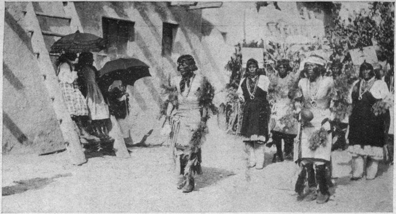
AN ACOMA INDIAN DANCE
The dances of the Pueblo Indians are not social diversions but serious religious ceremonies.
LAGUNA, THE MOTHER PUEBLO OF SEVEN
This pueblo, languishing while neighboring Acoma flourished, borrowed the latter’s picture of St. Joseph to change her fortune, prospered accordingly, and then refused to return the picture, thus precipitating a lawsuit unique in our annals.
Most visitors spend a couple of hours at Acoma, and return the same day to the railroad. This, at a pinch, suffices for a ramble about the streets, and for looking into doorways for glimpses of the primitive family 74 life, chaffering with the women for the pretty pottery for which Acoma is famed,[34] and for a visit to the natural rock cisterns whence girls are continually coming with dripping ollas balanced on their heads. And of course, there is the old adobe church with its balconied convento, to be seen. It dates from about 1700. As the Rock was bare of building material, this had all to be brought up from below on the backs of Indian neophytes—the timbers from the mountains 20 miles away. The graveyard is a remarkable piece of work founded on the sloping rock by building retaining walls of stone (40 feet high, at the outer end) and filling in with sandy earth lugged patiently up from the plain.
A conspicuous feature in the view from the Rock of Acoma is a solitary mesa or rock-table, 3 miles to the northward, which the Acomas call Katzímo, and the Spaniards named La Mesa Encantada (the Enchanted Mesa). Its flat top is 430 perpendicular 75 feet above the plain, and can now be reached only with scaling ladders and ropes. Formerly there was a single trail up the side. The Indian tradition is that long, long ago, before the coming of the white invaders, the village of the Acomas occupied the summit. One day, while all the population except a few old people were working in the fields below, a tempest completely swept away the upper part of the trail; so that the inhabitants could never again reach their homes. They began life over again by building a new pueblo on the Rock of Acoma.[35]
The annual public fiesta of Acoma is held September 2, the day of San Estéban Rey—that is, of St. Stephen the King, Acoma’s patron saint and Hungary’s. It is attended by a picturesque crowd of Mexicans, Navajos and Pueblos, besides a sprinkling of Americans. Among the visitors are thrifty Isleteños, their farm wagons loaded with melons, grapes and peaches for sale and barter. As on all such occasions in the Rio 76 Grande pueblos, there is first a great clanging of the church bells to get the people to mass; after which, the saint’s statue beneath a canopy is brought out from the church, and all the people march in procession behind it, the cross, and the padre, while to the accompaniment of a solemn chant the firing of guns and a wild clamor of discordant church bells, the image is carried to a booth of green boughs in the plaza, there to rest and receive the homage of the people. Throughout the day baskets heaped with fruit, loaves of bread, vegetables and candles are laid at the saint’s feet, and at intervals the edibles are handed out to the crowd, or tossed in the air to be scrambled for amid much hilarity. In the afternoon there is an Indian dance, participated in by men and women in colorful costumes, the women’s heads adorned with tablitas (curious, painted boards set upright and cut into shapes symbolic of clouds and what not). A choir of men with a drum made of a section of cottonwood log, supplies the music, chanting in unison the ancient songs of thanksgiving efficacious long before St. 77 Stephen was ever heard of in Acoma, and not to be lightly abandoned. At sundown the saint is returned to his place in the church, and the evening is given over to such jollity as personal fancy dictates, usually including a baile, or dance, by the Mexicans and such white folk as stay, and it must be confessed, too often a surreptitious bout with John Barleycorn smuggled in by bootleggers.
There are no accommodations for visitors at Acoma, but if you have a taste for mild adventure you will enjoy—in retrospect anyhow—lodging a night or two with some family in the village, if you have brought your own provisions. This gives you a leisurely opportunity to watch the people at their daily tasks, and to enjoy the exquisite outlook at evening and early morning from the Rock. A night on an Acoma housetop beneath the brilliant stars is like being transported to Syria. Take it as a rule that if you desire to learn anything worth while of Indian life, you must abandon hurry; and the more you pump an Indian, the less he will tell you. The best 78 things in the Southwest come to the waiting traveler, not to the hustler. As to the language, in every pueblo there is someone who talks English enough to act as interpreter, but if you know a little Spanish, you may do without any intermediary in the Rio Grande villages.
The natural pendant to a visit to Acoma is one to Laguna pueblo, 2 miles from the station of the same name.[36] Like Acoma, it is built upon a rock, but Laguna’s is merely a low outcropping little above the level of the ground. The pueblo is full of picturesque bits, and the fall and rise of the streets continually give you skyey silhouettes, the delight of artists who like liberal foregrounds. The mature coloring of the houses in time-mellowed, pearly tones, coupled with the fact that the old trail leading from the outskirts of the pueblo to the spring is worn deep in the rock floor by the wear of generations of moccasined feet, gives one the impression 79 that Laguna is of great antiquity. Nevertheless, it is not, having been founded about 1697. In 1699 it received its name San José de la Laguna—Saint Joseph of the Lake—the appropriateness of which is not now apparent as there is no lake there. In those days, however, there was a lagoon nearby, due largely to the damming of the little River San José by beavers. English is very generally spoken in this pueblo.
Some 60 years ago Laguna was the defendant in a curious lawsuit brought against it by Acoma. Fray Juan Ramirez—he of the Camino del Padre—had put Acoma under the patronage of Saint Joseph, spouse of Our Lady and patron of the Church Universal, and in the Acoma church the saint’s picture hung for many years, a source of local blessing as the Acomas firmly believed. Now while Acoma prospered Laguna had many misfortunes—crop failures, sickness and so on; and with a view to bettering matters Laguna asked Acoma for the loan of Saint Joseph. This request was granted with the understanding that the loan should be for one month only. 80 But alas, recreant Laguna, once in possession, refused to give back the picture, which was proving as “good medicine” there as had been the case at Acoma. At last the padre was called on to settle the dispute and he suggested that lots be drawn for it. This was done and the picture fell to Acoma. The Lagunas proved poor losers, however, and made off with the painting by force—which enraged the Acomas to the fighting point, and war was only averted by the padre’s persuading them to do what a Pueblo Indian is very loth to do, submit the case to the white man’s courts. Lawyers were engaged by both pueblos, and after a hot wrangle involving an appeal to the Supreme Court of New Mexico, the picture was awarded to Acoma. Evidently the saint himself approved the judgment, for tradition has it that when the Acoma delegation appointed to fetch the picture back were half way to Laguna, their astonished eyes were greeted by the sight of it reposing under a mesquite bush. Evidently, upon receipt of the news, it had set out of its own accord for home!
In proof of which the traveler today may see the painting in the old church at Acoma.[37]
Laguna’s principal public fiesta is held annually on September 18, and adds to the usual ceremonies of the saint’s day at a pueblo the features of a country fair, for the Lagunas are notable agriculturists. The Mission church interior at Laguna, by the way, possesses features of interest in the way of Indian decoration and ancient Spanish paintings, particularly those of the altar done on stretched hide. Visitors may be accommodated in Indian houses, if they court that experience, or at the residence of a Protestant missionary near by. The National Old Trails transcontinental highway passes the pueblo.
Gallup, New Mexico, has never made much of a stir as a tourist center, but like many a spot of modest pretensions, it is deserving beyond its gettings. As an example of the “city beautiful” it is not, in my judgment, a success; but as a base and a fitting-out point for some of the most interesting parts of the Southwest, it is to be heartily commended.[38] Particularly is this so now that the motor car has so largely supplanted the horse-drawn vehicle for excursions afield. There are comfortable hotel accommodations and there are Harvey meals obtainable.
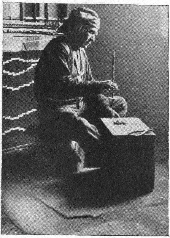
BEAD MAKER, ZUÑI PUEBLO
Necklaces of flat, round beads made from sea shells form a common adornment of Pueblo Indians.
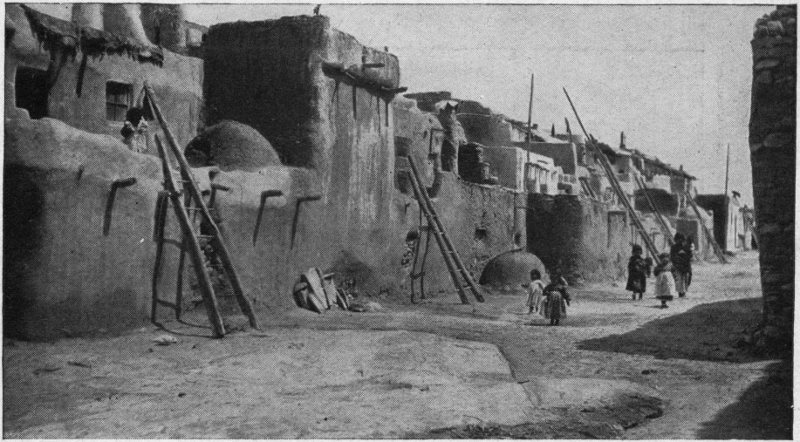
A STREET IN ACOMA PUEBLO
The ladders afford means of access to the upper stories.
From Gallup (which is on one of the main automobile routes followed by transcontinental motorists) good trips radiate in many directions—85 miles to Cañon de Chelly, for instance, and its cliff dwellings amidst surpassing scenery; 75 miles to the Pueblo Bonito ruins in Chaco Cañon; 125 miles to the Hopi country; 42 miles to Zuñi pueblo; 75 miles to Inscription Rock of the Conquistadores. The great Navajo reservation with its picturesque aboriginal life reaches almost to Gallup’s back door, and even the Mesa Verde National Park,[39] can be done from Gallup in 4 or 5 days for the round trip, if the weather conditions are right.
This chapter has to do with the famous 84 Indian pueblo of Zuñi, which lies to the south, about 2½ hours by motor car. The road is all sorts from a motorist’s standpoint; so be your own best friend and take it good-naturedly, for fussing will not mend it. In a few minutes you are beyond sight of houses and railroads, and in a twinkling Time’s clock has whirled back a couple of centuries. You pass, perhaps, a Navajo woman astride her pony, a sheepskin or two tied to the saddle, on her way to the trader’s for coffee and tobacco; and then a Mexican teamster crouching over a bit of camp-fire where his chili and beans are stewing, his wagon piled high with wool sacks drawn up by the roadside. Now a solitary adobe ranch house, or a lone trader’s log hut is seen in a wilderness of sagey plain; and now a flock of sheep drift into the road out of the piñon- and cedar-scrub, a couple of bright-eyed Navajo children shepherding in their wake. By and by you pass another sort of Indian on horseback, a slightly built man with long jet-black hair lifted by the breeze, a red banda encircling it—he is a Zuñi. And then topping a low hill, you are 85 greeted by the distant sight of a long flat-topped mesa, creamy pink against a blue sky. It is Towa-yálleni, Zuñi’s Mountain of the Sacred Corn. A turn in the road, and the great yellow plain of Zuñi spreads out before you, the Zuñi River threading its midst, and on its bank the old pueblo humps itself like a huge anthill, hardly distinguishable in color from the plain itself.
Zuñi (with a population of some 1600) is historically perhaps the most interesting of all the Pueblo towns, for it is the present-day representative of those Seven Cities of Cíbola, the fable of whose wealth led to the discovery of New Mexico in the sixteenth century. There really were seven Zuñi villages in Coronado’s time, all of which have long since disappeared, though sites of at least five are known. The present Zuñi pueblo seems to have been built about the year 1700, replacing that one of the ancient seven known as Hálona. This occupied the opposite or south bank of the river in Coronado’s time—a spot now partially covered by the buildings of a white trader.
If you are going to hold your car and return to Gallup the same day, there will probably be 3 or 4 hours available for a stroll about the pueblo. The houses, of a characteristic reddish tone, rise from one-storied structures on the outskirts to 5 stories at the center of the town, and you will enjoy mounting by ladders and stepping stones to that uppermost height for the lovely view over the plain to the mountains that hem in the Zuñi valley. The narrow streets without sidewalks open out now and then into small plazas, and some communicate with one another by tunnels. Beehive ovens squat upon the roofs in dome-like fashion and contribute a suggestion of the Orient—of Cairo or Syria. Dogs, turkeys, pigs and burros have equal right with humanity in the cramped thoroughfares, and if one is of a cleanly habit, one needs to watch one’s steps. But dirt and picturesqueness were ever comrades, and Zuñi is truly picturesque. From the open door issues the hum of the busy mealing stones, and the fragrance of the crushed 87 corn; perhaps, too, to your ravished ears, the high-keyed melody of grinding songs shrilled by the women as they work.
Look in, and if your manner is respectful and the girls not over shy, you will be allowed the enjoyment of a charming picture of kneeling, swaying bodies and of down-turned faces veiled in falling hair. Ollas of native ware stand about with water; parti-colored blankets of Navajo or Zuñi weave hanging from wall or ceiling give a touch of brightness in the dim light of the room; in the triangular corner fireplace dinner simmers within a bowl of native pottery set upon the coals. If fortune favors you there may be a potter at her moulding, or, in the street, jars being fired or bread being put to bake in the adobe ovens; or in some plaza a ceremonial dance in costume may be in progress. Zuñi is still comfortably pagan—the ancient Catholic church is a ruin and the modern Protestant mission is by no means overworked—and throughout the year the red gods of Zuñi have homage paid them in many a 88 ceremony rich in symbolism and pure beauty.[40]
On the outskirts of the pueblo in August, one may have a sight of wheat thrashing on the open-air thrashing floors, the grain being trodden out in oriental fashion by horses, sheep or goats. Or there may be a straight-away horse race over the plain with a picturesque crowd looking on; or a gallo race, the part of the rooster (gallo) humanely taken in these latter days by a sack buried to the neck in the sand. A quieter feature of interest is the quaint little vegetable gardens on a slope by the river—each tiny garden enclosed with a thin adobe wall. These are tended by the women who daily bring water in ollas and pails to irrigate the plants.
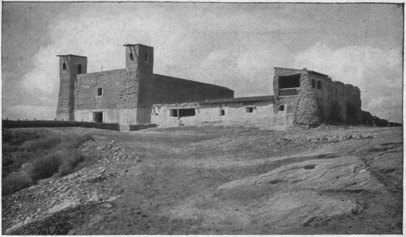
OLD CHURCH, ACOMA PUEBLO
Dating from about 1700. Tradition has it that it was 40 years in building. All material was carried up on Indians’ backs from the plain 350 feet below, by an almost precipitous trail.
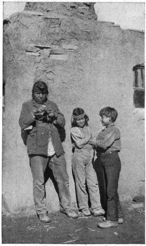
A SUNNY WALL IN ZUÑI
The men of Zuñi are famous knitters. This one is making his wife a pair of leggings.
A short walk from the pueblo brings you to Hepatina (hay´-pa-tee-na) a stone shrine erected on the plain, which in the Zuñi conception, marks the center of the earth; for the unreconstructed Zuñi believes naturally enough, just as your and my ancestors did a few centuries ago, that the earth is flat. Hither in the days of long ago, a guardian divinity of the Zuñis brought them as to the safest place in the world—the farthest from the edge—preceding them in the form of a water strider. The double-barred cross, which you will see sometimes on Zuñi pottery, or fashioned in silver, is the symbol of that divine guide. There has been, by the way, some good pottery made at Zuñi, and the visitor interested in that art may still enjoy the adventure of a house-to-house ceramic hunt with chances of a pleasurable outcome.
The accommodations for visitors in the pueblo are very limited. Perhaps one of the couple of white resident traders or the school teacher may be complaisant enough to take you in; and there are certain Indian houses where lodging can surely be had. If you are not of a meticulous sort, I would recommend a stop-over long enough at least to visit the mesa Towa-yálleni, which 90 Cushing has put into literature as Thunder Mountain. It looks near the pueblo, but is really 4 miles distant. On its summit centuries ago there was a pueblo of the Zuñis, the broken down walls of which, overrun with cactus and brush, are still quite evident. Curious pictographs of the ancients may be traced on many a rock; and if one knows where to look, there are pagan shrines where prayer plumes are yet offered to the Divine Ones. Among such are those of the Twin War Gods, whose home is believed to have been on Towa-yálleni—“little fellows that never give up.” I was once informed by a Zuñi, “gone away now may be gone up, may be gone down; quien sabe?”[41] It was on this mountain the Zuñis found a refuge after their losing fight with Coronado in 1540; and again in 1632 they retreated hither after killing their missionary, Padre Letrado, of whom we shall hear again at Inscription Rock in the next chapter. And here they were in 1692 when De Vargas forced their surrender in the re-conquest. 91 Tradition has it, too, that here long, long ago, the people fled for safety when an offended deity flooded them out of their villages in the plain; and the water still rising, a desperate sacrifice was called for. A boy and a girl were tossed from the summit into the angry flood. In a twinkling, the children were transformed into pinnacles of rock and the waters sank appeased. You can see these spires of stone today from Zuñi, and old people will tell you that the one with a double point is the boy. A peculiar virtue resides in that petrified humanity it seems. If a childless couple resort to the base of the pinnacles and there plant prayer plumes, there will be granted to them the children of their desire.
There are trails, steep and rough, up Towa-yálleni’s sides, and if you can make the trip with an intelligent and communicative old Zuñi (most of the young ones seem to know or care little about the ancient things), you will have a remarkable outing. An hour or two spent on that lonely breeze-swept, sun-kissed mesa-top, with the ruined 92 town, its broken shrines, its historic and legendary memories, will induct you, as no amount of reading will, into the atmosphere of the Southwest’s romantic past. There used to be—and for all I know still is—a trail that a rider on horseback can follow, at the northeastern side of the mesa. The ancient peach orchard through which it wound owes its existence to seed brought to Zuñi by the Spaniards.
NOTE: Five miles northeast of Zuñi, is Black Rock, where travelers with an interest in Government education of the Indians may see a Reservation School in operation. Within a radius of 15 or 20 miles of the main pueblo are 3 farming villages occupied in summer by Zuñis to be near certain tracts of tillable land. One of these, Ojo Caliente, 15 miles southwest of Zuñi, is close to the site of ancient Háwikuh—the first Pueblo town seen by white men. Upon it in 1539, intrepid Fray Marcos de Niza looked down from a nearby height, and then, warned by the murder of his avant-courier, the negro Estévanico, beat a prudent retreat to Mexico. Coronado captured the place in the following year, and thence made his first report of the famous 7 cities to the viceroy in Mexico. It is the scene of one of the most charming of Cushing’s Zuñi folk tales, “The Foster Child of the Deer.” Extensive excavations have recently been made there by Government ethnologists.
Thirty-five miles eastward from Zuñi (2 hours by automobile, if the roads are dry) is a huge rock mass of pale pink sandstone whose sides rise sheer a couple of hundred feet against a turquoise sky. It stands in the midst of a lonely plain whose wild grasses are nibbled by the passing flocks of wandering Navajos, and so far as I know, there is no nearer human habitation than the little Mormon settlement of Ramah, through which you pass to reach the rock. This cliff has a story to tell of such unique interest that the United States Government has acquired the mesa of which it is a spur for a National Monument. It is known as Inscription Rock, or El Morro (the latter a not uncommon Spanish-American designation for a bold promontory), and was a 94 landmark as early as the sixteenth century for the Spanish expeditions bound between Santa Fe, Acoma and Zuñi. Water, feed, and wood were here available, as they are today, making the foot of the high cliff a good camping place, and here as a matter of fact during the sixteenth, seventeenth, and eighteenth centuries, many a Spanish military party did camp, and having rested themselves and their cattle, went on refreshed to do the errands of their King and Church.
And hither one day in 1849, just after New Mexico had become part of the United States, came Lieut. J. H. Simpson, U. S. A., with some troopers on a military reconnaissance, and discovered that the base of the cliff was a veritable album of those old Conquistadores; bearing not only the names of the Spanish explorers but frequently an accompaniment of date and comment that form important contributory evidence touching the early history of the Southwest. Simpson made copies of a number of the inscriptions, and these were published with translations (not always accurate) in his 95 report to the Secretary of War.[42] Most of those recordings carved in the soft rock with sword or dagger point are still fresh and legible, so little have centuries of dry New Mexico weather worn the clear-cut lettering. If you go to see them, you will be a dry-as-dust indeed if you do not feel an odd sort of thrill as you put your finger tips upon the chiseled autographs of the men who won for Spain an empire and held it dauntlessly. For most of these records are not idle scribblings of the witless, but careful work by people with a purpose, whose names are mentioned in the documents of the time. Here are the names, for instance, of Oñate, the conqueror, and of De Vargas, the re-conqueror, the very flower of the warrior brotherhood. The Rock is a monument such as has no duplicate in the country; and some day when our historians have got the Southwest in 96 proper perspective, and waked up to a realization of the heroism and romance that went into the making of it, El Morro will perhaps be really protected (if its priceless inscriptions survive so long) and not left as it is now to vandal tourists to hack and carve their silly names upon.
It takes knowledge of old Spanish abbreviations to get at the sense of many of the records, but even the casual visitor cannot but be struck by the artistry that characterizes many of the petrographs. One who has Spanish enough to give zest to the quest could easily spend a couple of days, camped at this fascinating spot, spelling out the quaint old notations, peopling again in fancy this ancient camp-ground with the warriors of long ago in helmet and cuirass, their horses housed in leather; and ever with them the Franciscan soldiers of the Cross in gray gown and cord with dangling crucifix. Then there is the enjoyment of the place itself—the sunny solitude, and the glorious, extended views, the long blue line of the Zuñi Mountains, the pale spires of La Puerta de los Gigantes (the Giants’ 97 Gate). Then, if you like, is the climb to the mesa’s summit for yet wider views, and a sight of the ruined old pueblo there, whereof history has naught to tell—only tradition, which says that it was once a Zuñian town.
There is some doubt as to the earliest inscription on the Rock. One questionable writing, unsigned, appears to be 1580. Next in point of antiquity is the undoubted record of Oñate, cut across an earlier Indian petrograph, and reads literatim: “Paso por aqi el adelantado don jua de oñate del descubrimiento de la mar del sur a 16 del abril del 1606.” (That is: Passed by here the provincial chief Don Juan de Oñate from the discovery of the South Sea on 16th of April, 1606.) The discovery he records as of the South Sea (i.e., Pacific Ocean) was really of the Gulf of California, for Oñate doubtless believed as most of the world did in his day that California was an island. Oddly enough, though, he made a mistake in the date, which documentary evidence proves to have been 1605 not 1606.
The inscription of De Vargas, the reconqueror, 98 following the Pueblo rebellion of 1680, reads: “Aqui estaba el Genl Dn. Do de Vargas quien conquisto a nuestra santa fe y la real corona todo el nuevo Mexico a su costa año de 1692.” (Here was the General Don Diego de Vargas who conquered to our holy faith and the royal crown all New Mexico, at his own expense, year of 1692.)
Records of especial interest, too, are two of 1629, telling of the passing by of Governor Silva Nieto. One is in rhymed verse[43] and refers to Nieto as the “bearer of the Faith to Zuñi;” that is, he had acted as escort of the first Christian missionaries to pagan Zuñi. A tragic sequel to that inscription is a short one that is so abbreviated that scholars have had a hard tussle with it. The puzzle has been solved, however. You 99 will know this petroglyph by the signature Lujan, a soldier, and the date 1632; and it reads, Englished: “They passed on 23 March 1632 to the avenging of Padre Letrado’s death.” Zuñi did not take kindly to its missionaries and killed them periodically. This Padre Letrado was one of the martyrs—shot to death as he preached, holding out his crucifix to his murderers.[44]
In delicate, almost feminine, characters is a modest inscription that reads, translated: “I am from the hand of Felipe de Avellano, 16 September, soldier.” There is something touching, I think, about that personified periphrase, and I am glad that, in spite of the omission of the year, historians have identified the writer. He was a common soldier of the garrison at Zuñi after the reconquest, and met death there in 1700.
It is unfortunate that this noble and unique monument should be left exposed 100 as it is to vandals. Almost every white visitor thinks it is his duty to scratch his name up alongside the historic ones and there is no guardian to forbid—only an unregarded sign of the Department of the Interior tacked on a nearby tree. A year ago the Department, in response to private representation, promised to put up a fence of protection, and perhaps this has been done; but a fence is a perfectly inadequate measure. If the East possessed one such autograph in stone (of Joliet, or La Salle, or Cartier), as El Morro bears by the half dozen, I wonder if the few hundred a year necessary to support a local guardian would not be forthcoming? When will our nation take seriously the colonial history of the Southwest as just as much its own as that of the Atlantic side of the Continental Divide?
At the shortest, it is a matter of two days to achieve a visit to El Morro from the railway. Gallup is the best stop-off. There an automobile may be hired, and the night spent at Ramah, where accommodations may be had at the trader’s unless you prefer to 101 camp at the Rock itself, which, if you like such adventure and are prepared, is a joyous thing to do.
The Navajos are the Bedouins of our Southwest, and there are about 22,000 of them—a fine, independent tribe of Indians occupying a semi-desert, mountainous reservation in northwestern New Mexico, northeastern Arizona and a small corner of Utah. Indeed they occupy somewhat more, for they are confirmed rovers and are frequently found setting up their hogans, shepherding their sheep, and weaving their blankets, well across their government-fixed borders. One is sure to see some of them in Gallup, where they come to trade—the men generally in dark velveteen shirts worn loose outside the trousers, their long, black, uncut hair filleted about with red bandas and caught up behind in a club or knot. Both men and women are expert riders, sitting their ponies as firmly as centaurs; and 103 both are extravagantly fond of silver jewelry, of which they often wear small fortunes in necklaces, belts, bracelets, rings and buttons hammered by their own silversmiths from coin of Mexico. If you see them wearing blankets, as you will when the weather requires it, these will be the gaudy products of Yankee looms, which they buy for less than the price they receive for their own famous weave. So, thrifty traders that they are, they let the white folk have the latter and content themselves with the cheaper machine-made article bought from an American merchant.
It is part of the fun of a visit to the Hopi towns that you must cross a section of the Navajo Reservation and thus get a glimpse of life in the latter; but there is a special trip which I would like to recommend from Gallup as a starting point, that brings one more intimately into touch with the tribe. That is to Chin Lee and the Cañon de Chelly,[45] about 100 miles northwest of 104 Gallup. There is a choice of roads, so that the going and returning may be by different routes. The trip may be done by time economists in an automobile in two or three days, but a more enjoyable plan for easy-going folk is to take eight or ten days to it by horseback or wagon, camping by the way. And do it preferably in September or early October, for then the mid-year rains are usually over, the air clear and sparkling, and feed for horses sufficiently abundant. The elements that enter into the landscape are primarily those that go to the making of the grandeur of the Grand Cañon region, but scattered and distant, not concentrated. There is a similar sculpturing of the land into pinnacles and terraces, cones perfect or truncated, battlemented castles and airy spires, appearing, when afar, mistily in an atmosphere of amethyst and mauve and indefinite tones of yellow and pink. Now the road threads open, sunny forests of pine and oak, the latter in autumnal dress of crimson and gold and surprising you with acorns as sweet as chinquapins. Again, it traverses broad, unwatered, semi-desert 105 plains dotted with fragrant sage-brush and riotous sunflowers, the only animated things in sight being prairie dogs and jackrabbits, or an occasional band of Navajo ponies. As the morning advances, cumulus clouds rise in stately squadrons above the horizon and move across the sky dropping drifting shadows; at noon over a fire of sage stumps you heat up your beans and brew your coffee in the grateful shade of your wagon; night finds you at some hospitable trader’s post, or enjoying your blankets at the sign of La belle étoile. Only at long intervals will you come upon sign of human life. At Fort Defiance, 30 miles north of Gallup, is a Government Reservation school for the Navajos, and a mile from it an Episcopal medical mission—a living monument to the loving interest of Miss Eliza Thackara in these Indians. Eight miles south of Fort Defiance is the Franciscan Mission of St. Michael’s to the Navajo, where, if you are interested, the hospitable Brothers can show you what sort of a job it is to transform an ungroomed savage into Christian semblance. At Ganado, Arizona, 45 miles from 106 Gallup, is the trading post of Mr. J. L. Hubbell, whose name for a generation has in that part of the world been a synonym for hospitality.[46]
Nevertheless, there is more life than you see, for the native hogan, or one-roomed dwelling of logs covered with earth, is so inconspicuous that you may pass within a few rods of one and never detect it. The Navajos do not congregate in villages but each family wants a lot—miles, indeed—of elbow room.
Chin Lee, mentioned above, is not Chinese as it sounds, but the Navajo name of a spacious valley into which Cañon de Chelly debouches. If you have a taste for mythology, it will interest you to know that here, according to tradition, Estsán-atlehi (the chief goddess of the Navajo pantheon and wife of the Sun-god), traveling from the east once camped with her attendant divinities for a great ceremony and a footrace. She was on her way to her home in 107 the great water of the west, where in a floating house she still lives, and receives her lord the Sun every evening when his daily work is finished.[47] There is a trading post at Chin Lee, and beyond the broad flat in front of it is the entrance to Cañon de Chelly. This is a narrow, tortuous rift in the earth, some 20 miles long, whose perpendicular sides of red sandstone rise 800 to 1000 feet. Opening into it are two side gorges, Monument and Del Muerto Cañons. A shallow stream of sweet water—sometimes, however, hidden beneath the sands—creeps along the cañon floor, widens in the plain into the Rio de Chelly, and flowing northward joins the San Juan in southern Utah. So in time does it contribute its bit to the tawny flood that pours through the Grand Cañon of the Colorado.[48]
The interests that hold the visitor in Cañon de Chelly are several. There is, first, the stupendous scenery. Men and animals traversing this level floor seem pygmies at 108 the foot of the smooth, vertical walls, carved and stained by the master-artist Time working through who knows how many milleniums. The windings of the gorge keep one in perpetual expectancy of something going to happen just around the corner, and create an atmosphere of mystery that is little short of thrilling. In places the cañon widens out in sunlit coves and wild-grass meadows, where clustered reeds[49] rustle and wild flowers bloom. Quite as often, though, the walls are so close together that the sunshine never reaches the bottom and the grim surroundings suggest some overwhelming picture of Doré’s.
Then there are the ancient dwellings in the cliffs—little, crumbling cities of the dead. Perched high up in shallow cavities of the flat wall, some are inaccessible except by ladders; others, may be reached by scrambling up talus slopes. One famous one, known as Mummy Cave, in Cañon 109 del Muerto, should by all means be visited; but even more striking is one in the main cañon called La Casa Blanca or the White House. The upper story of this majestic ruin, which strikingly resembles some medieval castle, is colored white; and the whole line of the immense edifice set high above the earth and projected against the dark background of a natural cavity in the enormous cliff, makes a dramatic picture. The effect is heightened when we learn that in Navajo folk-lore it plays a part as the abode of certain genii or minor divinities who, the faithful believe, still haunt the edifice.
In places the cliffs are prehistoric art galleries, adorned with pictographs of unheard-of birds and animals, human hands outspread, geometrical designs, and attenuated figures of men in various attitudes.
Lastly, there is the interest of a present-day Indian life, for the cañon is the free, joyous home of numerous Navajo families, that come and go as fancy dictates. Their hogans, often with a hand-loom for 110 blanket weaving[50] swung from a nearby tree are set inconspicuously here and there at the base of the towering cliffs, wherever there is a bit of land suitable for the raising of corn, beans and melons. Peach orchards, too, are here, from seed of Spanish introduction centuries ago. Flocks of sheep and goats are continually on the move up and down the cañon, which is musical with their bleatings and the wild melody of the shepherds’ songs. It is a picturesque sight at evening to see the homing bands crowding into the primitive folds which sometimes are a mere crevice in the rock walls with a rude fence thrown across the opening.
During the wars which for many years marked the intercourse of the Navajos with the whites—both Spaniards and 111 Americans—the Cañon de Chelly was a notable stronghold of the red men. It was here that in 1864 Kit Carson and his troopers at last succeeded in breaking the backbone of the Indian resistance. Today the Navajos are as peaceable as the Pueblos.
According to Navajo legends, the boundaries of their land were marked out for them by the gods who brought them up through the great reed from the lower world.[51] These landmarks were in the form of mountains especially created for the purpose of earth brought from the lower world, and were seven in number. Of these the Sacred Mountain of the East is believed to be Pelado Peak, 20 miles northeast of Jemes pueblo and it was made fast to the earth by a bolt of lightning; the Sacred Mountain of the South is known to be Mount San Matéo, 20 miles or so northwest of Laguna pueblo, held in place by a great stone knife thrust through it from summit to base; the Sacred Mountain of the West, 112 is the San Francisco Mountain, 12 miles north of Flagstaff, Arizona, fastened down by a sunbeam; and the Sacred Mountain of the North is some one of the San Juan range, which a rainbow held in place. The other three are peaks of the mid-region, only one of which, Hosta Butte in Bernalillo County, New Mexico, has been identified.[52] Two of these mountains are plainly visible from the Santa Fe Railway trains and by motorists following the National Old Trails transcontinental highway—namely, the San Francisco Mountain (12,611 feet) and Mount San Matéo (11,389 feet). Both are extinct volcanoes. The vicinity of Mount San Matéo (which is also known as Mount Taylor)[53] is the scene of a thrilling tradition. There it was that the Navajo Gods of War (children of the Sun and of the Waterfall), mounted upon a rainbow, met and slew with lightning bolts the boy-eating giant, Ye-itso. The latter was a monster so huge that the spread of his two feet was a day’s journey for a man, his footfalls 113 were as thunder, and when he drank his draught exhausted a lake. His head, cut off by the War-gods and tossed away, was changed into El Cabezon, a truncated cone of a mountain visible 40 miles northeast from San Matéo; and his blood flowing in a deluge to the south and west is what we white folk in our ignorance call a hardened lava-flow, as we watch it from the car window for miles westward from McCarty’s. Look at it again with the eyes of faith, and is not its semblance that of coagulated, blackened blood?
So you see in this glorious Southwest we may still follow in the very footsteps of the gods, and regard the world as it seems through the eyes of a primitive and poetic race—see in the lightning the weapon of the red gods, in the rainbows their bridges to traverse chasms withal, in the sunbeams their swift cars of passage. There is something rather exhilarating, I think, to know that in our materialistic America there is a region where the Ancient Ones still haunt as in the youth of the world. To be sure 114 the white man’s schools are operating to break up this primitive faith; but the ingrained genius of a race is not made over in a generation. One may stumble still upon Navajo religious ceremonies, held in the open, with their picturesque rites and maskings and wild music. They differ markedly from the ceremonies of the Pueblos, and are, as a rule, undertaken under the charge of medicine men primarily for the cure of the sick. There are no fixed dates for any of these ceremonies, and casual travelers do not often see them, as they are most likely to be held during the cold weather, when few visitors care to penetrate into the country. An exceedingly interesting adjunct of many of the Navajo rites is the dry sand painting, of a symbolic character and often of striking beauty, made in color upon a prepared flooring of sand. The design is “drawn” on this by dribbling upon it the dry ground pigments—white, red, yellow, black and gray—from between the artist’s thumb and fore-finger. The picture must be done in one day, several men sometimes working upon it at once. When completed 115 the sick man is placed upon it and treated; and after that, the picture is obliterated.[54]
Now that the automobile has become a common mode of travel even in the desert, you may reach the pueblos of the Hopi Indians quite comfortably from Gallup.[55] The distance is about 130 miles to the first of the villages. The road is via St. Michael’s (where the Franciscan Brothers maintain a Mission for the Navajos); Ganado, where Mr. J. L. Hubbell’s trading post stands; and Keam’s Cañon, where Mr. Lorenzo Hubbell, hospitable son of a hospitable father, has another trading post. As far as Ganado (70 miles) the way is identical with the first part of one road to the Cañon de Chelly. From Ganado westward there are 60 miles of pure wilderness, semi-desert, treeless, but in summer and autumn splendid in places with sheets of wild flowers in purple and yellow. On every hand—sometimes near, sometimes afar—are the characteristic mesa formations of the Southwest carved by the elements into curious shapes to which the fancy readily suggests names. One that you will pass is a strikingly good model of a battleship’s dismantled hull, and goes by the name of Steamboat Rock—a pleasant conceit for this desert, which, the geologists tell us, was once a sea bottom. Nowhere is sign of humanity, save perhaps, some wandering Navajos or a chance traveler like yourself.
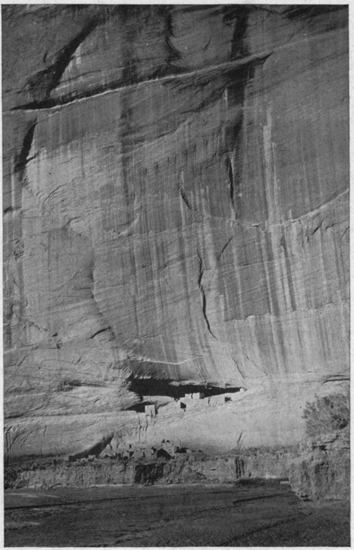
CASA BLANCA OR WHITE HOUSE
A prehistoric Cliff dwelling set amidst the stupendous scenery of the Cañon de Chelly, Arizona—the reputed haunt of certain Navajo gods.
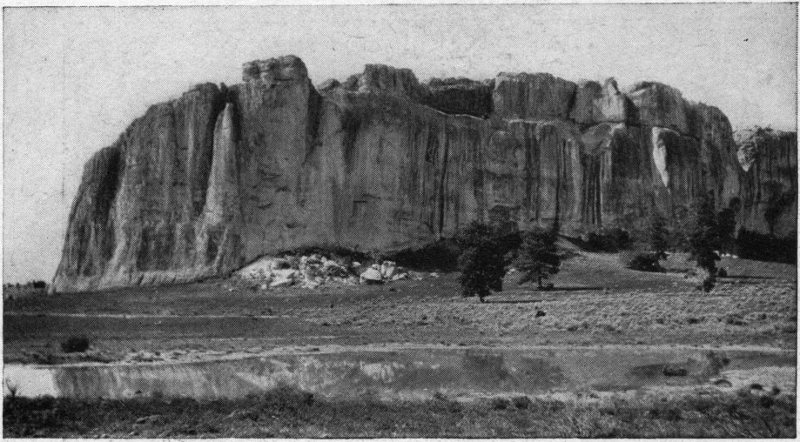
EL MORRO OR INSCRIPTION ROCK, N. M.
This remarkable cliff bears near its base a score or more of autographs carved in the stone by the Spanish conquerors during the 17th and 18th centuries.
At last there comes a change over the country ahead of you—a transfiguration to broad sweeps of pink and pallid yellow, with here and there a streak of white or of green, and on the far horizon a wall of purple. The Painted Desert is before you, and upon the very tip of a long promontory streaked horizontally with brown and red and yellow, 118 and laid upon the desert like a gigantic arm thrust out, you see the castellated sky-line formed by the pueblos of the First Hopi Mesa. The geography of the Hopi country is like this: Three long, narrow mesas extending fingerlike into the Painted Desert, the tips about 10 miles each from the next. On the First Mesa (which is the easternmost) are three villages in an almost continuous row—Hano (called also Tewa), which you plump breathlessly into at the top of the one steep trail which is your means of access to all; then Sichúmovi, and lastly, at the mesa’s extremity with all the desert in front, is Walpi, a most picturesque pile rising in terraces to 4 stories and suggesting some mediaeval fortress. The Second Mesa is forked at its tip, with Mishóngnovi and Shipaúlovi set superbly along one tine, and Shimópovi[56] on the other. On the Third Mesa stands old Oraibi, largest and until recently most populous of all. Some years ago, however, it suffered a secession of fully half its population, who are now established a few miles away on the same 119 mesa forming the independent pueblos of Hótavila and Bácavi.[57]
The situation of these little towns is magnificent beyond words, overlooking the Painted Desert, ever changing, ever wonderful, ever challenging the spiritual in you, and stretching to where the San Francisco Peaks, the Mogollones and the White Mountains notch the dim horizon line. The elevation (6000 feet above the sea) and the purity and dryness of the air, combine to make the climate particularly healthful and enjoyable. Winter brings frosts and some snow, alternating with brilliant sunshine. Summer, the season that interests the average visitor, is as a rule delightful—the afternoon thunder showers of July and August being only a refreshment and a source of added picturesqueness in the form of superb cloud effects, spectacular lightning, and splendid rainbows. Mid-day is warm enough for old men to loiter in the 120 sun in a costume that is pared down to a breech clout and little children joyously wear nothing at all; yet both need covering in the shade. As for the summer nights, they are always deliciously cool and for outdoor sleeping are ideal. The flat-roofed, eaveless houses are usually of flat stones laid in mud mortar, and though terraced, do not usually exceed two or three stories in height. The arrangement is in streets and plazas, the kivas or ceremonial chambers (corresponding to the estufas of the Rio Grande pueblos) being underground and reached by a descending ladder, whose upper part—two rungless poles—stick picturesquely up in the air. There is a growing tendency to build the new houses at the bases of the cliffs, particularly at the First and Third Mesas—a reversal to first principles; for when Don Pedro de Tovar, a lieutenant of Coronado, with Padre Juan de Padilla (of whom we heard at Isleta) and a few soldiers, visited in 1540 this province of Tusayan, as they called the country, they reported the Hopis dwelling at the foot of the mesas. It was only later, probably after 121 the Pueblo Rebellion of 1680, that the towns were rebuilt upon the mesa summits where we now find them. The sites of two former Walpis may still be traced below the First Mesa together with the ruins of an ancient Franciscan Mission, some of whose timbers, they say, form part of the existing pagan kivas. The Hopi never took kindly to missionary effort by the whites. Every padre among them was murdered at the time of the Rebellion, and they would never tolerate another. Even kind Padre Garcés (of whom we shall hear in a subsequent chapter) the Oraibians kept sitting outdoors in a street corner for two days, and then evicted him from their town. In 1700, one pueblo whose inhabitants showed a hospitable feeling to the preaching of a persistent friar, was attacked by neighboring Hopis, set on fire and such of the inhabitants as were not killed, were carried to other towns. Of that pueblo—its name was Awátobi—you may see some ruined remnants yet about 9 miles southeast of Walpi.[58]
The attraction that draws most visitors to the country of the Hopi Indians is the famous Snake Dance held annually in August. The date is a movable one and not known positively until 9 days in advance, when the information may be had of the Santa Fe railway officials, who make it a point to be posted. This remarkable ceremony, in which live snakes, a large proportion of them venomous rattlers, are handled by the dance participants as nonchalantly as if they were kittens, is in fact a prayer for rain, in which the snakes (never harmed or their fangs extracted as is sometimes ignorantly supposed), are intermediaries between the people and the gods of water. It is moreover the dramatization of a Hopi myth concerning the origin of the two clans—Antelope and Snake—who perform the ceremony. The myth has to do with the adventures of a young man who, impelled by curiosity to know where the river waters went, made a trip on a hollow 123 log down the Colorado to its mouth. There he had many dealings with the Snake people, in whose ways he was instructed by the friendly Spider Woman. Finally he married the Snake chief’s daughter, and brought her to his own country. The first children of this union were snakes, which the Hopis drove away, but the next were human, and these, the ancestors of the present Snake Clan, came to Walpi to live. The entire ceremony continues throughout 9 days, and is conducted secretly in the underground kiva until near sunset of the last day. Then the priests dramatically emerge into the upper air, and the dance with the snakes occurs. It is all over in about half an hour, but that half hour is what brings the crowd—about the most thrilling and wide-awake performance that is offered anywhere in America. Though the Snake Dance takes place annually, all the villages do not hold it the same year. The most frequented presentations are those at Walpi, held in the odd years, as 1917, 1919, etc., and at Oraibi, the latter in the even years, as 1918, 1920, etc.
The Snake Dance attracts largely through the horror awakened in most of us by reptiles, though it possesses many elements of majestic beauty, too. There are numerous other Hopi ceremonies whose dominant feature to the white onlooker is simple beauty; for instance, the picturesque Flute ceremony held at springs below the mesas, and then along the ascending trails to the mesa-top accompanied by songs, the music of native flutes and the scattering of flowers. This ceremony, which is also the dramatization of a legend[59] as well as an invocation for rain, alternates with the Snake Dance, being held at about but not at the identical time with it, and always at other pueblos than those holding the Snake Dance. This permits attenders at one to witness the other also. Then at all the pueblos there are the autumnal Basket Dances of the women, and in spring and summer the many 125 beautiful Katchina Dances. Katchinas are the deified spirits of the Hopis’ ancestors, and are intercessors with the greater gods for divine favors for the Hopis. They are supposed to reside amid the San Francisco Peaks, where the home of the Sun god is, the great dispenser of blessings. Their annual visits (Indians of the pueblo impersonating the gods) are the occasions of much merry-making, of songs and processions, and dances in mask and gay costumes. Each god has his distinctive mask and dress, and the queer little wooden “dolls” (as the traders call them, though “Katchina” is the better word), which the visitors find in Hopi houses are careful representations of these, made for the children of the household to familiarize themselves with the characteristic aspect of each divinity. “These dances,” to quote Mr. Walter Hough, whose excellent little work, “The Hopi,” should be read by every intending visitor, “show the cheerful Hopi at his best—a true spontaneous child of nature. They are the most characteristic ceremonies of the pueblos, most musical, spectacular and pleasing. 126 They are really more worthy of the attention of white people than the forbidding Snake Dance, which overshadows them by the elements of horror.”
Visitors who allow themselves to be hurried up to the Hopi towns the day before the Snake Dance and then packed off home the next morning, as most of them do, may think they have had a good time, but it is largely the bliss of ignorance. They do not know what they have missed by not spending a week or two. To be sure accommodations are limited and primitive, but one must expect to rough it more or less in Indian country. Still the Hopis are not savages and one can be made comfortable. It is generally possible to rent one of the small houses at the foot of the mesa, if one does not bring one’s own camp outfit, and there are traders at most of the villages where supplies of necessaries may be obtained. Climb the trail to the sunny, breeze-swept mesa top; get acquainted with the merry, well-behaved little children—easy enough, particularly if you have a little stock of candy; watch the women making piki 127 (the thin wafer-like corn-bread of many colors that is the Hopi staff of life), or molding or burning pottery; see the men marching off, huge hoes on shoulder, to cultivate their corn and beans, sometimes miles away, in damp spots of the desert, or coming inward-bound driving burros laden with firewood or products of the field. All this, in an architectural setting that is as picturesque as Syria, replete with entrancing “bits” that are a harvest to the artist or the kodaker. After a day or two you will have had your measure pretty well taken by the population, and granting your manners have been decent, you will be making friends, and every day will show you something new in the life of this most interesting race. Of course there is a difference in the different towns—the customs of some have been more modified than others by contact with the whites and the influence of the Government educational system. The Walpians and their neighbors are perhaps the most Americanized; the people of Hótavila and Shimópovi, the least so.
The Hopis possess arts of great interest. 128 Pottery of beautiful form and design is made at Hano[60] of the First Mesa. This tiny village has the honor of being the home of the most famous of Indian potters, Nampéyo, whose work is so exquisite that it looks distinctive in any company. Her daughter Kwatsoa seems nearly as gifted. Then there is basketry. Curiously enough the East Mesa makes no baskets whatever, and the baskets of the Middle Mesa are quite of another sort from those of the Third Mesa, and both so different from all other Indian baskets whatsoever, as to be recognized at a glance. The Third Mesa baskets are woven wicker work usually in the form of a tray or plaque, the design symbolizing birds, clouds, butterflies, etc., in glaring aniline dyes. Those of the Second Mesa are in heavy coils sewed together with a thread of the yucca wrapping, and 129 in various shapes from flat to globular, the latter sometimes provided with handles. Weaving is an ancient Hopi art that is now unfortunately decadent. In pre-Spanish days and for some time afterwards, the Hopi cultivated a native cotton,[61] and cotton is still woven by them into ceremonial kilts and cord. Formerly they were famous weavers of rabbit-skin blankets. The visitor may still run across an occasional one in the pueblos, but the blanket of wool has long since displaced them. The Hopis make of weaving a man’s business, which is usually carried on in the kivas when these are not being used for religious purposes. They specialize in women’s mantas, or one-piece dresses, of a dark color with little or no ornamentation.
Everybody enjoys his stop off at the Petrified Forest. For one thing, this sight is as easy of achievement as falling off a log, and that counts heavily with your average American tourist. Even if your train drops you at Adamana[62] in the middle of the night, as some trains do, there will be somebody there to carry your bag and pilot you the couple of hundred yards to the lone hotel which, with the railroad station and the water tank, is practically all there is of Adamana. Then you are put comfortably to bed in a room that awaits you. In the morning you are given a leisurely breakfast at your own hour, and packed in an automobile to see one part of the Forest; brought home to luncheon; and in the afternoon 131 motored off to another part. If you are an invalid or just naturally lazy, you need not even leave your seat in the conveyance. After that it is your choice to proceed on your travels, or stay over another day and visit more distant parts of the Forest. In seeing the Forest, you incidentally have several miles of reasonably easy driving over the vast northern Arizona plateau with its wide views to the edge of a world hemmed in with many a dreamy mountain range and long, colorful, flat-topped mesas breaking away in terraces and steps to the plains. You will quite possibly see coyotes and jackrabbits and prairie dogs, cattle grazing the wild grasses, a Navajo Indian or two, cowboys on their loping ponies, perhaps a round-up with its trailing chuckwagon. You will steep yourself in the delicious Arizona sunshine, and be humbled before the majesty of the glorious Arizona sky, blue as sapphire and piled high at times with colossal masses of cumulus clouds that forevermore will mean Arizona to you.
The Forest is unfortunately mis-named, for it is not a forest. There is not a single 132 standing trunk, such as you may see occasionally in Utah or the Yellowstone. In the midst of a treeless plain the broken logs litter the ground in sections rarely over 25 feet long, oftenest in short chunks as if sawn apart, and in chips and splinters innumerable. Trunk diameters of 2 or 3 feet are common, and as high as 6 feet has been reported. It seems likely that the trees did not grow where they now lie but have been washed hither in some prehistoric swirl of waters, (as logs are carried down stream in our latter-day puny freshets,) becoming stranded in certain depressions of the land where we now find them, often having had their woody tissue gradually replaced by silica and agatized. Whence they came nobody knows, nor when. The guess of the unlettered guide who shows you about, may be as near right as the trained geologist’s, who locates the time of their fall as the Triassic Age, and their old home as perhaps beside some inland sea; but whether that was one million years ago or twenty, who can say, further than that they surely antedate the appearance of man upon this 133 planet. The trees are evidently of different sorts, but mostly conifers apparently related to our present day araucarias, of which the Norfolk Island pine is a familiar example. Mr. F. H. Knowlton, botanist of the Smithsonian Institution, identifies then as Araucarioxylon Arizonicum, an extinct tree once existing also in the east-central United States.[63] Limbs and branches in anything approaching entirety are not found—only the trunks and infinite fragments are here. The coloration due to the presence of iron oxides in the soil at the time of silicification is often exquisite, in shades of pink, yellow, blue, brown, crimson—a never failing source of delight to visitors. Dr. L. F. Ward, of the United States Geological Survey, has said that “there is no other petrified forest in which the wood assumes so many varied and interesting forms and colors.... The state of mineralization in which much of this wood exists almost places it among the gems or precious stones. Not only are chalcedony, opals and agates 134 found among them, but many approach the condition of jasper and onyx.”[64]
The parts of the Forest that tourists usually visit are the so-called First Forest, about 6 miles south of Adamana (which contains the huge trunk that spans a picturesque chasm 45 feet wide, and is known as the Natural Bridge[65]); the Second Forest, 2½ miles further south; and the North Forest. The last is 9 miles due north from Adamana, at the edge of such a chaotic, burned-out bit of volcanic waste, as is in itself worth seeing, breaking away gradually into the Painted Desert. If for any reason, your time is too limited to admit of your visiting more than one section of the Forest, by all means, let that section be this North Forest. The trees are less numerous and the fragments are less strikingly colored than in the parts to the south, but that background of color and mystery given by the desert, lends a fascination and gives to the 135 picture a composition that is unique and unforgettable.
There is, moreover, the so-called Third or Rainbow Forest,[66] 13 miles southwest of Adamana. This region contains the most numerous and the largest trunks, some of them (partially underground) measuring upwards of 200 feet in length. The especially rich coloring of the wood here has given rise to the local name “Rainbow.”
In several parts of the Petrified Forest (a large portion of which is now, by the way, a National Monument), are the ruins of many small prehistoric Indian villages. The relics found indicate that four different stocks of Indians have lived among these shattered trees, one clearly Hopi, another probably Zuñian, the others undetermined (one apparently of cannibalistic habits). Dr. Walter Hough has written very entertainingly of this human interest of the Petrified Forest in Harpers’ Magazine for November, 136 1902. The houses of the Rainbow Forest were unique in aboriginal architecture in that they were constructed of petrified logs. To quote Dr. Hough: “It is probable that prehistoric builders never chose more beautiful stones for the construction of their habitations than the trunks of the trees which flourished ages before man appeared on the earth. This wood agate also furnished material for stone hammers, arrowheads and knives, which are often found in ruins hundreds of miles from the Forest.”[67]
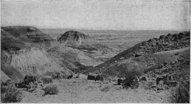
IN THE NORTH PETRIFIED FOREST
Near Adamana, Arizona. A glimpse of the famous Painted Desert in the background.
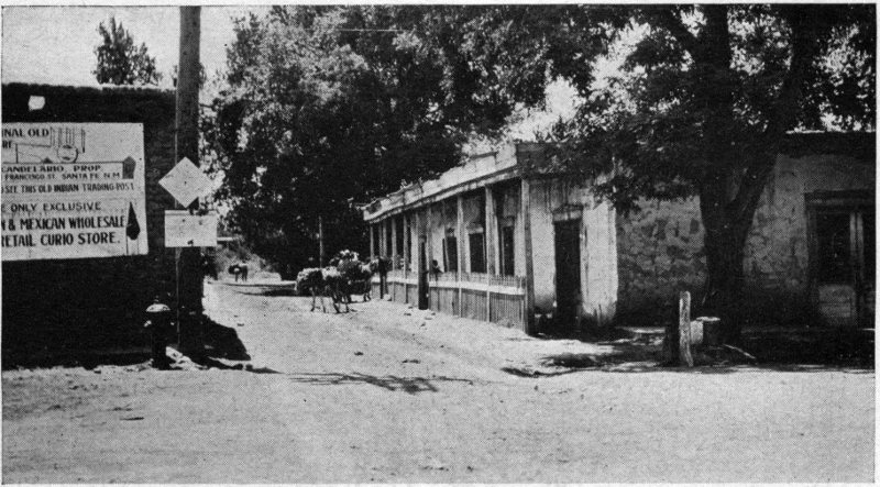
A CORNER IN SANTA FE, N. M.
The New Mexican capital retains to this day many picturesque features of the Spanish and Mexican dominance.
A score of years ago Flagstaff[68] was chiefly known to the traveler as the gateway to the Grand Cañon of the Colorado, 70 miles to the northwest. One may still reach that marvelous chasm by automobile from Flagstaff, arriving at Grand View after 5 or 6 hours’ driving, now through a park-like forest of yellow pine, now across an open plateau region with alluring views of far-off mountain ranges and of the Painted Desert. The completion of the railroad spur from Williams to the Grand Cañon, however, put a quietus upon the operation of the horse stages from Flagstaff; and since the passing of the Grand Cañon business the 138 town has cut small figure in tourist itineraries, its energies since being concentrated on the less precarious profits from lumber, cattle and wool. Nevertheless, its situation in a clearing of the beautiful Coconino National Forest, 7000 feet above the sea makes it a convenient base for visiting certain attractions of a remarkable nature thereabout, as lava beds, ice caves, extinct volcanoes, prehistoric cliff[69] and cinder-cone dwellings, the Painted Desert, and the famous San Francisco Peaks, fabled home of the Hopi Katchinas and the scene of many an Indian legend. The town has several hotels of a modest sort, and is on the line of the National Old Trails transcontinental motor highway; and if you have your own car or the wherewithal to rent one in Flagstaff, you can be very happy in this neighborhood for a week or two. The town itself, with a population of a 139 couple of thousand, has a certain picturesqueness of an up-to-date frontier fashion, in which automobiles and soda-pop largely take the place of ponies, pistols and “forty-rod,” for at this writing the hand of “bone dry” Prohibition rests paternally upon Arizona. Especially interesting are Saturday nights, when the streets are likely to be thronged with lumberjacks, cowpunchers and ranchers—American and Mexican—come to town to swap news and trade, to see the “shows,” play pool and listen to the “rag” of blatant gramophones. A Navajo or two, standing in the glare of the electric lights, may add a touch of aboriginal color to the scene—teamsters for some desert trading post.
Dominating Flagstaff, as Mont Blanc dominates Chamonix, is the isolated mountain mass, the highest in Arizona, called the San Francisco Peaks, snow-crowned seven or eight months in the year and familiar to every traveler by the Santa Fe’s transcontinental trains. Their clustered half-dozen summits in the form of graceful cones attain a maximum elevation of 12,611 feet 140 above the sea (5600 feet above Flagstaff) and have been a famous landmark from the time of the Spanish conquistadores, who named them, to the present day. The Navajos, as has been told in a previous chapter, assign to the great mountain a divine construction from earth brought up in the Emergence from the underworld, the gods who built it pinning it down poetically with a sunbeam. Matter-of-fact geologists, however, consider the mass as merely an extinct volcano with its top blown off, and find its flanks covered with the congealed lava streams of successive eruptions. The disintegrated surfaces of lava make a fertile bed for the abundant forests, gardens of wild flowers, and natural fields of indigenous grasses that clothe the base and sides up to within a few hundred feet of the craggy top. If you have a taste for mountain climbing and fine outlooks, by all means give a day or two to the San Francisco Mountain. It is of easiest ascent, and the views, full of delight from the moment you leave Flagstaff, attain at the summit a climax that is nothing short of dramatic. The whole of 141 the northern and central Arizona plateau is spread below and about you in such glory of color (if the atmospheric conditions be right) as you have never dreamt of. You can pick out the farther wall of the Grand Cañon and the Buckskin Mountains beyond; the companion volcanic cones of Kendrick, Bill Williams,[70] and Sitgreaves to the westward; the Mogollon Mesa stretching south towards Phoenix; the Verde Valley; the Red Rock Country and Oak Creek Cañon; Sunset Peak;[71] and most striking of all, the glory of the Painted Desert stretching illimitably to the northeast, with the Little Colorado River winding across it to join the Big Colorado 60 miles due north of you. The opportunity to enjoy that unobscured outlook upon the desert from a point over a 142 mile above it, is alone a sufficient reward for the trip. It is like looking on another world, so unearthly are the tones in which that marvelous waste is dyed—indefinite shades of yellow, pink, crimson, brown, cream, green; so striking the sculpturing of its mesas and promontories. Then, too, if you have a spark of romance in your make-up, will it not be an event to tread the very pathways of the gods with whom the Indian fancy has peopled the glades and gorges of this hoary old volcano, as the Greeks peopled Ida—to know that somewhere in these sunny, piny slopes is the fabled house of the Sun God, who, when he would travel, summons a rainbow, as you or I would ring for a taxicab, and to whom, it is said, the Hopis still send prayer plumes by a messenger who trots the 70 miles from the pueblos hither between sunrise and sunset of a summer day?
Would it not give you a thrill to feel when passing through the aspen groves that dot the upper heights, that in such a rustling wood here upon this very mountain, when the world was young, the Hero-Children of 143 the Spider Woman slew the wicked Giant Elk who ravaged the land of the Hopi—those Hero-Children of whom one was Youth, begotten of the Light, and the other Echo, begotten of the Raindrop?[72]
From Flagstaff to the tip of Humphrey’s Peak, the highest of all, is 10 miles in a bee-line, or about 15 as pedestrians and horses go. Of this distance about 5 miles are by a good road practicable for automobiles, now winding through open forest, now skirting some ranch—a pleasant, old-fashioned highway bordered with worm fences and thickets of wild rose and goldenrod. From a certain point on the road to the Peaks, which are always in view, an easy trail leads through a charming forest to which the absence of underbrush gives a park-like character, open and sunny and carpeted in places with wild flowers. The prevailing trees for a couple of thousand feet of the ascent are yellow pines, rising at their best to a height of over 100 feet and probably of an age of 300 to 500 years. Above this yellow pine 144 belt the trail steepens and zigzags sharply bringing you out at last amid broken stone and volcanic scoriae where no trees are, only shy sub-alpine plants clinging by their toes to the crevices of the rocks. Here a hog-back joins Humphrey’s Peak (12,611 feet) and Agassiz (12,330 feet), and you have the choice of mounting to either or both. Under the eastern slopes of these peaks a glacier 2 miles long once headed, whose bed is now a large valley within the mountain’s folds dropping downward to the northeast. To the geological, this valley with its moraine and glaciated rocks is a source of especial interest, since it constitutes one of the southernmost instances of ice action within the United States.[73]
A good walker used to high altitudes can do the round trip from Flagstaff to the summit and back in a day of 12 hours, but he should be sure to carry water. For the average tourist, however, horseback is recommended with a guide (procurable at Flagstaff). Added interest will be secured 145 by arranging to camp over night upon the mountain, for in this way the superb light effects of early morning and evening may be enjoyed at leisure. Owing to snow on the peaks most of the year, the ascent must usually be made between mid-June and mid-October. June is probably the best month, if snow is absent, as the atmosphere is then apt to be at its clearest; after that, September or early October is the choice. July and August are months of frequent, almost daily, thunderstorms, which, of course, are disturbing factors in more ways than one. Flagstaff, by the way, is credited by the United States’ Geological Survey with a greater rainfall than any other station in Arizona, and this is attributed to its nearness to the San Francisco Mountain.
Should you desire a closer acquaintance with that harlequin of wastes, the Painted Desert, there are from Flagstaff two trips you can take across an end of it with reasonable success in a motor car. One is to the Hopi village of Oraibi by way of Tolcheco, and the other to Tuba. The distance in each case is about 70 miles. To Tuba 146 there is a semi-weekly automobile stage (with shovel and water bags strapped to it), making the round trip usually inside of one day. It is an interesting excursion, taking you close to Sunset Peak, with its remarkable rosy crest, and over the Little Colorado River by a bridge that makes the traveler independent of the sudden rises of that erratic stream. You will pass here and there mounds that are the crumbled remains of prehistoric pueblos, and again stone chips and bits of trunks of petrified trees, the scattered fragments of vanished forests of which the Petrified Forest of Adamana is our most perfect remnant. Sometimes we pass beneath ruddy cliffs eroded and weathered into such grotesqueness of face and figure as would make Alice out of Wonderland feel at home, squat toads and humped camels and ogres with thick grinning lips. Farther away, mesas jutting into the desert present the semblance of cities with towers and ramparts in ghostly tones of pink and yellow and cream.[74] Occasionally 147 an auto-truck, hauling goods to or from some desert trade-post, passes you, and sometimes a wagon train of wool, horse-drawn, in charge of Navajo teamsters. Approaching Tuba, you cross the Moenkopi Wash, and are refreshed with the greenery of the farms of the Hopis, who from time immemorial have occupied this haunt of moisture. If you have time to visit the little pueblo of Moenkopi, 2 miles from Tuba and perched on the mesa edge overlooking the farms, it will interest you. It is the westernmost of all the Hopi villages, its population of a couple of hundred enjoying life in Indian fashion with abounding dances and thanksgiving. At Tuba itself, there is not much for the casual visitor, except a couple of Indian trading establishments and a Government Boarding School with its concomitant buildings connected with the Agency of the Western Navajo Reservation. The region roundabout, however, includes enough points of local interest to occupy a 148 two or three weeks’ vacation very pleasantly. Accommodations are obtainable at a trader’s or one of the Government houses, and saddle horses may be hired from the Indians. Some 65 miles to the north are certain remarkably fine pueblo- or Cliff dwelling-ruins, known as Betata Kin and Keet Seel, in Marsh Pass.[75]
Twenty or thirty miles south of Flagstaff is a region of unique interest, known as the Oak Creek Valley, whither Flagstaffians motor in season to fish for trout and enjoy a bit of Arcady. There are a public resort or two and a number of ranches in the valley, tributary to which is some of the wildest scenery in the Southwest. In adjacent cañons, whose sides often rise an almost sheer 800 to 1000 feet, are the ruined habitations of a prehistoric people (probably ancestors of certain existing Hopi clans)—cliff 149 houses, cavate dwellings and fortified eminences, the last advantageously adopted by the Apaches in the wars of half a century ago. The dominant color of the rock is bright red, frequently in horizontal bands, and has gained the region the popular appellation of “The Red Rock Country.” The cañon walls and outstanding rock masses have been worn by the elements into columns, minarets, steeples, temples and other architectural semblances such as are shown surpassingly in the Grand Cañon. Indian pictographs abound—some prehistoric, some evidently of modern Apache doing. Dr. J. W. Fewkes, the scientific discoverer of the region a quarter of a century ago, thought himself justified in comparing it to the Garden of the Gods, than which it is much more extended.[76]
From Williams, on the Santa Fe’s transcontinental line, a branch runs due north across 65 miles of the great Colorado Plateau and lands the traveler at the very rim of the Grand Cañon—one of the most enjoyable, most novel, most awakening sights among the Southwest’s marvels. Even if your arrival be at darkest midnight, you will feel the nearness of that awful void in the unseen—a strange and humbling experience. For accommodations you have the choice of American plan and what passes in the wilderness for luxury at the big El Továr Hotel,[77] or of lodging yourself more economically but comfortably enough in cabin or tent at 151 the nearby Bright Angel Camp with meals á la carte at the Harvey Café. Then you will want to know what to see.
The Grand Cañon is among those stupendous natural wonders that the traveler needs time to adjust himself to; and I am inclined to believe that his first act in wisdom is to sit down at the rim with a comprehensive map before him and spend a leisurely hour studying geography. Fortunately a very good practical map is included in the Santa Fe’s folder that describes the Cañon, and this may be had of any agent for the asking. The names, taken from all sorts of mythologies and philosophies—Hindu, Chinese, Norse, British, Greek, Egyptian, with a dash of Aztec and latter day American—and given to the various prominent shapes simulating temples, pagodas, castles, towers, colonnades and what not, are rather bewildering and indeed seem out of place in mid-Arizona. In better taste, I think, are the more simply named spots that commemorate adjacent native tribes as Hopi, Walapai, Zuñi; old white dwellers by the rim like Bass, Rowe and Hance; and explorers associated 152 with the Cañon, such as Powell, Escalante and Cárdenas. Cárdenas, it may not be amiss to state, was the officer dispatched by Coronado from Zuñi to learn the truth about the great gorge and river, the report of which Tovar had brought him from the Hopis. It was Cárdenas and his little company of a dozen soldiers, who, one autumn day of 1540, were the first white men to look into the mighty chasm. At the bottom they could detect the great river flowing, seemingly a mere thread of a rivulet; but their attempts to reach it were fruitless, so precipitous they found the Cañon walls.[78] The stream that first received the name of Colorado, is the one we now call Little Colorado. Oñate dubbed it so—Spanish for red—because of the color of its turbid waters. The greater river in Cárdenas’s day was known as el Rio del Tizón, the river of the Fire-brand—a name given it by explorers of its lower waters because of certain Indians on its bank whom the 153 Spaniards saw warming themselves with brands taken from the fire. The Colorado River as we now know it, and including its tributaries the Grand and the Green, drains a region only secondary to the basin of the Mississippi. Its length from the headwaters of the Green in Wyoming to the outlet into the Gulf of California is about 2000 miles. The Grand Cañon (including 65 miles above the junction with the Little Colorado and known as Marble Cañon) is 283 miles in length, the walls varying from 3000 to nearly 6000 feet high and rising from the river in a series of huge steps or terraces, so that the width, which at the river is from about 100 to 600 feet, increases to several miles at the rim. The deepest part of the chasm is near the hotels, and the river there flows over a mile below them.[79] 154 The Cañon walls are the delight of geologists, who find there in orderly arrangement (stratum upon stratum in banded colors) the deposits of the successive ages of the earth from the archaean granite to the lava flows of recent geologic time. A succinct and readable account of the geological features of the Cañon will be found in the United States Geological Survey’s admirable Guide Book of the Western United States, Part C—a book of especial value to the car-window observer on the Santa Fe route.
Trains to the Cañon are arranged so that travelers may reach it in the early morning and leave the same evening. In a way this is unfortunate, for it offers a temptation, almost irresistible to an American tourist, to “do” the place in a day and go on to some other sight. Of course no one can do it in a day, but he can do certain things, and he can get a notion of the general scheme. Three days at least would best be planned for, and of course more still would be better. The principal features that should not be missed, may be summed up as follows: A 155 horseback trip down into the Cañon by either Bright Angel Trail or the Hermit Trail; the drive (15 miles the round) over the Hermit Rim road; the auto trip (26 miles the round) to Grand View Point. There are, moreover, several short drives of four or five miles by public coach to vantage points along the rim, costing a dollar or two per passenger; and of course walks innumerable, among which that to Hopi Point, about 2 miles northwest from the railway terminus, is particularly to be recommended for its sunset view of the Cañon. Another pleasant short rim walk is to Yavapai Point, 1½ miles to the eastward. From both these points the view is superb.
The trip down the Bright Angel[80] trail to the river and back is an all day jaunt. To the tenderfoot it is a somewhat harrowing experience to be borne downward at an angle of 45 degrees more or less on the back of a wobbling animal, whose head at times 156 hangs over eternity, and whose only footing is on a narrow shelf scratched out of a precipitous wall of the Cañon. However, as nothing tragical happens, and as there is no escape once you are started on the descensus Averni, you soon find enjoyment in the novel trip, zigzagging ever downward through successive geologic ages marked by rock strata in white, red, brown and blue.
Something over half way down there is a grateful let-up, when the trail runs out upon a plateau watered by a musical little brook. This place is known as “The Indian Garden.” It is enclosed on three sides by lofty reddish walls, and here some Havasupai Indians are said to have had in comparatively recent times a village, and to have cultivated the land. Long before them, however, en el tiempo de cuanto ha, as the Pueblo story tellers say in poetic Spanish (“in the time of how long ago”), another race must have tilled the same soil, as the near-by cliffs maintain numerous remains of rock dwellings and other evidences of human occupancy. It is a pleasant, flowery, romantic spot, this Indian Garden, in the 157 Cañon’s crimson heart, with its fascinating environment of rock sculpturings that seem the towers, palaces and temples of an enchanted city awaiting the lifting of a spell. At the plateau’s outer edge you have a stupendous view of the colossal gorge and the muddy torrent of the river, leaping and roaring 1300 feet below. You may make the Indian Garden the limit of your descent, or you may continue to the river itself, corkscrewing down among the crevices and rockbound ways and echoes of the inexorable wall until you come out upon a little beach, past which, more terrible than beautiful, the savage torrent thunders and cascades and tears its course to freedom. You will be glad to get into the blessed upper world again, but you would not have missed the experience for a greater cost of clambering.
The Hermit Rim road is a first-class modern highway (so far barred, thank heaven, to automobiles), extending about 7½ miles westward from El Tovar by way of Hopi Point to the Hermit Basin. Part of it passes through beautiful stretches of park-like forest, emerging upon the dizzy brink 158 of the Cañon with magnificent outlooks over chasm and river to distant mountains and cloud-piled sky. If you enjoy walking, it is pleasant to do this trip one way in the public coach and the other afoot by way of Rowe’s Well. The Hermit Rim Road ends at the head of a comparatively new trail to the river, a sort of trail de luxe, 4 feet wide and protected by a stone wall very reassuring to the apprehensive. As on the Bright Angel trail, there is a plateau midway. Here a public camp is maintained, where accommodations for an over-night stay may be had. From this camp to the river must be done afoot—an easy grade, it is said, but I cannot speak from personal knowledge. There is a trail connecting the lower portions of Hermit and Bright Angel trails, so that one may go to the river by one route and return by the other. This consumes 3 days ordinarily, and must be taken as a camping trip with its concomitant ups and downs. It is hardly to be recommended to any but the reasonably robust—and good natured!
Grand View Point, 13 miles east of El 159 Tovar—a beautiful drive that may be done by motor car through the Coconino Forest—is the terminus of the old-time stage route from Flagstaff. The view at the point is perhaps the finest of all—quite different from that at El Tovar and more extended: owing to the greater width between the main walls of the Cañon; to the fact that the river here makes a sharp turn to the north; and the further fact that the relative lowness of the eastern wall of the bend opens up a vista towards the desert, which at El Tovar is hidden. The Grand View round trip with a look-around at Grand View Point may be done in half a day from El Tovar, but if one can afford to give a day or two to it, the material is here to be worth the extra time. Here is a hotel to care for you. Particularly of interest is the trail to Moran Point, some half dozen miles to the east, an exquisite outlook and the view point of Thomas Moran’s famous picture of the Cañon which occupies a place in the Capitol at Washington. There is a trail down to the river from Grand View Point, and another by way of Red Cañon, heading a little 160 to the west of Moran Point. A connecting trail at the bottom of the Cañon makes it possible to descend by one trail and return by the other, if one goes prepared to camp by the river. There are, by the way, several varieties of fish in the Colorado, one, the so-called Colorado salmon,[81] being a good table fish, though the catching involves no sport, as it is not gamey.
The Grand Cañon may be visited at any season, though in winter there is often snow upon the rim and upper levels. Usually there is not enough to interfere seriously with reaching the various points of interest; and as one descends into the gorge, one soon passes out of wintry into warmer and still warmer conditions. Even in December some flowers will be blooming in the bottom of the Cañon. July and August constitute the usual summer rainy season, when frequent thunderstorms are to be expected, particularly in the afternoons. They are 161 usually of short duration. The atmospheric effects accompanying and succeeding them are often magnificent.[82]
If you happen never to have speculated in copper or archaeology and are not a Southwesterner, it is quite likely that you have not heard of the Verde Valley. It is a somewhat sinuous cleft up and down the very center of Arizona, holding in its heart the Verde River (el Rio Verde, or Green River, of the Spaniards) which has its source under the San Francisco Peaks, and after 150 miles or so through cramped cañons and sunny bottomlands of more or less fertility, joins the Salt River about 50 miles east of the latter’s junction with the Gila. On the western edge of its upper reaches are the smelter towns of Clarkdale and Jerome,[83] and the famous copper mines of the United Verde Company. Across the valley from these, to the eastward and bordering the great Mogollon Mesa that divides the basin of the Little Colorado and the Gila, is that Red Rock country referred to in a previous chapter, together with the Verde’s beautiful tributary, Oak Creek; while some 30 miles to the south there enters the Verde another stream called Beaver Creek. It is upon the latter the scene of this present chapter is laid.
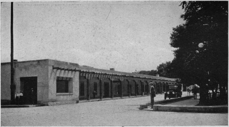
OLD GOVERNOR’S PALACE, SANTA FE, N. M.
The center for three centuries of the political life of New Mexico, under the successive regimes of Spaniard, Indian, Mexican and American.
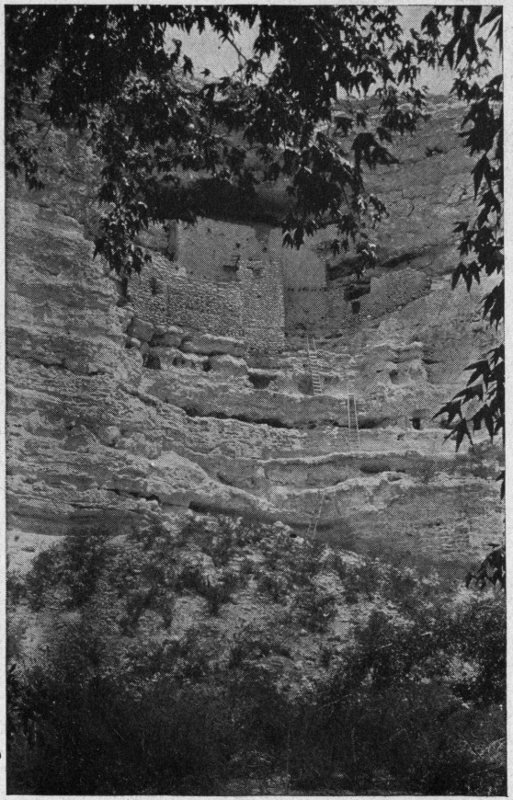
MONTEZUMA’S CASTLE
Near Camp Verde, Arizona. A beautiful specimen of prehistoric Cliff architecture, with which, however, Montezuma had nothing to do.
Today the valley of the Verde maintains but a sparse population. Here and there is a white man’s hamlet; here and there are wickiups of the now peaceable Apaches; and where, between the cliffs that wall in much of the valley, there is level land enough to make farming operations possible, there are scattering ranches strung along. Time was, however, when the valley was the home of an abounding aboriginal population. How long ago that was no one knows, further than that it was before—and probably long before—the 16th century Spaniards discovered the Upper Verde and reported silver 164 outcroppings there. The bordering cliffs and hilltops are dotted and honeycombed with the ruins of pueblos, stone fortresses and cave dwellings to an extent that has made the region unusually attractive to the archaeologists. Two of these prehistoric remains on Beaver Creek hold especial interest also for the lay traveler. They are the so-called Casa Montezuma, or Montezuma’s Castle, and Montezuma’s Well. The former, a strikingly fine example of a cliff ruin as imposing in its way as a castle on the Rhine, has been made a National Monument and is under such protection of the United States government as goes with a printed notice tacked upon a tree nearby, for there is no resident guardian. The Well is upon a private ranch 8 miles north of the Castle. It need hardly be said that Montezuma, whose name is popularly joined to both, had nothing whatever to do with either; nor indeed had any Aztec, though people who get their ancient history from newspapers, will tell you that the ruins are of Aztec construction. Both Castle and Well are close to the Arizona State Highway, and may be 165 reached by a 50 or 60 mile drive from Flagstaff, or half that from Jerome. Another way to reach them is from Prescott by automobile livery. Yet another is by rail from Prescott to Cherry Creek (Dewey Postoffice) on the Crown King branch of the Santa Fe, and then by auto-stage through the picturesque Cherry Creek Cañon 32 miles to Campe Verde on the Verde River. Campe Verde was formerly an army post of importance during the Apache wars, but is now peaceful enough for the most pacific, maintaining a hotel, a garage, a barber shop, an ice-cream and soda-pop saloon, a store or two, and similar amenities of 20th century living as delightful as unexpected in this out-of-the-way corner of our country.
And I think here is as good a place as any to say a word about the modern Southwestern mail stage. It is, of course, motor-driven in this mechanical age, and lacks the peculiar dash and picturesqueness of the 4- and 6-horse vehicles of other days. Nevertheless, much of the charm that enveloped western stage travel then clings to the modern auto-stage. There is the same 166 immersion in glorious, wild scenery; the same thrill of excitement as you spin down mountain grades and around curves with a cañon yawning hungrily beside you; the same exhilaration of association with fellow passengers of types foreign to Broadway or La Salle Street; many times there is the same driver, who, surrendering the ribbon for a steering wheel, has not at all changed his nature. The seat beside him is still the premium place, and if he takes a fancy to you, he will exude information, anecdote and picturesque fiction as freely as a spring its refreshing waters. To travel a bit by stage, when occasion offers, gives a flavor to your Southwestern outing that you will be sorry to have missed. Besides, it sometimes saves you money and time.
From Camp Verde to Montezuma’s Castle is a pleasant 3 mile jaunt. Of course you may miss the trail, as I did, and walk six, but if you keep close to Beaver Creek, with a sharp eye ahead, you can detect the ruin from nearly a mile away, snugly ensconced high up in a niche of a pale cliff, overlooking the valley. It is a comparatively 167 small ruin, but there is a charm in its very compactness. And there is the charm, too, of color, the general tone of the buildings being pink set in a framing of white. The base is about 75 feet above the level of the creek that flows at the foot of the cliff—flows, that is, when water happens to be in it, which is not always. The structure itself is perhaps 30 feet high, with substantial squared walls of masonry, and is in 5 stories, access from one to another being either by openings in the ceilings or by modern ladders fastened against the outside walls. How the ancients managed the ascent from the ground, there is none to tell us. An interesting feature is a bowed parapet or battlement (the height of one’s shoulder), which surmounts the fourth story, and from below hides the fifth story rooms which are placed well back against the innermost part of the cliff recess and roofed by its overhang. Be sure you climb to that battlemented upper story (it will be no easy job, for you have to swing yourself up to it through the ceiling of the fourth), and leaning upon the parapet, enjoy the 168 solitude that stretches before you—from the sycamores lining Beaver Creek at the cliff’s foot, across the mesquite-dotted mesa, and the green bottomlands of the Verde to the long purple range of the Black Hills in the dim southwest. If any sound there be, it is the whisper of the wind in the trees far below, or the cooing of the wild doves, which haunt the place. So do bats, and a certain queer acidulous smell that pervades the rooms is attributable to them. As you walk about, your feet stir up the dust of ages. Here and there on the mud-plastered walls are human finger prints dried in the material when it was laid on by prehistoric hands. In some of the rooms, particularly in certain cave dwellings (which, following the natural ledges, you will find scooped out of the tufa cliff beside the Castle), the ceiling and walls are blackened still with soot from the smoke of pre-Columbian fires. You may pick up bits of pottery, as you stroll, corn-cobs wizened of the ages, broken metates, or malpais rubbing stones, mute reminders of the human drama once enacted here. The airy battlement is pierced 169 with downward-pointing loopholes through which arrows were doubtless shot at foes below. It is this abounding and evident human touch, this mystery of a long vanished human life, that lends to Southwestern travel a unique fascination, reaching to something in us that is not awakened by purely natural aspects more sublime but disassociated from man. In spite of the fact that men will kill one another, mistreat, enslave and exploit one another, men never lose a supreme interest in men; stronger than all is the yearning of the human heart for other human hearts. Is it love outwearing love’s antithesis?
Montezuma’s Well is 8 miles further up Beaver Creek, and is reached by a public highway quite practicable for automobiles when the fords of the creek are not running high water. You pass a ranch every mile or so, and the Well itself is found to be situated inside the wire fences of one. After the hospitable and unexacting solitude of Montezuma’s Castle, you will experience a bit of a shock, perhaps, at the fences and in finding that a fee of half a dollar is imposed 170 for entrance to the Well. Nevertheless the sight is worth the money. Proceeding from the ranch house across an eighth of a mile of open, treeless mesa, you come quite without warning, to a crater-like[84] opening 500 feet across, yawning at your feet. Its walls drop almost perpendicularly some 60 feet or more to a round pool of clear water steel blue, except around the margins, where accumulations of pondweed give it a brown tinge. There is a precipitous, stony trail down which you may pick your way to the water’s edge; and there, as in the bottom of a colossal mush-bowl, you are hid from the world and the world from you. Catclaw and wild grape, hackberry and wild walnut and salt-bush make a scrubby cover roundabout, with datura and cleome and blooming wild tobacco adding a flower-touch. There is here as at Montezuma’s Castle a peculiar sense of loneliness and silence—broken only by an occasional bird 171 note, or the hum of vagabond bees. In the clear, still waters of the pool are reflections of the cliffs, and raising your eyes to them you recognize in the southern side a few squat little stone houses wedged in between the strata of the rock walls. You can, if you choose, easily climb to some of them, and stooping through the small doorways get a taste of what it was like to be a cliff dweller. At the north end of the pond there is a thicket of willows and cottonwoods, and there the waters find their exit by an underground passage that would lead them into Beaver Creek (which flows beyond the hill) were it not that they are diverted to irrigate the ranch lands. Near this place of disappearance, is a very interesting feature of the Well—a series of natural caverns reaching far back under the hill, forming an irregular dwelling of many rooms, with occasional bits of built-in wall of mud-plastered stone. Upon such a wall at the very entrance of the cavern is the tiny imprint of a child’s hand, left we must suppose, by some prehistoric toddler steadying itself—how many, many centuries ago, 172 who can tell?—against the freshly plastered surface, just as a baby, uncertain of its feet, would do to-day. At the time Mr. Chas. F. Lummis wrote his fascinating volume, “Some Strange Corners of our Country,” and described Montezuma’s Castle and Well, the precious imprint was perfect; but some witless latter-day visitor has pecked out the palm with his vandal jack-knife, destroying in a moment what Time, the arch-destroyer, had respected for centuries. Still the marks of the baby fingers were left when I visited the place a year ago and I hope still are, to link the fancy tenderly with that ancient people, our elder brethren.
The proprietor of the Well, Mr. W. B. Back, will guide you about and light you into the cavern’s recesses, piloting you with a lantern through passages so low and narrow at times that you must go almost on hands and knees until he brings you, far within, into a spacious and utterly dark rock-chamber with a stream of living water coursing musically through it, where further investigation is barred. He will also transport you in an anachronous row-boat across 173 the bosom of the Well. It seems the soundings deepen suddenly from 80 feet at the outer part to 500 feet and no bottom at the center. There the water rises as in a funnel from its unknown source. At the outlet beyond the hill the waters gush from beneath a high, darkling cliff in an impetuous stream that varies little in volume throughout the year, the measurement being about 112 miner’s inches. Your guide takes you there, too (passing on the way the ruins of an ancient pueblo that once occupied the mesa near the Well’s edge), and you will enjoy the sight of that brisk little torrent fringed with a riot of maiden-hair fern and columbine, and darkened by the shadows from huge sycamores that foregather about it. The ancient Well-dweller, knew perfectly the value of that water and led it by ditches, the remains of which you may yet see, to irrigate their corn- and bean-fields a mile away. Apaches, who within recent years have been the only Indians dwelling in the region, profess no knowledge of the people who built the houses here. Mr. Back (who, by the way, in 1889 filed as 174 a homesteader on the land about the Well including the Well itself as a water right) informed me that the Apaches regard the place with disfavor. “Aqua no ’ueno,” one old man told him, “water no good. Long time ago, you sabe, three Indian mujeres all same women, you sabe, she swim out in water, and go round and round, you sabe, in the middle, and by ’em by, she go down, all three. Never come back. No, no—no ’ueno.” The water is warmish, but quite drinkable—if you can forget about those Apache ladies who are still in it.
It would seem reasonable that so remarkable a natural phenomenon as is the Well, situated in a region as populous with aborigines as the Verde Valley once was, would have a place in Indian folk lore; and as a matter of fact Dr. J. W. Fewkes[85] has learned that the Hopis know of its existence, and claim it as the home of some of their ancestors. Moreover, the tales of some of their old men indicate that they regard the place as the house of the Plumed Serpent, a divinity peculiarly dear to the 175 desert dwelling Hopis of today, as the guardian of the waters and springs. Indeed, it is, perhaps, as a shrine of the divine that the Well is most truly to be considered; and in view of the extensive pueblo that once flourished on the rim, it may be that the houses of the Well walls were used in connection with religious observances rather than as a habitation of the common people.
If you are a Southwesterner, born or naturalized, returning from a visit “back East,” your spirits rise with a jump when the trainmen call out “San Antone!” For this is the frontier of your own dear country, and you feel the thrill that goes with getting home again and being among your own people. Dusty and a bit down at the heel in spots is San Antonio, you think? Yes, son, but it is picturesque; and there are adobes and Mexicans, Stetson hats and cart-wheel dollars once more, and it is where the Southwest begins, if you are westbound on the S. P.
San Antonio more than anywhere else in Texas has an Old World atmosphere. The former Spanish capital of the province, there are parts of it that impart to the visitor 177 much the same feeling that Monterey, that other Spanish capital, gives him in California—the feeling that may be this is the United States, but it needs to be demonstrated. Of course, being a city of 100,000 people and commercially important, it has its well-groomed, American side, but unless you are in San Antonio merely in quest of health and comfort,[86] it is not that spick-and-span side that appeals to your traveler’s taste. You will prefer those streets, irregular and even unpaved (often their Spanish names still clinging to them), of the older quarters, where cracked one-storied adobes in open sunshine, elbow stately old tree-embowered mansions, whose tangled gardens seem to hide in their unkempt corners untold romances. You will like the Mexican quarter with its queer little shops, and the market square with its picturesque crowds of swarthy peones, donkeys and country teams of odd sorts, its squatting street venders of tortillas, cakes, dulces, songbooks, 178 religious pictures and shoe-strings. You will like, too, the bridges over the little river that winds cosily about through the midst of the town, and the waterside lawns where trees cast a comfortable shade and summer houses invite to tea al fresco. There are literally dozens of those bridges, with railings at a convenient height to lean your elbows on and dream away an idle half-hour. Moreover, you will like the many charming parks and plazas, where you may sit under a palm tree and enjoy the passing tide of open-air life and make more acquaintances in half an hour than you would in New York in a year.
The Main Plaza is dominated by the cathedral of San Fernando, which dates from 1738, though little of the original structure remains—most of the present building having been constructed about half a century ago. What is left of the original church is in the rear, backing on another and larger square, the old Plaza de Armas, or Military Plaza as it is now called.
Modern San Antonio has risen out of the consolidation of the presidio of San Antonio 179 de Béjar, the Mission of Antonio de Valero (both mission and presidio founded in 1718) and the villa—a form of Spanish municipality—of San Fernando, founded in 1730. The Mission, after abandonment as a religious institution, was turned into a fortress and barracks, and acquired the name of Alamo.[87] The Church of the Mission and what is left of the main building of the Fort are the most famous historical buildings in the city. They face on the Alamo Plaza, and are of such unique interest as to draw, in themselves, many visitors to San Antonio; for they are in a sense to Texas what Faneuil Hall is to New England, the cradle of its liberty. Late in 1835, when Texas was still a part of Mexico, San Antonio was stormed and captured by a band of insurgent American-Texans under the leadership of “Old Ben” Milam, who was killed in the fight. (You will see his statue in Milam Square, if you are interested enough to look it up). The Alamo, which 180 was well outside the San Antonio of those days, was surrendered with the city. Here the Texans later entrenched themselves, and in February and March of the following year were besieged for 12 days by 4000 Mexicans under General Santa Ana. Of the Texans, there were less than 200, including some women and children. Refusing to surrender, every man of them was killed in the final assault upon the place, the only survivors (according to H. H. Bancroft) being 3 women, 2 children and one negro boy servant. “Remember the Alamo” became the war-cry of the Texans in the subsequent struggle that ended in the independence of the province.
The little Alamo Church and part of the main building that we see to-day, form only a small portion of the establishment that existed in 1836 and was occupied by the Texan defenders. Besides this church part (now maintained as a public monument) there was the large two-story convento-fortress divided into rooms and used as armory and barracks, part of which now exists and is cared for by the State of Texas; 181 also a prison building and courtyard; the whole covering between 2 and 3 acres. Prominent among the Alamo defenders was that picturesque character and popular Southwestern hero, Davy Crockett. Another was James Bowie, to whom many authorities attribute the invention of the famous knife that bears the Bowie name, but Bancroft says it was Rezin Bowie, a brother of James, who originated it. These and others of the participants in the Texan war of independence are commemorated in the names of streets, parks and public houses throughout the city. As for the Alamo, it is bait in all sorts of business ventures—giving name to saloons, suspenders, grocery stores, restaurants, lodging houses and what not.
Next to the Alamo, the sightseer (unless an enthusiasm for matters military takes him straight to San Antonio’s famous army post, Sam Houston), will find worth while a visit to the old Franciscan Missions, now in ruins, that are strung along the San Antonio River to the south of the city. There are four of these, the first about 2 miles from the Alamo, the rest at similar intervals 182 of a couple of miles. Americans have got in the way of calling them, in numerical fashion, First, Second, Third and Fourth Missions, respectively, to the neglect of their fine old Spanish names. The First, which is on the southern outskirts of the city, and may be reached by a moderate walk from a street car line, is the Mission Nuestra Señora de la Purísima Concepcion de Acuña (Our Lady of the Immaculate Conception, of Acuña). From quite a distance one catches sight of its twin square towers with pyramidal tops and its high dome peeping above a tangle of mesquite, chinnaberry and pecan trees, and sprawling juisache bushes. A Mexican family lives in an end of the ruined convento part, and a small fee is charged for showing the inside of the church and permitting you to climb the belfry for a fine view over the country. The façade is interesting with much curious sculpturing. The knotted cord of St. Francis winds above the austere polygonal “arch” of the doorway, upon which is this Spanish inscription: A su patrono y princessa con estas armas atiende esta mission y defiende el 183 punto de su pureza. (With these arms this Mission attends her Patroness and Princess and defends the state of her immaculateness.) This is an obvious allusion to the controversy long maintained among old-time theologians concerning the dogma of the Virgin Mary’s immaculate conception—a doctrine defended and preached by the Franciscans from the first. In the corners immediately above the arch are two medallions, the one bearing an unusual form of the Franciscan Order’s coat-of-arms—the Saviour’s naked arm and the sleeved arm of St. Francis nailed together to the Cross; the other carved in the semblance of five blood-drops, to symbolize perhaps the stigmata of St. Francis. Upon the keystone is another elaborate embellishment now much worn by the elements. The central figure of this is plainly representative of the consecrated elements in the Lord’s Supper—a slender Spanish chalice surmounted by the Sacred Host. Worn figures at the sides of the chalice may have represented clouds or adoring angels. The whole carving of the keystone obviously typifies the 184 Church’s missionary purpose. The front was once gaily frescoed in red, yellow, blue and orange; but Time’s remorseless hand has fallen heavily on that. Begun in 1731, the building was not completed until 1752. After Mexican independence from Spain was accomplished, this Mission as well as the others, was abandoned and was not infrequently used by both Mexican and United States troops for barracks and stables. Some 30 years ago Bishop Neraz of San Antonio had La Purísima Concepcion cleared of rubbish and re-dedicated to Our Lady of Lourdes.[88]
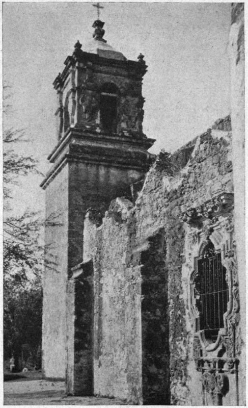
SAN JOSÉ DE AGUAYO
The sculptured window of this old Franciscan Mission near San Antonio, Texas, is widely famed for its refined beauty.
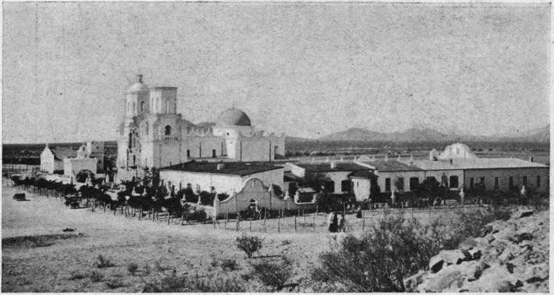
SAN XAVIER DEL BAC, ARIZONA.
Though largely restored, this survival of early 17th-century missionary effort, is one of the most interesting antiquities of its class in the United States.
The Second Mission, properly called San José de Aguayo, was the first founded of the four, dating from 1720. It was 11 years a-building, and the date of its completion, March 5, 1731, seems to have determined the beginning of the remaining three Missions in the chain, all of which were founded on their present sites in that same year.[89] It was in its day the most flourishing of the Texas Missions, as, in its ruins, it is the most beautiful. The builder indulged to the uttermost his love of florid carving, and the broken façade of the roofless church is a marvel of ornate sculpturing—of saints, life size or in bust, cherubs’ heads and flaming hearts, volutes and arabesques and conchoids innumerable. But it is good sculpture and an amazing thing that it should have been wrought to the glory of God in that wilderness of what was Northern Mexico, near two centuries ago. Doubtless it was the work of some artisan (I have read that his name was Juan Huisar) brought up from Old Mexico where such ecclesiastical art was encouraged from the beginning of the Spanish occupation; and for assistants Indians were employed. Around the corner 186 from this front is a window in the baptistry that makes you exclaim for the beauty of it, so exquisite is it in its sculptured setting, so delicate and of so simple loveliness is its reja, or grating of wrought iron. And about it in the broken chinks of crumbling masonry is a fern garden of Nature’s own sowing, of a sort that thrives in the sunshine and aridity of the Southwest and nowhere else, a species that botanists call Notholaena sinuata. The Mission is quite abandoned now save for an occasional service at a modest little altar in one room. A neighboring Mexican family has the key and supplies a guide.
These two Missions are usually all the hurrying tourist sees; but an hour more, if you are in an automobile, is enough to afford a glance at the other two, which, if less interesting, are still a pleasant adventure. The Third (6 miles from San Antonio) is Mission San Juan Capistrano (Saint John of Capistrano, in Italy), and the Fourth is San Francisco de la Espada (Saint Francis of the Sword). The last has undergone some restoration to fit it for the resident priest, who ministers to a Mexican flock quartered 187 roundabout. The entire round of the Missions can be easily done by motor car in half a day; but take a day to it, if you can spare the time, picnic somewhere by the river, and do the beautiful old places with leisure and reverence. Surely one can do worse things, to quote Sidney Lanier, “than to steal out here from town ... and dream back the century and a half of strange, lonesome, devout, hymn-haunted and Indian-haunted years that have trailed past these walls.”
Annually during the last week of April, there is held in San Antonio an open air carnival called the Fiesta San Jacinto. The name commemorates the decisive battle of San Jacinto, fought April 21, 1836, between Mexicans and Texans, and ending the War of Texan Independence. Elaborate celebrations mark the festival, which is almost as well known in the Southwest as the New Orleans Mardi Gras.
NOTE: Readers interested in particulars of the history of the San Antonio Missions will be repaid by consulting the valuable work of Miss Adina DeZavala, entitled: “History and Legends of The Alamo and Other Missions in and Around San Antonio.”
There are two Arizonas. There is that wide, breezy plateau region of the north, a mile and more above sea level, where our travels so far have been; and there is the much lower desert region of the south slanting downward from the Gila River to Sonoran Mexico, from which country there is little to distinguish it physically. This desert region, known to the Spaniards as Pimería Alta (that is, the upper country of the Pima Indians), was the only portion of what was afterwards called Arizona to possess a white population until several years after our Mexican War. The tourist to-day penetrates it in two general ways. Near the Mexican frontier the Southern Pacific transcontinental line traverses it, passing through Yuma and Tucson and reaching up to Phoenix by a 189 branch from Maricopa. From the north a branch of the Santa Fe system runs southward from Ash Fork through Prescott directly to Phoenix.
Phoenix is the State capital, a very modern little city dating from 1817, with a population of perhaps 20,000. There is a touch of poetry in the name, which was given to symbolize the rising of a new civilization from the ashes of that prehistoric culture the evidences of whose existence cover so much of Southern Arizona. Here, where 50 years ago was pure desert lorded over by the giant Sahuaro—that huge tree-cactus which is Arizona’s State emblem—we find today surrounding Phoenix a pleasant land of ranches watered by full irrigation canals flowing in the shade of palms and cottonwoods, where besides the common staples of potatoes, corn and alfalfa, there is the exotic grace of the orange and the fig, the olive, the date and the apricot. This is the valley of the Salt River, whose waters are impounded by the huge Roosevelt Dam, some 80 miles east of Phoenix. Travelers desirous of studying desert reclamation will 190 find Phoenix a good center for their observations.
If you value your personal comfort, the time to visit Phoenix is between November and May. During the rest of the year the weather normally is remorselessly hot to the unacclimated. My own acquaintance with the city began in August. In a hazy way I had noticed something unaccustomed about the look of the population, the men particularly, but failed to analyze it until a sociable street car conductor remarked to me, “Stranger here?” “Yes,” said I, “my first day.” “We always know strangers right away,” he continued. “You see, they wear their coats.” Then I took a fresh look around and though it was a fairly crowded street, I failed to see a man who was not in his shirt sleeves. The winter and early spring, however, are delicious with the peculiar purity and dryness of the desert air to which a touch of frost at night may give added vitality.
That interesting 120 mile automobile highway called the Apache Trail finds at Phoenix its western terminus. Its eastern 191 end is at Globe, a mining town on modern lines in the center of a rich copper district.[90] This point is connected by rail with Bowie, 124 miles distant, on the Southern Pacific Railway. Transcontinental travelers by this route, either east- or west-bound, are now given the opportunity of varying their trip by taking this motor drive over the Apache Trail, linking up with the train again at the point of ending. The feature of the motor trip, which consumed 9 to 12 hours, is the chance it yields the traveler to get a more intimate acquaintance with the Arizona countryside than is possible from a car window. Mines and cattle ranges, stupendous cañons, strange rock-sculpturings in glowing colors, the desert with its entrancing vistas, its grotesque and often beautiful plant-life, even a glimpse of prehistoric ruins—all this the drive affords; and to it is added the impressive sight of the Roosevelt Dam with its beautiful, winding driveway upon the breast and its exhibition of 192 man-made waterfalls and 30-mile lake, an unoffended Nature looking indulgently down from surrounding precipices and mountain crests and seeming to say, “Son, not so bad.” There is a hotel at the Dam, on a promontory overlooking the water—and in the water bass and “salmon” are said to be. A stop-over here is necessary if you wish to visit the Cliff Dwellings, 5 miles to the eastward, officially known as the Tonto National Monument.
The Apache Trail detour cuts the traveler out of stopping off at one of the most interesting little cities of the Southwest—Tucson.[91] It may be that not all will find this oasis town, lapped in the desert and girt about with low mountains, as much to their liking as I do, but I believe it possesses features worth going back on one’s tracks 193 to see; for it has a decided character of its own. With an out-and-out modern American side, there is the grace of an historic past, whose outward and visible sign is a picturesque Spanish quarter in adobe, pink, blue and glaring white, clustering about a sleepy old plaza and trailing off through a fringe of Indian ranchería to the blazing desert. The region roundabout is associated with pretty much all the history that Arizona had until it became part of the United States. The Santa Cruz Valley, in which Tucson lies, was a highway of travel during three centuries between Old Mexico and the Spanish settlements and Missions of Pimería Alta. Through this valley or the neighboring one of San Pedro (there is a difference of opinion on this point), Brother Marcos de Niza, the first white man to put foot in Arizona, must have passed in 1539 on his way to Zuñi’s Seven Cities; and this way, the following year, came Coronado upon the expedition that made of New Mexico a province of Spain. A century later the region was the scene of the spiritual labors of Padre Eusebio Francisco Kino, a 194 devoted Jesuit missionary to the Indians—a man of mark in his time, to whom is credited the founding of the Spanish Mission San Francisco Xavier del Bac, about 9 miles south of Tucson. The present beautiful structure, however (Tucson’s crack sight for tourists), was not erected until long after Padre Kino’s day.
San Xavier is, in itself, worth a stop-over at Tucson. You may make the round trip from the railway station in a couple of hours by automobile, getting en route a taste of genuine desert scenery, with its scattered covering of creosote bush, mesquite, cat’s claw, ocotillo and sahuaro. The Mission building is one of the most beautiful examples of Spanish ecclesiastical architecture in our country; and the pure white structure, lonely in the desert, its glistening walls and stately towers and dome silhouetted against a sapphire sky, makes a striking sight, oriental in its suggestion. The church part is still used for religious services, and other portions form the residence of Sisters of a Catholic order who conduct a school for the children of the 195 Papago Indians. The primitive habitations of the latter, scattered about within easy access of the Mission, are the Mission’s only near neighbors. A small fee admits one to the church. A feature of interest at the front is the coat-of-arms in relief of the Order of Saint Francis of Assisi.[92] This is evidence enough that the present structure, which was begun in 1783 and finished in 1797, was erected by Franciscans, although, as already stated, the Mission itself was founded about a century previously by Jesuits. In 1768 and for ten succeeding years, the resident missionary at San Xavier was Padre Francisco Garcés, one of the most remarkable characters in the Southwest’s history. An enthusiastic young priest in his early thirties when he came to San Xavier, and possessed of a powerful physique, he journeyed on foot up and down the valleys of the Gila and the Colorado (even penetrating into California and to the Hopi 196 village of Oraibi), tirelessly searching out Indians, and preaching to them Christ and the gospel of reconciliation. He was indeed the original Christian Pacifist of the Southwest, urging upon the Indian tribes everywhere that they should settle their differences peaceably and live together as brothers. To prove his faith he would never suffer a military escort to accompany him in his wilderness pioneering, but took only an Indian companion or two as interpreter, and a mule to carry his ecclesiastical impedimenta. Neither would he bear any weapon for defense, but went “equipped only with charity and apostolic zeal.”[93] His kindly, joyous character, so endeared him to the aborigines, that, as he himself records, a village would often refuse to supply him a guide to the next tribe, wanting to keep him for themselves. Under such circumstances, he would set out alone. He was a rare puzzle to those barbarians, both because 197 they found it difficult to decide whether in his long gown and clean-shaven face he was man or woman, and because he strangely wanted nothing of them but the chance to give them a free passport to Heaven—an inexplicable sort of white man, indeed!
While on your Mission pilgrimage, it will be worth while to continue southward some 50 miles more to Mission San José de Tumacácori. The road is fairly good and about 7 hours will suffice for the round from Tucson by automobile; or the train may be taken on the Nogales branch of the Southern Pacific to Tubac station, whence a walk southward a couple of miles brings you to the Mission.[94] The buildings, mostly of adobe, are in ruins and very picturesque with a domed sanctuary and a huge square belfry, now broken and dismantled. They and a few acres surrounding them now form 198 the Tumacácori National Monument, under the care of the United States Government. This Mission in the wilderness was once, next to San Xavier, the most important in what is now Arizona. It was established by Jesuits in 1754, though the present church building is of Franciscan structure of much later date, having been completed in 1822, replacing one destroyed by the ceaselessly raiding Apaches.[95] Of interest, too, in this vicinity, is the ancient village of Tubac, 2 miles north of Tumacácori. Here in the 18th century was a Spanish presidio thought needful for supplementing the preaching of the friars by the argument of the sword. To Californians and those interested in the history of the Golden State, the place has an appeal because here during several years Don Juan Bautista Anza was commandant—the sturdy soldier who conceived the idea of a practicable overland route from Mexico 199 across the deserts to the Spanish settlements on the California coast, and in 1775-6 convoyed over this route the colonists who founded San Francisco. Today Tubac is an unpretentious little adobe hamlet sprawling about a gravelly, sunny knoll, and looking across the Santa Cruz River with its fringe of billowy cottonwoods to the blue line of the Santa Rita and San Gaetano ranges. At Rosy’s Café I got a modest but comforting luncheon, and on your way to Tumacácori you, too, might do worse.
West of Tucson 65 miles is the little town of Casa Grande, which takes its name from one of the most famous prehistoric ruins in the United States, standing about 18 miles to the northeast, near the Gila River. If you have a taste for prehistoric architecture, you will enjoy Casa Grande, for it is sui generis among our country’s antiquities. If, on the other hand, you are just an ordinary tourist, you must decide for yourself whether a half day’s motor trip across the desert to see a ruinous, cubical mud house topped with a corrugated iron roof, in the midst of a sunburnt wilderness, will or will 200 not be worth your while. What touches the fancy is that here, centuries doubtless before Columbus (perhaps before the time of the Cliff Dwellers) dwelt and toiled an unknown people whose remains are of a type that possesses important points of difference from those found elsewhere within the limits of the United States, though similar ruins exist in Mexico. Casa Grande is Spanish for Great House, and is given to this ruin because its outstanding feature is a huge block of a building of three or four stories in height, and thick walls of caliche—a mixture of mud, lime and pebbles molded into form and dried, somewhat as modern concrete walls are built up. The unique character of the Casa Grande caused it to be set aside 25 years ago as a National Monument, and important work has since been done there by Government ethnologists, in the way of strengthening and repairing the crumbling walls and cleaning up the rooms. Extensive excavations have also been made close by, resulting in uncovering the foundations of a numerous aggregation of houses plazas, enclosing walls, etc. These reveal 201 the fact that in some age the place was a walled city of importance, even if it was of mud—a sort of American Lutetia, to which Fate denied the glory of becoming a Paris. The huge building in the center—the Casa Grande—probably served partly as a religious temple, but principally as a citadel where in time of attack by enemies the people took refuge. Access to the upper stories was doubtless by ladders outside, as in modern pueblos. Indeed, this is but one of several walled-in compounds of buildings that formerly existed in the Gila Valley, and are now but shapeless heaps of earth. Some of these close to the main Casa Grande ruin have been excavated and their plan laid bare. The remains of an extensive irrigation system are still in evidence, water having been drawn from the Gila.
The first white man of unimpeachable record to see Casa Grande was that Padre Eusebio Kino, of whom we heard at San Xavier and who gave the ruin its Spanish name. He learned of it from his Indians, and in 1694 visited the place, saying mass in one of its rooms. There is some reason 202 to identify the spot with Chichiticale, or Red House, a ruin noted in the reports of Fray Marcos de Niza and of Coronado, both of whom probably passed not far from Casa Grande on their way to Zuñi, but most scholars now reject this theory of identity. After Kino the ruin was frequently examined by explorers and written about up to the American occupation. Anza and his San Francisco colonists camped a few miles distant, and the commandant with his two friars, Padres Garcés and Font, inspected the place with great interest on October 31, 1775. Font in his diary gives a circumstantial account of it, calling it La Casa de Moctezuma (Montezuma’s House), and narrates a tradition of the neighboring Pima Indians as to its origin. It seems[96] that long ago, nobody knows how long, there came to that neighborhood an old man of so harsh and crabbed a disposition that he was called Bitter Man (el Hombre ’Amargo, in Padre 203 Font’s version). With him were his daughter and son-in-law, and for servants he had the Storm Cloud and the Wind. Until then the land had been barren, but Bitter Man had with him seeds which he sowed, and with the help of the two servants abundant crops grew year after year, and were harvested. It was these people who built the Great House, and they dwelt there, though not without quarrels because of Bitter Man’s character, so that even Storm Cloud and Wind left him at times, but they came back. After many years, however, all went away—whither, who knows—and were heard of no more forever.
Casa Grande may also be reached by conveyance from Florence on the Arizona Eastern Railway, from which point it is distant a dozen miles or so. Owing to the extreme summer heat of this desert country, the trip to the ruin is most comfortably made in the late autumn, winter or early spring. There is a resident care-taker who acts as guide.
“Shall they say of you, you have been to Rome and not seen the Pope?” Yet that is what will be said if you turn back at the Colorado River and leave Southern California out of your Southwestern travels. However, few people do that. The fear is that in their haste to reach that tourist playground, they may neglect too much of what the preceding chapters have dwelt upon. Intent upon seeing the Pope, they may do scant justice to Rome.
By Southern California is meant California south of the Teháchapi Mountains and their western prolongation ending in Santa Barbara County at the sea. It is not a political division, but Nature’s—in its physical aspect differing quite markedly from Central and Northern California. 205 Long regarded with a sort of mild contempt by the Americans who settled Central California and who habitually spoke of the South as “the cow counties,” Southern California has in the last quarter century attained a reputation not short of gilt-edged. Lonely, treeless plains and valleys and brush-clad mesas that a comparatively few years ago were counted desert and good for nothing except for cattle ranges and sheep runs, have become, with the development of water, pleasant lands of fruitfulness supporting a numerous and progressive population. The extensive cultivation of the orange, the lemon, the fig, the grape, the English walnut, the apricot, the olive; the planting of the eucalyptus, the palm and a hundred kinds of exotic shade and ornamental trees; the dotting of the landscape with villas of a distinguished sort of architecture patterned on Italian and Spanish models—all this has wrought a transformation that makes even more appropriate today than 25 years ago the sobriquet of “Our Italy” given the region by Charles Dudley Warner.
Here wealthy Easterners maintain winter 206 homes as they keep summer estates on the Atlantic Coast, and less well-to-do folk—retired farmers, tradesmen or professional people—buy a bungalow and settle down to the enjoyment of a good climate and the luxury of having roses and green peas in their winter gardens. Not only Americans but those of other nationalities have discovered that Southern California totals a remarkable number of points in the problem of comfortable living—a healthful and delightful climate (notably in winter), a fruitful soil capable of raising everything natural to the temperate zone besides a large number of things sub-tropical, a beautiful and varied terrain embracing seaside, valley and mountain, and an admirable system of capital roads. For the tourist there is not only the attraction of this beauty and comfort, but there is the drawing of historic interest, touched with that indefinable sense of romance that attaches wherever Spain has had a foothold. In Southern California as elsewhere in the Southwest, that Spanish flavor is very evident, manifested in the presence of a considerable Spanish-speaking 207 population, in the remains of Spanish-built Missions and ranch houses, and in the persistence of Spanish geographic nomenclature.
The hub of Southern California is Los Angeles, which in a generation has expanded from a sleepy little half-Spanish pueblo of a few thousand to a metropolis of half a million, with a taste for the latest in everything and the money to indulge it. It is the natural center from which to do one’s sightseeing, though Pasadena, adjoining it on the north, is almost as convenient and, indeed, preferred by many who are not in a hurry and prefer surroundings more rural. Pasadena is a little city of 40,000, beautifully situated on a shelving mesa at the base of the Sierra Madre and overlooking the fertile San Gabriel Valley. It is nationally famous for its numerous fine estates and the winter residences of wealthy Easterners; but outside of that it possesses mile upon mile of tree-lined streets where modest homes of the bungalow type look out from a setting of vine and shrub and flower. Each New Year’s Day the city becomes the objective 208 of tens of thousands of visitors to view the Tournament of Roses, an outdoor fiesta whose distinctive feature is a street floral pageant.
From Los Angeles lines of transportation radiate to all points of interest. You have your pick of steam railways, electric lines, auto-stages and ocean steamers. Hundreds of miles of first class, hard-surfaced roads make Southern California a motorist’s paradise, and automobiling is here so notable a feature of tourist life that, if possible, the traveler should make provision for it when packing his pocket book. Public automobiles are abundant and the prices reasonable enough, from $1.50 per hour upward, with special rates for trips. If you are able to club with others for a car, you may find this the cheapest form of travel. Maps and specific information as to drives may be had at offices of the Automobile Club of Southern California.[97]
For those who do not care for motoring or find it too expensive, most of the desirable points are reached by electric and steam lines, or by auto-stages. There are several daily excursions scheduled by the Pacific Electric Railway, which afford at a minimum of expense a satisfactory means of getting a comprehensive idea of Southern California. One of these, to Mount Lowe (a prominent 210 peak of the Sierra Madre), may be substituted for the automobile drive up Mount Wilson. The visit to San Juan Capistrano Mission may be made by train, the railway station being close by. There is a resident priest and religious services are regularly held in one of the restored rooms. The 211 Mission was founded in 1775, and the church part—now a ruin, the result of an earthquake in 1812—marked in its prime the high-tide of Mission architecture in California.
The Franciscan Mission establishments in California are among the most interesting historical monuments of our country; and those of the southern end of the State remain to-day especially noteworthy. Ten miles from Los Angeles is Mission San Gabriel (founded in 1771 on the bank of the Rio Hondo a few miles east of the present site, to which it was removed in 1775). It was for many years a principal center of civilization in the province, the settlement antedating the founding of Los Angeles by several years. Of the original establishment little remains but the church part, which is in a state of good preservation and serves as a place of worship for a considerable congregation, largely of Spanish descent. Mission San Fernando (about 25 miles west of the heart of Los Angeles) is deserted, save by a caretaker. The fine corridored convento, flush with the highway, is its most conspicuous 212 feature today, but the Mission was once of notable extent. A cloistered walk formerly connected the convento with the ruined church in the rear. If you stroll on past the church to the ancient olive orchard beyond and look back, having the two date palms there in your foreground, you will get a charming picture of the noble old temple where Padre “Napoleon” strove, during a third of the Mission’s existence, to steer his dusky children heavenward. Apropos of these California Missions (whose plan was quite different from those of New Mexico and Arizona) it should be borne in mind that originally each consisted of a huge hollow square of buildings, facing within on an open courtyard. The church occupied part or all of one side, the other sides consisting of living rooms for the one or two padres (the convento part), kitchens, store rooms, shops where the neophytes were taught and labored, and the monjerio or sleeping apartment of the Indian widows and unmarried girls of the Mission. Outside this compound were the huts of the Indian converts, arranged in streets and forming an 213 orderly village of sometimes a couple of thousand souls.[98]
South of Los Angeles, 125 miles, is San Diego, reached either by rail, steamer, or automobile. If the last way is chosen, going and returning may be done over different highways, one following the coast, the other running further inland via Riverside. Both roads are excellent. Forty miles before reaching San Diego, you pass within calling distance of Mission San Luis Rey (St. Louis, the King)—4 miles east of Oceanside, a railroad stop where conveyance may be had for the Mission. San Luis Rey was founded in 1798 and in its proportions rivaled San Juan Capistrano. It is still an imposing establishment, though restored with rather too heavy a hand to suit the artistic sense. The situation is charming, on a knoll in the midst of a noble valley, emerald green in winter and spring, the San Luis Rey River flowing close by the Mission. A community of hospitable Franciscan brothers occupies the premises, and religious services 214 are regularly held in the church. Twenty miles further up the river (eastward), a pleasant drive, is San Luis Rey’s sub-mission or asistencia, San Antonio de Pala, which no lover of the picturesque should miss visiting. White-walled and red-tiled, the quaint little church with a remarkable, white bell-tower set not on it but beside it, is one’s beau ideal of an old mission. The setting, too, is satisfying. On every hand are the mountains; a stone’s throw away ripples the little river; and clustered close by is a picturesque village of about 300 Indians, to whom a resident priest, with rooms in the Mission, is cura. Both Mission San Luis Rey and this outpost of Pala were constructed by Indians under the supervision of the famous Padre Peyri, one of the most forceful and devoted of the early Franciscans in California. He gave the best of his life to his wilderness flock, and years after his departure, the Indians, in reverence of his memory, would still offer up their prayers before his picture as before a saint’s.
San Diego, a city claiming a population of 100,000, is spread over seaward-looking 215 hills affording a delightful view of the land-locked Bay of San Diego and the Pacific Ocean going down to China. The mountains of Old Mexico, too, only 20 miles away, make a feature in the prospect. If you are in any doubt what to do in San Diego, you need only stroll around to the neighborhood of the Plaza, and you will be shown. Street cars, automobiles, “rubberneck” busses and tourist agency windows are hung with notices of places to see and trips to take, and the streets are sprinkled with uniformed officials emblazoned with gold lace, to give you details. You may have a good time on any of these jaunts, if you are good-natured and like a bit of roughing it (for San Diego’s vicinity has not as yet reached Los Angeles County’s excellence in roads); but to give you a start I would itemize the following as not to be overlooked:
The exquisite gardens at Balboa Park (where the Panama-California Exposition of 1915-16 was held), affording in epitome a charming object lesson in what California gardens offer both in exotic and native plants; the drive to and along the headland 216 of Point Loma for the fine views; by ferry across the bay to Coronado’s famous hotel and beach; the ride by railway or automobile to La Jolla (pronounced lah ho´ yah), a pleasant little seaside resort with interesting cliffs and surf-drenched rocks; by street car to Old Town (where San Diego had its beginning), to visit the Estudillo house—a former Spanish home intelligently restored and interesting as a bit of old-time architecture with its tiled inner corridors about a flowery patio. It is locally known as “Ramona’s Marriage Place,” because it was here, according to the novel, that the priest lived who married Ramona and Alessandro. On the hill back of Old Town once stood Padre Junípero Serra’s first Mission in California, founded in 1769; but it is all gone now, the site being marked by a large cross made of the original red tiles that once littered the ground. It is but a short walk worth taking both for the view and for the sentiment of standing on the spot where white civilization in California had its beginning. Five miles up the valley that stretches eastward at your feet is what is 217 left of the second Mission (established in 1774). This historic building has been sadly neglected and is but a ruined shell, which only reverence for its past makes interesting. Across the road from it is the old olive orchard, believed to be the original planting of the olive in the State.
San Diego’s back country offers many interesting trips by auto-stage or private car, the roads being as a rule good but with the ups and downs of a hilly region. There are several good hotels in the mountains at a distance of 60 miles or so from San Diego, so that the night may be spent here if desired. Pine Hills, Mesa Grande, and Warner’s Hot Springs may be mentioned as desirable objectives. The trip by auto-stage or your own car via Campo to El Centro or Calexico (at the Mexican border) in the Imperial Valley will prove an unforgettable experience. The Imperial Valley is a depression below sea-level in the Colorado Desert of California, which after lying desolate for ages has of late been made exceedingly productive by diverting irrigation water to it from the Colorado River. This trip had 218 best be made between November and May, as the desert heat in summer and early autumn is intense. If you have your own car and desire the experience of more desert, return may be made around the Salton Sea through the Coachella Valley (where dates are now extensively grown), to Palm Springs and Riverside.
While we have rambled along the coast between Los Angeles and San Diego, our eyes will often have been caught by the sight of a long, low island well out to sea. It is Santa Catalina, whose reputation as a sea-angler’s paradise is world wide. It has also a most delightful climate—its and San Diego’s being perhaps the most equable of any on the Coast. The marine gardens that line the shores are also of wide fame, and are made visible by boats with glass bottoms, through which one looks down into the transparent waters of another world where waving kelps and sea mosses are the forests and bright colored fish, sea anemones, jelly fish, sea cucumbers and other queer creatures are the inhabitants. The trip thither and return may be accomplished from Los 219 Angeles, between breakfast and evening dinner, if you do not care to stay longer.
A hundred miles northwest of Los Angeles lies Santa Barbara (a little city of 15,000), rich in beautiful homes and flowery gardens. It is delightfully situated with the ocean at its feet and the Santa Inés Mountains at its back, and may be reached from Los Angeles either by train or by a picturesque motor drive through valleys, over mountains and beside the sea. Here is the best preserved of all the existing Franciscan Missions in California—never abandoned since its founding in 1786, though now for many a year there have been no Indians in its care. It is the residence of a Franciscan community, and the members in their long brown gowns and white cord girdles may be seen any day at their various tasks about the grounds—one of which is the piloting of visitors through the church.
Driving, horseback-riding, playing golf, or simply sitting still and enjoying being alive in the midst of fine scenery, are the principal occupations of Santa Barbara’s visitors. Among the longer drives should 220 be mentioned the 40 miles to the Ojai Valley by way of the lovely Casitas Passes, and the 45 miles across the Santa Inés Mountains to the Mission Santa Inés in the valley of the same name. The latter trip is made more enjoyable if two days are taken to it, the mountains being crossed by the San Marcos Pass[99] into the Valley of Santa Inés, famous for its majestic oaks, and the night passed at Los Olivos, 6 miles north of the Mission Mattei’s Tavern at Los Olivos, is one of the most comfortable country inns in California. The return should be made by the Gaviota Pass and the seaside road back to Santa Barbara. The Mission of Santa Inés (which is Spanish for Saint Agnes, whose eve gives title to Keat’s immortal poem), is sight enough to make the trip worth while—with white walls, red-tiled roofs and flowery, corridored front, in a valley rimmed about with mountains. The Mission was long abandoned and in ruins, but when the present hospitable rector took charge some 15 years ago, he began a careful restoration and with 221 his own hands did much of the necessary labor to put it as we see it today.[100]
While the climate of the Southwest is characterized by abundant sunshine and a low degree of relative humidity, it has periods of considerable moisture precipitation. In winter this takes the form of snow in the northern and central portions of New Mexico and Arizona (which lie at an elevation of 5000 feet and more above sea level). The snow, however, except upon the mountains, disappears rather rapidly under the hot sunshine of midday, so that the traveler has a fair chance to sandwich his trips between the storms. The mid-year precipitation of rain is generally during July and August, and throughout all parts of both those States it descends usually in severe electrical storms. These occur as a rule in the afternoon and pass quickly, but while 223 they last they are apt to be very, very wet. They are the occasion of sky effects of cloud and rainbow wonderful enough to compensate for whatever discomfort the rain may cause. In most sections the summer temperatures are on the whole agreeable, but in the much lower altitudes of parts of southern Arizona and New Mexico, desert conditions largely prevail, with a degree of heat in summer that is trying to sight-seers.
In Southern California climatic conditions differ greatly from those east of the Colorado River. The coast year is divided naturally into a dry season and a wet—the latter normally extending from October or November to April or May. From about mid-spring to about mid-autumn no rainfall whatever is to be expected, except in the high mountains where there are occasional thundershowers during summer. The winter precipitation comes usually in intermittent rain-storms of perhaps two or three days’ duration (on the higher mountains these come as snow), the intervening periods generally characterized by pleasant, sunshiny days and by nights with temperatures 224 (particularly during December and January), not infrequently as low as 30 degrees Fahr. These minimums, however, rarely hold over an hour or so; and curiously enough, though they result in early morning frosts, only the tenderest vegetation is killed, the mercury rising rapidly after sunrise; so that a great variety of garden flowers bloom, and many vegetables mature, in the open throughout the winter. A marked feature of the California 24 hours is the wide difference between the temperature at midday and that at night, amounting to 35 or 40 degrees F. This condition is fairly constant and to be counted on daily. Similarly there is a very marked difference between shade and sun. A respectful regard for this fact will save the traveler many a bad cold. In summer, though the mercury may run well up into the 90’s and sometimes even to over 100 degrees, the accompanying relative humidity is low, so that it may be said that as a rule one suffers less from heat on the Pacific Coast than on the Atlantic at a dozen degrees lower.
As regards clothing, a simple and safe rule 225 for travelers in the Southwest is to bring with them the same sort that they would wear in New York, season for season. No part of the Southwest is tropical, or even Floridian.
In the matter of expenses, Southern California has had a wider experience in catering to tourists than Arizona and New Mexico and its facilities are now thoroughly systematized, so that the average man may, if he chooses, live there about as cheaply as at home, or he may have the most luxurious accommodations at the larger resorts on a basis that only the very wealthy are familiar with. European plan is that most in vogue in California hotels, and the one most satisfactory for the traveler, who, in his rambles, often finds himself at meal-time far from his hostelry. Unless you want to pay more, you may calculate on $1.00 to $1.50 a night for a comfortable room. In Arizona and New Mexico the sparser settlement of the country results in plainer accommodations, but the rates are reasonable—room $1.00 a day and up; American plan rate under normal conditions about $3.00 a day. At many points 226 in these two States the railways conduct hotels for the accommodation of their patrons, and they are, in my experience, uniformly good.
The charge for saddle-horses varies greatly. In out-of-the-way places where the horses range for their feed, ponies may be had for a dollar a day; but at the popular resorts, the rent of a good mount is generally in the neighborhood of $3.00 a day; it may be even more. There is a similar irregularity as to automobile rates. The latter are largely influenced by the character of the trip, as 50 miles on some roads would involve greater expense to the owner than 100 miles on others. A return of $15 or $20 a day for a car is not infrequently considered satisfactory, but harder trips naturally necessitate a much higher charge. In bargaining for transportation in the Southwest, where it may be a day’s journey between stopping places, it is well to remember that the lowest priced is not always the cheapest. It pays to pay for responsibility.
1. To Redlands, in the San Bernardino foothills, one of the most beautiful of California towns, and Riverside with its famous Mission Inn (about 145 miles the round, including the ascent of Mt. Roubidoux), traversing a beautiful orange and lemon district and paralleling the stately Sierra Madre, whose highest peaks are snow-capped in winter. (If there is time for another day this trip may be extended in winter or spring to include the run to Palm Springs in the desert, 50 miles beyond Redlands. This is particularly enjoyable in March and April when the wild flowers of the desert are in bloom—a surprising and lovely sight. There is a good hotel at Palm Springs, but it is safest to arrange ahead for accommodations).
2. To Mission San Juan Capistrano (about 120 miles the round), one of the most interesting and poetic in its half ruin of the old Franciscan California establishments. The road traverses the rich agricultural districts tributary to Whittier and Santa Ana, and a portion of the extensive Irvine, or San Joaquin Ranch (about 100,000 acres). A detour may be made to include Laguna and Arch Beaches and a run (over an inferior road) of ten miles overlooking a picturesque rock-bound bit of Pacific surf.
3. To Mount Wilson Peak (50 miles the round, but includes 9 miles of tortuous mountain road with a grade as high as 23% in one or two spots). On this peak (6000 feet above the sea) are situated the buildings of the Carnegie Solar Observatory, which, however, are not open to the public. The views from the peak are very beautiful. The trip can also be made by public auto-stage. There is a hotel at the summit.
4. To Camulos Rancho (95 miles the round), a good example of the old style Spanish-California ranch, utilized by Mrs. Jackson as the scene of part of her novel “Ramona.” It is situated in the Santa Clara Valley of the South. A stop may be made en route at Mission San Fernando. The return trip may be made by way of Topanga Cañon and the seaside town of Santa Monica, if an extra hour can be given to it.
Half-day drives in the vicinity of Los Angeles are too numerous to be itemized here, but the following may be mentioned:
1. To the Mission San Fernando by way of Hollywood (famous for its beautiful homes, and latterly as the capital of “Movie-land”) and through the Cahuenga Pass, returning via the Topanga Cañon, the beach and Santa Monica.
2. To Sunland via Alhambra and Santa Anita Avenue to the Foothill Boulevard, Altadena, and La Cañada, returning via Roscoe and Tropico.
3. To Mission San Gabriel, returning by way of Pasadena’s famous residential districts of Oak Knoll and Orange Grove Boulevard, thence over the Arroyo Seco Bridge and past the Annandale Country Club, back to the city.
4. To Whittier and the citrus-fruit belt of the San Gabriel Valley via either Turnbull or Brea Cañons (the latter picturesque with oil derricks) returning by the Valley Boulevard.
A B C D E F G H I J K L M N O P Q R S T U V W X Y Z
Every day brings a new experience—crowded with scenic delight—at Glacier National Park—Uncle Sam’s playground in the Montana Rockies.
Maybe you are going over the “Notch”—sky-high Gunsight Pass—on a surefooted horse—a real mountaineer experience. Perhaps you’re gliding amid tremendous scenes over a modern motor trail through the thick of the wilds. Another day, you pow-wow with the picturesque Blackfeet Indians.
Send for descriptive literature with maps and photographic views of the Park’s beauty spots and definite information as to cost. Write
C. E. STONE
Passenger Traffic Manager
ST. PAUL, MINN.

Ask for new booklet
“Off the beaten Path”
of Maps and Pictures
W. J. Black, Pass. Traf. Mgr.
AT&SF Ry—1118 Ry. Exch. Chi·