
Transcriber’s Note: Obvious errors in spelling and punctuation have been corrected. Footnotes have been moved to the end of the text body. Also images have been moved from the middle of a paragraph to the closest paragraph break, causing missing page numbers for those image pages and blank pages in this ebook.
THE ARTHUR H. CLARK COMPANY
CLEVELAND, OHIO
1903
COPYRIGHT, 1903
BY
The Arthur H. Clark Company
ALL RIGHTS RESERVED
| PAGE | ||
| Preface | 9 | |
| I. | The Old Trading Path | 15 |
| II. | A Blood-Red Frontier | 35 |
| III. | The Campaigns of 1758 | 65 |
| IV. | The Old or a New Road? | 81 |
| V. | The New Road | 124 |
| VI. | The Military Road to the West | 163 |
| VII. | The Pennsylvania Road | 190 |
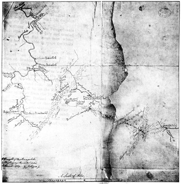
| I. | Shippen’s Draught of the Monongahela and Youghiogheny Rivers, and Braddock’s Road (1759) | 29 |
| II. | Frontier Forts and Blockhouses in 1756 | 51 |
| III. | Forbes’s Road to Raystown (1757) | 103 |
| IV. | The Remains of Bouquet’s Redoubt at Fort Pitt | 184 |
When General Edward Braddock landed in Virginia in 1755, one of his first acts in his campaign upon the Ohio was to urge Governor Morris to have a road opened westward through Pennsylvania. His reason for wishing another road, parallel to the one his own army was to cut, was that there might be a shorter route than his own to the northern colonies, over which his expresses might pass speedily, and over which wagons might come more quickly from Pennsylvania—then the “granary of America.”
It was inevitable that the shortest route from the center of the colonies to the Ohio would become the most important. The road Braddock asked Morris to open was completed only three miles beyond the present town of Bedford, Pennsylvania, when the road choppers hurried home on [Pg 10]receipt of the news of Braddock’s defeat.
Braddock made a death-bed prophecy; it was that the British would do better next time. In 1758 Pitt placed Braddock’s unfulfilled task on the shoulders of Brigadier-general John Forbes, who marched to Bedford on the new road opened by Morris; thence he opened, along the general alignment of the prehistoric “Trading Path,” a new road to the Ohio. It was a desperate undertaking; but Forbes completed his campaign in November, 1758 triumphantly—at the price of his life.
This road, fortified at Carlisle, Shippensburg, Chambersburg, Loudon, Littleton, Bedford, Ligonier, and Pittsburg became the great military route from the Atlantic seaboard to the trans-Allegheny empire. By it Fort Pitt was relieved during Pontiac’s rebellion and the Ohio Indians were brought to terms. Throughout the Revolutionary War this road was the main thoroughfare over which the western forts received ammunition and supplies. In the dark days of the last decade of the eighteenth century, when the Kentucky and Ohio pioneers were fighting for the foot[Pg 11]hold they had obtained in the West, this road played a vital part.
When the need for it passed, Forbes’s Road, too, passed away. Two great railways, on either side, run westward following waterways which the old road assiduously avoided—keeping to the high ground between them. Between these new and fast courses of human traffic the old Glade Road lies along the hills, and, in the dust or in the snow, marks the course of armies which won a way through the mountains and made possible our westward expansion.
The “Old Glade Road,” the old-time name of the Youghiogheny division (Burd’s or the “Turkey Foot” Road) of this thoroughfare, has been selected as the title of this volume, as more distinctive than the “Pennsylvania Road,” which would apply to numerous highways.
A. B. H.
Marietta, Ohio, December 30, 1902.
When, in the middle of the eighteenth century, intelligent white men were beginning to cross the Allegheny Mountains and enter the Ohio basin, one of the most practicable routes was found to be an old trading path which ran almost directly west from Philadelphia to the present site of Pittsburg. According to the Indians it was the easiest route from the Atlantic slope through the dense laurel wildernesses to the Ohio.[1] The course of this path is best described by the route of the old state road of Pennsylvania to Pittsburg built in the first half-decade succeeding the Revolutionary War. This road passed through Shippensburg, Carlisle, Bedford, Ligonier, and Greensburg; the Old Trading Path passed, in general, through the[Pg 16] same points. Comparing this path, which became Forbes’s Road, with Nemacolin’s path which ran parallel with it, converging on the same point on the Ohio, one might say that the former was the overland path, and the latter, strictly speaking, a portage path. The Old Trading Path offered no portage between streams, as Nemacolin’s path did between the Potomac and Monongahela. It kept on higher, dryer ground and crossed no river of importance. This made it the easiest and surest course; in the wintry season, when the Youghiogheny and Monongahela and their tributaries were out of banks, the Old Trading Path must have been by far the safest route to the Ohio; it kept to the high ground between the Monongahela and Allegheny. It was the high ground over which this path ran that the unfortunate Braddock attempted to reach after crossing the Youghiogheny at Stewart’s Crossing. The deep ravines drove him back. There is little doubt he would have been successful had he reached this watershed and proceeded to Fort Duquesne upon the Old Trading Path.
As is true of so many great western[Pg 17] routes, so of this path—the bold Christopher Gist was the first white man of importance to leave reliable record of it. In 1750 he was employed to go westward for the Ohio Company. His outward route, only, is of importance here.[2] On Wednesday, October 31, he departed from Colonel Cresap’s near Cumberland, Maryland and proceeded “along an old old Indian Path N 30 E about 11 Miles.”[3] This led him along the foot of the Great Warrior Mountain, through the Flintstone district of Allegheny County, Maryland. The path ran onward into Bedford County, Pennsylvania, and through Warrior’s Gap to the Juniata River. Here, near the old settlement Bloody Run, now Everett, the path joined the well-worn thoroughfare running westward familiarly known as the “Old Trading Path.” Eight miles westward of this junction, near the present site of Bedford, a well-known trail to the Allegheny valley left the Old Trading Path and passed through the Indian Frank’s Town and northwest to the French Venango[Pg 18]—Franklin, Pennsylvania. Leaving this on his right, Gist pushed on west over the Old Trading Path. “Snow and such bad Weather” made his progress slow; from the fifth to the ninth he spent between what are now Everett in Bedford County and Stoyestown in Somerset County.[4] On the eleventh he crossed the north and east Forks of Quemahoning—often called “Cowamahony” in early records.[5] On the twelfth he “crossed a great Laurel Mountain”—Laurel Hill. On the fourteenth he “set out N 45 W 6 M to Loylhannan an old Indian Town on a Creek of Ohio called Kiscominatis, then N 1 M NW 1 M to an Indian’s Camp on the said Creek.”[6] The present town of Ligonier, Westmoreland County, occupies the site of this Indian settlement. “Laurel-hanne, signifying the middle stream in the Delaware tongue. The stream here is half way between the Juniata at Bedford and the Ohio [Pittsburg].”[7] Between here and the Ohio, Gist[Pg 19] mentions no proper names. The path ran northwest from the present site of Ligonier, through Chestnut Ridge “at the Miller’s Run Gap, and reached the creek again at the Big Bottom below the present town of Latrobe on the Pennsylvania Central Railway; there the trail forked ... the main trail [traveled by Gist], led directly westward to Shannopin’s Town, by a course parallel with and a few miles north of the Pennsylvania Railway.”[8]
The following table of distances from Carlisle to Pittsburg was presented to the Pennsylvania Council March 2, 1754:
| MILES | |
| From Carlisle to Major Montour’s | 10 |
| From Montour’s to Jacob Pyatt’s | 25 |
| From Pyatt’s to George Croghan’s at Aucquick Old Town[9] | 15 |
| From Croghan’s to the Three Springs | 10 |
| [Pg 20]From the Three Springs to Sideling Hill | 7 |
| From Sideling Hill to Contz’s Harbour | 8 |
| From Contz’s Harbour to the top of Ray’s Hill | 1 |
| From Ray’s Hill to the 1 crossing of Juniata[10] | 10 |
| From 1 crossing of Juniata to Allaquapy’s Gap[11] | 6 |
| From Allaquapy’s Gap to Ray’s town[12] | 5 |
| From Ray’s town to the Shawonese Cabbin[13] | 8 |
| From Shawonese Cabbins to the Top of Allegheny Mountain | 8 |
| From Allegheny Mountain to Edmund’s Swamp[14] | 8 |
| From Edmund’s Swamp to Cowamahony Creek[15] | 6 |
| From Cowamahony to Kackanapaulins | 5 |
| [Pg 21]From Kackanapaulins To Loyal Hanin[16] foot Ray’s Hill | 18 |
| From Loyal Hanin to Shanoppin’s Town[17] | 50 |
By this early measurement the total distance between Carlisle to Pittsburg by the Indian path was one hundred and ninety miles; ninety-seven miles from Carlisle to Raystown and ninety-three miles from Raystown to Pittsburg.[18] When it is remembered that this was the original Indian track totally uninfluenced by the white man’s attention it is interesting to note that the great state road of Pennsylvania from Carlisle to Pittsburg, laid out in 1785, so nearly followed the Indian route that its length between those points (in 1819) was just one hundred and ninety-seven miles—seven miles longer[19] than[Pg 22] that of the prehistoric trace of Indian and buffalo. Perhaps there is no more significant instance of the practicability of Indian routes in the United States than this. The very fact that the Indian path was not very much shorter than the first state road shows that it was distinctively a utilitarian course. One interested in this significant comparison will be glad to compare the courses of the old path and that of the state road as given by the compass.[20]
Other references to the Old Trading Path are made by such traders as George Croghan and John Harris. Croghan wrote to Richard Peters, March 23, 1754: “The road we now travel ... from Laurel Hill to Shanopens (near the forks of the Ohio), is but 46 miles, as the road now goes, which I suppose may be 30 odd miles on a straight line.”[21] In an “Account of the Road to Loggs Town on Allegheny River, taken by John Harris, 1754” this itinerary is given:[Pg 23]
| “From Ray’s Town to the Shawana Cabbins | 8 M |
| To Edmund’s Swamp | 8 M |
| To Stoney Creek | 6 M |
| To Kickener Paulin’s House, (Indian) | 6 M |
| To the Clear Fields | 7 M |
| To the other side of the Laurel Hill | 5 M |
| To Loyal Haning | 6 M |
| To the Big Bottom | 8 M |
| To the Chestnut Ridge | 8 M |
| To the parting of the Road[22] | 4 M |
| Thence one Road leads to Shannopin’s Town the other to Kisscomenettes, old Town.”[23] |
So much for the Old Trading Path before the memorable year of 1755. It is signifi[Pg 24]cant that the route had already been “surveyed”; Pennsylvania herself desired a share of the Indian trade which Virginia hoped to monopolize through her Ohio Company, which already had storehouses built at Wills Creek on the Cumberland and at Redstone Old Fort on the Monongahela. But with the beginning of hostilities with the French, precipitated by Washington and his Virginians in 1754, the Indian trade was now completely at a standstill.
General Braddock and his army which was destined to march westward and capture Fort Duquesne arrived at Alexandria, Virginia, February 20, 1755. Already Braddock’s deputy quartermaster-general, Sir John St. Clair, had passed through Maryland and Virginia and had decided upon the route of the army to Fort Cumberland, the point of rendezvous. Four days after Braddock reached Alexandria, Governor Morris of Pennsylvania received a letter from St. Clair asking him to “open a road toward the head of Youghheagang or any other way that is nearer the French forts,” in order that the stores to be sup[Pg 25]plied by the northern colonies might take a shorter course than by way of the roads then being opened through Maryland and Virginia.[24] Morris immediately replied “... there is no Waggon Road from Carlisle West through the Mountains but only a Horse Path, by which the Indian Traders used to carry their Goods and Skins to and from the Ohio while that Trade remained open.”[25] Though Morris usually made requests of the assembly in vain, the request concerning this road was granted, and Morris was empowered, in the middle of March, to open a road “through Carlisle and Shippensburg to the Yoijogain, and to the camp at Will Creek.”[26] He immediately appointed George Croghan, John Armstrong, James Burd, William Buchannan, and Adam Hoops to find a road to the three forks of the Youghiogheny—or “Turkey Foot” as the spot was familiarly known on the frontier. On April 29 Burd reported as follows to Morris: “... We have viewed and layed out the Roads[Pg 26] leading from hence to the Yohiogain and the camp at Will’s Creek, and enclosed You have the Draughts thereof.... We have dispersed our Advertisements through the Counties of Lancaster, York, and Cumberland, to encourage Labourers to come to Work, and We intend to set off to begin to clear up on Monday first.”[27] Thus, slowly, the Old Trading Path was widened into a rough roadway westward from Carlisle. On May 26, John Armstrong wrote Governor Morris that there were over a hundred choppers at work.[28] Five days later Burd wrote Richard Peters that there were one hundred and fifty at work; but he adds, ominously: “The People are all anxious to have arms, and if You can procure me arms I would not trouble the General for a cover; but if you can’t they will not be willing to go past Ray’s Town without a guard.”[29] Little wonder: the van of Braddock’s army had struck westward into the Alleghenies the day before this was written, and already the woods[Pg 27] were full of spies sent out by the French, and many massacres had been reported. The horses and wagons which Franklin had secured for Braddock comprised almost his whole equipment. These had gone to Fort Cumberland by the old “Monocasy Road” and Watkins Ferry.[30]
On the twelfth of June Allison and Maxwell wrote Richard Peters that “Sideling Hill,” sixty-seven miles west of Carlisle, and thirty miles east of Raystown, “is cut very artificially, nay more so than We ever saw any; the first waggon that carried a Load up it took fifteen Hundred without ever stopping;” there were, however, many discouragements—“for four Days the Labourers had not one Glass of Liquor!”[31] On June 15 William Buchannan reported that the road was cleared to Raystown.[32] But some of the wagons were “pretty much damnified.” On the seventeenth Edward Shippen wrote Morris from Lancaster: “I understand Mr. Burd has[Pg 28] cut the Road 5 Miles beyond Ray’s Town, which is 90 Miles from Shippensburg.”[33] On the twenty-first General Braddock wrote as follows to Governor Morris from Bear Camp (seven miles west of Little Crossings): “As it is perfectly understood here in what Part the Road making in your Province is to communicate wth that thro’ wch I am now proceeding to Fort Du Quesne, I must beg that you and Mr Peters will immediately settle it, and send an express on Purpose after me with the most exact Description of it, that there may be no Mistake in a Matter of so much Importance.”[34] On July 3 Morris wrote Burd, who was in command of the working party, concerning this request of Braddock’s. He takes it “for granted ... that the Road must pass the Turkey Foot ... and that there cou’d be no Road got to the Northward.” Under such circumstances he affirmed that the nearest course to Braddock’s Road would be a straight line from Turkey Foot (Confluence, Pennsylvania) to the Great Crossings of the Youghiogheny[Pg 31] (Smithfield, Pennsylvania). He asked Burd to settle this point and send his decision immediately to Braddock.[35]
Click here for larger image size
Shippen’s Draught of the Monongahela and Youghiogheny Rivers and Braddock’s Road (1759)(Great Crossings was the intended junction of Paddock’s Road and Burd’s)
(From the original in possession of Pennsylvania Historical Society)
The working party on the Pennsylvania road was attacked early in July and needed every one of the five score men whom Braddock had been able to spare for their protection.[36]
Burd replied[37] from the “Top of the Alleghanies” on July 17, while still in ignorance of Braddock’s utter rout: “At present I can’t form any Judgment where I shall cut the General’s Road, further than I know our Course leads us to the Turkey Foot, By the Information of Mr. Croghan when we run the Road first. Mr. Croghan assured me he wou’d be on the Road with me in order to pilott from the Place where we left off blaizeing. Instead of that he has never been here, nor is there one Man in my Company that ever was out this Way to the Turkey Foot, But the Party I send will discover the Place where we shall cut the Road and inform the General, and upon[Pg 32] their return I will order ’em to blaize back to me.”
The news of Braddock’s defeat came slowly to the cutters of this historic roadway from central Pennsylvania to the Youghiogheny. On Tuesday night, July 15, a messenger was sent to them from Fort Cumberland, who arrived the night of the day the above letter was written.[38] Dunbar wrote Morris from “near ye great Crossings” on the sixteenth: “I have sent an Express to Captain Hogg, who is covering the People cutting Your New Road, as I can’t think his advancing that Way safe, to retire immediately.”[39] Burd reported to Morris from Shippensburg July 25, that his party had retreated to Fort Cumberland from the top of Allegheny Mountain July 17; “St Clair told Me,” he added, tentatively, “that I had done my Duty.” He had left before Dunbar’s messenger had arrived.[40]
Such is the first chapter of the story of[Pg 33] the white man’s occupation of the Old Trading Path and the Old Glade Road—the name commonly applied to the portion which Burd opened from the main path from where it diverged four miles west of Bedford to the summit of Allegheny Mountain. This branch was also known as the “Turkey Foot Road.”[41] The Old Trading Path was now a white man’s road from Carlisle to Bedford and four miles beyond. But the tide of war now set over the mountains after Braddock’s defeat, putting an end to any improvement of the new rough road that was opened. Yet not all the ground gained was to be lost. Governor Shirley, now in command, wildly ordered Dunbar to move westward again to retrieve Braddock’s mistakes, but sanely added, that, in the case of defeat “You are to make the most proper Disposition of his Majesties’ Forces to cover the Frontiers of the Provinces, particularly at the Towns of Shippensburg and Carlisle, and at or near a place called McDowell’s Mill, where the New Road to the Allegheny[Pg 34] Mountains begins in Pennsylvania, from the Incursions of the Enemy until you shall receive further orders.”[42]
Was this a hint that Braddock had been sent by a wrong route and that his successor would march to Fort Duquesne over the Old Trading Path?
There is no truer picture of the dark days of 1755-56 along the frontiers of Pennsylvania and Virginia than that presented in the correspondence of Washington at this time. A great burden fell upon his young shoulders with the failure of the campaigns of 1755. Though far from being at fault, he suffered greatly through the faults and failures of others. The British army had come and had been routed. Now, after such a victory as the Indians had never dreamed possible, the Virginia and Pennsylvania frontiers, five hundred miles in length, lay helpless before the bands of bold marauders drunk with the blood of Braddock’s slain.
The young colonel of the remnant of the Virginia Regiment took up the difficult task of defending the southern frontier as readily as though a quiet, happy life on[Pg 36] his rich farms was an alternative as impossible as alluring. But perhaps a bleeding border-land never in the world needed a twenty-three year old lad more than Virginia now needed her young son. A flood-tide of murder and pillage swept over the Alleghenies. The raids of the savages brought the people to their senses, as the most terrible of tales came in from the frontier. But soon the question arose, “Where is the frontier?” The great track Braddock had opened for the conquest of the Ohio valley became the pathway of his conquerors, and soon Fort Cumberland, the frontier post, was far in the enemies’ country. The Indians soon found Burd’s road on the summit of the Alleghenies and poured over it by Raystown toward Carlisle and Shippensburg. Each day brought the line of settlements nearer and nearer the populous portions of Virginia and Pennsylvania, until Winchester became an endangered outpost and fears were entertained for Lancaster and York. Hundreds now who had refused the despairing Braddock horses and wagons saw their wives and children murdered[Pg 37] and their homesteads burned to the ground.
Whether Dunbar did right or wrong in hurrying back to Virginia, it was a bitter day for Virginia and Pennsylvania. When his army hastened from the frontier, it became the prey of the foes whose appetite that army had whetted. Yet Shirley, reconsidering his former scheme, ordered Dunbar to New York. After drawing the full fire of the French and Indians upon Virginia and Pennsylvania, this army was sent to New York.
Looking backward, with the stern years 1775-82 in mind, it is easy to see that then, in 1755, Pennsylvania and Virginia were to be put through a hard school for a glorious purpose. They were to be trained in the art of war. Of it they had known practically nothing. They had no effective militia. Of military ethics they had no dream. They knew not what obedience meant and could not understand delegated authority. Their liberty was license or nothing. Of the power of organization, concentration, discipline, routine, and method they were almost as ignorant as their redskinned enemies. Although the[Pg 38] men of New England had not been given such great obstacles to overcome, it is undoubtedly true that their militia was far more adequate than anything of which Pennsylvania or Virginia knew, at least until 1758.[43] And yet Braddock died cursing his regulars and extolling the colonials!
Washington was elected commander-in-chief in Virginia on his own dignified terms; the army was increased to sixteen companies and £40,000 were voted for general defense. By October the young commander was at Winchester, where he faced a situation desperate and appalling. The country-side was terror-stricken, and few could be found even for defense; many chose “to die with their wives and families.” The few score men who[Pg 39] attempted to stem the tide of retreat were almost powerless. “No orders are obeyed,” Washington wrote Dinwiddie, “but such as a party of soldiers, or my own drawn sword enforces.” Such was the frenzy of the retreat of the frontier population that threats were made “to blow out the brains” of all in authority who opposed them. But the young commander continued undaunted. He impressed men and horses and wagons, and sent them hurrying for flour and musket-balls and flints; he compelled men to erect little fortresses to which the people might flee.
Not the least of his trials—undoubtedly the most discouraging—was the faithlessness of the troops sent out by Governor Dinwiddie upon the reeking frontier. Many of them were themselves panic-stricken and fled back with the rabble. The whole militia régime was inadequate; there was no authority of sufficient weight vested in the commanding officers to enable them to deal even with insolence, much less desertion. “I must assume the freedom,” Washington wrote the governor, “to express some surprise, that we alone[Pg 40] should be so tenacious of our liberty as not to invest a power, where interest and policy so unanswerably demand it.... Do we not know, that every nation under the sun finds its account therein, and that, without it, no order or regularity can be observed? Why then should it be expected from us, who are all young and inexperienced, to govern and keep up a proper spirit of discipline without laws, when the best and most experienced can scarcely do it with them?”
As the winter of 1755-6 approached, the Indian atrocities ceased and for a few months there was quiet. But by early spring the raids were renewed with merciless regularity. Every day brought a new tale of murder and pillage; and very soon every road was filled with fugitives “bringing to Winchester fresh dismay.”
With his few men this first hero of Winchester (who by the way was at his post, not “twenty miles away”) was again straining every nerve that Virginia might not lose the great stretch of beautiful country west of the Blue Ridge. “The supplicating tears of women and moving[Pg 41] petitions of the men, melt me into such deadly sorrow, that I solemnly declare, if I know my own mind, I could offer myself a willing sacrifice to the butchering enemy, provided that would contribute to the people’s ease.” Perhaps the vacillating Dinwiddie threw this letter down as too ardent a one for a military hand to pen; if so Edward Everett has raised it aloft to show his thrilled audiences “the whole man” Washington. “The inhabitants are removing daily,” he again wrote—“... in a short time will leave this country as desolate as Hampshire.” To such a degree were the people terrified that secret meetings were held where leaders openly spoke of making terms with the French and Indians by renouncing all claims to the West—no less traitors to the best good of the colonies than those who celebrated over Braddock’s defeat.[44]
The campaign of 1756, as conducted by Shirley, contained no hope of relief for Pennsylvania or Virginia; “so much am I kept in the dark,” Washington exclaimed, “that I do not know whether to prepare for[Pg 42] the offensive or defensive; yet what might be absolutely necessary in the one, would be quite useless in the other.” He well knew a determined stroke at Fort Duquesne, “a floodgate to open ruin and woe,” was the only hope of the southern and central colonies. In the meantime he led a desperately exasperating life attempting to hold the frontier with his tatterdemalion army by following Pennsylvania’s example of building a line of forts to defend the country. There was no destitution or distress of which he did not know; at times he was begging for blankets to cover his naked soldiers, and again for shoes and shirts; there were few guns in a state of repair and at times in days of danger hundreds flocked to him who could neither be fed nor armed. His life must have been known to Lord Fairfax who wrote in the following strain: “Such a medley of undisciplined militia must create you various troubles, but having Cæsar’s Commentaries and perhaps Quintus Curtius, you have therein read of greater fatigues, murmurings, mutinies, and defections, than will probably come to your share.” The fact[Pg 43] is, in these days there was no officer’s duty with which Washington was not acquainted. He supervised the building of forts, the transportation of stores and guns and ammunition, here reprimanding a coarse mountaineer for profanity, there leading the scouts as they threshed a mountain for lurking Delawares; he personally hurried off wagons to endangered outposts with flour and powder, and then listened to and quieted the fears of frantic women and men.
Is the splendid lesson of these years clear? By Providential dispensation these colonies were a miniature of the America of 1775, suddenly thrown upon its own resources and in war. The divine hand is not more clearly seen in our national development than in the struggle of the colonies between 1745 and 1763, which prepared a nation for the hour her independence should strike. And now it was that Washington, Gates, Mercer, Gladwin, Lewis, Putnam, Crawford, Gibson, Stephen, St. Clair, and Stewart learned for themselves and then taught their countrymen to fight; now Washington found what it meant to[Pg 44] be the commander of bare-foot armies, already a hero of two defeats, he was yet to play the hero in bitter, pitiful extremities, to become a dogged believer in hopeless, last alternatives, a burden-bearer for hundreds of homeless ones—a people’s mainstay when other men were faltering. Now, as in 1775, his task was to rouse a people only half awake to the crisis; to demonstrate the superiority of wisely ordered liberty over license, and the inferiority of personal independence compared with a unity made strong through faithful coöperation, and hallowed by mutual self-sacrifice. And fortunate it was for all the colonies that England compelled them to learn how to carry war’s heavy harness now, against the day when they should be assailed by something more disastrously fatal to the cause of liberty than savages fired to murder and pillage by French brandy.
In all these wild days, the old path westward from Shippensburg and Carlisle was often crowded with fugitives fleeing from the reeking frontier, and, quite as often, shrouded in a cloud of dust raised by squads[Pg 45] of wan militia hastening westward to the defense of the outposts. Though no officer guarding this strategic passage-way became endeared to his countrymen as Washington, here heroism and devotion were displayed, if ever on this continent. The plans of England during these years will be described elsewhere, but it is to our purpose to know now that for the present she deserted the southern provinces; that she was “willing to wait for the rains to wet the powder, and rats to eat the bow-strings of the enemy, rather than attempt to drive them from her [southern] frontiers.” Until 1756 the matter of the defense of the Pennsylvania frontier was left almost entirely to individual initiative. But already the road through Carlisle and Shippensburg had been fortified. Fort Lowther was erected in Carlisle as early as 1753. It was an important post on the route to Virginia, over which the wagons and horses raised by Franklin for Braddock, were, in part, forwarded to Fort Cumberland. Here Governor Morris came, to be in closer touch with Braddock, and here the news of the defeat reached him.[Pg 46]
Fort Franklin was erected on the old road at Shippensburg, twenty miles west of Carlisle and thirty-six from Harris Ferry (Harrisburg). It was built sometime previous to Braddock’s time but was not used after 1756. Ten miles further on at Falling Springs (Chambersburg) there was no fortification in 1755, nor was there one at Loudoun (Loudon) thirteen miles west of that point. Two miles south of Fort Loudoun Morris erected a deposit at McDowell’s Mill (Bridgeport, Franklin County) but, though the spot was well known on the frontier, there seems to have been no regular fort there until 1756.[45] It was at this point that the new road toward Raystown diverged westward from the main road running south to Virginia. This junction was considered a strategic point by the time of Braddock’s defeat, as shown by Shirley’s order to Dunbar quoted at the close of the last chapter.
Up to the time of Braddock’s defeat the Pennsylvania Assembly had done nothing toward the preservation of the colony, save ordering the road cut from Carlisle to the[Pg 47] Youghiogheny river. They furnished not a man for Braddock’s army and voted not a pound toward the expense of securing the wagons and horses which made Braddock’s march possible. The stores which Governor Morris laid in along the line of the road, at Shippensburg and McDowell’s Mill, were secured and forwarded without aid from the Assembly. Though many Pennsylvanians served, in one way or another, in the unfortunate expedition, the public was divided on this issue. Some were loyal to the Assembly and many favored warlike measures. It has been asserted that had not Forbes’s Road been built in 1758 its building would have been postponed twenty years.
Passing this interesting speculation, it is sure Braddock’s defeat brought to Pennsylvania a terrible and bloody awakening; nothing can show this more strikingly than the fact that when Braddock’s successor came, only three years later, the Pennsylvania Assembly quickly supported him by voting twenty-seven hundred men for offensive service and appropriating half a million dollars for war.[Pg 48]
The change was not more striking than was the need for it. All the terrifying scenes in Virginia were reproduced in Pennsylvania; the savages poured through the mountain gaps and fell with unparalleled fury upon a hundred defenseless settlements. Pennsylvania had not expanded further at this time than to the Blue Mountains. Her frontier was not, therefore, nearly as broad as Virginia’s, and the frontier firing-line was not so far removed from the populated districts. At the same time it is probable that the Indians from Logstown and Kittanning could get a scalp quicker (so far as distance was concerned) from Pennsylvania than from Virginia—and the French paid as much for one as for the other!
Late in 1756 the Pennsylvania Assembly, now awakened to the condition of affairs caused by their shortsighted, prejudiced policy, took the matter of protection of the frontier into their own hands. Failing to furnish the ounce of prevention, they came quickly with the pound of cure. A chain of forts was planned which, stretching along the barrier wall of the Blue Moun[Pg 49]tains from the Potomac to the Delaware, should guard the more prominent gaps. “Sometimes the chain of defenses ran on the south side, and frequently both sides of the mountains were occupied, as the needs of the population demanded. Some of these forts consisted of the defenses previously erected by the settlers, which were available for the purpose, and of which the government took possession, while others were newly erected. Almost without exception they were composed of a stockade of heavy planks, inclosing a space of ground more or less extensive, on which were built from one to four blockhouses, pierced with loopholes for musketry, and occupied as quarters by the soldiers and refugee settlers. In addition to these regular forts it became necessary at various points where depredations were most frequent, to have subsidiary places of defense and refuge, which were also garrisoned by soldiers and which generally comprised farmhouses, selected because of their superior strength and convenient location, around which the usual stockade was thrown, or occasionally blockhouses erected[Pg 50] for the purpose. The soldiers who garrisoned these forts were provincial troops, which almost without exception were details from the First Battalion of the Pennsylvania Regiment, under the command of that brave and energetic officer, Lt. Colonel Conrad Weiser.”[46] The appended map is a photograph of the original which was made in this year, 1756—for the forts of 1757 are not included. It is of particular interest because it gives the complete cordon of forts along the frontier from the Hudson to the last fort in Virginia which Washington was building. Among other things this map shows clearly how much wider were the frontiers of the southern than those of the northern colonies. The most westerly fort in Virginia was fifty miles further west than Fort Duquesne. The Appalachian range trends southwesterly and its influence upon the expansion of the colonies is most significant.
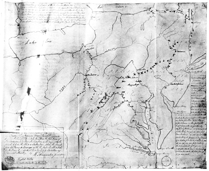
Click here for larger image size
Frontier Forts and Blockhouses in 1756(From the original in British Public Records Office)
In this year, though a western campaign on Fort Duquesne did not materialize, the line of the old road was greatly strengthened and a blow was struck at the Indians[Pg 53] on the Allegheny that was timely and effective. The former was a most important task—of far greater importance than was dreamed at that date. No one then knew the part this road westward from Carlisle was to play in our national development; it could not have been conceived, in 1756, that this route was to be the only fortified highway into the West—the most important military road of equal length on the continent throughout the eighteenth century.
That Fort Lowther at Carlisle was in ruins in 1756 is shown by the following letter written by William Trent to Richard Peters February 15, 1756, which also gives a realistic picture of the state of affairs which compelled the Pennsylvania Assembly to begin the fort-building of that year: “All the people had left their houses, betwixt this and the mountain, some come to town and others gathering into the little forts.[47] They are moving their effects from Shippensburg; every one thinks of flying unless the Government fall upon some effectual method, and that immediately, of[Pg 54] securing the frontiers, there will not be one inhabitant in this Valley one month longer. There is a few of us endeavoring to keep up the spirits of the people. We have proposed going upon the enemy tomorrow, but whether a number sufficient can be got, I cannot tell; no one scarce seems to be affected with the distress of their neighbours and for that reason none will stir but those that are next the enemy and in immediate danger. A fort in this town would have saved this part of the country, but I doubt this town in a few days, will be deserted, if this party [of savages] that is out should kill any people nigh here.” Commissioner Young was at Carlisle soon after, putting Fort Lowther into proper condition; he wrote Governor Morris: “I have endeavored to put this large fort in the best possible defense I can; but I am sorry to say the people of this town cannot be prevailed on, to do anything for their own safety.... They seem to be lulled into fatal security, a strange infatuation, which seems to prevail throughout this province.” The fort was not completed in July; Colonel Armstrong[Pg 55] wrote Morris on the twenty-third of that month. “The duties of the harvest field have not permitted me to finish Carlisle Fort with the soldiers, it should be done otherwise, the soldiers cannot be so well governed, and may be absent or without the gates at the time of the greatest necessity.” In the same letter Colonel Armstrong—the Washington of Pennsylvania—wrote: “Lyttleton, Shippensburg and Carlisle (the two last not finished) are the only forts now built that will in my opinion be serviceable to the public.” It is significant that these three forts were on the old road westward, showing that this route was of utmost importance in Armstrong’s eyes.
Fort Lyttleton was one of four important forts erected, at Armstrong’s direction, by Governor Morris west of the Susquehanna late in 1755 and early in 1756. It was built “at Sugar Cabins upon the new road”; wrote Morris to Shirley February 9: “It [Fort Lyttleton] stands upon the new road opened by this Province towards the Ohio, and about twenty miles from the settlements, and I have called it Fort Lyttleton, in honor of my friend George. This fort[Pg 56] will not only protect the inhabitants in that part of the Province, but being upon a road that within a few miles joins General Braddock’s road, it will prevent the march of any regulars into the Province and at the same time serve as an advance post or magazine in case of an attempt to the westward.” The site of this fort was on land now owned by Dr. Trout, of McConnellsburg, Pennsylvania—about sixty feet on the north side of the old state road.[48]
Fort Morris at Shippensburg was building in November 1755; “we have one hundred men working,” wrote James Burd, “... with heart and hand every day. The town is full of people, five or six families in a house, in great want of arms and ammunition; but, with what we have we are determined to give the enemy as warm a reception, as we can. Some of our people have been taken prisoners, but have made their escape, and came to us this morning.” There had, as noted, been some sort of fortification here at an earlier date, Fort Franklin. As said previously, Fort Morris was still uncompleted July 23,[Pg 57] 1756. It was in Fort Franklin, undoubtedly, that the magazine was placed during Braddock’s campaign. Fort McDowell, at McDowell’s Mill, was also erected in 1756, being an important point at the junction of the old road into Virginia and the new road to Raystown. The savage onslaughts of the Indians were felt no more severely in any quarter than near here. At Great Cove, in November 1755, forty-seven persons were murdered or taken captive out of a total population of ninety-three. The strategic position of Fort McDowell at the junction of the roads was emphasized by Colonel Armstrong, who, after saying that Forts Lyttleton, Shippensburg, and Carlisle were the only ones that would be useful to the public, added: “McDowell’s, or thereabouts, is a necessary post; but the present fort is not defensible.”
Fort Loudoun was erected on the old road in 1756, one mile east of the present village of Loudon, Franklin County. The spot was historic even before it was fortified, the settlement here being one of the oldest in that section of the state. This point was a famous rendezvous both in the[Pg 58] early days when the Old Trading Path was the main western highway, and in after days when the path became Forbes’s Road. From here the pack-horse trains started westward into the mountains loaded—two hundred pounds to a horse—with goods which had come this far in wagons from Lancaster and Philadelphia. The site of Fort Loudoun therefore marks the western extremity of the early colonial roadways and the eastern extremity of the “packers’ paths” or trading paths which offered, until 1758, the only route across the mountains.[49] Fort Loudoun was built late in 1755, after considerable debate as to its location. Colonel Armstrong, after examining a spot near one Barr’s, finally determined to locate it “on a place in that neighborhood, near to Parnell’s Knob, where one Patton lives ... as it is near the new road; it will make the distance from Shippensburg to Fort Lyttleton two miles further than by McDowell’s.”
Ten miles southwest of Shippensburg,[Pg 59] Benjamin Chambers, a noted pioneer, erected Fort Chambers at Falling Spring, the present Chambersburg. It was a private fort completed in 1756; by some means the owner had secured two four-pound cannon which he mounted in his little fort, the roof of which he had already covered with lead. It was feared that Chambers’s little fort would be captured by the savages and the guns turned upon Shippensburg and Carlisle. But their owner repudiated the insinuation and even held the guns from Colonel Armstrong, who was armed with the governor’s order to surrender them. Incidentally, also, he made good his boasts and held the fort with equal pugnacity from the savages. Colonel Chambers was of great assistance to General Forbes in the days of 1758, and, as an aged man, sent his three sons, raised in the lead-roofed fortress with its “Great Guns,” to Boston in 1775 to fight again for the land he had helped to conquer from the Indians in the dark days of Braddock and Forbes. Such men as Benjamin Chambers made Forbes’s Road a possibility. The state road built westward over the track of[Pg 60] Forbes’s and Bouquet’s armies is well known in eastern Pennsylvania as the “Chambersburg and Pittsburg turnpike.”[50]
These forts west of the Susquehanna were garrisoned by the eight companies of the second battalion of the Pennsylvania regiment. While the work of completing the forts not yet finished went on, a campaign of more importance than was realized was conceived by ex-Governor Morris and explained to Governor Denny and the Council. It comprised a bold stroke by Lieutenant-colonel Armstrong at the Indian-infested region of Kittanning on the Allegheny. Here the Delaware Captain Jacobs held bloody sway, having, according to the report of an Indian spy who had recently visited the spot, nearly one hundred white prisoners from Virginia and Pennsylvania captive at that point.
Fort Shirley was appointed the place of rendezvous and the little campaign was kept as secret as possible. As the map shows, Fort Shirley (no. 23), Fort Lyttleton (no. 24) and Shippensburg form a triangle, the longest side of which marks the straight[Pg 61] line between the two latter posts. Fort Loudoun was near this line between Fort Lyttleton and Fort Morris at Shippensburg. Near Fort Loudoun a branch of the old Kittanning Path ran northwesterly by Fort Shirley and onward to the Allegheny.[51] Over this track the bold band, which rendezvoused at Fort Shirley late in August, was to enter the Indian land. It numbered three hundred and seven men, almost precisely the size of Washington’s party which precipitated war in 1754. But with the gloomy fate of Washington’s band and Braddock’s army in mind this must have been a thoughtful company of men that proceeded from Fort Shirley on the next to the last day of August 1756. Their success was all out of proportion to their expectation but not out of proportion to their bravery. Within a week Kittanning was reached, surrounded when it was darkest before dawn, and savagely attacked in the grey of the misty morning. The town was utterly destroyed, some three score savages killed and eleven prisoners rescued and brought back over the mountains.[Pg 62] The moral effect of this dash toward the Allegheny was of exceeding benefit to the whole frontier, and Armstrong—always feared by the Indians—became their especial bête noire. The expedition, having been made from lethargic Pennsylvania, had a wholesome effect upon all the other colonies and did much to cement them into the common league which accomplished much before two years had passed. Armstrong, as one of the builders of the new road through Raystown, as efficient officer in the work of fortifying this route, and now as leader of an offensive stroke at once daring and successful, was slowly being fitted for more useful and more important duties when the flower of Pennsylvania’s frontier should be thrown across the Alleghenies upon Fort Duquesne.
This officer’s opinion, already quoted, that the only forts worth the candle west of the Susquehanna were the three or four which fortified the main route westward from Carlisle to Raystown, appears to have met the approval of those in authority by 1757; on April 10, Governor Denny wrote to the Proprietaries: “Four Forts only[Pg 63] were to remain over Susquehannah, viz., Lyttleton, Loudoun, Shippensburg, and Carlisle.”[52] If this is considered a backward step it must also be considered as a concentration of energy in a most telling manner. If the frontier from the Susquehanna to the Maryland line could not be held at every point the decision seems to have been that the line of the old road must be secured at all costs, whereupon all the public forts were abandoned save the four which guarded this western highway. But the decision meant more than this. It was in fact an offensive measure. Instead of holding a line of forts at the mountain gaps as a shield to the settlements, the line of the roadway westward was to be protected and even prolonged—a bristling sword-point stretching over the Alleghenies into the very heart of the French and Indian region. This is proved by the building of a new fort yet further west than Lyttleton—at Raystown, near the point where Burd’s road, cut in 1755 toward the Youghiogheny, left the Old Trading Path. This significant undertak[Pg 64]ing was evidently on the tapis early in the winter. On February 22, Armstrong wrote Burd: “This is all that can possibly be done, before the grass grows and proper numbers unite, except it is agreed to fortify Raystown, of which I, yet, know nothing.” On the fifth of May he addressed a letter to the governor in which he said: “... prompts me to propose to your Honour what I have long ago suggested, to the late Governor and gentlemen commissioners, that is the building a fort at Raystown without which the King’s business and the country’s safety can never be effected to the westward.... ’Tis true this service will require upwards of five hundred men, as no doubt they will be attacked if any power be at Fort Duquesne, because this will be a visible, large and direct stride to that place.” Thus it is clear that every step westward on the new-cut roadway from Fort Lyttleton toward Raystown was a step toward Fort Duquesne, and every fortification built on this track was a “visible, large and direct” stroke at the power of France on the Ohio. A fort was erected at Raystown within the year.
“Between the French and the earthquakes,” wrote Horace Walpole in 1758 to Mr. Conway, “you have no notion how good we have grown; nobody makes a suit of clothes now but of sackcloth turned up with ashes.” The years 1756 and 1757 were crowded with disappointments. With the miscarriage of the three campaigns of 1755, Governor Shirley became the successor of the forgotten Braddock and assembled a council of war at New York composed of Governors Shirley, Hardy, Sharpe, Morris, and Fitch, Colonels Dunbar and Schuyler, Majors Craven and Rutherford, and Sir John St. Clair. As though in very mockery, the king’s instructions to the betrayed and sacrificed Braddock were read to the council, after which General Shirley announced a scheme for campaigns to be conducted during the new[Pg 66] year. The new “generalissimo” proposed four campaigns: one army of five thousand men was to assemble at Oswego, four thousand of whom were to be sent to destroy, first, Fort Frontenac, then Forts Niagara, Presque Isle, La Bœuf, and Detroit; a second army of three thousand provincials was to march over Braddock’s Road against Fort Duquesne; an army of one thousand men was to advance to Crown Point on Lake Champlain and erect a fort there; a fourth army of two thousand men was to “carry fire and sword” up the Kennebec River, across the portage, and down Rivière Chaudière to its mouth near Quebec. The Council agreed, as councils will, to all this Quixotic program; insisting, however, that ten thousand men should be sent to Crown Point and six thousand to Oswego.
In spite of Shirley’s earnestness things moved very slowly, and the bickering between governors and assemblies and the jealousy of men out of power of those in power retarded every movement. The deadlock in Pennsylvania resulted in the abandonment of that province and Virginia so far as offensive measures were concerned,[Pg 67] and the two governors busied themselves in fortifying their smoking frontiers, as described above. And finally the northern campaigns toward the lakes came to a sudden stand when General Shirley was superseded in his command by Lord Loudoun who, lacking the sense to forward Shirley’s plans, officiously altered them completely at a time when everything depended on quick and concerted action. As a result, Loudoun moved northward at a snail’s pace.
It seemed as though affairs in America were momentarily paralyzed by the shock of the tremendous conflict now opened on the continent. On the eighteenth of May England had declared war on France and twenty-two days later France responded, and the most terrible conflict of the eighteenth century opened, in which the great Frederick eventually humbled, with England’s help, the three empresses whose hatred he had drawn upon himself. But while Louis sent an army of one hundred thousand against Frederick, he had yet twelve thousand to hurry over to New France to make good the successes of 1755. These sailed under that best and bravest of[Pg 68] Frenchmen since the days of Champlain, Montcalm, on the third of April. In three months Montcalm had swept down Lake Champlain to Fort Ticonderoga. Then, as if to make sport of his antagonist—Loudoun, who had abandoned Shirley’s Oswego scheme—Montcalm returned to Montreal, hurried with three thousand soldiers down the St. Lawrence and across to Oswego, which surrendered at once with its twelve hundred defenders. The outwitted Loudoun crawled slowly up to Lake George; the winter of 1756-57 came on, and the two commanders glared at each other across the narrow space of snow and ice that separated them. The two important campaigns planned by Shirley were utter failures, and the westward campaign against Fort Duquesne was not even attempted. The French were strengthening everywhere. “Whoever is in or whoever is out,” exclaimed Chesterfield, “I am sure we are undone both at home and abroad.... We are no longer a nation.” But one of Shirley’s coups had succeeded; Winslow captured Beauséjour. In the west Armstrong had razed the Indian town of Kittan[Pg 69]ning on the Allegheny. On the other hand these minor successes were far overbalanced by the destruction of Oswego and Fort Bull, between the Mohawk and Lake Oneida, and the menacing position Montcalm had assumed with the strengthening of Ticonderoga, Crown Point, and Frontenac.
Pitt, a fine example of a man too powerful to hold office with peace, was forced into the premiership again near the end of this black year of 1756. Parliament refused to support him, the Duke of Cumberland, captain-general of the army, opposed him, and the king hated him; early in April 1757 he was dismissed. England had found her man but the pigmies in power shrank from acknowledging him. With that sublime confidence which once or twice in a century betokens latent genius, Pitt exclaimed: “I am sure I can save this country, and that nobody else can.” Meantime Chesterfield was sighing: “I never saw so dreadful a time.” The year of 1757 dragged on as gloomily as its predecessor. Montcalm, master of the situation, pushed southward upon Fort William Henry on[Pg 70] Lake George, and General Webb at Fort Edward. Loudoun abandoned the scene and went gallantly sailing with the fleet against Louisbourg. Fort William Henry surrendered and Montcalm spread terror to Albany and New York. Had he pressed his advantage it is questionable if he could not have occupied the whole Hudson Valley. Why he did not could have been explained better in Quebec than in New York. It was ever the foe behind Montcalm that was his worst enemy, and which eventually compassed his ruin.
If official jealousies were now the bane of New France, incapacity until now had handicapped her enemies. When Pitt was forced out of office in April, England was “left without a government.” “England has been long in labor,” said the Prussian Frederick, “and at last she has brought forth a man.” Her hour was long delayed, but early in 1758 Pitt was again made Secretary of State with old Newcastle First Lord of the Treasury. “It was a partnership of magpie and eagle. The dirty work of government, intrigue, bribery, and all the patronage that did not affect the war,[Pg 71] fell to the share of the old politician. If Pitt could appoint generals, admirals, and ambassadors, Newcastle was welcome to the rest. ‘I will borrow the Duke’s majorities to carry on the government,’ said the new secretary.”[53]
Seldom indeed has the elevation of one man to power produced such almost instantaneous results as did the elevation of Pitt. The desperateness of England’s condition undoubtedly intensified, by contrast, the successes which came when he assumed full power. England had been fighting, not France and her allies, but the stars; all the bravery and sturdiness of her soldiers and sailors could not counteract the ignorance and incapacity of those who had heretofore commanded them. Now, capacity and ability were in league; like an electric shock the realization of this significant union passed from man to man. The people felt it, and the army and navy; the political pigmies about the throne felt it, as well as the king. Pitt, vain as any genius, asked for the latter’s confidence; the reply was “deserve it and you shall[Pg 72] have it”—and a Hanoverian king of England kept his word. “I shall now have no more peace,” he had sighed when Pelham died; and had not the reins of power soon passed into the hands of Pitt it is doubtful if he ever could have had peace with honor. It was the skilful surgeon’s knife that England needed, and no time for men who feared the sight of blood; the “Great Commoner” proved the skilful surgeon and at once gave England a motto Pelham never knew: “Neither fleet nor army should eat the bread of the nation in idleness.”
Pitt at once displayed a prime qualification for his post of honor by choosing with unfailing discernment men who should lead both fleets and armies from idleness into action. His American campaign of 1758 embraced three decisive movements, an attack on Louisbourg—stepping-stone to Quebec—an invasion upon Montcalm on Lake Champlain, and an expedition to Fort Duquesne. For these three movements he chose two of the three leaders. The two he chose completed their assignments with utmost courage and success. The third, Abercrombie, whom Pitt could not prevent[Pg 73] succeeding the incompetent Loudoun—met with defeat. As if to reaffirm his sagacity, Ferdinand of Brunswick, whom Pitt sent to Frederick the Great in the place of the disgraced Duke of Cumberland, was also signally victorious over the foes who had compelled the king’s brother, the year before, to sign a convention in which he promised to disband his army.
Admiral Boscawen set Amherst down before Louisbourg with fourteen thousand men at the beginning of June, young Wolfe leading the army up from the boats over crags which the French had left unguarded because they were, seemingly, inaccessible. At the same time Abercrombie was gathering his army, of equal strength, at the head of Lake George, preparatory to proceeding northward upon Fort Ticonderoga.
The command, of the Fort Duquesne campaign was given by Pitt to Brigadier John Forbes, a Scot, ten years younger than his century. Of Forbes little seems to be known save that he began life as a medical student; abandoning his profession for that of arms he made a brave and good officer. That Pitt chose him to retrieve[Pg 74] the dead Braddock’s mistakes speaks loudly of his commanding abilities; the numerous quotations from his correspondence given elsewhere in this monograph will present a clearer picture of this almost unknown hero than has ever yet been drawn. “Though a well-bred man of the world,” writes Parkman, “his tastes were simple; he detested ceremony, and dealt frankly and plainly with the colonists, who both respected and liked him.”[54] The correspondence between Forbes and his chief assistant, Lieutenant-colonel Henry Bouquet, a Swiss, commanding the regiment of Royal Americans, is convincing proof of the democratic plainness and whole-hearted earnestness of Braddock’s successor.
The condition of the frontiers of Virginia and Pennsylvania during the years succeeding Braddock’s defeat has been previously reviewed, and the greatness of the task now thrown upon General Forbes’s shoulders can be readily conceived. Yet there was much in his favor; the colonies were quite aroused to the danger. Pennsylvania and Virginia were at last ready to put[Pg 75] shoulder to shoulder in an attempt to drive the French from the Ohio. Pennsylvania promised Forbes twenty-seven hundred men; sixteen hundred were to come from Virginia and other of the southern provinces. Twelve hundred Highlanders from Montgomery’s regiment were given Forbes, also the Royal American regiment, made up largely of Pennsylvania Germans and officered by men brought for the purpose from Europe. The force, when at last gathered together, amounted to between six and seven thousand men. The very proportions of this army were its principal menace. No one believed that Fort Duquesne, far away in the forests beyond the mountains, could hold out against this formidable array. That the French, now being attacked simultaneously in the east and in the north, could send reënforcements to the Ohio was no more likely. But there still lay the Alleghenies, their crags and gorges. Could this large body of troops cross them and take provisions sufficient to support men and horses? As with Braddock, so now with Forbes, it was the mere physical feat of[Pg 76] throwing an army three hundred miles into the forests that was the crucial problem. Fort Duquesne could have been captured with half of Forbes’s army; Wolfe had hardly more than that at Quebec in the year succeeding. If Forbes could move this army, or any considerable fraction of it, across the mountains, there was no reasonable doubt of his success.
Forbes was much more delayed in getting his expedition off than was either of his two colleagues, Abercrombie and Amherst. Little dreaming that it would not be until the middle of June that his stores would arrive from England, Forbes had in March settled upon Conococheague (Williamsport, Maryland) as a convenient point of rendezvous for his army.[55] In this he acted upon the advice of his quartermaster-general, Sir John St. Clair, who was sent forward to examine routes and provide forage, but for whom, however, Forbes had little respect. Some time later St. Clair urged Forbes to alter this plan and make the new outpost on Burd’s Road toward the Youghiogheny, Raystown, the point of[Pg 77] rendezvous. The difficulty of the route from Conococheague to Fort Cumberland undoubtedly induced St. Clair to advise this change of base; later Governor Sharpe had a road cut from Fort Frederick to Fort Cumberland, but that was not until late in June. Following St. Clair’s advice, Forbes changed his original plan and Raystown (Bedford, Pennsylvania) became the base of supplies and point of rendezvous. On the twenty-third of April Colonel Bouquet, commanding the Royal Americans, wrote Forbes of his arrival at New York and in less than a month this exceedingly efficient officer was on his way over the old road westward through Shippensburg and Carlisle. He was at Lancaster May 20, and wrote Forbes: “I arrived here this morning, and found Mr Young waiting for money to clear Armstrong’s Path the Commissioners having disappointed him.”[56] On the twenty-second he wrote again outlining the route and stages on the road to Raystown:[Pg 78]
| “The first Stage (from Lancaster) | Shippensburg |
| 2d | Fort Loudon |
| 3 | Fort Littleton |
| 4 18 miles 1/2 way to Rays Town, where I shall have a stockade Erect’d | |
| 5 17 miles at Rays Town where we shall Build a Fort.”[57] | |
General Forbes reached Philadelphia by the middle of April but found himself as yet without an army. The raising of the provincials progressed slowly; his Highlanders were not yet arrived from South Carolina; his stores and ammunition had not come from England. However, on May 20, he wrote Bouquet giving orders concerning the formation of magazines and ordered him to contract for one hundred and twenty wagons to transport provisions “backwards to Rays town,” and to select at that point a site for a fort. He added: “By all means have the road reconnoitred from Rays town to the Yohageny”—the road Burd had completed to the summit of[Pg 79] Allegheny Mountain in 1755. It is plain that Forbes intended, at this time, to march to Fort Cumberland by way of Carlisle and Bedford, and go on to Fort Duquesne over Braddock’s Road. In this case he much needed Burd’s road to the Youghiogheny—for the same reasons that Braddock did. There is no evidence that Forbes conceived the plan of using a new road westward from Raystown until he and Bouquet came to realize that, with that point as a rendezvous, the Fort Cumberland route would necessitate a long detour from a direct line toward Fort Duquesne.
Bouquet pushed on westward. He left Fort Lowther, at Carlisle, June 8, and was writing Forbes from Fort Loudoun on the eleventh. On the twenty-second he reached the Juniata and wrote Forbes on the twenty-eighth from his “Camp near Raes Town,” which now became the rendezvous of the summer’s campaign. Here Fort Bedford was built, making the most westernly fort in the chain of fortresses built through central Pennsylvania. It was one of the leading features of General Forbes’s plan to extend this chain of forts all the[Pg 80] way to the Ohio. “It was absolutely necessary,” he wrote to Pitt, explaining this feature of his campaign, “that I should take precautions by having posts along my route, which I have done from a project that I took from Turpin’s Essay, Sur la Guerre. Last chapter 4th Book, Intitled Principe sur lequel on peut établir un projet de Campagne, if you take the trouble of Looking into this Book, you will see the General principles upon which I have proceeded.”[58]
The Highlanders did not arrive from South Carolina until the seventh of June, and the army stores and artillery did not arrive from England until the fourteenth. The work of raising the provincial troops was not forwarded with any greater despatch. In general terms Forbes did not get fairly started from the seaboard until three weeks later than Braddock had left Fort Cumberland. Thus, though personally blameless, Forbes began his campaign under an almost fatal handicap. And, with this army converging from many points upon Fort Bedford, arose the vital question of routes to be pursued.
So many are the versions of the story of the building of Forbes’s Road through Pennsylvania that it was with utmost interest that the present writer took up the task of examining the only sources of reliable information: the correspondence of General Forbes, Colonel Bouquet, and Sir John St. Clair, as preserved in the Bouquet Papers at the British Museum, and at the British Public Records Office. While these letters were supplemented by frequent personal interviews which have never been recorded, yet the testimony given by them is overwhelming that, until the very last, both men, Forbes and Bouquet, were quite undecided what route to Fort Duquesne was most practicable; both were open to conviction, and were equally disinterested parties, thinking only of the good of the cause to which both soon gave their lives.[Pg 82] No one can read this voluminous correspondence and believe for one moment that General Forbes was prejudiced in favor of a Pennsylvania route by Pennsylvania intriguers, as has been frequently asserted;[59] nor that the brave Swiss Bouquet was at any time determined to guide the army whose van he bravely led by any but the most expeditious and practicable thoroughfare. That both men knew of the bitter factional fight which was waging, this correspondence makes very clear; that both were made doubly proof against factional arguments, because of this knowledge, is equally plain.
Before entering upon a consideration of the Forbes-Bouquet-St. Clair correspondence, it must be always remembered that General Forbes had originally planned to make the campaign by the old Braddock Road from Virginia and had issued orders for the assembling of both provincial and regular troops at “Conegochieque” (Conococheague), on the road built by Governor Sharpe from Alexandria to Fort Frederick in 1754, over which Dunbar’s column[Pg 83] marched.[60] It was undoubtedly his purpose to march south from Philadelphia over the old Monoccasy road to the Potomac and then westward over the Braddock routes which converged upon Fort Cumberland. From there the main track of Braddock’s army offered an open way toward Fort Duquesne. As previously suggested it was the advice of Sir John St. Clair, his quartermaster-general, that influenced Forbes to alter his plan and march straight westward from Philadelphia toward Lancaster and the Pennsylvania frontier. Whatever may have induced St. Clair to give this advice, it is sure he had learned some lessons from the disastrous campaign of 1755 when he led Braddock through a country quite devoid of carriages, horses, and produce; Pennsylvania, on the other hand, was the granary of America;[61] and, if a road was lacking, horses and wagons were not, and it was better to lack what could be provided than to lack that which could not possibly be obtained.[Pg 84]
On May 20, Forbes wrote Bouquet from Philadelphia that it was time the magazines were being formed. One week later (May 21), Sir John St. Clair wrote Bouquet from Winchester: “Governor Sharpe has been here with me and is returned to Frederick Town in Maryland.” It would seem that Sir John’s change of mind concerning the advisability of Forbes opening a new route westward dated from Governor Sharpe’s visit; for, on the day following (May 28), he writes Bouquet: “I am not anxious about the cutting the Road to Rays Town from Fort Cumberland, it may be done in 4 days, or in 2, if the two Ends are gone upon at the same time; but I am afraid you will have a deal of work from Fort Loudon to Rays Town, which I am afraid will be Troublesome.” On the cover of this letter Bouquet made the following memorandum: “The Officer Commanding the Virginia Troops, soon to March into Pennsylvania, is to take Directions from Henry Pollan living upon the Temporary line, or in his absence, from any Sensible person about his House, for the nearest and best Waggon Road From said Pollans or the Widow[Pg 85] McGaws to Fort Loudon, to which place the Troops are to March, Shippensburg being much out of the Way.”[62]
Bouquet reached Carlisle on the twenty-fourth of May, and wrote Forbes as follows on the day after: “I shall order Washington’s Regiment to Fort Cumberland and as soon as we take post at Reas Town 300 of them must cut the Road along the Path from Fort Cumberland to Reas Town and join us.”
The evident plan of Sir John St. Clair to divert Bouquet from the route he had originally outlined is disclosed further in a letter written from Winchester on May 31, in which he says: “I cannot send Colo Byrd to you as all the Cherokees have resolved never more to go to Pennsylvania, on account of the Soldiers of fort Loudon, taking up arms against them, by Capt Trent’s Instigation.” Under the same date, however, Bouquet wrote St. Clair and in the letter gave the order which he had preserved in form of a memorandum on the back of St. Clair’s letter of May 28. Sir John, however, became more and more[Pg 86] insistent that the Virginia and Maryland routes should be employed; on June 6 he wrote Bouquet that “the Pattomack has as much water in it as the Po at Cremona,” intending to show how useful the stream would be for transporting army stores to Fort Cumberland. On June 9—when Washington arrived at Winchester—St. Clair wrote Bouquet: “I send you this by John Walker who is the best Woodsman I ever knew, he will be usefull in reconnoitering the road to be cut on the other Side of the Mountain, but do not attempt it too far to the Right.” In this letter St. Clair again reiterates the threat that the Cherokees will not go into Pennsylvania. And in a postscript, written in French, he adds a parting shot: “I think you will have some trouble to find a road from the mountain to the great falls of the Yougheogany.” On June 11 St. Clair again wrote: “I had great dependence on John Walker the Guide for finding the Road from the Allegheny Ridge to the great Crossing, I detained him the other day, on purpose, to know if he wou’d attempt to find it. The answer that he made me, was, that he knew[Pg 87] that Country very well, having hunted there many years, that the Hills run across the line the Road ought to go and are very steep: That he was sent by Colo Dunbar, from the great Crossing, to acquaint Colo Burd, of the defeat of the Army, and that the year after he was taken prisoner by the Shanese, and carried [over] that Road, to the french fort; and that the Shanese (who he was acquainted with and speaks their Language) told him, that was the best way to get out of these Mountains and Laurell Thicketts. On the whole he says that the Road may be made, with a great deal of labor, & time, but that it must be reconoiter’d, when the leaves are off the Trees; being impossible to do it at this season. Considering all these Circumstances and the Season of the Year advancing so fast, and the Small Number of Indians we have left, I must send you my opinion (which always was that if I was to carry a Convoy from Lancaster to fort Cumberland I would pass by, or near Reas Town). That we have not time to reconoitre the Road in question, and open it, without taking up more time than we have[Pg 88] to spare, and which wou’d give the french and Indians too favorable an opportunity of attacking on that laborious Work. I think it will be more eligible to fall down on fort Cumberland, and get on from thence to the great Crossing, after making a Block house, at the little meadows. This will advance us 40 miles from fort Cumberland, and a deposite may be made at that place.”
No one can read this strange letter without realizing Bouquet’s unhappy situation: a vacillating know-nothing for quartermaster-general, and a commander-in-chief detained from coming to the front. Bouquet wrote to Forbes, who answered that the course of the proposed new road should be examined before that route was abandoned. “I have yours of the 14th,” wrote Forbes on June 19, “from Fort Loudon and I am sorry that you are obliged to change our Route, and shall be glad to find the road proposed by Govr Sharp practicable, in which case I should think it ought to be sett about immediately.[63]... I suppose you will reconnoitre the road across the Allegany mountains from Reas town[Pg 89] and if found unpracticable, that the Fort Cumberland Garrison should open the old road[64] forward towards the Crossing of the Yohagani.... I find we must take nothing by report in this country, for there are many who have their own designs in representing things, so I am glad you have proceeded to Reas town, where you will be able to judge of the roads and act accordingly.... Let there be no stops put to the roads as that is our principall care at present.” No one can believe that the author of this letter was the blindly prejudiced man some have painted him.
Bouquet was, however, not to be contented with an examination of one route westward; his scouts were out in three directions: on Braddock’s Road, on the Old Trading Path running westward from Raystown (now Bedford), and also on the upper path toward the Allegheny by way of the Indian Frank’s Town. In all this Forbes seconded him as shown by his letter of June 27: “I approve much of your trying to pass the Laurel Hill leaving the Yohageny to the left, as also of knowing[Pg 90] what can be done by the path from Franks town or even from the head of the Susquehannah, For I have all along had in view to have partys, to fall upon their Settlements about Venango and there abouts while we are pushing forward our principale Design.” In the meantime old Sir John kept up his current of objections, so wretchedly ill-timed; he wrote thus from Carlisle June 30: “I shall be glad you may find a Waggon Road leaving the Yougheagany on the left, it is what I never cou’d find, I think the Experiment is dangerous at present and going on an uncertainty when by falling down upon fort Cumberland, we have our Road opened; should [the wagon road] be made use of, then the Collums of our army would be too far assunder.” St. Clair had been pushing the opening of the road from Fort Frederick to Fort Cumberland in the expectation that the army would consequently “fall down” to the more southernly westward road even before reaching Fort Cumberland. Three days previous to the last letter quoted he wrote Bouquet: “I have this morning [June 27] received the report that the road from fort[Pg 91] Frederick to Fort Cumberland is practicable.”
Bouquet evidently laid the sum and substance of St. Clair’s letters before General Forbes who, on July 6, delivered himself in reply as follows: “Sir John St. Clair was the person who first advised me to go by Raes town, why he has altered his sentiments I do not know, or to what purpose make the road from Fort Frederick to Cumberland, as most certainly we shall now all go by Raes town, but I am afraid that Sir John is led by passions, he says he knows very well that we shall not find a road from Raes town across the Allegany, and that to go by Raes town to F. Cumberland is a great way about, but this he ought to have said two months ago or hold his peace now. Pray examine the Country tother side of the Allegany particularly the Laurell Ridge that he says its impossible we can pass without going into Braddock’s old road. What his views are in those suggestions I know not, but I should be sorry to be obliged to alter ones schemes so late in the day, particularly as it was Sir Johns proper business to have forseen and to have fore[Pg 92]told all this. Who to the Contrary was the first adviser. Let the road to Fort Cumberland from Raes town be finished with all Diligence because if we must go by Fort Cumberland it must be through Raes town as it is now too late to make use of the road by Fort Frederick and I fancy you will agree that ... there is no time to be lost.” General Forbes wrote an interesting letter to Pitt under the date of July 10. Speaking of Raystown he writes: “The place having its name from one Rae, who designed to have made a plantation there several years ago.” Speaking of the country he observes: “Being an immense Forest of 240 miles in Extent, intersected by several ranges of mountains, impenetrable almost to any thing human save the Indians (if they be allowed the appelation) who have foot paths or tracks through those desarts, by the help of which, we make our roads.... I am in hopes of finding a better way over the Alleganey Mountain, than that from fort Cumberland which General Braddock took. If so I shall shorten both my march, and my labor of the road about 40 miles,[Pg 93] which is a great consideration. For were I to pursue Mr Braddock’s route, I should save but little labour, as that road is now a brush wood, by the sprouts from the old stumps, which must be cut down and made proper for Carriages as well as any other passage that we must attempt.” Yet his letter to Bouquet on the day after, July 11, says that Forbes was not stickling for the new road: “I shall hurry up the troops, directly,” he wrote, “so pray see for a road across the Alligeny or by Fort Cumberland, which Garrison may if necessary be clearing Braddocks old road.” However, lest he be put under the necessity of taking the longer route, he wrote again to Bouquet by James Grant: “that the Road over the Allegany may be reconnoitred, for he (Forbes) is unwilling to be put under the necessity of making any Detour.”
On July 14 General Forbes wrote Bouquet from Carlisle: “I ... have all along thought the road from F. Frederick to Cumberland superfluous, if we could have done without it, which I am glad to understand we can do by Raes town. It would have been double pleasure if from thence[Pg 94] we could have got a good road across the Laurell hill, But by Capt Wards journal I begin to fear it will be difficult, altho I would have you continue to make further tryalls, for I should be very sorry to pass by Fort Cumberland. I am sensible that some foolish people have made partys to drive us into that road, as well as into the road by Fort Frederick, but as I utterly detest all partys and views in military operations, so you may very well guess, how and what arguments I have had with Sir John St Clair upon that subject. But I expect Governor Sharp here this night when I shall know more of this same road. I hope your second detachment across the Allegeny have been able to ascertain what route we must take, and that consequently you are sett about clearing of it.... I have sent up Major Armstrong with one Demming an old Indian trader who has been many a time upon the road from Raes town to Fort duquesne, he says there is no Difficulty in the road across the Laurell Hill and that He leaves the Yohageny all the way upon his left hand about 8 miles, and that it is only 40 miles from the Lau[Pg 95]rell Hill to Fort duquesne, along the top of the Chestnut ridge.... As I presume you may want Forage, and as Sir John has confessed that he had provided none but at Fort Cumberland (I suppose on purpose to drive me into that road, for what purpose I know not) If you therefore think it necessary, send Waggons to Fort Cumberland for part of it.... Let me hear immediately your resolution about the road.”
To this Bouquet replied that he had sent orders to have Braddock’s Road reconnoitred and cleared; “at all events it may serve to deceive the Enemy.” He was daily in expectation of news from his exploring parties on Laurel Hill and promised Forbes to forward their report as soon as he received it.
Washington had now reached Fort Cumberland and was soon in correspondence with Bouquet at Raystown thirty-four miles to the northward. July 16 he wrote: “I shall direct the officer, that marches out, to take particular pains in reconnoitring General Braddock’s road, though I have had repeated information, that it only wants[Pg 96] such small repairs, as could with ease be made as fast as the army would march.”[65] On the twenty-first he wrote: “The bridge is finished at this place, and tomorrow Major Peachey, with three hundred men, will proceed to open General Braddock’s road. I shall direct them to go to George’s Creek, ten miles in advance. By that time I may possibly hear from you ... for it will be needless to open a road, of which no use will be made afterwards.”[66] Thus it is clear that, as late as July 20, Washington at Fort Cumberland, Bouquet at Raystown, and Forbes at Carlisle were all in doubt as to the army’s route.
On July 21 Bouquet wrote General Forbes: “I waited for the return of Captain Ward before replying [to Forbes’s letters of the 14th and 17th inst]. He arrived yesterday evening, his journal being so vague and confused that I could not understand anything from it. Captain Gordon is making an extract from it which I send with this. They are convinced that a waggon road could be made across Lau[Pg 97]rell Hill, not so bad as that from Fort Littleton to this place, & that there is water and grass all the way, but little forage between the two mountains. The slope of the Alleghany is the worst, the country between that and Laurell Hill is passable, and this last mountain, (of which they have made a sample—) is very easy to cross: all the guides & officers who were on the Ohio agree that from Lawrell Hill onwards there are no further difficulties; it is a chain of hills easy to cross. They have thought it impracticable to continue the road cut by Colonel Burd to join the Braddock road, except by following the whole length of Lawrell Hill, which would make the road longer than if taken through Cumberland; the rest of the country is rendered impassable by marshes, &c. The pack horses have just arrived. We must give them a day’s rest, & on the day after tomorrow Major Armstrong will set out with a party of 100 volunteers to mark out the road, and will send me a man every day (or every two days) to inform me of his progress & observations. There is no spot suitable for the making of a depôt until[Pg 98] one comes to the foot of the other slope of Lawrell Hill, which may be about 45 miles from here; there is sufficient water there, and forage, but as it would entail too great a risk to leave his party on the other side of Lawrell Hill, I shall give him instructions to reconnoitre, & to mark out the site of the depot, & then return to Edmund’s Swamp, where I will in the first place send him a reinforcement with provisions, so that he may make an entrenched camp there, which will serve as flying base; and if the report he makes of his route is favourable, I shall send 600 men (in all) to take a post at Loyal Hanny, which I conceive to be the proper place for the chief depôt; from there it will be more easy to push his parties forward than from this place. I hope you will be here before the main detachment marches, and in that case I shall go myself, if you approve. I wish the new levies may be able to join before that time, so as to be able to form the three Pennsylvania battalions, and get them into order. I shall have here the two companies of workmen from Virginia, to be employed in cutting the road as soon[Pg 99] as you shall have decided upon your route. I shall await your arrival before beginning, because the pack horses cross without difficulty, and will suffice to carry their provisions. As regards your route the Virginia party continues in full force, and although the secret motive of their policy seems to me not above suspicion of partiality, it nevertheless appears to me an additional reason for acting with double caution in a matter of this consequence, so as to have ample answers for all their clamors, if any accident happens, which they would not fail to attribute to the choice of a fresh route. Captain Patterson, who set out two days after Captain Ward with a party of 13 men to reconnoitre the fort, has returned with them without accomplishing anything. He tried to cross the two mountains in a direct line with the fort, but he found Lawrell Hill impassible, and the different reports agree in the fact that there is no other pass to be found except the Indian Path reconnoitred by Captain Ward. The guide Dunning speaks of a gap he crossed 16 years ago, but no one knows this gap, which he declares he found in ‘Hunting[Pg 100] Horses.’ He is marching with the Major and two or three other guides.... The communication with Cumberland is cut, and it is an excellent road.”[67]
On July 20 Forbes wrote, by the hand of St. Clair, to Bouquet asking that all the guides then with him be sent to Carlisle for a conference with the general. Three days later Bouquet answered as follows: “Major Armstrong has three guides (and three Indians) with him: McConnell, Brown and Starrat. I am sending you all that are left there,—Frazer, Walker, Garret, and the two that are at Littleton,—Ohins and Lowry. If those from Cumberland arrive in time, I will send them on afterwards.”
On July 25 Washington wrote Bouquet from Fort Cumberland: “I do not incline to propose any thing that may seem officious, but would it not facilitate the operation of the campaign, if the Virginian troops were ordered to proceed as far as the Great Crossing, and construct forts at the most advantageous situations as they[Pg 101] advance, opening the road at the same time? In such a case, I should be glad to be joined by that part of my regiment at Raystown. Major Peachey, who commands the working party on Braddock’s road, writes to me, that he finds few repairs wanting. Tonight I shall order him to proceed as far as Savage River, and then return, as his party is too weak to adventure further.... I shall most cheerfully work on any road, pursue any route or enter upon any service, that the General or yourself may think me usefully imployed in, or qualified for, and shall never have a will of my own, when a duty is required of me. But since you desire me to speak my sentiments freely, permit me to observe, that after having conversed with all the guides, and having been informed by others, who have a knowledge of the country, I am convinced that a road, to be compared with General Braddock’s, or indeed, that will be fit for transportation even by packhorses, cannot be made. I have no predilection for the route you have in mind, not because difficulties appear therein, but because I doubt whether satisfaction can be given in[Pg 102] the execution of the plan. I know not what reports you may have received from your reconnoitring parties; but I have been uniformly told, that, if you expect a tolerable road by Raystown, you will be disappointed, for no movement can be made that way without destroying our horses. I should be extremely glad of one hour’s conference with you, when the General arrives. I could then explain myself more fully, and, I think, demonstrate the advantages of pushing out a body of light troops in this quarter. I would make a trip to Raystown with great pleasure, if my presence here could be dispensed with for a day or two, of which you can best judge.”
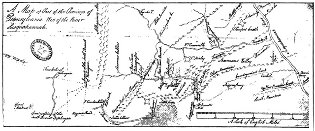
Click here for larger image size
Forbes’s Road to Raystown (1757)[The dotted line to the Youghiogheny shows the line of Burd’s Road]
(From the original in the British Museum)
With Washington’s letter came also one from General Forbes, written July 23. From it these extracts are to the point: “As I disclaim all parties (factions) myself, I should be sorry that they were to Creep in amongst us. I therefore conceive what the Virginia folks would be at, for to me it appears to be them, and them only, that want to drive us into the road by Fort Cumberland, no doubt in opposition to the Pennsylvanians who by Raes town would [Pg 105] have a nigher Communication (than them) to the Ohio. Sir John St. Clair was the first person that proposed and enforced me in to take the road by Raes town, I having previous to this ordered our Army to assemble at Conegochegue which I was obliged afterwards to alter to Raestown at his Instance, altho he then declared that he nor nobody else knew any thing of the road leading from the Laurell hill, but as he has represented it of late impracticable to me, I was therefore pressing to have the Communication opened from Raes town to Fort Cumberland. Sir John I am afraid had got a new light at Winchester, and I believe from thence proceeded to the opening the road from Fort Frederick to Fort Cumberland. I put the Question fairly to him yesterday morning by asking him if he knew of any Intention of making me change measures and forcing me into the Fort Cumberland road, when he knew that it was at his Instance solely, that I had changed it to Raes town; I showed him Capt Ward’s Journal & description of the road from Raestown to the top of the Laurell Hill, telling him at the same time,[Pg 106] that if an easy road could be found there, or made there, that I was amazed he should know nothing off it, which was evident by his telling me of late that the Laurel hill was impracticable, he appeared nonplused, but rather than appear ignorant, he said that there were many Indian Traders that knew those roads very well; I stopt him short by saying if that was the case, that I was very sorry he had never found them out, or never thought it worth his while to examine them. In short he knows nothing of the matter. Coll Byrd in a paragraph of his letter from Fort Cumberland, amongst other things writes, that he has upwards of sixty Indians waiting my arrival, and ready to accompany me, but they will not follow me unless I go by Fort Cumberland. This is a new system of military Discipline truly; and shows that my Good friend Byrd is either made the Cats Foot of himself, or he little knows me, if he imagines that Sixty scoundrels are to direct me in my measures. As we are now so far advanced as Raestown I should look fickle in my measures, in changing, to go by Fort Cumberland, without being made[Pg 107] thoroughly sensible of the impracticability of passing by the shortest way over the Laurell Hill to the Ohio. The difference at present in the length of road the one way and the other stands thus—
“From Raestown to Fort Cumberland, 34 miles or upwards
“From Fort Cumberland to Fort Duquesne by Genl Braddocks, 125 miles in all 160 to which add the passage of rivers &c and the last 8 miles not cut.
“The other road—
“From Raestown to the top of the Laurell Hill 46 miles
“From then to Fort Duquesne suppose 40 or 50 miles in all 90 with no rivers to obstruct you and nothing to stop you that I can see, except the Bugbear, a tremendous pass of the Laurel Hill.
“If what I say is true and those two roads are compared, I don’t see that I am to Hesitate one moment which to take unless I take a party [join a faction] likewise, which I hope never to do in Army matters.
“I have now told you my Opinion, and what I think of the affairs of the road, but[Pg 108] to judge at such Distance, and of a Country I never saw, nor heard spoke off but in Capt Ward’s account, I therefore can say nothing decisive, so have sent up Sir John St Clair in order that he may explore that new road and determine the most Ellegible to be pursued, but this I think need not hinder you from proceeding upon the new road as soon as you can Conveniently.... I have spoke very roundly upon this subject [roads and forage] to Sir John, who was sent up the Country from Philadelphia for no other purpose than to fix the roads and provide forage, both of which I am sorry to say it, are yet to begin—but all this entre nous until I see you.”
Under the same date (July 25) General Forbes wrote as follows to Major-general Abercrombie: “Scouting Parties have been sent out, with the best Guides we could find, and according to the Reports which some of them have made, the Road over the Allegeny Mountain and the Lawrel Ridge will be found practicable for Carriages, which will be of infinate Consequence, will facilitate Our Matters much by shortening the March at least 70 miles,[Pg 109] besides the Advantage of having no Rivers to pass, as We shall keep the Yeogheny upon our Left.... The Troops are all in Motion ... but I have Retarded the March of some of them upon the Route from this Place, as I am unwilling to bring them together till the Route is finally determined.”
On the twenty-sixth Bouquet wrote Forbes as follows:
“I am sending you a letter I have received from Major Armstrong. By the report of the two guides he sent out it seems the thing is very practicable; in an affair of so much consequence as this I thought I ought to act with greatest caution. While the waggoner returned today with an escort to reconnoitre how the road could be laid so as to avoid all the detours and windings of the path; and I have asked Colonel Burd to go with Rhor tomorrow to the top of the mountain (Allegheny) to determine the straightest line from here to the foot of the ascent, and to mark the turnings of the road to reach the top. I hope you will be here on their return, and could then judge if it would be well to risk[Pg 110] this route. In 3 days the Major will return to Edmund’s Swamp, where there is abundant forage, and he will let me know what we must expect from Lawrell Hill. A man who has been 50 times by this path to the Ohio says that the remainder of the route after Loyal Hanny is a long series of hills, with swamps and bogs, but not of great ascent. He is a man named Fergusson, very limited, from whom one can elicit nothing precise; I have sent him with the Major and Dunnings. Upon the Major’s report, we shall be sure of the route as far as Loyal Hanny; and, as regards the remainder, I am sending out Captain Patterson tomorrow with 4 men, to follow this same path to the end, and return forthwith to report, observing the bad places, and the facilities afforded by the country for obviating them, such as trees, stones, &c., the quantity of grass and water, the defiles, distances, &c. He ought to be back in 12 days at latest. Colonel Washington has had the beginning of the road cut from Braddock, [along Braddock’s Road?] which I have fixed at 10 miles from Fort Cumberland. You will have been informed by the[Pg 111] guides I sent you of the advantages of this route which is open, and needs very little in the way of repair; its drawbacks consist in the want of forage, its length, its defiles, and the crossing of rivers. Colonel Washington, who is animated with sincere zeal to contribute to the success of this expedition, and is ready to march wheresoever you may decide, writes me that, from all he has heard and from all the information he has been able to collect, our route is impracticable even for packhorses, so bad are the mountains, and that the Braddock road is the only one to take &c.
“There, my dear General, you have in brief the reports and opinions which have reached me; I will add no reflection of my own, hoping to see you every day. Do you not think it would be well to see Colonel Washington here, before making your decision? and if our parties continue to send favourable news, to convert him to give way to the evidence?”
In reply to Washington’s letter of the twenty-fifth Bouquet wrote: “Nothing can exceed your generous dispositions for the service. I see with the utmost satisfac[Pg 112]tion, that you are above the influences of prejudice, and ready to go heartily where reason and judgement shall direct. I wish, sincerely, that we may all entertain one and the same opinion; therefore I desire to have an interview with you at the houses built half way between our camps. I will communicate all the intelligence, which it has been in my power to collect; and, by weighing impartially the advantages and disadvantages of each route, I hope we shall be able to determine what is most eligible, and save the General trouble and loss of time.”[68]
Concerning this meeting Washington wrote as follows to his friend Major Francis Halket, then in Forbes’s camp at Carlisle: “I am just returned (August 2nd)[69] from a conference with Colonel Bouquet. I find him fixed, I think I may say unalterably fixed, to lead you a new way to the Ohio, through a road, every inch of which is to be cut at this advanced season, when we[Pg 113] have scarce time left to tread the beaten track, universally confessed to be the best passage through the mountains. If Colonel Bouquet succeeds in this point with the General, all is lost,—all is lost indeed,—our enterprise will be ruined, and we shall be stopped at the Laurel Hill this winter; but not to gather laurels, except of the kind that covers the mountains. The Southern Indians will turn against us, and these colonies will be desolated by such an accession to the enemy’s strength. These must be the consequences of a miscarriage; and a miscarriage is the almost necessary consequence of our attempt to march the army by this new route. I have given my reasons at large to Colonel Bouquet. He desired that I would do so, that he might forward them to the General. Should this happen, you will be able to judge of their weight. I am uninfluenced by prejudice, having no hopes or fears but for the general good. Of this you may be assured, and that my sincere sentiments are spoken on this occasion.”
Concerning the same interview Bouquet wrote Forbes (July 31): “I have had an[Pg 114] interview with Colonel Washington, to ascertain how he conceives the difficulties could be overcome; I got no satisfaction from it; the majority of these gentlemen do not know the difference between a party and an army, and, overlooking all difficulties, they believe everything to be easy which flatters their ideas. What I shall have to tell you on this point cannot be discussed in a letter....”
In this same letter Bouquet wrote, concerning the general situation: “You will see from the extract appended from Major Armstrong’s letters the report he makes thereupon. All seems practicable and even easy, but I put too little confidence in the observations of a young man without experience to act upon his judgement. I have therefore sent Colonel Burd, Rhor and Captain Ward to reconnoitre the Allegheny, to make an examination of all the difficulties, and thus put me into a position to decide what reliance is to be placed on the rest of the discoveries. Unfortunately they have found things very different, and this mountain which these gentlemen crossed so easily is worse than Seydeling[Pg 115] Hill, and the ascent much longer. Considering that it was impossible to cut a waggon road on this slope without immense labour, they searched along the mountain for another pass, and found about two miles to the North a gap of which no one was aware.... It seems that, with much labour, one might make a much easier road there than the other; it remains to be seen what obstacles are still to be encountered before Loyal Hanning. Sir John has arrived, and I have communicated to him all I know on the subject; and he starts today or tomorrow morning with Colonel Burd, Rhor and 200 men to reconnoitre this gap, and the whole route as far as Loyal Hanning. He will spend 6 or 7 days on this survey, and I hope on his return you will be able to form a decision. And, in order that no time may be lost, I will make a commencement of the work if the thing is practicable without awaiting your orders. I have thought it best not to do so up to the present, in order not to lay ourselves open to public reflections if we commenced and abandoned different routes. I agree with you that you cannot take the[Pg 116] Cumberland route untill you are in a position to demonstrate the impossibility of finding another road, or at any rate the impossibility of opening one without risking the expedition by too great an expenditure of time. We are in a cruel position, if you are reduced to a single line of communication. It is 64 miles from Cumberland to Gist, and there are only three places capable of furnishing forage sufficient for the army; the rest would not suffice for a single night. The frost, which commences at the end of October, destroys all the grass, and the rivers overflowing in the spring cut off all communication.... If we open a new route, we have not enough axes.” On the same day Forbes wrote Bouquet by the hand of Halket a decisive letter in which he said: “he [Forbes] thinks that no time should be lost in making the new Road, he has directed me to inform you that you are immediately to begin the opening of it agreeable to the manner he wrote to you in his last letter, as he sees all the advantages he can propose by going that Route, and will avoid innumerable Inconveniencys he would[Pg 117] encounter was he to go the other, he is at the same time extremely surprised at the partial disposition that appears in those Virginia Gentlemans sentiments, as there can be no sort of comparison between the two Routes when you consider the situation of the Troops now at Reastown, & that their is not the least reason to expect that we shall meet with any difficulties but what may be easily surmounted.” On the next day but one Forbes wrote: “he [Halket] told you my opinion of the Laurell Hill road, and that I thought it ought to be sett about directly, as it is good to have two Strings to one Bow.”
On this day Washington wrote a last letter to Bouquet in behalf of the Braddock route:
“The matters, of which we spoke relative to the roads, have since our parting, been the subject of my closest reflection; and, so far am I from altering my opinion, that, the more time and attention I bestow, the more I am confirmed in it; and the reasons for taking Braddock’s road appear in a stronger point of view. To enumerate the whole of these reasons would be[Pg 118] tedious, and to you, who are become so much master of the subject, unnecessary. I shall therefore, briefly mention a few only, which I think so obvious in themselves, that they must effectually remove objections. Several years ago the Virginians and Pennsylvanians commenced a trade with the Indians settled on the Ohio, and, to obviate the many inconveniencies of a bad road, they, after reiterated and ineffectual efforts to discover where a good one might be made, employed for the purpose several of the most intelligent Indians, who, in the course of many years’ hunting, had acquired a perfect knowledge of these mountains. The Indians, having taken the greatest pains to gain the rewards offered for this discovery, declared, that the path leading from Will’s Creek was infinitely preferable to any, that could be made at any other place. Time and experience so clearly demonstrated this truth, that the Pennsylvania traders commonly carried out their goods by Will’s Creek. Therefore, the Ohio Company, in 1753, at a considerable expense, opened the road. In 1754 the troops, whom I had the honor to command,[Pg 119] greatly repaired it, as far as Gist’s plantation; and, in 1755, it was widened and completed by General Braddock to within six miles of Fort Duquesne. A road, that has so long been opened, and so well and so often repaired, must be much firmer and better than a new one, allowing the ground to be equally good.
“But, supposing it were practicable to make a road from Raystown quite as good as General Braddock’s,—I ask, have we time to do it? Certainly not. To surmount the difficulties to be encountered in making it over such mountains, covered with woods and rocks, would require so much time, as to blast our otherwise well-grounded hopes of striking the important stroke this season.
“The favorable accounts, that some give of the forage on the Raystown road, as being so much better than that on the other, are certainly exaggerated. It is well known, that, on both routes, the rich valleys between the mountains abound with good forage, and that those, which are stony and bushy, are destitute of it. Colonel Byrd and the engineer, who accom[Pg 120]panied him, confirm this fact. Surely the meadows on Braddock’s road would greatly overbalance the advantage of having grass to the foot of the ridge, on the Raystown road; and all agree, that a more barren road is nowhere to be found, than that from Raystown to the inhabitants, which is likewise to be considered.
“Another principal objection made to General Braddock’s road is in regard to the waters. But these seldom swell so much, as to obstruct the passage. The Youghiogany River, which is the most rapid and soonest filled, I have crossed with a body of troops, after more than thirty days’ almost continued rain. In fine, any difficulties on this score are so trivial, that they really are not worth mentioning. The Monongahela, the largest of all these rivers, may, if necessary, easily be avoided, as Mr. Frazer the principal guide informs me, by passing a defile, and even that, he says, may be shunned.
“Again, it is said, there are many defiles on this road. I grant that there are some, but I know of none that may not be traversed; and I should be glad to be informed[Pg 121] where a road can be had, over these mountains, not subject to the same inconvenience. The shortness of the distance between Raystown and Loyal Hanna is used as an argument against this road, which bears in it something unaccountable to me; for I must beg leave to ask, whether it requires more time, or is more difficult and expensive, to go one hundred and forty-five miles in a good road already made to our hands, than to cut one hundred miles anew, and a great part of the way over impassable mountains.
“That the old road is many miles nearer Winchester in Virginia, and Fort Frederic in Maryland, than the contemplated one, is incontestable; and I will here show the distances from Carlisle by the two routes, fixing the different stages, some of which I have from information only, but others I believe to be exact.
From Carlisle to Fort Duquesne by way of Raystown.
| MILES. | |
| From Carlisle to Shippensburg | 21 |
| “ Shippensburg to Fort Loudoun | 24 |
| “ Fort Loudoun to Fort Littleton | 20 |
| “ Fort Littleton to Juniatta Crossing | 14 |
| “ Juniatta Crossing to Raystown | 14 |
| —— | |
| 93 | |
| “ Raystown to Fort Duquesne | 100 |
| —— | |
| 193 |
From Carlisle to Fort Duquesne, by way of Forts Frederic and Cumberland.
| MILES. | |
| From Carlisle to Shippensburg | 21 |
| “ Shippensburg to Chambers’s | 12 |
| “ Chambers’s to Pacelin’s | 12 |
| “ Pacelin’s to Fort Frederic | 12 |
| “ Fort Frederic to Fort Cumberland | 40 |
| —— | |
| 97 | |
| “ Fort Cumberland to Fort Duquesne | 115 |
| —— | |
| 212 |
“From this computation there appears to be a difference of nineteen miles only. Were all the supplies necessarily to come from Carlisle, it is well known, that the [Pg 123]goodness of the old road is a sufficient compensation for the shortness of the other, as the wrecked and broken wagons there clearly demonstrate....
“... From what has been said relative to the two roads, it appears to me very clear, that the old one is infinitely better, than the other can be made, and that there is no room to hesitate in deciding which to take, when we consider the advanced season, and the little time left to execute our plan.”
But Forbes’s letter of the thirty-first was decisive, and, following his orders, Colonel Bouquet began cutting a new road westward from Raystown August 1.
The correspondence included in the chapter preceding affords probably the utmost light that can be thrown today upon the reason of the making of the great Pennsylvanian thoroughfare to the Ohio. It cannot be affirmed, as has often been said, that Forbes was early prejudiced in favor of a Pennsylvania route; he never could have been such a hypocrite as to pen the words to be found on page 94. That his first plans were completely altered at the advice of Sir John St. Clair is very plain from his letters to Governor Denny (March 20) and to Colonel Bouquet (July 6); but up to the very last he leaves the question open, to be decided wholly according to the reports of the guides and explorers. It is difficult, however, to reconcile the words in Forbes’s letter to Bouquet of July 23, in which he states[Pg 125] that St. Clair, when advising the Raystown route, affirmed “that he nor nobody else knew anything of the road leading from Laurell hill.” It is evident from this that Forbes originally expected to fall down to the Braddock road from Raystown, but that when once on the ground, with the distances clear in his mind, he was compelled to find a shorter road westward if there was one to be found. This is the only explanation of his immediate change of plan at St. Clair’s advice, knowing that St. Clair had found no route westward by Laurel Hill; it seems that St. Clair thought only of proceeding via Raystown to Fort Cumberland, as he affirmed in his letter of June 9 to Bouquet. St. Clair was undoubtedly right in deciding that the best course to Fort Cumberland from Philadelphia for the army was through populous Pennsylvania, and his understanding that the Braddock Road would be followed from that point would easily explain why he had provided forage at Fort Cumberland, which occasioned Forbes’s criticism in his letter of July 14. Indeed from Forbes’s letters of June 16, 19, and 27, it does not seem that he[Pg 126] had any definite plan for the construction of a new road.
On the other hand Forbes very correctly doubted the advisability of using Braddock’s long route when his army was once gathered together along the road from Carlisle to Raystown. Bouquet stated his (Forbes’s) position very soundly when he said: “You cannot take the Cumberland until you are in a position to demonstrate the impossibility of finding another road, or at any rate the impossibility of opening one without risking the expedition by too great an expenditure of time.” Moreover, Forbes had a comprehensive view of the situation such as probably no one else had.
So far as Bouquet’s position was concerned, his correspondence shows that he was assiduous in carrying out Forbes’s directions; as to any conspiracy on his part to win Forbes over to the Pennsylvania route, as Washington insinuated, who can believe one existed after reading his letters? Bouquet very properly threw the burden of ultimate decision upon Forbes, as it was his duty to do; he sent him all the information which he could obtain, pro and con,[Pg 127] concerning all routes; he sent Colonel Burd out, with his guides, in order to have testimony upon which he was sure he could rely; he urged Forbes to defer his decision of route until he (Forbes) could have a personal interview with Washington; he had Braddock’s Road partly cleared and plainly described it as needing “very little in the way of repair;” he never seems to have attempted to minimize the difficulties of making a new route or maximize those of the old; he continually urges the necessity of great caution in the selection of a route.
The motives which directed the movements of Sir John St. Clair during these months of controversy are quite beyond fathoming. It is easy to believe that the “new light,” which Forbes said Sir John had received “at Winchester,” made it clear that if he did not send the army over the southern route (Fort Frederick-Fort Cumberland) to Cumberland, it was possible that Forbes would never traverse Braddock’s Road at all. It is certain that upon Governor Sharpe’s and Washington’s arrival upon the scene, Sir John began to[Pg 128] shower upon Bouquet letters advising the opening of the Fort Frederick-Fort Cumberland road; “and I believe from thence,” Forbes wrote of St. Clair’s meeting with Governor Sharpe, “proceeded to the opening the road from Fort Frederick to Fort Cumberland.” Indeed, it would be interesting to know whether it was not St. Clair’s suddenly raised clamor over the length of the Raystown route to Fort Cumberland (hoping to “drive” Forbes over the Fort Frederick route) that determined Forbes to ignore Fort Cumberland and push out on a new, shorter route to the Ohio.
Whatever were St. Clair’s reasons for such vacillating plans, it is sure he fell into disgrace in Forbes’s eyes. In addition to the upbraiding he received from the general’s own lips, Forbes wrote in his letter of July 14 that the wagons were the plague of his life and denied that St. Clair had taken “the smallest pains” or made the “least inquiry” concerning the matters he had been detailed to care for. Again, in Forbes’s letter to Bouquet of July 17 he says: “Sir John acknowledges taking some (kettles &c. from Pennsylvania troops)[Pg 129] and applying them to the use of the Virginians &c. which is terrible.” In a letter previously quoted Forbes affirms that St. Clair—who was sent in advance of the army to settle the matter of route—“knows nothing of the matter.” Forbes’s wrath at St. Clair reached a climax before the end of August when he savagely declared that he suspected his “heart as well as the head.”[70]
And now as to Washington. His letters are typical of the young man to whom these western forests were not unfamiliar; they are patriotic and loyal. Though he was standing for election to the House of Burgesses in his home county, he had refused to accept a leave of absence to do his electioneering—which in no wise prevented his election. I cannot find any ill-boding prophecy in his letters, concerning the making of a new road westward from Raystown, which after events did not justify. He affirmed that Forbes could not reach Fort Duquesne by a new road before the winter set in; and no prophecy ever seemed more accurately fulfilled. For before Fort Duquesne was reached it was decided not[Pg 130] to attempt to continue the campaign further. An unexpected occurrence suddenly turned the tide and Forbes went on—to a splendid conquest. But, nevertheless, Washington’s prophecy was, not long after it was made, found to have been that of a wise man. Had Forbes been one iota less fortunate than Braddock was unfortunate, Washington’s words would have come true to the letter. So much for his judgment, which Forbes ignored.
But Washington’s knowledge was limited, so far as the general situation of the army was concerned. Forbes’s expedition was one of three simultaneous campaigns; and the three commanders were somewhat dependent upon each other. At any time Forbes might be called upon to give assistance to Abercrombie or Johnson. Forbes was in constant correspondence with both of his colleagues; after Abercrombie’s repulse the prosecution of the Fort Duquesne campaign, it may almost be said, was in question. At any rate it was important to have open the shortest possible route of communication to the northern colonies where the other campaigns were[Pg 131] being pushed; in case Fort Duquesne was captured a straight road through populous, grain-growing Pennsylvania would be of utmost importance; especially as Pennsylvania abounded in vehicles, while in Virginia they were scarce.
Washington thought only of a quick campaign completed in the same season as begun. Forbes, however, was not in eager haste and had good reason for moving slowly. As early as August 9 he wrote Bouquet: “Between you and I be it said, as we are now so late, we are yet too soon. This is a parable that I shall soon explain.” Three reasons appealed to Forbes for moving slowly, though it is doubtful if he intended moving as slowly as he actually did move: Frederick Post, the missionary, had been sent to the Indians on the Beaver asking them to withdraw from the French; the Indian chiefs were invited to the treaty at Easton, where their alliance with the French would, it was hoped, be undermined; winter was drawing on apace, when the Indians who were with the French would withdraw to their villages and begin to prepare for the inclement season.[Pg 132]
One of the direct serious charges brought against Washington was that he did “not know the difference between a party and an army.” This is brought by Colonel Bouquet and I do not believe that he was in error or that the accusation can be proved unjust. Washington had had much experience, such as it was, in the Fort Necessity campaign, with Braddock, and on the Virginia frontier. But the Fort Necessity campaign was conspicuous as a political, not a military event. The force he led west did not number two hundred men. This was, surely, a party, not an army. Now, be it remembered, the great difficulty of leading any body of men, small or great, lay in provisioning them and feeding the horses. The larger the army the greater the difficulty—indeed the difficulty trebled as the number of men and horses was doubled. On those mountain roads the second wagon was drawn with much greater difficulty than the first. Again, a small body of men could, in part, be supplied with food from the forests; in the case of an army this source of supply must be ignored. In the case of Washington’s Fort Necessity[Pg 133] campaign, how did his handful of men fare? They nearly starved—and capitulated because they did not have the food to give them the necessary strength to retreat. This was not Washington’s fault, for he, properly, left this matter with those whose business it was; but the experience certainly did not teach him how to handle an army.
I cannot see that he had the opportunity to learn much more in Braddock’s campaign in 1755. He was that general’s aide, a carrier of messages and orders, and a member of the military family. He had ever before his eyes a thousand examples of carelessness, chicanery, and mismanagement, but those could not teach him how an army was to be cared for properly. His advice was often asked and minded, but he gave it in the capacity of a frontiersman, not as a tactician or officer. The one exception was when he urged that Braddock divide the army into two parties by sending a small flying column rapidly against Fort Duquesne.
It is clear from preceding pages that, on the Virginia frontier, he learned no lessons on the control of large bodies of men.[Pg 134]
But now, in 1758, as colonel of an important branch of the army General Forbes was throwing across the Alleghenies, Washington came forward conspicuously as a champion of a certain route to be pursued by an army of five thousand men. Frankly, what did he know of the needs of five thousand men on a march of two hundred miles from their base of supplies? His correspondence on this point is not satisfactory. He had never passed over the Pennsylvania Road, and, though he understood better than anyone what it meant to cut a new road, he does not answer the argument that the Braddock Road failed to offer as much pasturage for horses and cattle as the Pennsylvania route. He confines himself largely to the matter of celerity: and the situation, as we have explained, did not demand haste. Forbes had the best of reasons for moving slowly. From a commissary’s standpoint Washington’s argument could have had no weight whatever.
Washington was strongly prejudiced in favor of the Virginia route; and no man could have had better reasons for prejudice, as will be shown. He argued conspicuously[Pg 135] and vehemently on a subject with which he had no experience. Great and good as he became, and brave and faithful as he was, it is all the easier to confess to a weakness which was due to a lack of experience and to loyal, old-time Virginia pride. It is an exceedingly pleasant duty to emphasize the fact that, after his repeated arguments were cast aside by his superiors and a route was chosen in the face of the strongest opposition he could bring to bear on the subject, the young man swallowed his chagrin and the slights under which his fine spirit must have writhed, and worked manfully and heroically for measures which he had heartily opposed. In all that he had done in the past five years he never played the man better than here and now.
It is very difficult to unravel what General Forbes continually calls the plot of certain Virginians to force him into Braddock’s Road. The matter is of additional interest because, in his letter to Bouquet of August 9, Forbes utters a very sharp criticism of Washington: “By a very unguarded letter of Col. Washington’s that accidentally fell into my hands, I am now[Pg 136] at the bottom of their scheme against this new road, a scheme that I think was a shame for any officer to be concerned in, but more of this at [our] meeting.” Again on September 4 he wrote: “Therefore [I] would consult C. Washington, altho perhaps not follow his advice, as his Behaviour about the roads, was in no ways like a soldier.” What letter this was of Washington’s I do not know. It could not have been the letter written to Halket (page 113); it hardly seems possible that it could have been the following letter which Washington wrote to Governor Fouquier: “The Pennsylvanians, whose present as well as future interest it was to have the expedition conducted through their government, and along that way, because it secures their frontiers at present, and their trade hereafter, a chain of forts being erected, had prejudiced the General absolutely against the old road, and made him believe that we were the partial people, and determined him at all events to pursue that route.”[71] The doubt is not whether Forbes would[Pg 137] have spoken sharply if he had seen this letter, but whether it could have fallen into his hands. It was undoubtedly sent from Fort Cumberland straight to Winchester and Williamsburg. From one point the letter does Washington no credit, though it shows plainly that there was a bitter factional fight and that he felt strongly the righteousness of the Virginian side of the question, for which he is not to be blamed. As to his accusation against his general, it seems to me unreasonably bitter. Forbes’s correspondence with Bouquet is convincing proof of the falseness of Washington’s theory that the Pennsylvanians “had prejudiced the General absolutely against the old road ... and determined him at all events to pursue that (new) route.” After wrestling with the route question two months Forbes wrote General Abercrombie as late as July 25 that he was unwilling to bring the divisions of his army together “till the Route is finally determined.” Forbes had no predilection for Pennsylvanians; when, in September, a spirit of jealousy appeared concerning the province from which the army provisions should be[Pg 138] obtained, Forbes wrote Bouquet (September 17): “I believe neither you nor I values one farthing where we get provisions from, provided we are supplyed, or Interest ourselves either with Virginia or Pennsylvania, which last I hope will be damn’d for their treatment of us with the Waggons, and every other thing where they could profit by us from their impositions, altho at the risque of our perdition.”
The controversy as to whether Forbes’s route should be through Pennsylvania or Virginia serves to bring into clear perspective one of the most interesting and one of the most important phases of our study—the meaning of the building of a road at that time to either one of those colonies. Nothing could emphasize this more than the sharpness of the quarrel and the position of those concerned in it. It meant very much to Pennsylvania to have Forbes cut a road to the Ohio in both of the two ways suggested by Washington to Governor Fouquier—it fortified her frontier and opened a future avenue of trade. The Old Trading Path had been her best course westward and her trade with the Indians[Pg 139] had been nothing to what it would now become. But such as it had been, it was most distasteful to the Virginians to the south who called the West their own. This rivalry was intense for more than a quarter of a century and came near ending in bloodshed; the quarrel was only forgotten in the tumultuous days of 1775. General Forbes seems to have understood very well that his new road would be of utmost importance to Pennsylvania as that province would then have a “nigher Communication [than Virginia] to the Ohio;” and that was the very reason he cut it: because it was shorter—not to please Pennsylvania. If Fort Duquesne was to be captured and fortified and manned and supplied, the shortest route thither would be, as the dark days of 1764 and 1775 and 1791 proved, a desperately long road to travel.
On the other hand the building of Forbes’s road in Pennsylvania was a boon which that province far less deserved than Virginia. Virginia men and capital were foremost in the field for securing the Indian trade of the Ohio; they had, nearly ten years before, secured a grant of land[Pg 140] between the Monongahela and Kanawha, and sent explorers and a number of pioneers to occupy the land; their private means had been given to clear the first white man’s road thither and erect storehouses at Wills Creek and Redstone; the activity of these ambitious, worthy men had brought on the war now existing. When open strife became the colonies’ only hope of holding the West, Virginia was first and foremost in the field; the same spirit that showed itself in commercial energy was very evident when war broke out, and for four years Virginia had given of her treasure and of her citizens for the cause. During this time Pennsylvania had hardly lifted a finger, steadily pursuing a course which brought down upon her legislators most bitter invectives from every portion of the colonies. And now, in the last year of the war, the conquering army was to pass through Pennsylvania to the Ohio, building a road thither which should for all time give this province an advantage very much greater than that ever enjoyed by any of the others. True, Braddock’s Road curled along over the mountains, but after the[Pg 141] defeat by the Monongahela it had never been used except by small parties on foot and had become well-nigh impassable otherwise. We do not know what Washington wrote in the letter which Forbes so roundly criticised, but it can easily be conceived, without detriment to his character, that he might have spoken in a way Forbes could not understand concerning lethargic Pennsylvania’s undeserved good fortune.[72] But Forbes had the present to deal with, not the past, and the shortest route to the Ohio was all too long.
This became alarmingly plain in a very short time after the day, August 1, on[Pg 142] which Bouquet began to cut it. The story of the hewing of this road cannot be told better than by quoting the fragments appertaining to it contained in the letters of those closely concerned in its building. Old St. Clair, who, as we have seen, was sent on by Forbes to Bouquet, was the advance supervisor. As early as August 12 he was writing Bouquet from “Camp on ye Side of Alleganys” that not as much progress had been made as he had hoped, and that the “Work to be done on this Road is immense. Send as many men as you can with digging tools, this is a most diabolical work, and whiskey must be had. I told you that the road wou’d take 500 Men 5 Days in cutting to the Top of the Mountain.” On the sixteenth he wrote: “A small retrencht is picked out at Kikeny Pawlings.”
| “... The Stages will be | |
| from Rays Town to the Shanoe Cabins | 11 Miles, |
| to Sr Allan McLeans camp | 9 or 10 Miles |
| to Edmunds Swamp | 9 or 10 Miles.” |
“... The Pack Horses returning from Kikoney Paulins have taken the other[Pg 143] Road, so you may send them back loaded.”
Forbes, writing to Bouquet, refers as follows to the new road August 7: “Extremely well satisfied with your accounts of the Road, and very glad to find that you have, entered upon the making of it;” (August 9): “I hope your new road advances briskly, and that from the Alleghany Hill to Laurell Hill may be carrying forward by different partys, at the same time, that you are making the pass of the Allegany practicable;” (August 15): “I hope the new road goes on fast and that soon we shall be able to take post at Loyal Haning. I see nothing that can facilitate this more than by still amusing the Enemy by pushing Considerable parties along Mr Braddock’s route, which parties might endeavour to try to find communications betwixt the two roads where they approach the nearest, or where most likely such passages can be found. As it will be necessary very soon to make a disposition of our small Army I beg you will give your thoughts a little that way. At present I think the greatest part ought to be assembled at Raestown to make our main push by that road, while[Pg 144] Coll Washington, or some other officer might push along the other road and might join us if a Communication can be found when called upon. But this is only an Idea in Embryo....” (August 18): “In carrying forward the new road I think there might easily be a small road carried on at the same time, at about 100 yards to the right and left of it, and parallel with it, by which our flanking partys might advance easier along with the line. I dont mean here to cut down any large trees, only to clear away the Brushwood and saplins, so as the men either on foot or on horseback may pass the easier along....”
Bouquet forwarded this order to St. Clair on August 23, also writing: “Colonel Burd is to command on the West of Lawrell Hill, and to march without delay and before the Road is cut to Loyal H— [Hannan].” On the same date St. Clair wrote Bouquet from Stoney Creek as follows: “I wrote you yesterday ... that three waggons have got to this place, the Road not so good as I shall make it.... I hope to get to Kikoney Pawlins to morrow night, if not shall do it next day. Tell Mr Sinclair[Pg 145] to send me my Down Quilt the weather is cold.” That evening he wrote again, in reply to Bouquet’s letter, from “Kikoney Paulins:” “It is impossible for me to tell you any more than I have done about the Road to L— H— [Loyal Hannan]. I required 600 Men to make the Road over the Lai Ri—ge in three days on condition I was to see it done my Self, and perhaps I might reach L— H the 3d Day. I expect to get the Road cleared as far as the clear fields a Mile from the foot of L—R on this Side, by the time the A—y [army] comes up, and work afterwards with as many men as the Other Corps will give me.” From Edmonds Swamp St. Clair wrote next (no date): “I got the Waggons safe as far as this post yesterday the road is so far good, and if it had not rain’d so hard I was in hopes to report the Road good this Night to Kikoney Pawlings.... If you think the Road from Rays town to the Shanoe Cabins will be wet in the autumn, it wou’d be well to open the Road over the two Risings, and it wou’d be shorter for our Returned Waggons. I shall send out a Reconoitering party 25 Miles[Pg 146] northward that we may know the Paths that lead to sidling Hill.”
By the last of August all parties concerned were beginning to realize that the young Washington had been telling some plain truth when he urged Forbes not to try this new route. On the twenty-seventh Bouquet wrote St. Clair: “I am extremely disappointed in my Expectation of the Road being open before this time to the foot of Lawrell Hill ... push that Road with all possible dispatch ... the Chief thing we want is the Communication open for Waggons to Loyal Hannon. Employ all your Strength there, and Colonel Burd has order to cut backwards to you from L. Han.... Capt Dudgeon and Mr Dapt will oversee some Part of the Road, and every body is to stir and make amend for their unaccountable slowness.” Bouquet blamed St. Clair for the delay and Forbes wrote him from Shippensburg August 28: “The slow advance of the new road and the cause of it touch me to the quick, it was a thing I early foresaw and guarded again[st] such an assistant with all the force and Energy of words that I was master of,[Pg 147] but being over ruled was resolved to make the most I could of a wrong head ... the Virginians who are able to march ... might advance as far forward upon Braddock’s road as to that part of it which is most contiguous to our second deposite, which I think might be about Saltlick Creek.... The using of Braddock’s road I have always had in mind was it only a blind—pray lose no time as that does not oblidge us to march, before we see proper.”
Forbes alone realized that despatch was not to be, necessarily, the secret of the success of his campaign, though he had urged Bouquet to hasten the roadmaking as fast as possible. He had his eyes fixed elsewhere than on the Allegheny ranges; he knew the Indians at Fort Duquesne were weary of the listless campaign; that Bradstreet had been sent against Fort Frontenac (which, if captured, would shut Fort Duquesne completely off from Quebec); that by the first of September a hundred Indians were already gathered at Easton ready for a treaty; that the brave Post was now among the Delawares bringing the final opportunity for them to abandon the[Pg 148] French cause. On September 2 he wrote Bouquet hinting of all these circumstances and urging delay in everything but mere road-building. On the sixth of September Forbes wrote Pitt:
“In my last I had the honour to acquaint you, of my proceedings in the new road across the Alleganey mountains, and over Laurell Hill, (leaving the Rivers Yohieganey and Monongahela to my left hand) strait to the Ohio, by which I have saved a great deal of way, and prevented the misfortunes that the overflowing of those rivers might occasion.
“I acquainted you likewise of the suspicions I had, of the small trust I could repose in the Pennsylvanians in assisting of me with anyone necessary, or any help in furthering the service that they did not think themselves compelled to do by the words of your letter to them.... My advanced post consisting of 1500 men, are now in possession of a strong post 9 miles on the other side of Laurell Hill, and about 40 from Fort Du Quesne, nor had the Enemy even suspected my attempting such a road till very lately, they having been all[Pg 149] along securing the strong passes, and fords of the rivers upon Genl Braddock’s route.”[73]
Forbes had been in Philadelphia while Bouquet was struggling away at Raystown with his thousand perplexities. Early in July he had proceeded to Carlisle where he remained stricken down “with a cursed flux” until the eleventh of August. Two days later he reached Shippensburg, where he was again prostrated and unable to advance until the middle of September. It is difficult to realize that the campaign had been directed so largely by this prostrate man whose “excruciating pains” often left him “as weak as a new-born infant” and who, when able to be about camp, retired “at eight at night, if able to sit up so late.” All of this might well have been stated long ago but it is of particular significance now that Forbes’s correspondence of the whole summer has been systematically reviewed. The very trials[Pg 150] and perplexities, the crying need for his bravery and resolution, seemed in a measure to keep him alive.
No one can study this campaign without yearning to know more of the impetuous soul which threw its last grain of strength into making it a triumphant success. The Indians called Forbes “The Head of Iron”—and no words can better describe the man. Giving all praise possible to Bouquet for his sturdy and active service throughout the summer, it is still plain that the dying Forbes was the magnetic influence that made others strong. Those were dark days at Raystown when at last the pale general arrived upon the ground; “had not the General come up,” wrote an officer on the spot, “the Consequence wou’d have been dangerous.”[74] Bouquet was an invaluable man but the “Head of Iron” in command was needed.
The remainder of the campaign has been often told and in detail. Washington and his Virginians came northward over the newly-cut road to Fort Bedford at Rays[Pg 151]town and plunged westward to the Loyalhannan, to which point Armstrong and St. Clair pushed the road-building. Washington himself supervised the cutting of Forbes’s road westward from Fort Ligonier toward Fort Duquesne. Much as he had wrangled with Bouquet as to the propriety of making a new road he was as good as his word and worked heroically for its success. Never, even in Braddock’s death-trap on the Monongahela, did he come nearer giving his life to his country. Forbes’s first check came when Grant’s command, sent forward from Fort Ligonier to reconnoitre Fort Duquesne, was cut to pieces on Grant’s Hill within sight of the French fort. Eight hundred men went on the expedition; two hundred and seventy-three were killed, wounded, or captured. Bouquet reported the disaster to Forbes on the seventeenth of September, upon which the sad man “deeply touched by this reverse,” writes Parkman, “yet expressed himself with a moderation that does him honor.” “Your letter of the seventeenth I read with no less surprise than concern, as I could not believe that such an attempt[Pg 152] would have been made without my knowledge and concurrence. The breaking in upon our fair and flattering hopes of success touches me most sensibly. There are two wounded highland officers just now arrived, who give so lame an account of the matter that one can draw nothing from them, only that my friend Grant most certainly lost his wits, and by his thirst of fame brought on his own perdition, and ran great risk of ours.” The brave generosity of these words is not so significant as the fact that this pain-racked man, far behind on the road, had such a grasp of the minutest detail of the whole campaign that Bouquet, he believed, would not even send out a scouting party in force without his “knowledge and concurrence.”
A letter from Forbes to Bouquet dated Reastown, September 23rd, contains some interesting paragraphs: “The description of the roads is so various and disagreeable that I do not know what to think or say. Lieutenant Evans came down here the other day, and described Laurell Hill as, at present, impracticable, but he said he could mend it with the assistance of 500[Pg 153] men, fascines and fagots, in one day’s time. Col. Stephens writes Col. Washington that he is told by everybody that the road from Loyal Hannon to the Ohio and the French fort is now impracticable. For what reason, or why, he writes thus I do not know; but I see Col. Washington and my friend, Col. Byrd, would rather be glad this was true than otherways, seeing the other road (their favourite scheme) was not followed out. I told them plainly that, whatever they thought, yet I did aver that, in our prosecuting the present road, we had proceeded from the best intelligence that could be got for the good and convenience of the army, without any views to oblige any one province or another; and added that those two gentlemen were the only people that I had met with who had shewed their weakness in their attachment to the province they belong to, by declaring so publickly in favour of one road without their knowing anything of the other, having never heard from any Pennsylvania person one word about the road; and that, as for myself, I could safely say—and believed I might answer for you—that the good of the[Pg 154] service was the only view we had at heart, not valuing the provincial interest, jealousys, or suspicions, one single two-pence; and that, therefore, I could not believe Col. Stephen’s descriptions untill I had heard from you, which I hope you will very soon be able to disprove. I fancy what I have said more on this subject will cure them from coming upon this topic again.”
Forbes’s next check was more ominous than Grant’s scrimmage. It was not administered by the French—though they followed up the decisive victory on Grant’s Hill with various attacks in force upon Fort Ligonier—but by the clouded heavens. A wet autumn set in early as if to make St. Clair’s road doubly “diabolical.” Forbes wrote Bouquet on October 15: “Your Description of the roads pierces me to the very soul yet still my hopes are that a few Dry days would make things wear a more favourable aspect as all Clay Countries are either good or bad for Carriages according to the wet or dry season. It is true we cannot surmount impossibilities nor prevent unforseen accidents but it must be a comfort both to you and I still that we[Pg 155] proceeded wt Caution in the choice of this road and in the opinion of every Disinterested man, it had every advantage over the other. And I am not sure but it has so still considering the Yachiogeny & Monongehela rivers—so I beg yt you will without taking notice to any body make yourself master of the arguments for and objections against the two roads so that upon comparison one may Judge how far we have been in the right in our Choice. N. B. If any party goes out after the Enemy they ought to have instructions always with regard to the roads forward as likewise ye Communication twixt Loyalhana and the nearest part of Mr Braddocks road which want of all things to be reconnoitred in order to stop foolish mouths if it chances to prove anyways as good or practicable. May not such a communication be found without crossing Laurel hill?”
These are exceedingly interesting words when we know that failure stared Forbes in the face. This might mean official inquiry or court martial; in such a case there would have been, no doubt, question raised as to the “right” of Forbes’s and[Pg 156] Bouquet’s “choice.” But the fact that Forbes desired to know the exact condition of Braddock’s Road, to get into it if it seemed best, and to prove the soundness of his judgment if it was found to be useless, is especially significant because it shows so plainly that the weary man already scented failure. In a few days he wrote again: “These four days of constant rain have completely ruined the road. The wagons would cut it up more in an hour than we could repair in a week. I have written to General Abercrombie, but have not had one scrap of a pen from him since the beginning of September; so it looks as if we were either forgot or left to our fate.”
Early in November the poor man was carried on over the mountains to Fort Ligonier where the whole army, approximately six thousand strong, lay. Hope of continuing the campaign had fled and the desperate prospect of wintering amid the mountains, with no certainty of receiving sufficient stores to keep man and beast alive, stared the whole army in the face. Nevertheless, at a council of officers it was decided to attempt nothing further that season.[Pg 157]
In a few hours three prisoners were brought into camp who reported the true condition of affairs at Fort Duquesne. Bradstreet had destroyed the stores destined for the Ohio by the destruction of Fort Frontenac. Ligneris, the commandant, had consequently been compelled to send home his Illinois and Louisiana militia. The brave Post had succeeded in alienating the Ohio Indians. The remainder at Fort Duquesne were glad now to hurry away into their winter quarters in their distant homelands. The gods had favored the brave.
Immediately Forbes determined upon a hurried advance with a picked body of twenty-five hundred men, unencumbered. Washington and Armstrong hastened ahead to cut the pathway. A strong vanguard led the way. Behind them came the hero of the hour and of the campaign, Forbes, borne on his litter. The Highlanders occupied the center of the rear, with the Royal Americans and provincials on their right and left under Bouquet and Washington. On the night of the twenty-fourth the little army lay on its arms in the[Pg 158] hills of Turkey Creek, near Braddock’s fatal field. At midnight a booming report startled them. Were the French welcoming the long-expected reënforcements from Presque Isle and Niagara—or had a magazine exploded? In the morning some advised a delay to reconnoitre. Forbes scorned the suggestion; “I will sleep,” he is said to have exclaimed, “in Fort Duquesne or in hell tonight.”
At dusk that November evening the army marched breathlessly down the wide, hard trace over which Beaujeu had led his rabble toward Braddock’s army and, without opposition, came at last within sight of the goal upon which the eyes of the world had been directed so long. The barracks and store-house of Fort Duquesne were burned, the fortifications blown up and the French—gone forever.
Two days later a weary man sat within an improvised house and with a feeble hand indited a letter to the British Secretary of State. And all it contained was summed up in its first words: “Pittsbourgh 27th Novemr 1758.” It was Pitt’s bourgh now. The region about the junction of the Alle[Pg 159]gheny and Monongahela was known in Kentucky as “the Pitt country.”
The generous Bouquet expressed the sentiment of the army when he affirmed: “After God, the success of this expedition is entirely due to the General.” When Forbes’s physical condition is understood, his last campaign must be considered one of the most heroic in the annals of America. “Its solid value was above price. It opened the Great West to English enterprise, took from France half her savage allies, and relieved the western borders from the scourge of Indian war. From southern New York to North Carolina, the frontier populations had cause to bless the memory of the steadfast and all-enduring soldier.”[75]
Forbes soon became unable to write or dictate a letter. On the terrible return journey over his freshly-hewn road he suffered intensely, sometimes losing consciousness. He was carried the entire distance to Philadelphia on his litter, and in March he died. His body, at last free from pain, was laid with befitting honors in the chancel of Christ Church.[Pg 160]
The following death notice and appreciation of General Forbes appeared in the Pennsylvania Gazette March 15, 1759:
“On Sunday last, died, of a tedious illness, John Forbes, Esq., in the 49th year of his age, son to —— Forbes, Esq., of Petmerief, in the Shire of Fife, in Scotland, Brigadier General, Colonel of the 17th Regiment of North America; a gentleman generally known and esteemed, and most sincerely and universally regretted. In his younger days he was bred to the profession of physic, but, early ambitious of the military character, he purchased into the Regiment of Scott’s Grey Dragoons, where, by repeated purchases and faithful services, he arrived to the rank of Lieutenant Colonel. His superior abilities soon recommended him to the protection of General Campbell, the Earl of Stair, Duke of Bedford, Lord Ligonier, and other distinguished characters in the army; with some of them as an aid; with the rest in the familiarity of a family man. During the last war he had the honor to be employed in the post of Quarter-Master General, in the army under his Royal Highness, the[Pg 161] Duke, which duty he discharged with accuracy, dignity and dispatch. His services in America are well known. By a steady pursuit of well-concerted measures, in defiance of disease and numberless obstructions, he brought to a happy issue a most extraordinary campaign, and made a willing sacrifice of his own life to what he valued more—the interests of his king and country. As a man he was just and without prejudices; brave, without ostentation; uncommonly warm in his friendships, and incapable of flattery; acquainted with the world and mankind, he was well-bred, but absolutely impatient of formality and affectation. As an officer, he was quick to discern useful men and useful measures, generally seeing both at first view, according to their real qualities; steady in his measures, and open to information and council; in command he had dignity without superciliousness; and though perfectly master of the forms, never hesitated to drop them, when the spirit and more essential parts of the service required it.
“Yesterday, (14th,) he was interred in the Chancel of Christ’s Church, in this city.[Pg 162]”
A fellow-countryman of Forbes has built beside Forbes’s Road (now Forbes Street), in the city of Pittsburg, a magnificent library. What could be more fitting or beautiful than that this brave Scotchman’s memory should be honored with a monumental pillar here on his road which “opened the Great West to English enterprise?” And let it bear the sweet human testimony of a British historian: “No general was ever more beloved by the men under his command.”[76]
There is another hero of Forbes’s Road. The rough days of that summer of 1758 were only suggestions of what was to come. Other armies than that of Forbes were to pass this way, for, be it understood at once, Forbes’s Road became the great military highway into the West. No single road in America witnessed so many campaigns; no road in America was fortified by such a chain of forts. For a generation this route from Lancaster by Carlisle, Bedford, Ligonier to Pittsburg was the most important thoroughfare to the West.
The French retired from Fort Duquesne, down the Ohio and up the Allegheny. The remainder of the war was fought far away on the St. Lawrence. Hardly a shot was fired in the West after the skirmishes at Fort Ligonier succeeding Grant’s defeat.[Pg 164] The French at Venango and Detroit made light of Forbes’s occupation of Fort Duquesne. They had retired voluntarily and swore to return in the spring. In a dozen western posts the French bragged still of their possession of the West and of their future conquests. The Indians believed each boast.
In the next year’s campaign Quebec fell. New France passed away, and all French territory east of the Mississippi, save only a fishing station on the island of Newfoundland came into the hands of the English. But this campaign was fought in the far northeast. Of it the West and its redskinned inhabitants knew nothing. Fort Niagara was the most westerly fort which had succumbed; Fort Duquesne, technically, was evacuated. The real story of the successive French defeats was, perhaps, little heard of in the West; or, if communicated to the Indian allies there, the logical conclusion was not plain to them. How could a land be conquered where not a single battle had been fought? So far as the Indians were concerned, France was never more in possession of their western lakes and forests[Pg 165] than then. Was not the blundering Braddock killed and his fine army utterly put to rout? Were not the French forts in the West—Presque Isle, Venango, Le Bœuf, Miami, and Detroit, secure? Fort Duquesne could be reoccupied whenever the French would give the signal. The leaden plates of France still reposed at the mouths of the rivers of the West and the Arms of the King of France still rattled in the wind which swept the land.
Fancy the surprise of the Indians, then, when little parties of redcoat soldiers came into the West, and, with quiet insolence, took possession of the French forts and of the Indian’s land! And the French moved neither hand nor foot to oppose them, though through so many years they had boasted their prowess, and though ten Wyandots could have done so successfully. Detroit was surrendered to a mere corporal’s guard, and the lesser forts to a sentry’s watch each. It remained for the newcomers to inform the Indians of the events which led to the changing of the flags on these inland fortresses—to tell them that the French armies had been[Pg 166] utterly overwhelmed, and the French capital captured, and French rule in America at an end.
But these explanations, given glibly, no doubt, by arrogant English officers, were repeated over and over by the Indians, and slowly, before a hundred, yea, a thousand dim fires in the forests. We can believe it was not all plain to them, this sudden conquest of a country where hardly a battle had been fought for eight years, and that battle the greatest victory ever achieved by the red man. Perhaps messengers were sent back to the forts to gain, casually, additional information concerning this marvelous conquest by proxy. French traders, as ignorant, or feigning to be, as the Indians, were implored to explain the sudden forgetfulness of the French “Father” of the Indians.
It was inexplicable. The news spread rapidly: “The French have surrendered our land to the English.” Fierce Shawanese around their fires at Chillicothe on the Scioto heard the news, and sullenly passed it on westward to the Miamis, and eastward to the angered Delawares on the[Pg 167] Muskingum, who had now forgotten Frederick Post. The Senecas on the upper Allegheny heard the news. The Ottawas and Wyandots on both sides of the Detroit River heard it—and before the fires of each of these fierce French-loving Indian nations there was much silence while chieftains pondered, and the few words uttered were stern and cruel.
Cruel words grew to angry threats. By what right, the chieftains asked, could the French surrender the Black Forest to the English? When did the French come to own the land, after all? They were the guests, the friends of the Indian—not his conquerors. The French built forts, it is true, but they were for the Indian as well as for the French, and were forts in name only, and the more of them the merrier! But now a conqueror had come, telling the Indian the land was no longer his, but belonged to the British king.
Threats soon grew into visible form. Where it started is not surely known—some say from the Senecas on the upper Allegheny—but soon a fearful Bloody Belt went on a journey with its terrible sum[Pg 168]mons to war. It passed to the Delawares and to the Shawanese and Miamis and Wyandots, and where it went the death halloo sounded through the forests. The call was to the Indians of the Black Forest to rise and cast out the English from the land. If the French could not have it, certainly no one else should. The dogs of war were loosened. The young warriors of the Allegheny and Muskingum and Scioto and Miami and Detroit danced wildly before the fires, and the old men sang their half-forgotten war chants.
The terrible war which in 1763 burst over the West has never been paralleled by savages the world over in point of swift success. This may be attributed to the fact that a leader was found in Pontiac, a chieftain in the Ottawa nation, who for daring and intelligence was never matched by a man of his race. He had the courage of sweeping and patriotic convictions. He saw in the English occupation of the land the doom of the red man. Indeed he must have seen it before, but if so he had not had an opportunity to put his convictions to a public test. The Indian was becoming a[Pg 169] changed man. The implements and utensils of the white man were adopted by the red. The independent forest arts of their fathers were beginning to be forgotten. Kettles and blankets and powder and lead were taking the place of the wooden bowls and fur robes and swift flint heads. In another generation the art of making a living for himself in the forest would be forgotten by the Indian, and he would henceforth be absolutely dependent upon the foreigner. All this Pontiac saw. He felt commissioned to lead a return to nature. The arts of the white man must be discarded and the Indians must come back to their primitive mode of living in dependence upon their own skill and ingenuity.
And so Pontiac waged a religious war. At a great convention of the savages he told them that a Delaware Indian had, while lost in the forests, been guided into a path which led to the home of the Great Spirit, and, on coming there, had been upbraided by the Master of Life himself for the degenerate state to which his race was falling. The forest arts of their[Pg 170] fathers must be encouraged and relied upon. The utensils of the white man must be banished from the wigwams. Bows and arrows and tomahawks and stone hatchets should not be discarded. Otherwise the Great Spirit would take away their land from them and give it to others. And so, much of the fury which accompanied the war was a sort of religious frenzy. “The Master of Life himself has stirred us up,” said the warriors.
Pontiac’s plot—undoubtedly the most comprehensive military campaign ever conceived in redman’s brain—was discovered by the British at Fort Miami, on the Maumee River, in March 1763, four years after the fall of Quebec. There the Bloody Belt was found and secured before it could be forwarded to the Wabash with its murderous message. By threats and warnings the untutored English officers thought to quell the disturbance. Amherst, his Majesty’s commanding general in America, haughtily condemned the signs of revolution as “unwarranted.” Moreover he gave his officers in the West authority to declare to the Indian chieftains that if they should con[Pg 171]spire they would in his eyes, make “a contemptible figure!” Time passed and the garrisons breathed easily as quiet reigned.
It was but the lull before the storm. On the seventh of May, Pontiac, who led his Ottawas at Braddock’s defeat, appeared before Detroit, the metropolis of the northwest, with three hundred warriors. The watchfulness of the brave Major Gladwin, a well-trained pupil in that school on Braddock’s Road, and the failure of Pontiac to capture the fort by strategy, though his warriors were admitted within its walls and had shortened guns concealed beneath their blankets, was the dramatic beginning of a reign of terror and a war of devastation all the way from Sault St. Marie to even beyond the crest of the Alleghenies. Pontiac immediately invested Detroit and throughout the Black Forest his faithful allies did their Ottawa chieftain’s will. On the sixteenth of May, Fort Sandusky was surrounded by Indians seemingly friendly. The British commander permitted seven to enter. As they sat smoking, by the turn of a head the signal was[Pg 172] given and the commander was a prisoner. As he was hurried out of the fort he saw, here one dead soldier, there another—victims of the massacre. Nine days later a band of Indians appeared before the fort at the mouth of the St. Joseph. “We are come to see our relatives,” they said, “and wish the garrison good morning.” Within two minutes after their entrance the commanding officer and three men were prisoners and eleven others were murdered. Two days later the commander of Fort Miami, on the Maumee River, came, at an Indian girl’s pitiful plea, to the Indian village to bleed a sick child. He was shot in his tracks. Four days later the commander of Fort Ouatianon, on the Wabash, was inveigled into an Indian cabin and captured, the fort surrendering forthwith. Two days later Indians gathered at Fort Michilimackinac to engage in a game of lacrosse. At the height of the contest the ball was thrown near a gate of the fort. In the twinkling of an eye the commanding officer who stood watching the game was seized, and the Indians, snatching tomahawks from under the blankets of squaws who were[Pg 173] standing in proper position, entered the fort and killed fifteen soldiers outright and took the remainder of the garrison prisoners.
Sixteen days later Fort Le Bœuf, on French Creek, where Washington delivered his message to the haughty St. Pierre a decade before, was attacked by an overwhelming army of savages. Keeping the enemy off until midnight, the garrison made good its escape, unknown to the exultant besiegers who had already fired one corner bastion, and fled down the river to Fort Pitt. On their way they passed the smouldering ruins of Fort Venango. Two days later Fort Presque Isle was attacked. In two days the commander, senseless with terror, struck his flag. The same day Fort Ligonier on Forbes’s Road was invested by a besieging army.
Thus the campaign of Pontiac, prosecuted with such swiftness and such success, bade fair to end in triumph. “We hate the English,” the Indians sent word to the French on the Mississippi, “and wish to kill them. We are all united: the war is our war, and we will continue it for seven[Pg 174] years. The English shall never come into the West!”
But Fort Detroit and Fort Pitt stood firm. For months Pontiac beleaguered the northern fortress, gaining advantages whenever the garrison attacked him, but unable to reduce the fort. All summer long the eyes of the world were upon Detroit; and the gallant defense of Fort Pitt, was, comparatively, forgotten. But the maintenance of this strategic point was of incalculable importance to the West. The garrison felt this. And here, if anywhere, was courage shown in battle. Here, if ever, brave men faced fearful odds with unshaken courage worthy of their Saxon blood.
In planning his campaign Pontiac delegated the Shawanese and Delawares to carry Fort Pitt. If they could not do it he might be assured that the position was impregnable. They were his most reliable warriors, and, once given the task of carrying out the second most important coup of their great leader’s plan, could be trusted to use any alternative savage lust could suggest, or trick savage cunning could invent in order to accomplish their portion[Pg 175] of the terrible conquest of the West. The defense of Detroit was brave; but Detroit was on the great water highway east and west. Succor was possible, in fact probable, in time; if not, there was a way of escape. At Fort Pitt could either be expected? The only approach to it was this indifferent roadway hewn westward from Bedford in 1758. Moreover the fort had never been completed. On three sides the flood tides of the rivers had injured it. Ecuyer, its valiant defender, threw up a rough rampart of logs and palisaded the interior. And in this fragile fortress, hardly worthy of the name, behind which lay the darkling Alleghenies and about which loomed the Black Forest, were gathered some six hundred souls, a larger community, probably, than the total population of Detroit. And around on every side were gathered the lines of ochred warriors preparing for another charge even to the very blood-bespattered walls. The garrison might well have believed itself beyond the reach of succor, if indeed succor could avail before need of it had vanished. The bones of Braddock’s seven[Pg 176] hundred slain lay scattered about the forests only seven miles away. Could another army come again? Little wonder that the Shawanese and Delawares were already flushed with victory as they renewed their unavailing attacks.
The task of relieving Fort Pitt was placed upon the tried shoulders of Colonel Henry Bouquet, whose brilliant services in Forbes’s campaign have been fully described. Amherst, then commanding in America, sent him the remains of the Forty-second and Seventy-seventh regiments, which amounted to the pitiful total of three hundred and forty-seven men and officers; concerning additional troops Amherst was painfully plain: “Should the whole race of Indians take arms against us I can do no more.” Recruits joined the army as it moved along through Lancaster and Carlisle, which augmented the force slightly.
But the brave Bouquet, with an army not exceeding five hundred men, set out westward from Bedford on the rough road he himself had made with the vanguard of the “Head of Iron” five years before.[Pg 177] The appalling condition in which he found the country along the border would have daunted a less bold man. Every fort from Lake Erie to the Ohio had been razed to the ground. The whole country was panic-stricken. Houses were left vacant or burned, together with crops, and the mountain roads were blocked with fugitives, half famished, who threw themselves upon the intrepid Bouquet at his camps. It was indeed a trying time, a time for such a man as Bouquet to show himself.
Never did the success of a campaign in the history of war depend more on the sagacity, bravery, and personal knowledge of a single commanding officer. This daring Swiss was everywhere and everything. He knew that the enemy, though they retired before him even as he approached Fort Ligonier, were watching every movement of the coming army. He knew they were cognizant of his weakness, the debility of his men, the lack of provision, the paucity of scouts and spies. He knew, and so did the silent, lurking spies of the enemy, that Braddock’s slain outnumbered his whole force.[Pg 178]
But Ligonier—named by Bouquet himself from a warrior whose bravery was now his inspiration—was not a place to pause, though just beyond lay the death-trap where Aubrey had defeated the ill-fated Grant five years before. On he went. As the inevitable battle-ground was neared Bouquet redoubled his watchfulness. When a darker defile than usual was reached, with a rifle across his lap, the commander went forward and himself led the army’s van into it.
On the morning of the fifth of August tents were struck early and another day’s march commenced. Over broken country enveloped in forests the army went its way. By one o’clock they had made seventeen miles and were not less than half a mile from Bushy Run, their proposed camping place. Suddenly was heard the report of rifle fire in front. As the main army listened the noise quickened to a sharp rattle—and the decisive battle of Bushy Run was commenced.
The two foremost companies were ordered forward to support the vanguard now hotly engaged. This causing no[Pg 179] abatement, the convoy was halted and a general charge formed. By an onward rush, with fixed bayonets, Bouquet and his eager men cleared the field. But firing on the right and left and in the rear announced that both flanks and the convoy were simultaneously attacked. An order was given to fall back. This having been executed, an unbroken circle was formed about the terrified horses.
Though in number the combatants were nearly equal, the savages had all the advantage of a superior force fighting under cover. Bouquet’s army, like Braddock’s, was in the open. With furious cries accompanied by a heavy fire, the Indians attempted to break the iron circle. And they fought with sly cunning. Not waiting to receive the answering attacks, they leaped behind the nearest trees, only to come back to the attack with increased ferocity from another quarter. The English suffered severely while the active Indians, under cover, were almost untouched. Nothing but implicit confidence in Bouquet could have inspired this little army with the steadiness it displayed. No[Pg 180] one lost composure. Each man knew they could not retreat or advance—fight they must and fight they surely did.
Night came, and under cover of the darkness the wearied soldiers cared for the wounded. Placed in the cleared center of the circle, a rude wall of sacks of flour was built around them. Here, enduring agonies of thirst, for not a drop of water could be obtained, they lay listening to the fiendish yells of the enemy—a poor cure for wounds and burning thirst.
When the necessary arrangements for the night had been completed and provision made against a night attack, Bouquet, doubtful of surviving the morrow’s battle, wrote to Sir Jeffrey Amherst a brief and concise account of the day’s fight. His report ends with these words:
“... As, in case of another engagement, I fear insurmountable, difficulties in protecting and transporting our provisions, being already so much weakened by the losses of this day, in men and horses, besides the additional necessity of carrying the wounded, whose situation is truly deplorable.”[Pg 181]
Even before morning light, the beastly, impatient cries of the Indians began to be heard on every side, soon accompanied by a deadly fire. As on the preceding day the return fire had little effect, for the savages silently vanished at the gleam of leveled bayonets. But at ten o’clock the ring remained unbroken though the troops were already fatigued and were now crazed by torments of thirst, “more intolerable than the enemy’s fire.” The horses, often struck and completely terrified, now broke away by scores and madly galloped up and down the neighboring hills. The ranks were constantly thinning. It was plain to all that a decisive and immediate bold stroke must be made.
The commander was equal to the emergency! The confidence of the foe had grown so overbearing that Bouquet determined to stake everything upon the very recklessness of his enemies. The portion of the circle which immediately fronted the Indians, and which was composed of light infantry, was ordered to feign retreat. As this movement was accomplished, a thin line of men was thrown across the deserted[Pg 182] position from the sides, drawing in close to the convoy. Thinking this to be a retreat, which the new line had been summoned to cover, the Indians, with cutting screams, jumped out from every side and rushed headlong toward the centre of the circle. Then, suddenly upon their rear poured the light infantry, which had made a marvelous detour through the woods. With a frightful bayonet charge and with highland yells as piercing as those of the Indians, the grenadiers, flushed with victory, drove the terrified savages through the forests. In the twinkling of an eye the outcries of the savages ceased altogether and not a living foe remained. Sixty Indian corpses lay scattered about the camp. Only one captive was taken and he was riddled with English bullets. The loss of the English amounted to eight officers and one hundred and fifteen men. This was the first English victory over the Indians of the central West. Fort Necessity, Braddock’s Field, and Grant’s Hill were now avenged. It was a late victory but was far better late than never. Fort Pitt was relieved.
What Forbes’s Road was to Pittsburg and the West in the Old French War and in Pontiac’s Rebellion it was in the Revolutionary days, 1775-83. For thirty years after it was built it was the main highway across the mountains. It is impossible to estimate the worth of this straight roadway to the Ohio; had Forbes followed Braddock’s Road to Fort Pitt, western travel ever after would have been at the mercy of the two rivers, the Youghiogheny and Monongahela, which that road crosses. In the winter months it would have been difficult, if not impossible, to have kept open communication between a line of forts and blockhouses on Braddock’s Road. This was done on Forbes’s Road throughout the half century of conflict.
At the opening of the Revolutionary War, the continental war office being at Philadelphia, Forbes’s Road became more strategic than ever in its history. It was now known as the “Pennsylvania Road,” and was the direct route to the military center of the West, Fort Pitt. Braddock’s Road—now known as the “Virginia Road”—was the main route from Vir[Pg 186]ginia and Maryland. In the dispute between Virginia and Pennsylvania for the region of which Fort Pitt was the center, the two routes thither were the avenues of the two contending factions. With the drowning of this quarrel in the momentous struggle precipitated in 1775, Forbes’s Road at once became preëminently important. Cattle and goods were frequently sent over Braddock’s Road as far as Brownsville and forwarded by water to Fort Pitt and the American forts on the Ohio. But far greater was the activity on Forbes’s Road. Forts Bedford and Ligonier, and a score of fortified cabins at such points as Turtle Creek, Sewickly, Bullock Pens, Widow Myers, Proctors, Brush Run, Reyburn’s, and Hannastown served to guard the main thoroughfare to the Ohio. Between these points scouts were continually hurrying, and over the narrow roadway passed the wagons and pack-horses laden with ammunition and stores. Hannastown and Ligonier became the important entrepôts between Carlisle and Fort Pitt in the Revolution. Carlisle was the important eastern depot[Pg 187] of troops and ammunition from which both eastern and western commanders received supplies.[77] Garrisons along the Pennsylvania Road were ordered at the close of the war to report at Carlisle for their pay.[78] Hannastown, thirty miles east of Fort Pitt and three miles northeast of the present Greensburg, was the first collection of huts on the Pennsylvania Road between Bedford and Pittsburg dignified by the name of a town. At the breaking out of the Revolution it was the most important settlement in all Westmoreland County save only those about Forts Pitt and Ligonier. “These huts scattered along the narrow pack-horse track among the monster trees of the ancient forest, was that Hannastown, which occupied such a prominent place in the early history of Western Pennsylvania where was held the first court west of the Alleghany where the resolves of May 16, 1775, were passed.”[79] From this rude little cluster of huts on Forbes’s Road, deep in the Allegheny[Pg 188] mountains, came one of the first and most spirited protests against British tyranny. From such sparks the flames of revolution were soon fanned. Hannastown “was burned last Saturday afternoon,” wrote General Irvine to Secretary of War Lincoln, July 16, 1782; “... that place is about thirty-five miles in the rear of Fort Pitt, on the main road leading to Philadelphia, generally called the Pennsylvania [Forbes’s] road. The Virginia [Braddock’s] road is yet open, but how long it will continue so is uncertain, as this stroke has alarmed the whole country beyond conception.”
In winter the road was almost impassable; Brodhead wrote Richard Peters: “The great Depth of Snow upon the Alleghany and Laurel Hills have prevented our Getting every kind of Stores, nor do I expect to get any now until the latter End of April.”[80] General Irvine wrote his wife January 8, 1782: “If the road was fit for sleighing I could now go down (to Carlisle) snugly, but it is quite impracticable; it is barely passable on horseback.” Fort Pitt[Pg 189] was invariably supplied with regular troops from Lancaster or Carlisle, which marched over the Pennsylvania Road.[81]
Such had become the importance of the Pennsylvania Road that, soon after the Revolutionary struggle, Pennsylvania took active steps to improve it. On the twenty-first day of September an act of the Assembly of Pennsylvania gave birth to the great thoroughfare at first called “The Western Road to Pittsburg,” and familiarly known since as the Pittsburg or the Chambersburg-Pittsburg Pike.[82] This state road was, as heretofore recorded, one hundred and ninety-seven miles in length from Carlisle to Pittsburg. The road built in 1785-87 follows practically the course of the present highway between the same points. Here and there the traveler may[Pg 191] see the olden track a few rods distant on his right or left; at points it lies several miles to the south. The present Pittsburg Pike passes through Greensburg, while old Hannastown on Forbes’s Road lies three miles to the northwest. The old route was a little less careful as to hills than the new, and made a straighter line across the country; the telephone companies have taken advantage of this and send their wires along the easily discerned track of the old road at many points. There is no point perhaps where the old road of 1785 is so plainly to be remarked as on the side of the upper end of Long Hollow Run, Napier township, Bedford County, a few miles west of historic little Bedford.[83]
The Pennsylvania Road and its important branch, the “Turkey Foot” Road to the Youghiogheny, became one of the important highways to the Ohio basin in the pioneer era. With the digging of the Pennsylvania canal up the valley of the Juniata, the Pennsylvania Road became[Pg 192] less important until it became what it is today, a merely local thoroughfare. For the last two decades in the eighteenth century, the Pennsylvania Road held a preëminent position—days when a good road westward meant everything to the West. But the road could never be again what it was in the savage days of ’58, ’63 and ’75-’82, when it was the one fortified route to the Ohio. The need for Forbes’s Road passed when Forts Loudoun, Bedford, Ligonier, and Pitt were demolished. While they were standing, the open pathway between them meant everything to their defenders and to the farmers and woodsmen about them. But it meant almost as much to the fortresses far beyond in the wilderness of the Ohio Valley—Forts McIntosh, Patrick Henry, Harmar, Finney, and Washington. The vast proportion of stores and ammunition for the defenders of the Black Forest of the West passed over Forbes’s Road, and its story is linked more closely than we can now realize with the occupation and the winning of the West.
Mr. McMaster has an interesting paragraph on Forbes’s Road in pioneer days:[Pg 193]
“From Philadelphia ran out a road to what was then the far West. Its course after leaving the city lay through the counties of Chester and Lancaster, then sparsely settled, now thick with towns and cities and penetrated with innumerable railways, and went over the Blue Ridge mountains to Shippensburg and the little town of Bedford. Thence it wound through the beautiful hills of western Pennsylvania, and crossed the Alleghany mountains to the head-waters of the Ohio. It was known to travelers as the northern route, and was declared to be execrable. In reality it was merely a passable road, broad and level in the lowlands, narrow and dangerous in the passes of the mountains, and beset with steep declivities. Yet it was the chief highway between the Mississippi valley and the East, and was constantly travelled in the summer months by thousands of emigrants to the western country, and by long trains of wagons bringing the produce of the little farms on the banks of the Ohio to the markets of Philadelphia and Baltimore. In any other section of the country a road so frequented would have been con[Pg 194]sidered as eminently pleasant and safe. But some years later the traveler who was forced to make the journey from Philadelphia to Pittsburg in his carriage and four, beheld with dread the cloud of dust which marked the slow approach of a train of wagons. For nothing excited the anger of the sturdy teamsters more than the sight of a carriage. To them it was the unmistakable mark of aristocracy, and they were indeed in a particularly good humor when they suffered the despised vehicle to draw up by the road-side without breaking the shaft, or taking off the wheels, or tumbling it over into the ditch. His troubles over, the traveler found himself at a small hamlet, then known as Pittsburg.”[84]
Forbes’s Road, strictly speaking, began at Bedford, as Braddock’s Road began at Cumberland. In these pages the main route from Philadelphia—the Pennsylvania Road—has been considered under the head of Forbes’s Road. The eastern extremity of this thoroughfare, or the portion, sixty-six miles in length, between[Pg 195] Philadelphia and Lancaster, became the first macadamized road in the United States and demands particular attention in another volume of this series[85].
Nothing could have been more surprising to the writer than to find how remarkably this road held its own in competition with the Braddock or the Cumberland Road south of it. Explain it as you will, nine-tenths of the published accounts left by travelers of the old journey from Philadelphia, Baltimore, or Washington into the Ohio Valley describe this Pennsylvania route. The Cumberland Road was built from Cumberland, Maryland to Wheeling, West Virginia, on the Ohio (1806-1818) at a cost of nearly two million dollars, yet during the entire first half of that century you will find that almost every important writer who passed over the mountains went over the Pennsylvania Road. It is exceedingly difficult to find a graphic picture of a journey over Braddock’s Road before 1800; contemporaneous descriptions of a journey over the Cumberland or National Road are not numerous. On the other hand a vol[Pg 196]ume could be filled with descriptions of the old Pennsylvania Road through Bedford and Ligonier. I believe the fame of the Cumberland Road was due rather to the fact of its being a national enterprise—and the first of its kind on the continent—than to any superiority it achieved over competing routes. The idea of the road was grand and it played a mighty part in the advancement of the West; but, such was the nature of its course, that it does not seem to have been the “popular route” from Washington to Pittsburg, the principal port on the Ohio River.
The Pennsylvania Road was the most important link between New England and the Ohio Valley in the days when New England was sending the bravest of its sons to become the pioneers of the rising empire in the West. True, Venable has written:
“The footsteps of a hundred years
Have echoed, since o’er Braddock’s Road,
Bold Putnam and the Pioneers
Led History the way they strode.
“On wild Monongahela’s stream
They launched the Mayflower of the West,
A perfect state their civic dream,
A new New World their pilgrim quest.”
[Pg 197]
It is due to the Pennsylvania Road, however, to correct the history of these lofty strains. Putnam and his pioneers did not travel one step on Braddock’s Road, nor did they launch their boats on wild Monongahela’s stream. They came over the worn track of Forbes’s Road through Carlisle and Bedford, proceeding southwest through the “Glades” to the Youghiogheny River at West Newton, Pennsylvania.[86]
Braddock’s Road would have been exceedingly roundabout for New England travelers, as Forbes long before clearly established. Pennsylvania’s new road, begun in 1785, was not a tempting route of travel for these New Englanders in this year, 1788. “The roads, at that day,” wrote Dr. Hildreth, “across the mountains were the worst we can imagine—cut into deep gullies on one side by mountain rains, while the other was filled with blocks of sand stone.... As few of the emigrant wagons were provided with lock-chains for the wheels, the downward impetus was[Pg 198] checked by a large log, or broken tree top, tied with a rope to the back of the wagon and dragged along on the ground. In other places, the road was so sideling that all the men who could be spared were required to pull at the side stays, or short ropes attached to the upper side of the wagons, to prevent their upsetting.... All this part of the country, and as far east as Carlisle, had been, about twenty-five years before, depopulated by the depredations of the Indians. Many of the present inhabitants well remembered those days of trial, and could not see these helpless women and children moving so far away into the wilderness as Ohio, without expressing their fears.... Three days after ... they reached the little village of Bedford. During this period they had crossed “Sideling Hill,” forded some of the main branches of the Juniata, and threaded the narrow valleys along its borders. Every few miles long strings of pack-horses met them on the road, bearing heavy burthens of peltry and ginseng, the two main articles of export from the regions west of the mountains. Others overtook them loaded[Pg 199] with kegs of spirits, salt, and bales of dry goods, on their way to the traders in Pittsburg.... Four miles beyond Bedford, the road to the right was called the “Pittsburg Road,” while that to the left was called the “Glade Road,” and led to Simrel’s ferry, on the Yohiogany river. This was the route of the emigrants....”
This imperfect glimpse of these “founders of Ohio” toiling over the Pennsylvania Road in 1788 on their way to Marietta—the vanguard of that Ohio Company which made possible the “sublime” Ordinance of 1787—is striking proof that this pathway was the link between the old and the new New England.
The Pennsylvania Road was also a common route from Baltimore and Washington; it was Arthur Lee’s route to Pittsburg in 1784,[87] and Col. John May’s route from Baltimore to Pittsburg in 1788.[88] Francis Baily, F. R. S., President of the Royal Astronomical Society of England, was one of the well-known Englishmen who left a record of experiences on this pioneer high[Pg 200]way. In 1796 this gentleman started upon a tour from Washington to Pittsburg. He mentions no other route than the one he traversed, and it is altogether probable that he pursued the most popular. On October 7 he left Washington, and, passing through Fredericktown, Hagerstown, and Chambersburg, met the Pennsylvania Road at McConnellstown, and traveled westward on it to Pittsburg.[89] That Mr. Baily pursued the main route westward there can be no doubt. An entry in his Journal for October 11 reads: “Chambersburg is ... a large and flourishing place, not inferior to Frederick’s-town or Hagar’s-town; being, like them, on the high road to the western country, it enjoys all the advantages which arise from such a continual body of people as are perpetually emigrating thither.”
The celebrated Morris Birkbeck, founder of the English settlement in Illinois, journeyed from Washington, D.C., to Pittsburg, in 1817, by way of Frederickstown and Hagerstown and the Pennsylvania Road. At “McConnell’s Town,” under the date of[Pg 201] May 23, he wrote in his journal: “The road we have been travelling [from Washington, D. C.] terminates at this place, where it strikes the great turnpike from Philadelphia to Pittsburg.”[90] Of the scenes about him Mr. Birkbeck writes:[91] “Old America seems to be breaking up, and moving westward. We are seldom out of sight, as we travel on this grand track, towards the Ohio, of family groups.... To give an idea of the internal movements of this vast hive, about 12,000 wagons passed between Baltimore and Philadelphia, in the last year, with from four to six, carrying from thirty-five to forty cwt. The cost of carriage is about seven dollars per cwt., from Philadelphia to Pittsburg, and the money paid for the conveyance of goods on this road, exceeds £300,000 sterling. Add to these the numerous stages loaded to the utmost, and the innumerable travellers, on horseback, on foot, and in light waggons, and you have before you a scene of bustle and business, extending over a space of three[Pg 202] hundred miles, which is truly wonderful.” Birkbeck does not mention the Cumberland Road, though it is drawn on the map accompanying his book. His advice to prospective immigrants is, in every instance, to come westward by the Pennsylvania Road.[92]
W. Faux, the English farmer who came to America to examine Birkbeck’s scheme went westward by Braddock’s (Cumberland) Road.[93] He returned to the East, however, by the Pennsylvania Road. In examining the works of a score of English travelers this was the only one I happened to find who had gone westward over the Cumberland Road. Later travelers, as Charles Augustus Murray, Martineau, and Dickens passed westward over the Pennsylvania Canal and incline railway.
No sooner did this northern canal route and railway rob the Pennsylvania and Cumberland roads of much business, than the Baltimore and Ohio Railway, in turn, took it away from the canal. The building[Pg 203] of the railway was one of the epoch-making events in our national history; “I consider this among the most important acts of my life,” affirmed the venerable Charles Carroll, the Maryland commissioner for the railway, “second only to my signing the Declaration of Independence, if even it be second to that.”[94]
For a number of years the Baltimore and Ohio Railway—the heir and assign of Braddock’s Road and the famed Cumberland Road—was the great avenue of western movement and progress. But brain and muscle, even genius, cannot make two miles one mile. The shortest route across the continent was, inevitably, to become the important highway. It must be remembered that in the early days Philadelphia was the metropolis of America, and Baltimore its chief rival. As long as these cities held the balance of power and trade, a southerly route to Pittsburg, such as that of Braddock’s Road, then the Cumberland Road and, finally, the Baltimore and Ohio Railway would be successful. But with[Pg 204] the vast strides made by New York, the center of power stole northward until no route to the Ohio could compete with the most direct westward line from New York and Philadelphia.
The question then became the same old-time problem which Forbes met and decided. The straightest possible line of communication between Philadelphia and Pittsburg was equally necessary in 1860 and in 1760. The only difference was that made necessary by the doing away with the heavy grades of pioneer roads and following the water courses.
The result was the Pennsylvania Railroad—and its motto is full of significance, “Look at the Map.” There is to be found the secret of its splendid success. The distance from Philadelphia to Pittsburg on the Baltimore and Ohio Railway (Connellsville route) is four hundred and thirty-eight miles. The distance between Philadelphia and Pittsburg on the Pennsylvania Railroad is three hundred and fifty-four miles—a saving of eighty-four miles. These railways do not follow the old highway routes closely but they mark their general align[Pg 205]ment and are frequently close beside them.
“Look at the map” was practically Forbes’s challenge to those who disputed his judgment a century and a half ago when he determined to build a straight road from the heart of the colonies to the strategic key of the Ohio Valley. His wisdom has been triumphantly confirmed in the present generation.
[1] Affirmation of Shawanese to the Indian trader, John Walker; see Sir John St. Clair’s letter, p. 86 ff.
[2] Historic Highways of America, vol. vi, ch. I.
[3] Darlington’s Christopher Gist’s Journals, p. 32.
[4] Id., pp. 32, 33.
[5] Pennsylvania Colonial Records, vol. v, p. 750.
[6] Darlington’s Christopher Gist’s Journals, p. 33.
[7] Id., (notes), p. 91. Cf. Errett in Magazine of Western History, May 1885, p. 53.
[8] Id., (notes), pp. 91-92.
[9] Later the site of Fort Shirley, Shirleysburg, Huntington County. See Frontier Forts of Pennsylvania, vol. ii, p. 457.
[10] Menchtown, at the foot of Ray’s Hill.
[11] Mt. Dallas.
[12] Bedford.
[13] Mile Hill, one mile east of Schellsburg, Bedford County.
[14] Buckstown, Somerset County.
[15] Quemahoning—“Stoney Creek.”
[16] Ligonier, Westmoreland County.
[17] Delaware Indian village of some twenty huts situated in that part of Pittsburg contained between Penn Avenue, Thirtieth Street and Two Mile Run in the Twelfth Ward, along the shore of the Allegheny.
[18] Cf. Forbes-Bouquet, pp. 102-108.
[19] Proved by comparison with Dana’s Description of the Bounty Lands in the State of Illinois; also the principal Roads and Routes, pp. 55, 96.
[20] For course of Indian path by compass see Colonial Records, vol. v, p. 750, 751; for route of state road by compass see Id., vol. xvi, pp. 466-477.
[21] Pennsylvania Archives, vol. ii, p. 132.
[22] The branch which left the main trail here led northwest to the Kiskiminitas River and down that river to Kiskiminitas Old Town at Old Town Run, seven miles distant from the Allegheny River. In the survey of the main trail previously referred to (note 20) we read: “N. 64, W. 12 Miles to Loyal Hanin Old Town; N. 20. W. 10 Miles to the Forks of the Road.” The discrepancy is so great as to lead one to think there were two routes from “Loyal Haning” to “the parting of the Road.”
[23] Pennsylvania Archives, vol. ii, p, 135.
[24] Pennsylvania Colonial Records, vol. vi, p. 300.
[25] Id., p. 302.
[26] Id., p. 318.
[27] Id., p. 377.
[28] Id., p. 403.
[29] Id., p. 404.
[30] Sioussat’s “Highway Legislation in Maryland,” Maryland Geological Survey (special publication), vol. iii, part iii, p. 136.
[31] Pennsylvania Colonial Records, pp. 434, 435.
[32] Id., p. 435.
[33] Id., p. 431.
[34] Id., p. 446.
[35] Id., p. 452.
[36] Id., pp. 431, 460.
[37] Id., p. 485.
[38] Id., p. 493.
[39] Id., p. 499.
[40] For road-cutters’ claim of £5000, see Pennsylvania Colonial Records, vol. vi, pp. 523, 620-621.
[41] Land Records of Allegheny County, Maryland, Liber D, fol. 225.
[42] Id., p. 561.
[43] See Davies’s Sermon, Virginia’s Danger and Remedy, (Glasgow, 1756) 2d ed., p. 6; Cort’s Colonel Henry Bouquet, p. 74; London Public Advertiser, October 3, 1755; Bouquet au Forbes, July 31, 1758, p. 113; “I know of only one remedy for the frightful indolence of the officers of these provinces, which would be to drum one out in the presence of the whole army”—Bouquet au Forbes, July 1758; Bouquet Papers, 21, 640, fol. 95. Bury: Exodus of the Western Nations, vol. ii, pp. 250-251.
[44] Pennsylvania Colonial Records, vol. vi, p. 503.
[45] Morris to Braddock, July 3, 1755.
[46] Frontier Forts of Pennsylvania, vol. i, pp. 4, 5.
[47] Cabins fortified by their owners and neighbors.
[48] Frontier Forts of Pennsylvania, vol. i, p. 558.
[49] Braddock’s Road cannot be considered as a wagon road at this time; long before hostilities had ceased it had become impassable for wagons.
[50] Frontier Forts of Pennsylvania, vol. i, p. 536.
[51] Historic Highways of America, vol. ii, p. 85.
[52] Pennsylvania Archives, vol. iii, p. 119.
[53] Parkman: Montcalm and Wolfe, vol. ii, p. 41.
[54] Montcalm and Wolfe, vol. ii, p. 132.
[55] See note 60.
[56] This, as with all succeeding quotations from the correspondence of Bouquet, Forbes, and St. Clair, was copied by the writer from the originals in the Bouquet Papers in the British Museum.
[57] The main route westward was, the year before, in poor condition between Philadelphia and Bedford. Loudon to Denny, Pennsylvania Archives, iii, pp. 278-279.
[58] Forbes to Pitt, October 20, 1758.
[59] By Hildreth and others.
[60] Forbes to Governor Denny (of Pennsylvania), March 20, 1758: Pennsylvania Records, N, p. 206.
[61] Note 43, first reference.
[62] Cf. Historic Highways of America, vol. iv, p. 192.
[63] Fort Frederick-Fort Cumberland route.
[64] Braddock’s Road.
[65] Sparks: Writings of Washington, vol. ii, p. 295.
[66] Id., p. 298.
[67] Bouquet never exaggerates the difficulties that would attend Forbes if he chose to march by Fort Cumberland.
[68] Sparks: Writings of Washington, (1834) vol. ii, p. 300, note.
[69] Quotations from Washington’s correspondence can be identified by dates in Sparks’s Writings of Washington.
[70] Forbes to Bouquet, August 28, 1756.
[71] Sparks: Writings of Washington (1834), vol. ii, p. 308, note.
[72] Washington’s jealousy of Virginia’s welfare appeared in 1755 when the question of Braddock’s route from Alexandria to Fort Cumberland arose. It would seem to us today that conditions in Virginia must have been pitiable if the marching of an army through the colony could have been considered in any way a boon. Yet such was Washington’s attitude in 1755 toward the Governor of Maryland’s new road. In a letter to Lord Fairfax dated May 5, 1755, Washington objected to Dunbar’s regiment marching to Cumberland by way of Frederick, Maryland; in a letter to Major Carlisle written from Fort Cumberland May 14, 1755, he ridicules the route: “Dunbar had to recross [the Potomac] at Connogagee [Williamsport, Maryland] and come down [into Virginia]—laughable enough.”
[73] As to the correctness of Forbes’s statement see Bougainville au Cremille, Pennsylvania Archives (2d series), vol. vi, p. 425; also Daine au Maréchal de Belleisle, id., pp. 420, 423.
[74] Armstrong to Richard Peters. Pennsylvania Archives, vol. iii, p. 552.
[75] Parkman: Montcalm and Wolfe, vol. ii, p. 162.
[76] Entick: History of the Late War (1763), vol. iii, p. 263, note.
[77] Lincoln to Irvine, July 25, 1782.
[78] Id., June 23. 1783.
[79] Egle’s History of Pennsylvania, pp. 1153, 1154.
[80] Pennsylvania Archives, vol. viii, p. 120.
[81] Brig. Gen. Hazen to Irvine, September 21, 1782.
[82] Colonial Records, vol. xv, pp. 13, 121, 273, 274, 322, 326-327, 330, 331-337, 346, 359, 431, 519, 594, 599, 635; vol. xvi, pp. 466-477.
[83] Several items of interest to students of Forbes’s Road will be found in History of the County of Westmorland, Pennsylvania, pp. 28-31.
[84] McMaster’s History of the People of the United States, vol. i, pp. 67, 68.
[85] Historic Highways of America, vol. xi.
[86] Darlington’s note in Edes’s Journal and Letters of Col. John May, of Boston, p. 31; Dr. S. P. Hildreth: Early Immigration, p. 124.
[87] The Olden Time, vol. ii., p. 335.
[88] Journal and Letters of Col. John May, p. 30.
[89] Journal of a Tour in Unsettled Parts of North America, London 1856, pp. 129-143.
[90] Notes on a Journey in America, 3d edition, 1818, p. 30.
[91] Id., pp. 31, 36.
[92] Letters from Illinois (London 1818), pp. 52, 77; Additional Extracts, p. 111.
[93] Memorable Days in America (London 1823), p. 164.
[94] History and Description of the Baltimore and Ohio Railroad, 1853, p. 20.
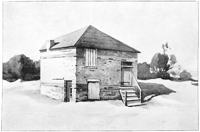
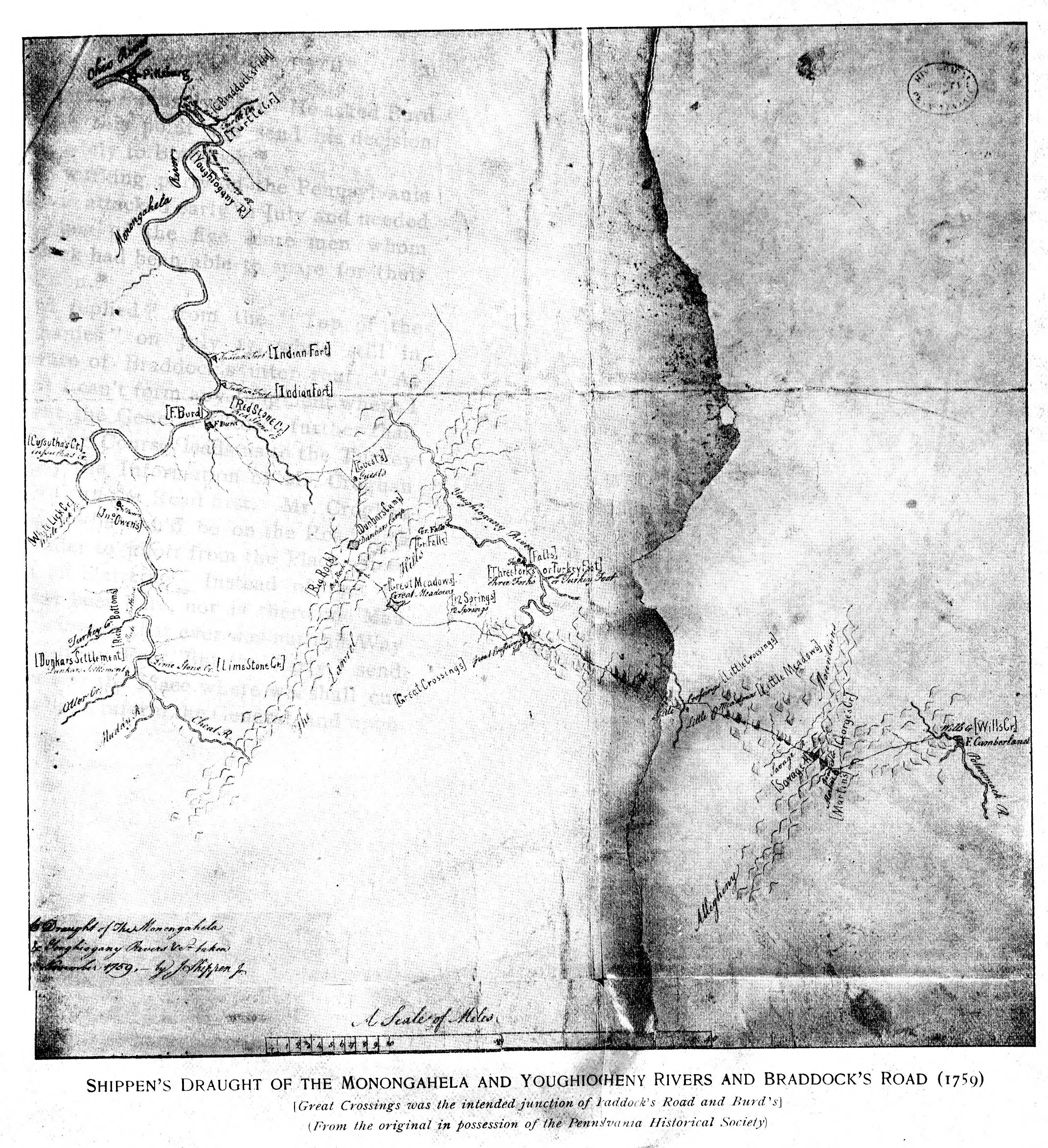
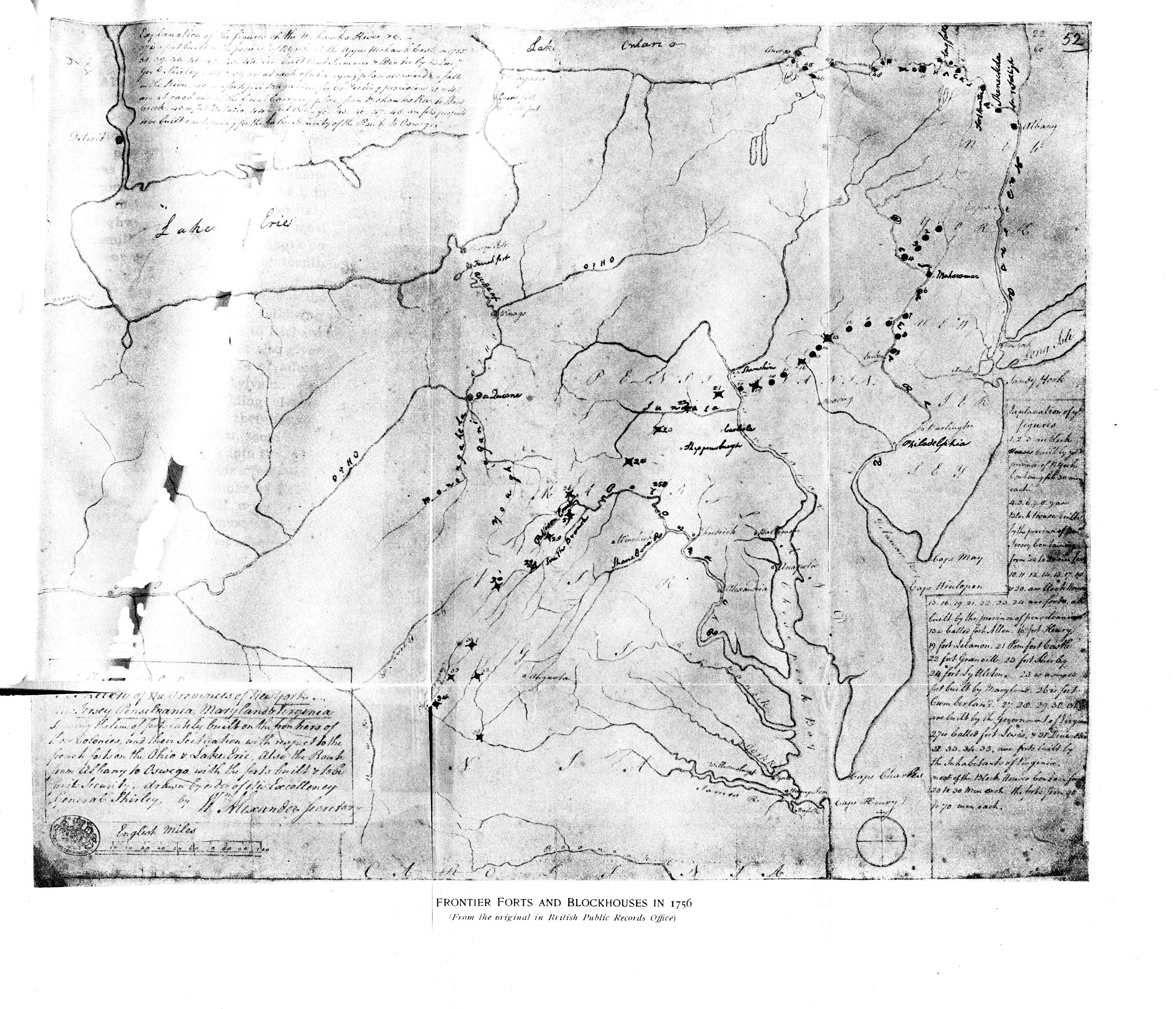
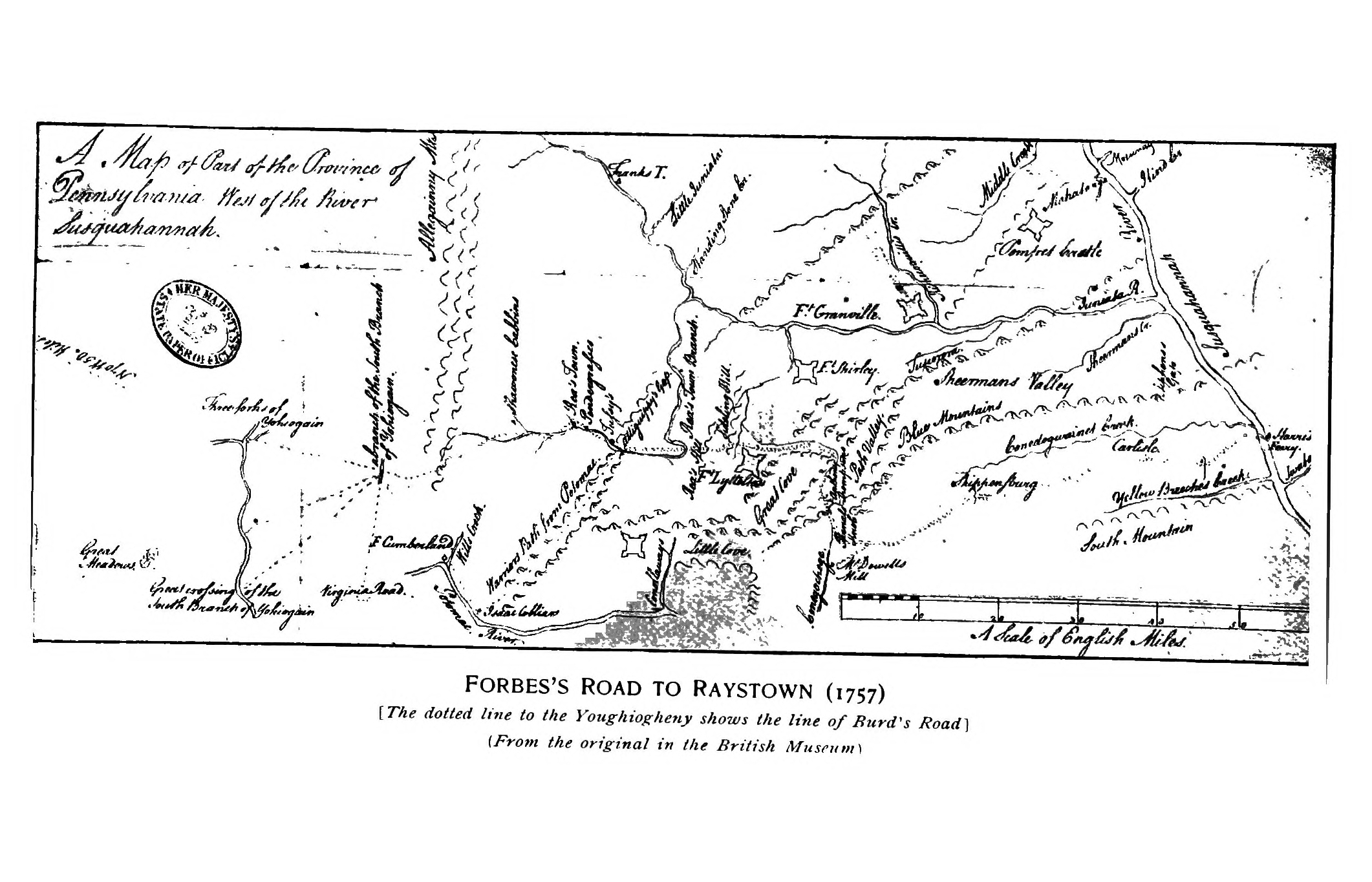