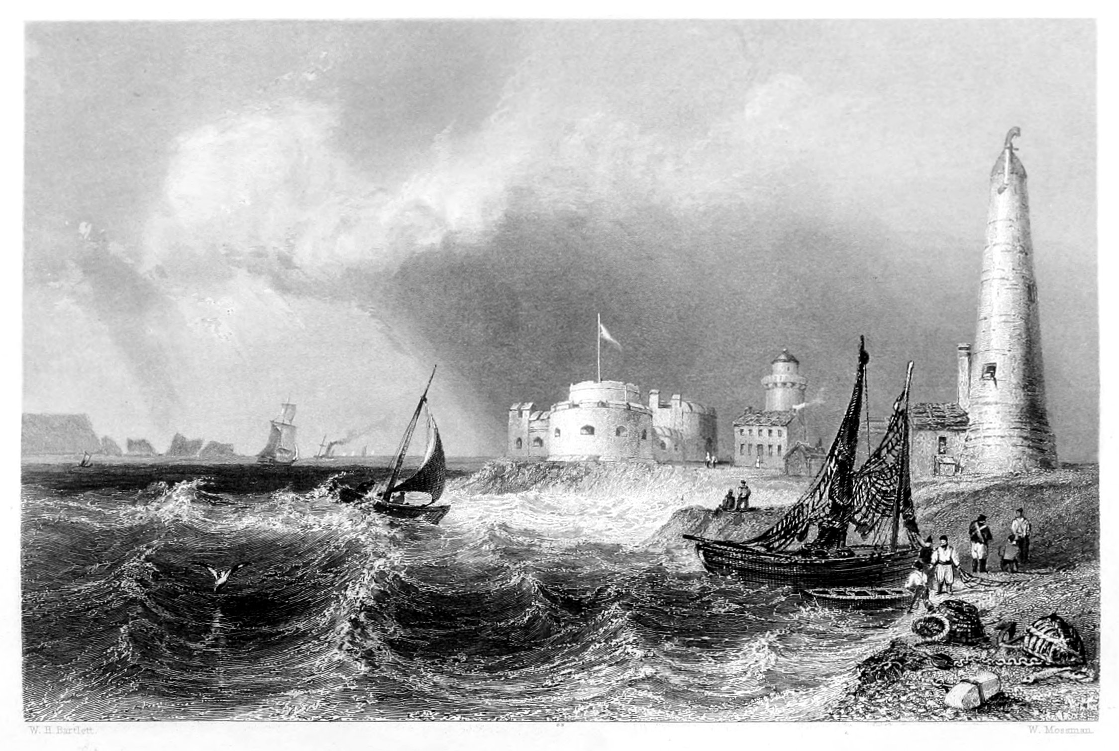
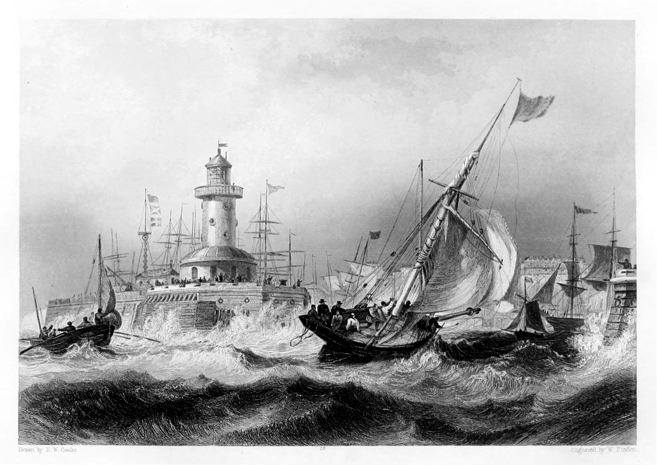
 ENTRANCE TO THE PORT OF BERWICK.
The Project Gutenberg EBook of The Ports, Harbours, Watering-places and
Picturesque Scenery of Great Britain Vol. 2, by William Finden

This eBook is for the use of anyone anywhere at no cost and with
almost no restrictions whatsoever.  You may copy it, give it away or
re-use it under the terms of the Project Gutenberg License included
with this eBook or online at www.gutenberg.org


Title: The Ports, Harbours, Watering-places and Picturesque Scenery of Great Britain Vol. 2

Author: William Finden

Illustrator: W. H. Bartlett
             J. D. Harding
             T. Creswick

Release Date: January 6, 2011 [EBook #34867]

Language: English

Character set encoding: ISO-8859-1

*** START OF THIS PROJECT GUTENBERG EBOOK THE PORTS, HARBOURS ***


Produced by Chris Curnow, Susan Skinner and the Online
Distributed Proofreading Team at http://www.pgdp.net (This
file was produced from images generously made available
by The Internet Archive)
THE
PORTS, HARBOURS, WATERING-PLACES,
And Picturesque Scenery
OF
GREAT BRITAIN.
ILLUSTRATED BY VIEWS TAKEN ON THE SPOT,
BY
W. H. BARTLETT, J. D. HARDING, T. CRESWICK,
AND OTHERS.
WITH DESCRIPTIONS, HISTORICAL AND TOPOGRAPHICAL.
VOL. II.
JAMES S. VIRTUE, CITY ROAD, AND IVY LANE, LONDON.
VOLUME II.
The River Mersey, at Liverpool.
Liverpool—Canning Dock and Custom-House.
———— St. Nicholas' Church, with Shipping.
Conway Castle, with the Suspension-Bridge.
———— Quay, with the Castle and Bridge.
Menai Bridge, with the Strait.
Beaumaris, with the Menai Strait.
Holyhead, the Lighthouse, Triumphal-Arch, &c.
Carnarvon Castle, the Eagle Tower.
Swansea Bay, with Lighthouse in the Distance.
Oystermouth Castle, overlooking Swansea Bay.
The Mumbles' Lighthouse, Swansea Bay.
Gloucester, Port and Cathedral.
Bristol City, from Rownham Ferry.
—————— Redcliffe Church and Basin.
Clifton, with the New Suspension-Bridge.
Bath, with the City, Cathedral, and Downs.
Sidmouth, View from the Beach.
Hurst Castle, King Charles's Prison.
Portsmouth, Entrance to the Harbour.
—————— Rigging-Hulk and Frigate.
—————— View from the Saluting Platform.
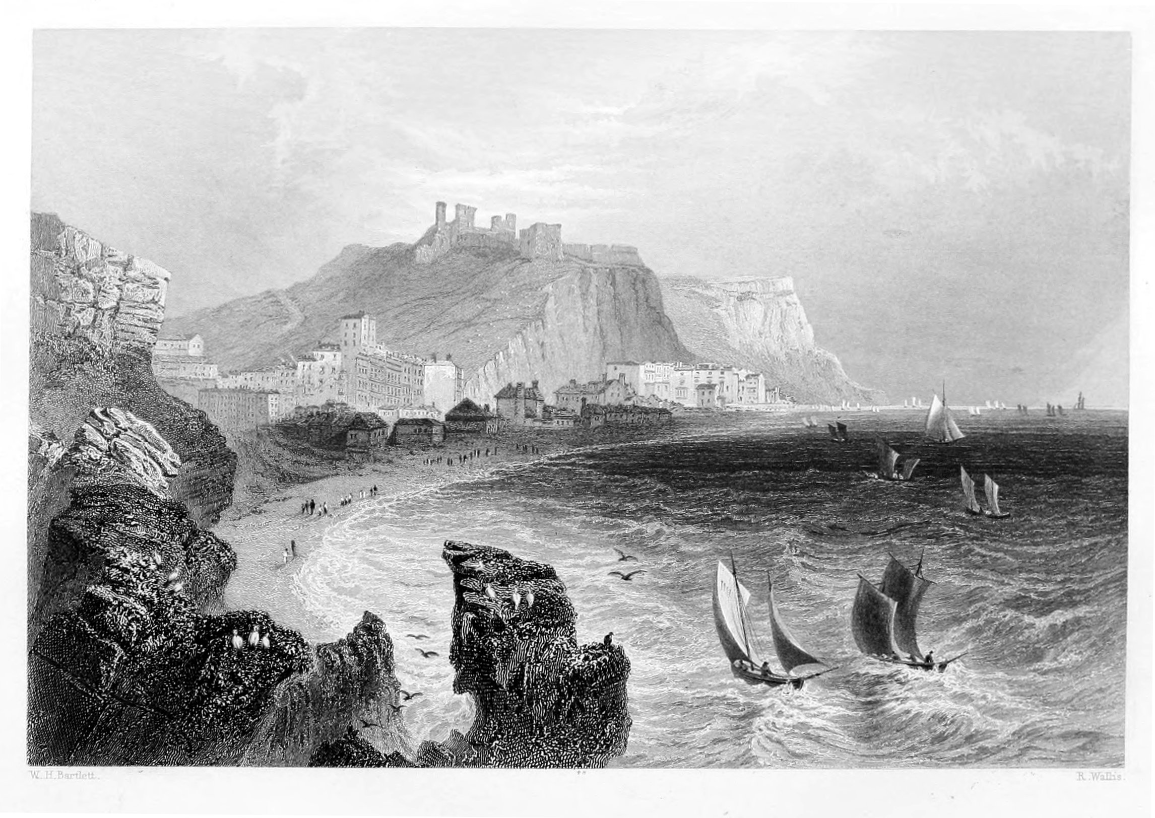
Hastings, with the Town and Castle.
Rye, Sussex, with its ancient Gate, Church, &c.
Sandwich, Kent, Ancient Gate and Drawbridge.
Ramsgate, Kent, Entrance to the Harbour.
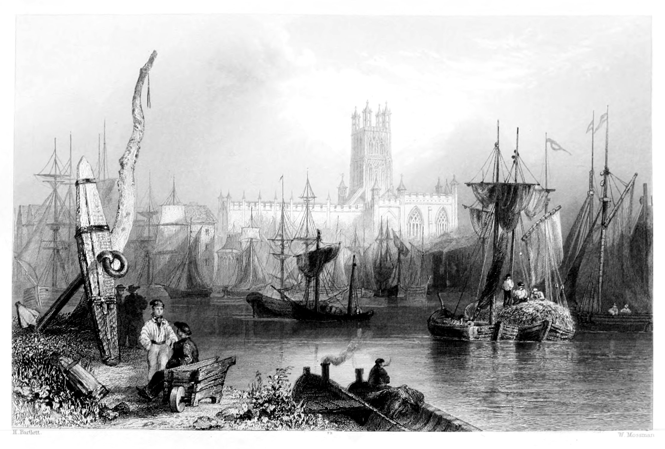
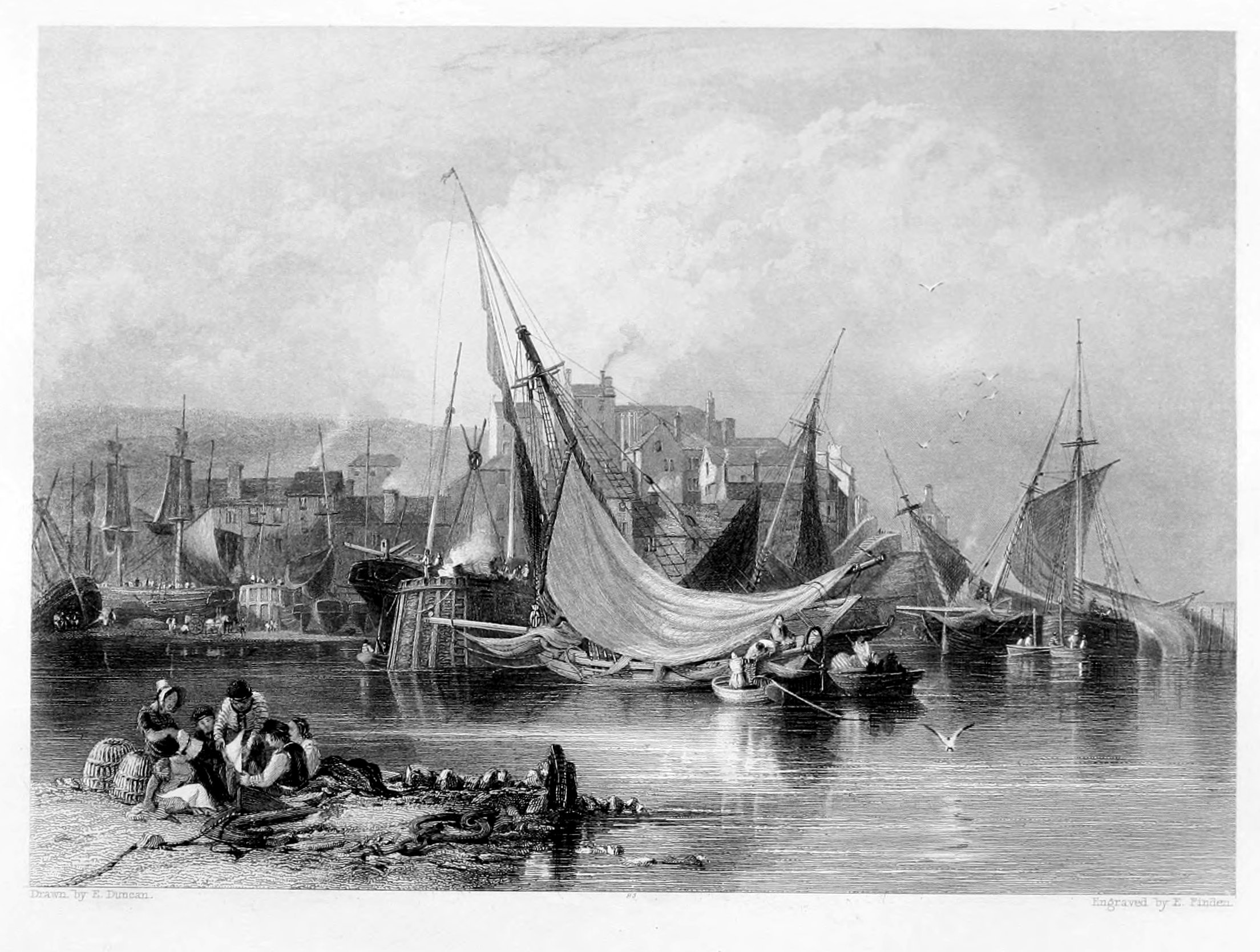
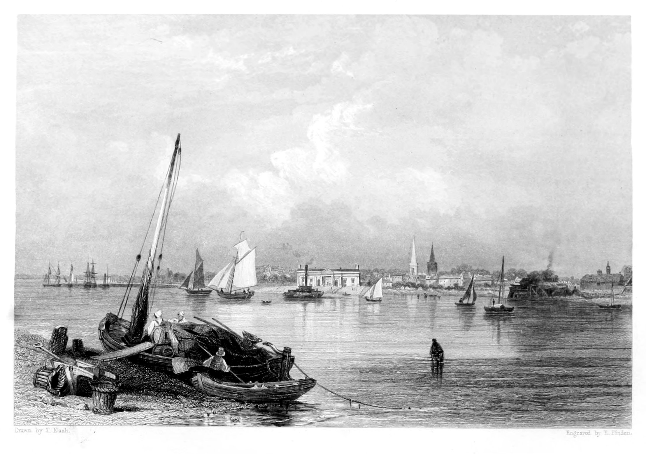
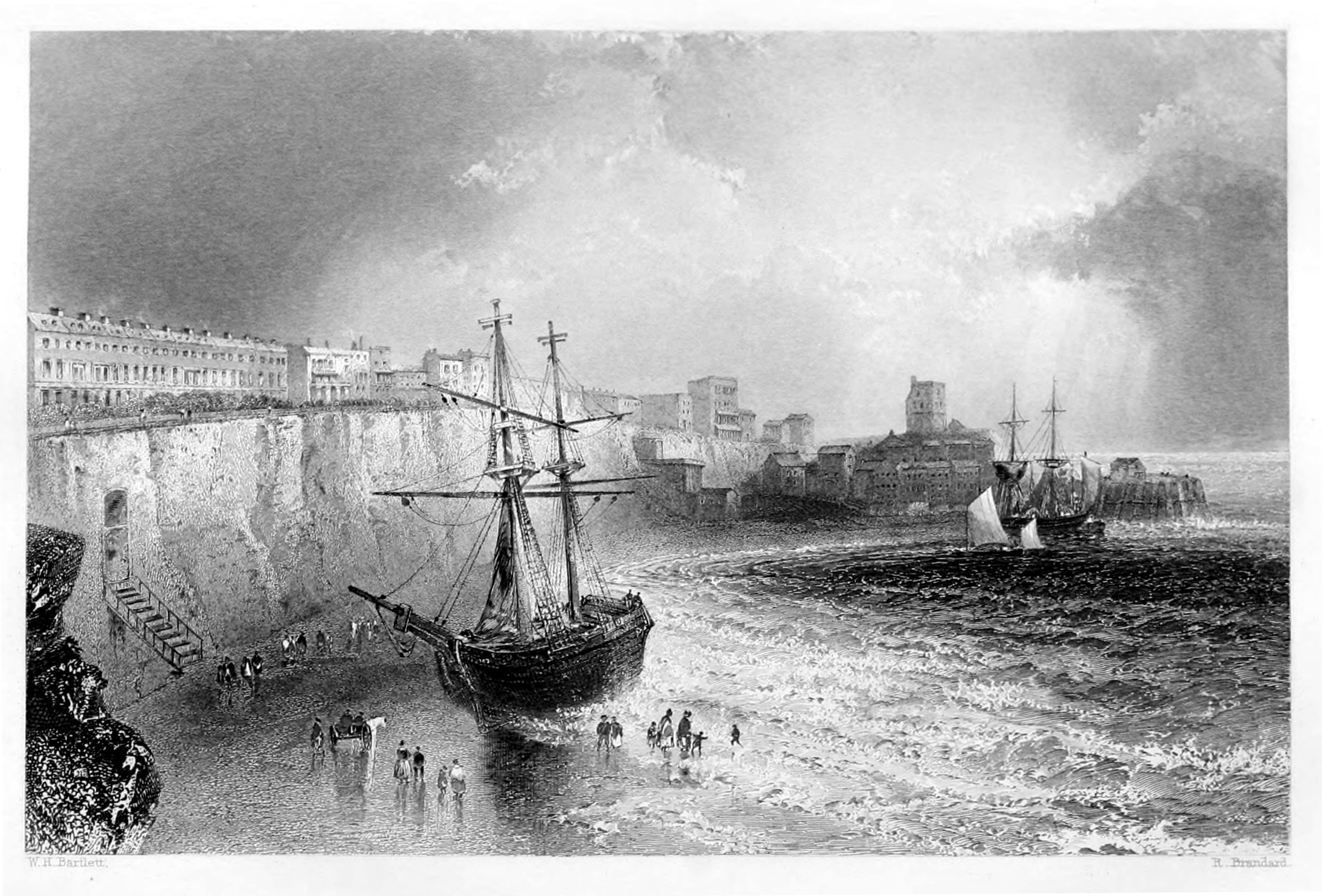
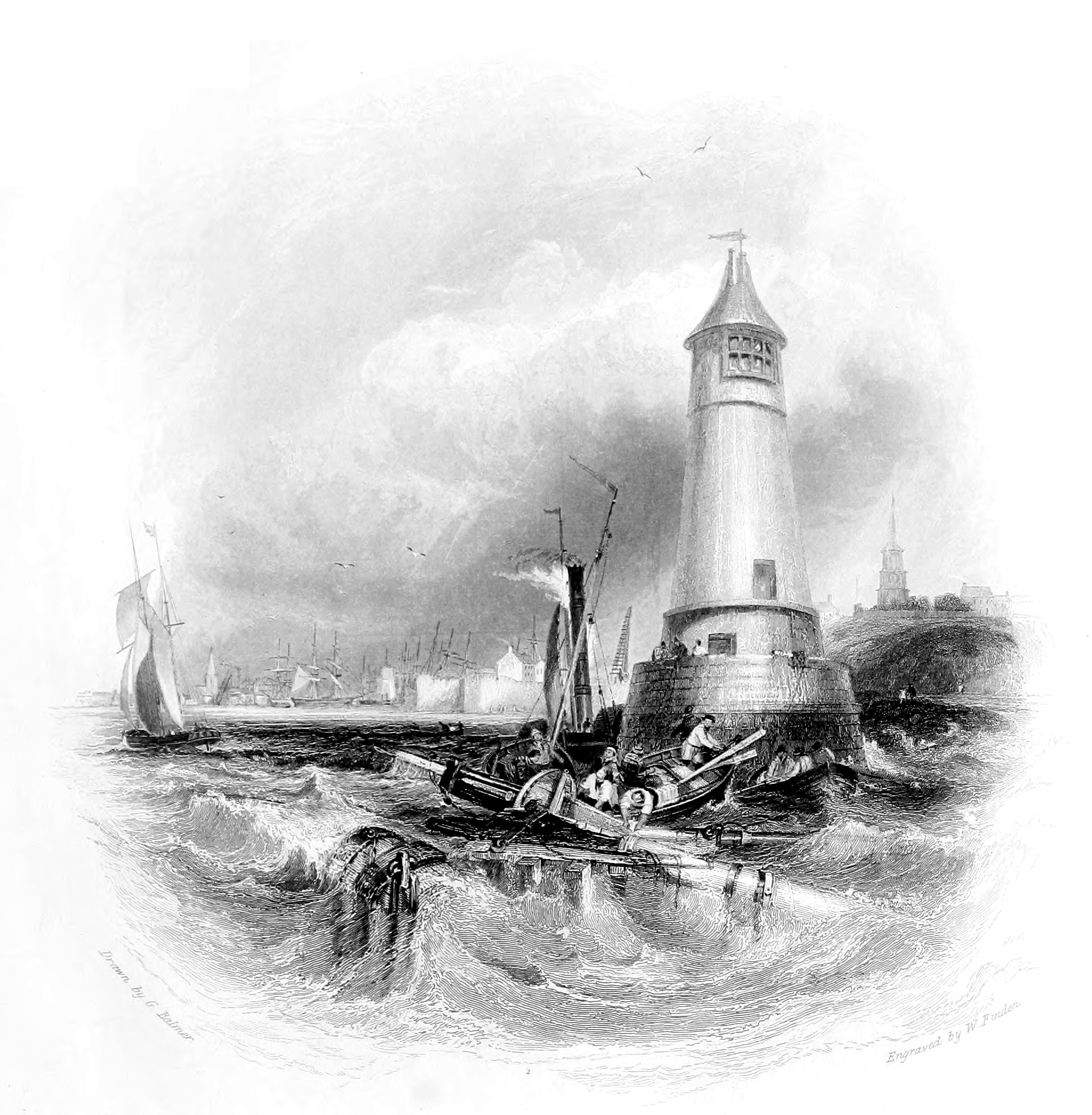
The view of the Lighthouse, at the head of Berwick Pier (which forms the vignette to our Second Volume), is taken from the entrance to the harbour, about half a mile below the bridge. This Pier, the building of which was commenced in 1810, stands on the north side of the river, and is chiefly erected on the foundations of an old one, which is said to have been built in the reign of Queen Elizabeth. From the lighthouse, which was finished in 1826, two lights are exhibited at night, the one above the other. The upper one, which is of a pale, white colour, is lighted from sunset to sunrise; the lower one, which is of a bright red, is a tide-light, and is only displayed during the time that there is ten feet water on the bar.
Berwick Harbour is not well adapted for vessels of large burthen, for the greater part of the shore, in front of the quay, is dry at low water. On the Tweedmouth side, near the Car Rock, is the best water within the bar; and a vessel drawing from sixteen to eighteen feet water may lie there at all hours of the tide without touching the ground. The entrance to the harbour is narrow, as a bank of sand stretches out to the eastward, from the Spittal shore, to the extent of nearly half a mile, and approaches to within a cable's length of the rocks on the north. When the wind is from the eastward, there is always a swell on the bar; and the ebb-tide—more especially when there is a fresh in the river, in consequence of rain—runs out with such velocity that it is impossible for a vessel to make head against it. Vessels bound for Berwick, which cannot take the harbour in bad weather, usually seek shelter in Leith Roads.
The salmon fishery forms a most important branch of the trade of Berwick. About the middle of the last century, the fish used chiefly to be conveyed to London by small vessels of about forty tons burthen, belonging to Harwich and Gravesend, engaged by the London dealers; the fresh-caught salmon and gilse were conveyed in wells in the hold, but a large portion was sent pickled in kits. About 1787, the practice of packing salmon in pounded ice was suggested by George Dempster, Esq., of Dunnichen, then M.P. for Cupar, to Mr. John Richardson, a salmon-dealer, of Perth, who immediately adopted it; and the next year the salmon-dealers of Berwick followed his example.
Most of the salmon sent from Berwick to London are caught between the mouth of the Tweed and Norham, which is about eight miles up the river, and the highest point to which the tide flows. In 1799, the yearly rental of the fisheries within this distance, on both sides of the river, was estimated at £10,000; and in 1817 it was nearly double that sum. In consequence of the decline of the salmon fishery since 1820, it does not at the present time exceed £9,000. Various causes have been assigned for the decline of the salmon fishery in the Tweed; such as the building of the New Pier at the north side of the harbour; with the draining of lands and the destruction of fish in close time towards the upper parts of the river. How the building of the New Pier, and the draining of lands in Selkirk and Roxburghshire affect the breed of salmon, has not been clearly shown; and poaching in close time has not prevailed to a greater extent during the last twenty years than in the twenty years previous to 1816. The unremitting manner in which the river was legally fished between the mouth of the Tweed and Norham, from 1800 to 1817, is more likely to have been one great cause of the decline; but the proprietors of the fisheries seem unwilling to admit that a river may be over-fished, as well as land exhausted by over-cropping.
It can scarcely be said that there is a public market for salmon in Berwick, almost all that are caught being engrossed by factors or fish-curers, and sent to London; and salmon is generally as dear there as in the metropolis. The fish, as soon as caught, are packed in large boxes, between layers of pounded ice, and in this manner conveyed to the metropolis.
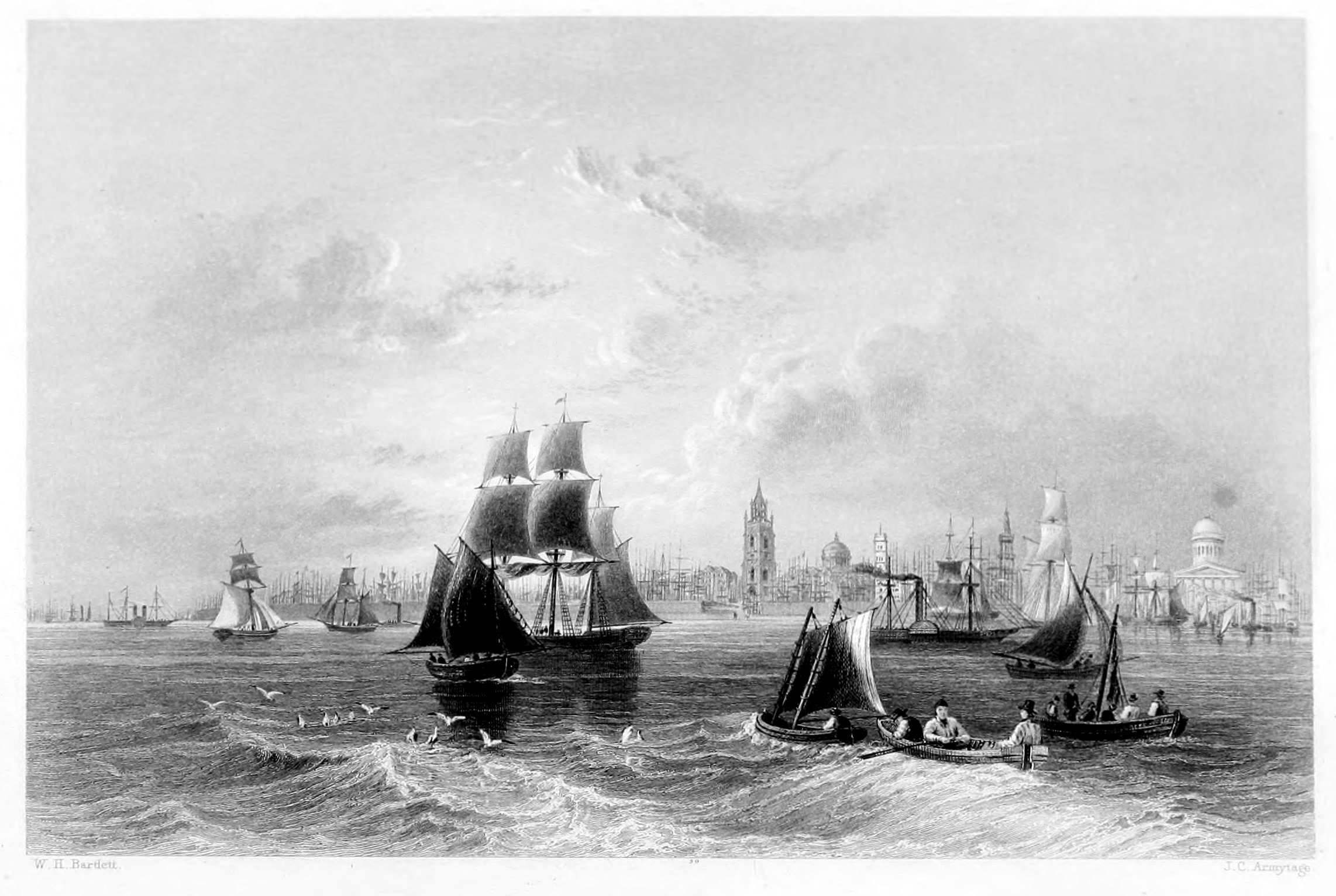
The Mersey is to Liverpool what the Thames is to London—the grand channel of mercantile prosperity—the main artery that carries health and vigour into the heart of the city, and thence distributes them by a thousand ramifications through all classes of the community. The navigation of this river has long been an object of primary import to the prosperity of our national trade; and therefore every suggestion which promised to obviate and remove those impediments which nature had thrown in the way, has been met with the greatest promptness and liberality. Whatever it was possible for art to accomplish has been attempted, and that so successfully that, if the ultimate object has not yet been obtained, the navigation of the Mersey has at least been rendered comparatively safe and expeditious. The grand enterprise for facilitating the intercourse between Liverpool and Manchester was commenced in 1720, when a canal was formed, and the navigation of the Mersey and Irwell was so greatly improved, that the "flats"—which were previously ten or eleven days in going from one town to the other—could now, by taking advantage of the tide, accomplish the same distance in as many hours. How amazingly this distance has been again shortened in our own times, by the introduction of steam power, is familiar to every one.
The rise and expansion of Liverpool—in all that regards it as a mercantile emporium—have taken place within the last two centuries. In 1650, the town—a mere fishing hamlet—consisted of only five or six streets. A pool, branching from the river, extended over the space now occupied by the new Custom-house and the three streets adjoining; and, for the convenience of intercourse, a ferry-boat was kept at the corner of Church-street and Whitechapel. This ferry was at last superseded by a bridge, erected by the proprietor of the land, Lord Molyneux; and since that period the advancement of the Mersey in the list of great navigable rivers has been unprecedentedly rapid and successful. The grand municipal improvements, however, have all been effected within the last century. During that interval, splendid squares, streets, and public monuments have sprung up into existence. Previously to that epoch there was no spirit, no scope for commercial enterprise, and consequently no harbour, nor dock, nor warehouse. But now spacious harbours extend for several miles along the bank of the Mersey: on the bosom of the river stately merchantmen, outward or homeward bound, laden with the produce of every clime, are continually passing and repassing; while the usual embellishments which follow a train of successful industry are apparent at every step of our progress, adding ever varying features of beauty and animation to the landscape. He who would form a just estimate of the vast and unlimited resources of this great commercial city, should spend at least a day, partly in a promenade along the banks, and partly on the spring-tide of the Mersey.
This river is navigable for vessels of considerable burden so far as the mouth of the Irwell,—a distance of thirty-five miles from Liverpool. It derives its source from the confluence of several small streams on the Cheshire and Derbyshire frontier, and pursues a serpentine course, gradually inclining to the south-west. Its largest tributary is the Irwell, which falls into it near the village of Flixton, seven miles from Manchester. A little below Warrington, the Mersey expands into a broad arm of the sea, and turning abruptly to the south-west, contracts its channel as it passes Liverpool to about three quarters of a mile in breadth; but in proceeding farther inland, it again increases its width to more than three miles. This peculiarity is very advantageous to the port, as the great body of water, passing and repassing at every tide, keeps the navigation of the Mersey always open. A range of sand banks run parallel with the coast for many miles, but several channels intervene, giving sufficient depth for vessels of the heaviest draught at high water, at which time the Mersey presents the most interesting and striking scene,—particularly when a westerly wind favours the arrival of the numerous fleets destined to this port, bearing the flags and freighted with the produce of all nations that have found a place in the chart of commercial enterprise.
Liverpool presents one of the most remarkable instances on record of the vast influence of commercial speculation, when pursued with steady vigour, prudence, and resolution. Commerce is the first step to empire, and, successfully prosecuted, never fails to consolidate the strength and independence of the state. To this important end no city in the kingdom has so amply contributed as Liverpool; none of our rivers, the Thames excepted, has wafted to our shores so many precious cargoes as the Mersey, nor exported so much of the produce of our native manufactures to all parts of the world. This great commercial city, rapid as its progress has been, is still advancing in the career of prosperity; hardly a month passes without some local improvement,—some substantial proof that her trade is on the increase, stimulating domestic industry, and affording the means of unlimited intercourse with every shore of the commercial world.
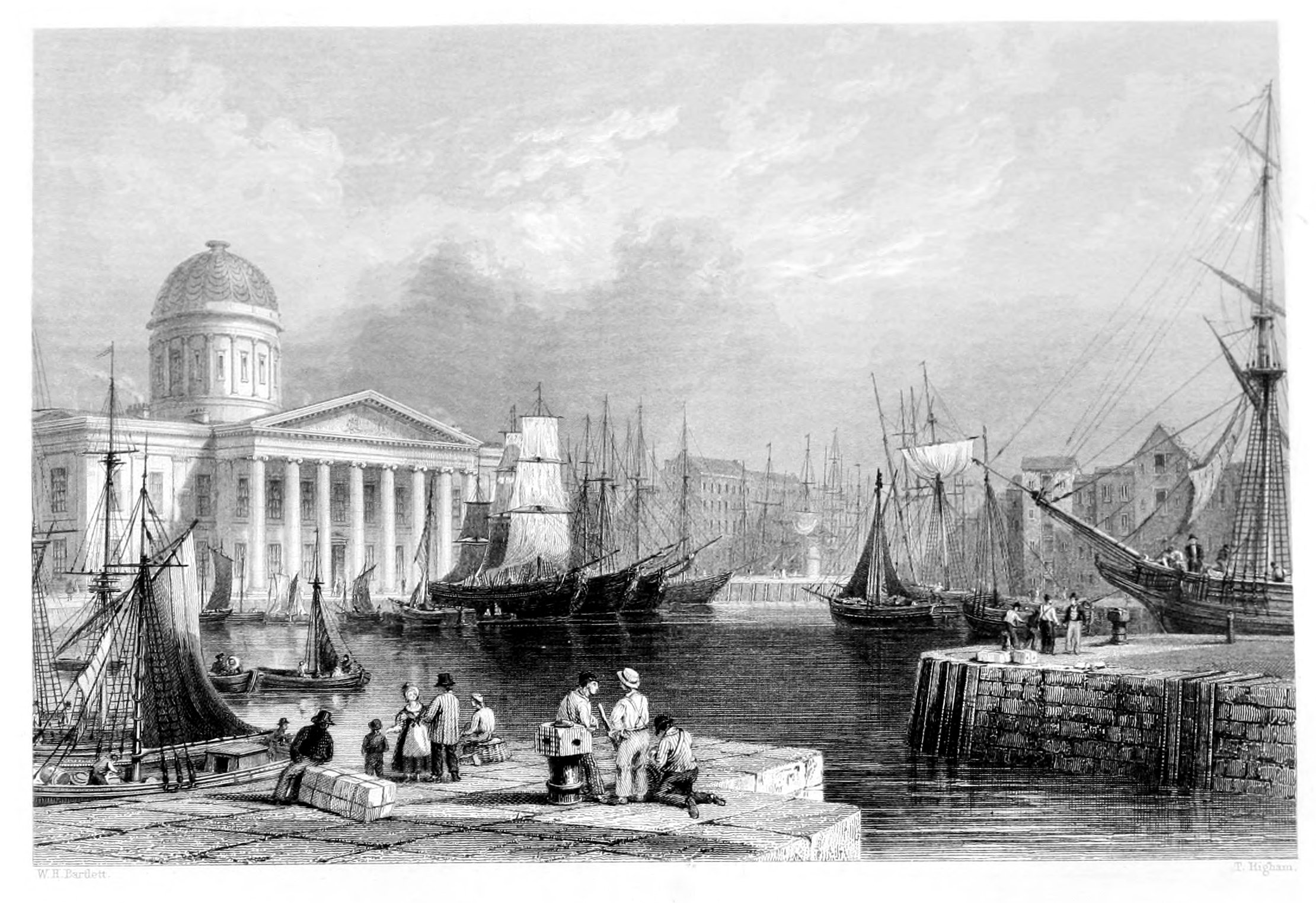
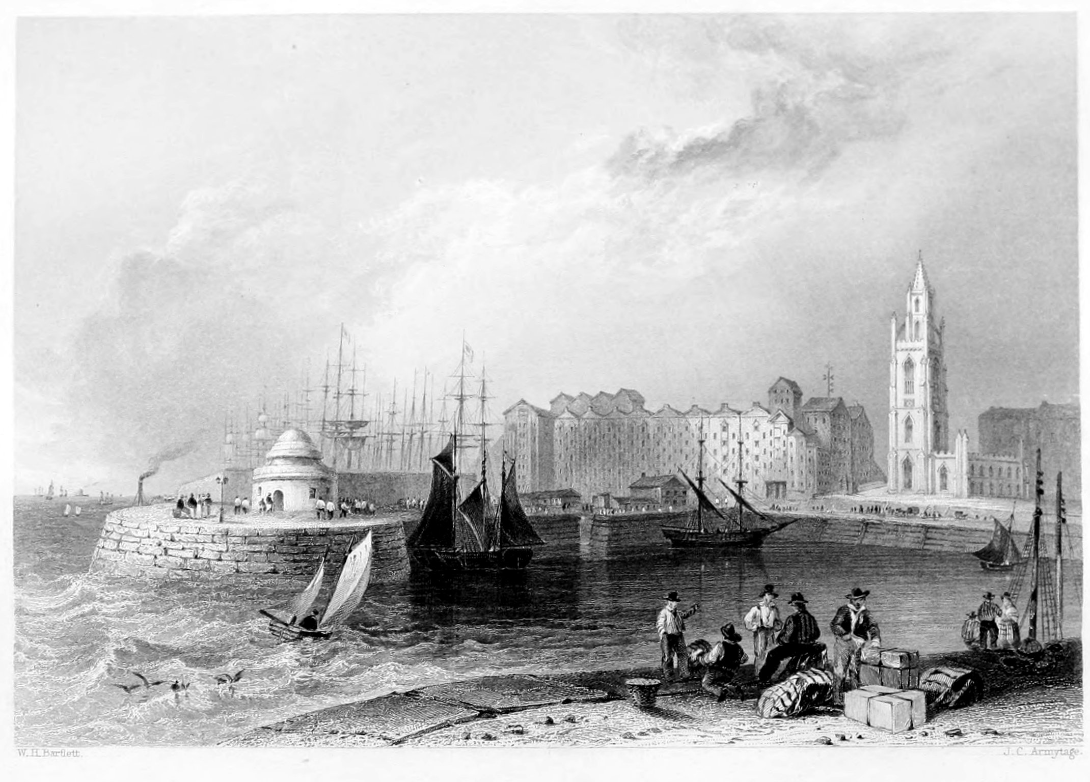
Canning Dock, with the Custom-house, forms one of the finest points of view in Liverpool, presenting at one view a building of elegant design and execution, and a forest of masts which sufficiently indicate the bustle of trade, and the air of business that pervade every feature of the place—animate or inanimate. Canning Dock—so distinguished in honour of Mr. Canning, a name happily identified with Liverpool and the prosperity of its trade,—covers a space of five hundred yards in length. On the west side it communicates with three graving docks, where vessels are laid up for repairs, and is chiefly occupied by vessels trading to the northern coast. It is the first of the seven docks extending southward, and is generally filled by vessels in the act of discharging or taking in their cargoes. It presents a scene of great bustle and activity, and, though only one out of many, affords the stranger a very clear idea of the vast amount of traffic that is daily shipped or entered at this emporium.
The Custom-House is of recent date, and replaced the old official buildings, which were found quite inadequate to the purposes of a daily extending commerce. Through the united interest of Canning and Huskisson, negociations were entered into with Government as to the necessity of a new Custom-house; and after a short time arrangements were concluded for its immediate erection. Mr. Foster, architect to the Liverpool corporation, was engaged to prepare the designs, and made choice of the present site as the most appropriate for a commercial building of this size and character.
The lower apartments of the Custom-house consist of spacious vaults for the safe custody of bonded and other goods; and in the centre is the apartment known as the Long Room. The offices of customs occupy the whole extent of the west wing; and it is intended that part of the east wing shall be appropriated to the use of the general post-office. Above these are the excise offices and those of the dock-treasurer and secretaries. The remaining portions of the edifice are subdivided into the board-room, the dock-committee's offices, and the stamp-office.
The chasteness and beauty of the Ionic style of architecture adopted in this magnificent edifice have been much and justly admired. The centre, and the east and west fronts are adorned by lofty porticos, each supported by eight Ionic columns. The centre of the building is surmounted by a magnificent dome, lighted by sixteen windows, and ornamented round by pilasters. Inclosed within the outer dome is a smaller one encircled by twelve windows, so as to afford sufficient light to the Long Room. The interior of this building will amply repay the stranger for a visit. The grand front is opposite Castle-street; and, entering in this direction, the first object which claims attention is the massive grouping of the pilasters which support the floor of the Long Room over head. The stairs, flanked by handsome iron balustrades,—the landing-places supported by eight Ionic stone columns, each of a single piece,—the four pilasters, and the elaborate ceilings,—are all deserving of particular attention. The Long Room is altogether splendidly designed and executed; lighted by fourteen windows on the sides, and by twelve as already observed, in the inner dome. The ceiling is divided by lateral and transverse beams into regular compartments, all beautifully ornamented. At each of the opposite ends of this noble apartment are a corresponding flight of stairs and landing-places. But to convey a just description of this monument to the genius of commerce is at once difficult and tedious; we therefore recommend all who may visit Liverpool, as admirers of its docks, harbours, and splendid edifices, to devote an hour to the Custom-house—a building which reflects great honour upon the architect, and serves as a lasting ornament to the second city of the empire.
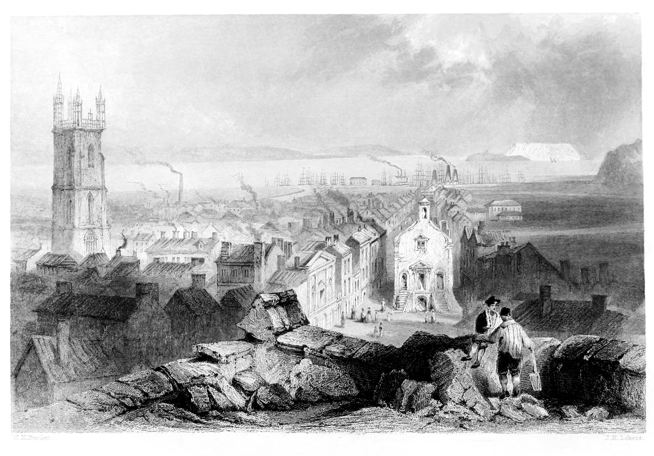
 ST. NICHOLAS' CHURCH, LIVERPOOL.
St. Nicholas, or the Old Church, is supposed to stand upon the site of an ancient chapel built about the time of the Conquest. But whether this be correct or not, there is at least evidence to prove that, in 1361, license for burial here was granted by the Bishop of Lichfield. It was endowed by Queen Elizabeth with a small sum, under five pounds, to be paid annually out of the chantry rents to the minister; and another sum, between five and six pounds, as a yearly grant to the schoolmaster. In the olden time a statue of the patron, St. Nicholas, erected in the churchyard, was much frequented by mariners, who believed that an offering made to the saint would conciliate the winds in their favour, and secure a prosperous voyage. Time, however, put an end to this confederacy between the saint and seamen. St. Nicholas was dethroned; and for a time the winds "blew as if they would have cracked their cheeks" at the downfall of one who had so long laid them under arrest. But at length a better knowledge of the compass and the coast made the seaman ample compensation for the loss of his ghostly patron, and showed him that a skilful mariner and a stout bark are better securities against storm and tempest than any saint in the calendar.
In 1774 this church was rebuilt,—"The old roof, walls, and Gothic pillars, the old blue ceiling, black and white clouds, golden sun, moon, and stars, painted and gilt thereon," were removed, and the re-edification completed, under the direction of Joseph Brooks, Esq. In 1810 this church was the scene of a dreadful catastrophe; the steeple suddenly gave way as the children of the charity-school were entering the church. It fell upon the body of the building, and twenty-four lives were sacrificed, seventeen of which were girls belonging to the school. Many others were severely wounded. The accident was attributed to the weakness of an old arch upon which a modern spire had been erected. The spire was subsequently restored by Mr. Harrison, of Chester, with a degree of taste and execution which does him credit. It consists of an ornamented Gothic tower, surmounted by an open lantern, with an air of great lightness and elegance, and forming a very striking feature among the many architectural objects—civil and ecclesiastical—by which it is surrounded. The height of the tower is one hundred and twenty feet, and that of the lantern sixty; so that together the steeple has an elevation of not less than one hundred and eighty feet. During the night the clock opposite the river is illuminated, so that it may serve as a landmark to assure the mariner that St. Nicholas is still on the watch for his safety, as in the good olden time.
St. George's Dock, from which the view of the Church is taken, was constructed according to an act of parliament obtained in 1762, and completed at an expenditure of twenty-one thousand pounds. It is two hundred and sixty-four yards in length, one hundred in breadth, and lined on the east side by a row of very large warehouses, with footpaths under the piazzas. Extending along both sides are sheds for merchandise; and on the pier-head, at the west side of the dock, are the public baths. The latter, comprised in a large building of plain but classical design and execution, were erected by the corporation at an expense of thirty-six thousand pounds, and opened to the public in the month of June, 1829. Nothing could be better adapted to its purpose than this great public edifice, in which the twofold recommendation of ornament and utility are happily combined. The water is constantly flowing through the baths in a fresh current; being supplied from the river at high-tide, filtered, and contained in a reservoir of eight hundred tons under the centre of the building. Private, cold, shower, warm, tepid, medicated, and vapour baths are to be had at all hours; and from the excellent manner in which every department is arranged and conducted, the inhabitants possess in this establishment one of the great means of promoting health and averting disease.
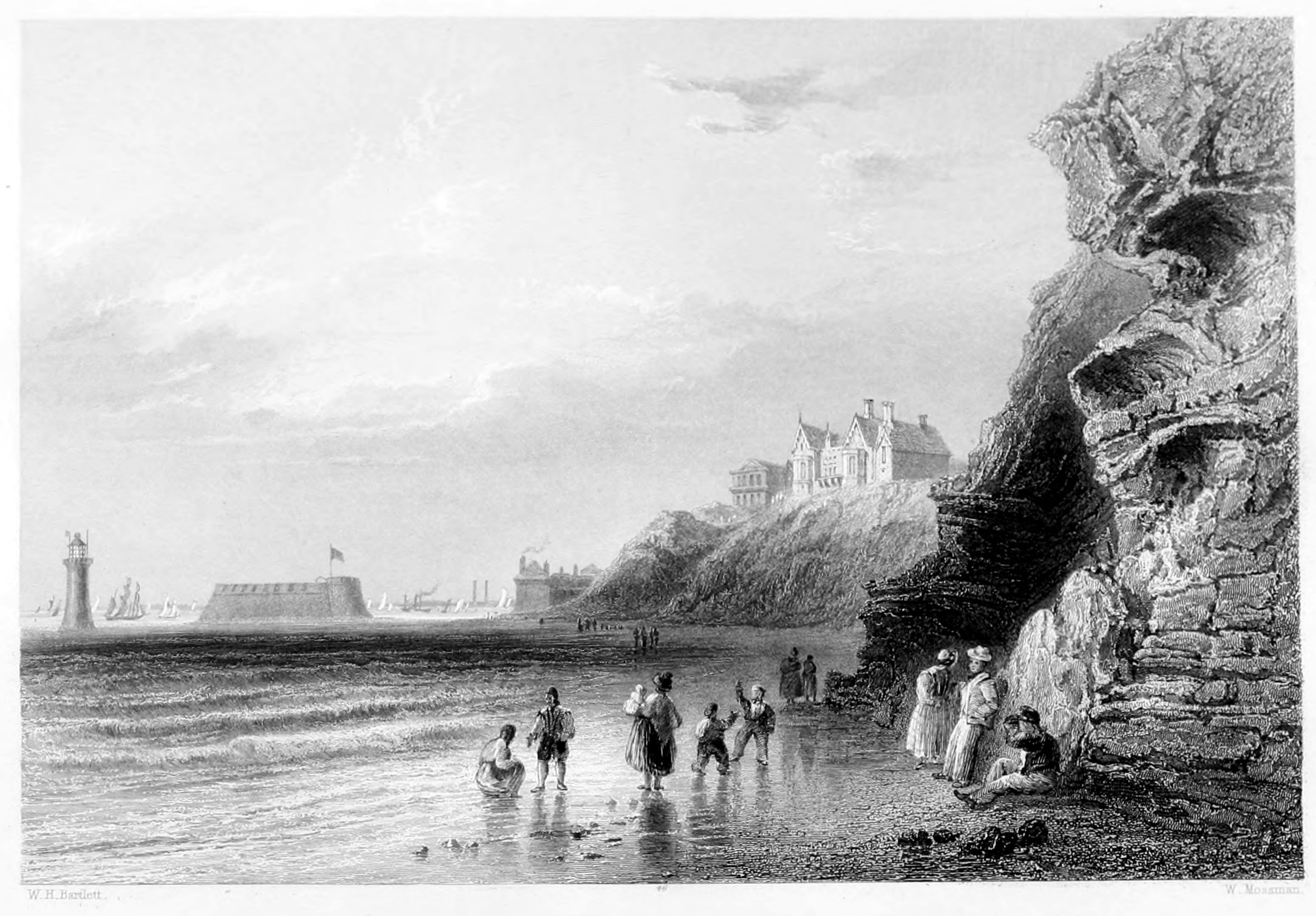
New Brighton has already taken a prominent station in the list of fashionable watering-places, and in several respects bids fair to eclipse even the attractions of its celebrated namesake in Sussex. Highly favoured by nature in a romantic point of view, the striking features of this locality have been duly taken advantage of in constructing a series of marine villas, all in harmony with the native landscape. These, with the most picturesque effects as viewed from a distance, combine every accommodation that can be desired,—either for families of distinction, or private individuals; while the air, which the invalid inhales from the atmosphere around him, produces a degree of vigour and exhilaration, which is rarely experienced in situations more inland or less elevated.
The honour of founding New Brighton belongs to James Atherton, Esq. A bold design, as it at first appeared, but which judgment, taste, and a liberal hand have converted into a lasting monument,—creditable alike to the originator and to the discriminating public, who have manifested a decided preference for the situation, and thus amply justified the enterprise. The first step taken by Mr. Atherton was to purchase nearly two hundred acres of land, including the site of the future town. These were put under the care of persons well instructed in the plan of operations. The design was prosecuted with unremitting zeal; houses sprang up, streets were laid out, and in a comparatively short time the skeleton of New Brighton was completed. Strangers resorted to the spot; the citizens of Liverpool became eager for its completion, and for those enjoyments which it presented as a summer retreat, as well as for the many advantages which it offered to the invalid. Thus encouraged by the vote of public approbation, the works made rapid progress, and shortly after assumed the name and consideration of a favourite watering-place.
In the design and execution of the various embellishments of the place, the architect has never stepped aside from the rules of good taste. The pleasure and accommodation of the visitors have been carefully studied. Spacious streets, fifteen yards in breadth and nearly a mile in length, insure a free circulation of air, and throw open an agreeable promenade to the public, who resort thither in great numbers during the summer and autumn. The partiality evinced for this watering place, (of which the inhabitants can so readily take advantage,) is every day adding to the number of its visitors, and thereby contributing to the further extension of the original plan. A commodious and elegant hotel has been erected, where casual visitors and others, in conjunction with the allurements of a well-served table, can enjoy the exhilarating prospect of the sea, and the numberless vessels of all denominations that stud and traverse its waters. For the accommodation of the resident population, a reservoir, containing nearly two thousand gallons of water, has been constructed, and supplied from a fine spring on the beach.
The Fort and Lighthouse are objects well deserving of attention. The former is very strongly built, and covers a space of nearly four thousand yards. It is approached from the main land by means of a drawbridge, and mounts sixteen pieces of cannon with others in the embrasures of the towers. On account of the great sandbank at the entrance of the river, it is ordered that every ship of heavy burden shall pass within nine hundred yards of the Fort.
The Lighthouse is constructed of Anglesey marble, and is considered a masterpiece of its kind. It rises about ninety feet above the rock; each stone is worked to a given geometrical form, and made to lock and dovetail with those adjoining with great accuracy. The whole is cemented together by a liquid volcanic substance brought from the vicinity of Mount Ætna, which, in the course of time, becomes as hard as marble. The lantern is illuminated by revolving lights—two of which are brilliantly white, and the other of a deep red. The work is from the design of Mr. Foster, and executed by Mr. Tomkinson, at an expense to the Liverpool Corporation of twenty-seven thousand five hundred pounds.
The reputation of the Matlock water is supported by the recorded testimony of more than a century; while the picturesque scenery in which the village is embosomed forms no small addition to its medicinal attractions. The number of invalids who resort annually to this salubrious spring appears to be on the increase,—the best criterion of the value attached to it. In the superior accommodation which it now offers to every class of visitors, nothing has been neglected that even the most fastidious can desire. Those domestic comforts, in particular, which are often of more real importance to valetudinarians than the skill of the physician, have been provided with a scrupulous exactness, which makes the stranger at Matlock feel completely at home.
Matlock, however, though so friendly to the invalid, is neither gloomy nor isolated; but to those who delight to mix in the gayer scenes of artificial life, it possesses every attraction which refined society and social intercourse can bestow. He who seeks health, and he who seeks relaxation and pleasure, may enjoy every facility which science or fashion can offer; and nowhere are the amusements better conducted, or the rules of society more strictly observed, than at Matlock.
The environs embrace some of the most striking and romantic scenery, as well as historical sites, in England; and so close at hand that many of the finest features enter into the same picture. Washed by the crystal Derwent and finely wooded,—with rocks, and fountains, and precipices, scattered at random through the charming landscape,—the visitor is tempted to pass much of his time in the open air, which accelerates the cure the water has begun. Romantic foot-paths, meandering along the rocky acclivities, and opening at short intervals upon enchanting points of view, allure the indolent to that salutary exercise which seldom fails to reward the piéton with increased strength and exhilaration of spirits. The roads in the vicinity are kept in the best possible order, and, owing to the nature of the soil, rain is so speedily carried off, or absorbed, that the invalid may indulge in out-door exercise without apprehension.
That portion of Matlock in which the invalid is most interested consists of the Old Bath, the New Bath, the Hotel, and several commodious lodging-houses, situated on the south-east side of the Derwent. These, with the various additions and improvements recently effected, offer to his choice all that can be desired in point of comfort and convenience. The buildings are of stone, elegantly constructed externally, and presenting internally an arrangement admirably adapted to the purposes of their erection. The servants of the establishments are well conducted, and attentive to their several duties; and the vigilance with which every department is regulated is a subject of commendation with every visitor.
The water of Matlock is remarkable for its sparkling purity; it springs from limestone rock in a copious stream; and, having a temperature of sixty-eight degrees of Fahrenheit, is to be considered as a thermal water. It has been found to contain a small portion of neutral salt—probably muriate of soda—and an earthy salt, chiefly calcareous. Of the latter, when the water is exposed to the air, a deposition is quickly effected, and incrustations formed upon every substance immersed in it—some curious specimens of which are seen at what are called the Petrifying Wells.
In a medical point of view, the water of Matlock may be employed in all those cases in which a pure diluent drink is advisable; but it is chiefly used as a tepid bath—or at least as one which exceeds the extreme limits of a cold bath. On this account, it produces only a slight shock on immersion, and is, therefore, peculiarly fitted for those delicate and languid habits that cannot exert sufficient reaction to overcome the effects of the common cold-bath, and on which the benefit it produces chiefly depends. It forms a good intermediate bath between that of Bath or Buxton and the sea, and may be recommended as a preparative for the latter. The abundant supply of water always at the same temperature is a circumstance in favour of natural baths; while the purity of the air and exquisite beauty of the situation must always render Matlock a favourite resort for the invalid and man of taste. To the geologist it presents a wide and interesting field of observation. Few districts in England comprise within the same limits so great a proportion of poetical and historical scenes.
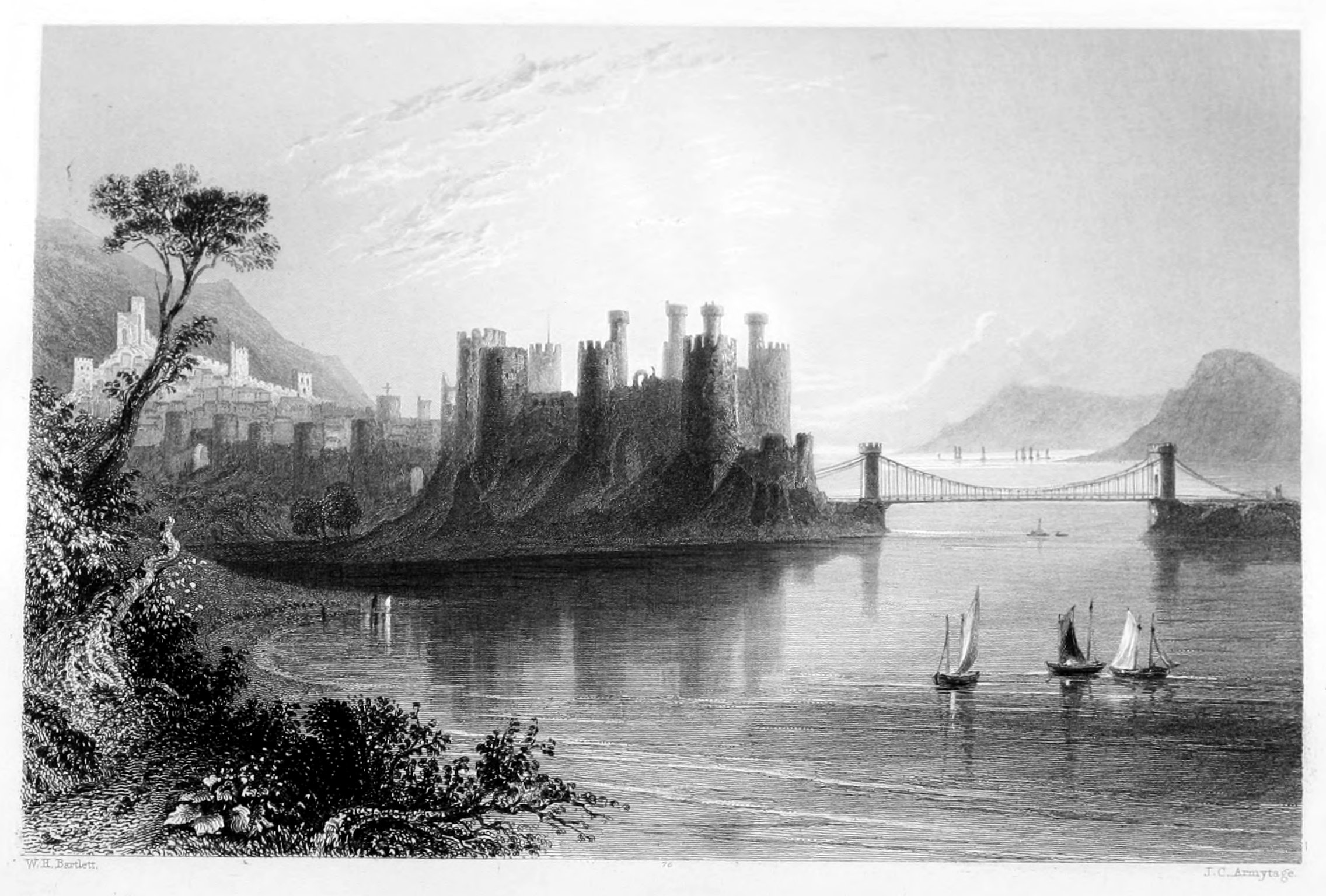
Conway, or more properly Aberconway—so called from its position on the river of that name—makes no inconsiderable figure in the page of ancient history. It appears, on the testimony of Suetonius, the Roman governor in Britain, that the chief motive entertained by his countrymen in their occupation of this coast was a pearl fishery at the mouth of the river Conway; a specimen of which, presented by Sir R. Wynne to the Queen of Charles the Second, is said to have found a place among the jewels that now adorn the British diadem.
The town of Conway is large, though not populous, and in situation and appearance highly picturesque. It is surrounded by lofty embattled walls, a mile and a half in circumference, well preserved, defended by twenty-four round-towers and four gates, and presenting at all points a striking picture of the ancient style of fortification. From the side towards the river ran two curtain-walls, terminating in watch-towers, but of which only one remains.
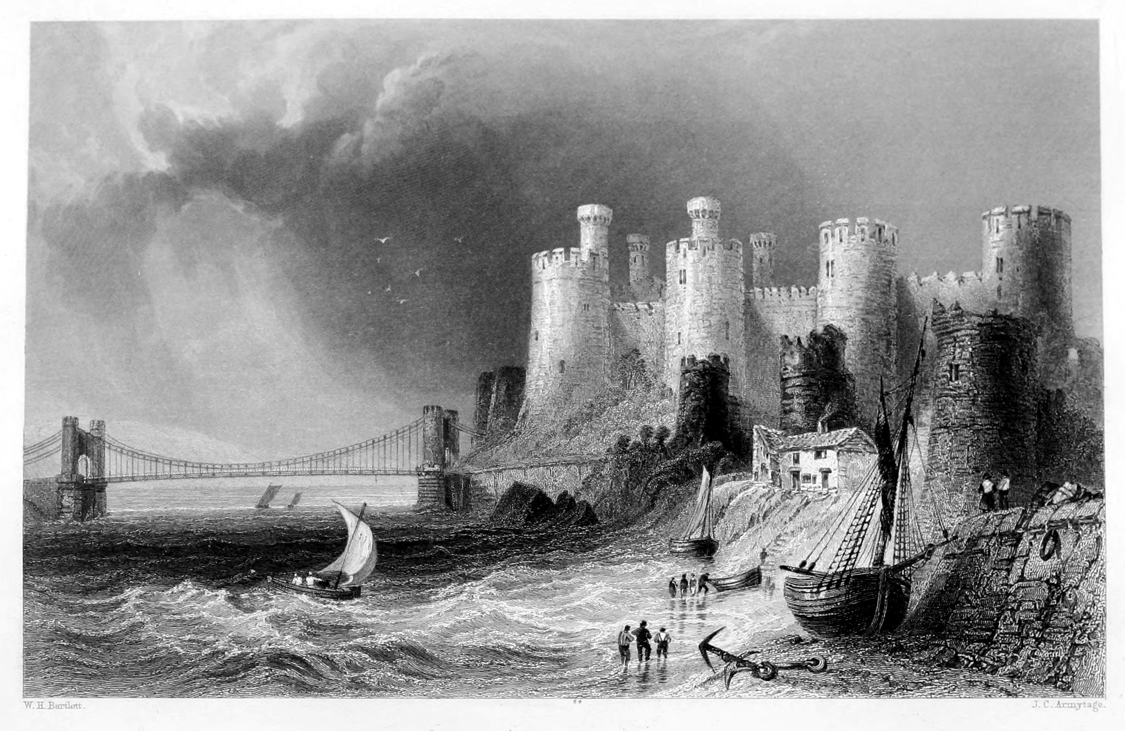
The castle, a truly grand and imposing structure, was built in 1284; an epoch which gave origin to so many of those native fortresses, which will long continue to be the subject of interest and admiration to every traveller in this romantic country.
Conway had, unlike Carnarvon and other fortresses situated on a level, no imposing portal to usher into the interior. Its two entrances were small, both practised for security, between an advanced work flanked by two small towers, one ascending by winding stairs from the river, the other, from the interior of the town, crossed the defensive moat by means of a drawbridge, and passed through a portal and outwork of small turrets into the great court of the castle. This stands on a rock, its courts flanked by eight enormous battlemented round-towers of unequalled beauty of proportion, those next the river having in addition small turrets. Of these towers, all are perfect as to their exterior save one, called Twr Dwu, or the broken tower, of which the lower portion, with the rock that supported it, has fallen away, exposing to view the immense solidity of its fractured walls. The interior of each tower was occupied by several stages of spacious apartments, the flooring and roof of which are entirely gone, with the fire-places, and lancet windows, the interior yawning in vacant desolation, blackened, weather-stained, and overgrown with rampant weeds and briers. There were stairs to ascend to the upper apartments from the courts below, and a way round the battlements which may still be followed out. The interior of the castle consists of two courts, comprising the different apartments. As we enter the grassy area, surrounded by ivied walls, and picturesquely surmounted by the battlemented turrets, the great hall appears on the right; three spacious windows of pointed architecture, and formerly highly enriched with mullions and tracery, lighted it on the side next the court, and the side wall, furnished with six lancet windows, with recessed and raised seats, looking out upon the creek, which, running up from the Conway, defended the walls on the south. Two carved fire-places of ample dimensions warmed the immense and royal apartment, supported by several gothic arches, some of which, clothed with ivy, still span the vacant space above, while beneath, among nettles and brambles, yawn the offices below. At the extremity of the hall is a noble arched window. The walls are now mantled thick with ivy, and the nettle and bramble overgrow what remains of the floor of this royal apartment, where Edward, whose statue in Westminster Abbey is of unequalled beauty, and Queen Eleanor, with masque and antique pageantry, entertained the throng of knights and barons bold, who had assisted in the subjugation of the Welsh, who besieged, however, the potent monarch in his own castle, and would have starved him into a surrender, but for the timely arrival of a fleet bearing soldiers and provisions. Since that period, its history is little remarkable. It was held in the civil war, for Charles I., by Archbishop Williams, who, being superseded by Prince Rupert, assisted the Parliamentarians in effecting the reduction of the place.
The district of Conway is mostly agricultural, and possesses no distinct manufactures by which the prosperity of the town and its population can be greatly promoted. A few small trading-vessels belong to the port; and here also ships of burden are occasionally repaired. The great improvement to the harbour is the erection of the quay; and the channel of the river having been deepened, and every impediment to the navigation removed, it may be anticipated that a speedy increase of trading intercourse will succeed its former languor and inactivity. The exports consist chiefly of timber, slate, and lead; and the imports, of coal from Flint and Liverpool, and of tea, sugar, cotton, with various other articles of domestic consumption.
The chain-bridge, which constitutes so beautiful a feature in the picture of Conway, was erected by Mr. Telford, of whose genius Wales possesses several of the noblest monuments. That immediately under notice—constructed on the same principles as the bridge over the Menai, but much smaller in its proportions—is three hundred and twenty feet between the supporting towers, and eighteen feet above high-water mark. Nothing can be more elegant and beautiful, as it appears lightly spanning the river, and suffering the eye to penetrate its net-like fabric, so as scarcely to offer an obstruction to the landscape which shines through it. The scenery at this point is exceedingly interesting, and presents the works of nature, and art, and human genius, in striking combination.
The town of Conway, before the formation of the railroad, was one of the most old-world places imaginable, unique for its faded and forlorn appearance, small as is the area enclosed, a considerable portion being occupied by open spaces and gardens. Everywhere entered by gothic portals, and as its interior was traced, with the defensive wall everywhere in sight, it transported the beholder back to the middle ages, more than any other walled city in England. There is a singular and picturesque variety of ancient houses; some at the head of the street leading to the castle, curiously carved, appear almost as old as the castle itself; others with their gable roofs, and black rafters, are of later date, and the Plas Mawr, or great mansion, in the principal street, prominently challenges the traveller's attention with its air of faded magnificence and singular construction. It is of Elizabethan architecture, and the arms of England, with initial letters E. R. and R. D., supposed to be Robert Dudley, Earl of Leicester, as well as those of R. W., Robert Wynne of Gwydir, sheriff of Carnarvon in 1591, and founder of the house, occur frequently, and the place is lavishly adorned with various decorative devices of the age—swans, owls, ostriches, mermaids, ragged staves, &c. The church contains little to interest beyond its front, and an inscription to a certain Nicholas Hooker, of Conway, gentleman, of a very anti-Malthusian import, the said Nicholas, though the father of twenty-seven children, being but a degenerate copy of his father, who could boast—O si sic omnia!—of no less than forty-one.
Numerous and delightful are the rambles about this most picturesque place, which is backed by bold heathy hills and green sequestered valleys. One of the prettiest is to Gyffin, about a mile distant, which may be reached by following up the shores of the creek, south of the castle, and the small stream coming down into it. The little church is very ancient, and contains some curious paintings worthy of inspection; it is half buried, and so unpretending is the building in aspect, that it may be passed almost without noticing its sacred character. There is an excellent view of the town and castle from the upper road on the return; the long line of walls may be traced from the highest point, as they sweep round and join the castle, the whole space thus enclosed resembling in its outline the Welsh harp, as often suggested. The river and hills appear finely beyond. The artist especially should not omit to view Conway from this, perhaps its finest point of view.
So unique is, or rather was, Conway Castle in picturesque effect, that it is difficult to mention any particular point from which it appears to greater advantage than another. From the quay, or the river, from every eminence around, seen in front or flank, near or distant, either by itself, or where the walls of the town prominently enter into the composition, it is, or rather was, alike unequalled. The tourist who is not pressed for time, and delights to hover around so magnificent a memorial of past ages, will study it at every point. On taking a solitary walk round the walls, he may fancy himself tracing the abandoned battlements of some old gothic town of the Orient, Rhodes, or Antioch, or the Saracenic defences of Jerusalem; a dream which may hardly be long indulged at present; for now, as Hood says,
and its crumbling memorials are sharing the same fate. Furness Abbey is turned into a railway station, and the passing train thunders through the very centre of old, castellated Conway, reminding us, while it indeed scares away all romantic daydreams, of the happy change from feudal oppression and border warfare, to the fusion of jarring interests, and the progress of enlightened civilization.
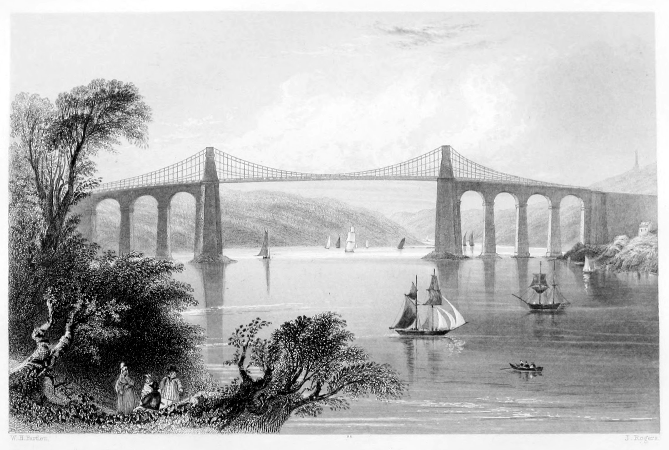
The Menai Bridge, one of the many triumphs of modern engineering, arose from the following circumstances. During the summer of 1818, Mr. Telford, the engineer, was engaged on a survey of the extensive line of road from the metropolis to Holyhead—that point of the Welsh coast nearest to Ireland, and situated in the Island of Anglesea. Between this island and the Caernarvon coast flows that arm of the sea familiar to every reader as the Menai Straits, through which the tide rushes with great velocity, owing to local peculiarities well known to all who have navigated that portion of the Channel. There were at this time five or six ferries across the strait; but these, owing to the circumstances mentioned, were generally difficult, and seldom without danger; so that the intercourse between the opposite shores being much impeded, was a source of daily inconvenience to the inhabitants. This was more particularly felt from the fact that one of the staple productions of Anglesea was its cattle, which, when sold for the inland counties or the London market, had to be driven into the water, and compelled to cross the strait by swimming, which was attended with risk of property as well as inconvenience. These circumstances were brought before the eyes of Telford, and his ever-active and ingenious mind set instantly to work, in order to remedy the evil by providing new facilities of intercourse. The result of his reflections and mature calculations on this engrossing topic was the possibility of throwing a bridge across the Menai.
The grand obstacle was a deep rapid tide-stream with high banks. To have erected a bridge of the usual materials would have obstructed the navigation; and any attempt to erect piers in the shifting bed of the sea must have inevitably proved a failure. Telford therefore recommended the erection of a suspension-bridge; and the plan, after due consideration, being approved by government, the work was commenced in 1820, carried on with great spirit, and in 1826 brought to a most successful termination. It is partly of stone, partly of iron, and consists of seven stone arches. These arches connect the land with the two main piers, which rise on an elevation of fifty-three feet above the level of the road, over the top of which the chains are suspended, each of which measures from its fastenings in the rock, one thousand seven hundred and fourteen feet. The topmasts of the first three-masted vessel which passed under the bridge were nearly as high as those of a frigate, but they cleared twelve feet and a half below the level of the roadway. The suspending power of the chains is calculated at two thousand and sixteen tons; and the total weight of each chain is one hundred and twenty-one tons.
Since the day it was first opened, the Menai Bridge has been the wonder of every traveller, an object of pilgrimage for scientific men of all countries, and a source of daily advantage to the United Kingdom, which no other work would have supplied. "The visiting of the Menai Bridge," says Mr. Smith, in his Guide to Snowdonia, "forms a new era in the lives of those who have not had that pleasure, and is a renewed luxury to those who have. There is something to be admired at every step: the effect of a passing carriage; the vibration caused by the mere application of the hand to the suspending-rods; the depth of a hundred feet to the level of the water; the fine view of the Straits in both directions; the lofty pillar erected in honour of Lord Anglesey; the diminutive appearance of persons on the shore; the excellence and strength of the workmanship, the beauty of the arches over the road through the suspension-piers, and the echo in them, all conspire to fascinate and detain the spectator. There is so much elegance, beauty, and magnificence, in this grand work of art, that it harmonizes and accords perfectly with the natural scenery around; and although in itself an object of admiration, still, in connexion with the features of the landscape, it heightens the effect of the general view."
"Seen, as I approached it," says Mr. Roscoe, "in the clear light of an autumnal sunset, which threw a splendour over the wide range of hills beyond, and the sweep of richly variegated groves and plantations which covered their base; the bright river, the rocky picturesque foreground; villas, spires, and towers here and there enlivening the prospect—the Menai Bridge appeared more like the work of some great magician than the mere result of man's skill and industry." Such were the encomiums lavished upon the first bridge which crossed the Menai; but men have since learned to view this structure with diminished admiration. Telford's great work no longer stands alone. The tubular bridge of his great successor, Stephenson, has taken its place beside the older and lighter work, and the very fact of its existence tends to diminish the wonder with which the first was looked upon.
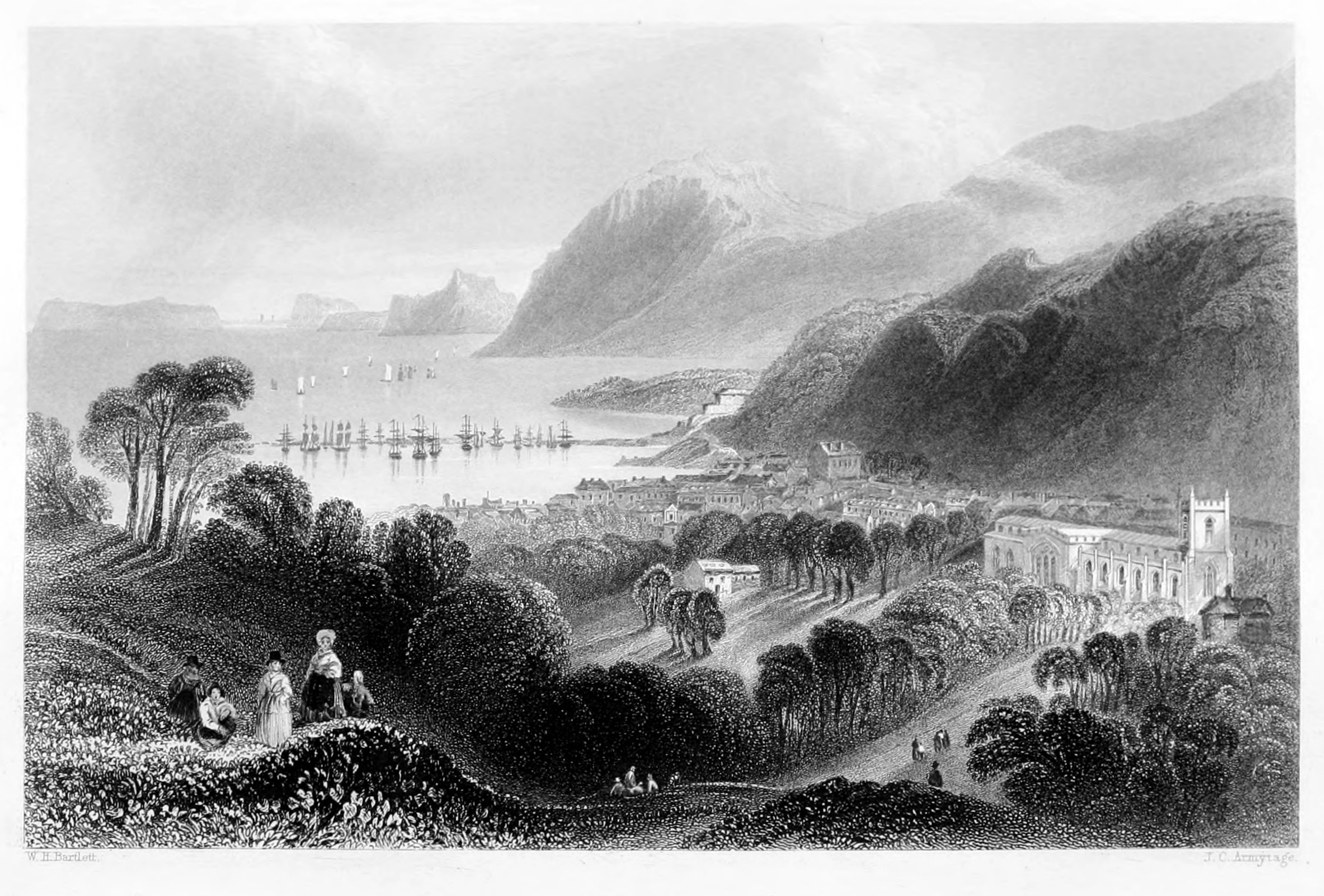
Bangor, although a city and the oldest see in the principality, is inconsiderable in size and population; but the natural beauty of its situation, the advantages which it commands from its inland as well as maritime connexion, and its excellent society, render the town and environs a most desirable place of residence, as well as a favourite resort for those families and individuals who employ the summer months in the pursuit of health, recreation, or improvement. The numerous walks, rides, and drives in the vicinity, all enhanced by their immediate and varied prospects of the sea, offer those facilities to health and enjoyment which cannot be too highly appreciated either by the tourist or resident. The city consists principally of one irregular street, fully a mile in length, with a fine vista towards the Menai—a name which the genius of Telford has rendered familiar to all the admirers of science and art. The houses are well-built, of a moderate size, neat in their appearance, and present to the stranger's eye a pleasing air of domestic comfort and progressive improvement. In the latter respect, no year passes away without contributing something to the public ornament or utility—objects which are zealously patronised by the influential inhabitants, and encouraged by those numerous and spirited visitors, estimated at fifty thousand annually, whom business or relaxation attract to the place. But to convey the best proof of the advances which Bangor has realised in the scale of provincial importance, and in all that has immediate reference to social and local improvements, we need only state that at the commencement of the present century the number of houses was only ninety-three, but that now it amounts to nine hundred or upwards. During three-quarters of the year a regular communication between Bangor and Liverpool is kept up by the steamboats that ply along this romantic and much-frequented coast, and which contribute greatly to the interests of the place. The environs are enlivened by many picturesque villas, and every accommodation is provided in the hotels and private lodging-houses for the reception of visitors.
The great object of general interest at Bangor is its cathedral,—a very ancient and venerable structure,—the foundation of which was among the earliest of those primitive temples which marked the triumphant progress of Christianity on the British soil. It is understood to have been founded by St. Daniel, at the commencement of the sixth century, and bears the sainted name of the founder. The choir was built by Bishop Deane, in or about 1496, and is used only for the cathedral service. The nave, built by Bishop Skivington in 1532, is fitted up as a parish church; and in one of the transepts the service is read in the Welsh tongue.
The free school,—founded in 1557 by Dr. Glynn, brother of the bishop of that name,—five daily schools within the parish, the central National school, four Sunday-schools, and almshouses, give a most favourable impression of the religious and civil advantages enjoyed by the inhabitants of Bangor, who evince a spirit and zeal worthy of those blessings which, in comparison with other and far more populous towns, place them in so enviable a position.
The principal export is the product of the slate-quarries, which is conveyed on a railway from Llandegai, six miles distant, to port Penrhyn, at the egress of the river Cegid into the Menai. This port is now capable of receiving vessels of large burden. It is nine hundred feet in length, and in all respects well adapted for the trading-craft which here take in their cargoes. The slates are of all dimensions, from large tombstone slabs down to the smallest size for roofing. For cyphering-slates, inkstands, and other fancy articles, there is a manufactory near the port. At a short distance is a handsome building containing hot and cold sea-water baths, with rooms for dressing and refreshment. The construction of this establishment, with its terrace and other appurtenances, is said to have cost the late Lord Penrhyn thirty thousand pounds. In the straits of Menai there is a good fishery, near Garth Ferry. There is a weekly market every Friday; and fairs are held in April, June, September, and October. No stranger should neglect to visit Penrhyn Castle, one of the finest baronial mansions in Europe.
"I have stood gazing on Snowdon and Plinlimmon, the vale of Clwyd, the straits of Menai—lake, river, sea, and land—till they seemed of themselves to say, Stranger, well mayst thou gaze! we merit thine admiration—we are of God!"
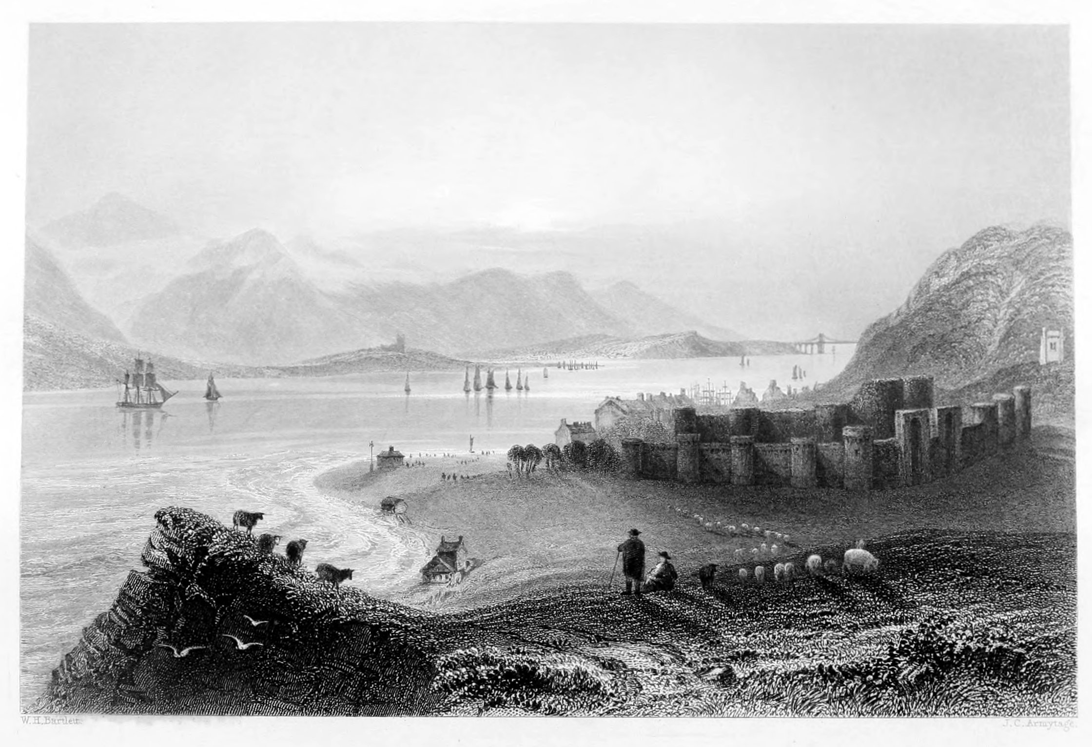
Beaumaris is finely situated on the picturesque banks of the Menai, where it opens into the bay, and presents many attractions derived from its historical monuments, its natural advantages, and modern improvements. As the principal town in the island and county of Anglesea, it has long been a place of fashionable resort, and being at the same time the borough and market-town, it is a scene of considerable activity, cheerfulness, and animation. It is in general well built; particularly one street, the houses of which are large and commodious, and of superior design and execution. Of the original wall by which it was once enclosed, considerable portions still remain—sufficient to demonstrate, by their massive strength and durability, the iron features, and the no less iron policy of feudal times. The castle—erected by Edward the First, and now an imposing ruin close to the town—covers a large space of ground, but stands too low to produce that effect upon the spectator which it would have done had it, like so many of its cotemporaries, occupied an isolated and commanding position. It is surrounded by a deep fosse, with an entrance between two embattled walls on the east, with round and square towers. The gate opens into a spacious court, measuring fifty-seven yards by sixty, with four square towers, and an advanced-work on the east, called the Gunner's Walk. Within these was the keep—the body of the castle—nearly square, having a round tower at each angle, and another in the centre of each façade. The area forms an irregular octagon, of the dimensions above named. In the middle of the north side is the hall, twenty yards long by twelve broad, with two round towers, and several others about the inner and outer walls, built of a bluish stone intermixed with square stones, which produce a rather novel and pleasing effect.
There appears to have been originally a communication round the whole buildings of the inner court by means of a gallery two yards broad, and which still remains nearly entire. In various recesses in different parts of the sides of this gallery are square apertures, which appear to have had trap-doors or openings into a dungeon beneath. The two eastern towers served also as dungeons, with a dark and narrow descent to each—sufficiently characteristic of the dark and despotic purposes to which they were applied. On the east side of this building are the remains of a very small chapel, arched and ribbed with painting and intersecting arches; also some Gothic pilasters and narrow lancet-headed windows, and various compartments, with closets constructed—after the manner of those times—in the centre of the massive walls.
When Edward the First built the town, and erected it into a corporation, he endowed it at the same time with various lands and privileges of considerable value, in order to secure more firmly his possessions in the island, and changed its name from Bonover to Beaumaris, in allusion, it is supposed, to its low but pleasant situation. He caused also a canal to be cut, in order that vessels might be brought up close under the battlements to discharge their cargoes, as the iron mooring-rings affixed to the walls clearly indicate.
The church, which forms a prominent feature in the picture of Beaumaris, is a spacious and very elegant structure, having a lofty square tower, visible at a great distance, and presenting in all its proportions and compartments a fine specimen of ecclesiastical architecture. The other public buildings consist of the county-hall, the town-hall, the free-school, and the custom-house; each possessing, in an eminent degree, every ornament and accommodation befitting buildings of their class and destination. The view from the green commands a striking prospect of the most interesting portion of the Menai Strait, bounded in the distance by the Caernarvon mountains, which gradually overtop each other till they unite in the majestic Snowdon, whose summit—now belted with clouds, and now glittering in the sunshine—asserts his claim to undivided empire as "Sovran" of the British Alps.
With respect to trade, Beaumaris can hardly be said to enjoy any exclusive advantages: the vessels belonging to the port are generally hired by neighbouring merchants and others, who have trading connexions with Liverpool and other ports on the English and Irish sides of the Channel. The bay, though not spacious, is safe and commodious, and affords shelter and good anchorage for vessels that take refuge here in tempestuous weather. The town has a weekly market on Wednesdays, and three annual cattle fairs in February, September, and December. During the season it is much resorted to as bathing-quarters, and has everything to recommend it as a summer residence. A steam-boat plies regularly between this and Liverpool, thereby affording every facility to visitors, and presenting in the passage a rich succession of beautiful, picturesque, and sublime scenery, which successively invites and fascinates the eye of the spectator.
Holyhead is familiar to every reader as the favourite point of rendezvous for all who are on their way to the Irish capital. By the admirable arrangements of the Post-office, and the sure and swift-sailing packets that are here in regular attendance, a passage across the Channel is now a matter of as much certainty, as to time, as that of the mail from London. The perfect order and the surprising expedition with which passengers and despatches may thus be forwarded to and from Dublin are the general theme of admiration amongst foreigners, and a means of vast accommodation to our own commercial houses. During a long series of years the improvement of Holyhead has engaged the special attention of Government; every suggestion, entitled to the approbation of skilful and experienced engineers, has been liberally carried into effect: so that in the present day it seems hardly possible that any packet-station can offer greater facilities for all the purposes of Government, or for the interests of social and commercial intercourse, than Holyhead. The steam-vessels which carry the daily mails are of the best possible construction, commanded by experienced naval officers, and affording excellent accommodation for the passengers who are constantly passing to and fro between the British and Irish shores.
The harbour of Holyhead is shaped by the natural cliffs which overhang the sea, on the verge of which stand the ancient sanctuary of the place and its cemetery. The foundation of this church—originally a small monastery—dates from the close of the fourth century: it was long afterwards remodelled into a college of presbyters by one of the Lords of Anglesey; and, after undergoing many alterations suitable to the varying taste of the ages through which it has passed, it assumed its present appearance—that of an embattled edifice built in the shape of a cross.
Under the Head—the mountain from which the harbour takes its name, and which overshadows the town—are two rocky eminences nearly opposite the church, both of which are crowned with ruins which carry the mind far back among the bright days of Cambrian independence. In the rock is a wide and lofty cavern, supported by natural columns, on which tradition has conferred the title of the Parliament-house; and it is not to be denied that patriotic legislators have been often worse accommodated. This curiosity requires to be visited in a boat. On the highest point stands an uncemented circular stone wall, about ten feet in circumference, which is conjectured to have served as a pharos in ancient times; for this coast has a perilous celebrity attached to it, and no vessel could safely approach the haven by night without a warning signal of this kind.
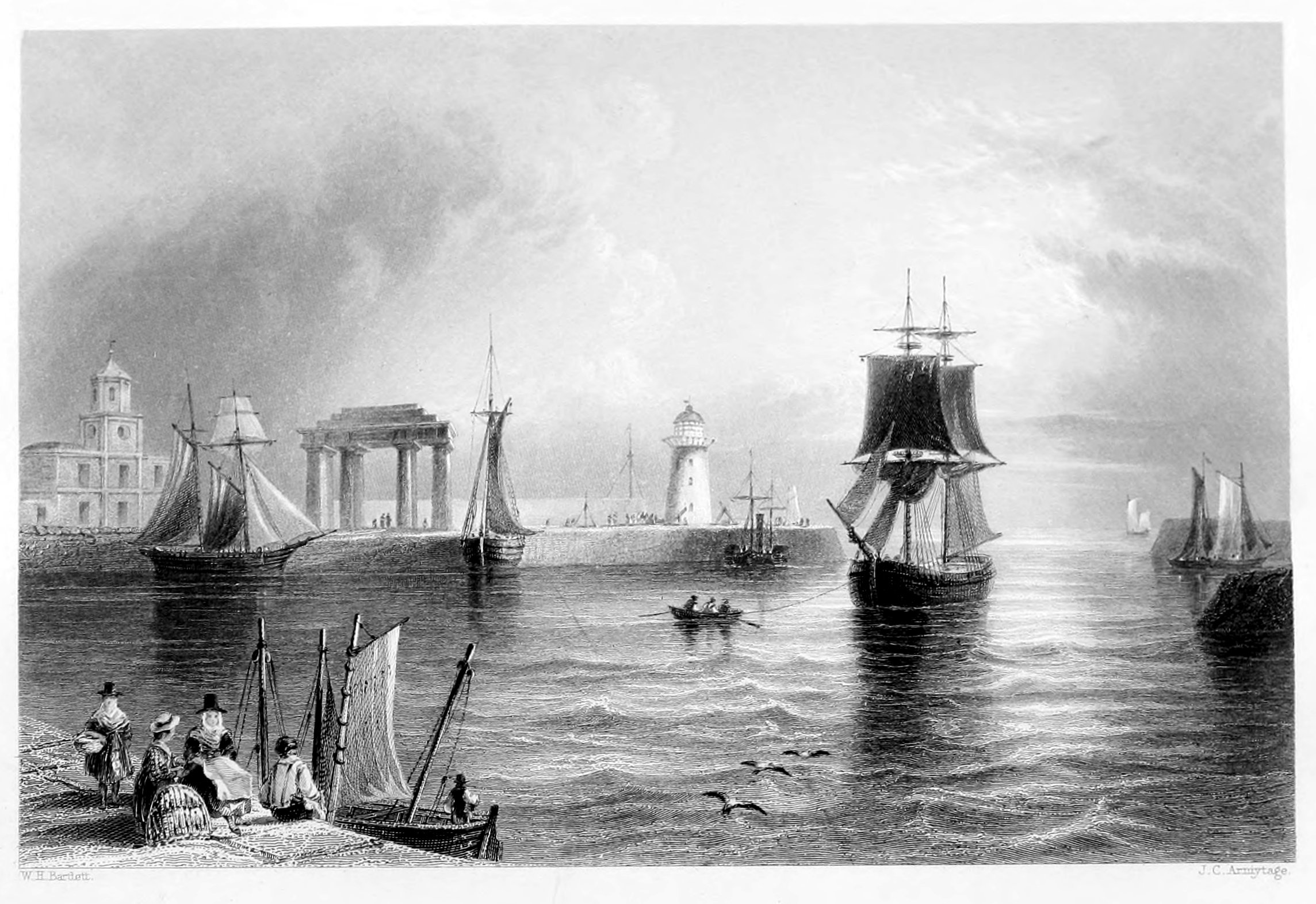
The pier of Holyhead is admirably constructed. It is built on a small island north of the harbour, called Inys-halen, and combines in an eminent degree the requisites of security and accommodation in a work of such importance to the interests of trade. The foundation was laid in 1809, under fortunate auspices; and the grand object, which had been so long and anxiously cherished, was happily accomplished, under the able direction of Mr. Rennie, within a comparatively short period. It has a depth of four fathoms water, so that vessels of heavy burden can ride at anchor in perfect safety. At the extremity is a lighthouse, finely proportioned, substantially built, and highly ornamental as well as useful to the pier and harbour.
The pier extends a thousand feet in length; and close adjoining to it are the Custom-house, with several respectable family houses, among which are those for the harbour-master and resident engineers. The lighthouse contains twenty lamps and reflectors, at an elevation of more than fifty feet above the sea, and exhibiting in every direction a steady blaze of light. At the present time, works for improving and enlarging the harbour are proceeding on a very extensive scale, and bid fair, upon completion, to render Holyhead one of the first harbours of the United Kingdom.
"Approaching it from the water, its singular aspect, its wild site and deserted air—the lighthouse towering seventy feet in height—the neat, comfortable dwellings close under its guardian wing—the sounds of life and industry mingled with the lashing of the sea—and the cry of innumerable birds, ever circling above and around—were altogether of so unwonted a character, that, had I been transported to the antipodes, I could not have felt more unfeigned surprise."—Roscoe.
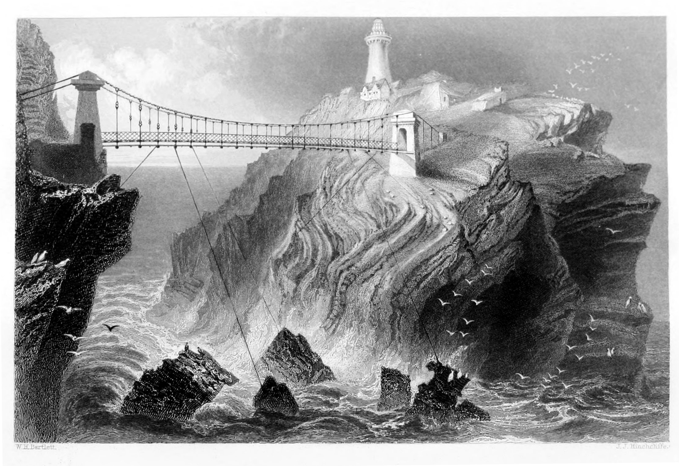
Few objects on the British coast excite more individual interest than the subject of this illustration. The singularity of its position, the difficulties which attended its erection, the grand objects of humanity to which it has been made subservient, are all calculated to interest the heart, and afford scope for the imagination.
The Southstack islet is about thirty yards from the rock known as the Head; and on this the lighthouse was erected in 1809, under the direction of Captain Evans, of the Royal Navy. Its form is that of a round tower, the foundation of which is a hundred and forty feet, and the light two hundred feet above the sea—so that it embraces within its sphere the whole bay of Caernarvon. The approach by water to this remarkable sanctuary of human life is well calculated to make a lasting impression upon every visitor, and should never be omitted where a favourable opportunity is presented by the state of the weather. It is here that the extremes of natural desolation and human industry are brought into juxtaposition; where human enterprise has established an asylum amidst the ruins of nature, the war of waves, the wreck of tempests, to shed the "light of hope" over the heart of many a despairing mariner.
Happily for the cause of humanity, vast efforts have been made, and are continually making, to diminish where they cannot entirely remove the dangers which have so long invested our native coast; and it is impossible to calculate the number of lives and the amount of merchandise which have thus been saved from imminent destruction. Much, however, still remains to be effected—much that is really practicable—and it is earnestly to be desired that the attention of Government should be constantly directed to those points on which the science of the engineer can be most beneficially employed. Holyhead in particular is still susceptible of vast improvements; and with the addition of a capacious outer harbour, sufficient to admit merchant-vessels and others of larger size than those now frequenting the port, it would speedily realize all that could be wished for by those most interested in the welfare of the place, and in the prosperity of trade. This is also a subject well deserving of attention on the part of the Admiralty; for, with proper accommodation, her Majesty's ships, in the event of a war, might be advantageously stationed at this port, so as to secure free intercourse, and serve as a protection to the coast, which is now in a defenceless condition and open to any attempt at hostile aggression. We are happy that this question has received the consideration of her Majesty's Government; and feel assured that the steps which are now making towards the accomplishment of so great a desideratum will ensure the grateful approbation of the public, and the increased prosperity of Holyhead.
The Southstack, as already mentioned, is cut off from the promontory by a deep chasm thirty yards in width, through which the sea roars and boils with great force and impetuosity. To cross this formidable ravine an oriental rope-bridge was formerly employed, that is—a sliding basket was attached to the cable, which was secured at either side of the abyss; the passenger entered the basket, and by the ingenious working of lateral pulleys it was sent off or hauled in, according to the arrival or departure of visitors. This hempen apparatus was replaced in 1827 by a handsome suspension-bridge, on the same principles as that over the Menai. It was suggested by the intelligent veteran already mentioned, Captain Evans, and has answered every purpose contemplated in its erection. The roadway is five feet in width, and its height above high-water mark is about seventy feet. The airy span of this bridge is highly graceful and picturesque, and adds greatly to the interest of the picture. On the rock, close under the walls of the lighthouse, are several cottages for the use of the Superintendent and those under his command. The different points of view which it comprises are all deeply interesting to a stranger, particularly from the lighthouse, where the sphere of vision is greatly enlarged.
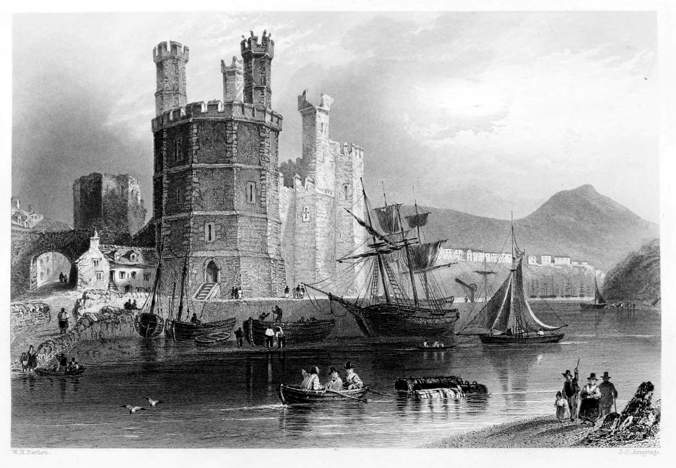
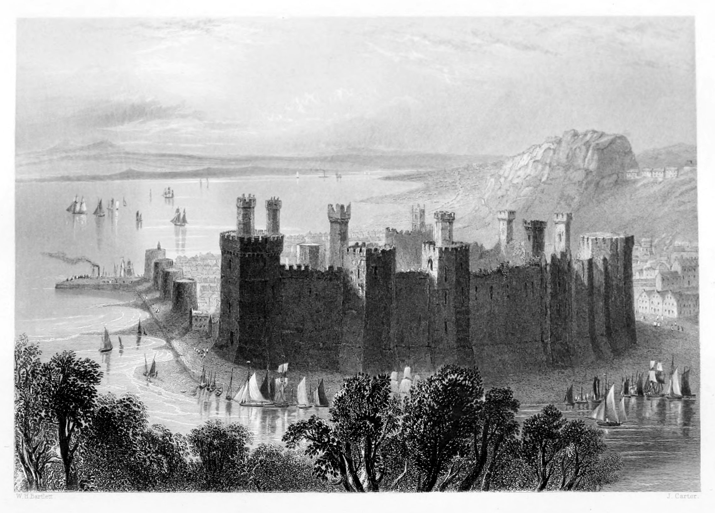
Caernarvon Castle, of which the Engraving annexed presents so faithful and striking a resemblance, is a subject of no ordinary interest: it generally engrosses the attention of all strangers in these parts, and is, in every sense, one of the noblest specimens of castellated architecture in existence. Like so many others of similar design and execution, this fortress owes its origin to the policy of Edward the First, who built it, according to contemporary history, by appropriating the revenues of the See of York, then vacant, to the purposes of warlike enterprise and ambition. The town is understood to have arisen under the same auspices. The Castle defends it on the south by means of a narrow, deep moat in front. In its west wall are three circular towers, with two others on either side, and a narrow gate or entrance, over which is placed a bare-headed figure with flowing locks,—the statue of the founder,—holding in his left hand a sword, which he draws with his right hand,—or rather, perhaps, is returning to its scabbard, in allusion to the subjugation of the Welsh,—and a defaced shield under his feet. This gate leads to a narrow, oblong court. At the west end is a polygon, or many-sided tower, with three others of hexagonal form above, and eagles sculptured on the battlements, from which it received the name, preserved in the Engraving, of the "Eagle Tower." It is a noble structure, having ten sides, and a staircase of three hundred steps to the battlements. In this tower is the birth-chamber of Edward the Second,—the first Prince of Wales,[1]—whose nativity, on the 25th of April, 1284, was an humiliating epoch to the spirit of Cambrian freedom. The room measures only eleven feet by seven,—dimensions little in accordance with the importance attached to that event,—but still in some measure characteristic of the fortunes of the royal heir, who, after an eventful reign, was destined at last to perish by a horrible death in the dungeon-room of Berkeley Castle. Adjoining this chamber is a semicircular apartment, traditionally described as the King's Nursery.
The Castle and the court which it encloses are very nearly a mile in circumference. From the outside, twelve towers are seen; out of which, as observed in those of Conway Castle, issue several smaller angular turrets, which, relieved against the horizon, produce a very picturesque effect. A gateway on the south side of the Castle is called the Queen's Gate, from the circumstance of Queen Eleanor having entered the fortress through this gate, by a temporary bridge erected for the occasion.
Our limits do not permit us to indulge in more minute description of this vast and imposing fortress, which, from the state of repair in which it is still kept, may brave the changes of season and the fury of the elements for many generations to come. Externally it is still entire, and challenges the admiration of all who have the least taste for what is sublime and striking in architecture. The castle-walls are still washed by the sea on the north and west, as they formerly were on the south. Founded upon a rock, and occupying so strong a position, it might well have been considered impregnable in the absence of gunpowder. Immense as the structure appears, it is said to have been built within the short space of twelve months; a fact which would appear incredible, did we not reflect that in those days of bitter vassalage the will of the sovereign was a law that could not be transgressed without certain destruction to the offenders. If a work was considered impracticable, or of doubtful accomplishment, all hesitation was removed—all difficulties cancelled—by these expressive words, Le Roi l'a voulu! And under the more than magical influence of this laconic phrase, the "towery fortress" of Caernarvon may have sprung into sudden existence.
The first royal charter granted in the Principality of Wales was that conferred on the town of Caernarvon by Edward the First. It is a place of great historical interest and importance, and, in connexion with its magnificent castle, presents one of the most imposing features on the British coast. The town is not large; but the recent improvements—public and private—which have been carried into effect have materially contributed to its internal convenience and outward embellishment. Of these the Baths demand especial notice, as one of the principal recommendations to strangers and invalids who resort to this part of the Cambrian shore either for health or relaxation. The building in itself is a good specimen of classical taste—combining elegance of design with excellent workmanship, and presenting, in the distribution of its apartments, every convenience for the reception of visiters and invalids, a choice of hot and cold sea-water baths, with the appendage of comfortable dressing-rooms. For those who have the pleasure in the "cold plunge," as the means of bracing the relaxed system by the exercise of swimming, there is excellent accommodation in a capacious bath, appropriated to that salutary purpose, which is refreshed by a constant supply of water drawn by a steam-engine from the sea through iron pipes, and received into large reservoirs of the same metal. This edifice, which combines in an eminent degree the useful and ornamental, was built at the expense of the Marquess of Anglesey, and is said to have cost upwards of ten thousand pounds.
Within the walls this ancient town is intersected by ten streets, crossing each other at right-angles, which, at various points, fix the stranger's attention by those features and recollections of "other times" with which they are so closely associated. Of these, the main or high street runs from the land to the Water-gate, and is a very fair specimen of that architecture which characterises almost all town buildings of the feudal period. Beyond the walls the town assumes a very different character; elegance, taste, and comfort, and those features which mark the progress of art and refinement, are brought into immediate view; while numerous cottages, and several villas of handsome design and finely situated, throw an air of luxury and domestic comfort over the rural suburbs, the natural character of which is highly favourable to buildings of this description. The town is well paved, lighted with gas, and abundantly supplied with water.
The Port of Caernarvon has accommodation for shipping not exceeding four hundred tons burden, and is frequented by a great number of vessels in the coasting-trade, as well as by others in connexion with London, Liverpool, Glasgow, Dublin, Cork, Bristol, and various port-towns in the United Kingdom. The principal exports consist of slate and copper-ore, the inland transport of which has been greatly facilitated since the construction of the railway. The imports are chiefly colonial produce, Birmingham and Manchester goods, and various articles of home-consumption from the London markets. The quay and harbour of Caernarvon, which formerly presented serious obstacles to the shipping interest on account of the bar at the entrance, have been so improved that the danger, if not entirely removed, is at least so far diminished as to excite little apprehension for the safety of the ordinary craft in connexion with this port. To defray the expense of these public works, Government has levied additional port-dues; and it is much to be wished that, in all other harbours of difficult or dangerous access, the same advantages could be obtained on similar conditions.
The town is now, agreeably to the Municipal Act, divided into two wards, and governed by a mayor, six aldermen, and eighteen councillors. In addition to the picturesque civic retreats already alluded to, as giving so much animation to the native scenery, the neighbourhood is embellished with the baronial seats of the Marquess of Anglesey, Lord Boston, and Lord Newborough. The ruins of Segontium, several Roman stations, part of a military road, and a considerable number of primitive domestic edifices, are among the chief objects of antiquity which deserve the attention of visiters to this neighbourhood.
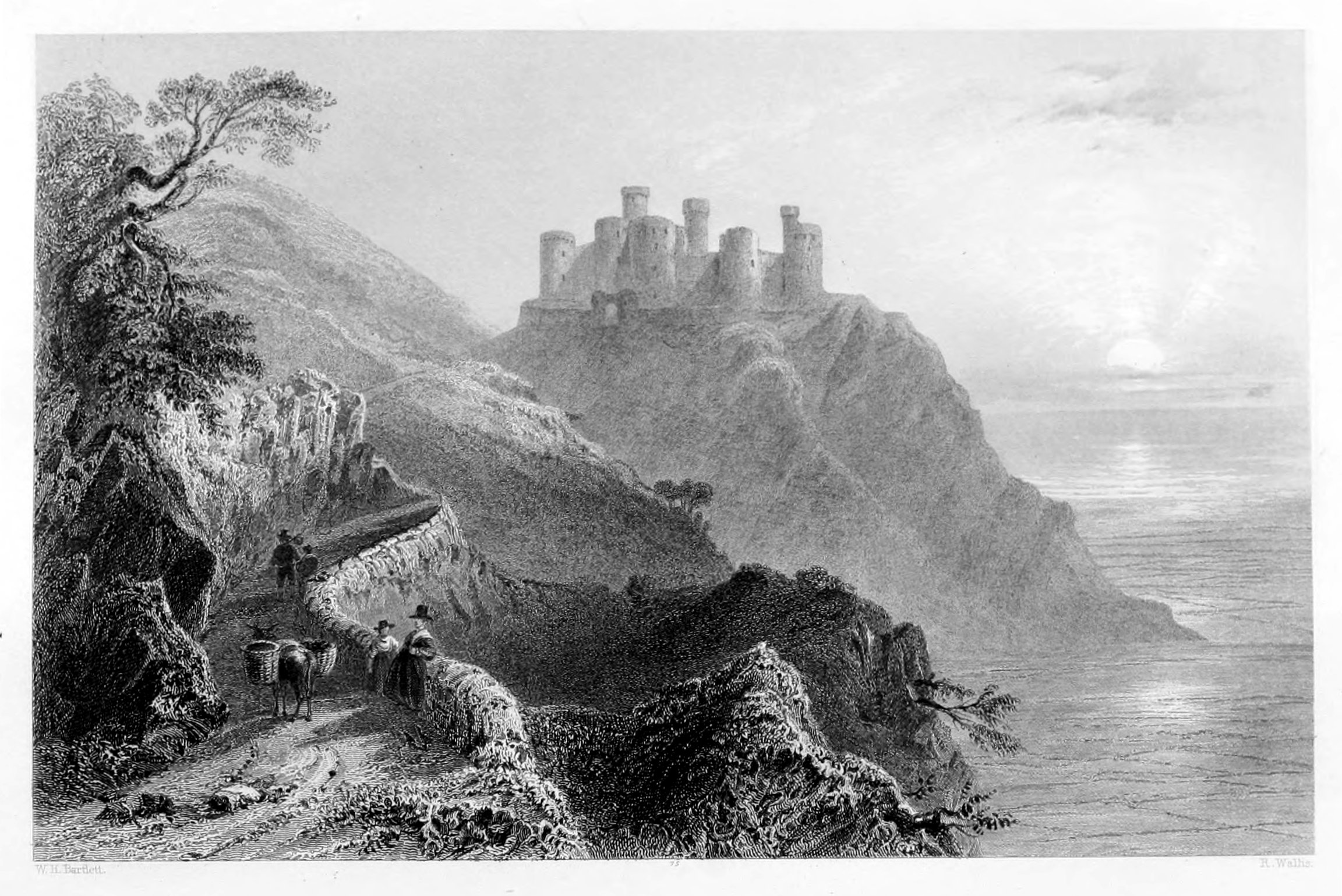
Harlech Castle, according to the Welsh historians, derives its origin from Maelgwyn Gwynedd, prince of North Wales, who flourished at the commencement of the sixth century. The present castle appears to have been rebuilt by Edward I., on the foundations of the original fortress, portions of which are still observable in the masonry of the latter epoch, so well known as the "castle-building reign" in England. In the reign of Henry IV. the castle was seized by Owen Glendower, but was retaken four years later; and, after the battle of Northampton, in 1460, afforded temporary shelter to Margaret of Anjou.
In 1468, the castle of Harlech was captured, after a short siege, by the Earl of Pembroke; of whom Sir John Wynne, in his history of the Gwydir family, quotes some Cambrian lines expressive of the ravages committed by him in the counties of Merioneth and Denbigh at that unhappy period. The last of the many tempestuous scenes with which this fortress has been visited occurred in 1647, when William Owen, with a garrison of only twenty men, surrendered it to Cromwell's forces under General Mytton; but this was not accomplished till every other castle in Wales had deserted the royal cause.
This castle is a strong square building, with a round-tower at each angle, and one of the same form at each side of the gateway. Besides these there are four other turrets, smaller and higher, which rise above the towers at the angles, and are in a more dilapidated state. The entrance is under a pointed arch, which formerly contained six gates of massive strength and construction. Although the roofs, doors, and casements of this interesting stronghold have long disappeared, it still presents in the distance an air of even habitable preservation. There are the remains of stone staircases in every tower, and in the area one of these, leading to the top of the battlements, is still entire. In all the rooms fire-places, with pointed arches, are visible, as well as window recesses, which in the state apartments are three in a row, and of spacious dimensions; while those in the smaller rooms gradually contract outwards till they terminate in a "slit" or loophole, as in most other castles of this style and period.
The view of Harlech Castle is among the finest in this picturesque and interesting country; the situation is commanding, and the effect of these venerable towers and battlements, as they first burst upon the traveller's eye, is strikingly bold and impressive. His fancy is hurried back to the days of other times: the shades of native harpers and native heroes flit before his eye; history and romance divide the empire of his mind; and for a time he rests with mute but intense interest on these castellated landmarks of Cambrian history.
The rock upon which the fortress is built rises from the Gamlas,—a level marsh, resembling water in the distance, nearly a mile in breadth, and which it is probable was once covered by the sea. On the side overlooking this marsh, the rock is precipitous, and steep at either end. In front it is on a level with the town of Harlech, from which it is separated only by a deep trench or moat, and overlooked by a group of magnificent mountains in the rear, from which the view is sublime. The whole platform of the rock is occupied by the castle, except a narrow belt of about four or five feet in width, forming a beautiful green path, which winds round the outer walls, skirting the very brink of the precipice.
The town of Harlech is an ancient free burgh, and originally one of the chief places in the county of Merioneth. It is now reduced to the condition of a secondary village, has a corporation governed by a mayor, is one of the polling-places for the county members, and is enlivened during the year by several periodical fairs and weekly markets.
Various objects of antiquity have been discovered from time to time in the neighbourhood of Harlech. In 1692 an ancient gold torque was dug up in a garden near the castle. It is in the form of a wreathed bar, or several rods twisted together, about four feet long, flexible, bent in the form of a hat-band, neither sharp nor twisted, but plain, evenly cut, an inch in circumference, and in weight about eight ounces. This interesting relic is an heir-loom in the Mostyn family. Several coins of the Roman empire have also been found in and near this town, which afford indisputable evidence of its great antiquity. The distance of Harlech from London is two hundred and twenty-nine miles.
Barmouth, the only port in Merionethshire, occupies a romantic situation at the mouth of the river Mawddach, where the tide at high-water forms a bay of about a mile across, but rather hazardous, owing to the shifting sandbanks by which the channel is interrupted. Overhung by lofty mountains, which leave no adequate space for the horizontal expansion of the village, the houses appear to hang almost perpendicularly from the steep side of the cliffs, so that the chimneys of the one appear to be the foundation of the other. They form eight successive tiers or terraces, to which there is no better approach than by steps hewn in the rock.
This romantic village, which consists of only one irregular street, is much frequented as sea-bathing quarters, for which it has every accommodation, and, in respect to bold and picturesque scenery, has few rivals in the whole Principality. The sea-beach affords every facility for pedestrian exercise; the walks along the banks of the river are numerous, and command the most striking points of view; while regular assemblies, and some of the best Cambrian harps, promote social intercourse and hilarity among the visitors, and give a stir and animation to the whole neighbourhood.
Barmouth, says Mr. Roscoe, is considered to the north-west part of the kingdom, much like Weymouth and other fashionable watering-places to the south, and is resorted to during the summer months, not only by numbers of families in the Principality, but by many others residing in the surrounding counties. The sands are very fine and hard, extending along the beach for several miles, and the bathing is at all times as excellent as can be desired. The restless tides of the Channel dashing against the surrounding coast produce that constant and salubrious motion, which is extended to the waters of the bay. There are two convenient inns, the "Commercial," and the "Cors y Gedol Arms," besides a number of respectable lodging-houses.
The town has the benefit of weekly markets, with an excellent supply of fish and poultry, at a cheap rate, and is further enlivened by two annual fairs, in October and November. The native manufactures consist chiefly of flannel and hosiery, a great quantity of which is exported. The other exports consist of corn, butter, cheese, oak-bark, timber, &c.; the imports, of coal, culm, and other articles for the use of the interior.
The number of small coasting-vessels, and others belonging to this haven that trade with Ireland, is stated at a hundred or upwards; and commercial business, upon the whole, is considered to be in a flourishing state.
The distance of Barmouth from London is two hundred and twenty-two miles, and it communicates with Caernarvon by a cross-mail. The resident population is considerably under two thousand, but is greatly augmented during the bathing season. The shipping at the pier communicates to the place a particular air of prosperity and cheerfulness, and gives employment to a very considerable portion of the inhabitants.
"The beauties of the road from Llanilltyd to Barmouth," says Mr. Pratt, "are so manifold and extraordinary that they literally beggar description. New pastures of the most exuberant fertility, new woods rising in all the majesty of foliage, the road itself curving in numberless unexpected directions,—at one moment shut into a verdant recess, so contracted that there seems neither carriage nor bridle-way out of it, and at another the azure expanse of the main ocean filling the eye. On one side, rocks glittering in all the colours of that beauty which constitutes the sublime, and of a height which diminishes the wild herds that browse, or look down upon you from the summit, where the largest animal appears insignificantly minute. On the other hand, plains, villas, cottages, or copses, with whatever belongs to that milder grace which appertains to the beautiful."
The reputation which Swansea has long enjoyed as a delightful watering-place has suffered no diminution in consequence of the numerous rivals with which this coast is so agreeably diversified. As bathing quarters, it enjoys peculiar advantages in its shore, which is admirably adapted for that purpose; while the adjacent scenery, and the various objects of interest or curiosity with which it abounds, serve as pleasing incentives to exercise and recreation,—the happy effects of which are soon observable in the health and appearance of invalids who make choice of Swansea as their summer residence. Every resource which visitors can desire, for promoting either health of body or agreeable occupation for the mind, is here amply provided. Warm, sea-water, and vapour, baths,—public rooms, billiard-tables, reading-rooms, circulating libraries,—with comfortable private lodgings and excellent hotels, are among the list of daily luxuries at their command.
The Harbour of Swansea is capacious,—well constructed, defended by two strong stone piers, about eighteen hundred feet in length,—and affords accommodation to a great many trading-vessels. On the west pier, a light-house and watch-tower offer additional security to the shipping; and every facility is provided for lading and unlading. The tide flows a considerable way up the river, which is navigable to the extent of two miles for vessels of burden. The canal, running parallel with the river, extends to Brecknockshire, a distance of sixteen miles; and in its course passes through thirty-six locks, and over several aqueducts. Its head is nearly four hundred feet higher than its mouth, which readily accounts for the great number of locks. There is also a canal from the Swansea to the Neath canal, on which a packet-boat is established, and a tram-road from the former to Oystermouth. With Bristol and Ilfracombe there is a regular communication kept up by means of steam-vessels, which leave and arrive according to the state of the tide.
The public buildings of Swansea—ancient and modern—are numerous in proportion to the population. The Town-hall, erected in 1829, is an elegant structure, approached by two flights of steps, and adorned with columns of the Doric order. The castle, situated nearly in the centre of the town, was originally a building of great extent, and of a strength well suited to the purposes of its erection. A massive tower, surmounted by a range of light arches which support a parapet, is the principal part now remaining of this once redoubtable fortress. It appears to have been founded at the remote epoch of 1113, by Henry Beaumont, Earl of Warwick,—a Norman leader who conquered Gowerland; but being soon after laid siege to by a Welsh chief,—Griffith ap Rhys ap Theodore,—a considerable portion of the outworks was destroyed. It is now in the possession of the Duke of Beaufort, "Earl" of Glamorgan, who is hereditarily entitled to the "prisage and butlerage" of all wines brought into the harbours of Swansea and Chepstow.
The public rooms of Swansea stand on the north side of the promenade, called the Burrows, which consist of several acres tastefully laid out in parterres. Here also are an excellent House of Industry and an Infirmary, established in 1817 and situated on the beach. Besides the free Grammar-school, founded in the seventeenth century, by Hugh, Bishop of Waterford and Lismore, there are the Lancasterian and National-schools, which are incalculable blessings to the increasing population of Swansea.
This stately relic of the feudal ages overlooks the picturesque Bay of Swansea, and attracts many strangers to its gate,—not only for its venerable antiquity, but for its bold position on the verge of lofty and abrupt limestone cliffs, which command a magnificent view of the subjacent scenery. It is supposed by some to have been erected by the Earl of Warwick, in the reign of Henry the First; by others, to have been the family fortress of the Lords of Gower, in the reign of King John. But to which of the two the credit of founder belongs is matter of conjecture. Like the Castle of Swansea, already mentioned, it is now the property of the Beaufort family, whose mineral possessions in this district are said to be of incalculable value.
The principal walls of this domestic fortress have suffered comparatively little from the lapse of time, or the hand of violence. Most of the original apartments may be easily traced out, so as to give a tolerably correct idea of their shape and dimensions, and the internal economy with which they were arranged. The general figure of the main body is polygonal; the ramparts are lofty and massive, but not flanked with towers, except at the entrance, which appears to have been strongly secured by double gates and a portcullis.
In many parts along this picturesque coast, the limestone rocks swell over a fine sandy beach into perpendicular cliffs of great boldness, exhibiting vast quantities of organic remains, and worn in many places into deep and lofty caverns. Built on a cliff of this description, and with all the necessary accessories of vigilance and security, it could have been hardly possible to have selected anything more eligible for a feudal keep, whose chiefs generally chose their fortalices as the eagle chooses his eyry,—to secure a wide field for himself, and exclude lesser birds of prey.
The village of Oystermouth—about half a mile to the south of the castle—occupies a beautiful position on the verge of the Bay. A lofty rock throws its shadow over it; the headland of which, called the Mumble Point, stretches far into the sea, and affords a safe anchorage for shipping. The village is chiefly inhabited by fishermen, who, as the name implies, are mostly employed in dredging for oysters, which are found of superior quality in the adjoining bay. During summer, it is much resorted to by strangers, for the benefit of sea-bathing,—a source of annual revenue to the inhabitants, who, by letting their apartments, secure very good returns.
This is understood to be the natal soil of Gower,—the father of English poetry,—and therefore classic ground:—
The railway from Oystermouth to Swansea is a source of great convenience to the inhabitants, as a means of ready intercourse between the most frequented points of the coast adjacent. Newton, proverbially known as a healthy station for invalids and sea-bathers, and Caswell Bay, within half-an-hour's walk of Oystermouth, are well deserving of a stranger's attention. The latter is remarkable for the number and extent of the marine caverns already alluded to, as well as for the beauty and variety of the sea-shells with which the sands at low water are profusely enamelled.
Inscription for a Lighthouse.
The Mumbles' Lighthouse is much frequented by visitors from Swansea during the season. Few jaunts of this character can be productive of more enjoyment than a trip from Swansea to Oystermouth Castle and the Mumbles' rocks. The road, issuing from the western extremity of Swansea, follows the shore of the bay, with the open sea on the left, and on the right a range of wooded hills; of which advantage has been taken for the site of numerous pretty villas. Some gentlemen's seats occupy the intervening level, and their plantations skirt the high-road. Of these Singleton Abbey and Woodlands are the principal. As we near the extremity of the bay the scene is indeed beautiful. Oystermouth Castle, and the pretty village of the same name, lead the visitor onwards till he reaches a broken, breezy headland, the only ascent to which is by a kind of sheep-path, which zig-zags its way to the summit of a narrow promontory terminating in two islands, and on the farther of which is situated the Mumbles' Lighthouse. It is a structure admirably adapted for the purpose to which it is devoted. To every building of this description, devoted to the preservation of human life, a profound interest is attached; and we cannot but observe at a single glance how invaluable these Lights have been, and ever must be, where the danger of shipwreck is so greatly increased by the rugged nature of a coast—here walled in by precipitous cliffs, and there scattered with rocks that appear and disappear according to the tide. The means thus happily adopted along the Welsh coast have been crowned with success; and how comfortable is it to reflect, when calmly seated at our winter hearths, that—while the "winds howl round our steady battlements," and "ships break from their moorings,"—there are friendly lights sparkling around our coasts, to cheer and direct the bewildered mariner in his course, to show him his danger, and to point out "a way to escape."
To understand the importance of lighthouses, we need only remind the reader of the published "Statement," that the number of British vessels alone, which have been annually returned as wrecked, amounts to five hundred and fifty;—namely, "three shipwrecks every two days throughout the year." The average burden of merchant-vessels is about one hundred and ten tons; and if we value old and new together at half the price of building, we have £330,000 for the worth of the whole, which, by deducting the value of sails, masts, and other materials saved from some of those stranded, may be reduced to £300,000. If we add an equal sum for the cost of the cargoes, the whole loss from shipwrecks will amount to £600,000. This statement proceeds on an old estimate from 1793 to 1829; but M'Culloch, in the supplement to his Dictionary, says that the number of ships actually lost, or driven ashore, in 1833, amounted to eight hundred. It is probable, then, that the annual lost by shipwreck is not much short of a million sterling. If one-fifth of this loss could be prevented by additional lighthouses, the saving of money would amount to a million in five years,—to say nothing of the still more important saving in human life. We are anxious—not on the score of economy only, but of humanity—to place these lamentable facts before the eyes of Government, from whose hands the mitigation at least, if not the removal, of such disasters is confidently expected.
In the rock immediately under the lighthouse is a large cavern, called Bob's Cove,—a very characteristic feature, and a chief attraction to pleasure-parties, who resort hither at low water for the sake of the view, which from this isolated point is very striking and variegated:—
Expanding to the eastward, is the beautiful curve of Swansea Bay and the distant mountains; on the westward, the broken coast of Gower; in front, the boundless expanse of ocean. The bracing sea breezes inhaled upon this exposed promontory, its elastic turf, and the magnificent prospect it everywhere commands, never fail to produce a most agreeable and salutary exhilaration, and constitute the finest medical and physical tour in the world.
Twelfth Night.
The Nass Lights were erected by the late Mr. Nelson, in 1832, under the direction of the Trinity House. The eastern, or upper Light, burns at the height of one hundred and sixty-seven feet, and the western, or lower one, at one hundred and twenty-three feet above high-water mark. They are one thousand feet apart, built of the stone of the country, and stand on Nass Point, near Dunraven Castle, Glamorganshire.
It unfortunately was not merely the dangers of the ocean to which the luckless mariner was in past times exposed upon this iron-bound coast, to them was too frequently added the infamous deceptions of the wreckers, who were accustomed to resort to the artifice of driving to and fro an ass bearing two lanterns, so as to represent a distant vessel in motion, and thus lured many a ship to destruction among the rocks and sands. Numerous are the legends of fearful interest which the older inhabitants relate descriptive of the accidents attendant upon these murderous practices, now happily only matters of history.
The erection of lighthouses, beacons, and other means for the prevention of shipwreck, is every year becoming an object of greater importance to the members of that excellent corporation, the Trinity House. Within the last thirty years, great and permanent advantages have been secured to commerce by the vigilance and activity of that body. Much, however, is still left to call aloud for the exercise of their high privilege, skill, and humanity. The navigation of our coasts is still attended in many parts with imminent danger. Rocks, and shoals, and quicksands, indeed, cannot be obliterated by the hand of man; but the perils they involve, in respect to the shipping, may be greatly diminished by increasing the number of those monitory beacons to which the eye of the mariner is so often turned with intense anxiety. The erection of the two lighthouses which here illustrate the subject, has been attended with the happiest consequences. Many a shipwreck, we will venture to say, has been prevented by a timely regard to these friendly beacons. The Bristol Channel has often been the scene of sad catastrophes in the chronicles of seafaring life; but at present the danger to the foreign and coasting-trade has been greatly obviated by those judicious measures which have emanated from the above society.
The voyage up the Bristol Channel is singularly romantic and beautiful; but the coast is exposed to all the fury of the Atlantic, and the surf against the cliffs is distinctly visible at Swansea. The steamers now keep close along shore, in a channel inside the Nass Sands, which form an extensive and dangerous bank to seaward. The contrast between the tumultuous masses of breakers over these sands, when the wind is fresh, and the calmness of the narrow channel we are traversing in security, is very striking. These sands, and another large shoal, called the Skerweathers, have been fatal to many vessels. A large West Indiaman, with a cargo of rum and other valuable produce, was lost a few years ago on a rock called the Tusca, which disappears at high-water; and in 1831, this coast was fatal to the steamer Frolic, in which all the crew and passengers, amounting to nearly eighty persons, perished. The coast near Porthcaul appears at Swansea to be the eastern extremity of the bay; but the bluff point called the Nass, about eight miles further, is literally so. The coast onwards, past the Nass-point, as observed in the admirable Engraving annexed, is almost perpendicular, so as closely to resemble a lofty wall, in which the limestone rock is disposed in horizontal strata. When the sea runs high in this quarter, the scene, as may be readily conceived, is truly terrific—
Merchant of Venice.
The county of Glamorgan, of which the principal town is represented in the accompanying plate, abounds in historical sites well adapted for the pencil, and furnishing the reader with many interesting facts and traditions. The southern portion of the country is remarkably fertile, highly cultivated, and presents to the stranger a long succession of luxuriant corn-fields, verdant pastures, and animated pictures of rural happiness and independence. It would be difficult to find any tract of land in Great Britain that can surpass the Vale of Glamorgan in richness of soil, or in soft and graceful scenery. This favoured region extends the whole length of the county—from the base of the mountains on the north to the shore of the Bristol Channel on the south-west. It presents throughout a most gratifying proof of what may be accomplished by judicious management, when soil and climate are both in favour of agricultural operations.
As a fair proof of the mild and salubrious nature of the atmosphere, we need only observe that the magnolia, the myrtle, and other delicate exotics, not only live but flourish in this auspicious climate. Equally favourable to health and longevity, this district has numerous living testimonies in the vigorous health and protracted age of its inhabitants, who are fully sensible of the blessings they enjoy. The valley, at its greatest breadth, measures about eighteen miles; in various places, however, it is contracted into less than the half of this space, and presents in its outline a constant variety of picturesque and graceful windings.
The town of Cardiff is built on the eastern bank of the river Taff, over which there is a handsome bridge of five arches, leading to Swansea. It is a thriving town, possessing considerable trade; and, by means of a canal from Pennarth to Merthyr-Tydvil, has become the connecting medium between these extensive iron-works and the English market, and is, in fact, the port of the latter. The Taff, which falls into the sea at Cardiff, forms a principal outlet for the mining districts of Glamorganshire, the produce of which has hitherto found its way to market through the Glamorganshire canal; but its sea-lock, constructed about fifty years ago, has long been found inadequate to the demands for increased accommodation, in consequence of the great prosperity of trade since the canal was opened.
The Marquess of Bute, possessing lands in this neighbourhood, obtained, in 1830, an act for constructing a new harbour, to be called the Bute ship-canal, and completed the work at his own expense. The great advantages of this enterprise are—a straight, open channel from Cardiff-roads to the new sea-gates, which are forty-five feet wide, with a depth of seventeen feet at neap, and thirty feet at spring-tide. On passing the sea-gate, vessels enter a capacious basin, having an area of about an acre and a half, sufficient to accommodate large trading-vessels and steamers. Quays are erected along the side of the canal, finished with strong granite coping, and comprising more than a mile of wharfs, with ample space for warehouses, exclusive of the wharfs at the outer basin. This great work was finished in the summer of 1839, at an expense to the proprietor of three hundred thousand pounds.
Cardiff Castle, which stands insulated on a high mound of earth, was partially restored and modernised by the late Marquess of Bute. This ancient fortress is connected with several interesting events in history. In one of its towers, or dungeons, Robert Duke of Normandy was twenty-five years imprisoned by his younger brother, Henry the First, who had previously usurped the throne and deprived him of his eyesight. In the reign of Charles the First it was bombarded by the Parliamentary forces during three successive days, and only surrendered in consequence of treachery on the part of the garrison.
Drayton. Vale of Gloucester.
Caer-Glow, or the "fair city" of the ancient Britons, is a name happily characteristic of Gloucester. The beauty of its situation, on a gentle eminence overlooking the Severn, where its stream is divided into two channels by the Isle of Alney; the richness and fertility of the surrounding districts; its highly picturesque scenery; its splendid cathedral and numerous public buildings; and latterly the tide of prosperity occasioned by the vast improvements in regard to its inland port, present a combination of attractions for which it would be difficult to find a parallel in the British provinces. Commercial enterprise has now a fixed residence in the place, and within the last ten years has made great and important advances in the several departments of foreign and domestic industry.
The Port of Gloucester and the Cathedral, of which the accompanying plate gives a most correct and interesting view, are the two principal features; and to these, in accordance with the plan of the work, our descriptive text will be more strictly confined. The Port is of great antiquity,—so much so as to have existed as an inland harbour long prior to any written document of the place,—but it is only of late years that ships of burden could be anchored in the city basin. A century ago, as recorded in the Magna Britannia, the Port of Gloucester had a large quay and wharf on the banks of the river, very commodious for trade, to which belonged a custom-house, with officers proper for it; but the business was not great, as the city of Bristol, only a few miles distant, had engrossed all the foreign trade in this part of the country. The vessels which at the period in question navigated the Severn were generally small trading-craft, of between fifty and two hundred tons burden, so that Gloucester was deprived of all those advantages which have been so happily secured to it by modern enterprise and improvement. Of these, the Berkeley ship-canal is a noble monument. By the vast facilities thus afforded, the commerce of Gloucester has enjoyed a course of uninterrupted prosperity, and bids fair to eclipse even Bristol itself in the extent and ramifications of its still increasing trade. Ships of heavy burden are now safely moored in the basin, and discharge those cargoes in the heart of the city which had formerly to be transhipped at Bristol, and conveyed to their destination by means of barges and lighters.
The Gloucester Spa, which is now become a place of fashionable resort, has contributed in no small degree to the many attractions of the city and its vicinity. This saline chalybeate was first opened to the public by a grand fête, in May, 1815. The establishment contains every requisite for the health and recreation of the visitors, and vies as much with Cheltenham and Leamington in its appropriate and tasteful arrangements, as it does in the salubrious qualities of its spring—in proof of which numerous testimonies are daily added as the result of experience. There is a very handsome pump-room, with hot, cold, and vapour baths, and an abundant supply of water. The Spa is in the centre of grounds tastefully laid out, embellished with all the care and effect of landscape-gardening, and presenting to the piéton and equestrian a pleasing variety of shady walks and rides,
The Cathedral of Gloucester is deservedly considered one of the noblest specimens of ecclesiastical architecture in Christendom. It is a grand object with every traveller who enters upon a tour of the English provinces, and makes a strong impression on the mind, even after he has visited the gorgeous temples of Rome and Milan.
In the interior of the cathedral are numerous specimens of monumental sculpture; among which the most remarkable are those of Robert, Duke of Normandy, and Richard the Second. The present altar, of the Corinthian order, is placed before the rich tracery of the original high-altar, which, except from the side-galleries of the choir, is concealed from view. The great elevation of the vault overhead, the richness and variety of its designs, the elaborate and minute tracery with which the walls are adorned, added to the vast dimensions of the great oriel—eighty-seven feet in height—render the choir an almost unrivalled specimen of what is styled the florid Gothic, and leave an impression upon the stranger's mind never to be obliterated.
Spenser.
The city of Bristol has enjoyed a celebrity of many centuries, and is continually adding to her power and affluence by that spirit of enterprise which has drawn tribute from the remotest shores and peopled her harbour with the ships of all nations. The commercial importance which she acquired at so early a period of our history, and which gave her for a time so preponderating an influence over the other ports and harbours of the kingdom, has been sustained by her spirited citizens with a skill and industry rarely equalled and never surpassed. To the great facilities formerly enjoyed by the merchants of Bristol another advantage has been added by the construction of the Great Western Railway, which has opened a rapid channel of intercourse between the Thames and the Severn,—the London docks and the harbour of Bristol. This event has been still further advantageous in having given origin to various ramifications of the same means of conveyance, so that the products of our native manufactures can be thrown into this channel, and an interchange effected, with a cheapness and facility quite unprecedented in the history of our inland commerce. That Bristol has recently extended her commercial interests by her connexion with the West Indies, Russia, France, and Germany, is abundantly indicated by the numerous traders from those countries which are to be seen lading and unlading in her port.
Bristol possesses no less than nineteen parish churches, with a population—not including the suburbs—considerably under sixty thousand. The cathedral, an ancient and most venerable pile, was founded about the middle of the twelfth century by the mayor of Bristol, and, till the reign of Henry the Second, it served as a priory of Black Canons. It was then converted into an abbey, and subsequently, on the dissolution of monastic establishments, under Henry the Eighth, it underwent the further change into a cathedral, dedicated to the Holy Trinity. A bishop, dean, six secular canons or prebendaries, one archdeacon, six minor canons or priests'-vicars, a deacon and subdeacon, six lay clerks, six choristers, two grammar-schoolmasters, four almsmen, and others, were endowed with the site, church, and greatest part of the lands of the old monastery. The various changes it has undergone exhibit the finest specimens of English architecture peculiar to the several periods at which they took place. All the ornamental work is of the purest design, and elaborately executed, but on which our limited space will not permit us to enlarge. Several of the lateral chapels are in fine taste and preservation, containing monuments of the founder, of several abbots, and bishops; also those erected to the memory of Mrs. Draper—the "Eliza" of Sterne, Mrs. Mason, and Lady Hesketh, which awaken feelings of deep interest in every mind imbued with the literary history of the last century.
On the east bank of the Avon is Redcliff Parade, affording a beautiful prospect of the city, shipping, and surrounding country. The quay, which extends from St. Giles's to Bristol Bridge, exceeds a mile in length, and is known by the quaint names of the Back, the Grove, and the Gib. On the banks of the river below the city are numerous dockyards, as well as the merchants' floating dock. The several squares in Bristol are handsome: Queen's-square has a spacious walk, shaded with trees, and an equestrian statue of William III., by Rysbrach, in the centre; King's-square is well built on an agreeable slope; on the north-west side of the city is Brandon-hill, where the laundresses dry their linen, as they profess, in virtue of a charter from Queen Elizabeth.
Clifton, two miles west of Bristol, is charmingly situated on the summit of the northern cliffs above the river Avon; many of the houses are occupied by invalids, who seek the aid of Bristol Hot Wells, situated at the western extremity of Clifton, near the stupendous rock of St. Vincent. From its summit above the banks of the Avon there is a fine prospect of the river and its environs, embracing some of the most fertile land in Somersetshire, as well as the western part of Bristol.
The church of St Mary Redcliffe's, Bristol, was founded in 1249, and not completed till 1375, an interval of a hundred and twenty-six years. The founder was Simon de Burton, mayor of Bristol. It is pronounced by Camden as "on all accounts the first parish church in England." It has, of course, undergone, in the long lapse of generations, many changes, repairs, and perhaps improvements. In the middle of the fifteenth century, after having been seriously damaged in a storm, it was repaired by William Cannynge the mayor; and, owing to the extent of these repairs, he has established a just claim to the gratitude of posterity as the second founder, and to commemorate the restoration thus effected, two beautiful monumental statues were erected to the memory of himself and his wife in the church. This patriotic and pious individual was five times mayor of Bristol, and makes a prominent figure in the Chatterton controversy. It is to be regretted, however, that the spire was never restored, which, with the tower, was originally two hundred and fifty feet high. So great was the beauty of this sacred edifice, that it was celebrated over the whole country as a masterpiece of art, and attracted numerous visitors; nor has that admiration diminished with the lapse of time, for there are very few individuals, curious in the mystery of ecclesiastical architecture, who have not visited or studied the specimen here preserved.
The church is built in the form of a cross; and the nave, which rises above the aisles in the manner of a cathedral, is lighted by a series of lofty windows on each side, and supported by flying-buttresses. The tower is large and richly ornamented, like the remaining part of the spire, with carved work, niches, and statues. The principal entrance is from the west front; but there are porches both to the northern and southern sides. Of the first of these the interior is very beautiful; and it was over this porch that the room was situated in which Chatterton, whose father was sexton of the church, pretended to have found the poems which he attributed to Rowley. The length of the church is two hundred and thirty-nine feet, that of the transept one hundred and seventeen feet. It is remarkable that the transept consists of three divisions or aisles, like the body of the church; and the effect thus produced is fine and striking, when the spectator places himself in the centre and looks around him. The breadth of the nave and aisles is fifty-nine feet; the height of the nave is fifty-four feet, and that of the aisles twenty-five feet. The roof, which is nearly sixty feet in height, is arched with stone, and ornamented with various devices. Although externally this church has all the appearance of a massive structure, it has nevertheless, from its loftiness and the peculiar beauty of its masonry, a light and airy appearance both within and without; and justifies the high eulogium, which we have already quoted, as pronounced upon it by Camden. Among the sepulchral treasures contained in this church, is the tomb of Sir William Penn, father of the celebrated founder of Pennsylvania.
The business of shipbuilding is carried on to a very considerable extent in Bristol; and stimulated by that spirit which has always characterized the magistrates and merchants of Bristol, added to the vast improvements which have been so recently affected, it is confidently believed, that this ancient city and port are now entering upon a fresh epoch in their commercial prosperity.
The principal exports are derived from the neighbouring manufactures; and the imports consist chiefly of sugar, rum, wine, wool, tobacco, coffee, turpentine, hemp, and timber. The quay extends upwards of a mile along the banks of the rivers Frome and Avon. Owing to the serious inconvenience and frequent damage sustained by large vessels, when lying at low water in the river, a floating harbour was formed here at great expense in 1804. To accomplish so important a design the course of the Avon was changed; the old channel was dammed up to form the new harbour, which, communicating with the river, is accessible at all times, with sufficient depth of water for vessels of the largest size. This great work, comprising the elegant iron bridges over the Avon, was the result of five years' labour, and an enormous expenditure; and, although much benefit has accrued to the port from the success of so spirited an undertaking, still the expectations to which it naturally gave rise, as to the extension of commerce, have not been realized. This is attributable to various local causes.
Address to the Bristol Fountain.
The village of Clifton has long been distinguished among our native watering-places as the Montpelier of England. In point of situation, and the beautiful and varied scenery it commands, it is without a rival among those numerous springs which, from their medicinal virtues, have risen into universal repute. It occupies a very elevated position; and from the windows of his apartment the visitor may enjoy enchanting views of the western part of Bristol, the Avon, and the numerous vessels that glide to and fro upon its waters. The plateau, which terminates a gradual ascent from the river, is covered with elegant buildings, that furnish excellent accommodation to the numerous visitors who annually resort to these salubrious fountains. Many private families of opulence and respectability make this their principal residence, and with justice, for few situations in the British empire can supply more varied and rational sources of enjoyment. Those who seek to combine the blessings of health with rational amusement and mental cultivation, will very rarely be disappointed in selecting the now "classic" shades of Clifton as a residence.
The Bristol hot-well—"Bristoliensis aqua"—is a pure thermal, slightly acidulated spring. The fresh water is inodorous, perfectly limpid and sparkling, and sends forth numerous air-bubbles when poured into a glass. It is very agreeable to the taste, and in specific gravity approaches very nearly to that of distilled water; a fact which proves that it contains only an extremely minute admixture of foreign ingredients. The temperature of this water, taking the average of the most accurate observations, may be reckoned at 74°; a degree of temperature which is scarcely, if at all, influenced by the difference of season. The water contains both solid and gaseous matter, and the distinction between the two requires to be attended to, as it is owing to its very minute proportion of solid matter that it deserves the character of a very fine natural spring. To its excess in gaseous contents it is principally indebted for its medicinal properties,—whatever these may be,—independently of those of mere water with an increase of temperature. The principal ingredients of the hot-well water are a large proportion of carbonic acid gas—fixed air—a certain portion of magnesia and lime in various combinations with the muriatic, sulphuric, and carbonic acids. The general inference is that it is remarkably pure for a natural fountain, from the fact of its containing no other solid matter—and that in less quantity—than what is contained in almost any common spring-water. Much, however, of the merit ascribed to the Bristol and Clifton wells is due to the mild and temperate climate of the place, which of itself is sufficient to recommend Bristol as a desirable residence for invalids.
Independently of its medicinal waters, Clifton has many attractions, which from time to time have been the subjects both of painting and poetry, and made it the favoured residence of many distinguished individuals. Of the latter, none have deserved better of their country than Mrs. Hannah More, whose writings breathe the purest sentiments of religion and morality, and whose personal Memoirs form one of the most interesting volumes in English biography.
The Suspension Bridge, which forms so prominent a feature in our engraving, is unfortunately still far from that state of completion in which the artist has been pleased to depict it. Many years have passed since its commencement, and still more thousands of pounds have been expended in preparation, and yet this great and useful work remains a monument of misapplied capital and wasted labour.
Warton.
The origin of Bath, like that of other celebrated towns, is involved in obscurity. To its medicinal springs, however, it is solely indebted for the great reputation it has enjoyed for centuries, as a sanctuary for the afflicted, a cheerful asylum for the invalid, and as a favourite point of reunion, where social pleasure and mental cultivation were sure of a kindred reception among the many gifted spirits who have sought health or relaxation in its shades. The comparative quiet which here prevails is not without its importance to the invalid; after the dissipation of a season in Town, a retreat to Bath is like the tranquillity of a monastery after the excitement of a military campaign. This was more particularly felt and acknowledged as long as the continent remained shut; but during the last twenty years the temptation to foreign travel and the fame of certain continental spas have annually diverted from home a great many of those whose cases, it is probable, would have benefited in an equal measure by resorting to the thermal waters of Bath. Travelling, however, is of itself a sanatory process; and to this, to the changes of scene, of society, of diet, and to the mental excitement produced by a succession of new scenes and incidents, the invalid is more indebted than to any of the numerous spas, to which the credit of a cure is so generally ascribed by the recruited votary. This is a fact well known to the physician, and corroborated by the results of daily experience. When such means are impracticable, however, the society and the waters of Bath furnish excellent substitutes; and the testimonies in their favour are too well supported by ancient and "modern instances" to require any eulogium in a work like the present.
The trade of Bath, like that of most great watering-places, is greatly dependent on its visitors. Hotels and lodging-houses are numerous, elegant, commodious, and fitted for the accommodation of all classes of society. Property, nevertheless, has suffered much depreciation of late years, owing to various causes, and not a little to the preference given to those continental spas already alluded to, by which many of the streams which used to flow in upon Bath as a regular source of prosperity have been greatly diminished or entirely dried up.
The public amusements of Bath are numerous and liberally conducted. Of these the most important are the subscription assemblies and concerts, at which a master of the ceremonies presides—a functionary of high authority, who holds his office in regular descent from the hands of the celebrated Beau Nash. The latter gentleman, by a peculiar union of good sense, "effrontery, wit, vivacity, and perseverance, acquired an ascendancy among the votaries of rank and fashion which rendered him a species of modish despot, to whose decrees it was deemed a part of the loyalty of high breeding to yield in silent submission." The assemblies are held in the Upper Rooms, in the vicinity of the Circus, which were erected in 1791, at an expense of twenty thousand pounds. The Ball-room is one hundred and five feet long, forty-three feet wide, and forty-two high. The Lower Assembly-rooms stood near the Parade, and were also very elegantly fitted up, though on a less extensive scale, but were destroyed by fire in 1820. The theatre is a handsome edifice, fitted up in splendid style, with three tiers of boxes, and the roof divided into compartments, containing the beautiful paintings by Cassali which formerly occupied a similar place in Fonthill Abbey.
In the vicinity of Bath, especially on Lansdown and Claverton Downs, there are delightful spots for equestrian exercise. Races take place on the former of these the week after Ascot races.
Bath is eminently distinguished for its numerous public charities, its literary and scientific institutions, its society for the encouragement of agriculture, the arts, manufactures, and commerce; its clubs, subscription-rooms, libraries, schools, and hospitals.
The diseases in which the waters of Bath are resorted to are very numerous, and in many instances consist of such as are the most difficult and important of all that come under medical treatment. In most cases the bath is used along with the waters as an internal medicine—first adopted in the case of King Charles. The general indications of the propriety of using these medicinal waters are chiefly in cases where a gentle, gradual, and permanent stimulus is required. Bath water may certainly be considered as a chalybeate, in which the iron is very small in quantity, but in a highly active form, whilst the degree of temperature is in itself a stimulus of considerable power.
This Engraving, after Mr. Jendles' spirited sketch, embraces not only Tintagel Castle, but one of those more useful erections which modern science has rendered available to commercial purposes, and intended for the shipment of ores from the neighbouring mine. The different character of the erections which crown the opposing cliffs mark the widely separated eras of their erection, while both become objects of deep interest to those who see in the ruins of the one hand, and the progressively improving mechanism of the other, a type of the spirit which animated our warlike ancestors to maintain their dominant power over their native soil, converted in their more peaceful descendants into a determination to make the best use of the treasures it contains.
Tintagel Castle is situated partly on the extremity of a bold rock of slate, on the coast, and partly on a rocky island, with which it was formerly connected by a drawbridge, and is of great antiquity. This castle is said to have been the birthplace of King Arthur, but his history is so blended with the marvellous, that his very existence has been doubted, and the circumstances connected with his birth are certainly not amongst those parts of the relation which are most entitled to credit. It was, however, said by Lord Bacon, that there was truth enough in his story to make him famous besides that which was fabulous.
In the year 1245, Richard Earl of Cornwall, brother to King Henry III., was accused of having afforded an asylum in Tintagel Castle to his nephew David, Prince of Wales, and in the reign of Henry III. the castle and manor of Tintagel were annexed to the Duchy of Cornwall. So little remains of the walls of this ancient and formerly impregnable castle, that the date of its erection cannot even be conjectured from the style of the architecture: it is certain that the castle was in a dilapidated state in 1337, in which year a survey was made. There was then no governor, but the priest who officiated in the chapel of the castle had the custody of it, without fee. It is described as a castle sufficiently walled, in which were two chambers beyond the two gates, in a decayed state. A chamber, with a small kitchen for the constable, in good repair; a stable for eight horses, decayed; and a cellar and bakehouse, ruinous. The timber of the great hall had been taken down by command of John of Eltham, Earl of Cornwall, because the hall was ruinous, and the walls of no value.
In the reign of Richard II., Tintagel Castle was made a state prison, and in 1385, John Northampton, lord mayor of London, was committed to this castle. Thomas Beauchamp, Earl of Warwick, was also a prisoner here in 1397. "The ruins of Tintagel Castle," says the Rev. R. Warner, "claim dominion over unqualified desolation; over one wide and wild scene of troubled ocean, barren country, and horrid rocks: its situation and aspect quite chilled the tourist," and in continuation of his description, he introduces the less sublime remark, "that to look at it was enough to give one the tooth-ache."
Tintagel was made a free borough by Richard Earl of Cornwall, and, as well as Trevenna, about a mile distant from each other, forms part of the borough of Bossiney, which formerly sent two members to parliament. Although not incorporated, it is governed by a mayor. At Trevenna is an annual fair for horned cattle on the first Monday after the 19th of October; and at Tintagel is a school supported by the mayor and free burgesses. The church, dedicated to St. Simphorian, is a vicarage, in the patronage of the dean and chapter of Windsor. It was formerly appropriated to the abbey of Fonteverard, in Normandy, but having passed in the same manner as Leighton Buzzard, in Bedfordshire, was given, by King Edward IV., to the collegiate chapel of St. George at Windsor.
The view of Plymouth is taken from the grounds of Mount Edgecumbe, looking across the lower part of the Sound. About the middle distance is St. Nicholas' Island; beyond which are perceived the ramparts of the citadel. Between the citadel and the point of land to the right, where several small vessels are seen, is the entrance of the creek called the Catwater.
The towns of Plymouth and Devonport—the latter until 1824 having usually been called Plymouth Dock, or briefly, Dock—stand nearly in the same relation to each other as Portsmouth and Portsea, except that they are not contiguous, the distance between them being about a mile and a half. Plymouth is the old borough, and Devonport is the modern town; the latter, indeed, has been entirely built within the last hundred-and-fifty years, since the establishment of the royal dockyard by William III., in 1691. Each town returns two members to Parliament, this privilege having been conferred on Devonport by the Reform Bill; and the municipal government of each is vested in separate authorities. Plymouth and Devonport, with Stonehouse, which lies between them, may be considered as forming one large town, which occupies a parallelogram about two miles and a half in length by one in breadth, and contains, with the suburbs of Morice-town and Stoke, about a hundred thousand inhabitants.
Plymouth harbour, or, as it is generally called, Sutton Pool, is on the land side nearly surrounded by houses, and the entrance to it from the Catwater is protected by two stone piers, about ninety feet apart. Plymouth has a considerable coasting trade with London, Bristol, Hull, Newcastle, and other parts of England, and also carries on a direct trade with the Baltic, the Mediterranean, America, and the West Indies. The principal exports are copper, tin, and lead-ore, manganese, granite, and pilchards. There are about fifty decked fishing-boats belonging to Plymouth, which not only supply its market and that of Devonport with plenty of excellent fish, but also furnish a considerable quantity for Bath, London, and other places. The fish most common in Plymouth market are hake, basse, gurnards, pipers, tub-fish, whiting-pouts, soles, mullets red and grey, and John-Dories. Quin, that he might enjoy the latter fish in perfection, took an express journey from Bath to Plymouth. The export of granite, and other kinds of stone for the purposes of building, is greatly facilitated by a railway, which extends from about the middle of Dartmoor to the quays at Sutton Pool and Catwater. The larger class of merchant-vessels generally anchor in the Catwater; and in time of war it is the usual rendezvous for transports. It is sheltered from south-westerly gales by Mount Battan, and is sufficiently spacious to afford anchorage for six or eight hundred sail of such ships as are usually employed in the merchant service. There are about 320 ships belonging to Plymouth, the tonnage of which, according to the old admeasurement, is about 26,000 tons.
Though the neighbourhood of Plymouth affords so many beautiful and interesting views, the town itself presents but little to excite the admiration of the stranger. It is very irregularly built; and most of the old houses have a very mean appearance, more especially when contrasted with some of recent erection. Several large buildings, within the last twenty or thirty years, have been erected at Plymouth and Devonport, in the pure Grecian style; and the two towns afford ample evidence of the imitative genius of the architects. At the corner of almost every principal street, the stranger is presented with reminiscences of Stuart and Revett's Athens.
Plymouth citadel is situated to the southward of the town, and at the eastern extremity of the rocky elevation called the Hoe. It commands the passage to the Hamoaze, between St. Nicholas' Island and the main-land, as well as the entrance of the Catwater. It was erected on the site of the old fort, in the reign of Charles II., and consists of five bastions, which are further strengthened with ravelins and hornworks. The ramparts are nearly three-quarters of a mile in circuit; and there are platforms for a hundred-and-twenty cannon. The entrance to the citadel is on the north, through an outer and an inner gate. Within the walls are the residence of the lieutenant-governor, officers' houses and barracks for the garrison, with a magazine, chapel, and hospital. In the centre of the green is a bronze statue of George II., the work of an artist named Robert Pitt, and erected, in 1728, at the expense of Louis Dufour, Esq., an officer of the garrison. An excellent panoramic view of Plymouth, Saltram, the Catwater, the Sound, Mount Edgecumbe, and other places, is to be obtained from the ramparts, round which visitors are permitted to walk.
The view of Mount Edgecumbe is taken from Cremhill point, a little to the south-east of the entrance of Stonehouse Creek. About the centre of the view is perceived a battery, near to the Old Blockhouse which was erected in the reign of Queen Elizabeth; between the masts of the brig, which is sailing in towards the Hamoaze, the house is seen; and to the left, in the distance, is Cawsand Bay.
For upwards of two hundred years the situation of Mount Edgecumbe, whether looking towards it or from it, and the beauty of the grounds in its vicinity have been the subject of general admiration. In visiting Mount Edgecumbe from Plymouth or Devonport, the most usual way is to cross at the ferry from Cremhill point. The gardens generally first claim the visitor's attention. Near the lodge, on the left, is a garden laid out in the Italian style, and surrounded by a bank planted with evergreens. In this garden is the orangery, and opposite to it is a beautiful terrace, on which, and in the grounds below, are several statues. The visitor is next shown the French flower-garden, which is planted with the most beautiful shrubs and flowers, and was the favourite retreat of Sophia, Countess of Mount Edgecumbe, who died in 1806, and to whose memory a cenotaph, consisting of an urn and a tablet, is erected within its bounds. The English garden and shrubbery display less art, but are no less beautiful than the imitative gardens of Italy and France. In it is a bath of the Doric order, and a secluded walk leads to a rocky excavation, overspread with ivy and other creeping plants, amidst lofty evergreens: fragments of antiques are scattered amidst heaps of stones in this romantic dell. In the pleasure-grounds, a path continued along the edge of a cliff, which affords interesting views of the picturesque sinuosities of the coast, leads to a verdant lawn, from which the sides rise with a gentle ascent in a semicircle. The acclivity above the lawn is thickly shaded by a succession of trees, which form a magnificent amphitheatre, and display an endless variety of foliage. From different parts of the amphitheatre, Barn Poole presents the appearance of an extensive lake, without any visible communication with the sea, from which it appears to be separated by the diversified line of coast, that forms its boundary on every side. At the entrance of a wood near this spot is an Ionic circular temple dedicated to Milton, whence the path continues on the margin of the cliff, through plantations and shrubs, which fringe the rocky coast down to the brink of the sea. In the more open part of the park is a mock ruin, intended as a picturesque object from the grounds and from the opposite shore. A cottage near the cliff is overhung with beautiful evergreen oaks, the windows of which command pleasing sea views in opposite directions. After ascending a perpendicular rock, by a winding path of perilous appearance, the great terrace at the arch presents itself, having the appearance of a perforation in the cliff, the base of which is washed by the waves of the Sound.
The walks round the grounds are extremely pleasing, and from many points excellent views are obtained of Plymouth Sound, the Hamoaze, Devonport, and the surrounding country. It seems, however, doubtful if the circumstance of a nobleman's seat commanding a view of a large town, at the distance of less than a mile, be an advantage to it. It is perhaps not altogether pleasant to have a country seat overlooked by, and overlooking, a large town. Dr. Johnson, alluding to the view of Mount Edgecumbe, has observed, that "though there is the grandeur of a fleet, there is also the impression of there being a dock-yard, the circumstances of which are not agreeable."
The house at Mount Edgecumbe was erected about the year 1550, by Sir Richard Edgecumbe, who was sheriff of Devonshire in the thirty-fifth year of the reign of Henry VIII., in the castellated style, with circular towers at the corners. About seventy years ago, those towers were pulled down, and rebuilt in their present octangular form. In the principal rooms is a collection of family portraits, including a few by Sir Joshua Reynolds.
W. Stewart Rose.
In the Engraving of Brixham Quay, from a painting by Edward Duncan, the view is taken from the eastward. To the right, from the end of the pier, several of the larger class of fishing vessels belonging to the place are perceived lying aground; while, further in the harbour, a merchant brig is seen discharging her cargo. In the foreground, to the left, the attention of a group appears to be engaged by a small ship which a young fisherman holds in his hands.
Brixham lies about a mile and a half to the westward of Berry Head, the southern extremity of Torbay, in the county of Devon, and is about twenty-eight miles south of Exeter, and one hundred and ninety-eight west-south-west of London. As a fishing town, Brixham is one of the most considerable in the kingdom. The total number of fishing vessels belonging to the place is nearly two hundred, of which, about one hundred and ten are from thirty to forty tons burden, and the rest from six to eighteen tons. Besides these, there are several yawls and smaller boats which are employed in the fishery near the shore. For years past about seventy of the larger class of fishing vessels have been accustomed to proceed to Ramsgate, for the purpose of catching fish in the North Sea for the supply of the London market. They usually leave Brixham in November and December, and return again towards the latter end of June. The Brixham fishermen send a great quantity of fish to the Exeter, Bath, Plymouth, and Bristol markets. The principal fish which they take are cod, ling, conger-eels, turbot, whitings, hake, soles, skate and plaice, with herring and mackerel in the season. A quantity of whitings are generally salted and dried at Brixham. On the coast of Devonshire dried whitings are called "buckhorn," a name sufficiently expressive of their hardness and insipidity. Besides the vessels employed in the fishery, there are ships belonging to Brixham which are chiefly engaged in the West India, Mediterranean, and coasting trades. A weekly market, with a market-house at the water-side, was established here in 1799, and in 1804 a stone pier of great strength was erected at the expense of the nation. The population of the place is about 5,000. One of the most memorable events in its history is the landing there of William Prince of Orange, afterwards William III., on the 5th of November, 1688. The view of Torbay, from the cliffs above the town, is in the highest degree interesting, especially when enlivened, as it frequently is, by a fleet of fishing-boats dotting its placid waters, and stretching far into the British Channel.
At an early period the manor of Brixham was held by the Nevants and the Valletorts; but after divers ownerships it was divided into twelve quarters, one of which was purchased by twelve fishermen of Brixham Quay, and divided into as many shares; some of these have been much farther subdivided, yet their owners, be their shares ever so small, have the local denomination of Quay Lords.
Brixham Church Town is about a mile distant from the quay. The church is a spacious structure of the date of the fourteenth century, with an embattled tower, and the peculiarities of the architecture of that period. It is dedicated to the Virgin Mary, and contains several monuments of considerable antiquity, the inspection of which will repay the antiquarian for the visit.
Torquay, one of the most fashionable watering-places on the Devonshire coast, is situated on the opposite side of Torbay, at a distance of about five miles by water; but if the journey be made by land, the curve of the bay extends it upwards of nine. It is sheltered from the north winds by the promontory of Hope's Nose, and a range of lofty hills which form its northern boundary. It is rapidly increasing in extent, and is spoken of in terms of the highest admiration by most of the visitors. The houses are chiefly built of a kind of marble found in the vicinity, and are so scattered among the hills and dales as to command delightful views of the surrounding country. On the coast the rock scenery is truly magnificent, and from the heights the eye ranges over a wide extent of cultivated land, abounding in every variety of nature, and terminated by the distant outline of the mountain tops.
The town of Exmouth, as its name imports, is situated at the mouth of the Ex, one of the largest rivers in Devonshire, which, rising in Exmoor, in Somersetshire, flows past Tiverton, Exeter, and Topsham, and after a course of about seventy miles discharges itself into the sea. It lies on the left bank of the river, and is about eleven miles to the south-eastward of Exeter, and one hundred and sixty-eight from London. It is sheltered from the north-east and south-east winds; and the temperature of the air is mild and highly favourable to invalids. As the bathing-machines are placed within the bar, which breaks the violence of the sea, visiters are thus enabled to bathe in safety at all times. There are also excellent warm sea-water baths in the town for such as require them. There is a convenient market-place at Exmouth; and a new church was erected by Lord Rolle in 1825. Exmouth and Littleham constitute a united parish, the population of which is about 3,400. In 1814, the late Admiral Sir Edward Pellew was created a peer, with the title of Baron Exmouth; and in 1816, after his expedition to Algiers, he was further advanced to the rank of Viscount.
In the reign of King John, Exmouth appears to have been a port of some consequence; and in 1347 it furnished ten ships and one hundred and ninety-three mariners to the grand fleet assembled by Edward III. for his expedition against France. In the reign of Henry VIII., Leland calls it "a fisschar tounlet," in which state it appears to have continued till about the middle of the last century, when it began to increase, in consequence of the number of persons visiting it for the sake of sea-bathing. It is said that Exmouth first came into repute as a watering-place from one of the judges of assize going there to bathe, and returning with his health very much improved. The following account of the place, and of the manner in which the visiters passed their time about sixty years ago, is from a letter published in Polwhele's History of Devon:—"The village is a very pretty one, and composed, for the most part, of cot-houses, neat and clean, and consisting of four or five rooms, which are generally let at a guinea a week. We have from some of the houses, when the tide is in, a beautiful view of the river, which, united with the sea, forms a fine sheet of water before our doors of large extent. Lord Courtenay's and Lord Lisburne's grounds, rising in inequalities on the other shore, complete the perspective. This is the most gay part of the village; but then its brilliancy is only temporary—for, the tide returned, instead of a fine sheet of water, we are presented with a bed of mud, whose perfumes are not equal to those of a bed of roses.... Exmouth boasts no public rooms or assemblies, save one card assembly, in an inconvenient apartment at one of the inns, on Monday evenings. The company meet at half after five, and break up at ten; they play at shilling whist, or twopenny quadrille. We have very few young people here, and no diversions; no belles dames amusing to the unmarried, but some beldames unamusing to the married. Walking on a hill which commands a view of the ocean, and bathing, with a visit or two, serve to pass away the morning, and tea-drinking in the evening."
From the preceding account it would appear that Exmouth, "sixty years since," was but a dull place, even at the height of the season, and more likely to induce lowness of spirits than to prove a remedy for care, "the busy man's disease;" for what temperament, however mercurial, could bear up against the daily round of tea-parties—where silence was only broken by the "beldame's" scandal—diversified once a week with shilling whist or twopenny quadrille? Since the period when the above-quoted letter was written, Exmouth has been greatly improved, and many large houses have been built for the accommodation of visiters. But since the cot-houses have been elevated to handsome three-storied dwellings, it is only fair to add that the rate of lodgings has also been raised in the same proportion; "five or six rooms, neat and clean," are no longer to be obtained at a guinea a week. There is now a commodious assembly-room in the town, where the young and the fair—who are not so scarce at Exmouth as they appear to have been sixty years ago—occasionally meet to enjoy the amusement of dancing; while the more elderly have still the opportunity of cheating time at "shilling whist or twopenny quadrille." There are also several billiard and reading-rooms, which are places pleasant enough to while away an hour or two in when it rains; and the monotony of the morning walk on the hill, and the dulness of the evening tea-drinking, are now frequently diversified with excursions by water to Powderham Castle, Dawlish, Topsham, and places adjacent.
The village of Budleigh-Salterton lies about half-way between Sidmouth and Exmouth, and at a short distance to the westward of the mouth of the river Otter. It is pleasantly situated by the sea-shore; and the beauty of the country in its vicinity, and the convenience afforded for sea-bathing, have caused it of late years to be much frequented as a watering-place.
Of the many watering-places with which the requirements of fashion have sprinkled our southern coasts, there are few which can boast of a more delightful situation than the subject of our present engraving. Protected on both sides by the surrounding hills, it is completely sheltered from the severity of those winds which are frequently the bane of some of our otherwise most eligible retreats; while its view of the ocean is uninterrupted by any of those obstacles which add more to the utility than the beauty of our older sea-bathing towns. The coast of Devonshire offers peculiar advantages to the invalid; it has a southern aspect; the winters are milder than in any other part of England, and the north-east wind, with its concomitant evils, is less felt than in the more exposed though more popular ports of the Isle of Thanet. In addition to a genial climate, Devonshire is entitled to some preference on the score of economy with that large class to whom the cost of even an occasional residence at the coast is a serious consideration; and although a temporary sojourn at any watering-place must necessarily be more expensive than the same time spent in a rural district, the visiter will find that in none can a greater share of the comforts and even luxuries of life be obtained upon moderate terms than in Budleigh-Salterton and its neighbouring towns of Exmouth and Sidmouth.
Another advantage which these smaller towns possess is the freedom from restraint in which they allow their patrons to indulge. The almost slavish deference which the higher classes of society are compelled to pay to certain conventional rules of fashion and etiquette may be quietly laid aside during a residence at such towns as the one now before us, and this, too, without fear of forfeiting that claim to exclusiveness which every grade is so anxious to maintain against the one below it. Few persons will deny the gratification that they have derived from an occasional relaxation of those social laws that restrict our actions in everyday life; and not the least of the benefits which they receive from their summer visits to the coast may be traced to the opportunities which they afford for their becoming again, though but for a few weeks, or even days, "children of a larger growth."
The village of East Budleigh, which is also the name of one of the hundreds into which Devon is divided, lies about two miles above Budleigh-Salterton, on the banks of the river Otter. Leland, in his Itinerary, thus notices East Budleigh: "On the west side of the haven is Budelegh, right almost against Oterton, but it is somewhat more from the shore than Oterton. Lesse then an hunderith yeres sins, ships usid this harbour, but it is now clene barrid. Some call this Budeley Haven, of Budeley town." It has been supposed by Polwhele that the name Budleigh, or Budely, is derived from the British budelle, a stream, and that it had originated from the number of springs or small brooks which run through every valley in the parish; for scarcely a house can be found that is more than a furlong distant from a rivulet.
Hayes, near East Budleigh, is celebrated as the birthplace of Sir Walter Raleigh. This fact is mentioned in our notice of Ladram Bay; but the following circumstance, which has since come to our knowledge, will confirm the remarks we then made, by showing the hero's love for the place of his birth, and its probable effect upon his after life. His father having only a lease of the property, it subsequently came into the possession of a person named Duke, to whom Sir Walter addressed a letter, dated "From the Court, 26th July, 1584," wherein he expresses a wish to purchase the farm and house of Hayes, and says that from "the natural disposition he has to that place, being born in that house, he would rather seat himself there than any where else." The proprietor, not wishing to have so great a man for a neighbour, did not comply with Sir Walter's request. The letter, about fifty years ago, was to be seen at Otterton House, pasted on a piece of board for its better preservation.[3]
At St. Mary Ottery, about six miles above East Budleigh, on the opposite side of the river, the poet Coleridge was born, in 1772. When young he went to London, where he was educated at Christ's Hospital; and few reminiscences of the place of his birth are to be found in his poems, though he has dedicated one sonnet to his "Dear native brook, wild streamlet of the west,"—the river Otter.
In this view, from a painting by J. D. Harding, the characteristic features of the coast of Devon are most happily expressed; and the manner in which the subject is treated at once displays the feeling of the artist to appreciate, and his ability to depict, the most beautiful scenery of the English coast. The simplicity of truth is not here outraged for the sake of pictorial effect, but the whole composition is at the same time appropriate, natural, and pleasing.
Sidmouth is situated on the southern coast of Devonshire, about 15 miles south-east of Exeter, and 158 south-west of London. It derives its name from the little stream called the Sid, which there discharges itself into the sea. The town is situated at the end of a beautiful vale, and is sheltered on the east, west, and north by ranges of hills, which are cultivated to their very summits. It occupies the margin of a small bay, bounded on the east by Salcombe Hill, and on the west by Peak Hill, each more than 600 feet above the level of the sea at low water. The undulating and richly-cultivated vale through which the Sid meanders is screened towards the north by the Gittisham and Honiton Hills. On the south it commands an extensive view of the sea. It has a bold and open shore, and many of its newest houses are built near the beach, which is protected from the encroachments of the sea by a natural rampart of shingly pebbles, that rises in four or five successive stages from near low-water mark, and terminates in a broad and commodious promenade about one-third of a mile in length. Sidmouth has two suburbs, respectively called the Western Town and the Marsh. It has a weekly market on Saturday, and two annual fairs—the one on Easter Tuesday, the other on the Wednesday after September 1. The church is dedicated to St. Nicholas. Its revenues were granted, in 1205, by Bishop Marshall, to the monastery of St. Michael, in Normandy, to which the priory of Otterton was a cell, but afterwards reduced with those of the other alien priories. The beauty of its situation, the mildness and salubrity of the air, and the conveniences afforded for sea-bathing, have caused Sidmouth to be much frequented within the last forty years as a watering-place; and there are now many private residences of the nobility and gentry erected in its immediate vicinity, the proprietors of which, attracted by the beauty of the scenery, and the mild, sheltered character of the situation, reside there during the greater part of the year; thus giving a superiority to the society, which the visitor cannot always find in sea-bathing towns of a much larger population.
Sidmouth is a place of great antiquity; and in 1348 it supplied three ships and sixty-two mariners to the great fleet of Edward III. It has been said that there was formerly a good harbour at Sidmouth, but that it became so choked up with sand, that no ships could enter. This account, however, is considered by the Rev. Edmund Butcher to be inaccurate. He says that no sand has destroyed its harbour; and he is of opinion that there never was one of any magnitude at the place. He, however, thinks that there might have been a kind of natural basin, in which the small vessels of former times might have rode, or even discharged their cargoes, with less risk than is at present incurred by vessels which unload on the beach.
Ladram Bay is on the southern coast of Devonshire, and lies between Sidmouth and the mouth of the river Otter. It is of small extent, and is neither noticed by any of the historians of the country, nor described in any guide-book. The Lade rock forms its eastern extremity; and to the westward it is bounded by a similar promontory, near to which are the caves represented in the engraving. The bay is only accessible to pedestrians proceeding from Sidmouth at low water through a cave at its eastern point; and its approach from the westward is also through a perforated rock. This small and secluded bay is extremely romantic, and the cliffs between its extreme points are lofty and nearly perpendicular. It is frequently visited in summer by picnic parties from Sidmouth, Otterton, and Budleigh Salterton; and it is said that smugglers, availing themselves of its retired situation, occasionally manage to land a cargo there, notwithstanding the vigilance of the preventive men, who have a look-out near the bay, but not a regular station. The only house in its immediate vicinity is a fisherman's cottage, near the end of the road leading to it from Otterton.
There are several curious caverns and perforated rocks on the southern coast of Devon. Just within the promontory called the Bolt-head, at the western end of Salcomb-bar, is a cavern called the Bull-hole, which is believed by many persons of the neighbourhood to extend for about three miles to a similar cavern in a creek near Sewer-mill. The tradition is that a bull entered at one cavern, and came out at the other; and hence the name of the Bull-hole. Nearly at the top of the cliff of Bolberry Down, about a mile to the eastward of the Bolt-tail, is a cavern called Ralph's-hole, which is about twenty feet long, seven feet wide, and eight feet high. It is nearly four hundred feet above the sea; and the rock by which it is approached is within three feet of the precipice, and only admits of one person passing at a time. It is said that a man named Ralph made this cave his abode for many years in order to avoid being arrested, and that with a hay-fork as a weapon to defend the entrance he set the bailiffs at defiance; his residence, however, was more remarkable for its security than its convenience; and if the blessing of freedom is not included in the balance of advantages and evils, Ralph would probably have found a more comfortable home in any of her Majesty's gaols than in his sea-beaten fortress. A few miles further westward, directly off Thurlston sands, in Bigberry bay, is a perforated rock, about thirty feet high, called Thurlston rock. At very low ebb-tides it is left dry, but as the flood increases, the sea washes over it, making a noise in stormy weather that is heard at a great distance.
The village of Otterton, in the immediate vicinity of these caves, is remarkable for the peculiarity of possessing a church with a tower at the eastern end. At this place there was formerly an alien priory subject to St. Michael's, in Normandy. The river Otter is a fine trout stream, and affords much amusement to the patrons of the rod and line; but it is navigable for boats only at high-water, when small craft can ascend as far as Otterton, about two and a half miles from its mouth. A view from Peak-hill, an eminence in this neighbourhood, frequently excites the admiration of visitors, commanding as it does the beautiful vale of Sidmouth, with the village and beach on the east, the vale of the Otter on the west, bordered by Haldon and other hills, and extending to the sea on the south.
Bicton House, on the banks of the Otter, is the seat of Lord Rolle; it is a spacious edifice, standing in a park plentifully stocked with beach, elm, and oak, and abounding in deer. At the time of Domesday survey, this manor was held by the somewhat burdensome tenure of maintaining the county gaol; but from this service it has been many years relieved by Act of Parliament. Sir Walter Raleigh was born at Hayes, in the parish of East Budleigh, a small village about four miles from Sidmouth; and much of his love for maritime enterprise was probably derived from his early associations with this romantic coast, so well calculated to impress the youthful mind with a passion for the sea and its wonders.
Weymouth and Melcombe-Regis lie on opposite sides of the same river, the latter on the east, and the former on the west. They are connected by a bridge, the central part of which can be swung open, to allow of the passing and repassing of ships. The name of Weymouth is generally given to the united towns, which are both in the county of Dorset, and about 130 miles to the south-westward of London.
Weymouth derives its name from the Wey, or Way, a small river which there discharges itself into the sea. It is a place of great antiquity; it is mentioned in a charter granted by Ethelred, about the year 880, giving certain lands there to his faithful minister, Altsere. In the Domesday Survey there are no less than eight places in the county with the name of Wai or Waia; that, however, which is described as having twelve salterns, or salt ponds, was undoubtedly the Weymouth of the present time. In the reign of Edward II. Weymouth returned two members to Parliament; and in 1347, probably in conjunction with Melcombe, it supplied 15 ships and 263 mariners to the grand fleet of Edward III.
Melcombe owes its adjunct, "Regis"—King's—to its having been a part of the demesne lands of the crown in the time of Edward I. It is not mentioned in the Domesday survey; but it appears to have been summoned to return two members to Parliament several years earlier than Weymouth, though the latter, in all charters, has precedence as the more ancient town. The inhabitants of the two places had frequent quarrels respecting their rights to the harbour and the profits thence accruing; and, in consequence of those dissensions, the towns were deprived of the privileges of a staple port by Henry VI. In the thirteenth year of the reign of Elizabeth the two towns were united into one borough, having their privileges in common, and jointly returning four members to Parliament. By the Reform Bill the number of members returned by the united towns has been limited to two.
The following is Leland's account of the two places at the time of his visiting them, in the reign of Henry VIII.: "Ther is a townlet on the hither side of the haven of Waymouth caullid Milton or Melcombe], beyng privilegid and having a mair. This town, as it is evidently seene, hathe beene far bigger then it is now. The cause of this is layid on to the Frenchmen, that in tymes of war rasid this towne for lak of defence. For so many houses as be yn the town, they be welle and strongly buildid of stone. There is a chapelle of ease in Milton. The paroch church is a mile of: a manifest token that Milton is no very old town ... Milton standith as a peninsula, by reason of the water of the haven that a little above the toun, spreedith abrode and makith a bay, and by the bay of the mayne sea that gulfith it in on the other side. The tounlet of Waymouth lyith strait agaynst Milton on the other side of the haven, and at this place the water of the haven is but of a small brede; and the trajectus is by a bote and a rope bent over the haven, so that in the fery bote they use no oars. Waymouth hath certein liberties and privileges, but ther is no mair yn it. Ther is a key and warf for shippes."[4]
In the same manner as at many other towns on the southern coast, the trade of Weymouth appears to have declined considerably from the time that the English ceased to have any possessions in France; and the comparatively small depth of water in the harbour has tended to prevent the increase of its shipping in modern times. The harbour at Weymouth is what is called a tide-harbour. The channel is about fourteen feet deep at high water; and at the quays on each side the ships lie aground at low water. The large lake at the westward of Melcombe-Regis receives at spring tides a vast body of water, which, on its return scours the harbour and prevents the accumulation of sand. The number of ships belonging to the port of Weymouth is about eighty-five, the aggregate tonnage of which is 7175 tons.
The increase of Weymouth within the last forty or fifty years is chiefly owing to the number of persons who take up a temporary residence there to enjoy the benefit of sea-bathing, for which the excellent beach affords the greatest convenience. It is said that the place first began to obtain celebrity on this account about 1763, in consequence of Ralph Allen, Esq., of Prior Park, near Bath, having derived great benefit while residing there, and recommending it to his friends. Weymouth was visited, in 1789, by George III., who resided there for about ten weeks, and was so much pleased with the place that in several succeeding years it was honoured with a royal visit.
W. Stewart Rose.
Among the numerous objects which confer particular interest and beauty on the neighbourhood of Lymington, the most prominent is Hurst Castle, of which a striking view is presented in the annexed Engraving. It was erected by Henry the Eighth, as a fortress for the protection of this part of the Channel from piratical inroads and hostile aggression, and to give his "loving subjects" a strong and lasting pledge of his "paternal solicitude" for their welfare. It is situated near the extremity of a remarkable, natural causeway, or point of land, which runs boldly into the sea to a distance of nearly two miles, and exhibits these massive battlements to great advantage. Its works of defence consist of a circular tower, strengthened by semicircular bastions; and when armed and garrisoned in a manner becoming the important trust confided to it, must have presented a very formidable appearance.
Lymington, to whose neighbourhood this formidable stronghold serves as an attractive feature, is now well known and much frequented as a delightful watering-place. It stands about a mile from the narrow channel which separates the main land from the Isle of Wight. Owing to the daily increasing facilities of communication, the picturesque scenery of the New Forest, the various objects of interest and notoriety with which the vicinity abounds, and the delightful prospects which may be enjoyed from the windows of the apartments as well as from the adjoining walks, Lymington is well deserving of the commendation which it has uniformly received from all strangers.[5]
Among the many tempting rides and walks which are open to the public, and present a continual variety of sea and inland views, the most interesting are those to Mudiford, Milford, Boldre, Beaulieu, and High Cliff. On the latter the late Earl of Bute erected a magnificent edifice, in consequence of an early and strong partiality to the spot; for here, he observed, he had always slept soundly, when he could find that luxury nowhere else. The view from this point is one of the finest in the kingdom. The house, though much reduced in size, and modernized by the present owner, has rather gained than lost by the change; while the salubrious quality of the air has certainly not deteriorated. Boldre contains much picturesque scenery, which will be still more highly appreciated when the stranger is informed that in the vicarage of this parish, and amidst the scenes which daily met his eye, the late Rev. and pious William Gilpin composed his popular work on Forest Scenery.[6] Beaulieu is interesting as having been the seat of a rich abbey, founded in 1204; the refectory of which has been long used as a parish church.[7] Mudiford possesses a fine level sandy beach, of wide extent, admirably adapted for sea-bathing, and commanding a variety of scenes and objects of great beauty. It was a favourite with George the Third and Queen Charlotte, when at Weymouth, who honoured Mr. Rose with a visit at his picturesque cottage on the beach.
East and West Cowes, in the Isle of Wight, lie on opposite sides, and near the mouth of the river Medina, which rises on the southern side of the island, and after passing Newport, discharges itself into the strait—usually called the Solent Sea—that separates the Isle of Wight from the main land. The view of the harbour in the engraving is taken from West Cowes.
In the reign of Henry VIII., two castles were built at the mouth of the river Medina to defend the passage to Newport. The old castle at West Cowes is still standing, but that of East Cowes has long been demolished. The castellated building seen in the engraving is a gentleman's seat, and is of modern erection, combining the interior comforts of modern civilization with the exterior grandeur of a baronial residence of the middle ages; but whether such a combination is lawful, admits of a doubt. Beheld from the sea, with its towers and battlements rising above the luxuriant plantations around it, has a fine and imposing effect. The grounds are extensive and well designed, possessing at once the scenery of a park and the cultivated beauty of a pleasure-ground.
Cowes harbour is spacious and commodious; and the roads off the mouth of the river, which afford excellent anchorage, used frequently to be crowded, in time of war, with merchant-vessels waiting for convoy; and the towns derived great advantage from supplying ships, while thus detained, with provisions and small stores. The loss of a great part of this trade, on the termination of the war, has perhaps been more than compensated by Cowes having become the rendezvous of the Royal Yacht Squadron, which was first established under the name of the Yacht Club, in 1815. The number of vessels belonging to the squadron is about a hundred, and their aggregate tonnage is nearly 9,000 tons. The members have a club-house at Cowes; and at the annual regatta, which generally takes place about the last week in August, there are usually upwards of two hundred vessels assembled in the roads, to witness the sailing for the different prizes.
The town of West Cowes is situated on the declivity, and at the base of a hill, on the summit of which stands the church. The streets are mostly narrow, and irregularly built; but recently the town and its vicinity have been much improved by the erection of several large houses and beautiful villas. There is a regular communication between Cowes and Southampton, by steam-boats, which, in summer, leave each place twice a day. East Cowes is a much smaller place than West Cowes; but, like the latter, it has been greatly enlarged within the last twenty years.
In the vicinity of East Cowes is situated Osborne House, the marine residence of her Majesty and the royal family, for whose accommodation great additions and improvements have been made to the house and grounds, and what was formerly the seat of a private gentleman, has now been rendered a palace worthy of the royalty of England. The brief limits to which our notices are confined preclude us from entering upon a description of an edifice to which we could do but very imperfect justice, and which, after all, must derive its chief interest from the illustrious family who occupy its walls, and avail themselves of its peculiarly advantageous situation as the starting point for those marine excursions in which the Queen and her Consort so frequently indulge. The presence of royalty in its neighbourhood has rendered Cowes one of the most fashionable, as nature had previously made it one of the most beautiful, of the watering places on our southern coast, while the facilities afforded by the competing lines of the London and South Western, and London and South Coast Railways, render it at all times easy of access from the metropolis.
The town of Southampton is situated in the county of the same name, or, as it is more frequently called, Hampshire. It is built on a point of land at the confluence of the river Itchin with the estuary called the Anton, but which is more generally known as Southampton Water. The origin of the name of the town—which has unquestionably given its name to the county—does not appear to have been satisfactorily ascertained; some writers supposing it to be composed of the Saxon words, ham and tun or ton—which are nearly synonymous, and each equivalent to the modern English town—with the prefix South to distinguish it more emphatically from Northampton. Others, however, consider that the name has been derived from the river Anton, on the banks of which the town is situated. "The town of Andover," says Sir Henry Englefield, "the village of Abbot's-An, the farm of Northanton, and the hamlet of Southanton, both near Overton, and not far from the eastern source of the river Anton or rather Ant, are abundant proofs of the probability of this etymology."
Southampton, as a chartered borough, may rank with the oldest in the kingdom. Madox, in his Firma Burgi, says that Henry II. "confirmed to his men, or burgesses of Southampton, their guild, and their liberties and customs by sea and land; he having regard to the great charges which the inhabitants thereof have been at in defending the sea-coasts." From a grant by the same king to the priory of St. Dionysius, it appears that there were then four churches in Southampton. While the English were in possession of Guienne, the merchants of Southampton carried on a considerable trade with Bayonne, Bordeaux, and other towns in the south of France.
In 1338 the town was assaulted and burnt by a party of French or Genoese; and in the next year an act was passed for its better fortification. Whatever injury the town might have sustained from the attack of the French or Genoese, it would seem that its trade as a port was not diminished by it; for, nine years afterwards, Southampton supplied twenty-one ships and four hundred and seventy-six mariners to the great fleet of Edward III. In consequence of another attack by the French, in the reign of Richard II., the fortifications were further strengthened. In 1415 the army of Henry V., destined for the invasion of France, assembled at Southampton, where, previous to their embarkation, the Earl of Cambridge, Lord Scrope, and Sir Thomas Grey, were executed for high treason. The result of this memorable expedition was the victory of Agincourt. While the English continued to hold possession of part of France, the trade of Southampton appears to have been very flourishing, and the port was one of the principal in the south of England for the import of wine. Camden, writing about 1586, describes it as a town famous for the number and neatness of its buildings, the wealth of its inhabitants, and the resort of merchants; "but now," adds Camden's translator, writing about a hundred years afterwards, "it is not in the same flourishing condition as formerly it was; for having lost a great part of its trade, it has lost most of its inhabitants too; and the great houses of merchants are now dropping to the ground, and only show its ancient magnificence."[8]
For the last fifty years the trade of Southampton, as a port, has been gradually reviving; and at present there is no port in the south of England in a more flourishing condition. The arrival and departure of the numerous large steamers belonging to the Oriental and Peninsular and the West India Mail Packet Companies, give it an air of activity and importance very different from the character given of it in the preceding paragraph. The splendid docks, and the facilities afforded by the railway, have induced the government of the day to select it as an eligible point for the embarkation of a large portion of the emigrants sent out with free or assisted passages to the Australian colonies.
The accompanying View shows a portion of those ancient fortifications within which the town of Southampton was originally enclosed. The walls are in many places quite demolished; but in others they still present a venerable, though dilapidated appearance, with the remains of several towers at regular intervals, after the manner of fortified cities. The circuit of the walls is computed at nearly two miles. With regard to the precise date at which the walls were erected, there is no certain record. The north, east, and south walls bear every mark of uniform regularity in their structure: the gates of the town are apparently of the same date with the walls, and much resemble each other in the massy, flat form of their pointed arches, which rise at an angle from their piers, being struck from centres below the level of their spring—a mode of construction chiefly used in the reign of Edward the First. Yet the remains of semicircular towers, still visible on the Bargate, and which flanked its round arch, very much resembling the towers on the north and east walls, lead us to suspect that the wall, on the land side at least, is of higher antiquity than the time of the Edwards, and that the present gates were built later than the wall. The very singular position of the Water-gate, which retires thirty feet behind the eastern part of the south wall, and the awkward position of the South-gate, at the very angle of the wall, seem to indicate that these gates were not parts of the original design. From the south-west angle of the wall, quite to the Bridle-gate, which was close to the vallum of the Castle, the whole wall is a mass of irregular and almost inexplicable construction. It is conjectured that the side of the town, protected as it was by the Castle, and covered by the sea, was not at all, or but very slightly fortified, until the fatal experience of the sack of the town by the French proved that some further defence was necessary. The line of the town wall, south of the West-gate, is irregular in its construction; and the wall between the West and Bridle-gates bears evident marks of having been built in the most hasty manner, and with the greatest economy of materials. This wall, in its present form, Sir Henry Englefield supposes to have been built about the period when, according to the old historians, Richard the Second fortified the town, and built, or probably repaired and strengthened, the Castle, for it had evidently been built several centuries before his reign.
At the accession of Henry the Eighth, the port of Southampton was much frequented by foreign merchant vessels, particularly those of Venice, which traded largely in wool and tin. But the exportation of wool being prohibited by the legislature, the Levant merchants gradually resorted to other ports, and, now deserted by her commercial friends, Southampton found her resources greatly impoverished. About the commencement of the last century, however, the tide flowed once more in her favour, and, continuing to increase, has at length placed her in a position of unprecedented prosperity. But to this happy result the erecting of new docks, an improved harbour, and, above all, communication with London by railway, have mainly contributed. The terminus to the latter, begun and completed in 1839, is a very pleasing piece of Italian composition, with a projecting rusticated arcade of five arches below, and the same number of pedimental windows to the upper floor. The façade, nearly seventy feet in length, is considerably extended in its lower part by screen-walls, which take a sweep from the building.
The principal trade of Southampton is with Portugal and the Baltic, and with the islands of Guernsey and Jersey. Hemp, iron, and tallow are imported from Russia; tar and pitch from Sweden; and from Portugal, wine and fruit.
The environs of Southampton are particularly interesting and agreeable—enlivened with elegant seats, romantic ruins, picturesque villages, and much beautiful scenery, which never fail to attract a great confluence of visitors during the fine season. Among these Netley Abbey is the grand attraction. The town itself is rich in vestiges of antiquity; and, in its modern character, presents all the agrémens to be met with in our most fashionable watering-places.
In the front of this view, and towards the right, a man-of-war cutter is seen running out of the harbour; and, from her heel to leeward, and the agitated state of the water, we may perceive that it is blowing a stiff breeze. Vessels of her class are chiefly employed in the coast-guard service and as admirals' tenders, or as packets on short voyages, or in communicating between one naval depôt and another. In the distance, to leeward of her, the Dock-yard semaphore is perceived; and more to the right, but nearer to the eye of the spectator, is seen the Round Tower; from which, in former times, an immense chain used to extend to the Block-house at Gosport, on the opposite side of the channel, for the purpose of protecting the entrance to the harbour, in the event of its being assailed by the ships of an enemy. Towards the centre of the engraving a broad-side view is presented of the Port-Admiral's flag-ship, a first-rate, which, from the flags at her mast-head, appears to be making a signal; ahead of her, in the distance, the hulls are perceived of two ships of war, laid up in ordinary; and further to the left is seen part of the Block-house Fort, at Gosport, with a beacon, to direct vessels in making the harbour.
Portsmouth harbour is one of the most secure and commodious in the kingdom; and from the depth of water, both within it and at its mouth, ships of the line can enter or depart at all times of the tide. From the narrowness of its entrance,—which, between the old Round Tower at Portsmouth and the Block-house Fort at Gosport, is not wider than the Thames at London-bridge,—it is protected from the swell of the sea; while it is sheltered from the violence of winds blowing off the land, by the range of hills to the northward. Immediately above its entrance the harbour begins to expand, and about a mile and a half above the old Round Tower it is nearly two miles in breadth. It then branches off into three principal creeks, or leats, as they are frequently called; one of which runs up to Fareham, another to Porchester Castle, and the third to Portsbridge. In these creeks most of the men-of-war in ordinary are moored. As those ships, when laid up, are each covered over with a large wooden roof, to protect them from the effects of the weather, they appear, when seen from Portsdown Hill, which commands an excellent view of the harbour, not so much like floating castles as like immense floating barns—ample garners, which would contain more corn than the swords and cutlasses of their former gallant crews, beat into reaping-hooks, will ever cut down!
At Portsmouth the tide flows about seven hours and ebbs about five; and the velocity with which the ebb tide runs out effectually scours the channel at the mouth of the harbour, and prevents the accumulation of sand. It is high water in the harbour at half-past 11 o'clock at the full and change of the moon; and the rise of spring tides is about eighteen feet, and of neaps about twelve. In the months of March and April the specific gravity of the water in Portsmouth harbour becomes so much increased, that ships lying there are observed to float about two inches lighter than at other times of the year. The latitude of the Observatory in the Dock-yard is 50° 48' 3" north; longitude 1° 5' 59" west.
Though Portsmouth does not appear to have been a place of much consideration as a naval station previous to the reign of Henry VIII., who may be regarded as the first English King that established a permanent royal navy, it was yet undoubtedly a town of some consequence long before that time. In 1194, Richard I. granted a charter to the inhabitants, wherein, after declaring that he retains the town of "Portsmue" in his own hands, he establishes an annual fair to be held therein for fifteen days, to which all persons of England, Normandy, Poictou, Wales, Scotland, and all others, either foreigners or his own people, might freely resort, and enjoy the same privileges as at the fairs of Winchester, Hoiland, or elsewhere in his dominions. The burgesses of "Portsmue," as the place was then called, were also allowed to have a weekly market, with the same privileges and immunities as those of Winchester and Oxford; with freedom from all tolls of portage, passage, and stallage, and exemption from suit and service at hundred and county courts.[9] This charter was confirmed in 1201 by King John, and in 1230 by Henry II.; and in 1256 the latter monarch granted another charter, establishing a guild of merchants at Portsmouth. The privileges of the burgesses were at several different times confirmed by succeeding kings; and, in 1627, Charles I. granted them a charter, whereby a mayor and twelve aldermen were appointed for the civil government of the town. This charter, which was renewed by Charles II., has since been modified by the Municipal Reform Bill of 1835, which directs that the borough shall be divided into six wards, which shall elect a town council of forty-two members. In 1298 the borough was summoned to send two members to Parliament, a privilege which it continues to enjoy.
In this engraving we have a view of a new frigate, with only her lower masts in, lying alongside of the Topaze rigging-hulk. The latter vessel—which now presents so clumsy an appearance, from her bows and sides being sheathed with a stout doubling of timber, and from a wooden house being built over her stem—was formerly a French frigate, and, when she first came into our possession, she was much admired by nautical men for the beauty of her build. Further in the distance, to the right, is seen a first-rate lying off the Dockyard Quay, partly rigged; and, beyond her, are perceived the immense wooden roofs which cover the building-slips. The line of building to the right is the rigging-house, and the tower erected above it is the Dockyard Semaphore. On the extreme right, towards the front, is seen the forepart of a mooring-lighter, with one of the numerous spar-booms lying afloat near the Common Hard. The original picture was exhibited in the Gallery of the British Institution, where it excited general admiration.
The great naval depôt at Portsmouth is partially described in connection with other engravings in this work, and we have therefore thought it might be interesting to occupy our present space with some details respecting the peculiar mode in which one very important portion of the rigging is manufactured in this yard, and which forms a principal object of curiosity to all persons visiting it. We allude to the machinery for manufacturing blocks, invented by Mr. Brunel, the celebrated engineer.
After the wood—generally elm—for the shell of the block is cut into proper sizes by circular-saws, its complete formation, including the pin and the sheave, is effected by means of several different machines, all contrived with the greatest mechanical skill, and put in motion by a steam-engine. The first process is that of the boring-machine, which, by means of a centre-bit, pierces a hole to receive the pin, and at the same time, according as the block is intended to be single or double, forms one or two similar holes, at right angles to the former, to receive the first stroke of the chisel which cuts out the space for the sheave. By the second, called the mortising-machine, this space is cut out by a chisel acting vertically, and making about a hundred and twenty strokes a minute, and under which the block is caused to move gradually, so that at each stroke a thin piece of the wood is cut away. After this the block is taken to a circular-saw, which cuts off the corners, and reduces it to the form of an octagon. The shaping-machine, to which it is next taken, consists of two equal and parallel wheels moving on the same axis, to which one of them is permanently fixed, while the other is moveable in the line of the axis, so that, by sliding it nearer to the former, or more apart, as may be required, the shells of blocks of all sizes may be fixed between their two parallel rims. Ten shells of the same size being firmly fixed at regular intervals between those rims, the wheels are put into motion with extreme velocity, and the shells are rounded by striking against a cutting instrument, which at the same time moves in such a manner as to give to each block its proper shape and curvature. When one half of the side has thus been finished, the motion of the wheels is reversed, and the other half finished in the same manner. When one side has been rounded, the shells are reversed, and the other side completed as above. The last process which the shell undergoes consists in scooping out the groove for the strap, or "strop," as the rope is called, which goes round the block. The shell is now completed, and the visitor is next shown the different processes in forming the sheave and the pin.
The sheaves are generally made of lignum-vitæ; and the first operation is performed by a circular-saw, which cuts the wood into pieces of a proper thickness. By a second machine the holes for the pins are bored, and they are formed into perfect circles by means of a crown-saw. The third, called the coaking-machine, is an admirable specimen of mechanical ingenuity. By its operation, a small cutter drills out round the pin-hole—to a certain depth from the flat surface of the sheave—three semicircular grooves, for the reception of the metal coak, or bush, which sustains the friction of the pin. So truly are those grooves formed, that the slight tap of a hammer is sufficient to fix the coak in its place. The fourth operation consists in casting the coaks. By a fifth, after being fitted in the grooves, holes are drilled in the coaks, for the reception of the pins which fasten them to the sheaves; and by a sixth the pins are rivetted. By the seventh operation, the central hole in the coak for the pin, on which the sheave turns, is drilled out. By the eighth, the groove for the rope is turned round the circumference of the sheave, and its sides polished. In the ninth, the iron pins, on which the sheaves revolve, are cast, turned, and polished; and on their being inserted, the block is complete and ready for use.
The correctness of this view will be immediately recognised by every person in the least acquainted with Portsmouth. The platform, from which it is taken, forms the grand promenade of the inhabitants, and is usually the first place visited by strangers, on account of the prospect which is thence obtained. Immediately in front of the engraving is seen the northern extremity of the platform, on which are two soldiers, who seem indulging themselves with a leisurely inhalation of the fresh breeze from the water, after having liberally expended a portion of their own breath in sounding their bugles at parade. Beyond the platform, the most conspicuous object is the Government Semaphore, with three flags displayed as a signal; and to the left, the landing-place called the King's Stairs. Beyond the old round tower is seen the flag-ship of the Port Admiral; and, between her and the gun-brig which is running in, a distant view is obtained of the Town Hall of Gosport.
Portsmouth, one of our greatest naval depôts, is situated near the south-western extremity of the island of Portsea, in the county of Hampshire, and is about seventy miles S.S.W. of London. Adjoining to it, on the northward, is the town of Portsea; and to the south-east, without the walls, lies the suburb of Southsea. The three places may be considered as forming one large town, under the general name of Portsmouth, the aggregate population of which is about 50,000. The population of Gosport, which lies to the westward of Portsmouth, on the opposite side of the harbour, is, with that of the adjacent hamlet of Stoke, about 12,000. The docks and naval storehouses are within the precinct of Portsea; the hospital and the victualling establishment are at Gosport; and the offices of the Port Admiral and the residence of the Lieutenant-Governor are at Portsmouth, within the lines of which are also the barracks for the accommodation of the garrison. Portsmouth is strongly fortified by a circuit of bastions and a moat, which enclose the town on the landside, and which are connected with a similar line, extending in a semi-circular form round the landside of Portsea. In the event of a siege, it would require 14,000 men to form an efficient garrison for the united towns. The situation of Portsmouth is low and marshy; and the peculiar smell which arises from the mud at low water, and from the moat, may be perceived at the distance of two or three miles, in approaching the town from the northward.
The principal church at Portsmouth stands in St. Thomas'-street, and nearly in the centre of the town. It is dedicated to St. Thomas à Becket, and was erected between 1210 and 1220, by Peter de Rupibus, Bishop of Winchester. The transept and the chancel are the only parts which remain of the original structure, the nave and side-aisles having been rebuilt in 1692. At the same time the old tower, which formerly stood above the intersection of the transepts and the nave, was taken down, and the present one erected at the western entrance. It is surmounted with a cupola, and its height is about 120 feet.
With the exception of the older parts of St. Thomas' Church, which afford one or two good specimens of the Gothic style, Portsmouth contains but little in the shape of architectural antiquities that is likely to attract the notice of the stranger. The building, above which the Semaphore is erected, near the northern extremity of the saluting platform, was, in former times, the residence of the governor of the town. Previous to the suppression of the monasteries and religious houses, it belonged to a Domus Dei, or hospital, which was founded in 1238. A part of the church of this hospital is yet standing at a short distance to the south-east of the Semaphore, and near to the grand parade. It is now the garrison chapel; and against its walls are placed numerous monuments erected to the memory of officers, both naval and military, who have died in the service of their country.
Gosport, of which our engraving represents a view, is a small, but important town, adjoining Portsmouth, from which it is separated by a wide channel, forming part of the extensive basin known as Portsmouth Harbour, and containing a large number of our "wooden walls;" some in a condition ready to put to sea at a few hours' notice, others lying in ordinary, as it is termed, that is, without rigging, sails, or other fittings requisite to render them complete and efficient for service, but which are speedily provided when required. Portsmouth, Gosport, and the neighbouring towns—including Portsea and Landport—form one extensive fortified position, protected at every point from the attacks of an enemy; they are enclosed by broad earthworks, along the extent of which are mounted heavy guns, commanding the various drawbridges which cross the moat surrounding the works. At a short distance from the town is a large range of barracks for the marines, capable of accommodating upwards of a thousand men—a portion of the building, including the house of the commandant, has but recently been completed. Near this is a new prison, devoted entirely to military occupation; it is a substantial building of red brick, and well adapted for the accommodation of its inmates consistent with its character as a penal establishment.
Close to the harbour, and within the fortifications, is an immense pile of imposing appearance, called the Clarence Victualling-yard; the most interesting feature of which is, the admirable but simple steam-machinery employed in making biscuits for the navy. In the precincts of this immense depository are also included a cooperage, brewhouse, and slaughterhouse, which supply the navy with the stores requisite for their various destinations, including wines and spirits, of which a large stock is constantly kept here. The quay at which her Majesty embarks for her private residence, Osborne House, in the Isle of Wight, is situated in this yard, which is connected with the main line of the South-Western Railway, by a small branch running from the terminus, devoted solely to the use of her Majesty and the Lords of the Admiralty. There are two churches in the town, St. Mathew's, near the entrance to the Clarence-yard, and Trinity; the former consists entirely of free sittings, the latter is a chapel of ease to the parish church, situated at Alverstoke, a small village, at a distance of little more than a mile from the town. There are also a Catholic chapel, two Wesleyan chapels, and two Congregational chapels in the town.
Of late years the neighbourhood of Gosport has much improved; many handsome and commodious villas, and other residences, having been erected at various times. Anglesea, which adjoins Alverstoke, is quite a new neighbourhood, and has but recently come into existence, consisting principally of residences for the gentry during the summer months. The town of Ryde, in the Isle of Wight, is situated opposite to this spot, and between them lies the Solent, which at times is enlivened by the appearance of some ships of war lying at anchor, and frequently of large fleets of merchant ships detained here from stress of weather, or waiting a favourable wind to convey them to their respective destinations. At the mouth of the harbour, on the Gosport side, is situated Blockhouse Fort, opposite to a similar one on the Portsmouth side, embrasured with heavy guns for protecting the entrance to the harbour, which is approached only by a circuitous channel, commanded on the one side by the guns of Southsea Castle, and on the other by those of Fort Monckton, at a short distance from which has recently been erected another fort, to protect the entrance to the Southampton Water. Adjoining Blockhouse Fort are barracks for the Royal Artillery, and at Fort Monckton, barracks for infantry. Near the latter is Haslar Hospital, devoted to the reception of sick members of the navy and marines; it is a handsome quadrangular building of red brick, and affords accommodation for a large number of patients; within its walls are included a church, and a Museum of Natural History, which is well supplied with specimens, and to which additions are being continually made by the officers and gentlemen connected with the service. At the foot of the High-street, Gosport, is the landing-place for passengers by the steam ferry, or floating bridge, as it is called, which plies between Gosport and Portsmouth every half-hour, and forms the only means of communication for carriages and vehicles of all kinds. In addition to the steam ferry is a staff of watermen, busily plying their calling during the absence of the bridge, and securing the stray passengers that may prefer their mode of transport, or have arrived too late for the other conveyance. During certain states of the weather, the danger and difficulty of managing their boats entitle the watermen to increased fares, which are indicated by certain coloured flags hoisted conspicuously over the town hall, near the beach, and regulated by a person appointed by the licensing magistrates. The climate of this part is healthy, and well adapted for persons with weak lungs, or affections to which a cold, keen, air would be unfavourable.
In this Engraving (a vignette) is presented a stern-view of a seventy-four, with her guess-warp booms[11] out, moored at Spithead. To the right is a victualling hoy, dropping alongside of the seventy-four; and in the distance is seen a first-rate. The time is evening, which invests the whole scene with its calm. We may conclude that the day has been fine, as both ships seem to have availed themselves of the opportunity thus afforded of "drying hammocks;" they are seen suspended from their yards and between their masts.
The roadstead of Spithead, which is sufficiently large to afford convenient anchorage for nearly all the ships of the British navy, lies between Portsmouth and the Isle of Wight; and the usual place in which ships of war ride is about three miles distant from Portsmouth harbour. It derives its name from the Spit, or end of a sand bank, extending from the western shore of the estuary towards Southsea Castle, about a mile below Portsmouth. The channel for the harbour, from Spithead, is comparatively narrow, and is commanded by the batteries at Southsea Castle. To the westward of Spithead is the sand called the Motherbank, on the edge of which merchantmen generally anchor; and to the north-eastward are St. Helen's roads, a frequent rendezvous as well for ships of war as for vessels in the merchant service. All these roadsteads are protected from southerly winds by the high land of the Isle of Wight.
Within the last few years considerable interest has been excited by the attempts which have been made to raise the guns, and various other articles, belonging to the Royal George, which sank at Spithead on 29th August, 1782. This ship carried 108 guns, and was considered one of the finest in the navy, had just returned from sea, and, as she had made more water than usual for some time before, it was at first intended that she should go into dock. The surveying officers, however, having discovered that the leak was not very far below the water-line, it was resolved to repair the defect, with a view to saving time, by giving the ship a heel as she lay at her moorings at Spithead. On subsequent examination, it was found that a pipe which supplied the water for washing the decks required to be replaced, and, as it lay considerably below the water-line, it became necessary to give her a greater heel than had been at first contemplated. For the purpose of effecting this, some of her guns and part of her ballast were removed to the opposite side. As the ship lay thus considerably inclined on her side, she, from some cause that has not been clearly ascertained, gave an additional heel, and the water rushing in through her lower-deck ports, which had been carelessly left open, she almost instantly filled and sank, carrying down with her a victualling hoy that was lying alongside. At the time of the accident there were nearly twelve hundred persons on board, of which number about nine hundred, including two hundred and fifty women, were drowned. Among the sufferers were Admiral Kempenfelt and several of the officers. About three hundred persons, chiefly belonging to the ship's crew, were saved. Admiral Sir P. Durham, at that time one of the lieutenants of the Royal George, was on board when the accident happened, and saved himself by swimming to the shore.
Mr. Kingstone, of the Portsmouth dockyard, who went down to the wreck in a diving-bell in 1817, gives the following account of its appearance at that time:—"The quarter-deck, forecastle, and roundhead, with the larboard topside as low down as the range of the upper deck, are entirely gone. The oak-strakes and midships of the flat of the upper deck are much decayed by worms in several places so as to show the beams and framing beneath. The whole of the fir appears as sound as when first laid. The deck is much twisted, from the ship's falling so much fore and aft. The wreck has a beautiful appearance when viewed about a fathom above the deck, being covered with small weeds, interspersed with shells, star-fish, and a species of polypus, lying on a thin, greasy, grey sediment. All below the deck is a perfect solid of fine black mud; and, when suspended over the larboard side, she appears a rude mass of timber lying in all directions."
During the summer of 1853, Spithead was the scene of a grand marine review and sham fight. Her Majesty and Prince Albert were present, with a numerous suite of naval officers. The nautical skill displayed on the occasion received the highest encomiums from those best qualified to judge of its value; and the merit of the screw propeller, as attached to vessels of war, was strikingly manifested.
Brighton is in the county of Sussex, and lies about fifty-two miles south of London. The old name of the town was Brighthelmstone, which some antiquaries suppose to have been derived from Brighthelm, a Saxon bishop; while others suppose that it may be derived from the Saxon beorht, briht, berht, and byrt, signifying bright; heal, a light-house or watch-tower, a corner or point of a wedge, a hall; and the word tun, or ton, signifying a town.
The name, spelled Bristelmstune, occurs in Doomsday-book. Three manors are described under this name, and they all appear to have been formerly in the possession of Earl Godwin, the father of King Harold. Brighton, or Brighthelmstone, until it began to be frequented as a watering-place, about the middle of the last century, is seldom noticed by historians; and until that period it never appears to have risen above the condition of a small fishing town. In 1313, John de Warren, then lord of the manor, obtained a charter to have a market at Brighthelmstone every Thursday; and in 1513 the place was pillaged by the French. In the reign of Henry VIII. a block-house was erected at Brighton; and this defence appears to have been either rebuilt or further strengthened in 1558.
About 1750, Brighton, which was then recovering from the depressed state in which it had been for upwards of a century, began to be visited during the summer as a bathing-place. In 1782, the Duke of Cumberland, brother to George III., when residing at Brighton, received a visit from the Prince of Wales, afterwards George IV., and his royal highness was so much pleased with the place, that he determined to build for himself a marine residence there. The Pavilion was accordingly commenced in 1784; but from the alterations and additions which the royal owner was almost constantly making, it would be difficult to say when it was finished. On the decease of George IV., the Pavilion became the property of his successor, William IV., from whom it has descended to her present Majesty, who, disapproving of it as a marine residence, it was allowed to fall into decay, and was ultimately purchased from the crown by the corporation for upwards of £50,000. It is now open to the public for a small fee, and the larger rooms are occasionally used for balls, concerts, and public meetings. The grounds are at all times available as promenades; and, whatever the architect may say of its merits, there can be no doubt that the edifice adds one to the many attractions of Brighton, and forms a favourite lounge for the visitors in weather which will not permit of recreation in the open air.
The Chain Pier is within a few minutes' walk of the Pavilion: it is constructed upon the suspension principle; the chains are supported by four pairs of towers, placed at a distance of nearly two hundred feet apart. It terminates in a circular platform furnished with an awning and seats, for the convenience of those who are desirous of inhaling the invigorating breeze from so advantageous a position; commanding, as it does, not only a prospect of the entire bay, but also an excellent view of the town. The expense of its erection was about £30,000; but it has, on several occasions, suffered from tempests, to which its great length and exposed position render it at all times peculiarly liable, yet the public spirit and liberality of the inhabitants have on each occasion speedily repaired the damage.
There is, perhaps, not another watering-place in the kingdom which can exhibit so imposing a front to the ocean. For an extent of nearly three miles Brighton displays a continuous line of handsome buildings, interspersed with squares, crescents, and terraces—all commanding views of the sea. The district of Kemp Town, at the eastern extremity of this line, deserves especial notice. Many of its mansions comprise all the luxuries and conveniences of the metropolis, with the sanitary advantages of marine villas; leaving nothing to be desired by the most fastidious taste, and affording accommodation for large establishments conducted upon a scale befitting the highest ranks of our aristocracy.
The proximity of Brighton to London, the short time in which the transit between the towns is accomplished—less than two hours, and the numerous trains which run during the day, give it at all times a decided advantage over other sea-bathing towns on the south coast, and make a popular excursion for those whom business or taste confines to the capital, and who cannot enjoy a lengthened stay at the coast.
The high grounds on the land side of Brighton afford unusual facilities for horse and carriage drives, and thus agreeably diversify the amusements of the day—an opportunity of which the inhabitants and visitors freely avail themselves. Of the bathing accommodations we have left ourselves no room to speak; but we may say they are of the highest character, replete with every convenience, and on a scale becoming a town of sixty thousand permanent residents.
The town of Hastings is situated on the coast of Sussex, about sixty-four miles S.S.E. of London. It has been supposed that the place was so called from Hastings, a Danish pirate, "who, where he landed for booty, built sometimes little fortresses; as we read, in Asserius Menevensis, of Beamflote Castle built by him in Essex, and of others at Appledore and Middleton in Kent"[12]. This conjecture, however, does not appear to be well founded; for there can be little doubt of the place having been called Hastings about the year 780, in the reign of King Offa, whereas Hastings, the pirate, did not invade England till about 880, in the reign of Alfred the Great. "Some there are," says Camden, "who ridiculously derive the name from the English word haste; because, as Matthew Paris writes, 'apud Hastings ligneum agiliter castrum statuit Gulielmus Conquestor'—at Hastings William the Conqueror hastily set up a fortress of timber." Truly, as old Fuller might have said, there has been more haste than speed in the endeavour to provide this place with a godfather.
It is said that the old Saxon town of Hastings stood considerably to the southward of the present one, and that it was destroyed by the incursions of the sea previous to the Conquest. The town, however, would appear to have been in a short time rebuilt; for William the Conqueror, soon after landing at Pevensey, marched to Hastings, from whence he advanced about eight miles into the country, where he encountered the English army under Harold, at the place since called Battle, in commemoration of the event.
Hastings, though not the oldest, is considered to hold the first rank among the ancient maritime boroughs called the Cinque Ports, which were originally instituted for the defence of the coast, and endowed with special privileges on condition of supplying a certain number of ships and mariners for that purpose. Dover, Sandwich, and Romney are considered the oldest of the Cinque Ports, as they are the only ones which are mentioned in Domesday as privileged ports. Hastings and Hythe are supposed to have been added by William the Conqueror; and the number being thus increased to five, occasioned the community to be called the Cinque Ports. Although Winchelsea and Rye, which had previously been members of Hastings, were constituted principal ports at some period between the Conquest and the reign of King John, the name of Cinque Ports still continued to be given to the community. The Cinque Ports are governed by a lord warden, who is also governor of Dover Castle. A certain number of persons (called Barons) deputed from the Cinque Ports, have the privilege of supporting the canopies above the king and queen at coronations.
There was formerly a pier at Hastings, at which vessels could unload; but it was destroyed in a violent storm, about the commencement of the reign of Queen Elizabeth, and never rebuilt. From the remains of this pier, which are still to be seen at low water, it appears to have run out in a south-eastern direction from the centre of the Marine Parade, below where the fort now stands. The fort, in a great measure, answers the purpose of a breakwater in resisting the waves, which in high tides, accompanied with a strong wind from the seaward, would otherwise be likely to do serious damage to the lower part of the town.
The trade of Hastings is very inconsiderable; its imports being chiefly coals for the consumption of the town, and its exports principally oak timber and plank, for the purposes of ship-building. The great supports of the town are the numerous visitors who take lodgings there during the bathing season, and the fishery, which gives employment to about 500 persons. What may now be considered the old town of Hastings is situated in a hollow between two hills, the East and the Castle-hill, and consists chiefly of two streets, which run nearly parallel to each other, and are called High-street and All-Saints-street. The new town of Hastings, which has been almost wholly erected within the last thirty years, lies to the south and westward of the Castle-hill, so called from the ruins of the old castle on its top. There are two old churches at Hastings, St. Clement's and All-Saints', and a modern chapel, St. Mary's, in Pelham-crescent, immediately under the Castle-hill. From the accommodation which it affords to visitors, and the beauty and interest of the walks and rides in its vicinity, Hastings is one of the most agreeable watering-places on the southern coast of England.
We have elsewhere remarked upon the origin and early history of this fashionable watering-place, and at the same time traced its connexion with those once important towns, the Cinque Ports: on the present occasion we propose to occupy our space with its modern features, and to include a brief notice of its more aristocratic neighbour, St. Leonards. The older streets, that lie close under the hill and stretch up towards London, are narrow and inconvenient; they are mostly occupied as shops, but new ranges of smart and commodious dwelling-houses have been built on every hand. For many years the visiters to Hastings had to submit to the inconveniences attendant upon a residence in a small fishing-town; but these have now been removed, and hotels and private lodging-houses, provided with all the luxuries of modern requirement, are to be found in abundance. The rapidity with which Hastings can be reached from the metropolis, while it has greatly increased the number of its visiters, has, perhaps, robbed it of part of that exclusiveness for which it was formerly distinguished. It is now the summer resort of a large and constantly-increasing number of the middle class, who derive a new stock of health from its genial breezes and bracing waves, while their expenditure forms the support of the large and constantly-increasing resident population.
Of St. Leonards, we may remark that it is quite a creature of our own day. Mr. Burton, the architect of a large part of the buildings about the Regent's-park, commenced the formation of a new town here in 1828. His plan was conceived on a bold scale, and was very fairly carried into execution. A noble esplanade extends for more than half a mile along the beach. A handsome range of buildings, called the Marina, some five hundred feet in extent, stretches along the sea-front of the town, with a covered colonnade of the same length. Other terraces and scattered villas, bearing in character a considerable resemblance to those in the Regent's-park, were also erected, together with a church, assembly-rooms, bath-houses, and hotels of large size and the most complete arrangements. There are also pleasure-grounds and other contrivances for the amusement or comfort of visiters. St. Leonards has been able to boast of a large array of noble and distinguished visiters from its earliest infancy. Her present Majesty heads the list, she having, when Princess Victoria, resided with her mother, in 1834, at the western end of the Marina. The Queen Dowager is also among the names it delights to remember. The house in which she lived is now called Adelaide House. Among its literary visitants Campbell has perhaps the first place, he having left a permanent record of his residence at it in the Lines on the View from St. Leonards:—
St. Leonards was originally a mile and a half distant from Hastings; but the old town has stretched out its arms to its youthful progeny. The Grand Parade was the first step towards uniting them; and now other places have sprung up, and they are fairly joined together. The esplanade now reaches, with hardly an interruption, from the Marine Parade at Hastings to the Marina at St. Leonards, and forms probably the finest walk of the kind in the kingdom.
The vicinity of Hastings is replete with objects of interest, and amongst them we may mention Bulverhythe, a short distance from St. Leonards, generally assigned as the landing-place of William of Normandy. East Hill, or Camp Hill, was probably the site chosen for his first encampment, whence, after a brief stay, he marched to meet the English troops under Harold. Of the events of that day our readers are already well informed; but should any of them feel disposed to spend a day in visiting the old town of Battle, they will find their labour well repaid by an inspection of the ruins of Battle Abbey; though we must caution them against the supposition that the existing remains are those of the edifice erected by the Conqueror in commemoration of his victory: they are of a later date, yet still deserving of a better fate than seems to have fallen to their share.
To the Cinque Ports, of which Rye and Winchilsea are appendages, we have already adverted in several articles of this work. As places where strength and vigilance were particularly necessary, and from which ships might put to sea in cases of sudden emergency, these ports were entitled, in former times, to the special attention of government, and performed great and important services to the country. Their privileges are numerous, and they are within the jurisdiction of the Constable of Dover Castle, Warden of the Cinque Ports.
Until the reign of Henry VIII., the crown seems to have had no permanent navy, but to have depended almost entirely on the Cinque Ports for the protection of our maritime frontier; and hence the origin of those privileges conferred upon them by successive sovereigns, in acknowledgment of services rendered to the State. Among these are the exemption from toll and harbour-dues, still recognised at several ports, and various other rights of minor consideration. In ancient times there were several courts of jurisdiction, extending over all the ports and their members, and intended either as courts of appeal, for persons who considered themselves aggrieved by any of the separate and local tribunals, or for regulating the grand affairs of the whole association; but these may now be considered as obsolete—their functions have dwindled to mere matters of form.
Rye is a town and harbour of great antiquity, near the borders of the Kentish marshes. It occupies the declivity of a hill, on a peninsula, bounded on the south and west by the sea, and on the east by the river Rother. The town is composed of several well-formed and regularly built streets, and lighted with gas; and from various points the eye wanders over the channel and adjacent country, where rural and marine scenery conspire to form some of the most delightful views on the coast of England. The ancient history of Rye, during the height of its prosperity as a sea-port, abounds in incidents of a martial and romantic interest, as transmitted to us by Froissart and the ancient chroniclers of those times when the star of chivalry was still dominant in the kingdoms of Europe.
In the reign of Richard II., and again in that of Henry VI., Rye was burnt by the French, when the early records of the town are supposed to have been consumed; for, with the exception of a few fragments, all the old writings and charters which have been discovered are subsequent to that calamity. In the same conflagration, the old church is supposed to have fallen a sacrifice, and to have been rebuilt in its present form—a capacious cruciform structure with a central tower—but in a different situation, the original having stood on the spot, near Ypres tower, called the Old Church-yard. This tower, now appropriated to the purposes of a gaol, has recently undergone several alterations and improvements.
The old harbour of Rye, which in former days presented so stirring a scene of commercial activity, has dwindled like that of Sandwich, Winchilsea, and many of its prosperous contemporaries, into comparative insignificance. But in accounting for this melancholy fact, we must look to natural causes, rather than to the decay of native enterprise. The present harbour is situated on the east side of the town; and on the north—a mile and a half from the sea entrance—vessels of two hundred tons burden can still lade and unlade close to the quay. Under spirited management, and with proper funds for such an enterprise, it is believed that it might still be made to accommodate vessels of every draught and tonnage. By means of the three rivers, Rother, Tillingham, and Brede, which traverse the country, great facilities are afforded to commercial intercourse. Coal, corn, hops, bark, wood, and timber, constitute the chief articles of trade; and several sloops are constantly employed in conveying chalk from the cliffs at Eastbourne, for the burning of lime. During the season, the herring and mackarel fisheries employ a good many hands, the produce of which is chiefly sent to the London market.
The Borough of Rye has exercised the elective franchise from the earliest date of parliamentary representation. Previous to the enactment of the Reform Bill, it returned two members; but by that great public measure the town and its electoral district were limited to one representative. The government of the town is vested in a mayor, four aldermen, and twelve councillors. The mayor is coroner for the borough and liberty, and also a justice of the peace. Courts of quarter sessions are held before a recorder, nominated by the crown; and a commission of the peace has been conferred on four gentlemen, residents of the borough, who meet in petty session twice a week in the Court-hall. The church-living, a discharged vicarage, is in the gift of the Earl of Burlington. The charitable institutions consist of a Free Grammar School, a British School, an almshouse, and some minor bequests for benevolent purposes. Corn and provision-markets are held twice a week—a cattle-market every fortnight—and annual fairs on Whitmonday and the tenth of August.
Folkstone is in the county of Kent, and lies about seventy-two miles south-east of London, and seven west-south-west of Dover. In the beautiful vignette, from a drawing by Boyes, the view is taken from the eastward, and represents the characteristics of Folkstone of the past rather than the present. Few ports in her Majesty's dominions have risen into commercial eminence so rapidly as the subject of our present Engraving. For the following description we are principally indebted to the recently published work of Mr. G. Measom. He remarks: "The town is very irregularly built in its lower and older part, having steep and narrow streets, which nevertheless are clean and well paved, and the whole is now lighted with gas. The higher portion, however, going up to the cliffs, is much more regular, and comprises several pretty terraces with lodging-houses for summer visitors, who may here enjoy all the benefits of a fine, bracing air, and sea-bathing, combined with that rural retirement so desirable in the country, and which cannot be found either at Dover, Ramsgate, or other bathing towns on this coast. The cliffs, too, command the most delightful views, south-west, over the wide level of Romney Marsh, as far as Beachy Head, while seaward stands the town and harbour at our feet, beyond which are the Straits of Dover, skirted in the horizon by the coast of France. Folkstone has two churches—one of modern erection in the upper town—and four or five places of worship for Dissenters, all of which have attached Sunday-schools; besides which there are several daily subscription-schools, and a good grammar-school. It has also a town-hall and market-house, a custom-house, a mechanics' institute, dispensary, several libraries, reading-rooms, &c., and four or five good inns.
"The port of Folkstone, not less than the town, has been vastly improved by the South-Eastern Railway Company. Even before they acquired possession of it in 1845, efforts had been made by the construction of an arm at the end of the pier to arrest the progress of shingle, which here, as at Dover, constantly choked and filled up the harbour. The first step adopted by the company was the carrying out from the south-west end of the arm of the pier of a groyne formed with piles, and which gradually led to the formation of a breakwater, about fifty feet broad at top, forming an obtuse angle with the old arm of the pier. This at once stopped the further accumulation of shingle within the harbour, which was then at vast expense cleared of the gravel and mud long collected therein, and it has since remained clear. This breakwater, moreover, has been greatly improved by constructions of masonry intended to bind the work together; and at the same time great additions and improvements have been made both in the foundations and superstructures of the original piers. In fact, Folkstone Harbour, which was before a slough of gravel and mud, almost inaccessible except at half-spring or spring tides, has, owing to these improvements, become 'a harbour having twenty feet of water considerably within the entrance, and is now capable of being entered by steamers three hours and a half after high water; while during neap tides there are occasionally four or five feet of water in the entrance at low water, and immediately outside, sufficient for a steamer to take her passengers from the pier-head and work herself clearly off.' (See Mr. Swan's Report.) Another point of importance in connexion with this harbour, is the great ease with which it can be taken in bad weather, to which the captains of steamers bear almost individual testimony; and to this, also, we may add the superior ease with which vessels may be swung, and the facility of backing out without turning round, so as to save time in landing passengers and again leaving port. On the whole, this harbour, as now improved, is one of the finest monuments of engineering skill in this country, and confers infinite honour on Peter W. Barlow, Esq., the company's engineer, and the Directors, who so spiritedly backed the undertaking. It scarcely need be added, that the first result of these improvements was to make Folkstone suited for a regular packet station, and now for some years this port has acquired at least one-half of the traffic across the Straits, which was formerly wholly monopolised by the neighbouring port of Dover; nor, as the sea voyage is shorter, and the steamers are vastly superior, can there be any doubt that ere long it will become the chosen route of all the intelligent travelling public. Indeed, the constantly and rapidly increasing customs and harbour dues of the port, year by year, furnish of themselves a sufficient proof that Folkstone has acquired a vigour and vitality which it only requires perseverance in the inhabitants to maintain; nor can this increase in the prosperity of the town be truly ascribed to any other cause than the spirited conduct of the company, who have made it one of their most important maritime termini. The census, moreover, speaks on this subject with an eloquence that is quite unanswerable, for in 1831 Folkstone had only 2,300 inhabitants, and in 1841 but 2,900, whereas in 1851 it had upwards of 7,500; showing an increase of about 140 per cent. Facts like these speak more than all praise!"[13]
The most favourable point of view for an artist who is desirous of obtaining a general view of Dover, is certainly that portion of the Ramsgate Road of which Mr. Bartlett has availed himself on the present occasion. Placed at a sufficient elevation to enable him to embrace a wide extent of land and water, he is still sufficiently near the town to secure that distinctness of detail which adds so much to the effect of a landscape. One of the chief points of attraction in Dover must always be the Castle, but as we shall have another opportunity of referring to that structure, in connection with our view of Dover from the Beach, we purpose now to devote our attention to the town itself.
At the period of the Conquest, Dover was unquestionably a place of considerable note. It is mentioned, with Sandwich and Romney, in the Domesday-book, as a privileged port; and is said to have enjoyed, from an earlier period, sundry privileges and immunities in common with those two towns, on consideration of supplying a certain number of ships and mariners for the defence of the adjacent coast. In the reign of King John, Dover received a charter as one of the Cinque Ports; and in several succeeding reigns, its shipping and mariners were frequently employed in the fleets assembled to convey English armies to France. As it was considered the key of England, it was surrounded with walls and strongly fortified; and as it was the principal port in the kingdom for persons taking shipping in proceeding to France, acts were passed in the reign of Edward III. and Richard II., appointing the rate of passage. Henry VIII. expended large sums in the improvement of the harbour, the entrance of which had been much choked up by shingle washed in by the sea. A pier was commenced, and carried on at a great expense, but he died before it was completed; and in the reign of his successor, the work appears to have been almost wholly suspended. In the reign of Elizabeth, further attempts were made to improve the harbour; and in 1606 an act was passed appointing eleven commissioners, who were empowered to receive certain rates, and employ the money in repairing the pier and improving the harbour. In succeeding times various plans have been tried to prevent the increase of the bar, which, after a gale of wind from the seaward, is sometimes increased so much, as to prevent all vessels, except those that are of very light draught of water, from entering or leaving the port. It is high water at Dover pier at sixteen minutes past eleven on the full and change of the moon; and the rise of the water at spring-tides is about twenty feet. Dover is much frequented in summer as a watering-place; and for the convenience which it affords, and the beautiful and interesting scenery in its neighbourhood, it is surpassed by no other town on the coast.
At a short distance from the entrance to Dover Castle is mounted the long brass gun, usually called Queen Elizabeth's pocket-pistol, which was presented to her Majesty by the United Provinces. It is twenty-four feet long; but is so much "honey-combed," that, were it fired, it would be certain to burst. Popular tradition says that it contains an inscription to this effect:—
There is, indeed, an inscription on it in the Dutch language, but though it commemorates the destructive power of this long piece of ordnance, it says nothing which implies that its range was so extraordinary. The distance from Dover Castle to the church of Notre-Dame, at Calais, is rather more than twenty-six miles. This gun was cast at Utrecht in 1544, by James Tolkys, and the verses inscribed on its breech have been translated as follows:—
About a mile to the southward of the town is the celebrated cliff which is supposed to have been described by Shakspeare in King Lear.
"Gloster.—Dost thou know Dover?
Edgar.—Ay, master.
Gloster.—There is a cliff, whose high and bending head
Looks fearfully in the confined deep:
Bring me to the very brim of it.
* * * * *
Edgar.—Come on, sir; here's the place:—stand
Still.—How fearful
And dizzy 'tis, to cast one's eye so low!
The crows, and choughs, that wing the midway air,
Show scarce so gross as beetles: halfway down
Hangs one that gathers samphire; dreadful trade!
Methinks he seems no bigger than his head:
The fishermen that walk upon the beach
Appear like mice; and yon tall anchoring bark,
Diminished to her cock; her cock, a buoy
Almost too small for sight: the murmuring surge,
That on the unnumber'd idle pebbles chafes,
Cannot be heard so high. I'll look no more,
Lest my brain turn, and the deficient sight
Topple down headlong."
Dover is in the county of Kent, and lies about seventy-two miles south-south-east of London. The town is situated in a valley, having on one side the cliffs on which Dover Castle is built, and on the other the eminence called the Heights; these are strongly fortified, and form the principal defence of the town and harbour. The greater part of the town lies on the western side of a small stream, called the Dour, which there discharges itself into the sea. The view in the Engraving is taken from the beach, on the eastern side of the harbour, looking towards the north-east. The row of houses seen extending in a line nearly parallel with the beach is called the Marine Parade; and, crowning the cliff, is perceived what of old was termed "the Key and Bar of England,"—Dover Castle. Its importance as a place of defence against the attacks of an invading enemy has, however, been seldom proved; and for the last three centuries the best defence of England against the invasion of her foes has been her wooden-walls.
The height of the cliff, on which Dover Castle stands, is about three hundred and twenty feet above the level of the sea; and the area of the ground inclosed by the outward walls is about thirty-four acres. It has been supposed that the Romans, in one of Julius Cæsar's expeditions, first built a castle and established a military station at Dover; but this opinion is founded on mere conjecture, and is extremely improbable. That the Romans, at some subsequent period, had a station not far from the present keep is certain; for the remains of the walls and ditch are still perceptible. It however appears to have been but of small size, and was probably only a castrum exploratorum, or look-out station, garrisoned by a small body of soldiers detached from a neighbouring camp. Within the boundary of the exploratory camp the Romans had built a pharos, or watch-tower, the greater part of which is yet standing.
Previous to the Norman Conquest, there was undoubtedly a castle or fortress at Dover, probably near the spot where the keep or principal tower of Dover Castle now stands. Previous to the death of Edward the Confessor it appears to have belonged to Harold, afterwards King of England; for William, Duke of Normandy, who was then probably devising measures to secure to himself the English crown, refused to allow Harold to depart from Rouen, till he had taken an oath to deliver up to him "the Castle of Dover and the well of water in it," on the decease of Edward. After the battle of Hastings, the Conqueror marched without delay to Dover, took possession of the castle, and put the governor to death. It appears that he also burnt the town, which perhaps might not have received him with sufficient humility, in order to terrify others into immediate submission to his authority. The foundation of the present keep of Dover Castle was laid by Henry II. in 1153, the year before he succeeded to the English crown on the death of King Stephen. The ground plan is nearly a square, and the building, in its general appearance, bears a great resemblance to Rochester Castle, which was erected according to the designs of Bishop Gundulph—the architect of the White Tower in the Tower of London—in the early part of the reign of William Rufus. The walls of the keep of Dover Castle are from eighteen to twenty feet thick, and are traversed by galleries communicating with the principal apartments. The summit is embattled; and the top of the northern turret is 93 feet high from the ground, and about 465 feet above the level of the sea, at low water. The view from the top is extremely grand and interesting, including the North Foreland, Reculver Church, Ramsgate Pier, Sandwich, and a great part of the intermediate country, with the straits of Dover, the town of Calais, and the line of the French coast from Gravelines to Boulogne. In 1800, a bomb-proof arched roof was constructed, and several large cannon mounted on it. During the late war the fortifications were greatly strengthened, the old towers on the walls repaired, and additional quarters for soldiers constructed, in order that the garrison, in the event of invasion, might be able to withstand a regular siege.
The history of Sandwich, as one of the Cinque Ports, presents a striking example of the fluctuation of trade, and the uncertain tenure by which all mercantile property is held, when supported by merely human ingenuity and enterprise. A very slight operation of nature is sufficient to paralyse the hand of ambition, and to strike the once productive landscape with sterility. Harbours, where our forefathers have counted the thickly crowded masts of stately merchantmen, are now deserted or forgotten. Many of the channels through which riches were once poured into this county, have been gradually dried up; while new ports and harbours have been opened on various parts of the coast, where commercial enterprise has fixed her abode. But, like their predecessors, these also may be deserted in their turn, and silently co-operate in that ever-progressive scheme of nature, by which, as the old and familiar scenes of our youth become changed or obliterated, others are called forth to take their place. The existence of a shoal, or the shifting of a sand-bank, may mar or diminish the prosperity of a city; and to the great local changes which this part of the Kentish coast has undergone, the decay of Sandwich, as a harbour, is chiefly to be ascribed. Where fleets of merchantmen once rode in safety; where the busy scenes of lading and unlading once offered pictures of maritime prosperity, the fishing-craft of the place can hardly find anchorage, and all the characteristics of a flourishing port have disappeared; so that it may be affirmed, with a truth too evident, that—
The town of Sandwich includes the parishes of St. Clement, St. Mary-the-Virgin, and St. Peter-the-Apostle. St. Clement's Church is a very ancient and spacious structure, with a massive tower, a noble specimen of the Norman style of ecclesiastical architecture. St. Mary's is also a church of considerable antiquity as well as St. Peter's; but both have been considerably damaged by time and accident. The Guildhall is an ancient and handsome edifice. The Free Grammar-School, endowed with exhibitions, was founded in 1563; and among the charitable institutions are the Hospitals of St. Thomas and St. John, in which a number of aged persons of good character, but in reduced circumstances, are comfortably supported. The Hospital of St. Bartholomew is a munificent foundation, from the funds of which sixteen decayed tradesmen of respectable character, and others, members of the corporation, are supported in comparative affluence.
Sandwich was originally enclosed by walls and partly fortified. It had eight gates, one of which, called Fisher's Gate, is considered by architects and antiquaries as well deserving of inspection, for the excellence of its design and workmanship. It illustrates a period when the craft had reached its zenith in this country, and when the Templars—the Vaubans of their day—still exercised the mysteries of architecture.
Ship-building and rope-making, as well as a foreign trade with Norway, Sweden, and Russia, in iron, timber, and hemp, are still carried on in Sandwich though comparatively to a very small extent. The home trade, chiefly with Wales and Scotland, consists of flour, seed, hops, malt, fruit, &c.; but of the once celebrated woollen trade of Sandwich not a vestige is left. The weekly market-days are Wednesday and Saturday, with a cattle-market every alternate Monday, and annual fairs on the second of October and fourth of December.
The view of the entrance to Ramsgate harbour, engraved from a painting by E. W. Cooke, is taken from the southward, and its fidelity will immediately be recognised by every one who has seen the place. It is blowing a stiff breeze, which causes a swell; and the fishing smack, seen entering, is lowering her sails, that she may not have too much way when she gets within the harbour. To the left is the lighthouse, which stands near the end of the western pier; and the extremity of the eastern pier is perceived to the right.
The cost of Ramsgate harbour, dock, lighthouse, and other requisite buildings, is said to have amounted to £650,000. The form of the harbour is nearly circular, and its area is about forty-six acres. The length of the eastern pier, following its angles, or "cants" as they are technically termed, is about 2000 feet, and that of the western about 1500. Their general width is about 26 feet, including the thickness of the parapets; and the width of the entrance to the harbour between their heads is 240 feet. The harbour is maintained by a tonnage duty on all ships passing, whether sailing on the east or west of the Goodwin Sands, and by a duty on coals and stones discharged in the harbour.
The light displayed from the lighthouse is stationary, and is only exhibited when there is ten feet water between the pier heads. In the day time a flag is hoisted while there is the same depth of water at the entrance of the harbour. In spring tides, the depth of water increases to sixteen feet in about an hour from the time that the ten-feet signal is displayed; in about two hours to twenty feet; and in three hours, or about high water, to twenty-one feet. In neap-tides the depth of water at those periods respectively is fourteen, seventeen, and eighteen feet between the pier heads.
During the summer, Ramsgate is much frequented by visitors from London, who come by the daily steam-packets to enjoy the benefit of sea-bathing, for which the beach to the southward of the pier affords excellent opportunity. Powerful steam-packets ply every day between London and Ramsgate, and the passage up or down is usually made in seven hours. There are several excellent hotels and many convenient lodging-houses at Ramsgate, and the charges generally are moderate. At the close of the year, when the summer visitants have all retired to their several homes, another description of persons make their appearance at Ramsgate—the Torbay fishermen, who generally establish their rendezvous there from December to June, for the sake of fishing in the North Sea. It seems probable that Ramsgate, as a port, will continue to increase very considerably in importance; and, in the event of a continental war, when steam-vessels are likely to be much employed, its eligibility as a place for the embarkation of troops, and as a packet station, will doubtless not be overlooked. It not unfrequently happens, in stormy weather, that the Dover packets enter Ramsgate with safety, when they cannot approach their own harbour.
The South-Eastern Railway Company have extended their line to Ramsgate, and the route, though rather circuitous, secures a large share of patronage from that portion of the pleasure-seeking visitants of our coasts to whom the stiff breezes and heavy swell, generally found off the North Foreland, are the reverse of gratifying.
George IV., on his departure to visit his Hanoverian dominions in 1821, embarked at Ramsgate; and to commemorate the event, an obelisk was erected by subscription of the inhabitants. The popularity of Ramsgate, as a watering-place, was greatly increased by the partiality evinced for it by her present Majesty, when Princess Victoria, who, with her august mother, the Duchess of Kent, honoured it with several successive visits.
Camden, in his Britannia, gives the people of the Isle of Thanet, and more particularly the inhabitants of Ramsgate, Margate, and Broadstairs, the following character: "They are, as it were, amphibious, seeking their living both by sea and land, and turning to account both elements. They are fishermen and ploughmen, farmers and sailors; and the same man that holds the shafts of a plough, turning up a furrow on land, can also take the helm at sea. According to the season, they make nets, catch cod, herring, mackerel, and other fish; go to sea, and export their own commodities—and those very men also dung the ground, plough, sow, harrow, reap, and house the corn." The inhabitants of Ramsgate, and of the Isle of Thanet generally, no longer retain this amphibious character; the "division of labour," the advantages of which are so strikingly pointed out by political economists in the manufacture of pins, has abridged their multifarious pursuits; the same man does not now till the earth and plough the sea; and few indeed are to be found who can handle an oar as well as a flail: the consequence is, that we have better boatmen and better agriculturists.
Campbell.
This delightful watering-place, nearly equidistant from Margate on the north, and Ramsgate on the south, enjoys its full share of popularity; and, judging from many recent improvements, offers increasing attractions to the numerous visitors who make Thanet's "sea-girt shore" their summer residence. To those who prefer tranquillity and retirement to scenes of bustle and holiday festivity, Broadstairs will present many advantages over its more gay and animated rivals; and to the studious and contemplative nothing can be more congenial than the society which generally meet once a year in this interesting spot. To the invalid it is favourable from the same causes, offering few temptations to gaiety or indulgence, but affording every facility for retired and intellectual enjoyment. The sea-view is magnificent; and the numerous vessels which are constantly passing and repassing give a most agreeable animation to the waters in front, which are walled in by lofty cliffs, from which the visitor inhales the fresh sea-breeze, as it first strikes the land, and carries its invigorating influence through his frame.
Broadstairs has long been the periodical residence of many distinguished literary men, most of whom have acknowledged the benefit derived from its bracing climate, and verified their opinion by repeated trials. If pure air could be as readily administered as certain medicinal compounds, there would be little necessity for so often deserting the courts and counting-houses of the metropolis in search of health; but so long as this "draught" cannot be made up according to nature's prescription, it is cheering to know that on the coast it may be had ready prepared, and without "mistake" or "adulteration."
It was while overlooking a scene like that which opens upon the visitor at Broadstairs, and while sensibly feeling all the salubrious influence of the breezes, that seemed to welcome and caress him when exchanging the pleasures of town for poetry and contemplation on the coast, that the Bard of Hope broke out into these noble and impassioned lines:—
Broadstairs appears, in addition to its attraction as bathing-quarters, to have formerly enjoyed a considerable share of trade in the fisheries; but this source of revenue having dried up, recourse was had to ship-building, which is still carried on to a small extent. Its chief dependence, however, is on the number and respectability of its visitors, many of whom retire here for several months annually with their families, and, by a liberal expenditure, do much to support the markets and to encourage local industry. The bathing-place is at the mouth of the harbour, under the cliff, and is provided with every accommodation to be found at the larger watering-places. There are two or more excellent hotels, and two extensive public libraries, commanding magnificent views of the sea and the shipping—from a fishing-boat to a seventy-four—passing to and from the Downs, at all hours of the day. The place is still further enlivened, as well as benefited, by the London steamers, which here land or embark passengers in their way to and from town.
So named in consequence of its having been the point at which King Charles II. and his brother, the Duke of York, disembarked on their way from London to Dover, as recorded in the preceding inscription. It consists of a narrow sloping passage, cut through the chalk cliff, and communicating with the beach for the convenience of the fishery formerly carried on in this neighbourhood. It was originally known as "St. Bartholomew's Gate," from the circumstance of its having been completed, according to tradition, on the festival of that Saint, and therefore placed under hallowed auspices. The eastern side of this portal, opposite the sea, bears, in Saxon characters, God Bless Barth'lem's Gate. It is about a mile from Broadstairs, and in the midst of scenery which Henry Lord Holland did much to embellish by great liberality and a correct taste in architecture. His marine residence here was built after the model of Cicero's villa on the shore of Baiæ, near Naples; but being subsequently purchased by some monied speculator, who had most likely never heard of Cicero, it was despoiled of its rich Italian marbles, curtailed and barbarised in its proportions, and metamorphosed into three insignificant dwellings. Around it were several fantastic buildings, intended to represent various Gothic ruins; the most considerable of which was the convent, containing the remains of a chapel and five cells, which once afforded an asylum to poor families. Nearer the cliff is a rude Gothic structure, erected on the larger of the two tumuli, called Hackendown Banks, which, according to tradition, marks the spot where a sanguinary conflict took place between the Saxons and the Danes, in which the latter were defeated. On opening these barrows, graves were found excavated in the solid chalk, of an oblong oval form, about three feet long, and covered with flat stones. In one of them were discovered three urns of coarse, black, ill-burnt earth, which, on being exposed to the air, crumbled to pieces. On a tablet erected by Lord Holland is a Latin inscription, to the memory of the Danes and Saxons, who here fought a sanguinary battle for the possession of Britain; the natives having before been perfidiously and cruelly expelled. The village of St. Peter, situated on a conspicuously wooded eminence, is much frequented by pleasure parties from the three bathing-places adjacent. The church is a fine, venerable structure, the steeple of which, of great strength and solidity, is remarkable for a rent from top to bottom, occasioned, it is said, by the shock of an earthquake, which was severely felt along this coast in 1580.
The North Foreland, the most eastern point of England, and supposed to be the "Cantium" of Ptolemy, forms a bold projection on the line of cliffs between Broadstairs and Kingsgate. On this promontory stands the North Foreland Lighthouse, which has proved an incalculable safeguard to the navigation of the Downs, which, independently of the near vicinity of the Goodwin Sands, is attended with great risk in dark and stormy weather. The lights consist of patent lamps, with large magnifying lenses twenty inches in diameter, which are lighted at sunset, and kept burning till after daybreak. From the top the view of the straits and French coast is most extensive, and on this account it is much resorted to by strangers. The date of its erection is that of the landing of King Charles at Kingsgate, already noticed.
The Goodwin Sands, which here protect the Downs from the swell of the Northern Ocean, are about seven miles from the coast, ten miles long, and two or more in breadth. They consist of a more soft, fluid, porous, spongy, but withal tenacious substance, than the neighbouring sands, and are consequently of such a quality, that when a ship strikes upon them there is but very little chance of her getting off: the nature of the sand being to swallow its prey in a few hours, while the surf, which breaks over them, frustrates all attempts to approach the ill-fated vessel. When the tide, however, has ebbed sufficiently, these sands become so hard and firm that cricket-matches have been played upon them. But woe to him who does not quit so treacherous a field at the proper moment; for on the return of the tide they are instantly converted into quicksands, that float to and fro with the waves.
Along the west side of the Isle of Thanet the sea has made very considerable encroachments; many of the ancient landmarks have been washed away, and naturally exposed to the fury of the north and east winds, great portions of the cliffs have gradually disappeared in the sea. The same causes continuing in active operation, the effects are annually perceptible upon the boundary line, which defends this coast from the Northern Ocean. But the damage sustained in the east is amply compensated for in the west of England, where a territory fit for the accommodation of 20,000 or 30,000 inhabitants might be gained from the tide-mark at little comparative outlay. We allude to the projected improvements on the Lancashire coast, particularly Morecambe Bay, and the estuary of the river Duddon.
Margate had originally a natural inlet of the sea; and in the reign of Edward I. Gore-end church, in consequence of the sea's encroachment, was removed inland. "Margate," says Leland, "lyeth in St. John's paroche in Thanet, a v. mile fro Reculver; and there is a village and a peere for shyppes, but sore decayed." Owing to its natural position, Margate has never been able to establish a foreign trade. In 1787, the old wooden pier having become ruinous, it was cased with stone, and extended further into the sea; but a tremendous gale having soon after come on, the works were demolished; and a fresh act of parliament being obtained for that purpose, a fine, strong, and convenient mole was erected on a new plan, where a public promenade, with an extensive prospect, affords a beautiful source of recreation to the visitors, while at the same time it shuts out from observation the hurry and bustle of the harbour.
In 1748, a tremendous storm from the southward drove a number of vessels from their anchorage in the Downs, many of which were wrecked under these cliffs. The vast sacrifice of life and property thus occasioned induced the shipping and mercantile interests to think of increasing the capacity of Ramsgate harbour, an account of which appears in this work. Winds from the south-east and south-west are those by which the safety of the shipping in the Downs is most endangered. Vessels breaking adrift in the latter at night, with strong south-west and southerly gales, says an experienced naval officer, should run into the North Sea, through the Gulf Stream; if in distress, and the attempt uncertain, the only alternative is to run for Ramsgate harbour or on the Sandwich flats. Along this coast nine lug-boats, called hovellers, are employed for the relief of vessels in distress. They vary from twenty to twenty-seven tons burthen each, draw five feet water, and are usually manned with a crew of ten men, who are always on the out-look for vessels requiring their assistance. By their proverbial courage and exertions, many lives are annually saved from vessels wrecked on the neighbouring coast and shoals, and much valuable property restored to its owners. When it becomes a salvage case, they lay their claims before one of the commission courts, appointed by the Lord Warden, who make an award agreeable to the service performed. Several of these boats are stationed at Margate, Ramsgate, Deal, and Dover; but those of the latter only have the privilege to enter continental ports, by license from the Custom-house. In the most severe and boisterous weather several of these boats cruise in the Narrows of the Channel, and are frequently the means of rendering, under desperate circumstances, important service to the shipping interest.
The view of the Dock-yard at Chatham is taken from the opposite side of the Medway, a little above Upnor Castle, which was built by Queen Elizabeth to defend the passage of the river. To the left is seen a sheer hulk, so called from her "sheers"—two strong pieces of timber of great height, inclining towards each other and joined together at the top—which are used for the purpose of raising and placing in their proper situations the lower masts of ships of war. Further to the right are perceived the large roofs of the building-slips and dry-docks; nearly abreast of which are two ships of war laid up in ordinary. A-head of those vessels are two others of the same class; and further up the river, directly in front, a view is obtained of part of the town of Chatham.
The Dock-yard of Chatham lies at a short distance to the northward of the town of that name, and on the right bank of the river Medway. The first dockyard at Chatham for the service of the navy was established by Queen Elizabeth. It was situated higher up the river than the present yard, on a narrow slip of land, and had only one dock. In 1622 a new dock-yard was formed by James I., and the site of the old one, which was too circumscribed for the service of the increasing navy, was assigned to the Board of Ordnance. In the reign of Charles I., additional dry-docks and building-slips were formed and several store-houses erected.
Chatham dock-yard is enclosed on the land side by a high wall, and the principal entrance is through a lofty gateway to the south-west, above which are the royal arms, and on each side an embattled tower. Strangers wishing to see the yard are furnished with a ticket by the superintendent of the dock-police on entering their names in a book kept at a lodge within the gate. There are four docks and seven building-slips at Chatham, most of which are covered with immense roofs. To the south-westward of the docks there is a long range of store-houses facing the river, and having in front a spacious quay, part of which is occupied as an anchor wharf. Behind this line of buildings, which is upwards of a thousand feet in length, is the ropery, where cables and all other kinds of ropes are manufactured for the use of ships of war. Beyond the docks to the northward, are the mast-ponds and sheds for storing timber, on the right; and on the left is the boat-house. At the smith's shop anchors and other articles of iron work are made for the use of the navy; and towards the north-eastern extremity of the yard is a saw-mill, erected by Mr. Brunel, the inventor of the block-machinery at Portsmouth. The mill is situated on an eminence, and the timber intended to be cut is floated through a tunnel from the Medway into an elliptic basin, from which it is raised by machinery to the level of the mill. The saws are put in motion by a steam-engine; and the timber, after having been cut, is conveyed away by trucks running on railways to different parts of the yard. When M. Charles Dupin, the celebrated French author of several works on the dock-yards, roads, bridges, and harbours of Great Britain, visited Chatham in 1817, he objected to this saw-mill being erected on an eminence; but he seems to have overlooked the consequent advantage of the timber being thence conveyed by a gentle slope, with very little labour, to the different docks and slips, without interfering with any of the other works.[14] The commissioner has a handsome residence within the walls of the yard, and there are also many excellent houses, which are occupied by the officers and principal artificers. A neat chapel, of brick, for the convenience of the officers and workmen, was erected within the yard in 1811. At one period during the late war, the number of men employed was 3000.
The Ordnance Wharf is situated to the south-westward of the dock-yard on the site of the old yard established by Queen Elizabeth, and it is still frequently called the Old Dock. The guns are placed in rows, and have painted on them the name of the ship to which they belong, and their weight of metal; the carriages are also placed separately, but under sheds. Large piles of shot are seen in various parts of the wharf; and there is also within its boundary an armoury, where various kinds of weapons—chiefly muskets, pistols, pikes, and cutlasses—are arranged in admirable order.
A fund—commonly called the Chest of Chatham—for the relief of disabled seamen, was established there by Queen Elizabeth on the recommendation of Sir Francis Drake and Sir John Hawkins, in 1588—the seamen of the royal navy, after the defeat of the Spanish Armada, having agreed to give up a portion of their pay for the relief of their wounded and disabled brethren. The Royal Marine Hospital of Chatham is one of the finest establishments of the kind in Great Britain, and from the elegance of its plan, the extent of its buildings, and its commanding position, forms a truly noble feature in the landscape.
The great facilities of communication with the metropolis, the salubrity of the air, the beauty of the surrounding scenery, and the public amusements by which it is enlivened, have all contributed to render Gravesend the most frequented town on the river Thames. The thousands of visitors who here keep holiday during six or eight months of the year, have insured resources to the inhabitants more to be depended on than the fluctuations of trade. New houses, new streets, hotels, reading-rooms, public baths, and pleasure-gardens, have all appeared in succession since the introduction of steam on the river, and now present attractions rarely to be met with in any inland or maritime town of like size. The harbour, generally enlivened by East and West Indiamen at anchor; the incessant passing and repassing of steamers to every part of the coast and kingdom; with private yachts and pleasure-boats skimming past, or lying off the piers, with their holiday freight of joyous citizens, give a never failing interest and spirit to the whole picture; and present, in a short sojourn at Gravesend, more animation and variety than is to be met with at any other part of the river. The rides and drives inland are highly varied and picturesque. Cobham Hall—the ancient seat of Lord Darnley—and its magnificent park-scenery, with the village and ancient church adjoining, are objects that well repay a summer-day's excursion. Springhead, famous for the water-cresses which it supplies to the London markets, is one of the most rural and picturesque retreats in Kent; while Gad's-hill, to which Shakspeare has given immortality, as the scene of the robbery of the Sandwich merchants, said to have been perpetrated by Henry the Fifth—when Prince Hal—and his dissolute companions, is within an easy walk. Windmill-hill, the highest object in the background of the picture, is proverbially famed as commanding one of the finest panoramic views in the county.
The bathing-establishments are on a large scale, admirably constructed, and managed with great punctuality and attention. Adjoining the Clifton Baths is a delightful pleasure-ground, agreeably varied with walks and seats, and ornamented with trees, shrubs, and flowers. From this eminence, which overhangs the Thames, a charming prospect is open at all times to the groups of visitors by whom it is frequented.
The gardens, now known as the Rosherville-gardens, have been opened of late years for dancing, music, and fireworks during the season, and have become the chosen resort of numerous societies and schools, who here celebrate their anniversaries. A large dining-hall and other necessary adjuncts have been erected for their accommodation, including a handsome pier, at which most of the steam-boats call, on their passages to and from the other piers.
The Town-pier—having superseded the old and unpleasant process of boating—is a structure of vast convenience as a landing place, and is besides of excellent design and execution. It consists of insulated columns, or piles of cast-iron, supporting a floor or stage, and extends into the river about fifty feet beyond low-water-mark. In summer this stage is covered with an awning, under which visitors can promenade, sheltered from sun or shower, and enjoy the entertainment furnished by an excellent band of music, which takes its daily station on the Pier. Below the Town-pier is another pier, or jetty, extending nearly a hundred feet into the water, called the Terrace-pier—so called from having attached to it an extensive terrace or promenade, and a beautifully arranged lawn or shrubbery, for the use of those who frequent the pier.
During the last ten years, Gravesend has several times suffered very severely from fires, causing great destruction in the more closely-built portions of the town; these calamitous visitations, though deplorable in their immediate consequences, have not been without their beneficial results, by affording an opportunity for widening and improving the thoroughfares in their vicinity, and of which due advantage has been wisely taken.
For many years, the steam-boat companies monopolized the traffic from London to Gravesend, their superior vessels, rapid speed, and moderate fare, set every other species of conveyance at defiance; but they have been compelled to admit a formidable rival to their trade, in the all-absorbing railway, which now surpasses them in quickness, and places itself upon an equality in respect to price and accommodation. The North-Kent line passing through Woolwich and Erith, has penetrated into the heart of Gravesend, and by filling up the Thames and Medway canal, made an iron road to the ancient city of Rochester. But, although the skill of the engineer and wealth of the capitalist has thus succeeded in bringing this fashionable watering-place and the old cathedral town into closer connection with our giant metropolis, they have not been able to overcome those natural obstacles to the rapid progress of the locomotive engine—hills and valleys, without having recourse to that most disagreeable of all roads, the subterranean—and the difference between rushing through their sombre excavations, amid the clatter of the machinery and the hissing of the liberated steam, and calmly gliding on the quiet surface of the beautiful Thames, must, we think, be such as to render the journey by the river at all times the most popular with those who travel for pleasure.
It may be safely affirmed that they who have witnessed the view of London, from Greenwich Park, have beheld a scene which neither time nor circumstances can ever obliterate, and to which it may be doubted if Europe itself could furnish a rival. It is a point to which foreigners and strangers uniformly advert, in expressing their admiration of the British capital and its environs; and to which, during the fine season, multitudes resort for the sake of the delicious park-scenery and the magnificent prospects which it commands. From the base of the National Observatory to the cupola of St. Paul's, the objects which it embraces are of the most variegated and imposing character. In the fore ground is the palace of the former "Kings and Queens of England,"—now the noblest Hospital in the world—with all its stately appendages. In the centre of the picture is the Thames—the great "highway" by which the fleets of commerce are continually pouring the treasures of the world into the heart of the metropolis. In the back ground—here in bold relief, and there dimly shadowed in the horizon—are seen the towers and temples of London, with the majestic dome of St. Paul's presiding over the whole in glorious pre-eminence. Turning to the east, the scene presents new objects of interest and admiration. The shipping off Blackwall—the Docks—the vast traffic by which the river is continually agitated—the steamers passing and repassing, their decks crowded with company, and the bands of music occasionally striking up, as they pass the Royal Hospital, the national air of "Rule Britannia,"—all produce an effect upon the spectators, which, in point of animation, cannot be surpassed. What gives peculiar interest to the picture, is the appearance of the "ancient mariners" who are continually in sight—pensioners who have given their legs and arms as pledges to British independence, and now pass the evening of their days in every comfort to which a weather-beaten seaman can aspire—
This magnificent Hospital presents an imposing range of buildings in the Grecian style of architecture, extending several hundred feet along the right bank of the Thames, and divided into two wings by a noble lawn, with a descent to the water's edge by a handsome flight of steps. The wings recede a considerable space from the river and are crowned in the distance by two lofty domes, behind which rise the acclivities of the royal park, covered with trees of centuries, and undulating with variegated masses of verdure. Through the midst of these, and occupying the site of the original fortress of Greenwich, rises that celebrated Observatory which has so frequently engaged the attention of scientific Europe; and with which the names of Flamsteed, Halley, Bradley, Bliss, Maskelyn, Pond, and Airey, are so emphatically connected.
To the history of Greenwich Hospital we can only very briefly advert. After the rebellion in 1715, the forfeited estates of the Earl of Derwentwater, amounting at that time to six thousand pounds per annum, were voted by parliament to this hospital; and with the numerous benefactions since bestowed by private individuals, it is now enabled to provide for nearly three thousand inmates. Every Pensioner receives a liberal allowance of provisions and clothes, with a shilling a week for pocket-money. The nurses—widows of seamen, and of whom there were lately a hundred and five—in addition to provisions, have each an annual allowance of from eighteen to twenty pounds. A library is provided for the exclusive use of the Pensioners. The office of governor of Greenwich Hospital is generally conferred on veterans of the highest rank and standing in the service,—such as Hood, Keats and Hardy, the friend and companion of Nelson.
The Port of London commences at London Bridge. The forest of masts which rises in direct view—thickening in perspective till it is lost in the distance—announces the vast extent of that Commerce which stretches its arms to the "uttermost parts of the globe." The Pool, as this part of the river is called, extends from London Bridge to Deptford,—a distance of nearly four miles, with an average breadth of from four to five hundred yards. It consists of four divisions, called the Upper, Middle, and Lower Pools, and that occupying the space between Limehouse and Deptford. The Upper Pool extends from London Bridge to Union Hole—a space of about sixteen hundred yards; from this to Wapping New Stairs forms the Middle Pool—about seven hundred yards. The Lower Pool extends from the latter point to Horseferry Pier, Limehouse—about eighteen hundred yards. The fourth Pool occupies the space between Limehouse and Deptford—about two thousand seven hundred yards.
The Custom-House, which is a prominent feature in this View, was first erected in 1559—very shortly after the accession of Queen Elizabeth; but, having shared the fate of the other public buildings in the great fire of London, it was rebuilt, two years after by Charles the Second. By a similar calamity, however, this was also burnt to the ground in 1718, and a third erected, which—strange to say—was also consumed in 1814. The fourth, which is the present magnificent structure, was opened for business in May, 1817. It was erected from the designs of David Laing, Esq.; but, in consequence of certain defects, which threatened destruction to a considerable portion of the building, the Long Room, as it is called, was shored up, the front next to the river taken down, and the present front as shown in the Engraving, was substituted by Mr. Smirke. The whole is erected on an extensive and magnificent scale.
The London and St. Katherine's Docks are seen a little to the right, and afford accommodation to a vast number of shipping. The London Dock covers twenty acres: fourteen tobacco-warehouses cover an acre each; the cellars occupy three acres, and can accommodate twenty-two thousand pipes of wine. The St. Katherine's Dock covers the extensive area of ground which a few years ago was occupied by the parish of St. Katherine; the whole of which, comprising above twelve hundred houses, was bought and pulled down, at an outlay of two millions sterling, for the construction of these magnificent basins and warehouses, with which nothing that mercantile enterprise has hitherto effected can bear a comparison. The old parish church of St. Katherine was built on the site of an ancient monastery founded in the twelfth century by Matilda of Boulogne. A rich hospital and various benefactions have belonged to this parish ever since its original endowment; for the perpetuation of which a handsome church and several dwelling-houses were erected near Gloucester Gate, Regent's Park, the emoluments connected with which were bestowed by the late Queen Adelaide, in whose gift they were, upon persons belonging to the royal household, or otherwise recommended to her Majesty.
In front of these docks is a spacious steam-packet wharf; and from this point to Rotherhithe the river—here called the Middle Pool—is generally so crowded with shipping at anchor, or rapidly passing up and down, that it requires both skill and caution on the part of the helmsman to avoid collision. It is here that strangers can form an exact idea of the vast traffic by which the Thames is continually animated, and to which there is no parallel in the cities of commercial Europe.
Notwithstanding the obvious utility of wet-docks, and the vast trade of the British Metropolis, there was no establishment of this sort on the Thames till nearly a century after a wet-dock had been constructed at Liverpool. The inconvenience arising from the crowded state of the river at those periods when the fleets of merchantmen were accustomed to arrive, the very insufficient accommodation afforded by the legal quays and sufferance-wharfs; the necessity under which many ships were placed of unloading in the river by means of fighters, and the insecurity and loss of property thence arising, had been felt and complained of as an intolerable grievance. But so powerful was the opposition to any change, made by the private wharfingers and others interested in the support of the existing order of things, that it was not till 1793 that a plan was projected for making wet-docks for the Port of London, yet the activity and enterprise of the merchants and shipowners of the metropolis have, since that date, amply compensated for their lost time, and the docks of London are now models of superiority in that peculiar department of civil engineering.
Though not included in the engraving, the recent improvements which have been effected in its vicinity by the public spirit of the Corporation of London, demand a passing tribute of admiration. The New Coal Exchange is an edifice worthy of the purpose for which it was designed—the mart for the sale of one of Great Britain's most valuable products; and Billingsgate is now a market fitting for a city containing two millions of inhabitants.
This celebrated fortress is situated on the east side of the City, a short distance from London-bridge, near the banks of the river Thames. It at first consisted of no more than what is at present called the White Tower, traditionally reported, without any authority, to have been built by Julius Cæsar, though there is the strongest evidence of its being marked out and a part of it first erected by William the Conqueror, in the year 1076, doubtless with a view to secure to himself and followers a safe retreat, in case the English should ever have recourse to arms to recover their ancient possessions and lost liberties.
The death of the Conqueror, however, in 1087, about eight years after he had commenced this fortress, for some time prevented its progress, and left it to be completed by his son William Rufus, who, in 1098, surrounded it with walls and a broad and deep ditch, which is in some places about one hundred and twenty feet wide, into which water from the river Thames was introduced. Henry III., in 1240, ordered a stone gate, bulwark, and other additions to be made to this fortress, and the ancient tower to be whitened, from whence it was called the White Tower. In 1465, Edward IV. greatly enlarged the fortifications, and built the Lion's Tower, for the reception of foreign beasts, birds, &c., presented to the kings of England; the zoological collection have, however, long since been transferred to more eligible quarters in the Regent's-park. By the command of Charles II., in 1663, the ditch was completely cleansed, the esplanade rebuilt with brick and stone, and sluices were erected for admitting and retaining water from the Thames, as occasion might require.
The Tower is in the best situation that could have been chosen for a fortress, lying near enough to protect the metropolis and the seat of commerce from invasion by water. It is parted from the river Thames by a commodious wharf and narrow ditch, over which is a drawbridge. Upon this wharf is a noble platform, on which are placed sixty-one pieces of cannon, nine-pounders, mounted on handsome iron carriages, which were fired on state holidays, but small pieces are now used for those purposes.
Parallel to the middle part of the wharf, upon the walls, is a platform, seventy yards in length, called the Ladies' Line, from its being much frequented in the summer evenings, as on the inside it is shaded with a row of lofty trees, and without affords a fine prospect of the shipping and of the boats passing and repassing on the river. The ascent to this line is by stone steps, and, being once upon it, there is a walk almost round the walls of the fortress without interruption, in doing which the visiter passes three batteries: the first called the Devil's Battery, where there is a platform on which are mounted seven pieces of cannon; the next is named the Stone Battery, and is defended by eight pieces of cannon; and the last, called the Wooden Battery, is mounted with six pieces of cannon.
The wharf, or esplanade, which is divided from Tower-hill at each end by gates, is opened every morning for the convenience of a free intercourse between the respective inhabitants of the Tower, the City, and its suburbs. From this wharf is an entrance for persons on foot, over the drawbridge already mentioned; and also a water-gate under the Tower-wall, commonly called the Traitor's-gate, through which it has been customary, for the greater privacy, to convey traitors and other state prisoners by water to and from the Tower; the water of the ditch had here a communication with the Thames, by means of a stone bridge on the wharf. Over this water-gate is a regular building, terminated at each end by a round tower, on which are embrasures for pointing cannon.
The principal buildings are the church, a small edifice, dedicated to St. Peter ad Vincula, the White Tower, the Governor's House, the Bloody Tower, the Offices of Ordnance, of the Keepers of the Records, the Jewel Office, the New Spanish Armoury, the New Horse Armoury, the Grand Storehouse, in which is the small armoury, the train of artillery, and the tent room; the New Storehouse, wherein are three armouries; handsome houses for the chief and inferior officers; the Mess-house for the officers of the garrison, and the barracks for the soldiers. In addition to these, there is a street called the Mint, which includes nearly one-third part of the Tower. The principal part of the houses were formerly inhabited by the officers employed in the coinage, but now by the military and various persons employed in the different offices.
The ravages of the fire which occurred in this fortress a few years since have now been repaired, and its ancient walls strengthened and improved in accordance with the rules of fortification adopted by the best engineers of the day. The stagnant moat which formerly encircled it has been drained and converted into an exercise ground for the soldiers in the garrison.
[1] The origin of the motto Ich Dien—I serve—is generally attributed to Edward the Black Prince who, in leading the vanguard of his army to the battle of Cressy, slew John of Luxemburg, King of Bohemia, and then deplumed his helmet of those ostrich feathers which, in memory of this victory, became his cognisance,—sometimes using one feather, at others three, as appears on his seals and tomb, with scrolls containing this motto, Ich Dien. But the ancient arms of the princes of Wales, while they were independent sovereigns, were quarterly gules and or, four lions passant, counterchanged. The Charter of Edward the First to his son is dated March 24th, 1305,—i.e. when the Prince had attained his majority.
[2] In allusion to the crystal-brilliants, long known as "Bristol diamonds."
[3] Polwhele's History of Devon, vol ii. p. 219.
[4] Leland's Itinerary, vol. iii., p. 79. Edition 1769.
[5] The cliffs which extend towards Hurst Castle abound in marine fossils, shells, and petrifactions, from which many excellent collections have been made.
[6] Remarks on Forest Scenery and other Woodland Views, illustrated by the Scenery of New Forest, 1791. The Picturesque Tours, by the same author, display a deep and correct feeling of the beauties of nature. At his death, in 1804, he appropriated a collection of his Sketches to the endowment of a school at Boldre.
[7] The pulpit belonging to this ancient refectory is the most perfect and elegant relic of its kind in England.
[8] Camden's Britannia, translated by Bishop Gibson, vol. i., p. 213.
[9] Anderson's History of Commerce, vol. i., p. 180., edit. 1787.
[10] Lines by Lord Byron "On the Death of Sir Peter Parker."
[11] The guess-warp booms are the spars suspended at right angles from a ship's side, to which the boats are made fast when she is moored.
[12] Camden's Britannia, Bishop Gibson's Translation.
[13] G. Measom's Illustrated Guide to the South-Eastern Railway.
[14] Quarterly Review—Dupin, On the Marine Establishments of France and England.—No. xliii. p. 41.
End of the Project Gutenberg EBook of The Ports, Harbours, Watering-places
and Picturesque Scenery of Great Britain Vol. 2, by William Finden

*** END OF THIS PROJECT GUTENBERG EBOOK THE PORTS, HARBOURS ***

***** This file should be named 34867-h.htm or 34867-h.zip *****
This and all associated files of various formats will be found in:
        http://www.gutenberg.org/3/4/8/6/34867/

Produced by Chris Curnow, Susan Skinner and the Online
Distributed Proofreading Team at http://www.pgdp.net (This
file was produced from images generously made available
by The Internet Archive)


Updated editions will replace the previous one--the old editions
will be renamed.

Creating the works from public domain print editions means that no
one owns a United States copyright in these works, so the Foundation
(and you!) can copy and distribute it in the United States without
permission and without paying copyright royalties.  Special rules,
set forth in the General Terms of Use part of this license, apply to
copying and distributing Project Gutenberg-tm electronic works to
protect the PROJECT GUTENBERG-tm concept and trademark.  Project
Gutenberg is a registered trademark, and may not be used if you
charge for the eBooks, unless you receive specific permission.  If you
do not charge anything for copies of this eBook, complying with the
rules is very easy.  You may use this eBook for nearly any purpose
such as creation of derivative works, reports, performances and
research.  They may be modified and printed and given away--you may do
practically ANYTHING with public domain eBooks.  Redistribution is
subject to the trademark license, especially commercial
redistribution.


*** START: FULL LICENSE ***

THE FULL PROJECT GUTENBERG LICENSE
PLEASE READ THIS BEFORE YOU DISTRIBUTE OR USE THIS WORK

To protect the Project Gutenberg-tm mission of promoting the free
distribution of electronic works, by using or distributing this work
(or any other work associated in any way with the phrase "Project
Gutenberg"), you agree to comply with all the terms of the Full Project
Gutenberg-tm License (available with this file or online at
http://gutenberg.org/license).


Section 1.  General Terms of Use and Redistributing Project Gutenberg-tm
electronic works

1.A.  By reading or using any part of this Project Gutenberg-tm
electronic work, you indicate that you have read, understand, agree to
and accept all the terms of this license and intellectual property
(trademark/copyright) agreement.  If you do not agree to abide by all
the terms of this agreement, you must cease using and return or destroy
all copies of Project Gutenberg-tm electronic works in your possession.
If you paid a fee for obtaining a copy of or access to a Project
Gutenberg-tm electronic work and you do not agree to be bound by the
terms of this agreement, you may obtain a refund from the person or
entity to whom you paid the fee as set forth in paragraph 1.E.8.

1.B.  "Project Gutenberg" is a registered trademark.  It may only be
used on or associated in any way with an electronic work by people who
agree to be bound by the terms of this agreement.  There are a few
things that you can do with most Project Gutenberg-tm electronic works
even without complying with the full terms of this agreement.  See
paragraph 1.C below.  There are a lot of things you can do with Project
Gutenberg-tm electronic works if you follow the terms of this agreement
and help preserve free future access to Project Gutenberg-tm electronic
works.  See paragraph 1.E below.

1.C.  The Project Gutenberg Literary Archive Foundation ("the Foundation"
or PGLAF), owns a compilation copyright in the collection of Project
Gutenberg-tm electronic works.  Nearly all the individual works in the
collection are in the public domain in the United States.  If an
individual work is in the public domain in the United States and you are
located in the United States, we do not claim a right to prevent you from
copying, distributing, performing, displaying or creating derivative
works based on the work as long as all references to Project Gutenberg
are removed.  Of course, we hope that you will support the Project
Gutenberg-tm mission of promoting free access to electronic works by
freely sharing Project Gutenberg-tm works in compliance with the terms of
this agreement for keeping the Project Gutenberg-tm name associated with
the work.  You can easily comply with the terms of this agreement by
keeping this work in the same format with its attached full Project
Gutenberg-tm License when you share it without charge with others.

1.D.  The copyright laws of the place where you are located also govern
what you can do with this work.  Copyright laws in most countries are in
a constant state of change.  If you are outside the United States, check
the laws of your country in addition to the terms of this agreement
before downloading, copying, displaying, performing, distributing or
creating derivative works based on this work or any other Project
Gutenberg-tm work.  The Foundation makes no representations concerning
the copyright status of any work in any country outside the United
States.

1.E.  Unless you have removed all references to Project Gutenberg:

1.E.1.  The following sentence, with active links to, or other immediate
access to, the full Project Gutenberg-tm License must appear prominently
whenever any copy of a Project Gutenberg-tm work (any work on which the
phrase "Project Gutenberg" appears, or with which the phrase "Project
Gutenberg" is associated) is accessed, displayed, performed, viewed,
copied or distributed:

This eBook is for the use of anyone anywhere at no cost and with
almost no restrictions whatsoever.  You may copy it, give it away or
re-use it under the terms of the Project Gutenberg License included
with this eBook or online at www.gutenberg.org

1.E.2.  If an individual Project Gutenberg-tm electronic work is derived
from the public domain (does not contain a notice indicating that it is
posted with permission of the copyright holder), the work can be copied
and distributed to anyone in the United States without paying any fees
or charges.  If you are redistributing or providing access to a work
with the phrase "Project Gutenberg" associated with or appearing on the
work, you must comply either with the requirements of paragraphs 1.E.1
through 1.E.7 or obtain permission for the use of the work and the
Project Gutenberg-tm trademark as set forth in paragraphs 1.E.8 or
1.E.9.

1.E.3.  If an individual Project Gutenberg-tm electronic work is posted
with the permission of the copyright holder, your use and distribution
must comply with both paragraphs 1.E.1 through 1.E.7 and any additional
terms imposed by the copyright holder.  Additional terms will be linked
to the Project Gutenberg-tm License for all works posted with the
permission of the copyright holder found at the beginning of this work.

1.E.4.  Do not unlink or detach or remove the full Project Gutenberg-tm
License terms from this work, or any files containing a part of this
work or any other work associated with Project Gutenberg-tm.

1.E.5.  Do not copy, display, perform, distribute or redistribute this
electronic work, or any part of this electronic work, without
prominently displaying the sentence set forth in paragraph 1.E.1 with
active links or immediate access to the full terms of the Project
Gutenberg-tm License.

1.E.6.  You may convert to and distribute this work in any binary,
compressed, marked up, nonproprietary or proprietary form, including any
word processing or hypertext form.  However, if you provide access to or
distribute copies of a Project Gutenberg-tm work in a format other than
"Plain Vanilla ASCII" or other format used in the official version
posted on the official Project Gutenberg-tm web site (www.gutenberg.org),
you must, at no additional cost, fee or expense to the user, provide a
copy, a means of exporting a copy, or a means of obtaining a copy upon
request, of the work in its original "Plain Vanilla ASCII" or other
form.  Any alternate format must include the full Project Gutenberg-tm
License as specified in paragraph 1.E.1.

1.E.7.  Do not charge a fee for access to, viewing, displaying,
performing, copying or distributing any Project Gutenberg-tm works
unless you comply with paragraph 1.E.8 or 1.E.9.

1.E.8.  You may charge a reasonable fee for copies of or providing
access to or distributing Project Gutenberg-tm electronic works provided
that

- You pay a royalty fee of 20% of the gross profits you derive from
     the use of Project Gutenberg-tm works calculated using the method
     you already use to calculate your applicable taxes.  The fee is
     owed to the owner of the Project Gutenberg-tm trademark, but he
     has agreed to donate royalties under this paragraph to the
     Project Gutenberg Literary Archive Foundation.  Royalty payments
     must be paid within 60 days following each date on which you
     prepare (or are legally required to prepare) your periodic tax
     returns.  Royalty payments should be clearly marked as such and
     sent to the Project Gutenberg Literary Archive Foundation at the
     address specified in Section 4, "Information about donations to
     the Project Gutenberg Literary Archive Foundation."

- You provide a full refund of any money paid by a user who notifies
     you in writing (or by e-mail) within 30 days of receipt that s/he
     does not agree to the terms of the full Project Gutenberg-tm
     License.  You must require such a user to return or
     destroy all copies of the works possessed in a physical medium
     and discontinue all use of and all access to other copies of
     Project Gutenberg-tm works.

- You provide, in accordance with paragraph 1.F.3, a full refund of any
     money paid for a work or a replacement copy, if a defect in the
     electronic work is discovered and reported to you within 90 days
     of receipt of the work.

- You comply with all other terms of this agreement for free
     distribution of Project Gutenberg-tm works.

1.E.9.  If you wish to charge a fee or distribute a Project Gutenberg-tm
electronic work or group of works on different terms than are set
forth in this agreement, you must obtain permission in writing from
both the Project Gutenberg Literary Archive Foundation and Michael
Hart, the owner of the Project Gutenberg-tm trademark.  Contact the
Foundation as set forth in Section 3 below.

1.F.

1.F.1.  Project Gutenberg volunteers and employees expend considerable
effort to identify, do copyright research on, transcribe and proofread
public domain works in creating the Project Gutenberg-tm
collection.  Despite these efforts, Project Gutenberg-tm electronic
works, and the medium on which they may be stored, may contain
"Defects," such as, but not limited to, incomplete, inaccurate or
corrupt data, transcription errors, a copyright or other intellectual
property infringement, a defective or damaged disk or other medium, a
computer virus, or computer codes that damage or cannot be read by
your equipment.

1.F.2.  LIMITED WARRANTY, DISCLAIMER OF DAMAGES - Except for the "Right
of Replacement or Refund" described in paragraph 1.F.3, the Project
Gutenberg Literary Archive Foundation, the owner of the Project
Gutenberg-tm trademark, and any other party distributing a Project
Gutenberg-tm electronic work under this agreement, disclaim all
liability to you for damages, costs and expenses, including legal
fees.  YOU AGREE THAT YOU HAVE NO REMEDIES FOR NEGLIGENCE, STRICT
LIABILITY, BREACH OF WARRANTY OR BREACH OF CONTRACT EXCEPT THOSE
PROVIDED IN PARAGRAPH 1.F.3. YOU AGREE THAT THE FOUNDATION, THE
TRADEMARK OWNER, AND ANY DISTRIBUTOR UNDER THIS AGREEMENT WILL NOT BE
LIABLE TO YOU FOR ACTUAL, DIRECT, INDIRECT, CONSEQUENTIAL, PUNITIVE OR
INCIDENTAL DAMAGES EVEN IF YOU GIVE NOTICE OF THE POSSIBILITY OF SUCH
DAMAGE.

1.F.3.  LIMITED RIGHT OF REPLACEMENT OR REFUND - If you discover a
defect in this electronic work within 90 days of receiving it, you can
receive a refund of the money (if any) you paid for it by sending a
written explanation to the person you received the work from.  If you
received the work on a physical medium, you must return the medium with
your written explanation.  The person or entity that provided you with
the defective work may elect to provide a replacement copy in lieu of a
refund.  If you received the work electronically, the person or entity
providing it to you may choose to give you a second opportunity to
receive the work electronically in lieu of a refund.  If the second copy
is also defective, you may demand a refund in writing without further
opportunities to fix the problem.

1.F.4.  Except for the limited right of replacement or refund set forth
in paragraph 1.F.3, this work is provided to you 'AS-IS' WITH NO OTHER
WARRANTIES OF ANY KIND, EXPRESS OR IMPLIED, INCLUDING BUT NOT LIMITED TO
WARRANTIES OF MERCHANTIBILITY OR FITNESS FOR ANY PURPOSE.

1.F.5.  Some states do not allow disclaimers of certain implied
warranties or the exclusion or limitation of certain types of damages.
If any disclaimer or limitation set forth in this agreement violates the
law of the state applicable to this agreement, the agreement shall be
interpreted to make the maximum disclaimer or limitation permitted by
the applicable state law.  The invalidity or unenforceability of any
provision of this agreement shall not void the remaining provisions.

1.F.6.  INDEMNITY - You agree to indemnify and hold the Foundation, the
trademark owner, any agent or employee of the Foundation, anyone
providing copies of Project Gutenberg-tm electronic works in accordance
with this agreement, and any volunteers associated with the production,
promotion and distribution of Project Gutenberg-tm electronic works,
harmless from all liability, costs and expenses, including legal fees,
that arise directly or indirectly from any of the following which you do
or cause to occur: (a) distribution of this or any Project Gutenberg-tm
work, (b) alteration, modification, or additions or deletions to any
Project Gutenberg-tm work, and (c) any Defect you cause.


Section  2.  Information about the Mission of Project Gutenberg-tm

Project Gutenberg-tm is synonymous with the free distribution of
electronic works in formats readable by the widest variety of computers
including obsolete, old, middle-aged and new computers.  It exists
because of the efforts of hundreds of volunteers and donations from
people in all walks of life.

Volunteers and financial support to provide volunteers with the
assistance they need, are critical to reaching Project Gutenberg-tm's
goals and ensuring that the Project Gutenberg-tm collection will
remain freely available for generations to come.  In 2001, the Project
Gutenberg Literary Archive Foundation was created to provide a secure
and permanent future for Project Gutenberg-tm and future generations.
To learn more about the Project Gutenberg Literary Archive Foundation
and how your efforts and donations can help, see Sections 3 and 4
and the Foundation web page at http://www.pglaf.org.


Section 3.  Information about the Project Gutenberg Literary Archive
Foundation

The Project Gutenberg Literary Archive Foundation is a non profit
501(c)(3) educational corporation organized under the laws of the
state of Mississippi and granted tax exempt status by the Internal
Revenue Service.  The Foundation's EIN or federal tax identification
number is 64-6221541.  Its 501(c)(3) letter is posted at
http://pglaf.org/fundraising.  Contributions to the Project Gutenberg
Literary Archive Foundation are tax deductible to the full extent
permitted by U.S. federal laws and your state's laws.

The Foundation's principal office is located at 4557 Melan Dr. S.
Fairbanks, AK, 99712., but its volunteers and employees are scattered
throughout numerous locations.  Its business office is located at
809 North 1500 West, Salt Lake City, UT 84116, (801) 596-1887, email
business@pglaf.org.  Email contact links and up to date contact
information can be found at the Foundation's web site and official
page at http://pglaf.org

For additional contact information:
     Dr. Gregory B. Newby
     Chief Executive and Director
     gbnewby@pglaf.org


Section 4.  Information about Donations to the Project Gutenberg
Literary Archive Foundation

Project Gutenberg-tm depends upon and cannot survive without wide
spread public support and donations to carry out its mission of
increasing the number of public domain and licensed works that can be
freely distributed in machine readable form accessible by the widest
array of equipment including outdated equipment.  Many small donations
($1 to $5,000) are particularly important to maintaining tax exempt
status with the IRS.

The Foundation is committed to complying with the laws regulating
charities and charitable donations in all 50 states of the United
States.  Compliance requirements are not uniform and it takes a
considerable effort, much paperwork and many fees to meet and keep up
with these requirements.  We do not solicit donations in locations
where we have not received written confirmation of compliance.  To
SEND DONATIONS or determine the status of compliance for any
particular state visit http://pglaf.org

While we cannot and do not solicit contributions from states where we
have not met the solicitation requirements, we know of no prohibition
against accepting unsolicited donations from donors in such states who
approach us with offers to donate.

International donations are gratefully accepted, but we cannot make
any statements concerning tax treatment of donations received from
outside the United States.  U.S. laws alone swamp our small staff.

Please check the Project Gutenberg Web pages for current donation
methods and addresses.  Donations are accepted in a number of other
ways including checks, online payments and credit card donations.
To donate, please visit: http://pglaf.org/donate


Section 5.  General Information About Project Gutenberg-tm electronic
works.

Professor Michael S. Hart is the originator of the Project Gutenberg-tm
concept of a library of electronic works that could be freely shared
with anyone.  For thirty years, he produced and distributed Project
Gutenberg-tm eBooks with only a loose network of volunteer support.


Project Gutenberg-tm eBooks are often created from several printed
editions, all of which are confirmed as Public Domain in the U.S.
unless a copyright notice is included.  Thus, we do not necessarily
keep eBooks in compliance with any particular paper edition.


Most people start at our Web site which has the main PG search facility:

     http://www.gutenberg.org

This Web site includes information about Project Gutenberg-tm,
including how to make donations to the Project Gutenberg Literary
Archive Foundation, how to help produce our new eBooks, and how to
subscribe to our email newsletter to hear about new eBooks.